Embed Size (px)
Citation preview
European Association of Remote Sensing Laboratories

1
EEuurrooppeeaann AAssssoocciiaattiioonn ooff RReemmoottee SSeennssiinngg LLaabboorraattoorriieess
European Association of Remote Sensing Laboratories
June 2011

2
EEuurrooppeeaann AAssssoocciiaattiioonn ooff RReemmoottee SSeennssiinngg LLaabboorraattoorriieess
3
EEuurrooppeeaann AAssssoocciiaattiioonn ooff RReemmoottee SSeennssiinngg LLaabboorraattoorriieess
Contents
The Mission of EARSeL 4
Projects 6
Member Laboratories 7
Partner Organisations 7
Publications 8
Become an EARSeL Member 8
Special Interest Groups 9
Land Use / Land Cover 10
Land Ice and Snow 11
Coastal Zones 12
Forestry 14
Forest Fires 16
Geology 17
Urban Remote Sensing 18
Developing Countries 20
Cultural and Natural Heritage 22
Temporal Analysis of Image Data 24
Imaging Spectroscopy 27
3D Remote Sensing 28
Radar 30
Thermal Remote Sensing 33
Education and Training 34
Image Credits 36
Imprint 39
4
EEuurrooppeeaann AAssssoocciiaattiioonn ooff RReemmoottee SSeennssiinngg LLaabboorraattoorriieess
The Mission of EARSeLFounded in 1977 at the onset of Earth observation from
space, the European Association of Remote Sensing Labor-
atories (EARSeL) is a long-established network of scientific
organisations from academia and the commercial world,
from all over Europe and beyond. EARSeL members are
leading European institutes and companies involved in
Research on principles of remote sensing, e.g. radia-
tive transfer theory, data and image processing, pho-
togrammetry, and Geographical Information Systems,
methods and applications as well as teaching of Earth
observation in the visible, infrared and microwave
spectral range using satellites and aircraft, and
remote sensing data validation with ground-based
measurements on land, in the oceans and atmosphere.
EARSeL’s foundation at the Danish Technical University
in Lyngby, Denmark, September 1976, read more in
EARSeL’s History.
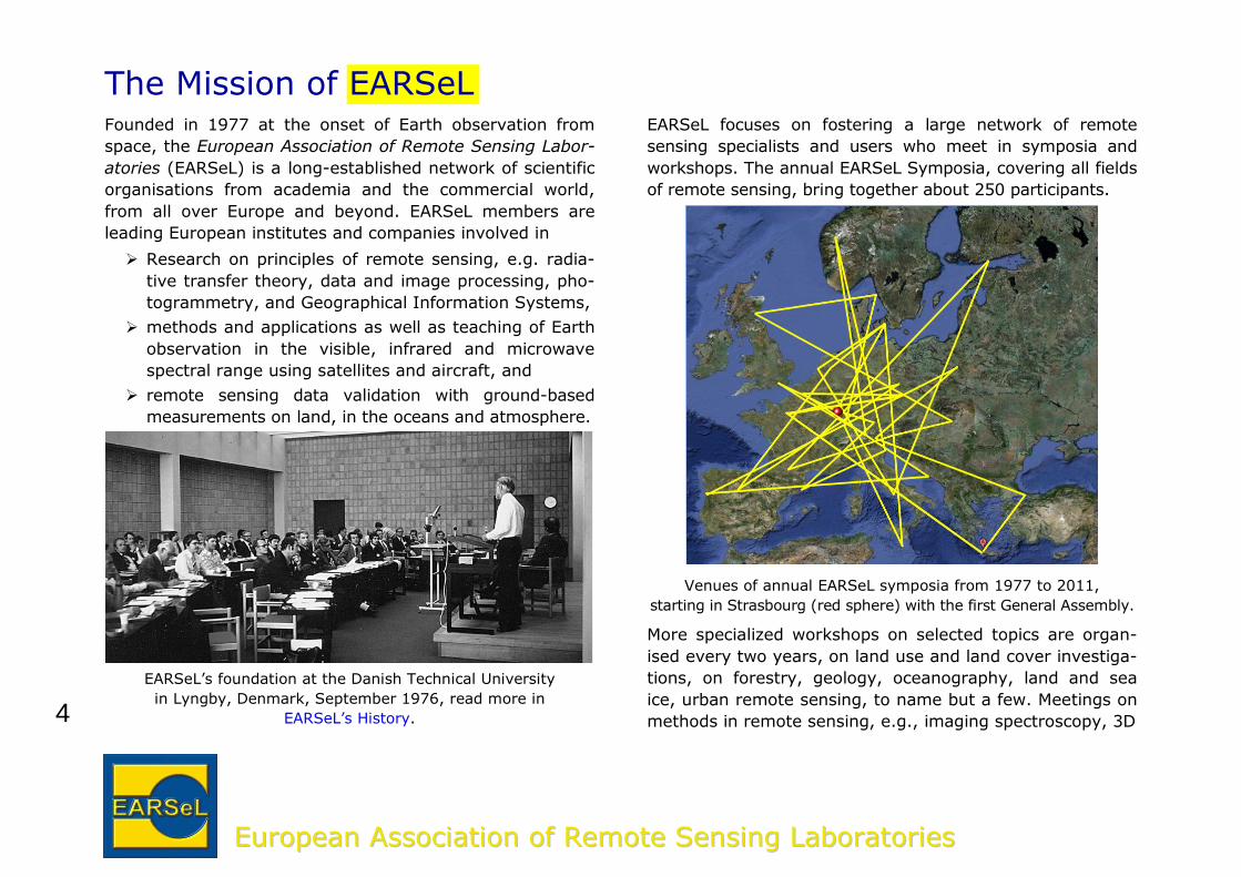
EARSeL focuses on fostering a large network of remote
sensing specialists and users who meet in symposia and
workshops. The annual EARSeL Symposia, covering all fields
of remote sensing, bring together about 250 participants.
Venues of annual EARSeL symposia from 1977 to 2011,
starting in Strasbourg (red sphere) with the first General Assembly.
More specialized workshops on selected topics are organ-
ised every two years, on land use and land cover investiga-
tions, on forestry, geology, oceanography, land and sea
ice, urban remote sensing, to name but a few. Meetings on
methods in remote sensing, e.g., imaging spectroscopy, 3D
5
EEuurrooppeeaann AAssssoocciiaattiioonn ooff RReemmoottee SSeennssiinngg LLaabboorraattoorriieess
imagery, radar and observations in the infrared, have be-
come of increasing interest as well.
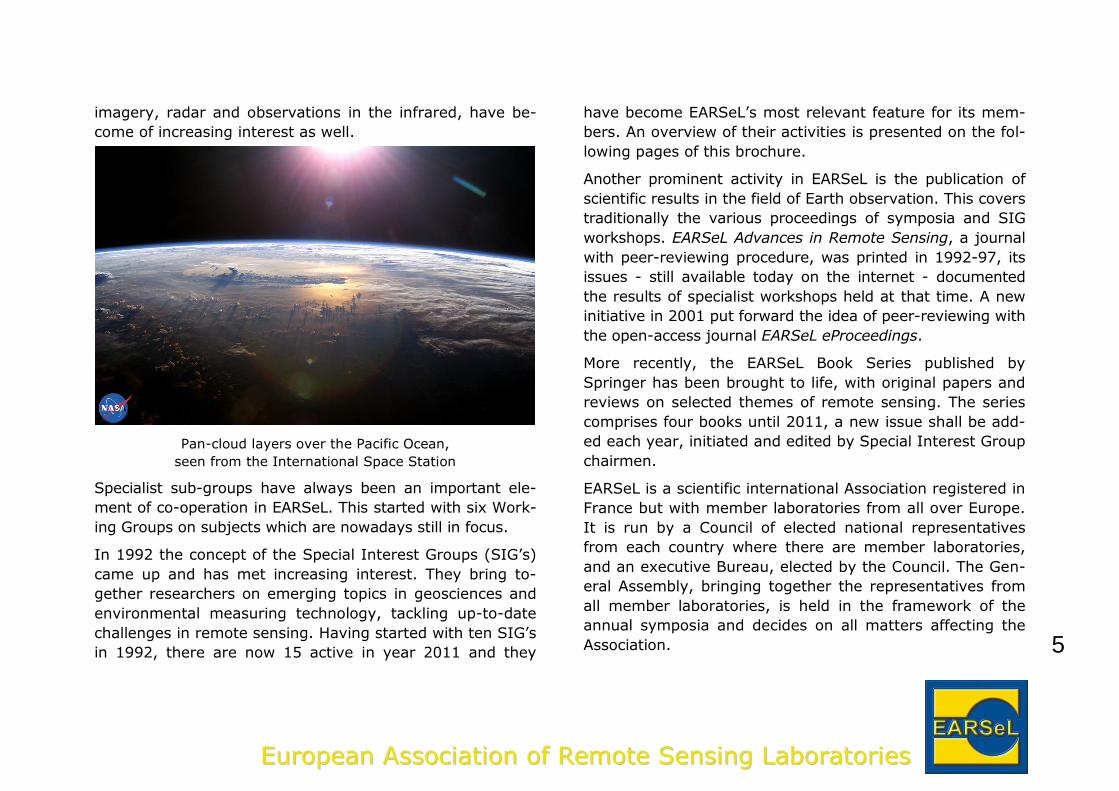
Pan-cloud layers over the Pacific Ocean,
seen from the International Space Station
Specialist sub-groups have always been an important ele-
ment of co-operation in EARSeL. This started with six Work-
ing Groups on subjects which are nowadays still in focus.
In 1992 the concept of the Special Interest Groups (SIG’s)
came up and has met increasing interest. They bring to-
gether researchers on emerging topics in geosciences and
environmental measuring technology, tackling up-to-date
challenges in remote sensing. Having started with ten SIG’s
in 1992, there are now 15 active in year 2011 and they
have become EARSeL’s most relevant feature for its mem-
bers. An overview of their activities is presented on the fol-
lowing pages of this brochure.
Another prominent activity in EARSeL is the publication of
scientific results in the field of Earth observation. This covers
traditionally the various proceedings of symposia and SIG
workshops. EARSeL Advances in Remote Sensing, a journal
with peer-reviewing procedure, was printed in 1992-97, its
issues - still available today on the internet - documented
the results of specialist workshops held at that time. A new
initiative in 2001 put forward the idea of peer-reviewing with
the open-access journal EARSeL eProceedings.
More recently, the EARSeL Book Series published by
Springer has been brought to life, with original papers and
reviews on selected themes of remote sensing. The series
comprises four books until 2011, a new issue shall be add-
ed each year, initiated and edited by Special Interest Group
chairmen.
EARSeL is a scientific international Association registered in
France but with member laboratories from all over Europe.
It is run by a Council of elected national representatives
from each country where there are member laboratories,
and an executive Bureau, elected by the Council. The Gen-
eral Assembly, bringing together the representatives from
all member laboratories, is held in the framework of the
annual symposia and decides on all matters affecting the
Association.
6
EEuurrooppeeaann AAssssoocciiaattiioonn ooff RReemmoottee SSeennssiinngg LLaabboorraattoorriieess
Projects Research projects on the use of remote sensing for re-
search, monitoring and education have become increasing-
ly important activity in EARSeL, with the Association in a
co-ordinating function or as a partner. These initiatives
strengthen networking among members, and they increase
EARSeL’s visibility in the remote sensing community and at
international funding agencies.
Presently, EARSeL is involved in
the GMES land monitoring project
funded by the EC in FP7
the forest cover change project
funded by Belgian Science Policy
EARSeL’s tasks are to provide project results through its
members involved, to organise reviews by other experts in
the field, and to publish the project results through its
journals, in its symposia and in its workshops.
Under the umbrella of EARSeL, an educational project was
conducted in 2007-09:
Science Education through
Earth Observation for
High Schools,
funded by the EC in FP6
In SEOS, 17 internet-based e-learning tutorials have been
created by 15 partners in several European languages, for
use in science curricula but also suitable for individual and
enquiry-based learning. Some tutorials, e.g., on marine pol-
lution and on ocean currents, can be used in training pro-
grammes for environmental and governmental agencies.
Publication of SEOS on the internet (lms.seos-project.eu)
permits a worldwide access, and allows for continuous up-
dates with most actual information. Additional tutorials
from EARSeL member laboratories on new and emerging
topics are very much welcome and may be added anytime.
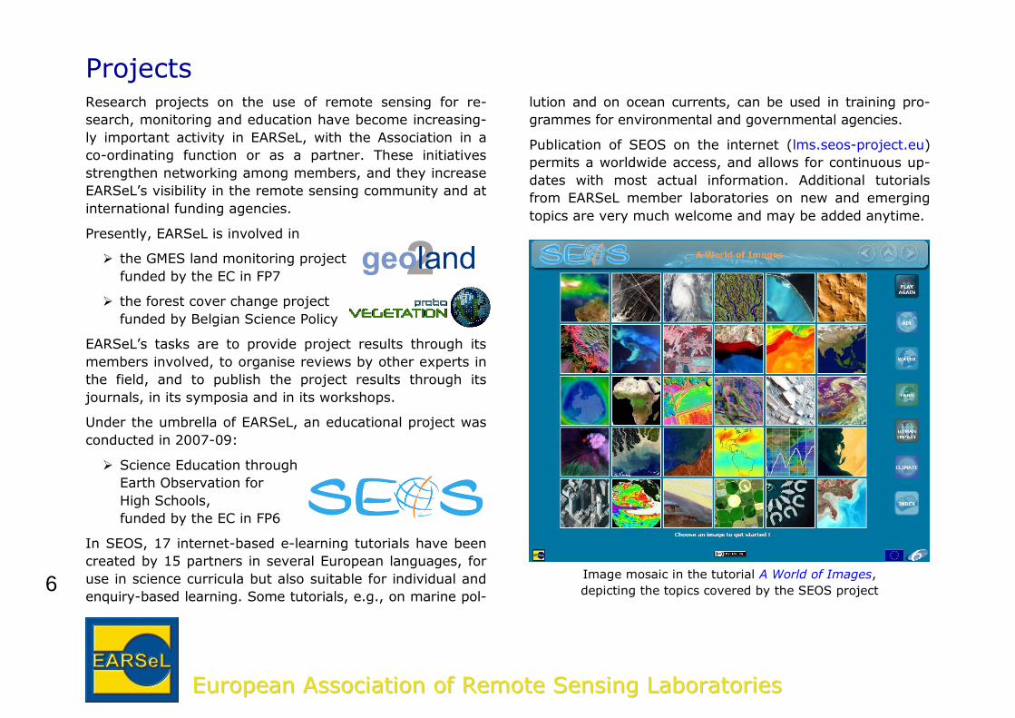
Image mosaic in the tutorial A World of Images,
depicting the topics covered by the SEOS project
7
EEuurrooppeeaann AAssssoocciiaattiioonn ooff RReemmoottee SSeennssiinngg LLaabboorraattoorriieess
Member Laboratories EARSeL has member laboratories in the following countries:
AUSTRIA BELGIUM BULGARIA
CROATIA CZECH REPUBLIC DENMARK
ESTONIA FINLAND FRANCE
GERMANY GREECE HUNGARY
ICELAND ISRAEL ITALY
LEBANON THE NETHERLANDS NORWAY
POLAND PORTUGAL ROMANIA
RUSSIA SERBIA AND MONTENEGRO
SLOVENIA SPAIN SYRIA
SWEDEN SWITZERLAND TURKEY
UNITED KINGDOM
Examples of member laboratories:
German Aerospace Center
IFREMER, France
VITO, Belgium
Rijkswaterstaat, The Netherlands
KTH Royal Institute of Technology, Sweden
European Centre for Medium-Range
Weather Forecast (ECMWF), UK
FÖMI Remote Sensing Directorate, Hungary
Partner Organisations EARSeL cooperates very closely at the working level with:
the European Space Agency (ESA)
the United Nations Educational, Scientific and Cultural
Organization (UNESCO)
the European Commission
in programmes for using and dissemination satellite data,
and in educational initiatives.
EARSeL is a regional member of ISPRS, the International
Society for Photogrammetry and Remote Sensing.
In 2010 an initiative has been launched for a broader coop-eration with partner organisations in Africa, Asia, and
South and Central America:
Society of Latin American Experts in Remote Sensing
(SELPER)
Asian Association on Remote Sensing (AARS)
African Association of Remote Sensing of the Envi-
ronment (AARSE)
Moreover, EARSeL undertakes joint activities with
the European Association of Remote Sensing Compa-
nies (EARSC)
Eurisy, an organisation promoting the use of satellite
services to the society
EARSeL co-operates closely with many national societies,
e.g., with the Remote Sensing and Photogrammetry Socie-
ty, UK, and with NASA Jet Propulsion Laboratory, Pasade-
na, U.S.A.
8
EEuurrooppeeaann AAssssoocciiaattiioonn ooff RReemmoottee SSeennssiinngg LLaabboorraattoorriieess
Publications EARSeL publishes several periodicals and monographs on
remote sensing of the Earth:
EARSeL Newsletter is a forum for an exchange of
news and views among the members of the Associa-
tion, a digest of Association activities and a general re-
view of the current remote sensing scene. It is printed
quarterly and also available on the internet
Proceedings of Symposia and Workshops, which
collect quality-checked manuscripts from EARSeL meet-
ings and are published on CD-ROM and on the internet
Springer Book Series on Remote Sensing and Digi-
tal Image Processing, published since 2009, includes
four issues on different topics, more issues are in prep-
aration
EARSeL eProceedings, the open-access journal with
peer-reviewed publications on all fields of remote sensing.
Become an EARSeL Member Members receive all EARSeL publications free of charge. No
page charges are requested from members for publishing
the results of their research in EARSeL eProceedings and in
the Springer Book Series on Remote Sensing and Digital
Image processing.
Moreover, EARSeL members are entitled to
reduced registration fees at the annual symposia and at
specialist workshops
joining one or more Special Interest Groups
networking with colleagues around Europe
participating in research projects initiated by EARSeL.
More information and an application form is available on
the EARSeL homepage, http://www.earsel.org.
9
EEuurrooppeeaann AAssssoocciiaattiioonn ooff RReemmoottee SSeennssiinngg LLaabboorraattoorriieess
Special Interest GroupsEARSeL members are invited to join one or several of
EARSeL’s Special Interest Groups (SIGs) which bring to-
gether institutes and companies that have similar broad
fields of research activity. The Special Interest Groups or-
ganise high-level workshops, mostly at regular intervals
every two or three years, for an exchange of recent re-
search results.
Networking in SIGs is the initial point for joint activities
such as cooperation of member laboratories in research
projects and in applications for joint projects.
The current list of Special Interest Groups includes the fol-
lowing topics:
3D Remote Sensing Coastal Zones
Cultural and Natural Heritage Developing Countries
Education and Training Forestry
Forest Fires Geological Applications
Imaging Spectroscopy Land Ice and Snow
Land Use / Land Cover Radar Remote Sensing
Temporal Analysis Thermal Remote Sensing
Urban Remote Sensing
More Special Interest Groups may be established depend-
ing on requirements of future research.
An overview of activities performed in the Special Interest
Groups is given on the following pages.
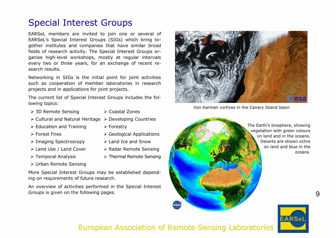
Von Karman vortices in the Canary Island basin
The Earth’s biosphere, showing
vegetation with green colours
on land and in the oceans.
Deserts are shown ochre
on land and blue in the
oceans.
10
EEuurrooppeeaann AAssssoocciiaattiioonn ooff RReemmoottee SSeennssiinngg LLaabboorraattoorriieess
Land Use / Land CoverLand use and land cover have been one of the first and
main products from remote sensing data. Its dynamics are
strongly influenced by socio-economic factors and political
decisions, generating a need for adequate mapping and
monitoring tools. As a consequence, robust and sophisti-
cated analysis methods are required for accurate infor-
mation extraction and fast and efficient data analyses need
to be adapted to the rapid advances in image and sensor
technologies as well as data amounts. Furthermore, multi-
temporal and multi-sensor approaches are becoming more
and more important not only for change detection but also
for more detailed classification approaches and information
retrieval algorithms.
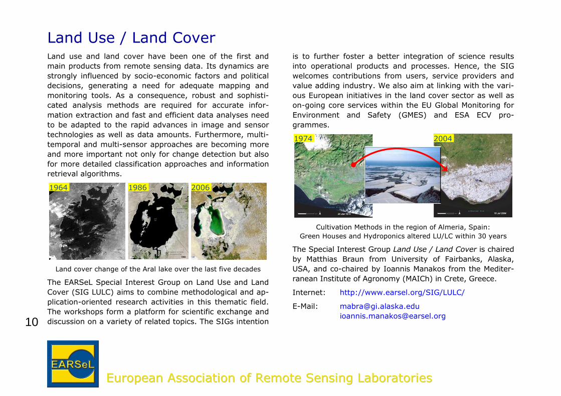
Land cover change of the Aral lake over the last five decades
The EARSeL Special Interest Group on Land Use and Land
Cover (SIG LULC) aims to combine methodological and ap-
plication-oriented research activities in this thematic field.
The workshops form a platform for scientific exchange and
discussion on a variety of related topics. The SIGs intention
is to further foster a better integration of science results
into operational products and processes. Hence, the SIG
welcomes contributions from users, service providers and
value adding industry. We also aim at linking with the vari-
ous European initiatives in the land cover sector as well as
on-going core services within the EU Global Monitoring for
Environment and Safety (GMES) and ESA ECV pro-
grammes.
Cultivation Methods in the region of Almeria, Spain:
Green Houses and Hydroponics altered LU/LC within 30 years
The Special Interest Group Land Use / Land Cover is chaired
by Matthias Braun from University of Fairbanks, Alaska,
USA, and co-chaired by Ioannis Manakos from the Mediter-
ranean Institute of Agronomy (MAICh) in Crete, Greece.
Internet: http://www.earsel.org/SIG/LULC/
E-Mail: [email protected]
1964 1986 2006
1974 2004
11
EEuurrooppeeaann AAssssoocciiaattiioonn ooff RReemmoottee SSeennssiinngg LLaabboorraattoorriieess
Land Ice and SnowThe dynamics of snow accumulation and ablation in moun-
tainous regions is important to humans and wildlife. The
latitude and elevation of snow and glaciers influence water
run-off and therefore the water supply for irrigation, tour-
ism, and power generation. Snow is one of the most fasci-
nating materials in nature. A variety of ice crystal shapes
are observed which depend on origin, age, density, and
temperature. As snow changes its behaviour, its spectral
characteristics change as well. These behavioural changes,
which are related to the energy and mass transport, essen-
tially affect climate and hydrology. Both the diurnal and
annual variability of snow coverage is a driving force of our
climate. Some millions of square kilometres of land surface
and polar oceans change their albedo during the year.
Hence precise mapping and monitoring of the cryosphere is
needed to contribute to questions in hydrology and climate
research. Satellite and airborne sensors offer the possibility
of detecting snow cover in a spatially comprehensive way
over scales from small catchments, to mountain ranges, or
even the hemisphere.
Only remote sensing techniques can provide the required
data. Therefore, there was a need to bring together scien-
tists working in this field to offer a lively environment for
discussion and exchange of new project ideas – the hour of
birth of the Special Interest Group Remote Sensing of Land
Ice and Snow. Since 1992, workshops have been organised
every three years with the aim of combining methodologi-
cal and application-oriented research activities in this the-
matic field.
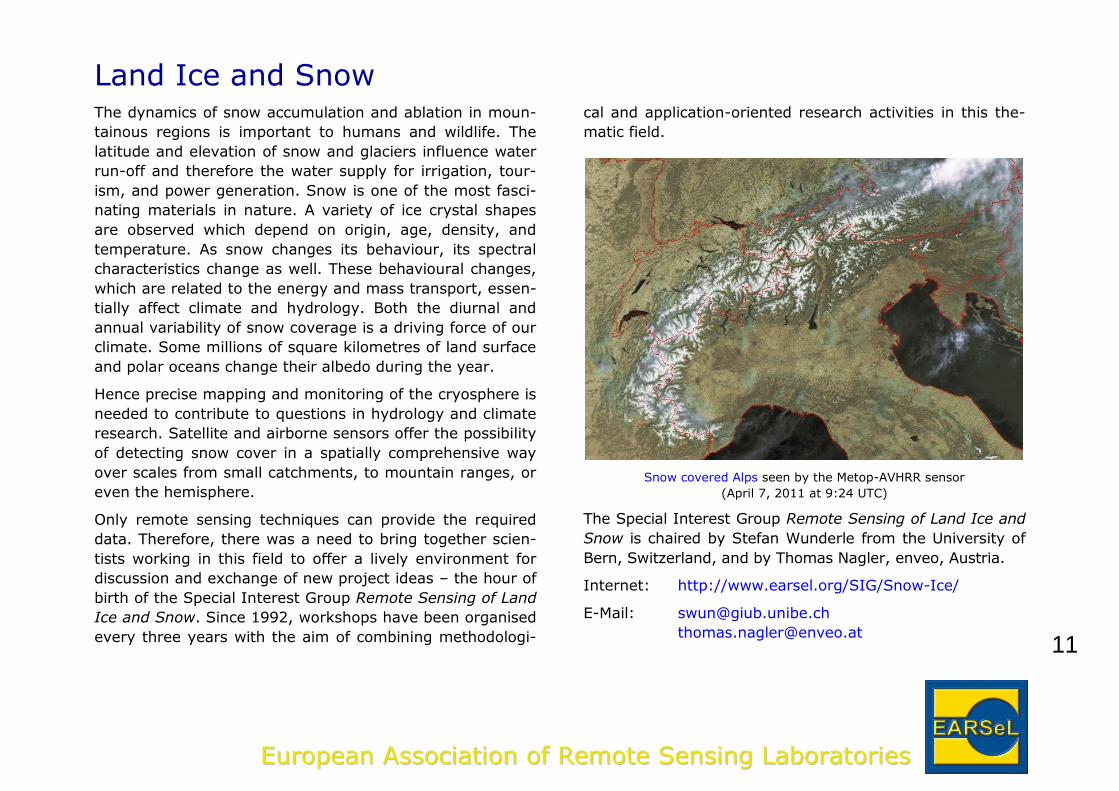
Snow covered Alps seen by the Metop-AVHRR sensor
(April 7, 2011 at 9:24 UTC)
The Special Interest Group Remote Sensing of Land Ice and
Snow is chaired by Stefan Wunderle from the University of
Bern, Switzerland, and by Thomas Nagler, enveo, Austria.
Internet: http://www.earsel.org/SIG/Snow-Ice/
E-Mail: [email protected]
12
EEuurrooppeeaann AAssssoocciiaattiioonn ooff RReemmoottee SSeennssiinngg LLaabboorraattoorriieess
Coastal ZonesAbout 60% of the world's population lives at a distance of
50 km from the coastline. This segment of the oceans has
a considerable economical and environmental importance
due to its high productivity. These ecosystems are very
sensitive and vulnerable. Many factors threaten their bal-
ance: coastal erosion, pollution, eutrophication, unsustain-
able exploitation of fisheries, urbanization, tourism, sea
level rise. For these concerns, nowadays the major goal of
the international community is to identify the conditions for
a sustainable use of coastal environments so that future
generations can continue to enjoy the products that derive
from this resource.
Coastal areas have a strong impact on socio-economic ac-
tivities. But they are affected by environmental risks:
climate change causing sea level rise and coastal ero-
sion
degradation of natural habitats and biodiversity
changes
water eutrophication and development of toxic algal
blooms
water pollution due to river discharge, groundwater,
sewage, oils and chemical indiscriminate releases or
from fish farming and other aquacultures
the seabed morphology close to coastline, in the con-
text of a possible formation of tsunami waves due to
submarine avalanches of sediments or earthquakes.
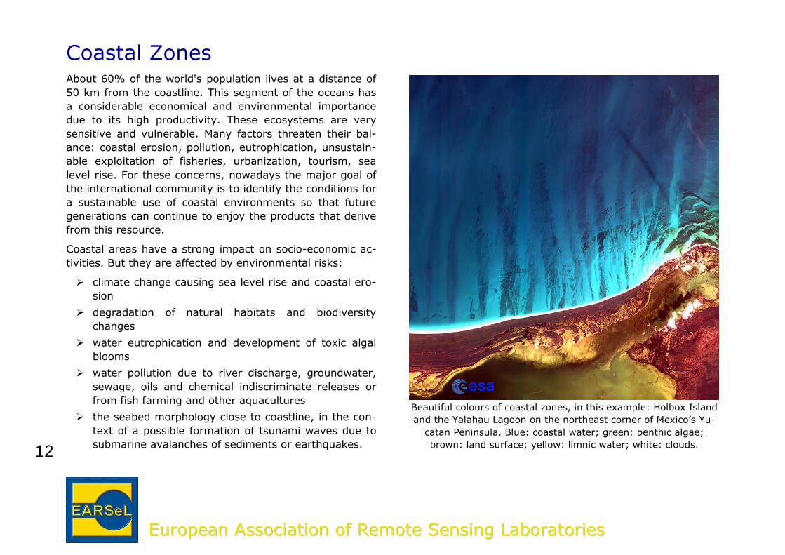
Beautiful colours of coastal zones, in this example: Holbox Island
and the Yalahau Lagoon on the northeast corner of Mexico’s Yu-
catan Peninsula. Blue: coastal water; green: benthic algae;
brown: land surface; yellow: limnic water; white: clouds.
13
EEuurrooppeeaann AAssssoocciiaattiioonn ooff RReemmoottee SSeennssiinngg LLaabboorraattoorriieess
Research and monitoring of these phenomena help in the
understanding of processes, in order to support a future sus-
tainable development of coastal zones. This implies the ne-
cessity to develop and implement new tools and methods
such as remote sensing for the management of coastal risks.
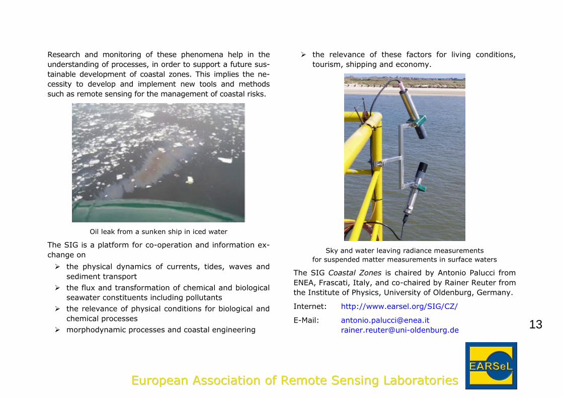
Oil leak from a sunken ship in iced water
The SIG is a platform for co-operation and information ex-
change on
the physical dynamics of currents, tides, waves and
sediment transport
the flux and transformation of chemical and biological
seawater constituents including pollutants
the relevance of physical conditions for biological and
chemical processes
morphodynamic processes and coastal engineering
the relevance of these factors for living conditions,
tourism, shipping and economy.
Sky and water leaving radiance measurements
for suspended matter measurements in surface waters
The SIG Coastal Zones is chaired by Antonio Palucci from
ENEA, Frascati, Italy, and co-chaired by Rainer Reuter from
the Institute of Physics, University of Oldenburg, Germany.
Internet: http://www.earsel.org/SIG/CZ/
E-Mail: [email protected]
14
EEuurrooppeeaann AAssssoocciiaattiioonn ooff RReemmoottee SSeennssiinngg LLaabboorraattoorriieess
ForestryMore than one third of Europe is covered by forests. Re-
mote sensing can be seen as a very important branch of a
big tree called geomatics, being a powerful tool for forest
resources assessment and monitoring. Consequently, it
serves as a unique source of information in the context of
topics such as land use/land cover change, climate change,
biodiversity and landscape ecology.
Presently there are different research platforms on remote
sensing in forestry such as: the IUFRO Remote Sens-
ing/GIS (4.02.05 and 4.02.08) World Forestry groups, the
ISPRS Forestry Group and the ForestSat or SilviLaser sym-
posium events as well. In this context, the Special Interest
Group on Forestry defines its role as a rather application-
oriented group. The objectives of the SIG Forestry aim at
setting up a common forum for the research community
and professionals from the forestry sector, where both the
operational techniques as well as developing methodologies
can be presented and understood in order to improve for-
est management and protection practices in Europe.
The SIG Forestry topics include:
forest resource mapping, biomass estimation and
change detection
forest inventories, biophysical parameters
forest damage/degradation related to climate change
biodiversity, protected forests, mountain forestry, and
acquisition of reference field data.
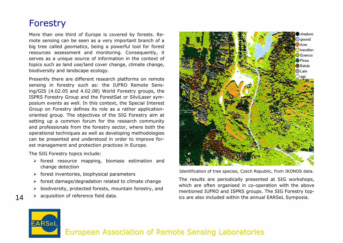
Identification of tree species, Czech Republic, from IKONOS data.
The results are periodically presented at SIG workshops,
which are often organised in co-operation with the above
mentioned IUFRO and ISPRS groups. The SIG Forestry top-
ics are also included within the annual EARSeL Symposia.
15
EEuurrooppeeaann AAssssoocciiaattiioonn ooff RReemmoottee SSeennssiinngg LLaabboorraattoorriieess
Other activities include searching for joint projects with ex-
ternal funding, and arranging freely accessible sensor da-
tasets or ground truth reference data for algorithm testing.
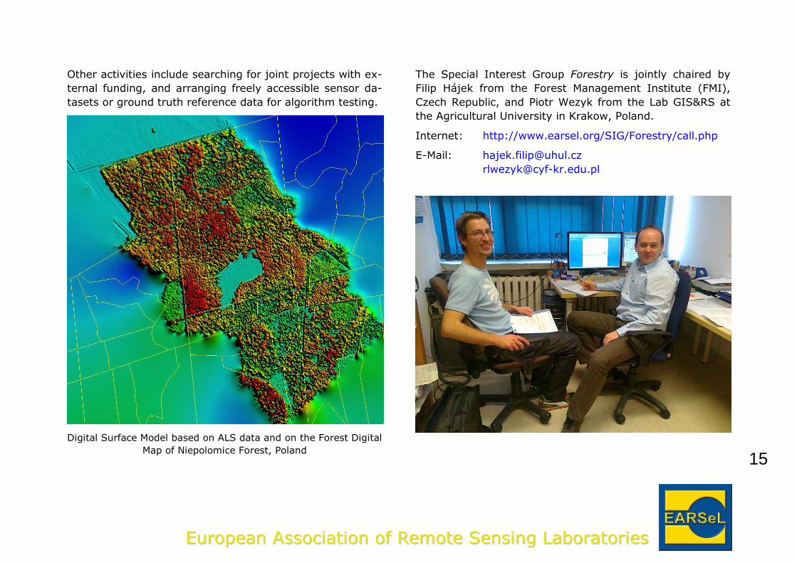
Digital Surface Model based on ALS data and on the Forest Digital
Map of Niepolomice Forest, Poland
The Special Interest Group Forestry is jointly chaired by
Filip Hájek from the Forest Management Institute (FMI),
Czech Republic, and Piotr Wezyk from the Lab GIS&RS at
the Agricultural University in Krakow, Poland.
Internet: http://www.earsel.org/SIG/Forestry/call.php
E-Mail: [email protected]
16
EEuurrooppeeaann AAssssoocciiaattiioonn ooff RReemmoottee SSeennssiinngg LLaabboorraattoorriieess
Forest FiresThe Special Interest Group Forest Fires (FF-SIG) was cre-
ated in 1995, following the initiative of several researchers
studying fires in Mediterranean Europe. The group fosters
interaction among scientists and managers who are inter-
ested in using remotely sensed data and techniques to im-
prove the traditional methods of fire risk estimation, active
fire monitoring, and the assessment of forest fire effects.
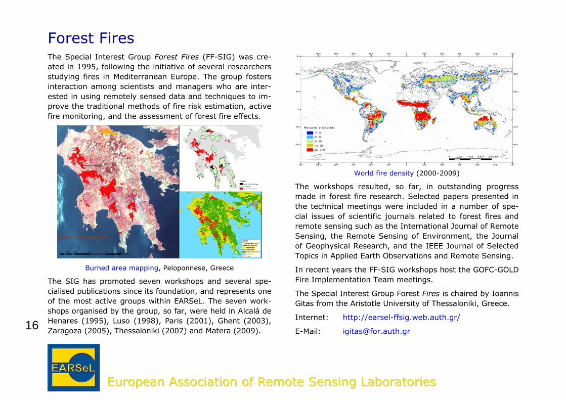
Burned area mapping, Peloponnese, Greece
The SIG has promoted seven workshops and several spe-
cialised publications since its foundation, and represents one
of the most active groups within EARSeL. The seven work-
shops organised by the group, so far, were held in Alcalá de
Henares (1995), Luso (1998), Paris (2001), Ghent (2003),
Zaragoza (2005), Thessaloniki (2007) and Matera (2009).
World fire density (2000-2009)
The workshops resulted, so far, in outstanding progress
made in forest fire research. Selected papers presented in
the technical meetings were included in a number of spe-
cial issues of scientific journals related to forest fires and
remote sensing such as the International Journal of Remote
Sensing, the Remote Sensing of Environment, the Journal
of Geophysical Research, and the IEEE Journal of Selected
Topics in Applied Earth Observations and Remote Sensing.
In recent years the FF-SIG workshops host the GOFC-GOLD
Fire Implementation Team meetings.
The Special Interest Group Forest Fires is chaired by Ioannis
Gitas from the Aristotle University of Thessaloniki, Greece.
Internet: http://earsel-ffsig.web.auth.gr/
E-Mail: [email protected]
17
EEuurrooppeeaann AAssssoocciiaattiioonn ooff RReemmoottee SSeennssiinngg LLaabboorraattoorriieess
GeologyThe Special Interest Group Geological Applications started
its mission in 1999. It is a forum for international discus-
sions amongst Earth scientists. The main objectives of the
SIG are to promote geologic remote sensing and Earth ob-
servation and to bridge the gap between technology and
applications by bringing together experts from universities,
institutes and commercial enterprises at scientific meet-
ings.
There is a great number of possibilities of remote sensing
in all the sections of geology (lithological and mineral map-
ping, structural geology, tectonics, hydrogeology, geomor-
phology, mine monitoring etc).
Remote sensing data facilitates mine monitoring
Earth observation can provide almost real time accurate
data for addressing geohazards (landslides monitoring, vol-
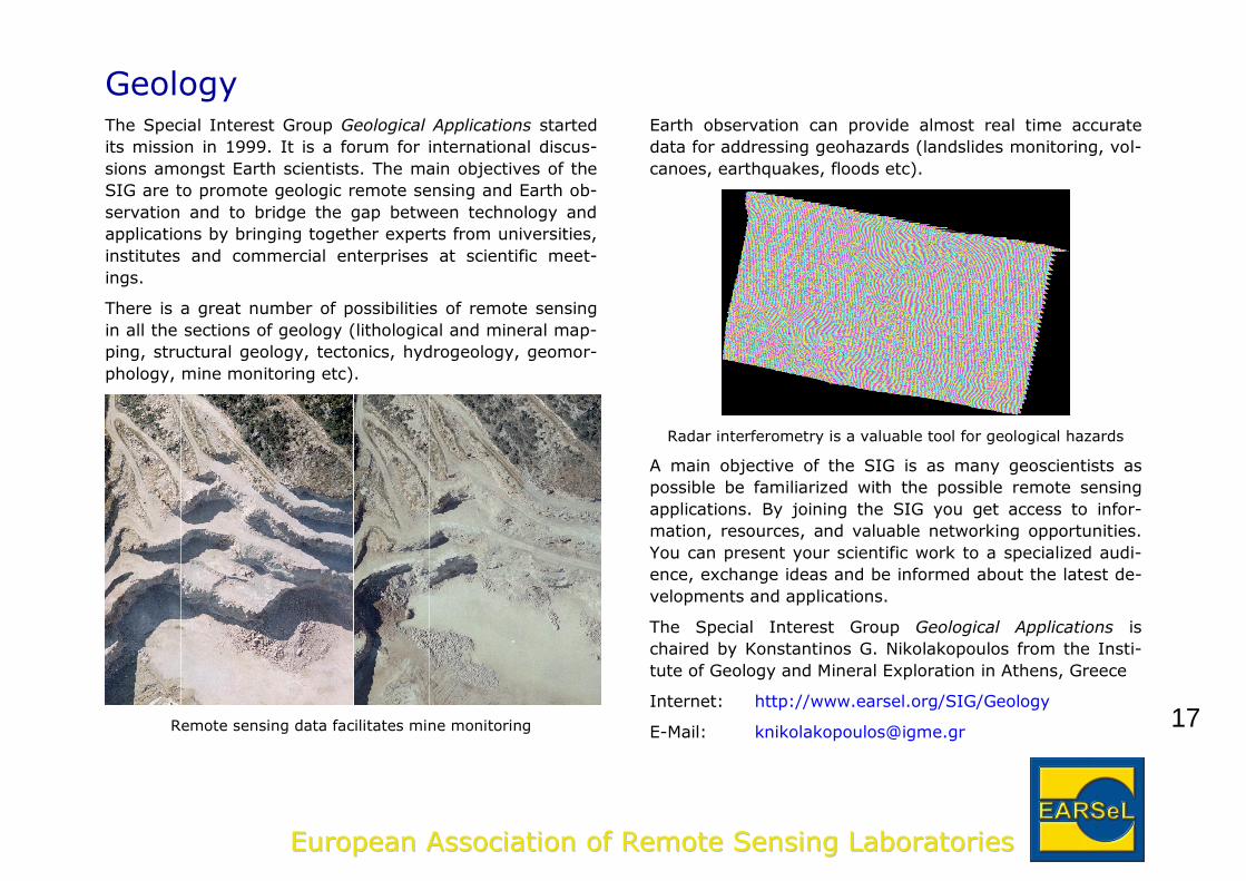
canoes, earthquakes, floods etc).
Radar interferometry is a valuable tool for geological hazards
A main objective of the SIG is as many geoscientists as
possible be familiarized with the possible remote sensing
applications. By joining the SIG you get access to infor-
mation, resources, and valuable networking opportunities.
You can present your scientific work to a specialized audi-
ence, exchange ideas and be informed about the latest de-
velopments and applications.
The Special Interest Group Geological Applications is
chaired by Konstantinos G. Nikolakopoulos from the Insti-
tute of Geology and Mineral Exploration in Athens, Greece
Internet: http://www.earsel.org/SIG/Geology
E-Mail: [email protected]
18
EEuurrooppeeaann AAssssoocciiaattiioonn ooff RReemmoottee SSeennssiinngg LLaabboorraattoorriieess
Urban Remote SensingUrban environments are characterized by highly dynamic
changes in biophysical and socio-economic domains, and
management of urban environments involves procedures of
mapping and monitoring which require a reliable infor-
mation base and robust analytical technologies. Remote
sensing and geographic information systems (GIS), given
their cost-effectiveness and technological soundness, are
increasingly being used for developing useful sources of
information and for decision making in support of a wide
array of urban applications. The Special Interest Group Ur-
ban Remote Sensing (SIG-URS) focuses on GI applications
in urban and suburban environments and invites interested
people to join the SIG and share their experiences and
knowledge with others.
Urban areas are growing rapidly in all countries of the
world. Urban growth and its associated problems are very
challenging tasks in which remote sensing imagery could
help to obtain-to-date information. During the last few dec-
ades and especially during the last few years we have rec-
ognized rapid advances in the imaging technology (e.g.
high spatial resolution, Lidar, etc.) and in image analysis
techniques (e.g. object based classification). According to
the growing awareness of urban areas, agglomerations and
mega cities, more and more scientists focus on topic relat-
ed to them. To further support research and information
exchange in this area, EARSeL established the Special In-
terest Group on Urban Remote Sensing.
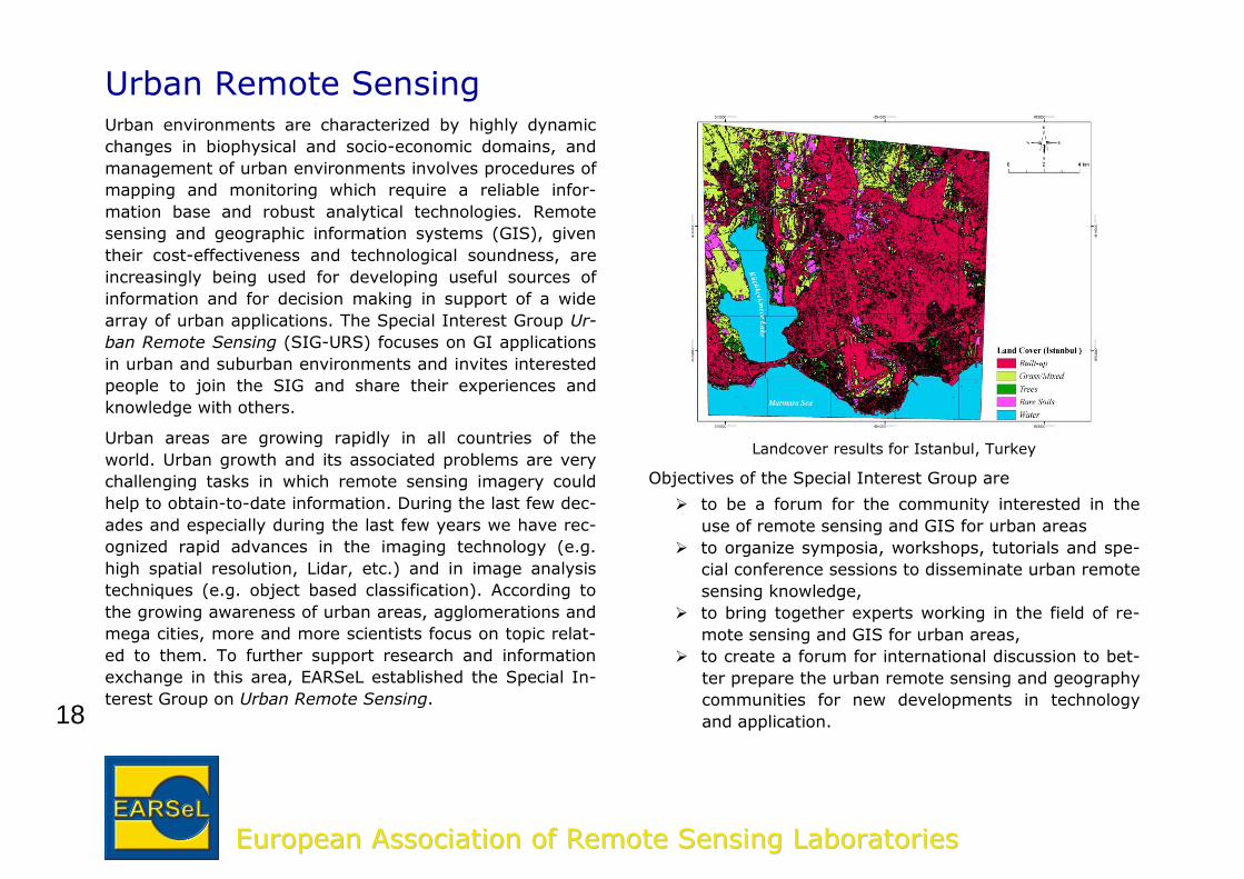
Landcover results for Istanbul, Turkey
Objectives of the Special Interest Group are
to be a forum for the community interested in the
use of remote sensing and GIS for urban areas
to organize symposia, workshops, tutorials and spe-
cial conference sessions to disseminate urban remote
sensing knowledge,
to bring together experts working in the field of re-
mote sensing and GIS for urban areas,
to create a forum for international discussion to bet-
ter prepare the urban remote sensing and geography
communities for new developments in technology
and application.
19
EEuurrooppeeaann AAssssoocciiaattiioonn ooff RReemmoottee SSeennssiinngg LLaabboorraattoorriieess
Starting from 2001 the SIG has organised several confer-
ences in Regensburg, Berlin, Bochum and Munich (Germany);
Istanbul (Turkey); Paris (France); Tempe (USA); and Shang-
hai (China). We have also organized special sessions on ur-
ban remote sensing in different international conferences,
published a book (Editors: Rashed & Jürgens; Chapter: Mak-
tav & Sunar), and edited the special issue Urban Remote
Sensing of the International Journal of Remote Sensing.
The Special Interest Group Urban Remote Sensing is
chaired by Carsten Jürgens from the Department of Geog-
raphy, Ruhr University Bochum, Germany and co-chaired
by Derya Maktav from the Department of Geomatics Engi-
neering, Istanbul Technical University, Istanbul, Turkey.
Internet: http://www.ins.itu.edu.tr/sig-urs
E-Mail: [email protected]
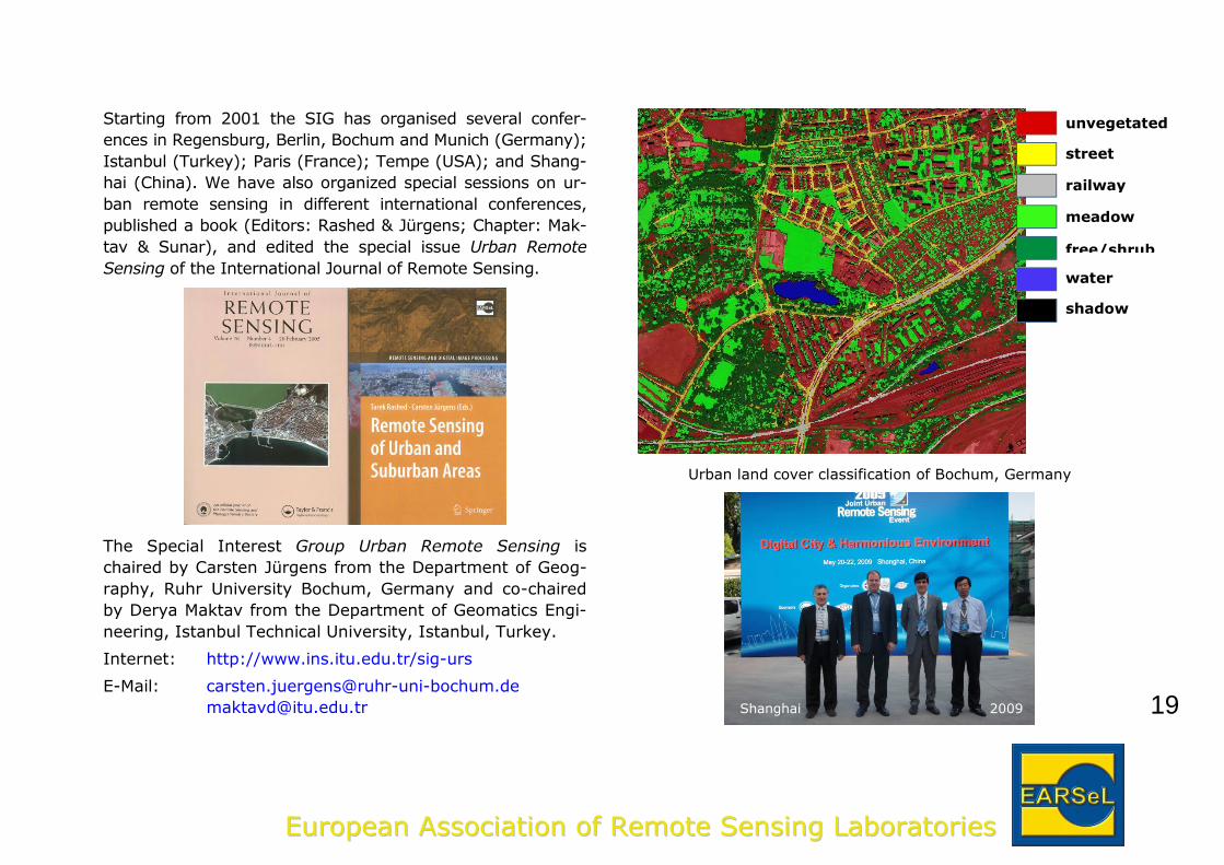
Urban land cover classification of Bochum, Germany
Shanghai 2009
railway
unvegetated
street
free/shrub
meadow
shadow
water
20
EEuurrooppeeaann AAssssoocciiaattiioonn ooff RReemmoottee SSeennssiinngg LLaabboorraattoorriieess
Developing CountriesEARSeL, like other organizations of the remote sensing
community, realizes that remote sensing offers global, re-
gional and local observation possibilities which are difficult
to attain by other methods. It further realizes that the most
potential applications are in areas where data are greatly
lacking, which holds particularly in the developing countries.
It is therefore that within EARSeL a Special Interest Group
on Developing Countries has been established.
Many workshops held up to now in relation to this SIG con-
centrated on problems associated with the use of remote
sensing in the developing countries. Especially, remote
sensing is rapidly becoming accepted in many of such
countries as an excellent tool for mapping purposes since
up-to-date maps and topographical information are not al-
ways available.
Working in developing countries often brings up problems
which are different to the ones faced by scientists in more
developed countries working on topics in developed coun-
tries. Therefore, a European contact group has been estab-
lished in order to bring together these scientists in order to
exchange experiences and results of research programs
more easily.
The SIG aims also to set up contacts with the national de-
velopment agencies of the EU, in order to highlight the im-
portance of remote sensing for mapping purposes in devel-
oping countries and to establish cooperation with the de-
veloping agencies.
Examples of challenges in developing countries Capacity building in Remote Sensing
21
EEuurrooppeeaann AAssssoocciiaattiioonn ooff RReemmoottee SSeennssiinngg LLaabboorraattoorriieess
The SIG Developing Countries organized workshops in Gent
(Belgium) 2000, Bonn (Germany) 2002, Cairo (Egypt)
2005, and Istanbul (Turkey) 2008. It also participated in
Joint EARSeL Workshops held in Bochum (Germany) 2008
and Gent (Belgium) 2010.
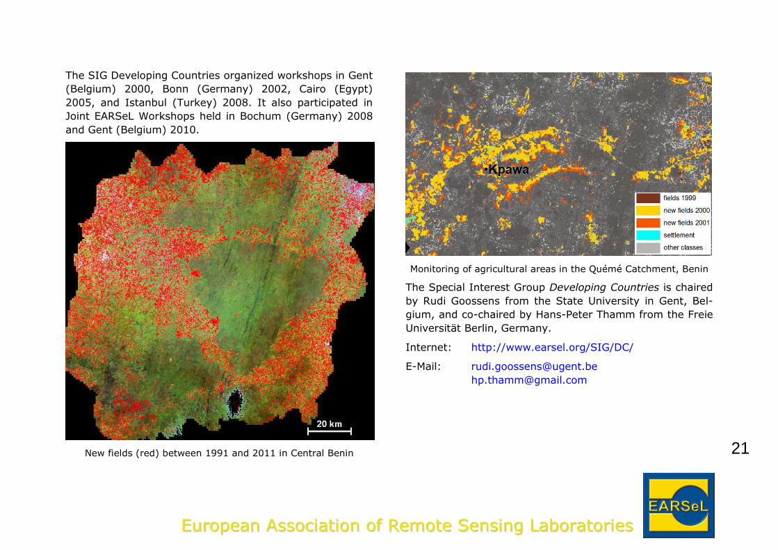
New fields (red) between 1991 and 2011 in Central Benin
Monitoring of agricultural areas in the Quémé Catchment, Benin
The Special Interest Group Developing Countries is chaired
by Rudi Goossens from the State University in Gent, Bel-
gium, and co-chaired by Hans-Peter Thamm from the Freie
Universität Berlin, Germany.
Internet: http://www.earsel.org/SIG/DC/
E-Mail: [email protected]
22
EEuurrooppeeaann AAssssoocciiaattiioonn ooff RReemmoottee SSeennssiinngg LLaabboorraattoorriieess
Cultural and Natural HeritageThe research, documentation, presentation and manage-
ment of heritage sites is a complex task. While this task
was previously in the hands or archaeologists in the case of
cultural heritage sites, or environmentalists in the case of
natural heritage sites, today it requires an interdisciplinary
approach.
This is precisely the support that remote sensing brings to
cultural and natural heritage. Remote Sensing is a technol-
ogy of obtaining geometrical and semantic information
about the Earth and its environment using non-invasive
technologies. There is today a large range of satellite sen-
sors available. This data is then combined with airborne
and terrestrial sensors. The diversity in terms of sensors
and systems subsequently brings the diversity in applica-
tions. The cultural heritage domain is obtaining large bene-
fits from the combinations of all these technologies.
The EARSeL Special Interest Group on Applications of Re-
mote Sensing for Cultural and Natural Heritage brings to-
gether experts working on the wide range of disciplines
mentioned in the previous paragraph.
Through the organization of international workshops this
Special Interest Group of EARSeL facilitates the exchange
of technologies, lessons learnt and projects in the area of
remote sensing as applied to natural and cultural heritage.
The United Nations Educational, Scientific and Cultural Or-
ganization (UNESCO) and its dedicated programme Open
Initiative on the use of Space Technologies to support
World Heritage is a strong partner of EARSeL for this par-
ticular SIG.
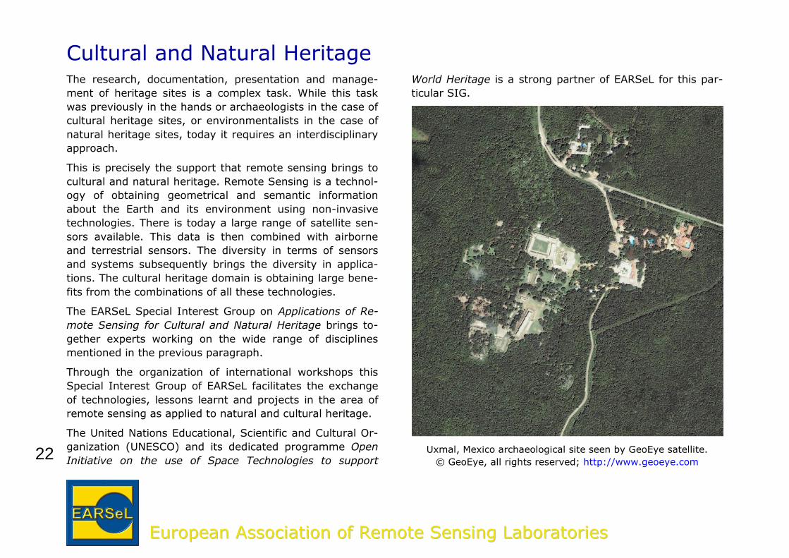
Uxmal, Mexico archaeological site seen by GeoEye satellite.
© GeoEye, all rights reserved; http://www.geoeye.com
23
EEuurrooppeeaann AAssssoocciiaattiioonn ooff RReemmoottee SSeennssiinngg LLaabboorraattoorriieess
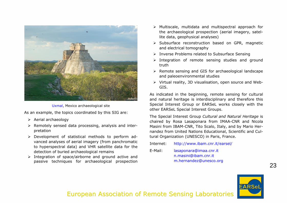
Uxmal, Mexico archaeological site
As an example, the topics coordinated by this SIG are:
Aerial archaeology
Remotely sensed data processing, analysis and inter-
pretation
Development of statistical methods to perform ad-
vanced analyses of aerial imagery (from panchromatic
to hyperspectral data) and VHR satellite data for the
detection of buried archaeological remains
Integration of space/airborne and ground active and passive techniques for archaeological prospection
Multiscale, multidata and multispectral approach for
the archaeological prospection (aerial imagery, satel-
lite data, geophysical analyses)
Subsurface reconstruction based on GPR, magnetic
and electrical tomography
Inverse Problems related to Subsurface Sensing
Integration of remote sensing studies and ground
truth
Remote sensing and GIS for archaeological landscape
and paleoenvironmental studies
Virtual reality, 3D visualisation, open source and Web-
GIS.
As indicated in the beginning, remote sensing for cultural
and natural heritage is interdisciplinary and therefore this
Special Interest Group or EARSeL works closely with the
other EARSeL Special Interest Groups.
The Special Interest Group Cultural and Natural Heritage is
chaired by Rosa Lasaponara from IMAA-CNR and Nicola
Masini from IBAM-CNR, Tito Scalo, Italy, and by Mario Her-
nandez from United Nations Educational, Scientific and Cul-
tural Organization (UNESCO) in Paris, France.
Internet: http://www.ibam.cnr.it/earsel/
E-Mail: [email protected]
24
EEuurrooppeeaann AAssssoocciiaattiioonn ooff RReemmoottee SSeennssiinngg LLaabboorraattoorriieess
Temporal Analysis of Image DataMany years ago EARSeL began the process of establishing
a Special Interest Group on time series analysis of remote-
ly sensed data. This action was stimulated by the open and
mostly free access to satellite data archives providing the
opportunity to study, for example, environmental changes
over a period of more than 30 years which is the minimum
time needed to study impacts of climate change.
It is no surprise that timeseries analysis of satellite data is
a growing field of interest in various scientific disciplines
and the use of “old” data experiences a kind of renais-
sance. Furthermore there is intensive use of new sensors
providing data with global coverage in a very short time-
scale and enabling in-depth analysis of environmental pro-
cesses and anthropogenic impacts.
The following topics are an interesting start of this new
SIG:
overview of existing data archives, e.g., Landsat,
NOAA-AVHRR, MODIS, ERS 1 and 2, InSAR, etc.
methodological requirements on multitemporal data
calibration and correction, and on geometric accura-
cy of old satellite data
existing tools for time series analysis in commercial
software packages
development of improved/sophisticated algorithms
for change detection
vegetation dynamics and ecological processes
high resolution time series from Thermal Infrared
cameras - the link to boundary layer meteorology
and process studies.
It is obvious that the activities of this Special Interest Group
are closely related to many other EarseL SIGs. Therefore a
close co-operation is foreseen. The development of sophisti-
cated algorithms is an especially important task.
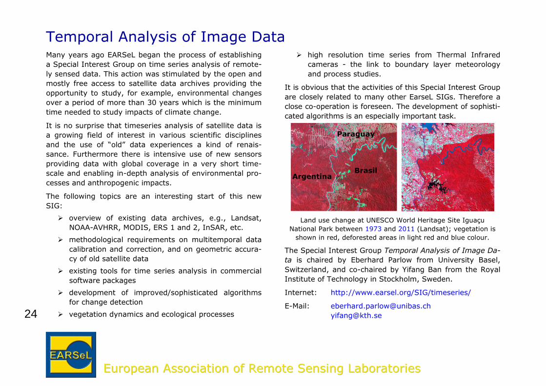
Land use change at UNESCO World Heritage Site Iguaçu
National Park between 1973 and 2011 (Landsat); vegetation is
shown in red, deforested areas in light red and blue colour.
The Special Interest Group Temporal Analysis of Image Da-
ta is chaired by Eberhard Parlow from University Basel,
Switzerland, and co-chaired by Yifang Ban from the Royal
Institute of Technology in Stockholm, Sweden.
Internet: http://www.earsel.org/SIG/timeseries/
E-Mail: [email protected]
Brasil Argentina
Paraguay
25
EEuurrooppeeaann AAssssoocciiaattiioonn ooff RReemmoottee SSeennssiinngg LLaabboorraattoorriieess
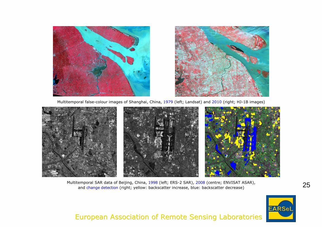
Multitemporal false-colour images of Shanghai, China, 1979 (left; Landsat) and 2010 (right; HJ-1B images)
Multitemporal SAR data of Beijing, China, 1998 (left; ERS-2 SAR), 2008 (centre; ENVISAT ASAR),
and change detection (right; yellow: backscatter increase, blue: backscatter decrease)
26
EEuurrooppeeaann AAssssoocciiaattiioonn ooff RReemmoottee SSeennssiinngg LLaabboorraattoorriieess
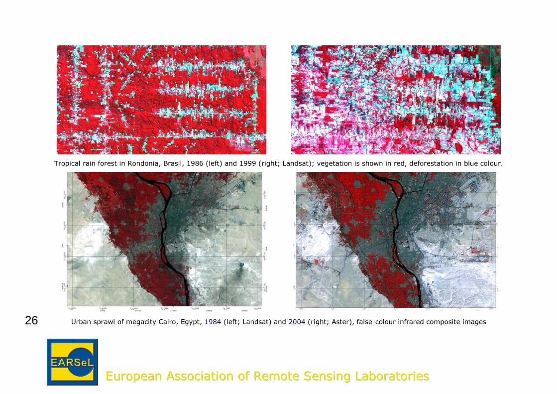
Tropical rain forest in Rondonia, Brasil, 1986 (left) and 1999 (right; Landsat); vegetation is shown in red, deforestation in blue colour.
Urban sprawl of megacity Cairo, Egypt, 1984 (left; Landsat) and 2004 (right; Aster), false-colour infrared composite images
27
EEuurrooppeeaann AAssssoocciiaattiioonn ooff RReemmoottee SSeennssiinngg LLaabboorraattoorriieess
Imaging SpectroscopyImaging Spectroscopy is concerned with the measurement,
analysis, and interpretation of spectra acquired from a given
scene or object at various altitudes of airborne or satellite im-
aging spectrometers. Hyperspectral sensors produce hundreds
of images, corresponding to contiguous channels of different
wavelengths for the same region on the Earth surface, ena-
bling the construction of an almost continuous reflectance
spectrum for every pixel in the scene. Spectra can range from
the visible, near- and mid-infrared to the thermal infrared.
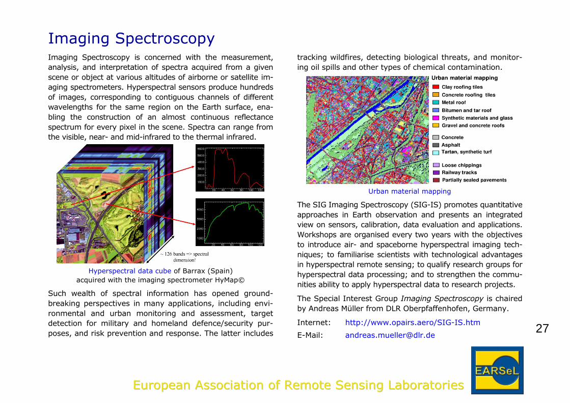
Hyperspectral data cube of Barrax (Spain)
acquired with the imaging spectrometer HyMap©
Such wealth of spectral information has opened ground-
breaking perspectives in many applications, including envi-
ronmental and urban monitoring and assessment, target
detection for military and homeland defence/security pur-
poses, and risk prevention and response. The latter includes
tracking wildfires, detecting biological threats, and monitor-
ing oil spills and other types of chemical contamination.
Urban material mapping
The SIG Imaging Spectroscopy (SIG-IS) promotes quantitative
approaches in Earth observation and presents an integrated
view on sensors, calibration, data evaluation and applications.
Workshops are organised every two years with the objectives
to introduce air- and spaceborne hyperspectral imaging tech-
niques; to familiarise scientists with technological advantages
in hyperspectral remote sensing; to qualify research groups for
hyperspectral data processing; and to strengthen the commu-
nities ability to apply hyperspectral data to research projects.
The Special Interest Group Imaging Spectroscopy is chaired
by Andreas Müller from DLR Oberpfaffenhofen, Germany.
Internet: http://www.opairs.aero/SIG-IS.htm
E-Mail: [email protected]
28
EEuurrooppeeaann AAssssoocciiaattiioonn ooff RReemmoottee SSeennssiinngg LLaabboorraattoorriieess
3D Remote Sensing The three-dimensional shape of the Earth has become of
major importance for several remote sensing applications in
the last year, thanks to the continuously increased ground
resolution of optical and radar sensors. Topics like the geo-
metrical correction of the remote sensed imagery through
models for image orientation and geo-referencing and the
discrete 3-D representation of the surface of the Earth
through Digital Surface, Elevation and Terrain Models (DSM
– DEM - DTM) based on remotely sensed imagery are of
primary importance.
The mentioned topics are strictly interrelated, since the
generation of DSMs requires stereo or multiple image ori-
entation together with matching strategies, whereas the
image correction for orthoimagery production requires the
DSM’s. Moreover, the generation of DEM’s and DTM’s from
DSMs requires filtering strategies to eliminate vegetation
and man-made objects (buildings, bridges, ...) in order to
recover the shape of the bare terrain itself.
The discrete 3-D representation of the surface of the Earth
is a basis for a large and increasing variety of applications
in Engineering, Earth and Environmental Science, Safety
and Security (terrain analysis, flood prediction, coastal
mapping, erosion control, determination of subsidence,
noise and gas propagation, telecommunications planning,
…), so that methodologies and techniques related to the
different steps of DSMs, DEMs and DTMs generation and
quality control are in the centre of the SIG 3D Remote
Sensing.
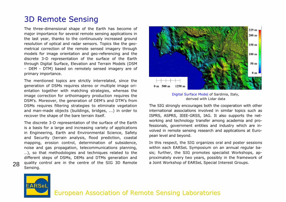
Digital Surface Model of Sardinia, Italy,
derived with Lidar data
The SIG strongly encourages both the cooperation with other
international associations involved in similar topics such as
ISPRS, ASPRS, IEEE-GRSS, IAG. It also supports the net-
working and technology transfer among academia and pro-
fessionals, government entities and industry which are in-
volved in remote sensing research and applications at Euro-
pean level and beyond.
In this respect, the SIG organizes oral and poster sessions
within each EARSeL Symposium on an annual regular ba-
sis; further, the SIG promotes specialist Workshops, ap-
proximately every two years, possibly in the framework of
a Joint Workshop of EARSeL Special Interest Groups.
29
EEuurrooppeeaann AAssssoocciiaattiioonn ooff RReemmoottee SSeennssiinngg LLaabboorraattoorriieess
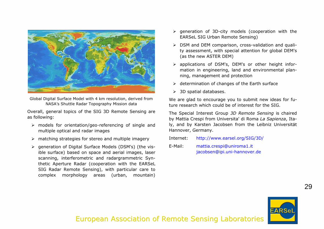
Global Digital Surface Model with 4 km resolution, derived from
NASA’s Shuttle Radar Topography Mission data
Overall, general topics of the SIG 3D Remote Sensing are
as following:
models for orientation/geo-referencing of single and
multiple optical and radar images
matching strategies for stereo and multiple imagery
generation of Digital Surface Models (DSM's) (the vis-
ible surface) based on space and aerial images, laser
scanning, interferometric and radargrammetric Syn-
thetic Aperture Radar (cooperation with the EARSeL
SIG Radar Remote Sensing), with particular care to
complex morphology areas (urban, mountain)
generation of 3D-city models (cooperation with the
EARSeL SIG Urban Remote Sensing)
DSM and DEM comparison, cross-validation and quali-
ty assessment, with special attention for global DEM's
(as the new ASTER DEM)
applications of DSM's, DEM's or other height infor-
mation in engineering, land and environmental plan-
ning, management and protection
determination of changes of the Earth surface
3D spatial databases.
We are glad to encourage you to submit new ideas for fu-
ture research which could be of interest for the SIG.
The Special Interest Group 3D Remote Sensing is chaired
by Mattia Crespi from Universita' di Roma La Sapienza, Ita-
ly, and by Karsten Jacobsen from the Leibniz Universität
Hannover, Germany.
Internet: http://www.earsel.org/SIG/3D/
E-Mail: [email protected]
30
EEuurrooppeeaann AAssssoocciiaattiioonn ooff RReemmoottee SSeennssiinngg LLaabboorraattoorriieess
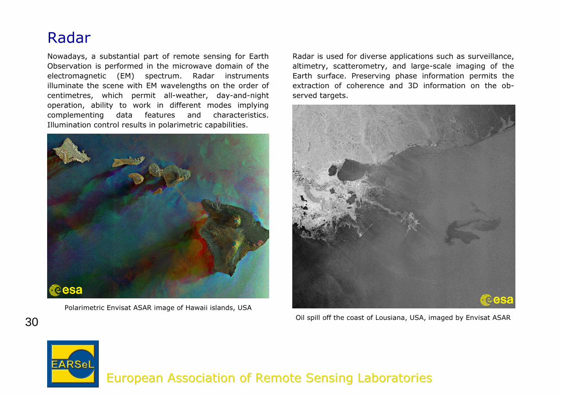
RadarNowadays, a substantial part of remote sensing for Earth
Observation is performed in the microwave domain of the
electromagnetic (EM) spectrum. Radar instruments
illuminate the scene with EM wavelengths on the order of
centimetres, which permit all-weather, day-and-night
operation, ability to work in different modes implying
complementing data features and characteristics.
Illumination control results in polarimetric capabilities.
Polarimetric Envisat ASAR image of Hawaii islands, USA
Radar is used for diverse applications such as surveillance,
altimetry, scatterometry, and large-scale imaging of the
Earth surface. Preserving phase information permits the
extraction of coherence and 3D information on the ob-
served targets.
Oil spill off the coast of Lousiana, USA, imaged by Envisat ASAR
31
EEuurrooppeeaann AAssssoocciiaattiioonn ooff RReemmoottee SSeennssiinngg LLaabboorraattoorriieess
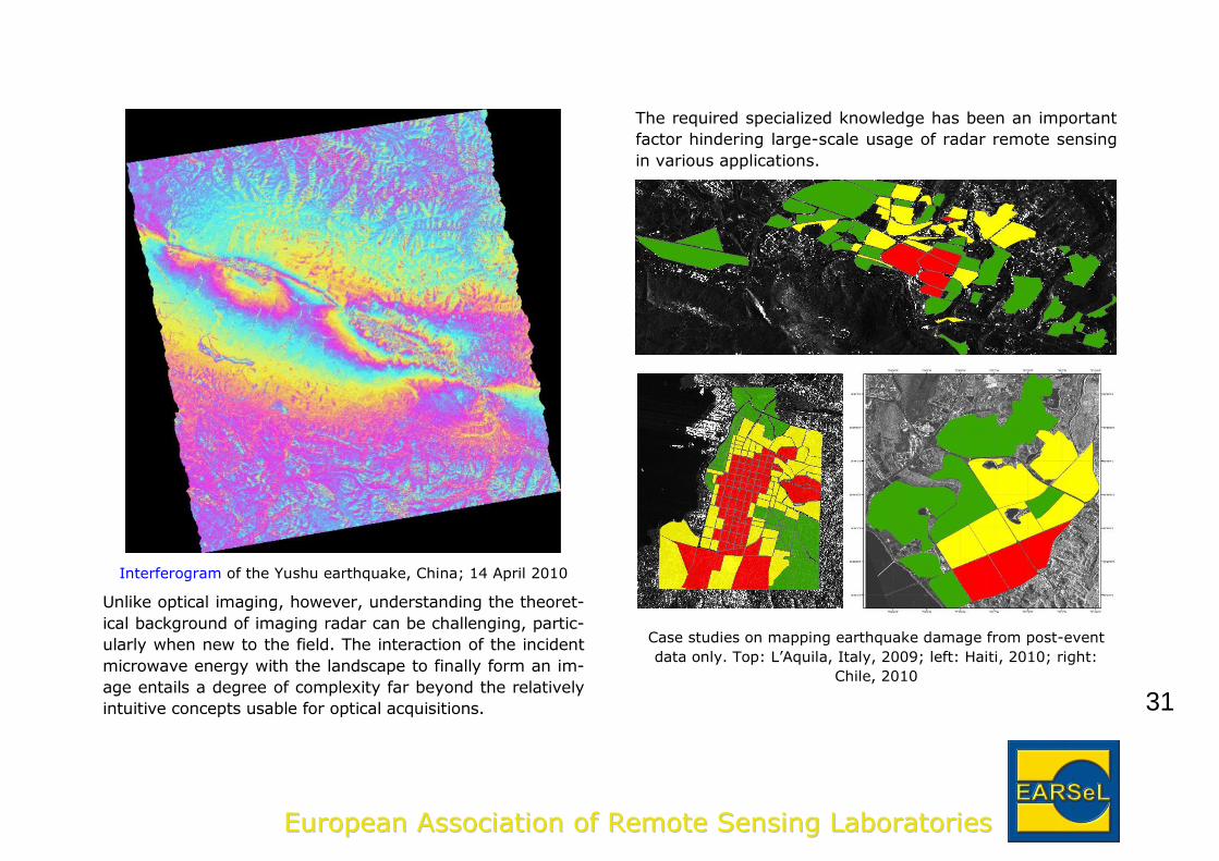
Interferogram of the Yushu earthquake, China; 14 April 2010
Unlike optical imaging, however, understanding the theoret-
ical background of imaging radar can be challenging, partic-
ularly when new to the field. The interaction of the incident
microwave energy with the landscape to finally form an im-
age entails a degree of complexity far beyond the relatively
intuitive concepts usable for optical acquisitions.
The required specialized knowledge has been an important
factor hindering large-scale usage of radar remote sensing
in various applications.
Case studies on mapping earthquake damage from post-event
data only. Top: L’Aquila, Italy, 2009; left: Haiti, 2010; right:
Chile, 2010
32
EEuurrooppeeaann AAssssoocciiaattiioonn ooff RReemmoottee SSeennssiinngg LLaabboorraattoorriieess
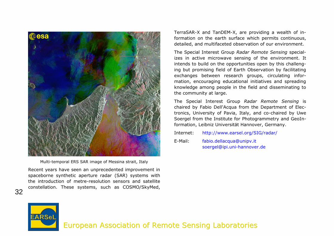
Multi-temporal ERS SAR image of Messina strait, Italy
Recent years have seen an unprecedented improvement in
spaceborne synthetic aperture radar (SAR) systems with
the introduction of metre-resolution sensors and satellite
constellation. These systems, such as COSMO/SkyMed,
TerraSAR-X and TanDEM-X, are providing a wealth of in-
formation on the earth surface which permits continuous,
detailed, and multifaceted observation of our environment.
The Special Interest Group Radar Remote Sensing special-
izes in active microwave sensing of the environment. It
intends to build on the opportunities open by this challeng-
ing but promising field of Earth Observation by facilitating
exchanges between research groups, circulating infor-
mation, encouraging educational initiatives and spreading
knowledge among people in the field and disseminating to
the community at large.
The Special Interest Group Radar Remote Sensing is
chaired by Fabio Dell'Acqua from the Department of Elec-
tronics, University of Pavia, Italy, and co-chaired by Uwe
Soergel from the Institute for Photogrammetry and GeoIn-
formation, Leibniz Universität Hannover, Germany.
Internet: http://www.earsel.org/SIG/radar/
E-Mail: [email protected]
33
EEuurrooppeeaann AAssssoocciiaattiioonn ooff RReemmoottee SSeennssiinngg LLaabboorraattoorriieess
Thermal Remote SensingThe Special Interest Group Thermal Remote Sensing (SIG-
TRS) brings together European thermal remote sensing
scientists from different disciplines. Our objectives include
Encouraging international exchange of knowledge
and data common to all thermal research groups
independent of application
Increasing awareness of the thermal remote sensing
domain
Joining forces in the TRS domain, in order to position
TRS higher on the agenda for new sensor
development in Europe
We intend to achieve these objectives by organizing
Workshops in the framework of EARSeL Symposia
Topical sessions attached to other EARSeL and/or
non-EARSeL events
Informal demonstrations or training courses
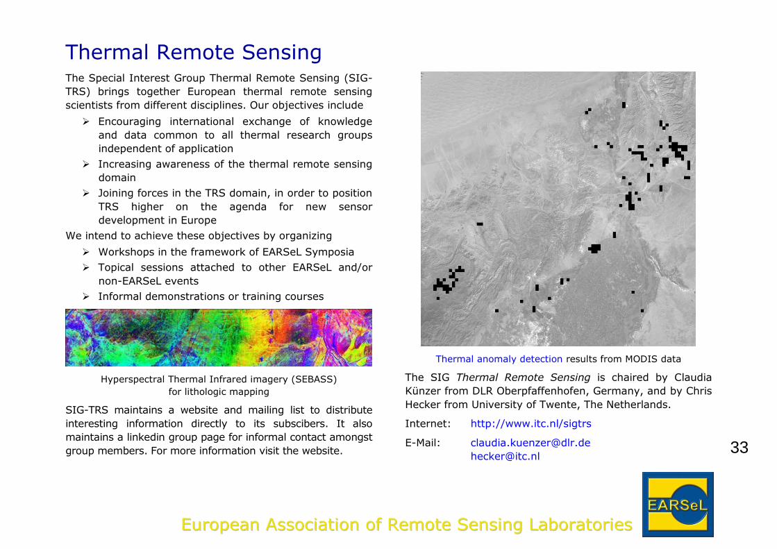
Hyperspectral Thermal Infrared imagery (SEBASS)
for lithologic mapping
SIG-TRS maintains a website and mailing list to distribute
interesting information directly to its subscibers. It also
maintains a linkedin group page for informal contact amongst
group members. For more information visit the website.
Thermal anomaly detection results from MODIS data
The SIG Thermal Remote Sensing is chaired by Claudia
Künzer from DLR Oberpfaffenhofen, Germany, and by Chris
Hecker from University of Twente, The Netherlands.
Internet: http://www.itc.nl/sigtrs
E-Mail: [email protected]
34
EEuurrooppeeaann AAssssoocciiaattiioonn ooff RReemmoottee SSeennssiinngg LLaabboorraattoorriieess
Education and TrainingRemote sensing of the earth covers many topics that are
significant for all science disciplines in school and university
curricula. Satellite imagery and data derived from satellite
sensors are available for studies of local or regional phe-
nomena. This covers larger scales, as is typical for remote
sensing using satellites, but also the region around schools,
and thus allows the appreciation of the dependence between
local and global scales. Remotely sensed data are used to
explain actual conditions on earth. But they also enable the
methods for predicting future developments to be appreciat-
ed – e.g. the climate system – with models.
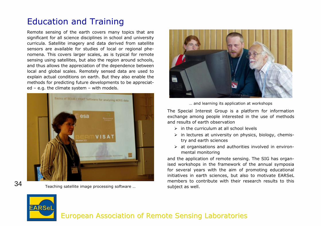
Teaching satellite image processing software …
… and learning its application at workshops
The Special Interest Group is a platform for information
exchange among people interested in the use of methods
and results of earth observation
in the curriculum at all school levels
in lectures at university on physics, biology, chemis-
try and earth sciences
at organisations and authorities involved in environ-
mental monitoring
and the application of remote sensing. The SIG has organ-
ised workshops in the framework of the annual symposia
for several years with the aim of promoting educational
initiatives in earth sciences, but also to motivate EARSeL
members to contribute with their research results to this
subject as well.
35
EEuurrooppeeaann AAssssoocciiaattiioonn ooff RReemmoottee SSeennssiinngg LLaabboorraattoorriieess
EARSeL’s SEOS project, described on page 6, and the
promotion of its tutorials (http://lms.seos-project.eu/) to
the public was the starting point of the SIG in 2007. Since
then, a number of other projects have been initiated.
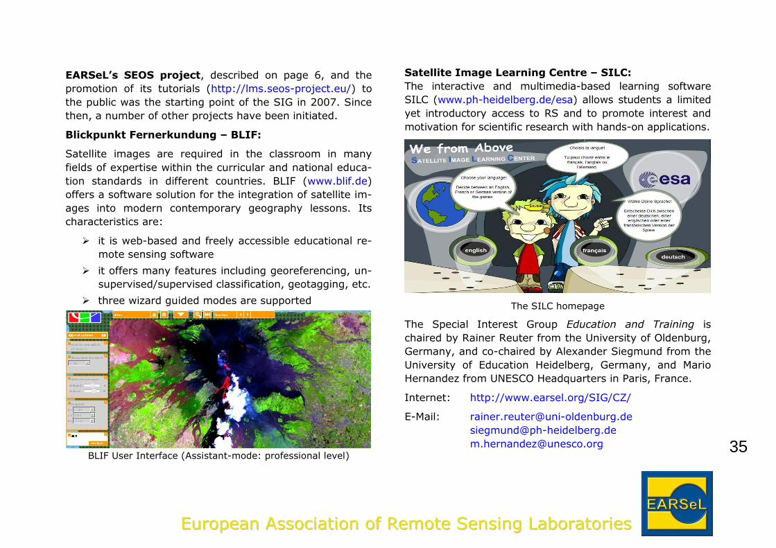
Blickpunkt Fernerkundung – BLIF:
Satellite images are required in the classroom in many
fields of expertise within the curricular and national educa-
tion standards in different countries. BLIF (www.blif.de)
offers a software solution for the integration of satellite im-
ages into modern contemporary geography lessons. Its
characteristics are:
it is web-based and freely accessible educational re-
mote sensing software
it offers many features including georeferencing, un-
supervised/supervised classification, geotagging, etc.
three wizard guided modes are supported
BLIF User Interface (Assistant-mode: professional level)
Satellite Image Learning Centre – SILC:
The interactive and multimedia-based learning software
SILC (www.ph-heidelberg.de/esa) allows students a limited
yet introductory access to RS and to promote interest and
motivation for scientific research with hands-on applications.
The SILC homepage
The Special Interest Group Education and Training is
chaired by Rainer Reuter from the University of Oldenburg,
Germany, and co-chaired by Alexander Siegmund from the
University of Education Heidelberg, Germany, and Mario
Hernandez from UNESCO Headquarters in Paris, France.
Internet: http://www.earsel.org/SIG/CZ/
E-Mail: [email protected]
36
EEuurrooppeeaann AAssssoocciiaattiioonn ooff RReemmoottee SSeennssiinngg LLaabboorraattoorriieess
Image CreditsCover page
True-colour Envisat MERIS mosaic of Europe.
Antonios Mouratidis, European Space Agency (ESA).
The Mission of EARSeL
EARSeL’s foundation meeting …
EARSeL's History; Godefroy M, G Østrem & R Vaughan (Eds.), 2008. http://www.earsel.org/Monographs/EARSeL-History.pdf.
Venues of annual EARSeL symposia … Eberhard Parlow, University of Basel, Switzerland.
Pan-cloud layers over the Pacific Ocean … NASA Johnson Space Center, The Gateway to Astronaut
Photography of the Earth, http://eol.jsc.nasa.gov/. Mission: ISS007, Roll: E Frame: 10807: Pan-cloud layers, anvils.
Projects
Image mosaic in the tutorial A World of Images, … SEOS project, http://lms.seos-project.eu/learning_modules#1.
Special Interest Groups
Von Karman vortices in the Canary Island basin European Space Agency, Envisat MERIS, 6 June 2010, http://earth.eo.esa.int/cgi-bin/satimgsql.pl?show_url=2058.
The Earth’s biosphere, …
NASA Goddard Space Flight Center, SeaWiFS Project, SeaWiFS Globe Design Tool; http://oceancolor.gsfc.nasa.gov/SeaWiFS/.
Land Use / Land Cover
Land cover change of the Aral lake over the last five decades.
Beckel, 2007; UNEP site 09.2009; UNEP site 09.2009; Beck-el, 2007; NASA Earth Observatory 08.2009; ESA 08.2009
http://lms.seos-project.eu/learning_modules/landuse/landuse-c03-p03.html.
Cultivation Methods in the Region Almeria, Spain … UNEP, 09.2009; http://lms.seos-
project.eu/learning_modules/landuse/landuse-c03-p03.html.
Land Ice and Snow
Snow covered Alps seen by Metop-AVHRR sensor …
Remote Sensing Research Group, Institute of Geography, University of Bern, Switzerland.
Coastal Zones
Beautiful colours of coastal zones …
European Space Agency (ESA) http://www.esa.int/esaEO/SEMOYZ3UFLG_index_0.html.
Oil leak from a sunken ship in iced water Sergey Babichenko, Laser Diagnostics Instruments AS, Tal-
linn, Estonia.
Sky and water leaving radiance measurements …
Rainer Reuter, University of Oldenburg, Germany.
Forestry
Identification of tree species, Czech Republic, …
Filip Hájek, Forest Management Institute, Czech Republic.
Digital Surface Model based on ALS data … Piotr Wezyk, Agricultural University in Krakow, Poland.
Forest Fires
Burned area mapping, Peloponnese, Greece
Laboratory of Forest Management and Remote Sensing, Aristotle University of Thessaloniki, Greece.
37
EEuurrooppeeaann AAssssoocciiaattiioonn ooff RReemmoottee SSeennssiinngg LLaabboorraattoorriieess
World fire density (2000-2009)
Lucrecia Pettinari, University of Alcalá, Madrid, Spain.
Geology
Remote sensing data facilitates mine monitoring.
Konstantinos G. Nikolakopoulos, Institute of Geology & Mineral Exploration, Greece.
Radar interferometry is a valuable tool for geological hazards. Konstantinos G. Nikolakopoulos, Institute of Geology &
Mineral Exploration, Greece.
Urban Remote Sensing
Urban land cover classification of Bochum, Germany
Ruhr University Bochum, Germany; Carsten Jürgens.
Landcover results for Istanbul, Turkey
Istanbul Technical University, Turkey; Derya Maktav.
Developing Countries
Examples of challenges in developing countries.
Hans-Peter Thamm, Freie Universität Berlin.
Capacity building in Remote Sensing.
Rudi Goossens, State University of Gent, Belgium
New fields (red) between 1991 and 2011 in Central Benin.
Hans-Peter Thamm, Freie Universität Berlin.
Monitoring of agricultural areas in the Quémé Catchment ... Modified from Thamm H-P, M Judex & G Menz, 2005: Mod-elling of Land-Use and Land-Cover Change (LUCC) in West-
ern Africa using Remote Sensing. In: Photogrammetrie, Fernerkundung, Geoinformation 3, 191-199
Cultural and Natural Heritage
Uxmal, Mexico archaeological site seen by GeoEye satellite.
GeoEye, 08.08.2002, all rights reserved, http://www.geoeye.com.
Uxmal, Mexico archaeological site
Mario Hernandez, United Nations Educational, Scientific and Cultural Organization (UNESCO), Paris, France.
Temporal Analysis of Image Data
Land use change at UNESCO World Heritage Site Iguaçu Nationalpark … Eberhard Parlow, University of Basel, Switzerland.
Multitemporal images of Shanghai, China, ...
Left: data from US Geological Survey; right: HJ-1B images, Yifang Ban; data from Chinese Ministry of Science and Technology (MOST)
Multitemporal SAR data of Beijing, China, ... left and centre: Yifang Ban; data from European Space
Agency (ESA); right: Yifang Ban, Royal Institute of Tech-nology, Stockholm, Sweden.
Tropical rain forest in Rondonia/Brasil … Eberhard Parlow, University of Basel, Switzerland.
Urban sprawl of megacity Cairo/Egypt …
Eberhard Parlow, University of Basel, Switzerland.
Imaging Spectroscopy
Hyperspectral data cube of Barrax (Spain) … OpAiRS - Optical Airborne Remote Sensing and Calibration
Facility, German Aerospace Center (DLR), Oberpfaffenho-fen, Germany.
38
EEuurrooppeeaann AAssssoocciiaattiioonn ooff RReemmoottee SSeennssiinngg LLaabboorraattoorriieess
Urban material mapping Wieke Heldens, Earth Observation Center (EOC), German
Aerospace Center (DLR), Oberpfaffenhofen, Germany.
3D Remote Sensing
Digital Surface Model of Sardinia, Italy, … Dipartimento di Ingegneria Civile, Edile e Ambientale, Uni-
versita' di Roma "La Sapienza", Italy, from data available
at Regione Sardegna, http://www.sardegnageoportale.it/.
Global Digital Surface Model with 4 km resolution, … Valerie Paskevich, Woods Hole Science Center, U.S.A. US Geological Survey, http://woodshole.er.usgs.gov/openfile/of2005-
1001/data/basemaps/srtm30plus/srtm30plus-world_pctshade.htm
Radar
Polarimetric ASAR image of Hawaii islands, USA.
European Space Agency (ESA).
Oil spill off the coast of Lousiana, USA, … European Space Agency (ESA).
Interferogram on 14th April 2010 Yushu earthquake, China. PALSAR data Jaxa/METI; processing: SARMAP SA.
Case studies on mapping earthquake damage … COSMO/SkyMed data, ASI; processing:
EUCENTRE/University of Pavia.
Multi-temporal ERS SAR image of Messina strait, Italy.
European Space Agency (ESA), Multimedia Repository.
Thermal Remote Sensing
Hyperspectral Thermal Infrared imagery (SEBASS)
University of Twente, ITC, The Netherlands.
Thermal anomaly detection results from MODIS data University of Twente, ITC, The Netherlands.
Education and Training
Teaching satellite image processing software … Photos taken at the EARSeL Symposium 2005, Porto, Por-tugal. Rainer Reuter, University of Oldenburg, Germany.
BLIF User Interface …
University of Education Heidelberg, Germany.
The SILC homepage
University of Education Heidelberg, Germany.
Imprint
Earthrise
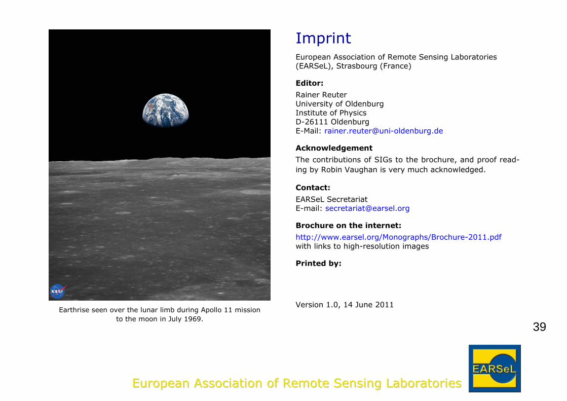
NASA Johnson Space Center, The Gateway to Astronaut Photography of the Earth, http://eol.jsc.nasa.gov/, Mission AS11, Roll 84, Frame 6552
39
EEuurrooppeeaann AAssssoocciiaattiioonn ooff RReemmoottee SSeennssiinngg LLaabboorraattoorriieess
Earthrise seen over the lunar limb during Apollo 11 mission
to the moon in July 1969.
Imprint European Association of Remote Sensing Laboratories (EARSeL), Strasbourg (France)
Editor:
Rainer Reuter
University of Oldenburg Institute of Physics D-26111 Oldenburg
E-Mail: [email protected]
Acknowledgement
The contributions of SIGs to the brochure, and proof read-
ing by Robin Vaughan is very much acknowledged.
Contact:
EARSeL Secretariat E-mail: [email protected]
Brochure on the internet:
http://www.earsel.org/Monographs/Brochure-2011.pdf
with links to high-resolution images
Printed by:
Version 1.0, 14 June 2011
40
EEuurrooppeeaann AAssssoocciiaattiioonn ooff RReemmoottee SSeennssiinngg LLaabboorraattoorriieess
41
EEuurrooppeeaann AAssssoocciiaattiioonn ooff RReemmoottee SSeennssiinngg LLaabboorraattoorriieess
42
EEuurrooppeeaann AAssssoocciiaattiioonn ooff RReemmoottee SSeennssiinngg LLaabboorraattoorriieess


![[REMOTE SENSING] 3-PM Remote Sensing](https://img.pdfslide.us/doc/110x75/61f2bbb282fa78206228d9e2/remote-sensing-3-pm-remote-sensing.jpg)

