Embed Size (px)
Citation preview
Page 1
EuroGlobalMap
User Guide Refers to EGM 10.0, released in September 2017
Page 2
Contents
INTRODUCTION .......................................................................................................................................................... 3
CONTACT DETAILS ................................................................................................................................................................ 3 PRODUCT PERFORMANCE ...................................................................................................................................................... 3 LIABILITY ............................................................................................................................................................................ 3 DATA COPYRIGHT ................................................................................................................................................................. 4 USER GUIDE COPYRIGHT........................................................................................................................................................ 4 TRADE MARKS ..................................................................................................................................................................... 4
OVERVIEW OF EGM DATA .......................................................................................................................................... 5
GENERAL PRODUCT DESCRIPTION ............................................................................................................................................ 5 DATA DIRECTORY STRUCTURE FILENAMES .................................................................................................................................. 6 METADATA DIRECTORY STRUCTURE AND METADATA FILES ............................................................................................................ 6
USING EGM ................................................................................................................................................................ 7
WHAT YOU NEED TO USE EGM .............................................................................................................................................. 7 POPULATING THE MISSING ATTRIBUTE VALUES ........................................................................................................................... 7 SAVING NAMES OF THE FEATURES WITH DIFFERENT LANGUAGES .................................................................................................... 7 INTERNATIONAL COUNTRY CODES, ICC ..................................................................................................................................... 9
ANNEXES ...................................................................................................................................................................10
ANNEX A: PRODUCT PERFORMANCE ...................................................................................................................................... 11 ANNEX B: COPYRIGHT STATEMENTS ...................................................................................................................................... 12 ANNEX C: COUNTRIES/AREAS INCLUDED TO EUROGEOGRAPHICS PRODUCTS ................................................................................. 13
Page 3
Introduction This User Guide has been designed to provide the information needed to use the EuroGlobalMap (EGM) dataset.
The Guide is arranged into the following sections:
“Introduction”: contact details, copyrights, other general information.
"Overview of EGM data" provides an introduction to the EGM product.
"Using EGM" contains some instructions on how to use the dataset.
Additional documents for detailed information are:
EGM specifications: EGM_Specifications_v10.pdf
Changes from v9.0 to v10.0: EGM_Changes_v10.pdf
If you find an error, omission, or have a suggestion about how this Guide can be improved, please contact EuroGe-
ographics at the address shown below, under contact details.
Contact details
If you have problems using EGM or any questions related to the dataset or its use please contact EuroGeographics or
the distributor from which you purchased the data.
EuroGeographics’ address is:
EuroGeographics
76 rue du Nord
1000 Brussels
BELGIUM
Telephone: +32 (0) 2 888 71 93
Facsimile: +32 (0) 2 888 71 94
E-mail: [email protected]
Web: http://www.EuroGeographics.org
Product performance
If you have any problems or identify any errors in the data, please complete the product performance report provided
in Annex A.
Liability
A full description of the terms and conditions of supply and use of EGM is included in the End User Licence signed by
your organisation.
EuroGeographics and the national mapping agencies contributing to EGM have made every effort to ensure that the
data supplied is free from errors and omissions.
It is the Customer’s responsibility to ensure that the data ordered is suitable for the intended purpose. Neither Euro-
Geographics nor the national mapping agencies will be liable to the customer or any other party for any loss, damage,
inconvenience or expense resulting from the use of, or reliance upon, the data.
Page 4
Data copyright
EGM data is copyright of EuroGeographics and the contributing national mapping agencies. As standard, EGM data
may be used for internal business use only. It may not be used for Internet applications unless this has been explicitly
agreed within a scheduled addition to the licence. Your licence agreement specifies the number of concurrent users,
which may use the data. Additionally, any printed output, which is based on EGM data, must bear an appropriate
copyright acknowledgement.
Copyright statements are named in Annex B.
User Guide copyright
This User Guide is copyright of EuroGeographics. No part of this document may be reproduced or transmitted in any
form or by any means, electronic or mechanical, for any purpose, without the express written permission of EuroGe-
ographics.
Trade marks
Trade marks in this Guide are the property of their respective owners. ARC/INFO and ArcGIS are registered trademarks
of Environmental Systems Research Institute (ESRI), Inc.
Excel and Word are trademarks of Microsoft.
Page 5
Overview of EGM data
General product description
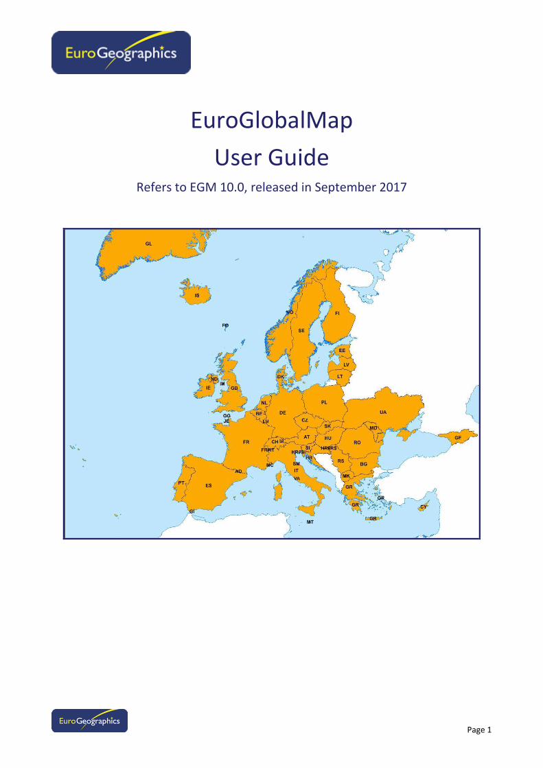
EGM v9.0 is a pan-European dataset containing basic geographic information at the scale 1:1 M covering 45 European
countries and/or administrative areas (see attached table, Annex C). The data is seamless1 and harmonised, and is
produced by the EGM Project Coordinator (IGN France) in cooperation by the National Mapping Agencies of Europe.
EuroGlobalMap contains five themes:
Administrative boundaries
Hydrography
Transportation
Settlements
Named locations
Coordinates: Geographical in degrees (longitude, latitude) with decimal fraction and based on the ETRS89 spatial
reference system, which corresponds to WGS84 reference system. Data in diverse coordinates might be available from
online web service, VARs and distributors.
Coordinate accuracy: ArcGIS Personal Geodatabase (v9.3) and Shapefiles: 9 significant digits e.g. 61.0000001 dd.
Positional accuracy: 1000 metres (or at least 2000 metres).
Feature selection: Minimum size of areas or lines is feature dependent. Smallest area units are about 0.5 km². See
detailed instructions in EGM v9.0 specifications.
Feature coding structure: DIGEST FACC Edition 2.1, Sep. 2001.
Character sets used: ISO8859 –series (see the details in EGM specifications and technical guide). UNICODE system is
used in Geodatabase.
Metadata: According ISO19115 standard and INSPIRE implementation rules.
Coverage: Andorra2, Austria, Belgium, Bulgaria, Croatia, Czech Republic, Cyprus, Denmark, Estonia, Finland, Faroe
Islands2, France, Georgia, Germany, Gibraltar
2, Greece, Great Britain, Greenland
2, Hungary, Iceland, Ireland, Italy, Ko-
sovo2, Latvia, Liechtenstein
2, Lithuania, Luxembourg
2, Republic of Macedonia, Malta, Monaco
2, Moldova, Northern
Ireland, Norway, Poland, Portugal, Romania, San Marino2, Serbia, Slovakia, Slovenia, Spain, Sweden, Switzerland, the
Netherlands, Ukraine, and Vatican2. The product will be gradually extended targeting to cover the whole of Europe.
Product types for supply: EGM will be available online via the EuroGeographics website.
Update: The product is updated annually.
Product formats: ArcGIS Personal Geodatabase (ArcGIS v9.3), Arc Shape-files. Diverse formats might be available from
online web service, VARs and distributors.
Distribution media: EuroGeographics website.
EuroGlobalMap is designed for business use and can be exploited for analysis covering large areas (environment, hy-
drography, population, transportation, geographical names…). It is mainly focused to serve as geographic backdrop for
presentation and visualisation.
See more information on the EGM project’s website: http://www.eurogeographics.org/products-and-
services/euroglobalmap.
1 The term "seamless" means that there are no gaps between graphical objects initially derived from different sources.
2 The datasets covering these territories are included to the data directories of the surrounding country (e.g. Andorra included in dataset
of Spain).

Page 6
Data directory structure filenames
In the EGM v5.1 all features in all themes are coded with an ICC code (International Country Code). With this code it is
easier to select the wanted features based on their location. Features inside e.g. Germany have ICC value “DE” and
features locating in Germany-France border have ICC value “DE#FR”
ICC coding is based on “directory areas” (see below) which mainly mean responsibility areas (of data collecting and
maintenance). Directory lines following mostly latitude/longitude axes. These lines are not of any administrative
meaning.
Each directory area contains one country area. There are, however, the following exceptions:
Monaco is included in the directory area “FR” (France).
San Marino and Vatican are included in directory area “IT” (Italy).
Gibraltar is included in directory area “ES” (Spain).
Northern Ireland is coded “ND”.
Channel Isles (Jersey, Guernsey, Alderney, Sark) are included to “GB”.
Some outer sea islands are not included: Svalbard/Spitsbergen, Jan Mayen island. Obs: Svalbard is included in
feature class “LandmaskA”.
Kosovo is included in the directory area “RS” (Serbia).
Geodatabase files:
Full Europe: EGM_10.gdb
Metadata directory structure and metadata files
There are three kinds of metadata files available:
EGM_Metadata_v10.xls: metadata according to the ISO 19115 standard.
EGM_Data_completeness_v10.xls: completeness and existence of the features and attributes.
EGM_Lineage_v10.pdf: additional information.
EGM_Updates_v10.xls: detail of the themes updated for each country
Page 7
Using EGM
What you need to use EGM
Hardware
EGM can be used with any computer platform from a PC to a mainframe.
There are no any specific hardware requirements for managing EGM data.
Software
EGM is a dataset and is delivered without a user interface for displaying or an-alysing it. Whatever you want to do
with the data, you need to have appropriate software.
EGM can be used directly with the ArcGIS software and may also be imported into other GIS software packages.
Populating the missing attribute values
There are no empty attribute fields in the EGM database. All features have valid values for all attributes.
If the attribute is logically impossible for the feature a special “No/null value” code is used. If the feature does not
have a certain attribute value (e.g. a name with the secondary language) then value “not applicable” is used. If the
NMCA does not have certain attribute information, values like “unknown” or “unpopulated” are used. See more de-
tails in EGM specifications.
Saving names of the features with different languages
At most two national languages are used to save the names of each feature (name of the country with maximum
three languages). These items, NAMN1 and NAMN2, can use different code pages (character sets). Some countries
have, however, used different primary and secondary languages in different areas of the country. The languages used
in EGM in each country are saved with ICC codes to table “EGM_CHR”:
Country/Area Language Code Character set
AD Catalan CAT 1
AD Spanish SPA 1
AT Germany GER 1
BE Dutch DUT 1
BE French FRE 1
BE German GER 1
BG Bulgarian BUL 5
CH French FRE 1
CH German GER 1
CH Italian ITA 1
CH Raeto-Romance ROH 1
CY Greek GRE 7
CZ Czech CZ 2
DE German GER 1
DE Sorbian languages WEN ?
DK Danish DAN 1
EE Estonian EST 4
ES Basque BAQ 1
Page 8
Country/Area Language Code Character set
ES Catalan CAT 1
ES Gallegan GLG 1
ES Spanish SPA 1
FI Finnish FIN 1
FI Northern Sami SME 4
FI Swedish SWE 1
FO Danish DAN 1
FR French FRE 1
GB English ENG 1
GB Gaelic GLA 1
GB Welsh WEL 0
GE Georgian GEO 99
GI Spanish SPA 1
GL Danish DAN 1
GL Greenlandic KAL 10
GR Greek GRE 7
HR Croatian SCR 2
HU Hungarian HUN 2
IE English ENG 1
IE Gaeilge GLE 1
IS Icelandic ICE 15
IT Italian ITA 1
LI German GER 1
LT Lithuanian LIT 4
LU French FRE 1
LV Latvian LAV 4
MC French FRE 1
MD Moldavian MOL 2
MK Macedonian MKD ?
MT Maltese MLT 3
RS Serbian SRP 5
UA Ukrainian UKR 5
If the name of the feature has a “real” value it has been transliterated to ASCII characters (note: not transcripted) and
saved to items NAMA1 and NAMA2.
The purpose of the transliteration is to give all the users at least some uniform vision about the names of the features
wherever in Europe they operate (also in those cases when not all the fonts and character sets are installed to the
user’s PC). Transliteration rules are included to the national metadata files (lineage).
Please note that if the name of the feature contains diacritical alphabets (like ä, ö, å, ü, é, ě, ę…) the transliterated
name is always more or less a distortion of the original geographical name. Be very careful when using the translit-
erated names, they do not represent the original ones and can look sometimes very strange: e.g. with city “Athens”
(Greek: ΑΘΗΝΑ) the transliterated name is “AUHNA” and the transcripted name (like it is pronounced in Greece) is
“ATHINA”.
Page 9
International country codes, ICC
International country codes used in EGM (and based on a location of the feature: inside a country or between two
countries) mainly follow the ISO 3166 standard for coding. Exceptions are named in table below:
Country/Area ICC used
Northern Ireland ND
Isle of Man IM

Page 10
Annexes

Page 11
Annex A: Product performance
Please complete and send to the Production Manager of EGM:
Clément Godin
Institut national de l’information géographique et forestière (IGN)
73, avenue de Paris
94165 Saint-Mandé Cedex
FRANCE
Telephone: +33 (0)1 43 98 81 81
E-mail: [email protected]
Web: http://www.ign.fr
Description of problem encountered / suggestion:
________________________________________________________________________________________________
________________________________________________________________________________________________
________________________________________________________________________________________________
________________________________________________________________________________________________
________________________________________________________________________________________________
________________________________________________________________________________________________
________________________________________________________________________________________________
________________________________________________________________________________________________
________________________________________________________________________________________________
Version of data (from DVD): _________________________________________________________________________
Your name: ______________________________________________________________________________________
Company: ________________________________________________________________________________________
Address: ________________________________________________________________________________________
________________________________________________________________________________________
________________________________________________________________________________________
Telephone: _______________________________________________________________________________________
Facsimile: ________________________________________________________________________________________
E-mail: __________________________________________________________________________________________
Page 12
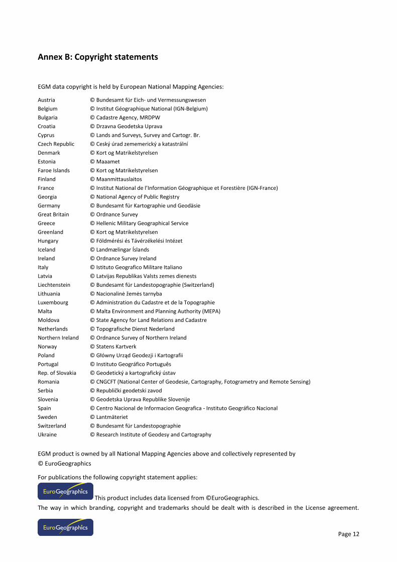
Annex B: Copyright statements
EGM data copyright is held by European National Mapping Agencies:
Austria © Bundesamt für Eich- und Vermessungswesen
Belgium © Institut Géographique National (IGN-Belgium)
Bulgaria © Cadastre Agency, MRDPW
Croatia © Drzavna Geodetska Uprava
Cyprus © Lands and Surveys, Survey and Cartogr. Br.
Czech Republic © Ceský úrad zememerický a katastrální
Denmark © Kort og Matrikelstyrelsen
Estonia © Maaamet
Faroe Islands © Kort og Matrikelstyrelsen
Finland © Maanmittauslaitos
France © Institut National de l’Information Géographique et Forestière (IGN-France)
Georgia © National Agency of Public Registry
Germany © Bundesamt für Kartographie und Geodäsie
Great Britain © Ordnance Survey
Greece © Hellenic Military Geographical Service
Greenland © Kort og Matrikelstyrelsen
Hungary © Földmérési és Távérzékelési Intézet
Iceland © Landmælingar Íslands
Ireland © Ordnance Survey Ireland
Italy © Istituto Geografico Militare Italiano
Latvia © Latvijas Republikas Valsts zemes dienests
Liechtenstein © Bundesamt für Landestopographie (Switzerland)
Lithuania © Nacionalinė žemės tarnyba
Luxembourg © Administration du Cadastre et de la Topographie
Malta © Malta Environment and Planning Authority (MEPA)
Moldova © State Agency for Land Relations and Cadastre
Netherlands © Topografische Dienst Nederland
Northern Ireland © Ordnance Survey of Northern Ireland
Norway © Statens Kartverk
Poland © Główny Urząd Geodezji i Kartografii
Portugal © Instituto Geográfico Português
Rep. of Slovakia © Geodetický a kartografický ústav
Romania © CNGCFT (National Center of Geodesie, Cartography, Fotogrametry and Remote Sensing)
Serbia © Republički geodetski zavod
Slovenia © Geodetska Uprava Republike Slovenije
Spain © Centro Nacional de Informacion Geografica - Instituto Geográfico Nacional
Sweden © Lantmäteriet
Switzerland © Bundesamt für Landestopographie
Ukraine © Research Institute of Geodesy and Cartography
EGM product is owned by all National Mapping Agencies above and collectively represented by
© EuroGeographics
For publications the following copyright statement applies:
This product includes data licensed from ©EuroGeographics.
The way in which branding, copyright and trademarks should be dealt with is described in the License agreement.
Page 13
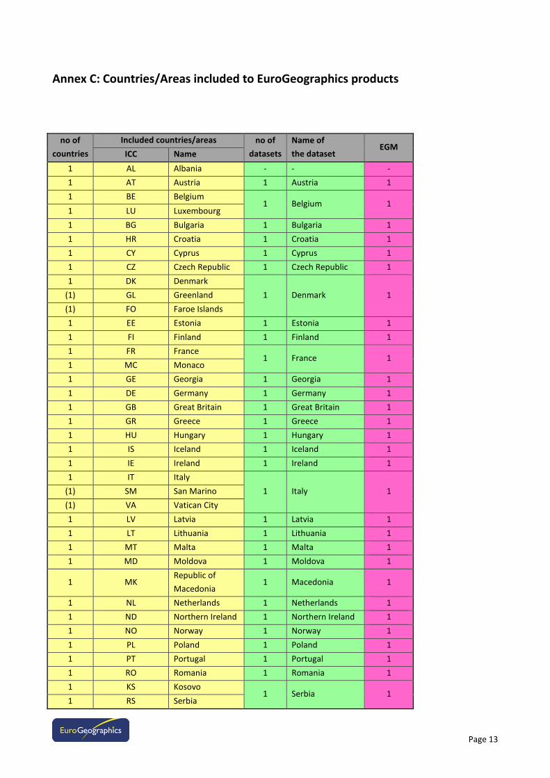
Annex C: Countries/Areas included to EuroGeographics products
no of
countries
Included countries/areas no of
datasets
Name of
the dataset EGM
ICC Name
1 AL Albania - - -
1 AT Austria 1 Austria 1
1 BE Belgium 1 Belgium 1
1 LU Luxembourg
1 BG Bulgaria 1 Bulgaria 1
1 HR Croatia 1 Croatia 1
1 CY Cyprus 1 Cyprus 1
1 CZ Czech Republic 1 Czech Republic 1
1 DK Denmark
1 Denmark 1 (1) GL Greenland
(1) FO Faroe Islands
1 EE Estonia 1 Estonia 1
1 FI Finland 1 Finland 1
1 FR France 1 France 1
1 MC Monaco
1 GE Georgia 1 Georgia 1
1 DE Germany 1 Germany 1
1 GB Great Britain 1 Great Britain 1
1 GR Greece 1 Greece 1
1 HU Hungary 1 Hungary 1
1 IS Iceland 1 Iceland 1
1 IE Ireland 1 Ireland 1
1 IT Italy
1 Italy 1 (1) SM San Marino
(1) VA Vatican City
1 LV Latvia 1 Latvia 1
1 LT Lithuania 1 Lithuania 1
1 MT Malta 1 Malta 1
1 MD Moldova 1 Moldova 1
1 MK Republic of
Macedonia 1 Macedonia 1
1 NL Netherlands 1 Netherlands 1
1 ND Northern Ireland 1 Northern Ireland 1
1 NO Norway 1 Norway 1
1 PL Poland 1 Poland 1
1 PT Portugal 1 Portugal 1
1 RO Romania 1 Romania 1
1 KS Kosovo 1 Serbia 1
1 RS Serbia
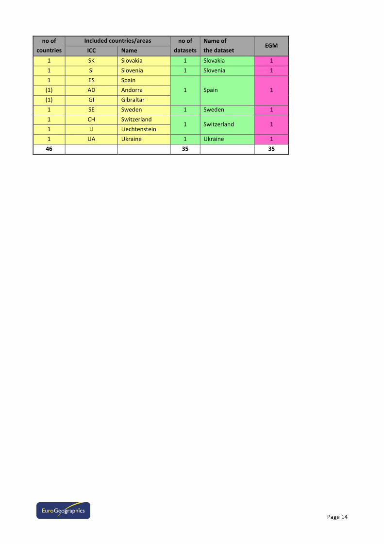
Page 14
no of
countries
Included countries/areas no of
datasets
Name of
the dataset EGM
ICC Name
1 SK Slovakia 1 Slovakia 1
1 SI Slovenia 1 Slovenia 1
1 ES Spain
1 Spain 1 (1) AD Andorra
(1) GI Gibraltar
1 SE Sweden 1 Sweden 1
1 CH Switzerland 1 Switzerland 1
1 LI Liechtenstein
1 UA Ukraine 1 Ukraine 1
46 35 35


![FRE NOTHAFT_05-06-09[1]](https://img.pdfslide.us/doc/110x75/577dac451a28ab223f8d9173/fre-nothaft05-06-091.jpg)