Embed Size (px)
Citation preview
PREPARED BY
Moore Iacofano Goltsman, Inc.
WITH
Fehr & Peers
A.D. Hinshaw Associates
Hon Consulting, Inc.
Mariana Lopez
PREPARED FOR
City of San Diego
Funded by the Caltrans Transportation Planning
Grant Program
Euclid Avenue Gateway Master Plan Presenting a Vision for Corridor Land Use, Mobility, and Urban Design
SUMMARY REPORT
C I T Y O F S A N D I E G O
F e b r u a r y 2 8 , 2 0 1 4

table of contentsEUCLID AVENUE GATEWAY MASTER PLAN – SUMMARY REPORT
i . executive summary 1
i i . acknowledgements 3
i i i . location and purpose of plan 5
iv. exist ing conditions 7
v. context and goals 11
vi. land use and mobil ity recommendations 13
vi i . implementation 19

E U C L I D A V E N U E G A T E W A Y M A S T E R P L A N — S U M M A R Y R E P O R T | 1
i. executive summary
This corridor master plan addresses the segment of Euclid Avenue that extends from State Route (SR)-94 south to Guymon Street in the Encanto Neighborhood Community Planning Area. The mix of land uses and densities in this master plan has been proposed to create welcoming roadway that enhances connectivity to residential areas, schools, parks, recreation, shopping and other commercial activities. This master plan has been developed in coordination and concurrently with the Encanto Neighborhoods Community Plan Update (CPU). The master plan also works with proposed modifications of the SR-94 interchange at Euclid Avenue.
Existing land uses include vacant parcels, single-family residential, institutional (school), and commercial parcels. The emerging mixed-use Village at Market Creek near the Euclid and Market Trolley station is a substantial nearby asset. Open space and recreation assets include Chollas Creek and Gompers Neighborhood Park. Vacant lots offer development opportunities. One of the major mobility issues along the Euclid Avenue corridor is safety for pedestrians and bicyclists. Safe pedestrian crossings are difficult due to the wide right-of-way width, high traffic speeds, and volumes. Significant existing noise impacts related to traffic were identified
along Euclid Avenue between Guymon Street and SR-94. Three hazardous waste sites were identified in the Project Area. At the 1st site, the hazardous waste case is closed, and at a 2nd site, the hazardous waste case is open. At the 3rd site, there is a closed hazardous waste case, and an open hazardous waste case. No air quality issues from stationary or mobile sources were identified.
A variety of City plans and programs apply to the corridor, including the San Diego General Plan, Southeastern San Diego Community Plan, Chollas Creek Enhancement Program, and Chollas Creek South Branch Implementation Program. The existing 1987 Community Plan, which provides a framework to guide development in the Southeastern community, is currently being updated. Stakeholder input from the Encanto Community Plan Update process highlighted the desire for increased transit service, bicycle facilities, safe pedestrian facilities, traffic calming. The Euclid Avenue Gateway Plan’s incorporating the land use and zoning proposed with the concurrent Encanto Neighborhood Community Plan update.
The Euclid Avenue Gateway land use mix will:
• Promote employment generating uses and community serving retail
2 | E U C L I D A V E N U E G A T E W A Y M A S T E R P L A N — S U M M A R Y R E P O R T
I . e x e c u t i v e s u m m a r y
• Support nearby regional transit and transit-oriented development
• Complement nearby institutional facilities, especially schools and library
• Help identify Euclid Avenue as a gateway to the Encanto Neighborhoods
• Improves open space and trail connectivity
The recommended land use designations allow mixed uses that provide more community serving retail and additional housing within the existing residential context.
The Euclid Avenue Gateway mobility improvements will:
• Enhance the safety and efficiency of pedestrians, bicyclists, transit, and vehicles
• Encourage walking and bicycling with safe and enjoyable facilities
• Provide safer access to transit
This plan recommends adding Class II bike lanes on Euclid Avenue and improving pedestrian safety. There are both interim and long-term recommendations. Detailed recommendations include removing on-street parking along the west side to allow for creation of a class II bike lane, incorporating a landscaped median with a significant community designed gateway feature near the SR-94 interchange, and providing additional pedestrian and roadway lighting. This plan also includes urban design concepts with the proposed land uses and development intensities for two focus areas: the major development parcel
northwest of Euclid and Hilltop, and the plan area between Hilltop Drive and Guymon Street.
Community improvements may be funded by private and public/private development and through the City’s Capital Improvement Program. Other funding can include state and federal sources (Community Development Block Grants, Low Income Housing Tax Credits, Proposition 1C Funds, Caltrans Active Transportation Program), local (Infrastructure Financing Districts, City of San Diego General Fund, developer incentives), and property owner funds (Development Impact Fees, Developer Exactions, Business Improvement Districts).
E U C L I D A V E N U E G A T E W A Y M A S T E R P L A N — S U M M A R Y R E P O R T | 3
ii. acknowledgements
The Euclid Avenue Gateway Master Plan has been funded by a Caltrans Transportation Planning Grant for Environmental Justice. This Plan has benefited from participation by the residents and Encanto Neighborhoods Community Planning Group members who participated in meetings and workshops, providing valuable feedback and input to help shape the study area’s future. The City’s Planning, Neighborhoods & Economic Development staff for this project include:
William Fulton, Director
Nancy Bragado, Deputy Director
Lara Gates, Supervising Planner
Karen Bucey, Community Planner
Jeff Harkness, Parks Planner
Maureen Gardiner, Mobility Planner
Samir Hajjiri, Senior Traffic Engineer
Keryna Johnson, Intern
Admin Espinoza, Intern
Nadia Jeronimo, Intern
Tara Lieberman, Intern
Consultants for this project are:• MIG, Inc.
• Fehr & Peers
• A.D. Hinshaw Associates, Inc.
• Hon Consulting, Inc.
• Mariana Lopez

E U C L I D A V E N U E G A T E W A Y M A S T E R P L A N — S U M M A R Y R E P O R T | 5
!(!(
!(
Euclid Avenue Project Area
Encanto Neighborhoods Community Plan Area (CPA)
San Diego County
!( Trolley Stops
Orange Line Trolley
N
Data Source: City of San Diego
0 0.5Miles
Map created March 1, 2013
FEDERAL
HOME
54TH
IMPERIAL
SKYLINE
WO
OD
MA
N
EUC
LID
VA
LEN
CIA
47TH
43RD
60TH
LOGAN
DIVISION PLAZA
MARKET
LEM
ON
GR
OV
E
805
SR-94
NATIONAL CITY
N
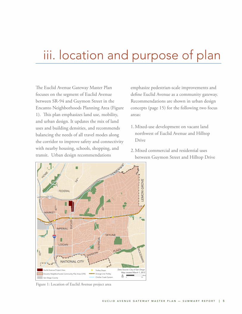
iii. location and purpose of plan
The Euclid Avenue Gateway Master Plan focuses on the segment of Euclid Avenue between SR-94 and Guymon Street in the Encanto Neighborhoods Planning Area (Figure 1). This plan emphasizes land use, mobility, and urban design. It updates the mix of land uses and building densities, and recommends balancing the needs of all travel modes along the corridor to improve safety and connectivity with nearby housing, schools, shopping, and transit. Urban design recommendations
emphasize pedestrian-scale improvements and define Euclid Avenue as a community gateway. Recommendations are shown in urban design concepts (page 15) for the following two focus areas:
1. Mixed-use development on vacant land northwest of Euclid Avenue and Hilltop Drive
2. Mixed commercial and residential uses between Guymon Street and Hilltop Drive
Figure 1: Location of Euclid Avenue project area
Chollas Creek System

E U C L I D A V E N U E G A T E W A Y M A S T E R P L A N — S U M M A R Y R E P O R T | 7
iv. existing conditions
LAND USES
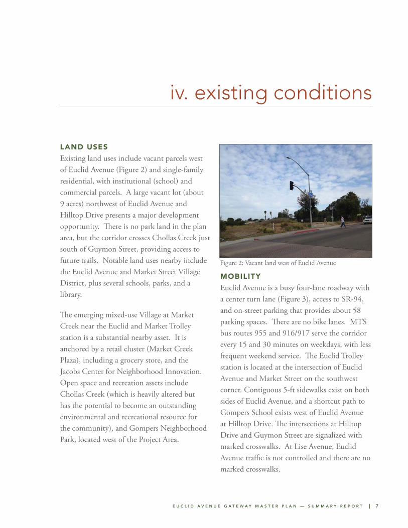
Existing land uses include vacant parcels west of Euclid Avenue (Figure 2) and single-family residential, with institutional (school) and commercial parcels. A large vacant lot (about 9 acres) northwest of Euclid Avenue and Hilltop Drive presents a major development opportunity. There is no park land in the plan area, but the corridor crosses Chollas Creek just south of Guymon Street, providing access to future trails. Notable land uses nearby include the Euclid Avenue and Market Street Village District, plus several schools, parks, and a library.
The emerging mixed-use Village at Market Creek near the Euclid and Market Trolley station is a substantial nearby asset. It is anchored by a retail cluster (Market Creek Plaza), including a grocery store, and the Jacobs Center for Neighborhood Innovation. Open space and recreation assets include Chollas Creek (which is heavily altered but has the potential to become an outstanding environmental and recreational resource for the community), and Gompers Neighborhood Park, located west of the Project Area.
MOBILITY
Euclid Avenue is a busy four-lane roadway with a center turn lane (Figure 3), access to SR-94, and on-street parking that provides about 58 parking spaces. There are no bike lanes. MTS bus routes 955 and 916/917 serve the corridor every 15 and 30 minutes on weekdays, with less frequent weekend service. The Euclid Trolley station is located at the intersection of Euclid Avenue and Market Street on the southwest corner. Contiguous 5-ft sidewalks exist on both sides of Euclid Avenue, and a shortcut path to Gompers School exists west of Euclid Avenue at Hilltop Drive. The intersections at Hilltop Drive and Guymon Street are signalized with marked crosswalks. At Lise Avenue, Euclid Avenue traffic is not controlled and there are no marked crosswalks.
Figure 2: Vacant land west of Euclid Avenue
8 | E U C L I D A V E N U E G A T E W A Y M A S T E R P L A N — S U M M A R Y R E P O R T
I . e x i s t i n g c o n d i t i o n s
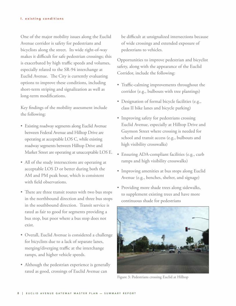
One of the major mobility issues along the Euclid Avenue corridor is safety for pedestrians and bicyclists along the street. Its wide right-of-way makes it difficult for safe pedestrian crossings; this is exacerbated by high traffic speeds and volumes, especially related to the SR-94 interchange at Euclid Avenue. The City is currently evaluating options to improve these conditions, including short-term striping and signalization as well as long-term modifications.
Key findings of the mobility assessment include the following:
• Existing roadway segments along Euclid Avenue between Federal Avenue and Hilltop Drive are operating at acceptable LOS C, while existing roadway segments between Hilltop Drive and Market Street are operating at unacceptable LOS E.
• All of the study intersections are operating at acceptable LOS D or better during both the AM and PM peak hour, which is consistent with field observations.
• There are three transit routes with two bus stops in the northbound direction and three bus stops in the southbound direction. Transit service is rated as fair to good for segments providing a bus stop, but poor where a bus stop does not exist.
• Overall, Euclid Avenue is considered a challenge for bicyclists due to a lack of separate lanes, merging/diverging traffic at the interchange ramps, and higher vehicle speeds.
• Although the pedestrian experience is generally rated as good, crossings of Euclid Avenue can
be difficult at unsignalized intersections because of wide crossings and extended exposure of pedestrians to vehicles.
Opportunities to improve pedestrian and bicyclist safety, along with the appearance of the Euclid Corridor, include the following:
• Traffic-calming improvements throughout the corridor (e.g., bulbouts with tree plantings)
• Designation of formal bicycle facilities (e.g., class II bike lanes and bicycle parking)
• Improving safety for pedestrians crossing Euclid Avenue, especially at Hilltop Drive and Guymon Street where crossing is needed for school and transit access (e.g., bulbouts and high visibility crosswalks)
• Ensuring ADA-compliant facilities (e.g., curb ramps and high visibility crosswalks)
• Improving amenities at bus stops along Euclid Avenue (e.g., benches, shelter, and signage)
• Providing more shade trees along sidewalks, to supplement existing trees and have more continuous shade for pedestrians
Figure 3: Pedestrians crossing Euclid at Hilltop
E U C L I D A V E N U E G A T E W A Y M A S T E R P L A N — S U M M A R Y R E P O R T | 9
I . e x i s t i n g c o n d i t i o n s
ENVIRONMENTAL CONDITIONS
No air quality or noise impacts from stationary sources were identified, although the service station on the east side of Euclid Avenue just south of SR-94 can potentially exceed air quality or noise standards through direct exceedances of SDAPCD air quality standards as well as violation of the City’s General Plan and Ordinance noise standards. Significant existing noise impacts related to traffic were identified along Euclid Avenue between Guymon Street and SR-94. No significant existing intersection air quality impacts or significant ambient air quality degradation due to traffic were indicated for the area. Three hazardous waste sites were identified in the Project Area. At the 1st site, the hazardous waste case is closed, and at a 2nd site, the hazardous waste case is open. At the 3rd site, there is a closed hazardous waste case, and an open hazardous waste case. Properties with open cases represent a moderate to high risk of encountering hazardous materials during potential future redevelopment. Closed release cases represent a moderate to low risk of encountering impact during potential future redevelopment. If redevelopment of a closed release case property is proposed, additional research into the unauthorized release case should be performed.
PLANNING POLICIES
A variety of City plans and programs apply to the corridor, including the San Diego General Plan, Southeastern San Diego Community Plan, Chollas Creek Enhancement Program, and Chollas Creek South Branch Implementation Program. The 2008 San Diego General Plan provides goals and objectives for the entire City,
and is built around the “City of Villages” strategy, which “focuses growth into mixed-use activity centers that are pedestrian-friendly districts linked to an improved regional transit system.” The Southeastern San Diego Community Plan, which provides a framework to guide development in the Southeastern community, was originally adopted by City Council in 1969, updated in 1987, and is currently being updated again. Through this update process there will be a Community Plan for Encanto and also for Southeast San Diego.
The Chollas Creek Enhancement Program was adopted in 2002 and provides detailed policies, funding strategies, and a phasing plan to guide the plan’s implementation. The Enhancement Program envisions a linear park along multiple creek branches, bicycle and pedestrian linkages, return to a natural state where feasible, and development that is integrated with the creek; and accessible open space to create attractive sustainable spaces. Recommendations for Segment 1 of Chollas Creek South Branch, which crosses under Euclid Avenue at Guymon Street, include habitat enhancement/restoration with a reconstruction/Arts Project along 51st Street and trail linkages to lead from the Gompers Learning Laboratory along public sidewalks to the Chollas Creek and Euclid Avenue convergence at Guymon Street.
STAKEHOLDER ISSUES
Stakeholder input from the Encanto Community Plan Update process highlighted the desire for increased transit service, bicycle facilities, safe pedestrian facilities, traffic calming, and
10 | E U C L I D A V E N U E G A T E W A Y M A S T E R P L A N — S U M M A R Y R E P O R T
narrowing roadways. Needs for improved sidewalks (repairs and construction where missing) and more street lighting, especially around bus stops were noted. Most participants mentioned that streets in the planning areas are in disrepair, making the area seem neglected and contributing to actual or perceived crime. Biking was identified as dangerous and bike lanes and routes as lacking. The desire for freeway crossings to be pedestrian friendly was expressed, which relates to the SR- 94 overpasses at the north end of the segment of Euclid Avenue being addressed in this master plan. Several stakeholders suggested that some of the wider streets in commercial areas and around schools be narrowed to reduce vehicle speeds and make walking safer. Development opportunities were primarily identified along commercial and mixed-use corridors. Market Creek Plaza was noted as being successful but presenting the opportunity to be more pedestrian-oriented at Euclid Avenue.
I . e x i s t i n g c o n d i t i o n s
E U C L I D A V E N U E G A T E W A Y M A S T E R P L A N — S U M M A R Y R E P O R T | 11
v. context and goals
PLANNING CONTEXT
This master plan has been developed in coordination and concurrently with the Encanto Neighborhoods Community Plan Update (CPU). The master plan also works with proposed modifications of the SR-94 interchange at Euclid Avenue. Overall recommendations and graphics of the Euclid Avenue Gateway Master Plan will be incorporated in the updated Encanto Neighborhoods Community Plan. Future development will need to conform to the Community Plan’s land use designations. The public outreach involved in this effort included ongoing meetings with the Encanto Neighborhoods Community Planning Group between March and December of 2013, pop-up outreach, and two community workshops in 2013.
LAND USE GOALS
The Euclid Avenue Corridor will provide a mix of land uses that:
• Promotes employment-generating uses and community-serving retail
• Supports nearby regional transit and transit-oriented development
• Complements nearby institutional facilities, especially schools and library
• Helps identify Euclid Avenue as a gateway to the Encanto Neighborhoods
• Improves open space and trail connectivity
MOBILITY GOALS
The Euclid Avenue Corridor will promote mobility improvements to:
• Enhance the safety and efficiency of moving pedestrians, bicyclists, transit, and vehicles
• Encourage walking and bicycling with safe and enjoyable facilities
• Provide safer access to transit

E U C L I D A V E N U E G A T E W A Y M A S T E R P L A N — S U M M A R Y R E P O R T | 13
vi. land use and mobility recommendations
LAND USE RECOMMENDATIONS
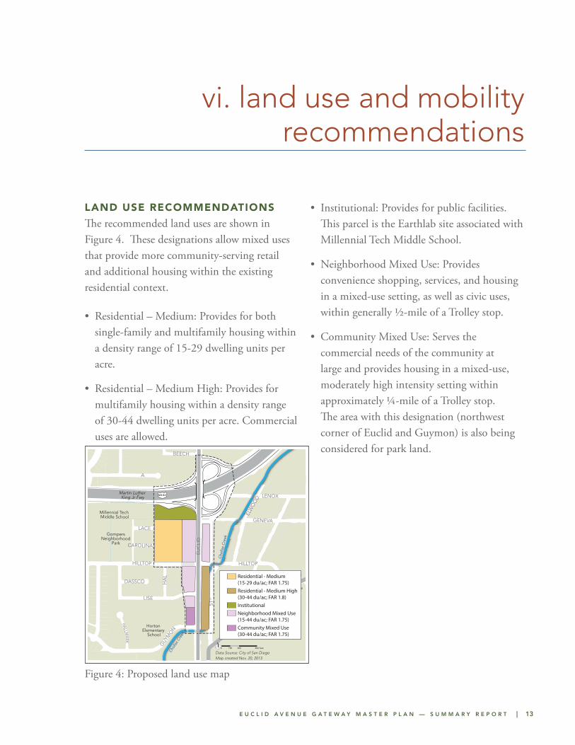
The recommended land uses are shown in Figure 4. These designations allow mixed uses that provide more community-serving retail and additional housing within the existing residential context.
• Residential – Medium: Provides for both single-family and multifamily housing within a density range of 15-29 dwelling units per acre.
• Residential – Medium High: Provides for multifamily housing within a density range of 30-44 dwelling units per acre. Commercial uses are allowed.
• Institutional: Provides for public facilities. This parcel is the Earthlab site associated with Millennial Tech Middle School.
• Neighborhood Mixed Use: Provides convenience shopping, services, and housing in a mixed-use setting, as well as civic uses, within generally ½-mile of a Trolley stop.
• Community Mixed Use: Serves the commercial needs of the community at large and provides housing in a mixed-use, moderately high intensity setting within approximately ¼-mile of a Trolley stop. The area with this designation (northwest corner of Euclid and Guymon) is also being considered for park land.
Figure 4: Proposed land use map
T
A
EUC
LID
LISE
51ST
WIN
STO
N
HILLTOP
GENEVA
ROSWELL
ELW
OO
D
HA
L
LENOX
BEECH
GUY
MO
N
LACE
MELRO
SE
MA
RY L
OU
DASSCO
HA
LLMA
RK
CAROLINA
HILLTOP
MARKET
FEDERAL
49TH
Millennial Tech Middle School
Martin Luther King Jr Fwy
Horton Elementary
School
GompersNeighborhood
Park
Foodland
Malcolm XLibrary
United African AmericanMinisterial Action Council
Market CreekPlaza
Gompers PreparatoryAcademy
EuclidAvenue Transit
Station
San Diego Trolley - Orange Line
Cho
llas
Cre
ek
Chol
las C
reek
Food 4 Less
Jacobs Centerfor
NeighborhoodInnovation
SR-94
Project Area
Project Area Parcel
Chollas CreekHighway
Arterial Bus Stop
Transit HubT
Trolley
N
Data Source: City of San Diego
Euclid Avenue Master Plan - Location
0 300 600150 feet
Euclid Avenue Master Plan: Preferred Land Use
Community Mixed Use (30-44 du/ac; FAR 1.75)
Neighborhood Mixed Use (15-44 du/ac; FAR 1.75)
Residential - Medium High (30-44 du/ac; FAR 1.8)Institutional
Residential - Medium (15-29 du/ac; FAR 1.75)
N
0 300 600150 feet
Data Source: City of San DiegoMap created Nov. 20, 2013
Residential - Medium (15-29 du/ac; FAR 1.75)Residential - Medium High (30-44 du/ac; FAR 1.8)InstitutionalNeighborhood Mixed Use (15-44 du/ac; FAR 1.75)Community Mixed Use (30-44 du/ac; FAR 1.75)
14 | E U C L I D A V E N U E G A T E W A Y M A S T E R P L A N — S U M M A R Y R E P O R T
v i . l a n d u s e a n d m o b i l i t y r e c o m m e n d a t i o n s
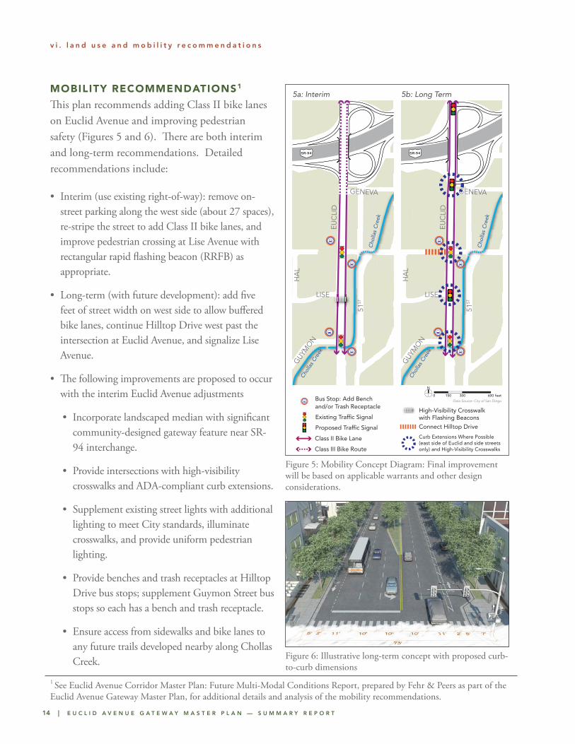
MOBILITY RECOMMENDATIONS1
This plan recommends adding Class II bike lanes on Euclid Avenue and improving pedestrian safety (Figures 5 and 6). There are both interim and long-term recommendations. Detailed recommendations include:
• Interim (use existing right-of-way): remove on-street parking along the west side (about 27 spaces), re-stripe the street to add Class II bike lanes, and improve pedestrian crossing at Lise Avenue with rectangular rapid flashing beacon (RRFB) as appropriate.
• Long-term (with future development): add five feet of street width on west side to allow buffered bike lanes, continue Hilltop Drive west past the intersection at Euclid Avenue, and signalize Lise Avenue.
• The following improvements are proposed to occur with the interim Euclid Avenue adjustments
• Incorporate landscaped median with significant community-designed gateway feature near SR-94 interchange.
• Provide intersections with high-visibility crosswalks and ADA-compliant curb extensions.
• Supplement existing street lights with additional lighting to meet City standards, illuminate crosswalks, and provide uniform pedestrian lighting.
• Provide benches and trash receptacles at Hilltop Drive bus stops; supplement Guymon Street bus stops so each has a bench and trash receptacle.
• Ensure access from sidewalks and bike lanes to any future trails developed nearby along Chollas Creek.
Figure 5: Mobility Concept Diagram: Final improvement will be based on applicable warrants and other design considerations.
Figure 6: Illustrative long-term concept with proposed curb-to-curb dimensions
TT
A
EUC
LID
LISE
51ST
WIN
STO
N
HILLTOP
GENEVA
ROSWELL
ELW
OO
D
HA
L
LENOX
BEECH
GUY
MO
N
LACE
MELRO
SE
MA
RY L
OU
DASSCO
HA
LLMA
RK
CAROLINA
HILLTOP
MARKET
FEDERAL
49TH
Millennial Tech Middle School
Martin Luther King Jr Fwy
Horton Elementary
School
GompersNeighborhood
Park
Foodland
Malcolm XLibrary
United African AmericanMinisterial Action Council
Market CreekPlaza
Gompers PreparatoryAcademy
EuclidAvenue Transit
Station
San Diego Trolley - Orange Line
Cho
llas
Cre
ek
Chol
las C
reek
Food 4 Less
Jacobs Centerfor
NeighborhoodInnovation
SR-94
Project AreaChollas CreekTrolley
N
Data Source: City of San Diego
Euclid Avenue Mobility Recommendations - Interim
0 300 600150 feet
Class II Bike Lane
Class III Bike Route
High-Visibility Crosswalk with Flashing Beacons
Existing Traffic Signal
Proposed Traffic Signal
Connect Hilltop Drive
Curb Extensions Where Possible (east side of Euclid and side streets only) and High-Visibility Crosswalks
Bus Stop: Add Bench and/or Trash Receptacle
TT
A
EUC
LID
LISE
51ST
WIN
STO
N
HILLTOP
GENEVA
ROSWELL
ELW
OO
D
HA
L
LENOX
BEECH
GUY
MO
N
LACE
MELRO
SE
MA
RY L
OU
DASSCO
HA
LLMA
RKCAROLINA
HILLTOP
MARKET
FEDERAL
49TH
Millennial Tech Middle School
Martin Luther King Jr Fwy
Horton Elementary
School
GompersNeighborhood
Park
Foodland
Malcolm XLibrary
United African AmericanMinisterial Action Council
Market CreekPlaza
Gompers PreparatoryAcademy
EuclidAvenue Transit
Station
San Diego Trolley - Orange Line
Cho
llas
Cre
ek
Chol
las C
reek
Food 4 Less
Jacobs Centerfor
NeighborhoodInnovation
SR-94
Project AreaChollas CreekTrolley
N
Data Source: City of San Diego
Euclid Avenue Mobility Recommendations - Interim
0 300 600150 feet
Class II Bike Lane
Class III Bike Route
High-Visibility Crosswalk with Flashing Beacons
Existing Traffic Signal
Proposed Traffic Signal
Connect Hilltop Drive
Curb Extensions Where Possible (east side of Euclid and side streets only) and High-Visibility Crosswalks
Bus Stop: Add Bench and/or Trash Receptacle
TT
A
EUC
LID
LISE
51ST
WIN
STO
N
HILLTOP
GENEVA
ROSWELL
ELW
OO
D
HA
LLENOX
BEECH
GUY
MO
N
LACEM
ELROSE
MA
RY L
OU
DASSCO
HA
LLMA
RK
CAROLINA
HILLTOP
MARKET
FEDERAL
49TH
Millennial Tech Middle School
Martin Luther King Jr Fwy
Horton Elementary
School
GompersNeighborhood
Park
Foodland
Malcolm XLibrary
United African AmericanMinisterial Action Council
Market CreekPlaza
Gompers PreparatoryAcademy
EuclidAvenue Transit
Station
San Diego Trolley - Orange Line
Cho
llas
Cre
ek
Chol
las C
reek
Food 4 Less
Jacobs Centerfor
NeighborhoodInnovation
SR-94
Project AreaChollas CreekTrolley
N
Data Source: City of San Diego
Euclid Avenue Mobility Recommendations - Interim
0 300 600150 feet
Class II Bike Lane
Class III Bike Route
High-Visibility Crosswalk with Flashing Beacons
Existing Traffic Signal
Proposed Traffic Signal
Connect Hilltop Drive
Curb Extensions Where Possible (east side of Euclid and side streets only) and High-Visibility Crosswalks
Bus Stop: Add Bench and/or Trash Receptacle
TT
A
EUC
LID
LISE
51ST
WIN
STO
N
HILLTOP
GENEVA
ROSWELL
ELW
OO
D
HA
L
LENOX
BEECH
GUY
MO
N
LACE
MELRO
SE
MA
RY L
OU
DASSCO
HA
LLMA
RK
CAROLINA
HILLTOP
MARKET
FEDERAL
49TH
Millennial Tech Middle School
Martin Luther King Jr Fwy
Horton Elementary
School
GompersNeighborhood
Park
Foodland
Malcolm XLibrary
United African AmericanMinisterial Action Council
Market CreekPlaza
Gompers PreparatoryAcademy
EuclidAvenue Transit
Station
San Diego Trolley - Orange Line
Cho
llas
Cre
ek
Chol
las C
reek
Food 4 Less
Jacobs Centerfor
NeighborhoodInnovation
SR-94
Project AreaChollas CreekTrolley
N
Data Source: City of San Diego
Euclid Avenue Mobility Recommendations - Interim
0 300 600150 feet
Class II Bike Lane
Class III Bike Route
High-Visibility Crosswalk with Flashing Beacons
Existing Traffic Signal
Proposed Traffic Signal
Connect Hilltop Drive
Curb Extensions Where Possible (east side of Euclid and side streets only) and High-Visibility Crosswalks
Bus Stop: Add Bench and/or Trash Receptacle
5a: Interim 5b: Long Term
1 See Euclid Avenue Corridor Master Plan: Future Multi-Modal Conditions Report, prepared by Fehr & Peers as part of the Euclid Avenue Gateway Master Plan, for additional details and analysis of the mobility recommendations.
E U C L I D A V E N U E G A T E W A Y M A S T E R P L A N — S U M M A R Y R E P O R T | 15
v i . l a n d u s e a n d m o b i l i t y r e c o m m e n d a t i o n s
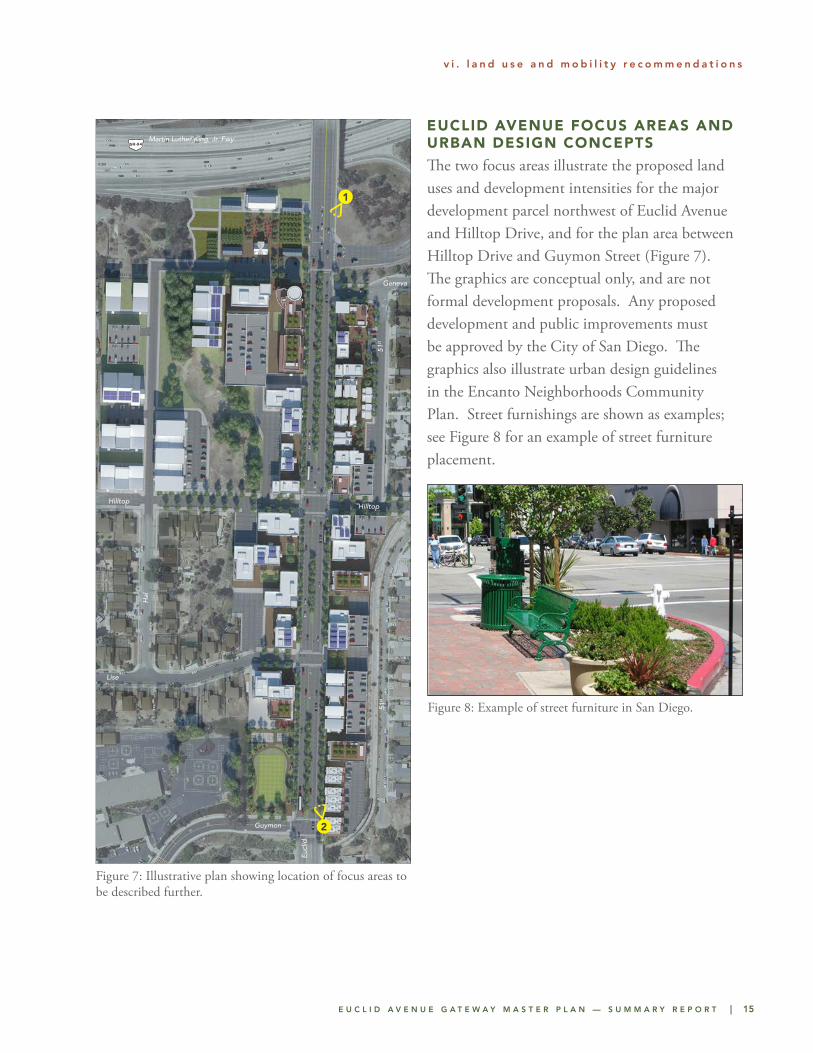
EUCLID AVENUE FOCUS AREAS AND URBAN DESIGN CONCEPTS
The two focus areas illustrate the proposed land uses and development intensities for the major development parcel northwest of Euclid Avenue and Hilltop Drive, and for the plan area between Hilltop Drive and Guymon Street (Figure 7). The graphics are conceptual only, and are not formal development proposals. Any proposed development and public improvements must be approved by the City of San Diego. The graphics also illustrate urban design guidelines in the Encanto Neighborhoods Community Plan. Street furnishings are shown as examples; see Figure 8 for an example of street furniture placement.
Figure 7: Illustrative plan showing location of focus areas to be described further.
Figure 8: Example of street furniture in San Diego.
SR-94Martin Luther King, Jr. Fwy
Hilltop
Lise
Guymon
Euc
lid
Hal
51st
51st
Geneva
Hilltop
1
2
16 | E U C L I D A V E N U E G A T E W A Y M A S T E R P L A N — S U M M A R Y R E P O R T
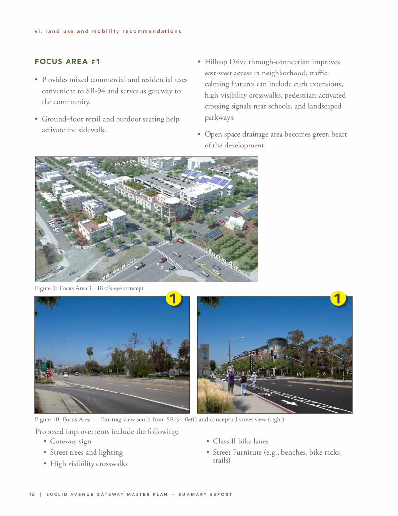
Figure 10: Focus Area 1 - Existing view south from SR-94 (left) and conceptual street view (right)
1 1
FOCUS AREA #1
• Provides mixed commercial and residential uses convenient to SR-94 and serves as gateway to the community.
• Ground-floor retail and outdoor seating help activate the sidewalk.
• Hilltop Drive through-connection improves east-west access in neighborhood; traffic-calming features can include curb extensions, high-visibility crosswalks, pedestrian-activated crossing signals near schools, and landscaped parkways.
• Open space drainage area becomes green heart of the development.
v i . l a n d u s e a n d m o b i l i t y r e c o m m e n d a t i o n s
Figure 9: Focus Area 1 - Bird’s-eye concept
• Gateway sign• Street trees and lighting• High visibility crosswalks
• Class II bike lanes• Street Furniture (e.g., benches, bike racks,
trails)
Proposed improvements include the following:
E U C L I D A V E N U E G A T E W A Y M A S T E R P L A N — S U M M A R Y R E P O R T | 17
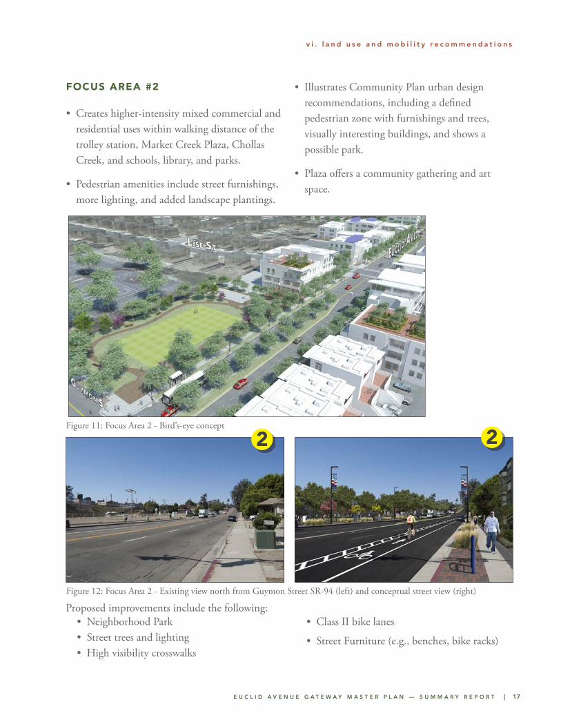
FOCUS AREA #2
• Creates higher-intensity mixed commercial and residential uses within walking distance of the trolley station, Market Creek Plaza, Chollas Creek, and schools, library, and parks.
• Pedestrian amenities include street furnishings, more lighting, and added landscape plantings.
• Illustrates Community Plan urban design recommendations, including a defined pedestrian zone with furnishings and trees, visually interesting buildings, and shows a possible park.
• Plaza offers a community gathering and art space.
v i . l a n d u s e a n d m o b i l i t y r e c o m m e n d a t i o n s
Figure 11: Focus Area 2 - Bird’s-eye concept
Figure 12: Focus Area 2 - Existing view north from Guymon Street SR-94 (left) and conceptual street view (right)
22
• Neighborhood Park• Street trees and lighting• High visibility crosswalks
• Class II bike lanes
• Street Furniture (e.g., benches, bike racks)
Proposed improvements include the following:

E U C L I D A V E N U E G A T E W A Y M A S T E R P L A N — S U M M A R Y R E P O R T | 19
Future community improvements may be funded by development and through the City’s Capital Improvement Program. Other funding can include state and federal sources (Community Development Block Grants, Low Income Housing Tax Credits, Proposition 1C Funds, Caltrans Active Transportation
Program), regional (including SANDAG Smart Growth Incentive Program), local (Infrastructure Financing Districts, City of San Diego General Fund, developer incentives), and property owner funds (Development Impact Fees, Developer Exactions, Business Improvement Districts).
vii. implementation