Embed Size (px)
Citation preview
EU Framework Program for Research and Innovation
(SC5-18a-2014 - H2020)
Project Nr: 641538
Coordinating an Observation Network of Networks EnCompassing saTellite and IN-situ to fill the Gaps in European Observations
Deliverable D2.2 EVs current status in different communities and way to move forward
Version 1.0.0
Due date of deliverable: 1/08/2015 Actual submission date: 28/12/2015
Ref. Ares(2016)85023 - 07/01/2016

H2020 Project Nr: 641538. Project start date: 01 Feb 2015 Acronym: ConnectinGEO Project title: Coordinating an Observation Network of Networks EnCompassing saTellite and IN-situ to fill the Gaps in European Observations Theme: SC5-18a-2014. Coordinating European Observation Networks to reinforce the knowledge base for climate, natural resources and raw materials
Document control page
Title D2.2 EVs current status in different communities and way to move forward
Creator CREAF
Editor CMCC, TIWAH
Description
Report on the Essential Variables current status in the scientific community and the strategy to push them forward. This report summarizes the results of the workshop “Towards a sustainability process for GEOSS Essential Variables (EVs),” at which the current status of the EV discussions in a number of communities was reviewed and recommendations for the further development of a general process for the identification and validation of the EVs were developed.
Publisher ConnectinGEO Consortium
Contributors ConnectinGEO Partners
Type Text
Format MS-Word
Language EN-GB
Creation date 01/04/2015
Version number 0.0.9
Version date 28/12/2015
Last modified by Hans-Peter Plag
Rights Copyright © 2015, ConnectinGEO Consortium
Dissemination level
CO (confidential, only for members of the consortium)
X PU (public)
PP (restricted to other programme participants)
RE (restricted to a group specified by the consortium)
When restricted, access granted to:
Nature
X R (report)
P (prototype)
D (demonstrator)
O (other)
Review status
Draft Where applicable:
WP leader accepted Accepted by the PTB
PMB quality controlled Accepted by the PTB as public document
X Coordinator accepted
Action requested
to be revised by all ConnectinGEO partners
for approval of the WP leader
for approval of the PMB
for approval of the Project Coordinator
for approval of the PTB
Requested deadline
H2020 Project Nr: 641538. Project start date: 01 Feb 2015 Acronym: ConnectinGEO Project title: Coordinating an Observation Network of Networks EnCompassing saTellite and IN-situ to fill the Gaps in European Observations Theme: SC5-18a-2014. Coordinating European Observation Networks to reinforce the knowledge base for climate, natural resources and raw materials
Revision history
Version Date Modified by Comments
0.1 AB_CMCC Created the basic content of the deliverable
0.2 JM_CREAF Some content addition
0.3 IS_CREAF Addition of the content of the EV workshop in Bari. Application of the deliverables format
0.4 HPP_TIWAH Several edits, integration of contributions from several partners
0.5 All Integration of additional inputs
0.6 SJP_TIWAH Integration of additional inputs and formatting of the complete text
0.7 IS_CREAF Incorporation of the minutes of the Bari workshop
0.7 IMC_IIASA Provision of content on the Health EV section
0.8 HPP_TIWAH Additional Sections on Disaster and Water
0.9 JM_CREAF Executive Summary and some edits
0.10 HPP_TIWAH Some final edits
Contributors
Acronym Full name
AB_CMCC Antonio Bombelli (CMCC)
JM_CREAF Joan Masó (CREAF)
IS_CREAF Ivette Serral (CREAF)
SJP_TIWAH Shelley Jules-Plag (TIWAH)
HPP_TIWAH Hans Peter Plag (TIWAH)
IMC_IIASA Ian Mcallum (IIASA)
Copyright © 2015, ConnectinGEO Consortium
The ConnectinGEO Consortium grants third parties the right to use and distribute all or parts of this
document, provided that the ConnectinGEO project and the document are properly referenced.
THIS DOCUMENT IS PROVIDED BY THE COPYRIGHT HOLDERS AND CONTRIBUTORS "AS IS" AND
ANY EXPRESS OR IMPLIED WARRANTIES, INCLUDING, BUT NOT LIMITED TO, THE IMPLIED
WARRANTIES OF MERCHANTABILITY AND FITNESS FOR A PARTICULAR PURPOSE ARE
DISCLAIMED. IN NO EVENT SHALL THE COPYRIGHT OWNER OR CONTRIBUTORS BE LIABLE FOR
ANY DIRECT, INDIRECT, INCIDENTAL, SPECIAL, EXEMPLARY, OR CONSEQUENTIAL DAMAGES
(INCLUDING, BUT NOT LIMITED TO, PROCUREMENT OF SUBSTITUTE GOODS OR SERVICES; LOSS
OF USE, DATA, OR PROFITS; OR BUSINESS INTERRUPTION) HOWEVER CAUSED AND ON ANY
THEORY OF LIABILITY, WHETHER IN CONTRACT, STRICT LIABILITY, OR TORT (INCLUDING
NEGLIGENCE OR OTHERWISE) ARISING IN ANY WAY OUT OF THE USE OF THIS DOCUMENT, EVEN
IF ADVISED OF THE POSSIBILITY OF SUCH DAMAGE.
H2020 Project Nr: 641538. Project start date: 01 Feb 2015 Acronym: ConnectinGEO Project title: Coordinating an Observation Network of Networks EnCompassing saTellite and IN-situ to fill the Gaps in European Observations Theme: SC5-18a-2014. Coordinating European Observation Networks to reinforce the knowledge base for climate, natural resources and raw materials
Table of Contents
Executive Summary ...................................................................................................................... i
1. Introduction ......................................................................................................................... 1 1.1. Scope of the Report ................................................................................................................. 1 1.2. Objectives of the Bari workshop .............................................................................................. 1 1.3. The value for EVs ..................................................................................................................... 2
2. Definition of EVs................................................................................................................... 3
3. Current status of EVs in GEO SBAs and Thematic Areas ........................................................ 4 3.1. Agriculture ............................................................................................................................... 7
3.1.1. Introduction ............................................................................................................................. 7 3.1.2. Current EVs ............................................................................................................................... 8 3.1.3. Methodology ............................................................................................................................ 8 3.1.4. Users and community .............................................................................................................. 9 3.1.5. International bodies ............................................................................................................... 10 3.1.6. Challenges and how these are addressed .............................................................................. 10 3.1.7. Gaps and requirements .......................................................................................................... 11 3.1.8. Conclusions ............................................................................................................................ 14
3.2. Biodiversity ............................................................................................................................. 14 3.2.1. Introduction ........................................................................................................................... 14 3.2.2. Status of EV discussion and EVs ............................................................................................. 14 3.2.3. Methodology .......................................................................................................................... 16 3.2.4. Users and community ............................................................................................................ 17 3.2.5. International bodies ............................................................................................................... 19 3.2.6. Challenges and steps to address these .................................................................................. 19 3.2.7. Observational requirements and gaps ................................................................................... 19 3.2.8. Conclusions ............................................................................................................................ 21
3.3. Climate ................................................................................................................................... 21 3.3.1. Introduction ........................................................................................................................... 21 3.3.2. Status of existing EVs in the domain ...................................................................................... 22 3.3.3. Methodology .......................................................................................................................... 23 3.3.4. Users and community ............................................................................................................ 25 3.3.5. International bodies ............................................................................................................... 26 3.3.6. Challenges and how these are addressed .............................................................................. 27 3.3.7. Challenges, Observational requirements and Gaps ............................................................... 27 3.3.8. Conclusions ............................................................................................................................ 30
3.4. Disasters ................................................................................................................................. 32 3.4.1. Introduction ........................................................................................................................... 32 3.4.2. Status of EV discussion and EVs ............................................................................................. 32 3.4.3. Methodology .......................................................................................................................... 33 3.4.4. International Organizations involved and monitoring networks ........................................... 33 3.4.5. Challenges and Steps to Address these.................................................................................. 33 3.4.6. Observational requirements and Gaps .................................................................................. 34 3.4.7. Conclusions ............................................................................................................................ 34
3.5. Ecosystems ............................................................................................................................. 34 3.5.1. Introduction ........................................................................................................................... 34 3.5.2. Status of EV discussion and EVs ............................................................................................. 34 3.5.3. Methodology .......................................................................................................................... 36 3.5.4. Users and community ............................................................................................................ 37
H2020 Project Nr: 641538. Project start date: 01 Feb 2015 Acronym: ConnectinGEO Project title: Coordinating an Observation Network of Networks EnCompassing saTellite and IN-situ to fill the Gaps in European Observations Theme: SC5-18a-2014. Coordinating European Observation Networks to reinforce the knowledge base for climate, natural resources and raw materials
3.5.5. International bodies ............................................................................................................... 37 3.5.6. Challenges and how these are addressed .............................................................................. 37 3.5.7. Gaps and requirements .......................................................................................................... 38 3.5.8. Conclusions ............................................................................................................................ 38
3.6. Energy .................................................................................................................................... 38 3.6.1. Introduction ........................................................................................................................... 38 3.6.2. Status of EV discussion and EVs ............................................................................................. 38 3.6.3. Methodology .......................................................................................................................... 39 3.6.4. Users and community ............................................................................................................ 40 3.6.5. International bodies ............................................................................................................... 41 3.6.6. Challenges and Steps to Address these.................................................................................. 41 3.6.7. Observational requirements and Gaps .................................................................................. 41 3.6.8. Conclusions ............................................................................................................................ 41
3.7. Health ..................................................................................................................................... 42 3.7.1. Introduction ........................................................................................................................... 42 3.7.2. Status of EV discussion and EVs ............................................................................................. 43 3.7.3. Methodology .......................................................................................................................... 44 3.7.4. International Organizations involved and monitoring networks ........................................... 44 3.7.5. Challenges and Steps to Address these.................................................................................. 44 3.7.6. Observational requirements and Gaps .................................................................................. 44 3.7.7. Conclusions ............................................................................................................................ 44
3.8. Water ..................................................................................................................................... 45 3.8.1. Introduction ........................................................................................................................... 45 3.8.2. Status of EV discussion and EVs ............................................................................................. 45 3.8.3. Methodology .......................................................................................................................... 45 3.8.4. International Organizations involved and monitoring networks ........................................... 46 3.8.5. Challenges and Steps to Address these.................................................................................. 46 3.8.6. Observational requirements and Gaps .................................................................................. 46 3.8.7. Conclusions ............................................................................................................................ 47
3.9. Weather ................................................................................................................................. 48 3.9.1. Introduction ........................................................................................................................... 48 3.9.2. Status of EV discussion and EVs ............................................................................................. 49 3.9.3. Methodology .......................................................................................................................... 49 3.9.4. Users and community ............................................................................................................ 51 3.9.5. International bodies ............................................................................................................... 53 3.9.6. Observational requirements and Gaps .................................................................................. 54 3.9.7. Conclusions ............................................................................................................................ 54
3.10. Human Settlements ................................................................................................................ 54 3.10.1. Introduction ........................................................................................................................... 54 3.10.2. Status of EV discussion and EVs ............................................................................................. 55 3.10.3. Methodology .......................................................................................................................... 55 3.10.4. Users and community ............................................................................................................ 55 3.10.5. International bodies ............................................................................................................... 56 3.10.6. Challenges and Steps to Address these.................................................................................. 56 3.10.7. Observational requirements and Gaps .................................................................................. 56 3.10.8. Conclusions ............................................................................................................................ 56
3.11. Oceans (and Marine Ecosystems) ............................................................................................ 56 3.11.1. Introduction ........................................................................................................................... 56 3.11.2. Status of EV discussion and EVs ............................................................................................. 57 3.11.3. Methodology .......................................................................................................................... 57 3.11.4. Users and community ............................................................................................................ 58 3.11.5. International bodies ............................................................................................................... 58
H2020 Project Nr: 641538. Project start date: 01 Feb 2015 Acronym: ConnectinGEO Project title: Coordinating an Observation Network of Networks EnCompassing saTellite and IN-situ to fill the Gaps in European Observations Theme: SC5-18a-2014. Coordinating European Observation Networks to reinforce the knowledge base for climate, natural resources and raw materials
3.11.6. Challenges and Steps to Address these.................................................................................. 58 3.11.7. Observational requirements and Gaps .................................................................................. 58 3.11.8. Conclusions ............................................................................................................................ 59
3.12. Citizen Science ........................................................................................................................ 59 3.12.1. Introduction ........................................................................................................................... 59 3.12.2. Status of EV discussion and EVs ............................................................................................. 60 3.12.3. Methodology .......................................................................................................................... 60 3.12.4. Users and community ............................................................................................................ 61 3.12.5. International bodies ............................................................................................................... 61 3.12.6. Challenges and Steps to Address these.................................................................................. 61 3.12.7. Observational requirements and Gaps .................................................................................. 62 3.12.8. Conclusions ............................................................................................................................ 62
4. Conclusions, Recommendations and Way forward ............................................................. 62 4.1. Commonalities and Differences .............................................................................................. 62 4.2. Criteria to identify EVs ............................................................................................................ 62 4.3. Recommended process to reach consensus concerning sets of EVs ......................................... 63 4.4. EVs and the Gap analysis in ConnectinGEO .............................................................................. 63 4.5. EVs in the context of GEO ....................................................................................................... 63
5. Bibliography ....................................................................................................................... 64
Annex 1: Lists of Essential Variables ........................................................................................... 67
Annex 2: Acronyms .................................................................................................................... 70
Annex 3: Workshop Minutes ...................................................................................................... 71 Annex 3.1 Objectives ........................................................................................................................... 72 Annex 3.2 The venue and participants ................................................................................................. 72 Annex 3.3 Program .............................................................................................................................. 74 Annex 3.4 List of participants .............................................................................................................. 76 Annex 3.5 Workshop Minutes ............................................................................................................. 77
Figures Figure 1 Status of Existing EVs in the Agriculture Domain ................................................................................. 9 Figure 2 Energy system Life cycle. .................................................................................................................... 40 Figure 3 An example of a direct health effect measured partly with remote sensing data. ........................... 43 Figure 4: Conceptual Overlap of Essential Variables in Different Domains in a Venn diagram. Figure
extracted from http://ioc-goos-oopc.org/obs/ecv.php .......................................................................... 48 Figure 5 Diagram of WMO’s Rolling Review of User Requirements (RRR) ...................................................... 50 Figure 6: Structure of OSCAR............................................................................................................................ 52 Figure 7: Requirements Filtered for Different Application Areas .................................................................... 52 Figure 8: Global Observing System Synoptic Network. .................................................................................... 53 Figure 9: Regional Basic Synoptic Networks (RBSN). Covers specific aspects of the weather forecasting ...... 53 Figure 10: GSN (GCOS Surface Network) ECVs ............................................................................................ 54 Figure 11: Resulting high-resolution human settlement maps over China. ..................................................... 55 Figure 12: The Role of Crowdsourcing and Citizen Science. ............................................................................ 60 Figure 13: General methodology of citizen science approach taken with the geo-wiki.org platform to
produce new and improved global land cover/ land use maps. ............................................................. 61 Figure 14: Workshop leaflet ............................................................................................................................. 71
H2020 Project Nr: 641538. Project start date: 01 Feb 2015 Acronym: ConnectinGEO Project title: Coordinating an Observation Network of Networks EnCompassing saTellite and IN-situ to fill the Gaps in European Observations Theme: SC5-18a-2014. Coordinating European Observation Networks to reinforce the knowledge base for climate, natural resources and raw materials
Tables Table 1 Summary of Responses to the Questions given to the Presenters at the Bari Workshop .................... 7 Table 2 GEOGLAM Phase 1 Satellite Observational Requirements for Target Products. Field size variation:
small (S ~ <2.5 ha), medium (M = ~2.5 ha-15 ha), and large (L = ~ >15ha) Cloud free < 10% average cloud cover across the scene. .................................................................................................................. 11
Table 3 GEOGLAM Phase 1 Target Product Observational Requirements Core and Contributing Data Streams .................................................................................................................................................... 13
Table 4 List of Essential Biodiversity Variables ................................................................................................. 15 Table 5 Examples of Candidate Essential Biodiversity Variables ..................................................................... 16 Table 6 The GEO-BON Draft Checklist for Essential Biodiversity Variables ...................................................... 18 Table 7: Commitments to the Habitat and Bird Directives by National and Regional Administrations .......... 20 Table 8: List of Agreed-Upon GCOS Essential Climate Variables ...................................................................... 22 Table 9 Initial Set of Observational Requirements Developed by WMO-GAW ............................................... 30 Table 10 Selected Preliminary Essential Variables for Several Domains ......................................................... 36 Table 11 List of Primary and Supplemental Essential Water Variables. From Lawford (2014). ....................... 46 Table 12 The analytical basis for identifying preliminary EWVs. Note that P means “partial.” From Lawford
(2014). ...................................................................................................................................................... 47 Table 13 List of application areas ..................................................................................................................... 51
H2020 Project Nr: 641538. Project start date: 01 Feb 2015 Acronym: ConnectinGEO Project title: Coordinating an Observation Network of Networks EnCompassing saTellite and IN-situ to fill the Gaps in European Observations Theme: SC5-18a-2014. Coordinating European Observation Networks to reinforce the knowledge base for climate, natural resources and raw materials
Executive Summary
The ConnectinGEO workshop “Towards a sustainability process for GEOSS Essential Variables (EVs)” was held in Bari on June 11-12, 2015. The presentations and reports contributed by a wide range of communities provided important input from different sectors for assessing the status of the EV development. The workshop covered the status of EV discussions in the Societal Benefit Areas (SBAs) Agriculture, Biodiversity, Climate (and specifically Atmospheric composition, Carbon Cycle, and Greenhouse Gasses), Disasters, Ecosystems, Energy, Health, Water (and River discharge), and Weather, and the thematic areas Citizen Science, Human Settlements, Oceans (and Marine Ecosystems), and Solid Earth Science (including volcanology). From the analysis of the workshop presentations we distilled a definition of the essential variables that will guide the rest of the ConnectinGEO activities and the ENEON. EVs are “a minimal set of variables that determine the system’s state and developments, are crucial for predicting system developments, and allow us to define metrics that measure the trajectory of the system”. Specific application dependent characteristics such as minimum spatial and temporal resolution of observations and data quality thresholds are not included in the EV definition. In most SBAs and thematic areas, the development of sets of EV’s is a community processes leading to an agreement on what is essential for this goals of the community. While there are many differences across the communities in the details of the criteria, methodologies, and processes used to develop sets of EVs, there is also a considerable common core across the communities, particularly those with a more advanced discussion. Concerning inter-community differences of criteria, in particular, the feasibility to measure the EVs in terms of cost, effort, and impact plays a different role in different communities. There is some level of overlap between the EVs determined by different communities (e.g., Climate and Water), and there is a potential to develop an integrated set of EVs common to several or all SBAs, which then could be complemented with SBA specific EVs. The SBAs with a more mature development of EV lists are Climate, Ocean and Biodiversity. The Water SBA is also maturing a set of EVs in GEOSS. There are also SBAs that are working with a common set of variables that can be considered essential for them. In that sense, agricultural monitoring is conducted both by the USA and EU in a similar way; Crop Area, Crop Type, Crop Condition, etc., are obvious candidates for Agriculture EV’s. More work is required for an agreement on other EVs for this SBA. Ecosystems is a cross-domain area that can make use of existing sets of EVs (such as ECVs, EOVs and EBVs) complemented by socioeconomic variables that can help to define ecosystem services to human societies. Renewable energy can also make use of the ECVs but there is a need for additional variables. For example, solar surface irradiance and wind at different levels next to the ground are good candidates to explore. The Disaster SBA is one of the most heterogeneous areas dealing with disasters caused by a wide range of natural and anthropogenic hazards. Different sets of EVs are required fro the different hazards, the vulnerability of exposed assets, and the impacts of the hazards on communities. In particular, socioeconomic EVs are required to characterize vulnerability and resilience (e.g., demographics, availability of public services, productive infrastructures, etc.) and to measure the extent of the hazard impacts on human societies leading to disasters.

H2020 Project Nr: 641538. Project start date: 01 Feb 2015 Acronym: ConnectinGEO Project title: Coordinating an Observation Network of Networks EnCompassing saTellite and IN-situ to fill the Gaps in European Observations Theme: SC5-18a-2014. Coordinating European Observation Networks to reinforce the knowledge base for climate, natural resources and raw materials
ConnectinGEO will focus on supporting Water, Agriculture, Renewable Energy and Ecosystems to make progress in the EV development by stimulating the debate in their respective international forums (mainly within GEO) using ENEON and GEOSS as catalysers of the process. Methodologies used to define the EVs and described in this document (as well as D2.1) will be taking into account. The next deliverable D2.3 “Proposal of EVs for selected themes” will propose a set of community-specific EVs as well as an aggregated set of GEOSS EVs and a path for making progress in setting new EVs for sectors where the concept is still not adopted in a mature way.
H2020 Project Nr: 641538. Project start date: 01 Feb 2015 Acronym: ConnectinGEO Project title: Coordinating an Observation Network of Networks EnCompassing saTellite and IN-situ to fill the Gaps in European Observations Theme: SC5-18a-2014. Coordinating European Observation Networks to reinforce the knowledge base for climate, natural resources and raw materials
1
1. Introduction
1.1. Scope of the Report
This report serves three purposes:
(1) It summarizes the deliberation at the ConnectinGEO workshop “Towards a sustainability process for GEOSS Essential Variables (EVs)” held in Bari on June 11-12, 2015, which in the following is denoted as the Bari workshop.
(2) It analyses the workshop results and assesses the overall status in terms of consistency of definition of EVs, process for the identification of EVs, approach to validation and acceptance of EVs, and use of EVs across the different communities considered.
(3) It complements the previous two points with an analysis of EV discussions available in published reports and other documents.
There are two basic approaches to the process that leads to community-accepted EVs:
(a) Based on community objectives, expertise and capabilities, a community agrees on a set of variables that is essential for this community;
(b) Starting from agreed-upon societal goals, a process leads to targets and metrics to monitor and predict progress towards the targets, and from there to variables required to quantify the metrics, which is mostly defined through a set of indicators.
The Bari workshop focused on (a) and the reports provided by a wide range of communities provided important input for an assessment of the status. The scope of this deliverable is the summary and analysis of these workshop proceedings. The Bari workshop also provided a basis for the Deliverable D2.3 “Proposal of EVs for selected themes.” In conjunction with the Deliverable 2.1 “Towards a Goal-Based Process for the Identification of Essential Variables,” which focuses on (b), the three deliverables constitute a comprehensive overview of processes used to identify EVs, community specific definitions of EVs, sets of community-specific EVs as well as an aggregated set of GEOSS EVs.
1.2. Objectives of the Bari workshop
The Bari workshop contributed to the ConnectinGEO work plan and provided important input for the further development of set of EVs for the GEO Societal Benefit Areas (SBAs) and thematic areas. Details on the workshop are included in the Workshop Minutes in the appendix. The specific objectives of the workshop were to:
- assess the status of existing EVs in selected Societal Benefits Areas (SBAs) and thematic areas addressed by GEO;
- review the different processes (criteria, methods, etc.) used by SBA and thematic communities to define and identify EVs;
- find commonalities (distinguish between the specificities that have to be addressed internally by each community and the common processes/issues -
H2020 Project Nr: 641538. Project start date: 01 Feb 2015 Acronym: ConnectinGEO Project title: Coordinating an Observation Network of Networks EnCompassing saTellite and IN-situ to fill the Gaps in European Observations Theme: SC5-18a-2014. Coordinating European Observation Networks to reinforce the knowledge base for climate, natural resources and raw materials
2
definition, criteria, methods, priorities, gaps, etc. - that crosscut and integrate all EVs) and possibly identify common EVs.
- assess to what extent existing EVs are validated, endorsed by international independent bodies, and used (assess the usefulness and applicability of the EVs concept);
- assess the observational requirements for EVs(in terms of temporal frequency, spatial resolution, accuracy, other specifications);
- understand what are the operational networks currently measuring EVs and what is their status;
- assess the current gaps, priorities and requirements for improving the use of EVs;
- produce a peer reviewed document on the EV status and definition process and requirements;
- contribute to the progress of the definition of EV in fields that are ready to move in this direction.
- make an attempt to identify a list of potential EVs to be used in the frame of GEO/GEOSS
In order to achieve these objectives, a set of questions had been developed and the presenters representing the different SBAs and thematic areas were asked to respond to these questions. The responses provided in the presentations complement the literature review and allow us to address most of the above objectives in this report. In particular, Section 3 integrates the input from the Bari workshop into the review of EVs in the SBAs and thematic areas.
1.3. The value for EVs
Despite the significant progress made in ensuring that Earth Observations (EOs)_are collected and available to meet the information needs of a wide range of users, there are still many user needs that are not being met. There is still insufficiently consistency in monitoring and sharing of such information. Along with sometimes inadequate financial resources, a key obstacle is the lack of general consensus about what variables are essential to monitor. Different organizations and projects promote diverse measurements and many initiatives collecting EOs could benefit from the existence of a set of commonly agreed EVs as a basis to commit resources and to support progress towards an evidence-based knowledge base for decision making. Important gaps still remain and many key variables central to scientific and societal information needs are not, or not sufficiently observed. In particular, only a few GEO SBAs and themes have agreed, or have made significant progress towards agreement, on a specific set of EVs. The concept of EVs assumes that there is a (small) number of variables that are essential to characterize the state and trends in a system without losing significant information. It is that set of variables that needs to be observed if past changes in the system have to be documented and if predictability of future changes is to be developed. Identifying this set of EVs allows for a commitment of inherently scarce resources to the essential observation needs. It also supports and eases the management of data and observations all along the chain from the measurement of raw data, through the processing and to the delivery of products, information and services needed by end users.
H2020 Project Nr: 641538. Project start date: 01 Feb 2015 Acronym: ConnectinGEO Project title: Coordinating an Observation Network of Networks EnCompassing saTellite and IN-situ to fill the Gaps in European Observations Theme: SC5-18a-2014. Coordinating European Observation Networks to reinforce the knowledge base for climate, natural resources and raw materials
3
EVs are needed to: - Describe natural and human systems and their processes, at physical,
biogeochemical and biological level. - Monitor status and trends of these systems in the different domains - Predict, detect and attribute (i.e., identify drivers) changes - Assess the impacts of these changes - Identify tolerable limits of these changes (sustainable development and planetary
boundaries)
They are helpful to: - Agree on a list of variables that are of common interest in a collective. - Agree on variables that are feasible to measure in terms of cost, effort, and
impact. - Set up a list of key variables to be considered for the long-term measurement. - Better communicate to funding agencies the need for long-term acquisition. - Develop a consistent way to communicate messages to decision maker through
homogeneous descriptions. - Facilitate high acceptance by the stakeholders.
In the frame of GEO, EVs are ideally needed to optimize the efforts and concentrate on a smaller set of variables characterizing one or (possibly) more GEO Societal benefits in a global scale and the topics of the Communities of Practice (CoPs). This would optimize the activities of the community working within GEO and possibly also promote collaboration among different tasks that may need the same EVs. The EVs identified by the collaborative work of the ConnectinGEO project will be also proposed for the new GEO Work Plan for the 2016-2025 period.
2. Definition of EVs To get a useful definition of EVs it is necessary to clarify the meaning of the terms “essential” and “variable”. The adjective “essential” has a number of different meanings, ranging from absolutely necessary and indispensable to containing an essence of something. A variable that significantly improves the reliability and accuracy of desired results can be considered essential. A variable that provides important information related to a specific goal is essential for this goal, independent of the capability to actually observe the variable. The essentiality of a variable may also depend on the information needs of different communities and target users (science, policy, etc.). In principle any variable can be “essential” for somebody or for achieving something. Therefore, the definition of what an EV is needs to be formalized and endorsed according to the collective interest and preferably in an internationally recognized process. In the context of the ConnectinGEO project, EVs are “a minimal set of variables that determine the system’s state and developments, are crucial for predicting system developments, and allow us to define metrics that measure the trajectory of the system” (ConnectinGEO 2015). The spatial and temporal resolution of observations of any given EV depend on the use of the observations, and in some cases, available observations of an EV may not be ready for use for specific applications. Limited

H2020 Project Nr: 641538. Project start date: 01 Feb 2015 Acronym: ConnectinGEO Project title: Coordinating an Observation Network of Networks EnCompassing saTellite and IN-situ to fill the Gaps in European Observations Theme: SC5-18a-2014. Coordinating European Observation Networks to reinforce the knowledge base for climate, natural resources and raw materials
4
knowledge of EVs implies limited predictive capabilities and limited means to measure where the system is heading. The generic nature of this EV definition allows us to identify sets of EVs for whatever system is being considered and for whatever goals are established in relation to this system. It allows for a broad application across different communities, and can be complemented with the specific requirements that each community may have related to the system the community is focusing on. Moreover, in a system of systems approach, sets of EVs can be aggregated into larger sets supporting prioritization of efforts across community and system boundaries. The concept of “variable” embedded in the definition given above has a certain level of abstraction. Identifying a variable does not imply that observation requirements in terms of spatial and temporal resolution, accuracy, latency, observation interval, etc. are also specified. Nor does it imply that measurement instruments are available to observe the variable. In some cases, variable may not be observable directly and have to be derived from a combination of observations. In such cases, the essential variable may have to be composed of a set of sub-variables that together provide the required information. One of the most important Workshop’s objectives was to review the different definition of EVs used in the different communities engaged or linked to GEO and to evaluate the level of consistency of these definitions. Although the “landscape” is quite diverse and complex, there seems to be some level of consistency with the system relevance of EVs but also considerable diversity with respect to the process how EVs are identified, validated and accepted. The definition of the Essential Climate Variables (ECVs) developed by the Global Climate Observing System (GCOS) and endorsed by the United Nation Framework Convention on Climate Change (UNFCCC) is consistent with the definition chosen by ConnectinGEO: “An ECV is a physical, chemical, or biological variable or a group of linked variables that critically contributes to the characterization of Earth’s climate.” Datasets of ECV provide the empirical evidence needed to document, understand and predict the evolution of climate, to guide mitigation and adaptation measures, to assess risks and enable attribution of climatic events to underlying causes, and to underpin climate services (Bojinski et al., 2014). ECVs are widely accepted and used at international level.
3. Current status of EVs in GEO SBAs and Thematic Areas The review of the current status of EV identification, agreements, and validation is based on two main approaches: (1) The Workshop held in Bari, and (2) a literature review. At the Bari workshop, presentations covered the status of EV developments and discussion for the SBAs Agriculture, Biodiversity, Climate (and specifically Atmospheric composition, Carbon Cycle, and Greenhouse Gasses), Disasters, Ecosystems, Energy, Health, Water (and River discharge), and Weather, and the thematic areas Citizen Science, Human Settlements, Oceans (and Marine Ecosystems), and Solid Earth Science (including volcanology). The speakers were asked to give an overview of the status of the discussion of EVs within their community, thematic area, or SBA. All speakers were asked to address the same set of questions (see Box 1) to get a coherent overview of the status for the different SBAs.
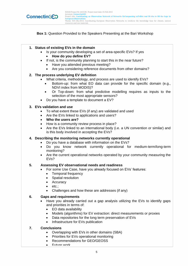
H2020 Project Nr: 641538. Project start date: 01 Feb 2015 Acronym: ConnectinGEO Project title: Coordinating an Observation Network of Networks EnCompassing saTellite and IN-situ to fill the Gaps in European Observations Theme: SC5-18a-2014. Coordinating European Observation Networks to reinforce the knowledge base for climate, natural resources and raw materials
5
Box 1: Question Provided to the Speakers Presenting at the Bari Workshops:
1. Status of existing EVs in the domain
Is your community developing a set of area-specific EVs? If yes
How do you define EV?
If not, is the community planning to start this in the near future?
Have you attended previous meeting?
Are you considering reference documents from other domains?
2. The process underlying EV definition
What criteria, methodology, and process are used to identify EVs?
Bottom-up: from what EO data can provide for the specific domain (e.g., NDVI index from MODIS)?
Or Top-down: from what predictive modelling requires as inputs to the selection of the most appropriate sensors?
Do you have a template to document a EV?
3. EVs validation and use
To what extent these EVs (if any) are validated and used
Are the EVs linked to applications and users?
Who the users are?
How is a community review process in place?
Are the EVs linked to an international body (i.e. a UN convention or similar) and is this body involved in accepting the EVs?
4. Describing the monitoring networks currently operational
Do you have a database with information on the EVs?
Do you know network currently operational for medium-term/long-term monitoring?
Are the current operational networks operated by your community measuring the EVs?
5. Assessing EV observational needs and readiness
For some Use Case, have you already focused on EVs’ features:
Temporal frequency
Spatial resolution
Accuracy
etc.;
Challenges and how these are addresses (if any)
6. Gaps and requirements
Have you already carried out a gap analysis utilizing the EVs to identify gaps and priorities in terms of:
EO data availability
Models (algorithms) for EV extraction: direct measurements or proxies
Data repositories for the long term preservation of EVs
Infrastructure for EVs publication
7. Conclusions
Overlapping with EVs in other domains (SBA)
Priorities for EVs operational monitoring
Recommendations for GEO/GEOSS
Future work
H2020 Project Nr: 641538. Project start date: 01 Feb 2015 Acronym: ConnectinGEO Project title: Coordinating an Observation Network of Networks EnCompassing saTellite and IN-situ to fill the Gaps in European Observations Theme: SC5-18a-2014. Coordinating European Observation Networks to reinforce the knowledge base for climate, natural resources and raw materials
6
The literature review used the same set of questions to extract EV information from published documents and other reports. In summary, it can be stated that despite differences in process, validation, and acceptance, there is significant overlap in the identified EVs for different SBAs and thematic areas. A list of EVs discussed in the different SBAs and thematic areas is provided in Annex 2. For example, several of the ECVs are also EVs for Water, Biodiversity, and Ecosystems. In fact, many of the EVs are not unique for one community but found in several thematic areas and SBAs. This underlines the fact that all the SBAs and thematic areas are aspects of a larger Earth system of systems. It also shows the great potential of an aggregated and prioritized set of EVs as guidance for the allocation of resources for GEOSS. The overview provided at the workshop revealed that the landscape of community-defined EVs is quite complex, with a wide range of variables considered essential in different areas and for different purposes, with different level of maturity in terms of their recognition and acceptance, their real applicability and use, the specification of observational requirements, the measuring capabilities, technological, networking and infrastructural issues and gaps, etc. Using those questions in Box 1 that allow for yes/no answers, Table 1 reflects some of the differences between communities. The table focuses on those questions that help to identify the maturity of the EV definition and validation processes and the relevant monitoring networks and emerging EV user communities. In the following sections, we summarize the status in each SBA and thematic area based on the responses received for the questions in Box 1 both in the workshop presentations and in the literature review. The SBAs are listed in alphabetical order not indicating the level of maturity of the approach to EVs. The thematic areas represented in five GEO SB Tasks are considered at the end of Section 3.
H2020 Project Nr: 641538. Project start date: 01 Feb 2015 Acronym: ConnectinGEO Project title: Coordinating an Observation Network of Networks EnCompassing saTellite and IN-situ to fill the Gaps in European Observations Theme: SC5-18a-2014. Coordinating European Observation Networks to reinforce the knowledge base for climate, natural resources and raw materials
7
Table 1 Summary of Responses to the Questions given to the Presenters at the Bari
Workshop
Is y
our
com
munity d
evelo
pin
g a
set of are
a-s
pecific
EV
s?
If n
ot,
is t
he
co
mm
un
ity p
lan
nin
g t
o s
tart
th
is in
th
e n
ea
r fu
ture
?
Do y
ou h
ave a
tem
pla
te to d
ocum
ent
an E
V?
Are
the
EV
s lin
ked t
o a
pplic
ations a
nd u
sers
?
Is a
com
munity r
evie
w p
rocess in
pla
ce
?
Are
th
e E
Vs form
ally
lin
ked to
an
in
tern
atio
nal body?
Do y
ou h
ave a
da
tab
ase w
ith
in
form
atio
n o
n th
e E
Vs?
1
Do y
ou k
now
netw
ork
curr
ently o
pera
tiona
l fo
r m
ediu
m-t
erm
/lon
g-
term
monito
rin
g?
Are
th
e c
urr
ent o
pera
tional ne
twork
s o
pera
ted b
y y
our
com
munity
measuri
ng t
he
E
Vs?
Have y
ou a
lready c
arr
ied o
ut a
ga
p a
na
lysis
utiliz
ing t
he
EV
s
Agriculture Y / ? Y Y Y Y Y/N Y/N Y
Biodiversity Y / Y Y N Y Y Y N N
Climate Y / Y Y Y Y Y Y Y Y1
Disasters N?
Ecosystems N Y N N N
Energy Y2 N N N N N
Health Y/N N N Y Y N Y N ?
Water Y / Y Y Y Y Y3 Y Y Y
Weather Y / Y Y Y Y Y Y Y ?
Human Settlements ? ? ? ? ? ? N N N ?
Oceans (and Marine Ecosystems)
Y / Y Y Y Y/N Y
1= In most cases the EVs are scattered in different databases and there is not a single one specific for EV; 2= but in an early stage; 3= at least for River Discharge;
3.1. Agriculture
3.1.1. Introduction
The agriculture theme is defining and perusing EVs even if experts in field does not use this lexicon as such. In GEOGLAM (that represents a strong Agriculture Community of Practice) EVs were defined based on monitoring needs to support policy and program development at the local, regional, national and global scales. GEOGLAM was initiated
H2020 Project Nr: 641538. Project start date: 01 Feb 2015 Acronym: ConnectinGEO Project title: Coordinating an Observation Network of Networks EnCompassing saTellite and IN-situ to fill the Gaps in European Observations Theme: SC5-18a-2014. Coordinating European Observation Networks to reinforce the knowledge base for climate, natural resources and raw materials
8
in 2011 by the G20 to allow agricultural transparent market. The sector has been using a clear set of comparative measures that can be globally applied at different scales including global assessment, national capacity building and Early Warning for Food Insecure Nations. These are also supported by Joint Experiments by R&D activities on sensors.
3.1.2. Current EVs
In the Agriculture domain the currently stated EVs are:
Crop Area: A mask of where there are crops. This is not a completely solved problem.
Crop Type: Crop Type area extent and crop calendars.
Crop Condition: The health and growing condition of croplands. How the crops evolve thought the growing season.
Crop Phenology: A key issue that is in a research phase but will be a good instrument for yield forecasting.
Crop Yield (current and forecast): Derived cropland output (yield) is based on empirical information and crop growth information.
Crop Management and agricultural practices. - Tillage - Residue
All across multiple time and space scales. There are different levels of maturity. Some EVs are in operational status (regular products produced at different scales) while others are in research and development phase. Agriculture is consuming EBV (Crop variables (e.g. LAI, NPP, Nitrogen content, Chlorophyll content, Water content) and ECV (Environment variables (e.g. soil type, soil moisture).
3.1.3. Methodology
The methodology to identify EVs follows a Top-down and bottom-up approach based on:
Needs are defined by users (top-down). The user community includes policy, programs, including commodity markets (AMIS-Agricultural Market Information System) but also covering food security with the same set of EV.
EV’s are broken down into 4-5 spatial-temporal scale classes that uses different tools for its determination and require constant research. (e.g. Crop detection in the USA and in north Africa uses different methodology and results in different temporal and spatial scale)
Spatial-temporal scale mapped to the classes of EO satellites sensors and in-situ data that can deliver the required information
Needs are met by operationalizing R&D (JECAM, SIGMA, etc) in a bottom-up fashion
H2020 Project Nr: 641538. Project start date: 01 Feb 2015 Acronym: ConnectinGEO Project title: Coordinating an Observation Network of Networks EnCompassing saTellite and IN-situ to fill the Gaps in European Observations Theme: SC5-18a-2014. Coordinating European Observation Networks to reinforce the knowledge base for climate, natural resources and raw materials
9
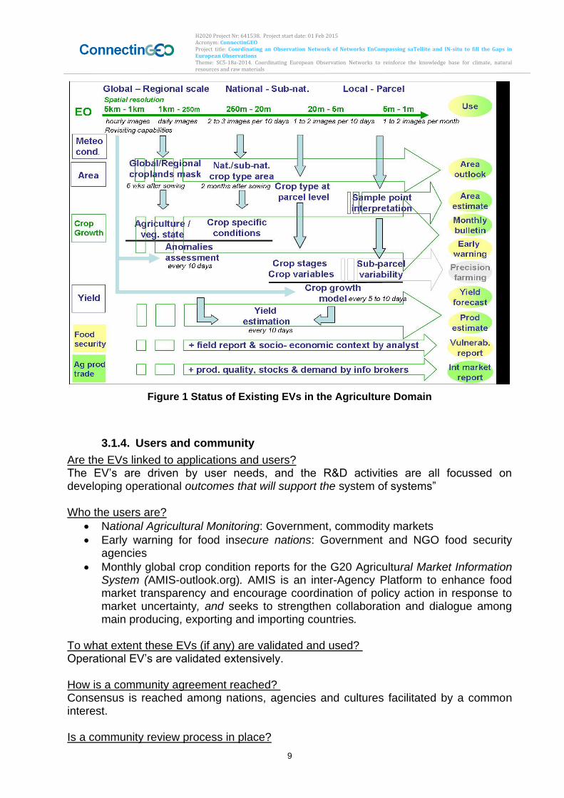
Figure 1 Status of Existing EVs in the Agriculture Domain
3.1.4. Users and community
Are the EVs linked to applications and users? The EV’s are driven by user needs, and the R&D activities are all focussed on developing operational outcomes that will support the system of systems”
Who the users are?
National Agricultural Monitoring: Government, commodity markets
Early warning for food insecure nations: Government and NGO food security agencies
Monthly global crop condition reports for the G20 Agricultural Market Information System (AMIS-outlook.org). AMIS is an inter-Agency Platform to enhance food market transparency and encourage coordination of policy action in response to market uncertainty, and seeks to strengthen collaboration and dialogue among main producing, exporting and importing countries.
To what extent these EVs (if any) are validated and used? Operational EV’s are validated extensively.
How is a community agreement reached? Consensus is reached among nations, agencies and cultures facilitated by a common interest.
Is a community review process in place?
H2020 Project Nr: 641538. Project start date: 01 Feb 2015 Acronym: ConnectinGEO Project title: Coordinating an Observation Network of Networks EnCompassing saTellite and IN-situ to fill the Gaps in European Observations Theme: SC5-18a-2014. Coordinating European Observation Networks to reinforce the knowledge base for climate, natural resources and raw materials
10
Yes, for global products monthly review meetings are held to vet the AMIS cop outlooks (fusion or science based EO and Ag-Met data and regional expertise); annual+ meetings to discuss the research agenda.
3.1.5. International bodies
Are the EVs linked to an international body (i.e. a UN convention or similar) and is this body involved in accepting the EVs?
Global Outlooks: GEO host the GEOGLAM secretariat. GEOGLAM/AMIS was created in response to the G20 Action Plan on Price volatility (France 2011), and re-affirmed (Mexico 2015).
Early Warning: Consensus on Early Warning Crop monitor way forward, May, 2015: Involved GEO; UN-FAO; FEWS-NET; World Food program; EC-JRC
National: Developed and vetted at national level. Several nations have operational monitoring systems but working together to build capacity in areas that do not have it.
There is no database with information about the EVs used but products are generated at different levels and these products use the EV and are accompanied by descriptions.
Summary crop conditions reports (amis-outlook.org)
Background information provided at the GEOGLAM crop monitoring website http://geoglam-crop-monitor.org
Information on JECAM research and annual reports: JECAM.org. Convergence of needs is being seen in the JECAM into a set of EVs. The network has no medium/large term security but in-kind contributions are not expected to fail soon sand monitoring will be maintained.
3.1.6. Challenges and how these are addressed
There are several products produced at different scales and temporal periodicities. There are still challenges to be addressed.
Not all nations share data and information equally. The fact that we are distributing summary data openly is stimulating some countries to release the data as they see the benefit.
Capacity issue in food insecure nations. There are still many countries that have bandwidth problems in accessing and downloading the data or running analysis.
Strong community built on common interest and best intentions with bottom-up vision and top down mandate (G20).
Primarily driven by in-kind resources. There is a need for more funding for the GEOGLAM secretariat (small glue funding).
Opportunity: Crowd sourcing crop conditions and adverse event impact on production, particularly in food insecure nations to bring more data.
H2020 Project Nr: 641538. Project start date: 01 Feb 2015 Acronym: ConnectinGEO Project title: Coordinating an Observation Network of Networks EnCompassing saTellite and IN-situ to fill the Gaps in European Observations Theme: SC5-18a-2014. Coordinating European Observation Networks to reinforce the knowledge base for climate, natural resources and raw materials
11
3.1.7. Gaps and requirements
There is a gap analysis conducted by a working group in CEOS to define data needs. They have produced an reference document (important for ConnectinGEO) with the title CEOS Acquisition Strategy for GEOGLAM that can be found here: http://ceos.org/document_management/Meetings/Plenary/28/21b_CEOS Acquisition Strategy for GEOGLAM V2 0 2014 Update v1.pdf.
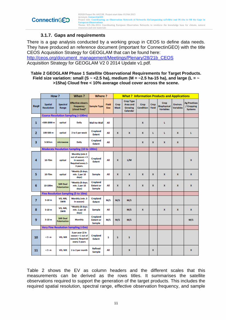
Table 2 GEOGLAM Phase 1 Satellite Observational Requirements for Target Products. Field size variation: small (S ~ <2.5 ha), medium (M = ~2.5 ha-15 ha), and large (L = ~
>15ha) Cloud free < 10% average cloud cover across the scene.
Table 2 shows the EV as column headers and the different scales that this measurements can be derived as the rows titles. It summarises the satellite observations required to support the generation of the target products. This includes the required spatial resolution, spectral range, effective observation frequency, and sample
H2020 Project Nr: 641538. Project start date: 01 Feb 2015 Acronym: ConnectinGEO Project title: Coordinating an Observation Network of Networks EnCompassing saTellite and IN-situ to fill the Gaps in European Observations Theme: SC5-18a-2014. Coordinating European Observation Networks to reinforce the knowledge base for climate, natural resources and raw materials
12
type for each product. 11 requirements have been defined in support of the target products.
‘X’ indicates data required for all field sizes; if data are to be used for only (or a combination of) large, medium, and/or small fields, the ‘X’ is supplanted with the field size designation.
Optical data refers to data spanning the visible, near-infrared, shortwave infrared, and long-wave infrared (thermal). Data requirements spanning less or different portions of the spectrum are specified accordingly.
Data should be made available near-real time, particularly for within season assessments;
Requirements have maximum and minimum ranges for spatial resolution, temporal resolution, and in some cases geographic extent;
Spatial resolution requirements are generated relative to field size; this is preliminary and could be refined/improved with a consideration of landscape heterogeneity and spatial pattern;
Meteorological parameters (snow cover, temp., rainfall, etc.) are not included in this table and will be addressed in another forum; and
Samples need to be coordinated and nested, but at present have been developed largely in the context of specific project needs and considerations.
H2020 Project Nr: 641538. Project start date: 01 Feb 2015 Acronym: ConnectinGEO Project title: Coordinating an Observation Network of Networks EnCompassing saTellite and IN-situ to fill the Gaps in European Observations Theme: SC5-18a-2014. Coordinating European Observation Networks to reinforce the knowledge base for climate, natural resources and raw materials
13
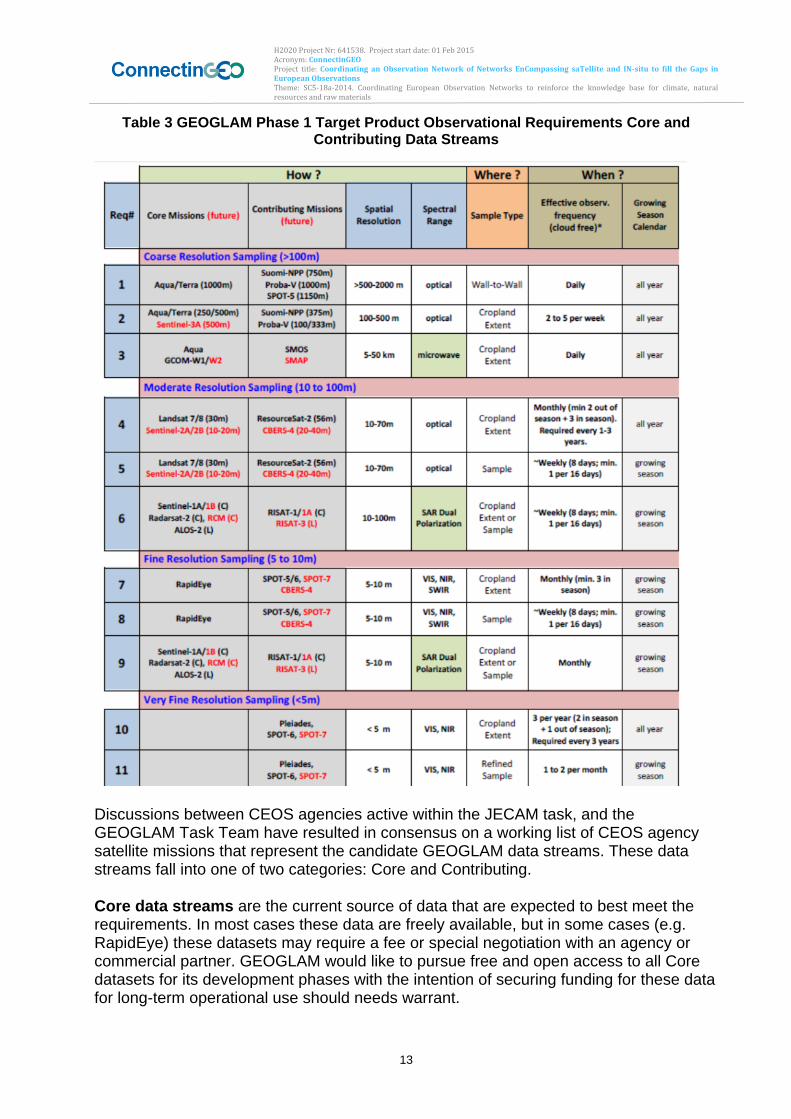
Table 3 GEOGLAM Phase 1 Target Product Observational Requirements Core and Contributing Data Streams
Discussions between CEOS agencies active within the JECAM task, and the GEOGLAM Task Team have resulted in consensus on a working list of CEOS agency satellite missions that represent the candidate GEOGLAM data streams. These data streams fall into one of two categories: Core and Contributing. Core data streams are the current source of data that are expected to best meet the requirements. In most cases these data are freely available, but in some cases (e.g. RapidEye) these datasets may require a fee or special negotiation with an agency or commercial partner. GEOGLAM would like to pursue free and open access to all Core datasets for its development phases with the intention of securing funding for these data for long-term operational use should needs warrant.
H2020 Project Nr: 641538. Project start date: 01 Feb 2015 Acronym: ConnectinGEO Project title: Coordinating an Observation Network of Networks EnCompassing saTellite and IN-situ to fill the Gaps in European Observations Theme: SC5-18a-2014. Coordinating European Observation Networks to reinforce the knowledge base for climate, natural resources and raw materials
14
Contributing data streams are the source of data that would be used for evaluation in the event the Core data streams are not available. It is possible that evaluation of contributing data will result in improved results such that a Contributing data source may be considered as a Core dataset in the future. GEOGLAM would like to pursue free and open access to all Contributing datasets for its development phases with the intention of securing funding for these data for long-term operational use should needs warrant. Table 3 shows how the GEOGLAM Core and Contributing data streams relate to the target product requirements.
3.1.8. Conclusions
Overlapping with EVs in other domains (SBA)
There is significant overlap with other SBA’s (as users and producers). Oportunity: to harmonize the needs of different document to engage more users in using the agriculture essential variables.
Priorities for EVs in Agriculture monitoring
Crop area, type, condition, phenology and yield
Refocus the variables to deal with sustainability context: Crop Management (tillage and residue) and link to other SBA’s (habitat biodiversity EVs, etc)
Recommendations for GEO/GEOSS in a global context:
Develop common approach to document EV’s and their observation requirements. EVs are a way to share common language and exchange information between domains.
Determine areas where EV/observation integration can occur. There is an strong bais to pursue some of the most funcamental EV’s that cut across multiple domains in a multi-disciplinary/domain/SBA fashion. Linking different user communities together.
3.2. Biodiversity
3.2.1. Introduction
The GEO_BON Initiative is coordinating the EV definition process for the Biodiversity. The process started with a first workshop on EBVs held from 27 to 29 February 2012 in Frascati, Italy The workshop explored the concept of EBVs, developed a conceptual framework for EBVs, defined an initial list of EBVs, their inter-relationships, and the inputs they depend upon, as well as draft components of a peer-reviewed EBV paper. The process is continuously evolving. During the workshop on EVs held in Bari, four presentations focused on EBVs (http://www.gstss.org/2015_Bari/program.php)
3.2.2. Status of EV discussion and EVs
The discussion on Essential Biodiversity Variables (EVBs) is quite advanced and very lively. The EBVs respond to the information needs of countries and national data are the
H2020 Project Nr: 641538. Project start date: 01 Feb 2015 Acronym: ConnectinGEO Project title: Coordinating an Observation Network of Networks EnCompassing saTellite and IN-situ to fill the Gaps in European Observations Theme: SC5-18a-2014. Coordinating European Observation Networks to reinforce the knowledge base for climate, natural resources and raw materials
15
building blocks of some EBVs. Generally, EBVs will be developed at the global scale from harmonized regional/national sub-units (Jorg Freyhof, GEO_BON, Bari workshop 2015). The definition of EV provided at the Bari workshop by the speakers representing the GEO-BON community and including also the contribution received from Columbia, is articulated as follows:
Essential is what needs to be monitored to describe and analyse the different dimensions of biodiversity change at multiple scale, e.g., local to regional, to global (Jorg Freyhof, GEO_BON, Bari workshop 2015; Pereira et al. 2013). In addition,
The variables should: reflect the most important items to observe; provide guidance to the observation system; respond to user needs; lie between raw observations and user needs (by G. Geller, GEO_BON, Bari workshop 2015). Such variables should be appropriately prioritized according on users needs
The list of candidate EBV classes and candidate EBV per class includes: genetic composition (co-ancestry, allaelic diversity, population genetic differentiation, breed and variety diversity), species populations, species traits, community composition, and ecosystem structure and ecosystem function. EBV candidates are reported in Table
4and for some of them, temporal requirements, in Table 5 (credits Pereira et al. 2013).
Table 4 List of Essential Biodiversity Variables
EBV class EBV candidate
Genetic composition Co-ancestry
Allelic diversity
Population genetic differentiation
Breed and variety diversity
Species populations Species distribution
Population abundance
Population structure by age/size class
Species traits Phenology
Body mass
Natal dispersion distance
Migratory behavior
Demographic traits
Physiological traits
Community composition Taxonomic diversity
Species interactions
Ecosystem function Net primary productivity
Secondary productivity
Nutrient retention
Disturbance regime
Ecosystem structure Habitat structure
H2020 Project Nr: 641538. Project start date: 01 Feb 2015 Acronym: ConnectinGEO Project title: Coordinating an Observation Network of Networks EnCompassing saTellite and IN-situ to fill the Gaps in European Observations Theme: SC5-18a-2014. Coordinating European Observation Networks to reinforce the knowledge base for climate, natural resources and raw materials
16
Ecosystem extent and fragmentation
Ecosystem composition by functional type
In Columbia, IDEAM and Humboldt Institute are mainly focusing on Ecosystem structure variables for forest ecosystems and are developing a Toolkit for supporting National and Regional scale biodiversity observations and Networks in the Neo-Tropics (Natalia Cordoba, Bari workshop 2015)
Table 5 Examples of Candidate Essential Biodiversity Variables
3.2.3. Methodology
Bottom-up and top-down approaches have been adopted in the GEO-BON community. . In Colombia they are mainly adopting the bottom-up approach, based on their expertize in EO data processing by using mainly optical images (Landsat and Modis) to be integrated with radar data. The current process for defining EVs within GEO-BON is articulated as follows:
Identify the users and specific types of user needs (e.g., Convention on the Biological Diversity (CBD))
Select variables that respond to user needs by announcing the “Call for EBV developers”
Developers utilize an on-line development framework, where a specific checklist is provided:
Each developer provides EV information according to the criteria in GEO-BON checklist and gets its own page
EV information is shown there and others can comment
Developer writes paper and submits to peer-reviewed journal as a validation process.
H2020 Project Nr: 641538. Project start date: 01 Feb 2015 Acronym: ConnectinGEO Project title: Coordinating an Observation Network of Networks EnCompassing saTellite and IN-situ to fill the Gaps in European Observations Theme: SC5-18a-2014. Coordinating European Observation Networks to reinforce the knowledge base for climate, natural resources and raw materials
17
If paper is accepted, then the GEO_BON community endorses the proposed EV.
Additional comments/issues possible. In order to evaluate and prioritize EVs, the following GCOS criteria are adopted: relevance, technical feasibility, cost effectiveness. The readiness of algorithm and data is also considered as additional criteria.
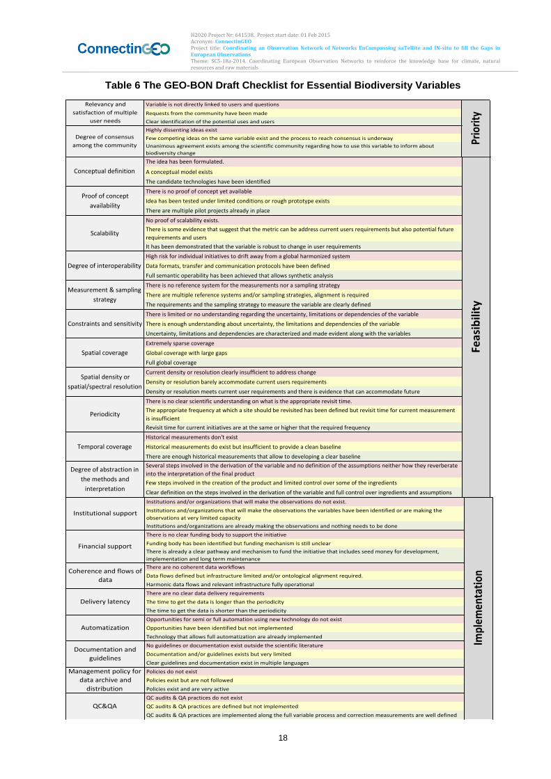
The GEO-BON draft checklist is reported hereafter (see Table 6) as useful for other communities (Geller, Bari workshop, 2015) The process is being updated and much work still has to be done mainly in terms of operationalization. As a perspective, it is proposed (Gery Geller, GEO-BON, Bari workshop 2015):
1) To develop EVs in conjunction with end user organization, such as UNFCCC, CBD, IPBES, governments and scientists.
2) End user org inserts need for EVs in formal documents so that GEO can point to those docs in discussions with members.
3) And request that CEOS respond and consider developing “Satellite Supplement”, as done by GCOS community
To be validated EBVs need to be measured, digitized, mobilized and finally made freely and openly available, a process just having started, also in Columbia where the users community is able to access the information generated in the framework of the Monitoring System of Forest and Carbon (SMBYC) project (Natalia Cordoba, Bari workshop 2015).
3.2.4. Users and community
Our Knowledge Society is based on science and technology, i.e., the availability of sound & reliable scientific data, analysis and interpretation (Christoph L. Häuser, Bari Workshop 2015). Scientific support is required to address the big issues related to Biodiversity loss and related ecosystem services degradation. In this framework, the candidate EBVs can support the needs closely linked to CBD Aichi Targets and the Intergovernmental Platform on Biodiversity and Ecosystem Services (IPBES), as well as many additional biodiversity-related conventions such as RAMSAR Convention on Wetlands, United Nation Convention to Combat Desertification (UNCCD), the Convention on Migratory Species (CMS). Governments need comprehensive and scientifically sound data and products on biodiversity and ecosystem service status and change. As an example, the commitments related to the Habitats Directive, the Bird Directive and the related Marine Strategy and Water Framework Directives strongly solicit the operationalization of the EBVs.
To date, GEO BON has three regional Biodiversity Observation Networks (BON), i.e. EU BON, AP-BON, and Arctic BON. The thematic BONs are encouraged to harmonize information that feeds directly into the development of Essential Biodiversity Variables.
H2020 Project Nr: 641538. Project start date: 01 Feb 2015 Acronym: ConnectinGEO Project title: Coordinating an Observation Network of Networks EnCompassing saTellite and IN-situ to fill the Gaps in European Observations Theme: SC5-18a-2014. Coordinating European Observation Networks to reinforce the knowledge base for climate, natural resources and raw materials
18
Table 6 The GEO-BON Draft Checklist for Essential Biodiversity Variables
Variableisnotdirectlylinkedtousersandquestions
Requestsfromthecommunityhavebeenmade
Clearidentificationofthepotentialusesandusers
Highlydissentingideasexist
Fewcompetingideasonthesamevariableexistandtheprocesstoreachconsensusisunderway
Unanimousagreementexistsamongthescientificcommunityregardinghowtousethisvariabletoinformabout
biodiversitychange
Relevancyand
satisfactionofmultiple
userneeds
Degreeofconsensus
amongthecommunity Priority
Theideahasbeenformulated.
Aconceptualmodelexists
Thecandidatetechnologieshavebeenidentified
Thereisnoproofofconceptyetavailable
Ideahasbeentestedunderlimitedconditionsorroughprototypeexists
Therearemultiplepilotprojectsalreadyinplace
Noproofofscalabilityexists.
Thereissomeevidencethatsuggestthatthemetriccanbeaddresscurrentusersrequirementsbutalsopotentialfuture
requirementsandusers
Ithasbeendemonstratedthatthevariableisrobusttochangeinuserrequirements
Highriskforindividualinitiativestodriftawayfromaglobalharmonizedsystem
Dataformats,transferandcommunicationprotocolshavebeendefined
Fullsemanticoperabilityhasbeenachievedthatallowssyntheticanalysis
Thereisnoreferencesystemforthemeasurementsnorasamplingstrategy
Therearemultiplereferencesystemsand/orsamplingstrategies,alignmentisrequired
Therequirementsandthesamplingstrategytomeasurethevariableareclearlydefined
Thereislimitedornounderstandingregardingtheuncertainty,limitationsordependenciesofthevariable
Thereisenoughunderstandingaboutuncertainty,thelimitationsanddependenciesofthevariable
Uncertainty,limitationsanddependenciesarecharacterizedandmadeevidentalongwiththevariables
Extremelysparsecoverage
Globalcoveragewithlargegaps
Fullglobalcoverage
Currentdensityorresolutionclearlyinsufficienttoaddresschange
Densityorresolutionbarelyaccommodatecurrentusersrequirements
Densityorresolutionmeetscurrentuserrequirementsandthereisevidencethatcanaccommodatefuture
Thereisnoclearscientificunderstandingonwhatistheappropriaterevisittime.
Theappropriatefrequencyatwhichasiteshouldberevisitedhasbeendefinedbutrevisittimeforcurrentmeasurement
isinsufficient
Revisittimeforcurrentinitiativesareatthesameorhigherthattherequiredfrequency
Historicalmeasurementsdon'texist
Historicalmeasurementsdoexistbutinsufficienttoprovideacleanbaseline
Thereareenoughhistoricalmeasurementsthatallowtodevelopingaclearbaseline
Severalstepsinvolvedinthederivationofthevariableandnodefinitionoftheassumptionsneitherhowtheyreverberate
intotheinterpretationofthefinalproduct
Fewstepsinvolvedinthecreationoftheproductandlimitedcontroloversomeoftheingredients
Cleardefinitiononthestepsinvolvedinthederivationofthevariableandfullcontroloveringredientsandassumptions
Conceptualdefinition
Proofofconcept
availability
Scalability
Degreeofinteroperability
Measurement&sampling
strategy
Constraintsandsensitivity
Spatialcoverage
Spatialdensityor
spatial/spectralresolution
Periodicity
Temporalcoverage
Degreeofabstractionin
themethodsand
interpretation
Feasibility
Institutionsand/ororganizationsthatwillmaketheobservationsdonotexist.
Institutionsand/organizationsthatwillmaketheobservationsthevariableshavebeenidentifiedoraremakingthe
observationsatverylimitedcapacity
Institutionsand/organizationsarealreadymakingtheobservationsandnothingneedstobedone
Thereisnoclearfundingbodytosupporttheinitiative
Fundingbodyhasbeenidentifiedbutfundingmechanismisstillunclear
Thereisalreadyaclearpathwayandmechanismtofundtheinitiativethatincludesseedmoneyfordevelopment,
implementationandlongtermmaintenance
Therearenocoherentdataworkflows
Dataflowsdefinedbutinfrastructurelimitedand/orontologicalalignmentrequired.
Harmonicdataflowsandrelevantinfrastructurefullyoperational
Therearenocleardatadeliveryrequirements
Thetimetogetthedataislongerthantheperiodicity
Thetimetogetthedataisshorterthantheperiodicity
Opportunitiesforsemiorfullautomationusingnewtechnologydonotexist
Opportunitieshavebeenidentifiedbutnotimplemented
Technologythatallowsfullautomatizationarealreadyimplemented
Noguidelinesordocumentationexistoutsidethescientificliterature
Documentationand/orguidelinesexistsbutverylimited
Clearguidelinesanddocumentationexistinmultiplelanguages
Policiesdonotexist
Policiesexistbutarenotfollowed
Policiesexistandareveryactive
QCaudits&QApracticesdonotexist
QCaudits&QApracticesaredefinedbutnotimplemented
QCaudits&QApracticesareimplementedalongthefullvariableprocessandcorrectionmeasurementsarewelldefined
Managementpolicyfor
dataarchiveand
distribution
QC&QA
Implem
entation
Institutionalsupport
Financialsupport
Coherenceandflowsof
data
Deliverylatency
Automatization
Documentationand
guidelines
H2020 Project Nr: 641538. Project start date: 01 Feb 2015 Acronym: ConnectinGEO Project title: Coordinating an Observation Network of Networks EnCompassing saTellite and IN-situ to fill the Gaps in European Observations Theme: SC5-18a-2014. Coordinating European Observation Networks to reinforce the knowledge base for climate, natural resources and raw materials
19
3.2.5. International bodies
Concerning monitoring networks, there are many currently operational. Some networks and regions have adopted the EBV concept to measure regional biodiversity. GEO-BON community has initiated a program that has as a goal to promote the development of national level biodiversity observation networks, where the EBV is used as the main framework that will guide these initiatives. In Columbia, they have a network of permanent plots and are in the process of including the Environmental local Authorities for long term monitoring, after a training process carried out by the IDEAM Institute
3.2.6. Challenges and steps to address these
The ongoing biodiversity loss and the continued and increased extinction rates and habitat loss are among the core challenges. There is a need to address the lack of basic data/knowledge, fragmentation of available information by solving the issues related to accessing/using existing data/knowledge and delivering targeted information in support to policy makers (Christoph L. Häuser, Bari workshop 2015).
3.2.7. Observational requirements and gaps
Some observational requirements are shown in Table 6. However, the problem of specific observational requirements to from EO has not been explicitly and systematically addressed for all the EBVs. Most efforts are devoted to global scale monitoring of EBVs and only recent work developed within previous FP7 space projects (BIO_SOS at www.biosos.eu and MS.Monina at www.ms-monina.eu/ ) have focused on fine scale Biodiversity monitoring, as requested by policy maker and management authorities of protected areas, such as the ones in Natura 2000 network. The new project titled Remote Sensing for Essential Biodiversity Variables (RS4EBV): An Innovator III project funded by the European Space Agency would address such multi-scale observational requirements. The project kicked off in March 2015 and will
run until early 2017 and its team consists of a core partnership between the UNEP
World Conservation Monitoring Centre (UNEP-WCMC) and the University of Twente – Faculty of Geo-Information Science and Earth Observation (UT-ITC) http://geobon.org/remote-sensing-for-essential-biodiversity-variables-rs4ebv/
Datadoesn'texists
Dataexistsbutitrequiresconsiderableeffortformobilization
Dataisfullyavailableandthefitforpurpose
Datamanagementplandoesn'texist
Datamanagementplanexistbutisnotcurrentlyimplemented
Datamanagementplanisfullyimplementincludingarchive,curationanddistributioninfrastructure
Dataisnotcurrentlyvalidated
Dataissomehowvalidatedhoweverprovenanceisnotfullyspecified
Fullyoperationaldatavalidationprocessonplaceandprovenanceisclearlyspecified
Short-termsustainabilitysecured(1to2years)
Mid-termsustainabilitysecured(2to5years)
Long-termsustainabilitysecured(5to10years)
Historicaldataforbaselinedoesn'texist
Availablehistoricaldatathatcanprovideabaselinebutitrequiressomework
Baselinealreadyexists
Productshavenotpermeatedthescientificcommunity
Productsarecurrentlybeingusedforpolicy
Productsarebeingusedinmanagementwithhighlevelofinvolvementatnationallevel
Status
Dataavailability
Datamanagement
Datavalidationand
provenance
Sustainability
Baselineavailability
Degreeofsocializationof
products
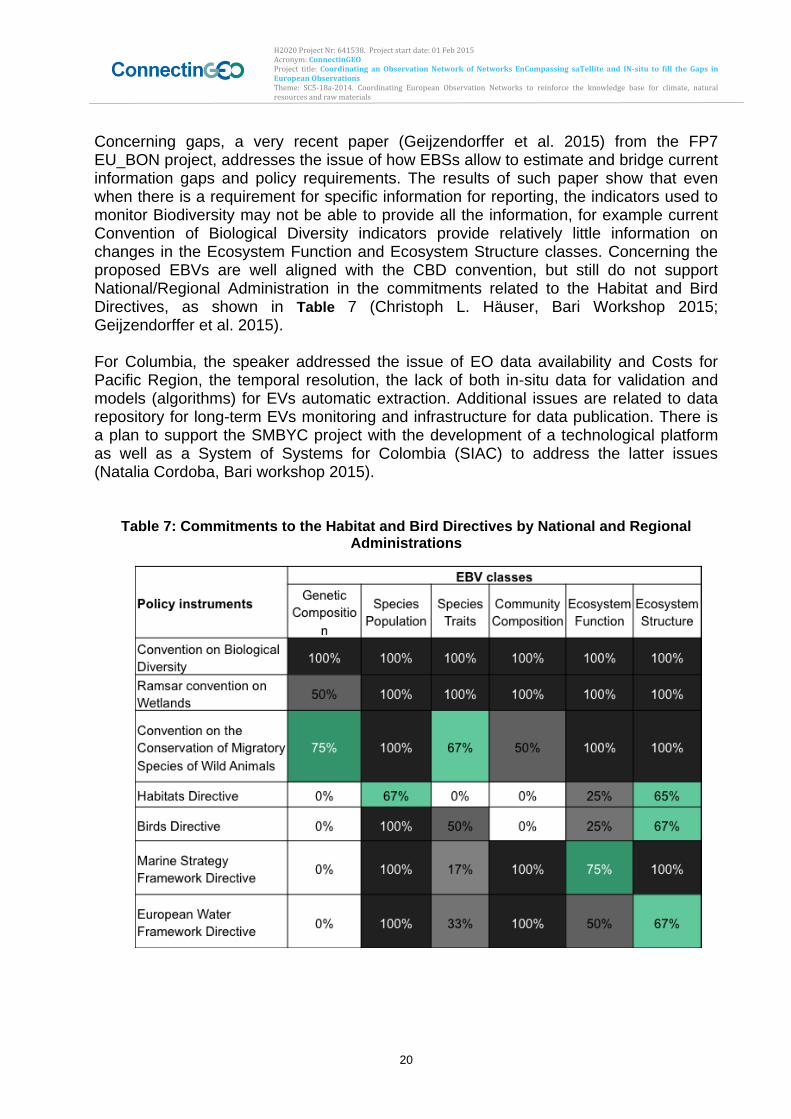
H2020 Project Nr: 641538. Project start date: 01 Feb 2015 Acronym: ConnectinGEO Project title: Coordinating an Observation Network of Networks EnCompassing saTellite and IN-situ to fill the Gaps in European Observations Theme: SC5-18a-2014. Coordinating European Observation Networks to reinforce the knowledge base for climate, natural resources and raw materials
20
Concerning gaps, a very recent paper (Geijzendorffer et al. 2015) from the FP7 EU_BON project, addresses the issue of how EBSs allow to estimate and bridge current information gaps and policy requirements. The results of such paper show that even when there is a requirement for specific information for reporting, the indicators used to monitor Biodiversity may not be able to provide all the information, for example current Convention of Biological Diversity indicators provide relatively little information on changes in the Ecosystem Function and Ecosystem Structure classes. Concerning the proposed EBVs are well aligned with the CBD convention, but still do not support National/Regional Administration in the commitments related to the Habitat and Bird Directives, as shown in Table 7 (Christoph L. Häuser, Bari Workshop 2015; Geijzendorffer et al. 2015). For Columbia, the speaker addressed the issue of EO data availability and Costs for Pacific Region, the temporal resolution, the lack of both in-situ data for validation and models (algorithms) for EVs automatic extraction. Additional issues are related to data repository for long-term EVs monitoring and infrastructure for data publication. There is a plan to support the SMBYC project with the development of a technological platform as well as a System of Systems for Colombia (SIAC) to address the latter issues (Natalia Cordoba, Bari workshop 2015).
Table 7: Commitments to the Habitat and Bird Directives by National and Regional
Administrations
H2020 Project Nr: 641538. Project start date: 01 Feb 2015 Acronym: ConnectinGEO Project title: Coordinating an Observation Network of Networks EnCompassing saTellite and IN-situ to fill the Gaps in European Observations Theme: SC5-18a-2014. Coordinating European Observation Networks to reinforce the knowledge base for climate, natural resources and raw materials
21
3.2.8. Conclusions
The status of EV discussion and definition is a dynamic process and continuously evolving. The the power of EBVs as a modelled layer between direct observations and indicators and its potential to generate global indicators and spatial explicit datasets is demonstrated by the recent activity of the GEO Bon community. Within the recent workshop held in September 2015 in Geneve, GEO BON presented a new generation of biodiversity indicators based on integrating information from a small set of EBVs: Species Distributions, Taxonomic Diversity (gamma diversity), Ecosystem Extent (http://www.geobon.org/Downloads/brochures/2015/GBCI_Version1.1_low.pdf). The new indicators developed in collaboration with GEO BON partners Map of Life and CSIRO and proposed for assessing and reporting progress against Aichi Targets 5, 11, 12, 15 and 19, are: the Species Habitat Indices (Target 5 and 12), the Biodiversity Habitat Index (Target 5), the Species Protection Index Target 11), the Protected Area Representativeness and Connectedness Indices (Target 11), the Global Ecosytem Restoration Index (Target 15), and the Species Status Information Index (Target 19). Such indicators were very well received (http://geobon.org/geo-bon-presents-a-new-generation-of-biodiversity-indicators-at-cbd-ahteg/).
The GEO_BON community has initiated a program aiming to promote the development of national level biodiversity observation networks, where the EBV is used as the main framework to guide these initiatives. As pointed out by (Jorg Freyhof, GEO_BON, Bari workshop 2015) national and regional project partners are adopting the concept of EBV to structure their monitoring data and observational Biodiversity networks. This would speed up to the operationalization process.
Obstacles in the definition of EVs relate to divers users and users needs, heterogeneity (e.g. for in-situ data) and tensions between science and applications. Identifying essential questions appears fundamental for making the definition of essential variables easier. Also in this community the GCOS process and criteria were useful as reference to initiate the EBV definition in the Biodiversity domain. To conclude, there is a very high community acceptance of EBVs and both existing FP7 (e.g., EU_BON) and new Horizon2020 (e.g., ECOPOTENTIAL) projects are contributing to the process of EBVs definition and implementation. However, as pointed out in previous section 3.2.7, no systematic work on multi-scale observational requirements from EO data has been carried out so far for the candidate variables. The new project titled Remote Sensing for Essential Biodiversity Variables (RS4EBV): An Innovator III project funded by the European Space Agency would address such observational requirements.
3.3. Climate
3.3.1. Introduction
In the frame of the GEO SBA Climate, we also consider EVs relevant for atmospheric composition, the carbon cycle, and Greenhouse gases. Climate (intended as climate variability and change) and carbon cycle (intended also as greenhouse gases emissions) are themes crosscutting different domains, as well different GEO Societal Benefit Areas (SBAs). The Essential Climate Variables (ECVs) are internationally well
H2020 Project Nr: 641538. Project start date: 01 Feb 2015 Acronym: ConnectinGEO Project title: Coordinating an Observation Network of Networks EnCompassing saTellite and IN-situ to fill the Gaps in European Observations Theme: SC5-18a-2014. Coordinating European Observation Networks to reinforce the knowledge base for climate, natural resources and raw materials
22
recognized since more than 10 years and many of them are essential also in other areas, not just climate or carbon cycle (www.wmo.int/pages/prog/gcos/index.php?name=EssentialClimateVariables). The ECVs are identified in three different domains: atmosphere (under the leadership of GCOS-WMO), ocean (under the leadership of IC-GOOS-UNESCO) and land (under the leadership of GTOS-FAO); see the following paragraph for more details. In this Section we focus on the EVs relevant to climate, carbon, and atmospheric composition issues, while more information on the EVs in the ocean domain can be found in Section 3.11. For atmospheric composition, the community is developing a set of area-specific EVs, which are defined in the context of their use in supporting priority applications (either directly in the prediction or in the evaluation). The presenter (i.e., Greg Carmichael from WMO-GAW) did not attend previous meeting. The community is considering reference documents from other communities.
3.3.2. Status of existing EVs in the domain
The variable essential for the climate domains, the so called ECVs, Essential Climate Variables, were already identified by the Global Climate Observing System (GCOS) more than 10 years ago. The ECVs mission is to support the work of the UNFCCC and the IPCC and other end users in achieving their objectives and mandates. A recent definition describes an ECV as “a physical, chemical, or biological variable or a group of linked variables that critically contributes to the characterization of Earth’s climate” (Bojinski et al., 2014). This definition is widely accepted by the scientific community and endorsed by the United Nation Convention on Climate Change (UNFCCC) and other international bodies and programmes. ECVs datasets provide the empirical evidence needed to understand and predict the evolution of climate, to guide mitigation and adaptation measures, to assess risks and enable attribution of climatic events to underlying causes, and to underpin climate services. The current ECVs list includes 50 variables in the three domains of Atmosphere, Ocean and Land (Table 8).
Table 8: List of Agreed-Upon GCOS Essential Climate Variables
Domain GCOS Essential Climate Variables
Atmospheric Surface: Air temperature, Wind speed and direction, Water vapour, Pressure, Precipitation, Surface radiation budget. Upper-air: Temperature, Wind speed and direction, Water vapour, Cloud properties, Earth radiation budget (including solar irradiance). Composition: Carbon dioxide, Methane, and other long-lived greenhouse gases, Ozone and Aerosol, supported by their precursors.
Oceanic Surface: Sea-surface temperature, Sea-surface salinity, Sea level, Sea state, Sea ice, Surface current, Ocean colour, Carbon dioxide partial pressure, Ocean acidity, Phytoplankton. Sub-surface: Temperature, Salinity, Current, Nutrients, Carbon dioxide partial pressure, Ocean acidity, Oxygen, Tracers.
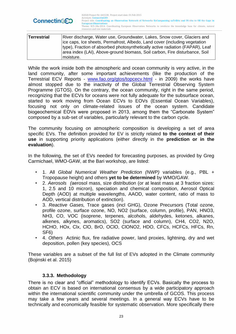
H2020 Project Nr: 641538. Project start date: 01 Feb 2015 Acronym: ConnectinGEO Project title: Coordinating an Observation Network of Networks EnCompassing saTellite and IN-situ to fill the Gaps in European Observations Theme: SC5-18a-2014. Coordinating European Observation Networks to reinforce the knowledge base for climate, natural resources and raw materials
23
Terrestrial River discharge, Water use, Groundwater, Lakes, Snow cover, Glaciers and ice caps, Ice sheets, Permafrost, Albedo, Land cover (including vegetation type), Fraction of absorbed photosynthetically active radiation (FAPAR), Leaf area index (LAI), Above-ground biomass, Soil carbon, Fire disturbance, Soil moisture.
While the work inside both the atmospheric and ocean community is very active, in the land community, after some important achievements (like the production of the Terrestrial ECV Reports - www.fao.org/gtos/topcecv.html - in 2009) the works have almost stopped due to the inactivity of the Global Terrestrial Observing System Programme (GTOS). On the contrary, the ocean community, right in the same period, recognizing that the ECVs for oceans were not fully adequate for the subsurface ocean, started to work moving from Ocean ECVs to EOVs (Essential Ocean Variables), focusing not only on climate-related issues of the ocean system. Candidate biogeochemical EOVs were proposed in 2013, among them the “Carbonate System” composed by a sub-set of variables, particularly relevant to the carbon cycle. The community focusing on atmospheric composition is developing a set of area specific EVs. The definition provided for EV is strictly related to the context of their use in supporting priority applications (either directly in the prediction or in the evaluation). In the following, the set of EVs needed for forecasting purposes, as provided by Greg Carmichael, WMO-GAW, at the Bari workshop, are listed:
• 1. All Global Numerical Weather Prediction (NWP) variables (e.g., PBL + Tropopause height) and others yet to be determined by WMO/GAW.
• 2. Aerosols (aerosol mass, size distribution (or at least mass at 3 fraction sizes: 1, 2.5 and 10 micron), speciation and chemical composition, Aerosol Optical Depth (AOD) at multiple wavelengths, AAOD, water content, ratio of mass to AOD, vertical distribution of extinction).
• 3. Reactive Gases, Trace gases (incl GHG), Ozone Precursors (Total ozone, profile ozone, surface ozone, NO, NO2 (surface, column, profile), PAN, HNO3, NH3, CO, VOC (isoprene, terpenes, alcohols, aldehydes, ketones, alkanes, alkenes, alkynes, aromatics), SO2 (surface and column), CH4, CO2, N2O, HCHO, HOx, Clx, ClO, BrO, OClO, ClONO2, HDO, CFCs, HCFCs, HFCs, Rn, SF6)
• 4. Others Actinic flux, fire radiative power, land proxies, lightning, dry and wet deposition, pollen (key species), OCS
These variables are a subset of the full list of EVs adopted in the Climate community (Bojinski et al. 2015)
3.3.3. Methodology
There is no clear and “official” methodology to identify ECVs. Basically the process to obtain an ECV is based on international consensus by a wide participatory approach within the international scientific community under the umbrella of GCOS. This process may take a few years and several meetings. In a general way ECVs have to be technically and economically feasible for systematic observation. More specifically there
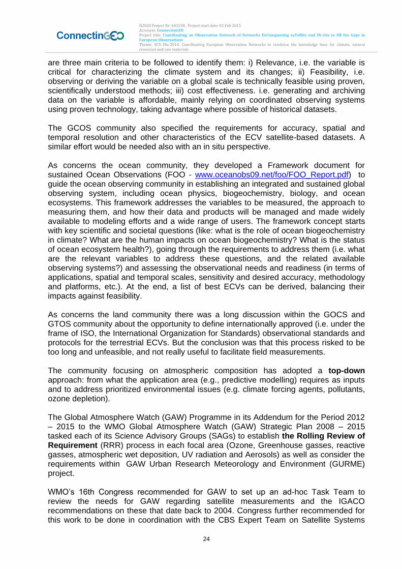
H2020 Project Nr: 641538. Project start date: 01 Feb 2015 Acronym: ConnectinGEO Project title: Coordinating an Observation Network of Networks EnCompassing saTellite and IN-situ to fill the Gaps in European Observations Theme: SC5-18a-2014. Coordinating European Observation Networks to reinforce the knowledge base for climate, natural resources and raw materials
24
are three main criteria to be followed to identify them: i) Relevance, i.e. the variable is critical for characterizing the climate system and its changes; ii) Feasibility, i.e. observing or deriving the variable on a global scale is technically feasible using proven, scientifically understood methods; iii) cost effectiveness. i.e. generating and archiving data on the variable is affordable, mainly relying on coordinated observing systems using proven technology, taking advantage where possible of historical datasets. The GCOS community also specified the requirements for accuracy, spatial and temporal resolution and other characteristics of the ECV satellite-based datasets. A similar effort would be needed also with an in situ perspective. As concerns the ocean community, they developed a Framework document for sustained Ocean Observations (FOO - www.oceanobs09.net/foo/FOO_Report.pdf) to guide the ocean observing community in establishing an integrated and sustained global observing system, including ocean physics, biogeochemistry, biology, and ocean ecosystems. This framework addresses the variables to be measured, the approach to measuring them, and how their data and products will be managed and made widely available to modeling efforts and a wide range of users. The framework concept starts with key scientific and societal questions (like: what is the role of ocean biogeochemistry in climate? What are the human impacts on ocean biogeochemistry? What is the status of ocean ecosystem health?), going through the requirements to address them (i.e. what are the relevant variables to address these questions, and the related available observing systems?) and assessing the observational needs and readiness (in terms of applications, spatial and temporal scales, sensitivity and desired accuracy, methodology and platforms, etc.). At the end, a list of best ECVs can be derived, balancing their impacts against feasibility. As concerns the land community there was a long discussion within the GOCS and GTOS community about the opportunity to define internationally approved (i.e. under the frame of ISO, the International Organization for Standards) observational standards and protocols for the terrestrial ECVs. But the conclusion was that this process risked to be too long and unfeasible, and not really useful to facilitate field measurements. The community focusing on atmospheric composition has adopted a top-down approach: from what the application area (e.g., predictive modelling) requires as inputs and to address prioritized environmental issues (e.g. climate forcing agents, pollutants, ozone depletion). The Global Atmosphere Watch (GAW) Programme in its Addendum for the Period 2012 – 2015 to the WMO Global Atmosphere Watch (GAW) Strategic Plan 2008 – 2015 tasked each of its Science Advisory Groups (SAGs) to establish the Rolling Review of Requirement (RRR) process in each focal area (Ozone, Greenhouse gasses, reactive gasses, atmospheric wet deposition, UV radiation and Aerosols) as well as consider the requirements within GAW Urban Research Meteorology and Environment (GURME) project. WMO’s 16th Congress recommended for GAW to set up an ad-hoc Task Team to review the needs for GAW regarding satellite measurements and the IGACO recommendations on these that date back to 2004. Congress further recommended for this work to be done in coordination with the CBS Expert Team on Satellite Systems
H2020 Project Nr: 641538. Project start date: 01 Feb 2015 Acronym: ConnectinGEO Project title: Coordinating an Observation Network of Networks EnCompassing saTellite and IN-situ to fill the Gaps in European Observations Theme: SC5-18a-2014. Coordinating European Observation Networks to reinforce the knowledge base for climate, natural resources and raw materials
25
(ET-SAT) and the Expert Team on Evolution of the Global Observing Systems (ET-EGOS), the Committee on Earth Observation Satellites (CEOS) Atmospheric Composition Constellation group and the Coordination Group for Meteorological Satellites (CGMS) and also taking into consideration GCOS requirements and the vision for the GOS in 2025. Concerning validation, the community is adopting extensive protocols, such as CCLs and WCCP, many used in trend and assessment analysis.
3.3.4. Users and community
The communities working on climate-relevant essential variables are mainly regrouped and organized under the umbrella of GCOS and GOOS. In the frame of these two programmes there are process, basically based on meetings, discussions and approvals, for reaching community agreement and review. The users potentially interested in EVs data and products on climate related issues range from the scientific community to governmental bodies, from public to private sector, from mass media to the general public. In principle the ECVs are conceived to serve the need of key users, like the research community, particularly under the frame of IPCC and the policy-relevant community, like UNFCCC (see the following section for more details). Another key categories of users are the same data providers, i.e. the monitoring networks, that use EVs and their spatio-temporal variation trends for research purposes linked to climate change. While there is the general recognition about the importance of users in assessing the value of the essential variables, a clear unique process for identification of users and their needs, for collecting their feedbacks, as well as a validation mechanism does not seem to be in place. The EV use and validation mainly rely on the evidence provided by the scientific publications in peer-reviewed journals. There is no unique network and/or infrastructure system and one single database on ECVs and other climate and carbon relevant variables. Among the most relevant there are: ARGO (for ocean temperature and salinity), FluxNet (for terrestrial carbon fluxes), GAW (Global Atmospheric Watch), ICOS (EU Integrated Carbon Observing System), IMOS (Integrated Marine Observing System), IOOS (US Integrated Ocean Observing System), NEON (US National Ecological Observatory Network), OceanSites, SOOP (Ship-of-Opportunity Programme), and others. There are also several satellite platforms to indirectly or directly measure climate relevant variables. Among them GOSAT (Greenhouse Gases Observing SATellite) and OCO2 (Orbiting Carbon Observatory) are two from the most recent missions to measure CO2, CH4 and other GHG concentrations in the atmosphere, while SCIAMACHY (SCanning Imaging Absorption spectroMeter for Atmospheric CHartographY) was measuring different kind of radiation. There are also the terrestrial networks previously coordinated under the GTOS’ umbrella, like GTN-P (Global Terrestrial Network for Permafrost), GTN-G (Global Terrestrial Network for Glaciers), GTN-H (Global Terrestrial Network for Hydrology) and GTN-R (Global Terrestrial Network for River Discharge).
H2020 Project Nr: 641538. Project start date: 01 Feb 2015 Acronym: ConnectinGEO Project title: Coordinating an Observation Network of Networks EnCompassing saTellite and IN-situ to fill the Gaps in European Observations Theme: SC5-18a-2014. Coordinating European Observation Networks to reinforce the knowledge base for climate, natural resources and raw materials
26
A list of main databases available online is here provided:
AsiaFlux, www.asiaflux.net/datapolicy.html
CARBOCHANGE, http://carbochange.b.uib.no/data/dataportals
CARBOOCEAN data portal, http://dataportal.carboocean.org
Emission Database for Global Atmospheric Research, http://edgar.jrc.ec.europa.eu/index.php
European Fluxes Database, www.europe-fluxdata.eu
European Eddy Fluxes databases cluster, www.europe-fluxdata.eu/newtcdc2/p_home.aspxwww.rainfor.org
Global Fire Emission Database, www.globalfiredata.org/Data/index.html
Globalview, www.esrl.noaa.gov/gmd/ccgg/globalview
GloRiCh - Global River Chemistry Database, www.ifbm.zmaw.de/GloRiCh-Global-River-Chemistry.6468.0.html?&L=3
RAINFOR - Amazon Forest Inventory Network, www.rainfor.org
SOCAT (Surface Ocean CO2 Atlas) Data Access System, www.socat.info/about.html
WMO World Data Center for Greenhouse Gases, http://gaw.kishou.go.jp/wdcgg Within the atmospheric composition community, several GAW networks are recognized by GCOS as networks for Essential Climate Variables. WMO’s 16th Congress recommended for GAW to set up an ad-hoc Task Team to review the needs for GAW regarding satellite measurements and the IGACO recommendations on these that date back to 2004. Congress further recommended for this work to be done in coordination with the CBS Expert Team on Satellite Systems (ET-SAT) and the Expert Team on Evolution of the Global Observing Systems (ET-EGOS), the Committee on Earth Observation Satellites (CEOS) Atmospheric Composition Constellation group and the Coordination Group for Meteorological Satellites (CGMS) and also taking into consideration GCOS requirements and the vision for the GOS in 2025. The users are varied: general public, the media, the scientific community (including satellite people and modellers), conventions and protocols.
3.3.5. International bodies
The ECVs process is endorsed by the UNFCCC. GCOS periodically report to the UNFCCC Subsidiary Body for Scientific and Technological Advice (SBSTA) under the “Research and Systematic Observation” agenda item, about the ECVs status and progress. For instance, GCOS has recently submitted to UNFCCC-SBSTA its report GCOS-195 – Status of the Global Observing System for Climate (http://www.wmo.int/pages/prog/gcos/Publications/GCOS-195_en_LowRes.pdf), to be discussed at COP21 in Paris (December 2015). The report reviews the overall status of each ECVs, assesses progress against the latest Implementation plan, the Implementation Plan for the Global Observing System for Climate in Support of the UNFCCC (2010 Update), and identifies gaps. The report does not provide actions or plans to address gaps, deficiencies or additional requirements that have been identified: this is the role of the new GCOS Implementation Plan being developed for release and submission to the UNFCCC in 2016.
H2020 Project Nr: 641538. Project start date: 01 Feb 2015 Acronym: ConnectinGEO Project title: Coordinating an Observation Network of Networks EnCompassing saTellite and IN-situ to fill the Gaps in European Observations Theme: SC5-18a-2014. Coordinating European Observation Networks to reinforce the knowledge base for climate, natural resources and raw materials
27
Moreover, the ECVs have been endorsed by several other international organizations and programmes, according to their relevance: WMO for the atmospheric domain, UNESCO, through IOC-GOOS, for the ocean domain, and FAO, through the GTOS programme, for the terrestrial domain. Also ESA (European Space Agency) adopted the ECVs concept and launched its Climate Change Initiative (ESA-CCI) to exploit long-term global records of ECVs from space-based observations. ECVs are also at the basis of the Climate Data Store of the European Earth observation programme Copernicus. The main international organizations involved in the atmospheric composition community are the World Meteorological Organization (WMO), United Nations Environment Programme (UNEP) and the World Health Organization (WHO). Concerning the monitoring networks currently operational for medium-term / long-term monitoring, GAW is collaborating with the Total Carbon Column Observing Network (TCCON), IMPROVE-Optical; European Aerosol Research Lidar Network (EARLINET); Latin American LIdar Network (LALINET or ALINE); Asian Dust Network (AD-Net); National Atmospheric Deposition Program (NADP); Atmospheric Chemistry Monitoring Network in Africa (IDAF). More information at http://www.wmo.int/pages/prog/arep/gaw/ gaw_home_en.html. In addition, the Network for the Detection of Atmospheric Composition Change (NDACC), establish links between climate change and atmospheric composition. Providing also support to both satellite calibration and validation and models validation (De Mazière, Paris workshop 2015)
3.3.6. Challenges and how these are addressed
The challenges are described in the next section together with observational requirements and gaps.
3.3.7. Challenges, Observational requirements and Gaps
The GCOS climate monitoring principles is a list of 20 useful principles to be adopted for an effective monitoring system for climate (www.wmo.int/pages/prog/gcos/documents/GCOS_Climate_Monitoring_Principles.pdf). The new GCOS Implementation Plan that will be released in 2016, will provide an updated view on actions and plans to address gaps, deficiencies or additional requirements that have been identified. The GCOS document “Systematic Observation Requirements for Satellite-Based Data Products for Climate” (www.wmo.int/pages/prog/gcos/documents/SatelliteSupplement2011Update.pdf) defines the requirements for satellite instruments and satellite datasets, the calibration, validation and data archiving needs, the adequacy/inadequacy of current holdings, and the actions needed. The data products requirements are described in terms of Spatial Resolution (vertical and horizontal), temporal resolution, accuracy and stability (i.e. the extent to which the error of a product remains constant over a long period, typically a decade or more). It provides guidance on how to address these issues. The GTOS terrestrial ECVs reports provided an assessment of the status of the methodology, protocols, networks, and other issues, with a focus on the development of
H2020 Project Nr: 641538. Project start date: 01 Feb 2015 Acronym: ConnectinGEO Project title: Coordinating an Observation Network of Networks EnCompassing saTellite and IN-situ to fill the Gaps in European Observations Theme: SC5-18a-2014. Coordinating European Observation Networks to reinforce the knowledge base for climate, natural resources and raw materials
28
the standards for each single Terrestrial ECVs. In these documents the requirements in terms of accuracy, resolution, etc., are considered. They were released in 2009 but have not been updated since then. The ocean community, being in the process of approving the EOVs, are also working on the definition of the observational requirements of these variables. As regards carbon observations in particular, a recent paper (Ciais et al., 2014) analyzed the state, challenges and observational requirements of a global carbon monitoring system. Among the challenges that Ciais et al. (2014) highlighted are: i) bring remote-sensing measurements to a level of long-term consistency and accuracy so that they can be efficiently combined in models to reduce uncertainties, in synergy with ground based data; ii) bring tight observational constraints on fossil fuel and land use change emissions, for providing policy-relevant observations; iii) significantly increase the resolution and density of in situ and remotely sensed data; iv) advance with the modelling tools and applications. Aside the above documents, a systematic gaps analysis on data availability and repositories, models (algorithms) for EV extraction, and operational networks and infrastructure needed to observe EVs, does not seem to be carried out. Most of the current monitoring networks in different domains have an inadequate geographical coverage and do not allow for capturing all the implications of the monitored phenomena. For instance the majority of the flux sites are located at temperate latitudes, while the plant productivity is largest in the tropics, similarly most of the inventory sites are located at temperate latitudes, while carbon storage is largest in the tropics. Also southern oceans are less studied. Moreover, in many case these monitoring networks are supported by short term research projects. To implement a long-term funding strategy for maintain monitoring networks is a challenge needed to go beyond the funding period of research projects. Another challenge is to reduce significantly the uncertainty in the obtained numbers. The current level of scientific knowledge allows a consistent understanding of the general status and trends of the climate system and carbon uptake and emission trends. However, the uncertainties are too high for undertaking legally binding commitments and other policy actions with the required reliability. For the atmospheric composition community, challenges arise due to different parameters, different platforms, varying capacity of the Members, and different availability of resources. The following steps should be addressed (Greg Carmichael, Bari workshop 2015):
Strict requirement to the quality of observations
Worldwide use of the same standards
Harmonized observation methods A GAW Task Team was established in 2014 to identify observational requirements and satellite measurements and includes the following members: WMO/GAW and user representatives: Greg Carmichael, WMO EPAC SSC Chair. (Chair of the TT) Ben Veihelman, ESA / ESTEC
H2020 Project Nr: 641538. Project start date: 01 Feb 2015 Acronym: ConnectinGEO Project title: Coordinating an Observation Network of Networks EnCompassing saTellite and IN-situ to fill the Gaps in European Observations Theme: SC5-18a-2014. Coordinating European Observation Networks to reinforce the knowledge base for climate, natural resources and raw materials
29
Claire Granier, LATMOS-IPSL and NOAA/ERSL & CU/CIRES, France Sander Houweling, SRON, Netherlands (GHG SAG) Randall Martin, Dalhousie Univ., Canada Terry Nakajima, CESD/AORI, Japan Vincent-Henri Peuch, ECMWF, (Copernicus and MACC-II) Sandro Fuzzi, CNR, Italy As requested by WMO Congress John Eyre, UKMO, chair IPET-OSDE Richard Eckman, CEOS (NASA), USA Rosemary Munro, CGMS (EUMETSAT) Claus Zehner, ESA/ESRIN Such requirements depend on application areas, which include (Carmichael, Bari Workshop 2015):
Forecasting (F) Atmospheric Composition in Near Real Time (NRT) - Covers applications from global to regional scales (with horizontal resolutions
similar to global Numerical Weather Prediction (NWP) (~ 10 km and coarser) with stringent timeliness requirements (NRT) to support operations such as sand and dust storm and chemical weather forecasts.
Monitoring (M) Atmospheric Composition in Near Real Time - Covers applications related to evaluating and analysing changes (temporally
and spatially) in atmospheric composition regionally and globally to support treaty monitoring, climatologies and re-analyses, assessing trends in composition and emissions/fluxes, and to better understand processes, using data of controlled quality (and with less stringent time requirements (not needed in NRT)), and used in products such as Ozone and Greenhouse Gas Bulletins, and State/Heath of the Atmosphere reports.
Providing Atmospheric Composition information to support services in urban and populated areas (U)
- Covers applications that target limited areas (with horizontal resolution of a few km or smaller and stringent timeliness requirements to support services related to weather/climate/pollution, such as air quality forecasting.
An initial set of observational requirements of GAW is reported in the presentation of Carmichael at the Bari Workshop (Table 9). However, as well evidenced by the author, there is still a need for prioritization, expert and end user input.
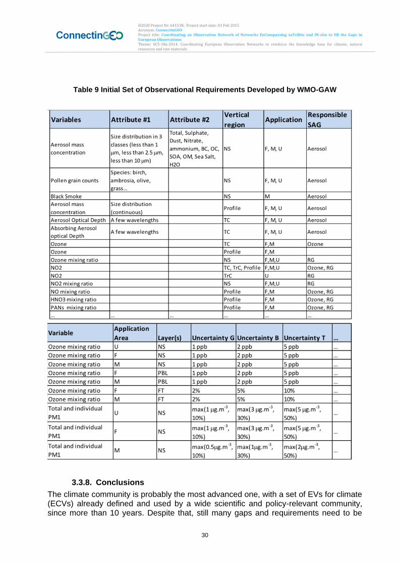
H2020 Project Nr: 641538. Project start date: 01 Feb 2015 Acronym: ConnectinGEO Project title: Coordinating an Observation Network of Networks EnCompassing saTellite and IN-situ to fill the Gaps in European Observations Theme: SC5-18a-2014. Coordinating European Observation Networks to reinforce the knowledge base for climate, natural resources and raw materials
30
Table 9 Initial Set of Observational Requirements Developed by WMO-GAW
3.3.8. Conclusions
The climate community is probably the most advanced one, with a set of EVs for climate (ECVs) already defined and used by a wide scientific and policy-relevant community, since more than 10 years. Despite that, still many gaps and requirements need to be
H2020 Project Nr: 641538. Project start date: 01 Feb 2015 Acronym: ConnectinGEO Project title: Coordinating an Observation Network of Networks EnCompassing saTellite and IN-situ to fill the Gaps in European Observations Theme: SC5-18a-2014. Coordinating European Observation Networks to reinforce the knowledge base for climate, natural resources and raw materials
31
addressed. Fortunately, many different efforts in different domains and communities, are converging in order to produce new plans and strategies on the variables essential for climate observations and understanding, and the requirements to effectively monitor and use them. The overlaps with other EVS in other domains are evident. Most of the ECVs are relevant to fields and domains other than climate, cross-cutting almost all the other GEO SBAs and themes: in addition to atmosphere, ocean and land, there are ECVs relevant to agriculture, biodiversity, disasters, ecosystems, energy, health, human settlements, water, weather, and others. This linkages are specifically emphasized in the following relevant chapters. The added value of GEO and its GEOSS could be the provision of cross-coordination among the different communities and networks working on the ECVs, in synergy with the GCOS programme. It is highly recommended to improve the GEO-GCOS relationships in general, and the use of ECVs can be one of the specific sectors where this collaboration can be improved with useful results. Other issues were there is room for significant improvements through the GEO intervention are the following:
Substantial expansions of the ground-based observation networks (i.e. in southern oceans, tropical forests, and the Arctic) are required to reach the needed high spatial resolution (at least for CO2 and CH4 fluxes, and for carbon stocks) for addressing policy-relevant objectives. In situ derived variables have then to be complemented with remote-sensed ones: in order to have a reliable full vision, in situ observations providing the ground “truth” and satellite imagery offer a synoptic view at global level with frequent revisit.
The adoption of internationally agreed standards and protocols for measuring and analysing EVs could represent a useful step forward for improving interoperability and the application of these variables. GEO can advocate for the adoption of standards and protocols.
The high number of different database available online, in some case also driving to the same contents, makes difficult to the users to understand and access to the full range of available data. It is recommended to promote the integration of all the relevant compatible datasets into one single access point. Even more, a common data processing, analysis, archival, and distribution system, with careful attention to user-friendly protocols for end-product formats, delivery protocols, and metadata, is highly desirable. This is right the role that GEO can play with its common infrastructure and data portal.
A systematic mechanism to identify and approach users should be developed, in order to get their feedbacks the EVs use, usefulness and requirements, as well as assess their validation. GEO can set up this mechanism in the frame of the new work plan and users’ involvement task.
The lack of funding is one of the fundamental issues that limits data continuity. GEO can advocate with GEO members to sustain the current monitoring networks and develop new ones, especially in less developed regions.
A common strategy, in the frame of the new GEO Work Plan, to address the EVs concept in an interoperable way across the different communities, should be developed and agreed.
H2020 Project Nr: 641538. Project start date: 01 Feb 2015 Acronym: ConnectinGEO Project title: Coordinating an Observation Network of Networks EnCompassing saTellite and IN-situ to fill the Gaps in European Observations Theme: SC5-18a-2014. Coordinating European Observation Networks to reinforce the knowledge base for climate, natural resources and raw materials
32
Of course this is not an exhaustive list, and many other issues have to be addressed. But this list highlights some key element to improve the quality and applicability of essential variable on climate and carbon and show how the contribution that can be given by GEO to address these issues. More in general, to ensure the provision of high quality (and quality controlled) essential policy-relevant variable on climate and carbon, an integrated and coordinated global climate and GHG observing and analysis system is needed, with a time perspective, considering both sustainability and maintainability, of some decades, ideally through at least 2050. The implementation of such a system need to be a collaborative effort on an international scale, both to ensure transparency and credibility, as well as to pool the needed resources (human, infrastructural, knowledge, financial, etc.) together. This is the place were GEO can definitively play a leading role. In the atmospheric composition community, the GAW Task Team is committed to engage the GAW Scientific Advisory Groups and other users: to define the observations requirements for the three applications areas (i.e., M, F, U) ready by autumn 2015; to identify specific requirements for a set of priority variable of common interest for the application areas; finally, to populate the WMO RRR database for the applications mentioned by the end of 201. As future activity, GAW will review the statements for gap analysis and will regularly update the requirements for the three application areas (F, M, U), as part of the WMO Rolling Review Requirements process. In addition, GAP and will assist other WMO applications areas in reviewing atmospheric composition requirements. The main goal is to inform the Vision for WMO Integrated Global Observing System (WIGOS) surface/space components in 2040, and subsequent update of the Coordinating Group for Meteorological Satellite (CGMS) baseline.
3.4. Disasters
3.4.1. Introduction
Disasters result from a wide range of natural and anthropogenic hazards interacting with anthropogenic infrastructure, socio-economic communities, and the environment. In order to inform risk management and to understand the processes that lead from hazards to disasters, information is required on the hazards, the vulnerability of socio-economic communities, the infrastructure, and the environment, and the potential impacts of the hazards on socio-economic processes, infrastructure and services, and the environment. Efforts to define EVs have been made in several areas of risk management, although often not using the terminology of EVs. The most recent global agreement on efforts for disaster risk reduction, the Sendai Framework for Disaster Risk Reduction 2015 – 2030 (United Nation, 2015) does not use the terminology of EVs.
3.4.2. Status of EV discussion and EVs
In the context of GEO, the work plan tasks in the Disaster SBA did not engage in a comprehensive dialog about Essential Disaster Risk Variables (EDRVs). The most advanced deliberations focused on the hazards. The Geohazards Community of Practice (GHCP, see http://www.geohazcop.org) built on the work carried out by the
H2020 Project Nr: 641538. Project start date: 01 Feb 2015 Acronym: ConnectinGEO Project title: Coordinating an Observation Network of Networks EnCompassing saTellite and IN-situ to fill the Gaps in European Observations Theme: SC5-18a-2014. Coordinating European Observation Networks to reinforce the knowledge base for climate, natural resources and raw materials
33
IGOS-P Geohazards Theme (Marsh et al., 2004) and developed a comprehensive set of observational requirements for geohazards (Salichon et al., 2007; LeCozannet and Salichon, 2007), which implicitly defines a set of EDRVs for geohazards. Other SBA communities such as climate, weather, and water communities addressed domain-specific EVs for extreme events, which are relevant for natural hazards in these domains. Much less has been done in terms of vulnerability and resilience. In terms of anthropogenic hazards, GEO has not engaged to any mentionable extent in defining EVs or observational requirements. Cascading effects and secondary hazards resulting from the interaction of natural and anthropogenic hazards with an increasingly complex and globally connected and interdependent society have not been considered in a discussion of EDRVs,
3.4.3. Methodology
A challenge for the development of EDRVs is the wide range of natural and anthropogenic hazards, the complexity of human society, and the cyclic nature of risk management and resilience. Risk management is composed of four phases, including preparedness, early warning, response, and recovery. Each of these phases has its own, though overlapping, set of EDRVs. The complexity and interconnectedness of human society with rapid developments in technology, infrastructure and organization complicates the determination and monitoring of changing vulnerabilities and community disaster resilience. The wide range of natural and anthropogenic hazards challenges the definition of a minimal set of EVs for these hazards. Taking a risk-based approach, risk can be defined as the product of hazard probability, vulnerability of an exposed asset to the hazard, and the value of the exposed asset. For a comprehensive risk assessment, the full probability density function of the hazard needs to be known together with the vulnerability of exposed assets (including infrastructure, services, social fabric, economic productivity, and natural environment) as a function of hazard intensity. In a community disaster resilience approach, comprehensive sets of EDRVs could be derived for each of the risk management phases.
3.4.4. International Organizations involved and monitoring networks
Currently there seems to be no coordinated international activity focusing on EDRVs. The Sendai Framework could provide a context for such an activity, and GEO could take a lead in developing a process for the identification of EDRVs.
3.4.5. Challenges and Steps to Address these
Disaster risk management is a very wide field challenging the determination of a minimal set of EDRVs. The different types of hazards (geological, hydrometeorological, biological, and extraterrestrial) require different sets of EVs. Likewise, the exposed assets and their vulnerability also require complex sets of EVs. Documenting hazardous events and their impacts in form a disasters requires a combination of environmental and socio-economic variables. It will be important to address the linkage between EDRVs and those identified in other SBAs.
H2020 Project Nr: 641538. Project start date: 01 Feb 2015 Acronym: ConnectinGEO Project title: Coordinating an Observation Network of Networks EnCompassing saTellite and IN-situ to fill the Gaps in European Observations Theme: SC5-18a-2014. Coordinating European Observation Networks to reinforce the knowledge base for climate, natural resources and raw materials
34
3.4.6. Observational requirements and Gaps
A comprehensive set of observational requirements for hazard, vulnerability, resilience and disaster-related observations does not seem to exist. The GHCP developed observational requirements for geohazards (LeCozannet and Salichon, 2007).
3.4.7. Conclusions
Deliberations on EDRVs do not seem to have started in any well-defined process. Up to now, EVs have only been identified for a few partical aspects of the risk management cycle mainly focusing on hazards. GEO could play an important role in developing a process to identify comprehensive sets of EDRVs for the different phases of the disaster risk managment cycle.
3.5. Ecosystems
3.5.1. Introduction
There is still lack on consensus on how to measure ecosystem functions and ecosystems services. The experts consulted think that pick some EV from other communities such as the EBV and ECV could be enough. Even if this can be a good step in the right direction the question of having the right set of variable to full characterize the ecosystems functions and services remains.
3.5.2. Status of EV discussion and EVs
The discussion on EVs for ecosystems has recently started by firstly focusing on the definition of what an ecosystem is, due to the intrinsic complexity of any ecosystem. An ecosystem is composed by a biotic component whose core element for dynamic processes is biodiversity. On the other hand an ecosystem can be considered a very complex adaptive system, which includes not only biotic but also non-biotic components and the interactions with their special environment, with which they form one physical system (Tansley 1935). Ecosystems are complex adaptive systems. Recently emerging in the literature, macrosystem ecology (MSE) presents a conceptual framework for investigating ecological patterns and processes related to ecosystems at regional to continental scales (extents), named “macroscales” (with distances spanning hundreds to thousands of kilometres). Ecosystem phenomena operate across a range of scales but the development of ecological theory of regions to continents lags behind that of finer scales. “Components” at these spatial scales are biological (eg species, populations, communities), geophysical (eg climate, physiography, hydrology, geochemistry), and social (eg political systems, economies, cultures), and can span timescales ranging from days to millennia. When interacting with one another and with phenomena at other spatial or temporal scales, these components constitute a “macrosystem” (Sorrano et al. 2014a and 2014b).
MSE is the study of such extensive and multi-scaled systems and treats the components of regions to continents as a set of interacting parts of a system. Integration of fine-scaled mechanisms with broad-scale patterns and processes will
H2020 Project Nr: 641538. Project start date: 01 Feb 2015 Acronym: ConnectinGEO Project title: Coordinating an Observation Network of Networks EnCompassing saTellite and IN-situ to fill the Gaps in European Observations Theme: SC5-18a-2014. Coordinating European Observation Networks to reinforce the knowledge base for climate, natural resources and raw materials
35
improve predictions of environmental change and better inform environmental policy at the scale of regions to continents.
In such framework, cross-scale interactions are very important to understand the dynamics of ecosystems. Processes at one spatial or temporal scale can interact with processes at another scale, often resulting in nonlinear dynamics with thresholds. Researchers are trying to develop models that include inhomogeneity of the system at different scale and identify variables to be monitored. Components at local scales can interact and accumulate across space to produce patterns and processes at the macroscale, often referred to as emergent properties (Heffernan et al. 2014; Antonello Provenzale, Bari workshop 2015). Global and regional climate models for climate predictions typically account for large-scale land-atmosphere feedbacks. However, these models omit local vegetation-environment feedbacks that may be crucial for critical transitions in ecosystems at larger scales. In more recent research, Rietkerk at al. (2011) propose the hypothesis that, if the balance of feedbacks is positive at all scales, local vegetation-environment feedbacks may trigger a cascade of amplifying effects, propagating from local to large scale, possibly leading to critical transitions in the large-scale climate. Consequently there is a need for linking local ecosystem feedbacks with large-scale land- atmosphere feedbacks in global and regional climate models for improving climate predictions.
There also fluxes inside and outside ecosystems to be considered. Fluxes of water, carbon, phosphorous, nitrogen are generally considered as necessary to the dynamic of ecosystems. As an example, rainfall is a driver for biodiversity, but it is an internal variable for ecosystems. You change the ecosystem and you change the rainfall in the Amazon. However, there are also other fluxes (e.g., iron, bore) that are not necessary but can have a negative impact on the state of ecosystems and should be analysed. Uncertainty measurements are finally requested when taking into account the physical information relating each component of an ecosystem. In this framework, the discussion is focusing on the selection of EVs from other domains useful for specific purposes. To do that, the questions, the issues should be first identified, based on prior knowledge (science).
There are variables, which are essential for some applications but insignificant for others. Rainfall is a driver for ecosystems, but it is an EV for biodiversity, if you change the ecosystem you change the water. Different uses of the terms "drivers," "variables," cause confusion in the literature and in discussions on the dynamics of ecosystems and social–ecological systems. Three main sources of confusion are unclear definition of the system, unclear definition of the role of people, and confusion between variables and drivers. (Walker at al., 2012). In dynamical terms, a system is defined by (composed of) its state variables, and it is the relationships among them that are of central interest. The system changes as a consequence of both these internal relationships and the effects of external drivers—variables that, within the scale of the analysis, are not considered to be part of the system and are not affected by what happens within the system. Drivers come from larger scales, and one of the sources of confusion in multi-stakeholder discussions arises when stakeholders have different focal scales, and the focal scale for some includes variables that are “external” for others. It is necessary to decide what is in and outside the system because this is not always obvious.
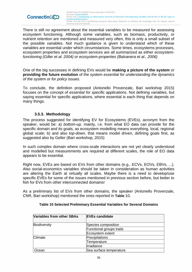
H2020 Project Nr: 641538. Project start date: 01 Feb 2015 Acronym: ConnectinGEO Project title: Coordinating an Observation Network of Networks EnCompassing saTellite and IN-situ to fill the Gaps in European Observations Theme: SC5-18a-2014. Coordinating European Observation Networks to reinforce the knowledge base for climate, natural resources and raw materials
36
There is still no agreement about the essential variables to be measured for assessing ecosystem functioning. Although some variables, such as biomass, productivity, or nutrient retention are mentioned and measured very often, this is only a small subset of the possible variables. Not much guidance is given to understand which of these variables are essential under which circumstances. Some times, ecosystems processes, ecosystem properties and ecosystem services are all summarized as either ecosystem-functioning (Giller et al. 2004) or ecosystem-properties (Balvanera et al., 2006) One of the big successes in defining EVs would be making a picture of the system or providing the future evolution of the system essential for understanding the dynamics of the system or for policy issues. To conclude, the definition proposed (Antonello Provenzale, Bari workshop 2015) focuses on the concept of essential for specific applications. Not defining variables, but saying essential for specific applications, where essential is each thing that depends on many things.
3.5.3. Methodology
The process suggested for identifying EV for Ecosystems (EVEs), acronym from the speaker, would be: a) bottom-up, mainly, i.e. from what EO data can provide for the specific domain and its goals, as ecosystem modelling means everything, local, regional global scale; b) and also top-down, that means model driven, defining goals first, as suggested also by Geller (Bari workshop, 2015) In such complex domain where cross-scale interactions are not yet clearly understood and modelled but measurements are required at different scales, the role of EO data appears to be essential. Right now, EVEs are based on EVs from other domains (e.g., ECVs, EOVs, EBVs, ...). Also social-economics variables should be taken in consideration as human activities are altering the Earth at virtually all scales. Maybe there is a need to develop/use specific EVEs for some of the issues mentioned in previous section before, but better to fish for EVs from other interconnected domains! As a preliminary list of EVs from other domains, the speaker (Antonello Provenzale, CNR, Bari workshop) mentioned the ones reported in Table 10.
Table 10 Selected Preliminary Essential Variables for Several Domains
Variables from other SBAs EVEs candidate
Biodiversity Species composition
Functional groups traits
Ecosystem extent
Climate Precipitations
Temperature
Irradiance
Ocean Sea surface temperature
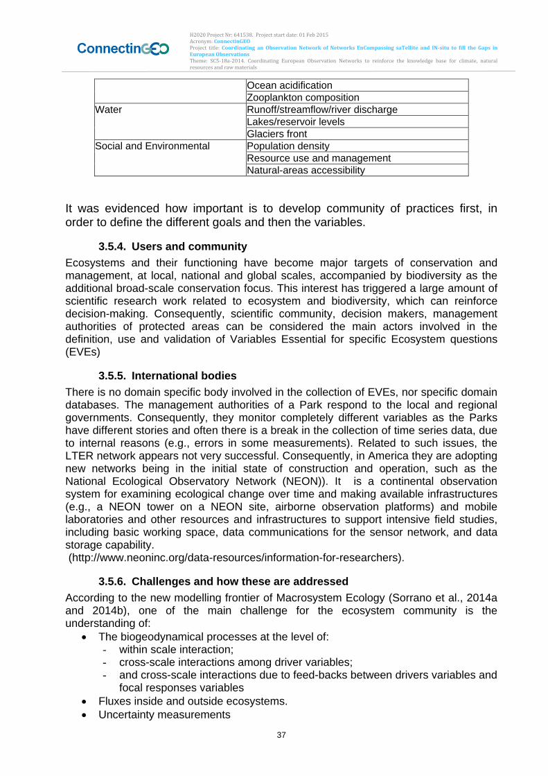
H2020 Project Nr: 641538. Project start date: 01 Feb 2015 Acronym: ConnectinGEO Project title: Coordinating an Observation Network of Networks EnCompassing saTellite and IN-situ to fill the Gaps in European Observations Theme: SC5-18a-2014. Coordinating European Observation Networks to reinforce the knowledge base for climate, natural resources and raw materials
37
Ocean acidification
Zooplankton composition
Water Runoff/streamflow/river discharge
Lakes/reservoir levels
Glaciers front
Social and Environmental Population density
Resource use and management
Natural-areas accessibility
It was evidenced how important is to develop community of practices first, in order to define the different goals and then the variables.
3.5.4. Users and community
Ecosystems and their functioning have become major targets of conservation and management, at local, national and global scales, accompanied by biodiversity as the additional broad-scale conservation focus. This interest has triggered a large amount of scientific research work related to ecosystem and biodiversity, which can reinforce decision-making. Consequently, scientific community, decision makers, management authorities of protected areas can be considered the main actors involved in the definition, use and validation of Variables Essential for specific Ecosystem questions (EVEs)
3.5.5. International bodies
There is no domain specific body involved in the collection of EVEs, nor specific domain databases. The management authorities of a Park respond to the local and regional governments. Consequently, they monitor completely different variables as the Parks have different stories and often there is a break in the collection of time series data, due to internal reasons (e.g., errors in some measurements). Related to such issues, the LTER network appears not very successful. Consequently, in America they are adopting new networks being in the initial state of construction and operation, such as the National Ecological Observatory Network (NEON)). It is a continental observation system for examining ecological change over time and making available infrastructures (e.g., a NEON tower on a NEON site, airborne observation platforms) and mobile laboratories and other resources and infrastructures to support intensive field studies, including basic working space, data communications for the sensor network, and data storage capability. (http://www.neoninc.org/data-resources/information-for-researchers).
3.5.6. Challenges and how these are addressed
According to the new modelling frontier of Macrosystem Ecology (Sorrano et al., 2014a and 2014b), one of the main challenge for the ecosystem community is the understanding of:
The biogeodynamical processes at the level of: - within scale interaction; - cross-scale interactions among driver variables; - and cross-scale interactions due to feed-backs between drivers variables and
focal responses variables
Fluxes inside and outside ecosystems.
Uncertainty measurements
H2020 Project Nr: 641538. Project start date: 01 Feb 2015 Acronym: ConnectinGEO Project title: Coordinating an Observation Network of Networks EnCompassing saTellite and IN-situ to fill the Gaps in European Observations Theme: SC5-18a-2014. Coordinating European Observation Networks to reinforce the knowledge base for climate, natural resources and raw materials
38
The exploitation of multi-scale EO data and techniques would provide useful inputs to MSE research efforts, within the Horizon2020 ECOPOTENTIAL project.
3.5.7. Gaps and requirements
The Gap analysis for the EVEs is difficult to achieve due to the state of research and the complexity of ecosystem state and functioning understanding. The new MSE approach, coupled with the use of multi-scale multi-temporal EO data and techniques, would contribute to the re-use of existing EVs and definition of new EVEs (if needed) depending on specific domain issues. This research will be carried out in the framework of the Horizon2020 ECOPOTENTIAL project
3.5.8. Conclusions
The speaker considers the proliferation of EVs not useful in the complex domain of ecosystems. It is wrong to look for universality in such complex domain where even in very simple system it is not possible to apply a generalized variable. This makes more sense in other domains such as climatology, meteorology. Consequently, EVEs are linked with and extracted from other societal benefits areas (e.g., Biodiversity, Water, Climate, Social and Health).. No major dedicated-EO network exists nevertheless, as it is possible to obtain EVEs to serve the community by exploiting EO networks from the other SBAs. The interest of the recent Horizon2020 ECOPOTENTIAL project is to further investigate and prioritize those variables according to specific domain questions and different ecosystem types.
3.6. Energy
3.6.1. Introduction
Renewable Eenergy (RE) is a domain where no major dedicated EO network exists. No formal attempt by international bodies to define EVs was undertaken. Nevertheless EV has been established through several international projects involving stakeholders. In the following, we make a review of the RE situation concerning EV.
3.6.2. Status of EV discussion and EVs
The first formalized attempt from the Energy Community of Practices (Energy CoP) involved within GEO, to develop a set of area-specific EVs was linked with the GEO Task US-09-01a. This task entitled “Identify Critical Earth Observation Priorities for Societal Benefit Areas”, aimed at establishing a process for identifying critical Earth observation priorities common to many of the nine GEO societal benefit areas, involving scientific and technical experts, taking account of socio-economic factors, and building on the results of existing systems’ requirements development processes. Other attempts were based on users’ needs (industrial users) coming from collaborative projects or users surveys since 2000. Stakeholders in RE have a pragmatic way to solve their needs of information, data and variables, they did not yet define the term Essential of the EV. Hence, a first attempt to define the Renewable Energy - Essential Variables

H2020 Project Nr: 641538. Project start date: 01 Feb 2015 Acronym: ConnectinGEO Project title: Coordinating an Observation Network of Networks EnCompassing saTellite and IN-situ to fill the Gaps in European Observations Theme: SC5-18a-2014. Coordinating European Observation Networks to reinforce the knowledge base for climate, natural resources and raw materials
39
(RE-EV) is done within this project. This definition will be widely communicated to the RE community. The proposed definition is: Renewable Energy Essential Variables (RE-EVs) are variables that meet important requirements from RE stakeholders and that are technically and economically feasible for systematic observation and global implementation. The ConnectinGEO project focuses on the solar, wind and ocean energies. The proposed list of RE-EVs is a first attempt to defined such concept and it will evolved in the future according to the technical advances in energy systems and the observation processes. For solar energy (Thermal, PV and CSP):
Solar Surface Irradiance and its components (global, direct, diffuse)
Surface air temperature
Land use, Land cover (including urbanization, hydrology, grid description, …)
Elevation (Orography) For onshore wind:
Wind speed and direction
Land surface temperature
Surface atmospheric pressure
Surface air temperature
Surface humidity
Land use, Land cover (including urbanization, hydrology, grid description, …)
Elevation (Orography) For Ocean (fixed and floating offshore wind, wave, tidal, currents, OTEC)
Wave (height, direction, period)
Wind speed and direction
Tidal (min, max, sea surface elevation)
Current (speed, direction)
Temperature (sea-surface, sub-surface and deep-sea)
Bathymetry
3.6.3. Methodology
The approach used for defining the RE-EVs is a bottom-up approach. It starts from the stakeholders needs expressed since 2000 in collaborative projects such as ENVISOLAR, EO-WindFARM, EO-Hydro projects realized within the Earth Observation Market Development Programme from ESA, from FP5, FP6, FP7 and H2020 projects such as SoDa, MESOR, ENDORSE, EQUIMAR and many others such as those of the International Renewable Energy Agency (IRENA) or the tasks of the International Energy Agency (IEA). It is a system-based approach, gathering an inventory of variables, information and data for defining the Energy system life cycle. (Fig. 2) represents all the steps of the life cycle
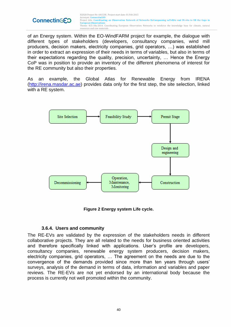
H2020 Project Nr: 641538. Project start date: 01 Feb 2015 Acronym: ConnectinGEO Project title: Coordinating an Observation Network of Networks EnCompassing saTellite and IN-situ to fill the Gaps in European Observations Theme: SC5-18a-2014. Coordinating European Observation Networks to reinforce the knowledge base for climate, natural resources and raw materials
40
of an Energy system. Within the EO-WindFARM project for example, the dialogue with different types of stakeholders (developers, consultancy companies, wind mill producers, decision makers, electricity companies, grid operators, …) was established in order to extract an expression of their needs in terms of variables, but also in terms of their expectations regarding the quality, precision, uncertainty, … Hence the Energy CoP was in position to provide an inventory of the different phenomena of interest for the RE community but also their properties. As an example, the Global Atlas for Renewable Energy from IRENA (http://irena.masdar.ac.ae) provides data only for the first step, the site selection, linked with a RE system.
Figure 2 Energy system Life cycle.
3.6.4. Users and community
The RE-EVs are validated by the expression of the stakeholders needs in different collaborative projects. They are all related to the needs for business oriented activities and therefore specifically linked with applications. User’s profile are developers, consultancy companies, renewable energy system producers, decision makers, electricity companies, grid operators, … The agreement on the needs are due to the convergence of the demands provided since more than ten years through users’ surveys, analysis of the demand in terms of data, information and variables and paper reviews. The RE-EVs are not yet endorsed by an international body because the process is currently not well promoted within the community.
H2020 Project Nr: 641538. Project start date: 01 Feb 2015 Acronym: ConnectinGEO Project title: Coordinating an Observation Network of Networks EnCompassing saTellite and IN-situ to fill the Gaps in European Observations Theme: SC5-18a-2014. Coordinating European Observation Networks to reinforce the knowledge base for climate, natural resources and raw materials
41
3.6.5. International bodies
The international bodies fully or partly involved in the identification and collection of RE-EVs are GEO, IRENA and IEA. But no coordination currently exists between all of them. Through the activities of the Energy CoP of GEO, links are built between GEO and IRENA and between IEA and IRENA. Though the Energy community makes extensive use of EO-based products for their daily research and business activities, the main difficulty regarding RE-EVs is that no major dedicated Earth Observation network (in-situ and/or satellites) currently exists. All the RE-EVs are linked with other Societal Benefit Areas such as Weather, Climate, Water, Agriculture or other scientific domains of interest such as Ocean. Nevertheless, through GEO and the establishment of GEOSS, some activities are launched to better assessing and promoting the use of these RE-EVs. A GEOSS Community Portal, webservice-energy.org, proposes a geo-spatial catalog of data and metadata for RE, several Web-GIS applications and a collection of Web services. Within ConnectinGEO, one of the outputs of WP5 targeting industrial challenges will be the release of a platform for collecting and offering access to in-situ measurements of EVs related to solar and wind energy.
3.6.6. Challenges and Steps to Address these
The main challenges for RE-EVs are:
Determining RE-EVs for all renewable energies (solar, wind and ocean are addressed in ConnectinGEO).
Benefiting of other SBA-EVs and translating them into RE-EVs (example: from ECV, the surface radiation budget into DNI, GHI, Diffuse, Spectral distribution using proxies).
Translating RE-EVs into observational requirements in order to define specific EO networks for renewable energies including precision, accuracy, and uncertainty.
Ensuring the dissemination of RE-EVs to the stakeholders
3.6.7. Observational requirements and Gaps
The Gap analysis for the RE-EVs is difficult to achieve due to the lack of dedicated RE-EV networks. Nevertheless, the priorities are to take advantage of the other observational networks to fulfill the gaps of RE-EVs, in terms of quality, coverage, … The Webservice-energy.org community portal is the EO data repository for renewable energies. Access to in-situ data and metadata is also dealt with, in this community portal. Through WP5, preliminary work is achieved for demonstrating the benefits of using a Sensor Observing Service to collect, process and disseminate the in-situ measurements, in a collaborative approach with stakeholders in solar energy.
3.6.8. Conclusions
All the RE-EVs are linked with and extracted from other societal benefits areas. No major dedicated RE-EO network exists. Nevertheless, by exploiting EO networks from the other SBAs, it is possible to obtain RE-EVs in order to serve the community. The future plans and the needed work are:
To determine the RE-EVs for all renewable energies
H2020 Project Nr: 641538. Project start date: 01 Feb 2015 Acronym: ConnectinGEO Project title: Coordinating an Observation Network of Networks EnCompassing saTellite and IN-situ to fill the Gaps in European Observations Theme: SC5-18a-2014. Coordinating European Observation Networks to reinforce the knowledge base for climate, natural resources and raw materials
42
To translate other SBA-EVs into RE-EVs (example: from ECV, the surface radiation budget into DNI, GHI, Diffuse, Spectral distribution using proxies).
To translate RE-EVs into observational requirements in order to define specific EO networks for renewable energies including precision, accuracy, and uncertainty
To ensure the dissemination of RE-EVs to stakeholders Renewable Energy For solar:
Solar Surface Irradiance and its components (global, direct, diffuse)
Surface air temperature
Surface humidity
Cloud cover
Precipitation
Urbanization
Land use, Land cover For onshore wind:
Wind speed and direction
Land surface temperature
Surface atmospheric pressure
Surface air temperature
Surface humidity
Urbanization
Land use, Land cover
Elevation For Ocean
Wave (height, direction, period)
Wind speed and direction
Tidal (min, max, sea surface elevation)
Current (speed, direction)
Temperature (sea-surface and sub-surface)
Bathymetry
3.7. Health
3.7.1. Introduction
Changes in the natural environment can compromise human health. Droughts may lead to malnutrition and life-threatening forest fires. Dust storms and smog often cause respiratory illnesses. Algal blooms contaminate seafood. Climate change and extreme weather events are associated with a wide range of health risks. Emerging infectious diseases such as HIV/AIDS and Lyme appear to be linked to land-use changes that have opened up previously hidden pathways for disease transmission. The Group on Earth Observations is working with the Health community to improve the flow of user-friendly environmental data. Comprehensive data sets support prevention, early warning, research, health-care planning and delivery, and timely public alerts. Gathered and distributed through the Global Earth Observation System of Systems,
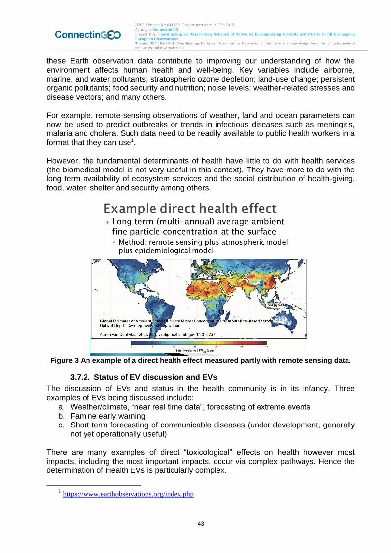
H2020 Project Nr: 641538. Project start date: 01 Feb 2015 Acronym: ConnectinGEO Project title: Coordinating an Observation Network of Networks EnCompassing saTellite and IN-situ to fill the Gaps in European Observations Theme: SC5-18a-2014. Coordinating European Observation Networks to reinforce the knowledge base for climate, natural resources and raw materials
43
these Earth observation data contribute to improving our understanding of how the environment affects human health and well-being. Key variables include airborne, marine, and water pollutants; stratospheric ozone depletion; land-use change; persistent organic pollutants; food security and nutrition; noise levels; weather-related stresses and disease vectors; and many others. For example, remote-sensing observations of weather, land and ocean parameters can now be used to predict outbreaks or trends in infectious diseases such as meningitis, malaria and cholera. Such data need to be readily available to public health workers in a format that they can use1. However, the fundamental determinants of health have little to do with health services (the biomedical model is not very useful in this context). They have more to do with the long term availability of ecosystem services and the social distribution of health-giving, food, water, shelter and security among others.
Figure 3 An example of a direct health effect measured partly with remote sensing data.
3.7.2. Status of EV discussion and EVs
The discussion of EVs and status in the health community is in its infancy. Three examples of EVs being discussed include:
a. Weather/climate, “near real time data”, forecasting of extreme events b. Famine early warning c. Short term forecasting of communicable diseases (under development, generally
not yet operationally useful) There are many examples of direct “toxicological” effects on health however most impacts, including the most important impacts, occur via complex pathways. Hence the determination of Health EVs is particularly complex.
1 https://www.earthobservations.org/index.php
H2020 Project Nr: 641538. Project start date: 01 Feb 2015 Acronym: ConnectinGEO Project title: Coordinating an Observation Network of Networks EnCompassing saTellite and IN-situ to fill the Gaps in European Observations Theme: SC5-18a-2014. Coordinating European Observation Networks to reinforce the knowledge base for climate, natural resources and raw materials
44
3.7.3. Methodology
A formal methodology has not materialized, however the basic workflow is as follows: a. Top down: start with health significance – the significance of the health problem
should be the driver that determines how essential a relevant variable is. b. Describe relevant causal pathways / networks – one needs to determine the
linkages that affect a particular health issue. c. Consider how EO can contribute useful information – EO can certainly play a role
in monitoring and improving human health, particularly in the determination of the direct “toxicological” effects.
3.7.4. International Organizations involved and monitoring networks
International organizations discussing and endorsing the EVs include: the SDGs, Future Earth, CBD, Montreal protocol, UNFCCC, UNEP, UNDP, UNICEF, WMO, WHO, IFRCRCS among others.
3.7.5. Challenges and Steps to Address these
Numerous challenges remain in the Health SBA in terms of identifying and retrieving the relevant data. No – relevant data are scattered and mostly not linked to health issues (due to complex, indirect causal pathways for the most important impacts.
3.7.6. Observational requirements and Gaps
Examples of earth observation contributing to health planning for extreme climate events are many including e.g. cyclones, heatwaves, air pollution. Emerging examples for other issues include water, food security, some communicable diseases and more. Access to comprehensive health data is critical given increasing challenges to accessibility and delivery of high-quality care under increasing fiscal pressures. Across the health system, in both developed and developing countries, accurate health data is simply not available. Despite the overwhelming demand, there are a number of critical challenges to the collection, analysis and application of high-quality health data. http://www.weforum.org/news/improved-quality-and-access-health-data-essential-global-health Only about a quarter of the world’s deaths are recorded through civil registration. India alone represents 17.5% of the global population and has a sample registration scheme that captures only 0.5% of deaths. Improving death records in India and other countries would represent a major scientific advancement. Information about the prevalence of non-communicable diseases in sub-Saharan Africa is also severely lacking. One powerful illustration of these data gaps is the fact the GBD study was able to find data from only six African cancer registries. In contrast, GBD used data from 64 cancer registries in Italy alone. http://www.healthdata.org/acting-data/data-health-initiative-improving-availability-and-quality-health-data
3.7.7. Conclusions
In conclusion, there is substantial overlapping with EVs in other domains (SBAs) especially climate, disasters, water, food, energy and biodiversity. Priorities for EVs operational monitoring include a contribution to understanding and validating assessment models (medium to long term scenarios, rather than short term forecasts).
H2020 Project Nr: 641538. Project start date: 01 Feb 2015 Acronym: ConnectinGEO Project title: Coordinating an Observation Network of Networks EnCompassing saTellite and IN-situ to fill the Gaps in European Observations Theme: SC5-18a-2014. Coordinating European Observation Networks to reinforce the knowledge base for climate, natural resources and raw materials
45
Recommendations for GEO/GEOSS are manifold and include: informing global policy questions about sustainability rather than specific “biomedical” health issues; and extending engagement with the global health community. Future work includes:
I. Addressing the sustainable development goals, UN conventions (e,g, FCCC, CBD) planetary boundaries, safe pathways of development, extreme events, food security, water and sanitation;
II. Integration with socio-economic variables (i.e. social inequality, population); and III. Human impacts on the earth system (i.e. production, consumption).
3.8. Water
3.8.1. Introduction
The GEO Water Cycle Community of Practice has been engaged in identifying user needs and Essential Water Cycle Variables (EWVs). This work builds on the achievements of the IGOS-P Integrated Global Water Cycle Observation Theme (Lawford et al., 2004) and has resulted in two major documents (Unninayar and Friedl, 2010, Lawford, 2014) with the GEOSS Water Strategy (Lawford, 2014) summarizing the most recent status.
3.8.2. Status of EV discussion and EVs
The deliberation on EWVs are still in an early stage. The GEOSS Water Strategy defines EWVs as “water variables/parameters that address “user”-defined critical requirements for one or more of the following:
Observational “monitoring” of key elements of the global and regional/local water cycle,
Observations required by diagnostic and/or land surface/hydrological prediction models that are used to generate derived products for the end-user communities, and
Observational and model-derived variables and parameters required by users of water data/information products as applied to various inter-disciplinary decision support systems and tools”
Lawford (2014) includes a preliminary list of EWV (Table 11) and links these EWV to different areas of application (Table 12). There is a plan to revise and improve this list over the next few years.
3.8.3. Methodology
The EWVs are identified through a review process with wide acceptance in the water cycle community of practice and beyond. The EWVs are linked to applications and end-users. The EWVs are identified through reviewing and consolidating user needs and observational requirements in all GEO user sectors as defined by the GEO SBAs. The community agreements are reached through a review process and a consensus.
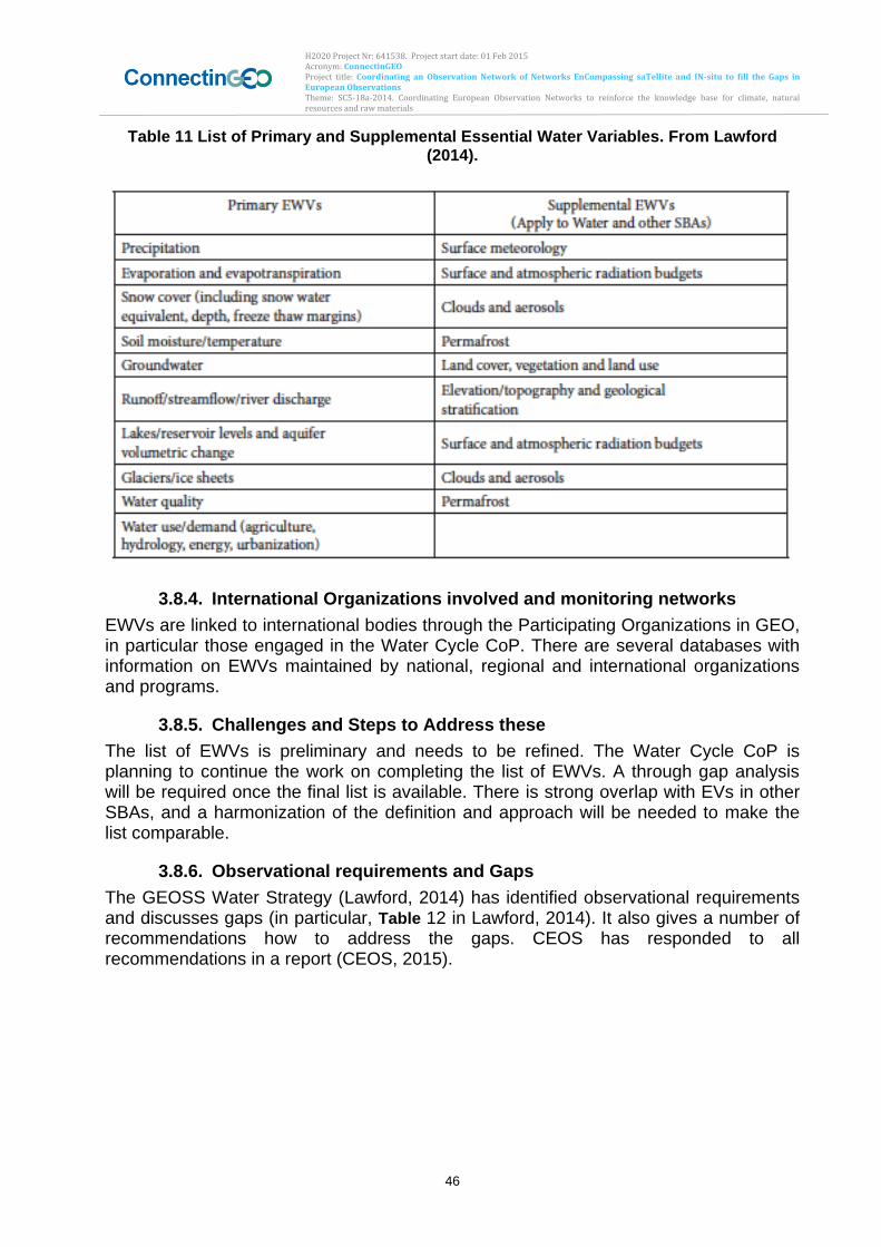
H2020 Project Nr: 641538. Project start date: 01 Feb 2015 Acronym: ConnectinGEO Project title: Coordinating an Observation Network of Networks EnCompassing saTellite and IN-situ to fill the Gaps in European Observations Theme: SC5-18a-2014. Coordinating European Observation Networks to reinforce the knowledge base for climate, natural resources and raw materials
46
Table 11 List of Primary and Supplemental Essential Water Variables. From Lawford (2014).
3.8.4. International Organizations involved and monitoring networks
EWVs are linked to international bodies through the Participating Organizations in GEO, in particular those engaged in the Water Cycle CoP. There are several databases with information on EWVs maintained by national, regional and international organizations and programs.
3.8.5. Challenges and Steps to Address these
The list of EWVs is preliminary and needs to be refined. The Water Cycle CoP is planning to continue the work on completing the list of EWVs. A through gap analysis will be required once the final list is available. There is strong overlap with EVs in other SBAs, and a harmonization of the definition and approach will be needed to make the list comparable.
3.8.6. Observational requirements and Gaps
The GEOSS Water Strategy (Lawford, 2014) has identified observational requirements and discusses gaps (in particular, Table 12 in Lawford, 2014). It also gives a number of recommendations how to address the gaps. CEOS has responded to all recommendations in a report (CEOS, 2015).
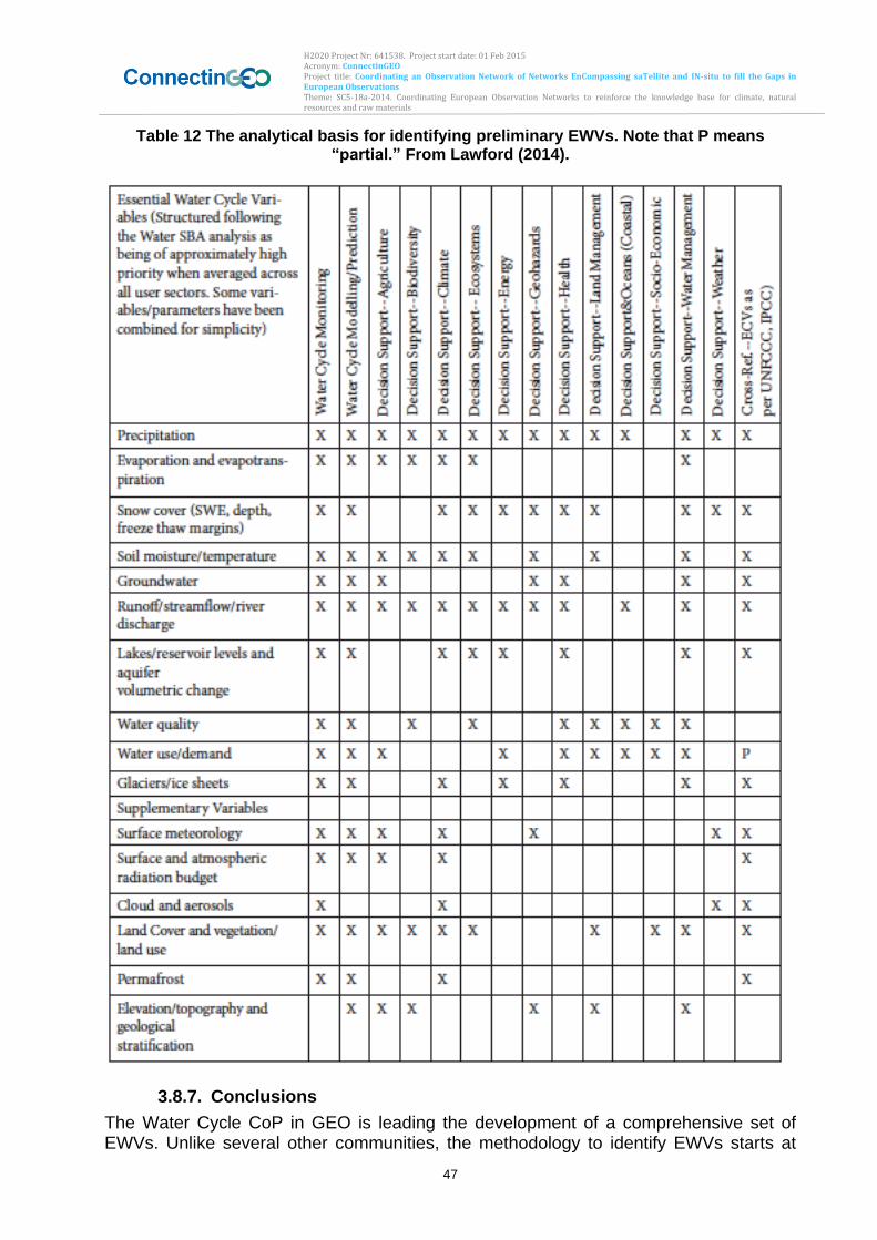
H2020 Project Nr: 641538. Project start date: 01 Feb 2015 Acronym: ConnectinGEO Project title: Coordinating an Observation Network of Networks EnCompassing saTellite and IN-situ to fill the Gaps in European Observations Theme: SC5-18a-2014. Coordinating European Observation Networks to reinforce the knowledge base for climate, natural resources and raw materials
47
Table 12 The analytical basis for identifying preliminary EWVs. Note that P means “partial.” From Lawford (2014).
3.8.7. Conclusions
The Water Cycle CoP in GEO is leading the development of a comprehensive set of EWVs. Unlike several other communities, the methodology to identify EWVs starts at
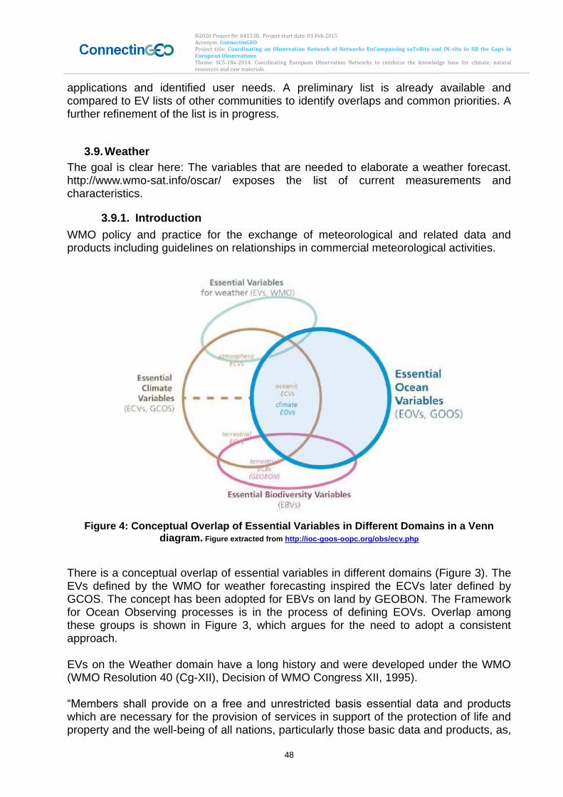
H2020 Project Nr: 641538. Project start date: 01 Feb 2015 Acronym: ConnectinGEO Project title: Coordinating an Observation Network of Networks EnCompassing saTellite and IN-situ to fill the Gaps in European Observations Theme: SC5-18a-2014. Coordinating European Observation Networks to reinforce the knowledge base for climate, natural resources and raw materials
48
applications and identified user needs. A preliminary list is already available and compared to EV lists of other communities to identify overlaps and common priorities. A further refinement of the list is in progress.
3.9. Weather
The goal is clear here: The variables that are needed to elaborate a weather forecast. http://www.wmo-sat.info/oscar/ exposes the list of current measurements and characteristics.
3.9.1. Introduction
WMO policy and practice for the exchange of meteorological and related data and products including guidelines on relationships in commercial meteorological activities.
Figure 4: Conceptual Overlap of Essential Variables in Different Domains in a Venn diagram. Figure extracted from http://ioc-goos-oopc.org/obs/ecv.php
There is a conceptual overlap of essential variables in different domains (Figure 3). The EVs defined by the WMO for weather forecasting inspired the ECVs later defined by GCOS. The concept has been adopted for EBVs on land by GEOBON. The Framework for Ocean Observing processes is in the process of defining EOVs. Overlap among these groups is shown in Figure 3, which argues for the need to adopt a consistent approach. EVs on the Weather domain have a long history and were developed under the WMO (WMO Resolution 40 (Cg-XII), Decision of WMO Congress XII, 1995). “Members shall provide on a free and unrestricted basis essential data and products which are necessary for the provision of services in support of the protection of life and property and the well-being of all nations, particularly those basic data and products, as,
H2020 Project Nr: 641538. Project start date: 01 Feb 2015 Acronym: ConnectinGEO Project title: Coordinating an Observation Network of Networks EnCompassing saTellite and IN-situ to fill the Gaps in European Observations Theme: SC5-18a-2014. Coordinating European Observation Networks to reinforce the knowledge base for climate, natural resources and raw materials
49
at a minimum, described in Annex 1 to this resolution, required to describe and forecast accurately weather and climate, and support WMO Programmes”. [WMO Resolution 40 (Cg-XII)]
3.9.2. Status of EV discussion and EVs
The backbone of the surface-based sub-system are about 11000 stations on land making observations at or near the Earth’s surface, at least every three hours and often hourly, of meteorological parameters such as atmospheric pressure, wind speed and direction, air temperature and relative humidity. EWV are somehow similar to ECV but in EWV you need more observations but you don’t necessarily need long records. EWV are obtained from a users’ requirement process. How the EWV have to be regarding the WMO Resolution 40 (Cg-XII):
Minimum set of data and products which are essential to support WMO Programmes
Protection of life and property and the well-being of all nations
To describe and forecast accurately weather and climate
Six-hourly surface synoptic data from RBSNs (Regional Basic Synoptic Networks)
All available in situ observations from the marine environment
All available aircraft reports
All available data from upper air sounding networks
All reports from the network of stations recommended by the regional associations as necessary to provide a good representation of climate
Products distributed by WMCs and RSMCs (Regional Specialized Meteorological Centers) to meet their WMO obligations
Severe weather warnings and advisories for the protection of life and property targeted upon end-users
Data and products from operational meteorological satellites that are agreed between WMO and satellite operators
3.9.3. Methodology
There are established procedures for defining, reviewing and monitoring the user requirements. Definition of requirements:
- Bottom-up: from what EO data can provide for the specific domain (e.g., NDVI index from MODIS)?
- Or Top-down: from what predictive modeling requires as inputs to the selection of the most appropriate sensors?
WMO Rolling Review of user Requirements (Fig. 4): 1. review of technology-free Members' requirements for observations, within an area of
application
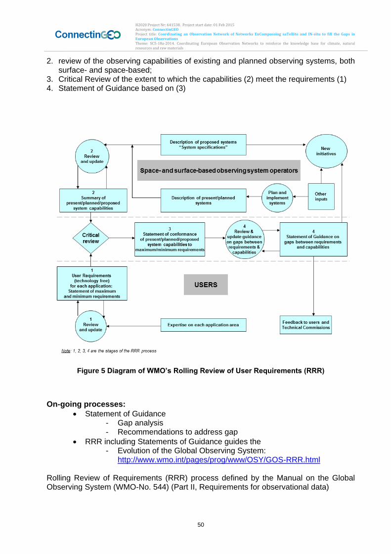
H2020 Project Nr: 641538. Project start date: 01 Feb 2015 Acronym: ConnectinGEO Project title: Coordinating an Observation Network of Networks EnCompassing saTellite and IN-situ to fill the Gaps in European Observations Theme: SC5-18a-2014. Coordinating European Observation Networks to reinforce the knowledge base for climate, natural resources and raw materials
50
2. review of the observing capabilities of existing and planned observing systems, both surface- and space-based;
3. Critical Review of the extent to which the capabilities (2) meet the requirements (1) 4. Statement of Guidance based on (3)
Figure 5 Diagram of WMO’s Rolling Review of User Requirements (RRR)
On-going processes:
Statement of Guidance - Gap analysis - Recommendations to address gap
RRR including Statements of Guidance guides the - Evolution of the Global Observing System:
http://www.wmo.int/pages/prog/www/OSY/GOS-RRR.html Rolling Review of Requirements (RRR) process defined by the Manual on the Global Observing System (WMO-No. 544) (Part II, Requirements for observational data)
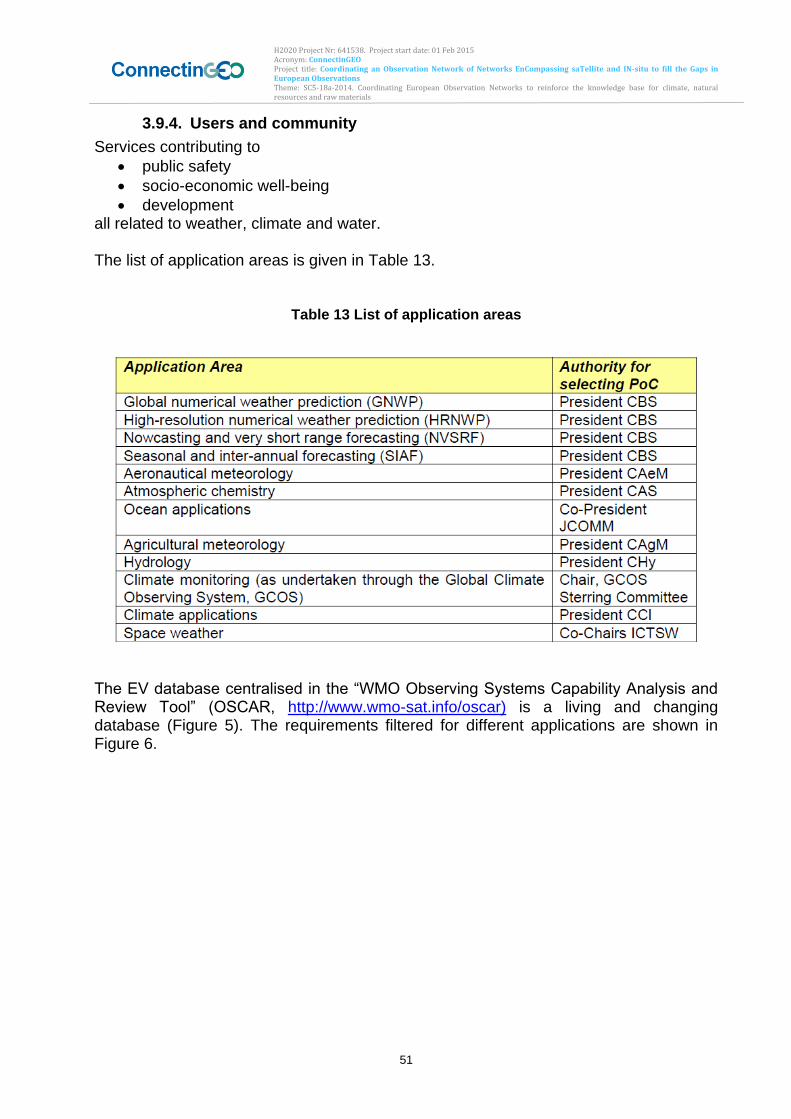
H2020 Project Nr: 641538. Project start date: 01 Feb 2015 Acronym: ConnectinGEO Project title: Coordinating an Observation Network of Networks EnCompassing saTellite and IN-situ to fill the Gaps in European Observations Theme: SC5-18a-2014. Coordinating European Observation Networks to reinforce the knowledge base for climate, natural resources and raw materials
51
3.9.4. Users and community
Services contributing to
public safety
socio-economic well-being
development all related to weather, climate and water. The list of application areas is given in Table 13.
Table 13 List of application areas
The EV database centralised in the “WMO Observing Systems Capability Analysis and Review Tool” (OSCAR, http://www.wmo-sat.info/oscar) is a living and changing database (Figure 5). The requirements filtered for different applications are shown in Figure 6.
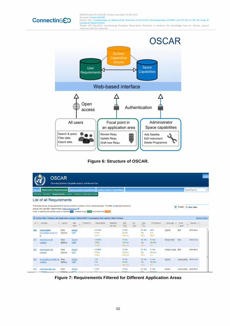
H2020 Project Nr: 641538. Project start date: 01 Feb 2015 Acronym: ConnectinGEO Project title: Coordinating an Observation Network of Networks EnCompassing saTellite and IN-situ to fill the Gaps in European Observations Theme: SC5-18a-2014. Coordinating European Observation Networks to reinforce the knowledge base for climate, natural resources and raw materials
52
Figure 6: Structure of OSCAR.
Figure 7: Requirements Filtered for Different Application Areas
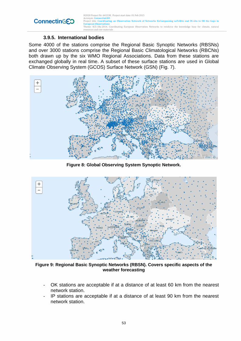
H2020 Project Nr: 641538. Project start date: 01 Feb 2015 Acronym: ConnectinGEO Project title: Coordinating an Observation Network of Networks EnCompassing saTellite and IN-situ to fill the Gaps in European Observations Theme: SC5-18a-2014. Coordinating European Observation Networks to reinforce the knowledge base for climate, natural resources and raw materials
53
3.9.5. International bodies
Some 4000 of the stations comprise the Regional Basic Synoptic Networks (RBSNs) and over 3000 stations comprise the Regional Basic Climatological Networks (RBCNs) both drawn up by the six WMO Regional Associations. Data from these stations are exchanged globally in real time. A subset of these surface stations are used in Global Climate Observing System (GCOS) Surface Network (GSN) (Fig. 7).
Figure 8: Global Observing System Synoptic Network.
Figure 9: Regional Basic Synoptic Networks (RBSN). Covers specific aspects of the weather forecasting
- OK stations are acceptable if at a distance of at least 60 km from the nearest
network station. - IP stations are acceptable if at a distance of at least 90 km from the nearest
network station.
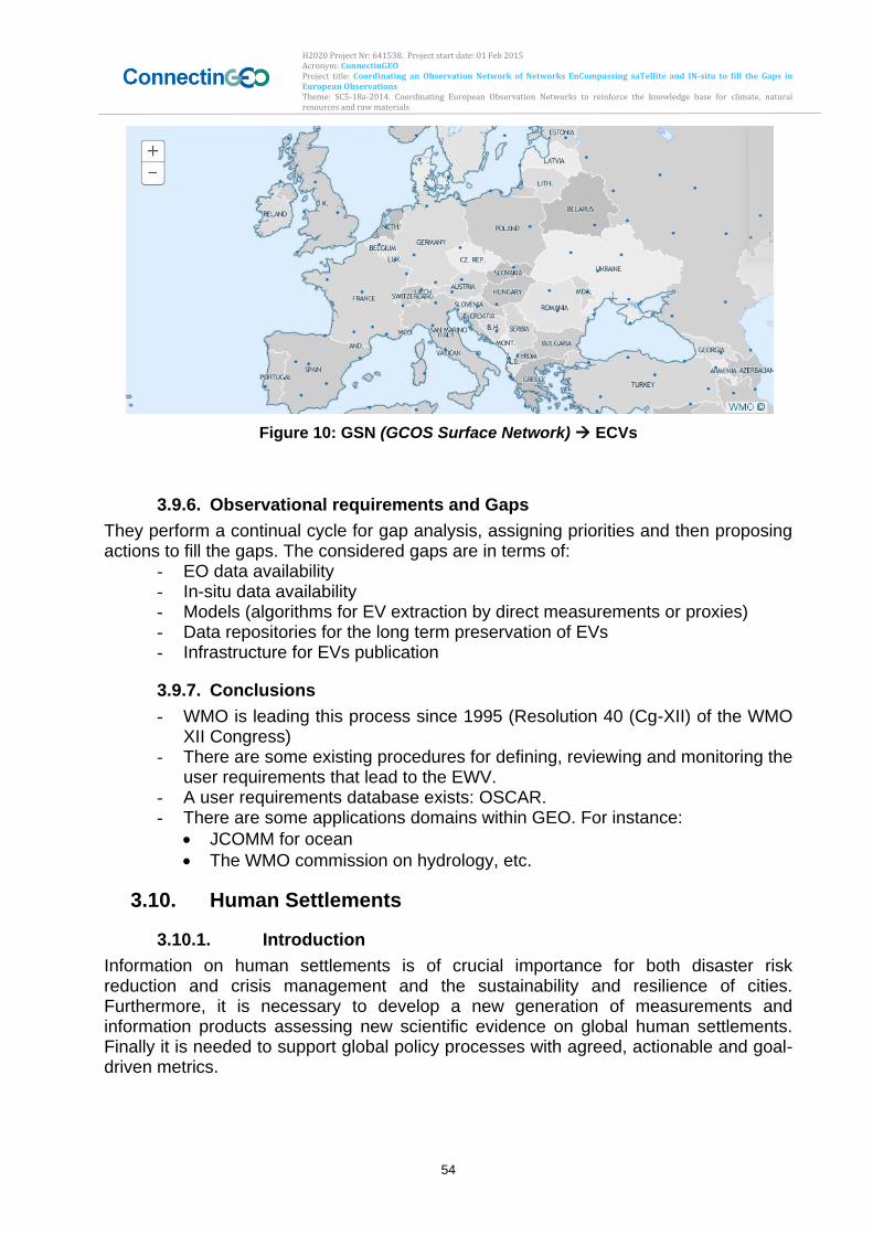
H2020 Project Nr: 641538. Project start date: 01 Feb 2015 Acronym: ConnectinGEO Project title: Coordinating an Observation Network of Networks EnCompassing saTellite and IN-situ to fill the Gaps in European Observations Theme: SC5-18a-2014. Coordinating European Observation Networks to reinforce the knowledge base for climate, natural resources and raw materials
54
Figure 10: GSN (GCOS Surface Network) ECVs
3.9.6. Observational requirements and Gaps
They perform a continual cycle for gap analysis, assigning priorities and then proposing actions to fill the gaps. The considered gaps are in terms of:
- EO data availability - In-situ data availability - Models (algorithms for EV extraction by direct measurements or proxies) - Data repositories for the long term preservation of EVs - Infrastructure for EVs publication
3.9.7. Conclusions
- WMO is leading this process since 1995 (Resolution 40 (Cg-XII) of the WMO XII Congress)
- There are some existing procedures for defining, reviewing and monitoring the user requirements that lead to the EWV.
- A user requirements database exists: OSCAR. - There are some applications domains within GEO. For instance:
JCOMM for ocean
The WMO commission on hydrology, etc.
3.10. Human Settlements
3.10.1. Introduction
Information on human settlements is of crucial importance for both disaster risk reduction and crisis management and the sustainability and resilience of cities. Furthermore, it is necessary to develop a new generation of measurements and information products assessing new scientific evidence on global human settlements. Finally it is needed to support global policy processes with agreed, actionable and goal-driven metrics.
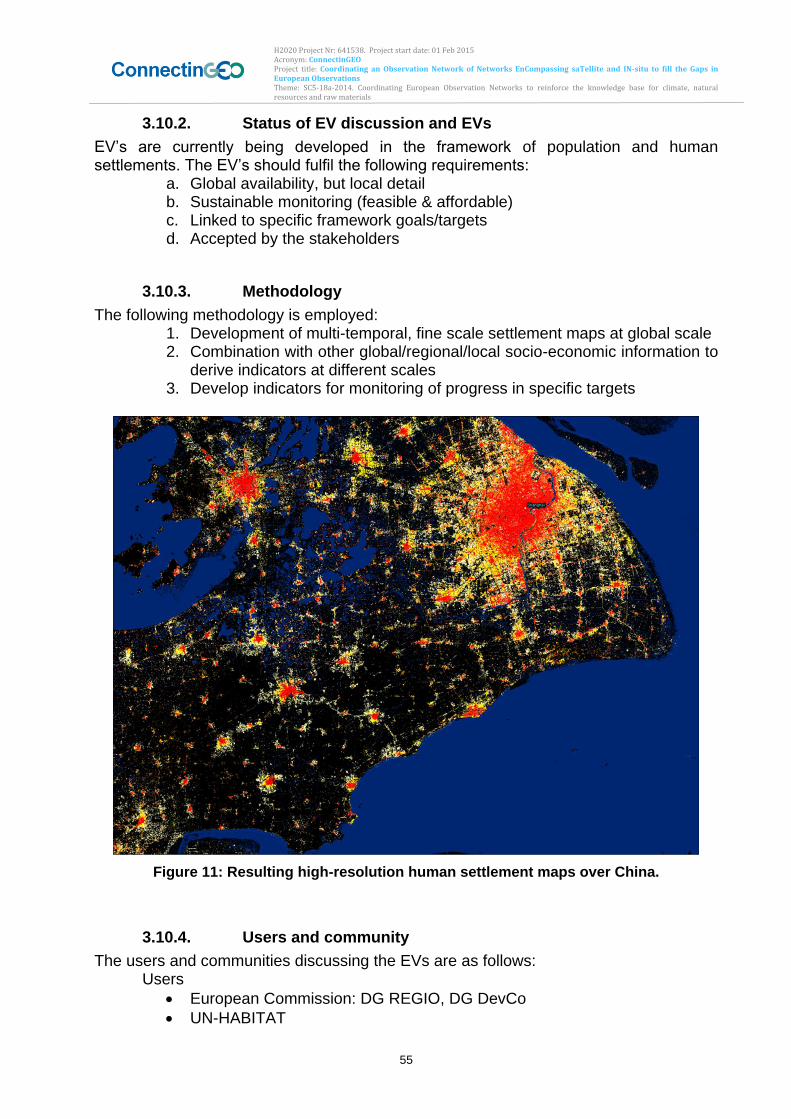
H2020 Project Nr: 641538. Project start date: 01 Feb 2015 Acronym: ConnectinGEO Project title: Coordinating an Observation Network of Networks EnCompassing saTellite and IN-situ to fill the Gaps in European Observations Theme: SC5-18a-2014. Coordinating European Observation Networks to reinforce the knowledge base for climate, natural resources and raw materials
55
3.10.2. Status of EV discussion and EVs
EV’s are currently being developed in the framework of population and human settlements. The EV’s should fulfil the following requirements:
a. Global availability, but local detail b. Sustainable monitoring (feasible & affordable) c. Linked to specific framework goals/targets d. Accepted by the stakeholders
3.10.3. Methodology
The following methodology is employed: 1. Development of multi-temporal, fine scale settlement maps at global scale 2. Combination with other global/regional/local socio-economic information to
derive indicators at different scales 3. Develop indicators for monitoring of progress in specific targets
Figure 11: Resulting high-resolution human settlement maps over China.
3.10.4. Users and community
The users and communities discussing the EVs are as follows: Users
European Commission: DG REGIO, DG DevCo
UN-HABITAT
H2020 Project Nr: 641538. Project start date: 01 Feb 2015 Acronym: ConnectinGEO Project title: Coordinating an Observation Network of Networks EnCompassing saTellite and IN-situ to fill the Gaps in European Observations Theme: SC5-18a-2014. Coordinating European Observation Networks to reinforce the knowledge base for climate, natural resources and raw materials
56
Joint Development of EVs with the users Active GEO community that is using the data in their work, for example:
Worldpop project for population mapping
UNICEF for DRR in Myanmar
3.10.5. International bodies
A variety of international organizations require such information to support global policy processes with agreed, actionable and goal-driven metrics:
Sendai Framework for DRR (March 2015)
Sustainable Development Goals (September 2015)
Habitat III UN Conference on Housing and Sustainable Urban Development (October 2016)
UN Framework Convention on Climate Change December (2015)
3.10.6. Challenges and Steps to Address these
Numerous challenges exist to deliver EVs in the domain of human settlements, namely:
• Big Data: automatic information extraction • Lack of reference data for validation: collaboration with GEO initiative for
regional assessments Here in particular the use of citizen science could play a role to address the lack of reference data. Citizens are particularly suited to collecting mobile geo-tagged information in urban areas.
3.10.7. Observational requirements and Gaps
• EO data availability is sufficient • In-situ data availability is scattered, but open data policies and crowd
sourcing (Open Street Maps) slowly improve the availability • Data repositories for the long term preservation of EVs are available • Infrastructure for EVs publication is available
3.10.8. Conclusions
Today it is possible to provide fine scale human settlement information at a global scale, which was previously hindered by a lack of data and processing power. Furthermore, these efforts provide relevant information for other domains. The priority now is the acceptance of EVs by the user community as indicators of progress in the UN frameworks. The establishment of the human settlements layer among other datasets helps to address this need.
3.11. Oceans (and Marine Ecosystems)
3.11.1. Introduction
The ocean has transversal impacts on many SBA’s. At the workshop in Bari, the discussion of Essential Ocean Variables (EOVs) focused on biogeochemical aspects of
H2020 Project Nr: 641538. Project start date: 01 Feb 2015 Acronym: ConnectinGEO Project title: Coordinating an Observation Network of Networks EnCompassing saTellite and IN-situ to fill the Gaps in European Observations Theme: SC5-18a-2014. Coordinating European Observation Networks to reinforce the knowledge base for climate, natural resources and raw materials
57
the ocean. The presentation introduced the general process and the steps followed to propose a set of EVs for the biogeochemical domain of the ocean. The case of the “Oxygen” EV was chosen as an example to illustrate it. The information presented here complements this input provided during the Bari workshop with a review of reports produced by different panels in GOOS and GEOSS and the efforts undertaken by the GEOWOW project (European FP-7, http://www.geowow.eu/), which started a process to assess the role of global Earth observations in the SBAs addressed by GEO. For the ocean components, the EV definition and the process for the identification of EVs are coordinated by the IOC for three different ocean subthemes: ocean physics, marine biology and ecosystems, and marine biogeochemistry. We summarize here the present status of procedures and selection of ocean EVs for these three subthemes.
3.11.2. Status of EV discussion and EVs
Sponsor of the OceanObs’09 conference on “Ocean information for Society: sustaining the benefits, realizing the potential,” promoted the formation of an Integrated Framework for Sustained Ocean Observations task team (see http://www.oceanobs09.net/foo/). The work undertaken by this team resulted into the report “Framework for Ocean Observing” (FOO, Lindstrom et al. 2012) with the goal of “moving the global sustained ocean observations forward in the next decade”. The GOOS steering committee has adopted this framework as a guiding document for its work, and the Ocean Observations Panel for Climate (OOPC) in response to the FOO has set up the initiative to identify the EOVs going even beyond the requirements established by the GCOS for the ECVs (see, e.g., documents at GOSIC site, http://www.gosic.org/). A good synthesis of the status of EOVs, and the relationships to global conventions/mandates, SBAs and observing networks is the interactive diagram proposed by tIOC-GOOS (http://lists-ioc-goos.org/goos-strategic-mapping-graphic/). In Appendix xx, the sets of EV’s for each subtheme mentioned in the introduction are listed based on the available most recent documents. These subthemes correspond to the three panels of experts coordinated by the IOC, which follow the methodology proposed in FOO (see next section).
3.11.3. Methodology
As commented before, the methodology to identify the EOVs is described in Lindstrom et al (2012). Since the development of the FOO and promoted by the GEOWOW project (GEOWOW-WP6-IOU-I6.1.1), a series of meetings/workshops of experts of the three Ocean Observing Panels (Physics, Biology/Ecology and Carbon/Biogeochemistry) have been organized to propose a set of EOV. The process of defining these EOV’s is an open process mostly through a simultaneous top-down and bottom-up approach, trying to address both scientific questions and tackle societal benefit areas (how to determine the ocean ecosystem health, which is the role of biogeochemical cycles in climate, human impacts on oceans, etc.) Panels experts proposed an initial set of EOV to address identified issues, and then a screening process is started based on an impact versus feasibility balance that assembles together variables of similar nature and/or overlapping variables (a single
H2020 Project Nr: 641538. Project start date: 01 Feb 2015 Acronym: ConnectinGEO Project title: Coordinating an Observation Network of Networks EnCompassing saTellite and IN-situ to fill the Gaps in European Observations Theme: SC5-18a-2014. Coordinating European Observation Networks to reinforce the knowledge base for climate, natural resources and raw materials
58
variable addressing different issues). This process helps to decide and retain a subset of the initially proposed EVs, discarding in general low impact and/or low feasibility variables. For example, the Biology/Ecosystem panel started from a set of 43 variables finally reduced to 11 EVs (Fischer and Grimes, 2012, GOOS, 2013) or in the case of the Biogeochemical panel an initial set of 53 variables finally was reduced up to 9 EVs (IOCCP, 2013).
3.11.4. Users and community
Although this point was not specifically addressed in the Bari meeting nor does it appear in the reviewed documents, the representativeness of the coordinating institutions (see next point) of the EV discussion and the list of attendance to the working meetings almost encompasses the whole scientific community worldwide working in the ocean component. The participation appears somehow biased towards the scientific and observational community with not much participation of governmental agencies or end-users community. However, in the EV discussion process, requirements were considered within the perspective and scope of services, the climate mandates and conventions established by the UNFCCC, the support of the IPCC and sustainable observations systems, which in fact are reflecting the main societal needs.
3.11.5. International bodies
Coordinating institutions IOC (OOPC panel), WMO GOOS GCOS IOCCP These coordinating institutions are wide in scope in terms of the ocean component, and represent the worldwide ocean scientific community, including universities, public research institutions and national state agencies to ensure the different views and inputs.
3.11.6. Challenges and Steps to Address these
The OOPC has summarized quite well the main scientific and technical challenges for the ocean component (see http://ioc-goos-oopc.org/obs/challenges.php).
3.11.7. Observational requirements and Gaps
Observational requirements in term of both technical instrumentation (devices, networks, technologies, etc.) and scales of phenomena to be monitored are unequally analyzed among the panels. Both, the physical and biogeochemical panels have carefully defined the scales and measurement requirements, reflected by the readiness level of each variable. The readiness level incorporates three main ranking values: Mature, Pilot and Concept (see page 11 in Lindstrom et al., 2012) that includes aspects of requirement processes, coordination of observational elements and data management & information products.
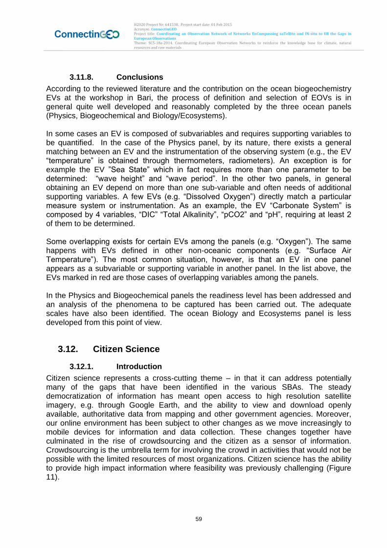
H2020 Project Nr: 641538. Project start date: 01 Feb 2015 Acronym: ConnectinGEO Project title: Coordinating an Observation Network of Networks EnCompassing saTellite and IN-situ to fill the Gaps in European Observations Theme: SC5-18a-2014. Coordinating European Observation Networks to reinforce the knowledge base for climate, natural resources and raw materials
59
3.11.8. Conclusions
According to the reviewed literature and the contribution on the ocean biogeochemistry EVs at the workshop in Bari, the process of definition and selection of EOVs is in general quite well developed and reasonably completed by the three ocean panels (Physics, Biogeochemical and Biology/Ecosystems). In some cases an EV is composed of subvariables and requires supporting variables to be quantified. In the case of the Physics panel, by its nature, there exists a general matching between an EV and the instrumentation of the observing system (e.g., the EV “temperature” is obtained through thermometers, radiometers). An exception is for example the EV ”Sea State” which in fact requires more than one parameter to be determined: “wave height” and “wave period”. In the other two panels, in general obtaining an EV depend on more than one sub-variable and often needs of additional supporting variables. A few EVs (e.g. “Dissolved Oxygen”) directly match a particular measure system or instrumentation. As an example, the EV “Carbonate System” is composed by 4 variables, “DIC” “Total Alkalinity”, “pCO2” and “pH”, requiring at least 2 of them to be determined. Some overlapping exists for certain EVs among the panels (e.g. “Oxygen”). The same happens with EVs defined in other non-oceanic components (e.g. “Surface Air Temperature”). The most common situation, however, is that an EV in one panel appears as a subvariable or supporting variable in another panel. In the list above, the EVs marked in red are those cases of overlapping variables among the panels. In the Physics and Biogeochemical panels the readiness level has been addressed and an analysis of the phenomena to be captured has been carried out. The adequate scales have also been identified. The ocean Biology and Ecosystems panel is less developed from this point of view.
3.12. Citizen Science
3.12.1. Introduction
Citizen science represents a cross-cutting theme – in that it can address potentially many of the gaps that have been identified in the various SBAs. The steady democratization of information has meant open access to high resolution satellite imagery, e.g. through Google Earth, and the ability to view and download openly available, authoritative data from mapping and other government agencies. Moreover, our online environment has been subject to other changes as we move increasingly to mobile devices for information and data collection. These changes together have culminated in the rise of crowdsourcing and the citizen as a sensor of information. Crowdsourcing is the umbrella term for involving the crowd in activities that would not be possible with the limited resources of most organizations. Citizen science has the ability to provide high impact information where feasibility was previously challenging (Figure 11).
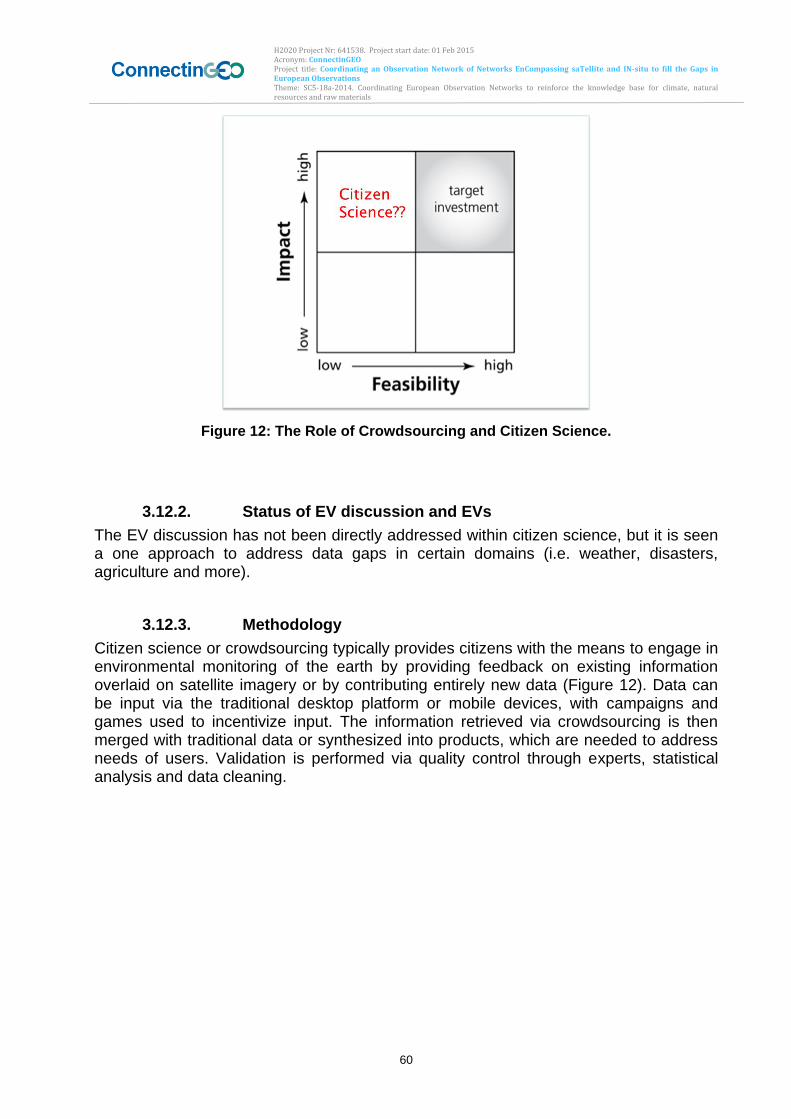
H2020 Project Nr: 641538. Project start date: 01 Feb 2015 Acronym: ConnectinGEO Project title: Coordinating an Observation Network of Networks EnCompassing saTellite and IN-situ to fill the Gaps in European Observations Theme: SC5-18a-2014. Coordinating European Observation Networks to reinforce the knowledge base for climate, natural resources and raw materials
60
Figure 12: The Role of Crowdsourcing and Citizen Science.
3.12.2. Status of EV discussion and EVs
The EV discussion has not been directly addressed within citizen science, but it is seen a one approach to address data gaps in certain domains (i.e. weather, disasters, agriculture and more).
3.12.3. Methodology
Citizen science or crowdsourcing typically provides citizens with the means to engage in environmental monitoring of the earth by providing feedback on existing information overlaid on satellite imagery or by contributing entirely new data (Figure 12). Data can be input via the traditional desktop platform or mobile devices, with campaigns and games used to incentivize input. The information retrieved via crowdsourcing is then merged with traditional data or synthesized into products, which are needed to address needs of users. Validation is performed via quality control through experts, statistical analysis and data cleaning.
H2020 Project Nr: 641538. Project start date: 01 Feb 2015 Acronym: ConnectinGEO Project title: Coordinating an Observation Network of Networks EnCompassing saTellite and IN-situ to fill the Gaps in European Observations Theme: SC5-18a-2014. Coordinating European Observation Networks to reinforce the knowledge base for climate, natural resources and raw materials
61
Figure 13: General methodology of citizen science approach taken with the geo-wiki.org platform to produce new and improved global land cover/ land use maps.
3.12.4. Users and community
The users and community is rapidly growing around citizen science as increasingly governments, SMEs, research organizations, NGOs realize the potential that it offers.
3.12.5. International bodies
International organizations considering citizen science include among others the ECSA – the European Citizen Science Association. New bodies are forming regularly signaling the growing interest in this field.
3.12.6. Challenges and Steps to Address these
Numerous challenges exist in order to effectively include citizen science. The main challenge to overcome is the issue of quality. The main issue to address this is through rigorous sample design which ensures that the needed amount of measurements are taken at appropriate locations.
H2020 Project Nr: 641538. Project start date: 01 Feb 2015 Acronym: ConnectinGEO Project title: Coordinating an Observation Network of Networks EnCompassing saTellite and IN-situ to fill the Gaps in European Observations Theme: SC5-18a-2014. Coordinating European Observation Networks to reinforce the knowledge base for climate, natural resources and raw materials
62
3.12.7. Observational requirements and Gaps
One example was the extreme lack of in-situ data for calibration and validation of global land cover datasets – deemed an EV in several SBAs. Citizen science has proven useful at filling this gap by providing large volumes of in-situ data which can be used to produce new and improved global land cover datasets.
3.12.8. Conclusions
In conclusion, citizen science is seen as potentially being able to help across most SBAs. Citizen Science could potentially address data needs where feasibility has been limiting. Furthermore, citizen science has the added benefit of reduced costs and higher spatial and temporal resolution than traditional forms of in-situ data collection. Hence citizen science should feature prominently in GEOSS.
4. Conclusions, Recommendations and Way forward
4.1. Commonalities and Differences
The review of the processes for the development of EVs and the current status in identifying EVs and using them for prioritization in Chapter 3 reveals considerable differences across the different SBAs and thematic areas in GEO. The definitions for EVs show some variations across the SBAs. While in some SBAs the feasibility of observing EVs is an important factor (e.g., for EOVs), in other SBAs, the user needs and applications are more relevant (e.g., Water). In several SBAs, the development of sets of EVs is based on well-defined methods and has progressed to near final list (e.g., ECVs) while other SBAs have not yet started to discuss EVs (e.g., Disasters).
4.2. Criteria to identify EVs
In a summary of the criteria used in different SBAs, proposed key criteria for the identification of EVs include:
Relevance: the variable is critical for the objective to be achieve (i.e. the goals and targets defined by GEO or other communities that need the EVs);
Repeatability: the variable can be determined continuously at the required time scale and frequency.
Coverage: the variable, in principle, can be determined with the required spatial coverage and with the required spatial and temporal resolution.
Feasibility: quantifying the variable (either from observations or derived methods) on a global scale is, in principle, technically feasible using proven, scientifically understood methods.
Cost effectiveness: generating and archiving data on the variable is affordable, mainly relying on coordinated observing systems using proven technology, taking advantage where possible of historical datasets.
H2020 Project Nr: 641538. Project start date: 01 Feb 2015 Acronym: ConnectinGEO Project title: Coordinating an Observation Network of Networks EnCompassing saTellite and IN-situ to fill the Gaps in European Observations Theme: SC5-18a-2014. Coordinating European Observation Networks to reinforce the knowledge base for climate, natural resources and raw materials
63
4.3. Recommended process to reach consensus concerning sets of EVs
It is recommended to use a community-based approach for the endorsement of proposed sets of EVs. In this approach, expert groups can develop proposed sets of EVs using both expert-based and goal-based methodologies. In the expert-based approach, it is important to link the proposed EVs to societal benefits. The goal-based approach takes the societal benefits as a starting point. Ideally, EV proposals should use both approaches in parallel. It is of advantage to connect to development of EVs to international agreements or frameworks and embed the process into related international communities. The example of the ECVs can provide guidance for this approach. For the consensus and endorsement processes, the involvement of a large community is important. An iterative combination of stakeholder forums with open community reviews of the proposals is considered important to reach both refinements and broad acceptance of the proposed EVs. Demonstrating the value of EVs and their consistency with the definition as well as the established criteria in pilot project can inform the consensus building processes. Publishing the work that leads to the EV proposals and the results of the pilot project also can support the reaching of a community consensus.
4.4. EVs and the Gap analysis in ConnectinGEO
The different sets of EVs currently available provide an important starting point for the gap analysis to be carried out in ConnectinGEO. For selected sets of EVs (e.g., ECVs, EOVs, and EWVs), the gap analysis can focus on spatial and temporal coverage, as well as the feasibility of extracting the EVs from the available observations discoverable through GEOSS.
4.5. EVs in the context of GEO
Comprehensive sets of SBA-specific EVs as well as an integrated set of GEO EVs are of high value for any gap analysis and prioritization within GEO. GEO should therefore emphasize the importance of EVs throughout all GEO activities and ensure that the GEOSS Knowledge Base provides blueprints and support to all GEO communities in the process of identifying and ratifying sets of EVs. The blue prints should cover both the expert-based and the goal-based approach. Moreover, the GEOSS Knowledge Base should be developed into the place to document EVs and to use them in GEOSS-wide gap analyses.
H2020 Project Nr: 641538. Project start date: 01 Feb 2015 Acronym: ConnectinGEO Project title: Coordinating an Observation Network of Networks EnCompassing saTellite and IN-situ to fill the Gaps in European Observations Theme: SC5-18a-2014. Coordinating European Observation Networks to reinforce the knowledge base for climate, natural resources and raw materials
64
5. Bibliography Balvanera, P., Pfisterer, A.B., Buchmann, N., He, J.S., Nakashizuka, T., Raffaelli, D. & Schmid, B. (2006) Quantifying the evidence for biodiversity effects on ecosystem functioning and services. Ecology Letters, 9, 1146– 1156. Bojinski S., Verstraete M., Peterson T.C., Richter C., Simmons A., Zemp M., 2014: The Concept of Essential Climate Variables in Support of Climate Research, Applications, and Policy. Bull. Amer. Meteor. Soc., 95, 1431–1443. CEOS, 2015. CEOS Strategy for Water Observations from Space. Committee for Earth Observation Satellites. Ciais P., Dolman A.J., Bombelli A., Duren R., Peregon A., Rayner P.J., Miller C., Gobron N., Kinderman G., Marland G., Gruber N., Chevallier F., Andres R.J., Balsamo G., Bopp L., Bréon F.-M., Broquet G., Dargaville R., Battin T.J., Borges A., Bovensmann H., Buchwitz M., Butler J., Canadell J. G., Cook R.B., DeFries R., Engelen R., Gurney K.R., Heinze C., Heimann M., Held A., Henry M., Law B., Luyssaert S., Miller J., Moriyama T., Moulin C., Myneni R.B., Nussli C., Obersteiner M., Ojima D., Pan Y., Paris J.-D., Piao S.L., Poulter B., Plummer S., Quegan S., Raymond P., Reichstein M., Rivier L., Sabine C., Schimel D., Tarasova O., Valentini R., Wang R., van der Werf G., Wickland D., Williams M., and Zehner C., 2014. Current systematic carbon-cycle observations and the need for implementing a policy-relevant carbon observing system. Biogeosciences, 11, 3547-3602. doi:10.5194/bg-11-3547-2014. Fischer A. and S. Grimes, 2012: Definition of ecosystem Essential Ocean Variables. I6.1.1 Report on WP6-T6.1 of GEOWOW European FP7 project. Draft of 18/12/2012 available at GEOWOW site (http://www.geowow.eu) Geijzendorffer I. R., Regan E. C., Pereira H. M., Brotons L., Brummitt N., Gavish Y., Haase P., Martin C.S., Mihou J. B., Secades C., Schmeller D. S., Stoll S., Wetzel F. T. and Walters M.: 2015 Bridging the gaps between biodiversity data a policy reporting needs: An Essential Biodiversity Variables prospective. Journal of Applied Ecology. DOI: 10.1111/1365-2664.12417
GEO BON Secretariat. Global Biodiversity change indicators. Version 1. Model-based integration of remote-sensing & in situ observations that enables dynamic updates and transparency at low cost http://www.geobon.org/Downloads/brochures/2015/GBCI_Version1.1_low.pdf
Giller, P.S., Hillebrand, H., Berninger, U.G., et al., 2004. Biodiversity effects on ecosystem functioning: emerging issues and their experimental test in aquatic environments. Oikos 104, 423–436.
GOOS, 2014. Identifying Ecosystem Essential Ocean Variables (EOVs): Report of the First Workshop of Technical Experts for the Global Ocean Observing System (GOOS) Biology and Ecosystems Panel. IOC/GOOS report GOOS-207. Available at
H2020 Project Nr: 641538. Project start date: 01 Feb 2015 Acronym: ConnectinGEO Project title: Coordinating an Observation Network of Networks EnCompassing saTellite and IN-situ to fill the Gaps in European Observations Theme: SC5-18a-2014. Coordinating European Observation Networks to reinforce the knowledge base for climate, natural resources and raw materials
65
http://www.ioc-goos.org/index.php?option=com_oe&task=viewDocumentRecord&docID=13586. GCOS, 2010: Implementation plan for the global observing system for climate in support of the UNFCCC (2010 update). GCOS Report No. 138, 186 pp. [Available online at www.wmo.int/pages/prog/gcos/Publications/gcos-138.pdf.] Heffernan J.B., Sorrano P.A., Angilletta M.J., and other co-authors 2014. Macrosystems ecology: understanding ecological patterns and processes at continental scales. Front. Ecol. Environ., 12 (1), 5-14. doi:10.1890/130017 IOCCP, 2013:First Technical Experts Workshop of the GOOS Biogeochemistry Panel, Defining Essential Ocean Variables for Biogeochemistry. Draft Report (available at http://www.ioccp.org/index.php/foo) Jax K., Ecosystem Functioning, Cambridge University press, 2010. Jacobs S.J. 1991. On the existence of a slow manifold in a model system of equations. Journal of the Atmospheric Sciences. 37, 958-968. Lawford, R. (ed.), 2014. The GEOSS Water Strategy: From Observations to Decisions. Japan Aerospace Exploration Agency. LeCozannet, G., Salichon, J., 2007. Geohazards Earth Observation Requirements. BRGM, France, Report BRGM/RP-55719-FR. Available at http://www.geohazcop.org/library/documents/Geohaz_Obs_Requirements.pdf Lindstrom A. Gunn J., Fischer A., McCurdy A., Glover L.K. and Task Team members, 2012: A Framework for Ocean Observing. By the Task Team for an Integrated Framework for Sustained Ocean Observing, UNESCO 2012, IOC/INF-1284, doi: 10.5270/OceanObs09-FOO Lorenz E.N. and Krishnamurthy, 1987. On the nonexistence of a slow manifold. Journal of the Atmospheric Sciences, 44, 2940-2950. Lorenz E.N. 1992. The Slow manifold-what is it?. Journal of the Atmospheric Sciences, 49, 2449-2450. Marsh, S. and the Geohazards Theme Team, 2004. Geohazards Theme Report. Integrated Global Observing Strategy Partnership (IGOS-P), Theme Report. Available at http://www.geohazcop.org/library/documents/igos_geohazards_report.pdf. Pereira, H. M., S. Ferrier, M. Walters, G. N. Geller, R. H. G. Jongman, R. J. Scholes, M. W. Bruford, N. Brummitt, S. H. M. Butchart, A. C. Cardoso, N. C. Coops, E. Dulloo, D. P. Faith, J. Freyhof, R. D. Gregory, C. Heip, R. Höft, G. Hurtt, W. Jetz, D. S. Karp, M. A. McGeoch, D. Obura, Y. Onoda, N. Pettorelli, B. Reyers, R. Sayre, J. P. W. Scharlemann, , S. N. Stuart, E. Turak, M. Walpole, M. Wegmann 2013 SCIENCE VOL 339, 277-278. Rietkerk M., Brovkin V., Van Bodegim P.M. and other co-authors 2011.
H2020 Project Nr: 641538. Project start date: 01 Feb 2015 Acronym: ConnectinGEO Project title: Coordinating an Observation Network of Networks EnCompassing saTellite and IN-situ to fill the Gaps in European Observations Theme: SC5-18a-2014. Coordinating European Observation Networks to reinforce the knowledge base for climate, natural resources and raw materials
66
Soranno PA, Cheruvelil KS, Bissell EG, et al. 2014a. Cross-scale interactions: quantifying multi-scaled cause–effect relation- ships in macrosystems. Front Ecol Environ 12: 65–73. Salichon, J., G. LeCozannet, H.Modaressi, S. Hosford, R. Missotten, K. McManus, S.Marsh, M. Paganini, C. Ishida, H.-P.Plag, J. Labrecque, C. Dobson, J. Quick, D. Giardini, K. Takara, H. Fukuoka, N. Casagli, W. Marzocchi, 2007. IGOS Geohazards Theme Report. BRGM, France, Report BRGM/RP-55739-FR. Available at http://www.geohazcop.org/library/documents/igos_geohazards_report_2007.pdf. Soranno PA and Schimel DS. 2014b. Macrosystems ecology: big data, big ecology. Front. Ecol Environ. 12: 3. Local ecosystem feedbacks and critical transitions in the climate. Ecological complexity 8, 223-228. United Nations, 2015. The Sendai Framework for Disaster Risk Reduction 2015-2030. UNISDR/GE/2015 – ICLUX EN5000 1st edition. Unninayar, S., Friedl, L, 2010. GEO Task US-09-01a – Earth Observation Priorities: Water Societal Benefit Area. Group on Earth Observations. Walters M., 2015 Bridging the gap between biodiversity data and policy reporting needs: An Essential Biodiversity Variables perspective. Journal of Applied Ecology, doi: 10.1111/1365-2664.12417.
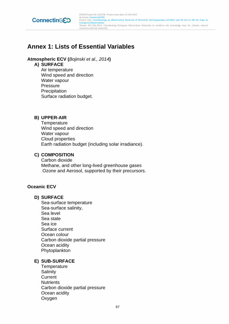
H2020 Project Nr: 641538. Project start date: 01 Feb 2015 Acronym: ConnectinGEO Project title: Coordinating an Observation Network of Networks EnCompassing saTellite and IN-situ to fill the Gaps in European Observations Theme: SC5-18a-2014. Coordinating European Observation Networks to reinforce the knowledge base for climate, natural resources and raw materials
67
Annex 1: Lists of Essential Variables Atmospheric ECV (Bojinski et al., 2014)
A) SURFACE Air temperature Wind speed and direction Water vapour Pressure Precipitation Surface radiation budget.
B) UPPER-AIR Temperature Wind speed and direction Water vapour Cloud properties Earth radiation budget (including solar irradiance).
C) COMPOSITION Carbon dioxide Methane, and other long-lived greenhouse gases Ozone and Aerosol, supported by their precursors.
Oceanic ECV
D) SURFACE Sea-surface temperature Sea-surface salinity, Sea level Sea state Sea ice Surface current Ocean colour Carbon dioxide partial pressure Ocean acidity Phytoplankton
E) SUB-SURFACE Temperature Salinity Current Nutrients Carbon dioxide partial pressure Ocean acidity Oxygen
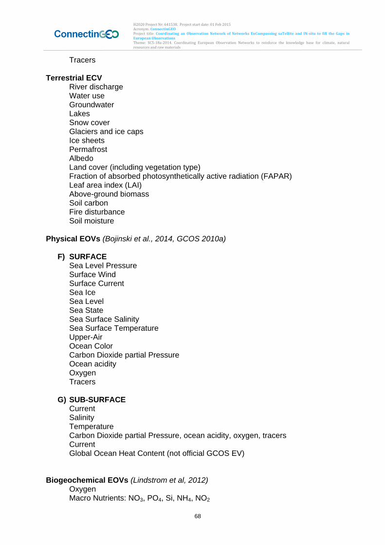
H2020 Project Nr: 641538. Project start date: 01 Feb 2015 Acronym: ConnectinGEO Project title: Coordinating an Observation Network of Networks EnCompassing saTellite and IN-situ to fill the Gaps in European Observations Theme: SC5-18a-2014. Coordinating European Observation Networks to reinforce the knowledge base for climate, natural resources and raw materials
68
Tracers Terrestrial ECV
River discharge Water use Groundwater Lakes Snow cover Glaciers and ice caps Ice sheets Permafrost Albedo Land cover (including vegetation type) Fraction of absorbed photosynthetically active radiation (FAPAR) Leaf area index (LAI) Above-ground biomass Soil carbon Fire disturbance Soil moisture
Physical EOVs (Bojinski et al., 2014, GCOS 2010a)
F) SURFACE Sea Level Pressure Surface Wind Surface Current Sea Ice Sea Level Sea State Sea Surface Salinity Sea Surface Temperature Upper-Air Ocean Color Carbon Dioxide partial Pressure Ocean acidity Oxygen Tracers
G) SUB-SURFACE
Current Salinity Temperature Carbon Dioxide partial Pressure, ocean acidity, oxygen, tracers Current Global Ocean Heat Content (not official GCOS EV)
Biogeochemical EOVs (Lindstrom et al, 2012) Oxygen Macro Nutrients: NO3, PO4, Si, NH4, NO2
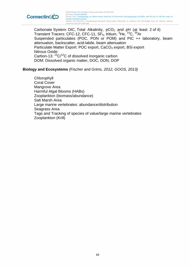
H2020 Project Nr: 641538. Project start date: 01 Feb 2015 Acronym: ConnectinGEO Project title: Coordinating an Observation Network of Networks EnCompassing saTellite and IN-situ to fill the Gaps in European Observations Theme: SC5-18a-2014. Coordinating European Observation Networks to reinforce the knowledge base for climate, natural resources and raw materials
69
Carbonate System: DIC, Total Alkalinity, pCO2 and pH (at least 2 of 4) Transient Tracers: CFC-12, CFC11, SF6, tritium, 3He, 14C, 39Ar Suspended particulates (POC, PON or POM) and PIC ++ laboratory, beam
attenuation, backscatter, acidlabile, beam attenuation Particulate Matter Export: POC export, CaCO3 export, BSi export Nitrous Oxide: Carbon-13: 13C/12C of dissolved inorganic carbon DOM: Dissolved organic matter, DOC, DON, DOP Biology and Ecosystems (Fischer and Grims, 2012, GOOS, 2013)
Chlorophyll Coral Cover Mangrove Area Harmful Algal Blooms (HABs) Zooplankton (biomass/abundance) Salt Marsh Area Large marine vertebrates: abundance/distribution Seagrass Area Tags and Tracking of species of value/large marine vertebrates Zooplankton (Krill)
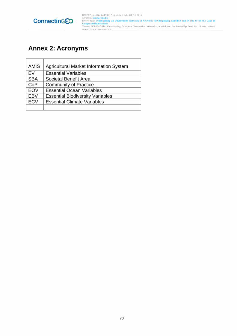
H2020 Project Nr: 641538. Project start date: 01 Feb 2015 Acronym: ConnectinGEO Project title: Coordinating an Observation Network of Networks EnCompassing saTellite and IN-situ to fill the Gaps in European Observations Theme: SC5-18a-2014. Coordinating European Observation Networks to reinforce the knowledge base for climate, natural resources and raw materials
70
Annex 2: Acronyms
AMIS Agricultural Market Information System
EV Essential Variables
SBA Societal Benefit Area
CoP Community of Practice
EOV Essential Ocean Variables
EBV Essential Biodiversity Variables
ECV Essential Climate Variables
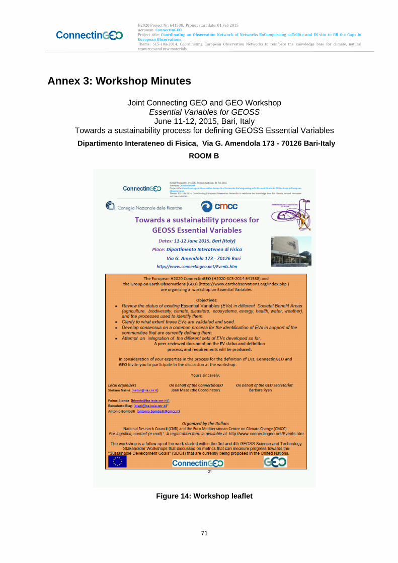
H2020 Project Nr: 641538. Project start date: 01 Feb 2015 Acronym: ConnectinGEO Project title: Coordinating an Observation Network of Networks EnCompassing saTellite and IN-situ to fill the Gaps in European Observations Theme: SC5-18a-2014. Coordinating European Observation Networks to reinforce the knowledge base for climate, natural resources and raw materials
71
Annex 3: Workshop Minutes
Joint Connecting GEO and GEO Workshop Essential Variables for GEOSS
June 11-12, 2015, Bari, Italy Towards a sustainability process for defining GEOSS Essential Variables
Dipartimento Interateneo di Fisica, Via G. Amendola 173 - 70126 Bari-Italy
ROOM B
Figure 14: Workshop leaflet
H2020 Project Nr: 641538. Project start date: 01 Feb 2015 Acronym: ConnectinGEO Project title: Coordinating an Observation Network of Networks EnCompassing saTellite and IN-situ to fill the Gaps in European Observations Theme: SC5-18a-2014. Coordinating European Observation Networks to reinforce the knowledge base for climate, natural resources and raw materials
72
Workshop Theme: Knowing the Essential Variables: Earth Observation priorities have to be on those variables that are essential for societal relevant applications, and the GEO SBAs are in the process of identifying the SBA specific essential variables. The goal is to review the status and homogenize the process of identifying and documenting the EVs.
Annex 3.1 Objectives
The Bari workshop contributes to the ConnectinGEO work plan and provides important inputs from the different SBAs to both the GEO Executive Committee and the scientific community. The specific objectives of the workshop were to:
- assess the status of existing EVs in selected Societal Benefits Areas (SBAs) and thematic areas addressed by GEO;review the different processes (criteria, methods, etc.) used by SBA and thematic communities to define and identify EVs;
- find commonalities (distinguish between the specificities that have to be addressed internally by each community and the common processes/issues - definition, criteria, methods, priorities, gaps, etc. - that crosscut and integrate all EVs) and possibly identify common-EVs.
- assess to what extent existing EVs are validated, endorsed by international independent bodies, and used (assess the usefulness and applicability of the EVs concept);assess the observational requirements for EVs (in terms of temporal frequency, spatial resolution, accuracy, other specifications);
- understand what are the operational networks currently measuring EVs and what is their status;
- assess the current gaps, priorities and requirements for improving the use of EVs;
- produce a peer reviewed document on the EV status and definition process and requirements;
- contribute to the progress of the definition of EV in fields that are ready to move in this direction.
- make an attempt to identify a list of potential EVs to be used in the frame of GEO/GEOSS
In order to achieve these objectives, a set of questions had been developed and the presenters representing the different SBAs and thematic areas were asked to respond to these questions, with these reported in Box 1 of Section 1.2Box 1: Question Provided to the Speakers Presenting at the Bari Workshops:.The responses provided in the presentations allow us to address most of the above objectives in this report.
Annex 3.2 The venue and participants
The meeting was held in Bari,(Italy) at the premises of the Dipartimento Interateneo di Fisica of the University of Bari. It was very successful, with 21 speakers (4 of them participated by remote connection), representing the following SBAs: Agriculture, Biodiversity, Climate (and specifically Atmospheric composition, Carbon Cycle, and Greenhouse Gasses), Disasters (including Volcanology), Ecosystems, Energy, Health, Water (and River discharge), and Weather, and the thematic areas related to
H2020 Project Nr: 641538. Project start date: 01 Feb 2015 Acronym: ConnectinGEO Project title: Coordinating an Observation Network of Networks EnCompassing saTellite and IN-situ to fill the Gaps in European Observations Theme: SC5-18a-2014. Coordinating European Observation Networks to reinforce the knowledge base for climate, natural resources and raw materials
73
Oceans (and Marine Ecosystems) and emerging Socio–Economics and Human Settlements. In the introduction section of the workshop, the objectives of the ConnectinGEO project and of the workshop were described by the project Coordinator and the organizing committee members for dissemination purposes as well as for soliciting the contribution of the audience (more than 50 attendees). Two participants from Bolivia and Columbia attended the meeting and contributed to the discussion with a presentation on the EV process definition in their Countries. The detailed program of the workshop is provided below. Beside the Organizing and Local Committee representatives, more than 70 people from several Countries were invited as speakers and 21 accepted to give a presentation. Many colleagues were not able to attend the meeting only due to overlapping commitments, but all the invited solicited us to send them the final report on the meeting (i.e., a copy of the present document). The dissemination activity carried out in the organizational phase of the meeting as well as during the meeting, provided us a good feeling about the high interest in the efforts for EVs identification/validation for long-term environmental monitoring and the networking activity carried out by the project to identify commonalities characterizing such process. Some invited people agreed also to serve as scientific advisors of the present report. The original presentations can be downloaded at: http://www.gstss.org/2015_Bari/program.php
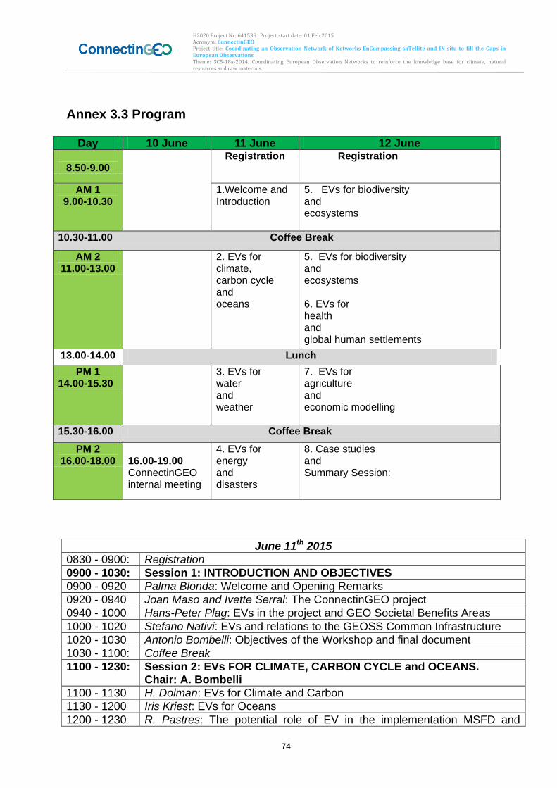
H2020 Project Nr: 641538. Project start date: 01 Feb 2015 Acronym: ConnectinGEO Project title: Coordinating an Observation Network of Networks EnCompassing saTellite and IN-situ to fill the Gaps in European Observations Theme: SC5-18a-2014. Coordinating European Observation Networks to reinforce the knowledge base for climate, natural resources and raw materials
74
Annex 3.3 Program
Thursday, June 11, 2015
June 11th 2015
0830 - 0900: Registration
0900 - 1030: Session 1: INTRODUCTION AND OBJECTIVES
0900 - 0920 Palma Blonda: Welcome and Opening Remarks
0920 - 0940 Joan Maso and Ivette Serral: The ConnectinGEO project
0940 - 1000 Hans-Peter Plag: EVs in the project and GEO Societal Benefits Areas
1000 - 1020 Stefano Nativi: EVs and relations to the GEOSS Common Infrastructure
1020 - 1030 Antonio Bombelli: Objectives of the Workshop and final document
1030 - 1100: Coffee Break
1100 - 1230: Session 2: EVs FOR CLIMATE, CARBON CYCLE and OCEANS. Chair: A. Bombelli
1100 - 1130 H. Dolman: EVs for Climate and Carbon
1130 - 1200 Iris Kriest: EVs for Oceans
1200 - 1230 R. Pastres: The potential role of EV in the implementation MSFD and
Day 10 June 11 June 12 June
8.50-9.00 Registration
Registration
AM 1 9.00-10.30
1.Welcome and Introduction
5. EVs for biodiversity and ecosystems
10.30-11.00 Coffee Break
AM 2 11.00-13.00
2. EVs for climate, carbon cycle and oceans
5. EVs for biodiversity and ecosystems 6. EVs for health and global human settlements
13.00-14.00 Lunch
PM 1 14.00-15.30
3. EVs for water and weather
7. EVs for agriculture and economic modelling
15.30-16.00 Coffee Break
PM 2 16.00-18.00
16.00-19.00 ConnectinGEO internal meeting
4. EVs for energy and disasters
8. Case studies and Summary Session:
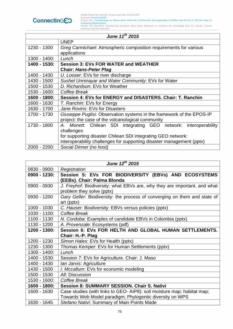
H2020 Project Nr: 641538. Project start date: 01 Feb 2015 Acronym: ConnectinGEO Project title: Coordinating an Observation Network of Networks EnCompassing saTellite and IN-situ to fill the Gaps in European Observations Theme: SC5-18a-2014. Coordinating European Observation Networks to reinforce the knowledge base for climate, natural resources and raw materials
75
June 11th 2015
UNEP
1230 - 1300 Greg Carmichael: Atmospheric composition requirements for various applications
1300 - 1400: Lunch
1400 - 1530: Session 3: EVs FOR WATER and WEATHER Chair: Hans-Peter Plag
1400 - 1430 U. Looser: EVs for river discharge
1430 - 1500 Sushel Unninayar and Water Community: EVs for Water
1500 - 1530 D. Richardson: EVs for Weather
1530 - 1600: Coffee Break
1600 - 1800: Session 4: EVs for ENERGY and DISASTERS. Chair: T. Ranchin
1600 - 1630 T. Ranchin: EVs for Energy
1630 - 1700 Jane Rovins: EVs for Disasters
1700 - 1730 Giuseppe Puglisi: Observation systems in the framework of the EPOS-IP project: the case of the volcanological community
1730 - 1800 A. Monett: Chilean SDI integrating GEO network: interoperability challenges for supporting disaster Chilean SDI integrating GEO network: interoperability challenges for supporting disaster management (pptx)
2000 - 2200: Social Dinner (no host)
Friday, June 12, 2015
June 12th 2015
0830 - 0900: Registration
0900 - 1230: Session 5: EVs FOR BIODIVERSITY (EBVs) AND ECOSYSTEMS (EEBs). Chair: Palma Blonda
0900 - 0930 J. Freyhof: Biodiversity: what EBVs are, why they are important, and what problem they solve (pptx)
0930 - 1200 Gary Geller: Biodiversity: the process of converging on them and state of art (pptx)
1000 - 1030 C. Hauser: Biodiversity: EBVs versus policies (pptx)
1030 - 1100: Coffee Break
1100 - 1130 N. Cordoba: Examples of candidate EBVs in Colombia (pptx)
1130 - 1200 A. Provenzale: Ecosystems (pdf)
1200 - 1300: Session 6: EVs FOR HELTH AND GLOBAL HUMAN SETTLEMENTS. Chair: H.-P. Plag
1200 - 1230 Simon Hales: EVs for Health (pptx)
1230 - 1300 Thomas Kemper: EVs for Human Settlements (pptx)
1300 - 1400: Lunch
1400 - 1530: Session 7: EVs for Agriculture. Chair: J. Maso
1400 - 1430 Ian Jarvis: Agriculture
1430 - 1500 I. Mccallum: EVs for economic modeling
1500 - 1530 All: Discussion
1530 - 1600: Coffee Break
1600 - 1800: Session 8: SUMMARY SESSION. Chair S. Nativi
1600 - 1630 Case studies (with links to GEO- AIP8): soil moisture map; habitat map; Towards Web Model paradigm; Phylogentic diversity on WPS
1630 - 1645 Stefano Nativi: Summary of Main Points Made

H2020 Project Nr: 641538. Project start date: 01 Feb 2015 Acronym: ConnectinGEO Project title: Coordinating an Observation Network of Networks EnCompassing saTellite and IN-situ to fill the Gaps in European Observations Theme: SC5-18a-2014. Coordinating European Observation Networks to reinforce the knowledge base for climate, natural resources and raw materials
76
June 12th 2015
1645 - 1700 Hans-Peter Plag: Summary of Responses to Questions
1700- 1730 All: Discussion
1730 - 1800 Palma Blonda and Antonio Bombelli: Recommendations and a time-line for the report
1800 Joan Maso: Close of Workshop
Annex 3.4 List of participants
Local organizers of Essential Variables Workshop
1 Nativi Stefano [email protected] iia - cnr Italy
2 Blonda Palma [email protected] issia - cnr
3 Biagi Benedetto [email protected] issia - cnr
4 Bombelli Antonio [email protected] cmcc
Speakers at Essential Variables Workshop
5 Nuzzo Sergio Dip. Fisica - UniBa Italy
6 Maso Joan [email protected] CREAF Spain
7 Serral Ivette CREAF Spain
8 Plag Hans-Peter [email protected] Tiwah UG Germany
9 Dolman Han [email protected] VU Univ. Netherlands
10 Kriest Iris [email protected] GEOMAR Germany
11 Pastres Roberto [email protected] Univ VE Italy
12 Carmichael Greg [email protected] WMO US
13 Looser Ulrich [email protected] GRDC Germany
14 Richardson D. ECMWF UK
15 Ranchin Thierry [email protected]
MINES France
16 Rovins Jane [email protected] Disaster Reduction US
17 Puglisi Giuseppe [email protected] INGV Italy
18 Monett A. SNIT IDE de Chile
19 Freyhof Joerg [email protected] iDiv Germany
20 Geller Gary [email protected] NASA JPL US
21 Hauser Christoph christoph.haeuser@ mfn-berlin.de MfN Germany
22 Cordoba N. IDEAM Colombia
23 Provenzale Antonello [email protected] cnr – Italy
24 Hales Simon [email protected] WHO New Zealand
25 Kemper Thomas [email protected] JRC Italy
26 Jarvis Ian [email protected] Canada
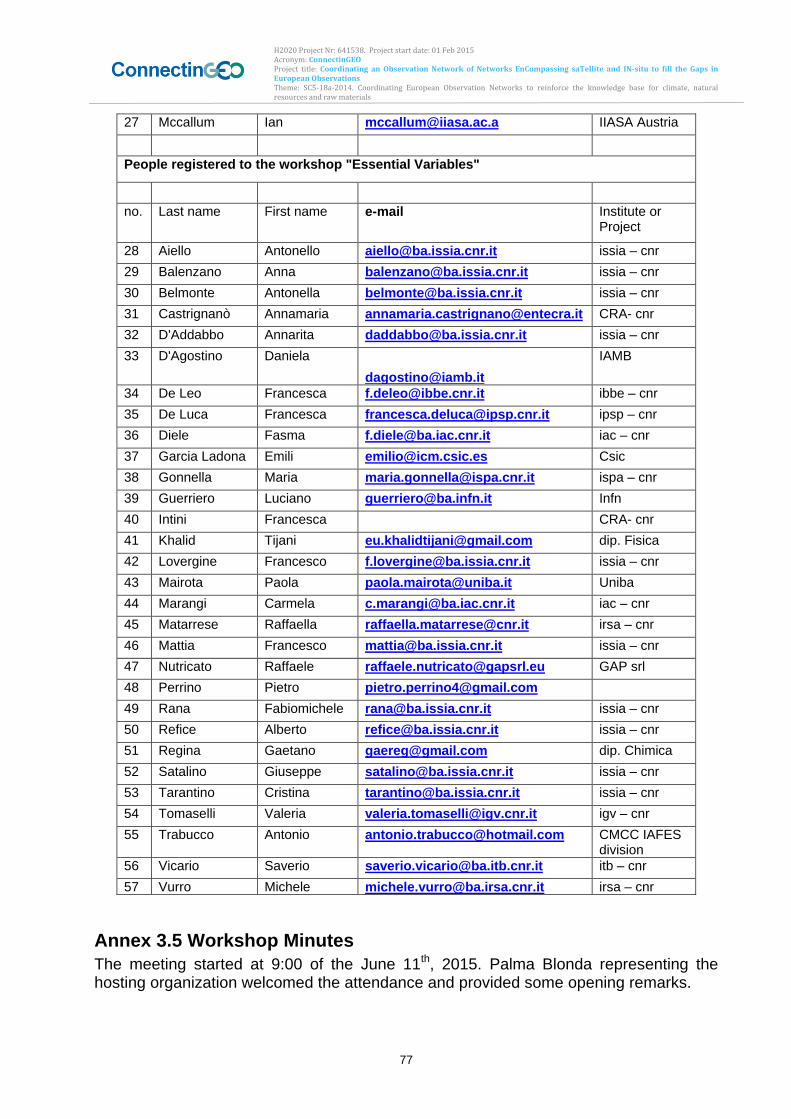
H2020 Project Nr: 641538. Project start date: 01 Feb 2015 Acronym: ConnectinGEO Project title: Coordinating an Observation Network of Networks EnCompassing saTellite and IN-situ to fill the Gaps in European Observations Theme: SC5-18a-2014. Coordinating European Observation Networks to reinforce the knowledge base for climate, natural resources and raw materials
77
27 Mccallum Ian [email protected] IIASA Austria
People registered to the workshop "Essential Variables"
no. Last name First name e-mail Institute or Project
28 Aiello Antonello [email protected] issia – cnr
29 Balenzano Anna [email protected] issia – cnr
30 Belmonte Antonella [email protected] issia – cnr
31 Castrignanò Annamaria [email protected] CRA- cnr
32 D'Addabbo Annarita [email protected] issia – cnr
33 D'Agostino Daniela
IAMB
34 De Leo Francesca [email protected] ibbe – cnr
35 De Luca Francesca [email protected] ipsp – cnr
36 Diele Fasma [email protected] iac – cnr
37 Garcia Ladona Emili [email protected] Csic
38 Gonnella Maria [email protected] ispa – cnr
39 Guerriero Luciano [email protected] Infn
40 Intini Francesca CRA- cnr
41 Khalid Tijani [email protected] dip. Fisica
42 Lovergine Francesco [email protected] issia – cnr
43 Mairota Paola [email protected] Uniba
44 Marangi Carmela [email protected] iac – cnr
45 Matarrese Raffaella [email protected] irsa – cnr
46 Mattia Francesco [email protected] issia – cnr
47 Nutricato Raffaele [email protected] GAP srl
48 Perrino Pietro [email protected]
49 Rana Fabiomichele [email protected] issia – cnr
50 Refice Alberto [email protected] issia – cnr
51 Regina Gaetano [email protected] dip. Chimica
52 Satalino Giuseppe [email protected] issia – cnr
53 Tarantino Cristina [email protected] issia – cnr
54 Tomaselli Valeria [email protected] igv – cnr
55 Trabucco Antonio [email protected] CMCC IAFES division
56 Vicario Saverio [email protected] itb – cnr
57 Vurro Michele [email protected] irsa – cnr
Annex 3.5 Workshop Minutes
The meeting started at 9:00 of the June 11th, 2015. Palma Blonda representing the hosting organization welcomed the attendance and provided some opening remarks.
H2020 Project Nr: 641538. Project start date: 01 Feb 2015 Acronym: ConnectinGEO Project title: Coordinating an Observation Network of Networks EnCompassing saTellite and IN-situ to fill the Gaps in European Observations Theme: SC5-18a-2014. Coordinating European Observation Networks to reinforce the knowledge base for climate, natural resources and raw materials
78
In the introduction section of the workshop, the coordinator exposed the objectives of the ConnectinGEO project and of the workshop. At 09:40 Hans-Peter Plag provided a set of first ideas about the EVs in the project and GEO SBA with the purpose of providing a straw person to start the discussion. At 10:00 Stefano Nativi explained the relations between the EVs and the GEOSS Common Infrastructure and how to extract them from the brokering of GEOSS data (40 brokered data providers, about 40 million discoverable and potentially accessible first level resources, more than 170 million of individual resources). At 10:20 some remarks about the objectives of the workshop by Antonio Bombelli. In this case, the vision of the final document was also introduced:
- A peer reviewed document on the EV status and definition process and requirements.
- Address the workshop objectives and provide recommendations and way forward in the frame of GEO/GEOSS
At 11:00 started the session on EVs FOR CLIMATE, CARBON CYCLE and OCEANS. Chair: A. Bombelli H. Dolman introduced the EVs for Climate and Carbon (11:00). Some remarks:
- Terrestrial observations need to be integrated across time and space scales this leads us to the “observational gap”.
- Consider uncertainties in observations. - Essential Carbon Variables are part of the ECV.
At 11:30 Iris Kriest talked about the EVs for Oceans for biochemistry and answered one by one all the questions formulated in the workshop. He presented as well the structure and process for the definition of the EOV. Following this process, and among impact and feasibility, 8 main EOV are identified. At 12:00 R. Pastres explained the potential role of EV in the implementation of the Marine Strategy Framework Directive (MSFD) and the UNEP/MAP ecosystem approach. Marine EV are very much biological variables and are still in a very preliminary stage. A methodology for its definition was presented as well as a prediction on how the variables are responding to the pressure. A set of indicators can also be derived from marine EVs, and then these indicators derived to produce some assessments. At 12:30 Greg Carmichael introduced the concept of the EV in the atmospheric composition domain. He answered all the questions formulated in the workshop. The methodology for define the EV was also explained and it’s based on a top-down approach. At 14:00 started the session on EVs FOR WATER and WEATHER. Chair: Hans-Peter Plag U. Looser explained at 14:00 the EVs for river discharge. He answered all the questions formulated in the workshop. He stated that long-term river discharge measurements are
H2020 Project Nr: 641538. Project start date: 01 Feb 2015 Acronym: ConnectinGEO Project title: Coordinating an Observation Network of Networks EnCompassing saTellite and IN-situ to fill the Gaps in European Observations Theme: SC5-18a-2014. Coordinating European Observation Networks to reinforce the knowledge base for climate, natural resources and raw materials
79
the essential information source for many water resource applications, although there is some overlapping with EV in other domains as water is a key element in all SBA. At 14:30 Sushel Unninayar and the Water Community introduced the EVs for Water. Essential Water Cycle Variables (EWCVs) are defined through a review process: they are derived by reviewing/consolidating user-needs/requirements (for observations of water variables) in all GEO user sectors as defined by the GEO SBA. EWV are defined as water variables/parameters that address “user”-defined critical requirements. There are 9 primary EWCV and 6 supplementary EWV that can be expanded into much more detailed sub-parameters/variables. D. Richardson talked about the EVs for Weather (15:00). He answered all the questions formulated in the workshop. The EWV were defined under the WMO and they have to be essential to support the WMO Programmes. The methodology for defining the EWV is based on both a bottom-up and top-down approach. A rolling review of requirements also helps to this definition. At 16:00 started the session 4 on EVs for ENERGY and DISASTERS. Chair: T. Ranchin At 16:00 T. Ranchin talked about EVs for Energy. In the case of ConnectinGEO only renewable energy EV are considered: RE-EV. The first attempt of formalizing them was in the GEO Task US-09-01a. The definition is based on bibliographic survey on user needs and users’ survey. The most clearly defined ones are: RE-EVs for Solar, RE-EVs for Onshore Wind, and Tentative RE-EVs for Ocean. At 16:30 Jane Rovins gave the talk about EVs for Disasters. The EV relevant to the disasters domain are Primary Human Impact Indicators, Secondary & Tertiary Human Indicators, and Economic Loss Indicators. A clear methodology is needed to know what is a lost and how to assess it. Acceptance and understanding of disasters is a trans-disciplinary item. Giuseppe Puglisi talked about Observation systems in the framework of the EPOS-IP project: the case of the volcanological community (17:00). They are not developing specific EV in this concrete disaster domain (neither in the Earth Science domain). Moreover they are not planning to start this process in the near future. EPOS is coordinating this huge community. A. Monett introduced the Chilean SDI integrating GEO network: interoperability challenges f or supporting disaster Chilean SDI integrating GEO network (17:30). Chile is strongly related to GEOSS: is working with the GEOSS Architecture Implementation Pilot and there’s also a Chile Capacity Building WG for disasters. They are defining EV as measures of metadata web services accessible, searchable and discoverable nationally and internationally. Chile CB WG will develop a set of area-specific EVs. The first day of the meeting was adjourned at 18:00. On the June 12th, the meeting continued at 9:00 with the session 5 EVs FOR BIODIVERSITY (EBVs) AND ECOSYSTEMS (EEBs). Chair: Palma Blonda.
H2020 Project Nr: 641538. Project start date: 01 Feb 2015 Acronym: ConnectinGEO Project title: Coordinating an Observation Network of Networks EnCompassing saTellite and IN-situ to fill the Gaps in European Observations Theme: SC5-18a-2014. Coordinating European Observation Networks to reinforce the knowledge base for climate, natural resources and raw materials
80
At 9:00 J. Freyhof explained how EV are being developed in the Biodiversity domain: what EBVs are, why they are important, and what problem they solve. EBV must be: easy to detect change, quantifiable, repeatable, allow aggregation and disaggregation, and biological. At 09:30, Gary Geller explained about the process of developing EV and some options from the GEO BON experience. Variables must reflect the most important items to observe, provide guidance to the observation system, respond to user needs, and lie between raw observations and user needs. He stated the possibility of splintering EBV concept to other groups. At 10:00, C. Häuser talked about EBVs versus policies. There’s a great opportunity for EBVs to significantly advance with data standardization and open data sharing – through specific demands from international political frameworks. At 11:00 N. Cordoba presented some examples of candidate EBVs in Colombia. At 11:30, A. Provenzale, coordinator of the ECOPOTENTIAL H2020 project talked about EV in the Ecosystems domain. Currently EV for ecosystems (EVE) are based on other EV (ECV, EOV, EBV, etc). Antonello’s view was to use several existing EV rather than create new EVE. At 12:00 started the session 6 on EVs FOR HEALTH AND GLOBAL HUMAN SETTLEMENTS. Chair: H.-P. Plag The first to speak was Simon Hales at 12:00 regarding EVs in the Health domain. In this case, Hales noted that with Health there’s a need for a global context rather than a specific area of application, as health problems are from a global nature. At 12:30 Thomas Kemper talked about EVs for Human Settlements and the need for fine-scale global human settlement information. A GEO Global Human Settlement Initiative was launched in October 2014 at the JRC to develop a new generation of measurements and information products. EV’s are currently being developed. In this domain, EV must accomplish: global availability, but local detail, sustainable monitoring (feasible & affordable), linked to specific framework goals/targets, and be accepted by the stakeholders. At 14:00 started the session 7 on EVs for Agriculture. Chair: J. Masó The session started with Ian Jarvis at 14:00 talking about EV on the agriculture domain. In this case, some EV are being developed by GEOGLAM (Agriculture Community of Practice), based on monitoring needs to support policy at the local, regional, national and global scales. Current EAV are: Crop Area, Crop Type, Crop Condition, Crop Phenology, Crop Yield (forecast), Crop Management (Tillage and Residue). All across multiple time and space scales. At 14:30 I. McCallum talked about Citizen Science to capture EV. CS can help across most SBAs and can address data needs where feasibility has been limiting, and can provide information at low cost.
H2020 Project Nr: 641538. Project start date: 01 Feb 2015 Acronym: ConnectinGEO Project title: Coordinating an Observation Network of Networks EnCompassing saTellite and IN-situ to fill the Gaps in European Observations Theme: SC5-18a-2014. Coordinating European Observation Networks to reinforce the knowledge base for climate, natural resources and raw materials
81
At 15:00 there was an overall discussion with the participation of all the attendants. At 16:00 started the SUMMARY SESSION. Chair S. Nativi At 16:00 some case studies (with links to GEO- AIP8) were explained: soil moisture map; habitat maps; Web Model paradigm; and Phylogentic diversity on WPS. At 16:30 Stefano Nativi made a summary of the main points raised in the workshop:
- Any Variable is “essential” for somebody or for achieving something - GEOSS must capture what somebody and something are:
o consider a scope o consider EVs to achieve that scope
- Communities of Practices have been defining “their” Essential Variables for providing services:
o deal with “many” EVs belonging to the same domain (SBA) o GEOSS must consider them all.
- Challenges to GEOSS: o different maturity levels o global vs local o harmonization/alignment
- Possible starting communities for ConnectinGEO:
o Climatology o Hydrology o Agriculture o Biodiversity o Oceanography o Weather o Cross-domain EVs have to be recognized by GEOSS
At 16:45 Hans-Peter Plag made a summary on responses given by the attendants to the formulated questions. Some conclusions:
- Most of those community represented are developing at different levels - All the communities are planning to start EV in the near future - Communities differ from each other in the EV definitions - There’s a wide range of different methodologies, criteria, and processes - ConnectinGEO: connecting the EVs of GEO Communities across the SBAs
At 17:00 there were some more discussions among all participants. At 17:30 Palma Blonda and Antonio Bombelli made some recommendations and a time-line for the report:
- Assess the status of existing EVs in the different GEO SBAs - Review the different processes (criteria, methods, etc.) to define and identify EVs - Find commonalities; identify “super-EVs - Validation and applicability - Monitoring networks - Observational needs and readiness - Gaps and priorities - Recommendations on EV and a way to move forward

H2020 Project Nr: 641538. Project start date: 01 Feb 2015 Acronym: ConnectinGEO Project title: Coordinating an Observation Network of Networks EnCompassing saTellite and IN-situ to fill the Gaps in European Observations Theme: SC5-18a-2014. Coordinating European Observation Networks to reinforce the knowledge base for climate, natural resources and raw materials
82
At 18:00 Joan Masó, closed the Workshop and thanked everyone for their participation.