Embed Size (px)
Citation preview
Volcanic and geological mapping of Mount Etna volcano using remote sensing
Misha’el MisriUp619683
1.0 IntroductionRemote sensing is a technique used to acquire data or information from an area at a distance by emitting and reflecting electromagnetic radiation, an energy transfer from either an airborne sensor, such as aircrafts or spacebourne sensors attached to satellites and shuttles. The data collected is then analysed and transformed into a visual aid to study the area in much more depth.
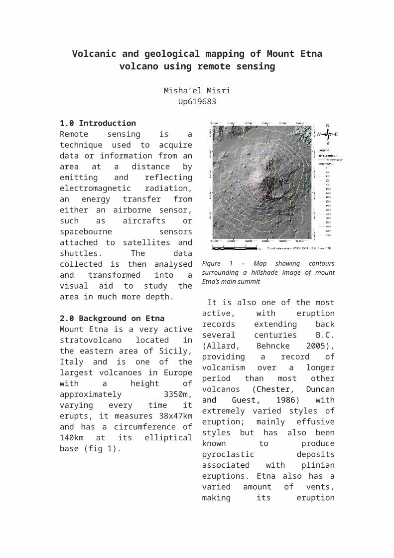
2.0 Background on EtnaMount Etna is a very active stratovolcano located in the eastern area of Sicily, Italy and is one of the largest volcanoes in Europe with a height of approximately 3350m, varying every time it erupts, it measures 38x47km and has a circumference of 140km at its elliptical base (fig 1).
Figure 1 – Map showing contours surrounding a hillshade image of mount Etna’s main summit
It is also one of the most active, with eruption records extending back several centuries B.C. (Allard, Behncke 2005), providing a record of volcanism over a longer period than most other volcanos (Chester, Duncan and Guest, 1986) with extremely varied styles of eruption; mainly effusive styles but has also been known to produce pyroclastic deposits associated with plinian eruptions. Etna also has a varied amount of vents, making its eruption location fairly unpredictable.
Etna is one of the most popular volcanoes to be studied and monitored from its long term ground deformation to its gas geochemistry (Caracciolo et al., 2014, pp. 36–40) because it is so easily accessible, it has good road communications including drivable road tracks to the summit on both the Northern and Southern flanks (Chester, Duncan and Guest, 1986). In addition, large parts of the volcanos flanks are heavily populated and cultivated (Chester, Duncan and Guest, 1986), this makes the area very vulnerable in a social aspect.
3.0 Literature review3.1 ASTERAdvanced Spacebourne Thermal Emission and reflection radiometer (ASTER) is an instrument used to record data such as reflectance, elevation and surface temperature to create an intricate and detailed high-resolution image of an area ranging between 15-90m. ASTER can have a different number of bands depending on the wavelength; it has three visible bands in the visible near-infrared
(VNIR), six bands in the shortwave infrared (SWIR), and five bands in the thermal infrared regions (Yamaguchi et al., 1998, pp. 1062–1071).
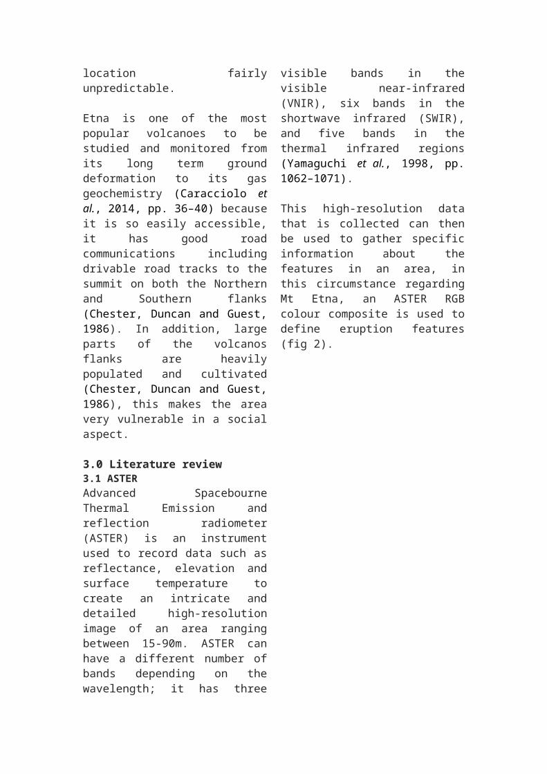
This high-resolution data that is collected can then be used to gather specific information about the features in an area, in this circumstance regarding Mt Etna, an ASTER RGB colour composite is used to define eruption features (fig 2).
Figure 2 – false colour composite created by combining different bands to enhance lava flow, Mt Etna
Figure 2 demonstrates how the high resolution size and the choice of the specific bands highlights the exact location of lava flows represented by bright orange colour flowing in a southerly direction from the vent.
Another way aster can be used regarding Etna is by combining the bands in a different way to show something new. Figure 3 is an image that highlights two different types of clouds being emitted from the vent during the eruption; the more predominant cloud, in a southerly direction being the ash cloud and a slightly more faint cloud shown
heading in a S-E direction which would appear to be a sulpher cloud.
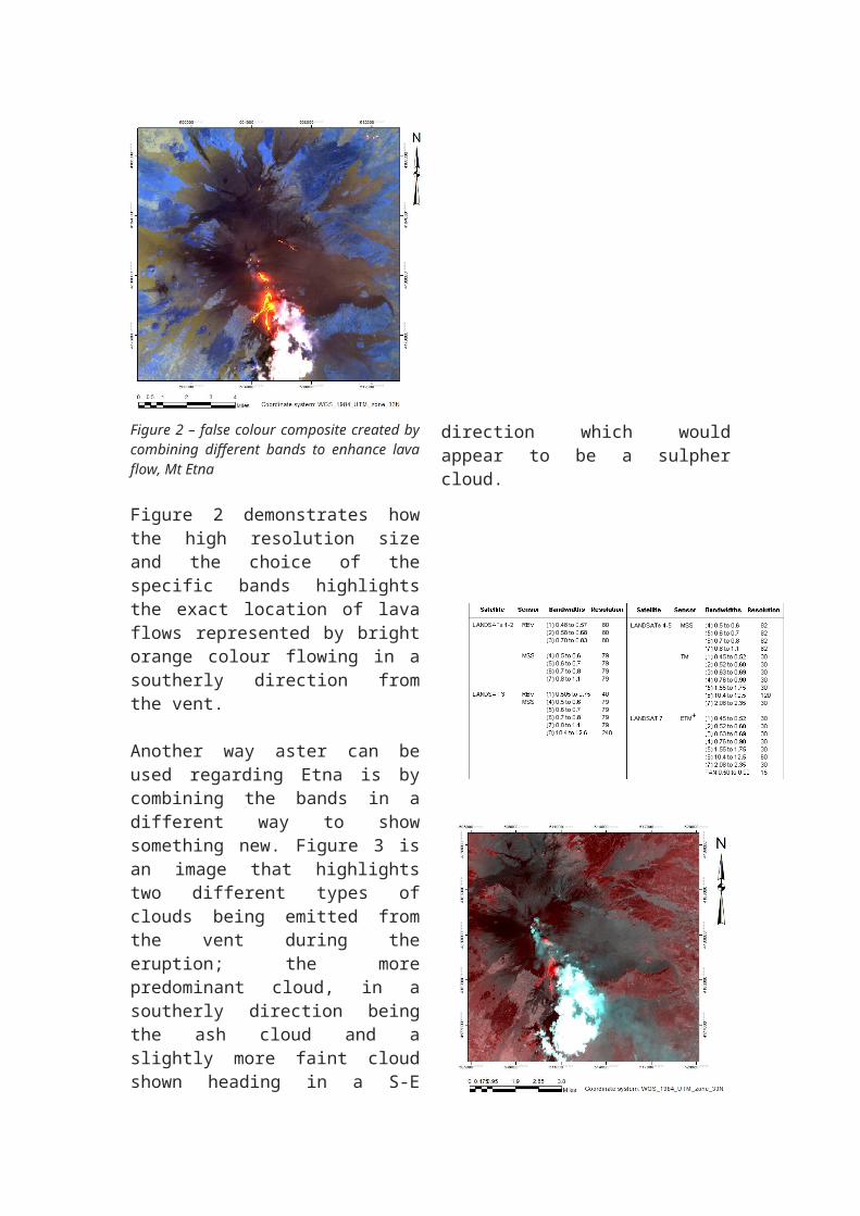
Figure 3 – False colour composite created by combining different bands to enhance ash and sulpher clouds, Mt Etna
3.2 LANDSATLandsat platforms carry multiple remote sensor systems and data relay systems (http://landsathandbook.gsfc.nasa.gov/program/) that are used to obtain very high-resolution multispectral data of the Earth. Sensors record reflected and emitted energy from the Earth in various wavelengths of the electromagnetic spectrum (http://landsat.gsfc.nasa.gov/?page_id=9).
Figure 4 – Table showing the different satellites and sensors used during Landsat missions
They have been in operation since 1972 however Landsat-1, formally named the Earth Resources Technology Satellites (ERTSs) programme, launched in 1975. Since then Landsat 7 and 8 have been launched, each having newer, more advanced sensors and larger bandwidths (fig 4). These newer programs can record a much wider range of the visible, near infrared and thermal infrared spectrums.
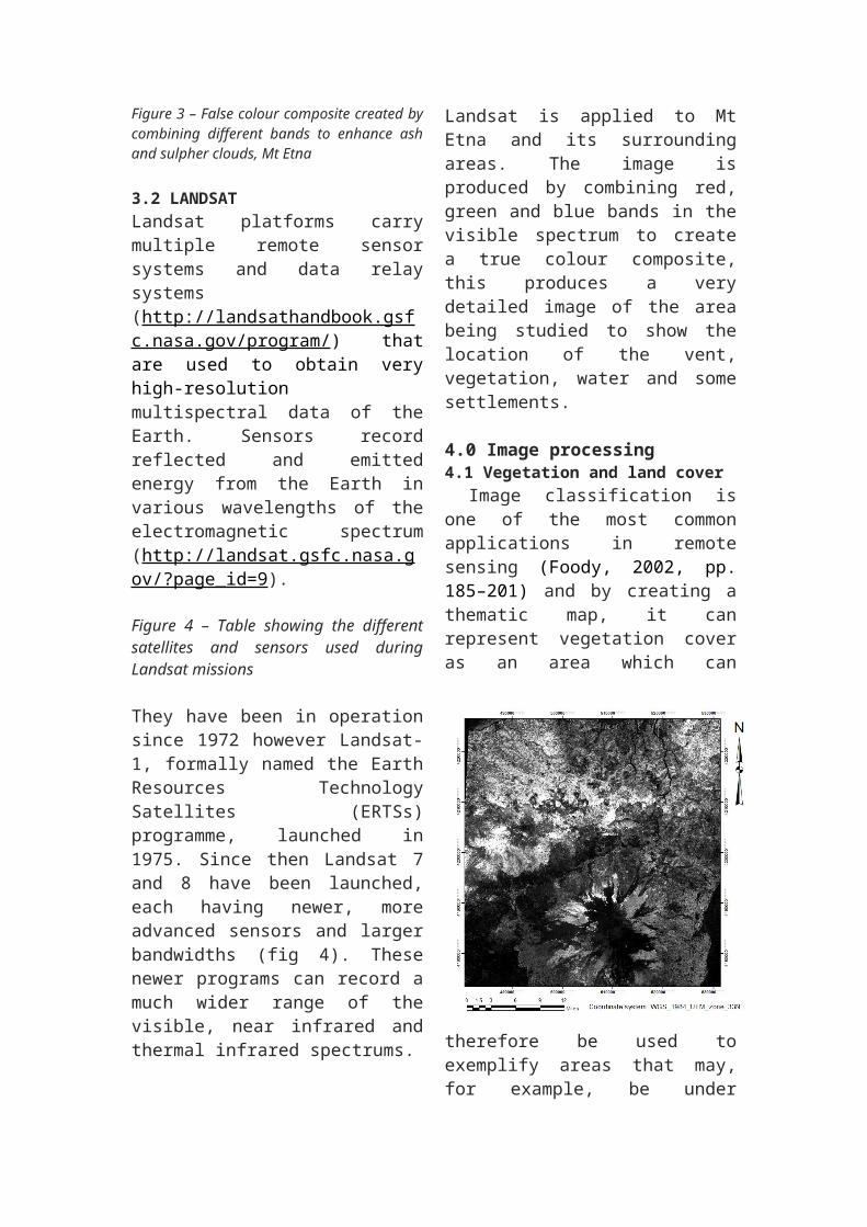
Landsat is applied to Mt Etna and its surrounding areas. The image is produced by combining red, green and blue bands in the visible spectrum to create a true colour composite, this produces a very detailed image of the area being studied to show the location of the vent, vegetation, water and some settlements. 4.0 Image processing4.1 Vegetation and land cover Image classification is one of the most common applications in remote sensing (Foody, 2002, pp. 185–201) and by creating a thematic map, it can represent vegetation cover as an area which can therefore be used to exemplify areas that may, for example, be under threat to ecological changes or have new areas that grown due to new fertile soil created by ash fall.
Figure 5 – different band ratios used to create a vegetation index image of Mt Etna
Combining different band ratios to create a vegetation cover to represent areas of growth created shown in figure 5. Vegetation cover is shown in lighter colours, thus the lighter the area, the denser the vegetation cover is. The figure can also represent the
ages of the lava, with old lava flows being a lighter colour as is has time to become fertile and allow growth where as newer, fresher lava flows are shown with a darker colour.
4.2 Supervised and unsupervised image classificationsClassifying an image can be very useful when it comes to identifying specific features in a geographical setting such as settlements, vegetation and lava flows.
There are two different types of image classification, the first being supervised; this is a process that involves grouping together areas of similarity, in most circumstances, areas with similar colour groups, then giving these groups a name, for example; a large area of a blue colour of a true colour composite will be easily recognized as a body of water, so this area will have a polygon drawn around it and labeled.
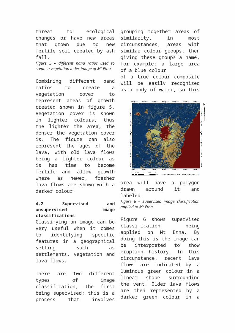
Figure 6 – Supervised image classification applied to Mt Etna
Figure 6 shows supervised classification being applied on Mt Etna. By doing this is the image can be interpreted to show eruption history. In this circumstance, recent lava flows are indicated by a luminous green
colour in a linear shape surrounding the vent. Older lava flows are then represented by a darker green colour in a radial fashion around the vent. Settlements are also shown on the image as a yellow colour, this can be especially useful when wanting to create vulnerability maps to shows areas that are susceptible to the hazard of lava flows.
The second type of image classification is unsupervised, this is when an image is uploaded and a number of classes are selected to show areas that have similarities with the general rule of; the greater number of classes, the more detailed a final image can be.
Figure 7 – Unsupervised classification applied to Mt Etna
Figure 7 in an example of how unsupervised classification can once again be used to highlight the recent and older lava flows, in this circumstance the older lava flows are the main focus, defined by an orange colour in a radial fashion around the summit.
4.3 Enhancement of volcanic landformsA Digital elevation model (DEM) is extremely useful when it comes to identifying different landforms within an area such as geological landforms.
It identifies these features by creating a combination of hillshade, aspect and slope maps to highlight areas that are being studied.Figure 8 – Digital elevation model applied to Mt Etna to using hillshade and slope
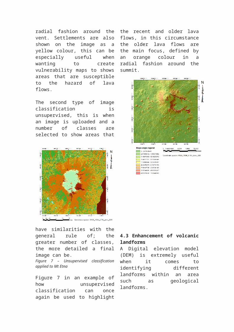
Figure 8 shows how the application of DEM data to an area can highlight geological features such as the main summit and also the small vents that are surrounding the summit in a north-westerly and south-easterly directions.
There are about 300 vents surrounding the summit of mount Etna are all susceptible to erupting, making it difficult to predict just where an eruption will take place, making it more difficult to predict vulnerable areas.
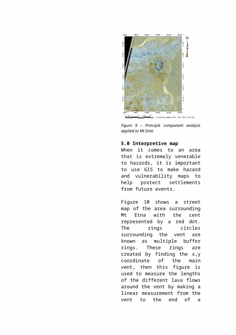
4.4 Principal Component AnalysisPrincipal component analysis (PCA) is a technique, where it replaces the p original variables by a smaller number, q, of derived variables, the principal components, which are linear combinations of the original variables (Jolliffe, 1986)
Figure 9 shows an image of what Mt Etna looks like with PCA applied to it. By doing this is highlights the different the minerals within the ground represented by different colours on the map. In this map it shows both a light blue hue in the northern side; this represents the clay rich minerals in the soil, then areas of a yellow colour show iron rich minerals. This information is very useful when it comes to inhabiting areas as it may show areas with more fertile soil, or can even
show where extent of old lava flows as basalt contains a lot of iron so can show vulnerable areas that are potentially susceptible to harm.Figure 9 – Principle component analysis applied to Mt Enta
5.0 Interpretive mapWhen it comes to an area that is extremely venerable to hazards, it is important to use GIS to make hazard and vulnerability maps to help protect settlements from future events.
Figure 10 shows a street map of the area surrounding Mt Etna with the cent represented by a red dot. The rings circles surrounding the vent are known as multiple buffer rings. These rings are created by finding the x,y coordinate of the main vent, then this figure is used to measure the lengths of the different lava flows around the vent by making a linear measurement from the vent to the end of a singular lava flow. This process is then repeated for each lava flow to create a buffer rings for the different sets of lava flows, with the furthest flow extending over 20,000 meters.
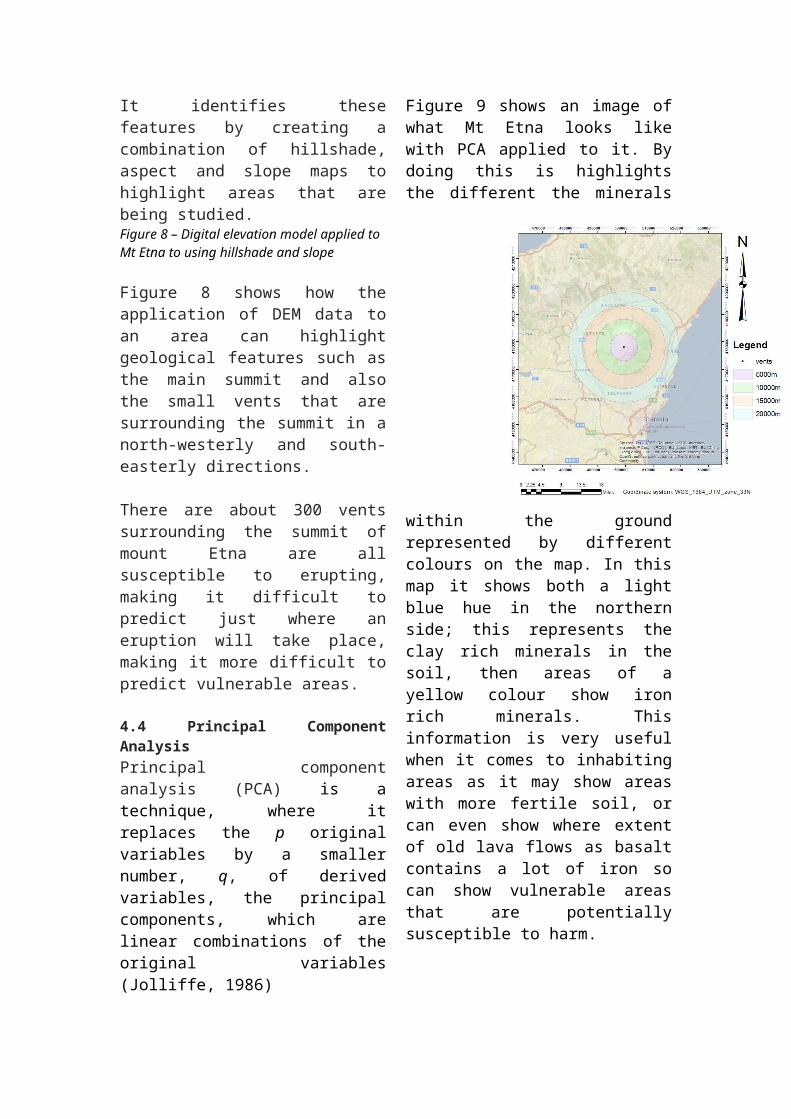
Figure 10 – Lava flow vulnerability map surround the main vent, Mt Etna represented using multiple buffer rings
Figure 10 shows that there are many settlement within the lava hazard zones with most only living a mere 15,000 Meters away from the vent.
6.0 ConclusionBy creating all the different maps it has helped with the understanding of how Mt Etna has behaved in its past and also helped in predicting what possible
effects it could have on surrounding settlements in the future by using and manipulating the different Landsat and ASTER bands to your advantage to show different interpretations. By doing so it has been uncovered that past lava flows have extended out much further from the main vent than more recent flows, this may be because the composition of the lava itself could be changing, making it less viscous than before.
BibliographyCaracciolo, D., Nicolosi, Carluccio, Chiappini, De Ritis, Giuntini, Materni, Messina and Chiappini (2014) ‘High resolution aeromagnetic anomaly map of Mount Etna volcano, Southern Italy’, Journal of Volcanology and Geothermal Research, 277, pp. 36–40. doi: 10.1016/j.jvolgeores.2014.03.008.
Chester, D. K., Duncan, A. M. and Guest, J. E. (1986) Mount Etna: The Anatomy of a Volcano. United States: Stanford University Press.Foody, G. (2002) ‘Status of land cover classification accuracy assessment’, Remote Sensing of Environment, 80(1), pp. 185–201. doi: 10.1016/s0034-4257(01)00295-4.
Harris, A., Blake, S., Rothery, D. and Stevens, N. (1997) ‘A chronology of the 1991 to 1993 Mount Etna eruption using advanced very high resolution radiometer data:
Implications for real-time thermal volcano monitoring’, Journal of Geophysical Research, 102(B4). doi: 10.1029/96jb03388.Jolliffe, I. (1986) Principal component analysis. United States: Springer-Verlag New York Inc.
Lillesand, T., Kiefer, R. and Chipman, J. (2007) Remote Sensing and Image Interpretation. 6th edn. United Kingdom: Wiley, John & Sons, Incorporated.
Muller, J.-P. (1988a) Digital image processing in remote sensing. United Kingdom: Taylor & Francis Ltd.
Muller, J.-P. (1988b) Digital image processing in remote sensing. United Kingdom: Taylor & Francis Ltd.
P, L. (1986) Applied remote sensing. 1st edn. United Kingdom: Longman.
R, J., John (2006) Remote Sensing of the Environment: An Earth Resource Perspective. 2nd edn. United States: Pearson Prentice Hall.
Reichs, K. (2014) Bones of the Lost: (Temperance Brennan 16). United Kingdom: Arrow Books Ltd.
Yamaguchi, Kahle, A. B., Tsu, Kawakami and Pniel (1998) ‘Overview of Advanced Spaceborne Thermal Emission and Reflection Radiometer (ASTER)’, IEEE Transactions on Geoscience and Remote Sensing, 36(4), pp. 1062–1071. doi: 10.1109/36.700991.
Available at: http://landsathandbook.gsfc.nasa.gov/program/.
Available at: http://landsat.gsfc.nasa.gov/?page_id=9.