Embed Size (px)
Citation preview
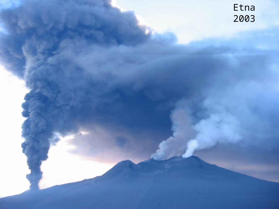
Etna 2003
Most volcanoes occur in narrow belts or are grouped together in small clumps. This is because they usually occur at plate boundaries. One such ‘belt’ of volcanoes is called the Ring of Fire, which runs around the edge of the Pacific Ocean, where, amongst others, the Pacific Plate meets the Eurasian Plate, the Indo-Australian Plate, the Antarctic Plate, and the Nazca Plate.Forecasting involves probable character and time of an eruption in a monitored volcano. The character of an eruption is based on the prehistoric and historic record of the volcano in question and its volcanic products. For example, a violently erupting volcano that has produced ash fall, ash flow and volcanic mudflows (or lahars) is likely to do the same in the future. Determining the timing of an eruption in a monitored volcano depends on measuring a number of parameters, including, but not limited to, seismic activity at the volcano (especially depth and frequency of volcanic earthquakes), ground deformations (determined using a tiltmeter and/or GPS, and satellite interferometry), and gas emissions (sampling the amount of sulfur dioxide gas emitted by correlation spectrometer, or COSPEC
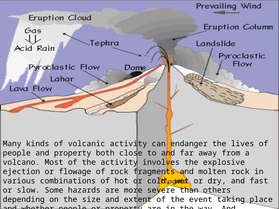
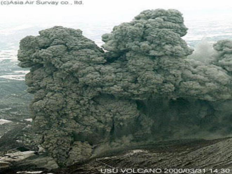
Many kinds of volcanic activity can endanger the lives of people and property both close to and far away from a volcano. Most of the activity involves the explosive ejection or flowage of rock fragments and molten rock in various combinations of hot or cold, wet or dry, and fast or slow. Some hazards are more severe than others depending on the size and extent of the event taking place and whether people or property are in the way. And although most volcano hazards are triggered directly by an eruption, some occur when a volcano is quiet.
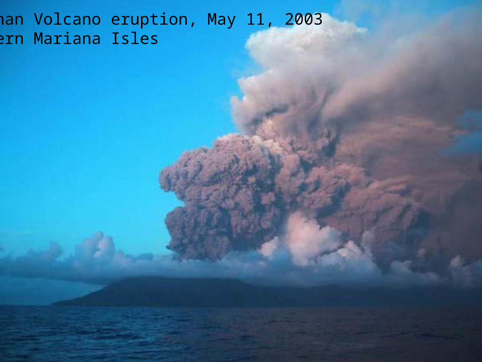
Anatahan Volcano eruption, May 11, 2003 Northern Mariana Isles
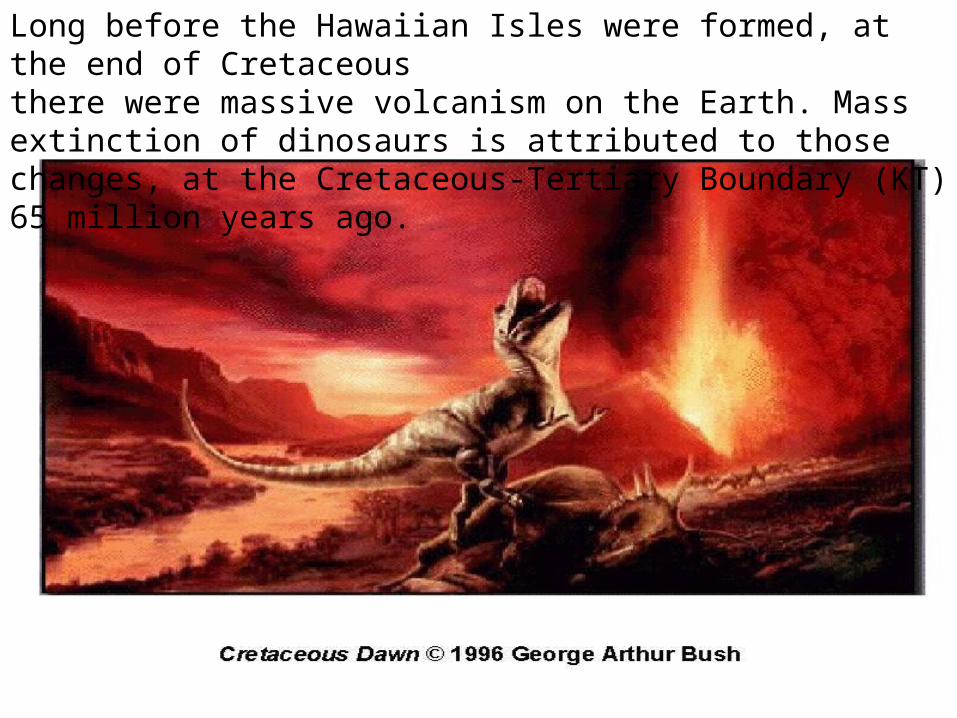
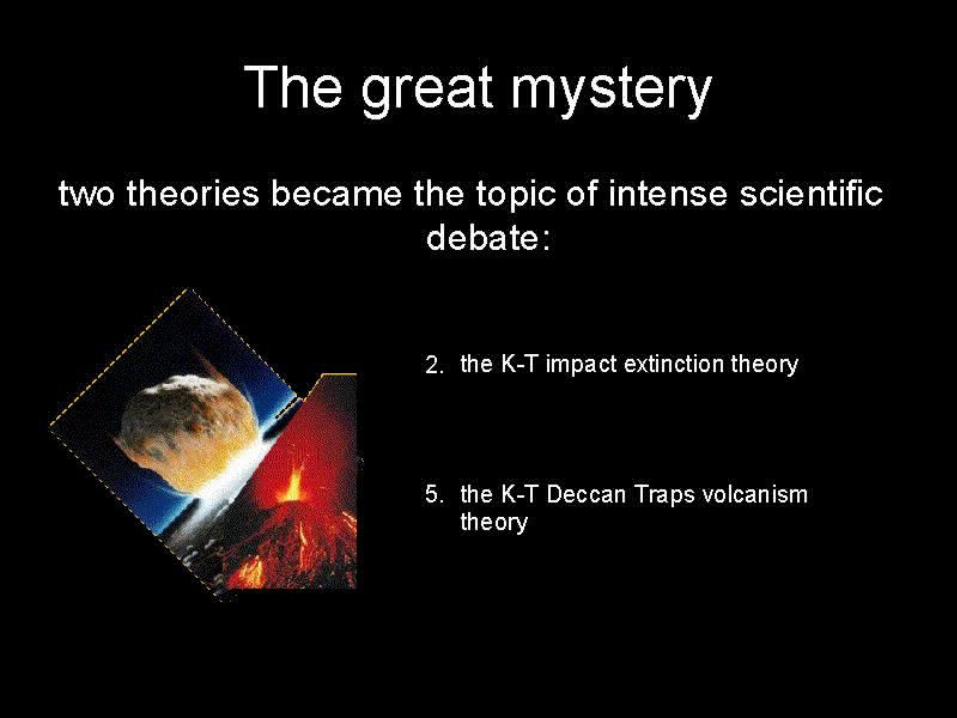
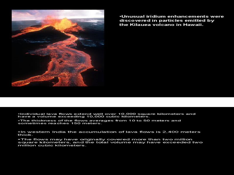
Long before the Hawaiian Isles were formed, at the end of Cretaceousthere were massive volcanism on the Earth. Mass extinction of dinosaurs is attributed to those changes, at the Cretaceous-Tertiary Boundary (KT)65 million years ago.
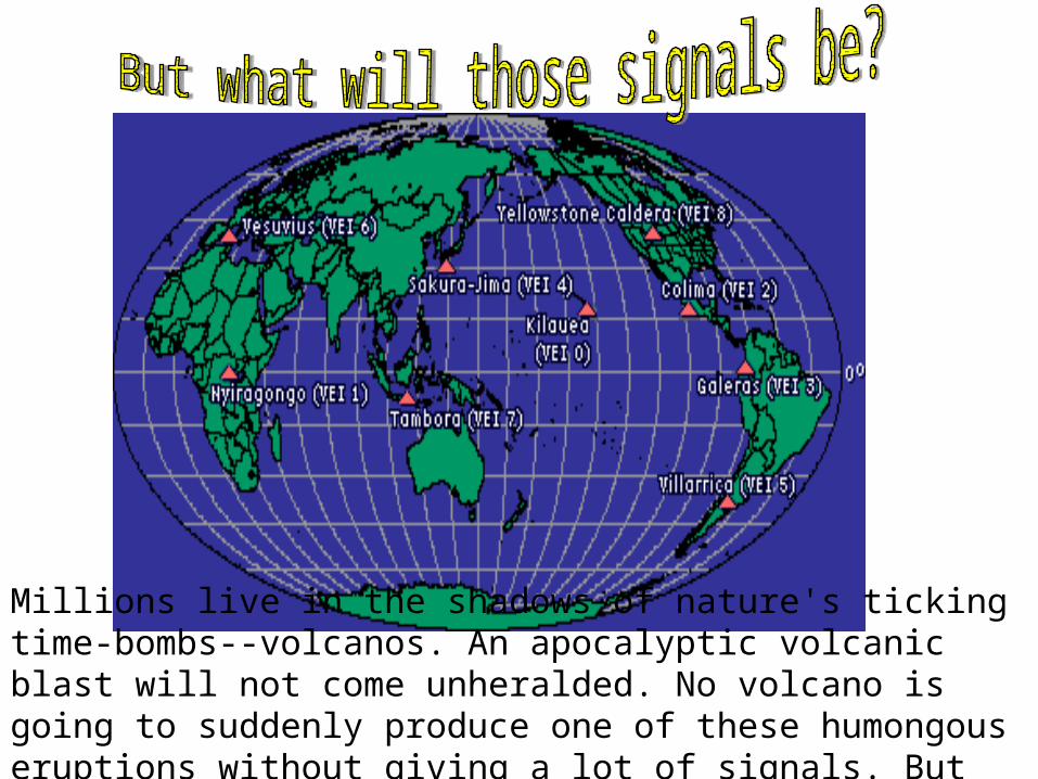
Millions live in the shadows of nature's ticking time-bombs--volcanos. An apocalyptic volcanic blast will not come unheralded. No volcano is going to suddenly produce one of these humongous eruptions without giving a lot of signals. But what will those signals be?
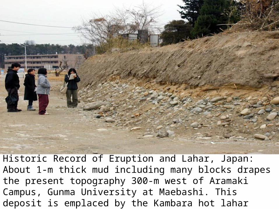
Historic Record of Eruption and Lahar, Japan: About 1-m thick mud including many blocks drapes the present topography 300-m west of Aramaki Campus, Gunma University at Maebashi. This deposit is emplaced by the Kambara hot lahar originated from the northern flank of Asama on August 5, 1783. Outcrop exposed by urban development.

Mt. Pagan, Northern Mariana, Guam, 1994
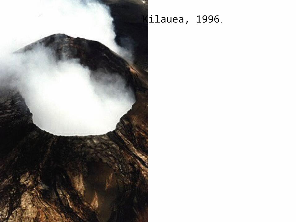
Kilauea, 1996.
As the world's population grows, more and more people are living in potentially dangerous volcanic areas. Volcanic eruptions continue--as they have throughout history--posing ever-greater threats to life and proper There are mainly two internal heat sources that drive plate tectonics and volcanic eruptions: heat left over from the formation of the earth, and decay of radioactive elements within the earth. Volcanic eruptions account for a large proportion of the internal heat that is dissipated from the interior of the earth.
Are Volcanic Eruptions Tied to Lunar Cycle?Gravity is one of Earth's strongest forces, so you can't ignore the moon. The challenge is to find out just how it's playing a role
Glaciers and VolcanoesClimate and environmental change can trigger volcanic eruptions. Over the past 800,000 years, a new study shows, glaciers prompted eruptions after they retreated north. One possibility is that all the extra weight of the glacial ice holds the magma, or molten rock, in place. Then when the ice melts and the water evaporates, less weight on the Earth's crust triggers volcanoes to erupt.
Hazardous volcanic activity poses a threat to people and property. Unlike most other natural hazards, the damage inflicted by volcanoes can be significantly mitigated if volcanic behavior is assessed rapidly, as dangerous situations develop.
Volcanic Hazards1. Local volcanic hazards : The magnitude of the proximal threat is
much larger. There is the potential for many (perhaps thousands) of deaths and of extensive or total destruction of buildings, roads, dams, pipelines, or any other structures in the area. The surface drainage pattern may be disrupted, and arable land or forest temporarily or permanently destroyed.Proximal hazards require evacuation of people, livestock, any other movable property, to appreciable distances from their homes, for uncertain lengths of time, often weeks or months.
2. Local and Distant Tsunamis in the Coastal and Oceanic Volcanic Eruptions
3. Atmospheric Disseminated ash-plume, Aviation hazard4. Pollution, Vog, Haze, Global cooling
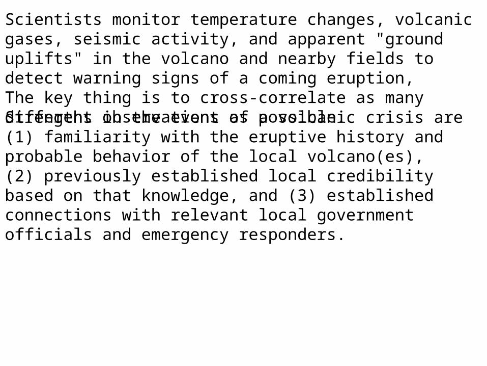
Strengths in the event of a volcanic crisis are (1) familiarity with the eruptive history and probable behavior of the local volcano(es), (2) previously established local credibility based on that knowledge, and (3) established connections with relevant local government officials and emergency responders.
Scientists monitor temperature changes, volcanic gases, seismic activity, and apparent "ground uplifts" in the volcano and nearby fields to detect warning signs of a coming eruption,The key thing is to cross-correlate as many different observations as possible.
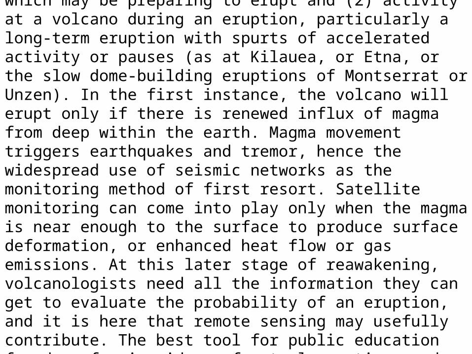
There are two distinct circumstances in which volcanologists monitor activity at volcanoes: (1) unrest at a volcano that has been dormant, but which may be preparing to erupt and (2) activity at a volcano during an eruption, particularly a long-term eruption with spurts of accelerated activity or pauses (as at Kilauea, or Etna, or the slow dome-building eruptions of Montserrat or Unzen). In the first instance, the volcano will erupt only if there is renewed influx of magma from deep within the earth. Magma movement triggers earthquakes and tremor, hence the widespread use of seismic networks as the monitoring method of first resort. Satellite monitoring can come into play only when the magma is near enough to the surface to produce surface deformation, or enhanced heat flow or gas emissions. At this later stage of reawakening, volcanologists need all the information they can get to evaluate the probability of an eruption, and it is here that remote sensing may usefully contribute. The best tool for public education found so far is videos of actual eruptions and their consequences.
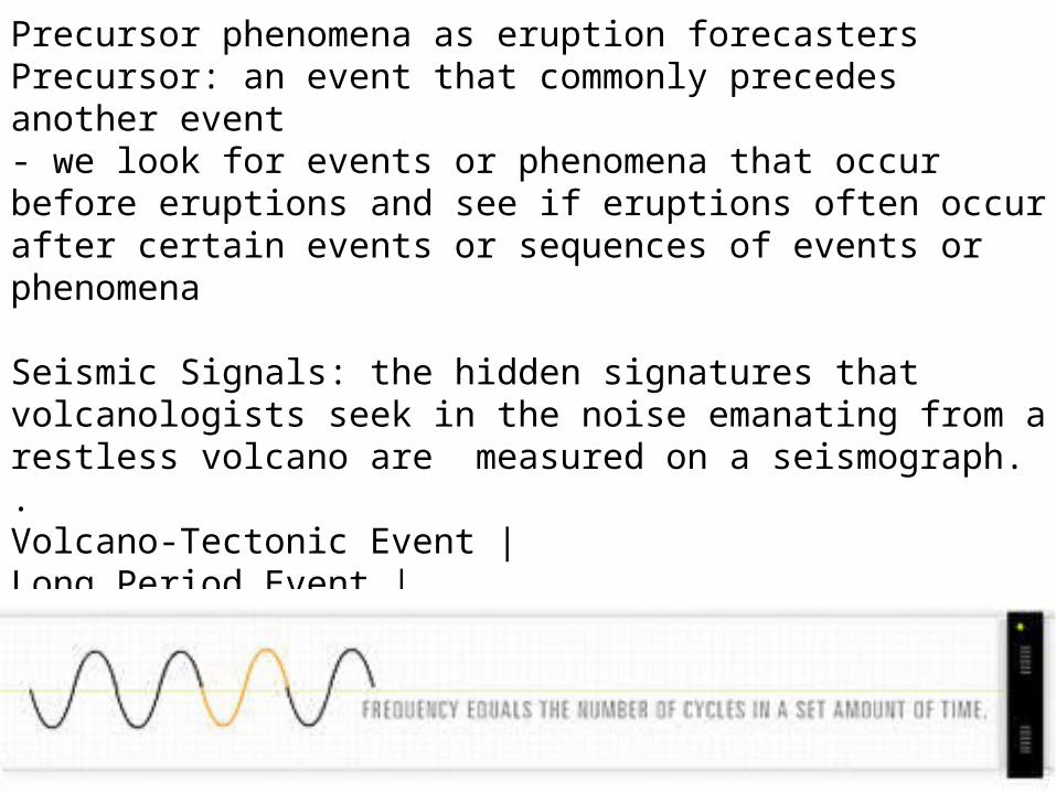
Precursor phenomena as eruption forecastersPrecursor: an event that commonly precedes another event- we look for events or phenomena that occur before eruptions and see if eruptions often occur after certain events or sequences of events or phenomena
Seismic Signals: the hidden signatures that volcanologists seek in the noise emanating from a restless volcano are measured on a seismograph..Volcano-Tectonic Event |Long Period Event |Tremor Hybrid
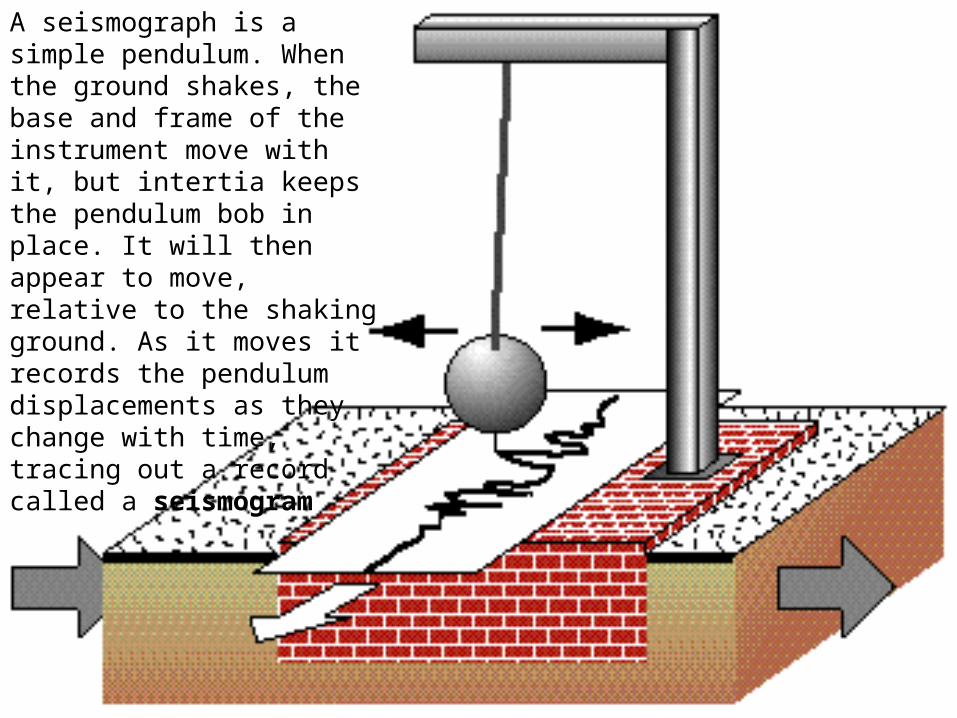
A seismograph is a simple pendulum. When the ground shakes, the base and frame of the instrument move with it, but intertia keeps the pendulum bob in place. It will then appear to move, relative to the shaking ground. As it moves it records the pendulum displacements as they change with time, tracing out a record called a seismogram
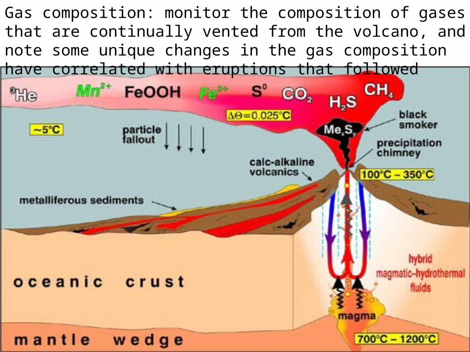
Gas composition: monitor the composition of gases that are continually vented from the volcano, and note some unique changes in the gas composition have correlated with eruptions that followed

As the world's population grows, more and more people are living in potentially dangerous volcanic areas. Volcanic eruptions continue--as they have throughout history--posing ever-greater threats to life and proper There are mainly two internal heat sources that drive plate tectonics and volcanic eruptions: heat left over from the formation of the earth, and decay of radioactive elements within the earth. Volcanic eruptions account for a large proportion of the internal heat that is dissipated from the interior of the earth.
Are Volcanic Eruptions Tied to Lunar Cycle?Gravity is one of Earth's strongest forces, so you can't ignore the moon. The challenge is to find out just how it's playing a role
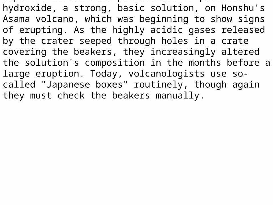
Japanese researchers put beakers of potassium hydroxide, a strong, basic solution, on Honshu's Asama volcano, which was beginning to show signs of erupting. As the highly acidic gases released by the crater seeped through holes in a crate covering the beakers, they increasingly altered the solution's composition in the months before a large eruption. Today, volcanologists use so-called "Japanese boxes" routinely, though again they must check the beakers manually.
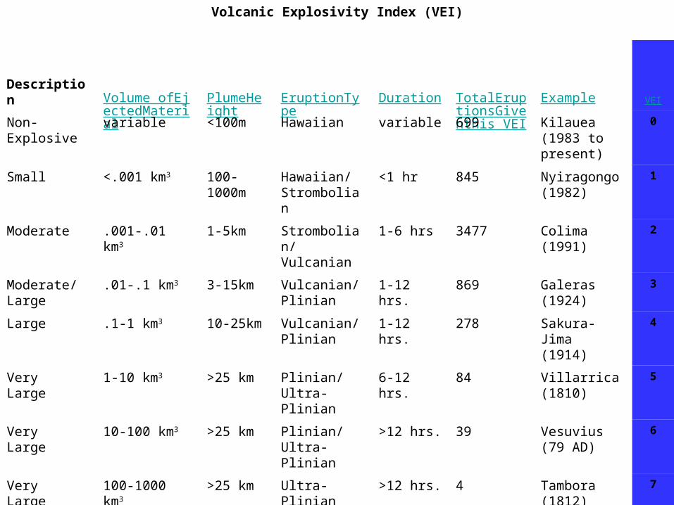
Volcanic Explosivity Index (VEI)
Description Volume ofEjectedMaterial
PlumeHeight
EruptionType Duration TotalEruptionsGiventhis VEI
Example VEI
Non-Explosive
variable <100m Hawaiian variable 699 Kilauea(1983 topresent)
0
Small <.001 km3 100-1000m
Hawaiian/Strombolian
<1 hr 845 Nyiragongo(1982)
1
Moderate .001-.01 km3 1-5km Strombolian/Vulcanian
1-6 hrs 3477 Colima(1991)
2
Moderate/Large
.01-.1 km3 3-15km Vulcanian/Plinian
1-12 hrs. 869 Galeras(1924)
3
Large .1-1 km3 10-25km Vulcanian/Plinian
1-12 hrs. 278 Sakura-Jima(1914)
4
VeryLarge
1-10 km3 >25 km Plinian/Ultra-Plinian
6-12 hrs. 84 Villarrica(1810)
5
VeryLarge
10-100 km3 >25 km Plinian/Ultra-Plinian
>12 hrs. 39 Vesuvius(79 AD)
6
VeryLarge
100-1000 km3 >25 km Ultra-Plinian >12 hrs. 4 Tambora(1812)
7
VeryLarge
>1,000 km3 >25 km Ultra-Plinian >12 hrs. 0 YellowstoneCaldera(2 millionyears ago)
8
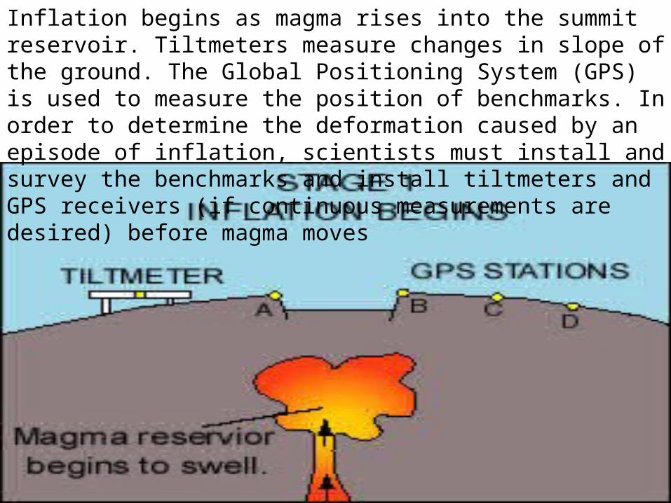
Inflation begins as magma rises into the summit reservoir. Tiltmeters measure changes in slope of the ground. The Global Positioning System (GPS) is used to measure the position of benchmarks. In order to determine the deformation caused by an episode of inflation, scientists must install and survey the benchmarks and install tiltmeters and GPS receivers (if continuous measurements are desired) before magma moves
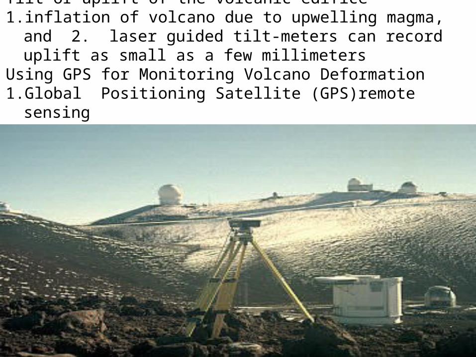
Tilt or uplift of the volcanic edifice1. inflation of volcano due to upwelling magma, and 2. laser guided
tilt-meters can record uplift as small as a few millimetersUsing GPS for Monitoring Volcano Deformation1. Global Positioning Satellite (GPS)remote sensing
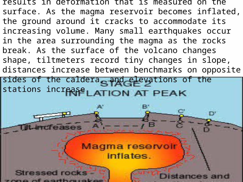
Peak Inflation : Inflating magma reservoir results in deformation that is measured on the surface. As the magma reservoir becomes inflated, the ground around it cracks to accommodate its increasing volume. Many small earthquakes occur in the area surrounding the magma as the rocks break. As the surface of the volcano changes shape, tiltmeters record tiny changes in slope, distances increase between benchmarks on opposite sides of the caldera, and elevations of the stations increase
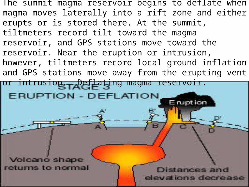
Eruption usually leads to deflationThe summit magma reservoir begins to deflate when magma moves laterally into a rift zone and either erupts or is stored there. At the summit, tiltmeters record tilt toward the magma reservoir, and GPS stations move toward the reservoir. Near the eruption or intrusion, however, tiltmeters record local ground inflation and GPS stations move away from the erupting vent or intrusion. Deflating magma reservoir.
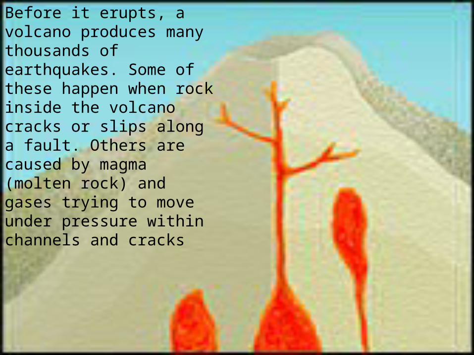
Before it erupts, a volcano produces many thousands of earthquakes. Some of these happen when rock inside the volcano cracks or slips along a fault. Others are caused by magma (molten rock) and gases trying to move under pressure within channels and cracks
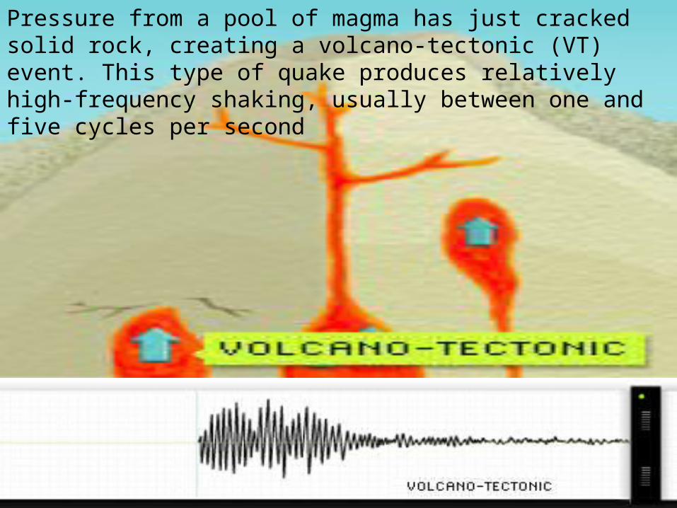
Pressure from a pool of magma has just cracked solid rock, creating a volcano-tectonic (VT) event. This type of quake produces relatively high-frequency shaking, usually between one and five cycles per second
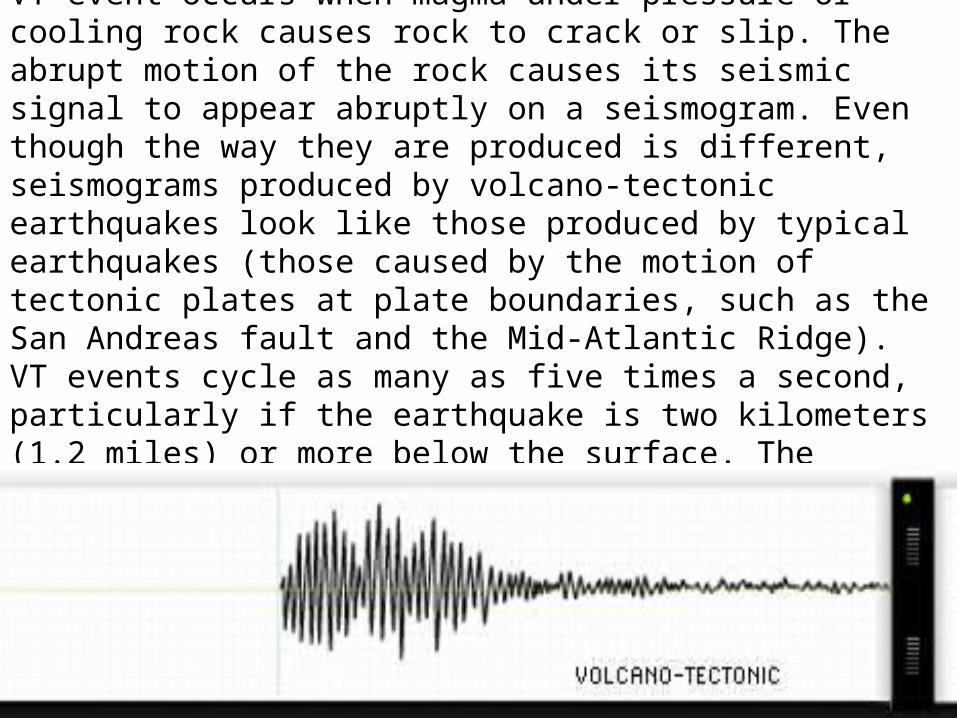
Seismic Signal of Volcano-Tectonic (VT) Event : A VT event occurs when magma under pressure or cooling rock causes rock to crack or slip. The abrupt motion of the rock causes its seismic signal to appear abruptly on a seismogram. Even though the way they are produced is different, seismograms produced by volcano-tectonic earthquakes look like those produced by typical earthquakes (those caused by the motion of tectonic plates at plate boundaries, such as the San Andreas fault and the Mid-Atlantic Ridge). VT events cycle as many as five times a second, particularly if the earthquake is two kilometers (1.2 miles) or more below the surface. The frequency of the VT signal shown here is five cycles per second
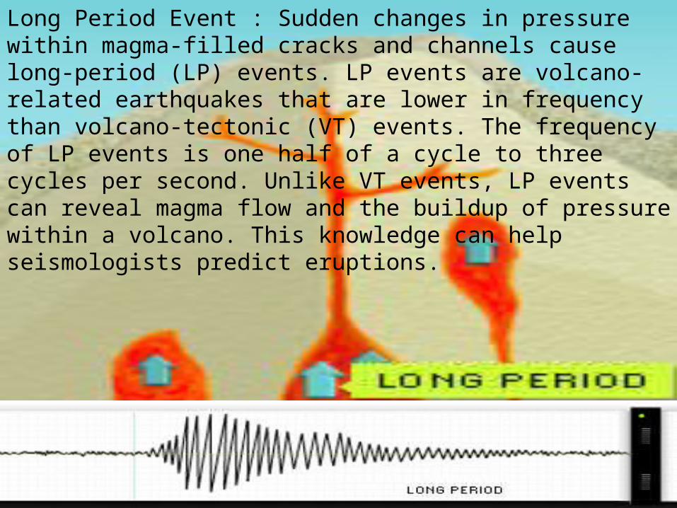
Long Period Event : Sudden changes in pressure within magma-filled cracks and channels cause long-period (LP) events. LP events are volcano-related earthquakes that are lower in frequency than volcano-tectonic (VT) events. The frequency of LP events is one half of a cycle to three cycles per second. Unlike VT events, LP events can reveal magma flow and the buildup of pressure within a volcano. This knowledge can help seismologists predict eruptions.
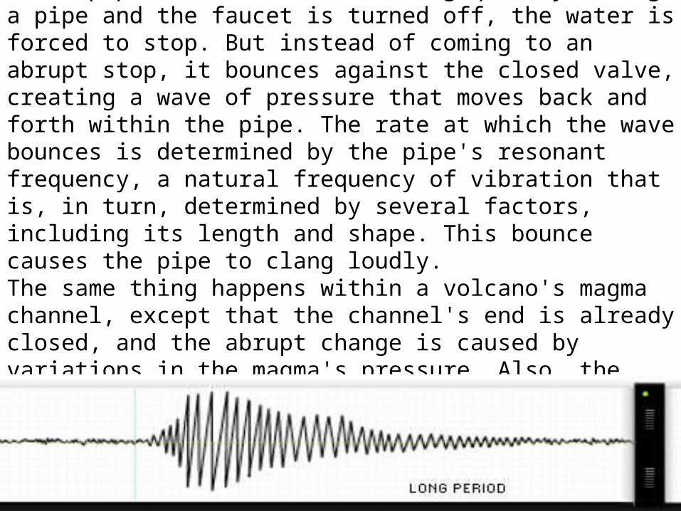
The shaking that causes LP events is similar to the "water hammer" that happens in household water pipes. When water is moving quickly through a pipe and the faucet is turned off, the water is forced to stop. But instead of coming to an abrupt stop, it bounces against the closed valve, creating a wave of pressure that moves back and forth within the pipe. The rate at which the wave bounces is determined by the pipe's resonant frequency, a natural frequency of vibration that is, in turn, determined by several factors, including its length and shape. This bounce causes the pipe to clang loudly. The same thing happens within a volcano's magma channel, except that the channel's end is already closed, and the abrupt change is caused by variations in the magma's pressure. Also, the frequency of the bounce is much slower within the channel.

Tremor: A tremor is a long-period (LP) event, but one that lasts longer than the typical LP event. In fact, a single tremor can last anywhere from several minutes to months. The frequency range of a tremor is the same as that with an LP event: one half of a cycle to three cycles per second. The signal shown here has a frequency of two cycles per second. Like LP events, tremors can also be a good indicator of an impending volcanic eruption.
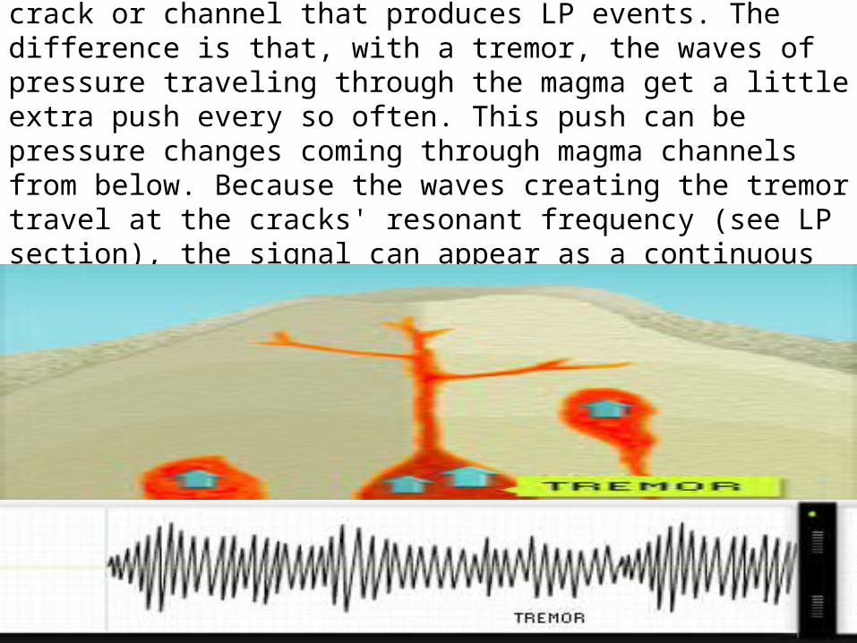
The source of a tremor can and often is the same crack or channel that produces LP events. The difference is that, with a tremor, the waves of pressure traveling through the magma get a little extra push every so often. This push can be pressure changes coming through magma channels from below. Because the waves creating the tremor travel at the cracks' resonant frequency (see LP section), the signal can appear as a continuous wave moving at a single frequency.
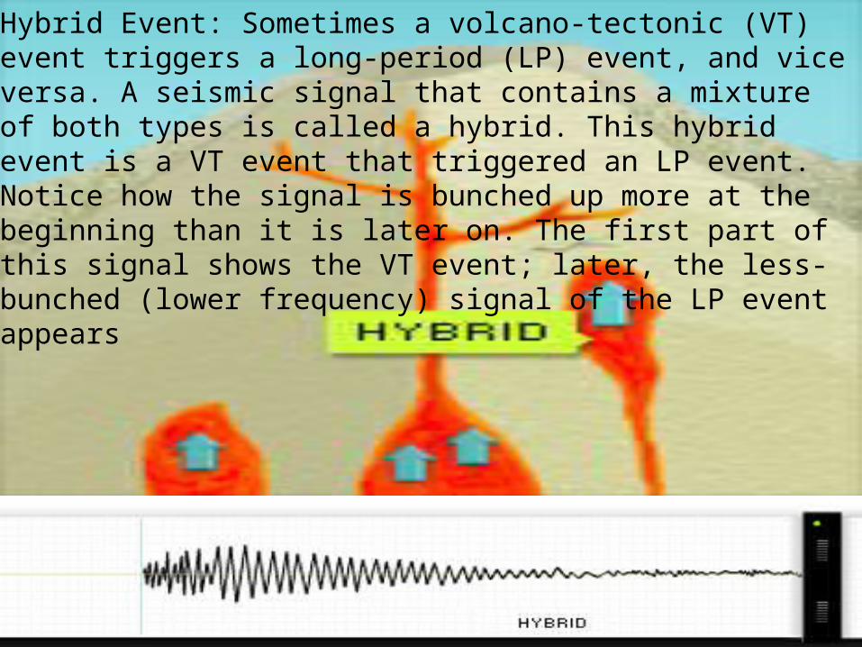
Hybrid Event: Sometimes a volcano-tectonic (VT) event triggers a long-period (LP) event, and vice versa. A seismic signal that contains a mixture of both types is called a hybrid. This hybrid event is a VT event that triggered an LP event. Notice how the signal is bunched up more at the beginning than it is later on. The first part of this signal shows the VT event; later, the less-bunched (lower frequency) signal of the LP event appears
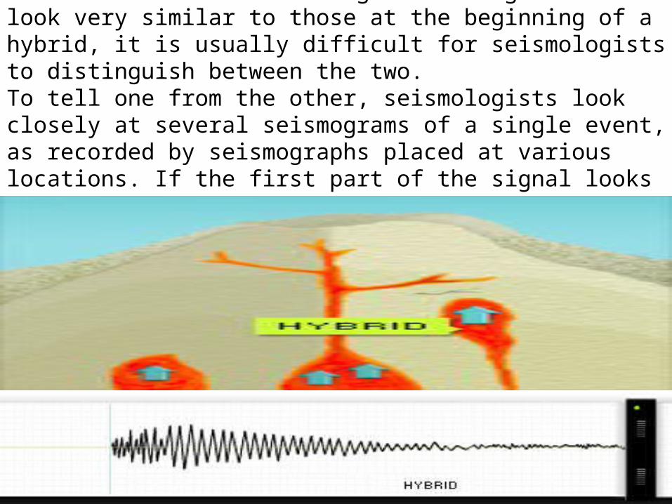
Because LP events often begin with signals that look very similar to those at the beginning of a hybrid, it is usually difficult for seismologists to distinguish between the two. To tell one from the other, seismologists look closely at several seismograms of a single event, as recorded by seismographs placed at various locations. If the first part of the signal looks similar on all of the seismograms, they probably have an LP event.
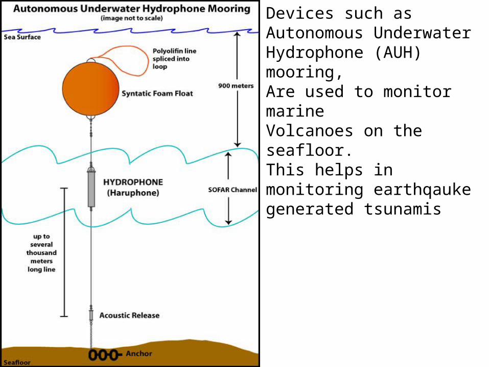
Devices such asAutonomous Underwater Hydrophone (AUH) mooring,Are used to monitor marine Volcanoes on the seafloor.This helps in monitoring earthqauke generated tsunamis
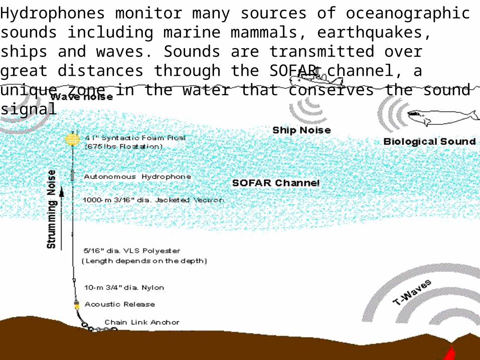
Hydrophones monitor many sources of oceanographic sounds including marine mammals, earthquakes, ships and waves. Sounds are transmitted over great distances through the SOFAR channel, a unique zone in the water that conserves the sound signal
Emergency management is a broad term and includes the ‘4R’s’:
Risk Reduction: looking for ways of reducing the consequences of hazards, such as land use planning, building and safety codes, insurance incentives, to name a few. To do this effectively we need good information about hazards and their impacts on communities.
Readiness: increasing the understanding and awareness of hazards through education programmes. Working with the community to develop self-help programmes such as household emergency plans and business continuity plans. Ensuring plans and systems are in place (and tested), that enable agencies and communities to respond effectively to an emergency.
Response: actions taken immediately before, during or directly after an emergency to save lives and property. To reduce the damage and make sure we can respond as effectively as possible, we need to have already reduced the risk as much as possible and have good response plans and procedures in place that have been well rehearsed.
Recovery: as well as coping with problems immediately after an emergency, recovery programmes extend to rebuilding and restoring the community. We may look at rebuilding a community in a new way to prevent a disaster from occurring again.
Civil Defence is a component of emergency management, relating mainly to Readiness and Response activities.Hazards range from big events such as volcanic eruptions, through to floods and storms, fires, power failure, and disease outbreaks.By working together in all areas of emergency management we can create a community which can reduce the impacts of hazards and can bounce back.For more information contact your local council, civil defence or emergency management office.
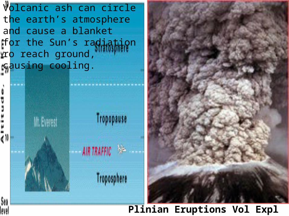
Volcanic ash can circle the earth’s atmosphere and cause a blanketfor the Sun’s radiation ro reach ground, causing cooling.
Plinian Eruptions Vol Expl Index 6
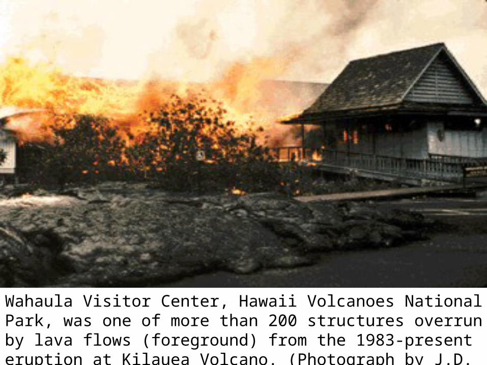
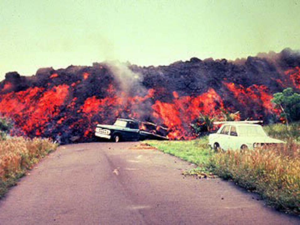
Wahaula Visitor Center, Hawaii Volcanoes National Park, was one of more than 200 structures overrun by lava flows (foreground) from the 1983-present eruption at Kilauea Volcano. (Photograph by J.D. Griggs, USGS.)
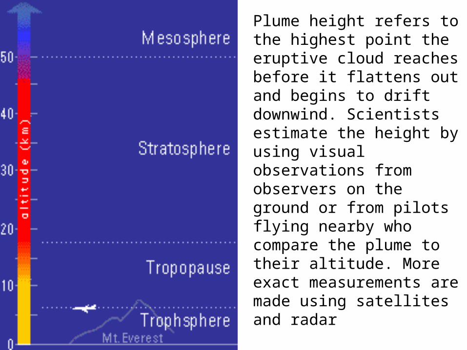
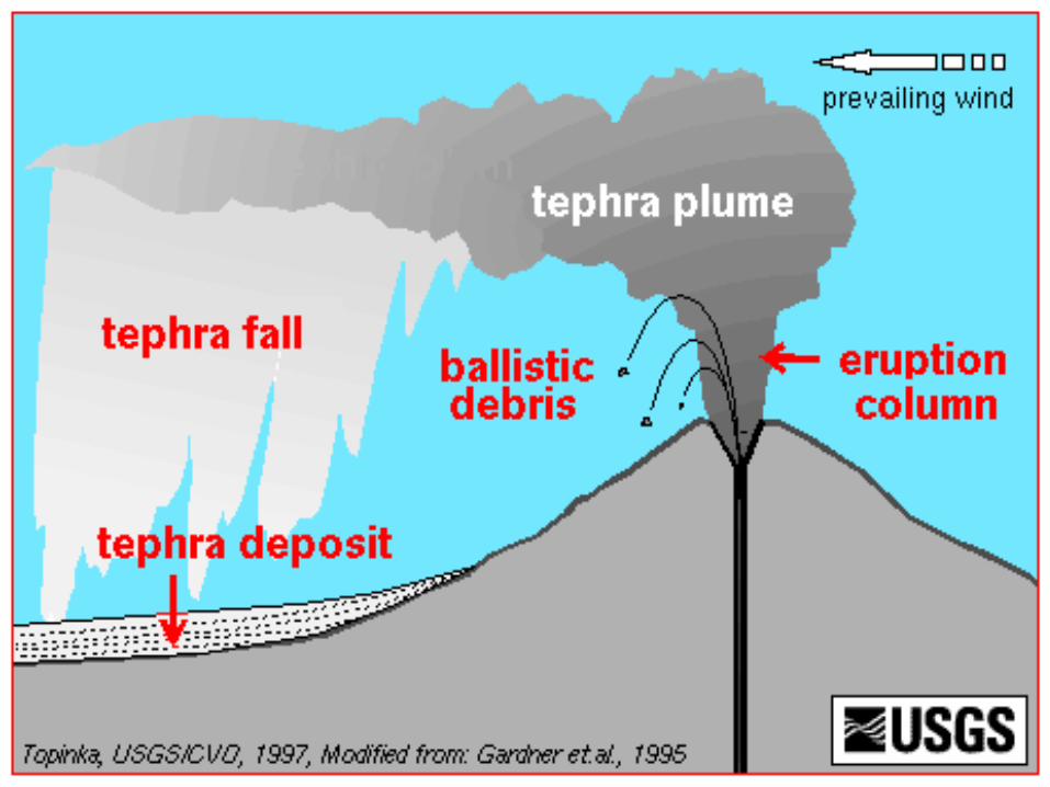
Plume height refers to the highest point the eruptive cloud reaches before it flattens out and begins to drift downwind. Scientists estimate the height by using visual observations from observers on the ground or from pilots flying nearby who compare the plume to their altitude. More exact measurements are made using satellites and radar
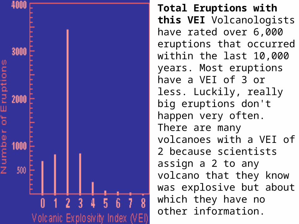
Total Eruptions with this VEI Volcanologists have rated over 6,000 eruptions that occurred within the last 10,000 years. Most eruptions have a VEI of 3 or less. Luckily, really big eruptions don't happen very often. There are many volcanoes with a VEI of 2 because scientists assign a 2 to any volcano that they know was explosive but about which they have no other information.
The experience of that local population with volcanic eruptions is usually limited, often non-existent, as most volcanoes have major eruptions less than once a century.The volcanological community has experienced some major successes in working with decision-makers and the general public to mitigate the damage from volcanic eruptions . The best tool for public education found so far is videos of actual eruptions and their consequences.Responsibility for ordering volcano-inspired response (decisions to limit access to, or require evacuation from, certain areas, and for how long) usually rests with local government officials and emergency managers or civil defense personnel. There are enormous social and economic costs to any measures taken, and great resistance from almost all components of the local community is the norm. Even one instance of evacuation that in hindsight comes to be viewed as a "false alarm" can damage the credibility of both the officials and the scientists whose information formed the basis for the action, for many years.
The Risk to Aviation from Airborne Volcanic Ash
Airborne volcanic ash is a serious aviation safety hazard. In the past 20 years, more than 80 commercial aircraft have unexpectedly encountered volcanic ash clouds in flight. Commercial jetliners that have encountered volcanic ash plumes have had all engines fail, with several near-crashes. Abrasion to forward-facing surfaces, including cockpit windows, the leading edges of wings and control surfaces, engine cowlings, etc., threaten safety and require expensive repairs. Cockpit windows have been pitted badly enough to endanger landing. Damages to a single aircraft have reached $80 million. In addition to these major repair costs from encountering a heavier plume of ash, aircraft flying through thinner plumes require increased maintenance of engines and external surfaces.
Responsibility for most aspects of volcano monitoring is dispersed and usually quite local. The directory of volcano-monitoring entities issued by the World Organization of Volcano Observatories (WOVO) lists 61 separate observatories. Most of these focus on a single volcano, and the levels of staffing, instrumentation, computer support, and communications links with the outside vary greatly. Their strengths in the event of a volcanic crisis are (a) familiarity with the eruptive history and probable behavior of the local volcano(es), (b) previously established local credibility based on that knowledge, and (c) established connections with relevant local government officials and emergency responders. In Hawaii, Hawaii Volcano Observatory is the federal agency for the hazard monitoring.
On average, about 15 major explosive eruptions—those powerful enough to inject ash into the stratosphere—occur per year. Ash clouds that reach above 25,000 ft. can travel hundreds of miles. Giant plumes from a major eruption, such as Mt. Pinatubo in 1991, can affect aircraft thousands of miles downwind. When Mt. St. Helens erupted in 1980, the plume reached an altitude of 90,000 ft. in 30 minutes and was 50 miles wide. In 15 hours, the plume traveled 600 miles downwind. After 2 weeks, ash had circled the earth.
Volcanoes pose a serious threat to persons on the ground near erupting volcanoes (due to proximal
hazards such as lava flows, mud flows, ash fall, etc). Ash clouds from major eruptions endanger
aircraft and airport operations over distances of thousands of kilometers. Remote sensing has
become an indispensable part of the global system of detection and tracking of the airborne
products of explosive volcanic eruptions via a network of Volcanic Ash Advisory Centers (VAACs)
and Meteorological Watch Offices (MWOs). Visible and InfraRed (IR) satellite data provide critical
information on current ash cloud coverage, height, movement, and mass as input to aviation
SIGnificant METerological (SIGMET) advisories and forecast trajectory dispersion models. Recent
research has also shown the potential of remote sensing for monitoring proximal hazards such as hot
spots and lava flows using geostationary and polar InfraRed (IR) data. Also, Interferometric
Synthetic Aperture Radar (InSAR) imagery has been used to document deformation andtopographic changes at volcanoes. However, limited spatial and temporal resolution of availablesatellite data means that, for most proximal hazards, it is used mainly as supplemental informationfor current eruptions, and post-disaster assessment in mitigation and prevention of future disasters.Spectral bands used in detection of volcanic ash and surface-based hazards are identified in thisreport. They include a variety of IR bands, especially those centered near 4, 7.3, 8.5, 11 and 12microns. Visible (0.5 - 1.0 micron) and dual ultraviolet (UV) (0.3 - 0.4 micron) channels, althoughlimited to daytime use, are valuable for qualitative assessment of ash and sulfur dioxide (SO2) plumecoverage, and quantitative estimation of ash optical depth, ash cloud top height (through parallaxtechniques) and total mass of silicate ash and SO2. The minimum spectral channels needed foreffective remote sensing of volcanic hazards are specified in the report and recommendations, as arethreshold and optimum spatial resolutions and frequencies. Similar requirements are proposed forsome important derived products (ash cloud height, ash column mass, and SO2 concentration).
Volcanic Ash PlumesVolcanic ash poses a menace to persons on the ground near erupting volcanoes, and to aircraft over thousands of kilometers for major eruptions. Volcanic eruption clouds containing silicate ashparticles, volcanic gases, and acid aerosols can do extensive damage to high altitude jet aircraft. When ingested into jet engines, melted volcanic ash can block air intakes, abrade turbine surfaces and blade tips, and generally cause loss of engine performance that could result in either emergency engine shutdowns or compressor stall failures (flameouts).Since volcanicaerosols (gases and particulates) can be injected at all altitudes from sea level to 150,000 ft (45,000 m) Above Sea Level (ASL) or more, from perennially erupting sources (e.g., Mt. Etna, Italy; Mt. Sakurajima, Japan) or from massive, explosive eruptions (e.g., Mt. Pinatubo 1991), aircraft can be affected at any operational altitude. Thus, ash ingestion and abrasion risks can be experienced by trans-continental and trans-oceanic aircraft at cruising altitudes in the upper troposphere and lower stratosphere, as well as by aircraft operating near the ground in regions affected by local plumes or ashfall.
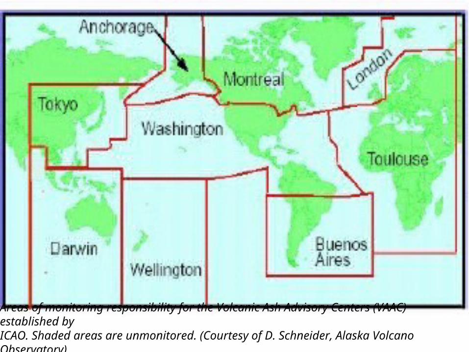
Areas of monitoring responsibility for the Volcanic Ash Advisory Centers (VAAC) established byICAO. Shaded areas are unmonitored. (Courtesy of D. Schneider, Alaska Volcano Observatory)
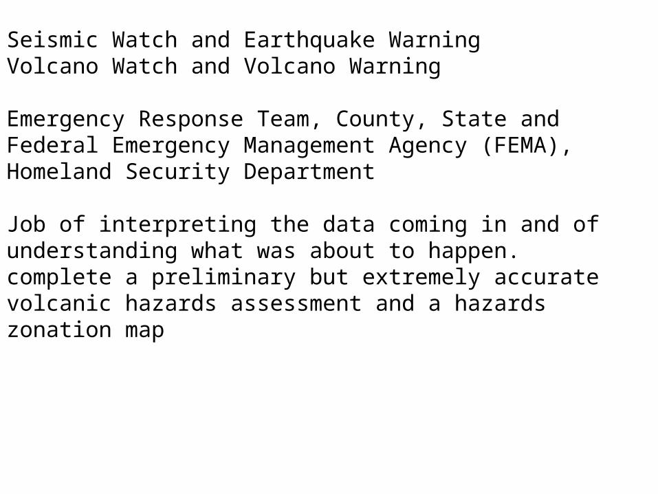
Seismic Watch and Earthquake WarningVolcano Watch and Volcano Warning
Emergency Response Team, County, State and Federal Emergency Management Agency (FEMA), Homeland Security Department
Job of interpreting the data coming in and of understanding what was about to happen. complete a preliminary but extremely accurate volcanic hazards assessment and a hazards zonation map
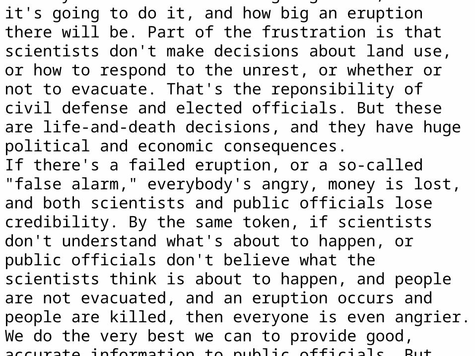
Even with equipment installed and the most experienced team members that we can assemble, it's extremely difficult to accurately forecast exactly what the volcano is going to do, when it's going to do it, and how big an eruption there will be. Part of the frustration is that scientists don't make decisions about land use, or how to respond to the unrest, or whether or not to evacuate. That's the reponsibility of civil defense and elected officials. But these are life-and-death decisions, and they have huge political and economic consequences.If there's a failed eruption, or a so-called "false alarm," everybody's angry, money is lost, and both scientists and public officials lose credibility. By the same token, if scientists don't understand what's about to happen, or public officials don't believe what the scientists think is about to happen, and people are not evacuated, and an eruption occurs and people are killed, then everyone is even angrier. We do the very best we can to provide good, accurate information to public officials. But we're never in a position where we can say we're confident that an eruption will occur within "x" number of days and be of a certain size and destroy a certain area
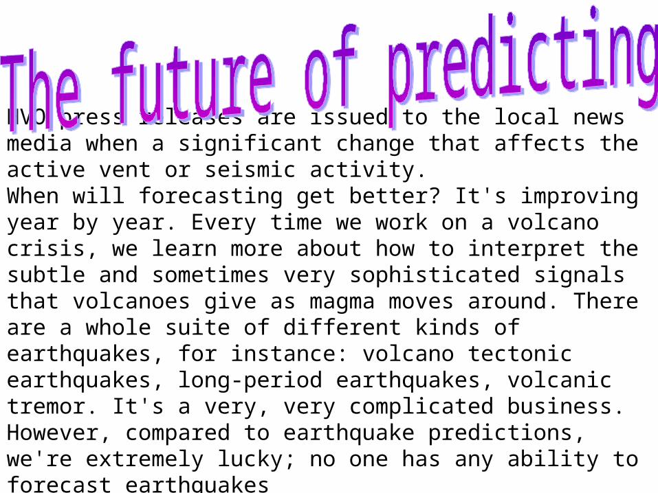
HVO press releases are issued to the local news media when a significant change that affects the active vent or seismic activity. When will forecasting get better? It's improving year by year. Every time we work on a volcano crisis, we learn more about how to interpret the subtle and sometimes very sophisticated signals that volcanoes give as magma moves around. There are a whole suite of different kinds of earthquakes, for instance: volcano tectonic earthquakes, long-period earthquakes, volcanic tremor. It's a very, very complicated business. However, compared to earthquake predictions, we're extremely lucky; no one has any ability to forecast earthquakes
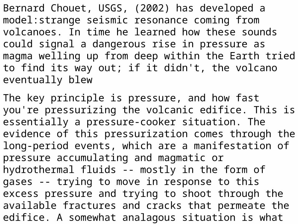
Bernard Chouet, USGS, (2002) has developed a model:strange seismic resonance coming from volcanoes. In time he learned how these sounds could signal a dangerous rise in pressure as magma welling up from deep within the Earth tried to find its way out; if it didn't, the volcano eventually blew
The key principle is pressure, and how fast you're pressurizing the volcanic edifice. This is essentially a pressure-cooker situation. The evidence of this pressurization comes through the long-period events, which are a manifestation of pressure accumulating and magmatic or hydrothermal fluids -- mostly in the form of gases -- trying to move in response to this excess pressure and trying to shoot through the available fractures and cracks that permeate the edifice. A somewhat analagous situation is what happens when you boil water in a teakettle. When the water starts to boil, you have this singing steam coming out of the teakettle. In a way the volcano is also singing its song. Individual long-period events are little chirping sounds the volcano makes while pressurizing. When the long-period events occur in rapid succession, a sustained signal results. The volcano then is literally singing its tune.
This is a siren song because the volcano is telling you, "I'm under pressure here. I'm going to blow at the top.“
Scientists tracking active volcanoes walk a tightrope when advising public officials on the likelihood of an eruption.
The interface between the scientists monitoring a volcano and public officials is very difficult. Most people are willing to be evacuated once. But if nothing happens, the loss of credibility could cause people to ignore future warnings.
Scientists can't make the decision to evacuate. They provide information on the hazards, and we are working to do that. But using the information—long-range land-use planning, development of early-warning systems, and evacuation plans—that's up to public officials
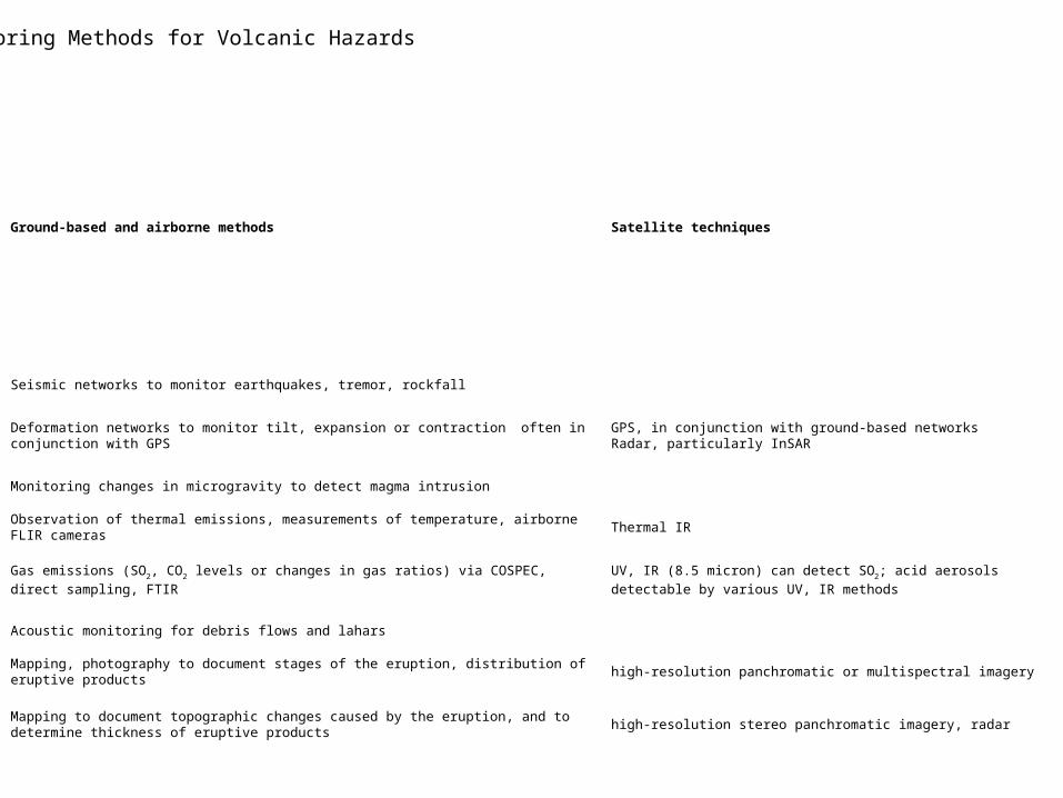
Ground-based and airborne methods Satellite techniques
Seismic networks to monitor earthquakes, tremor, rockfall
Deformation networks to monitor tilt, expansion or contraction often in conjunction with GPSGPS, in conjunction with ground-based networksRadar, particularly InSAR
Monitoring changes in microgravity to detect magma intrusion
Observation of thermal emissions, measurements of temperature, airborne FLIR cameras Thermal IR
Gas emissions (SO2, CO2 levels or changes in gas ratios) via COSPEC, direct sampling, FTIRUV, IR (8.5 micron) can detect SO2; acid aerosols detectable by various
UV, IR methods
Acoustic monitoring for debris flows and lahars
Mapping, photography to document stages of the eruption, distribution of eruptive products high-resolution panchromatic or multispectral imagery
Mapping to document topographic changes caused by the eruption, and to determine thickness of eruptive products
high-resolution stereo panchromatic imagery, radar
Monitoring Methods for Volcanic Hazards