Embed Size (px)
Citation preview
Spring 2002 Volume 50, Number 2
© 2001 Oklahoma Anthropological Society
Oklahoma Archeology, Journal of the Oklahoma Anthropological Society www.okarcheology.org ISSN 1071-6610 Oklahoma Anthropological Society Editors: Richard and Mary Ann Drass For Membership, Dues or Publications, contact: Pete Thurmond Rt. 1, Box 62B Cheyenne OK 73628-9729 (580)497-2566 Fax: (580)497-2662 [email protected] The OAS membership year runs from January 1 through December 31 of the calendar year. Active and Institutional Members receive 4 issues per year of the Quarterly Journal.Contributing and Sustaining members further receive any memoirs occasionally published by the Society at no additional cost. Papers and contributions are welcomed. Accompany articles with file on disk, if available. Convert Mac files to PC. Prefer high quality B&W illustrations. Submit contributionson or before March 1, June 1, September 1, and December 1 to: Rich and Mary Ann Drass 1813 Oakmeadows Dr. Norman OK 73071 (405)321-3526 Fax (405)579-9155. [email protected]
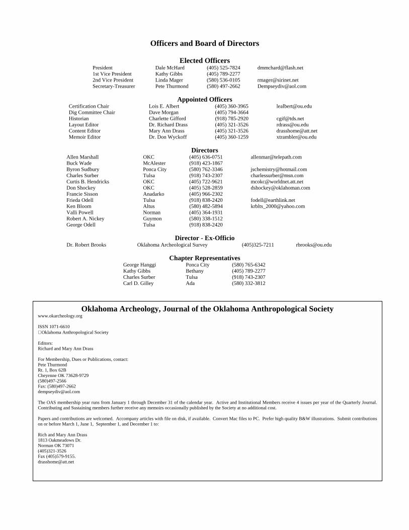
Officers and Board of Directors
Elected Officers President Dale McHard (405) 525-7824 [email protected] 1st Vice President Kathy Gibbs (405) 789-2277 2nd Vice President Linda Mager (580) 536-0105 [email protected] Secretary-Treasurer Pete Thurmond (580) 497-2662 [email protected]
Appointed Officers
Certification Chair Lois E. Albert (405) 360-3965 [email protected] Dig Committee Chair Dave Morgan (405) 794-3664 Historian Charlette Gifford (918) 785-2920 [email protected] Layout Editor Dr. Richard Drass (405) 321-3526 [email protected] Content Editor Mary Ann Drass (405) 321-3526 [email protected] Memoir Editor Dr. Don Wyckoff (405) 360-1259 [email protected]
Directors
Allen Marshall OKC (405) 636-0751 [email protected] Buck Wade McAlester (918) 423-1867 Byron Sudbury Ponca City (580) 762-3346 [email protected] Charles Surber Tulsa (918) 743-2307 [email protected] Curtis B. Hendricks OKC (405) 722-9621 [email protected] Don Shockey OKC (405) 528-2859 [email protected] Francie Sisson Anadarko (405) 966-2302 Frieda Odell Tulsa (918) 838-2420 [email protected] Ken Bloom Altus (580) 482-5894 [email protected] Valli Powell Norman (405) 364-1931 Robert A. Nickey Guymon (580) 338-1512 George Odell Tulsa (918) 838-2420
Director - Ex-Officio
Dr. Robert Brooks Oklahoma Archeological Survey (405)325-7211 [email protected]
Chapter Representatives George Hanggi Ponca City (580) 765-6342 Kathy Gibbs Bethany (405) 789-2277 Charles Surber Tulsa (918) 743-2307 Carl D. Gilley Ada (580) 332-3812
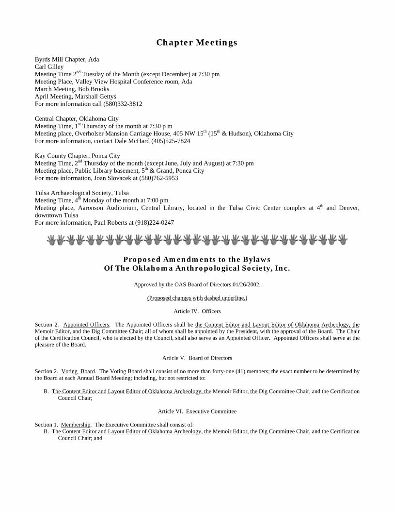
Chapter Meetings Byrds Mill Chapter, Ada Carl Gilley Meeting Time 2nd Tuesday of the Month (except December) at 7:30 pm Meeting Place, Valley View Hospital Conference room, Ada March Meeting, Bob Brooks April Meeting, Marshall Gettys For more information call (580)332-3812 Central Chapter, Oklahoma City Meeting Time, 1st Thursday of the month at 7:30 p m Meeting place, Overholser Mansion Carriage House, 405 NW 15th (15th & Hudson), Oklahoma City For more information, contact Dale McHard (405)525-7824 Kay County Chapter, Ponca City Meeting Time, 2nd Thursday of the month (except June, July and August) at 7:30 pm Meeting place, Public Library basement, 5th & Grand, Ponca City For more information, Joan Slovacek at (580)762-5953 Tulsa Archaeological Society, Tulsa Meeting Time, 4th Monday of the month at 7:00 pm Meeting place, Aaronson Auditorium, Central Library, located in the Tulsa Civic Center complex at 4th and Denver, downtown Tulsa For more information, Paul Roberts at (918)224-0247
Proposed Amendments to the Bylaws Of The Oklahoma Anthropological Society, Inc.
Approved by the OAS Board of Directors 01/26/2002.
(Proposed changes with dashed underline.)
Article IV. Officers
Section 2. Appointed Officers. The Appointed Officers shall be the Content Editor and Layout Editor of Oklahoma Archeology, the Memoir Editor, and the Dig Committee Chair; all of whom shall be appointed by the President, with the approval of the Board. The Chair of the Certification Council, who is elected by the Council, shall also serve as an Appointed Officer. Appointed Officers shall serve at the pleasure of the Board.
Article V. Board of Directors Section 2. Voting Board. The Voting Board shall consist of no more than forty-one (41) members; the exact number to be determined by the Board at each Annual Board Meeting; including, but not restricted to: B. The Content Editor and Layout Editor of Oklahoma Archeology, the Memoir Editor, the Dig Committee Chair, and the Certification
Council Chair;
Article VI. Executive Committee Section 1. Membership. The Executive Committee shall consist of: B. The Content Editor and Layout Editor of Oklahoma Archeology, the Memoir Editor, the Dig Committee Chair, and the Certification
Council Chair; and
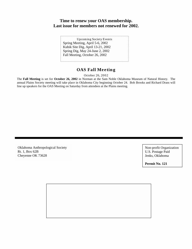
Time to renew your OAS membership. Last issue for members not renewed for 2002.
OAS Fall Meeting
October 26, 2002 The Fall Meeting is set for October 26, 2002 in Norman at the Sam Noble Oklahoma Museum of Natural History. The annual Plains Society meeting will take place in Oklahoma City beginning October 24. Bob Brooks and Richard Drass will line up speakers for the OAS Meeting on Saturday from attendees at the Plains meeting.
Oklahoma Anthropological Society Rt. 1, Box 62B Cheyenne OK 73628
Non-profit Organization U.S. Postage Paid Jenks, Oklahoma Permit No. 121
Upcoming Society Events Spring Meeting, April 5-6, 2002 Kubik Site Dig, April 13-21, 2002 Spring Dig, May 24-June 2, 2002 Fall Meeting, October 26, 2002
Oklahoma Archeology, Vol. 50, No. 2 1
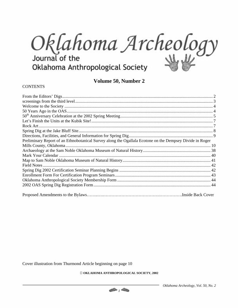
Volume 50, Number 2
CONTENTS From the Editors’ Digs............................................................................................................................................ 2 screenings from the third level ................................................................................................................................ 3 Welcome to the Society .......................................................................................................................................... 4 50 Years Ago in the OAS........................................................................................................................................ 4 50th Anniversary Celebration at the 2002 Spring Meeting...................................................................................... 5 Let’s Finish the Units at the Kubik Site!................................................................................................................. 7 Rock Art .................................................................................................................................................................. 7 Spring Dig at the Jake Bluff Site............................................................................................................................. 8 Directions, Facilities, and General Information for Spring Dig.............................................................................. 9 Preliminary Report of an Ethnobotanical Survey along the Ogallala Ecotone on the Dempsey Divide in Roger Mills County, Oklahoma....................................................................................................................................... 10 Archaeology at the Sam Noble Oklahoma Museum of Natural History............................................................... 38 Mark Your Calendar ............................................................................................................................................. 40 Map to Sam Noble Oklahoma Museum of Natural History.................................................................................. 41 Field Notes ............................................................................................................................................................ 42 Spring Dig 2002 Certification Seminar Planning Begins ..................................................................................... 42 Enrollment Form For Certification Program Seminars......................................................................................... 43 Oklahoma Anthropological Society Membership Form ....................................................................................... 44 2002 OAS Spring Dig Registration Form............................................................................................................. 44 Proposed Amendments to the Bylaws……..….………………………………….…………….Inside Back Cover Cover illustration from Thurmond Article beginning on page 10
OKLAHOMA ANTHROPOLOGICAL SOCIETY, 2002
Oklahoma Archeology, Vol. 50, No. 2 2
From the Editors’ Digs The Board of Directors at the January meeting instituted several changes in the Society’s publications, pending approval by the membership at the Spring Meeting. This issue of Oklahoma Archeology, Journal of the Oklahoma Anthropological Society, reflects the most significant change. We hope you’ll like it – let us give you a little background and what we hope to accomplish. In December, Nona Leatherwood Maxwell informed Dale McHard that she could not continue as Newsletter Editor. The search for a new editor began, and, after talking to Nona, Mary Ann Drass accepted the Newsletter Editor duties (thanks, Nona, for your valuable advice). Discussion among some Board members about the format and content of the Newsletter and the Bulletin followed. Richard and Nona had both noticed increasing difficulty in attracting material for our publications. We decided we might improve interest in the Newsletter by moving procedural information such as minutes of meetings and financial statements to the Society website, www.okarcheology.org. We hoped to free space for substantive articles on the subjects that drew us all to the Society in the first place. Then, Pete Thurmond, in a brainstorm while out feeding cows, came up with the notion of merging the best qualities of the Newsletter and the Bulletin into one quarterly journal. Discussions among several Board members ensued. The result we envision, as you can see in this inaugural issue, is a publication providing timely Society news with at least one manuscript that would have appeared in the Bulletin. We hope to increase the information and interest in each publication a member receives. Oklahoma Archeology will appear in January, April, July, and October -- a winter, spring, summer, and fall issue. These are being timed to allow publicity for the Spring Meeting, the Spring Dig, the Fall Meeting and the Fall Dig. For timely notification of members, we will need to have advance planning deadlines for Society events. Additionally, Lois Albert has pointed out that certification participants will need to stay in close touch, either by phone or email to be aware of changes in seminar schedules.
The new publication will be 40 to 50 pages per issue. Papers too long to fit this new format will be considered for the Memoir series. Pete believes this change will make better use of our Memoir budget. The format in this first issue reflects ideas from many people (special thanks to Byron Sudbury and Pete Thurmond for creative input and Seth Hawkins for Rock Art) for the new Oklahoma Archeology. With your help, we’d like to revive an old Society tradition of notes from members on interesting features and finds in a column called Field Notes. In this issue, Mary Ann has written up a feature found while walking with Richard, David Engle and Seth Hawkins in a survey for sites along Deer Creek near Thomas in western Oklahoma. Let us hear from you with your notes and photos. Since 70% of our membership do not belong to a chapter, we’ve been thinking of ways to introduce ourselves to each other. In the next issue, we will begin a column called Society Spotlight providing a short biography of a Society member we think you’d like to get to know. We’d love to have your help with this column so send in write-ups, photos or nominations. In this same spirit, we hope to have a continuing series with biographies of anthropological researchers working in the state. Additionally, Seth Hawkins has donated some of his original cartoons from the series, Rock Art. We think you’ll enjoy them as much as we have. This spring will be a great time to get together. Start at the Spring Meeting where we will be celebrating the 50th Anniversary of the Society (see the column called 50 Years Ago taken from the very first issue of the Newsletter). Follow up the next week with a few days spent in Kay County working at the Calf Creek period Kubik Site with Larry Neal. Finish with a Memorial Day dig at Jake Bluff with PaleoIndian researcher Lee Bement. Let us know what you would like to see in the Society’s Journal. We’ll try to make it happen. Mary Ann Drass Richard Drass February 15, 2002
Oklahoma Archeology, Vol. 50, No. 2 3
screenings from the third level One of the artifacts found in the screen is what you are holding in your hands right now - a new publication with a "fresh" look, new concepts and presentations, with a more readable format and feel. (Sounds a bit like an ad for a new magazine, doesn't it?). This change came about because your Officers and Members of the Board felt (actually, knew) that the time had come to do something. In particular, the quality of the printing and the look of the old newsletter just were not up to the standards that the Board believed the Society's informational publication should have. I hope that you like what you see and will continue to enjoy reading this new journal. Please let me have your comments concerning this matter; any changes that would further improve the publication will be considered. Another change related to the new journal is that you will be encouraged to submit articles or stories for publication. Don't have any ideas? How about recipes for the dig, pictures, stories from around the campfire, personal experiences, whatever? I want to take this opportunity to thank Nona Maxwell for her work in editing and publishing the old newsletter for the Society for the past year or so; thanks also to Don, her husband, for helping with the manual labor and affixing the mailing labels. Thanks very much to both of you! My thanks go to Mary Ann Drass for agreeing to be the layout editor of the new journal along with several related jobs. Richard, her husband, will be content editor. Thanks for volunteering for this big job and for the work you have put in already. Don't forget that on the evening of April 5 and all day on April 6 the Society will be celebrating its 50th anniversary. I think that we have a fine program planned that will include some very interesting historical materials about people and activities of the Society's first 50 years …nearing the 30-centimeter level… Dale McHard President, OAS
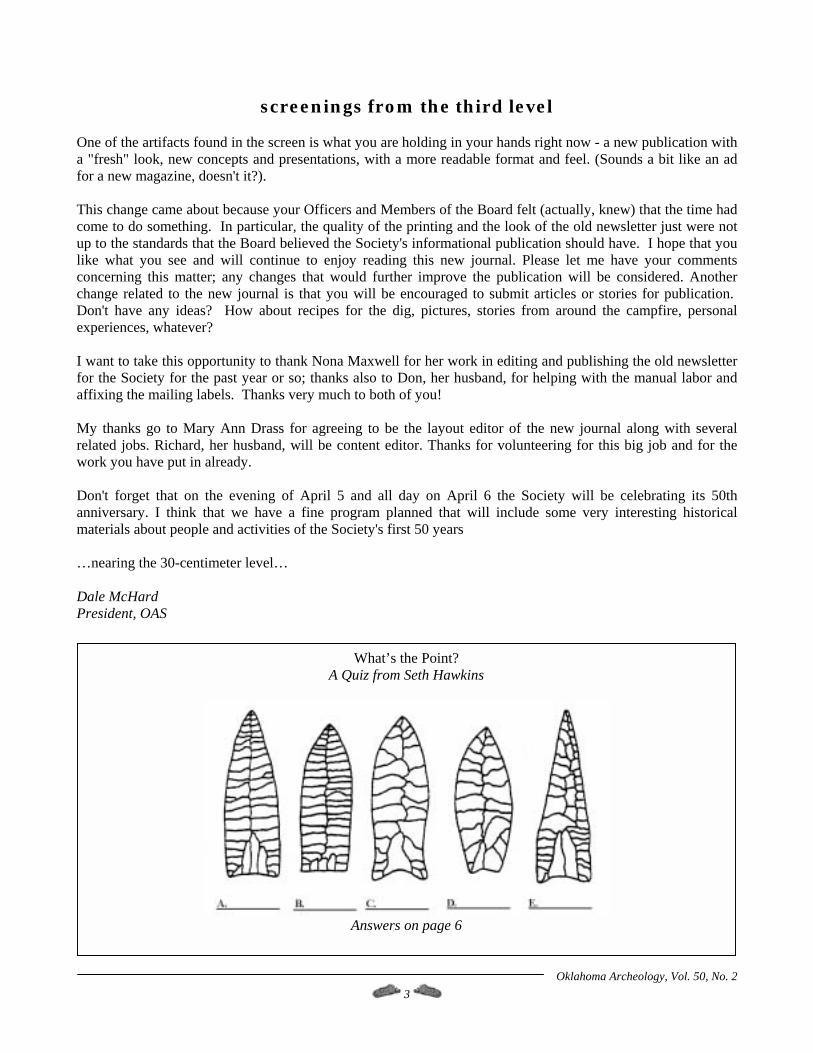
What’s the Point? A Quiz from Seth Hawkins
Answers on page 6
Oklahoma Archeology, Vol. 50, No. 2 4
Welcome to the Society New Members, 12/16/2001 through 02/15/2002 Sustaining Misty Brownfield, Ponca City Rogina M. Lopez, Tecumseh Contributing Ronald E. Barnes, OKC Kelly A. & Trower J. Bradford Kristin L. Mravinec, Woodward Kirsten Kahl, Dallas, TX
Active Beth Arnold & Diane Arnold, Tulsa John R. Erickson, Perryton, TX Helen Goosman, Fort Gibson Pam Hallows, Noble Jay Hapgood, Grapevine, TX Sally A. Wilkins, Antlers
50 Years Ago in the OAS The first issue of the Newsletter of the Oklahoma Anthropological Society appeared in April 1952. Forty-eight members were listed on the rolls. Officers of the newly formed Society included President Rev. R.C. Swanson (Oklahoma City), 1st Vice President Mr. U.S. Blankenship (Homestead), 2nd Vice President Mr. Frank DeLaMater (McAlester), Secretary-Treasurer Dr. Karl Schmitt (Norman), and Editor Dr. Robert E. Bell (Norman). Dues are shown below: Active $3.00 Sustaining $25.00 Associate $2.00 Life $75.00 Contributing $10.00 Institutional $3.00 The first issue contains an account of a visit to the Lacey Site in Garvin County to uncover a house pattern. Several Society members excavated the Washita River focus (now phase) house. A 30’ square structure, the house had four center posts and a central fireplace. A pit was also excavated at the same time. It held pottery sherds, a polished bone chisel, a triangular arrowhead and animal bones and mussel shell. Harold Brighton began a survey of areas to be inundated by soon-to-be constructed Keystone Reservoir. Portions of three counties would be flooded. Society members with knowledge of historic or prehistoric sites in the area were requested to contact Dr. Bell with that information. The editor, Dr. Robert E. Bell, wrote in the Volume 1, Number 1 issue:
Aside from our society meetings, fieldtrips, and occasional get togethers, I believe the Newsletter will become the most important factor in uniting the members into a single organized group. It will be through our Newsletter that we can keep informed as to new discoveries or current events of interest. It can and should serve as a medium for activities of the various members, as a place for announcements, or for the exchange of ideas or information. In brief, it should serve as a letter from each member of the society to all other members in the society. In this way, we can all profit from the knowledge and experience of others with the resulting increased enjoyment in pursuing our mutual interests.
Oklahoma Archeology, Vol. 50, No. 2 5
50th Anniversary Celebration at the 2002 Spring Meeting Sam Noble Oklahoma Museum of Natural History, Norman, Oklahoma
April 5-6, 2002
On April 5 and 6, the Oklahoma Anthropological Society will mark its 50th birthday at the 2002 Spring Meeting in Norman. Make the trip to the Sam Noble Oklahoma Museum of Natural History for a celebration of the Society’s contributions to archeology and anthropology in the state of Oklahoma. Friday evening, Don Wyckoff and the Crosstimber Ramblers will entertain us with “Mammoth Bluegrass.” Music begins at 7:30 p.m. in the Museum auditorium. The museum will open at 7 p.m. and attendees may visit museum exhibits at no charge. Saturday morning, a short Board of Directors meeting will be held at 8:45 a. m. in the large teaching lab. Enter through the staff entrance at the northeast corner of the building. Festivities kick off at 10 a.m. In a full day of activities, the Society will be welcoming many charter and long-time members (see the list of members contacted by Paul Ferguson in the Reunion Committee report below). Additionally, Don Wyckoff will provide a slide presentation of Society digs and history. The Redbud Café in the Museum will be open for lunch. State Archeologist Bob Brooks has arranged for three speakers. Survey archeologist Lee Bement will speak on “Upcoming Work at Jake Bluff.” Paul Minnis, OU Department of Anthropology, will talk about his research and John Blitz, OU Department of Anthropology, will speak on “Mississippian Mound Centers and Ancient Political Territories.”
(See the Museum location map on page 41)
Reunion Committee Report To get the word out about the 50th reunion, the following people have either been contacted by phone or mail or have helped contact present and former members. I think a good number of them hope to attend. Larry Banks - if a consulting job in New Madrid doesn't interfere. Dr. Robert E. Bell – will attend. Ann Bullard sends regrets - Jack is in a Nursing Home. Arnold L. Coldiron Doke Crabtree Austin Dennis – hopes to be able to attend. John & Loy Flick - hope to make it. Charlette Gifford - wants history articles and artifacts. Mary Elizabeth Good – May be able to come with her daughter and Dora Malone. George and Nina Hanggi - Gave lots of names of old timers. Bill and Anna Harwood - Sends regrets. They stay on their ranch nowadays. Quentis and Mary Herron - Still busy with the Museum of the Red River. Robert Hill - one of the 1953 OAS starters. He is housebound now Jack Hofman Sherl Holesko Alvis and Willa Laverty - They might make it. Lawrence and Gene LeVick - Should be there if doesn't have to do chores for son. Chris Lintz Dora Malone - Hopes to bring Mary Elizabeth Good.
Oklahoma Archeology, Vol. 50, No. 2 6
Claude Long - Looking forward to the Reunion. Jimmy Martin - Will try to make it if his knees hold up. Hazel Matejec Rose (King) Mayer Don and Jane Menzie – Plan to attend (attended original organizational meeting at Dr. Bell’s house) Jan (Mullins) Foos Phil Newkumet Terry Nowka - One of the originals from 1953. Greg Perino - is still full of information. Mel Phillips - Ask him about his meeting with Ted Kennedy in Washington. Pauline Poe - Lost Quentin last May - will come if gets a driver. Walt Rosborough Charlie and Joan Slovacek Towana Spivey - Hopes to come - so do we. Charles Surber Ken and Kenie Tyrrell Buck Wade - Always helpful Charles and Kathleen Wallis Don Wyckoff - gave many names. These are just a few of the people who should be contacted. If you know of any former or current long-time members, let them know about the meeting and please let me know so that I can formally invite them. Send any information to Paul Ferguson 3815 East 56th Place, Tulsa, Oklahoma, 74135-4140. Phone (918) 747-8582 or email [email protected]. Paul Ferguson
Historian's Report
Attention Chapter Presidents - Each Chapter should prepare a display of their history for the Anniversary Meeting. I will provide copies of everything in our archives related to your Chapter to assist you. Let me know where you want this sent. As you fill in the gaps in your history from additional materials your members have, please remember that we would like to have a copy for the archives. Charlette Gifford P.O. Box 4750, Tulsa, OK 74159 [email protected]. Norman Lodging for the Spring Meeting: Days Inn, 609 N Interstate Dr., $40-45 (405) 360-4380 Fairfield Inn by Marriott, 301 Norman Center Ct., $70 (405) 447-1661 Guest Inn, 2543 W Main St., $45 (405) 360-1234 Hampton Inn, 309 Norman Center Ct, $70 (405) 366-2100 Holiday Inn, 1000 N Interstate Dr $80+ (405) 364-2882
LaQuinta Inn, 930 Ed Noble Dr., $75 (405) 579-4001 Montford Inn B&B, 322 W Tonkawa $90+ (405) 321-2200 Ramada Inn, 1200 24th Ave SW $45 (405) 321-0100 Residence Inn, 2681 Jefferson St., $100 (405) 366-0900 Thunderbird Lodge, 1430 24th Avenue SW, $45 (405) 329-6990
Answers to Quiz: A. Plainview B. Milnesand C. Golondrina D. Angostura E. Meserve
Oklahoma Archeology, Vol. 50, No. 2 7
Let’s Finish the Units at the Kubik Site! April 13-21, 2002
Larry Neal, Oklahoma Archeological Survey The Kubik site near Newkirk is a deep stratified site with features spanning at least part of the Middle Archaic, two probable Late Archaic components, through a very thin veneer of Late Prehistoric materials found in the top of only a few of the units nearest the creek. The Middle Archaic Calf Creek component is best defined and dated to between 5,000 and 6,000 B.P. so far, and it is deeply buried. It has preserved bone and charred plant remains (wild onion bulbs!) and features that include fire places built on top of the ground surface (no pits) and piles of flint knapping debris with flake refits that show us a bit about the knapping activities and skill levels of the people at the site. The charred material has also given us clues as to the times of the year the site was used (the onions are most easily gathered in the spring/early summer, black walnut hulls may indicate either a fall/winter or spring/early summer use) and some clues that the environment was not quite as grim as has been assumed (bison, deer, the wild onion, fruiting black walnut- not as dry as earlier maybe, oaks and cottonwoods lining the stream). There have been three excavation periods on the site, one in 1996 to test the site for good Calf Creek deposits and
evidence of stratification, an OAS Spring Dig in 1998, and a shorter dig in 2000 to try to complete the unfinished units from the OAS dig. The last excavation confirmed a component 30-40 cm below the identified Calf Creek materials but was only reached in part of one unit. As of yet we have no projectile points or other tools to give us a clue as to the age of the deeper component. Profiles in the creek bank and back hoe trenches suggests it does seem to be preserved in only a small area of the site near the creek, and it is in danger of being lost due to bank slump within a few more years. We still have deep units at the Kubik site begun by the OAS to push through the Calf Creek and complete to the deeper component to hopefully give us artifacts or features with charcoal for a better understanding of the chronological sequence. So, check your schedules and see if you can devote a little time and fun to the project. It can help get you in shape for the Spring Dig with Lee at the end of May! We are planning for the week of April 13 to April 21, 2002, and you don't have to be there for the entire period. I would appreciate a note or a call so that I will have an idea of when people can be there.
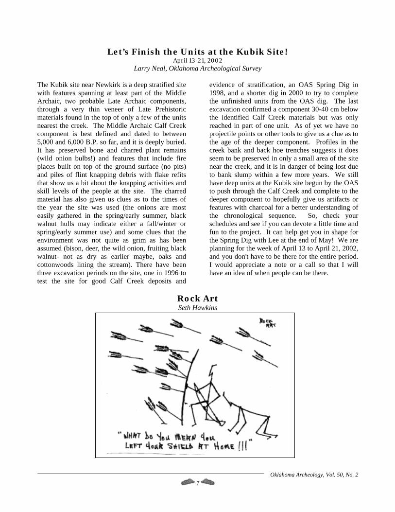
Rock Art Seth Hawkins
Oklahoma Archeology, Vol. 50, No. 2 8
Spring Dig at the Jake Bluff Site May 24 – June 2, 2002
Excavation at the Jake Bluff Site, 34HP60, Harper County, Oklahoma
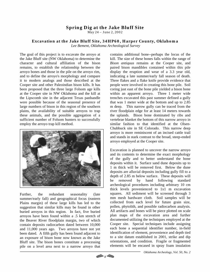
Lee Bement, Oklahoma Archeological Survey The goal of this project is to excavate the arroyo at the Jake Bluff site (NW Oklahoma) to determine the character and cultural affiliation of the bison remains, to establish the relationship between the arroyo bones and those in the pile on the arroyo rim, and to define the arroyo's morphology and compare it to modern analogs and those described at the Cooper site and other Paleoindian bison kills. It has been proposed that the three large Folsom age kills at the Cooper site in NW Oklahoma and the kill at the Lipscomb site in the adjacent Texas panhandle were possible because of the seasonal presence of large numbers of bison in this region of the southern plains, the availability of suitable arroyos to trap these animals, and the possible aggregation of a sufficient number of Folsom hunters to successfully employ the arroyo trap kill method.
Further, the redundant seasonality (late summer/early fall) and geographical focus (eastern Plains margin) of these large kills has led to the suggestion that similar kills may be found in other buried arroyos in this region. In fact, five buried arroyos have been found within a .5 km stretch of the Beaver River floodplain margin, two of which contain deposits radiocarbon dated between 10,000 and 11,000 years ago. Two arroyos have not yet been dated. A fifth gully has been found adjacent to an exposure of bison bone now known as the Jake Bluff site. The bison bones constitute a processing pile on a level area next to a narrow arroyo that
contains additional bone--perhaps the locus of the kill. The size of these bones falls within the range of Bison antiquus remains at the Cooper site, and paired bison mandibles contained within this pile display the eruption and wear of a 3.3 year old, indicating a late summer/early fall season of death. Three flakes and a flake knife provide evidence that people were involved in creating this bone pile. Soil coring just east of the bone pile yielded a bison bone within an apparent arroyo. Three 1 meter wide trenches excavated this past summer defined a gully that was 1 meter wide at the bottom and up to 2.85 m deep. This narrow gully can be traced from the river floodplain edge for at least 14 meters towards the uplands. Bison bone dominated by ribs and vertebrae blanket the bottom of this narrow arroyo in similar fashion to that identified at the Olsen-Chubbuck site in SE Colorado. This narrow deep arroyo is more reminiscent of an incised cattle trail and stands in stark contrast to the broad, steep-ended arroyo employed at the Cooper site. Excavation is planned to uncover the narrow arroyo and its contents to determine the exact morphology of the gully and to better understand the bone deposits within it. Surface sand dune deposits up to 1 m thick will be removed first. Below the dune deposits are alluvial deposits including gully fill to a depth of 2.85 m below surface. These deposits will be removed by hand following standard archeological procedures including arbitrary 10 cm thick levels provenienced to 1x1 m excavation squares. All sediment will be screened through 3 mm mesh hardware cloth. Soil samples will be collected from each level for future grain size, pollen, phytolith, and possible radiocarbon analysis. All artifacts and bones will be piece plotted on scale plan maps of the excavation area and further documented utilizing the techniques employed at the Cooper site. Special techniques include assigning each bone a sequential identifier number, in-field identification of element, provenience and depth tied to a site datum established in 2001, strike and dip orientations, and condition. Fragile or fragmented elements will be encased in spray foam insulation
Oklahoma Archeology, Vol. 50, No. 2 9
that hardens to form a hard cast similar to that provided by Plaster of Paris only lighter and less messy. A large supply of spray foam has been donated to the Oklahoma Archeological Survey by Convenience Products, makers of "Touch 'n Foam" and is available for use by this project. The excavation will expose up to 12 meters of the length of the arroyo and the flat areas on the arroyo rim. All materials removed during this excavation
will be transported to the Oklahoma Archeological Survey, University of Oklahoma, Norman where they will be washed, catalogued, and analyzed. The results of the excavation and the analysis will be applied to the hypothesis that Paleoindians utilized this area of the southern Plains to take advantage of the larger than normal numbers of bison and the arroyos suitable for large scale arroyo bison kills.
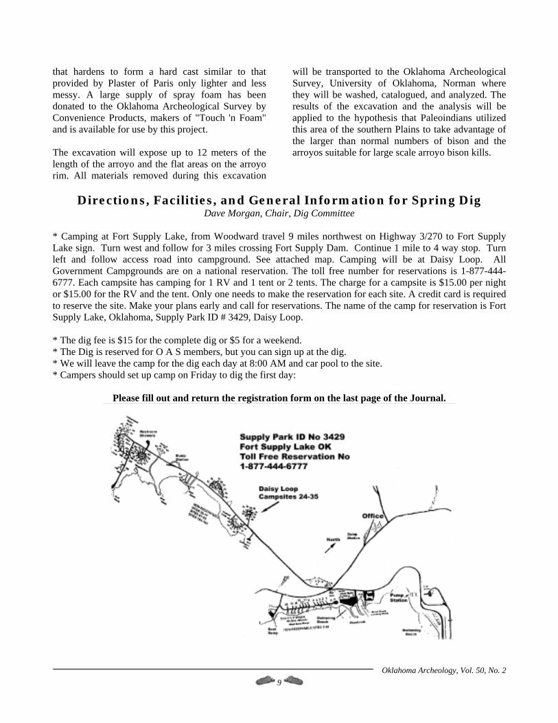
Directions, Facilities, and General Information for Spring Dig
Dave Morgan, Chair, Dig Committee * Camping at Fort Supply Lake, from Woodward travel 9 miles northwest on Highway 3/270 to Fort Supply Lake sign. Turn west and follow for 3 miles crossing Fort Supply Dam. Continue 1 mile to 4 way stop. Turn left and follow access road into campground. See attached map. Camping will be at Daisy Loop. All Government Campgrounds are on a national reservation. The toll free number for reservations is 1-877-444-6777. Each campsite has camping for 1 RV and 1 tent or 2 tents. The charge for a campsite is $15.00 per night or $15.00 for the RV and the tent. Only one needs to make the reservation for each site. A credit card is required to reserve the site. Make your plans early and call for reservations. The name of the camp for reservation is Fort Supply Lake, Oklahoma, Supply Park ID # 3429, Daisy Loop. * The dig fee is $15 for the complete dig or $5 for a weekend. * The Dig is reserved for O A S members, but you can sign up at the dig. * We will leave the camp for the dig each day at 8:00 AM and car pool to the site. * Campers should set up camp on Friday to dig the first day:
Please fill out and return the registration form on the last page of the Journal.
Oklahoma Archeology, Vol. 50, No. 2 10
Preliminary Report of an Ethnobotanical Survey along the Ogallala Ecotone on the Dempsey Divide in Roger Mills County, Oklahoma
J. Peter Thurmond, Dempsey Divide Research Foundation, Inc.; Oklahoma Anthropological Society, Inc.;
Sam Noble Oklahoma Museum of Natural History, University of Oklahoma; Thurmond Ranch, Inc.; Western Oklahoma Financial Services, Inc.
Craig C. Freeman, Kansas Biological Survey, Kansas Natural Heritage Inventory, R.L. McGregor Herbarium,
University of Kansas Natural History Museum and Biodiversity Center, University of Kansas.
Kelly Kindscher, Department of Ecology and Evolutionary Biology, Environmental Studies Program, Kansas Biological Survey, Kansas Natural Heritage Inventory, University of Kansas.
Hillary Loring, Kansas Biological Survey, University of Kansas.
Caleb A. Morse, R.L. McGregor Herbarium,
University of Kansas Natural History Museum and Biodiversity Center, University of Kansas.
Bruce W. Hoagland, Department of Geography, Oklahoma Biological Survey, Oklahoma Natural Heritage Inventory, University of Oklahoma.
Introduction An intensive botanical survey of the 9275 acre (3755 ha) Thurmond Ranch in southern Roger Mills County, Oklahoma was performed in the spring, summer, and early fall of 2001. Field work was conducted by personnel of the Kansas Biological Survey and the R.L. McGregor Herbarium of the University of Kansas, and the Oklahoma Biological Survey of the University of Oklahoma. The purpose of the project was to document and collect the floral species growing along the Ogallala ecotone, as an adjunct to ongoing, long-term archeological and paleoclimatological research in the Dempsey Divide study area (Bement 2000; Bement and Buehler 1994, 1998; Buehler 1997; Thurmond 1990, 1991a, 1991b, 1991c, 1997; Thurmond and Picarella 1999; Thurmond, Wyckoff, and Batchelor, 1998; Thurmond and Wyckoff 1998, 1999, 2001). The place name "Dempsey Divide" was coined by Thurmond (1990) for the uplands between the Washita and North Fork of the Red rivers in western Oklahoma. The other major interfluvial divides of northwestern Oklahoma have been subsequently named (Thurmond and Wyckoff 1999). Lead botanists on the botanical survey were Craig Freeman, an authority on Great Plains plant systematics and taxonomy (c.f. Collins et al. 1995;
Freeman 1998a, 1998b, 2002; Freeman and Schofield 1991; Freeman et al. 1997, 1998); and Kelly Kindscher and Hillary Loring, specialists in Great Plains ecology and ethnobotany (Kindscher 1987, 1992, 1995; Kindscher et al. 1996, 1998; Lauver et al. 1999; Loring et al. 1999, 2000). As a result of this survey, the Thurmond Ranch was listed on The Oklahoma State Register of Natural Heritage Areas, administered by the Oklahoma Biological Survey, in September of 2001 (Shannon 2001, 2002).
The Dempsey Divide Study Area and the Thurmond Ranch: An Intersection of Geology,
Climate, and People The bulk of the archeological and paleoclimatological research on the Dempsey Divide has been conducted on the Thurmond Ranch (hereafter referred to simply as "the ranch"), a fourteen square mile (36 km2) contiguous block to the immediate southwest of the town of Cheyenne, in southern Roger Mills County, Oklahoma. The ranch is on the north side of the Dempsey Divide, and extends from its crest to the edge of the modern valley of the Washita River. It is drained by three short, spring-fed, steep-gradient tributaries of the
Oklahoma Archeology, Vol. 50, No. 2 11
Washita: Brokenleg, Plum, and Sergeant Major creeks. These streams drop some 400' (120 m) in their 7 mile (11.3 km) descent across the ranch to the Washita. The north-flowing tributaries of this river have incised a dense dendritic drainage network on the north side of the divide, creating canyon systems characterized by arroyo cut and fill cycles (c.f. Schumm and Hadley 1957) operating on centennial and millennial time scales. The most recent arroyo incision cycle began around the turn of the 20th century, triggered by the intense land use of the early post-1892 white settlement (homesteader) period. Air photo analysis indicates that approximately 1560 ac (630 ha, or 16.8%) of the ranch was farmed, and most of the rest was intensely grazed in the 1890s and early 1900s. A family lived on and subsistence farmed virtually every quarter section during this time, inflicting an intense insult upon the land. The homesteaders began to leave around 1915. Most of the land comprising the ranch was purchased by the first author's family between 1915 and 1945. The last of the cultivated land was put back to grass in the early 1960s, and land use has been limited to low-intensity grazing by cattle, horses, and llamas since that time. The deer (Odocoileus virginiana) and turkey (Meleagris gallopavo) populations on the ranch have been growing rapidly since the 1980s. Some limited disturbance by deep drilling for natural gas has occurred since the late 1970s. Erosion on the ranch has been brought under control by the recovery of the vegetation and the construction of some 562 erosion control structures in cooperation with the USDA Natural Resources Conservation Service under their Critical Area Treatment (CAT) program. The ranch straddles a major geological and ecological boundary, the eastern outcrop edge of the Tertiary Ogallala Formation. The Ogallala is outwash from the front range of the Rocky Mountains, deposited across much of the western Great Plains in Late Miocene to earliest Pliocene times by interior continental (dryland) anastomosing streams that have no modern analogue. Vertebrate local faunas of the Ogallala Formation on the Southern Plains are of Clarendonian to Hemphillian age, dating from 12 million to 4.5 million years ago (Czaplewski et al. 2001). Western Oklahoma was arid grassland at the time of Ogallala deposition, but the streams flowing though the area headed up in the
Rockies. Intense rainfall in the mountains resulted in periodic fluvial transport of coarse sediment out onto the plains, where it was dumped as each flood ran out of steam (Frye and Leonard 1957; Gustavson and Finley 1985; Gutentag et al. 1984; Reeves and Reeves 1996; Ryder 1996; Seni 1980). Cobbles as large as 40 cm in maximum dimension can be seen in the basal Ogallala Formation on the ranch. Much of the sediment comprising the lower part of the Ogallala is quite sandy, and the formation is a major aquifer (Reeves and Reeves 1996). The Ogallala was deposited on an eroded Miocene prairie landscape with a mature dendritic stream network, not unlike the modern one, developed on redbeds of Late Permian age (Gustavson and Finley 1985; Gustavson and Winkler 1988). The geologic unit directly underlying the Ogallala locally is the Doxey Shale, and it is in turn underlain by the Cloud Chief Formation (Bowers 1967, Carr and Bergman 1976). These three units are all quite different from one another, with profound effects on the topography, vegetation, and history of human use. The generally pale brown to white, sandy lower Ogallala forms a gently rolling landscape atop the Dempsey Divide, and was significantly reworked by the wind into dunes and deflation basins in Late Pleistocene times (Thurmond and Wyckoff 1998). Given its predominantly fluvial origin, the texture and degree of cementation of the Ogallala are quite variable over short distances. Scattered thin calcareous sandstones are present which formed in broad, shallow lakes that periodically dried up. A "red Ogallala" facies occurs in the lower part of the formation, of variant expression from place to place, that represents Miocene reworking of Permian clastics at the inception of Ogallala deposition (Czaplewski et al. 2001; Neil H. Suneson, Oklahoma Geological Survey, personal communication, 2001). Deposition of the Ogallala Formation ceased in Pliocene times, and its eastern edge has been eroding back to the west through most of the Pleistocene. This retreat is apparently episodic, effected through cycles of cut and fill, but episodes of retreat can be quite rapid. The Ogallala outcrop edge on the Thurmond Ranch retreated by over a mile at the end of the last glaciation, between 15,000 and 10,000 years ago (Thurmond and Wyckoff 2001).
Oklahoma Archeology, Vol. 50, No. 2 12
The Doxey Shale is a dark red series of discontinuous claystone and sandy siltstone laminae. The Doxey formed in a coastal floodplain environment, under a tropical, monsoonal climate much like that of southern India today. Oklahoma was in fact a part of the Pangaean supercontinent at that time, and located just south of the equator (Pan Terra, Inc. 1994). The Doxey is comprised principally of ancient thick, buried vertisols, which slowly accumulated on the coastal floodplains as a product of low-energy overbank flooding. Pedogenesis destroyed all sedimentary structure, and slickensides are still visible on the angular blocky ped surfaces. These now indurated soils are punctuated by crevasse splay sandy siltstones, each formed in no more than a few days, as a result of levee breaching during exceptionally violent riverine floods (Suneson op. cit.). The Doxey is quite dense and fine-textured on average, and resists downward percolation of groundwater. As a result, many of the streams leading off the Ogallala are spring-fed where the modern drainages cross the outcrop edge. The location and strength of the modern springs is controlled in part by the buried landscape under the Ogallala; groundwater follows the topographic lows formed by Middle Miocene paleovalleys. Minor seeps and springs can be found in the Doxey outcrop in wet years, where groundwater pipes through joints in the formation under hydraulic head from local Ogallala recharge (Thurmond et al. 1998). Given its texture, the Doxey is fairly resistant to erosion, and is typified by deep canyonlands in the upper part of its outcrop. Isolated remnants just beyond the Doxey outcrop edge form characteristic conical "haystack" hills (Bowers 1967). The underlying Cloud Chief Formation is a pastel red mix of soft, finely laminated silty sandstone, punctuated by thin beds of gypsum. The Cloud Chief was deposited primarily in marine littoral and shallow near-shore environments. It erodes much more evenly and readily than the Doxey Shale, and is characterized by gentle, rolling topography. Stream valleys open out, and stream and slope gradients drop dramatically when you pass from the Doxey outcrop to that of the Cloud Chief. Evaporites in the Cloud Chief had a profound post-depositional effect on the overlying Doxey Shale, probably during the time when both were buried under the
Ogallala aquifer (Caran and Baumgardner 1990, Martinez et al. 1998). Dissolution of the deep Cloud Chief has resulted in discontinuous but significant subsidence of the Doxey. The latter is often tilted, fractured, and weakly faulted. None of this deformation is of tectonic origin. Bizarre karst landforms and stream diversions are aerially visible in the Doxey outcrop. Given the complex geology and often intensely dissected terrain, the soils along the north side of the Dempsey Divide are a highly variable patchwork. Soils on the Ogallala outcrop tend to be calcareous, but on average are deep, sandy mollisols. The coarse texture, in combination with a gentle, often internally drained relief atop the Ogallala outcrop, results in much higher effective precipitation than on the Permian outcrops, especially the Doxey Shale. The latter formation is characterized by extensive exposures of weathering bedrock and orthents, except where Late Holocene gully fills have facilitated the development of isolated alfisols, inceptisols, and shallow mollisols. The more gentle landscape and moderately coarser texture of the Cloud Chief outcrop is associated with more extensive areas of the latter soil types, but evaporites often discourage plant growth in eroded areas. Let us emphasize that the fundamental contrast within the study area is between the Ogallala outcrop and the underlying/adjacent Permian redbeds. Because the terrain and soil texture on the Ogallala combine to yield significantly higher effective precipitation, due to much higher infiltration, that outcrop is associated with a much higher vegetal biomass and apparent biodiversity than the adjacent Permian outcrops. This fact has long been observed by the archeologists working on the Dempsey Divide, and was the impetus of the current botanical survey. A remarkable concentration of prehistoric hunter-gatherer campsites is associated with the ecotone formed by the Ogallala outcrop edge, and it has been inferred that these sites were situated to make most efficient use of the varying floral and faunal communities found on either side of this boundary (Thurmond 1990, 1991b). However, human use of the Ogallala ecotone on the Dempsey Divide was not continuous over time, and this discontinuity appears to be a function of climate change. Most human habitation occurred during the
Oklahoma Archeology, Vol. 50, No. 2 13
first Christian millennium, with lesser peaks during the Early Holocene (10,000-8000 rcy BP) and Protohistoric (AD 1450-1700) periods (op. cit.). Regional climate was extremely unstable, but on average cooler and wetter in Late Pleistocene to Early Holocene times. The upland valleys of the ranch were choked with marshy sediment at this time (Thurmond and Wyckoff 2001). Climate deteriorated rapidly around 7,000 years ago into the Altithermal, a drought which lasted for millennia, and the region turned to desert (c.f. Antevs 1955; Holliday 1989; Meltzer and Collins 1987; Reeves 1973; Toomey et al. 1993). The study area was virtually uninhabited during most of the Middle Holocene (Thurmond and Wyckoff 1999). The canyons of the ranch incised their fills during the Altithermal, and apparently remained open until its end. Increasing rainfall around 3,200 years ago initiated rapid refilling of the canyon system with sediment, and people returned to the area late in the first millenium BC. On average, climate during the first millennium of the Christian era was the wettest of any time since the Early Holocene, and the most recent millennium was much like today (Hall 1982, 1988, 1990). However, study of buried soils on the Dempsey Divide by Thurmond and Wyckoff (2001) has revealed a century-scale cycle in rainfall, operating since late glacial times, that is particularly well documented for the last two millennia. Regional climate oscillates between wetter (pluvial) and drier (interpluvial) conditions and back again roughly every four hundred years. Since 50 BC, the pluvials have averaged 185 years in duration, and the interpluvials 205 years. Late Holocene pluvial duration has varied from 150 to 225 years on the Southern Plains (ibid.). We are currently in the pluvial half of the cycle, and average annual rainfall has increased by some 25% over the past century. Analysis of 20th century rainfall on the Dempsey Divide reveals a roughly 20 year cycle as well (ibid.). The most recent peak in this decadal cycle was in the late 1990s (Thurmond and Thurmond 2001). In its geology, geomorphology, and climate (and the three are obviously interrelated), the eastern outcrop edge of the Ogallala Formation is a very unstable and dynamic area. The local vegetation must surely be adapted to this inherent character.
The 2001 Ethnobotanical Survey Floral species were collected and documented by the University of Kansas and University of Oklahoma personnel in the summer of 2001 by geologic outcrop and topographic/geomorphic setting. Each species was vouchered in the collections of both the R.L. McGregor Herbarium, University of Kansas, and the Robert Bebb Herbarium, University of Oklahoma. Three permanent sampling plots were established on each of the three principal geologic outcrops. Digital floral distribution maps in GIS format are in preparation. A current and complete list of the flora of the Dempsey Divide study area is posted on the Internet at http://www.geocities.com/ dempseydiv/ and will be updated periodically. A detailed botanical reporting of the vouchered flora from this survey is in preparation, detailing floral associations by geologic outcrop and habitat, and summarizing the vegetation alliances of the study area (Freeman et al. n.d.). Kindscher and Loring plan a more detailed report of the ethnobotany of the Dempsey Divide. The results of the 2001 botanical survey fulfill and exceed all prior expectations. A surprising diversity of floral taxa survived the profound environmental insults of the Altithermal and the homesteaders. We say taxa, rather than species, because multiple subspecies and/or varieties have been documented for some floral species. A first-pass reconnaissance of the ranch in the summer of 2000 by Kindscher and Loring identified 168 taxa. Monthly collecting forays were made by the authors (principally Freeman, Loring, and Morse) during the 2001 growing season, from April to October. By July of 2001, the taxonomic count had risen to 334. As of 01/31/2002, our current floral taxa count is 490. Continued monitoring is planned in coming years to identify plant taxa that have been missed. This botanical survey of the Thurmond Ranch was performed at a time when the local vegetation had been stressed by a string of hot, dry summers. Based on the experience of the Kansas Biological Survey personnel with long-term botanical monitoring at the Tall Grass Prairie Preserve in Osage County, Oklahoma, a significant number of additional plant taxa is expected to be documented along the Ogallala ecotone on the Dempsey Divide in future, wetter years (c.f. Loring et al. 1999).

Oklahoma Archeology, Vol. 50, No. 2 14
Of the taxa collected to date, 44 (9.0%) are (mostly inadvertent) introductions from Eurasia. Another four species are native to North America, but probably represent deliberate post-1892 homesteader introductions: Campsis radicans (trumpet vine), Carya illinoinensis (pecan), Catalpa speciosa (catalpa), and Maclura pomifera (bois d'arc). Trumpet vine is observed only in very protected settings adjacent to old homestead sites on the Dempsey Divide (only near the long-occupied Sarah Clines homestead on the ranch, at Brokenleg Springs). Pecan is found only at one homestead site adjacent to the ranch, on the lower reaches of Brokenleg Creek. However, Marcy noted pecan on the North Fork of the Red River as far west as the Texas line in 1859 (Foreman 1937). If pecan is locally introduced, it was perhaps not carried very far. Catalpa is known to have been transplanted by settlers, and was sometimes used in shelterbelt plantings. Its distribution along the spring-fed creeks in Roger Mills County is spotty, suggesting a fairly recent origin. Bois d'arc is found only in or near planted shelterbelts. Schambach (2000) believes the prehistoric Late Holocene range of bois d'arc was limited to a small area south of the Red River in northeast Texas, adjacent to the Sanders archeological site. Echinochloa muricata v muricata (barnyard grass) and Juglans nigra (black walnut) could represent deliberate prehistoric introductions. Echinochloa was recovered from a Late Woodland (ca. AD 900-1000) context just below Brokenleg Springs, in the 1988-1991 Oklahoma Anthropological Society excavations at 34RM208A, the Beaver Dam site (Richard R. Drass, Oklahoma Archeological Survey, personal communication, 2001). Black walnut is fairly ubiquitous along the creeks and upland draws. These could be relict stands from the Early Holocene, but black walnut was a favored Native American nut tree, and far superior to the clearly indigenous Juglans microcarpa. The third author thinks it likely that indigenous peoples carried and transplanted J. nigra nuts into favorable habitats outside its then-current range prior to the 1890s. However, given our uncertainty as to the origins of these two species on the Dempsey Divide, we treat them herein as species native to the study area. One of the clearly introduced Eurasian species, Acorus calamus (sweetflag), merits discussion.
There was initial excitement when a patch of sweetflag was found growing at Brokenleg Springs. There are only two prior records of sweetflag in Oklahoma, in Cleveland and Stephens counties. Sweetflag is often found growing in marshes adjacent to Plains Village sites in the Central and Northern Plains, where it is interpreted as a Native American transplant (Gilmore 1931:90). However, there is a tremendous amount of confusion in the literature concerning the genus Acorus in North America. In most of the literature the name Acorus calamus has been applied to all populations of North American plants. But recent analysis of sweetflag morphology, essential oil chemistry, isozomes, and cytology have resulted in a subdivision into two species: A. calamus, an introduced (Eurasian) sterile triploid; and A. americanus, a fertile diploid, which is native to North America (Thompson 2000). The latter is distributed primarily across the northeastern and midwestern United States and southern Canada. Thompson (ibid.) shows the distribution of A. calamus throughout much of the eastern United States, with scattered occurrences on the Great Plains, based on herbarium material she borrowed and verified. The closest documented occurrence of A. americanus is in northeastern Nebraska. The two species are distinguished most easily on the basis of vegetative features, since A. calamus produces flowers, but never has mature fruits. The leaves of the specimens from the ranch have a very prominent midvein, with much less prominent lateral veins - characteristic of the Eurasian sweetflag. The Brokenleg Springs sweetflag patch is adjacent to the Sarah Clines homestead, and could conceivably have been planted by her in the early 20th century. However, white settlers did not make much use of this plant. We believe an earlier Native American introduction of the species to the Ogallala ecotone is likely, given the strong (and continuing) ethnobotanical importance of sweetflag to Native Americans (c.f. Cheatham et al. 1995; Motley 1994), the timing of its advent in North America, and the local archeological record. Mabry (1977:141) reports that A. calamus arrived in North America from Europe in 1567. The third author believes it likely that the sweetflag Gilmore (op. cit.) reports transplanted by the Pawnee and other tribes was A. calamus, not A. americana, based on the locations involved. And although AD 1000-1450 Plains
Oklahoma Archeology, Vol. 50, No. 2 15
Village sites are rare on the Dempsey Divide (Thurmond and Picarella 1999), post-AD 1450 Protohistoric sites are not uncommon (Thurmond 1991b). The first author has observed A. calamus growing in the Ogallala ecotone along Trail Branch Creek on the Durham Divide, in northern Roger Mills County. We think it likely that sweetflag is fairly common in marshes and on perennial streams along the Ogallala ecotone on the Dempsey Divide. The distribution and origin of sweetflag on the Southern Plains is a topic worthy of further study. So 442 taxa, or 90.0% of the total collected, appear to be native to the study area. Of these 442 taxa, 19 (4.3%) are identified as disjunct; i.e. present as isolated occurrences more than 100 km from the area of common occurrence of each taxon. Another 27 taxa (6.1%) are considered edge-of-range, or at the margin of their modern range. A listing of the identified disjunct and edge-of-range floral taxa is provided in Tables 1 and 2. The modern range data derive from Atlas of the Flora of the Great Plains (Great Plains Flora Association 1977), The PLANTS Database, Version 3.1 (USDA Natural Resources Conservation Service 2001), Catalog of the Woody Plants of Oklahoma (Johnson and Hoagland 2001), and the collections of the Robert Bebb Herbarium, University of Oklahoma (Wayne Elisens, Robert Bebb Herbarium, personal communication, 2002). Ethnographically known useful plants are indicated with a superscript "u" in Tables 1 and 2. Fourteen of the 19 disjunct taxa (73.7%), and 15 of the 27 edge-of-range taxa (55.5%), are known useful plants. For the disjunct taxa, that percentage rises to 89.5% if
the two threeawns, possible inadvertent 20th century agricultural introductions, are excluded. The remaining disjuncts and most of the other edge-of-range taxa have close relatives that are known to have been used as medicinal plants. It is possible that nearly all of the disjunct and edge-of-range taxa were useful plants. Most of these plants would have been unavailable to groups living further to the west. Medicinal plants may have represented valuable and readily portable items of trade for the native inhabitants of the Canadian, North Fork, and upper Washita basins, particularly in Late Prehistoric and Protohistoric times. There are Late Prehistoric village sites within walking distance of the basal Ogallala springs along the Washita River (files of the Oklahoma Archeological Survey, 2001). Plant collecting forays into the uplands of the Dempsey Divide from these villages would have left little, if any, lasting archeological record. The known (generalized) uses of these plants can be found in Table 3. For more detailed information on how specific plants were used, pending publication of the final report of this ethnobotanical survey, the best basic references are Kindscher 1987, 1992; Moerman 1986, and Tull 1999. Non-botanists be forewarned that floral taxonomy is in a state of rapid flux at the start of the 21st century. We use herein the current plant nomenclature as of this writing (Freeman 2002). Many of these scientific names are not the same as those one will find in the preexisting literature. As a convenience to the reader, a list of taxonomic synonyms, using Flora of the Great Plains (Great Plains Flora Association 1991) as the prior standard, is provided in Table 5.
Table 1: Disjunct Floral Taxa of the Ogallala Ecotone on the Dempsey Divide
100 Km+ beyond the Modern Core Range
1) Agalinis aspera, tall false foxglove. Range: primarily the Central and Northern Plains, but extending sporadically into Oklahoma. There is a cluster of records in five central Oklahoma counties and an isolated record in Woods County. 2) Aristida basiramea, forktip threeawn. Range: the eastern half of the Central and Southern Plains, the Upper Midwest, and parts of New England and the Southeast. Not previously recorded in Oklahoma west of Canadian County.
Oklahoma Archeology, Vol. 50, No. 2 16
3) Aristida purpurascens v purpurascens, arrow feather threeawn. Range: much of the eastern United States and parts of southeastern Canada. Interstate 35 marks the western edge of its distribution in Oklahoma but for this record and a prior one in Jackson County. 4) Aster patens v patentissimus, sky drop aster. Range: the eastern half of Oklahoma, Arkansas, extreme southeast Kansas, and the southern two-thirds of Missouri. Again, all prior records for the species are east of I-35 but for one in Comanche County. 5) Botrychium virginianumu, rattlesnake fern. Range: eastern margin of the Central and Northern Plains. Most common in the eastern third of Kansas and in Missouri. There are a few scattered records of this species in eastern Oklahoma and an isolated one in Woods County. 6) Carex austrinau, southern sedge. Range: eastern margin of the Central and Southern Plains. Most common in the eastern half of Kansas and western third of Missouri. Fairly common in the eastern half of Oklahoma, ranging west to Caddo and Comanche counties. There is an isolated record in Cimarron County. 7) Carex bulbostylisu, eastern narrowleaf sedge. Range: the eastern half of the United States and southeastern Canada. The species is fairly common in the eastern two-thirds of Oklahoma, but isolated populations in Roger Mills County marshes are the only occurrence known west of Caddo County. 8) Cyperus acuminatusu, tapeleaf flatsedge. Range: much of the eastern half of the United States. There are scattered occurrences in the eastern half of Oklahoma, but the species is regionally most common in the eastern three-quarters of Kansas, eastern half of Nebraska, and western half of Missouri. The westernmost prior records in Oklahoma are in Grant, Jefferson, and Kingfisher counties. 9) Cyperus lupulinus s lupulinusu, Houghton flatsedge. Range: most of the northeastern quarter of the United States. Fairly common in central Kansas, but not previously documented in Oklahoma except for another isolated occurrence in Cimarron County. 10) Echinochloa muricata v muricatau, barnyard grass. Range: much of the eastern half of the United States and southeastern Canada. The species is scattered across the eastern half of Oklahoma, but the closest concentration in its distribution is in the eastern half of Kansas and the western quarter of Missouri. The closest prior records in Oklahoma are in Alfalfa, Canadian, and Comanche counties. 11) Epilobium leptophyllumu, bog willowherb. Range: much of the northern United States and southern Canada. Scattered occurrences have been documented in (mostly northern) Kansas, but this is the first record for Oklahoma. 12) Lechea tenuifoliau, narrowleaf pinweed. Range: most of the eastern half of the United States. Most common regionally in the southeastern half of Oklahoma, western half of Missouri, and southeastern quarter of Kansas. The closest prior records in Oklahoma are in Canadian, Comanche, and Grady counties. 13) Polygonum tenueu, pleatleaf knotweed. Range: most of the eastern United States and southeastern Canada. The species is regionally most common in eastern Kansas and western Missouri; it is also fairly common in eastern Oklahoma. The most westerly previous record in Oklahoma is in Comanche County. 14) Potentilla paradoxa, bushy cinquefoil. Range: much of the northern United States and southern Canada. The species is fairly common on the Northern Plains. A few scattered populations have been documented in western Kansas, eastern Colorado, and the northern Texas Panhandle. The only prior record for Oklahoma is in Woods County.
Oklahoma Archeology, Vol. 50, No. 2 17
15) Pseudognaphalium obtusifoliumu, fragrant everlasting. Range: the eastern half of the United States and southeastern Canada. The species is fairly common in the eastern half of Oklahoma but has not previously been documented west of Blaine and Canadian counties. 16) Rudbeckia subtomentosau, sweet coneflower. Range: the southern half of Iowa, western half of Missouri, extreme eastern Kansas; with scattered occurrences in the eastern quarter of Oklahoma and northwestern quarter of Arkansas. The closest prior record is in Bryan County in far southeastern Oklahoma. 17) Sporobolus clandestinusu, southeastern rough dropseed. Range: most of the eastern United States, excluding Michigan and northern New England. The species is scattered across Oklahoma east of Interstate 35. The only prior record west of I-35 in Oklahoma is in Major County. 18) Stylosanthes biflorau, sidebeak pencilflower. Range: the southeastern United States including the Ohio River and southern Mississippi River drainage basins. Not previously recorded in Oklahoma west of Caddo and Grady counties. 19) Tragia betonicifoliau, betony noseburn. Range: the southeastern third of Kansas, southwestern fifth of Missouri, and the north-central to northeastern quarter of Oklahoma. Not previously recorded in Oklahoma west of Garfield and Grady counties.
Table 2: Edge-of-Range Floral Taxa of the Ogallala Ecotone on the Dempsey Divide
Within 100 km of the Modern Core Range
1) Asclepias viridisu, spider milkweed, green antelopehorn. Range: centered on the Mississippi River valley. The species occurs in the eastern half of the Central and Southern Plains, from southeastern Nebraska to Texas. It is common in the eastern three quarters of Oklahoma but has not previously been documented west of Custer County. 2) Bidens comosus, leafy-bract beggarstick. Range: the Central and Northern Plains, and the western margin of the Eastern Woodlands from Minnesota to Missouri. A few occurrences have been documented around Oklahoma City, and the species has been recorded to the immediate west in Hemphill and Wheeler counties, Texas. However, Bidens comosus is very uncommon south of Kansas. 3) Chamaesyce nutans, eyebane. Range: most of the eastern half of the United States and southeastern Canada. The most westerly prior records on the Southern Plains are in Custer and Greer counties, Oklahoma. 4) Cocculus carolinusu, Carolina coralbead. Range: most of the southeastern quarter of the United States. Common in the southeastern three-quarters of Oklahoma. The species has not previously been collected in Roger Mills County but is known to occur in Custer and Washita counties. 5) Diospyros virginianau, persimmon. Range: most of the eastern United States, excluding the northern border states. The eastern edge of the ubiquitous distribution of the species in Oklahoma splits the state in two on a southwest (Comanche County) to northeast (Osage County) axis. Isolated populations in the spring areas of Ellis, Harper, Woods, and now Roger Mills counties could perhaps be considered disjunct. 6) Eleocharis erythropoda, bald spikerush. Range: the Mississippi River drainage basin and the northeastern United States. The species occurs in marshes west to the eastern Texas panhandle, but prior records in Oklahoma are surprisingly few (six northwest and south-central counties).

Oklahoma Archeology, Vol. 50, No. 2 18
7) Erigeron modestus, High Plains fleabane. Range: western third of Kansas, southeastern quarter of Colorado, extreme western Oklahoma, western third of Texas, and eastern New Mexico. There are prior records from all of the westernmost tier of counties in Oklahoma. 8) Eupatorium perfoliatum v perfoliatumu, boneset. Range: most of the eastern half of the United States and southeastern Canada. The species is scattered across the eastern half of the Great Plains. Regionally, it occurs no further west than Ellis and Roger Mills counties in Oklahoma and Wheeler County, Texas. 9) Forestiera pubescens, elbowbush. Range: primarily the American Southwest. The northeastern edge of the range of this species is in Oklahoma, extending from Roger Mills County to southern Blaine County and Canadian County, thence southeast to McCurtain County. 10) Hedysarum boreale, northern sweet vetch. Range: the northwestern United States and southwestern Canada, extending south into extreme northern Arizona and New Mexico, and southeastward through Colorado into the Oklahoma and Texas panhandles and extreme western Oklahoma. Previously recorded in Ellis and Roger Mills counties. 11) Helianthus tuberosusu, Jerusalem artichoke. Range: southeastern Canada and most of the eastern United States, excepting the Gulf Coast. Jerusalem artichoke is fairly common in the eastern three quarters of Kansas, the east half of Oklahoma, and northeastern Texas. The only prior record in Oklahoma west of Interstate 35 is in Ellis County. 12) Juglans nigrau, black walnut. Range: much of the eastern half of the United States. The species occurs sporadically throughout the main body of Oklahoma and in Beaver County in the Oklahoma Panhandle, but the only documented occurrence in the Texas Panhandle is just across the border in Hemphill County. Black walnut is regionally most common in the eastern three-quarters of Kansas, western half of Missouri, and along the border between Iowa and Nebraska. See discussion above; this is possibly a Native American introduction to the study area. 13) Melampodium leucanthum, Plains blackfoot daisy. Range: the western Southern Plains south to central and southwest Texas, Chihuahua, Coahuila; west to Arizona. Not known to occur east of Roger Mills County. 14) Mirabilis glabra, smooth four o'clock. Range: the American Southwest and the western Southern Plains. There are prior records in all four of the easternmost counties of the Texas Panhandle, but the only prior record in Oklahoma is in Cimarron County. 15) Muhlenbergia soboliferau, rock muhly. Range: much of the eastern United States and southeastern Canada. Regionally most common in eastern Kansas and western Missouri, the species is scattered across Oklahoma, mostly the eastern two-thirds. The only two more westerly prior records are in Woods County, Oklahoma, and just across the border in Hemphill County, Texas. 16) Opuntia phaeacantha v majoru, Mojave pricklypear. Range: the American Southwest, extending into western Texas. Fairly common in the Texas Panhandle. There are scattered previously documented occurrences in Oklahoma as far east as Grady and Osage counties. 17) Quercus havardiiu, shinnery oak. Range: eastern New Mexico, northwestern Texas, and extreme western Oklahoma. In western Oklahoma, the species has been recorded in Beckham, Blaine, Cimarron, Dewey, Ellis, Harper, and Roger Mills counties. 18) Quercus havardii x stellatau, shinnery/post oak hybrid. Range: for Q. stellata, much of the eastern United States, excluding New England and the northern Midwest. Pure post oak perhaps does not occur west of Caddo
Oklahoma Archeology, Vol. 50, No. 2 19
and Comanche counties in Oklahoma. The westernmost distribution of Q. stellata in western Oklahoma as mapped in Atlas of the Flora of the Great Plains (to the Texas line and across it into Hemphill County, Texas; Great Plains Flora Association 1977) is coincident with the easternmost distribution of Q. havardii. It is possible that many of the occurrences of Q. stellata mapped in western Oklahoma are in fact Q. havardii/stellata hybrids, as appears to be the case on the ranch. The oaks of western Oklahoma are a puzzle. Despite apparent reproduction primarily through vegetative means, Southern Plains oaks display the genetic variation of a sexual population, and have often been interpreted as hybridizing quite freely (Mayes et al. 1998; Wiedeman and Penfound 1960). However, Muller (1951:22) believes "The freedom of hybridization ascribed to oaks is immensely over-rated." In an earlier article (1941:148) he states that "The species of Quercus are notoriously variable in trivial characters. This variability has given rise to the belief that the oak species hybridize freely." This is a situation begging a sorting-out with modern technology. 19) Quercus macrocarpau, bur oak. Range: most of the Mississippi River basin, extending into the northeastern United States and southeastern Canada. In Oklahoma, bur oak has previously been collected as far west as Custer, Dewey, and Washita counties, but this is the first record in the western tier of counties in the main body of the state. Quercus macrocarpa has not been documented in the Oklahoma or Texas panhandles. 20) Rhus aromatica v trilobatau, western fragrant sumac. Range: the western half of the Great Plains. Not previously documented on the Southern Plains east of the Oklahoma and Texas panhandles. 21) Ruellia humilis, fringeleaf wild petunia. Range: from Pennsylvania and West Virginia southwest to the eastern half of Kansas, most of Oklahoma, and the northeastern quarter of Texas. The most westerly documented occurrences are in Roger Mills County and Wheeler County, Texas. 22) Smilax hispidau, bristly greenbrier. Range: most of the eastern half of the United States. The species is fairly common in the eastern three-quarters of Oklahoma, but has not previously been documented west of Harper and Washita counties. 23) Solidago altiplanities, Llano Estacado goldenrod. Range: the southern Texas Panhandle and southwestern Oklahoma. The core distribution runs across the south half of the Texas Panhandle to Harmon and Jackson counties, Oklahoma. There are two prior outlying records, in Custer and Jefferson counties (Taylor and Taylor 1983). 24) Triodanis leptocarpa, slimpod Venus looking glass. Range: scattered over most of the Great Plains, the species is most common in the eastern two-thirds of Kansas and the western two-thirds of Missouri. It has not been previously documented in Oklahoma west of Washita County. 25) Verbena urticifoliau, nettleleaf vervain. Range: the eastern United States and southeastern Canada. The species occurs in all of Oklahoma except the Panhandle. The westernmost regional records are just across the border in Hemphill and Wheeler counties, Texas. 26) Xanthisma texanum v drummondii, Drummond's sleepy daisy. Range: limited to the Southern Plains of eastern New Mexico, western Texas, and southern Oklahoma. The species has been collected in all of the adjoining counties to the west, south, and east of Roger Mills County, but has not previously been collected in this county. 27) Zinnia grandiflorau, Rocky Mountain zinnia. Range: the American Southwest, parts of northern Mexico, and the west half of the Southern Plains. The species is not known to grow east of Custer and Washita counties in Oklahoma.
Oklahoma Archeology, Vol. 50, No. 2 20
Discussion: The Dempsey Divide Flora, Paleoclimate and Prehistory
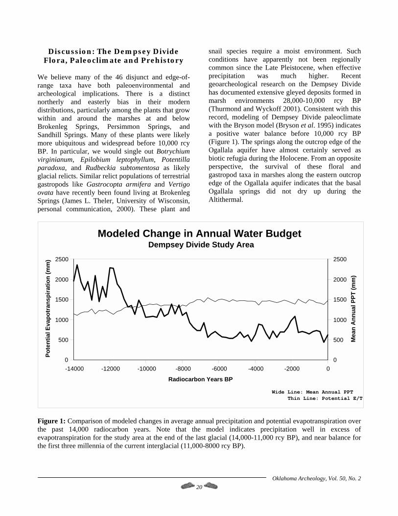
We believe many of the 46 disjunct and edge-of-range taxa have both paleoenvironmental and archeological implications. There is a distinct northerly and easterly bias in their modern distributions, particularly among the plants that grow within and around the marshes at and below Brokenleg Springs, Persimmon Springs, and Sandhill Springs. Many of these plants were likely more ubiquitous and widespread before 10,000 rcy BP. In particular, we would single out Botrychium virginianum, Epilobium leptophyllum, Potentilla paradoxa, and Rudbeckia subtomentosa as likely glacial relicts. Similar relict populations of terrestrial gastropods like Gastrocopta armifera and Vertigo ovata have recently been found living at Brokenleg Springs (James L. Theler, University of Wisconsin, personal communication, 2000). These plant and
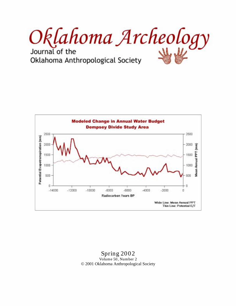
snail species require a moist environment. Such conditions have apparently not been regionally common since the Late Pleistocene, when effective precipitation was much higher. Recent geoarcheological research on the Dempsey Divide has documented extensive gleyed deposits formed in marsh environments 28,000-10,000 rcy BP (Thurmond and Wyckoff 2001). Consistent with this record, modeling of Dempsey Divide paleoclimate with the Bryson model (Bryson et al. 1995) indicates a positive water balance before 10,000 rcy BP (Figure 1). The springs along the outcrop edge of the Ogallala aquifer have almost certainly served as biotic refugia during the Holocene. From an opposite perspective, the survival of these floral and gastropod taxa in marshes along the eastern outcrop edge of the Ogallala aquifer indicates that the basal Ogallala springs did not dry up during the Altithermal.
-14000 -12000 -10000 -8000 -6000 -4000 -2000 0
Radiocarbon Years BP
0
500
1000
1500
2000
2500
Pote
ntia
l Eva
potr
ansp
iratio
n (m
m)
0
500
1000
1500
2000
2500
Mea
n A
nnua
l PPT
(mm
)
Wide Line: Mean Annual PPTThin Line: Potential E/T
Modeled Change in Annual Water BudgetDempsey Divide Study Area
Figure 1: Comparison of modeled changes in average annual precipitation and potential evapotranspiration over the past 14,000 radiocarbon years. Note that the model indicates precipitation well in excess of evapotranspiration for the study area at the end of the last glacial (14,000-11,000 rcy BP), and near balance for the first three millennia of the current interglacial (11,000-8000 rcy BP).
Oklahoma Archeology, Vol. 50, No. 2 21
Perhaps most surprising, and of greatest relevance to the archeological record, is that 258 (58.4%) of the 442 native floral taxa are ethnographically known useful plants. Some of the identified plants may have had uses we do not know about, so this should be regarded as a minimum number. Significant staple plant foods are present in abundance along the Ogallala ecotone. The oaks produce a large mast crop in some years. However, given their adaptation to upland slopes, the local oaks are highly dependent on rainfall, and their mast production varies considerably from year to year. Also, most acorns require tannin extraction for human consumption (Wandsnider 1997). A far more reliable staple food resource for hunter-gatherers would have been cattail. Typha domingensis is the local species, at least on Brokenleg and Sergeant Major creeks on the ranch. Two other species occur on the Great Plains: T. angustifolia (which is what we initially thought we were seeing on the ranch) and T. latifolia. All are common on the Southern Plains, and apparently hybridize (Great Plains Flora Association 1991). As indicated above, there is a base flow of fossil Ogallala aquifer water from the better springs along the Dempsey Divide, like those at the heads of Brokenleg and Sergeant Major creeks, that is not
dependent on current rainfall recharge. Cattails grow around and downstream of these springs, and, given this base flow, their production is consistent from year to year. One acre of cattails will produce 6,475 lbs (2,940 kg) of flour per year on average (Harrington 1972). At present, there are 17.5 acres (7.1 ha) of cattails growing in the upper reaches of Brokenleg and Sergeant Major creeks. The acreage on these two creeks alone would produce some 55 tons (50 mt) of cattail flour per year. Such yield could not be sustainably harvested year after year, but you see the point. Along the Ogallala ecotone, cattails would have represented a productive, reliable, and easy to collect and process source of carbohydrate for prehistoric hunter-gatherers. The subsistence attraction of the Ogallala ecotone to prehistoric hunter-gatherers is abundantly evident. Cattails, supplemented by acorns in good years, provided a virtually inexhaustible carbohydrate source. As with rice or potatoes, you might get tired of it, but you certainly would not starve. Walnuts could be crushed and boiled for fat. Bison, deer, turkey, and other small game provided protein. The other useful plants provided dietary variety; vitamins and minerals; medicines; dyes; fiber for weaving, basketry and cordage; material for atlatls and darts, bows and arrows, tool hafts, and digging sticks; and building materials.
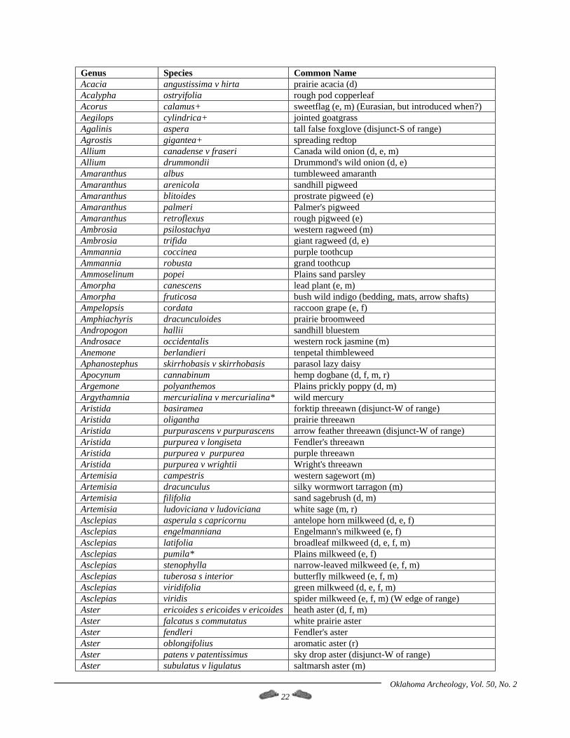
Table 3: Modern Vascular Flora of the Ogallala Ecotone on the Dempsey Divide
Township 12N, Range 24W; Township 13N, Range 23W, and Township 13N, Range 24W
Southern Roger Mills County, Oklahoma The following is a list of the plants vouchered by the R.L. McGregor Herbarium of the University of Kansas and the Robert Bebb Herbarium of the University of Oklahoma as of 12/31/2001 from the Thurmond Ranch Natural Area and its immediate vicinity. Ethnographically known uses are indicated as follows: a parenthetical "c" = use as cleansing agent; "d" = use as dyeing agent; "e" = edible parts (or was used for broth, non-medicinal tea, or as a spice); "f" = use for fiber; "m" = medicinal uses; "r" = ritual uses. Assessments of use follow Cheatham et al. 1995; Elias and Dykeman 1982; Harrington 1967, 1972; Hutchens 1974; Kindscher 1987, 1992; Mabry 1977; Moerman 1986; Motley 1994; Tull 1999; and USDA Natural Resources Conservation Service 2001. Taxa marked with a plus sign (+) are not native to North America (principally following Great Plains Flora Association 1991). Those marked with an asterisk (*) were collected not on the ranch, but on adjacent properties along the Ogallala ecotone on the Dempsey Divide. In the species column, "s" = subspecies; "v" = variety; and "x" = hybrid.
Oklahoma Archeology, Vol. 50, No. 2 22
Genus Species Common Name Acacia angustissima v hirta prairie acacia (d) Acalypha ostryifolia rough pod copperleaf Acorus calamus+ sweetflag (e, m) (Eurasian, but introduced when?) Aegilops cylindrica+ jointed goatgrass Agalinis aspera tall false foxglove (disjunct-S of range) Agrostis gigantea+ spreading redtop Allium canadense v fraseri Canada wild onion (d, e, m) Allium drummondii Drummond's wild onion (d, e) Amaranthus albus tumbleweed amaranth Amaranthus arenicola sandhill pigweed Amaranthus blitoides prostrate pigweed (e) Amaranthus palmeri Palmer's pigweed Amaranthus retroflexus rough pigweed (e) Ambrosia psilostachya western ragweed (m) Ambrosia trifida giant ragweed (d, e) Ammannia coccinea purple toothcup Ammannia robusta grand toothcup Ammoselinum popei Plains sand parsley Amorpha canescens lead plant (e, m) Amorpha fruticosa bush wild indigo (bedding, mats, arrow shafts) Ampelopsis cordata raccoon grape (e, f) Amphiachyris dracunculoides prairie broomweed Andropogon hallii sandhill bluestem Androsace occidentalis western rock jasmine (m) Anemone berlandieri tenpetal thimbleweed Aphanostephus skirrhobasis v skirrhobasis parasol lazy daisy Apocynum cannabinum hemp dogbane (d, f, m, r) Argemone polyanthemos Plains prickly poppy (d, m) Argythamnia mercurialina v mercurialina* wild mercury Aristida basiramea forktip threeawn (disjunct-W of range) Aristida oligantha prairie threeawn Aristida purpurascens v purpurascens arrow feather threeawn (disjunct-W of range) Aristida purpurea v longiseta Fendler's threeawn Aristida purpurea v purpurea purple threeawn Aristida purpurea v wrightii Wright's threeawn Artemisia campestris western sagewort (m) Artemisia dracunculus silky wormwort tarragon (m) Artemisia filifolia sand sagebrush (d, m) Artemisia ludoviciana v ludoviciana white sage (m, r) Asclepias asperula s capricornu antelope horn milkweed (d, e, f) Asclepias engelmanniana Engelmann's milkweed (e, f) Asclepias latifolia broadleaf milkweed (d, e, f, m) Asclepias pumila* Plains milkweed (e, f) Asclepias stenophylla narrow-leaved milkweed (e, f, m) Asclepias tuberosa s interior butterfly milkweed (e, f, m) Asclepias viridifolia green milkweed (d, e, f, m) Asclepias viridis spider milkweed (e, f, m) (W edge of range) Aster ericoides s ericoides v ericoides heath aster (d, f, m) Aster falcatus s commutatus white prairie aster Aster fendleri Fendler's aster Aster oblongifolius aromatic aster (r) Aster patens v patentissimus sky drop aster (disjunct-W of range) Aster subulatus v ligulatus saltmarsh aster (m)
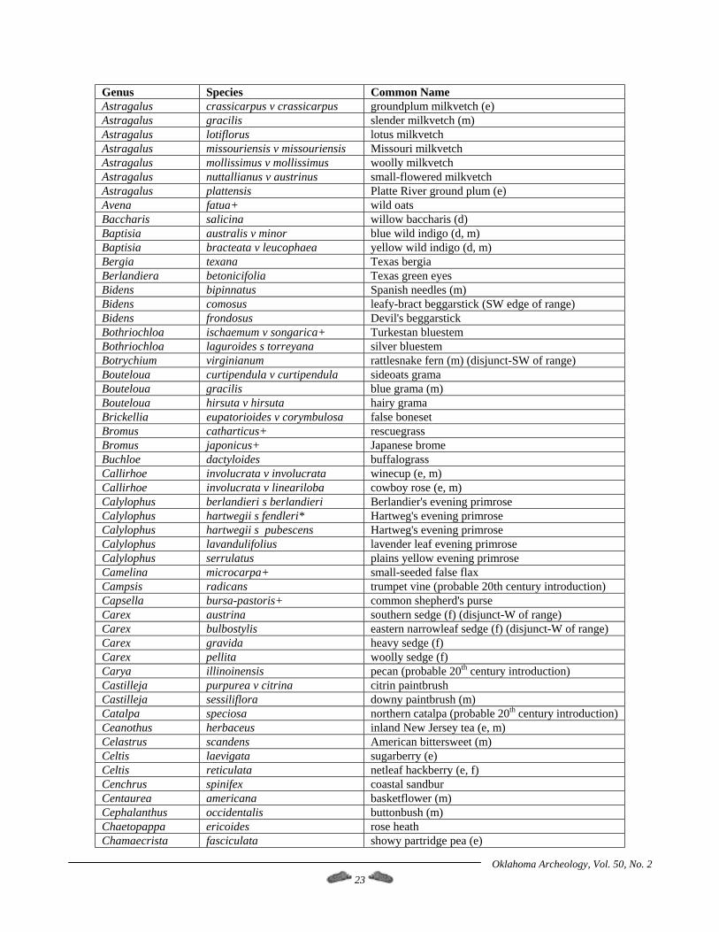
Oklahoma Archeology, Vol. 50, No. 2 23
Genus Species Common Name Astragalus crassicarpus v crassicarpus groundplum milkvetch (e) Astragalus gracilis slender milkvetch (m) Astragalus lotiflorus lotus milkvetch Astragalus missouriensis v missouriensis Missouri milkvetch Astragalus mollissimus v mollissimus woolly milkvetch Astragalus nuttallianus v austrinus small-flowered milkvetch Astragalus plattensis Platte River ground plum (e) Avena fatua+ wild oats Baccharis salicina willow baccharis (d) Baptisia australis v minor blue wild indigo (d, m) Baptisia bracteata v leucophaea yellow wild indigo (d, m) Bergia texana Texas bergia Berlandiera betonicifolia Texas green eyes Bidens bipinnatus Spanish needles (m) Bidens comosus leafy-bract beggarstick (SW edge of range) Bidens frondosus Devil's beggarstick Bothriochloa ischaemum v songarica+ Turkestan bluestem Bothriochloa laguroides s torreyana silver bluestem Botrychium virginianum rattlesnake fern (m) (disjunct-SW of range) Bouteloua curtipendula v curtipendula sideoats grama Bouteloua gracilis blue grama (m) Bouteloua hirsuta v hirsuta hairy grama Brickellia eupatorioides v corymbulosa false boneset Bromus catharticus+ rescuegrass Bromus japonicus+ Japanese brome Buchloe dactyloides buffalograss Callirhoe involucrata v involucrata winecup (e, m) Callirhoe involucrata v lineariloba cowboy rose (e, m) Calylophus berlandieri s berlandieri Berlandier's evening primrose Calylophus hartwegii s fendleri* Hartweg's evening primrose Calylophus hartwegii s pubescens Hartweg's evening primrose Calylophus lavandulifolius lavender leaf evening primrose Calylophus serrulatus plains yellow evening primrose Camelina microcarpa+ small-seeded false flax Campsis radicans trumpet vine (probable 20th century introduction) Capsella bursa-pastoris+ common shepherd's purse Carex austrina southern sedge (f) (disjunct-W of range) Carex bulbostylis eastern narrowleaf sedge (f) (disjunct-W of range) Carex gravida heavy sedge (f) Carex pellita woolly sedge (f) Carya illinoinensis pecan (probable 20th century introduction) Castilleja purpurea v citrina citrin paintbrush Castilleja sessiliflora downy paintbrush (m) Catalpa speciosa northern catalpa (probable 20th century introduction) Ceanothus herbaceus inland New Jersey tea (e, m) Celastrus scandens American bittersweet (m) Celtis laevigata sugarberry (e) Celtis reticulata netleaf hackberry (e, f) Cenchrus spinifex coastal sandbur Centaurea americana basketflower (m) Cephalanthus occidentalis buttonbush (m) Chaetopappa ericoides rose heath Chamaecrista fasciculata showy partridge pea (e)
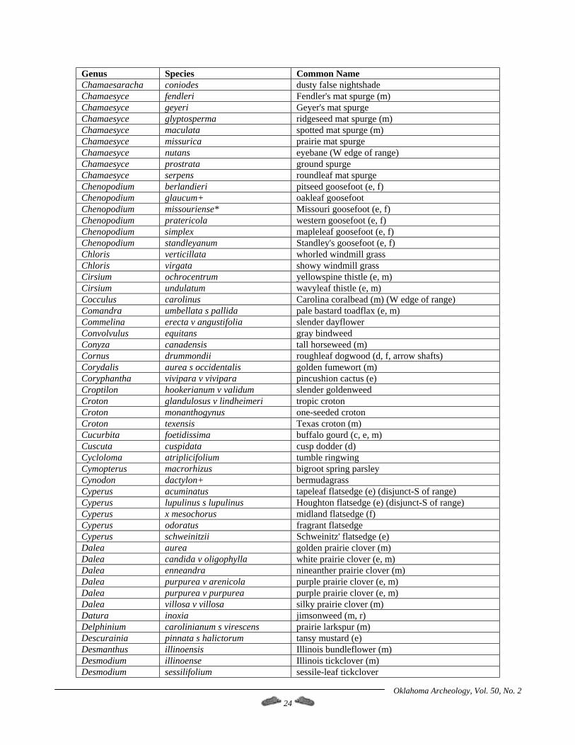
Oklahoma Archeology, Vol. 50, No. 2 24
Genus Species Common Name Chamaesaracha coniodes dusty false nightshade Chamaesyce fendleri Fendler's mat spurge (m) Chamaesyce geyeri Geyer's mat spurge Chamaesyce glyptosperma ridgeseed mat spurge (m) Chamaesyce maculata spotted mat spurge (m) Chamaesyce missurica prairie mat spurge Chamaesyce nutans eyebane (W edge of range) Chamaesyce prostrata ground spurge Chamaesyce serpens roundleaf mat spurge Chenopodium berlandieri pitseed goosefoot (e, f) Chenopodium glaucum+ oakleaf goosefoot Chenopodium missouriense* Missouri goosefoot (e, f) Chenopodium pratericola western goosefoot (e, f) Chenopodium simplex mapleleaf goosefoot (e, f) Chenopodium standleyanum Standley's goosefoot (e, f) Chloris verticillata whorled windmill grass Chloris virgata showy windmill grass Cirsium ochrocentrum yellowspine thistle (e, m) Cirsium undulatum wavyleaf thistle (e, m) Cocculus carolinus Carolina coralbead (m) (W edge of range) Comandra umbellata s pallida pale bastard toadflax (e, m) Commelina erecta v angustifolia slender dayflower Convolvulus equitans gray bindweed Conyza canadensis tall horseweed (m) Cornus drummondii roughleaf dogwood (d, f, arrow shafts) Corydalis aurea s occidentalis golden fumewort (m) Coryphantha vivipara v vivipara pincushion cactus (e) Croptilon hookerianum v validum slender goldenweed Croton glandulosus v lindheimeri tropic croton Croton monanthogynus one-seeded croton Croton texensis Texas croton (m) Cucurbita foetidissima buffalo gourd (c, e, m) Cuscuta cuspidata cusp dodder (d) Cycloloma atriplicifolium tumble ringwing Cymopterus macrorhizus bigroot spring parsley Cynodon dactylon+ bermudagrass Cyperus acuminatus tapeleaf flatsedge (e) (disjunct-S of range) Cyperus lupulinus s lupulinus Houghton flatsedge (e) (disjunct-S of range) Cyperus x mesochorus midland flatsedge (f) Cyperus odoratus fragrant flatsedge Cyperus schweinitzii Schweinitz' flatsedge (e) Dalea aurea golden prairie clover (m) Dalea candida v oligophylla white prairie clover (e, m) Dalea enneandra nineanther prairie clover (m) Dalea purpurea v arenicola purple prairie clover (e, m) Dalea purpurea v purpurea purple prairie clover (e, m) Dalea villosa v villosa silky prairie clover (m) Datura inoxia jimsonweed (m, r) Delphinium carolinianum s virescens prairie larkspur (m) Descurainia pinnata s halictorum tansy mustard (e) Desmanthus illinoensis Illinois bundleflower (m) Desmodium illinoense Illinois tickclover (m) Desmodium sessilifolium sessile-leaf tickclover
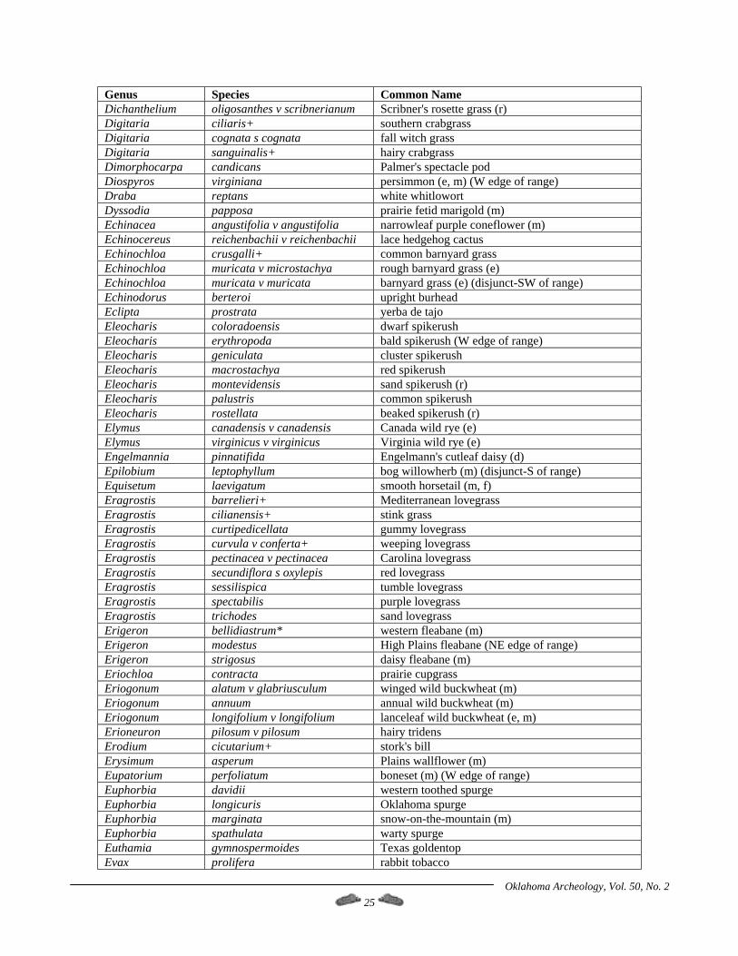
Oklahoma Archeology, Vol. 50, No. 2 25
Genus Species Common Name Dichanthelium oligosanthes v scribnerianum Scribner's rosette grass (r) Digitaria ciliaris+ southern crabgrass Digitaria cognata s cognata fall witch grass Digitaria sanguinalis+ hairy crabgrass Dimorphocarpa candicans Palmer's spectacle pod Diospyros virginiana persimmon (e, m) (W edge of range) Draba reptans white whitlowort Dyssodia papposa prairie fetid marigold (m) Echinacea angustifolia v angustifolia narrowleaf purple coneflower (m) Echinocereus reichenbachii v reichenbachii lace hedgehog cactus Echinochloa crusgalli+ common barnyard grass Echinochloa muricata v microstachya rough barnyard grass (e) Echinochloa muricata v muricata barnyard grass (e) (disjunct-SW of range) Echinodorus berteroi upright burhead Eclipta prostrata yerba de tajo Eleocharis coloradoensis dwarf spikerush Eleocharis erythropoda bald spikerush (W edge of range) Eleocharis geniculata cluster spikerush Eleocharis macrostachya red spikerush Eleocharis montevidensis sand spikerush (r) Eleocharis palustris common spikerush Eleocharis rostellata beaked spikerush (r) Elymus canadensis v canadensis Canada wild rye (e) Elymus virginicus v virginicus Virginia wild rye (e) Engelmannia pinnatifida Engelmann's cutleaf daisy (d) Epilobium leptophyllum bog willowherb (m) (disjunct-S of range) Equisetum laevigatum smooth horsetail (m, f) Eragrostis barrelieri+ Mediterranean lovegrass Eragrostis cilianensis+ stink grass Eragrostis curtipedicellata gummy lovegrass Eragrostis curvula v conferta+ weeping lovegrass Eragrostis pectinacea v pectinacea Carolina lovegrass Eragrostis secundiflora s oxylepis red lovegrass Eragrostis sessilispica tumble lovegrass Eragrostis spectabilis purple lovegrass Eragrostis trichodes sand lovegrass Erigeron bellidiastrum* western fleabane (m) Erigeron modestus High Plains fleabane (NE edge of range) Erigeron strigosus daisy fleabane (m) Eriochloa contracta prairie cupgrass Eriogonum alatum v glabriusculum winged wild buckwheat (m) Eriogonum annuum annual wild buckwheat (m) Eriogonum longifolium v longifolium lanceleaf wild buckwheat (e, m) Erioneuron pilosum v pilosum hairy tridens Erodium cicutarium+ stork's bill Erysimum asperum Plains wallflower (m) Eupatorium perfoliatum boneset (m) (W edge of range) Euphorbia davidii western toothed spurge Euphorbia longicuris Oklahoma spurge Euphorbia marginata snow-on-the-mountain (m) Euphorbia spathulata warty spurge Euthamia gymnospermoides Texas goldentop Evax prolifera rabbit tobacco
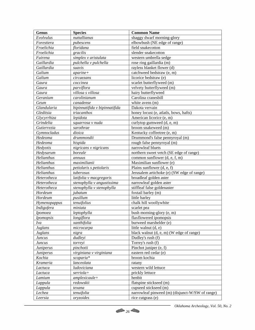
Oklahoma Archeology, Vol. 50, No. 2 26
Genus Species Common Name Evolvulus nuttallianus shaggy dwarf morning-glory Forestiera pubescens elbowbush (NE edge of range) Froelichia floridana field snakecotton Froelichia gracilis slender snakecotton Fuirena simplex v aristulata western umbrella sedge Gaillardia pulchella v pulchella rose ring gaillardia (m) Gaillardia suavis rayless blanket flower (d) Galium aparine+ catchweed bedstraw (e, m) Galium circaezans licorice bedstraw (e) Gaura coccinea scarlet butterflyweed (m) Gaura parviflora velvety butterflyweed (m) Gaura villosa s villosa hairy butterflyweed Geranium carolinianum Carolina cranesbill Geum canadense white avens (m) Glandularia bipinnatifida v bipinnatifida Dakota vervain Gleditsia triacanthos honey locust (e, atlatls, bows, hafts) Glycyrrhiza lepidota American licorice (e, m) Grindelia squarrosa v nuda curlytop gumweed (d, e, m) Gutierrezia sarothrae broom snakeweed (m) Gymnocladus dioica Kentucky coffeetree (e, m) Hedeoma drummondii Drummond's false pennyroyal (m) Hedeoma hispida rough false pennyroyal (m) Hedyotis nigricans v nigricans narrowleaf bluets Hedysarum boreale northern sweet vetch (SE edge of range) Helianthus annuus common sunflower (d, e, f, m) Helianthus maximilianii Maximilian sunflower (e) Helianthus petiolaris s petiolaris Plains sunflower (d, e, f) Helianthus tuberosus Jerusalem artichoke (e) (SW edge of range) Heterotheca latifolia v macgregoris broadleaf golden aster Heterotheca stenophylla v angustissima narrowleaf golden aster Heterotheca stenophylla v stenophylla stiffleaf false goldenaster Hordeum jubatum foxtail barley (m) Hordeum pusillum little barley Hymenopappus tenuifolius chalk hill woollywhite Indigofera miniata scarlet pea Ipomoea leptophylla bush morning-glory (e, m) Ipomopsis longiflora flaxflowered ipomopsis Iva xanthifolia burweed marshelder (e) Juglans microcarpa little walnut (d, e) Juglans nigra black walnut (d, e, m) (W edge of range) Juncus dudleyi Dudley's rush (f) Juncus torreyi Torrey's rush (f) Juniperus pinchotii Pinchot juniper (e, f) Juniperus virginiana v virginiana eastern red cedar (e) Kochia scoparia* broom kochia Krameria lanceolata ratany Lactuca ludoviciana western wild lettuce Lactuca serriola+ prickly lettuce Lamium amplexicaule+ henbit Lappula redowskii flatspine stickseed (m) Lappula texana cupseed stickseed (m) Lechea tenuifolia narrowleaf pinweed (m) (disjunct-W/SW of range) Leersia oryzoides rice cutgrass (e)
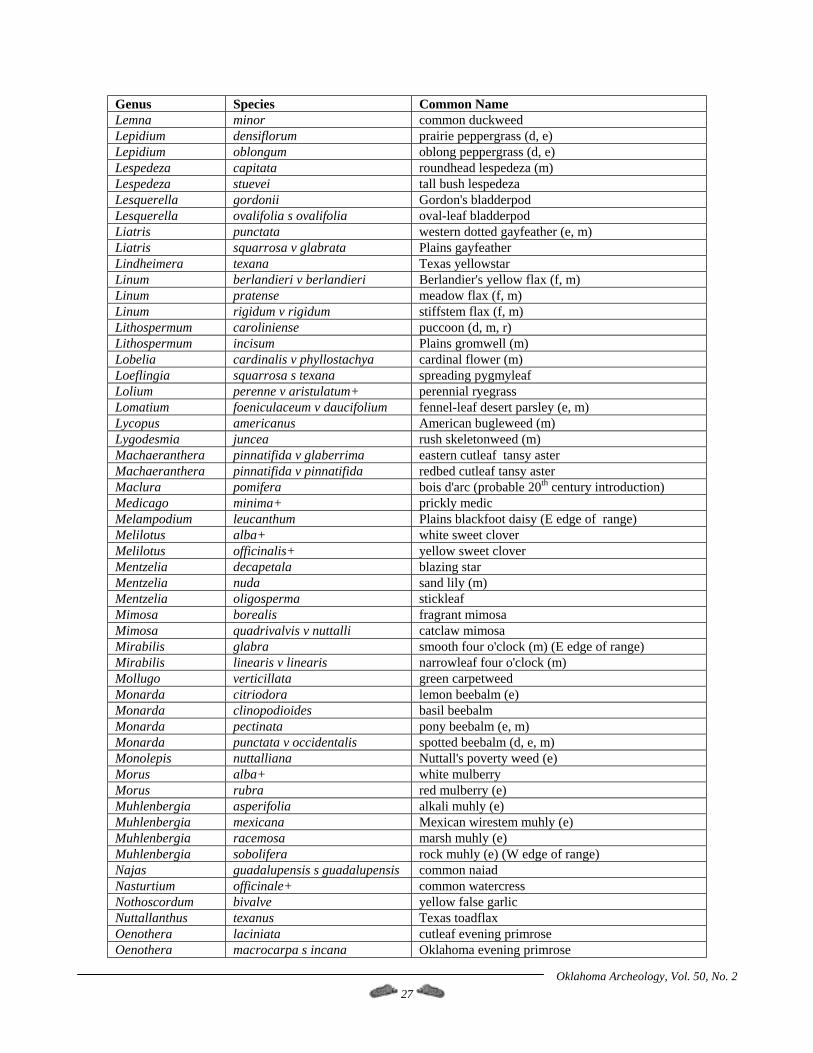
Oklahoma Archeology, Vol. 50, No. 2 27
Genus Species Common Name Lemna minor common duckweed Lepidium densiflorum prairie peppergrass (d, e) Lepidium oblongum oblong peppergrass (d, e) Lespedeza capitata roundhead lespedeza (m) Lespedeza stuevei tall bush lespedeza Lesquerella gordonii Gordon's bladderpod Lesquerella ovalifolia s ovalifolia oval-leaf bladderpod Liatris punctata western dotted gayfeather (e, m) Liatris squarrosa v glabrata Plains gayfeather Lindheimera texana Texas yellowstar Linum berlandieri v berlandieri Berlandier's yellow flax (f, m) Linum pratense meadow flax (f, m) Linum rigidum v rigidum stiffstem flax (f, m) Lithospermum caroliniense puccoon (d, m, r) Lithospermum incisum Plains gromwell (m) Lobelia cardinalis v phyllostachya cardinal flower (m) Loeflingia squarrosa s texana spreading pygmyleaf Lolium perenne v aristulatum+ perennial ryegrass Lomatium foeniculaceum v daucifolium fennel-leaf desert parsley (e, m) Lycopus americanus American bugleweed (m) Lygodesmia juncea rush skeletonweed (m) Machaeranthera pinnatifida v glaberrima eastern cutleaf tansy aster Machaeranthera pinnatifida v pinnatifida redbed cutleaf tansy aster Maclura pomifera bois d'arc (probable 20th century introduction) Medicago minima+ prickly medic Melampodium leucanthum Plains blackfoot daisy (E edge of range) Melilotus alba+ white sweet clover Melilotus officinalis+ yellow sweet clover Mentzelia decapetala blazing star Mentzelia nuda sand lily (m) Mentzelia oligosperma stickleaf Mimosa borealis fragrant mimosa Mimosa quadrivalvis v nuttalli catclaw mimosa Mirabilis glabra smooth four o'clock (m) (E edge of range) Mirabilis linearis v linearis narrowleaf four o'clock (m) Mollugo verticillata green carpetweed Monarda citriodora lemon beebalm (e) Monarda clinopodioides basil beebalm Monarda pectinata pony beebalm (e, m) Monarda punctata v occidentalis spotted beebalm (d, e, m) Monolepis nuttalliana Nuttall's poverty weed (e) Morus alba+ white mulberry Morus rubra red mulberry (e) Muhlenbergia asperifolia alkali muhly (e) Muhlenbergia mexicana Mexican wirestem muhly (e) Muhlenbergia racemosa marsh muhly (e) Muhlenbergia sobolifera rock muhly (e) (W edge of range) Najas guadalupensis s guadalupensis common naiad Nasturtium officinale+ common watercress Nothoscordum bivalve yellow false garlic Nuttallanthus texanus Texas toadflax Oenothera laciniata cutleaf evening primrose Oenothera macrocarpa s incana Oklahoma evening primrose
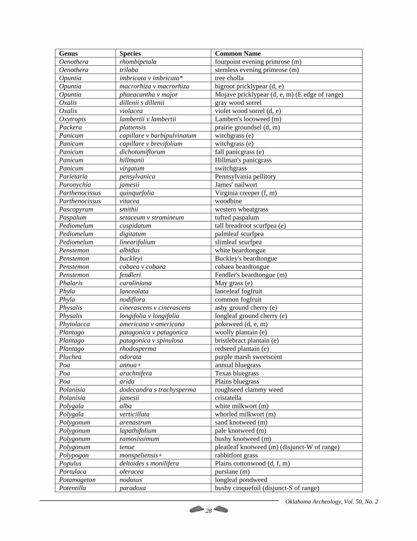
Oklahoma Archeology, Vol. 50, No. 2 28
Genus Species Common Name Oenothera rhombipetala fourpoint evening primrose (m) Oenothera triloba stemless evening primrose (m) Opuntia imbricata v imbricata* tree cholla Opuntia macrorhiza v macrorhiza bigroot pricklypear (d, e) Opuntia phaeacantha v major Mojave pricklypear (d, e, m) (E edge of range) Oxalis dillenii s dillenii gray wood sorrel Oxalis violacea violet wood sorrel (d, e) Oxytropis lambertii v lambertii Lambert's locoweed (m) Packera plattensis prairie groundsel (d, m) Panicum capillare v barbipulvinatum witchgrass (e) Panicum capillare v brevifolium witchgrass (e) Panicum dichotomiflorum fall panicgrass (e) Panicum hillmanii Hillman's panicgrass Panicum virgatum switchgrass Parietaria pensylvanica Pennsylvania pellitory Paronychia jamesii James' nailwort Parthenocissus quinquefolia Virginia creeper (f, m) Parthenocissus vitacea woodbine Pascopyrum smithii western wheatgrass Paspalum setaceum v stramineum tufted paspalum Pediomelum cuspidatum tall breadroot scurfpea (e) Pediomelum digitatum palmleaf scurfpea Pediomelum linearifolium slimleaf scurfpea Penstemon albidus white beardtongue Penstemon buckleyi Buckley's beardtongue Penstemon cobaea v cobaea cobaea beardtongue Penstemon fendleri Fendler's beardtongue (m) Phalaris caroliniana May grass (e) Phyla lanceolata lanceleaf fogfruit Phyla nodiflora common fogfruit Physalis cinerascens v cinerascens ashy ground cherry (e) Physalis longifolia v longifolia longleaf ground cherry (e) Phytolacca americana v americana pokeweed (d, e, m) Plantago patagonica v patagonica woolly plantain (e) Plantago patagonica v spinulosa bristlebract plantain (e) Plantago rhodosperma redseed plantain (e) Pluchea odorata purple marsh sweetscent Poa annua+ annual bluegrass Poa arachnifera Texas bluegrass Poa arida Plains bluegrass Polanisia dodecandra s trachysperma roughseed clammy weed Polanisia jamesii cristatella Polygala alba white milkwort (m) Polygala verticillata whorled milkwort (m) Polygonum arenastrum sand knotweed (m) Polygonum lapathifolium pale knotweed (m) Polygonum ramosissimum bushy knotweed (m) Polygonum tenue pleatleaf knotweed (m) (disjunct-W of range) Polypogon monspeliensis+ rabbitfoot grass Populus deltoides s monilifera Plains cottonwood (d, f, m) Portulaca oleracea purslane (m) Potamogeton nodosus longleaf pondweed Potentilla paradoxa bushy cinquefoil (disjunct-S of range)
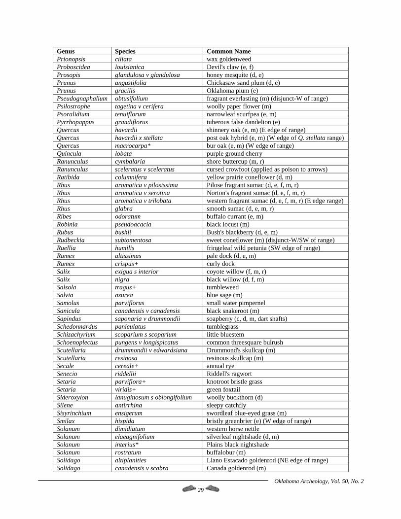
Oklahoma Archeology, Vol. 50, No. 2 29
Genus Species Common Name Prionopsis ciliata wax goldenweed Proboscidea louisianica Devil's claw (e, f) Prosopis glandulosa v glandulosa honey mesquite (d, e) Prunus angustifolia Chickasaw sand plum (d, e) Prunus gracilis Oklahoma plum (e) Pseudognaphalium obtusifolium fragrant everlasting (m) (disjunct-W of range) Psilostrophe tagetina v cerifera woolly paper flower (m) Psoralidium tenuiflorum narrowleaf scurfpea (e, m) Pyrrhopappus grandiflorus tuberous false dandelion (e) Quercus havardii shinnery oak (e, m) (E edge of range) Quercus havardii x stellata post oak hybrid (e, m) (W edge of Q. stellata range) Quercus macrocarpa* bur oak (e, m) (W edge of range) Quincula lobata purple ground cherry Ranunculus cymbalaria shore buttercup (m, r) Ranunculus sceleratus v sceleratus cursed crowfoot (applied as poison to arrows) Ratibida columnifera yellow prairie coneflower (d, m) Rhus aromatica v pilosissima Pilose fragrant sumac (d, e, f, m, r) Rhus aromatica v serotina Norton's fragrant sumac (d, e, f, m, r) Rhus aromatica v trilobata western fragrant sumac (d, e, f, m, r) (E edge range) Rhus glabra smooth sumac (d, e, m, r) Ribes odoratum buffalo currant (e, m) Robinia pseudoacacia black locust (m) Rubus bushii Bush's blackberry (d, e, m) Rudbeckia subtomentosa sweet coneflower (m) (disjunct-W/SW of range) Ruellia humilis fringeleaf wild petunia (SW edge of range) Rumex altissimus pale dock (d, e, m) Rumex crispus+ curly dock Salix exigua s interior coyote willow (f, m, r) Salix nigra black willow (d, f, m) Salsola tragus+ tumbleweed Salvia azurea blue sage (m) Samolus parviflorus small water pimpernel Sanicula canadensis v canadensis black snakeroot (m) Sapindus saponaria v drummondii soapberry (c, d, m, dart shafts) Schedonnardus paniculatus tumblegrass Schizachyrium scoparium s scoparium little bluestem Schoenoplectus pungens v longispicatus common threesquare bulrush Scutellaria drummondii v edwardsiana Drummond's skullcap (m) Scutellaria resinosa resinous skullcap (m) Secale cereale+ annual rye Senecio riddellii Riddell's ragwort Setaria parviflora+ knotroot bristle grass Setaria viridis+ green foxtail Sideroxylon lanuginosum s oblongifolium woolly buckthorn (d) Silene antirrhina sleepy catchfly Sisyrinchium ensigerum swordleaf blue-eyed grass (m) Smilax hispida bristly greenbrier (e) (W edge of range) Solanum dimidiatum western horse nettle Solanum elaeagnifolium silverleaf nightshade (d, m) Solanum interius* Plains black nightshade Solanum rostratum buffalobur (m) Solidago altiplanities Llano Estacado goldenrod (NE edge of range) Solidago canadensis v scabra Canada goldenrod (m)
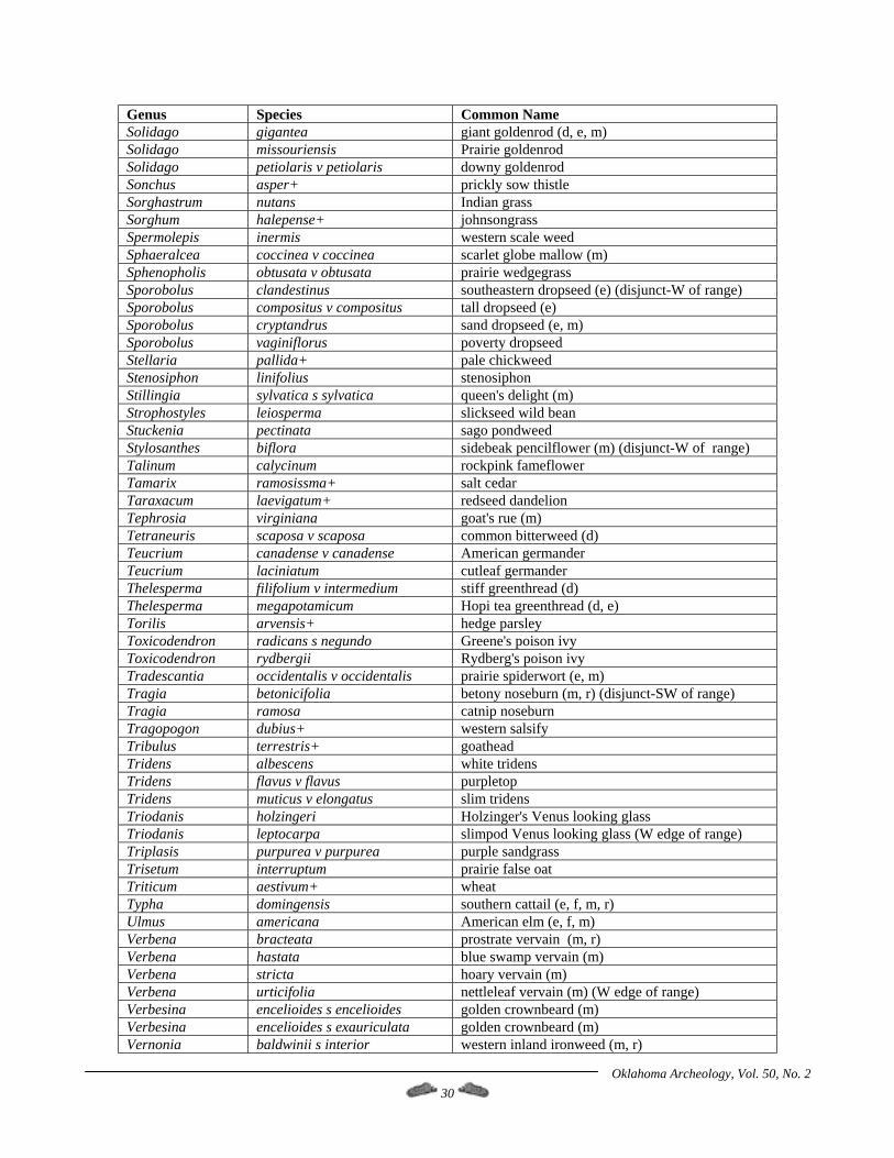
Oklahoma Archeology, Vol. 50, No. 2 30
Genus Species Common Name Solidago gigantea giant goldenrod (d, e, m) Solidago missouriensis Prairie goldenrod Solidago petiolaris v petiolaris downy goldenrod Sonchus asper+ prickly sow thistle Sorghastrum nutans Indian grass Sorghum halepense+ johnsongrass Spermolepis inermis western scale weed Sphaeralcea coccinea v coccinea scarlet globe mallow (m) Sphenopholis obtusata v obtusata prairie wedgegrass Sporobolus clandestinus southeastern dropseed (e) (disjunct-W of range) Sporobolus compositus v compositus tall dropseed (e) Sporobolus cryptandrus sand dropseed (e, m) Sporobolus vaginiflorus poverty dropseed Stellaria pallida+ pale chickweed Stenosiphon linifolius stenosiphon Stillingia sylvatica s sylvatica queen's delight (m) Strophostyles leiosperma slickseed wild bean Stuckenia pectinata sago pondweed Stylosanthes biflora sidebeak pencilflower (m) (disjunct-W of range) Talinum calycinum rockpink fameflower Tamarix ramosissma+ salt cedar Taraxacum laevigatum+ redseed dandelion Tephrosia virginiana goat's rue (m) Tetraneuris scaposa v scaposa common bitterweed (d) Teucrium canadense v canadense American germander Teucrium laciniatum cutleaf germander Thelesperma filifolium v intermedium stiff greenthread (d) Thelesperma megapotamicum Hopi tea greenthread (d, e) Torilis arvensis+ hedge parsley Toxicodendron radicans s negundo Greene's poison ivy Toxicodendron rydbergii Rydberg's poison ivy Tradescantia occidentalis v occidentalis prairie spiderwort (e, m) Tragia betonicifolia betony noseburn (m, r) (disjunct-SW of range) Tragia ramosa catnip noseburn Tragopogon dubius+ western salsify Tribulus terrestris+ goathead Tridens albescens white tridens Tridens flavus v flavus purpletop Tridens muticus v elongatus slim tridens Triodanis holzingeri Holzinger's Venus looking glass Triodanis leptocarpa slimpod Venus looking glass (W edge of range) Triplasis purpurea v purpurea purple sandgrass Trisetum interruptum prairie false oat Triticum aestivum+ wheat Typha domingensis southern cattail (e, f, m, r) Ulmus americana American elm (e, f, m) Verbena bracteata prostrate vervain (m, r) Verbena hastata blue swamp vervain (m) Verbena stricta hoary vervain (m) Verbena urticifolia nettleleaf vervain (m) (W edge of range) Verbesina encelioides s encelioides golden crownbeard (m) Verbesina encelioides s exauriculata golden crownbeard (m) Vernonia baldwinii s interior western inland ironweed (m, r)
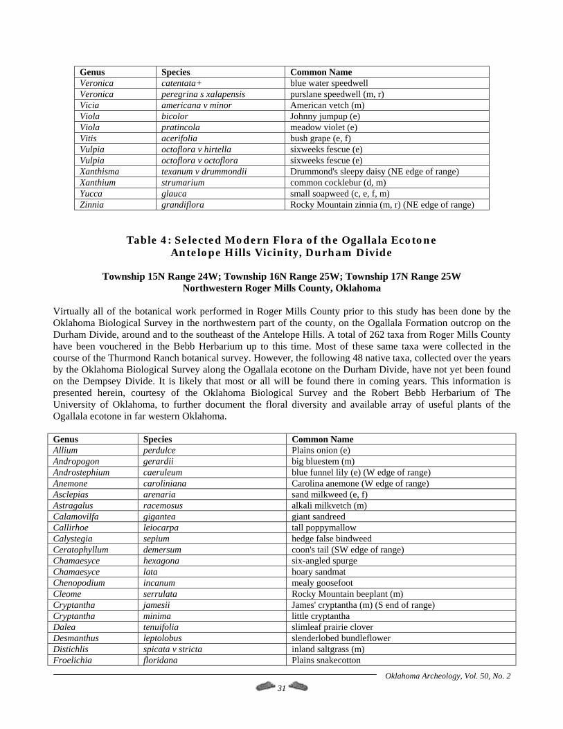
Oklahoma Archeology, Vol. 50, No. 2 31
Genus Species Common Name Veronica catentata+ blue water speedwell Veronica peregrina s xalapensis purslane speedwell (m, r) Vicia americana v minor American vetch (m) Viola bicolor Johnny jumpup (e) Viola pratincola meadow violet (e) Vitis acerifolia bush grape (e, f) Vulpia octoflora v hirtella sixweeks fescue (e) Vulpia octoflora v octoflora sixweeks fescue (e) Xanthisma texanum v drummondii Drummond's sleepy daisy (NE edge of range) Xanthium strumarium common cocklebur (d, m) Yucca glauca small soapweed (c, e, f, m) Zinnia grandiflora Rocky Mountain zinnia (m, r) (NE edge of range)
Table 4: Selected Modern Flora of the Ogallala Ecotone Antelope Hills Vicinity, Durham Divide
Township 15N Range 24W; Township 16N Range 25W; Township 17N Range 25W
Northwestern Roger Mills County, Oklahoma Virtually all of the botanical work performed in Roger Mills County prior to this study has been done by the Oklahoma Biological Survey in the northwestern part of the county, on the Ogallala Formation outcrop on the Durham Divide, around and to the southeast of the Antelope Hills. A total of 262 taxa from Roger Mills County have been vouchered in the Bebb Herbarium up to this time. Most of these same taxa were collected in the course of the Thurmond Ranch botanical survey. However, the following 48 native taxa, collected over the years by the Oklahoma Biological Survey along the Ogallala ecotone on the Durham Divide, have not yet been found on the Dempsey Divide. It is likely that most or all will be found there in coming years. This information is presented herein, courtesy of the Oklahoma Biological Survey and the Robert Bebb Herbarium of The University of Oklahoma, to further document the floral diversity and available array of useful plants of the Ogallala ecotone in far western Oklahoma. Genus Species Common Name Allium perdulce Plains onion (e) Andropogon gerardii big bluestem (m) Androstephium caeruleum blue funnel lily (e) (W edge of range) Anemone caroliniana Carolina anemone (W edge of range) Asclepias arenaria sand milkweed (e, f) Astragalus racemosus alkali milkvetch (m) Calamovilfa gigantea giant sandreed Callirhoe leiocarpa tall poppymallow Calystegia sepium hedge false bindweed Ceratophyllum demersum coon's tail (SW edge of range) Chamaesyce hexagona six-angled spurge Chamaesyce lata hoary sandmat Chenopodium incanum mealy goosefoot Cleome serrulata Rocky Mountain beeplant (m) Cryptantha jamesii James' cryptantha (m) (S end of range) Cryptantha minima little cryptantha Dalea tenuifolia slimleaf prairie clover Desmanthus leptolobus slenderlobed bundleflower Distichlis spicata v stricta inland saltgrass (m) Froelichia floridana Plains snakecotton
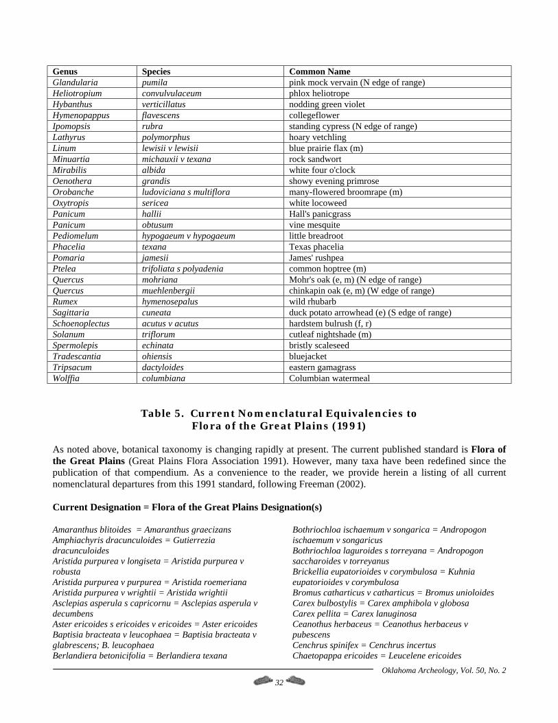
Oklahoma Archeology, Vol. 50, No. 2 32
Genus Species Common Name Glandularia pumila pink mock vervain (N edge of range) Heliotropium convulvulaceum phlox heliotrope Hybanthus verticillatus nodding green violet Hymenopappus flavescens collegeflower Ipomopsis rubra standing cypress (N edge of range) Lathyrus polymorphus hoary vetchling Linum lewisii v lewisii blue prairie flax (m) Minuartia michauxii v texana rock sandwort Mirabilis albida white four o'clock Oenothera grandis showy evening primrose Orobanche ludoviciana s multiflora many-flowered broomrape (m) Oxytropis sericea white locoweed Panicum hallii Hall's panicgrass Panicum obtusum vine mesquite Pediomelum hypogaeum v hypogaeum little breadroot Phacelia texana Texas phacelia Pomaria jamesii James' rushpea Ptelea trifoliata s polyadenia common hoptree (m) Quercus mohriana Mohr's oak (e, m) (N edge of range) Quercus muehlenbergii chinkapin oak (e, m) (W edge of range) Rumex hymenosepalus wild rhubarb Sagittaria cuneata duck potato arrowhead (e) (S edge of range) Schoenoplectus acutus v acutus hardstem bulrush (f, r) Solanum triflorum cutleaf nightshade (m) Spermolepis echinata bristly scaleseed Tradescantia ohiensis bluejacket Tripsacum dactyloides eastern gamagrass Wolffia columbiana Columbian watermeal
Table 5. Current Nomenclatural Equivalencies to Flora of the Great Plains (1991)
As noted above, botanical taxonomy is changing rapidly at present. The current published standard is Flora of the Great Plains (Great Plains Flora Association 1991). However, many taxa have been redefined since the publication of that compendium. As a convenience to the reader, we provide herein a listing of all current nomenclatural departures from this 1991 standard, following Freeman (2002). Current Designation = Flora of the Great Plains Designation(s) Amaranthus blitoides = Amaranthus graecizans Amphiachyris dracunculoides = Gutierrezia dracunculoides Aristida purpurea v longiseta = Aristida purpurea v robusta Aristida purpurea v purpurea = Aristida roemeriana Aristida purpurea v wrightii = Aristida wrightii Asclepias asperula s capricornu = Asclepias asperula v decumbens Aster ericoides s ericoides v ericoides = Aster ericoides Baptisia bracteata v leucophaea = Baptisia bracteata v glabrescens; B. leucophaea Berlandiera betonicifolia = Berlandiera texana
Bothriochloa ischaemum v songarica = Andropogon ischaemum v songaricus Bothriochloa laguroides s torreyana = Andropogon saccharoides v torreyanus Brickellia eupatorioides v corymbulosa = Kuhnia eupatorioides v corymbulosa Bromus catharticus v catharticus = Bromus unioloides Carex bulbostylis = Carex amphibola v globosa Carex pellita = Carex lanuginosa Ceanothus herbaceus = Ceanothus herbaceus v pubescens Cenchrus spinifex = Cenchrus incertus Chaetopappa ericoides = Leucelene ericoides

Oklahoma Archeology, Vol. 50, No. 2 33
Chamaecrista fasciculata = Cassia chamaecrista, C. fasciculata Chamaesyce fendleri = Euphorbia fendleri Chamaesyce geyeri = Euphorbia geyeri Chamaesyce glyptosperma = Euphorbia glyptosperma Chamaesyce maculata = Euphorbia maculata Chamaesyce missurica = Euphorbia missurica Chamaesyce nutans = Euphorbia nutans Chamaesyce prostrata = Euphorbia prostrata Chamaesyce serpens = Euphorbia serpens Chenopodium simplex = Chenopodium gigantospermum, C. hybridum Croptilon hookerianum v validum = Haplopappus validus Datura inoxia = Datura wrightii Delphinium carolinianum s virescens = Delphinium virescens; D. virescens s penardii Digitaria ciliaris = Digitaria adscendens Digitaria cognata s cognata = Leptoloma cognatum Dimorphocarpa candicans = Dimorphocarpa palmeri; Dithyrea wislizenii v palmeri Echinodorus berteroi = Echinodorus rostratus Eleocharis coloradoensis = Eleocharis parvula v anachaeta Eleocharis geniculata = Eleocharis caribaea Eleocharis macrostachya = Eleocharis xyridiformis Eleocharis palustris = Eleocharis smallii Eragrostis secundiflora s oxylepis = Eragrostis oxylepis Erioneuron pilosum v pilosum = Tridens pilosus Euthamia gymnospermoides = Solidago gymnospermoides; S. graminifolia v media Glandularia bipinnatifida v bipinnatifida = Verbena bipinnatifida Glandularia pumila = Verbena pumila Heterotheca stenophylla v angustifolia = Chrysopsis villosa v angustifolia Heterotheca stenophylla v stenophylla = Chrysopsis stenophylla Indigofera miniata = Indigofera miniata v leptosepala Liatris squarrosa = Liatris glabrata Linum berlandieri v berlandieri = Linum rigidum v berlandieri Linum lewisii v lewisii = Linum perenne v lewisii Machaeranthera pinnatifida v glaberrima = Haplopappus spinulosus s glaberrimus Machaeranthera pinnatifida v pinnatifida = Haplopappus spinulosus s australis; H. spinulosus s cotula; H. spinulosus s spinulosus Mimosa quadrivalvis v nuttallii = Schrankia nuttallii Minuartia michauxii v texana = Arenaria stricta s texana Nuttallanthus texanus = Linaria canadensis v texana Orobanche ludoviciana s multiflora = Orobanche multiflora Packera plattensis = Senecio plattensis Pascopyrum smithii = Agropyron smithii Pediomelum cuspidatum = Psoralea cuspidata Pediomelum digitatum = Psoralea digitata v digitata
Pediomelum hypogaeum v hypogaeum = Psoralea hypogaea v hypogaea Pediomelum linearifolium = Psoralea linearifolia Phyla lanceolata = Lippia lanceolata Phyla nodiflora = Lippia nodiflora v nodiflora; Phyla incisa Physalis cinerascens v cinerascens = Physalis viscosa s mollis v cinerascens; P. viscosa v cinerascens Pluchea odorata = Pluchea purpurascens Polanisia jamesii = Cristatella jamesii Prionopsis ciliata = Haplopappus ciliatus Pseudognaphalium obtusifolium = Gnaphalium obtusifolium Psilostrophe tagetina v cerifera = Psilostrophe villosa Psoralidium tenuiflorum = Psoralea tenuiflora v floribunda; P. tenuiflora v tenuiflora Quercus havardii v havardii = Quercus havardii Salsola tragus = Salsola iberica Salvia azurea = Salvia pitcheri Sapindus saponaria v drummondii = Sapindus drummondii Schizachyrium scoparium s scoparium = Andropogon scoparius Schoenoplectus acutus v acutus = Scirpus acutus Schoenoplectus pungens v longispicatus = Scirpus americanus; S. pungens Setaria parviflora = Setaria geniculata Sideroxylon lanuginosum s oblongifolium = Bumelia lanuginosa v oblongifolia Solidago altiplanities = new species Sporobolus clandestinus = Sporobolus asper v clandestinus Sporobolus compositus v compositus = Sporobolus asper Stuckenia pectinata = Potamogeton pectinatus Teucrium canadense v canadense = Teucrium canadense v virginicum Tetraneuris scaposa v scaposa = Hymenoxys scaposa v glabra; H. scaposa v scaposa Viola bicolor = Viola rafinesquii Vulpia octoflora v hirtella = Festuca octoflora Vulpia octoflora v octoflora = Festuca octoflora Xanthisma texanum s drummondii = Xanthisma texanum v drummondii
Acknowledgements The Dempsey Divide Research Foundation, Inc., the R.L. McGregor Herbarium, and the Kansas Biological Survey provided funding for this survey. We thank J. Byron Sudbury, Allison L. Thurmond, Susan I. Thurmond, Harold V. Werner, and Don G. Wyckoff for their constructive comments on initial drafts of this article.
Oklahoma Archeology, Vol. 50, No. 2 34
References Cited Antevs, Ernst 1955 Geologic-Climatic Dating in the West.
American Antiquity 20:317-335. Bement, Leland C. 2000 Bison, Nuts, and the Dempsey Divide.
Newsletter of the Oklahoma Archeological Survey 20(1):1-3.
Bement, Leland C. and Kent J. Buehler 1994 Preliminary Results from the Certain Site: A
Late Archaic Bison Kill in Western Oklahoma. Plains Anthropologist 39(148):173-183.
1998 Confirmation of a Southern Plains Late
Archaic Bison Jump. Paper presented at the 56th Annual Plains Conference, Bismarck, South Dakota.
Bowers, John R. 1967 Geology of the Cheyenne Area, Roger Mills
County, Oklahoma. Master of Science Thesis, University of Oklahoma. Norman, OK.
Bryson, Reid A., Robert U. Bryson, Emi Ito and Paul Morin 1995 An Archeoclimatology Workbook: High
Resolution, Site-Specific Climate Modeling for Field Scientists, Version 1.1.4. Center for Climatic Research, University of Wisconsin at Madison; and Department of Geology and Geophysics, University of Minnesota.
Buehler, Kent J. 1997 Where's the Cliff? Late Archaic Bison Kills in
the Southern Plains. Plains Anthropologist 42(159):135-143.
Caran, S. Christopher and Robert W. Baumgardner, Jr. 1990 Quaternary Stratigraphy and
Paleoenvironments of the Texas Rolling Plains. Bulletin of the Geological Society of America 102:768-785.
Carr, Jerry E. and DeRoy L. Bergman 1976 Reconnaissance of the Water Resources of
the Clinton Quadrangle, West-Central Oklahoma. Oklahoma Geological Survey, Hydrologic Atlas 5. Norman, OK.
Cheatham, Scooter, Marshall C. Johnston and Lynn Marshall 1995 The Useful Wild Plants of Texas, the
Southeastern and Southwestern United States, the Southern Plains, and Northern
Texas; Volume 1: Abronia to Arundo. Useful Wild Plants, Inc. Austin, TX.
Collins, J.T., S. Collins, J. Horak, D. Mulhern, W. Busby, C.C. Freeman, and G. Wallace 1995 An Illustrated Guide to Endangered and
Threatened Species in Kansas. University Press of Kansas.
Czaplewski, Nicholas J., J. Peter Thurmond, and Don G. Wyckoff 2001 Wild Horse Creek #1: A Late Miocene
(Clarendonian-Hemphillian) Vertebrate Fossil Assemblage in Roger Mills County, Oklahoma. Oklahoma Geology Notes 61(3):60-67.
Elias, Thomas S. and Peter A. Dykeman 1982 Field Guide to North American Edible Wild
Plants. Van Nostrand Reinhold Company. New York, NY.
Foreman, Grant (editor) 1937 Adventure on Red River: Report on the
Exploration of the Headwaters of the Red River by Captain Randolph B. Marcy and Captain G. B. McClellan. University of Oklahoma Press. Norman.
Freeman, Craig C. 1998a The Flora of Konza Prairie: A Historical
Review and Contemporary Patterns. In Grassland Dynamics: Long-term Ecological Research in Tallgrass Prairie, pp. 69-80. Oxford University Press. Oxford, England.
1998b Vascular Plants New to Kansas. Sida 18:593-
604. 2002 Checklist of the Vascular Plants of the
Grassland Biome of Central North America (http://nhm.ku.edu/herbarium/herbinfo.html). R.L. McGregor Herbarium, University of Kansas. Lawrence, KS.
Freeman, Craig C., William H. Busby, Chris L. Lauver, Kelly Kindscher, J. Elliott, and Douglas A. Eifler 1997 A Natural Areas Inventory of the Ft.
Leavenworth Military Reservation, Leavenworth, Kansas. Kansas Biological Survey Report Number 77. Lawrence, KS.
Freeman, Craig C., William H. Busby, Chris L. Lauver and Paul M. Liechti 1998 A Systematic Survey for Protected and
Rare Species and the Identification of
Oklahoma Archeology, Vol. 50, No. 2 35
Riparian Natural Communities along the Republican River in North-Central Kansas. Kansas Biological Survey Report Number 85. Lawrence, KS.
Freeman, Craig C., Caleb A. Morse, and J. Peter Thurmond n.d. Preliminary Survey of the Vascular Flora
along the Ogallala Ecotone on the Dempsey Divide, Roger Mills County, Oklahoma. Manuscript in preparation for publication by the R.L. McGregor Herbarium, University of Kansas. Lawrence, KS.
Freeman, Craig C. and Eileen K. Schofield 1991 Roadside Wildflowers of the Southern
Great Plains. University Press of Kansas. Lawrence, KS.
Frye, John C. and A. Byron Leonard 1957 Studies of Cenozoic Geology along the
Eastern Margin of the Texas High Plains. University of Texas, Bureau of Economic Geology, Report of Investigations 32. Austin, TX.
Gilmore, Melvin R. 1931 Dispersal by Indians: A Factor in the
Extension of Discontinuous Distribution of Certain Species of Native Plants. Papers of the Michigan Academy of Science, Arts, and Letters 13:89-94.
Great Plains Flora Association 1977 Atlas of the Flora of the Great Plains. Iowa
State University Press. Ames, IA. 1991 Flora of the Great Plains. University Press of
Kansas. Lawrence, KS. Gustavson, Thomas C. and Robert J. Finley 1985 Late Cenozoic Geomorphic Evolution of the
Texas Panhandle and Northeastern New Mexico: Case Studies of Structural Controls on Regional Drainage Development. The University of Texas, Bureau of Economic Geology, Report of Investigations 148. Austin, TX.
Gustavson, Thomas E. and Dale A. Winkler 1988 Depositional Facies of the Miocene-Pliocene
Ogallala Formation, Northwestern Texas and Eastern New Mexico. Geology 16:203-206.
Gutentag, Edwin D., Frederick J. Heimes, Noel C. Krothe, Richard R. Luckey, and John B. Weeks 1984 Geohydrology of the High Plains Aquifer in
Parts of Colorado, Kansas, Nebraska, New Mexico, Oklahoma, South Dakota, Texas, and Wyoming. U.S. Geological Survey Professional Paper 1400-B. Washington, DC.
Hall, Stephen A. 1982 Late Holocene Paleoecology of the Southern
Plains. Quaternary Research 17:391-407. 1988 Environment and Archaeology of the Central
Osage Plains. Plains Anthropologist 33(120):203-218.
1990 Channel Trenching and Climatic Change in the
Southern U.S. Great Plains. Geology 18:342-345.
Harrington, H.D. 1967 Edible Native Plants of the Rocky
Mountains. University of New Mexico Press. Albuquerque, NM.
1972 Western Edible Wild Plants. University of
New Mexico Press. Albuquerque, NM. Holliday, Vance T. 1989 Middle Holocene Drought on the Southern
High Plains. Quaternary Research 31(1):74-82.
Hutchens, Alma R. 1974 Indian Herbalogy of North America. Fifth
edition. Merco. Windsor, Ontario. Johnson, Forrest L. and Bruce W. Hoagland 2001 Catalog of the Woody Plants of Oklahoma
(http://www.biosurvey.ou.edu/shrub/cover.htm. Oklahoma Biological Survey. Norman, OK.
Kindscher, Kelly 1987 Edible Wild Plants of the Prairie: An
Ethnobotanical Guide. University Press of Kansas. Lawrence, KS.
1992 Medicinal Wild Plants of the Prairie: An
Ethnobotanical Guide. University Press of Kansas. Lawrence, KS.
1995 Prairie Plant Guilds: An Ordination of Prairie
Plant Species based on Ecological and Morphological Traits. Vegetation 117:29-50.
Oklahoma Archeology, Vol. 50, No. 2 36
Kindscher, Kelly, P. Manfredi, M. Britton, M. Devidova, and D. Hurlburt 1998 Testing Prairie Plants with Ethnobotanical
Importance for Anti-Cancer and Anti-AIDS Compounds. Journal of Ethnobiology 18:229-245.
Kindscher, Kelly, Shari Wilson, Alexandra Fraser, and Chris Lauver 1996 Vegetation of Western Kansas Playa Lakes.
Kansas Biological Survey. Lawrence, KS. Lauver, Chris L., Kelly Kindscher, D. Fraser-Langendoen, and R. Schneider 1999 A Classification of the Natural Vegetation of
Kansas. Southwest Naturalist 44:421-443. Loring, Hillary, Kelly Kindscher, Todd Aschenbach, and Alexandra Fraser 1999 A Survey of Large Ranches and Prairie
Remnants in the Flint Hills and Central Tall Grass Prairie Ecoregion of Kansas. Kansas Biological Survey Report Number 88. Lawrence, KS.
Loring, Hillary, Kelly Kindscher, and Mike Bullerman 2000 An Inventory of the Central Mixed Grass
Prairie Ecoregion in Kansas, Oklahoma, and Texas. Kansas Biological Survey Report Number 97. Lawrence, KS.
Mabry, Richard 1977 Plantcraft: A Guide to the Everyday Use of
Wild Plants. Universe Books. New York, NY. Martinez, Joseph D., Kenneth S. Johnson, and James T. Neal 1998 Sinkholes in Evaporite Rocks. American
Scientist 86(1):38-51. Mayes, Steven G., Mark A. McGinley and Charles R. Werth 1998 Clonal Population Structure and Genetic
Variation in Sand-Shinnery Oak, Quercus havardii (Fagaceae). American Journal of Botany 85(11):1609-1617.
Meltzer, David J. and Michael B. Collins 1987 Prehistoric Water Wells on the Southern High
Plains: Clues to Altithermal Climate. Journal of Field Archaeology 14(1):9-28.
Moerman, Daniel E. 1986 Medicinal Plants of Native America.
University of Michigan Museum of Anthropology, Research Reports in
Ethnobotany, Contribution 2, Volumes 1 and 2. Ann Arbor, MI.
Motley, Timothy J. 1994 The Ethnobotany of Sweet Flag, Acorus
calamus (Araceae). Economic Botany 48(4):397-412.
Muller, Cornelius H. 1941 Ecological Control of Hybridization in
Quercus: A Factor in the Mechanism of Evolution. Evolution 6(2):147-161.
1951 The Oaks of Texas. Contributions from the
Texas Research Foundation 1(3):21-177. Pan Terra, Inc. 1994 A Correlated History of Earth. Pan Terra,
Inc. Alton, MN. Reeves, Brian 1973 The Concept of an Altithermal Cultural Hiatus
in Northern Plains Prehistory. American Antiquity 75(5):1221-1253.
Reeves, C.C., Jr. and Judy A. Reeves 1996 The Ogallala Aquifer of the Southern High
Plains. Estacado Books. Lubbock, TX. Ryder, Paul D. 1996 Ground Water Atlas of the United States,
Segment 4: Oklahoma and Texas. U.S. Geological Survey, Hydrologic Investigations Atlas 730-E. Reston, VA.
Schambach, Frank F. 2000 Spiroan Traders, the Sanders Site, and the
Plains Interaction Sphere. Plains Anthropologist 45(171): 7-33.
Schumm, S.A. and R.F. Hadley 1957 Arroyos and the Semiarid Cycle of Erosion.
American Journal of Science 255:161-174. Seni, Steven J. 1980 Sand-Body Geometry and Depositional
Systems, Ogallala Formation, Texas. University of Texas, Bureau of Economic Geology, Report of Investigations 105. Austin, TX.
Shannon, Kim 2001 Western Workings. Oklahoma Conservator
Winter 2001:7.
Oklahoma Archeology, Vol. 50, No. 2 37
2002 Dempsey Divide, Roger Mills County. Registry News 2002 Edition:10-11.
Taylor, Constance E.S. and R. John Taylor 1983 New Species, New Combinations and Notes
on the Goldenrods (Euthamia and Solidago - Asteraceae). Sida 10(2): 176-183.
Thompson, Sue A. 2000 Acoraceae, C. Agardh: Sweet-Flag Family. In
Flora of North America, Flora of North America Editorial Committee (editors), Volume 22, pp. 124-127. Oxford University Press, New York, NY.
Thurmond, J. Peter 1990 Late Paleoindian Utilization of the Dempsey
Divide on the Southern Plains. Plains Anthropological Society Memoir 25.
1991a A Late Archaic/Woodland Lunate Stone
Burial in Far Western Oklahoma. Bulletin of the Texas Archeological Society 60:241-255.
1991b Archeology of the Dempsey Divide, A Late
Archaic/Woodland Hotspot on the Southern Plains. Bulletin of the Oklahoma Anthropological Society 39:103-157.
1991c An Additional Paleoindian Component on the
Dempsey Divide: 34RM602B, Thurmond Ranch #94B, Roger Mills County, Oklahoma. Bulletin of the Oklahoma Anthropological Society 39:159-169.
1997 A Recently Recorded Late Woodland
Campsite on the Dempsey Divide: 34RM773, Thurmond Ranch #112. Oklahoma Archeology 45(4):9-11.
Thurmond, J. Peter and Amy E. Picarella 1999 34RM448, Thurmond Ranch #27, A Late
Prehistoric Campsite on the Dempsey Divide in Roger Mills County, Oklahoma. Oklahoma Archeology 47(5):12-16.
Thurmond, J. Peter and Allison L. Thurmond 2001 The Rain on the Plains: Feast or Famine.
Oklahoma Archeology 49(3):8-10.
Thurmond, J. Peter and Don G. Wyckoff 1998 Late Pleistocene Dunes along the Dempsey
Divide, Roger Mills County, Oklahoma. Current Research in the Pleistocene 15:139-143.
1999 The Calf Creek Horizon in Northwestern Oklahoma. Plains Anthropologist 44(169):231-250.
2001 Prehistory and Past Environments of the
Dempsey Divide (http://www.geocities.com/ dempseydiv/). The Dempsey Divide Research Foundation, Inc. Cheyenne, OK.
Thurmond, J. Peter, Don G. Wyckoff and Charles B. Batchelor 1998 A Rapid Return to Woodland Conditions? Or
How Site 34RM451 Returned to Waterfront Property. Oklahoma Archeology 46(3):5-8.
Toomey, Rickard S., III, Michael D. Blum, and Salvatore Valastro 1993 Late Quaternary Climates and Environments
of the Edwards Plateau. Global and Planetary Change 7:299-320.
Tull, Delena 1999 Edible and Useful Plants of Texas and the
Southwest. University of Texas Press. Austin, TX.
United States Department of Agriculture, Natural Resources Conservation Service 2001 The PLANTS Database, Version 3.1
(http://plants/usda.gov). National Plant Data Center. Baton Rouge, LA.
Wandsnider, Lu Ann 1997 The Roasted and the Boiled: Food
Composition and Heat Treatment with Special Emphasis on Pit-Hearth Cooking. Journal of Anthropological Archaeology 16:1-48.
Wiedeman, V.E. and William T. Penfound 1960 A Preliminary Study of the Shinnery of
Oklahoma. The Southwestern Naturalist 5(3):117-122.
Oklahoma Archeology, Vol. 50, No. 2 38
Archaeology at the Sam Noble Oklahoma Museum of Natural History Don G. Wyckoff, Sam Noble Oklahoma Museum of Natural History
Archaeological work at the Museum primarily involves research and curation. This latter means organization and care of the archaeological collection, which is the largest collection numerically (over 3 million specimens) held at the Museum. Moved from three different, but equally terrible, storage areas in 1999, the 8000 boxes of artifacts were shelved according to the six Oklahoma research areas long recognized by the Oklahoma Archaeological Survey as well as by state or country of origin (the holdings do include small, but interesting materials from states around Oklahoma and from Central and South American countries and even Japan). As of April 1, 2001, Peggy (Flynn) Rubenstein replaced Sue Richter as Curatorial Assistant for the archaeology collection. Formerly Lab Director and researcher with the Oklahoma Archaeological Survey (and the now defunct Archaeological Research and Management Center), Peggy quickly got to work getting the collection better organized for research and/or exhibit needs. She perceptively refocused the archaeology lab so that it could function to clean and catalogue collections as well as do preliminary research. Equally important she organized space in the R.E. Bell Collections Area so that a few graduate students would have table and computer access in order to conduct collections research linked to their graduate studies or graduate employment. By the fall of 2001, Peggy and graduate assistant Beau Schriever were back fully engaged with the records and artifact collections, all of which are now housed in excellent quarters in the 12,000 sq. ft. storage area on the 5th floor of the Museum. Year’s accumulations of field notes, maps, photos, slides, and other records pertaining to site collections held at the Museum are being systematically stored in appropriate file holders and cabinets. She and Beau are grateful for the volunteer assistance of OAS members (and Museum docents) Betty Flora and Jean Cochrane. Starting in January, we have undergraduate student Michelle Barry enrolled in credit hours to learn curation and conservation concerns with archaeological materials. She will spend the spring semester working with the several collections and
diverse records (W.P.A. and privately donated) from the Stamper site in Texas County. A key site in the recognition of prehistoric villagers in the Oklahoma panhandle, the Stamper site material was studied in the mid-1940s and published upon in the Texas Society bulletin by Virginia Watson. Since then notable surface collections from the site were donated to the Museum by OAS members Vincent Dale and Ralph White (both now deceased but who had lived in Guymon). Among other things, Michelle will be compiling information on all the Stamper site holdings as well as repackaging artifacts so that they are conserved in more appropriate ways. In 2001, the widows of OAS members James Hemming (Carnegie) and Ralph White kindly donated significant archaeological collections to SNOMNH. OAS member Jim Cox assisted with the Hemming collection, some of which was adequately recorded regarding the sites it came from. Other important parts of this collection are being provenienced, and as soon as each part is documented to the site, that material is catalogued. Assisting Peggy in getting the Hemming material accessioned and catalogued were O.U. students Susan de Quevedo and Wendell Nelson. Clearly, documentation and care of the collections are major tasks being performed at the Museum, and Peggy’s organizational skills and resolve are integral to accomplishing these tasks. Just recently she and Beau located, inventoried, and prepared for loan the large collection from the Hooks site, one of the Fourche Maline midden mounds dug by WPA crews back in the early 1940s. This collection and copies of its records were loaned to Dr. George Odell who will be using it to teach students how to analyze diverse archaeological materials. Research is also ongoing at SNOMNH. Curator Don Wyckoff is working with several graduate students who work in space provided at the Museum. Doctoral student Warren Lail is studying artifacts borrowed from the Seton Museum at Philmont Scout Ranch in addition to materials recovered there last summer during the O.U. archaeological field school that he co-directed with
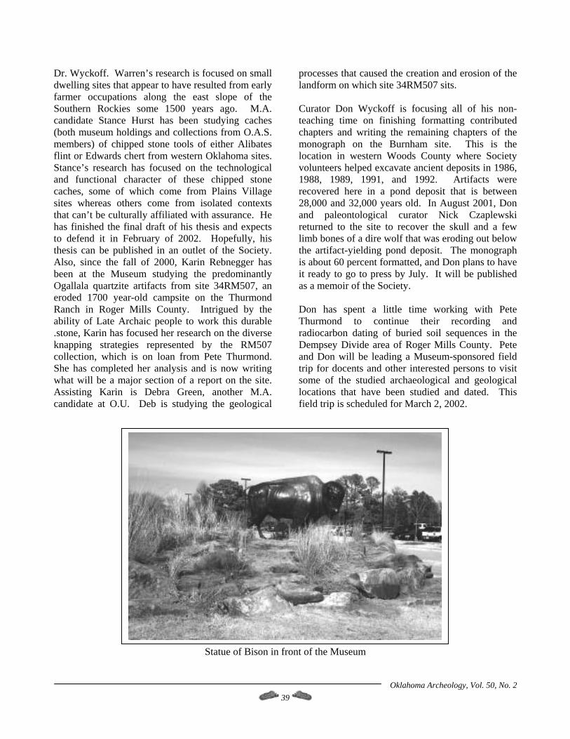
Oklahoma Archeology, Vol. 50, No. 2 39
Dr. Wyckoff. Warren’s research is focused on small dwelling sites that appear to have resulted from early farmer occupations along the east slope of the Southern Rockies some 1500 years ago. M.A. candidate Stance Hurst has been studying caches (both museum holdings and collections from O.A.S. members) of chipped stone tools of either Alibates flint or Edwards chert from western Oklahoma sites. Stance’s research has focused on the technological and functional character of these chipped stone caches, some of which come from Plains Village sites whereas others come from isolated contexts that can’t be culturally affiliated with assurance. He has finished the final draft of his thesis and expects to defend it in February of 2002. Hopefully, his thesis can be published in an outlet of the Society. Also, since the fall of 2000, Karin Rebnegger has been at the Museum studying the predominantly Ogallala quartzite artifacts from site 34RM507, an eroded 1700 year-old campsite on the Thurmond Ranch in Roger Mills County. Intrigued by the ability of Late Archaic people to work this durable .stone, Karin has focused her research on the diverse knapping strategies represented by the RM507 collection, which is on loan from Pete Thurmond. She has completed her analysis and is now writing what will be a major section of a report on the site. Assisting Karin is Debra Green, another M.A. candidate at O.U. Deb is studying the geological
processes that caused the creation and erosion of the landform on which site 34RM507 sits. Curator Don Wyckoff is focusing all of his non-teaching time on finishing formatting contributed chapters and writing the remaining chapters of the monograph on the Burnham site. This is the location in western Woods County where Society volunteers helped excavate ancient deposits in 1986, 1988, 1989, 1991, and 1992. Artifacts were recovered here in a pond deposit that is between 28,000 and 32,000 years old. In August 2001, Don and paleontological curator Nick Czaplewski returned to the site to recover the skull and a few limb bones of a dire wolf that was eroding out below the artifact-yielding pond deposit. The monograph is about 60 percent formatted, and Don plans to have it ready to go to press by July. It will be published as a memoir of the Society. Don has spent a little time working with Pete Thurmond to continue their recording and radiocarbon dating of buried soil sequences in the Dempsey Divide area of Roger Mills County. Pete and Don will be leading a Museum-sponsored field trip for docents and other interested persons to visit some of the studied archaeological and geological locations that have been studied and dated. This field trip is scheduled for March 2, 2002.
Statue of Bison in front of the Museum
Oklahoma Archeology, Vol. 50, No. 2 40
Mark Your Calendar
DRIPPING SPRINGS KNAP-IN
March 8-10 Where? Dripping Springs State Park (Clovis Point Area) West of Okmulgee, OK. South of Okmulgee State Park on Hwy 56. Northeast of Okemah. Why? An opportunity for Flintknappers to meet and visit with other knappers, a chance to learn some new knapping techniques, an opportunity to buy/swap/trade for flint and knapping tools, a chance for the general public to observe knapping demos and an opportunity for knappers to sell their items to the general public. How much? We'll be asking for a $3 donation (voluntary) from the knappers that attend to reimburse the organizers for the cost for renting the covered pavilion. Venders are required to pay 10 percent sales fee to the park. For more information : Neil Garrison, Yukon, OK Phone 405-373-0309, or e-mail: [email protected]
Spiro Mounds Activities
March 16, 2002
The 15th Annual Family Kite Flite Day at the Spiro Mounds Archaeological Center will be held 9 am - 5 pm on Saturday, March 16. Entry and most activities will be free although there will be $1 per car parking donation requested. It is a great day to celebrate St. Pat’s Day and the end of winter. The Spiro Mounds Archaeological Center has hosted a day of spring fun and learning since 1987. Each year over 600 folks bring lawn chairs, blankets, kids and kites and fly the winds along with fancier kites flown by "Professional" kiters. Demonstrations by kiters from Oklahoma and Arkansas will include stunt kites, parafoils and incredibly large kites. About 100 donated kites will be given away by drawing. Younger kids can have fun in the children area. There will be a sandbox where children can dig for shells, jewels, coins and a special token that can be turned in for a kite. There will be a bubble making area that always draws a crowd. Vendors will have Arts and Crafts, Native American art and other things for sale. There will also be food vendors and the grounds are perfect for a family picnic. We will dedicate a new Nature Trail created by Eagle Scout Brian DeHem of Boy Scout Troop 123, Greenwood, Arkansas. New trail signs were just installed on the historic trails and they will also be dedicated. From 12:30-1:30 p.m., there will be a Crawdad Fishing Derby where the "fisherman" with the largest Crawdad and the Crawmom with the most babies will get a prize. A fee of $1 will be charged to cover the bait and line. We will also
have a crawdad pool where kids can pick up a live crawdad and enter a drawing for a prize. The Oklahoma Historical Society, the Spiro Mounds Archaeological Center and the Spiro Mounds Development Association with help from the Fort Coffee Fire Department and the Scout Troops of Spiro sponsor this event. For further information, call Dennis Peterson at 918-962-2062.
March 20-21, 2002 Are you ready to get rid of the dreary, cold winter and welcome a warm spring? Wonder about the importance of spring to Native Americans? Come celebrate the beginning of spring a little differently this year. On March 20 and 21, there will be a series of guided Vernal Equinox walks at the Spiro Mounds Archaeological Center where you can learn from an archaeologist and ask questions too. Each day there will be walks at 11 am, 2 pm and 7 pm led by archaeologist and manager Dennis Peterson. Each walk will take two hours and require a mile of easy walking. Mr. Peterson will discuss this unique prehistoric Native American mound site and why some of the mounds are lined up for the sunsets of the Solstices and Equinoxes. He will tell the history of the excavations, Native American ceremonies and stories, and tales of unusual happenings associated with the mounds. There is a fee of $3 for adults and $2 for children for this tour. No reservations are required unless you are bringing a big group. The Spiro Mounds Archaeological Center is the only prehistoric Native American site open to the public in Oklahoma and is administered by the Oklahoma Historical Society. The Center is open Wednesday through Saturday from 9 am to 5 pm and Sunday from noon until 5 pm. Admission is free although donations are appreciated. The Center is located 3 miles east of Spiro, OK on highway 9/271 and 4 miles north on Spiro Mounds Road. If you need more information or wish to schedule a group or school tour, call 918-962-2062 or email at [email protected]. Dennis Peterson Spiro Mounds Archaeological Center
Missouri Archaeological Society Meeting
April 26-28, 2002
At the board meeting of the Missouri Archaeological Society (MAS) on 3 Feb the board agreed to extend a special invitation to members of the Oklahoma Anthropological Society to attend the MAS annual meeting which will be held in Springfield, MO April 26-28
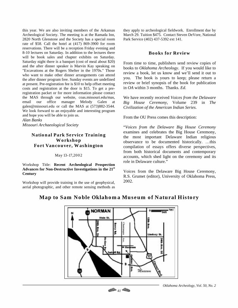
Oklahoma Archeology, Vol. 50, No. 2 41
this year. We are also inviting members of the Arkansas Archeological Society. The meeting is at the Ramada Inn, 2820 North Glenstone and the Society has a special room rate of $58. Call the hotel at (417) 869-3900 for room reservations. There will be a reception Friday evening and 8-10 lectures on Saturday. In addition to the lectures there will be book sales and chapter exhibits on Saturday. Saturday night there is a banquet (cost of meal about $20) and the after dinner speaker is Marvin Kay speaking on "Excavations at the Rogers Shelter in the 1970s." Those who want to make other dinner arrangements can attend the after dinner program free. Sunday events are undefined at present. Pre-registration fee is $10 to help offset meeting costs and registration at the door is $15. To get a pre-registration packet or for more information please contact the MAS through our website, coas.missouri.edu/mas, email our office manager Melody Galen at [email protected] or call the MAS at (573)882-3544. We look forward to an enjoyable and interesting program and hope you will be able to join us. Alan Banks Missouri Archaeological Society
National Park Service Training Workshop
Fort Vancouver, Washington
May 13-17,2002 Workshop Title: Recent Archeological Prospection Advances for Non-Destructive Investigations in the 21st Century Workshop will provide training in the use of geophysical, aerial photographic, and other remote sensing methods as
they apply to archeological fieldwork. Enrollment due by March 29. Tuition $475. Contact Steven DeVore, National Park Service (402) 437-5392 ext 141.
Books for Review From time to time, publishers send review copies of books to Oklahoma Archeology. If you would like to review a book, let us know and we’ll send it out to you. The book is yours to keep; please return a review or brief synopsis of the book for publication in OA within 3 months. Thanks. Ed. We have recently received Voices from the Delaware Big House Ceremony, Volume 239 in The Civilization of the American Indian Series. From the OU Press comes this description: “Voices from the Delaware Big House Ceremony examines and celebrates the Big House Ceremony, the most important Delaware Indian religious observance to be documented historically. …this compilation of essays offers diverse perspectives, from both historical documents and contemporary accounts, which shed light on the ceremony and its role in Delaware culture.” Voices from the Delaware Big House Ceremony, R.S. Grumet (editor), University of Oklahoma Press, 2002.
Map to Sam Noble Oklahoma Museum of Natural History
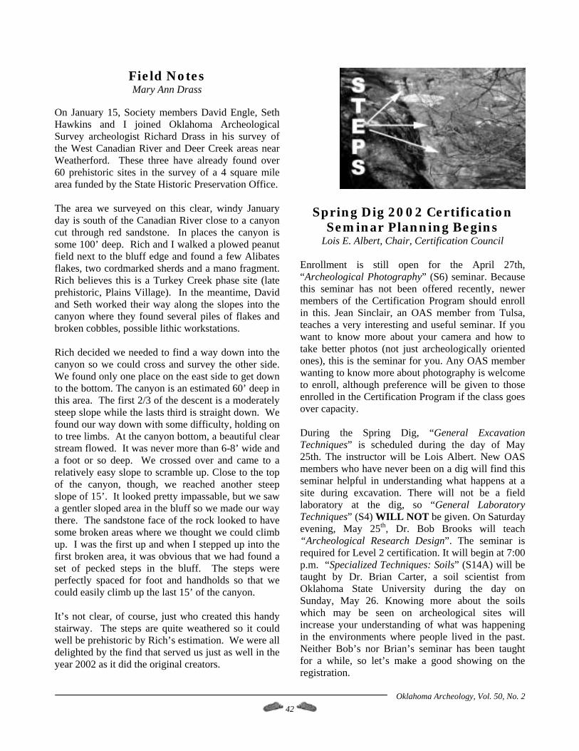
Oklahoma Archeology, Vol. 50, No. 2 42
Field Notes Mary Ann Drass
On January 15, Society members David Engle, Seth Hawkins and I joined Oklahoma Archeological Survey archeologist Richard Drass in his survey of the West Canadian River and Deer Creek areas near Weatherford. These three have already found over 60 prehistoric sites in the survey of a 4 square mile area funded by the State Historic Preservation Office. The area we surveyed on this clear, windy January day is south of the Canadian River close to a canyon cut through red sandstone. In places the canyon is some 100’ deep. Rich and I walked a plowed peanut field next to the bluff edge and found a few Alibates flakes, two cordmarked sherds and a mano fragment. Rich believes this is a Turkey Creek phase site (late prehistoric, Plains Village). In the meantime, David and Seth worked their way along the slopes into the canyon where they found several piles of flakes and broken cobbles, possible lithic workstations. Rich decided we needed to find a way down into the canyon so we could cross and survey the other side. We found only one place on the east side to get down to the bottom. The canyon is an estimated 60’ deep in this area. The first 2/3 of the descent is a moderately steep slope while the lasts third is straight down. We found our way down with some difficulty, holding on to tree limbs. At the canyon bottom, a beautiful clear stream flowed. It was never more than 6-8’ wide and a foot or so deep. We crossed over and came to a relatively easy slope to scramble up. Close to the top of the canyon, though, we reached another steep slope of 15’. It looked pretty impassable, but we saw a gentler sloped area in the bluff so we made our way there. The sandstone face of the rock looked to have some broken areas where we thought we could climb up. I was the first up and when I stepped up into the first broken area, it was obvious that we had found a set of pecked steps in the bluff. The steps were perfectly spaced for foot and handholds so that we could easily climb up the last 15’ of the canyon. It’s not clear, of course, just who created this handy stairway. The steps are quite weathered so it could well be prehistoric by Rich’s estimation. We were all delighted by the find that served us just as well in the year 2002 as it did the original creators.
Spring Dig 2002 Certification Seminar Planning Begins
Lois E. Albert, Chair, Certification Council Enrollment is still open for the April 27th, “Archeological Photography” (S6) seminar. Because this seminar has not been offered recently, newer members of the Certification Program should enroll in this. Jean Sinclair, an OAS member from Tulsa, teaches a very interesting and useful seminar. If you want to know more about your camera and how to take better photos (not just archeologically oriented ones), this is the seminar for you. Any OAS member wanting to know more about photography is welcome to enroll, although preference will be given to those enrolled in the Certification Program if the class goes over capacity. During the Spring Dig, “General Excavation Techniques” is scheduled during the day of May 25th. The instructor will be Lois Albert. New OAS members who have never been on a dig will find this seminar helpful in understanding what happens at a site during excavation. There will not be a field laboratory at the dig, so “General Laboratory Techniques” (S4) WILL NOT be given. On Saturday evening, May 25th, Dr. Bob Brooks will teach “Archeological Research Design”. The seminar is required for Level 2 certification. It will begin at 7:00 p.m. “Specialized Techniques: Soils” (S14A) will be taught by Dr. Brian Carter, a soil scientist from Oklahoma State University during the day on Sunday, May 26. Knowing more about the soils which may be seen on archeological sites will increase your understanding of what was happening in the environments where people lived in the past. Neither Bob’s nor Brian’s seminar has been taught for a while, so let’s make a good showing on the registration.

Oklahoma Archeology, Vol. 50, No. 2 43
Enrollment Form For Certification Program Seminars _____ S7 Lithic Technology and Analysis, Saturday, March 9, 9:00 a.m. Instructor: Don Wyckoff. Place:
Oklahoma Archeological Survey conference room. YOU MUST ENROLL IN THIS SEMINAR EARLY BECAUSE PRE-SEMINAR READING IS REQUIRED.
OAS Spring Meeting will be April 5 & 6 at Sam Noble Oklahoma Museum of Natural History. _____ S6 Archeological Photography, Saturday, April 27, 9:00 a.m.. Instructor: Jean Sinclair. Place:
Oklahoma Archeological Survey conference room. _____S3 General Excavation Techniques, Saturday, May 25, 8:30 a.m. until early or mid-afternoon. OAS
Spring Dig, picnic pavilion at campground. Instructor: Lois Albert. _____S11 Archeological Research Design, Saturday, May 25, 7:00 p.m. OAS spring Dig, picnic pavilion
at campground. Instructor: Dr. Bob Brooks. _____S14a Specialized Techniques: Soils, Sunday, May 16, 8:30 a.m. to 4:00 + p.m. Meet at the picnic
pavilion at campground. Instructor: Dr. Brian Carter. Please include $2.00 per seminar as an enrollment fee (make checks payable to OU/Archeological Survey). In seminars with limited enrollment, preference will be given to members who are in the Certification Program. Some seminars may have an additional fee for reading or study materials; this is usually a nominal amount. The readings for the Lithics seminar will cost $22.70, including shipping/handling. Indicate: ___ I am a current OAS member. ___ I am enrolled in the Certification Program. Name: ____________________________________________________________________ Address: ____________________________________________________________________ City/State/Zip: ________________________________________________________________ Telephone: (____) _______________ (W), (____) _______________ (H) email address: Send this completed form with your payment (check/money order - make check to Oklahoma Archeological Survey) to:
Lois Albert, Certification Council Chair Oklahoma Archeological Survey The University of Oklahoma 111 E. Chesapeake Norman OK 73019-5111 Telephone: (405) 325-7207; FAX (405) 325-7604 e-mail: [email protected]

Oklahoma Archeology, Vol. 50, No. 2 44
Oklahoma Anthropological Society Membership Form
MEMBERSHIP CATEGORY DESIRED:
( ) Active $20.00 Receive 4 issues of Oklahoma Archeology, Journal of the Oklahoma Anthropological Society
( ) Contributing $30.00 Receive 4 issues of Oklahoma Archeology, Journal of the Oklahoma Anthropological Society and any memoirs occasionally published by the Society at no additional cost
( ) Sustaining $40.00 Receive 4 issues of Oklahoma Archeology, Journal of the Oklahoma Anthropological Society and any memoirs occasionally published by the Society at no additional cost
( ) Associate $5.00 For one additional member of your immediate family $10.00 for two or more
( ) Life $500.00 Provides all benefits of a contributing membership throughout the lifetime of member
( ) Institutional – Domestic $30.00 ( ) Institutional – Foreign $35.00 ( ) OAS New Member Handbook $5.00 (recommended to new members)
Name:_____________________________________________________ Address:___________________________________________________ City:________________________ State:______ Zip+4 _____________
Make check payable to: Oklahoma Anthropological Society Attn: Pete Thurmond Rt. 1, Box 62B Cheyenne OK 73628
---------------------------------------------------------------------------------------------------------------------------------------
2002 OAS Spring Dig Registration Form List all members of your party: ______________________________________________________________________________________
Address: ______________________________________________________________________________________
Circle the dates you will attend: May 25 26 27 28 29 30 31 June 1 2 Enclose $15.00 each adult up to two then $10.00 each over two. $5.00 each for weekend. $5.00 each for children. Make check to: OAS Dig Comm. and mail to: OAS Dig Comm., 1049 S. W 2nd. Moore, OK.73160-2211