Embed Size (px)
Citation preview

Improving Availability, Access and Use of Climate Information in EthiopiaEthiopia
Tufa Dinku1, Kinfe Hilemariam2, David Grimes3, and Stephen Connor1
1. International Research Institute for Climate and Society (IRI)
The Earth Institute at Columbia University, [email protected]
2. National Meteorology Agency, Addis Ababa, Ethiopia 3. Department of Meteorology, University of Reading, UK
OutlineOutline
• The ProblemThe Problem
• Suggested solutionSuggested solution
• Implementation in EthiopiaImplementation in Ethiopia
• Scaling upScaling up
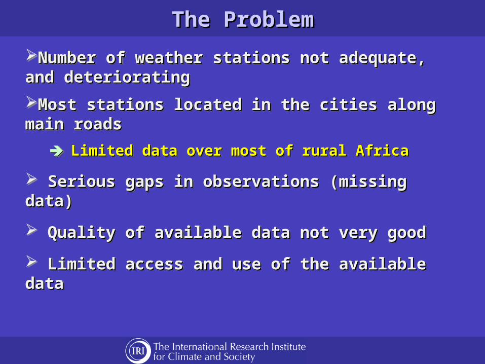
The ProblemThe Problem
Number of weather stations not adequate, and Number of weather stations not adequate, and deterioratingdeteriorating
Most stations located in the cities along main roadsMost stations located in the cities along main roads
Limited data over most of rural AfricaLimited data over most of rural Africa
Serious gaps in observations (missing data)Serious gaps in observations (missing data)
Quality of available data not very goodQuality of available data not very good
Limited access and use of the available dataLimited access and use of the available data
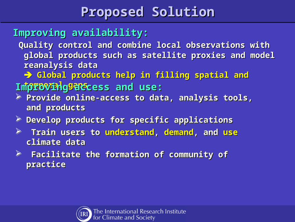
Proposed SolutionProposed SolutionProposed SolutionProposed Solution
Improving availability:Improving availability: Quality control and combine local observations with global Quality control and combine local observations with global
products such as satellite proxies and model reanalysis dataproducts such as satellite proxies and model reanalysis data Global products help in filling spatial and temporal gapsGlobal products help in filling spatial and temporal gaps
Improving access and use:Improving access and use: Provide online-access to data, analysis tools, and productsProvide online-access to data, analysis tools, and products Develop products for specific applicationsDevelop products for specific applications Train users to Train users to understandunderstand, , demanddemand, and , and useuse climate data climate data Facilitate the formation of community of practiceFacilitate the formation of community of practice
Improving access and use:Improving access and use: Provide online-access to data, analysis tools, and productsProvide online-access to data, analysis tools, and products Develop products for specific applicationsDevelop products for specific applications Train users to Train users to understandunderstand, , demanddemand, and , and useuse climate data climate data Facilitate the formation of community of practiceFacilitate the formation of community of practice
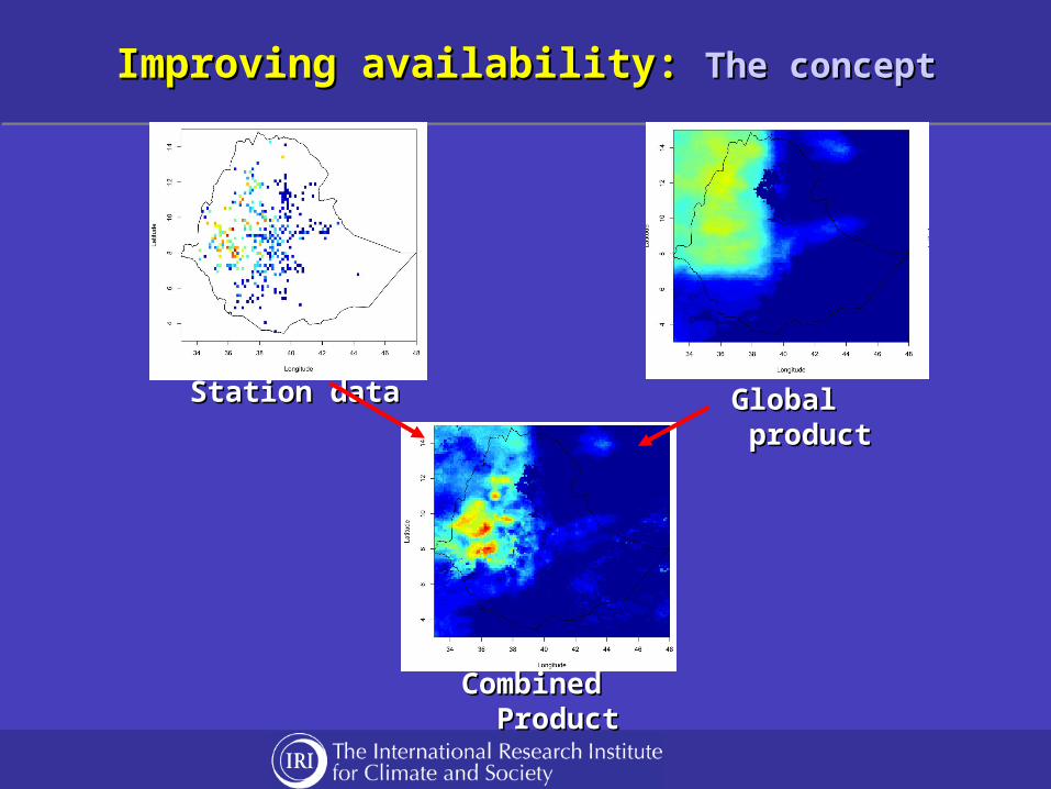
Improving availability: Improving availability: The conceptThe conceptImproving availability: Improving availability: The conceptThe concept
Station dataStation data Global productGlobal product
Combined Combined ProductProduct
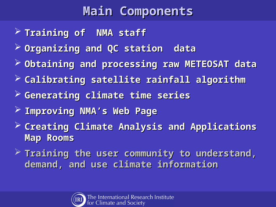
Main ComponentsMain Components
Training of NMA staffTraining of NMA staff
Organizing and QC station dataOrganizing and QC station data
Obtaining and processing raw METEOSAT dataObtaining and processing raw METEOSAT data
Calibrating satellite rainfall algorithmCalibrating satellite rainfall algorithm
Generating climate time seriesGenerating climate time series
Improving NMA’s Web PageImproving NMA’s Web Page
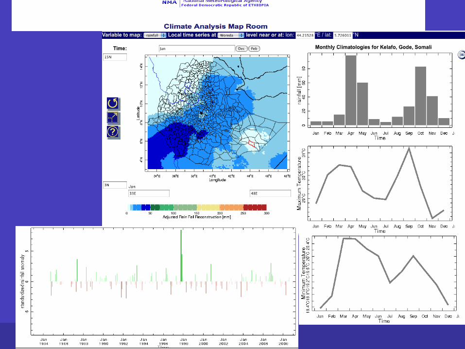
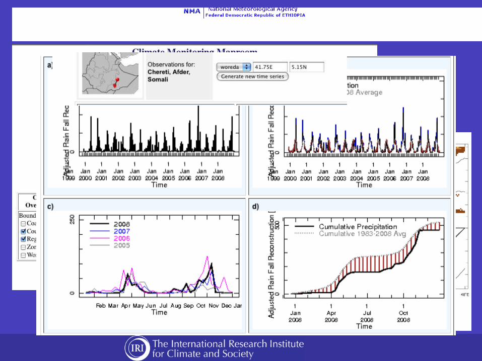
Creating Climate Analysis and Applications Map Creating Climate Analysis and Applications Map Rooms Rooms
Training the user community to understand, demand, Training the user community to understand, demand, and use climate informationand use climate information
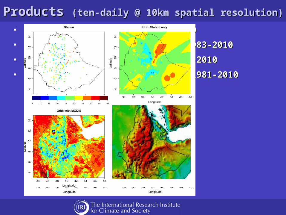
Products Products (ten-daily @ 10km spatial resolution)(ten-daily @ 10km spatial resolution)
• Gridded station data: 1981-2010Gridded station data: 1981-2010
• Satellite Rainfall Estimates: 1983-2010Satellite Rainfall Estimates: 1983-2010
• Combined Rainfall Product: 1983-2010Combined Rainfall Product: 1983-2010
• Combined Temperature Products: 1981-2010Combined Temperature Products: 1981-2010
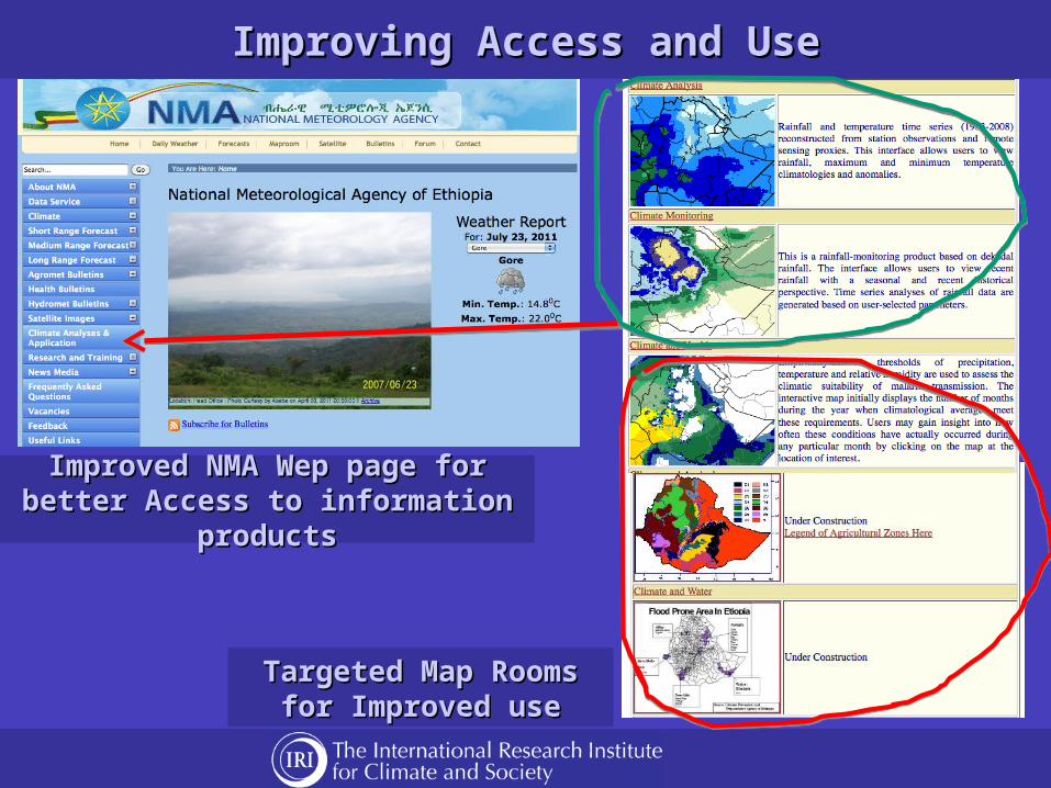
Improving Access and UseImproving Access and Use
Improved NMA Wep page for better Improved NMA Wep page for better Access to information productsAccess to information products
Targeted Map Rooms for Targeted Map Rooms for Improved useImproved use
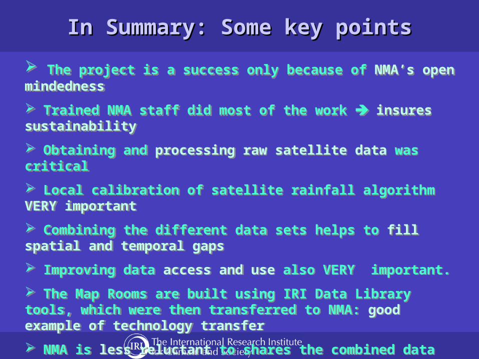
In Summary: Some key pointsIn Summary: Some key points
The project is a success only because of NMA’s open mindedness
Trained NMA staff did most of the work insures sustainability
Obtaining and processing raw satellite data was critical
Local calibration of satellite rainfall algorithm VERY important
Combining the different data sets helps to fill spatial and temporal gaps
Improving data access and use also VERY important.
The Map Rooms are built using IRI Data Library tools, which were then transferred to NMA: good example of technology transfer
NMA is less reluctant to shares the combined data
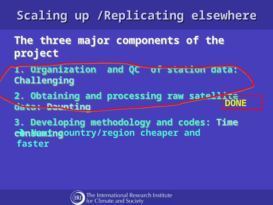
Scaling up /Replicating elsewhereScaling up /Replicating elsewhere
The three major components of the project
1. Organization and QC of station data: Challenging
2. Obtaining and processing raw satellite data: Daunting
3. Developing methodology and codes: Time consuming
The three major components of the project
1. Organization and QC of station data: Challenging
2. Obtaining and processing raw satellite data: Daunting
3. Developing methodology and codes: Time consuming
DONE
Next country/region cheaper and faster

Thank YouThank You


Evaluation of ProductsEvaluation of ProductsComparing the satellite rainfall estimate with other productsComparing the satellite rainfall estimate with other products
Comparison of the current Comparison of the current satellite rainfall estimate satellite rainfall estimate with other widely used with other widely used satellite products at spatial satellite products at spatial resolution of 0.25resolution of 0.25oo and and dekadal aggregation.dekadal aggregation.
ETHTAM
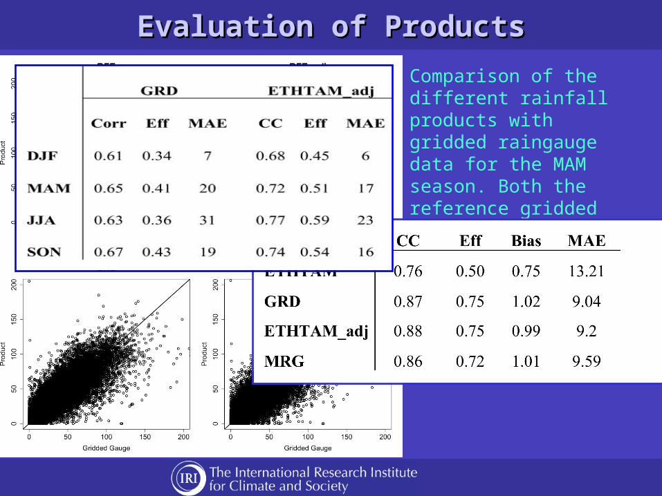
Evaluation of ProductsEvaluation of Products
Comparison of the different rainfall products with gridded raingauge data for the MAM season. Both the reference gridded gauge and the four products have been averaged over 0.25o lat/long boxes