Embed Size (px)
Citation preview

EUREF 2010 - June 2-5, Gävle, Sweden
Estimating Zenith Total Delay Fields by Estimating Zenith Total Delay Fields by
using Groundusing Ground--Based GPS networkBased GPS network
R. Pacione, B. Pace, C. Sciarretta
e-GEOS S.p.A. CGS - Matera, Italy
F. VespeAgenzia Spaziale Italiana, CGS - Matera, Italy

EUREF 2010 - June 2-5, Gävle, Sweden
Outlook of the talkOutlook of the talk
�Why do we need ZTD fields?
�How these fields can be derived from point wise ZTD estimates?
�Experimental data
�Future activities

EUREF 2010 - June 2-5, Gävle, Sweden
ZTD field exploitationZTD field exploitation
SAR product geolocation
GNSS Navigation
GNSS Ground-Based & Space-Based Met.

EUREF 2010 - June 2-5, Gävle, Sweden
GNSS NavigationGNSS Navigation
ZTD field in a region of interest may
serve to derive tropospheric
correction, to be removed from the
GNSS signal, at the desired user
location for positioning services.
The effectiveness of such a
correction resides mainly on the
density of the available GNSS
network and on the possibility of a
fast GNSS data processing to
minimize the latency between the
ZTD field delivery and the time of
the requested correction.SCUTUM (www.scutumgnss.eu) introduces EGNOS (European Geostationary Navigation Overlay Service) in the dangerous goods transports for Europe. The SCUTUM project is managed by
the European GNSS Supervisory Authority (GSA) through EU 7FP funds.

EUREF 2010 - June 2-5, Gävle, Sweden
GNSS GroundGNSS Ground--based and Spacebased and Space--based Meteorologybased Meteorology
RO is not a stand-alone technique
since to get pressure, temperature
and water vapour pressure from
refractivity profile external
information (ECMWF/NCEP) are
needed.
The availability of reliable ZTD fields in the area of the occultation
event let us to use the ZTD as additional data in the lower
troposphere.
( ) ( ))(
)(
2)(1 2hT
hP
hT
hP wetaahN +=
( )T
P
R
mmg
T
P
Ra
gmaN
Ra
gm
dh
dP wetwetdrywetdrydry−
++−=2
1
3
1
∫ ∫∞
−
∞
−
−− +==GPSground GPSground
wdh
T
Pa
T
PadhhNZTD )(10)(10
22166

EUREF 2010 - June 2-5, Gävle, Sweden
Synthetic Aperture Radar (SAR) product geolocationSynthetic Aperture Radar (SAR) product geolocation
Atmospheric effects are no more
negligible in accurate geolocation (at 1-
m level) of the products generated by
the most advanced SAR satellite
missions, as Cosmo-SKYMed (ASI) and
Terrasar-X (DLR).
Even if a routine correction at a
global scale of the SAR images can
be more easily implemented by
means of a tropospheric model,
specific and refined applications for a
given area may profit from the
experimental GNSS ZTD fields.
SAR Satellite
troposphere
ZTD
AOI 0
10km
200km
1500kmionosphereTEC

EUREF 2010 - June 2-5, Gävle, Sweden
TroposphericTropospheric models: UNB3m and GPT&SAASTAMOINEN models: UNB3m and GPT&SAASTAMOINEN
(1/2)(1/2)
� UNB3m computes the hydrostatic and wet zenith delays according to:
- Saastamoinen model
- prediction of the meteorological parameters with annual mean
and amplitude for temperature, pressure and relative humidity.
� GPT&SAASTAMOINEN computes the hydrostatic and wet zenith delays according to:
- Saastamoinen model
- GPT model (based on a spherical harmonic expansion).

EUREF 2010 - June 2-5, Gävle, Sweden
ONSA, ZIMM and MILO geographical location
TroposphericTropospheric models: UNB3m and GPT&SAASTAMOINEN models: UNB3m and GPT&SAASTAMOINEN
(2/2)(2/2)

EUREF 2010 - June 2-5, Gävle, Sweden
From point wise ZTD estimates to the ZTD FieldsFrom point wise ZTD estimates to the ZTD Fields
First Step:
ZTD residuals
Second Step:
residual grids
Third Step:
ZTD at a given location
MSLRES
MSL,2RES
MSL,4RES
MSL,3RES
MSL,1RES

EUREF 2010 - June 2-5, Gävle, Sweden
From point wise ZTD estimates to the ZTD Fields: First From point wise ZTD estimates to the ZTD Fields: First
StepStepTo obtain residuals ZTD at mean sea level, we need estimated and modelled ZTD values.
Following UNB3m and its look-up table barometric pressure ( ), temperature ( ), relative humidity ( ), temperature
lapse rate ( ) and water vapour pressure height factor ( ) are determinated for a given latitude and day of the year.
T RHβλ
P
MSL MOD, MSL MSL
ZWD ZWD RES −=

EUREF 2010 - June 2-5, Gävle, Sweden
From point wise ZTD estimates to the ZTD Fields: Second From point wise ZTD estimates to the ZTD Fields: Second
StepStep
We get gridded residuals at mean sea level using Ordinary
Kriging interpolation.
The outputs are 0.50x0.50 residual
grids.
EUREF 2010 - June 2-5, Gävle, Sweden
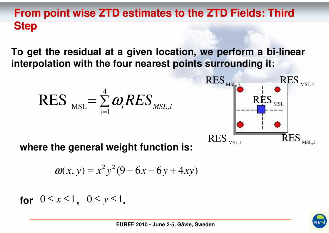
From point wise ZTD estimates to the ZTD Fields: Third From point wise ZTD estimates to the ZTD Fields: Third
StepStep
∑=
=4
1i,MSL
RESiMSLi
RESω
To get the residual at a given location, we perform a bi-linear interpolation with the four nearest points surrounding it:
MSLRES
MSL,2RES
MSL,4RES
MSL,3RES
MSL,1RES
where the general weight function is:
for , .
)4669(),(22
xyyxyxyx +−−=ω
10 ≤≤ x 10 ≤≤ y

EUREF 2010 - June 2-5, Gävle, Sweden
Experimental dataExperimental data
GPS ground-based network
We test our procedure over 1 week (from 10MAR14 to 10MAR20) of ZTD estimates
coming from 130 European GPS stations mostly belonging to the EPN Network.
a) Residual field b) ZTD field c) Error field

EUREF 2010 - June 2-5, Gävle, Sweden
ZTD Field Validation (1/2)ZTD Field Validation (1/2)
�in red GPS-derived,
�in blue Gridded,
�in green VMF1_Site
(http://ggosatm.hg.tuwien.ac.at/DELAY/readme.html)
ZT
D[m
m]
BZRG ZTD time-series BRUS ZTD time-seriesZIMM ZTD time-series

EUREF 2010 - June 2-5, Gävle, Sweden
ZTD Field Validation (2/2)ZTD Field Validation (2/2)
The agreement of “GPS vs Gridded” is
better than “GPS vs VMF1_Site” and it is
partly to be expected since GPS-derived
ZTDs are the input data for computing
the ZTD fields.0,938,1-2,3GPS-VMF1_site
0,992,8-1,1GPS-Gridded
CCSTD [mm]
MEAN [mm]

EUREF 2010 - June 2-5, Gävle, Sweden
Summary & future activitiesSummary & future activities
�We present a method for estimating ZTD fields by using ground-based GPS network and we foresee some fields of
applications.
�More sites will be included in the GPS network in order to have
a denser and more homogenous coverage.
�The validation activities will continue by considering a longer
time series and other ZTD fields as those provided by the University of Technology of Vienna.
�Improve the ZTD residuals computation by considering the tropospheric gradients.

EUREF 2010 - June 2-5, Gävle, Sweden
ReferencesReferences
Boehm, J., Heinkelmann, R. and Schuh, H., “Short Note: a global model of pressure and temperature for geodetic applications”, Journal of Geodesy, Vol. 81, no. 10, pp. 679-683, 2007.
Leandro, R., Langley, R.B., and Santos, M.C., “UNB Neutral Atmosphere Models: Development and Performance”,Proceedings of the Institute of Navigation National Technical Meeting, 18-20 January, 2006, Monterrey, CA, USA, pp. 564-573, 2006.
McCarthy, D.D. and Petit, G., IERS Conventions (2003). IERS Technical Note 32, Verlag des Bundesamtsfür Kartographie und Geodäsie, Frankfurt am Main, 2004.
Zheng, Y., Feng, Y. and Bai, Z., “Grid Residual Tropospheric Corrections for Improved Differential GPS Positioning over the Victoria GPS Network (GPSnet)”, Journal of Global Positioning Systems, Vol. 4, no. 1-2, pp. 284-290, 2005.