Embed Size (px)
Citation preview

ALOS PI Symposium 2008, Rhodes, Greece. 3-7 November 2008
Establishment of monitoring and hazard level assessment system for landslide disasters by ALOS, and its application
Ryoichi Furuta(1), Atsushi Yashima(2), Kazuhide Sawada(2), and Hiroshi Fukuoka(3)
(1) Remote Sensing Technology Center of Japan, 1-9-9 Roppongi, Minatoku, 106-0032 Tokyo, Japan
(2) Gifu University, 1-1 Yanagido, 501-1193 Gifu, Japan(3) Kyoto University, Gokasho, Uji, 611-0011 Kyoto, Japan

ALOS PI Symposium 2008, Rhodes, Greece. 3-7 November 2008
Research Objective
• Prototype landslide monitoring and assessment system proposed by the authors in 2003.– GIS, Analysis tools for estimation of landslide stability.– Existing information (DEM, Vector Map, etc.) was used.– Latest information (topography, land-cover, etc.) is necessary.
• To improve a landslide monitoring and assessment system, we apply the ALOS data.– DSM generation tool– Collapse-type landslide recognition tool
• To understand capability of PALSAR DInSAR to monitor very slow landslide movement on the steep slope.– Application to Zentoku landslide

ALOS PI Symposium 2008, Rhodes, Greece. 3-7 November 2008
Outline
• Improvement of “Landslide Monitoring and Assessment System”
• Analytical result of DInSAR of Zentoku Landslide.
• Conclusions

ALOS PI Symposium 2008, Rhodes, Greece. 3-7 November 2008
Improvement of a prototype system of “Landslide Monitoring and Assessment System”
• GIS based information system– Attribution Analysis Tool based on statistics– Landslide hazard level estimation tool based on
photogrammetric analysis and numerical analysis
• Tools for ALOS data utilization– Image reconstruction (L1B1 to Geocorded image)– Pan-sharpen image generation (modified HSI)– DSM generation– Collapse-type landslide recognition (based on face recognition
technique)

ALOS PI Symposium 2008, Rhodes, Greece. 3-7 November 2008
DEM&
Vector Map
ImageProcessingTool
DSMGeneratingTool
LandslideRecognitionTool
DInSARProcessor
Creep-type
Collapse-type AttributionAnalysisTool
Landslide
LandslideSimulationTool
PhotogrammetricAnalysisTool
LandslideSimulationTool
LandslideSimulationTool Very simple model
Numerical model
Numerical model
GIS
All of information is puttogether on the GIS platform

ALOS PI Symposium 2008, Rhodes, Greece. 3-7 November 2008
About DSM Generation Tool
• DSM generation tool– DSM is generated from a pair of PRISM image.
• Backward view – Nadir view• Forward view – Nadir view• Backward view – Forward view
– Generate DSM with several pixel spacing.• 2.5m ~ 90m
– Including filtering and interpolating function.• Noise (Residue) cut• IDW method for interpolation
– Accuracy of generated DSM (20m pixel spacing)• Approx. 12m for elevation (validated by 50m res. DEM)• Approx. 6m for horizontal direction (validated by 1:2500 vector
map)– Application
• Landslide stability, simulation, mapping, etc…

ALOS PI Symposium 2008, Rhodes, Greece. 3-7 November 2008
Processing flow of DSM Generation Tool
PRISM L1B1(Nadir)
PRISM L1B1(Oblique)
Image reconstruction&
Convert to UTM projection
Resolution selection
Conjugate point search
Convert to height
Filtering & interpolating
Output DSM
Bird’s eye view of generated DSMSSDA
©JAXA analyzed by RESTEC

ALOS PI Symposium 2008, Rhodes, Greece. 3-7 November 2008
Bird’s eye view of generated DSM of Gifu area
©JAXA, Analyzed by RESTEC

ALOS PI Symposium 2008, Rhodes, Greece. 3-7 November 2008
Development of Collapse-type Landslide Recognition Tool
• Point of view– The collapsed pattern of collapse-type landslide shows very similar
pattern.
• Method– Application of face recognition technique.
• Technique to recognize human face from image or video
– Collapse-type landslide areas are recognized by template of landslide pattern.
• Problem– Similar pattern like mine site, agriculture area, cloud area, etc. was
detected.
• Solution– Apply the masked image created by NDVI value to masked out error
area.

ALOS PI Symposium 2008, Rhodes, Greece. 3-7 November 2008
Processing flow of Collapse-type Landslide Recognition Tool
Template
©JAXA analyzed by RESTEC
Search similar area
ALOS/Optical image(product level 1B1)
Image re-construction
Filtering (masking)
Recognition result
0 45
90
135180225
270
315 0 45
90
135180225
270
315
Segmentation of input image by NDVI
We change the size of this template to recognize several scale of landslide
ALOS PI Symposium 2008, Rhodes, Greece. 3-7 November 2008
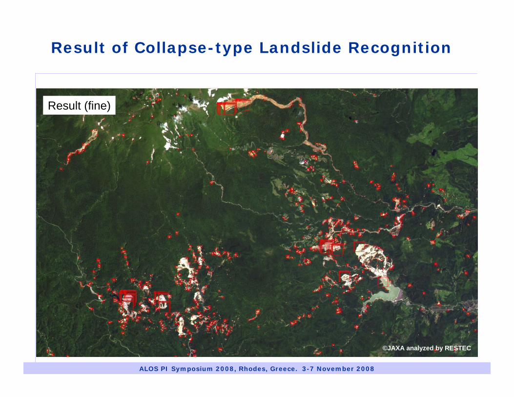
Result (fine)
©JAXA analyzed by RESTEC
Result of Collapse-type Landslide Recognition

ALOS PI Symposium 2008, Rhodes, Greece. 3-7 November 2008
Result (error by paddy fields)
©JAXA analyzed by RESTEC
Result of Collapse-type Landslide Recognition

ALOS PI Symposium 2008, Rhodes, Greece. 3-7 November 2008
Result (error by clouds)
©JAXA analyzed by RESTEC
Result of Collapse-type Landslide Recognition

ALOS PI Symposium 2008, Rhodes, Greece. 3-7 November 2008
Before After
Masked by segmentation image derived from NDVI value
©JAXA analyzed by RESTEC

ALOS PI Symposium 2008, Rhodes, Greece. 3-7 November 2008
DInSAR analysis for steep slope
• Aim– To understand capability
of DInSAR at steep slope
• Overview of test site– Zentoku landslide is one of
the active landslide in Japan.
– Average of slope angle: 28 deg. (Steep slope)
– Size of landslide; width 2000m, length 900m
NN
Image from:http://www.yamato.kkr.mlit.go.jp/YKNET/outline/landslide/landslide/work/moc/zentoku/zentoku01.html
Tokushima Pref.
500m

ALOS PI Symposium 2008, Rhodes, Greece. 3-7 November 2008
Relationship of analyzed data and monthly precipitation
0
100
200
300
400
500
1 2 3 4 5 6 7 8 9 10 11 12 13Month
Pre
cipi
tatio
n(m
m)
200620072008
10130828
0718
0716 10160831
2006
20072008
Ikeda station
DInSAR analysis for steep slope

ALOS PI Symposium 2008, Rhodes, Greece. 3-7 November 2008
DInSAR analysis for steep slope
Time series of DInSAR Result10130828
0718
0716 10160831
2006
20072008
(a)
(b) (c) (d)
(e)
(a) (b) (c)
(d) (e) (f)
All of image ©METI, JAXA analyzed by RESTEC
(f)
N
Az
Rg
-π +π

ALOS PI Symposium 2008, Rhodes, Greece. 3-7 November 2008
Simulation of landslide movement by very simple model
DInSAR result
Simulated result
Simulated image was analyzed by very simple model.
Liner model
yCLy
avedisavey
dWdd
dWdd
⋅−=
⋅−=
dave: Annual deformation / temporal base-lineWdis: Weighting by distance from the bottom of landslide.WCL: Weighting by distance from the center of landslide of each elevation.
-π +π

ALOS PI Symposium 2008, Rhodes, Greece. 3-7 November 2008
Conclusions
• We developed ALOS data processing tools to improve our prototype landslide monitoring and assessment system.
• Capability of developed tools are confirmed.– Approx. 12m accuracy for elevation. (DSM Generating Tool)– Good result and errors can be reduced by mask image of NDVI.
(Collapse-type Landslide Recognition Tool)
• DInSAR analysis for steep slope is complicated.– It is difficult to identify the movement area from DInSAR result.– Not so negative.– Proposed simulation model needs improvement.
• We should improve our tools to increase the accuracy of each result for operational use.