Embed Size (px)
Citation preview

Esso Highlands Limited
>
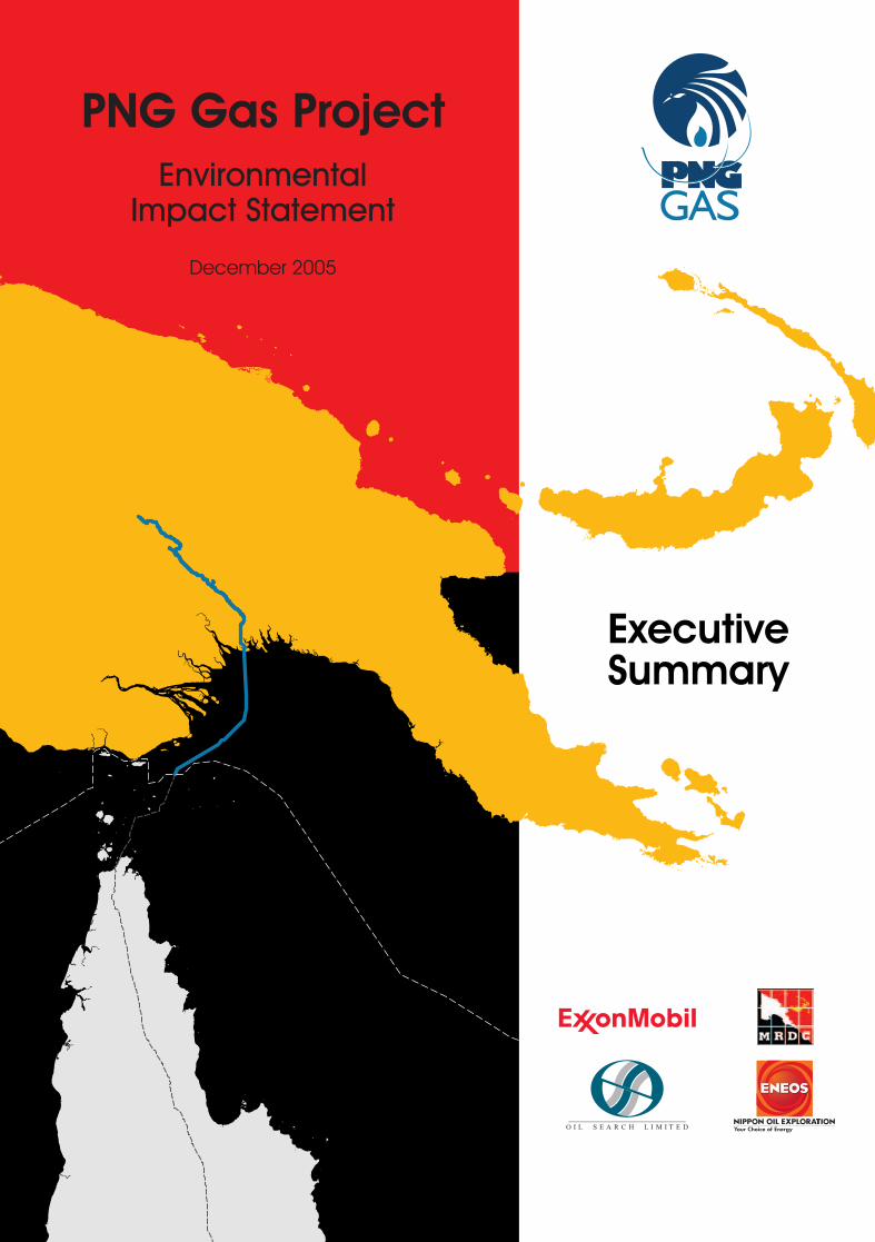
PNG Gas Project
Environmental Impact Statement
Executive Summary
December 2005
CR 790_20_Rev4
Prepared by:
Enesar Consulting Pty Ltd
124 Camberwell Road Hawthorn East Victoria Australia 3123
p 61-3-9882 3555 f 61-3-9882 3533
e [email protected] www enesar.com.au
PNG Gas Project Environmental Impact Statement
Esso Highlands Limited PGGP-EDR-00-SR-000-R26-0001
i
790_20_EIS_ExSum-Rev4.doc/December 2005
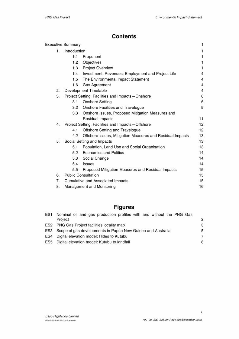
Contents Executive Summary 1
1. Introduction 1 1.1 Proponent 1 1.2 Objectives 1 1.3 Project Overview 1 1.4 Investment, Revenues, Employment and Project Life 4 1.5 The Environmental Impact Statement 4 1.6 Gas Agreement 4
2. Development Timetable 4 3. Project Setting, Facilities and Impacts—Onshore 6
3.1 Onshore Setting 6 3.2 Onshore Facilities and Travelogue 9 3.3 Onshore Issues, Proposed Mitigation Measures and Residual Impacts 11
4. Project Setting, Facilities and Impacts—Offshore 12 4.1 Offshore Setting and Travelogue 12 4.2 Offshore Issues, Mitigation Measures and Residual Impacts 13
5. Social Setting and Impacts 13 5.1 Population, Land Use and Social Organisation 13 5.2 Economics and Politics 14 5.3 Social Change 14 5.4 Issues 14 5.5 Proposed Mitigation Measures and Residual Impacts 15
6. Public Consultation 15 7. Cumulative and Associated Impacts 15 8. Management and Monitoring 16
Figures ES1 Nominal oil and gas production profiles with and without the PNG Gas
Project 2 ES2 PNG Gas Project facilities locality map 3 ES3 Scope of gas developments in Papua New Guinea and Australia 5 ES4 Digital elevation model: Hides to Kutubu 7 ES5 Digital elevation model: Kutubu to landfall 8

PNG Gas Project Environmental Impact Statement
Esso Highlands LimitedPGGP-EDR-00-SR-000-R26-0001
1
790_20_EIS_ExSum-Rev4.doc/December 2005
Executive Summary
1. Introduction1.1 ProponentThe PNG Gas Project is being developed through a joint venture between EssoHighlands Limited and its affiliates (as Operator) and Esso’s co-venturers Oil SearchLimited and its affiliates, Nippon Oil Exploration Limited through its subsidiary MerlinPetroleum Company Limited, and subsidiaries of Mineral Resources DevelopmentCompany Limited.
1.2 ObjectivesThe PNG Gas Project has two interdependent objectives:
• To commercialise the gas reserves of the existing Kutubu, Gobe and Moran oil fieldsand of the Hides gas field and, in so doing,
• To maximise oil recovery from existing oil and gas fields and facilities.
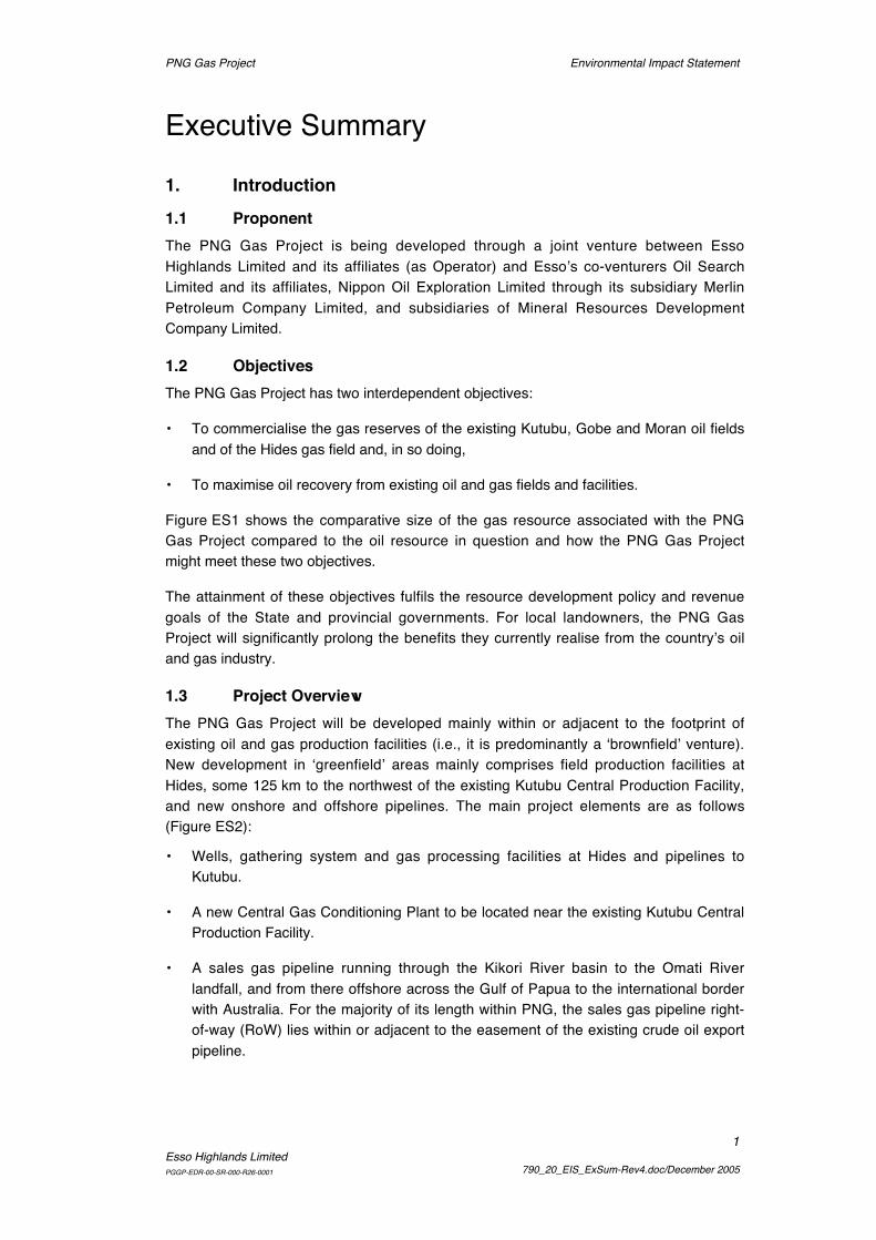
Figure ES1 shows the comparative size of the gas resource associated with the PNGGas Project compared to the oil resource in question and how the PNG Gas Projectmight meet these two objectives.
The attainment of these objectives fulfils the resource development policy and revenuegoals of the State and provincial governments. For local landowners, the PNG GasProject will significantly prolong the benefits they currently realise from the country’s oiland gas industry.
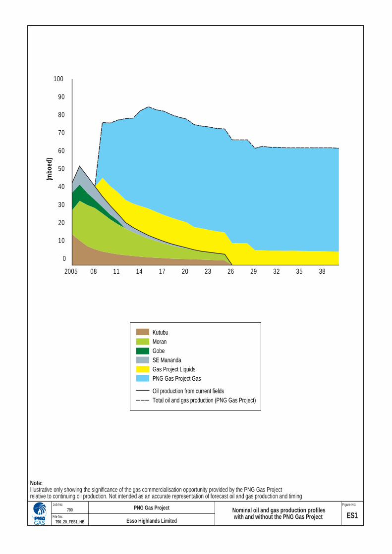
1.3 Project OverviewThe PNG Gas Project will be developed mainly within or adjacent to the footprint ofexisting oil and gas production facilities (i.e., it is predominantly a ‘brownfield’ venture).New development in ‘greenfield’ areas mainly comprises field production facilities atHides, some 125 km to the northwest of the existing Kutubu Central Production Facility,and new onshore and offshore pipelines. The main project elements are as follows(Figure ES2):
• Wells, gathering system and gas processing facilities at Hides and pipelines toKutubu.
• A new Central Gas Conditioning Plant to be located near the existing Kutubu CentralProduction Facility.
• A sales gas pipeline running through the Kikori River basin to the Omati Riverlandfall, and from there offshore across the Gulf of Papua to the international borderwith Australia. For the majority of its length within PNG, the sales gas pipeline right-of-way (RoW) lies within or adjacent to the easement of the existing crude oil exportpipeline.
Note:Illustrative only showing the significance of the gas commercialisation opportunity provided by the PNG Gas Projectrelative to continuing oil production. Not intended as an accurate representation of forecast oil and gas production and timing
0
10
20
30
40
50
60
70
80
90
100
2005 08 11 14 17 20 23 26 29 32 35 38
(mbo
ed)
KutubuMoranGobeSE ManandaGas Project LiquidsPNG Gas Project Gas
Oil production from current fieldsTotal oil and gas production (PNG Gas Project)
ES1790_20_FES1_HB
790Figure No: Job No:
File No:
PNG Gas Project Nominal oil and gas production profileswith and without the PNG Gas Project Esso Highlands Limited
10
100 100
100
100
800
800
20
30
50
10 50203040
202020 1020202020 4020 800
20 20 20
10 10 50 10
20304050 90
0102030
40
1020800
30
50
10
10 203010
4030 50
10010
10
10
50
1020
20
10
10 9001000
2010
5010 1020
30
30
30
1010
20
2020
40
101010
20 700
10
10
6001010
10
20
10
10 500 60020 20
10
30
101050060
0 70010
200
700
100010 500600700
20
20
80010
10
10
1010
10
20
20 20
20
40
40
40 200
10 20 10
2010
10 20
30
30
500600
1010 101020 10 50020
10
10600
700
1 0 10 4010 10
1020 20
20
20
20
30
40 30
10 30 4010 40
20
20
20
30
30
30
50
10 10203010 10
505010 10 10
1020
20 203040
302010 10 20
1020
20
20
202010
2010
10 1000202030
10
20
20
30304050
100
100
200
2001010
500
500
600
600
700
70010
10
10
10
10
10
10
10
10
10
10
10
10 10
10
101010
101010
10 10 2010 10 101020
20
20
20
10
10 100
10 10
10
10 1010
10 20
1 010 1010
1010
1010 10
1010 10
10
10
10
1020
20
20
10
10
2010
2010 20
10
20
20
20
20
20
20 10
10
10
10
20
20
2020
20
20
20
20
20
20
20
20
20
20
20
30
30
30
30
3030
30
30
30
30
30
3030
30
30 30
30
40
40
40
40
40
40
40 40
40
40
40
40
40
40
50
50
50
50
50
50
50
50
50
50
50
100
100
100
100
100
100
100
100
100
100
200
200
200
200
200
200
200
500
500
500500
500
500
500
500
600
600
600600
600
600
600
600
700
700
700
700
700
700
70070
0
800
800
800
800
800
800
800
800
900
900
900
900
900
900
900
900
0
1000
1000
1000
1000
1000
1000
1000
1000
0002000
2000
2000
WESTERN
GULF
SOUTHERNHIGHLANDS
WESTERNHIGHLANDS
ENGA
EASTERN HIGHLANDS
MADANG
CHIMBU
WESTSEPIK
EAST SEPIK
Serki
Isara
Ali
Duru
Aewa
Kawatangwa
Moro
Waru
Kantobo
Inu
ManuHumane
EraveSamberigi
Mission
MoroOmai
Orakana
Mendi
Poroma
Bisi
KitomaveKikoriVeiru
Kaiam
Babai Veraibari
Waira
Gibu
Moka Koumaio
FaiaSumakarimo
Goari
Omati
Misiki
Wareho
Kubeai
Hivaro
Pai
Nogoli
Maipani
Kawatasi
Ludesa Mission
Komo
Giwaretore
Goaribari Is.
Kerema
GULF OF PAPUAKadir
TariIdauwi Benaria
Angore
Homa
Kopi
KUTUBUCentral Production Facility andCentral Gas Conditioning Plant
Ridge Camp
HIDESProduction Facility
KOPICamp
GOBEProduction Facility
AGOGOProduction Facility
PAPUA NEW GUINEA
AUSTRALIA
Kikori River
Fly River
Omati River
Hegigio River
Mubi River Erave River
Lake Kutubu
Wassi Falls
Basilisk Passage
PassageMoon
Missionary Passage
K e r e m aB a y
P u r a r i D e l t a
TORRES STRAIT
Ende avou
r St
rait
Bligh Entrance
K i k o r i D e l t a
Tancred Passage
F l y D e l ta
a n d
Es t
u ar y
Gubam
Karp
Jaru
Parama Is.
Saibai Is.
Kaumag Is.
Boigu Is.
Daru Is.Bobo Is.
Bramble Cay
HornIs.
Thursday Is.
MoaIs.
BaduIs.
Princeof
Wales Is.
Murray Is. (Mer)
Idihi ItDaugo
Is.
Haidara Is.
Sassie Is.
Sassie Rf.Urul Reef (Day)
Vigilant Channel
Kekeni Reef
Sinavi Reef
Nateara Reef
Lagoon Reef
Liljebald Passage
Liljebald Passage
RedscarBay
RedscarBay
CautionBay
CautionBay
Basilisk Passage
R e ef
Ba r
r ie r
Gre
at
GREA
T
NORTH
EAST
CHANNEL
Seisia
Injinoo
Tor r
e s
S t
r ai t
I
s la n
d s
E a s te r n
Pa t c
h R e e f s
Bamaga
Cable BeachMuteeHead
ADOLPHUS CHANNEL
O r m a n Re e
f s
EasternFields
BootReef
PortMoresby
Darnley Is.Pearce Cay
CORALSEA
Wa r r
i or
Re e
f s
Dungeness Reef
DARAI PLATEAU
Mount Giluwe
Mount Bosavi
Mount Sisa
Doma Peaks
Mount Kerewa
Mount Murray
Mount Duau
Karius Range
HidesGas Plant
Iwa Range
Kumul Marine Terminal
8 800
000
8 900
000
9 000
000
9 100
000
9 200
000
9 300
000
8 800
000
8 900
000
9 000
000
9 100
000
9 200
000
9 300
000
700 000 800 000 900 000
700 000 800 000 900 000
1 000 000
1 000 000
LEGENDProposed new pipelines - PNGProposed new pipeline - AustraliaExisting crude oil export pipelineTorres Strait Protected ZoneAustralian Exclusive Economic Zone(PNG–Australian border)Provincial boundariesRiverShipping channels
Note: Pipelines and access ways approximate the proposed alignments based on engineering data provided up to 20 October 2005.
DEPTH (m)-5-10-15-20-25-30-35-40-45-50-55-60-65-70-75-80-85-90-95-100-150-200-300-400>6000
0 kmWGS 84 UTM Zone 54 S
100
N
PNG Gas Project facilities locality map ES2790_20_FES2_HB
790Figure No: Job No:
File No:
PNG Gas Project
Esso Highlands Limited
Environmental Impact Statement PNG Gas Project
4
790_20_EIS_ExSum-Rev4.doc/December 2005Esso Highlands Limited
PGGP-EDR-00-SR-000-R26-0001
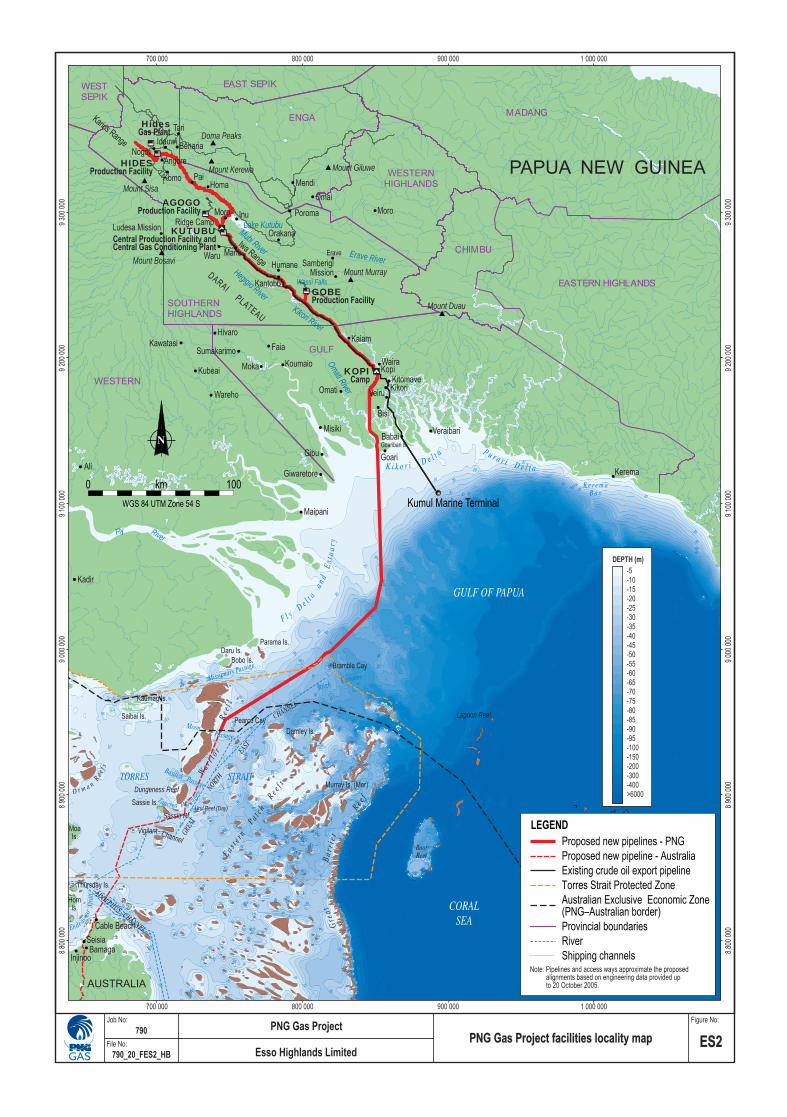
At the international border, the sales gas pipeline owner becomes the AGL PetronasConsortium (APC), who will build the continuation of the pipeline to markets in Australia.Figure ES3 shows the overall scope of the development in Papua New Guinea andAustralia.
1.4 Investment, Revenues, Employment and Project LifeThe PNG Gas Project’s capital investment in Papua New Guinea will be on the order ofK8.3 billion (US$2.5 billion in 2005 dollars), with approximately the same againestimated for recurrent expenditures over the nominal project life of approximately 30years. Gas production is scheduled to commence in 2009. The estimated net presentvalue of the project to Papua New Guinea is between US$3 billion and $US4 billion. Netcash flow to governments and landowners is projected to be US$3.2 billion over thenominal project life. Construction direct employment1 will peak at 2,500 positions (themajority of whom will be PNG citizens), and the combined oil and gas operations willdirectly employ approximately 400 full-time equivalent positions1.
1.5 The Environmental Impact StatementThe Operator has prepared an Environmental Impact Statement (EIS) in accordancewith Section 53 of the Environment Act 2000. The EIS seeks approval to construct andcommission the PNG Gas Project. Existing operations that will provide gas to the projectwould continue under their respective licences, approvals and permits.
1.6 Gas AgreementThe legal and fiscal parameters of the PNG Gas Project and the provision for Stateparticipation in the project are set out in the PNG Gas Project Gas Agreement executedin 2002 between the co-venturers, the Independent State of Papua New Guinea and theBank of Papua New Guinea.
The Gas Agreement contemplates that operations involving gas recovery at Kutubu,Gobe, Moran and Hides will be part of a coordinated development under the Oil and GasAct 1998. The Gas Agreement also provides that the PNG Gas Project may completethe pipeline construction RoWs as a public road link from Tari to the Gulf coast at Kikoriand requires the State to build new sections of road so as to complete an eastern linkfrom Mendi and Mt Hagen to Kikori.
2. Development TimetableThe PNG Gas Project schedule is predicated on producing 225 petajoules (PJ) of naturalgas per year. The nominal project life is 30 years, with first gas scheduled to be availablefor delivery to customers in Australia in 2009 after a three-year construction periodstarting in 2006. Further developments between 2011 and 2029 will add compressionand additional wells at Hides and new sources of gas.
1 This employment figure excludes contract service providers.

WEST SEPIK
NORTHERN
EAST SEPIK
WEST NEW BRITAIN
MOROBE
EASTERNHIGHLANDS
MADANG
MILNE BAY
CENTRAL
WESTERN
CHIMBU
WESTERNHIGHLANDS
ENGA
SOUTHERNHIGHLANDS
GULF
Mt Isa
Hides
GobeKopi
KutubuAgogo
KumulMarineTerminal
SOUTH AUSTRALIA
PAPUA NEW GUINEA
QUEENSLAND
NORTHERN TERRITORY
NEW SOUTH WALES
INDONESIA
Madang
Lae
Port MoresbyDaru
WeipaGove
Bamaga
Coen
Cooktown
CairnsChillagoe
Townsville
Bowen
Mackay
Charters Towers
Nebo
RockhamptonGladstone
BrisbaneMoonieSurat
Gilmore
Roma
SouthDenison
Fields
NorthDenison
Fields
Barcaldine
Jackson
BalleraMoomba
Omicron
25°S
30°S
20°S
15°S
10°S
5°S
25°S
30°S
20°S
15°S
10°S
5°S
155°E150°E145°E140°E135°E
150°E145°E140°E135°E
LEGENDProposed gas pipelines - PNGProposed gas pipelines - AustraliaExisting gas pipelineExisting oil pipelineAustralian Exclusive Economic Zone(PNG-- Australia border)
Note: Pipelines and access ways approximatethe proposed alignments based on engineeringdata provided up to 20 October 2005.
N
Projection: UTM Zone 54 S (WGS 84)
0 km 500
Scope of gas developments in Papua New Guinea and Australia ES3
790_20_FES3_HB
790Figure No: Job No:
File No:
PNG Gas Project
Esso Highlands Limited
Environmental Impact Statement PNG Gas Project
6
790_20_EIS_ExSum-Rev4.doc/December 2005Esso Highlands Limited
PGGP-EDR-00-SR-000-R26-0001
3. Project Setting, Facilities and Impacts—Onshore
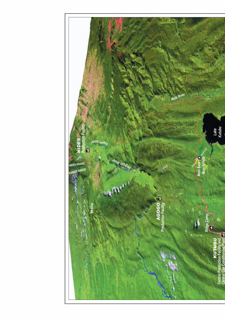
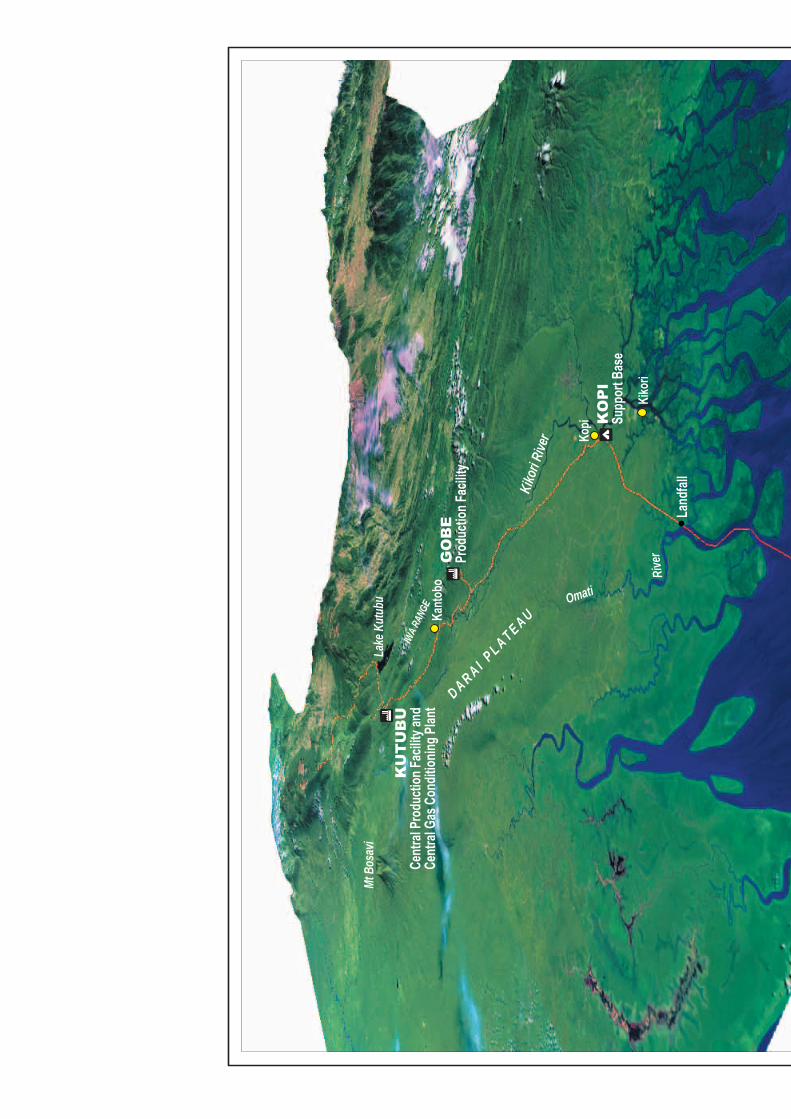
3.1 Onshore SettingThe environment in which the PNG Gas Project is located ranges from thenorthwest–southeast trending ridges and ravines, karst and incised volcanic landforms ofthe higher elevations of the Papuan Fold Belt (Figure ES4) to the Kikori Basin lowlandsand delta landforms of the Gulf of Papua (Figure ES5).
The project area lies within the catchment of the Kikori River system and featuresextensive tracts of relatively little-disturbed and sparsely populated moist tropical forestof at least 19 different broad types. Previous surveys undertaken by the World WideFund for Nature (WWF) and new surveys commissioned for this EIS have determinedthat the Kikori River basin contains 79 species of non-flying mammals, 46 species ofbats, 389 species of birds and 90 species of frogs. A further 30 species of bats and155 species of birds could also occur in the area.
Notable species include birds-of-paradise, cassowaries, fruit doves, tree kangaroos,microhylid frogs, fruit bats and orchids. A number of groups within the fauna are narrowlydistributed according to altitude, and a number of species have localised and somewhatrestricted occurrences.
Mean annual rainfall varies across the project area, from 2,500 mm at Tari to 4,500 mmat Kutubu and 5,700 mm at Kikori, with relatively low runoff and high infiltration throughthe karst landforms and thence into aquifers and underground rivers. Smaller riversthrough volcanic terrain and the numerous larger rivers carry high sediment loads duringhigher flows, and there are some areas of impeded drainage, with swamps.
Remoteness, soil infertility and endemic malaria have kept human populations at lowdensities, and so there has been limited hunting and forest clearing pressure over mostof the project area to date.
Most of the listed and restricted fauna species are generally under hunting pressureacross their range in PNG, with critically endangered species comprising severalmammals and one plant. No bioregion and no particular part of the project areatraversed by the sales gas pipeline has a concentration of listed species.
Industrial development to date in the Kikori River basin area has involved the oil and gasindustry and large-scale commercial logging. With localised exceptions around the mainpetroleum production facilities at Kutubu and Hides, the historic pattern of sparsepopulation has generally persisted since oil and gas production began in the early1990s.
There is evidence that the biodiversity effects of these industries have been limited andlocalised to the areas of direct disturbance. The PNG Gas Project will broaden to alimited extent the development footprint at the extremities of the existing oil and gasinfrastructure and extend the life of the industry in the region by several decades.
Hegigio River
TagariRiver
Mt S
isa
Lake
Kutu
bu
Mubi River
HIDES RANGE
KARIUS RANGE
Moro
Bas
e
HID
ES
Prod
uctio
n Fac
ility
AG
OG
OPr
oduc
tion F
acilit
y
Moro
Airf
ield
Ridg
e Cam
p
KU
TU
BU
Cent
ral P
rodu
ction
Facil
ity an
dCe
ntra
l Gas
Con
dition
ing P
lant
Note:
Pipe
lines
and a
cces
s way
s app
roxim
atethe
prop
osed
align
ments
base
d on e
ngine
ering
data
prov
ided u
p to 2
0 Octo
ber 2
005.
Digit
al ele
vatio
n mod
el: H
ides t
o Kut
ubu
ES4
790_
20_F
ES4_
HB
790
Figur
e No:
Job N
o:
File N
o:
PNG
Gas P
rojec
t
Esso
High
lands
Limi
ted
Kopi
Kiko
ri Rive
r
Omati
Rive
r
Lake
Kut
ubu
IWA R
ANGE
D ARA I PL A T EAUKa
ntob
o
Kiko
ri
Land
fall
Mt B
osav
i
KU
TU
BU
Cent
ral P
rodu
ction
Facil
ity an
dCe
ntra
l Gas
Con
dition
ing P
lant
KO
PI
Supp
ort B
ase
GO
BE
Prod
uctio
n Fac
ility
Note:
Pipe
lines
and a
cces
s way
s app
roxim
atethe
prop
osed
align
ments
base
d on e
ngine
ering
data
prov
ided u
p to 2
0 Octo
ber 2
005.
Digit
al ele
vatio
n mod
el: K
utub
u to l
andf
allES
579
0_20
_FES
5_HB
790
Figur
e No:
Job N
o:
File N
o:
PNG
Gas P
rojec
t
Esso
High
lands
Limi
ted
PNG Gas Project Environmental Impact Statement
Esso Highlands LimitedPGGP-EDR-00-SR-000-R26-0001
9
790_20_EIS_ExSum-Rev4.doc/December 2005
In general, the conservation values of the project area are high; and numerous local-scale landform features, such as sinkholes, spires, towers, caves, springs and waterfalls,are to be found. However, these values and features are not uniformly at risk from theproject. Accordingly, five noteworthy areas have been identified for which priorities formanagement and the application of appropriate mitigation measures have been defined.These areas are:
• The lower montane forest with Nothofagus on the karst of Hides Ridge—plant andanimal diversity.
• Sinkhole swamps on Hides Ridge (frogs).
• Caves (bats).
• Swamp forest—specialist vertebrates (birds, turtles, crocodiles).
• Stream banks and riparian vegetation at higher elevations—specialist vertebrates(birds and frogs).
3.2 Onshore Facilities and TravelogueHides Gas Field and Spine Line (Gas and Liquids)
In the northwest at elevations between 1,800 m and 2,800 m exists the polygonal karstof Hides Ridge (Figure ES4). Initially, three new wells will be drilled and three existingwells will be recompleted on Hides Ridge. The wellstreams will be gathered in a 550-mmspine line buried in a RoW nominally 12 m in width. Substantial earthworks are requiredto construct the RoW, and these earthworks will often extend the total width of the areacleared. A further five wells will be drilled on Hides Ridge in two subsequent drillingcampaigns.
There are currently two existing gas production wells and their flowlines and twoundeveloped exploration wells on Hides Ridge, but the area is otherwise little disturbed.Frequent cloud cover makes for a consistently moist climate, and the trees on the ridgeare festooned with epiphytes. The biodiversity on Hides Ridge is notable: the vegetationis relatively intact, has few noxious weeds, is rich in ferns and includes 12 new plantspecies; the fauna is diverse and notable for high-altitude birds, bats and frogs and anabundance of arboreal mammals; the sinkhole swamps have a rich and restricted frogfauna. Similar habitat is to be found on adjacent mountains and ranges to the southwestand northwest.
The EIS identified Hides Ridge as an area warranting focused environmental planningand management attention. This has included an assessment of the option to drill wellsfrom the valleys on either side of the ridge in order to avoid the top of the ridgealtogether (technically infeasible) and to develop the field using lower-impact, helicopter-supported high-manual-labour methods (complex, with serious cost, schedule and safetydrawbacks). These studies indicated that there were no technically feasible alternativesthat offered a significant environmental benefit.
From Hides Ridge, the spine line will descend through cleared and settled country to theproposed Hides Production Facility on the south bank of the Tagari River at an elevationof approximately 1,250 m ASL. The Hides Production Facility will separate the raw gas
Environmental Impact Statement PNG Gas Project
10
790_20_EIS_ExSum-Rev4.doc/December 2005Esso Highlands Limited
PGGP-EDR-00-SR-000-R26-0001
into rich gas and natural gas liquids (mainly condensate) streams, which will flowseparately via two new pipelines to the proposed Central Gas Conditioning Plant atKutubu.
Hides to Kutubu
The two new pipelines from the Hides Production Facility will run to the Kutubu CentralGas Conditioning Plant (Figure ES4). Between Idauwi and Homa, existing roads will belinked by the construction access way/RoW to form a public road.
Much of this area is partly cleared and settled, but the RoW encounters forested, steep,incised volcanic terrain between the Maruba and Pawgano rivers. Major earthworks inthis locale raise the issue of forest clearing, spoil management and the impact ofconstruction-generated sediment on watercourses. There are also a number ofarchaeological and cultural heritage sites to be negotiated in this area.
The geology reverts to limestone and gentler terrain as the RoW follows the existingroad from Homa to Moro around the northern end of the Ramsar-listed Lake Kutubucatchment. From Moro, the RoW crosses a ridge to the new Kutubu Central GasConditioning Plant at approximately 960 m ASL. Here, gas and liquids from Hides will beseparated, and the gas from Hides and from the existing oil production operations will beprocessed. Gas will be conditioned to export specification and will be sent via the newsales gas pipeline to customers, initially in Australia. LPGs from the Central GasConditioning Plant will be reinjected for possible future production or used as fuel gas inthe process. The Hides liquids will be transferred from the Central Gas ConditioningPlant for stabilisation at the nearby existing Kutubu Central Production Facility and fromthere will flow via the existing crude oil export pipeline to the Kumul Marine Terminal inthe Gulf of Papua.
Kutubu to Kopi Sales Gas Pipeline
The sales gas pipeline will run from the Central Gas Conditioning Plant generally withinthe easement of the existing crude oil export pipeline and, south of Gobe, the existingroad between Gobe and Kopi (which parallels the existing oil pipeline easement). Someexisting roads will be upgraded by the project in this area, and some new sections ofaccess way will be constructed (Figure ES5).
From Kutubu, the sales gas pipeline RoW will initially step down over successive ridgesthrough lowland hill forest to the Ai’io River, before continuing over flatter karst terrainthrough swamp forest and woodland and finally descending the last escarpment to theconfluence of the Mubi and Kikori rivers. At this location, the construction access wayand future public road will deviate to the west between KP 55 and the Mubi River (inorder to maintain a trafficable grade), while the sales gas pipeline RoW will stay within asteep section of the existing crude oil export pipeline easement.
From the Mubi River to Kopi, the rejoined RoW and access way will follow the existingcrude oil export pipeline ROW along the floodplain of the Kikori River through lowland hillforest on limestone pavement and karst featuring some caves and pinnacles to the KopiSupport Base.
PNG Gas Project Environmental Impact Statement
Esso Highlands LimitedPGGP-EDR-00-SR-000-R26-0001
11
790_20_EIS_ExSum-Rev4.doc/December 2005
The key areas of management focus in this section will be the protection of bat cavesand sites of high archaeological and cultural significance in the Kopi area (see below).
Kopi Support Base
The existing Kopi Support Base and wharf will be extended and upgraded by the PNGGas Project. These works will also need to negotiate archaeological and cultural sites,for which a detailed ground survey is currently underway.
Kopi to Omati Sales Gas Pipeline
The sales gas pipeline will run the final 34 km from Kopi through lowland forest on karstplains, then across the Veiru Hills and through the increasingly swampy ground of thedelta to a nypa palm–fringed landfall on the Omati River.
3.3 Onshore Issues, Proposed Mitigation Measures and ResidualImpacts
Biodiversity Conservation
The direct biodiversity impacts of the construction and presence of PNG Gas Projectfacilities will be felt primarily as limited and localised habitat loss due to clearing andbarrier effects. Based on the experience of the existing petroleum developments in theKikori River basin, rapid natural revegetation of reclaimed earthworks is anticipated.Accordingly, project-related impacts on flora and fauna will be limited and localised.
The main impact on flora and fauna will be habitat loss at the time of construction, inparticular on Hides Ridge. The operations phase of the project will require a 7-m-wideaccess track to service the gas wells, but the remaining construction-disturbed landsurfaces will be allowed to revegetate. Natural revegetation has occurred quickly atlower elevations but will take more time in the cool climate associated with Hides Ridge,where active measures may be needed to accelerate the process. The RoW on HidesRidge threads a path through the karst terrain, and earthworks spoil has been estimatedto potentially affect up to 46 sinkholes. These sinkholes cover an area of between 3 and6 ha out of some 130 ha of sinkhole habitat on Hides Ridge. Extensive analagous high-altitude polygonal karst habitat also exists on the Karius Range to the southwest and tothe northwest. In this context, the overall impact on Hides Ridge sinkhole habitat hasbeen predicted to be low to moderate, limited in extent, and of medium- to long-term induration. It is worthy to note that only a small portion of the sinkholes in the Hides Ridgearea that will be impacted by sidecast spoil contain sinkhole swamp habitat.
Of the other noteworthy areas or features in the project area, the swamp forest habitatwill not be adversely affected provided appropriate drainage is maintained; measures tothis effect are proposed to be adopted. Caves and resident bat populations will beprotected to the extent practicable by performing surveys ahead of construction andimplementing appropriate blasting procedures. Completed watercourse crossings will bereclaimed.
The existing petroleum developments have shown direct impacts to have been restrictedto the very close proximity of facilities. Indirect impacts, on the other hand, have apotential to extend beyond the development footprint unless properly managed. These
Environmental Impact Statement PNG Gas Project
12
790_20_EIS_ExSum-Rev4.doc/December 2005Esso Highlands Limited
PGGP-EDR-00-SR-000-R26-0001
impacts include fire, dieback, weeds, animal pests, and improved access potentiallypromoting in-migration and enhancing logging, hunting and forest clearing activities.Indirect impacts can also be long term, and so consistent and prolonged monitoring andmanagement by the State is required over the life of the project.
An assortment of mitigation measures associated with biodiversity conservation andconstruction earthworks has been proposed to reduce residual direct impacts to low ornegligible levels.
Aquatic Environment
The Hides Ridge sinkholes discussed above aside, the principal and only materialimpact that the project is anticipated to have on the aquatic on-shore environment willtake place in the steep terrain and volcanic soils over a 14-km section on the new roadbetween Idauwi and Homa. Here, the sedimentation and turbidity effects of constructionearthworks on the aquatic ecosystem of watercourses will be major in the short term(less than one year) but restricted to a site scale (within 2 km), with moderate and lowimpacts at the local scale (2 to 10 km). Within 3 years following the earthworks, recoverywill be essentially complete. None of the areas in the vicinities of the project’s majorearthworks is inhabited.
Post-construction monitoring and appropriate erosion control measures will beimplemented when and where required to facilitate the natural revegetation of reclaimedconstruction-disturbed land surfaces. Active revegetation techniques will be employedwhere natural revegetation is assessed to be inadequate. Impacts on the on-shoreaquatic environment are predicted to fall to negligible within the medium term of betweentwo and five years.
No residual impacts are predicted for other watercourses and water bodies in the projectarea, including Lake Kutubu.
Noise, Air Quality and Greenhouse Gas
Modelling has determined that noise and air emissions associated with the PNG GasProject will be non-problematic. Greenhouse gas emissions have been calculated andreported under the PNG protocol.
4. Project Setting, Facilities and Impacts—Offshore
4.1 Offshore Setting and TravelogueThe offshore sales gas pipeline will run through the low-lying, swampy prograding deltacomplexes at the head of the Gulf of Papua out across the muddy seabed of the Gulfitself and around the delta front of the Fly River to the reefs, cays, small continentalislands, and shoals of Torres Strait.
Gulf of Papua
Regardless of its pathway, the sales gas pipeline must traverse or negotiate the samefour features of the seabed in the Gulf of Papua: the unstable delta front of the Fly River;the otherwise generally muddy, stable Gulf seabed, interspersed with dead trees; prawntrawl grounds; and the hard carbonate shelf with extensive areas of the calcareous alga
PNG Gas Project Environmental Impact Statement
Esso Highlands LimitedPGGP-EDR-00-SR-000-R26-0001
13
790_20_EIS_ExSum-Rev4.doc/December 2005
Halimeda beyond the zone of sedimentation. There is no route in the Gulf that avoids thealmost ubiquitous muddy seabed; but, equally, from an environmental impact point ofview, there is no reason to do so. Hence, alternative alignments for the offshore salesgas pipeline in the Gulf were not investigated. In fact, the line of the shortest route takesthe pipeline to the west, and this has the effect of reducing the overlap with the mainprawn trawling grounds to the east and avoiding the Halimeda beds.
Torres Strait
The pipeline routing criteria in the Torres Strait are well aligned from an engineering andenvironmental standpoint: the shortest route that avoids coral reefs and shippingchannels and that limits the disturbance of seagrass beds. The entrance to the Straitthrough PNG waters is environmentally and economically unconstrained as the pipelineenters the Torres Strait Protected Zone (TSPZ).
The TSPZ exists to manage fisheries and enable customary use of and movementthrough Torres Strait under the joint authority of Papua New Guinea and Australia.
Crossing the international boundary near Pearce Cay, the pipeline encounters theplatform massif of the Warrior Reefs, which runs north–south for more than 100 km. Thepipeline must cross from east to west through one of a number of natural breaks, as thepassage around its southern extremity is constrained by shallow sections of shippingchannels. Four transits of the Warrior Reefs were assessed under Australian andQueensland environmental assessment processes, and one was selected and approvedin 1998 (North Central [‘Basilisk’] Passage). However, subsequent consultation revealedthat the Basilisk Passage was constrained by its cultural heritage and, at the request ofits Islander custodians, a route further to the south has been nominated, approved byAustralian Commonwealth and Queensland authorities and adopted for detailedengineering survey and design by the proponents of the Australian portion of the salesgas pipeline (South Central Passage [‘Bet Reef’]).
4.2 Offshore Issues, Mitigation Measures and Residual ImpactsRoute selection to reduce overlap with prawn trawling grounds, to avoid coral reefs, andto reduce the extent of seagrass beds traversed has been the principal mitigationapproach adopted for the offshore sales gas pipeline.
During operations, there will be no requirement for an exclusion zone for trawlers aroundthe pipeline, which will mostly sink into the soft seabed. Residual impacts on the marineenvironment are predicted to be negligible.
5. Social Setting and Impacts
5.1 Population, Land Use and Social OrganisationThe PNG Gas Project area is one of the most remote and least accessible parts ofPapua New Guinea. The region supports a generally sparse local population, whichoperates a generally subsistence economy based on sago palm cultivation, slash-and-burn agriculture, and hunting, gathering and fishing.
The project impact area has a diverse sociocultural character, with numerous tribal andlanguage groupings. Social organisation is mainly based on patrilineal descent, which
Environmental Impact Statement PNG Gas Project
14
790_20_EIS_ExSum-Rev4.doc/December 2005Esso Highlands Limited
PGGP-EDR-00-SR-000-R26-0001
determines all of the important relationships of people to people, people to land, andpeople to their spiritual beliefs.
The project impact area has a very low potential for broad-acre commercial agriculture,and none has developed.
For the proponents of new projects, the most important feature of PNG society is theprimacy of small clan groups and their customary ownership and control of land.
5.2 Economics and PoliticsThe principal sources of cash income in the project impact area are wages and royaltiesfrom the oil developments and, to a lesser extent, from commercial logging in the Gulflowlands. The PNG Gas Project will not necessarily increase the quantum of benefits,but rather will extend their geographic scope and term. As far as all those who own landare concerned, the amount, destination and use of project revenue streams is the PNGGas Project’s single biggest socio-economic issue.
The negotiation of project benefits between the different levels of government andlandholders is mandated by legislation and codified in a formal and structured process.This provides for the negotiation of agreements regarding the sharing of resource projectbenefits between the various levels of government and landowners and for a process bywhich the State will manage this distribution.
5.3 Social ChangeThe oil and gas industry in PNG spans a decade and a half to date and has providedinfrastructure, service, wealth, training and employment opportunities to the project area.
These have accelerated the pace of social transformation to modernity: new forms ofrepresentation have arisen; access to non-traditional economic, political and juralinstitutions has increased; and commercial business developments with shareholdingconstituencies, democratic decision-making and monetary responsibilities have beencreated.
National and local PNG constituencies continue to welcome the developments that bringabout such changes—in the project impact area, landowner support for the PNG GasProject is greater than 82%.
5.4 IssuesThe social issues most articulated in attitude and opinion surveys carried out by the PNGGas Project in the project impact area have been:
• The ability of the government to ensure that landowners’ interests are reflected inrepresentative and accountable entities and that benefits are equitably distributed.
• Social service delivery.
These issues are all matters for government and are beyond the purview of the PNGGas Project.
The PNG Gas Project will continue the process of social change in the project impactarea, and the improved public road system associated with the project will increase
PNG Gas Project Environmental Impact Statement
Esso Highlands LimitedPGGP-EDR-00-SR-000-R26-0001
15
790_20_EIS_ExSum-Rev4.doc/December 2005
mobility, access to services and commercial opportunities. On the other hand, the roadcould lead to higher crime, prostitution, and rates of sexually transmitted diseases(including HIV/AIDS) in the project impact area and a number of other social challengesthat government will need to address.
In the longer term lie questions of economic dependency and options for sustainablebusiness and services in the future.
5.5 Proposed Mitigation Measures and Residual ImpactsThe State has the responsibility for managing the main social issues related to the PNGGas Project, especially the vehicles for local participation, governance and equity ofbenefit and service distribution processes.
These processes have been underway for some time and are the subject of renewedrounds of explanatory presentations and consultations in the villages and towns of theproject impact area carried out by government agencies with the assistance of projectpersonnel.
Social impacts in the project impact area within the purview of the PNG Gas Project tomitigate directly lie in the following areas: accessing labour via the NECL and existinglandowner companies; contributing to health, education and agricultural initiatives(especially those targeted at women); avoiding cultural property and spiritual places;payment of legislatively required compensation in a fair and transparent manner; andconsulting with local communities. In-principle mitigation measures related to thesematters are proposed in the EIS.
6. Public ConsultationPublic consultation in the project impact area is an ongoing process involving routineinteractions, formal presentations and ad hoc meetings. Public attitudes and opinionsabout the PNG Gas Project and other issues have been documented to a large extentthrough a comprehensive household survey, which achieved a population coverage ofapproximately 40%.
A variety of non-governmental organisations have been included in the project’spublication consultation program, including international and local organisations andfaith-based groups.
7. Cumulative and Associated ImpactsCumulative impacts arise at particular places in the project area as a result of theactivities or initiatives of others, but are in some way related to the PNG Gas Project.
As far as forestry is concerned, the presence of an improved public road associated withthe PNG Gas Project could provide a small fraction of the road requirements of one ofthe forestry blocks in the project area at no cost to the concession-holder, but thissituation was assessed as being inconsequential in determining whether commerciallogging in this forest management area would be encouraged or accelerated. In general,the forest industry makes its own commercial and environmental arrangements and hashad very little overlap with the oil and gas sector.
Environmental Impact Statement PNG Gas Project
16
790_20_EIS_ExSum-Rev4.doc/December 2005Esso Highlands Limited
PGGP-EDR-00-SR-000-R26-0001
The improved public road system associated with the project gives rise to severalpotential environmental risks, including increased forest clearing, wildlife hunting andpoaching, fire and noxious weed invasion. Settlement along the road, however, isanticipated to continue to be severely constrained by the inhospitable, unproductive andmalarial environment, as well as social norms discouraging squatting.
Similarly, the drivers for mass migration via the improved road system are not evident,and major spontaneous resettlement is not expected. Much will depend on the extent towhich commercial opportunities created by the road are grasped.
Associated impacts have been defined as those arising outside the project area from theactivities of other parties that are dependent on the PNG Gas Project. Some involve thepossibility of creating value-adding gas-fueled industries within Papua New Guinea. Anumber of such developments are being explored by others, with encouragement fromthe State, but are not sufficiently defined at this time. These ventures will require theirown environmental assessments and development approvals in due course. In Australia,the displacement of coal and fuel oil by PNG gas will reduce CO2 emissions byapproximately 1.8 million tonnes of per year (with a net reduction after taking intoaccount the gas production-related emissions of approximately two-thirds of thisamount).
8. Management and MonitoringThe proposed mitigation measures appearing in the EIS are anticipated to beimplemented progressively during the project’s preconstruction, construction andoperations phases within a framework featuring a multi-module EnvironmentalManagement Plan (EMP).


![Travelogue ATripToAndamanIslands.by.ArindamBasu [UsAb]](https://img.pdfslide.us/doc/110x75/577c7fb01a28abe054a5aab5/travelogue-atriptoandamanislandsbyarindambasu-usab.jpg)