Embed Size (px)
Citation preview
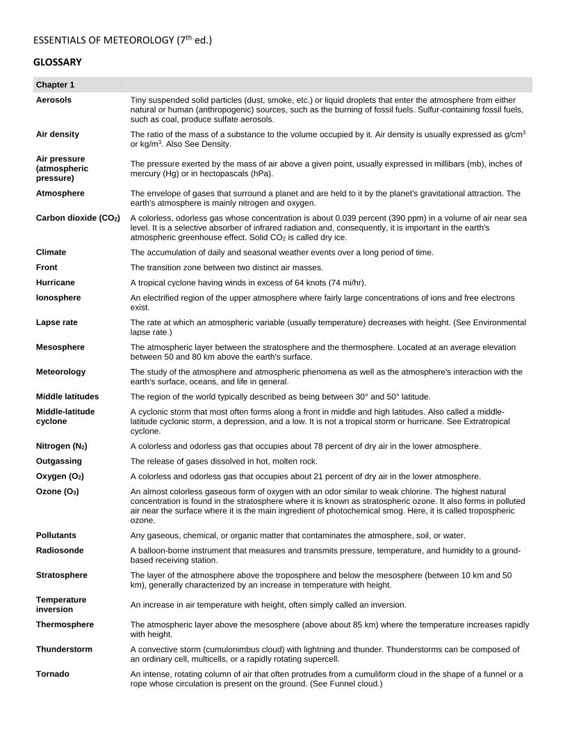
ESSENTIALS OF METEOROLOGY (7th ed.)
GLOSSARY
Chapter 1
Aerosols Tiny suspended solid particles (dust, smoke, etc.) or liquid droplets that enter the atmosphere from either natural or human (anthropogenic) sources, such as the burning of fossil fuels. Sulfur-containing fossil fuels, such as coal, produce sulfate aerosols.
Air density The ratio of the mass of a substance to the volume occupied by it. Air density is usually expressed as g/cm3 or kg/m3. Also See Density.
Air pressure (atmospheric pressure)
The pressure exerted by the mass of air above a given point, usually expressed in millibars (mb), inches of mercury (Hg) or in hectopascals (hPa).
Atmosphere The envelope of gases that surround a planet and are held to it by the planet's gravitational attraction. The earth's atmosphere is mainly nitrogen and oxygen.
Carbon dioxide (CO2) A colorless, odorless gas whose concentration is about 0.039 percent (390 ppm) in a volume of air near sea level. It is a selective absorber of infrared radiation and, consequently, it is important in the earth's atmospheric greenhouse effect. Solid CO2 is called dry ice.
Climate The accumulation of daily and seasonal weather events over a long period of time.
Front The transition zone between two distinct air masses.
Hurricane A tropical cyclone having winds in excess of 64 knots (74 mi/hr).
Ionosphere An electrified region of the upper atmosphere where fairly large concentrations of ions and free electrons exist.
Lapse rate The rate at which an atmospheric variable (usually temperature) decreases with height. (See Environmental lapse rate.)
Mesosphere The atmospheric layer between the stratosphere and the thermosphere. Located at an average elevation between 50 and 80 km above the earth's surface.
Meteorology The study of the atmosphere and atmospheric phenomena as well as the atmosphere's interaction with the earth's surface, oceans, and life in general.
Middle latitudes The region of the world typically described as being between 30° and 50° latitude.
Middle-latitude cyclone
A cyclonic storm that most often forms along a front in middle and high latitudes. Also called a middle-latitude cyclonic storm, a depression, and a low. It is not a tropical storm or hurricane. See Extratropical cyclone.
Nitrogen (N2) A colorless and odorless gas that occupies about 78 percent of dry air in the lower atmosphere.
Outgassing The release of gases dissolved in hot, molten rock.
Oxygen (O2) A colorless and odorless gas that occupies about 21 percent of dry air in the lower atmosphere.
Ozone (O3) An almost colorless gaseous form of oxygen with an odor similar to weak chlorine. The highest natural concentration is found in the stratosphere where it is known as stratospheric ozone. It also forms in polluted air near the surface where it is the main ingredient of photochemical smog. Here, it is called tropospheric ozone.
Pollutants Any gaseous, chemical, or organic matter that contaminates the atmosphere, soil, or water.
Radiosonde A balloon-borne instrument that measures and transmits pressure, temperature, and humidity to a ground-based receiving station.
Stratosphere The layer of the atmosphere above the troposphere and below the mesosphere (between 10 km and 50 km), generally characterized by an increase in temperature with height.
Temperature inversion An increase in air temperature with height, often simply called an inversion.
Thermosphere The atmospheric layer above the mesosphere (above about 85 km) where the temperature increases rapidly with height.
Thunderstorm A convective storm (cumulonimbus cloud) with lightning and thunder. Thunderstorms can be composed of an ordinary cell, multicells, or a rapidly rotating supercell.
Tornado An intense, rotating column of air that often protrudes from a cumuliform cloud in the shape of a funnel or a rope whose circulation is present on the ground. (See Funnel cloud.)

Tropopause The boundary between the troposphere and the stratosphere.
Troposphere The layer of the atmosphere extending from the earth's surface up to the tropopause (about 10 km above the ground).
Water vapor Water in a vapor (gaseous) form. Also called moisture.
Weather The condition of the atmosphere at any particular time and place.
Weather elements The elements of air temperature, air pressure, humidity, clouds, precipitation, visibility, and wind that determine the present state of the atmosphere, the weather.
Wind Air in motion relative to the earth's surface.
Wind direction The direction from which the wind is blowing.
Wind speed The rate at which the air moves by a stationary object, usually measured in statute miles per hour (mi/hr), nautical miles per hour (knots), kilometers per hour (km/hr), or meters per second (m/sec).

Chapter 2
Absolute zero A temperature reading of 2273°C, 2460°F, or 0K. Theoretically, there is no molecular motion at this temperature.
Advection The horizontal transfer of any atmospheric property by the wind.
Albedo The percent of radiation returning from a surface compared to that which strikes it.
Atmospheric window The wavelength range between 8 and 11 mm in which little absorption of infrared radiation takes place.
Autumnal equinox The equinox at which the sun approaches the Southern Hemisphere and passes directly over the equator. Occurs around September 23.
Blackbody A hypothetical object that absorbs all of the radiation that strikes it. It also emits radiation at a maximum rate for its given temperature.
Celsius scale A temperature scale where zero is assigned to the temperature where water freezes and 100 to the temperature where water boils (at sea level).
Conduction The transfer of heat by molecular activity from one substance to another, or through a substance. Transfer is always from warmer to colder regions.
Convection Motions in a fluid that result in the transport and mixing of the fluid's properties. In meteorology, convection usually refers to atmospheric motions that are predominantly vertical, such as rising air currents due to surface heating. The rising of heated surface air and the sinking of cooler air aloft is often called free convection. (Compare with forced convection.)
Electromagnetic waves
Energy propagated in the form of electromagnetic waves. These waves do not need molecules to propagate them, and in a vacuum they travel at nearly 300,000 km per sec (186,000 mi per sec). See Radiant energy.
Fahrenheit scale A temperature scale where 32 is assigned to the temperature where water freezes and 212 to the temperature at which water boils (at sea level).
Greenhouse effect The warming of an atmosphere by its absorbing and emitting infrared radiation while allowing shortwave radiation to pass on through. The gases mainly responsible for the earth's atmospheric greenhouse effect are water vapor and carbon dioxide. See Atmospheric greenhouse effect.
Greenhouse gases Gases in the earth's atmosphere, such as water vapor and carbon dioxide, that allow much of the sunlight to pass through but are strong absorbers of infrared energy emitted by the earth and the atmosphere. Other greenhouse gases include methane, nitrous oxide, fluorocarbons, and ozone.
Heat A form of energy transferred between systems by virtue of their temperature differences.
Indian summer An unseasonably warm spell with clear skies near the middle of autumn. Usually follows a substantial period of cool weather.
Infrared radiation Electromagnetic radiation with wavelengths between about 0.7 and 1000 mm. This radiation is longer than visible radiation but shorter than microwave radiation.
Kelvin scale A temperature scale with zero degrees equal to the theoretical temperature at which all molecular motion ceases. Also called the absolute scale. The units are sometimes called �degrees Kelvin�; however, the correct SI terminology is �Kelvins,� abbreviated K.
Kinetic energy The energy within a body that is a result of its motion.
Latent heat The heat that is either released or absorbed by a unit mass of a substance when it undergoes a change of state, such as during evaporation, condensation, or sublimation.
Longwave radiation A term most often used to describe the infrared energy emitted by the earth and the atmosphere.
Micrometer (mm) A unit of length equal to one-millionth of a meter.
Photon A discrete quantity of energy that can be thought of as a packet of electromagnetic radiation traveling at the speed of light.
Radiant energy (radiation)
Energy propagated in the form of electromagnetic waves. These waves do not need molecules to propagate them, and in a vacuum they travel at nearly 300,000 km per sec (186,000 mi per sec).
Radiative equilibrium temperature
The temperature achieved when an object, behaving as a blackbody, is absorbing and emitting radiation at equal rates.
Reflected light The process whereby a surface turns back a portion of the radiation that strikes it. When the radiation that is turned back (reflected) from the surface is visible light, the radiation is referred to as reflected light. See Reflection.
Scattering The process by which small particles in the atmosphere deflect radiation from its path into different directions.
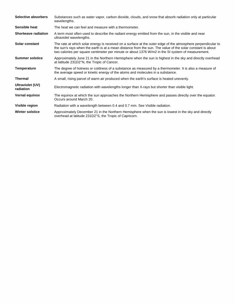
Selective absorbers Substances such as water vapor, carbon dioxide, clouds, and snow that absorb radiation only at particular wavelengths.
Sensible heat The heat we can feel and measure with a thermometer.
Shortwave radiation A term most often used to describe the radiant energy emitted from the sun, in the visible and near ultraviolet wavelengths.
Solar constant The rate at which solar energy is received on a surface at the outer edge of the atmosphere perpendicular to the sun's rays when the earth is at a mean distance from the sun. The value of the solar constant is about two calories per square centimeter per minute or about 1376 W/m2 in the SI system of measurement.
Summer solstice Approximately June 21 in the Northern Hemisphere when the sun is highest in the sky and directly overhead at latitude 231D2°N, the Tropic of Cancer.
Temperature The degree of hotness or coldness of a substance as measured by a thermometer. It is also a measure of the average speed or kinetic energy of the atoms and molecules in a substance.
Thermal A small, rising parcel of warm air produced when the earth's surface is heated unevenly.
Ultraviolet (UV) radiation Electromagnetic radiation with wavelengths longer than X-rays but shorter than visible light.
Vernal equinox The equinox at which the sun approaches the Northern Hemisphere and passes directly over the equator. Occurs around March 20.
Visible region Radiation with a wavelength between 0.4 and 0.7 mm. See Visible radiation.
Winter solstice Approximately December 21 in the Northern Hemisphere when the sun is lowest in the sky and directly overhead at latitude 231D2°S, the Tropic of Capricorn.
Chapter 3
Annual range of temperature The difference between the warmest and coldest months at any given location.
Bimetallic thermometer
A temperature-measuring device usually consisting of two dissimilar metals that expand and contract differentially as the temperature changes.
Controls of temperature The main factors that cause variations in temperature from one place to another.
Cooling degree-day A form of degree-day used in estimating the amount of energy necessary to reduce the effective temperature of warm air. A cooling degree-day is a day on which the average temperature is one degree above a desired base temperature.
Daily range of temperature The difference between the maximum and minimum temperatures for any given day.
Electrical thermometers
Thermometers that use elements that convert energy from one form to another (transducers). Common electrical thermometers include the electrical resistance thermometer, thermocouple, and thermistor.
Freeze A condition occurring over a widespread area when the surface air temperature remains below freezing for a sufficient time to damage certain agricultural crops. A freeze most often occurs as cold air is advected into a region, causing freezing conditions to exist in a deep layer of surface air. Also called advection frost.
Frostbite The partial freezing of exposed parts of the body, causing injury to the skin and sometimes to deeper tissues.
Growing degree-day A form of the degree-day used as a guide for crop planting and for estimating crop maturity dates.
Heating degree-day A form of the degree-day used as an index for fuel consumption.
Hypothermia The deterioration in one's mental and physical condition brought on by a rapid lowering of human body temperature.
Instrument shelter A boxlike (often wooden) structure designed to protect weather instruments from direct sunshine and precipitation.
Isotherm A line connecting points of equal temperature.
Liquid-in-glass thermometer
An instrument for measuring temperature. The most common is liquid-in-glass, which has a sealed glass tube attached to a glass bulb filled with liquid. See Thermometer.
Maximum thermometer
A thermometer with a small constriction just above the bulb. It is designed to measure the maximum air temperature.
Mean annual temperature The average temperature at any given location for the entire year.
Mean daily temperature The average of the highest and lowest temperature for a 24-hour period.
Minimum thermometer A thermometer designed to measure the minimum air temperature during a desired time period.
Orchard heaters Oil heaters placed in orchards that generate heat and promote convective circulations to protect fruit trees from damaging low temperatures. Also called smudge pots.
Radiation inversion An increase in temperature with height due to radiational cooling of the earth's surface. Also called a nocturnal inversion.
Radiational cooling The process by which the earth's surface and adjacent air cool by emitting infrared radiation.
Radiometer An instrument designed to measure the intensity of infrared radiation emitted by an object. Also called infrared sensor. See Infrared radiometer.
Sensible temperature The sensation of temperature that the human body feels in contrast to the actual temperature of the environment as measured with a thermometer.
Thermal belts Horizontal zones of vegetation found along hillsides that are primarily the result of vertical temperature variations.
Thermograph An instrument that measures and records air temperature.
Wind machines Fans placed in orchards for the purpose of mixing cold surface air with warmer air above.
Wind-chill index The cooling effect of any combination of temperature and wind, expressed as the loss of body heat. Also called wind-chill factor.
Chapter 4
Actual Vapor Pressure The pressure exerted by the water vapor molecules in a given volume of air. Also See Vapor pressure.
Advection fog Occurs when warm, moist air moves over a cold surface and the air cools to below its dew point.
Altocumulus A middle cloud, usually white or gray. Often occurs in layers or patches with wavy, rounded masses or rolls.
Altostratus A middle cloud composed of gray or bluish sheets or layers of uniform appearance. In the thinner regions, the sun or moon usually appears dimly visible.
Apparent temperature What the air temperature �feels like� for various combinations of air temperature and relative humidity.
Cirrocumulus A high cloud that appears as a white patch of clouds without shadows. It consists of very small elements in the form of grains or ripples.
Cirrostratus High, thin, sheetlike clouds, composed of ice crystals. They frequently cover the entire sky and often produce a halo.
Cirrus A high cloud composed of ice crystals in the form of thin, white, featherlike clouds in patches, filaments, or narrow bands.
Condensation The process by which water vapor becomes a liquid.
Condensation nuclei Also called cloud condensation nuclei. Tiny particles upon whose surfaces condensation of water vapor begins in the atmosphere.
Contrail (condensation trail) A cloudlike streamer frequently seen forming behind aircraft flying in clear, cold, humid air.
Cumulonimbus An exceptionally dense and vertically developed cloud, often with a top in the shape of an anvil. The cloud is frequently accompanied by heavy showers, lightning, thunder, and sometimes hail. It is also known as a thunderstorm cloud.
Cumulus A cloud in the form of individual, detached domes or towers that are usually dense and well defined. It has a flat base with a bulging upper part that often resembles cauliflower. Cumulus clouds of fair weather are called cumulus humilis. Those that exhibit much vertical growth are called cumulus congestus or towering cumulus.
Dew Water that has condensed onto objects near the ground when their temperatures have fallen below the dew point of the surface air.
Dew point (dew-point temperature)
The temperature to which air must be cooled (at constant pressure and constant water vapor content) for saturation to occur.
Evaporation The process by which a liquid changes into a gas.
Evaporation (mixing) fog
Fog produced when sufficient water vapor is added to the air by evaporation, and the moist air mixes with relatively drier air. The two common types are steam fog, which forms when cold air moves over warm water, and frontal fog, which forms as warm raindrops evaporate in a cool air mass.
Fog A cloud with its base at the earth's surface.
Frost (also called hoarfrost)
A covering of ice produced by deposition on exposed surfaces when the air temperature falls below the frost point.
Geostationary satellite
A satellite that orbits the earth at the same rate that the earth rotates and thus remains over a fixed place above the equator.
Haze Fine dry or wet dust or salt particles dispersed through a portion of the atmosphere. Individually these are not visible but cumulatively they will diminish visibility. Dry haze particles are very small, on the order of 0.1 mm. Wet haze particles are larger.
Heat Index (HI) An index that combines air temperature and relative humidity to determine an apparent temperature�how hot it actually feels.
Heat stroke A physical condition induced by a person's overexposure to high air temperatures, especially when accompanied by high humidity.
Humidity A general term that refers to the air's water vapor content. (See Relative humidity.)
Hydrologic cycle A model that illustrates the movement and exchange of water among the earth, atmosphere, and oceans.
Hygrometer An instrument designed to measure the air's water vapor content. The sensing part of the instrument can be hair (hair hygrometer), a plate coated with carbon (electrical hygrometer), or an infrared sensor (infrared hygrometer).
Lenticular cloud A cloud in the shape of a lens.
Mammatus clouds Clouds that look like pouches hanging from the underside of a cloud.
Nacreous clouds Clouds of unknown composition that have a soft, pearly luster and that form at altitudes about 25 to 30 km above the earth's surface. They are also called mother-of-pearl clouds.
Nimbostratus A dark, gray cloud characterized by more or less continuously falling precipitation. It is rarely accompanied by lightning, thunder, or hail.
Noctilucent clouds Wavy, thin, bluish-white clouds that are best seen at twilight in polar latitudes. They form at altitudes about 80 to 90 km above the surface.
Pileus cloud A smooth cloud in the form of a cap. Occurs above, or is attached to, the top of a cumuliform cloud. Also called a cap cloud.
Polar orbiting satellite A satellite whose orbit closely parallels the earth's meridian lines and thus crosses the polar regions on each orbit.
Precipitation Any form of water particles�liquid or solid�that falls from the atmosphere and reaches the ground.
Psychrometer An instrument used to measure the water vapor content of the air. It consists of two thermometers (dry bulb and wet bulb). After whirling the instrument, the dew point and relative humidity can be obtained with the aid of tables.
Radiation fog Fog produced over land when radiational cooling reduces the air temperature to or below its dew point. It is also known as ground fog and valley fog.
Relative humidity The ratio of the amount of water vapor in the air compared to the amount required for saturation (at a particular temperature and pressure). The ratio of the air's actual vapor pressure to its saturation vapor pressure.
Saturation (of air) An atmospheric condition whereby the level of water vapor is the maximum possible at the existing temperature and pressure.
Saturation vapor pressure
The maximum amount of water vapor necessary to keep moist air in equilibrium with a surface of pure water or ice. It represents the maximum amount of water vapor that the air can hold at any given temperature and pressure. (See Equilibrium vapor pressure.)
Stratocumulus A low cloud, predominantly stratiform, with low, lumpy, rounded masses, often with blue sky between them.
Stratus A low, gray cloud layer with a rather uniform base whose precipitation is most commonly drizzle.
Supersaturation A condition whereby the atmosphere contains more water vapor than is needed to produce saturation with respect to a flat surface of pure water or ice, and the relative humidity is greater than 100 percent.
Upslope fog Fog formed as moist, stable air flows upward over a topographic barrier.
Wet-bulb temperature The lowest temperature that can be obtained by evaporating water into the air.

Chapter 5
Absolutely stable atmosphere
An atmospheric condition that exists when the environmental lapse rate is less than the moist adiabatic rate. This results in a lifted parcel of air being colder than the air around it.
Absolutely unstable atmosphere
An atmospheric condition that exists when the environmental lapse rate is greater than the dry adiabatic rate. This results in a lifted parcel of air being warmer than the air around it.
Accretion The growth of a precipitation particle by the collision of an ice crystal or snowflake with a supercooled liquid droplet that freezes upon impact.
Adiabatic process A process that takes place without a transfer of heat between the system (such as an air parcel) and its surroundings. In an adiabatic process, compression always results in warming, and expansion results in cooling.
Black ice A thin sheet of ice that appears relatively dark and may form as supercooled droplets, drizzle, or light rain come in contact with a road surface that is below freezing. Also, thin dark-appearing ice that forms on freshwater or saltwater ponds, or lakes.
Blizzard A severe weather condition characterized by low temperatures and strong winds (greater than 35 mi/hr) bearing a great amount of snow either falling or blowing. When these conditions continue after the falling snow has ended, it is termed a ground blizzard.
Cloud seeding The introduction of artificial substances (usually silver iodide or dry ice) into a cloud for the purpose of either modifying its development or increasing its precipitation.
Coalescence The merging of cloud droplets into a single larger droplet.
Collision-coalescence process
The process of producing precipitation by liquid particles (cloud droplets and raindrops) colliding and joining (coalescing).
Condensation level The level above the surface marking the base of a cumuliform cloud.
Conditionally unstable atmosphere
An atmospheric condition that exists when the environmental lapse rate is less than the dry adiabatic rate but greater than the moist adiabatic rate. Also called conditional instability.
Doppler radar A radar that determines the velocity of falling precipitation either toward or away from the radar unit by taking into account the Doppler shift.
Drizzle Small water drops between 0.2 and 0.5 mm in diameter that fall slowly and reduce visibility more than light rain.
Dry adiabatic rate The rate of change of temperature in a rising or descending unsaturated air parcel. The rate of adiabatic cooling or warming is about 10°C per 1000 m (5.5°F per 1000 ft).
Environmental lapse rate The rate of decrease of air temperature with elevation. It is most often measured with a radiosonde.
Fall streaks Falling ice crystals that evaporate before reaching the ground.
Freezing rain and freezing drizzle
Rain or drizzle that falls in liquid form and then freezes upon striking a cold object or ground. Both can produce a coating of ice on objects, which is called glaze.
Hailstones Transparent or partially opaque particles of ice that range in size from that of a pea to that of golf balls.
Ice nuclei Particles that act as nuclei for the formation of ice crystals in the atmosphere.
Ice storm A winter storm characterized by a substantial amount of precipitation in the form of freezing rain, freezing drizzle, or sleet.
Ice-crystal (Bergeron) process
A process that produces precipitation. The process involves tiny ice crystals in a supercooled cloud growing larger at the expense of the surrounding liquid droplets. Also called the Bergeron process.
Moist adiabatic rate The rate of change of temperature in a rising or descending saturated air parcel. The rate of cooling or warming varies but a common value of 6°C per 1000 m (3.3°F per 1000 ft) is used.
Orographic uplift The lifting of air over a topographic barrier. Clouds that form in this lifting process are called orographic clouds.
Precipitation Any form of water particles�liquid or solid�that falls from the atmosphere and reaches the ground.
Radar An electronic instrument used to detect objects (such as falling precipitation) by their ability to reflect and scatter microwaves back to a receiver. (See also Doppler radar.)
Rain Precipitation in the form of liquid water drops that have diameters greater than that of drizzle.
Rain shadow The region on the leeside of a mountain where the precipitation is noticeably less than on the windward side.
Rime A white or milky granular deposit of ice formed by the rapid freezing of supercooled water drops as they come in contact with an object in below-freezing air.
Shower Intermittent precipitation from a cumuliform cloud, usually of short duration but often heavy.
Sleet A type of precipitation consisting of transparent pellets of ice 5 mm or less in diameter. Same as ice pellets.
Snow A solid form of precipitation composed of ice crystals in complex hexagonal form.
Snow grains Precipitation in the form of very small, opaque grains of ice. The solid equivalent of drizzle.
Snow pellets White, opaque, approximately round ice particles between 2 and 5 mm in diameter that form in a cloud either from the sticking together of ice crystals or from the process of accretion. Also called graupel.
Snow squall (shower) An intermittent heavy shower of snow that greatly reduces visibility.
Standard rain gauge A nonrecording rain gauge with an 8-inch diameter collector funnel and a tube that amplifies rainfall by tenfold.
Supercooled cloud (or cloud droplets)
A cloud composed of liquid droplets at temperatures below 0°C (32°F). When the cloud is on the ground it is called supercooled fog or cold fog.
Trace (of precipitation) An amount of precipitation less than 0.01 in. (0.025 cm).
Virga Precipitation that falls from a cloud but evaporates before reaching the ground. (See Fall streaks.)
Water equivalent The depth of water that would result from the melting of a snow sample. Typically about 10 inches of snow will melt to 1 inch of water, producing a water equivalent of 10 to 1.
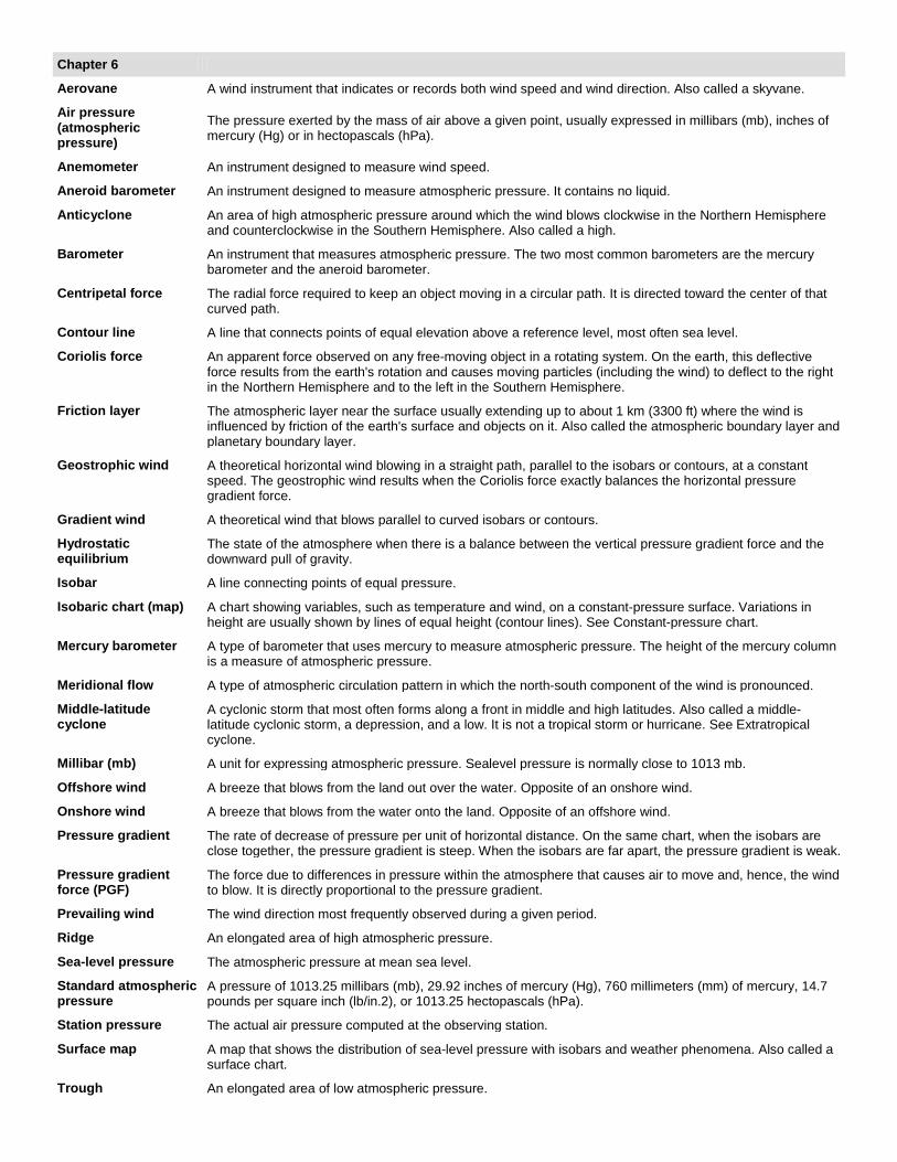
Chapter 6
Aerovane A wind instrument that indicates or records both wind speed and wind direction. Also called a skyvane.
Air pressure (atmospheric pressure)
The pressure exerted by the mass of air above a given point, usually expressed in millibars (mb), inches of mercury (Hg) or in hectopascals (hPa).
Anemometer An instrument designed to measure wind speed.
Aneroid barometer An instrument designed to measure atmospheric pressure. It contains no liquid.
Anticyclone An area of high atmospheric pressure around which the wind blows clockwise in the Northern Hemisphere and counterclockwise in the Southern Hemisphere. Also called a high.
Barometer An instrument that measures atmospheric pressure. The two most common barometers are the mercury barometer and the aneroid barometer.
Centripetal force The radial force required to keep an object moving in a circular path. It is directed toward the center of that curved path.
Contour line A line that connects points of equal elevation above a reference level, most often sea level.
Coriolis force An apparent force observed on any free-moving object in a rotating system. On the earth, this deflective force results from the earth's rotation and causes moving particles (including the wind) to deflect to the right in the Northern Hemisphere and to the left in the Southern Hemisphere.
Friction layer The atmospheric layer near the surface usually extending up to about 1 km (3300 ft) where the wind is influenced by friction of the earth's surface and objects on it. Also called the atmospheric boundary layer and planetary boundary layer.
Geostrophic wind A theoretical horizontal wind blowing in a straight path, parallel to the isobars or contours, at a constant speed. The geostrophic wind results when the Coriolis force exactly balances the horizontal pressure gradient force.
Gradient wind A theoretical wind that blows parallel to curved isobars or contours.
Hydrostatic equilibrium
The state of the atmosphere when there is a balance between the vertical pressure gradient force and the downward pull of gravity.
Isobar A line connecting points of equal pressure.
Isobaric chart (map) A chart showing variables, such as temperature and wind, on a constant-pressure surface. Variations in height are usually shown by lines of equal height (contour lines). See Constant-pressure chart.
Mercury barometer A type of barometer that uses mercury to measure atmospheric pressure. The height of the mercury column is a measure of atmospheric pressure.
Meridional flow A type of atmospheric circulation pattern in which the north-south component of the wind is pronounced.
Middle-latitude cyclone
A cyclonic storm that most often forms along a front in middle and high latitudes. Also called a middle-latitude cyclonic storm, a depression, and a low. It is not a tropical storm or hurricane. See Extratropical cyclone.
Millibar (mb) A unit for expressing atmospheric pressure. Sealevel pressure is normally close to 1013 mb.
Offshore wind A breeze that blows from the land out over the water. Opposite of an onshore wind.
Onshore wind A breeze that blows from the water onto the land. Opposite of an offshore wind.
Pressure gradient The rate of decrease of pressure per unit of horizontal distance. On the same chart, when the isobars are close together, the pressure gradient is steep. When the isobars are far apart, the pressure gradient is weak.
Pressure gradient force (PGF)
The force due to differences in pressure within the atmosphere that causes air to move and, hence, the wind to blow. It is directly proportional to the pressure gradient.
Prevailing wind The wind direction most frequently observed during a given period.
Ridge An elongated area of high atmospheric pressure.
Sea-level pressure The atmospheric pressure at mean sea level.
Standard atmospheric pressure
A pressure of 1013.25 millibars (mb), 29.92 inches of mercury (Hg), 760 millimeters (mm) of mercury, 14.7 pounds per square inch (lb/in.2), or 1013.25 hectopascals (hPa).
Station pressure The actual air pressure computed at the observing station.
Surface map A map that shows the distribution of sea-level pressure with isobars and weather phenomena. Also called a surface chart.
Trough An elongated area of low atmospheric pressure.

Wind profiler A Doppler radar capable of measuring the turbulent eddies that move with the wind. Because of this, it is able to provide a vertical picture of wind speed and wind direction.
Wind rose A diagram that shows the percent of time that the wind blows from different directions at a given location over a given time.
Wind vane An instrument used to indicate wind direction.
Zonal wind flow A wind that has a predominate west-to-east component.

Chapter 7
Aleutian low The subpolar low-pressure area that is centered near the Aleutian Islands on charts that show mean sea-level pressure.
Arctic Oscillation (AO) A reversal of atmospheric pressure over the Arctic that produces changes in the upper-level westerly winds over northern latitudes. These changes in upper-level winds influence winter weather patterns over North America, Greenland, and Europe.
Bermuda high A semipermanent high in the subtropical high-pressure belt centered near 30° latitude. The Bermuda high is located over the Atlantic Ocean off the east coast of North America. The Pacific high is located off the west coast of North America. See Subtropical high.
Chinook wind A warm, dry wind on the eastern side of the Rocky Mountains. In the Alps, the wind is called a Foehn.
Clear air turbulence (CAT)
Turbulence encountered by aircraft flying through cloudless skies. Thermals, wind shear, and jet streams can each be a factor in producing CAT.
Doldrums The region near the equator that is characterized by low pressure and light, shifting winds.
Dust devil (whirlwind) A small but rapidly rotating wind made visible by the dust, sand, and debris it picks up from the surface. It develops best on clear, dry, hot afternoons.
El Niño An extensive ocean warming that begins along the coast of Peru and Ecuador and extends westward over the tropical Pacific. Major El Niño events, or strong El Niños, occur once every 2 to 7 years as a current of nutrient-poor tropical water moves southward along the west coast of South America.
ENSO (El Niño/Southern Oscillation)
A condition in the tropical Pacific whereby the reversal of surface air pressure at opposite ends of the Pacific Ocean induces westerly winds, a strengthening of the equatorial countercurrent, and extensive ocean warming.
General circulation of the atmosphere Large-scale atmospheric motions over the entire earth.
Gulf stream A warm, swift, narrow ocean current flowing along the east coast of the United States.
Haboob A dust or sandstorm that forms as cold downdrafts from a thunderstorm turbulently lift dust and sand into the air.
Hadley cell A thermal circulation proposed by George Hadley to explain the movement of the trade winds. It consists of rising air near the equator and sinking air near 30° latitude.
Icelandic low The subpolar low-pressure area that is centered near Iceland on charts that show mean sea-level pressure.
Intertropical Convergence Zone (ITCZ)
The boundary zone separating the northeast trade winds of the Northern Hemisphere from the southeast trade winds of the Southern Hemisphere.
Jet stream Relatively strong winds concentrated within a narrow band in the atmosphere.
Katabatic (fall) wind Any wind blowing downslope. It is usually cold.
La Niña A condition where the central and eastern tropical Pacific Ocean turns cooler than normal.
Land breeze A coastal breeze that blows from land to sea, usually at night.
Macroscale The normal meteorological synoptic scale for obtaining weather information. It can cover an area ranging from the size of a continent to the entire globe.
Mesoscale The scale of meteorological phenomena that range in size from a few km to about 100 km. It includes local winds, thunderstorms, and tornadoes.
Microscale The smallest scale of atmospheric motions.
Monsoon A name given to seasonal winds that typically blow from different directions during different times of the year, most often during summer and winter.
Monsoon wind system
A wind system that reverses direction between winter and summer. Usually the wind blows from land to sea in winter and from sea to land in summer.
Mountain and valley breeze
A local wind system of a mountain valley that blows downhill (mountain breeze) at night and uphill (valley breeze) during the day.
North Atlantic Oscillation (NAO)
A reversal of atmospheric pressure over the Atlantic Ocean that influences the weather over Europe and over eastern North America.
Pacific Decadal Oscillation (PDO) A reversal in ocean surface temperatures that occurs every 20 to 30 years over the northern Pacific Ocean.

Pacific high A semipermanent high in the subtropical high-pressure belt centered near 30° latitude. The Bermuda high is located over the Atlantic Ocean off the east coast of North America. The Pacific high is located off the west coast of North America. Also See Subtropical high.
Polar easterlies A shallow body of easterly winds located at high latitudes poleward of the subpolar low.
Polar front A semipermanent, semicontinuous front that separates tropical air masses from polar air masses.
Polar front jet stream (polar jet)
The jet stream that is associated with the polar front in middle and high latitudes. It is usually located at altitudes between 9 and 12 km.
Rotors Turbulent eddies that form downwind of a mountain chain, creating hazardous flying conditions.
Santa Ana wind A warm, dry wind that blows into southern California from the east off the elevated desert plateau. Its warmth is derived from compressional heating.
Scales of motion The hierarchy of atmospheric circulations from tiny gusts to giant storms.
Sea breeze A coastal local wind that blows from the ocean onto the land. The leading edge of the breeze is termed a sea-breeze front.
Siberian high A strong, shallow area of high pressure that forms over Siberia in winter.
Southern Oscillation (SO)
The reversal of surface air pressure at opposite ends of the tropical Pacific Ocean that occur during major El Niño events.
Subpolar low A belt of low pressure located between 50° and 70° latitude. In the Northern Hemisphere, this �belt� consists of the Aleutian low in the North Pacific and the Icelandic low in the North Atlantic. In the Southern Hemisphere, it exists around the periphery of the Antarctic continent.
Subtropical high A semipermanent high in the subtropical high-pressure belt centered near 30° latitude. The Bermuda high is located over the Atlantic Ocean off the east coast of North America. The Pacific high is located off the west coast of North America.
Subtropical jet stream The jet stream typically found between 20° and 30° latitude at altitudes between 12 and 14 km.
Teleconnections A linkage between weather changes occurring in widely separated regions of the world.
Thermal circulations Air flow resulting primarily from the heating and cooling of air.
Trade winds The winds that occupy most of the tropics and blow from the subtropical highs to the equatorial low.
Upwelling The rising of water (usually cold) toward the surface from the deeper regions of a body of water.
Valley breeze A local wind system of a mountain valley that blows downhill (mountain breeze) at night and uphill (valley breeze) during the day. See Mountain breeze.
Westerlies The dominant westerly winds that blow in the middle latitudes on the poleward side of the subtropical high-pressure areas.
Wind shear The rate of change of wind speed or wind direction over a given distance.
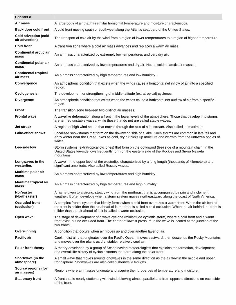
Chapter 8
Air mass A large body of air that has similar horizontal temperature and moisture characteristics.
Back-door cold front A cold front moving south or southwest along the Atlantic seaboard of the United States.
Cold advection (cold air advection) The transport of cold air by the wind from a region of lower temperatures to a region of higher temperature.
Cold front A transition zone where a cold air mass advances and replaces a warm air mass.
Continental arctic air mass An air mass characterized by extremely low temperatures and very dry air.
Continental polar air mass An air mass characterized by low temperatures and dry air. Not as cold as arctic air masses.
Continental tropical air mass An air mass characterized by high temperatures and low humidity.
Convergence An atmospheric condition that exists when the winds cause a horizontal net inflow of air into a specified region.
Cyclogenesis The development or strengthening of middle-latitude (extratropical) cyclones.
Divergence An atmospheric condition that exists when the winds cause a horizontal net outflow of air from a specific region.
Front The transition zone between two distinct air masses.
Frontal wave A wavelike deformation along a front in the lower levels of the atmosphere. Those that develop into storms are termed unstable waves, while those that do not are called stable waves.
Jet streak A region of high wind speed that moves through the axis of a jet stream. Also called jet maximum.
Lake-effect snows Localized snowstorms that form on the downwind side of a lake. Such storms are common in late fall and early winter near the Great Lakes as cold, dry air picks up moisture and warmth from the unfrozen bodies of water.
Lee-side low Storm systems (extratropical cyclones) that form on the downwind (lee) side of a mountain chain. In the United States lee-side lows frequently form on the eastern side of the Rockies and Sierra Nevada mountains.
Longwaves in the westerlies
A wave in the upper level of the westerlies characterized by a long length (thousands of kilometers) and significant amplitude. Also called Rossby waves.
Maritime polar air mass An air mass characterized by low temperatures and high humidity.
Maritime tropical air mass An air mass characterized by high temperatures and high humidity.
Nor'easter (Northeaster)
A name given to a strong, steady wind from the northeast that is accompanied by rain and inclement weather. It often develops when a storm system moves northeastward along the coast of North America.
Occluded front (occlusion)
A complex frontal system that ideally forms when a cold front overtakes a warm front. When the air behind the front is colder than the air ahead of it, the front is called a cold occlusion. When the air behind the front is milder than the air ahead of it, it is called a warm occlusion.
Open wave The stage of development of a wave cyclone (midlatitude cyclonic storm) where a cold front and a warm front exist, but no occluded front. The center of lowest pressure in the wave is located at the junction of the two fronts.
Overrunning A condition that occurs when air moves up and over another layer of air.
Pacific air Cool, moist air that originates over the Pacific Ocean, moves eastward, then descends the Rocky Mountains and moves over the plains as dry, stable, relatively cool air.
Polar front theory A theory developed by a group of Scandinavian meteorologists that explains the formation, development, and overall life history of cyclonic storms that form along the polar front.
Shortwave (in the atmosphere)
A small wave that moves around longwaves in the same direction as the air flow in the middle and upper troposphere. Shortwaves are also called shortwave troughs.
Source regions (for air masses) Regions where air masses originate and acquire their properties of temperature and moisture.
Stationary front A front that is nearly stationary with winds blowing almost parallel and from opposite directions on each side of the front.

Warm advection (or warm air advection)
The transport of warm air by the wind from a region of higher temperatures to a region of lower temperatures.
Warm front A front that moves in such a way that warm air replaces cold air.
Wave cyclone An extratropical cyclone that forms and moves along a front. The circulation of winds about the cyclone tends to produce a wavelike deformation on the front.
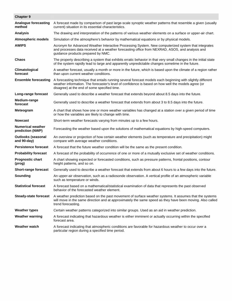
Chapter 9
Analogue forecasting method
A forecast made by comparison of past large-scale synoptic weather patterns that resemble a given (usually current) situation in its essential characteristics.
Analysis The drawing and interpretation of the patterns of various weather elements on a surface or upper-air chart.
Atmospheric models Simulation of the atmosphere's behavior by mathematical equations or by physical models.
AWIPS Acronym for Advanced Weather Interactive Processing System. New computerized system that integrates and processes data received at a weather forecasting office from NEXRAD, ASOS, and analysis and guidance products prepared by NMC.
Chaos The property describing a system that exhibits erratic behavior in that very small changes in the initial state of the system rapidly lead to large and apparently unpredictable changes sometime in the future.
Climatological forecast
A weather forecast, usually a month or more in the future, which is based upon the climate of a region rather than upon current weather conditions.
Ensemble forecasting A forecasting technique that entails running several forecast models each beginning with slightly different weather information. The forecaster's level of confidence is based on how well the models agree (or disagree) at the end of some specified time.
Long-range forecast Generally used to describe a weather forecast that extends beyond about 8.5 days into the future.
Medium-range forecast Generally used to describe a weather forecast that extends from about 3 to 8.5 days into the future.
Meteogram A chart that shows how one or more weather variables has changed at a station over a given period of time or how the variables are likely to change with time.
Nowcast Short-term weather forecasts varying from minutes up to a few hours.
Numerical weather prediction (NWP) Forecasting the weather based upon the solutions of mathematical equations by high-speed computers.
Outlooks (seasonal and 90-day)
An overview or projection of how certain weather elements (such as temperature and precipitation) might compare with average weather conditions.
Persistence forecast A forecast that the future weather condition will be the same as the present condition.
Probability forecast A forecast of the probability of occurrence of one or more of a mutually exclusive set of weather conditions.
Prognostic chart (prog)
A chart showing expected or forecasted conditions, such as pressure patterns, frontal positions, contour height patterns, and so on.
Short-range forecast Generally used to describe a weather forecast that extends from about 6 hours to a few days into the future.
Sounding An upper-air observation, such as a radiosonde observation. A vertical profile of an atmospheric variable such as temperature or winds.
Statistical forecast A forecast based on a mathematical/statistical examination of data that represents the past observed behavior of the forecasted weather element.
Steady-state forecast A weather prediction based on the past movement of surface weather systems. It assumes that the systems will move in the same direction and at approximately the same speed as they have been moving. Also called trend forecasting.
Weather types Certain weather patterns categorized into similar groups. Used as an aid in weather prediction.
Weather warning A forecast indicating that hazardous weather is either imminent or actually occurring within the specified forecast area.
Weather watch A forecast indicating that atmospheric conditions are favorable for hazardous weather to occur over a particular region during a specified time period.
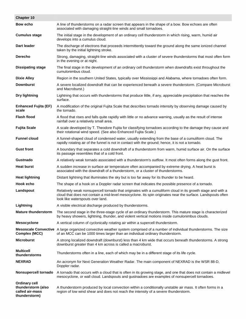
Chapter 10
Bow echo A line of thunderstorms on a radar screen that appears in the shape of a bow. Bow echoes are often associated with damaging straight-line winds and small tornadoes.
Cumulus stage The initial stage in the development of an ordinary cell thunderstorm in which rising, warm, humid air develops into a cumulus cloud.
Dart leader The discharge of electrons that proceeds intermittently toward the ground along the same ionized channel taken by the initial lightning stroke.
Derecho Strong, damaging, straight-line winds associated with a cluster of severe thunderstorms that most often form in the evening or at night.
Dissipating stage The final stage in the development of an ordinary cell thunderstorm when downdrafts exist throughout the cumulonimbus cloud.
Dixie Alley Region in the southern United States, typically over Mississippi and Alabama, where tornadoes often form.
Downburst A severe localized downdraft that can be experienced beneath a severe thunderstorm. (Compare Microburst and Macroburst.)
Dry lightning Lightning that occurs with thunderstorms that produce little, if any, appreciable precipitation that reaches the surface.
Enhanced Fujita (EF) scale
A modification of the original Fujita Scale that describes tornado intensity by observing damage caused by the tornado.
Flash flood A flood that rises and falls quite rapidly with little or no advance warning, usually as the result of intense rainfall over a relatively small area.
Fujita Scale A scale developed by T. Theodore Fujita for classifying tornadoes according to the damage they cause and their rotational wind speed. (See also Enhanced Fujita Scale.)
Funnel cloud A funnel-shaped cloud of condensed water, usually extending from the base of a cumuliform cloud. The rapidly rotating air of the funnel is not in contact with the ground; hence, it is not a tornado.
Gust front A boundary that separates a cold downdraft of a thunderstorm from warm, humid surface air. On the surface its passage resembles that of a cold front.
Gustnado A relatively weak tornado associated with a thunderstorm's outflow. It most often forms along the gust front.
Heat burst A sudden increase in surface air temperature often accompanied by extreme drying. A heat burst is associated with the downdraft of a thunderstorm, or a cluster of thunderstorms.
Heat lightning Distant lightning that illuminates the sky but is too far away for its thunder to be heard.
Hook echo The shape of a hook on a Doppler radar screen that indicates the possible presence of a tornado.
Landspout Relatively weak nonsupercell tornado that originates with a cumuliform cloud in its growth stage and with a cloud that does not contain a mid-level mesocyclone. Its spin originates near the surface. Landspouts often look like waterspouts over land.
Lightning A visible electrical discharge produced by thunderstorms.
Mature thunderstorm The second stage in the three-stage cycle of an ordinary thunderstorm. This mature stage is characterized by heavy showers, lightning, thunder, and violent vertical motions inside cumulonimbus clouds.
Mesocyclone A vertical column of cyclonically rotating air within a supercell thunderstorm.
Mesoscale Convective Complex (MCC)
A large organized convective weather system comprised of a number of individual thunderstorms. The size of an MCC can be 1000 times larger than an individual ordinary thunderstorm.
Microburst A strong localized downdraft (downburst) less than 4 km wide that occurs beneath thunderstorms. A strong downburst greater than 4 km across is called a macroburst.
Multicell thunderstorms Thunderstorms often in a line, each of which may be in a different stage of its life cycle.
NEXRAD An acronym for Next Generation Weather Radar. The main component of NEXRAD is the WSR 88-D, Doppler radar.
Nonsupercell tornado A tornado that occurs with a cloud that is often in its growing stage, and one that does not contain a midlevel mesocyclone, or wall cloud. Landspouts and gustnadoes are examples of nonsupercell tornadoes.
Ordinary cell thunderstorm (also called air-mass thunderstorm)
A thunderstorm produced by local convection within a conditionally unstable air mass. It often forms in a region of low wind shear and does not reach the intensity of a severe thunderstorm.
Outflow boundary A surface boundary separating cooler more-dense air from warmer less-dense air. Outflow boundaries formed by the horizontal spreading of cool air that originated inside a thunderstorm.
Overshooting top A situation in a mature thunderstorm where rising air, associated with strong convection, penetrates into a stable layer (usually the stratosphere), forcing the upper part of the cloud to rise above its relatively flat anvil top.
Return stroke The luminous lightning stroke that propagates upward from the earth to the base of a cloud.
Roll cloud A dense, roll-shaped, elongated cloud that appears to slowly spin about a horizontal axis behind the leading edge of a thunderstorm's gust front.
Shelf cloud A dense, arch-shaped, ominous-looking cloud that often forms along the leading edge of a thunderstorm's gust front, especially when stable air rises up and over cooler air at the surface. Also called an arcus cloud.
Sonic boom A loud explosive-like sound caused by a shock wave emanating from an aircraft (or any object) traveling at or above the speed of sound.
Squall line A line of thunderstorms that form along a cold front or out ahead of it.
St. Elmo's fire A bright electric discharge that is projected from objects (usually pointed) when they are in a strong electric field, such as during a thunderstorm.
Stepped leader An initial discharge of electrons that proceeds intermittently toward the ground in a series of steps in a cloud-to-ground lightning stroke.
Straight-line wind Strong winds created by a thunderstorm's downdraft that flows outward, away from the storm in a straight line, more or less parallel to the ground.
Suction vortices Small, rapidly rotating whirls perhaps 10 m in diameter that are found within large tornadoes.
Supercell storm A severe thunderstorm that consists primarily of a single rotating updraft. Its organized internal structure allows the storm to maintain itself for several hours. Supercell storms can produce large hail and dangerous tornadoes.
Supercell tornadoes Tornadoes that occur within supercell thunderstorms that contain well-developed, mid-level mesocyclones.
Thunder The sound due to rapidly expanding gases along the channel of a lightning discharge.
Tornado An intense, rotating column of air that often protrudes from a cumuliform cloud in the shape of a funnel or a rope whose circulation is present on the ground. (See Funnel cloud.)
Tornado alley A region in the Great Plains of the United States extending from Texas and Oklahoma northward into Kansas and Nebraska where tornadoes are most frequent.
Tornado outbreak A series of tornadoes that forms within a particular region�a region that may include several states. Often associated with widespread damage and destruction.
Tornado warning A warning issued when a tornado has actually been observed either visually or on a radar screen. It is also issued when the formation of tornadoes is imminent.
Tornado watch A forecast issued to alert the public that tornadoes may develop within a specified area.
Tornadogenesis The process by which a tornado forms.
Wall cloud An area of rotating clouds that extends beneath a supercell thunderstorm and from which a funnel cloud may appear. Also called a collar cloud and pedestal cloud.
Waterspout A column of rotating wind over water that has characteristics of a dust devil and a tornado.

Chapter 11
Ekman transport Net surface water transport due to the Ekman spiral. In the Northern Hemisphere the transport is 90° to the right of the surface wind direction.
Eye (of hurricane) A region in the center of a hurricane (tropical cyclone) where the winds are light and skies are clear to partly cloudy.
Eyewall A wall of dense thunderstorms that surrounds the eye of a hurricane.
Eyewall replacement A situation within a hurricane (tropical cyclone) where the storm's original eyewall dissipates and a new eyewall forms outward, farther away from the center of the storm.
Hurricane A tropical cyclone having winds in excess of 64 knots (74 mi/hr).
Hurricane hunters A popular term for aircraft and/or personnel engaged in the reconnaissance of hurricanes (tropical cyclones).
Hurricane warning A warning given when it is likely that a hurricane will strike an area within 24 hours.
Hurricane watch A hurricane watch indicates that a hurricane poses a threat to an area (often within several days) and residents of the watch area should be prepared.
Saffir-Simpson scale A scale relating a hurricane's winds to the possible damage it is capable of inflicting. It is now called the Saffir-Simpson hurricane wind scale.
Storm surge An abnormal rise of the sea along a shore; primarily due to the winds of a storm, especially a hurricane.
Streamline A line that shows the wind-flow pattern.
Super typhoon A tropical cyclone (typhoon) in the western Pacific that has sustained winds of 130 knots or greater.
Trade wind inversion A temperature inversion frequently found in the subtropics over the eastern portions of the tropical oceans.
Tropical cyclone The general term for storms (cyclones) that form over warm tropical oceans.
Tropical depression A mass of thunderstorms and clouds generally with a cyclonic wind circulation of between 20 and 34 knots.
Tropical storm Organized thunderstorms with a cyclonic wind circulation between 35 and 64 knots.
Tropical wave A migratory wavelike disturbance in the tropical easterlies. Tropical waves occasionally intensify into tropical cyclones. They are also called easterly waves.
Typhoon A hurricane (tropical cyclone) that forms in the western Pacific Ocean.
Chapter 12
Arid climate An extremely dry climate�drier than the semi-arid climate. Often referred to as a �true desert� climate.
Climatic controls The relatively permanent factors that govern the general nature of the climate of a region.
Dry-summer subtropical climate
A climate characterized by mild, wet winters and warm to hot, dry summers. Typically located between 30 and 45 degrees latitude on the western side of continents. Also called Mediterranean climate.
Global climate Climate of the entire globe.
Highland climate The climate of high elevations. Also called mountain climate. There is no single climatic type but a variety of different climate zones often characterized by a rapid change in temperature and precipitation as one ascends or descends in elevation.
Humid continental climate
A climate characterized by severe winters and mild to warm summers with adequate annual precipitation. Typically located over large continental areas in the Northern Hemisphere between about 40° and 70° latitude.
Humid subtropical climate
A climate characterized by hot muggy summers, cool to cold winters, and abundant precipitation throughout the year.
Köppen classification system
A system for classifying climates developed by W. Köppen that is based mainly on annual and monthly averages of temperature and precipitation.
Laterite A soil formed under tropical conditions where heavy rainfall leaches soluble minerals from the soil. This leaching leaves the soil hard and poor for growing crops.
Macroclimate The general climate of a large area, such as a country.
Marine climate A climate controlled largely by the ocean. The ocean's influence keeps winters relatively mild and summers cool.
Mesoclimate The climate of an area ranging in size from a few acres to several square kilometers.
Microclimate The climate structure of the air space near the surface of the earth.
Permafrost A layer of soil beneath the earth's surface that remains frozen throughout the year.
Polar ice cap climate A climate characterized by extreme cold, as every month has an average temperature below freezing.
Polar tundra climate A climate characterized by extremely cold winters and cool summers, as the average temperature of the warmest month climbs above freezing but remains below 10°C (50°F).
Savanna A tropical or subtropical region of grassland and drought-resistant vegetation. Typically found in tropical wet-and-dry climates.
Semi-arid climate A dry climate where potential evaporation and transpiration exceed precipitation. Not as dry as the arid climate. Typical vegetation is short grass.
Steppe An area of grass-covered, treeless plains that has a semiarid climate.
Subpolar climate A climate observed in the Northern Hemisphere that borders the polar climate. It is characterized by severely cold winters and short, cool summers. Also known as taiga climate and boreal climate.
Taiga (boreal forest) The open northern part of the coniferous forest. Taiga also refers to subpolar climate.
Tropical monsoon climate A tropical climate with a brief dry period of perhaps one or two months.
Tropical rainforest A type of forest consisting mainly of lofty trees and a dense undergrowth near the ground.
Tropical wet climate A tropical climate with sufficient rainfall to produce a dense tropical rainforest.
Tropical wet-and-dry climate
A tropical climate poleward of the tropical wet climate where a distinct dry season occurs, often lasting for two months or more.
Xerophytes Drought-resistant vegetation.
Chapter 13
Chemical weathering-CO2 feedback
A negative feedback in earth's climate system. As chemical weathering of rocks increases, CO2 is removed from the atmosphere more quickly, which in turn weakens the greenhouse effect, causing the atmosphere to cool. Thus, an increase in global chemical weathering tends to lower atmospheric temperatures.
Climate change A change in the long-term statistical average of weather elements�such as temperature or precipitation�sustained over several decades or longer. Climate change is also called climatic change.
Dendrochronology The analysis of the annual growth rings of trees as a means of interpreting past climatic conditions.
Desertification A general increase in the desert conditions of a region.
Eccentricity (of the earth's orbit) The deviation of the earth's orbit from elliptical to nearly circular.
Geoengineering The use of global scale technology fixes to mitigate climate changes.
Global warming Increasing global surface air temperatures that show up in the climate record. The term global warming is usually attributed to human activities, such as increasing concentrations of greenhouse gases from automobiles and industrial processes, for example.
Ice Age The most recent period of extensive continental glaciation that saw large portions of North America and Europe covered with ice. It began about 2 million years ago and ended about 10,000 years ago. See Pleistocene epoch.
Interglacial period A time interval of relatively mild climate during the Ice Age when continental ice sheets were absent or limited in extent to Greenland and the Antarctic.
Little Ice Age The period from about 1550 to 1850 when average temperatures over Europe were lower, and alpine glaciers increased in size and advanced down mountain canyons.
Maunder minimum A period from about 1645 to 1715 when few, if any, sunspots were observed.
Mid-Holocene maximum A warm period in geologic history about 5000 to 6000 years ago that favored the development of plants.
Milankovitch theory A theory proposed by Milutin Milankovitch in the 1930s suggesting that changes in the earth's orbit were responsible for variations in solar energy reaching the earth's surface and climatic changes.
Negative feedback mechanism
A process whereby an initial change in an atmospheric process will tend to either reinforce the process (positive feedback) or weaken the process (negative feedback). See Feedback mechanism.
Obliquity (of the earth's axis) The tilt of the earth's axis. It represents the angle from the perpendicular to the plane of the earth's orbit.
Positive feedback mechanism
A process whereby an initial change in an atmospheric process will tend to either reinforce the process (positive feedback) or weaken the process (negative feedback). See Feedback mechanism.
Precession (of the earth's axis of rotation)
The wobble of the earth's axis of rotation that traces out the path of a cone over a period of about 23,000 years.
Radiative forcing An increase (positive) or a decrease (negative) in net radiant energy observed over an area at the tropopause. An increase in radiative forcing may induce surface warming, whereas a decrease may induce surface cooling.
Radiative forcing agent
Any factor (such as increasing greenhouse gases and variations in solar output) that can change the balance between incoming energy from the sun and outgoing energy from the earth and the atmosphere.
Snow-albedo feedback
A positive feedback whereby increasing surface air temperatures enhance the melting of snow and ice in polar latitudes. This reduces the earth's albedo and allows more sunlight to reach the surface, which causes the air temperature to rise even more.
Sulfate aerosols Tiny suspended solid particles (dust, smoke, etc.) or liquid droplets that enter the atmosphere from either natural or human (anthropogenic) sources, such as the burning of fossil fuels. Sulfur-containing fossil fuels, such as coal, produce sulfate aerosols. See Aerosols.
Water vapor�greenhouse effect feedback
A positive feedback whereby increasing surface air temperatures cause an increase in the evaporation of water from the oceans. Increasing concentrations of atmospheric water vapor enhance the greenhouse effect, which causes the surface air temperature to rise even more.
Younger-Dryas event A cold episode that took place about 11,000 years ago, when average temperatures dropped suddenly and portions of the Northern Hemisphere reverted back to glacial conditions.
Chapter 14
Acid deposition The depositing of acidic particles (usually sulfuric acid and nitric acid) at the earth's surface. Acid deposition occurs in dry form (dry deposition) or wet form (wet deposition). Acid rain and acid precipitation often denote wet deposition. (See Acid rain.)
Acid fog Cloud droplets or raindrops combining with gaseous pollutants, such as oxides of sulfur and nitrogen, to make falling rain (or snow) acidic�pH less than 5.0. If fog droplets combine with such pollutants it becomes acid fog.
Acid rain Cloud droplets or raindrops combining with gaseous pollutants, such as oxides of sulfur and nitrogen, to make falling rain (or snow) acidic�pH less than 5.0. If fog droplets combine with such pollutants it becomes acid fog.
Air pollutants Solid, liquid, or gaseous airborne substances that occur in concentrations high enough to threaten the health of people and animals, to harm vegetation and structures, or to toxify a given environment.
Air Quality Index (AQI) An index of air quality that provides daily air pollution concentrations. Intervals on the scale relate to potential health effects.
Atmospheric stagnation
A condition of light winds and poor vertical mixing that can lead to a high concentration of pollutants. Air stagnations are most often associated with fair weather, an inversion, and the sinking air of a high-pressure area.
Carbon monoxide (CO) A colorless, odorless, toxic gas that forms during the incomplete combustion of carbon-containing fuels.
Country breeze A light breeze that blows into a city from the surrounding countryside. It is best observed on clear nights when the urban heat island is most pronounced.
Dispersion (of pollution) The spreading out of atmospheric pollutants.
Hydrocarbons Chemical compounds composed of only hydrogen and carbon�they are included under the general term volatile organic compounds (VOCs).
Mixing depth The vertical extent of the mixing layer.
Mixing layer The unstable atmospheric layer that extends from the surface up to the base of an inversion. Within this layer, the air is well stirred.
Nitric oxide (NO) A colorless gas produced by natural bacterial action in soil and by combustion processes at high temperatures. In polluted air, nitric oxide can react with ozone and hydrocarbons to form other substances. In this manner, it acts as an agent in the production of photochemical smog.
Nitrogen dioxide (NO2)
A reddish-brown gas, produced by natural bacterial action in soil and by combustion processes at high temperatures. In the presence of sunlight, it breaks down into nitric oxide and atomic oxygen. In polluted air, nitrogen dioxide acts as an agent in the production of photochemical smog.
Ozone (O3) An almost colorless gaseous form of oxygen with an odor similar to weak chlorine. The highest natural concentration is found in the stratosphere where it is known as stratospheric ozone. It also forms in polluted air near the surface where it is the main ingredient of photochemical smog. Here, it is called tropospheric ozone.
Ozone hole A sharp drop in stratospheric ozone concentration observed over the Antarctic during the spring.
Particulate matter Solid particles or liquid droplets that are small enough to remain suspended in the air. Also called aerosols.
Photochemical smog Originally smog meant a mixture of smoke and fog. Today, smog means air that has restricted visibility due to pollution, or pollution formed in the presence of sunlight�photochemical smog. Also See Smog.
Primary air pollutants Air pollutants that enter the atmosphere directly.
Radiation inversion An increase in temperature with height due to radiational cooling of the earth's surface. Also called a nocturnal inversion.
Secondary air pollutants
Pollutants that form when a chemical reaction occurs between a primary air pollutant and some other component of air. Tropospheric ozone is a secondary air pollutant.
Smog Originally smog meant a mixture of smoke and fog. Today, smog means air that has restricted visibility due to pollution, or pollution formed in the presence of sunlight�photochemical smog.
Subsidence inversion A temperature inversion produced by compressional warming�the adiabatic warming of a layer of sinking air.
Sulfur dioxide (SO2) A colorless gas that forms primarily in the burning of sulfur-containing fossil fuels.
Urban heat island The increased air temperatures in urban areas as contrasted to the cooler surrounding rural areas.

Volatile organic compounds (VOCs)
A class of organic compounds that are released into the atmosphere from sources such as motor vehicles, paints, and solvents. VOCs (which include hydrocarbons) contribute to the production of secondary pollutants, such as ozone.
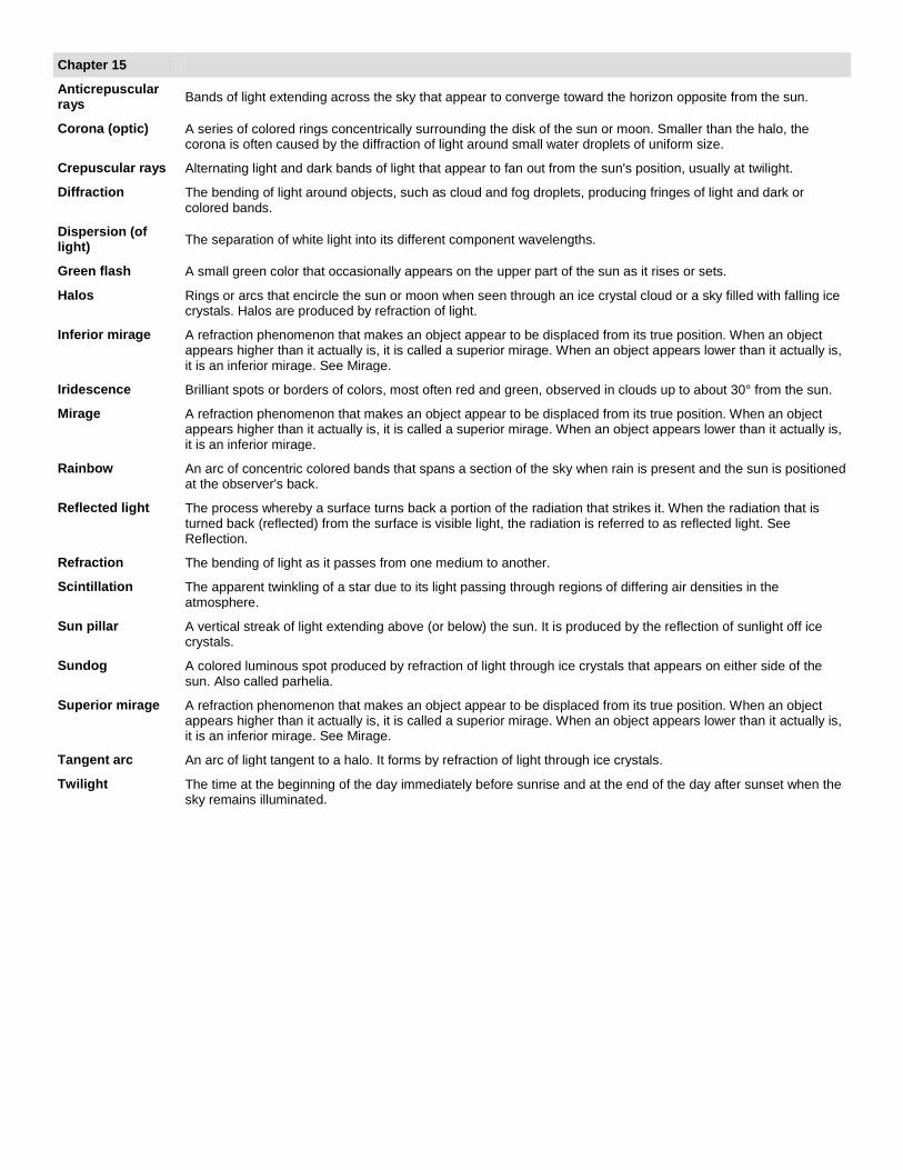
Chapter 15
Anticrepuscular rays Bands of light extending across the sky that appear to converge toward the horizon opposite from the sun.
Corona (optic) A series of colored rings concentrically surrounding the disk of the sun or moon. Smaller than the halo, the corona is often caused by the diffraction of light around small water droplets of uniform size.
Crepuscular rays Alternating light and dark bands of light that appear to fan out from the sun's position, usually at twilight.
Diffraction The bending of light around objects, such as cloud and fog droplets, producing fringes of light and dark or colored bands.
Dispersion (of light) The separation of white light into its different component wavelengths.
Green flash A small green color that occasionally appears on the upper part of the sun as it rises or sets.
Halos Rings or arcs that encircle the sun or moon when seen through an ice crystal cloud or a sky filled with falling ice crystals. Halos are produced by refraction of light.
Inferior mirage A refraction phenomenon that makes an object appear to be displaced from its true position. When an object appears higher than it actually is, it is called a superior mirage. When an object appears lower than it actually is, it is an inferior mirage. See Mirage.
Iridescence Brilliant spots or borders of colors, most often red and green, observed in clouds up to about 30° from the sun.
Mirage A refraction phenomenon that makes an object appear to be displaced from its true position. When an object appears higher than it actually is, it is called a superior mirage. When an object appears lower than it actually is, it is an inferior mirage.
Rainbow An arc of concentric colored bands that spans a section of the sky when rain is present and the sun is positioned at the observer's back.
Reflected light The process whereby a surface turns back a portion of the radiation that strikes it. When the radiation that is turned back (reflected) from the surface is visible light, the radiation is referred to as reflected light. See Reflection.
Refraction The bending of light as it passes from one medium to another.
Scintillation The apparent twinkling of a star due to its light passing through regions of differing air densities in the atmosphere.
Sun pillar A vertical streak of light extending above (or below) the sun. It is produced by the reflection of sunlight off ice crystals.
Sundog A colored luminous spot produced by refraction of light through ice crystals that appears on either side of the sun. Also called parhelia.
Superior mirage A refraction phenomenon that makes an object appear to be displaced from its true position. When an object appears higher than it actually is, it is called a superior mirage. When an object appears lower than it actually is, it is an inferior mirage. See Mirage.
Tangent arc An arc of light tangent to a halo. It forms by refraction of light through ice crystals.
Twilight The time at the beginning of the day immediately before sunrise and at the end of the day after sunset when the sky remains illuminated.