Embed Size (px)
Citation preview

Essential Elements of Information Publication Guidance Version 1.0 | March 2015 For Emergency Management Officials

2
Table of Contents
1 Executive Summary ......................................................................................................... 3
2 EEI Design Process ........................................................................................................... 5 2.1 EEI Templates .................................................................................................................... 11
3 EEI SOP Annex Templates .............................................................................................. 19 3.1 Standard Operating Procedure Annex: Transportation ....................................................... 21
3.1.1 Transportation: Air .............................................................................................................. 21 3.1.2 Transportation: Rail Network.............................................................................................. 22 3.1.3 Transportation: Roads ......................................................................................................... 23 3.1.4 Transportation: Waterways ................................................................................................ 24
3.2 Standard Operating Procedure Annex: Infrastructure ......................................................... 26 3.2.1 Infrastructure: Electricity Grid ............................................................................................ 26 3.2.2 Infrastructure: Natural Gas Grid ......................................................................................... 27 3.2.3 Infrastructure: Water Grid .................................................................................................. 28
3.3 Standard Operating Procedure Annex: Operations ............................................................. 29 3.3.1 Operations: Area Command ............................................................................................... 29 3.3.2 Operations: Communications (Public Safety and General Public) ...................................... 30 3.3.3 Operations: Evacuation Orders ........................................................................................... 31 3.3.4 Operations: Hospital Status ................................................................................................ 32 3.3.5 Operations: Injuries and Fatalities ...................................................................................... 33 3.3.6 Operations: Joint Reception, Staging, Onward Movement and Integration (JRSOI) Sites . 34 3.3.7 Operations: Points of Distribution (PODs) .......................................................................... 35 3.3.8 Operations: Shelters ........................................................................................................... 36 3.3.9 Operations: Staging Areas ................................................................................................... 37

3 1 Executive Summary There is a critical need for public safety officials to have the right information at the right time, so that officials can make good decisions by having actionable information readily available. Effective decision-making is contingent upon communities of interest collectively defining and codifying their operational information requirements for various missions. These collections of pre-defined operational information requirements are known as essential elements of information (EEIs). EEIs represent the evolution of the localized data sharing components from the custodial owners of data into a hierarchical system that allows for specific information requirements to be shared and understood at a regional or national view. Although many emergency management organizations have been establishing their own information requirements for some time, the objective of this publication guidance is to showcase a crowd-sourced definition of the information sharing elements required to support cross-jurisdictional sharing of EEIs. The EEIs in this guidance are not intended to represent “the” national model, but to present an emerging model that has gained traction throughout parts of the county and in several state and local communities, to help jumpstart agencies’ ability to more effectively employ their information enterprise in support of operations. Clear definition of EEIs will help foster the ability of communities to mobilize operators, planners, and technical personnel to work together to refine and share information products that help responders achieve their respective missions. The EEI Publication Guidance is a part of the Virtual USA (vUSA) product line distributed by the National Information Sharing Consortium (NISC) and developed in partnership with the White House Incident Management Information Sharing Sub-Committee (IMIS-SC). Version 1.0 draws upon the strategic EEI templates that were tested during the Central United States Earthquake Consortium’s (CUSEC) June 2014 CAPSTONE-14 Exercise. Subsequent versions will provide more tactical EEIs that come out of the NISC’s work with the IMIS-SC, which seeks to develop a framework to institutionalize an ongoing process of defining and prioritizing EEIs nationwide. A companion to this document is the NISC Member Portal, found at www.nisconsortium.org, where NISC members can test drive EEI data models, templates, tools, and apps (see Figure 1.1). NISC members will also have the ability to download executable map packages for the EEI templates and workflow models and deploy them in the native operational environment of each agency. These map packages will be compatible with ArcGIS, WebEOC, and other third party or customized solutions.

4
Figure 1.1: NISC Member Portal
This document is divided into three sections. Section 1 provides an Executive Summary. Section 2 describes the EEI Design Process, which outlines the key components of a process for defining EEIs for a given hazard, exercise, or plan. Section 3, Standard Operating Procedure (SOP) Annex Templates, was created for the purpose of linking and orienting the work of planners, operations, and technical staff around pre-defined EEIs. The content of this guidance was informed and influenced by numerous sources, including 12 Virtual USA regional field implementation projects; current-state technical capabilities that were assessed in more than 40 states; operational information requirements garnered from the Department of Homeland Security Science & Technology Directorate (DHS S&T), the DHS GeoCONOPS, the White House Open Government Initiative, and most recently, the implementation of the CUSEC CAPSTONE-14 exercise in June 2014.1
1 For more information on the CAPSTONE-14 Exercise, see the DHS Science & Technology First Responders Group’s Central U.S. Earthquake Consortium CAPSTONE-14 Exercise After-Action Report, and CUSEC’s CAPSTONE-14 After-Action Report at www.nisconsortium.org.

5
2 EEI Design Process This section outlines the key components of a process to define, test, and evaluate EEIs for a given hazard, exercise, or plan. It has been tested through numerous regional information sharing projects and captures the evolution of emerging practices from various Virtual USA projects. This process model was tested most recently during the CUSEC CAPSTONE-14 planning process that began in 2011 and culminated in a final exercise in June 2014. The model connects key decision points with the information requirements for making those decisions, while at the same time coordinating efforts with the systems and tools that are used to enable information exchange. It is critical to coordinate definition of EEIs among various roles in an organization that have a stake in information sharing discussions, including but not limited to operators, planners, and technical staff. This generic design model can be replicated in single agency plans or regional multi-jurisdictional response plans, including plans in the private sector and federal entities. The planning process outlined in this section contains a two key elements that could be used for any multi-jurisdictional information sharing effort. One key element is standardization of data formats. Data interoperability starts with a recognition that there are information gaps and that processes need to be developed to standardize capturing information into formats that are shareable. Another key element is the hierarchical organization of EEIs. Information requirements will differ for various roles, but agreeing on an organizational scheme that provides logical groupings helps to focus requirement gathering. Just as Emergency Support Functions (ESFs) provide a logical grouping of support capabilities, a logical grouping of EEIs provides an organizational structure for information gathering activities that may sometimes line up with ESFs when it makes sense to do so. For example, Transportation (ESF 1) is also a major information requirement that may include many detailed features depending on the type and scale of the response—from day to day 511/road status information to emergency operations centers determining key service routes during a major disaster. Standardization, along with hierarchical organization of EEIs, builds the foundation for a specific process for defining EEIs. This process is depicted in Figure 2.1 below and explained in more detail in the six steps that follow.

6
Figure 2.1: EEI Design Process
1. Initial EEI Requirements Discussion: Emergency managers and various partners must determine a mutually agreed upon list of EEIs for a given scenario, hazard type, or exercise. This initial discussion draws from knowledge of existing plans, but is not limited by them. An example would be the operator definitions found on Table 2.1 below that was developed by eight emergency management directors from the Central United States Earthquake Consortium (CUSEC) who were preparing for a catastrophic earthquake event. Executive-level agreement of EEIs is critical for an organization to have a comprehensive approach that will orient plans, training, technology, and operations in support of the mission.
Table 2.1 EEI Definitions for the Operator Essential Element of Information
Description
Electricity Grid Operational status of Electricity Grid Natural Gas Grid Operational status of Natural Gas Grid Water Grid Operational status of Water Grid Road Status (including bridges)
Operational status of roadway transportation network, especially pre-defined emergency supply routes critical for response and recovery efforts
Rail Network (including bridges)
Operational status of railway transportation network
Navigable Waterways Operational status of navigable waterway transportation network Air Transportation Infrastructure
Operational status and capabilities of airports and airspace
Area Command Locations Location and activation status of area command (often overlaps with state emergency operation centers)
Staging Areas Location, status, and type of staging areas, which are used to temporarily store resources required for emergency response and recovery

7 Points of Distribution (PODS)
Location, type, and operation status of PODs for distribution of food, water, and other bulk commodities
Joint Reception, Staging, Onward Movement and Integration (JRSOI) Sites
Location, status, and points of contact for JRSOI sites, established by the State branch of the National Guard to coordinate emergency response efforts
Evacuation Orders Areas under current evacuation orders, and the details concerning the orders
Injuries and Fatalities Confirmed number of injuries and fatalities Shelters Location and operational status of sheltering facilities Communications Operational status of landline, cellular, and internet access Hospital Status Operational status of hospitals, including beds available, supply
status, etc.
2. Working Group Formation and Reconciliation of the EEI List and Their Definitions: Once executive-level agreement of EEIs is achieved, operators, planners, and technical personnel should come together by forming a working group that will configure plans, processes, and systems to support the stated information requirements. Working group composition may vary across agencies. At a minimum it should include those personnel that have an operational coordination role around a particular interest area (e.g., ESF); planning staff who formulate hazard-specific plans, exercises, and SOPs; and technical staff that manage the enterprise including GIS personnel, WebEOC administrators, database administrators, and other developers actively involved in the process. In many cases, working groups may be subdivided according to specialty (e.g., a technical working group that may focus on GIS data requirements). The EEI list provided by emergency managers to the working group must be reconciled with:
• Existing base datasets available, such as the Homeland Security Information Program (HSIP) Gold or Freedom datasets, or state and local datasets;
• Current operational processes (WebEOC, EMITS, GIS, etc.); and • External live or sensor based systems (private sector store status, power company
outage reporting, 511 systems, etc.).
Data models and symbols must be decided upon based on operational requirements, and editing workflows must be tested with the available tools and systems in use. The working group may also evaluate various approaches for existing tools and easily configurable applications or develop new workflows within operational systems that scale to support regional and national-level involvement. For example, Table 2.2 shows a sample template designed to provide an actionable level of information for GIS personnel to configure systems in support of operational requirements.

8
Table 2.2. Sample EEI Templates for the GIS Manager Category EEI Feature
Type Suggested Attributes
Responsible ESF Status Red Status Yellow Status Green Status Gray
Infrastructure Electricity Grid
Name, State Name, Status, Comments, Provider Name, Without Power, Total Customers, Percent Out, Last Update, Updated By
12-Energy No availability
Limited availability Available Unknown
Infrastructure Natural Gas Grid
Name, State Name, Status, Comments, Provider Name, Last Update, Updated By
12-Energy No availability
Limited availability Available Unknown
Infrastructure Water Grid
Name, State Name, Status, Comments, Provider Name, Customers Affected, Last Update, Updated By
12-Energy No availability
Limited availability Available Unknown
After EEIs have been reviewed against existing datasets, consideration must also be given to how to create, manage, share, and procure information products for information gaps that do not exist or that are currently unavailable to a broad audience. Establishing partnerships between agencies can open up information to a broader audience to help move the EEI publication guidance beyond a multi-state, catastrophic planning method to a wider national dialogue, where agencies and organizations can create their own EEI templates at a more granular level. For example, during the CUSEC CAPSTONE-14 exercise, Tennessee volunteered to create a regional county status map for 18 EEIs where state and local officials could enter in the status of EEIs that they were currently not tracking through an existing system (see Figure 2.2). The output of this template was “mashed up” into a webmap and shared with dozens of agencies as over 13,000 status updates were created for more than 420 counties in five days.
Figure 2.2 Example of the WebEOC Regional EEI Status Board hosted by TEMA.

9 3. Coordinate Technical Outputs with Operations and Planning Personnel: Technical outputs for each EEI, as exemplified in table 2.2 above, should be coordinated with all operations and planning personnel in an organization to compare EEI requirements with existing plans, business processes, data models, and/or technologies. Operations personnel should drive definitions of key decisions and the timing of those decisions to further refine the EEIs and help drive the information collection workflows and owners of this process. The ideal scenario is that technical staff are not the ones inputting data during an event or an exercise. Technical staff should focus on configuring templates that are user friendly and accessible to operations staff who would be the primary source of data entry and information sharing during an event. Planning personnel should coordinate the information needs and requirements with hazard-specific plans, standard operating procedures, and exercise designs. Exercise designs are most effective when they realistically link hazard scenarios with the operational information requirements at each stage of the preparedness, response, recovery, or mitigation scenario. The CAPSTONE-14 model demonstrated that when information requirements are appropriately defined and coordinated across the enterprise, information products can be readily made available to support specific planning scenarios, partner missions, and situational awareness of monitoring parties. As new technologies emerge, workflows adapted by agencies and organizations outlining who owns what processes, what data to expect, and who to expect it from, will feed into future updates of EEI templates. This process is underscored by the principle that operational workflow requirements should drive technology since maintaining operational workflows is critical regardless of the technological capability. 4. Develop an Exercise to Test Plans and Workflows: Once all EEIs and their technical requirements have been fully vetted by an organization’s operations and planning personnel, organizations should develop an exercise to test EEI templates and workflows. When developing an exercise, it is important to coordinate the content and timing of exercise injects with the appropriate workflows in the updated hazard-specific plan. This will help to drive EEI testing and evaluation to see if the defined EEIs will support scaled information sharing at the local, state, regional, and national levels. For example, if the transportation EEI related to road status is exercised, the exercise plan should require a report of the status of key bridges to initiate the process for capturing the transportation road status EEI and showing that information on the map. However, the plan should not stop short of seeing status information on a map; the exercise plan should also account for the ability to make decisions based on that information across stakeholder organizations. An organization can only evaluate readiness for a particular hazard once an exercise links the operational need with the pre-scripted plan and the available data. 5. Exercise and Evaluate EEIs: Throughout the implementation of an exercise, operations, planning, technical, and executive-level staff should evaluate EEI workflows, data models, and applications to determine their effectiveness and utility. For example, what an executive or an operator have pre-determined as a critical information need may not actually turn out to be
10 critical during an exercise. Evaluations should include a minimum set of metrics related to the following:
• Metrics related to sharing of information to build a common operating picture; • Metrics related to the quality of EEI data models and symbols; • Metrics related to the ability to make decisions based on the information provided; and • Metrics related to the NASA Task Load Index2 that evaluate various data collection
workflows and the impact on personnel’s ability to get the job done. Collaborative evaluation among all relevant personnel of EEIs’ utility will help to inform future changes and refine operational workflows. 6. Create and Integrate Standard Operating Procedure (SOP) Annex Templates: Standard operating procedure (SOP) annex templates are intended to help to support one of the primary objectives of any agency, which is to develop, codify, and share EEIs required to inform decision makers. The intended home for these annexes is in the official SOP of an agency that is used as a basis for training, exercises, and planning. Upon adoption of EEIs, reconciliation will be required to fully integrate with existing operational processes. Further work will need to be done to identify and align the EEIs by hazard type, daily operations activities, and response activities from the local to federal levels. Documenting EEIs in SOP annexes provides a starting point for future EEI discussions, including reaching out to potential data partners for their authoritative sources of information, such as power providers, other private sector companies, or other government agencies. One aspect of the EEI discussion is to bring together these kinds of partners so more authoritative data can be used to reduce duplication of efforts. The templates also serve to institutionalize processes in an industry that often experiences high turnover, and with that change in personnel a loss in institutional knowledge.
2 See http://humansystems.arc.nasa.gov/groups/tlx/index.html for more information on the NASA Task Load Index.

11
2.1 EEI Templates The EEI Publication Guidance and member portal on www.nisconsortium.org provide a series of EEI data models, templates for operators and planners, and readily deployable tools, apps, and EEI map package templates (see Figures 2.3 and 2.4). The EEI templates featured were derived from the CUSEC CAPSTONE-14 planning effort, and can be divided into the following three categories: Transportation, Infrastructure, and Operations.
Figure 2.3 EEI Test Drive Data Models

12 Figure 2.4 NISC EEI Test Drive Workflow Model in ArcGIS Online and ArcGIS Online Dashboard
This EEI Publication Guidance provides a text-based visualization of some of the templates which may be accessed in the NISC member portal. However, this document does not describe how content was architected for sharing between systems such as ArcGIS Online, WebEOC, and customized enterprise systems. The CAPSTONE-14 Draft Guidelines for Publishing and Sharing Information available in the NISC resource library provides information on how to configure systems for operational use. Using the CAPSTONE-14 Draft Guidelines, the templates provided in the NISC Member Portal are available to jumpstart an agency with an assortment of EEI models that can be configured for use locally.

13 Each EEI described in this guidance contains one or more data layers and several important components, including the responsible Emergency Support Function (ESF), data owner, geometry type, the minimum set of attributes for the dataset, the estimated availability of the data after a disaster occurs, and the deliverable type. Many of the EEIs include links to dynamic web mapping services hosted on ArcGIS Online. Where applicable, the NISC sought to unify the data models for critical infrastructure and key resources with the HSIP and other existing data models, adding the operational status elements as appropriate which are not captured in the HSIP data models. The following tables identify EEI definitions for various roles, to include the operator (Table 2.3) and the GIS manager (Table 2.4). A sample EEI definition table for a database administrator is available in Table 2.5, but database administrator examples are not provided for each EEI. Table 2.3 EEI Definitions for the Operator EEI Description Electricity Grid Operational status of Electricity Grid Natural Gas Grid Operational status of Natural Gas Grid Water Grid Operational status of Water Grid Road Status (including bridges)
Operational status of roadway transportation network, especially pre-defined emergency supply routes critical for response and recovery efforts
Rail Network Operational status of railway transportation network Navigable Waterways Operational status of navigable waterways transportation network Air Transportation Infrastructure
Operational status of airports and airspace
Area Command Locations
Location and activation status of area command (often overlaps with state emergency operation centers)
Staging Areas Location, status, and type of staging areas, which are used to temporarily store resources required for emergency response and recovery
Points of Distribution (PODS)
Location, type, and operation status of PODs for distribution of food, water and other bulk commodities
Joint Reception, Staging, Onward Movement and Integration (JRSOI) Sites
Location, status, and points of contact for JRSOI sites, established by the State branch of the National Guard to coordinate emergency response efforts
Evacuation Orders Areas under current evacuation orders, and the details concerning the orders
Injuries and Fatalities Confirmed number of injuries and fatalities Shelters Location and operational status of sheltering facilities Communications Operational status of landline, cellular, and internet access Hospital Status Operational status of hospitals, including beds available, supply status,
etc.

Table 2.4 EEI Template for the GIS Manager EEI templates for the GIS Manager uses a color-coded scheme that works with various specific symbols sets, along with polygon fill colors, to help standardize an operational status view across many states and jurisdictions. Distinguishing color coding features that have known status values from those that are unknown and/or are not actively being tracked provide a new approach to status tracking. The accepted operational process is to set features to “unknown” by set criteria such as an earthquake or tornado, and then initiate processes for determining status. This gives a real-time view of the status update processes to update EEIs. For example, road inspection crews driving predesignated routes and reporting status along the way would be represented on the map by gray for roads not yet inspected or red, yellow, or green as they report status.
Category EEI Feature Type Suggested Attributes Responsible
ESF Status Red Status Yellow Status Green Status Gray
Infrastructure Electricity Grid
Name, State Name, Status, Comments, Provider Name, Without Power, Total Customers, Percent Out, Last Update, Updated By
12-Energy No availability Limited availability Available Unknown
Infrastructure Natural Gas Grid
Name, State Name, Status, Comments, Provider Name, Last Update, Updated By
12-Energy No availability Limited availability Available Unknown
Infrastructure Water Grid
Name, State Name, Status, Comments, Provider Name, Customers Affected, Last Update, Updated By
12-Energy No availability Limited availability Available Unknown

15
Category EEI Feature Type Suggested Attributes Responsible
ESF Status Red Status Yellow Status Green Status Gray
Transportation Roads (including bridges)
Roads: Name, Description, Location, Condition, Status Bridges: Location, Roadway, Roadway Detail, Status, Comments, Last Update, Updated By
1-Transportation
Major delays or closed
Minor delays due to road conditions
Passable Unknown
Transportation Rail network (including bridges)
Rail Network Status, Comments, Last Update, Updated By
1-Transportation
Major delays or closed
Minor delays due to conditions Passable Unknown
Transportation Waterways
Waterway Name, Waterway Type, Location, Status, Description, Estimate Fix Time, Contact, Recent Progress
1-Transportation
Major delays or closed
Minor delays due to conditions Passable Unknown
Transportation Air
State Name, County Name, City Name, Full Name, Status, Comments, Last Update, Updated By
1-Transportation Closed
Limited use/emergency use only
Open Unknown
Operations
Area Command Locations
Name, Street, City, State, Zip code, Phone, Fax, Website, Traffic, Status, Comments, POC, POC Phone, State or Local
5-Emergency Management
Level 1-full activation
Level 2-partial activation
Level 3-operational/ monitoring
Unknown

16
Category EEI Feature Type Suggested Attributes Responsible
ESF Status Red Status Yellow Status Green Status Gray
Operations Staging Areas
Staging Area Status, Staging Area Type, POC Name, POC Phone, Comments, GlobalID_str, State, Staging Area Name
5-Emergency Management Closed
Limited use/emergency use only
Open Unknown
Operations
Points of Distribution (PODS)
POD Status, Name, POC Name, POC Phone, Comments, Location, Commodities
ESF 7- Logistics Closed Limited use/emergency use only
Open Unknown
Operations
Joint Reception, Staging, Onward Movement and Integration (JRSOI) Sites
JRSOI Status, JRSOI Type, POC Name, POC Phone #, Last Update Date, Last Update By, Comments, Capacity
5-Emergency Management Closed
Limited use/emergency use only
Open Unknown
Operations Evacuation Orders
Name, State Name, Evacuation Orders, Comments, Area of Concern, Point of Contact, Start Date, End Date, Phone, Last Update, Updated By
5-Emergency Management Mandatory Voluntary/
phased None Unknown
Operations
Injuries and Fatalities
Name, State Name, Status, Injuries, Fatalities, Comments, Last Update, Updated By
8-Public Health and Medical Services
Confirmed fatalities/ injuries
Fatality/injury confirmation underway
No fatality reports Unknown
Operations Shelters
Name, Telephone, Address, City, State, County, Pet Facilities, Status, POC, POC Phone, Capacity Max, Capacity Current
6-Mass Care-Emer Assistance-Housing-Human Services
Full or over capacity
Open-more than 50% occupancy
Open-less than 50% occupancy or Closed
Unknown

17
Category EEI Feature Type Suggested Attributes Responsible
ESF Status Red Status Yellow Status Green Status Gray
Operations
Communications (Public Safety and General Public)
Name, State Name, Communication Network, Comments, POC, POC Phone, Last Update, Updated By
2-Communications
Emergency and commercial communications network failure?
Emergency communication up; commercial failed or limited, including cellular
Normal operations Unknown
Operations Hospital Status
Name, Alternative Name, Address, City, State, Zip, Phone, POC, Website, County, Owner, Total Staff, Type, Beds, Trauma, Helipad, Date Created, Status, Comments, Updated By, Max Capacity, Current Capacity
8-Public Health and Medical Services
Not operational or no capacity for new patients
At or above capacity
Available capacity Unknown

Table 2.5 EEI Definitions for the Database Administrator Below is a sample hospital status data model for the database administrator. This is one example that can be used as a model for other EEIs.

19
3 EEI SOP Annex Templates The EEI standard operating procedure (SOP) annex templates were created for the purpose of linking and orienting the work of planners, operations staff, and technical staff around pre-defined EEIs. This SOP annex model can be used to link plans to the actual implementation and configuration of technologies in support of stated operational needs. This ultimately would inform how data is created, procured, shared, and tracked in various systems of record, including but not limited to systems such as WebEOC, ArcGIS-based systems, or other database systems. Using SOP annex templates captures information requirements in an organized plan which can withstand changes in management and/or operational tools, thus reducing risk to continuity of government. Plans that have specific information requirements with pre-identified owners and clear processes in place for information management allow for better integration of technology into daily and catastrophic operations. SOP annex templates help to support one of the primary objectives of any agency, which is to develop, codify, and share EEIs required to inform decision makers. Requirements change throughout the course of a disaster, which gives way to other processes. SOP annex templates capture detailed information. These templates ensure accurate identification of who is going to own which processes as well as when the data will become available as requirements change throughout the course of an emergency management disaster cycle. EEIs can be derived from various sources of information, including data from predictive modeling, situation reports, and data collected in the field. Strategic EEI attributes are those that are required for the purposes of shared situational awareness, monitoring, and coordination support at regional or national levels. For example, agency X may have a need to know whether there is power available in a particular jurisdiction for the purposes of communications and coordinating mutual aid support, but they may not need to know details about the particular transformer that is broken, as the utility teams that will be deployed to fix the problem are those that require that granular level of information. Tactical EEI attributes are those that are required for the purposes of the local resource owner or “boots on the ground” professional to get a job done. The tactical EEI definition builds on the strategic EEI definition, to ensure that horizontal and vertical information sharing is consistent and coordinated. For example, power status at the tactical level may include the utility provider name, transformer details, and estimated time to fix IN ADDITION TO the typical information provided at the strategic level which may only include a county level representation of the number without power, number of total customers, percent without power, etc. NISC members can test drive SOP templates or download a map package by clicking on the link displayed at the end of each template. Note that in the EEI test drives on the NISC Member Portal, the strategic EEI attributes will be highlighted and may or may not include the tactical

20
EEI attributes. In addition, ancillary layers provide added data elements that may or may not be represented in EEI templates found in the NISC Member Portal.

21
3.1 Standard Operating Procedure Annex: Transportation The transportation SOP annexes provide a model definition of strategic and tactical EEI attributes required for decision makers to respond to all hazard types. The transportation-related annexes document the CUSEC model for operational and technical information requirements. Other agencies may use this to inform how to configure their own enterprise to share information horizontally and vertically. The transportation annex templates are intended to be included as a part of an agency’s SOPs to unify information management needs of operators, planners, and technical staff. The templates may be adapted and configured for specific use by ESFs or modified to support specific hazard types.
3.1.1 Transportation: Air Air transportation has been identified as an EEI to support response and recovery operations following a disaster. The layers included in this EEI are intended to inform the operational status and capabilities of airports and airspace. Responsible ESF ESF 1 – Transportation
Data Owner/Sources Federal Aviation Administration (FAA), Local Authorities, Emergency Management Agency (EMA)
Primary Layer Geometry Type
Suggested Attributes Estimated Availability
Deliverable
Airport Status
Strategic: State Name, County Name, City Name, Full Name, Status, Comments, Last Update, Updated By Tactical: Material Handling Equipment, Fuel Availability, Security, Maintenance, Staffing & Hours of Operation, Maximum-On-The-Ground (MOG) & Ramp Capacity, Last Update Date/Time
24 hours Operational Status Reporting Template Editable Map Service Web Map
Ancillary Layers National Aerospace System (NAS)
Air Navigation System, Air Traffic Control, Airspace Status, Temp. Flight Restrictions
24 hours Map Service
To test drive this EEI template and/or download the map package to use in your organization, click on link below and log into the NISC Member Portal.

22
3.1.2 Transportation: Rail Network Rail transportation has been identified as an EEI to support recovery operations following a disaster. Immediately after a disaster, information needs will focus on life safety issues associated with the rail infrastructure, for example, stranded trains or HazMat concerns along rail lines. Longer term information needs will focus on the status of rail lines, crossings, and rail yards for the purposes of commodity transport. The major focus will be on rail yards as intermodal transportation hubs to connect to other transportation networks. Responsible ESF ESF 1 – Transportation
Data Owner/Sources Department of Transportation (DOT), Private
Primary Layer Geometry Type
Suggested Attributes Estimated Availability
Deliverable
Rail Network Status
Strategic: Rail Network Status, Comments, Last Update, Updated By Tactical: Community Impact (Hazmat, large fires, etc.), status of bridges/overpasses, stranded train
24 hours Operational Status Reporting Template Editable Map Service Web Map
Ancillary Layers Passenger Rail Status
Train Station Status, Passenger Rail Operator Name, Evacuation operations, Stranded Trains (Y/N), Last Update Date/Time
24 hours Map Service
Rail Yard Status
Status, Community Impact (Hazmat, etc.), Rail Yard Owner Name, Type (e.g., Humpyard, Intermodal), Last Update Date/Time
24 hours Map Service
Bridge/Other Crossings Status
Status, Last Update Date/Time 24 hours Map Service
To test drive this EEI template and/or download the map package to use in your organization, click on link below and log into the NISC Member Portal.
23
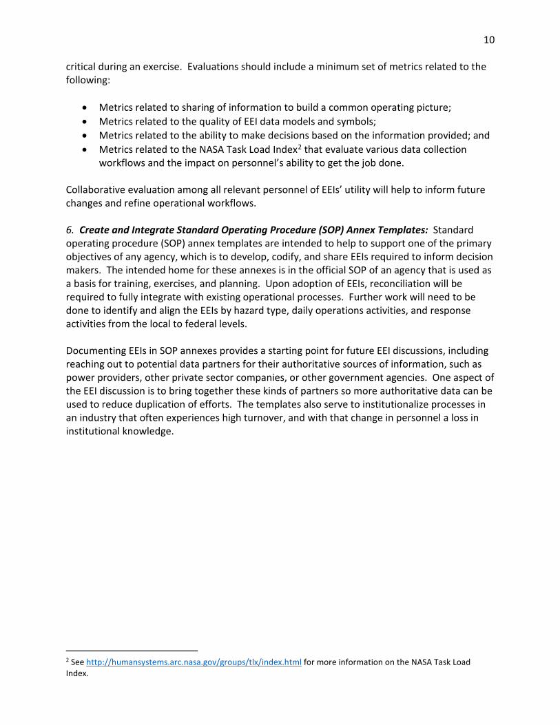
3.1.3 Transportation: Roads Road networks have been identified as an EEI to support response and recovery operations following a large scale disaster. Route inspections or assessments can be conducted through both aerial and ground surveillance through state Departments of Transportation (DOTs) and/or Civil Air Patrol. Routes will be presumed closed after a major disaster and opened in segments following ground truth data. Responsible ESF ESF 1 – Transportation
Data Owner/Sources DOT
Primary Layer Geometry Type
Suggested Attributes Estimated Availability
Deliverable
Road Status
Strategic (Road): Name, Description, Location, Condition, Status Tactical: Distance of closure
12-24 hours Operational Status Report Template Editable Map Service Web Map
Ancillary Layers
Bridge/Other Crossings Status
Strategic (Bridge): Location, Roadway, Roadway Detail, Status, Comments, Last Update, Updated By
48 hours Map Service
To test drive this EEI template and/or download the map package to use in your organization, click on link below and log into the NISC Member Portal.

24
3.1.4 Transportation: Waterways Waterways have been identified as an EEI to support response and recovery operations following a disaster. River transportation can support moving bulk resources outside logistical staging areas. The layers included in this EEI are intended to inform the operational status and capabilities of waterway transportation systems. Responsible ESF ESF 1 – Transportation
Data Owner/Sources United States Army Corps of Engineers (USACE), United States Coast Guard (USCG)
Primary Layer Geometry Type
Suggested Attributes Estimated Availability
Deliverable
Waterway Status
Strategic: Waterway Name, Waterway Type, Location, Status, Description, Estimated Fix Time, Contact, Recent Progress Tactical: Length, Data, Feature ID, A Node, B Node, Link Name, A Mile, B Mile, Length 1, Length SRC, Shape SRC, Link Type, Ctrl Depth, Waterway, Geo Class, Func. Class
10 days Operational Status Reporting Template Editable Map Service Web Map
Ancillary Layers Landslide / Ground Failures
Description, Last Updated 1-24 hours Map Service
Port Status
Port Name, Location (e.g., river mile; lat/long), Status, Description, Estimated Fix Time, Contact, Recent Progress, Last Update Date/Time
24 hours Map Service
Lock Status
Location (e.g., river mile; lat/long), Status, Description, Estimated Fix Time, Contact, Recent Progress, Last Update Date/Time
24 hours Map Service
Bridge/Other Crossing Status
Location (e.g., river mile; lat/long), Status, Description, Estimated Fix Time, Contact, Recent Progress, Last Update Date/Time
48 hours Map Service
Boat Ramp Status
Location (e.g., river mile; lat/long), Status, Description, Estimated Fix Time, Contact, Recent Progress, Last Update Date/Time
Unknown Map Service
Navigation/Recovery Boat Status
Location (e.g., river mile; lat/long), Status, Description, Estimated Fix Time, Contact, Recent Progress, Last Update Date/Time
Unknown Map Service
Fueling Point Status
Location (e.g., river mile; lat/long), Status, Description, Estimated Fix Time, Contact, Recent Progress, Last Update Date/Time
Unknown Map Service

25
To test drive this EEI template and/or download the map package to use in your organization, click on link below and log into the NISC Member Portal.

26
3.2 Standard Operating Procedure Annex: Infrastructure The infrastructure SOP annexes provide a model definition of strategic and tactical EEI attributes required for decision makers to respond to all hazard types. The infrastructure-related annexes document the CUSEC model for operational and technical information requirements such that other agencies may use this to inform how to configure their enterprise to share information horizontally and vertically. The infrastructure annex templates are intended to be included as a part of an agency’s SOPs to unify information management needs of operators, planners, and technical staff. The template may be adapted and configured for specific use by ESFs or modified to support specific hazard types.
3.2.1 Infrastructure: Electricity Grid The status of the electric grid has been identified as an EEI to support overall response and recovery operations following a disaster. The operational status of the electric grid is typically available from electric utility companies, of which most maintain status maps on their websites. The status of electricity availability is often summarized by State Emergency Operation Centers (SEOCs) at the county level. Responsible ESF ESF 12 - Energy
Data Owner/Sources Energy Provider, SEOC
Primary Layer Geometry Type
Suggested Attributes Estimated Availability
Deliverable
Electricity Grid Status
Strategic: Name, State Name, Status, Comments, Provider Name, Without Power, Total Customers, Percent Out, Last Update, Updated By
24 hours Operational Status Reporting Template Editable Map Service Web Map
To test drive this EEI template and/or download the map package to use in your organization, click on link below and log into the NISC Member Portal.

27
3.2.2 Infrastructure: Natural Gas Grid The status of the natural gas grid has been identified as an EEI to support overall response and recovery operations following a disaster. The operational status of the natural gas grid is typically available from natural gas utility companies, most of which maintain status maps on their websites. The status of natural gas availability is often summarized by SEOCs at the county level. Responsible ESF ESF 12 - Energy
Data Owner/Sources Energy Provider, SEOC
Primary Layer Geometry Type
Suggested Attributes Estimated Availability
Deliverable
Natural Gas Grid Status
Strategic: Name, State Name, Status, Comments, Provider Name, Last Update, Updated By
24 hours Operational Status Reporting Template Editable Map Service Web Map
To test drive this EEI template and/or download the map package to use in your organization, click on link below and log into the NISC Member Portal.

28
3.2.3 Infrastructure: Water Grid The status of the water grid has been identified as an EEI to support overall response and recovery operations following a disaster. The operational status of the water grid is generally available from utility companies. The water grid status is often summarized by SEOCs at the county level. Responsible ESF ESF 12 - Energy
Data Owner/Sources Water Utility Provider, SEOC
Primary Layer
Geometry Type
Suggested Attributes Estimated Availability
Deliverable
Water Grid Status
Strategic: Name, State Name, Status, Comments, Provider Name, Customers Affected, Last Update, Updated By
24 hours Operational Status Reporting Template Editable Map Service Web Map
To test drive this EEI template and/or download the map package to use in your organization, click on link below and log into the NISC Member Portal.

29
3.3 Standard Operating Procedure Annex: Operations The operations SOP annexes provide a model definition of strategic and tactical EEI attributes required for decision makers to respond to all hazard types. The operations-related annexes document the CUSEC model for operational and technical information requirements such that other agencies may use this to inform how to configure their enterprise to share information horizontally and vertically. The operational annex templates are intended to be included as a part of an agency’s SOPs to unify information management needs of operators, planners, and technical staff. The template may be adapted and configured for specific use by ESFs or modified to support specific hazard types.
3.3.1 Operations: Area Command Area Command locations have been identified as an EEI to support overall response and recovery operations following a disaster. Area Command locations are often situated at Emergency Operation Centers (EOCs) and are used to provide coordination, resource allocation and establish priorities during an emergency. The Area Command EEI focuses on the operational status or activation level of individual Area Command locations. Responsible ESF ESF 5 – Emergency Management
Data Owner/Sources SEOC, Local EMAs
Primary Layer Geometry Type
Suggested Attributes Estimated Availability
Deliverable
Area Command Status
Strategic: Name, Street, City, State, Zip code, Phone, Fax, Website, Traffic, Status, Comments, POC, POC Phone, State or Local
12 hours Operational Status Reporting Template Editable Map Service Web Map
To test drive this EEI template and/or download the map package to use in your organization, click on link below and log into the NISC Member Portal.
30
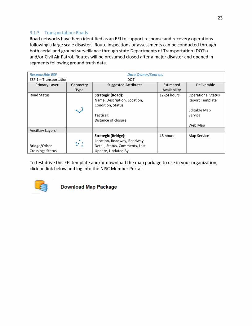
3.3.2 Operations: Communications (Public Safety and General Public) Communications is an EEI to support overall response and recovery operations following a disaster. The Communication EEI contains information on the operational status of emergency communication networks for public safety, as well as landline, cellular, and internet access status for the general public. Responsible ESF ESF 2 – Communications
Data Owner/Sources SEOC
Primary Layer Geometry Type
Suggested Attributes Estimated Availability
Deliverable
Communications Status (Public Safety and General Public)
Strategic: Name, State Name, Communication Network, Comments, POC, POC Phone, Last Update, Updated By
12 hours Operational Status Reporting Template Editable Map Service Web Map
To test drive this EEI template and/or download the map package to use in your organization, click on link below and log into the NISC Member Portal.

31
3.3.3 Operations: Evacuation Orders Evacuation orders have been identified as an EEI to support overall response and recovery operations following a disaster. Evacuation orders may be placed to move affected populations, however, complications can arise from a compromised transportation infrastructure, including damaged roads and bridges, as well as the availability of temporary housing/shelters for evacuees. Responsible ESF ESF 5 – Emergency Management
Data Owner/Sources SEOC
Primary Layer Geometry Type
Suggested Attributes Estimated Availability
Deliverable
Evacuation Orders
Strategic: Name, State Name, Evacuation Orders, Comments, Area of Concern, Point of Contact, Start Date, End Date, Phone, Last Update, Updated By
24 hours Operational Status Reporting Template Editable Map Service Web Map
To test drive this EEI template and/or download the map package to use in your organization, click on link below and log into the NISC Member Portal.

32
3.3.4 Operations: Hospital Status Hospital Status has been identified as an EEI to support overall response and recovery operations following a disaster. Depending on the type and magnitude of the disaster, hospital resources may be stressed by large numbers of casualties. The hospital EEI helps identify the operational status of hospitals (for example, ability to accept injured disaster survivors, supply shortages, etc.) and helps incident commanders direct resources and casualty evacuations accordingly. Responsible ESF ESF 8 – Public Health and Medical Services
Data Owner/Sources SEOC and/or State Health Dept.
Primary Layer
Geometry Type
Suggested Attributes Estimated Availability
Deliverable
Hospital Status
Strategic: Name, Alternative Name, Address, City, State, Zip, Phone, POC, Website, County, Owner, Total Staff, Type, Beds, Trauma, Helipad, Date Created, Status, Comments, Updated By, Max Capacity, Current Capacity
4 hours Operational Status Reporting Template Editable Map Service Web Map
To test drive this EEI template and/or download the map package to use in your organization, click on link below and log into the NISC Member Portal.

33
3.3.5 Operations: Injuries and Fatalities Injuries and fatality status has been identified as an EEI to support overall response and recovery operations following a disaster. The layers included in this EEI are intended to help inform where to send emergency resources. Responsible ESF ESF 8 – Public Health and Medical Services
Data Owner/Sources SEOC and/or State Health Dept.
Primary Layer Geometry Type
Suggested Attributes Estimated Availability
Deliverable
Injuries and Fatalities Status
Strategic Name, State Name, Status, Injuries, Fatalities, Comments, Last Update, Updated By
24 hours – 6 days
Operational Status Reporting Template Editable Map Service Web Map
To test drive this EEI template and/or download the map package to use in your organization, click on link below and log into the NISC Member Portal.

34
3.3.6 Operations: Joint Reception, Staging, Onward Movement and Integration (JRSOI) Sites Operations: Joint Reception, Staging, Onward Movement and Integration (JRSOI) Sites have been identified as an EEI to support overall response and recovery operations following a disaster. Command and Control for JRSOI sites is provided by the State branch of the National Guard, which will use the JRSOI Sites to coordinate the emergency response effort. This EEI includes the location, current status, and contact information for the point of contact (POC) associated with the JRSOI site. Responsible ESF ESF 5 – Emergency Management
Data Owner/Sources SEOC, State Air National Guard (ANG)
Primary Layer Geometry Type
Suggested Attributes Estimated Availability
Deliverable
Joint Reception, Staging, Onward Movement and Integration (JRSOI) Sites Status
Strategic: JRSOI Status, JRSOI Type, POC Name, POC Phone #, Last Update Date, Last Update By, Comments, Capacity
24 hours Operational Status Reporting Template Editable Map Service Web Map
To test drive this EEI template and/or download the map package to use in your organization, please click on link below and log into the NISC Member Portal.

35
3.3.7 Operations: Points of Distribution (PODs) Points of distribution (PODs) have been identified as an EEI to support overall response and recovery operations following a disaster. PODs are often located in conjunction with intermodal transportation hubs, and are important for the storage and distribution of food, water, and other bulk commodities. The PODs EEI provides various information, including the PODs’ location, type (food, equipment, etc.), and status. Responsible ESF ESF 5 – Emergency Management
Data Owner/Sources SEOC
Primary Layer Geometry Type
Suggested Attributes Estimated Availability
Deliverable
Points of Distribution (PODs) Status
Strategic: POD Status, Name, POC Name, POC Phone, Comments, Location, Commodities
4 days Operational Status Reporting Template Editable Map Service Web Map
To test drive this EEI template and/or download the map package to use in your organization, click on link below and log into the NISC Member Portal.

36
3.3.8 Operations: Shelters Shelters have been identified as an EEI to support overall response and recovery operations following a disaster. Emergency shelters provide a service for displaced populations in order to bridge the gap between longer term temporary housing or until utility service is resumed. Shelters are typically operated by the American Red Cross, although other organizations may open ‘ad-hoc’ shelters depending on need. The former are included in existing geospatial datasets, the latter will require effort to locate and inventory following a disaster. Shelters will have requirements including utility service and availability of food and water supplies. The shelter EEI contains important information on the capacity (current and maximum), whether pets are accepted, and the current status. Responsible ESF ESF 6- Mass Care-Emergency Assistance-Housing-Human Services
Data Owner/Sources Red Cross, SEOC
Primary Layer
Geometry Type
Suggested Attributes Estimated Availability
Deliverable
Shelter Status
Strategic: Name, Telephone, Address, City, State, County, Pet Facilities, Status, POC, POC Phone, Capacity Max, Capacity Current
6 hours Operational Status Reporting Template Editable Map Service Web Map
To test drive this EEI template and/or download the map package to use in your organization, click on link below and log into the NISC Member Portal.

37
3.3.9 Operations: Staging Areas Staging areas have been identified as an EEI to support response and recovery operations following a disaster. Staging areas are used to store resources for response and recovery close to affected areas. The staging areas EEI will include information on the type, status, and location. Responsible ESF ESF 5 – Emergency Management
Data Owner/Sources SEOC
Primary Layer
Geometry Type
Suggested Attributes Estimated Availability
Deliverable
Staging Area Status
Strategic: Staging Area Status, Staging Area Type, POC Name, POC Phone, Comments, GlobalID_str, State, Staging Area Name
24 hours Operational Status Reporting Template Editable Map Service Web Map
To test drive this EEI template and/or download the map package to use in your organization, click on link below and log into the NISC Member Portal.