Embed Size (px)
Citation preview

December 2009
RESOURCE MANAGEMENT PLAN
Compiled by: Recreation Resources
Research Services Sid Stevenson, PhD

Page 3 JCPRD Resource Management Plan 2009
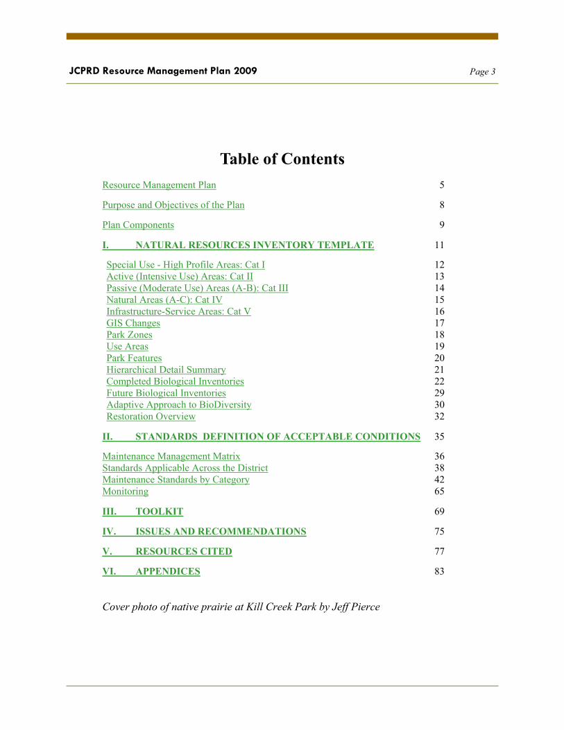
Table of Contents Resource Management Plan 5
Purpose and Objectives of the Plan 8
Plan Components 9
I. NATURAL RESOURCES INVENTORY TEMPLATE 11
Special Use - High Profile Areas: Cat I 12 Active (Intensive Use) Areas: Cat II 13 Passive (Moderate Use) Areas (A-B): Cat III 14 Natural Areas (A-C): Cat IV 15 Infrastructure-Service Areas: Cat V 16 GIS Changes 17 Park Zones 18 Use Areas 19 Park Features 20 Hierarchical Detail Summary 21 Completed Biological Inventories 22 Future Biological Inventories 29 Adaptive Approach to BioDiversity 30 Restoration Overview 32
II. STANDARDS DEFINITION OF ACCEPTABLE CONDITIONS 35
Maintenance Management Matrix 36 Standards Applicable Across the District 38 Maintenance Standards by Category 42 Monitoring 65
III. TOOLKIT 69
IV. ISSUES AND RECOMMENDATIONS 75
V. RESOURCES CITED 77
VI. APPENDICES 83
Cover photo of native prairie at Kill Creek Park by Jeff Pierce

Page 4 JCPRD Resource Management Plan 2009

Page 5 JCPRD Resource Management Plan 2009
RESOURCE MANAGEMENT PLAN
This Resource Management Plan has been created by the Johnson County Park and Recreation District to guide its efforts in the general management and maintenance operations of its properties; with particular focus on sustainable practices that enhance the stewardship of it’s natural resources.

Page 6 JCPRD Resource Management Plan 2009
The Johnson County Park and Recreation District (JCPRD) owns and operates approximately 9,000 acres of parkland, ranging from highly developed athletic facilities such as the Mid-America Sports complex to natural woodlands and significant acreages of native prairie grasslands. Increased recreation activity and population growth and the resulting changes in park use will result in increasing pressure for the development of natural areas into active recreation use sites. Presently, only approximately 20% of the District’s properties are classified as active or special use. Balancing a high rate of population growth (40% projected increase by 2020) and the corresponding recreation use with preservation of open space and natural areas in particular will prove increasingly challenging.
In anticipation of these concerns, this plan is intended to complement the District’s current operation and planned acquisition and recreation development expansion and other regional and community ecological enhancement efforts. This plan is also designed to provide on the ground details for implementing maintenance management recommendations specific to the diverse array of park features operated by the District. The plan builds upon the existing body of work already prepared for the District, including but not limited to: the JCPRD Master Action Plan, MAP-2020, Natural Resources Inventories section of SMP Park Master Plan (Terra Technologies ) and like documents.
This plan is a tool to assist the in addressing the land use innovation and responsive stewardship components of the District’s mission. It is also intended to serve as a guide in implementing the District’s Biodiversity policy.
Operations management is generally the function of the Parks and Golf Course Operations Division, with substantial planning and technical assistance provided by the Planning and Interpretive units, most notably in the management of trails and stream-ways, environmental education, property acquisition, and design.
The mission of the JCPRD, like many public park agencies, is a dichotomy relative to land use. On one hand the District desires to preserve, restore, and enhance its natural areas for values such as plant and wildlife habitat, ecosystem functions, socioeconomic values, living museums protecting natural heritage, as outdoor classrooms and for general aesthetics and community livability. It must balance this portion of its mission with the need to manage its properties for a substantial amount of public recreational use.

Page 7 JCPRD Resource Management Plan 2009

Page 8 JCPRD Resource Management Plan 2009
Purpose and Objectives of the Plan
The general purpose of this Resource Management Plan is to provide a framework for implementing management recommendations that will result in favorable visitor experiences balanced with sound natural resource stewardship of District properties. With this plan the District hopes to reach the following management objectives:
Establishment of Maintenance Standards - Definition of Acceptable Conditions, and a means of Monitoring
Clearly define the acceptable physical condition of the District’s recreation and natural resources Development of an assessment process to determine: - Significant declines as well as increases in native species richness - Changes in acreage of native communities, wildlife habitats and invasive species - The level of success of restoration activities in achieving conservation and restoration goals. - The degree to which current maintenance actions meet agency standards. Provide an adaptive management framework for evaluating changes (e.g., conceptual model). Recreation and Aesthetic Goals:
To clarify guidelines for recreation uses that are compatible with conservation and restoration goals To identify and encourage specific management actions that promote visitor enjoyment and safety To maintain and develop natural views and corresponding buffers to enhance park experiences. To illustrate the degree to which the District maintains a diverse spectrum of recreation opportunities
Stewardship Goals: To identify existing natural resources. To attempt to maintain viable populations of all special-status species.* To optimize local biodiversity by maintaining and enhancing native plant and animal communities. To re-establish in District natural areas native community diversity, structure, and ecosystem function where degraded To improve natural area connectivity. To decrease the extent of invasive species cover.
Page 9 JCPRD Resource Management Plan 2009
PLAN COMPONENTS
This document purposefully addresses this intent with the following components:
I. Natural Resource Inventory Template
A. A geo-database including a hierarchal process to map park features and the current inventory of plant and animal species within; and establishes a framework to subsequently monitor changes.
1. Hierarchy detail (park/zone/feature-plot/species)
B. Summary of completed plant/animal inventories of District properties
C. Overview of restoration and renovation objectives and current sites
II. Standards - Definition of acceptable conditions
A. Defines maintenance standards (acceptable conditions) and tolerance levels of undesirable conditions for 5 broad levels of park use. A District wide matrix of standards is provided, searchable by applicability.
1. Specifies invasive and problematic species tolerance levels by park features
2.Applies District Biodiversity policy relative to special status species and defines appropriate District action.
B. Assessment Instruments - are provided; to be modified as needed for use by the District for random assessments (by park feature). Data from the assessment is intended to measure the effectiveness of current District maintenance efforts in meeting the defined standards.
C. Recommendations on monitoring methods
III. Toolkit of Resources - an electronic archive of applicable best management practices
A. Intended to ensure that the District’s efforts at adaptive management are well directed and result in the intended outcomes. The District is not alone in its efforts to be a good steward of its properties. This section provides help in the form of organizing available resources. (Included in the Matrix file)

Page 10 JCPRD Resource Management Plan 2009
IV. Resource Management Plan Strategic Elements
The Resource Management Plan shall serve as the parent document to which subsequent specific resources plans like the following can find commonality of purpose.
A. Nuisance Wildlife Plan - Shall manage varying control strategies related to the overpopulation of deer, geese, rodents, beavers or other species including straying domestic pets. The plan shall also manage wildlife populations to address health and safety concerns, conflicts with peoples and other wildlife, and the health of native plant communities.
B. Forest Stewardship Plan - Shall manage and protect the District’s forested areas. This plan shall include inventory and monitoring components and result in specific management regimens.
1. Kansas Forest Service proposal
C. Integrated Pest Management Program - (include here when adopted)
D. Prairie Stewardship Plan - shall manage and protect the grassland features of the District, to include but not be limited to meadows, pastures, and fields; with particular focus on restoration.
E. Riparian Areas, Lakes and Wetlands Plan - Shall manage and protect streams, creeks, open water, drainages and associated riparian areas within the District for an optimal mix of benefits including water quality, biodiversity, and recreational use.
V. Issues and Recommended Actions. This section summarizes issues and recommended actions
Page 11 JCPRD Resource Management Plan 2009
I. NATURAL RESOURCE INVENTORY TEMPLATE
Categorizing the Physical Resources - Hierarchy
Park Use Areas
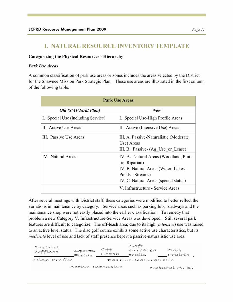
A common classification of park use areas or zones includes the areas selected by the District for the Shawnee Mission Park Strategic Plan. These use areas are illustrated in the first column of the following table:
After several meetings with District staff, these categories were modified to better reflect the variations in maintenance by category. Service areas such as parking lots, roadways and the maintenance shop were not easily placed into the earlier classification. To remedy that problem a new Category V. Infrastructure-Service Areas was developed. Still several park features are difficult to categorize. The off-leash area; due to its high (intensive) use was raised to an active level status. The disc golf course exhibits some active use characteristics, but its moderate level of use and lack of staff presence kept it a passive-naturalistic use area.
Old (SMP Strat Plan) New
I. Special Use (including Service) I. Special Use-High Profile Areas
II. Active Use Areas II. Active (Intensive Use) Areas
III. Passive Use Areas III. A. Passive-Naturalistic (Moderate Use) Areas III. B. Passive- (Ag_Use_or_Lease)
IV. Natural Areas IV. A. Natural Areas (Woodland, Prai-rie, Riparian) IV. B Natural Areas (Water: Lakes -Ponds - Streams) IV. C Natural Areas (special status)
V. Infrastructure - Service Areas
Park Use Areas

Page 12 JCPRD Resource Management Plan 2009
Special Use - High Profile Areas and Facilities - Class I
Characterized by a high level of facility development – considerable land alteration – landscaped areas – on-site personnel - receive intensive public use – user fees commonly applied. District examples include:
• Administration Offices-Visitor’s Center
• SMP Theater
• Nature Centers
• Park Entrances
• Recreation Centers
• Pools and Aquatic Centers
Highest Level Athletic Fields
• Mid America Sports Complex
Golf Courses
Typical Park Features/vegetation Management Zones
• Lawns and Irrigated athletic turf
• Botanical/Floral Displays
• Landscaped trees and shrubs

Page 13 JCPRD Resource Management Plan 2009
Active (Intensive Use) Areas - Class II
Typically associated with a high level of public use – specialized facility development – involves support amenities including utilities - on site personnel not uncommon. District examples include:
• Group Recreation Sites (with shelters, play equip, etc)
• Athletic courts
• Children’s play areas (playgrounds)
• Competitive sports fields (2nd tier)
• Shared use, hard surfaced trails
• Special amenities, including:
- RC Flying Field
- Archery Range
- Beach and Marina
- Off Leash Area
- Challenge course
Typical vegetation management zones
• Turf
• Turf Fields
• Special (e.g. sand beaches, docks, trails, infields))

Page 14 JCPRD Resource Management Plan 2009
Passive-Naturalistic (Moderate Use) Areas - Class III
The general nature of the recreation experience is restorative escape from the urban landscape to participate in less structured, low intensity activities. Characterized by mixed landscapes supporting a wide array of uses requiring no on-site agency personnel - lightly programmed, self facilitated recreation areas.
District examples include:
• Disc Golf Course
• Single use and non-paved trails
• Cross-country race course (non event days)
• Special event parking (non event days, temporary)
• Substantial segments of open usable park space adjacent to higher use areas
Typical vegetation management zones
Turf fields (non irrigated mowed sections of park features)
Passive – AG_USE_or_LEASE Areas - Class III
The District manages several properties by using agricultural practices as a secondary revenue producer, or a compatible vegetation control method. Haying is one practice; with cutting scheduled so as to benefit subsequent recreational uses.
The District also leases parcels to 3rd party recreation suppliers, which in turn provide recreation opportunities on these properties. These parcels are not categorized as active recreation use (even though technically that is their primary purpose) because the land is not available for general public use after the lease.
District example:
• MACTA Equestrian Use Area - Heritage Park
* haying may be an appropriate management tool for prairie restoration in District natural areas so a hayed meadow does not automatically classify the feature as AG_USE_orLEASE area.

Page 15 JCPRD Resource Management Plan 2009
Natural Areas (A.) - Class IV
Dual purposes: resource protection and more primitive/dispersed recreation experiences
Development is restricted or non–existent. Dispersed public use is allowed if consistent with area conservation goals. An access area is often the primary amenity. Shall include parkways/open space not within the primary corridor, most of which are riparian zones, where the primary recreation feature is a trail. Areas within a park, managed more naturally to serve as buffer zones are included.
Natural Areas - Water (B.) - Class IV
The District manages several Lakes (>acres), Ponds (< 2 acres), Stream segments and Wetlands on its properties; primarily with a focus on biodiversity
Exception - Zones in larger bodies of water may be managed for relatively intense active use
Natural Areas - Special Status (C.) - Class IV
Within larger natural areas are possible sites/features deemed worthy of additional protection. These sites may be so designated for the presence of threatened and endangered species, archeological, cultural or historical features; designation as a mitigation site; presence of research plots; and certain renovation and sensitive bio-diversity sites.
District examples of Natural Areas (A) and Natural Areas - Water (B) and Natural Areas (Special –Status) (C.) include:
• Kill Creek Streamway Park Riparian Area (A)
• Shawnee Mission Lake (B)
• Prairie Special Status and prairie renovation sites
- Meade’s Milkweed Site Buffer-Kill Creek Park (C.) - Ogg Prairie-Shawnee Mission Park (C)
* Other park districts employ a subdivision of the Natural Areas by size. The approach has some merit but no JCPRD natural areas are currently subcategorized using that approach.

Page 16 JCPRD Resource Management Plan 2009
Infrastructure – Service Areas - Class V
Specialized areas for transportation, utility, sanitation and like functions. Restrooms in group recreation areas may be evaluated as stand alone SERVICE features located within an ACTIVE_USE area.
District examples include:
• Roads, parking areas, sidewalks and like service oriented hardscapes
• Bridges
• Maintenance Shop and grounds
• Dam site

Page 17 JCPRD Resource Management Plan 2009
Geo-Database/GIS Changes
Three (3) new GIS layers were developed for each of the parks managed by the District.
1. PARK ZONES Subdivides larger parks into zones. Shawnee Mission Park was subdivided into 6 zones (A-F). Serves only to make sub-categorization and coding of park features-plots easier. Parks with less than 30 features were not subdivided.
2. USE AREAS Reflects the addition of the Infrastructure-Service area category (Cat V), and new subcategories under the Passive Use (Passive-Naturalistic and Passive Ag_Use or Lease) and Natural Area titles (Natural_water, and Natural_Special_Status). Old park use categories were modified in shape by District staff to represent current and forthcoming park uses.
3. PARK FEATURES-PLOTS a plot or polygon containing the park features to be evaluated relative their level of maintenance and/or the dominant vegetation feature of the sector. In other words a park feature polygon can represent a park recreation feature such as Group Recreation Site #12 that would contain similar maintenance protocols….or a polygon designed to contain a dominant vegetation type or cultural feature, or an invasive species control site. Maintenance within a park feature/ sector should be similar.
Trails, by the nature of their linear characteristics, are included in a separate layer.
New fields/attributes
FEAT_ID a number assigned to the park feature polygon. This ID # is a combination of Park Code_Park Zone_Sequential Park Feature #(e.g. SMP_D_09)
YR_FOCUS a field within the park features layer that illustrates the District’s focus on that park feature-plot for the current year.
Maps illustrating the use of these layers follow:

Page 18 JCPRD Resource Management Plan 2009
Park Zones
Six park sectors/zones have been identified (A-F) and illustrated in the overlay map of Shawnee Mission Park. Each section is separated by a major park road. The primary benefit of the zone is the coding of individual plots.

Page 19 JCPRD Resource Management Plan 2009
USE Areas
The map depicts an example of the USE AREA categories utilized for Shawnee Mission Park, a portion of Mill Creek Stream-way Park, Oakridge Park and Tomahawk Hills Golf Course.

Page 20 JCPRD Resource Management Plan 2009
Park Features
The following graphic illustrates the new designations for Park Features, labeled here in white as code, for a portion of Shawnee Mission Park. These features are to be monitored in accordance with defined standards.
2010 Focus actions for the Ogg South Prairie Test area show an expected prescribed April burn to control woody plants.

Page 21 JCPRD Resource Management Plan 2009
Hierarchical Detail Summary
Amended and new GIS layers provide increasing levels of specification from the most general (PARK) to the most specific (FEATURE-PLOT). This specificity allows for the archival of pertinent biological data by feature and the maintenance of current strategic activities consistent with prescribed plans.
Park (e.g. Shawnee Mission Park)
Zone Zone C for SMP has 47 features. Shawnee Mission Park has 133 features.
Use Area Includes the Categories: I, High Profile; II , Active Use; III, Passive Use (A-B); IV, Natural (A-C); and V, Service – Infrastructure.
Feature-Plot (each polygon feature has a unique ID and contains fields including: vegetation feature, primary invasive species, secondary invasive species, protected species, current year focus). This data will be joinable future inventories with a common FEAT_ID.

Page 22 JCPRD Resource Management Plan 2009
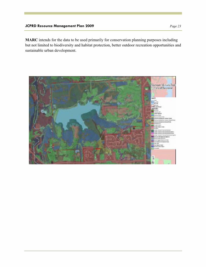
Additional Inventory GIS layers
The GIS layers illustrated on the following page are provided by the Mid America Regional Council (MARC) (compiled by Applied Ecological Services, Inc.) to illustrate that other entities * have compiled vegetation and land use data which may be useful in more specific classification of park features as the bio-diversity plan progresses. These data were utilized in the development of the Park Feature polygons.
USGS GAP Analysis Data is also available for Johnson Co, though it is somewhat dated.
Page 23 JCPRD Resource Management Plan 2009
MARC intends for the data to be used primarily for conservation planning purposes including but not limited to biodiversity and habitat protection, better outdoor recreation opportunities and sustainable urban development.

Page 24 JCPRD Resource Management Plan 2009
Completed Biological Inventories for District Parks
The results of ten (10) biological surveys completed in Johnson county are compiled in an electronically published excel file linked to the District’s website. The inventories were conducted either at the following locations or by the following authors: Ogg Road Prairie SMP 2003, Kill Creek Prairie, O.P. Arboretum, The Prairie Center, Hansen, Hansen, Fell, Freeman, Freeman, Snyder.
The data-fields in the combined inventory master contain the following categories; many of which are incomplete but which allow for detailed future inventories of protected and problematic, as well as indicator species in particular. The field FEAT-ID corresponds to the District’s Geo-database for spatial mapping of species by park feature polygons. Capability exists for geospatially registered point mapping in future inventories and is encouraged as affordable. The Nature Conservancy provides specific software (WIMS) free for problematic specifies identification in the field.
The KS Biological Survey utilized the Natural Heritage Inventory Database in its 2005 regional natural areas inventory (including Johnson County)
Scientific Name Symbol type Common Name County Distrib. Category Federal Noxious Status Federal Noxious Common Name State Noxious Status State Noxious Common Name PLANTS Invasive Status Federal T/E Status Federal T/E Common Name State T/E Status State T/E Common Name National Wetland Indicator Status Regional Wetland Indicator Status FEAT_ID

Page 25 JCPRD Resource Management Plan 2009
Several Johnson County streams were inventoried as part of the HUC (Hydrologic Unit Code) 10270104 survey conducted between 1994 and 2003. The full Sub Watershed Report is available from the KS Dept of Wildlife and Park’s website.

Page 26 JCPRD Resource Management Plan 2009

Page 27 JCPRD Resource Management Plan 2009
A less specific but nonetheless valuable inventory was compiled by J. Stevenson (2006) of forested acreage changes at Kill Creek park over several decades. The focus was on the utilization of GIS in biological assessments.

Page 28 JCPRD Resource Management Plan 2009

Page 29 JCPRD Resource Management Plan 2009
Future Biological Inventories:
Given that a desired outcome of resource management planning is the protection of a diverse array of native plant species in a functioning ecosystem, subsequent biological inventories are needed to establish baseline data on the current population levels of both desirable and undesirable species.
These inventories should incorporate GIS so that the geo-database template established by the resource management plan will function as intended. Nature Conservancy’s WIMS model is an approach worthy of consideration for plants; as is the KS Natural Heritage Inventory database.
Size and Scope Given the recommendations in this document for specific resource plans, it is likely that new inventories will be somewhat resource specific (e.g. forest inventory, prairie inventory, wetlands inventory). Also, high priority should be given to inventories of park feature polygons and plots already designated by District staff for focus or renovation.
Focus of inventories can be on species of significance both positive and negative. In other words, emphasis should be placed on identifying invasive species, threatened and endangered species and indicator species.
Several options exist for conducting the inventories and each varies in cost/benefit. Vendor contract is always an option, but the District should explore resources such as the KS Biological Survey, the Kansas Forest Service, the Kansas Native Plant Society, the Nature Conservancy, Bridging the Gap and the Mid America Regional Council, and like entities as possible choices. The latter has recently conducted biological inventories using volunteers in the KC Metro area. In-house inventories are an additional option but would require substantial staff training.

Page 30 JCPRD Resource Management Plan 2009
An Adaptive Approach to Biodiversity in District Natural Areas
Adaptive management is a flexible, learning-based approach to managing complex ecosystems. This approach recognizes that some uncertainty exists about the nature of ecosystems and the organisms and processes that define them. Adaptive management, as applied to natural systems, involves a continuous cycle of systematically monitoring biodiversity and other ecosystem goals, and reassessing the plans, strategies/goals, methods, and questions that underlie the management approach. The following is a sample adaptive approach, which has been modified from an outline provided by the Nature Conservancy, in its Weed Control Methods Handbook. The protocol has been expanded here to include animals:
(1) establish management goals (JCPRD Biodiversity policy). Translate these goals generally to park use areas and specifically to park features (plot or sites) using the standards of acceptable conditions developed by the Resource Management Plan.
(2) determine which plant and animal species, if any, impair or have potential to impair attainment of these management goals and objectives/acceptable conditions by park feature. Utilize general and specific inventories to determine presence of desirable and undesirable plant and animal populations by park feature as the baseline data for this process.
(3) Utilize up to date science and resources, including those provided in the toolkit compiled in this document, to determine the current best practices (methods) available to control biological populations not in compliance with the acceptable standards.
(4) From this research, develop and implement specific action plans to move conditions toward management goals and objectives; (* initiate control activities at this stage)
(5) monitor and assess the impacts of management actions in terms of their effectiveness in moving conditions toward these goals and objectives; and
(6) reevaluate, modify, and start the cycle again.
*When selecting control methods, keep in mind that the ultimate purpose of the work is to preserve native species, communities, and/or functioning ecosystems.

Page 31 JCPRD Resource Management Plan 2009

Page 32 JCPRD Resource Management Plan 2009
Restoration Overview
Ecological restoration is the process of repairing damage caused by humans to the diversity and dynamics of indigenous ecosystems. When successful, the restored ecosystem contains a characteristic species assemblage with high levels of native species, is self-sustaining at the individual and community levels, functions normally, is integrated into a larger scale landscape, threats have been reduced, and the community is resilient enough to survive normal stressors (SER 2004).
It is a process where ecologists attempt to utilize good science and best practices of weed management, plant propagation, monitoring, to achieve the desired results. Science helps predict how plants will respond, but that is tempered by the practical restrictions of managing natural resources in an urban setting.
One recognized approach is the use of the Bradley method. The Bradley Method of restoration is a widely practiced method of plant community restoration, because it provides a realistic framework for restoration in resource-limited situations (Bradley 1997). Developed in the 1960s, the Bradley Method works on three general principles: (1) work from areas with native plants toward weed-infested areas; (2) create minimal disturbance; and (3) allow native plant regeneration to dictate the rate of weed removal. These principles prioritize the protection of intact areas, remove the pressure that invasive plants place on native plants, and encourage the natural recruitment and spread of plants into degraded areas by means of seeds and spores.
Pre restoration initiation questions Justification is needed before initiating the re-introduction of plant species into a site. The following should be considered at minimum: There should be evidence of historic presence. The park and specific park feature must be large enough to support a viable population . There should be enough undisturbed habitat that is relatively weed-free to support the species. Can the park feature be managed within the framework of expected recreational use - or must the use category be changed, and if so is that compatible with park planning ?

Page 33 JCPRD Resource Management Plan 2009
Restoration priorities:
A variation of the triage model developed for the Seattle park systems’ forests is recommended. The premise of the model is that the areas of highest priority should be a measure of highest value compared to the threat. The perceptual map is a matrix of 9 sectors.
Highest Priority: Highest Quality Areas with low threats. Protect the best first. Invasive cover is usually less than 5%. Focus on removing and/or halting invasives.
Lowest Priority: Lowest quality areas with high threats. Justification for this low priority is that a few years down the road before controls can begin will make little difference due to the magnitude of controls needed (invasives often over 20%).
Priority rankings.
1-3. high value (1) low, (2) medium, (3) high threat 4-6 medium value (4) low, (5) medium, (3) high threat 7-9 low value (7) low, (8) medium, (9) high threat
The approach recognizes an agency’s limited resources and each year a focus plan addressing the highest priority features is developed. Each resource category (I, forest, II, prairie, and III, wetlands-lakes-riparian) would be similarly rated.

Page 34 JCPRD Resource Management Plan 2009

Page 35 JCPRD Resource Management Plan 2009
II. STANDARDS Definition of Acceptable Conditions
The primary output of this section is the development of park maintenance standards. These standards are intended to define the desired conditions of park features in the District’s effort to continue to provide both high quality and a diverse spectrum of recreation experiences on its properties; balanced with the need to protect the integrity of important natural resources.
Value of standards?
• Intent is to communicate the condition of the park system to JCPRD staff, elected officials and the public
• Assist JCPRD staff in scheduling and prioritizing maintenance functions
• Improve park conditions by efficient and directed resource utilization
• Reduce subjectivity and improve reliable, measurable and objective information on park conditions
• Enhance the utilization of best maintenance practices
• Develop new performance measures

Page 36 JCPRD Resource Management Plan 2009
Maintenance Management Matrix (MMM)
The Matrix (MMM) is the primary working document within the Resource Management Plan. The Matrix (MMM) is an excel table, a portion of which is illustrated below, that contains the standards criteria by park feature (here only one category of park features - Cat I Special Use - High Profile Areas is shown). The value of the matrix as the parent document is that future changes, once made to this document can apply to the corresponding inspection forms and text documents. Over 100 maintenance standards have to date been developed.
CODE STD_CAT Element Maintenance Information unit of meas-ure Link
IV. Open Space and Natural Areas
WD.12 WEED _INVASIVE
Vegetation Control (Invasive spe-cies) Use of prescribed burning and Herbicides
Some invasive species have un-derground storage organs that re-sprout vigorously after fire, and/or seeds whose germination is stimulated by fire. Some of these species may not be possible to control with fire, but some can be controlled with repeated burns and others may be especially vul-nerable to herbicides after a burn. Re-sprouts or seedlings that are 1 to 3 months old are often espe-cially sensitive to herbicides. Utilize Guidelines for Herbicide Use and Developing a Rationale for Herbicide Use in this hand-book, in the related link posted here as a resource. Use of pre-scribed burning and/or herbicides is done with approval from the appropriate authorizing agents and in compliance with published regulations.
The standard is met if pre-scribed burns and/or herbi-cides are being adequately considered as a control re-gime; and if utilized - their use follows adaptive and best manage-ment practices and is em-ployed only with effective results.
Prescribed-Fire.doc x

Page 37 JCPRD Resource Management Plan 2009
CODE Reflects the category standard. First two letters of code are same as first two in Standard Category. The number following is sequential for that Category.
STD_CAT The standard category includes categories like APPEARANCE, RECREATION, STRUCTURAL, SAFETY, HEALTH, ENVIRONMENTAL, WILDLIFE
Element The subcategory that more closely defines the standard
Maintenance Information A general statement of desired maintenance actions and considerations
Unit of Measure The objective measure of the standard. Specifies when standard is met. As in the case of the example, there may be no difference between the unit of measure and wording of the standard, but they typically vary
Link Link to additional information if available
Park Feature A polygon/area that contains a specific park amenity like the Marina, Group Rec Area #8, SMP Theater, Adm Office grounds, Off-leash area…or… a polygon/area that contains a specific vegetation zone; as in a defined woodland, a buffer, a prairie restoration site, etc..
Additional specificity can be added using linked tables and GIS methodology.
This information could be used for many different purposes such as identifying maintenance problems, allocating resources, and improving park conditions.
Page 38 JCPRD Resource Management Plan 2009
Standards Applicable across the District
Several standards are applicable agency wide. The remainder have been categorized and are applicable to specific park features and vegetation zones as outlined in the previous page.
Standards are compiled in the Maintenance Management Matrix (MMM) an Excel spreadsheet, first and then saved in a text version here. These same standards are organized here, sorted by CODE, Standard Category and Subcategory. Links to additional information are contained in the Excel version.
AA.01 ALL AGENCY Inspections regularly scheduled
The District shall perform regular monitoring of its maintenance activities in order to determine to what extent the acceptable conditions outlined by the standard are being achieved. These assessments shall be performed in accordance with governing or regulatory body recommendations.
AA.02 SAFETY job hazard analysis (OSHA/USACE)
By 2011, the District shall complete a job hazard analysis form for all maintenance tasks (see link for evaluation of specific maintenance tasks performed by USACE project personnel)
(Resources: OSHA Region VII (IA,* KS, MO, NE) City Center Square 1100 Main Street, Suite 800 Kansas City, MO 64105 (816) 426-5861 USACE maintenance activity hazard analysis
AA.03 PEST MGMT Integrated pest management program IPM
The JCPRD shall develop an integrated pest management program to include but not be limited to cultural, mechanical and chemical means of controlling plant, insect, animal and like pests on JCPRD managed properties
A good example is available at: Portland, OR IPM Manual

Page 39 JCPRD Resource Management Plan 2009
AA.04 WEED_INVASIVE IPM Vegetation control (Invasive species) Code of Conduct for Public Agencies
The District shall comply with the intent of the code of conduct for public agencies relative to the control of invasive species.
1. Require risk assessment for government-led or financed plant introductions to ensure that no new harmful plant species are introduced, intentionally or unintentionally. 2. Do not distribute existing holdings of invasive plant species to areas where they can potentially do harm; eliminate these holdings or maintain new or existing holdings using appropriate safeguards. 3. Coordinate and facilitate collaboration in databases, early warning systems, monitoring, and other means of preventing invasive plant species problems. 4. Lead and fund (subject to budgetary considerations) the development of environmentally sound methods to control harmful invasive plant species, seek control of such species on public lands and promote their control on adjacent private lands. 5. Develop and promote the use of non-invasive plant species within all government units and to the public. 6. Facilitate, lead, coordinate and evaluate public outreach and education on harmful invasive plant species. 7. Encourage employees and management to participate in ongoing training programs on invasive plant species. 8. Foster international cooperation to minimize the risk of the import and export of potentially invasive plant species. 9. Develop partnerships and incentive programs to lessen the impact of invasive plant species and provide non- invasive restoration materials. 10. Provide a forum for regular evaluation of the effectiveness of these voluntary codes of conduct towards preventing the invasive plant species problem. 11. Assist in the enforcement of local invasive plant species policy.
AA.05 WEED_INVASIVE IPM Vegetation control (Invasive Species – mapping)
The District, in future biological inventories, shall geo-spatially map the presence of invasive/non-native and/or problematic plant species in a fashion compatible with the geo-database developed for the park resource plan; so as to aid in management and control of these problematic populations.
The Nature Conservancy's (TNC's) Weed Information Management System (WIMS) is an existing platform for this mapping function. WIMS is a Microsoft Access-based relational database application that is designed to assist natural resource managers in managing their weed data. WIMS keeps track of three types of data records: weed occurrences (GPS point locations), assessments (size and status of the weed infestation to facilitate monitoring over time), and management treatments applied to those weed infestations. Data can be easily exchanged between multiple users, exported in

Page 40 JCPRD Resource Management Plan 2009
NAWMA (North American Weed Management Association) standards, and written to shape-files for mapping in any standard GIS program. A variety of reports can also be easily generated. Additionally, WIMS can be used on a handheld unit (either MS Windows-based Pocket PC or Trimble with a GPS unit) to capture data in the field. When using WIMS on a handheld unit with an ArcPad interface, a site manager can use background imagery and other GIS layers for mapping weeds, then upload the new data into the Access database with a few mouse clicks!
AA.06 WEED_INVASIVE IPM Vegetation control (invasive species fact sheet)
The JCPRD shall utilize current information on invasive plants and adopt recognized best practices in their control.
Information on best practices for control of invasive species is available at several locations linked to this chapter in the Excel version or in the Toolkit sections at the end of the document...including but not limited to:
Kansas Native Plant Society KNPS Invasive Plants Fact Sheet Chemical Weed Control - KSU USDA National Invasive Species Information Center KSDA Plant Protection - Weed Control Program Invasivespedia Invasive Species Plant Summaries– contains species by species stewardship (management/control) abstracts
AA.07 WEED_INVASIVE/PROBLEMATIC SPECIES definitions
The JCPRD shall utilize the following (expanded) definition of invasive/problematic species for the control of same on District properties: An “invasive species” is a species (plant, animal or other organism) that is non-native (exotic or alien) to the ecosystem under consideration and/or is likely to cause economic, cultural or environmental harm, or harm to human health. The species, often due to changes in human activity, characteristically out competes native species for available resources, reproduces prolifically, and has the potential to dominate landscapes, regions and ecosystems.

Page 41 JCPRD Resource Management Plan 2009
AA.07 WILDLIFE IPM wildlife damage control
The JCPRD shall establish a plan to direct agency actions in the management and control of wildlife populations on District properties; with particular focus on nuisance wildlife populations. A Nuisance Wildlife Plan is under development.
Wildlife damage control is an important part of wildlife management on JCPRD properties. High park usage increases the likelihood of conflicts; and the resulting health and safety hazards. Also, too many of any one species in a defined location causes conflicts with other wildlife and plant species. Wildlife damage control requires adequate documentation of damage (to property, to habitats, other wildlife and human activity) prior to prescribing control methods.
AA.08 WILDLIFE IPM Wildlife damage control (documentation)
To document the presence of wildlife problems, JCPRD staff shall routinely record the existence of nuisance animals; potential carriers of plague or hantavirus, or rabies; or poisonous snakes in or around recreation sites. Staff shall also record evidence of wildlife damage when identified. Periodic wildlife population inventories shall be conducted and these data compared to specialist recommended population levels by species; with corresponding control measures similarly designed to meet desired population levels.
AA.09 ALL AGENCY ADA compliance
Maintenance practices shall ensure that amenities constructed to be in compliance with ADA access regulations, designed to reduce personal navigational barriers, stay that way. Treads, gates, ramps, parking spots with transfer points and the like shall be maintained in a serviceable and functional state, free of cracks, washouts, lips, berms, and debris that might impede access.
Page 42 JCPRD Resource Management Plan 2009
Maintenance Standards
(by Category)
CODE CATEGORY SUB-CAT
AP.01 APPEARANCE Litter Control
Facilities and their surrounding areas should be substantially free of litter and debris. Litter should be picked up whenever visible in Cat I (high profile) areas and during major events in Cat II (Active Use) areas; and as scheduled in remaining Categories, unless events and increased use warrant a higher frequency at times. Receptacles should be plentiful enough to hold all trash generated between servicing without normally overflowing. Examples of litter include cigarette butts, tissue paper, bottles, cans, food wrappings, newspapers, and larger items like abandoned appliances.
The standard is met if no more than 5 pieces of litter or debris, lightly scattered, are visible in a 25’ x 25’ area, or along a 100’ line (CAT I feature). The acceptable level increases across other Categories at the following levels (CAT II/V=10 pieces, CAT III=15 pieces, CAT IV=20 pieces).
The standard is not met if needles, condoms, broken glass, or human feces are present
AP.02 APPEARANCE Graffiti
The area, facility, structure, signs and related amenities in the immediate vicinity are free of graffiti
AP.03 APPEARANCE Debris 1.(High Profile)
Facilities and their surrounding areas should be substantially free of debris. Debris includes grass clippings on walks, tree limbs, pine cones (non-seasonal), sand, gravel and other native materials. The standard is met if no more than 5 pieces of debris, lightly scattered, are visible in a 25’ x 25’ area, or along a 100’ line

Page 43 JCPRD Resource Management Plan 2009
AP.04 APPEARANCE General Appearance (Botanical Displays)
Floral plantings should be healthy and vigorous, and appear to be well maintained. Often multiple plantings are scheduled, usually at least three blooming cycles per year. Some designs may call for a more frequent rotation of bloom. Ornamental plantings should contain plant materials appropriately sized and shaped for their location, with consideration given for aesthetics, water consumption, and any desired functionality (e.g. sight barrier). The display shall be 100% free of vines overtaking ornamental plantings
AP.06 APPEARANCE Debris Cat II (Active Use)
Facilities and their surrounding areas should be substantially free of debris during events and peak use periods and immediately after a mowing. Debris includes larger tree limbs, sand, gravel and other natural materials (grass clippings and pine cones are excluded). Debris removal shall coincide with mowing schedule. The standard is met if no more than 10 pieces of debris, lightly scattered, are visible in a 25’ x 25’ area, or along a 100’ line
AP.07 APPEARANCE paint/coating condition
Paint on surfaces shall be generally uniform in color; not peeling on 90% of the equipment or structural area.
AP.08 APPEARANCE General Appearance (lawns and irrigated sports turf)
From April – October 95% of turf area is uniformly green. Turf appears healthy, with bare or brown spots occupying less than 5% of the turf landscape. Lawns are free of visible holes greater than four (4) inches (2"" for sport fields) in diameter and/or depth. Holes greater than four (4) inches, or 2"" for sport fields (in diameter and/or depth) that are observed during the inspection process should be reported so they can be filled. The standard is not met if multiple holes and/or mounds caused by any animal (e.g., gophers, moles) prevent safe use of the area
AP.09 APPEARANCE Trash receptacles
90% of refuse containers should not be overflowing. Hardware is intact. Area around receptacles is free of litter and debris. Number of receptacles is adequate for area usage. Utilize gloves whenever picking up garbage. Use universal caution in the presences of any hazardous materials such as needles, glass. Flies and foul odors should be repressed on an as needed basis. 90% of all receptacles are free of large cracks or damage that affects their use.
Page 44 JCPRD Resource Management Plan 2009
AP.10 APPEARANCE Debris II (Active Use - Paved Trails)
Hard surfaced paths and trails are free of litter and debris large enough to impede safe passage. Leaves and twigs are generally excluded. The presence of sand or gravel on the trail that is not readily visible to users should be promptly removed or reported so as not to cause a hazard. Hazardous debris removal shall be done when noticed; removal of non-hazardous debris shall coincide with mowing schedules.
AP.11 APPEARANCE Debris III (Passive Use)
Passive use areas serve often as a transition from active use areas to natural areas. It is appropriate for reasonable levels of naturally occurring debris to be present. Debris in passive use areas includes only items large enough or in sufficient quantities to pose either a safety hazards, obstruction or eyesore. Non-hazardous debris removal shall coincide with mowing schedules.
AP.12 APPEARANCE Debris IV (open space and natural areas)
Debris (limbs, rocks, leaves and other natural materials) in natural areas must be substantially interfering with the intended recreational or wildlife habitat uses of the parcel to be considered for removal.
AP.13 APPEARANCE Debris V (service areas)
Debris removal in and near a service amenity shall match with the facility's maintenance category. In other words, a restroom (service facility) in an active use area shall meet the Debris standard for a Category II area.
AP.14 APPEARANCE Recreation furniture
Recreation furniture, such as BBQs, picnic tables, and benches and bleachers are clean; demonstrating reasonably recent washing and or sanitizing; consistent with the restrooms in the same use category.
EN.01 ENVIRONMENTAL storm water runoff
Excessive storm water runoff appears to have negative impacts on SMP lake. Post storm inspections have revealed increased turbidity, and high levels of chemicals, litter and debris. JCPRD activities shall not contribute to these impacts due to maintenance practices, or the placement of, or storage of materials or debris. Impacts shall be regularly monitored.
Page 45 JCPRD Resource Management Plan 2009
EN.02 ENVIRONMENTAL Threatened and Endangered Species - vegetation
Only one threatened and endangered plant species is currently known to inhabit JCPRD managed properties (Meade's Milkweed-Kill Creek Park). High quality natural areas are those properties that host remnant natural communities; capable of hosting threatened and endangered species. If threatened and endangered plant species are believed to be found on JCPRD properties the following actions shall be taken: (1) A recognized expert shall verify the existence of such species; (2) Upon verification, a specific vegetation management plan; giving full consideration to the property's intended uses and JCPRD's mission shall be formulated with reclassification into a different maintenance category. Vegetation management of natural areas, including renovation practices and control of invasive species are detailed in the vegetation standards section.
HE.01 HEALTH restroom sanitation and frequency
Restrooms cleanliness shall be maintained by a detailed and regularly scheduled regimen and more frequently (as needed) when events place additional demand on use; or unclean situations have been brought to staff's attention. Sanitation is a multi-step process and includes the proper use of chemicals including disinfectants, fungicides and odor reducers. A 3D type (detergent, disinfectant, and deodorant) should be utilized. This solution in proper strength is not hazardous to handle, but most toilet bowl cleaners are. Staff are reminded to read the labels of all chemicals; follow instructions; and pay particular attention to disposing of used and unused cleaning agents and chemicals. Always install insecticide and deodorant blocks where children cannot reach them. Prevent slippery floors by removing water, sand particles, etc
HE.02 HEALTH restroom functionality
Restrooms physical structures (toilets, urinals, sinks, partitions, lights, diaper-changing stations, doors, and water faucets should be fully operational. Restrooms must have supplies available (toilet paper, paper towels, soap) to be considered functional.
HE.03 HEALTH Restroom Safety
Restrooms are intended to be hazard free to users of all ages and ability levels. While performing routine cleaning maintenance watch for splinters, protruding nails, torn screen or hardware cloth, loose screws on door hinges and toilet paper dispensers, tripping hazards on walkways and around site, etc. Other typical hazards include wet/slippery floors both during the cleaning process and at any time. Warning or correction of this condition is vital.
Maintenance staff should fix correctable hazards as they clean the facility

Page 46 JCPRD Resource Management Plan 2009
HE.04 HEALTH Pet Waste
In areas frequented by pets, bag stations and waste receptacles are conveniently located and operational.
LA.02 LAWNS Edging (lawns)
Lawn edges shall be clearly defined and have less than 3 inches of growth over adjoining landscape.
LA.03 LAWNS Fertilization (lawns/turf)
Adequate fertilization (preferably based on periodic soil tests) shall be used for turf areas to optimize desired plant characteristics in sports turf areas. Application rates and times should ensure an even supply of nutrients for the entire year. High use areas may require specialized fertilization schedules. Amended turf soils designed for quick field drainage may require special fertilization levels due to high leaching rates.
LA.04 LAWNS Irrigation (lawn/turf)
Typically sub-surface automated sprinkler systems shall be used. May incorporate environmentally sensitive, computer operated and monitored systems to optimize water usage. Irrigation is fully functional, adjusted for correct coverage and leak free. Utilization of deep and infrequent irrigation strategy to encourage deep root growth is encouraged. Irrigation immediately after an event is advised to improve recuperation.
LA.05 LAWNS String Trimming (lawns)
String trimming around objects in the landscape and sidewalk edging should be done as needed to maintain a consistent appearance with the surrounding turf. Debris from such trimming will be removed from sidewalks and parking lots immediately. String Trimming shall be completed with adequate care, so as to not damage trees, fencing or other objects
LA.06 LAWNS Mowing (lawns)
Typically mowed weekly or more frequently during the peak growing season; timed to remove approximately 1/3 of the plant per cutting. Mow to a turf height of approximately 2 to 2.5".

Page 47 JCPRD Resource Management Plan 2009
PE.01 PEST Integrated pest management - CAT I
A scheduled chemical or cultural program shall be used to prevent significant damage. It is anticipated that problems will either be prevented or observed at a very early stage and corrected immediately. Insect infestation and/or treatable diseases affect no more than a small percentage of the total.
PE.02 PEST Integrated pest management - CAT II, V
Structures, such as shelters and restrooms in category 2 areas shall be relatively pest and rodent free; regularly treated for ants, wasps, mice and roaches. Visible presence of notable infestation of pests and vermin shall be reported for quick attenuation.
PE.03 PEST Integrated pest management - CAT III, V
Insect and pest management shall focus on infestations, designed primarily to protect the health of remaining plant materials or reduce the likelihood on undesirable interactions with park guests.
PE.04 PEST Integrated pest management - CAT 4
Insect and disease management shall focus on infestations which can permanently harm the area's vegetation. Treatment normally would be designed to protect the health of remaining plant materials or salvage key species. Pest control would focus on reducing infestations that would otherwise result in substantial negative interactions with park guests or desirable wildlife populations.
RE.02 RECREATION Playability
The maintenance staff shall have input on any sport fields playability, either verbally or by written guidelines. Wet fields shall not be used if the damage caused by playing is considered extensive, necessitating significant turf repairs and/or turf replacement.
RE.03 RECREATION Artificial Turf
Artificial Turf shall be maintained in a state that is fully functional, with no tears or mis-aligned seams present to cause tripping hazards. Worn sections should be replaced as needed, and an annual evaluation conducted to determine continued suitability once the worn areas reach 20% or more of the surface area.

Page 48 JCPRD Resource Management Plan 2009
RE.04 RECREATION High wear zone adaptations
Goal mouths and center mid field sections of soccer pitches and flag football fields are the most susceptible to excess wear. Two approaches have proven to reduce wear: (1) no warm-up in goal mouth policy, and/or (2) field layout alteration, whereby the pitch/field is moved several yards to the side, within a larger play area. Standard is met if an adaptation is utilized.
RE.05 RECREATION Striping and lining
Court or play area lines shall be appropriately sized and located in accordance with published specifications of a recognized sport sanctioning body. Play lines are clearly visible and show only moderate wear. Multiple use court lines are clearly depicted utilizing separate colors. Spray paint is the preferred lining method for the turf areas of competitive sport fields; applied with mechanical assistance (using either premixed spray cans or bulk mixed in house and sprayed with a larger mechanical equipment). Chalk (marble dust) is the preferred lining method for infields (see pre game preparation for detail).
RE.06 RECREATION 3rd party standard compliance
Amenity meets design standards as outlined by recognized entity such as National Playground Safety Institute, or sanctioning body such as Babe Ruth Baseball or USA Soccer.) Design standards/specifications may include size, shape, materials, etc.. (in some instances specs vary between groups using amenity so site must be adaptable).
RE.07 RECREATION Structure functionality (sports)
95% of the sport related structures are fully operational for playing; tennis nets are free of holes, tears and frays; standards are straight and solid; basketball backboards, rims, nets and support poles have all hardware intact and are well aligned and solid; Volleyball nets are free of holes, tears and frays; standards are straight and solid; skateboard elements are all structurally sound; with no loose fittings or exposed sharp or damaged edges. All sport structures are intact and on-site (not missing).

Page 49 JCPRD Resource Management Plan 2009
RE.08 RECREATION game-time field conditions – infield
Game-time field conditions (midseason) of baseball and softball infields shall be described as:
• neither rock hard or powdery
• accurately lined (straight, visible enough to be functional; and to contest specifications)
• free of holes, and low spots that collect water
• drug so as to be smooth and free of dangerous undulations which could cause bad hops
• does not exhibit an excessive lip buildup (edge of infield/outfield)
• free of rocks and debris over ½” in diameter
SA.01 SAFETY Pruning - Trees and shrubs (for safety)
No broken or dead limbs greater than four (4) inches in diameter are visible. Remove dead, diseased, interfering, hazardous and weak branches. Lower limbs need to be at a height of 8 foot above pedestrian sidewalks, 10 ft above multiple use trails, and 13.5 feet above streets. An inspection schedule will be set so that every tree in high profile landscaped areas is inspected at least twice per year. Adaptive trimming should be scheduled every other year, incorporating class I pruning techniques. Dead trees in Class 1-III areas shall be removed within 60 days of identification. Prune to clear branches away from sidewalks and curb edges to eliminate hazards to pedestrians and to keep the flow in the curb line clear of debris
SA.02 SAFETY snow removal (Cat I properties)
Snow removal starts the same day as accumulations of 1/2"" are present. Snow shall be removed from parking lots, walkways and paved trails deemed valuable to pedestrian transportation by noon the day following the end of the snow. Melting compounds for snow and ice are appropriate for use on walkways between high profile facilities and parking areas.

Page 50 JCPRD Resource Management Plan 2009
SA.03 SAFETY Corridor (vegetation clearance)
A corridor/shoulder of approximately 6' wide (where feasible) shall be maintained adjacent to paved trails via regular mowing and pruning. It shall be maintained sufficiently free of limbs and branches so that a mower operator can proceed unimpeded. It shall be mowed at an approximate height of 3.5”, or similar to other active recreation area (CAT II) standards. Trees shall be trimmed over the trail tread to an approximate height of 10’ for multiple use trails, 8’ for pedestrian paths, and 13.5’ for streets.
SA.04 SAFETY Corridor (primitive)
For non-accessible, native surfaced trails (e.g. hiking trails) the trail tread and limb and debris free corridor combined shall be wide enough for clear passage of a 50" wide ATV for maintenance and emergency access. (this access route can deviate from the trail tread occasionally if doing so preserves a valuable trail experience or otherwise better protects the terrain) Specialized - mountain bike trails may be exempted.

Page 51 JCPRD Resource Management Plan 2009
ST.01 STRUCTURAL Structure functionality (bridges)
Bridges shall be maintained to be structurally sound and so as to provide a uniform surface, free of tripping hazards. Bridges shall be ADA accessible. Bridges shall have handrails. Bridges shall not impede traffic flow. Designed ADA access points function as intended. Structure shall be free of loose hardware and components, with no sharp edges.
ST.02 STRUCTURAL Structure functionality (shelters and restrooms)
Shelter and restroom structure is free of broken boards, loose shingles or other roofing. All of the structure’s mechanical equipment/systems (lights, ventilation, water spigots and hose bibs, doors and locks) are operational. Enclosed kitchens, when present, are equipped with an operational fire-extinguisher. All fixtures are securely fastened, stable and leak free. No violations of building safety codes are evident (bare wires, etc..).
ST.03 STRUCTURAL stairways
Stairways are structurally sound. Structurally sound implies, among other things, that raisers and treads are consistent from top to bottom and that the stairways have handrails.
ST.04 STRUCTURAL retaining walls
Retaining walls are structurally sound. Retaining walls are free of vandalism and graffiti. Note: Structurally sound implies, among other things, that the walls are not leaning and that they are free of large cracks.
ST.05 STRUCTURAL Lighting/electrical
All electrical systems and components are operational and in compliance with appropriate building codes (e.g. no exposed wires). 90% of the available lamps are operational. Timers are fully functional and are properly set for specific hours of operation. Lighting controls have adequate instructions posted and are conveniently located. Lighting is adequate in amount and uniformity, and in compliance with recognized sanctioning bodies.
Page 52 JCPRD Resource Management Plan 2009
ST.06 STRUCTURAL Fencing
Fencing is functional, free of protrusions, and free of holes throughout; particularly gaps along the base. Fencing is the appropriate gauge. Fence fabric is straight and free of bending and sagging, and tightly affixed to its supports? All gates and latches are operational. Windscreens are tightly secured to the fencing and are free of tears and holes. Support rails and caps are straight, properly placed and serviceable.
ST.07 STRUCTURAL Signage
If signs are present, they are legible, and properly installed in a visible location (need for signs, sign intent, and purpose are not to be evaluated using this instrument) Keep signs bright, patch holes or blemishes, and tighten. Keep posters and signs fresh and neat. Adequate communication uses as few signs as possible and those which fit the recreation situation.
ST.08 STRUCTURAL Structure functionality (recreational furniture)
90% of benches and tables are structurally sound (i.e., no broken slats), properly anchored, and free of sharp edges, splinters and protrusions. Hardware (bolts, screws) is properly secured and sound. Grills are stable, operational and 95% free of broken components (any that are broken pose an aesthetic problem and not a functional one).
ST.09 STRUCTURAL Structure functionality (playgrounds)
At least 90% of the play structure/equipment is functional; free of deterioration, such as rust, rot, splinters, and dent, and any non-functional equipment is not deemed a hazard. Play equipment and surrounding areas meet ASTM and NPSI standards. Decks and planks are smooth, structurally sound and free from warping. 100% of equipment is free of protrusion hazards. 100% of equipment is properly secured (e.g. tightened bolts).
SU.01 SURFACE borders (playground)
If a play area has a border, it is well defined and intact. Impact attenuating/cushioning material is maintained in place as a result. Borders meet ASTM and NPSI guidelines.
SU.02 SURFACE curbs
When present 90% of the curbs on park roads and parking lots are intact and serviceable.

Page 53 JCPRD Resource Management Plan 2009
SU.03 SURFACE Drainage
Drainage – Without assistance, 90% of surface water drains off of hard-surface areas within 3 hours of a 1" rain, and the remaining 10% dissipates within a day.
SU.04 SURFACE Surface Quality (courts)
All sport court surfaces shall be smooth, level within allowable grade for drainage (slope typically ranges from 1-2%), and free of gaping cracks, holes and trip hazards. Worn painted and/or coated surfaces do not exceed 20% of the entire court surface, are free of extreme color variations, and are solidly adhered to the base surface
SU.05 SURFACE Surface Quality (decking)
Deck planks are intact, smooth, structurally sound and free of splinters; and have no cracks larger than 1/4 that would appear to affect the structural integrity. Nails, bolts and screws are flush or below the surface whenever contact is expected. Planks exhibit no excessive warping.
SU.06 SURFACE Curb stops
Mounting rebar is flush or countersunk. Structural steel is not visible. Curbs themselves should be maintained and at least 90% intact.
SU.07 SURFACE Surface Quality (non paved trails)
Trail tread shall be maintained so that water remains on the trail for the shortest possible time. Sheet flow over the side of the trail is preferred; followed by water-bars as necessary to remove water from the trail. Trail segments prone to erosion should be hardened or re-routed; or if necessary closed and renovated. (maintenance may be performed by 3rd parties to these or higher standards).
SU.08 SURFACE Surface Quality (paved trails)
Surface is relatively even and stable with minor undulations only, easily navigable by an inexperienced cyclist. The surface should not contain gaping cracks or holes larger than 2” wide or deep. (Debris on surface can cause hazards….see debris standard)

Page 54 JCPRD Resource Management Plan 2009
SU.09 SURFACE Surface Quality (playgrounds)
Surface meets applicable standard for its type (e.g. sand is loose and at least 12 “ deep, cushioned rubber surfaces are in place, free of tears and holes, and adjoining seams do not exceed ¼ “ elevation difference.
SU.10 SURFACE Surface Quality (roads and parking lots)
Surface is 95% free of potholes larger than 3" by June 1 of each year. Surface is generally smooth with no cracks larger than 1" across. Cracks shall be scheduled for repairs annually.
SU.11 SURFACE Surface Quality (sidewalks)
Surface is relatively even and stable with minor undulations only, easily navigable by pedestrians. Surfaces shall be free from large cracks (1" or wider, especially cracks that separate in elevation, leaving trip hazards. Sidewalks should drain quickly and completely.
SU.12 SURFACE accessibility
Parking spaces designated as accessible are maintained accordingly; with adequate signage in good condition. Parking area and immediate vicinity are free of large cracks, holes or heaves that could jeopardize desired level of accessibility.
TR.01 TREES Tree pruning
Variations in pruning to achieve various park objectives such as ease in mowing or tree and species characteristic protection. Could be supplemented or aided by mulching.
TR.02 TREES Mulching (tree bases)
Mulch is replaced semi-annually in depleted areas. Place bark mulch around the base of trees planted in landscaped areas to a minimum of two foot radius (not a magic number) from the tree. The mulch should be below one inch in depth where it contacts the tree trunk and 3 to 4 inches through out the remainder of the tree ring. Trees within the landscape area are consistently, rather than sporadically mulched. Avoid over-mulching. Mulch volcanoes are actually detrimental. A thin layer of mulch, applied as broadly as practical, can improve the soil structure, oxygen levels, temperature, and moisture availability where these roots grow.

Page 55 JCPRD Resource Management Plan 2009
Specific trees in CAT I-III zones may be mulched to achieve specific objectives such as landscaped appearance, tree protection and establishment of new trees, but mulching of mature trees in CAT II and III zones would otherwise be an exception. Newly planted trees may be protected with trunk wraps several feet high to reduce damage by animals.
TR.03 TREES Pruning - Shrubs (for plant health)
Shrubs in high profile areas and plantings shall be pruned annually to remove deadwood and diseased wood from deciduous and evergreen shrubs. Schedule dormant rejuvenation pruning as appropriate for the plants. Schedule pruning to coincide with low demand periods or to take advantage of special growing characteristics such as pruning after flowering. All dead or damaged shrubs shall be removed within one month. Shrubs that are maintained as a hedge will be pruned and shaped semi-annually. Pruning shall be performed in accordance with the ANSI #A300 Standards.
TR.04 TREES Irrigation (trees and shrubs)
All trees and shrubs not located in the irrigated area shall be watered (at their species optimum rate) to provide adequate moisture, for two years after initial planting, and as needed during drought.
TR.05 TREES Pruning - Trees (for plant health and maintenance considerations)
Pruning shall be performed to remove sucker growth, hazardous, broken, diseased or dead wood to rejuvenate and shape the plant. During the first year after planting, do not prune trees except to remove diseased or deadwood. During the establishment years (2 through 3), prune suckers, diseased or deadwood. Pruning should be conservative during these years to allow for plant establishment. Years 3-30, schedule pruning as needed to grow and form tree structure. Painting of newly pruned limbs is not recommended because studies have shown that no benefit exists. However, all freshly cut tree stumps should be treated (exception: eastern red cedar currently...provided no branches remain). The best time for the treatment is the same day the tree is cut.

Page 56 JCPRD Resource Management Plan 2009
TR.06 TREES General Appearance (trees in high profile areas)
Vines in trees do not exceed five (5) feet in height from the base of the tree and are not in the canopy of the tree. (Poison Ivy shall be regularly eradicated in landscaped areas and Group Rec sites). All trees are alive and 90% of trees are free of damage (e.g., dead limbs, brown foliage, damaged bark). Note: With the exception of open spaces including natural areas, the standard is not met if any tree is dead. No excessive suckering and un-pruned growth exists on more than 5% of the trees in a viewing area. Insect infestation and/or treatable tree diseases do not affect more than 10% of any one tree or more than 5% of a stand. (Note * treatable tree diseases assume cost effective treatments. Only trees of special stature due to their size, species, location or historical significance would normally warrant extraordinary measures.
TR.07 TREES Planting procedures – new trees
When utilized for newly planted trees, mulch, stakes and wires are maintained as functional; protective sleeves are in place to prevent gouging by the wire.
Generally, newly planted trees 8' tall and above (with exceptions otherwise noted) shall be managed for optimal survival by the use of stabilization, trunk protection, adequate watering and mulching. These trees shall be guy wired for stabilization during the tree's establishment period (1-2 years) with the stakes and wires set within the mulch zone, so as to aid in mowing. Newly planted trees may be protected with trunk wraps/ sleeves several ft high to reduce damage by animals to the trunks
TU.01 TURF Aeration/core cultivating
The District shall utilize core aeration in varying intervals depending on soil type, use and compaction, as a means of maintaining healthy turf.
Core aeration has multiple benefits for turf including improving the soil's water, oxygen and nutrient movement. For cool season turf such as tall fescue and Kentucky bluegrass, aeration also provides root-level access for fall fertilizer applications. Aeration/core cultivation should be scheduled depending on the type of area and degree of use. Lawns should be aerated at least twice per year; sports turf at least 3 times per year (and more often in selected areas) if necessary, and other active use areas at least once per year. Do not aerate if the temperature is expected to rise above 80 degrees. Do not aerate sports turf within 2 days of competition. Aeration provides a good opportunity for over-seeding and top dressing (followed by dragging, but only if the cores are dry enough to pulverize).

Page 57 JCPRD Resource Management Plan 2009
TU.02 TURF Over-seeding/Re-propagation
Primary over-seeding of fescue lawns and turf should be conducted in September and early October, but secondary and opportunistic over-seeding should be timed along with core aeration.
TU.03 TURF Mowing (active use areas)
This grass/non-irrigated turf area shall be mowed (on average) weekly and regularly maintained at approximately a 3.5” height. It shall be maintained sufficiently free of limbs and branches so that a mower operator can proceed unimpeded. Trail corridors shall be mowed on a similar schedule.
TU.04 TURF Mowing (hay meadows)
The harvesting of hay is utilized by the District for both cultural and biological purposes. Hay meadows can be utilized as a sustainable maintenance measure for passive use turf control and agricultural product supply (hay); allow for specialized but periodic uses of District properties (e.g. special event parking) and achieve desirable controls of woody plants.
Native warm-season grasses (Bluestem, Indian grass, Switch grass usually are hayed in late June and July - after most of the bird broods have hatched. These grasses should not be cut closer than 5-6 inches to allow for rapid re-growth. Clipping grasses any lower runs the risk of removing the point, or node, on the grass stem where new growth occurs. Re-growth of the grass will be slower because the ""growth point"" has been removed and the new leaves must now grow from the dormant buds located lower on the stem. Cutting too late in the season may not allow plants to re-grow to the needed height of 12-15"" before fall dormancy to optimize plant health. A buffer of un-mown grass of at least 25' wide surrounding the hayfield and particularly serving as a transition zone between meadows and woodlands will enhance remaining wildlife protection, allowing prey species to move to the adjacent un-mown areas for cover. Haying cool season grasses such as fescue should be delayed if brood survival is a consideration. Mowing heights for cool season grasses should be 4-5 inches, also to enhance brood survival (lower is acceptable for plant health).
TU.05 TURF Mowing (passive use areas)
Passive Use areas are typically mowed every 7-10 working days, with exceptions for weather and special events. Renovation needed only in extreme problem areas. Passive use areas may also be hayed only once during the summer (see Mowing hay meadows)

Page 58 JCPRD Resource Management Plan 2009
VE.04 VEGETATION Mulching (landscaped shrub and floral beds)
Mulch in shrub beds should be maintained at a 3 to 4 inch depth and contained within the border of the shrub bed. Mulch should be replaced semi-annually in depleted areas.
VE.05 VEGETATION Fertilization (grasslands)
Note: Fertilization of remnant native prairies is recommended only under certain conditions. Prairie remnants should not be fertilized or limed unless they are in excellent condition because the fertilizer may be used by undesirable weedy plants.
VE.06 VEGETATION vegetation restoration (see also re-propagation)
Vegetation restoration shall be utilized in passive use, open space and natural areas to restore the landscape and its related beneficial and native plant materials whenever feasible. The removal of invasive species is often conducted either preliminary to or simultaneously.
VE.07 VEGETATION re-propagation
In natural areas - Prescriptive plantings for renovation can include the harvest and over-seeding of grass and forbs seeds. Vegetation restoration shall be utilized in passive use, open space and natural areas to restore the landscape and its related beneficial and native plant materials whenever feasible. The removal of invasive species is often conducted either preliminary to or simultaneously. Native prairies already contain several beneficial legumes and should never be over-seeded in an attempt to increase productivity.
WD.01 WEED_INVASIVE Vegetation control (invasive/undesirable species – woody vines including Poison Ivy)
See also (prescribed burning) mechanical, grubbing including frilling. One woody vine - Poison Ivy, is difficult and expensive to control, but its presence notably limits active recreation participation. Control in active areas should be ongoing and immediate. Control in natural areas should be limited to sites where infestation is severe enough to restrict access to resource experiences.
WD.04 WEED_INVASIVE Prescribed burning
The District shall, whenever possible, utilize prescribed burning as a management practice in the control of invasive and problematic species; and as a wildfire prevention strategy on District properties.

Page 59 JCPRD Resource Management Plan 2009
Burning is an important native-grass and remnant-prairie management practice when used under the right conditions and at the right time. Fire releases nutrients, controls ground litter and some unwanted plants, stimulates seed production and helps improve plant diversity within the native grassland.
Targeting prescribed burns earlier in the burn window may improve plant community diversity and increase habitat favored by a more diverse wildlife population. Studies show that prescribed burns in March and early April will favor forbs (broad-leaf plants), while late April or May burns will favor the production of grasses. A fire at the wrong time can be costly to both wildlife and forage production, but burning time should be varied to maintain plant diversity. Caution: Use fire with great care. Experienced personnel are available to assist in the planning of prescribed burns. Contact the NRCS office (technical assistance) the EPA (particulate concerns) and local governmental entities including Fire Districts for approval prior to initiation.
Properly used, prescribed burning can increase desirable warm season grasses and native wildflowers. This plant complex supplies food, nesting and brood rearing cover for ground dwelling birds. Timing is important, but the weather conditions the day of the burn can affect the degree of brush control obtained, completeness of the burn, and smoke particles emitted.”
WD.05 WEED_INVASIVE Vegetation control in natural areas (approved herbicides)
9 The District shall utilize approved herbicides and application methods in the control of undesirable vegetation in natural areas. Due in part to limitations of prescribed burning in an urban environment, and general effectiveness, vegetation control in natural areas should also include the limited utilization of herbicides.
For most herbicide applications in natural areas, spot spraying is preferred. This permits application of the chemical just to target species. (Do not spray when rainfall is threatened.) Personnel applying herbicide must be properly trained and knowledgeable about the native vegetation.
Broadcast spraying in natural area restoration is used primarily when a fallow field is to be planted to prairie. It must be ascertained first that all of the existing vegetation is undesirable. The field can then be treated with a nonspecific herbicide such as glyphosate, which kills all existing vegetation. A boom sprayer towed behind a tractor is usually used.

Page 60 JCPRD Resource Management Plan 2009
A list of herbicides commonly used for the control of invasive plants and noxious weeds in prairie sites is provided by the Wisconsin DNR.
It should be emphasized that herbicide use should be used as part of a total management system. Since no herbicide is completely specific care must be taken to ensure that sensitive non-target species are not treated.
General procedures for herbicide use include:
Herbicide label directions must be carefully followed. Protective gear should be worn as per the label directions. Containers must be labeled and stored appropriately, and used containers must be disposed of properly. Empty containers should be rinsed at least three times with clean water and the rinse water must be disposed of per Environmental Protection Agency (EPA) guidelines. If a herbicide is used in a public area, notices must be posted near all treated areas. Livestock should not be permitted in treated areas until the herbicide has dissipated. Wind speeds must be less than 10 mph to minimize herbicide drift. Areas to be treated should be surveyed first to ensure protection of non-target species. Only spot applications should be used in areas containing sensitive plant species. Personnel who function as commercial herbicide contractors must be certified.
For additional resources see Wisconsin DNR web page: Herbicides for Use in Natural Areas
WD.07 WEED_INVASIVE Vegetation control (invasive/undesirable species - woody/vines - eastern red cedar)
When identified as a problematic species within a park feature polygon; and as a general prevention strategy the District shall regularly employ control methods to limit the prolific expansion of eastern red cedar on its properties using cultural, mechanical and chemical means.
Research has shown that as little as one tree per acre invading into native prairie can have a negative affect on the use of that acre by grassland nesting birds. In addition, one acre of cedar trees can rob as much as 55,000 gallons of water per year from surrounding grasslands and streams. Trees also produce a shading effect and, in the case of eastern red cedar, can smother the native grasses.

Page 61 JCPRD Resource Management Plan 2009
Control Procedures:
Manual/Mechanical: To remove more mature cedar trees, first they have to be clipped or cut. If the terrain is relatively flat, a mechanical tree cutter is used, which saves a lot of time. In steep terrain, the trees must be removed with a chain saw. Prescribed fire is a necessary tool if tree invasion is to be kept in check. The cedar trees must be burned or new shoots will germinate and actually exacerbate, rather than improve, the situation. Chemical: Most herbicides are ineffective or erratic in control of red cedar (Johnson 1979). The best results from herbicidal control are as follows: 1. Tree injection - Picloram as a potassium salt injected into trees in winter, summer and spring (Oklahoma) at rates of 1 and 3 ml. per inch (2.54cm) dbh (diameter breast height) killed red cedar after 14 months (Buehring et al. 1971). In an Arkansas study, Picloram in an aqueous solution (1:5) injected in June provided 83% kill by the following December (Voeller and Holt 1973). 2. Soil Application - Application of 10% granular Picloram in August (OK) at 3 and 6 teaspoons per inch dbh provided 90% and 70% control respectively after 13 months (Buehring et al. 1971). In Kansas, fenuro, picloran and karbutilate applied as granules to the soil in April at 1 to 2 tablespoons per inch basal diameter showed 70 to 100% control after 23 months (Owensby et al. 1973). 3. Foliar and stem sprays - Sprays giving greater than 80% kill on trees 2 to 4 ft tal and 7 to 8 ft height included paraquat at 1 and 2lbs per acre + .5% surfactant; dicamba at 3 and 6lbs/ acre and dicamba at 2lbs/acre + 2.4-5T ester at 4lbs per acres; 2-4D + dichloropropal at 4 lbs per acre each or 8lbs/acres each; and AMS at 50 and 75lb/100 gal spray (Behring et al. 1971 - from Forestry Abstracts 24(6) 1973). 4. Basal Application - Hexazione applied as an undiluted liquid in July in Virginia at 4 and 8ml per 2 inches of basal stem diameter killed red cedar trees having basal stem diameter less than one inch to seven inches. (Link et al. 1979).
*Always check to be sure methodology is in compliance with JCPRD integrated pest management program and applicable county, state and federal regulations* USFWS
The publication, Weed Control Methods in Natural Areas by the Nature Conservancy summarizes a variety of control techniques, and suggests that Mowing/haying is a mechanical method of woody species control but is not fully effective without a broader control plan including prescribed burning, and or the use of herbicides.
Page 62 JCPRD Resource Management Plan 2009
WD.10 WEED_INVASIVE Vegetation control (invasive species - Sericea lespedeza)
The District shall initiate control actions intended to eradicate Sericea lespedeza whenever it has been identified on District properties.
Spot spraying is the preferred control method in the Flint Hills region of Kansas, and is promoted by the PFW (Partners for Fish and Wildlife - USFWS. Sericea seeds are primarily carried by water flow. Because of that, drainages that are invaded by Sericea have the potential to contaminate thousands of downstream acres. The Kansas PFW program is providing cost-share for landowners to conduct spot spraying for Sericea control. Following a prescribed 3-year plan, landowners can have a 98% reduction in Sericea infestation, thus allowing future control by the landowner at a nominal cost. The improved health and vigor of the native vegetation will impede re-invasion by Sericea.
The goal is to maintain natural diversity and high quality native prairie habitat to benefit grassland nesting birds and other wildlife Invasive Species Control, Partners for Fish and Wildlife, Mountain-Prairie Region, U.S. Fish and Wildlife Service
WD.11 WEED_INVASIVE Vegetation control (invasive/undesirable species - woody/vines -bush honeysuckle)
JCPRD procedures will be determined in large part by the effectiveness of the current control program underway at Ernie Miller Nature Center. Control success is dependant upon repeated measures due to the existing seed bank, and the program should be evaluated annually for 2-3 years before a final determination is made.
General control recommendations include:
At least one agency (Ohio) has found that, in terms of time and personnel, the most effective and efficient method for removal of bush honeysuckle has been the Fall foliar spraying with 1% glyphosate (Roundup©). Proper application of this method, where at least 70% of the foliage covered with spray, kills plants completely. Penetrating the shrub area to reach other plants can be physically difficult but our spray 100-gallon capacity spray apparatus can project 15ft forward into a towering line of honeysuckle. Alternatively, we use a spray rig with 300 gallons spray tank that can spray 30 ft ahead at a rate of 100gal/hour. During fall of 2000, we used a 100 gal sprayer to cover nearly 20 acres of infested area with 800 gallons of 1%Roundup, consuming a total of 70 person-hrs. Because of the seed bank under the mature shrubs, new honeysuckle seedlings germinate and these will begin to reproduce in 2 to 5 years. During the
Page 63 JCPRD Resource Management Plan 2009
several-year period before the bushes are old enough to flower, we can treat other locations before returning to the location we sprayed earlier. Each year we attempt to address some of the areas with large, mature plants but also reserve time to re-address areas that have become re-infested with seedlings. Generally, in an area with sufficient light penetration in a rich woodland to support mature honeysuckle, recovery seems to take place on its own. Within a season after removal we find that native herbs predominate the area where the competitor for sunlight, honeysuckle, has been removed. Herbs such as white snakeroot (Ageratina altissima), clearweed (Pilea pumila), mayapple (Podophyllum peltatum) among others, begin colonizing under the dead honeysuckle in areas that were devoid of a functional herbaceous layer when the honeysuckle was alive. Killing bush honeysuckle releases other species that inhabit the woodland floor, allowing for the germination of many forbs, shrubs and trees, and new honeysuckle seedlings. Spraying creates yet another disturbance to a habitat and the open disturbed areas such as former grazing land, local roads and fence lines once will often show a flush of additional non-native, undesirable species including garlic mustard, Alliaria petiolata and Tree-of-Heaven, Ailanthus altissima. In places, the fragmented and highly disturbed nature of this habitat may prevent it from recovering naturally on its own within a reasonable time. Here may be a need to restock certain areas that were under a high level of honeysuckle for long enough that the propagules for replacement are insufficient. We are experimenting with ways of introducing plugs and seeds to establish native herbs by seeding such as woodland grasses, wood mints, asters and goldenrods. We are only beginning to move beyond removal, major task, and are now looking for ways to enhance the restoration process of these susceptible areas. The outlook is positive but will require a long-term management plan and on-going attention. Japanese Honeysuckle, Lonicera japonica An application of 1% Roundup on the leaves of Japanese honeysuckle late in the growing season (August-Sept) resulted in successful control. The vine form of honeysuckle spreads readily and roots many places so control requires several applications of herbicide to kill what initially escaped. The first application generally kills most of the plant. At least one more application is needed in areas with a dense, many layered ‘carpet’. "Marianist Env Ed Ctr Dayton, OH"

Page 64 JCPRD Resource Management Plan 2009
WD.12 WEED_INVASIVE Vegetation Control (Invasive/undesirable species)
The District shall give adequate consideration to the utilization of multiple approaches in its control of undesirable vegetations.
Some invasive species have underground storage organs that re-sprout vigorously after fire, and/or seeds whose germination is stimulated by fire. Some of these species may not be possible to control with fire, but some can be controlled with repeated burns and others may be especially vulnerable to herbicides after a burn. Re-sprouts or seedlings that are 1 to 3 months old are often especially sensitive to herbicides. Be sure to read the Guidelines for Herbicide Use and Developing a Rationale for Herbicide Use in this handbook, if you are considering the use of an herbicide."
Resource Management Plan 2009 WD.13 WEED_INVASIVE Vegetation Control (noxious weeds)
The District shall be in compliance with the Kansas Noxious Weed Law K.S.A. 2-1314 et seq. .
This law requires all persons who own or supervise land in Kansas to control and eradicate all weeds declared noxious by legislative action. The weeds declared noxious are: FIELD BINDWEED, MUSK THISTLE, JOHNSON GRASS, BUR RAGWEED, CANADA THISTLE, LEAFY SPURGE, HOARY CRESS, QUACK GRASS, RUSSIAN KNAPWEED, KUDZU AND PIGNUT.
Control is defined as preventing the production of viable seed and the vegetative spread of the plant. Chemicals are available from JOCO Public Works for the control of noxious weeds.
Page 65 JCPRD Resource Management Plan 2009
Monitoring
In order to determine whether the desired conditions have been met, a park’s features will be periodically inspected according to each feature’s applicable set of standards. Over time, the data collected will help District officials make more informed resource allocation decisions.
Specific to natural area features containing priority parcels and parcels under renovation or undergoing species reintroduction, monitoring is a crucial element (#5) of the Adaptive Approach to Biodiversity. Monitoring is the assessment of the control actions and is essential prior to determining success and any needed modifications to reach target outcomes. Monitoring should be scheduled annually for priority parcels and parcels containing renovation and species reintroduction, and regularly but periodically for those parcels/features of less concern.
Monitoring for invasive species control and native species enhancement shall include quantitative and qualitative measures, to include but not be limited to:
Evidence of native plant recruitment Quantitative data on (% control) of invasive species Measures of cover, height and vigor Consideration should be given to utilization of a NAWMA standard methodology (see also beyond NAWMA).
Monitoring is best completed by a District staff member * with ecological knowledge and awareness of a particular plot’s history and conditions and the details of any restoration vendor’s contracts (if any). Monitoring could also be completed via vendor contract.
* the District Ecologist (new position) called for in this Resource Management Plan, would likely either conduct or at least supervise monitoring activity.
A monitoring protocol is detailed in Appendix I-27: Significant Natural Resource Areas Management Plan: San Francisco Park and Recreation Department

Page 66 JCPRD Resource Management Plan 2009
PARK Feature - Resource Assessment
CAT IV, Natural Areas (evaluate if checked as applica-
ble)
Comments: Date _____
Inspector ______
SCORE ___met/____items SCORE as ____%
Feature being inspected _______________________ Maintenance zone code _______________________ Invasive species _________________inhabits ___ % of this park feature
CODE STD_CAT Element Maintenance Information
Standard Met
IV. Open Space and Natural Areas
IV. Wood-land
IV. Wetland
IV. Prai-rie
V. Env area of signifi-cance
IV. Water
AP.01 AP-PEARANCE
Litter Control
Facilities and their surrounding areas should be substantially free of litter and debris Exam-ples of litter include cigarette butts, tissue paper, bottles, cans, food wrappings, newspapers, bags of garbage, and larger items. The standard is met if no more than 20 pieces of litter or debris, lightly scattered, are visible in a 25’ x 25’ area, or along a 100’ line. The standard is not met if needles, condoms, broken glass, or human feces are present
* x x x x x x
EN.02 ENVI-RONMENTAL
Threat-ened and Endan-gered Species - vege-
The standard is met if recog-nized consideration is given to use of the designated area where an endangered species is known to inhabit.
x x x

Page 67 JCPRD Resource Management Plan 2009
Assessment Instrument
From the information compiled in the Maintenance Management Matrix, DRAFT six evaluation instruments have been developed for six classes of park features; ranging from the most landscaped (CAT I High Profile-Special Use) through the Category IV Natural, A service/infrastructure category (CAT V) covers specialized uses such as roadways.
Since one instrument may cover several features, it requires that the evaluator select the appropriate criteria (units of measure) from the provided listing. The instrument is intended to rate how well applicable standards are met by a given park feature.
In an effort to make scoring reliable the evaluative criteria are designed so that most evaluators would come up with the same conclusions about whether a park meets certain quality standards.
It is beyond the scope of this document to incorporate validated inspection instruments. However, it is recommended that the District test the process and consider implementation in some form as a means of monitoring standard achievement.
Scoring After a park feature has been evaluated; it will receive an aggregate score for the number of applicable standards it meets. For example, if a park feature is evaluated on 10 applicable standards and scores an 8/10, it will receive an aggregate score of 80%. Similar park features must utilize the same set of standards to be comparable (e.g. group recreation areas 1-10 should all be evaluated using the same criteria).
The evaluation form includes a comments area to allow evaluators or agency staff (if different) to explain why standards may not have been met. For example, “80% of the turf area was not fairly green” due to a broken irrigation system.
Ultimately, the results can be compared feature to feature (group recreation site 10 to group recreation site 12) or totals between park A and park B; or used to summarize the condition of a given feature system-wide (these same group recreation sites).
Resource Management Plan 2009
Resource Management Plan 2009

Page 68 JCPRD Resource Management Plan 2009
Resource Management Plan 2009
Resource Management Plan 2009
Resource Management Plan 2009
Resource Management Plan 2009
Resource Management Plan 2009
Resource Management Plan 2009
Resource Management Plan 2009
Resource Management Plan 2009
Resource Management Plan 2009
Resource Management Plan 2009
Resource Management Plan 2009
Resource Management Plan 2009
Resource Management Plan 2009
Resource Management Plan 2009
Resource Management Plan 2009
Resource Manage Resource Management Plan 2009

Page 69 JCPRD Resource Management Plan 2009
III. TOOLKIT
An archive of informational resources on resource management topics has been compiled and published in two locations; JCPRD intranet website and within the Maintenance Management Matrix dataset. The former is a compendium of resources arranged by topic; the latter has links related to specific maintenance standards. Of note * Within the toolkit are the links to resources where JCPRD staff can utilize specialized technical assistance to help the District reach its resource management goals. Only five sections of the Links are detailed here:
1. KS Forest Service Stewardship Planning - Forestry
The Kansas Forest Service is prepared to assist the Johnson County Parks and Recreation District with the preparation of a resource management plan in the following ways:
To provide an overall description of the forest resources, the Kansas Forest Service, through the Watershed Forester, could provide the Johnson County Parks and Recreation District with a Forest Stewardship Plan specific to Shawnee Mission Park. The Watershed Forester has statewide responsibilities to help establish and manage forestland surrounding bodies of water such as streams, rivers, and lakes. The Forest Stewardship Program is a product of the USDA Forest Service and used throughout the country to provide landowners with management plans for their forest resources. information about the forest based on the goals and objectives of the Johnson County Parks and Recreation District.
The Stewardship Plan would provide information about the forest based on the goals and objectives of the Johnson County Parks and Recreation District. The Stewardship Plan would include the following information:
Goals and objectives for the park Property descriptions History; soils; water; range; recreation; fish and wildlife; forest health and protection; archaeological, cultural, historical sites; wetlands; threatened and endangered species Management area prescriptions Stand/area description Management recommendations

Page 70 JCPRD Resource Management Plan 2009
2. The Kansas Natural Heritage Inventory
The Kansas Natural Heritage Inventory (KSNHI) is a research program of the Kansas Biological Survey (KBS). Its mission is to collect, manage, and disseminate information about the biological diversity of the state, emphasizing the plants, animals, and natural communities that are sensitive, threatened, or endangered. The KSNHI uses a standardized methodology to maintain this information in an integrated data management system consisting of map, manual, and computer files. These data are made available to a wide variety of users to provide early notice of potential natural resource conflicts, guide public and private land protection efforts, and are essential to the outreach and educational efforts of KSNHI and KBS. KSNHI is a contributing member of NatureServe, a network connecting science with conservation, consisting of natural heritage programs and conservation data centers throughout the United States, Canada, and Latin America. Through NatureServe, data are integrated among member programs to provide seamless coverage of multi-jurisdictional datasets.
KSNHI conducts directed surveys for rare species and their habitats, habitat assessments, and surveys for a variety of natural community types. KSNHI is increasingly involved in restoration and remediation projects, and in the development of site-specific management recommendations. Another expanding area of expertise is the use of remote sensing techniques and the development of GIS databases that contribute to the protection of the state's biodiversity.
Several resources compiled by KSNHI are utilized by the JCPRD in its resource management plan. A GIS layer of threatened and endangered species and natural communities is archived for Johnson County. The Natural Areas Inventory of Douglas, Johnson and other NE KS counties by Kelly Kindscher et al, KNHI surveys the remaining high quality natural areas in the county, including JCPRD properties.

Page 71 JCPRD Resource Management Plan 2009
2009
3. Mid America Regional Council’s Environmental Programs
MARC’s main environmental program areas of air quality, watershed management, solid waste management, and green infrastructure bring community partners together to address regional environmental issues in a cooperative setting.
Each program includes a strong educational component based on the concepts of smart growth and sustainability, with messages directed at a variety of groups and audiences.
MARC also works with several broad-based environmental initiatives that cut across program lines to achieve multiple objectives at once (only two of several listed:)
Natural Resource Inventory (NRI) uses digital map data to study valuable natural resource assets and ecological features in the Kansas City region.
MetroGreen is a comprehensive plan to build a network of more than 1,100 miles of greenway trails.

Page 72 JCPRD Resource Management Plan 2009
Resource Management Plan 2009 4. Related Environmental Links (KS)
• Water Link (KSU)
• Natural Kansas
• Bridging the Gap
• KS Alliance for Wetlands and Streams (KAWS)

Page 73 JCPRD Resource Management Plan 2009
5. Government Links Several laws and policies require and govern natural resource management. These include federal laws, such as the Clean Water Act and the Endangered Species Act, Kansas State Statutes, and regional county and local policies and ordinances.
FEDERAL
• U.S. Army Corps of Engineers, Kansas City District
• Kansas Section 401/404 Nation Wide Permit Information
• Clean Water Action Plan
• USDA Natural Resources Conservation Service - certified NRCS Conservation Planners The National Environmental Policy Update w/ Handbook (in pdf)
• USDA Plant Identification Center
• U.S. EPA Catalog of watershed groups
• U.S. EPA Office of Water
• U.S. EPA Region 7 National Environmental Compliance Assistance Clearinghouse
• USDI Fish and Wildlife Service Kansas COOP Fish and Wildlife Research Unit
• USDA National Invasive Species Information Center
• USGS GAP Analysis Program

Page 74 JCPRD Resource Management Plan 2009
STATE
• Kansas State University Research and Extension Services (Environment)
- Kansas Conservation and Resource Services
• Kansas Water Office
• State Conservation Commission
• Kansas Department of Agriculture
- Plant Protection and Weed Control Program
Noxious weeds listing
• Kansas Department of Transportation
• Kansas Biological Survey (incl. staff contacts)
- KSHNI KS Natural Heritage Inventory
• Kansas Geological Survey
• Kansas Forest Service
• Kansas Department of Health and Environment (KDHE), Division of Environment (incl. links RE environmental resources)
Kansas Department of Wildlife and Parks
Threatened and Endangered Species Species in Need of Conservation (SINC) Controlling Wildlife Kansas Comprehensive Wildlife Conservation Plan Stream Assessment and Monitoring Program

Page 75 JCPRD Resource Management Plan 2009
IV. ISSUES AND RECOMMENDATIONS
In the process of compiling this plan, Recreation Resources Research Services has identified several issues and opportunities related to the maintenance and supply of park experiences by the District. Several of these items may already be discussed in the body of the document but are highlighted here as a point of emphasis due to their overall value to the implementation of this and related resource or vegetation plans.
Categorical Conversion
As the population of the District grows, increasing public demand will necessitate interagency and cross-jurisdictional planning to preserve increasingly scarce low intensity recreation opportunities in the region. In the effort to preserve open space, natural areas and like properties the District has partners such as the Nature Conservancy, or the Trust for Public Land that have demonstrated a willingness to work to preserve natural properties either by fee title or easements. The purposes are not always compatible however, and recreation interests are often a low priority of these entities; leaving a important niche for the District.
Other Park and Recreation agencies in Johnson County may need to play a broader program supply role to reduce the pressure on the District to covert passive use and natural areas to active use. Still, there will be pressure to allow recreation uses that require resource adaptation in areas where it has not historically been offered. This document probably falls short in not providing a scoring system to assist in evaluating those requests, but it does attempt to clarify the framework and suggests that such conversions to more active status should occur only after very careful scrutiny.
Less scrutiny is necessary when a reduction in resource utilization (e.g. active to passive or passive to natural) is the resulting outcome. The District should regularly review the classification of its properties and the resulting levels of maintenance as these are understandably impacted by available resources.

Page 76 JCPRD Resource Management Plan 2009
Sustainable Design The intent of the standard is as valuable in the design of an amenity as in maintaining it. For example; good trail layout and design leads to easier maintenance (observed problems in this area include trail side erosion with debris left on the shared-use trail). Selection of durable materials in the construction of amenities is both cost-effective and easier to maintain.
Monitoring/Assessment This plan includes drafts of assessment tools to use in monitoring the annual progress made in maintaining the District’s natural resources and park features. Continuing development of an assessment process is encouraged.
Scheduling the Work This plan intentionally leaves off maintenance schedules. If the JCPRD incorporates a monitoring approach, it is anticipated that personnel and other resources at the disposal of the division and possibly District will be re-prioritized as needed to achieve the desired level of service. However, it is also very likely that the monitoring process will confirm that current maintenance resources (human/fiscal/equipment) are inadequate to achieve the desired level of service.
Additional Plans and Processes The District should consider additional planning processes and policy development related to managing its natural areas and resources. These should include:
Nuisance Wildlife Management Plan (underway) Forest/Woodland Management Plan (proposal developed by KS Forest Service) Lakes, Streams, Wetlands and associated Riparian Areas Management Plan Prairie Remnant and Prairie Restoration Management
Integrated Pest Management Plan The District does not presently utilize a formal IPM program, and should. Good examples are contained in the resources section. Such a plan should focus on all aspects, including non chemical as well as appropriate chemical controls, and include public information and solid record keeping components.
Job Hazard Analysis The District should conduct a job hazard analysis for maintenance tasks.
New Position The implementation of the District’s new Biodiversity policy and the adoption of the resource management plan and specific forestry, wildlife control, prairie and wetland plans and their corresponding inventory, monitoring and control components will be best accomplished by the hiring of an Ecologist.

Page 77 JCPRD Resource Management Plan 2009
V. RESOURCES CITED

Page 78 JCPRD Resource Management Plan 2009
Page 79 JCPRD Resource Management Plan 2009
Article/Report/Resource Publisher/Archive Author/Editor addendum YR 20 year Strategic Plan - Green Seattle Partnership
Seattle Parks and Recreation 2005
2006 Chemical Weed Control for Field Crops, Pastures, Rangeland and Non-cropland
Kansas State Univer-sity Agricultural Ex-periment Station and Cooperative Extension Service
D.L. Regehr, D. E. Peterson, W. H. Fick, P. W. Stahlman, and R. E. Wolf
2006
A Guide to Prairie and Wetland Restoration in Eastern Nebraska
Steeinauer, G., Whitney, B., Ad-ams, K. Buller-man, M. and Hel-zer. C.
Prairie Plains Resource Insti-tute and Ne-braska Game and Parks Commission
2003
A Half Century of Forest Invasion on a Natural Area in Northeastern Kansas.
Transactions of the Kansas Academy of Science 104(1): 1-17
Fitch, H.S., Von Achen, P.V., Echelle, E.F
2001
A Natural Areas Inventory of Douglas, Johnson, Leavenworth, Miami and Wyandotte Counties in Northeast Kansas
Kansas Natural Heri-tage Inventory
Kelly Kindscher, William H. Busby, Jennifer M. De-lisle, Jennifer A. Dropkin and Craig C. Freeman
Open File Re-port No. 124 Sept 1
2005
Aerial Imagery Catalog Listing. Farm Service Agency (FSA)
Best Management Practices - Natural Areas: City of Seattle City of Seattle 2005
City Code of Lenexa, KS Stream Setbacks City of Lenexa
City of Kirkland, WA Natural Re-sources Management Plan 2003
Ecological Land Cover Classifica-tion for a Natural Resources In-ventory in the Kansas City Re-gion, USA
Applied Ecological Services, Inc. In coop with MARC
2004
Cleaning Recreation Sites Cleaning Recreation Sites USFS
William Makel, G. Hoshide, J. Kautz
1995
Biological Survey in Shawnee Mission Park Resource Plan
Johnson County Park and Recreation District
Terra Technolo-gies 2003

Page 80 JCPRD Resource Management Plan 2009
Expansion of gallery forest on Konza Prairie Research Natural Area, Kansas, USA.
Landscape Ecology 9(2):117-125
Knight, C.L., Briggs, J.M. and Nellis, M.D.
1994
Fauntleroy Park Vegetation Man-agement Plan
prepared by Arborwise, LLC 2003
Fire history of oak gallery forests in a northeast Kansas tallgrass prairie.
American Midland. Natu-ralist. 114: 188-191. Abrams, M.D 1985
Forest Cover Change in the Vicin-ity of Kill Creek Park as Deter-mined by Historic Air Photos, Johnson County, Kansas
unpublished report: Mas-ter of Science-Physical Science, Emporia State University
Jacob Stevenson 2005
Forest spread and phase transi-tions at forest-prairie ecotones in Kansas, U.S.A.
Landscape Ecology 11(4): 225-235.
Loehle, C., Li, B. and Sundell, R.C 1996
GAP Program
Green Seattle Partnership Forest Steward Field guide
Prepared by Cascade Land Conservancy and Seattle Parks
2005
Riparian buffer programs: a guide to developing and implementing a riparian buffer program as an ur-ban best management practice.
US. EPA Office of Wet-lands, Oceans and Water-sheds, Washington, D.C.
Heraty, M.
Identifying historical and recent land-cover changes in Kansas using post-classification change detection techniques.
Transactions of the Kan-sas Academy of Science (107)3: 105-118.
Peterson, D.L., Eg-bert, S.L., Price, K.P., and Martinko, E.A.
2004
Article/Report/Resource Publisher/Archive Author/Editor addendum YR
Environmental Management Sys-tems
prepared for the Small Business Leadership Training Program
Waters. J. Pollution Pre-vention Insti-tute
1998
Environmental Assessment - Sun-flower Army Ammunition Plan (SAAP), Johnson Co, KS
U. S. General Service Administration
Louis Berger and Associates, and Dames & More
1999

Page 81 JCPRD Resource Management Plan 2009
Article/Report/Resource Publisher/Archive Author/Editor addendum YR
Kansas geospatial community commons, Data and Map Services.
Data Access and Support Center (DASC) KS Geo-logical Survey, University of Kansas
2008
Kansas Lower Republican River Basin Sub Watershed Report (JOCO streams)
Kansas Department of Wildlife and Parks Stream Monitoring and Assess-ment Program
KDWP Environ-mental Services Section
prepared for the Kansas Alliance for Wetlands and Streams
2006
Kansas Natural Resource Planner KS Biological Survey et al.
KS Biological Sur-vey et al. 2009
Levels of Service: in Comprehen-sive Boise Park and Recreation System Plan
City of Boise, ID City of Boise, ID web 2004
Mapping, Analyzing, and Visualiz-ing 60 years of forest cover change in northeast Kansas.
KS Applied Remote Sensing Program (KARS), University of KS
Dunbar, M. D.
Native Habitat Restoration: A guide for citizen involvement in San Francisco Natural Areas
San Francisco Park and Recreation Department: Natural Areas Program
2000
Observed Park Conditions - Park Inventory form
Austin, Texas Park and Recreation Department Resources Inventory, Ap-pendix E.
2001
On the Map - Conservation Plan-ning for the Kansas City Region
Mid America Regional Council Feb 2005
Park Maintenance Standards: APRS and NSPR - Ntl Recreation and Park As-sociation (NRPA).
NRPA 1986
Planning and Organizing Mainte-nance Programs Chp 2 in Park and Recreation Maintenance Man-agement
Robert Sternloff 1998
Shawnee Mission Park Resource Plan (Biological Survey) Terra Technologies 2003

Page 82 JCPRD Resource Management Plan 2009
Article/Report/Resource Publisher/Archive Author/Editor addendum YR
Significant Natural Resource Areas Management Plan
San Francisco Park and Recreation Department
San Francisco Park and Recreation Department
2006
Terrestrial Invasive Species Man-agement Plan
Terrestrial Invasive Spe-cies Management Plan KDWP
Prepared by Jason Goeckler - Aquatic Nui-sance Species Coordinator
2006
The Tallgrass Restoration Hand-book Island Press Packard. S. and
Mutel, C. 1997
Trail Maintenance Standards - City of Seattle Department of Parks and Recreation
Turf Athletics - Top 10 tips for field maintenance
Setting Standards: Put it in writing Lowe, T.
USGA Green Section: RE-CORD
TVA Natural Resource Manage-ment Strategy
Tennessee Valley Author-ity Crosby. B. 2008
Using GAP Data in State Com-prehensive Wildlife Management Plans
http://www.nbii.gov/images/uploaded/8496_ 1181237240270_GAP-
USGS GAP Analy-sis Program 2008
Woody plant invasion of unburned Kansas bluestem prairie.
Journal of Range Man-agement 29(1): 19-24.
Bragg, T.R. and Hulbert, L.C 1976

Page 83 JCPRD Resource Management Plan 2009
APPENDICES

PARK FEAT_ID P_SPECIES 2010_ACTN INVAS_PRI PRI_SEVER Shawnee Mission Park SMP_A_05 n/a *, *, *, E red cedar 20% Shawnee Mission Park SMP_A_20 0 Antioch Park ANT_A_11 0 Kill Creek Park KIL_C_16 0 Kill Creek Streamway Park C KCS_C_06 0 Oakridge Farm OAK_A_08 0 Heritage HER_D_08 0 Heritage HER_B_05 0 Ernie Miller Park EMP_A_08 0 Mill Creek Streamway Park MCS_B_08 0 Mill Creek Streamway Park MCS_C_11 0
APPENDIX A Utilization of Park Features GIS Layer in vegetation
management The FEAT_ID (Feature ID) attribute identifies plots in each park in the District. Examples in the following table illustrates plots from several JCPRD parks. Plant inventories provide the data to complete the attributes relative to protected and invasive species. No protected species were identified for the plot (P_SPECIES). The primary invasive species was identified as East-ern Red Cedar (INVAS_PRI). This problem woody plant occupies 20% of the plot.
The 2010_ACTN attribute is a text cell where staff outline site objectives/maintenance actions for the upcoming year (usually related to the enhancement of protected and control of invasive species) for example:
Assume for 2010 the following actions for site SMP_A_05 (Theater West Woodland) were entered:
* Reduce primary invasive (eastern red cedar) by 50% * Conduct maintenance assessment * Reduce poison ivy near recreation amenities Clean feature of trash and debris
Page 84 JCPRD Resource Management Plan 2009
APPENDIX A Utilization of Park Features GIS Layer in vegetation
management The FEAT_ID (Feature ID) attribute identifies plots in each park in the District. Examples in the following table illustrates plots from several JCPRD parks. Plant inventories provide the data to complete the attributes relative to protected and invasive species. No protected species were identified for the plot (P_SPECIES). The primary invasive species was identified as East-ern Red Cedar (INVAS_PRI). This problem woody plant occupies 20% of the plot.
The 2010_ACTN attribute is a text cell where staff outline site objectives/maintenance actions for the upcoming year (usually related to the enhancement of protected and control of invasive species) for example:
Assume for 2010 the following actions for site SMP_A_05 (Theater West Woodland) were entered:
* Reduce primary invasive (eastern red cedar) by 50% * Conduct maintenance assessment * Reduce poison ivy near recreation amenities Clean feature of trash and debris
PARK FEAT_ID P_SPECIES 2010_ACTN INVAS_PRI PRI_SEVER Shawnee Mission Park SMP_A_05 n/a *, *, *, E red cedar 20% Shawnee Mission Park SMP_A_20 0 Antioch Park ANT_A_11 0 Kill Creek Park KIL_C_16 0 Kill Creek Streamway Park C KCS_C_06 0 Oakridge Farm OAK_A_08 0 Heritage HER_D_08 0 Heritage HER_B_05 0 Ernie Miller Park EMP_A_08 0 Mill Creek Streamway Park MCS_B_08 0 Mill Creek Streamway Park MCS_C_11 0

Page 85 JCPRD Resource Management Plan 2009
APPENDIX B Sample Annual Work Plan
From the 2010_ACTN attribute compiled for each park feature (* not all park features will have 2010 action) maintenance supervisors/park managers will prepare a work plan. Selected elements of such a plan are provided here for the SMP_A_05 feature (Theater West Woodland) in Shawnee Mission Park.
Location Actions Month Estimate work time
Work per-formed by
SMP_A_05 Reduce Eastern Red Ce-dar by 50% (prescribed burn)
April 40 hrs Staff and vol-unteers
SMP_A_05 Reduce Eastern Red Ce-dar by 50% (hand re-moval) followed by win-ter burn of cuttings
Oct/Dec 40 hrs Staff and vol-unteers
SMP_A_05 Conduct Maintenance Assessment of feature using RMP Form CAT IV for Natural Areas (adapt form as needed using applicable stan-dards)
July/Aug 3 hrs 3rd party (other agency staff)
SMP_A_05 Spray all Poison Ivy within 50’ of feature’s recreation amenities with either Triclopyr or Gly-phosate (Repeat in 4 weeks)
June/July 8 hrs Staff
SMP_A_05 Pick up trash and debris April 16 hrs Staff and Volunteers