Embed Size (px)
Citation preview

Prepared for: ESKOM TRANSMISSION EPA INTERNATIONAL A PHASE I HERITAGE IMPACT ASSESSMENT (HIA) STUDY
FOR ESKOM’S PROPOSED NEW 400kV POWER LINE ROUTE BETWEEN THE MATIMBA B POWER STATION AND THE MARANG SUBSTATION NEAR RUSTENBURG
Prepared by:
DR JULIUS CC PISTORIUS Archaeologist & Heritage Management Consultant 352 Rosemary Street Lynnwood 0081 Pretoria Tel & fax 012 3485668 Cell 0825545449 February 2007
Member ASAPA

2
EXECUTIVE SUMMARY
Eskom is expanding transmission and generation infrastructure to ensure a sufficient
generation capacity to sustain the country’s economic growth. Consequently, the
proposed Matimba Transmission Integration Project requires the construction of power
lines as well as the construction and upgrading of substations. This project involves the
construction of a 400kV power line from the Matimba B Power Station near Lephalale in
the Limpopo Province to the Marang Substation near Rustenburg in the North-West
Province.
The Matimba B-Marang power line may impact on any of the types and ranges of
heritage resources that are outlined in Section 3 of the National Heritage Resources Act
(No 25 of 1999) (see Box 1). Consequently, a Phase I Heritage Impact Assessment
(HIA) study for the proposed 400kV Matimba B-Marang power line corridor as well as for
the Spitskop and Marang Substations was conducted.
The Phase I HIA study had the following aims: to establish whether any types and
ranges of heritage resources as outlined in Section 3 of the National Heritage Resources
Act do occur in or near the Eskom Project Area and, if so, to determine the nature, the
extent and the significance of these remains; to determine whether such remains will be
affected by the proposed new development; and to evaluate what appropriate actions
can be taken to reduce the impact of the development on such remains.
The Matimba B-Marang power line can be divided into two main stretches, namely a
northern and a southern stretch. The southern stretch can be divided into two options
namely a Western Matimba B-Marang option and an Eastern Matimba B-Marang option.
The upgrading of the Spitskop and the Marang Substations are part of the Matimba
Integration Project.
The main types and ranges of heritage resources that were identified in the Eskom Project
Area consist of:
• Ruins and graves that were identified from the Surveyor General’s 1: 50 000
topographical maps and which occur in or near the power line corridor.

3
• Stone walled settlements or clusters of these sites which occur along the Western
Matimba B and the Eastern Matimba B-Marang Options and near the Marang
Substation.
The majority of these heritage resources and graves were mapped. The levels of
significance of these remains have been indicated as well as the magnitude of any impact
on these heritage resources and graves (Figure 3 & Table 1).
It is possible that ruins on Geelhoutskloof 359JQ and Geluk 212KP may be impacted by the
new power line. The nature, extent and significance of these ‘ruins’ (which have been
identified from the 1: 50 000 topographical maps) is unknown. These remains usually do
not have any outstanding significance as they date from the recent past.
However, if these ruins are older than sixty years they qualify as heritage resources and are
subsequently protected by Section 34 of the National Heritage Resources Act (No 25 of
1999). If they are to be impacted by the development a permit to demolish these ruins have
to be acquired from the North-West Provincial Heritage Resources Authority (NW PHRA).
The permit would authorise the destruction of these remains.
Stone walled sites are abundant in and near the Eskom Project Area. These sites date from
the Late Iron Age. These sites and clusters of sites (cultural landscapes) hold high
significance and are protected by Section 35 of the National Heritage Resources Act (No
25 of 1999).
The following stretches of the proposed Matimba B-Marang power line together with the
Marang Substation may have a negative impact on single stone walled sites or clusters of
stone walled sites, namely (Table 1):
• The Western Matimba B-Marang option: The stretch runs from Paardekraal
eastwards and then south-eastwards to the Marang Substation. Stone walled
settlements occur at most of the isolated, scattered norite hills close to the
Marang Substation.
• The 1st Eastern Matimba B-Marang option: The stretch runs between
Makgope/Malepe mountains and the southernmost point. The eastern end of

4
Makgope mountain is covered with stone walled sites which may be impacted by
the power line.
• The 2nd Eastern Matimba B-Marang option: This stretch runs from the southern
most turning point along the western edge of the Thaba-ea-Nape range of
mountains to the Marang Substation. This stretch of the Thaba-ea-Nape
mountain range is covered with a number of stone walled sites.
• The Marang Substation: Kopjes to the north and south of Marang Substation are
associated with stone walled settlements. Upgrading of the Marang Substation
may have an affect on these settlements.
The following mitigating circumstances as well as opportunities for mitigation of the
stone walled sites or the complexes of stone walled sites exist, namely (Table 2):
• Stone walled settlements (and norite kopjes) exist along the Western Matimba
B-Marang option which runs from Paardekraal to the Marang Substation. The
norite hills and settlements along this stretch are not numerous. Neither do these
settlements (and kopjes) cover large surface areas. It is possible that the stone
walled settlements (and kopjes) could be avoided if this stretch of the power
lined is thoroughly planned.
• The 1st Eastern Matimba B-Marang option runs between Makgope/Malepe
mountains and the southern most point of the power line. The eastern end of
Makgope is covered with stone walled sites. It is possible to avoid these sites if
the Matimba B-Marang power line is constructed to the east of Eskom’s existing
power line which runs through the Makgope-Malepe poort.
• The 2nd Eastern Matamba B-Marang option runs from the southern most turning
point along the western edge of the Thaba-ea-Nape range of mountains to the
Marang Substation. This stretch of the Thaba-ea-Nape range of mountains is
covered with a large number of stone walled sites. One of Eskom’s existing
power lines already runs along this corridor. If the proposed new Matimba B-
Marang power line runs parallel with the existing power line it may avoid the
stone walled sites and clusters of sites along this stretch.
• The Marang Substation is associated with kopjes with stone walled settlements
located to the north and to the south of the substation. Any upgrading of the
Marang Substation may have an affect on these settlements. However, the
5
upgrading of the Marang Substation may not require more space which
subsequently will not cause an impact on these sites.
Graves and graveyards hold high significance and are protected by various laws.
Legislation with regard to graves includes the National Heritage Resources Act (No 25 of
1999) whenever graves are older than sixty years. The act also distinguishes various
categories of graves and burial grounds. Other legislation with regard to graves includes
those which apply when graves are exhumed and relocated, namely the Ordinance on
Exhumations (No 12 of 1980) and the Human Tissues Act (No 65 of 1983 as amended).
It seems as if a graveyard along the Makgope/Malepe mountains to the southern most
turning point (1st Eastern Matimba B-Marang Option) may be affected by the new power
line.
This graveyard, however, is located some distance to the west of the 1st Eastern
Matimba B-Marang option. It needs not to be affected if the new power line is
constructed to the east of Eskom’s existing power line. The graveyard can also be
mitigated by following one of two strategies, namely:
• The graves can be kept in situ in the proposed new power line corridor. However,
the graves have to be demarcated (with a fence) to prevent that any (accidental)
damage is inflicted on the graves during the construction of the power line.
Access to the graveyard must be possible after the power line has been
constructed.
• The graves can be exhumed and relocated. The exhumation of human remains
and the relocation of graveyards are regulated by various laws, regulations and
administrative procedures. This task is undertaken by forensic archaeologists or
by reputed undertakers who are acquainted with all the administrative
procedures and relevant legislation that have to be adhered to whenever human
remains are exhumed and relocated. This process also includes social
consultation with a 60 days statutory notice period for graves older than sixty
years. Permission for the exhumation and relocation of human remains have to
be obtained from the descendants of the deceased (if known), the National
Department of Health, the Provincial Department of Health, the Premier of the
Province and the local police.

6
Summary:
The most significant impact on stone walled sites and complexes of stone walled sites
(cultural landscapes) may occur along the 2nd Eastern Matimba B-Marang option
considering the large number of sites and complexes of sites which occur along this
option. The Western Matimba B-Marang option therefore may be a preferred option if the
2nd Eastern Matimba B-Marang option’s new trajectory along Eskom’s existing power
line may not guarantee the unaffected continued existence of stone walled sites and
cultural landscapes along this option.

7
CONTENTS Executive summary 2 1 INTRODUCTION 9 2 AIMS WITH THIS STUDY 10 3 METHODOLOGY 12 3.1 Fieldwork 12
3.2 Databases, literature survey and maps 12
3.3 Earlier surveys 13
3.4 Mapping heritage resources 13
3.5 Assumptions and limitations 14
4 A BRIEF CONTEXT OF THE ESKOM PROJECT AREA 15
4.1 Location 15
4.2 The nature of the Eskom Project Area 15
4.2.1 The bushveld in the north 15
4.2.2 The Bankeveld in the south 17
4.3 Heritage resources in the Eskom Project Area 19
4.3.1 Heritage resources in the bushveld in the north 19
4.3.1 Heritage resources in the Bankeveld in the south 21
5 THE PHASE I HERITAGE IMPACT ASSESSMENT STUDY 25 5.1 The survey for the Matimba B-Marang power line corridor 25
5.1.1 The main stretches of the power line 25
5.1.1.1 The northern stretch 27
Known heritage resources 28
5.1.1.2 The southern stretch 28
5.1.1.2.1 The Western Matimba B-Marang option 28
8
Known heritage resource 29
5.1.1.2.2 The Eastern Matimba B-Marang option 29
Known heritage resources 30
5.2 The survey for the Spitskop and Marang Substations 31
5.2.1 Spitskop Substation 31
5.2.1 Marang Substation 31
6 THE SIGNIFICANCE OF THE HERITAGE RESOURCES 33 6.1 Levels of significance of the heritage resources 33
6.1.1 The significance of the ruins 33
6.1.2 The significance of the stone walled sites 34
6.1.3 The significance of graves and graveyards 36
6.2 Possible impact on the heritage resources 36
6.2.1 Possible impact on ruins 36
6.2.2 Possible impact on stone walled sites 37
6.2.3 Possible impact on graves and graveyards 37
6.3 Mitigating the impact on the heritage resources 38
6.3.1 Mitigating the ruins 38
6.3.2 Mitigating the stone walled sites 38
6.3.3 Mitigating the graveyard 40
6.4 Preferred route option 41
7 CONCLUSION AND RECOMMENDATIONS 42
8 SELECT BIBLIOGRAPHY 48
9
1 INTRODUCTION
Eskom is expanding transmission and generation infrastructure to ensure a
sufficient generation capacity to sustain the country’s economic growth. The
Matimba and Mmamabula (Botswana) coal beds have been identified as sources
for future power generation. Eskom’s proposed new Matimba B power station will
be established 10km from the existing Matimba Power Station near Lephalale
(Ellisras) in the Limpopo Province of South Africa. Matimba B must commence
with operation in 2010 and it has to be connected to the transmission network.
Consequently, the proposed Matimba Transmission Integration Project requires
the construction of power lines as well as the construction and upgrading of
substations. This project involves the following activities:
• The establishment of a 400kV power line from the Matimba B Power
Station to the Marang Substation near Rustenburg. (This power line needs
not to go through the Spitskop Substation near Northam).
• The establishment of 2X400kV power lines from the Matimba B Power
Station to the Dinaledi Substation near Madibeng (Brits). (It is required
that these power lines go through the Spitskop Substation).
• The upgrading of the Marang, Spitskop and Dinaledi Substations to
accommodate the additional capacity they will receive.
This study only focuses on the Phase I Heritage Impact Assessment (HIA) study
which has been done for the 400kV power line corridor that runs between the
Matimba B Power Station near Lephalale in the Limpopo Province and the
Marang Substation near Rustenburg in the North-West Province. The proposed
new power line will be approximately 270km long.

10
2 AIMS WITH THIS STUDY
Eskom’s proposed new 400kV Matimba B-Marang power line will cross parts of
both the Limpopo and the North-West Provinces of South Africa. The power line will
be confined to a clearly defined power line corridor which was divided into a
northern stretch and a southern stretch. The southern stretch has two options.
These stretches and options for the proposed new Matimba B-Marang power line
also represent the Eskom Project Area.
Eskom’s proposed 400kv Matimba B-Marang power line may impact on any of
the types and ranges of heritage resources that are outlined in Section 3 of the
National Heritage Resources Act (No 25 of 1999) (see Box 1) as any of these
heritage resources may be located in or near the proposed new Matimba B-
Marang power line corridor. Eskom and PBA International therefore
commissioned the author to undertake a Phase I Heritage Impact Assessment
(HIA) study for the proposed new Matamba B-Marang 400kV power line with the
following aims.
• to establish whether any of the types and ranges of heritage resources as
outlined in Section 3 of the National Heritage Resources Act (No 25 of 1999)
(Box 1) do occur in or near the Eskom Project Area and, if so, to determine the
nature, the extent and the significance of these remains;
• to determine whether such remains will be affected by the proposed new power
line; and
• to evaluate what appropriate actions could be taken to reduce the impact of the
proposed new power line on such remains.
11
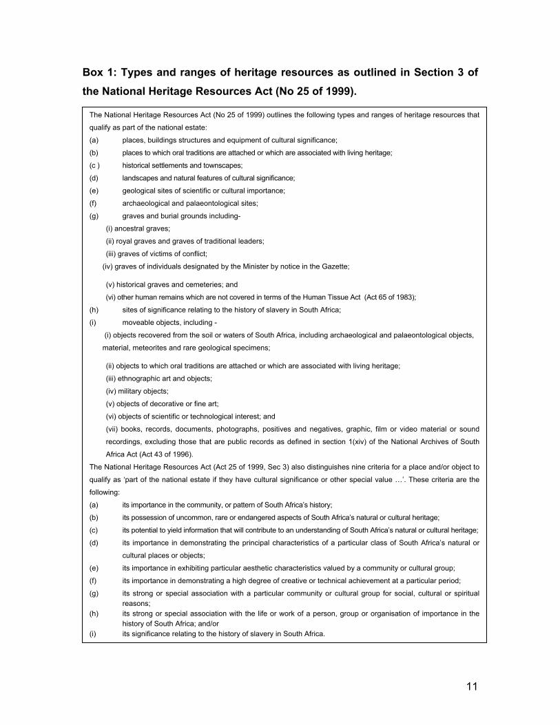
Box 1: Types and ranges of heritage resources as outlined in Section 3 of the National Heritage Resources Act (No 25 of 1999).
The National Heritage Resources Act (No 25 of 1999) outlines the following types and ranges of heritage resources that
qualify as part of the national estate:
(a) places, buildings structures and equipment of cultural significance;
(b) places to which oral traditions are attached or which are associated with living heritage;
(c ) historical settlements and townscapes;
(d) landscapes and natural features of cultural significance;
(e) geological sites of scientific or cultural importance;
(f) archaeological and palaeontological sites;
(g) graves and burial grounds including-
(i) ancestral graves;
(ii) royal graves and graves of traditional leaders;
(iii) graves of victims of conflict;
(iv) graves of individuals designated by the Minister by notice in the Gazette;
(v) historical graves and cemeteries; and
(vi) other human remains which are not covered in terms of the Human Tissue Act (Act 65 of 1983);
(h) sites of significance relating to the history of slavery in South Africa;
(i) moveable objects, including -
(i) objects recovered from the soil or waters of South Africa, including archaeological and palaeontological objects,
material, meteorites and rare geological specimens;
(ii) objects to which oral traditions are attached or which are associated with living heritage;
(iii) ethnographic art and objects;
(iv) military objects;
(v) objects of decorative or fine art;
(vi) objects of scientific or technological interest; and
(vii) books, records, documents, photographs, positives and negatives, graphic, film or video material or sound
recordings, excluding those that are public records as defined in section 1(xiv) of the National Archives of South
Africa Act (Act 43 of 1996).
The National Heritage Resources Act (Act 25 of 1999, Sec 3) also distinguishes nine criteria for a place and/or object to
qualify as ‘part of the national estate if they have cultural significance or other special value …’. These criteria are the
following:
(a) its importance in the community, or pattern of South Africa’s history;
(b) its possession of uncommon, rare or endangered aspects of South Africa’s natural or cultural heritage;
(c) its potential to yield information that will contribute to an understanding of South Africa’s natural or cultural heritage;
(d) its importance in demonstrating the principal characteristics of a particular class of South Africa’s natural or
cultural places or objects;
(e) its importance in exhibiting particular aesthetic characteristics valued by a community or cultural group;
(f) its importance in demonstrating a high degree of creative or technical achievement at a particular period;
(g) its strong or special association with a particular community or cultural group for social, cultural or spiritual reasons; (h) its strong or special association with the life or work of a person, group or organisation of importance in the history of South Africa; and/or (i) its significance relating to the history of slavery in South Africa.

12
3 METHODOLOGY This Phase I HIA study was conducted by means of:
• Travelling the length of the proposed new power line corridors with a
helicopter, vehicle and surveying selected spots of the Eskom Project
Area on foot.
• Surveying literature relating to the pre-historical and historical context of
the Eskom Project Area.
• Consulting maps of the Eskom Project Area.
• Consulting archaeological (heritage) data bases such as the one kept at
he North-West Provincial Heritage Resources Agency (NW PHRA).
• Relying on experience gained from twenty years of fieldwork in the Eskom
Project Area during which time numerous surveys were conducted for
mines, residential areas, power lines and other types of development
projects.
• Integrating all information obtained from the literature survey, maps, data
bases and previous surveys with the evidence derived from the fieldwork.
3.1 Fieldwork
The proposed Matimba B-Marang power line options were surveyed by means of
flying the lengths of the major power line corridors with a helicopter, travelling
stretches of the proposed new power line corridors with a vehicle and surveying
selected spots along the power line corridors on foot.
3.2 Databases, literature survey and maps
Databases kept and maintained at institutions such as the North-West Heritage
Resources Agency (SAHRA) in Mafekeng and the Archaeological Data Recording
Centre at the National Flagship Institute (Museum Africa) in Pretoria were consulted

13
to determine whether any heritage resources had been identified during earlier
archaeological surveys in the project area.
Literature relating to the pre-historical and the historical unfolding of the Eskom
Project Area was briefly reviewed. Pre-historical and historical events relating to
the broad Eskom Project Area were highlighted in order to contextualise the
project area and to determine what possible types and ranges of heritage
resources may be expected to occur in or near the proposed Matimba B-Marang
power line corridors.
In addition, the Eskom Project Area was also studied by means of the 1:50 000
topographical maps and the 1:250 000 map on which the project area appears.
3.3 Earlier surveys The author has conducted numerous surveys and excavations in the Eskom
Project Area during the last two decades. The surveys were conducted for
granite, platinum and chrome mines. Excavations of approximately twenty
settlements were undertaken while conducting research on the origins and
history of the Tswana. Experience gained from these surveys and excavations
contributed to knowledge about the presence of heritage resources in or near
power line corridors (see Part 8, ‘Select Bibliography’).
3.4 Mapping heritage resources
Known heritage resources (including cultural landscapes) as well as ‘ruins’ and
‘graves’ indicated on the Surveyor General’s 1: 50 000 topographical maps on
which the Eskom Project Area appears were mapped by GIS Corporation.
14
3.5 Assumptions and limitations
It must be pointed out that this Phase I HIA study did not succeed in identifying
all possible types and ranges of heritage resources along the proposed new
Matimba B-Marang power line corridors because the total length of the proposed
new power line corridor could not be surveyed in full.
This Phase I HIA study has to be followed by a pedestrian (foot) survey of
selected stretches of the final power line corridor in order to identify any possible
impacts on heritage resources which may occur along these stretches of the
proposed new power line corridor.

15
4 A BRIEF CONTEXT OF THE ESKOM PROJECT AREA
4.1 Location
Eskom’s proposed new power line corridors will run from Lephalale (Ellisras) in the
Limpopo Province in the north to the Marang Substation in the Bafokeng
(Rustenburg) District in the south. The proposed new power line will cross two
provincial boundaries, namely that of the Limpopo Province and the North-West
Province of South Africa. The power lines will also cross two major ecozones,
namely savannah bush veldt in the north and the Bankeveld in the south, each
zone characterised by particular types and ranges of heritage resources relating to
the history of various cultural groups who occupied these ecozones from the
earliest times.
4.2 The nature of the Eskom Project Area
The Eskom Project Area incorporates a northern bushveld savanna ecozone that
stretches from Lephalale in the north to a series of norite kopjes in the south. The
Bankeveld is an intermediary zone between the northern bushveld and the grass
veld of the Highveld stretching further to the south. The northern bushveld and the
Bankeveld ecozones do not only harbour significantly different types and ranges of
heritage resources, but also reflect marked differences in the number of heritage
resources that occur in each of these ecozones.
4.2.1 The bushveld in the north
The northern bushveld is characterised by shale with traces of sediments near
the Limpopo River in the far west. A patch with arenite, which is the dominant
material in the Waterberg Mountain mass further to the east, outside the Eskom
Project Area, occurs near the northern stretch of the power line. The vegetation
is predominantly sweet Bushveld although thickets and clumps of bush and high

16
fynbos occur. Towards the south vegetation described as part of the Western
Sandy Bushveld encroaches. Degraded forest and woodland occurs towards the
northern stretch of the power lines.
No conspicuous topographical features other than consistent level sandy plains
covered with open savannah bush mark this part of the project area which is also
home to several scattered pans. Agricultural fields, many abandoned today, dot
the project area where the Matimba B Power Station will be established.
The bushveld savanna was sparsely populated by humans in the past. However,
occupation started at an early period so that humans may have been present in
the area over a long time span, but on a limited scale. This occupation occurred
from the Stone Age, hundreds of thousands of years ago, throughout the Early
Iron Age which covers the first millennium AD and the historical period which
commences with the arrival of the first colonial hunters, traders and farmers.

17
Figure 1- The northern bushveld part of the Matimba B-Marang Project Area seen from the air. Outstretched open savannah veldt with little surface water is a dominant feature of the landscape. This inhospitable environment was not conducive for human settlement in the past (above).
4.2.2 The Bankeveld in the south
The Bankeveld is a narrow strip of land between the northern bushveld and the
southern grassvelds of South Africa and can be divided into the Western, Central
and the Eastern Bankeveld. Only the Central Bankeveld is important to this report.
The Central Bankeveld can be roughly demarcated by Krugersdorp in the south,
the Pienaars River to the north, Bronkhorstspruit in the east and the Pilanesberg to
the west.

18
The Central Bankeveld is covered by older grabbo penetrated by younger vulcanic
magma which formed a series and chains of pyramid-shaped granite hills from the
Pilanesberg in the north-west to Onderstepoort near Pretoria in the east. These
hills, as part of the Magaliesberg valley, represent a unique ecozone characterised
by grassveld savanna and near wooded valleys. The region has abundant surface
water supplies. The Pienaar, the Moretele, the Hex and the Apies Rivers all drain
their waters into the Crocodile River. Numerous Late Iron Age Tswana chiefdoms
emerged during the last four centuries in this part of the North-West.
Figure 2- The Bankeveld characterises the southern part of the Eskom Project Area. This ecozone is home to a series of granite kopjes running from Onderstepoort via Madibeng to the Pilanesberg. Along the base lines of these kopjes thousands of stone walled sites occupied by ancestral Tswana clans and chiefdoms such as the Kgatla, Kwena and Fokeng occur (above).
19
4.3 Heritage resources in the Eskom Project Area
Different types and ranges of heritage resources occur in the bushveld in the north
and in the Bankeveld ecozone in the south. Whilst heritage resources are scarce,
scattered and limited in types and ranges in the northern bushveld, a wider variety
of heritage resources occur in the southern Bankeveld with stone walled sites,
particularly, in abundance. These sites are also clustered covering large surface
areas which qualify as cultural landscapes.
4.3.1 Heritage resources in the bushveld in the north
Hunter gatherers from the Stone Age, including a few who left rock paintings
during the last 20 000 years in the mountainous Waterberg to the east of the
Project Area, lived in the bushveld from as early as the Middle Stone Age (MSA),
200 000 years ago. MSA and Late Stone Age (LSA) tools were observed along
the banks of the Mokolo (Mogol) River and on farms to the east of the project
area. At Nelsonskop, a small protrusion on the north-eastern border of the
project area engravings of animal spoor, cupules and other incisions were found
on a face of this hill. Most of the Stone Age sites in the bushveld were open
(surface) sites which imply that most of the artefacts on these sites occur ‘out of
context’.
Hunter-gatherers were followed by the first agro-pastoralists who lived in semi-
permanent villages and who practised metal working during the last two
millennia, the so-called Iron Age. Whilst the Early Iron Age (EIA) is marked by
small scattered sites with (elaborately) decorated pottery and in many instances
with iron smelting, Late Iron Age (LIA) sites may occur in clusters covering large
tracks of land constituting cultural landscapes. The area close to the junction
between the Limpopo River and the Matlabas River, on both sides of the
Limpopo River, west of the Eskom Project Area, have been home to early
20
farmers who lived in small scattered villages near these water sources. Here,
they utilized pieces of land close to the banks of the rivers or near confluences
between these rivers and small streams. They planted crops while small
numbers of cattle and small stock were kept when grazing and shrubbery
allowed for stock keeping.
EIA as well as LIA communities did not prefer the flat outstretched sand veldt of
the Eskom Project Area for habitation or for farming. The scarcity of surface
water for humans and animals; low annual summer rainfalls, high temperatures
with accompanying high evaporation rates and soils which lacked nutrients were
not conducive to crop planting. The absence of all year round grazing also did
not encourage mixed farming in this part of the project area. Late Iron Age
occupation on the scale that marked the Ga-Seleka and Shongwane areas to the
north-east of Lephalale did not occur in the Eskom Project Area.
No historically known tribal groupings or clans occupied the Eskom Project Area
during the LIA or the historical period. Communities known as the ‘Vaalpense’
(mixed Negroid and San) lived in the area. Their descendants can still be found
here. These communities were nomadic hunters and herders before they
became employed by the first colonial farmers.
Farm houses with outbuildings, family graveyards, cattle posts, outlying bore
holes with drinking troughs and grazing fields lead to the establishment of cultural
landscapes of some proportions in the Eskom Project Area from the second half
of the 19th century. First generation homesteads, ‘hartbeeshuise’ constructed
with clay or clay bricks and thatched roofs, have all disappeared by now and
have been replaced with second and third generation farm residences. Some of
these, as well as farm stores along dirt roads in the project area, may be older
than sixty years. In general, however, as elsewhere in the larger region, farm
homesteads with associated infrastructure and activity areas have been
transformed as a result of changing subsistence patterns

21
4.3.1 Heritage resources in the Bankeveld in the south
The emergence of the earliest ancestors of modern humans, 2-3 million years ago,
occurred in the Krugersdrop area, close to the project area. The remains of
Australopithecine and Homo habilis were found in dolerite caves and underground
dwellings at Sterkfontein and Swartkrans near Krugersdorp. Homo habilis, one of
the Early Stone Age hominids, is associated with Oldowan artefacts which include
crude implements manufactured from pebble stones.
The Acheulian industrial complex replaced the Oldowan industrial complex during
the Early Stone Age (ESA). This phase of human existence was widely distributed
across the world and is associated with Homo Erectus who manufactured hand
axes and cleavers from as early as 500 000 years ago. One of the earliest
discoveries of an Acheulian site was made at Wonderboompoort, in a part of the
Magaliesberg. Late Auchelian hand axes have been found in the Bankeveld near
the Eskom Project Area.
MSA sites dating from as early as 200 000 years ago have been found all over
South Africa. MSA hunter-gatherer bands lived and hunted to the north and south
of the Magaliesberg. MSA people looked like modern humans. They lived in
small bands and occupied camp sites near water but also started to use caves as
dwellings. They manufactured a wide range of stone tools, including blades and
points that may have been hafted on long wooden sticks that were used as
spears.
The Late Stone Age (LSA) commenced 20 000 years ago, or somewhat earlier.
Various types of stone (lithic) industries that are scattered across the country are
associated with the San and Khoi-Khoi people who are associated with the Late
Iron Age and the historical period. The San were renowned as formidable hunter-
gatherers, while the Khoi-Khoi also herded with cattle and small stock during the
22
last two thousand years. LSA people manufactured tools that were small but highly
effective, such as arrow points and knives. They are also known for their rock art
skills.
Early Iron Age (EIA) farming communities practised a mixed economy consisting of
plant cultivation and stock herding near the Magaliesberg during the first half of the
first millennium AD. These Bantu-Negroid people, who probably interbred with the
local San and Khoi-Khoi, were ironworkers of some repute and established the first
permanent villages south of the Limpopo River.
During the Late Iron Age (LIA) farming was practised in the northern, central and
eastern parts of the country. Extensive stone walled sites occur in the Thaba-ea-
Nape range of mountains that runs from the east to the west across the Eskom
Project Area. These stone walled sites are associated with ancestor rulers of the
Tswana such as the Kwena, Kgatla and Fokeng who today live in the Madibeng-
Marikana and Rustenburg areas.
Numerous pre-difaqane and difaqane wars were fought during the last quarter of
the 18th century and the first quarter of the 19th century in the Bankeveld. These
wars led to the displacement of large numbers of Tswana clans in the Bankeveld.
Internal strife between the various Tswana chiefdoms also seems to have been on
the increase from the latter half of the 18th century onwards. Paternal relatives
fought against each other to attain the chieftaincy of the various Tswana chiefdoms.
Succession disputes led to the splintering of chiefdoms into a growing number of
independent spheres of influence in the Bankeveld.
The difaqane wars were caused by the Ndebele (Matabele) of Mzilikazi who arrived
from the Vaal River region to occupy the Bankeveld in August 1827. The Matabele
destroyed the Kwena Môgôpa, the Kgatla and what had remained of the Pô after
an earlier defeat by the Pedi.

23
The Ndebele established several settlement complexes in this region from whence
they maintained their grip on the indigenous population. Four of these Zulu/Nguni
residences (imisi) and military kraals (amakhanda) have been discovered during
the course of archaeological surveys in the Central Bankeveld. Two of these village
complexes are located near modern Rustenburg and Madibeng respectively. Both
these villages were visited and painted by the first white men who entered the
Bankeveld, namely Charles Bell, who escorted Andrew Smith's expedition in June
1835, and Cornwallis Harris, who travelled and hunted extensively in the Bankeveld
during December 1836.
During the early 19th century, travellers, traders and missionaries visited what is
today the Bankeveld where they encountered the devastated Tswana chiefdoms.
Amongst the travellers who moved through the Bankeveld were the traders Robert
Schoon and William McLuckie, who visited the Ndebele village near Rustenburg in
August 1829. They were followed two months later by the missionary Robert
Moffat, who also passed this village and visited Mzilikazi in an umuzi near what is
today Pretoria. In June 1835, Charles Bell and other members of Andrew Smith's
expedition visited the Matabele village near Rustenburg. One year later, in
December 1836, Cornwallis Harris visited and painted emHlalandlela near
Madibeng.
These early travellers were followed from the 1840’s by the first colonists who
settled in various places in the Magaliesberg such as Rustenburg, Marikana,
Schaapkraal, Hekpoort and Madibeng (Brits).
The Transvaal Anglo Boer War followed in 1880 to 1881. The Second Anglo
Boer War raged from 1899 to 1902. Battlefields, graveyards and fortifications
from this time still exist. The British built masonry forts, redoubts, trenches and
barbed wire fences to curtail the movements of Boer commandos. In open
terrain, blockhouses were spaced roughly one kilometre apart and linked with
barbed wire fences. Cliffs prevented troops from crossing mountains, so

24
blockhouses were built at points were it was possible to cross such mountain
ranges.
The 20th century saw the introduction of large-scale dry land farming on the
Highveldt, the Bankeveld and further to the north in the bushveld. Farm
homesteads with outbuildings and family graveyards became common place
across vast expanses of the country side. Simultaneously, black townships
developed, many later became part of homelands such as Bophuthatswana and
Lebowa. The 20th century is therefore associated with numerous formal and
informal homesteads which are older than sixty years, many associated with
small family graveyards that are scattered across the South African landscape.
After the discovery of the Merensky Reef in 1929, economy activities in the
Bankeveld near the Eskom Project Area gradually changed from farming into
platinum and chrome mining. What started as small scale mining activities north of
the Magaliesberg during the 20th century was soon eclipsed by the rise of the
platinum mining complex near Rustenburg. The discovery of the Merensky Reef
and the accompanying platinum boom was soon followed by the establishment of
numerous chrome and norite mines in the North-West Province.

25
5 THE PHASE I HERITAGE IMPACT ASSESSMENT STUDY The proposed Matimba Transmission Integration Project requires the
construction of a 400kV power line from Matimba B Power Station to the Marang
Substation near Rustenburg and the upgrading of the Spitskop and Marang
Substations.
The Phase I HIA study for the 400kV power line running between Matimba B and
Marang is first discussed and thereafter the Phase I survey for the Spitskop and
Marang Substations.
5.1 The survey for the Matimba B-Marang power line corridor 5.1.1 The main stretches of the Matimba B-Marang power line
The Matimba B-Marang power line can be divided into two main stretches,
namely a northern and a southern stretch. The southern stretch can be divided
into a western and an eastern option. The northern stretch runs from the
Matimba B Power Station southwards to a point to the east of Mogwase (at the
Pilanesberg) and the southern stretch runs from east of Mogwase to the Marang
Substation in the south. The southern stretch has two possible options, namely a
Western Matimba B-Marang option and an Eastern Matimba B-Marang option.
The various stretches and options for the proposed new Matimba B-Marang
power line and known heritage resources close to these stretches are now
discussed.

26
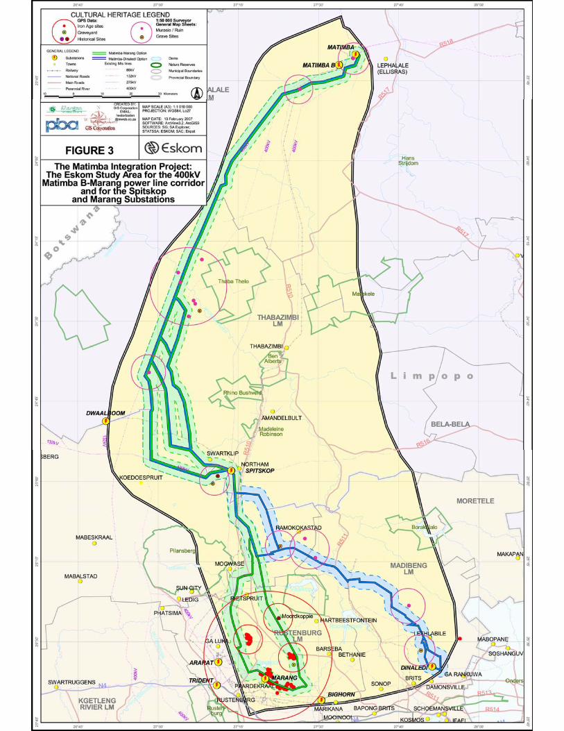
Figure 3 – The Matimba Integration Project: The Eskom Study Area for the 400kV Matimba B-Marang power line corridor and for the Spitskop and Marang Substations. Note the presence of ruins, graves and stone walled settlements in and near the Eskom Project Area.

27
5.1.1.1 The northern stretch
The most northern stretch for the Matimba B-Marang power line is identical with
the northern stretch for the Matimba B-Dinaledi power line.
The northern stretch can be divided into the following shorter stretches (parts),
namely:
• From Matimba B Power Station bending westwards two times before
running parallel for a short distance with the Sandloop River then bending
south-westwards skirting the western edge of the Waterberg mountain
mass (on Geelhoutskloof 359LQ) before bending south-westwards again
in order to run to the Matlabas River.
• From the Matlabas River south-westwards across a level land mass to the
Crocodile River. This stretch covers open savannah with no outstanding
topographical features.
• From the Crocodile River southwards, following several jinks to the west
and the east to the farm Zoetdoorns 259KP.
• From Zoetdoorns 259KP eastwards to Spitskop Substation. This stretch
runs across an extensive agricultural field (Application 358KP), the
southern tip of the Mponyane mountain range (Kraalhoek 399KQ),
between agricultural fields (Haakdoorn 6JQ and Varkensvlei 403KQ),
across a second agricultural field (Spitskop 410KQ) and then slightly to
the north of Sefikile mountain to Spitskop.
• From Spitskop southwards to a bend to the south-east (on Varkenfontein
73JQ) and then running to the split (east of Mogwase) from where the
Matimba B-Marang power line may follow a western option or an eastern
option to the Marang Substation.

28
Known heritage resources
The following known heritage resources occur along the northern stretch for the
Matimba B-Marang power line corridor:
• A single ruin on Geelhoutskloof 359LQ.
• At least five ruins occur close to the Crocodile River’s banks (close to the
eastern option for the Matimba B-Dinaledi power lines). One of these ruins
may be impacted by the Matimba B-Marang power line corridor (which is
also the western [central] Matimba B-Dinaledi option).
• A single ruin on Geluk 212LQ.
• Stone walled sites along the base of Sefikele kopje. These sites have
been damaged as a result of the village with the same name which has
being established around the foot of the kopje.
• Graves occur a considerable distance to the south-west of Spitskop
Substation
5.1.1.2 The southern stretch
The southern stretch of the Matimba B-Marang power line may follow one of two
options, namely the Western Matimba B-Marang option or the Eastern Matimba
B-Marang option. These two options with know heritage resources near these
options are now discussed
5.1.1.2.1 The Western Matimba B-Marang option
This Western Matimba B-Marang option can be divided into the following parts:
• From the dividing point east of Mogwase running southwards nearly
parallel with the Northam road and then through two jinks (to the west and
to the east) before turning with a ninety degree turn to the west (on
Kameelfontein 80JQ).

29
• Westwards from Kameelfontein 80JQ and then again bending south-
westwards (on Zanddrift 82JQ) running southwards to the west of the
village of Monnakato and Maile. Here, the power line also passes to the
west of the kopje Tlhating.
• From Tlhating along the western border of Welbekend 117JQ and to the
west of the Ga Nape complex of sites where a large concentration of
stone walled sites occur. (The Ga Nape Heritage Park is part of Bafokeng
Royal Resources’ Master Development Plan).
• From Ga Nape south-westwards and then south-eastwards to
Paardekraal.
• From Paardekraal eastwards and then south-eastwards to the Marang
Substation. Stone walled settlements occur at most of the isolated
scattered norite hills close to the Marang Substation.
Known heritage resources
The following known heritage resources occur along the western Matimba B-
Marang option:
• The Ga Nape complex of sites are located at Ga Nape and the
surrounding smaller norite hills in this part of the Thaba-ea-Nape range of
mountains. Bafokeng Royal Resources (BRR) have earmarked the farm
Welbekend 117JQ to be developed as a Heritage Park.
• Stone walled settlements occur at most of the isolated, scattered norite
hills that are located on the level turf veldt close to the Marang Substation.
5.1.1.2.2 The Eastern Matimba B-Marang option
The Eastern Matimba B-Marang option can be divided into the following parts:
• From a point to the east of Mogwase southwards to the village of
Tautanana where the line bends slightly to the south-east running to the
west of Moordkop (Potgietersfontein 125JQ). Moordkop is a historical

30
significant settlement as Mzilikazi’s Ndebele killed a number of Griqua at
this kopje in 1832.
• From the west of Moordkop across the Hex River (Kafferskraal 133JQ)
southwards between Makgope (Nooitgedacht 282JQ) and Malepe
(Nooitgedacjht 293JQ). Large numbers of stone walled settlements occur
in the Makgope mountain range.
• From Makgope and Malepe south-eastwards, running parallel with the
Marikana dirt road between the mountains Mothanyane and Visierskerf to
the most southern turning point of the power line. This stretch runs across
a level plain between the norite kopjes of the Thaba-ea-Nape range of
mountains. A graveyard occurs near this stretch of the power line.
• From the most southern turning point westwards to a point (on Hoedspruit
299JQ) where the power line bends to the north-west in order to run
across the western edge of the Thaba-ea-Nape range of mountains to the
Marang Substation. This stretch of the Thaba-ea-Nape mountain range is
covered with a number of stone walled sites.
Known heritage resources
The following known heritage resources occur along the eastern Matimba B-
Marang option:
• Moordkop is a historical significant settlement as Mzilikazi’s Ndebele killed
a number of Griqua at this kopje in 1832.
• Large numbers of stone walled settlements occur in the Makgope
mountain range, particularly on its eastern end.
• A graveyard occurs between Makgope/Malepe and the southern most
turning point.
• The stretch of the power line running from the southern most turning point
northwards along the western edge of the Thaba-ea-Nape mountain range
is covered with clusters of stone walled sites. This stretch will follow an
existing power line.

31
5.2 The survey for the Spitskop and Marang Substations
5.2.1 Spitskop Substation
The Spitskop Substation is located on level land south-west of Northam and to
the east of a village and kopje with the same name, namely Sefikile. Stone
walled sites occur along the base of this kopje. However, the larger part of this
complex has been damaged or destroyed when the modern village of Sefikile
was established and gradually expanded around the base of this kopje.
A graveyard is located to the south-west of Spitskop Substation. However, the
graveyards will not be affected by the upgrading of the substation.
5.2.1 Marang Substation
The Marang Substation is located on level turf veld to the east of new expanding
suburbs located to the west of the substation.
A number of scattered norite kopjes occur to the north, north-east and to the
south of the substation. Stone walled settlements occur along the base lines as
well as between these kopjes.

32
Northern Stretch Heritage Resources Level of
significance Magnitude of impact
●Matimba B-Matlabas River Ruin, Geelhoutskloof 359 LOW MEDIUM-HIGH
●Matlabas R- Crocodile River At least five ruins close to the
Crocodile R (one may be
impacted)
LOW LOW
●Crocodile R-Zoetdoorns 259 Ruin on Geluk 212 LOW MEDIUM-HIGH
●Zoetdoorns-Spitskop Stone walled sites, base of
Sefikele kopje
LOW LOW
Graves south-west, Spitskop HIGH LOW
Southern Stretch (Western/Eastern option)
Heritage Resources Level of significance
Magnitude of impact
Western Matimba B-Marang
●Mogwase-Kameelfontein 80
●Kameelfontein-Tlhating
●Tlhating-Ga Nape Stone walled sites at Ga Nape HIGH LOW
●Ga Nape Paardekraal
●Paardekraal-Marang Stone walled sites close to
kopjes near Marang
HIGH LOW-MEDIUM
Eastern Matimba B-Marang Heritage Resources Level of significance
Magnitude of impact
●Mogwase-Moordkop Moordkop HIGH LOW
●Moordkop-Makgope/Malepe Stone walled sites along
Makgope’s eastern end
HIGH LOW-MEDIUM
●Makgope/Malepe-southern
turning point
Graveyard close to the power
line
HIGH LOW
●Southern turning point-Marang Stone walled sites along
western edge of Thaba-ea-Nape
mountains
MEDIUM-HIGH
LOW-MEDIUM
Marang Substation ●August Mokgatles
Heritage Resources Level of significance
Magnitude of impact
Stone walled sites near
substation
HIGH LOW-MEDIUM
Table 1- Known heritage resources along the proposed 400kV Matimba B-Marang power line corridor and the Marang Substation, their levels of significance and the magnitude of the impact on these heritage resources (above).

33
6 THE SIGNIFICANCE OF THE HERITAGE RESOURCES The main types and ranges of heritage resources that were identified in the Eskom
Project Area consist of:
• Ruins and graves that were identified from the Surveyor General’s 1: 50 000
topographical maps and which occur in or near the power line corridor.
• Stone walled settlements or clusters of these sites which occur along the
Western Matimba B and the Eastern Matimba B-Marang Options and near
the Marang Substation.
6.1 Levels of significance of the heritage resources
The majority of these heritage resources and graves were mapped. The levels of
significance of these remains have been indicated as well as the magnitude of any
impact on these heritage resources and graves (Figure 3 & Table 1).
6.1.1 The significance of the ruins It is possible that ruins on Geelhoutskloof 359JQ and Geluk 212KP may be
impacted by the new power line. The nature, extent and significance of these ‘ruins’
which have been identified from the 1: 500 000 topographical maps is unknown.
These remains were mostly constructed with durable material such as brick and
cement walls and usually do not have outstanding significance as they date from
the more recent past.
However, if these ruins are older than sixty years they do qualify as heritage
resources and are protected by Section 34 of the National Heritage Resources Act
(No 25 of 1999).

34
6.1.2 The significance of the stone walled sites
Stone walled sites are abundant in and near the Eskom Project Area. These sites
date from the Late Iron Age. They are mostly associated with kopjes and
mountains, where norite and dolerite were used in the construction of these sites.
The sites are usually single settlements on kopjes or are clustered along the lower
foot slopes and spurs of large mountains.
The clusters of stone walled sites are composed of varying numbers of individual
sites (dikgôrô) that were grouped together to form villages which covered large
areas. The majority of the stone walled sites are confined to mountains and kopjes
on the farms Nooitgedacht 282JQ, August Mokgatles, Welbekend 117JQ and
Beestkraal 290JQ.
The following settlement types can be distinguished:
• Tswana villages (singular motse, plural metse) which were composed of a
single village (kgôrô) or a conglomeration of villages (dikgôrô). A typical
kgôrô is characterized by an outer scalloped wall that encircles central kraal
complexes that were usually linked together. The outer scalloped walls still
contain the remains of dwellings (huts) within their surrounding yards
(malapa) that were occupied by the various family groups (masika), central
kraal complexes composed of courts (makgotla) and enclosures for
domestic stock. Tswana sites are common throughout the Project Area.
• There are some sites that are composed of long terrace walls that are
‘stepped’ down the slopes of mountains. The terrace walls are associated
with a few small and large enclosures. These sites are not demarcated with
clear outer boundary walls. It is possible that these sites may have been built
by Ndebele people.
• There were some sites with spatial compositions that could not be
interpreted as yet, due to the dense vegetation cover on these sites at the
35
time of the year when the study was done. However, it is expected that
settlement types not previously recorded may occur in the clusters that were
discovered in the Eskom Project Area.
The stone walled sites in and near the Eskom Project Area can be rated as
significant in terms of criteria such as the following:
• The Thaba-ea-Nape range of mountains with individual mountains in this
range such as Malejane, Nape, Mofothelo, Motlhabe, etc are historical
beacons, as they are associated with human occupation during the last
three hundred and fifty to four hundred years.
• These sites and clusters of sites represent different villages which were
occupied simultaneously by several thousands of people who lived in these
villages from pre-historical times (AD1650) well into the historical period.
(Some of the sites may still have been occupied during the Transvaal Anglo
War [1899-1902]).
• Many of the sites and clusters of sites with their surrounding landscape
represent ‘cultural landscapes or townscapes’ which are unique, as these
sites and complexes of sites reflects a regional history, in particular that of
Kwena clans such as the Bafokeng.
• These townscapes incorporate intangible heritage attributes such as a
sense of place, the majesty of mountains associated with the social
(political) importance of rulers, activity areas which served as pastures for
stock, wood and water collecting spots, possible places of sacrifice and
worship, etc.
• These site complexes are unique in the context of the Late Iron Age, as they
contain settlements that are characteristic of Tswana and mixed
Tswana/Zulu (Ndebele) populations.
• Some of the settlements and clusters of settlements are in an excellent
(pristine) condition and have not been affected by any development in the
past. (However, its is also true that many sites and clusters of sites have

36
been affected in one way or another by mining or other development
activities in the past).
• These sites offer outstanding research opportunities, as they represent
archaeological ‘laboratories’ which can be utilised for decades to come.
Tangible heritage remains in the form of artefacts, structures and features
are in abundance in the archaeological deposits that are associated with the
sites.
• The village complexes offer exceptional educational and tourism potential, if
they are developed according to correct scientific and museological
principles.
6.1.3 The significance of graves and graveyards Graves and graveyards hold high significance and are protected by various laws.
Legislation with regard to graves includes the National Heritage Resources Act (No
25 of 1999) whenever graves are older than sixty years. The act also distinguishes
various categories of graves and burial grounds. Other legislation with regard to
graves includes those which apply when graves are exhumed and relocated,
namely the Ordinance on Exhumations (No 12 of 1980) and the Human Tissues
Act (No 65 of 1983 as amended).
6.2 Possible impact on the heritage resources
The magnitude of the impact of the various stretches of the Matimba B-Marang
power line and the Marang Substation on various heritage resources and graves
has been indicated and is discussed below (Table 1).
6.2.1 Possible impact on ruins It is possible that ruins on Geelhoutskloof 359JQ and Geluk 212KP may be
impacted by the new power line.

37
6.2.2 Possible impact on stone walled sites The following stretches of the proposed Matimba B-Marang power line together
with the Marang Substation may have a negative impact on single stone walled
sites or clusters of stone walled sites, namely (Table 1):
• The Western Matimba B-Marang option: The stretch runs from
Paardekraal eastwards and then south-eastwards to the Marang
Substation. Stone walled settlements occur at most of the isolated,
scattered norite hills close to the Marang Substation.
• The 1st Eastern Matimba B-Marang option: The stretch runs between
Makgope/Malepe mountains and the southernmost point. The eastern end
of Makgope mountain is covered with stone walled sites which may be
impacted by the power line.
• The 2nd Eastern Matimba B-Marang option: This stretch runs from the
southern most turning point along the western edge of the Thaba-ea-Nape
range of mountains to the Marang Substation. This stretch of the Thaba-
ea-Nape mountain range is covered with a number of stone walled sites.
• The Marang Substation: Kopjes to the north and south of Marang
Substation are associated with stone walled settlements. Upgrading of the
Marang Substation may have an affect on these settlements.
6.2.3 Possible impact on graves and graveyards It seems as if a graveyard along the Makgope/Malepe mountains to the southern
most point (1st Eastern Matimba B-Marang Option) may be affected by the new
power line.

38
6.3 Mitigating the impact on the heritage resources It seems as if ruins, stone walled sites and a graveyard may be affected by the
proposed new Matimba B-Marang power line and the Marang Substation.
6.3.1 Mitigating the ruins
The nature, extent and significance of the ruins which may be impacted on
Geelhoutskloof 359JQ and Geluk 212KP are unknown. These remains usually do
not have any outstanding significance as they date from the more recent past.
However, if these ruins are older than sixty years they qualify as heritage resources
and are subsequently protected by Section 34 of the National Heritage Resources
Act (No 25 of 1999).
It these ruins are older than sixty years are impacted by the development a permit
to demolish these ruins have to be acquired from the North-West Provincial
Heritage Resources Authority (NW PHRA). The permit would authorise the
destruction of these remains.
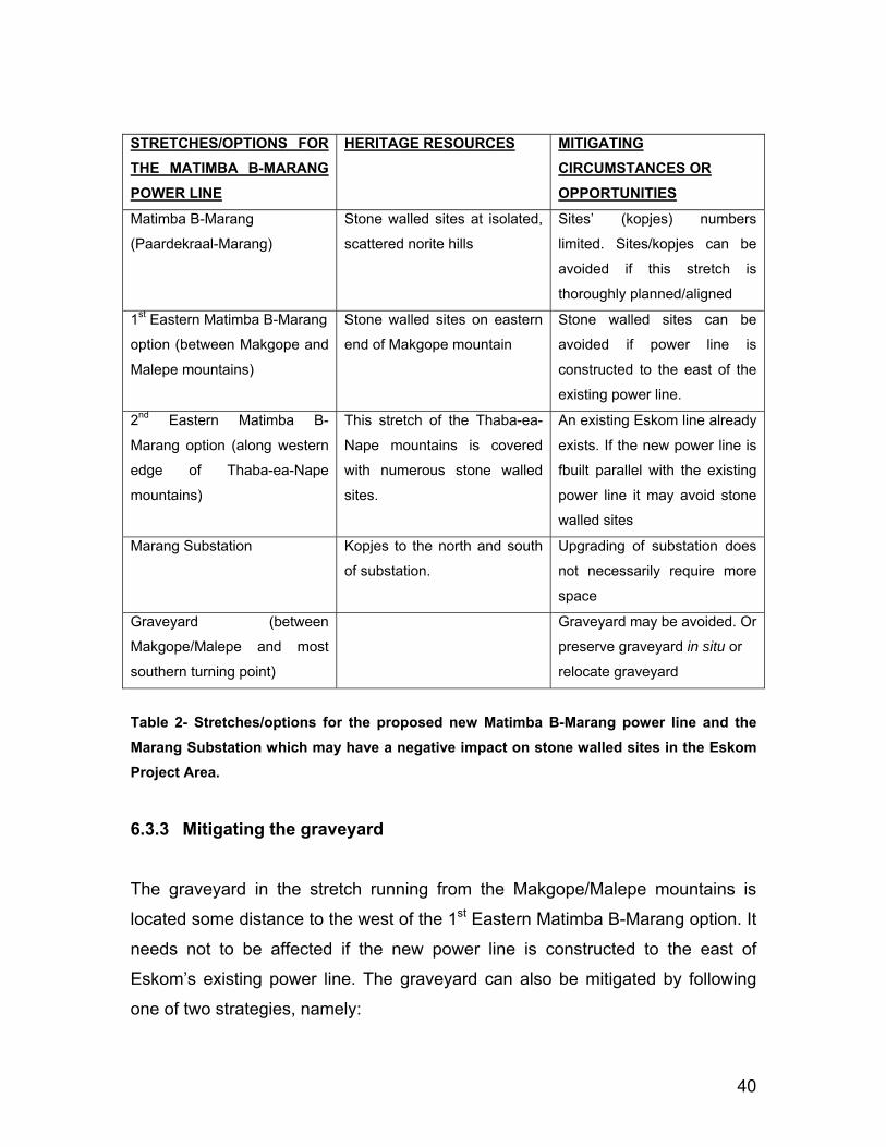
6.3.2 Mitigating the stone walled sites Three stretches of the proposed Matimba B-Marang power line corridor and the
Marang Substation may have an impact on stone walled settlements. The
following mitigating circumstances as well as opportunities for mitigation exist,
namely (Table 2):
• Stone walled settlements and scattered norite hills exist along the
Western Matimba B-Marang option which runs from Paardekraal to the
Marang Substation. The norite hills and settlements along this stretch are
not numerous. Neither do these settlements (and hills) cover large

39
surface areas. It is possible that the stone walled settlements (and kopjes)
could be avoided if this stretch of the power lined is thoroughly planned.
• The 1st Eastern Matimba B-Marang option runs between
Makgope/Malepe mountains and the southern most point. The eastern
end of Makgope is covered with stone walled sites. It is possible to avoid
these sites if the Matimba B-Marang power line is constructed to the east
of Eskom’s existing power line which runs through the Makgope-Malepe
poort.
• The 2nd Eastern Matamba B-Marang option runs from the southern most
turning point along the western edge of the Thaba-ea-Nape range of
mountains to the Marang Substation. This stretch of the Thaba-ea-Nape
range of mountains is covered with a large number of stone walled sites.
One of Eskom’s existing power lines already runs along this corridor. If
the proposed new Matimba B-Marang power line runs parallel with the
existing power line it may avoid the stone walled sites and clusters of
sites along this stretch.
• The Marang Substation is associated with kopjes with stone walled
settlements located to the north and to the south of the substation. Any
upgrading of the Marang Substation may have an affect on these
settlements. However, the upgrading of the Marang Substation may not
require more space which may cause an impact on these sites.
40
STRETCHES/OPTIONS FOR THE MATIMBA B-MARANG POWER LINE
HERITAGE RESOURCES MITIGATING CIRCUMSTANCES OR OPPORTUNITIES
Matimba B-Marang
(Paardekraal-Marang)
Stone walled sites at isolated,
scattered norite hills
Sites’ (kopjes) numbers
limited. Sites/kopjes can be
avoided if this stretch is
thoroughly planned/aligned
1st Eastern Matimba B-Marang
option (between Makgope and
Malepe mountains)
Stone walled sites on eastern
end of Makgope mountain
Stone walled sites can be
avoided if power line is
constructed to the east of the
existing power line.
2nd Eastern Matimba B-
Marang option (along western
edge of Thaba-ea-Nape
mountains)
This stretch of the Thaba-ea-
Nape mountains is covered
with numerous stone walled
sites.
An existing Eskom line already
exists. If the new power line is
fbuilt parallel with the existing
power line it may avoid stone
walled sites
Marang Substation Kopjes to the north and south
of substation.
Upgrading of substation does
not necessarily require more
space
Graveyard (between
Makgope/Malepe and most
southern turning point)
Graveyard may be avoided. Or
preserve graveyard in situ or
relocate graveyard
Table 2- Stretches/options for the proposed new Matimba B-Marang power line and the Marang Substation which may have a negative impact on stone walled sites in the Eskom Project Area.
6.3.3 Mitigating the graveyard
The graveyard in the stretch running from the Makgope/Malepe mountains is
located some distance to the west of the 1st Eastern Matimba B-Marang option. It
needs not to be affected if the new power line is constructed to the east of
Eskom’s existing power line. The graveyard can also be mitigated by following
one of two strategies, namely:

41
• The graves can be kept in situ in the proposed new power line corridor.
However, the graves have to be demarcated (with a fence) to prevent that
any (accidental) damage is inflicted on the graves during the construction
of the power line. Access to the graveyard must be possible after the
power line has been constructed.
• The graves can be exhumed and relocated. The exhumation of human
remains and the relocation of graveyards are regulated by various laws,
regulations and administrative procedures. This task is undertaken by
forensic archaeologists or by reputed undertakers who are acquainted
with all the administrative procedures and relevant legislation that have to
be adhered to whenever human remains are exhumed and relocated. This
process also includes social consultation with a 60 days statutory notice
period for graves older than sixty years. Permission for the exhumation
and relocation of human remains have to be obtained from the
descendants of the deceased (if known), the National Department of
Health, the Provincial Department of Health, the Premier of the Province
and the local police.
6.4 Preferred route option The most significant impact on stone walled sites and complexes of stone walled
sites (cultural landscapes) may occur along the 2nd Eastern Matimba B-Marang
option considering the large number of sites and complexes of sites which occur
along this option. The Western Matimba B-Marang option therefore may be a
preferred option if the 2nd Eastern Matimba B-Marang option’s new trajectory
along Eskom’s existing power line may not guarantee the unaffected continued
existence of stone walled sites and cultural landscapes along this option.

42
7 CONCLUSION AND RECOMMENDATIONS
Eskom is expanding transmission and generation infrastructure to ensure a
sufficient generation capacity to sustain the country’s economic growth.
Consequently, the proposed Matimba Transmission Integration Project requires
the construction of power lines as well as the construction and upgrading of
substations. This project involves the construction of a 400kV power line from the
Matimba B Power Station near Lephalale in the Limpopo Province to the Marang
Substation near Rustenburg in the North-West Province.
The Matimba B-Marang power line may impact on any of the types and ranges of
heritage resources that are outlined in Section 3 of the National Heritage
Resources Act (No 25 of 1999) (see Box 1). Consequently, a Phase I Heritage
Impact Assessment (HIA) study for the proposed 400kV Matimba B-Marang
power line corridor as well as for the Spitskop and Marang Substations was
conducted.
The Phase I HIA study had the following aims: to establish whether any types
and ranges of heritage resources as outlined in Section 3 of the National
Heritage Resources Act do occur in or near the Eskom Project Area and, if so, to
determine the nature, the extent and the significance of these remains; to
determine whether such remains will be affected by the proposed new
development; and to evaluate what appropriate actions can be taken to reduce
the impact of the development on such remains.
The Matimba B-Marang power line can be divided into two main stretches,
namely a northern and a southern stretch. The southern stretch can be divided
into two options namely a Western Matimba B-Marang option and an Eastern
Matimba B-Marang option. The upgrading of the Spitskop and the Marang
Substations are part of the Matimba Integration Project.

43
The main types and ranges of heritage resources that were identified in the Eskom
Project Area consist of:
• Ruins and graves that were identified from the Surveyor General’s 1: 50 000
topographical maps and which occur in or near the power line corridor.
• Stone walled settlements or clusters of these sites which occur along the
Western Matimba B and the Eastern Matimba B-Marang Options and near
the Marang Substation.
The majority of these heritage resources and graves were mapped. The levels of
significance of these remains have been indicated as well as the magnitude of any
impact on these heritage resources and graves (Figure 3 & Table 1).
It is possible that ruins on Geelhoutskloof 359JQ and Geluk 212KP may be
impacted by the new power line. The nature, extent and significance of these ‘ruins’
(which have been identified from the 1: 50 000 topographical maps) is unknown.
These remains usually do not have any outstanding significance as they date from
the recent past.
However, if these ruins are older than sixty years they qualify as heritage resources
and are subsequently protected by Section 34 of the National Heritage Resources
Act (No 25 of 1999). If they are to be impacted by the development a permit to
demolish these ruins have to be acquired from the North-West Provincial Heritage
Resources Authority (NW PHRA). The permit would authorise the destruction of
these remains.
Stone walled sites are abundant in and near the Eskom Project Area. These sites
date from the Late Iron Age. These sites and clusters of sites (cultural landscapes)
hold high significance and are protected by Section 35 of the National Heritage
Resources Act (No 25 of 1999).

44
The following stretches of the proposed Matimba B-Marang power line together
with the Marang Substation may have a negative impact on single stone walled
sites or clusters of stone walled sites, namely (Table 1):
• The Western Matimba B-Marang option: The stretch runs from
Paardekraal eastwards and then south-eastwards to the Marang
Substation. Stone walled settlements occur at most of the isolated,
scattered norite hills close to the Marang Substation.
• The 1st Eastern Matimba B-Marang option: The stretch runs between
Makgope/Malepe mountains and the southernmost point. The eastern end
of Makgope mountain is covered with stone walled sites which may be
impacted by the power line.
• The 2nd Eastern Matimba B-Marang option: This stretch runs from the
southern most turning point along the western edge of the Thaba-ea-Nape
range of mountains to the Marang Substation. This stretch of the Thaba-
ea-Nape mountain range is covered with a number of stone walled sites.
• The Marang Substation: Kopjes to the north and south of Marang
Substation are associated with stone walled settlements. Upgrading of the
Marang Substation may have an affect on these settlements.
The following mitigating circumstances as well as opportunities for mitigation of
the stone walled sites or the complexes of stone walled sites exist, namely (Table
2):
• Stone walled settlements (and norite kopjes) exist along the Western
Matimba B-Marang option which runs from Paardekraal to the Marang
Substation. The norite hills and settlements along this stretch are not
numerous. Neither do these settlements (and kopjes) cover large surface
areas. It is possible that the stone walled settlements (and kopjes) could
be avoided if this stretch of the power lined is thoroughly planned.
• The 1st Eastern Matimba B-Marang option runs between
Makgope/Malepe mountains and the southern most point of the power

45
line. The eastern end of Makgope is covered with stone walled sites. It is
possible to avoid these sites if the Matimba B-Marang power line is
constructed to the east of Eskom’s existing power line which runs through
the Makgope-Malepe poort.
• The 2nd Eastern Matamba B-Marang option runs from the southern most
turning point along the western edge of the Thaba-ea-Nape range of
mountains to the Marang Substation. This stretch of the Thaba-ea-Nape
range of mountains is covered with a large number of stone walled sites.
One of Eskom’s existing power lines already runs along this corridor. If
the proposed new Matimba B-Marang power line runs parallel with the
existing power line it may avoid the stone walled sites and clusters of
sites along this stretch.
• The Marang Substation is associated with kopjes with stone walled
settlements located to the north and to the south of the substation. Any
upgrading of the Marang Substation may have an affect on these
settlements. However, the upgrading of the Marang Substation may not
require more space which subsequently will not cause an impact on these
sites.
Graves and graveyards hold high significance and are protected by various laws.
Legislation with regard to graves includes the National Heritage Resources Act (No
25 of 1999) whenever graves are older than sixty years. The act also distinguishes
various categories of graves and burial grounds. Other legislation with regard to
graves includes those which apply when graves are exhumed and relocated,
namely the Ordinance on Exhumations (No 12 of 1980) and the Human Tissues
Act (No 65 of 1983 as amended).
It seems as if a graveyard along the Makgope/Malepe mountains to the southern
most turning point (1st Eastern Matimba B-Marang Option) may be affected by
the new power line.

46
This graveyard, however, is located some distance to the west of the 1st Eastern
Matimba B-Marang option. It needs not to be affected if the new power line is
constructed to the east of Eskom’s existing power line. The graveyard can also
be mitigated by following one of two strategies, namely:
• The graves can be kept in situ in the proposed new power line corridor.
However, the graves have to be demarcated (with a fence) to prevent that
any (accidental) damage is inflicted on the graves during the construction
of the power line. Access to the graveyard must be possible after the
power line has been constructed.
• The graves can be exhumed and relocated. The exhumation of human
remains and the relocation of graveyards are regulated by various laws,
regulations and administrative procedures. This task is undertaken by
forensic archaeologists or by reputed undertakers who are acquainted
with all the administrative procedures and relevant legislation that have to
be adhered to whenever human remains are exhumed and relocated. This
process also includes social consultation with a 60 days statutory notice
period for graves older than sixty years. Permission for the exhumation
and relocation of human remains have to be obtained from the
descendants of the deceased (if known), the National Department of
Health, the Provincial Department of Health, the Premier of the Province
and the local police.
Summary:
The most significant impact on stone walled sites and complexes of stone walled
sites (cultural landscapes) may occur along the 2nd Eastern Matimba B-Marang
option considering the large number of sites and complexes of sites which occur
along this option. The Western Matimba B-Marang option therefore may be a
preferred option if the 2nd Eastern Matimba B-Marang option’s new trajectory
along Eskom’s existing power line may not guarantee the unaffected continued
existence of stone walled sites and cultural landscapes along this option.

47
Dr Julius CC Pistorius Archaeologist & Heritage Management Consultant

48
8 SELECT BIBLIOGRAPHY Pistorius, J.C.C. 1992. Molokwane an Iron Age Bakwena Village. Early Tswana
settlement in the Western Transvaal. Perskor: Johannesburg. (pp79).
Pistorius, J.C.C. 1995. Rathateng and Mabyanamatshwaana: cradles of the Kwena
and Kgatla. South African Journal of Ethnology. 18(2), 49-62.
Pistorius, J.C.C. 1997. The Matabele village which eluded History, Part I. South
African Journal of Ethnology. 20(1), 26-38.
Pistorius, J.C.C. 1997. The Matabele village which eluded History, Part II. South
African Journal of Ethnology. 20(2), 43-55.
Pistorius, J.C.C. 1997. Mmatshetshele, the settlement of a displaced group in the
Bankeveld. South African Journal of Enthnology. 20(4), 191-206.
Pistorius, J.C.C. 1998. EmHlalandlela, a Matabele settlement in the Bankeveld.
South African Journal of Enthnology. 21(2), 55-65.
Pistorius, J.C.C. 1999. Archaeological survey and assessment of Granite mines on
the farms Tweedepoort (283JQ) and Boschpoort (284JQ) in the Rustenburg district.
Incorporating the Taylor mining area, the Bekker mining area, the Transvaal mining
area and the Springbok mining area. Addendum to the Environmental
Management Programme Reports done for Marlin and Kelgran Granite. Report
prepared for Marlin and Kelgran Granite Mines. (89pp).
Pistorius, JCC, Steyn, M. & Nienaber, W.C. 2002. Two burials at Malle, a Late
Iron Age settlement in the Bankeveld in the North-West Province. South African
Archaeological Bulletin. 57(176), 55-62.
Arbousset, T. & Daumas, F. 1968. Narrative of an exploratory tour to the north-east of the colony of the cape of Good Hope. Struik: Cape Town.
49
Horn, A. C. 1996. Okkupasie van die Bankeveld voor 1840 n.C.: ‘n sintese. Suid Afrikaanse Tydskrif vir Etnologie. 19(1):17-27. Harris, C. 1963. The wild sports of Southern Africa. London:John Murray. Lye, W.F. (ed.) 1975. Andrew Smith’s journal of his expedition into the interior of South Africa, 1834-1836. Cape Town:Balkema. Pistorius, J.C.C. 1992. Molokwane, an Iron Age Bakwena village. Early Tswana settlement in the Western Transvaal. Perskor: Johannesburg. Pistorius, J.C.C. 1994. Molokwane, a seventeenth century Batswana village. South African Journal of Ethnology. 17(2). pp38-53. Pistorius, J.C.C. 1995a. Rathateng and Mabyanamatshwaana: cradles of the Kwena and Kgatla. South African Journal of Ethnology. 18(2). pp49-62. Pistorius, J.C.C. 1995b. Radiocarbon dates from the Mabyanamatshwaana Complex. South African Journal of Ethnology. 18(3). pp123-127. Pistorius, J.C.C. & Steyn, M. 1995. Iron working and burial practices amongst the Kgatla-Kwena of the Mabyanamatshwaana Complex. Southern African Field Archaeology. 4(2). pp68-77. Pistorius, J.C.C. 1996. Spatial expressions in the kgosing of Molokwane. South African Journal of Ethnology. 19(4). pp143-164. Pistorius, J.C.C. 1997a. The Matabele village which eluded history, Part I. South African Journal of Ethnology. 20(1). pp26-38. Pistorius, J.C.C. 1997b. The Matabele village which eluded history, Part II. South African Journal of Ethnology. 20(2). pp43-55. Pistorius, J.C.C. 1997c. Diachronic evidence from the kgosing of Molokwane. South African Journal of Ethnology. 20(3). pp118-132. Pistorius, J.C.C. 1997d. Mmatshetshele, the settlement of a displaced group in the Bankeveld. South African Journal of Ethnology. 20(4). pp191-206.
50
Pistorius, J.C.C. 1998. EmHlalandlela, a Matabele settlement in the Bankeveld. South African Journal of Ethnology. 21(2). pp55-65. Pistorius, J.C.C., Steyn, M. & Nienaber, W.C. 1998. Two burials from Makgope, a Late Iron Age Batswana settlement in the Bankeveld. South African Journal of Ethnology. 21(3). pp115-124.