Embed Size (px)
Citation preview
Offices: Western Australia New South Wales Queensland Victoria Northern Territory Hanoi, Vietnam
CONSULTING ENGINEERS AND SCIENTISTS
Erosion and Sediment Control PlanRoper Bar Mine Site
Western Desert Resources Ltd
Project No: GC120095Project Name: WDRL Mine Site
Document No: GC1200095_ESCP-MS
Report Date: March 2012
Client: Western Desert Resources Ltd Page 3 of 27 Doc No. GC120004_ESCP-MS Doc Title: Erosion and Sediment Control Plan – Mine Site
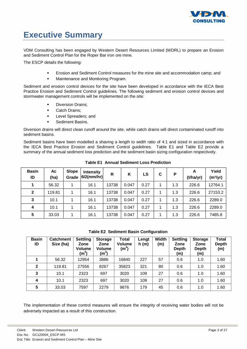
Executive Summary
VDM Consulting has been engaged by Western Desert Resources Limited (WDRL) to prepare an Erosion and Sediment Control Plan for the Roper Bar iron ore mine.
The ESCP details the following:
Erosion and Sediment Control measures for the mine site and accommodation camp; and Maintenance and Monitoring Program.
Sediment and erosion control devices for the site have been developed in accordance with the IECA Best Practice Erosion and Sediment Control guidelines. The following sediment and erosion control devices and stormwater management controls will be implemented on the site:
Diversion Drains; Catch Drains; Level Spreaders; and Sediment Basins.
Diversion drains will direct clean runoff around the site, while catch drains will direct contaminated runoff into sediment basins.
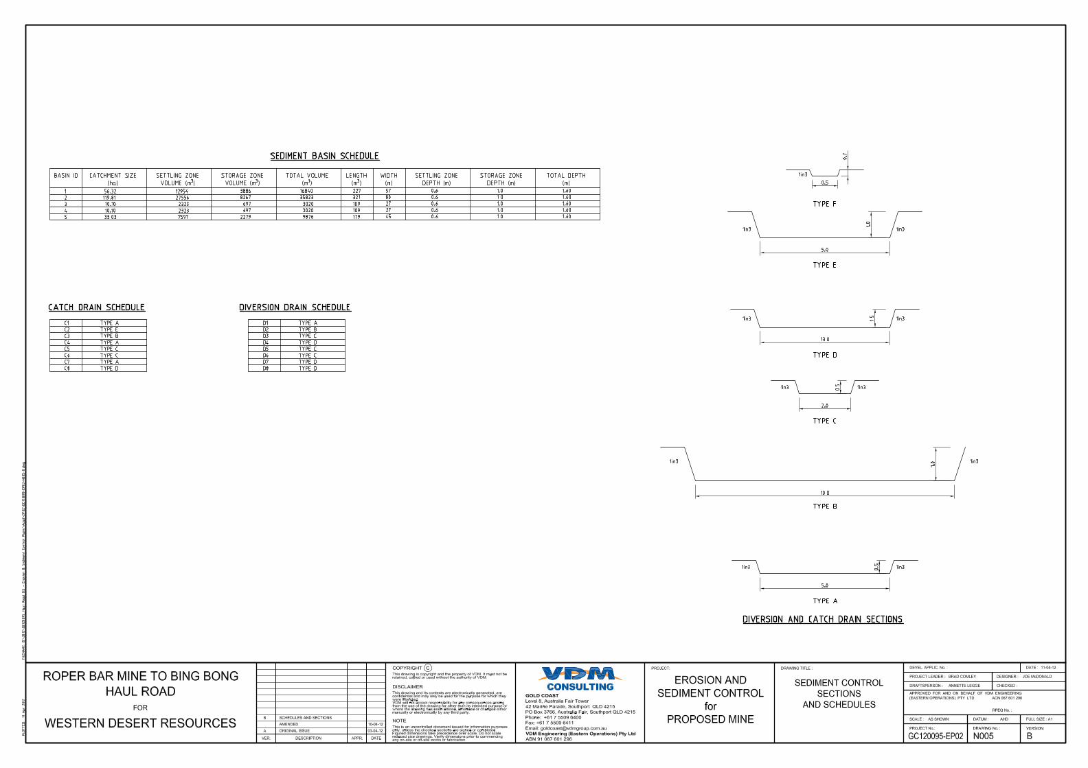
Sediment basins have been modelled a shaving a length to width ratio of 4:1 and sized in accordance with the IECA Best Practice Erosion and Sediment Control guidelines. Table E1 and Table E2 provide a summary of the annual sediment loss prediction and the sediment basin sizing configuration respectively.
Table E1 Annual Sediment Loss Prediction
Basin ID
Ac (ha)
Slope Grade
Intensity 6I2(mm/hr) R K LS C P
A (t/ha/yr)
Yield (m³/yr)
1 56.32 1 16.1 13738 0.047 0.27 1 1.3 226.6 12764.1
2 119.81 1 16.1 13738 0.047 0.27 1 1.3 226.6 27153.2
3 10.1 1 16.1 13738 0.047 0.27 1 1.3 226.6 2289.0
4 10.1 1 16.1 13738 0.047 0.27 1 1.3 226.6 2289.0
5 33.03 1 16.1 13738 0.047 0.27 1 1.3 226.6 7485.8
Table E2 Sediment Basin Configuration
Basin ID
Catchment Size (ha)
Settling Zone
Volume (m3)
Storage Zone
Volume (m3)
Total Volume
(m3)
Length (m)
Width (m)
Settling Zone Depth
(m)
Storage Zone Depth
(m)
Total Depth
(m)
1 56.32 12954 3886 16840 227 57 0.6 1.0 1.60 2 119.81 27556 8267 35823 321 80 0.6 1.0 1.60 3 10.1 2323 697 3020 109 27 0.6 1.0 1.60 4 10.1 2323 697 3020 109 27 0.6 1.0 1.60 5 33.03 7597 2279 9876 179 45 0.6 1.0 1.60
The implementation of these control measures will ensure the integrity of receiving water bodies will not be adversely impacted as a result of this construction.
Client: Western Desert Resources Ltd Page 4 of 27 Doc No. GC120004_ESCP-MS Doc Title: Erosion and Sediment Control Plan – Mine Site
Contents
1 Introduction....................................................................................................................................... 6
1.1 Background .................................................................................................................................. 6 1.2 Scope ........................................................................................................................................... 8 1.3 Objectives .................................................................................................................................... 8 1.4 Relevant Legislation and Guidelines ............................................................................................. 8 1.5 Performance Criteria ..................................................................................................................... 8
2 Site Characteristics .......................................................................................................................... 9
2.1 Locality ......................................................................................................................................... 9 2.2 Topography .................................................................................................................................. 9 2.3 Disturbance .................................................................................................................................. 9 2.4 Soils and Land Units ..................................................................................................................... 9
3 Erosion and Sediment Control ........................................................................................................12
3.1 Principles of Erosion and Sediment Control .................................................................................12 3.2 Management of Erosion and Sediment Control ............................................................................13 3.3 Erosion and Sediment Controls....................................................................................................15 3.4 Restricted Areas ..........................................................................................................................16 3.5 Construction Phase Monitoring ....................................................................................................16 3.6 Contingencies ..............................................................................................................................17 3.7 Responsibilities............................................................................................................................17
4 Conclusions .....................................................................................................................................20
Tables Table E1 Annual Sediment Loss Prediction ................................................................................................. 3 Table E2 Sediment Basin Configuration ...................................................................................................... 3 Table 2.1 Land Unit Types on the Subject Site ...........................................................................................10 Table 3.1 Annual Sediment Loss Prediction ...............................................................................................15 Table 3.2 Sediment Basin Configuration.....................................................................................................16 Table 3.3 Party Responsibilities .................................................................................................................17
Figures Figure 1.1 Proposed Roper Bar Mine and Haul Road Layout ....................................................................... 6 Figure 1.2 Mine Site Layout ........................................................................................................................ 7 Figure 2.1 Soil Types .................................................................................................................................. 9 Figure 2.2 Land Units at the Proposed Development Site ...........................................................................10
Client: Western Desert Resources Ltd Page 5 of 27 Doc No. GC120004_ESCP-MS Doc Title: Erosion and Sediment Control Plan – Mine Site
Appendices Appendix A – Erosion and Sediment Control Plan and Details .....................................................................21 Appendix B – Complaints Register ..............................................................................................................22 Appendix C – Incident/Non-Conformance Notification Form ........................................................................24 Appendix D – Drain Calculations .................................................................................................................26
Client: Western Desert Resources Ltd Page 6 of 27 Doc No. GC120004_ESCP-MS Doc Title: Erosion and Sediment Control Plan – Mine Site
1 Introduction
VDM Consulting has been commissioned by Ecoz Pty Ltd on behalf of Western Desert Resources to prepare an Erosion and Sediment Control Plan (ESCP) for the proposed Roper Bar Mine Site. This report has been prepared to accompany an Environmental Impact Statement (EIS).
A comprehensive review of available Erosion and Sediment Control devices and Best Management Practices (BMP) was undertaken as part of this investigation. The following sections provide a summary of the mitigation measures required to meet best practice in accordance with the International Erosion Control Association Australiasia Best Practice Erosion and Sediment Control Guidelines during the construction phases of the haul road.
This management plan is to be considered as part of an EIS process and provides conceptual design details. The level of detail provided within this report is not suitable for construction purposes, a Detailed Erosion and Sediment Control Plan outlining detailed designs will need to be completed in conjunction with detailed civil design documentation.
1.1 Background
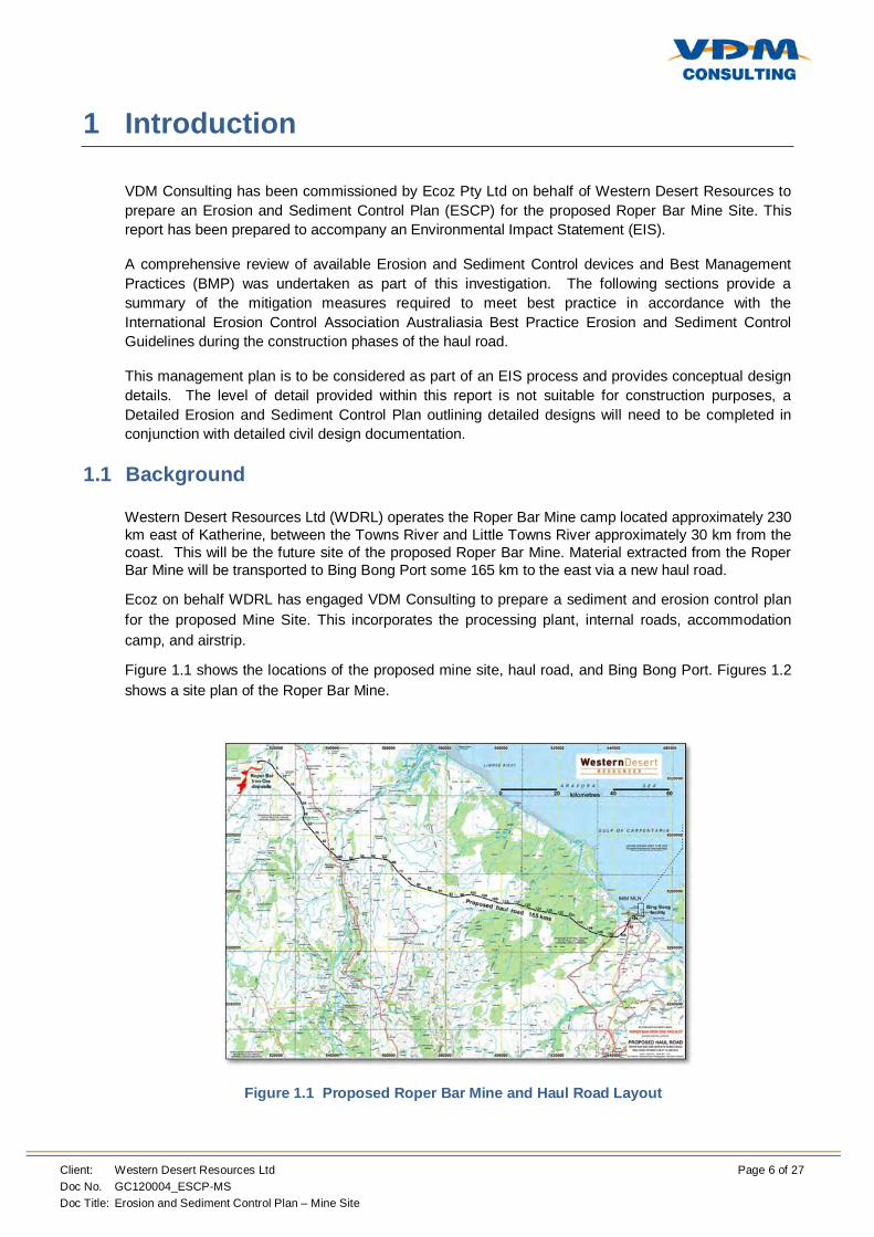
Western Desert Resources Ltd (WDRL) operates the Roper Bar Mine camp located approximately 230 km east of Katherine, between the Towns River and Little Towns River approximately 30 km from the coast. This will be the future site of the proposed Roper Bar Mine. Material extracted from the Roper Bar Mine will be transported to Bing Bong Port some 165 km to the east via a new haul road.
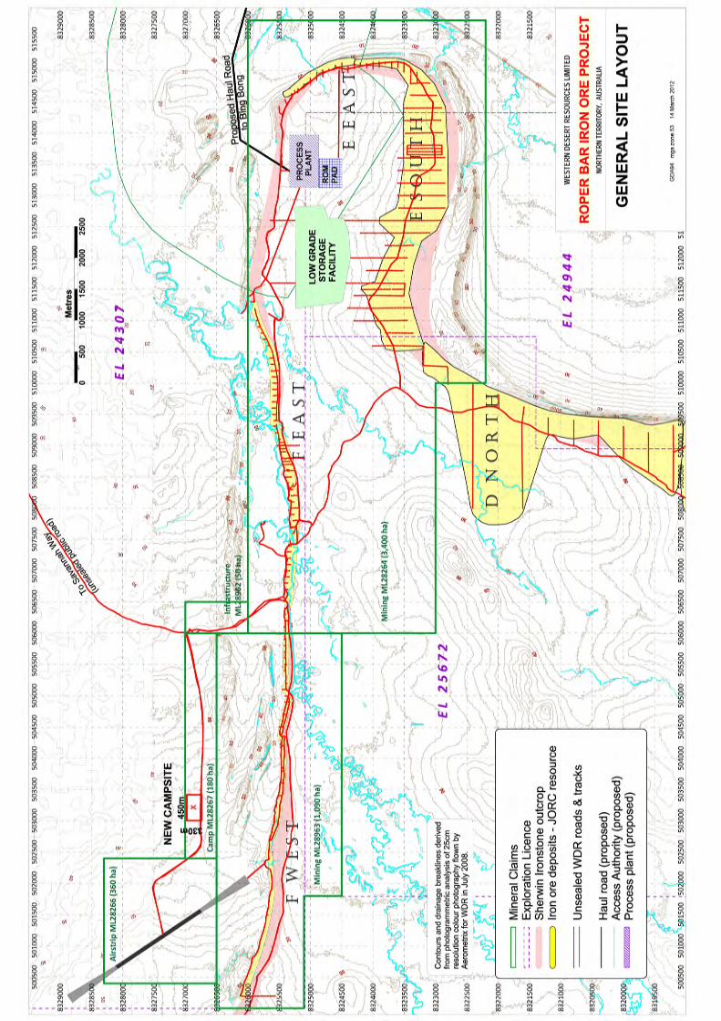
Ecoz on behalf WDRL has engaged VDM Consulting to prepare a sediment and erosion control plan for the proposed Mine Site. This incorporates the processing plant, internal roads, accommodation camp, and airstrip.
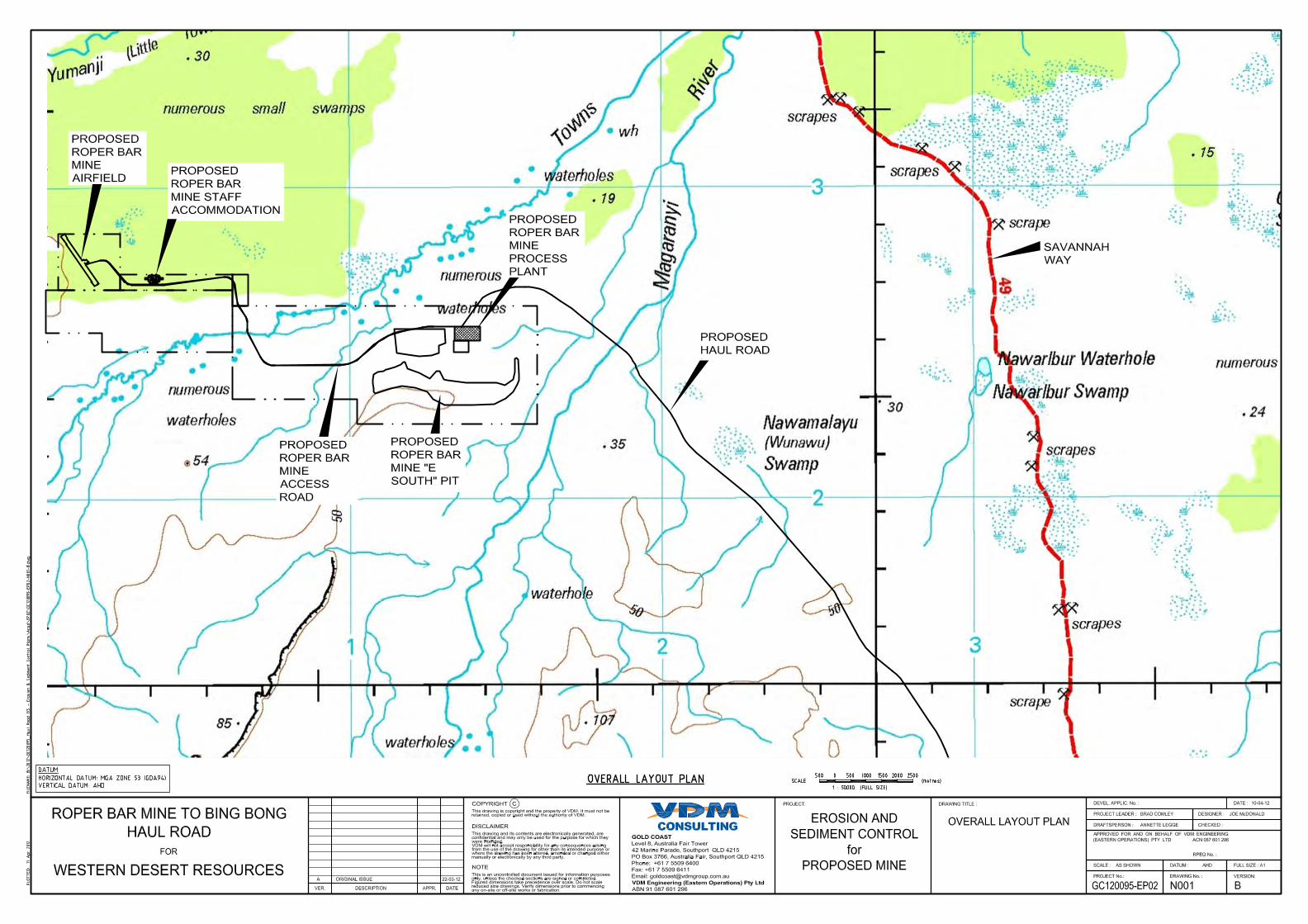
Figure 1.1 shows the locations of the proposed mine site, haul road, and Bing Bong Port. Figures 1.2 shows a site plan of the Roper Bar Mine.
Figure 1.1 Proposed Roper Bar Mine and Haul Road Layout
Client: Western Desert Resources Ltd Page 8 of 27 Doc No. GC120004_ESCP-MS Doc Title: Erosion and Sediment Control Plan – Mine Site
1.2 Scope
Specifically, this report details the following:
Erosion and Sediment Control measures for the mine site; and Maintenance and Monitoring Program.
To minimise the impact of the proposed development on the external environment the proponent shall implement this ESCP. To avoid significant and/or sustained deterioration in downstream water quality this ESCP may be amended as required, in response to the Monitoring and Maintenance Program described herein.
1.3 Objectives
The objectives of this ESCP are to:
Ensure stormwater is managed to protect downstream water quality; Reduce the potential for sedimentation (soil particles >1mm are retained onsite); Ensure adequate drainage and pollution control measures are implemented to manage
runoff from disturbed areas of the site; and Prevent soil erosion on site.
1.4 Relevant Legislation and Guidelines
The following legislation and guidelines were used to prepare this ESCP:
Water Act (NT); Waste Management and Pollution Control Act (NT); Soil Conservation and Land Utilisation Act (NT); NRETAS Erosion and Sediment Control Plan Content (2006); Department of Health and Families guidelines for preventing mosquito breeding associated
with construction practice near tidal areas in the NT (2005); and IEAust. Soil Erosion and Sediment Control Engineering Guidelines for Queensland
Construction Sites (June, 1996).
1.5 Performance Criteria
The following performance criteria in accordance with NRETAS requirements have been set for the Stockyard portion of the proposed development:
Stable embankments and drainage channels; No obvious accumulation of sediment within natural watercourses or drainage lines outside
of the construction area; No unnecessary disturbance of earth or vegetation outside areas to be cleared or
disturbed; No new biting insect breeding habitats created and no increase in mosquito numbers; Soil particles >1 mm do not leave the site; and All batters or embankments to have slopes greater than 1:3.
Client: Western Desert Resources Ltd Page 9 of 27 Doc No. GC120004_ESCP-MS Doc Title: Erosion and Sediment Control Plan – Mine Site
2 Site Characteristics
2.1 Locality
The subject mine site is located approximately 230 km east of Katherine, between the Towns River and Little Towns River approximately 30 km from the coast. This mine site is to be connected to Bing Bong Port by a 165 km haul road which will be used for the transportation of extracted material. The Port currently serves the nearby Xtrata McArthur Creek Mine, and an additional loading facility will be constructed to serve the Roper Bar Mine. Access to the Port is via a sealed road to Borroloola some 55 km to the south.
2.2 Topography
Aerial LiDAR survey has been used as the basis for topographical information. This data has produced 0.5m contours in the location of the mine. The site is generally flat with an average elevation of approximately 3.0 m AHD. The site is bounded by ridges to the south and east and generally slopes toward the Little Towns River which runs from west to east between the mine site and the accommodation camp.
2.3 Disturbance
The site has had no previous works undertaken on it, and is therefore free from disturbance.
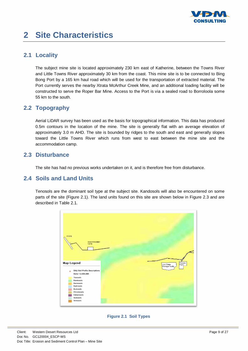
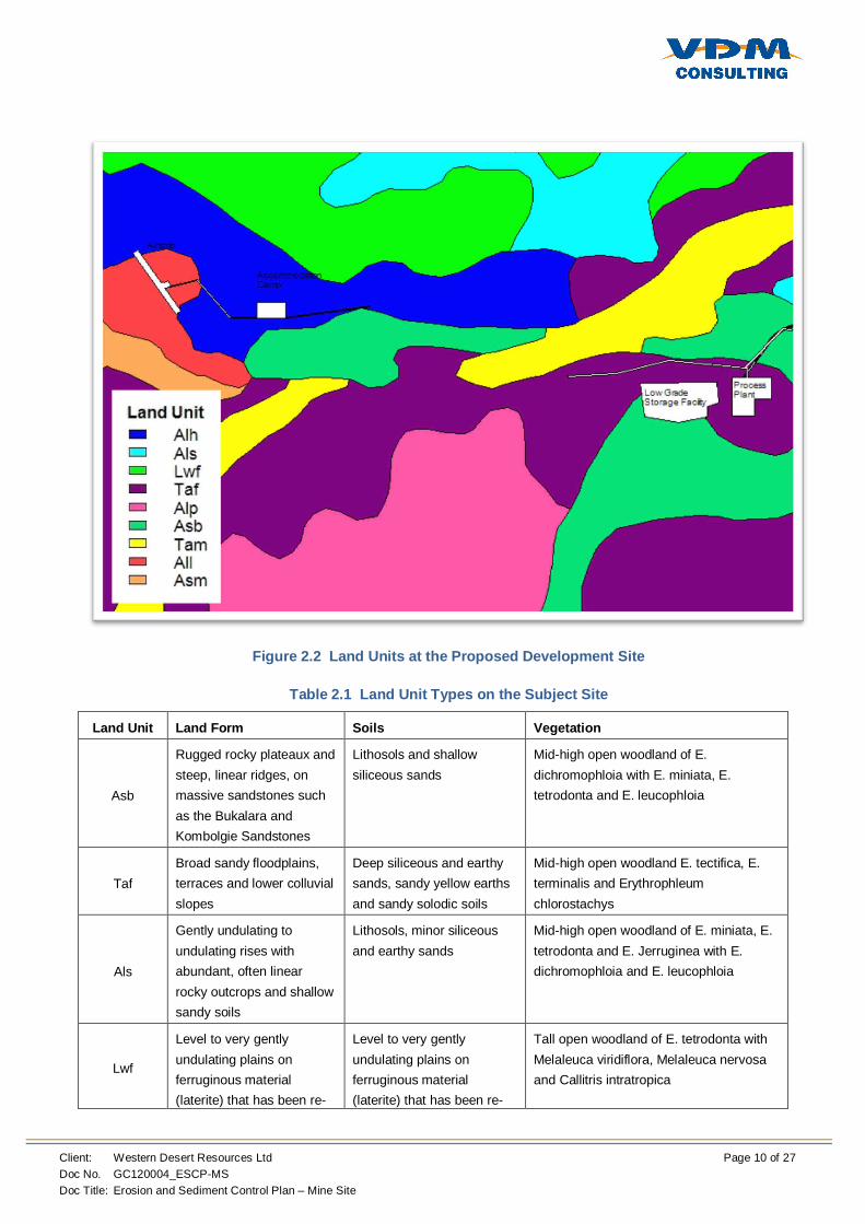
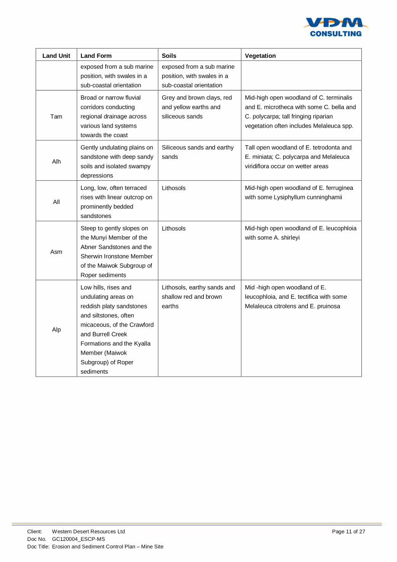
2.4 Soils and Land Units
Tenosols are the dominant soil type at the subject site. Kandosols will also be encountered on some parts of the site (Figure 2.1). The land units found on this site are shown below in Figure 2.3 and are described in Table 2.1.
Figure 2.1 Soil Types
Client: Western Desert Resources Ltd Page 10 of 27 Doc No. GC120004_ESCP-MS Doc Title: Erosion and Sediment Control Plan – Mine Site
Figure 2.2 Land Units at the Proposed Development Site
Table 2.1 Land Unit Types on the Subject Site
Land Unit Land Form Soils Vegetation
Asb
Rugged rocky plateaux and steep, linear ridges, on massive sandstones such as the Bukalara and Kombolgie Sandstones
Lithosols and shallow siliceous sands
Mid-high open woodland of E. dichromophloia with E. miniata, E. tetrodonta and E. leucophloia
Taf Broad sandy floodplains, terraces and lower colluvial slopes
Deep siliceous and earthy sands, sandy yellow earths and sandy solodic soils
Mid-high open woodland E. tectifica, E. terminalis and Erythrophleum chlorostachys
Als
Gently undulating to undulating rises with abundant, often linear rocky outcrops and shallow sandy soils
Lithosols, minor siliceous and earthy sands
Mid-high open woodland of E. miniata, E. tetrodonta and E. Jerruginea with E. dichromophloia and E. leucophloia
Lwf
Level to very gently undulating plains on ferruginous material (laterite) that has been re-
Level to very gently undulating plains on ferruginous material (laterite) that has been re-
Tall open woodland of E. tetrodonta with Melaleuca viridiflora, Melaleuca nervosa and Callitris intratropica
Client: Western Desert Resources Ltd Page 11 of 27 Doc No. GC120004_ESCP-MS Doc Title: Erosion and Sediment Control Plan – Mine Site
Land Unit Land Form Soils Vegetation
exposed from a sub marine position, with swales in a sub-coastal orientation
exposed from a sub marine position, with swales in a sub-coastal orientation
Tam
Broad or narrow fluvial corridors conducting regional drainage across various land systems towards the coast
Grey and brown clays, red and yellow earths and siliceous sands
Mid-high open woodland of C. terminalis and E. microtheca with some C. bella and C. polycarpa; tall fringing riparian vegetation often includes Melaleuca spp.
Alh
Gently undulating plains on sandstone with deep sandy soils and isolated swampy depressions
Siliceous sands and earthy sands
Tall open woodland of E. tetrodonta and E. miniata; C. polycarpa and Melaleuca viridiflora occur on wetter areas
All
Long, low, often terraced rises with linear outcrop on prominently bedded sandstones
Lithosols Mid-high open woodland of E. ferruginea with some Lysiphyllum cunninghamii
Asm
Steep to gently slopes on the Munyi Member of the Abner Sandstones and the Sherwin Ironstone Member of the Maiwok Subgroup of Roper sediments
Lithosols Mid-high open woodland of E. leucophloia with some A. shirleyi
Alp
Low hills, rises and undulating areas on reddish platy sandstones and siltstones, often micaceous, of the Crawford and Burrell Creek Formations and the Kyalla Member (Maiwok Subgroup) of Roper sediments
Lithosols, earthy sands and shallow red and brown earths
Mid -high open woodland of E. leucophloia, and E. tectifica with some Melaleuca citrolens and E. pruinosa
Client: Western Desert Resources Ltd Page 12 of 27 Doc No. GC120004_ESCP-MS Doc Title: Erosion and Sediment Control Plan – Mine Site
3 Erosion and Sediment Control
The purpose of this section is to provide a set of best practice site management procedures to control the severity and extent of soil erosion and pollutant transport during the construction phase of the proposed development.
Clearing of the site and the construction of erosion and sediment controls will comply with the NT Government Department of NRETAS’s Erosion and Sediment Control Plan Content dated 2006. Due consideration should be given to stripped topsoil being retained and reused in drains, disturbed areas and rehabilitation of the site. The construction contractor will be responsible for the implementation, inspection, repair and modification of the controls.
The climate in the vicinity of the site is characterised by distinct wet and dry seasons. During the wet season from December to March access to the site may be limited by flooding and little if any construction work will be possible. Therefore it is anticipated and recommended that construction works be carried out during the dry season. This will significantly lower the risk of erosion and sediment transport as very little rain falls during this time period.
3.1 Principles of Erosion and Sediment Control
The principles of effective erosion and sediment control for the proposed clearing activity on site are based on the following:
Appropriately integrate the development into the site; Integrate erosion and sediment control issues into site and construction planning; Develop effective and flexible erosion and sediment control (ESC) plans based on
anticipated soil, weather and construction conditions; Minimise the extent and duration of soil disturbance; Control water movement through the site; Minimise soil erosion; Promptly stabilise disturbed areas; Maximise sediment retention on site; Maintain all ESC measures in proper working order at all times; and Monitor the site and adjust ESC practices to maintain the required performance standard.
3.1.1 Site Installation Sequence
The following sediment and erosion control devices and stormwater management controls will be implemented on the site;
Tree Clearing – Clearing of vegetation as required will be undertaken where necessary; Diversion Drains – Used to divert clean water from upstream catchments around the site; Catch Drains – Used to transport contaminated runoff to sediment basins; Level Spreaders – Used to reduce velocities and return channelised flow to sheet flow; and Sediment Basins – Used to trap and retain sediment via settlement of suspended particles.
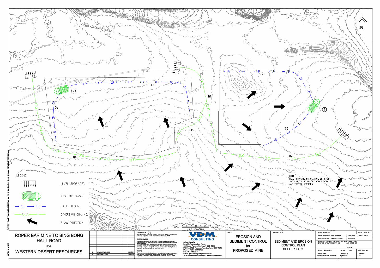
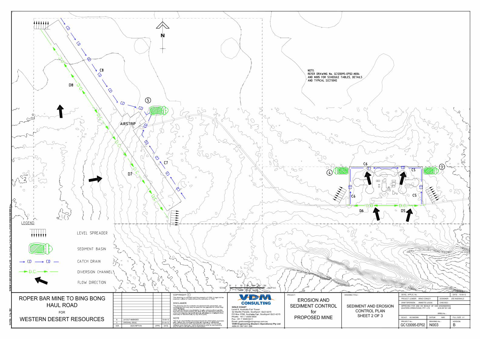
These controls have been developed in accordance with IECA Best Practice Erosion and Sediment Control guidelines and the location of these devices is presented in Appendix A.
Client: Western Desert Resources Ltd Page 13 of 27 Doc No. GC120004_ESCP-MS Doc Title: Erosion and Sediment Control Plan – Mine Site
3.2 Management of Erosion and Sediment Control
The following measures are to be implemented to maintain the current environmental values onsite.
Commitment:
No deterioration in downstream water quality and no net increase in runoff quantity.
Issue: Runoff - Stormwater Management - Contamination of Surface water - Erosion and Sedimentation.
Objectives: To ensure that there is no deterioration in stormwater quality or any reduction in the environmental values of the downstream receiving waters as a result of the proposed construction activities on the subject site;
To control stormwater runoff to minimise sediment loss from the site and pollution of natural waterways and drainage systems;
To comply with relevant governing statutory requirements; To prevent soil erosion and contamination of the stormwater
drainage system and waterways; To prevent sediment from being deposited off site; and Compliance with Environmental Protection Policies.
Management Procedure:
Pre-Construction (Sediment and Erosion Control): Sediment erosion controls will be developed as construction
progresses through each development stage; Site personnel informed of the erosion and sediment controls; Install vehicular shake down grids/rubble grids at designated
construction exits to remove sediment from vehicles prior to exiting site. Any sediment dispersed onto roads shall be swept up immediately and placed in construction rubble waste bin. Construct exits in accordance with IEAust Guidelines at designated exits;
Minimise vegetation removal to areas designated for clearing. Clearly identify “No Go Areas” where vegetation is to be maintained.
Install diversion drains to direct clean stormwater away from disturbed areas;
Install mulch mounds to reduce runoff velocities and encourage sedimentation and filtration of eroded soils; and
Transportation of soil and other fill: Trucks shall have their loads secured and covered. Any spillage shall be collected and removed streets on a daily basis and placed in a construction rubble waste bin for removal.
Construction (Mitigation of Water Quality): Sediment fences to be erected at the base of all batters and
soil stockpiles to prevent sediment laden stormwater migrating away from source;
Regular inspections as soon as practicable after storm events to check and maintain controls;
Inspection dates and actions taken to be recorded and available for review upon request;
Client: Western Desert Resources Ltd Page 14 of 27 Doc No. GC120004_ESCP-MS Doc Title: Erosion and Sediment Control Plan – Mine Site
Sediment to be removed from fences and basins when controls are 40% full and at the completion of construction. All material to be re-used or stored on-site in a controlled manner or taken off-site for re-use or disposal at a licensed waste disposal facility;
Monitoring of water quality to determine the effectiveness of the sediment and erosion control management practices; and
Progressive re-vegetation of filled and disturbed areas.
Performance Indicators:
Visual evidence of deterioration of baseline water quality of downstream water courses directly attributable to the site;
Pollutant concentrations that exceed the water quality objectives (TSS 90th percentile all other analytes 80th percentile);
Visible erosion; and Failure of control measures.
Responsibility: Site Foreman and Environmental Management Officer.
Critical Dates: Prior to commencement of work/construction safety induction (include training, awareness of commitments, directives, working hours and approval conditions for stormwater management, water quality and sediment and erosion control).
Monitoring: Regular inspection as soon as practicable after storm events to check and maintain controls. Site visits from Environmental Management Officer during construction. Monitoring regime to be in accordance with the approved site Stormwater Management Plan. WQ monitoring by qualified personnel.
Reporting: Report incidents to Site Foreman. Upon notification of Environmental Management Officer (EMO). EMO to certify compliance of measures by way of letter upon completion, and if necessary notify Project Manager of non-compliance. Site Manager (during construction) to report to relevant authority.
Corrective Action: All corrective actions shall be agreed upon, dependent upon the severity of non-conformance and parameter concerned, between Construction Engineering, the Environmental Consultant and relevant authority. Remove sediment from fences when controls are 40% full and at completion of construction. Observations and monitoring data shall be used to guide implementation of additional measures, if and when required.
The triggering of a performance indicator will require: Locate source of water quality deterioration; Prevent continuing deterioration by repairing existing
measures, construct additional measures or modify procedures;
Review strategies/management plans in consultation with relevant authority; and
Repair existing controls, construct additional controls or modify procedures to prevent future deterioration in water quality.
Client: Western Desert Resources Ltd Page 15 of 27 Doc No. GC120004_ESCP-MS Doc Title: Erosion and Sediment Control Plan – Mine Site
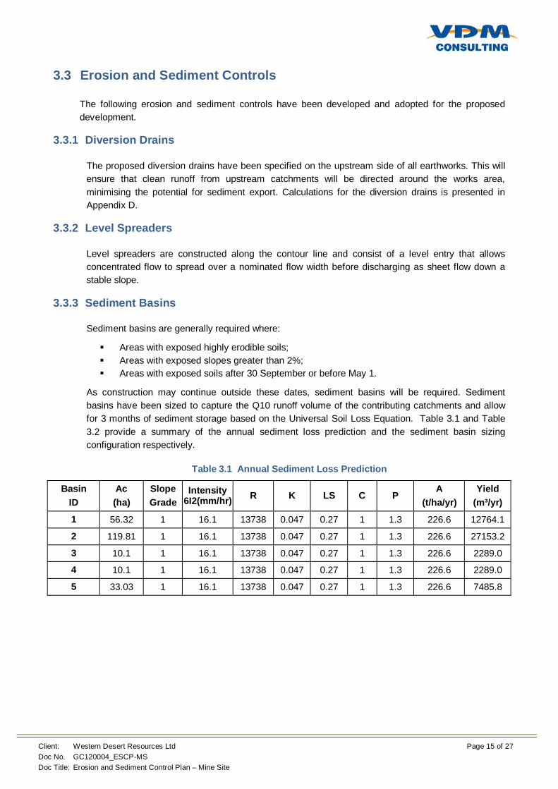
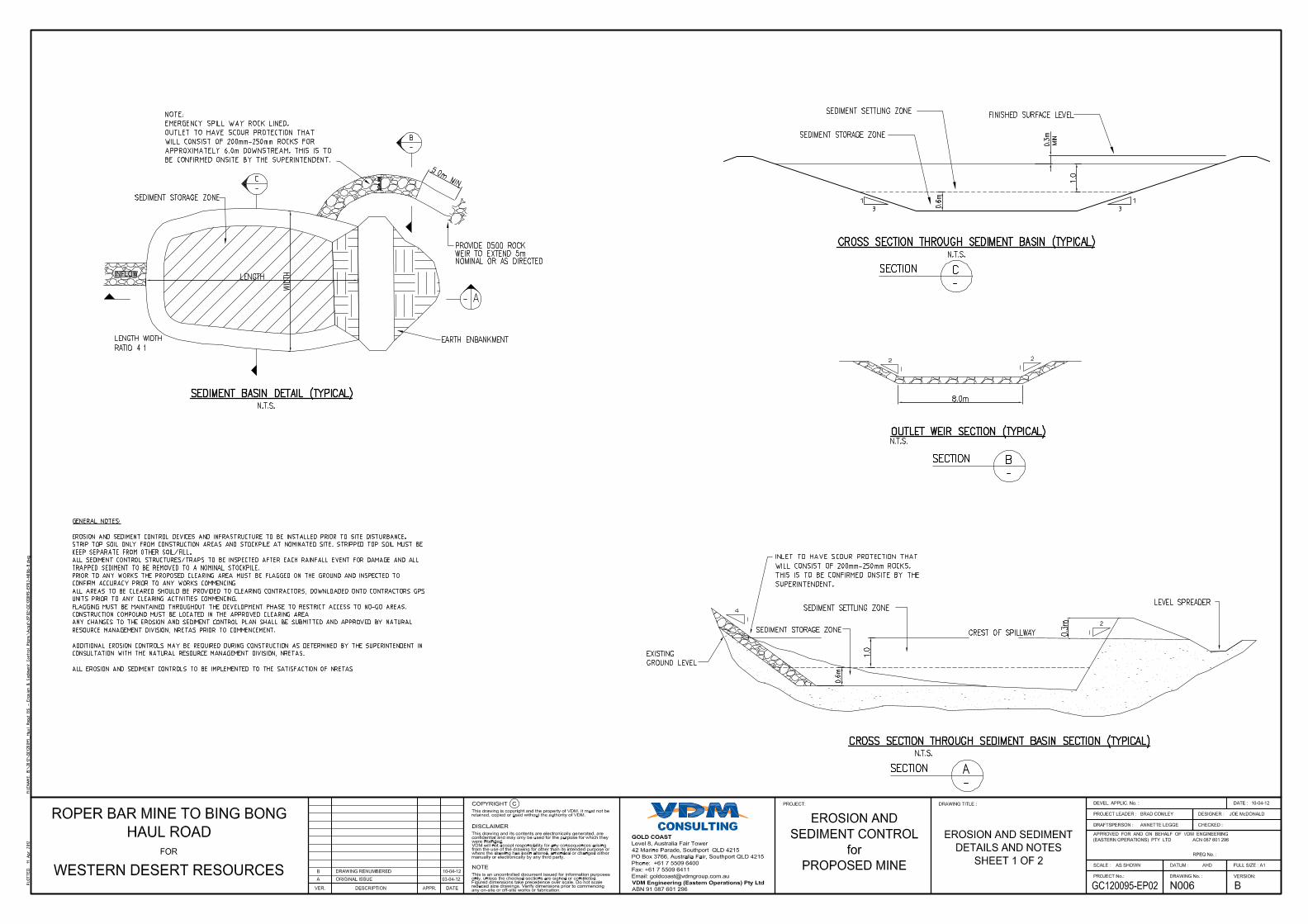
3.3 Erosion and Sediment Controls
The following erosion and sediment controls have been developed and adopted for the proposed development.
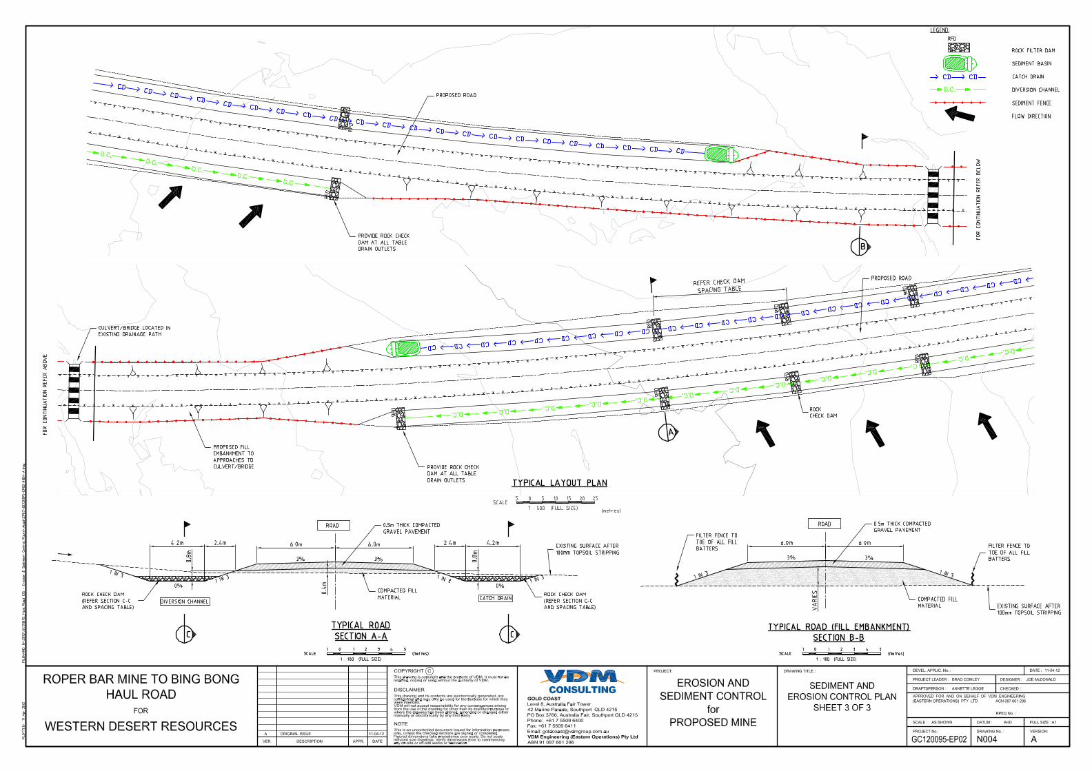
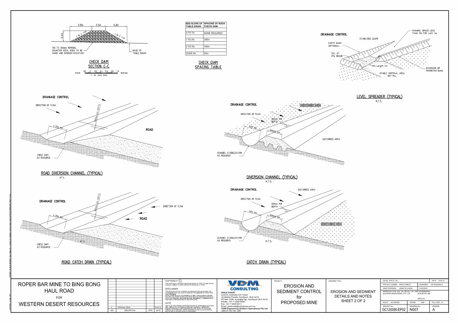
3.3.1 Diversion Drains
The proposed diversion drains have been specified on the upstream side of all earthworks. This will ensure that clean runoff from upstream catchments will be directed around the works area, minimising the potential for sediment export. Calculations for the diversion drains is presented in Appendix D.
3.3.2 Level Spreaders
Level spreaders are constructed along the contour line and consist of a level entry that allows concentrated flow to spread over a nominated flow width before discharging as sheet flow down a stable slope.
3.3.3 Sediment Basins
Sediment basins are generally required where:
Areas with exposed highly erodible soils; Areas with exposed slopes greater than 2%; Areas with exposed soils after 30 September or before May 1.
As construction may continue outside these dates, sediment basins will be required. Sediment basins have been sized to capture the Q10 runoff volume of the contributing catchments and allow for 3 months of sediment storage based on the Universal Soil Loss Equation. Table 3.1 and Table 3.2 provide a summary of the annual sediment loss prediction and the sediment basin sizing configuration respectively.
Table 3.1 Annual Sediment Loss Prediction
Basin ID
Ac (ha)
Slope Grade
Intensity 6I2(mm/hr) R K LS C P
A (t/ha/yr)
Yield (m³/yr)
1 56.32 1 16.1 13738 0.047 0.27 1 1.3 226.6 12764.1
2 119.81 1 16.1 13738 0.047 0.27 1 1.3 226.6 27153.2
3 10.1 1 16.1 13738 0.047 0.27 1 1.3 226.6 2289.0
4 10.1 1 16.1 13738 0.047 0.27 1 1.3 226.6 2289.0
5 33.03 1 16.1 13738 0.047 0.27 1 1.3 226.6 7485.8
Client: Western Desert Resources Ltd Page 16 of 27 Doc No. GC120004_ESCP-MS Doc Title: Erosion and Sediment Control Plan – Mine Site
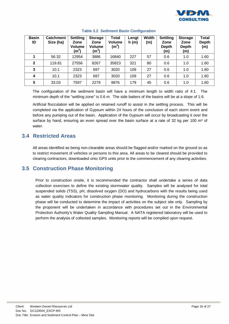
Table 3.2 Sediment Basin Configuration
Basin ID
Catchment Size (ha)
Settling Zone
Volume (m3)
Storage Zone
Volume (m3)
Total Volume
(m3)
Length (m)
Width (m)
Settling Zone Depth
(m)
Storage Zone Depth
(m)
Total Depth
(m)
1 56.32 12954 3886 16840 227 57 0.6 1.0 1.60 2 119.81 27556 8267 35823 321 80 0.6 1.0 1.60 3 10.1 2323 697 3020 109 27 0.6 1.0 1.60 4 10.1 2323 697 3020 109 27 0.6 1.0 1.60 5 33.03 7597 2279 9876 179 45 0.6 1.0 1.60
The configuration of the sediment basin will have a minimum length to width ratio of 4:1. The minimum depth of the “settling zone” is 0.6 m. The side batters of the basins will be at a slope of 1:6.
Artificial flocculation will be applied on retained runoff to assist in the settling process. This will be completed via the application of Gypsum within 24 hours of the conclusion of each storm event and before any pumping out of the basin. Application of the Gypsum will occur by broadcasting it over the surface by hand, ensuring an even spread over the basin surface at a rate of 32 kg per 100 m³ of water.
3.4 Restricted Areas
All areas identified as being non-clearable areas should be flagged and/or marked on the ground so as to restrict movement of vehicles or persons to this area. All areas to be cleared should be provided to clearing contractors, downloaded onto GPS units prior to the commencement of any clearing activities.
3.5 Construction Phase Monitoring
Prior to construction onsite, it is recommended the contractor shall undertake a series of data collection exercises to define the existing stormwater quality. Samples will be analysed for total suspended solids (TSS), pH, dissolved oxygen (DO) and hydrocarbons with the results being used as water quality indicators for construction phase monitoring. Monitoring during the construction phase will be conducted to determine the impact of activities on the subject site only. Sampling by the proponent will be undertaken in accordance with procedures set out in the Environmental Protection Authority’s Water Quality Sampling Manual. A NATA registered laboratory will be used to perform the analysis of collected samples. Monitoring reports will be compiled upon request.
Client: Western Desert Resources Ltd Page 17 of 27 Doc No. GC120004_ESCP-MS Doc Title: Erosion and Sediment Control Plan – Mine Site
3.5.1 Investigation Indicators
The following indicators are used to identify if the objectives of the ESCP are being met:
Visible evidence of deterioration of baseline water quality of downstream watercourses that is directly attributable to the site;
Pollutant concentrations that exceed the water quality objectives (TSS 90th percentile all other anolytes 80th percentile);
Visible significant erosion; and/or Failure of control measures.
The triggering of an investigation indicator will require the following remedial actions:
Locate source of water quality deterioration; Prevent continuing deterioration with temporary controls; Repair existing controls, construct additional controls or modify procedures to prevent
future deterioration in water quality; and During the operational phase of the development, if there is a significant deterioration in
water quality, the management plan and strategies will be reviewed.
3.6 Contingencies
During construction, the Contractor/Principal/Site Foreman shall allocate sufficient resources (personnel, plant, equipment and materials) to the site and store on-site, at suitable locations and at all times sufficient quantities of materials to immediately attend to any non-conformance.
Corrective actions may be agreed upon, dependent upon the severity of non-conformance and/or emergency and parameter involved, between the Principal, Construction Contractor, Environmental Consultant, and relevant Government Representatives.
3.7 Responsibilities
It should be noted that the basic responsibility for environmental protection rests with all employees and sub-contractors. Table 3.3 presents the specific responsibilities that pertain to this CMP.
Table 3.3 Party Responsibilities
Party Primary Responsibility
Project Manager
Overall implementation of the ESCP and management of environmental impacts and risks.
Responsible for reporting any incidents to relevant authorities if required.
Issue and distribution of ESCP. Revision of the ESCP, as required, to reflect the status quo. Revisions are to be made by replacing the entire document by
consecutively numbered amendments. Implementation, monitoring, reporting and corrective actions within
the ESCP.
Construction Manager/Site Manager
Implementation of strategies, requirements, procedures and measures to ensure that appropriate environmental protection is in place.
Induction, supervising and monitoring of the ESCP.
Client: Western Desert Resources Ltd Page 18 of 27 Doc No. GC120004_ESCP-MS Doc Title: Erosion and Sediment Control Plan – Mine Site
Party Primary Responsibility
Safety Officer To attend construction at all times during working hours. Site inspections (random, daily) to ensure adherence to the different
plans and procedures. Direct actions, as required, to protect the environment and to
minimise and/or rectify any environmental concerns.
All other site personnel
Adherence to Site Safety Rules and ESCP.
3.7.1 Environmental Complaints and Incidents
The Site Manager shall investigate all environmental complaints. Where considered appropriate and/or required, the Site Manager shall notify the relevant statutory authority. Complaints received by external parties will also be subject to investigation by the Site Manager or EMO.
Should an environmental incident occur during the course of construction, the Landowner shall take prompt action to minimise any impact and, where necessary, seek the advice of the relevant authorities.
All complaints will be treated with respect. The Site Manager shall maintain a Complaints Register (refer Appendix B) and shall direct an appropriate course of action relating to the complaint. The Complaints Register will be included in any audit reports during construction and shall record the date, time and nature of any complaint, the name and contact details of the complainant, action taken, person responsible for action, and resolution of complaint. The Site Manager shall certify each entry on the record.
3.7.2 Environmental Notifications
In the event of a major incident/non-conformance that may cause or causes environmental harm, as soon as practicable after being made aware of the incident, the following people have a duty to notify the relevant authority of the incident:
The person carrying on the activity;
An employee or agent carrying on the activity;
An employer carrying on the activity; and
The occupier of the premises where the incident occurs.
Notification must be given as soon practicable after the person becomes aware of the incident.
The Site Manager shall furnish the following details:
The time, date, nature, duration and location of the incident;
The location of the place where non-conformance occurred;
The nature of the non-conformance;
The circumstances in which the incident occurred (including the cause of the incident, if known);
The action taken or proposed to be taken to deal with the incident; and
Other information prescribed by the regulations.
Client: Western Desert Resources Ltd Page 19 of 27 Doc No. GC120004_ESCP-MS Doc Title: Erosion and Sediment Control Plan – Mine Site
3.7.3 Awareness and Training
A copy of this document will be available from the following officers at the site:
Site Manager; and
Safety Officer.
Awareness and Training forms part of Safety Inductions conducted prior to site work. It is a requirement that no person shall undertake any site work unless properly inducted. As part of their site induction and training all personnel engaged in construction shall be made aware of the provisions of this document in order to promote a general awareness of the environment and to minimise any potential impact and/or disturbances to the environment. Evidence of environmental induction of personnel in this project shall be maintained on project records.
Client: Western Desert Resources Ltd Page 20 of 27 Doc No. GC120004_ESCP-MS Doc Title: Erosion and Sediment Control Plan – Mine Site
4 Conclusions
This study has reviewed the construction impact of the proposed construction on receiving waters. Based on this study the following erosion and sediment control measures have been developed:
Diversion Drains; Catch Drains; Level Spreaders; and Sediment Basins.
Sediment basins have been sized to capture sediment carried by runoff from the contributing catchments and have been designed using the IECA Best Practice Erosion and Sediment Control guidelines with a minimum storage depth of 0.6 m.
In summary, the integrity of receiving water bodies will not be adversely impacted as a result of this construction provided the sediment control measures described herein are implemented.
Client: Western Desert Resources Ltd Doc No. GC120095_ESCP-MS Doc Title: Erosion and Sediment Control Plan – Mine Site
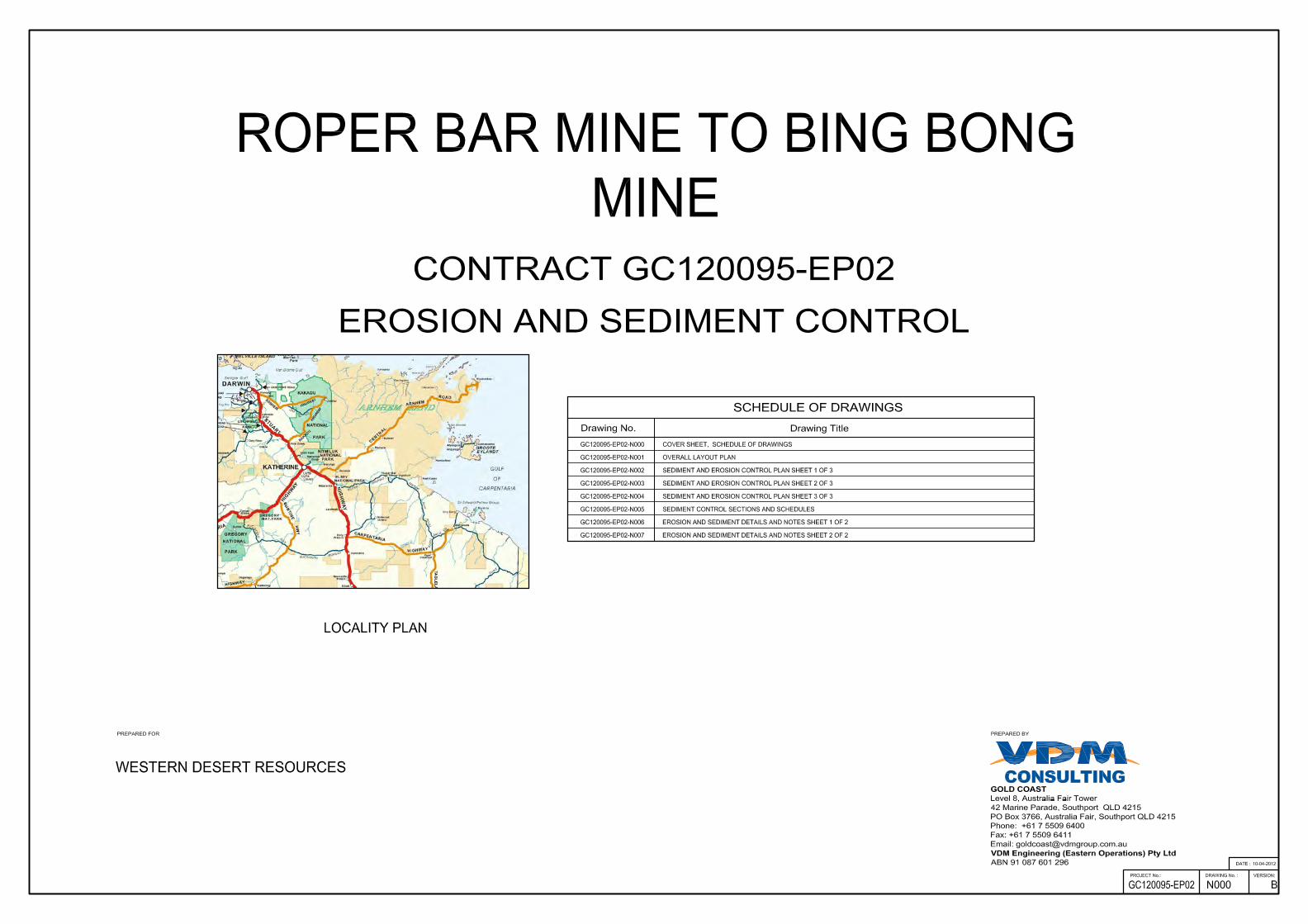
Appendix A – Erosion and Sediment Control Plan and Details

This page has been intentionally left blank.

This page has been intentionally left blank.
CONSULTING

This page has been intentionally left blank.

This page has been intentionally left blank.

This page has been intentionally left blank.

This page has been intentionally left blank.

This page has been intentionally left blank.

This page has been intentionally left blank.
Client: Western Desert Resources Ltd Doc No. GC120095_ESCP-MS Doc Title: Erosion and Sediment Control Plan – Mine Site
Appendix B – Complaints Register
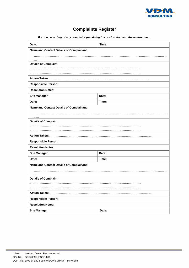
Client: Western Desert Resources Ltd Doc No. GC120095_ESCP-MS Doc Title: Erosion and Sediment Control Plan – Mine Site
Complaints Register
For the recording of any complaint pertaining to construction and the environment.
Date: Time:
Name and Contact Details of Complainant:
…………………………………………………………………………………………………………………
Details of Complaint: ……………………………………………………………………………………………………… ………………………………………………………………………………………………………
Action Taken:…………………………………………………………………………………………..….
Responsible Person:
Resolution/Notes:
Site Manager: Date:
Date: Time:
Name and Contact Details of Complainant:
………………………………………………………………………………………………………………..…
Details of Complaint: ……………………………………………………………………………………………………… ………………………………………………………………………………………………………
Action Taken:………………………………………………………………………………………………
Responsible Person:
Resolution/Notes:
Site Manager: Date:
Date: Time:
Name and Contact Details of Complainant:
…………………………………………………………………………………………………………………
Details of Complaint: ……………………………………………………………………………………………………… ………………………………………………………………………………………………………
Action Taken:………………………………………………………………………………………………
Responsible Person:
Resolution/Notes:
Site Manager: Date:
Client: Western Desert Resources Ltd Doc No. GC120095_ESCP-MS Doc Title: Erosion and Sediment Control Plan – Mine Site
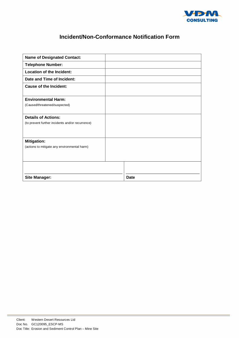
Appendix C – Incident/Non-Conformance Notification Form
Client: Western Desert Resources Ltd Doc No. GC120095_ESCP-MS Doc Title: Erosion and Sediment Control Plan – Mine Site
Incident/Non-Conformance Notification Form
Name of Designated Contact:
Telephone Number: Location of the Incident: Date and Time of Incident:
Cause of the Incident:
Environmental Harm: (Caused/threatened/suspected)
Details of Actions: (to prevent further incidents and/or recurrence)
Mitigation: (actions to mitigate any environmental harm)
Site Manager:
Date

Client: Western Desert Resources Ltd Doc No. GC120095_ESCP-MS Doc Title: Erosion and Sediment Control Plan – Mine Site
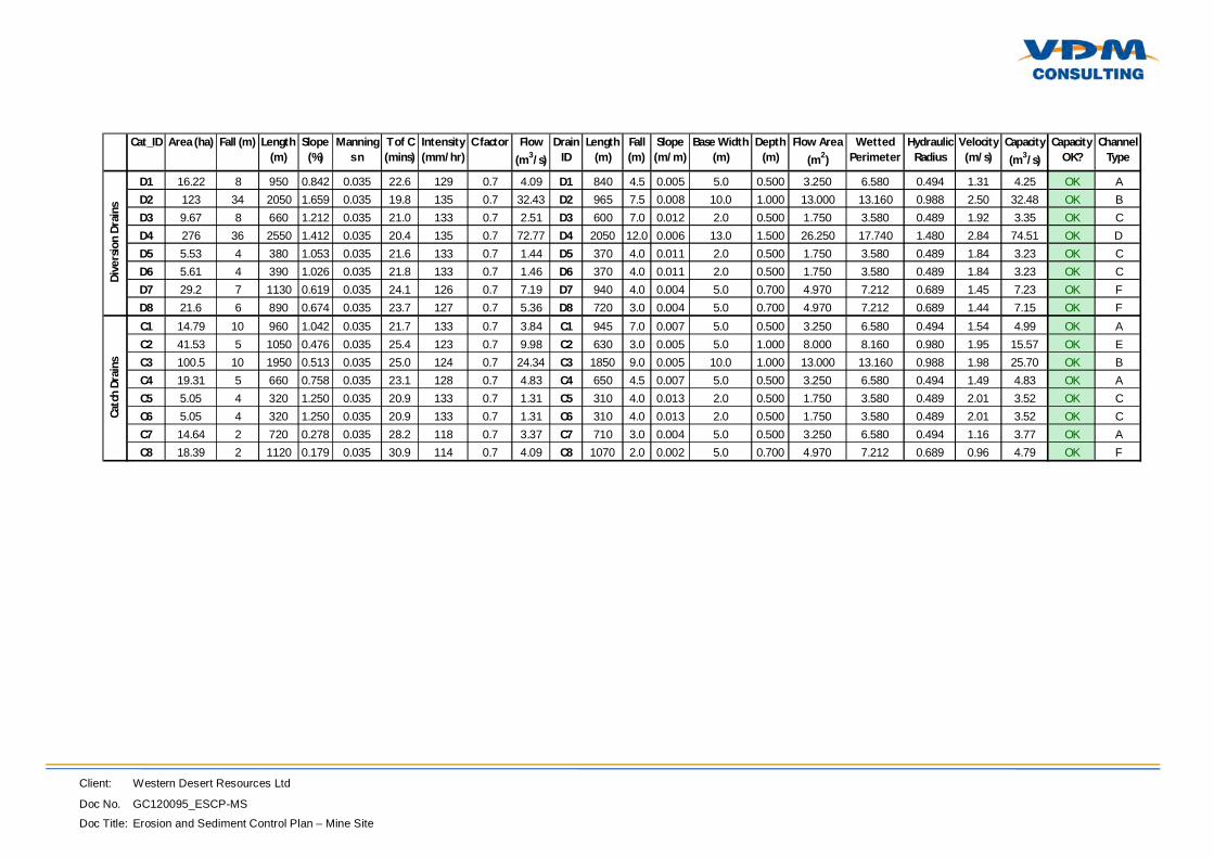
Appendix D – Drain Calculations
Client: Western Desert Resources Ltd
Doc No. GC120095_ESCP-MS
Doc Title: Erosion and Sediment Control Plan – Mine Site
Cat_ID Area (ha) Fall (m) Length (m)
Slope (%)
Mannings n
T of C (mins)
Intensity (mm/hr)
C factor Flow (m3/s)
Drain ID
Length (m)
Fall (m)
Slope (m/m)
Base Width (m)
Depth (m)
Flow Area (m2)
Wetted Perimeter
Hydraulic Radius
Velocity (m/s)
Capacity (m3/s)
Capacity OK?
Channel Type
D1 16.22 8 950 0.842 0.035 22.6 129 0.7 4.09 D1 840 4.5 0.005 5.0 0.500 3.250 6.580 0.494 1.31 4.25 OK AD2 123 34 2050 1.659 0.035 19.8 135 0.7 32.43 D2 965 7.5 0.008 10.0 1.000 13.000 13.160 0.988 2.50 32.48 OK BD3 9.67 8 660 1.212 0.035 21.0 133 0.7 2.51 D3 600 7.0 0.012 2.0 0.500 1.750 3.580 0.489 1.92 3.35 OK CD4 276 36 2550 1.412 0.035 20.4 135 0.7 72.77 D4 2050 12.0 0.006 13.0 1.500 26.250 17.740 1.480 2.84 74.51 OK DD5 5.53 4 380 1.053 0.035 21.6 133 0.7 1.44 D5 370 4.0 0.011 2.0 0.500 1.750 3.580 0.489 1.84 3.23 OK CD6 5.61 4 390 1.026 0.035 21.8 133 0.7 1.46 D6 370 4.0 0.011 2.0 0.500 1.750 3.580 0.489 1.84 3.23 OK CD7 29.2 7 1130 0.619 0.035 24.1 126 0.7 7.19 D7 940 4.0 0.004 5.0 0.700 4.970 7.212 0.689 1.45 7.23 OK FD8 21.6 6 890 0.674 0.035 23.7 127 0.7 5.36 D8 720 3.0 0.004 5.0 0.700 4.970 7.212 0.689 1.44 7.15 OK F
C1 14.79 10 960 1.042 0.035 21.7 133 0.7 3.84 C1 945 7.0 0.007 5.0 0.500 3.250 6.580 0.494 1.54 4.99 OK AC2 41.53 5 1050 0.476 0.035 25.4 123 0.7 9.98 C2 630 3.0 0.005 5.0 1.000 8.000 8.160 0.980 1.95 15.57 OK EC3 100.5 10 1950 0.513 0.035 25.0 124 0.7 24.34 C3 1850 9.0 0.005 10.0 1.000 13.000 13.160 0.988 1.98 25.70 OK BC4 19.31 5 660 0.758 0.035 23.1 128 0.7 4.83 C4 650 4.5 0.007 5.0 0.500 3.250 6.580 0.494 1.49 4.83 OK AC5 5.05 4 320 1.250 0.035 20.9 133 0.7 1.31 C5 310 4.0 0.013 2.0 0.500 1.750 3.580 0.489 2.01 3.52 OK CC6 5.05 4 320 1.250 0.035 20.9 133 0.7 1.31 C6 310 4.0 0.013 2.0 0.500 1.750 3.580 0.489 2.01 3.52 OK CC7 14.64 2 720 0.278 0.035 28.2 118 0.7 3.37 C7 710 3.0 0.004 5.0 0.500 3.250 6.580 0.494 1.16 3.77 OK AC8 18.39 2 1120 0.179 0.035 30.9 114 0.7 4.09 C8 1070 2.0 0.002 5.0 0.700 4.970 7.212 0.689 0.96 4.79 OK F
Dive
rsio
n Dr
ains
Catc
h Dr
ains