Embed Size (px)
Citation preview
ERDAS IMAGINE®The world’s most widely-used remote sensing software package for creating information from geospatial data
GE
OS
PA
TIA
L

3
ERDAS IMAGINE®
Geographic imaging professionals need to process vast amounts of geospatial data every day — often relying on software designed for other purposes and add-on applications that create almost as many problems as they solve. Is it possible to save both time and money, leverage existing data investments, and improve your image analysis capabilities, with just one software application? Yes, it is…
4
YOU can MaKe THe MOST OF YOUR geOSpaTial daTa Imagery and LiDAR are the primary sources
of data for mapping and managing features or
resources. Whether you are studying changes in
urban growth, sensitive environments, mapping
resources, or assessing damage from natural
disasters, a geospatial data archive enables you
to reference and measure the amount of change
that has taken place in a geographic area.
Accurate and up-to-date data leads to quicker,
more informed decisions.
ERDAS IMAGINE unites users from different
departments within your organization, saving
training time and increasing productivity. Your
co-workers, business partners, and clients can
now work on a project and produce consistent
results through a single intuitive interface. You
can also customize ERDAS IMAGINE to simplify
your workflows.
ERDAS IMAGINE provides true value, consolidating
remote sensing, photogrammetry, LiDAR analysis,
basic vector analysis, and radar processing into
a single product. We offer many solutions in one,
incorporating the following standards, enterprise
capabilities, and products:
• Image analysis, remote sensing, and GIS
•Support for optical panchromatic,
multispectral and hyperspectral imagery,
radar, and LiDAR data
•User-friendly ribbon interface
•Multi-core and distributed processing
•Spatial modeling with raster, vector and
point cloud operators, as well as real-time
results preview
•High-performance terrain preparation
and mosaicking
•A variety of change detection tools
•ERDAS ER Mapper algorithm support
•Ability to convert more than 190 image
formats into all major file formats, including
GeoTIFF, NITF, CADRG, JPEG, JPEG2000,
ECW, and MrSID
•Comprehensive OGC® web services, including
Web Processing Service (WPS), Web Coverage
Service (WCS), Web Mapping Service (WMS),
and Catalog Services for the Web (CS-W)
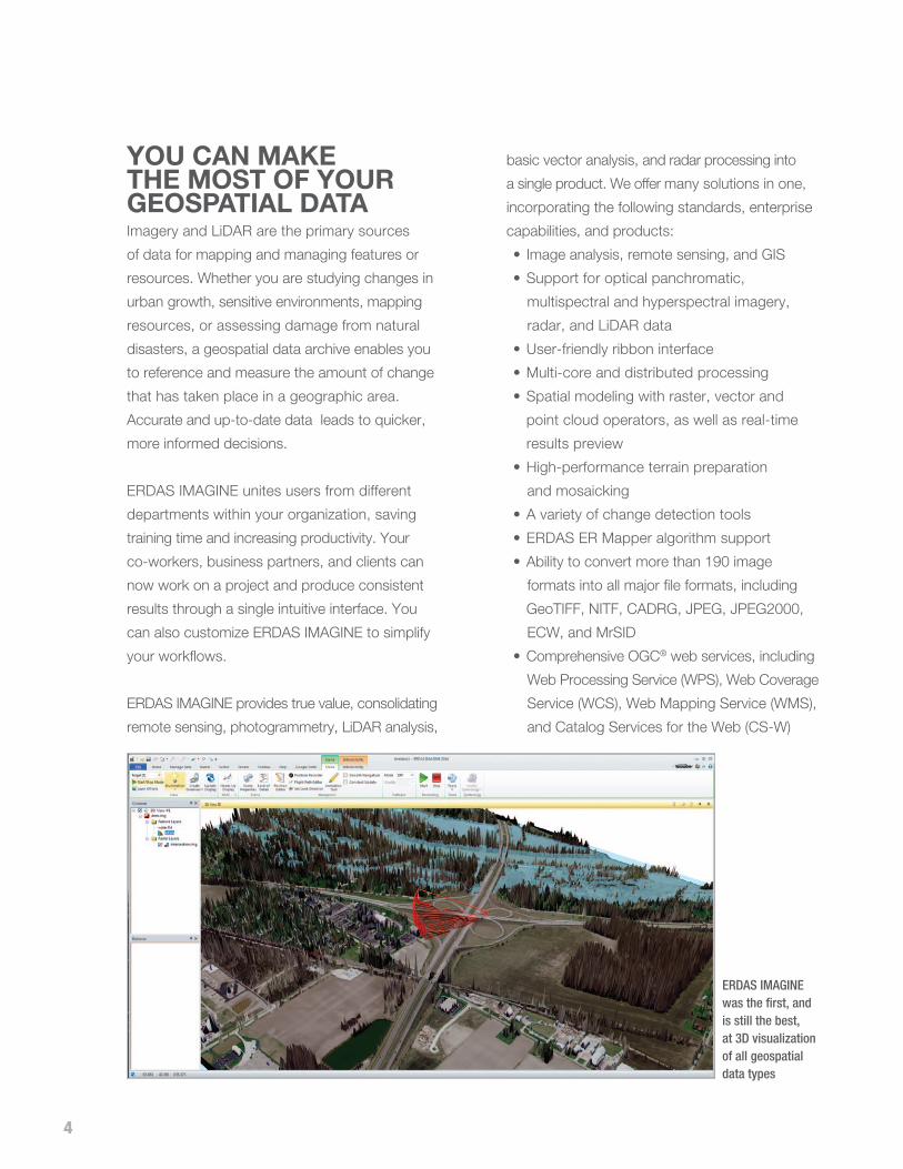
ERDAS IMAGINEwas the first, and is still the best, at 3D visualization of all geospatial data types

5
VeRSaTile For organizations with extensive collections of
geospatial data, ERDAS IMAGINE supports
enterprise-enabled geospatial image processing
that utilizes a centralized relational database
to store geospatial information. This provides
enormous benefit to an institution, making data
visible and accessible to end users through data
management solutions such as ERDAS APOLLO.
Existing and future investments in image and
feature geospatial information are exploitable by
the greatest number of decision-makers.
As users upgrade their hardware and operating
systems, ERDAS IMAGINE takes advantage
of these new technologies through threading,
parallel processing, and minimizing the number
of times the pixel is touched on the hard disk.
Batch tools in IMAGINE Advantage® and
IMAGINE Professional® enable multi-core
and distributed processing jobs, allowing
large projects to fully leverage system and
network resources.
ERDAS IMAGINE provides more classification solutions than any other product on the market, including object-based segmentation.

6
cOMpleTe ERDAS IMAGINE is easy-to-use, raster-based
software designed specifically to extract information
from images. Perfect for beginners and experts alike,
easy-to-learn ERDAS IMAGINE enables you to
process imagery like a seasoned professional,
regardless of your experience in geographic imaging.
ERDAS IMAGINE is the most powerful package for
derived information (data production), supporting
multiple workflows, including:
•Data conversion
•Orthorectification
•Color balancing, mosaicking, and
compression
•Land-cover mapping and terrain
categorization
•LiDAR editing and classification
•Map and report generation and printing
through the map composer, PowerPoint®,
or Word
•Feature capture and update
•Spatial modeling and analysis
•Terrain creation, editing, and analysis
SeaMleSS How do you maximize the investment in your
goespatial data? ERDAS IMAGINE simplifies
classification, orthorectification, mosaicking,
reprojection, and image interpretation while
maintaining the integrity of the geospatial data you
need for updating your GIS in multiple formats.
The intuitive ERDAS IMAGINE interface
streamlines your workflow and saves time.
Powerful algorithms and data processing
functions work behind the scenes so you can
concentrate on your analyses. The quick
display and ability to work with multiple
datasets in geographically linked viewers in
ERDAS IMAGINE dramatically reduces the time
you would otherwise spend trying to manually
relate information from various sources.
The Spatial Modeler uses GeoMedia® vector operators to perform analysis.
7
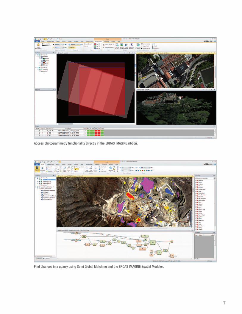
Find changes in a quarry using Semi Global Matching and the ERDAS IMAGINE Spatial Modeler.
Access photogrammetry functionality directly in the ERDAS IMAGINE ribbon.

8
With a wide array of tools enabling you to analyze data from virtually any source and present in formats ranging from
printed maps to 3D models, ERDAS IMAGINE offers you one comprehensive solution for all of your geographic
imaging and image processing needs. It simplifies and streamlines your production workflow, saving you time,
money, and resources without sacrificing accuracy.
ERDAS IMAGINE fully enables the display, editing, and analysis of point clouds derived from LiDAR or generated
from point correlation of stereo pairs. It also allows direct reading of LAS-formatted points clouds, enabling 2D/3D/
profile viewing, symbolization, measurement, editing, and classification.
Selected Functionality OptionsFUNCTIONALITY ESSENTIALS ADVANTAGE PROFESSIONAL
Geographically connect files across viewers • • •
Compress into MrSID, ECW, and JPEG2000 formats • • •
Use more than 190 different image and GIS data formats • • •
Rapidly display and roam through imagery vectors and LiDAR • • •
Create and edit shapefiles • • •
Create and print maps in more than 1000 different projected
coordinate systems• • •
Display and analyze Esri® Geodatabases • • •
2D, 3D, and profile viewing of point clouds • • •
Virtual mosaic of imagery • • •
Polynomial-rectify images • • •
Batch processing • • •
Parallel batch processing • •
Orthorectify images • •
Advanced image mosaic into a single image or image tiles • •
RGB-encode, edit, filter, merge, and split point cloud data • •
Interpolate surfaces • •
Perform spatial, radiometric, and spectral enhancement • •
Analyze radar images • •
Perform advanced multispectral image
classification and point cloud classification•
Perform graphical spatial modeling •
Extract information from hyperspectral imagery •

9
View and Edit LiDAR data as well as point clouds created in IMAGINE Photogrammetry and ImageStation.
IMAGINE Professional®: The most sophisticated
software for geographic imaging, IMAGINE
Professional includes complex hyperspectral
image analysis, and advanced classification
tools. It also includes graphical spatial data
modeling, which is a unique capability for
analyzing spatial data.
The all-new spatial modeler is a dynamic,
graphical, spatial data modeling environment
that provides real time feedback and previews.
The modern interface includes extended analysis
operators and support of Python scripting.
Authored models can be easily run in batch or
published to a server (ERDAS APOLLO WPS).
THe eRdaS iMagine pROdUcT SUiTeIMAGINE Essentials®: A powerful, low-cost
image and LiDAR mapping and visualization tool
that allows different types of geospatial data to
be combined and quickly organized for projects.
IMAGINE Essentials provides a robust set of tools
for geocorrection, analysis, visualization, and
map output.
IMAGINE Advantage®: A geographic imaging
toolset that extends the capabilities of IMAGINE
Essentials by adding more precise mapping and
geospatial data processing functions.
IMAGINE Advantage includes a complete
set of tools to analyze data from imagery
via mosaicking, surface interpolation, radar
analysis, advanced image interpretation,
and orthorectification.

10
diScOVeR THe pOTenTial OF YOUR iMageRY Additionally, Intergraph® provides an array of
add-ons that expand the core functionality
of ERDAS IMAGINE so you can tailor it to
your organization’s individual geospatial and
business needs. These innovative products
include the IMAGINE Expansion Pack, IMAGINE
Photogrammetry, IMAGINE Objective, IMAGINE
Terrain Editor, and many others. For more
information about these add-ons, please contact
your Intergraph sales representative.
Increase your accuracy using the flexible and
comprehensive toolset of the standard in imaging
software — ERDAS IMAGINE, from the inventors
of commercial remote-sensing software.
A full set of dynamic tools for working with radar data, including automatic change detection
About INtERGRAPHIntergraph helps the world work smarter. The company’s software and
solutions improve the lives of millions of people through better facilities,
safer communities and more reliable operations.
Intergraph Process, Power & Marine (PP&M) is the world’s leading
provider of enterprise engineering software enabling smarter design
and operation of plants, ships and offshore facilities. Intergraph
Security, Government & Infrastructure (SG&I) is the leader in smart
solutions for emergency response, utilities, transportation and other
global challenges. For more information, visit www.intergraph.com.
Intergraph is part of Hexagon (Nordic exchange: HEXA B; www.
hexagon.com), a leading global provider of design, measurement,
and visualization technologies that enable customers to design,
measure and position objects, and process and present data.
11

geospa t ia l . in tergraph.com
©2014 Intergraph Corporation. All rights reserved. Intergraph is part of Hexagon. Intergraph, the Intergraph logo, ERDAS IMAGINE, IMAGINE Essentials, IMAGINE Advantage, and IMAGINE Professional are registered trademarks of Intergraph Corporation or its subsidiaries in the United States and in other countries. PowerPoint is a registered trademark of Microsoft Corporation. Other products and brand names are trademarks of their respective owners.
GEO-US-0011F-ENG 12/13