Embed Size (px)
Citation preview
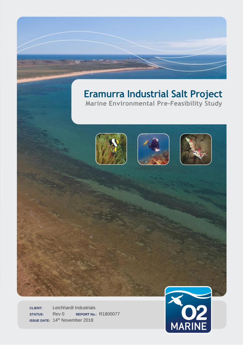
CLIENT: Leichhardt Industrials
STATUS: Rev 0 REPORT No.: R1800077
ISSUE DATE: 14th November 2018
Eramurra Industrial Salt Project Marine Environmental Pre-Feasibility Study
ii Leichhardt Industrials
Eramurra Industrial Salt Project
18WAU-0014 R1800077
Important Note
This report and all its components (including images, audio, video, text) is copyright. Apart from fair
dealing for the purposes of private study, research, criticism or review as permitted under the Copyright
Act 1968, no part may be reproduced, copied, transmitted in any form or by any means (electronic,
mechanical or graphic) without the prior written permission of O2 Marine.
This report has been prepared for the sole use of the Leichhardt Industrials Pty Ltd (herein, ‘the client’),
for a specific site (herein ‘the site’, the specific purpose specified in Section 1 of this report (herein ‘the
purpose’). This report is strictly limited for use by the client, to the purpose and site and may not be
used for any other purposes.
Third parties, excluding regulatory agencies assessing an application in relation to the purpose, may
not rely on this report. O2 Marine waives all liability to any third-party loss, damage, liability or claim
arising out of or incidental to a third-party publishing, using or relying on the facts, content, opinions or
subject matter contained in this report.
O2 Marine waives all responsibility for loss or damage where the accuracy and effectiveness of
information provided by the Client or other third parties was inaccurate or not up to date and was relied
upon, wholly or in part in reporting.
iii Leichhardt Industrials
Eramurra Industrial Salt Project
18WAU-0014 R1800077
WA Marine Pty Ltd t/as O2 Marine ACN 168 014 819
Originating Office – Southwest
Suite 5, 18 Griffin Drive, Dunsborough WA 6281
T 1300 739 447 | [email protected]
Version Register
Version Status Author Reviewer Change from
Previous Version
Authorised for Release
(signed and dated)
Rev A Draft M Donda C Lane C Lane 2/10/2018
Rev0 Final M. Donda T. Hurley T Hurley 13/11/2018
Transmission Register
Controlled copies of this document are issued to the persons/companies listed below. Any copy of this
report held by persons not listed in this register is deemed uncontrolled. Updated versions of this report
if issued will be released to all parties listed below via the email address listed.
Name Email Address
Phil Scott [email protected]
iv Leichhardt Industrials
Eramurra Industrial Salt Project
18WAU-0014 R1800077
Table of Contents
1. Introduction 6
Eramurra Industrial Salt Project 6
Project Marine Elements 9
2. Desktop Review 12
Features of Conservation Significance (Marine) 12
Existing Marine Environment 14
3. Marine Environmental Reconnaissance Survey 27
Survey Objectives 27
Survey Methods 27
Survey Findings 28
4. Environmental Factors (Sea Theme) 37
Preliminary Environmental Factors 37
5. Key Findings & Recommendations 43
Conclusions 43
Recommendations 44
6. References 47
Figures
Figure 1 Eramurra Industrial Salt Project Location (Source: Preston 2018) 6
Figure 2 Eramurra Industrial Salt Project area (Source: Preston 2018) 8
Figure 3 Preliminary Marine Infrastructure Options 11
Figure 4 Towed video survey locations and observed BCH 32
Tables
Table 1 Features of conservation significance protected through commonwealth government legislation 12
Table 2 Features of conservation significance protected through state legislation 13
Table 3 Marine Mammal species likely to occur in the Project area. 19
Table 4 Marine Reptile species likely to occur in the Project area. 21
Table 5 Marine Sharks and Ray species likely to occur in the Project area. 23
Table 6 Marine Migratory and other listed marine species likely to occur in the Project area. 24
Table 7 Broad benthic habitat type and cover categories 27
Table 8 Description of broad subtidal BCH classes observed during the towed video survey 29
Table 9 Description of broad intertidal BCH classes observed during the aerial survey 34
Table 10 Preliminary Assessment Against ‘Sea Theme’ Environmental Factors 38
v Leichhardt Industrials
Eramurra Industrial Salt Project
18WAU-0014 R1800077
Appendices
Appendix A Database Searches A
6
Leichhardt Industrials Eramurra Industrial Salt Project
18WAU-0014 R1800077
1. Introduction
Eramurra Industrial Salt Project
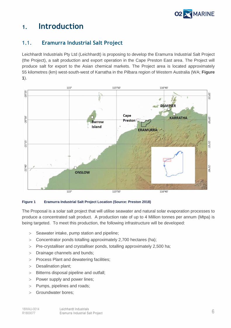
Leichhardt Industrials Pty Ltd (Leichhardt) is proposing to develop the Eramurra Industrial Salt Project
(the Project), a salt production and export operation in the Cape Preston East area. The Project will
produce salt for export to the Asian chemical markets. The Project area is located approximately
55 kilometres (km) west-south-west of Karratha in the Pilbara region of Western Australia (WA; Figure
1).
Figure 1 Eramurra Industrial Salt Project Location (Source: Preston 2018)
The Proposal is a solar salt project that will utilise seawater and natural solar evaporation processes to
produce a concentrated salt product. A production rate of up to 4 Million tonnes per annum (Mtpa) is
being targeted. To meet this production, the following infrastructure will be developed:
Seawater intake, pump station and pipeline;
Concentrator ponds totalling approximately 2,700 hectares (ha);
Pre-crystalliser and crystalliser ponds, totalling approximately 2,500 ha;
Drainage channels and bunds;
Process Plant and dewatering facilities;
Desalination plant;
Bitterns disposal pipeline and outfall;
Power supply and power lines;
Pumps, pipelines and roads;
Groundwater bores;
7
Leichhardt Industrials Eramurra Industrial Salt Project
18WAU-0014 R1800077
Accommodation camp;
Administration buildings;
Workshops;
Laydown areas;
Communications facilities;
A subsea pipeline and offshore export facility; and
Other associated infrastructure.
The Proposal will produce salt products according to the following process:
Seawater will be pumped into the first concentrator pond before undergoing progressive
concentration by solar evaporation as it flows through successive concentrator ponds;
The saturated brine will be pumped into pre-crystalliser and finally crystalliser ponds where
further evaporation occurs, and salt is deposited onto a pre-formed base of salt;
Bitterns will be pumped and disposed of via an ocean outfall (approximately 8 GLpa) at, or en-
route, to the selected port option; and
Salt will be removed from the drained crystalliser ponds by mechanical harvesters and
stockpiled adjacent to the processing facilities.
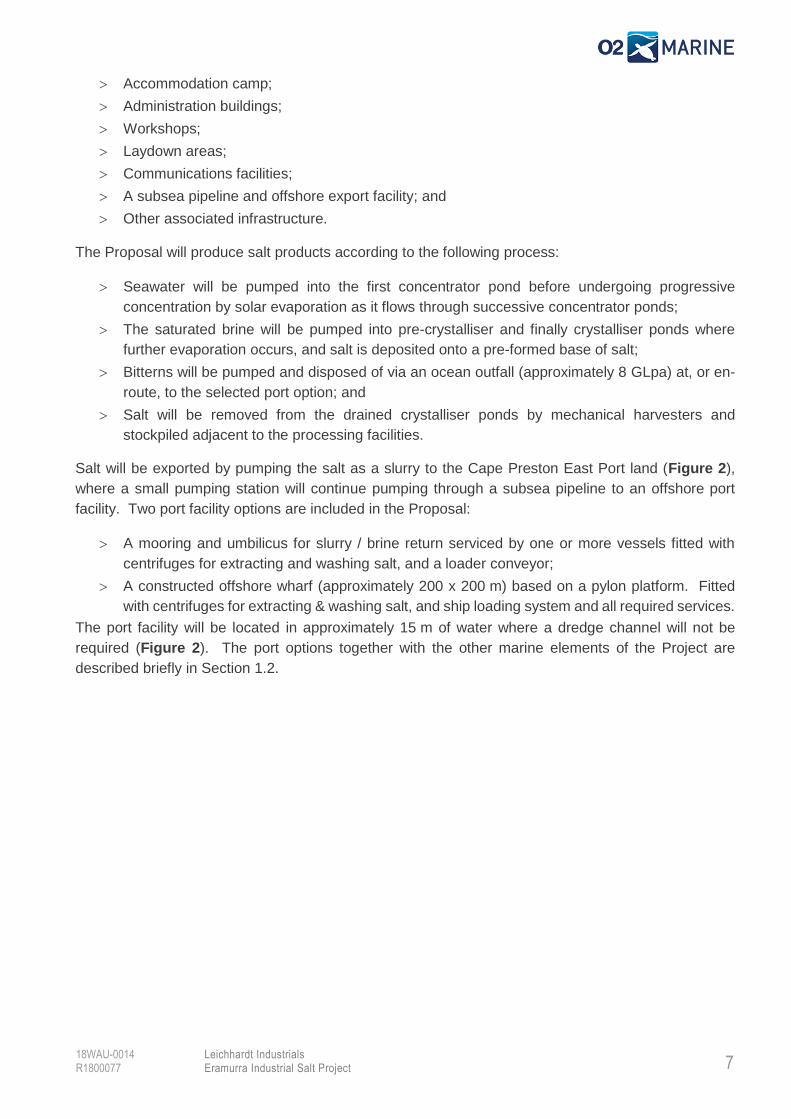
Salt will be exported by pumping the salt as a slurry to the Cape Preston East Port land (Figure 2),
where a small pumping station will continue pumping through a subsea pipeline to an offshore port
facility. Two port facility options are included in the Proposal:
A mooring and umbilicus for slurry / brine return serviced by one or more vessels fitted with
centrifuges for extracting and washing salt, and a loader conveyor;
A constructed offshore wharf (approximately 200 x 200 m) based on a pylon platform. Fitted
with centrifuges for extracting & washing salt, and ship loading system and all required services.
The port facility will be located in approximately 15 m of water where a dredge channel will not be
required (Figure 2). The port options together with the other marine elements of the Project are
described briefly in Section 1.2.
8
Leichhardt Industrials Eramurra Industrial Salt Project
18WAU-0014 R1800077
Figure 2 Eramurra Industrial Salt Project area (Source: Preston 2018)
9
Leichhardt Industrials Eramurra Industrial Salt Project
18WAU-0014 R1800077
Project Marine Elements
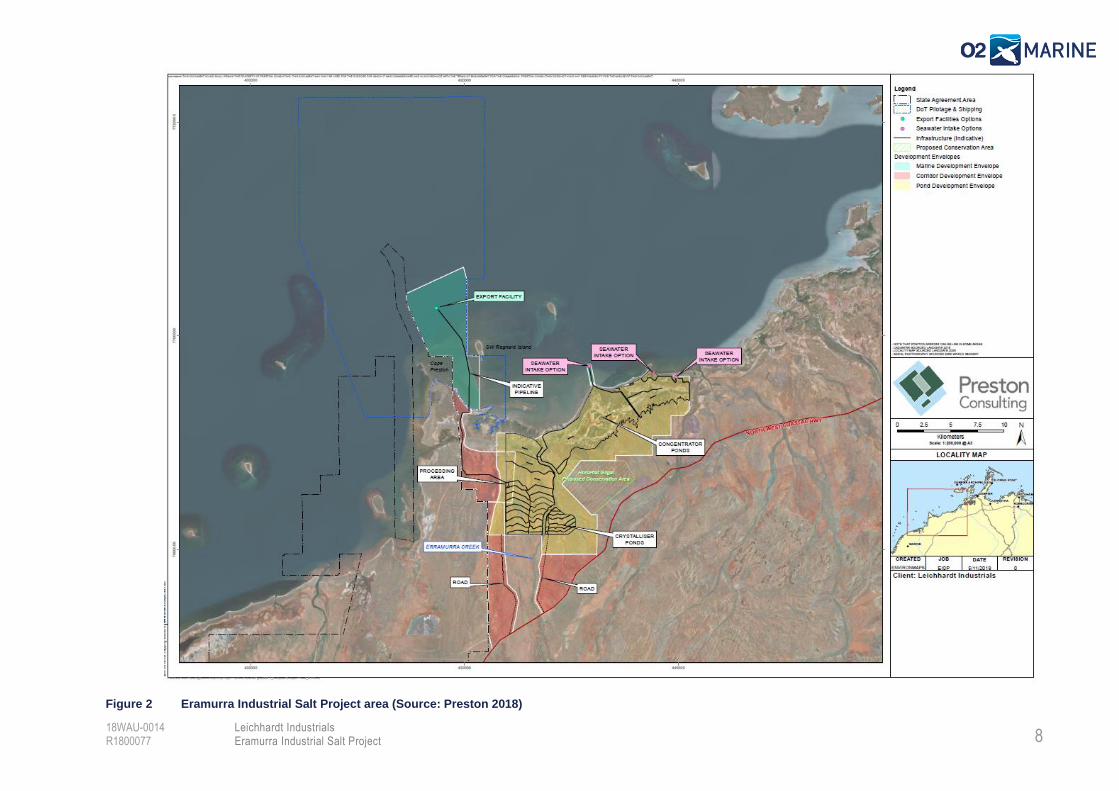
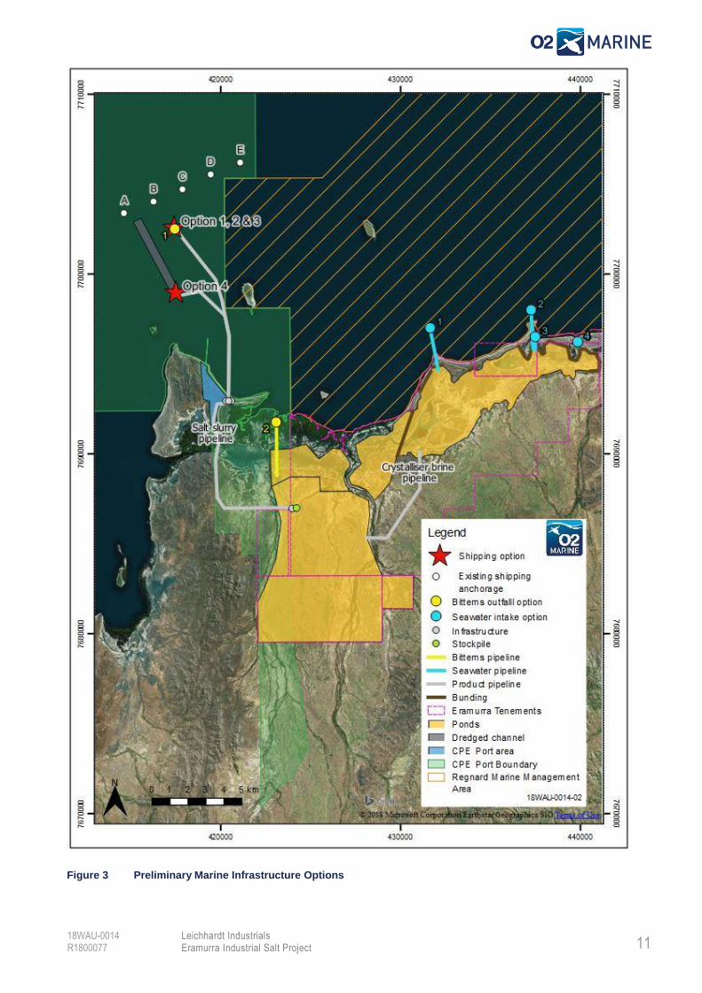
The Marine elements of the Project, as assessed in this Report, will comprise the following:
Seawater Intake – Seawater intake is proposed to occur during high tides and will include extraction
of approximately 8 GLpa. Four seawater intake location options were considered (Figure 3), located
at:
Intake Option 1 – Gnoorea Point Boat Ramp;
Intake Option 2 – Pelican Point;
Intake Option 3 – Barndar Creek; and
Intake Option 4 – Pimbyana Creek
Option 2 has since been eliminated in consideration of an Aboriginal Heritage site.
Export Facility – Four port options were considered. These options are outlined briefly below and
shown in Figure 3:
Port Option 1 – Dedicated Ship Fleet: Comprised of a mooring & umbilicus for slurry / brine
return, power, fresh water from shore. A fleet of 4 x dedicated Handimax / Panamax ships fitted
with centrifuges for extracting & washing salt, and a loader conveyor;
Port Option 2 – Converted Cape Sized OR custom barge floating processing, stockpile & wharf:
Self-powered, reverse osmosis (RO) freshwater & power generation. Comprised of a mooring
& umbilicus for slurry / brine return. Fitted with centrifuges for extracting & washing salt, and
ship loading system;
Port Option 3 – Wharf Island (200 x 200 m) – Constructed from a pylon platform. Receives salt
slurry via pipeline for centrifuge & salt stockpile. Comprised of diesel power generator 1.5 Mw,
RO freshwater plant, fuel storage, water storage and ship loading system; and
Port Option 4 – Dredge Channel & Wharf Island (200 x 200 m): Constructed either from dredged
spoils OR a pylon platform. Receives salt slurry via pipeline for centrifuge & salt stockpile.
Comprised of diesel power generator 1.5 Mw, RO freshwater plant, fuel storage, water storage
and ship loading system.
Option 4 has since been eliminated due to environmental and economic considerations.
Waste Bitterns Outfall – Discharge of approximately 8 GLpa year of waste bitterns is required to
dispose of waste by-products derived during salt processing. Two location options are initially
proposed. These options are outlined briefly below and shown in Figure 3:
Bitterns Option 1 – Discharge of waste bitterns at location of Port Options 1, 2 & 3; and
Bitterns Option 2 - Discharge of waste bitterns into tidal creek. Discharge to only occur during
ebb tide conditions.
Bitterns Option 2 has since been eliminated due to environmental considerations.
10
Leichhardt Industrials Eramurra Industrial Salt Project
18WAU-0014 R1800077
Objectives
Liechardt commissioned preliminary environmental investigations and desktop review to support pre-
feasibility assessment and minimise the environmental footprint of the Proposal. O2 Marine was
engaged to review the marine environmental aspects of the Proposal. The specific objectives of this
report are to:
Identify features of conservation significance relevant to the Project area;
Broadly characterise the marine environment and identify key environmental factors for the
Project;
Inform of any potential impacts associated with marine aspects of the Project which may be
considered environmentally unacceptable by regulatory authorities; and
Provide recommendations regarding design considerations and likely marine environmental
studies.
It is noted that the scope of works defined to O2 Marine requires an assessment of the marine ecological
aspects of the Project only. However, during searches there are overlaps with other scopes including
social values as undertaken by Preston for the Project and terrestrial ecological aspects as evaluated
by Phoenix Environmental.
11
Leichhardt Industrials Eramurra Industrial Salt Project
18WAU-0014 R1800077
Figure 3 Preliminary Marine Infrastructure Options
12
Leichhardt Industrials Eramurra Industrial Salt Project
18WAU-0014 R1800077
2. Desktop Review
Features of Conservation Significance (Marine)
Key features of conservation significance located within and/or adjacent to the Project area that are
protected through Commonwealth and State government legislation have been identified through
desktop review and are presented in Table 1 and Table 2, respectively.
Provisions for protection of these features of conservation significance are made within the following
legislation:
Commonwealth Legislation
• Environment Protection and Biodiversity Conservation Act 1999 (EPBC Act); and • Historic Shipwrecks Act 1976 (HS Act).
State Legislation
• Biodiversity Conservation Act 2016 (BC Act); • Environmental Protection Act 1986 (EP Act); • Maritime Archaeology Act 1973 (MA Act); and • Heritage of Western Australian Act 1990 (HWA Act).
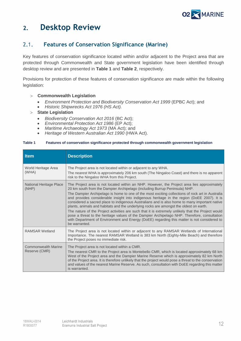
Table 1 Features of conservation significance protected through commonwealth government legislation
Item Description
World Heritage Area (WHA)
The Project area is not located within or adjacent to any WHA.
The nearest WHA is approximately 206 km south (The Ningaloo Coast) and there is no apparent risk to the Ningaloo WHA from this Project.
National Heritage Place (NHP)
The Project area is not located within an NHP. However, the Project area lies approximately 20 km south from the Dampier Archipelago (including Burrup Peninsula) NHP.
The Dampier Archipelago is home to one of the most exciting collections of rock art in Australia and provides considerable insight into indigenous heritage in the region (DoEE 2007). It is considered a sacred place to indigenous Australians and is also home to many important native plants, animals and habitats and the underlying rocks are amongst the oldest on earth.
The nature of the Project activities are such that it is extremely unlikely that the Project would pose a threat to the heritage values of the Dampier Archipelago NHP. Therefore, consultation with Department of Environment and Energy (DoEE) regarding this matter is not considered to be warranted.
RAMSAR Wetland The Project area is not located within or adjacent to any RAMSAR Wetlands of International Importance. The nearest RAMSAR Wetland is 383 km North (Eighty-Mile Beach) and therefore the Project poses no immediate risk.
Commonwealth Marine Reserve (CMR)
The Project area is not located within a CMR.
The nearest CMR to the Project area is Montebello CMR, which is located approximately 68 km West of the Project area and the Dampier Marine Reserve which is approximately 82 km North of the Project area. It is therefore unlikely that the project would pose a threat to the conservation and values of the nearest Marine Reserve. As such, consultation with DoEE regarding this matter is warranted.
13
Leichhardt Industrials Eramurra Industrial Salt Project
18WAU-0014 R1800077
Item Description
EPBC Act Listed Species
The EPBC Act Protected Matters Search Tool (PMST) (Appendix 1) was used with a 10 km buffer to identify EPBC Act Listed species which are protected as ‘Matters of National Environmental Significance’ (MNES) and have the potential to occur within the Project area. These Included:
• 9 Bird species (3x Critically Endangered (CE), 4X Endangered (E) & 2x Vulnerable (V);
• 6 Mammal species (2x E & 4x V);
• 8 Reptile species (1x CE, 2x E & 5x V);
• 5 Shark species (5x V);
• 6 Migratory Marine Bird species (1x E);
• 19 Migratory Marine species (3x E & 8x V);
• 3x Migratory Terrestrial species;
11x Migratory Wetlands Species (2x CE & 1X E)Complete species list provided in Appendix 1. Appendix 1 also identified numerous other EPBC Act listed species which have the potential to occur in the Project area and are protected as ‘Other Matters Protected by the EPBC Act’.
Given that several of the EPBC Act listed species are known to occur in the Project area and may be impacted by Project activities, referral of the Project to the DoEE in accordance with the EPBC Act is considered to be warranted.
Threatened Ecological Communities (TEC)
The EPBC Act PMST (Appendix 1) did not identify any TEC that may be likely to occur within a 10 km buffer area of the Project.
Shipwrecks There are no shipwreck sites in the vicinity of the Project area. The nearest known shipwreck is located 34 km north within the Dampier Archipelago.
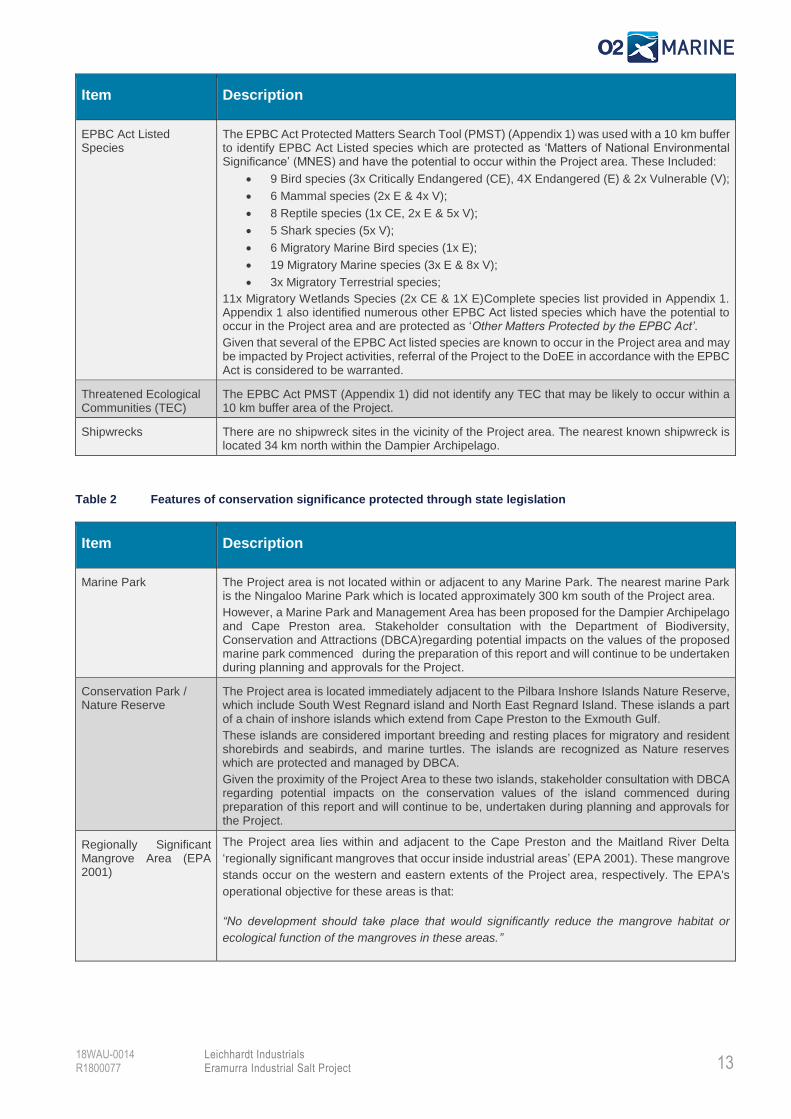
Table 2 Features of conservation significance protected through state legislation
Item Description
Marine Park The Project area is not located within or adjacent to any Marine Park. The nearest marine Park is the Ningaloo Marine Park which is located approximately 300 km south of the Project area.
However, a Marine Park and Management Area has been proposed for the Dampier Archipelago and Cape Preston area. Stakeholder consultation with the Department of Biodiversity, Conservation and Attractions (DBCA)regarding potential impacts on the values of the proposed marine park commenced during the preparation of this report and will continue to be undertaken during planning and approvals for the Project.
Conservation Park / Nature Reserve
The Project area is located immediately adjacent to the Pilbara Inshore Islands Nature Reserve, which include South West Regnard island and North East Regnard Island. These islands a part of a chain of inshore islands which extend from Cape Preston to the Exmouth Gulf.
These islands are considered important breeding and resting places for migratory and resident shorebirds and seabirds, and marine turtles. The islands are recognized as Nature reserves which are protected and managed by DBCA.
Given the proximity of the Project Area to these two islands, stakeholder consultation with DBCA regarding potential impacts on the conservation values of the island commenced during preparation of this report and will continue to be, undertaken during planning and approvals for the Project.
Regionally Significant Mangrove Area (EPA 2001)
The Project area lies within and adjacent to the Cape Preston and the Maitland River Delta
‘regionally significant mangroves that occur inside industrial areas’ (EPA 2001). These mangrove
stands occur on the western and eastern extents of the Project area, respectively. The EPA's
operational objective for these areas is that:
“No development should take place that would significantly reduce the mangrove habitat or
ecological function of the mangroves in these areas.”
14
Leichhardt Industrials Eramurra Industrial Salt Project
18WAU-0014 R1800077
Item Description
Fish Habitat Protection Area (FHPA)
The Project area is not located within or adjacent to any FHPA.
The nearest FHPA is located over 500 km from the Project area (i.e. Point Quobba). Therefore, the Project is not expected to result in impact to any FHPA.
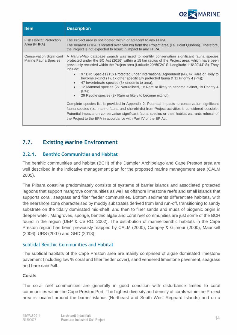
Conservation Significant Marine Fauna Species
A NatureMap database search was used to identify conservation significant fauna species protected under the BC Act (2016) within a 15 km radius of the Project area, which have been
previously recorded within the Project area (Latitude 2050’24” S, Longitude 11620’44” S). They Include:
• 97 Bird Species (15x Protected under International Agreement (IA), 4x Rare or likely to become extinct (T), 1x other specifically protected fauna & 1x Priority 4 (P4));
• 47 Invertebrate species (6x endemic to area);
• 12 Mammal species (2x Naturalised, 1x Rare or likely to become extinct, 1x Priority 4 (P4);
• 29 Reptile species (3x Rare or likely to become extinct).
Complete species list is provided in Appendix 2. Potential impacts to conservation significant
fauna species (i.e. marine fauna and shorebirds) from Project activities is considered possible.
Potential impacts on conservation significant fauna species or their habitat warrants referral of
the Project to the EPA in accordance with Part IV of the EP Act.
Existing Marine Environment
2.2.1. Benthic Communities and Habitat
The benthic communities and habitat (BCH) of the Dampier Archipelago and Cape Preston area are
well described in the indicative management plan for the proposed marine management area (CALM
2005).
The Pilbara coastline predominately consists of systems of barrier islands and associated protected
lagoons that support mangrove communities as well as offshore limestone reefs and small islands that
supports coral, seagrass and filter feeder communities. Bottom sediments differentiate habitats, with
the nearshore zone characterised by muddy substrates derived from land run-off, transitioning to sandy
substrate on the tidally dominated mid-shelf, and then to finer sands and muds of biogenic origin in
deeper water. Mangroves, sponge, benthic algae and coral reef communities are just some of the BCH
found in the region (DEP & CSIRO, 2002). The distribution of marine benthic habitats in the Cape
Preston region has been previously mapped by CALM (2000), Campey & Gilmour (2000), Maunsell
(2006), URS (2007) and GHD (2013).
Subtidal Benthic Communities and Habitat
The subtidal habitats of the Cape Preston area are mainly comprised of algae dominated limestone
pavement (including low % coral and filter feeder cover), sand veneered limestone pavement, seagrass
and bare sand/silt.
Corals
The coral reef communities are generally in good condition with disturbance limited to coral
communities within the Cape Preston Port. The highest diversity and density of corals within the Project
area is located around the barrier islands (Northeast and South West Regnard Islands) and on a
15
Leichhardt Industrials Eramurra Industrial Salt Project
18WAU-0014 R1800077
limestone pavement reef surrounding Cape Preston. Large isolated bommies (Porities sp.) are also
located in the protected lee of Southwest Regnard Island.
The marine management area is known to have a high diversity of hard corals (CALM 2005). This high
diversity is likely attributed to the variety of substrates and oceanographic conditions within the
proposed reserve, where conditions range from exposed reefs with high wave action, clear water and
low sediment deposition rates on the seaward coasts of the outer islands, to the sheltered areas further
inshore with high sediment deposition rates and turbid waters (CALM 2005). Coral communities within
this area support a wide variety of marine life including sponges, sea stars, sea urchins, crustaceans,
molluscs, gastropods, worms and fishes.
Potential pressures on coral communities in the Project area include physical disturbance, nutrients,
toxicants, introduced pests, increased suspended sediments/ sedimentation and elevated water
temperatures.
Macroalgal and seagrass communities
Macroalgae (seaweeds) dominate submerged limestone reefs and grow on stable rubble and boulder
surfaces in the Dampier Archipelago and Cape Preston area. These communities are most commonly
found on shallow limestone pavements in depths less than 10 m and can provide important nursery
grounds for juvenile fish (CALM 2005). Low relief limestone reefs which are dominated by macroalgae
and turf algae account for 17% of the major marine habitats within the proposed marine management
area (CALM 2005).
Seagrasses provide important habitat and food for turtles, dugongs, mollusc, sea urchins, sea stars,
sea cucumbers, crabs and fishes. Seagrass occurs in the larger bays and sheltered flats of the region
and six species of seagrass are present on the subtidal soft sediment habitats (CALM 2005, Campey
& Gilmour 2000). The area between West Intercourse Island and Cape Preston is recognised as one
of the most important areas of seagrass in the region (CALM 2005).
The macroalgal and seagrass communities are generally in an undisturbed condition, apart from
localised disturbance surrounding Cape Preston Port. Potential pressures on these communities in the
project area include physical disturbance, nutrients, toxicants, increased TSS, sedimentation and
elevation in water temperature.
Subtidal soft-bottom communities
Subtidal soft-bottom communities consist of silt or sand and comprise 57% of the major marine habitats
of the proposed Dampier Archipelago and Cape Preston area. These communities are typically bare,
but may have seasonal vegetation or permanent patches of seagrass, macroalgae or filter feeders.
Silt habitats occur in the sheltered areas nearshore, while sand occurs more offshore. Soft-bottom
communities often support a rich variety of infauna that live in the substrate such as polychaete worms,
molluscs and crustaceans. They also support surface dwellers that live above or on the substrate such
as flathead, rays, flounder, crabs, bivalve molluscs, gastropods or sea snails, sea urchins and sea stars.
Inhabitants may also include filter feeding invertebrates such as sponges, corals, sea whips and sea
squirts.
16
Leichhardt Industrials Eramurra Industrial Salt Project
18WAU-0014 R1800077
The subtidal soft-bottom communities are generally in an undisturbed condition. Potential pressures on
subtidal soft bottom communities include physical disturbance, toxicants, nutrients, turbidity, bitterns
discharge and discharge of higher temperature water from desalination.
Intertidal Benthic Communities and Habitat
The intertidal BCH of the Project area is predominately salt marsh, mangal, sand, sand/mudflats with
associated filter feeder communities, algae dominated limestone pavement and sand/rubble veneered
limestone pavement. Yanare River and Maitland River supply silt to surrounding intertidal areas.
Shallow intertidal coral reef communities are also present around Southwest Regnard and Northeast
Regnard Islands.
Mangrove communities
Six species of mangrove are found within the vicinity of the Project area and the mangroves in this area
are generally considered to be in pristine condition. The Project area lies within and adjacent to the
designated Cape Preston and the Maitland River Delta ‘Regionally Significant’ mangrove areas (EPA
2001), which are located on the western and eastern extent of the Project area, respectively.
The mangrove communities in this area are considered to be of great ecological and economic
importance, supporting a varied number of organisms such as snails, crabs, shrimps, oysters,
barnacles, fish and birds. Physical disturbance, pollution (particularly oil), dust and litter are potential
pressures on all intertidal BCH (CALM 2005).
Intertidal sand and mudflat communities
Intertidal sand and mudflat communities cover 14% of the Dampier and Cape Preston area occurring
in sheltered, relatively low energy marine environments that result in depositional conditions. These
communities occur along most of the coastline of the region. The intertidal sand and mudflat
communities are extremely important from a biodiversity conservation perspective because of the high
diversity of infauna (particularly molluscs) that live within the substrate of these habitats (CALM 2005).
The intertidal sand and mudflat communities are generally in an undisturbed condition, apart from some
localised disturbance. Although typically bare of vegetation, these areas are often covered with a
surface film of micro-organisms that are a rich source of food for the high diversity of invertebrates they
support. This includes bivalve shells, lamp shells or brachiopods, worms, crabs and sea urchins. The
abundance of invertebrate life found on intertidal sand and mudflat communities provides a valuable
food source for larger fish and other organisms which swim over the area at high tide, as well as resident
and migratory shorebirds (CALM 2005). Potential pressures on intertidal sand and mudflat communities
are physical disturbance, toxicants, nutrients, Fishing, Dust and commercial harvest.
Rocky shore communities
The rocky shore communities comprise approximately 40% of the shoreline habitats of the Dampier
and Cape Preston area. Sedimentary limestone rocky shores consist of low cliffs formed by a
combination of wave attack, biological erosion, undercutting and rock falls, and often have intertidal
platforms associated with them.
The large tidal range within the Project area results in pronounced horizontal zonation of plants and
animals such as oysters, barnacles, crabs and molluscs. In areas of low wave action, such as the east
17
Leichhardt Industrials Eramurra Industrial Salt Project
18WAU-0014 R1800077
coasts of the barrier islands, platforms are often covered by a layer of mud or sand. In more exposed
areas, platforms are covered with an algal turf and corals may grow on the outer edges. This habitat
supports a myriad of marine animals, whose distribution is controlled by the action of the tides. Bivalve
shells, snails, crabs, worms and small fish can seek refuge from desiccation in shallow rock pools at
low tide, while larger fish and other marine animals come in to feed on these organisms when the tide
is high. The abundance of invertebrate life on rocky shores provides a valuable food source for
shorebirds and contributes significantly to the biological diversity of the proposed reserves (CALM
2005).
The rocky shore communities of the region are typically in an undisturbed condition.
2.2.2. Coastal Processes
The Project area experiences meso- to macro-tidal variation (ranging from 0.5 – 5 m), with the episodic
effect of severe tropical cyclones during December to April (Eliot et al. 2013).
Dominant wave direction in the Project area is west-north-west and is generated from refracted
Southern Ocean swells, monsoonal activity and tropical cyclones. Typical oceanic swell heights are 1-
2 m with swells of between 5-20 m possible during cyclonic events. However, the barrier islands in the
Project area and the adjacent Dampier Archipelago offer significant protection from waves and the wave
energy is often dissipated before reaching the coastline (Eliot et al. 2013).
The Project area has been broadly characterised as a floodplain coast, with Eramurra Creek, McKay
Creek, Devil Creek and Yanyare River debouching into Regnard Bay (Eliot et al. 2013). The coast is
perched on an extensive subtidal rock platform, with relict emergent features providing chains of barrier
island and headland control for Forty Mile Beach and Gnoorea (Eliot et al. 2013). The Maitland and
Yanyare Rivers provide episodic sediment supply with net longshore sediment transport north and
south, respectively. The coastal area encompasses outwash plains, basins and tidal creeks with
interaction between coastal and fluvial processes (Stul et al. 2014).
The Cape Preston Port, located southwest of the Project area, is a large breakwater, that is built upon
an existing basalt rock formation. The Port represents a dominant feature on the coastline, as it provides
a sharp change in coastal orientation to the coasts to both the east and west. Sediment supply to the
Project area is largely from west to east, with intermittently high but more commonly low sediment
supply from the Fortescue River, bypassing around Cape Preston. However, the Cape Preston Port
forms a major accretive feature on the southwest side of the Cape, with sand shoals to the east
(adjacent to the Project area) indicating only very occasional bypassing. The low-lying nature of the
Eramurra Creek floodplain suggests that a limited amount of bypassed material enters western Regnard
Bay, with the majority of sediment anticipated to travel along the steep coastal contours between Cape
Preston and North East Regnard Island (Stul et al. 2014).
Potential pressures on coastal processes include infrastructure that alters longshore current patterns
or tidal flows or removal of coastline protection communities (e.g. mangroves).
18
Leichhardt Industrials Eramurra Industrial Salt Project
18WAU-0014 R1800077
2.2.3. Marine Environmental Quality
Water Quality
Marine water quality over much of the Pilbara region is regarded as of high quality, relatively undisturbed
and essential to the maintenance of a healthy ecosystem. The broad oceanographic processes and the
nature of water circulation in the region influence transport, dispersal and mixing of sediment, biota and
pollutants and consequently the water quality of the area. Nearshore water movements and mixing
patterns in the Project area are driven primarily by large tidal ranges, local currents and winds, but are
also influenced by seabed topography and the steering effect of islands and reefs (CALM 2005).
Potential pressures on water quality are discharge of pollutants (nutrients and toxicants) into the water,
construction activities generating elevated turbidity and suspended sediment (i.e. trench excavation or
rock dumping for pipelines), disturbance of acid sulfate soils and the risk of accidental spillage of
toxicants and nutrients.
In accordance with the State Water Quality Management Strategy Environmental Quality Management
Framework (EQMF), the Department of Environment (DoE) consulted with relevant stakeholder groups
across the Pilbara in 2006 to establish Environmental Values (EVs) and Environmental Quality
Objectives (EQOs) and assign appropriate Levels of Ecological Protection for Pilbara Coastal Waters.
This process has since been refined and described in EPA’s Technical Guidance for Protecting the
Marine Environmental Quality of Western Australia (EPA 2016). Marine coastal waters in the Project
area are assigned a High Level of Ecological Protection (LEP), with the proposed South West Regnard
Island conservation zone assigned a Maximum LEP.
In accordance with EPA (2016), Maximum LEP areas are not permitted any detectable change in
ecosystem processes, biodiversity, abundance and biomass of marine life and the quality of water,
biota and sediment. Small detectable changes in water and/or sediment quality beyond limits of natural
variation are permitted for High LEP areas, provided that there is no resultant effect on biota. These
designations have implications for permitted activities such as waste bitterns discharges.
Sediment Quality
Except for areas of high shipping activity (e.g. in the Dampier and Cape Preston Ports), the sediment
quality of the Dampier Archipelago and Cape Preston region is generally in an undisturbed condition
(CALM 2005). The current major pressure on sediment quality in the vicinity of the Project area is from
shipping activity, pollution and mobilisation of contaminated sediments through dredging and waste
discharges.
Maintaining high sediment quality is important for the maintenance of healthy ecosystems, as such the
EPA (2016) guidance for protecting marine environmental quality is also applicable to sediment quality.
As discussed previously, the Project area is afforded a High LEP with the proposed South West
Regnard Island conservation zone assigned a Maximum LEP. These designations have implications
for permitted activities such as waste bitterns discharges.
2.2.4. Marine Fauna
The marine waters within and adjacent to the Project area support a variety of fauna, several of which
are listed as being of conservation significance and protected under the Commonwealth EPBC Act
and/or State BC Act.
19
Leichhardt Industrials Eramurra Industrial Salt Project
18WAU-0014 R1800077
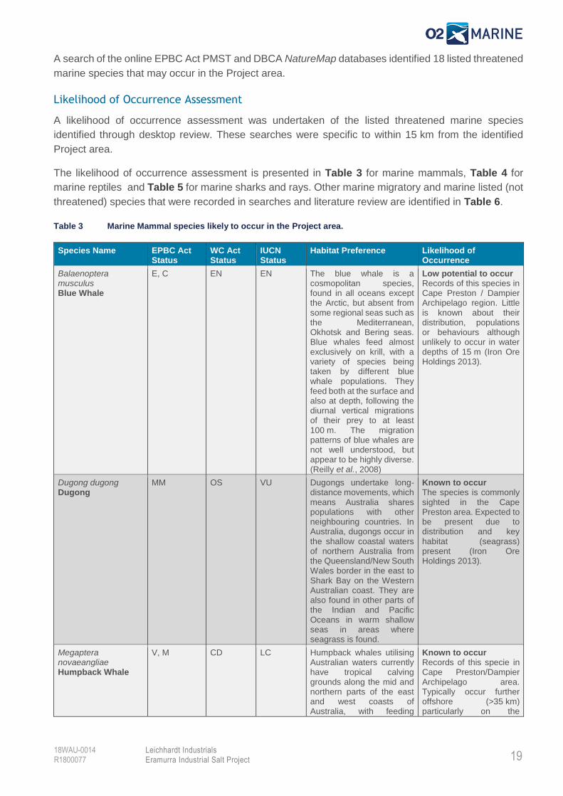
A search of the online EPBC Act PMST and DBCA NatureMap databases identified 18 listed threatened
marine species that may occur in the Project area.
Likelihood of Occurrence Assessment
A likelihood of occurrence assessment was undertaken of the listed threatened marine species
identified through desktop review. These searches were specific to within 15 km from the identified
Project area.
The likelihood of occurrence assessment is presented in Table 3 for marine mammals, Table 4 for
marine reptiles and Table 5 for marine sharks and rays. Other marine migratory and marine listed (not
threatened) species that were recorded in searches and literature review are identified in Table 6.
Table 3 Marine Mammal species likely to occur in the Project area.
Species Name EPBC Act Status
WC Act Status
IUCN Status
Habitat Preference Likelihood of Occurrence
Balaenoptera musculus Blue Whale
E, C EN EN The blue whale is a cosmopolitan species, found in all oceans except the Arctic, but absent from some regional seas such as the Mediterranean, Okhotsk and Bering seas. Blue whales feed almost exclusively on krill, with a variety of species being taken by different blue whale populations. They feed both at the surface and also at depth, following the diurnal vertical migrations of their prey to at least 100 m. The migration patterns of blue whales are not well understood, but appear to be highly diverse. (Reilly et al., 2008)
Low potential to occur Records of this species in Cape Preston / Dampier Archipelago region. Little is known about their distribution, populations or behaviours although unlikely to occur in water depths of 15 m (Iron Ore Holdings 2013).
Dugong dugong Dugong
MM OS VU Dugongs undertake long-distance movements, which means Australia shares populations with other neighbouring countries. In Australia, dugongs occur in the shallow coastal waters of northern Australia from the Queensland/New South Wales border in the east to Shark Bay on the Western Australian coast. They are also found in other parts of the Indian and Pacific Oceans in warm shallow seas in areas where seagrass is found.
Known to occur The species is commonly sighted in the Cape Preston area. Expected to be present due to distribution and key habitat (seagrass) present (Iron Ore Holdings 2013).
Megaptera novaeangliae Humpback Whale
V, M CD LC Humpback whales utilising Australian waters currently have tropical calving grounds along the mid and northern parts of the east and west coasts of Australia, with feeding
Known to occur Records of this specie in Cape Preston/Dampier Archipelago area. Typically occur further offshore (>35 km) particularly on the
20
Leichhardt Industrials Eramurra Industrial Salt Project
18WAU-0014 R1800077
Species Name EPBC Act Status
WC Act Status
IUCN Status
Habitat Preference Likelihood of Occurrence
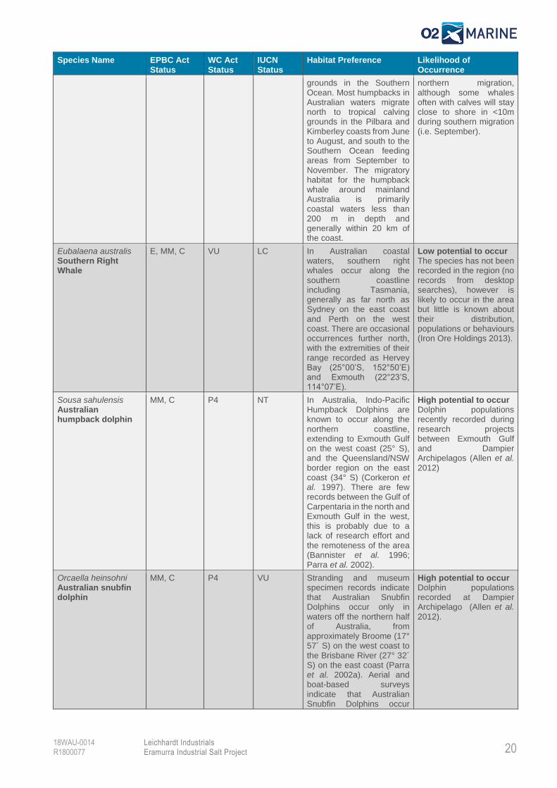
grounds in the Southern Ocean. Most humpbacks in Australian waters migrate north to tropical calving grounds in the Pilbara and Kimberley coasts from June to August, and south to the Southern Ocean feeding areas from September to November. The migratory habitat for the humpback whale around mainland Australia is primarily coastal waters less than 200 m in depth and generally within 20 km of the coast.
northern migration, although some whales often with calves will stay close to shore in <10m during southern migration (i.e. September).
Eubalaena australis Southern Right Whale
E, MM, C VU LC In Australian coastal waters, southern right whales occur along the southern coastline including Tasmania, generally as far north as Sydney on the east coast and Perth on the west coast. There are occasional occurrences further north, with the extremities of their range recorded as Hervey Bay (25°00’S, 152°50’E) and Exmouth (22°23’S, 114°07’E).
Low potential to occur The species has not been recorded in the region (no records from desktop searches), however is likely to occur in the area but little is known about their distribution, populations or behaviours (Iron Ore Holdings 2013).
Sousa sahulensis Australian humpback dolphin
MM, C P4 NT In Australia, Indo-Pacific Humpback Dolphins are known to occur along the northern coastline, extending to Exmouth Gulf on the west coast (25° S), and the Queensland/NSW border region on the east coast (34° S) (Corkeron et al. 1997). There are few records between the Gulf of Carpentaria in the north and Exmouth Gulf in the west, this is probably due to a lack of research effort and the remoteness of the area (Bannister et al. 1996; Parra et al. 2002).
High potential to occur Dolphin populations recently recorded during research projects between Exmouth Gulf and Dampier Archipelagos (Allen et al. 2012)
Orcaella heinsohni Australian snubfin dolphin
MM, C P4 VU Stranding and museum specimen records indicate that Australian Snubfin Dolphins occur only in waters off the northern half of Australia, from approximately Broome (17° 57´ S) on the west coast to the Brisbane River (27° 32´ S) on the east coast (Parra et al. 2002a). Aerial and boat-based surveys indicate that Australian Snubfin Dolphins occur
High potential to occur Dolphin populations recorded at Dampier Archipelago (Allen et al. 2012).
21
Leichhardt Industrials Eramurra Industrial Salt Project
18WAU-0014 R1800077
Species Name EPBC Act Status
WC Act Status
IUCN Status
Habitat Preference Likelihood of Occurrence
mostly in protected shallow waters close to the coast, and close to river and creek mouths (Parra et al. 2002a).
Tursiops aduncus Indo-Pacific/Spotted Bottlenose Dolphin
MM, C MM At species level, the Indian Ocean Bottlenose Dolphins are found in tropical and sub-tropical coastal and shallow offshore waters of the Indian Ocean, Indo-Pacific Region and the western Pacific Ocean (Moller & Beheregaray 2001). Bottlenose dolphins are distributed continuously around the Australian mainland, but the taxonomic status of many populations is unknown. Indian Ocean Bottlenose Dolphins have been confirmed to occur in estuarine and coastal waters of eastern, western and northern Australia (Möller & Beheregaray 2001).
High potential to occur Dolphin populations regularly recorded along in nearshore waters along the coast between Dampier Archipelago and Exmouth Gulf. (Allen et al. 2012).
EPBC Act (species listed under the Commonwealth Environment Protection and Biodiversity Conservation Act 1999): Ex = Extinct,
CE = Critically Endangered, E = Endangered, V = Vulnerable, M = Migratory, MM = Migratory Marine, MT = Migratory Terrestrial,
MW = Migratory Wetlands, Ma = Listed Marine
WC Act (species listed under the Western Australian Wildlife Conservation Act 1950): Threatened Species: EX = Presumed Extinct,
CR = Critically Endangered, EN = Endangered, VU = Vulnerable, IA = Migratory birds protected under an International Agreement, CD =
Conservation Dependent, OS = Other Specially Protected. Priority Species: P1 = Priority 1, P2 = Priority 2, P3 = Priority 3, P4 = Priority 4
IUCN (species listed under the International Union for Conservation of Nature (IUCN) Red List of Threatened Species): EX = Extinct, EW = Extinct in the Wild, CR = Critically Endangered, EN = Endangered, VU = Vulnerable, NT = Near Threatened, LC = Least Concern.
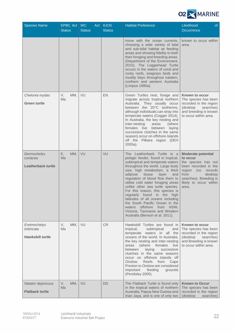
Table 4 Marine Reptile species likely to occur in the Project area.
Species Name EPBC Act
Status
WC Act
Status
IUCN
Status
Habitat Preference Likelihood of
Occurrence
Aipysurus
apraefrontalis
Short-nosed Seasnake
CE, Ma CR CR The Short-nosed Sea snake is endemic to Western Australia, and has been recorded from Exmouth Gulf, Western Australia to the reefs of the Sahul Shelf, in the eastern Indian Ocean. The species prefers the reef flats or shallow waters along the outer reef edge in water depths to 10 m (McCosker 1975).
Moderate potential to occur Species or species habitat likely to occur within area.
Caretta caretta
Loggerhead turtle
E, MM,
Ma EN VU In Australia, Loggerhead Turtles
nest on open, sandy beaches concentrated in southern Queensland and from Shark Bay to the North West Cape in Western Australia. They live at or near the surface of the ocean and
Known to occur The species has been recorded in the region and Foraging, feeding or related behaviour
22
Leichhardt Industrials Eramurra Industrial Salt Project
18WAU-0014 R1800077
Species Name EPBC Act
Status
WC Act
Status
IUCN
Status
Habitat Preference Likelihood of
Occurrence
move with the ocean currents, choosing a wide variety of tidal and sub-tidal habitat as feeding areas and showing fidelity to both their foraging and breeding areas. (Department of the Environment, 2015). The Loggerhead Turtle occurs in the waters of coral and rocky reefs, seagrass beds and muddy bays throughout eastern, northern and western Australia (Limpus 1995a).
known to occur within area.
Chelonia mydas
Green turtle
V, MM, Ma
VU EN Green Turtles nest, forage and migrate across tropical northern Australia. They usually occur between the 20°C isotherms, although individuals can stray into temperate waters (Cogger 2014). In Australia, the key nesting and inter-nesting areas (where females live between laying successive clutches in the same season) occur on offshore Islands off the Pilbara region (DEH
2005a).
Known to occur The species has been recorded in the region (desktop searches) and breeding is known to occur within area.
Dermochelys coriacea
Leatherback turtle
E, MM, Ma
VU VU The Leatherback Turtle is a pelagic feeder, found in tropical, subtropical and temperate waters throughout the world. Large body size, high metabolism, a thick adipose tissue layer and regulation of blood flow them to utilise cold water foraging areas unlike other sea turtle species. For this reason, this species is regularly found in the high latitudes of all oceans including the South Pacific Ocean in the waters offshore from NSW, Victoria, Tasmania and Western Australia (Benson et al. 2011).
Moderate potential to occur the species has not been recorded in the region (no records from desktop searches). Breeding is likely to occur within
area.
Eretmochelys
imbricata
Hawksbill turtle
V, MM,
Ma VU CR Hawksbill Turtles are found in
tropical, subtropical and temperate waters in all the oceans of the world. In Australia, the key nesting and inter-nesting areas (where females live between laying successive clutches in the same season) occur on offshore Islands off Onslow. Reefs from Cape Preston to Onslow are considered important feeding grounds (Pendoley 2005).
Known to occur The species has been recorded in the region (desktop searches) and Breeding is known
to occur within area.
Natator depressus
Flatback turtle
V, MM,
Ma VU DD The Flatback Turtle is found only
in the tropical waters of northern Australia, Papua New Guinea and Irian Jaya, and is one of only two
Known to Occur The species has been recorded in the region (desktop searches)
23
Leichhardt Industrials Eramurra Industrial Salt Project
18WAU-0014 R1800077
Species Name EPBC Act
Status
WC Act
Status
IUCN
Status
Habitat Preference Likelihood of
Occurrence
species of sea turtle without a global distribution. On the North-West Shelf, the major rookeries are on the mid-eastern coast of Barrow Island and at Mundabullangana Station near Cape Thouin on the mainland (Prince 1994b). These turtles are known to occur in the Pilbara region during all sensitive life-history phases (mating, nesting and inter-nesting).
and breeding is known to occur within area or having the potential to seasonally nest (Citic Pacific Mining 2013)
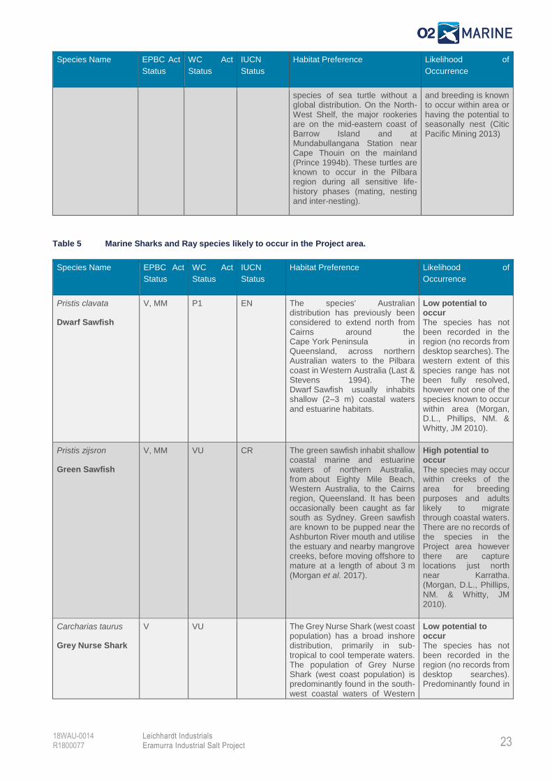
Table 5 Marine Sharks and Ray species likely to occur in the Project area.
Species Name EPBC Act
Status
WC Act
Status
IUCN
Status
Habitat Preference Likelihood of
Occurrence
Pristis clavata
Dwarf Sawfish
V, MM P1 EN The species' Australian distribution has previously been considered to extend north from Cairns around the Cape York Peninsula in Queensland, across northern Australian waters to the Pilbara coast in Western Australia (Last & Stevens 1994). The Dwarf Sawfish usually inhabits shallow (2–3 m) coastal waters
and estuarine habitats.
Low potential to occur The species has not been recorded in the region (no records from desktop searches). The western extent of this species range has not been fully resolved, however not one of the species known to occur within area (Morgan, D.L., Phillips, NM. & Whitty, JM 2010).
Pristis zijsron
Green Sawfish
V, MM VU CR The green sawfish inhabit shallow coastal marine and estuarine waters of northern Australia, from about Eighty Mile Beach, Western Australia, to the Cairns region, Queensland. It has been occasionally been caught as far south as Sydney. Green sawfish are known to be pupped near the Ashburton River mouth and utilise the estuary and nearby mangrove creeks, before moving offshore to mature at a length of about 3 m (Morgan et al. 2017).
High potential to occur The species may occur within creeks of the area for breeding purposes and adults likely to migrate through coastal waters. There are no records of the species in the Project area however there are capture locations just north near Karratha. (Morgan, D.L., Phillips, NM. & Whitty, JM 2010).
Carcharias taurus
Grey Nurse Shark
V VU The Grey Nurse Shark (west coast population) has a broad inshore distribution, primarily in sub-tropical to cool temperate waters. The population of Grey Nurse Shark (west coast population) is predominantly found in the south-west coastal waters of Western
Low potential to occur The species has not been recorded in the region (no records from desktop searches). Predominantly found in
24
Leichhardt Industrials Eramurra Industrial Salt Project
18WAU-0014 R1800077
Species Name EPBC Act
Status
WC Act
Status
IUCN
Status
Habitat Preference Likelihood of
Occurrence
Australia and has been recorded as far north as the North West
Shelf (Last & Stevens 1994).
cooler coastal waters further south.
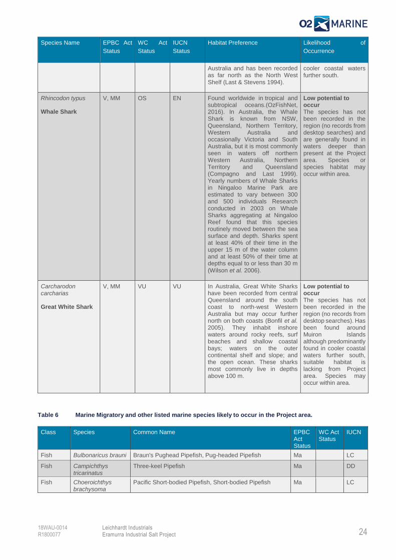
Rhincodon typus
Whale Shark
V, MM OS EN Found worldwide in tropical and subtropical oceans.(OzFishNet, 2016). In Australia, the Whale Shark is known from NSW, Queensland, Northern Territory, Western Australia and occasionally Victoria and South Australia, but it is most commonly seen in waters off northern Western Australia, Northern Territory and Queensland (Compagno and Last 1999). Yearly numbers of Whale Sharks in Ningaloo Marine Park are estimated to vary between 300 and 500 individuals Research conducted in 2003 on Whale Sharks aggregating at Ningaloo Reef found that this species routinely moved between the sea surface and depth. Sharks spent at least 40% of their time in the upper 15 m of the water column and at least 50% of their time at depths equal to or less than 30 m
(Wilson et al. 2006).
Low potential to occur The species has not been recorded in the region (no records from desktop searches) and are generally found in waters deeper than present at the Project area. Species or species habitat may occur within area.
Carcharodon carcharias
Great White Shark
V, MM VU VU In Australia, Great White Sharks have been recorded from central Queensland around the south coast to north-west Western Australia but may occur further north on both coasts (Bonfil et al. 2005). They inhabit inshore waters around rocky reefs, surf beaches and shallow coastal bays; waters on the outer continental shelf and slope; and the open ocean. These sharks most commonly live in depths above 100 m.
Low potential to occur The species has not been recorded in the region (no records from desktop searches). Has been found around Muiron Islands although predominantly found in cooler coastal waters further south, suitable habitat is lacking from Project area. Species may occur within area.
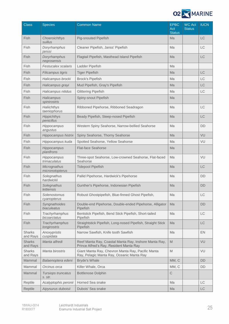
Table 6 Marine Migratory and other listed marine species likely to occur in the Project area.
Class Species Common Name EPBC Act Status
WC Act Status
IUCN
Fish Bulbonaricus brauni Braun's Pughead Pipefish, Pug-headed Pipefish Ma LC
Fish Campichthys tricarinatus
Three-keel Pipefish Ma DD
Fish Choeroichthys brachysoma
Pacific Short-bodied Pipefish, Short-bodied Pipefish Ma LC
25
Leichhardt Industrials Eramurra Industrial Salt Project
18WAU-0014 R1800077
Class Species Common Name EPBC Act Status
WC Act Status
IUCN
Fish Choeroichthys suillus
Pig-snouted Pipefish Ma LC
Fish Doryrhamphus janssi
Cleaner Pipefish, Janss' Pipefish Ma LC
Fish Doryrhamphus negrosensis
Flagtail Pipefish, Masthead Island Pipefish Ma LC
Fish Festucalex scalaris Ladder Pipefish Ma
Fish Filicampus tigris Tiger Pipefish Ma LC
Fish Halicampus brocki Brock's Pipefish Ma LC
Fish Halicampus grayi Mud Pipefish, Gray's Pipefish Ma LC
Fish Halicampus nitidus Glittering Pipefish Ma LC
Fish Halicampus spinirostris
Spiny-snout Pipefish Ma
Fish Haliichthys taeniophorus
Ribboned Pipehorse, Ribboned Seadragon Ma LC
Fish Hippichthys penicillus
Beady Pipefish, Steep-nosed Pipefish Ma LC
Fish Hippocampus angustus
Western Spiny Seahorse, Narrow-bellied Seahorse Ma DD
Fish Hippocampus histrix Spiny Seahorse, Thorny Seahorse Ma VU
Fish Hippocampus kuda Spotted Seahorse, Yellow Seahorse Ma VU
Fish Hippocampus planifrons
Flat-face Seahorse Ma
Fish Hippocampus trimaculatus
Three-spot Seahorse, Low-crowned Seahorse, Flat-faced Seahorse
Ma VU
Fish Micrognathus micronotopterus
Tidepool Pipefish Ma LC
Fish Solegnathus hardwickii
Pallid Pipehorse, Hardwick's Pipehorse Ma DD
Fish Solegnathus lettiensis
Gunther's Pipehorse, Indonesian Pipefish Ma DD
Fish Solenostomus cyanopterus
Robust Ghostpipefish, Blue-finned Ghost Pipefish, Ma LC
Fish Syngnathoides biaculeatus
Double-end Pipehorse, Double-ended Pipehorse, Alligator Pipefish
Ma DD
Fish Trachyrhamphus bicoarctatus
Bentstick Pipefish, Bend Stick Pipefish, Short-tailed Pipefish
Ma LC
Fish Trachyrhamphus longirostris
Straightstick Pipefish, Long-nosed Pipefish, Straight Stick Pipefish
Ma LC
Sharks and Rays
Anoxypristis cuspidata
Narrow Sawfish, Knife tooth Sawfish Ma EN
Sharks and Rays
Manta alfredi Reef Manta Ray, Coastal Manta Ray, Inshore Manta Ray, Prince Alfred’s Ray, Resident Manta Ray
M VU
Sharks and Rays
Manta birostris Giant Manta Ray, Chevron Manta Ray, Pacific Manta Ray, Pelagic Manta Ray, Oceanic Manta Ray
M VU
Mammal Balaenoptera edeni Bryde's Whale MM, C DD
Mammal Orcinus orca Killer Whale, Orca MM, C DD
Mammal Tursiops truncatus s. str.
Bottlenose Dolphin C
Reptile Acalyptophis peronii Horned Sea snake Ma LC
Reptile Aipysurus duboisii Dubois' Sea snake Ma LC
26
Leichhardt Industrials Eramurra Industrial Salt Project
18WAU-0014 R1800077
Class Species Common Name EPBC Act Status
WC Act Status
IUCN
Reptile Aipysurus eydouxii Spine-tailed Sea snake Ma LC
Reptile Aipysurus laevis Olive Sea snake Ma LC
Reptile Aipysurus tenuis Brown-lined Sea snake M
Reptile Astrotia stokesii Stokes' Seasnake Ma LC
Reptile Disteria kingii Spectacled Seasnake M
Reptile Disteria major Olive-headed Seasnake M
Reptile Emydocephalus annulatus
Turtle-headed Seasnake M LC
Reptile Ephalophis greyi North-western Mangrove Seasnake Ma
Reptile Hydrelaps darwiniensis
Black-ringed Seasnake Ma LC
Reptile Hydrophis elegans Elegant Seasnake Ma LC
Reptile Hydrophis macdowelli
Small headed Seasnake Ma LC
Reptile Hydrophis ornatus Spotted Seasnake, Ornate Reef Seasnake Ma LC
Reptile Pelamis platurus Yellow-bellied Seasnake Ma
27
Leichhardt Industrials Eramurra Industrial Salt Project
18WAU-0014 R1800077
3. Marine Environmental Reconnaissance Survey
Survey Objectives
O2 Marine undertook a three-day reconnaissance field survey of the marine portion of the Project area
to:
Validate (to the extent possible in a brief survey) the findings of the desktop review,
specifically in relation to BCH and available marine fauna habitat;
Identify potential seawater intake locations;
Identify any potential impacts associated with marine aspects of the Project which may be
considered environmentally unacceptable by regulatory authorities; and
Record incidental observations of any conservation significant marine fauna observed onsite.
Survey Methods
The reconnaissance survey was undertaken by two suitably qualified marine scientists between the
23rd to 25th July 2018. The survey included targeted towed video transects of subtidal BCH areas and
Unmanned Aerial Survey (UAV) of intertidal BCH areas, to evaluate and identify options for positioning
of proposed Project marine infrastructure.
Incidental marine fauna observations were also made throughout the survey.
Towed Video Survey
Sixty (60) 50 m long towed video transects were undertaken to evaluate the subtidal BCH in relation to
the proposed subsea pipeline route and Port infrastructure and to identify potential seawater intake
locations.
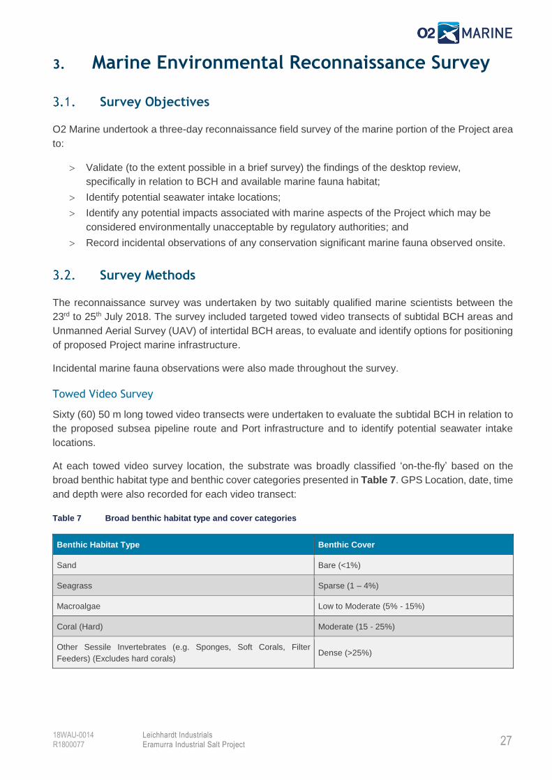
At each towed video survey location, the substrate was broadly classified ‘on-the-fly’ based on the
broad benthic habitat type and benthic cover categories presented in Table 7. GPS Location, date, time
and depth were also recorded for each video transect:
Table 7 Broad benthic habitat type and cover categories
Benthic Habitat Type Benthic Cover
Sand Bare (<1%)
Seagrass Sparse (1 – 4%)
Macroalgae Low to Moderate (5% - 15%)
Coral (Hard) Moderate (15 - 25%)
Other Sessile Invertebrates (e.g. Sponges, Soft Corals, Filter
Feeders) (Excludes hard corals) Dense (>25%)
28
Leichhardt Industrials Eramurra Industrial Salt Project
18WAU-0014 R1800077
Aerial Survey
A UAV survey was undertaken at three (3) locations as a rapid assessment tool to broadly identify
intertidal habitats of the Project area. At each location, the UAV was flown in a North, South, East and
West direction over a distance of approximately 0.75 – 1 km.
Video and still images were captured during each flight and these were reviewed to identify the location
and extent of key intertidal BCH present within the Project area.
Survey Findings
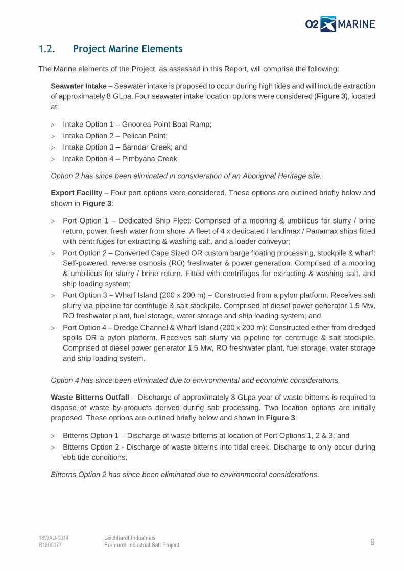
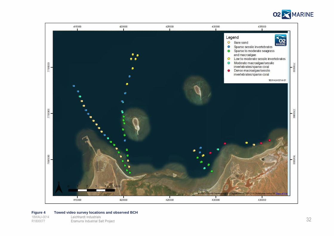
3.3.1. Towed Video Survey
The towed video survey results are presented in Figure 4. Towed video survey data was collected at
60 locations and six (6) broad habitat classes were identified during the survey and these are described
in Table 8.
During the survey, several key observations were made regarding the proposed Project infrastructure,
including:
Cover of BCH was generally Bare to Sparse along both proposed pipeline routes, with the
western pipe route supporting the least value BCH;
No significant BCH (i.e. high cover coral or seagrass communities), that have previously been
recorded in the Cape Preston region were observed in any of the Proposed Project infrastructure
areas;
The shallow limestone reef on the western edge of Southwest Regnard Island was identified to
support a ‘Moderate Macroalgae, Sessile Invertebrates & Sparse Coral’ assemblage, which
could be easily avoided by shifting the pipeline route approximately 500 m west;
The reef located adjacent to 40 Mile Beach was found to support a dense macroalgal
community, which is not proposed to be impacted; and
The sandy areas west of Gnoorea Point were found to support large areas of patchy seagrass
(Halophila sp.) and although it was mostly sparse, the species observed are ephemeral and it
is likely that this area would support dense seagrass meadows during certain times of the year.
Dugong’s were also observed to be feeding in these areas during the survey.
3.3.2. Incidental Marine Fauna Observations
Observations of marine fauna were made throughout the video survey. Key observations include:
Dugong (Dugong dugong) were observed on three occasions in the vicinity of the patchy
seagrass areas, located approximately 2 km west of Gnoorea Point;
One Dugong (Dugong dugong) was also observed approximately 4 km East of Gnoorea Point;
and
Two Flatback Turtles (Natator depressus) were observed in the vicinity of the offshore
anchorage area.
29
Leichhardt Industrials Eramurra Industrial Salt Project
18WAU-0014 R1800077
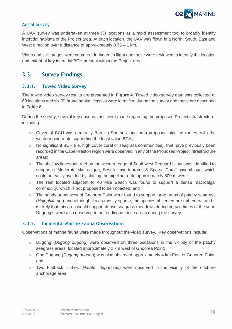
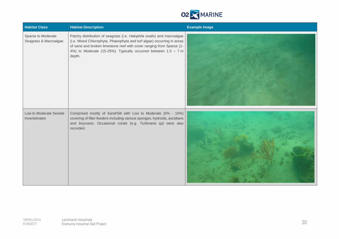
Table 8 Description of broad subtidal BCH classes observed during the towed video survey
Habitat Class Habitat Description Example Image
Bare Sand Typically comprises of silt or sand with no or occasional very sparse
covering of fine algal matting. Silt areas often comprised of bioturbation
(burrows formed by living organisms). Sand areas are often rippled and
contain traces of shell grit or coral rubble. Majority of bare sand areas
located inshore and along the western transect, which crosses a large
sand bar area.
Sparse Sessile
Invertebrates
Comprised mostly of Sand/Silt with sparse (1-4%) covering of filter
feeders including various sponges, hydroids, ascidians and bryzoans.
30
Leichhardt Industrials Eramurra Industrial Salt Project
18WAU-0014 R1800077
Habitat Class Habitat Description Example Image
Sparse to Moderate
Seagrass & Macroalgae
Patchy distribution of seagrass (i.e. Halophila ovalis) and macroalgae
(i.e. Mixed Chlorophyta, Phaeophyta and turf algae) occurring in areas
of sand and broken limestone reef with cover ranging from Sparse (1-
4%) to Moderate (15-25%). Typically occurred between 1.5 – 7 m
depth.
Low to Moderate Sessile
Invertebrates
Comprised mostly of Sand/Silt with Low to Moderate (5% - 15%)
covering of filter feeders including various sponges, hydroids, ascidians
and bryzoans. Occasional corals (e.g. Turbinaria sp) were also
recorded.
31
Leichhardt Industrials Eramurra Industrial Salt Project
18WAU-0014 R1800077
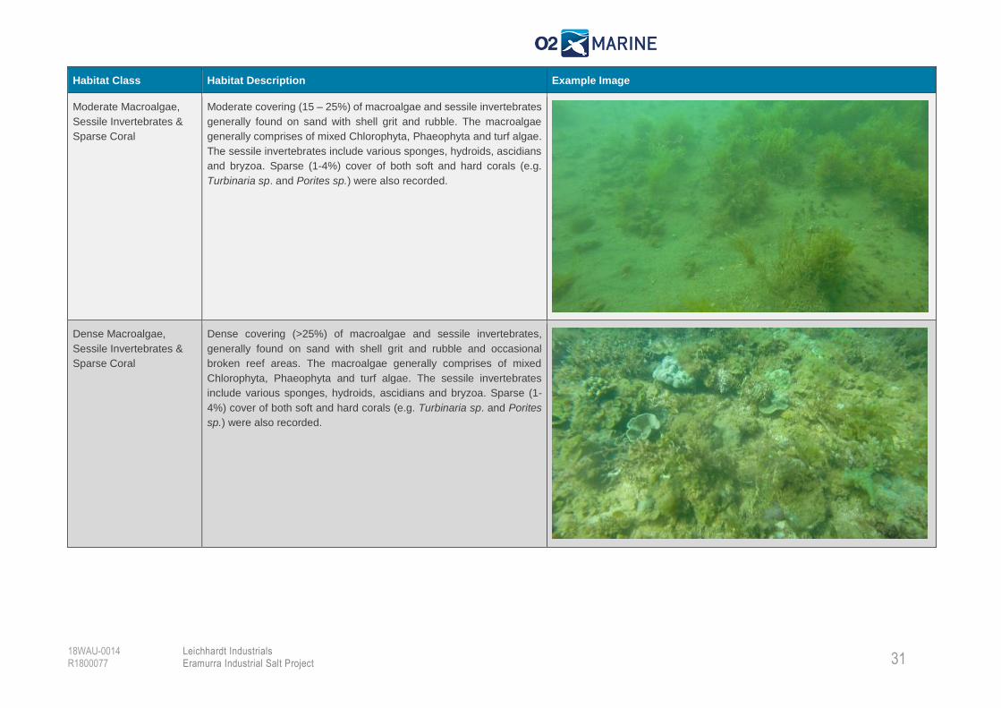
Habitat Class Habitat Description Example Image
Moderate Macroalgae,
Sessile Invertebrates &
Sparse Coral
Moderate covering (15 – 25%) of macroalgae and sessile invertebrates
generally found on sand with shell grit and rubble. The macroalgae
generally comprises of mixed Chlorophyta, Phaeophyta and turf algae.
The sessile invertebrates include various sponges, hydroids, ascidians
and bryzoa. Sparse (1-4%) cover of both soft and hard corals (e.g.
Turbinaria sp. and Porites sp.) were also recorded.
Dense Macroalgae,
Sessile Invertebrates &
Sparse Coral
Dense covering (>25%) of macroalgae and sessile invertebrates,
generally found on sand with shell grit and rubble and occasional
broken reef areas. The macroalgae generally comprises of mixed
Chlorophyta, Phaeophyta and turf algae. The sessile invertebrates
include various sponges, hydroids, ascidians and bryzoa. Sparse (1-
4%) cover of both soft and hard corals (e.g. Turbinaria sp. and Porites
sp.) were also recorded.
32
Leichhardt Industrials Eramurra Industrial Salt Project
18WAU-0014 R1800077
Figure 4 Towed video survey locations and observed BCH
33
Leichhardt Industrials Eramurra Industrial Salt Project
18WAU-0014 R1800077
3.3.3. Aerial & Beach Walk Survey
Aerial survey data (still/video images) was collected at three (3) locations and five broad intertidal
habitat classes were identified during the survey. These intertidal habitat classes are described in Table
9.
During the survey, several key observations were made regarding the proposed Project infrastructure,
including:
Beaches located to the east and west of Gnoorea Point and east of Cape Preston were all
identified to provide potential turtle nesting habitat;
Mangroves west of Gnoorea Point, within Eramurra Station were generally found to be in good
condition, with the exception of a 1-2 ha area that appeared to have been affected by dieback
with very high tree mortality observed; and
No significant algal mat areas were observed in the Project area, however, potential algal mat
BCH areas were only surveyed via UAV, therefore further ‘on ground’ validation in the supratidal
portion of the Project area is required.
34
Leichhardt Industrials Eramurra Industrial Salt Project
18WAU-0014 R1800077
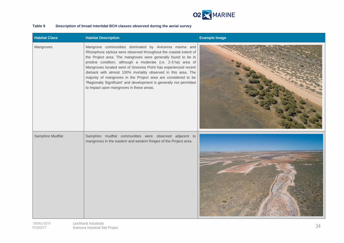
Table 9 Description of broad intertidal BCH classes observed during the aerial survey
Habitat Class Habitat Description Example Image
Mangroves Mangrove communities dominated by Avicenna marina and
Rhizophora stylosa were observed throughout the coastal extent of
the Project area. The mangroves were generally found to be in
pristine condition, although a moderate (i.e. 2-3 ha) area of
Mangroves located west of Gnoorea Point has experienced recent
dieback with almost 100% mortality observed in this area. The
majority of mangroves in the Project area are considered to be
‘Regionally Significant’ and development is generally not permitted
to impact upon mangroves in these areas.
Samphire Mudflat Samphire mudflat communities were observed adjacent to
mangroves in the eastern and western fringes of the Project area.
35
Leichhardt Industrials Eramurra Industrial Salt Project
18WAU-0014 R1800077
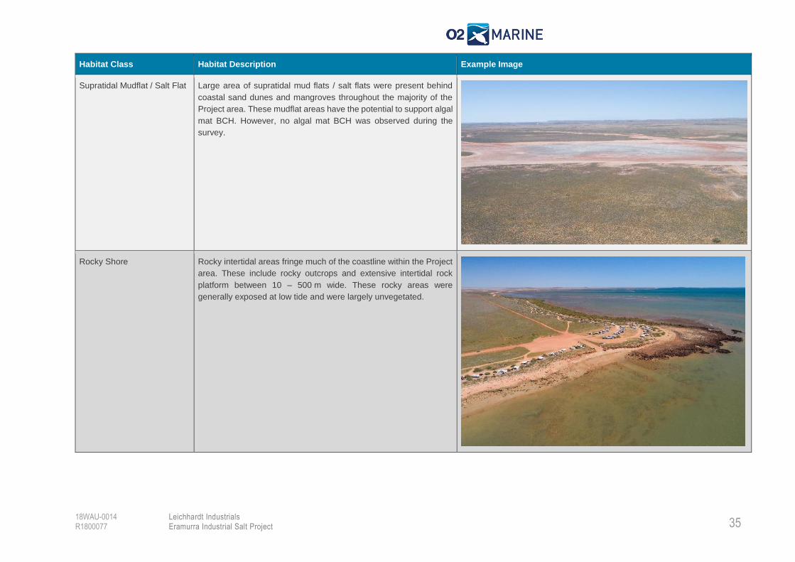
Habitat Class Habitat Description Example Image
Supratidal Mudflat / Salt Flat Large area of supratidal mud flats / salt flats were present behind
coastal sand dunes and mangroves throughout the majority of the
Project area. These mudflat areas have the potential to support algal
mat BCH. However, no algal mat BCH was observed during the
survey.
Rocky Shore Rocky intertidal areas fringe much of the coastline within the Project
area. These include rocky outcrops and extensive intertidal rock
platform between 10 – 500 m wide. These rocky areas were
generally exposed at low tide and were largely unvegetated.
36
Leichhardt Industrials Eramurra Industrial Salt Project
18WAU-0014 R1800077
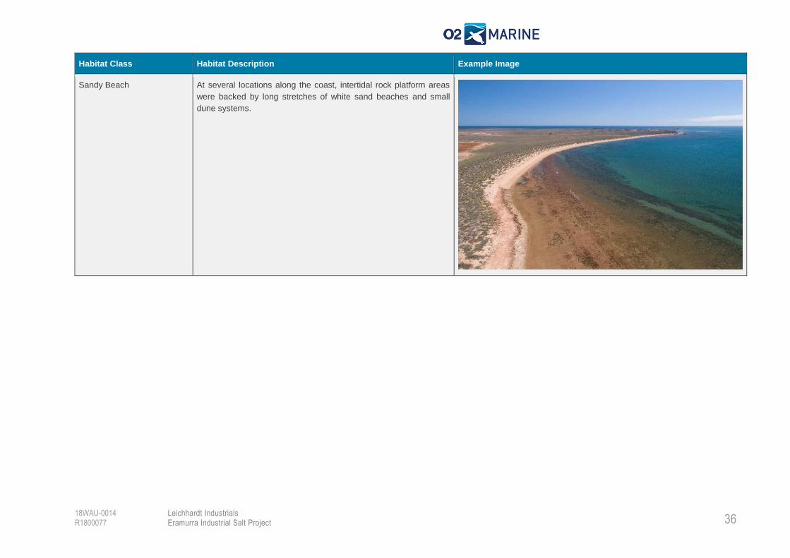
Habitat Class Habitat Description Example Image
Sandy Beach At several locations along the coast, intertidal rock platform areas
were backed by long stretches of white sand beaches and small
dune systems.
37
Leichhardt Industrials Eramurra Industrial Salt Project
18WAU-0014 R1800077
4. Environmental Factors (Sea Theme)
The West Australian Environmental Protection Authority (EPA) uses ‘Environmental Factors’ as the
basis for assessing whether the Project’s impact on the environment is acceptable. Environmental
factors are those elements of the environment that may be impacted by an aspect of the Project. They
provide a systematic approach to organising environmental information for the purpose of
environmental impact assessment (EIA). The EPA has identified an ‘Environmental Objective’ for each
environmental factor and will make judgement on whether the impact of a proposal may be significant.
Preliminary Environmental Factors
The ‘Sea’ themed Environmental Factors and associated Objectives are shown in Table 10 along with
a brief description of:
The Project activities that have the potential to impact on each of these environmental factors;
and
An evaluation of the risk of the Project activities compromising the EPA’s objective for each of
these factors.
This preliminary assessment forms the basis for identification of the environmental factors that have
the potential to be significantly impacted as a result of the Project activities. It also serves to identify
requirements for future targeted investigations in respect of the relevant key environmental factors.
It is noted that the preliminary impact assessment considers impacts associated with all Options
presented in Section 1.2.

38
Leichhardt Industrials Eramurra Industrial Salt Project
18WAU-0014 R1800077
Table 10 Preliminary Assessment Against ‘Sea Theme’ Environmental Factors
Environmental Factor Environmental Objective Existing Environment Relevant Project
Activities
Potential Impacts Preliminary Impact
Assessment
Targeted Investigations
Required
Benthic Communities and Habitats (BCH)
To protect BCH so that biological diversity and ecological integrity are maintained.
The Project area is known to support significant BCH areas, including dense seagrass meadows, regionally significant mangrove communities and high cover (>25%) coral reef communities.
Field survey of key Project infrastructure locations did not identify any significant subtidal BCH areas, although areas of sparse coral and sparse to moderate seagrass habitats were identified. It is noted that the sparse to moderate seagrass BCH may support denser meadows at certain times of year.
Aerial survey and intertidal walks found the Regionally Significant mangrove communities of the Project area to be in good condition, although some areas were dieback affected.
Pond construction.
Wharf construction.
Shoreline crossing/
subsea pipeline
installation.
Capital dredging (If
required), with onshore
spoil disposal.
Waste bitterns
discharge.
Brine dewatering
discharge.
Fuel storage and operation.
Other turbidity generating activities (i.e. trenching, drilling, rock armouring)
Direct removal or
disturbance of intertidal
and subtidal benthic
habitat.
Increased total
suspended solids (TSS)
(dredging impact) and
reduced light affecting
subtidal BCH.
Increased
sedimentation
(dredging impact)
affecting subtidal BCH.
Toxic waste bitterns
discharge affecting
BCH.
Accidental fuel spills to
water resulting in toxic
effects on BCH.
Introduction /
translocation of
Invasive Marine
Species (IMS).
Project infrastructure footprint
will be designed to avoid
and/or minimise direct impacts
on important BCH areas.
Indirect dredging and other
turbidity generating impacts
(i.e. increased TSS and
sedimentation) to subtidal BCH
areas are possible and will
require further assessment to
determine the extent severity
and duration of impacts.
However, with development
and implementation of an
appropriate Management Plan
dredging and other turbidity
generating impacts impacts
are expected to be
recoverable.
Impacts to BCH as a result of
discharging toxic waste
bitterns to the marine
environment are possible and
will require assessment.
However, it is considered that
with application of the EPA’s
Technical Guidance regarding
Marine Environmental Quality
and appropriate discharge site
selection, this potential impact
can be managed to meet the
BCH Mapping Validation
Study
BCH Baseline study
(Focussed on Dredging
and waste bitterns impact
areas)
Baseline Water Quality
Monitoring (Dredging,
Waste Bitterns & brine
dewatering Impacts)
Dredge Plume Modelling
Study (Dredging Impacts
Only)
Targeted Mangrove
Study
Surface Water Modelling
Study (Intertidal BCH
Impacts)
Groundwater Modelling
Study (Intertidal Impacts)
39
Leichhardt Industrials Eramurra Industrial Salt Project
18WAU-0014 R1800077
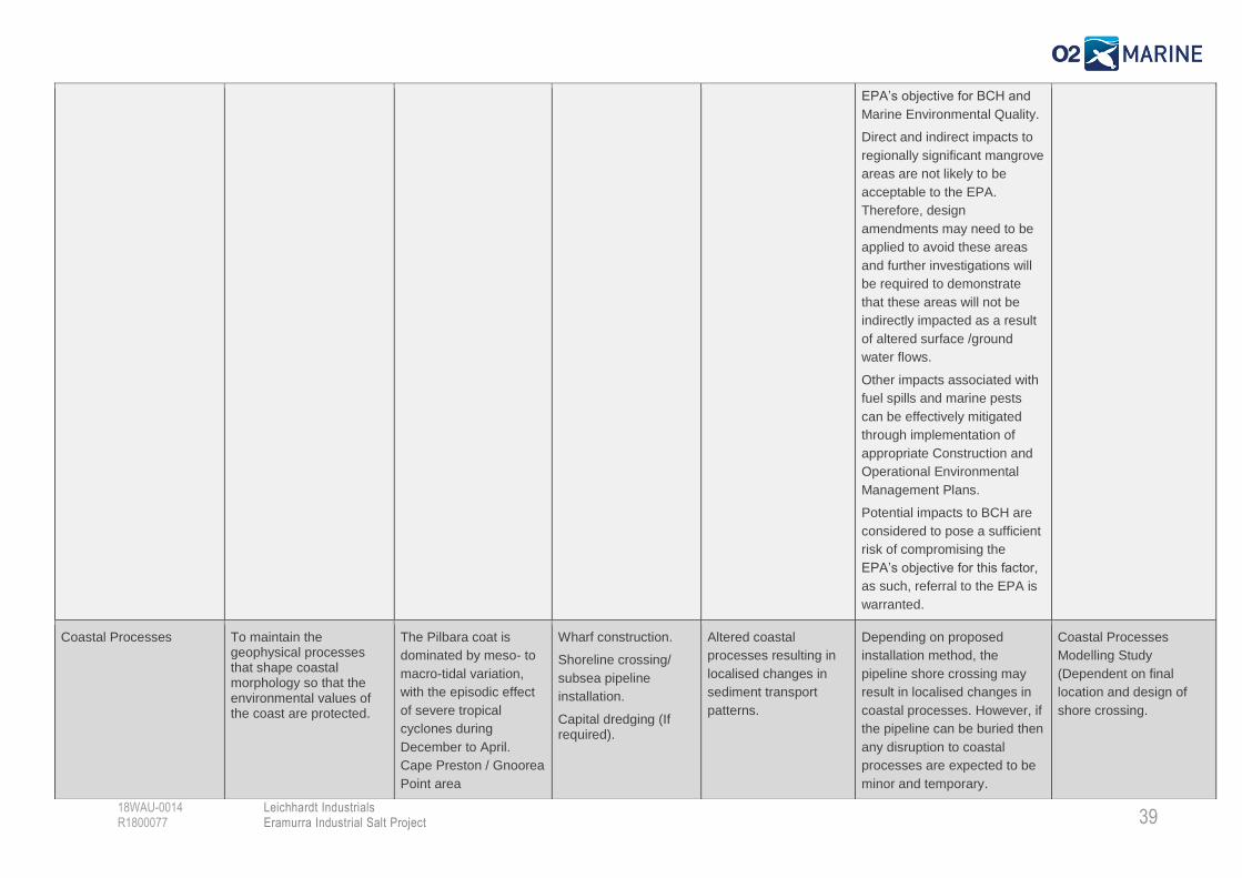
EPA’s objective for BCH and
Marine Environmental Quality.
Direct and indirect impacts to
regionally significant mangrove
areas are not likely to be
acceptable to the EPA.
Therefore, design
amendments may need to be
applied to avoid these areas
and further investigations will
be required to demonstrate
that these areas will not be
indirectly impacted as a result
of altered surface /ground
water flows.
Other impacts associated with
fuel spills and marine pests
can be effectively mitigated
through implementation of
appropriate Construction and
Operational Environmental
Management Plans.
Potential impacts to BCH are
considered to pose a sufficient
risk of compromising the
EPA’s objective for this factor,
as such, referral to the EPA is
warranted.
Coastal Processes To maintain the geophysical processes that shape coastal morphology so that the environmental values of the coast are protected.
The Pilbara coat is
dominated by meso- to
macro-tidal variation,
with the episodic effect
of severe tropical
cyclones during
December to April.
Cape Preston / Gnoorea
Point area
Wharf construction.
Shoreline crossing/
subsea pipeline
installation.
Capital dredging (If required).
Altered coastal
processes resulting in
localised changes in
sediment transport
patterns.
Depending on proposed
installation method, the
pipeline shore crossing may
result in localised changes in
coastal processes. However, if
the pipeline can be buried then
any disruption to coastal
processes are expected to be
minor and temporary.
Coastal Processes
Modelling Study
(Dependent on final
location and design of
shore crossing.
40
Leichhardt Industrials Eramurra Industrial Salt Project
18WAU-0014 R1800077
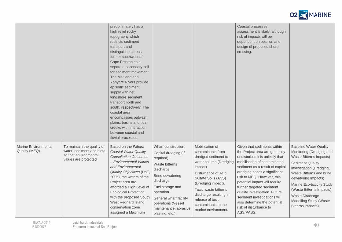
predominately has a
high relief rocky
topography which
restricts sediment
transport and
distinguishes areas
further southwest of
Cape Preston as a
separate secondary cell
for sediment movement.
The Maitland and
Yanyare Rivers provide
episodic sediment
supply with net
longshore sediment
transport north and
south, respectively. The
coastal area
encompasses outwash
plains, basins and tidal
creeks with interaction
between coastal and
fluvial processes.
Coastal processes
assessment is likely, although
risk of impacts will be
dependent on position and
design of proposed shore
crossing.
Marine Environmental Quality (MEQ)
To maintain the quality of water, sediment and biota so that environmental values are protected
Based on the Pilbara
Coastal Water Quality
Consultation Outcomes
– Environmental Values
and Environmental
Quality Objectives (DoE,
2006), the waters of the
Project area are
afforded a High Level of
Ecological Protection,
with the proposed South
West Regnard Island
conservation zone
assigned a Maximum
Wharf construction.
Capital dredging (If
required).
Waste bitterns
discharge.
Brine dewatering
discharge.
Fuel storage and
operation.
General wharf facility
operations (Vessel
maintenance, abrasive
blasting, etc.).
Mobilisation of
contaminants from
dredged sediment to
water column (Dredging
impact).
Disturbance of Acid
Sulfate Soils (ASS)
(Dredging impact).
Toxic waste bitterns
discharge resulting in
release of toxic
contaminants to the
marine environment.
Given that sediments within
the Project area are generally
undisturbed it is unlikely that
mobilisation of contaminated
sediment as a result of capital
dredging poses a significant
risk to MEQ. However, this
potential impact will require
further targeted sediment
quality investigation. Future
sediment investigations will
also determine the potential
risk of disturbance to
ASS/PASS.
Baseline Water Quality
Monitoring (Dredging and
Waste Bitterns Impacts)
Sediment Quality
investigation (Dredging,
Waste Bitterns and brine
dewatering Impacts)
Marine Eco-toxicity Study
(Waste Bitterns Impacts)
Waste Discharge
Modelling Study (Waste
Bitterns Impacts)
41
Leichhardt Industrials Eramurra Industrial Salt Project
18WAU-0014 R1800077
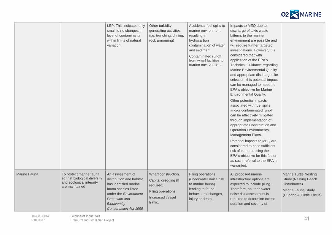
LEP. This indicates only
small to no changes in
level of contaminants
within limits of natural
variation.
Other turbidity
generating activities
(i.e. trenching, drilling,
rock armouring)
Accidental fuel spills to
marine environment
resulting in
hydrocarbon
contamination of water
and sediment.
Contaminated runoff from wharf facilities to marine environment.
Impacts to MEQ due to
discharge of toxic waste
bitterns to the marine
environment are possible and
will require further targeted
investigations. However, it is
considered that with
application of the EPA’s
Technical Guidance regarding
Marine Environmental Quality
and appropriate discharge site
selection, this potential impact
can be managed to meet the
EPA’s objective for Marine
Environmental Quality.
Other potential impacts
associated with fuel spills
and/or contaminated runoff
can be effectively mitigated
through implementation of
appropriate Construction and
Operation Environmental
Management Plans.
Potential impacts to MEQ are
considered to pose sufficient
risk of compromising the
EPA’s objective for this factor,
as such, referral to the EPA is
warranted.
Marine Fauna To protect marine fauna so that biological diversity and ecological integrity are maintained
An assessment of
distribution and habitat
has identified marine
fauna species listed
under the Environment
Protection and
Biodiversity
Conservation Act 1999
Wharf construction.
Capital dredging (If
required).
Piling operations.
Increased vessel
traffic.
Piling operations
(underwater noise risk
to marine fauna)
leading to fauna
behavioural changes,
injury or death.
All proposed marine
infrastructure options are
expected to include piling.
Therefore, an underwater
noise risk assessment is
required to determine extent,
duration and severity of
Marine Turtle Nesting
Study (Nesting Beach
Disturbance)
Marine Fauna Study
(Dugong & Turtle Focus)
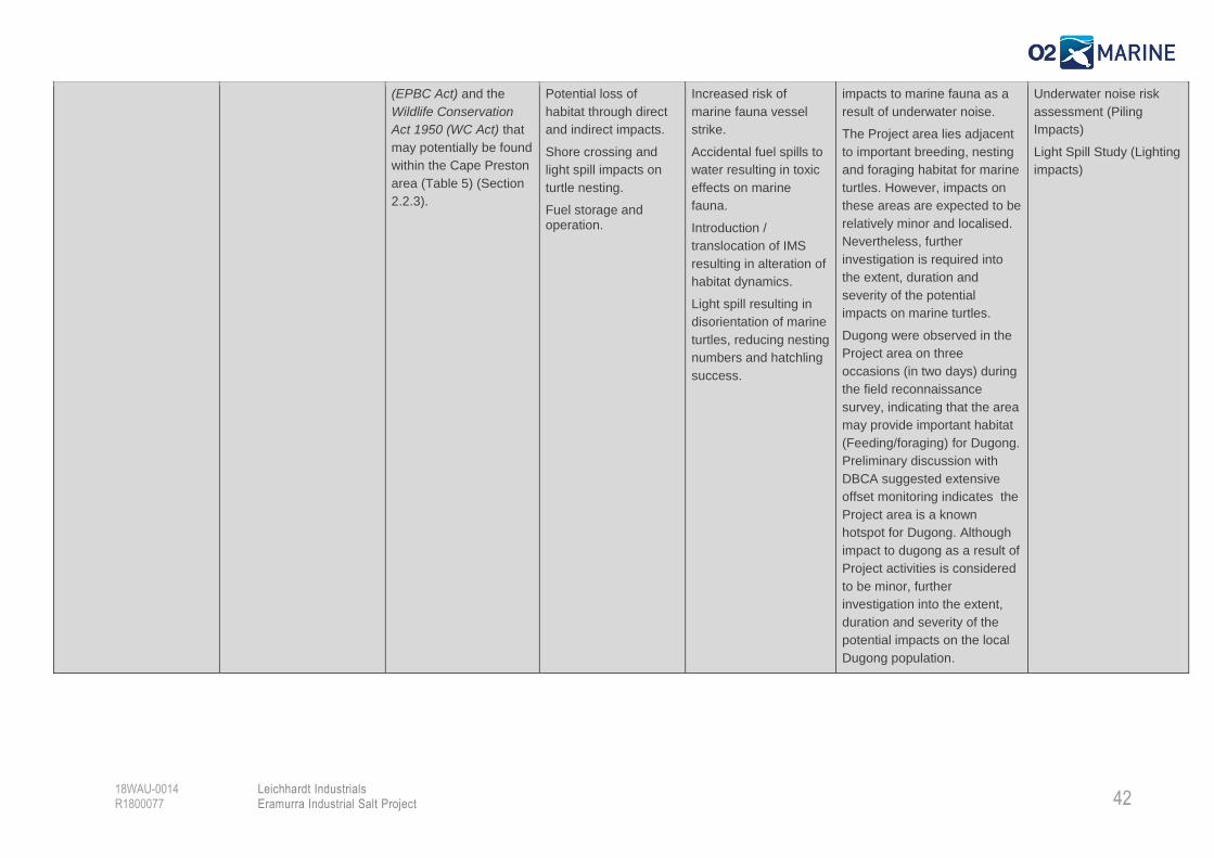
42
Leichhardt Industrials Eramurra Industrial Salt Project
18WAU-0014 R1800077
(EPBC Act) and the
Wildlife Conservation
Act 1950 (WC Act) that
may potentially be found
within the Cape Preston
area (Table 5) (Section
2.2.3).
Potential loss of
habitat through direct
and indirect impacts.
Shore crossing and
light spill impacts on
turtle nesting.
Fuel storage and operation.
Increased risk of
marine fauna vessel
strike.
Accidental fuel spills to
water resulting in toxic
effects on marine
fauna.
Introduction /
translocation of IMS
resulting in alteration of
habitat dynamics.
Light spill resulting in
disorientation of marine
turtles, reducing nesting
numbers and hatchling
success.
impacts to marine fauna as a
result of underwater noise.
The Project area lies adjacent
to important breeding, nesting
and foraging habitat for marine
turtles. However, impacts on
these areas are expected to be
relatively minor and localised.
Nevertheless, further
investigation is required into
the extent, duration and
severity of the potential
impacts on marine turtles.
Dugong were observed in the
Project area on three
occasions (in two days) during
the field reconnaissance
survey, indicating that the area
may provide important habitat
(Feeding/foraging) for Dugong.
Preliminary discussion with
DBCA suggested extensive
offset monitoring indicates the
Project area is a known
hotspot for Dugong. Although
impact to dugong as a result of
Project activities is considered
to be minor, further
investigation into the extent,
duration and severity of the
potential impacts on the local
Dugong population.
Underwater noise risk
assessment (Piling
Impacts)
Light Spill Study (Lighting
impacts)
43 Leichhardt Industrials Eramurra Industrial Salt Project
18WAU-0014 R1800077
5. Key Findings & Recommendations
Conclusions
5.1.1. Features of Conservation Significance
Commonwealth Legislation
Several Commonwealth species of conservation significance were identified as being at risk as a result
of the proposed Project activities. These included 12 protected marine species and 19 marine migratory
species that may occur in the Project area. The protected marine species include five marine reptiles
(four turtles and one sea snake); four elasmobranch fish (two sawfish and two sharks); and two marine
mammals (two whales).
No other Commonwealth features of conservation significance were considered to be at risk as a result
of the proposed Project activities.
A likelihood of occurrence assessment determined that several of these species have the potential to
be significantly impacted as a result of the proposed Project activities, therefore referral of the Project
in accordance with the EPBC act is considered to be warranted.
State Legislation
The following features of conservation significance, protected through State Legislation were identified
during desktop review:
The Project area is located within and adjacent to the Proposed Regnard Marine Management
Area (RMMA) which although not currently a gazetted management area, ongoing stakeholder
consultation with DBCA will be undertaken during development planning;
The Project area is located adjacent to the Pilbara Inshore Islands Nature Reserve, although
impacts on this reserve are unlikely, ongoing stakeholder consultation with DBCA will be
undertaken during development planning;
The Project area intersects the Cape Preston Regionally Significant Mangrove Area and is
adjacent to the Maitland River Regionally Significant Mangrove Area. Impacts in these areas
are typically not permitted and should be avoided wherever possible;
Naturemap database search identified 16 listed threatened marine species protected under the
BC Act.
5.1.2. Key Environmental Factors
Desktop review, reconnaissance survey and preliminary EIA identified three marine environmental
factors as potentially being at risk of significant impact as a result of the proposed Project activities.
Potential impacts on the following key environmental factors therefore warrant referral to the EPA:
Benthic Communities & Habitat;
Marine Environmental Quality;
Coastal Processes; and
44 Leichhardt Industrials Eramurra Industrial Salt Project
18WAU-0014 R1800077
Marine Fauna.
Key activities / impacts posing a significant threat to these key environmental factors included:
Pipeline installation;
Dewatering brine;
Waste bitterns discharge;
Direct habitat removal;
Piling; and
Light spill.
Impacts associated with dredging for Port Option 4 were considered but have subsequently been
removed from further consideration.
All activities / impacts could potentially be managed / mitigated. However, recommendations are made
below regarding design amendments that should be considered to reduce the extent, duration and
severity of potential impacts on the key environmental factors. Further recommendations are also made
regarding the targeted investigations required to understand the extent, duration and severity of
potential impacts.
Recommendations
O2 Marine has provided several key recommendations regarding:
Design amendments that could be considered to reduce project impacts;
Stakeholders that should be consulted once the final design of the Project is confirmed; and
Marine environmental investigations that are likely to be required to inform the EIA and
approvals for the Project.
These key recommendations are provided below.
Design Considerations
1. Seawater Intake Options – All seawater intake options are considered acceptable from a
marine environmental impact perspective. However, O2 Marine understands Option 2 has since
been eliminated in consideration of an Aboriginal Heritage site. The following O2 Marine
recommendations should be considered when selecting the appropriate seawater intake option:
a. Avoid direct impacts to BCH, either intertidal or subtidal;
b. Undertake tidal inundation modelling study for the two creek intake options (i.e. 3 & 4)
to determine if these options are acceptable.
2. Export Facilities - Port Option 4 (Refer Section 1.2), which involves dredging and potentially
construction of a wharf island using dredge spoil, will result in significant impacts on subtidal
BCH. Furthermore, it is likely that these impacts would extend to include regionally significant
coral communities found nearby to Southwest Regnard Island.
45 Leichhardt Industrials Eramurra Industrial Salt Project
18WAU-0014 R1800077
It is further noted that construction of a dredge channel in this area is likely to be considerably
more costly than extension of the already proposed subsea pipeline and construction of the
wharf island as a piled structure at the end of the proposed dredge channel, rather than in the
proposed location.
Therefore, under recommendations provided from O2 Marine, Port Option 4 has been removed
from further consideration as this option is the most environmentally unacceptable option and
the least likely to receive approval, particularly considering the more environmentally acceptable
alternatives that are currently being considered.
3. Water Bitterns Outfall - Proposed waste bitterns outfall Option 2 is located within a tidal creek
in a regionally significant mangrove area. This option is considered to pose a significant risk to
BCH (Mangroves) and marine fauna. It is noted that the EPA (2001) guidance recommends that
no development should take place that would significantly reduce the mangrove habitat or
ecological function of the mangroves in these areas. Therefore, under recommendations
provided from O2 Marine, Option 2 has been reconsidered as the EPA may take a presumption
that any impacts in this area represent an environmentally unacceptable outcome.
In addition, O2 Marine recommends that, where possible, the waste bitterns outfall should be
located in an area where maximum mixing occurs to ensure that bitterns are adequately mixed
within the smallest possible distance of the outfall. The typically approved mixing zone afforded
a low LEP is 70 m from the diffuser.
O2 Marine considers that Bitterns outfall Option 1, which is located at the proposed export facility
represents the most environmentally acceptable option as this will result in the least risk of
causing significant environmental impact.
4. Concentrator Ponds – Positioning of concentrator ponds (and any other intertidal
infrastructure) should avoid all mangroves within the EPA (2001) designated ‘Regionally
Significant’ mangrove areas (i.e. Cape Preston and Maitland River Delta). It is noted that
significant modifications to the project design have already been made to minimise direct
impacts to mangrove areas. However, in order to demonstrate that the combined direct and
indirect impacts from the development will not significantly reduce the mangrove habitat or
ecological function of the mangroves in these areas, the EPA recommends that the proponent
should:
a. Demonstrate a significant understanding of the mangrove systems, in terms of habitats,
dependent habitats and ecological functions, which are likely to be affected if
development is implemented;
b. Use the above understanding to evaluate how the mangrove system would be affected
and the environmental significance of any such impacts, including cumulative impacts;
c. Demonstrate that the proposed development adopts good engineering design and 'best
practice' processes for minimising potential environmental impacts and maintains the
ecological function and overall biological value and environmental quality of the area;
and
d. Demonstrate that all feasible and prudent alternative (industry siting) to impacting
detrimentally on mangroves have been considered.

46 Leichhardt Industrials Eramurra Industrial Salt Project
18WAU-0014 R1800077
5. Pipeline Installation – Whilst the risk of impacts to coastal processes is not high and the
potential pipeline route can be easily designed to avoid sensitive intertidal and subtidal BCH
environments, O2 Marine recommend considerations will need to be provided for selecting an
appropriate route, installation technique and management option to minimise safety,
environmental and economic risk to the Project. The absence of detail in an assessment will
likely raise a risk which should be relatively low due to not providing confidence to the EPA that
risks will be as they are predicted.
Stakeholder Consultation
6. Given the Project area lies within and adjacent to the proposed Regnard Marine Management
Area and adjacent to the Pilbara Inshore Islands Nature Reserve, under recommendations
provided from O2 Marine preliminary Project consultation with DBCA was held on Thursday 1st
November. O2 Marine recommends that ongoing consultation with DBCA is undertaken once
project activities are confirmed and potential impacts are understood. Consultation with DBCA
throughout the EIA and approvals stages of the project is considered crucial to reduce
comments received during EIA public review periods.
Marine Environmental Investigations
7. The following marine environmental investigations are recommended to inform the EIA and
approvals for the project:
a. BCH mapping study;
b. BCH baseline study;
c. Targeted mangrove study;
d. Baseline water quality monitoring (physico-chemical and contaminant);
e. Targeted sediment quality investigation (contaminants and infauna);
f. Eco-toxicity testing of waste bitterns discharge;
g. Bitterns outfall modelling study;
h. Marine fauna study (focus on turtles and dugongs);
i. Marine turtle nesting study#;
j. Light spill study#;
k. Marine noise risk assessment;
l. Marine pest risk assessment; and
m. Construction environmental management plan.
^Dependent on pipeline installation and shoreline crossing method proposed. # Scope of study dependent on final design footprint.
47 Leichhardt Industrials Eramurra Industrial Salt Project
18WAU-0014 R1800077
6. References
Allen, S.J., Cagnazzi, D., Hodgson, A.J., Bejder, L. (2012). Tropical inshore dolphins of north-western
Australia: Unknown populations in a rapidly changing region. Article in Pacific Conservation
Biology. January 2012
ANZECC & ARMCANZ (2000). Australian and New Zealand guidelines for fresh and marine water
quality. National Water Quality Management Strategy No 4, Australian and New Zealand
Environment and Conservation Council and Agricultural and Resource Management Council of
Australia and New Zealand, Canberra, ACT.
Bamford M., D. Watkins, W. Bancroft, G. Tischler & J. Wahl (2008). Migratory Shorebirds of the East Asian - Australasian Flyway: Population estimates and internationally important sites. Canberra, ACT: Department of the Environment, Water, Heritage and the Arts, Wetlands International-Oceania. Available from: http://www.environment.gov.au/biodiversity/migratory/publications/shorebirds-east-asia.html.
Bannister, J.L., C.M. Kemper & R.M. Warneke (1996). The Action Plan for Australian Cetaceans. Canberra: Australian Nature Conservation Agency. Available from: http://www.environment.gov.au/resource/action-plan-australian-cetaceans.
Barrett, G., A. Silcocks, S. Barry, R. Poulter & R. Cunningham (2002b). Australian Bird Atlas 1998-2001 Main Report To Environment Australia. Melbourne: Birds Australia.
Barrett, G., A. Silcocks, S. Barry, R. Cunningham & R. Poulter (2003). The New Atlas of Australian Birds. Melbourne, Victoria: Birds Australia.
Begg. (1981). The Small Mammals of Little Nourlangie Rock, N.T III. Ecology of Dasyurus hallucatus, the Northern Quoll (Marsupialia : Dasyuridae). Wildlife Research, 8(1), 73-85.
Benson, S.R., T. Eguchi, D.G. Foley, K.A. Forney, H. Bailey, C. Hitipeuw, B.P. Samber, R.F. Tapilatu, V. Rei, P. Ramohia, J. Pita & P.H. Dutton (2011). Large-scale movements and high-use areas of western Pacific leatherback turtles, Dermochelys coriacea. Ecosphere. 2(7):art84.
BirdLife International. (2017). Sternula nereis in The IUCN Red List of Threatened Species 2017.
Retrieved May 15, 2017, from http://www.iucnredlist.org/details/22694691/0
BirdLife International. 2017. Numenius madagascariensis (amended version of 2016 assessment). The IUCN Red List of Threatened Species 2017: e.T22693199A118601473. http://dx.doi.org/10.2305/IUCN.UK.2017-3.RLTS.T22693199A118601473.en. Downloaded on 20 August 2018.
BirdLife International. 2016. Pezoporus occidentalis. The IUCN Red List of Threatened Species 2016: e.T22685237A93064947. http://dx.doi.org/10.2305/IUCN.UK.2016-3.RLTS.T22685237A93064947.en. Downloaded on 20 August 2018.
Blakers, M., S.J.J.F. Davies & P.N. Reilly (1984). The Atlas of Australian Birds. Melbourne, Victoria:
Melbourne University Press.
Bonfil, R., M. Meÿer, M.C. Scholl, R. Johnson, S. O'Brien, H. Oosthuizen, S. Swanson, D. Kotze & M. Paterson (2005). Transoceanic Migration, Spatial Dynamics, and Population Linkages of White Sharks. Science. 310:100 - 103. Available from: http://www.sciencemag.org/cgi/content/abstract/sci310/5745/100.

48 Leichhardt Industrials Eramurra Industrial Salt Project
18WAU-0014 R1800077
Braithwaite, R.W. & A.D. Griffiths (1994). Demographic variation and range contraction in the Northern Quoll, Dasyurus hallucatus (Marsupialia: Dasyuridae). Wildlife Research. 21:203-218.
Bruce, G.D., J.D. Stevens & H. Malcolm (2006). Movements and swimming behaviour of white sharks (Carcharodon carcharias) in Australian waters. Marine Biology. 150:161-172. Available from: http://web.ebscohost.com/ehost/pdfviewer/pdfviewer?vid=5&hid=15&sid=e92b4861-0c33-4972-81be-796819288dd2%40sessionmgr4.
Campey, ML & Gilmour, JP. (2000). Baseline survey of benthic marine communities of Cape Preston
and Preston Island. Perth. University of Western Australia.
Chatto, R. (2003). The distribution and status of shorebirds around the coast and coastal wetlands of
the Northern Territory. Darwin.
Citic Pacific Mining, (2013). SINO Iron project Operational Environmental Management Plan.
http://www.citicpacificmining.com/templates/OperationalEnvironmentalManagementPlan.pdf
Cogger, H. G. (2014). Reptiles & Amphibians of Australia (7th ed.). CSIRO Publishing.
Compagno, L.J.V. and P.R. Last, 1999. Pristidae. Sawfishes. p. 1410-1417. In K.E. Carpenter and V. Niem (eds.) FAO identification guide for fishery purposes. The Living Marine Resources of the Western Central Pacific. FAO, Rome. http://www.fao.org/docrep/009/w7191e/w7191e00.HTM
Corkeron, P.J. , N.M. Morisette, L. Porter & H. Marsh (1997). Distribution and status of Humpback Dolphins, Sousa chinensis, in Australian waters. Asian Marine Biology. 14:49-59Morgan1, D.L, Brendan C. Ebner1,2,3, Mark G. Allen1, Adrian C. Gleiss1, Stephen J. Beatty1, Jeff M. Whitty1. 2017. Habitat use and site fidelity of neonate and juvenile green sawfish Pristis zijsron in a nursery area in Western Australia. 1Freshwater Fish Group & Fish Health Unit, Centre for Fish & Fisheries Research, School of Veterinary and Life Sciences, Murdoch University, Murdoch, Western Australia. 2TropWATER, James Cook University, Queensland. 3CSIRO Land and Water, Queensland.
DEP & CSIRO (2002). North West Shelf Joint Environmental Study Interim Report. June 2002.
Department of Environmental Protection and Commonwealth Scientific and Industrial Research
Organisation (Marine Research) Perth, WA.
Department of Conservation and Land Management (CALM) (2005) Indicative Management Plan for
the proposed Dampier Archipelago Marine Park and Cape Preston Marine Management Area.
Department of Environment. (2006). Pilbara Coastal Water Quality Consultation Outcomes:
Environmental Values and Environmental Quality Objectives. Marine Report Series.
Department of Environment & Energy (DoEE) (2007) National Heritage List: The West Kimberley,
Western Australia. Accessed online (09th August 2018) at:
http://www.environment.gov.au/system/files/pages/d53ee213-2f1e-481e-b0f6-
85d861a52de2/files/national-heritage-dampier.pdf
DoEE (2015) Protected Matters Search Tool. Search conducted of Cape Preston region 15th August
2018 Accessed online: http://www.environment.gov.au/webgis-framework/apps/pmst/pmst.jsf
Department of Environment and Heritage (2005a). Issues paper for six species of marine turtles found in Australian waters that are listed as threatened under the Environment Protection and Biodiversity Conservation Act 1999. Commonwealth Department of Environment and Heritage:
49 Leichhardt Industrials Eramurra Industrial Salt Project
18WAU-0014 R1800077
Canberra. Available from: http://www.environment.gov.au/biodiversity/threatened/publications/recovery/marine-turtles/pubs/issues-paper.pdf. [Accessed: 02-Oct-2007].
DoE (2006). Background quality of the marine sediments of the Pilbara coast. Marine Report No. 1,
Department of Environment, Perth, WA.
DoE (2006). Pilbara coastal water quality consultation outcomes: Environmental Values and
Environmental Quality Objectives. Marine Report No. 1, Department of Environment, Perth, WA.
Department of the Environment, Water, Heritage and the Arts (DEWHA) (2008a). The South-West Marine Bioregional Plan: Bioregional Profile: A Description of the Ecosystems, Conservation Values and Uses of the South-West Marine Region. Canberra: DEWHA. Available from: http://www.environment.gov.au/resource/south-west-marine-bioregional-plan-bioregional-profile-description-ecosystems-conservation.
Department of Planning, Land and Heritage (DoPLH) (2018) Aboriginal Heritage Enquiry System.
Search conducted of Cape Preston region on 15th August 2018 Accessed online.
Department of the Prime Minister and Cabinet, Department of Communications, and CSIRO Data61
(2014-2017). National Map. Accessed online 15th August 2018.
https://nationalmap.gov.au/about.html
Eliot, I, Gozzard, B. Eliot, M. Stul, T. and McCormack G. (2013) Geology, Geomorphology &
Vulnerability of the Pilbara Coast, In the Shires of Ashburton, East Pilbara and Roebourne, and
the Town of Port Hedland, Western Australia. Damara WA Pty Ltd and Geological Survey of
Western Australia, Innaloo, Western Australia.
Environment Australia (EA) (2001f). NON-CURRENT National Recovery Plan for Albatrosses and Giant-Petrels 2001-2005. Canberra, ACT: Environment Australia. Available from: http://www.environment.gov.au/archive/biodiversity/threatened/publications/recovery/albatross/index.html. In effect under the EPBC Act from 15-Sep-2001.
GHD (2013). Cape Preston East Environmental Studies Marine Benthic Habitat Assessment Habitat Mapping. Report 61/28777/I prepared for Iron Ore Holdings Limited.
Hall, R. (1910b). The southern limit of Rostratula australis, Gould. Emu. 10:138.
Heritage Council (2018) Western Australian Heritage Database. Search conducted of Cape Preston
region on 15th August 2018 Accessed online.
http://www.environment.gov.au/heritage/ahc/publications/national-heritage-places-map
Higgins, P.J. & S.J.J.F. Davies, eds (1996). Handbook of Australian, New Zealand and Antarctic Birds. Volume Three - Snipe to Pigeons. Melbourne, Victoria: Oxford University Press.
Iron Ore Holdings LTD. (2013). Cape Preston Export Facilities Assessment or Proponent information. Perth. http://www.epa.wa.gov.au/sites/default/files/API_documents/1954-130410%20IOH%20API%20Document.pdf
Leatherwood, S. & R.R. Reeves (1983). The Sierra Club Handbook of Whales and Dolphins. San Francisco: Sierra Club Books.
Limpus, C.J. (1995a). Conservation of marine turtles in the Indo-Pacific region. Brisbane: Queensland Department of Environment and Heritage.
50 Leichhardt Industrials Eramurra Industrial Salt Project
18WAU-0014 R1800077
Marchant, S. & P.J. Higgins, eds. (1993). Handbook of Australian, New Zealand and Antarctic Birds.
Volume 2 - Raptors to Lapwings. Melbourne, Victoria: Oxford University Press.
McCosker, J.E. (1975). Feeding behaviour of Indo-Australian Hydrophiidae. In: Dunson, W. A., ed. The Biology of Sea Snakes. Page(s) 217-232. Baltimore: University Park Press.
Minton, C.D.T. (2002). Personal communication. Australasian Wader Studies Group.
Möller, L.M. & L.B. Beheregaray (2001). Coastal bottlenose dolphins from southeastern Australia are Tursiops aduncus according to sequences of the mitochondrial DNA control region. Marine Mammal Science. 17:249-263.
Molloy, S.W., Davis, R.A., Dunlop, J. and van Etten, E.J.B. (2015) Spatial Modelling for the Northern Quoll in the Pilbara: Informing the Management of a Unique and Isolated Population of an Endangered and Iconic Species. Edith Cowan University and Department of Parks and Wildlife, Western Australia.
Morgan, D.L., Phillips, NM. & Whitty, JM (2010). Endangered Sawfishes and River Sharks in Western Australia. Centre for Fish & Fisheries Research, Murdoch University, South St, Murdoch, Western Australia.
MPRSWG (1994). A Representative Marine Reserve System for Western Australia. Report of the Marine Parks and Reserves Selection Working Group. Department of Conservation and Land Management, Perth, Western Australia
Oakwood. (1997). The ecology of the northern quoll, Dasyurus hallucatus. ANU, Canberra.
Parra, G.J., A.R. Preen, P.J. Corkeron, C. Azuma & H. Marsh (2002a). Distribution of Irrawaddy dolphins, Orcaella brevirostris, in Australian waters. Raffles Bulletin of Zoology. 10:141-154.
Paterson, R.A. (1990). Effects of long-term anti-shark measures on target and non-target species in Queensland, Australia. Biological Conservation. 52:147-159.
Pendoley, K.L. (2005). Sea turtles and the environmental management of industrial activities in north-west Western Australia. Ph.D. Thesis. PhD Thesis, Murdoch University: Perth
Pollock. (1999). Notes on status, distribution and diet of Northern Quoll Dasyurus hallucatus in the Mackay-Bowen area, mideastern Queensland. Australian Zoologist, 31(2), 388-395.
Prince, R.I. (1994b). Status of the Western Australian marine turtle populations: the Western Australian Marine Turtle Project 1986-1990. In: Russell, J., ed. Proceedings of the Australian Marine Turtle Conservation Workshop, Gold Coast 14-17 November 1990. Page(s) 1-14. Queensland Department of Environment and Heritage. Canberra, ANCA
Reilly, S. B., Bannister, J. L., Best, P. B., Brown, M., Brownell Jr., R. L., Butterworth, D. S., … Zerbini, A. N. (2008). Balaenoptera musculus. The IUCN Red List of Threatened Species 2008: e.T2477A9447146. Retrieved from http://dx.doi.org/10.2305/IUCN.UK.2008.RLTS.T2477A9447146.en
Schmitt, Bradley, Kemper, Kitchener, Humphreys, & How. (1989). Ecology and physiology of the northern quoll, Dasyurus hallucatus (Marsupialia, Dasyuridae), at Mitchell Plateau, Kimberley, Western Australia. Journal of Zoology, 217(4), 539-558.
Stul, T., Gozzard, G.R., Eliot, I.G., and Eliot, M.J. (2014). Coastal Sediment Cells for the Pilbara Region between Giralia and Beebingarra Creek, Western Australia. Report prepared by Seashore Engineering Pty Ltd and Geological Survey of Western Australia for the Western Australian Department of Transport, Fremantle.
51 Leichhardt Industrials Eramurra Industrial Salt Project
18WAU-0014 R1800077
SWQMS (2004). Implementation Framework for Western Australia for the Australian and New Zealand
Guidelines for Fresh and Marine Water Quality and Water Quality Monitoring and Reporting
(Guidelines Nos. 4 & 7: National Water Quality Management Strategy). State Water Quality
Management Strategy Report No. 6, Government of Western Australia.
Threatened Species Scientific Committee (2005aq). NON-APPROVED Conservation Advice on Northern Quoll (Dasyurus hallucatus). Available from: http://www.environment.gov.au/biodiversity/threatened/species/dasyurus-hallucatus.html#conservation.
Wenziker K.J., McAlpine, K. W., Apte, S.C. and Masini, R.J. (in press). Background quality for coastal
marine waters of the North West Shelf, Western Australia. North West Shelf Joint Environmental
Management Study, CSIRO Marine Research, GPO Box 1538, Hobart Tasmania 7001.
Wilson, S.G., J.J. Polovina, B.S. Stewart & M.G. Meekan (2006). Movements of Whale Sharks (Rhincodon typus) tagged at Ningaloo Reef, Western Australia. Marine Biology. 148:1157-1166.
Wilson, J.R., Nebel, S. & Minton, C.D.T. (2007). Migration ecology and morphometries of two Bar-tailed Godwit populations in Australia, Emu – Austral Ornithology, 107:4, 262-274, DOI: 10.1071/MU07026.
Woehler, E.J., J. Cooper, J.P. Croxall, W.R. Fraser, G.L. Kooyman, G.D. Miller, D.C. Nel, D.L.
Patterson, H.U. Peter, C.A. Ribic, K. Salwicka , W.Z. Trivelpiece & H. Weimerskirch (2001). A
statistical assessment of the status and trends of Antarctic and subantarctic seabirds. Report on
SCAR BBS Workshop on Southern Ocean seabird populations. Scientific Committee for Antarctic
Research.
Woehler, E.J., M.J. Riddle & C.A. Ribic (in press). Long-term population trends in Southern Giant
Petrels in East Antarctica. In: Proceedings of Eighth SCAR Biology Symposium.

A Leichhardt Industrials Eramurra Industrial Salt Project
18WAU-0014 R1800077
Appendix A Database Searches
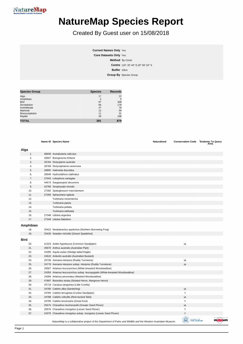
Page 1
NatureMap Species Report
Created By Guest user on 15/08/2018
Current Names Only Core Datasets Only
Method Centre Buffer
Group By
Yes Yes 'By Circle' 116° 20' 44'' E,20° 50' 24'' S 15km Species Group
Species Group Species Records Alga 17 22 Amphibian 2 5 Bird 97 308 Dicotyledon 66 178 Invertebrate 47 78 Mammal 12 59 Monocotyledon 11 31 Reptile 29 198 TOTAL 281 879
Name ID Species Name Naturalised Conservation Code 1Endemic To QueryArea
Alga1. 48409 Acetabularia caliculus
2. 26507 Boergesenia forbesii
3. 26764 Dictyopteris australis
4. 26769 Dictyosphaeria cavernosa
5. 26892 Halimeda discoidea
6. 26949 Hydroclathrus clathratus
7. 27043 Lobophora variegata
8. 44573 Sargassopsis decurrens
9. 42785 Sirophysalis trinodis
10. 27282 Spatoglossum macrodontum
11. 27293 Sphacelaria rigidula
12. Turbinaria mesenterina
13. Turbinaria patula
14. Turbinaria peltata
15. Turbinaria stellulata
16. 27348 Udotea argentea
17. 27349 Udotea flabellum
Amphibian18. 25422 Neobatrachus aquilonius (Northern Burrowing Frog)
19. 25430 Notaden nichollsi (Desert Spadefoot)
Bird20. 41323 Actitis hypoleucos (Common Sandpiper) IA
21. 25670 Anthus australis (Australian Pipit)
22. 24285 Aquila audax (Wedge-tailed Eagle)
23. 24610 Ardeotis australis (Australian Bustard)
24. 25736 Arenaria interpres (Ruddy Turnstone) IA
25. 24778 Arenaria interpres subsp. interpres (Ruddy Turnstone) IA
26. 25567 Artamus leucorynchus (White-breasted Woodswallow)
27. 24354 Artamus leucorynchus subsp. leucopygialis (White-breasted Woodswallow)
28. 24356 Artamus personatus (Masked Woodswallow)
29. 47897 Butorides striata (Striated Heron, Mangrove Heron)
30. 25716 Cacatua sanguinea (Little Corella)
31. 24780 Calidris alba (Sanderling) IA
32. 24784 Calidris ferruginea (Curlew Sandpiper) T
33. 24788 Calidris ruficollis (Red-necked Stint) IA
34. 24790 Calidris tenuirostris (Great Knot) T
35. 25575 Charadrius leschenaultii (Greater Sand Plover) IA
36. 25576 Charadrius mongolus (Lesser Sand Plover) T
37. 24375 Charadrius mongolus subsp. mongolus (Lesser Sand Plover) T
NatureMap is a collaborative project of the Department of Parks and Wildlife and the Western Australian Museum.
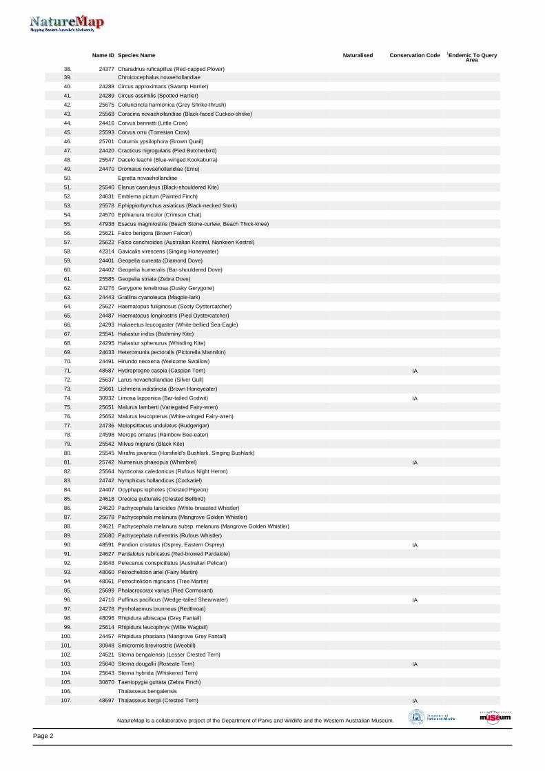
Page 2
Name ID Species Name Naturalised Conservation Code 1Endemic To QueryArea
38. 24377 Charadrius ruficapillus (Red-capped Plover)
39. Chroicocephalus novaehollandiae
40. 24288 Circus approximans (Swamp Harrier)
41. 24289 Circus assimilis (Spotted Harrier)
42. 25675 Colluricincla harmonica (Grey Shrike-thrush)
43. 25568 Coracina novaehollandiae (Black-faced Cuckoo-shrike)
44. 24416 Corvus bennetti (Little Crow)
45. 25593 Corvus orru (Torresian Crow)
46. 25701 Coturnix ypsilophora (Brown Quail)
47. 24420 Cracticus nigrogularis (Pied Butcherbird)
48. 25547 Dacelo leachii (Blue-winged Kookaburra)
49. 24470 Dromaius novaehollandiae (Emu)
50. Egretta novaehollandiae
51. 25540 Elanus caeruleus (Black-shouldered Kite)
52. 24631 Emblema pictum (Painted Finch)
53. 25578 Ephippiorhynchus asiaticus (Black-necked Stork)
54. 24570 Epthianura tricolor (Crimson Chat)
55. 47938 Esacus magnirostris (Beach Stone-curlew, Beach Thick-knee)
56. 25621 Falco berigora (Brown Falcon)
57. 25622 Falco cenchroides (Australian Kestrel, Nankeen Kestrel)
58. 42314 Gavicalis virescens (Singing Honeyeater)
59. 24401 Geopelia cuneata (Diamond Dove)
60. 24402 Geopelia humeralis (Bar-shouldered Dove)
61. 25585 Geopelia striata (Zebra Dove)
62. 24276 Gerygone tenebrosa (Dusky Gerygone)
63. 24443 Grallina cyanoleuca (Magpie-lark)
64. 25627 Haematopus fuliginosus (Sooty Oystercatcher)
65. 24487 Haematopus longirostris (Pied Oystercatcher)
66. 24293 Haliaeetus leucogaster (White-bellied Sea-Eagle)
67. 25541 Haliastur indus (Brahminy Kite)
68. 24295 Haliastur sphenurus (Whistling Kite)
69. 24633 Heteromunia pectoralis (Pictorella Mannikin)
70. 24491 Hirundo neoxena (Welcome Swallow)
71. 48587 Hydroprogne caspia (Caspian Tern) IA
72. 25637 Larus novaehollandiae (Silver Gull)
73. 25661 Lichmera indistincta (Brown Honeyeater)
74. 30932 Limosa lapponica (Bar-tailed Godwit) IA
75. 25651 Malurus lamberti (Variegated Fairy-wren)
76. 25652 Malurus leucopterus (White-winged Fairy-wren)
77. 24736 Melopsittacus undulatus (Budgerigar)
78. 24598 Merops ornatus (Rainbow Bee-eater)
79. 25542 Milvus migrans (Black Kite)
80. 25545 Mirafra javanica (Horsfield's Bushlark, Singing Bushlark)
81. 25742 Numenius phaeopus (Whimbrel) IA
82. 25564 Nycticorax caledonicus (Rufous Night Heron)
83. 24742 Nymphicus hollandicus (Cockatiel)
84. 24407 Ocyphaps lophotes (Crested Pigeon)
85. 24618 Oreoica gutturalis (Crested Bellbird)
86. 24620 Pachycephala lanioides (White-breasted Whistler)
87. 25678 Pachycephala melanura (Mangrove Golden Whistler)
88. 24621 Pachycephala melanura subsp. melanura (Mangrove Golden Whistler)
89. 25680 Pachycephala rufiventris (Rufous Whistler)
90. 48591 Pandion cristatus (Osprey, Eastern Osprey) IA
91. 24627 Pardalotus rubricatus (Red-browed Pardalote)
92. 24648 Pelecanus conspicillatus (Australian Pelican)
93. 48060 Petrochelidon ariel (Fairy Martin)
94. 48061 Petrochelidon nigricans (Tree Martin)
95. 25699 Phalacrocorax varius (Pied Cormorant)
96. 24716 Puffinus pacificus (Wedge-tailed Shearwater) IA
97. 24278 Pyrrholaemus brunneus (Redthroat)
98. 48096 Rhipidura albiscapa (Grey Fantail)
99. 25614 Rhipidura leucophrys (Willie Wagtail)
100. 24457 Rhipidura phasiana (Mangrove Grey Fantail)
101. 30948 Smicrornis brevirostris (Weebill)
102. 24521 Sterna bengalensis (Lesser Crested Tern)
103. 25640 Sterna dougallii (Roseate Tern) IA
104. 25643 Sterna hybrida (Whiskered Tern)
105. 30870 Taeniopygia guttata (Zebra Finch)
106. Thalasseus bengalensis
107. 48597 Thalasseus bergii (Crested Tern) IA
NatureMap is a collaborative project of the Department of Parks and Wildlife and the Western Australian Museum.
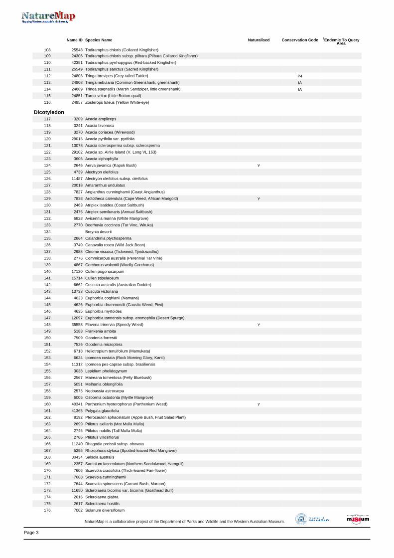
Page 3
Name ID Species Name Naturalised Conservation Code 1Endemic To QueryArea
108. 25548 Todiramphus chloris (Collared Kingfisher)
109. 24306 Todiramphus chloris subsp. pilbara (Pilbara Collared Kingfisher)
110. 42351 Todiramphus pyrrhopygius (Red-backed Kingfisher)
111. 25549 Todiramphus sanctus (Sacred Kingfisher)
112. 24803 Tringa brevipes (Grey-tailed Tattler) P4
113. 24808 Tringa nebularia (Common Greenshank, greenshank) IA
114. 24809 Tringa stagnatilis (Marsh Sandpiper, little greenshank) IA
115. 24851 Turnix velox (Little Button-quail)
116. 24857 Zosterops luteus (Yellow White-eye)
Dicotyledon117. 3209 Acacia ampliceps
118. 3241 Acacia bivenosa
119. 3270 Acacia coriacea (Wirewood)
120. 29015 Acacia pyrifolia var. pyrifolia
121. 13078 Acacia sclerosperma subsp. sclerosperma
122. 29102 Acacia sp. Airlie Island (V. Long VL 163)
123. 3606 Acacia xiphophylla
124. 2646 Aerva javanica (Kapok Bush) Y
125. 4739 Alectryon oleifolius
126. 11487 Alectryon oleifolius subsp. oleifolius
127. 20018 Amaranthus undulatus
128. 7827 Angianthus cunninghamii (Coast Angianthus)
129. 7838 Arctotheca calendula (Cape Weed, African Marigold) Y
130. 2463 Atriplex isatidea (Coast Saltbush)
131. 2476 Atriplex semilunaris (Annual Saltbush)
132. 6828 Avicennia marina (White Mangrove)
133. 2770 Boerhavia coccinea (Tar Vine, Wituka)
134. Breynia desorii
135. 2864 Calandrinia ptychosperma
136. 3749 Canavalia rosea (Wild Jack Bean)
137. 2988 Cleome viscosa (Tickweed, Tjinduwadhu)
138. 2776 Commicarpus australis (Perennial Tar Vine)
139. 4867 Corchorus walcottii (Woolly Corchorus)
140. 17120 Cullen pogonocarpum
141. 15714 Cullen stipulaceum
142. 6662 Cuscuta australis (Australian Dodder)
143. 13733 Cuscuta victoriana
144. 4623 Euphorbia coghlanii (Namana)
145. 4626 Euphorbia drummondii (Caustic Weed, Piwi)
146. 4635 Euphorbia myrtoides
147. 12097 Euphorbia tannensis subsp. eremophila (Desert Spurge)
148. 35558 Flaveria trinervia (Speedy Weed) Y
149. 5188 Frankenia ambita
150. 7509 Goodenia forrestii
151. 7526 Goodenia microptera
152. 6718 Heliotropium tenuifolium (Mamukata)
153. 6624 Ipomoea costata (Rock Morning Glory, Kanti)
154. 11312 Ipomoea pes-caprae subsp. brasiliensis
155. 3038 Lepidium pholidogynum
156. 2567 Maireana tomentosa (Felty Bluebush)
157. 5051 Melhania oblongifolia
158. 2573 Neobassia astrocarpa
159. 6005 Osbornia octodonta (Myrtle Mangrove)
160. 40341 Parthenium hysterophorus (Parthenium Weed) Y
161. 41365 Polygala glaucifolia
162. 8192 Pterocaulon sphacelatum (Apple Bush, Fruit Salad Plant)
163. 2699 Ptilotus axillaris (Mat Mulla Mulla)
164. 2746 Ptilotus nobilis (Tall Mulla Mulla)
165. 2766 Ptilotus villosiflorus
166. 11240 Rhagodia preissii subsp. obovata
167. 5295 Rhizophora stylosa (Spotted-leaved Red Mangrove)
168. 30434 Salsola australis
169. 2357 Santalum lanceolatum (Northern Sandalwood, Yarnguli)
170. 7606 Scaevola crassifolia (Thick-leaved Fan-flower)
171. 7608 Scaevola cunninghamii
172. 7644 Scaevola spinescens (Currant Bush, Maroon)
173. 11650 Sclerolaena bicornis var. bicornis (Goathead Burr)
174. 2616 Sclerolaena glabra
175. 2617 Sclerolaena hostilis
176. 7002 Solanum diversiflorum
NatureMap is a collaborative project of the Department of Parks and Wildlife and the Western Australian Museum.
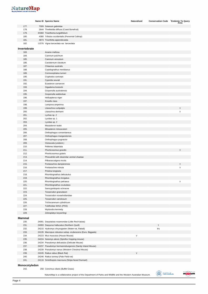
Page 4
Name ID Species Name Naturalised Conservation Code 1Endemic To QueryArea
177. 7009 Solanum gabrielae
178. 2644 Threlkeldia diffusa (Coast Bonefruit)
179. 44360 Trianthema turgidifolium
180. 4380 Tribulus occidentalis (Perennial Caltrop)
181. 4873 Triumfetta appendiculata
182. 11576 Vigna lanceolata var. lanceolata
Invertebrate183. Aname mellosa
184. Carenum pulchrum
185. Carenum venustum
186. Cavisternum clavatum
187. Chlaenius australis
188. Copidognathus meridianus
189. Cormocephalus turneri
190. Cryptodus caviceps
191. Cypretta seurati
192. Euasteron carnarvon
193. Gigadema bostocki
194. Grayenulla australensis
195. Grayenulla waldockae
196. Helluapterus niger
197. Knoelle clara
198. Lampona ampeinna
199. Litarachna curtipalpis Y
200. Litarachna denhami Y
201. Lychas sp. 2
202. Lycidas sp. 1
203. Lycidas sp. 2
204. Masasteron tealei
205. Minasteron minusculum
206. Onthophagus consentaneus
207. Onthophagus margaretensis
208. Onthophagus pugnacior
209. Ostracoda (unident.)
210. Pellenes bitaeniata
211. Phorticosomus grandis Y
212. Phorticosomus gularis
213. Phreodrilid with dissimilar ventral chaetae
214. Pilbarascutigera incola
215. Pontarachne dampierensis Y
216. Pontarachne minuta Y
217. Pristina longiseta
218. Rhombognathus delicatulus
219. Rhombognathus levigatus
220. Rhombognathus petraeus Y
221. Rhombognathus scutulatus
222. Sarscypridopsis ochracea
223. Tesserodon granulatum
224. Tesserodon novaehollandiae
225. Tesserodon variolosum
226. Trichocarenum cylindricum
227. Tubificidae WA21 (PSS)
228. Wydundra kennedy
229. Zebraplatys keyserlingi
Mammal230. 24091 Dasykaluta rosamondae (Little Red Kaluta)
231. 24093 Dasyurus hallucatus (Northern Quoll) T
232. 24215 Hydromys chrysogaster (Water-rat, Rakali) P4
233. 24135 Macropus robustus subsp. erubescens (Euro, Biggada)
234. 24223 Mus musculus (House Mouse) Y
235. 24224 Notomys alexis (Spinifex Hopping-mouse)
236. 24234 Pseudomys delicatulus (Delicate Mouse)
237. 24237 Pseudomys hermannsburgensis (Sandy Inland Mouse)
238. 24239 Pseudomys nanus (Western Chestnut Mouse)
239. 24245 Rattus rattus (Black Rat) Y
240. 24246 Rattus tunneyi (Pale Field-rat)
241. 24116 Sminthopsis macroura (Stripe-faced Dunnart)
Monocotyledon242. 258 Cenchrus ciliaris (Buffel Grass)
NatureMap is a collaborative project of the Department of Parks and Wildlife and the Western Australian Museum.
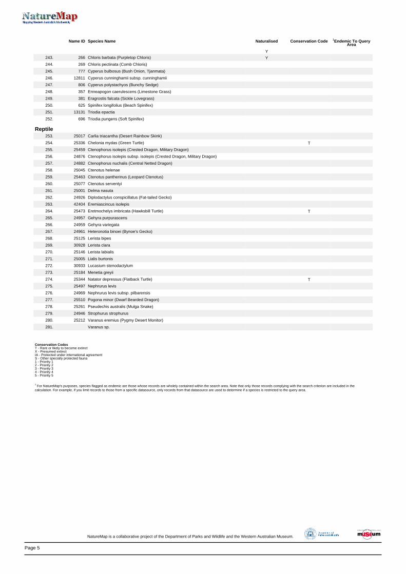
Page 5
Name ID Species Name Naturalised Conservation Code 1Endemic To QueryArea
Y
243. 266 Chloris barbata (Purpletop Chloris) Y
244. 269 Chloris pectinata (Comb Chloris)
245. 777 Cyperus bulbosus (Bush Onion, Tjanmata)
246. 12811 Cyperus cunninghamii subsp. cunninghamii
247. 806 Cyperus polystachyos (Bunchy Sedge)
248. 357 Enneapogon caerulescens (Limestone Grass)
249. 381 Eragrostis falcata (Sickle Lovegrass)
250. 625 Spinifex longifolius (Beach Spinifex)
251. 13131 Triodia epactia
252. 696 Triodia pungens (Soft Spinifex)
Reptile253. 25017 Carlia triacantha (Desert Rainbow Skink)
254. 25336 Chelonia mydas (Green Turtle) T
255. 25459 Ctenophorus isolepis (Crested Dragon, Military Dragon)
256. 24876 Ctenophorus isolepis subsp. isolepis (Crested Dragon, Military Dragon)
257. 24882 Ctenophorus nuchalis (Central Netted Dragon)
258. 25045 Ctenotus helenae
259. 25463 Ctenotus pantherinus (Leopard Ctenotus)
260. 25077 Ctenotus serventyi
261. 25001 Delma nasuta
262. 24926 Diplodactylus conspicillatus (Fat-tailed Gecko)
263. 42404 Eremiascincus isolepis
264. 25473 Eretmochelys imbricata (Hawksbill Turtle) T
265. 24957 Gehyra purpurascens
266. 24959 Gehyra variegata
267. 24961 Heteronotia binoei (Bynoe's Gecko)
268. 25125 Lerista bipes
269. 30928 Lerista clara
270. 25146 Lerista labialis
271. 25005 Lialis burtonis
272. 30933 Lucasium stenodactylum
273. 25184 Menetia greyii
274. 25344 Natator depressus (Flatback Turtle) T
275. 25497 Nephrurus levis
276. 24969 Nephrurus levis subsp. pilbarensis
277. 25510 Pogona minor (Dwarf Bearded Dragon)
278. 25261 Pseudechis australis (Mulga Snake)
279. 24946 Strophurus strophurus
280. 25212 Varanus eremius (Pygmy Desert Monitor)
281. Varanus sp.
Conservation CodesT - Rare or likely to become extinctX - Presumed extinctIA - Protected under international agreementS - Other specially protected fauna1 - Priority 12 - Priority 23 - Priority 34 - Priority 45 - Priority 5
1 For NatureMap's purposes, species flagged as endemic are those whose records are wholely contained within the search area. Note that only those records complying with the search criterion are included in the
calculation. For example, if you limit records to those from a specific datasource, only records from that datasource are used to determine if a species is restricted to the query area.
NatureMap is a collaborative project of the Department of Parks and Wildlife and the Western Australian Museum.
EPBC Act Protected Matters Report
This report provides general guidance on matters of national environmental significance and other mattersprotected by the EPBC Act in the area you have selected.
Information on the coverage of this report and qualifications on data supporting this report are contained in thecaveat at the end of the report.
Information is available about Environment Assessments and the EPBC Act including significance guidelines,forms and application process details.
Other Matters Protected by the EPBC Act
Acknowledgements
Buffer: 10.0Km
Matters of NES
Report created: 15/08/18 12:15:34
Coordinates
This map may contain data which are©Commonwealth of Australia(Geoscience Australia), ©PSMA 2010
CaveatExtra Information
DetailsSummary
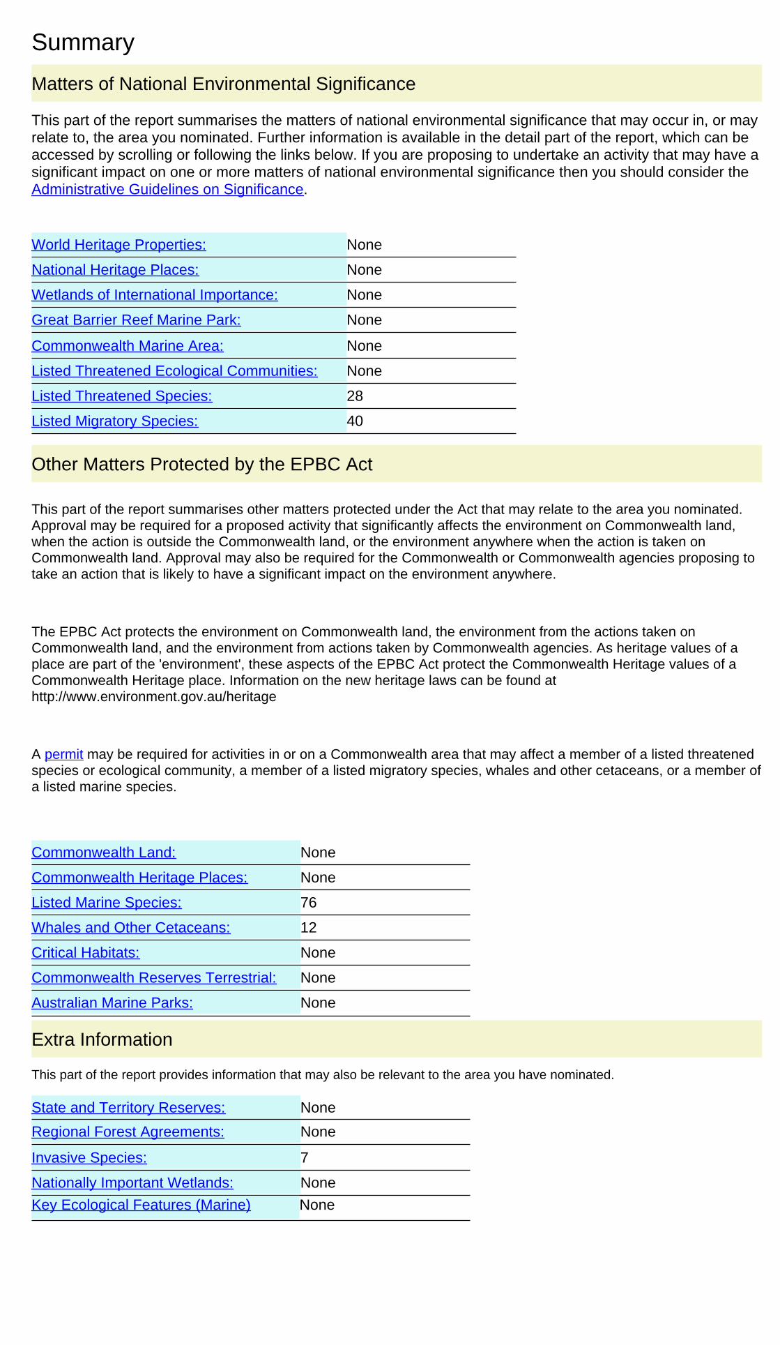
Summary
This part of the report summarises the matters of national environmental significance that may occur in, or mayrelate to, the area you nominated. Further information is available in the detail part of the report, which can beaccessed by scrolling or following the links below. If you are proposing to undertake an activity that may have asignificant impact on one or more matters of national environmental significance then you should consider theAdministrative Guidelines on Significance.
Matters of National Environmental Significance
Listed Threatened Ecological Communities:
Listed Migratory Species:
None
Great Barrier Reef Marine Park:
Wetlands of International Importance:
Listed Threatened Species:
None
28
None
None
National Heritage Places:
Commonwealth Marine Area:
World Heritage Properties:
None
None
40
The EPBC Act protects the environment on Commonwealth land, the environment from the actions taken onCommonwealth land, and the environment from actions taken by Commonwealth agencies. As heritage values of aplace are part of the 'environment', these aspects of the EPBC Act protect the Commonwealth Heritage values of aCommonwealth Heritage place. Information on the new heritage laws can be found athttp://www.environment.gov.au/heritage
This part of the report summarises other matters protected under the Act that may relate to the area you nominated.Approval may be required for a proposed activity that significantly affects the environment on Commonwealth land,when the action is outside the Commonwealth land, or the environment anywhere when the action is taken onCommonwealth land. Approval may also be required for the Commonwealth or Commonwealth agencies proposing totake an action that is likely to have a significant impact on the environment anywhere.
A permit may be required for activities in or on a Commonwealth area that may affect a member of a listed threatenedspecies or ecological community, a member of a listed migratory species, whales and other cetaceans, or a member ofa listed marine species.
Other Matters Protected by the EPBC Act
None
None
12
Listed Marine Species:
Whales and Other Cetaceans:
76
Commonwealth Heritage Places:
None
None
Critical Habitats:
Commonwealth Land:
Commonwealth Reserves Terrestrial:
NoneAustralian Marine Parks:
Extra Information
This part of the report provides information that may also be relevant to the area you have nominated.
None
NoneState and Territory Reserves:
Nationally Important Wetlands:
NoneRegional Forest Agreements:
Invasive Species: 7
NoneKey Ecological Features (Marine)
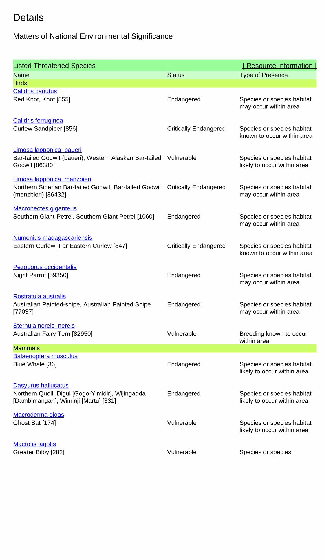
Details
Listed Threatened Species [ Resource Information ]Name Status Type of PresenceBirds
Red Knot, Knot [855] Endangered Species or species habitatmay occur within area
Calidris canutus
Curlew Sandpiper [856] Critically Endangered Species or species habitatknown to occur within area
Calidris ferruginea
Bar-tailed Godwit (baueri), Western Alaskan Bar-tailedGodwit [86380]
Vulnerable Species or species habitatlikely to occur within area
Limosa lapponica baueri
Northern Siberian Bar-tailed Godwit, Bar-tailed Godwit(menzbieri) [86432]
Critically Endangered Species or species habitatmay occur within area
Limosa lapponica menzbieri
Southern Giant-Petrel, Southern Giant Petrel [1060] Endangered Species or species habitatmay occur within area
Macronectes giganteus
Eastern Curlew, Far Eastern Curlew [847] Critically Endangered Species or species habitatknown to occur within area
Numenius madagascariensis
Night Parrot [59350] Endangered Species or species habitatmay occur within area
Pezoporus occidentalis
Australian Painted-snipe, Australian Painted Snipe[77037]
Endangered Species or species habitatmay occur within area
Rostratula australis
Australian Fairy Tern [82950] Vulnerable Breeding known to occurwithin area
Sternula nereis nereis
Mammals
Blue Whale [36] Endangered Species or species habitatlikely to occur within area
Balaenoptera musculus
Northern Quoll, Digul [Gogo-Yimidir], Wijingadda[Dambimangari], Wiminji [Martu] [331]
Endangered Species or species habitatlikely to occur within area
Dasyurus hallucatus
Ghost Bat [174] Vulnerable Species or species habitatlikely to occur within area
Macroderma gigas
Greater Bilby [282] Vulnerable Species or speciesMacrotis lagotis
Matters of National Environmental Significance
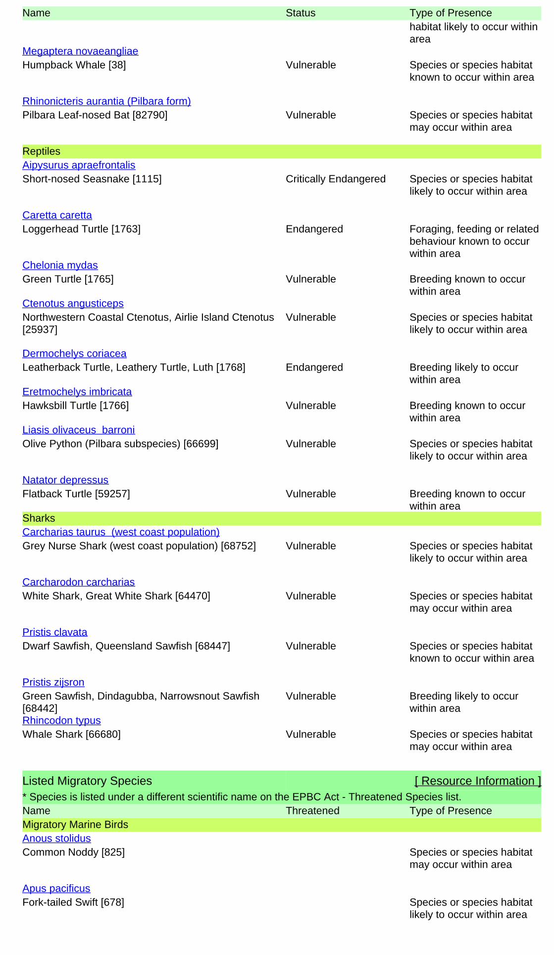
Name Status Type of Presencehabitat likely to occur withinarea
Humpback Whale [38] Vulnerable Species or species habitatknown to occur within area
Megaptera novaeangliae
Pilbara Leaf-nosed Bat [82790] Vulnerable Species or species habitatmay occur within area
Rhinonicteris aurantia (Pilbara form)
Reptiles
Short-nosed Seasnake [1115] Critically Endangered Species or species habitatlikely to occur within area
Aipysurus apraefrontalis
Loggerhead Turtle [1763] Endangered Foraging, feeding or relatedbehaviour known to occurwithin area
Caretta caretta
Green Turtle [1765] Vulnerable Breeding known to occurwithin area
Chelonia mydas
Northwestern Coastal Ctenotus, Airlie Island Ctenotus[25937]
Vulnerable Species or species habitatlikely to occur within area
Ctenotus angusticeps
Leatherback Turtle, Leathery Turtle, Luth [1768] Endangered Breeding likely to occurwithin area
Dermochelys coriacea
Hawksbill Turtle [1766] Vulnerable Breeding known to occurwithin area
Eretmochelys imbricata
Olive Python (Pilbara subspecies) [66699] Vulnerable Species or species habitatlikely to occur within area
Liasis olivaceus barroni
Flatback Turtle [59257] Vulnerable Breeding known to occurwithin area
Natator depressus
Sharks
Grey Nurse Shark (west coast population) [68752] Vulnerable Species or species habitatlikely to occur within area
Carcharias taurus (west coast population)
White Shark, Great White Shark [64470] Vulnerable Species or species habitatmay occur within area
Carcharodon carcharias
Dwarf Sawfish, Queensland Sawfish [68447] Vulnerable Species or species habitatknown to occur within area
Pristis clavata
Green Sawfish, Dindagubba, Narrowsnout Sawfish[68442]
Vulnerable Breeding likely to occurwithin area
Pristis zijsron
Whale Shark [66680] Vulnerable Species or species habitatmay occur within area
Rhincodon typus
Listed Migratory Species [ Resource Information ]* Species is listed under a different scientific name on the EPBC Act - Threatened Species list.Name Threatened Type of PresenceMigratory Marine Birds
Common Noddy [825] Species or species habitatmay occur within area
Anous stolidus
Fork-tailed Swift [678] Species or species habitatlikely to occur within area
Apus pacificus
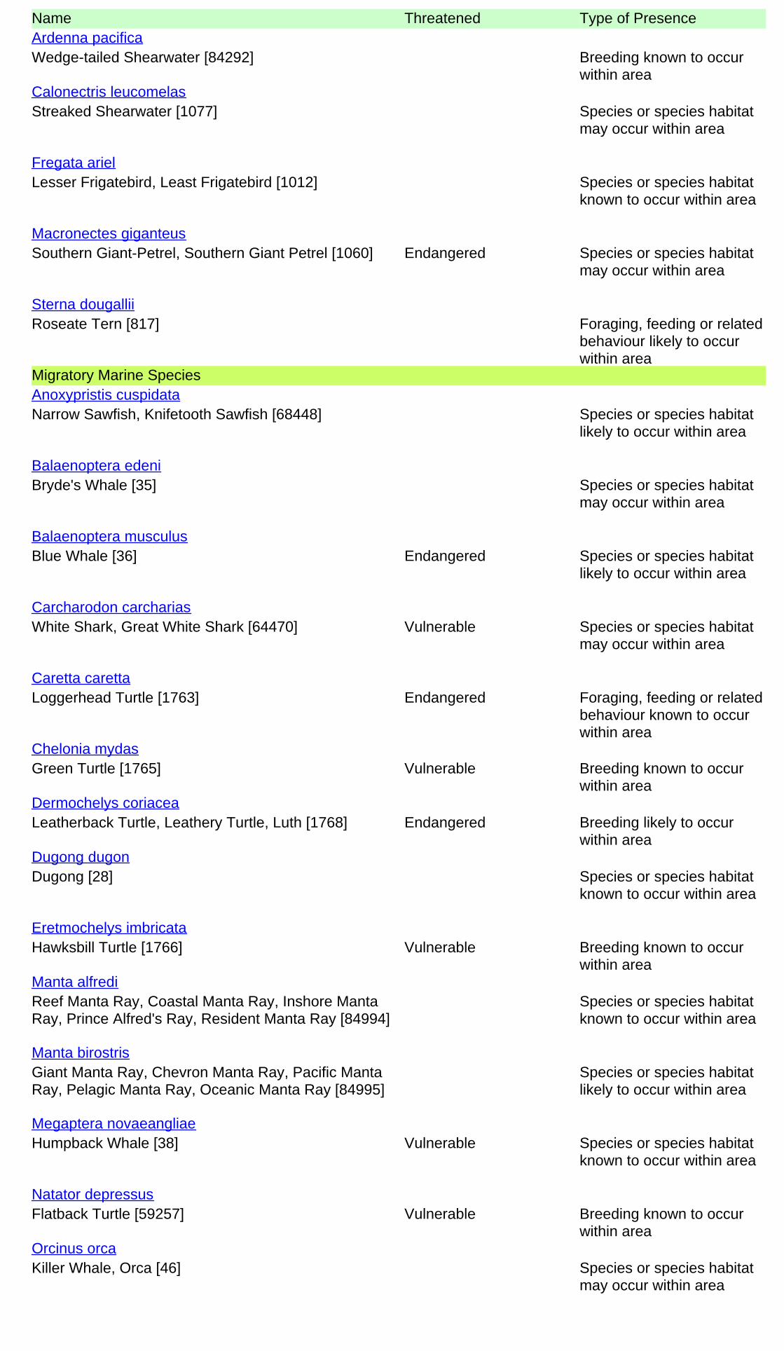
Name Threatened Type of Presence
Wedge-tailed Shearwater [84292] Breeding known to occurwithin area
Ardenna pacifica
Streaked Shearwater [1077] Species or species habitatmay occur within area
Calonectris leucomelas
Lesser Frigatebird, Least Frigatebird [1012] Species or species habitatknown to occur within area
Fregata ariel
Southern Giant-Petrel, Southern Giant Petrel [1060] Endangered Species or species habitatmay occur within area
Macronectes giganteus
Roseate Tern [817] Foraging, feeding or relatedbehaviour likely to occurwithin area
Sterna dougallii
Migratory Marine Species
Narrow Sawfish, Knifetooth Sawfish [68448] Species or species habitatlikely to occur within area
Anoxypristis cuspidata
Bryde's Whale [35] Species or species habitatmay occur within area
Balaenoptera edeni
Blue Whale [36] Endangered Species or species habitatlikely to occur within area
Balaenoptera musculus
White Shark, Great White Shark [64470] Vulnerable Species or species habitatmay occur within area
Carcharodon carcharias
Loggerhead Turtle [1763] Endangered Foraging, feeding or relatedbehaviour known to occurwithin area
Caretta caretta
Green Turtle [1765] Vulnerable Breeding known to occurwithin area
Chelonia mydas
Leatherback Turtle, Leathery Turtle, Luth [1768] Endangered Breeding likely to occurwithin area
Dermochelys coriacea
Dugong [28] Species or species habitatknown to occur within area
Dugong dugon
Hawksbill Turtle [1766] Vulnerable Breeding known to occurwithin area
Eretmochelys imbricata
Reef Manta Ray, Coastal Manta Ray, Inshore MantaRay, Prince Alfred's Ray, Resident Manta Ray [84994]
Species or species habitatknown to occur within area
Manta alfredi
Giant Manta Ray, Chevron Manta Ray, Pacific MantaRay, Pelagic Manta Ray, Oceanic Manta Ray [84995]
Species or species habitatlikely to occur within area
Manta birostris
Humpback Whale [38] Vulnerable Species or species habitatknown to occur within area
Megaptera novaeangliae
Flatback Turtle [59257] Vulnerable Breeding known to occurwithin area
Natator depressus
Killer Whale, Orca [46] Species or species habitatmay occur within area
Orcinus orca
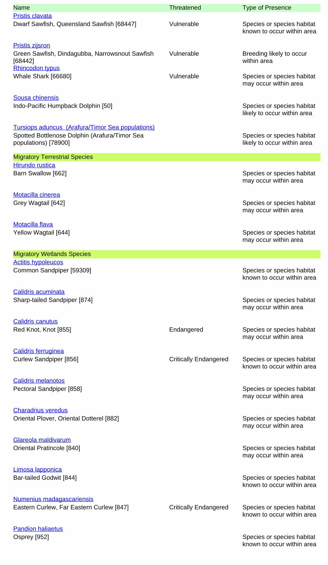
Name Threatened Type of Presence
Dwarf Sawfish, Queensland Sawfish [68447] Vulnerable Species or species habitatknown to occur within area
Pristis clavata
Green Sawfish, Dindagubba, Narrowsnout Sawfish[68442]
Vulnerable Breeding likely to occurwithin area
Pristis zijsron
Whale Shark [66680] Vulnerable Species or species habitatmay occur within area
Rhincodon typus
Indo-Pacific Humpback Dolphin [50] Species or species habitatlikely to occur within area
Sousa chinensis
Spotted Bottlenose Dolphin (Arafura/Timor Seapopulations) [78900]
Species or species habitatlikely to occur within area
Tursiops aduncus (Arafura/Timor Sea populations)
Migratory Terrestrial Species
Barn Swallow [662] Species or species habitatmay occur within area
Hirundo rustica
Grey Wagtail [642] Species or species habitatmay occur within area
Motacilla cinerea
Yellow Wagtail [644] Species or species habitatmay occur within area
Motacilla flava
Migratory Wetlands Species
Common Sandpiper [59309] Species or species habitatknown to occur within area
Actitis hypoleucos
Sharp-tailed Sandpiper [874] Species or species habitatmay occur within area
Calidris acuminata
Red Knot, Knot [855] Endangered Species or species habitatmay occur within area
Calidris canutus
Curlew Sandpiper [856] Critically Endangered Species or species habitatknown to occur within area
Calidris ferruginea
Pectoral Sandpiper [858] Species or species habitatmay occur within area
Calidris melanotos
Oriental Plover, Oriental Dotterel [882] Species or species habitatmay occur within area
Charadrius veredus
Oriental Pratincole [840] Species or species habitatmay occur within area
Glareola maldivarum
Bar-tailed Godwit [844] Species or species habitatknown to occur within area
Limosa lapponica
Eastern Curlew, Far Eastern Curlew [847] Critically Endangered Species or species habitatknown to occur within area
Numenius madagascariensis
Osprey [952] Species or species habitatknown to occur within area
Pandion haliaetus
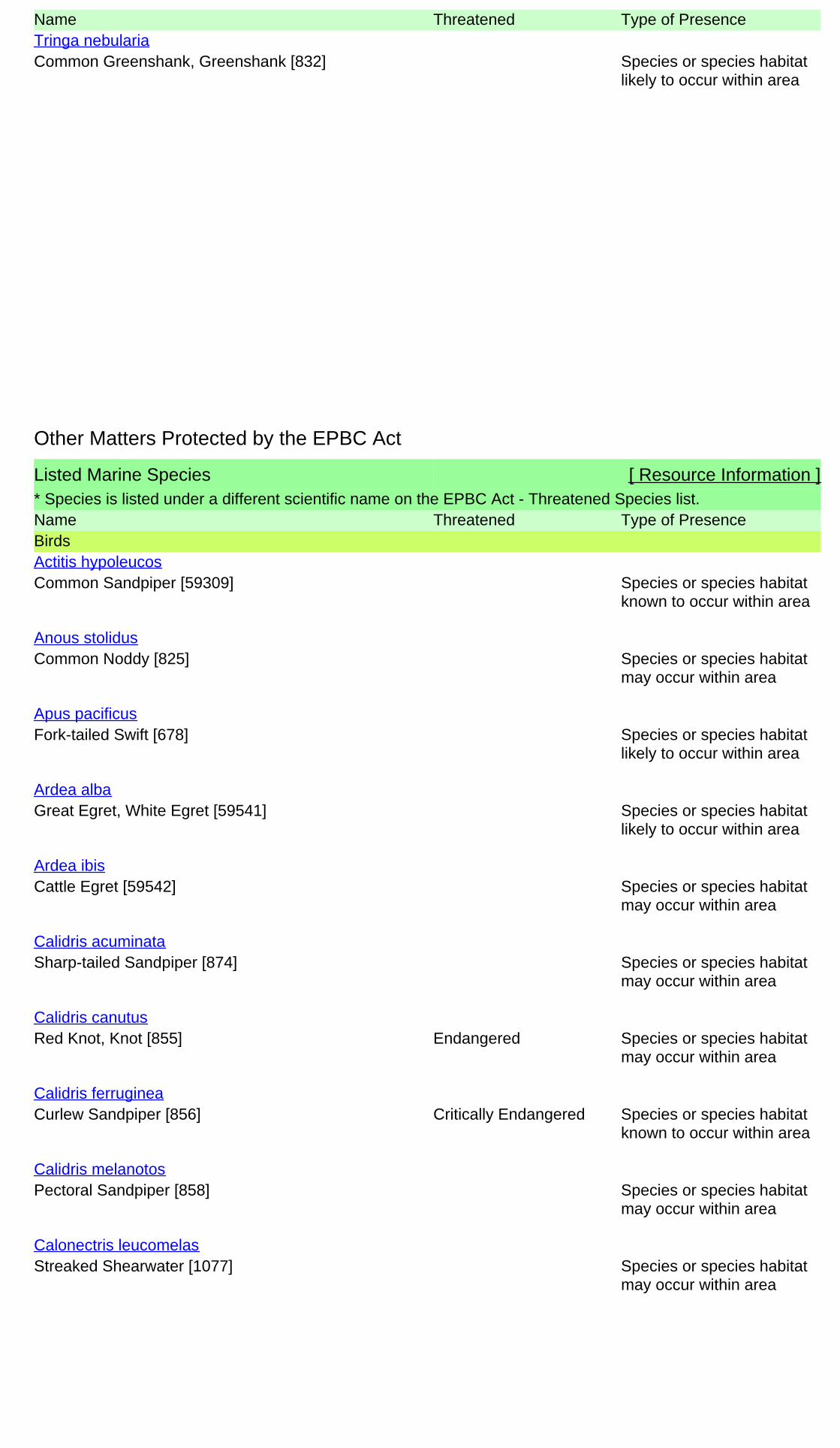
Name Threatened Type of Presence
Common Greenshank, Greenshank [832] Species or species habitatlikely to occur within area
Tringa nebularia
Listed Marine Species [ Resource Information ]* Species is listed under a different scientific name on the EPBC Act - Threatened Species list.Name Threatened Type of PresenceBirds
Common Sandpiper [59309] Species or species habitatknown to occur within area
Actitis hypoleucos
Common Noddy [825] Species or species habitatmay occur within area
Anous stolidus
Fork-tailed Swift [678] Species or species habitatlikely to occur within area
Apus pacificus
Great Egret, White Egret [59541] Species or species habitatlikely to occur within area
Ardea alba
Cattle Egret [59542] Species or species habitatmay occur within area
Ardea ibis
Sharp-tailed Sandpiper [874] Species or species habitatmay occur within area
Calidris acuminata
Red Knot, Knot [855] Endangered Species or species habitatmay occur within area
Calidris canutus
Curlew Sandpiper [856] Critically Endangered Species or species habitatknown to occur within area
Calidris ferruginea
Pectoral Sandpiper [858] Species or species habitatmay occur within area
Calidris melanotos
Streaked Shearwater [1077] Species or species habitatmay occur within area
Calonectris leucomelas
Other Matters Protected by the EPBC Act
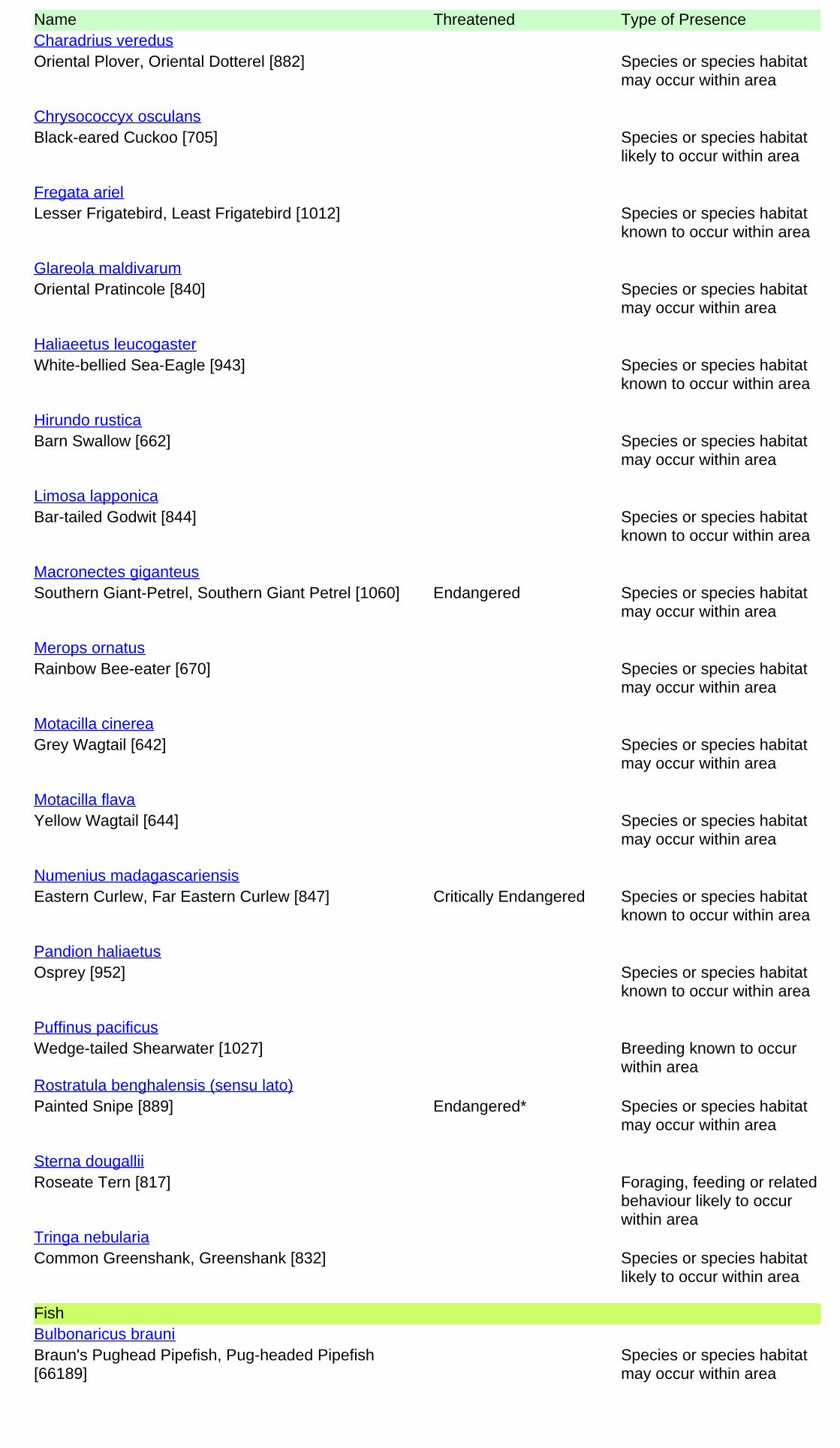
Name Threatened Type of Presence
Oriental Plover, Oriental Dotterel [882] Species or species habitatmay occur within area
Charadrius veredus
Black-eared Cuckoo [705] Species or species habitatlikely to occur within area
Chrysococcyx osculans
Lesser Frigatebird, Least Frigatebird [1012] Species or species habitatknown to occur within area
Fregata ariel
Oriental Pratincole [840] Species or species habitatmay occur within area
Glareola maldivarum
White-bellied Sea-Eagle [943] Species or species habitatknown to occur within area
Haliaeetus leucogaster
Barn Swallow [662] Species or species habitatmay occur within area
Hirundo rustica
Bar-tailed Godwit [844] Species or species habitatknown to occur within area
Limosa lapponica
Southern Giant-Petrel, Southern Giant Petrel [1060] Endangered Species or species habitatmay occur within area
Macronectes giganteus
Rainbow Bee-eater [670] Species or species habitatmay occur within area
Merops ornatus
Grey Wagtail [642] Species or species habitatmay occur within area
Motacilla cinerea
Yellow Wagtail [644] Species or species habitatmay occur within area
Motacilla flava
Eastern Curlew, Far Eastern Curlew [847] Critically Endangered Species or species habitatknown to occur within area
Numenius madagascariensis
Osprey [952] Species or species habitatknown to occur within area
Pandion haliaetus
Wedge-tailed Shearwater [1027] Breeding known to occurwithin area
Puffinus pacificus
Painted Snipe [889] Endangered* Species or species habitatmay occur within area
Rostratula benghalensis (sensu lato)
Roseate Tern [817] Foraging, feeding or relatedbehaviour likely to occurwithin area
Sterna dougallii
Common Greenshank, Greenshank [832] Species or species habitatlikely to occur within area
Tringa nebularia
Fish
Braun's Pughead Pipefish, Pug-headed Pipefish[66189]
Species or species habitatmay occur within area
Bulbonaricus brauni
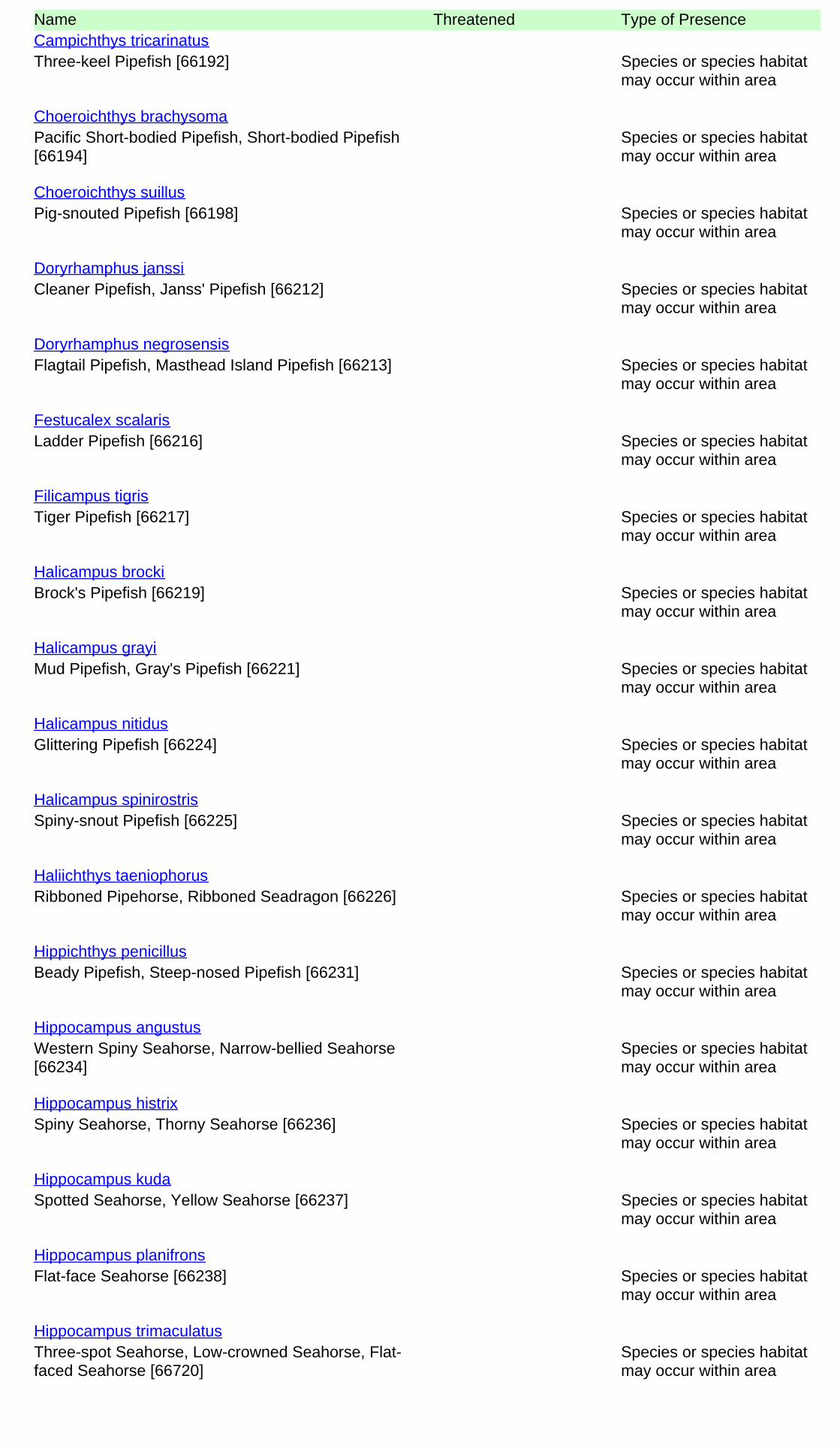
Name Threatened Type of Presence
Three-keel Pipefish [66192] Species or species habitatmay occur within area
Campichthys tricarinatus
Pacific Short-bodied Pipefish, Short-bodied Pipefish[66194]
Species or species habitatmay occur within area
Choeroichthys brachysoma
Pig-snouted Pipefish [66198] Species or species habitatmay occur within area
Choeroichthys suillus
Cleaner Pipefish, Janss' Pipefish [66212] Species or species habitatmay occur within area
Doryrhamphus janssi
Flagtail Pipefish, Masthead Island Pipefish [66213] Species or species habitatmay occur within area
Doryrhamphus negrosensis
Ladder Pipefish [66216] Species or species habitatmay occur within area
Festucalex scalaris
Tiger Pipefish [66217] Species or species habitatmay occur within area
Filicampus tigris
Brock's Pipefish [66219] Species or species habitatmay occur within area
Halicampus brocki
Mud Pipefish, Gray's Pipefish [66221] Species or species habitatmay occur within area
Halicampus grayi
Glittering Pipefish [66224] Species or species habitatmay occur within area
Halicampus nitidus
Spiny-snout Pipefish [66225] Species or species habitatmay occur within area
Halicampus spinirostris
Ribboned Pipehorse, Ribboned Seadragon [66226] Species or species habitatmay occur within area
Haliichthys taeniophorus
Beady Pipefish, Steep-nosed Pipefish [66231] Species or species habitatmay occur within area
Hippichthys penicillus
Western Spiny Seahorse, Narrow-bellied Seahorse[66234]
Species or species habitatmay occur within area
Hippocampus angustus
Spiny Seahorse, Thorny Seahorse [66236] Species or species habitatmay occur within area
Hippocampus histrix
Spotted Seahorse, Yellow Seahorse [66237] Species or species habitatmay occur within area
Hippocampus kuda
Flat-face Seahorse [66238] Species or species habitatmay occur within area
Hippocampus planifrons
Three-spot Seahorse, Low-crowned Seahorse, Flat-faced Seahorse [66720]
Species or species habitatmay occur within area
Hippocampus trimaculatus
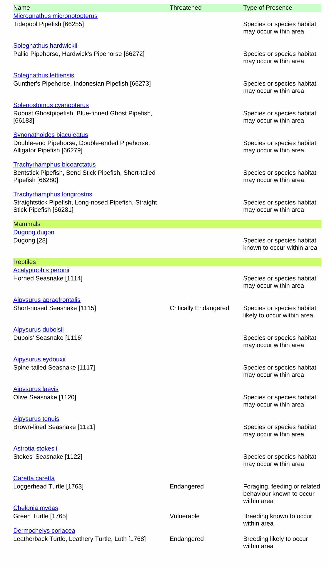
Name Threatened Type of Presence
Tidepool Pipefish [66255] Species or species habitatmay occur within area
Micrognathus micronotopterus
Pallid Pipehorse, Hardwick's Pipehorse [66272] Species or species habitatmay occur within area
Solegnathus hardwickii
Gunther's Pipehorse, Indonesian Pipefish [66273] Species or species habitatmay occur within area
Solegnathus lettiensis
Robust Ghostpipefish, Blue-finned Ghost Pipefish,[66183]
Species or species habitatmay occur within area
Solenostomus cyanopterus
Double-end Pipehorse, Double-ended Pipehorse,Alligator Pipefish [66279]
Species or species habitatmay occur within area
Syngnathoides biaculeatus
Bentstick Pipefish, Bend Stick Pipefish, Short-tailedPipefish [66280]
Species or species habitatmay occur within area
Trachyrhamphus bicoarctatus
Straightstick Pipefish, Long-nosed Pipefish, StraightStick Pipefish [66281]
Species or species habitatmay occur within area
Trachyrhamphus longirostris
Mammals
Dugong [28] Species or species habitatknown to occur within area
Dugong dugon
Reptiles
Horned Seasnake [1114] Species or species habitatmay occur within area
Acalyptophis peronii
Short-nosed Seasnake [1115] Critically Endangered Species or species habitatlikely to occur within area
Aipysurus apraefrontalis
Dubois' Seasnake [1116] Species or species habitatmay occur within area
Aipysurus duboisii
Spine-tailed Seasnake [1117] Species or species habitatmay occur within area
Aipysurus eydouxii
Olive Seasnake [1120] Species or species habitatmay occur within area
Aipysurus laevis
Brown-lined Seasnake [1121] Species or species habitatmay occur within area
Aipysurus tenuis
Stokes' Seasnake [1122] Species or species habitatmay occur within area
Astrotia stokesii
Loggerhead Turtle [1763] Endangered Foraging, feeding or relatedbehaviour known to occurwithin area
Caretta caretta
Green Turtle [1765] Vulnerable Breeding known to occurwithin area
Chelonia mydas
Leatherback Turtle, Leathery Turtle, Luth [1768] Endangered Breeding likely to occurwithin area
Dermochelys coriacea
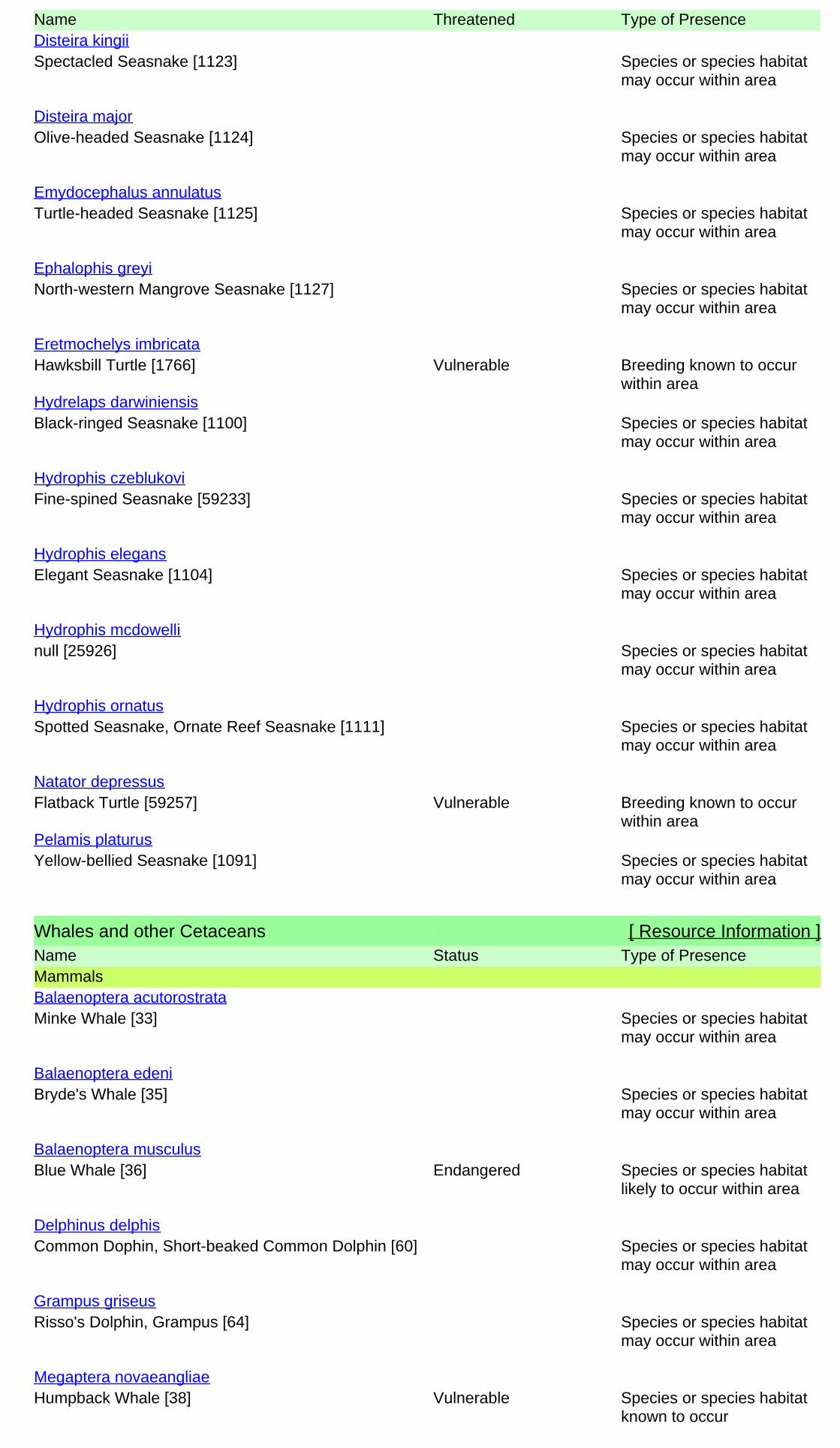
Name Threatened Type of Presence
Spectacled Seasnake [1123] Species or species habitatmay occur within area
Disteira kingii
Olive-headed Seasnake [1124] Species or species habitatmay occur within area
Disteira major
Turtle-headed Seasnake [1125] Species or species habitatmay occur within area
Emydocephalus annulatus
North-western Mangrove Seasnake [1127] Species or species habitatmay occur within area
Ephalophis greyi
Hawksbill Turtle [1766] Vulnerable Breeding known to occurwithin area
Eretmochelys imbricata
Black-ringed Seasnake [1100] Species or species habitatmay occur within area
Hydrelaps darwiniensis
Fine-spined Seasnake [59233] Species or species habitatmay occur within area
Hydrophis czeblukovi
Elegant Seasnake [1104] Species or species habitatmay occur within area
Hydrophis elegans
null [25926] Species or species habitatmay occur within area
Hydrophis mcdowelli
Spotted Seasnake, Ornate Reef Seasnake [1111] Species or species habitatmay occur within area
Hydrophis ornatus
Flatback Turtle [59257] Vulnerable Breeding known to occurwithin area
Natator depressus
Yellow-bellied Seasnake [1091] Species or species habitatmay occur within area
Pelamis platurus
Whales and other Cetaceans [ Resource Information ]Name Status Type of PresenceMammals
Minke Whale [33] Species or species habitatmay occur within area
Balaenoptera acutorostrata
Bryde's Whale [35] Species or species habitatmay occur within area
Balaenoptera edeni
Blue Whale [36] Endangered Species or species habitatlikely to occur within area
Balaenoptera musculus
Common Dophin, Short-beaked Common Dolphin [60] Species or species habitatmay occur within area
Delphinus delphis
Risso's Dolphin, Grampus [64] Species or species habitatmay occur within area
Grampus griseus
Humpback Whale [38] Vulnerable Species or species habitatknown to occur
Megaptera novaeangliae

Name Status Type of Presencewithin area
Killer Whale, Orca [46] Species or species habitatmay occur within area
Orcinus orca
Indo-Pacific Humpback Dolphin [50] Species or species habitatlikely to occur within area
Sousa chinensis
Spotted Dolphin, Pantropical Spotted Dolphin [51] Species or species habitatmay occur within area
Stenella attenuata
Indian Ocean Bottlenose Dolphin, Spotted BottlenoseDolphin [68418]
Species or species habitatlikely to occur within area
Tursiops aduncus
Spotted Bottlenose Dolphin (Arafura/Timor Seapopulations) [78900]
Species or species habitatlikely to occur within area
Tursiops aduncus (Arafura/Timor Sea populations)
Bottlenose Dolphin [68417] Species or species habitatmay occur within area
Tursiops truncatus s. str.
Extra Information
Invasive Species [ Resource Information ]Weeds reported here are the 20 species of national significance (WoNS), along with other introduced plantsthat are considered by the States and Territories to pose a particularly significant threat to biodiversity. Thefollowing feral animals are reported: Goat, Red Fox, Cat, Rabbit, Pig, Water Buffalo and Cane Toad. Maps fromLandscape Health Project, National Land and Water Resouces Audit, 2001.
Name Status Type of PresenceMammals
Domestic Dog [82654] Species or species habitatlikely to occur within area
Canis lupus familiaris
Cat, House Cat, Domestic Cat [19] Species or species habitatlikely to occur within area
Felis catus
Rabbit, European Rabbit [128] Species or species habitatlikely to occur within area
Oryctolagus cuniculus
Red Fox, Fox [18] Species or species habitatlikely to occur within area
Vulpes vulpes
Plants
Buffel-grass, Black Buffel-grass [20213] Species or species habitatlikely to occur within area
Cenchrus ciliaris
Parkinsonia, Jerusalem Thorn, Jelly Bean Tree, HorseBean [12301]
Species or species habitatlikely to occur within area
Parkinsonia aculeata

Name Status Type of Presence
Mesquite, Algaroba [68407] Species or species habitatlikely to occur within area
Prosopis spp.
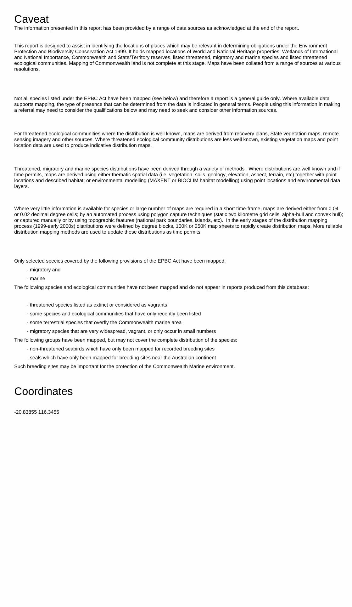
- non-threatened seabirds which have only been mapped for recorded breeding sites
- migratory species that are very widespread, vagrant, or only occur in small numbers
- some species and ecological communities that have only recently been listed
Not all species listed under the EPBC Act have been mapped (see below) and therefore a report is a general guide only. Where available datasupports mapping, the type of presence that can be determined from the data is indicated in general terms. People using this information in makinga referral may need to consider the qualifications below and may need to seek and consider other information sources.
For threatened ecological communities where the distribution is well known, maps are derived from recovery plans, State vegetation maps, remotesensing imagery and other sources. Where threatened ecological community distributions are less well known, existing vegetation maps and pointlocation data are used to produce indicative distribution maps.
- seals which have only been mapped for breeding sites near the Australian continent
Such breeding sites may be important for the protection of the Commonwealth Marine environment.
Threatened, migratory and marine species distributions have been derived through a variety of methods. Where distributions are well known and iftime permits, maps are derived using either thematic spatial data (i.e. vegetation, soils, geology, elevation, aspect, terrain, etc) together with pointlocations and described habitat; or environmental modelling (MAXENT or BIOCLIM habitat modelling) using point locations and environmental datalayers.
The information presented in this report has been provided by a range of data sources as acknowledged at the end of the report.Caveat
- migratory and
The following species and ecological communities have not been mapped and do not appear in reports produced from this database:
- marine
This report is designed to assist in identifying the locations of places which may be relevant in determining obligations under the EnvironmentProtection and Biodiversity Conservation Act 1999. It holds mapped locations of World and National Heritage properties, Wetlands of Internationaland National Importance, Commonwealth and State/Territory reserves, listed threatened, migratory and marine species and listed threatenedecological communities. Mapping of Commonwealth land is not complete at this stage. Maps have been collated from a range of sources at variousresolutions.
- threatened species listed as extinct or considered as vagrants
- some terrestrial species that overfly the Commonwealth marine area
The following groups have been mapped, but may not cover the complete distribution of the species:
Only selected species covered by the following provisions of the EPBC Act have been mapped:
Where very little information is available for species or large number of maps are required in a short time-frame, maps are derived either from 0.04or 0.02 decimal degree cells; by an automated process using polygon capture techniques (static two kilometre grid cells, alpha-hull and convex hull);or captured manually or by using topographic features (national park boundaries, islands, etc). In the early stages of the distribution mappingprocess (1999-early 2000s) distributions were defined by degree blocks, 100K or 250K map sheets to rapidly create distribution maps. More reliabledistribution mapping methods are used to update these distributions as time permits.
-20.83855 116.3455
Coordinates
-Environment and Planning Directorate, ACT-Birdlife Australia-Australian Bird and Bat Banding Scheme
-Department of Parks and Wildlife, Western Australia
Acknowledgements
-Office of Environment and Heritage, New South Wales
-Department of Primary Industries, Parks, Water and Environment, Tasmania
-Department of Land and Resource Management, Northern Territory-Department of Environmental and Heritage Protection, Queensland
-Department of Environment and Primary Industries, Victoria
-Australian National Wildlife Collection
-Department of Environment, Water and Natural Resources, South Australia
This database has been compiled from a range of data sources. The department acknowledges the followingcustodians who have contributed valuable data and advice:
-Australian Museum
-National Herbarium of NSW
Forestry Corporation, NSW-Australian Government, Department of Defence
-State Herbarium of South Australia
The Department is extremely grateful to the many organisations and individuals who provided expert adviceand information on numerous draft distributions.
-Natural history museums of Australia
-Queensland Museum
-Australian National Herbarium, Canberra
-Royal Botanic Gardens and National Herbarium of Victoria
-Geoscience Australia
-Ocean Biogeographic Information System
-Online Zoological Collections of Australian Museums-Queensland Herbarium
-Western Australian Herbarium
-Tasmanian Herbarium
-Northern Territory Herbarium
-South Australian Museum
-Museum Victoria
-University of New England
-CSIRO
-Other groups and individuals-Tasmanian Museum and Art Gallery, Hobart, Tasmania
-Museum and Art Gallery of the Northern Territory
-Reef Life Survey Australia-Australian Institute of Marine Science-Australian Government National Environmental Science Program
-Australian Tropical Herbarium, Cairns
-Australian Government – Australian Antarctic Data Centre
-Queen Victoria Museum and Art Gallery, Inveresk, Tasmania
-eBird Australia
-American Museum of Natural History
© Commonwealth of Australia
+61 2 6274 1111
Canberra ACT 2601 Australia
GPO Box 787
Department of the Environment
Please feel free to provide feedback via the Contact Us page.
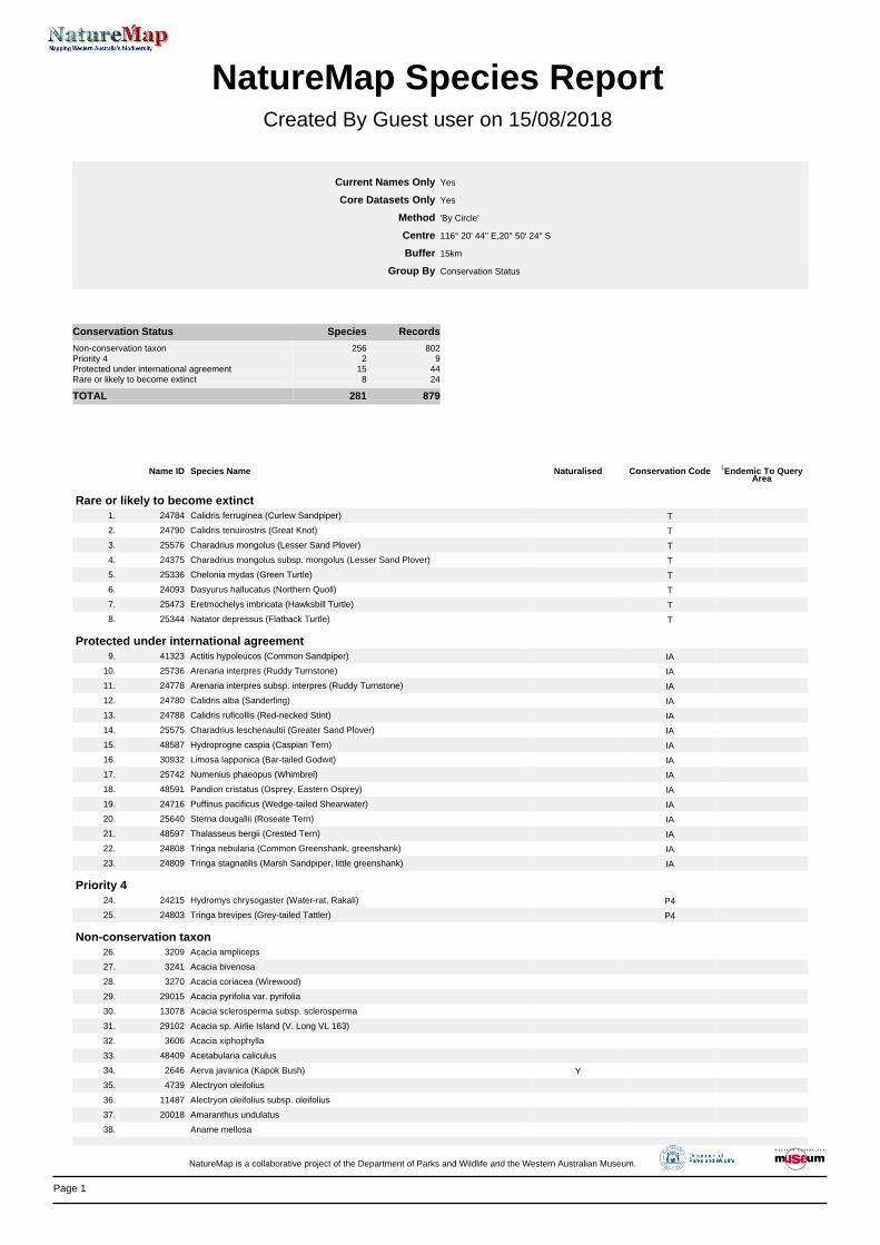
Page 1
NatureMap Species Report
Created By Guest user on 15/08/2018
Current Names Only Core Datasets Only
Method Centre Buffer
Group By
Yes Yes 'By Circle' 116° 20' 44'' E,20° 50' 24'' S 15km Conservation Status
Conservation Status Species Records Non-conservation taxon 256 802 Priority 4 2 9 Protected under international agreement 15 44 Rare or likely to become extinct 8 24 TOTAL 281 879
Name ID Species Name Naturalised Conservation Code 1Endemic To QueryArea
Rare or likely to become extinct1. 24784 Calidris ferruginea (Curlew Sandpiper) T
2. 24790 Calidris tenuirostris (Great Knot) T
3. 25576 Charadrius mongolus (Lesser Sand Plover) T
4. 24375 Charadrius mongolus subsp. mongolus (Lesser Sand Plover) T
5. 25336 Chelonia mydas (Green Turtle) T
6. 24093 Dasyurus hallucatus (Northern Quoll) T
7. 25473 Eretmochelys imbricata (Hawksbill Turtle) T
8. 25344 Natator depressus (Flatback Turtle) T
Protected under international agreement9. 41323 Actitis hypoleucos (Common Sandpiper) IA
10. 25736 Arenaria interpres (Ruddy Turnstone) IA
11. 24778 Arenaria interpres subsp. interpres (Ruddy Turnstone) IA
12. 24780 Calidris alba (Sanderling) IA
13. 24788 Calidris ruficollis (Red-necked Stint) IA
14. 25575 Charadrius leschenaultii (Greater Sand Plover) IA
15. 48587 Hydroprogne caspia (Caspian Tern) IA
16. 30932 Limosa lapponica (Bar-tailed Godwit) IA
17. 25742 Numenius phaeopus (Whimbrel) IA
18. 48591 Pandion cristatus (Osprey, Eastern Osprey) IA
19. 24716 Puffinus pacificus (Wedge-tailed Shearwater) IA
20. 25640 Sterna dougallii (Roseate Tern) IA
21. 48597 Thalasseus bergii (Crested Tern) IA
22. 24808 Tringa nebularia (Common Greenshank, greenshank) IA
23. 24809 Tringa stagnatilis (Marsh Sandpiper, little greenshank) IA
Priority 424. 24215 Hydromys chrysogaster (Water-rat, Rakali) P4
25. 24803 Tringa brevipes (Grey-tailed Tattler) P4
Non-conservation taxon26. 3209 Acacia ampliceps
27. 3241 Acacia bivenosa
28. 3270 Acacia coriacea (Wirewood)
29. 29015 Acacia pyrifolia var. pyrifolia
30. 13078 Acacia sclerosperma subsp. sclerosperma
31. 29102 Acacia sp. Airlie Island (V. Long VL 163)
32. 3606 Acacia xiphophylla
33. 48409 Acetabularia caliculus
34. 2646 Aerva javanica (Kapok Bush) Y
35. 4739 Alectryon oleifolius
36. 11487 Alectryon oleifolius subsp. oleifolius
37. 20018 Amaranthus undulatus
38. Aname mellosa
NatureMap is a collaborative project of the Department of Parks and Wildlife and the Western Australian Museum.
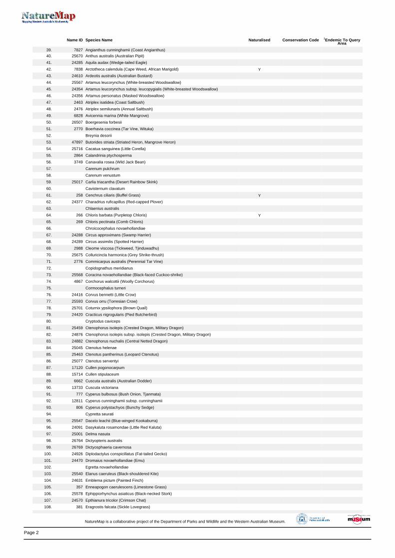
Page 2
Name ID Species Name Naturalised Conservation Code 1Endemic To QueryArea
39. 7827 Angianthus cunninghamii (Coast Angianthus)
40. 25670 Anthus australis (Australian Pipit)
41. 24285 Aquila audax (Wedge-tailed Eagle)
42. 7838 Arctotheca calendula (Cape Weed, African Marigold) Y
43. 24610 Ardeotis australis (Australian Bustard)
44. 25567 Artamus leucorynchus (White-breasted Woodswallow)
45. 24354 Artamus leucorynchus subsp. leucopygialis (White-breasted Woodswallow)
46. 24356 Artamus personatus (Masked Woodswallow)
47. 2463 Atriplex isatidea (Coast Saltbush)
48. 2476 Atriplex semilunaris (Annual Saltbush)
49. 6828 Avicennia marina (White Mangrove)
50. 26507 Boergesenia forbesii
51. 2770 Boerhavia coccinea (Tar Vine, Wituka)
52. Breynia desorii
53. 47897 Butorides striata (Striated Heron, Mangrove Heron)
54. 25716 Cacatua sanguinea (Little Corella)
55. 2864 Calandrinia ptychosperma
56. 3749 Canavalia rosea (Wild Jack Bean)
57. Carenum pulchrum
58. Carenum venustum
59. 25017 Carlia triacantha (Desert Rainbow Skink)
60. Cavisternum clavatum
61. 258 Cenchrus ciliaris (Buffel Grass) Y
62. 24377 Charadrius ruficapillus (Red-capped Plover)
63. Chlaenius australis
64. 266 Chloris barbata (Purpletop Chloris) Y
65. 269 Chloris pectinata (Comb Chloris)
66. Chroicocephalus novaehollandiae
67. 24288 Circus approximans (Swamp Harrier)
68. 24289 Circus assimilis (Spotted Harrier)
69. 2988 Cleome viscosa (Tickweed, Tjinduwadhu)
70. 25675 Colluricincla harmonica (Grey Shrike-thrush)
71. 2776 Commicarpus australis (Perennial Tar Vine)
72. Copidognathus meridianus
73. 25568 Coracina novaehollandiae (Black-faced Cuckoo-shrike)
74. 4867 Corchorus walcottii (Woolly Corchorus)
75. Cormocephalus turneri
76. 24416 Corvus bennetti (Little Crow)
77. 25593 Corvus orru (Torresian Crow)
78. 25701 Coturnix ypsilophora (Brown Quail)
79. 24420 Cracticus nigrogularis (Pied Butcherbird)
80. Cryptodus caviceps
81. 25459 Ctenophorus isolepis (Crested Dragon, Military Dragon)
82. 24876 Ctenophorus isolepis subsp. isolepis (Crested Dragon, Military Dragon)
83. 24882 Ctenophorus nuchalis (Central Netted Dragon)
84. 25045 Ctenotus helenae
85. 25463 Ctenotus pantherinus (Leopard Ctenotus)
86. 25077 Ctenotus serventyi
87. 17120 Cullen pogonocarpum
88. 15714 Cullen stipulaceum
89. 6662 Cuscuta australis (Australian Dodder)
90. 13733 Cuscuta victoriana
91. 777 Cyperus bulbosus (Bush Onion, Tjanmata)
92. 12811 Cyperus cunninghamii subsp. cunninghamii
93. 806 Cyperus polystachyos (Bunchy Sedge)
94. Cypretta seurati
95. 25547 Dacelo leachii (Blue-winged Kookaburra)
96. 24091 Dasykaluta rosamondae (Little Red Kaluta)
97. 25001 Delma nasuta
98. 26764 Dictyopteris australis
99. 26769 Dictyosphaeria cavernosa
100. 24926 Diplodactylus conspicillatus (Fat-tailed Gecko)
101. 24470 Dromaius novaehollandiae (Emu)
102. Egretta novaehollandiae
103. 25540 Elanus caeruleus (Black-shouldered Kite)
104. 24631 Emblema pictum (Painted Finch)
105. 357 Enneapogon caerulescens (Limestone Grass)
106. 25578 Ephippiorhynchus asiaticus (Black-necked Stork)
107. 24570 Epthianura tricolor (Crimson Chat)
108. 381 Eragrostis falcata (Sickle Lovegrass)
NatureMap is a collaborative project of the Department of Parks and Wildlife and the Western Australian Museum.
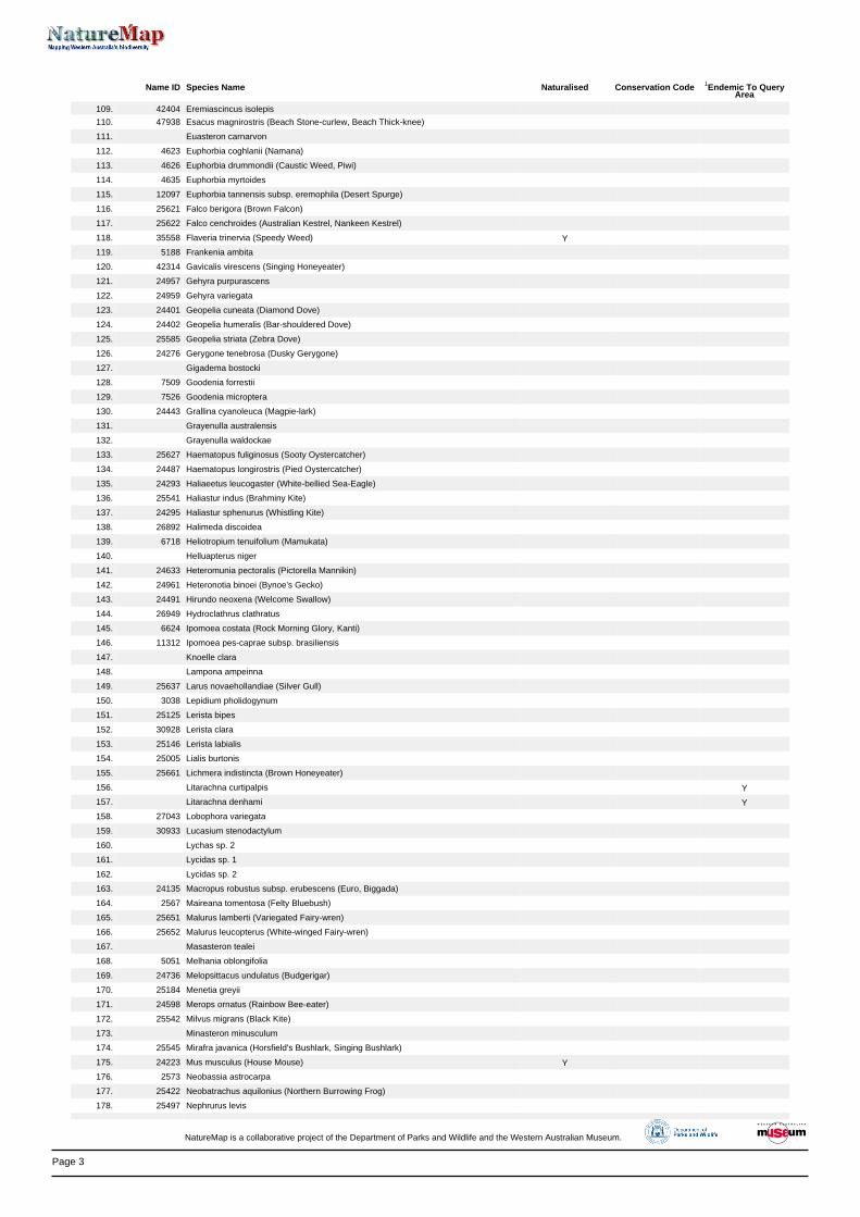
Page 3
Name ID Species Name Naturalised Conservation Code 1Endemic To QueryArea
109. 42404 Eremiascincus isolepis
110. 47938 Esacus magnirostris (Beach Stone-curlew, Beach Thick-knee)
111. Euasteron carnarvon
112. 4623 Euphorbia coghlanii (Namana)
113. 4626 Euphorbia drummondii (Caustic Weed, Piwi)
114. 4635 Euphorbia myrtoides
115. 12097 Euphorbia tannensis subsp. eremophila (Desert Spurge)
116. 25621 Falco berigora (Brown Falcon)
117. 25622 Falco cenchroides (Australian Kestrel, Nankeen Kestrel)
118. 35558 Flaveria trinervia (Speedy Weed) Y
119. 5188 Frankenia ambita
120. 42314 Gavicalis virescens (Singing Honeyeater)
121. 24957 Gehyra purpurascens
122. 24959 Gehyra variegata
123. 24401 Geopelia cuneata (Diamond Dove)
124. 24402 Geopelia humeralis (Bar-shouldered Dove)
125. 25585 Geopelia striata (Zebra Dove)
126. 24276 Gerygone tenebrosa (Dusky Gerygone)
127. Gigadema bostocki
128. 7509 Goodenia forrestii
129. 7526 Goodenia microptera
130. 24443 Grallina cyanoleuca (Magpie-lark)
131. Grayenulla australensis
132. Grayenulla waldockae
133. 25627 Haematopus fuliginosus (Sooty Oystercatcher)
134. 24487 Haematopus longirostris (Pied Oystercatcher)
135. 24293 Haliaeetus leucogaster (White-bellied Sea-Eagle)
136. 25541 Haliastur indus (Brahminy Kite)
137. 24295 Haliastur sphenurus (Whistling Kite)
138. 26892 Halimeda discoidea
139. 6718 Heliotropium tenuifolium (Mamukata)
140. Helluapterus niger
141. 24633 Heteromunia pectoralis (Pictorella Mannikin)
142. 24961 Heteronotia binoei (Bynoe's Gecko)
143. 24491 Hirundo neoxena (Welcome Swallow)
144. 26949 Hydroclathrus clathratus
145. 6624 Ipomoea costata (Rock Morning Glory, Kanti)
146. 11312 Ipomoea pes-caprae subsp. brasiliensis
147. Knoelle clara
148. Lampona ampeinna
149. 25637 Larus novaehollandiae (Silver Gull)
150. 3038 Lepidium pholidogynum
151. 25125 Lerista bipes
152. 30928 Lerista clara
153. 25146 Lerista labialis
154. 25005 Lialis burtonis
155. 25661 Lichmera indistincta (Brown Honeyeater)
156. Litarachna curtipalpis Y
157. Litarachna denhami Y
158. 27043 Lobophora variegata
159. 30933 Lucasium stenodactylum
160. Lychas sp. 2
161. Lycidas sp. 1
162. Lycidas sp. 2
163. 24135 Macropus robustus subsp. erubescens (Euro, Biggada)
164. 2567 Maireana tomentosa (Felty Bluebush)
165. 25651 Malurus lamberti (Variegated Fairy-wren)
166. 25652 Malurus leucopterus (White-winged Fairy-wren)
167. Masasteron tealei
168. 5051 Melhania oblongifolia
169. 24736 Melopsittacus undulatus (Budgerigar)
170. 25184 Menetia greyii
171. 24598 Merops ornatus (Rainbow Bee-eater)
172. 25542 Milvus migrans (Black Kite)
173. Minasteron minusculum
174. 25545 Mirafra javanica (Horsfield's Bushlark, Singing Bushlark)
175. 24223 Mus musculus (House Mouse) Y
176. 2573 Neobassia astrocarpa
177. 25422 Neobatrachus aquilonius (Northern Burrowing Frog)
178. 25497 Nephrurus levis
NatureMap is a collaborative project of the Department of Parks and Wildlife and the Western Australian Museum.
Page 4
Name ID Species Name Naturalised Conservation Code 1Endemic To QueryArea
179. 24969 Nephrurus levis subsp. pilbarensis
180. 25430 Notaden nichollsi (Desert Spadefoot)
181. 24224 Notomys alexis (Spinifex Hopping-mouse)
182. 25564 Nycticorax caledonicus (Rufous Night Heron)
183. 24742 Nymphicus hollandicus (Cockatiel)
184. 24407 Ocyphaps lophotes (Crested Pigeon)
185. Onthophagus consentaneus
186. Onthophagus margaretensis
187. Onthophagus pugnacior
188. 24618 Oreoica gutturalis (Crested Bellbird)
189. 6005 Osbornia octodonta (Myrtle Mangrove)
190. Ostracoda (unident.)
191. 24620 Pachycephala lanioides (White-breasted Whistler)
192. 25678 Pachycephala melanura (Mangrove Golden Whistler)
193. 24621 Pachycephala melanura subsp. melanura (Mangrove Golden Whistler)
194. 25680 Pachycephala rufiventris (Rufous Whistler)
195. 24627 Pardalotus rubricatus (Red-browed Pardalote)
196. 40341 Parthenium hysterophorus (Parthenium Weed) Y
197. 24648 Pelecanus conspicillatus (Australian Pelican)
198. Pellenes bitaeniata
199. 48060 Petrochelidon ariel (Fairy Martin)
200. 48061 Petrochelidon nigricans (Tree Martin)
201. 25699 Phalacrocorax varius (Pied Cormorant)
202. Phorticosomus grandis Y
203. Phorticosomus gularis
204. Phreodrilid with dissimilar ventral chaetae
205. Pilbarascutigera incola
206. 25510 Pogona minor (Dwarf Bearded Dragon)
207. 41365 Polygala glaucifolia
208. Pontarachne dampierensis Y
209. Pontarachne minuta Y
210. Pristina longiseta
211. 25261 Pseudechis australis (Mulga Snake)
212. 24234 Pseudomys delicatulus (Delicate Mouse)
213. 24237 Pseudomys hermannsburgensis (Sandy Inland Mouse)
214. 24239 Pseudomys nanus (Western Chestnut Mouse)
215. 8192 Pterocaulon sphacelatum (Apple Bush, Fruit Salad Plant)
216. 2699 Ptilotus axillaris (Mat Mulla Mulla)
217. 2746 Ptilotus nobilis (Tall Mulla Mulla)
218. 2766 Ptilotus villosiflorus
219. 24278 Pyrrholaemus brunneus (Redthroat)
220. 24245 Rattus rattus (Black Rat) Y
221. 24246 Rattus tunneyi (Pale Field-rat)
222. 11240 Rhagodia preissii subsp. obovata
223. 48096 Rhipidura albiscapa (Grey Fantail)
224. 25614 Rhipidura leucophrys (Willie Wagtail)
225. 24457 Rhipidura phasiana (Mangrove Grey Fantail)
226. 5295 Rhizophora stylosa (Spotted-leaved Red Mangrove)
227. Rhombognathus delicatulus
228. Rhombognathus levigatus
229. Rhombognathus petraeus Y
230. Rhombognathus scutulatus
231. 30434 Salsola australis
232. 2357 Santalum lanceolatum (Northern Sandalwood, Yarnguli)
233. 44573 Sargassopsis decurrens
234. Sarscypridopsis ochracea
235. 7606 Scaevola crassifolia (Thick-leaved Fan-flower)
236. 7608 Scaevola cunninghamii
237. 7644 Scaevola spinescens (Currant Bush, Maroon)
238. 11650 Sclerolaena bicornis var. bicornis (Goathead Burr)
239. 2616 Sclerolaena glabra
240. 2617 Sclerolaena hostilis
241. 42785 Sirophysalis trinodis
242. 30948 Smicrornis brevirostris (Weebill)
243. 24116 Sminthopsis macroura (Stripe-faced Dunnart)
244. 7002 Solanum diversiflorum
245. 7009 Solanum gabrielae
246. 27282 Spatoglossum macrodontum
247. 27293 Sphacelaria rigidula
248. 625 Spinifex longifolius (Beach Spinifex)
NatureMap is a collaborative project of the Department of Parks and Wildlife and the Western Australian Museum.
Page 5
Name ID Species Name Naturalised Conservation Code 1Endemic To QueryArea
249. 24521 Sterna bengalensis (Lesser Crested Tern)
250. 25643 Sterna hybrida (Whiskered Tern)
251. 24946 Strophurus strophurus
252. 30870 Taeniopygia guttata (Zebra Finch)
253. Tesserodon granulatum
254. Tesserodon novaehollandiae
255. Tesserodon variolosum
256. Thalasseus bengalensis
257. 2644 Threlkeldia diffusa (Coast Bonefruit)
258. 25548 Todiramphus chloris (Collared Kingfisher)
259. 24306 Todiramphus chloris subsp. pilbara (Pilbara Collared Kingfisher)
260. 42351 Todiramphus pyrrhopygius (Red-backed Kingfisher)
261. 25549 Todiramphus sanctus (Sacred Kingfisher)
262. 44360 Trianthema turgidifolium
263. 4380 Tribulus occidentalis (Perennial Caltrop)
264. Trichocarenum cylindricum
265. 13131 Triodia epactia
266. 696 Triodia pungens (Soft Spinifex)
267. 4873 Triumfetta appendiculata
268. Tubificidae WA21 (PSS)
269. Turbinaria mesenterina
270. Turbinaria patula
271. Turbinaria peltata
272. Turbinaria stellulata
273. 24851 Turnix velox (Little Button-quail)
274. 27348 Udotea argentea
275. 27349 Udotea flabellum
276. 25212 Varanus eremius (Pygmy Desert Monitor)
277. Varanus sp.
278. 11576 Vigna lanceolata var. lanceolata
279. Wydundra kennedy
280. Zebraplatys keyserlingi
281. 24857 Zosterops luteus (Yellow White-eye)
Conservation CodesT - Rare or likely to become extinctX - Presumed extinctIA - Protected under international agreementS - Other specially protected fauna1 - Priority 12 - Priority 23 - Priority 34 - Priority 45 - Priority 5
1 For NatureMap's purposes, species flagged as endemic are those whose records are wholely contained within the search area. Note that only those records complying with the search criterion are included in the
calculation. For example, if you limit records to those from a specific datasource, only records from that datasource are used to determine if a species is restricted to the query area.
NatureMap is a collaborative project of the Department of Parks and Wildlife and the Western Australian Museum.