Embed Size (px)
Citation preview
7 September 2016
PRELIMINARY LAND CONTAMINATION STUDY
Employment Precinct, Fishermans Bend
RE
PO
RT
Report Number. 1654703-001-R-Rev0 Distribution: 1 e-copy: DELWP 1 e-copy: Golder Associates Pty Ltd
Submitted to: Att: Andrea Kleist Senior Urban Strategist Department of Environment, Land, Water, & Planning Level 36/2 Lonsdale Street, Melbourne, VIC 3000
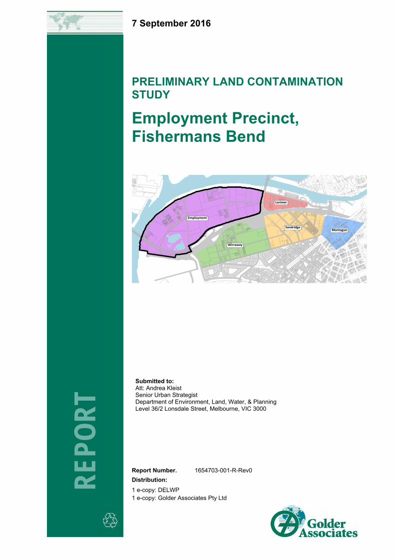
Employment
Wirraway
SandridgeMontague
Lorimer
PRELIMINARY LAND CONTAMINATION STUDY, EMPLOYMENT PRECINCT FISHERMANS BEND
7 September 2016 Report No. 1654703-001-R-Rev0 i
EXECUTIVE SUMMARY Urban Renewal Vision for Melbourne The Fishermans Bend Employment Precinct represents one of the most challenging urban renewal projects in Australia due to a long industrial history, land reclamation activities, complex underlying geology, and the current substantial private land ownership. Successful redevelopment requires the involvement of many agencies and stakeholders to find solutions for issues arising and to manage the integration of the Fishermans Bend District into the surrounding urban areas. To create alignment requires vision, planning and experience within the Victorian planning and regulatory environment throughout the lifespan of the redevelopment, which is anticipated to take 20 to 30 years.
Given the likelihood of extensive contamination across the Employment Precinct, DELWP engaged Golder to undertake this preliminary study of land contamination issues to assess the potential land use contamination ranking and opportunities to be considered as part of planning for district renewal. The information from this study will be used to inform transformative development planning for the Employment Precinct.
Objective and Study Themes Golder has undertaken a high level review of potential land contamination issues associated with past and present land uses within the Employment Precinct at Fishermans Bend.
The study was developed around five themes: 1) Understanding Melbourne’s Industrial Legacy and Precinct Redevelopment; 2) Past and Present Land Use; 3) Land Reclamation and Filling History; 4) Potential Land Use Contamination; and 5) Precinct Initiatives to Support Urban Renewal. The themes are structured to highlight how patterns of land use have shifted since Melbourne was settled, and to highlight the influence of social, regulatory and market influences on shaping the land use and development in Fishermans Bend, and when these events took place.
The current mosaic of land uses associated with land contamination is a result of interaction between themes. This report emphasises the importance of looking at such problems from first principles to shape and guide the Fishermans Bend Recast Vision moving forward.
Ultimately, potential land contamination is a recognised key factor in influencing the rate of urban renewal and choice of strategy direction for urban renewal projects.
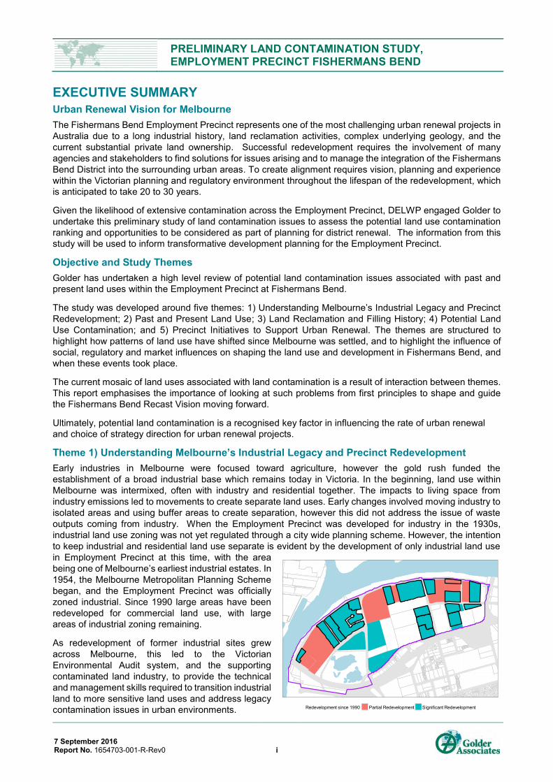
Theme 1) Understanding Melbourne’s Industrial Legacy and Precinct Redevelopment Early industries in Melbourne were focused toward agriculture, however the gold rush funded the establishment of a broad industrial base which remains today in Victoria. In the beginning, land use within Melbourne was intermixed, often with industry and residential together. The impacts to living space from industry emissions led to movements to create separate land uses. Early changes involved moving industry to isolated areas and using buffer areas to create separation, however this did not address the issue of waste outputs coming from industry. When the Employment Precinct was developed for industry in the 1930s, industrial land use zoning was not yet regulated through a city wide planning scheme. However, the intention to keep industrial and residential land use separate is evident by the development of only industrial land use in Employment Precinct at this time, with the area being one of Melbourne’s earliest industrial estates. In 1954, the Melbourne Metropolitan Planning Scheme began, and the Employment Precinct was officially zoned industrial. Since 1990 large areas have been redeveloped for commercial land use, with large areas of industrial zoning remaining.
As redevelopment of former industrial sites grew across Melbourne, this led to the Victorian Environmental Audit system, and the supporting contaminated land industry, to provide the technical and management skills required to transition industrial land to more sensitive land uses and address legacy contamination issues in urban environments. Redevelopment since 1990 Partial Redevelopment Significant Redevelopment
PRELIMINARY LAND CONTAMINATION STUDY, EMPLOYMENT PRECINCT FISHERMANS BEND
7 September 2016 Report No. 1654703-001-R-Rev0 ii
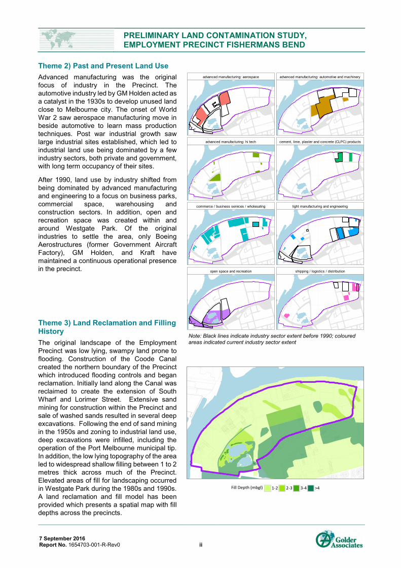
Theme 2) Past and Present Land Use Advanced manufacturing was the original focus of industry in the Precinct. The automotive industry led by GM Holden acted as a catalyst in the 1930s to develop unused land close to Melbourne city. The onset of World War 2 saw aerospace manufacturing move in beside automotive to learn mass production techniques. Post war industrial growth saw large industrial sites established, which led to industrial land use being dominated by a few industry sectors, both private and government, with long term occupancy of their sites.
After 1990, land use by industry shifted from being dominated by advanced manufacturing and engineering to a focus on business parks, commercial space, warehousing and construction sectors. In addition, open and recreation space was created within and around Westgate Park. Of the original industries to settle the area, only Boeing Aerostructures (former Government Aircraft Factory), GM Holden, and Kraft have maintained a continuous operational presence in the precinct.
Theme 3) Land Reclamation and Filling History The original landscape of the Employment Precinct was low lying, swampy land prone to flooding. Construction of the Coode Canal created the northern boundary of the Precinct which introduced flooding controls and began reclamation. Initially land along the Canal was reclaimed to create the extension of South Wharf and Lorimer Street. Extensive sand mining for construction within the Precinct and sale of washed sands resulted in several deep excavations. Following the end of sand mining in the 1950s and zoning to industrial land use, deep excavations were infilled, including the operation of the Port Melbourne municipal tip. In addition, the low lying topography of the area led to widespread shallow filling between 1 to 2 metres thick across much of the Precinct. Elevated areas of fill for landscaping occurred in Westgate Park during the 1980s and 1990s. A land reclamation and fill model has been provided which presents a spatial map with fill depths across the precincts.
Fill Depth (mbgl) 1-2 2-3 3-4 >4
Note: Black lines indicate industry sector extent before 1990; coloured areas indicated current industry sector extent
advanced manufacturing: aerospace advanced manufacturing: automotive and machinery
advanced manufacturing: hi tech cement, lime, plaster and concrete (CLPC) products
commerce / business services / wholesaling light manufacturing and engineering
open space and recreation shipping / logistics / distribution
PRELIMINARY LAND CONTAMINATION STUDY, EMPLOYMENT PRECINCT FISHERMANS BEND
7 September 2016 Report No. 1654703-001-R-Rev0
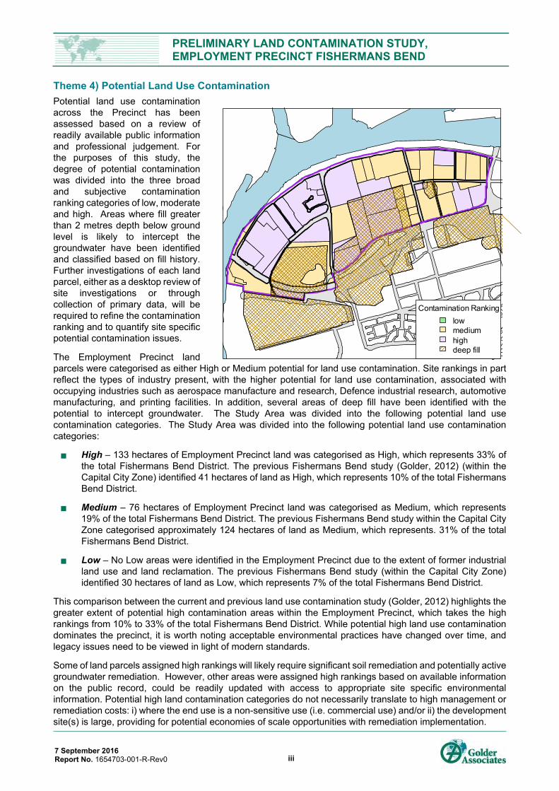
Theme 4) Potential Land Use Contamination Potential land use contamination across the Precinct has been assessed based on a review of readily available public information and professional judgement. For the purposes of this study, the degree of potential contamination was divided into the three broad and subjective contamination ranking categories of low, moderate and high. Areas where fill greater than 2 metres depth below ground level is likely to intercept the groundwater have been identified and classified based on fill history. Further investigations of each land parcel, either as a desktop review of site investigations or through collection of primary data, will be required to refine the contamination ranking and to quantify site specific potential contamination issues.
The Employment Precinct land parcels were categorised as either High or Medium potential for land use contamination. Site rankings in part reflect the types of industry present, with the higher potential for land use contamination, associated with occupying industries such as aerospace manufacture and research, Defence industrial research, automotive manufacturing, and printing facilities. In addition, several areas of deep fill have been identified with the potential to intercept groundwater. The Study Area was divided into the following potential land use contamination categories. The Study Area was divided into the following potential land use contamination categories:
High – 133 hectares of Employment Precinct land was categorised as High, which represents 33% of the total Fishermans Bend District. The previous Fishermans Bend study (Golder, 2012) (within the Capital City Zone) identified 41 hectares of land as High, which represents 10% of the total Fishermans Bend District.
Medium – 76 hectares of Employment Precinct land was categorised as Medium, which represents 19% of the total Fishermans Bend District. The previous Fishermans Bend study within the Capital City Zone categorised approximately 124 hectares of land as Medium, which represents. 31% of the total Fishermans Bend District.
Low – No Low areas were identified in the Employment Precinct due to the extent of former industrial land use and land reclamation. The previous Fishermans Bend study (within the Capital City Zone) identified 30 hectares of land as Low, which represents 7% of the total Fishermans Bend District.
This comparison between the current and previous land use contamination study (Golder, 2012) highlights the greater extent of potential high contamination areas within the Employment Precinct, which takes the high rankings from 10% to 33% of the total Fishermans Bend District. While potential high land use contamination dominates the precinct, it is worth noting acceptable environmental practices have changed over time, and legacy issues need to be viewed in light of modern standards.
Some of land parcels assigned high rankings will likely require significant soil remediation and potentially active groundwater remediation. However, other areas were assigned high rankings based on available information on the public record, could be readily updated with access to appropriate site specific environmental information. Potential high land contamination categories do not necessarily translate to high management or remediation costs: i) where the end use is a non-sensitive use (i.e. commercial use) and/or ii) the development site(s) is large, providing for potential economies of scale opportunities with remediation implementation.
Contamination Rankinglowmediumhighdeep fill
iii
PRELIMINARY LAND CONTAMINATION STUDY, EMPLOYMENT PRECINCT FISHERMANS BEND
7 September 2016 Report No. 1654703-001-R-Rev0 iv
Theme 5) Precinct Initiative to Support Urban Renewal The Employment Precinct and four associated Precincts within the Fishermans Bend District are commencing a 20 to 30-year period of urban renewal. Managing and remediating the contamination has been identified as a critical component of the urban renewal. The close proximity of the potentially contaminated sites within the precinct, and the potential to plan and regulate contaminated soil at a precinct level offer the potential to unlock more timely and economical contamination management strategies than might conventionally be adopted.
This document aimed to identify initiatives and opportunities to manage contamination at the precinct scale, capitalising on proximity and synergies towards the common development goals. The brief was for initiatives to be progressive, to look for opportunities and initiatives which may not necessarily be within the current regulatory framework, and to stimulate discussion on new regulatory standards that may be applied to contaminated land for the Fishermans Bend.
A total of ten initiatives were identified under three ‘themes’ to advance land contamination management in a precinct setting:
Regulatory:
Initiative 1. Definition of ‘site’ within the precinct for the purposes of contaminated soil re-use
Initiative 2. ‘Clusters’ of contamination management
Initiative 3. Prioritization of high risk sites to expedite closure and unencumber surrounds
Initiative 4. Precinct-specific Environmental Audit Statement conditions
Initiative 5. Resolving Precinct Groundwater Issues
Strategic:
Initiative 6. Integrating Waste Soil Management Strategy with Strategic Planning
Initiative 7. Development of Soil Containment /Repositories
Data and Communication:
Initiative 8. Contamination management efficiencies from shared learnings and pre-definedremediation goals
Initiative 9. Promotion of innovation in technology and policy
Initiative 10. Data collaboration – advances to support sharing of contamination information
These initiatives should be considered as preliminary. It is expected that the proposed initiatives will be a starting-point to stimulate discussion by stakeholders.
Consequently, actions are proposed to further explore each of the ten initiatives, with the aim of evaluating whether they are feasible, what adjustments may be required and, importantly, what stimulus and incentives may be needed to make them attractive for adoption by stakeholders.
The Fishermans Bend District is the largest urban renewal area in Australia. This provides a unique opportunity to explore and advance the way contaminated land is considered in the regulatory, strategic planning and data-sharing context.
PRELIMINARY LAND CONTAMINATION STUDY, EMPLOYMENT PRECINCT FISHERMANS BEND
7 September 2016 Report No. 1654703-001-R-Rev0 v
Table of Contents
1.0 INTRODUCTION ........................................................................................................................................................ 1
1.1 Background .................................................................................................................................................. 1
1.2 Study Objectives ........................................................................................................................................... 2
1.3 Study Approach and Report Structure .......................................................................................................... 3
2.0 UNDERSTANDING MELBOURNE’S INDUSTRIAL LEGACY AND PRECINCT REDEVELOPMENT ..................... 4
2.1 Societal Management of Industrial Sites in Melbourne ................................................................................. 5
2.1.1 1830s to 1890s: Melbourne’s Rapid Growth ........................................................................................... 5
2.1.2 1900s to 1940s: The Arrival of Mass Production ..................................................................................... 6
2.1.3 1950s to 1980s: Melbourne Metropolitan Planning Scheme ................................................................... 8
2.1.4 1990s to present: Current Approaches to Contaminated Land Assessment ......................................... 10
2.2 Summary: Precinct Redevelopment Model since 1990 .............................................................................. 12
3.0 PAST AND PRESENT LAND USE .......................................................................................................................... 13
3.1 Precinct Land Use and Development History ............................................................................................. 13
3.1.1 1830s to 1890s: The Gold Rush ........................................................................................................... 13
3.1.2 1900s to 1940s: Mass Production of Goods for WW2 .......................................................................... 14
3.1.3 1950s to 1980s: Mass Production of Goods for Consumers ................................................................. 17
3.1.4 1990s to present: Industrial Renewal, Business Parks and Recent Industry ........................................ 19
3.2 Summary: Industry Land Use Model ........................................................................................................... 21
3.2.1 Past and Present Land Use by Industry Sector .................................................................................... 21
3.2.2 Sub-Precinct: Businesses, Products and Land Use .............................................................................. 23
4.0 LAND RECLAMATION AND FILLING HISTORY ................................................................................................... 25
4.1 Geology of the Study Area .......................................................................................................................... 25
4.2 Land Reclamation and Filling History ......................................................................................................... 25
4.2.1 1830s to 1890s: Harbour Development and Coode Canal .................................................................... 25
4.2.2 1900s to 1940s: Early Industry at Fishermans Bend ............................................................................. 27
4.2.3 1950s to 1980s: Reclamation and Landfill ............................................................................................ 28
4.2.4 1990s to present: Using the Waste Management Hierarchy ................................................................. 31
4.3 Summary: Land Reclamation and Fill Depth Model .................................................................................... 32
5.0 POTENTIAL LAND USE CONTAMINATION .......................................................................................................... 34
5.1 Potential Contaminants and Sources .......................................................................................................... 34
5.2 Potential Contamination Issues by Segment of the Environment ............................................................... 35
5.3 Summary: Land Use Contamination Model ................................................................................................ 38
PRELIMINARY LAND CONTAMINATION STUDY, EMPLOYMENT PRECINCT FISHERMANS BEND
7 September 2016 Report No. 1654703-001-R-Rev0 vi
5.3.1 Approach ............................................................................................................................................... 38
5.3.2 Review of Potential Contamination Categories ..................................................................................... 40
6.0 PRECINCT INITIATIVES TO SUPPORT URBAN RENEWAL ................................................................................ 43
6.1 Current Regulation of Management of Land Contamination ....................................................................... 43
6.2 Challenges for Contamination Management at the Precinct Scale ............................................................. 45
6.3 Smarter Urban Renewal – Translating a Framework into Outcomes .......................................................... 46
6.4 Contaminated Land Management Initiatives ............................................................................................... 47
6.5 Land Use Urban Renewal Initiatives ........................................................................................................... 49
6.5.1 Regulatory Initiatives ............................................................................................................................. 50
6.5.2 Strategic Initiatives ................................................................................................................................ 54
6.5.3 Data and Communication Initiatives ...................................................................................................... 56
7.0 CONCLUSIONS ....................................................................................................................................................... 59
8.0 IMPORTANT INFORMATION .................................................................................................................................. 62
9.0 BIBLIOGRAPHY ...................................................................................................................................................... 63
TABLES Table 1: Industrial Land Uses Identified within the Study Area ......................................................................................... 21
Table 2: Potential Land Use Contamination Categories - Employment Precinct ............................................................... 39
Table 3: Area (hectares) by Contamination Category and Precinct (property parcels only) .............................................. 40
Table 4: Percentage (%) of Area by Contamination Category and Precinct (property parcels only) ................................. 40
FIGURES (WITHIN REPORT) Figure 1: Fishermans Bend District. Dashed lines show distance to Melbourne Town Hall ................................................ 1
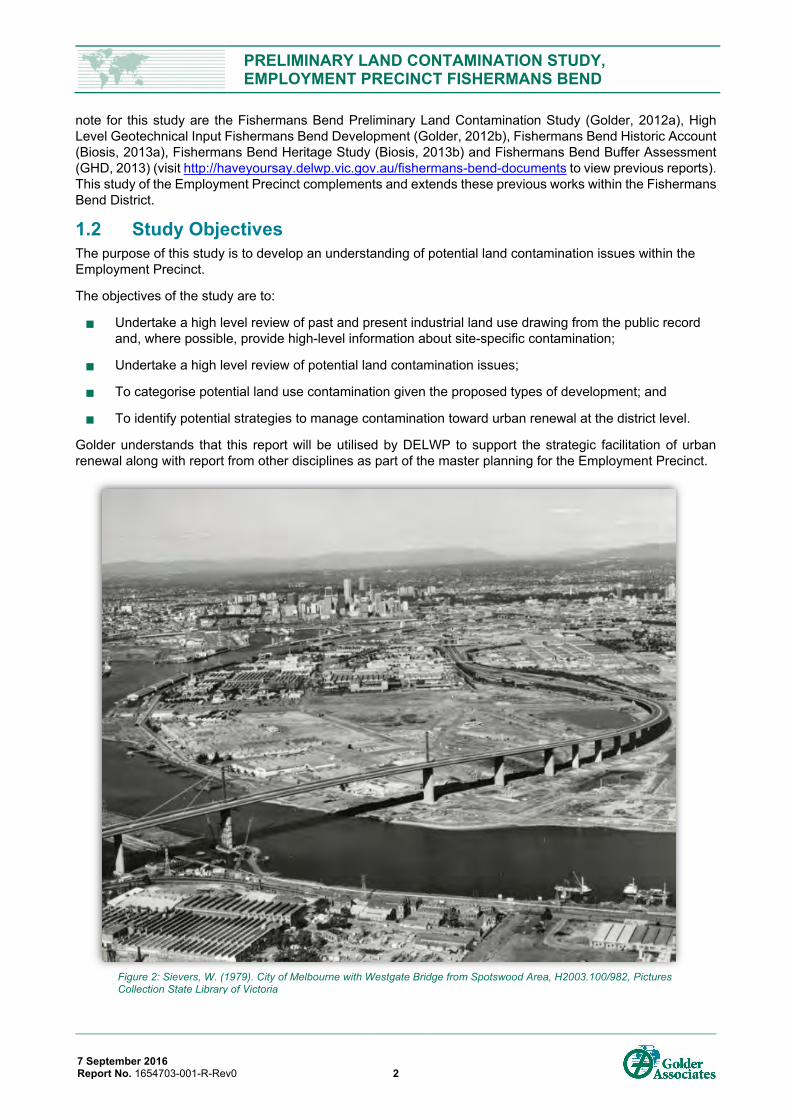
Figure 2: Sievers, W. (1979). City of Melbourne with Westgate Bridge from Spotswood Area, H2003.100/982, Pictures Collection State Library of Victoria ....................................................................................................... 2
Figure 3: 1954, The Australian Women's Weekly (1933 - 1982), 4 August, p. 58 viewed 20 Jul 2016, http://nla.gov.au/nla.news-page4812733 ............................................................................................................ 3
Figure 4: Photograph - Aerial View of Spotswood Pumping Station, Lower Yarra River & Fishermen's Bend, Victoria, circa 1954, Item MM 92390, Museum Victoria Collections (from MMBW Melbourne Metropolitan Planning Scheme report 1954, p.51). ............................................................................................ 4
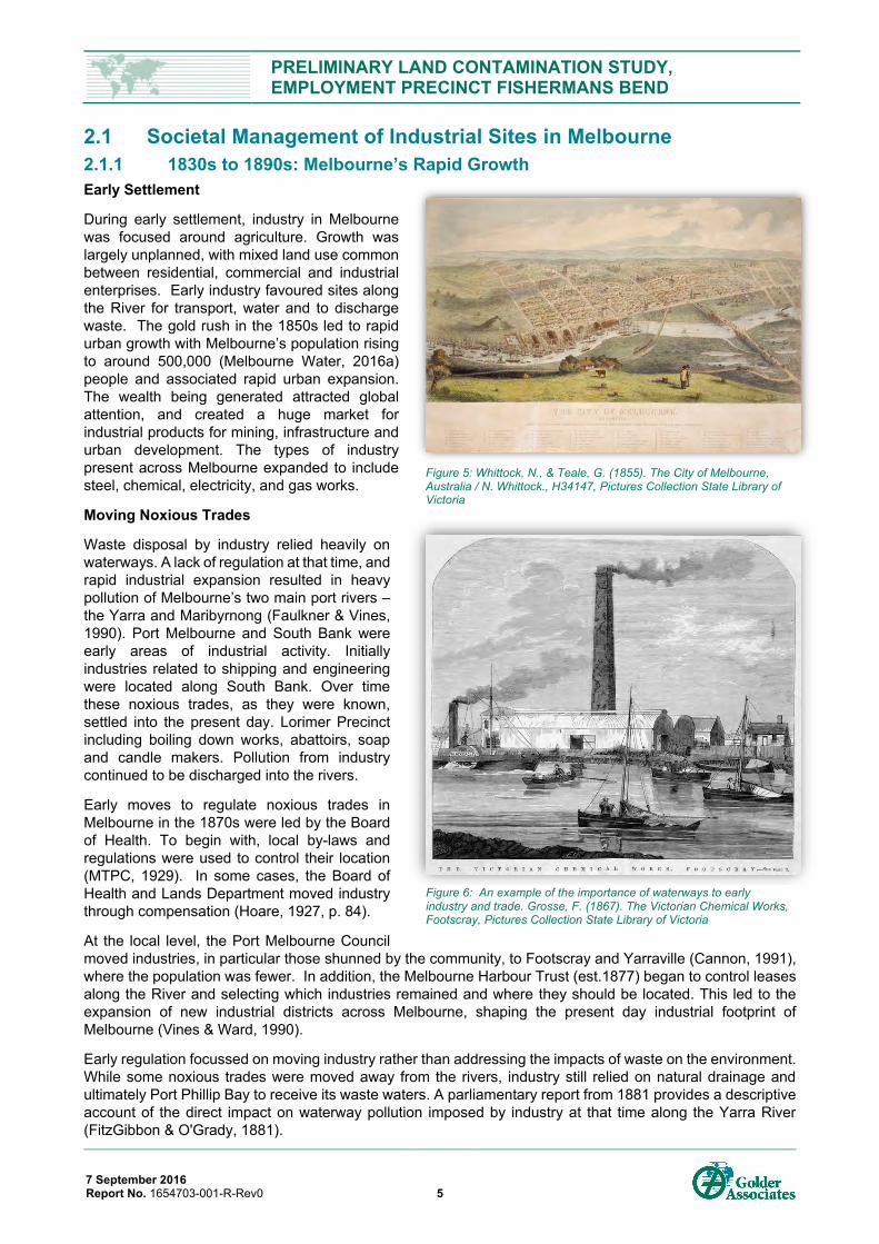
Figure 5: Whittock, N., & Teale, G. (1855). The City of Melbourne, Australia / N. Whittock., H34147, Pictures Collection State Library of Victoria ..................................................................................................................... 5
Figure 6: An example of the importance of waterways to early industry and trade. Grosse, F. (1867). The Victorian Chemical Works, Footscray, Pictures Collection State Library of Victoria ........................................... 5
Figure 7: (1892). Works on the new sewerage scheme for Melbourne. Melbourne, David Syme and co., image ian01/08/92/12, Pictures Collection, State Library of Victoria ............................................................................. 6
Figure 8: Radio Manufacture at the Radio Corporation Pty Ltd, South Melbourne Factory. (1931): In Collection: Pay Book and Photographs of the Radio Corporation of Australia Ltd., MS10808/PHO10, Pictures Collection State Library of Victoria ..................................................................................................................... 6
PRELIMINARY LAND CONTAMINATION STUDY, EMPLOYMENT PRECINCT FISHERMANS BEND
7 September 2016 Report No. 1654703-001-R-Rev0 vii
Figure 9: Phillip-Stephan Photolithographic Typographic Process Co. Ltd. (1891). Birds Eye View Melbourne, A view of Melbourne looking south-east across the Yarra. Several factory chimneys belch black smoke into the atmosphere amongst residential areas. H9021; H81.112/1, Pictures Collection, State Library of Victoria ............................................................................................................................................................... 7
Figure 11: Close up of Fishermans Bend from 1954 plan showing extent of existing industrial land use (black) and expansion of industrial zoned land (orange). (MMBW, 1954, p. 49) ................................................................... 8
Figure 11: 1954 plan showing extent of existing industrial land use (black) and expansion of industrial zoned land (orange). (MMBW, 1954, p. 49) .......................................................................................................................... 8
Figure 12: Hansford, P & Argus (1954) Chimney being demolished, H2002.199/672, Pictures Collection, State Library of Victoria ............................................................................................................................................... 9
Figure 13: Cutaway view of a 1953 automotive lead acid battery, National Institute of Standards and Technology Digital Collections, Gaithersburg, MD20899 ....................................................................................................... 9
Figure 14: Current Planning Scheme and Overlays for the Employment Precinct. Employment precinct outlined with a solid black line. ....................................................................................................................................... 10
Figure 15: All sites with publicly available environmental contamination reports (as of June 2016). A summary of the reports is included in Appendix D2 ............................................................................................................. 11
Figure 16: Redeveloped sites and those with available environmental reports. Redeveloped since 1990s. The year 1990 used as a benchmark as the Victorian Environmental Audit system began in 1989. Figure includes sites completely redeveloped with significant redevelopment. Black lines indicate business parks and commercial / office / warehouse space. ........................................................................................... 12
Figure 17: Coode, J. (1879). Melbourne Harbour Trust dock and river improvements proposed by Sir John Coode, Pictures Collection, State Library of Victoria. Note how shipping and trade are the first industries to shape the Employment Precinct. ...................................................................................................................... 13
Figure 18: Melbourne and Metropolitan Board of Works plan, scale 160 feet to 1 inch. no.9, Port Melbourne, c1894, Pictures Collection, State Library of Victoria ......................................................................................... 13
Figure 19: Tucker, A. (1939). Fisherman's Bend: Collection of contact prints, depicting aspects of the artist's life and the artistic community in Melbourne, 1930-1945. H2008/.98/497, Pictures Collection, State Library of Victoria ......................................................................................................................................................... 13
Figure 20: Melbourne Harbor Trust. (1940). Reclamation sites, Scale 1100' to 1' (approx). Drawer 9A, DRG. No. 8016, Pictures Collection State Library of Victoria. Note – precinct boundaries shown in black. ..................... 14
Figure 21: Personal Papers of Prime Minister Menzies, Airport press cuttings re Fishermen's Bend, 1936, National Archives of Australia, CP450/7, 173 ................................................................................................................. 14
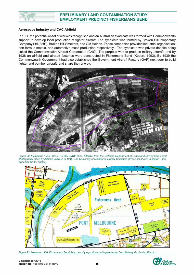
Figure 22: Melbourne 1945. Scale 1:5,660. B&W, sheet 848b4a, from the Victorian Department of Lands and Survey from aerial photography taken by Adastra Airways in 1945, The University of Melbourne Library Collection (Precincts shown in colour – see Appendix D3 for details). ............................................................. 15
Figure 23: Melways 1966, Fishermans Bend, Map proudly reproduced with permission from Melway Publishing Pty Ltd .............................................................................................................................................................. 15
Figure 24: A68 Mustang production line. [PRG 247/143/77], State Library of South Australia .......................................... 16
Figure 25: Fishermans Bend, Melbourne, vic. 1943-04-06. General view of the depot of Victoria l. Of c. Area salvage unit, showing a stack of salvaged timber in the foreground, image 050589, Australian War Memorial .......................................................................................................................................................... 16
Figure 26: Mechanical foundry GMH Fishermen's Bend, 1956, National Archives of Australia: A1200, L20453 .............. 16
Figure 27: Prototype No.5 of 48-215 [FX], [BRG 213/65/30/21], State Library of South Australia ..................................... 17
Figure 28: Truck displaying fibrous plaster. products of Australian Gypsum (later Boral Plasterboard), c1930s. H2009.20/69, Harold Paynting Collection, Pictures Collection, State Library of Victoria .................................. 17
Figure 29: Storage chambers for cheese at Kraft Foods Limited at Fishermans Bend, 1956, National Archives of Australia: A1200, L22723 ................................................................................................................................. 17
Figure 30: Car Racing at Fisherman's Bend, between 1945 and 1954, H2014.957/138, Reginald Fulford compiler, Pictures Collection, State Library of Victoria .................................................................................................... 18
PRELIMINARY LAND CONTAMINATION STUDY, EMPLOYMENT PRECINCT FISHERMANS BEND
7 September 2016 Report No. 1654703-001-R-Rev0 viii
Figure 31: Checkers examine new Holden engines at the engine assembly plant at Fisherman's Bend near Melbourne, 1963, National Archives of Australia: A1200, L45049 ................................................................... 18
Figure 32: Pratt, CD & Airspy (1950), Aerial view of Fisherman's Bend, Image H2008.32/6. Pictures Collection State Library of Victoria .................................................................................................................................... 18
Figure 33: Dry bulk industries which rely on port access for delivery of raw materials. Both Boral Plasterboard (left) and Independent Cement and Lime (right) access the port using pipelines over Lorimer Street. Break bulk and dry bulk ships can be seen unloading. ..................................................................................... 19
Figure 34: Current commercial spaces, business parks and distribution centres. Employment Precinct boundary in purple. .............................................................................................................................................................. 19
Figure 35: Summary of site development since 1990. Sites developed into business parks are shown with a black bold line. Employment precinct boundary in purple .......................................................................................... 20
Figure 36: Announced future development sites. Employment precinct boundary in purple. ............................................ 20
Figure 37: Location of industry footprint in Fisherman’s Bend Precinct showing a) past land use (black border) and b) present land use (filled area). Study Area boundary shown with Employment Precinct in purple. ........ 22
Figure 38: Sub-precincts within the Study Area. Sub-precincts divided by roadways have borders indicated by colour. .............................................................................................................................................................. 23
Figure 39: Cox 1864 Plan, Cox, Henry L. (Henry Laird) & Bourchier, Thomas & McHugh, P. H & Great Britain. Hydrographic Department 1866, Victoria-Australia, Port Phillip. Hobson Bay and River Yarra leading to Melbourne, [1866 ed.], Published by the Admiralty, London, Pictures Collection, State Library of Victoria ............................................................................................................................................................. 25
Figure 40: Melbourne Harbour Trust. Drawing no. 1, General plan showing harbour improvements: as recommended by Sir John Coode in his report of 17th Feb. 1879. Pictures Collection, State Library of Victoria ............................................................................................................................................................. 26
Figure 41: Calvert, S, 1884, The Harbour Trust Operations at Fisherman's Bend, David Syme and Co, Melbourne, Pictures Collection, State Library of Victoria .................................................................................................... 26
Figure 42: Aerial view of General Motors Holden, Fisherman's Bend, Pratt. CD, and Airspy (1940), Image H91.160/263, Pictures Collection, State Library of Victoria .............................................................................. 27
Figure 43: Original GMH factory, ca 1936, Pratt, CD & Airspy (1940), General Motors Holden (GMH) factory at Fishermans Bend, beside Yarra River, H91.160/258, Pictures Collection, State Library of Victoria ................ 27
Figure 44: Hodgson, F. (c.1940), Aerial view of Fisherman's Bend, Victoria, H96.163/11, Pictures Collection, State Library of Victoria ............................................................................................................................................. 27
Figure 45: Pratt, CD & Airspy (1950), Aerial view of Fisherman's Bend, H2008.32/7, Pictures Collection, State Library of Victoria. Note: image likely taken late 1950s. ................................................................................... 28
Figure 46: Pratt, CD & Airspy (1950), Aerial view of Fisherman's Bend, H2008.32/1, Pictures Collection State Library of Victoria. Note: Image likely taken around c1960. ............................................................................. 29
Figure 47: Pratt, CD & Airspy (1950), Aerial view of GM Holden Fisherman's Bend, Image H2008.41/71, Pictures Collection State Library of Victoria, Note the white 'fan' in the top left corner which is landfill waste from the Port Melbourne municipal tip being deposited. Image likely taken around c1960. ..................................... 29
Figure 48: Pratt, CD & Airspy (1950), Aerial view of Fisherman's Bend, Image H2008.32/6. Pictures Collection State Library of Victoria, Note the former Melbourne Sand Works site in the bottom left corner and the recently SEC workshop under construction in the centre, Photo likely around early 1960s. ............................ 30
Figure 49: Waste management hierarchy, source: Victorian EPA, http://www.epa.vic.gov.au/your-environment/waste ........................................................................................................................................... 31
Figure 50: Employment Precinct Fill Depth model ............................................................................................................ 33
Figure 51: Cross section from landfill along southern boundary of Employment Precinct. Source: EPA Audit CARMS No. 38456-3a. Cross section highlights depth of a landfill compared with shallow fill layers. Landfill located along west side of Salmon Street, northern boundary of Plummer Street Precinct ................. 33
Figure 52: AVRO LINCOLN DEMONSTRATED AT GOVERNMENT AIRCRAFT FACTORY'S AIRSTRIP AT FISHERMENS BEND, PORT MELBOURNE, 1939-1945, Australian War Memorial, AC0261 ........................ 35
PRELIMINARY LAND CONTAMINATION STUDY, EMPLOYMENT PRECINCT FISHERMANS BEND
7 September 2016 Report No. 1654703-001-R-Rev0 ix
Figure 53: Shell of unfinished car, in paint drying oven at the General Motors Holden factory, Fishermans Bend, Melbourne, 1953, National Archive of Australia, A1200: L15483 ..................................................................... 36
Figure 54: Interior view of grocer, 1948, H94.150/67. Harold Paynting Collection, State Library of Victoria. Note mass produced food goods, including Kraft, in background. ............................................................................ 37
Figure 55: First Australian made Gypsy Moth goes out onto the test bench at General Motors – Holden’s works at Fisherman's Bend. ca. 1940, Argus (Melbourne, Vic., H99.206/1951, Pictures Collection, State Library of Victoria ......................................................................................................................................................... 38
Figure 56: Potential Land Use Contamination for Industrial Land Use. Areas where deep fill has been identified are indicated by hatching. ................................................................................................................................ 42
Figure 57: Front view of the CA-4 A23-1001 CAC Woomera, prototype of a three-seat strike-reconnaissance and dive-bomber, completed and ready for testing in a hangar at the CAC factories in Fishermans Bend, Victoria. CA4 A231001 Woomera. [PRG 247/143/36], State Library of South Australia ................................... 43
Figure 58: Example of investigation of former landfill. Dark soil impacted by waste oil (Photograph by P. Bentley). ........ 45
Figure 59: Ron Barassi Snr Park, Docklands with physical separate layer between site users and residual soil contamination (photograph by C. Wallis) .......................................................................................................... 45
Figure 60: Sievers, W., & Yuncken Freeman Architects. (1967). Lifting and Fitting Pre-cast Concrete Panels, Government Laboratories Block, State Government Offices, Macarthur Street, East Melbourne, H2000.195/336, Pictures Collection, State Library of Victoria. CLPC products from the Employment Precinct have been used to build Melbourne. .................................................................................................. 46
Figure 61: Testing and inspection of component parts before assembly is a feature of production methods, at the plant of the Standard Motor Company (Australia) Pty Ltd, at Fishermen's Bend, Victoria - Here a distributor is being electrically tested and adjusted, 1956, National Archives of Australia, A1200, L21179 ............................................................................................................................................................. 47
Figure 62: Paint finishing on cars at the Standard Motor Company (Australia) Pty Ltd in Fishermen's Bend, 1956, National Archives of Australia, A1200, L21173. Site located in the Sandridge Precinct (former Toyota plant) ................................................................................................................................................................ 49
Figure 63: Existing Regional Groundwater Network in Fisherman’s Bend. Image sourced from the technical report: AECOM, 2016, Baseline Groundwater Quality Assessment, Fishermans Bend Urban Renewal Area. ................................................................................................................................................................. 53
FIGURES (ATTACHED TO MAIN REPORT)
Figure A- 1: Fishermans Bend Urban Renewal Area Figure A- 2: Regional Geology and Cross Section Locations Figure A- 3: Cross Sections A and B Figure A- 4: Cross Sections E and F Figure A- 5: Regional Topography Figure A- 6: Fill Model Figure A- 7: Land Contamination Ranking
Figure C2- 1: Registered Groundwater Bore Use
Figure D3- 1: Historical Aerial Photograph - 1931 Figure D3- 2: Historical Aerial Photograph - 1945 Figure D3- 3: Historical Aerial Photograph - 1951 Figure D3- 4: Historical Aerial Photograph - 1966 Figure D3- 5: Historical Aerial Photograph - 1972 Figure D3- 6: Historical Aerial Photograph - 1982 Figure D3- 7: Historical Aerial Photograph - 1990 Figure D3- 8: Historical Aerial Photograph – 2016
PRELIMINARY LAND CONTAMINATION STUDY, EMPLOYMENT PRECINCT FISHERMANS BEND
7 September 2016 Report No. 1654703-001-R-Rev0 x
Appendix A – Figures for Main Report Appendix B – Materials and Method
Appendix C – Environmental Setting
- Appendix C1 – Geology and Geotechnical Review
- Appendix C2 – Drainage and Hydrogeology
- Appendix C3 – Acid Sulfate Soils
Appendix D – Industrial Land Use Setting
- Appendix D1 – Land Use and Contaminants of Interest
- Appendix D2 – Contaminated Land Regulatory Setting
- Appendix D3 – Aerial Photographs
- Appendix D4 – Planning Scheme
Appendix E – Important Information
PRELIMINARY LAND CONTAMINATION STUDY, EMPLOYMENT PRECINCT FISHERMANS BEND
7 September 2016 Report No. 1654703-001-R-Rev0 1
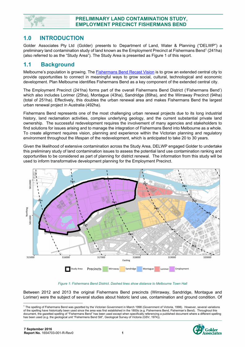
1.0 INTRODUCTION Golder Associates Pty Ltd (Golder) presents to Department of Land, Water & Planning (“DELWP”) a preliminary land contamination study of land known as the Employment Precinct at Fishermans Bend1 (241ha) (also referred to as the “Study Area”). The Study Area is presented as Figure 1 of this report.
1.1 Background Melbourne’s population is growing. The Fishermans Bend Recast Vision is to grow an extended central city to provide opportunities to connect in meaningful ways to grow social, cultural, technological and economic development. Plan Melbourne identifies Fishermans Bend as a key component of the extended central city.
The Employment Precinct (241ha) forms part of the overall Fishermans Bend District (‘Fishermans Bend’) which also includes Lorimer (25ha), Montague (43ha), Sandridge (89ha), and the Wirraway Precinct (94ha) (total of 251ha). Effectively, this doubles the urban renewal area and makes Fishermans Bend the largest urban renewal project in Australia (492ha).
Fishermans Bend represents one of the most challenging urban renewal projects due to its long industrial history, land reclamation activities, complex underlying geology, and the current substantial private land ownership. The successful redevelopment requires the involvement of many agencies and stakeholders to find solutions for issues arising and to manage the integration of Fishermans Bend into Melbourne as a whole. To create alignment requires vision, planning and experience within the Victorian planning and regulatory environment throughout the lifespan of the redevelopment, which is anticipated to take 20 to 30 years.
Given the likelihood of extensive contamination across the Study Area, DELWP engaged Golder to undertake this preliminary study of land contamination issues to assess the potential land use contamination ranking and opportunities to be considered as part of planning for district renewal. The information from this study will be used to inform transformative development planning for the Employment Precinct.
Figure 1: Fishermans Bend District. Dashed lines show distance to Melbourne Town Hall
Between 2012 and 2013 the original Fishermans Bend precincts (Wirraway, Sandridge, Montague and Lorimer) were the subject of several studies about historic land use, contamination and ground condition. Of
1 The spelling of Fishermans Bend was gazetted by the Victorian Government in March 1998 (Government of Victoria, 1998). However, several variations of the spelling have historically been used since the area was first established in the 1800s (e.g. Fishermens Bend, Fisherman’s Bend). Throughout this document, the gazetted spelling of “Fishermans Bend” has been used except when specifically referencing a published document where a different spelling has been used (e.g. the geological unit “Fishermens Bend Silt”, Geological Survey of Victoria (GSV, 1974)).
2km
2km
2km
3km
3km
3km
3km
4km
4km
5km
5km
6km
58
11
000
58
12
000
315000 316000 317000 318000 319000 320000Easting
No
rth
ing
Study Area Precincts Wirraway Sandridge Montague Lorimer Employment
PRELIMINARY LAND CONTAMINATION STUDY, EMPLOYMENT PRECINCT FISHERMANS BEND
7 September 2016 Report No. 1654703-001-R-Rev0 2
note for this study are the Fishermans Bend Preliminary Land Contamination Study (Golder, 2012a), High Level Geotechnical Input Fishermans Bend Development (Golder, 2012b), Fishermans Bend Historic Account (Biosis, 2013a), Fishermans Bend Heritage Study (Biosis, 2013b) and Fishermans Bend Buffer Assessment (GHD, 2013) (visit http://haveyoursay.delwp.vic.gov.au/fishermans-bend-documents to view previous reports). This study of the Employment Precinct complements and extends these previous works within the Fishermans Bend District.
1.2 Study Objectives The purpose of this study is to develop an understanding of potential land contamination issues within the Employment Precinct.
The objectives of the study are to:
Undertake a high level review of past and present industrial land use drawing from the public record and, where possible, provide high-level information about site-specific contamination;
Undertake a high level review of potential land contamination issues;
To categorise potential land use contamination given the proposed types of development; and
To identify potential strategies to manage contamination toward urban renewal at the district level.
Golder understands that this report will be utilised by DELWP to support the strategic facilitation of urban renewal along with report from other disciplines as part of the master planning for the Employment Precinct.
Figure 2: Sievers, W. (1979). City of Melbourne with Westgate Bridge from Spotswood Area, H2003.100/982, Pictures Collection State Library of Victoria
PRELIMINARY LAND CONTAMINATION STUDY, EMPLOYMENT PRECINCT FISHERMANS BEND
7 September 2016 Report No. 1654703-001-R-Rev0 3
1.3 Study Approach and Report Structure To address the objectives, this report is structured into four themes. For each theme information from reviewed records is presented chronologically to illustrate the development within the Study Area and how events within Melbourne were shaping development in the Study Area. At the end of each theme a model summarising key information in each theme relevant to the Employment Precinct development narrative is presented.
Theme 1) Understanding Melbourne’s Industrial Legacy and Precinct Redevelopment
A review of how Melbourne has grown to manage industrial sites, how the process for the renewal of industrial sites emerged, and what this means for the Study Area.
Theme 2) Past and Present Land Use
Review of past and present industrial land use in the Study Area, reviewing the context and drivers for industry development and change overtime. The Study Area is divided into small sub-precincts based on former land use and geography, with available high-level information presented historic site activities, industrial products and production processes to provide an understanding of what was produced and how. A model for the extent of past and present industry land use is presented.
Theme 3) Land Reclamation and Filling History
A review of the phases of reclamation. A model of fill depth across the region is presented.
Theme 4) Potential Land Use Contamination
Drawing from the other themes, a review of potential land use contamination is provided based on the proposed types of development. A model is presented with categories of potential levels of contamination divided into high, medium or low.
Theme 5) Precinct Initiatives to Support Urban Renewal
Precinct initiatives that could be considered to enable sustainable and cost effective development outcomes.
Figures and historic images are included throughout the main body of this report to illustrate historic land use, industrial setting and products manufactured within the Study Area. Supporting information and explanatory notes are included in the Appendices at the rear of the main report.
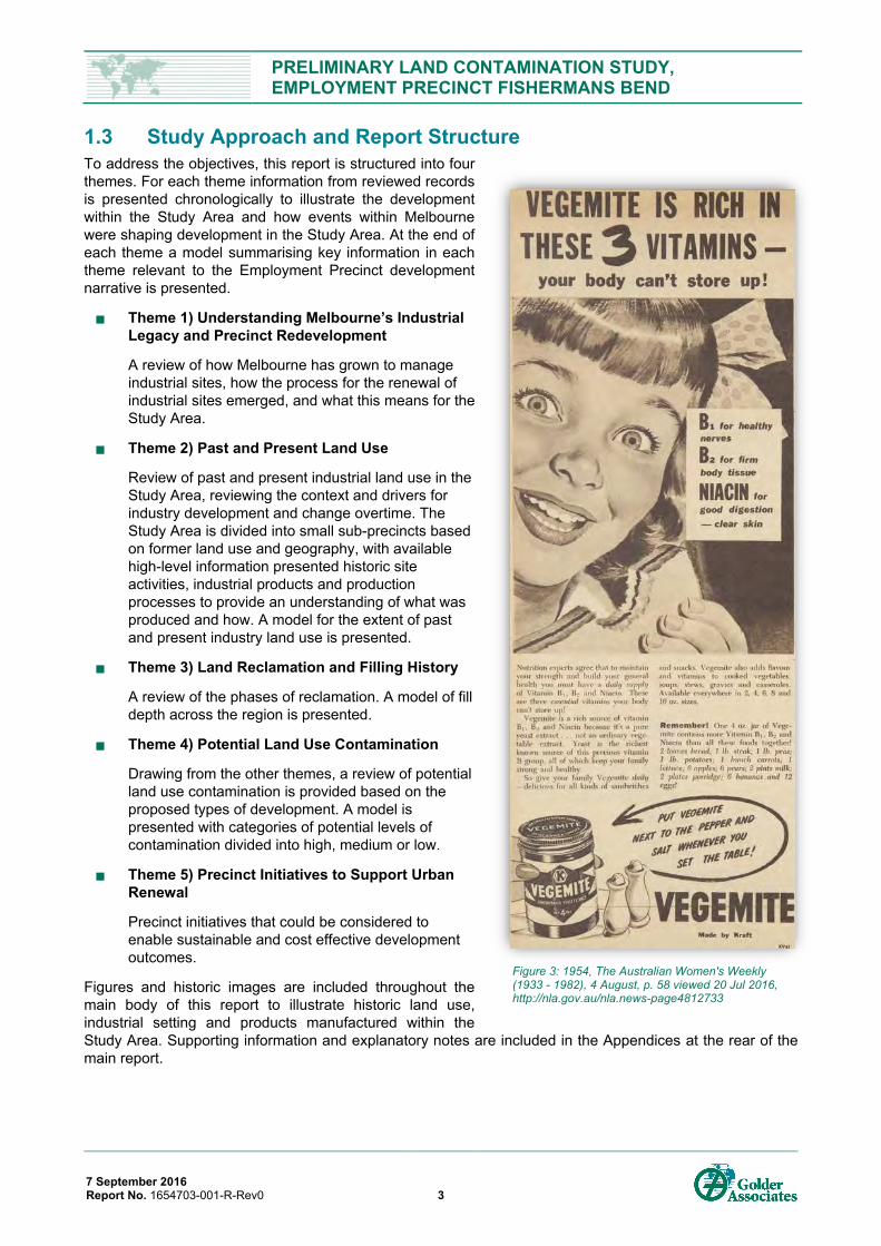
Figure 3: 1954, The Australian Women's Weekly (1933 - 1982), 4 August, p. 58 viewed 20 Jul 2016, http://nla.gov.au/nla.news-page4812733
PRELIMINARY LAND CONTAMINATION STUDY, EMPLOYMENT PRECINCT FISHERMANS BEND
7 September 2016 Report No. 1654703-001-R-Rev0 4
2.0 UNDERSTANDING MELBOURNE’S INDUSTRIAL LEGACY AND PRECINCT REDEVELOPMENT
This section is intended to provide context describing how Melbourne has evolved, recognising the increased need to protect and conserve human and environmental values. The trends reflected here have been influenced by Melbourne being part of an international community and exchange of ideas that occurs within this community. This section provides an overview of where identified needs to improve health within urban environments arose, and the social and regulatory milestones which have guided us to today.
The focus here is on change, and approaches to management of industrial land in Melbourne since its establishment in 1835, and some of the challenges and solutions which arose. Initial concerns focused on human health and amenity, managed through limited environmental planning considerations.
Beginning in the 1960s the impacts of industrial chemicals on environmental values became widely recognised globally resulting in environmental legislation. The purpose of legislation was to establish measures for protecting human health, amenity and the environment whilst affording the capacity of ongoing industrial operation and development. The statutory framework has matured since its development taking into account new information on impacts of pollutants and reflecting the aspirations of Victorians for a healthy environment. The Environmental Audit system established in the late 1980s emerged out of a contamination event in Ardeer, Melbourne. The Environmental Audit system, which is administered and overseen by the Victorian EPA, is a modern statutory tool that enables former industrial sites to be renewed for more sensitive land uses, whilst providing a high standard of control to maintain the confidence of the Victorian government, community and industry.
Industrial practices have changed over time. Past events which may not meet today’s standards were acceptable practice at their time. When looking at past industry practices in today’s environment, it is important to consider this context, and to see through the lens of what was acceptable at that time. This section covers changes to the management of pollution, contamination and waste and how these changes are reflected in the history of Fisherman’s Bend Employment Precinct.
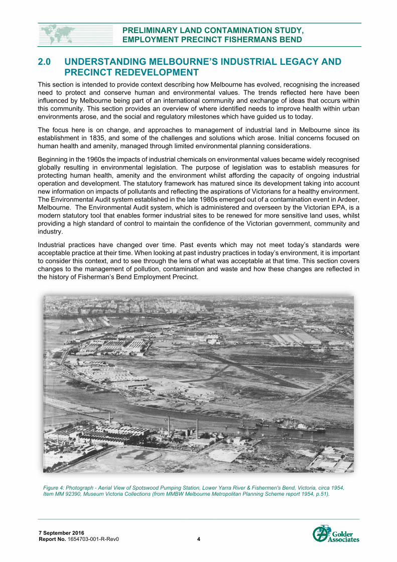
Figure 4: Photograph - Aerial View of Spotswood Pumping Station, Lower Yarra River & Fishermen's Bend, Victoria, circa 1954, Item MM 92390, Museum Victoria Collections (from MMBW Melbourne Metropolitan Planning Scheme report 1954, p.51).
PRELIMINARY LAND CONTAMINATION STUDY, EMPLOYMENT PRECINCT FISHERMANS BEND
7 September 2016 Report No. 1654703-001-R-Rev0 5
2.1 Societal Management of Industrial Sites in Melbourne 2.1.1 1830s to 1890s: Melbourne’s Rapid Growth Early Settlement
During early settlement, industry in Melbourne was focused around agriculture. Growth was largely unplanned, with mixed land use common between residential, commercial and industrial enterprises. Early industry favoured sites along the River for transport, water and to discharge waste. The gold rush in the 1850s led to rapid urban growth with Melbourne’s population rising to around 500,000 (Melbourne Water, 2016a) people and associated rapid urban expansion. The wealth being generated attracted global attention, and created a huge market for industrial products for mining, infrastructure and urban development. The types of industry present across Melbourne expanded to include steel, chemical, electricity, and gas works.
Moving Noxious Trades
Waste disposal by industry relied heavily on waterways. A lack of regulation at that time, and rapid industrial expansion resulted in heavy pollution of Melbourne’s two main port rivers – the Yarra and Maribyrnong (Faulkner & Vines, 1990). Port Melbourne and South Bank were early areas of industrial activity. Initially industries related to shipping and engineering were located along South Bank. Over time these noxious trades, as they were known, settled into the present day. Lorimer Precinct including boiling down works, abattoirs, soap and candle makers. Pollution from industry continued to be discharged into the rivers.
Early moves to regulate noxious trades in Melbourne in the 1870s were led by the Board of Health. To begin with, local by-laws and regulations were used to control their location (MTPC, 1929). In some cases, the Board of Health and Lands Department moved industry through compensation (Hoare, 1927, p. 84).
At the local level, the Port Melbourne Council moved industries, in particular those shunned by the community, to Footscray and Yarraville (Cannon, 1991), where the population was fewer. In addition, the Melbourne Harbour Trust (est.1877) began to control leases along the River and selecting which industries remained and where they should be located. This led to the expansion of new industrial districts across Melbourne, shaping the present day industrial footprint of Melbourne (Vines & Ward, 1990).
Early regulation focussed on moving industry rather than addressing the impacts of waste on the environment. While some noxious trades were moved away from the rivers, industry still relied on natural drainage and ultimately Port Phillip Bay to receive its waste waters. A parliamentary report from 1881 provides a descriptive account of the direct impact on waterway pollution imposed by industry at that time along the Yarra River (FitzGibbon & O'Grady, 1881).
Figure 6: An example of the importance of waterways to early industry and trade. Grosse, F. (1867). The Victorian Chemical Works, Footscray, Pictures Collection State Library of Victoria
Figure 5: Whittock, N., & Teale, G. (1855). The City of Melbourne, Australia / N. Whittock., H34147, Pictures Collection State Library of Victoria

PRELIMINARY LAND CONTAMINATION STUDY, EMPLOYMENT PRECINCT FISHERMANS BEND
7 September 2016 Report No. 1654703-001-R-Rev0 6
Melbourne Metropolitan Board of Works
In addition to industrial waste, Melbourne was also overwhelmed with managing human effluent. Despite Melbourne’s wealth, early rapid and unplanned growth led to a sewerage system of open drains along streets. These drains flowed into street channels and connected with natural drainage lines to remove waste in an increasingly urbanising landscape. ‘Night soil collectors’ to manually clear ‘thunder boxes’ using weekly collection were introduced, however open drains were preferred (Melbourne Water, 2016b).
Understandably, the city was nicknamed Marvellous Smellbourne. The combination of waste streams from residential, commercial and industrial land uses required a collective solution to manage urban health. By 1890 plans were made to develop a sewerage system. Melbourne Metropolitan Board of Works was formed in 1891. The Hobsons Bay Main and pumping station in Spotswood was completed in 1895 to service the Melbourne CBD and southeast suburbs (Engineering Heritage Victoria, 2014). The main defines the southern boundary of Westgate Park. In 1897 the first flushing toilet was installed in Port Melbourne (Museum Victoria, 2016).
2.1.2 1900s to 1940s: The Arrival of Mass Production Mass Production, Bigger Factories and Electricity
The rise of mass production from the automotive industry in 1908 set the tone for modern industry. Factory design shifted to large buildings to accommodate this new method. Demand for large wide open factory floors brought saw tooth roofs for lighting to accommodate mass production techniques. Provision of electricity enabled the shift toward modem mass production. The first industrial revolution was defined by steam power where factories were reliant on their own source of power. The second industrial revolution has been defined by electricity where power generation moved from site based to regional production beginning with the Newport Power Station (1919) and the Yallourn Power Station (1921) (Brady, 1997). This new source of energy changed production process, infrastructure and the scale of production possible.
Figure 7: (1892). Works on the new sewerage scheme for Melbourne. Melbourne, David Syme and co., image ian01/08/92/12, Pictures Collection, State Library of Victoria
Figure 8: Radio Manufacture at the Radio Corporation Pty Ltd, South Melbourne Factory. (1931): In Collection: Pay Book and Photographs of the Radio Corporation of Australia Ltd., MS10808/PHO10, Pictures Collection State Library of Victoria
PRELIMINARY LAND CONTAMINATION STUDY, EMPLOYMENT PRECINCT FISHERMANS BEND
7 September 2016 Report No. 1654703-001-R-Rev0 7
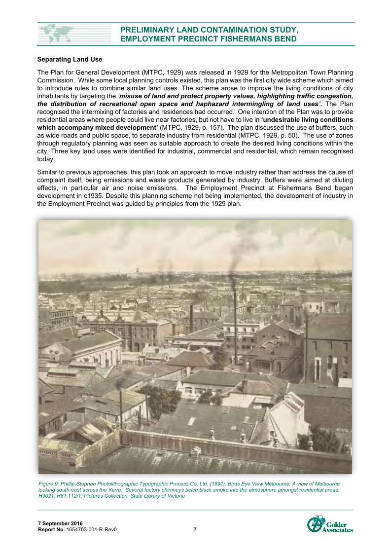
Separating Land Use
The Plan for General Development (MTPC, 1929) was released in 1929 for the Metropolitan Town Planning Commission. While some local planning controls existed, this plan was the first city wide scheme which aimed to introduce rules to combine similar land uses. The scheme arose to improve the living conditions of city inhabitants by targeting the ‘misuse of land and protect property values, highlighting traffic congestion, the distribution of recreational open space and haphazard intermingling of land uses’. The Plan recognised the intermixing of factories and residences had occurred. One intention of the Plan was to provide residential areas where people could live near factories, but not have to live in ‘undesirable living conditions which accompany mixed development’ (MTPC, 1929, p. 157). The plan discussed the use of buffers, such as wide roads and public space, to separate industry from residential (MTPC, 1929, p. 50). The use of zones through regulatory planning was seen as suitable approach to create the desired living conditions within the city. Three key land uses were identified for industrial, commercial and residential, which remain recognised today.
Similar to previous approaches, this plan took an approach to move industry rather than address the cause of complaint itself, being emissions and waste products generated by industry. Buffers were aimed at diluting effects, in particular air and noise emissions. The Employment Precinct at Fishermans Bend began development in c1935. Despite this planning scheme not being implemented, the development of industry in the Employment Precinct was guided by principles from the 1929 plan.
Figure 9: Phillip-Stephan Photolithographic Typographic Process Co. Ltd. (1891). Birds Eye View Melbourne, A view of Melbourne looking south-east across the Yarra. Several factory chimneys belch black smoke into the atmosphere amongst residential areas. H9021; H81.112/1, Pictures Collection, State Library of Victoria
PRELIMINARY LAND CONTAMINATION STUDY, EMPLOYMENT PRECINCT FISHERMANS BEND
7 September 2016 Report No. 1654703-001-R-Rev0 8
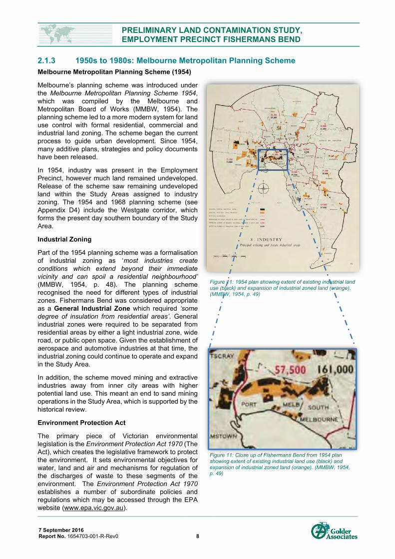
2.1.3 1950s to 1980s: Melbourne Metropolitan Planning Scheme Melbourne Metropolitan Planning Scheme (1954)
Melbourne’s planning scheme was introduced under the Melbourne Metropolitan Planning Scheme 1954, which was compiled by the Melbourne and Metropolitan Board of Works (MMBW, 1954). The planning scheme led to a more modern system for land use control with formal residential, commercial and industrial land zoning. The scheme began the current process to guide urban development. Since 1954, many additive plans, strategies and policy documents have been released.
In 1954, industry was present in the Employment Precinct, however much land remained undeveloped. Release of the scheme saw remaining undeveloped land within the Study Areas assigned to industry zoning. The 1954 and 1968 planning scheme (see Appendix D4) include the Westgate corridor, which forms the present day southern boundary of the Study Area.
Industrial Zoning
Part of the 1954 planning scheme was a formalisation of industrial zoning as ‘most industries create conditions which extend beyond their immediate vicinity and can spoil a residential neighbourhood’ (MMBW, 1954, p. 48). The planning scheme recognised the need for different types of industrial zones. Fishermans Bend was considered appropriate as a General Industrial Zone which required ‘some degree of insulation from residential areas’. General industrial zones were required to be separated from residential areas by either a light industrial zone, wide road, or public open space. Given the establishment of aerospace and automotive industries at that time, the industrial zoning could continue to operate and expand in the Study Area.
In addition, the scheme moved mining and extractive industries away from inner city areas with higher potential land use. This meant an end to sand mining operations in the Study Area, which is supported by the historical review.
Environment Protection Act
The primary piece of Victorian environmental legislation is the Environment Protection Act 1970 (The Act), which creates the legislative framework to protect the environment. It sets environmental objectives for water, land and air and mechanisms for regulation of the discharges of waste to these segments of the environment. The Environment Protection Act 1970 establishes a number of subordinate policies and regulations which may be accessed through the EPA website (www.epa.vic.gov.au).
Figure 11: Close up of Fishermans Bend from 1954 plan showing extent of existing industrial land use (black) and expansion of industrial zoned land (orange). (MMBW, 1954, p. 49)
Figure 11: 1954 plan showing extent of existing industrial land use (black) and expansion of industrial zoned land (orange). (MMBW, 1954, p. 49)
PRELIMINARY LAND CONTAMINATION STUDY, EMPLOYMENT PRECINCT FISHERMANS BEND
7 September 2016 Report No. 1654703-001-R-Rev0 9
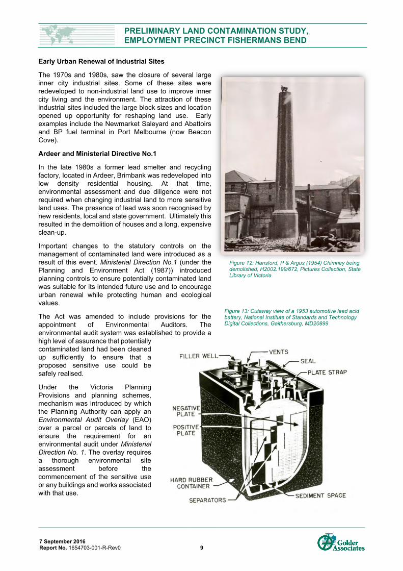
Early Urban Renewal of Industrial Sites
The 1970s and 1980s, saw the closure of several large inner city industrial sites. Some of these sites were redeveloped to non-industrial land use to improve inner city living and the environment. The attraction of these industrial sites included the large block sizes and location opened up opportunity for reshaping land use. Early examples include the Newmarket Saleyard and Abattoirs and BP fuel terminal in Port Melbourne (now Beacon Cove).
Ardeer and Ministerial Directive No.1
In the late 1980s a former lead smelter and recycling factory, located in Ardeer, Brimbank was redeveloped into low density residential housing. At that time, environmental assessment and due diligence were not required when changing industrial land to more sensitive land uses. The presence of lead was soon recognised by new residents, local and state government. Ultimately this resulted in the demolition of houses and a long, expensive clean-up.
Important changes to the statutory controls on the management of contaminated land were introduced as a result of this event. Ministerial Direction No.1 (under the Planning and Environment Act (1987)) introduced planning controls to ensure potentially contaminated land was suitable for its intended future use and to encourage urban renewal while protecting human and ecological values.
The Act was amended to include provisions for the appointment of Environmental Auditors. The environmental audit system was established to provide a high level of assurance that potentially contaminated land had been cleaned up sufficiently to ensure that a proposed sensitive use could be safely realised.
Under the Victoria Planning Provisions and planning schemes, mechanism was introduced by which the Planning Authority can apply an Environmental Audit Overlay (EAO) over a parcel or parcels of land to ensure the requirement for an environmental audit under Ministerial Direction No. 1. The overlay requires a thorough environmental site assessment before the commencement of the sensitive use or any buildings and works associated with that use.
Figure 12: Hansford, P & Argus (1954) Chimney being demolished, H2002.199/672, Pictures Collection, State Library of Victoria
Figure 13: Cutaway view of a 1953 automotive lead acid battery, National Institute of Standards and Technology Digital Collections, Gaithersburg, MD20899
PRELIMINARY LAND CONTAMINATION STUDY, EMPLOYMENT PRECINCT FISHERMANS BEND
7 September 2016 Report No. 1654703-001-R-Rev0 10
2.1.4 1990s to present: Current Approaches to Contaminated Land Assessment Urban Renewal toward a more Sensitive Land Use (53x Environmental Audit)
The environmental audit system for contaminated land establishes a process of independent third party review by EPA appointed Environmental Auditors to evaluate the condition of the site and form an opinion on its suitability for use. Environmental Auditors are engaged and paid by proponents, but their primary duty of care is to the Victorian environment and community. The Environmental Auditor is required to make a “total assessment” of the potential for detrimental impacts on the environment from contamination, by considering and applying EPA regulations, policies, and guidelines.
Under Section 53X of The Act, Environmental Audits are a statutory tool used to protect the community and to confirm that potentially contaminated land is suitable for its intended use. Triggers for carrying out a 53X Audit at a site include the following:
planning need (permit condition, Environmental Audit Overlay, rezoning of land to more sensitive use);
due diligence (e.g. buying/selling a property);
when changing a land use to a more sensitive use;
when a previous use may have introduced contamination.
Undertaking an Audit typically involves engagement of an Environmental Auditor appointed by EPA pursuant to Section 53 of The Act, a site investigation phase and, depending on the results of the investigation, further steps such as risk assessment, soil/groundwater remediation and ongoing management of residual contamination.
When groundwater cannot be remediated to restore all the protected uses, the Environmental Auditor has the faculty to determine that Clean Up to the Extent Practicable (CUTEP) has occurred and must recommend to EPA the boundary of the groundwater quality restricted use zone (GQRUZ) where the pollution precludes a protected use of groundwater.
The Audit is finalised when the Auditor is satisfied that site risks have been remediated, or suitably managed.
For sites where no adverse contamination remains that would restrict any future use of that land, the Environmental Auditor issues a Certificate of Environmental Audit and Audit report certifying the site is suitable for any use with no conditions. If residual contamination requires management potentially restricting the use that can be made of the land, the Environmental Auditor issues a Statement of Environmental Audit and Audit Report. This may include:
restrictions and conditions that must be met for the site to be suitable for its intended use (i.e. installation of separation layers above contaminated soil or construction of vapour barrier).
conditions on parties to implement ongoing actions (i.e. ongoing groundwater monitoring and contingency measures to be adopted if certain triggers are realised).
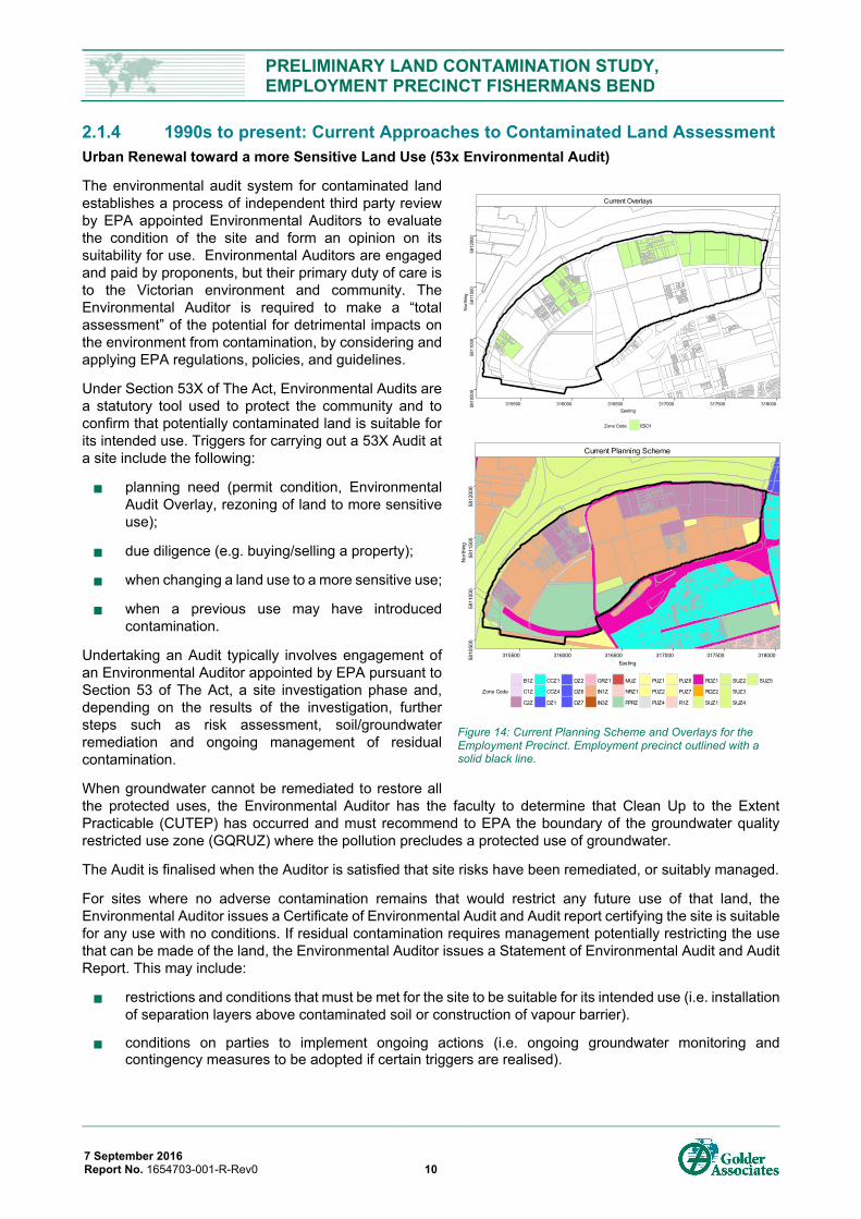
Figure 14: Current Planning Scheme and Overlays for the Employment Precinct. Employment precinct outlined with a solid black line.
Current Planning Scheme
5810
500
5811
000
5811
500
5812
000
315500 316000 316500 317000 317500 318000Easting
Nor
thin
g
Zone Code
B1Z
C1Z
C2Z
CCZ1
CCZ4
DZ1
DZ2
DZ6
DZ7
GRZ1
IN1Z
IN3Z
MUZ
NRZ1
PPRZ
PUZ1
PUZ2
PUZ4
PUZ6
PUZ7
R1Z
RDZ1
RDZ2
SUZ1
SUZ2
SUZ3
SUZ4
SUZ5
Current Overlays
5810
500
5811
000
5811
500
5812
000
315500 316000 316500 317000 317500 318000Easting
Nor
thin
g
Zone Code ESO1
PRELIMINARY LAND CONTAMINATION STUDY, EMPLOYMENT PRECINCT FISHERMANS BEND
7 September 2016 Report No. 1654703-001-R-Rev0 11
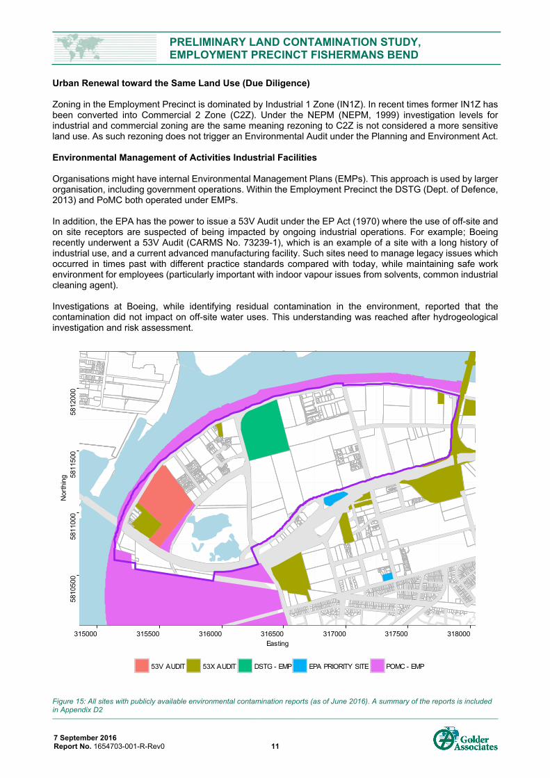
Urban Renewal toward the Same Land Use (Due Diligence) Zoning in the Employment Precinct is dominated by Industrial 1 Zone (IN1Z). In recent times former IN1Z has been converted into Commercial 2 Zone (C2Z). Under the NEPM (NEPM, 1999) investigation levels for industrial and commercial zoning are the same meaning rezoning to C2Z is not considered a more sensitive land use. As such rezoning does not trigger an Environmental Audit under the Planning and Environment Act. Environmental Management of Activities Industrial Facilities Organisations might have internal Environmental Management Plans (EMPs). This approach is used by larger organisation, including government operations. Within the Employment Precinct the DSTG (Dept. of Defence, 2013) and PoMC both operated under EMPs. In addition, the EPA has the power to issue a 53V Audit under the EP Act (1970) where the use of off-site and on site receptors are suspected of being impacted by ongoing industrial operations. For example; Boeing recently underwent a 53V Audit (CARMS No. 73239-1), which is an example of a site with a long history of industrial use, and a current advanced manufacturing facility. Such sites need to manage legacy issues which occurred in times past with different practice standards compared with today, while maintaining safe work environment for employees (particularly important with indoor vapour issues from solvents, common industrial cleaning agent). Investigations at Boeing, while identifying residual contamination in the environment, reported that the contamination did not impact on off-site water uses. This understanding was reached after hydrogeological investigation and risk assessment.
Figure 15: All sites with publicly available environmental contamination reports (as of June 2016). A summary of the reports is included in Appendix D2
5810
500
5811
000
5811
500
5812
000
315000 315500 316000 316500 317000 317500 318000Easting
Nor
thin
g
53V AUDIT 53X AUDIT DSTG - EMP EPA PRIORITY SITE POMC - EMP
PRELIMINARY LAND CONTAMINATION STUDY, EMPLOYMENT PRECINCT FISHERMANS BEND
7 September 2016 Report No. 1654703-001-R-Rev0 12
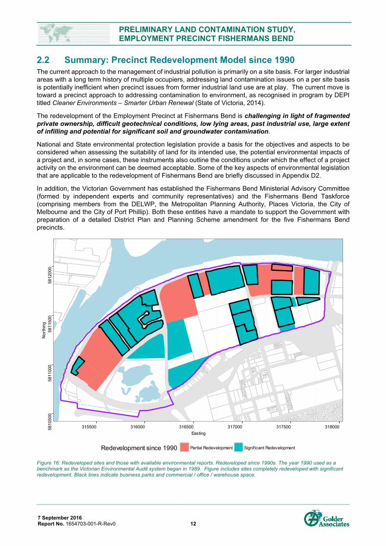
2.2 Summary: Precinct Redevelopment Model since 1990 The current approach to the management of industrial pollution is primarily on a site basis. For larger industrial areas with a long term history of multiple occupiers, addressing land contamination issues on a per site basis is potentially inefficient when precinct issues from former industrial land use are at play. The current move is toward a precinct approach to addressing contamination to environment, as recognised in program by DEPI titled Cleaner Environments – Smarter Urban Renewal (State of Victoria, 2014).
The redevelopment of the Employment Precinct at Fishermans Bend is challenging in light of fragmented private ownership, difficult geotechnical conditions, low lying areas, past industrial use, large extent of infilling and potential for significant soil and groundwater contamination.
National and State environmental protection legislation provide a basis for the objectives and aspects to be considered when assessing the suitability of land for its intended use, the potential environmental impacts of a project and, in some cases, these instruments also outline the conditions under which the effect of a project activity on the environment can be deemed acceptable. Some of the key aspects of environmental legislation that are applicable to the redevelopment of Fishermans Bend are briefly discussed in Appendix D2.
In addition, the Victorian Government has established the Fishermans Bend Ministerial Advisory Committee (formed by independent experts and community representatives) and the Fishermans Bend Taskforce (comprising members from the DELWP, the Metropolitan Planning Authority, Places Victoria, the City of Melbourne and the City of Port Phillip). Both these entities have a mandate to support the Government with preparation of a detailed District Plan and Planning Scheme amendment for the five Fishermans Bend precincts.
Figure 16: Redeveloped sites and those with available environmental reports. Redeveloped since 1990s. The year 1990 used as a benchmark as the Victorian Environmental Audit system began in 1989. Figure includes sites completely redeveloped with significant redevelopment. Black lines indicate business parks and commercial / office / warehouse space.
5810
500
5811
000
5811
500
5812
000
315500 316000 316500 317000 317500 318000Easting
Nor
thin
g
Redevelopment since 1990 Partial Redevelopment Signif icant Redevelopment
PRELIMINARY LAND CONTAMINATION STUDY, EMPLOYMENT PRECINCT FISHERMANS BEND
7 September 2016 Report No. 1654703-001-R-Rev0 13
3.0 PAST AND PRESENT LAND USE 3.1 Precinct Land Use and Development History 3.1.1 1830s to 1890s: The Gold Rush Gold Grows Early Industry
Early industry in Melbourne focused around agriculture and building a new settlement. The discovery of gold in Ballarat in 1851 made Victoria swell with people and wealth. This created rapid demand for products to supply the mining industry and revenue to fund the expansion of Victoria’s industrial base including engineering works, steel, machinery, explosives, chemicals, food, shelter and transport (i.e. rail and shipping).
Fishermans Bend was an area of Melbourne to experience early industrial growth. Flooding of lower lying areas saw early developments begin in the eastern part of the Study Area. Construction of the Coode Canal included reclamation, flood embankments and the extension of South Wharf, which would enable industry to expand westward in the Fishermans Bend. At that time the western part of Fishermans Bend was occupied by few scattered houses and fishermen’s camps (hence the name).
Economic Downturn in the 1890s
Following the completion of the Coode Canal, Melbourne experienced a severe economic crash which saw a down turn in trade in the 1890s. This led to some factory closures and slowing of harbour trade, meaning development stalled along the section South Wharf recently constructed in the Employment Precinct.
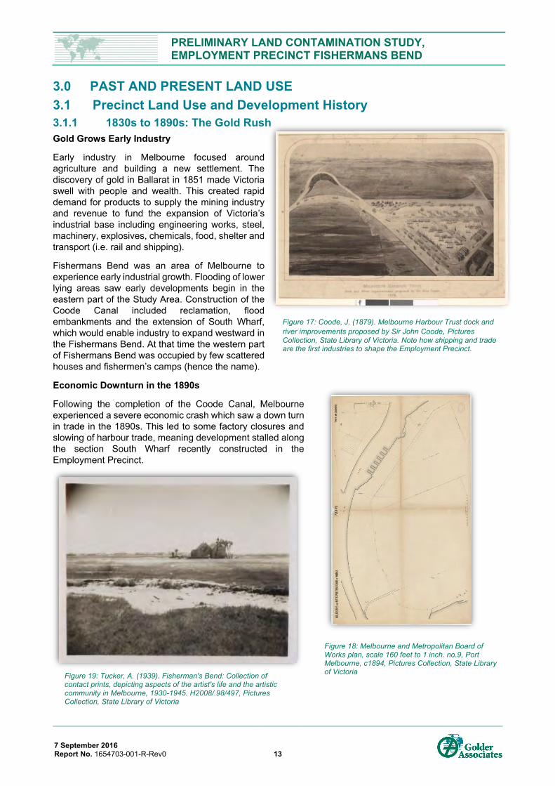
Figure 17: Coode, J. (1879). Melbourne Harbour Trust dock and river improvements proposed by Sir John Coode, Pictures Collection, State Library of Victoria. Note how shipping and trade are the first industries to shape the Employment Precinct.
Figure 19: Tucker, A. (1939). Fisherman's Bend: Collection of contact prints, depicting aspects of the artist's life and the artistic community in Melbourne, 1930-1945. H2008/.98/497, Pictures Collection, State Library of Victoria
Figure 18: Melbourne and Metropolitan Board of Works plan, scale 160 feet to 1 inch. no.9, Port Melbourne, c1894, Pictures Collection, State Library of Victoria
PRELIMINARY LAND CONTAMINATION STUDY, EMPLOYMENT PRECINCT FISHERMANS BEND
7 September 2016 Report No. 1654703-001-R-Rev0 14
3.1.2 1900s to 1940s: Mass Production of Goods for WW2 World War 1 and further economic depression of early 20th century delayed major developments of land at Fishermans Bend. As there were other sites in Melbourne with better development opportunities, limited development occurred in the Study Area until the 1930s, with the exception of a golf course, some sand mining and a rifle range.
Industrial growth concentrated along Lorimer Street and the newly constructed Salmon Street, which were along higher ground and easier for development.
Automotive Industry
Beginning in the 1930s a government led stimulus package was used to promote industrial growth in Victoria. This package saw GM Holden establish its Fishermans Bend auto assembly plant. The attraction for GM Holden was access to shipping and transport, labour, and room to expand. GM Holden was one of several automotive manufacturers which established in Fishermans Bend during this period. With mass production inherent with automotive manufacturing sites, expansion potential was an important siting criterion. From the beginning, the car industry was recognised for its role in stimulating growth of other industries in the region, a connection which influences the high number of vehicle parts manufacturers and related industries which moved to Port Melbourne. These support industries included glass, paint, leather, rubber, metal trades, oil and petroleum (Vines & Ward, 1990). GM Holden began in 1936, and shortly after Neale’s Motors (later AutoCraft / Austin Motors) opened next door.
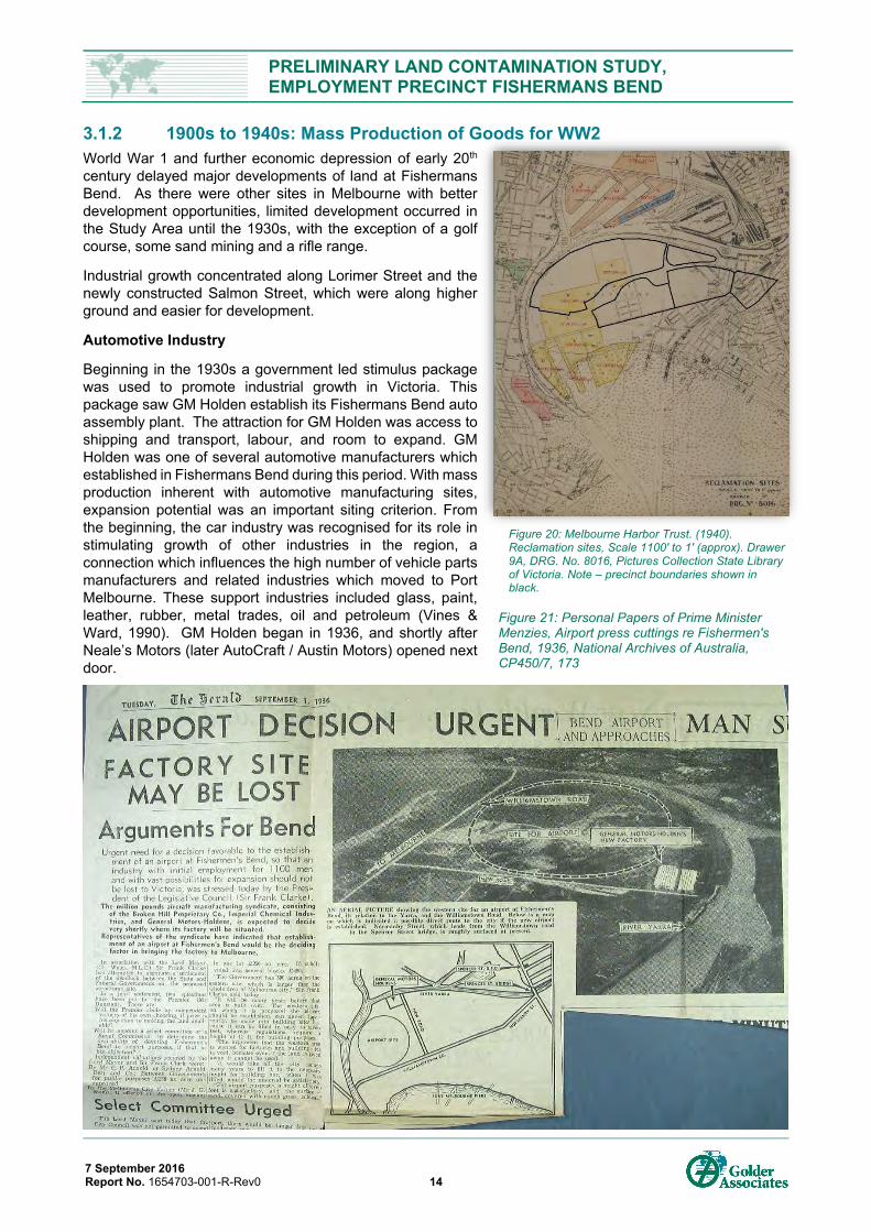
Figure 20: Melbourne Harbor Trust. (1940). Reclamation sites, Scale 1100' to 1' (approx). Drawer 9A, DRG. No. 8016, Pictures Collection State Library of Victoria. Note – precinct boundaries shown in black.
Figure 21: Personal Papers of Prime Minister Menzies, Airport press cuttings re Fishermen's Bend, 1936, National Archives of Australia, CP450/7, 173
PRELIMINARY LAND CONTAMINATION STUDY, EMPLOYMENT PRECINCT FISHERMANS BEND
7 September 2016 Report No. 1654703-001-R-Rev0 15
Aerospace Industry and CAC Airfield
In 1936 the potential onset of war was recognised and an Australian syndicate was formed with Commonwealth support to develop local production of fighter aircraft. The syndicate was formed by Broken Hill Proprietary Company Ltd (BHP), Broken Hill Smelters, and GM Holden. These companies provided industrial organisation, non-ferrous metals, and automotive mass production respectively. The syndicate was private despite being called the Commonwealth Aircraft Corporation (CAC). The purpose was to produce military aircraft, and by 1938 an airfield and aircraft factories were constructed in Fishermans Bend (Kepert, 1993). By 1939 the Commonwealth Government had also established the Government Aircraft Factory (GAF) next door to build fighter and bomber aircraft, and share the runway.
Figure 22: Melbourne 1945. Scale 1:5,660. B&W, sheet 848b4a, from the Victorian Department of Lands and Survey from aerial photography taken by Adastra Airways in 1945, The University of Melbourne Library Collection (Precincts shown in colour – see Appendix D3 for details).
Figure 23: Melways 1966, Fishermans Bend, Map proudly reproduced with permission from Melway Publishing Pty Ltd
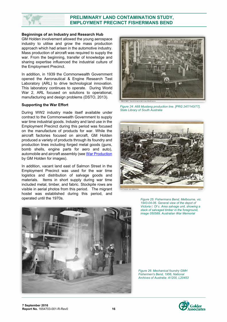
PRELIMINARY LAND CONTAMINATION STUDY, EMPLOYMENT PRECINCT FISHERMANS BEND
7 September 2016 Report No. 1654703-001-R-Rev0 16
Beginnings of an Industry and Research Hub GM Holden involvement allowed the young aerospace industry to utilise and grow the mass production approach which had arisen in the automotive industry. Mass production of aircraft was required to supply the war. From the beginning, transfer of knowledge and sharing expertise influenced the industrial culture of the Employment Precinct.
In addition, in 1939 the Commonwealth Government opened the Aeronautical & Engine Research Test Laboratory (ARL) to drive technological innovation. This laboratory continues to operate. During World War 2, ARL focused on solutions to operational, manufacturing and design problems (DSTO, 2013).
Supporting the War Effort
During WW2 industry made itself available under contract to the Commonwealth Government to supply war time industrial goods. Industry and land use in the Employment Precinct during this period was focused on the manufacture of products for war. While the aircraft factories focused on aircraft, GM Holden produced a variety of products through its foundry and production lines including forged metal goods (guns, bomb shells, engine parts for aero and auto), automobile and aircraft assembly (see War Production by GM Holden for images).
In addition, vacant land east of Salmon Street in the Employment Precinct was used for the war time logistics and distribution of salvage goods and materials. Items in short supply during war time included metal, timber, and fabric. Stockpile rows are visible in aerial photos from this period. The migrant hostel was established during this period, and operated until the 1970s.
Figure 26: Mechanical foundry GMH Fishermen's Bend, 1956, National Archives of Australia: A1200, L20453
Figure 24: A68 Mustang production line. [PRG 247/143/77], State Library of South Australia
Figure 25: Fishermans Bend, Melbourne, vic. 1943-04-06. General view of the depot of Victoria l. Of c. Area salvage unit, showing a stack of salvaged timber in the foreground, image 050589, Australian War Memorial
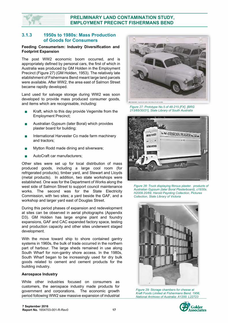
PRELIMINARY LAND CONTAMINATION STUDY, EMPLOYMENT PRECINCT FISHERMANS BEND
7 September 2016 Report No. 1654703-001-R-Rev0 17
3.1.3 1950s to 1980s: Mass Production of Goods for Consumers
Feeding Consumerism: Industry Diversification and Footprint Expansion
The post WW2 economic boom occurred, and is appropriately defined by personal cars, the first of which in Australia was produced by GM Holden in the Employment Precinct (Figure 27) (GM Holden, 1953). The relatively late etablishment of Fishermans Bend meant large land parcels were available. After WW2, the area east of Salmon Street became rapidly developed.
Land used for salvage storage during WW2 was soon developed to provide mass produced consumer goods, and items which are recognisable, including:
Kraft, which to this day provide Vegemite from the Employment Precinct;
Australian Gypsum (later Boral) which provides plaster board for building;
International Harvester Co made farm machinery and tractors;
Mytton Rodd made dining and silverware;
AutoCraft car manufacturers;
Other sites were set up for local distribution of mass produced goods, including a large cool room (for refrigerated products), timber yard, and Stewart and Lloyds (metal products). In addition, two state workshops were established. One was for the Department of Works along the west side of Salmon Street to support council maintenance works. The second was for the State Electricity Commission, with two sites; a yard beside the GAF, and a workshop and larger yard east of Douglas Street.
During this period phases of expansion and redevelopment at sites can be observed in aerial photographs (Appendix D3). GM Holden has large engine plant and foundry expansions, GAF and CAC expanded factory space, testing and production capacity and other sites underwent staged development.
With the move toward ship to shore contained gantry systems in 1960s, the bulk of trade occurred in the northern part of harbour. The large sheds remained in use along South Wharf for non-gantry shore access. In the 1980s, South Wharf began to be increasingly used for dry bulk goods related to cement and cement products for the building industry.
Aerospace Industry
While other industries focused on consumers as customers, the aerospace industry made products for government and corporations. The economic growth period following WW2 saw massive expansion of industrial
Figure 27: Prototype No.5 of 48-215 [FX], [BRG 213/65/30/21], State Library of South Australia
Figure 28: Truck displaying fibrous plaster. products of Australian Gypsum (later Boral Plasterboard), c1930s. H2009.20/69, Harold Paynting Collection, Pictures Collection, State Library of Victoria
Figure 29: Storage chambers for cheese at Kraft Foods Limited at Fishermans Bend, 1956, National Archives of Australia: A1200, L22723
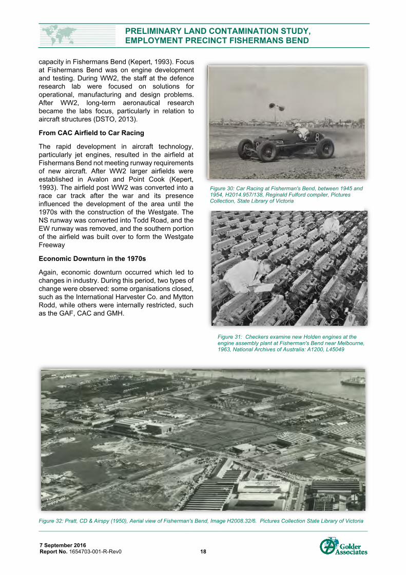
PRELIMINARY LAND CONTAMINATION STUDY, EMPLOYMENT PRECINCT FISHERMANS BEND
7 September 2016 Report No. 1654703-001-R-Rev0 18
capacity in Fishermans Bend (Kepert, 1993). Focus at Fishermans Bend was on engine development and testing. During WW2, the staff at the defence research lab were focused on solutions for operational, manufacturing and design problems. After WW2, long-term aeronautical research became the labs focus, particularly in relation to aircraft structures (DSTO, 2013).
From CAC Airfield to Car Racing
The rapid development in aircraft technology, particularly jet engines, resulted in the airfield at Fishermans Bend not meeting runway requirements of new aircraft. After WW2 larger airfields were established in Avalon and Point Cook (Kepert, 1993). The airfield post WW2 was converted into a race car track after the war and its presence influenced the development of the area until the 1970s with the construction of the Westgate. The NS runway was converted into Todd Road, and the EW runway was removed, and the southern portion of the airfield was built over to form the Westgate Freeway
Economic Downturn in the 1970s
Again, economic downturn occurred which led to changes in industry. During this period, two types of change were observed: some organisations closed, such as the International Harvester Co. and Mytton Rodd, while others were internally restricted, such as the GAF, CAC and GMH.
Figure 32: Pratt, CD & Airspy (1950), Aerial view of Fisherman's Bend, Image H2008.32/6. Pictures Collection State Library of Victoria
Figure 31: Checkers examine new Holden engines at the engine assembly plant at Fisherman's Bend near Melbourne, 1963, National Archives of Australia: A1200, L45049
Figure 30: Car Racing at Fisherman's Bend, between 1945 and 1954, H2014.957/138, Reginald Fulford compiler, Pictures Collection, State Library of Victoria
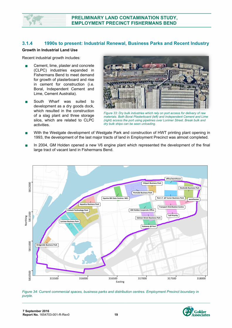
PRELIMINARY LAND CONTAMINATION STUDY, EMPLOYMENT PRECINCT FISHERMANS BEND
7 September 2016 Report No. 1654703-001-R-Rev0 19
3.1.4 1990s to present: Industrial Renewal, Business Parks and Recent Industry Growth in Industrial Land Use
Recent industrial growth includes:
Cement, lime, plaster and concrete (CLPC) industries expanded in Fishermans Bend to meet demand for growth of plasterboard and rise in cement for construction (i.e. Boral, Independent Cement and Lime, Cement Australia).
South Wharf was suited to development as a dry goods dock, which resulted in the construction of a slag plant and three storage silos, which are related to CLPC activities.
With the Westgate development of Westgate Park and construction of HWT printing plant opening in 1993, the development of the last major tracts of land in Employment Precinct was almost completed.
In 2004, GM Holden opened a new V6 engine plant which represented the development of the final large tract of vacant land in Fishermans Bend.
Figure 34: Current commercial spaces, business parks and distribution centres. Employment Precinct boundary in purple.
Citiport Business Park
GM Holden Corporate Office
Dockside Business Park
Tranzport Distribution Centre
Portside Business Park
Lorimer Business Park
Aquatica Business Park
Cititech Technology Park
Gateway @ Port
Equinix IBX Data Centres: ME1 Port I.T. @ Turner Business Parkwarehouses
Toll Priority
office/warehouse
Bridgeside Business Park
Salmon Street Business Park
58
10
500
58
11
000
58
11
500
58
12
000
315500 316000 316500 317000 317500 318000Easting
No
rth
ing
Figure 33: Dry bulk industries which rely on port access for delivery of raw materials. Both Boral Plasterboard (left) and Independent Cement and Lime (right) access the port using pipelines over Lorimer Street. Break bulk and dry bulk ships can be seen unloading.
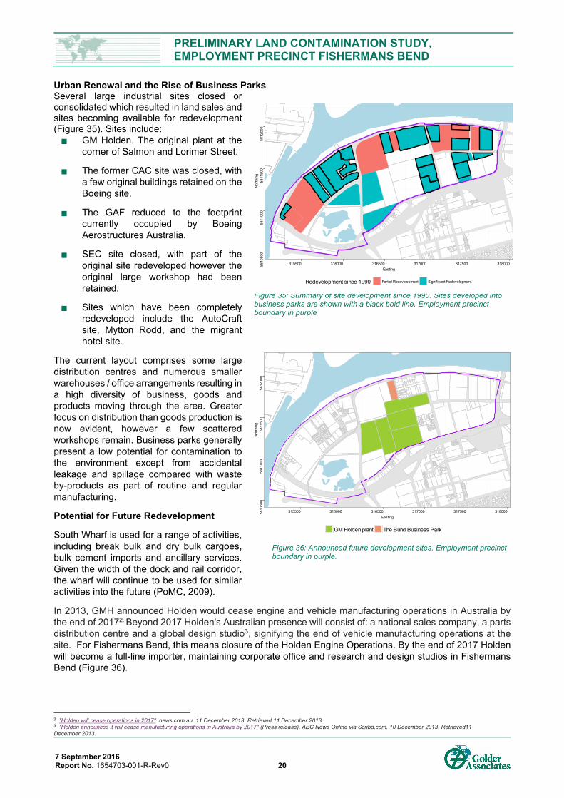
PRELIMINARY LAND CONTAMINATION STUDY, EMPLOYMENT PRECINCT FISHERMANS BEND
7 September 2016 Report No. 1654703-001-R-Rev0 20
Urban Renewal and the Rise of Business Parks Several large industrial sites closed or consolidated which resulted in land sales and sites becoming available for redevelopment (Figure 35). Sites include: GM Holden. The original plant at the
corner of Salmon and Lorimer Street.
The former CAC site was closed, with a few original buildings retained on the Boeing site.
The GAF reduced to the footprint currently occupied by Boeing Aerostructures Australia.
SEC site closed, with part of the original site redeveloped however the original large workshop had been retained.
Sites which have been completely redeveloped include the AutoCraft site, Mytton Rodd, and the migrant hotel site.
The current layout comprises some large distribution centres and numerous smaller warehouses / office arrangements resulting in a high diversity of business, goods and products moving through the area. Greater focus on distribution than goods production is now evident, however a few scattered workshops remain. Business parks generally present a low potential for contamination to the environment except from accidental leakage and spillage compared with waste by-products as part of routine and regular manufacturing.
Potential for Future Redevelopment
South Wharf is used for a range of activities, including break bulk and dry bulk cargoes, bulk cement imports and ancillary services. Given the width of the dock and rail corridor, the wharf will continue to be used for similar activities into the future (PoMC, 2009).
In 2013, GMH announced Holden would cease engine and vehicle manufacturing operations in Australia by the end of 20172. Beyond 2017 Holden's Australian presence will consist of: a national sales company, a parts distribution centre and a global design studio3, signifying the end of vehicle manufacturing operations at the site. For Fishermans Bend, this means closure of the Holden Engine Operations. By the end of 2017 Holden will become a full-line importer, maintaining corporate office and research and design studios in Fishermans Bend (Figure 36).
2 "Holden will cease operations in 2017". news.com.au. 11 December 2013. Retrieved 11 December 2013. 3 "Holden announces it will cease manufacturing operations in Australia by 2017" (Press release). ABC News Online via Scribd.com. 10 December 2013. Retrieved11 December 2013.
Figure 35: Summary of site development since 1990. Sites developed into business parks are shown with a black bold line. Employment precinct boundary in purple
5810
500
5811
000
5811
500
5812
000
315500 316000 316500 317000 317500 318000Easting
Nor
thin
g
Redevelopment since 1990 Partial Redevelopment Signif icant Redevelopment
Figure 36: Announced future development sites. Employment precinct boundary in purple.
5810
500
5811
000
5811
500
5812
000
315500 316000 316500 317000 317500 318000Easting
Nor
thin
g
GM Holden plant The Bund Business Park
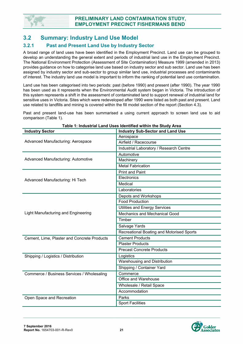
PRELIMINARY LAND CONTAMINATION STUDY, EMPLOYMENT PRECINCT FISHERMANS BEND
7 September 2016 Report No. 1654703-001-R-Rev0 21
3.2 Summary: Industry Land Use Model 3.2.1 Past and Present Land Use by Industry Sector A broad range of land uses have been identified in the Employment Precinct. Land use can be grouped to develop an understanding the general extent and periods of industrial land use in the Employment Precinct. The National Environment Protection (Assessment of Site Contamination) Measure 1999 (amended in 2013) provides guidance on how to categorise land use based on industry sector and sub sector. Land use has been assigned by industry sector and sub-sector to group similar land use, industrial processes and contaminants of interest. The industry land use model is important to inform the ranking of potential land use contamination.
Land use has been categorised into two periods: past (before 1990) and present (after 1990). The year 1990 has been used as it represents when the Environmental Audit system began in Victoria. The introduction of this system represents a shift in the assessment of contaminated land to support renewal of industrial land for sensitive uses in Victoria. Sites which were redeveloped after 1990 were listed as both past and present. Land use related to landfills and mining is covered within the fill model section of the report (Section 4.3).
Past and present land-use has been summarised a using current approach to screen land use to aid comparison (Table 1).
Table 1: Industrial Land Uses Identified within the Study Area Industry Sector Industry Sub-Sector and Land Use
Advanced Manufacturing: Aerospace Aerospace Airfield / Racecourse Industrial Laboratory / Research Centre
Advanced Manufacturing: Automotive Automotive Machinery Metal Fabrication
Advanced Manufacturing: Hi Tech
Print and Paint Electronics Medical Laboratories
Light Manufacturing and Engineering
Depots and Workshops Food Production Utilities and Energy Services Mechanics and Mechanical Good Timber Salvage Yards Recreational Boating and Motorised Sports
Cement, Lime, Plaster and Concrete Products Cement Products Plaster Products Precast Concrete Products
Shipping / Logistics / Distribution Logistics Warehousing and Distribution Shipping / Container Yard
Commerce / Business Services / Wholesaling Commerce Office and Warehouse Wholesale / Retail Space Accommodation
Open Space and Recreation Parks Sport Facilities
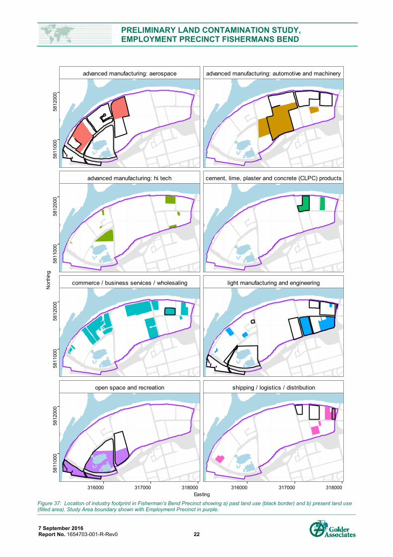
PRELIMINARY LAND CONTAMINATION STUDY, EMPLOYMENT PRECINCT FISHERMANS BEND
7 September 2016 Report No. 1654703-001-R-Rev0 22
Figure 37: Location of industry footprint in Fisherman’s Bend Precinct showing a) past land use (black border) and b) present land use (filled area). Study Area boundary shown with Employment Precinct in purple.
advanced manufacturing: aerospace advanced manufacturing: automotive and machinery
advanced manufacturing: hi tech cement, lime, plaster and concrete (CLPC) products
commerce / business services / wholesaling light manufacturing and engineering
open space and recreation shipping / logistics / distribution
5811
000
5812
000
5811
000
5812
000
5811
000
5812
000
5811
000
5812
000
316000 317000 318000 316000 317000 318000Easting
Nor
thin
g
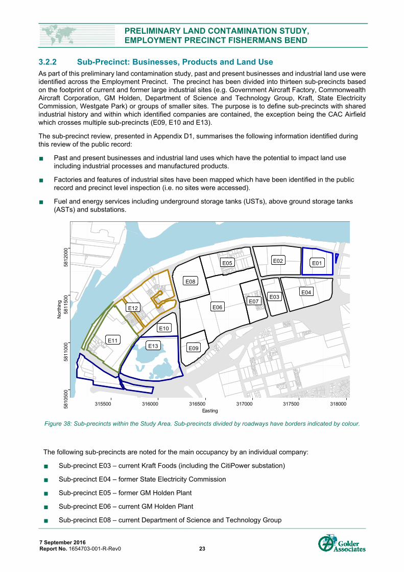
PRELIMINARY LAND CONTAMINATION STUDY, EMPLOYMENT PRECINCT FISHERMANS BEND
7 September 2016 Report No. 1654703-001-R-Rev0 23
3.2.2 Sub-Precinct: Businesses, Products and Land Use As part of this preliminary land contamination study, past and present businesses and industrial land use were identified across the Employment Precinct. The precinct has been divided into thirteen sub-precincts based on the footprint of current and former large industrial sites (e.g. Government Aircraft Factory, Commonwealth Aircraft Corporation, GM Holden, Department of Science and Technology Group, Kraft, State Electricity Commission, Westgate Park) or groups of smaller sites. The purpose is to define sub-precincts with shared industrial history and within which identified companies are contained, the exception being the CAC Airfield which crosses multiple sub-precincts (E09, E10 and E13).
The sub-precinct review, presented in Appendix D1, summarises the following information identified during this review of the public record:
Past and present businesses and industrial land uses which have the potential to impact land use including industrial processes and manufactured products.
Factories and features of industrial sites have been mapped which have been identified in the public record and precinct level inspection (i.e. no sites were accessed).
Fuel and energy services including underground storage tanks (USTs), above ground storage tanks (ASTs) and substations.
Figure 38: Sub-precincts within the Study Area. Sub-precincts divided by roadways have borders indicated by colour.
The following sub-precincts are noted for the main occupancy by an individual company:
Sub-precinct E03 – current Kraft Foods (including the CitiPower substation)
Sub-precinct E04 – former State Electricity Commission
Sub-precinct E05 – former GM Holden Plant
Sub-precinct E06 – current GM Holden Plant
Sub-precinct E08 – current Department of Science and Technology Group
E05
E08
E07
E04
E12
E02
E03
E01
E10
E06
E11E09E13
5810
500
5811
000
5811
500
5812
000
315500 316000 316500 317000 317500 318000Easting
Nor
thin
g
PRELIMINARY LAND CONTAMINATION STUDY, EMPLOYMENT PRECINCT FISHERMANS BEND
7 September 2016 Report No. 1654703-001-R-Rev0 24
Sub-precinct E09 – former Port Melbourne Municipal Tip
Sub-precinct E10 – current Herald and Weekly Times print facility
Sub-precinct E11 – current Boeing Aerostructures Australia and former Government Aircraft Factory
Sub-precinct E12 – former Commonwealth Aircraft Corporation
Sub-precinct E13 – current Westgate Park
The following sub-precincts are noted for their mixed land use and ownership. This approach is similar to that adopted in the Golder (2012) study:
Sub-precinct E01 – current mixed industry and distribution land use
Sub-precinct E02 - current mixed industry and business park land use
Sub-precinct E07 – current business parks
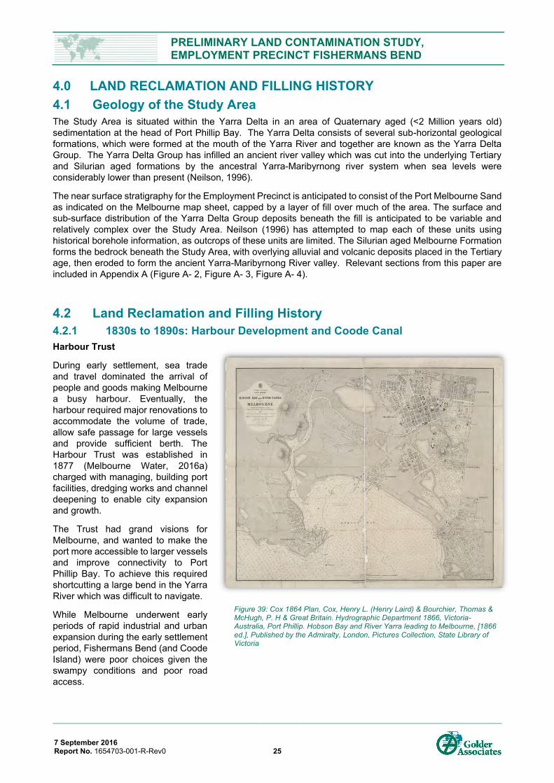
PRELIMINARY LAND CONTAMINATION STUDY, EMPLOYMENT PRECINCT FISHERMANS BEND
7 September 2016 Report No. 1654703-001-R-Rev0 25
4.0 LAND RECLAMATION AND FILLING HISTORY 4.1 Geology of the Study Area The Study Area is situated within the Yarra Delta in an area of Quaternary aged (<2 Million years old) sedimentation at the head of Port Phillip Bay. The Yarra Delta consists of several sub-horizontal geological formations, which were formed at the mouth of the Yarra River and together are known as the Yarra Delta Group. The Yarra Delta Group has infilled an ancient river valley which was cut into the underlying Tertiary and Silurian aged formations by the ancestral Yarra-Maribyrnong river system when sea levels were considerably lower than present (Neilson, 1996).
The near surface stratigraphy for the Employment Precinct is anticipated to consist of the Port Melbourne Sand as indicated on the Melbourne map sheet, capped by a layer of fill over much of the area. The surface and sub-surface distribution of the Yarra Delta Group deposits beneath the fill is anticipated to be variable and relatively complex over the Study Area. Neilson (1996) has attempted to map each of these units using historical borehole information, as outcrops of these units are limited. The Silurian aged Melbourne Formation forms the bedrock beneath the Study Area, with overlying alluvial and volcanic deposits placed in the Tertiary age, then eroded to form the ancient Yarra-Maribyrnong River valley. Relevant sections from this paper are included in Appendix A (Figure A- 2, Figure A- 3, Figure A- 4).
4.2 Land Reclamation and Filling History 4.2.1 1830s to 1890s: Harbour Development and Coode Canal Harbour Trust
During early settlement, sea trade and travel dominated the arrival of people and goods making Melbourne a busy harbour. Eventually, the harbour required major renovations to accommodate the volume of trade, allow safe passage for large vessels and provide sufficient berth. The Harbour Trust was established in 1877 (Melbourne Water, 2016a) charged with managing, building port facilities, dredging works and channel deepening to enable city expansion and growth.
The Trust had grand visions for Melbourne, and wanted to make the port more accessible to larger vessels and improve connectivity to Port Phillip Bay. To achieve this required shortcutting a large bend in the Yarra River which was difficult to navigate.
While Melbourne underwent early periods of rapid industrial and urban expansion during the early settlement period, Fishermans Bend (and Coode Island) were poor choices given the swampy conditions and poor road access.
Figure 39: Cox 1864 Plan, Cox, Henry L. (Henry Laird) & Bourchier, Thomas & McHugh, P. H & Great Britain. Hydrographic Department 1866, Victoria-Australia, Port Phillip. Hobson Bay and River Yarra leading to Melbourne, [1866 ed.], Published by the Admiralty, London, Pictures Collection, State Library of Victoria
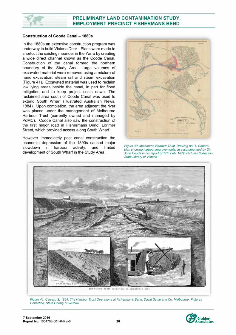
PRELIMINARY LAND CONTAMINATION STUDY, EMPLOYMENT PRECINCT FISHERMANS BEND
7 September 2016 Report No. 1654703-001-R-Rev0 26
Construction of Coode Canal – 1880s
In the 1880s an extensive construction program was underway to build Victoria Dock. Plans were made to shortcut the existing meander in the Yarra by creating a wide direct channel known as the Coode Canal. Construction of the canal formed the northern boundary of the Study Area. Large volumes of excavated material were removed using a mixture of hand excavation, steam rail and steam excavation (Figure 41). Excavated material was used to reclaim low lying areas beside the canal, in part for flood mitigation and to keep project costs down. The reclaimed area south of Coode Canal was used to extend South Wharf (Illustrated Australian News, 1884). Upon completion, the area adjacent the river was placed under the management of Melbourne Harbour Trust (currently owned and managed by PoMC). Coode Canal also saw the construction of the first major road in Fishermans Bend, Lorimer Street, which provided access along South Wharf.
However immediately post canal construction the economic depression of the 1890s caused major slowdown in harbour activity, and limited development of South Wharf in the Study Area.
Figure 40: Melbourne Harbour Trust. Drawing no. 1, General plan showing harbour improvements: as recommended by Sir John Coode in his report of 17th Feb. 1879. Pictures Collection, State Library of Victoria
Figure 41: Calvert, S, 1884, The Harbour Trust Operations at Fisherman's Bend, David Syme and Co, Melbourne, Pictures Collection, State Library of Victoria
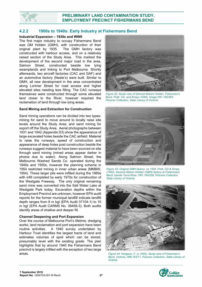
PRELIMINARY LAND CONTAMINATION STUDY, EMPLOYMENT PRECINCT FISHERMANS BEND
7 September 2016 Report No. 1654703-001-R-Rev0 27
4.2.2 1900s to 1940s: Early Industry at Fishermans Bend Industrial Expansion – 1930s and WWII The first major industry to occupy Fishermans Bend was GM Holden (GMH), with construction of their original plant by 1935. The GMH factory was constructed with harbour access, and on a relatively raised section of the Study Area. This marked the development of the second major road in the area, Salmon Street, constructed beside low lying swamplands and linking to Port Melbourne. Shortly afterwards, two aircraft factories (CAC and GAF) and an automotive factory (Neale’s) were built. Similar to GMH, all new development in the area concentrated along Lorimer Street for road access and higher elevated sites needing less filling. The CAC runways themselves were constructed through some elevated land closer to the River, however required the reclamation of land through low lying areas.
Sand Mining and Extraction for Construction
Sand mining operations can be divided into two types: mining for sand to move around to locally raise site levels around the Study Area; and sand mining for export off the Study Area. Aerial photographs between 1931 and 1942 (Appendix D3) show the appearance of large excavated holes beside the CAC airfield. Material to raise the runways, speed of construction and appearance of deep holes post construction beside the runways suggest material to have been sourced on site through sand mining (mined areas appear darker in photos due to water). Along Salmon Street, the Melbourne Washed Sands Co. operated during the 1940s and 1950s, however the planning scheme in 1954 restricted mining in inner urban areas (MMBW, 1954). These larger pits were infilled during the 1960s with infill completed by early 1970s for construction of the Westgate Freeway. The only original remaining sand mine was converted into the Salt Water Lake at Westgate Park today. Excavation depths within the Employment Precinct are unknown, however EPA audit reports for the former municipal landfill indicate landfill depth ranges from 8 m bgl (EPA Audit 37104-1) to 10 m bgl (EPA Audit CARMS No. 38456-3). Both audits identify areas of shallow and deeper fill.
Channel Deepening and Port Expansion Over the course of Melbourne Port’s lifetime, dredging works, land reclamation and port expansion have been routine activities. A 1940 survey undertaken by Harbour Trust identifies the largest tracts of land and estimates volumes of spoil which can be stored, presumably level with the existing grade. The plan highlights that by around 1940 the Fishermans Bend precinct is largely infilled with the exception of two large areas.
Figure 43: Original GMH factory, ca 1936, Pratt, CD & Airspy (1940), General Motors Holden (GMH) factory at Fishermans Bend, beside Yarra River, H91.160/258, Pictures Collection, State Library of Victoria
Figure 44: Hodgson, F. (c.1940), Aerial view of Fisherman's Bend, Victoria, H96.163/11, Pictures Collection, State Library of Victoria
Figure 42: Aerial view of General Motors Holden, Fisherman's Bend, Pratt. CD, and Airspy (1940), Image H91.160/263, Pictures Collection, State Library of Victoria
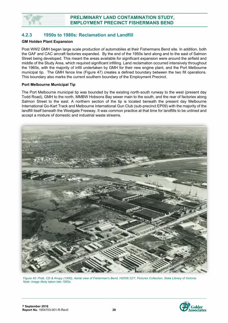
PRELIMINARY LAND CONTAMINATION STUDY, EMPLOYMENT PRECINCT FISHERMANS BEND
7 September 2016 Report No. 1654703-001-R-Rev0 28
4.2.3 1950s to 1980s: Reclamation and Landfill GM Holden Plant Expansion
Post WW2 GMH began large scale production of automobiles at their Fishermans Bend site. In addition, both the GAF and CAC aircraft factories expanded. By the end of the 1950s land along and to the east of Salmon Street being developed. This meant the areas available for significant expansion were around the airfield and middle of the Study Area, which required significant infilling. Land reclamation occurred intensively throughout the 1960s, with the majority of infill undertaken by GMH for their new engine plant, and the Port Melbourne municipal tip. The GMH fence line (Figure 47) creates a defined boundary between the two fill operations. This boundary also marks the current southern boundary of the Employment Precinct.
Port Melbourne Municipal Tip
The Port Melbourne municipal tip was bounded by the existing north-south runway to the west (present day Todd Road), GMH to the north, MMBW Hobsons Bay sewer main to the south, and the rear of factories along Salmon Street to the east. A northern section of the tip is located beneath the present day Melbourne International Go-Kart Track and Melbourne International Gun Club (sub-precinct EP09) with the majority of the landfill itself beneath the Westgate Freeway. It was common practice at that time for landfills to be unlined and accept a mixture of domestic and industrial waste streams.
Figure 45: Pratt, CD & Airspy (1950), Aerial view of Fisherman's Bend, H2008.32/7, Pictures Collection, State Library of Victoria. Note: image likely taken late 1950s.
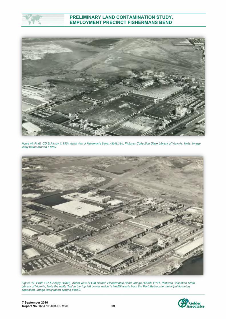
PRELIMINARY LAND CONTAMINATION STUDY, EMPLOYMENT PRECINCT FISHERMANS BEND
7 September 2016 Report No. 1654703-001-R-Rev0 29
Figure 46: Pratt, CD & Airspy (1950), Aerial view of Fisherman's Bend, H2008.32/1, Pictures Collection State Library of Victoria. Note: Image likely taken around c1960.
Figure 47: Pratt, CD & Airspy (1950), Aerial view of GM Holden Fisherman's Bend, Image H2008.41/71, Pictures Collection State Library of Victoria, Note the white 'fan' in the top left corner which is landfill waste from the Port Melbourne municipal tip being deposited. Image likely taken around c1960.
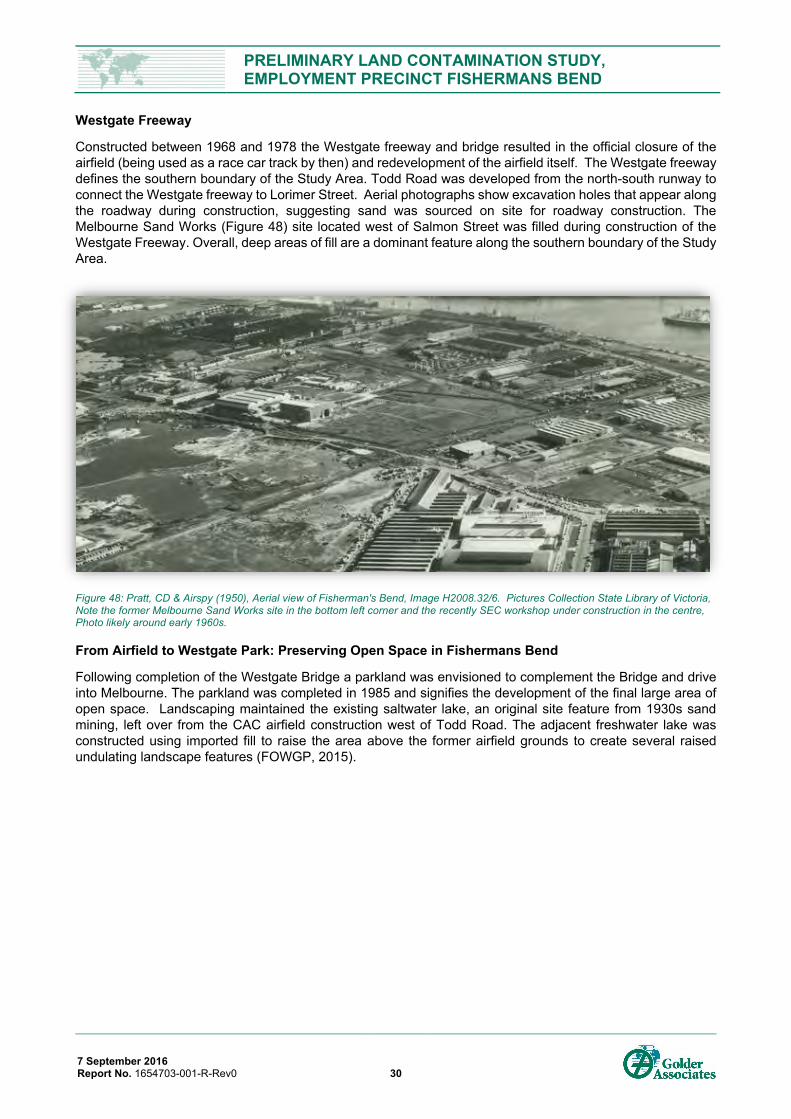
PRELIMINARY LAND CONTAMINATION STUDY, EMPLOYMENT PRECINCT FISHERMANS BEND
7 September 2016 Report No. 1654703-001-R-Rev0 30
Westgate Freeway
Constructed between 1968 and 1978 the Westgate freeway and bridge resulted in the official closure of the airfield (being used as a race car track by then) and redevelopment of the airfield itself. The Westgate freeway defines the southern boundary of the Study Area. Todd Road was developed from the north-south runway to connect the Westgate freeway to Lorimer Street. Aerial photographs show excavation holes that appear along the roadway during construction, suggesting sand was sourced on site for roadway construction. The Melbourne Sand Works (Figure 48) site located west of Salmon Street was filled during construction of the Westgate Freeway. Overall, deep areas of fill are a dominant feature along the southern boundary of the Study Area.
Figure 48: Pratt, CD & Airspy (1950), Aerial view of Fisherman's Bend, Image H2008.32/6. Pictures Collection State Library of Victoria, Note the former Melbourne Sand Works site in the bottom left corner and the recently SEC workshop under construction in the centre, Photo likely around early 1960s.
From Airfield to Westgate Park: Preserving Open Space in Fishermans Bend
Following completion of the Westgate Bridge a parkland was envisioned to complement the Bridge and drive into Melbourne. The parkland was completed in 1985 and signifies the development of the final large area of open space. Landscaping maintained the existing saltwater lake, an original site feature from 1930s sand mining, left over from the CAC airfield construction west of Todd Road. The adjacent freshwater lake was constructed using imported fill to raise the area above the former airfield grounds to create several raised undulating landscape features (FOWGP, 2015).
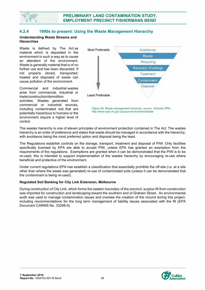
PRELIMINARY LAND CONTAMINATION STUDY, EMPLOYMENT PRECINCT FISHERMANS BEND
7 September 2016 Report No. 1654703-001-R-Rev0 31
4.2.4 1990s to present: Using the Waste Management Hierarchy Understanding Waste Streams and Hierarchies
Waste is defined by The Act as material which is deposited in the environment in such a way as to cause an alteration of the environment. Waste is generally material that is of no further use and has been discarded. If not properly stored, transported, treated and disposed of waste can cause pollution of the environment.
Commercial and industrial wastes arise from commercial, industrial or trade/construction/demolition activities. Wastes generated from commercial or industrial sources, including contaminated soil, that are potentially hazardous to humans or the environment require a higher level of control.
The wastes hierarchy is one of eleven principles of environment protection contained in The Act. The wastes hierarchy is an order of preference and states that waste should be managed in accordance with the hierarchy, with avoidance being the most preferred option and disposal being the least.
The Regulations establish controls on the storage, transport, treatment and disposal of PIW. Only facilities specifically licensed by EPA are able to accept PIW, unless EPA has granted an exemption from the requirements of the regulations. Exemptions are granted when it can be demonstrated that the PIW is to be re-used, this is intended to support implementation of the wastes hierarchy by encouraging re-use where beneficial and protective of the environment.
Under current regulations EPA has establish a classification that essentially prohibits the off-site (i.e. at a site other than where the waste was generated) re-use of contaminated soils (unless it can be demonstrated that the contaminant is being re-used).
Regulated Soil Banking for City Link Extension, Melbourne
During construction of City Link, which forms the eastern boundary of the precinct, surplus fill from construction was imported for construction and landscaping toward the southern end of Graham Street. An environmental audit was used to manage contamination issues and oversee the creation of the mound during this project, including recommendations for the long term management of liability issues associated with the fill (EPA Document CARMS No. 33298-9).
Figure 49: Waste management hierarchy, source: Victorian EPA, http://www.epa.vic.gov.au/your-environment/waste
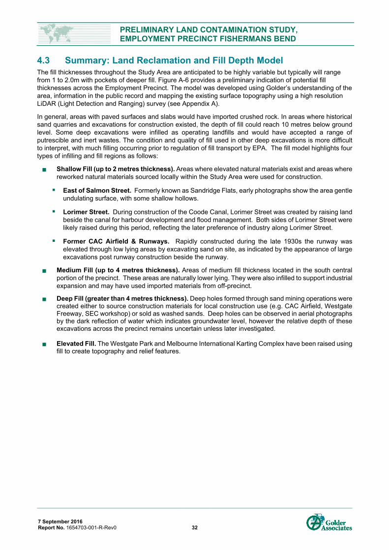
PRELIMINARY LAND CONTAMINATION STUDY, EMPLOYMENT PRECINCT FISHERMANS BEND
7 September 2016 Report No. 1654703-001-R-Rev0 32
4.3 Summary: Land Reclamation and Fill Depth Model The fill thicknesses throughout the Study Area are anticipated to be highly variable but typically will range from 1 to 2.0m with pockets of deeper fill. Figure A-6 provides a preliminary indication of potential fill thicknesses across the Employment Precinct. The model was developed using Golder’s understanding of the area, information in the public record and mapping the existing surface topography using a high resolution LiDAR (Light Detection and Ranging) survey (see Appendix A).
In general, areas with paved surfaces and slabs would have imported crushed rock. In areas where historical sand quarries and excavations for construction existed, the depth of fill could reach 10 metres below ground level. Some deep excavations were infilled as operating landfills and would have accepted a range of putrescible and inert wastes. The condition and quality of fill used in other deep excavations is more difficult to interpret, with much filling occurring prior to regulation of fill transport by EPA. The fill model highlights four types of infilling and fill regions as follows:
Shallow Fill (up to 2 metres thickness). Areas where elevated natural materials exist and areas where reworked natural materials sourced locally within the Study Area were used for construction.
East of Salmon Street. Formerly known as Sandridge Flats, early photographs show the area gentleundulating surface, with some shallow hollows.
Lorimer Street. During construction of the Coode Canal, Lorimer Street was created by raising landbeside the canal for harbour development and flood management. Both sides of Lorimer Street werelikely raised during this period, reflecting the later preference of industry along Lorimer Street.
Former CAC Airfield & Runways. Rapidly constructed during the late 1930s the runway waselevated through low lying areas by excavating sand on site, as indicated by the appearance of largeexcavations post runway construction beside the runway.
Medium Fill (up to 4 metres thickness). Areas of medium fill thickness located in the south central portion of the precinct. These areas are naturally lower lying. They were also infilled to support industrial expansion and may have used imported materials from off-precinct.
Deep Fill (greater than 4 metres thickness). Deep holes formed through sand mining operations were created either to source construction materials for local construction use (e.g. CAC Airfield, Westgate Freeway, SEC workshop) or sold as washed sands. Deep holes can be observed in aerial photographs by the dark reflection of water which indicates groundwater level, however the relative depth of these excavations across the precinct remains uncertain unless later investigated.
Elevated Fill. The Westgate Park and Melbourne International Karting Complex have been raised using fill to create topography and relief features.
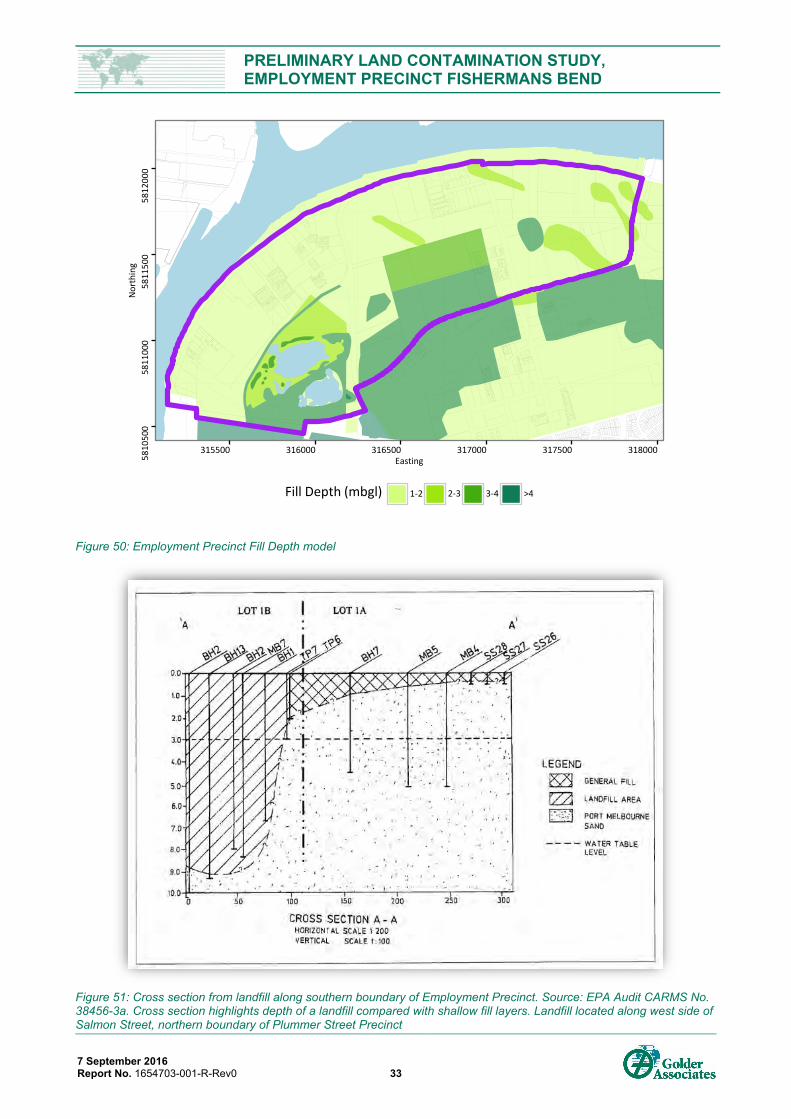
PRELIMINARY LAND CONTAMINATION STUDY, EMPLOYMENT PRECINCT FISHERMANS BEND
7 September 2016 Report No. 1654703-001-R-Rev0 33
Figure 50: Employment Precinct Fill Depth model
Figure 51: Cross section from landfill along southern boundary of Employment Precinct. Source: EPA Audit CARMS No. 38456-3a. Cross section highlights depth of a landfill compared with shallow fill layers. Landfill located along west side of Salmon Street, northern boundary of Plummer Street Precinct
58
10
500
58
11
000
58
11
500
58
12
000
315500 316000 316500 317000 317500 318000Easting
No
rth
ing
Fill Depth (mbgl) 1-2 2-3 3-4 >4
PRELIMINARY LAND CONTAMINATION STUDY, EMPLOYMENT PRECINCT FISHERMANS BEND
7 September 2016 Report No. 1654703-001-R-Rev0 34
5.0 POTENTIAL LAND USE CONTAMINATION 5.1 Potential Contaminants and Sources Based on the high level contamination review of the Study Area and along with our experience and knowledge of industries, potential contaminants and their general sources are listed below. Further details for sub-precincts and specific industries are provided in Appendix D1 of this report. For the purposes of this assessment detailed site information about the type and nature of operations and specific processes and chemical uses was not assessed and as such the extent of applicability of the below contaminants has not been verified.
The following potential contaminants and contaminant sources may be widespread across the Employment Precinct:
Heavy metals (arsenic, cadmium, copper, chromium, mercury, lead, nickel, zinc) and metalloids associated with imported fill and various industrial waste streams (e.g. foundries and other metal works, timber works, paint works, printing works).
Polycyclic aromatic hydrocarbons (PAHs) associated with imported fill (especially gasworks wastes from the nearby South Melbourne and West Melbourne Gasworks), use and storage of fuels and oils, by-products from boiler houses and various industrial waste streams.
Petroleum hydrocarbons (total petroleum hydrocarbons (TPH), monocyclic aromatic hydrocarbons (MAH) and phenols associated with the use and storage of fuels and oils and various industrial waste streams.
Solvents (non-chlorinated solvents (e.g. kerosene, petroleum ether, white spirit, turpentine, phenol, acetone, Methyl ethyl ketone (MEK), Methyl isobutyl ketone (MIBK), methyl butyl ketone (MBK) and chlorinated solvents (e.g. perchloroethylene (PCE), trichloroethene (TCE), and breakdown products)) associated with the use and storage of lubricating and hydraulic oils, degreasers and various industrial waste streams.
Aesthetic issues from visual and olfactory contamination such as hydrocarbon staining, odour or building rubble in fill.
Other potential contaminants that may be present but less likely to be widespread:
Acids and caustics associated with imported fill, animal and animal product processing (e.g. soap works) and various industrial waste streams.
Inorganics (e.g. high salinities (TDS), nutrients (ammonia, nitrate, sulfates)) associated with imported fill (including Coode Island Silt), animal and animal product processing (e.g. soap works) and various industrial waste streams.
Polychlorinated biphenyls (PCBs) associated with the manufacture and use of transformers and capacitors (may exist in electrical substations) and manufacture of electrical equipment.
Pesticides / herbicides associated with spraying of weeds and pests.
Chemicals associated with plastics, adhesives and resins (e.g. polyvinyl acetate, formaldehyde, acrylates, phthalates).
Cyanide associated with imported fill (by products of nearby gasworks), metal treatment and other industrial streams.
Asbestos associated with the construction and demolition of existing and former buildings and/or present in imported fill.
Methane and hydrogen sulphide and other landfill gasses associated with landfill sites.
Other industry specific and “exotic” chemicals that will need to be assessed during site specific site history assessment (see Appendix D1).
Perfluorooctanesulfonate (PFOS) and Perfluorooctanesulfonic acid (PFAS) associated with firefighting foams, mist suppressant in plating industries, hydraulic oils in aviation, surfactants, and photography.
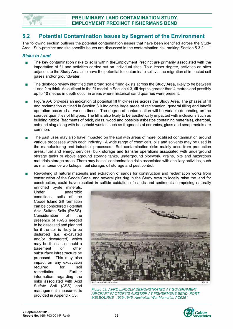
PRELIMINARY LAND CONTAMINATION STUDY, EMPLOYMENT PRECINCT FISHERMANS BEND
7 September 2016 Report No. 1654703-001-R-Rev0 35
5.2 Potential Contamination Issues by Segment of the Environment The following section outlines the potential contamination issues that have been identified across the Study Area. Sub-precinct and site specific issues are discussed in the contamination risk ranking Section 5.3.2.
Risks to Land
The key contamination risks to soils within theEmployment Precinct are primarily associated with the importation of fill and activities carried out on individual sites. To a lesser degree, activities on sites adjacent to the Study Area also have the potential to contaminate soil, via the migration of impacted soil gases and/or groundwater.
The desk-top review identified that broad scale filling exists across the Study Area, likely to be between 1 and 2 m thick. As outlined in the fill model in Section 4.3, fill depths greater than 4 metres and possibly up to 10 metres in depth occur in areas where historical sand quarries were present.
Figure A-6 provides an indication of potential fill thicknesses across the Study Area. The phases of fill and reclamation outlined in Section 3.0 indicates large areas of reclamation, general filling and landfill operation occurred at various times. The degree of contamination will be variable depending on the sources quantities of fill types. The fill is also likely to be aesthetically impacted with inclusions such as building rubble (fragments of brick, glass, wood and possible asbestos containing materials), charcoal, ash and slag along with household wastes such as fragments of ceramics, glass and scrap metals are common.
The past uses may also have impacted on the soil with areas of more localised contamination around various processes within each industry. A wide range of chemicals, oils and solvents may be used in the manufacturing and industrial processes. Soil contamination risks mainly arise from production areas, fuel and energy services, bulk storage and transfer operations associated with underground storage tanks or above aground storage tanks, underground pipework, drains, pits and hazardous materials storage areas. There may be soil contamination risks associated with ancillary activities, such as maintenance workshops, fuel storage, oil storage and pest control.
Reworking of natural materials and extraction of sands for construction and reclamation works from construction of the Coode Canal and several pits dug in the Study Area to locally raise the land for construction, could have resulted in sulfide oxidation of sands and sediments comprising naturally enriched pyrite minerals. Under anaerobic conditions, soils of the Coode Island Silt formation can be considered Potential Acid Sulfate Soils (PASS). Consideration of the presence of PASS needed to be assessed and planned for if the soil is likely to be disturbed (i.e. excavated and/or dewatered) which may be the case should a basement or other subsurface infrastructure be proposed. This may also impact on any excavation required for soil remediation. Further information regarding the risks associated with Acid Sulfate Soil (ASS) and management measures is provided in Appendix C3.
Figure 52: AVRO LINCOLN DEMONSTRATED AT GOVERNMENT AIRCRAFT FACTORY'S AIRSTRIP AT FISHERMENS BEND, PORT MELBOURNE, 1939-1945, Australian War Memorial, AC0261
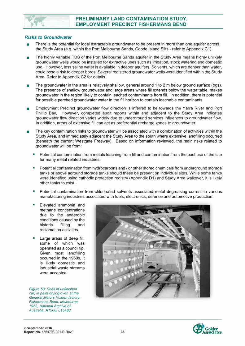
PRELIMINARY LAND CONTAMINATION STUDY, EMPLOYMENT PRECINCT FISHERMANS BEND
7 September 2016 Report No. 1654703-001-R-Rev0 36
Risks to Groundwater
There is the potential for local extractable groundwater to be present in more than one aquifer across the Study Area (e.g. within the Port Melbourne Sands, Coode Island Silts - refer to Appendix C1).
The highly variable TDS of the Port Melbourne Sands aquifer in the Study Area means highly unlikely groundwater wells would be installed for extractive uses such as irrigation, stock watering and domestic use. However, less saline water is available in deeper aquifers. Solvents, which are denser than water, could pose a risk to deeper bores. Several registered groundwater wells were identified within the Study Area. Refer to Appendix C2 for details.
The groundwater in the area is relatively shallow, general around 1 to 2 m below ground surface (bgs). The presence of shallow groundwater and large areas where fill extends below the water table, makes groundwater in the region likely to contain leached contaminants from fill. In addition, there is potential for possible perched groundwater water in the fill horizon to contain leachable contaminants.
Employment Precinct groundwater flow direction is inferred to be towards the Yarra River and Port Phillip Bay. However, completed audit reports within and adjacent to the Study Area indicates groundwater flow direction varies widely due to underground services influences to groundwater flow. In addition, areas of extensive fill can act as preferential recharge zones to groundwater.
The key contamination risks to groundwater will be associated with a combination of activities within the Study Area, and immediately adjacent the Study Area to the south where extensive landfilling occurred (beneath the current Westgate Freeway). Based on information reviewed, the main risks related to groundwater will be from:
Potential contamination from metals leaching from fill and contamination from the past use of the site for many metal related industries.
Potential contamination from hydrocarbons and / or other stored chemicals from underground storage tanks or above aground storage tanks should these be present on individual sites. While some tanks were identified using cathodic protection registry (Appendix D1) and Study Area walkover, it is likely other tanks to exist.
Potential contamination from chlorinated solvents associated metal degreasing current to various manufacturing industries associated with tools, electronics, defence and automotive production.
Elevated ammonia and methane concentrations due to the anaerobic conditions caused by the historic filling and reclamation activities.
Large areas of deep fill, some of which was operated as a council tip. Given most landfilling occurred in the 1960s, it is likely domestic and industrial waste streams were accepted.
Figure 53: Shell of unfinished car, in paint drying oven at the General Motors Holden factory, Fishermans Bend, Melbourne, 1953, National Archive of Australia, A1200: L15483
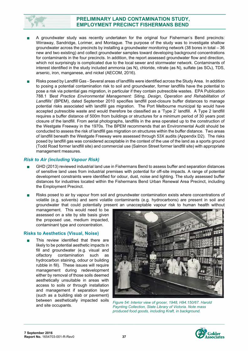
PRELIMINARY LAND CONTAMINATION STUDY, EMPLOYMENT PRECINCT FISHERMANS BEND
7 September 2016 Report No. 1654703-001-R-Rev0 37
A groundwater study was recently undertaken for the original four Fisherman’s Bend precincts: Wirraway, Sandridge, Lorimer, and Montague. The purpose of the study was to investigate shallow groundwater across the precincts by installing a groundwater monitoring network (38 bores in total – 36 new and two existing) and collect groundwater samples toward developing background concentrations for contaminants in the four precincts. In addition, the report assessed groundwater flow and direction, which not surprisingly is complicated due to the local sewer and stormwater network. Contaminants of interest identified in the study included ammonia (as N), chloride, nitrate (as N), sulfate (as SO4), TDS, arsenic, iron, manganese, and nickel (AECOM, 2016).
Risks posed by Landfill Gas - Several areas of landfills were identified across the Study Area. In addition to posing a potential contamination risk to soil and groundwater, former landfills have the potential to pose a risk via potential gas migration, in particular if they contain putrescible wastes. EPA Publication 788.1 ‘Best Practice Environmental Management: Siting, Design, Operation and Rehabilitation of Landfills’ (BPEM), dated September 2010 specifies landfill post-closure buffer distances to manage potential risks associated with landfill gas migration. The Port Melbourne municipal tip would have accepted putrescible waste and would therefore be classified as a ‘Type 2’ landfill. A Type 2 landfill requires a buffer distance of 500m from buildings or structures for a minimum period of 30 years post closure of the landfill. From aerial photographs, landfills in the area operated up to the construction of the Westgate Freeway in the 1970s. The BPEM recommends that an Environmental Audit should be conducted to assess the risk of landfill gas migration on structures within the buffer distance. Two areas of landfill beneath the Westgate Freeway were assessed through 53X audits (Appendix D2). The risks posed by landfill gas was considered acceptable in the context of the use of the land as a sports ground (Todd Road former landfill site) and commercial use (Salmon Street former landfill site) with appropriate management measures.
Risk to Air (including Vapour Risk)
GHD (2013) reviewed industrial land use in Fishermans Bend to assess buffer and separation distances of sensitive land uses from industrial premises with potential for off-site impacts. A range of potential development constraints were identified for odour, dust, noise and lighting. The study assessed buffer distances for industries located within the Fishermans Bend Urban Renewal Area Precinct, including the Employment Precinct.
Risks posed to air by vapour from soil and groundwater contamination exists where concentrations of volatile (e.g. solvents) and semi volatile contaminants (e.g. hydrocarbons) are present in soil and groundwater that could potentially present an unacceptable vapour risk to human health without management. This would need to be assessed on a site by site basis given the proposed use, medium impacted, contaminant type and concentration.
Risks to Aesthetics (Visual, Noise)
This review identified that there are likely to be potential aesthetic impacts in fill and groundwater (e.g. visual and olfactory contamination such as hydrocarbon staining, odour or building rubble in fill). These issues will require management during redevelopment either by removal of those soils deemed aesthetically unsuitable in areas with access to soils or through installation and management if separation layer (such as a building slab or pavement) between aesthetically impacted soils and site occupants.
Figure 54: Interior view of grocer, 1948, H94.150/67. Harold Paynting Collection, State Library of Victoria. Note mass produced food goods, including Kraft, in background.
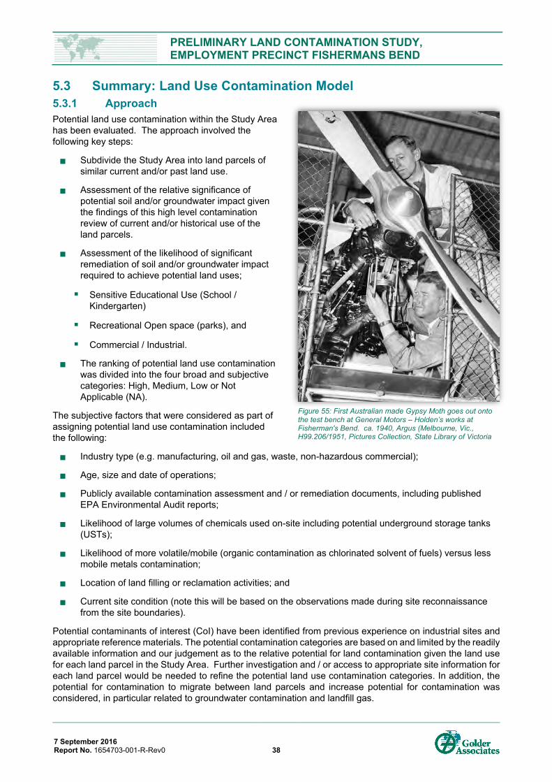
PRELIMINARY LAND CONTAMINATION STUDY, EMPLOYMENT PRECINCT FISHERMANS BEND
7 September 2016 Report No. 1654703-001-R-Rev0 38
5.3 Summary: Land Use Contamination Model 5.3.1 Approach Potential land use contamination within the Study Area has been evaluated. The approach involved the following key steps:
Subdivide the Study Area into land parcels of similar current and/or past land use.
Assessment of the relative significance of potential soil and/or groundwater impact given the findings of this high level contamination review of current and/or historical use of the land parcels.
Assessment of the likelihood of significant remediation of soil and/or groundwater impact required to achieve potential land uses;
Sensitive Educational Use (School / Kindergarten)
Recreational Open space (parks), and
Commercial / Industrial.
The ranking of potential land use contamination was divided into the four broad and subjective categories: High, Medium, Low or Not Applicable (NA).
The subjective factors that were considered as part of assigning potential land use contamination included the following:
Industry type (e.g. manufacturing, oil and gas, waste, non-hazardous commercial);
Age, size and date of operations;
Publicly available contamination assessment and / or remediation documents, including published EPA Environmental Audit reports;
Likelihood of large volumes of chemicals used on-site including potential underground storage tanks (USTs);
Likelihood of more volatile/mobile (organic contamination as chlorinated solvent of fuels) versus less mobile metals contamination;
Location of land filling or reclamation activities; and
Current site condition (note this will be based on the observations made during site reconnaissance from the site boundaries).
Potential contaminants of interest (CoI) have been identified from previous experience on industrial sites and appropriate reference materials. The potential contamination categories are based on and limited by the readily available information and our judgement as to the relative potential for land contamination given the land use for each land parcel in the Study Area. Further investigation and / or access to appropriate site information for each land parcel would be needed to refine the potential land use contamination categories. In addition, the potential for contamination to migrate between land parcels and increase potential for contamination was considered, in particular related to groundwater contamination and landfill gas.
Figure 55: First Australian made Gypsy Moth goes out onto the test bench at General Motors – Holden’s works at Fisherman's Bend. ca. 1940, Argus (Melbourne, Vic., H99.206/1951, Pictures Collection, State Library of Victoria
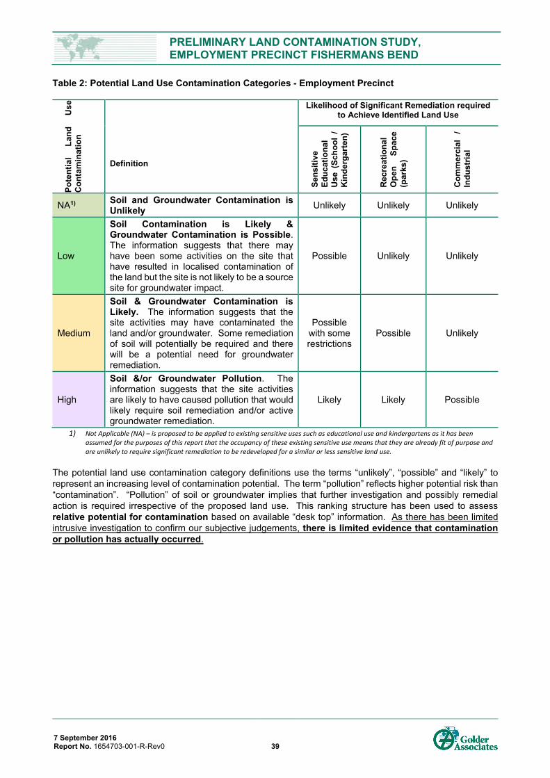
PRELIMINARY LAND CONTAMINATION STUDY, EMPLOYMENT PRECINCT FISHERMANS BEND
7 September 2016 Report No. 1654703-001-R-Rev0 39
Table 2: Potential Land Use Contamination Categories - Employment Precinct
Pote
ntia
l La
nd
Use
C
onta
min
atio
n
Definition
Likelihood of Significant Remediation required to Achieve Identified Land Use
Sens
itive
Ed
ucat
iona
l U
se (
Scho
ol /
K
inde
rgar
ten)
Rec
reat
iona
l O
pen
Spac
e (p
arks
)
Com
mer
cial
/
Indu
stria
l
NA1) Soil and Groundwater Contamination is Unlikely Unlikely Unlikely Unlikely
Low
Soil Contamination is Likely & Groundwater Contamination is Possible. The information suggests that there may have been some activities on the site that have resulted in localised contamination of the land but the site is not likely to be a source site for groundwater impact.
Possible Unlikely Unlikely
Medium
Soil & Groundwater Contamination is Likely. The information suggests that the site activities may have contaminated the land and/or groundwater. Some remediation of soil will potentially be required and there will be a potential need for groundwater remediation.
Possible with some restrictions
Possible Unlikely
High
Soil &/or Groundwater Pollution. The information suggests that the site activities are likely to have caused pollution that would likely require soil remediation and/or active groundwater remediation.
Likely Likely Possible
1) Not Applicable (NA) – is proposed to be applied to existing sensitive uses such as educational use and kindergartens as it has been assumed for the purposes of this report that the occupancy of these existing sensitive use means that they are already fit of purpose and are unlikely to require significant remediation to be redeveloped for a similar or less sensitive land use.
The potential land use contamination category definitions use the terms “unlikely”, “possible” and “likely” to represent an increasing level of contamination potential. The term “pollution” reflects higher potential risk than “contamination”. “Pollution” of soil or groundwater implies that further investigation and possibly remedial action is required irrespective of the proposed land use. This ranking structure has been used to assess relative potential for contamination based on available “desk top” information. As there has been limited intrusive investigation to confirm our subjective judgements, there is limited evidence that contamination or pollution has actually occurred.
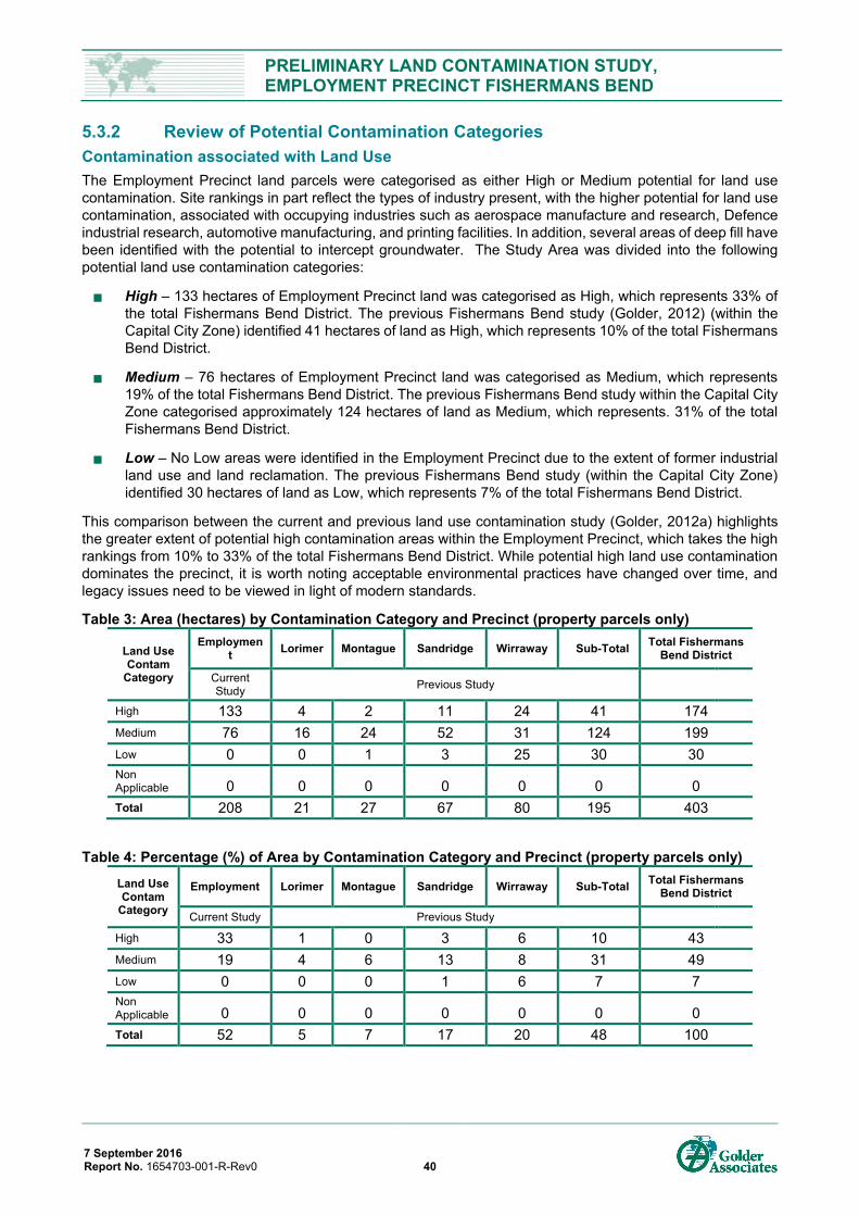
PRELIMINARY LAND CONTAMINATION STUDY, EMPLOYMENT PRECINCT FISHERMANS BEND
7 September 2016 Report No. 1654703-001-R-Rev0 40
5.3.2 Review of Potential Contamination Categories Contamination associated with Land Use The Employment Precinct land parcels were categorised as either High or Medium potential for land use contamination. Site rankings in part reflect the types of industry present, with the higher potential for land use contamination, associated with occupying industries such as aerospace manufacture and research, Defence industrial research, automotive manufacturing, and printing facilities. In addition, several areas of deep fill have been identified with the potential to intercept groundwater. The Study Area was divided into the following potential land use contamination categories:
High – 133 hectares of Employment Precinct land was categorised as High, which represents 33% of the total Fishermans Bend District. The previous Fishermans Bend study (Golder, 2012) (within the Capital City Zone) identified 41 hectares of land as High, which represents 10% of the total Fishermans Bend District.
Medium – 76 hectares of Employment Precinct land was categorised as Medium, which represents 19% of the total Fishermans Bend District. The previous Fishermans Bend study within the Capital City Zone categorised approximately 124 hectares of land as Medium, which represents. 31% of the total Fishermans Bend District.
Low – No Low areas were identified in the Employment Precinct due to the extent of former industrial land use and land reclamation. The previous Fishermans Bend study (within the Capital City Zone) identified 30 hectares of land as Low, which represents 7% of the total Fishermans Bend District.
This comparison between the current and previous land use contamination study (Golder, 2012a) highlights the greater extent of potential high contamination areas within the Employment Precinct, which takes the high rankings from 10% to 33% of the total Fishermans Bend District. While potential high land use contamination dominates the precinct, it is worth noting acceptable environmental practices have changed over time, and legacy issues need to be viewed in light of modern standards.
Table 3: Area (hectares) by Contamination Category and Precinct (property parcels only)
Land Use Contam
Category
Employment Lorimer Montague Sandridge Wirraway Sub-Total Total Fishermans
Bend District
Current Study Previous Study
High 133 4 2 11 24 41 174
Medium 76 16 24 52 31 124 199
Low 0 0 1 3 25 30 30 Non Applicable 0 0 0 0 0 0 0
Total 208 21 27 67 80 195 403
Table 4: Percentage (%) of Area by Contamination Category and Precinct (property parcels only)
Land Use Contam
Category
Employment Lorimer Montague Sandridge Wirraway Sub-Total Total Fishermans Bend District
Current Study Previous Study
High 33 1 0 3 6 10 43
Medium 19 4 6 13 8 31 49
Low 0 0 0 1 6 7 7 Non Applicable 0 0 0 0 0 0 0
Total 52 5 7 17 20 48 100
PRELIMINARY LAND CONTAMINATION STUDY, EMPLOYMENT PRECINCT FISHERMANS BEND
7 September 2016 Report No. 1654703-001-R-Rev0 41
Based on the land use contamination ranking methodology above, the applied potential land use contamination categories are presented on Figure A- 7.
The sites / sub-precincts considered to contain land uses with high contamination are summarised below.
Sub-precinct E02. Currently operating print works; the print works is located in a factory with partial redevelopment since 1990.
Sub-precinct E03. Electrical substation since c1935.
Sub-precinct E04. Fishermans Bend Terminal Station (electricity) and the former SEC workshop, both of which have not been redeveloped since 1990.
Sub-precinct E06. Currently operating automotive manufacturing site (GM Holden Fishermans Bend Plant). Foundries and engine plants constructed before 1990 are considered High; the V6 engine plant (c2003), maintenance workshops and administration areas are considered Medium.
Sub-precinct E08. Former and current land use as an industrial laboratory and research centre. Groundwater impacts due to TRH and solvents have been indicated.
Sub-precinct E09. Northern part of former Port Melbourne Municipal tip.
Sub-precinct E10. Current printing facility for the Herald and Weekly Times.
Sub-precinct E11. Former and current aerospace manufacturing. A recent EPA 53V Audit report identified groundwater to be impacted by solvents.
Sub-precinct E12. Former aerospace manufacturing and aerospace research facility. While an EPA 53X Audit is available for one lot, there are gaps in publicly available information over impacts to groundwater, particularly for solvents.
Contamination associated with Landfills and Areas where Deep Fill Intercepts Groundwater Land reclamation and the placement of fill is widespread and has occurred across the Study Area (see Section 4.2 for discussion). Fill has been placed in a manner to infill natural depression and landscape features, raise the surface level and infill areas of former sand mining and deep excavations. Due to shallow groundwater across the Study Area, it is likely large areas of fill extend below the groundwater table. Where this occurs the risk for mobilisation of contaminants increases. Areas where fill likely extends below the groundwater table have been categorised as High based on limited available information. Areas of deep fill can be characterised as follows:
Landfill. Area where putrescible and non-putrescible wastes were placed.
Engineered Fill. This refers to the GM Holden engine plants and foundries (sub-precinct E06). This sub-precinct was intentionally filled for construction purposes, and as such putrescible wastes would unlikely have been placed as they were not geotechnically suitable for slab construction.
Unknown Fill. Areas of deep fill where fill history and purpose was not identified during this review.
In addition, due to the shallow water table across the area, groundwater level rise associated with sea level rise could submerge areas of fill currently above the groundwater. While these areas have not been mapped, they are recognised as a potential issue toward management of district level groundwater contamination issues in the medium to longer term.
Contamination associated with Roadways and Transport Corridors
The contamination ranking for roadways including median strips and road verges has not been visually shown. The historic development of the road network used existing elevated areas. Lorimer Street originated by following the raised embankment along the river, while Salmon Street connected Lorimer Street to Williamstown Road located east of the central swampland. Todd Road was constructed using a former runway which is inferred to have been elevated through mining local sand. We have assessed that the contamination presented by these materials would on average categorise as Medium for much of the Study Area. The only section of road overlying a landfill is located at the corner of Turner and
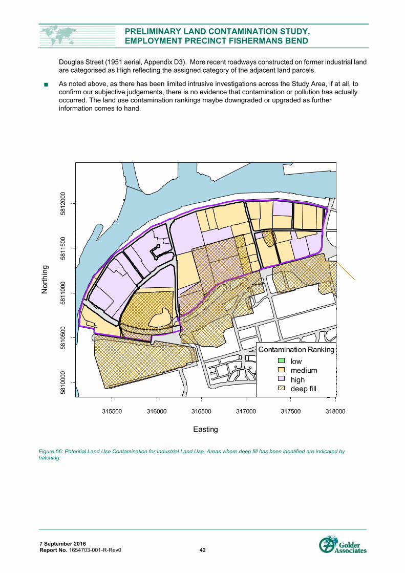
PRELIMINARY LAND CONTAMINATION STUDY, EMPLOYMENT PRECINCT FISHERMANS BEND
7 September 2016 Report No. 1654703-001-R-Rev0 42
Douglas Street (1951 aerial, Appendix D3). More recent roadways constructed on former industrial land are categorised as High reflecting the assigned category of the adjacent land parcels.
As noted above, as there has been limited intrusive investigations across the Study Area, if at all, to confirm our subjective judgements, there is no evidence that contamination or pollution has actually occurred. The land use contamination rankings maybe downgraded or upgraded as further information comes to hand.
Figure 56: Potential Land Use Contamination for Industrial Land Use. Areas where deep fill has been identified are indicated by hatching.
Easting
Nor
thin
g
315500 316000 316500 317000 317500 318000
5810
000
5810
500
5811
000
5811
500
5812
000
Contamination Rankinglowmediumhighdeep fill
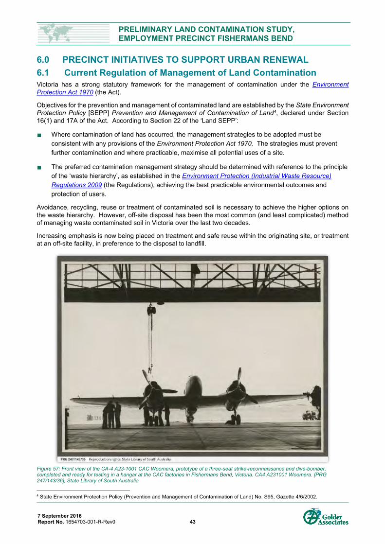
PRELIMINARY LAND CONTAMINATION STUDY, EMPLOYMENT PRECINCT FISHERMANS BEND
7 September 2016 Report No. 1654703-001-R-Rev0 43
6.0 PRECINCT INITIATIVES TO SUPPORT URBAN RENEWAL 6.1 Current Regulation of Management of Land Contamination Victoria has a strong statutory framework for the management of contamination under the Environment Protection Act 1970 (the Act).
Objectives for the prevention and management of contaminated land are established by the State Environment Protection Policy [SEPP] Prevention and Management of Contamination of Land4, declared under Section 16(1) and 17A of the Act. According to Section 22 of the ‘Land SEPP’:
Where contamination of land has occurred, the management strategies to be adopted must be consistent with any provisions of the Environment Protection Act 1970. The strategies must prevent further contamination and where practicable, maximise all potential uses of a site.
The preferred contamination management strategy should be determined with reference to the principle of the ‘waste hierarchy’, as established in the Environment Protection (Industrial Waste Resource) Regulations 2009 (the Regulations), achieving the best practicable environmental outcomes and protection of users.
Avoidance, recycling, reuse or treatment of contaminated soil is necessary to achieve the higher options on the waste hierarchy. However, off-site disposal has been the most common (and least complicated) method of managing waste contaminated soil in Victoria over the last two decades.
Increasing emphasis is now being placed on treatment and safe reuse within the originating site, or treatment at an off-site facility, in preference to the disposal to landfill.
Figure 57: Front view of the CA-4 A23-1001 CAC Woomera, prototype of a three-seat strike-reconnaissance and dive-bomber, completed and ready for testing in a hangar at the CAC factories in Fishermans Bend, Victoria. CA4 A231001 Woomera. [PRG 247/143/36], State Library of South Australia
4 State Environment Protection Policy (Prevention and Management of Contamination of Land) No. S95, Gazette 4/6/2002.
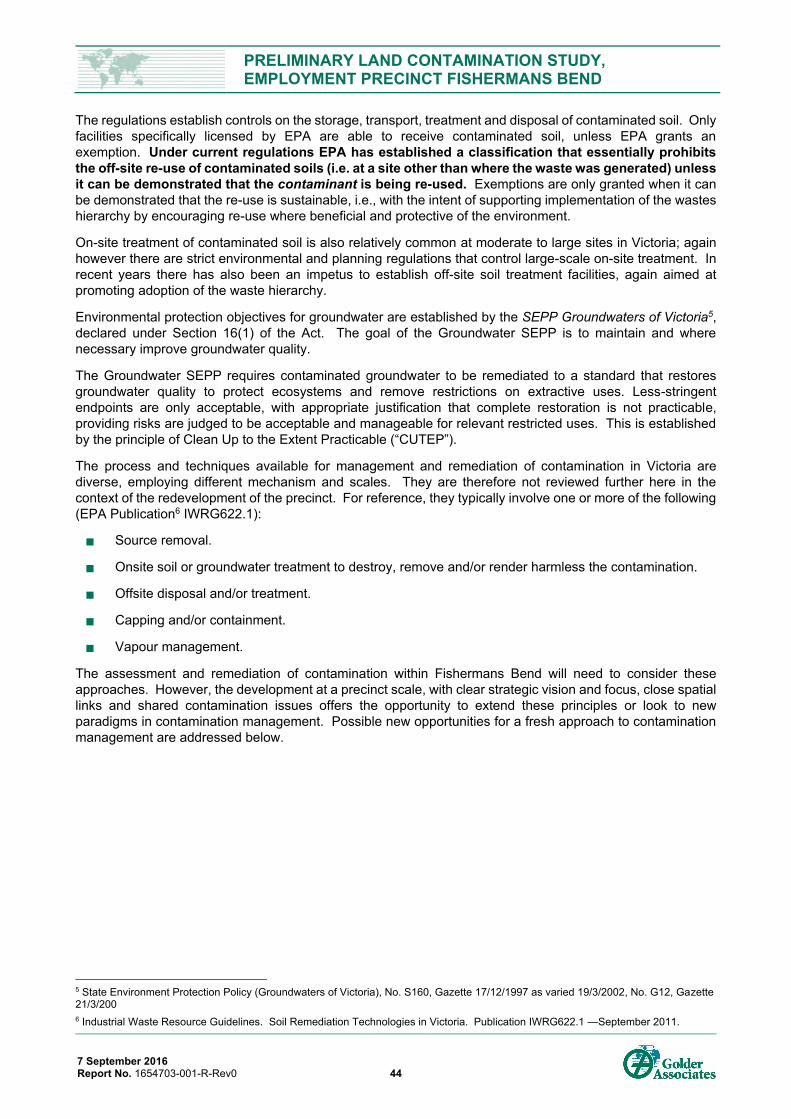
PRELIMINARY LAND CONTAMINATION STUDY, EMPLOYMENT PRECINCT FISHERMANS BEND
7 September 2016 Report No. 1654703-001-R-Rev0 44
The regulations establish controls on the storage, transport, treatment and disposal of contaminated soil. Only facilities specifically licensed by EPA are able to receive contaminated soil, unless EPA grants an exemption. Under current regulations EPA has established a classification that essentially prohibits the off-site re-use of contaminated soils (i.e. at a site other than where the waste was generated) unless it can be demonstrated that the contaminant is being re-used. Exemptions are only granted when it can be demonstrated that the re-use is sustainable, i.e., with the intent of supporting implementation of the wastes hierarchy by encouraging re-use where beneficial and protective of the environment.
On-site treatment of contaminated soil is also relatively common at moderate to large sites in Victoria; again however there are strict environmental and planning regulations that control large-scale on-site treatment. In recent years there has also been an impetus to establish off-site soil treatment facilities, again aimed at promoting adoption of the waste hierarchy.
Environmental protection objectives for groundwater are established by the SEPP Groundwaters of Victoria5, declared under Section 16(1) of the Act. The goal of the Groundwater SEPP is to maintain and where necessary improve groundwater quality.
The Groundwater SEPP requires contaminated groundwater to be remediated to a standard that restores groundwater quality to protect ecosystems and remove restrictions on extractive uses. Less-stringent endpoints are only acceptable, with appropriate justification that complete restoration is not practicable, providing risks are judged to be acceptable and manageable for relevant restricted uses. This is established by the principle of Clean Up to the Extent Practicable (“CUTEP”).
The process and techniques available for management and remediation of contamination in Victoria are diverse, employing different mechanism and scales. They are therefore not reviewed further here in the context of the redevelopment of the precinct. For reference, they typically involve one or more of the following (EPA Publication6 IWRG622.1):
Source removal.
Onsite soil or groundwater treatment to destroy, remove and/or render harmless the contamination.
Offsite disposal and/or treatment.
Capping and/or containment.
Vapour management.
The assessment and remediation of contamination within Fishermans Bend will need to consider these approaches. However, the development at a precinct scale, with clear strategic vision and focus, close spatial links and shared contamination issues offers the opportunity to extend these principles or look to new paradigms in contamination management. Possible new opportunities for a fresh approach to contamination management are addressed below.
5 State Environment Protection Policy (Groundwaters of Victoria), No. S160, Gazette 17/12/1997 as varied 19/3/2002, No. G12, Gazette 21/3/200 6 Industrial Waste Resource Guidelines. Soil Remediation Technologies in Victoria. Publication IWRG622.1 —September 2011.
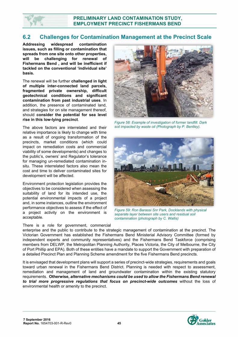
PRELIMINARY LAND CONTAMINATION STUDY, EMPLOYMENT PRECINCT FISHERMANS BEND
7 September 2016 Report No. 1654703-001-R-Rev0 45
6.2 Challenges for Contamination Management at the Precinct Scale Addressing widespread contamination issues, such as filling or contamination that spreads from one site onto other properties, will be challenging for renewal of Fishermans Bend , and will be inefficient if tackled on the conventional ‘individual site’ basis.
The renewal will be further challenged in light of multiple inter-connected land parcels, fragmented private ownership, difficult geotechnical conditions and significant contamination from past industrial uses. In addition, the presence of contaminated land, and strategies for on site management thereof, should consider the potential for sea level rise in this low-lying precinct.
The above factors are interrelated and their relative importance is likely to change with time as a result of ongoing transformation of the precincts, market conditions (which could impact on remediation costs and commercial viability of some developments) and changes to the public’s, owners’ and Regulator’s tolerance for managing un-remediated contamination in-situ. These interrelated factors also mean the cost and time to deliver contaminated sites for development will be affected.
Environment protection legislation provides the objectives to be considered when assessing the suitability of land for its intended use, the potential environmental impacts of a project and, in some instances, outline the environment performance objectives to assess if the effect of a project activity on the environment is acceptable.
There is a role for government, commercial enterprise and the public to contribute to the strategic management of contamination at the precinct. The Victorian Government has established the Fishermans Bend Ministerial Advisory Committee (formed by independent experts and community representatives) and the Fishermans Bend Taskforce (comprising members from DELWP, the Metropolitan Planning Authority, Places Victoria, the City of Melbourne, the City of Port Phillip and EPA). Both of these entities have a mandate to support the Government with preparation of a detailed Precinct Plan and Planning Scheme amendment for the five Fishermans Bend precincts.
It is envisaged that development plans will support a series of precinct-wide strategies, requirements and goals toward urban renewal in the Fishermans Bend District. Planning is needed with respect to assessment, remediation and management of land and groundwater contamination within the existing statutory requirements. Otherwise, alternative mechanisms could be used to allow the Fishermans Bend renewal to trial more progressive regulations that focus on precinct-wide outcomes without the loss of environmental health or amenity to the precinct.
Figure 58: Example of investigation of former landfill. Dark soil impacted by waste oil (Photograph by P. Bentley).
Figure 59: Ron Barassi Snr Park, Docklands with physical separate layer between site users and residual soil contamination (photograph by C. Wallis)
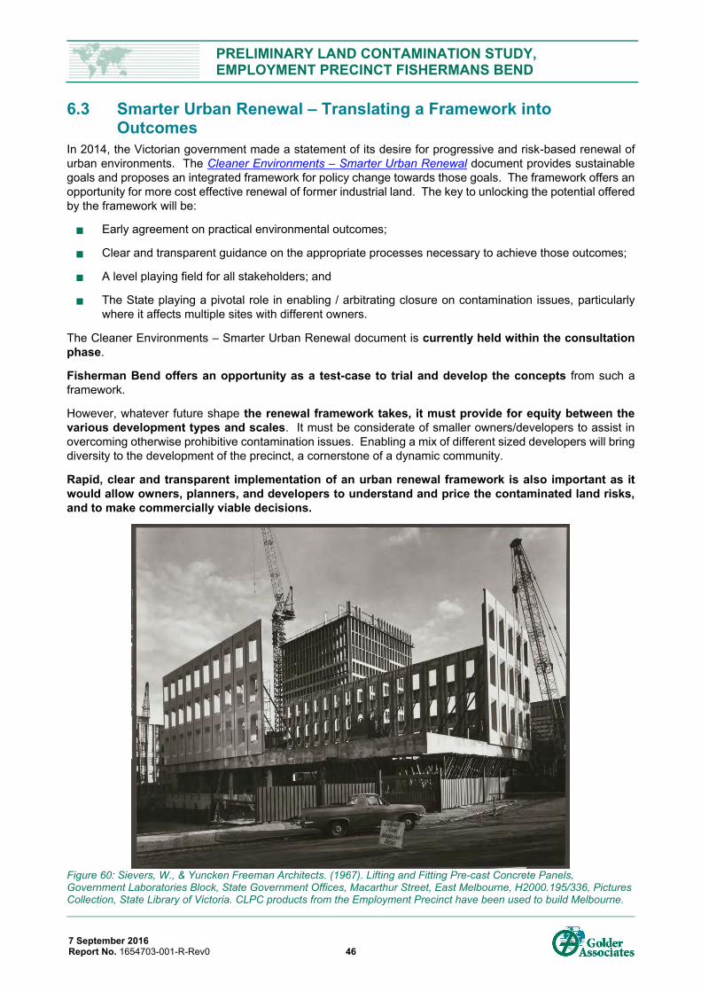
PRELIMINARY LAND CONTAMINATION STUDY, EMPLOYMENT PRECINCT FISHERMANS BEND
7 September 2016 Report No. 1654703-001-R-Rev0 46
6.3 Smarter Urban Renewal – Translating a Framework into Outcomes
In 2014, the Victorian government made a statement of its desire for progressive and risk-based renewal of urban environments. The Cleaner Environments – Smarter Urban Renewal document provides sustainable goals and proposes an integrated framework for policy change towards those goals. The framework offers an opportunity for more cost effective renewal of former industrial land. The key to unlocking the potential offered by the framework will be:
Early agreement on practical environmental outcomes;
Clear and transparent guidance on the appropriate processes necessary to achieve those outcomes;
A level playing field for all stakeholders; and
The State playing a pivotal role in enabling / arbitrating closure on contamination issues, particularly where it affects multiple sites with different owners.
The Cleaner Environments – Smarter Urban Renewal document is currently held within the consultation phase.
Fisherman Bend offers an opportunity as a test-case to trial and develop the concepts from such a framework.
However, whatever future shape the renewal framework takes, it must provide for equity between the various development types and scales. It must be considerate of smaller owners/developers to assist in overcoming otherwise prohibitive contamination issues. Enabling a mix of different sized developers will bring diversity to the development of the precinct, a cornerstone of a dynamic community.
Rapid, clear and transparent implementation of an urban renewal framework is also important as it would allow owners, planners, and developers to understand and price the contaminated land risks, and to make commercially viable decisions.
Figure 60: Sievers, W., & Yuncken Freeman Architects. (1967). Lifting and Fitting Pre-cast Concrete Panels, Government Laboratories Block, State Government Offices, Macarthur Street, East Melbourne, H2000.195/336, Pictures Collection, State Library of Victoria. CLPC products from the Employment Precinct have been used to build Melbourne.
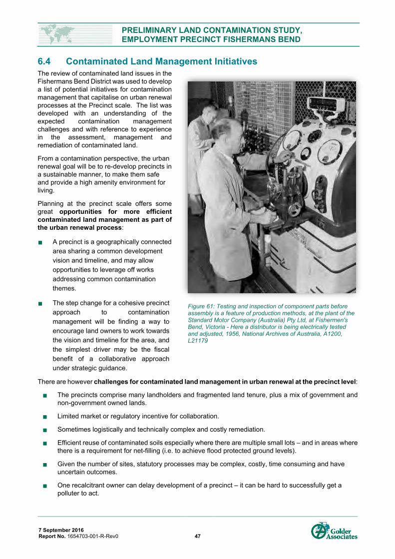
PRELIMINARY LAND CONTAMINATION STUDY, EMPLOYMENT PRECINCT FISHERMANS BEND
7 September 2016 Report No. 1654703-001-R-Rev0 47
6.4 Contaminated Land Management Initiatives The review of contaminated land issues in the Fishermans Bend District was used to develop a list of potential initiatives for contamination management that capitalise on urban renewal processes at the Precinct scale. The list was developed with an understanding of the expected contamination management challenges and with reference to experience in the assessment, management and remediation of contaminated land.
From a contamination perspective, the urban renewal goal will be to re-develop precincts in a sustainable manner, to make them safe and provide a high amenity environment for living.
Planning at the precinct scale offers some great opportunities for more efficient contaminated land management as part of the urban renewal process:
A precinct is a geographically connected area sharing a common development vision and timeline, and may allow opportunities to leverage off works addressing common contamination themes.
The step change for a cohesive precinct approach to contamination management will be finding a way to encourage land owners to work towards the vision and timeline for the area, and the simplest driver may be the fiscal benefit of a collaborative approach under strategic guidance.
There are however challenges for contaminated land management in urban renewal at the precinct level:
The precincts comprise many landholders and fragmented land tenure, plus a mix of government and non-government owned lands.
Limited market or regulatory incentive for collaboration.
Sometimes logistically and technically complex and costly remediation.
Efficient reuse of contaminated soils especially where there are multiple small lots – and in areas where there is a requirement for net-filling (i.e. to achieve flood protected ground levels).
Given the number of sites, statutory processes may be complex, costly, time consuming and have uncertain outcomes.
One recalcitrant owner can delay development of a precinct – it can be hard to successfully get a polluter to act.
Figure 61: Testing and inspection of component parts before assembly is a feature of production methods, at the plant of the Standard Motor Company (Australia) Pty Ltd, at Fishermen's Bend, Victoria - Here a distributor is being electrically tested and adjusted, 1956, National Archives of Australia, A1200, L21179
PRELIMINARY LAND CONTAMINATION STUDY, EMPLOYMENT PRECINCT FISHERMANS BEND
7 September 2016 Report No. 1654703-001-R-Rev0 48
There is a time element to development at the precinct-scale (the Fishermans Bend District has a time line of 20 to 30 years). This adds the temporal complexity of, for example: changes in legislation and regulation changes to preferred land; and changes in available information (i.e. such as the predictions of sea level change).
Some of contributing factors to these issues are:
No party (central government or private entity) has responsibility for gathering and distributing information on contamination. Limited incentive to do so (e.g. funding, responsibility, liability).
Little required reporting of contamination except through the Audit process.
When it comes to remediation and redevelopment of former industrial sites, the past and current focus has been at the site scale. Site based focus however leads to:
Lost opportunities to make contamination management efficient. Each owner/site goes through its own learning process and develops its own remedial strategies, thus losing the potential for economies of scale in treating similar issues.
Fragmentation of data. Contamination is not often well delineated beyond the property boundaries.
Inefficient collection of data. Remediation duplication of effort can result where issues cross boundaries.
EPA’s statutory powers (and the planning authority’s responsibilities) generally structured around premises and occupiers rather than precincts.
The Environmental Audit System currently designed to consider individual sites rather than neighbourhood or precinct-wide contamination issues.
Onsite management or reuse of contaminated soil is more poorly defined and more difficult than offsite disposal.
In Victoria, the development of some of our largest industrial sites have been at the same scale as a ’precinct’, but have the advantage of having an individual owner. This enabled the remediation and management of complex contamination issues at those sites to be integrated into the broader redevelopment design and timing. Examples of remediation and development by single developers and single owners include the Albion Explosives Factory, Kodak Coburg and Beacon Cove BP Fuel Terminal.
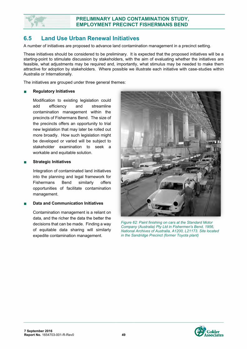
PRELIMINARY LAND CONTAMINATION STUDY, EMPLOYMENT PRECINCT FISHERMANS BEND
7 September 2016 Report No. 1654703-001-R-Rev0 49
6.5 Land Use Urban Renewal Initiatives A number of initiatives are proposed to advance land contamination management in a precinct setting.
These initiatives should be considered to be preliminary. It is expected that the proposed initiatives will be a starting-point to stimulate discussion by stakeholders, with the aim of evaluating whether the initiatives are feasible, what adjustments may be required and, importantly, what stimulus may be needed to make them attractive for adoption by stakeholders. Where possible we illustrate each initiative with case-studies within Australia or Internationally.
The initiatives are grouped under three general themes:
Regulatory Initiatives
Modification to existing legislation could add efficiency and streamline contamination management within the precincts of Fishermans Bend. The size of the precincts offers an opportunity to trial new legislation that may later be rolled out more broadly. How such legislation might be developed or varied will be subject to stakeholder examination to seek a workable and equitable solution.
Strategic Initiatives
Integration of contaminated land initiatives into the planning and legal framework for Fishermans Bend similarly offers opportunities of facilitate contamination management.
Data and Communication Initiatives
Contamination management is a reliant on data, and the richer the data the better the decisions that can be made. Finding a way of equitable data sharing will similarly expedite contamination management.
Figure 62: Paint finishing on cars at the Standard Motor Company (Australia) Pty Ltd in Fishermen's Bend, 1956, National Archives of Australia, A1200, L21173. Site located in the Sandridge Precinct (former Toyota plant)
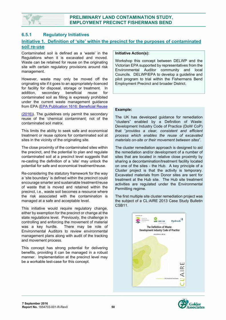
PRELIMINARY LAND CONTAMINATION STUDY, EMPLOYMENT PRECINCT FISHERMANS BEND
7 September 2016 Report No. 1654703-001-R-Rev0 50
6.5.1 Regulatory Initiatives Initiative 1. Definition of ‘site’ within the precinct for the purposes of contaminated soil re-use Contaminated soil is defined as a ‘waste’ in the Regulations when it is excavated and moved. Waste can be retained for reuse on the originating site with certain regulatory provisions around risk management.
However, waste may only be moved off the originating site if it goes to an appropriately-licenced for facility for disposal, storage or treatment. In addition, secondary beneficial reuse for contaminated soil as filling is expressly prohibited under the current waste management guidance from EPA (EPA Publication 1616: Beneficial Reuse
(2016)). The guidelines only permit the secondary reuse of the ‘chemical contaminant; not of the contaminated soil matrix.
This limits the ability to seek safe and economical treatment or reuse options for contaminated soil at sites in the vicinity of the originating site.
The close proximity of the contaminated sites within the precinct, and the potential to plan and regulate contaminated soil at a precinct level suggests that re-casting the definition of a ‘site’ may unlock the potential for safe and economical treatment/reuse.
Re-considering the statutory framework for the way a ‘site boundary’ is defined within the precinct could encourage smarter and sustainable treatment/reuse of waste that is moved and retained within the precinct, i.e., waste soil becomes a resource where the risk associated with the contamination is managed at a safe and acceptable level.
This initiative would require regulatory change, either by exemption for the precinct or change at the state regulations level. Previously, the challenge in controlling and enforcing the movement of material was a key hurdle. There may be role of Environmental Auditors to review environmental management plans along with audit of the tracking and movement process.
This concept has strong potential for delivering benefits, providing it can be managed in a robust manner. Implementation at the precinct level may be a workable test-case for this concept.
Initiative Action(s):
Workshop this concept between DELWP and the Victorian EPA supported by representatives from the Environmental Auditor community and local Councils. DELWP/EPA to develop a guideline and pilot program to trial within the Fishermans Bend Employment Precinct and broader District.
Example:
The UK has developed guidance for remediation “clusters” enabled by a Definition of Waste: Development Industry Code of Practice (DoW CoP) that “provides a clear, consistent and efficient process which enables the reuse of excavated materials on-site or their movement between sites”.
The cluster remediation approach is designed to aid the remediation and/or development of a number of sites that are located in relative close proximity by sharing a decontamination/treatment facility located on one of the sites - the Hub. A key principle of a Cluster project is that the activity is temporary. Excavated materials from Donor sites are sent for treatment at the Hub site. The Hub site treatment activities are regulated under the Environmental Permitting regime.
The first multiple site cluster remediation project was the subject of a CL:AIRE 2013 Case Study Bulletin CSB11.
PRELIMINARY LAND CONTAMINATION STUDY, EMPLOYMENT PRECINCT FISHERMANS BEND
7 September 2016 Report No. 1654703-001-R-Rev0 51
Initiative 2. ‘Clusters’ of contamination management Fishermans Bend represents a highly challenging urban renewal project from a contamination perspective due to its complex underlying geology, the manner of its original reclamation from the swamps of the Yarra delta (filling with wastes), its long industrial history, and the substantial private land ownership. These variables mean the remediation goals and associated cost and time to deliver remediated sites as part of the overall precinct scale renewal will be affected by strategic planning decisions and other supporting government initiatives relating to management of contaminated land.
Precinct-wide contamination management strategies must be adopted. These will require engagement from public and private land owners to collectively provide input toward to strategies which affects their land.
Contaminated land is conventionally managed and treated at the individual site level. This is clearly an ‘intuitive’ commercial approach, where each land owner is focussed on their own issues. Off-site treatment at licenced facilities is also a good option, and there has been recent step change in Victoria with new high-tech contaminated soil treatment facilities opening for business (e.g. Renex).
There is currently a gap within the treatment options, where the establishment of temporary plant for treatment of contaminated soil on one site cannot be used to treat soil from other contaminated sites without obtaining a Works Approval and due to limitation on transport of wastes between sites.
The initiative is to permit, in a controlled manner, a temporary plant that was established to treat waste from one site to receive and treat waste from other sites within the precinct or other relevant commonalty (i.e. industry type). This will obviously require commercial initiative, however the ability to receive waste from off-site may (partially) off-set the capital expenditure of establishing the plant. The overall net benefit may be measured in the reduced cost and time for clean-up of sites.
While this approach has strong merits for application at Fishermans Bend, this approach is not easily implemented in Victoria due to the existing statutory framework for planning and environmental controls relevant to treatment facility sites. It may also not be easy to achieve for the precinct as a whole due to number of parties involved. However, dividing the precinct into a series of contamination management ‘hubs’ or ‘clusters’ that have common contamination issues opens opportunities for more collaboration, and the incentive of reduced remediation costs.
7 Contaminated Land: Applications in Real Environments (CL:AIRE) Version 2 March 2011. The Definition of Waste: Development Industry Code of Practice.
Initiative Action(s):
Adopting the cluster treatment concept and ability to transfer wastes for treatment/reuse between sites would require policy change, or precinct-specific exemptions, plus guidance like that prepared by the United Kingdom’s CL:AIRE ‘Definition of Waste: Development Industry Code of Practice (DoW CoP)’7. Ideally an overarching responsible party, such as a ‘cluster’ body-corporate, could potentially administer and arbitrate the process at the precinct.
The concept of grouping sites together as “Superlots” has already been identified by DELWP (refer to the Ministerial Advisory Committee Report (2016)), however the focus was on Master Planning. Extending this concept to contaminated land is a logical next step.
Further steps would include a workshop on this initiative between DELWP and the Victorian EPA, supported by representatives from the Environmental Auditor community, local Councils and stakeholders (owners/developers). The objective of the initiative would be to create:
Policy change or local exemption to enable a clear, consistent and efficient process for the reuse of excavated materials on-site or their movement between sites for the purposes of treatment.
Division of the site into conceptual contamination management clusters where a few owners with similar contamination issues can leverage off a central management/processing resource or share recyclable fill.
PRELIMINARY LAND CONTAMINATION STUDY, EMPLOYMENT PRECINCT FISHERMANS BEND
7 September 2016 Report No. 1654703-001-R-Rev0 52
Initiative 3. Prioritisation of high risk sites to expedite closure and unencumber surrounds Significant or complex contamination issues take longer to assess and remediate. They are also more complex to close out with EPA, particularly were groundwater is impacted.
Progressing the early assessment and remediation of ‘high risk’ sites that are potential sources of offsite vapour or groundwater pollution may expedite the development of the areas in the precinct with more recalcitrant contamination issues.
Early attention to these sites is also less likely to encumber (technically and/or financially) the progress of neighbouring development sites - the development of surrounding land parcels affected by such ‘source sites’ can be problematic to development type, costs, timing and the approval process.
To a large extent this process is already undertaken in Victoria, administered under the EPA’s Priority Sites Register. However, the next step would be to integrate prioritization with strategy of Fishermans Bend planning to expedite development of sections of the precinct.
Initiative Action(s):
The next step would be to further develop the high-level contaminated land risk assessment for the precinct, drawing on lines of evidence for potential contamination presence plus voluntary feed-back from owners. For example; site owners have knowledge which they wish to share with DELWP to verify that the risk categorisation is different (i.e. lower ‘no groundwater pollution’) than the indicative risks in the initial assessment. This type of voluntary reporting would be need to be carefully handled to be effective, to ensure industry would come forward without fear of a ‘Notice’
DELWP could then develop a framework to categorise risk of contaminated land presence for areas of the precinct. There would be a role for EPA or an Environmental Auditor to potentially verify that the updated assessment risk is reasonable in the context of an agreed and defined framework.
The strategic plan for development for the precinct can then be reviewed in the context of the risk categories, to identify areas where contamination management needs to be prioritised. There may also need to be an exploration of how the contamination management could be incentivised to deliver effective solutions in a timely manner.
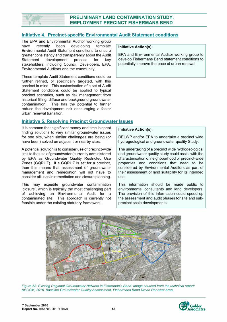
PRELIMINARY LAND CONTAMINATION STUDY, EMPLOYMENT PRECINCT FISHERMANS BEND
7 September 2016 Report No. 1654703-001-R-Rev0 53
Initiative 4. Precinct-specific Environmental Audit Statement conditions The EPA and Environmental Auditor working group have recently been developing template Environmental Audit Statement conditions to ensure greater consistency and transparency about the Audit Statement development process for key stakeholders, including Council, Developers, EPA, Environmental Auditors and the community.
These template Audit Statement conditions could be further refined, or specifically targeted, with this precinct in mind. This customisation of a set of Audit Statement conditions could be applied to typical precinct scenarios, such as risk management from historical filling, diffuse and background groundwater contamination. This has the potential to further reduce the development risk encouraging a faster urban renewal transition.
Initiative 5. Resolving Precinct Groundwater Issues It is common that significant money and time is spent finding solutions to very similar groundwater issues for one site, when similar challenges are being (or have been) solved on adjacent or nearby sites.
A potential solution is to consider use of precinct-wide limit to the use of groundwater (currently administered by EPA as Groundwater Quality Restricted Use Zones (GQRUZ). If a GQRUZ is set for a precinct, then this means that assessment of groundwater management and remediation will not have to consider all uses in remediation and closure planning.
This may expedite groundwater contamination ‘closure’, which is typically the most challenging part of achieving an Environmental Audit for a contaminated site. This approach is currently not feasible under the existing statutory framework.
Figure 63: Existing Regional Groundwater Network in Fisherman’s Bend. Image sourced from the technical report: AECOM, 2016, Baseline Groundwater Quality Assessment, Fishermans Bend Urban Renewal Area.
Initiative Action(s):
EPA and Environmental Auditor working group to develop Fishermans Bend statement conditions to potentially improve the pace of urban renewal.
Initiative Action(s):
DELWP and/or EPA to undertake a precinct wide hydrogeological and groundwater quality Study.
The undertaking of a precinct wide hydrogeological and groundwater quality study could assist with the characterisation of neighbourhood or precinct-wide properties and conditions that need to be considered by Environmental Auditors as part of their assessment of land suitability for its intended use.
This information should be made public to environmental consultants and land developers. The provision of this information could speed up the assessment and audit phases for site and sub-precinct scale developments.
PRELIMINARY LAND CONTAMINATION STUDY, EMPLOYMENT PRECINCT FISHERMANS BEND
7 September 2016 Report No. 1654703-001-R-Rev0 54
6.5.2 Strategic Initiatives Initiative 6. Integrating Waste Soil Management Strategy with Strategic Planning The requirement to manage contaminated land is enshrined in the Victorian planning regulations. However, the expected precinct-wide contamination issues and the strategic planning at the precinct level offers the opportunity for new ways to integrate contamination management into the renewal of the area. The aim is to improve the net environmental benefit of materials reuse. Two potential opportunities are identified below.
Initiative 6a. Reuse of Contaminated Soil in the Flood/Inundation Protection for the Precinct Clause 13.01 of State Planning Policy requires “decision makers to consider future flood risks associated with modelled sea level rise”. A report from Melbourne Water (Melbourne Water, 2012) recommends “a minimum finished floor level of 3 mAHD for a 1 in 100-year flood in 2100” [the majority of the current precinct has a surface level of 1 to <3 mAHD with some more elevated areas to the south east around 3 to 4 mAHD.
Many low elevation coastal areas including Fishermans Bend will need to be raised and or protected to avert inundation due to sea level rise and exposure to storm surges. There is likely to be a significant deficit in material required to increase ground levels to meet planning requirements future flood and inundation risks. The significant amount of excess spoil from development and remediation processes within the precinct will need to find a safe and secure home. Linking the deficit and surplus together in a safe manner requires a sustainable opportunity. In response:
It is recommended a spoil management strategy be developed which evaluates the potential quality of materials available, associated volumes, potential movement and reuse needs based some broad precinct staging and design levels (i.e. in mAHD) that need to be achieved to meet flooding and storm surge protection. Consideration should be had to establish one or multiple on-site processing facilities / soil banks to minimise transport and maximise retention of material within the precinct.
Consideration of other sources of spoil from major urban and infrastructure developments (e.g. tunnels, roadways, major infrastructure projects) should be considered in this evaluation to meet the significant deficit in materials that will be required to elevate the precinct in various lifts during the renewal journey.
Initiative 6b. Review the Planning for Placement of Infrastructure and Services When planning large scale infrastructure changes or improvements, consideration should be given to the design to either minimise the disturbance of potentially contaminated fill or for the return of the disturbed fill to the depth and location from which it was removed subject to appropriate controls.
Alternatively, consideration should be given to potential opportunities for on-site management of contaminated soils arising from services installation within a designated part of the precinct, using features such as mounds or reclaimed excavations with separation barriers to make clear the divide between soil types. Introduction of precinct wide sustainable solutions required integration between relevant stakeholders.
Initiative Action(s):
Develop a;
- precinct wide spoil management strategy that considers future development level targets to support climate change adaptation.
- contaminated land transfer framework to support the implementation of the spoil management strategy.
Encourage collaboration in early design and throughout the planning and implementation process. Define a collaborative governance model to support the integration of contamination management ideas with other technical disciplines, into practice.
Initiative Action(s):
A contaminated land transfer framework be developed to support the implementation of the spoil management strategy and thereby expedite the transfer of public roads and services between parties.
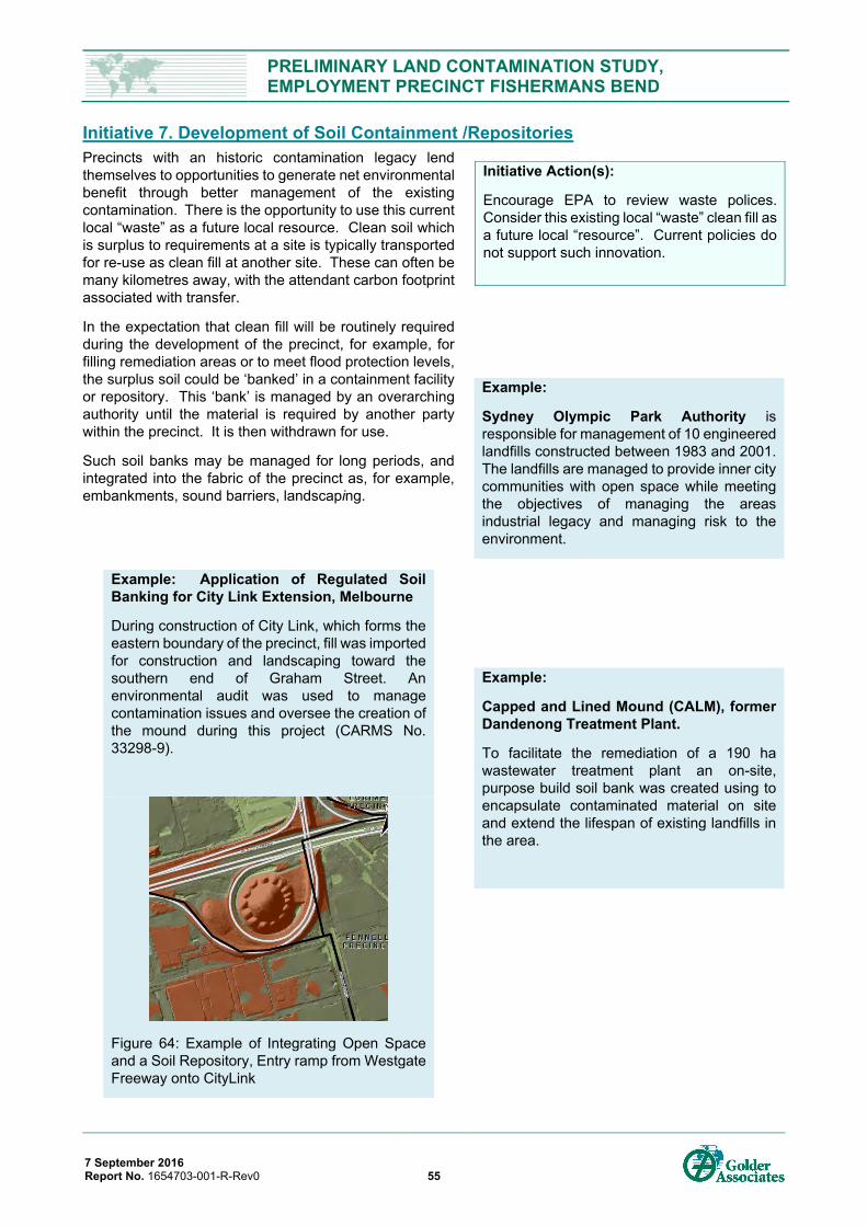
PRELIMINARY LAND CONTAMINATION STUDY, EMPLOYMENT PRECINCT FISHERMANS BEND
7 September 2016 Report No. 1654703-001-R-Rev0 55
Initiative 7. Development of Soil Containment /Repositories Precincts with an historic contamination legacy lend themselves to opportunities to generate net environmental benefit through better management of the existing contamination. There is the opportunity to use this current local “waste” as a future local resource. Clean soil which is surplus to requirements at a site is typically transported for re-use as clean fill at another site. These can often be many kilometres away, with the attendant carbon footprint associated with transfer.
In the expectation that clean fill will be routinely required during the development of the precinct, for example, for filling remediation areas or to meet flood protection levels, the surplus soil could be ‘banked’ in a containment facility or repository. This ‘bank’ is managed by an overarching authority until the material is required by another party within the precinct. It is then withdrawn for use.
Such soil banks may be managed for long periods, and integrated into the fabric of the precinct as, for example, embankments, sound barriers, landscaping.
Initiative Action(s):
Encourage EPA to review waste polices. Consider this existing local “waste” clean fill as a future local “resource”. Current policies do not support such innovation.
Example:
Sydney Olympic Park Authority is responsible for management of 10 engineered landfills constructed between 1983 and 2001. The landfills are managed to provide inner city communities with open space while meeting the objectives of managing the areas industrial legacy and managing risk to the environment.
Example: Application of Regulated Soil Banking for City Link Extension, Melbourne
During construction of City Link, which forms the eastern boundary of the precinct, fill was imported for construction and landscaping toward the southern end of Graham Street. An environmental audit was used to manage contamination issues and oversee the creation of the mound during this project (CARMS No. 33298-9).
Figure 64: Example of Integrating Open Space and a Soil Repository, Entry ramp from Westgate Freeway onto CityLink
Example:
Capped and Lined Mound (CALM), former Dandenong Treatment Plant.
To facilitate the remediation of a 190 ha wastewater treatment plant an on-site, purpose build soil bank was created using to encapsulate contaminated material on site and extend the lifespan of existing landfills in the area.
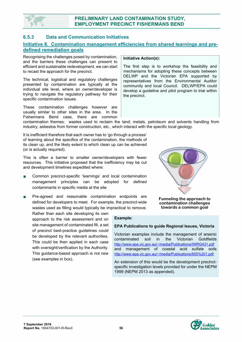
PRELIMINARY LAND CONTAMINATION STUDY, EMPLOYMENT PRECINCT FISHERMANS BEND
7 September 2016 Report No. 1654703-001-R-Rev0 56
6.5.3 Data and Communication Initiatives Initiative 8. Contamination management efficiencies from shared learnings and pre-defined remediation goals Recognising the challenges posed by contamination, and the barriers these challenges can present to efficient and sustainable redevelopment, we can start to recast the approach for the precinct.
The technical, logistical and regulatory challenges presented by contamination are typically at the individual site level, where an owner/developer is trying to navigate the regulatory pathway for their specific contamination issues.
These contamination challenges however are usually similar to other sites in the area. In the Fishermans Bend case, there are common contamination themes: wastes used to reclaim the land; metals, petroleum and solvents handling from industry; asbestos from former construction, etc., which interact with the specific local geology.
It is inefficient therefore that each owner has to ‘go through a process’ of learning about the specifics of the contamination, the methods of its clean up, and the likely extent to which clean up can be achieved (or is actually required).
This is often a barrier to smaller owner/developers with fewer resources. This initiative proposed that the inefficiency may be cut and development timelines expedited where:
Common precinct-specific ‘learnings’ and local contamination management principles can be adopted for defined contaminants in specific media at the site.
Pre-agreed and reasonable contamination endpoints are defined for developers to meet. For example, the precinct-wide wastes used as filling would typically be impractical to remove. Rather than each site developing its own approach to the risk assessment and on site management of contaminated fill, a set of precinct best-practice guidelines could be developed by the relevant authorities. This could be then applied in each case with oversight/verification by the Authority. This guidance-based approach is not new (see examples in box).
Initiative Action(s):
The first step is to workshop the feasibility and mechanisms for adopting these concepts between DELWP and the Victorian EPA supported by representatives from the Environmental Auditor community and local Council. DELWP/EPA could develop a guideline and pilot program to trial within the precinct.
Example:
EPA Publications to guide Regional Issues, Victoria
Victorian examples include the management of arsenic contaminated soil in the Victorian Goldfields http://www.epa.vic.gov.au/~/media/Publications/IWRG431.pdf and management of coastal acid sulfate soils http://www.epa.vic.gov.au/~/media/Publications/655%201.pdf.
An extension of this would be the development precinct-specific investigation levels provided for under the NEPM 1999 (NEPM 2013 as appended).
Funneling the approach to contamination challenges towards a common goal
PRELIMINARY LAND CONTAMINATION STUDY, EMPLOYMENT PRECINCT FISHERMANS BEND
7 September 2016 Report No. 1654703-001-R-Rev0 57
Initiative 9. Promotion of innovation in technology and policy The EPA, and in particular the EPA’s HazWaste Fund http://www.epa.vic.gov.au/our-work/programs/hazwaste-fund has been promoting and encouraging the piloting of remediation technologies in Victoria with a focus on clean technologies. An example is the thermal treatment facility for contaminated soils in Dandenong.
Fishermans Bend offers a focussed opportunity to target support for bringing in new contamination remediation/management innovations, particularly if the ‘cluster’ approach above is considered. EPA could trial precinct-specific remediation and waste polices with sunset clauses to assess uptake, monitor value and respond accordingly (i.e. by expanding or cancelling the policy as required).
Initiative Action(s):
To engage with EPA about opportunities for the HazWaste fund or equivalent in the Fishermans Bend Precinct(s). An alternative is to see sources of funding for a precinct-specific innovation fund – this might be coupled to other proposed initiatives in this documents (e.g., the remediation ‘cluster’ initiative) with the aim of the innovation fund being the primer for adoption of other initiatives.
Other opportunities could be via information sharing through a Steering Committee or precinct ‘conferences’ where working ideas/experiences are presented and shared.
Example:
NSW Catchment Levies and Proximity Principle for Waste Management, NSW
NSW Protection of the Environment Operations (Waste) Regulation 2014 amendments have created a setting that promotes through local “catchment” levies and the “proximity principle”. A levy applies to restricted solid wastes leaving the Sydney metropolitan area for disposal or treatment. Encouraging disposal or treatment at the closest facility (reducing risk of transport accidents and increasing sustainability by less fuel consumption).
Has led to the development of soil remediation “clusters” such as former Cootamundra gasworks, St Mary’s recycling facility, and potential facility in Port of Newcastle to treat and either dispose or provide a resource “i.e. clean fill” within local catchment areas.
Example:
Federal Remediation Technologies Roundtable (FRTR), USA
FRTR is a collaborative US Government collaboration design to engage public and private stakeholders towards innovative use of remedial technology to address contamination (https://frtr.gov/).
PRELIMINARY LAND CONTAMINATION STUDY, EMPLOYMENT PRECINCT FISHERMANS BEND
7 September 2016 Report No. 1654703-001-R-Rev0 58
Initiative 10. Data collaboration – advances to support sharing of contamination information Many of the principles we have mentioned throughout this document would benefit from and, in many cases, can only be achieved where there is a degree of collaboration between independent site owners.
Knowledge sharing on contamination typically occurs only reluctantly, and often only when directed by the Regulator. We are aware of public and private stakeholders working together to achieve more strategic and efficient redevelopment outcome for multiple land parcels that are co-located. This approach has the potential to:
Save a considerable amount in audit and investigations costs.
Allows for a more orderly roll out of “renewal ready” land.
Provide more certainty around the urban renewal process.
Sharing data, though challenging given an owner’s nervousness about admitting liability, may reduce individual expenditures on investigation, and has the potential to expedite the development of remediation solutions.
The precinct offers the opportunity to create a curated central data portal and workbench for information regarding contamination conditions across a precinct or district. Currently there is no trigger to provide information other than via Environmental Audit. There would be a significant saving in cost and reduce development lead time for precinct renewal if there was a portal to manage and update information regarding:
Background soil concentrations
Groundwater depths
Groundwater flow direction
Groundwater quality and background
EPA’s groundwater study in the Fishermans Bend precincts (Lorimer, Montague, Sandridge, and Wirraway) was a first step in data gathering on a precinct scale. It is understood the next step will be to undertaken a similar study for the Employment Precinct. The data and all the associated metadata now need to be made accessible to stakeholders to allow it to be readily considered, queried and aggregated with site specific and sub-precinct investigations to support more efficient development. It is also understood this information will be used by EPA to inform Policy decisions around demarcating a GQRUZ that applies to the precinct, or parts thereof, and the associated CUTEP process.
Initiative Action(s):
DELWP to develop a central database to hold all contamination and other relevant information, building on this land contamination study and the groundwater study undertaken by EPA. It would be worthwhile undertaking a stakeholder workshop(s) to map out data management risks and reliance. The first version could comprise a partially locked interactive map of information with some data layers around, industry practices, topography/fill depth, borelogs, groundwater levels, groundwater contours and groundwater chemistry made freely available to download in standard database formats. If it was established as online portal DELWP would have greater control of data and ability to update data for dissemination more quickly.
Example:
Superfund Redevelopment Initiative, US EPA
The Superfund Redevelopment Initiative is a communication strategy being applied across superfund sites within the USA. Superfund sites in the US are sites identified with high risk legacy impact on the environment. There are a large number of superfund sites across the USA. Agencies there have sought to share knowledge and resources to more efficiently address these sites. One communication strategy is the Superfund Redevelopment Initiative which aims to integrate the technical community with the broader social community around these issues through a national coordinated program.
Environmental Audits, Victorian EPA.
Completed environmental audits are made available to the wider community and become part of the public record upon completion of the audit. These reports provide useful information for nearby site investigations.
Shorten the timeframe for and investigate and clean-up (if required).
PRELIMINARY LAND CONTAMINATION STUDY, EMPLOYMENT PRECINCT FISHERMANS BEND
7 September 2016 Report No. 1654703-001-R-Rev0 59
7.0 CONCLUSIONS Golder Associates has undertaken a high level review of potential land contamination issues associated past and present land use within the Employment Precinct within the Fishermans Bend District.
Theme 1) Understanding Melbourne’s Industrial Legacy and Precinct Redevelopment Early industries in Melbourne were focused toward agriculture, however the gold rush funded the establishment of a broad industrial base which remains today in Victoria. In the beginning, land use within Melbourne was intermixed, often with industry and residential together. The impacts to living space from industry emissions led to movements to create separate land uses. Early changes involved moving industry to isolated areas and using buffer areas to create separation, however this did not address the issue of waste outputs coming from industry. When the Employment Precinct was developed for industry in the 1930s, industrial land use zoning was not yet regulated through a city wide planning scheme. However, the intention to keep industrial and residential land use separate is evident by the development of only industrial land use in Employment Precinct at this time, with the area being one of Melbourne’s earliest industrial estates. In 1954, the Melbourne Metropolitan Planning Scheme began, and the Employment Precinct was officially zoned industrial. Since 1990 large areas have been redeveloped for commercial land use, with large areas of industrial zoning remaining.
As redevelopment of former industrial sites grew across Melbourne, this led to the Victorian Environmental Audit system, and the supporting contaminated land industry, to provide the technical and management skills required to transition industrial land to more sensitive land uses and address legacy contamination issues in urban environments.
Theme 2) Past and Present Land Use Advanced manufacturing was the original focus of industry in the Precinct. The automotive industry led by GM Holden acted as a catalyst in the 1930s to develop unused land close to Melbourne city. The onset of World War 2 saw aerospace manufacturing move in beside automotive to learn mass production techniques. Post war industrial growth saw large industrial sites established, which led to industrial land use being dominated by a few industry sectors, both private and government, with long term occupancy of their sites.
After 1990, land use by industry shifted from being dominated by advanced manufacturing and engineering to a focus on business parks, commercial space, warehousing and construction sectors. In addition, open and recreation space was created within and around Westgate Park. Of the original industries to settle the area, only Boeing Aerostructures (former Government Aircraft Factory), GM Holden, and Kraft have maintained a continuous operational presence in the precinct.
Theme 3) Land Reclamation and Filling History The original landscape of the Employment Precinct was low lying, swampy land prone to flooding. Construction of the Coode Canal created the northern boundary of the Precinct which introduced flooding controls and began reclamation. Initially land along the Canal was reclaimed to create the extension of South Wharf and Lorimer Street. Extensive sand mining for construction within the Precinct and sale of washed sands resulted in several deep excavations. Following the end of sand mining in the 1950s and zoning to industrial land use, deep excavations were infilled, including the operation of the Port Melbourne municipal tip. In addition, the low lying topography of the area led to widespread shallow filling between 1 to 2 metres thick across much of the Precinct. Elevated areas of fill for landscaping occurred in Westgate Park during the 1980s and 1990s. A land reclamation and fill model has been provided which presents a spatial map with fill depths across the precincts.
Theme 4) Potential Land Use Contamination Potential land use contamination across the Precinct has been assessed based on a review of readily available public information and professional judgement. For the purposes of this study, the degree of potential contamination was divided into the three broad and subjective contamination ranking categories of low, moderate and high. Areas where fill greater than 2 metres depth below ground level is likely to intercept the groundwater have been identified and classified based on fill history. Further investigations of each land parcel, either as a desktop review of site investigations or through collection of primary data, will be required to refine the contamination ranking and to quantify site specific potential contamination issues.
PRELIMINARY LAND CONTAMINATION STUDY, EMPLOYMENT PRECINCT FISHERMANS BEND
7 September 2016 Report No. 1654703-001-R-Rev0 60
The Employment Precinct land parcels were categorised as either High or Medium potential for land use contamination. Site rankings in part reflect the types of industry present, with the higher potential for land use contamination, associated with occupying industries such as aerospace manufacture and research, Defence industrial research, automotive manufacturing, and printing facilities. In addition, several areas of deep fill have been identified with the potential to intercept groundwater. The Study Area was divided into the following potential land use contamination categories.
High – 133 hectares of Employment Precinct land was categorised as High, which represents 33% of the total Fishermans Bend District. The previous Fishermans Bend study (Golder, 2012) (within the Capital City Zone) identified 41 hectares of land as High, which represents 10% of the total Fishermans Bend District.
Medium – 76 hectares of Employment Precinct land was categorised as Medium, which represents 19% of the total Fishermans Bend District. The previous Fishermans Bend study within the Capital City Zone categorised approximately 124 hectares of land as Medium, which represents. 31% of the total Fishermans Bend District.
Low – No Low areas were identified in the Employment Precinct due to the extent of former industrial land use and land reclamation. The previous Fishermans Bend study (within the Capital City Zone) identified 30 hectares of land as Low, which represents 7% of the total Fishermans Bend District.
This comparison between the current and previous land use contamination study (Golder, 2012a) highlights the greater extent of potential high contamination areas within the Employment Precinct, which takes the high rankings from 10% to 33% of the total Fishermans Bend District. While potential high land use contamination dominates the precinct, it is worth noting acceptable environmental practices have changed over time, and legacy issues need to be viewed in light of modern standards.
Some of land parcels assigned high rankings will likely require significant soil remediation and potentially active groundwater remediation. However, other areas were assigned high rankings based on available information on the public record, could be readily updated with access to appropriate site specific environmental information. Potential high land contamination categories do not necessarily translate to high management or remediation costs: i) where the end use is a non-sensitive use (i.e. commercial use) and/or ii) the development site(s) is large, providing for potential economies of scale opportunities with remediation implementation.
Theme 5) Precinct Initiatives to Support Urban Renewal The Employment Precinct and four associated Precincts within the Fishermans Bend District are commencing a 20 to 30-year period of urban renewal. Managing and remediating the contamination has been identified as a critical component of the urban renewal. The close proximity of the potentially contaminated sites within the precinct, and the potential to plan and regulate contaminated soil at a precinct level offer the potential to unlock more timely and economical contamination management strategies than might conventionally be adopted.
This document aimed to identify initiatives and opportunities to manage contamination at the precinct scale, capitalising on proximity and synergies towards the common development goals. The brief was for initiatives to be progressive, to look for opportunities and initiatives which may not necessarily be within the current regulatory framework, and to stimulate discussion on new regulatory standards that may be applied to contaminated land for the Fishermans Bend.
A total of ten initiatives were identified under three ‘themes’ to advance land contamination management in a precinct setting:
Regulatory:
Initiative 1. Definition of ‘site’ within the precinct for the purposes of contaminated soil re-use
Initiative 2. ‘Clusters’ of contamination management
Initiative 3. Prioritization of high risk sites to expedite closure and unencumber surrounds
Initiative 4. Precinct-specific Environmental Audit Statement conditions
Initiative 5. Resolving Precinct Groundwater Issues
PRELIMINARY LAND CONTAMINATION STUDY, EMPLOYMENT PRECINCT FISHERMANS BEND
7 September 2016 Report No. 1654703-001-R-Rev0 61
Strategic:
Initiative 6. Integrating Waste Soil Management Strategy with Strategic Planning
Initiative 7. Development of Soil Containment /Repositories
Data and Communication:
Initiative 8. Contamination management efficiencies from shared learnings and pre-defined remediation goals
Initiative 9. Promotion of innovation in technology and policy
Initiative 10. Data collaboration – advances to support sharing of contamination information
These initiatives should be considered as preliminary. It is expected that the proposed initiatives will be a starting-point to stimulate discussion by stakeholders.
Consequently, actions are proposed to further explore each of the ten initiatives, with the aim of evaluating whether they are feasible, what adjustments may be required and, importantly, what stimulus and incentives may be needed to make them attractive for adoption by stakeholders.
The Fishermans Bend District is the largest urban renewal area in Australia. This provides a unique opportunity to explore and advance the way contaminated land is considered in the regulatory, strategic planning and data-sharing context.
PRELIMINARY LAND CONTAMINATION STUDY, EMPLOYMENT PRECINCT FISHERMANS BEND
7 September 2016 Report No. 1654703-001-R-Rev0 62
8.0 IMPORTANT INFORMATION Your attention is drawn to the document titled - “Important Information Relating to this Report”, which is included in Appendix E of this report. The statements presented in that document are intended to inform a reader of the report about its proper use. There are important limitations as to who can use the report and how it can be used. It is important that a reader of the report understands and has realistic expectations about those matters. The Important Information document does not alter the obligations Golder Associates has under the contract between it and its client.
Report Signature Page
GOLDER ASSOCIATES PTY LTD
Paul Bentley Christian Wallis Environmental Engineer Principal Scientist
PDB/CJW
A.B.N. 64 006 107 857
Golder, Golder Associates and the GA globe design are trademarks of Golder Associates Corporation.
c:\users\paul\documents\golder_2016\fishermans bend\00_portfolio\1654703-001-r-rev0_fishbend\1654703-001-r-rev0_employment_precinct_cjw.docx
PRELIMINARY LAND CONTAMINATION STUDY, EMPLOYMENT PRECINCT FISHERMANS BEND
7 September 2016 Report No. 1654703-001-R-Rev0 63
9.0 BIBLIOGRAPHY AECOM, 2016. Baseline Groundwater Quality Assessment, Fishermans Bend Urban Renewal Area, Melbourne: Environmental Protection Authority.
Biosis, 2013a. Fishermans Bend Historic Account, Melbourne: Biosis.
Biosis, 2013b. Fishermans Bend Heritage Study, Melbourne: Biosis.
Brady, F. A., 1997. A Dictionary on electricity : a joint project of CIGRE and AHEF contribution on Australia. , Melbourne: CIGRE.
Cannon, M., 1991. Old Melbourne Town before the Gold Rush, Melbourne: Loch Haven Books.
Dept. of Defence, 2013. DSTO - Fisherman's Bend, Victoria, Canberra: Australian Government.
DSTO, 2013. DEFENCE SCIENCE AND TECHNOLOGY ORGANISATION HUMAN PROTECTION AND PERFORMANCE DIVISION SECURITY AND FACILITIES UPGRADE, Fishermans Bend, Melbourne, Victoria, Canberra, ACT: Department of Defence.
Engineering Heritage Victoria, 2014. MELBOURNE SEWERAGE SYSTEM, Nineteenth Century Scheme, Melbourne: Engineers Australia.
Faulkner, R. & Vines, G., 1990. Maribyrnong River, A River of History, Ecomuseum Broadsheets, 4, Maribynong: Melbournes LIving Museum of the West Inc..
FitzGibbon, E. & O'Grady, T., 1881. River Yarra: Return to an Order of the Legislative Assembly Dated 7th June 1881 for the Official Reply of the City Council of Melbourne to the Minute of His Excellency the Governor Calling Attention to the Stench Arising From the River Yarra., Melbourne: Government Printer.
FOWGP, 2015. Park history: The 30th Anniversary book: The Westgate Park creation story. [Online] Available at: http://www.westgatepark.org/friends-of-westgate-park/ [Accessed 16 June 2016].
GHD, 2013. Fishermans Bend Buffer Assessment, Melbourne: GHD.
GM Holden, 1953. About ourselves. Melbourne: General Motors-Holden's Limited Public Relations Dept..
Golder, 2012a. Preliminary Land Contamination Study, Melbourne: Golder Associates.
Golder, 2012b. High Level Geotechnical Input Fisherman's Bend Development, Melbourne: Golder Associates.
Golder, 2012. Preliminary Land Contamination Study, Melbourne: Golder Associates.
Government of Victoria, 1998. Victoria Government Gazette, General. No G12 Thursday 26 March 1998, Melbourne: Government of Victoria.
GSV, 1974. 1:63,360 Geological Mapsheet of Melbourne, Melbourne: Geological Survey of Victoria.
Hoare, B., 1927. Jubilee history of the Melbourne Harbor Trust : compiled from the original records of the Trust and from the Victorian Hansard, Melbourne: Peacock Bros.
Illustrated Australian News, 1884. The Harbour Trust Operations at Fishermans Bend. 3 September, p. 132.
Kepert, J., 1993. FISHERMENS BEND - A CENTRE OF AUSTRALIAN AVIATION, Canberra: COMMONWEALTH OF AUSTRALIA.
Kepert, J., 1993. FISHERMENS BEND - A CENTRE OF AUSTRALIAN AVIATION, General Document 39, Canberra: COMMONWEALTH OF AUSTRALIA.
Melbourne Water, 2012. Planning for sea level rise, Mebourne: Melbourne Water.
Melbourne Water, 2016a. History of the Yarra River. [Online] Available at: http://www.melbournewater.com.au/aboutus/historyandheritage/History-of-our-rivers-and-
PRELIMINARY LAND CONTAMINATION STUDY, EMPLOYMENT PRECINCT FISHERMANS BEND
7 September 2016 Report No. 1654703-001-R-Rev0 64
creeks/Pages/History-of-the-Yarra-River.aspx [Accessed 02 July 2016].
Melbourne Water, 2016b. History of Sewerage. [Online] Available at: http://www.melbournewater.com.au/aboutus/historyandheritage/historyofsewerage/pages/history-of-sewerage.aspx [Accessed 02 July 2016].
MMBW, 1954. Melborne Metropolitan Planning Scheme, Melbourne: Melbourne Metropolitan Board of Works.
MTPC, 1929. Plan of general development, Melbourne - report of the Metropolitan Town Planning Commission, Melbourne: Govt. Printer Melbourne.
Museum Victoria, 2016. From Concept to First Flush. [Online] Available at: https://museumvictoria.com.au/scienceworks/discoverycentre/pumpingstation/the-buildings/from-concept-to-first-flush/ [Accessed 02 July 2016].
Neilson, J., 1996. The Geological Setting of the Coode Island Silt, Building on Coode Island Silt., Melbourne: Australian Geomechanics Society and the Structural Branch Seminar.
PoMC, 2009. Port Development Strategy 2035 Vision, Melbourne: Port of Melbourne Corporation.
State of Victoria, 2014. Cleaner Environments - Smarter Urban Renewal, Melbourne: State of Victoria.
Vines, G. & Ward, A., 1990. Industrial heartland : Introduction to the Western Region Industrial Heritage Study, Highpoint City, Vic.: Melbourne's Living Museum of the West.
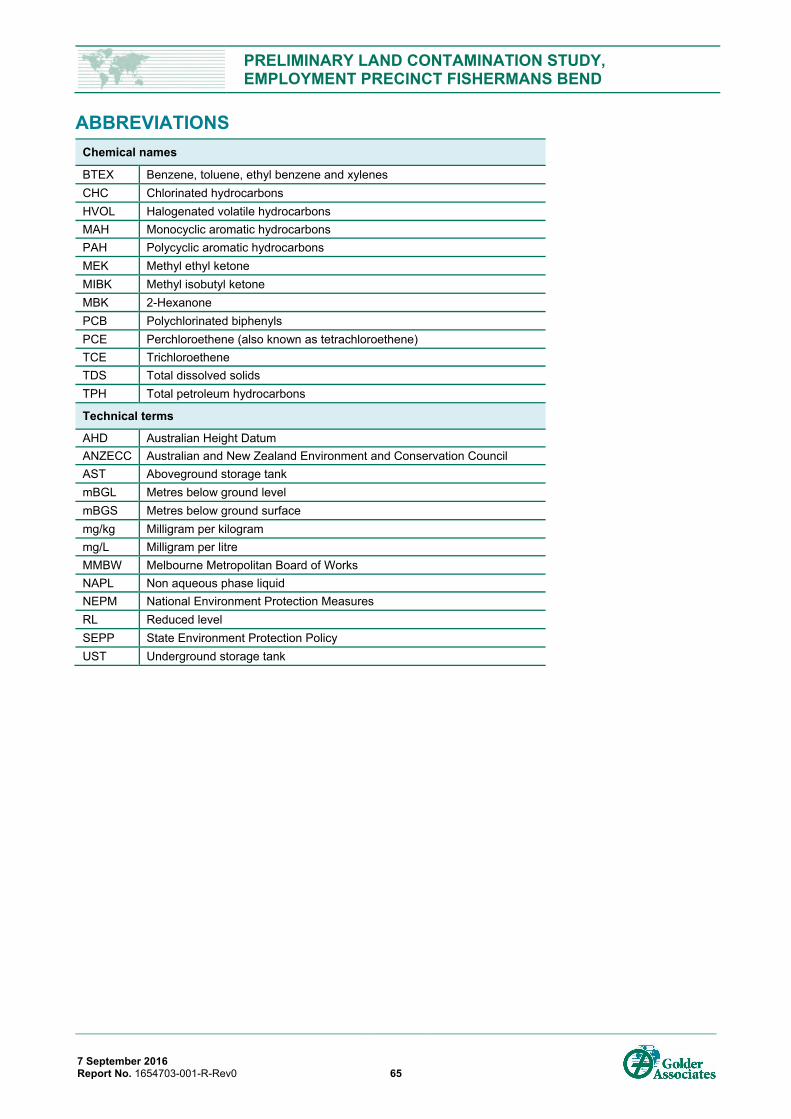
PRELIMINARY LAND CONTAMINATION STUDY, EMPLOYMENT PRECINCT FISHERMANS BEND
7 September 2016 Report No. 1654703-001-R-Rev0 65
ABBREVIATIONS Chemical names
BTEX Benzene, toluene, ethyl benzene and xylenes CHC Chlorinated hydrocarbons HVOL Halogenated volatile hydrocarbons MAH Monocyclic aromatic hydrocarbons PAH Polycyclic aromatic hydrocarbons MEK Methyl ethyl ketone MIBK Methyl isobutyl ketone MBK 2-Hexanone PCB Polychlorinated biphenyls PCE Perchloroethene (also known as tetrachloroethene) TCE Trichloroethene TDS Total dissolved solids TPH Total petroleum hydrocarbons
Technical terms
AHD Australian Height Datum ANZECC Australian and New Zealand Environment and Conservation Council AST Aboveground storage tank mBGL Metres below ground level mBGS Metres below ground surface mg/kg Milligram per kilogram mg/L Milligram per litre MMBW Melbourne Metropolitan Board of Works NAPL Non aqueous phase liquid NEPM National Environment Protection Measures RL Reduced level SEPP State Environment Protection Policy UST Underground storage tank
PRELIMINARY LAND CONTAMINATION STUDY, EMPLOYMENT PRECINCT FISHERMANS BEND
7 September 2016 Report No. 1654703-001-R-Rev0
APPENDIX A Figures
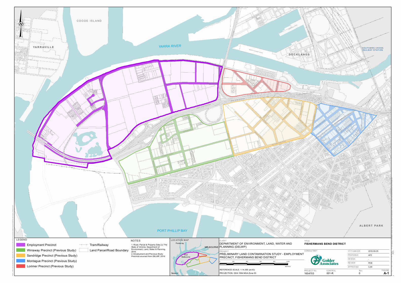
WEST GATE FR EEWAY
LOR IM ER STR EET
WILLIAMSTOWN ROAD
INGLES STREET
TOD
D R
OA
D
GR
AH
AM
ST
RE
ET
BAY S
TREET
BEACH STREET
SALM
ON
STR
EE
T
COOK STREET
PLU MM ER STR EET
TUR NER STREET
CIT
YLI
NK
COLLIN S STREET
FER
RA
RS
STR
EE
T
ESP
LAN
AD
E E
AS
T
CA
PITA
L CIT
Y TR
AIL
SPE
NC
ER
ST
RE
ET
ROUSE STREET
DORC AS STREET
BERTIE STREET
CITY R
OAD
PARK STR EET
SMIT
H S
TRE
ET
NORMANBY ROAD
BEACON ROAD
YOR K STREET
BAN K STREET
LIARDET STREET
NORTH WH ARF ROAD
BRIDGE STREET
CE
CIL S
TRE
ET
HA
RB
OU
R E
SP
LAN
AD
E
IFF
LA S
TRE
ET
CLA
RE
ND
ON
ST
RE
ET
MO
NTAGU
E STREET
THE BOULEVARD
DOCKLANDS DR IVE
PIC
KLE
S S
TRE
ET
NE
LSO
N R
OA
D
COVENTRY STREET
BUCKHURST STREET
CENTRAL PIER
PRO
HA
SK
Y S
TREE
T
FENNELL STREET
MARKET STREET
BATMANS HILL DR
IVE
JOH
NS
ON
STR
EE
T
FLIN DER S STREET
TRIBE STREET
BOU RKE STR EET
WH
ITE
STR
EE
T
LYELL STR EET
WOOLBOARD R OAD
LA TROBE STR EET
THA
CK
RA
Y RO
AD
BOUNDARY STREET
DANKS STREET
WOODRUFF S
TREET
HA
RT
LEY
STR
EE
T
CROC KFOR D STR EET
ROGERS STREET
GIT
TU
S S
TRE
ET
HEND ERSON STREET
ANDERSON STREET
CIT
YLI
NK
BOU RKE STR EET
WEST GATE FR EEWAY
GR
AH
AM
ST
RE
ET
BR IDGE STREET
INGLES STREET
BOUNDARY STREET
CLIENT
DEPARTMENT OF ENVIRONMENT, LAND, WATER ANDPLANNING (DELWP)
LEGEND
Employment Precinct
Wirraway Precinct (Previous Study)
Sandridge Precinct (Previous Study)
Montague Precinct (Previous Study)
Lorimer Precinct (Previous Study)
Tram/Railway
Land Parcel/Road Boundary
NOTES
PROJECT
PRELIMINARY LAND CONTAMINATION STUDY - EMPLOYMENTPRECINCT, FISHERMANS BEND DISTRICT
TITLE
FISHERMANS BEND DISTRICT
1654703 001-R 0 A-1
2016-09-05
AFE
-
PDB
CJW
Path
: J:\E
nv\2
016\
1654
703
- D
ELW
P P
SI F
ishe
rmen
s B
end\
Tech
nica
l Doc
\GIS
\Pro
ject
\165
4703
-001
-R-A
-1-R
ev0.
mxd
LOCATION MAP
IF T
HIS
ME
AS
UR
EM
EN
T D
OE
S N
OT
MA
TCH
WH
AT
IS S
HO
WN
, TH
E S
HE
ET
SIZ
E H
AS
BE
EN
MO
DIF
IED
FR
OM
: A3
CONSULTANT
PROJECT No. CONTROL Rev. FIGURE
YYYY-MM-DD
PREPARED
DESIGN
REVIEW
APPROVED
25m
m0
0 200 400 600 800 1,000
METR ES
PROJECTION: GDA 1994 MGA Zone 55
REFERENCE SCALE: 1:14,000 (at A3)
NOTES1. Road, Parcel & Property Data (c) TheState of Victoria, Department ofEnvironment, Land, Water & Planning,2016.2. Employment and Previous StudyPrecincts sourced from DELWP, 2016.
D O C K L A N D SD O C K L A N D S
YARRA RIVERS OU TH E R N C R OS SS OU TH E R N C R OS SRA I LW AY S TAT I ONRA I LW AY S TAT I ON
YA R R AV I L L EYA R R AV I L L E
A L B E R T P A R KA L B E R T P A R K
C O O D E IS L A N DC O O D E IS L A N D
PORT PHILLIP BAY
MELBOURNE
PortMelbourne
Newport
Footscray
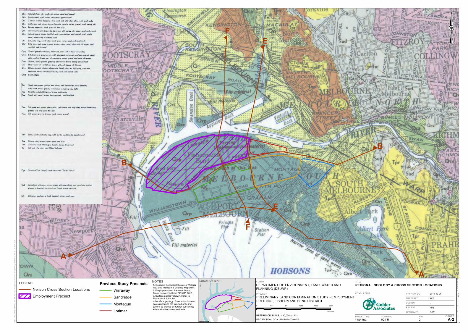
CLIENT
DEPARTMENT OF ENVIRONMENT, LAND, WATER ANDPLANNING (DELWP)
LEGEND
Neilson Cross Section Locations
Employment Precinct
NOTES
PROJECT
PRELIMINARY LAND CONTAMINATION STUDY - EMPLOYMENTPRECINCT, FISHERMANS BEND DISTRICT
TITLE
REGIONAL GEOLOGY & CROSS SECTION LOCATIONS
1654703 001-R 0 A-2
2016-09-05
AFE
-
PDB
CJW
Path
: J:\E
nv\2
016\
1654
703
- D
ELW
P P
SI F
ishe
rmen
s B
end\
Tech
nica
l Doc
\GIS
\Pro
ject
\165
4703
-001
-R-A
-2-R
ev0.
mxd
LOCATION MAP
IF T
HIS
ME
AS
UR
EM
EN
T D
OE
S N
OT
MA
TCH
WH
AT
IS S
HO
WN
, TH
E S
HE
ET
SIZ
E H
AS
BE
EN
MO
DIF
IED
FR
OM
: A3
CONSULTANT
PROJECT No. CONTROL Rev. FIGURE
YYYY-MM-DD
PREPARED
DESIGN
REVIEW
APPROVED
25m
m0
0 400 800 1,200 1,600 2,000
METR ES
PROJECTION: GDA 1994 MGA Zone 55
REFERENCE SCALE: 1:30,000 (at A3)
Previous Study PrecinctsWirraway
Sandridge
Montague
Lorimer
0 0.5 10.2 5 Km
¥NOTES1. Geology: Geological Survey of Victoria,1:63,000 Melbourne Geology Mapsheet.2. Employment and Previous StudyPrecincts sourced from DELWP, 2016.3. Surface geology shown. Refer toFigures A-3 & A-4 forsubsurface geology. Boundaries betweengeological units are inferred only andsubject to change as further subsurfaceinformation becomes available.
FE
B
B
A
A
F
E

CLIENT
DEPARTMENT OF ENVIRONMENT, LAND, WATER ANDPLANNING (DELWP)
LEGEND
PROJECT
PRELIMINARY LAND CONTAMINATION STUDY - EMPLOYMENTPRECINCT, FISHERMANS BEND DISTRICT
TITLE
CROSS SECTIONS A & B
1654703 001-R 0 A-3
2016-09-05
AFE
-
PDB
CJW
Path
: J:\E
nv\2
016\
1654
703
- D
ELW
P P
SI F
ishe
rmen
s B
end\
Tech
nica
l Doc
\GIS
\Pro
ject
\165
4703
-001
-R-A
-3-R
ev0.
mxd
IF T
HIS
ME
AS
UR
EM
EN
T D
OE
S N
OT
MA
TCH
WH
AT
IS S
HO
WN
, TH
E S
HE
ET
SIZ
E H
AS
BE
EN
MO
DIF
IED
FR
OM
: A3
CONSULTANT
PROJECT No. CONTROL Rev. FIGURE
YYYY-MM-DD
PREPARED
DESIGN
REVIEW
APPROVED
25m
m0
NOTES1. Geology: Geological Survey of Victoria,1:63,000 Melbourne Geology Mapsheet.2. Cross Section Data sourced fromNeilson, 1996.
NOT TO SCALE
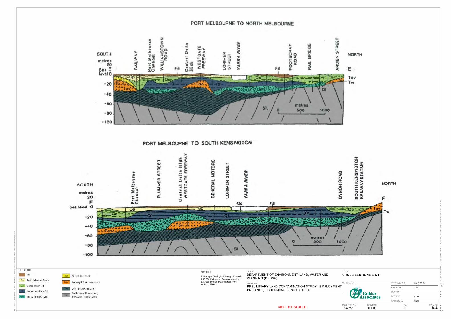
CLIENT
DEPARTMENT OF ENVIRONMENT, LAND, WATER ANDPLANNING (DELWP)
LEGEND
PROJECT
PRELIMINARY LAND CONTAMINATION STUDY - EMPLOYMENTPRECINCT, FISHERMANS BEND DISTRICT
TITLE
CROSS SECTIONS E & F
1654703 001-R 0 A-4
2016-09-05
AFE
-
PDB
CJW
Path
: J:\E
nv\2
016\
1654
703
- D
ELW
P P
SI F
ishe
rmen
s B
end\
Tech
nica
l Doc
\GIS
\Pro
ject
\165
4703
-001
-R-A
-4-R
ev0.
mxd
IF T
HIS
ME
AS
UR
EM
EN
T D
OE
S N
OT
MA
TCH
WH
AT
IS S
HO
WN
, TH
E S
HE
ET
SIZ
E H
AS
BE
EN
MO
DIF
IED
FR
OM
: A3
CONSULTANT
PROJECT No. CONTROL Rev. FIGURE
YYYY-MM-DD
PREPARED
DESIGN
REVIEW
APPROVED
25m
m0
NOTES1. Geology: Geological Survey of Victoria,1:63,000 Melbourne Geology Mapsheet.2. Cross Section Data sourced fromNeilson, 1996.
NOT TO SCALE
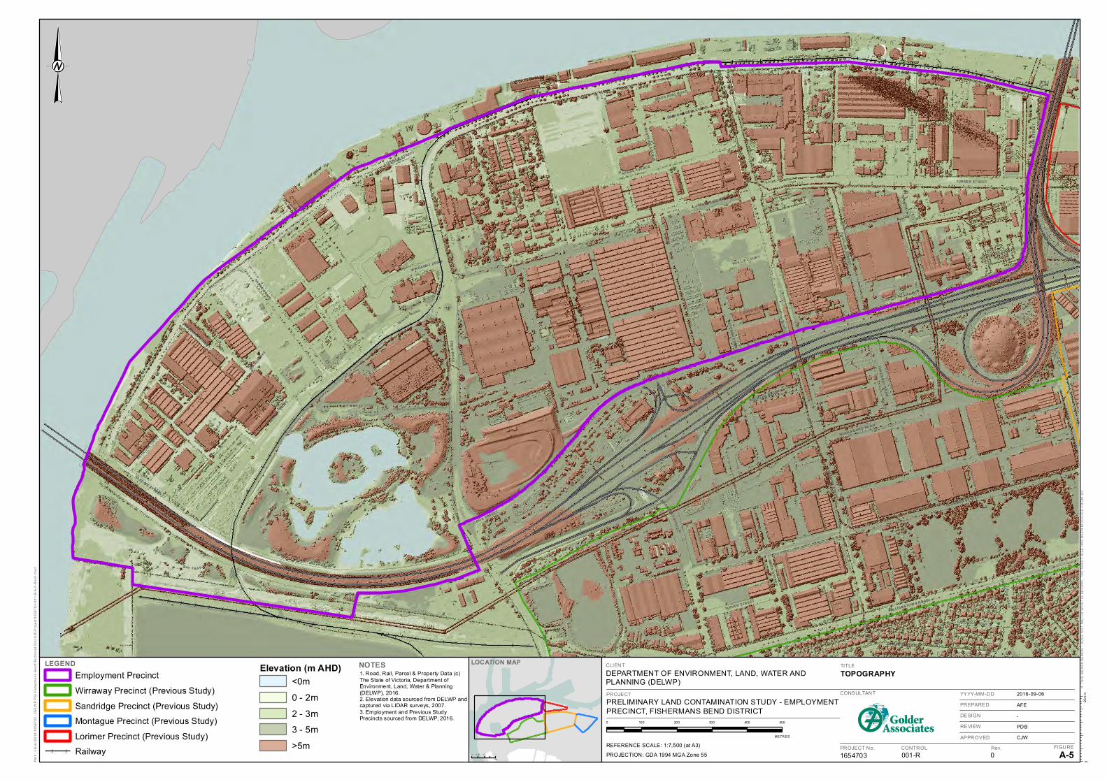
MIRAGE W
AY
PAG
E A
VE
NU
E
BE
AC
ON
RO
AD
EME
RY
ST
RE
ET
TUCKER AVENUE
GA
TE
WAY
CO
UR
T
WE
STS
IDE
AV
EN
UE
SMIT
H S
TRE
ET
CANBERRA STREET
PH ILLIP C OUR T
SARD INE STREET
DOCK STREET
NETWORK D
RIVE
POO
LMA
NS
T REE
T
CRICH TON AVEN UE
ED WAR DS AVENU E
INN ER RING ROA D
SABR
E DRIVE
WOOLB OAR D ROA D
CAPR IC E AVENU E
WIR RAWAY DRIVE
THA
CK
RA
Y R
OA
D
TA RVER STR EET
PROHASKY
STRE
ET
WILLIAM STOW N R OAD
HORNET DR IV
E
GR
AH
AM
ST
RE
ET
CENTRA L BOULEVA RD
SALM
ON
STR
EE
T
CI TY
LIN
K
ROCK LEA DR IVE
HA
LL
STR
EE
T
B
AYSIDE AVENU E
TUR NER STREET
WHARF ROAD
DO
UG
LA
S S
TRE
ET
TO
DD
RO
AD
BAY T R A IL
L ORIMER STREET
COO K STREET
PLUM MER STREET
WEST GATE FREEWAY
CLIENT
DEPARTMENT OF ENVIRONMENT, LAND, WATER ANDPLANNING (DELWP)
LEGENDEmployment Precinct
Wirraway Precinct (Previous Study)
Sandridge Precinct (Previous Study)
Montague Precinct (Previous Study)
Lorimer Precinct (Previous Study)
Railway
NOTES
PROJECT
PRELIMINARY LAND CONTAMINATION STUDY - EMPLOYMENTPRECINCT, FISHERMANS BEND DISTRICT
TITLE
TOPOGRAPHY
1654703 001-R 0 A-5
2016-09-06
AFE
-
PDB
CJW
Path
: J:\E
nv\2
016\
1654
703
- D
ELW
P P
SI F
ishe
rmen
s B
end\
Tech
nica
l Doc
\GIS
\Pro
ject
\165
4703
-001
-R-A
-5-R
ev0.
mxd
IF T
HIS
ME
AS
UR
EM
EN
T D
OE
S N
OT
MA
TCH
WH
AT
IS S
HO
WN
, TH
E S
HE
ET
SIZ
E H
AS
BE
EN
MO
DIF
IED
FR
OM
: A3
CONSULTANT
PROJECT No. CONTROL Rev. FIGURE
YYYY-MM-DD
PREPARED
DESIGN
REVIEW
APPROVED
25m
m0
0 100 200 300 400 500
METR ES
PROJECTION: GDA 1994 MGA Zone 55
REFERENCE SCALE: 1:7,500 (at A3)
Elevation (m AHD)<0m
0 - 2m
2 - 3m
3 - 5m
>5m
1. Road, Rail, Parcel & Property Data (c)The State of Victoria, Department ofEnvironment, Land, Water & Planning(DELWP), 2016.2. Elevation data sourced from DELWP andcaptured via LIDAR surveys, 2007.3. Employment and Previous StudyPrecincts sourced from DELWP, 2016.
LOCATION MAP
0 0. 5 10. 25
Km
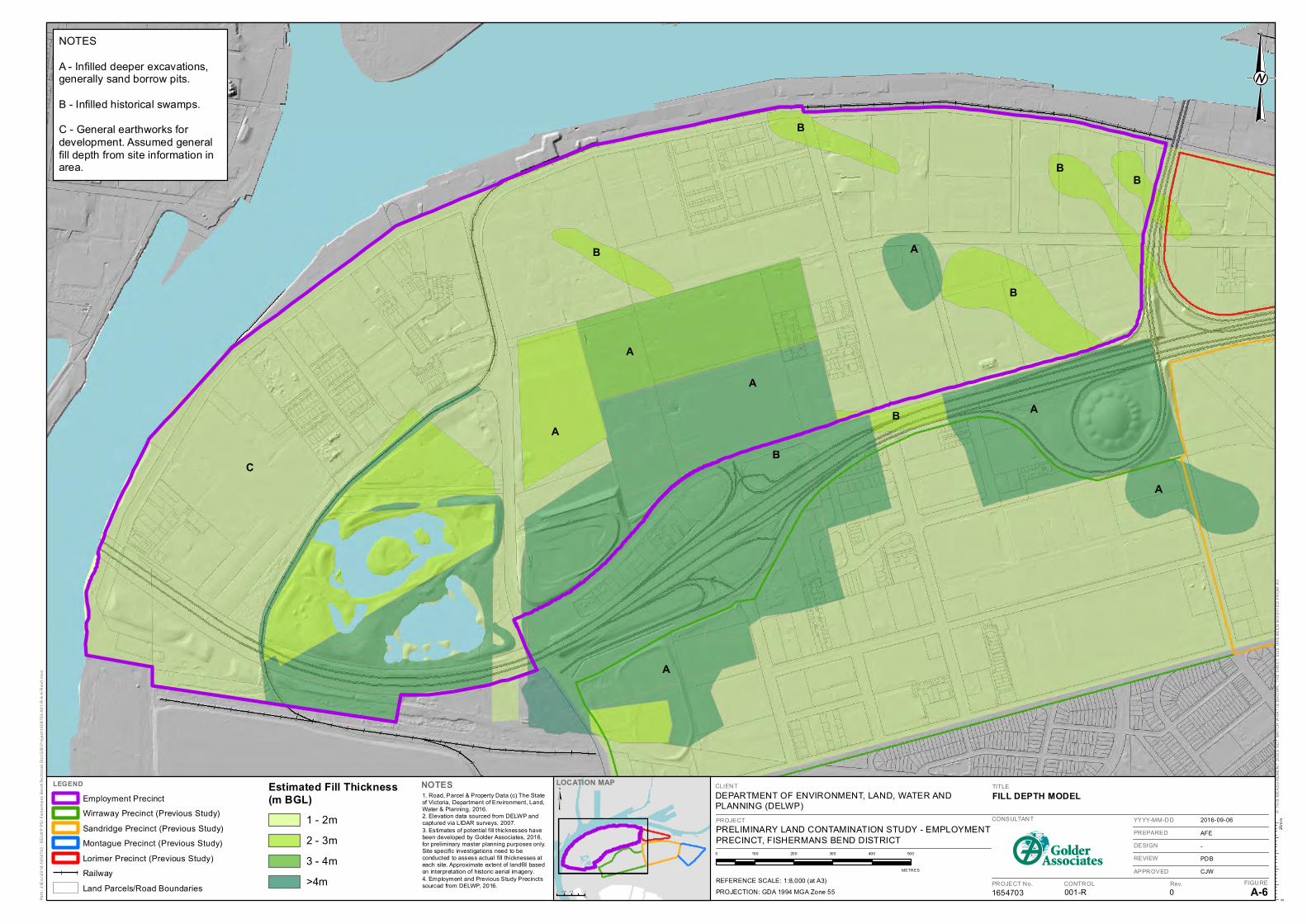
CLIENT
DEPARTMENT OF ENVIRONMENT, LAND, WATER ANDPLANNING (DELWP)
LEGEND
Employment Precinct
Wirraway Precinct (Previous Study)
Sandridge Precinct (Previous Study)
Montague Precinct (Previous Study)
Lorimer Precinct (Previous Study)
Railway
Land Parcels/Road Boundaries
NOTES
PROJECT
PRELIMINARY LAND CONTAMINATION STUDY - EMPLOYMENTPRECINCT, FISHERMANS BEND DISTRICT
TITLE
FILL DEPTH MODEL
1654703 001-R 0 A-6
2016-09-06
AFE
-
PDB
CJW
Path
: J:\E
nv\2
016\
1654
703
- D
ELW
P P
SI F
ishe
rmen
s B
end\
Tech
nica
l Doc
\GIS
\Pro
ject
\165
4703
-001
-R-A
-6-R
ev0.
mxd
IF T
HIS
ME
AS
UR
EM
EN
T D
OE
S N
OT
MA
TCH
WH
AT
IS S
HO
WN
, TH
E S
HE
ET
SIZ
E H
AS
BE
EN
MO
DIF
IED
FR
OM
: A3
CONSULTANT
PROJECT No. CONTROL Rev. FIGURE
YYYY-MM-DD
PREPARED
DESIGN
REVIEW
APPROVED
25m
m0
0 100 200 300 400 500
METR ES
PROJECTION: GDA 1994 MGA Zone 55
REFERENCE SCALE: 1:8,000 (at A3)
Estimated Fill Thickness(m BGL)
1 - 2m
2 - 3m
3 - 4m
>4m
LOCATION MAP
¥
0 0. 5 10. 25
Km
NOTES
A - Infilled deeper excavations,generally sand borrow pits.
B - Infilled historical swamps.
C - General earthworks fordevelopment. Assumed generalfill depth from site information inarea.
1. Road, Parcel & Property Data (c) The Stateof Victoria, Department of Environment, Land,Water & Planning, 2016.2. Elevation data sourced from DELWP andcaptured via LIDAR surveys, 2007.3. Estimates of potential fill thicknesses havebeen developed by Golder Associates, 2016,for preliminary master planning purposes only.Site specific investigations need to beconducted to assess actual fill thicknesses ateach site. Approximate extent of landfill basedon interpretation of historic aerial imagery.4. Employment and Previous Study Precinctssourced from DELWP, 2016.
A
B
C
A
A
A
A
A
A
B
B
B
B
B
B
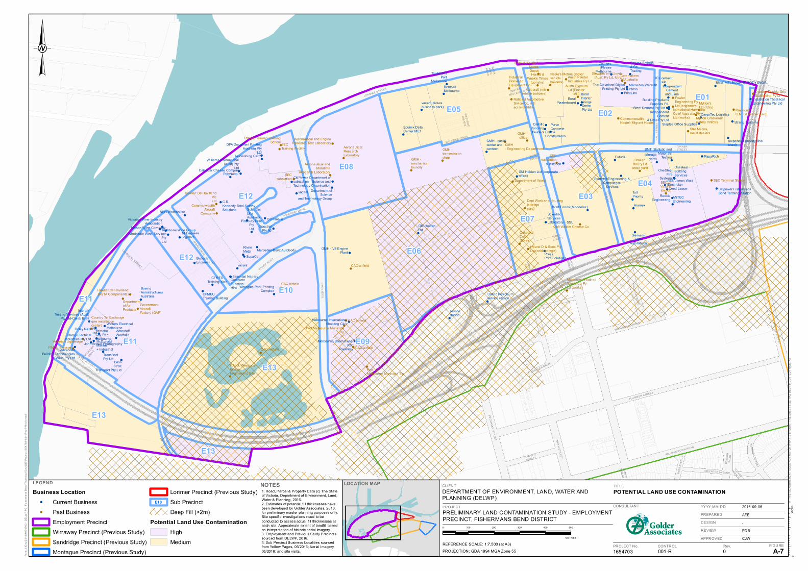
!
!
!
!
!
!
!
!
!
!
!
!
!
!
!!
!
!
!
!!
!
!
!
!
!
!
!
!
!
!!
!
!
!
!
!
!
! !
!!
!
!
!
!
!
!
!!
!
!
!
!
!
!
!
!
!
!
!
!
!
!
!
!
!!
!
! !
!
!
!
!!
!
!
!
!
!
!
!
!
!
!
!
!
!
!
!
!
!
!
!
!
!
!
!
!
!
!
!
!
!
!
!
!
!
!
!
!
!
!!
!!
!
!
!
!
!
!
!
!
!
!
!
!
!
!
!
!
!
!
! !
!
!
!
!
!
!
!!
!
!
!
!
TUR NERSTREET
HA
LL S
TR
EE
T
BAYSID E AVENU E
WE
STS
IDE
AVE
NU
E
CIT
YLI
NK
INN
ER
RIN
G
RO
AD
WIR RAWAY DRIVE
WHARF ROAD SA
LMO
N
STR
EE
T
TOD
D R
OA
D
BAY TRAIL
BEA
CO
NR
OA
D
TUCKER
AVENUE
COOK STREET
PAG
E A
VE
NU
E
POO
LMA
N S
TRE
ET
EME
RY
STR
EE
T
PRO
HA
SK
Y S
TREE
T
SABRE D
RIVE
SARDINE STREET
GA
TEW
AY
CO
UR
T
WOOLBOARD R OAD
CRICH TON AVENU E
WILLIAMSTOWN ROAD
SMIT
H S
TRE
ET
CANBERRA STREET
DOCK
STREET
NETWORK
DRIVE
CAPRICE
AVENU E
THA
CK
RA
Y RO
AD
PLU MM ER STR EET
TAR VER
STREET
CENTRAL
BOU LEVAR D
GR
AH
AM
ST
RE
ET
ROCKLEA D RIVE
DO
UG
LAS
STR
EE
T
WEST GATE FREEWAY
LOR IM ER STR EET
E05
E08
E07
E04
E12
E12
E02
E03
E01
E10
E06
E11
E11 E09
E13
E13
E13
Hawker de Havilland(ASTA Components)
Hawker De HavillandVicLtd
AeronauticalResearchLaboratory
GovernmentAircraftFactory (GAF)
Victorian Lighterage
Neale's Motors (motorvehiclebuilders)
Autocraft (mtrvehicle builders)
Austn PlasterIndustries Py Ld
Stewarts and Lloyds(Aust) Py Ld, fctry)
FowlerEngineering PyLtd, engineers
Mytton'sLtd (fctry)
RaymondG.N. Ld (timber yard)
Cyclone Double GripScaffolding Py Lt
Departmentof AirProducts
National AutomotiveSrvice Co, mtraccrs dstrbtrs
IndustrialDomesticEquipment Co.
Herald &Weekly Times
(ppr stre)Austn Gypsum
Ld (PlasterMill)
Intrnational HarvesterCo of Australia PtyLtd (works)Commonwealth
Hostel (Migrant Hostel)
CommonwealthAircraft
Company
Country Tel Exchange(pre installationcenter)
Department of Works
OakbondColdStores
Hyland D & Sons PtyLtd (cold storage)
SECsubstation
SEC ofVictoria(depot)
SEC Terminal Station
BrokenHill Py Ldscrap yard
Stro Metals,metal dealers
Dept Work and Housing(storageyard)
Melbourne WashedSands Co PyLd (works)
Kraft Walker Cheese Co
Dept of Air-No.1StoresDepot
P.M.G. Storage
P.M.G. WestgateBridgeEngineering Site
PortMelbourne Municiple TIp
CAC Airfield
Mytton Grosvenorcutlery mnfctrs
Tubemakersof Australia
CAC airfield
GMH -mechanicalfoundry
GMH -transmissionshop
GMH- Engineering Department
GMH -office
CAC airfield
CAC airfield
CAC airfield
Port Melbourne MunicipleTIp
PMG Linesman TrainingSchool
SECTraining Facility
SECsubstation
Aeronautical and EngineResearch Test Laboratory
Aeronautical andMaratime
Research Laboratory
PrintLinx
Installation TheatricalEngineering Pty Ltd
OnesteelBuildingServices
IntertekTesting Services (Aust)
Pty Ltd-Caleb Brett
ScientificServicesLaboratory - SSL
Wholesale Wine ServicesPtyLtd
SpectrolPty ltd
OneSteelFire
Systems
AdvancedBuilding Technologies
Group Pty Ltd
Building ProductsSupplies P/L
Finsbury PrintPtyLtd
DPA Document PrintingAustralia Pty
Ltd
The Cleveland DigitalPrinting Pty Ltd
Clamp ElectricalIndustries Pty Ltd
Watters ElectricalMelbourne
YamahaCity PortMelbourne
BoralInteriorLinings
Westgate Park PrintingComplex
Victorian Wine IndustryAssociation
IndependentCement
& Lime Pty Ltd
Steel Cement Pty Ltd
CamilloConcreteBuilders
PiaveConcrete
GM Holden Ltd (corporateoffice)
Mercedes WaratahPress
Nelson Wine Company
Williams International(Aust) Pty
Ltd
Melbourne InternationalKart
Raceway
BassStrait
Transport Pty Ltd
CompleteFunctionHire
Essential Napery
TransfleetPty Ltd
Melbourne InternationalShooting Club
Mercedes-Benz Autobody
BMW MELBOURNE BODYSHOPRentokilMelbourne
John Brown Photography
BoralPlasterboard
DeritePty Ltd
C.R.Kennedy Total SurveySolutions
Oxley Nets PtyLtd
vacant
vacant
CFMEUTraining Building
vacant (futurebusiness park)
Equinix DataCenter ME1
substation
BMT (Ballist ic andMaterials
Testing
SiemansRail
Automation
TollPriority
Futuris
Kraft Foods (Mondelez)
IndependantCement
and Lime
Citipower FishermansBend Terminal Station
United Petroleumservice station
servicestation
Strang Systems
(expanded polystyreneshed)
GM HoldenLtd
Synertec Engineering &Compliance
Services
NBN Warehouse
BoeingAerostructuresAustralia
Staples Office Supplies
CargoTec Logistics
ABB James WattElectrician
ANTECEngineering
(storageyard)
George Fethers& CoTrading
Aramex
TaubmansPort
Melbourne
McDonaldMarine+ Industrial
14 DegreesLogistics
Rathbone Wine Group
SchindlerLiftsAustralia
PolyNovoCalendar Cheese Company
RheinMetal
SupaCat
Astonishing Cards
CFMEUTraining Yard
CremaConstructions
CouriersPlease
Melbourne
PressPrint SolutionsBiotech
Engineering
RocoleEngineering
Lend Lease
Crommelin
AerostaffAustralia
PapaRich
ICL cementsilo
GMH - V8 EnginePlant
GMH - socialcenter andcanteen
CitiPowersubstation
Department ofScience and
Technology OrganisationDepartment of
Scienceand Technology Group
CLIENT
DEPARTMENT OF ENVIRONMENT, LAND, WATER ANDPLANNING (DELWP)
LEGEND
Business Location! Current Business! Past Business
Employment Precinct
Wirraway Precinct (Previous Study)
Sandridge Precinct (Previous Study)
Montague Precinct (Previous Study)
Lorimer Precinct (Previous Study)
Sub Precinct
Deep Fill (>2m)
Potential Land Use ContaminationHigh
Medium
NOTES
PROJECT
PRELIMINARY LAND CONTAMINATION STUDY - EMPLOYMENTPRECINCT, FISHERMANS BEND DISTRICT
TITLE
POTENTIAL LAND USE CONTAMINATION
1654703 001-R 0 A-7
2016-09-06
AFE
-
PDB
CJW
Path
: J:\E
nv\2
016\
1654
703
- D
ELW
P P
SI F
ishe
rmen
s B
end\
Tech
nica
l Doc
\GIS
\Pro
ject
\165
4703
-001
-R-A
-7-R
ev0.
mxd
IF T
HIS
ME
AS
UR
EM
EN
T D
OE
S N
OT
MA
TCH
WH
AT
IS S
HO
WN
, TH
E S
HE
ET
SIZ
E H
AS
BE
EN
MO
DIF
IED
FR
OM
: A3
CONSULTANT
PROJECT No. CONTROL Rev. FIGURE
YYYY-MM-DD
PREPARED
DESIGN
REVIEW
APPROVED
25m
m0
0 100 200 300 400 500
METR ES
PROJECTION: GDA 1994 MGA Zone 55
REFERENCE SCALE: 1:7,500 (at A3)
LOCATION MAP1. Road, Parcel & Property Data (c) The Stateof Victoria, Department of Environment, Land,Water & Planning, 2016.2. Estimates of potential fill thicknesses havebeen developed by Golder Associates, 2016,for preliminary master planning purposes only.Site specific investigations need to beconducted to assess actual fill thicknesses ateach site. Approximate extent of landfill basedon interpretation of historic aerial imagery.3. Employment and Previous Study Precinctssourced from DELWP, 2016.4. Sub Precinct Business Localities sourcedfrom Yellow Pages, 06/2016; Aerial Imagery,06/2016; and site visits.
E10


![Amendment GC81 - Fishermans Bend · 2019-03-18 · Amendment GC81 Mark Sheppard Fishermans Bend - Sandridge David Lock Associates 6 [15] The features of Sandridge that present challenges](https://img.pdfslide.us/doc/110x75/5f0aa8c57e708231d42cb4d3/amendment-gc81-fishermans-bend-2019-03-18-amendment-gc81-mark-sheppard-fishermans.jpg)