Embed Size (px)
Citation preview

EPA Region 4 Format File Guide
Version 1.2
Updated December 2015
EPA Region 4 Superfund
Updated by:
DISCLAIMER OF ENDORSEMENT
Reference herein to any specific commercial products, process, or service by trade name, trademark, manufacturer, or otherwise, does not necessarily constitute or imply its endorsement, recommendation, or favoring by the United States Government. The views and opinions of authors expressed herein do not necessarily state or reflect those of the United States Government, and shall not be used for advertising or product endorsement purposes.
STATUS OF DOCUMENT
As of November 2015, this document and all contents contained herein are considered DRAFT and are subject to revision and subsequent republication. Ecological EDD specifications do not appear in this guidance as they are currently under development, and will appear in future addenda.
CONTACTS
For questions and comments, contact:
Your RPM or, DART Coordinator Superfund Division, 11th Floor East United States Environmental Protection Agency, Region 4 Sam Nunn Atlanta Federal Center 61 Forsyth Street, SW Atlanta, GA 30303-8960 (707) 752-5254 [email protected]
Acronyms CAS RN – Chemical Abstracts Service Registry Number DART – Data Archival and ReTrieval EDD – Electronic Data Deliverable EDP – EQuIS Data Processor EPA – Environmental Protection Agency EQuIS – Environmental Quality Information System O&M – Operation and Maintenance SESD – Science and Ecosystem Support Division SRS – Substance Registry System CLP – Contract Laboratory Program PRP – Potentially Responsible Party QC – Quality Control
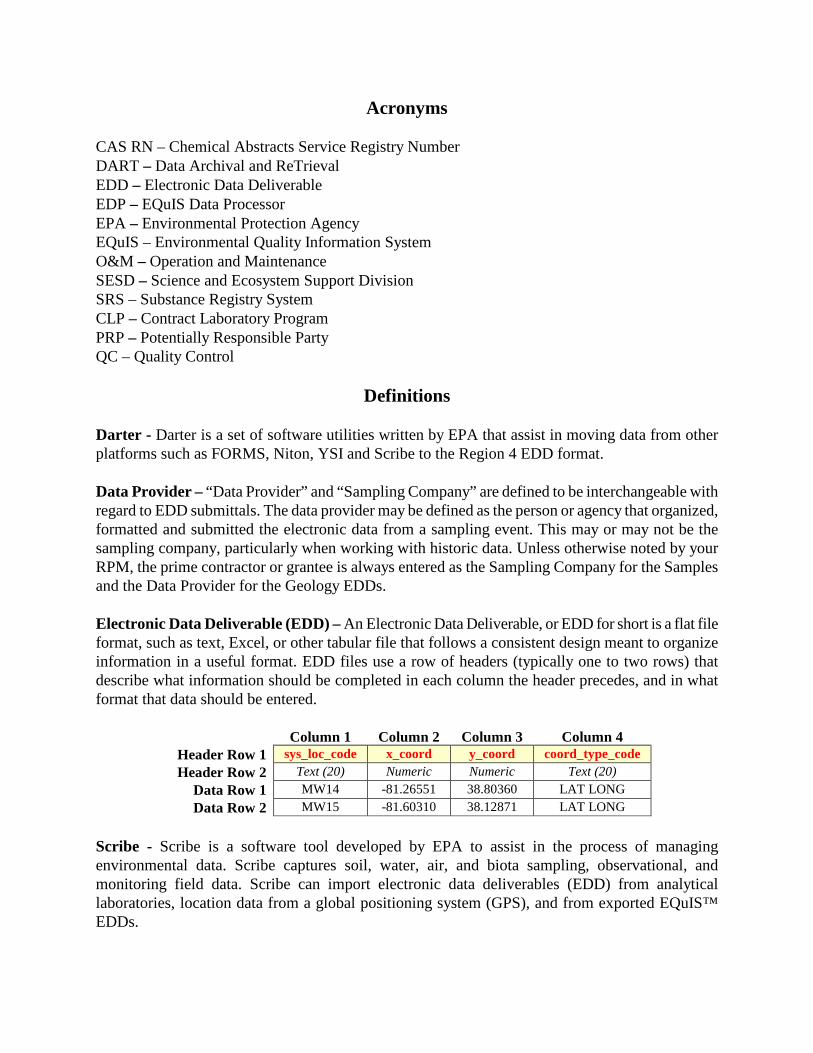
Definitions Darter - Darter is a set of software utilities written by EPA that assist in moving data from other platforms such as FORMS, Niton, YSI and Scribe to the Region 4 EDD format. Data Provider – “Data Provider” and “Sampling Company” are defined to be interchangeable with regard to EDD submittals. The data provider may be defined as the person or agency that organized, formatted and submitted the electronic data from a sampling event. This may or may not be the sampling company, particularly when working with historic data. Unless otherwise noted by your RPM, the prime contractor or grantee is always entered as the Sampling Company for the Samples and the Data Provider for the Geology EDDs. Electronic Data Deliverable (EDD) – An Electronic Data Deliverable, or EDD for short is a flat file format, such as text, Excel, or other tabular file that follows a consistent design meant to organize information in a useful format. EDD files use a row of headers (typically one to two rows) that describe what information should be completed in each column the header precedes, and in what format that data should be entered.
Column 1 Column 2 Column 3 Column 4 Header Row 1 sys_loc_code x_coord y_coord coord_type_code Header Row 2 Text (20) Numeric Numeric Text (20)
Data Row 1 MW14 -81.26551 38.80360 LAT LONG Data Row 2 MW15 -81.60310 38.12871 LAT LONG
Scribe - Scribe is a software tool developed by EPA to assist in the process of managing environmental data. Scribe captures soil, water, air, and biota sampling, observational, and monitoring field data. Scribe can import electronic data deliverables (EDD) from analytical laboratories, location data from a global positioning system (GPS), and from exported EQuIS™ EDDs.
Sample Company – “Data Provider” and “Sampling Company” are defined to be interchangeable with regard to EDD submittals. The data provider may be defined as the person or agency that organized, formatted and submitted the electronic data from a sampling event. This may or may not be the sampling company, particularly when working with historic data. Unless otherwise noted by your RPM, the prime contractor or grantee is always entered as the Sampling Company for the Samples and the Data Provider for the Geology EDDs. .rvf – The “.rvf” file (reference value file) is associated with the EQuIS Data Processor (EDP) from EarthSoft. This file contains the valid values reference tables used by EDP to populate the drop down menus used when a specific type of value is required in an EDD, such as the units “mg/kg” (milligrams per kilogram) or a media code such as “GW” (groundwater). These fields limit the type of data permitted in certain columns of the EDD, and all the most recent valid values are in the “.rvf” file. Therefore, it is extremely important to insure you are using the most current file. You should check the EarthSoft web site to see if your version is current before working on your data. .zip archive - The ZIP file format is a data compression and archival format that contains one or more files that have been compressed, to reduce their file size, or stored as-is. Many software utilities are available to create, modify, or open (unzip, decompress) ZIP files. ZIP files typically use the file extensions “.zip” or “.ZIP” and the MIME media type application/zip. However, due to security features at EPA, compressed files with the extension .zip should be renamed to the extension “.edd.”
TABLE OF CONTENTS
1.0 INTRODUCTION..................................................................................................................... 1 1.1 What You Will Find in this Guide ........................................................................................ 1 1.2 What You Will NOT Find in this Guide ............................................................................... 1 1.3 Projects .................................................................................................................................. 1 1.4 Data Provider ........................................................................................................................ 2 1.5 Historical Data ...................................................................................................................... 2 1.6 Current Data .......................................................................................................................... 2 1.7 Scribe .................................................................................................................................... 3
2.0 GENERAL EDD REPORTING REQUIREMENTS ................................................................ 4 2.1 Defining the Data Submittal ................................................................................................. 4 2.2 File Formats .......................................................................................................................... 5 2.3 EDD Files .............................................................................................................................. 6 2.4 Data Integrity Rules ............................................................................................................ 10 2.5 File Naming Convention ..................................................................................................... 11 2.6 Valid Values ........................................................................................................................ 12 2.7 Understanding Analytical Methods..................................................................................... 14 2.8 Reporting Results ................................................................................................................ 16 2.9 Reporting Duplicate Lab Results ........................................................................................ 16 2.10 Reporting Tentatively Identified Compounds (TICs) ....................................................... 16 2.11 Using the EQuIS Data Processor to Check EDD Formatting ........................................... 17
3.0 EDD FILE FORMATS ........................................................................................................... 18 3.1 Site EDD File ...................................................................................................................... 18 3.2 Location EDD File .............................................................................................................. 19 3.3 Alternate Position EDD File ............................................................................................... 23 3.4 Site Location EDD File ....................................................................................................... 24 3.5 Location Parameter EDD File ............................................................................................. 25 3.6 Field Results EDD File ....................................................................................................... 26 3.7 Chemistry Field Sample EDD File ..................................................................................... 27 3.8 Chemistry Sample Parameter EDD File ............................................................................. 31 3.9 Chemistry Test EDD File .................................................................................................... 32 3.10 Chemistry Result EDD File .............................................................................................. 36 3.11 Well EDD File .................................................................................................................. 41 3.12 Well Construction EDD File ............................................................................................. 44 3.13 Well Datum EDD File ...................................................................................................... 45 3.14 Water Level EDD File ...................................................................................................... 48 3.15 Geologic Sample EDD File............................................................................................... 49 3.16 Geologic Sample Parameter EDD File ............................................................................. 50 3.17 Water Table EDD File ...................................................................................................... 51 3.18 Lithology EDD File ........................................................................................................... 52 3.19 Drill Activity EDD File ..................................................................................................... 54 3.20 Drill Parameter EDD File ................................................................................................. 56 3.21 Downhole Point Parameter EDD File ............................................................................... 56
3.22 Static Properties EDD File ................................................................................................ 57 3.32 Files EDD Section ............................................................................................................. 59 3.24 Working with Data ............................................................................................................ 60
LIST OF TABLES AND FIGURES
Table 1.1 Data Reporting Requirements – Project ID Format 3 Table 2-1 Data Submittal Summary Form 4 Table 2-2 When to Submit Your Data Submittal Summary Form 5 Table 2-3 Instructions for Producing Tab-Delimited Text Files 5 Figure 2-1 Conceptual Model of the EDD Submittal Process 7 Table 2-4 General Information on EDD Files 8 Table 2-5 Valid Values and Associated EDD files 12 Table 2-6 EPA Method Codes 14 Table 2-7 Example of Reporting Non-detects 16 Table 2-8 Example of Reporting Laboratory Duplicates 16 Table 2-9 Example of TIC Reporting 17 Figure 3-1 Measure Datum Calculation 47
USEPA Region 4 Format Guide Version 1.20 December 2015 1
1.0 INTRODUCTION The Region 4 Format Guide describes the formats of the various EDD files necessary for properly preparing, formatting and electronically submitting operation and maintenance (O&M) environmental data to EPA Region 4 using the EQuIS© Data Processor (EDP) from EarthSoft. Instructions for obtaining EDP can be found in Section 2.11 of this document. Instructions for using the EDP are available in the EPA Region 4 EDP Reference Manual. You may obtain instructions from the manufacturer as well at http://www.earthsoft.com. While it should be understood that it would be a rare occasion that any one site would require the use of every possible Electronic Data Deliverable (EDD), and that simultaneously no amount of EDD files could completely cover the requirements of every possible site, every effort has been made to create EDD files that incorporate as much useful discreet information as is possible based on the commonalities of the various sites under the EPA Region 4 purview. Thus, a reasonable effort should be made by data managers to prepare data to correctly import into the EQuIS database structure when required to do so. It is also understood that in some rare cases, historical data may lack key components necessary for complete importation and subsequently may only be partially input, or in some extremely rare cases not be capable of input at all. The decision to import or not import this data lies exclusively with EPA Region 4. 1.1 What You Will Find in this Guide This document should serve as a reference guide for the individuals who understands the structure of their own data and the process used to format and import electronic data into management systems such as EQuIS. In this guide you will find a detailed description of all EDD formats currently used by EPA Region 4 as well as information for handling formatting issues with historic data. 1.2 What You Will NOT Find in this Guide This guide does not contain detailed instructions on how to manage information nor does it contain directions for importing electronic data into the EPA EQuIS database. This information is contained in the EPA Region 4 EDP Reference Manual found on EPA Region 4 Superfund’s website at
http://www2.epa.gov/superfund/region-4-superfund-electronic-data-submission
You will also not find lessons or instructions on general data management. It is assumed that persons dealing with data of this nature have some experience and understanding of basic data management guidelines and software. 1.3 Projects Before data can be submitted to EPA Region 4, the dataset must be defined as a “project” in the EPA Region 4 data system. Once this has occurred, the system will generate an E-mail to the data provider (see below) requesting the data for most fund lead projects. Other type of projects should follow their statement of work or directive from their RPM. The EDD(s) containing the data are then
USEPA Region 4 Format Guide Version 1.20 December 2015 2
attached to this E-mail and returned to EPA Region 4 R4DART. The project defines the numbers of samples, the media sampled, and the analyses performed (including lab results, field results, lithology, etc.). Each project will be assigned a unique ID (project ID) to identify the dataset in the system. Data from a given project can be sent to EPA Region 4 in multiple submittals, if desired. When multiple laboratories and/or chain-of-custodies are needed for the unique project id, then multiple project numbers will be assigned under the project ID. Projects that are not logged through R4LIMS or if you have not received your project ID and project numbers, contact R4DART for further instructions. 1.4 Data Provider The EPA Region 4 data system defines the “data provider” as the entity preparing and sending the EDDs to the R4DART. It is the responsibility of the data provider to ensure completeness of the data submittal, and to correct any errors in the dataset. 1.5 Historical Data The determination as to the status of data as either “historical” or “current” is at the sole discretion of the EPA Region 4 DART Coordinator. The data provider is encouraged to become familiar with and submit Electronic Data Deliverables (EDDs) in accordance with the standard EPA Region 4 EDP Reference Manual located on the EPA Region 4 web site:
http://www2.epa.gov/superfund/region-4-superfund-electronic-data-submission
EPA Region 4 will require all data providers to submit EDDs in accordance with this manual and reference guide. The intent of developing special requirements for historical information is to decrease the burden and complications associated with reporting in-depth details about data that may have been collected a number of years ago while retaining the value of the information being reported. EPA recognizes that some information about data collected in the past may not be readily available and, by reducing the requirements for electronic historical data, is endeavoring to strike a balance between minimizing the amount of effort involved in inputting information and maximizing the ability to document remedy progress. 1.6 Current Data Data is considered to be “current” if it was collected on or after the deadline specified for the specific data type and provider outlined in Table 1.1. The data provider should anticipate all future data being collected for a site on or after the deadline to be submitted according to the site-specific legal order, on a regular basis (at least annually, semi-annually) or in accordance with this manual. In addition to the routine data checking performed on all data as it loads into the EPA Region 4 DART system, current data will undergo an additional electronic EPA Region 4 review prior to
USEPA Region 4 Format Guide Version 1.20 December 2015 3
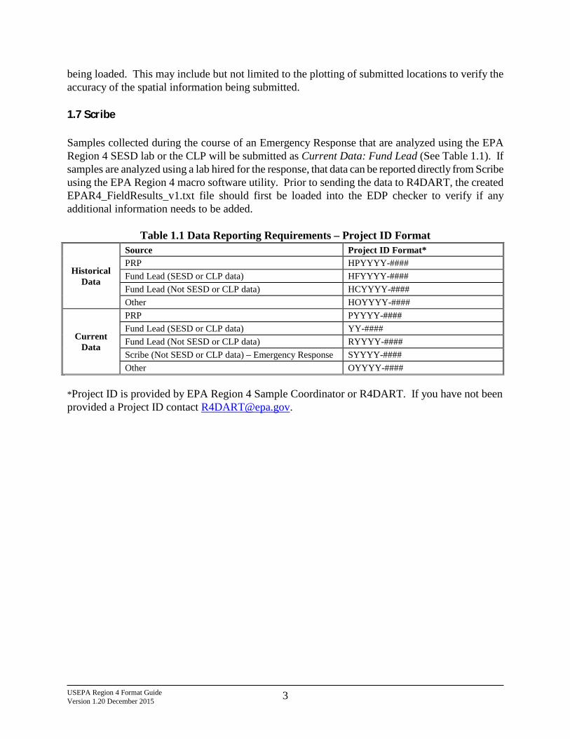
being loaded. This may include but not limited to the plotting of submitted locations to verify the accuracy of the spatial information being submitted. 1.7 Scribe Samples collected during the course of an Emergency Response that are analyzed using the EPA Region 4 SESD lab or the CLP will be submitted as Current Data: Fund Lead (See Table 1.1). If samples are analyzed using a lab hired for the response, that data can be reported directly from Scribe using the EPA Region 4 macro software utility. Prior to sending the data to R4DART, the created EPAR4_FieldResults_v1.txt file should first be loaded into the EDP checker to verify if any additional information needs to be added.
Table 1.1 Data Reporting Requirements – Project ID Format
Historical Data
Source Project ID Format* PRP HPYYYY-#### Fund Lead (SESD or CLP data) HFYYYY-#### Fund Lead (Not SESD or CLP data) HCYYYY-#### Other HOYYYY-####
Current Data
PRP PYYYY-#### Fund Lead (SESD or CLP data) YY-#### Fund Lead (Not SESD or CLP data) RYYYY-#### Scribe (Not SESD or CLP data) – Emergency Response SYYYY-#### Other OYYYY-####
*Project ID is provided by EPA Region 4 Sample Coordinator or R4DART. If you have not been provided a Project ID contact [email protected].
USEPA Region 4 Format Guide Version 1.20 December 2015 4
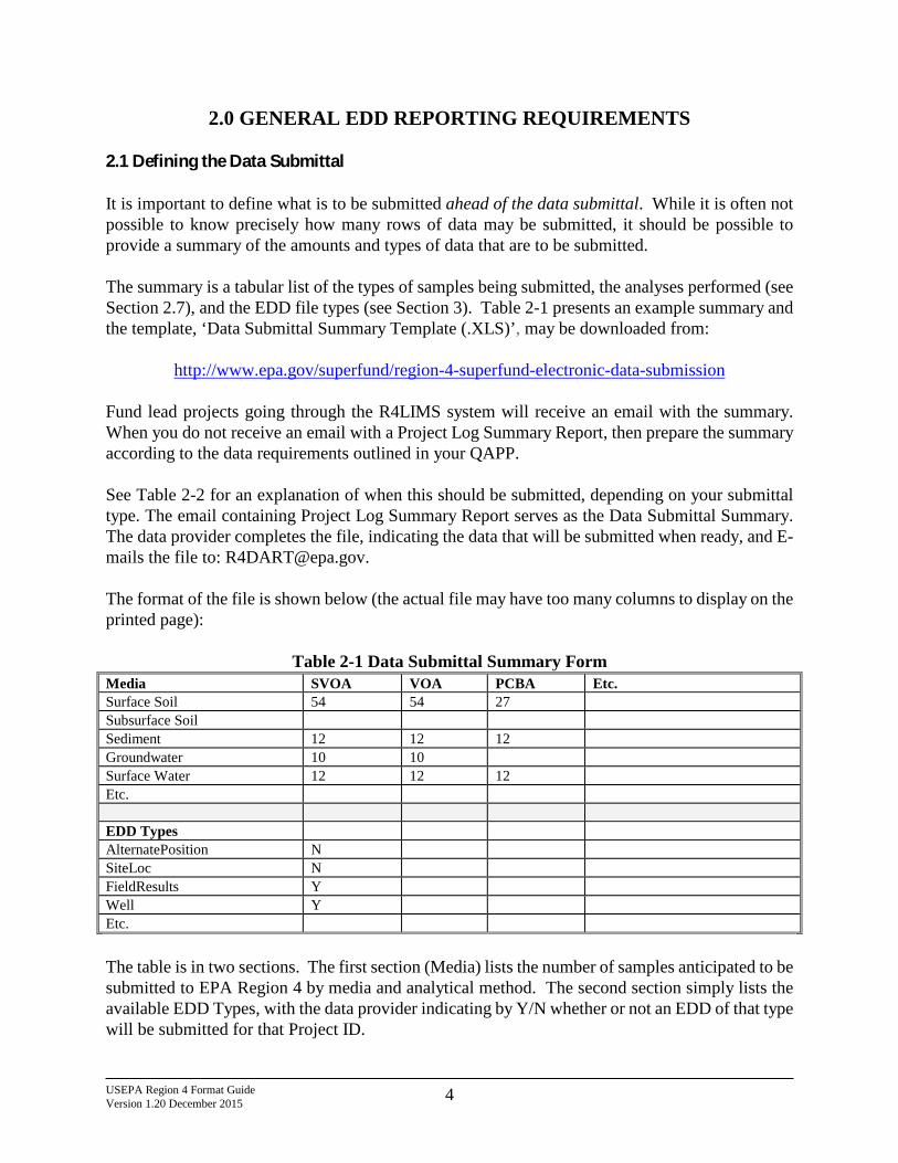
2.0 GENERAL EDD REPORTING REQUIREMENTS 2.1 Defining the Data Submittal It is important to define what is to be submitted ahead of the data submittal. While it is often not possible to know precisely how many rows of data may be submitted, it should be possible to provide a summary of the amounts and types of data that are to be submitted. The summary is a tabular list of the types of samples being submitted, the analyses performed (see Section 2.7), and the EDD file types (see Section 3). Table 2-1 presents an example summary and the template, ‘Data Submittal Summary Template (.XLS)’, may be downloaded from:
http://www.epa.gov/superfund/region-4-superfund-electronic-data-submission Fund lead projects going through the R4LIMS system will receive an email with the summary. When you do not receive an email with a Project Log Summary Report, then prepare the summary according to the data requirements outlined in your QAPP. See Table 2-2 for an explanation of when this should be submitted, depending on your submittal type. The email containing Project Log Summary Report serves as the Data Submittal Summary. The data provider completes the file, indicating the data that will be submitted when ready, and E-mails the file to: [email protected]. The format of the file is shown below (the actual file may have too many columns to display on the printed page):
Table 2-1 Data Submittal Summary Form Media SVOA VOA PCBA Etc. Surface Soil 54 54 27 Subsurface Soil Sediment 12 12 12 Groundwater 10 10 Surface Water 12 12 12 Etc. EDD Types AlternatePosition N SiteLoc N FieldResults Y Well Y Etc. The table is in two sections. The first section (Media) lists the number of samples anticipated to be submitted to EPA Region 4 by media and analytical method. The second section simply lists the available EDD Types, with the data provider indicating by Y/N whether or not an EDD of that type will be submitted for that Project ID.
USEPA Region 4 Format Guide Version 1.20 December 2015 5
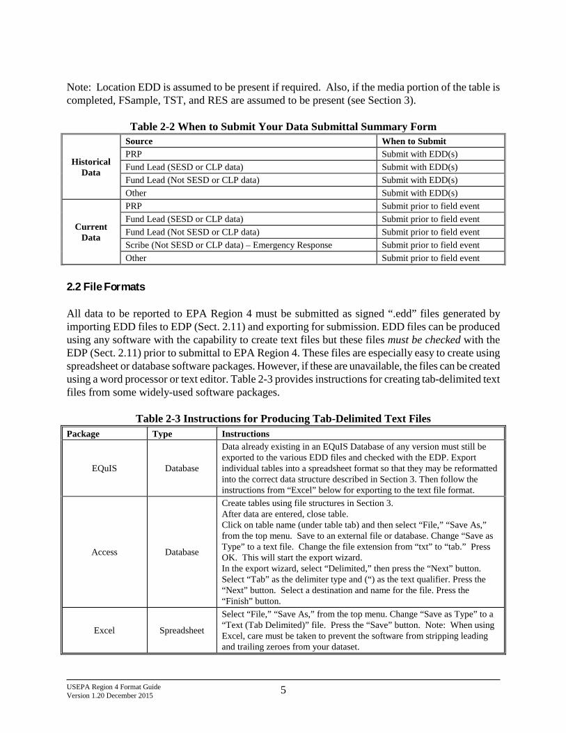
Note: Location EDD is assumed to be present if required. Also, if the media portion of the table is completed, FSample, TST, and RES are assumed to be present (see Section 3).
Table 2-2 When to Submit Your Data Submittal Summary Form
Historical Data
Source When to Submit PRP Submit with EDD(s) Fund Lead (SESD or CLP data) Submit with EDD(s) Fund Lead (Not SESD or CLP data) Submit with EDD(s) Other Submit with EDD(s)
Current Data
PRP Submit prior to field event Fund Lead (SESD or CLP data) Submit prior to field event Fund Lead (Not SESD or CLP data) Submit prior to field event Scribe (Not SESD or CLP data) – Emergency Response Submit prior to field event Other Submit prior to field event
2.2 File Formats All data to be reported to EPA Region 4 must be submitted as signed “.edd” files generated by importing EDD files to EDP (Sect. 2.11) and exporting for submission. EDD files can be produced using any software with the capability to create text files but these files must be checked with the EDP (Sect. 2.11) prior to submittal to EPA Region 4. These files are especially easy to create using spreadsheet or database software packages. However, if these are unavailable, the files can be created using a word processor or text editor. Table 2-3 provides instructions for creating tab-delimited text files from some widely-used software packages.
Table 2-3 Instructions for Producing Tab-Delimited Text Files
Package Type Instructions
EQuIS Database
Data already existing in an EQuIS Database of any version must still be exported to the various EDD files and checked with the EDP. Export individual tables into a spreadsheet format so that they may be reformatted into the correct data structure described in Section 3. Then follow the instructions from “Excel” below for exporting to the text file format.
Access Database
Create tables using file structures in Section 3. After data are entered, close table. Click on table name (under table tab) and then select “File,” “Save As,” from the top menu. Save to an external file or database. Change “Save as Type” to a text file. Change the file extension from “txt” to “tab.” Press OK. This will start the export wizard. In the export wizard, select “Delimited,” then press the “Next” button. Select “Tab” as the delimiter type and (“) as the text qualifier. Press the “Next” button. Select a destination and name for the file. Press the “Finish” button.
Excel Spreadsheet
Select “File,” “Save As,” from the top menu. Change “Save as Type” to a “Text (Tab Delimited)” file. Press the “Save” button. Note: When using Excel, care must be taken to prevent the software from stripping leading and trailing zeroes from your dataset.
USEPA Region 4 Format Guide Version 1.20 December 2015 6
Package Type Instructions
Quattro® v8 Spreadsheet Select “File,” “Save As,” from the top menu. Change the “File Type” to “ASCII Text (Tab Delimited).” Press the “Save Button.” Be sure to check that Quattro does not delete leading and trailing zeros.
Lotus 1-2-3 Spreadsheet
Select “File,” “Save As,” from the top menu. Change “Save as Type” to a “Comma Separated Value (CSV)” file. Provide file name. Press the “Save” button. Be sure to check that Lotus does not delete leading and trailing zeros.
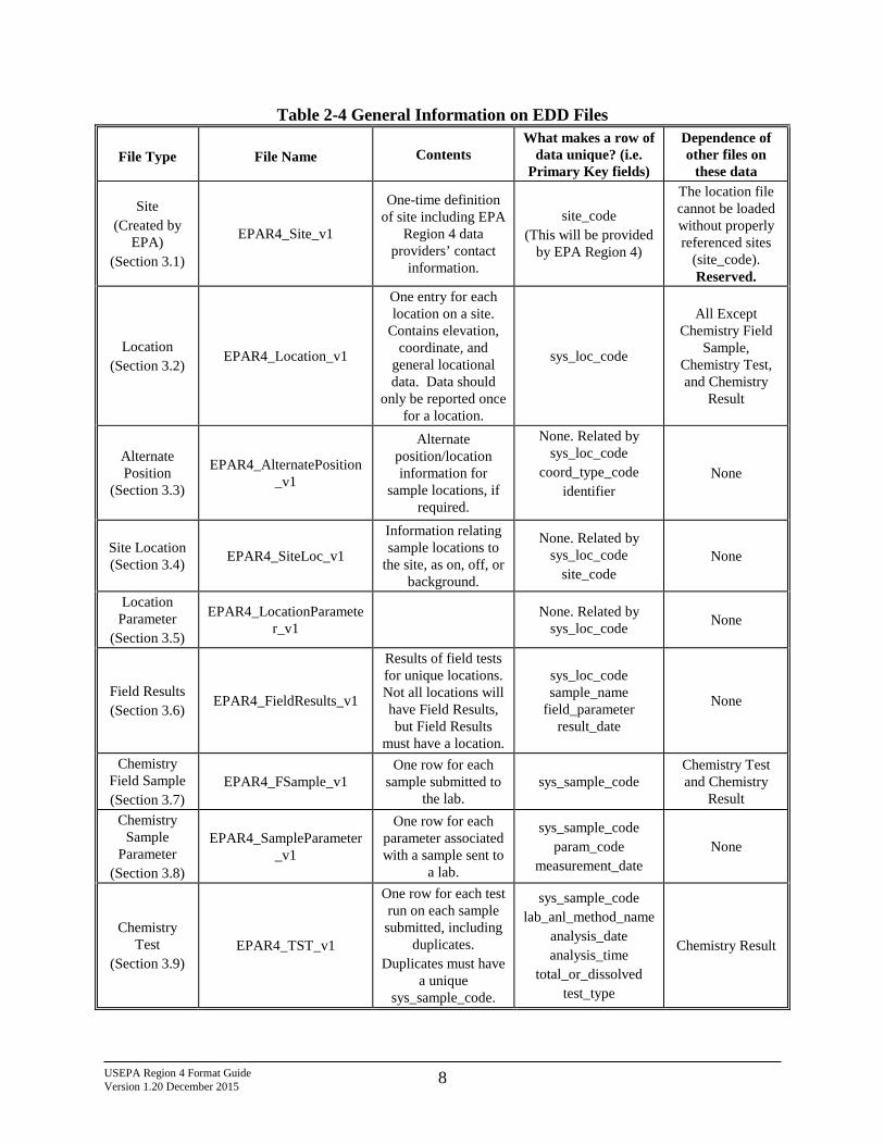
2.3 EDD Files The tables in this guidance identify the various types of data being requested. Each EDD file should be saved as an individual text file and should be named in accordance with the naming convention rules. Table 2-4 provides general information on the files that make up this EDD. Detailed instructions for creating all the EDD files are provided in Section 3. Instructions for submitting your EDDs to EPA Region 4 are presented in Section 4.0 and in the EDP Reference Manual. Figure 2-1 below shows the EDD creation process conceptually. It is not possible to prepare a dataset for acceptance into a database without understanding the basics of how databases operate. Row uniqueness and referential integrity are requirements of the EQuIS database. Their requirements impact how the EDD is prepared. Row uniqueness is assured when no two rows in a file contain the same values for all the fields listed under the heading “What makes a row of data unique?” in Table 2-4, also see Section 2.4.
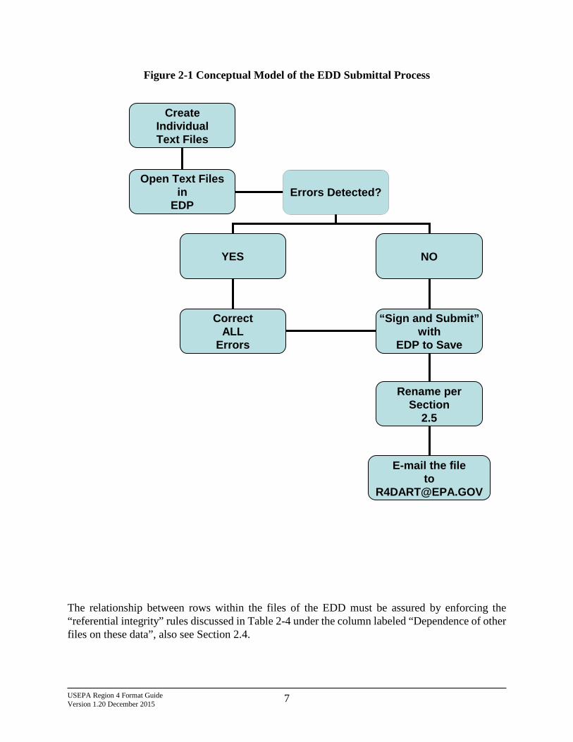
USEPA Region 4 Format Guide Version 1.20 December 2015 7
Figure 2-1 Conceptual Model of the EDD Submittal Process
The relationship between rows within the files of the EDD must be assured by enforcing the “referential integrity” rules discussed in Table 2-4 under the column labeled “Dependence of other files on these data”, also see Section 2.4.
Create Individual Text Files
Open Text Files in
EDP
Errors Detected?
YES
NO
Correct ALL
Errors
“Sign and Submit” with
EDP to Save
Rename per Section
2.5
E-mail the file to
USEPA Region 4 Format Guide Version 1.20 December 2015 8
Table 2-4 General Information on EDD Files
File Type
File Name Contents What makes a row of
data unique? (i.e. Primary Key fields)
Dependence of other files on
these data
Site (Created by
EPA) (Section 3.1)
EPAR4_Site_v1
One-time definition of site including EPA
Region 4 data providers’ contact
information.
site_code (This will be provided
by EPA Region 4)
The location file cannot be loaded without properly referenced sites
(site_code). Reserved.
Location (Section 3.2)
EPAR4_Location_v1
One entry for each location on a site.
Contains elevation, coordinate, and
general locational data. Data should
only be reported once for a location.
sys_loc_code
All Except Chemistry Field
Sample, Chemistry Test, and Chemistry
Result
Alternate Position
(Section 3.3)
EPAR4_AlternatePosition_v1
Alternate position/location information for
sample locations, if required.
None. Related by sys_loc_code
coord_type_code identifier
None
Site Location (Section 3.4) EPAR4_SiteLoc_v1
Information relating sample locations to
the site, as on, off, or background.
None. Related by sys_loc_code
site_code None
Location Parameter
(Section 3.5)
EPAR4_LocationParameter_v1 None. Related by
sys_loc_code None
Field Results (Section 3.6)
EPAR4_FieldResults_v1
Results of field tests for unique locations. Not all locations will have Field Results, but Field Results
must have a location.
sys_loc_code sample_name
field_parameter result_date
None
Chemistry Field Sample (Section 3.7)
EPAR4_FSample_v1 One row for each
sample submitted to the lab.
sys_sample_code Chemistry Test and Chemistry
Result Chemistry
Sample Parameter
(Section 3.8)
EPAR4_SampleParameter_v1
One row for each parameter associated with a sample sent to
a lab.
sys_sample_code param_code
measurement_date None
Chemistry Test
(Section 3.9) EPAR4_TST_v1
One row for each test run on each sample submitted, including
duplicates. Duplicates must have
a unique sys_sample_code.
sys_sample_code lab_anl_method_name
analysis_date analysis_time
total_or_dissolved test_type
Chemistry Result
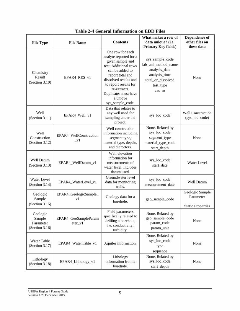
USEPA Region 4 Format Guide Version 1.20 December 2015 9
Table 2-4 General Information on EDD Files
File Type
File Name Contents What makes a row of
data unique? (i.e. Primary Key fields)
Dependence of other files on
these data
Chemistry Result
(Section 3.10) EPAR4_RES_v1
One row for each analyte reported for a
given sample and test. Additional rows
can be added to report total and
dissolved results and to report results for
re-extracts. Duplicates must have
a unique sys_sample_code.
sys_sample_code lab_anl_method_name
analysis_date analysis_time
total_or_dissolved test_type cas_rn
None
Well (Section 3.11)
EPAR4_Well_v1
Data that relates to any well used for
sampling under the project.
sys_loc_code Well Construction (sys_loc_code)
Well Construction
(Section 3.12)
EPAR4_WellConstruction_v1
Well construction information including
segment type, material type, depths,
and diameters.
None. Related by sys_loc_code segment_type
material_type_code start_depth
None
Well Datum (Section 3.13)
EPAR4_WellDatum_v1
Well elevation information for
measurements of water level. Includes
datum used.
sys_loc_code start_date
Water Level
Water Level (Section 3.14)
EPAR4_WaterLevel_v1 Groundwater level data for monitoring
wells.
sys_loc_code measurement_date
Well Datum
Geologic Sample
(Section 3.15)
EPAR4_GeologicSample_v1
Geology data for a borehole. geo_sample_code
Geologic Sample Parameter
Static Properties
Geologic Sample
Parameter (Section 3.16)
EPAR4_GeoSampleParameter_v1
Field parameters specifically related to drilling a borehole, i.e. conductivity,
turbidity.
None. Related by geo_sample_code
param_code param_unit
None
Water Table (Section 3.17) EPAR4_WaterTable_v1 Aquifer information.
None. Related by sys_loc_code
type sequence
None
Lithology (Section 3.18) EPAR4_Lithology_v1
Lithology information from a
borehole.
None. Related by sys_loc_code start_depth
None
USEPA Region 4 Format Guide Version 1.20 December 2015 10
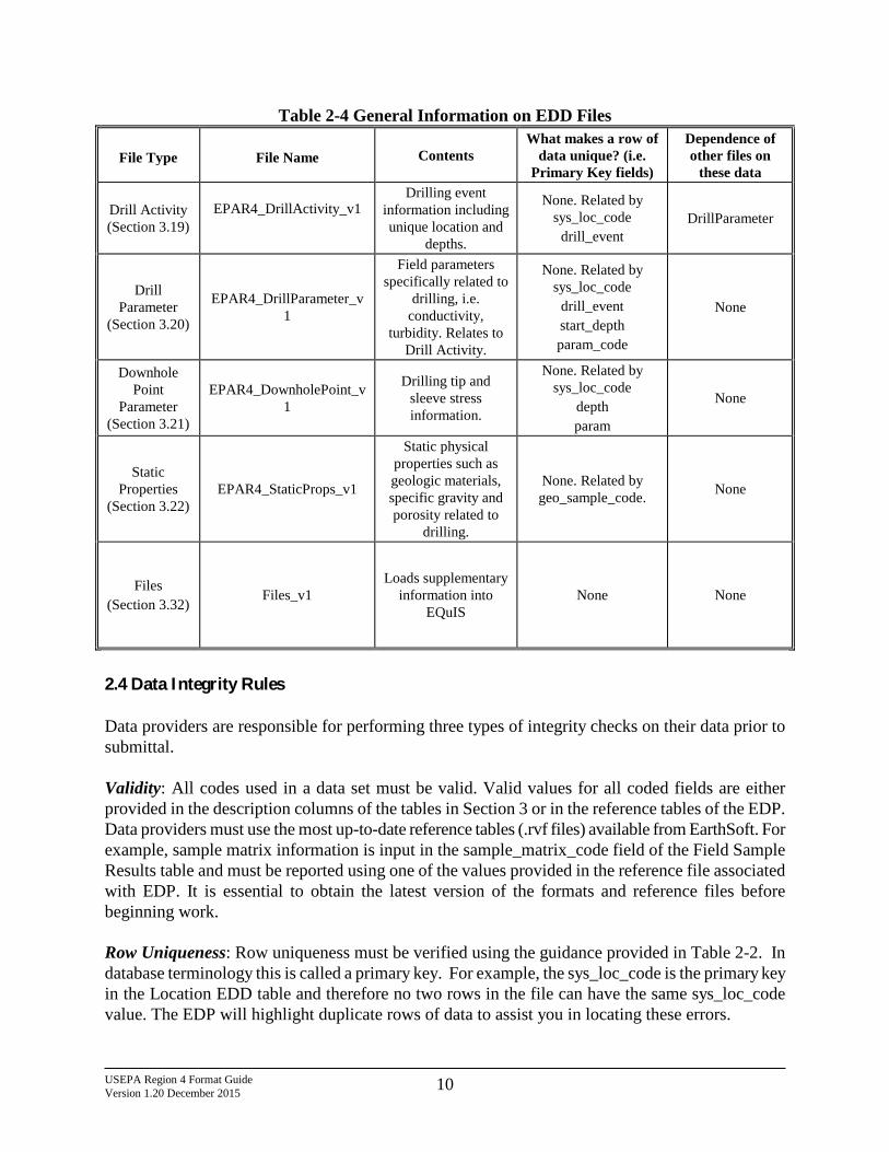
Table 2-4 General Information on EDD Files
File Type
File Name Contents What makes a row of
data unique? (i.e. Primary Key fields)
Dependence of other files on
these data
Drill Activity (Section 3.19)
EPAR4_DrillActivity_v1
Drilling event information including unique location and
depths.
None. Related by sys_loc_code
drill_event DrillParameter
Drill Parameter
(Section 3.20)
EPAR4_DrillParameter_v1
Field parameters specifically related to
drilling, i.e. conductivity,
turbidity. Relates to Drill Activity.
None. Related by sys_loc_code
drill_event start_depth param_code
None
Downhole Point
Parameter (Section 3.21)
EPAR4_DownholePoint_v1
Drilling tip and sleeve stress information.
None. Related by sys_loc_code
depth param
None
Static Properties
(Section 3.22) EPAR4_StaticProps_v1
Static physical properties such as geologic materials, specific gravity and porosity related to
drilling.
None. Related by geo_sample_code. None
Files (Section 3.32)
Files_v1 Loads supplementary
information into EQuIS
None None
2.4 Data Integrity Rules Data providers are responsible for performing three types of integrity checks on their data prior to submittal. Validity: All codes used in a data set must be valid. Valid values for all coded fields are either provided in the description columns of the tables in Section 3 or in the reference tables of the EDP. Data providers must use the most up-to-date reference tables (.rvf files) available from EarthSoft. For example, sample matrix information is input in the sample_matrix_code field of the Field Sample Results table and must be reported using one of the values provided in the reference file associated with EDP. It is essential to obtain the latest version of the formats and reference files before beginning work. Row Uniqueness: Row uniqueness must be verified using the guidance provided in Table 2-2. In database terminology this is called a primary key. For example, the sys_loc_code is the primary key in the Location EDD table and therefore no two rows in the file can have the same sys_loc_code value. The EDP will highlight duplicate rows of data to assist you in locating these errors.
USEPA Region 4 Format Guide Version 1.20 December 2015 11
Row Integrity: The relationship between rows within the tables of the EDD must be assured by enforcing the “referential integrity” rules discussed in Table 2-2 under the column labeled “Dependence of other files on these data.” For example, the values in the sys_loc_code field in the Field Sample Results table must match with a value previously reported in the sys_loc_code field of the Location table. The EDP will not test for integrity between EDDs and existing data in the database until it is loaded. The data provider will be responsible for taking care not to submit duplicate data. If the data fails integrity tests, it will NOT be uploaded into the DART system at EPA Region 4 and you will be notified via automated E-mail that the data was not successfully loaded. You will need to correct any errors and resubmit the data along with the error report E-mail. Instructions are included with the E-mail. 2.5 File Naming Convention The data submittal is actually a .zip archive file containing one or more of the individual EDD files (see Section 3). The submitted file IS REQUIRED to be named according to the following convention after processing with the EDP:
Lab Project Number_Lab Project Name_Data Provider_YY MM DD_Type.EPAID.EPAR4.edd Note: Lab Project Number is provided by EPA Region 4. Lab Project Name is provided by EPA Region 4. Data Provider is provided by EPA Region 4 EPA ID is provided by EPA Region 4 The .edd file is a standard .zip file. The extension must be changed to .edd or the file will be rejected by the USEPA E-mail server. EDP has an option to save the EDD with the .edd extension. As an example: P2015-0001_ChemicalCompanyABC_PL-DataProvider_15 01 08_Ch.110001224773.EPAR4.edd
• Task Code is P2015-001, • Site Name is Chemical Company ABC, • Company Code is PL-DataProvider, • Date Submitting is January 8th, 2015 as 15 01 08, • Type of data submission is Ch for Chemistry, • Facility Code is 110001224773, and the • Format used is EPAR4
This filename is in the E-mail you received when the project was created at EPA Region 4 – you can copy and paste to rename your .edd file. NOTE: In order for EPA Region 4 to properly process the EDDs, the file naming convention must be
USEPA Region 4 Format Guide Version 1.20 December 2015 12
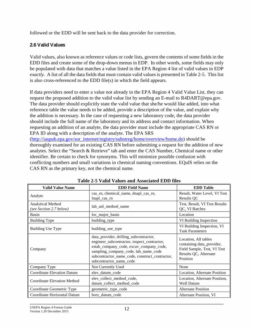
followed or the EDD will be sent back to the data provider for correction. 2.6 Valid Values Valid values, also known as reference values or code lists, govern the contents of some fields in the EDD files and create some of the drop-down menus in EDP. In other words, some fields may only be populated with data that matches a value listed in the EPA Region 4 list of valid values in EDP exactly. A list of all the data fields that must contain valid values is presented in Table 2-5. This list is also cross-referenced to the EDD file(s) in which the field appears. If data providers need to enter a value not already in the EPA Region 4 Valid Value List, they can request the proposed addition to the valid value list by sending an E-mail to [email protected]. The data provider should explicitly state the valid value that she/he would like added, into what reference table the value needs to be added, provide a description of the value, and explain why the addition is necessary. In the case of requesting a new laboratory code, the data provider should include the full name of the laboratory and its address and contact information. When requesting an addition of an analyte, the data provider must include the appropriate CAS RN or EPA ID along with a description of the analyte. The EPA SRS (http://iaspub.epa.gov/sor_internet/registry/substreg/home/overview/home.do) should be thoroughly examined for an existing CAS RN before submitting a request for the addition of new analytes. Select the “Search & Retrieve” tab and enter the CAS Number, Chemical name or other identifier. Be certain to check for synonyms. This will minimize possible confusion with conflicting numbers and small variations in chemical naming conventions. EQuIS relies on the CAS RN as the primary key, not the chemical name.
Table 2-5 Valid Values and Associated EDD files Valid Value Name EDD Field Name EDD Table
Analyte cas_rn, chemical_name, dnapl_cas_rn, lnapl_cas_rn
Result, Water Level, VI Test Results QC
Analytical Method (see Section 2.7 below) lab_anl_method_name Test, Result, VI Test Results
QC, VI Batches Basin loc_major_basin Location Building Type building_type VI Building Inspection
Building Use Type building_use_type VI Building Inspection, VI Task Parameters
Company
data_provider, drilling_subcontractor, engineer_subcontractor, inspect_contractor, estab_company_code, excav_company_code, sampling_company_code, lab_name_code subcontractor_name_code, construct_contractor, subcontractor_name_code
Location, All tables containing data_provider, Field Sample, Test, VI Test Results QC, Alternate Position
Company Type Not Currently Used None Coordinate Elevation Datum elev_datum_code Location, Alternate Position
Coordinate Elevation Method elev_collect_method_code, datum_collect_method_code
Location, Alternate Position, Well Datum
Coordinate Geometric Type geometric_type_code Alternate Position Coordinate Horizontal Datum horz_datum_code Alternate Position, VI
USEPA Region 4 Format Guide Version 1.20 December 2015 13
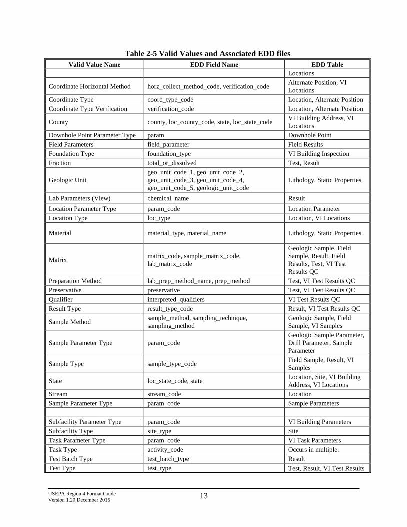
Table 2-5 Valid Values and Associated EDD files Valid Value Name EDD Field Name EDD Table
Locations
Coordinate Horizontal Method horz_collect_method_code, verification_code Alternate Position, VI Locations
Coordinate Type coord_type_code Location, Alternate Position Coordinate Type Verification verification_code Location, Alternate Position
County county, loc_county_code, state, loc_state_code VI Building Address, VI Locations
Downhole Point Parameter Type param Downhole Point Field Parameters field_parameter Field Results Foundation Type foundation_type VI Building Inspection Fraction total_or_dissolved Test, Result
Geologic Unit geo_unit_code_1, geo_unit_code_2, geo_unit_code_3, geo_unit_code_4, geo_unit_code_5, geologic_unit_code
Lithology, Static Properties
Lab Parameters (View) chemical_name Result Location Parameter Type param_code Location Parameter Location Type loc_type Location, VI Locations
Material material_type, material_name Lithology, Static Properties
Matrix matrix_code, sample_matrix_code, lab_matrix_code
Geologic Sample, Field Sample, Result, Field Results, Test, VI Test Results QC
Preparation Method lab_prep_method_name, prep_method Test, VI Test Results QC Preservative preservative Test, VI Test Results QC Qualifier interpreted_qualifiers VI Test Results QC Result Type result_type_code Result, VI Test Results QC
Sample Method sample_method, sampling_technique, sampling_method
Geologic Sample, Field Sample, VI Samples
Sample Parameter Type param_code Geologic Sample Parameter, Drill Parameter, Sample Parameter
Sample Type sample_type_code Field Sample, Result, VI Samples
State loc_state_code, state Location, Site, VI Building Address, VI Locations
Stream stream_code Location Sample Parameter Type param_code Sample Parameters Subfacility Parameter Type param_code VI Building Parameters Subfacility Type site_type Site Task Parameter Type param_code VI Task Parameters Task Type activity_code Occurs in multiple. Test Batch Type test_batch_type Result Test Type test_type Test, Result, VI Test Results
USEPA Region 4 Format Guide Version 1.20 December 2015 14
Table 2-5 Valid Values and Associated EDD files Valid Value Name EDD Field Name EDD Table
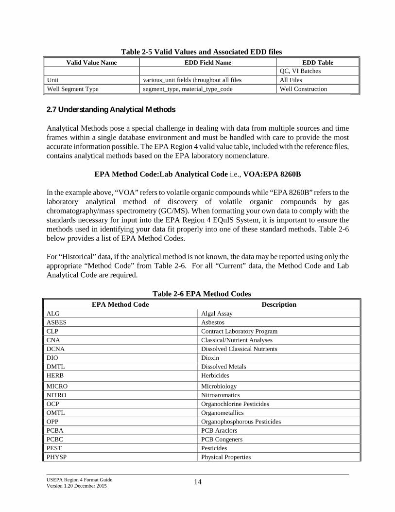
QC, VI Batches Unit various_unit fields throughout all files All Files Well Segment Type segment_type, material_type_code Well Construction
2.7 Understanding Analytical Methods Analytical Methods pose a special challenge in dealing with data from multiple sources and time frames within a single database environment and must be handled with care to provide the most accurate information possible. The EPA Region 4 valid value table, included with the reference files, contains analytical methods based on the EPA laboratory nomenclature.
EPA Method Code:Lab Analytical Code i.e., VOA:EPA 8260B
In the example above, “VOA” refers to volatile organic compounds while “EPA 8260B” refers to the laboratory analytical method of discovery of volatile organic compounds by gas chromatography/mass spectrometry (GC/MS). When formatting your own data to comply with the standards necessary for input into the EPA Region 4 EQuIS System, it is important to ensure the methods used in identifying your data fit properly into one of these standard methods. Table 2-6 below provides a list of EPA Method Codes. For “Historical” data, if the analytical method is not known, the data may be reported using only the appropriate “Method Code” from Table 2-6. For all “Current” data, the Method Code and Lab Analytical Code are required.
Table 2-6 EPA Method Codes
EPA Method Code Description ALG Algal Assay ASBES Asbestos CLP Contract Laboratory Program CNA Classical/Nutrient Analyses DCNA Dissolved Classical Nutrients DIO Dioxin DMTL Dissolved Metals HERB Herbicides
MICRO Microbiology NITRO Nitroaromatics OCP Organochlorine Pesticides OMTL Organometallics OPP Organophosphorous Pesticides PCBA PCB Araclors PCBC PCB Congeners PEST Pesticides PHYSP Physical Properties
USEPA Region 4 Format Guide Version 1.20 December 2015 15
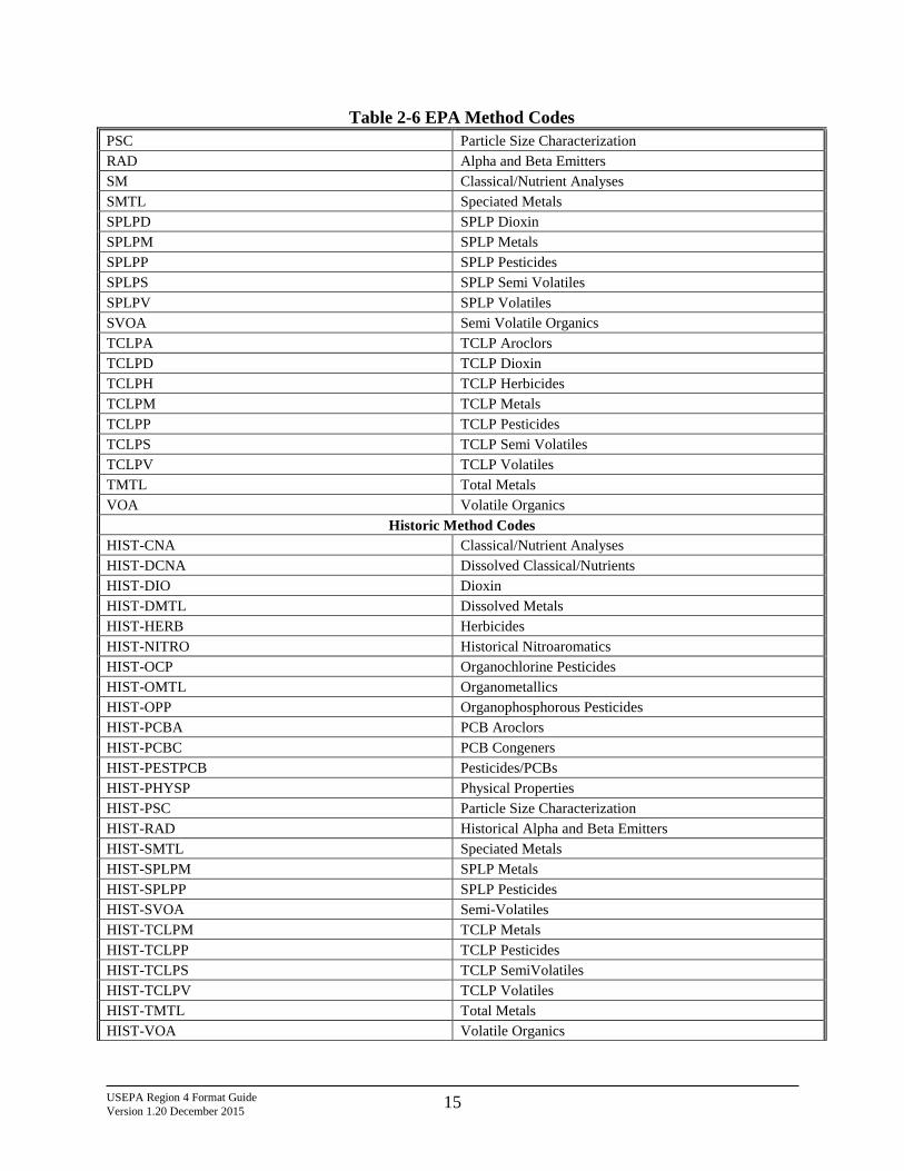
Table 2-6 EPA Method Codes PSC Particle Size Characterization RAD Alpha and Beta Emitters SM Classical/Nutrient Analyses SMTL Speciated Metals SPLPD SPLP Dioxin SPLPM SPLP Metals SPLPP SPLP Pesticides SPLPS SPLP Semi Volatiles SPLPV SPLP Volatiles SVOA Semi Volatile Organics TCLPA TCLP Aroclors TCLPD TCLP Dioxin TCLPH TCLP Herbicides TCLPM TCLP Metals TCLPP TCLP Pesticides TCLPS TCLP Semi Volatiles TCLPV TCLP Volatiles TMTL Total Metals VOA Volatile Organics
Historic Method Codes HIST-CNA Classical/Nutrient Analyses HIST-DCNA Dissolved Classical/Nutrients HIST-DIO Dioxin HIST-DMTL Dissolved Metals HIST-HERB Herbicides HIST-NITRO Historical Nitroaromatics HIST-OCP Organochlorine Pesticides HIST-OMTL Organometallics HIST-OPP Organophosphorous Pesticides HIST-PCBA PCB Aroclors HIST-PCBC PCB Congeners HIST-PESTPCB Pesticides/PCBs HIST-PHYSP Physical Properties HIST-PSC Particle Size Characterization HIST-RAD Historical Alpha and Beta Emitters HIST-SMTL Speciated Metals HIST-SPLPM SPLP Metals HIST-SPLPP SPLP Pesticides HIST-SVOA Semi-Volatiles HIST-TCLPM TCLP Metals HIST-TCLPP TCLP Pesticides HIST-TCLPS TCLP SemiVolatiles HIST-TCLPV TCLP Volatiles HIST-TMTL Total Metals HIST-VOA Volatile Organics
USEPA Region 4 Format Guide Version 1.20 December 2015 16
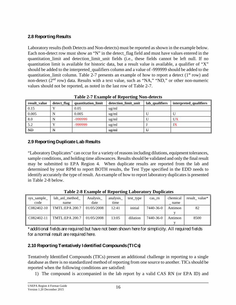
2.8 Reporting Results Laboratory results (both Detects and Non-detects) must be reported as shown in the example below. Each non-detect row must show an “N” in the detect_flag field and must have values entered in the quantitation_limit and detection_limit_unit fields (i.e., these fields cannot be left null. If no quantitation limit is available for historic data, but a result value is available, a qualifier of “X” should be added to the interpreted_qualifiers column and a value of -999999 should be added to the quantitation_limit column. Table 2-7 presents an example of how to report a detect (1st row) and non-detect (2nd row) data. Results with a text value, such as “NA,” “ND,” or other non-numeric values should not be reported, as noted in the last row of Table 2-7.
Table 2-7 Example of Reporting Non-detects result_value detect_flag quantitation_limit detection_limit_unit lab_qualifiers interpreted_qualifiers 0.15 Y 0.05 ug/ml 0.005 N 0.005 ug/ml U U 8.0 N -999999 ug/ml U UX 5.2 Y -999999 ug/ml J JX ND N ug/ml U
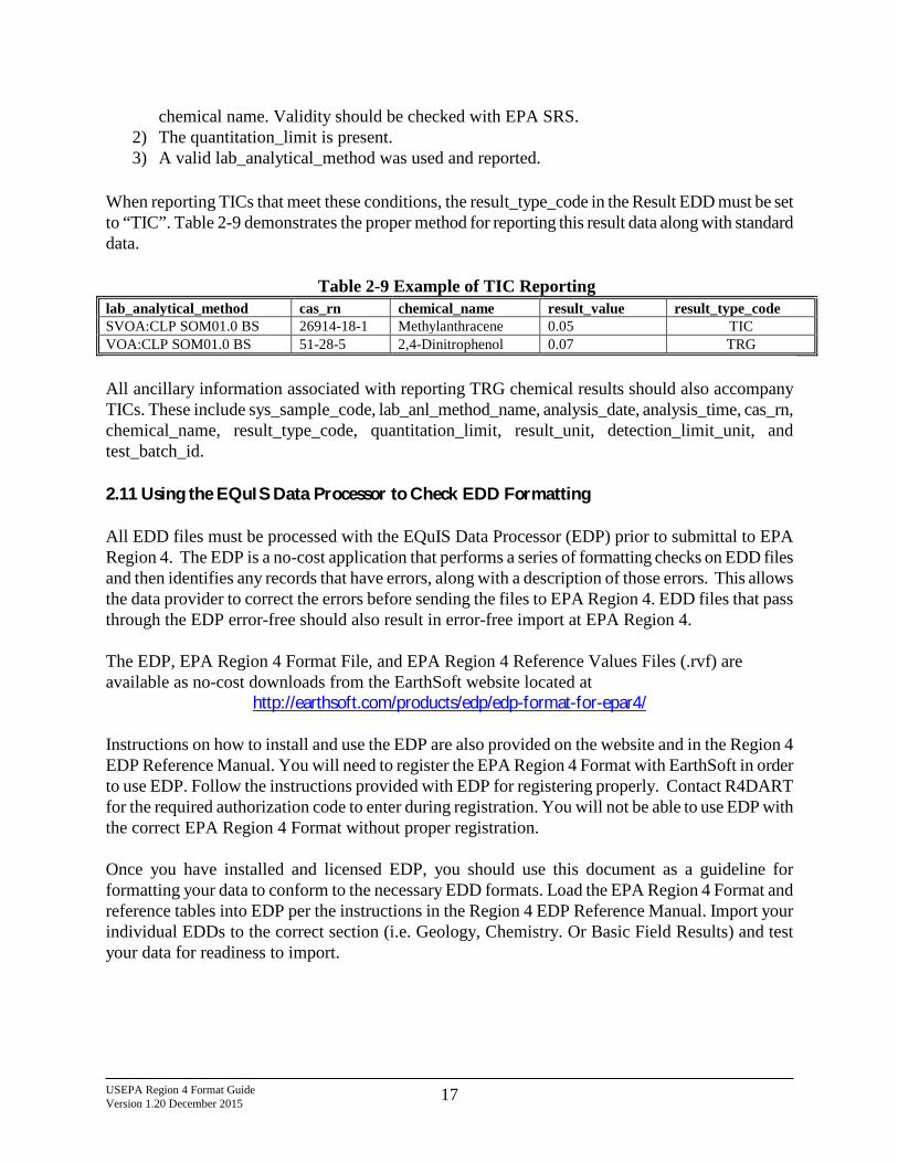
2.9 Reporting Duplicate Lab Results “Laboratory Duplicates” can occur for a variety of reasons including dilutions, equipment tolerances, sample conditions, and holding time allowances. Results should be validated and only the final result may be submitted to EPA Region 4. When duplicate results are reported from the lab and determined by your RPM to report BOTH results, the Test Type specified in the EDD needs to identify accurately the type of result. An example of how to report laboratory duplicates is presented in Table 2-8 below.
Table 2-8 Example of Reporting Laboratory Duplicates sys_sample_
code lab_anl_method_
name Analysis_
date analysis_
time test_type cas_rn chemical
_ name result_ value*
C082402-10 TMTL:EPA 200.7 01/05/2008 12:41 initial 7440-36-0 Antimony
82
C082402-11 TMTL:EPA 200.7 01/05/2008 13:05 dilution 7440-36-0 Antimony
8500
*additional fields are required but have not been shown here for simplicity. All required fields for a normal result are required here. 2.10 Reporting Tentatively Identified Compounds (TICs) Tentatively Identified Compounds (TICs) present an additional challenge in reporting to a single database as there is no standardized method of reporting from one source to another. TICs should be reported when the following conditions are satisfied:
1) The compound is accompanied in the lab report by a valid CAS RN (or EPA ID) and
USEPA Region 4 Format Guide Version 1.20 December 2015 17
chemical name. Validity should be checked with EPA SRS. 2) The quantitation_limit is present. 3) A valid lab_analytical_method was used and reported.
When reporting TICs that meet these conditions, the result_type_code in the Result EDD must be set to “TIC”. Table 2-9 demonstrates the proper method for reporting this result data along with standard data.
Table 2-9 Example of TIC Reporting
lab_analytical_method cas_rn chemical_name result_value result_type_code SVOA:CLP SOM01.0 BS 26914-18-1 Methylanthracene 0.05 TIC VOA:CLP SOM01.0 BS 51-28-5 2,4-Dinitrophenol 0.07 TRG
All ancillary information associated with reporting TRG chemical results should also accompany TICs. These include sys_sample_code, lab_anl_method_name, analysis_date, analysis_time, cas_rn, chemical_name, result_type_code, quantitation_limit, result_unit, detection_limit_unit, and test_batch_id. 2.11 Using the EQuIS Data Processor to Check EDD Formatting All EDD files must be processed with the EQuIS Data Processor (EDP) prior to submittal to EPA Region 4. The EDP is a no-cost application that performs a series of formatting checks on EDD files and then identifies any records that have errors, along with a description of those errors. This allows the data provider to correct the errors before sending the files to EPA Region 4. EDD files that pass through the EDP error-free should also result in error-free import at EPA Region 4. The EDP, EPA Region 4 Format File, and EPA Region 4 Reference Values Files (.rvf) are available as no-cost downloads from the EarthSoft website located at
http://earthsoft.com/products/edp/edp-format-for-epar4/ Instructions on how to install and use the EDP are also provided on the website and in the Region 4 EDP Reference Manual. You will need to register the EPA Region 4 Format with EarthSoft in order to use EDP. Follow the instructions provided with EDP for registering properly. Contact R4DART for the required authorization code to enter during registration. You will not be able to use EDP with the correct EPA Region 4 Format without proper registration. Once you have installed and licensed EDP, you should use this document as a guideline for formatting your data to conform to the necessary EDD formats. Load the EPA Region 4 Format and reference tables into EDP per the instructions in the Region 4 EDP Reference Manual. Import your individual EDDs to the correct section (i.e. Geology, Chemistry. Or Basic Field Results) and test your data for readiness to import.
USEPA Region 4 Format Guide Version 1.20 December 2015 18
3.0 EDD FILE FORMATS This section contains detailed information regarding the files that make up the EPA Region 4 EDD Format. As stated in section 2.1, each EDD file must be saved as individual text files and can be created using any software with the capability to create text files (including EDP). If a column is limited to a specific number of characters, the limit will be given in parenthesis within the “Data Type” column (e.g., “Text (3)” signifies the value cannot exceed 3 characters in length). Columns marked “Required” must be reported for each row in the file. If these fields are not reported, errors will be identified in the EDD and the EDD will need to be resubmitted. Columns marked “If available” should also be reported if possible. The Location file needs to be submitted as part of the first EDD submittal. This file need only be submitted once, unless information in the file changes or additional information, such as a new sampling location, needs to be added. For all other EDD files, EPA Region 4 will send a list of the EDDs expected for the data submittal. Note: EPA Region 4 will provide the valid values for data_provider, task_code and activity_code for each data submittal. 3.1 Site EDD File The Site EDD file contains general information about the site, including EPA Region 4 data providers’ contact information. The Site EDD file is typically submitted only once for new sites and must be part of the first EDD submittal. The site file only needs to be resubmitted if the site information needs to be updated, such as the site name or data provider information for the site. When resubmitting the site file, please notify EPA Region 4 that the site information has changed and needs to be updated. Site EDD files should be named according to the following convention: EPAR4_Site_v1.csv or .txt for tab-delimited files.
Field Name Data Type Key Required current/historical Parent Description
site_code Text (20) PK current/historical Use "Registry ID" (EnviroFacts) or "GNIS ID" (USGS NHD). site_type Text (20) Site type.
USEPA Region 4 Format Guide Version 1.20 December 2015 19
Field Name Data Type Key Required current/historical Parent Description
site_name Text(60) PK Use "Facility Name (EnviroFacts) or "GNIS Name" (USGS NHD).
site_task_code Text(20) Unused. site_desc1 Text(255) Alternate Name 1. site_desc2 Text(255) Alternate Name 2. contact_name Text(50) Unused. address1 Text(40) Location Address (EnviroFacts). address2 Text(40) Supplemental Address (EnviroFacts). city Text(40) City Name (EnviroFacts). state Text(10) State (EnviroFacts). zipcode Text(30) Zip/Postal Code (EnviroFacts). phone_number Text(30) Unused. alt_phone_number Text(30) Unused. fax_number Text(30) Unused. email_address Text(100) Unused.
3.2 Location EDD File The Location file is typically submitted only once and must be part of the first EDD submittal. The location file only needs to be resubmitted if a new sampling location is used, such as a new monitoring well, or to update previously submitted information. When resubmitting the location file, only include data for the new locations and/or for the locations whose information is being updated. The Location EDD file contains general information about sampling station locations and station ID numbers. This table does not need to be resubmitted if information has previously been submitted to EPA Region 4 as an EDD. Location EDD files should be named according to the following convention: EPAR4_Location_v1.csv or .txt for tab-delimited files.
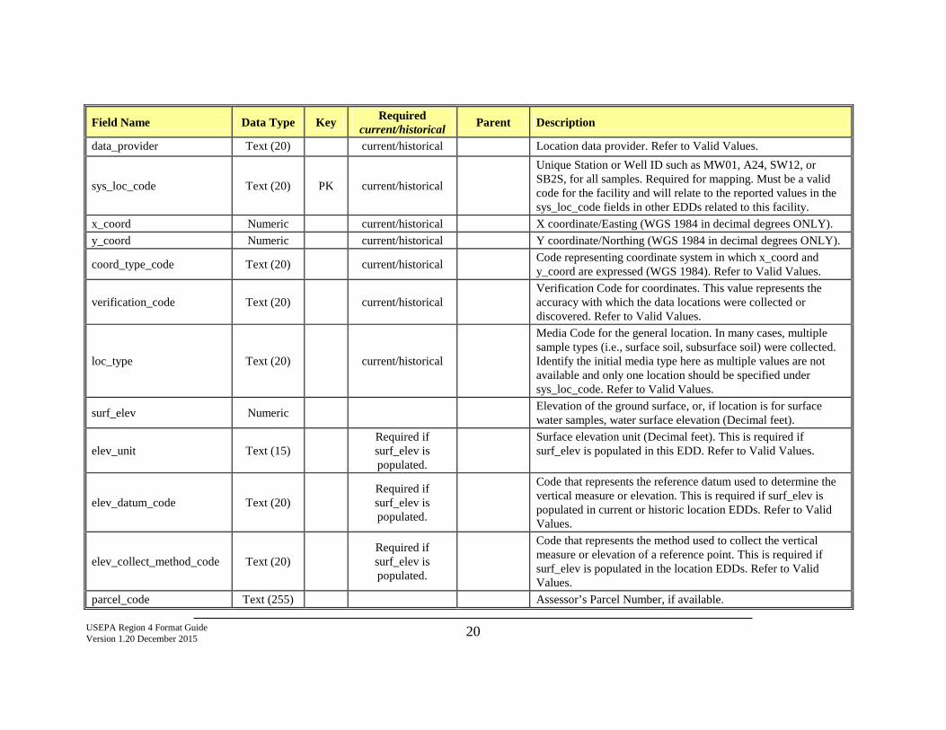
USEPA Region 4 Format Guide Version 1.20 December 2015 20
Field Name Data Type Key Required current/historical Parent Description
data_provider Text (20) current/historical Location data provider. Refer to Valid Values.
sys_loc_code Text (20) PK current/historical
Unique Station or Well ID such as MW01, A24, SW12, or SB2S, for all samples. Required for mapping. Must be a valid code for the facility and will relate to the reported values in the sys_loc_code fields in other EDDs related to this facility.
x_coord Numeric current/historical X coordinate/Easting (WGS 1984 in decimal degrees ONLY). y_coord Numeric current/historical Y coordinate/Northing (WGS 1984 in decimal degrees ONLY).
coord_type_code Text (20) current/historical Code representing coordinate system in which x_coord and y_coord are expressed (WGS 1984). Refer to Valid Values.
verification_code Text (20) current/historical Verification Code for coordinates. This value represents the accuracy with which the data locations were collected or discovered. Refer to Valid Values.
loc_type Text (20) current/historical
Media Code for the general location. In many cases, multiple sample types (i.e., surface soil, subsurface soil) were collected. Identify the initial media type here as multiple values are not available and only one location should be specified under sys_loc_code. Refer to Valid Values.
surf_elev Numeric Elevation of the ground surface, or, if location is for surface water samples, water surface elevation (Decimal feet).
elev_unit Text (15) Required if surf_elev is populated.
Surface elevation unit (Decimal feet). This is required if surf_elev is populated in this EDD. Refer to Valid Values.
elev_datum_code Text (20) Required if surf_elev is populated.
Code that represents the reference datum used to determine the vertical measure or elevation. This is required if surf_elev is populated in current or historic location EDDs. Refer to Valid Values.
elev_collect_method_code Text (20) Required if surf_elev is populated.
Code that represents the method used to collect the vertical measure or elevation of a reference point. This is required if surf_elev is populated in the location EDDs. Refer to Valid Values.
parcel_code Text (255) Assessor’s Parcel Number, if available.
USEPA Region 4 Format Guide Version 1.20 December 2015 21
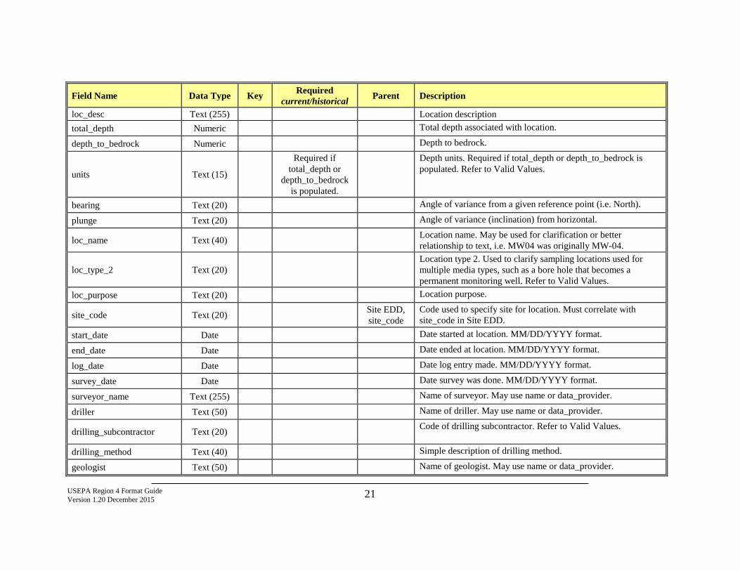
Field Name Data Type Key Required current/historical Parent Description
loc_desc Text (255) Location description total_depth Numeric Total depth associated with location.
depth_to_bedrock Numeric Depth to bedrock.
units Text (15)
Required if total_depth or
depth_to_bedrock is populated.
Depth units. Required if total_depth or depth_to_bedrock is populated. Refer to Valid Values.
bearing Text (20) Angle of variance from a given reference point (i.e. North).
plunge Text (20) Angle of variance (inclination) from horizontal.
loc_name Text (40) Location name. May be used for clarification or better relationship to text, i.e. MW04 was originally MW-04.
loc_type_2 Text (20) Location type 2. Used to clarify sampling locations used for multiple media types, such as a bore hole that becomes a permanent monitoring well. Refer to Valid Values.
loc_purpose Text (20) Location purpose.
site_code Text (20) Site EDD, site_code
Code used to specify site for location. Must correlate with site_code in Site EDD.
start_date Date Date started at location. MM/DD/YYYY format.
end_date Date Date ended at location. MM/DD/YYYY format.
log_date Date Date log entry made. MM/DD/YYYY format.
survey_date Date Date survey was done. MM/DD/YYYY format.
surveyor_name Text (255) Name of surveyor. May use name or data_provider.
driller Text (50) Name of driller. May use name or data_provider.
drilling_subcontractor Text (20) Code of drilling subcontractor. Refer to Valid Values.
drilling_method Text (40) Simple description of drilling method.
geologist Text (50) Name of geologist. May use name or data_provider.
USEPA Region 4 Format Guide Version 1.20 December 2015 22
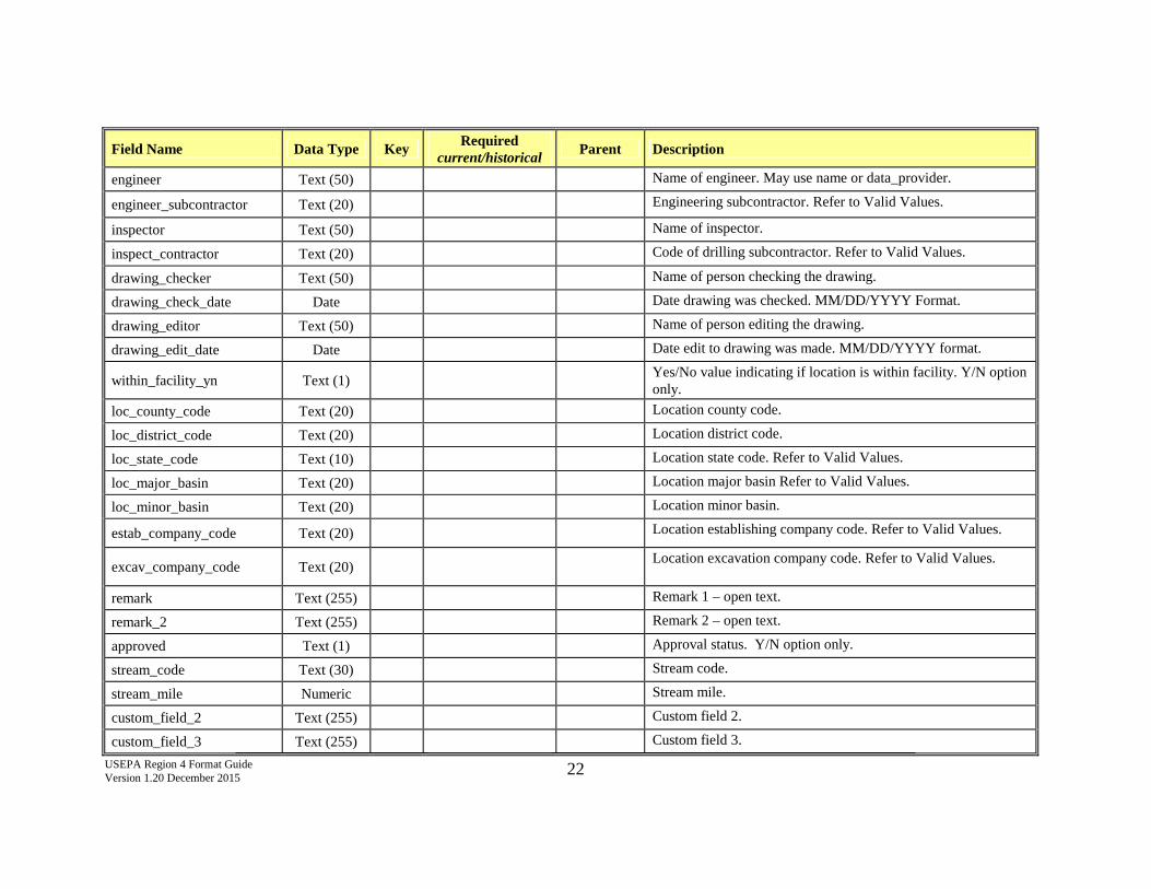
Field Name Data Type Key Required current/historical Parent Description
engineer Text (50) Name of engineer. May use name or data_provider.
engineer_subcontractor Text (20) Engineering subcontractor. Refer to Valid Values.
inspector Text (50) Name of inspector.
inspect_contractor Text (20) Code of drilling subcontractor. Refer to Valid Values.
drawing_checker Text (50) Name of person checking the drawing.
drawing_check_date Date Date drawing was checked. MM/DD/YYYY Format.
drawing_editor Text (50) Name of person editing the drawing.
drawing_edit_date Date Date edit to drawing was made. MM/DD/YYYY format.
within_facility_yn Text (1) Yes/No value indicating if location is within facility. Y/N option only.
loc_county_code Text (20) Location county code.
loc_district_code Text (20) Location district code.
loc_state_code Text (10) Location state code. Refer to Valid Values.
loc_major_basin Text (20) Location major basin Refer to Valid Values.
loc_minor_basin Text (20) Location minor basin.
estab_company_code Text (20) Location establishing company code. Refer to Valid Values.
excav_company_code Text (20) Location excavation company code. Refer to Valid Values.
remark Text (255) Remark 1 – open text.
remark_2 Text (255) Remark 2 – open text.
approved Text (1) Approval status. Y/N option only.
stream_code Text (30) Stream code.
stream_mile Numeric Stream mile.
custom_field_2 Text (255) Custom field 2.
custom_field_3 Text (255) Custom field 3.
USEPA Region 4 Format Guide Version 1.20 December 2015 23
Field Name Data Type Key Required current/historical Parent Description
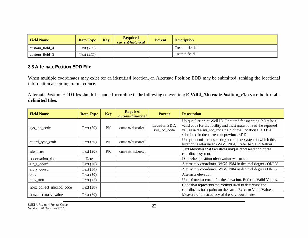
custom_field_4 Text (255) Custom field 4.
custom_field_5 Text (255) Custom field 5.
3.3 Alternate Position EDD File When multiple coordinates may exist for an identified location, an Alternate Position EDD may be submitted, ranking the locational information according to preference. Alternate Position EDD files should be named according to the following convention: EPAR4_AlternatePosition_v1.csv or .txt for tab-delimited files.
Field Name Data Type Key Required current/historical Parent Description
sys_loc_code Text (20) PK current/historical Location EDD, sys_loc_code
Unique Station or Well ID. Required for mapping. Must be a valid code for the facility and must match one of the reported values in the sys_loc_code field of the Location EDD file submitted in the current or previous EDD.
coord_type_code Text (20) PK current/historical Unique identifier describing coordinate system in which this location is referenced (WGS 1984). Refer to Valid Values.
identifier Text (20) PK current/historical Text identifier that facilitates unique representation of the coordinate system.
observation_date Date Date when position observation was made. alt_x_coord Text (20) Alternate x coordinate. WGS 1984 in decimal degrees ONLY. alt_y_coord Text (20) Alternate y coordinate. WGS 1984 in decimal degrees ONLY. elev Text (20) Alternate elevation. elev_unit Text (15) Unit of measurement for the elevation. Refer to Valid Values.
horz_collect_method_code Text (20) Code that represents the method used to determine the coordinates for a point on the earth. Refer to Valid Values.
horz_accuracy_value Text (20) Measure of the accuracy of the x, y coordinates.
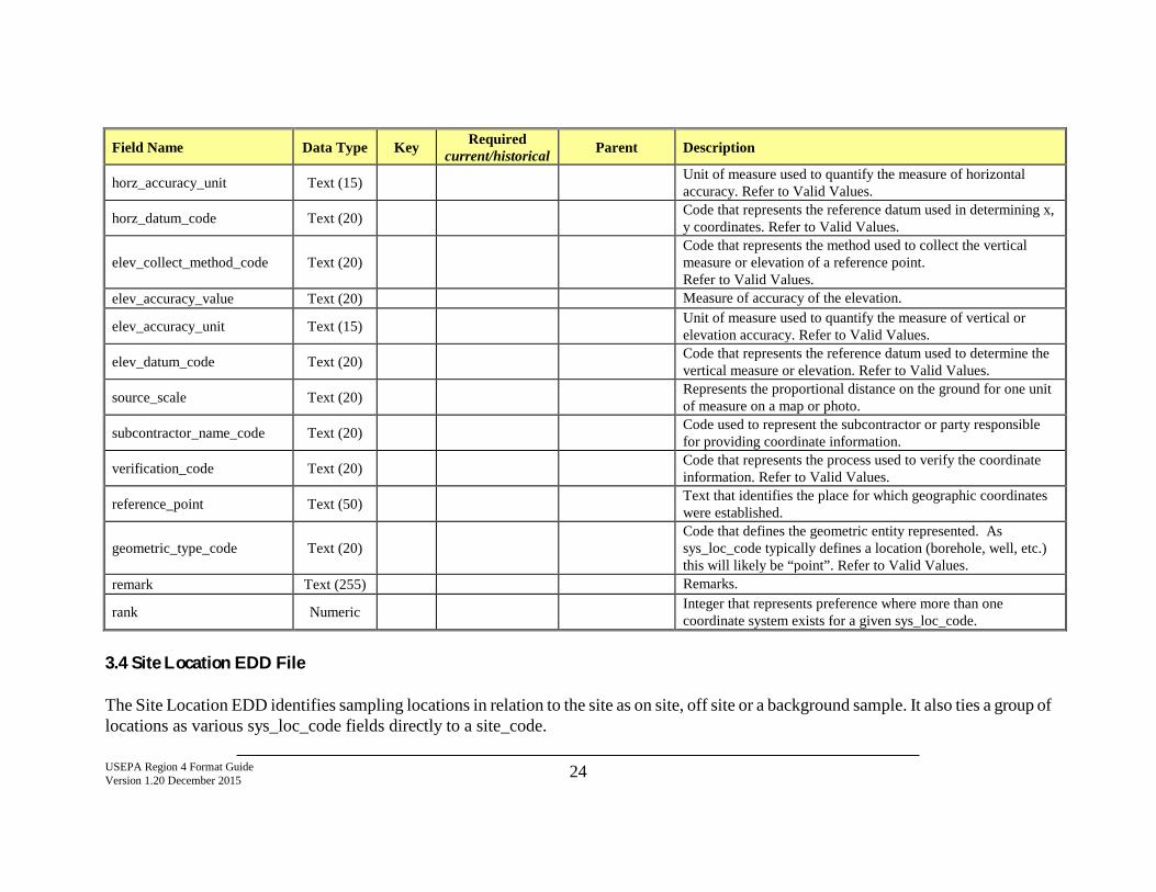
USEPA Region 4 Format Guide Version 1.20 December 2015 24
Field Name Data Type Key Required current/historical Parent Description
horz_accuracy_unit Text (15) Unit of measure used to quantify the measure of horizontal accuracy. Refer to Valid Values.
horz_datum_code Text (20) Code that represents the reference datum used in determining x, y coordinates. Refer to Valid Values.
elev_collect_method_code Text (20) Code that represents the method used to collect the vertical measure or elevation of a reference point. Refer to Valid Values.
elev_accuracy_value Text (20) Measure of accuracy of the elevation.
elev_accuracy_unit Text (15) Unit of measure used to quantify the measure of vertical or elevation accuracy. Refer to Valid Values.
elev_datum_code Text (20) Code that represents the reference datum used to determine the vertical measure or elevation. Refer to Valid Values.
source_scale Text (20) Represents the proportional distance on the ground for one unit of measure on a map or photo.
subcontractor_name_code Text (20) Code used to represent the subcontractor or party responsible for providing coordinate information.
verification_code Text (20) Code that represents the process used to verify the coordinate information. Refer to Valid Values.
reference_point Text (50) Text that identifies the place for which geographic coordinates were established.
geometric_type_code Text (20) Code that defines the geometric entity represented. As sys_loc_code typically defines a location (borehole, well, etc.) this will likely be “point”. Refer to Valid Values.
remark Text (255) Remarks.
rank Numeric Integer that represents preference where more than one coordinate system exists for a given sys_loc_code.
3.4 Site Location EDD File The Site Location EDD identifies sampling locations in relation to the site as on site, off site or a background sample. It also ties a group of locations as various sys_loc_code fields directly to a site_code.
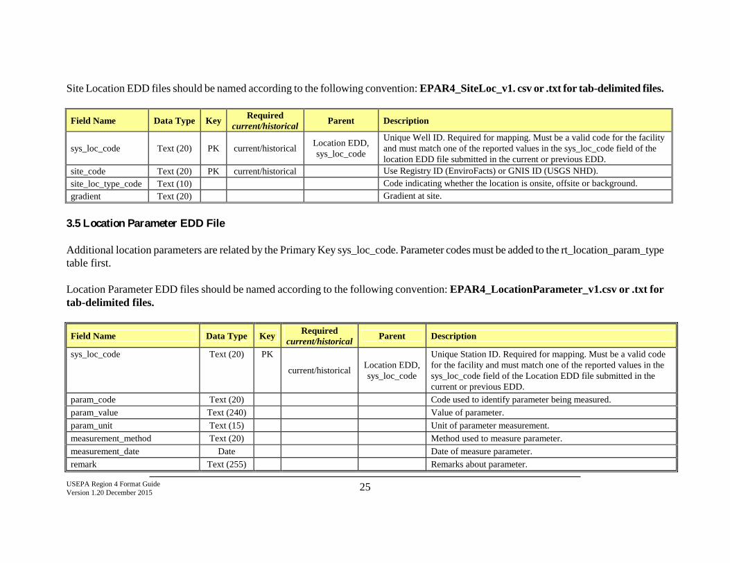
USEPA Region 4 Format Guide Version 1.20 December 2015 25
Site Location EDD files should be named according to the following convention: EPAR4_SiteLoc_v1. csv or .txt for tab-delimited files.
Field Name Data Type Key Required current/historical Parent Description
sys_loc_code Text (20) PK current/historical Location EDD, sys_loc_code
Unique Well ID. Required for mapping. Must be a valid code for the facility and must match one of the reported values in the sys_loc_code field of the location EDD file submitted in the current or previous EDD.
site_code Text (20) PK current/historical Use Registry ID (EnviroFacts) or GNIS ID (USGS NHD). site_loc_type_code Text (10) Code indicating whether the location is onsite, offsite or background. gradient Text (20) Gradient at site.
3.5 Location Parameter EDD File Additional location parameters are related by the Primary Key sys_loc_code. Parameter codes must be added to the rt_location_param_type table first. Location Parameter EDD files should be named according to the following convention: EPAR4_LocationParameter_v1.csv or .txt for tab-delimited files.
Field Name Data Type Key Required current/historical Parent Description
sys_loc_code Text (20) PK
current/historical Location EDD, sys_loc_code
Unique Station ID. Required for mapping. Must be a valid code for the facility and must match one of the reported values in the sys_loc_code field of the Location EDD file submitted in the current or previous EDD.
param_code Text (20) Code used to identify parameter being measured. param_value Text (240) Value of parameter. param_unit Text (15) Unit of parameter measurement. measurement_method Text (20) Method used to measure parameter. measurement_date Date Date of measure parameter. remark Text (255) Remarks about parameter.
USEPA Region 4 Format Guide Version 1.20 December 2015 26
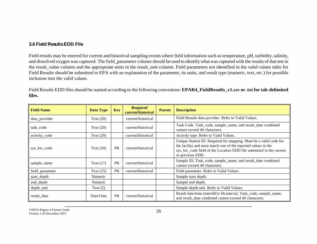
3.6 Field Results EDD File Field results may be entered for current and historical sampling events where field information such as temperature, pH, turbidity, salinity, and dissolved oxygen was captured. The field_parameter column should be used to identify what was captured with the results of that test in the result_value column and the appropriate units in the result_unit column. Field parameters not identified in the valid values table for Field Results should be submitted to EPA with an explanation of the parameter, its units, and result type (numeric, text, etc.) for possible inclusion into the valid values. Field Results EDD files should be named according to the following convention: EPAR4_FieldResults_v1.csv or .txt for tab-delimited files.
Field Name Data Type Key Required current/historical Parent Description
data_provider Text (20) current/historical Field Results data provider. Refer to Valid Values.
task_code Text (20) current/historical Task Code. Task_code, sample_name, and result_date combined cannot exceed 40 characters.
activity_code Text (20) current/historical Activity type. Refer to Valid Values.
sys_loc_code Text (20) PK current/historical
Unique Station ID. Required for mapping. Must be a valid code for the facility and must match one of the reported values in the sys_loc_code field of the Location EDD file submitted in the current or previous EDD.
sample_name Text (17) PK current/historical Sample ID. Task_code, sample_name, and result_date combined cannot exceed 40 characters.
field_parameter Text (15) PK current/historical Field parameter. Refer to Valid Values. start_depth Numeric Sample start depth. end_depth Numeric Sample end depth. depth_unit Text (2) Sample depth unit. Refer to Valid Values.
result_date DateTime PK current/historical Result date/time (mm/dd/yr hh:mm:ss). Task_code, sample_name, and result_date combined cannot exceed 40 characters.
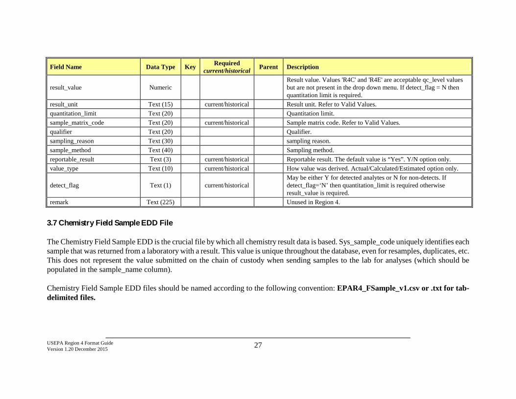
USEPA Region 4 Format Guide Version 1.20 December 2015 27
Field Name Data Type Key Required current/historical Parent Description
result_value Numeric Result value. Values 'R4C' and 'R4E' are acceptable qc_level values but are not present in the drop down menu. If detect_flag = N then quantitation limit is required.
result_unit Text (15) current/historical Result unit. Refer to Valid Values. quantitation_limit Text (20) Quantitation limit. sample_matrix_code Text (20) current/historical Sample matrix code. Refer to Valid Values. qualifier Text (20) Qualifier. sampling_reason Text (30) sampling reason. sample_method Text (40) Sampling method. reportable_result Text (3) current/historical Reportable result. The default value is “Yes”. Y/N option only. value_type Text (10) current/historical How value was derived. Actual/Calculated/Estimated option only.
detect_flag Text (1) current/historical May be either Y for detected analytes or N for non-detects. If detect_flag=‘N’ then quantitation_limit is required otherwise result_value is required.
remark Text (225) Unused in Region 4.
3.7 Chemistry Field Sample EDD File The Chemistry Field Sample EDD is the crucial file by which all chemistry result data is based. Sys_sample_code uniquely identifies each sample that was returned from a laboratory with a result. This value is unique throughout the database, even for resamples, duplicates, etc. This does not represent the value submitted on the chain of custody when sending samples to the lab for analyses (which should be populated in the sample_name column). Chemistry Field Sample EDD files should be named according to the following convention: EPAR4_FSample_v1.csv or .txt for tab-delimited files.
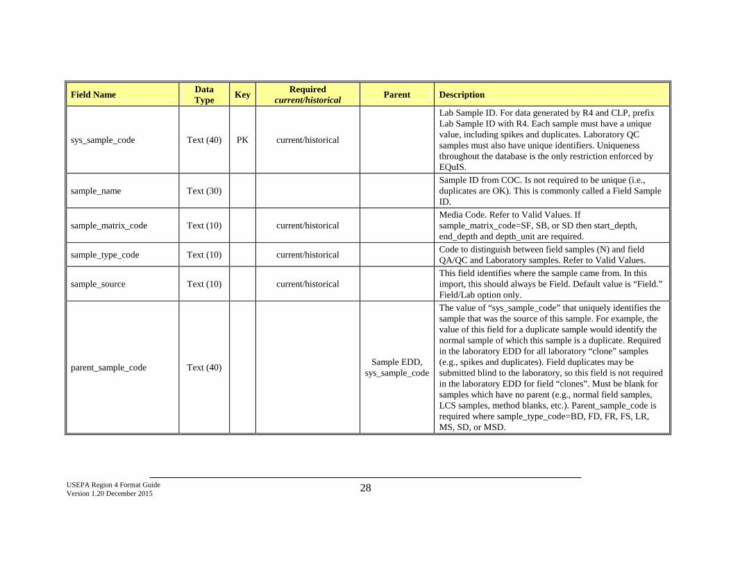
USEPA Region 4 Format Guide Version 1.20 December 2015 28
Field Name Data Type Key Required
current/historical Parent Description
sys_sample_code Text (40) PK current/historical
Lab Sample ID. For data generated by R4 and CLP, prefix Lab Sample ID with R4. Each sample must have a unique value, including spikes and duplicates. Laboratory QC samples must also have unique identifiers. Uniqueness throughout the database is the only restriction enforced by EQuIS.
sample_name Text (30) Sample ID from COC. Is not required to be unique (i.e., duplicates are OK). This is commonly called a Field Sample ID.
sample_matrix_code Text (10) current/historical Media Code. Refer to Valid Values. If sample_matrix_code=SF, SB, or SD then start_depth, end_depth and depth_unit are required.
sample_type_code Text (10) current/historical Code to distinguish between field samples (N) and field QA/QC and Laboratory samples. Refer to Valid Values.
sample_source Text (10) current/historical This field identifies where the sample came from. In this import, this should always be Field. Default value is “Field.” Field/Lab option only.
parent_sample_code Text (40) Sample EDD, sys_sample_code
The value of “sys_sample_code” that uniquely identifies the sample that was the source of this sample. For example, the value of this field for a duplicate sample would identify the normal sample of which this sample is a duplicate. Required in the laboratory EDD for all laboratory “clone” samples (e.g., spikes and duplicates). Field duplicates may be submitted blind to the laboratory, so this field is not required in the laboratory EDD for field “clones”. Must be blank for samples which have no parent (e.g., normal field samples, LCS samples, method blanks, etc.). Parent_sample_code is required where sample_type_code=BD, FD, FR, FS, LR, MS, SD, or MSD.
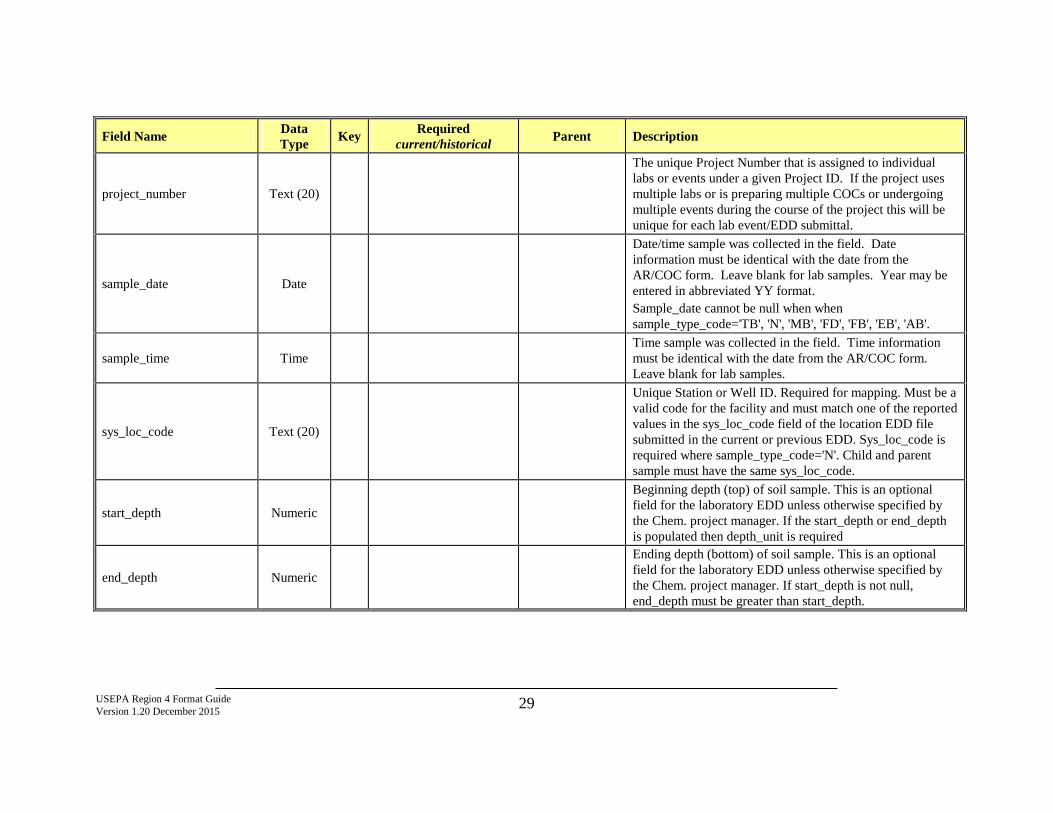
USEPA Region 4 Format Guide Version 1.20 December 2015 29
Field Name Data Type Key Required
current/historical Parent Description
project_number Text (20)
The unique Project Number that is assigned to individual labs or events under a given Project ID. If the project uses multiple labs or is preparing multiple COCs or undergoing multiple events during the course of the project this will be unique for each lab event/EDD submittal.
sample_date Date
Date/time sample was collected in the field. Date information must be identical with the date from the AR/COC form. Leave blank for lab samples. Year may be entered in abbreviated YY format. Sample_date cannot be null when when sample_type_code='TB', 'N', 'MB', 'FD', 'FB', 'EB', 'AB'.
sample_time Time Time sample was collected in the field. Time information must be identical with the date from the AR/COC form. Leave blank for lab samples.
sys_loc_code Text (20)
Unique Station or Well ID. Required for mapping. Must be a valid code for the facility and must match one of the reported values in the sys_loc_code field of the location EDD file submitted in the current or previous EDD. Sys_loc_code is required where sample_type_code='N'. Child and parent sample must have the same sys_loc_code.
start_depth Numeric
Beginning depth (top) of soil sample. This is an optional field for the laboratory EDD unless otherwise specified by the Chem. project manager. If the start_depth or end_depth is populated then depth_unit is required
end_depth Numeric
Ending depth (bottom) of soil sample. This is an optional field for the laboratory EDD unless otherwise specified by the Chem. project manager. If start_depth is not null, end_depth must be greater than start_depth.
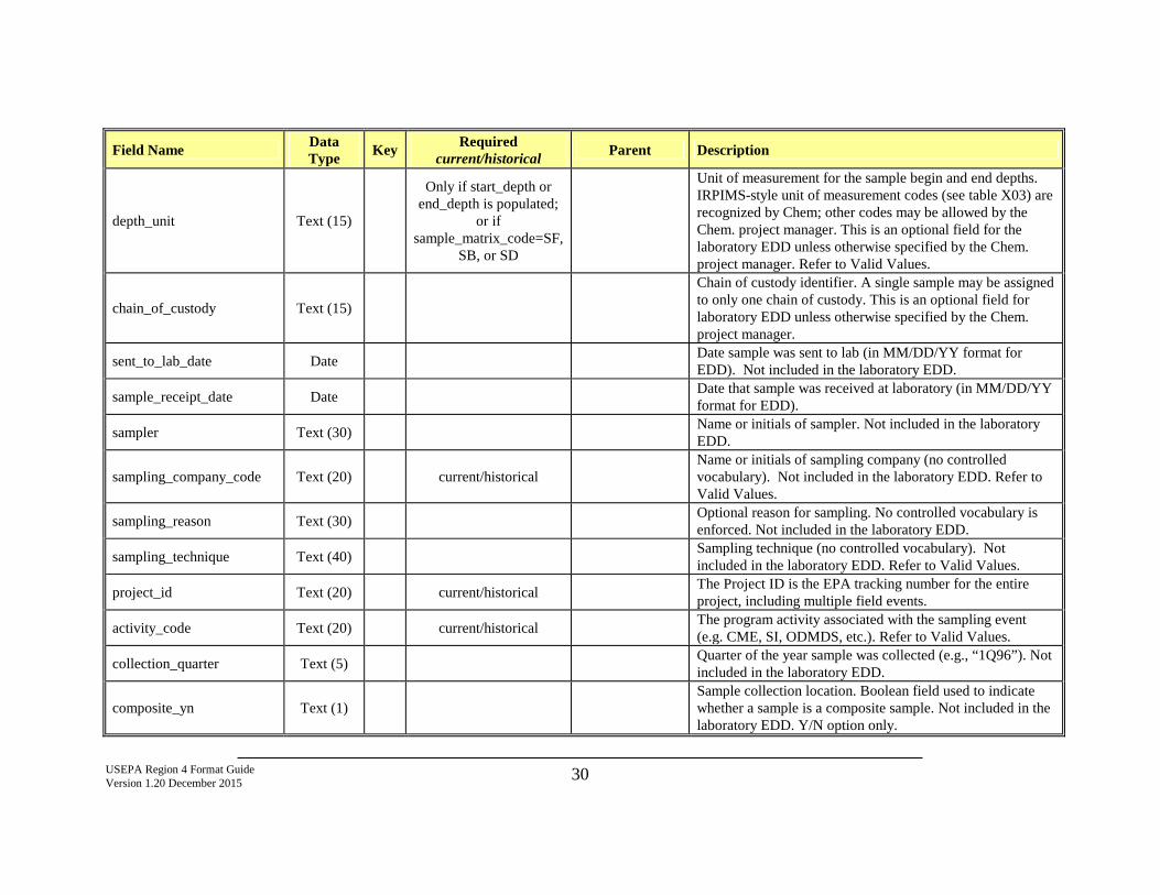
USEPA Region 4 Format Guide Version 1.20 December 2015 30
Field Name Data Type Key Required
current/historical Parent Description
depth_unit Text (15)
Only if start_depth or end_depth is populated;
or if sample_matrix_code=SF,
SB, or SD
Unit of measurement for the sample begin and end depths. IRPIMS-style unit of measurement codes (see table X03) are recognized by Chem; other codes may be allowed by the Chem. project manager. This is an optional field for the laboratory EDD unless otherwise specified by the Chem. project manager. Refer to Valid Values.
chain_of_custody Text (15)
Chain of custody identifier. A single sample may be assigned to only one chain of custody. This is an optional field for laboratory EDD unless otherwise specified by the Chem. project manager.
sent_to_lab_date Date Date sample was sent to lab (in MM/DD/YY format for EDD). Not included in the laboratory EDD.
sample_receipt_date Date Date that sample was received at laboratory (in MM/DD/YY format for EDD).
sampler Text (30) Name or initials of sampler. Not included in the laboratory EDD.
sampling_company_code Text (20) current/historical Name or initials of sampling company (no controlled vocabulary). Not included in the laboratory EDD. Refer to Valid Values.
sampling_reason Text (30) Optional reason for sampling. No controlled vocabulary is enforced. Not included in the laboratory EDD.
sampling_technique Text (40) Sampling technique (no controlled vocabulary). Not included in the laboratory EDD. Refer to Valid Values.
project_id Text (20) current/historical The Project ID is the EPA tracking number for the entire project, including multiple field events.
activity_code Text (20) current/historical The program activity associated with the sampling event (e.g. CME, SI, ODMDS, etc.). Refer to Valid Values.
collection_quarter Text (5) Quarter of the year sample was collected (e.g., “1Q96”). Not included in the laboratory EDD.
composite_yn Text (1) Sample collection location. Boolean field used to indicate whether a sample is a composite sample. Not included in the laboratory EDD. Y/N option only.
USEPA Region 4 Format Guide Version 1.20 December 2015 31
Field Name Data Type Key Required
current/historical Parent Description
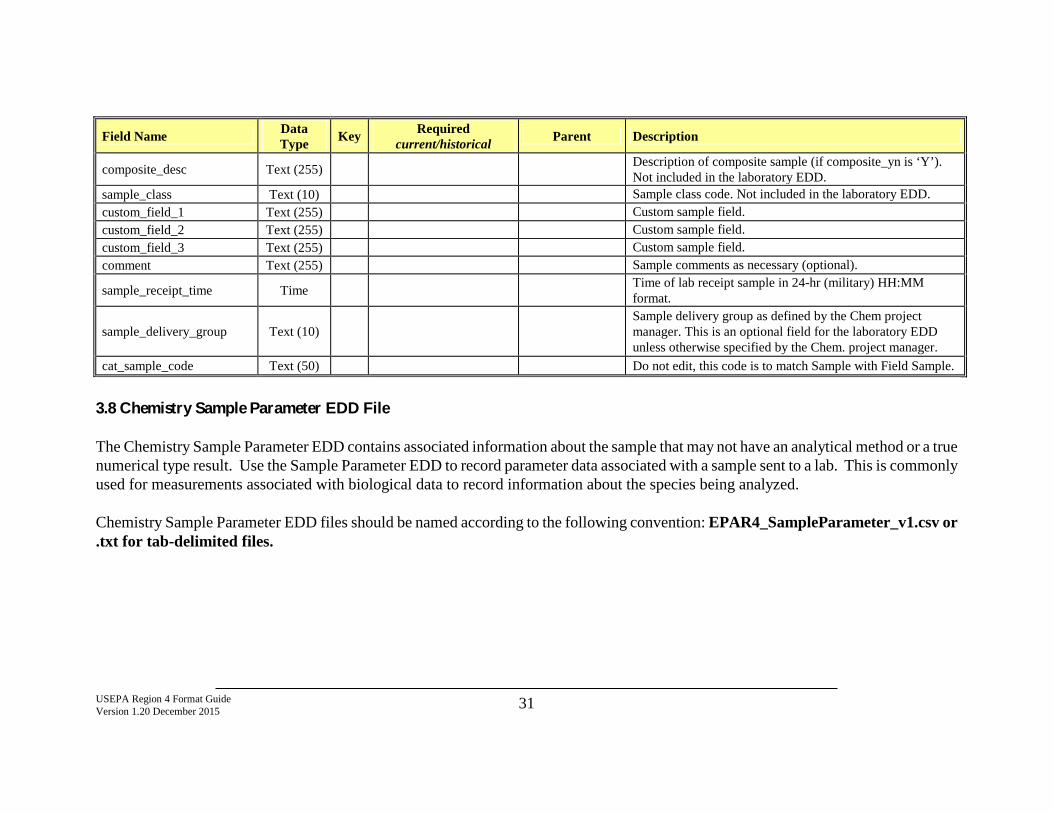
composite_desc Text (255) Description of composite sample (if composite_yn is ‘Y’). Not included in the laboratory EDD.
sample_class Text (10) Sample class code. Not included in the laboratory EDD. custom_field_1 Text (255) Custom sample field. custom_field_2 Text (255) Custom sample field. custom_field_3 Text (255) Custom sample field. comment Text (255) Sample comments as necessary (optional).
sample_receipt_time Time Time of lab receipt sample in 24-hr (military) HH:MM format.
sample_delivery_group Text (10) Sample delivery group as defined by the Chem project manager. This is an optional field for the laboratory EDD unless otherwise specified by the Chem. project manager.
cat_sample_code Text (50) Do not edit, this code is to match Sample with Field Sample.
3.8 Chemistry Sample Parameter EDD File The Chemistry Sample Parameter EDD contains associated information about the sample that may not have an analytical method or a true numerical type result. Use the Sample Parameter EDD to record parameter data associated with a sample sent to a lab. This is commonly used for measurements associated with biological data to record information about the species being analyzed. Chemistry Sample Parameter EDD files should be named according to the following convention: EPAR4_SampleParameter_v1.csv or .txt for tab-delimited files.
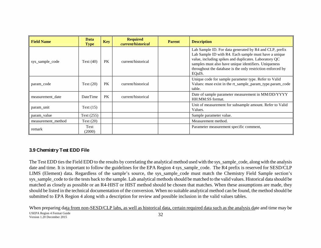
USEPA Region 4 Format Guide Version 1.20 December 2015 32
Field Name Data Type Key Required
current/historical Parent Description
sys_sample_code Text (40) PK current/historical
Lab Sample ID. For data generated by R4 and CLP, prefix Lab Sample ID with R4. Each sample must have a unique value, including spikes and duplicates. Laboratory QC samples must also have unique identifiers. Uniqueness throughout the database is the only restriction enforced by EQuIS.
param_code Text (20) PK current/historical Unique code for sample parameter type. Refer to Valid Values: must exist in the rt_sample_param_type.param_code table.
measurement_date DateTime PK current/historical Date of sample parameter measurement in MM/DD/YYYY HH:MM:SS format.
param_unit Text (15) Unit of measurement for subsample amount. Refer to Valid Values.
param_value Text (255) Sample parameter value. measurement_method Text (20) Measurement method.
remark Text (2000) Parameter measurement specific comment,
3.9 Chemistry Test EDD File The Test EDD ties the Field EDD to the results by correlating the analytical method used with the sys_sample_code, along with the analysis date and time. It is important to follow the guidelines for the EPA Region 4 sys_sample_code. The R4 prefix is reserved for SESD/CLP LIMS (Element) data. Regardless of the sample’s source, the sys_sample_code must match the Chemistry Field Sample section’s sys_sample_code to tie the tests back to the sample. Lab analytical methods should be matched to the valid values. Historical data should be matched as closely as possible or an R4-HIST or HIST method should be chosen that matches. When these assumptions are made, they should be listed in the technical documentation of the conversion. When no suitable analytical method can be found, the method should be submitted to EPA Region 4 along with a description for review and possible inclusion in the valid values tables. When preparing data from non-SESD/CLP labs, as well as historical data, certain required data such as the analysis date and time may be
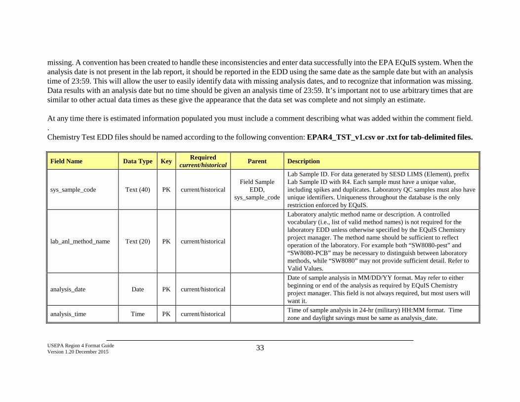
USEPA Region 4 Format Guide Version 1.20 December 2015 33
missing. A convention has been created to handle these inconsistencies and enter data successfully into the EPA EQuIS system. When the analysis date is not present in the lab report, it should be reported in the EDD using the same date as the sample date but with an analysis time of 23:59. This will allow the user to easily identify data with missing analysis dates, and to recognize that information was missing. Data results with an analysis date but no time should be given an analysis time of 23:59. It’s important not to use arbitrary times that are similar to other actual data times as these give the appearance that the data set was complete and not simply an estimate. At any time there is estimated information populated you must include a comment describing what was added within the comment field. . Chemistry Test EDD files should be named according to the following convention: EPAR4_TST_v1.csv or .txt for tab-delimited files.
Field Name Data Type Key Required current/historical Parent Description
sys_sample_code Text (40) PK current/historical Field Sample
EDD, sys_sample_code
Lab Sample ID. For data generated by SESD LIMS (Element), prefix Lab Sample ID with R4. Each sample must have a unique value, including spikes and duplicates. Laboratory QC samples must also have unique identifiers. Uniqueness throughout the database is the only restriction enforced by EQuIS.
lab_anl_method_name Text (20) PK current/historical
Laboratory analytic method name or description. A controlled vocabulary (i.e., list of valid method names) is not required for the laboratory EDD unless otherwise specified by the EQuIS Chemistry project manager. The method name should be sufficient to reflect operation of the laboratory. For example both “SW8080-pest” and “SW8080-PCB” may be necessary to distinguish between laboratory methods, while “SW8080” may not provide sufficient detail. Refer to Valid Values.
analysis_date Date PK current/historical
Date of sample analysis in MM/DD/YY format. May refer to either beginning or end of the analysis as required by EQuIS Chemistry project manager. This field is not always required, but most users will want it.
analysis_time Time PK current/historical Time of sample analysis in 24-hr (military) HH:MM format. Time zone and daylight savings must be same as analysis_date.
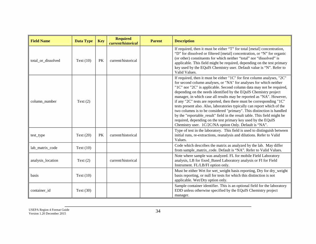
USEPA Region 4 Format Guide Version 1.20 December 2015 34
Field Name Data Type Key Required current/historical Parent Description
total_or_dissolved Text (10) PK current/historical
If required, then it must be either “T” for total [metal] concentration, “D” for dissolved or filtered [metal] concentration, or “N” for organic (or other) constituents for which neither “total” nor “dissolved” is applicable. This field might be required, depending on the test primary key used by the EQuIS Chemistry user. Default value is “N”. Refer to Valid Values.
column_number Text (2)
If required, then it must be either "1C" for first column analyses, "2C" for second column analyses, or "NA" for analyses for which neither "1C" nor "2C" is applicable. Second column data may not be required, depending on the needs identified by the EQuIS Chemistry project manager, in which case all results may be reported as "NA". However, if any "2C" tests are reported, then there must be corresponding "1C" tests present also. Also, laboratories typically can report which of the two columns is to be considered "primary". This distinction is handled by the "reportable_result" field in the result table. This field might be required, depending on the test primary key used by the EQuIS Chemistry user. 1C/2C/NA option Only. Default is “NA”.
test_type Text (20) PK current/historical Type of test in the laboratory. This field is used to distinguish between initial runs, re-extractions, reanalysis and dilutions. Refer to Valid Values.
lab_matrix_code Text (10) Code which describes the matrix as analyzed by the lab. May differ from sample_matrix_code. Default is “NA”. Refer to Valid Values.
analysis_location Text (2) current/historical Note where sample was analyzed. FL for mobile Field Laboratory analysis, LB for fixed_Based Laboratory analysis or FI for Field Instrument. FL/LB/FI option only.
basis Text (10) Must be either Wet for wet_weight basis reporting, Dry for dry_weight basis reporting, or null for tests for which this distinction is not applicable. Wet/Dry option only.
container_id Text (30) Sample container identifier. This is an optional field for the laboratory EDD unless otherwise specified by the EQuIS Chemistry project manager.
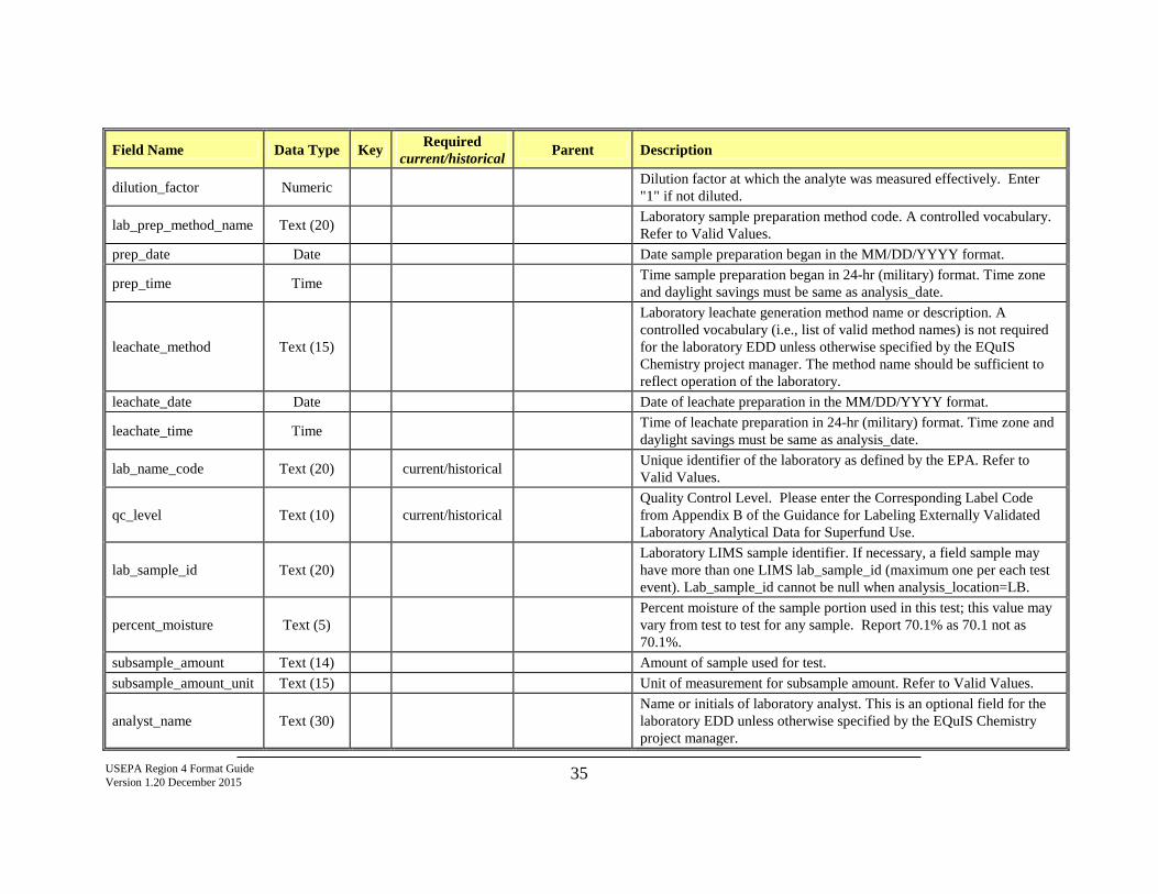
USEPA Region 4 Format Guide Version 1.20 December 2015 35
Field Name Data Type Key Required current/historical Parent Description
dilution_factor Numeric Dilution factor at which the analyte was measured effectively. Enter "1" if not diluted.
lab_prep_method_name Text (20) Laboratory sample preparation method code. A controlled vocabulary. Refer to Valid Values.
prep_date Date Date sample preparation began in the MM/DD/YYYY format.
prep_time Time Time sample preparation began in 24-hr (military) format. Time zone and daylight savings must be same as analysis_date.
leachate_method Text (15)
Laboratory leachate generation method name or description. A controlled vocabulary (i.e., list of valid method names) is not required for the laboratory EDD unless otherwise specified by the EQuIS Chemistry project manager. The method name should be sufficient to reflect operation of the laboratory.
leachate_date Date Date of leachate preparation in the MM/DD/YYYY format.
leachate_time Time Time of leachate preparation in 24-hr (military) format. Time zone and daylight savings must be same as analysis_date.
lab_name_code Text (20) current/historical Unique identifier of the laboratory as defined by the EPA. Refer to Valid Values.
qc_level Text (10) current/historical Quality Control Level. Please enter the Corresponding Label Code from Appendix B of the Guidance for Labeling Externally Validated Laboratory Analytical Data for Superfund Use.
lab_sample_id Text (20) Laboratory LIMS sample identifier. If necessary, a field sample may have more than one LIMS lab_sample_id (maximum one per each test event). Lab_sample_id cannot be null when analysis_location=LB.
percent_moisture Text (5) Percent moisture of the sample portion used in this test; this value may vary from test to test for any sample. Report 70.1% as 70.1 not as 70.1%.
subsample_amount Text (14) Amount of sample used for test. subsample_amount_unit Text (15) Unit of measurement for subsample amount. Refer to Valid Values.
analyst_name Text (30) Name or initials of laboratory analyst. This is an optional field for the laboratory EDD unless otherwise specified by the EQuIS Chemistry project manager.
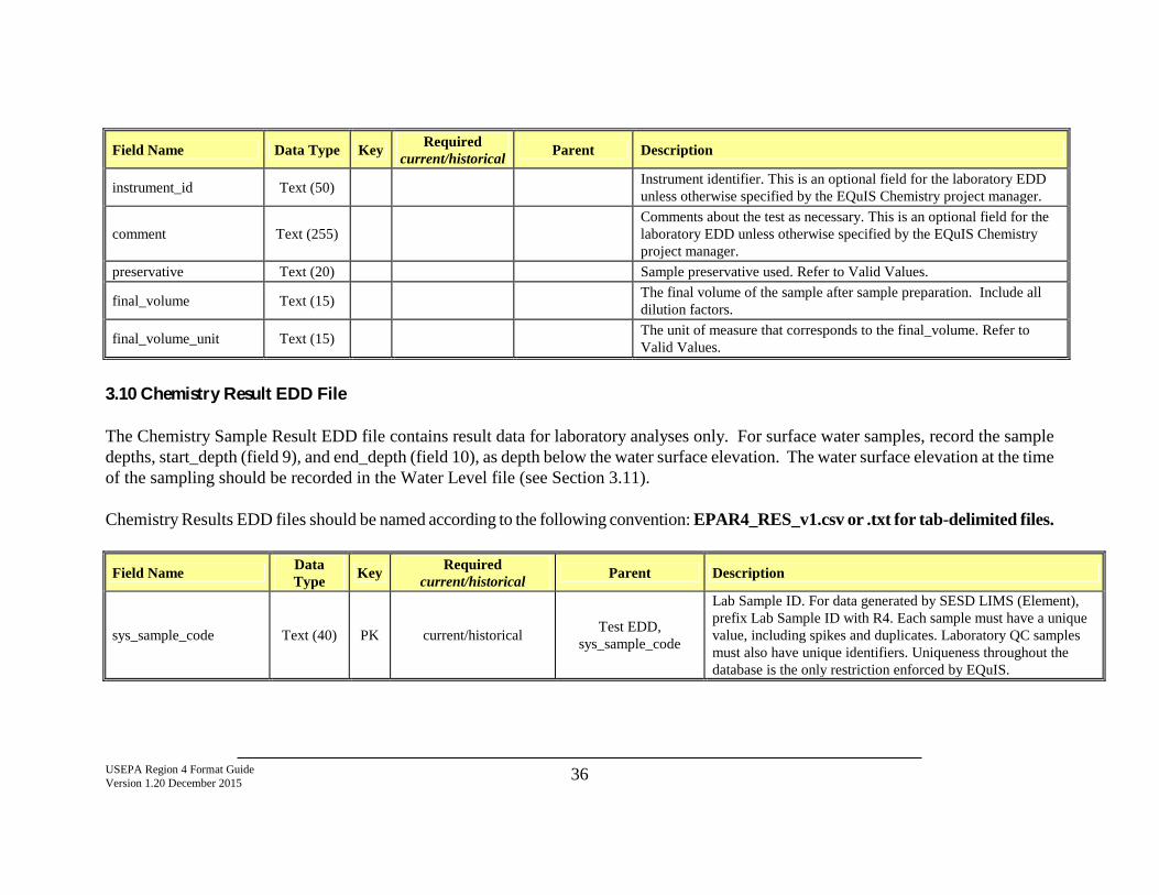
USEPA Region 4 Format Guide Version 1.20 December 2015 36
Field Name Data Type Key Required current/historical Parent Description
instrument_id Text (50) Instrument identifier. This is an optional field for the laboratory EDD unless otherwise specified by the EQuIS Chemistry project manager.
comment Text (255) Comments about the test as necessary. This is an optional field for the laboratory EDD unless otherwise specified by the EQuIS Chemistry project manager.
preservative Text (20) Sample preservative used. Refer to Valid Values.
final_volume Text (15) The final volume of the sample after sample preparation. Include all dilution factors.
final_volume_unit Text (15) The unit of measure that corresponds to the final_volume. Refer to Valid Values.
3.10 Chemistry Result EDD File The Chemistry Sample Result EDD file contains result data for laboratory analyses only. For surface water samples, record the sample depths, start_depth (field 9), and end_depth (field 10), as depth below the water surface elevation. The water surface elevation at the time of the sampling should be recorded in the Water Level file (see Section 3.11). Chemistry Results EDD files should be named according to the following convention: EPAR4_RES_v1.csv or .txt for tab-delimited files.
Field Name Data Type Key Required
current/historical Parent Description
sys_sample_code Text (40) PK current/historical Test EDD, sys_sample_code
Lab Sample ID. For data generated by SESD LIMS (Element), prefix Lab Sample ID with R4. Each sample must have a unique value, including spikes and duplicates. Laboratory QC samples must also have unique identifiers. Uniqueness throughout the database is the only restriction enforced by EQuIS.
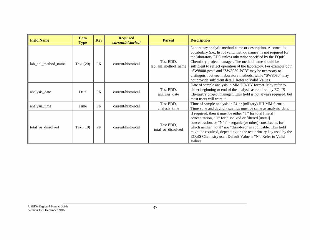
USEPA Region 4 Format Guide Version 1.20 December 2015 37
Field Name Data Type Key Required
current/historical Parent Description
lab_anl_method_name Text (20) PK current/historical Test EDD, lab_anl_method_name
Laboratory analytic method name or description. A controlled vocabulary (i.e., list of valid method names) is not required for the laboratory EDD unless otherwise specified by the EQuIS Chemistry project manager. The method name should be sufficient to reflect operation of the laboratory. For example both “SW8080-pest” and “SW8080-PCB” may be necessary to distinguish between laboratory methods, while “SW8080” may not provide sufficient detail. Refer to Valid Values.
analysis_date Date PK current/historical Test EDD, analysis_date
Date of sample analysis in MM/DD/YY format. May refer to either beginning or end of the analysis as required by EQuIS Chemistry project manager. This field is not always required, but most users will want it.
analysis_time Time PK current/historical Test EDD, analysis_time
Time of sample analysis in 24-hr (military) HH:MM format. Time zone and daylight savings must be same as analysis_date.
total_or_dissolved Text (10) PK current/historical Test EDD, total_or_dissolved
If required, then it must be either “T” for total [metal] concentration, “D” for dissolved or filtered [metal] concentration, or “N” for organic (or other) constituents for which neither "total" nor "dissolved" is applicable. This field might be required, depending on the test primary key used by the EQuIS Chemistry user. Default Value is “N”. Refer to Valid Values.
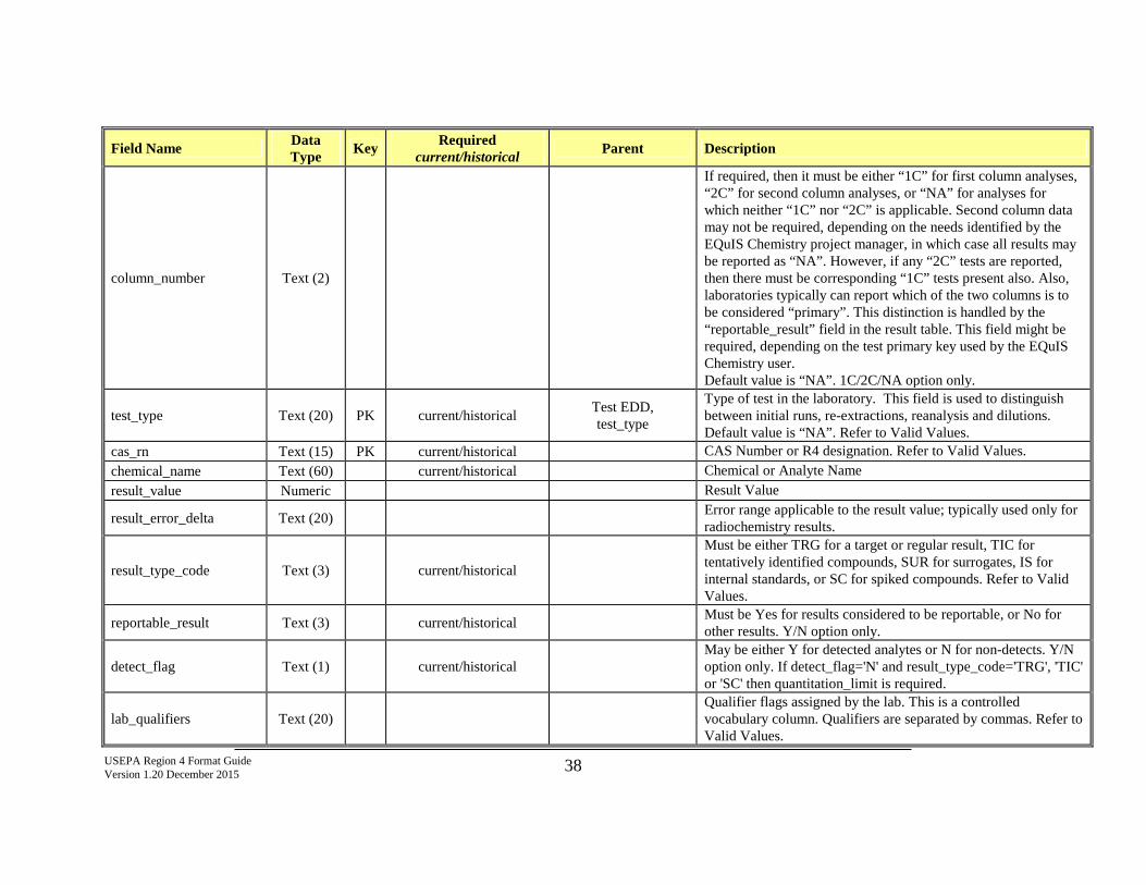
USEPA Region 4 Format Guide Version 1.20 December 2015 38
Field Name Data Type Key Required
current/historical Parent Description
column_number Text (2)
If required, then it must be either “1C” for first column analyses, “2C” for second column analyses, or “NA” for analyses for which neither “1C” nor “2C” is applicable. Second column data may not be required, depending on the needs identified by the EQuIS Chemistry project manager, in which case all results may be reported as “NA”. However, if any “2C” tests are reported, then there must be corresponding “1C” tests present also. Also, laboratories typically can report which of the two columns is to be considered “primary”. This distinction is handled by the “reportable_result” field in the result table. This field might be required, depending on the test primary key used by the EQuIS Chemistry user. Default value is “NA”. 1C/2C/NA option only.
test_type Text (20) PK current/historical Test EDD, test_type
Type of test in the laboratory. This field is used to distinguish between initial runs, re-extractions, reanalysis and dilutions. Default value is “NA”. Refer to Valid Values.
cas_rn Text (15) PK current/historical CAS Number or R4 designation. Refer to Valid Values. chemical_name Text (60) current/historical Chemical or Analyte Name result_value Numeric Result Value
result_error_delta Text (20) Error range applicable to the result value; typically used only for radiochemistry results.
result_type_code Text (3) current/historical
Must be either TRG for a target or regular result, TIC for tentatively identified compounds, SUR for surrogates, IS for internal standards, or SC for spiked compounds. Refer to Valid Values.
reportable_result Text (3) current/historical Must be Yes for results considered to be reportable, or No for other results. Y/N option only.
detect_flag Text (1) current/historical May be either Y for detected analytes or N for non-detects. Y/N option only. If detect_flag='N' and result_type_code='TRG', 'TIC' or 'SC' then quantitation_limit is required.
lab_qualifiers Text (20) Qualifier flags assigned by the lab. This is a controlled vocabulary column. Qualifiers are separated by commas. Refer to Valid Values.
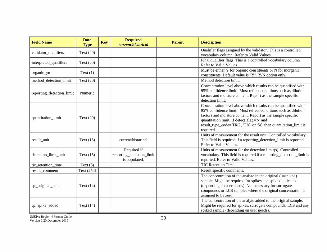
USEPA Region 4 Format Guide Version 1.20 December 2015 39
Field Name Data Type Key Required
current/historical Parent Description
validator_qualifiers Text (40) Qualifier flags assigned by the validator. This is a controlled vocabulary column. Refer to Valid Values.
interpreted_qualifiers Text (20) Final qualifier flags. This is a controlled vocabulary column. Refer to Valid Values.
organic_yn Text (1) Must be either Y for organic constituents or N for inorganic constituents. Default value is “Y”. Y/N option only.
method_detection_limit Text (20) Method detection limit.
reporting_detection_limit Numeric
Concentration level above which results can be quantified with 95% confidence limit. Must reflect conditions such as dilution factors and moisture content. Report as the sample specific detection limit.
quantitation_limit Text (20)
Concentration level above which results can be quantified with 95% confidence limit. Must reflect conditions such as dilution factors and moisture content. Report as the sample specific quantitation limit. If detect_flag='N' and result_type_code='TRG', 'TIC' or 'SC' then quantitation_limit is required.
result_unit Text (15) current/historical Units of measurement for the result unit. Controlled vocabulary. This field is required if a reporting_detection_limit is reported. Refer to Valid Values.
detection_limit_unit Text (15) Required if
reporting_detection_limit is populated,
Units of measurement for the detection limit(s). Controlled vocabulary. This field is required if a reporting_detection_limit is reported. Refer to Valid Values.
tic_retention_time Text (8) TIC Retention Time. result_comment Text (254) Result specific comments.
qc_original_conc Text (14)
The concentration of the analyte in the original (unspiked) sample. Might be required for spikes and spike duplicates (depending on user needs). Not necessary for surrogate compounds or LCS samples where the original concentration is assumed to be zero.
qc_spike_added Text (14) The concentration of the analyte added to the original sample. Might be required for spikes, surrogate compounds, LCS and any spiked sample (depending on user needs).
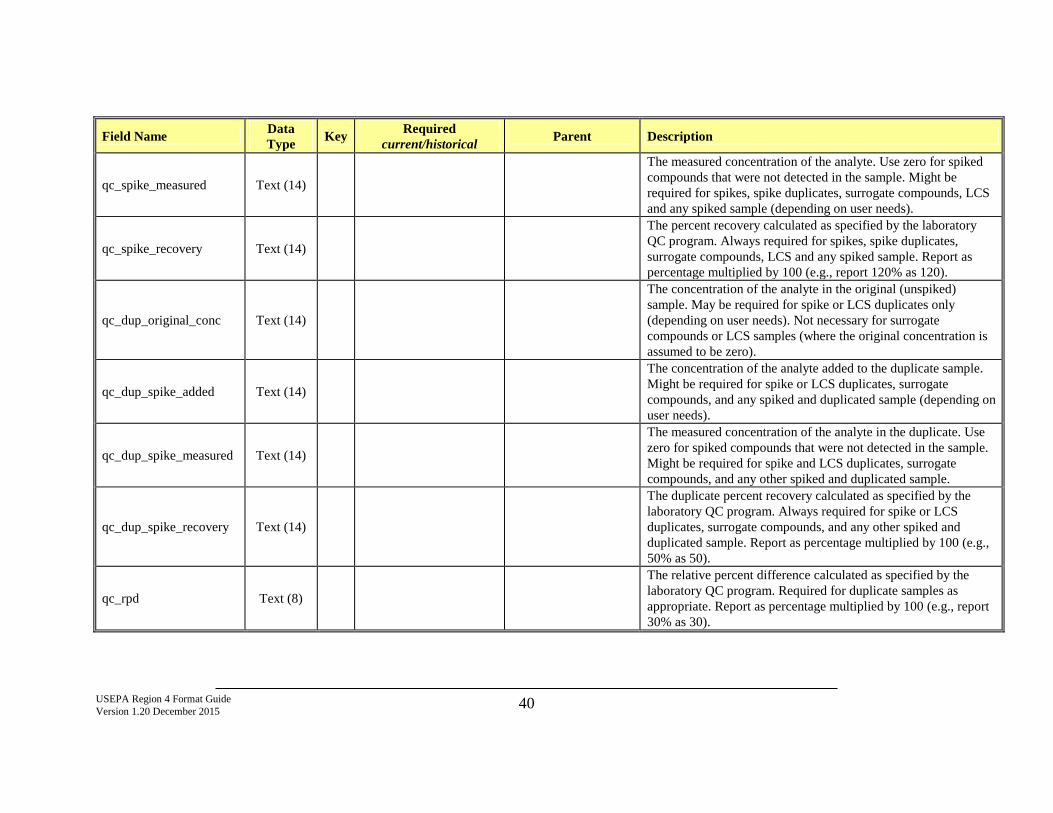
USEPA Region 4 Format Guide Version 1.20 December 2015 40
Field Name Data Type Key Required
current/historical Parent Description
qc_spike_measured Text (14)
The measured concentration of the analyte. Use zero for spiked compounds that were not detected in the sample. Might be required for spikes, spike duplicates, surrogate compounds, LCS and any spiked sample (depending on user needs).
qc_spike_recovery Text (14)
The percent recovery calculated as specified by the laboratory QC program. Always required for spikes, spike duplicates, surrogate compounds, LCS and any spiked sample. Report as percentage multiplied by 100 (e.g., report 120% as 120).
qc_dup_original_conc Text (14)
The concentration of the analyte in the original (unspiked) sample. May be required for spike or LCS duplicates only (depending on user needs). Not necessary for surrogate compounds or LCS samples (where the original concentration is assumed to be zero).
qc_dup_spike_added Text (14)
The concentration of the analyte added to the duplicate sample. Might be required for spike or LCS duplicates, surrogate compounds, and any spiked and duplicated sample (depending on user needs).
qc_dup_spike_measured Text (14)
The measured concentration of the analyte in the duplicate. Use zero for spiked compounds that were not detected in the sample. Might be required for spike and LCS duplicates, surrogate compounds, and any other spiked and duplicated sample.
qc_dup_spike_recovery Text (14)
The duplicate percent recovery calculated as specified by the laboratory QC program. Always required for spike or LCS duplicates, surrogate compounds, and any other spiked and duplicated sample. Report as percentage multiplied by 100 (e.g., 50% as 50).
qc_rpd Text (8)
The relative percent difference calculated as specified by the laboratory QC program. Required for duplicate samples as appropriate. Report as percentage multiplied by 100 (e.g., report 30% as 30).
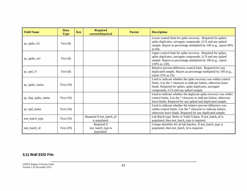
USEPA Region 4 Format Guide Version 1.20 December 2015 41
Field Name Data Type Key Required
current/historical Parent Description
qc_spike_lcl Text (8)
Lower control limit for spike recovery. Required for spikes, spike duplicates, surrogate compounds, LCS and any spiked sample. Report as percentage multiplied by 100 (e.g., report 60% as 60).
qc_spike_ucl Text (8)
Upper control limit for spike recovery. Required for spikes, spike duplicates, surrogate compounds, LCS and any spiked sample. Report as percentage multiplied by 100 (e.g., report 120% as 120).
qc_rpd_cl Text (8) Relative percent difference control limit. Required for any duplicated sample. Report as percentage multiplied by 100 (e.g., report 25% as 25).
qc_spike_status Text (10)
Used to indicate whether the spike recovery was within control limits. Use the * character to indicate failure, otherwise leave blank. Required for spikes, spike duplicates, surrogate compounds, LCS and any spiked sample.
qc_dup_spike_status Text (10) Used to indicate whether the duplicate spike recovery was within control limits. Use the * character to indicate failure, otherwise leave blank. Required for any spiked and duplicated sample.
qc_rpd_status Text (10) Used to indicate whether the relative percent difference was within control limits. Use the * character to indicate failure, otherwise leave blank. Required for any duplicated sample.
test_batch_type Text (10) Required if test_batch_id is populated. Lab Batch type. Refer to Valid Values. If test_batch_id is
populated, then test_batch_type is required.
test_batch_id Text (20) Required if
test_batch_type is populated.
Unique identifier for all lab batches. If test_batch_type is populated, then test_batch_id is required.
3.11 Well EDD File
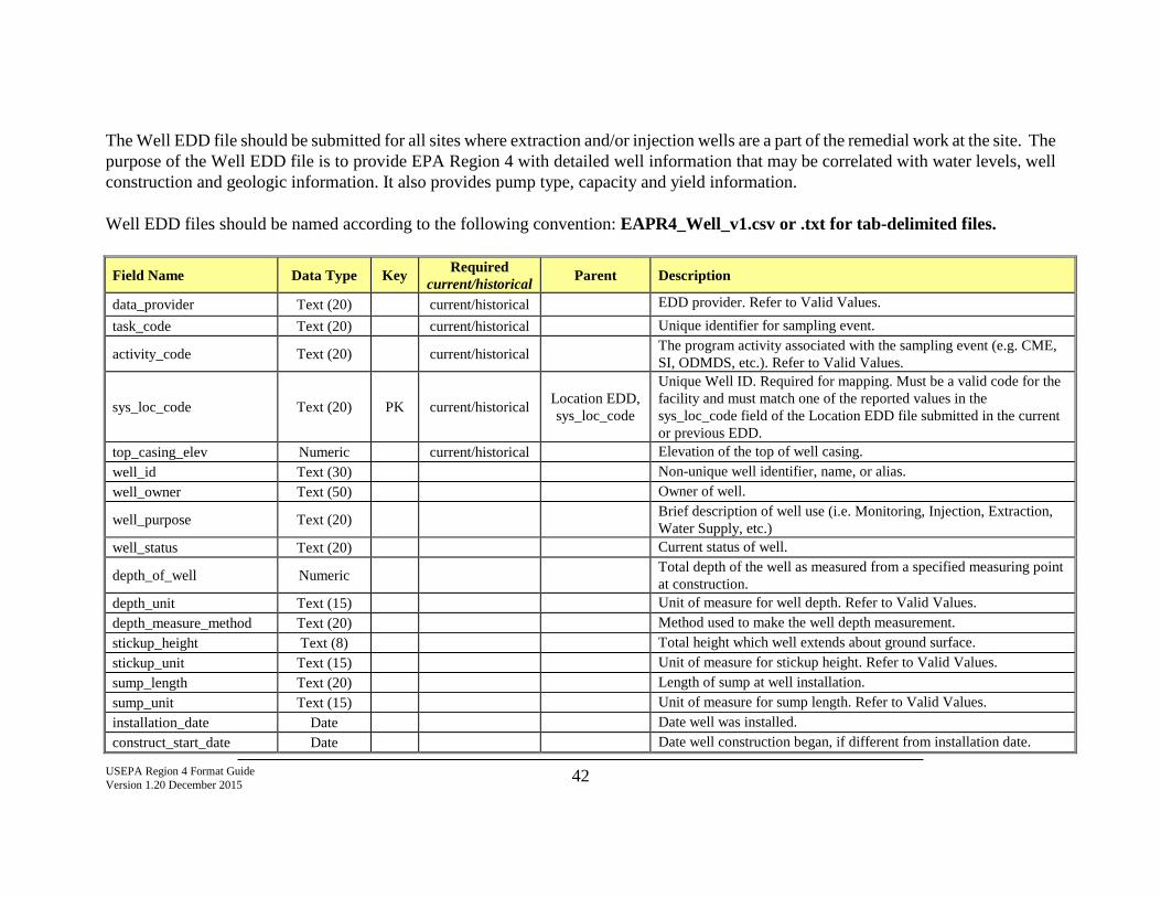
USEPA Region 4 Format Guide Version 1.20 December 2015 42
The Well EDD file should be submitted for all sites where extraction and/or injection wells are a part of the remedial work at the site. The purpose of the Well EDD file is to provide EPA Region 4 with detailed well information that may be correlated with water levels, well construction and geologic information. It also provides pump type, capacity and yield information. Well EDD files should be named according to the following convention: EAPR4_Well_v1.csv or .txt for tab-delimited files.
Field Name Data Type Key Required current/historical Parent Description
data_provider Text (20) current/historical EDD provider. Refer to Valid Values. task_code Text (20) current/historical Unique identifier for sampling event.
activity_code Text (20) current/historical The program activity associated with the sampling event (e.g. CME, SI, ODMDS, etc.). Refer to Valid Values.
sys_loc_code Text (20) PK current/historical Location EDD, sys_loc_code
Unique Well ID. Required for mapping. Must be a valid code for the facility and must match one of the reported values in the sys_loc_code field of the Location EDD file submitted in the current or previous EDD.
top_casing_elev Numeric current/historical Elevation of the top of well casing. well_id Text (30) Non-unique well identifier, name, or alias. well_owner Text (50) Owner of well.
well_purpose Text (20) Brief description of well use (i.e. Monitoring, Injection, Extraction, Water Supply, etc.)
well_status Text (20) Current status of well.
depth_of_well Numeric Total depth of the well as measured from a specified measuring point at construction.
depth_unit Text (15) Unit of measure for well depth. Refer to Valid Values. depth_measure_method Text (20) Method used to make the well depth measurement. stickup_height Text (8) Total height which well extends about ground surface. stickup_unit Text (15) Unit of measure for stickup height. Refer to Valid Values. sump_length Text (20) Length of sump at well installation. sump_unit Text (15) Unit of measure for sump length. Refer to Valid Values. installation_date Date Date well was installed. construct_start_date Date Date well construction began, if different from installation date.
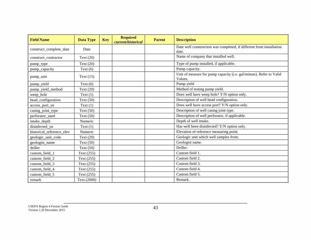
USEPA Region 4 Format Guide Version 1.20 December 2015 43
Field Name Data Type Key Required current/historical Parent Description
construct_complete_date Date Date well construction was completed, if different from installation date.
construct_contractor Text (20) Name of company that installed well.
pump_type Text (20) Type of pump installed, if applicable. pump_capacity Text (6) Pump capacity.
pump_unit Text (15) Unit of measure for pump capacity (i.e. gal/minute). Refer to Valid Values.
pump_yield Text (6) Pump yield pump_yield_method Text (20) Method of testing pump yield. weep_hole Text (1) Does well have weep hole? Y/N option only. head_configuration Text (50) Description of well head configuration. access_port_yn Text (1) Does well have access port? Y/N option only. casing_joint_type Text (50) Description of well casing joint type. perforator_used Text (50) Description of well perforator, if applicable. intake_depth Numeric Depth of well intake. disinfected_yn Text (1) Has well been disinfected? Y/N option only. historical_reference_elev Numeric Elevation of reference measuring point. geologic_unit_code Text (20) Geologic unit which well samples from. geologist_name Text (50) Geologist name. driller Text (50) Driller. custom_field_1 Text (255) Custom field 1. custom_field_2 Text (255) Custom field 2. custom_field_3 Text (255) Custom field 3. custom_field_4 Text (255) Custom field 4. custom_field_5 Text (255) Custom field 5. remark Text (2000) Remark.
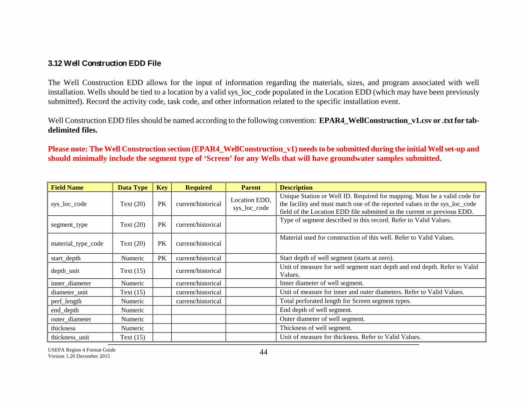
USEPA Region 4 Format Guide Version 1.20 December 2015 44
3.12 Well Construction EDD File The Well Construction EDD allows for the input of information regarding the materials, sizes, and program associated with well installation. Wells should be tied to a location by a valid sys_loc_code populated in the Location EDD (which may have been previously submitted). Record the activity code, task code, and other information related to the specific installation event. Well Construction EDD files should be named according to the following convention: EPAR4_WellConstruction_v1.csv or .txt for tab-delimited files. Please note: The Well Construction section (EPAR4_WellConstruction_v1) needs to be submitted during the initial Well set-up and should minimally include the segment type of ‘Screen’ for any Wells that will have groundwater samples submitted. Field Name Data Type Key Required Parent Description
sys_loc_code Text (20) PK current/historical Location EDD, sys_loc_code
Unique Station or Well ID. Required for mapping. Must be a valid code for the facility and must match one of the reported values in the sys_loc_code field of the Location EDD file submitted in the current or previous EDD.
segment_type Text (20) PK current/historical Type of segment described in this record. Refer to Valid Values.
material_type_code Text (20) PK current/historical Material used for construction of this well. Refer to Valid Values.
start_depth Numeric PK current/historical Start depth of well segment (starts at zero).
depth_unit Text (15) current/historical Unit of measure for well segment start depth and end depth. Refer to Valid Values.
inner_diameter Numeric current/historical Inner diameter of well segment. diameter_unit Text (15) current/historical Unit of measure for inner and outer diameters. Refer to Valid Values. perf_length Numeric current/historical Total perforated length for Screen segment types. end_depth Numeric End depth of well segment. outer_diameter Numeric Outer diameter of well segment. thickness Numeric Thickness of well segment. thickness_unit Text (15) Unit of measure for thickness. Refer to Valid Values.
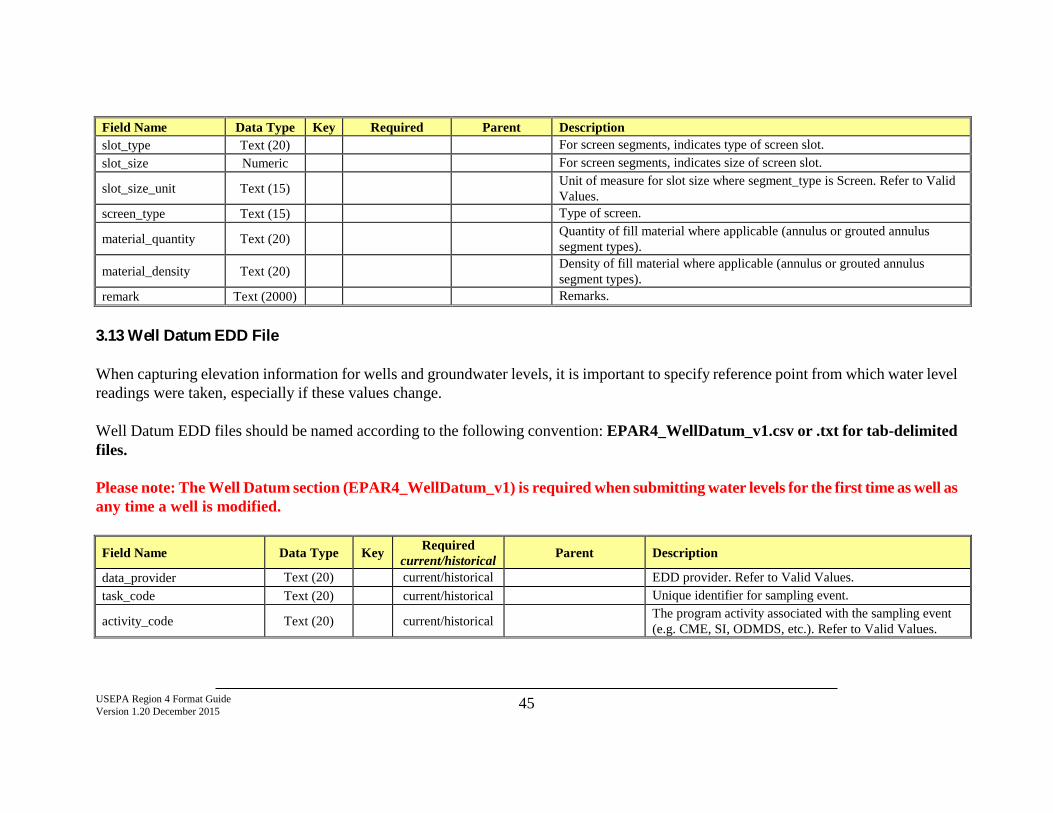
USEPA Region 4 Format Guide Version 1.20 December 2015 45
Field Name Data Type Key Required Parent Description slot_type Text (20) For screen segments, indicates type of screen slot. slot_size Numeric For screen segments, indicates size of screen slot.
slot_size_unit Text (15) Unit of measure for slot size where segment_type is Screen. Refer to Valid Values.
screen_type Text (15) Type of screen.
material_quantity Text (20) Quantity of fill material where applicable (annulus or grouted annulus segment types).
material_density Text (20) Density of fill material where applicable (annulus or grouted annulus segment types).
remark Text (2000) Remarks.
3.13 Well Datum EDD File When capturing elevation information for wells and groundwater levels, it is important to specify reference point from which water level readings were taken, especially if these values change. Well Datum EDD files should be named according to the following convention: EPAR4_WellDatum_v1.csv or .txt for tab-delimited files. Please note: The Well Datum section (EPAR4_WellDatum_v1) is required when submitting water levels for the first time as well as any time a well is modified.
Field Name Data Type Key Required current/historical Parent Description
data_provider Text (20) current/historical EDD provider. Refer to Valid Values. task_code Text (20) current/historical Unique identifier for sampling event.
activity_code Text (20) current/historical The program activity associated with the sampling event (e.g. CME, SI, ODMDS, etc.). Refer to Valid Values.
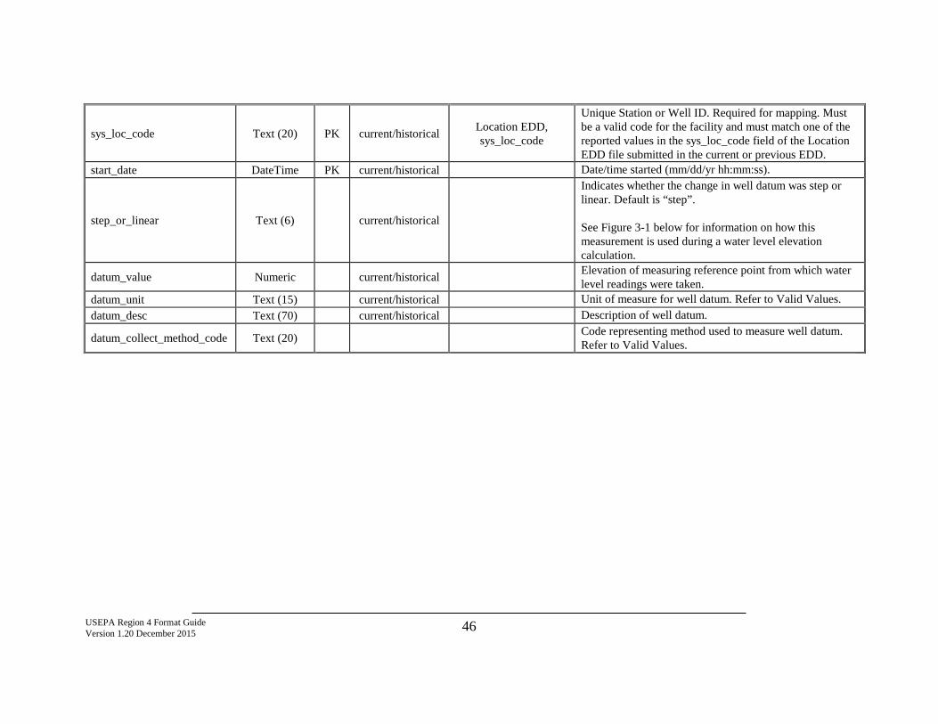
USEPA Region 4 Format Guide Version 1.20 December 2015 46
sys_loc_code Text (20) PK current/historical Location EDD, sys_loc_code
Unique Station or Well ID. Required for mapping. Must be a valid code for the facility and must match one of the reported values in the sys_loc_code field of the Location EDD file submitted in the current or previous EDD.
start_date DateTime PK current/historical Date/time started (mm/dd/yr hh:mm:ss).
step_or_linear Text (6) current/historical
Indicates whether the change in well datum was step or linear. Default is “step”. See Figure 3-1 below for information on how this measurement is used during a water level elevation calculation.
datum_value Numeric current/historical Elevation of measuring reference point from which water level readings were taken.
datum_unit Text (15) current/historical Unit of measure for well datum. Refer to Valid Values. datum_desc Text (70) current/historical Description of well datum.
datum_collect_method_code Text (20) Code representing method used to measure well datum. Refer to Valid Values.
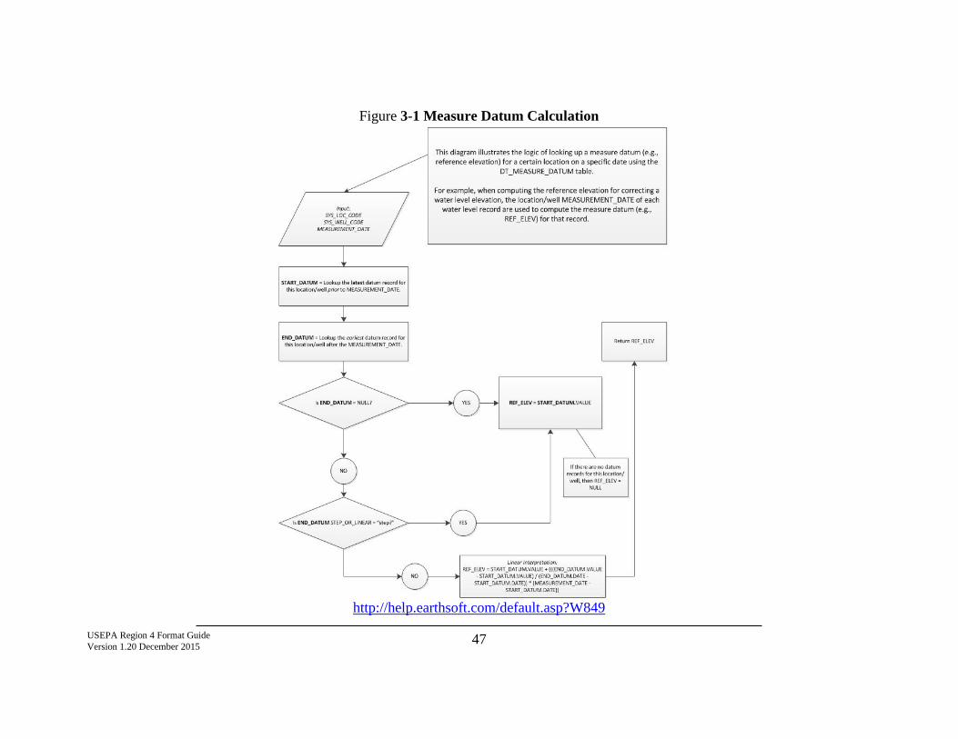
USEPA Region 4 Format Guide Version 1.20 December 2015 47
Figure 3-1 Measure Datum Calculation
http://help.earthsoft.com/default.asp?W849
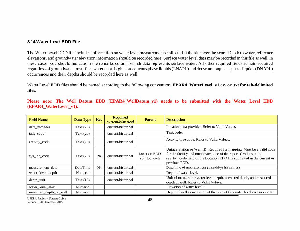
USEPA Region 4 Format Guide Version 1.20 December 2015 48
3.14 Water Level EDD File The Water Level EDD file includes information on water level measurements collected at the site over the years. Depth to water, reference elevations, and groundwater elevation information should be recorded here. Surface water level data may be recorded in this file as well. In these cases, you should indicate in the remarks column which data represents surface water. All other required fields remain required regardless of groundwater or surface water data. Light non-aqueous phase liquids (LNAPL) and dense non-aqueous phase liquids (DNAPL) occurrences and their depths should be recorded here as well. Water Level EDD files should be named according to the following convention: EPAR4_WaterLevel_v1.csv or .txt for tab-delimited files. Please note: The Well Datum EDD (EPAR4_WellDatum_v1) needs to be submitted with the Water Level EDD (EPAR4_WaterLevel_v1).
Field Name Data Type Key Required current/historical Parent Description
data_provider Text (20) current/historical Location data provider. Refer to Valid Values.
task_code Text (20) current/historical Task code.
activity_code Text (20) current/historical Activity type code. Refer to Valid Values.
sys_loc_code Text (20) PK current/historical Location EDD, sys_loc_code
Unique Station or Well ID. Required for mapping. Must be a valid code for the facility and must match one of the reported values in the sys_loc_code field of the Location EDD file submitted in the current or previous EDD.
measurement_date DateTime PK current/historical Date/time of measurement (mm/dd/yr hh:mm:ss). water_level_depth Numeric current/historical Depth of water level.
depth_unit Text (15) current/historical Unit of measure for water level depth, corrected depth, and measured depth of well. Refer to Valid Values.
water_level_elev Numeric Elevation of water level. measured_depth_of_well Numeric Depth of well as measured at the time of this water level measurement.
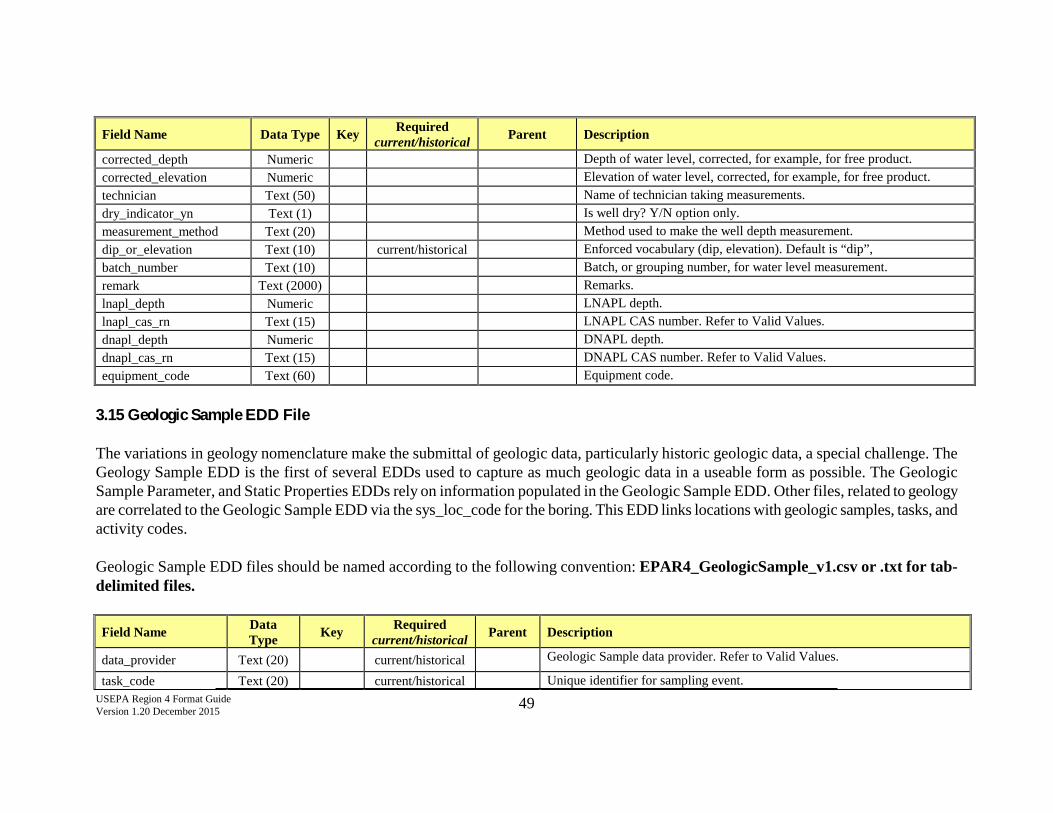
USEPA Region 4 Format Guide Version 1.20 December 2015 49
Field Name Data Type Key Required current/historical Parent Description
corrected_depth Numeric Depth of water level, corrected, for example, for free product. corrected_elevation Numeric Elevation of water level, corrected, for example, for free product. technician Text (50) Name of technician taking measurements. dry_indicator_yn Text (1) Is well dry? Y/N option only. measurement_method Text (20) Method used to make the well depth measurement. dip_or_elevation Text (10) current/historical Enforced vocabulary (dip, elevation). Default is “dip”, batch_number Text (10) Batch, or grouping number, for water level measurement. remark Text (2000) Remarks. lnapl_depth Numeric LNAPL depth. lnapl_cas_rn Text (15) LNAPL CAS number. Refer to Valid Values. dnapl_depth Numeric DNAPL depth. dnapl_cas_rn Text (15) DNAPL CAS number. Refer to Valid Values. equipment_code Text (60) Equipment code.
3.15 Geologic Sample EDD File The variations in geology nomenclature make the submittal of geologic data, particularly historic geologic data, a special challenge. The Geology Sample EDD is the first of several EDDs used to capture as much geologic data in a useable form as possible. The Geologic Sample Parameter, and Static Properties EDDs rely on information populated in the Geologic Sample EDD. Other files, related to geology are correlated to the Geologic Sample EDD via the sys_loc_code for the boring. This EDD links locations with geologic samples, tasks, and activity codes. Geologic Sample EDD files should be named according to the following convention: EPAR4_GeologicSample_v1.csv or .txt for tab-delimited files.
Field Name Data Type Key Required
current/historical Parent Description
data_provider Text (20) current/historical Geologic Sample data provider. Refer to Valid Values.
task_code Text (20) current/historical Unique identifier for sampling event.
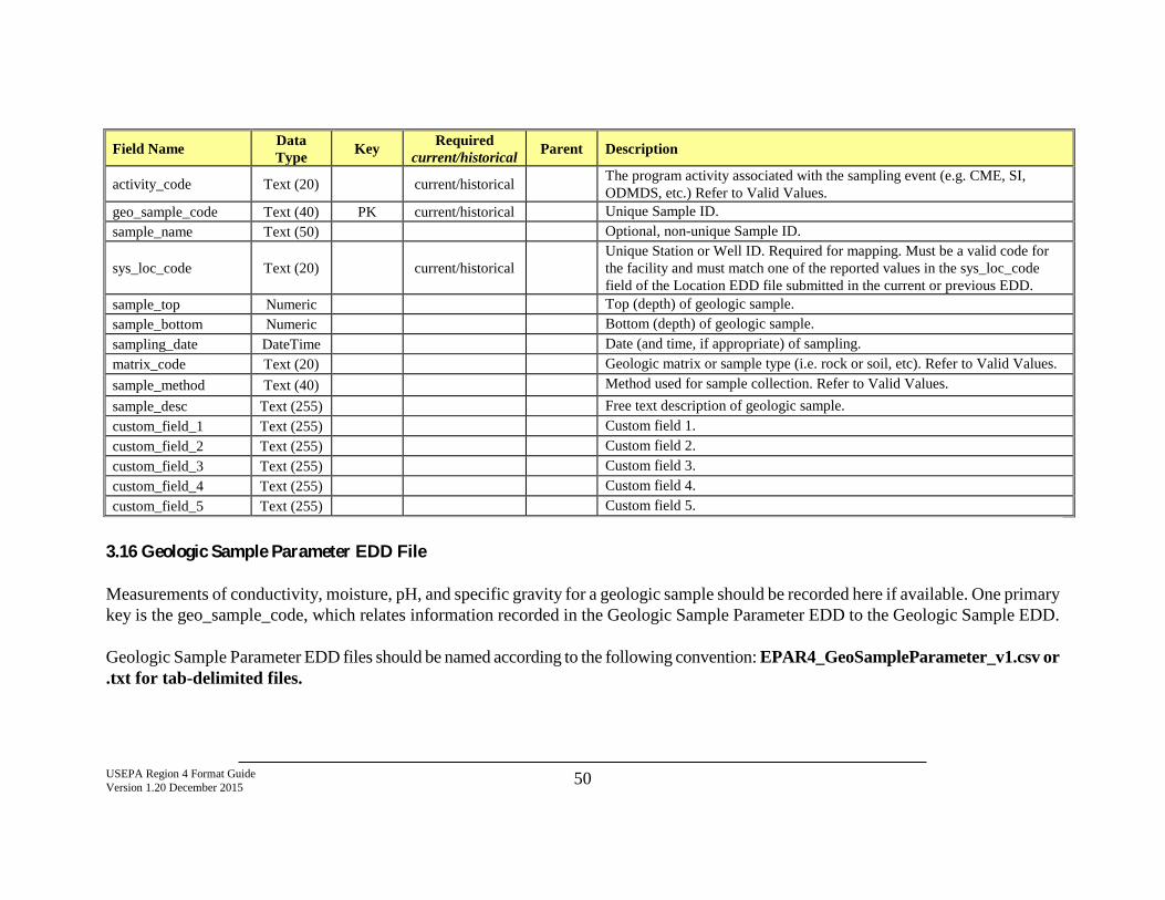
USEPA Region 4 Format Guide Version 1.20 December 2015 50
Field Name Data Type Key Required
current/historical Parent Description
activity_code Text (20) current/historical The program activity associated with the sampling event (e.g. CME, SI, ODMDS, etc.) Refer to Valid Values.
geo_sample_code Text (40) PK current/historical Unique Sample ID. sample_name Text (50) Optional, non-unique Sample ID.
sys_loc_code Text (20) current/historical Unique Station or Well ID. Required for mapping. Must be a valid code for the facility and must match one of the reported values in the sys_loc_code field of the Location EDD file submitted in the current or previous EDD.
sample_top Numeric Top (depth) of geologic sample. sample_bottom Numeric Bottom (depth) of geologic sample. sampling_date DateTime Date (and time, if appropriate) of sampling. matrix_code Text (20) Geologic matrix or sample type (i.e. rock or soil, etc). Refer to Valid Values. sample_method Text (40) Method used for sample collection. Refer to Valid Values. sample_desc Text (255) Free text description of geologic sample. custom_field_1 Text (255) Custom field 1. custom_field_2 Text (255) Custom field 2. custom_field_3 Text (255) Custom field 3. custom_field_4 Text (255) Custom field 4. custom_field_5 Text (255) Custom field 5.
3.16 Geologic Sample Parameter EDD File Measurements of conductivity, moisture, pH, and specific gravity for a geologic sample should be recorded here if available. One primary key is the geo_sample_code, which relates information recorded in the Geologic Sample Parameter EDD to the Geologic Sample EDD. Geologic Sample Parameter EDD files should be named according to the following convention: EPAR4_GeoSampleParameter_v1.csv or .txt for tab-delimited files.
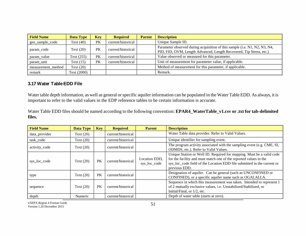
USEPA Region 4 Format Guide Version 1.20 December 2015 51
Field Name Data Type Key Required Parent Description geo_sample_code Text (40) PK current/historical Unique Sample ID.
param_code Text (20) PK current/historical Parameter observed during acquisition of this sample (i.e. N1, N2, N3, N4, PID, FID, OVM, Length Advanced, Length Recovered, Tip Stress, etc.)
param_value Text (255) PK current/historical Value observed or measured for this parameter. param_unit Text (15) PK current/historical Unit of measurement for parameter value, if applicable. measurement_method Text (20) Method of measurement for this parameter, if applicable. remark Text (2000) Remark.
3.17 Water Table EDD File Water table depth information, as well as general or specific aquifer information can be populated in the Water Table EDD. As always, it is important to refer to the valid values in the EDP reference tables to be certain information is accurate. Water Table EDD files should be named according to the following convention: EPAR4_WaterTable_v1.csv or .txt for tab-delimited files. Field Name Data Type Key Required Parent Description data_provider Text (20) current/historical Water Table data provider. Refer to Valid Values.
task_code Text (20) current/historical Unique identifier for sampling event.
activity_code Text (20) current/historical The program activity associated with the sampling event (e.g. CME, SI, ODMDS, etc.). Refer to Valid Values.
sys_loc_code Text (20) PK current/historical Location EDD, sys_loc_code
Unique Station or Well ID. Required for mapping. Must be a valid code for the facility and must match one of the reported values in the sys_loc_code field of the Location EDD file submitted in the current or previous EDD.
type Text (20) PK current/historical Designation of aquifer. Can be general (such as UNCONFINED or CONFINED), or a specific aquifer name such as OGALALLA.
sequence Text (20) PK current/historical Sequence in which this measurement was taken. Intended to represent 1 of 2 mutually exclusive values, i.e. Unstabilized/Stabilized, or Initial/Final, or 1/2, etc.
depth Numeric current/historical Depth of water table (starts at zero).
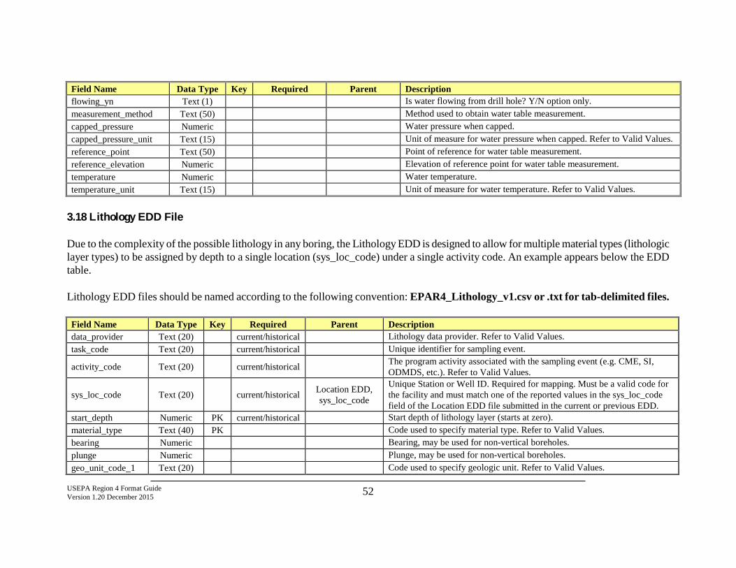
USEPA Region 4 Format Guide Version 1.20 December 2015 52
Field Name Data Type Key Required Parent Description flowing_yn Text (1) Is water flowing from drill hole? Y/N option only. measurement_method Text (50) Method used to obtain water table measurement. capped_pressure Numeric Water pressure when capped. capped_pressure_unit Text (15) Unit of measure for water pressure when capped. Refer to Valid Values. reference_point Text (50) Point of reference for water table measurement. reference_elevation Numeric Elevation of reference point for water table measurement. temperature Numeric Water temperature. temperature_unit Text (15) Unit of measure for water temperature. Refer to Valid Values.
3.18 Lithology EDD File Due to the complexity of the possible lithology in any boring, the Lithology EDD is designed to allow for multiple material types (lithologic layer types) to be assigned by depth to a single location (sys_loc_code) under a single activity code. An example appears below the EDD table. Lithology EDD files should be named according to the following convention: EPAR4_Lithology_v1.csv or .txt for tab-delimited files. Field Name Data Type Key Required Parent Description data_provider Text (20) current/historical Lithology data provider. Refer to Valid Values. task_code Text (20) current/historical Unique identifier for sampling event.
activity_code Text (20) current/historical The program activity associated with the sampling event (e.g. CME, SI, ODMDS, etc.). Refer to Valid Values.
sys_loc_code Text (20) current/historical Location EDD, sys_loc_code
Unique Station or Well ID. Required for mapping. Must be a valid code for the facility and must match one of the reported values in the sys_loc_code field of the Location EDD file submitted in the current or previous EDD.
start_depth Numeric PK current/historical Start depth of lithology layer (starts at zero). material_type Text (40) PK Code used to specify material type. Refer to Valid Values. bearing Numeric Bearing, may be used for non-vertical boreholes. plunge Numeric Plunge, may be used for non-vertical boreholes. geo_unit_code_1 Text (20) Code used to specify geologic unit. Refer to Valid Values.
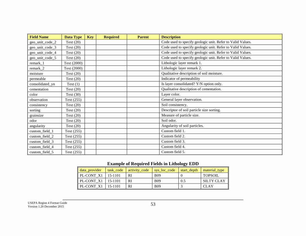
USEPA Region 4 Format Guide Version 1.20 December 2015 53
Field Name Data Type Key Required Parent Description geo_unit_code_2 Text (20) Code used to specify geologic unit. Refer to Valid Values. geo_unit_code_3 Text (20) Code used to specify geologic unit. Refer to Valid Values. geo_unit_code_4 Text (20) Code used to specify geologic unit. Refer to Valid Values. geo_unit_code_5 Text (20) Code used to specify geologic unit. Refer to Valid Values. remark_1 Text (2000) Lithologic layer remark 1. remark_2 Text (2000) Lithologic layer remark 2. moisture Text (20) Qualitative description of soil moisture. permeable Text (20) Indicator of permeability consolidated_yn Text (1) Is layer consolidated? Y/N option only. cementation Text (20) Qualitative description of cementation. color Text (30) Layer color. observation Text (255) General layer observation. consistency Text (20) Soil consistency. sorting Text (20) Descriptor of soil particle size sorting. grainsize Text (20) Measure of particle size. odor Text (20) Soil odor. angularity Text (20) Angularity of soil particles. custom_field_1 Text (255) Custom field 1. custom_field_2 Text (255) Custom field 2. custom_field_3 Text (255) Custom field 3. custom_field_4 Text (255) Custom field 4. custom_field_5 Text (255) Custom field 5.
Example of Required Fields in Lithology EDD
data_provider task_code activity_code sys_loc_code start_depth material_type PL-CONT_X1 15-1101 RI B09 0 TOPSOIL PL-CONT_X1 15-1101 RI B09 0.5 SILTY CLAY PL-CONT_X1 15-1101 RI B09 3 CLAY
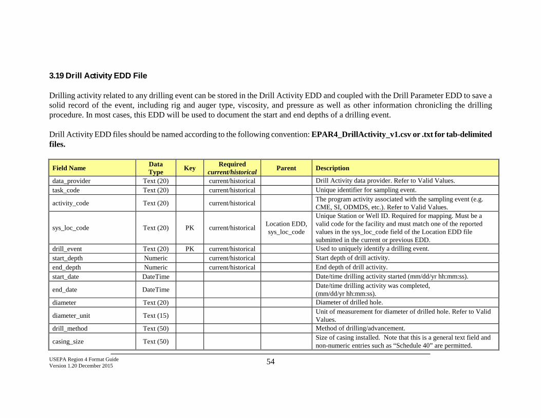
USEPA Region 4 Format Guide Version 1.20 December 2015 54
3.19 Drill Activity EDD File Drilling activity related to any drilling event can be stored in the Drill Activity EDD and coupled with the Drill Parameter EDD to save a solid record of the event, including rig and auger type, viscosity, and pressure as well as other information chronicling the drilling procedure. In most cases, this EDD will be used to document the start and end depths of a drilling event. Drill Activity EDD files should be named according to the following convention: EPAR4_DrillActivity_v1.csv or .txt for tab-delimited files.
Field Name Data Type Key Required
current/historical Parent Description
data_provider Text (20) current/historical Drill Activity data provider. Refer to Valid Values. task_code Text (20) current/historical Unique identifier for sampling event.
activity_code Text (20) current/historical The program activity associated with the sampling event (e.g. CME, SI, ODMDS, etc.). Refer to Valid Values.
sys_loc_code Text (20) PK current/historical Location EDD, sys_loc_code
Unique Station or Well ID. Required for mapping. Must be a valid code for the facility and must match one of the reported values in the sys_loc_code field of the Location EDD file submitted in the current or previous EDD.
drill_event Text (20) PK current/historical Used to uniquely identify a drilling event. start_depth Numeric current/historical Start depth of drill activity. end_depth Numeric current/historical End depth of drill activity. start_date DateTime Date/time drilling activity started (mm/dd/yr hh:mm:ss).
end_date DateTime Date/time drilling activity was completed, (mm/dd/yr hh:mm:ss).
diameter Text (20) Diameter of drilled hole.
diameter_unit Text (15) Unit of measurement for diameter of drilled hole. Refer to Valid Values.
drill_method Text (50) Method of drilling/advancement.
casing_size Text (50) Size of casing installed. Note that this is a general text field and non-numeric entries such as “Schedule 40” are permitted.
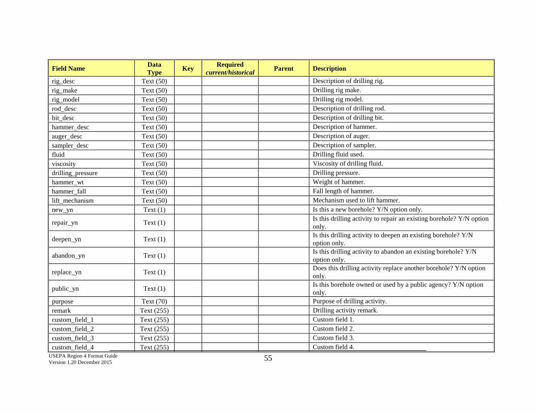
USEPA Region 4 Format Guide Version 1.20 December 2015 55
Field Name Data Type Key Required
current/historical Parent Description
rig_desc Text (50) Description of drilling rig. rig_make Text (50) Drilling rig make. rig_model Text (50) Drilling rig model. rod_desc Text (50) Description of drilling rod. bit_desc Text (50) Description of drilling bit. hammer_desc Text (50) Description of hammer. auger_desc Text (50) Description of auger. sampler_desc Text (50) Description of sampler. fluid Text (50) Drilling fluid used. viscosity Text (50) Viscosity of drilling fluid. drilling_pressure Text (50) Drilling pressure. hammer_wt Text (50) Weight of hammer. hammer_fall Text (50) Fall length of hammer. lift_mechanism Text (50) Mechanism used to lift hammer. new_yn Text (1) Is this a new borehole? Y/N option only.
repair_yn Text (1) Is this drilling activity to repair an existing borehole? Y/N option only.
deepen_yn Text (1) Is this drilling activity to deepen an existing borehole? Y/N option only.
abandon_yn Text (1) Is this drilling activity to abandon an existing borehole? Y/N option only.
replace_yn Text (1) Does this drilling activity replace another borehole? Y/N option only.
public_yn Text (1) Is this borehole owned or used by a public agency? Y/N option only.
purpose Text (70) Purpose of drilling activity. remark Text (255) Drilling activity remark. custom_field_1 Text (255) Custom field 1. custom_field_2 Text (255) Custom field 2. custom_field_3 Text (255) Custom field 3. custom_field_4 Text (255) Custom field 4.
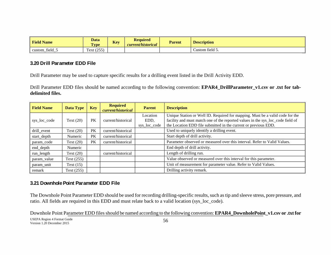
USEPA Region 4 Format Guide Version 1.20 December 2015 56
Field Name Data Type Key Required
current/historical Parent Description
custom_field_5 Text (255) Custom field 5.
3.20 Drill Parameter EDD File Drill Parameter may be used to capture specific results for a drilling event listed in the Drill Activity EDD. Drill Parameter EDD files should be named according to the following convention: EPAR4_DrillParameter_v1.csv or .txt for tab-delimited files.
Field Name Data Type Key Required current/historical Parent Description
sys_loc_code Text (20) PK current/historical Location
EDD, sys_loc_code
Unique Station or Well ID. Required for mapping. Must be a valid code for the facility and must match one of the reported values in the sys_loc_code field of the Location EDD file submitted in the current or previous EDD.
drill_event Text (20) PK current/historical Used to uniquely identify a drilling event. start_depth Numeric PK current/historical Start depth of drill activity. param_code Text (20) PK current/historical Parameter observed or measured over this interval. Refer to Valid Values. end_depth Numeric End depth of drill activity. run_length Text (20) current/historical Length of drilling run. param_value Text (255) Value observed or measured over this interval for this parameter. param_unit Text (15) Unit of measurement for parameter value. Refer to Valid Values. remark Text (255) Drilling activity remark.
3.21 Downhole Point Parameter EDD File The Downhole Point Parameter EDD should be used for recording drilling-specific results, such as tip and sleeve stress, pore pressure, and ratio. All fields are required in this EDD and must relate back to a valid location (sys_loc_code). Downhole Point Parameter EDD files should be named according to the following convention: EPAR4_DownholePoint_v1.csv or .txt for
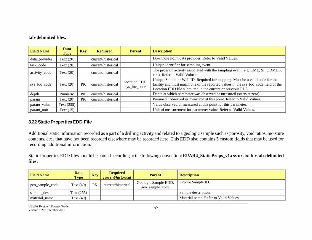
USEPA Region 4 Format Guide Version 1.20 December 2015 57
tab-delimited files.
Field Name Data Type Key Required Parent Description
data_provider Text (20) current/historical Downhole Point data provider. Refer to Valid Values.
task_code Text (20) current/historical Unique identifier for sampling event.
activity_code Text (20) current/historical The program activity associated with the sampling event (e.g. CME, SI, ODMDS, etc.). Refer to Valid Values.
sys_loc_code Text (20) PK current/historical Location EDD, sys_loc_code
Unique Station or Well ID. Required for mapping. Must be a valid code for the facility and must match one of the reported values in the sys_loc_code field of the Location EDD file submitted in the current or previous EDD.
depth Numeric PK current/historical Depth at which parameter was observed or measured (starts at zero). param Text (20) PK current/historical Parameter observed or measured at this point. Refer to Valid Values. param_value Text (255) Value observed or measured at this point for this parameter. param_unit Text (15) Unit of measurement for parameter value. Refer to Valid Values.
3.22 Static Properties EDD File Additional static information recorded as a part of a drilling activity and related to a geologic sample such as porosity, void ratios, moisture contents, etc., that have not been recorded elsewhere may be recorded here. This EDD also contains 5 custom fields that may be used for recording additional information. Static Properties EDD files should be named according to the following convention: EPAR4_StaticProps_v1.csv or .txt for tab-delimited files.
Field Name Data Type Key Required
current/historical Parent Description
geo_sample_code Text (40) PK current/historical Geologic Sample EDD, geo_sample_code
Unique Sample ID.
sample_desc Text (255) Sample description. material_name Text (40) Material name. Refer to Valid Values.
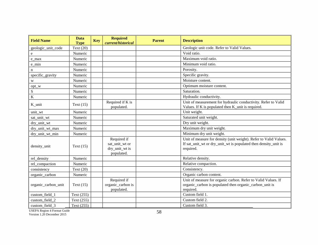
USEPA Region 4 Format Guide Version 1.20 December 2015 58
Field Name Data Type Key Required
current/historical Parent Description
geologic_unit_code Text (20) Geologic unit code. Refer to Valid Values. e Numeric Void ratio. e_max Numeric Maximum void ratio. e_min Numeric Minimum void ratio. n Numeric Porosity. specific_gravity Numeric Specific gravity. w Numeric Moisture content. opt_w Numeric Optimum moisture content. S Numeric Saturation. K Numeric Hydraulic conductivity.
K_unit Text (15) Required if K is populated. Unit of measurement for hydraulic conductivity. Refer to Valid
Values. If K is populated then K_unit is required. unit_wt Numeric Unit weight. sat_unit_wt Numeric Saturated unit weight. dry_unit_wt Numeric Dry unit weight. dry_unit_wt_max Numeric Maximum dry unit weight. dry_unit_wt_min Numeric Minimum dry unit weight.
density_unit Text (15)
Required if sat_unit_wt or dry_unit_wt is
populated.
Unit of measure for density (unit weight). Refer to Valid Values. If sat_unit_wt or dry_unit_wt is populated then density_unit is required.
rel_density Numeric Relative density. rel_compaction Numeric Relative compaction. consistency Text (20) Consistency. organic_carbon Numeric Organic carbon content.
organic_carbon_unit Text (15) Required if
organic_carbon is populated.
Unit of measure for organic carbon. Refer to Valid Values. If organic_carbon is populated then organic_carbon_unit is required.
custom_field_1 Text (255) Custom field 1. custom_field_2 Text (255) Custom field 2. custom_field_3 Text (255) Custom field 3.
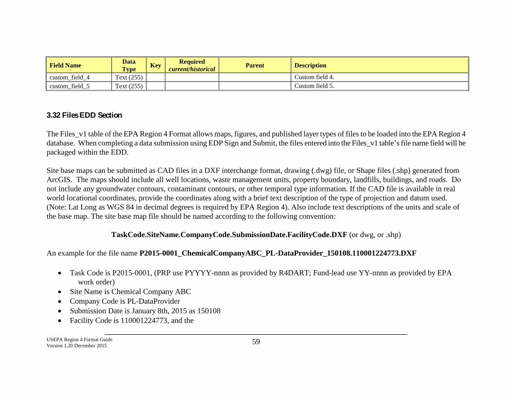
USEPA Region 4 Format Guide Version 1.20 December 2015 59
Field Name Data Type Key Required
current/historical Parent Description
custom_field_4 Text (255) Custom field 4. custom_field_5 Text (255) Custom field 5.
3.32 Files EDD Section The Files_v1 table of the EPA Region 4 Format allows maps, figures, and published layer types of files to be loaded into the EPA Region 4 database. When completing a data submission using EDP Sign and Submit, the files entered into the Files_v1 table’s file name field will be packaged within the EDD. Site base maps can be submitted as CAD files in a DXF interchange format, drawing (.dwg) file, or Shape files (.shp) generated from ArcGIS. The maps should include all well locations, waste management units, property boundary, landfills, buildings, and roads. Do not include any groundwater contours, contaminant contours, or other temporal type information. If the CAD file is available in real world locational coordinates, provide the coordinates along with a brief text description of the type of projection and datum used. (Note: Lat Long as WGS 84 in decimal degrees is required by EPA Region 4). Also include text descriptions of the units and scale of the base map. The site base map file should be named according to the following convention:
TaskCode.SiteName.CompanyCode.SubmissionDate.FacilityCode.DXF (or dwg, or .shp)
An example for the file name P2015-0001_ChemicalCompanyABC_PL-DataProvider_150108.110001224773.DXF
• Task Code is P2015-0001, (PRP use PYYYY-nnnn as provided by R4DART; Fund-lead use YY-nnnn as provided by EPA work order)
• Site Name is Chemical Company ABC • Company Code is PL-DataProvider • Submission Date is January 8th, 2015 as 150108 • Facility Code is 110001224773, and the
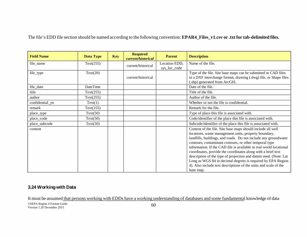
USEPA Region 4 Format Guide Version 1.20 December 2015 60
The file’s EDD file section should be named according to the following convention: EPAR4_Files_v1.csv or .txt for tab-delimited files.
Field Name Data Type Key Required current/historical Parent Description
file_name Text(255) current/historical Location EDD, sys_loc_code
Name of the file.
file_type Text(20) current/historical
Type of the file. Site base maps can be submitted in CAD files in a DXF interchange format, drawing (.dwg) file, or Shape files (.shp) generated from ArcGIS.
file_date DateTime Date of the file. title Text(255) Title of the file. author Text(255) Author of the file. confidential_yn Text(1) Whether or not the file is confidential. remark Text(255) Remark for the file. place_type Text(50) Type of place this file is associated with. place_code Text(50) Code/identifier of the place this file is associated with. place_subcode Text(50) Subcode/identifier of the place this file is associated with. content
Content of the file. Site base maps should include all well locations, waste management units, property boundary, landfills, buildings, and roads. Do not include any groundwater contours, contaminant contours, or other temporal type information. If the CAD file is available in real world locational coordinates, provide the coordinates along with a brief text description of the type of projection and datum used. (Note: Lat Long as WGS 84 in decimal degrees is required by EPA Region 4). Also include text descriptions of the units and scale of the base map.
3.24 Working with Data It must be assumed that persons working with EDDs have a working understanding of databases and some fundamental knowledge of data
USEPA Region 4 Format Guide Version 1.20 December 2015 61
base structure. Database managers will need to work in conjunction with environmental management in order to properly process and format this data. It is crucial to the EQuIS DART project that the data provided be of the highest standard and that every effort to properly format the data be made prior to submittal to EPA Region 4.

![ETSI GS NFV-SOL 004 V2.5 · TOSCA YAML CSAR file is an archive file using the ZIP file format whose structure complies with the TOSCA Simple Profile YAML v1.1 Specification [2]. The](https://img.pdfslide.us/doc/110x75/5e82fbc481444f068f4c052b/etsi-gs-nfv-sol-004-v25-tosca-yaml-csar-file-is-an-archive-file-using-the-zip-file.jpg)