Embed Size (px)
Citation preview

October 2006
NASA/TM–2006–214142
EOS Aqua AMSR-E Arctic Sea-Ice Validation Program:Arctic2006 Aircraft Campaign Flight Report
Donald J. Cavalieri and Thorsten Markus
https://ntrs.nasa.gov/search.jsp?R=20070008103 2018-09-06T15:57:08+00:00Z

The NASA STI Program Offi ce … in Profi le
Since its founding, NASA has been ded i cat ed to the ad vance ment of aeronautics and space science. The NASA Sci en tifi c and Technical Information (STI) Pro gram Offi ce plays a key part in helping NASA maintain this im por tant role.
The NASA STI Program Offi ce is operated by Langley Re search Center, the lead center for NASA̓ s scientifi c and technical in for ma tion. The NASA STI Program Offi ce pro vides ac cess to the NASA STI Database, the largest col lec tion of aero nau ti cal and space science STI in the world. The Pro gram Offi ce is also NASA̓ s in sti tu tion al mech a nism for dis sem i nat ing the results of its research and de vel op ment ac tiv i ties. These results are published by NASA in the NASA STI Report Series, which includes the following report types:
• TECHNICAL PUBLICATION. Reports of com plet ed research or a major signifi cant phase of research that present the results of NASA pro-grams and include ex ten sive data or the o ret i cal analysis. Includes com pi la tions of sig nifi cant scientifi c and technical data and in for ma tion deemed to be of con tinu ing ref er ence value. NASA̓ s counterpart of peer-re viewed formal pro fes sion al papers but has less stringent lim i ta -tions on manuscript length and ex tent of graphic pre sen ta tions.
• TECHNICAL MEMORANDUM. Scientifi c and tech ni cal fi ndings that are pre lim i nary or of spe cial ized interest, e.g., quick re lease reports, working papers, and bib li og ra phies that contain minimal annotation. Does not contain extensive analysis.
• CONTRACTOR REPORT. Scientifi c and techni-cal fi ndings by NASA-sponsored con trac tors and grantees.
• CONFERENCE PUBLICATION. Collected pa pers from scientifi c and technical conferences, symposia, sem i nars, or other meet ings spon sored or co spon sored by NASA.
• SPECIAL PUBLICATION. Scientifi c, tech ni cal, or historical information from NASA pro grams, projects, and mission, often con cerned with sub-jects having sub stan tial public interest.
• TECHNICAL TRANSLATION. En glish-language trans la tions of foreign sci en tifi c and tech ni cal ma-terial pertinent to NASA̓ s mis sion.
Specialized services that complement the STI Pro-gram Offi ceʼs diverse offerings include cre at ing custom the sau ri, building customized da ta bas es, organizing and pub lish ing research results . . . even pro vid ing videos.
For more information about the NASA STI Pro gram Offi ce, see the following:
• Access the NASA STI Program Home Page at http://www.sti.nasa.gov/STI-homepage.html
• E-mail your question via the Internet to [email protected]
• Fax your question to the NASA Access Help Desk at (301) 621-0134
• Telephone the NASA Access Help Desk at (301) 621-0390
• Write to: NASA Access Help Desk NASA Center for AeroSpace In for ma tion 7121 Standard Drive Hanover, MD 21076–1320

National Aeronautics and Space Administration
Goddard Space Flight CenterGreenbelt, Maryland 20771
October 2006
Donald J. Cavalieri and Thorsten MarkusNASA Goddard Space Flight Center, Greenbelt, Maryland
NASA/TM–2006–214142
EOS Aqua AMSR-E Arctic Sea-Ice Validation Program:Arctic2006 Aircraft Campaign Flight Report

Available from:
NASA Center for AeroSpace Information National Technical Information Service7121 Standard Drive 5285 Port Royal RoadHanover, MD 21076-1320 Springfield, VA 22161Price Code: A17 Price Code: A10

D.J. Cavalieri and T. Markus
iii
Abstract
In March 2006, a coordinated Arctic sea-ice validation field campaign using the NASA Wallops P-3B aircraft was successfully completed. This campaign was the second Alaskan Arctic field campaign for validating the Earth Observing System (EOS) Aqua Advanced Microwave Scanning Radiometer (AMSR-E) sea-ice products. The first campaign was completed in March 2003. The AMSR-E, designed and built by the Japanese Space Agency for NASA, was launched May 4, 2002 on the EOS Aqua spacecraft. The AMSR-E sea-ice products to be validated include sea-ice concentration, sea-ice temperature, and snow depth on sea ice. The focus of this campaign was on the validation of snow depth on sea ice and sea-ice temperature. This flight report describes the suite of instruments flown on the P-3, the objectives of each of the six flights, the Arctic regions overflown, and the coordination among satellite, aircraft, and surface-based measurements.

D.J. Cavalieri and T. Markus
v
TABLE OF CONTENTS
1. Introduction 1
2. NASA Wallops P-3B Aircraft Instrumentation 2
3. NASA Wallops P-3B Flight Summary 4
4. Concluding Remarks 8
5. Acknowledgments 8
6. References 9
7. Appendix A: List of Participants 10
8. Appendix B: Flight Logs 11

D.J. Cavalieri and T. Markus
1
1. Introduction
The Advanced Microwave Scanning Radiometer for EOS (AMSR-E) developed and built by the Japanese Aerospace and Exploration Agency (formerly the National Space Development Agency of Japan) for NASA was successfully launched on the EOS Aqua spacecraft in May 2002. This new state-of-the-art satellite radiometer provides a wider range of frequencies and twice the spatial resolution than is currently available with the Defense Meteorological Satellite Program (DMSP) Special Sensor Microwave/Imager (SSM/I) series of radiometers. The standard AMSR-E sea-ice products include sea-ice concentrations at spatial resolutions of 12.5 km and 25.0 km (Comiso et al., 2003; Markus and Cavalieri, 2000), snow depth on sea ice at a spatial resolution of 12.5 km (Markus and Cavalieri, 1998), and sea-ice temperature at a spatial resolution of 25 km (Gloersen et al., 1992). The scientific usefulness of these products depends on their level of accuracy, which will be determined through the implementation of a sea-ice product validation program. The main objective of the sea-ice validation program is to establish statistical relationships between the sea ice parameters derived from the new AMSR-E sea-ice algorithms and those same parameters derived from validation data sets. These validation data sets have been obtained from satellite, aircraft, and surface-based measurements covering as many different sea-ice conditions as possible for the purpose of providing a comprehensive measure of accuracy for each product. Further objectives are to understand the limitations of each of the AMSR-E sea-ice algorithms, including the reasons for their particular level of performance under different conditions, and to suggest improvements to each of the algorithms based on the results of the validation studies.
The overall sea-ice validation program consists of three elements: satellite data comparisons, coordinated satellite/aircraft/surface comparisons, and a modeling and sensitivity analysis component (Cavalieri et al., 2006). The Arctic2003 campaign, the first of the two coordinated Arctic satellite/aircraft/surface campaigns, was completed in March 2003 and had as its focus the validation of the sea-ice concentration product. It also provided a preliminary validation data set for the snow depth and ice temperature products. The snow depth and ice temperature validation data collected during the 2003 campaign consisted of only surface measurements made at two study sites (Cavalieri et al., 2003). There were no direct AMSR-E comparisons. In contrast, the March 2006 campaign provided the first comprehensive data set for the validation of these two products. The validation will first involve a comparison of the airborne and surface measurements made near Barrow to assess and validate the airborne sensor retrievals. These sensors include an AMSR-E simulator, a laser altimeter, a radar altimeter, and a wide-band radar, which measures snow thickness directly. The second step involves a direct comparison of the airborne sensor measurements with AMSR-E retrievals covering large areas in the Chukchi and Beaufort seas under a variety of snow depth and sea-ice conditions.
This flight report describes the aircraft instrumentation, summarizes the validation objectives
of each of the six flights, and provides illustrated examples of the coordination among satellite, aircraft, and surface-based measurements made in the vicinity of Barrow, Alaska. Participants in the Arctic2006 EOS Aqua AMSR-E sea ice validation field campaign are listed in Appendix A, including those associated with aircraft flights as well as those making surface measurements at the Barrow, Alaska study area. The aircraft flight logs for each flight are provided in Appendix B.
EOS Aqua AMSR-E Arctic Sea-Ice Validation Program: Arctic2006 Aircraft Campaign Flight Report
2
2. NASA Wallops P-3B Aircraft Instrumentation
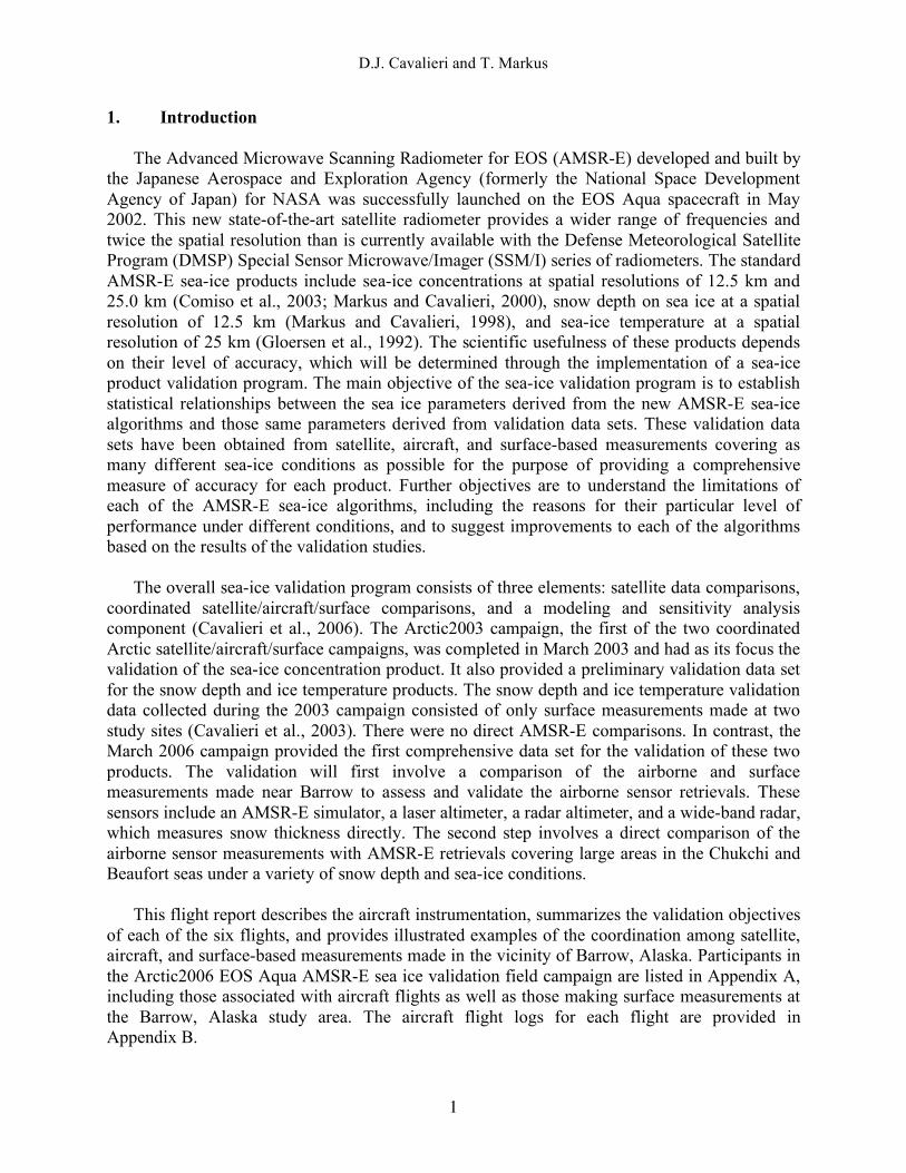
A critical component of the validation effort is the acquisition of airborne sensor data over large areas, which can be used to validate the AMSR-E sea-ice products directly. This is particularly true of the snow depth and ice temperature products, because no other satellite sensors can measure these products. The platform for acquiring these data was the NASA Wallops Flight Facility (WFF) P-3B aircraft. The P-3 aircraft is a 4-engine turboprop capable of long duration flights (8–12 hours), large payloads up to 15,000 pounds, altitudes up to 30,000 ft, and true airspeeds up to 330 knots (Figure 1). More detailed information about the aircraft may be obtained from the Web site http://wacop.wff.nasa.gov/LAAPBDesc.cfm. A discussion of the instruments onboard the aircraft follow below.
Figure 1. NASA P-3B aircraft at Wallops Flight Facility at Wallops Island, VA.
The polarimetric scanning radiometers (PSR-A and PSR-CX) from the University of
Colorado at Boulder, cover the AMSR-E range of frequencies (6.9–89.0 GHz) and polarizations (horizontal and vertical). Boresighted with each PSR scanhead was an infrared scanning radiometer operating at 9.6–11 µm providing surface temperature. At an altitude of 650 ft over the in situ data collection site, the PSR was operating in a fixed beam position looking forward at an incidence angle of 55°, which is identical to that of the AMSR-E instrument. The PSR spatial resolution was approximately 60 m at the 650 ft altitude.
The Airborne Topographic Mapper (ATM), a laser altimeter from NASA Wallops, was
flown to obtain high resolution ice surface topography and surface height. In combination with the D2P described below, snow depth on sea ice can potentially be measured. At a 650 ft flight altitude, the ATM’s swath width in scanning mode is 100 m with one shot per 2.4 square meters. In fixed beam mode the along-track spacing between shots is 2.4 cm.

D.J. Cavalieri and T. Markus
3
Delay-Doppler Phase-monopulse (D2P) radar altimeter data—from the Johns Hopkins University/Applied Physics Laboratory (JHU/APL)—were collected along with coincident ATM laser altimeter data to obtain elevation measurements of the snow-ice and snow-air interfaces, respectively. The difference (D2P-ATM) provides a rough measure of snow depth (e.g., Leuschen and Raney, 2005). These data along with the in situ snow depth measurements will be compared to the airborne snow radar. At an altitude of 650 ft, the footprint size is approximately 4 m along track and 30 m across track with a vertical precision of a few centimeters.
The snow radar from the University of Kansas is an ultra-wideband FM-CW radar with a
sweep bandwidth from 2–8 GHz. This is the first time this radar has been mounted on a plane, but the radar was successfully tested on a sled on sea ice in Antarctica (Kanagaratnam et al., 2006). At an altitude of 650 ft, the footprint size is about 2.5 m with an anticipated vertical resolution of 3 cm.
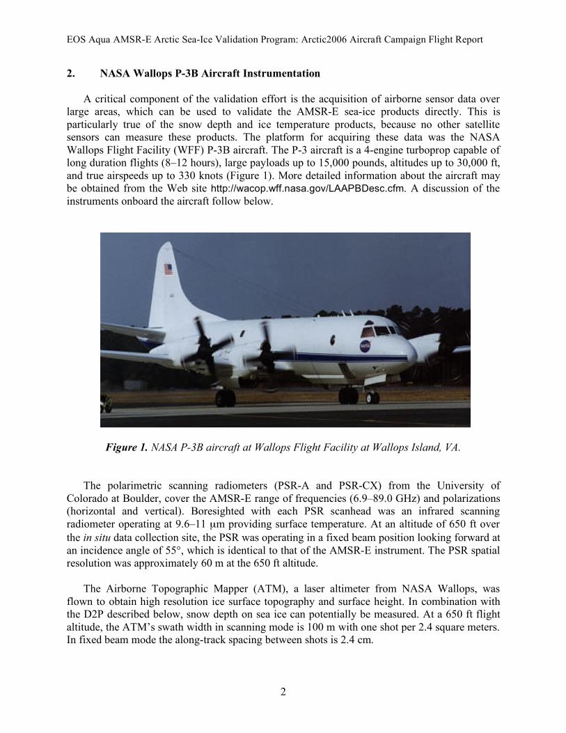
Aerial digital cameras from NASA Wallops documented sea-ice conditions. A brief
description of each sensor follows and a summary of their characteristics and purpose is given in Table 1. Sensor placement on the aircraft is illustrated in Figure 2. Table 1. NASA Wallops P-3B Sensors for Arctic2006.
Sensor Characteristics Purpose Sensor Scientist Polarimetric Scanning Radiometer (PSR-A and PSR-CX)
Operating Frequencies (H&V-pol): 6, 10, 18, 22, 37, 89 GHz
Aircraft AMSR-E simulator
A. Gasiewski and M. Klein; Univ. Colorado
IR radiometers bore-sighted with the PSR
9.6–11 µm radiometer Surface temperature A. Gasiewski and M. Klein; Univ. Colorado
Snow Radar FM-CW radar with a 2–8 GHz sweep bandwidth
Snow depth measurements
P. Gogineni and P. Kanagaratnam; Univ. Kansas
Delay-Doppler Radar Radar altimeter Sea-ice/snow inter-face elevation
C. Leuschen; JHU/APL (now Univ. Kansas)
Airborne Topographic Mapper (ATM-II)
Scanning lidar altimeter combined with a differential GPS system
Maps ice surface topography at high resolution
W. Krabill and J. Sonntag; NASA Wallops
Video and digital Cameras
2 Kodak digital cameras (3 megapixel)
Visible record of ice surface
W. Krabill and J. Sonntag; NASA Wallops
EOS Aqua AMSR-E Arctic Sea-Ice Validation Program: Arctic2006 Aircraft Campaign Flight Report
4
Figure 2. Configuration of the NASA WFF P-3B aircraft for the Arctic2006 aircraft campaign.
3. NASA Wallops P-3B Flight Summary
The P-3B made a total of six flights from Fairbanks International Airport, Alaska. The first two flights (March 18 and 20, 2006) were made over Elson Lagoon near Barrow, AK to coordinate with surface-based measurements of sea ice and its snow cover. Three other flights (March 21, 22, and 25, 2006) were made over areas of the Beaufort and Chukchi seas with patterns to cover as many AMSR-E footprints as possible. The sixth flight (March 24, 2006) was coordinated with an ICESat overpass in the high Arctic to support a study of the effects of snow cover variability on ice thickness retrievals from the ICESat laser altimeter. The location of all six flights is shown Figure 3. Each flight is summarized below including a brief description of the flight objective, sea-ice characteristics, and coordination with satellite and/or surface-based measurements.

D.J. Cavalieri and T. Markus
5
Figure 3. Location of the six NASA P-3 flights in the vicinity of Alaska during the EOS Aqua AMSR-E Arctic sea-ice campaign during March 2006. The blue-gray shading over the sea-ice covered oceans indicates snow depth on sea ice. The lighter shades indicate deeper snow.
Flight #1 (6.5 hr): March 18, 2006—Barrow. This flight was dedicated to obtaining aircraft measurements coincident with surface measurements of snow depth on sea ice and sea-ice temperature (Figure 4). Surface measurements were made along two transects each approximately 18 km long (Figure 5). Aerial photographic reconnaissance was undertaken with a Cessna 185 aircraft at an altitude of 4000 ft to provide a large-scale view of the study area before the NASA WFF P-3B arrived in Alaska. The P-3 made nine runs at altitudes of 600 ft and 1000 ft along each of the two transects to determine the optimum altitude for the new snow radar. The PSR operated in stare mode at these altitudes. In addition, the P-3 also made a survey flight at an altitude of 4300 ft to provide microwave and ATM coverage of the entire study region (Figure 6). Preliminary results show a wide range of snow depths promising an excellent validation data set.

EOS Aqua AMSR-E Arctic Sea-Ice Validation Program: Arctic2006 Aircraft Campaign Flight Report
6
Figure 4. Surface-based measurements made over Elson Lagoon coordinated with the NASA P-3B overflights. The P-3 can be seen near the center of the photo (Courtesy of J. Maslanik taken during the 2003 campaign)
Figure 5. Map showing the surface transects along which sea-ice and snow measurements were made at the Barrow study site. The “Chukchi” transect runs in a NW to SE direction whereas the “Elson” transect runs in a NE to SW direction. Both transects cut across Elson Lagoon.

D.J. Cavalieri and T. Markus
7
Figure 6. University of Colorado PSR image at 37 GHz V-pol of the Elson Lagoon study area. Surface transects are indicated by dotted lines.
Flight #2 (6.2 hrs): March 20, 2006—Barrow. This flight repeated the tracks made on March 18, but at the optimum altitude for the snow radar of 650 ft to increase the sample size of coordinated measurements and to cover an anomalous region in Elson Lagoon, which appeared in the PSR imagery acquired on March 18 (Figure 6). The PSR operated in stare mode at 650 ft altitude, whereas the PSR operated in scan mode at an altitude of 1100 ft and at 4300 ft. Flight #3 (7.5 hrs): March 21, 2006—Chukchi Sea. The objective of this flight was to validate the AMSR-E snow depth and ice temperature products directly by using the airborne sensors. The aircraft lines were oriented in a NE-SW direction (Figure 3). The area in the SW portion of the grid contained considerable gray and gray-white ice with numerous leads and finger rafting. In the NE portion of the grid, there was more thin (smooth) first-year and ridged first-year ice. This gradient of ice types should provide a gradient of both snow depth and ice temperature. All flight lines were flown at an altitude of 650 ft with the PSRs operating in stare mode. Flight #4 (7.7 hrs): March 22, 2006—Kotzebue Sound. The objective on this day was again to validate the AMSR-E snow depth and ice temperature products directly by using the airborne sensors. The aircraft lines were oriented in a NW-SE direction (Figure 3). There were a variety of first-year ice types including new, young, thin first-year, and medium first-year. The thickest ice was found in the NW portion of the grid with considerable ridging. Snow cover, as identified from AMSR-E data, was deeper over portions of this grid than it was in the Chukchi Sea. All flight lines were flown at an altitude of 650 ft with the PSRs operating in stare mode.

EOS Aqua AMSR-E Arctic Sea-Ice Validation Program: Arctic2006 Aircraft Campaign Flight Report
8
Flight #5 (6.7 hrs): March 24, 2006—High Arctic. The objective of this flight was to underfly the ICESat spacecraft. Because clear weather is critical for ICESat, we waited with this flight until we could expect cloud-free conditions for the entire flight. The altitude was 650 ft with the PSRs operating in stare mode. The time of turning point of the aircraft coincided with the time of the ICESat orbit. Flight #6 (7.9 hrs): March 25, 2006—North of Barrow. The objective of this flight was to acquire data in a region of mixed first-year and multiyear ice types. The grid on this day was oriented in a NW-SE direction. At the southern end of the grid, the ice cover was mixed young, first-year, and multiyear ice, whereas at the northern end of the grid the ice was mostly multiyear. 4. Concluding Remarks
The successful completion of the Arctic2006 aircraft campaign promises to provide the first comprehensive data set needed to validate the AMSR-E snow depth on sea-ice and ice temperature products. The new airborne snow radar (Gogineni et al., 2003) was flown for the first time during this campaign. Initial examination of some of the preliminary data collected suggests that the radar produced good discrimination between the snow-air and ice-snow interfaces and as such, should provide the requisite data needed to validate the AMSR-E snow depth product. This, in combination with the IR surface temperatures measured in combination with the altimeter data, the snow radar measurements, and the PSR radiances, should also provide the basis for obtaining an excellent validation data set with which to validate the sea-ice temperature product through the modeling of 1-D temperature profiles. 5. Acknowledgments
We thank all of the participants (Appendix A) whose dedication in both the planning and implementation phases of this campaign culminated in the acquisition of the first comprehensive data set with which to validate the AMSR-E snow depth and sea-ice temperature products. We also thank Michael King, EOS Senior Project Scientist; David Starr, EOS Validation Scientist; Claire Parkinson, Aqua Project Scientist; Elena Lobl, EOS Aqua AMSR-E Science Team Validation Scientist; and Waleed Abdalati, Cryospheric Sciences Branch Head, for their full support leading to the successful completion of this mission.
D.J. Cavalieri and T. Markus
9
6. References Cavalieri, D.J., T. Markus, J. Maslanik, M. Sturm, and E. Lobl, “March 2003 EOS Aqua AMSR-
E Arctic Sea Ice Field Campaign,” IEEE Trans. Geosci. Remote Sens., in press, 2006.
Comiso, J.C., D.J. Cavalieri, and T. Markus, “Sea ice concentration, ice temperature, and snow depth using AMSR-E data,” IEEE Trans. Geosci. Remote Sens., 41(2), 243–252, 2003.
Gloersen, P., W.J. Campbell, D.J. Cavalieri, J.C. Comiso, C.L. Parkinson, and H.J. Zwally, Arctic and Antarctic Sea Ice, 1978–1987: Satellite Passive Microwave Observations and Analysis, National Aeronautics and Space Administration, Special Publication 511, Washington, D.C., pp. 290, 1992.
Gogineni, S., K. Wong, S. Krishnan, P. Kanagaratnam, T. Markus, and V. Lytle, An Ultra-wideband Radar for Measurements of Snow Thickness Over Sea Ice, IEEE Inter. Geosci. Remote Sens. Symp., July 21–25, 2003, Toulouse, France.
Kanagaratnam, P., T. Markus, V. Lytle, B.G. Prescott, and P. Gogineni, “Ultra-wideband radar measurements of thickness of snow cover of sea ice,” IEEE Trans. Geosci. Remote Sens., accepted, 2006.
Leuschen, C.J., and R.K. Raney, “Initial Results of Data Collected by the APL D2P Radar Altimeter Over Land and Sea Ice,” Johns Hopkins APL Technical Digest, Volume 26, No. 2, 2005.
Markus, T., and D.J. Cavalieri, “Snow depth distribution over sea ice in the Southern Ocean from satellite passive microwave data, in Antarctic Sea Ice Physical Processes, Interactions, and Variability,” Antarctic Research Series, 74, edited by M.O. Jeffries, 19–40, AGU, Washington, D.C., 1998.
Markus, T., and D.J. Cavalieri, “An enhancement of the NASA Team sea ice algorithm,” IEEE Trans. Geosci. Remote Sens., 38, 1387–1398, 2000.
EOS Aqua AMSR-E Arctic Sea-Ice Validation Program: Arctic2006 Aircraft Campaign Flight Report
10
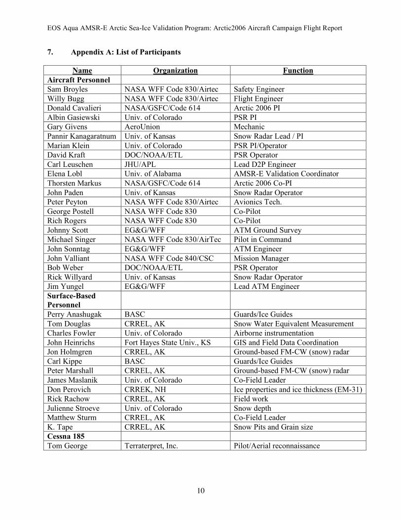
7. Appendix A: List of Participants
Name Organization Function Aircraft Personnel Sam Broyles NASA WFF Code 830/Airtec Safety Engineer Willy Bugg NASA WFF Code 830/Airtec Flight Engineer Donald Cavalieri NASA/GSFC/Code 614 Arctic 2006 PI Albin Gasiewski Univ. of Colorado PSR PI Gary Givens AeroUnion Mechanic Pannir Kanagaratnum Univ. of Kansas Snow Radar Lead / PI Marian Klein Univ. of Colorado PSR PI/Operator David Kraft DOC/NOAA/ETL PSR Operator Carl Leuschen JHU/APL Lead D2P Engineer Elena Lobl Univ. of Alabama AMSR-E Validation Coordinator Thorsten Markus NASA/GSFC/Code 614 Arctic 2006 Co-PI John Paden Univ. of Kansas Snow Radar Operator Peter Peyton NASA WFF Code 830/Airtec Avionics Tech. George Postell NASA WFF Code 830 Co-Pilot Rich Rogers NASA WFF Code 830 Co-Pilot Johnny Scott EG&G/WFF ATM Ground Survey Michael Singer NASA WFF Code 830/AirTec Pilot in Command John Sonntag EG&G/WFF ATM Engineer John Valliant NASA WFF Code 840/CSC Mission Manager Bob Weber DOC/NOAA/ETL PSR Operator Rick Willyard Univ. of Kansas Snow Radar Operator Jim Yungel EG&G/WFF Lead ATM Engineer Surface-Based Personnel
Perry Anashugak BASC Guards/Ice Guides Tom Douglas CRREL, AK Snow Water Equivalent Measurement Charles Fowler Univ. of Colorado Airborne instrumentation John Heinrichs Fort Hayes State Univ., KS GIS and Field Data Coordination Jon Holmgren CRREL, AK Ground-based FM-CW (snow) radar Carl Kippe BASC Guards/Ice Guides Peter Marshall CRREL, AK Ground-based FM-CW (snow) radar James Maslanik Univ. of Colorado Co-Field Leader Don Perovich CRREK, NH Ice properties and ice thickness (EM-31) Rick Rachow CRREL, AK Field work Julienne Stroeve Univ. of Colorado Snow depth Matthew Sturm CRREL, AK Co-Field Leader K. Tape CRREL, AK Snow Pits and Grain size Cessna 185 Tom George Terraterpret, Inc. Pilot/Aerial reconnaissance
D.J. Cavalieri and T. Markus
11
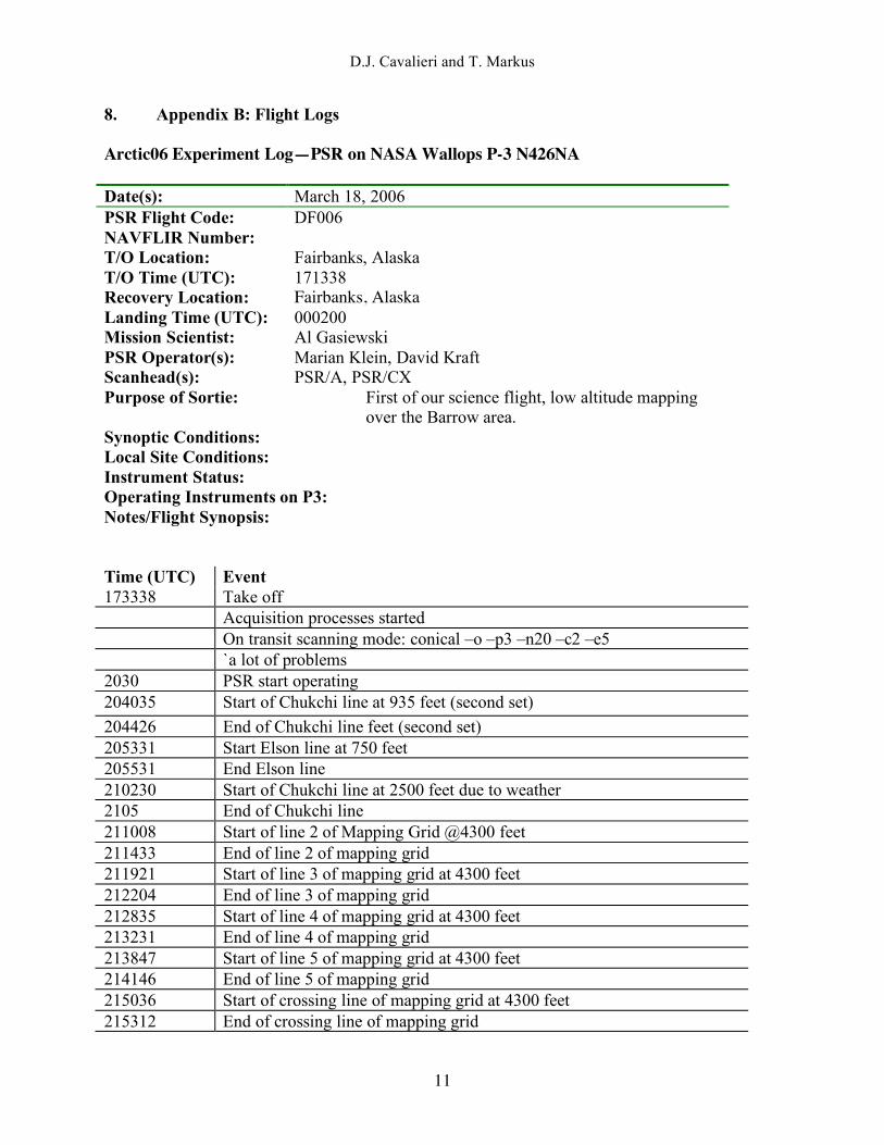
8. Appendix B: Flight Logs Arctic06 Experiment Log—PSR on NASA Wallops P-3 N426NA Date(s): March 18, 2006 PSR Flight Code: DF006 NAVFLIR Number: T/O Location: Fairbanks, Alaska T/O Time (UTC): 171338 Recovery Location: Fairbanks, Alaska Landing Time (UTC): 000200 Mission Scientist: Al Gasiewski PSR Operator(s): Marian Klein, David Kraft Scanhead(s): PSR/A, PSR/CX Purpose of Sortie: First of our science flight, low altitude mapping
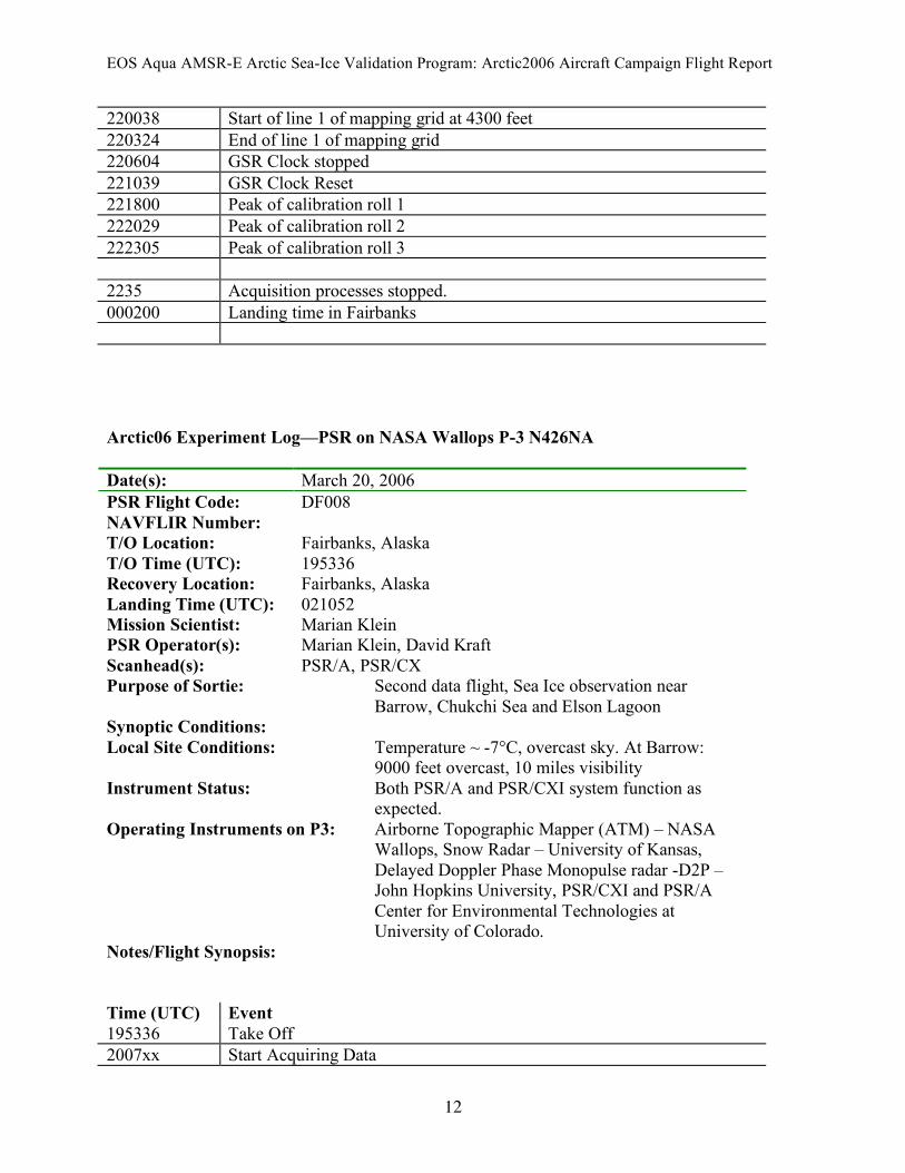
over the Barrow area. Synoptic Conditions: Local Site Conditions: Instrument Status: Operating Instruments on P3: Notes/Flight Synopsis: Time (UTC) Event 173338 Take off Acquisition processes started On transit scanning mode: conical –o –p3 –n20 –c2 –e5 `a lot of problems 2030 PSR start operating 204035 Start of Chukchi line at 935 feet (second set) 204426 End of Chukchi line feet (second set) 205331 Start Elson line at 750 feet 205531 End Elson line 210230 Start of Chukchi line at 2500 feet due to weather 2105 End of Chukchi line 211008 Start of line 2 of Mapping Grid @4300 feet 211433 End of line 2 of mapping grid 211921 Start of line 3 of mapping grid at 4300 feet 212204 End of line 3 of mapping grid 212835 Start of line 4 of mapping grid at 4300 feet 213231 End of line 4 of mapping grid 213847 Start of line 5 of mapping grid at 4300 feet 214146 End of line 5 of mapping grid 215036 Start of crossing line of mapping grid at 4300 feet 215312 End of crossing line of mapping grid
EOS Aqua AMSR-E Arctic Sea-Ice Validation Program: Arctic2006 Aircraft Campaign Flight Report
12
220038 Start of line 1 of mapping grid at 4300 feet 220324 End of line 1 of mapping grid 220604 GSR Clock stopped 221039 GSR Clock Reset 221800 Peak of calibration roll 1 222029 Peak of calibration roll 2 222305 Peak of calibration roll 3 2235 Acquisition processes stopped. 000200 Landing time in Fairbanks Arctic06 Experiment Log—PSR on NASA Wallops P-3 N426NA Date(s): March 20, 2006 PSR Flight Code: DF008 NAVFLIR Number: T/O Location: Fairbanks, Alaska T/O Time (UTC): 195336 Recovery Location: Fairbanks, Alaska Landing Time (UTC): 021052 Mission Scientist: Marian Klein PSR Operator(s): Marian Klein, David Kraft Scanhead(s): PSR/A, PSR/CX Purpose of Sortie: Second data flight, Sea Ice observation near
Barrow, Chukchi Sea and Elson Lagoon Synoptic Conditions: Local Site Conditions: Temperature ~ -7°C, overcast sky. At Barrow:
9000 feet overcast, 10 miles visibility Instrument Status: Both PSR/A and PSR/CXI system function as
expected. Operating Instruments on P3: Airborne Topographic Mapper (ATM) – NASA
Wallops, Snow Radar – University of Kansas, Delayed Doppler Phase Monopulse radar -D2P – John Hopkins University, PSR/CXI and PSR/A Center for Environmental Technologies at University of Colorado.
Notes/Flight Synopsis: Time (UTC) Event 195336 Take Off 2007xx Start Acquiring Data
D.J. Cavalieri and T. Markus
13
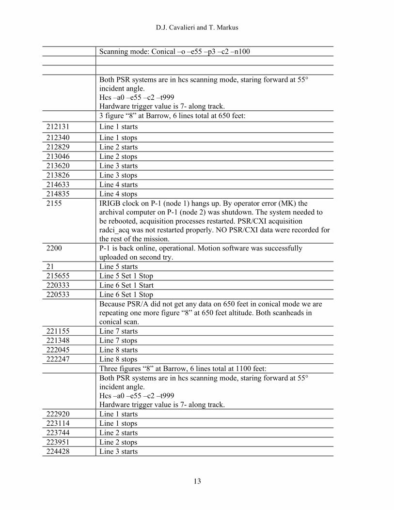
Scanning mode: Conical –o –e55 –p3 –c2 –n100 Both PSR systems are in hcs scanning mode, staring forward at 55°
incident angle. Hcs –a0 –e55 –c2 –t999 Hardware trigger value is 7- along track.
3 figure “8” at Barrow, 6 lines total at 650 feet: 212131 Line 1 starts 212340 Line 1 stops 212829 Line 2 starts 213046 Line 2 stops 213620 Line 3 starts 213826 Line 3 stops 214633 Line 4 starts 214835 Line 4 stops 2155 IRIGB clock on P-1 (node 1) hangs up. By operator error (MK) the
archival computer on P-1 (node 2) was shutdown. The system needed to be rebooted, acquisition processes restarted. PSR/CXI acquisition radci_acq was not restarted properly. NO PSR/CXI data were recorded for the rest of the mission.
2200 P-1 is back online, operational. Motion software was successfully uploaded on second try.
21 Line 5 starts 215655 Line 5 Set 1 Stop 220333 Line 6 Set 1 Start 220533 Line 6 Set 1 Stop Because PSR/A did not get any data on 650 feet in conical mode we are
repeating one more figure “8” at 650 feet altitude. Both scanheads in conical scan.
221155 Line 7 starts 221348 Line 7 stops 222045 Line 8 starts 222247 Line 8 stops Three figures “8” at Barrow, 6 lines total at 1100 feet: Both PSR systems are in hcs scanning mode, staring forward at 55°
incident angle. Hcs –a0 –e55 –c2 –t999 Hardware trigger value is 7- along track.
222920 Line 1 starts 223114 Line 1 stops 223744 Line 2 starts 223951 Line 2 stops 224428 Line 3 starts

EOS Aqua AMSR-E Arctic Sea-Ice Validation Program: Arctic2006 Aircraft Campaign Flight Report
14
224615 Line 3 stops 225014 IRIGB clock hanging again, Nav2 (node1) restarted. 225234 Line 4 starts 225440 Line 4 stops Both PSR systems are in conical scanning mode, at 55° incident angle.
Conical –o –e55 –p3 –c2 –n300 225949 Line 5 starts 230142 Line 5 stops 230834 Line 6 starts 231041 Line 6 stops 231915 IceSat line South to North at 1100 feet altitude starts. 232315 IceSat line stops. PSR mapping lines: 233406 Line 1 starts 233730 Line 1 stops 234430 Line 3 starts 234806 Line 3 stops 235315 Line 5 starts 235637 Line 5 stops 000051 Line 2 starts 000431 Line 2 ends 001007 Line 4 starts 001329 Line 4 stops 001816 IceSat line North to South at 4300 feet altitude starts. Both PSR systems
in scanning mode. 002132 IceSat line stops. PSR calibration rolls – aircraft heading for the rolls is 340 true. 002838 Roll 1 003052 Roll 2 003253 Roll 3 0120 PSR/CXI radiometric data acquisition (radci_acq) restarted. 0132 Acquisition processes stopped. 0134 Test reboot for a system. All the computers were powered down and
upload of the at6400 software was tested. The arch2 (node#2) motion controller software was uploaded successfully on a third try. Of six tries, two were successful uploads. Others ended up hanging during a motion controller program (*.prg). The arch3 (node#6) motion controller software successfully uploads the operating system and setup program (psrset.up),
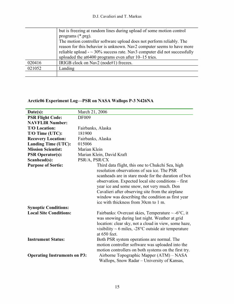
D.J. Cavalieri and T. Markus
15
but is freezing at random lines during upload of some motion control programs (*.prg). The motion controller software upload does not perform reliably. The reason for this behavior is unknown. Nav2 computer seems to have more reliable upload - ~ 30% success rate. Nav3 computer did not successfully uploaded the at6400 programs even after 10–15 tries.
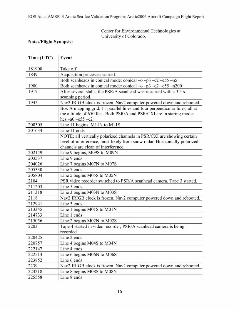
020416 IRIGB clock on Nav2 (node#1) freezes. 021052 Landing Arctic06 Experiment Log—PSR on NASA Wallops P-3 N426NA Date(s): March 21, 2006 PSR Flight Code: DF009 NAVFLIR Number: T/O Location: Fairbanks, Alaska T/O Time (UTC): 181900 Recovery Location: Fairbanks, Alaska Landing Time (UTC): 015006 Mission Scientist: Marian Klein PSR Operator(s): Marian Klein, David Kraft Scanhead(s): PSR/A, PSR/CX Purpose of Sortie: Third data flight, this one to Chukchi Sea, high
resolution observations of sea ice. The PSR scanheads are in stare mode for the duration of box observation. Expected local site conditions – first year ice and some snow, not very much. Don Cavalieri after observing site from the airplane window was describing the condition as first year ice with thickness from 30cm to 1 m.
Synoptic Conditions: Local Site Conditions: Fairbanks: Overcast skies, Temperature ~ -6°C, it
was snowing during last night. Weather at grid location: clear sky, not a cloud in view, some haze, visibility ~ 6 miles, -28°C outside air temperature at 650 feet.
Instrument Status: Both PSR system operations are normal. The motion controller software was uploaded into the motion controllers on both systems on the first try.
Operating Instruments on P3: Airborne Topographic Mapper (ATM) – NASA Wallops, Snow Radar – University of Kansas, Delayed Doppler Phase Monopulse radar -D2P – John Hopkins University, PSR/CXI and PSR/A
EOS Aqua AMSR-E Arctic Sea-Ice Validation Program: Arctic2006 Aircraft Campaign Flight Report
16
Center for Environmental Technologies at University of Colorado.
Notes/Flight Synopsis: Time (UTC) Event 181900 Take off 1849 Acquisition processes started. Both scanheads in conical mode: conical –o –p3 –c2 –e55 –n5 1900 Both scanheads in conical mode: conical –o –p3 –c2 –e55 –n200 1917 After several stalls, the PSR/A scanhead was restarted with a 3.5 s
scanning period. 1945 Nav2 IRIGB clock is frozen. Nav2 computer powered down and rebooted. Box A mapping grid: 11 parallel lines and four perpendicular lines, all at
the altitude of 650 feet. Both PSR/A and PSR/CXI are in staring mode: hcs –a0 –e55 –c2
200305 Line 11 begins, M11N to M11S 201634 Line 11 ends NOTE: all vertically polarized channels in PSR/CXI are showing certain
level of interference, most likely from snow radar. Horizontally polarized channels are clean of interference.
202149 Line 9 begins, M09S to M09N 203537 Line 9 ends 204026 Line 7 begins M07N to M07S 205330 Line 7 ends 205804 Line 5 begins M05S to M05N 2104 PSR video recorder switched to PSR/A scanhead camera. Tape 3 started. 211203 Line 5 ends. 211318 Line 3 begins M03N to M03S 2118 Nav2 IRIGB clock is frozen. Nav2 computer powered down and rebooted. 212941 Line 3 ends 213345 Line 1 begins M01S to M01N 214733 Line 1 ends 215056 Line 2 begins M02N to M02S 2203 Tape 4 started in video recorder, PSR/A scanhead camera is being
recorded. 220425 Line 2 ends 220757 Line 4 begins M04S to M04N 222147 Line 4 ends 222514 Line 6 begins M06N to M06S 223852 Line 6 ends 2239 Nav2 IRIGB clock is frozen. Nav2 computer powered down and rebooted. 224218 Line 8 begins M08S to M08N 225558 Line 8 ends

D.J. Cavalieri and T. Markus
17
225543 Nav2 IRIGB clock is frozen. Nav2 computer powered down and rebooted. 225855 Line 10 begins M10N to M10S 2303 Tape 5 started in video recorder, PSR/A scanhead camera is being
recorded. 231247 Line 10 ends 231530 Conical scanning mode on both scanheads. 231730 Conical scanning is over. Crossing lines next: 2318 Nav2 IRIGB clock is frozen. Nav2 computer powered down and rebooted. 232334 Line 4 begins X04S to X04N 233211 Line 4 ends Nav2 IRIGB clock is frozen and rebooted itself. It was out of
synchronization for ~30 seconds. 233415 Line 3 begins X03N to X03S 234226 Line 3 ends 234448 Line 2 begins X02S to X02N 235327 Line 2 ends 235555 Line 1 begins X01N to X01S 0001 Tape 6 started in video recorder, PSR/A scanhead camera is being
recorded. 000323 Line 1 end PSR calibration rolls (altitude 15000~). We are doing right banks today,
left wing goes up. (command: sky –a90 –e55) 001035 Roll 1 001325 Roll 2 001451 Roll 3 0118 Acquisition processes stopped. Start_motion was tested on both computers. Neither of the at6400 system
was able to upload the motion control software. It was tried approximately 10 times on both machines. After power off the Arch2 (node#2) motion control software was uploaded successfully on first try.
015006 Landing Arctic06 Experiment Log—PSR on NASA Wallops P-3 N426NA Date(s): March 22, 2006 PSR Flight Code: DF010 NAVFLIR Number: T/O Location: Fairbanks, Alaska T/O Time (UTC): 175838 Recovery Location: Fairbanks, Alaska

EOS Aqua AMSR-E Arctic Sea-Ice Validation Program: Arctic2006 Aircraft Campaign Flight Report
18
Landing Time (UTC): 014235 Mission Scientist: Marian Klein PSR Operator(s): Marian Klein, David Kraft Scanhead(s): PSR/A, PSR/CX Purpose of Sortie: Fourth data flight. Observation at Kotzebue Sound,
North on Nome. Low altitude grid, both scanheads in staring mode. Expected conditions within the area of observation are first year ice and thick snow. Don Cavalieri’s estimate from airplane window is that ice thickness is approximately 1 m and the snow cover is thicker here than it was on yesterday’s grid.
Synoptic Conditions: Local Site Conditions: Overcast skies at Fairbanks, temperature ~–10°C.
Weather at Kotzebue Sounds: -24°C at 650 feet altitude, visibility 10 miles, a little bit of haze, clear skies, no clouds in view.
Instrument Status: Both PSR/A and PSR/CXI systems are operating within established parameters. Motion control software was uploaded into both at 6400 cards on the first try.
Operating Instruments on P3: Airborne Topographic Mapper (ATM) – NASA Wallops, Snow Radar – University of Kansas, Delayed Doppler Phase Monopulse radar -D2P – John Hopkins University, PSR/CXI and PSR/A - Center for Environmental Technologies at University of Colorado.
Notes/Flight Synopsis: Time (UTC) Event 175838 Take off 1836 Nav2 IRIGB clock is frozen. Nav2 computer was powered down and
rebooted. 1840 Acquisition processes started. Xtrack scanning mode: xtrack –n5 –p4 –c2 1847 Conical on PSR/CXI was with 66° incident angle, it was corrected later. 1850 Conical scanning mode both scanheads: conical –o –e55 –p3 –c2 –n200 1905 PSR/A stalled, it was restarted in the same scanning mode. 1912 PSR/A stalled, it was restarted in the same scanning mode. Both scanheads are in staring mode: hcs –a0 –e55 –c2 –t999 Low altitude grid ~ 650 feet 193549 Line 11 starts M11S to M11N

D.J. Cavalieri and T. Markus
19
195040 Line 11 ends 195433 Line 9 starts M09N to M09S 1955 Nav2 IRIGB clock is frozen. Nav2 computer was powered down and
rebooted. 200726 Line 9 ends 201128 Line 7 starts M07S to M07N 202557 Line 7 ends 202942 Line 5 starts M05N to M05S 204238 Line 5 ends 204638 Line 3 starts M03S to M03N 210109 Line 3 ends 210156 Nav2 IRIGB clock is frozen. Nav2 computer was powered down and
rebooted. 210453 Line 1 starts M01N to M01S 211803 Line 1 ends 212336 Line 2 starts M02S to M02N 213321 Nav2 IRIGB clock is frozen. Nav2 computer was powered down and
rebooted. 213804 Line 2 ends 214140 Line 4 starts M04N to M04S 215437 Line 4 ends 215934 Line 6 starts M06S to M06N 2209 Video recorder switched to PSR/CXI video camera. It seems to have a
little clearer image that PSR/A. 221411 Line 6 ends 221738 Line 8 starts M08N to M08S 221920 Nav2 IRIGB clock is frozen. Nav2 computer was powered down and
rebooted. 222334 Nav2 IRIGB clock is frozen. Nav2 computer was powered down and
rebooted. 223033 Line 8 ends 223449 Line 10 starts M10S to M10N 224924 Line 10 ends Scanheads in conical mode. Crossing lines next, same altitude (~650 feet, same scanning mode for the
PSR scanheads). 225948 Line 6 starts X06N to X06S 230139 Nav2 IRIGB clock is frozen. Nav2 computer was powered down and
rebooted. 230752 Line 6 ends 231206 Line 4 starts X04S to X04N 232028 Line 4 ends 232438 Line 2 starts X02N to X02S 233247 Line 2 ends
EOS Aqua AMSR-E Arctic Sea-Ice Validation Program: Arctic2006 Aircraft Campaign Flight Report
20
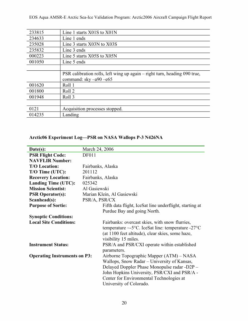
233815 Line 1 starts X01S to X01N 234633 Line 1 ends 235028 Line 3 starts X03N to X03S 235832 Line 3 ends 000223 Line 5 starts X05S to X05N 001050 Line 5 ends PSR calibration rolls, left wing up again – right turn, heading 090 true,
command: sky –a90 –e65 001620 Roll 1 001800 Roll 2 001948 Roll 3 0121 Acquisition processes stopped. 014235 Landing Arctic06 Experiment Log—PSR on NASA Wallops P-3 N426NA Date(s): March 24, 2006 PSR Flight Code: DF011 NAVFLIR Number: T/O Location: Fairbanks, Alaska T/O Time (UTC): 201112 Recovery Location: Fairbanks, Alaska Landing Time (UTC): 025342 Mission Scientist: Al Gasiewski PSR Operator(s): Marian Klein, Al Gasiewski Scanhead(s): PSR/A, PSR/CX Purpose of Sortie: Fifth data flight, IceSat line underflight, starting at
Purdue Bay and going North. Synoptic Conditions: Local Site Conditions: Fairbanks: overcast skies, with snow flurries,
temperature ~-5°C. IceSat line: temperature -27°C (at 1100 feet altitude), clear skies, some haze, visibility 15 miles.
Instrument Status: PSR/A and PSR/CXI operate within established parameters.
Operating Instruments on P3: Airborne Topographic Mapper (ATM) – NASA Wallops, Snow Radar – University of Kansas, Delayed Doppler Phase Monopulse radar -D2P – John Hopkins University, PSR/CXI and PSR/A - Center for Environmental Technologies at University of Colorado.
D.J. Cavalieri and T. Markus
21
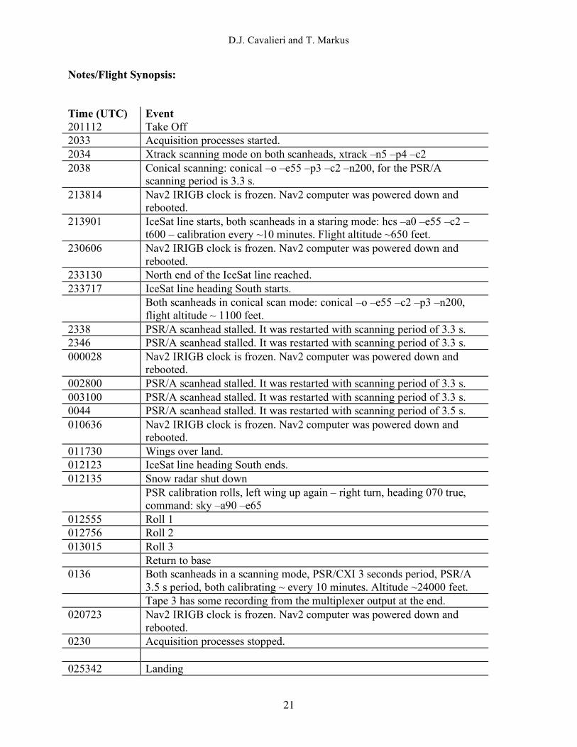
Notes/Flight Synopsis: Time (UTC) Event 201112 Take Off 2033 Acquisition processes started. 2034 Xtrack scanning mode on both scanheads, xtrack –n5 –p4 –c2 2038 Conical scanning: conical –o –e55 –p3 –c2 –n200, for the PSR/A
scanning period is 3.3 s. 213814 Nav2 IRIGB clock is frozen. Nav2 computer was powered down and
rebooted. 213901 IceSat line starts, both scanheads in a staring mode: hcs –a0 –e55 –c2 –
t600 – calibration every ~10 minutes. Flight altitude ~650 feet. 230606 Nav2 IRIGB clock is frozen. Nav2 computer was powered down and
rebooted. 233130 North end of the IceSat line reached. 233717 IceSat line heading South starts. Both scanheads in conical scan mode: conical –o –e55 –c2 –p3 –n200,
flight altitude ~ 1100 feet. 2338 PSR/A scanhead stalled. It was restarted with scanning period of 3.3 s. 2346 PSR/A scanhead stalled. It was restarted with scanning period of 3.3 s. 000028 Nav2 IRIGB clock is frozen. Nav2 computer was powered down and
rebooted. 002800 PSR/A scanhead stalled. It was restarted with scanning period of 3.3 s. 003100 PSR/A scanhead stalled. It was restarted with scanning period of 3.3 s. 0044 PSR/A scanhead stalled. It was restarted with scanning period of 3.5 s. 010636 Nav2 IRIGB clock is frozen. Nav2 computer was powered down and
rebooted. 011730 Wings over land. 012123 IceSat line heading South ends. 012135 Snow radar shut down PSR calibration rolls, left wing up again – right turn, heading 070 true,
command: sky –a90 –e65 012555 Roll 1 012756 Roll 2 013015 Roll 3 Return to base 0136 Both scanheads in a scanning mode, PSR/CXI 3 seconds period, PSR/A
3.5 s period, both calibrating ~ every 10 minutes. Altitude ~24000 feet. Tape 3 has some recording from the multiplexer output at the end. 020723 Nav2 IRIGB clock is frozen. Nav2 computer was powered down and
rebooted. 0230 Acquisition processes stopped. 025342 Landing

EOS Aqua AMSR-E Arctic Sea-Ice Validation Program: Arctic2006 Aircraft Campaign Flight Report
22
Arctic06 Experiment Log—PSR on NASA Wallops P-3 N426NA Date(s): March 25, 2006 PSR Flight Code: DF012 NAVFLIR Number: T/O Location: Fairbanks, Alaska T/O Time (UTC): 191145 Recovery Location: Fairbanks, Alaska Landing Time (UTC): 030441 Mission Scientist: Al Gasiewski PSR Operator(s): Marian Klein, David Kraft, Al Gasiewski, Scanhead(s): PSR/A, PSR/CX Purpose of Sortie: Sixth data flight, observation box north of Barrow
in Beaufort Sea. Synoptic Conditions: Fairbanks: Overcast skies with some snow
precipitation, temperature: On the grid: Haze, visibility 5 -6 miles, 10 miles at some places, clear skies, temperature -26° C at 650 feet altitude.
Local Site Conditions: Sea ice conditions based on Don Cavalieri’s estimate: Mostly multi-year ice connected by areas of first year ice. Some frozen meltponds.
Instrument Status: Both PSR systems operate within established paramaters.
Operating Instruments on P3: Airborne Topographic Mapper (ATM) – NASA Wallops, Snow Radar – University of Kansas, Delayed Doppler Phase Monopulse radar -D2P – John Hopkins University, PSR/CXI and PSR/A - Center for Environmental Technologies at University of Colorado.
Notes/Flight Synopsis: Time (UTC) Event 191145 Take off 1927 Acquisition processes started Both scanheads in conical scanning mode: conical –o –e55 –p3 –c2 –n200 1937 PSR/A stalled, it was restarted in conical scanning mode with period of
3.3 s. 2015 Nav2 IRIGB clock is frozen. Nav2 computer was powered down and
rebooted. Box observations are at 650 feet altitude. Both PSR systems are in stare
mode, hcs –a0 –e55 –c2 –t999 204725 Line 11 starts M11S to M11N 210142 Line 11 ends

D.J. Cavalieri and T. Markus
23
210425 Line 9 starts M09N to M09S 211741 Line 9 ends 212104 Line 7 starts M07S to M07N 213521 Line 7 ends 213740 Line 5 starts M05N to M05S 215150 Line 5 ends 215515 Line 3 starts M03S to M03N 220937 Line 3 ends 221252 Line 1 starts M01N to M01S 222610 Line 1 ends 220701 Nav2 IRIGB clock is frozen. Nav2 computer was powered down and
rebooted. 223030 Line 2 starts M02S to M02N 223246 Nav2 IRIGB clock is frozen. Nav2 computer was powered down and
rebooted. At this time IRIGB clock would again fail in short periods three times. Most of the time it was out of sync and it would reset itself and start counting from zero. The GPS preamplified power divider bias supply was changed by MK from the positioner P1 (Nav2 computer card GPS) to the positioner P3 (Nav3 computer).
PSR/CXI acquisition processes were restarted. For unknown reason the radci_acq and radci_log stopped between the 2209 and 2219.
224447 Line 2 ends 224747 Line 4 starts M04N to M04S 230101 Line 4 ends 230421 Line 6 starts M06S to M06N 230838 Nav2 IRIGB clock is frozen. Nav2 computer was powered down and
rebooted. 231839 Line 6 ends 232140 Line 8 starts M08N to M08S 233203 233458 Line 8 ends 233816 Line 10 starts M10S to M10N 234251 Nav2 IRIGB clock is frozen. Nav2 computer was powered down and
rebooted. 235239 Line 10 ends Higher altitude observations – 4300 feet. Both PSR scanheads in conical
scanning mode. PSR/A scanhead scanning period is 3.5 s and PSR/CXI 3 s.
235618 Line 5 starts H05N to H05S 000843 Line 5 ends 001400 Line 3 starts H03S to H03N 002713 Line 3 ends 003207 Line 1 starts H01N to H01S 004425 Line 1 ends

EOS Aqua AMSR-E Arctic Sea-Ice Validation Program: Arctic2006 Aircraft Campaign Flight Report
24
004933 Line 2 starts H02S to H02N 010248 Line 2 ends 010817 Line 4 starts H04N to N04S 011337 Nav2 IRIGB clock is frozen. Nav2 computer was powered down and
rebooted. Radci_acq restarted 012049 Line 4 ends PSR calibration rolls: right wing goes up (left turn), 090 true heading,
command: sky –d or sky –a270 –e65 012625 Roll 1 012816 Roll 2 012948 Roll3 0135-0205 After completing rolls flew straight into a long transit line at 24,000 ft
over sea ice back to land, including passage over a large frozen coastal plain lake (Teshekpuk Lake). Also passed over many small frozen coastal plain lakes. Terrain flat and snow covered until Brooks Range overflown starting at ~0205
0230 Nav2 IRIGB clock is frozen. Nav2 computer was powered down and rebooted.
0246 Acquisition processes stopped. 030441 Landing

REPORT DOCUMENTATION PAGE Form Approved OMB No. 0704-0188
The public reporting burden for this collection of information is estimated to average 1 hour per response, including the time for reviewing instructions, searching existingdata sources, gathering and maintaining the data needed, and completing and reviewing the collection of information. Send comments regarding this burden estimate or any other aspect of this collection of information, including suggestions for reducing this burden, to Department of Defense, Washington Headquarters Services, Directorate for Information Operations and Reports (0704-0188), 1215 Jefferson Davis Highway, Suite 1204, Arlington, VA 22202-4302. Respondents should be aware that notwithstanding any other provision of law, no person shall be subject to any penalty for failing to comply with a collection of information if it does not display a currently valid OMB control number. PLEASE DO NOT RETURN YOUR FORM TO THE ABOVE ADDRESS. 1. REPORT DATE (DD-MM-YYYY) 2. REPORT TYPE 3. DATES COVERED (From - To)
4. TITLE AND SUBTITLE 5a. CONTRACT NUMBER
5b. GRANT NUMBER
5c. PROGRAM ELEMENT NUMBER
6. AUTHOR(S) 5d. PROJECT NUMBER
5e. TASK NUMBER
5f. WORK UNIT NUMBER
7. PERFORMING ORGANIZATION NAME(S) AND ADDRESS(ES) 8. PERFORMING ORGANIZATION REPORT NUMBER
9. SPONSORING/MONITORING AGENCY NAME(S) AND ADDRESS(ES) 10. SPONSORING/MONITOR'S ACRONYM(S)
11. SPONSORING/MONITORINGREPORT NUMBER
12. DISTRIBUTION/AVAILABILITY STATEMENT
13. SUPPLEMENTARY NOTES
14. ABSTRACT
15. SUBJECT TERMS
16. SECURITY CLASSIFICATION OF: 17. LIMITATION OF ABSTRACT
18. NUMBER OF PAGES
19b. NAME OF RESPONSIBLE PERSON
a. REPORT b. ABSTRACT c. THIS PAGE 19b. TELEPHONE NUMBER (Include area code)
Standard Form 298 (Rev. 8-98)Prescribed by ANSI Std. Z39-18