Embed Size (px)
Citation preview
1
Envisioning BRT in Brea Bus Rapid Transit Station Concepts
The contents of this report reflect the views of the author who is responsible for the facts and accuracy of the data presented herein. The contents do not necessarily reflect the official views or policies of SCAG or DOT. This report does not constitute a standard, specification, or regulation.
Susan DeSantis Consulting
2
Compass BlueprintThis project was funded by the Southern California Association of Governments (SCAG) Compass Blueprint Demonstration Project Program. Compass Blueprint provides tools to cities to evaluate planning options and stimulate development consistent with the region’s goals. SCAG provides cities with support to help with visioning, infill analysis, policy assistance, economic and marketing assistance, and developing communication tools for cities.
Compass Blueprint
FundingThe preparation of this report was funded in part through grants from the United States Department of Transportation - Federal Highway Administration and the Federal Transit Administration - under provisions of the Transportation Equity Act for the 21st Century (TEA-21). Additional assistance was provided by the State of California State Business, Transportation and Housing Agency through the California Regional Blueprint Planning Grant.
Acknowledgements Beginning in 2003, the five North Orange County Cities (NOCC) of Brea, Fullerton, La Habra, Placentia and Yorba Linda undertook a cooperative effort to define a vision for transit in North Orange County,. The five cities have received grant funding from the Reduce Orange County Congestion (ROCC) program and the Southern California Association of Governments (SCAG) Compass Blueprint Demonstration Program, which together with the Orange County Transportation Authority (OCTA) Go Local program have provided funding (as well as in-kind City staff support) to explore opportunities for transit-oriented development around an emerging high-capacity transit system.
Prepared for:The City of Brea
Prepared by:The Planning CenterIBI GroupSusan DeSantis Consulting
3
BackgroundIn 2001, the Southern California Association of Governments (SCAG) started a regional visioning process that culminated in a strategy for regional growth that would accommodate the coming growth while providing for livability, mobility, prosperity, and sustainability. This strategy, called “Compass Blueprint,” promotes a stronger link between transportation and land use planning at both regional and local scales so that growth is directed toward areas that offer mobility and transportation choices. Compass Blueprint encourages creative, forward-thinking, and sustainable development solutions that fit local needs and support shared regional values. The strategy is broadly based on four key principles, which can be referred to as the “Compass Principles.”
• Improve Mobility• Foster Livability in All Communities• Enable Prosperity for All People• Promote Sustainability for Future Generations
Compass Blueprint is now in the implementation phase and SCAG is partnering with cities and counties in southern California to realize this growth vision. A series of Compass Blueprint Demonstration Projects were conducted that exemplify the goals shared by the Compass Blueprint and unique visions of local communities. The City of Brea applied for Compass Blueprint services and was selected to be one of these demonstration projects.
Introduction
Contents
• Introduction• Bus Rapid Transit• Study Area• Existing Conditions• Opportunities and
Constraints• Identifying a BRT Station Site• BRT Station Concepts• Transit Supportive Policies• Next Steps
4
Introduction
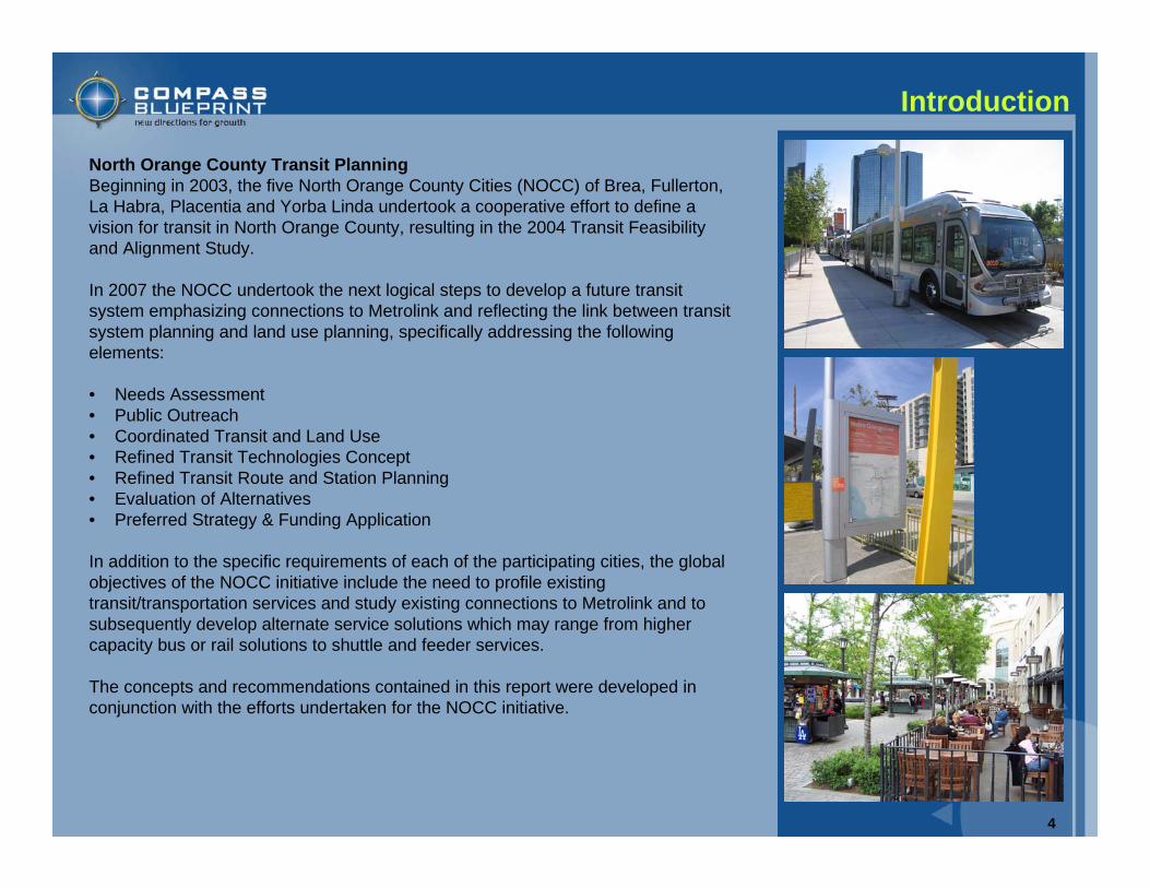
North Orange County Transit PlanningBeginning in 2003, the five North Orange County Cities (NOCC) of Brea, Fullerton, La Habra, Placentia and Yorba Linda undertook a cooperative effort to define a vision for transit in North Orange County, resulting in the 2004 Transit Feasibility and Alignment Study.
In 2007 the NOCC undertook the next logical steps to develop a future transit system emphasizing connections to Metrolink and reflecting the link between transit system planning and land use planning, specifically addressing the following elements:
• Needs Assessment• Public Outreach• Coordinated Transit and Land Use• Refined Transit Technologies Concept• Refined Transit Route and Station Planning• Evaluation of Alternatives• Preferred Strategy & Funding Application
In addition to the specific requirements of each of the participating cities, the global objectives of the NOCC initiative include the need to profile existing transit/transportation services and study existing connections to Metrolink and to subsequently develop alternate service solutions which may range from higher capacity bus or rail solutions to shuttle and feeder services.
The concepts and recommendations contained in this report were developed in conjunction with the efforts undertaken for the NOCC initiative.
5
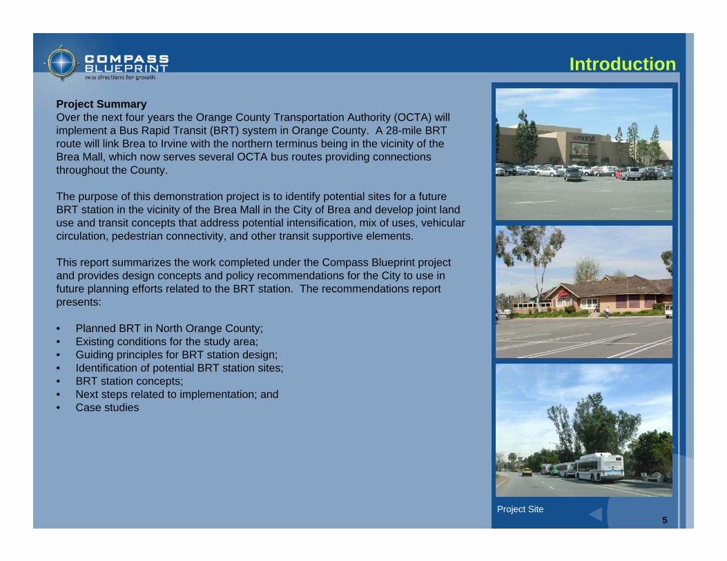
Project SummaryOver the next four years the Orange County Transportation Authority (OCTA) will implement a Bus Rapid Transit (BRT) system in Orange County. A 28-mile BRT route will link Brea to Irvine with the northern terminus being in the vicinity of the Brea Mall, which now serves several OCTA bus routes providing connections throughout the County.
The purpose of this demonstration project is to identify potential sites for a future BRT station in the vicinity of the Brea Mall in the City of Brea and develop joint land use and transit concepts that address potential intensification, mix of uses, vehicular circulation, pedestrian connectivity, and other transit supportive elements.
This report summarizes the work completed under the Compass Blueprint project and provides design concepts and policy recommendations for the City to use in future planning efforts related to the BRT station. The recommendations report presents:
• Planned BRT in North Orange County;• Existing conditions for the study area;• Guiding principles for BRT station design;• Identification of potential BRT station sites;• BRT station concepts;• Next steps related to implementation; and• Case studies
Introduction
Project Site
6
Bus Rapid Transit
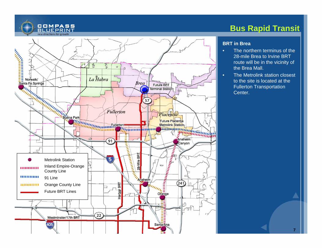
Bus Rapid TransitThe following three Bus Rapid Transit (BRT) routes will be implemented by the Orange County Transportation Authority (OCTA) during the next 4 years.
Harbor Boulevard BRTThe Harbor Boulevard BRT Project is scheduled for completion in late 2008. Route 43, which travels along Harbor Boulevard, is the busiest bus route in the county. The goal for the Harbor Boulevard BRT Project is to decrease travel time for customers and improve travel speed.
Westminster Boulevard/17th Street BRTThe Westminster Boulevard/17th Street BRT Project is the second of three BRT projects to be implemented by OCTA and is scheduled for completion in late 2009. Service on Westminster/17th will operate over a 22-mile, east-west route between Santa Ana and Long Beach, becoming the first truly regional BRT service operated by OCTA by providing direct connections to multimodal transit services in Los Angeles County at the Long Beach Transit Mall.
28-Mile BRTThe Brea to Irvine BRT Project is the third of three BRT projects to be implemented by OCTA and is scheduled for completion in late 2010. The 28-mile Brea to Irvine route will operate northbound and southbound and will link Brea, Fullerton, Anaheim, Orange, Santa Ana, Costa Mesa and Irvine. Five major transportation centers will be served, including the Fullerton Transportation Center, the Anaheim Regional Transportation Intermodal Center (ARTIC), the Depot at Santa Ana, John Wayne Airport and the Irvine Transportation Center.
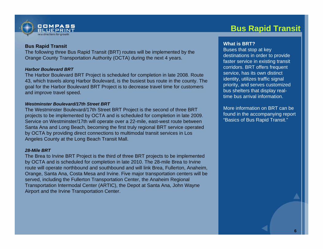
What is BRT?Buses that stop at key destinations in order to provide faster service in existing transit corridors. BRT offers frequent service, has its own distinct identity, utilizes traffic signal priority, and serves customized bus shelters that display real-time bus arrival information.
More information on BRT can be found in the accompanying report “Basics of Bus Rapid Transit.”
7
Bus Rapid Transit
Metrolink StationInland Empire-Orange County Line
91 Line
Orange County Line
Future BRT Lines
BRT in Brea• The northern terminus of the
28-mile Brea to Irvine BRT route will be in the vicinity of the Brea Mall.
• The Metrolink station closest to the site is located at the Fullerton Transportation Center.
8
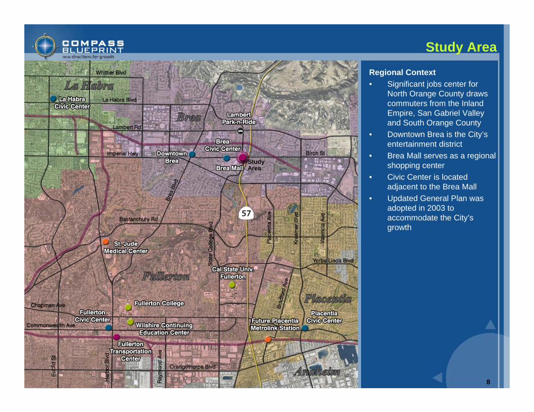
Study Area
Regional Context• Significant jobs center for
North Orange County draws commuters from the Inland Empire, San Gabriel Valley and South Orange County
• Downtown Brea is the City’s entertainment district
• Brea Mall serves as a regional shopping center
• Civic Center is located adjacent to the Brea Mall
• Updated General Plan was adopted in 2003 to accommodate the City’s growth
Study Area
9
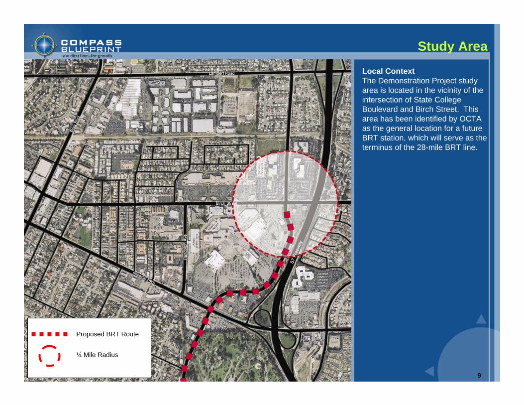
Study Area
Local ContextThe Demonstration Project study area is located in the vicinity of the intersection of State College Boulevard and Birch Street. This area has been identified by OCTA as the general location for a future BRT station, which will serve as the terminus of the 28-mile BRT line.
Proposed BRT Route
¼ Mile Radius

10
Existing Conditions
Average Daily Traffic Volume
Roadways• State College Boulevard and
Imperial Highway are the major arterials serving the study area, with four to six lanes each.
• Birch Street is classified as a primary four lane arterial directly to the north of the site, transitioning to a secondary arterial west of Randolph Avenue.
• Average daily traffic volumes near the site range from 23,000 vehicles on State College and 29,000 vehicles on Birch Street to 51,000 to 68,000 vehicles on Imperial Highway.
• Imperial Highway currently operates at LOS F on the segment south of the site.
• Average daily traffic (ADT) volumes on the 57 freeway adjacent to the site range from 225,000 to 263,000 vehicles
11
Existing Conditions
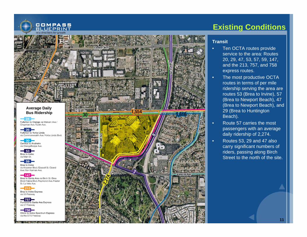
Transit• Ten OCTA routes provide
service to the area: Routes 20, 29, 47, 53, 57, 59, 147, and the 213, 757, and 758 express routes.
• The most productive OCTA routes in terms of per mile ridership serving the area are routes 53 (Brea to Irvine), 57 (Brea to Newport Beach), 47 (Brea to Newport Beach), and 29 (Brea to Huntington Beach).
• Route 57 carries the most passengers with an average daily ridership of 2,274.
• Routes 53, 29 and 47 also carry significant numbers of riders, passing along Birch Street to the north of the site.
Average Daily Bus Ridership
12
Opportunities and Constraints
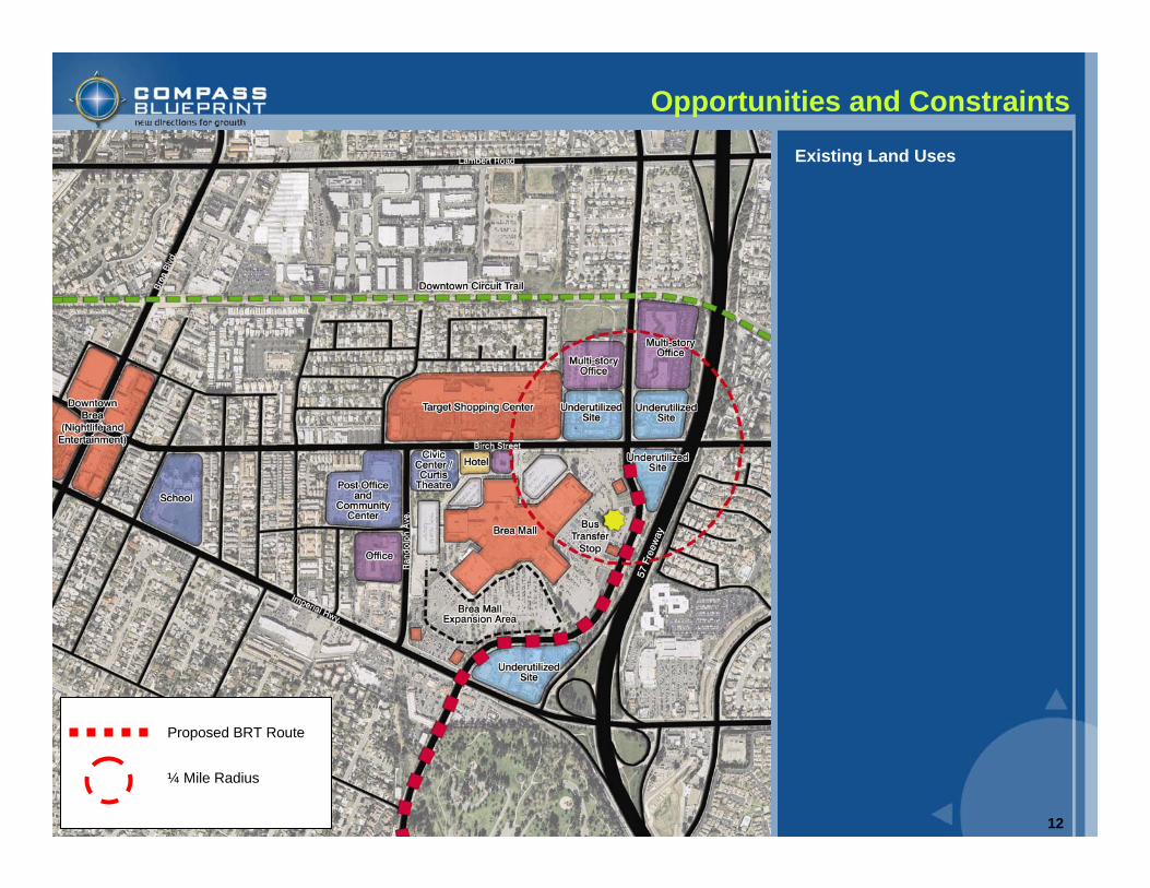
Existing Land Uses
Proposed BRT Route
¼ Mile Radius
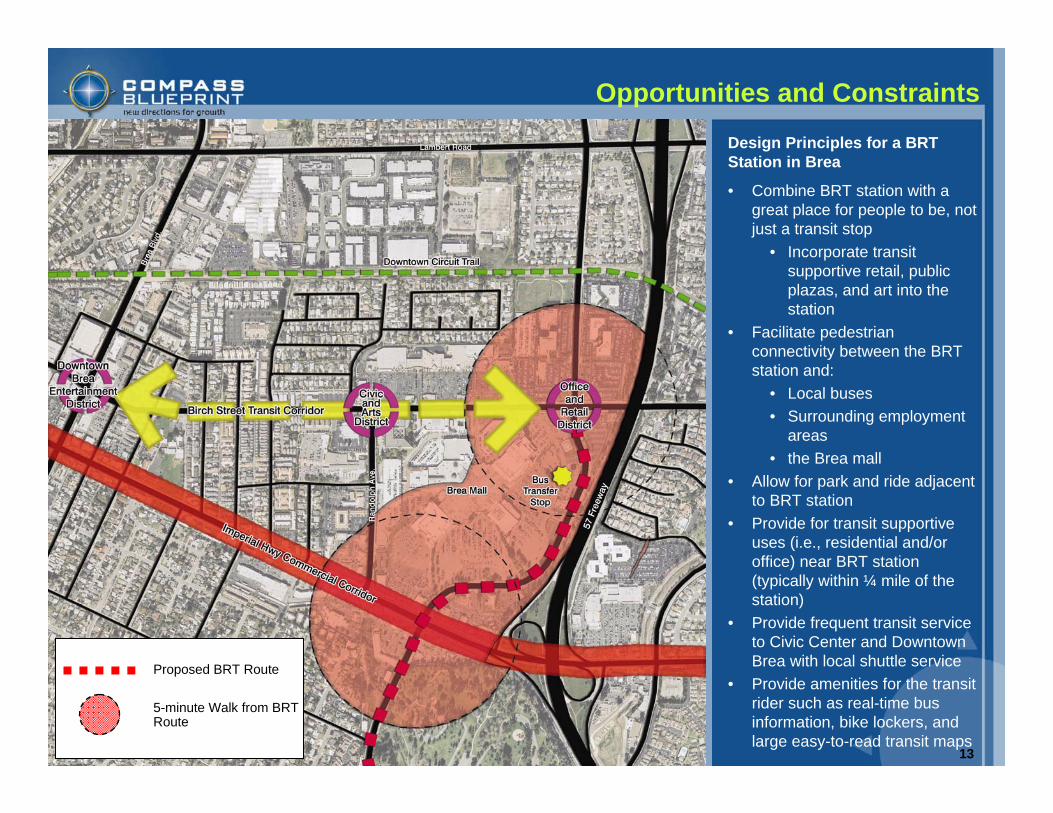
13
• Combine BRT station with a great place for people to be, not just a transit stop
• Incorporate transit supportive retail, public plazas, and art into the station
• Facilitate pedestrian connectivity between the BRT station and:
• Local buses • Surrounding employment
areas• the Brea mall
• Allow for park and ride adjacent to BRT station
• Provide for transit supportive uses (i.e., residential and/or office) near BRT station (typically within ¼ mile of the station)
• Provide frequent transit service to Civic Center and Downtown Brea with local shuttle service
• Provide amenities for the transit rider such as real-time bus information, bike lockers, and large easy-to-read transit maps
Opportunities and Constraints
Proposed BRT Route
5-minute Walk from BRT Route
Design Principles for a BRT Station in Brea
14
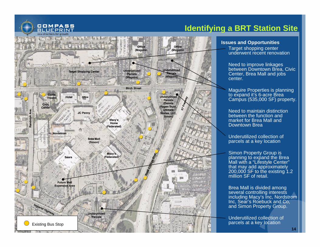
Issues and OpportunitiesTarget shopping center underwent recent renovation
Need to improve linkages between Downtown Brea, Civic Center, Brea Mall and jobs center.
Maguire Properties is planning to expand it’s 6-acre Brea Campus (535,000 SF) property.
Need to maintain distinction between the function and market for Brea Mall and Downtown Brea
Underutilized collection of parcels at a key location
Simon Property Group is planning to expand the Brea Mall with a “Lifestyle Center”that may add approximately 200,000 SF to the existing 1.2 million SF of retail.
Brea Mall is divided among several controlling interests including Macy’s Inc, Nordstrom Inc, Sear’s Roebuck and Co, and Simon Property Group.
Underutilized collection of parcels at a key location
Identifying a BRT Station Site
Existing Bus Stop
15
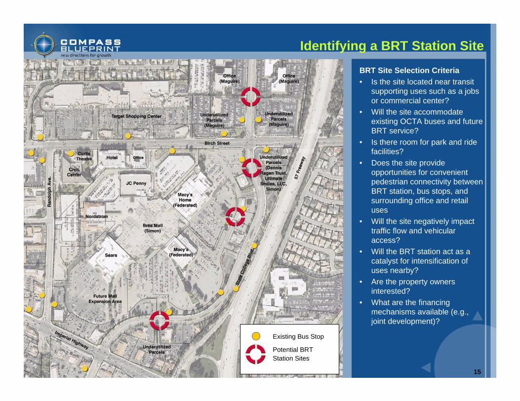
Identifying a BRT Station Site
BRT Site Selection Criteria• Is the site located near transit
supporting uses such as a jobs or commercial center?
• Will the site accommodate existing OCTA buses and future BRT service?
• Is there room for park and ride facilities?
• Does the site provide opportunities for convenient pedestrian connectivity between BRT station, bus stops, and surrounding office and retail uses
• Will the site negatively impact traffic flow and vehicular access?
• Will the BRT station act as a catalyst for intensification of uses nearby?
• Are the property owners interested?
• What are the financing mechanisms available (e.g., joint development)?
Existing Bus Stop
Potential BRT Station Sites
16
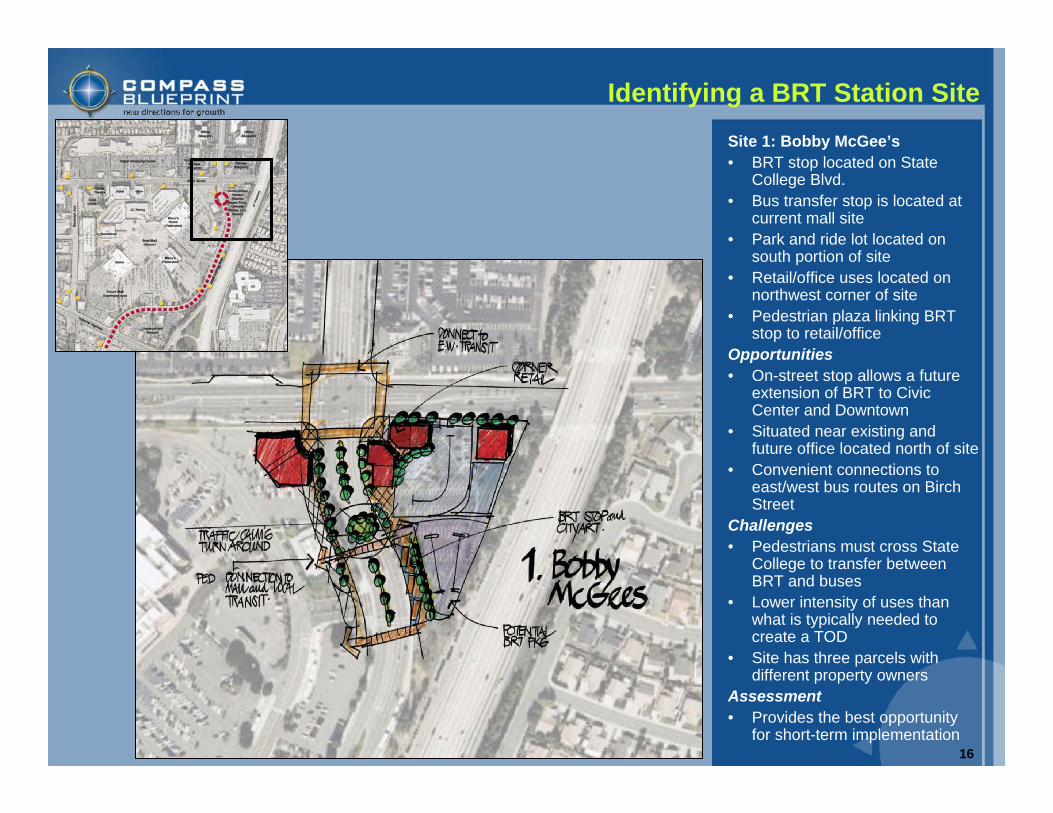
Identifying a BRT Station SiteSite 1: Bobby McGee’s• BRT stop located on State
College Blvd. • Bus transfer stop is located at
current mall site• Park and ride lot located on
south portion of site• Retail/office uses located on
northwest corner of site• Pedestrian plaza linking BRT
stop to retail/office Opportunities• On-street stop allows a future
extension of BRT to Civic Center and Downtown
• Situated near existing and future office located north of site
• Convenient connections to east/west bus routes on Birch Street
Challenges• Pedestrians must cross State
College to transfer between BRT and buses
• Lower intensity of uses than what is typically needed to create a TOD
• Site has three parcels with different property owners
Assessment• Provides the best opportunity
for short-term implementation
17
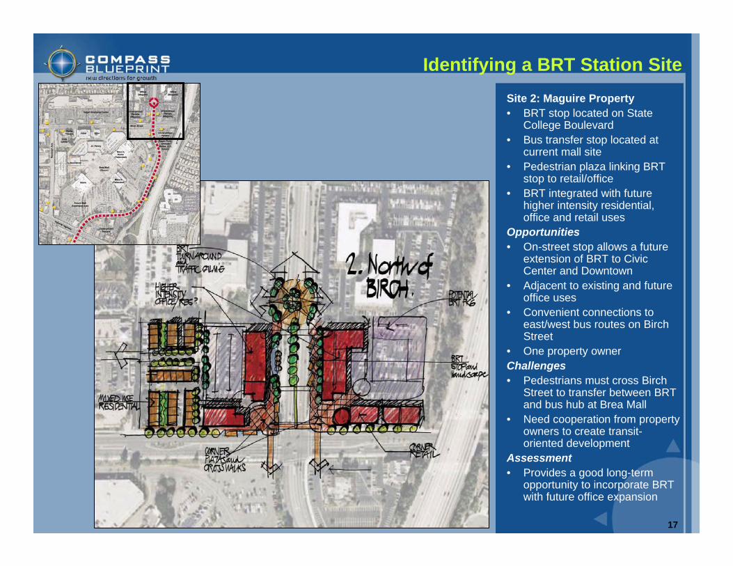
Identifying a BRT Station SiteSite 2: Maguire Property• BRT stop located on State
College Boulevard • Bus transfer stop located at
current mall site• Pedestrian plaza linking BRT
stop to retail/office• BRT integrated with future
higher intensity residential, office and retail uses
Opportunities• On-street stop allows a future
extension of BRT to Civic Center and Downtown
• Adjacent to existing and future office uses
• Convenient connections to east/west bus routes on Birch Street
• One property ownerChallenges• Pedestrians must cross Birch
Street to transfer between BRT and bus hub at Brea Mall
• Need cooperation from property owners to create transit-oriented development
Assessment• Provides a good long-term
opportunity to incorporate BRT with future office expansion
18
Identifying a BRT Station Site
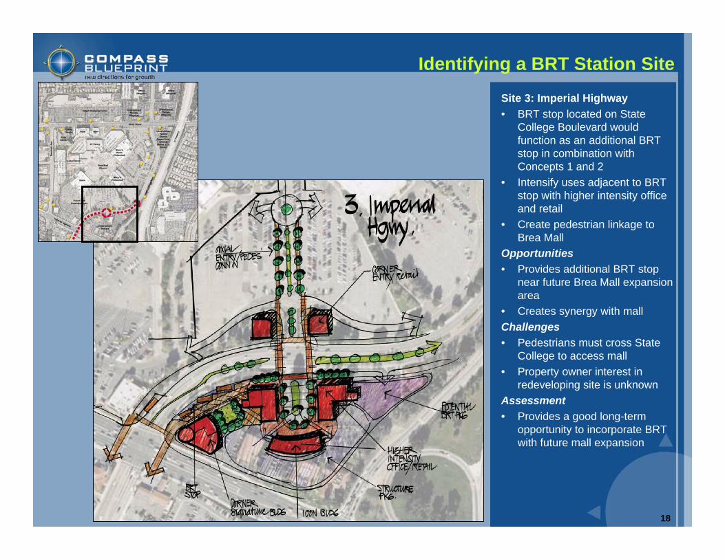
Site 3: Imperial Highway• BRT stop located on State
College Boulevard would function as an additional BRT stop in combination with Concepts 1 and 2
• Intensify uses adjacent to BRT stop with higher intensity office and retail
• Create pedestrian linkage to Brea Mall
Opportunities• Provides additional BRT stop
near future Brea Mall expansion area
• Creates synergy with mallChallenges• Pedestrians must cross State
College to access mall• Property owner interest in
redeveloping site is unknownAssessment• Provides a good long-term
opportunity to incorporate BRT with future mall expansion
19
Identifying a BRT Station Site
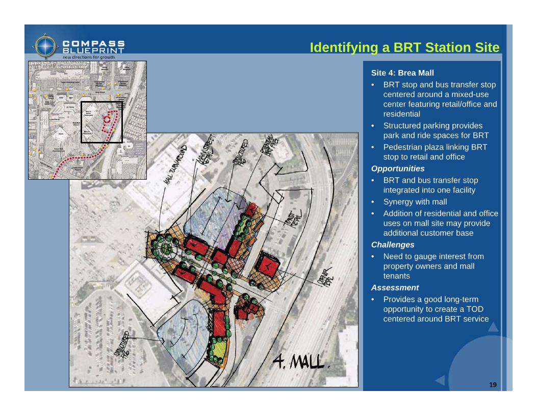
Site 4: Brea Mall• BRT stop and bus transfer stop
centered around a mixed-use center featuring retail/office and residential
• Structured parking provides park and ride spaces for BRT
• Pedestrian plaza linking BRT stop to retail and office
Opportunities• BRT and bus transfer stop
integrated into one facility• Synergy with mall• Addition of residential and office
uses on mall site may provide additional customer base
Challenges• Need to gauge interest from
property owners and mall tenants
Assessment• Provides a good long-term
opportunity to create a TOD centered around BRT service
20
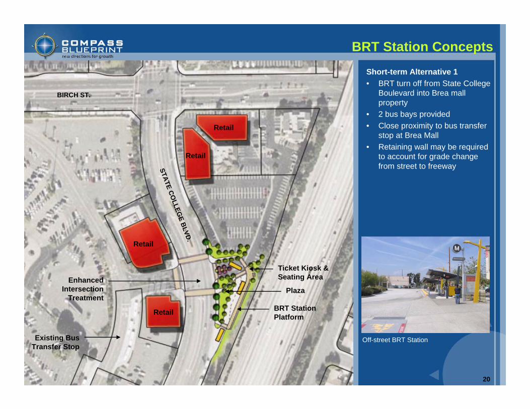
Short-term Alternative 1• BRT turn off from State College
Boulevard into Brea mall property
• 2 bus bays provided• Close proximity to bus transfer
stop at Brea Mall• Retaining wall may be required
to account for grade change from street to freeway
BRT Station Concepts
BRT Station Platform
Enhanced Intersection
Treatment
Retail
Retail
Retail
Retail
Plaza
Ticket Kiosk & Seating Area
Existing Bus Transfer Stop
Off-street BRT Station
BIRCH ST.
STATE COLLEG
E BLVD.
21
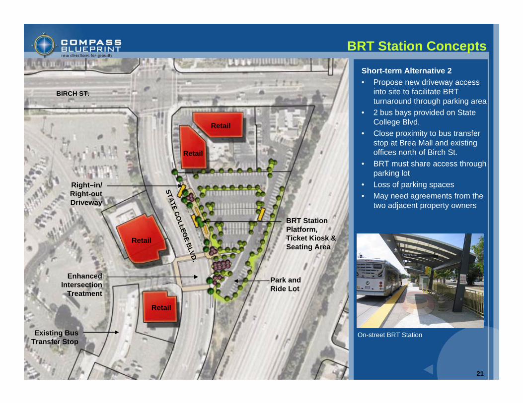
Short-term Alternative 2• Propose new driveway access
into site to facilitate BRT turnaround through parking area
• 2 bus bays provided on State College Blvd.
• Close proximity to bus transfer stop at Brea Mall and existing offices north of Birch St.
• BRT must share access through parking lot
• Loss of parking spaces• May need agreements from the
two adjacent property owners
BRT Station Concepts
Park and Ride Lot
Enhanced Intersection
Treatment
Retail
Retail
Retail
Retail
BRT Station Platform, Ticket Kiosk & Seating Area
Existing Bus Transfer Stop
Right–in/ Right-out Driveway
On-street BRT Station
BIRCH ST.
STATE COLLEG
E BLVD.
22
BRT Station Concepts
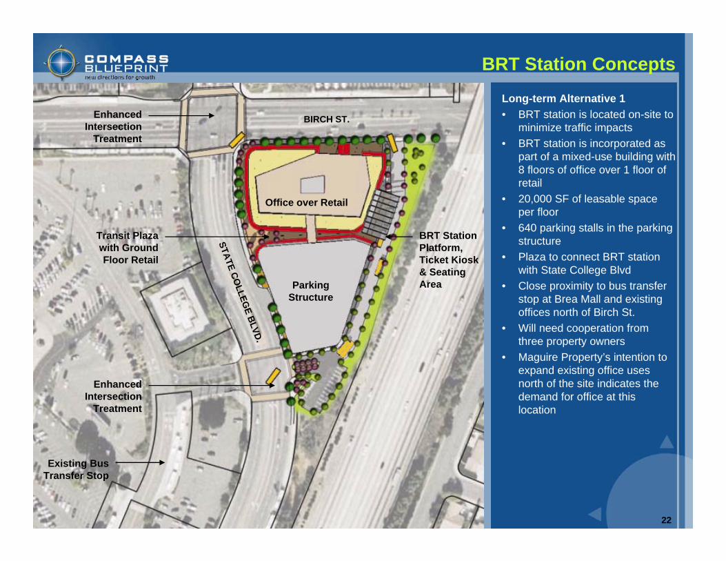
Long-term Alternative 1• BRT station is located on-site to
minimize traffic impacts• BRT station is incorporated as
part of a mixed-use building with 8 floors of office over 1 floor of retail
• 20,000 SF of leasable space per floor
• 640 parking stalls in the parking structure
• Plaza to connect BRT station with State College Blvd
• Close proximity to bus transfer stop at Brea Mall and existing offices north of Birch St.
• Will need cooperation from three property owners
• Maguire Property’s intention to expand existing office uses north of the site indicates the demand for office at this location
Parking Structure
Enhanced Intersection
Treatment
Office over Retail
Existing Bus Transfer Stop
Transit Plaza with Ground Floor Retail
BRT Station Platform, Ticket Kiosk & Seating Area
Enhanced Intersection
Treatment
BIRCH ST.
STATE COLLEG
E BLVD.
23
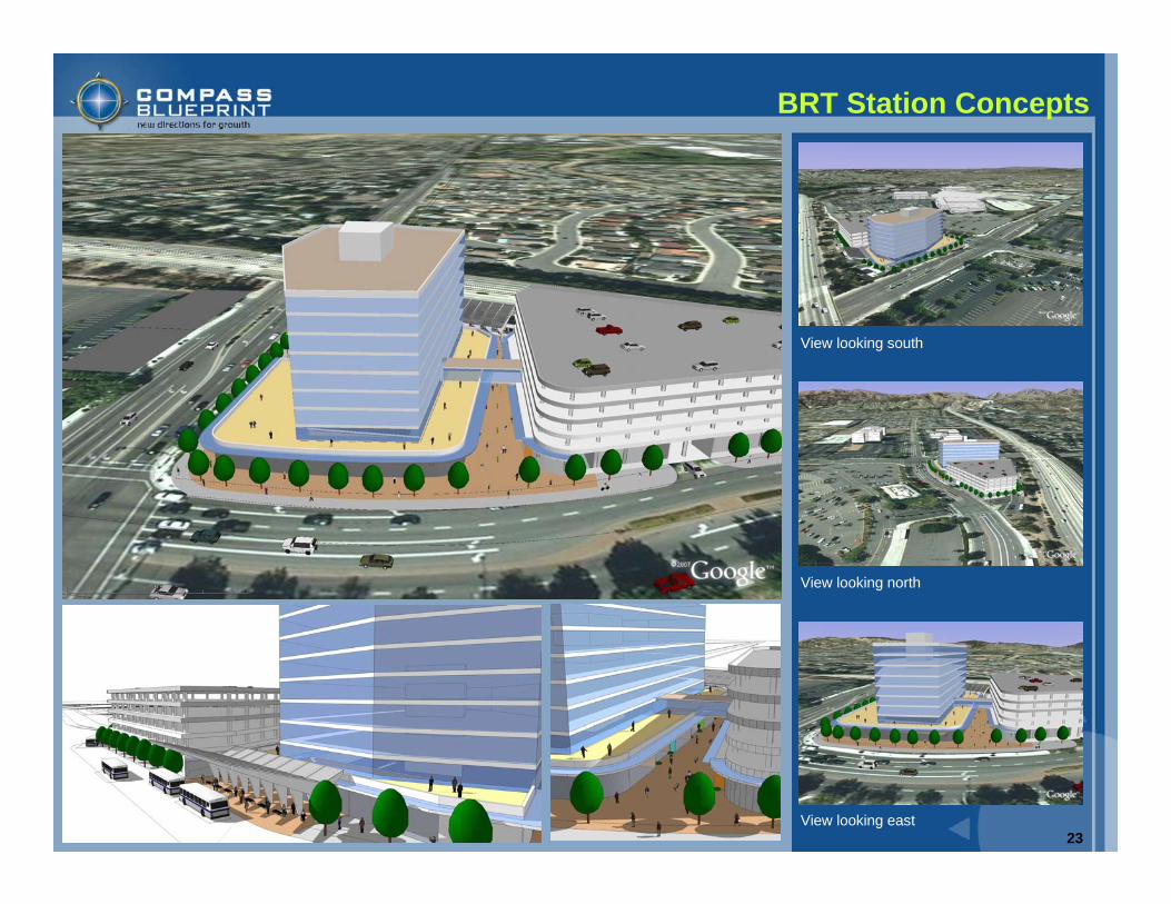
BRT Station Concepts
View looking south
View looking east
View looking north
24
Transit-Supportive Policies
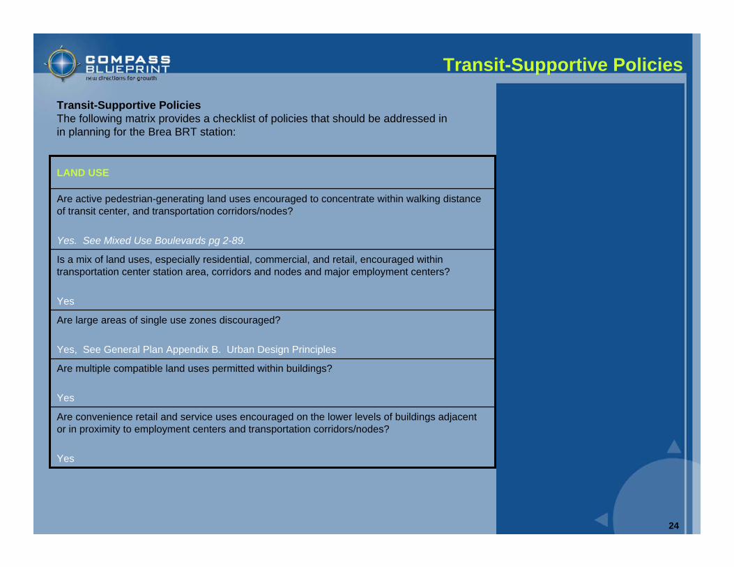
Are convenience retail and service uses encouraged on the lower levels of buildings adjacent or in proximity to employment centers and transportation corridors/nodes?
Yes
Are multiple compatible land uses permitted within buildings?
Yes
Are large areas of single use zones discouraged?
Yes, See General Plan Appendix B. Urban Design Principles
Is a mix of land uses, especially residential, commercial, and retail, encouraged within transportation center station area, corridors and nodes and major employment centers?
Yes
Are active pedestrian-generating land uses encouraged to concentrate within walking distance of transit center, and transportation corridors/nodes?
Yes. See Mixed Use Boulevards pg 2-89.
LAND USE
Transit-Supportive PoliciesThe following matrix provides a checklist of policies that should be addressed inin planning for the Brea BRT station:
25
Transit-Supportive Policies
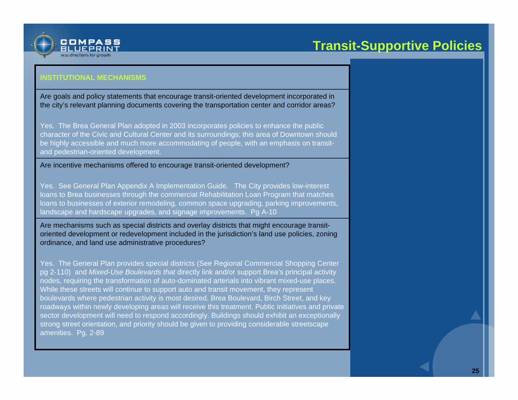
Are mechanisms such as special districts and overlay districts that might encourage transit-oriented development or redevelopment included in the jurisdiction’s land use policies, zoning ordinance, and land use administrative procedures?
Yes. The General Plan provides special districts (See Regional Commercial Shopping Center pg 2-110) and Mixed-Use Boulevards that directly link and/or support Brea’s principal activity nodes, requiring the transformation of auto-dominated arterials into vibrant mixed-use places. While these streets will continue to support auto and transit movement, they represent boulevards where pedestrian activity is most desired. Brea Boulevard, Birch Street, and key roadways within newly developing areas will receive this treatment. Public initiatives and private sector development will need to respond accordingly. Buildings should exhibit an exceptionally strong street orientation, and priority should be given to providing considerable streetscape amenities. Pg. 2-89
Are incentive mechanisms offered to encourage transit-oriented development?
Yes. See General Plan Appendix A Implementation Guide. The City provides low-interest loans to Brea businesses through the commercial Rehabilitation Loan Program that matches loans to businesses of exterior remodeling, common space upgrading, parking improvements, landscape and hardscape upgrades, and signage improvements. Pg A-10
Are goals and policy statements that encourage transit-oriented development incorporated in the city’s relevant planning documents covering the transportation center and corridor areas?
Yes. The Brea General Plan adopted in 2003 incorporates policies to enhance the public character of the Civic and Cultural Center and its surroundings; this area of Downtown should be highly accessible and much more accommodating of people, with an emphasis on transit-and pedestrian-oriented development.
INSTITUTIONAL MECHANISMS
26
Transit-Supportive Policies
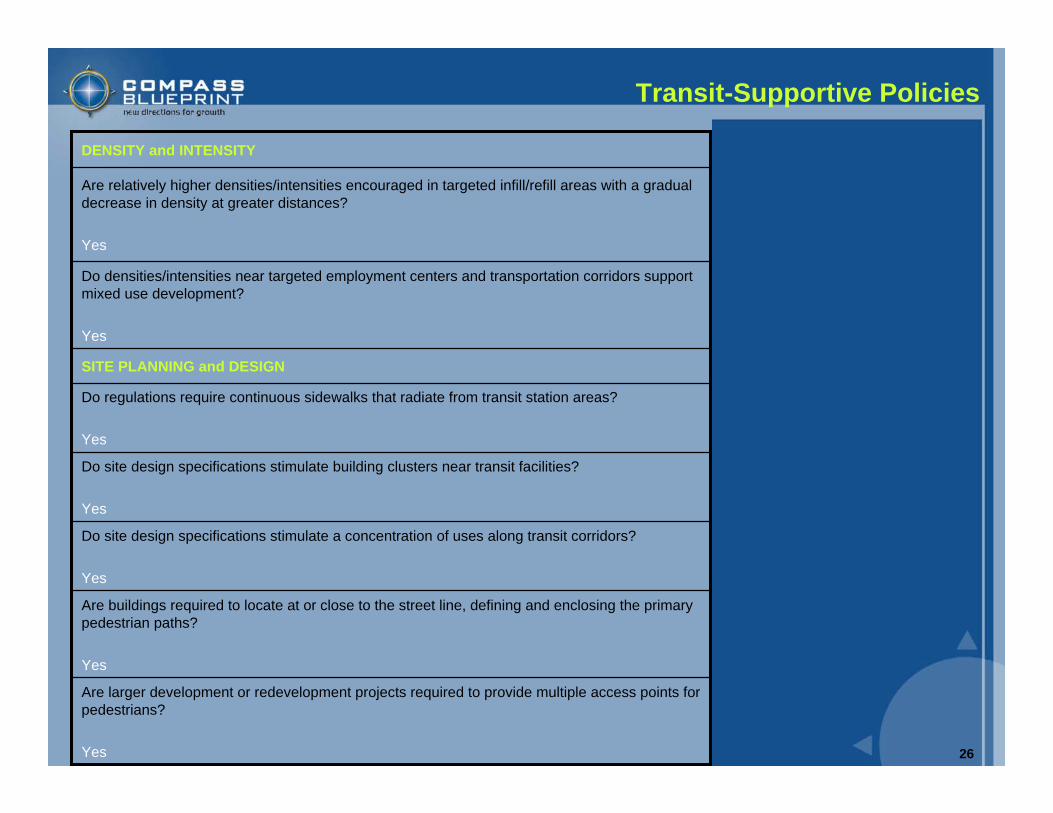
Are larger development or redevelopment projects required to provide multiple access points for pedestrians?
Yes
Are buildings required to locate at or close to the street line, defining and enclosing the primary pedestrian paths?
Yes
Do site design specifications stimulate a concentration of uses along transit corridors?
Yes
Do site design specifications stimulate building clusters near transit facilities?
Yes
Do regulations require continuous sidewalks that radiate from transit station areas?
Yes
SITE PLANNING and DESIGN
Do densities/intensities near targeted employment centers and transportation corridors support mixed use development?
Yes
Are relatively higher densities/intensities encouraged in targeted infill/refill areas with a gradual decrease in density at greater distances?
Yes
DENSITY and INTENSITY
27
Transit-Supportive Policies
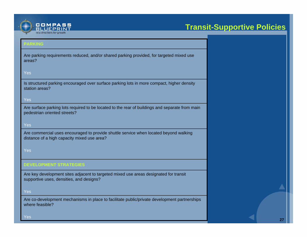
Are co-development mechanisms in place to facilitate public/private development partnerships where feasible?
Yes
Are key development sites adjacent to targeted mixed use areas designated for transit supportive uses, densities, and designs?
Yes
DEVELOPMENT STRATEGIES
Are commercial uses encouraged to provide shuttle service when located beyond walking distance of a high capacity mixed use area?
Yes
Are surface parking lots required to be located to the rear of buildings and separate from main pedestrian oriented streets?
Yes
Is structured parking encouraged over surface parking lots in more compact, higher density station areas?
Yes
Are parking requirements reduced, and/or shared parking provided, for targeted mixed use areas?
Yes
PARKING
28
Next Steps
Next StepsThe concepts and plans presented in this report are not prescribed plans, but rather are intended to provide the City of Brea, OCTA, business owners, and residents with ideas and concepts to use in the design of the future BRT station. The following next steps have been identified to ensure the BRT station addresses the short-term and long-term needs for all parties involved.
• Continue discussions with OCTA to discuss specific needs, shared goals, joint development opportunities, and transit station vision
• Continue to receive input from business owners, residents, and other stakeholders on the City’s vision for the BRT station
• Assess future BRT station concepts in terms of their long-term benefits to the City’s vision for the area and OCTA’s goals for BRT service
• Continue to educate stakeholders about BRT and the benefits comprehensive transit planning in north Orange County
29
Next Steps
Barriers to Creating a Transit-Oriented DevelopmentCities that want to create transit-oriented districts around commuter rail and/or bus rapid transit systems must overcome several obstacles in their way. The following list is provided to help cities identify possible barriers to transit-oriented development projects so they can be addressed early in the planning process.
• Higher construction costs associated with multi-story structures • Costs for site clearance, environmental remediation, and infrastructure
upgrading• Real versus perceived market demand for higher density housing near transit• Lack of developer interest in creating a TOD project near non fixed-guideway
systems (e.g., BRT) • Lack of developable parcels• Differing goals among actors and stakeholders • Conflicting views of the primary role of a transit station - a node in a
transportation network versus a place that is a focal point for neighborhood• Lack of local expertise in planning and implementation• Lack of collaboration between participating agencies• Transit agency requirements for parking
30
Next Steps
Joint DevelopmentJoint development represents active cooperation between the public and private sectors in undertaking real estate ventures which either physically connect to or functionally support a transit facility.
The term ‘joint development’ is also meant to cover those value capture mechanisms aimed at ensuring that the public shares in the benefit which accrues to the private sector (property owner/developer) because of improved access to a regional transit facility. Joint development at transit stations can include:
• Air-rights development• Ground-lease arrangements• Station interface or connection-fee programs • Other initiatives that promote real-estate development at or near transit stations
to the mutual benefit of public and private interests
• Increased ridership and the associated revenue gains• Revitalization of neighborhoods• Financial gains for joint development opportunities• Increases in the supply of affordable housing• Profits to those who own land and businesses near transit stops• Congestion relief• Improved safety for pedestrians and cyclists
Focusing growth around transit stations capitalizes on expensive public investments in transit by producing local and regional benefits. Benefit of TOD and joint development may include:


![[A4] XIAOMEI_Guangzhou BRT and New BRT in China - Ed](https://img.pdfslide.us/doc/110x75/577ce47b1a28abf1038e73a0/a4-xiaomeiguangzhou-brt-and-new-brt-in-china-ed.jpg)