Embed Size (px)
Citation preview
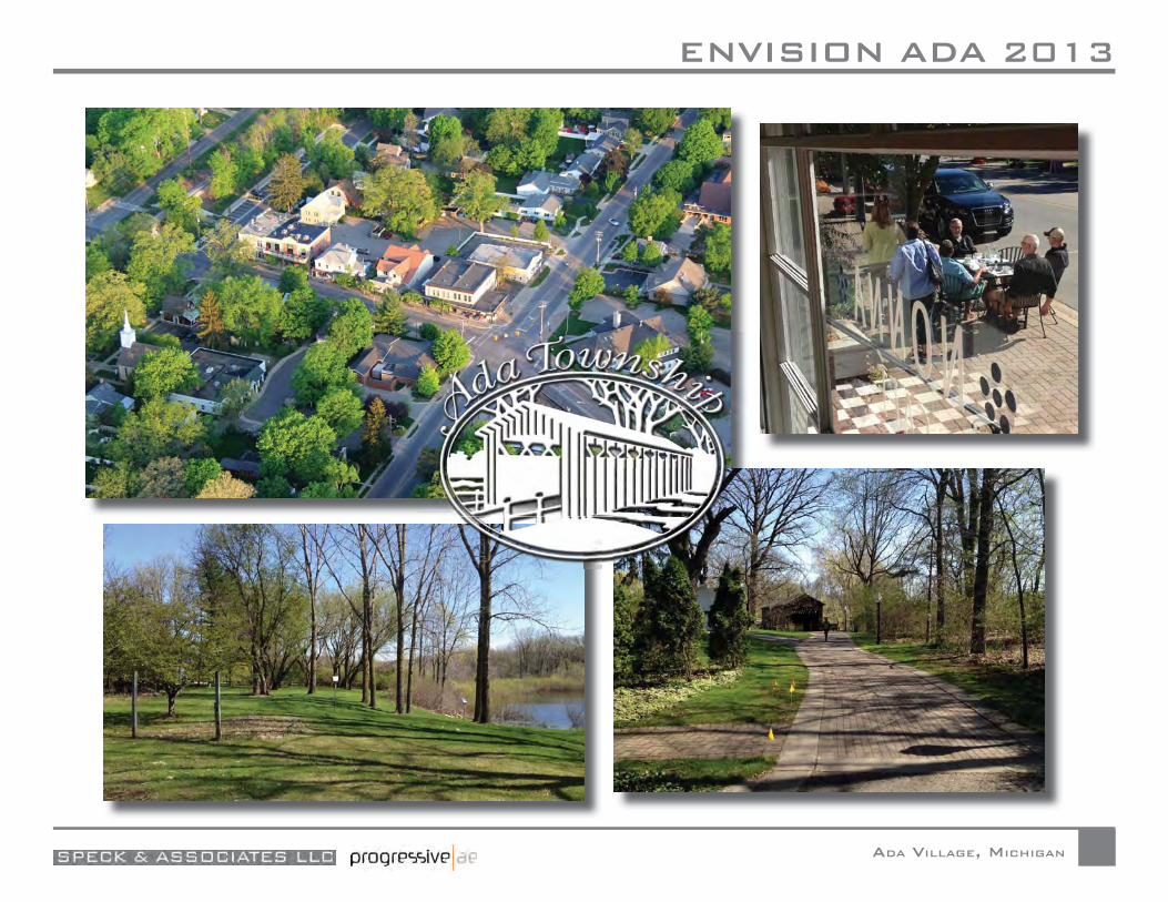
ENVISION ADA 2013
ADA VILLAGE, MICHIGAN

ENVISION ADA 2013
ADA VILLAGE, MICHIGAN
CONTENTS
INTRODUCTION. . . . . . . . . . . . . . . . . . . . i
I: PRE-DESIGN Existing Conditions . . . . . . . . . . . . . . . . . . . . . .I-1 Study Area . . . . . . . . . . . . . . . . . . . . . . . . .I-2 Boundaries and Activity . . . . . . . . . . . . . . . . . .I-2 Thoroughfares . . . . . . . . . . . . . . . . . . . . . . .I-2 Landscape . . . . . . . . . . . . . . . . . . . . . . . . .I-4 Land Use . . . . . . . . . . . . . . . . . . . . . . . . . .I-9 Buildings . . . . . . . . . . . . . . . . . . . . . . . . . I-10 Parking . . . . . . . . . . . . . . . . . . . . . . . . . . I-12 Public Utilities . . . . . . . . . . . . . . . . . . . . . . I-12 Public Engagement . . . . . . . . . . . . . . . . . . . . . I-14 Project Website/Facebook Page . . . . . . . . . . . . I-14 Walking Tour . . . . . . . . . . . . . . . . . . . . . . . I-15 Stakeholder Meetings . . . . . . . . . . . . . . . . . . I-15 Agency Meetings. . . . . . . . . . . . . . . . . . . . . I-16 Community Open House . . . . . . . . . . . . . . . . I-17
ENVISION ADA 2013
ADA VILLAGE, MICHIGAN
II: PRELIMINARY DESIGN 1. The Preliminary Plans . . . . . . . . . . . . . . . . II-1 The 2007 Charrette Plan . . . . . . . . . . . . . . II-1 Plan A . . . . . . . . . . . . . . . . . . . . . . . . II-3 Plan B . . . . . . . . . . . . . . . . . . . . . . . . II-5 2. The Public Response . . . . . . . . . . . . . . . . . II-7
III: FINAL DESIGN — THE PLAN 1. The Plan . . . . . . . . . . . . . . . . . . . . . . . . III-1 The Central Section. . . . . . . . . . . . . . . . . III-2 Thoroughfares . . . . . . . . . . . . . . . . . . . III-3 Landscape . . . . . . . . . . . . . . . . . . . . . . III-4 Buildings . . . . . . . . . . . . . . . . . . . . . . III-5 Demolition . . . . . . . . . . . . . . . . . . III-5 Construction . . . . . . . . . . . . . . . . . III-6 The Western Section . . . . . . . . . . . . . . . . III-8 Thoroughfares . . . . . . . . . . . . . . . . . . . III-8 Landscape . . . . . . . . . . . . . . . . . . . . . . III-9 Buildings . . . . . . . . . . . . . . . . . . . . . III-10 2. 3D model. . . . . . . . . . . . . . . . . . . . . . . III-13 3. Plan Capacity (and other statistics) . . . . . . . . III-14 Core Area Land Use and Parking Analysis . . . III-14 Methodology . . . . . . . . . . . . . . . . . . . III-14 Land Use Areas . . . . . . . . . . . . . . . . . . III-14 Parking Calculations . . . . . . . . . . . . . . . III-15
ENVISION ADA 2013
ADA VILLAGE, MICHIGAN
4. Plan Phasing and Cost Estimates . . . . . . . . . . III-16 Development Phasing Plan . . . . . . . . . . . III-16 Phase 1 . . . . . . . . . . . . . . . . . . . . . . III-16 Phase 2 . . . . . . . . . . . . . . . . . . . . . . III-16 Phase 3 . . . . . . . . . . . . . . . . . . . . . . III-16 Phase 4 . . . . . . . . . . . . . . . . . . . . . . III-16 Phase 5 . . . . . . . . . . . . . . . . . . . . . . III-16 Phase 6 . . . . . . . . . . . . . . . . . . . . . . III-17 Phase 7 . . . . . . . . . . . . . . . . . . . . . . III-17 Cost Estimate Assumptions . . . . . . . . . . . . . III-18 5. The Alternative Plan 1 and 2 . . . . . . . . . . . . III-20 6. Comparing the Alternatives . . . . . . . . . . . . III-22
IV: THOROUGHFARES 1. Thoroughfare Design Principles . . . . . . . . . . . IV-1 Induced Speed. . . . . . . . . . . . . . . . . . . . . IV-1 A Safe Walk . . . . . . . . . . . . . . . . . . . . . IV-1 Lanes of Proper Width . . . . . . . . . . . . . . . IV-1 Limited Use and Length of Turn Lane . . . . . . . IV-2 Bike Lanes . . . . . . . . . . . . . . . . . . . . . . IV-2 Continuous On-Street Parking. . . . . . . . . . . IV-2 Pedestrian-Friendly Signalization . . . . . . . . . IV-3 Proper Use of Roundabouts . . . . . . . . . . . . IV-3 2. Redesign of Existing Thoroughfares . . . . . . . . . IV-3
ENVISION ADA 2013
ADA VILLAGE, MICHIGAN
Fulton Street (MI 21) . . . . . . . . . . . . . . . . . IV-3 Ada Drive: East of Thornapple . . . . . . . . . . . . IV-4 Ada Drive: West of Thornapple . . . . . . . . . . . IV-6 Ada Drive: Under Railroad Bridge . . . . . . . . . . IV-7 Thornapple River Drive: West of Ada Drive . . . . . IV-8 Thornapple River Drive: Ada Drive to River . . . . . IV-9 Thornapple River Drive: East of River . . . . . . . IV-10 Bronson Street: East of Ada Drive . . . . . . . . . IV-11 3. Examples of New Thoroughfares. . . . . . . . . . IV-14 Headley Street . . . . . . . . . . . . . . . . . . . . IV-14 Garden Street . . . . . . . . . . . . . . . . . . . . IV-14 Thornapple Mews . . . . . . . . . . . . . . . . . . IV-15 New Street . . . . . . . . . . . . . . . . . . . . . . IV-15 Riverside Drive . . . . . . . . . . . . . . . . . . . IV-16 East Hamlet Loop . . . . . . . . . . . . . . . . . . IV-16 4. Cycle Facilities . . . . . . . . . . . . . . . . . . . . IV-17
V: BUILDING TYPES Large Loft Building. . . . . . . . . . . . . . . . . . . . V-1 Standard Loft . . . . . . . . . . . . . . . . . . . . . . . V-2 Live/Work Rowhouse . . . . . . . . . . . . . . . . . . V-3 Small Rowhouse . . . . . . . . . . . . . . . . . . . . . V-4 Large Rowhouse . . . . . . . . . . . . . . . . . . . . . V-5 Deep-Lot Rowhouse . . . . . . . . . . . . . . . . . . . V-6
ENVISION ADA 2013
ADA VILLAGE, MICHIGAN
Wide-Lot Rowhouse . . . . . . . . . . . . . . . . . . . V-7 Large Wide-Lot Rowhouse . . . . . . . . . . . . . . . V-8 Rear-Wall Rowhouse . . . . . . . . . . . . . . . . . . . V-9
Appendix 1.1 Appendix 1.2Appendix 2.1Appendix 3.1

INTRODUCTION
ADA VILLAGE, MICHIGANPage
i
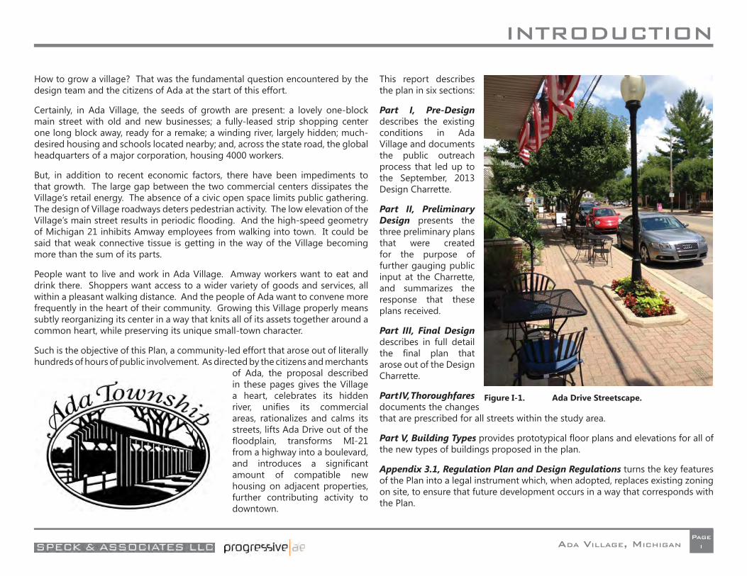
How to grow a village? That was the fundamental question encountered by the design team and the citizens of Ada at the start of this effort.
Certainly, in Ada Village, the seeds of growth are present: a lovely one-block main street with old and new businesses; a fully-leased strip shopping center one long block away, ready for a remake; a winding river, largely hidden; much-desired housing and schools located nearby; and, across the state road, the global headquarters of a major corporation, housing 4000 workers.
But, in addition to recent economic factors, there have been impediments to that growth. The large gap between the two commercial centers dissipates the Village’s retail energy. The absence of a civic open space limits public gathering. The design of Village roadways deters pedestrian activity. The low elevation of the Village’s main street results in periodic fl ooding. And the high-speed geometry of Michigan 21 inhibits Amway employees from walking into town. It could be said that weak connective tissue is getting in the way of the Village becoming more than the sum of its parts.
People want to live and work in Ada Village. Amway workers want to eat and drink there. Shoppers want access to a wider variety of goods and services, all within a pleasant walking distance. And the people of Ada want to convene more frequently in the heart of their community. Growing this Village properly means subtly reorganizing its center in a way that knits all of its assets together around a common heart, while preserving its unique small-town character.
Such is the objective of this Plan, a community-led effort that arose out of literally hundreds of hours of public involvement. As directed by the citizens and merchants
of Ada, the proposal described in these pages gives the Village a heart, celebrates its hidden river, unifi es its commercial areas, rationalizes and calms its streets, lifts Ada Drive out of the fl oodplain, transforms MI-21 from a highway into a boulevard, and introduces a signifi cant amount of compatible new housing on adjacent properties, further contributing activity to downtown.
This report describes the plan in six sections:
Part I, Pre-Design describes the existing conditions in Ada Village and documents the public outreach process that led up to the September, 2013 Design Charrette.
Part II, Preliminary Design presents the three preliminary plans that were created for the purpose of further gauging public input at the Charrette, and summarizes the response that these plans received.
Part III, Final Design describes in full detail the fi nal plan that arose out of the Design Charrette.
Part IV, Thoroughfares documents the changes that are prescribed for all streets within the study area.
Part V, Building Types provides prototypical fl oor plans and elevations for all of the new types of buildings proposed in the plan.
Appendix 3.1, Regulation Plan and Design Regulations turns the key features of the Plan into a legal instrument which, when adopted, replaces existing zoning on site, to ensure that future development occurs in a way that corresponds with the Plan.
Figure I-1. Ada Drive Streetscape.
INTRODUCTION
ADA VILLAGE, MICHIGANPage
ii
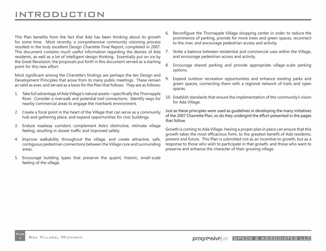
This Plan benefi ts from the fact that Ada has been thinking about its growth for some time. Most recently, a comprehensive community visioning process resulted in the truly excellent Design Charrette Final Report, completed in 2007. This document contains much useful information regarding the desires of Ada residents, as well as a lot of intelligent design thinking. Essentially put on ice by the Great Recession, the proposals put forth in this document served as a starting point for this new effort.
Most signifi cant among the Charrette’s fi ndings are perhaps the ten Design and Development Principles that arose from its many public meetings. These remain as valid as ever, and served as a basis for the Plan that follows. They are as follows:
1. Take full advantage of Ada Village’s natural assets—specifi cally the Thornapple River. Consider a riverwalk and potential trail connections. Identify ways for nearby commercial areas to engage the riverbank environment.
2. Create a focal point in the heart of the Village that can serve as a community hub and gathering place, and expand opportunities for civic buildings.
3. Endure roadway corridors complement Ada’s distinctive, intimate village feeling, resulting in slower traffi c and improved safety.
4. Improve walkability throughout the village, and create attractive, safe, contiguous pedestrian connections between the Village core and surrounding areas.
5. Encourage building types that preserve the quaint, historic, small-scale feeling of the village.
6. Reconfi gure the Thornapple Village shopping center in order to reduce the prominence of parking, provide for more trees and green spaces, reconnect to the river, and encourage pedestrian access and activity.
7. Strike a balance between residential and commercial uses within the Village, and encourage pedestrian access and activity.
8. Encourage shared parking and provide appropriate village-scale parking options.
9. Expand outdoor recreation opportunities and enhance existing parks and green spaces, connecting them with a regional network of trails and open spaces.
10. Establish standards that ensure the implementation of the community’s vision for Ada Village.
Just as these principles were used as guidelines in developing the many initiatives of the 2007 Charrette Plan, so do they undergird the effort presented in the pages that follow.
Growth is coming to Ada Village. Having a proper plan in place can ensure that this growth takes the most effi cacious form, to the greatest benefi t of Ada residents, present and future. This Plan is submitted not as an incentive to growth, but as a response to those who wish to participate in that growth, and those who want to preserve and enhance the character of their growing village.
I: PRE-DESIGN
ADA VILLAGE, MICHIGANPageI-1
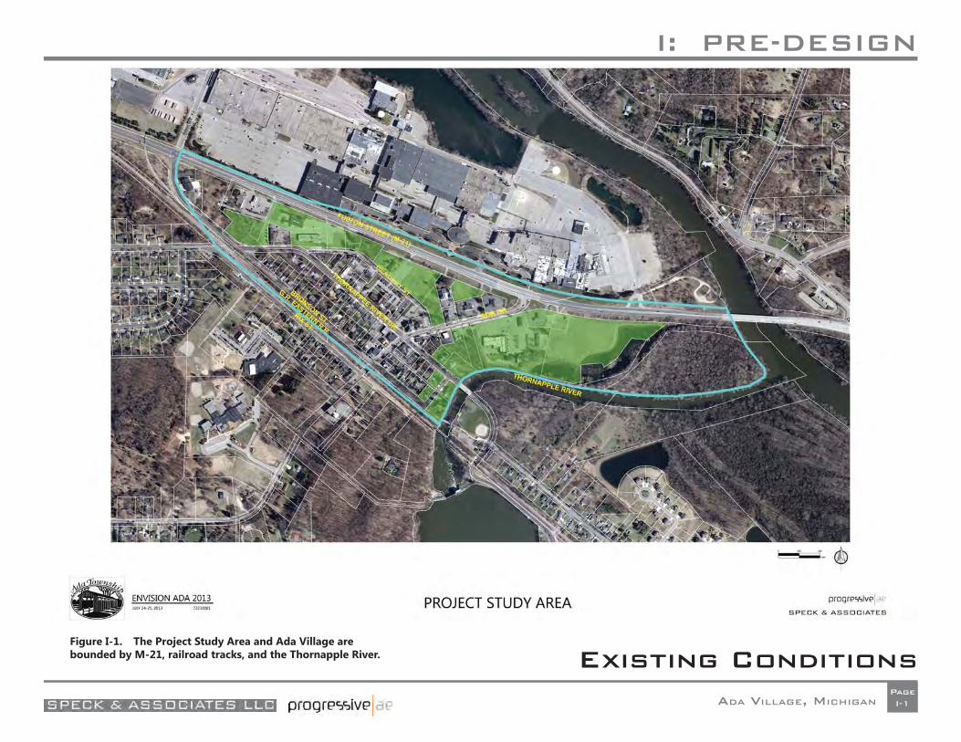
Existing ConditionsFigure I-1. The Project Study Area and Ada Village are bounded by M-21, railroad tracks, and the Thornapple River.
I: PRE-DESIGN
ADA VILLAGE, MICHIGANPageI-2
Study Area
A description of the current conditions of Ada Village can be broken down into the categories of Boundaries and Activity, Thoroughfares, Landscape, and Buildings. Figure I-1 indicates the property owned by Amway Corporation, shown in green.
Boundaries and Activity
Ada Village is effectively bounded by a long triangle consisting of Michigan State Highway 21 to the north, railroad tracks to the south/southwest, and the Thornapple River to the east. The center of the Village, based on where commercial activity takes place, could be said to stretch along Ada Drive from the Thornapple Village Shopping Center to
the railroad track underpass, and then northwest along Thornapple River Drive to embrace the Ada Community Reformed Church, whose parking lot holds the Ada Farmers’ Market.
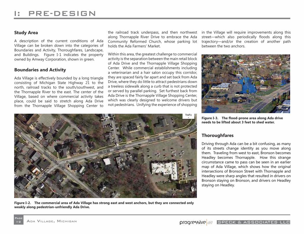
Within this area, the greatest challenge to commercial activity is the separation between the main retail block of Ada Drive and the Thornapple Village Shopping Center. While commercial establishments including a veterinarian and a hair salon occupy this corridor, they are spaced fairly far apart and set back from Ada Drive, where they do little to attract pedestrians down a treeless sidewalk along a curb that is not protected or served by parallel parking. Set furthest back from Ada Drive is the Thornapple Village Shopping Center, which was clearly designed to welcome drivers but not pedestrians. Unifying the experience of shopping
in the Village will require improvements along this street—which also periodically fl oods along this trajectory—and/or the creation of another path between the two anchors.
Thoroughfares
Driving through Ada can be a bit confusing, as many of its streets change identity as you move along them. Traveling from west to east, Bronson becomes Headley becomes Thornapple. How this strange circumstance came to pass can be seen in an earlier map of Ada Village, which shows how the original intersections of Bronson Street with Thornapple and Headley were sharp angles that resulted in drivers on Bronson staying on Bronson, and drivers on Headley staying on Headley.
Figure I-2. The commercial area of Ada Village has strong east and west anchors, but they are connected only weakly along pedestrian-unfriendly Ada Drive.
Figure I-3. The fl ood-prone area along Ada drive needs to be lifted about 3 feet to shed water.
I: PRE-DESIGN
ADA VILLAGE, MICHIGANPageI-3
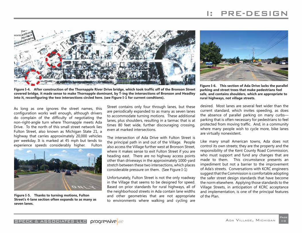
As long as one ignores the street names, this confi guration works well enough, although drivers do complain of the diffi culty of negotiating the non-right-angle turn where Thornapple meets Ada Drive. To the north of this small street network lies Fulton Street, also known as Michigan State 21, a highway that carries approximately 20,000 vehicles per weekday. It is marked at 45 mph but tends to experience speeds considerably higher. Fulton
Street contains only four through lanes, but these are periodically expanded to as many as seven lanes to accommodate turning motions. These additional lanes, plus shoulders, resulting in a tarmac that is at times 80 feet wide, further discouraging crossing, even at marked intersections.
The intersection of Ada Drive with Fulton Street is the principal path in and out of the Village. People also access the Village further west at Bronson Street, where it makes sense to exit Fulton Street if you are heading east. There are no highway access points other than driveways in the approximately 1000-yard stretch between these two intersections, which places considerable pressure on them. (See Figure I-1)
Unfortunately, Fulton Street is not the only roadway in the Village that seems to be designed for speed. Based on prior standards for rural highways, all of the neighborhood streets in Ada contain lane widths and other geometries that are not appropriate to environments where walking and cycling are
desired. Most lanes are several feet wider than the current standard, which invites speeding, as does the absence of parallel parking on many curbs—parking that is often necessary for pedestrians to feel protected from moving traffi c. And, in a community where many people wish to cycle more, bike lanes are virtually nonexistent.
Like many small American towns, Ada does not control its own streets; they are the property and the responsibility of the Kent County Road Commission, who must support and fund any changes that are made to them. This circumstance presents an impediment but not a barrier to the improvement of Ada’s streets. Conversations with KCRC engineers suggest that the Commission is comfortable adopting the safer street design standards that have become the norm elsewhere. Applying those standards to the Village Streets, in anticipation of KCRC acceptance and implementation, is one of the principal features of the Plan.
Figure I-4. After construction of the Thornapple River Drive bridge, which took traffi c off of the Bronson Street covered bridge, it made sense to make Thornapple dominant, by T-ing the intersections of Bronson and Headley into it, reconfi guring the two intersections circled here. (see Figure I-1 for current condtions).
Figure I-5. Thanks to turning motions, Fulton Street’s 4-lane section often expands to as many as seven lanes.
Figure I-6. This section of Ada Drive lacks the parallel parking and street trees that make pedestrians feel safe, and contains shoulders, which are appropriate to rural highways, not village streets.
I: PRE-DESIGN
ADA VILLAGE, MICHIGANPageI-4
Meetings with the County and State roadway agencies indicated that, for the most part, M-21 and the major streets are not experiencing undue congestion. The fi ve key issues/concerns that arose from those discussions (in no particular order of priority) were the need to:
• Address the skewed approaches at the Ada Drive/Thornapple Drive intersection as the current geometry creates sight distance and acute angle turn issues;
• Pursue complete streets tenets within the village roadway network;
• Provide traffi c calming measures on/along M-21 to help reduce speeds within the village area;
• Provide an alternative M-21 pedestrian crossing at/near the Amway driveway located approximately 1,700 feet east of the Bronson Street intersection; and
• Provide improved accessibility to/from M-21 into the village core.
Landscape
While there is a signifi cant amount of open space within the Village, very little of it is shaped or amnestied in a way that would cause it to attract visitors on a regular basis. In American community after community, we have seen how the investment in public spaces of high quality has resulted in positive transformations in civic life, and also led to increases in the value of surrounding properties and businesses—increases that more than justify the cost. While it lacks a central gathering space, Ada Village has two principal locations where gathering either occurs already or is poised to occur.
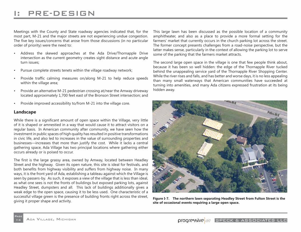
The fi rst is the large grassy area, owned by Amway, located between Headley Street and the highway. Given its open nature, this site is ideal for festivals, and both benefi ts from highway visibility and suffers from highway noise. In many ways, it is the front yard of Ada, establishing a tableau against which the Village is seen by passers-by. As such, it exposes a view of the village that is less than ideal, as what one sees is not the fronts of buildings but exposed parking lots, against Headley Street, dumpsters and all. This lack of buildings additionally gives a weak edge to the open space, causing it to be less used. One characteristic of a successful village green is the presence of building fronts right across the street, giving it proper shape and activity.
This large lawn has been discussed as the possible location of a community amphitheater, and also as a place to provide a more formal setting for the farmers’ market that currently occurs in the church parking lot across the street. The former concept presents challenges from a road-noise perspective, but the latter makes sense, particularly in the context of allowing the parking lot to serve some of the parking that the farmers market attracts.
The second large open space in the village is one that few people think about, because it has been so well hidden: the edge of the Thornapple River tucked behind the unappealing service yard of the Thornapple River Shopping Center. While the river rises and falls, and has better and worse days, it is no less appealing than many small waterways that American communities have succeeded at turning into amenities, and many Ada citizens expressed frustration at its being hidden away.
Figure I-7. The northern lawn separating Headley Street from Fulton Street is the site of occasional events requiring a large open space.

I: PRE-DESIGN
ADA VILLAGE, MICHIGANPageI-5
I: PRE-DESIGN
ADA VILLAGE, MICHIGANPageI-6
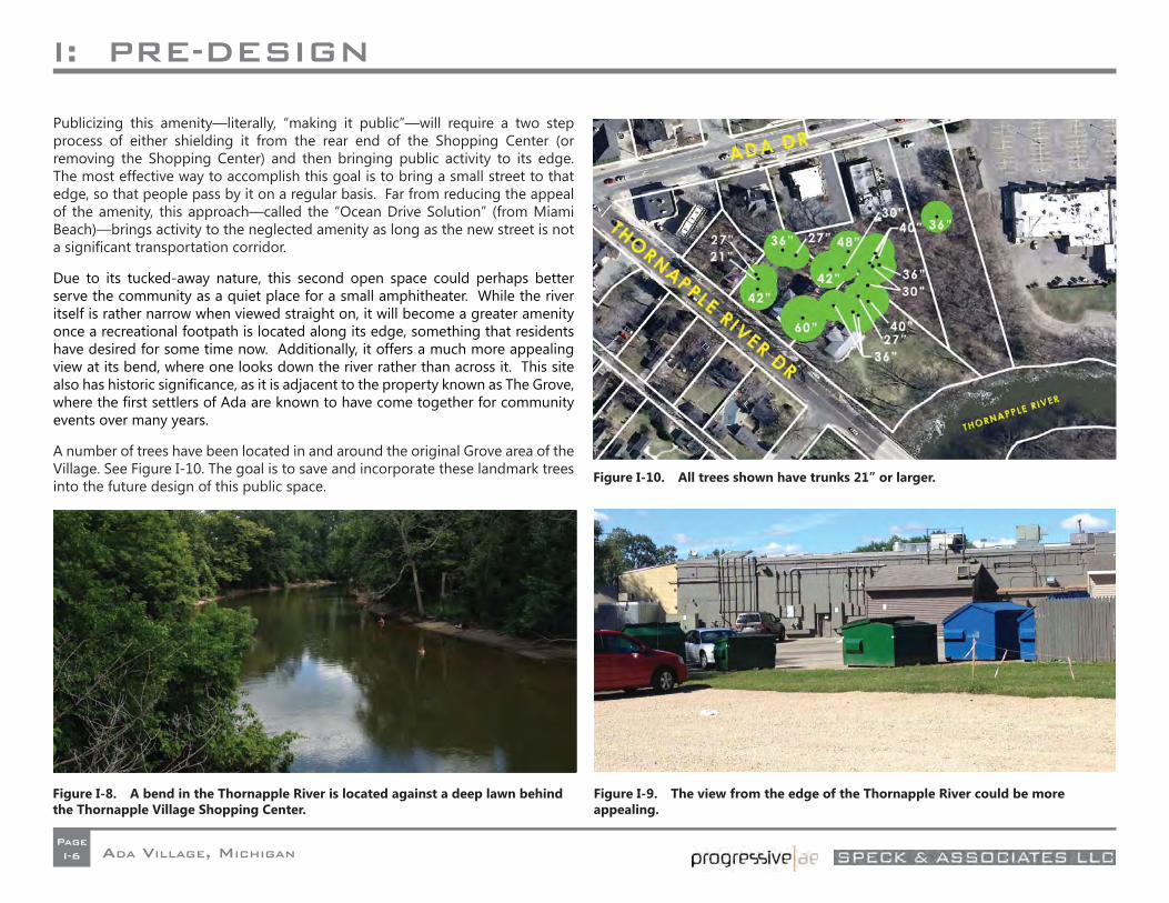
Publicizing this amenity—literally, “making it public”—will require a two step process of either shielding it from the rear end of the Shopping Center (or removing the Shopping Center) and then bringing public activity to its edge. The most effective way to accomplish this goal is to bring a small street to that edge, so that people pass by it on a regular basis. Far from reducing the appeal of the amenity, this approach—called the “Ocean Drive Solution” (from Miami Beach)—brings activity to the neglected amenity as long as the new street is not a signifi cant transportation corridor.
Due to its tucked-away nature, this second open space could perhaps better serve the community as a quiet place for a small amphitheater. While the river itself is rather narrow when viewed straight on, it will become a greater amenity once a recreational footpath is located along its edge, something that residents have desired for some time now. Additionally, it offers a much more appealing view at its bend, where one looks down the river rather than across it. This site also has historic signifi cance, as it is adjacent to the property known as The Grove, where the fi rst settlers of Ada are known to have come together for community events over many years.
A number of trees have been located in and around the original Grove area of the Village. See Figure I-10. The goal is to save and incorporate these landmark trees into the future design of this public space.
Figure I-9. The view from the edge of the Thornapple River could be more appealing.
Figure I-8. A bend in the Thornapple River is located against a deep lawn behind the Thornapple Village Shopping Center.
Figure I-10. All trees shown have trunks 21” or larger.
I: PRE-DESIGN
ADA VILLAGE, MICHIGANPageI-7
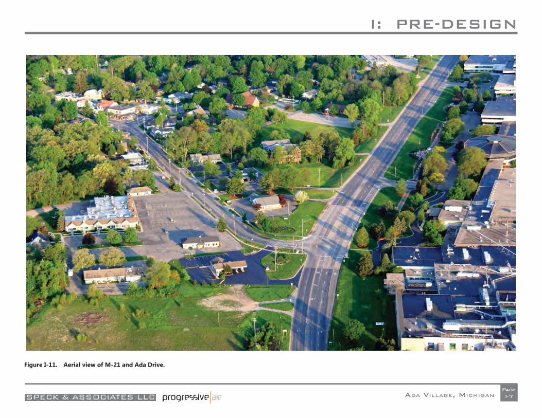
Figure I-11. Aerial view of M-21 and Ada Drive.
I: PRE-DESIGN
ADA VILLAGE, MICHIGANPageI-8
I: PRE-DESIGN
ADA VILLAGE, MICHIGANPageI-9
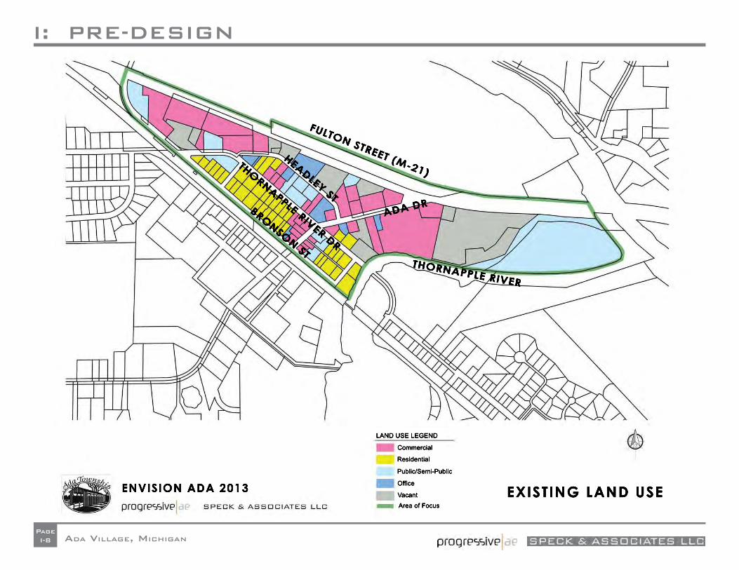
Land Use
The Village has been and continues to be the center of commerce, culture and government in the Township. The following is a brief summary of the current land uses in the Village as shown in the fi gure on the facing page.
• Residential - Most of the residential lots in the Village are single family homes concentrated between Bronson Street and Thornapple River Drive. Some of the Ada’s most architecturally signifi cant homes are located near the covered bridge at the east end of the study area.
• Commercial - The commercial uses in the Village include restaurants, banks, a hardware store, gas stations, a dry cleaner, gift shop, and apparel shop generally located along Ada Drive. The more traditional, walkable commercial core is between Bronson Street and Thornapple River Drive. The suburban, more auto-oriented uses are located between Thornapple River Dr. and M-21. The remainder of the commercial uses is located in a pocket of highway commercial activity located along M-21 just east of Bronson Street and on Thornapple River Drive.
• Offi ce - The offi ce uses are scattered throughout the study area. These include insurance and fi nancial services, general professional and medical facilities.
• Public/Semi-Public - The study area has many of the public/semi-public uses traditionally found in a town center. These include the Ada Township Hall and Fire Station, the U. S. Post Offi ce and the Community Church. At the confl uence of the Grand and Thornapple Rivers is a large undeveloped wooded wetland area owned by the Township.
• Vacant – A signifi cant portion of the study area is currently vacant. The largest parcel is the old Gilmore property at east end of the study area along M-21.
• Adjacent Land Uses - While not part of the study area, the Amway World Headquarters and manufacturing facility north of the Village along M-21 and the residential properties south of Bronson Street have are important to the study area.
I: PRE-DESIGN
ADA VILLAGE, MICHIGANPageI-10
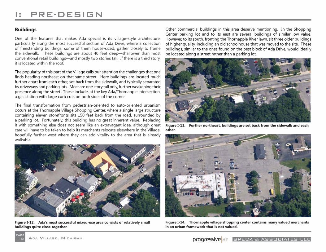
Buildings
One of the features that makes Ada special is its village-style architecture, particularly along the most successful section of Ada Drive, where a collection of freestanding buildings, some of them house-sized, gather closely to frame the sidewalk. These buildings are about 40 feet deep—shallower than most conventional retail buildings—and mostly two stories tall. If there is a third story, it is located within the roof.
The popularity of this part of the Village calls our attention the challenges that one fi nds heading northeast on that same street. Here buildings are located much further apart from each other, set back from the sidewalk, and typically separated by driveways and parking lots. Most are one story tall only, further weakening their presence along the street. These include, at the key Ada/Thornapple intersection, a gas station with large curb cuts on both sides of the corner.
The fi nal transformation from pedestrian-oriented to auto-oriented urbanism occurs at the Thornapple Village Shopping Center, where a single large structure containing eleven storefronts sits 150 feet back from the road, surrounded by a parking lot. Fortunately, this building has no great inherent value. Replacing it with something else does not seem like an extravagant idea, although great care will have to be taken to help its merchants relocate elsewhere in the Village, hopefully further west where they can add vitality to the area that is already walkable.
Other commercial buildings in this area deserve mentioning. In the Shopping Center parking lot and to its east are several buildings of similar low value. However, to its south, fronting the Thornapple River lawn, sit three older buildings of higher quality, including an old schoolhouse that was moved to the site. These buildings, similar to the ones found on the best block of Ada Drive, would ideally be located along a street rather than a parking lot.
Figure I-13. Further northeast, buildings are set back from the sidewalk and each other.
Figure I-12. Ada’s most successful mixed-use area consists of relatively small buildings quite close together.
Figure I-14. Thornapple village shopping center contains many valued merchants in an urban framework that is not valued.
I: PRE-DESIGN
ADA VILLAGE, MICHIGANPageI-11
I: PRE-DESIGN
ADA VILLAGE, MICHIGANPageI-12
Parking
The core area contains approximately 984 parking spaces with 667 space in off-street lots and the remaining 328 spaces on street.
Most of the parking lots are dedicated to single use sites, requiring customers to park in a separate lot for each store visit. This suburban style of parking provision design leads to patron frustration over a lack of adequate parking—both actual and perceived. A more effi cient and effective strategy for parking provision is to consolidate parking spaces into fewer, larger lots, giving customers the ability park once while visiting multiple stores.
Public Utilities
The Village is serviced with public sanitary sewer throughout the study area. This system is owned by Ada Township who is a customer of the City of Grand Rapids for wastewater treatment and transmission. A major pump station is located on M-21 within the study area. Sewage fl ows to this pump station and is then pumped via a forcemain system along Ada Drive to the south. Capacity is adequate to handle the additional demands associated with the development of the scale imagined in this plan.
The Village’s public water system is supplied by the City of Grand Rapids. Public water service in the Village is adequate, but there have been some pressure issues. The Michigan Department of Environmental Quality (MDEQ) has asked the Township to extend a water line across the Thornapple River to better service customers. This improvement may be required by the State as part of this project. The service area will need to be extended in several locations to service this proposed development, and some existing mains will need to be upsized and upgraded due to the age of the pipes.
A storm water distribution system is in place for a portion of the village. This system will need to be upgraded and extended for the proposed development needs. Currently, storm water discharges directly to the Thornapple River. The Township will not require storm water detention, but will require storm water fi ltration to treat the water for sediments prior to discharging into the river. Grouping storm water into areas where larger fi ltration systems can be installed would be the most effi cient way to treat this runoff.
I: PRE-DESIGN
ADA VILLAGE, MICHIGANPageI-13
RIX ST.
FULTON ST. (M-21)
ADA DR.
BRONSON ST.
HEADLEY ST.
THORNAPPLE RIVER DR.
RIVER S
T.Thornapple River
Mid-Michigan RR
630
634
636
632
638
640
642
644
646
648
628
650
652
654
656
658
660
624
622
662
620
664
666
618
668
670
672
614
616
674
626
676
678
680
682
684
686
688
690
692
694
696
698
700
702704 706
708710
712
714 716
718
720
722
724
726728
730732
734
736
738
622
642
682
644
620
632
618
624
624
630
630
628
648
634
62463
0
640
626
624
628
620
630
616
632
622
628
618
632
626
622
624
620
622
622
634
652
630
634
622
632
624
630
622
618
624
630
680
626
618
622
694
622
634
626
632
634
620
614
628
628
626
616
628
616
616
628
628
630
638
638
636
634
630
628
650
618
636
632
640
628
624
624
620
638
640
624
646
628
662
634
620
626
BASE PLAN MAPENVISION ADA 2013JULY 24-25, 2013 72230001
LEGEND100-yearfloodplain
100-yearfloodplain
Project_Outline
!5 Sewer Manholes
Sewer Mains
!( Storm Manholes
Storm Mains
G!. Water Fire Hydrants
Water Mains
Contours
Parcels
SPECK & ASSOCIATES LLC
0 100 200Feet
I: PRE-DESIGN
ADA VILLAGE, MICHIGANPageI-14
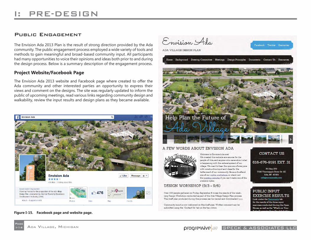
Figure I-15. Facebook page and website page.
Public Engagement
The Envision Ada 2013 Plan is the result of strong direction provided by the Ada community. The public engagement process employed a wide variety of tools and methods to gain meaningful and broad-based community input. All participants had many opportunities to voice their opinions and ideas both prior to and during the design process. Below is a summary description of the engagement process.
Project Website/Facebook Page
The Envision Ada 2013 website and Facebook page where created to offer the Ada community and other interested parties an opportunity to express their views and comment on the designs. The site was regularly updated to inform the public of upcoming meetings, read various links regarding community design and walkability, review the input results and design plans as they became available.
I: PRE-DESIGN
ADA VILLAGE, MICHIGANPageI-15
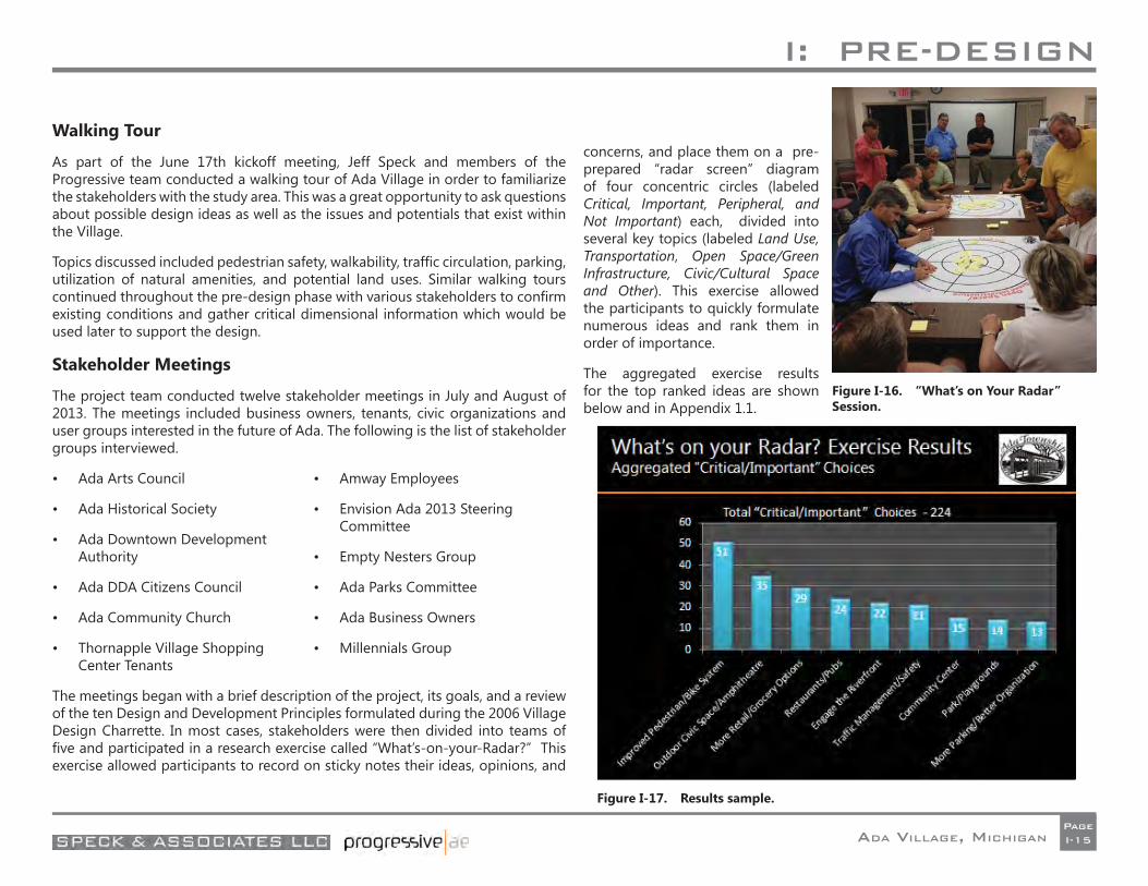
Figure I-16. “What’s on Your Radar” Session.
Figure I-17. Results sample.
Walking Tour
As part of the June 17th kickoff meeting, Jeff Speck and members of the Progressive team conducted a walking tour of Ada Village in order to familiarize the stakeholders with the study area. This was a great opportunity to ask questions about possible design ideas as well as the issues and potentials that exist within the Village.
Topics discussed included pedestrian safety, walkability, traffi c circulation, parking, utilization of natural amenities, and potential land uses. Similar walking tours continued throughout the pre-design phase with various stakeholders to confi rm existing conditions and gather critical dimensional information which would be used later to support the design.
Stakeholder Meetings
The project team conducted twelve stakeholder meetings in July and August of 2013. The meetings included business owners, tenants, civic organizations and user groups interested in the future of Ada. The following is the list of stakeholder groups interviewed.
• Ada Arts Council
• Ada Historical Society
• Ada Downtown Development Authority
• Ada DDA Citizens Council
• Ada Community Church
• Thornapple Village Shopping Center Tenants
• Amway Employees
• Envision Ada 2013 Steering Committee
• Empty Nesters Group
• Ada Parks Committee
• Ada Business Owners
• Millennials Group
The meetings began with a brief description of the project, its goals, and a review of the ten Design and Development Principles formulated during the 2006 Village Design Charrette. In most cases, stakeholders were then divided into teams of fi ve and participated in a research exercise called “What’s-on-your-Radar?” This exercise allowed participants to record on sticky notes their ideas, opinions, and
concerns, and place them on a pre-prepared “radar screen” diagram of four concentric circles (labeled Critical, Important, Peripheral, and Not Important) each, divided into several key topics (labeled Land Use, Transportation, Open Space/Green Infrastructure, Civic/Cultural Space and Other). This exercise allowed the participants to quickly formulate numerous ideas and rank them in order of importance.
The aggregated exercise results for the top ranked ideas are shown below and in Appendix 1.1.
I: PRE-DESIGN
ADA VILLAGE, MICHIGANPageI-16
Agency Meetings
Michigan Department of Transportation (MDOT) and Kent County Road Commission (KCRC)
Meetings were held with both roadway agencies at least twice during the master plan process. Initial meetings (July 8 with KCRC, July 15 with MDOT) were primarily held with staff from each agency to describe the current and upcoming Envision Ada process and to obtain their up-front input and perspective regarding roadway system opportunities and constraints. The real focus was the plan’s expectation to push beyond their current standards regarding street design in order to provide a more complete and walkable street system for all its current and future motorized and non-motorized users. Key initial feedback from the two agencies included support for a raised center median on portions of M-21, tentative support for use of “complete streets” design tenets on the County system (existing and new streets), and some resistance to the concept of multi-lane roundabouts on M-21.
After public and stakeholder meetings and subsequent initial Envision Ada plan design efforts, follow-up meetings were held with both agencies (September 27 with KCRC, September 30 with MDOT) to review the plan’s proposed roadway/street elements. One of the main topics of discussion was the proposed “new” Headley Street alignment and the related shift of Thornapple Drive at the east end and new major intersection with M-21 at the west end. Both agencies staff supported the new alignment although MDOT again expressed a strong preference for traffi c control other than a roundabout at the new M-21/Headley intersection (as well as at the longer term new intersection of M-21/”Main” further east). Additional feedback included:
• Need to revise the geometry of the new Headley Street at/near its west end to provide smoother transition for this future primary roadway (KCRC);
• Confi rmed support of a raised center median on M-21 where applicable – likely requiring widening of M-21 along south side to accommodate 15-16+ foot wide median (MDOT);
• Acceptance of east end transition of Thornapple to Headley in part due to resulting reduced traffi c safety/operational issues at the skewed Ada Drive/Thornapple Drive intersection (KCRC);
• The need for new/improved streets other than Ada Drive, Thornapple Drive, and the new Headley Street to be considered private roads that will not be accepted into the county public street system (KCRC);
• The need for MDOT to complete internal reviews/analyses to confi rm potential signalization at the proposed M-21/Headley intersection (key for safe pedestrian crossing also); and
• Specifi c right-of-way and cross section design input for the new and revised county streets (KCRC).
Upon revisions to the earlier plan, an additional meeting was held at the KCRC request on November 4th to discuss subsequent feedback from the KCRC commissioners. With the caveat that the primary new or reconstructed streets would meet the general KCRC design parameters, the commissioners accepted the plan, except for the unrevised west end of new Headley Street. Subsequent discussions resolved that issue with a slightly revised version of the curvature and boulevard design in that area.
Additional information can be found in the roadway agency meeting notes included in the appendix of this report.
Michigan Department of Environmental Quality (MDEQ)
A meeting with Matt Occhipinti, PE, Grand Rapids District Engineer for Water Resources Division of the MDEQ, was held on July 24, 2013. We discussed the master plan basic principles, and inquired about what development opportunities would be feasible within the fl oodplain and fl oodway of the Thornapple River. Mr. Occhipinti stated that any work within the fl oodplain would require a permit, and that all infi ll within that area would require compensatory storage excavation. This excavation would conform to a 1:1 ratio fi ll volume below the 100 year fl ood elevation (approximately 631). Compensatory excavation described as fi ll placed “as close to the fi ll action as possible,” but moveable to other areas within the drainage boundary. Volume could also be created underground, with Roselle Park and Amway land as additional options.
It was also learned that the fl oodway mapping can be modifi ed by submitting a hydraulic model (HECRAZ) and other required documentation. In addition, an open amphitheater, parking, and boardwalk that could be fl ooded would be allowed in the fl oodplain without requiring compensatory storage. Any
I: PRE-DESIGN
ADA VILLAGE, MICHIGANPageI-17
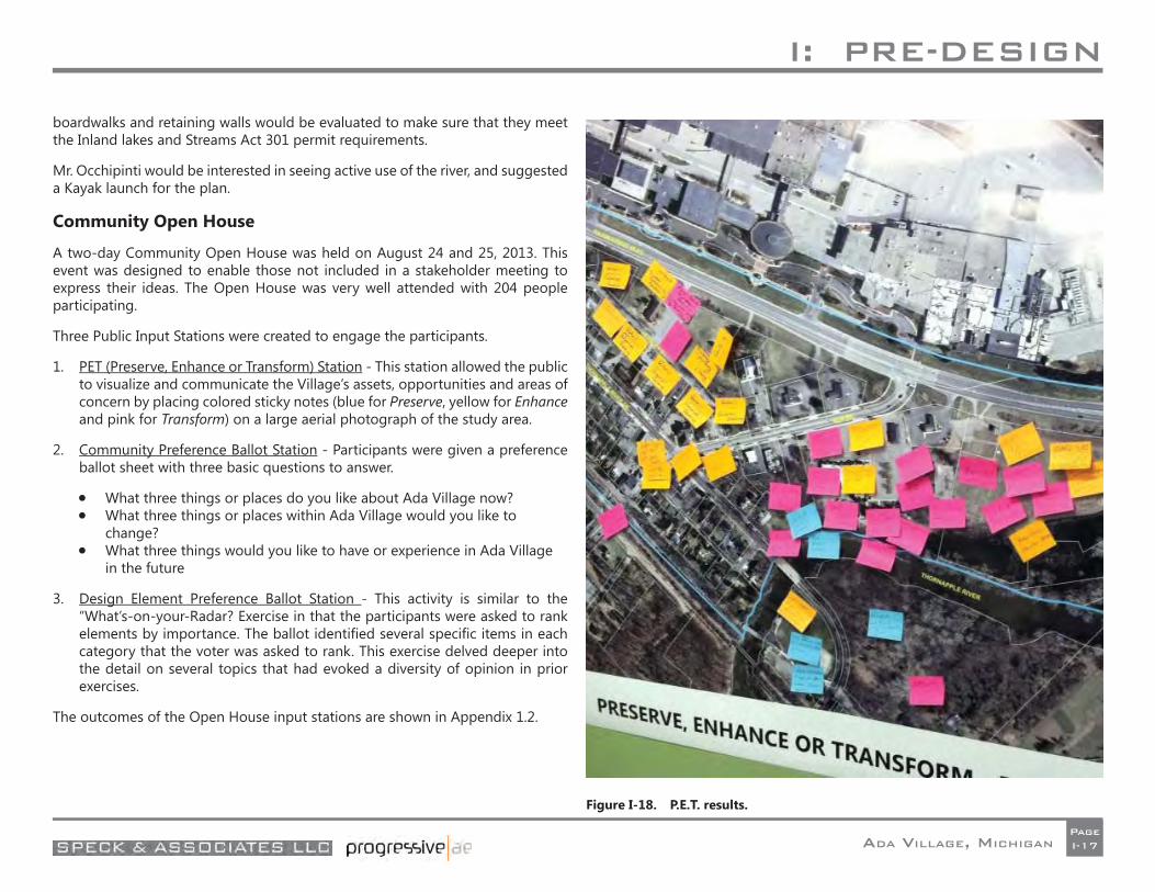
Figure I-18. P.E.T. results.
boardwalks and retaining walls would be evaluated to make sure that they meet the Inland lakes and Streams Act 301 permit requirements.
Mr. Occhipinti would be interested in seeing active use of the river, and suggested a Kayak launch for the plan.
Community Open House
A two-day Community Open House was held on August 24 and 25, 2013. This event was designed to enable those not included in a stakeholder meeting to express their ideas. The Open House was very well attended with 204 people participating.
Three Public Input Stations were created to engage the participants.
1. PET (Preserve, Enhance or Transform) Station - This station allowed the public to visualize and communicate the Village’s assets, opportunities and areas of concern by placing colored sticky notes (blue for Preserve, yellow for Enhance and pink for Transform) on a large aerial photograph of the study area.
2. Community Preference Ballot Station - Participants were given a preference ballot sheet with three basic questions to answer.
What three things or places do you like about Ada Village now? What three things or places within Ada Village would you like to
change? What three things would you like to have or experience in Ada Village
in the future
3. Design Element Preference Ballot Station - This activity is similar to the “What’s-on-your-Radar? Exercise in that the participants were asked to rank elements by importance. The ballot identifi ed several specifi c items in each category that the voter was asked to rank. This exercise delved deeper into the detail on several topics that had evoked a diversity of opinion in prior exercises.
The outcomes of the Open House input stations are shown in Appendix 1.2.

II: PRELIMINARY DESIGN
ADA VILLAGE, MICHIGANPageII-1
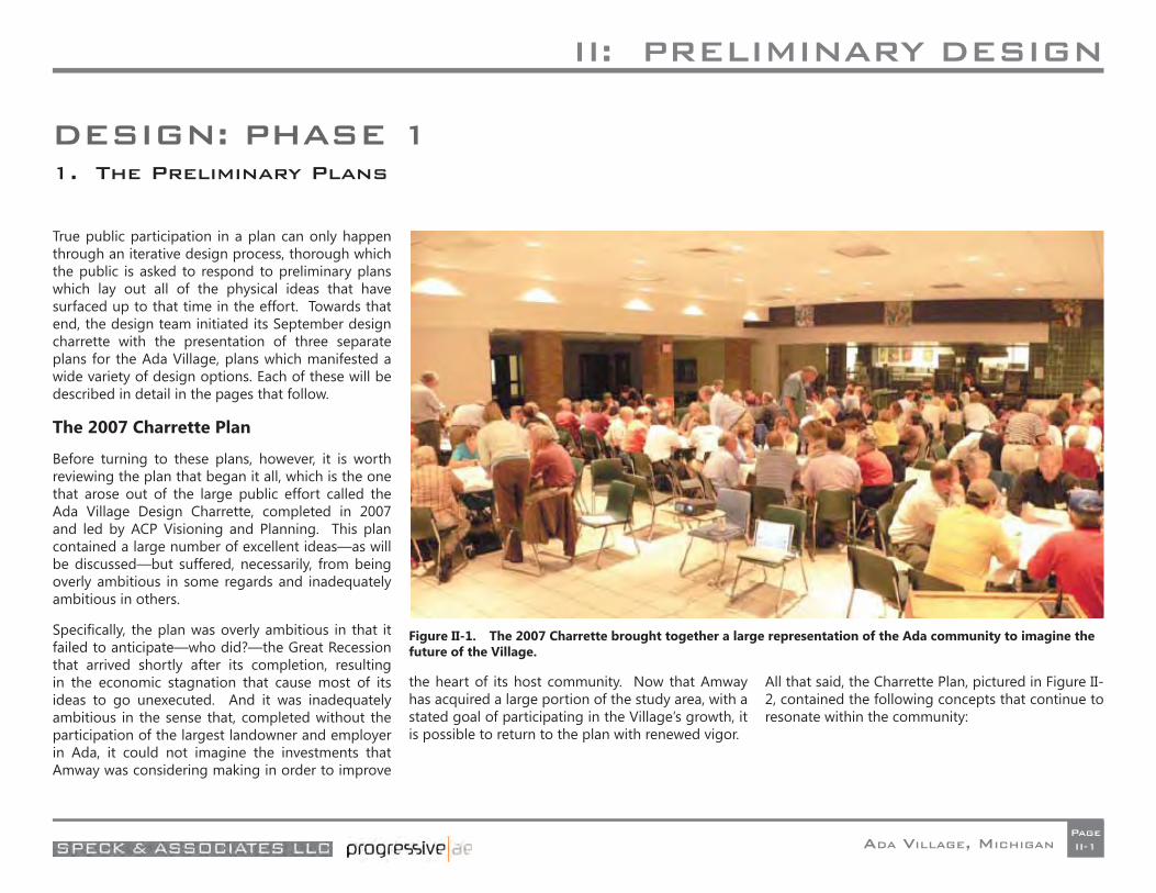
DESIGN: PHASE 11. The Preliminary Plans
True public participation in a plan can only happen through an iterative design process, thorough which the public is asked to respond to preliminary plans which lay out all of the physical ideas that have surfaced up to that time in the effort. Towards that end, the design team initiated its September design charrette with the presentation of three separate plans for the Ada Village, plans which manifested a wide variety of design options. Each of these will be described in detail in the pages that follow.
The 2007 Charrette Plan
Before turning to these plans, however, it is worth reviewing the plan that began it all, which is the one that arose out of the large public effort called the Ada Village Design Charrette, completed in 2007 and led by ACP Visioning and Planning. This plan contained a large number of excellent ideas—as will be discussed—but suffered, necessarily, from being overly ambitious in some regards and inadequately ambitious in others.
Specifi cally, the plan was overly ambitious in that it failed to anticipate—who did?—the Great Recession that arrived shortly after its completion, resulting in the economic stagnation that cause most of its ideas to go unexecuted. And it was inadequately ambitious in the sense that, completed without the participation of the largest landowner and employer in Ada, it could not imagine the investments that Amway was considering making in order to improve
the heart of its host community. Now that Amway has acquired a large portion of the study area, with a stated goal of participating in the Village’s growth, it is possible to return to the plan with renewed vigor.
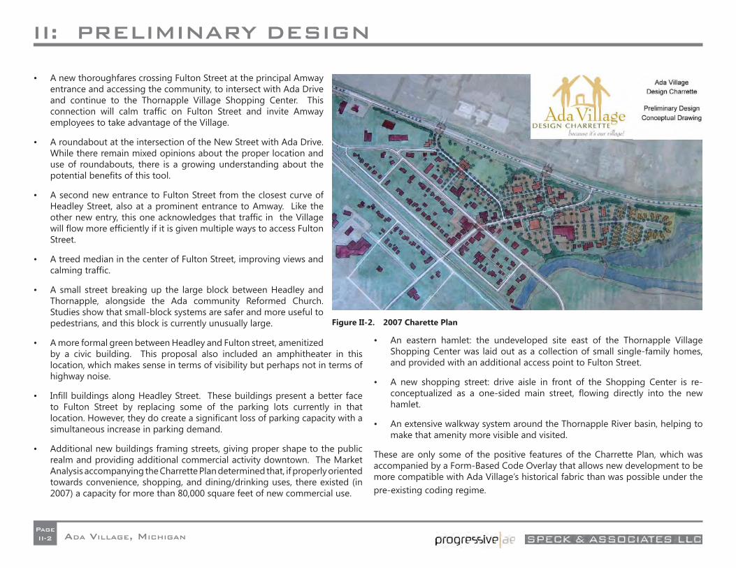
All that said, the Charrette Plan, pictured in Figure II-2, contained the following concepts that continue to resonate within the community:
Figure II-1. The 2007 Charrette brought together a large representation of the Ada community to imagine the future of the Village.
II: PRELIMINARY DESIGN
ADA VILLAGE, MICHIGANPageII-2
• A new thoroughfares crossing Fulton Street at the principal Amway entrance and accessing the community, to intersect with Ada Drive and continue to the Thornapple Village Shopping Center. This connection will calm traffi c on Fulton Street and invite Amway employees to take advantage of the Village.
• A roundabout at the intersection of the New Street with Ada Drive. While there remain mixed opinions about the proper location and use of roundabouts, there is a growing understanding about the potential benefi ts of this tool.
• A second new entrance to Fulton Street from the closest curve of Headley Street, also at a prominent entrance to Amway. Like the other new entry, this one acknowledges that traffi c in the Village will fl ow more effi ciently if it is given multiple ways to access Fulton Street.
• A treed median in the center of Fulton Street, improving views and calming traffi c.
• A small street breaking up the large block between Headley and Thornapple, alongside the Ada community Reformed Church. Studies show that small-block systems are safer and more useful to pedestrians, and this block is currently unusually large.
• A more formal green between Headley and Fulton street, amenitized by a civic building. This proposal also included an amphitheater in this location, which makes sense in terms of visibility but perhaps not in terms of highway noise.
• Infi ll buildings along Headley Street. These buildings present a better face to Fulton Street by replacing some of the parking lots currently in that location. However, they do create a signifi cant loss of parking capacity with a simultaneous increase in parking demand.
• Additional new buildings framing streets, giving proper shape to the public realm and providing additional commercial activity downtown. The Market Analysis accompanying the Charrette Plan determined that, if properly oriented towards convenience, shopping, and dining/drinking uses, there existed (in 2007) a capacity for more than 80,000 square feet of new commercial use.
• An eastern hamlet: the undeveloped site east of the Thornapple Village Shopping Center was laid out as a collection of small single-family homes, and provided with an additional access point to Fulton Street.
• A new shopping street: drive aisle in front of the Shopping Center is re-conceptualized as a one-sided main street, fl owing directly into the new hamlet.
• An extensive walkway system around the Thornapple River basin, helping to make that amenity more visible and visited.
These are only some of the positive features of the Charrette Plan, which was accompanied by a Form-Based Code Overlay that allows new development to be more compatible with Ada Village’s historical fabric than was possible under the pre-existing coding regime.
Figure II-2. 2007 Charette Plan
II: PRELIMINARY DESIGN
ADA VILLAGE, MICHIGANPageII-3
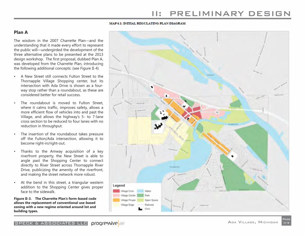
Plan A
The wisdom in the 2007 Charrette Plan—and the understanding that it made every effort to represent the public will—undergirded the development of the three alternative plans to be presented at the 2013 design workshop. The fi rst proposal, dubbed Plan A, was developed from the Charrette Plan, introducing the following additional concepts: (see Figure II-4)
• A New Street still connects Fulton Street to the Thornapple Village Shopping center, but its intersection with Ada Drive is shown as a four-way stop rather than a roundabout, as these are considered better for retail success.
• The roundabout is moved to Fulton Street, where it calms traffi c, improves safety, allows a more effi cient fl ow of vehicles into and past the Village, and allows the highway’s 5- to 7-lane cross section to be reduced to four lanes with no reduction in throughput.
• The insertion of the roundabout takes pressure off the Fulton/Ada intersection, allowing it to become right-in/right-out.
• Thanks to the Amway acquisition of a key riverfront property, the New Street is able to angle past the Shopping Center to connect directly to River Street across Thornapple River Drive, publicizing the amenity of the riverfront, and making the street network more robust.
• At the bend in this street, a triangular western addition to the Shopping Center gives proper face to the sidewalk.
Figure II-3. The Charrette Plan’s form-based code allows the replacement of conventional use-based zoning with a new regime oriented around lot and building types.
II: PRELIMINARY DESIGN
ADA VILLAGE, MICHIGANPageII-4
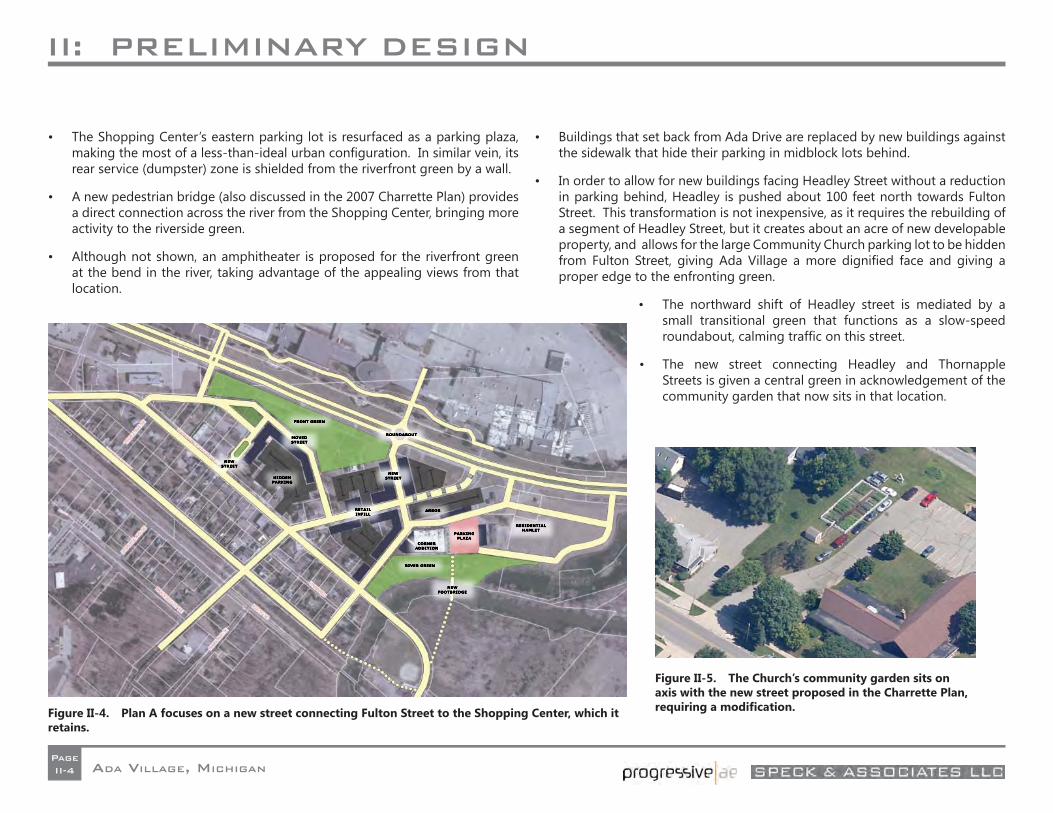
• The Shopping Center’s eastern parking lot is resurfaced as a parking plaza, making the most of a less-than-ideal urban confi guration. In similar vein, its rear service (dumpster) zone is shielded from the riverfront green by a wall.
• A new pedestrian bridge (also discussed in the 2007 Charrette Plan) provides a direct connection across the river from the Shopping Center, bringing more activity to the riverside green.
• Although not shown, an amphitheater is proposed for the riverfront green at the bend in the river, taking advantage of the appealing views from that location.
• Buildings that set back from Ada Drive are replaced by new buildings against the sidewalk that hide their parking in midblock lots behind.
• In order to allow for new buildings facing Headley Street without a reduction in parking behind, Headley is pushed about 100 feet north towards Fulton Street. This transformation is not inexpensive, as it requires the rebuilding of a segment of Headley Street, but it creates about an acre of new developable property, and allows for the large Community Church parking lot to be hidden from Fulton Street, giving Ada Village a more dignifi ed face and giving a proper edge to the enfronting green.
• The northward shift of Headley street is mediated by a small transitional green that functions as a slow-speed roundabout, calming traffi c on this street.
• The new street connecting Headley and Thornapple Streets is given a central green in acknowledgement of the community garden that now sits in that location.
Figure II-4. Plan A focuses on a new street connecting Fulton Street to the Shopping Center, which it retains.
Figure II-5. The Church’s community garden sits on axis with the new street proposed in the Charrette Plan, requiring a modifi cation.
II: PRELIMINARY DESIGN
ADA VILLAGE, MICHIGANPageII-5
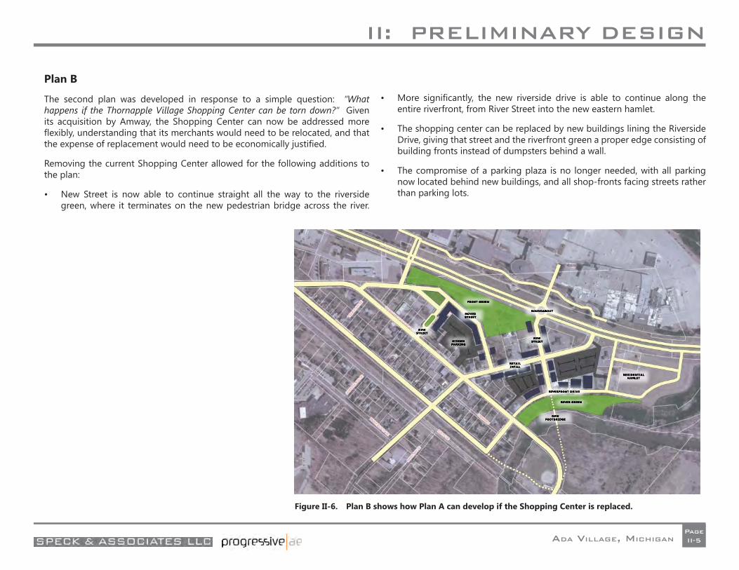
Plan B
The second plan was developed in response to a simple question: “What happens if the Thornapple Village Shopping Center can be torn down?” Given its acquisition by Amway, the Shopping Center can now be addressed more fl exibly, understanding that its merchants would need to be relocated, and that the expense of replacement would need to be economically justifi ed.
Removing the current Shopping Center allowed for the following additions to the plan:
• New Street is now able to continue straight all the way to the riverside green, where it terminates on the new pedestrian bridge across the river.
• More signifi cantly, the new riverside drive is able to continue along the entire riverfront, from River Street into the new eastern hamlet.
• The shopping center can be replaced by new buildings lining the Riverside Drive, giving that street and the riverfront green a proper edge consisting of building fronts instead of dumpsters behind a wall.
• The compromise of a parking plaza is no longer needed, with all parking now located behind new buildings, and all shop-fronts facing streets rather than parking lots.
Figure II-6. Plan B shows how Plan A can develop if the Shopping Center is replaced.

II: PRELIMINARY DESIGN
ADA VILLAGE, MICHIGANPageII-6
Plan C
The third plan was explicitly created with the charge of rejecting most of the ideas in the fi rst two plans, in order to propose the greatest variety of choices to the community. Key features of this plan are as follows:
• The new street and the Riverside Drive have been removed in favor of a new public green reaching from Fulton Street to the River. This green is lined by pedestrian streets and centered upon a pond connected to the river.
• The zone of the residential hamlet is left undeveloped as open space.
• The bend along the River is still developed as a public green, but it is kept tucked away rather than being exposed to public streets.
• Headley Street is still shifted north, but its public green is further constricted (and shaped) by commercial buildings located at its western end. This green is also allowed to cross Headley street and penetrate the adjacent block.
• An auto-oriented commercial zone is placed west of the western connection between Headley and Fulton Streets, in response to the request of several local merchants seeking greater highway visibility.
• In the most signifi cant modifi cation to the plan, the Thornapple/Headley and Thornapple/Ada intersections are reconfi gured so that the principal path through the Village and across Ada drive moves from Thornapple Village Drive to Headley Street. This proposal takes pressure off of the current Thornapple/Ada intersection, which can replace its signal with a three-way stop sign, and creates a new main/main intersection at Headley and Ada.
• The vacated portion of Thornapple, in front of Township Hall is replaced by a pedestrian street. Between this street and the shifted Thornapple, the Speedway gas station and another property are removed to create something that Ada currently lacks: a central green. Here it is shown with a public building upon it—an optional feature—but the key intention of this proposal is to give the Village a civic heart at its geographical center.
Figure II-7. Plan C redirects Thornapple’s traffi c onto Headley Street, creating a central village green.
II: PRELIMINARY DESIGN
ADA VILLAGE, MICHIGANPageII-7
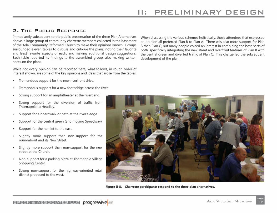
2. The Public ResponseImmediately subsequent to the public presentation of the three Plan Alternatives above, a large group of community charrette members collected in the basement of the Ada Community Reformed Church to make their opinions known. Groups surrounded eleven tables to discuss and critique the plans, noting their favorite and least favorite aspects of each, and making additional design suggestions. Each table reported its fi ndings to the assembled group, also making written notes on the plans.
While not every opinion can be recorded here, what follows, in rough order of interest shown, are some of the key opinions and ideas that arose from the tables:
• Tremendous support for the new riverfront drive.
• Tremendous support for a new footbridge across the river.
• Strong support for an amphitheater at the riverbend.
• Strong support for the diversion of traffi c from Thornapple to Headley.
• Support for a boardwalk or path at the river’s edge.
• Support for the central green (and moving Speedway).
• Support for the hamlet to the east.
• Slightly more support than non-support for the roundabout and its New Street.
• Slightly more support than non-support for the new street at the Church.
• Non-support for a parking plaza at Thornapple Village Shopping Center.
• Strong non-support for the highway-oriented retail district proposed to the west.
When discussing the various schemes holistically, those attendees that expressed an opinion all preferred Plan B to Plan A. There was also more support for Plan B than Plan C, but many people voiced an interest in combining the best parts of both, specifi cally integrating the new street and riverfront features of Plan B with the central green and diverted traffi c of Plan C. This charge led the subsequent development of the plan.
Figure II-8. Charrette participants respond to the three plan alternatives.

III: FINAL DESIGN
ADA VILLAGE, MICHIGANPageIII-1
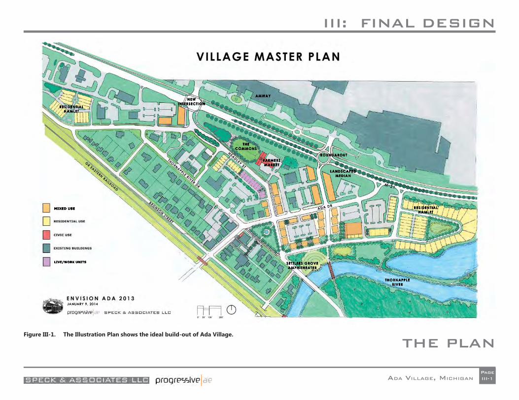
THE PLAN Figure III-1. The Illustration Plan shows the ideal build-out of Ada Village.
III: FINAL DESIGN
ADA VILLAGE, MICHIGANPageIII-2
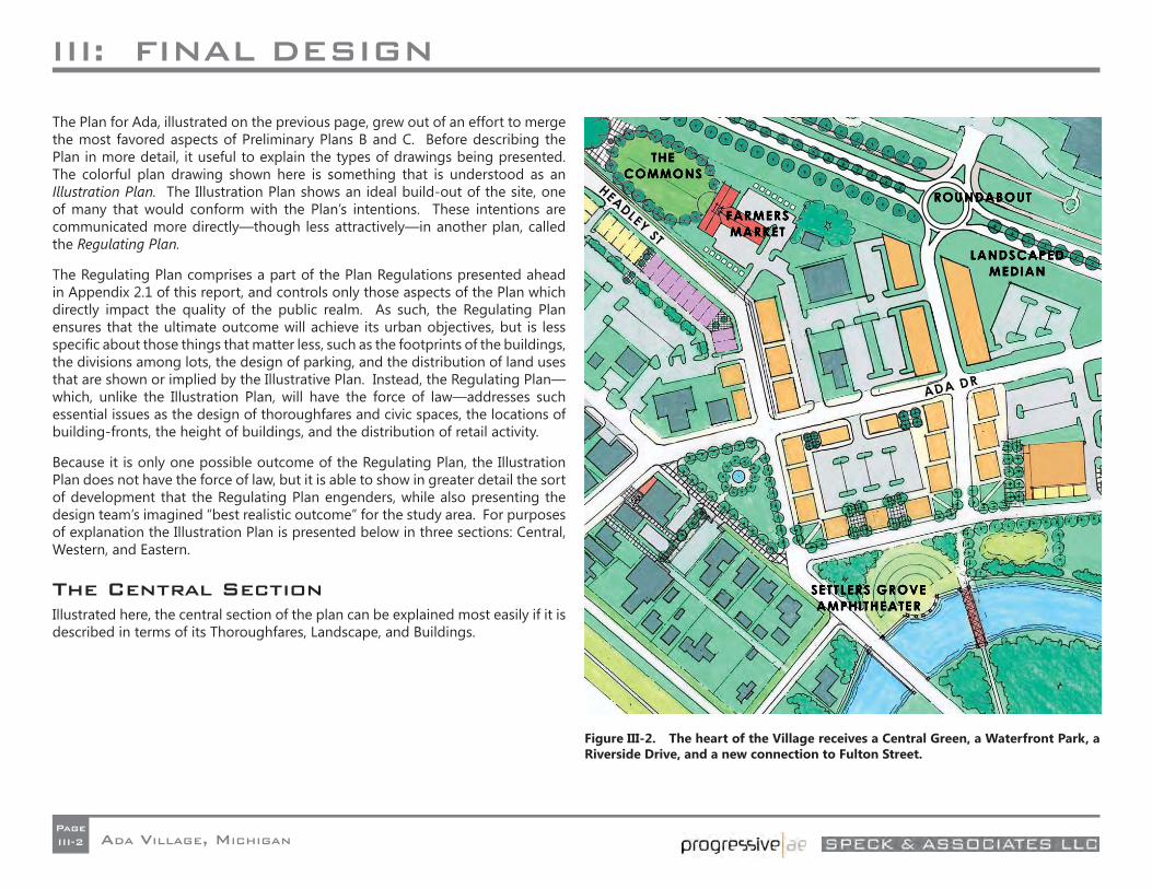
The Plan for Ada, illustrated on the previous page, grew out of an effort to merge the most favored aspects of Preliminary Plans B and C. Before describing the Plan in more detail, it useful to explain the types of drawings being presented. The colorful plan drawing shown here is something that is understood as an Illustration Plan. The Illustration Plan shows an ideal build-out of the site, one of many that would conform with the Plan’s intentions. These intentions are communicated more directly—though less attractively—in another plan, called the Regulating Plan.
The Regulating Plan comprises a part of the Plan Regulations presented ahead in Appendix 2.1 of this report, and controls only those aspects of the Plan which directly impact the quality of the public realm. As such, the Regulating Plan ensures that the ultimate outcome will achieve its urban objectives, but is less specifi c about those things that matter less, such as the footprints of the buildings, the divisions among lots, the design of parking, and the distribution of land uses that are shown or implied by the Illustrative Plan. Instead, the Regulating Plan—which, unlike the Illustration Plan, will have the force of law—addresses such essential issues as the design of thoroughfares and civic spaces, the locations of building-fronts, the height of buildings, and the distribution of retail activity.
Because it is only one possible outcome of the Regulating Plan, the Illustration Plan does not have the force of law, but it is able to show in greater detail the sort of development that the Regulating Plan engenders, while also presenting the design team’s imagined “best realistic outcome” for the study area. For purposes of explanation the Illustration Plan is presented below in three sections: Central, Western, and Eastern.
The Central SectionIllustrated here, the central section of the plan can be explained most easily if it is described in terms of its Thoroughfares, Landscape, and Buildings.
Figure III-2. The heart of the Village receives a Central Green, a Waterfront Park, a Riverside Drive, and a new connection to Fulton Street.
III: FINAL DESIGN
ADA VILLAGE, MICHIGANPageIII-3
Thoroughfares
The Plan proposes the following modifi cations to the Village’s thoroughfares:
• As it heads northwest, Thornapple River Drive is diverted at an angle so that it crosses Ada Drive to intersect with Headley Street. The vacated section of Thornapple, shown in Figure III-3, is replaced with a narrow cobblestone mews heading southeast only, intended principally for pedestrian use. Between these old and new trajectories sits the new Ada Central Green. This change is completed in conjunction with the reconfi guration of the western Thornapple/Headley intersection to favor Headley Street, so that Headley becomes once again the principal east-west corridor through the Village. This reconfi guration allows for the removal of the current Ada/Thornapple traffi c signal. It is likely that the new Ada/Headley intersection can be controlled by a 4-way stop sign. The new segment of Thornapple will include two driving lanes with one parking lane against its one urbanized fl ank.
• A New Street is introduced connecting the Amway main entrance across Fulton Street all the way to the riverfront. The Fulton intersection is shown in the ideal form of a roundabout, although the plan does not depend on a roundabout for its functionality. The New Street will contain two driving lanes fl anked by two parking lanes. The creation of this street, and the future value of Ada Drive, depend on the intersecting segment of Ada drive being lifted about 3 feet above its current fl ood-prone elevation.
• In the short term, Ada Drive is restriped to support slower travel speeds and bicycles. When it is eventually rebuilt to resist fl ooding, it will also need to include parallel parking. Both of these confi gurations are described in more detail ahead under Section IV.
• Thanks to the roundabout, Fulton Street can be transformed from its current 5- to 7- lane confi guration to a 4-lane
confi guration. Ideally, these four lanes are separated by a central median into two 2-lane drives, with both median and fl anks consistently planted with street trees.
• A new Riverside Drive is introduced to open up the river’s edge to the sort of mixed-use development that will cause it to be actively used. Rather than terminating on River Street as in the prior Plan B, this Drive terminates at the southern point of the Central Green, providing a seamless transition from the Village’s heart to its waterfront. As a true drive, this street will consist of two driving lanes with a raised curb and parallel parking against only its one urbanized fl ank.
Figure III-3. Viewed from the north: removing the Speedway gas station allows the diversion of Thornapple to connect to Headley, creating a Central Green.
III: FINAL DESIGN
ADA VILLAGE, MICHIGANPageIII-4
Landscape
The Plan proposes the following modifi cations to the Village’s landscape:
• The Central Green sits framed by Ada Drive, the diverted Thornapple River Drive, and the cobblestone mews occupying the old Thornapple trajectory. Located at the heart of the community, this Green provides a worthy terminus to the best section of Ada Drive and an attractive amenity around which additional retail establishments can be expected to gather. The Central Green is a high-value asset achieved at a high cost: the relocation of the existing Speedway gas station and other adjacent properties, to be discussed below. It is by no means an assured outcome, which is why Alternate Plan are provided in Section III.5 ahead. In addition to drawing shoppers down Ada Drive to the east, the Central Green also reaches south the Riverfront Park. It is expected to include a large central fountain surrounded by benches, and a crosswise path that continues across the street to reach the front door of the Township offi ces.
• The Riverfront Park runs the length of the Thornapple River from Thornapple River Drive to beyond the Thornapple Village Shopping Center. Made accessible by the creation of Riverfront Drive, this park includes the site of the former settlers’ Grove, and takes advantage of the bend in the River to provide uninterrupted water views to the east. This park is proposed to include a civic Amphitheater overlooking the riverbend, next to a new pedestrian bridge that provides an alternative to crossing the river along the unsafe trajectory of Thornapple. From this park, a new path along the River’s edge continues west all the way to the reservoir dam, and east to the banks of the Grand River.
• On the block facing the Riverfront Park, and also just to the east, three small Corner Greens are also added, to draw pedestrians around corners, and to ease access to hidden mid-block parking. Each is anticipated to include trees, a path, and a pair of facing benches.
• Finally, on the western stretch of Ada Drive, a small Sitting Plaza is located where one has been started but not completed, along the back of the telephone switching facility, under some healthy pine trees. This mini plaza, which leads to an existing walkway to mid-block parking, would be framed to its east by a proposed incubator space (described ahead), and provided with a bench or two. Ideally, the path to parking would be framed by a planted trellis.
Figure III-4. Looking east across the Central green to new mixed-use buildings facing the Headley Street extension.
III: FINAL DESIGN
ADA VILLAGE, MICHIGANPageIII-5
Buildings
Due to the anticipated willingness of private parties to redevelop key sites in the village, this plan imagines a signifi cant amount of demolition. It is understood that it is in the best interest of all parties—including the land developers—to secure alternative locations within the Village for any merchants or residents dislocated by this demolition, and to do so well in advance of requesting a vacancy.
Demolition:
Specifi cally, the development of the Central Green requires the relocation of the Speedway gas station, the two houses to its south along Thornapple River Drive, and the building immediately to its east on Ada Drive. Without these relocations, it is not possible to divert Thornapple into Headley across Ada Drive, which is why this report also includes the Alternative Plan presented ahead.
Additionally, in order to optimize the use of the block between the Speedway and the New Street to its east, this plan also envisions the replacement of the two buildings containing Heidi Christine’s Salon and the former Ninth Bridge Market. While these businesses are important community assets, they are located in buildings that are set back from Ada Drive within parking lots, providing a poor edge to the sidewalk and an ineffi cient parking arrangement. Replacing them with new buildings against the street allows for an effi cient mid-block parking lot to be fi t behind them, hidden from view.
Across Ada Drive, the Plan envisions the replacement of the small house at the Headley Street corner with a much larger building. Heading east, the Fifth Third Bank and Chase Bank, each surrounded by parking, are also imagined as replaced by multi-story buildings properly lining sidewalks. The New Street to Fulton can actually be built without this change, but it is hoped that the replacement of these
structures with larger buildings would help justify and support the cost of adding the New Street and lifting Ada Drive out of the fl ood zone.
Finally, as clearly desired by the community the Thornapple Village Shopping Center and its outlying structures are all marked for replacement. These include the three attractive buildings separating the Center’s eastern parking lot from the River, which should all ideally be relocated elsewhere. That said, these structures need not be moved for the Plan to be implemented, as they are located south of the proposed Riverside Drive.
Figure III-5. An amphitheater and new pedestrian bridge bring life to the bend in the Thornapple River.
III: FINAL DESIGN
ADA VILLAGE, MICHIGANPageIII-6
Figure III-6. The New Street reaches from Fulton Street to the River with compatibly-scaled buildings.
Construction
Working from west to east, the central section of the Plan receives the following new buildings:
• A small retail incubator space is attached to the fl ank of the telephone switching building. This building gives a proper commercial edge to an important corner, and also helps to shape the small plaza to its west.
• Flanking Headley Street to the north, new mixed-use buildings are proposed to connect Ada Drive more emphatically to the Township Green along Fulton Street. The fi rst of these buildings is located upon the current parking pad of 558 Ada Drive SE, requiring the cooperation of that owner, who will be provided with compensating parking spaces along Headley Street.
• The new block located between Ada Drive and Riverside Drive will be surrounded by new mixed-use buildings containing a ground fl oor of retail below one or two fl oors of apartments or offi ces. In keeping with Ada’s historic architecture, these buildings are house-sized, and are in some cases separated by small plazas for outdoor dining, easing pedestrian access through the block. To the east, fl anking the New Street, these buildings are set at a slight angle to the sidewalk, creating a sawtooth frontage, emulating the most historic section of Ada Drive.
• Across the New Street, the sawtooth arrangement of new mixed use buildings is repeated.
III: FINAL DESIGN
ADA VILLAGE, MICHIGANPageIII-7
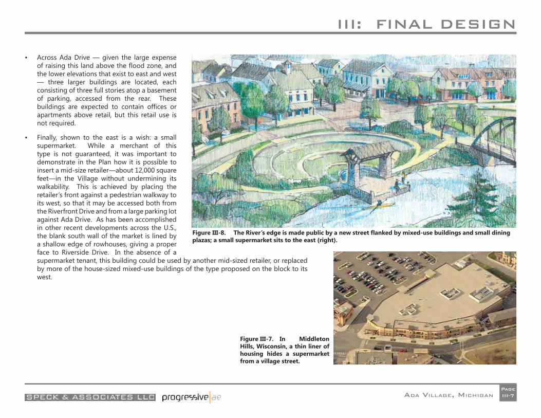
• Across Ada Drive — given the large expense of raising this land above the fl ood zone, and the lower elevations that exist to east and west — three larger buildings are located, each consisting of three full stories atop a basement of parking, accessed from the rear. These buildings are expected to contain offi ces or apartments above retail, but this retail use is not required.
• Finally, shown to the east is a wish: a small supermarket. While a merchant of this type is not guaranteed, it was important to demonstrate in the Plan how it is possible to insert a mid-size retailer—about 12,000 square feet—in the Village without undermining its walkability. This is achieved by placing the retailer’s front against a pedestrian walkway to its west, so that it may be accessed both from the Riverfront Drive and from a large parking lot against Ada Drive. As has been accomplished in other recent developments across the U.S., the blank south wall of the market is lined by a shallow edge of rowhouses, giving a proper face to Riverside Drive. In the absence of a supermarket tenant, this building could be used by another mid-sized retailer, or replaced by more of the house-sized mixed-use buildings of the type proposed on the block to its west.
Figure III-7. In Middleton Hills, Wisconsin, a thin liner of housing hides a supermarket from a village street.
Figure III-8. The River’s edge is made public by a new street fl anked by mixed-use buildings and small dining plazas; a small supermarket sits to the east (right).
III: FINAL DESIGN
ADA VILLAGE, MICHIGANPageIII-8
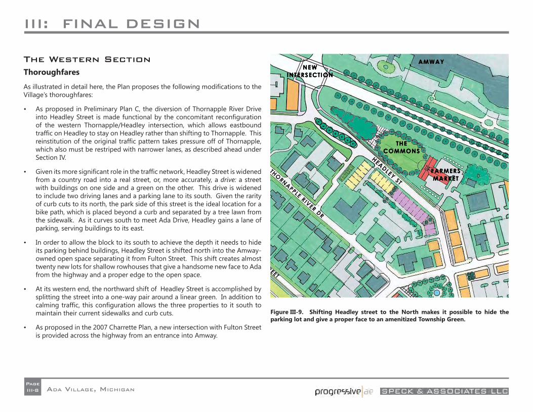
The Western SectionThoroughfares
As illustrated in detail here, the Plan proposes the following modifi cations to the Village’s thoroughfares:
• As proposed in Preliminary Plan C, the diversion of Thornapple River Drive into Headley Street is made functional by the concomitant reconfi guration of the western Thornapple/Headley intersection, which allows eastbound traffi c on Headley to stay on Headley rather than shifting to Thornapple. This reinstitution of the original traffi c pattern takes pressure off of Thornapple, which also must be restriped with narrower lanes, as described ahead under Section IV.
• Given its more signifi cant role in the traffi c network, Headley Street is widened from a country road into a real street, or, more accurately, a drive: a street with buildings on one side and a green on the other. This drive is widened to include two driving lanes and a parking lane to its south. Given the rarity of curb cuts to its north, the park side of this street is the ideal location for a bike path, which is placed beyond a curb and separated by a tree lawn from the sidewalk. As it curves south to meet Ada Drive, Headley gains a lane of parking, serving buildings to its east.
• In order to allow the block to its south to achieve the depth it needs to hide its parking behind buildings, Headley Street is shifted north into the Amway-owned open space separating it from Fulton Street. This shift creates almost twenty new lots for shallow rowhouses that give a handsome new face to Ada from the highway and a proper edge to the open space.
• At its western end, the northward shift of Headley Street is accomplished by splitting the street into a one-way pair around a linear green. In addition to calming traffi c, this confi guration allows the three properties to it south to maintain their current sidewalks and curb cuts.
• As proposed in the 2007 Charrette Plan, a new intersection with Fulton Street is provided across the highway from an entrance into Amway.
Figure III-9. Shifting Headley street to the North makes it possible to hide the parking lot and give a proper face to an amenitized Township Green.
III: FINAL DESIGN
ADA VILLAGE, MICHIGANPageIII-9
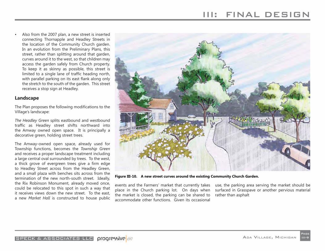
• Also from the 2007 plan, a new street is inserted connecting Thornapple and Headley Streets in the location of the Community Church garden. In an evolution from the Preliminary Plans, this street, rather than splitting around that garden, curves around it to the west, so that children may access the garden safely from Church property. To keep it as skinny as possible, this street is limited to a single lane of traffi c heading north, with parallel parking on its east fl ank along only the stretch to the south of the garden. This street receives a stop sign at Headley.
Landscape
The Plan proposes the following modifi cations to the Village’s landscape:
The Headley Green splits eastbound and westbound traffi c as Headley street shifts northward into the Amway owned open space. It is principally a decorative green, holding street trees.
The Amway-owned open space, already used for Township functions, becomes the Township Green and receives a proper landscape treatment including a large central oval surrounded by trees. To the west, a thick grove of evergreen trees give a fi rm edge to Headley Street across from the Headley Green, and a small plaza with benches sits across from the termination of the new north-south street. Ideally, the Rix Robinson Monument, already moved once, could be relocated to this spot in such a way that it receives views down the new street. To the east, a new Market Hall is constructed to house public
events and the Farmers’ market that currently takes place in the Church parking lot. On days when the market is closed, the parking can be shared to accommodate other functions. Given its occasional
use, the parking area serving the market should be surfaced in Grasspave or another pervious material rather than asphalt
Figure III-10. A new street curves around the existing Community Church Garden.
III: FINAL DESIGN
ADA VILLAGE, MICHIGANPageIII-10
Buildings
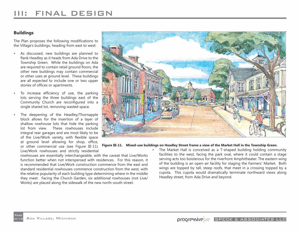
The Plan proposes the following modifi cations to the Village’s buildings, heading from east to west:
• As discussed, new buildings are planned to fl ank Headley as it heads from Ada Drive to the Township Green. While the buildings on Ada are required to contain retail ground fl oors, the other new buildings may contain commercial or other uses at ground level. These buildings are all expected to include one or two upper stories of offi ces or apartments.
• To increase effi ciency of use, the parking lots serving the three buildings east of the Community Church are reconfi gured into a single shared lot, removing wasted space.
• The deepening of the Headley/Thornapple block allows for the insertion of a layer of shallow rowhouse lots that hide the parking lot from view. These rowhouses include integral rear garages and are most likely to be of the Live/Work variety, with fl exible space at ground level allowing for shop, offi ce, or other commercial use (see Figure III-11). Live/Work rowhouses and strictly residential rowhouses are essentially interchangeable, with the caveat that Live/Works function better when not interspersed with residences. For this reason, it is recommended that Live/Work construction commence from the east and standard residential rowhouses commence construction from the west, with the relative popularity of each building type determining where in the middle they meet. Facing the Church Garden, six additional rowhouses (not Live/Works) are placed along the sidewalk of the new north-south street.
• The Market Hall is conceived as a T-shaped building holding community facilities to the west, facing the park oval, where it could contain a stage serving acts too boisterous for the riverfront Amphitheater. The eastern wing of the building is an open-air facility for staging the Farmers’ Market. Both wings are topped by tall, steep roofs, that meet in a crossing topped by a cupola. This cupola would dramatically terminate northward views along Headley street, from Ada Drive and beyond.
Figure III-11. Mixed-use buildings on Headley Street frame a view of the Market Hall in the Township Green.
III: FINAL DESIGN
ADA VILLAGE, MICHIGANPageIII-11
The Far-West Hamlet
One more addition to the Village is proposed at the intersection of Headley and Bronson Streets, where a wooded area sits available for development. A plan laid upon this site allows it to hold 19 rowhouses, most of which sit on deep lots with rear garages located across private patios. The houses frame a sequence of semi-public spaces: an Entry Green, and a Pedestrian Mews with a fountain court at its center, connecting back to an existing private midblock road. In creating a small residential development of this type the details are important. Note, for example, how the end-unit rowhouses along the Entrance Green locate their front doors on their Green-facing fl anks, centered under their gables.
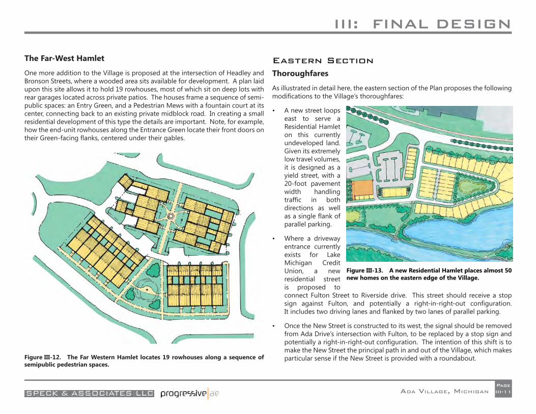
Eastern SectionThoroughfares
As illustrated in detail here, the eastern section of the Plan proposes the following modifi cations to the Village’s thoroughfares:
• A new street loops east to serve a Residential Hamlet on this currently undeveloped land. Given its extremely low travel volumes, it is designed as a yield street, with a 20-foot pavement width handling traffi c in both directions as well as a single fl ank of parallel parking.
• Where a driveway entrance currently exists for Lake Michigan Credit Union, a new residential street is proposed to connect Fulton Street to Riverside drive. This street should receive a stop sign against Fulton, and potentially a right-in-right-out confi guration. It includes two driving lanes and fl anked by two lanes of parallel parking.
• Once the New Street is constructed to its west, the signal should be removed from Ada Drive’s intersection with Fulton, to be replaced by a stop sign and potentially a right-in-right-out confi guration. The intention of this shift is to make the New Street the principal path in and out of the Village, which makes particular sense if the New Street is provided with a roundabout.Figure III-12. The Far Western Hamlet locates 19 rowhouses along a sequence of
semipublic pedestrian spaces.
Figure III-13. A new Residential Hamlet places almost 50 new homes on the eastern edge of the Village.
III: FINAL DESIGN
ADA VILLAGE, MICHIGANPageIII-12
Landscape
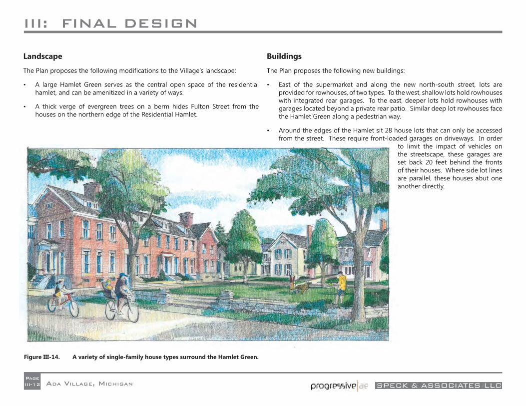
The Plan proposes the following modifi cations to the Village’s landscape:
• A large Hamlet Green serves as the central open space of the residential hamlet, and can be amenitized in a variety of ways.
• A thick verge of evergreen trees on a berm hides Fulton Street from the houses on the northern edge of the Residential Hamlet.
Buildings
The Plan proposes the following new buildings:
• East of the supermarket and along the new north-south street, lots are provided for rowhouses, of two types. To the west, shallow lots hold rowhouses with integrated rear garages. To the east, deeper lots hold rowhouses with garages located beyond a private rear patio. Similar deep lot rowhouses face the Hamlet Green along a pedestrian way.
• Around the edges of the Hamlet sit 28 house lots that can only be accessed from the street. These require front-loaded garages on driveways. In order
to limit the impact of vehicles on the streetscape, these garages are set back 20 feet behind the fronts of their houses. Where side lot lines are parallel, these houses abut one another directly.
Figure III-14. A variety of single-family house types surround the Hamlet Green.
III: FINAL DESIGN
ADA VILLAGE, MICHIGANPageIII-13
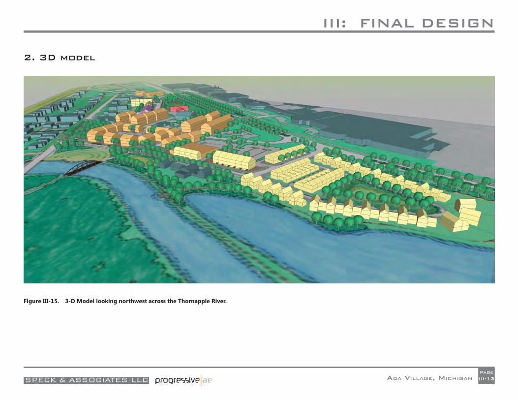
2. 3D model
Figure III-15. 3-D Model looking northwest across the Thornapple River.
III: FINAL DESIGN
ADA VILLAGE, MICHIGANPageIII-14
3. Plan Capacity (and other statistics)Core Area Land Use and Parking Analysis
Core Area
In general, the limits for this analysis are: M-21 to the north, the centerline of Thornapple River Drive to the south, the Thornapple River to the east and the new road adjacent to the Community Church to the west, as shown in the image on the facing page.
The area of analysis has excluded the following properties from the core area:
1. All properties that are not directly affected by the proposed master plan. These properties are generally south of Thornapple River Drive.
2. All properties west of the Amway-owned properties to Bronson, including the U. S. Post Offi ce. This area has not been included in the core area since it is far removed from any of the new retail developments proposed.
3. The two proposed residential hamlets (on the old Gilmore property and just west of the U. S. Post Offi ce). They have been excluded since each one will satisfy its parking needs internally.
Methodology
Since the parking analysis is based on a conceptual master plan, the following assumptions have been made:
All proposed new development is assumed to be retail on the ground fl oor.
All new buildings will have a second story and 50% of all new buildings will have a third story.
All second and third story development will be evenly split between offi ce and residential uses.
All residential development is assumed to be 2-bedroom units.
Standard 2-bedroom units are 1,250 sq. ft.
For parking calculation purposes we have assumed the net fl oor area for all new development is 90% of the gross fl oor area.
The parking requirements are assumed to be:
o Retail – 3 spaces per 1,000 sq. ft. of net fl oor area
o Offi ce – 3 spaces per 1,000 sq. ft. of net fl oor area
o Residential -1.5 spaces per living unit
Existing parking for the Community Church is 81 spaces and is assumed to be suffi cient for present and future needs.
Land Use Areas
The following are the total measured gross areas for all new and existing structures to remain for each land use type.
Retail
Existing Retail to Remain: 13,568 sq. ft.
New Retail: 105,150 sq. ft.
Retail in live /work units: 8,750 sq. ft.
Total: 127,468 sq. ft.
Offi ce
Existing Offi ce to Remain: 18,910 sq. ft.
New Offi ce:
o Second Floor 45,100 sq. ft
o Third Floor 22,550 sq. ft.
Total: 86,560 sq. ft.
Residential
Live/Work: 10 units
Stand-Alone Condo (2-bedroom): 30 units
Mixed-Use Condo (2-bedroom):
o Second Floor 36 units
o Third Floor 18 units
Total: 94 units
The Community Church
The current 81 spaces are assumed to be suffi cient for present and future needs.
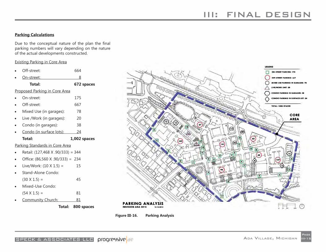
III: FINAL DESIGN
ADA VILLAGE, MICHIGANPageIII-15
Parking Calculations
Due to the conceptual nature of the plan the fi nal parking numbers will vary depending on the nature of the actual developments constructed.
Existing Parking in Core Area
Off-street: 664
On-street: 8
Total: 672 spaces
Proposed Parking in Core Area
On-street: 175
Off-street: 667
Mixed Use (in garages): 78
Live /Work (in garages): 20
Condo (in garages): 38
Condo (in surface lots): 24
Total: 1,002 spaces
Parking Standards in Core Area
Retail: (127,468 X .90/333) = 344
Offi ce: (86,560 X .90/333) = 234
Live/Work: (10 X 1.5) = 15
Stand-Alone Condo:
(30 X 1.5) = 45
Mixed-Use Condo:
(54 X 1.5) = 81
Community Church: 81
Total: 800 spaces
Figure III-16. Parking Analysis
III: FINAL DESIGN
ADA VILLAGE, MICHIGANPageIII-16
4. Plan Phasing and Cost EstimatesDevelopment Phasing Plan
The Phasing Plan is a tool created to provide a logical process for the implementation and the development of the Village Master Plan. The factors that infl uence the phasing sequence are property ownership, quantity of vacant land, existing fl oodplain limitations, available utilities, adjacent land uses and site visibility. From a development standpoint, the phases which are initially selected should have the characteristics and the proper mix of uses which will create the excitement, momentum and leasable space that spur subsequent phases of the development to move forward.
For the purposes of this discussion, we are utilizing the Illustration Plan as the ideal build out of Ada Village.
Phase 1
As illustrated in the attached plan, Phase 1, 1A and 1B will take place along the relocated and reconstructed Headley Street. During the development of the Master Plan, this area has been referred to as the “low hanging fruit” since much of the property proposed for development is under one ownership and is planned to receive land uses serving the needs expressed by many of the stakeholder groups. The Phase 1 area has excellent visibility from M-21 and provides key views through the Commons of the new development which includes the Farmers Market and the mixed use buildings.
Phase 2
The Village Green and the continuation of Headley to Thornapple River Drive assumes that the Speedway gas station will be relocated, and other properties within the proposed Headley corridor be acquired. Existing Thornapple River Drive south of the Village green becomes a one way cobbled mew intended for pedestrians, with limited auto access.
The reconfi guration of Thornapple River Drive to the west of Ada Drive adds parking, reduces lane widths, and introduces additional tree lawn area.
Reconfi guration of the M-21 corridor from the Bronson intersection east to the bridge proposes narrowing Fulton Street to 4 lanes and introduces a central tree-lined median with additional trees framing Fulton Street.
A fi nal area outlined in Phase 2 introduces attached townhomes on the vacant property at the west end of the Village at the intersection of Headley and Bronson. This residential unit type begins to address the need for a diversity in housing within the Village, a desire expressed in many of the stakeholder meetings.
Phase 3
The area along the Thornapple River is primarily dedicated to public uses which will be served by a new Riverside Drive. The proposed improvements shown are the boardwalk along the river, overlooks, an amphitheater, and the pedestrian bridge.
Phase 4
This phase introduces a new street connection to Ada Drive. In conjunction with those improvements, Ada Drive is raised above the fl oodplain and its utilities are improved to accommodate this future development zone. The scope of these improvements extends to Fulton Street, reshaping the site to the appropriate grade for the construction of buildings and parking.
Phase 4 supplements the improvements in Phase 1 to provide the necessary space for tenants within the existing shopping center to relocate into new buildings
Phase 5
Phase 5 requires that the existing shopping center and its surrounding buildings are removed in order to accommodate new mixed-use development. It will be necessary for this site to be raised to the appropriate grade to hold buildings and parking. A further extension of Riverside Drive will provide vehicular access to the development within this phase.
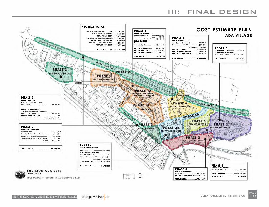
III: FINAL DESIGN
ADA VILLAGE, MICHIGANPageIII-17
III: FINAL DESIGN
ADA VILLAGE, MICHIGANPageIII-18
Phase 6
In this phase, an important street connection is made from Ada Drive to M-21, introducing the multi-lane roundabout. As in the other phases, it will be necessary to fi ll the site to the appropriate level, however, the design takes advantage of the change in grade by introducing lower level parking beneath each of the proposed buildings.
Phase 7
This phase expands the diversity of housing within the Village Core by offering a variety of single family and multiple family buildings. Access to this hamlet will require another new street connecting Riverside Drive to M-21, in addition to a loop road within the development zone. Utilities would be extended and looped to serve the development. The existing site has been previously fi lled but may require additional grading to prepare pads for building construction.
III: FINAL DESIGN
ADA VILLAGE, MICHIGANPageIII-19
COST ESTIMATE ASSUMPTIONS
The cost estimate is based on the Phasing Plan as previously presented. Costs were segregated into phases and, within these phases, broken down in to Public and Private costs, further defi ned as follows:
Public Infrastructure:
This is defi ned as public roads, streetscape, bike paths, and utilities necessary to service the development. Headley Street, Ada Drive, Thornapple River Drive, the M-21 streetscape, the roundabout, and the public riverfront development which includes the boardwalk and overlooks.
Civic Structures :
Civic structures include the Farmers Market, Amphitheater, Pedestrian Bridge, and the Community Center.
Private Infrastructure:
Private infrastructure includes the parking, sidewalks, and utilities serving the private developments. Also included in this classifi cation is Riverside Drive, off-street parking areas, and private residential streets.
Private Buildings:
This category includes the developer-driven mixed-use retail, residential, grocery store, offi ce, and other commercial development.
Details of cost estimates can be found in Appendix 2.1.
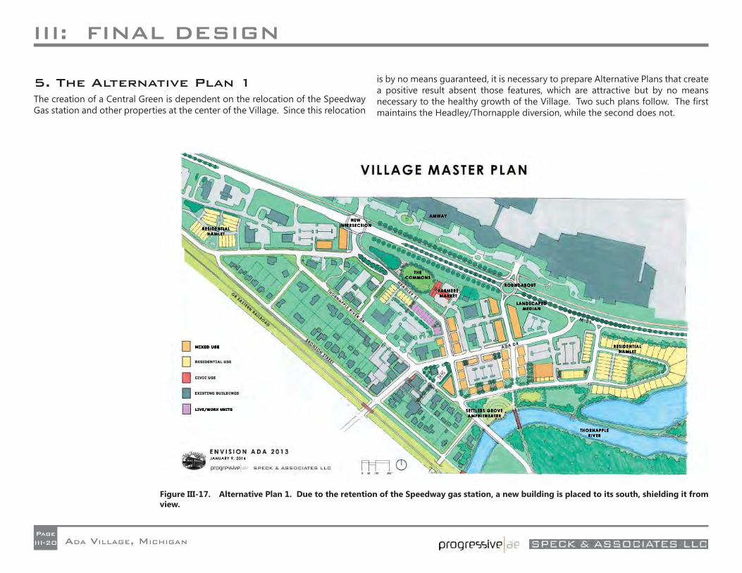
III: FINAL DESIGN
ADA VILLAGE, MICHIGANPageIII-20
5. The Alternative Plan 1The creation of a Central Green is dependent on the relocation of the Speedway Gas station and other properties at the center of the Village. Since this relocation
is by no means guaranteed, it is necessary to prepare Alternative Plans that create a positive result absent those features, which are attractive but by no means necessary to the healthy growth of the Village. Two such plans follow. The fi rst maintains the Headley/Thornapple diversion, while the second does not.
Figure III-17. Alternative Plan 1. Due to the retention of the Speedway gas station, a new building is placed to its south, shielding it from view.
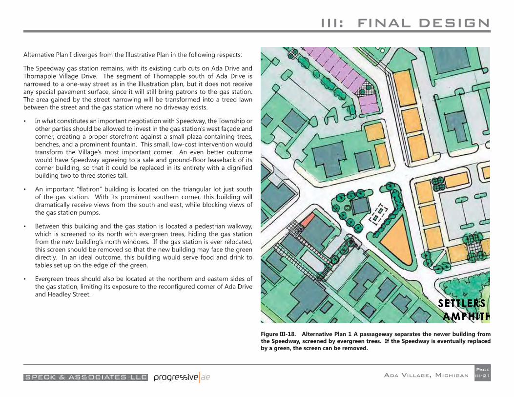
III: FINAL DESIGN
ADA VILLAGE, MICHIGANPageIII-21
Alternative Plan I diverges from the Illustrative Plan in the following respects:
The Speedway gas station remains, with its existing curb cuts on Ada Drive and Thornapple Village Drive. The segment of Thornapple south of Ada Drive is narrowed to a one-way street as in the Illustration plan, but it does not receive any special pavement surface, since it will still bring patrons to the gas station. The area gained by the street narrowing will be transformed into a treed lawn between the street and the gas station where no driveway exists.
• In what constitutes an important negotiation with Speedway, the Township or other parties should be allowed to invest in the gas station’s west façade and corner, creating a proper storefront against a small plaza containing trees, benches, and a prominent fountain. This small, low-cost intervention would transform the Village’s most important corner. An even better outcome would have Speedway agreeing to a sale and ground-fl oor leaseback of its corner building, so that it could be replaced in its entirety with a dignifi ed building two to three stories tall.
• An important “fl atiron” building is located on the triangular lot just south of the gas station. With its prominent southern corner, this building will dramatically receive views from the south and east, while blocking views of the gas station pumps.
• Between this building and the gas station is located a pedestrian walkway, which is screened to its north with evergreen trees, hiding the gas station from the new building’s north windows. If the gas station is ever relocated, this screen should be removed so that the new building may face the green directly. In an ideal outcome, this building would serve food and drink to tables set up on the edge of the green.
• Evergreen trees should also be located at the northern and eastern sides of the gas station, limiting its exposure to the reconfi gured corner of Ada Drive and Headley Street.
Figure III-18. Alternative Plan 1 A passageway separates the newer building from the Speedway, screened by evergreen trees. If the Speedway is eventually replaced by a green, the screen can be removed.
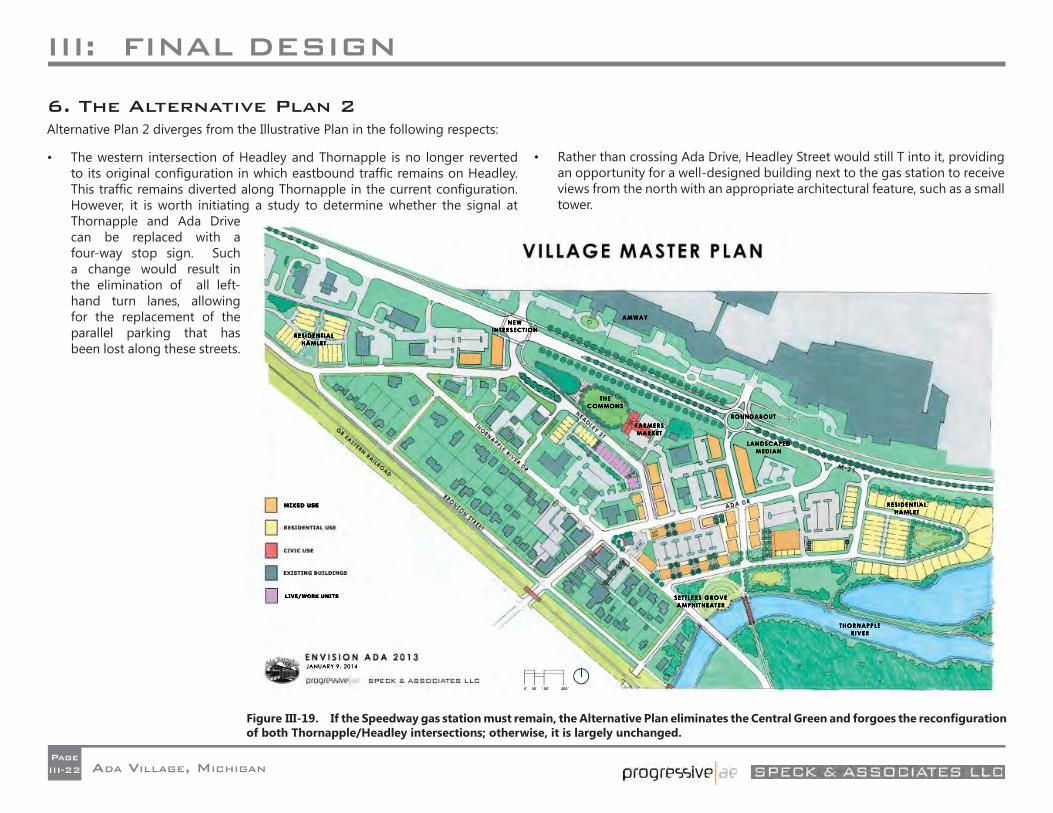
III: FINAL DESIGN
ADA VILLAGE, MICHIGANPageIII-22
6. The Alternative Plan 2Alternative Plan 2 diverges from the Illustrative Plan in the following respects:
• The western intersection of Headley and Thornapple is no longer reverted to its original confi guration in which eastbound traffi c remains on Headley. This traffi c remains diverted along Thornapple in the current confi guration. However, it is worth initiating a study to determine whether the signal at Thornapple and Ada Drive can be replaced with a four-way stop sign. Such a change would result in the elimination of all left-hand turn lanes, allowing for the replacement of the parallel parking that has been lost along these streets.
• Rather than crossing Ada Drive, Headley Street would still T into it, providing an opportunity for a well-designed building next to the gas station to receive views from the north with an appropriate architectural feature, such as a small tower.
Figure III-19. If the Speedway gas station must remain, the Alternative Plan eliminates the Central Green and forgoes the reconfi guration of both Thornapple/Headley intersections; otherwise, it is largely unchanged.
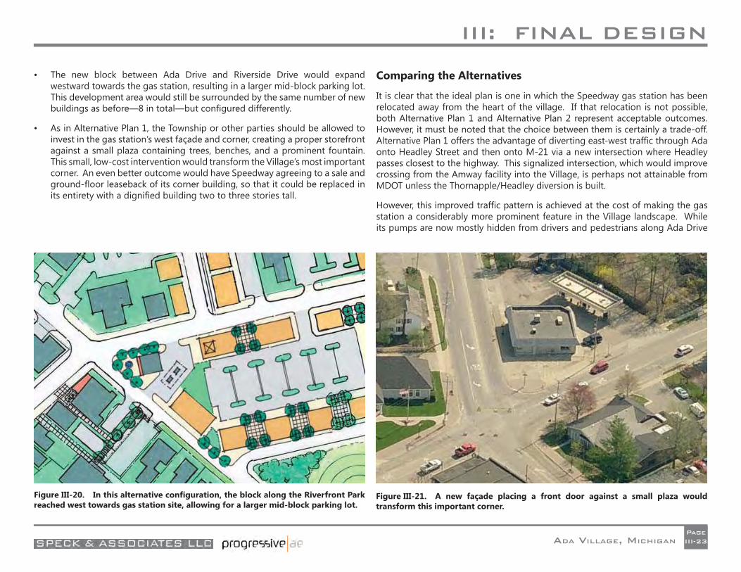
III: FINAL DESIGN
ADA VILLAGE, MICHIGANPageIII-23
• The new block between Ada Drive and Riverside Drive would expand westward towards the gas station, resulting in a larger mid-block parking lot. This development area would still be surrounded by the same number of new buildings as before—8 in total—but confi gured differently.
• As in Alternative Plan 1, the Township or other parties should be allowed to invest in the gas station’s west façade and corner, creating a proper storefront against a small plaza containing trees, benches, and a prominent fountain. This small, low-cost intervention would transform the Village’s most important corner. An even better outcome would have Speedway agreeing to a sale and ground-fl oor leaseback of its corner building, so that it could be replaced in its entirety with a dignifi ed building two to three stories tall.
Comparing the Alternatives
It is clear that the ideal plan is one in which the Speedway gas station has been relocated away from the heart of the village. If that relocation is not possible, both Alternative Plan 1 and Alternative Plan 2 represent acceptable outcomes. However, it must be noted that the choice between them is certainly a trade-off. Alternative Plan 1 offers the advantage of diverting east-west traffi c through Ada onto Headley Street and then onto M-21 via a new intersection where Headley passes closest to the highway. This signalized intersection, which would improve crossing from the Amway facility into the Village, is perhaps not attainable from MDOT unless the Thornapple/Headley diversion is built.
However, this improved traffi c pattern is achieved at the cost of making the gas station a considerably more prominent feature in the Village landscape. While its pumps are now mostly hidden from drivers and pedestrians along Ada Drive
Figure III-20. In this alternative confi guration, the block along the Riverfront Park reached west towards gas station site, allowing for a larger mid-block parking lot.
Figure III-21. A new façade placing a front door against a small plaza would transform this important corner.
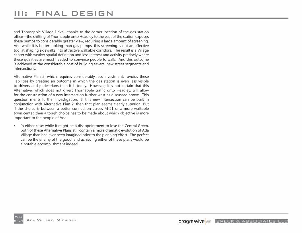
III: FINAL DESIGN
ADA VILLAGE, MICHIGANPageIII-24
and Thornapple Village Drive—thanks to the corner location of the gas station offi ce—the shifting of Thornapple onto Headley to the east of the station exposes these pumps to considerably greater view, requiring a large amount of screening. And while it is better looking than gas pumps, this screening is not an effective tool at shaping sidewalks into attractive walkable corridors. The result is a Village center with weaker spatial defi nition and less interest and activity precisely where these qualities are most needed to convince people to walk. And this outcome is achieved at the considerable cost of building several new street segments and intersections.
Alternative Plan 2, which requires considerably less investment, avoids these liabilities by creating an outcome in which the gas station is even less visible to drivers and pedestrians than it is today. However, it is not certain that this Alternative, which does not divert Thornapple traffi c onto Headley, will allow for the construction of a new intersection further west as discussed above. This question merits further investigation. If this new intersection can be built in conjunction with Alternative Plan 2, then that plan seems clearly superior. But if the choice is between a better connection across M-21 or a more walkable town center, then a tough choice has to be made about which objective is more important to the people of Ada.
• In either case: while it might be a disappointment to lose the Central Green, both of these Alternative Plans still contain a more dramatic evolution of Ada Village than had ever been imagined prior to the planning effort. The perfect can be the enemy of the good, and achieving either of these plans would be a notable accomplishment indeed.
IV: THOROUGHFARES
ADA VILLAGE, MICHIGANPageIV-1
THOROUGHFARES 1. Thoroughfare Design PrinciplesStreet life is dramatically impacted by the speed of vehicles. Whether they know the statistics or not, most pedestrians understand in their bones that a person hit by a car traveling at 35 mph is ten times as likely to die than if the car is traveling at 25 mph. Any community that is interested in street life—or human lives—must carefully consider the speed which it encourages cars to drive in places where pedestrians are present.
The above logic explains why a growing number of communities have instituted “20 is Plenty” ordinances in their downtowns, and a few have even settled on 18 mph as the target speed. Having low speed limits in a village center is important, but it is not enough, as most motorists drive not the speed that is marked, but the speed at which they feel comfortable. For this reason, it is essential that Village streets be engineered for the desired speed, which means eliminating wider lanes and other inducements to speeding.
Induced Speeding
Specifi cally, the new science of traffi c engineering—as opposed to the old mythology of traffi c engineering—maintains that wider lanes, shoulders, clear zones, and other reductions in the potential for confl ict actually encourage speeding and increase the danger of driving in communities. This may not be the case on highways, where most drivers travel at a set velocity based on speed limits, but it is most certainly true in downtowns, where the principal determinant of driver speed is the perception of safety.
The mandate of the above paragraph could not be more profound. For years, American traffi c engineers, applying the logic of highways, have widened driving lanes, eliminated curb parking, and even removed trees from community streets. The studies now show that this was a mistake. One study found that fewer injury crashes occur on streets with trees. Another estimated that “increased lane widths are responsible for approximately 900 additional traffi c fatalities per year.” (Robert Noland, “Traffi c Fatalities and Injuries: The Effect of Changing Infrastructure and Other Trends,” Center for Transport Studies, 2002.) If safety is a concern of those who build and maintain our city streets, then they can no longer allow a 12-foot lane to sit where a 10-foot lane will serve.
If one accepts this argument, it becomes clear that every street in Ada Village is in need of a redesign. This assessment is presented with an understanding that changes to streets often come slowly and sometimes at considerable expense. But they do come—routine deterioration demands resurfacing, which offers the opportunity to restripe—and sometimes a proper understanding of the value of safer streets causes them to come more quickly. Furthermore, a protocol which focuses on restriping rather than rebuilding, like the one that follows, can allow for dramatic change to occur at a reasonable cost.
A Safe WalkSpecifi cally, what are the strategies that keep automobiles at reasonable speeds while protecting pedestrians from them? In the case of villages like Ada, it is necessary to aspire to the following six mandates, each of which will be addressed individually:
• Lanes of proper width;
• Limited use and length of turn lanes;
• Including bike lanes;
• Continuous on-street parking;
• Pedestrian-friendly signalization;
• Proper use of roundabouts.
Lanes of Proper Width
Different-width traffi c lanes correspond to different travel speeds. A typical downtown lane width is 10 feet, which comfortably supports speeds of 35 mph. A typical highway lane width is 12 feet, which comfortably supports speeds of 70 mph. Drivers instinctively understand the connection between lane width and driving speed, and speed up when presented with wider lanes, even in downtown locations. Any lane wider than 10 feet encourages speeds that can increase risk to pedestrians. Many streets in Ada Village contain lanes that are 12 feet wide or more, and drivers can be observed approaching highway speeds when using them. On certain streets, highway-style shoulders also contribute
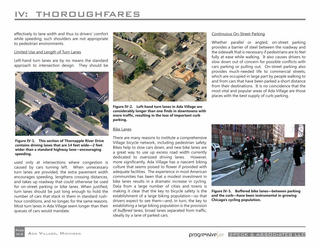
IV: THOROUGHFARES
ADA VILLAGE, MICHIGANPageIV-2
effectively to lane width and thus to drivers’ comfort while speeding; such shoulders are not appropriate to pedestrian environments.
Limited Use and Length of Turn Lanes
Left-hand turn lanes are by no means the standard approach to intersection design. They should be
used only at intersections where congestion is caused by cars turning left. When unnecessary turn lanes are provided, the extra pavement width encourages speeding, lengthens crossing distances, and takes up roadway that could otherwise be used for on-street parking or bike lanes. When justifi ed, turn lanes should be just long enough to hold the number of cars that stack in them in standard rush-hour conditions, and no longer, for the same reasons. Most turn lanes in Ada Village seem longer than their queues of cars would mandate.
Bike Lanes
There are many reasons to institute a comprehensive Village bicycle network, including pedestrian safety. Bikes help to slow cars down, and new bike lanes are a great way to use up excess road width currently dedicated to oversized driving lanes. However, more signifi cantly, Ada Village has a nascent biking culture that seems poised to fl ower if provided with adequate facilities. The experience in most American communities has been that a modest investment in bike lanes results in a dramatic increase in cycling. Data from a large number of cities and towns is making it clear that the key to bicycle safety is the establishment of a large biking population—so that drivers expect to see them—and, in turn, the key to establishing a large biking population is the provision of buffered lanes, broad lanes separated from traffi c, ideally by a lane of parked cars.
Continuous On-Street Parking
Whether parallel or angled, on-street parking provides a barrier of steel between the roadway and the sidewalk that is necessary if pedestrians are to feel fully at ease while walking. It also causes drivers to slow down out of concern for possible confl icts with cars parking or pulling out. On-street parking also provides much-needed life to commercial streets, which are occupied in large part by people walking to and from cars that have been parked a short distance from their destinations. It is no coincidence that the most vital and popular areas of Ada Village are those places with the best supply of curb parking.
Figure IV-1. This section of Thornapple River Drive contains driving lanes that are 14 feet wide—2 feet wider than a standard highway lane—encouraging speeding.
Figure IV-2. Left-hand turn lanes in Ada Village are considerably longer than one fi nds in downtowns with more traffi c, resulting in the loss of important curb parking.
Figure IV-3. Buffered bike lanes—between parking and the curb—have been instrumental in growing Chicago’s cycling population.
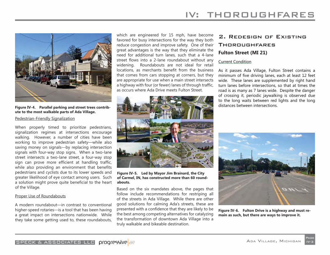
IV: THOROUGHFARES
ADA VILLAGE, MICHIGANPageIV-3
Pedestrian-Friendly Signalization
When properly timed to prioritize pedestrians, signalization regimes at intersections encourage walking. However, a number of cities have been working to improve pedestrian safety—while also saving money on signals—by replacing intersection signals with four-way stop signs. When a two-lane street intersects a two-lane street, a four-way stop sign can prove more effi cient at handling traffi c, while also providing an environment that benefi ts pedestrians and cyclists due to its lower speeds and greater likelihood of eye contact among users. Such a solution might prove quite benefi cial to the heart of the Village.
Proper Use of Roundabouts
A modern roundabout—in contrast to conventional higher-speed rotaries—is a tool that has been having a great impact on intersections nationwide. While they take some getting used to, these roundabouts,
which are engineered for 15 mph, have become favored for busy intersections for the way they both reduce congestion and improve safety. One of their great advantages is the way that they eliminate the need for additional turn lanes, such that a 4-lane street fl ows into a 2-lane roundabout without any widening. Roundabouts are not ideal for retail locations, as merchants benefi t from the business that comes from cars stopping at corners, but they are appropriate for use when a main street intersects a highway with four (or fewer) lanes of through traffi c, as occurs where Ada Drive meets Fulton Street.
Based on the six mandates above, the pages that follow include recommendations for restriping all of the streets in Ada Village. While there are other good solutions for calming Ada’s streets, these are presented with a confi dence that they are likely to be the best among competing alternatives for catalyzing the transformation of downtown Ada Village into a truly walkable and bikeable destination.
2. Redesign of Existing ThoroughfaresFulton Street (MI 21)
Current Condition
As it passes Ada Village, Fulton Street contains a minimum of fi ve driving lanes, each at least 12 feet wide. These lanes are supplemented by right hand turn lanes before intersections, so that at times the road is as many as 7 lanes wide. Despite the danger of crossing it, periodic jaywalking is observed due to the long waits between red lights and the long distances between intersections.Figure IV-4. Parallel parking and street trees contrib-
ute to the most walkable parts of Ada Village.
Figure IV-5. Led by Mayor Jim Brainard, the City of Carmel, IN, has constructed more than 60 round-abouts.
Figure IV-6. Fulton Drive is a highway and must re-main as such, but there are ways to improve it.
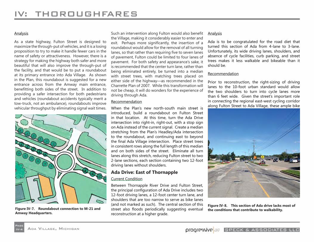
IV: THOROUGHFARES
ADA VILLAGE, MICHIGANPageIV-4
Analysis
As a state highway, Fulton Street is designed to maximize the through-put of vehicles, and it is a losing proposition to try to make it handle fewer cars in the name of safety or attractiveness. However, there is a strategy for making the highway both safer and more beautiful that will also improve the through-put of the facility, and that would be to put a roundabout at its primary entrance into Ada Village. As shown in the Plan, this roundabout is suggested for a new entrance across from the Amway main entrance, benefi tting both sides of the street. In addition to providing a safer intersection for both pedestrians and vehicles (roundabout accidents typically merit a tow-truck, not an ambulance), roundabouts improve vehicular throughput by eliminating signal wait times.
Such an intervention along Fulton would also benefi t the Village, making it considerably easier to enter and exit. Perhaps more signifi cantly, the insertion of a roundabout would allow for the removal of all turning lanes, so that rather than requiring fi ve to seven lanes of pavement, Fulton could be limited to four lanes of pavement. For both safety and appearance’s sake, it is recommended that the center turn lane, rather than being eliminated entirely, be turned into a median with street trees, with matching trees placed on either side of the highway—as recommended in the Charrette Plan of 2007. While this transformation will not be cheap, it will do wonders for the experience of driving through Ada.
Recommendation
When the Plan’s new north-south main street is introduced, build a roundabout on Fulton Street in that location. At this time, turn the Ada Drive intersection into right-in, right-out, with a stop sign on Ada instead of the current signal. Create a median stretching from the Plan’s Headley/Ada intersection to the roundabout, and continuing east to beyond the fi nal Ada Village intersection. Place street trees in consistent rows along the full length of this median and on both sides of the street. Eliminate all turn lanes along this stretch, reducing Fulton street to two 2-lane sections, each section containing two 12-foot driving lanes without shoulders.
Ada Drive: East of ThornappleCurrent Condition
Between Thornapple River Drive and Fulton Street, the principal confi guration of Ada Drive includes two 12-foot driving lanes, a 12-foot center turn lane, and shoulders that are too narrow to serve as bike lanes (and not marked as such). The central section of this street also fl oods periodically suggesting eventual reconstruction at a higher grade.
Analysis
Ada is to be congratulated for the road diet that turned this section of Ada from 4-lane to 3-lane. Unfortunately, its wide driving lanes, shoulders, and absence of cycle facilities, curb parking, and street trees makes it less walkable and bikeable than it should be.
Recommendation
Prior to reconstruction, the right-sizing of driving lanes to the 10-foot urban standard would allow the two shoulders to turn into cycle lanes more than 6 feet wide. Given the street’s important role in connecting the regional east-west cycling corridor along Fulton Street to Ada Village, these ample bike
Figure IV-7. Roundabout connection to M-21 and Amway Headquarters.
Figure IV-8. This section of Ada drive lacks most of the conditions that contribute to walkability.
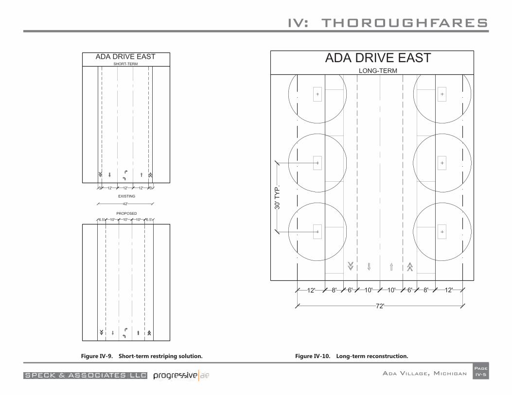
IV: THOROUGHFARES
ADA VILLAGE, MICHIGANPageIV-5
Figure IV-9. Short-term restriping solution. Figure IV-10. Long-term reconstruction.
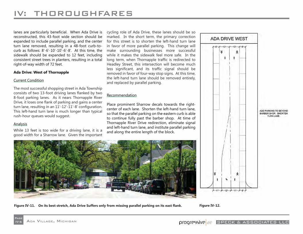
IV: THOROUGHFARES
ADA VILLAGE, MICHIGANPageIV-6
Figure IV-12.
lanes are particularly benefi cial. When Ada Drive is reconstructed, this 43-foot wide section should be expanded to include parallel parking, and the center turn lane removed, resulting in a 48-foot curb-to-curb as follows: 8’-6’-10’-10’-6’-8’. At this time, the sidewalk should be expanded to 12 feet, including consistent street trees in planters, resulting in a total right-of-way width of 72 feet.
Ada Drive: West of Thornapple
Current Condition
The most successful shopping street in Ada Township consists of two 13-foot driving lanes fl anked by two 8-foot parking lanes. As it nears Thornapple River Drive, it loses one fl ank of parking and gains a center turn lane, resulting in an 11’-12’-11’-8’ confi guration. This left-hand turn lane is much longer than typical rush-hour queues would suggest.
Analysis
While 13 feet is too wide for a driving lane, it is a good width for a Sharrow lane. Given the important
cycling role of Ada Drive, these lanes should be so marked. In the short term, the primary correction for this street is to shorten the left-hand turn lane in favor of more parallel parking. This change will make surrounding businesses more successful while it makes the sidewalk feel more safe. In the long term, when Thornapple traffi c is redirected to Headley Street, this intersection will become much less signifi cant, and its traffi c signal should be removed in favor of four-way stop signs. At this time, the left-hand turn lane should be removed entirely, and replaced by parallel parking.
Recommendation
Place prominent Sharrow decals towards the right-center of each lane. Shorten the left-hand turn lane, so that the parallel parking on the eastern curb is able to continue fully past the barber shop. At time of Thornapple River Drive redirection, eliminate signal and left-hand turn lane, and institute parallel parking and along the entire length of the block.
Figure IV-11. On its best stretch, Ada Drive Suffers only from missing parallel parking on its east fl ank.
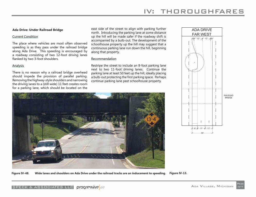
IV: THOROUGHFARES
ADA VILLAGE, MICHIGANPageIV-7
Ada Drive: Under Railroad Bridge
Current Condition
The place where vehicles are most often observed speeding is as they pass under the railroad bridge along Ada Drive. This speeding is encouraged by a roadway consisting of two 12-foot driving lanes fl anked by two 3-foot shoulders.
Analysis
There is no reason why a railroad bridge overhead should impede the provision of parallel parking. Removing the highway-style shoulders and narrowing the driving lanes to a (still wide) 11 feet creates room for a parking lane, which should be located on the
east side of the street to align with parking further north. Introducing the parking lane at some distance up the hill will be made safer if the roadway shift is accompanied by a bulb-out. The development of the schoolhouse property up the hill may suggest that a continuous parking lane run down the hill, beginning along that property.
Recommendation
Restripe the street to include an 8-foot parking lane next to two 11-foot driving lanes. Continue the parking lane at least 50 feet up the hill, ideally placing a bulb-out protecting the fi rst parking space. Perhaps continue parking lane past schoolhouse property.
Figure IV-48. Wide lanes and shoulders on Ada Drive under the railroad tracks are an inducement to speeding. Figure IV-13.
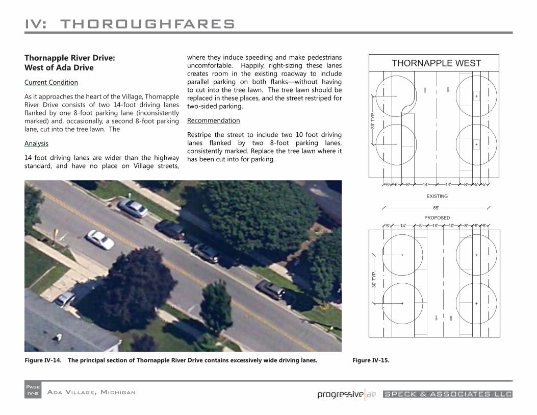
IV: THOROUGHFARES
ADA VILLAGE, MICHIGANPageIV-8
Thornapple River Drive: West of Ada Drive
Current Condition
As it approaches the heart of the Village, Thornapple River Drive consists of two 14-foot driving lanes fl anked by one 8-foot parking lane (inconsistently marked) and, occasionally, a second 8-foot parking lane, cut into the tree lawn. The
Analysis
14-foot driving lanes are wider than the highway standard, and have no place on Village streets,
where they induce speeding and make pedestrians uncomfortable. Happily, right-sizing these lanes creates room in the existing roadway to include parallel parking on both fl anks—without having to cut into the tree lawn. The tree lawn should be replaced in these places, and the street restriped for two-sided parking.
Recommendation
Restripe the street to include two 10-foot driving lanes fl anked by two 8-foot parking lanes, consistently marked. Replace the tree lawn where it has been cut into for parking.
Figure IV-14. The principal section of Thornapple River Drive contains excessively wide driving lanes. Figure IV-15.
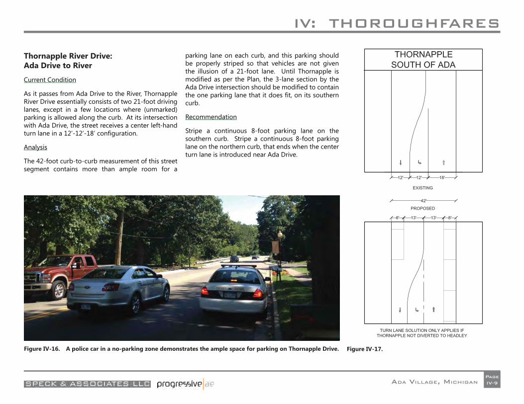
IV: THOROUGHFARES
ADA VILLAGE, MICHIGANPageIV-9
Thornapple River Drive: Ada Drive to River
Current Condition
As it passes from Ada Drive to the River, Thornapple River Drive essentially consists of two 21-foot driving lanes, except in a few locations where (unmarked) parking is allowed along the curb. At its intersection with Ada Drive, the street receives a center left-hand turn lane in a 12’-12’-18’ confi guration.
Analysis
The 42-foot curb-to-curb measurement of this street segment contains more than ample room for a
parking lane on each curb, and this parking should be properly striped so that vehicles are not given the illusion of a 21-foot lane. Until Thornapple is modifi ed as per the Plan, the 3-lane section by the Ada Drive intersection should be modifi ed to contain the one parking lane that it does fi t, on its southern curb.
Recommendation
Stripe a continuous 8-foot parking lane on the southern curb. Stripe a continuous 8-foot parking lane on the northern curb, that ends when the center turn lane is introduced near Ada Drive.
Figure IV-16. A police car in a no-parking zone demonstrates the ample space for parking on Thornapple Drive. Figure IV-17.
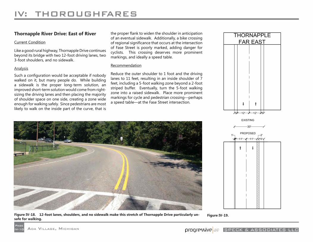
IV: THOROUGHFARES
ADA VILLAGE, MICHIGANPageIV-10
Thornapple River Drive: East of River
Current Condition
Like a good rural highway, Thornapple Drive continues beyond its bridge with two 12-foot driving lanes, two 3-foot shoulders, and no sidewalk.
Analysis
Such a confi guration would be acceptable if nobody walked on it, but many people do. While building a sidewalk is the proper long-term solution, an improved short-term solution would come from right-sizing the driving lanes and then placing the majority of shoulder space on one side, creating a zone wide enough for walking safely. Since pedestrians are most likely to walk on the inside part of the curve, that is
the proper fl ank to widen the shoulder in anticipation of an eventual sidewalk. Additionally, a bike crossing of regional signifi cance that occurs at the intersection of Fase Street is poorly marked, adding danger for cyclists. This crossing deserves more prominent markings, and ideally a speed table.
Recommendation
Reduce the outer shoulder to 1 foot and the driving lanes to 11 feet, resulting in an inside shoulder of 7 feet, including a 5-foot walking zone beyond a 2-foot striped buffer. Eventually, turn the 5-foot walking zone into a raised sidewalk. Place more prominent markings for cycle and pedestrian crossing—perhaps a speed table—at the Fase Street intersection.
Figure IV-18. 12-foot lanes, shoulders, and no sidewalk make this stretch of Thornapple Drive particularly un-safe for walking.
Figure IV-19.
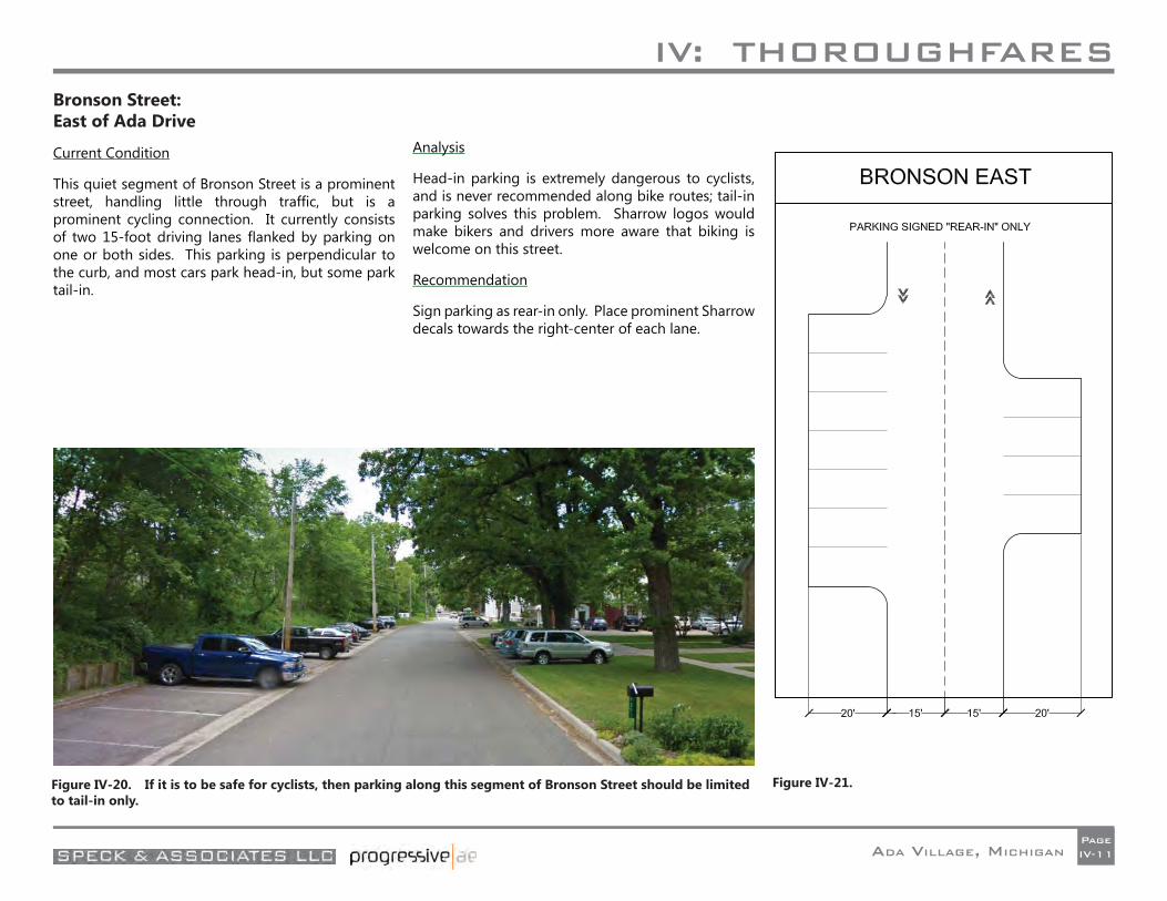
IV: THOROUGHFARES
ADA VILLAGE, MICHIGANPageIV-11
Bronson Street: East of Ada Drive
Current Condition
This quiet segment of Bronson Street is a prominent street, handling little through traffi c, but is a prominent cycling connection. It currently consists of two 15-foot driving lanes fl anked by parking on one or both sides. This parking is perpendicular to the curb, and most cars park head-in, but some park tail-in.
Analysis
Head-in parking is extremely dangerous to cyclists, and is never recommended along bike routes; tail-in parking solves this problem. Sharrow logos would make bikers and drivers more aware that biking is welcome on this street.
Recommendation
Sign parking as rear-in only. Place prominent Sharrow decals towards the right-center of each lane.
Figure IV-20. If it is to be safe for cyclists, then parking along this segment of Bronson Street should be limited to tail-in only.
Figure IV-21.
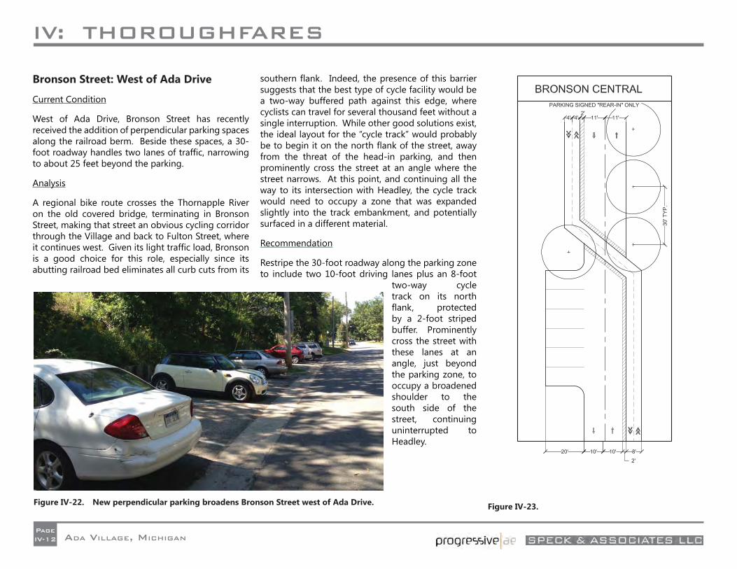
IV: THOROUGHFARES
ADA VILLAGE, MICHIGANPageIV-12
Bronson Street: West of Ada Drive
Current Condition
West of Ada Drive, Bronson Street has recently received the addition of perpendicular parking spaces along the railroad berm. Beside these spaces, a 30- foot roadway handles two lanes of traffi c, narrowing to about 25 feet beyond the parking.
Analysis
A regional bike route crosses the Thornapple River on the old covered bridge, terminating in Bronson Street, making that street an obvious cycling corridor through the Village and back to Fulton Street, where it continues west. Given its light traffi c load, Bronson is a good choice for this role, especially since its abutting railroad bed eliminates all curb cuts from its
southern fl ank. Indeed, the presence of this barrier suggests that the best type of cycle facility would be a two-way buffered path against this edge, where cyclists can travel for several thousand feet without a single interruption. While other good solutions exist, the ideal layout for the “cycle track” would probably be to begin it on the north fl ank of the street, away from the threat of the head-in parking, and then prominently cross the street at an angle where the street narrows. At this point, and continuing all the way to its intersection with Headley, the cycle track would need to occupy a zone that was expanded slightly into the track embankment, and potentially surfaced in a different material.
Recommendation
Restripe the 30-foot roadway along the parking zone to include two 10-foot driving lanes plus an 8-foot
two-way cycle track on its north fl ank, protected by a 2-foot striped buffer. Prominently cross the street with these lanes at an angle, just beyond the parking zone, to occupy a broadened shoulder to the south side of the street, continuing uninterrupted to Headley.
Figure IV-22. New perpendicular parking broadens Bronson Street west of Ada Drive. Figure IV-23.
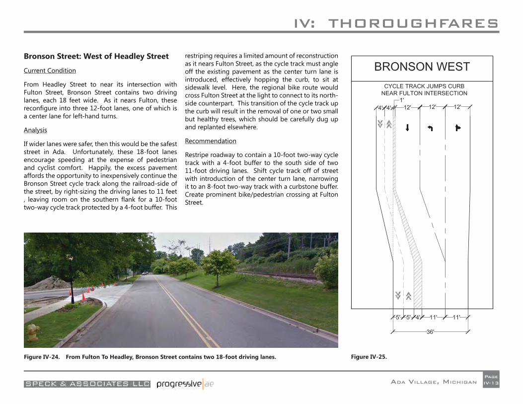
IV: THOROUGHFARES
ADA VILLAGE, MICHIGANPageIV-13
Bronson Street: West of Headley Street
Current Condition
From Headley Street to near its intersection with Fulton Street, Bronson Street contains two driving lanes, each 18 feet wide. As it nears Fulton, these reconfi gure into three 12-foot lanes, one of which is a center lane for left-hand turns.
Analysis
If wider lanes were safer, then this would be the safest street in Ada. Unfortunately, these 18-foot lanes encourage speeding at the expense of pedestrian and cyclist comfort. Happily, the excess pavement affords the opportunity to inexpensively continue the Bronson Street cycle track along the railroad-side of the street, by right-sizing the driving lanes to 11 feet , leaving room on the southern fl ank for a 10-foot two-way cycle track protected by a 4-foot buffer. This
restriping requires a limited amount of reconstruction as it nears Fulton Street, as the cycle track must angle off the existing pavement as the center turn lane is introduced, effectively hopping the curb, to sit at sidewalk level. Here, the regional bike route would cross Fulton Street at the light to connect to its north-side counterpart. This transition of the cycle track up the curb will result in the removal of one or two small but healthy trees, which should be carefully dug up and replanted elsewhere.
Recommendation
Restripe roadway to contain a 10-foot two-way cycle track with a 4-foot buffer to the south side of two 11-foot driving lanes. Shift cycle track off of street with introduction of the center turn lane, narrowing it to an 8-foot two-way track with a curbstone buffer. Create prominent bike/pedestrian crossing at Fulton Street.
Figure IV-24. From Fulton To Headley, Bronson Street contains two 18-foot driving lanes. Figure IV-25.
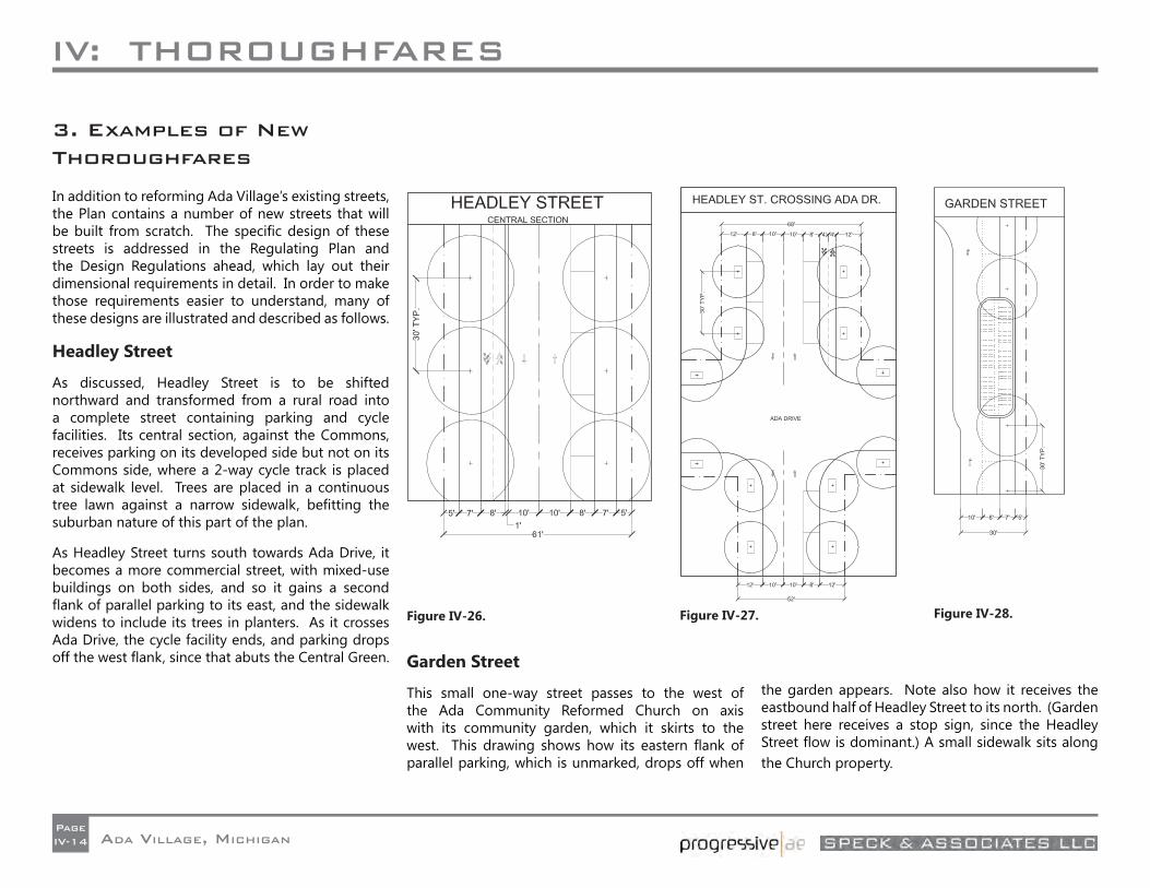
IV: THOROUGHFARES
ADA VILLAGE, MICHIGANPageIV-14
3. Examples of New Thoroughfares
In addition to reforming Ada Village’s existing streets, the Plan contains a number of new streets that will be built from scratch. The specifi c design of these streets is addressed in the Regulating Plan and the Design Regulations ahead, which lay out their dimensional requirements in detail. In order to make those requirements easier to understand, many of these designs are illustrated and described as follows.
Headley Street
As discussed, Headley Street is to be shifted northward and transformed from a rural road into a complete street containing parking and cycle facilities. Its central section, against the Commons, receives parking on its developed side but not on its Commons side, where a 2-way cycle track is placed at sidewalk level. Trees are placed in a continuous tree lawn against a narrow sidewalk, befi tting the suburban nature of this part of the plan.
As Headley Street turns south towards Ada Drive, it becomes a more commercial street, with mixed-use buildings on both sides, and so it gains a second fl ank of parallel parking to its east, and the sidewalk widens to include its trees in planters. As it crosses Ada Drive, the cycle facility ends, and parking drops off the west fl ank, since that abuts the Central Green. Garden Street
This small one-way street passes to the west of the Ada Community Reformed Church on axis with its community garden, which it skirts to the west. This drawing shows how its eastern fl ank of parallel parking, which is unmarked, drops off when
the garden appears. Note also how it receives the eastbound half of Headley Street to its north. (Garden street here receives a stop sign, since the Headley Street fl ow is dominant.) A small sidewalk sits along the Church property.
Figure IV-27. Figure IV-28. Figure IV-26.
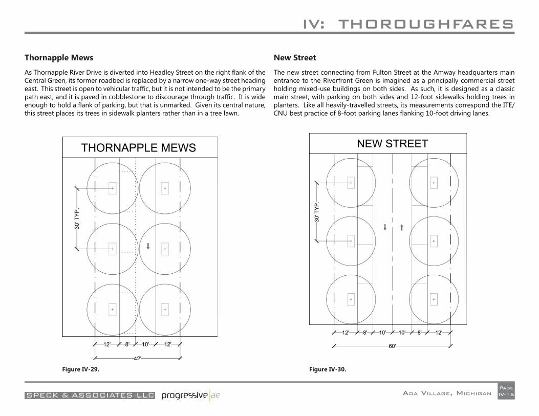
IV: THOROUGHFARES
ADA VILLAGE, MICHIGANPageIV-15
Thornapple Mews
As Thornapple River Drive is diverted into Headley Street on the right fl ank of the Central Green, its former roadbed is replaced by a narrow one-way street heading east. This street is open to vehicular traffi c, but it is not intended to be the primary path east, and it is paved in cobblestone to discourage through traffi c. It is wide enough to hold a fl ank of parking, but that is unmarked. Given its central nature, this street places its trees in sidewalk planters rather than in a tree lawn.
New Street
The new street connecting from Fulton Street at the Amway headquarters main entrance to the Riverfront Green is imagined as a principally commercial street holding mixed-use buildings on both sides. As such, it is designed as a classic main street, with parking on both sides and 12-foot sidewalks holding trees in planters. Like all heavily-travelled streets, its measurements correspond the ITE/CNU best practice of 8-foot parking lanes fl anking 10-foot driving lanes.
Figure IV-29. Figure IV-30.
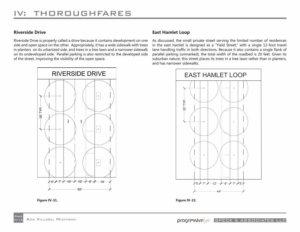
IV: THOROUGHFARES
ADA VILLAGE, MICHIGANPageIV-16
Riverside Drive
Riverside Drive is properly called a drive because it contains development on one side and open space on the other. Appropriately, it has a wide sidewalk with trees in planters on its urbanized side, and trees in a tree lawn and a narrower sidewalk on its undeveloped side. Parallel parking is also restricted to the developed side of the street, improving the visibility of the open space.
East Hamlet Loop
As discussed, the small private street serving the limited number of residences in the east hamlet is designed as a “Yield Street,” with a single 12-foot travel lane handling traffi c in both directions. Because it also contains a single fl ank of parallel parking (unmarked), the total width of the roadbed is 20 feet. Given its suburban nature, this street places its trees in a tree lawn rather than in planters, and has narrower sidewalks.
Figure IV-31. Figure IV-32.
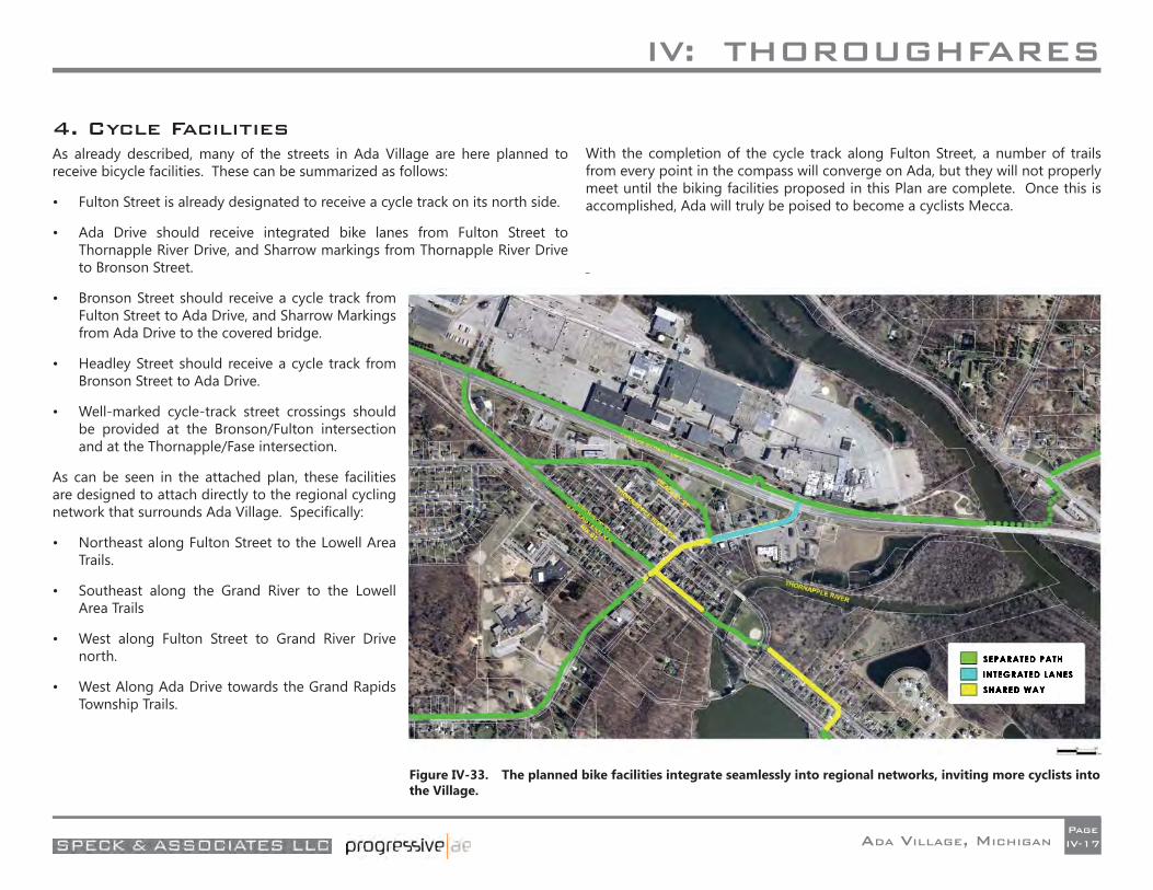
IV: THOROUGHFARES
ADA VILLAGE, MICHIGANPageIV-17
4. Cycle FacilitiesAs already described, many of the streets in Ada Village are here planned to receive bicycle facilities. These can be summarized as follows:
• Fulton Street is already designated to receive a cycle track on its north side.
• Ada Drive should receive integrated bike lanes from Fulton Street to Thornapple River Drive, and Sharrow markings from Thornapple River Drive to Bronson Street.
• Bronson Street should receive a cycle track from Fulton Street to Ada Drive, and Sharrow Markings from Ada Drive to the covered bridge.
• Headley Street should receive a cycle track from Bronson Street to Ada Drive.
• Well-marked cycle-track street crossings should be provided at the Bronson/Fulton intersection and at the Thornapple/Fase intersection.
As can be seen in the attached plan, these facilities are designed to attach directly to the regional cycling network that surrounds Ada Village. Specifi cally:
• Northeast along Fulton Street to the Lowell Area Trails.
• Southeast along the Grand River to the Lowell Area Trails
• West along Fulton Street to Grand River Drive north.
• West Along Ada Drive towards the Grand Rapids Township Trails.
With the completion of the cycle track along Fulton Street, a number of trails from every point in the compass will converge on Ada, but they will not properly meet until the biking facilities proposed in this Plan are complete. Once this is accomplished, Ada will truly be poised to become a cyclists Mecca.
Figure IV-33. The planned bike facilities integrate seamlessly into regional networks, inviting more cyclists into the Village.

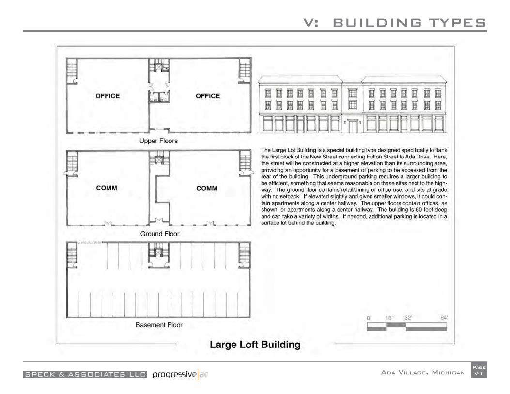
V: BUILDING TYPES
ADA VILLAGE, MICHIGANPageV-1
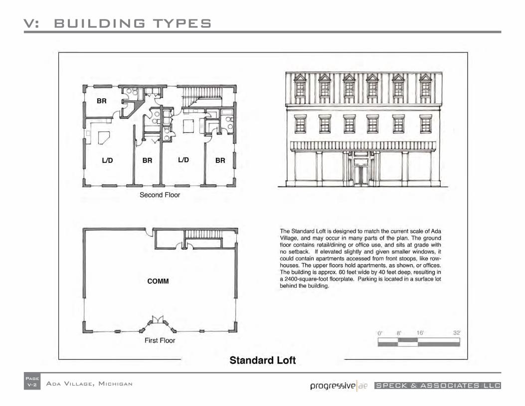
V: BUILDING TYPES
ADA VILLAGE, MICHIGANPageV-2
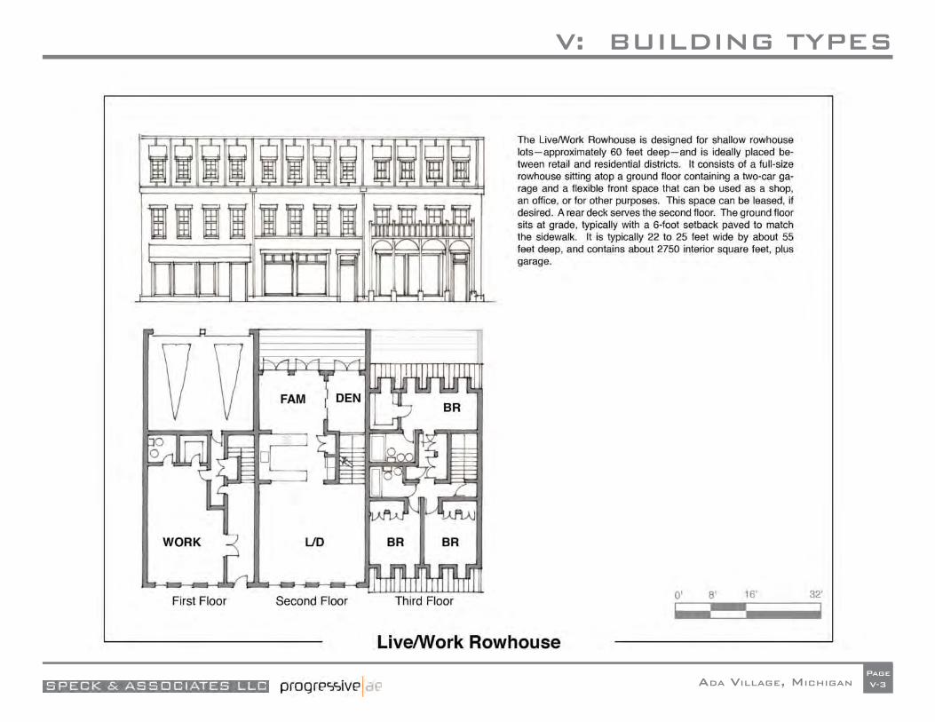
V: BUILDING TYPES
ADA VILLAGE, MICHIGANPageV-3
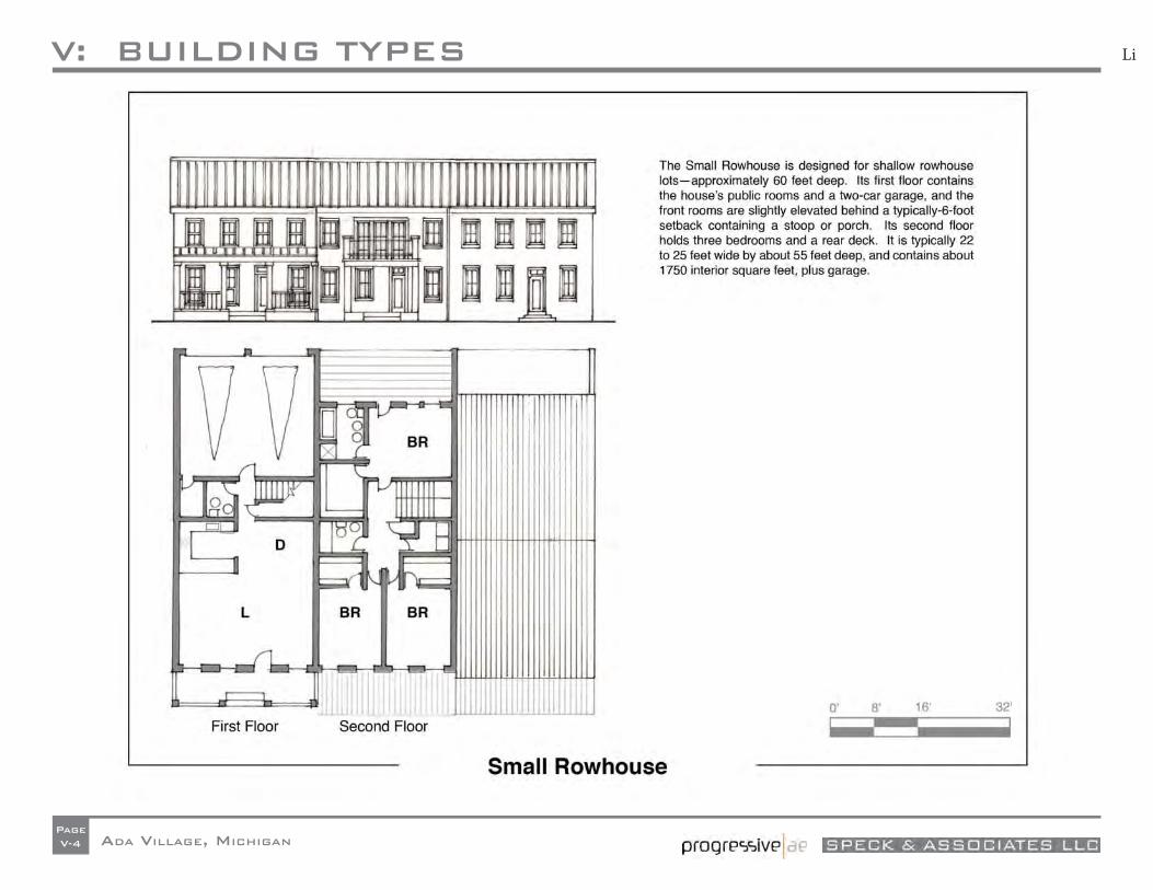
V: BUILDING TYPES
ADA VILLAGE, MICHIGANPageV-4
Li
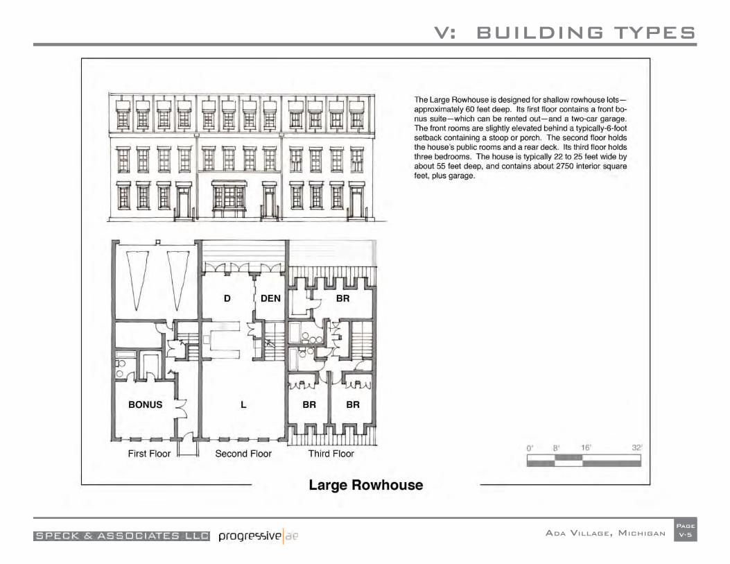
V: BUILDING TYPES
ADA VILLAGE, MICHIGANPageV-5
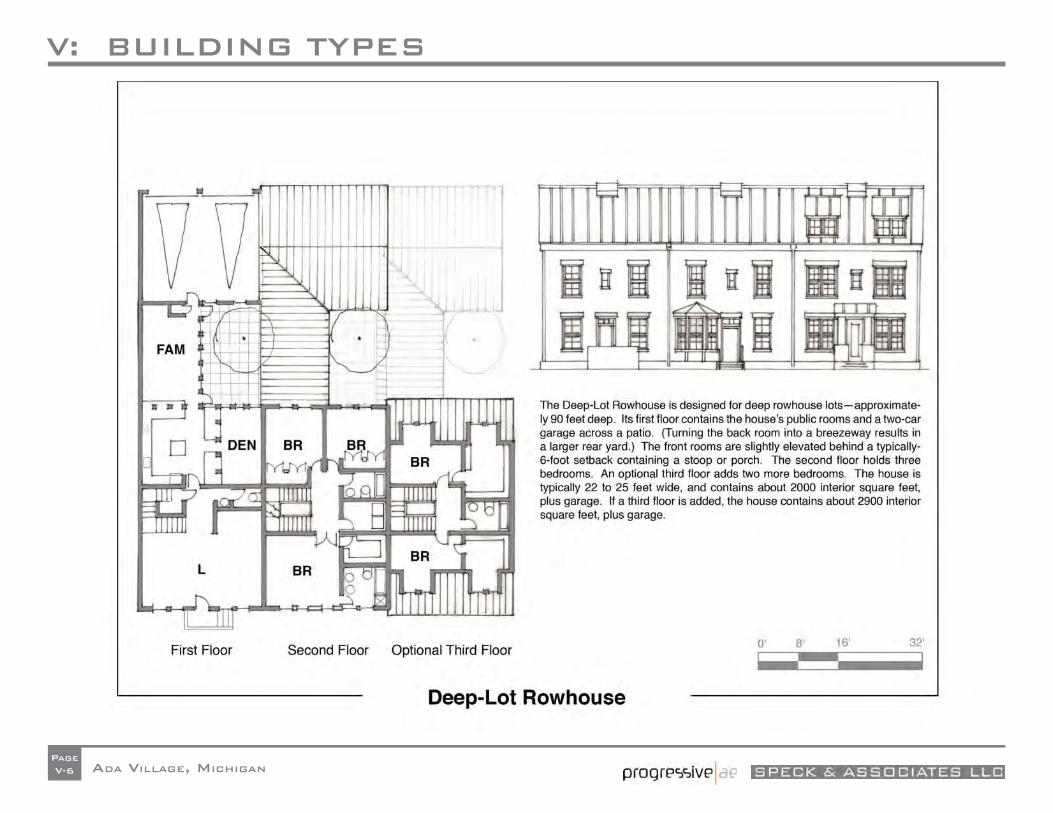
V: BUILDING TYPES
ADA VILLAGE, MICHIGANPageV-6
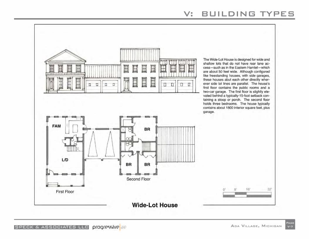
V: BUILDING TYPES
ADA VILLAGE, MICHIGANPageV-7
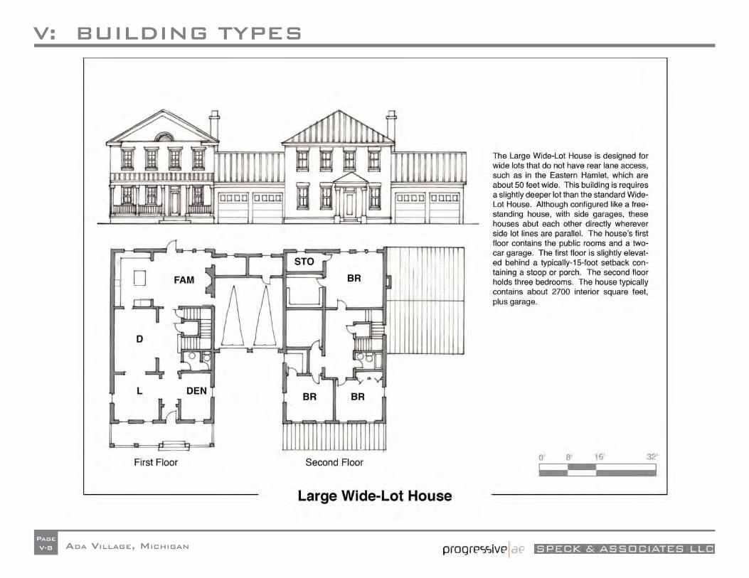
V: BUILDING TYPES
ADA VILLAGE, MICHIGANPageV-8
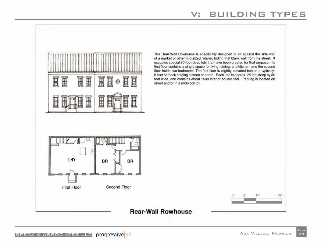
V: BUILDING TYPES
ADA VILLAGE, MICHIGANPageV-9


APPENDIX 1.1
ADA VILLAGE, MICHIGAN

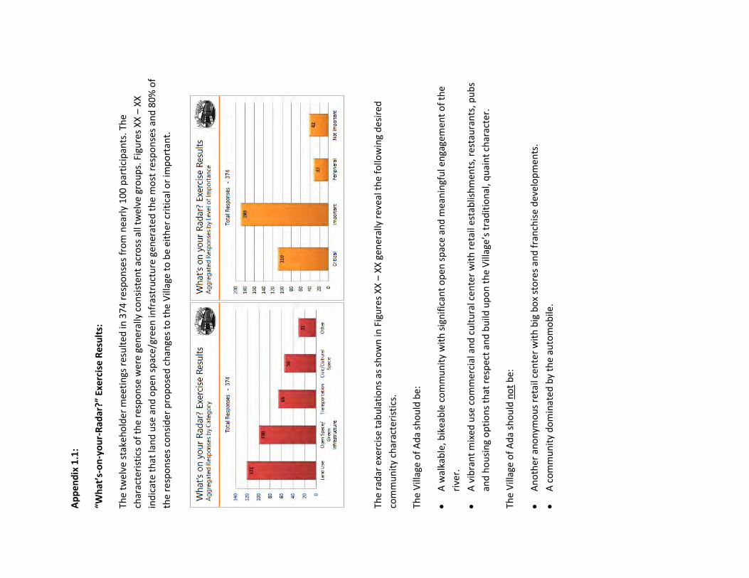
Ap
pen
dix
1.1
:
“Wh
at’s
-on
-yo
ur-
Rad
ar?”
Exe
rcis
e R
esu
lts:
The
twe
lve
stak
eh
old
er m
eeti
ngs
re
sult
ed in
37
4 r
esp
on
ses
fro
m n
earl
y 1
00
par
tici
pan
ts. T
he
char
acte
rist
ics
of
the
resp
on
se w
ere
gen
eral
ly c
on
sist
ent
acro
ss a
ll tw
elve
gro
up
s. F
igu
res
XX
– X
X
ind
icat
e t
hat
lan
d u
se a
nd
op
en s
pac
e/gr
een
infr
astr
uct
ure
gen
erat
ed
th
e m
ost
res
po
nse
s an
d 8
0%
of
the
resp
on
ses
con
sid
er p
rop
ose
d c
han
ges
to t
he
Vill
age
to b
e ei
ther
cri
tica
l or
imp
ort
ant.
Th
e ra
dar
exe
rcis
e ta
bu
lati
on
s as
sh
ow
n in
Fig
ure
s X
X –
XX
ge
ner
ally
rev
eal t
he
follo
win
g d
esir
ed
com
mu
nit
y ch
arac
teri
stic
s.
The
Vill
age
of
Ad
a sh
ou
ld b
e:
A w
alka
ble
, bik
eab
le c
om
mu
nit
y w
ith
sig
nif
ican
t o
pen
sp
ace
and
mea
nin
gfu
l en
gage
men
t o
f th
e
rive
r.
A v
ibra
nt
mix
ed u
se c
om
mer
cial
an
d c
ult
ura
l cen
ter
wit
h r
eta
il es
tab
lish
men
ts, r
esta
ura
nts
, pu
bs
and
ho
usi
ng
op
tio
ns
that
res
pec
t an
d b
uild
up
on
th
e V
illag
e’s
trad
itio
nal
, qu
ain
t ch
arac
ter.
The
Vill
age
of
Ad
a sh
ou
ld n
ot
be:
An
oth
er a
no
nym
ou
s re
tail
cen
ter
wit
h b
ig b
ox
sto
res
and
fra
nch
ise
dev
elo
pm
ents
.
A c
om
mu
nit
y d
om
inat
ed
by
the
auto
mo
bile
.

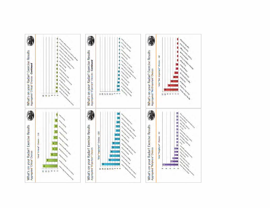


APPENDIX 1.2
ADA VILLAGE, MICHIGAN

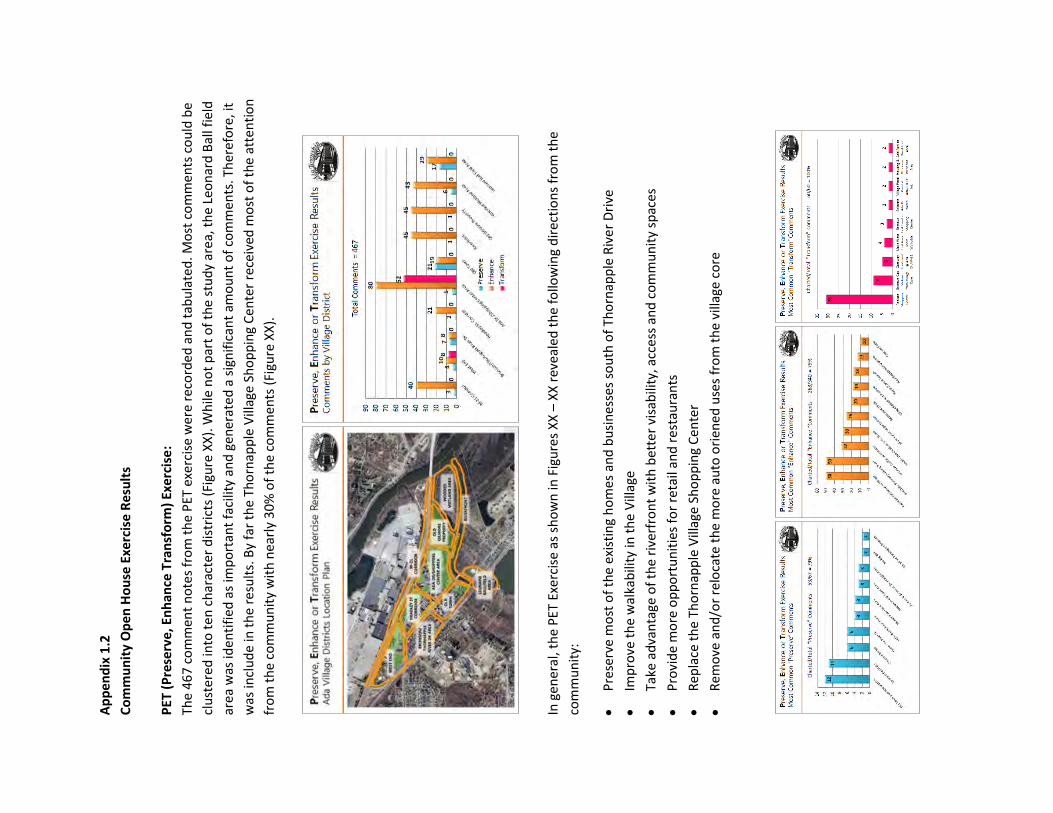
Ap
pen
dix
1.2
Co
mm
un
ity
Op
en H
ou
se E
xerc
ise
Re
sult
s
PET
(P
rese
rve,
En
han
ce T
ran
sfo
rm)
Exer
cise
:
The
467
co
mm
ent
no
tes
fro
m t
he
PET
exe
rcis
e w
ere
rec
ord
ed a
nd
tab
ula
ted
. Mo
st c
om
men
ts c
ou
ld b
e
clu
ste
red
into
te
n c
har
acte
r d
istr
icts
(Fi
gure
XX
). W
hile
no
t p
art
of
the
stu
dy
area
, th
e Le
on
ard
Bal
l fie
ld
area
was
iden
tifi
ed a
s im
po
rtan
t fa
cilit
y an
d g
ener
ate
d a
sig
nif
ican
t am
ou
nt
of
com
men
ts. T
her
efo
re, i
t
was
incl
ud
e in
th
e re
sult
s. B
y fa
r th
e Th
orn
app
le V
illag
e Sh
op
pin
g C
en
ter
rece
ived
mo
st o
f th
e at
ten
tio
n
fro
m t
he
com
mu
nit
y w
ith
nea
rly
30%
of
the
com
men
ts (
Figu
re X
X).
In
gen
eral
, th
e P
ET E
xerc
ise
as s
ho
wn
in F
igu
res
XX
– X
X r
evea
led
th
e fo
llow
ing
dir
ecti
on
s fr
om
th
e
com
mu
nit
y:
Pre
serv
e m
ost
of
the
exis
tin
g h
om
es a
nd
bu
sin
esse
s so
uth
of
Tho
rnap
ple
Riv
er
Dri
ve
Imp
rove
th
e w
alka
bili
ty in
th
e V
illag
e
Take
ad
van
tage
of
the
rive
rfro
nt
wit
h b
ette
r vi
sab
ility
, acc
ess
an
d c
om
mu
nit
y sp
aces
Pro
vid
e m
ore
op
po
rtu
nit
ies
for
reta
il an
d r
est
aura
nts
Rep
lace
th
e Th
orn
app
le V
illag
e Sh
op
pin
g C
en
ter
Rem
ove
an
d/o
r re
loca
te t
he
mo
re a
uto
ori
ened
use
s fr
om
th
e vi
llage
co
re

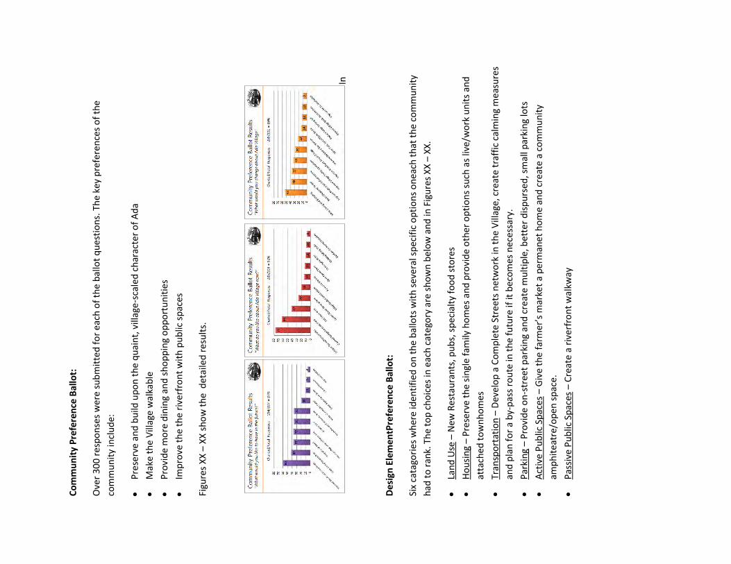
Co
mm
un
ity
Pre
fere
nce
Bal
lot:
Ove
r 3
00
res
po
nse
s w
ere
su
bm
itte
d f
or
each
of
the
bal
lot
qu
esti
on
s. T
he
key
pre
fere
nce
s o
f th
e
com
mu
nit
y in
clu
de:
Pre
serv
e an
d b
uild
up
on
th
e q
uai
nt,
vill
age
-sca
led
ch
arac
ter
of
Ad
a
Mak
e th
e V
illag
e w
alka
ble
Pro
vid
e m
ore
din
ing
and
sh
op
pin
g o
pp
ort
un
itie
s
Imp
rove
th
e th
e ri
verf
ron
t w
ith
pu
blic
sp
aces
Figu
res
XX
– X
X s
ho
w t
he
det
aile
d r
esu
lts.
In
De
sign
Ele
me
ntP
refe
ren
ce B
allo
t:
Six
cata
gori
es w
her
e id
enti
fied
on
th
e b
allo
ts w
ith
sev
eral
sp
ecif
ic o
pti
on
s o
nea
ch t
hat
th
e co
mm
un
ity
had
to
ran
k. T
he
top
ch
oic
es in
eac
h c
ate
gory
are
sh
ow
n b
elo
w a
nd
in F
igu
res
XX
– X
X.
Lan
d U
se –
New
Res
tau
ran
ts, p
ub
s, s
pec
ialt
y fo
od
sto
res
Ho
usi
ng
– P
rese
rve
the
sin
gle
fam
ily h
om
es a
nd
pro
vid
e o
ther
op
tio
ns
such
as
live/
wo
rk u
nit
s an
d
atta
ched
to
wn
ho
mes
Tran
spo
rtat
ion
– D
evel
op
a C
om
ple
te S
tree
ts n
etw
ork
in t
he
Vill
age,
cre
ate
tra
ffic
cal
min
g m
easu
res
and
pla
n f
or
a b
y-p
ass
rou
te in
th
e fu
ture
if it
bec
om
es n
ece
ssar
y.
Par
kin
g –
Pro
vid
e o
n-s
tree
t p
arki
ng
and
cre
ate
mu
ltip
le, b
ette
r d
isp
urs
ed, s
mal
l par
kin
g lo
ts
Act
ive
Pu
blic
Sp
aces
– G
ive
the
farm
er’s
mar
ket
a p
erm
anet
ho
me
and
cre
ate
a c
om
mu
nit
y
amp
hit
eatr
e/o
pen
sp
ace.
Pas
sive
Pu
blic
Sp
aces
– C
reat
e a
rive
rfro
nt
wal
kway

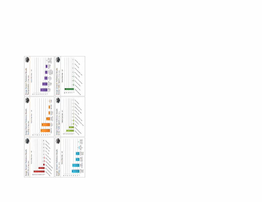


APPENDIX 2.1
ADA VILLAGE, MICHIGAN

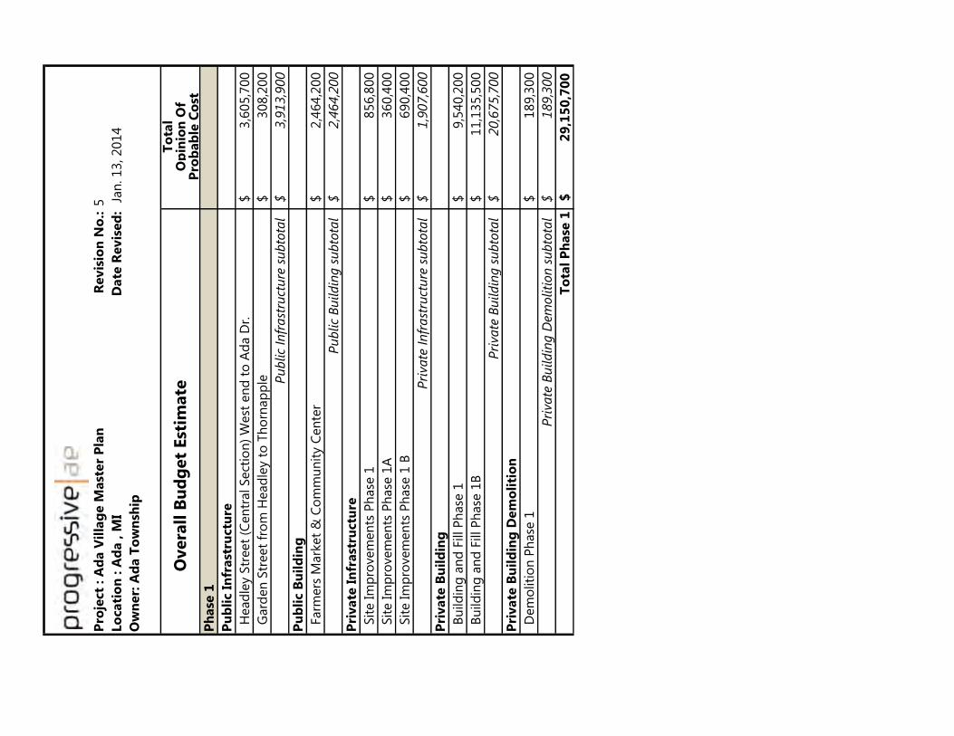
Pro
ject
: A
da V
illa
ge M
ast
er
Pla
nR
evis
ion
No
.:5
Lo
cati
on
: A
da , M
I D
ate
Revis
ed
: J
an
. 13, 2014
Ow
ner:
Ad
a T
ow
nsh
ip
To
tal
Op
inio
n O
fP
rob
ab
le C
ost
Ph
ase
1
Pu
bli
c I
nfr
ast
ructu
re
H
ead
ley S
treet
(Cen
tral Sect
ion
) W
est
en
d t
o A
da D
r.3,6
05,7
00
$
G
ard
en
Str
eet
fro
m H
ead
ley t
o T
ho
rnap
ple
308,2
00
$
Pu
blic
Infr
ast
ruct
ure
su
bto
tal
3,9
13,9
00
$
Pu
bli
c B
uil
din
g
Farm
ers
Mark
et
& C
om
mu
nit
y C
en
ter
2,4
64,2
00
$
Pu
blic
Bu
ildin
g s
ubto
tal
2,4
64,2
00
$
Pri
vate
In
frast
ructu
re
Sit
e Im
pro
vem
en
ts P
hase
1
856,8
00
$
Sit
e Im
pro
vem
en
ts P
hase
1A
360,4
00
$
Sit
e Im
pro
vem
en
ts P
hase
1 B
690,4
00
$
Pri
vate
In
frast
ruct
ure
su
bto
tal
1,9
07,6
00
$
Pri
vate
Bu
ild
ing
B
uild
ing
an
d F
ill P
hase
19,5
40,2
00
$
B
uild
ing
an
d F
ill P
hase
1B
11,1
35,5
00
$
Pri
vate
Bu
ildin
g s
ubto
tal
20,6
75,7
00
$
Pri
vate
Bu
ild
ing
Dem
oli
tio
n
D
em
oliti
on
Ph
ase
1189,3
00
$
Pri
vate
Bu
ildin
g D
em
oliti
on
su
bto
tal
189,3
00
$
To
tal
Ph
ase
12
9,1
50
,70
0$
Overa
ll B
ud
get
Est
imate

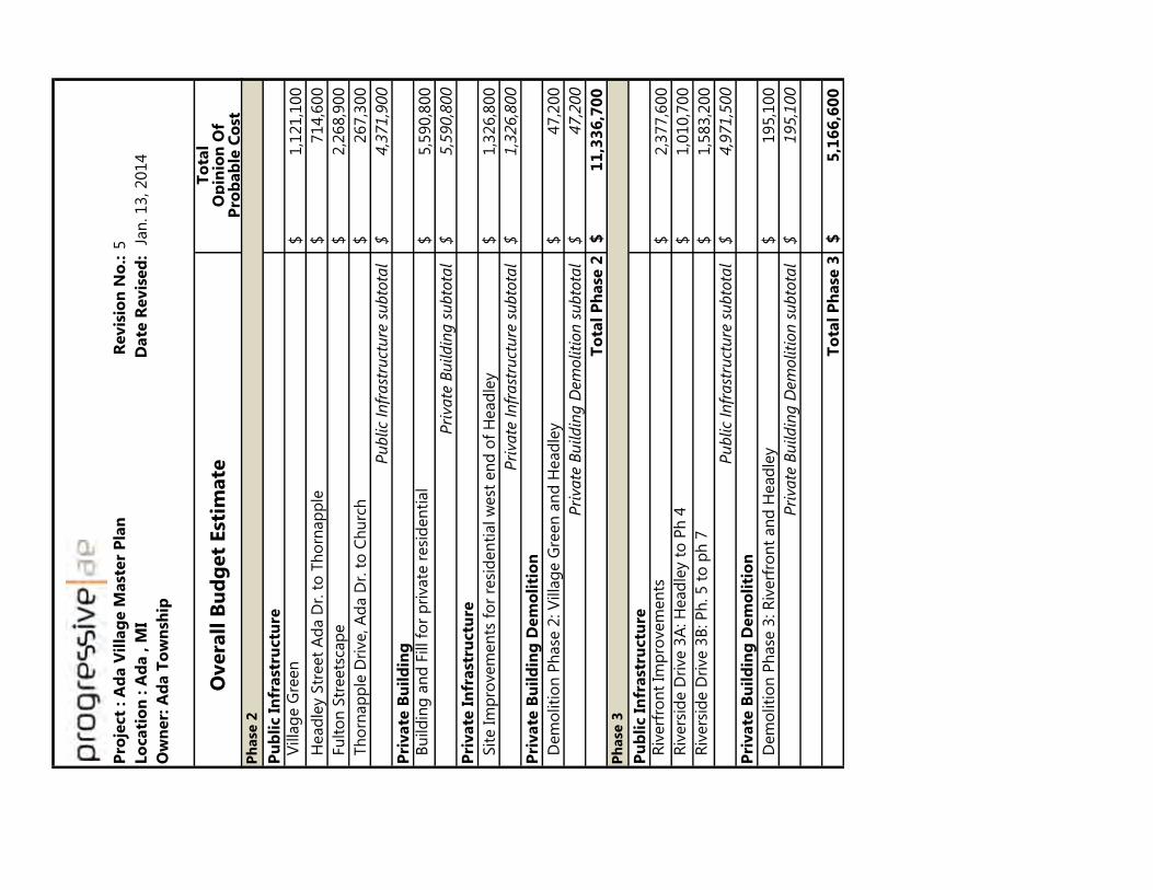
Pro
ject
: A
da V
illa
ge M
ast
er
Pla
nR
evis
ion
No
.:5
Lo
cati
on
: A
da , M
I D
ate
Revis
ed
: J
an
. 13, 2014
Ow
ner:
Ad
a T
ow
nsh
ip
To
tal
Op
inio
n O
fP
rob
ab
le C
ost
Overa
ll B
ud
get
Est
imate
Ph
ase
2
Pu
bli
c I
nfr
ast
ructu
re V
illa
ge G
reen
1,1
21,1
00
$
H
ead
ley S
treet
Ad
a D
r. t
o T
ho
rnap
ple
714,6
00
$
Fu
lto
n S
treets
cap
e2,2
68,9
00
$
Th
orn
ap
ple
Dri
ve, A
da D
r. t
o C
hu
rch
267,3
00
$
Pu
blic
Infr
ast
ruct
ure
su
bto
tal
4,3
71,9
00
$
Pri
vate
Bu
ild
ing
B
uild
ing
an
d F
ill fo
r p
rivate
resi
den
tial
5,5
90,8
00
$
Pri
vate
Bu
ildin
g s
ubto
tal
5,5
90,8
00
$
Pri
vate
In
frast
ructu
re
Sit
e Im
pro
vem
en
ts f
or
resi
den
tial w
est
en
d o
f H
ead
ley
1,3
26,8
00
$
Pri
vate
In
frast
ruct
ure
su
bto
tal
1,3
26,8
00
$
Pri
vate
Bu
ild
ing
Dem
oli
tio
n
D
em
oliti
on
Ph
ase
2: V
illa
ge G
reen
an
d H
ead
ley
47,2
00
$
Pri
vate
Bu
ildin
g D
em
oliti
on
su
bto
tal
47,2
00
$
To
tal
Ph
ase
21
1,3
36
,70
0$
Ph
ase
3
Pu
bli
c I
nfr
ast
ructu
re R
iverf
ron
t Im
pro
vem
en
ts2,3
77,6
00
$
R
ivers
ide D
rive 3
A: H
ead
ley t
o P
h 4
1,0
10,7
00
$
R
ivers
ide D
rive 3
B: P
h. 5 t
o p
h 7
1,5
83,2
00
$
Pu
blic
Infr
ast
ruct
ure
su
bto
tal
4,9
71,5
00
$
Pri
vate
Bu
ild
ing
Dem
oli
tio
n
D
em
oliti
on
Ph
ase
3: R
iverf
ron
t an
d H
ead
ley
195,1
00
$
Pri
vate
Bu
ildin
g D
em
oliti
on
su
bto
tal
195,1
00
$
To
tal
Ph
ase
35
,16
6,6
00
$

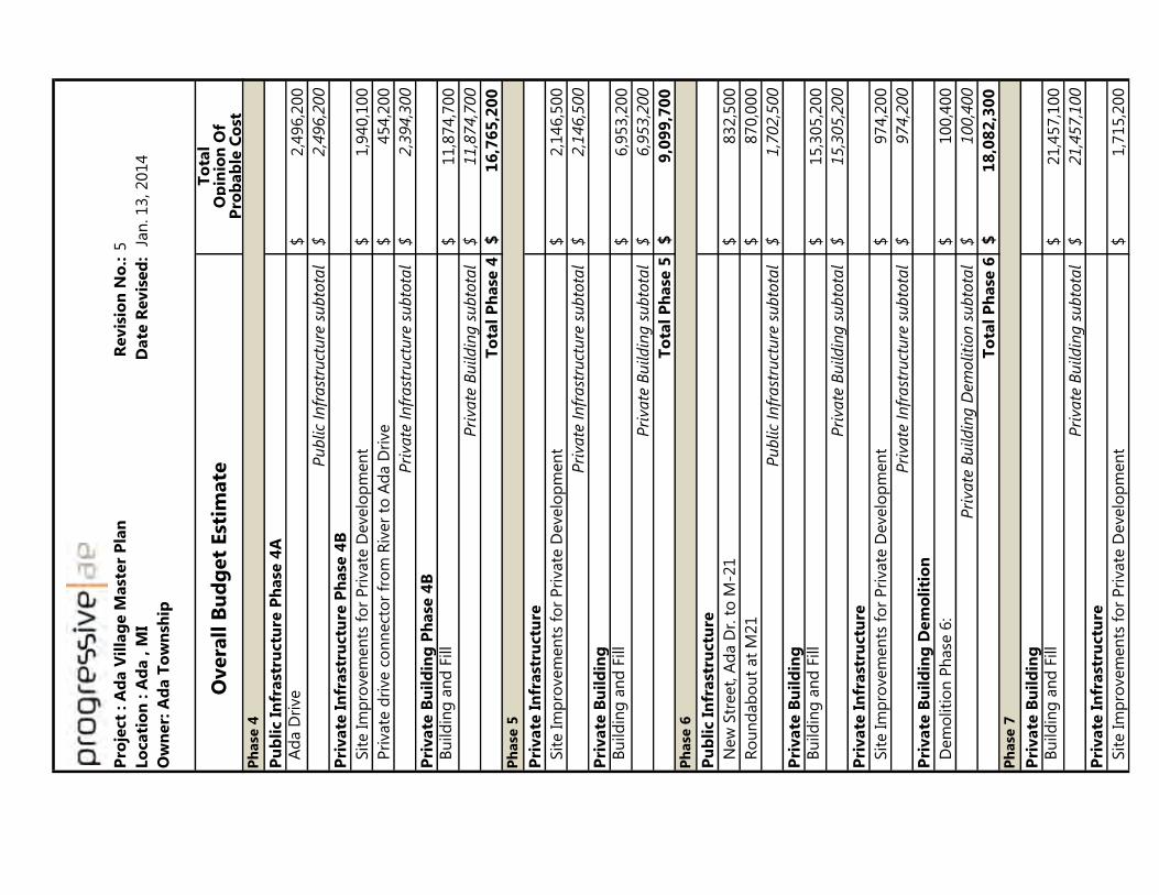
Pro
ject
: A
da V
illa
ge M
ast
er
Pla
nR
evis
ion
No
.:5
Lo
cati
on
: A
da , M
I D
ate
Revis
ed
: J
an
. 13, 2014
Ow
ner:
Ad
a T
ow
nsh
ip
To
tal
Op
inio
n O
fP
rob
ab
le C
ost
Overa
ll B
ud
get
Est
imate
Ph
ase
4
Pu
bli
c I
nfr
ast
ructu
re P
hase
4A
A
da D
rive
2,4
96,2
00
$
Pu
blic
Infr
ast
ruct
ure
su
bto
tal
2,4
96,2
00
$
Pri
vate
In
frast
ructu
re P
hase
4B
Sit
e Im
pro
vem
en
ts f
or
Pri
vate
Develo
pm
en
t1,9
40,1
00
$
P
rivate
dri
ve c
on
nect
or
fro
m R
iver
to A
da D
rive
454,2
00
$
Pri
vate
In
frast
ruct
ure
su
bto
tal
2,3
94,3
00
$
Pri
vate
Bu
ild
ing
Ph
ase
4B
B
uild
ing
an
d F
ill
11,8
74,7
00
$
Pri
vate
Bu
ildin
g s
ubto
tal
11,8
74,7
00
$
To
tal
Ph
ase
41
6,7
65
,20
0$
Ph
ase
5
Pri
vate
In
frast
ructu
re
Sit
e Im
pro
vem
en
ts f
or
Pri
vate
Develo
pm
en
t2,1
46,5
00
$
Pri
vate
In
frast
ruct
ure
su
bto
tal
2,1
46,5
00
$
Pri
vate
Bu
ild
ing
B
uild
ing
an
d F
ill
6,9
53,2
00
$
Pri
vate
Bu
ildin
g s
ubto
tal
6,9
53,2
00
$
To
tal
Ph
ase
59
,09
9,7
00
$
Ph
ase
6
Pu
bli
c I
nfr
ast
ructu
re
N
ew
Str
eet,
Ad
a D
r. t
o M
-21
832,5
00
$
R
ou
nd
ab
ou
t at
M21
870,0
00
$
Pu
blic
Infr
ast
ruct
ure
su
bto
tal
1,7
02,5
00
$
Pri
vate
Bu
ild
ing
B
uild
ing
an
d F
ill
15,3
05,2
00
$
Pri
vate
Bu
ildin
g s
ubto
tal
15,3
05,2
00
$
Pri
vate
In
frast
ructu
re
Sit
e Im
pro
vem
en
ts f
or
Pri
vate
Develo
pm
en
t974,2
00
$
Pri
vate
In
frast
ruct
ure
su
bto
tal
974,2
00
$
Pri
vate
Bu
ild
ing
Dem
oli
tio
n
D
em
oliti
on
Ph
ase
6:
100,4
00
$
Pri
vate
Bu
ildin
g D
em
oliti
on
su
bto
tal
100,4
00
$
To
tal
Ph
ase
61
8,0
82
,30
0$
Ph
ase
7
Pri
vate
Bu
ild
ing
B
uild
ing
an
d F
ill
21,4
57,1
00
$
Pri
vate
Bu
ildin
g s
ubto
tal
21,4
57,1
00
$
Pri
vate
In
frast
ructu
re
Sit
e Im
pro
vem
en
ts f
or
Pri
vate
Develo
pm
en
t1,7
15,2
00
$

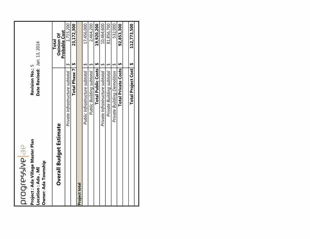
Pro
ject
: A
da V
illa
ge M
ast
er
Pla
nR
evis
ion
No
.:5
Lo
cati
on
: A
da , M
I D
ate
Revis
ed
: J
an
. 13, 2014
Ow
ner:
Ad
a T
ow
nsh
ip
To
tal
Op
inio
n O
fP
rob
ab
le C
ost
Overa
ll B
ud
get
Est
imate P
rivate
In
frast
ruct
ure
su
bto
tal
1,7
15,2
00
$
To
tal
Ph
ase
72
3,1
72
,30
0$
Pro
ject
tota
l
Pu
blic
Infr
ast
ruct
ure
su
bto
tal
17,4
56,0
00
$
Pu
blic
Bu
ildin
g s
ubto
tal
2,4
64,2
00
$
To
tal
Pu
bli
c C
ost
s1
9,9
20
,20
0$
Pri
vate
In
frast
ruct
ure
su
bto
tal
10,4
64,6
00
$
Pri
vate
Bu
ildin
g s
ubto
tal
81,8
56,7
00
$
Pri
vate
Bu
ildin
g D
em
oliti
on
532,0
00
$
To
tal
Pri
vate
Co
sts
92
,85
3,3
00
$
To
tal
Pro
ject
Co
st1
12
,77
3,5
00
$

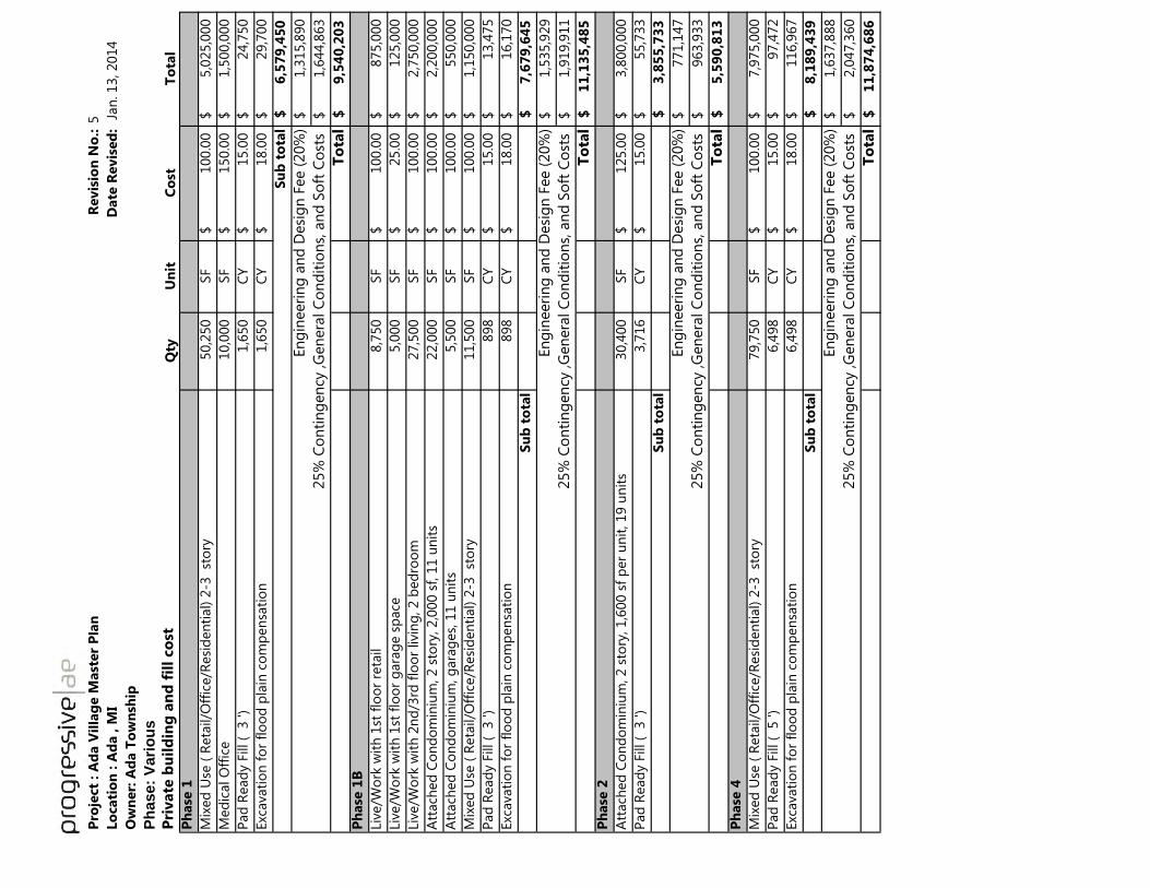
Pro
ject
: A
da V
illa
ge M
ast
er
Pla
nR
evis
ion
No
.:5
Lo
cati
on
: A
da , M
I
Date
Revis
ed
: J
an
. 13, 2014
Ow
ner:
Ad
a T
ow
nsh
ip
Ph
ase:
Vari
ou
s
Pri
vate
bu
ild
ing
an
d f
ill
co
stQ
tyU
nit
Co
stT
ota
l
Ph
ase
1
Mix
ed
Use
( R
eta
il/O
ffic
e/R
esi
den
tial) 2
-3 st
ory
50,2
50
SF
100.0
0$
5,0
25,0
00
$
Med
ical O
ffic
e10,0
00
SF
150.0
0$
1,5
00,0
00
$
Pad
Read
y F
ill (
3 ')
1,6
50
C
Y15.0
0$
24,7
50
$
Exc
avati
on
fo
r fl
oo
d p
lain
co
mp
en
sati
on
1,6
50
C
Y18.0
0$
29,7
00
$
Su
b t
ota
l6
,57
9,4
50
$
En
gin
eeri
ng
an
d D
esi
gn
Fee (
20%
)1,3
15,8
90
$
1
,644,8
63
$
To
tal
9,5
40
,20
3$
Ph
ase
1B
Liv
e/W
ork
wit
h 1
st f
loo
r re
tail
8,7
50
SF
100.0
0$
875,0
00
$
Liv
e/W
ork
wit
h 1
st f
loo
r g
ara
ge s
pace
5,0
00
SF
25.0
0$
125,0
00
$
Liv
e/W
ork
wit
h 2
nd
/3rd
flo
or
livin
g, 2 b
ed
roo
m27,5
00
SF
100.0
0$
2,7
50,0
00
$
Att
ach
ed
Co
nd
om
iniu
m, 2 s
tory
, 2,0
00 s
f, 1
1 u
nit
s22,0
00
SF
100.0
0$
2,2
00,0
00
$
Att
ach
ed
Co
nd
om
iniu
m, g
ara
ges,
11 u
nit
s5,5
00
SF
100.0
0$
550,0
00
$
Mix
ed
Use
( R
eta
il/O
ffic
e/R
esi
den
tial) 2
-3 st
ory
11,5
00
SF
100.0
0$
1,1
50,0
00
$
Pad
Read
y F
ill (
3 ')
898
CY
15.0
0$
13,4
75
$
Exc
avati
on
fo
r fl
oo
d p
lain
co
mp
en
sati
on
898
CY
18.0
0$
16,1
70
$
Su
b t
ota
l7
,67
9,6
45
$
En
gin
eeri
ng
an
d D
esi
gn
Fee (
20%
)1,5
35,9
29
$
1
,919,9
11
$
To
tal
11
,13
5,4
85
$
Ph
ase
2
Att
ach
ed
Co
nd
om
iniu
m, 2 s
tory
, 1,6
00 s
f p
er
un
it, 19 u
nit
s30,4
00
SF
125.0
0$
3,8
00,0
00
$
Pad
Read
y F
ill (
3 ')
3,7
16
C
Y15.0
0$
55,7
33
$
Su
b t
ota
l3
,85
5,7
33
$
En
gin
eeri
ng
an
d D
esi
gn
Fee (
20%
)771,1
47
$
9
63,9
33
$
To
tal
5,5
90
,81
3$
Ph
ase
4
Mix
ed
Use
( R
eta
il/O
ffic
e/R
esi
den
tial) 2
-3 st
ory
79,7
50
SF
100.0
0$
7,9
75,0
00
$
Pad
Read
y F
ill (
5 ')
6,4
98
C
Y15.0
0$
97,4
72
$
Exc
avati
on
fo
r fl
oo
d p
lain
co
mp
en
sati
on
6,4
98
C
Y18.0
0$
116,9
67
$
Su
b t
ota
l8
,18
9,4
39
$
En
gin
eeri
ng
an
d D
esi
gn
Fee (
20%
)1,6
37,8
88
$
2
,047,3
60
$
To
tal
11
,87
4,6
86
$
25%
Co
nti
ng
en
cy ,G
en
era
l C
on
dit
ion
s, a
nd
So
ft C
ost
s
25%
Co
nti
ng
en
cy ,G
en
era
l C
on
dit
ion
s, a
nd
So
ft C
ost
s
25%
Co
nti
ng
en
cy ,G
en
era
l C
on
dit
ion
s, a
nd
So
ft C
ost
s
25%
Co
nti
ng
en
cy ,G
en
era
l C
on
dit
ion
s, a
nd
So
ft C
ost
s

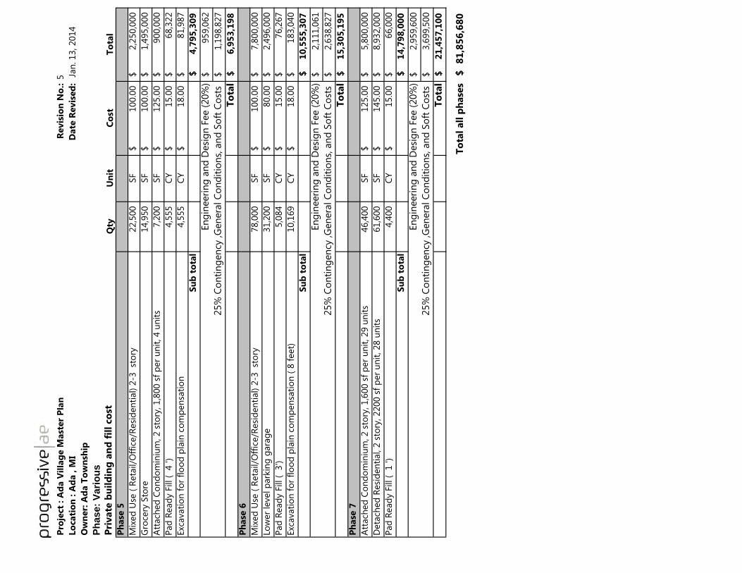
Pro
ject
: A
da V
illa
ge M
ast
er
Pla
nR
evis
ion
No
.:5
Lo
cati
on
: A
da , M
I
Date
Revis
ed
: J
an
. 13, 2014
Ow
ner:
Ad
a T
ow
nsh
ip
Ph
ase:
Vari
ou
s
Pri
vate
bu
ild
ing
an
d f
ill
co
stQ
tyU
nit
Co
stT
ota
l
Ph
ase
5
Mix
ed
Use
( R
eta
il/O
ffic
e/R
esi
den
tial) 2
-3 st
ory
22,5
00
SF
100.0
0$
2,2
50,0
00
$
Gro
cery
Sto
re14,9
50
SF
100.0
0$
1,4
95,0
00
$
Att
ach
ed
Co
nd
om
iniu
m, 2 s
tory
, 1,8
00 s
f p
er
un
it, 4 u
nit
s7,2
00
SF
125.0
0$
900,0
00
$
Pad
Read
y F
ill (
4 ')
4,5
55
C
Y15.0
0$
68,3
22
$
Exc
avati
on
fo
r fl
oo
d p
lain
co
mp
en
sati
on
4,5
55
C
Y18.0
0$
81,9
87
$
Su
b t
ota
l4
,79
5,3
09
$
En
gin
eeri
ng
an
d D
esi
gn
Fee (
20%
)959,0
62
$
1,1
98,8
27
$
To
tal
6,9
53
,19
8$
Ph
ase
6
Mix
ed
Use
( R
eta
il/O
ffic
e/R
esi
den
tial) 2
-3 st
ory
78,0
00
SF
100.0
0$
7,8
00,0
00
$
Lo
wer
level p
ark
ing
gara
ge
31,2
00
SF
80.0
0$
2,4
96,0
00
$
Pad
Read
y F
ill (
3')
5,0
84
C
Y15.0
0$
76,2
67
$
Exc
avati
on
fo
r fl
oo
d p
lain
co
mp
en
sati
on
( 8
feet)
10,1
69
CY
18.0
0$
183,0
40
$
Su
b t
ota
l1
0,5
55
,30
7$
En
gin
eeri
ng
an
d D
esi
gn
Fee (
20%
)2,1
11,0
61
$
2
,638,8
27
$
To
tal
15
,30
5,1
95
$
Ph
ase
7
Att
ach
ed
Co
nd
om
iniu
m, 2 s
tory
, 1,6
00 s
f p
er
un
it, 29 u
nit
s46,4
00
SF
125.0
0$
5,8
00,0
00
$
Deta
ched
Resi
den
tial,
2 s
tory
, 2200 s
f p
er
un
it, 28 u
nit
s61,6
00
SF
145.0
0$
8,9
32,0
00
$
Pad
Read
y F
ill (
1 ')
4,4
00
C
Y15.0
0$
66,0
00
$
Su
b t
ota
l1
4,7
98
,00
0$
En
gin
eeri
ng
an
d D
esi
gn
Fee (
20%
)2,9
59,6
00
$
3
,699,5
00
$
To
tal
21
,45
7,1
00
$
To
tal
all
ph
ase
s8
1,8
56
,68
0$
25%
Co
nti
ng
en
cy ,G
en
era
l C
on
dit
ion
s, a
nd
So
ft C
ost
s
25%
Co
nti
ng
en
cy ,G
en
era
l C
on
dit
ion
s, a
nd
So
ft C
ost
s
25%
Co
nti
ng
en
cy ,G
en
era
l C
on
dit
ion
s, a
nd
So
ft C
ost
s

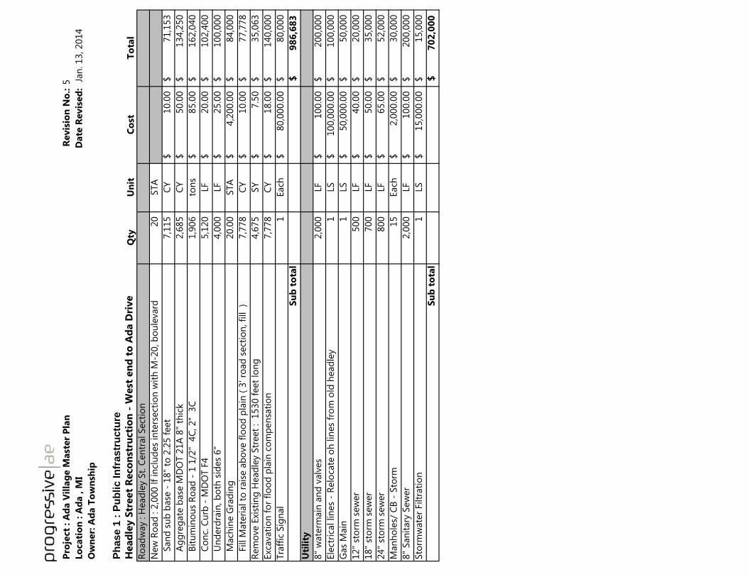
Pro
ject
: A
da V
illa
ge M
ast
er
Pla
nR
evis
ion
No
.:5
Lo
cati
on
: A
da , M
I D
ate
Revis
ed
: J
an
. 13, 2014
Ow
ner:
Ad
a T
ow
nsh
ip
Ph
ase 1
: P
ub
lic In
frastr
uctu
re
Head
ley S
treet
Reco
nst
ructi
on
- W
est
en
d t
o A
da D
rive
Qty
Un
itC
ost
To
tal
Ro
ad
way : H
ead
ley S
t. C
en
tral Sect
ion
New
Ro
ad
: 2
,000 lf
incl
ud
es
inte
rsect
ion
wit
h M
-20, b
ou
levard
20
STA
S
an
d s
ub
base
- 1
8"
to 2
.25 f
eet
7,1
15
CY
10.0
0$
71,1
53
$
A
gg
reg
ate
base
MD
OT 2
1A
8"
thic
k2,6
85
CY
50.0
0$
134,2
50
$
B
itu
min
ou
s R
oad
- 1
1/2
" 4
C, 2"
3C
1,9
06
ton
s85.0
0$
162,0
40
$
C
on
c. C
urb
- M
DO
T F
45,1
20
LF
20.0
0$
102,4
00
$
U
nd
erd
rain
, b
oth
sid
es
6"
4,0
00
LF
25.0
0$
100,0
00
$
M
ach
ine G
rad
ing
20.0
0
STA
4,2
00.0
0$
84,0
00
$
F
ill M
ate
rial to
rais
e a
bo
ve f
loo
d p
lain
( 3
' ro
ad
sect
ion
, fi
ll
)7,7
78
CY
10.0
0$
77,7
78
$
Rem
ove E
xist
ing
Head
ley S
treet
: 1
530 f
eet
lon
g4,6
75
SY
7.5
0$
35,0
63
$
Exc
avati
on
fo
r fl
oo
d p
lain
co
mp
en
sati
on
7,7
78
CY
18.0
0$
140,0
00
$
Tra
ffic
Sig
nal
1
Each
80,0
00.0
0$
80,0
00
$
Su
b t
ota
l9
86
,68
3$
Uti
lity
8"
wate
rmain
an
d v
alv
es
2,0
00
LF
100.0
0$
200,0
00
$
Ele
ctri
cal lin
es
- R
elo
cate
oh
lin
es
fro
m o
ld h
ead
ley
1
LS
100,0
00.0
0$
100,0
00
$
Gas
Main
1
LS
50,0
00.0
0$
50,0
00
$
12"
sto
rm s
ew
er
500
LF
40.0
0$
20,0
00
$
18"
sto
rm s
ew
er
700
LF
50.0
0$
35,0
00
$
24"
sto
rm s
ew
er
800
LF
65.0
0$
52,0
00
$
Man
ho
les/
CB
- S
torm
15
Each
2,0
00.0
0$
30,0
00
$
8"
San
itary
Sew
er
2,0
00
LF
100.0
0$
200,0
00
$
Sto
rmw
ate
r Filtr
ati
on
1
LS
15,0
00.0
0$
15,0
00
$
Su
b t
ota
l7
02
,00
0$

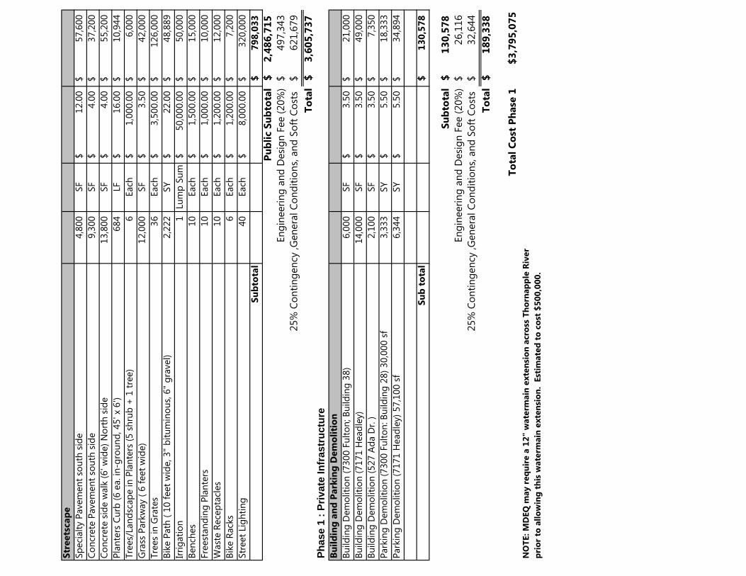
Str
eets
cap
e
Sp
eci
alt
y P
avem
en
t so
uth
sid
e4,8
00
SF
12.0
0$
57,6
00
$
Co
ncr
ete
Pavem
en
t so
uth
sid
e9,3
00
SF
4.0
0$
37,2
00
$
Co
ncr
ete
sid
e w
alk
(6' w
ide)
No
rth
sid
e13,8
00
SF
4.0
0$
55,2
00
$
Pla
nte
rs C
urb
(6 e
a. in
-gro
un
d, 45' x
6')
684
LF
16.0
0$
10,9
44
$
Tre
es/
Lan
dsc
ap
e in
Pla
nte
rs (
5 s
hru
b +
1 t
ree)
6
Each
1,0
00.0
0$
6,0
00
$
Gra
ss P
ark
way (
6 f
eet
wid
e)
12,0
00
SF
3.5
0$
42,0
00
$
Tre
es
in G
rate
s36
Each
3,5
00.0
0$
126,0
00
$
Bik
e P
ath
( 1
0 f
eet
wid
e, 3"
bit
um
ino
us,
6"
gra
vel)
2,2
22
SY
22.0
0$
48,8
89
$
Irri
gati
on
1
Lu
mp
Su
m50,0
00.0
0$
50,0
00
$
Ben
ches
10
Each
1,5
00.0
0$
15,0
00
$
Fre
est
an
din
g P
lan
ters
10
Each
1,0
00.0
0$
10,0
00
$
Wast
e R
ece
pta
cles
10
Each
1,2
00.0
0$
12,0
00
$
Bik
e R
ack
s6
Each
1,2
00.0
0$
7,2
00
$
Str
eet
Lig
hti
ng
40
Each
8,0
00.0
0$
320,0
00
$
Su
bto
tal
79
8,0
33
$
Pu
bli
c S
ub
tota
l2
,48
6,7
15
$
En
gin
eeri
ng
an
d D
esi
gn
Fee (
20%
)497,3
43
$
6
21,6
79
$
To
tal
3,6
05
,73
7$
Ph
ase 1
: P
rivate
In
frastr
uctu
re
Bu
ild
ing
an
d P
ark
ing
Dem
oli
tio
n
Bu
ild
ing
Dem
oliti
on
(7300 F
ult
on
; B
uild
ing
38)
6,0
00
SF
3.5
0$
21,0
00
$
Bu
ild
ing
Dem
oliti
on
(7171 H
ead
ley)
14,0
00
SF
3.5
0$
49,0
00
$
Bu
ild
ing
Dem
oliti
on
(527 A
da D
r. )
2,1
00
SF
3.5
0$
7,3
50
$
Park
ing
Dem
oliti
on
(7300 F
ult
on
: B
uild
ing
28)
30,0
00 s
f3,3
33
SY
5.5
0$
18,3
33
$
Park
ing
Dem
oliti
on
(7171 H
ead
ley)
57,1
00 s
f6,3
44
SY
5.5
0$
34,8
94
$
Su
b t
ota
l1
30
,57
8$
Su
bto
tal
13
0,5
78
$
En
gin
eeri
ng
an
d D
esi
gn
Fee (
20%
)26,1
16
$
32,6
44
$
To
tal
18
9,3
38
$
To
tal
Co
st P
hase
1$
3,7
95
,07
5
NO
TE: M
DEQ
may r
eq
uir
e a
12
" w
ate
rmain
exte
nsi
on
acro
ss T
ho
rnap
ple
Riv
er
pri
or
to a
llo
win
g t
his
wate
rmain
exte
nsi
on
. E
stim
ate
d t
o c
ost
$5
00
,00
0.
25%
Co
nti
ng
en
cy ,G
en
era
l C
on
dit
ion
s, a
nd
So
ft C
ost
s
25%
Co
nti
ng
en
cy ,G
en
era
l C
on
dit
ion
s, a
nd
So
ft C
ost
s

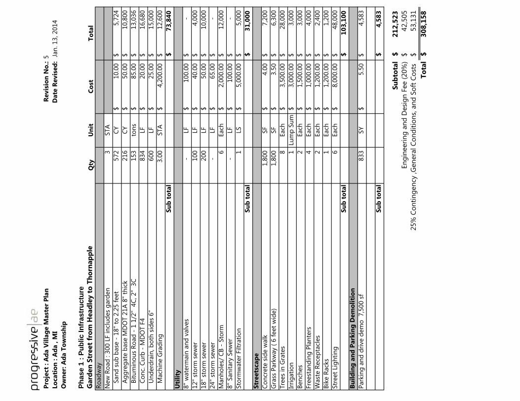
Pro
ject
: A
da V
illa
ge M
ast
er
Pla
nR
evis
ion
No
.:5
Lo
cati
on
: A
da , M
I D
ate
Revis
ed
: J
an
. 13, 2014
Ow
ner:
Ad
a T
ow
nsh
ip
Ph
ase 1
: P
ub
lic In
frastr
uctu
re
Gard
en
Str
eet
fro
m H
ead
ley t
o T
ho
rnap
ple
Qty
Un
itC
ost
To
tal
Ro
ad
way
New
Ro
ad
: 3
00 L
F in
clu
des
gard
en
3
STA
S
an
d s
ub
base
- 1
8"
to 2
.25 f
eet
572
CY
10.0
0$
5,7
24
$
A
gg
reg
ate
base
MD
OT 2
1A
8"
thic
k216
CY
50.0
0$
10,8
00
$
B
itu
min
ou
s R
oad
- 1
1/2
" 4
C, 2"
3C
153
ton
s85.0
0$
13,0
36
$
C
on
c. C
urb
- M
DO
T F
4834
LF
20.0
0$
16,6
80
$
U
nd
erd
rain
, b
oth
sid
es
6"
600
LF
25.0
0$
15,0
00
$
M
ach
ine G
rad
ing
3.0
0
STA
4,2
00.0
0$
12,6
00
$
Su
b t
ota
l7
3,8
40
$
Uti
lity
8"
wate
rmain
an
d v
alv
es
-
LF
100.0
0$
-$
12"
sto
rm s
ew
er
100
LF
40.0
0$
4,0
00
$
18"
sto
rm s
ew
er
200
LF
50.0
0$
10,0
00
$
24"
sto
rm s
ew
er
-
LF
65.0
0$
-
$
Man
ho
les/
CB
- S
torm
6
Each
2,0
00.0
0$
12,0
00
$
8"
San
itary
Sew
er
-
LF
100.0
0$
-$
Sto
rmw
ate
r Filtr
ati
on
1
LS
5,0
00.0
0$
5,0
00
$
Su
b t
ota
l3
1,0
00
$
Str
eets
cap
e
Co
ncr
ete
sid
e w
alk
1,8
00
SF
4.0
0$
7,2
00
$
Gra
ss P
ark
way (
6 f
eet
wid
e)
1,8
00
SF
3.5
0$
6,3
00
$
Tre
es
in G
rate
s8
Each
3,5
00.0
0$
28,0
00
$
Irri
gati
on
1
Lu
mp
Su
m3,0
00.0
0$
3,0
00
$
Ben
ches
2
Each
1,5
00.0
0$
3,0
00
$
Fre
est
an
din
g P
lan
ters
4
Each
1,0
00.0
0$
4,0
00
$
Wast
e R
ece
pta
cles
2
Each
1,2
00.0
0$
2,4
00
$
Bik
e R
ack
s1
Each
1,2
00.0
0$
1,2
00
$
Str
eet
Lig
hti
ng
6
Each
8,0
00.0
0$
48,0
00
$
Su
b t
ota
l1
03
,10
0$
Bu
ild
ing
an
d P
ark
ing
Dem
oli
tio
n
Park
ing
an
d d
rive d
em
o
7,5
00 s
f833
SY
5.5
0$
4,5
83
$
Su
b t
ota
l4
,58
3$
Su
bto
tal
21
2,5
23
$
En
gin
eeri
ng
an
d D
esi
gn
Fee (
20%
)42,5
05
$
53,1
31
$
To
tal
30
8,1
58
$
25%
Co
nti
ng
en
cy ,G
en
era
l C
on
dit
ion
s, a
nd
So
ft C
ost
s

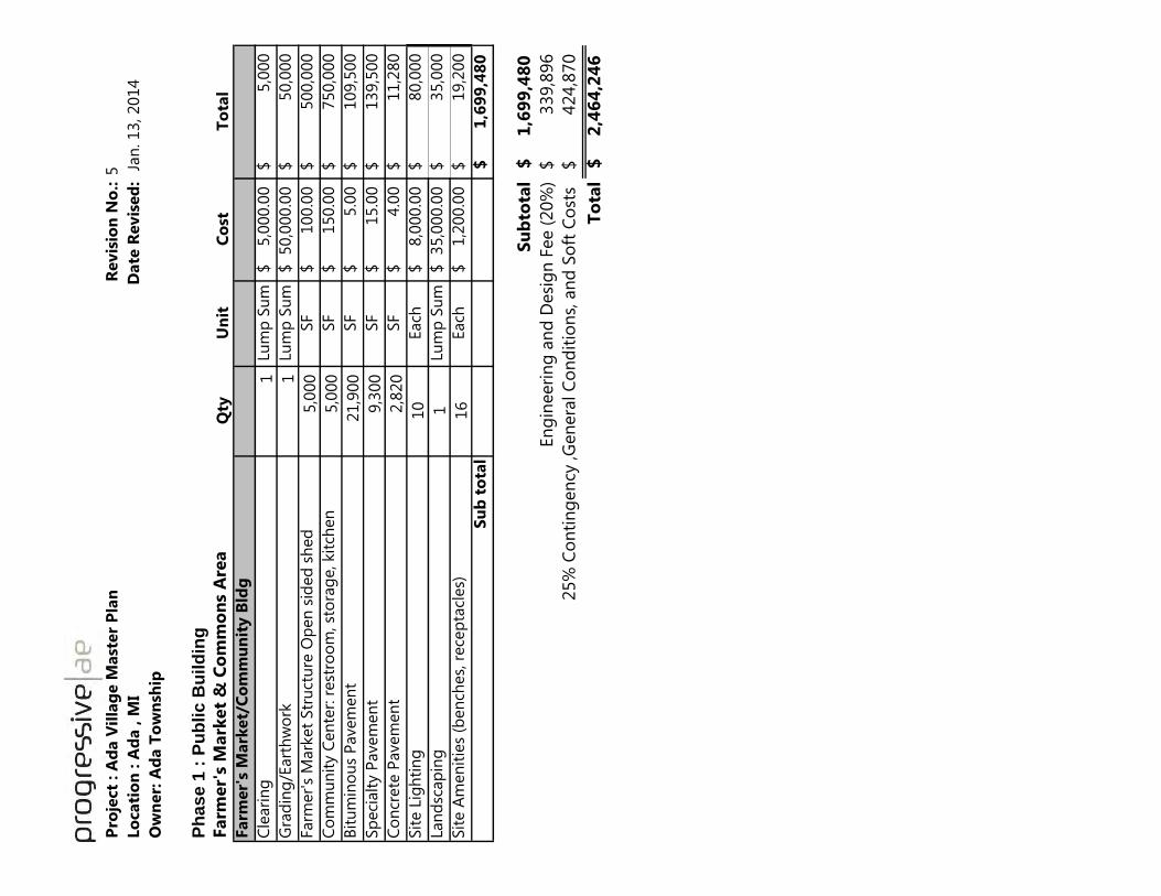
Pro
ject
: A
da V
illa
ge M
ast
er
Pla
nR
evis
ion
No
.:5
Lo
cati
on
: A
da , M
I D
ate
Revis
ed
: J
an
. 13, 2014
Ow
ner:
Ad
a T
ow
nsh
ip
Ph
as
e 1
: P
ub
lic
Bu
ild
ing
Farm
er'
s M
ark
et
& C
om
mo
ns
Are
aQ
tyU
nit
Co
stT
ota
l
Farm
er'
s M
ark
et/
Co
mm
un
ity B
ldg
Cle
ari
ng
1
Lum
p S
um
5,0
00.0
0$
5,0
00
$
Gra
din
g/E
art
hw
ork
1
Lum
p S
um
50,0
00.0
0$
50,0
00
$
Farm
er'
s M
ark
et
Str
uct
ure
Op
en
sid
ed
sh
ed
5,0
00
SF
100.0
0$
500,0
00
$
Co
mm
un
ity C
en
ter:
rest
roo
m, st
ora
ge, kit
chen
5,0
00
SF
150.0
0$
750,0
00
$
Bit
um
ino
us
Pavem
en
t 21,9
00
SF
5.0
0$
109,5
00
$
Sp
eci
alt
y P
avem
en
t 9,3
00
SF
15.0
0$
139,5
00
$
Co
ncr
ete
Pavem
en
t2,8
20
SF
4.0
0$
11,2
80
$
Sit
e L
igh
tin
g
10
Each
8,0
00.0
0$
80,0
00
$
Lan
dsc
ap
ing
1Lu
mp
Su
m35,0
00.0
0$
35,0
00
$
Sit
e A
men
itie
s (b
en
ches,
rece
pta
cles)
16
Each
1,2
00.0
0$
19,2
00
$
Su
b t
ota
l1
,69
9,4
80
$
Su
bto
tal
1,6
99
,48
0$
En
gin
eeri
ng
an
d D
esi
gn
Fee (
20%
)339,8
96
$ 4
24,8
70
$
To
tal
2,4
64
,24
6$
25%
Co
nti
ng
en
cy ,G
en
era
l C
on
dit
ion
s, a
nd
So
ft C
ost
s


Pro
ject
: A
da V
illa
ge M
ast
er
Pla
nR
evis
ion
No
.:5
Lo
cati
on
: A
da , M
I D
ate
Revis
ed
: J
an
. 13, 2014
Ow
ner:
Ad
a T
ow
nsh
ip
Ph
ase 1
: P
rivate
In
frastr
uctu
re
Mix
ed
use
, W
est
en
d H
ead
ley
Qty
Un
itC
ost
To
tal
Park
ing
are
a
Park
ing
an
d d
rive a
rea
74,5
00
SF
S
an
d s
ub
base
- 1
2"
3,3
11
CY
10.0
0$
33,1
11
$
A
gg
reg
ate
base
MD
OT 2
1A
8"
thic
k2,2
18
CY
50.0
0$
110,9
22
$
B
itu
min
ou
s p
avem
en
t -
1 1
/2"
4C
, 2"
3C
1,9
12
ton
s85.0
0$
162,5
34
$
C
on
c. C
urb
-2,0
00
LF
20.0
0$
40,0
00
$
G
rad
ing
75,0
00
SF
0.5
0$
37,5
00
$
Su
b t
ota
l3
84
,06
8$
Uti
lity
8"
wate
rmain
an
d v
alv
es
-
LF
100.0
0$
-$
Ele
ctri
cal lin
es
1
LS
10,0
00.0
0$
10,0
00
$
Gas
Main
1
LS
10,0
00.0
0$
10,0
00
$
12"
sto
rm s
ew
er
400
LF
40.0
0$
16,0
00
$
18"
sto
rm s
ew
er
400
LF
50.0
0$
20,0
00
$
24"
sto
rm s
ew
er
LF
65.0
0$
-
$
Man
ho
les/
CB
- S
torm
8
Each
2,0
00.0
0$
16,0
00
$
8"
San
itary
Sew
er
LF
120.0
0$
-$
Sto
rmw
ate
r Filtr
ati
on
1
LS
15,0
00.0
0$
15,0
00
$
Su
b t
ota
l8
7,0
00
$
Str
eets
cap
e
Sp
eci
alt
y P
avem
en
tSF
12.0
0$
-
$
Co
ncr
ete
sid
ew
alk
s4,8
00
SF
4.0
0$
19,2
00
$
Tre
es
32
Each
500.0
0$
16,0
00
$
Irri
gati
on
1
Lu
mp
Su
m10,0
00.0
0$
10,0
00
$
Ben
ches
2
Each
1,5
00.0
0$
3,0
00
$
Fre
est
an
din
g P
lan
ters
4
Each
1,0
00.0
0$
4,0
00
$
Wast
e R
ece
pta
cles
2
Each
1,2
00.0
0$
2,4
00
$
Bik
e R
ack
s1
Each
1,2
00.0
0$
1,2
00
$
Sit
e L
igh
tin
g8
Each
8,0
00.0
0$
64,0
00
$
Su
b t
ota
l1
19
,80
0$
Su
bto
tal
59
0,8
68
$
En
gin
eeri
ng
an
d D
esi
gn
Fee (
20%
)118,1
74
$
1
47,7
17
$
To
tal
85
6,7
58
$
25%
Co
nti
ng
en
cy ,G
en
era
l C
on
dit
ion
s, a
nd
So
ft C
ost
s

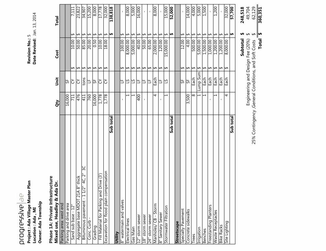
Pro
ject
: A
da V
illa
ge M
ast
er
Pla
nR
evis
ion
No
.:5
Lo
cati
on
: A
da , M
I D
ate
Revis
ed
: J
an
. 13, 2014
Ow
ner:
Ad
a T
ow
nsh
ip
Ph
ase 1
A:
Pri
vate
In
frastr
uctu
re
Mix
ed
use
, H
ead
ley &
Ad
a D
r.Q
tyU
nit
Co
stT
ota
l
Park
ing
are
a: w
est
en
d
Park
ing
an
d d
rive a
rea
16,0
00
SF
S
an
d s
ub
base
- 1
2"
711
CY
10.0
0$
7,1
11
$
A
gg
reg
ate
base
MD
OT 2
1A
8"
thic
k476
CY
50.0
0$
23,8
22
$
B
itu
min
ou
s p
avem
en
t -
1 1
/2"
4C
, 2"
3C
411
ton
s85.0
0$
34,9
07
$
C
on
c. C
urb
-760
LF
20.0
0$
15,2
00
$
G
rad
ing
16,0
00
SF
0.5
0$
8,0
00
$
F
ill M
ate
rial fo
r P
ark
ing
an
d D
rive (
3')
1,7
78
CY
10.0
0$
17,7
78
$
Exc
avati
on
fo
r fl
oo
d p
lain
co
mp
en
sati
on
1,7
78
CY
18.0
0$
32,0
00
$
Su
b t
ota
l1
38
,81
8$
Uti
lity
8"
wate
rmain
an
d v
alv
es
-
LF
100.0
0$
-$
Ele
ctri
cal lin
es
1
LS
8,0
00.0
0$
8,0
00
$
Gas
Main
1
LS
5,0
00.0
0$
5,0
00
$
12"
sto
rm s
ew
er
400
LF
40.0
0$
16,0
00
$
18"
sto
rm s
ew
er
-
LF
50.0
0$
-
$
24"
sto
rm s
ew
er
LF
65.0
0$
-
$
Man
ho
les/
CB
- S
torm
4
Each
2,0
00.0
0$
8,0
00
$
8"
San
itary
Sew
er
-
LF
120.0
0$
-$
Sto
rmw
ate
r Filtr
ati
on
1
LS
15,0
00.0
0$
15,0
00
$
Su
b t
ota
l5
2,0
00
$
Str
eets
cap
e
Sp
eci
alt
y P
avem
en
tSF
12.0
0$
-
$
Co
ncr
ete
sid
ew
alk
s3,5
00
SF
4.0
0$
14,0
00
$
Tre
es
8
Each
500.0
0$
4,0
00
$
Irri
gati
on
1
Lu
mp
Su
m5,0
00.0
0$
5,0
00
$
Ben
ches
1
Each
1,5
00.0
0$
1,5
00
$
Fre
est
an
din
g P
lan
ters
-
Each
1,0
00.0
0$
-
$
Wast
e R
ece
pta
cles
1
Each
1,2
00.0
0$
1,2
00
$
Bik
e R
ack
s-
Each
1,2
00.0
0$
-
$
Sit
e L
igh
tin
g4
Each
8,0
00.0
0$
32,0
00
$
Su
b t
ota
l5
7,7
00
$
Su
bto
tal
24
8,5
18
$
En
gin
eeri
ng
an
d D
esi
gn
Fee (
20%
)49,7
04
$
62,1
29
$
To
tal
36
0,3
51
$
25%
Co
nti
ng
en
cy ,G
en
era
l C
on
dit
ion
s, a
nd
So
ft C
ost
s

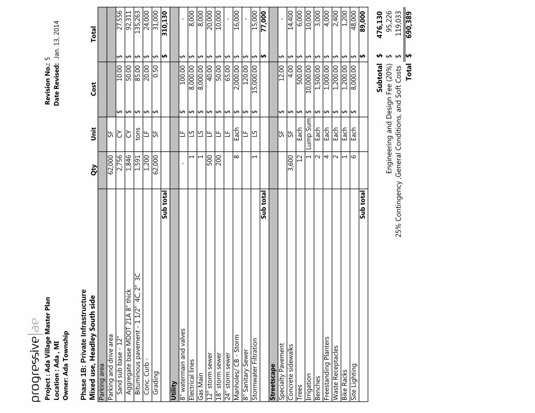
Pro
ject
: A
da V
illa
ge M
ast
er
Pla
nR
evis
ion
No
.:5
Lo
cati
on
: A
da , M
I D
ate
Revis
ed
: J
an
. 13, 2014
Ow
ner:
Ad
a T
ow
nsh
ip
Ph
ase 1
B:
Pri
vate
In
frastr
uctu
re
Mix
ed
use
, H
ead
ley S
ou
th s
ide
Qty
Un
itC
ost
To
tal
Park
ing
are
a
Park
ing
an
d d
rive a
rea
62,0
00
SF
S
an
d s
ub
base
- 1
2"
2,7
56
CY
10.0
0$
27,5
56
$
A
gg
reg
ate
base
MD
OT 2
1A
8"
thic
k1,8
46
CY
50.0
0$
92,3
11
$
B
itu
min
ou
s p
avem
en
t -
1 1
/2"
4C
, 2"
3C
1,5
91
ton
s85.0
0$
135,2
63
$
C
on
c. C
urb
-1,2
00
LF
20.0
0$
24,0
00
$
G
rad
ing
62,0
00
SF
0.5
0$
31,0
00
$
Su
b t
ota
l3
10
,13
0$
Uti
lity
8"
wate
rmain
an
d v
alv
es
-
LF
100.0
0$
-$
Ele
ctri
cal lin
es
1
LS
8,0
00.0
0$
8,0
00
$
Gas
Main
1
LS
8,0
00.0
0$
8,0
00
$
12"
sto
rm s
ew
er
500
LF
40.0
0$
20,0
00
$
18"
sto
rm s
ew
er
200
LF
50.0
0$
10,0
00
$
24"
sto
rm s
ew
er
LF
65.0
0$
-
$
Man
ho
les/
CB
- S
torm
8
Each
2,0
00.0
0$
16,0
00
$
8"
San
itary
Sew
er
LF
120.0
0$
-$
Sto
rmw
ate
r Filtr
ati
on
1
LS
15,0
00.0
0$
15,0
00
$
Su
b t
ota
l7
7,0
00
$
Str
eets
cap
e
Sp
eci
alt
y P
avem
en
tSF
12.0
0$
-
$
Co
ncr
ete
sid
ew
alk
s3,6
00
SF
4.0
0$
14,4
00
$
Tre
es
12
Each
500.0
0$
6,0
00
$
Irri
gati
on
1
Lu
mp
Su
m10,0
00.0
0$
10,0
00
$
Ben
ches
2
Each
1,5
00.0
0$
3,0
00
$
Fre
est
an
din
g P
lan
ters
4
Each
1,0
00.0
0$
4,0
00
$
Wast
e R
ece
pta
cles
2
Each
1,2
00.0
0$
2,4
00
$
Bik
e R
ack
s1
Each
1,2
00.0
0$
1,2
00
$
Sit
e L
igh
tin
g6
Each
8,0
00.0
0$
48,0
00
$
Su
b t
ota
l8
9,0
00
$
Su
bto
tal
47
6,1
30
$
En
gin
eeri
ng
an
d D
esi
gn
Fee (
20%
)95,2
26
$
119,0
33
$
To
tal
69
0,3
89
$
25%
Co
nti
ng
en
cy ,G
en
era
l C
on
dit
ion
s, a
nd
So
ft C
ost
s

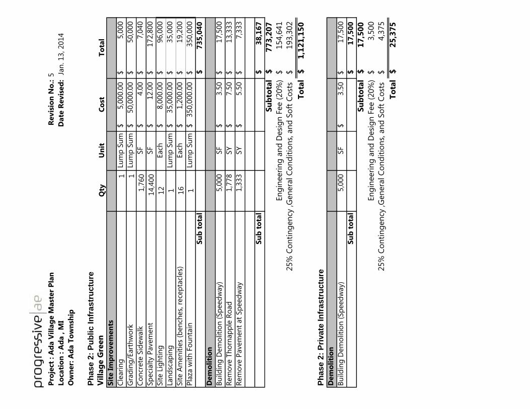
Pro
ject
: A
da V
illa
ge M
ast
er
Pla
nR
evis
ion
No
.:5
Lo
cati
on
: A
da , M
I D
ate
Revis
ed
: J
an
. 13, 2014
Ow
ner:
Ad
a T
ow
nsh
ip
Ph
as
e 2
: P
ub
lic
In
fra
str
uctu
re
Vil
lag
e G
reen
Qty
Un
itC
ost
To
tal
Sit
e I
mp
rovem
en
ts
Cle
ari
ng
1
Lum
p S
um
5,0
00.0
0$
5,0
00
$
Gra
din
g/E
art
hw
ork
1
Lum
p S
um
50,0
00.0
0$
50,0
00
$
Co
ncr
ete
Sid
ew
alk
1,7
60
SF
4.0
0$
7,0
40
$
Sp
eci
alt
y P
avem
en
t 14,4
00
SF
12.0
0$
172,8
00
$
Sit
e L
igh
tin
g
12
Each
8,0
00.0
0$
96,0
00
$
Lan
dsc
ap
ing
1Lu
mp
Su
m35,0
00.0
0$
35,0
00
$
Sit
e A
men
itie
s (b
en
ches,
rece
pta
cles)
16
Each
1,2
00.0
0$
19,2
00
$
Pla
za w
ith
Fo
un
tain
1Lu
mp
Su
m350,0
00.0
0$
350,0
00
$
Su
b t
ota
l7
35
,04
0$
Dem
oli
tio
n
Bu
ild
ing
Dem
oliti
on
(Sp
eed
way)
5,0
00
SF
3.5
0$
17,5
00
$
Rem
ove T
ho
rnap
ple
Ro
ad
1,7
78
SY
7.5
0$
13,3
33
$
Rem
ove P
avem
en
t at
Sp
eed
way
1,3
33
SY
5.5
0$
7,3
33
$
Su
b t
ota
l3
8,1
67
$
Su
bto
tal
77
3,2
07
$
En
gin
eeri
ng
an
d D
esi
gn
Fee (
20%
)154,6
41
$ 1
93,3
02
$
To
tal
1,1
21
,15
0$
Ph
as
e 2
: P
riva
te I
nfr
as
tru
ctu
re
Dem
oli
tio
n
Bu
ild
ing
Dem
oliti
on
(Sp
eed
way)
5,0
00
SF
3.5
0$
17,5
00
$
Su
b t
ota
l1
7,5
00
$
Su
bto
tal
17
,50
0$
En
gin
eeri
ng
an
d D
esi
gn
Fee (
20%
)3,5
00
$ 4
,375
$
To
tal
25
,37
5$
25%
Co
nti
ng
en
cy ,G
en
era
l C
on
dit
ion
s, a
nd
So
ft C
ost
s
25%
Co
nti
ng
en
cy ,G
en
era
l C
on
dit
ion
s, a
nd
So
ft C
ost
s

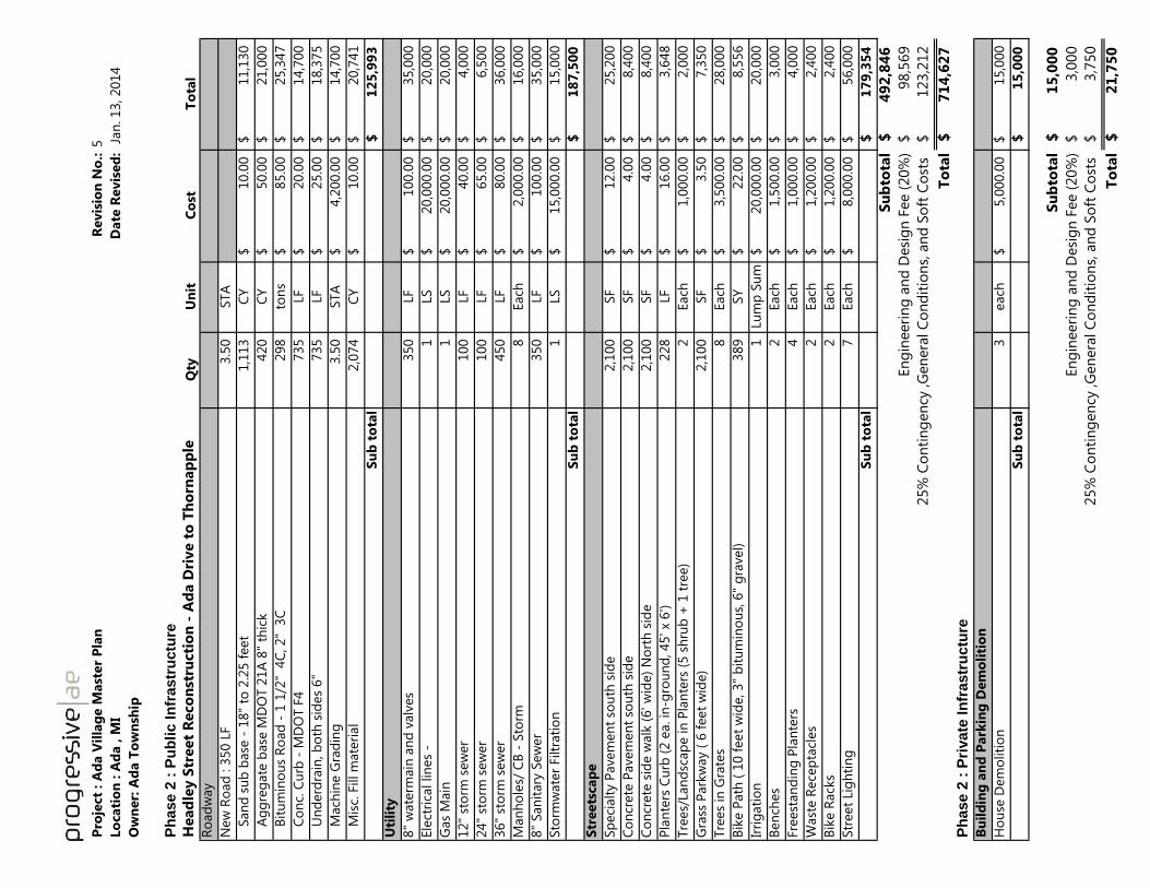
Pro
ject
: A
da V
illa
ge M
ast
er
Pla
nR
evis
ion
No
.:5
Lo
cati
on
: A
da , M
I
Date
Revis
ed
: J
an
. 13, 2014
Ow
ner:
Ad
a T
ow
nsh
ip
Ph
ase 2
: P
ub
lic I
nfr
astr
uctu
re
Head
ley S
treet
Reco
nst
ructi
on
- A
da D
rive t
o T
ho
rnap
ple
Qty
Un
itC
ost
To
tal
Ro
ad
way
New
Ro
ad
: 3
50 L
F3.5
0
STA
S
an
d s
ub
base
- 1
8"
to 2
.25 f
eet
1,1
13
CY
10.0
0$
11,1
30
$
A
gg
reg
ate
base
MD
OT 2
1A
8"
thic
k420
CY
50.0
0$
21,0
00
$
B
itu
min
ou
s R
oad
- 1
1/2
" 4
C, 2"
3C
298
ton
s85.0
0$
25,3
47
$
C
on
c. C
urb
- M
DO
T F
4735
LF
20.0
0$
14,7
00
$
U
nd
erd
rain
, b
oth
sid
es
6"
735
LF
25.0
0$
18,3
75
$
M
ach
ine G
rad
ing
3.5
0
STA
4,2
00.0
0$
14,7
00
$
M
isc.
Fill m
ate
rial
2,0
74
CY
10.0
0$
20,7
41
$
Su
b t
ota
l1
25
,99
3$
Uti
lity
8"
wate
rmain
an
d v
alv
es
350
LF
100.0
0$
35,0
00
$
Ele
ctri
cal lin
es
- 1
LS
20,0
00.0
0$
20,0
00
$
Gas
Main
1
LS
20,0
00.0
0$
20,0
00
$
12"
sto
rm s
ew
er
100
LF
40.0
0$
4,0
00
$
24"
sto
rm s
ew
er
100
LF
65.0
0$
6,5
00
$
36"
sto
rm s
ew
er
450
LF
80.0
0$
36,0
00
$
Man
ho
les/
CB
- S
torm
8
Each
2,0
00.0
0$
16,0
00
$
8"
San
itary
Sew
er
350
LF
100.0
0$
35,0
00
$
Sto
rmw
ate
r Filtr
ati
on
1
LS
15,0
00.0
0$
15,0
00
$
Su
b t
ota
l1
87
,50
0$
Str
eets
cap
e
Sp
eci
alt
y P
avem
en
t so
uth
sid
e2,1
00
SF
12.0
0$
25,2
00
$
Co
ncr
ete
Pavem
en
t so
uth
sid
e2,1
00
SF
4.0
0$
8,4
00
$
Co
ncr
ete
sid
e w
alk
(6' w
ide)
No
rth
sid
e2,1
00
SF
4.0
0$
8,4
00
$
Pla
nte
rs C
urb
(2 e
a. in
-gro
un
d, 45' x
6')
228
LF
16.0
0$
3,6
48
$
Tre
es/
Lan
dsc
ap
e in
Pla
nte
rs (
5 s
hru
b +
1 t
ree)
2
Each
1,0
00.0
0$
2,0
00
$
Gra
ss P
ark
way (
6 f
eet
wid
e)
2,1
00
SF
3.5
0$
7,3
50
$
Tre
es
in G
rate
s8
Each
3,5
00.0
0$
28,0
00
$
Bik
e P
ath
( 1
0 f
eet
wid
e, 3"
bit
um
ino
us,
6"
gra
vel)
389
SY
22.0
0$
8,5
56
$
Irri
gati
on
1
Lu
mp
Su
m20,0
00.0
0$
20,0
00
$
Ben
ches
2
Each
1,5
00.0
0$
3,0
00
$
Fre
est
an
din
g P
lan
ters
4
Each
1,0
00.0
0$
4,0
00
$
Wast
e R
ece
pta
cles
2
Each
1,2
00.0
0$
2,4
00
$
Bik
e R
ack
s2
Each
1,2
00.0
0$
2,4
00
$
Str
eet
Lig
hti
ng
7
Each
8,0
00.0
0$
56,0
00
$
Su
b t
ota
l1
79
,35
4$
Su
bto
tal
49
2,8
46
$
En
gin
eeri
ng
an
d D
esi
gn
Fee (
20%
)98,5
69
$ 123,2
12
$
To
tal
71
4,6
27
$
Ph
ase 2
: P
rivate
In
frastr
uctu
re
Bu
ild
ing
an
d P
ark
ing
Dem
oli
tio
n
Ho
use
Dem
oliti
on
3
each
5,0
00.0
0$
15,0
00
$
Su
b t
ota
l1
5,0
00
$
Su
bto
tal
15
,00
0$
En
gin
eeri
ng
an
d D
esi
gn
Fee (
20%
)3,0
00
$ 3
,750
$
To
tal
21
,75
0$
25%
Co
nti
ng
en
cy ,G
en
era
l C
on
dit
ion
s, a
nd
So
ft C
ost
s
25%
Co
nti
ng
en
cy ,G
en
era
l C
on
dit
ion
s, a
nd
So
ft C
ost
s

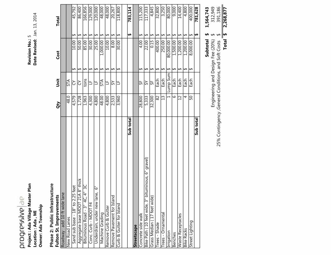
Pro
ject
: A
da V
illa
ge M
ast
er
Pla
nR
evis
ion
No
.:5
Lo
cati
on
: A
da , M
I D
ate
Revis
ed
: J
an
. 13, 2014
Ow
ner:
Ad
a T
ow
nsh
ip
Ph
ase 2
: P
ub
lic In
frastr
uctu
re
Fu
lto
n S
t. I
mp
rovem
en
tsQ
tyU
nit
Co
stT
ota
l
Ro
ad
way : a
dd
10 f
t w
ide lan
e
New
Ro
ad
Lan
es
48.0
STA
S
an
d s
ub
base
- 1
8"
to 2
.25 f
eet
4,5
79
CY
10.0
0$
45,7
92
$
A
gg
reg
ate
base
MD
OT 2
1A
8"
thic
k1,7
28
CY
50.0
0$
86,4
00
$
B
itu
min
ou
s R
oad
- 3
" 4
C, 4"
3C
1,9
63
ton
s85.0
0$
166,8
56
$
C
on
c. C
urb
- M
DO
T F
44,3
00
LF
30.0
0$
129,0
00
$
U
nd
erd
rain
, u
nd
er
new
lan
e, 6
"4,8
00
LF
25.0
0$
120,0
00
$
M
ach
ine G
rad
ing
48.0
0
STA
1,0
00.0
0$
48,0
00
$
Rem
ove C
urb
& G
utt
er
4,8
00
LF
10.0
0$
48,0
00
$
Rem
ove P
avem
en
t fo
r Is
lan
d2,5
33
SY
8.0
0$
20,2
67
$
Cu
rb &
Gu
tter
for
Isla
nd
3,9
60
LF
30.0
0$
118,8
00
$
Su
b t
ota
l7
83
,11
4$
Str
eets
cap
e
Co
ncr
ete
sid
e w
alk
28,8
00
SF
4.0
0$
115,2
00
$
Bik
e P
ath
( 1
0 f
eet
wid
e, 3"
bit
um
ino
us,
6"
gra
vel)
5,3
33
SY
22.0
0$
117,3
33
$
Gra
ss M
ed
ian
( 1
7 f
eet
wid
e)
32,3
00
SF
0.1
5$
4,8
45
$
Tre
es
- Sh
ad
e82
Each
400.0
0$
32,8
00
$
Tre
es
- O
rnam
en
tal
13
Each
250.0
0$
3,2
50
$
Irri
gati
on
1
Lu
mp
Su
m80,0
00.0
0$
80,0
00
$
Ben
ches
6
Each
1,5
00.0
0$
9,0
00
$
Wast
e R
ece
pta
cles
12
Each
1,2
00.0
0$
14,4
00
$
Bik
e R
ack
s4
Each
1,2
00.0
0$
4,8
00
$
Str
eet
Lig
hti
ng
50
Each
8,0
00.0
0$
400,0
00
$
Su
b t
ota
l7
81
,62
8$
Su
bto
tal
1,5
64
,74
3$
En
gin
eeri
ng
an
d D
esi
gn
Fee (
20%
)312,9
49
$
3
91,1
86
$
To
tal
2,2
68
,87
7$
25%
Co
nti
ng
en
cy ,G
en
era
l C
on
dit
ion
s, a
nd
So
ft C
ost
s

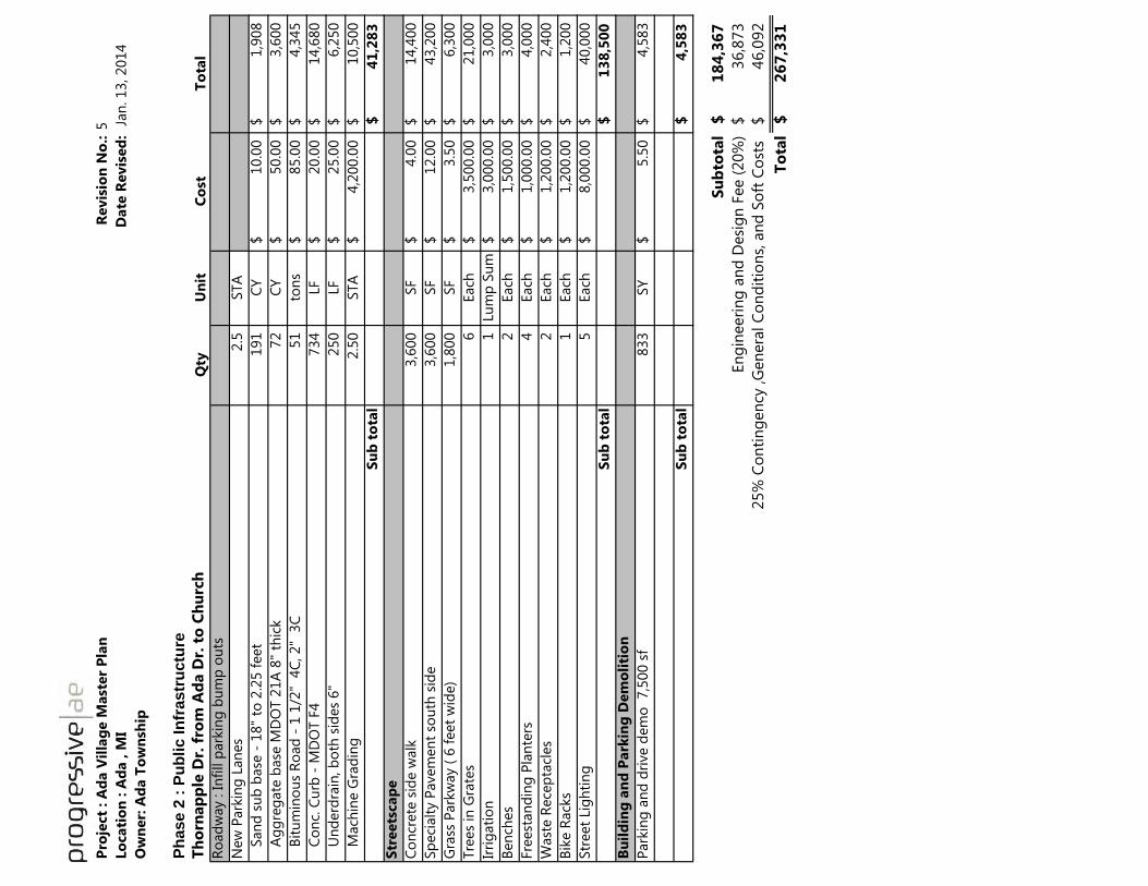
Pro
ject
: A
da V
illa
ge M
ast
er
Pla
nR
evis
ion
No
.:5
Lo
cati
on
: A
da , M
I D
ate
Revis
ed
: J
an
. 13, 2014
Ow
ner:
Ad
a T
ow
nsh
ip
Ph
ase 2
: P
ub
lic In
frastr
uctu
re
Th
orn
ap
ple
Dr.
fro
m A
da D
r. t
o C
hu
rch
Qty
Un
itC
ost
To
tal
Ro
ad
way : In
fill p
ark
ing
bu
mp
ou
ts
New
Park
ing
Lan
es
2.5
STA
S
an
d s
ub
base
- 1
8"
to 2
.25 f
eet
191
CY
10.0
0$
1,9
08
$
A
gg
reg
ate
base
MD
OT 2
1A
8"
thic
k72
C
Y50.0
0$
3,6
00
$
B
itu
min
ou
s R
oad
- 1
1/2
" 4
C, 2"
3C
51
to
ns
85.0
0$
4,3
45
$
C
on
c. C
urb
- M
DO
T F
4734
LF
20.0
0$
14,6
80
$
U
nd
erd
rain
, b
oth
sid
es
6"
250
LF
25.0
0$
6,2
50
$
M
ach
ine G
rad
ing
2.5
0
STA
4,2
00.0
0$
10,5
00
$
Su
b t
ota
l4
1,2
83
$
Str
eets
cap
e
Co
ncr
ete
sid
e w
alk
3,6
00
SF
4.0
0$
14,4
00
$
Sp
eci
alt
y P
avem
en
t so
uth
sid
e3,6
00
SF
12.0
0$
43,2
00
$
Gra
ss P
ark
way (
6 f
eet
wid
e)
1,8
00
SF
3.5
0$
6,3
00
$
Tre
es
in G
rate
s6
Each
3,5
00.0
0$
21,0
00
$
Irri
gati
on
1
Lu
mp
Su
m3,0
00.0
0$
3,0
00
$
Ben
ches
2
Each
1,5
00.0
0$
3,0
00
$
Fre
est
an
din
g P
lan
ters
4
Each
1,0
00.0
0$
4,0
00
$
Wast
e R
ece
pta
cles
2
Each
1,2
00.0
0$
2,4
00
$
Bik
e R
ack
s1
Each
1,2
00.0
0$
1,2
00
$
Str
eet
Lig
hti
ng
5
Each
8,0
00.0
0$
40,0
00
$
Su
b t
ota
l1
38
,50
0$
Bu
ild
ing
an
d P
ark
ing
Dem
oli
tio
n
Park
ing
an
d d
rive d
em
o
7,5
00 s
f833
SY
5.5
0$
4,5
83
$
Su
b t
ota
l4
,58
3$
Su
bto
tal
18
4,3
67
$
En
gin
eeri
ng
an
d D
esi
gn
Fee (
20%
)36,8
73
$
46,0
92
$
To
tal
26
7,3
31
$
25%
Co
nti
ng
en
cy ,G
en
era
l C
on
dit
ion
s, a
nd
So
ft C
ost
s


Pro
ject
: A
da V
illa
ge M
ast
er
Pla
nR
evis
ion
No
.:5
Lo
cati
on
: A
da , M
I D
ate
Revis
ed
: J
an
. 13, 2014
Ow
ner:
Ad
a T
ow
nsh
ip
Ph
ase 2
: P
rivate
In
frastr
uctu
re
Pri
vate
Develo
pm
en
t R
esi
den
tial
west
en
d H
ead
ley
Qty
Un
itC
ost
To
tal
Park
ing
are
a
Park
ing
an
d d
rive a
rea
36,3
20
SF
S
an
d s
ub
base
- 1
2"
1,6
14
CY
10.0
0$
16,1
42
$
A
gg
reg
ate
base
MD
OT 2
1A
8"
thic
k1,0
82
CY
50.0
0$
54,0
76
$
B
itu
min
ou
s R
oad
- 1
1/2
" 4
C, 2"
3C
932
ton
s85.0
0$
79,2
38
$
C
on
c. C
urb
-1,8
40
LF
20.0
0$
36,8
00
$
G
rad
ing
36,3
20
SF
0.5
0$
18,1
60
$
F
ill M
ate
rial fo
r w
alk
ou
t si
tes
( 5')
16,6
67
C
Y15.0
0$
250,0
00
$
Su
b t
ota
l4
54
,41
7$
Uti
lity
8"
wate
rmain
an
d v
alv
es
800
LF
100.0
0$
80,0
00
$
Ele
ctri
cal lin
es
1
LS
20,0
00.0
0$
20,0
00
$
Gas
Main
1
LS
10,0
00.0
0$
10,0
00
$
12"
sto
rm s
ew
er
300
LF
40.0
0$
12,0
00
$
18"
sto
rm s
ew
er
300
LF
50.0
0$
15,0
00
$
24"
sto
rm s
ew
er
LF
65.0
0$
-
$
Man
ho
les/
CB
- S
torm
6
Each
2,0
00.0
0$
12,0
00
$
8"
San
itary
Sew
er
550
LF
120.0
0$
66,0
00
$
Sto
rmw
ate
r Filtr
ati
on
1
LS
15,0
00.0
0$
15,0
00
$
Su
b t
ota
l2
30
,00
0$
Str
eets
cap
e
Co
ncr
ete
sid
ew
alk
s16,0
00
SF
4.0
0$
64,0
00
$
Tre
es
in G
rate
s16
Each
3,5
00.0
0$
56,0
00
$
Irri
gati
on
1
Lu
mp
Su
m4,0
00.0
0$
4,0
00
$
Ben
ches
2
Each
1,5
00.0
0$
3,0
00
$
Fre
est
an
din
g P
lan
ters
4
Each
1,0
00.0
0$
4,0
00
$
Wast
e R
ece
pta
cles
2
Each
1,2
00.0
0$
2,4
00
$
Bik
e R
ack
s1
Each
1,2
00.0
0$
1,2
00
$
Sit
e L
igh
tin
g12
Each
8,0
00.0
0$
96,0
00
$
Su
b t
ota
l2
30
,60
0$
Su
bto
tal
91
5,0
17
$
En
gin
eeri
ng
an
d D
esi
gn
Fee (
20%
)183,0
03
$
2
28,7
54
$
To
tal
1,3
26
,77
4$
25%
Co
nti
ng
en
cy ,G
en
era
l C
on
dit
ion
s, a
nd
So
ft C
ost
s

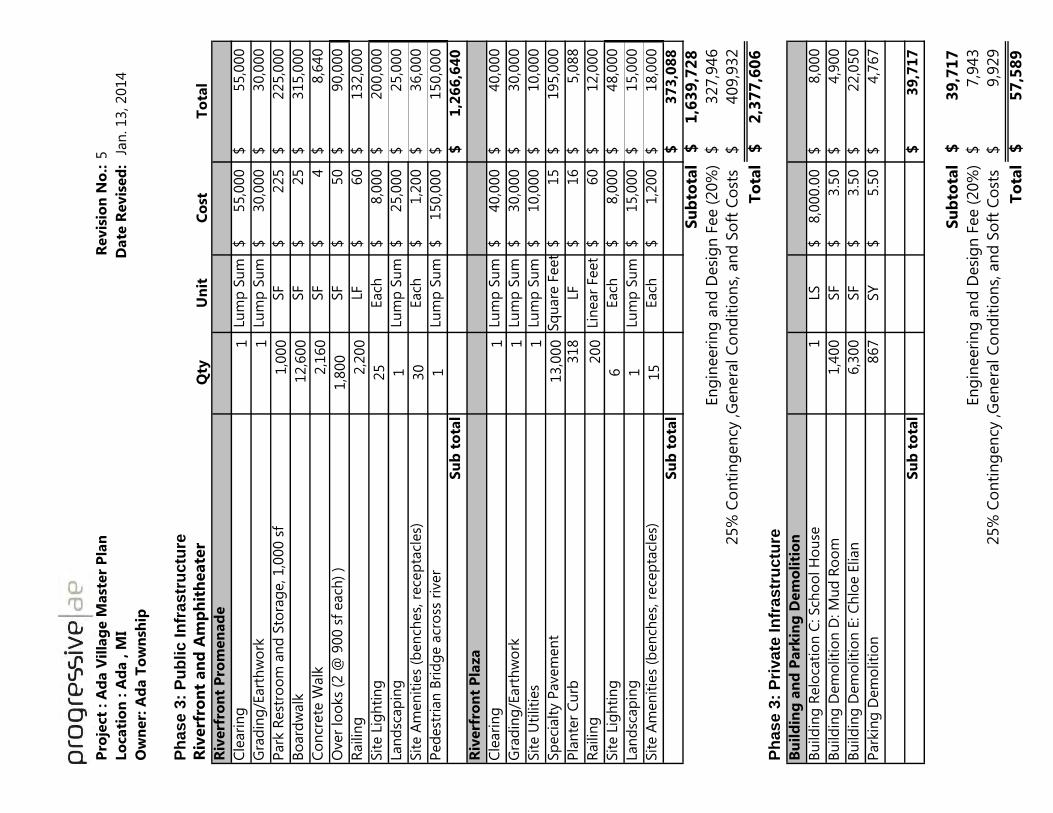
Pro
ject
: A
da V
illa
ge M
ast
er
Pla
nR
evis
ion
No
.:5
Lo
cati
on
: A
da , M
I D
ate
Revis
ed
: J
an
. 13, 2014
Ow
ner:
Ad
a T
ow
nsh
ip
Ph
as
e 3
: P
ub
lic
In
fra
str
uctu
re
Riv
erf
ron
t an
d A
mp
hit
heate
rQ
tyU
nit
Co
stT
ota
l
Riv
erf
ron
t P
rom
en
ad
e
Cle
ari
ng
1
Lum
p S
um
55,0
00
$
55,0
00
$
Gra
din
g/E
art
hw
ork
1
Lum
p S
um
30,0
00
$
30,0
00
$
Park
Rest
roo
m a
nd
Sto
rag
e, 1,0
00 s
f1,0
00
SF
225
$
225,0
00
$
Bo
ard
walk
12,6
00
SF
25
$
315,0
00
$
Co
ncr
ete
Walk
2,1
60
SF
4$
8,6
40
$
Over
loo
ks
(2 @
900 s
f each
) )
1,8
00
SF
50
$
90,0
00
$
Railin
g2,2
00
LF60
$
132,0
00
$
Sit
e L
igh
tin
g
25
Each
8,0
00
$
200,0
00
$
Lan
dsc
ap
ing
1Lu
mp
Su
m25,0
00
$
25,0
00
$
Sit
e A
men
itie
s (b
en
ches,
rece
pta
cles)
30
Each
1,2
00
$
36,0
00
$
Ped
est
rian
Bri
dg
e a
cro
ss r
iver
1Lu
mp
Su
m150,0
00
$
150,0
00
$
Su
b t
ota
l1
,26
6,6
40
$
Riv
erf
ron
t P
laza
Cle
ari
ng
1
Lum
p S
um
40,0
00
$
40,0
00
$
Gra
din
g/E
art
hw
ork
1
Lum
p S
um
30,0
00
$
30,0
00
$
Sit
e U
tiliti
es
1
Lum
p S
um
10,0
00
$
10,0
00
$
Sp
eci
alt
y P
avem
en
t 13,0
00
Sq
uare
Feet
15
$
195,0
00
$
Pla
nte
r C
urb
318
LF16
$
5,0
88
$
Railin
g200
Lin
ear
Feet
60
$
12,0
00
$
Sit
e L
igh
tin
g
6Each
8,0
00
$
48,0
00
$
Lan
dsc
ap
ing
1Lu
mp
Su
m15,0
00
$
15,0
00
$
Sit
e A
men
itie
s (b
en
ches,
rece
pta
cles)
15
Each
1,2
00
$
18,0
00
$
Su
b t
ota
l3
73
,08
8$
Su
bto
tal
1,6
39
,72
8$
En
gin
eeri
ng
an
d D
esi
gn
Fee (
20%
)327,9
46
$ 4
09,9
32
$
To
tal
2,3
77
,60
6$
Ph
as
e 3
: P
riva
te I
nfr
as
tru
ctu
re
Bu
ild
ing
an
d P
ark
ing
Dem
oli
tio
n
Bu
ild
ing
Relo
cati
on
C: Sch
oo
l H
ou
se1
LS8,0
00.0
0$
8,0
00
$
Bu
ild
ing
Dem
oliti
on
D: M
ud
Ro
om
1,4
00
SF
3.5
0$
4,9
00
$
Bu
ild
ing
Dem
oliti
on
E: C
hlo
e E
lian
6,3
00
SF
3.5
0$
22,0
50
$
Park
ing
Dem
oliti
on
867
SY
5.5
0$
4,7
67
$
Su
b t
ota
l3
9,7
17
$
Su
bto
tal
39
,71
7$
En
gin
eeri
ng
an
d D
esi
gn
Fee (
20%
)7,9
43
$ 9
,929
$
To
tal
57
,58
9$
25%
Co
nti
ng
en
cy ,G
en
era
l C
on
dit
ion
s, a
nd
So
ft C
ost
s
25%
Co
nti
ng
en
cy ,G
en
era
l C
on
dit
ion
s, a
nd
So
ft C
ost
s

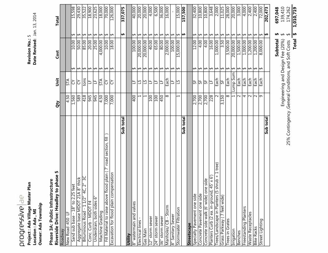
Pro
ject
: A
da V
illa
ge M
ast
er
Pla
nR
evis
ion
No
.:5
Lo
cati
on
: A
da , M
I D
ate
Revis
ed
: J
an
. 13, 2014
Ow
ner:
Ad
a T
ow
nsh
ip
Ph
ase 3
A:
Pu
blic In
frastr
uctu
re
Riv
ers
ide D
rive: H
ead
ley t
o p
hase
5Q
tyU
nit
Co
stT
ota
l
Ro
ad
way
New
Ro
ad
:450
LF
4.5
0
STA
S
an
d s
ub
base
- 1
8"
to 2
.25 f
eet
1,5
60
CY
10.0
0$
15,5
98
$
A
gg
reg
ate
base
MD
OT 2
1A
8"
thic
k589
CY
50.0
0$
29,4
30
$
B
itu
min
ou
s R
oad
- 1
1/2
" 4
C, 2"
3C
418
ton
s85.0
0$
35,5
22
$
C
on
c. C
urb
- M
DO
T F
4945
LF
20.0
0$
18,9
00
$
U
nd
erd
rain
, b
oth
sid
es
6"
945
LF
25.0
0$
23,6
25
$
M
ach
ine G
rad
ing
4.5
0
STA
4,0
00.0
0$
18,0
00
$
F
ill M
ate
rial to
rais
e a
bo
ve f
loo
d p
lain
( 7
' ro
ad
sect
ion
, fi
ll
)7,0
00
CY
10.0
0$
70,0
00
$
Exc
avati
on
fo
r fl
oo
d p
lain
co
mp
en
sati
on
7,0
00
CY
18.0
0$
126,0
00
$
Su
b t
ota
l3
37
,07
5$
Uti
lity
8"
wate
rmain
an
d v
alv
es
400
LF
100.0
0$
40,0
00
$
Ele
ctri
cal lin
es
- 1
LS
20,0
00.0
0$
20,0
00
$
Gas
Main
1
LS
20,0
00.0
0$
20,0
00
$
12"
sto
rm s
ew
er
100
LF
40.0
0$
4,0
00
$
24"
sto
rm s
ew
er
100
LF
65.0
0$
6,5
00
$
36"
sto
rm s
ew
er
450
LF
80.0
0$
36,0
00
$
Man
ho
les/
CB
- S
torm
8
Each
2,0
00.0
0$
16,0
00
$
8"
San
itary
Sew
er
LF
100.0
0$
-$
Sto
rmw
ate
r Filtr
ati
on
1
LS
15,0
00.0
0$
15,0
00
$
Su
b t
ota
l1
57
,50
0$
Str
eets
cap
e
Sp
eci
alt
y P
avem
en
t o
ne s
ide
2,7
00
SF
12.0
0$
32,4
00
$
Co
ncr
ete
Pavem
en
t o
ne s
ide
2,7
00
SF
4.0
0$
10,8
00
$
Co
ncr
ete
sid
e w
alk
(6' w
ide)
on
e s
ide
2,7
00
SF
4.0
0$
10,8
00
$
Pla
nte
rs C
urb
(2 e
a. in
-gro
un
d, 45' x
6')
228
LF
16.0
0$
3,6
48
$
Tre
es/
Lan
dsc
ap
e in
Pla
nte
rs (
5 s
hru
b +
1 t
ree)
2
Each
1,0
00.0
0$
2,0
00
$
Gra
ss P
ark
way (
7 f
eet
wid
e)
3,1
50
SF
3.5
0$
11,0
25
$
Tre
es
in G
rate
s8
Each
3,5
00.0
0$
28,0
00
$
Irri
gati
on
1
Lu
mp
Su
m20,0
00.0
0$
20,0
00
$
Ben
ches
2
Each
1,5
00.0
0$
3,0
00
$
Fre
est
an
din
g P
lan
ters
4
Each
1,0
00.0
0$
4,0
00
$
Wast
e R
ece
pta
cles
2
Each
1,2
00.0
0$
2,4
00
$
Bik
e R
ack
s2
Each
1,2
00.0
0$
2,4
00
$
Str
eet
Lig
hti
ng
9
Each
8,0
00.0
0$
72,0
00
$
Su
b t
ota
l2
02
,47
3$
Su
bto
tal
69
7,0
48
$
En
gin
eeri
ng
an
d D
esi
gn
Fee (
20%
)139,4
10
$
1
74,2
62
$
To
tal
1,0
10
,71
9$
25%
Co
nti
ng
en
cy ,G
en
era
l C
on
dit
ion
s, a
nd
So
ft C
ost
s

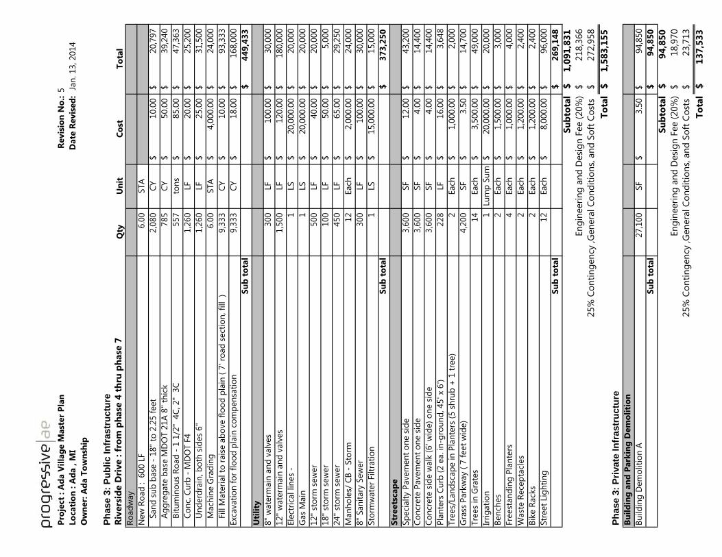
Pro
ject
: A
da V
illa
ge M
ast
er
Pla
nR
evis
ion
No
.:5
Lo
cati
on
: A
da , M
I
Date
Revis
ed
: J
an
. 13, 2014
Ow
ner:
Ad
a T
ow
nsh
ip
Ph
ase 3
: P
ub
lic I
nfr
astr
uctu
re
Riv
ers
ide D
rive : f
rom
ph
ase
4 t
hru
ph
ase
7
Qty
Un
itC
ost
To
tal
Ro
ad
way
New
Ro
ad
: 600 L
F6.0
0
STA
S
an
d s
ub
base
- 1
8"
to 2
.25 f
eet
2,0
80
CY
10.0
0$
20,7
97
$
A
gg
reg
ate
base
MD
OT 2
1A
8"
thic
k785
CY
50.0
0$
39,2
40
$
B
itu
min
ou
s R
oad
- 1
1/2
" 4
C, 2"
3C
557
ton
s85.0
0$
47,3
63
$
C
on
c. C
urb
- M
DO
T F
41,2
60
LF
20.0
0$
25,2
00
$
U
nd
erd
rain
, b
oth
sid
es
6"
1,2
60
LF
25.0
0$
31,5
00
$
M
ach
ine G
rad
ing
6.0
0
STA
4,0
00.0
0$
24,0
00
$
F
ill M
ate
rial to
rais
e a
bo
ve f
loo
d p
lain
( 7
' ro
ad
sect
ion
, fi
ll )
9,3
33
CY
10.0
0$
93,3
33
$
Exc
avati
on
fo
r fl
oo
d p
lain
co
mp
en
sati
on
9,3
33
CY
18.0
0$
168,0
00
$
Su
b t
ota
l4
49
,43
3$
Uti
lity
8"
wate
rmain
an
d v
alv
es
300
LF
100.0
0$
30,0
00
$
12"
wate
rmain
an
d v
alv
es
1,5
00
LF
120.0
0$
180,0
00
$
Ele
ctri
cal lin
es
- 1
LS
20,0
00.0
0$
20,0
00
$
Gas
Main
1
LS
20,0
00.0
0$
20,0
00
$
12"
sto
rm s
ew
er
500
LF
40.0
0$
20,0
00
$
18"
sto
rm s
ew
er
100
LF
50.0
0$
5,0
00
$
24"
sto
rm s
ew
er
450
LF
65.0
0$
29,2
50
$
Man
ho
les/
CB
- S
torm
12
Each
2,0
00.0
0$
24,0
00
$
8"
San
itary
Sew
er
300
LF
100.0
0$
30,0
00
$
Sto
rmw
ate
r Filtr
ati
on
1
LS
15,0
00.0
0$
15,0
00
$
Su
b t
ota
l3
73
,25
0$
Str
eets
cap
e
Sp
eci
alt
y P
avem
en
t o
ne s
ide
3,6
00
SF
12.0
0$
43,2
00
$
Co
ncr
ete
Pavem
en
t o
ne s
ide
3,6
00
SF
4.0
0$
14,4
00
$
Co
ncr
ete
sid
e w
alk
(6' w
ide)
on
e s
ide
3,6
00
SF
4.0
0$
14,4
00
$
Pla
nte
rs C
urb
(2 e
a. in
-gro
un
d, 45' x
6')
228
LF
16.0
0$
3,6
48
$
Tre
es/
Lan
dsc
ap
e in
Pla
nte
rs (
5 s
hru
b +
1 t
ree)
2
Each
1,0
00.0
0$
2,0
00
$
Gra
ss P
ark
way (
7 f
eet
wid
e)
4,2
00
SF
3.5
0$
14,7
00
$
Tre
es
in G
rate
s14
Each
3,5
00.0
0$
49,0
00
$
Irri
gati
on
1
Lu
mp
Su
m20,0
00.0
0$
20,0
00
$
Ben
ches
2
Each
1,5
00.0
0$
3,0
00
$
Fre
est
an
din
g P
lan
ters
4
Each
1,0
00.0
0$
4,0
00
$
Wast
e R
ece
pta
cles
2
Each
1,2
00.0
0$
2,4
00
$
Bik
e R
ack
s2
Each
1,2
00.0
0$
2,4
00
$
Str
eet
Lig
hti
ng
12
Each
8,0
00.0
0$
96,0
00
$
Su
b t
ota
l2
69
,14
8$
Su
bto
tal
1,0
91
,83
1$
En
gin
eeri
ng
an
d D
esi
gn
Fee (
20%
)218,3
66
$ 2
72,9
58
$
To
tal
1,5
83
,15
5$
Ph
ase 3
: P
rivate
In
frastr
uctu
re
Bu
ild
ing
an
d P
ark
ing
Dem
oli
tio
n
Bu
ild
ing
Dem
oliti
on
A27,1
00
SF
3.5
0$
94,8
50
$
Su
b t
ota
l9
4,8
50
$
Su
bto
tal
94
,85
0$
En
gin
eeri
ng
an
d D
esi
gn
Fee (
20%
)18,9
70
$ 2
3,7
13
$
To
tal
13
7,5
33
$
25%
Co
nti
ng
en
cy ,G
en
era
l C
on
dit
ion
s, a
nd
So
ft C
ost
s
25%
Co
nti
ng
en
cy ,G
en
era
l C
on
dit
ion
s, a
nd
So
ft C
ost
s

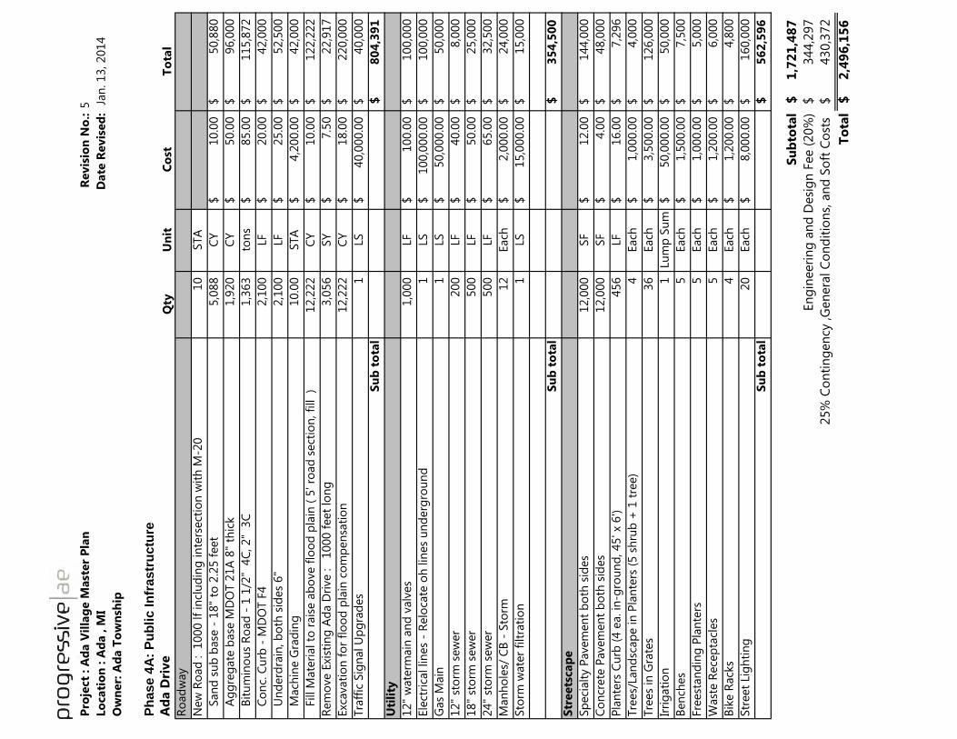
Pro
ject
: A
da V
illa
ge M
ast
er
Pla
nR
evis
ion
No
.:5
Lo
cati
on
: A
da , M
I D
ate
Revis
ed
: J
an
. 13, 2014
Ow
ner:
Ad
a T
ow
nsh
ip
Ph
ase 4
A:
Pu
blic In
frastr
uctu
re
Ad
a D
rive
Qty
Un
itC
ost
To
tal
Ro
ad
way
New
Ro
ad
:
1000 lf
incl
ud
ing
in
ters
ect
ion
wit
h M
-20
10
STA
S
an
d s
ub
base
- 1
8"
to 2
.25 f
eet
5,0
88
CY
10.0
0$
50,8
80
$
A
gg
reg
ate
base
MD
OT 2
1A
8"
thic
k1,9
20
CY
50.0
0$
96,0
00
$
B
itu
min
ou
s R
oad
- 1
1/2
" 4
C, 2"
3C
1,3
63
ton
s85.0
0$
115,8
72
$
C
on
c. C
urb
- M
DO
T F
42,1
00
LF
20.0
0$
42,0
00
$
U
nd
erd
rain
, b
oth
sid
es
6"
2,1
00
LF
25.0
0$
52,5
00
$
M
ach
ine G
rad
ing
10.0
0
STA
4,2
00.0
0$
42,0
00
$
F
ill M
ate
rial to
rais
e a
bo
ve f
loo
d p
lain
( 5
' ro
ad
sect
ion
, fi
ll
)12,2
22
C
Y10.0
0$
122,2
22
$
Rem
ove E
xist
ing
Ad
a D
rive :
1000 f
eet
lon
g3,0
56
SY
7.5
0$
22,9
17
$
Exc
avati
on
fo
r fl
oo
d p
lain
co
mp
en
sati
on
12,2
22
C
Y18.0
0$
220,0
00
$
Tra
ffic
Sig
nal U
pg
rad
es
1
LS
40,0
00.0
0$
40,0
00
$
Su
b t
ota
l8
04
,39
1$
Uti
lity
12"
wate
rmain
an
d v
alv
es
1,0
00
LF
100.0
0$
100,0
00
$
Ele
ctri
cal lin
es
- R
elo
cate
oh
lin
es
un
derg
rou
nd
1
LS
100,0
00.0
0$
100,0
00
$
Gas
Main
1
LS
50,0
00.0
0$
50,0
00
$
12"
sto
rm s
ew
er
200
LF
40.0
0$
8,0
00
$
18"
sto
rm s
ew
er
500
LF
50.0
0$
25,0
00
$
24"
sto
rm s
ew
er
500
LF
65.0
0$
32,5
00
$
Man
ho
les/
CB
- S
torm
12
Each
2,0
00.0
0$
24,0
00
$
Sto
rm w
ate
r fi
ltra
tio
n1
LS
15,0
00.0
0$
15,0
00
$
Su
b t
ota
l3
54
,50
0$
Str
eets
cap
e
Sp
eci
alt
y P
avem
en
t b
oth
sid
es
12,0
00
SF
12.0
0$
144,0
00
$
Co
ncr
ete
Pavem
en
t b
oth
sid
es
12,0
00
SF
4.0
0$
48,0
00
$
Pla
nte
rs C
urb
(4 e
a. in
-gro
un
d, 45' x
6')
456
LF
16.0
0$
7,2
96
$
Tre
es/
Lan
dsc
ap
e in
Pla
nte
rs (
5 s
hru
b +
1 t
ree)
4
Each
1,0
00.0
0$
4,0
00
$
Tre
es
in G
rate
s36
Each
3,5
00.0
0$
126,0
00
$
Irri
gati
on
1
Lu
mp
Su
m50,0
00.0
0$
50,0
00
$
Ben
ches
5
Each
1,5
00.0
0$
7,5
00
$
Fre
est
an
din
g P
lan
ters
5
Each
1,0
00.0
0$
5,0
00
$
Wast
e R
ece
pta
cles
5
Each
1,2
00.0
0$
6,0
00
$
Bik
e R
ack
s4
Each
1,2
00.0
0$
4,8
00
$
Str
eet
Lig
hti
ng
20
Each
8,0
00.0
0$
160,0
00
$
Su
b t
ota
l5
62
,59
6$
Su
bto
tal
1,7
21
,48
7$
En
gin
eeri
ng
an
d D
esi
gn
Fee (
20%
)344,2
97
$
4
30,3
72
$
To
tal
2,4
96
,15
6$
25%
Co
nti
ng
en
cy ,G
en
era
l C
on
dit
ion
s, a
nd
So
ft C
ost
s

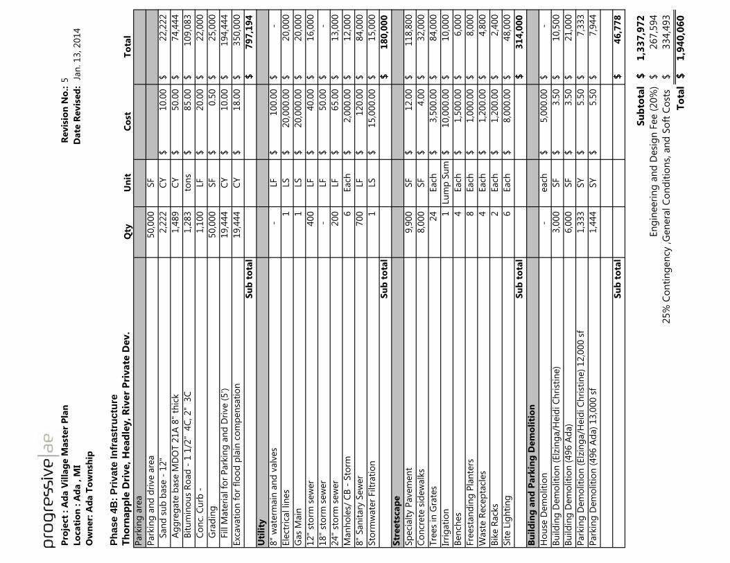
Pro
ject
: A
da V
illa
ge M
ast
er
Pla
nR
evis
ion
No
.:5
Lo
cati
on
: A
da , M
I D
ate
Revis
ed
: J
an
. 13, 2014
Ow
ner:
Ad
a T
ow
nsh
ip
Ph
ase 4
B:
Pri
vate
In
frastr
uctu
re
Th
orn
ap
ple
Dri
ve, H
ead
ley, R
iver
Pri
vate
Dev.
Qty
Un
itC
ost
To
tal
Park
ing
are
a
Park
ing
an
d d
rive a
rea
50,0
00
SF
S
an
d s
ub
base
- 1
2"
2,2
22
CY
10.0
0$
22,2
22
$
A
gg
reg
ate
base
MD
OT 2
1A
8"
thic
k1,4
89
CY
50.0
0$
74,4
44
$
B
itu
min
ou
s R
oad
- 1
1/2
" 4
C, 2"
3C
1,2
83
ton
s85.0
0$
109,0
83
$
C
on
c. C
urb
-1,1
00
LF
20.0
0$
22,0
00
$
G
rad
ing
50,0
00
SF
0.5
0$
25,0
00
$
F
ill M
ate
rial fo
r P
ark
ing
an
d D
rive (
5')
19,4
44
C
Y10.0
0$
194,4
44
$
Exc
avati
on
fo
r fl
oo
d p
lain
co
mp
en
sati
on
19,4
44
C
Y18.0
0$
350,0
00
$
Su
b t
ota
l7
97
,19
4$
Uti
lity
8"
wate
rmain
an
d v
alv
es
-
LF
100.0
0$
-$
Ele
ctri
cal lin
es
1
LS
20,0
00.0
0$
20,0
00
$
Gas
Main
1
LS
20,0
00.0
0$
20,0
00
$
12"
sto
rm s
ew
er
400
LF
40.0
0$
16,0
00
$
18"
sto
rm s
ew
er
-
LF
50.0
0$
-
$
24"
sto
rm s
ew
er
200
LF
65.0
0$
13,0
00
$
Man
ho
les/
CB
- S
torm
6
Each
2,0
00.0
0$
12,0
00
$
8"
San
itary
Sew
er
700
LF
120.0
0$
84,0
00
$
Sto
rmw
ate
r Filtr
ati
on
1
LS
15,0
00.0
0$
15,0
00
$
Su
b t
ota
l1
80
,00
0$
Str
eets
cap
e
Sp
eci
alt
y P
avem
en
t9,9
00
SF
12.0
0$
118,8
00
$
Co
ncr
ete
sid
ew
alk
s8,0
00
SF
4.0
0$
32,0
00
$
Tre
es
in G
rate
s24
Each
3,5
00.0
0$
84,0
00
$
Irri
gati
on
1
Lu
mp
Su
m10,0
00.0
0$
10,0
00
$
Ben
ches
4
Each
1,5
00.0
0$
6,0
00
$
Fre
est
an
din
g P
lan
ters
8
Each
1,0
00.0
0$
8,0
00
$
Wast
e R
ece
pta
cles
4
Each
1,2
00.0
0$
4,8
00
$
Bik
e R
ack
s2
Each
1,2
00.0
0$
2,4
00
$
Sit
e L
igh
tin
g6
Each
8,0
00.0
0$
48,0
00
$
Su
b t
ota
l3
14
,00
0$
Bu
ild
ing
an
d P
ark
ing
Dem
oli
tio
n
Ho
use
Dem
oliti
on
-
each
5,0
00.0
0$
-
$
Bu
ild
ing
Dem
oliti
on
(Elz
ing
a/H
eid
i C
hri
stin
e)
3,0
00
SF
3.5
0$
10,5
00
$
Bu
ild
ing
Dem
oliti
on
(496 A
da)
6,0
00
SF
3.5
0$
21,0
00
$
Park
ing
Dem
oliti
on
(Elz
ing
a/H
eid
i C
hri
stin
e)
12,0
00 s
f1,3
33
SY
5.5
0$
7,3
33
$
Park
ing
Dem
oliti
on
(496 A
da)
13,0
00 s
f1,4
44
SY
5.5
0$
7,9
44
$
Su
b t
ota
l4
6,7
78
$
Su
bto
tal
1,3
37
,97
2$
En
gin
eeri
ng
an
d D
esi
gn
Fee (
20%
)267,5
94
$
3
34,4
93
$
To
tal
1,9
40
,06
0$
25%
Co
nti
ng
en
cy ,G
en
era
l C
on
dit
ion
s, a
nd
So
ft C
ost
s

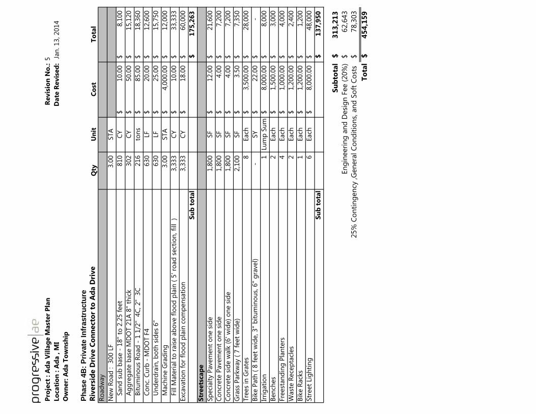
Pro
ject
: A
da V
illa
ge M
ast
er
Pla
nR
evis
ion
No
.:5
Lo
cati
on
: A
da , M
I D
ate
Revis
ed
: J
an
. 13, 2014
Ow
ner:
Ad
a T
ow
nsh
ip
Ph
ase 4
B:
Pri
vate
In
frastr
uctu
re
Riv
ers
ide D
rive C
on
necto
r to
Ad
a D
rive
Qty
Un
itC
ost
To
tal
Ro
ad
way
New
Ro
ad
:
300 L
F3.0
0
STA
S
an
d s
ub
base
- 1
8"
to 2
.25 f
eet
810
CY
10.0
0$
8,1
00
$
A
gg
reg
ate
base
MD
OT 2
1A
8"
thic
k302
CY
50.0
0$
15,1
20
$
B
itu
min
ou
s R
oad
- 1
1/2
" 4
C, 2"
3C
216
ton
s85.0
0$
18,3
60
$
C
on
c. C
urb
- M
DO
T F
4630
LF
20.0
0$
12,6
00
$
U
nd
erd
rain
, b
oth
sid
es
6"
630
LF
25.0
0$
15,7
50
$
M
ach
ine G
rad
ing
3.0
0
STA
4,0
00.0
0$
12,0
00
$
F
ill M
ate
rial to
rais
e a
bo
ve f
loo
d p
lain
( 5
' ro
ad
sect
ion
, fi
ll
)3,3
33
CY
10.0
0$
33,3
33
$
Exc
avati
on
fo
r fl
oo
d p
lain
co
mp
en
sati
on
3,3
33
CY
18.0
0$
60,0
00
$
Su
b t
ota
l1
75
,26
3$
Str
eets
cap
e
Sp
eci
alt
y P
avem
en
t o
ne s
ide
1,8
00
SF
12.0
0$
21,6
00
$
Co
ncr
ete
Pavem
en
t o
ne s
ide
1,8
00
SF
4.0
0$
7,2
00
$
Co
ncr
ete
sid
e w
alk
(6' w
ide)
on
e s
ide
1,8
00
SF
4.0
0$
7,2
00
$
Gra
ss P
ark
way (
7 f
eet
wid
e)
2,1
00
SF
3.5
0$
7,3
50
$
Tre
es
in G
rate
s8
Each
3,5
00.0
0$
28,0
00
$
Bik
e P
ath
( 8
feet
wid
e, 3"
bit
um
ino
us,
6"
gra
vel)
-
SY
22.0
0$
-
$
Irri
gati
on
1
Lu
mp
Su
m8,0
00.0
0$
8,0
00
$
Ben
ches
2
Each
1,5
00.0
0$
3,0
00
$
Fre
est
an
din
g P
lan
ters
4
Each
1,0
00.0
0$
4,0
00
$
Wast
e R
ece
pta
cles
2
Each
1,2
00.0
0$
2,4
00
$
Bik
e R
ack
s1
Each
1,2
00.0
0$
1,2
00
$
Str
eet
Lig
hti
ng
6
Each
8,0
00.0
0$
48,0
00
$
Su
b t
ota
l1
37
,95
0$
Su
bto
tal
31
3,2
13
$
En
gin
eeri
ng
an
d D
esi
gn
Fee (
20%
)62,6
43
$
78,3
03
$
To
tal
45
4,1
59
$
25%
Co
nti
ng
en
cy ,G
en
era
l C
on
dit
ion
s, a
nd
So
ft C
ost
s

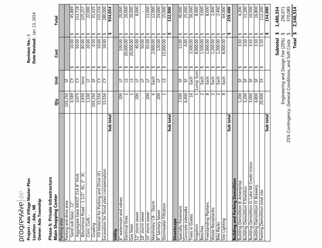
Pro
ject
: A
da V
illa
ge M
ast
er
Pla
nR
evis
ion
No
.:5
Lo
cati
on
: A
da , M
I D
ate
Revis
ed
: J
an
. 13, 2014
Ow
ner:
Ad
a T
ow
nsh
ip
Ph
ase 5
: P
rivate
In
frastr
uctu
re
Main
Sh
op
pin
g C
en
ter
Qty
Un
itC
ost
To
tal
Park
ing
are
a
Park
ing
an
d d
rive a
rea
103,2
50
SF
S
an
d s
ub
base
- 1
2"
4,5
89
CY
10.0
0$
45,8
89
$
A
gg
reg
ate
base
MD
OT 2
1A
8"
thic
k3,0
75
CY
50.0
0$
153,7
28
$
B
itu
min
ou
s R
oad
- 1
1/2
" 4
C, 2"
3C
2,6
50
ton
s85.0
0$
225,2
57
$
C
on
c. C
urb
-1,1
00
LF
20.0
0$
22,0
00
$
G
rad
ing
103,2
50
SF
0.5
0$
51,6
25
$
F
ill M
ate
rial fo
r P
ark
ing
an
d D
rive (
4')
15,5
56
C
Y10.0
0$
155,5
56
$
Exc
avati
on
fo
r fl
oo
d p
lain
co
mp
en
sati
on
15,5
56
C
Y18.0
0$
280,0
00
$
Su
b t
ota
l9
34
,05
4$
Uti
lity
8"
wate
rmain
an
d v
alv
es
200
LF
100.0
0$
20,0
00
$
Ele
ctri
cal lin
es
1
LS
20,0
00.0
0$
20,0
00
$
Gas
Main
1
LS
20,0
00.0
0$
20,0
00
$
12"
sto
rm s
ew
er
200
LF
40.0
0$
8,0
00
$
18"
sto
rm s
ew
er
-
LF
50.0
0$
-
$
24"
sto
rm s
ew
er
200
LF
65.0
0$
13,0
00
$
Man
ho
les/
CB
- S
torm
6
Each
2,0
00.0
0$
12,0
00
$
8"
San
itary
Sew
er
200
LF
120.0
0$
24,0
00
$
Sto
rmw
ate
r Filtr
ati
on
1
LS
15,0
00.0
0$
15,0
00
$
Su
b t
ota
l1
32
,00
0$
Str
eets
cap
e
Sp
eci
alt
y P
avem
en
t7,5
00
SF
12.0
0$
90,0
00
$
Co
ncr
ete
sid
ew
alk
s6,4
00
SF
4.0
0$
25,6
00
$
Tre
es
in G
rate
s16
Each
3,5
00.0
0$
56,0
00
$
Irri
gati
on
1
Lu
mp
Su
m8,0
00.0
0$
8,0
00
$
Ben
ches
2
Each
1,5
00.0
0$
3,0
00
$
Fre
est
an
din
g P
lan
ters
8
Each
1,0
00.0
0$
8,0
00
$
Wast
e R
ece
pta
cles
2
Each
1,2
00.0
0$
2,4
00
$
Bik
e R
ack
s2
Each
1,2
00.0
0$
2,4
00
$
Sit
e L
igh
tin
g8
Each
8,0
00.0
0$
64,0
00
$
Su
b t
ota
l2
59
,40
0$
Bu
ild
ing
an
d P
ark
ing
Dem
oli
tio
n
Bu
ild
ing
Dem
oliti
on
B: A
meri
pri
se1,2
00
SF
3.5
0$
4,2
00
$
Bu
ild
ing
Dem
oliti
on
F:S
held
on
3,2
00
SF
3.5
0$
11,2
00
$
Bu
ild
ing
Dem
oliti
on
G: Lake M
i C
red
it U
nio
n3,0
00
SF
3.5
0$
10,5
00
$
Bu
ild
ing
Dem
oliti
on
H: B
rew
ery
4,8
00
SF
3.5
0$
16,8
00
$
Park
ing
Dem
oliti
on
to
tal si
te20,4
00
SY
5.5
0$
112,2
00
$
Su
b t
ota
l1
54
,90
0$
Su
bto
tal
1,4
80
,35
4$
En
gin
eeri
ng
an
d D
esi
gn
Fee (
20%
)296,0
71
$
3
70,0
89
$
To
tal
2,1
46
,51
4$
25%
Co
nti
ng
en
cy ,G
en
era
l C
on
dit
ion
s, a
nd
So
ft C
ost
s

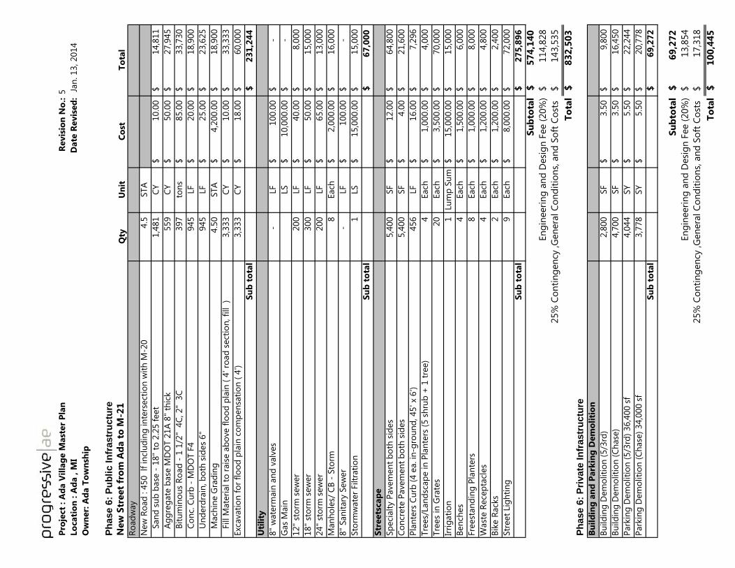
Pro
ject
: A
da V
illa
ge M
ast
er
Pla
nR
evis
ion
No
.:5
Lo
cati
on
: A
da , M
I
Date
Revis
ed
: J
an
. 13, 2014
Ow
ner:
Ad
a T
ow
nsh
ip
Ph
ase 6
: P
ub
lic I
nfr
astr
uctu
re
New
Str
eet
fro
m A
da t
o M
-21
Qty
Un
itC
ost
To
tal
Ro
ad
way
New
Ro
ad
: 4
50 lf
in
clu
din
g in
ters
ect
ion
wit
h M
-20
4.5
STA
S
an
d s
ub
base
- 1
8"
to 2
.25 f
eet
1,4
81
CY
10.0
0$
14,8
11
$
A
gg
reg
ate
base
MD
OT 2
1A
8"
thic
k559
CY
50.0
0$
27,9
45
$
B
itu
min
ou
s R
oad
- 1
1/2
" 4
C, 2"
3C
397
ton
s85.0
0$
33,7
30
$
C
on
c. C
urb
- M
DO
T F
4945
LF
20.0
0$
18,9
00
$
U
nd
erd
rain
, b
oth
sid
es
6"
945
LF
25.0
0$
23,6
25
$
M
ach
ine G
rad
ing
4.5
0
STA
4,2
00.0
0$
18,9
00
$
F
ill M
ate
rial to
rais
e a
bo
ve f
loo
d p
lain
( 4
' ro
ad
sect
ion
, fi
ll )
3,3
33
CY
10.0
0$
33,3
33
$
Exc
avati
on
fo
r fl
oo
d p
lain
co
mp
en
sati
on
( 4
')3,3
33
CY
18.0
0$
60,0
00
$
Su
b t
ota
l2
31
,24
4$
Uti
lity
8"
wate
rmain
an
d v
alv
es
-
LF
100.0
0$
-$
Gas
Main
LS
10,0
00.0
0$
-$
12"
sto
rm s
ew
er
200
LF
40.0
0$
8,0
00
$
18"
sto
rm s
ew
er
300
LF
50.0
0$
15,0
00
$
24"
sto
rm s
ew
er
200
LF
65.0
0$
13,0
00
$
Man
ho
les/
CB
- S
torm
8
Each
2,0
00.0
0$
16,0
00
$
8"
San
itary
Sew
er
-
LF
100.0
0$
-$
Sto
rmw
ate
r Filtr
ati
on
1
LS
15,0
00.0
0$
15,0
00
$
Su
b t
ota
l6
7,0
00
$
Str
eets
cap
e
Sp
eci
alt
y P
avem
en
t b
oth
sid
es
5,4
00
SF
12.0
0$
64,8
00
$
Co
ncr
ete
Pavem
en
t b
oth
sid
es
5,4
00
SF
4.0
0$
21,6
00
$
Pla
nte
rs C
urb
(4 e
a. in
-gro
un
d, 45' x
6')
456
LF
16.0
0$
7,2
96
$
Tre
es/
Lan
dsc
ap
e in
Pla
nte
rs (
5 s
hru
b +
1 t
ree)
4
Each
1,0
00.0
0$
4,0
00
$
Tre
es
in G
rate
s20
Each
3,5
00.0
0$
70,0
00
$
Irri
gati
on
1
Lu
mp
Su
m15,0
00.0
0$
15,0
00
$
Ben
ches
4
Each
1,5
00.0
0$
6,0
00
$
Fre
est
an
din
g P
lan
ters
8
Each
1,0
00.0
0$
8,0
00
$
Wast
e R
ece
pta
cles
4
Each
1,2
00.0
0$
4,8
00
$
Bik
e R
ack
s2
Each
1,2
00.0
0$
2,4
00
$
Str
eet
Lig
hti
ng
9
Each
8,0
00.0
0$
72,0
00
$
Su
b t
ota
l2
75
,89
6$
Su
bto
tal
57
4,1
40
$
En
gin
eeri
ng
an
d D
esi
gn
Fee (
20%
)114,8
28
$ 1
43,5
35
$
To
tal
83
2,5
03
$
Ph
ase 6
: P
rivate
In
frastr
uctu
re
Bu
ild
ing
an
d P
ark
ing
Dem
oli
tio
n
Bu
ild
ing
Dem
oliti
on
(5/3
rd)
2,8
00
SF
3.5
0$
9,8
00
$
Bu
ild
ing
Dem
oliti
on
(C
hase
)4,7
00
SF
3.5
0$
16,4
50
$
Park
ing
Dem
oliti
on
(5/3
rd)
36,4
00 s
f4,0
44
SY
5.5
0$
22,2
44
$
Park
ing
Dem
oliti
on
(C
hase
) 34,0
00 s
f3,7
78
SY
5.5
0$
20,7
78
$
Su
b t
ota
l6
9,2
72
$
Su
bto
tal
69
,27
2$
En
gin
eeri
ng
an
d D
esi
gn
Fee (
20%
)13,8
54
$ 1
7,3
18
$
To
tal
10
0,4
45
$
25%
Co
nti
ng
en
cy ,G
en
era
l C
on
dit
ion
s, a
nd
So
ft C
ost
s
25%
Co
nti
ng
en
cy ,G
en
era
l C
on
dit
ion
s, a
nd
So
ft C
ost
s

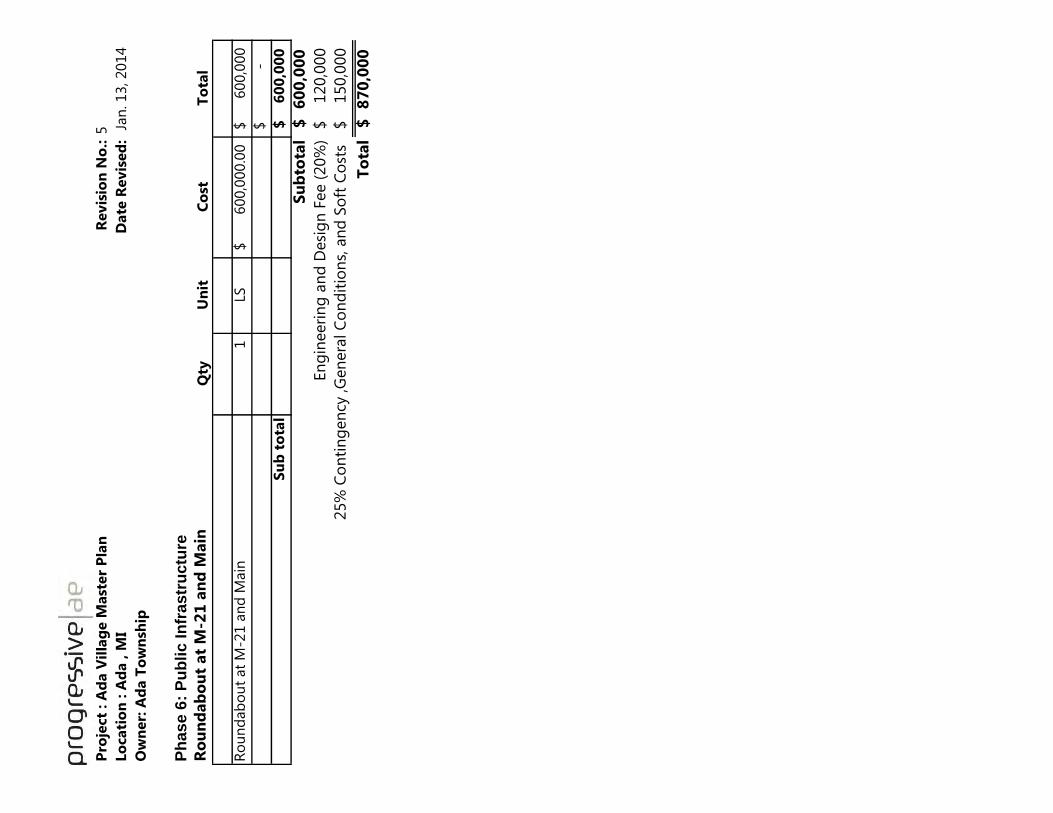
Pro
ject
: A
da V
illa
ge M
ast
er
Pla
nR
evis
ion
No
.:5
Lo
cati
on
: A
da , M
I D
ate
Revis
ed
: J
an
. 13, 2014
Ow
ner:
Ad
a T
ow
nsh
ip
Ph
as
e 6
: P
ub
lic
In
fra
str
uctu
re
Ro
un
dab
ou
t at
M-2
1 a
nd
Main
Qty
Un
itC
ost
To
tal
Ro
un
dab
ou
t at
M-2
1 a
nd
Main
1
LS600,0
00.0
0$
600,0
00
$
-$
Su
b t
ota
l6
00
,00
0$
Su
bto
tal
60
0,0
00
$
En
gin
eeri
ng
an
d D
esi
gn
Fee (
20%
)120,0
00
$
25%
Co
nti
ng
en
cy ,G
en
era
l C
on
dit
ion
s, a
nd
So
ft C
ost
s150,0
00
$
To
tal
87
0,0
00
$

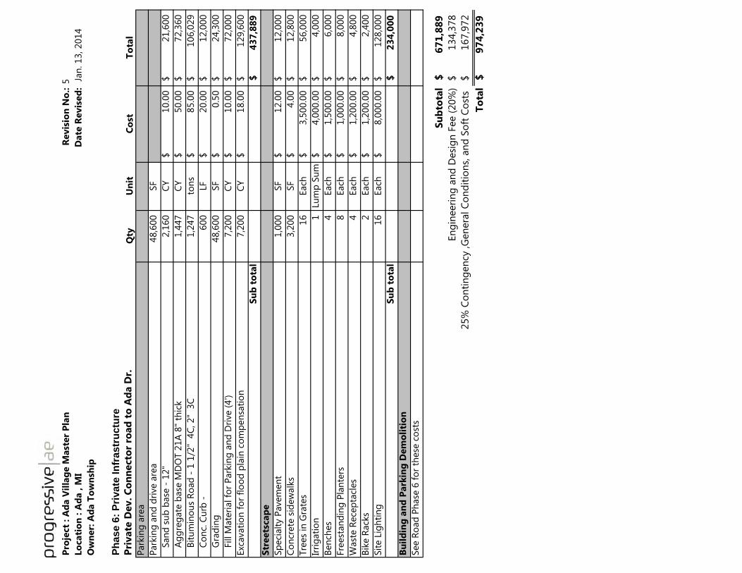
Pro
ject
: A
da V
illa
ge M
ast
er
Pla
nR
evis
ion
No
.:5
Lo
cati
on
: A
da , M
I D
ate
Revis
ed
: J
an
. 13, 2014
Ow
ner:
Ad
a T
ow
nsh
ip
Ph
ase 6
: P
rivate
In
frastr
uctu
re
Pri
vate
Dev. C
on
necto
r ro
ad
to
Ad
a D
r.Q
tyU
nit
Co
stT
ota
l
Park
ing
are
a
Park
ing
an
d d
rive a
rea
48,6
00
SF
S
an
d s
ub
base
- 1
2"
2,1
60
CY
10.0
0$
21,6
00
$
A
gg
reg
ate
base
MD
OT 2
1A
8"
thic
k1,4
47
CY
50.0
0$
72,3
60
$
B
itu
min
ou
s R
oad
- 1
1/2
" 4
C, 2"
3C
1,2
47
ton
s85.0
0$
106,0
29
$
C
on
c. C
urb
-600
LF
20.0
0$
12,0
00
$
G
rad
ing
48,6
00
SF
0.5
0$
24,3
00
$
F
ill M
ate
rial fo
r P
ark
ing
an
d D
rive (
4')
7,2
00
CY
10.0
0$
72,0
00
$
Exc
avati
on
fo
r fl
oo
d p
lain
co
mp
en
sati
on
7,2
00
CY
18.0
0$
129,6
00
$
Su
b t
ota
l4
37
,88
9$
Str
eets
cap
e
Sp
eci
alt
y P
avem
en
t1,0
00
SF
12.0
0$
12,0
00
$
Co
ncr
ete
sid
ew
alk
s3,2
00
SF
4.0
0$
12,8
00
$
Tre
es
in G
rate
s16
Each
3,5
00.0
0$
56,0
00
$
Irri
gati
on
1
Lu
mp
Su
m4,0
00.0
0$
4,0
00
$
Ben
ches
4
Each
1,5
00.0
0$
6,0
00
$
Fre
est
an
din
g P
lan
ters
8
Each
1,0
00.0
0$
8,0
00
$
Wast
e R
ece
pta
cles
4
Each
1,2
00.0
0$
4,8
00
$
Bik
e R
ack
s2
Each
1,2
00.0
0$
2,4
00
$
Sit
e L
igh
tin
g16
Each
8,0
00.0
0$
128,0
00
$
Su
b t
ota
l2
34
,00
0$
Bu
ild
ing
an
d P
ark
ing
Dem
oli
tio
n
See R
oad
Ph
ase
6 f
or
these
co
sts
Su
bto
tal
67
1,8
89
$
En
gin
eeri
ng
an
d D
esi
gn
Fee (
20%
)134,3
78
$
1
67,9
72
$
To
tal
97
4,2
39
$
25%
Co
nti
ng
en
cy ,G
en
era
l C
on
dit
ion
s, a
nd
So
ft C
ost
s

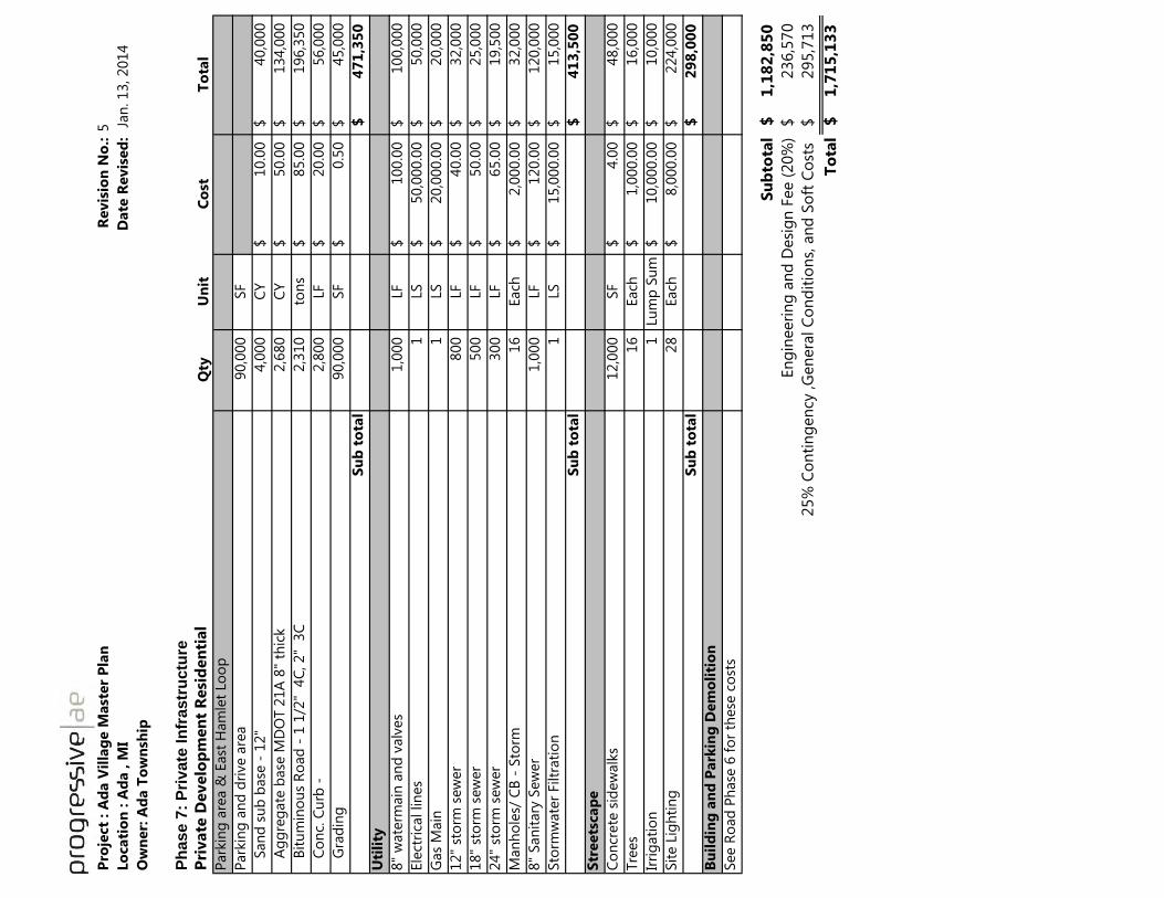
Pro
ject
: A
da V
illa
ge M
ast
er
Pla
nR
evis
ion
No
.:5
Lo
cati
on
: A
da , M
I D
ate
Revis
ed
: J
an
. 13, 2014
Ow
ner:
Ad
a T
ow
nsh
ip
Ph
ase 7
: P
rivate
In
frastr
uctu
re
Pri
vate
Develo
pm
en
t R
esi
den
tial
Qty
Un
itC
ost
To
tal
Park
ing
are
a &
East
Ham
let
Lo
op
Park
ing
an
d d
rive a
rea
90,0
00
SF
S
an
d s
ub
base
- 1
2"
4,0
00
CY
10.0
0$
40,0
00
$
A
gg
reg
ate
base
MD
OT 2
1A
8"
thic
k2,6
80
CY
50.0
0$
134,0
00
$
B
itu
min
ou
s R
oad
- 1
1/2
" 4
C, 2"
3C
2,3
10
ton
s85.0
0$
196,3
50
$
C
on
c. C
urb
-2,8
00
LF
20.0
0$
56,0
00
$
G
rad
ing
90,0
00
SF
0.5
0$
45,0
00
$
Su
b t
ota
l4
71
,35
0$
Uti
lity
8"
wate
rmain
an
d v
alv
es
1,0
00
LF
100.0
0$
100,0
00
$
Ele
ctri
cal lin
es
1
LS
50,0
00.0
0$
50,0
00
$
Gas
Main
1
LS
20,0
00.0
0$
20,0
00
$
12"
sto
rm s
ew
er
800
LF
40.0
0$
32,0
00
$
18"
sto
rm s
ew
er
500
LF
50.0
0$
25,0
00
$
24"
sto
rm s
ew
er
300
LF
65.0
0$
19,5
00
$
Man
ho
les/
CB
- S
torm
16
Each
2,0
00.0
0$
32,0
00
$
8"
San
itary
Sew
er
1,0
00
LF
120.0
0$
120,0
00
$
Sto
rmw
ate
r Filtr
ati
on
1
LS
15,0
00.0
0$
15,0
00
$
Su
b t
ota
l4
13
,50
0$
Str
eets
cap
e
Co
ncr
ete
sid
ew
alk
s12,0
00
SF
4.0
0$
48,0
00
$
Tre
es
16
Each
1,0
00.0
0$
16,0
00
$
Irri
gati
on
1
Lu
mp
Su
m10,0
00.0
0$
10,0
00
$
Sit
e L
igh
tin
g28
Each
8,0
00.0
0$
224,0
00
$
Su
b t
ota
l2
98
,00
0$
Bu
ild
ing
an
d P
ark
ing
Dem
oli
tio
n
See R
oad
Ph
ase
6 f
or
these
co
sts
Su
bto
tal
1,1
82
,85
0$
En
gin
eeri
ng
an
d D
esi
gn
Fee (
20%
)236,5
70
$
2
95,7
13
$
To
tal
1,7
15
,13
3$
25%
Co
nti
ng
en
cy ,G
en
era
l C
on
dit
ion
s, a
nd
So
ft C
ost
s

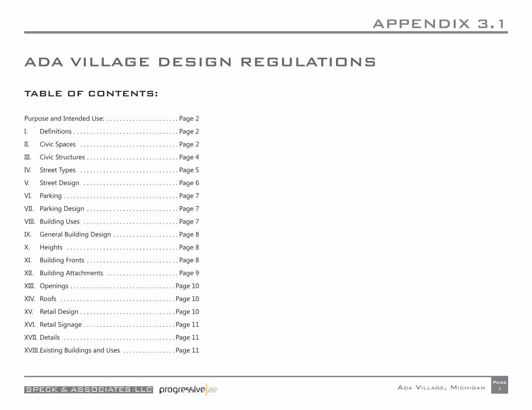
APPENDIX 3.1
ADA VILLAGE, MICHIGANPage
1
ADA VILLAGE DESIGN REGULATIONS
TABLE OF CONTENTS:
Purpose and Intended Use: . . . . . . . . . . . . . . . . . . . . . . Page 2
I. Defi nitions . . . . . . . . . . . . . . . . . . . . . . . . . . . . . . . . Page 2
II. Civic Spaces . . . . . . . . . . . . . . . . . . . . . . . . . . . . . . Page 2
III. Civic Structures . . . . . . . . . . . . . . . . . . . . . . . . . . . . Page 4
IV. Street Types . . . . . . . . . . . . . . . . . . . . . . . . . . . . . . Page 5
V. Street Design . . . . . . . . . . . . . . . . . . . . . . . . . . . . . Page 6
VI. Parking . . . . . . . . . . . . . . . . . . . . . . . . . . . . . . . . . . . Page 7
VII. Parking Design . . . . . . . . . . . . . . . . . . . . . . . . . . . . Page 7
VIII. Building Uses . . . . . . . . . . . . . . . . . . . . . . . . . . . . . Page 7
IX. General Building Design . . . . . . . . . . . . . . . . . . . . Page 8
X. Heights . . . . . . . . . . . . . . . . . . . . . . . . . . . . . . . . . . Page 8
XI. Building Fronts . . . . . . . . . . . . . . . . . . . . . . . . . . . . Page 8
XII. Building Attachments . . . . . . . . . . . . . . . . . . . . . . Page 9
XIII. Openings . . . . . . . . . . . . . . . . . . . . . . . . . . . . . . . . Page 10
XIV. Roofs . . . . . . . . . . . . . . . . . . . . . . . . . . . . . . . . . . . Page 10
XV. Retail Design . . . . . . . . . . . . . . . . . . . . . . . . . . . . . Page 10
XVI. Retail Signage . . . . . . . . . . . . . . . . . . . . . . . . . . . . Page 11
XVII. Details . . . . . . . . . . . . . . . . . . . . . . . . . . . . . . . . . . Page 11
XVIII. Existing Buildings and Uses . . . . . . . . . . . . . . . . Page 11
APPENDIX 3.1
ADA VILLAGE, MICHIGANPage
2
VI: REGULATIONS Purpose and Intended Use:
The successful implementation of the plan set forth in this report will depend in no small part on the Township’s development regulations being consistent with the urban design principles that underlie the plan. In many communities, Ada Township included, the typical suburban pattern of public space and adjacent private development that is auto-dominated and unfriendly and unsafe for pedestrians has been reinforced by, if not directly the result of, the community’s own zoning regulations. Ada Township has already adopted “form-based” zoning regulations that seek to remedy this drawback of conventional suburban zoning standards. The standards contained herein are recommended for inclusion into the Township’s existing form-based zoning regulations, to help ensure that future re-development of land in the study area will realize the vision set forth in this plan.
It is recognized that the process of amending the zoning regulations is the primary responsibility of the Planning Commission and Township Board, and will involve a separate process of soliciting public input on the proposed regulations. The standards in this Appendix should be viewed as an initial draft in beginning this process.
I. DEFINITIONS
Block: An area surrounded by Streets. Note that Streets are distinct from Rear Lanes, which occur in the middle of Blocks. Bulbout: An area where the sidewalk expands to include the width of the parking lane in order to narrow a Street’s crossing distance.
Civic Space: An open space in the Plan that is neither a right of way nor a platted private property. Civic Spaces may ultimately belong to Ada Township, a homeowners’ association, or another entity identified by the Township.
Civic Structure: A structure specifically built to enhance the public realm, which may also include certain public functions.
Curb Cut: A location where a private drive or driveway crosses a sidewalk along a Frontage.
Frontage: An edge of a property that faces a public space such as a Street or square. Edges along Rear Lanes, for example, are not Frontages. Frontages are marked in the Regulating Plan with Frontage Lines.
Frontage Line: As indicated in the Regulating Plan, a Frontage Line designates the location of a building edge.
Frontage Setback: The distance of a building’s Frontage Line from its front property line.
Granny Flat: An apartment located atop a single-family house’s garage.
Mews: A very low-capacity urban thoroughfare serving only abutting property. And shared by pedestrian, bicycle and vehicular traffi c. Pedestrians may be accommodated on a raised adjacent sidewalk.
Parking Zone: A location that may only hold parking lots (including their landscape).
APPENDIX 3.1
ADA VILLAGE, MICHIGANPage
3
Path: A surface within a Civic Space that supports pedestrian use.
Rear Lane: A public service thoroughfare that provides vehicular access to the rears of properties and the centers of Blocks. A Rear Alley is a Rear Lane serving non-residential properties.
Rear Lane Opening: The corner where a Rear Lane opens onto a Street.
Regulating Plan: The Ada Village Regulating Plan, which applies the details of these Regulations to the redevelopment area.
Regulations: When capitalized, the Ada Village Design Regulations—this document.
Retail: For the purposes of this document, Retail refers to retail, dining, entertainment, or similar uses.
Rowhouse: A single-family house that is attached on one or both sides to another similar house and served by a Rear Lane.
Setback: See Frontage Setback
Street: A public thoroughfare typically handling vehicular, bicycle, and pedestrian traffic. For the purposes of these Regulations, all thoroughfares— be they streets, road, drives, alleys, or lanes—are designated as streets.
Tree, Flowering: A tree that produces fl owers and reaches a height of approximately 30 feet at maturity, such as a Cleveland Pear or Japanese Flowering Cherry. Gingko Biloba and other tall, slim trees may also substitute.
Tree, Street: A tree that reaches a height of more than 30 feet at maturity, such as an Elm or Sycamore.
Vista Termination: As indicated on the Regulating Plan, a location on a building that is perspectively framed by a long view down a Street, and required to receive an appropriately-scaled architectural feature.
II. CIVIC SPACES
A number of both public and private Civic Spaces are indicated in the Regulating Plan. They include the following (with key numbers from the Regulating Plan), with requirements as noted:
The Western Hamlet Green [1]: A privately-owned and maintained green located within the residential hamlet on the north side of Headley St., near its intersection with Bronson St., this triangle frames a view to the Western Hamlet Mews behind. It shall provide one or more paved pedestrian paths from the street frontage extending to the north edge of the hamlet. It features existing preserved mature trees, additional landscape plantings and pedestrian amenities such as benches.
The Median Green [2]: This small linear green is located in the median of Headley St., south and east of its new intersection with Fulton St. (M-21). This green contains groundcover below Street Trees that have been planted to align with consistently-placed Street Trees located to the north and south side of the street, with the outcome being three aligned rows of roughly identical trees.
The Commons [3]: This large publicly-owned and maintained green shall include the following features:
To the north of the Headley St. Median Green, it shall receive a thick copse of evergreen trees, to shelter Headley Street from Fulton Street. It shall feature a pedestrian plaza that provides a new, highly-visible and accessible location for the Rix Robinson monument that is currently located in an obscure, neglected location near the south edge of the Fulton St. (M-21 pavement. At its east end shall be located a combined Civic Building, Farmers’ Market Pavilion and adjacent parking, as more thoroughly described under Civic Structures.
Paseos I and II [4][5] : Privately-owned and maintained paved pedestrian passageways, with public access easements, connecting the Headley Street sidewalk to the midblock parking lot. The pavement in these two passageways shall have a minimum width of 5-feet, and shall be fl anked by landscaped area separating the paved walkways from the adjacent buildings.
The Village Green [6]: This publicly-owned and maintained green is surrounded by the sidewalks of its surrounding streets, and shall contain public walkways, landscaping, canopy trees and pedestrian amenities surrounding a large central
APPENDIX 3.1
ADA VILLAGE, MICHIGANPage
4
visual feature, such as a fountain, statute, sculpture or monument. This Civic Space shall only be built upon the successful relocation of the Speedway gas station and adjacent properties.
The Township Path [7]: To the west of the parking lot in front of the Township Offi ces, there is room on the Township Offi ce property to insert a 5-foot-wide concrete sidewalk to provide a dedicated public pedestrian connection from the Thornapple River Dr. sidewalk to the front door of the Township Offi ces.
Corner Green 1 [8]: This privately-owned and maintained Green shall provide a 6-foot-wide sidewalk connection, from the public street corner to the midblock parking lot behind, and shall be subject to a public access easement. The two triangle-shaped areas between the sidewalk and the adjacent buildings shall either be privately-owned and maintained landscaped area, or alternatively may be outdoor seating area for businesses in the adjacent buildings.
Corner Green 2 [9]: This privately-owned and maintained green is essentially the mirror image of Corner Green 1.
Corner Green 3 [10]: This green is similar to Corner Green 1.
The Commercial Mews [11]: A larger retail building (approx 12,000 SF) is located to the east of this Civic Space, facing it. Connecting Riverside Drive to midblock parking, the privately-owned and maintained Commercial Mews shall be approximately forty feet wide and paved in bricks or similar, and shall contain public walkways, landscaping, canopy trees and pedestrian amenities.
The Riverfront Green [12]: This large, publicly-owned and maintained green consists of four sections, from west to east, as follows: From the adjacent street frontages, the turf shall gently slope towards the riverbank. While it is not required, this Plan recommends than that this turf be further shaped with stones into the terraced seating area of an Amphitheatre, to be more thoroughly described under Civic Structures, ahead. The residual land between the Amphitheater area and surrounding sidewalks (along Thornapple River Drive and Riverside Drive) shall each receive a dense planting of Street Trees. As indicated in the Regulating Plan, an 8-foot-wide asphalt Path shall continue the southward trajectory of the new street to its north to connect to a new pedestrian bridge across the Thornapple River, to be more thoroughly described under Civic
Structures, ahead. . To the east of this path, the grassy area between Riverside Drive and the River shall be left in its current condition and/ or depressed to assist in storm water retention.
Along the entire riverfront, starting from Thornapple River Dr. and extending north and east into the existing Township-owned open space at the confl uence of the Thornapple and Grand Rivers, interrupted only by the Amphitheater’s stage zone, an 8-foot-wide asphalt non-motorized trail shall run along the riverbank. Subject to State permitting processes, this trail may potentially extend underneath the west side of the M-21 bridge over the Grand River, and connect to the existing Township non-motorized trail that extends across the Grand River on the north side of the M-21 bridge deck.
The Eastern Hamlet Green [13]: This privately-owned and maintained green forms the centerpiece of the Eastern Hamlet. This area shall be landscaped and furnished with pedestrian amenities such that it provides an attractive and functional outdoor amenity for residents of the adjacent residential development.
III. CIVIC STRUCTURES
The Regulating Plan designates the following Civic Structures (with key numbers from the Regulating Plan) designed to play important placemaking roles within the community. They are as follows:
The Market Hall ①: The Market Hall includes indoor civic space and roofed, outdoor pavilion for the Ada Farmers’ Market. The specifi c functions served by the civic space will be determined through future space programming by the Township. The design of this structure will include a visually-prominent architectural feature that will function as a Vista Termination when viewed from Headley St., to the southeast. The Farmers’ Market pavilion shall be adjoined by a paved parking area for vendor vehicles.
The New Footbridge ②: A publicly-owned and maintained bridge designed to support pedestrian and low-speed bicycle traffi c shall be placed where indicated in the Regulating Plan, sited along the trajectory of the Path that continues from the Plan’s new north-south street to the river.
APPENDIX 3.1
ADA VILLAGE, MICHIGANPage
5
The Eastern Overlook ③: Where a Path connects another new north-south street to the river, a small overlook shall be located on the water’s edge.
IV. STREET TYPES
Twenty-five different Street types occur in the Regulating Plan. (Many of these are slight variations of each other, based upon the addition or subtraction of a fl ank of parking, thus the large number.) These Streets are indicated by the letters A - U in the Plan and described in the chart here. The specifi cations of the attached chart are fully a part of this Code. The chart describes each street in terms of its constituent parts, as follows: Figure VI-82.
Action: Some of the streets in the Regulating Plan do not currently exist, and will be built from scratch. Others are existing, but will require some reconstruction to conform to the Plan. Others require only restriping.
Street Type: Streets are described as Highways, Streets, One-Ways, Alleys, or Lanes.
ROW Width: The full width of the public right of way.
# Driving Lanes: The # of lanes for through traffi c, not for bikes or parking. Driving Lane Width: The width of all driving lanes. On Yield Streets, one 12-foot lane handles traffi c in both directions.
# Parking Lanes: Streets have parallel parking on both sides, one side, or none.
Parking Lane Width: All parking lanes are 8’ in width. This column also indicates which side of the street receives parking, if it is only one side.
Sidewalk Width: On commercial streets, the sidewalk is typically 12 feet wide, with trees placed in planters. On non-commercial streets, a sidewalk typically 5 feet wide is placed inboard of a tree lawn that is typically 7 feet wide. These measurements vary in special locations.
Tree Lawn Width: See above.
Bike Facilities: Some streets receive Sharrow markings, others Integrated Lanes, and others Cycle Tracks, as noted.
Notes: These address unique conditions, but also direct readers to Sections IV.2 and IV.3 of this report, where many of the designs are illustrated and described.
V. STREET DESIGN
Crosswalk Materials: Crosswalks shall be located to continue all sidewalk trajectories across all intersections and shall be surfaced in a material that contrasts with the Street surface.
Curbs: Curbs shall be vertical. Rollover or rounded curbs are only permitted where required to facilitate truck motions.
Left Hand Turn Lanes: Left hand turn lanes shall be limited to the shortest length deemed reasonable to handle peak turning demands.
Curb Radii: The curb return radius at Street corners shall be 10 feet. The curb return radius at Rear Lane ends shall be 5 feet. If such radii are not adequate to provide for the turning motions of trucks—with the truck allowed to swerve temporarily into the opposing lane—then they may be increased by only as much as is necessary to make such turning motions possible.
Curb Cuts: Curb Cuts are permitted at Frontages only in those locations specifically indicated in the Plan. Standard Curb Cuts may not exceed 20 feet in width, plus 3 feet corner curb radii where necessary. Residential Curb Cuts, also indicated, may not exceed 12 feet in width, plus 1 foot corner curb radii where necessary. (Houses with a double garage facing a street may provide a double-width driveway from the garage to the sidewalk edge but, once in the public right of way, the pavement must narrow to 12 feet maximum.) Curb Cuts are not regulated in non-Frontage locations.
Street Planting: Street Trees shall be planted along both sides of all new and
APPENDIX 3.1
ADA VILLAGE, MICHIGANPage
6
reconstructed streets, except Rear Lanes, and spaced consistently at an average on-center distance of approximately 30 feet. Street Trees shall be located at corners as described ahead, and then spaced regularly from corner to corner. At corners, the corner tree’s distance from the intersection shall be ten feet further from the intersection than a line that extends (across the sidewalk) the front property line of the property around the corner.
Tree Type/Quality: Each Street shall appear to have a single consistent tree species for its entire length. With the exception of the Commons and the Riverside Green, each Civic space shall appear to have no more than a single species of Street Tree and/or and single species of Flowering Tree, as further limited by the specifi cations for each space—already listed—but each of these civic spaces shall receive a unique species, to develop its own character. The term appear is used above because it is recommended that similar-appearing but genetically- distinct species be interspersed judiciously to avoid blight. Trees shall have a minimum height of 10 feet and a minimum caliper of 2 inches at time of planting.
Lighting: Street lights shall be located at the outer edge of all new sidewalks, shall be 12 feet to 15 feet tall, and shall be spaced regularly. Street lights shall be spaced approximately 50 feet on-center on commercial sidewalks (identifi ed by containing trees in planters rather than in a tree lawn), and approximately 150 feet on-center elsewhere.
Lighting Standards: Street lighting standards shall be sized appropriately to their low height. Light fi xtures shall use an energy-effi cient L.E.D. lamp. Lights shall not be sized and located around the goal of providing uniform coverage, as varying lighting levels are more attractive to pedestrians.
Sidewalk Objects: Any fi re hydrants, mailboxes, parking meters, bicycle racks, or other impediments to foot traffi c shall be located in the planting zone towards the curb. Benches shall be provided at retail Frontages at a minimum of one per Block face. Benches shall be located facing the Street with their backs against the building fronts. Benches built into building facades are encouraged and may encroach upon the sidewalk to a maximum depth of 2 feet. Bicycle Racks are required at a minimum of one rack having a minimum capacity of 4 bicycles per 300 linear feet of sidewalk edge on all commercial sidewalks (identifi ed by containing trees in planters rather than in a tree lawn).
Rear Alleys and Lanes: Wherever possible, Rear Alleys, Lanes, and midblock parking lots shall be the principal location of utilities such as water, sewer, electricity, gas, cable television, and trash pickup. Rear Lanes shall have a reverse crown, with French drains where necessary. Transformers, lift stations, traffi c signal control boxes, utility meters, HVAC equipment, and other such machinery shall not be located at Frontages or where they are readily visible at Frontages, but shall instead be located in Rear Lanes and parking lots.
VI. PARKING
General Approach: Parking demand in mixed-use development functions differently from parking demand in conventional suburban development, for several reasons:
A pedestrian-friendly environment allows people to walk rather than drive such that, for example, a resident or offi ce worker does not need a parking space at a nearby store or restaurant. Large amounts of on-street parking contribute to the number of spaces available. A collective parking supply (rather than site-by-site) allows the system to function and be regulated as an integrated organism. Complementary uses surrounding the collective parking supply allow spaces to serve different functions around the clock, such that, for example, a single space can serve an offi ce worker during the day and a resident at night. These four factors—a park-once environment, on-street parking, collective supply, and complimentary loads—all impact the off-street parking requirements, as follows:
Park-Once Environment: Effi ciencies due to increased pedestrian activity lead to the following general requirements:
Single-family homes, including all Rowhouses except those lining the blank wall of the market on Riverside Drive, shall provide a minimum of 2 off-street spaces per unit. Unlike with other uses, these shall be located on site, and are thus not impacted by the factors that follow. (The market-lining “Rear-Wall Rowhouses” on Riverside Drive shall each be assigned one on-street parking space and one parking space in the midblock lot.) All other Residential uses shall provide a minimum of 1.5 spaces per unit, on or off site.
APPENDIX 3.1
ADA VILLAGE, MICHIGANPage
7
All other uses shall provide a minimum of 3 spaces per 1000 interior square feet, on or off-site. Sidewalk dining is encouraged and thus shall not count towards this total.
On-Street Parking: Parking supply calculations shall include adjacent on-street parking spaces as the full equivalent of off-street parking spaces.
Collective Parking Supply: Parking calculations may be made comprehensively across multi-Block areas. If not otherwise assigned, any spot within 750 feet of its use may be counted towards that use if not otherwise assigned. Complimentary Loads: The minimum required quantity of parking may be reduced when shared parking is used. The following share factors shall be used to determine the reductions due to shared parking:
Residential and Office: .....................1.4Residential and Retail: ......................1.2Residential and Lodging:.................1.1Office and Retail: ................................1.3Office and Lodging:...........................1.7Retail and Lodging: ...........................1.3
To determine the Shared Parking Factor, divide the sum of the parking requirements for two functions by the applicable ratio to arrive at the total number of required spaces. For example, a combination of 10,000 square feet of retail and 40 apartments would be required to provide on- and off-street parking totaling ((10 * 3) + (40 * 1.5)) / 1.2 = (30 + 60) / 1.2 = 75 spaces.
Shared parking, to qualify as such, shall be located within 750 feet of each use.
VII. PARKING DESIGN
Building Orientation: Buildings that abut Rear Lanes or parking lots at their rears shall allow only secondary access from these edges, maintaining principal orientation and access towards their Frontages.
VIII. BUILDING USES
Mixed Use: This plan is intended to include a wide range of uses, including Retail, Residential, Offi ce, Lodging, Institutional, and other non-nuisance uses.
Retail: Ground-fl oor Retail (or dining/entertainment) use is required at certain Frontages and allowed at others, as indicated in the Plan. Such use is prohibited at all other Frontages.
Loft Buildings: The plan anticipates the development of many loft-style buildings that contain upper stories above a ground fl oor that may or may not contain Retail. In areas where Retail is required, all upper fl oors of these buildings may contain offi ces, residences, or some combination thereof. In areas where Retail is not required, all fl oors of these buildings may contain offi ces, residences, or some combination thereof. Residential: While the Regulations are fl exible, the Plan anticipates the following distribution of different residential Building Types:
Residential Lofts that place one or several stories of residential above a ground fl oor of Retail or residential use. These are typically parked in lots to the rear, but may occasionally place parking in a basement where a change in grade allows such access from the rear.
Live/Work Rowhouses that place a single-family residence atop a ground fl oor containing a commercial space at the front and a garage to the rear, situated in a party-wall arrangement with its neighbors.
Standard Rowhouses that contain a single-family residence and an integral rear garage, situated in a party-wall arrangement with its neighbors.
Deep-Lot Rowhouses that contain a single-family residence with a private rear garden between it and a rear garage, situated in a party-wall arrangement with its neighbors.
Rear-Wall Rowhouses that contain a single-family residence with its back wall built adjacent to the blank wall of the commercial building proposed near Riverside Drive. These are shallow, receiving light only from the front, and are situated in a party-wall arrangement with their neighbors.
APPENDIX 3.1
ADA VILLAGE, MICHIGANPage
8
Wide Lot Houses, to be located in the Eastern Hamlet only, where all vehicular access to the lot comes from the street at front. These houses are organized like conventional single-family homes, with garages to one side, except that, where side lot lines are parallel, houses directly abut their neighbors with their garages.
For informational purposes only, each of these Building Types is illustrated and described in section V of this report.
IX: GENERAL BUILDING DESIGN
Rowhouse Requirements: The following rules apply to Rowhouses:
All Rowhouses on a given straight Block segment shall be attached into a single group. In other words, gaps between Rowhouses shall only occur at rights of way or other public spaces, or where a bend in the road creates a non-parallel side-lot-line condition.
Rowhouses at Street corners shall locate their entrance on the long façade (turning the corner), centered beneath the gable, but not where the fl anking street is a Rear Lane.
Rowhouse lots shall be between 12 feet and 25 feet in width, with that distance supplemented on corner lots by any required side Setback.
For Deep-Lot Rowhouses, the rear garage shall be separated from the principal structure by a patio no less than 15 feet deep. A rear wing or breezeway may connect the house to the garage, as long as a 12-foot patio width is maintained. Each patio shall contain a shade tree.
Granny Flats are allowed only on Deep Lot Rowhouses, and are required on such houses at all Rear Lane Openings—where a rear lane meets a street. Granny Flats may contain a fi nished (third fl oor) attic story.
X. HEIGHTS
Building Heights: Heights are measured in reference to the sidewalk at the center of the front façade. Each Frontage is assigned a minimum and a maximum allowed building height, as further defi ned in the Regulations. When two different height requirements meet at a corner, the taller requirement takes precedence around the corner to a distance of at least 30 feet but no more than 60 feet from the Frontage Line.
Towers: To encourage an interesting skyline, building areas with a footprint of less that 200 square feet shall have no height limit.
Story Heights: Retail spaces shall have a minimum ceiling height of 12 feet, but 18 feet is recommended. Offi ce spaces shall have a minimum ceiling height of 10 feet. Residential spaces shall have a minimum ceiling height of 8 feet for upper stories and 9 feet for the fi rst fl oor.
Ground Floor Heights: All retail spaces shall be located on a ground fl oor placed at grade. Buildings with residential fi rst fl oors shall locate all fi rst-fl oor residences a minimum of 18 inches above adjacent sidewalk grade. This requirement becomes 30 inches when said fl oors are located within 5 feet of the sidewalk edge. Handicapped access, when provided on a building with an elevated fi rst fl oor, shall be located in non-Frontage locations whenever possible.
Tall Frontages: One-story commercial buildings, where permitted, shall maintain a minimum 18 foot parapet height at the Frontage Line. Single-family houses with sections of different height shall place the taller section at the Frontage Line and the lower section behind.
XI. BUILDING FRONTS
Frontages: The Regulating Plan distinguishes between Frontages and other property edges. Frontages require a higher level of urban performance, as further defi ned in the Regulations.
APPENDIX 3.1
ADA VILLAGE, MICHIGANPage
9
Frontage Lines: All Frontages are assigned Frontage Lines in the Plan. These are both setback lines and build-to lines: they specify the proper location of the building façade, as further defi ned in these Regulations.
Percent Frontages: All buildings shall place a building edge along no less than 60% of their Frontage Lines.
Sight Triangles: While they improve visibility, sight triangles increase vehicle speeds and can undermine pedestrian safety. Any requirements pertaining to sight triangles in currently enforced codes shall be waived when in confl ict with the Frontage Lines in the Regulating Plan, or with these Regulations’ tree-planting requirements.
Rear Lane Openings: To limit views into Rear Lanes, all buildings at Rear Lane entrance corners shall maintain a 0-foot Setback from the Rear Lane at the corner.
Vista Terminations: The Plan contains several locations on buildings that are perspectively framed by a long view down a Street—called a Vista Termination. Buildings located at Vista Terminations shall respond with an appropriately-scaled architectural feature, such as a tower or multi-story portico, in order to properly receive the vista. These shall be aligned properly to be framed symmetrically in the vista. Proper Vista Terminations include large bay windows, prominent gables, grouped window compositions, towers, and cupolas.
Materials: Building materials shall be used in a manner appropriate to their intrinsic formal properties, including their structural capacities as demonstrated in openings and spans. Metal elements shall be natural colored galvanized steel, stainless steel, anodized or electrostatic plated aluminum, marine-grade aluminum, copper, or bronze. Wood elements shall be painted or sealed with an opaque or semi solid stain, except walking surfaces, which may be left natural. Siding shall be wood or cementitious (Hardie Board or equivalent) and present 8 inches maximum siding width to the weather. All stucco shall be steel troweled with no evidence of the mark of the trowel. Sand cement render shall be applied without control joints. Corner beads are prohibited. Exterior trim shall be indistinguishable from wood when painted and shall be sized appropriately to its location.
Wall Confi gurations: Each building façade shall contain at most two different wall materials (not counting foundation walls and trim). Building walls shall be one color per material used (excluding trim). Materials may only transition across horizontal lines, for example, between building stories, and not across vertical lines, except in the case of attachments such as bay windows. When two materials are stacked horizontally, the heavier-looking material shall sit below the lighter-looking material, such as brick below Hardie-board or stone below stucco. When a material transition occurs around a corner, the transition shall occur at a distance from the corner that is appropriate for the materials represented, for example 12 or 16 inches for brick. Expansion joints shall be a rational part of the wall composition and shall be colored to match the wall. Trim, except at stucco, is required where there is a change in material or plane. Trim around lights, outlets, vents, meters, etc. shall match the wall color, not the object color.
Style: Buildings shall not present a historical pastiche. Buildings designed in a traditional style shall limit themselves to that style alone and shall embody that style convincingly. Keystones, quoins, and superimposed multiple gables (one gable overlapping another) are prohibited. Double front doors are prohibited on single-family homes.
XII. BUILDING ATTACHMENTS
Location: Any attachments such as bay windows, balconies, porches, stoops, awnings, and eaves shall extend forward of the line of the building front. Single-family houses shall provide either a stoop or a porch at the front door. All other buildings shall provide some form of shelter from rain at the front door.
Encroachments: Awnings are the only fi rst-fl oor attachments allowed to occupy the public right-of-way. On the second fl oor and above, balconies, bay windows, eaves, lights, and signs may occupy the public right-of-way. No attachment may extend above a vehicular roadbed at a height of less than 15 feet, or above a sidewalk at a height of less than 7 feet.
Awnings: Awnings shall be a minimum of 6 feet deep and shall be metal with colored fabric or glass. Fabric awnings shall have a metal structure covered with canvas or synthetic canvas, and be rectangular in shape with straight edges and no side panels or soffi t. Awnings shall not be backlit or used as signs, except for
APPENDIX 3.1
ADA VILLAGE, MICHIGANPage10
a possible single inscription on the fl ap, not to exceed 6 inches in height. All awnings on a single shop shall have the same depth, material, and color. Fabric awnings are permitted only above Retail windows.
Attachment Dimensions: Bay windows and balconies shall be no more than 3 feet deep; stoops shall be 3 feet to 6 feet deep; porches shall be between 6 feet and 10 feet deep.
Limited Balconies: Balconies and porches shall not constitute more than 50% of any facade.
Railings: Railings shall have top and bottom rails. The openings between spindles or balusters may not exceed 4 inches. Bottom rails shall clear the fl oor.
Privacy Walls and Fences: Single-family houses shall provide a wall or fence 5 feet to 6 feet in height between rear yards and against Rear Lanes and/or parking lots where no garage is present.
Yard Trees: All single-family houses with front Setbacks of 10 feet or greater shall be required to plant a front yard tree of a species matching the adjacent Street Tree if front attachments (such as a front porch) within the Setback provide an available space no less than 100 square feet in size. Said tree shall be located 5 feet from the front property line and 5 feet minimum from any side property line.
XIII. OPENINGS
Fenestration Ratio: The ratio of fenestration to area of the building façade shall be between 25% and 75%, except for retail Frontages where it shall be 60% to 95%. Retail establishments shall place windows regularly at all Frontages. Each facade shall be measured independently.
Blank Walls: Walls at Frontages may not be blank, and shall have at least one window per structural bay per fl oor, in a pattern that suggests habitation.
Window Materials: Windows shall have clear (not tinted) glass.
Window Panes: Each building façade shall be composed of windows that are all constructed from the same size or proportion of window pane, with the exception of a single custom window used in one or several special locations.
Mullions: Mullions, if used, shall either be true divided lights or be affi xed to the exterior surface of the window to cast a shadow line. Mullions are recommended for residential windows where stylistically appropriate, and discouraged for retail windows.
Shutters: Vertically hinged shutters, when provided, shall coincide in size to the opening with which they are associated, such that closing them would cover the window area.
Grouped Windows: When two or more windows occur in a single opening or dormer, they shall be separated by a 4”x4” post.
XIV. ROOFS
Rooftop Equipment: The screening of rooftop mechanical equipment is required. All rooftop mechanical equipment, with the exception of solar panels, shall be screened from view from all directions, and from all elevations of equal height or lower, to minimize the negative aesthetic impact upon the view from neighboring buildings and from street level. Said screening shall be consistent with the architecture of the building.
Dormers: Dormers shall be habitable and sized no larger than necessary to hold window(s) and framing.
Skylights: Bubble skylights shall not be visible at Frontages. Flush skylights, where visible at Frontages, shall be organized into a composed pattern.
XV. RETAIL DESIGN
No Malls: All retail spaces shall give direct access to a public sidewalk. No retail space may exist above the ground fl oor except as a mezzanine within a space that faces a ground-fl oor sidewalk.
Kneewall: Front glazing on retail establishments shall begin above a kneewall located 12 inches to 18 inches above sidewalk grade.
Blocked Windows: Retail uses shall not place inner partitions in windows that signifi cantly block views into the store.
APPENDIX 3.1
ADA VILLAGE, MICHIGANPage11
Sidewalk extension: All retail uses shall pave their Setbacks to match the adjoining sidewalk.
Alcove: All retail uses shall locate their primary entrances within a small additional Setback between 30 and 100 square feet in size, paved to match the sidewalk.
Sidewalk Use: Retail establishments are encouraged to place tables, chairs, and temporary displays on the public sidewalk as long a 5-foot-wide clear corridor is maintained for pedestrians.
XVI. RETAIL SIGNAGE
Limitations: The shop-front door, signage and lighting shall be designed as a unifi ed design. There are four types of signage permitted on businesses: a) a signage band, b) a pedestrian blade sign, c) a window logo, and d) an awning band. These are further limited as follows:
Sign Band: Each building may have a single sign band 60% maximum of the width of the building Frontage max., with a height not to exceed eighteen inches. If a building holds multiple tenants, the use of the sign band width shall be divided among tenants on a pro rata basis determined by their ground-fl oor square footage. The sign shall be integrally designed with the building or the associated storefronts in material and color. The sign band may not be internally lit.
Blade Sign: One two-sided blade sign is permitted for each business with a door on the sidewalk level. The blade sign shall be securely affi xed to the facade or storefront and may project over the sidewalk so long as it does not interfere with pedestrian fl ow. The blade sign may not exceed 6 square feet (including mounting hardware) in area in any shape, shall provide a minimum clearance above grade of 8 feet, shall be no less than 2 feet from the curb line, and shall not project further than 4 feet from the building wall. The sign shall not be translucent.
Logo: A logo inscribed on the storefront glass is permitted (one per business per building face), or the name of the store in permanently-affi xed cutout lettering. Logos shall not have an area greater than 25% of the area of the window to which
they are attached. Upstairs businesses are also allowed logos with the same limitations.
Other Signage: Billboards and other freestanding advertisements are prohibited, as are rooftop, fl ashing, moving, or intermittently illuminated signs, including digital changeable message signs. No sign shall be attached above the second story of any structure.
XVII. DETAILS
Consistency: Streets, squares, and other public spaces shall be designed with a common vocabulary of paving, curbing, fencing and walls, landscaping, signage, and lighting. This does not mean that all details will be consistent, but rather that all details will be understood to belong to the same family and/ or era of design. Building Variety: Buildings used repeatedly in the plan, such as Rowhouses and Loft Buildings, may only be repeated with similar facades to the degree that such repetition adds up to a total front footage of 75 feet or less. For example, a 25 foot-wide Rowhouse may be repeated only 3 times. Beyond this point, a truly distinct façade shall be introduced, as if a different architect was responsible.
Eyesores: Antennas, radar dishes, chain link fence, Vinyl fencing, barbed wire, razor wire, and chicken wire shall not be permitted where visible from Frontages. Dumpsters and trash shall be screened behind enclosures built for that purpose, and said enclosures shall not occur at Frontages.
XVIII. EXISTING BUILDINGS AND USES
General: In a number of locations on the Regulating Plan, requirements are shown for properties containing existing buildings and uses. While these requirements pertain to the replacement of existing buildings and uses with new ones, they do not mandate such replacement, and such redevelopment can only occur with the owner’s consent. Existing uses are thus “grandfathered” in. However, when existing buildings and uses are replaced, they shall be replaced according to the requirements of these Regulations.