Embed Size (px)
Citation preview
ENVIRONMENTALLY CRITICAL ISSUES & OPTIONS IN SEISMIC ACQUISITION FOR NATURAL GAS EXPLORATION IN COASTAL & OFFSHORE BLOCKS OF BANGLADESH
Delawar Bakht PEng 1, Md. Shafiqur Rahman 2
1. Advisor, Gas & Energy, BETS Consulting Service Ltd. Bangladesh
2. Environmental Specialist, SMEC Bangladesh Ltd. Bangladesh
Keywords: 1. Bangladesh; 2. Environmental Issues; 3. Coastal & Offshore Blocks; 4. Seismic Acquisition; 5. Gas Exploration Abstract
The paper is intended to recognize Seismic Acquisition as the primary step to delineate gas reserves in estuarine, coastal and offshore areas and initiate subsequent exploration. So, analysis of environmentally critical issues and mitigation measures has important role in safe and environmentally responsible development. Bangladesh is now working under its Gas Sector Master Plan and Strategy for 2025 in meeting its energy challenges and thus offering opportunities in further exploration in coastal and offshore Blocks in 2nd & 3rd round bidding process. So, the topic so opted for presentation in WGC 2009 bears high relevance to conference theme “The Global Energy Challenge: Reviewing the Strategies for Natural Gas towards 2030”. Attempts have been made to base this paper on essential details on recent experiences and studies conducted and participated by the authors while working in a team of both international and local multidisciplinary professionals specialized in estuarine and marine biodiversity, environmental specialists, prominent socio-economists and legal experts through extensive field visits, key informant interviews and collection and review of documentary evidences contained in similar other adjacent estuarine, coastal and offshore blocks during preparation of a full scale environmental impact assessment (EIA) report for obtaining approval of Department of Environment for launching seismic acquisition involving 2D / 3D seismic survey in one such exploration blocks involving both onshore and offshore lead areas of Bangladesh. Accordingly, it has reflected the extracts from other EIA reports done for adjacent offshore blocks, reference websites, literature reviews, public and stakeholders concerns, applicable legal and regulatory framework and the seismic operational activity descriptions including data acquisition procedure alternatives to choose from. Hence, It is expected that the generic and classical content of the presentation would tremendously benefit the operators and the professionals who are already working in the gas and environmental sectors of Bangladesh including its development partners and also attract attention of the prospective investors in Exploration & Production of natural gas in offshore blocks of Bangladesh and the adjoining neighborhood region in the Bay of Bengal.
Introduction
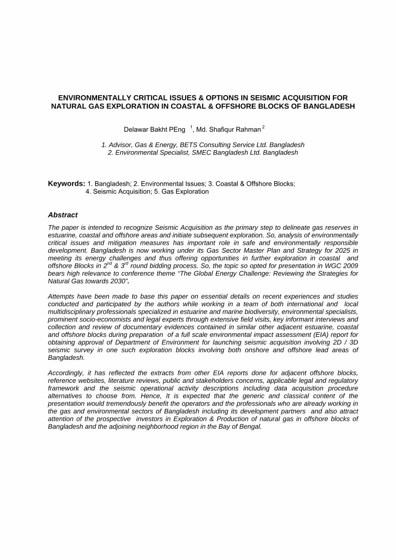
Contribution of natural gas in terms of security of supply of energy, safety and environment is currently a key driver for sustainable economic growth of Bangladesh, a developing country of South East Asia Map-1.
Map-1: Location of Bangladesh in South Asia
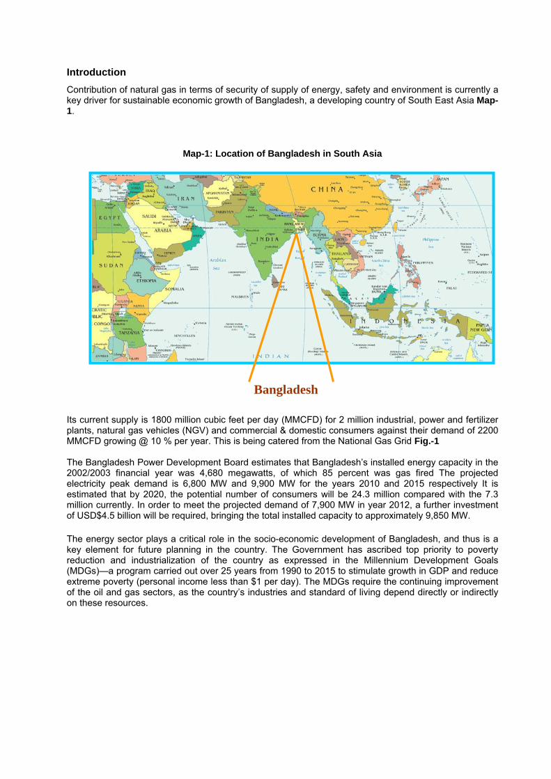
Bangladesh Its current supply is 1800 million cubic feet per day (MMCFD) for 2 million industrial, power and fertilizer plants, natural gas vehicles (NGV) and commercial & domestic consumers against their demand of 2200 MMCFD growing @ 10 % per year. This is being catered from the National Gas Grid Fig.-1 The Bangladesh Power Development Board estimates that Bangladesh’s installed energy capacity in the 2002/2003 financial year was 4,680 megawatts, of which 85 percent was gas fired The projected electricity peak demand is 6,800 MW and 9,900 MW for the years 2010 and 2015 respectively It is estimated that by 2020, the potential number of consumers will be 24.3 million compared with the 7.3 million currently. In order to meet the projected demand of 7,900 MW in year 2012, a further investment of USD$4.5 billion will be required, bringing the total installed capacity to approximately 9,850 MW. The energy sector plays a critical role in the socio-economic development of Bangladesh, and thus is a key element for future planning in the country. The Government has ascribed top priority to poverty reduction and industrialization of the country as expressed in the Millennium Development Goals (MDGs)—a program carried out over 25 years from 1990 to 2015 to stimulate growth in GDP and reduce extreme poverty (personal income less than $1 per day). The MDGs require the continuing improvement of the oil and gas sectors, as the country’s industries and standard of living depend directly or indirectly on these resources.
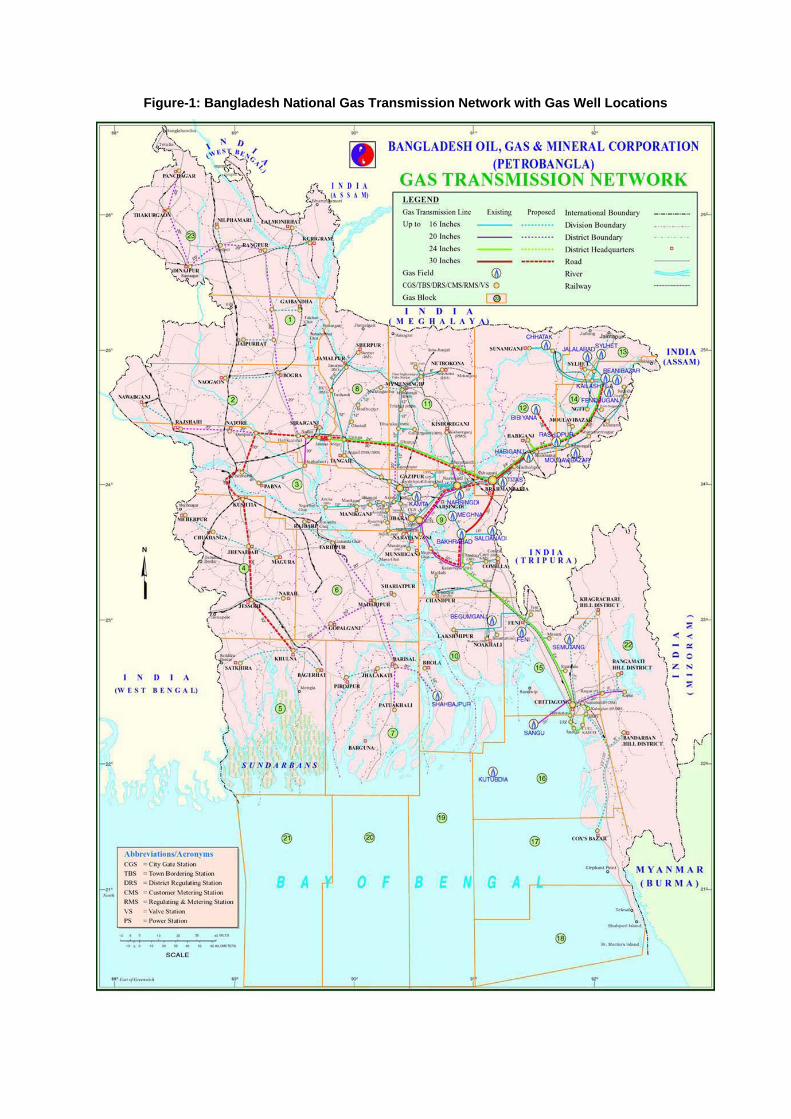
Figure-1: Bangladesh National Gas Transmission Network with Gas Well Locations
Currently gas is produced from 74 flowing wells of 15 fields. A few operators have conducted Seismic Acquisition and / or drilled a few wells in coastal offshore blocks and only one of them is producing from their offshore platform. A map showing the exploration and production blocks of Bangladesh and current production sharing contract (PSC) activities are placed in Map-2. Map-2.: Exploration and production blocks of Bangladesh and current PSC activities • During 1989 Bangladesh was divided into 23 acreage Blocks (6 offshore + 17 onshore
blocks) • 8 PSCs active in 10 Blocks: IOC Block(s) Nos Cairn, UK 16, 5 & 10 3 Chevron, USA 12,13 & 14, 7 3 Tullow, Ireland 9 1 Total E & P 17 & 18 1 • BAPEX working in 2 Blocks (Blocks 8 and 11) • 11 Blocks were open
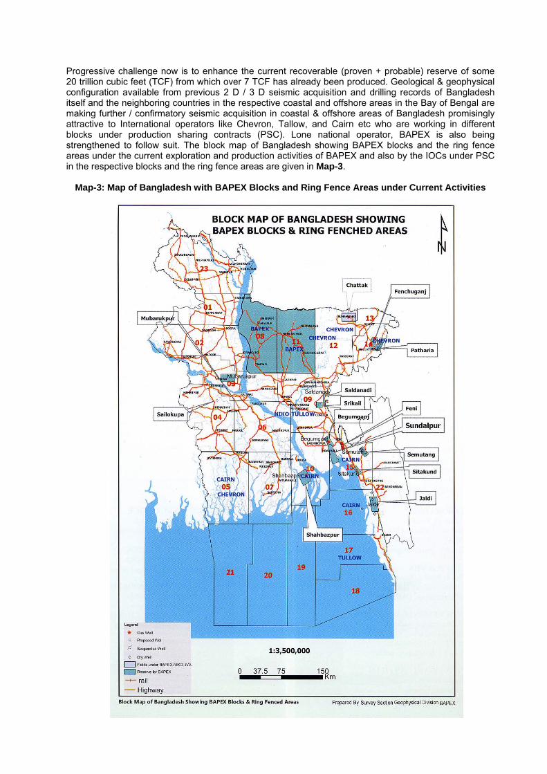
Progressive challenge now is to enhance the current recoverable (proven + probable) reserve of some 20 trillion cubic feet (TCF) from which over 7 TCF has already been produced. Geological & geophysical configuration available from previous 2 D / 3 D seismic acquisition and drilling records of Bangladesh itself and the neighboring countries in the respective coastal and offshore areas in the Bay of Bengal are making further / confirmatory seismic acquisition in coastal & offshore areas of Bangladesh promisingly attractive to International operators like Chevron, Tallow, and Cairn etc who are working in different blocks under production sharing contracts (PSC). Lone national operator, BAPEX is also being strengthened to follow suit. The block map of Bangladesh showing BAPEX blocks and the ring fence areas under the current exploration and production activities of BAPEX and also by the IOCs under PSC in the respective blocks and the ring fence areas are given in Map-3.
Map-3: Map of Bangladesh with BAPEX Blocks and Ring Fence Areas under Current Activities
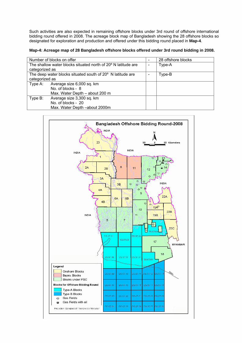
Such activities are also expected in remaining offshore blocks under 3rd round of offshore international bidding round offered in 2008. The acreage block map of Bangladesh showing the 28 offshore blocks so designated for exploration and production and offered under this bidding round placed in Map-4. Map-4: Acreage map of 28 Bangladesh offshore blocks offered under 3rd round bidding in 2008. Number of blocks on offer - 28 offshore blocks The shallow water blocks situated north of 20º N latitude are categorized as
- Type-A
The deep water blocks situated south of 20º N latitude are categorized as
- Type-B
Type A: Average size 6,000 sq. km No. of blocks - 8 Max. Water Depth – about 200 m Type B: Average size 3,300 sq. km No. of blocks - 20 Max. Water Depth –about 2000m
It is recognized that Seismic Acquisition is the primary step to delineate gas reserves and initiate subsequent exploration. So, analysis of environmentally critical issues and mitigation measures in estuarine, coastal & offshore areas has important role in safe and environmentally responsible development. Bangladesh is now working under its Gas Sector Master Plan & Strategy for 2025 done in 2006 in meeting its energy challenges. So, the topic so opted for presentation in this WGC 2009 bears high relevance to conference theme “The Global Energy Challenge: Reviewing the Strategies for Natural Gas towards 2030”. Objective Drilling activities in estuarine, coastal & offshore areas are comparatively expensive and by regulation of the country, operators doing 2 D / 3 D seismic survey are to adhere to certain legal framework and obtain site & environmental clearance from the Department of Environment (DOE) of the Ministry of Environment & Forest of the Government of the People’s Republic of Bangladesh. So this presentation would provide due coverage to the legal requirements along with the salient features of interest to DOE too in respect to management of environmentally critical issues typical to the offshore areas of Bangladesh including other regulatory issues involved there of. Government regulatory authorities usually supports selecting the optimal survey method for the coastal sites based upon:
Providing minimal environmental and social impact; Providing the highest level of safety for staff and the general public; and Providing good quality seismic data.
Project Alternatives The following 5 Project alternatives may be considered for assessment before firming up any decision to go forward with any seismic survey in coastal and offshore areas. These are briefly canvassed below in Table-1.
No Action; Aeromagnetic Survey; Ground Penetrating Radar; 3D Seismic Survey, and 2D Seismic Survey.
Table-1: Alternatives to be assessed for any seismic survey in coastal and offshore areas Option Advantages Disadvantages
Do Nothing • No additional potential for
environmental impact.
• Will not meet operator’s commitment under any PSC Block Contract.
• Prevents the potential for generation of local employment and income.
Aeromagnetic survey
• Can be carried out quickly and with no impact on the ground;
• May be carried out with fewer overall staff;
• Is less expensive to implement.
• Does not provide adequate information about the local geology due to poor resolution of equipment.
• Cannot provide greater geological detail than that which is already known.
• Cannot provide sufficient detail upon which to base significant management decisions.
Ground penetrating radar
• Allows a very accurate image of the upper layers of the strata for the area to be determined;
• May be carried out with fewer ground staff;
• Would allow operator to implement local improvement projects.
• Can only be used to shallow depths, which are not suitable for the deep gas strata known to occur in this area.
• Equipment needs to be physically moved over the entire project site. Not possible due to extensive cover of buildings, water, infrastructure and other natural features.
Option Advantages Disadvantages • Extremely expensive over such a
large area. • Good resolution of local geology; • Requires greater accessibility. • Can be carried out rapidly over
large areas; • Necessary knowledge and
infrastructure is already present within Bangladesh.
• Requires two lines (source and receiver) running perpendicular to each other in a grid pattern, as opposed to source and receiver lines following same path (as in 2D survey). Additional lines create a higher potential for environmental impacts;
3D survey • Not suited for water areas • Relatively expensive
• Physical spacing of source/receiver lines closer than in 2D survey.
• Significantly more expensive than 2D survey.
• Spacing between lines may be larger than 3D survey and therefore this option requires fewer shot holes and receiver lines to be laid.
• Provides less detail than for 3D survey, but provides cost effective information for decision making.
2D survey
• Geophones are located on the source lines, so there are fewer disturbances than for 3D survey.
If the nature of the areas to be surveyed and information collected from the previous 2D survey is available, further seismic survey is the most feasible option to gain sufficient information of the identified areas. Project Alternatives Five Project alternatives were considered:
No Action; Aeromagnetic Survey; Ground Penetrating Radar; 3D Seismic Survey, and i. 2D Seismic Survey.
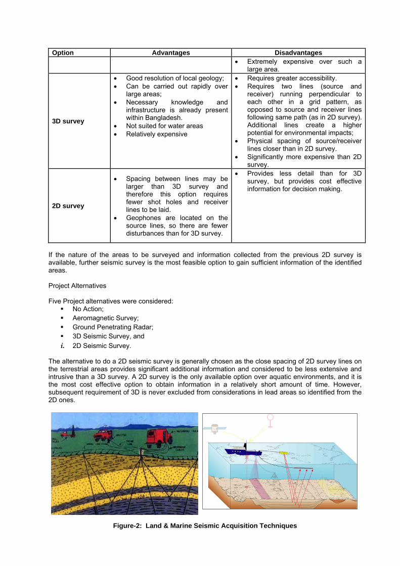
The alternative to do a 2D seismic survey is generally chosen as the close spacing of 2D survey lines on the terrestrial areas provides significant additional information and considered to be less extensive and intrusive than a 3D survey. A 2D survey is the only available option over aquatic environments, and it is the most cost effective option to obtain information in a relatively short amount of time. However, subsequent requirement of 3D is never excluded from considerations in lead areas so identified from the 2D ones.
Figure-2: Land & Marine Seismic Acquisition Techniques
During preparation of the EIA, if any number of environmental constraints are identified then the survey lines so designed may have to be modified to reduce potential environmental impacts on sensitive areas. The option to use the G.I. (Generator Injector) Gun is usually preferred due to its capacity to suppress bubble oscillation significantly and emission of low frequency sound waves that allow penetration into the strata below sea or river bottom.
Project Description
Any proposal for conducting a 2D / 3D Seismic Survey to be carried out carry out in discrete areas within PSC Blocks is usually based on operator’s extensive experience with this type of survey and also builds upon lessons learnt during the previous 2D survey undertaken in such of PSC Blocks in the past.
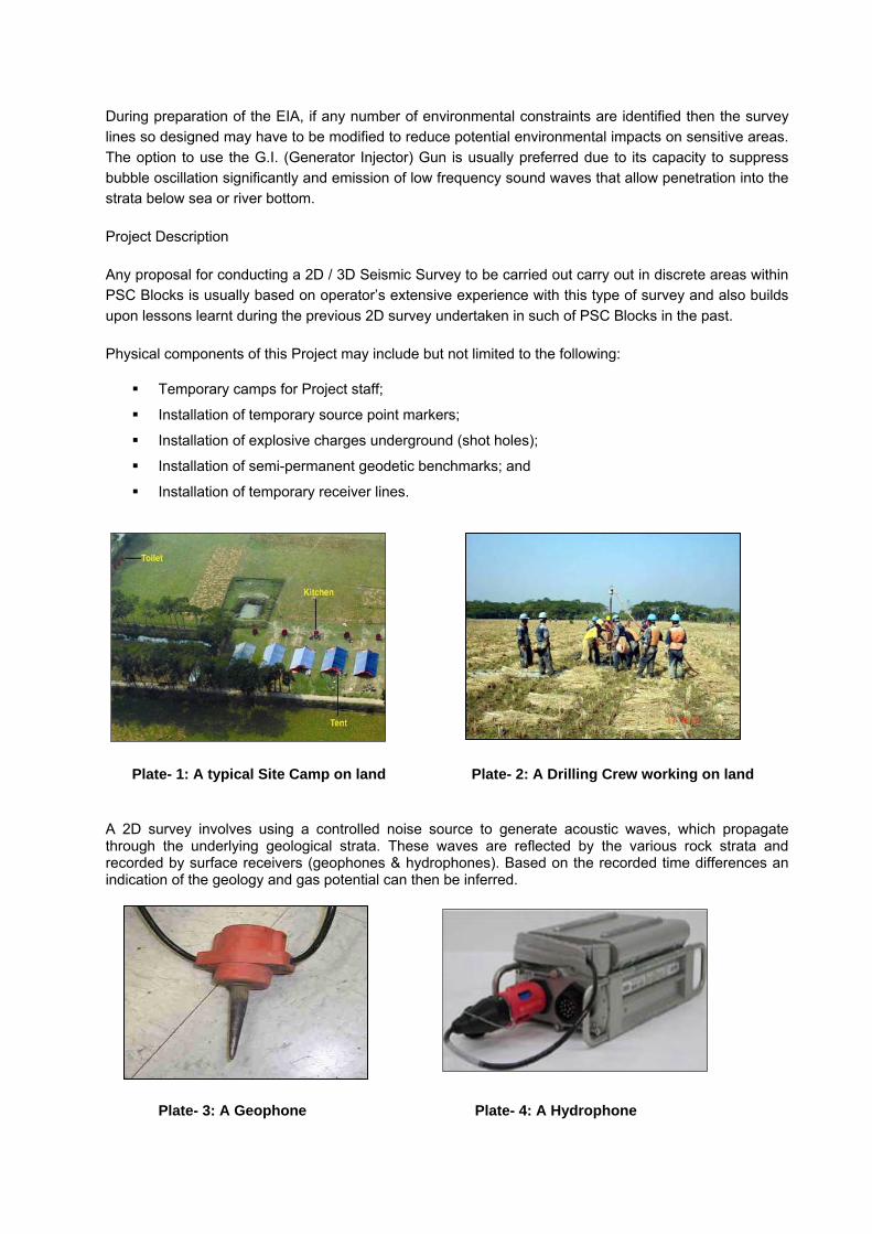
Physical components of this Project may include but not limited to the following:
Temporary camps for Project staff;
Installation of temporary source point markers;
Installation of explosive charges underground (shot holes);
Installation of semi-permanent geodetic benchmarks; and
Installation of temporary receiver lines.
Plate- 1: A typical Site Camp on land Plate- 2: A Drilling Crew working on land A 2D survey involves using a controlled noise source to generate acoustic waves, which propagate through the underlying geological strata. These waves are reflected by the various rock strata and recorded by surface receivers (geophones & hydrophones). Based on the recorded time differences an indication of the geology and gas potential can then be inferred.
Plate- 3: A Geophone Plate- 4: A Hydrophone

The 2D survey will generally be comprised of survey lines extending for up to approximately 40 kilometers. A noise source will be generated at approximately every 50 meters, with receiver geophones located at approximately 25 meter intervals. The geophones for land and hydrophones for water bodies are connected to a central recording facility. A grid pattern of survey lines will be established through the Project areas at spacing of between approximately 2 and 10 kilometers, depending on geological formations determined from the previous 2D survey.
Figure-3: Working Principles of seismic Reflection Method
Plate- 5: Powergel Seismic Explosive Plate-6: Drilling crew working on shallow water
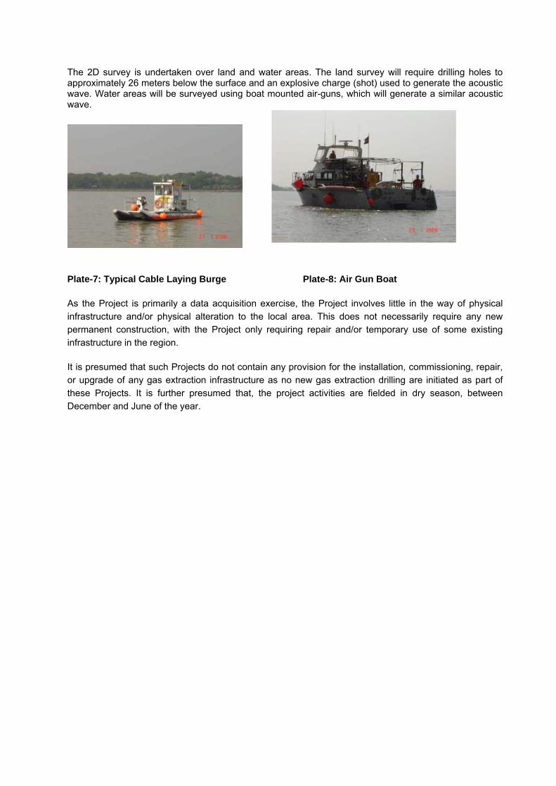
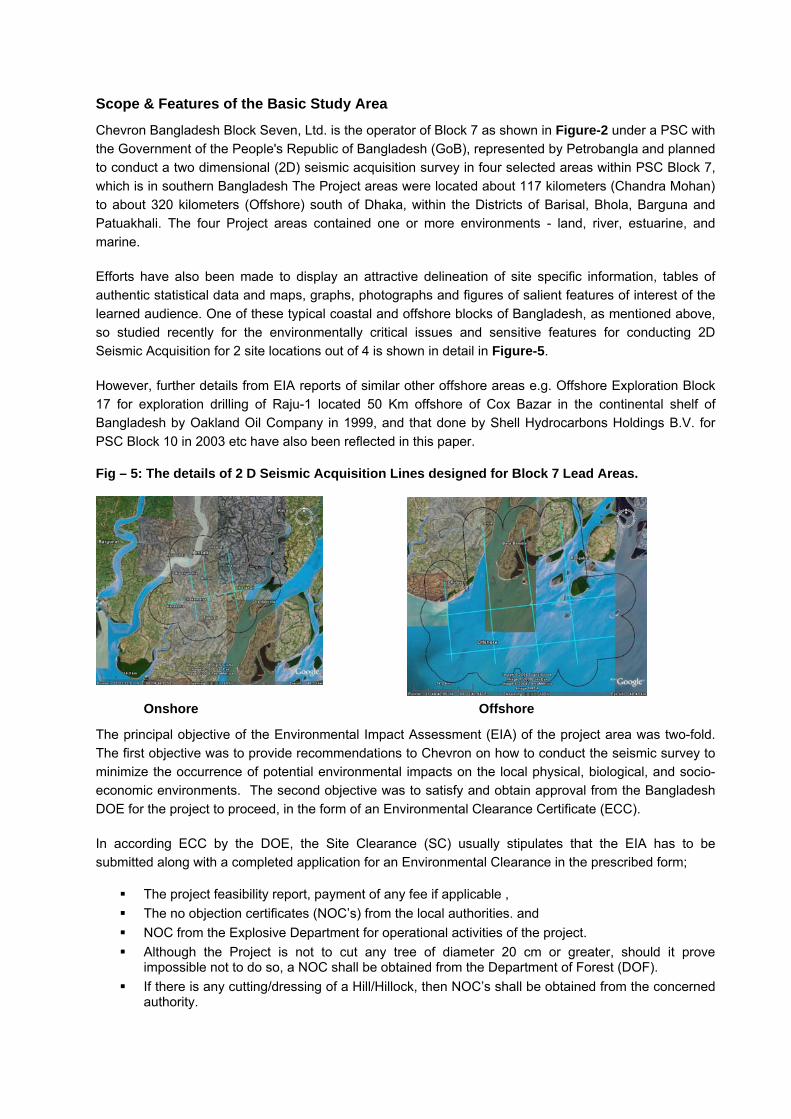
The 2D survey is undertaken over land and water areas. The land survey will require drilling holes to approximately 26 meters below the surface and an explosive charge (shot) used to generate the acoustic wave. Water areas will be surveyed using boat mounted air-guns, which will generate a similar acoustic wave.
Plate-7: Typical Cable Laying Boat
Plate-7: Typical Cable Laying Burge Plate-8: Air Gun Boat
As the Project is primarily a data acquisition exercise, the Project involves little in the way of physical infrastructure and/or physical alteration to the local area. This does not necessarily require any new permanent construction, with the Project only requiring repair and/or temporary use of some existing infrastructure in the region.
It is presumed that such Projects do not contain any provision for the installation, commissioning, repair, or upgrade of any gas extraction infrastructure as no new gas extraction drilling are initiated as part of these Projects. It is further presumed that, the project activities are fielded in dry season, between December and June of the year.

Figure-4: Project Area of Block-7 involving both onshore & offshore site locations to cover
Scope & Features of the Basic Study Area
Chevron Bangladesh Block Seven, Ltd. is the operator of Block 7 as shown in Figure-2 under a PSC with the Government of the People's Republic of Bangladesh (GoB), represented by Petrobangla and planned to conduct a two dimensional (2D) seismic acquisition survey in four selected areas within PSC Block 7, which is in southern Bangladesh The Project areas were located about 117 kilometers (Chandra Mohan) to about 320 kilometers (Offshore) south of Dhaka, within the Districts of Barisal, Bhola, Barguna and Patuakhali. The four Project areas contained one or more environments - land, river, estuarine, and marine.
Efforts have also been made to display an attractive delineation of site specific information, tables of authentic statistical data and maps, graphs, photographs and figures of salient features of interest of the learned audience. One of these typical coastal and offshore blocks of Bangladesh, as mentioned above, so studied recently for the environmentally critical issues and sensitive features for conducting 2D Seismic Acquisition for 2 site locations out of 4 is shown in detail in Figure-5.
However, further details from EIA reports of similar other offshore areas e.g. Offshore Exploration Block 17 for exploration drilling of Raju-1 located 50 Km offshore of Cox Bazar in the continental shelf of Bangladesh by Oakland Oil Company in 1999, and that done by Shell Hydrocarbons Holdings B.V. for PSC Block 10 in 2003 etc have also been reflected in this paper.
Fig – 5: The details of 2 D Seismic Acquisition Lines designed for Block 7 Lead Areas.
Onshore Offshore
The principal objective of the Environmental Impact Assessment (EIA) of the project area was two-fold. The first objective was to provide recommendations to Chevron on how to conduct the seismic survey to minimize the occurrence of potential environmental impacts on the local physical, biological, and socio-economic environments. The second objective was to satisfy and obtain approval from the Bangladesh DOE for the project to proceed, in the form of an Environmental Clearance Certificate (ECC).
In according ECC by the DOE, the Site Clearance (SC) usually stipulates that the EIA has to be submitted along with a completed application for an Environmental Clearance in the prescribed form;
The project feasibility report, payment of any fee if applicable , The no objection certificates (NOC’s) from the local authorities. and NOC from the Explosive Department for operational activities of the project. Although the Project is not to cut any tree of diameter 20 cm or greater, should it prove
impossible not to do so, a NOC shall be obtained from the Department of Forest (DOF). If there is any cutting/dressing of a Hill/Hillock, then NOC’s shall be obtained from the concerned
authority.

Key Environmental Issues Identified
The DOE, during evaluation of Site Clearances identifies the following key environmental issues
• Migratory Bird • Marine Turtle • Dolphin • Hilsha Fish • Coastal Forest & • Navigation
And as such DOE further stipulated that the EIA include:
The impact assessment of the migratory birds in the potentially impacted area and come up with site specific mitigation plan;
The measures which are required to avert disturbance to coastal and marine biota, known fishing ground and aquatic mammals; and
Disturbance in fishing and navigation in the Project area during the survey activities should be studied meticulously and an effective EMP shall be drawn on this aspect in consultation with local people.
These three items have been dealt with as indicated in Table-2
Table 2: Potential Impacts, Proposed Mitigations and Management Plans Required by the Site Clearance
Site Clearance Item
Primary Potential Impact Proposed Mitigations Management Plan
Migratory Birds Noise and disturbance caused by movement of people, vehicles, and boats
Change seismic survey line routes and modify time of survey
Biodiversity EMP
Coastal and Marine Biota
Noise and disturbance caused by movement of people and boats together with/effect of air pulses
Change seismic survey line routes and modify time of survey
Biodiversity EMP
Fishing and Navigation
Noise and disturbance caused by the movement and operation of air-gun boats
Consultations with shipping lines authorities, fishermen, boat operators, tour operators, and ferry operators
Biodiversity EMP
Bangladesh Legal Requirements
Seismic survey activities are authorized by the Ministry of Power, Energy, and Mineral Resources as part of PSC with the GoB. These survey activities falls into the "Red Category" within the Environmental Conservation Rules 1997 (ECR). Under this designation, a Site Clearance (SC) and an Environmental Clearance Certificate (ECC) must be obtained from the Department of Environment (DOE) prior to any physical survey works taking place. An SC may only be obtained after the Project’s potential physical, biological, and socio-economic impacts, project alternatives, and proposed mitigation measures are assessed with an Initial Environmental Examination (lEE). Accordingly, such Environmental Impact Assessment (EIA) resolves any issues identified in the IEE in order to obtain the subsequent ECC It also provides an Environmental Management Plan (EMP) which outlines the proposed implementation of mitigation and safety measures. The EA studies are usually done through engagement of multi-disciplinary environmental and socio-economic consultants to prepare the IEE and the subsequent EIA. The Legal requirements encompass the provisions of Territorial Waters & Maritime Zones Act, 1974 and under its section 3 Proclamation no. LT-1/3/74 in April, 1974 GOB has claimed a territorial sea 12

nautical miles in width measured from a baseline measuring 221 nautical miles in length. Continental Shelf claimed under section 7 of the Act is up to the outer limits of the continental margin bordering on the ocean or abyssal floor. Thus, the seabed and subsoil of the analogous submarine areas adjacent to the coast of any island, rock or any composite group thereof constitutes part of Bangladesh. Other pertinent legislations include but not limited to Marine Fisheries Ordinance, 1983, Protection & Conservation of Fish Act, 1950, Bangladesh Petroleum Act 1974, Bangladesh Oil, Gas, and Mineral Exploration Ordinance, 1985. The Explosives Act 1984, The Explosive Substances Act 1908, The Bangladesh Merchant Shipping Ordinance -1983, Radioactive Substances Act 1993 Bangladesh Wildlife (Preservation) Order, 1973 and the Acquisition and Requisition of Immovable Property ordinance, 1982 etc. Apart from these, International Convention and Guidelines includes those of World Bank for Environmental Assessment of Energy and Industry Projects 1991, World Bank Environment, Health and Safety Guidelines and Standards, 1995, UN Framework Convention on Climate Change, New York 1992 ratified by Bangladesh in 1994, UN Convention on the Law of the Sea 1982 ratified by Bangladesh in 1992 and such other legislation on Biological Diversity 1992, Oil Pollution Preparedness 1990, Protection of the Ozone Layer 1972, Protection of the World Cultural & Natural Heritage 1972, Wetlands of international importance 1971, Prevention of Pollution of the Sea by Oil 1954 and International Plant Protection Convention 1951 etc all of which were subsequently ratified by Bangladesh. Scope & Methodology of the EIA Reports The EIA reports are intended to provide recommendations on how to conduct the seismic survey to reduce the potential for environmental impacts on the local physical, biological, and socio-economic environments and thus to fulfill the EIA requirements under the Environmental Conservation Act 1995, Environmental Conservation Rules 1997 and the DOE’s Environmental Guidelines and Standards and in compliance to the foregoing legal requirements applicable as of date. However, these reports do not provide any assessment relating to potential impacts of future extraction or exploratory activities arising directly or indirectly as a result of this survey. If or when additional work following on from the seismic survey is deemed necessary, then a further impact assessment must be carried out specifically relating to that proposed development. The EIA reports are prepared based on information provided by the respective block operators, secondary sources and data collected from field observations, public consultations, surveys and other investigative methods. The Project team has to conduct a number of informal and formal reconnaissance and consultations on the local environmental and social conditions. Other environmental, socioeconomic and biophysical data are to be collected from Bangladesh Bureau of Statistics (BBS), the DOE, concerned authorities and other relevant environmental impact reports. Data are then analyzed by identifying both positive and negative potential impacts of the Project activity using the checklist method (DOE 1998). Salient issues of Existing Environment Terrestrial Ecosystems The countries of South and Southeast Asia are considered by IUCN as regions of high species diversity. A large number of native plants, including 3,000-4,000 species of woody flora, have been recorded from Bangladesh. The country lies at the meeting point (ecotonal region) of several floristic provinces, including the Manipur-Khasia, Bengal and North Burma provinces within the Indo-Malayan realm.The entire floodplain of Bangladesh was once well forested, but most of the native forests have disappeared in recent decades due to mounting pressure from human populations. The floodplain land has long been subject to cultivation, the most dominant land use.

Photograph – 1: Typical Paddy agriculture in Chandra Mohan of Barisal Division
As a result of past and continued land use, there are three main terrestrial biological communities within the study area. These do not include freshwater wetlands or mangroves. They are:
• Agricultural Land; • Village Forest and Homestead Plantation; • Island Flora; and • Embankment and Roadside Vegetation.
In Bangladesh almost the entire coastal region is poldered to protect this region from tidal surge, salt water intrusion and also to increase agricultural land. The principal non-rice crops within the floodplain areas include rice, jute, tobacco, sugar cane, potatoes, pulses, mangoes, coconuts, jackfruits, pineapples, bananas and guava. Given the dominance of crops in these areas, cultivated land is relatively low in species diversity. Village forests and homestead plantations are known to support some 149 tree species which consist mainly of fruit trees and multi-purpose species (IUCN, 2002). The vegetation in these areas supplies food, fodder, medicine, fuel and timber for local villagers. Island Flora Some of the larger islands contain vegetation similar to the mainland. Where intensive cultivation and plantations are not present, vegetation resembles those species found within the village and homestead areas. However other small and newly accreted islands are planted by the Department of Forestry (DOF) with mangrove species. Estuarine Flora There is characteristic estuarine flora along the river and canal banks, with many of the recorded species being typical floodplain species. The composition and abundance of the estuarine flora show strong spatial and temporal variations

Photograph -2: Typhus fruiticans in an estuarine area of PSC Block 7.
77 estuarine flora species were recorded within the Amtali Project area of Block 7 during the field investigations, while 104 and 92 plant species were recorded within the Kajal and Offshore estuarine areas respectively. Typical estuarine plants are much less abundant in Amtali than the Kajal and Offshore estuarine areas. Mangrove Forests One of the major characteristic features of the estuaries of the coastal areas is the presence of mangroves. In the past, extensive natural mangrove coverage was present within the estuarine areas of Bangladesh. Most of these areas are now lost and some have been utilized as selective mangrove plantations. A few small mangrove patches occur in the southern part of PSC Block 7. Similarly, Mangrove forests are found especially on Hatia Island, Char Kukrimukri and in the coastal belt of the main land of PSC Block 10 as well. Some of the smaller patches are natural but the majority is plantations on the newly accreted islands to assist land stabilization. The Offshore areas also have substantial mangrove forests, particularly along the coastline and the offshore islands.
Photograph-3: New plantation area in a Mangrove plantation within the Project areas
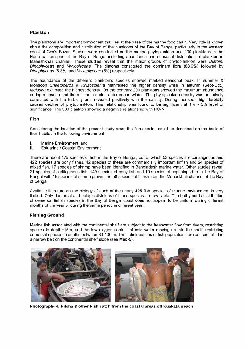
Plankton The planktons are important component that lies at the base of the marine food chain. Very little is known about the composition and distribution of the planktons of the Bay of Bengal particularly in the western coast of Cox’s Bazar. Studies were conducted on the marine phytoplankton and 200 planktons in the North eastern part of the Bay of Bengal including abundance and seasonal distribution of plankton in Maheshkhali channel. These studies reveal that the major groups of phytoplankton were Diatom, Dinophycean and Myxoplyceae. The diatoms constituted the dominant flora (88.6%) followed by Dinophycean (6.3%) and Myxoplyceae (5%) respectively. The abundance of the different plankton’s species showed marked seasonal peak. In summer & Monsoon Chaetoceros & Rhizosolenia manifested the higher density while in autumn (Sept-Oct.) Melosira exhibited the highest density. On the contrary 200 planktons showed the maximum abundance during monsoon and the minimum during autumn and winter. The phytoplankton density was negatively correlated with the turbidity and revealed positively with the salinity. During monsoon high turbidity causes decline of phytoplankton. This relationship was found to be significant at 1% - 5% level of significance. The 300 plankton showed a negative relationship with NO2N. Fish Considering the location of the present study area, the fish species could be described on the basis of their habitat in the following environment I. Marine Environment, and II. Estuarine / Coastal Environment. There are about 475 species of fish in the Bay of Bengal, out of which 53 species are cartilaginous and 422 species are bony fishes. 42 species of these are commercially important finfish and 24 species of mixed fish. 17 species of shrimp have been identified in Bangladesh marine water. Other studies reveal 21 species of cartilaginous fish, 149 species of bony fish and 10 species of cephalopod from the Bay of Bengal with 19 species of shrimp prawn and 58 species of finfish from the Moheskhali channel of the Bay of Bengal Available literature on the biology of each of the nearly 425 fish species of marine environment is very limited. Only demersal and pelagic divisions of these species are available. The bathymetric distribution of demersal finfish species in the Bay of Bengal coast does not appear to be uniform during different months of the year or during the same period in different year. Fishing Ground Marine fish associated with the continental shelf are subject to the freshwater flow from rivers, restricting species to depth>15m, and the low oxygen content of cold water moving up into the shelf, restricting demersal species to depths between 80-100 m. Thus, distributions of fish populations are concentrated in a narrow belt on the continental shelf slope (see Map-5). Photograph- 4: Hilsha & other Fish catch from the coastal areas off Kuakata Beach

Map-5: Map Showing the Fishing Ground within Exploration Blocks
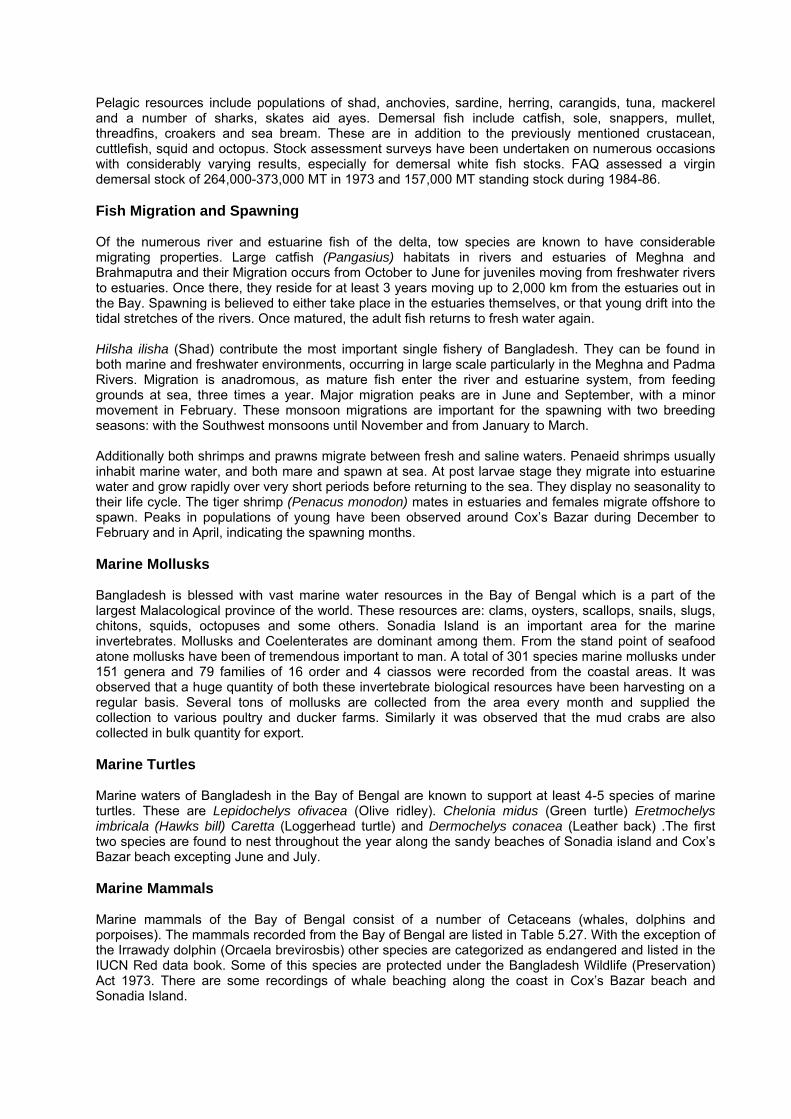
Pelagic resources include populations of shad, anchovies, sardine, herring, carangids, tuna, mackerel and a number of sharks, skates aid ayes. Demersal fish include catfish, sole, snappers, mullet, threadfins, croakers and sea bream. These are in addition to the previously mentioned crustacean, cuttlefish, squid and octopus. Stock assessment surveys have been undertaken on numerous occasions with considerably varying results, especially for demersal white fish stocks. FAQ assessed a virgin demersal stock of 264,000-373,000 MT in 1973 and 157,000 MT standing stock during 1984-86. Fish Migration and Spawning Of the numerous river and estuarine fish of the delta, tow species are known to have considerable migrating properties. Large catfish (Pangasius) habitats in rivers and estuaries of Meghna and Brahmaputra and their Migration occurs from October to June for juveniles moving from freshwater rivers to estuaries. Once there, they reside for at least 3 years moving up to 2,000 km from the estuaries out in the Bay. Spawning is believed to either take place in the estuaries themselves, or that young drift into the tidal stretches of the rivers. Once matured, the adult fish returns to fresh water again. Hilsha ilisha (Shad) contribute the most important single fishery of Bangladesh. They can be found in both marine and freshwater environments, occurring in large scale particularly in the Meghna and Padma Rivers. Migration is anadromous, as mature fish enter the river and estuarine system, from feeding grounds at sea, three times a year. Major migration peaks are in June and September, with a minor movement in February. These monsoon migrations are important for the spawning with two breeding seasons: with the Southwest monsoons until November and from January to March. Additionally both shrimps and prawns migrate between fresh and saline waters. Penaeid shrimps usually inhabit marine water, and both mare and spawn at sea. At post larvae stage they migrate into estuarine water and grow rapidly over very short periods before returning to the sea. They display no seasonality to their life cycle. The tiger shrimp (Penacus monodon) mates in estuaries and females migrate offshore to spawn. Peaks in populations of young have been observed around Cox’s Bazar during December to February and in April, indicating the spawning months. Marine Mollusks Bangladesh is blessed with vast marine water resources in the Bay of Bengal which is a part of the largest Malacological province of the world. These resources are: clams, oysters, scallops, snails, slugs, chitons, squids, octopuses and some others. Sonadia Island is an important area for the marine invertebrates. Mollusks and Coelenterates are dominant among them. From the stand point of seafood atone mollusks have been of tremendous important to man. A total of 301 species marine mollusks under 151 genera and 79 families of 16 order and 4 ciassos were recorded from the coastal areas. It was observed that a huge quantity of both these invertebrate biological resources have been harvesting on a regular basis. Several tons of mollusks are collected from the area every month and supplied the collection to various poultry and ducker farms. Similarly it was observed that the mud crabs are also collected in bulk quantity for export. Marine Turtles Marine waters of Bangladesh in the Bay of Bengal are known to support at least 4-5 species of marine turtles. These are Lepidochelys ofivacea (Olive ridley). Chelonia midus (Green turtle) Eretmochelys imbricala (Hawks bill) Caretta (Loggerhead turtle) and Dermochelys conacea (Leather back) .The first two species are found to nest throughout the year along the sandy beaches of Sonadia island and Cox’s Bazar beach excepting June and July. Marine Mammals Marine mammals of the Bay of Bengal consist of a number of Cetaceans (whales, dolphins and porpoises). The mammals recorded from the Bay of Bengal are listed in Table 5.27. With the exception of the Irrawady dolphin (Orcaela brevirosbis) other species are categorized as endangered and listed in the IUCN Red data book. Some of this species are protected under the Bangladesh Wildlife (Preservation) Act 1973. There are some recordings of whale beaching along the coast in Cox’s Bazar beach and Sonadia Island.

Photograph-5: Views of Cox’s Bazaar Sea Beach Shipping and Transport Chittagong is one of the seven major ports of Bangladesh. Anchorage areas for the port are found at the mouth of the Karnaphuli River. Cox’s Bazar is also an important port. In each coastal Thana there are smaller local ports. Similarly Mongla situated in the south west part of the country is the 2nd largest port after Chittagong. International and national vessels operating within the coastal and offshore Blocks include cargo vessels and tankers, small fishing vessels, salt transportation boats, local passenger ferries. Cargo vessels and tankers heading to and from Chittagong and Mongla via Malaysia, Singapore etc. travel up the east coast of Bangladesh. Vessels of over 10.4 m draught may be required to discharge cargo onto storage vessels anchored off Kutubdia Island. Cargo is then shipped to and from Chittagong on these smaller vessels. The anchorages are for this important shipping route lies of the North West Coast of Kutubdia Island. Vessels under 10.4 m draught may prefer to keep west of the shallow water bank of dolphin Shoal and to avoid the shallower areas around North Patches. Military Sensitive Areas Within Block 17, there are military exercise areas. The area between Kutubdia and Maheshkhali Island, Bangladesh Air Force conduct routine winter exercises. The probable location of the exercise area includes the northeast and southwest parts of the Kutubdia channel. The later near the northern tip of Maheshkhali Thana. Part of the south coast of Chakaria Thana is also used. In addition in the south west of Block 17, is an area where the Bangladesh Air force and Navy conduct routine winter exercises during the last week in February each year. Any intention to conduct similar exercises in areas touching other Blocks is circulated widely through local and national media. Extreme Events Cyclones: The region is prone to cyclones and this event is the most significant cause of deaths from all natural disasters in the coastal & offshore areas. Severe tropical cyclones generate the most extreme wind, wave, and water levels and current conditions in the region, which develop in the central Bay of Bengal and are a significant hazard to shipping. When these cyclones propagate towards the coast they become most dangerous: although winds and waves tend to decrease, water levels may rapidly increase in the form of a storm surge. If this coincides with the tidal high water, significant flooding may occur. Cyclones can occur at any time of the year but are most probable and more severe around April, May and October, November - the spring and autumn monsoon transition periods. The prevailing pattern of currents may be affected, sometimes considerably, by the passage of depressions and cyclonic storms. The currents generated by winds are dependent on the length of time over which the wind has blown over the sea, so it is the slower moving storms, which generate the strongest currents. Path of major cyclones in and around the project area is shown in Figure-6. Major cyclones that seriously hit the study area occurred in 1970, 1985, 1991.
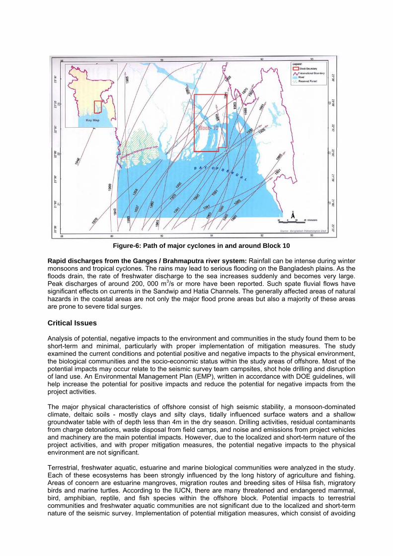
Figure-6: Path of major cyclones in and around Block 10 Rapid discharges from the Ganges / Brahmaputra river system: Rainfall can be intense during winter monsoons and tropical cyclones. The rains may lead to serious flooding on the Bangladesh plains. As the floods drain, the rate of freshwater discharge to the sea increases suddenly and becomes very large. Peak discharges of around 200, 000 m3/s or more have been reported. Such spate fluvial flows have significant effects on currents in the Sandwip and Hatia Channels. The generally affected areas of natural hazards in the coastal areas are not only the major flood prone areas but also a majority of these areas are prone to severe tidal surges. Critical Issues Analysis of potential, negative impacts to the environment and communities in the study found them to be short-term and minimal, particularly with proper implementation of mitigation measures. The study examined the current conditions and potential positive and negative impacts to the physical environment, the biological communities and the socio-economic status within the study areas of offshore. Most of the potential impacts may occur relate to the seismic survey team campsites, shot hole drilling and disruption of land use. An Environmental Management Plan (EMP), written in accordance with DOE guidelines, will help increase the potential for positive impacts and reduce the potential for negative impacts from the project activities. The major physical characteristics of offshore consist of high seismic stability, a monsoon-dominated climate, deltaic soils - mostly clays and silty clays, tidally influenced surface waters and a shallow groundwater table with of depth less than 4m in the dry season. Drilling activities, residual contaminants from charge detonations, waste disposal from field camps, and noise and emissions from project vehicles and machinery are the main potential impacts. However, due to the localized and short-term nature of the project activities, and with proper mitigation measures, the potential negative impacts to the physical environment are not significant. Terrestrial, freshwater aquatic, estuarine and marine biological communities were analyzed in the study. Each of these ecosystems has been strongly influenced by the long history of agriculture and fishing. Areas of concern are estuarine mangroves, migration routes and breeding sites of Hilsa fish, migratory birds and marine turtles. According to the IUCN, there are many threatened and endangered mammal, bird, amphibian, reptile, and fish species within the offshore block. Potential impacts to terrestrial communities and freshwater aquatic communities are not significant due to the localized and short-term nature of the seismic survey. Implementation of potential mitigation measures, which consist of avoiding

sensitive areas and migration/breeding periods, will reduce potential impacts to the areas of biological concern. The socio-economic condition of the study areas is focused around agriculture and fishing. Approximately 75% to 80% of the land use is agricultural. River travel is a dominant form of transportation. Sensitive socio-economic areas are a small group of Rakhain people, several historical and cultural sites, Kuakata Beach and other nearby tourist sites, together with limited access to health and waste disposal facilities. Potential positive impacts to the local economy are short-term employment and an increase in spending from non-local project staff. Potential negative impacts from seismic survey activities include disruption of agricultural lands, fishing and river traffic. Stakeholder consultation will determine the best way to inform the local communities and to receive feedback on compensation for inconveniences and decreases in productivity due to seismic survey activities. Two critical issues identified in the study were potential disruption of estuarine and marine species and of economic activities. The estuarine and marine environments host sensitive mangrove systems, and migration and breeding sites for migratory bird species, Hilsa fish and marine turtles, most notably the internationally protected olive ridley turtle. The economic backbone of the project areas consist of river traffic, agriculture and/or fishing. Various seismic survey activities have the potential to result in short-term increases in noise and vibration levels, light levels, and impact on wildlife and human access to terrestrial and aquatic areas. However, these are not anticipated to be significant with mitigation. As per the DOE Engagement Plan Framework Guidelines (1997) for IEEs, a rapid, informal consultation with stakeholders were organized and conducted during the study. Participants in these informal consultation meetings included elected representatives, local leaders, women’s groups, local administrations, and representatives of groups like farmers, fishermen, and others. In addition to these groups, a number of relevant officials/Key Informants were selected and consulted. During the public consultations, issues pertinent to the physical, biological, and social environments as well as cross-cutting issues were discussed with respect to the potential impacts of the seismic survey activities. The consultations also covered identification of sensitive issues, risks, potential threats, public concerns, and stakeholder expectations.
Salient Project Features
Important features of the seismic survey project are likely to be as follows:
The seismic surveys are to be undertaken over a certain distance within the respective blocks. The size of the seismic crew may be limited to 500-1000 personnel to work for duration of 5-6
months and executed at an estimate budget. Wildlife sanctuaries, breeding areas, nesting areas, and migration routes are to be avoided or the
potential impact minimized through careful application of the Environmental Management Plan; No cutting of trees greater than 20 cm girth is to be allowed during the survey. Any disturbed
vegetation is to be remediated. All equipment, unused supplies, and Project refuse have to be removed at the end of the operations, leaving the land in a state comparable to before the commencement of works;
Select chemicals should be biodegradable; The seismic sources are to be small explosive charges detonated in shot holes (2kg. charges at
the bottom of 26 meter shot holes). The shot holes are to be positioned every 50 meters along the source lines (north-south). Both source and receiver lines are to be shifted locally to take advantage of existing roads, trails, clearings, etc., and to avoid damage or disruption to local residents, agriculture or sensitive habitats;
Operations are to be allowed only during daytime (not earlier than 6:00 am and not later than half an hour prior to dusk) and camps will be set up in vacant, pre-disturbed areas;
During seismic survey operations, the number of personnel so engaged are to be carrying equipment by foot and setting up equipment in the field;
Settlements and facilities shall have to be avoided;
Local residents and government officials usually reveal an affirmative response to such Project throughout the area but the stakeholders wish to know more about the mode of execution of the Project in the field and particularly about procedure for payment of compensation for the likely damage to their crops;
Discussions and meetings with stakeholders and the general public usually generate enthusiasm about the Project. Local leaders within and around the project areas are to be appraised about the project to express their opinions, concerns. Assurances and planned remedial actions are required for their general willingness for full co-operation and support during the survey activities.
The Project should not occur on a geological formation or soil which is unstable or which would become unstable as a result of the Project and therefore, any chances of potentially resulting in a landslide, lateral spreading, subsidence, liquefaction or collapse would not be there ;
Earthquakes can occur in this part of the country but are considered unlikely. Severe weather including cyclonic storms is possible especially in the transitory monsoon season. The Project has to be scheduled to start at the commencement of the dry season and therefore, fair weather would be expected during the execution of the Project;
Standard seismic industry practice is to be adopted in order to protect the safety of the general public and Project staff when working with explosives. The explosive magazine has to be appropriately guarded 24 hours a day and will have to be located as far away from settlements as is possible;
Standard practice has to be followed to inventory and properly dispose of all crew waste; A waste management plan has to be provided to adequately deal with all waste including solid
waste likely to be produced from general operations and camp sites throughout the project implementation;
Using of air guns are to be preferred for offshore operations; Special care has to be taken to protect people including coastline and offshore biodiversity
against potential oil pollution through mitigating or eliminating grave and eminent dangers. An emergency response plan has to be provided in the environmental management plan. All
roles and responsibilities including those of external parties are to be clearly communicated.
Public Consultation Stakeholders usually considered for consultations are:
• Government Officials in different level • Chairman and Member of Union Parishad • Farmers • Fishermen • Boatmen • Local Businessmen • NGO Workers • Religious Leaders • Teachers • General People a Still Ongoing
The following major typical issues were raised during the public consultation and meetings with the key stakeholders so long as survey is conducted in terrestrial parts of any such survey operations. Workers conducting the seismic activities may damage crops and trees; Noise pollution from vehicles and equipment at the project sites may disturb residents, wildlife, aquatic, marine habitats, tourism, and other local activities; Compensation for crops as per government rate may not be fair compensation to the affected person as it is believed to be below the prevailing market rate; There may be increased soil erosion, particularly on the river banks, which should be addressed properly; Pollution of the natural water bodies should be taken care of as this water is used for domestic as well as agricultural consumption; Movement of vehicles may affect movement of people, especially women, children and disabled persons from one place to another; Dust and gaseous emission should be controlled; Environmental pollution caused by sanitary facilities and waste materials should be controlled as should any social nuisance caused by survey crews.
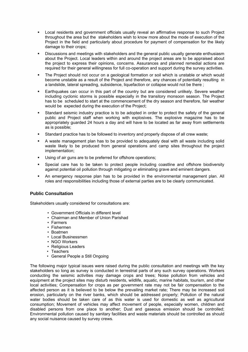
Photograph-6: Showing public consultation with local tour operators at tour Kuakata Sea Beach of Block 7 Project area
Terrestrial Ecosystems
No new roads be cut or constructed during the course of the project; Vehicles shall not be driven cross-country but shall remain on existing roads; The use of vehicle air-horns shall be limited to emergency situations; Where vegetation is not readily covering the drilling pits naturally they are to be reinstated; The level of noise made by crews working near settlement vegetation and mangrove areas will
be reduced; Mufflers will be used as appropriate on machinery; Buffers will be established around bat roosting areas and bird nesting areas; Shooting operations shall be monitored regularly by the EMR to determine whether the local
fauna/livestock are showing signs of abnormal behavior; Field camps shall only be established in previously disturbed areas, such as schools or
mosques; No vegetation shall be removed during the establishment of the campsite or thereafter during the
course of field operations; Camp sites shall be returned to its pre-existing state upon the completion of campsite
demobilization; and Wildlife or local livestock shall not be harassed, captured, hunted, fed or killed during the course
of field operations, especially in and around the field camps. Aquatic and Marine Ecosystems
Ensure that the sonar device used is of the minimum power required to get the necessary results and sonar to be switched off when not being used for bathymetric survey;
All boats to be used for cable laying activities should be moored in appropriate locations, away from any mangrove areas or areas being used by local wildlife;
All crew should disembark watercraft only in stable areas – such as wharves, jetties;
The Environmental Monitoring Representative (EMR) will be responsible for visually observing the area for significant species when boats are laying cables;
Consideration of seasonal migratory and breeding times for sensitive species;
Air gun usage will be minimized, as practicable, in areas where schooling fish have been observed when they are within the safety radius;
Use of the lowest possible power array to meet local conditions and obtain information being sought;
Trained fauna observers are to visually monitor all seismic activities;
Use ramp-up procedures prior to survey activities;
Use trained visual monitors to check for sensitive species prior to and during all survey activities;
Use appropriate exclusion zones to reduce behavioral effects on sensitive species;
Incorporate Environmental Effects Monitoring into the seismic surveys;
Incorporate appropriate equipment modifications to minimize any direct impact on fauna; and
Ensure equipment is modified, if required, to minimize any impacts of direct strikes to fauna. Environmental Management Plan The EMP is intended as an adaptive, practical guide to the routine implementation of the environmental and social mitigation measures to be described in the EIA. It sets out the finer details of what is required ‘on the ground’, and forms the primary mechanism for management, accountability and reporting on the Project’s environmental and social performance. So EMP is to be prepared in accordance with the requirements of the DOE’s EIA guidelines and international best practice, to meet the operators high standards of project implementation. The overarching principles of the EMP are to:
Integrate environmental protection and management into Project activities; and Consider and address, if appropriate, the concerns and interests of stakeholders during the
planning, operation, demobilization and rehabilitation phases of the Project. The EMP addresses management plans for the following areas:
Damage minimization Air quality Water Soil (erosion and sediment control) Noise and vibration Biodiversity Waste Hazardous materials Emergency response and disaster Socio-economic impact Shipping & Navigation Archaeological and cultural sites Site rehabilitation & Project monitoring and feedback
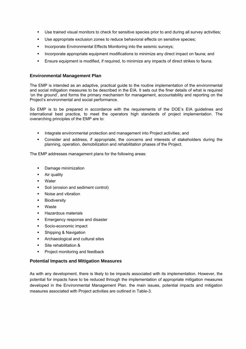
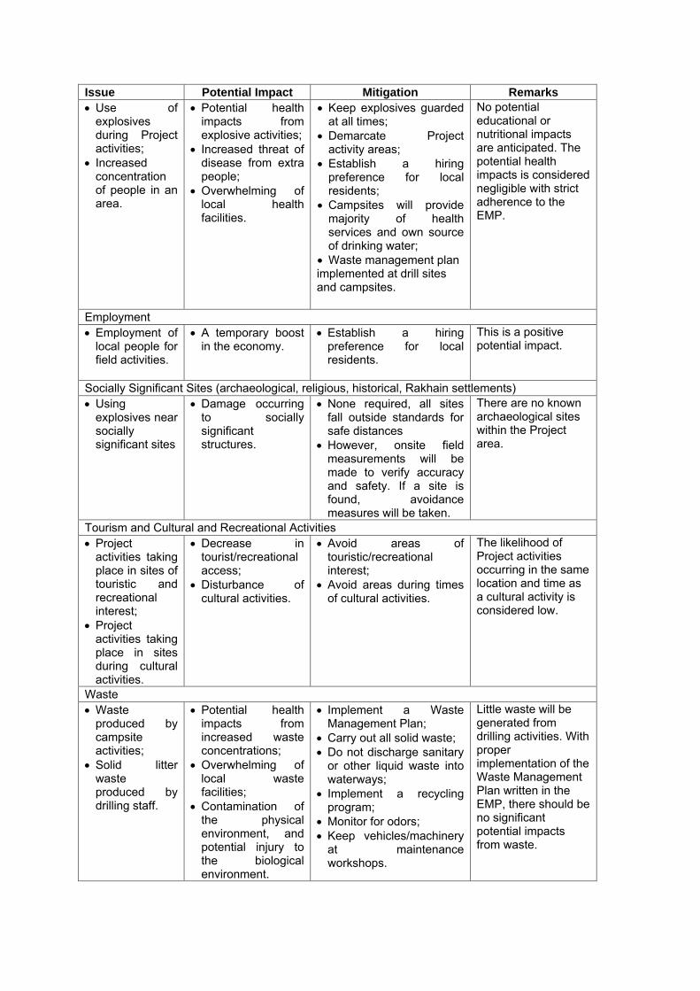
Potential Impacts and Mitigation Measures
As with any development, there is likely to be impacts associated with its implementation. However, the potential for impacts have to be reduced through the implementation of appropriate mitigation measures developed in the Environmental Management Plan. the main issues, potential impacts and mitigation measures associated with Project activities are outlined in Table-3.

Table-3: Summary of potential impacts and mitigation measures. Issue Potential Impact Mitigation Remarks Physical Environment Greenhouse Gas Emissions • Direct
emissions from vehicle and generator use;
• Indirect emissions from fossil fuel use for electricity.
• Release of atmospheric greenhouse gases;
• Reduced local/ regional air quality.
• Use most energy efficient equipment;
• Reduce vehicle and generator use, and keep usage records;
• Drive vehicles safely and at ≤ 80km/hr on highways to reduce fuel consumption and dust generation;
• Train staff in energy management conservation.
In general, climate conditions will not be affected due to the short-term nature of the Project.
Physiography, Geology and Soils • Soil erosion
and compaction from vehicle and foot traffic, campsite use and maintenance, and drilling.
• Increased sedimentation into local waterways;
• Loss of arable/useable soil.
• Conduct Project during dry season;
• Staff stays on paths/roads where available and designated areas within campsites;
• Reduce drill and stake hole sizes;
• Tamp down loose soil at drill sites and properly store excavated top soil for restoration;
• Maintain and restore native vegetation;
• Restore drill sites as soon as possible
• Reduce boat wakes to avoid splashing against river banks.
With proper mitigation, long term impacts to soil conditions are not anticipated. Potential impacts to the physiography or geology of the Project area are not anticipated.
• Soil contamination from moving and handling of potentially hazardous materials.
• Loss of arable/useable soil;
• Toxic effects to local flora and fauna.
• Properly dispose of liquid and sanitary waste;
• Do not soak stakes in hazardous chemicals.
With proper mitigation, long term impacts to soil conditions are not anticipated. Potential impacts to the physiography or geology of the Project area are not anticipated.
Surface and Groundwater • Soil erosion
impacts on surface waters;
• Use of potentially hazardous materials near surface waters and a shallow groundwater table.
• Sediment and chemical pollution into surface waters;
• Chemical pollution into a shallow groundwater table.
• Conduct Project during dry season;
• Implement soil erosion mitigation;
• Do not divert any water; • Staff will use existing
water crossing points when possible and walk in single file;
• Staff will build and dismantle water crossings per the EMP;
With proper mitigation, long term impacts to the surface and groundwater are not anticipated.
Issue Potential Impact Mitigation Remarks • Do not soak stakes in
hazardous chemicals; • Properly dispose of liquid
and sanitary waste; • Backfill wet shot holes
with bentonite above the water table;
• Plug up and do not use flowing (artesian) holes.
Noise and Vibration • Noise and
vibrations from drilling, generator use, detonation, and vehicle use;
• Noise from campsites;
• Vibrations from GI Guns
• Disturbance to local residences and/or businesses;
• Health and safety impacts on Project staff and local residences;
• Disruption of breeding and foraging of local fauna;
• Potential decrease in local species diversity.
• Use equipment that operates within GoB noise standards;
• Use mufflers on engines and set up noise buffer zones;
• Limit use of vehicle horns to emergencies;
• Restrict Project activities to daylight hours;
• Inform/consult with local communities to establish agreed upon hours of operation;
• Staff must wear protective hearing equipment;
• Reduce the number of staff in a given area;
• Field camps will be set up in areas remote from human habitation;
• GI Guns will not be fired if a sensitive animal is spotted coming within 300m of the boat.
Potential noise and vibration impacts are expected to be short term. With diligent mitigation, residual impacts to flora and fauna should be negligible.
Biological Environment Terrestrial Ecosystems • Vegetation
displacement from Project activities such as cable layout and drilling;
• Soil contamination from Project activities;
• Noise and vibrations from Project activities.
• Disruption of breeding and foraging of local fauna;
• Damage to local flora;
• Toxic effects to local flora and fauna.
• Implement above soil, and noise and vibration mitigations;
• Important to restore drilling sites and campsites to pre-project state;
• Establish campsites in previously disturbed areas, and avoid vegetation removal;
• Keep vehicles on already established roads and avoid creating new roads;
• Avoid breeding and migrating seasons and locations of key species when possible;
• Staff will not harass, capture, hunt, feed or kill wildlife or local livestock during field operations.
Project activities are expected to have only short term and minimal impacts on the terrestrial ecosystems. The Project area already has a high level of historic, human disturbance. Key species are migratory bird species in mangrove and estuarine areas.
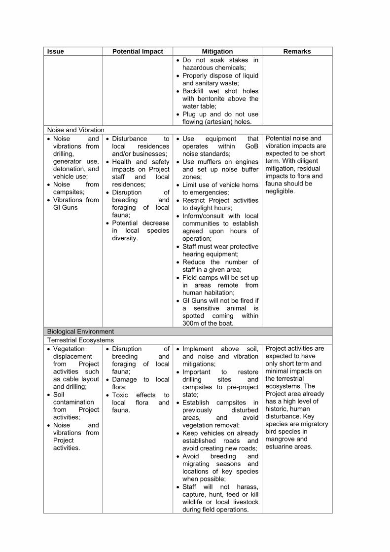
Issue Potential Impact Mitigation Remarks Aquatic Ecosystems • Cable laying
use of bathymetric sonar disturbing the pelagic and benthic zones;
• Boat traffic; • GI Gun
vibrations.
• Disruption of breeding and foraging, or injury and behavioral changes of local flora and fauna;
• Use trained visual monitors to check for sensitive species prior to and during all survey activities;
• Moor boats at proper docking areas, and staff disembark at proper locations;
• Avoid breeding and migrating seasons and locations of key species when possible;
• Maintain a safety radius of 500m around gunboats, and suspend firing GI Guns if a sensitive animal enters within 300m of gunboats.
• Incorporate Environmental Effects Monitoring into seismic surveys;
• Incorporate appropriate equipment modification to minimize any direct impact on fauna.
Cable laying and boat traffic have potentially minute and short term impacts. The main potential impacts come from the GI Guns’ underwater vibrations, especially to key species such as Hilsa fish, marine turtles and dolphins.
Socio-economic Environment Land Use and Transport • Project
activities taking place within Aus planted fields, fisheries, roads and ferry crossings;
• Project activities taking place on or near structures.
• Loss of economic productivity;
• Potential damage to structures;
• Inconvenience to local residences and businesses.
• Avoid where possible important land uses;
• Coordinate with local officials;
• Notify affected groups of Project activities at least 15 days prior to commencement;
• Provide appropriate compensation and prompt payment for damage to crops, fishing and structures, if any;
• Arrange for roads to be restored to pre-project condition, if needed.
Residual impacts are not expected. Any vegetation/damage is expected to regrow quickly.
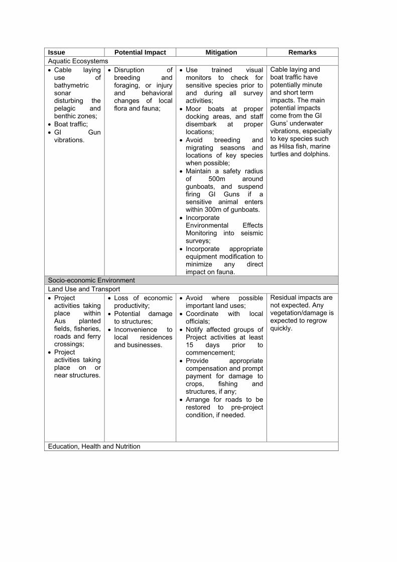
Education, Health and Nutrition
Issue Potential Impact Mitigation Remarks • Use of
explosives during Project activities;
• Increased concentration of people in an area.
• Potential health impacts from explosive activities;
• Increased threat of disease from extra people;
• Overwhelming of local health facilities.
• Keep explosives guarded at all times;
• Demarcate Project activity areas;
• Establish a hiring preference for local residents;
• Campsites will provide majority of health services and own source of drinking water;
• Waste management plan implemented at drill sites and campsites.
No potential educational or nutritional impacts are anticipated. The potential health impacts is considered negligible with strict adherence to the EMP.
Employment • Employment of
local people for field activities.
• A temporary boost in the economy.
• Establish a hiring preference for local residents.
This is a positive potential impact.
Socially Significant Sites (archaeological, religious, historical, Rakhain settlements) • Using
explosives near socially significant sites
• Damage occurring to socially significant structures.
• None required, all sites fall outside standards for safe distances
• However, onsite field measurements will be made to verify accuracy and safety. If a site is found, avoidance measures will be taken.
There are no known archaeological sites within the Project area.
Tourism and Cultural and Recreational Activities • Project
activities taking place in sites of touristic and recreational interest;
• Project activities taking place in sites during cultural activities.
• Decrease in tourist/recreational access;
• Disturbance of cultural activities.
• Avoid areas of touristic/recreational interest;
• Avoid areas during times of cultural activities.
The likelihood of Project activities occurring in the same location and time as a cultural activity is considered low.
Waste • Waste
produced by campsite activities;
• Solid litter waste produced by drilling staff.
• Potential health impacts from increased waste concentrations;
• Overwhelming of local waste facilities;
• Contamination of the physical environment, and potential injury to the biological environment.
• Implement a Waste Management Plan;
• Carry out all solid waste; • Do not discharge sanitary
or other liquid waste into waterways;
• Implement a recycling program;
• Monitor for odors; • Keep vehicles/machinery
at maintenance workshops.
Little waste will be generated from drilling activities. With proper implementation of the Waste Management Plan written in the EMP, there should be no significant potential impacts from waste.

Key assessment findings and Environmental Management Plan (EMP) Physical Environment: There are potential minor impacts related to soils, air emissions, water quality, and noise and vibration. These potential impacts can be appropriately managed and mitigated to acceptable levels. Biological Environment: There are some receptors that may be adversely affected by the seismic survey, namely: turtles; migrating birds; spawning fish (particularly the Hilsha); and dolphins. These receptors have to be extensively examined and appropriate mitigation measures designed and presented. It is not expected that these resources will be significantly impacted by the proposal. Socio-economic Environment: The proposed seismic survey is likely to have a positive impact on local employment generation and business opportunities. The Project will not contribute to the displacement of any existing housing or people, and communities will not be significantly affected. Appropriate compensation will be fairly and expeditiously paid to affected persons. Environmental Management Plans: Environmental protection measures will have to be implemented throughout the seismic survey and in this regard environmental management plans have to be prepared to ensure that any potential negative impacts are eliminated or minimized. These plans would identify potential impacts and present a range of measures designed to avoid, minimize or manage potential impacts. The plans would also document responsibilities, monitoring and reporting requirements. All activities will have to comply with Bangladesh regulatory requirements and International Best Management Practices. Application of Management Plans: Effective and diligent application of management plans will have to be ensure that any seismic surveys will have minimal long term negative impacts on the physical, biological or socio economic environments. There should be commitment to taking all appropriate monitoring and mitigation measures as would be outlined in the EIA report. There should also be commitment to maintaining a positive approach towards environmental management and positive growth within the communities in which the survey operation will be conducted. Conclusions Natural Gas is a significant source of energy for Bangladesh. The contribution of gas generated energy to the power and industrial development sectors, as said earlier, is sighting gradual increase. And hence, Bangladesh is now in a critical state of affaires so far as providing adequate supply of such commercial energy. So, it is now it’s first and foremost task to explore and extract gas and coal resources for sustainable energy security in future. Since extraction of coal resources is yet to be up to the mark, finding of new gas fields both in on-shore and off-shore blocks is standing highly imperative for its commercial energy market. The result of the foregoing studies has provided substantial materials for the paper to meet a good standing in WGC 2009, the celebrity international conference event of the energy industry. All efforts have been maintained to chronologically reveal that key potential impacts were due to seismic activity and noise and vibration during operation of vehicle, shot hole drilling and movement of air gun boats etc. primarily causing physiological and behavioral changes on fauna and flora, migratory birds, coastal and marine biota, fishing and navigation including likely damage of properties, fishing nets, loss of income of fisher men, boat-men, tour operators and indigenous communities. Key mitigation measures would require avoidance of breeding and migratory times for crabs, marine turtles, dolphins, Hilsha fish and migratory birds, restricting operations to daylight hours and ramping-up & soft start procedures including visual surveillance during the aquatic surveys; re-routing seismic survey lines for avoiding all coastline fish business, habitats, culturally significant sites, commercial and recreational areas and river and sea traffic routes. Terms and conditions of DOE primarily focus on management of air, water and soil quality and noise and vibration, biodiversity and waste, socio-economic impacts concerning interests of the community potentially affected by the survey, compensation and rehabilitation, archaeological and cultural sites, emergency response and disaster management under due project monitoring and feedback throughout the life of the project.
In fine, in order to provide images of the subsurface geological features in time/depth terms and below the high pressure zone and to identify any possible new drilling locations by delineating the structural, stratigraphic and combination leads to potentially reduce and more efficiently manage any potential new drilling operations, seismic acquisition is a very crucial stage of any exploration and production program. Thus, in identifying the lead areas and pin pointing exploratory / development drilling locations and management of any existing offshore producing fields, it is expected that the classical content of the foregoing presentation would tremendously benefit the environmental concerns relating to the gas industry of Bangladesh and also attract attention of the conference participants including those who are interested to invest in Exploration & Production of natural gas in coastal and offshore blocks of Bangladesh and the adjoining neighborhood region in the Bay of Bengal. Acknowledgements Authors acknowledges with thanks that they have freely consulted the concerned EIA documents prepared by the International Oil Companies viz Chevron, Oakland & Shell B.V now or previously have been operating in Bangladesh including the references cited therein for Blocks 7 and 17 & 10 and the consulting entities SMEC and BETS respectively who worked for preparing these documents to obtain DOE clearances. They are also particularly grateful to BETS, SMEC and all those who have provided intellectual and logistic supports during conducting the studies and preparing this paper. Finally, the authors also wish to express their sincere thanks to the WGC 2009 authorities and the WOC 1 Team for everything they are doing right from selecting the paper down to its presentation at the esteem conference.