Embed Size (px)
Citation preview

Environmental Technical Assistance and Information Exchange Facility (ENV-TAIEF) This project is financed by the European Union

Overview
• Context • Planning in the Netherlands • SEVESO Directive and UK experience
VIETNAM CASE
• What is the vision for Vietnam? • Environmental zoning • Possible method to come to zoning • Examples on Habitats and Water • Recommendations/suggestions

Environmental Technical Assistance and Information Exchange Facility (TAIEF)
Jan 2014 – Dec 2016
Contact: Technical Assistance and Information Exchange Facility (TAIEF)
NIRAS IC Sp. z o.o., Warsaw, Poland
Phone: +48 22 3957110, fax: +48 22 3957101
http://ec.europa.eu/environment/international_issues/taief/
Email: [email protected]
Implemented by IC Sp. z o.o.
Environmental Technical Assistance and Information Exchange Facility (ENV-TAIEF) This project is financed by the European Union

The purpose of TAIEF:
“To allow the efficient delivery of expertise on EU environment policies and instruments at
short notice in response to demand from stakeholders in emerging and middle-income countries in Asia, Latin America and Africa”
Environmental Technical Assistance and Information Exchange Facility (ENV-TAIEF) This project is financed by the European Union

Target groups
• National, sub-national public authorities
• Non-governmental and private organisations concerned with environmental policy and instruments, and their implementation.
What is offered?
Peer-to-peer exchanges with experts from EU Member State government institutions
• Expert missions
• Training seminars or workshops
• Study visits
Days, not weeks; series of missions possible
Environmental Technical Assistance and Information Exchange Facility (ENV-TAIEF) This project is financed by the European Union

CONTEXT
Environmental Technical Assistance and Information Exchange Facility (ENV-TAIEF) This project is financed by the European Union
• Mission supported by EC programme TAIEF
• Peer-to peer exchange by national experts
• Experts don’t represent EC or national governments but share ideas and thoughts based on their international and national experiences
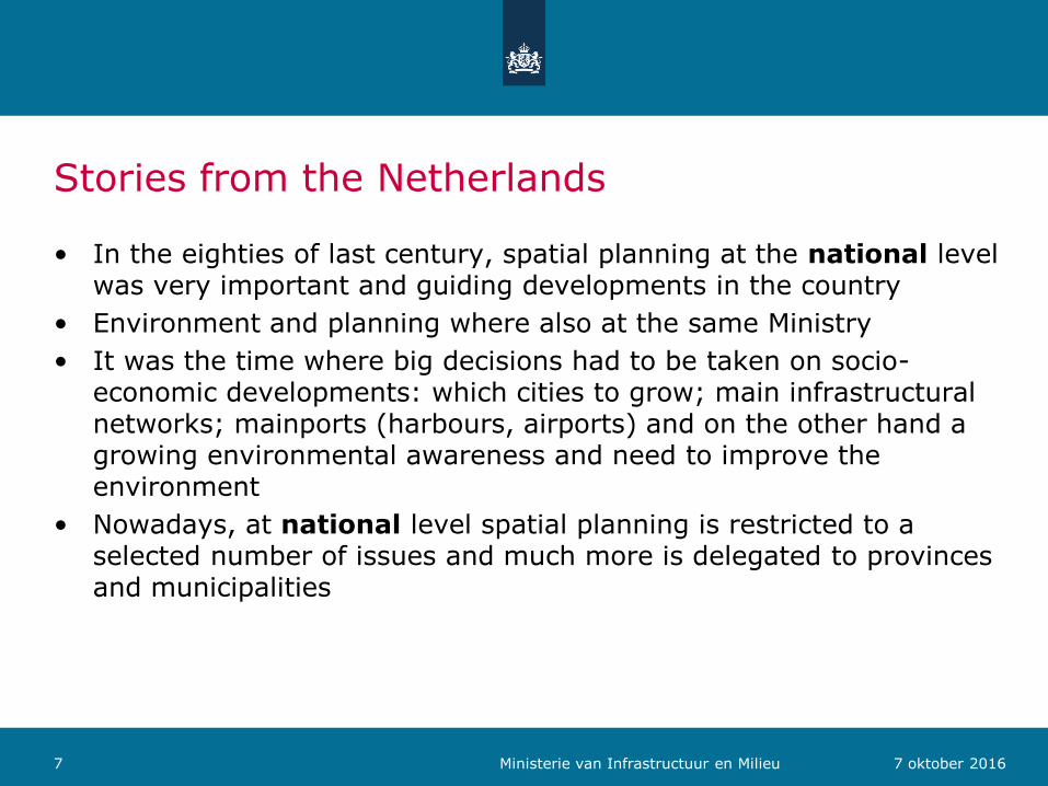
Stories from the Netherlands
• In the eighties of last century, spatial planning at the national level was very important and guiding developments in the country
• Environment and planning where also at the same Ministry
• It was the time where big decisions had to be taken on socio-economic developments: which cities to grow; main infrastructural networks; mainports (harbours, airports) and on the other hand a growing environmental awareness and need to improve the environment
• Nowadays, at national level spatial planning is restricted to a selected number of issues and much more is delegated to provinces and municipalities
7 7 oktober 2016 Ministerie van Infrastructuur en Milieu
8 7 oktober 2016 Ministerie van Infrastructuur en Milieu

Netherlands national spatial planning 2016
• Criteria for national spatial planning are:
– Benefits or drawbacks for the country as a whole and beyond powers of local authorities (military areas, mainports)
– International obligations (biodiversity, sustainable energy, water system, world heritage)
– Transcend provincial or national borders (main roads, railways, water network)
• On environment it means it is national responsibility to:
– Improve environmental quality (water, air, soil) and protection against noise and external safety risks
– Reserve space for water safety and sustainable fresh water supply and to develop frameworks for climate resistant city development
– Reserve space for a network of nature areas to protect species
9 7 oktober 2016 Ministerie van Infrastructuur en Milieu

Water Framework Directive (2000/60/EC) • River basin approach
• Ecological protection: general requirement with minimum requirements for the quality of biological community, hydrological characteristics and chemical characteristics
• Chemical protection: compliance with quality standards established for chemical substances
• Other uses or objectives for which water is protected in specific areas within river basins with higher standards than the general requirements:
– Essential drinking water supply zones
– Areas designated for the protection of economically significant aquatic species
– Specific protection of unique and valuable habitats (wetlands)
– Protection of bathing water quality in recreation areas
– Nutrient-sensitive areas
10 7 oktober 2016 Ministerie van Infrastructuur en Milieu

Natura 2000/Bird and Habitat Directive
• Annex 1: natural habitat types of Community interest who’s conservation requires the designation of special areas of conservation
– Tidal waters, estuaries, reefs, dunes, lakes,
– Scrubs, grasslands, forest
• Annex 2 Animal and plants species of Community interest whose conservation requires the designation of special areas of conservation
– Vertebrates: mammals, reptiles, fish, (separate list: birds)
– Invertebrates: insects, mollucs
– Plants, trees
• Annex 4: Species of Community interests in the whole country
11 7 oktober 2016 Ministerie van Infrastructuur en Milieu

Annex 3 Habitat Directive on criteria for zones Related to Annex 1 habitats:
• Degree of representation of the natural habitat type on the site
• Area of the site covered in relation to the total area covered by that habitat in the whole country
• Degree of conservation of the structure and function and restoration possibility
• Global assessment of the value of the site
Related to Annex 2 species:
• Size and density of the population of the species present related to the whole country
• Degree of conservation of the features of the habitat which are important to the species
• Degree of isolation of the population present on the site in relation to the natural range of the species
• Global assessment of the value of the site
12 7 oktober 2016 Ministerie van Infrastructuur en Milieu
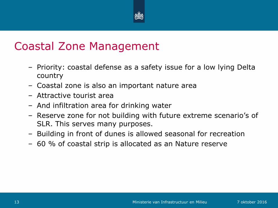
Coastal Zone Management
– Priority: coastal defense as a safety issue for a low lying Delta country
– Coastal zone is also an important nature area
– Attractive tourist area
– And infiltration area for drinking water
– Reserve zone for not building with future extreme scenario’s of SLR. This serves many purposes.
– Building in front of dunes is allowed seasonal for recreation
– 60 % of coastal strip is allocated as an Nature reserve
13 7 oktober 2016 Ministerie van Infrastructuur en Milieu

Delta programme for climate change adaptation
• Main issues are:
– Fresh water availability because of draughts (summer)
– Salt intrusion
– Higher rainfall peaks/wet periods/higher discharges
– Sea level rise (SLR)
– Combination in transitional waters of SLR and high river flows
• Programme for next 20 years with funds to:
– increase storage of fresh water
– Which can also be used to reduce salt intrusion
– Widen the rivers if possible and combine with nature protection
– This will also reduce the water levels down stream
– Strengthen the coast with sand nourishment (sand from the sea)
14 7 oktober 2016 Ministerie van Infrastructuur en Milieu

Marine Strategy Framework (2008/56/EC)
• EU legislation on Marine environmental policy
• Ecosystem based approach
• 11 descriptors and 26 criteria describe ‘Good Environmental Status’ (see decision 2010/477/EC)
1. Biological diversity is maintained, the quality and occurrence of habitats and the distribution of species are in line with prevailing physiographic, geographic and climate conditions. CRITERIA:
– Species level: distribution; population size; population condition
– Habitat level: distribution; extent; condition;
– Ecosystem level: interaction between components of the ecosystem
2. Human induced eutrophication is minimized (no loss of biodiversity, algae blooms, oxygen depletion). CRITERIA
– Nutrient levels in water column
– Chlorophyl concentration
15 7 oktober 2016 Ministerie van Infrastructuur en Milieu

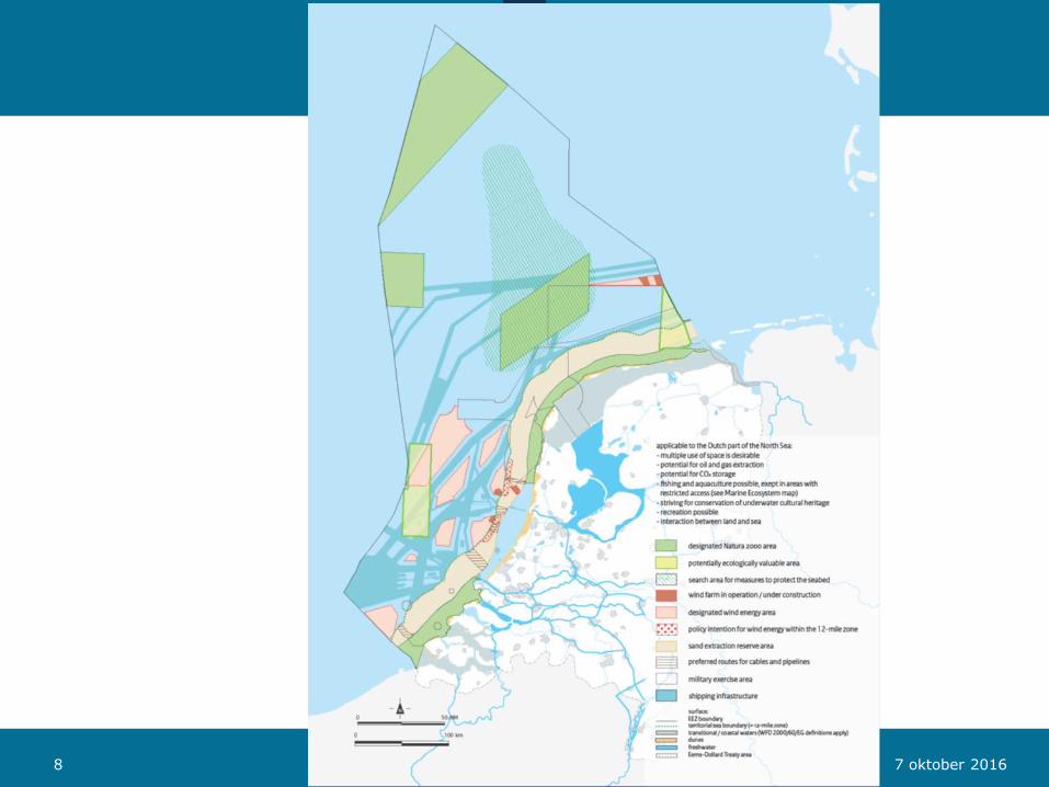
Maritime spatial planning in the Netherlands
• Marine or Maritime Spatial planning is a political decision making process designed to address issues concerning the use of maritime space and establish policy for it
• Policy decisions concerning use of maritime space lead to a policy statement or –document which gives clarity of the foreseen use of certain areas at sea
• Since it concerns space a visualisation on a map is helpful
• The legal status of the Dutch Maritime Spatial Policy Plan:
– Status is a framework vision as defined by the Spatial Planning Act
– The Dutch central government is the only competent authority as from 1 km off shore.
– The Dutch MSP is self binding for the Government
– It gives clarity for private industry and seafarers where certain activities are taking place and new ones are foreseen
16 Ministry of Infrastructure and the Environment

Governance structure for Integrated Maritime Policy in Netherlands
17 Ministry of Infrastructure and the Environment
Cabinet House of representatives
Min Economic Affairs (energy, nature & fisheries)
Ministry Infrastructure & Environment
Incl shipping, spatial development
and water affairs Lead on MSP/ICZM
Management organisation Rijkswaterstaat
(licenses other then oil/gas)
Min Defence (incl coast guard)
Min Cultural Afairs
Min Finance
Intra-governmental board of Directors on North Sea Affairs

Long Term Vision for Spatial Agenda 2050
Five themes identified:
1) Building with nature
2) Energy transition at sea
3) Multiple use of space
4) Connection between land and sea
5) Accessibility and shipping
Short term policy and decisions have to keep in mind this long term vision. For instance: also other forms of sustainable energy production next to wind energy will possibly need to be developed at sea.
18 Ministry of Infrastructure and the Environment
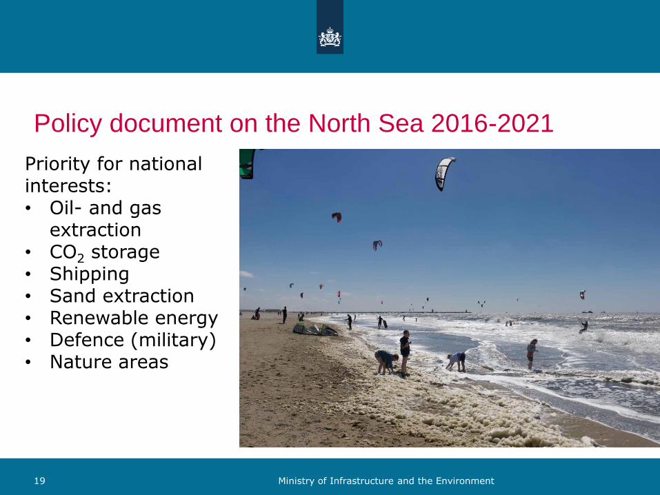
Policy document on the North Sea 2016-2021
19 Ministry of Infrastructure and the Environment
Priority for national interests: • Oil- and gas
extraction • CO2 storage • Shipping • Sand extraction • Renewable energy • Defence (military) • Nature areas

Marine ecosystem and the user functions
• Marine ecosystem
• Sustainable energy
• Extraction of surface minerals
• Oil and gas extraction
• CO2 storage
• Cables and pipelines
• Shipping
• Defence
• Fishing, aquaculture and mariculture
• Underwater Cultural Heritage
• Tourism and recreation
• Interaction between land and sea .
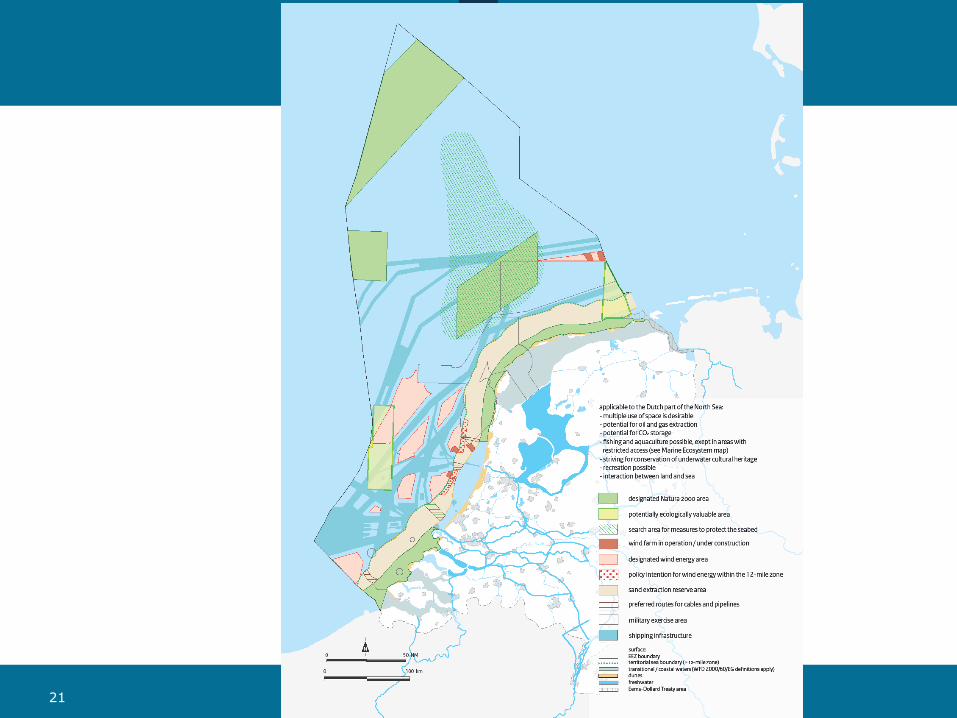
21 Ministerie van Infrastructuur en Milieu

SEVESO Directive and UK experience
22 7 oktober 2016

Vietnam case
23 7 oktober 2016

What is the vision for Vietnam? • Vietnam 2035 (WB report) states as one of the objectives: sustain the
environment:
– Protect the quality of natural resources (air, land, water)
– Build climate resilience into economic planning, sectoral policies and infrastructure investments
– Find ways to tap more clean energy sources
• 2012 National Environmental Protection Strategy 2020 with a vision to 2030:
– ..; research and experiments on eco-system based functional zoning should be carried out to support regional development planning with a view to clarify which regions should be given priority in or restricted from undertaking industrial development and/or mineral mining activities to reduce unexpected conflicts between socio-economic development and environmental protection.
• “Vietnam no longer exchanges environment for economic interests” (statement Deputy PM Dung on 18th July 2016)
24 7 oktober 2016

Environmental zoning • Planning is more than zoning. It is a cyclic process
• The purpose of a zone is to pay attention to specific features
• Coastal zone for instance, is the zone which influences the sea and where the sea influences the activities in the coast
• Environmental zoning is paying attention to environmental aspects. It does not mean other aspects or functions are not in that zone
• The purpose for environmental zoning is to give focus to an area because there is an environmental problem or because you want to achieve something (a certain quality)
• It gives a strong visual message to a wider audience on what is at stake
• Zoning comes with rules and arrangements how to address the issues. This may mean that the exact area is to be defined in coordinates
• Some of these issues may need to be addressed outside the zone itself (polluted air or water can come from outside the zone)
25 7 oktober 2016
Possible method to come to zoning
A list of questions may lead to the allocation of zones:
1. What is it what you want to protect, conserve, achieve? OBJECTIVES (try to be selective and look for representative species or habitats)
2. Where is this ‘to be protected’ allocated? LOCATION
3. What is the present situation and how bad is it? STATE/URGENCY
4. What are the causes if not in good state? PRESSURE
5. What is the consequence, also for society? IMPACT
6. Where is the (cause of the) problem? LOCATION
1. In the specific areas: rules to be set
2. Outside the specific areas: general standards should apply
7. How to address the pressure and who is needed for this? RESPONSE
26 7 oktober 2016
Example on Element Habitats (1)
Q1: WHAT to protect
• Habitats/living areas for plants, trees, birds, mammals, fish, reptiles, etc. Take representative species
• Certain species (i.e red list)
• Fragile/sensitive or unique species or ecosystems
• Example: habitat (forest) for kouprey (buffalo) or tiger
Q2: WHERE are they
• Map the habitats
• Is there a relationship between these areas because of migration/ life cycle steps (breeding, feeding, nursing areas) of certain species. If so and physical: map network/connections
27 7 oktober 2016

Example on Element Habitats (2)
Q3: Indicate STATE
In the description of the zone, describe the present state and how it deviates from the objective: to preserve or to restore
i.e. State of habitat of tiger is not good (too small)
Q4: CAUSE/identification of pressure
i.e. Cutting forest, hunting in the area
Q5: Consequence/IMPACT
i.e. Distinction of species, loss of biodiversity, less tourism
Q6: Location of cause
i.e. Within or directly near the habitat area
Q7: How to address and with whom?
i.e. Ministry for Forestry/Rural development, inspection/enforcement
28 7 oktober 2016

EXAMPLE on Element WATER (1)
Q1: WHAT to protect
a) Water quality for drinking water
b) Fresh water quantity in wetlands
c) Fresh water quality for biodiversity
Q2: WHERE
a) Drinking water catchment area
b) At wetlands
c) Whole river stretch downstream development areas
Q3: STATE
a) Poor water quality in catchment area of drinking water supply
b) Wetlands dry up more frequently
c) Polluted waters
29 7 oktober 2016

EXAMPLE on Element WATER (2)
Q4: CAUSE
a) Polluted discharges in catchment area of drinking water supply
b) Too much use of fresh water upstream or droughts due to climate change
c) Polluted discharges from industries, towns, agriculture (diffuse sources) upstream
Q5: WHAT IMPACT?
a) Human health risk
b) Salt intrusion
c) Biodiversity degrades
30 7 oktober 2016

EXAMPLE on Element WATER (3)
Q6: WHERE CAUSE?
a) Within drinking water catchment area
b) Delta main rivers
c) Along the whole river
Q7: RESPONSE
a) Drinking water catchment zoning with strict rules (and enforcement) on non-allowed discharges
b) Setting priorities on water use (quantities) within the whole river catchment area
c) Environmental quality standards on allowed discharges
31 7 oktober 2016

Recommendations/suggestions
GENERAL
• Zoning is a strong visual tool and a good first step to come to EPP
• To make zoning effective, rules need to be applied how to manage the activities in the zones or which could effect that zone
• It should be clear what needs to be achieved
• Zoning is only a first step. It needs to be linked to the rest of the policy cycle including addressing the pressures
• But not all aspects are addressed by zoning: there are generic minimum requirements which apply everywhere (air quality, water quality)
• SEA (and EIA) is the link between socio-economic development plans and EPP to assess that the values which need to be achieved are not in danger
32 7 oktober 2016
Institutional suggestions
• To develop EPP, other departments/sectors need to be involved:
– It may overlap with their responsibilities
– It needs their competence and knowledge and /or building relationships with academia to provide technical knowledge
– It may require the combination of the use of sectors legal framework
– Good cooperation and working relationships need to be established and maintained
– For developing EPP competent staff is required, also to assist province level
33 7 oktober 2016

Process
• Focus on priority issues which need to be addressed: water quality for drinking water or sensitive habitats, protected nature areas/habitats
• It is an evolving process which will expand in time, involving more sectors and stakeholders and levels of government
• Start with keeping it simple: start with a limited number of criteria per element (water, air, soil, nature) (i.e. see Rapid Assessment IUCN)
• ‘Learning by doing’ as competence grows and with increasing complexity
• Position paper on EPP by David Annandale gives a good analysis of the situation
• We agree zoning should now focus on Environmentally sensitivity area approach
34 7 oktober 2016

Concluding
• We gave some criteria examples used in Europe which could be considered to be applied in the Vietnamese context (Water, Nature, Chemical risks)
• After establishing the (limited) list of criteria, this list can guide the collection of data which is required as a priority to start the EPP
• Data and knowledge may come from different sources: from departments, stakeholders, academia/researchers
• It would be wise to involve those representatives and invite them to workshops and meetings
• Given the increased attention to the environment at political and strategic level, this momentum should be captured to the advantage of the EPP
35 7 oktober 2016

Just because you don’t see it, doesn’t mean it isn’t there

References
• http://ec.europa.eu/environment/marine/eu-coast-and-marine-policy/marine-strategy-framework-directive/index_en.htm – MSFD criteria: http://eur-lex.europa.eu/legal-
content/EN/TXT/?uri=CELEX:32010D0477(01)
• http://ec.europa.eu/environment/water/index_en.htm
• http://ec.europa.eu/environment/nature/index_en.htm
• http://ec.europa.eu/environment/air/index_en.htm


![Welcome to the Online Environmental Procedures … Environmental Procedures Manual [3] 2/13/12 requirements including agency coordination, situational solutions, technical assistance](https://img.pdfslide.us/doc/110x75/5ac9b2b97f8b9acb688d9c00/welcome-to-the-online-environmental-procedures-environmental-procedures-manual.jpg)