Embed Size (px)
Citation preview
15. Water environment
South London ERF Viridor Chapter 15: Water environment
Terence O'Rourke Ltd 227701 July 2012
15 Water environment
Introduction 15.1 This chapter discusses the water environment impacts due to construction and
operation of the proposed ERF, the associated CHP pipelines and the small changes to the existing restoration scheme for the application site.
15.2 The assessments have been focused on the hydrology, flood risk, water quality, fluvial channel geomorphology and water resources of surface waters; and the flow, volume, and water resources of groundwaters.
Surface water hydrology, flood risk & surface water drainage 15.3 In relation to surface water hydrology, flood risk and surface water drainage,
the assessment has considered potential increases in flood risk within the application site and the surrounding area, as a result of works within the floodplain area of the application site and increases in surface runoff rates and volumes due to increased impermeable areas within the ERF development area.
Surface water quality & biodiversity 15.4 In relation to surface water quality and biodiversity, the assessment
specifically considers: • Potential pollution of surface waters as a result of construction activities
such as earthworks or spillage and leakage associated with construction plant and on-site storage areas
• Potential pollution of surface waters as a result of operational routine runoff discharges and accidental spillage
Fluvial channel geomorphology 15.5 In relation to fluvial channel geomorphology, the assessment has considered
disruption to the geomorphology of the watercourses within the application site and surrounding area as a result construction sedimentation, channel diversions and modifications, and operational discharges.
Surface water resources 15.6 In relation to surface water resources, the assessment has considered
disruption to existing nearby abstractions and discharges as a consequence of potential pollution impacts and proposed channel modifications. Hydrogeology
15.7 In relation to hydrogeology, the assessment specifically considers: • Disruption to groundwater flows, volumes and water resources as a result
of construction excavation and dewatering activities • Disruption to groundwater flows, volumes and water resources as a result
of deep foundations and operational discharges
15.8 The assessment of potential impacts on groundwater quality is addressed in chapter 8: ground conditions.
South London ERF Viridor Chapter 15: Water environment
Terence O'Rourke Ltd 227701 July 2012
Legislation and policy
Legislation 15.9 The following legislation has been taken into account during the assessments:
The Water Framework Directive (WFD) (2000/60/EC) 15.10 The Water Framework Directive (WFD) seeks to enhance the status of aquatic
ecosystems, promote sustainable water use and contributes to mitigate the effects of flood and drought. The directive requires the member states to assess and classify the status of rivers, lakes, wetlands, groundwater, estuaries and coastal waters. The aim is for designated waterbodies to achieve ‘good overall status’ by 2015. Certain surface waterbodies may be designated as artificial/heavily modified and will have less stringent targets to meet, these will still need to demonstrate ‘good overall potential’ by 2015.
15.11 For surface waters the overall status is determined from assessment of both the chemical and ecological status of the waterbodies. Chemical status is determined by compliance with environmental standards for chemicals that are classed as ‘priority hazardous substances’. The ecological status of a surface waterbody is measured through a range of biological quality elements, supported by measurements of physico-chemistry, hydromorphology and compliance with environmental standards for chemicals that are classed as ‘specific pollutants’.
15.12 For groundwater, the overall status has both a quantitative and a chemical component.
15.13 The WFD is implemented in England through River Basin Management Plans (RBMP), one for each of the 11 river basin districts, which are reviewed and revised every six years. The RBMPs detail the current status of the waterbodies, set status targets for the current planning cycle, identify mitigation measures to be implemented to reach those targets and provide justification for targets other than the WFD objective of ‘good’ status by 2015.
The Groundwater Directive (80/68/EEC as amended by 91/692/EEC) 15.14 This directive relates to the protection of groundwater against pollution caused
by certain dangerous substances and places an obligation on member states to prevent pollution of groundwater by substances including hydrocarbons and control the introduction of named metals, including copper. The Groundwater Daughter Directive (2006/118/EC)
15.15 This directive sets out the general requirements to protect, enhance and restore all bodies of groundwater; to achieve good chemical and quantitative status of groundwater; to prevent the pollution and deterioration of groundwater; and to ensure a balance between groundwater abstraction and replenishment.
The Freshwater Fish Directive (FFD) (codified version) (2006/44/EC) 15.16 The FFD makes provision for the protection and improvement of the quality of
fresh waters capable of supporting, or potentially capable of supporting, certain fish species should pollution be reduced or eliminated. The directive requires that relevant waterbodies are classified as either Salmonid or Cyprinid
South London ERF Viridor Chapter 15: Water environment
Terence O'Rourke Ltd 227701 July 2012
waters. It also sets down imperative and guideline water quality criteria that must be met by such waters.
The Floods Directive (2007/60/EC) 15.17 This Directive makes provision for the assessment of flood risk, mapping its
potential impact and planning measures to reduce potential and significant flood risk.
UK legislation 15.18 The objectives of the directives discussed above that are relevant to this
assessment are met through the following UK legislation: • The Water Resources Act 1991, as amended • The Water Act 2003, as amended • The Floods and Water Management Act 2010 • The Land Drainage Act 1991, as amended • The Salmon and Freshwater Fisheries Act 1975, as amended • The Flood Risk Regulations 2009 • The Groundwater (England and Wales) Regulations 2009 • The Water Environment (Water Framework Directive) (England and
Wales) Regulations 2003 • The Environmental Permitting (England and Wales) Regulations 2010 • The Surface Waters (Fishlife) (Classification) Regulations 1997, as
amended • The Surface Waters (Fishlife) Direction 2007 • The Control of Pollution (Oil Storage) (England) Regulations 2001 • The Environmental Damage (Prevention and Remediation) Regulations
2009
15.19 Under the various acts and regulations listed above, consents will be required from the Environment Agency (EA) for both temporary construction and permanent operational discharges, and any temporary abstractions, impoundments and in-channel works relating to construction activities.
Planning policy 15.20 The following planning policies have been taken into account within this
assessment.
National Planning Policy Framework 15.21 The National Planning Policy Framework (NPPF) for England, along with the
Technical Guidance to the NPPF, was published in March 2012 and replaces the majority of the previous planning policy statements, including Planning Policy Statement 25: Development and Flood Risk. The NPPF recommends a proactive strategy to mitigate and adapt to climate change and requires that flood risk, sustainability and water quality are considered. In addition, the NPPF requires that account is taken of the potential for pollution arising from previous use of the land when determining suitability for the proposed use. London Plan: Spatial Development Strategy for Greater London
15.22 Developments within the Greater London Metropolitan Area are required to follow the London Plan. This includes requirements for new developments to
South London ERF Viridor Chapter 15: Water environment
Terence O'Rourke Ltd 227701 July 2012
minimise flood risk and improve water quality in line with the Thames RBMP. Policies within the London Plan which are relevant to this assessment include:
• Policy 5.3 – Sustainable design and construction • Policy 5.10 – urban greening • Policy 5.11 – Green roofs and development environs • Policy 5.12 – Flood risk management • Policy 5.13 – Sustainable drainage • Policy 5.14 – Water quality and wastewater infrastructure • Policy 5.15 – Water use and supplies • Policy 5.21 – Contaminated land • Policy 7.28 – Restoration of the Blue Ribbon Network
London Borough of Sutton Local Development Framework 15.23 The London Borough of Sutton Local Development Framework (LDF)
provides a long-term strategy for development within the council area. The LDF is made up of a number of documents, of which the Core Planning Strategy (CPS), South London Waste Plan (SLWP), Interim Planning Guidance 11 (IPG11) – Sustainable Design and Construction and Site Development Policies Development Plan Document (DPD) through Development Management Policies contain the following policies and guidance of relevance to this assessment:
• CPS Policy BP7 – Flood Risk and Climate Change Adaptation • SLWP Policy WP5 – Windfall Sites for Waste Management Facility
Development • SLWP Policy WP6 – Sustainable Construction of Waste Facilities • SLWP Policy WP7 – Protecting and Enhancing Amenity • SLWP – Schedule 3 – Information which may be required for a planning
application • IPG11 Guideline SDC6 – Flood Risk • IPG11 Guideline SDC7 – Sustainable Urban Drainage Systems • IPG11 Guideline SDC8 – Climate Change Adaptation • IPG11 Guideline SDC10 – Rainwater Harvesting • IPG11 Guideline SDC17 – Construction Site Impacts • DPD Policy DM7 – Flood Risk • DPD Policy DM8 – Climate Change Adaptation • DPD Policy DM9 – Water Supply, Water Quality and Sewerage
Infrastructure
London Borough of Sutton Surface Water Management Plan 15.24 As part of the Drain London project the London Borough of Sutton has
produced a Surface Water Management Plan (SWMP) Phase 1 (Preparation) and 2 (Risk Assessment), to define the preferred management of the surface water flood risk with the aim to set out an action plan for the London Borough of Sutton. The SWMP follows Technical Guidance issued by Defra in March 2010.
South London ERF Viridor Chapter 15: Water environment
Terence O'Rourke Ltd 227701 July 2012
Methodology
Standards & guidance documents 15.25 The following standards and guidance documents have been taken into
account during the assessment of impacts and development of the design proposals, good practice measures and mitigation measures: • DCLG Planning Policy Statement 25: Development and Flood Risk
Practice Guide, 2009 • EA Standing Advice: http://www.environment-
agency.gov.uk/research/planning/33098.aspx • Environment Agency Groundwater protection: Policy and practice (GP3),
2008 • CIRIA Report C532, Control of water pollution from construction sites –
guidance for consultants and contractors • CIRIA Report C684, Control of water pollution from linear construction
projects – technical guidance • Environment Agency Fluvial Design Guide • DEFRA Guidebook of Applied Fluvial Geomorphology • Stream Reconnaissance Handbook: Geomorphological Investigation and
Analysis of River Channels • Defra/EA Flood and Coastal Defence R&D Programme. Guidebook of
Applied Fluvial Geomorphology: R&D Technical Report FD1914 • CIRIA Report C697, The SUDS Manual • CIRIA Report C687, Planning for SUDS • Environment Agency Pollution Prevention Guidelines (PPGs):
• PPG1 – General guide to the prevention of pollution • PPG2 – Above ground oil storage • PPG3 – Use and design of oil separators in surface water drainage
systems • PPG4 – Treatment and disposal of sewage where no foul sewer is
available • PPG5 – Works and maintenance in or near water • PPG6 – Pollution prevention guidance for working at construction and
demolition sites • PPG7 – The safe operation of refuelling facilities • PPG13 – Vehicle washing and cleaning • PPG18 – Managing fire water and major spillages • PPG21 – Incident response planning • PPG22 – Incident response – dealing with spills
Consultation 15.26 An EIA scoping exercise was undertaken in December 2010 (further details
are provided in chapter 5). LBS issued the scoping report to statutory consultees, including the EA. The scoping consultation returned the following issues: • Off-site flood risk of a result of changes on-site • Proposals to consider vegetative solutions to flooding where possible
South London ERF Viridor Chapter 15: Water environment
Terence O'Rourke Ltd 227701 July 2012
• Incorporation of measures to promote flood storage, urban cooling, local amenity and biodiversity
15.27 A meeting was held with the EA on 16th February 2012 to discuss the planning application proposals. Key outcomes relating to the water environment are described below: • In relation to flood risk, the application site has already been sequentially
tested through the South London Waste Plan. In addition, the restoration scheme will be a water compatible feature and therefore the application site does not need further sequential testing
• Ground levels should remain the same as or lower than those agreed in the 2005 planning application for the restoration scheme if located within the EA flood zones
• The relevant information included in the 2005 ES should be appended to the water environment technical appendix that will accompany the current planning application (refer to technical appendix G)
• Following the 2005 planning application, the EA requested additional flood water storage capacity for the River Wandle to be accommodated within the lake complex at the application site. Viridor has confirmed the total storage capacities for this EIA (refer to paragraph 15.66)
• Transferring the wet grassland from north of the site to the south and east with links to the feeder reedbeds will aim to balance the needs of conservation and public access
• No existing watercourses should be placed in culvert and any crossings should utilise clear span bridges
• Consent will be required for any works, prior to works being undertaken, near to / adjacent to (i.e. within 8m of top of bank) any main river watercourses
• The surface water drainage from the ERF development will be attenuated to the greenfield runoff rate for the 1 in 100 year plus climate change scenario. The drainage strategy should employ SUDS and aim to discharge to local watercourses (via interceptors) rather than sewers
• Data from the previously conducted ground investigations can be used for the current planning application
Baseline data collection 15.28 Detailed desk studies and site surveys were undertaken to determine the
baseline conditions of the site. Data sources used in the desk study are shown in table 15.1.
Beddington 2009 Works, As Constructed South and North Lakes, Dwg No. 084/651-A, (Peter Baxter Associates, 2010) Beddington Lane - Energy Recovery Facility Environmental Impact Assessment Scoping Report (Mouchel, 2010) Beddington Lane Energy Recovery Facility at Viridor Site, Beddington Farmlands Landfill Site, Beddington Lane, Beddington, Formal Scoping Opinion under Regulation 10 of the Town and Country Planning (Environmental Impact Assessment (England and Wales) Regulations 1999 (as amended) (London Borough of Sutton, 2011) BGS Geological map, Sheet 270, South London, 1:50 000 BGS Hydrogeological map, Sheet HY14, Hydrogeology between Cambridge & Maidenhead, 1:100 000
South London ERF Viridor Chapter 15: Water environment
Terence O'Rourke Ltd 227701 July 2012
EA Flood Maps & flood levels within River Wandle overflow channel (EA, 2012) Envirocheck Report, Order Number: 37674101_1_1, Date: 21-Feb-2012 Environment Agency and DEFRA River Basin Management Plan Thames River Basin District, 2009 Environment Agency website (“What’s in your backyard”) and BGS website, borehole logs database 2012 Groundwater abstraction and usage records (EA, 2012) Groundwater contour map for the Chalk aquifer (EA, 2012) Guidebook of Applied Fluvial Geomorphology: R&D Technical Report FD1914 (Defra/EA Flood and Coastal Defence R&D Programme, 2003) Historical flood records in the vicinity of the application site Hydrometric (flow monitoring) data Beddington Park gauging station (EA website: www.environment-agency.gov.uk) Ordnance Survey maps (Licence No. 100028601) Records of accidental spillages in the vicinity of the site impacting the surface water and groundwater resources within the application site (EA, 2012) River quality/ WFD monitoring data including the physico-chemical and ecological status of the River Wandle (EA, 2012) SLR Consulting, 2005 Environmental Statement for the Development and Extension of a Waste Management Centre SLR Consulting, 2010 Planning Application for the Anaerobic Digestion Plant, Appendix 4 South London Energy from Waste, Beddington Lane Site, Geotechnical Interpretative Report (Lagan Group, Gifford, 2011) Stream Reconnaissance Handbook: Geomorphological Investigation and Analysis of River Channels. (Thorne C.R, May 1998) Surface water abstraction, discharge licences and usage records (EA, 2012) Thames Water sewer records (Thames Water, 2011) Topographic survey data (Viridor, 2011)
Table 15.1 Data sources
15.29 A walkover survey of the application site and surrounding watercourses was carried out on 2 April 2012. This site visit concentrated on gaining a good overall understanding of the water environment of the application site. Visual inspections of the channels and structures within the main watercourses were also undertaken.
15.30 River reconnaissance surveys were undertaken on the 5 September 2011 on the following watercourses:
• Oily Ditch and associated lakes and reedbeds • River Wandle, upstream and downstream of the application site • Beddington Corner Branch (BCB)
15.31 The river reconnaissance survey was chosen as the preferred method for this study as a robust and efficient way of identifying key geomorphological features and processes of the watercourses within the local area. The survey was undertaken in accordance with the Stream Reconnaissance Handbook.
15.32 This methodology uses a series of standard survey sheets that allow the surveyor to identify and record the key geomorphological features and processes of the watercourse. The results form the basis for further geomorphological analysis and interpretation.
South London ERF Viridor Chapter 15: Water environment
Terence O'Rourke Ltd 227701 July 2012
Assessment methods Surface water hydrology, flood risk and surface water drainage
15.33 The flood risk assessment has been carried out in accordance with the requirements of the EA.
15.34 To establish the flood risk associated with the application site the assessment has:
• Considered flood risk from rivers, the sea, land, groundwater, sewers and artificial sources
• Established whether the existing and proposed development in the study is likely to be affected by current or future flooding
• Assessed the potential impacts of the proposals on flood risk elsewhere • Determined any mitigation measures to manage flooding issues associated
with the proposed scheme in a sustainable way • Considers any flood mitigation measures that are included in the Flood
Risk Assessment (FRA)
Surface water quality & biodiversity 15.35 A qualitative assessment of the potential for construction pollution of the
surface waters was carried out, which involved a review of proposed construction methods in close proximity to waterbodies and the proposed mitigation measures targeted at avoiding or minimising the risk of construction pollution.
15.36 Similarly, the potential for pollution of the surface waters during the operational phase from routine runoff and accidental spillages has considered the current water quality of the receiving watercourses, potential contaminants and discharges and proposed mitigation. Fluvial channel geomorphology
15.37 A qualitative geomorphological assessment was carried out using data collated through desk studies and a river reconnaissance survey. Aerial photography and historic mapping were studied to identify the current and historic planform and land use changes in the surrounding area of the River Wandle and watercourses with the site. The river reconnaissance survey examined channel morphology and other factors affecting the watercourses.
15.38 From this baseline assessment a qualitative estimation can be made of both how ‘active’ the river is and the likely effect the development proposals (such as watercourse diversions and outfalls) may have on the existing status of the water environment.
Surface water resources 15.39 A qualitative assessment of the potential disruption to existing surface water
resources as a result of the construction and operation of the proposals was undertaken, which considered the current surface water abstractions and discharges, potential contaminants and channel modifications and proposed mitigation.
South London ERF Viridor Chapter 15: Water environment
Terence O'Rourke Ltd 227701 July 2012
Hydrogeology 15.40 A qualitative assessment of the potential for disruption of groundwater flows
and volumes from the proposed construction and operational activities of the development was carried out, which involved a review of existing groundwater data, proposed construction methods, operational ground levels and discharges, and proposed mitigation.
Impact significance criteria 15.41 Predicted significance of effects on the water environment have been based on
an evaluation of the sensitivity of the receptor being considered, and the predicted magnitude of impact using the criteria detailed in figures 15.1 – 15.3.
15.42 A qualitative assessment of importance, value or sensitivity of the environmental resource (the receptor) is described in figure 15.1. The qualitative criteria used to assess how far an impact deviates from the baseline condition, i.e. the magnitude, scale or severity of the effect or change, are described in figure 15.2. The degree of effect is derived by considering both the sensitivity of the receptor and the magnitude of change, as demonstrated in figure 15.3. The assessment also considers whether the effects are permanent, temporary, direct or indirect. If the degree of effect is moderate or above then the effect is considered to be significant. Slight or negligible effects are not considered to be significant.
Baseline conditions
Context 15.43 The application site is located within the catchment of the River Wandle,
which rises in the North Downs and flows north to join the River Thames at Wandsworth. To the south of the application site the Wandle flows through Beddington Park and the urban areas of Hackbridge and Beddington Corner, broadly skirting around the southern and western boundaries of the application site.
15.44 The application site has been previously worked for sand and gravel, the main excavated void space subsequently being used for landfill purposes. Landfill activities are on going in the central-eastern area of the site.
15.45 There are a number of surface water features within the application site that interact with the River Wandle. These include an overflow channel from the Wandle, the main effluent channel (MEC) from Beddington Sewage Treatment Works (STW) and a number of surface water sewers and drainage ditches. However there are no significant surface water features within or immediately adjacent to the ERF development area, which is located in the north-eastern corner of the application site.
15.46 The ERF development area and its immediate surroundings currently houses a recycling facility, in-vessel composting facility, the landfill gas engines and the landfill administration building. To the north and east, the ERF development area is bounded by disused sewage sludge beds, to the south and
South London ERF Viridor Chapter 15: Water environment
Terence O'Rourke Ltd 227701 July 2012
south-west by the operational landfill and the west by the former CEMEX concrete works.
15.47 The local topography generally falls to the north-west towards the River Wandle. The application site has a highly modified topography due to past and current use, with high ground in the centre where landfilling operations have ceased and restoration is underway and low ground around the perimeter of the site. The topography in the vicinity of the ERF development area falls to the west.
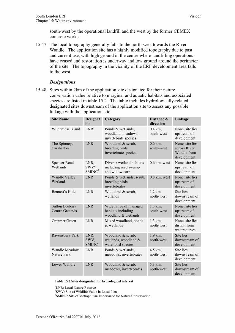
Designations 15.48 Sites within 2km of the application site designated for their nature
conservation value relative to marginal and aquatic habitats and associated species are listed in table 15.2. The table includes hydrologically-related designated sites downstream of the application site to assess any possible linkage with the application site.
Site Name Designation
Category Distance & direction
Linkage
Wilderness Island LNR1 Ponds & wetlands, woodland, meadows, invertebrate species
0.4 km, south-west
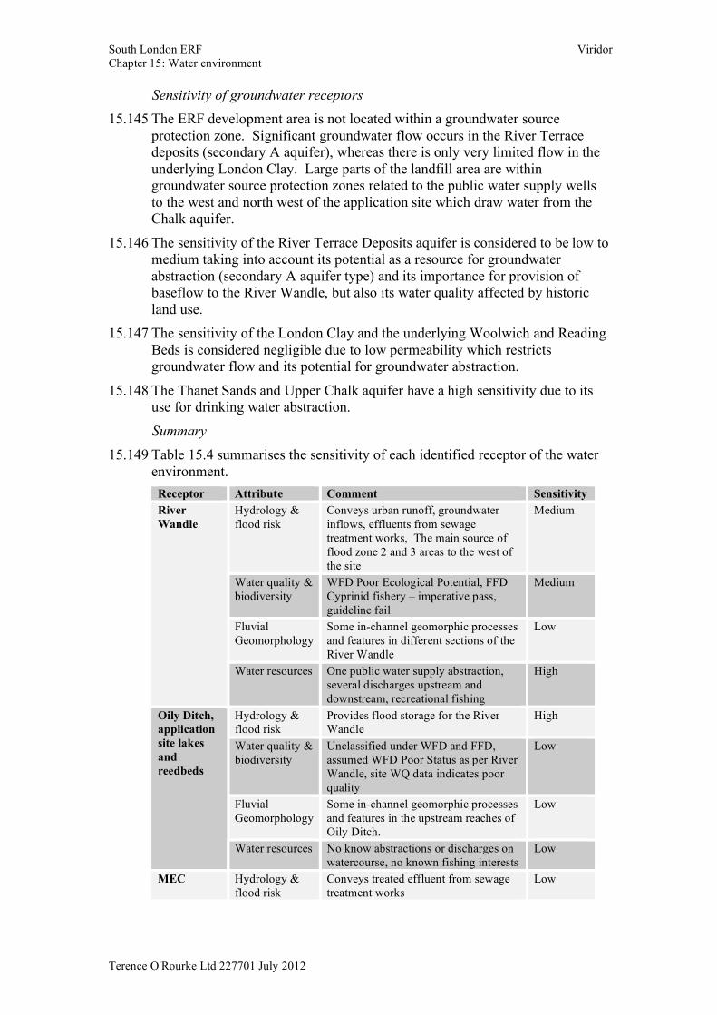
None, site lies upstream of development
The Spinney, Carshalton
LNR Woodland & scrub, breeding birds, invertebrate species
0.6 km, south-west
None, site lies across River Wandle from development
Spencer Road Wetlands
LNR, SWV2, SMINC3
Diverse wetland habitats including reed swamp and willow carr
0.6 km, west None, site lies upstream of development
Wandle Valley Wetland
LNR Ponds & wetlands, scrub, breeding birds, invertebrates
0.8 km, west None, site lies upstream of development
Bennett’s Hole LNR Woodland & scrub, wetlands
1.2 km, north-west
Site lies downstream of development
Sutton Ecology Centre Grounds
LNR Wide range of managed habitats including woodland & wetlands
1.3 km, south-west
None, site lies upstream of development
Cranmer Green LNR Mixed woodland, ponds & wetlands
1.3 km, north-west
None, site lies distant from watercourses
Ravensbury Park LNR, SWV, SMINC
Woodland & scrub, wetlands, woodland & water bird species
1.9 km, north-west
Site lies downstream of development
Wandle Meadow Nature Park
LNR Ponds & wetlands, meadows, invertebrates
4.5 km, north-west
Site lies downstream of development
Lower Wandle LNR Woodland & scrub, meadows, invertebrates
5.3 km, north-west
Site lies downstream of development
Table 15.2 Sites designated for hydrological interest
1LNR: Local Nature Reserve 2SWV: Site of Wildlife Value in Local Plan 3SMINC: Site of Metropolitan Importance for Nature Conservation
South London ERF Viridor Chapter 15: Water environment
Terence O'Rourke Ltd 227701 July 2012
Rainfall 15.49 Southern England has a more continental climate than most of the UK, giving
it colder winters and hot, humid summers. Its separation from the usual paths of Atlantic depressions also makes the climate relatively quiet, with low average rainfall. Rainfall in the Beddington area is low, in common with most of the region, as it has a low elevation and lies well away from the paths of prevailing Atlantic weather systems.
15.50 The standard annual average rainfall (SAAR) for the site has been estimated from the Flood Estimation Handbook (FEH) CD-ROM as 746mm, with the subcatchment to the north of the application site having an estimated SAAR of 637mm. To give these figures a context, the drier parts of Eastern England have annual rainfall totals of around 500mm with wetter areas including Wales, the Lake District and the Western Highlands of Scotland recording figures of 4000mm or more.
15.51 Rainfall monitoring data from Beddington STW has been supplied by the EA from March 2007 to March 2012. The daily rainfall records have been converted into monthly averages for all months where a complete dataset is available. For the calendar years with complete records, the average rainfall was 643mm (2008), 653mm (2009), 529mm (2010) and 489mm (2011). The monthly average data are shown in figure 15.4.
15.52 The Beddington STW rainfall record monthly rainfall high was recorded in July and a significant low in April. This record also shows comparatively low rainfall through the winter, notably in September, October and December. This may reflect unusual rainfall over one or more seasons which can act to skew the data in a short dataset like this one.
15.53 As rainfall data for the site are only available over a comparatively short time period they have been compared with long-term rainfall data from nearby Met Office monitoring stations. Rainfall data are available from the Heathrow station dating back to 1948. Long-term average data, as recorded over a 30-year period, are available for Greenwich and Wisley stations for the periods between 1971 and 2000. Monthly average rainfall data for these three stations are also provided in figure 15.4.
Surface water hydrology, flood risk & surface water drainage 15.54 Watercourses and waterbodies within and surrounding the application site are
indicated in figure 15.5. River Wandle
15.55 The application site lies within the catchment of the River Wandle, a chalk stream which rises in the North Downs and flows north to the River Thames at Wandsworth. The Wandle has several sources including a number of ephemeral streams in the upper catchment which are mostly in culvert. The two main sources are the Waddon and Carshalton Ponds, each located approximately 2km south east and south west of the application site respectively.
15.56 From Waddon Ponds the Wandle flows west through Beddington Park, broadly skirting the southern boundary of the application site, before turning
South London ERF Viridor Chapter 15: Water environment
Terence O'Rourke Ltd 227701 July 2012
north and joining with the Carshalton Pond tributary in Hackbridge. The Wandle continues north, broadly skirting the western boundary of the application site to Beddington Corner and on to Mitcham. It continues north for another 8km before joining the Thames at Wandsworth.
15.57 Immediately upstream of Beddington Park there is a flume and weir on the Wandle which diverts flood flows north towards the application site boundary, along an overflow channel known as the Oily Ditch.
15.58 The BCB flows into River Wandle near Beddington Corner (NGR 527755, 167039) bringing inflows from the Thames Water MEC, the Oily Ditch/application site lake complex siphon and other drainage ditches (including the northern ditch along the northern boundary of the application site) in the vicinity of the application site.
15.59 The Wandle catchment in general is heavily urbanised which results in a rapid response to rainfall. Although the baseflow in the river is relatively stable extensive groundwater abstraction and/or recharge activities influence the flows in the river. Data from the EA gauging station located at the flume in Beddington Park (station no. 39004, NGR 529600, 165500) indicates that the effective drainage catchment (area contributing to runoff) is smaller than the topographical catchment of 122km2. This is likely to be due to a significant proportion of surface runoff in the catchment being diverted into the surface water sewer network and therefore being diverted away from the Wandle. The gauging station is located downstream of the weir which diverts flood flows into the Oily Ditch overflow channel and therefore the high flows recorded at this gauging station may not be an accurate representation of flood flows.
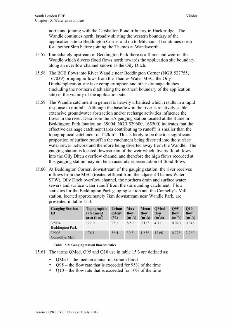
15.60 At Beddington Corner, downstream of the gauging station, the river receives inflows from the MEC (treated effluent from the adjacent Thames Water STW), Oily Ditch overflow channel, the northern drain and surface water sewers and surface water runoff from the surrounding catchment. Flow statistics for the Beddington Park gauging station and the Connelly’s Mill station, located approximately 7km downstream near Wandle Park, are presented in table 15.3.
Gauging Station ID
Topographic catchment area (km2)
Urban extent (%)
Max flow (m3/s)
Mean flow (m3/s)
QMed flow (m3/s)
Q95 flow (m3/s)
Q10 flow (m3/s)
39004 – Beddington Park
122.0 23.1 8.50 0.183 4.71 0.020 0.346
39003 – Connollys Mill
176.1 36.4 39.3 1.836 12.60 0.725 2.760
Table 15.3: Gauging station flow statistics
15.61 The terms QMed, Q95 and Q10 use in table 15.3 are defined as: • QMed – the median annual maximum flood • Q95 – the flow rate that is exceeded for 95% of the time • Q10 – the flow rate that is exceeded for 10% of the time
South London ERF Viridor Chapter 15: Water environment
Terence O'Rourke Ltd 227701 July 2012
Oily Ditch and the application site lakes & reedbeds 15.62 Immediately upstream of Beddington Park a weir diverts flood flows from the
River Wandle into the Oily Ditch, which flows north towards the application site.
15.63 As the Oily Ditch enters the application site it turns west and flows immediately adjacent to the southern boundary, passing through two small reedbeds which are under construction as part of the landfill restoration works. From here flows enter a large reedbed in the south-western corner of the application site. This reedbed has been recently constructed and has not yet established. Flow continues north through two lakes located adjacent to the western boundary of the application site.
15.64 Rectangular weirs have been installed between the southern lake, southern reedbed and the two small feeder reedbeds to maintain water levels within these surface water features. The southern reedbed also functions as a balancing pond to the southern lake. The southern and northern lakes are connected by twin 375mm diameter culverts. The outlet from the northern lake is a 2m wide concrete siphon which discharges into an in culvert section of the MEC from Beddington STW in the north western corner of the application site.
15.65 In addition to the overflows from the River Wandle, the Oily Ditch, lakes and reedbeds receive surface runoff from the soil stockpile in the south eastern corner of the application site and the restored portion of the landfill, as well as groundwater inflows. The northern lake also receives overflow from the MEC, via an overflow channel, which enters the lake at the northern end, close to the siphon.
15.66 The total 1 in 100-year storage capacity of the northern lake and southern lake complex is 291,000m3, which satisfies the EA requirements of 260,000m3 of storage for the application site. Further hydraulic details of the lakes and outfall structures are provided in the FRA. MEC
15.67 The MEC crosses diagonally across the northern half of the application site from the southeast to the north west, predominantly in a culvert (figure 15.5). There is a short open channel section located in the northern part of the application site.
15.68 In the north western corner of the application site the Oily Ditch and the MEC combine to form the Beddington Corner Branch (BCB), which flows west from the site boundary to join the River Wandle approximately 1km downstream of the site boundary.
15.69 The maximum discharge from the sewage treatment works into the MEC is limited to 8m3/s. At the head of the open channel section there is an overflow weir which diverts excess effluent flows into an overflow channel leading to the northern lake.
15.70 A surface water sewer, 2250mm in diameter, carries runoff from the commercial developments east of the application site across the application site from east to west and discharges into the open drain section of the MEC.
South London ERF Viridor Chapter 15: Water environment
Terence O'Rourke Ltd 227701 July 2012
Other application site drainage 15.71 A surface water drain runs along the northern boundary (referred to as the
‘northern drain’ within this assessment) of the application site and carries runoff from the surrounding developments north of the application site into the BCB of the River Wandle.
15.72 The existing waste recycling and IVC facilities do not have a formal surface water drainage system. Runoff from the roofs and hard-standing areas is allowed to drain naturally to the northern drain and to the underlying gravels.
15.73 The former CEMEX area, located close to the northern boundary of the application site, is unused land with no formal drainage. This area drains naturally to the northern drain and underlying gravels. This includes the former silt lagoons located in the north-west corner of the application site.
15.74 Rainfall falling on the operational part of the landfill area filters through the deposited waste to the leachate drainage system installed in the base of each landfill. This leachate is pumped out to a storage tank that periodically discharges to the Beddington STW.
15.75 The Thames Water sludge lagoons located in the south east corner of the application site receive effluents from the adjacent sewage works and are pumped out once the sludge settles, ultimately discharging into the MEC. For the purpose of this assessment it is assumed that the lagoons are lined with a suitable substance such as clay and therefore have no interaction with the surface waters or groundwater associated with the application site.
15.76 Four foul water rising mains run across the application site from close to Irrigation Bridge on the western boundary towards the proposed main access road on the eastern boundary (refer to figure 15.5 and the Thames Water sewer records in appendix C of the FRA). These foul mains do not interact with the application site surface waters or groundwaters. Beddington Corner Branch (BCB)
15.77 The BCB is formed by the confluence of the Oily Ditch and the MEC in the north western corner of the application site. The BCB flows from the application site boundary in a westerly direction to join the River Wandle approximately 1km downstream of the application site, downstream of Goat Bridge (refer to figure 15.5). Flood risk
15.78 As indicated in figure 2 of the FRA, the ERF development area and access road, the majority of the proposed CHP pipeline route and the existing stockpile area fall within the EA designated flood zone 11 (low probability). The Oily Ditch, lakes and reedbeds and a minor section of the CHP pipeline route fall within flood zone 22 (medium probability) and flood zone 33 (high
1 This zone comprises land assessed as having a less than 1 in 1000 annual probability of river or sea flooding in any year (<0.1%). 2 This zone comprises land assessed as having between a 1 in 100 and 1 in 1000 annual probability of river flooding (1% - 0.1%) or between a 1 in 200 and 1 in 1000 annual probability of sea flooding (0.5% - 0.1%) in any year. 3 This zone comprises land assessed as having a 1 in 100 or greater annual probability of river flooding (>1%) or a 1 in 200 or greater annual probability of flooding from the sea (>0.5%) in any year.
South London ERF Viridor Chapter 15: Water environment
Terence O'Rourke Ltd 227701 July 2012
probability). Flood zone 2 of River Wandle is fairly spread out along its flow path immediately west of the application site, while flood zone 3 is narrow and appears to be contained within the channel.
15.79 The LBS Surface Water Management Plan (SWMP) (LBS, 2011) indicates that the application site experiences minor surface water flooding of between 0.1m to 0.3m depth associated with a 1 in 200 year rainfall return period. In addition, the proposed ERF development area does not appear to lie within a critical drainage area (CDA) for surface water flooding. As such, the application site, including the ERF development area, is not considered to be at risk of flooding from land due to the limited potential for overland flows entering the application site from off-site areas under normal conditions, as opposed to failure of the existing infrastructure.
15.80 The groundwater levels are generally high across the ERF development area with strike levels of 3.0m below ground level or higher. The probability of flooding in the vicinity of the proposed ERF development area and the CHP pipeline route from groundwater sources is assessed as being high.
15.81 Surcharging of existing surface water sewers that cross the proposed ERF development area poses a potential flood risk.
15.82 EA mapping in relation to flood risk from reservoirs shows the largest area that might be flooded if a reservoir were to fail and release the water it holds. The proposed ERF development area, the proposed CHP pipeline and the stockpile area are not located within the area identified by EA mapping as being at potential flood risk from reservoirs. However, small parts the application site as a whole are identified as being at risk from the Russell Hill covered reservoir located within the Purley Way playing fields approximately 3km south-east of the application site (figure 15 of the FRA).
15.83 The River Wandle conveys flood flows, urban runoff, drainage and groundwater inflows, it is considered to be of medium sensitivity/ importance for the hydrology and flood risk attribute.
15.84 The primary purpose of the lakes and connecting reedbeds is flood storage and restoration of the biodiversity, natural habitats in the Wandle Valley. The Oily Ditch conveys flood flows and groundwater inflows into the lakes and reedbeds. The surface water and flood risk aspect of the lakes, reedbeds and the Oily Ditch has therefore been assessed as being of high sensitivity / importance.
15.85 The purpose of the BCB is to carry urban runoff. Due to the nature of flows and flood extents of this drain, it has been assigned a low sensitivity.
15.86 The MEC carries treated effluent from the Thames Water STW. It is assigned a ‘low’ sensitivity for the hydrology and flood risk attribute.
Surface water quality & biodiversity River Wandle
15.87 Under the WFD, the River Wandle has been classified as part of the Wandle (Croydon to Wandsworth) and the River Gravney waterbody which, as a heavily modified waterbody, was assessed as having an overall status of ‘poor potential’. The ecological quality element was assessed as ‘poor’ owing to

South London ERF Viridor Chapter 15: Water environment
Terence O'Rourke Ltd 227701 July 2012
poor fish and diatom classifications and elevated phosphate levels. The chemical quality element was assessed as ‘good’.
15.88 The EA has a number of monitoring locations on the River Wandle in the vicinity of the application site that provide an indication of local variations in water quality.
15.89 Routine water sampling at Beddington Park, upstream of the application site and Beddington STW, shows that the water quality is generally good. Sediment sampling at this location has shown that there are elevated concentrations of a number of potential pollutants associated with heavy industry, deposition of which is likely to have been historical.
15.90 Water sampling at Watermeads, downstream of the application site and Beddington STW demonstrates there are significantly elevated levels of oxidised and ammoniacal nitrogen and phosphate. These results are typical of water quality impacts from sewage discharges.
15.91 The WFD objectives for the River Wandle are for it to achieve ‘good’ ecological potential by 2027 and ‘good’ chemical status by 2015.
15.92 The River Wandle is designated under the FFD as a Cyprinid fishery, i.e. capable of supporting species such as tench, roach, chub and minnow. Under the FFD there are two levels of compliance – guideline and imperative. The imperative limits are essentially a minimum water quality standard that must be achieved for the watercourse to achieve its fisheries potential, whilst the guideline limits are an optimum to aim for. The River Wandle is passing the imperative water quality limits but failing the guideline limits.
15.93 EA fisheries survey data for the River Wandle in the vicinity of Beddington Park show that there are very low numbers of trout, bullhead, chub, roach, ruffe, barbel and European glass eels present. This is likely to reflect, in part, the heavily modified and channelised nature of the watercourses within the catchment, making them considerably less attractive to fish as there are few places to hide and limited locations suitable for spawning.
15.94 Between 1989 and October 2011 there have been 113 recorded pollution incidents on the River Wandle and its tributaries in the vicinity of the application site. The vast majority of these have been minor incidents; there have been eight significant incidents and one major incident4. The single recorded major incident occurred in 2007, when chemicals were accidentally released from Beddington STW and entered the Wandle immediately downstream of the application site in the Beddington Corner area. This pollution incident resulted in a significant fish kill.
15.95 The River Wandle has been assessed as having a biodiversity value at district level, using the evaluation criteria provided within chapter 11: natural heritaeg. This value reflects the presence of designated sites along the watercourse and the importance of the river to these sites.
4 Major incidents may have persistent and extensive effects on the quality of the environment and may cause major damage to the ecosystem and have a serious impact upon human health. Significant incidents, whilst less severe than major incidents, may still cause significant damage to the ecosystem, reduce amenity value and may impact on human health.
South London ERF Viridor Chapter 15: Water environment
Terence O'Rourke Ltd 227701 July 2012
15.96 Based on the data presented above the River Wandle is considered to be of medium sensitivity in relation to surface water quality and biodiversity.
Oily Ditch and application site lakes & reedbeds 15.97 There are no specific WFD classification data for the Oily Ditch, lakes or
reedbeds as they are too small to require separate classification from the River Wandle. Given that a proportion of the flow in these waterbodies comes from the River Wandle it is expected that they will have a similar chemical quality status i.e. ‘good’. However, it would be expected that they have a better ecological quality, particularly relating to phosphate levels, as the Oily Ditch is located upstream of the treated sewage discharges and the nature of the reedbeds and lakes promotes improved biodiversity.
15.98 Viridor has been carrying out monthly surface water quality monitoring at a number of locations within the application site since January 2010. The monitoring locations include one on the Oily Ditch as it enters the application site, one at the outlet of the Northern Lake and another on the MEC overflow channel.
15.99 The results show that in general the water quality of these waterbodies is relatively poor, with elevated levels of soluble metals. The Northern Lake has intermittent elevated levels of ammoniacal nitrogen in the winter months, although neither the Oily Ditch nor MEC overflow demonstrate similarly elevated levels on the relevant dates and there is insufficient data to determine the cause.
15.100 The Oily Ditch and the application site lakes and reedbeds have been assessed as having a biodiversity value at local level, using the evaluation criteria provided within chapter 11: natural heritage.
15.101 The Oily Ditch and application site lakes and reedbeds are considered to be of low sensitivity in relation to surface water quality and biodiversity. MEC
15.102 There are no specific WFD classification data for the MEC as it is not considered to be a controlled watercourse. Given the nature of the flows in the channel it is expected that the water quality will be poor for a watercourse.
15.103 The MEC has been assessed as having a biodiversity value at less than local level, using the evaluation criteria provided within chapter 11: natural heritage.
15.104 The MEC is considered to be of negligible sensitivity in relation to surface water quality and biodiversity.
Beddington Corner Branch 15.105 The BCB has no specific WFD classification data as it is also too small to
require separate classification. It is heavily modified and receives effluent discharging from Beddington STW and drainage from the application site. Given the small catchment area of the BCB there is unlikely to be significant natural flow to dilute the effluent discharges, unlike in the River Wandle. As a result it is assumed that the ecological and chemical quality of the BCB is worse than the River Wandle.
South London ERF Viridor Chapter 15: Water environment
Terence O'Rourke Ltd 227701 July 2012
15.106 The BCB has been assessed as having a biodiversity value at local level, using the evaluation criteria provided within chapter 11: natural heritage.
15.107 The BCB is considered to be of low sensitivity in relation to surface water quality and biodiversity.
Fluvial channel geomorphology River Wandle
15.108 The application site is located in the upper catchment of the River Wandle. The river is mainly a ground and surface water-fed river and the channel has been heavily modified throughout. The River Wandle flows broadly south west of the application site flowing through Wilderness Island, Watercress Park and joining with the BCB in the south east corner of Poulter Park. Sections of the River Wandle upstream and downstream of the application site have been subject to river restoration projects to improve ecological and aquatic diversity. Several in-channel structures cross the river channel including weirs, flumes and bridges within the local area of the application site. Urbanisation has confined the river channel within its natural floodplain.
15.109 Upstream of the Beddington flume and weir structure diverting flows into Oily Ditch the river channel has been modified with hard engineering along the river bank and river bed. The river channel is typically rectangular, with vertical riverbanks approximately 1.5m in height and a horizontal river bed approximately 3m in width. The riverbed is typically constructed of a concrete base which is overlain by fine deposits of silts, muds and small gravels that have accumulated in the river channel.
15.110 There are some geomorphic features and limited geomorphic processes occurring in the river channel. There are locations where depositional areas are colonised with aquatic ecology, stabilising small habitats. This has allowed the flow to meander across the channel bed. There is no evidence of erosion or significant deposition within the channel. Velocities are low during normal flows therefore sediment transport is limited.
15.111 Downstream of the confluence of the BCB, the River Wandle flows through Poulter Park along the eastern park boundary. The river channel increases in width to 4m+ and a natural riverbed can be viewed in intermittent sections along the downstream reach. There are intermittent sections of hard engineering and natural vegetation reinforcing the riverbank. The river bed consists of fine sediment, mainly silts, sands and small gravels. There is evidence of channel debris partially obscuring flows around the vegetation margins. There is some geomorphic diversity and limited geomorphic processes occurring in the river channel. Velocities are low during normal flows therefore sediment transport is limited.
15.112 Based on the data presented above the River Wandle is considered to be of low sensitivity in relation to fluvial channel geomorphology. Oily Ditch and application site lakes & reedbeds
15.113 At the upstream extent a flume and weir diverts flows from the River Wandle into Oily Ditch. The channel of Oily Ditch has been aligned to flow north and skirt around the boundary of the application site. In this location the top of the
South London ERF Viridor Chapter 15: Water environment
Terence O'Rourke Ltd 227701 July 2012
channel opens out to Beddington Park on the left bank and the Thames Water STW on the right bank. This section of the channel at the upstream extent is approximately 3 - 4m wide and approximately 1 - 1.5m in height with a trapezoidal channel profile. The channel bed consists of silts, sands and small gravels and aquatic vegetation has established in small pockets across the channel bed. There is some deposition of sediment on the bed of the channel allowing the flow to meander across the bed of the channel. The channel sides are densely vegetated and tapered at grade.
15.114 Approximately 200m downstream of the Beddington flume and weir on the River Wandle, the Oily Ditch has been engineered to flow west along the southern boundary of the application site. The channel bed reduces in width and the channel sides have been significantly raised. The left bank is densely vegetated with a narrow strip of woodland separating the Beddington Park and the application site. The right bank is constructed of a large soil stockpile which is loosely vegetated and stabilises the slope. The channel bed is mainly vegetated, however exposed sections of the channel bed consist of sands, silts and gravels. The overall dimensions of the channel increase as the channel flows into the southern lake area.
15.115 There are two lakes (a northern and southern lake) within the application site. The southern lake has established vegetated margins and, in the southern area, incorporates reedbeds to encourage vegetation succession, aquatic habitat and to enhance surface water quality. A series of control structures regulate flow and water levels in the lakes. The lakes provide a sediment trap for any material carried in higher flows along Oily Ditch.
15.116 The Oily Ditch and application site lakes and reedbeds are considered to be of low sensitivity in relation to fluvial channel geomorphology.
MEC 15.117 This is a manmade watercourse that is both in culvert and with open
trapezoidal channel sections. It flows from east to west from the Thames Water STW to the BCB across the application site, to the west of the ERF development area. There are no geomorphic processes or features operating within the channel.
15.118 The MEC is considered to be of negligible sensitivity in relation to fluvial channel geomorphology.
Beddington Corner Branch 15.119 At the time the survey was undertaken access to this section was restricted
although partial sections were available to view from a distance. The channel is manmade and has been heavily modified with concrete channel sides and channel bed. The channel is typically rectangular, with vertical banks approximately 2 - 2.5m in height and a horizontal bed approximately 2 - 3m in width. The channel bed is overlain by fine sediments consisting mainly of silts and gravels that have accumulated in the channel. There is very little geomorphic diversity and limited geomorphic processes occurring in the river channel. The velocity in the channel, viewed from London Road, was significantly greater than the Oily Ditch and River Wandle flow velocities due to the incorporation of the MEC outfall flow upstream of London Road. Any
South London ERF Viridor Chapter 15: Water environment
Terence O'Rourke Ltd 227701 July 2012
fine, loose sediment entering this watercourse would be transported along this section and deposited in the River Wandle downstream.
15.120 The BCB is considered to be of negligible sensitivity in relation to fluvial channel geomorphology. It is to be noted that this channel is not included within the application site area, however, it has been considered as one of the receptors for assessing impacts from the South London ERF proposals.
Surface water resources 15.121 There are 10 discharge consents within 1km of the development. The
discharge consents relate mainly to discharge to surface waters including the River Wandle and various surface water ditches that drain into the Wandle. Discharges include treated sewage effluent, cooling and process water and trade effluent.
15.122 The main discharges into the Wandle system are either into the main river immediately west of the application site or into the BCB which joins the Wandle at Mitcham Corner, north west of the application site. Both watercourses include discharges from the Beddington STW. Surface water from the application site also feeds into the BCB.
15.123 There are 22 licensed abstractions within 1km of the development. These are mainly groundwater abstractions and are discussed in more detail in the hydrogeology section below. There is also one licence for surface water abstraction from the River Wandle for public water supply.
15.124 The surface water abstraction is located on the main River Wandle, just upstream of Mitcham Corner. Some of the STW discharges feed into the main river downstream of this but it would appear that some discharge into the river upstream of this abstraction.
15.125 The River Wandle also supports recreational fishing in the area.
15.126 The River Wandle is considered to be of high sensitivity in relation to water resources. The remaining waterbodies under consideration have been assessed as being of low sensitivity in relation to water resources.
Hydrogeology 15.127 A detailed description of the application site geology including overall
hydrogeology and application site contamination is provided in chapter 8 (ground conditions). The following description focuses on groundwater flow and aquifer properties whereas the hydrogeological description in the ground conditions chapter is focuses on groundwater quality as part of the contaminated land assessments.
15.128 Borehole logs (see chapter 8, ground conditions, for borehole locations) from ground investigations carried out by Geotechnical Engineering Ltd in 2011 and 2012 (draft logs only) record made ground being present (1.5m to 3.5m) across the ERF development area. Most borehole logs across the ERF development area record thin layers (2m to 3.05m) of River Terrace Deposits beneath the made ground except for borehole logs BH01, BH02, BH03 and BH09 in the northern part of the ERF development area which record an absence of River Terrace Deposits, (probably removed during construction,
South London ERF Viridor Chapter 15: Water environment
Terence O'Rourke Ltd 227701 July 2012
and replaced by made ground). All borehole logs record London Clay underneath with the top elevation dipping in southern direction from approximately 27.40m AOD at BH01 to the north of the ERF to 24.95m AOD at BH08 at the southern limit of the ERF development area. Over the whole application site the London Clay gets thinner to the south and just past the application site southern boundary disappears altogether. The geological map (Sheet 270, South London, 1:50 000) indicate that the London Clay is further underlain by thin layers of Woolwich and Reading Beds and Thanet Sands followed by a thick layer of Upper Chalk. Aquifer characteristics
15.129 The following paragraphs provide a summary of hydrogeological properties of the different mediums found beneath the application site in order of depth. More detailed discussion of the different aquifers can be found in technical appendix G.
Made ground 15.130 Made ground comprises a range of materials, the exact hydrogeological
properties of which can vary significantly over short horizontal and vertical distances.
River Terrace Deposits 15.131 These deposits are classified by the EA as a secondary A aquifer. The
deposits form a highly conductive and porous layer which contains significant amounts of groundwater. The River Terrace Deposits within the application site are considered to be generally not fully saturated (unconfined) and in hydraulic continuity with the nearby surface water features including the application site lakes. The groundwater is perched above the London Clay and in hydraulic discontinuity with deeper water bearing strata.
London Clay 15.132 The London Clay is classified as unproductive strata, which acts as a
confining layer for the underlying aquifers. Woolwich and Reading Beds (Lambeth Group)
15.133 Some groundwater flow may occur in the sandier units but generally the more clayey Reading Formation can be considered as a low permeability confining layer providing protection to the underlying aquifers. There are no proposed construction activities which could affect these and the deeper formations.
Thanet Sands 15.134 The Thanet Sands form a relatively thin layer and consist mainly of silty fine
grained sand and can provide significant groundwater flow with the potential use for groundwater abstraction and are typically in hydraulic continuity with the Upper Chalk aquifer. Upper Chalk
15.135 The Upper Chalk is classified as a principal aquifer and is actively used for drinking water abstractions. The groundwater flow in the Chalk aquifer beneath the application site is not in hydraulic continuity with the River
South London ERF Viridor Chapter 15: Water environment
Terence O'Rourke Ltd 227701 July 2012
Terrace Deposits aquifer due to the presence of the London Clay and Woolwich and Reading Beds.
Groundwater recharge mechanisms 15.136 Rainfall rates are discussed in detail in the hydrology section. Groundwater
recharge occurs mainly in areas where permeable made ground or sand and gravel exists as the uppermost medium, whereas in areas with clayey top layers or hardcover most of the rainfall runs off. The groundwater in the gravel aquifer beneath the application site is mainly recharged in the application site areas and the off-site area to the east and south east of the application site.
Groundwater levels and flow 15.137 The subsurface hydrogeological characteristics of the application site are
governed by the relatively high permeability of the River Terrace Deposits which are in hydraulic continuity with the surface water features further to the west or north west (i.e. the River Wandle and its tributaries and the on-site lakes). Groundwater level data from the landfill area suggest a general east to west/northwest groundwater flow direction in the gravel layer with water levels falling from approximately 29m AOD at the eastern application site boundary to approximately 25m AOD at the western extent of the landfill area with a hydraulic gradient of between 0.003 and 0.01 (SLR Consulting, 2005). The seasonal variation of the water table in the boreholes was reported to be generally less than 2m.
15.138 From groundwater monitoring, and water strikes recorded when drilling, a picture of the groundwater flow regime beneath the ERF development area can be built up. Groundwater levels were found to be highly variable with groundwater levels at or close to ground surface in the north eastern part of the application site and groundwater levels approximately 2 - 3m below ground surface (26m - 27m AOD) in the southern part of the ERF development area which is underlain by gravel. The groundwater flow direction under the ERF development area is therefore variable but predominantly towards the south/south west as opposed to the regional groundwater flow directions observed on the adjacent landfill area which is predominantly from east to west/northwest. This local anomaly of groundwater flow direction is likely to be the result of the absence of River Terrace Deposits in the northern part of the application site where it has been replaced with a dominantly clayey Made Ground. The gravel layer in the central and southern part and the lower top elevation of the London Clay in the southern areas allow groundwater to be easily transmitted with the result of lower groundwater levels. Significant groundwater flow on-site is expected to occur mainly in the River Terrace Deposits where present, however some groundwater flow is also expected in the made ground especially locally if the made ground has a high gravel content and also in the top layer of the London Clay where sandy clay and thin siltstone layers are present.
15.139 The Thanet Sand and Upper Chalk aquifers are expected to be in hydraulic continuity. Chalk groundwater level monitoring data from the landfill area from 1994 show water levels at similar elevations compared to the River Terrace Deposits (approx. 20 - 28m AOD) and a north-westerly flow
South London ERF Viridor Chapter 15: Water environment
Terence O'Rourke Ltd 227701 July 2012
direction. These water levels were measured before pumping at the public water supply wells (Hackbridge pumping station) commenced. Water levels in the Chalk fell significantly with the groundwater abstraction and water levels were measured to be within 5m and -15m AOD beneath the landfill area in 2004 with a westerly groundwater flow direction. The clear hydraulic downwards gradient between the gravel aquifer and the Thanet Sands/Chalk aquifer confirms the effect of the London Clay as a confining layer, i.e. it limits vertical groundwater flow.
15.140 Specific ground investigations and groundwater level monitoring are on going on the ERF development area and along the proposed CHP pipeline routes. This information will be used for the detailed design of dewatering requirements for excavations which intercept groundwater but also to determine specific groundwater drainage needs, if required. Groundwater abstractions and source protection zones (SPZs)
15.141 EA information provided in April 2012 indicates 11 licensed groundwater abstractions within 3km distance of the application site. The full information is provided in technical appendix G. Most of the licensed abstractions are public water supply wells located to the west and north west of the application site. There are several licensed commercial water supply wells; the nearest to the application site is the borehole of the Mitcham Golf Club approximately 800m to the north west of the application site and the Hanson Quarry Products borehole approximately 780m to the east of the application site. There are no licensed groundwater abstractions within the application site.
15.142 From the Envirocheck report (order number: 37674101_1_1, as included in technical appendix D) and the EA website it can be seen that the ERF development area does not lie within a groundwater source protection zone, but the western boundary of the landfill area does lie within an SPZ1 and the majority of the landfill area except the eastern side lies within an SPZ2. Based on EA information these source protection zones are related to the public water supply abstractions at Goat Bridge (one borehole) and New Road, Mitcham (three boreholes) operated by Sutton and East Surrey Water drawing groundwater from the Chalk aquifer.
Groundwater quality 15.143 The application site and the surrounding area have a long history of mixed use
with potential sources of groundwater contamination including the sewage treatment works, sludge beds and landfill. Groundwater and surface water have been monitored extensively over time on the landfill area. Specific groundwater sampling on the ERF development area was undertaken in 2011 and further investigation and monitoring are on going for the area of the proposed CHP pipeline route along the new application site access road and to the west of the ERF development area to collect additional on-site groundwater quality information.
15.144 The groundwater quality and potential impacts by the development on groundwater quality are discussed in the ground conditions chapter, Chapter 8.
South London ERF Viridor Chapter 15: Water environment
Terence O'Rourke Ltd 227701 July 2012
Sensitivity of groundwater receptors 15.145 The ERF development area is not located within a groundwater source
protection zone. Significant groundwater flow occurs in the River Terrace deposits (secondary A aquifer), whereas there is only very limited flow in the underlying London Clay. Large parts of the landfill area are within groundwater source protection zones related to the public water supply wells to the west and north west of the application site which draw water from the Chalk aquifer.
15.146 The sensitivity of the River Terrace Deposits aquifer is considered to be low to medium taking into account its potential as a resource for groundwater abstraction (secondary A aquifer type) and its importance for provision of baseflow to the River Wandle, but also its water quality affected by historic land use.
15.147 The sensitivity of the London Clay and the underlying Woolwich and Reading Beds is considered negligible due to low permeability which restricts groundwater flow and its potential for groundwater abstraction.
15.148 The Thanet Sands and Upper Chalk aquifer have a high sensitivity due to its use for drinking water abstraction.
Summary 15.149 Table 15.4 summarises the sensitivity of each identified receptor of the water
environment. Receptor Attribute Comment Sensitivity
Hydrology & flood risk
Conveys urban runoff, groundwater inflows, effluents from sewage treatment works, The main source of flood zone 2 and 3 areas to the west of the site
Medium
Water quality & biodiversity
WFD Poor Ecological Potential, FFD Cyprinid fishery – imperative pass, guideline fail
Medium
Fluvial Geomorphology
Some in-channel geomorphic processes and features in different sections of the River Wandle
Low
River Wandle
Water resources One public water supply abstraction, several discharges upstream and downstream, recreational fishing
High
Hydrology & flood risk
Provides flood storage for the River Wandle
High
Water quality & biodiversity
Unclassified under WFD and FFD, assumed WFD Poor Status as per River Wandle, site WQ data indicates poor quality
Low
Fluvial Geomorphology
Some in-channel geomorphic processes and features in the upstream reaches of Oily Ditch.
Low
Oily Ditch, application site lakes and reedbeds
Water resources No know abstractions or discharges on watercourse, no known fishing interests
Low
MEC Hydrology & flood risk
Conveys treated effluent from sewage treatment works
Low
South London ERF Viridor Chapter 15: Water environment
Terence O'Rourke Ltd 227701 July 2012
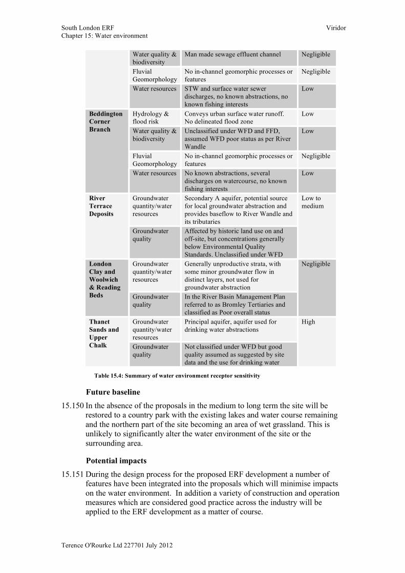
Water quality & biodiversity
Man made sewage effluent channel Negligible
Fluvial Geomorphology
No in-channel geomorphic processes or features
Negligible
Water resources STW and surface water sewer discharges, no known abstractions, no known fishing interests
Low
Hydrology & flood risk
Conveys urban surface water runoff. No delineated flood zone
Low
Water quality & biodiversity
Unclassified under WFD and FFD, assumed WFD poor status as per River Wandle
Low
Fluvial Geomorphology
No in-channel geomorphic processes or features
Negligible
Beddington Corner Branch
Water resources No known abstractions, several discharges on watercourse, no known fishing interests
Low
Groundwater quantity/water resources
Secondary A aquifer, potential source for local groundwater abstraction and provides baseflow to River Wandle and its tributaries
River Terrace Deposits
Groundwater quality
Affected by historic land use on and off-site, but concentrations generally below Environmental Quality Standards. Unclassified under WFD
Low to medium
Groundwater quantity/water resources
Generally unproductive strata, with some minor groundwater flow in distinct layers, not used for groundwater abstraction
London Clay and Woolwich & Reading Beds Groundwater
quality In the River Basin Management Plan referred to as Bromley Tertiaries and classified as Poor overall status
Negligible
Groundwater quantity/water resources
Principal aquifer, aquifer used for drinking water abstractions
Thanet Sands and Upper Chalk Groundwater
quality Not classified under WFD but good quality assumed as suggested by site data and the use for drinking water
High
Table 15.4: Summary of water environment receptor sensitivity
Future baseline 15.150 In the absence of the proposals in the medium to long term the site will be
restored to a country park with the existing lakes and water course remaining and the northern part of the site becoming an area of wet grassland. This is unlikely to significantly alter the water environment of the site or the surrounding area.
Potential impacts 15.151 During the design process for the proposed ERF development a number of
features have been integrated into the proposals which will minimise impacts on the water environment. In addition a variety of construction and operation measures which are considered good practice across the industry will be applied to the ERF development as a matter of course.
South London ERF Viridor Chapter 15: Water environment
Terence O'Rourke Ltd 227701 July 2012
15.152 The potential impacts discussed below have been considered assuming the implementation of relevant design features and good practice measures, but without additional specific mitigation measures.
Potential impacts during construction Surface water hydrology, flood risk & surface water drainage
15.153 The proposed ERF development area and associated access road are located within the low probability flood zone 1, so the flood risk from rivers in these areas during the construction phase is considered low. The construction phase of the proposed ERF development area will result in negligible change to the surface water flow patterns due to temporary routing and attenuation of the flows around the area. In addition, the implementation of good practice construction site drainage measures, such as cut off ditches and sedimentation ponds, will minimise the risk of runoff from these areas exacerbating flooding within the MEC, BCB or River Wandle during the construction phase.
15.154 The majority of the CHP pipeline route is within flood zone 1 (refer to the FRA). The section of the route along the south west boundary of the application site, in the vicinity of Hackbridge station, is indicated as being within flood zone 2. Construction of the CHP pipeline is likely to cause small but short term impacts on the overland paths along the route. The risk of flooding during construction is considered low, and the works are unlikely to exacerbate flooding elsewhere.
15.155 The prevailing high groundwater levels across the application site means that there is potential risk of groundwater flooding of the construction works, especially of the CHP excavations in the vicinity of the MEC overflow drain and the lakes.
15.156 As these excavations are shallow in depth, the groundwater flow within them will not be significant. However good practice groundwater cut-off techniques, such as sheet pile walls or similar, will minimise the inflows. These construction activities are not expected to exacerbate groundwater flooding elsewhere.
15.157 The wet grassland area is mainly located within flood zone 1 but is also slightly within flood zone 2 and 3 associated with the Oily Ditch. The risk of flood inundation to the wet grassland during construction will be minimised through the use of ‘offline’ construction, i.e. the Oily Ditch will only be diverted into the wet grassland area once its construction is complete. In addition the offline construction and proposed sediment control measures will minimise the risk of flooding in the Oily Ditch channel as a result of silting and blockages.
15.158 Based on the information above it is considered that the construction works will have a negligible adverse effect on the surface water hydrology and flood risk of the River Wandle, BCB, Oily Ditch, application site lakes and reedbeds and negligible adverse effect on the drainage features including the MEC and its overflow drain.
South London ERF Viridor Chapter 15: Water environment
Terence O'Rourke Ltd 227701 July 2012
Surface water quality and biodiversity 15.159 During construction there is a risk of sediment release as a result of activities
such as top soil stripping and earthworks within the ERF development area, CHP pipeline area and south-east wet grassland area. Sediment pollution is also possible during the construction of the ERF development area drainage outfall into the MEC and during the formation of the Oily Ditch channel through the wet grassland area.
15.160 There is also a risk of pollution due to accidental spillage of fuels, lubricants, hydraulic fluids cement and other chemicals used in the construction activities.
15.161 The risk of construction pollution will be minimised through the development and rigorous adherence to the Construction Environmental Management Plan (CEMP). Detailed method statements will also be prepared for works in or near the existing surface waters, which will be submitted to the EA for approval.
15.162 An environmental manager will be appointed, who will be responsible for the implementation of the CEMP, including liaison with the relevant environmental stakeholders, and pollution prevention communication and training for on-site staff.
15.163 Good practice measures to be implemented with particular relevance to the protection of surface water quality are summarised below:
• An oil absorbent boom will be installed on the existing surface waters immediately downstream of the development area for the duration of the construction works and will be regularly inspected and maintained
• Cut-off trenches will be used to prevent clean surface water entering the development area
• Vegetated buffer strips will be maintained adjacent to the existing site surface waters
• Exposed ground will be minimised with vegetation clearance restricted to the immediate area of the works and undertaken immediately prior to commencement of the works in any particular area of the site. Vegetation will be re-established as soon as practicable
• Sediment laden runoff from the development area and groundwater dewatering discharges from excavations will be collected and treated appropriately before discharge. This may be through the use of silt fences, silt traps, filter bunds (possibly straw bales or gravel bunds), settlement ponds and/or proprietary silt treatment units such as a ‘siltbuster’. Early construction of the permanent development drainage, in particular the SUDS pond, will be considered so that it may be used for treatment of construction runoff
• Control and treatment measures will be inspected regularly to ensure they are working effectively
• Local weather forecasts will be monitored and works scheduled accordingly. In particular earthworks and in-stream works will be stopped during storm events
• Emergency response plans will be developed and spill kits made available on-site
South London ERF Viridor Chapter 15: Water environment
Terence O'Rourke Ltd 227701 July 2012
• All relevant consents will be sought from the EA for temporary discharges and in-stream works
• Stockpiles will be located at least 10m from the existing site waterbodies. Cut-off ditches and silt fences will be used to manage sediment laden run-off from stockpiles
• Oils and potentially hazardous construction materials will be stored in bunded storage areas with external cut-off drainage; hydrocarbons will be stored in double skinned tanks. Containment capacity will be 110% of the capacity of the largest container in each containment area
• Any on-site fuelling and maintenance of construction plant, where reasonable practicable, will be on impermeable hardstanding with appropriate cut-off drainage and located away from the existing site waterbodies. In the event of plant breakdown drip trays will be used during any emergency maintenance and spill kits will be available on site
• Construction plant will be checked regularly for oil and fuel leaks, particularly when construction works are undertaken in or near the existing site waterbodies
• Waste fuels and other fluid contaminants will be collected in leak-proof containers prior to removal from site to an approved recycling facility
• Cement will be delivered to site in ready-mix lorries. Washing out of these lorries will be carried out off-site
• Foul drainage from site welfare facilities will be disposed of appropriately. This may be by discharge to the foul sewer or by collection in septic tank for disposal off-site
15.164 This list is not exhaustive. The CEMP will incorporate guidance from all relevant EA Pollution Prevention Guidelines (PPGs).
15.165 A specific Construction Method Statement (CMS) will be developed and implemented for the construction of any required drainage outfall. The method statement will be informed by the guidelines detailed in PPG5 Works or maintenance in or near water.
15.166 With the above good practice measures in place the release of sediment during construction remains a possibility, but the scale of any release will be minimised and if such an event were to occur, it is likely to have a temporary short-term impact on the MEC and Oily Ditch. The River Wandle and the BCB are unlikely to be affected due to their distance downstream and the dilution effect of the MEC and Oily Ditch flows.
15.167 With good practice measures in place it is considered unlikely that there will be an accidental spillage incident on-site during construction should there be an incident the scale of the spill will be very localised.
15.168 Potential construction pollution is considered to represent an adverse change of small magnitude on the water quality and biodiversity of the MEC and Oily Ditch, and therefore results in a negligible effect in relation to the MEC and a slight effect in relation to the Oily Ditch, neither of which are considered significant in an EIA context.
15.169 Potential construction pollution is considered result in a change of negligible magnitude on the water quality and biodiversity of the River Wandle and BCB, and resulting in a negligible effect that is not significant.
South London ERF Viridor Chapter 15: Water environment
Terence O'Rourke Ltd 227701 July 2012
Fluvial channel geomorphology 15.170 During construction the natural sediment erosion and deposition regime of the
watercourses can be affected by release of sediment from the construction works. As discussed above there is the possibility of sediment release from soil stripping and earthworks activities and the formation of the Oily Ditch channel through the wetland grassland area.
15.171 Appropriate surface water runoff control measures during construction, as discussed above, will limit mobilisation of sediment into these waterbodies.
15.172 The CHP pipeline across the main application site area is proposed to be constructed below ground and pass beneath the MEC. It is anticipated that a temporary flume maybe used to divert flows in the MEC during the construction of the CHP pipeline in this area. As the MEC is of negligible geomorphological interest, the impact magnitude of these works will be negligible.
15.173 Construction activities are considered to represent an adverse change of small magnitude on the geomorphology of the MEC and Oily Ditch, and a negligible effect in relation to the MEC and of slight effect in relation to the Oily Ditch, neither of which are considered significant in an EIA context.
15.174 Potential construction activities are considered to have a potential negligible change on the geomorphology of the River Wandle and BCB, and resulting in a negligible effect that is not significant. Surface water resources
15.175 The construction activities will not directly affect any of the identified surface water abstractions or discharges. As there will be no significant effects on the water quality or geomorphology of the surface waters of the application site, there will be no indirect impact on the identified surface water abstraction on the River Wandle.
15.176 Consequently there will be a potential negligible change on the water resources of the surface waters within the application site, resulting in a negligible effect that is not significant.
Hydrogeology 15.177 The boiler hall, turbine hall and flue gas treatment area of the main ERF
building will be constructed on a piled foundation. The piles will be driven into the underlying London Clay. The piles will not introduce a groundwater flow path between the River Terrace Deposits and Upper Chalk aquifers, due to the presence of the thick impermeable London Clay layer.
15.178 Excavation below the groundwater table will be required, in particular during the construction of the waste and ash bunkers, but also for any below ground tanks (fire water tank and fuel oil tank) and during the laying of below ground services or the upgrading of existing ground services. Dewatering will therefore be required to enable construction. Groundwater inflows from the River Terrace Deposits could be significant due to its high permeability, resulting in large volumes to be dewatered and potentially resulting in significant groundwater drawdown in the surrounding aquifer.
South London ERF Viridor Chapter 15: Water environment
Terence O'Rourke Ltd 227701 July 2012
15.179 The proposed use of an impermeable wall system (i.e. secant walls) during the excavation and construction of the waste and ash bunkers will minimise the need for significant dewatering and therefore minimise the impact on groundwater flows and drawdown.
15.180 The CHP pipelines will be laid up to approximately 1 - 3m depth below ground level. The greater depth (approx. 3m) is required in areas where interactions with other underground services need to be avoided (e.g. in the ERF development area and crossing the MEC). There is a chance that shallow groundwater in the made ground or in the River Terrace Deposits will be intercepted. In this case dewatering of the pipe trench may be required during construction.
15.181 Ground investigation and groundwater monitoring along the proposed CHP pipeline route are ongoing and will provide further information to define dewatering requirements. Should significant inflows be likely mitigation measure such as sheet pile walls or similar will be considered.
15.182 With these measures in place the excavation of the CHP pipeline route is likely to only impact on the local groundwater table in the immediate vicinity of the trenches, if at all.
15.183 Wet grassland is proposed in the south east area of the application site. It will be constructed by excavation/ re-grading of the existing stockpile to match the surrounding ground levels of 30m AOD. Groundwater levels in this area are approximately 28 - 29m AOD. Therefore during construction of the wet grassland area groundwater discharges from the River Terrace Deposits can be expected. This creates only a minor and local diversion of groundwater flow in the shallow aquifer. Groundwater and rainfall inflow to the wet grassland area during construction will be collected and treated in a settlement pond, tank of similar to remove any sediment before discharge into the downstream reedbeds.
15.184 During site preparation works and construction there is a risk of groundwater pollution mainly from the spillage of fuels. Measures to avoid groundwater pollution will be addressed in the CEMP in accordance with the Environment Agency’s Pollution Prevention Guidelines. Further discussion about the potential of groundwater pollution is provided in the ground conditions chapter, chapter 8.
15.185 The magnitude of construction impacts on the groundwater flow in the River Terrace Deposits is considered to be negligible to small and negligible for the Thanet Sands/Upper Chalk aquifer. Therefore the significance of the impacts is considered to be negligible to slight.
Summary of potential construction impacts 15.186 Table 15.5 summarises the importance of each identified receptor of the water
environment, the potential construction impacts, the resulting potential magnitude of change and subsequent significance.
15.187 The planning application boundary does not include the grid connection from the ERF to the substation, with the proposed route following existing highways infrastructure within the urban area to the east of the application site. It is unlikely that the temporary construction phase (approximately 10 to
South London ERF Viridor Chapter 15: Water environment
Terence O'Rourke Ltd 227701 July 2012
12 weeks) of this connection would result in any significant impacts to the water environment.
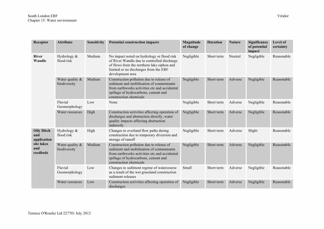
South London ERF Viridor Chapter 15: Water environment
Terence O'Rourke Ltd 227701 July 2012
Receptor Attribute Sensitivity Potential construction impacts Magnitude
of change Duration Nature Significance
of potential impact
Level of certainty
Hydrology & flood risk
Medium No impact noted on hydrology or flood risk of River Wandle due to controlled discharge of flows from the northern lake siphon and limited or no discharges from the ERF development area
Negligible Short term Neutral Negligible Reasonable
Water quality & biodiversity
Medium Construction pollution due to release of sediment and mobilisation of contaminants from earthworks activities etc and accidental spillage of hydrocarbons, cement and construction chemicals
Negligible Short term Adverse Negligible Reasonable
Fluvial Geomorphology
Low None Negligible Short term Adverse Negligible Reasonable
River Wandle
Water resources High Construction activities affecting operation of discharges and abstraction directly, water quality impacts affecting abstraction indirectly
Negligible Short term Adverse Negligible Reasonable
Hydrology & flood risk
High Changes to overland flow paths during construction due to temporary diversion and storage of runoff
Negligible Short term Adverse Slight Reasonable
Water quality & biodiversity
Medium Construction pollution due to release of sediment and mobilisation of contaminants from earthworks activities etc and accidental spillage of hydrocarbons, cement and construction chemicals
Negligible Short term Adverse Negligible Reasonable
Fluvial Geomorphology
Low Changes to sediment regime of watercourse as a result of the wet grassland construction sediment releases
Small Short term Adverse Negligible Reasonable
Oily Ditch and application site lakes and reedbeds
Water resources Low Construction activities affecting operation of discharges
Negligible Short term Adverse Negligible Reasonable
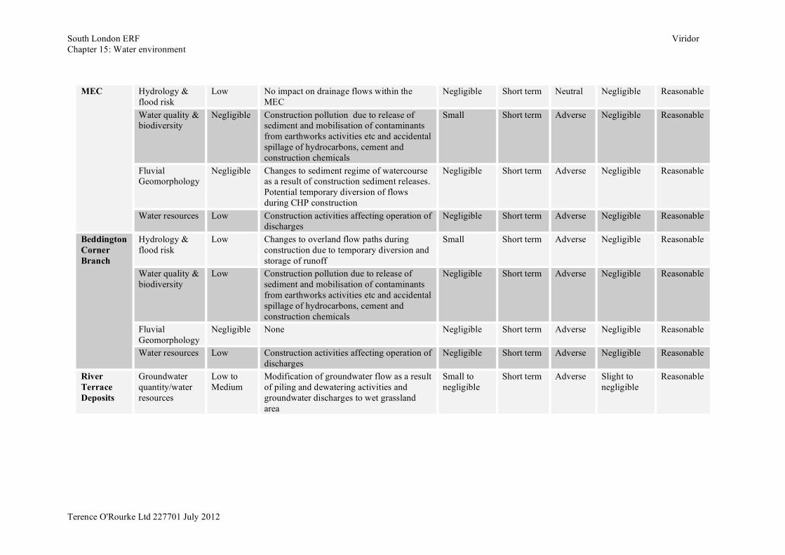
South London ERF Viridor Chapter 15: Water environment
Terence O'Rourke Ltd 227701 July 2012
Hydrology & flood risk
Low No impact on drainage flows within the MEC
Negligible Short term Neutral Negligible Reasonable
Water quality & biodiversity
Negligible Construction pollution due to release of sediment and mobilisation of contaminants from earthworks activities etc and accidental spillage of hydrocarbons, cement and construction chemicals
Small Short term Adverse Negligible Reasonable
Fluvial Geomorphology
Negligible Changes to sediment regime of watercourse as a result of construction sediment releases. Potential temporary diversion of flows during CHP construction
Negligible Short term Adverse Negligible Reasonable
MEC
Water resources Low Construction activities affecting operation of discharges
Negligible Short term Adverse Negligible Reasonable
Hydrology & flood risk
Low Changes to overland flow paths during construction due to temporary diversion and storage of runoff
Small Short term Adverse Negligible Reasonable
Water quality & biodiversity
Low Construction pollution due to release of sediment and mobilisation of contaminants from earthworks activities etc and accidental spillage of hydrocarbons, cement and construction chemicals
Negligible Short term Adverse Negligible Reasonable
Fluvial Geomorphology
Negligible None Negligible Short term Adverse Negligible Reasonable
Beddington Corner Branch
Water resources Low Construction activities affecting operation of discharges
Negligible Short term Adverse Negligible Reasonable
River Terrace Deposits
Groundwater quantity/water resources
Low to Medium
Modification of groundwater flow as a result of piling and dewatering activities and groundwater discharges to wet grassland area
Small to negligible
Short term Adverse Slight to negligible
Reasonable
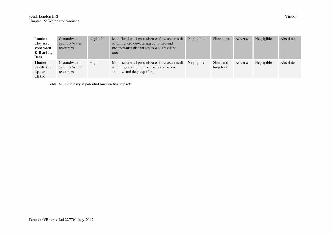
South London ERF Viridor Chapter 15: Water environment
Terence O'Rourke Ltd 227701 July 2012
London Clay and Woolwich & Reading Beds
Groundwater quantity/water resources
Negligible Modification of groundwater flow as a result of piling and dewatering activities and groundwater discharges to wet grassland area
Negligible Short term Adverse Negligible Absolute
Thanet Sands and Upper Chalk
Groundwater quantity/water resources
High Modification of groundwater flow as a result of piling (creation of pathways between shallow and deep aquifers)
Negligible Short and long term
Adverse Negligible Absolute
Table 15.5: Summary of potential construction impacts
South London ERF Viridor Chapter 15: Water environment
Terence O'Rourke Ltd 227701 July 2012
Potential impacts during operation Surface water hydrology, flood risk & surface water drainage
15.188 The ERF development includes construction of buildings, hardstanding areas, parking areas, internal circulation roads and the access road, which will increase the impermeable area across the ERF development area. This could result in increased surface runoff volumes and rates, subsequently increasing flood risk within the application site and within the surrounding watercourses.
15.189 To prevent this the ERF drainage system has been designed to attenuate surface runoff to greenfield runoff rates or less through the following design proposals:
• Rainwater harvesting of roof runoff will be used within the education centre, admin and welfare buildings. It may also be used for processes such as wash down water, fire water and top-up process water
• ERF development area runoff will drain to a series of ponds and wet grassland areas within the application site to the west of the ERF development area, eventually infiltrating into the groundwater via the wet grassland under normal conditions
• The ponds and wet grassland area will provide storm attenuation, with storm flow discharging to the MEC (or other suitable drain or watercourse) eventually discharging to the River Wandle, only under exceptional circumstances
• Any positive discharges will be restricted to a minimum of the EA requirements of greenfield rates set out in the FRA. The minimum total storage capacity for the ERF development will be 2,090m3 for the 1 in 100-year (plus climate change) rainfall event. Furthermore the ERF development is seeking to address and incorporate BREEAM requirements. The incorporation of BREEAM requirements may provide betterment to the required EA greenfield runoff restriction through a lower restricted maximum discharge rate of 12.5l/s and greater volume of surface water runoff storage of 2,300m3. Any positive discharge is to be off-set from the peak storm flows occurring in the natural drainage catchment.
15.190 With these measures in place there will be minimal impact to the surface water hydrology or flood risk of the River Wandle, BCB, MEC and Oily Ditch, application site lakes and reedbeds. Since there is no formal drainage system serving the existing waste facility currently located in the proposed ERF development area, the proposed surface water drainage system will provide formalised flow paths and attenuation of overland runoff.
15.191 In the operational phase the CHP pipeline will have no surface presence, with ground levels reinstated to previous levels. Therefore it will have no impact on surface water hydrology, flood risk and surface water drainage elements, i.e. the MEC, the MEC overflow channel and the twin pipes connecting the southern and northern lake complex.
15.192 The south east wet grassland will provide attenuation of flood flows from the River Wandle in conjunction with the reedbeds and lakes within the application site. The total provision of storage capacity within the application
South London ERF Viridor Chapter 15: Water environment
Terence O'Rourke Ltd 227701 July 2012
site south east wet grassland and lake complex is in excess of the EA requirements of 260,000m3 (for a 1 in 100-year rainfall event).
15.193 The south east wet grassland area has been designed to provide additional flood storage compared to current conditions and therefore should have a moderate beneficial effect on the surrounding hydrological system. However the outflows from the wet grassland will require efficient management in order to maintain optimum water levels in the wet grassland and downstream reedbeds, and to prevent backflows into the River Wandle overflow channel.
15.194 It is concluded that the potential impacts to surface water hydrology and flood risk associated with the River Wandle are negligible, with the MEC a slight adverse effect and with the BCB a slight beneficial effect, none of which are considered significant in an EIA context. A moderate beneficial effect that is significant is predicted for Oily Ditch and the application site lakes and reedbeds.
Surface water quality and biodiversity 15.195 During the operational phase of the ERF routine runoff from the development
area roads and hardstanding areas is likely to contain a broad range of potential pollutants, such as hydrocarbons i.e. fuel and lubricants, fuel additives, metal from corrosion of vehicles, de-icer and gritting material. These can subsequently be washed off the hardstandings during rainfall events into the development drainage system.
15.196 Accidents and fire at the ERF during the operational phase have the potential to lead to an acute pollution incident. Potential pollutants present on-site which may be released accidentally include hydrocarbons from vehicles, chemicals stored on-site and waste leachate from the ERF processes.
15.197 Given the relatively low traffic volumes related to the ERF operations, the concentration of pollutants in routine ERF area runoff is not expected to be particularly high.
15.198 Appropriate management and treatment of routine ERF area runoff and accidental spillages will be provided through the following design and good practice measures: • Development area runoff will drain to a series of ponds and wet grassland
areas within the application site to the west of the ERF development area, eventually infiltrating into the groundwater via the wet grassland under normal conditions, discharging into the MEC (or other suitable drain or watercourse) under exceptional storm conditions
• The ponds and wet grassland area will provide water quality treatment through filtration, sedimentation and plant uptake of pollutants
• The top pond will have a sediment forebay to improve water quality in the main body of the pond
• Hardstanding areas such as the access road and internal ERF development area roads will drain via oil and silt separators to the pond and wet grassland system
• The ERF car park will drain via a filter strip and swale to the pond and wet grassland system
• The on-site re-fuelling lay-by will be isolated from the surrounding areas by a concrete retention pit with a volume greater than the delivery tanker,
South London ERF Viridor Chapter 15: Water environment
Terence O'Rourke Ltd 227701 July 2012
with surface runoff passing through an oil interceptor prior to discharge into the pond system
• Chemicals stored on-site (for use in the treatment of process waters etc) will be kept in a secure bunded area with a containment capacity of 110% of the capacity of the largest container in the bunded area
• Operational procedures will be developed and implemented to minimise the risk of a pollution incident occurring
• Control systems will be incorporated into the drainage system, to allow isolation of the development area drainage before flows enter the pond system, for maintenance and containment of accidental spillages if necessary
• An aqueous emissions monitoring system will be installed which will comply with the requirements of the EA’s Technical Guidance Note M18 - Monitoring Discharges to Water and Sewer. The results of the emissions monitoring will be subject to audit by the EA under the Operator Monitoring Assessment (OMA) scheme
• A discharge consent will be sought from the EA for the ERF development area drainage system prior to construction
• The tipping hall and waste bunker within the main ERF building have been designed such that any waste leachate or wash water generated within the tipping hall will run into the waste bunker. The waste bunker will be constructed as a water retaining structure with a sump which will collect leachate. This leachate will be pumped out and used within the ERF processes, with no interaction with the surface waters or groundwater of the surrounding area. A similar construction design will be used for the ash bunker
• Foul water from the ERF development area welfare facilities and any excess water from the ERF processes will be discharged into the foul sewer system. Consents will be sought for these discharges prior to construction
15.199 With these measures in place the potential impacts on the water quality and biodiversity of the MEC, Oily Ditch, BCB and the River Wandle as a result of operational routine runoff are considered to be of negligible magnitude, and a negligible effect is predicted, which will not be significant.
15.200 Similarly, pollution impacts on the MEC, Oily Ditch, BCB and River Wandle through operational accidental spillage are unlikely and are considered to be of negligible magnitude, resulting in a negligible effect that is not significant. Fluvial channel geomorphology
15.201 Although discharge into the MEC (or other suitable drain or watercourse) from the ERF development area drainage system will be infrequent and rate restricted an outfall structure will be required on the receiving watercourse.
15.202 High velocity discharges and poorly constructed outfall structures can lead to scouring of the watercourse bed and banks, leading to changes in channel morphology.
15.203 Although the MEC, as a man made concrete channel, has negligible geomorphological interest an appropriate outfall structure is required, designed to current good practice standards. Therefore the outfall will
South London ERF Viridor Chapter 15: Water environment
Terence O'Rourke Ltd 227701 July 2012
discharge in the direction of flow for the receiving watercourse, with the structure constructed flush to the watercourse bank. The invert of the outfall pipe will be at or close to the top water level of the receiving watercourse to prevent submersion during storm conditions. An appropriate headwall, wingwalls and erosion protection apron will be provided as necessary to prevent erosion of the watercourse bank and bed. Erosion protection on the opposite bank and energy dissipaters (for example baffles or flow deflectors) will be provided as deemed appropriate to address potential erosion aspects related to high discharge velocities. The precise erosion protection measures required will be determined prior to construction.
15.204 On this basis there will be a potential negligible change on the geomorphology of the MEC, resulting in a negligible effect that is not significant.
15.205 As part of the restoration of the south east wet grassland area the Oily Ditch will be realigned through the middle of this area, to provide irrigation flows for the wet grassland. The Oily Ditch channel profile will be designed to maintain the natural bank and bed material that is currently present in this reach of the stream.
15.206 There will be a potential small beneficial change on the geomorphology of the Oily Ditch, resulting in a slight effect that is not significant. Surface water resources
15.207 The operation of the ERF will not directly alter the operation of the identified surface water abstractions and discharges. As there will be no significant effects on water quality or geomorphology of the surface waters of the application site, there will be no indirect impact on the identified surface water abstraction on the River Wandle.
15.208 There will be a potential negligible change on the water resources of the surface waters within the application site, resulting in a negligible effect that is not significant.
Hydrogeology 15.209 During the construction of the ERF, it is expected that small volumes of River
Terrace Deposits will be removed. In addition structures which extend below the groundwater table, such as the waste and ash bunkers, could act as barriers for groundwater flow. The resulting changes in groundwater flow are expected to be minor and localised as generally groundwater can flow around such obstructions.
15.210 The bunkers will be constructed using piled walls with a waterproof membrane lining. This will prevent both groundwater ingress into the completed bunkers and leachate egress into the surrounding groundwater aquifer. The bunkers will be designed as water retaining structures up to the tipping hall floor level. The potential impacts on groundwater quality are described in detail in the ground conditions chapter.
15.211 The CHP pipelines will be laid in approximately 1m to 3m deep trenches. The pipes will be bedded in sand with the remainder of the trench being backfilled with imported or excavated material. Given that most of the surrounding gravel aquifer will be removed in the future there is a risk of the pipeline route
South London ERF Viridor Chapter 15: Water environment
Terence O'Rourke Ltd 227701 July 2012
(in particular the bedding material) developing as a preferential flow path for groundwater flow.
15.212 Groundwater monitoring and investigations are ongoing and will provide further information to determine the likelihood of preferential flowpaths developing. If necessary regular clay bunds or potential groundwater drainage along the pipelines will be considered to mitigate against this.
15.213 The wet grassland area will be designed to receive permanent groundwater discharges from the River Terrace Deposits. This will create a minor and localised diversion of groundwater flow in the shallow aquifer.
15.214 The Upper Chalk aquifer will be unaffected during the operational phase.
15.215 Based on the above information the magnitude of the operational impact on groundwater flow in the River Terrace Deposits is considered to be negligible to small overall, resulting in negligible to slight effect, which is not significant.
15.216 The magnitude of the operational impact on the Upper Chalk will be negligible, resulting in negligible effect that is not significant.
Summary of potential operational impacts 15.217 Table 15.6 summarises the importance of each identified receptor of the water
environment, the potential operational impacts, the resulting potential magnitude of change and subsequent significance.
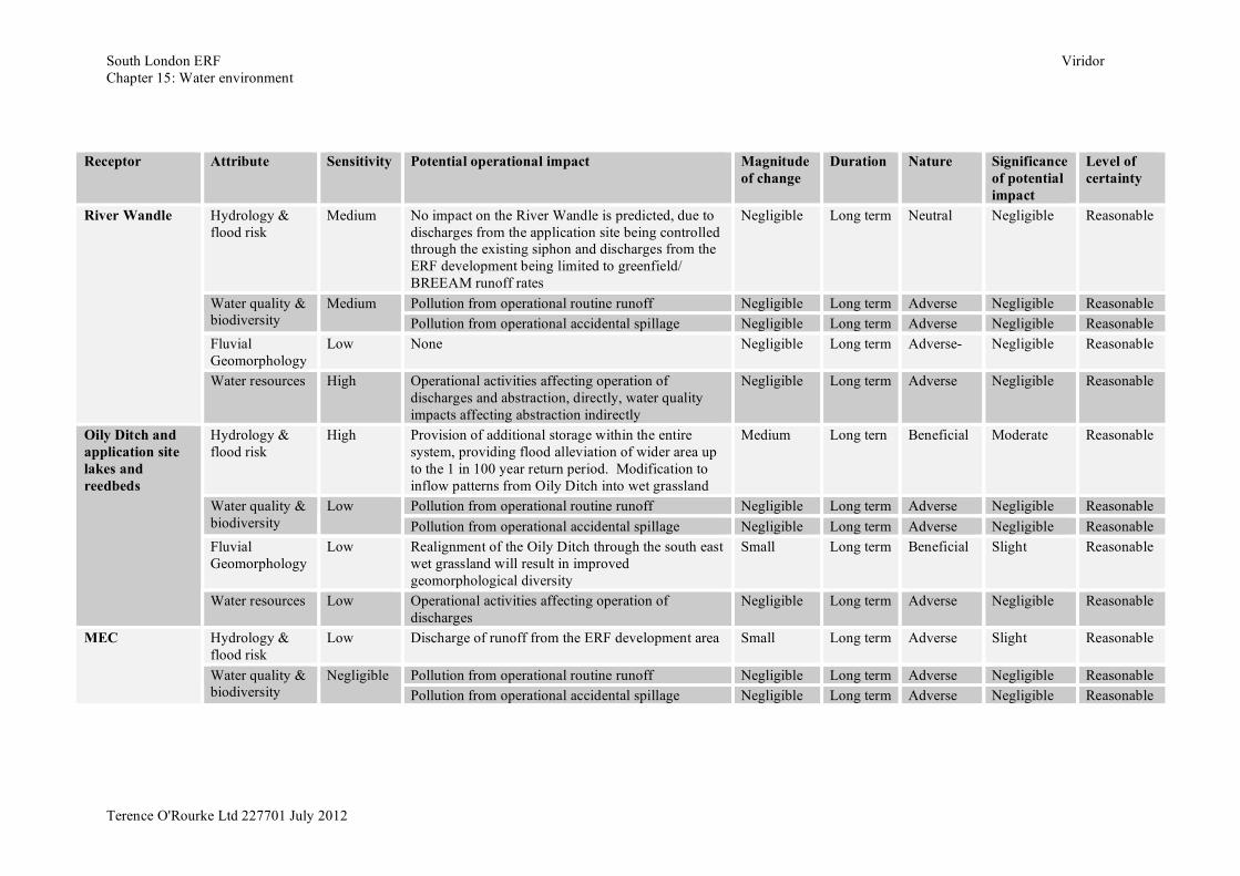
South London ERF Viridor Chapter 15: Water environment
Terence O'Rourke Ltd 227701 July 2012
Receptor Attribute Sensitivity Potential operational impact Magnitude
of change Duration Nature Significance
of potential impact
Level of certainty
Hydrology & flood risk
Medium No impact on the River Wandle is predicted, due to discharges from the application site being controlled through the existing siphon and discharges from the ERF development being limited to greenfield/ BREEAM runoff rates
Negligible Long term Neutral Negligible Reasonable
Pollution from operational routine runoff Negligible Long term Adverse Negligible Reasonable Water quality & biodiversity
Medium Pollution from operational accidental spillage Negligible Long term Adverse Negligible Reasonable
Fluvial Geomorphology
Low None Negligible Long term Adverse- Negligible Reasonable
River Wandle
Water resources High Operational activities affecting operation of discharges and abstraction, directly, water quality impacts affecting abstraction indirectly
Negligible Long term Adverse Negligible Reasonable
Hydrology & flood risk
High Provision of additional storage within the entire system, providing flood alleviation of wider area up to the 1 in 100 year return period. Modification to inflow patterns from Oily Ditch into wet grassland
Medium Long tern Beneficial Moderate Reasonable
Pollution from operational routine runoff Negligible Long term Adverse Negligible Reasonable Water quality & biodiversity
Low Pollution from operational accidental spillage Negligible Long term Adverse Negligible Reasonable
Fluvial Geomorphology
Low Realignment of the Oily Ditch through the south east wet grassland will result in improved geomorphological diversity
Small Long term Beneficial Slight Reasonable
Oily Ditch and application site lakes and reedbeds
Water resources Low Operational activities affecting operation of discharges
Negligible Long term Adverse Negligible Reasonable
Hydrology & flood risk
Low Discharge of runoff from the ERF development area Small Long term Adverse Slight Reasonable
Pollution from operational routine runoff Negligible Long term Adverse Negligible Reasonable
MEC
Water quality & biodiversity
Negligible Pollution from operational accidental spillage Negligible Long term Adverse Negligible Reasonable
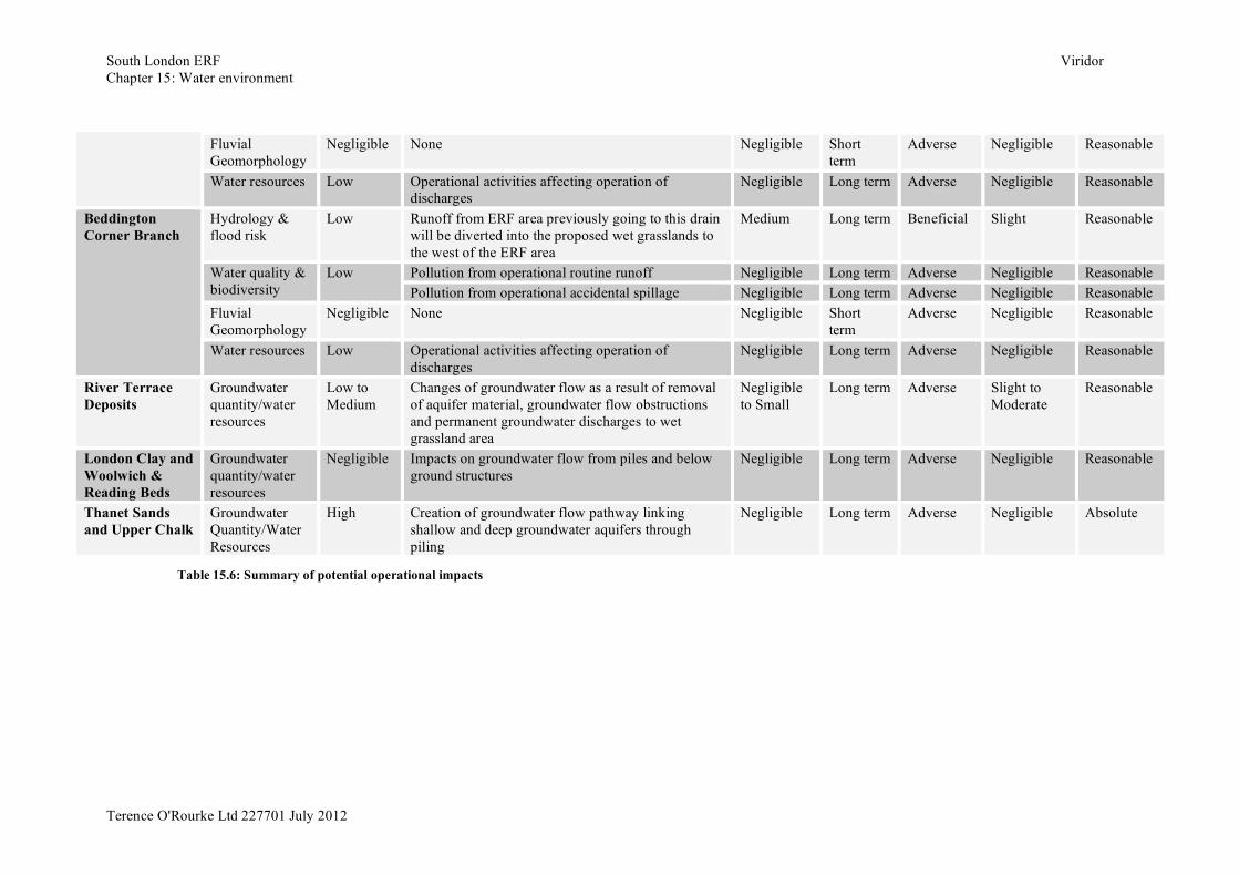
South London ERF Viridor Chapter 15: Water environment
Terence O'Rourke Ltd 227701 July 2012
Fluvial Geomorphology
Negligible None Negligible Short term
Adverse Negligible Reasonable
Water resources Low Operational activities affecting operation of discharges
Negligible Long term Adverse Negligible Reasonable
Hydrology & flood risk
Low Runoff from ERF area previously going to this drain will be diverted into the proposed wet grasslands to the west of the ERF area
Medium Long term Beneficial Slight Reasonable
Pollution from operational routine runoff Negligible Long term Adverse Negligible Reasonable Water quality & biodiversity
Low Pollution from operational accidental spillage Negligible Long term Adverse Negligible Reasonable
Fluvial Geomorphology
Negligible None Negligible Short term
Adverse Negligible Reasonable
Beddington Corner Branch
Water resources Low Operational activities affecting operation of discharges
Negligible Long term Adverse Negligible Reasonable
River Terrace Deposits
Groundwater quantity/water resources
Low to Medium
Changes of groundwater flow as a result of removal of aquifer material, groundwater flow obstructions and permanent groundwater discharges to wet grassland area
Negligible to Small
Long term Adverse Slight to Moderate
Reasonable
London Clay and Woolwich & Reading Beds
Groundwater quantity/water resources
Negligible Impacts on groundwater flow from piles and below ground structures
Negligible Long term Adverse Negligible Reasonable
Thanet Sands and Upper Chalk
Groundwater Quantity/Water Resources
High Creation of groundwater flow pathway linking shallow and deep groundwater aquifers through piling
Negligible Long term Adverse Negligible Absolute
Table 15.6: Summary of potential operational impacts
South London ERF Viridor Chapter 15: Water environment
Terence O’Rourke Ltd 227701 July 2012
Mitigation measures 15.218 As there are no significant potential impacts no further mitigation above and
beyond the design proposals and good practice measures outlined earlier are proposed in relation to the water environment.
Cumulative impact assessment 15.219 Potential cumulative impacts on the water environment include changes to the
watercourse hydrology and flood risk as a result of increased impermeable ground cover, changes to surface water quality as a result of construction pollution and permanent surface drainage outfalls, changes to watercourse geomorphology as a result of channel modifications and changes to groundwater flow and levels as a result of construction dewatering and permanent below ground structures.
15.220 The water environment cumulative impact assessment has involved a desk study review of the proposed developments to identify potential impacts and stated mitigation commitments. Using this information and the previously collated data on the baseline water environment a qualitative assessment of cumulative impacts has been carried out.
Relevant development details 15.221 Details of the development proposals which are relevant to the assessment of
water environment cumulative impacts are given below.
One51 waste management facility 15.222 The waste management facility proposal comprises construction of two
buildings, one housing the main waste management processes and material storage and the other offices and staff welfare facilities; and associated internal access roads, hardstanding and car parking.
15.223 The various planning application documents and drawings indicate that the buildings will be constructed with green roofs and that rainwater harvesting will be implemented on site. In addition the surface water drainage system for the site includes a stormwater attenuation tank and groundwater soakaway discharge. Furthermore, planning permission was granted with the condition that a surface water drainage scheme, based on sustainable drainage principles and providing storage of a 1 in 100 year plus 30% storm event, must be submitted and approved prior to construction.
15.224 The Environmental Statement for the development states that the groundwater level is approximately 2.3m bgl. The main waste management building includes a tipping hall with a waste bunker, the base of which will be constructed approximately 2.5m bgl. No information is provided on the proposed construction or dewatering techniques. However it is assumed that good practice measures will be used to minimise impacts on groundwater. As with the South London ERF development, the deep foundations of the waste bunker are unlikely to have a long-term impact on groundwater flows.
15.225 No information is provided on the management of waste leachate that may collect in the base of the waste bunker, however it is assumed that the bunker
South London ERF Viridor Chapter 15: Water environment
Terence O’Rourke Ltd 227701 July 2012
will be of a water-tight construction and that any excess leachate generated will be discharged to foul sewer.
Beddington Heat & Power gasification power plant 15.226 The gasification power plant development is essentially an extension of the
One51 development discussed above. The additional development footprint will consist of a small extension to the main waste management building and six external coolers.
15.227 The planning submission states that rainwater will be harvested for use in the cooling system and for use as greywater in the staff welfare facilities. It is also stated that a sustainable drainage system will be incorporated into the development proposals; however no details of this system have been provided. Given the distance from the nearest surface water features it is assumed that the site drainage system will discharge to groundwater via a soakaway or to the surface water sewer system; and that appropriate attenuation will be provided to prevent an increase in flood risk.
15.228 No information is provided on foundation design or interactions with groundwater; however it is assumed that piled foundations will be required for the cooling chimneys. It is also assumed that good practice measures will be used during construction to minimise impacts on groundwater quality and quantity.
Thames Water sludge dewatering scheme 15.229 The sludge dewatering scheme includes a number of above ground tanks,
dewatering equipment, conveyor belts and control kiosks, all of which will be constructed under Thames water permitted development rights. In addition two ‘Dutch Barns’, which require planning permission, are proposed for the storage of dewatered sludge cake.
15.230 The planning submission for the dutch barns states that sustainable drainage principles will be employed at the site. Drainage proposals included in the submission indicate that runoff from the dutch barn roofs, site access roads and the dewatering equipment and conveyor belt hardstanding areas will be collected and pumped into the inlet works for the sewage treatment works (STW). The STW will provide both water quality treatment and attenuation of this runoff. Clean runoff from the covered tanks and kiosks will drain to the surrounding ‘undeveloped’ ground, where it will infiltrate to groundwater. The ground between the tanks will be covered with loose stone to a depth of up to 0.3m. The void space in the stone bed will provide storage and attenuation of runoff, without surface ponding, for rainfall events up to the 1 in 100 year plus 30% climate change allowance storm.
15.231 No information is provided on foundation design or interactions with groundwater; however it is assumed that good practice measures will be used during construction to minimise impacts on groundwater quality and quantity. Felnex redevelopment
15.232 The Felnex proposals aim to redevelop the former trading estate into a mixed use development with residential, retail and commercial properties and associated infrastructure.
South London ERF Viridor Chapter 15: Water environment
Terence O’Rourke Ltd 227701 July 2012
15.233 The Environmental Statement (ES) indicates that a small part of the Felnex site may be flooded during a 1 in 100 year plus climate change flood. To mitigate this a surface water drainage system has been developed that will allow overland flood flow to be stored in landscaped depressions along the south east boundary of the site and then diverted via a flood relief culvert back to the River Wandle. The SUDS proposed for the site will discharge into the River Wandle via the existing site outfall. The SUDS will reduce the rate of surface runoff to greenfield rates for all rainfall events up to and including the 1 in 100 year plus climate change design storm.
15.234 The ES also states that groundwater ingress to shallow foundation excavations is expected from the Hackey Gravel deposits, and therefore dewatering will be required during the construction phase. It is also stated that if the water is contaminated it should be treated before disposal. Hackbridge masterplan
15.235 The Hackbridge masterplan sets out a framework and strategies for the regeneration of the Hackbridge area as a sustainable suburb. The masterplan promotes the One Planet Living principles of sustainability, which includes sustainable water management.
15.236 The sustainable water principle states that new developments should aim for a target of 45-70% retention of annual rainfall and up to 100% peak runoff reduction. And that measures which can contribute to achieving these targets include rainwater harvesting and best practice SUDS schemes.
Cumulative impacts 15.237 As the developments discussed above and the South London ERF
development and associated works lie within the River Wandle catchment there is likely to be cumulative impacts. Assuming that the various design proposals, good practice principles and mitigation measures discussed above are implemented the cumulative impacts on the River Wandle are expected to be slight and not significant.
15.238 It is likely that the implementation of SUDS within each of the developments will result in beneficial impacts on the flood risk and water quality of the River Wandle as surface runoff rates are reduced compared to the current situation on the sites where redevelopment is proposed.
15.239 Impacts on the shallow groundwater flow and volume of the Hackney Gravels are expected to be minimal and highly localised for each development. Therefore a negligible cumulative impact is anticipated, which is not significant.
15.240 The timing of the construction phase for each of the developments is unknown, however it is anticipated that these will not be concurrent and therefore there will be no significant impact. Should the works be carried out concurrently there is a slightly higher risk of short term sedimentation impacts on the River Wandle, but with good practice measures in use at each site the impact will remain not significant.
South London ERF Viridor Chapter 15: Water environment
Terence O’Rourke Ltd 227701 July 2012
Residual effects 15.241 There are no residual effects as the proposals have been assessed as having
negligible and/or slight effects on various aspects of the water environment, which are not considered to be significant in an EIA context.
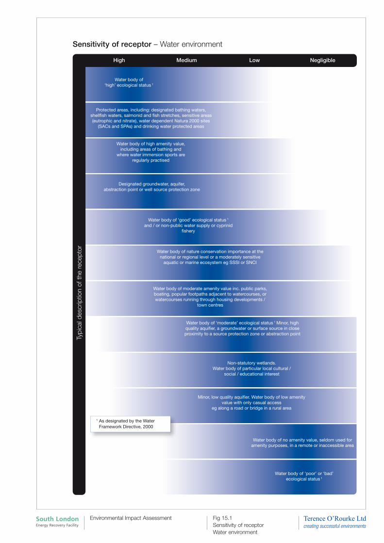
Sensitivity of receptor – Water environment
Typi
cal d
escr
iptio
n of
the
rec
epto
r
High LowMedium Negligible
Water body of ‘high’ ecological status 1
Protected areas, including: designated bathing waters, shellfish waters, salmonid and fish stretches, sensitive areas (eutrophic and nitrate), water dependent Natura 2000 sites
(SACs and SPAs) and drinking water protected areas
Water body of high amenity value,including areas of bathing and
where water immersion sports areregularly practised
Designated groundwater, aquifer,abstraction point or well source protection zone
Water body of ‘good’ ecological status 1 and / or non-public water supply or cyprinid
fishery
Water body of nature conservation importance at the national or regional level or a moderately sensitive
aquatic or marine ecosystem eg SSSI or SNCI
Water body of moderate amenity value inc. public parks, boating, popular footpaths adjacent to watercourses, or watercourses running through housing developments /
town centres
Water body of ‘moderate’ ecological status 1 Minor, high quality aquifier, a groundwater or surface source in close proximity to a source protection zone or abstraction point
Non-statutory wetlands. Water body of particular local cultural /
social / educational interest
Minor, low quality aquifier. Water body of low amenity value with only casual access
eg along a road or bridge in a rural area
Water body of no amenity value, seldom used for amenity purposes, in a remote or inaccessible area
Water body of ‘poor’ or ‘bad’ ecological status 1
1 As designated by the Water Framework Directive, 2000
Fig 15.1 Sensitivity of receptor Water environment
South London Energy Recovery Facility
Environmental Impact Assessment
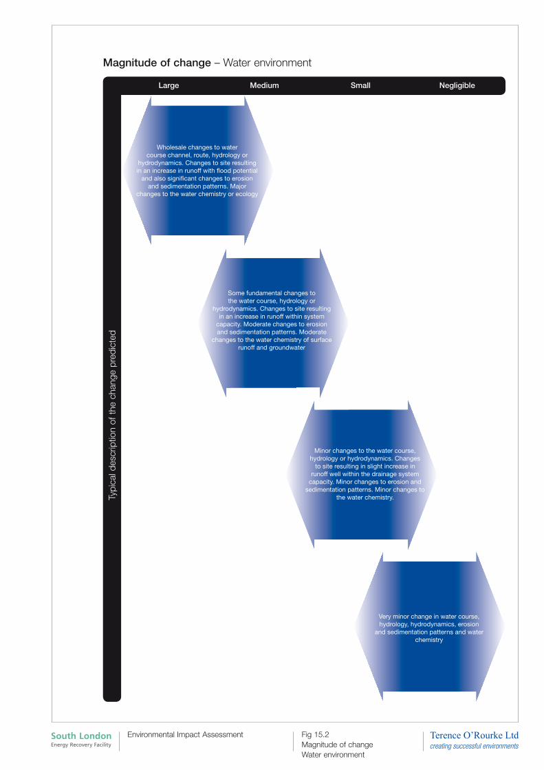
Magnitude of change – Water environment
NegligibleMedium SmallLarge
Typi
cal d
escr
iptio
n of
the
cha
nge
pred
icte
d
Wholesale changes to water course channel, route, hydrology or
hydrodynamics. Changes to site resulting in an increase in runoff with flood potential
and also significant changes to erosion and sedimentation patterns. Major
changes to the water chemistry or ecology
Some fundamental changes tothe water course, hydrology or
hydrodynamics. Changes to site resulting in an increase in runoff within system
capacity. Moderate changes to erosion and sedimentation patterns. Moderate
changes to the water chemistry of surfacerunoff and groundwater
Minor changes to the water course, hydrology or hydrodynamics. Changes
to site resulting in slight increase in runoff well within the drainage system
capacity. Minor changes to erosion and sedimentation patterns. Minor changes to
the water chemistry.
Very minor change in water course, hydrology, hydrodynamics, erosion
and sedimentation patterns and water chemistry
Fig 15.2 Magnitude of change Water environment
South London Energy Recovery Facility
Environmental Impact Assessment
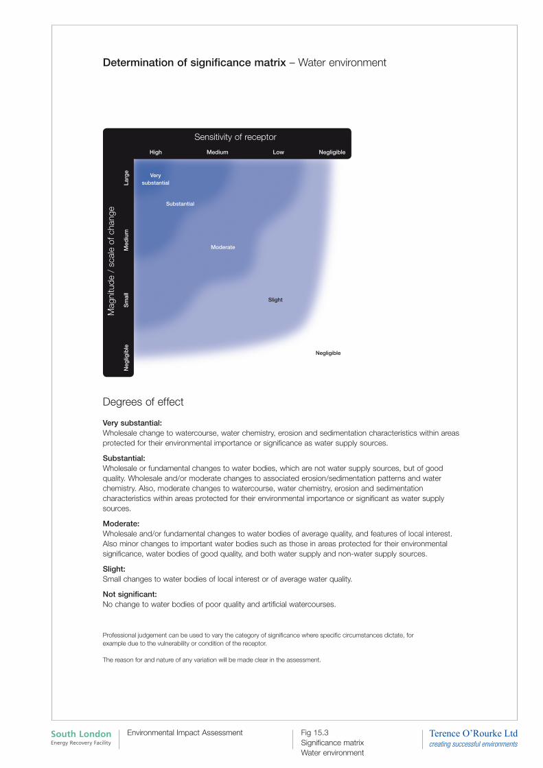
Determination of significance matrix – Water environment
Mag
nitu
de /
sca
le o
f cha
nge
Larg
eM
ediu
mS
mal
lN
eglig
ible
High Medium NegligibleLow
Sensitivity of receptor
Slight
Negligible
Moderate
Substantial
Very substantial
Degrees of effect Very substantial: Wholesale change to watercourse, water chemistry, erosion and sedimentation characteristics within areas protected for their environmental importance or significance as water supply sources.
Substantial: Wholesale or fundamental changes to water bodies, which are not water supply sources, but of good quality. Wholesale and/or moderate changes to associated erosion/sedimentation patterns and water chemistry. Also, moderate changes to watercourse, water chemistry, erosion and sedimentation characteristics within areas protected for their environmental importance or significant as water supply sources.
Moderate: Wholesale and/or fundamental changes to water bodies of average quality, and features of local interest. Also minor changes to important water bodies such as those in areas protected for their environmental significance, water bodies of good quality, and both water supply and non-water supply sources.
Slight: Small changes to water bodies of local interest or of average water quality.
Not significant: No change to water bodies of poor quality and artificial watercourses.
Professional judgement can be used to vary the category of significance where specific circumstances dictate, for example due to the vulnerability or condition of the receptor.
The reason for and nature of any variation will be made clear in the assessment.
Fig 15.3 Significance matrix Water environment
South London Energy Recovery Facility
Environmental Impact Assessment
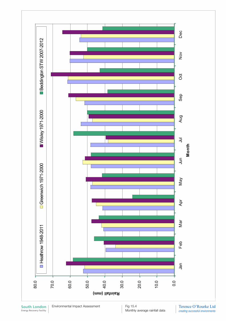
0.0
10.0
20.0
30.0
40.0
50.0
60.0
70.0
80.0
Jan
Feb
Mar
Apr
May
Jun
Jul
Aug
Sep
Oct
Nov
Dec
Mo
nth
Rainfall (mm)
Heath
row
1948-2
011
Gre
enw
ich 1
971-2
000
Wis
ley
1971-2
000
Beddin
gto
n S
TW
2007-2
012
1
5.4
: M
on
thly
av
erag
e ra
infa
ll d
ata
Fig 15.4 Monthly average rainfall data
South London Energy Recovery Facility
Environmental Impact Assessment
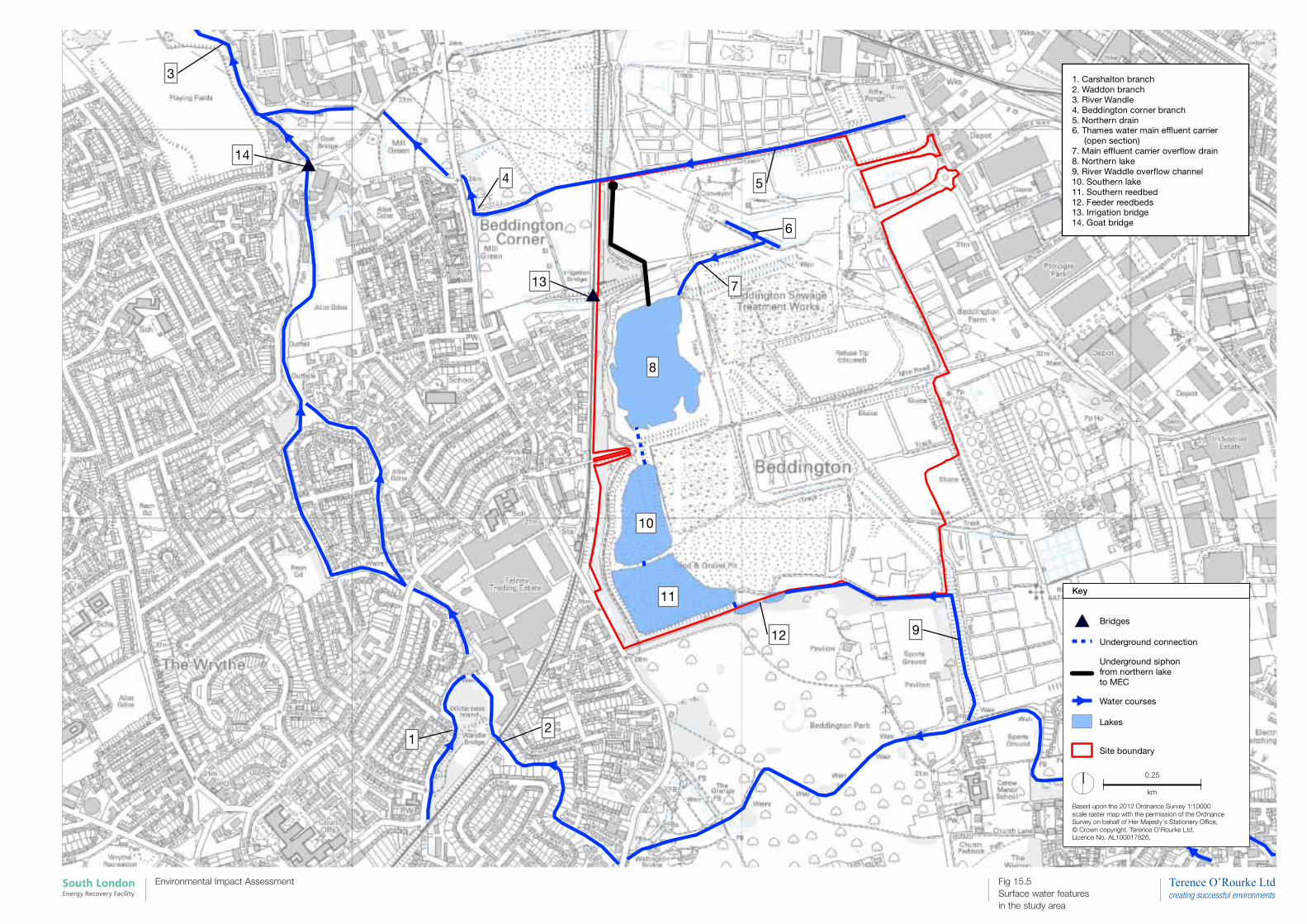
South London Energy Recovery Facility
Environmental Impact Assessment Fig 15.5 Surface water features in the study area
#*
#*
3
12
4 5
6
7
8
10
11
12 9
14
13
#* Bridges
Underground connection
Underground siphonfrom northern lake to MEC
Water courses
Lakes
Site boundary
I0.25
km
Based upon the 2012 Ordnance Survey 1:10000 scale raster map with the permission of the Ordnance Survey on behalf of Her Majesty's Stationery Office,© Crown copyright. Terence O'Rourke Ltd. Licence No. AL100017826.
1. Carshalton branch2. Waddon branch3. River Wandle4. Beddington corner branch5. Northern drain6. Thames water main effluent carrier (open section)7. Main effluent carrier overflow drain8. Northern lake9. River Waddle overflow channel10. Southern lake11. Southern reedbed12. Feeder reedbeds13. Irrigation bridge14. Goat bridge
Key