Embed Size (px)
Citation preview

ENVIRONMENTAL SITE ASSESSMENT SCREENING

PurposeFirst step in ODOT’s ESA ProcessIdentifies all sites in projectUse hard data to screen the project to
determine if site requires Phase I ESA3 types of information collected
◦Regulatory review◦Historical aerial review◦Site Inspection

Regulatory Review

Regulatory Database SearchSearch must have:
◦ NPL/Proposed NPL◦ CERCLIS & CERCLIS-NFRAP◦ CORRACTS◦ RCRA◦ Emergency Response Notification System◦ Landfills◦ BUSTR◦ VAP◦ No Contact List/Fish Advisory
May use commercial database search firm, ODOT GIS or other regulatory databases

Regulatory Database Search, cont.
Mostly concerned with sites within the project
If have the following sites, will often have Phase I ESA for the site regardless if in or out of project◦NPL/Proposed NPL◦CERCLIS/CERCLIS-NFRAP◦CORRACTS◦Other similar sites

Historical Aerials

Historical AerialsMay be obtained from various sources
◦ODOT Office of CADD & Mapping◦Ohio Department of Natural Resources◦Natural Resources Conservation Services◦US Geological Survey◦County Engineer’s Office◦Database Search Firms

Aerial TipsAerials should be high quality
◦Reviewers will enlarge aerial to 200%◦Watch pixelation
Project needs to be markedClearly list date of aerialEnsure you have earliest date possible
◦CADD & Mapping have some from 1938 with full state coverage in the 1950’s
◦Google Earth earliest aerials date to 1992 and can’t be only source

Items to NoteLand useAreas of excavationStorage or disposal areasDrumsTanks, tank pits and pump islandsAny other suspect uses or items

Findlay 1947

Findlay 1947

Site Inspection

Site Inspection Items to NoteEvidence of current and/or former UST
systemDisturbed soils and/or damaged
vegetationDrum (contents and number)Waste Ponds/lagoonsOdorsOther signs of treatment, storage or
disposal of regulated materials

PhotographsShow the entire site
◦View down the road not necessaryShow the site’s suspect areasIdentify site in captionCaption should provide the direction the
photo was takenIf using geopostitioning camera, provide
map with the direction of the photo

Site 2, Vacant Building, 117 Oak Park Drive, facing east

Geopositioning Camera
Site 2, Vacant Building, 117 Oak Park Drive


Optional InformationSanborn Maps
◦May be appropriate for non-typical projectsRegulatory Files
◦Requirement of Phase I ESAProperty Cards
◦Optional for Phase I ESA

MappingAll mapping/aerials must show projectUSGS Topo with project areaCounty and/or city road mapsHistorical aerial photographsPreliminary Plans – show locations of
sites◦Request from Prime Consultant or District
Oil/Gas Wells – If oil/gas wells in projectSanborn maps - optional

ESA Screening Recommendations

Recommendations2 basic outcomes based on all
information◦Phase I ESA◦No further environmental site assessment
warrantedDo not recommend
◦File review◦Plan notes

Recommendations, cont.Gas stations/BUSTR sites will be advanced to
Phase I ESA◦Unless, no ROW and no deep excavation (drive apron,
sidewalks)Electrical transformers
◦Privately owned is a concern since liability is tied to the site
◦Utility owned does not require reporting of the PCB level or additional investigation
◦Utility owned a concern if has apparent release ODOT will notify utility owner to address release

Recommendations, cont.Featureless open railroad track typically
does not warrant additional investigation unless has report or signs of a release ◦May go straight to Phase II ESA
Round houses, sidings, loading/unloading areas, repair areas will require Phase I ESA

ESA Screening Sheet

Site DocumentationMust document all sites in project
◦Residential and agricultural may be present together
Documenting sites by one of methods below◦ESA Screening Sheets◦Table with information contained in ESA
Screening sheer Typically used for large projects

Name of preparer
Preparer title
Date prepared
District #
LUC-75-3.99 77254
Short description of project
Tenant name and address they use for site

Provide current use and what they do – Joe’s Place, Auto Repair
Past use – gas station, landfill
For site
Near by NPL, CERCLIS, & RCRA CORRACT sites
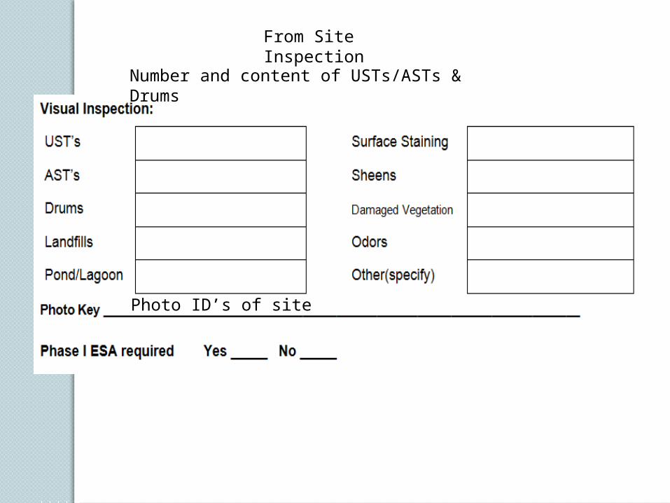
From Site Inspection
Number and content of USTs/ASTs & Drums
Photo ID’s of site

Non-typical ESA Issues

HAS-CR 69-2.93Hydrogen Sulfide Gas
30
Categorical Exclusion Training Class

HAS CR 69 2.93Hydrogen Sulfide Gas
Categorical Exclusion Training Class 31

HAS CR 69 2.93Hydrogen Sulfide Gas
Categorical Exclusion Training Class 32

MAH-224-20.721983 Mercaptan Spill
Categorical Exclusion Training Class 33

WAS – Appalachian CorridorCoal Ash Pond/C8 (PFOA)
Categorical Exclusion Training Class 34

Land Donations
Categorical Exclusion Training Class 35

Land Donations
Categorical Exclusion Training Class 36

Land Donations
Categorical Exclusion Training Class 37

QUESTIONS?