Embed Size (px)
Citation preview
Environmental Report of the
Proposed Variation to the County Donegal Development Plan 2018-2024 in respect of
the TEN-T Priority Route Improvement Project,
Donegal (Variation No.1)
Community, Development & Planning Services
January 2021


Environmental Report of the Proposed Variation to the County Donegal Development Plan 2018-2024 in respect of the TEN-T Priority Route Improvement Project, Donegal
i
TABLE OF CONTENTS
1 Introduction .............................................................................................................. 1
1.1 BACKGROUND .......................................................................................................... 1
1.2 STRATEGIC ENVIRONMENTAL ASSESSMENT ...................................................................... 1
1.3 PLANNING CONTEXT .................................................................................................. 3
1.4 SCREENING AND SCOPING FOR SEA ............................................................................... 3
1.5 APPROPRIATE ASSESSMENT ......................................................................................... 7
1.6 CHECKLIST OF CONTENTS OF ENVIRONMENTAL REPORT ...................................................... 8
2 Contents and Main Objectives of the Proposed Variation and Relationship with
Other Relevant Plans .......................................................................................................... 10
2.1 TEN-T PRIORITY ROUTE IMPROVEMENT PROJECT, DONEGAL .............................................. 10
2.2 PROPOSED VARIATION TO THE COUNTY DONEGAL DEVELOPMENT PLAN 2018-2024, IN RESPECT OF
THE TEN-T PRIPD ....................................................................................................................... 11
2.2.1 Geographical Scope .................................................................................. 14
2.2.2 Temporal Scope ....................................................................................... 14
2.3 RELATIONSHIP WITH OTHER RELEVANT PLANS................................................................. 15
2.3.1 Ireland 2040 Our Plan National Planning Framework .................................. 15
2.3.2 Project Ireland National Development Plan 2018-2027 ................................ 16
2.3.3 Northern and Western Regional Assembly Spatial and Economic Strategy 2020-
2032 (NWRA RSES) ............................................................................................................... 16
2.3.4 Seven Strategic Towns Local Area Plan 2018-2024 ..................................... 16
2.3.5 Draft Letterkenny Plan and Local Transport Plan (pre-draft stage) ............... 18
3 Relevant Aspects of the Current State of the Environment and Likely Evolution
Thereof Without Implementation of the Proposed Variation ............................................ 19
3.1 BIODIVERSITY, FLORA AND FAUNA ................................................................................ 19
3.1.1 Protected Habitats and Species ................................................................. 20
3.1.2 Designated Sites ...................................................................................... 21
3.1.3 Designated Shellfish Waters ...................................................................... 25
3.1.4 Freshwater Pearl Mussel ........................................................................... 26
3.1.5 Ecological Networks .................................................................................. 26
3.1.6 Invasive Species ....................................................................................... 27
3.2 POPULATION AND HUMAN HEALTH ................................................................................ 28
3.2.1 Population Trends .................................................................................... 29
3.2.2 Human Health .......................................................................................... 30
3.3 SOIL AND GEOLOGY .................................................................................................. 31
3.3.1 Land Cover .............................................................................................. 32

Environmental Report of the Proposed Variation to the County Donegal Development Plan 2018-2024 in respect of the TEN-T Priority Route Improvement Project, Donegal
ii
3.4 WATER .................................................................................................................. 33
3.4.1 River Basin District Sub-Catchments .......................................................... 33
3.4.2 Groundwater Status .................................................................................. 34
3.4.3 Surface Water Status ................................................................................ 35
3.4.4 Drinking Water and Wastewater ................................................................ 36
3.4.5 Wastewater Treatment ............................................................................. 36
3.4.6 Wastewater Treatment Systems Serving Single Houses .............................. 37
3.4.7 Drinking Water ......................................................................................... 37
3.4.8 Bathing Water Quality ............................................................................... 38
3.5 CLIMATE CHANGE AND AIR QUALITY ............................................................................. 39
3.6 CLIMATE CHANGE, MARINE AND COASTAL MANAGEMENT .................................................... 41
3.7 NOISE ................................................................................................................... 41
3.8 MATERIAL ASSETS .................................................................................................... 44
3.9 CULTURAL, ARCHAEOLOGICAL AND ARCHITECTURAL HERITAGE ............................................ 44
3.10 LANDSCAPE AND VISUAL ............................................................................................ 48
3.11 EVOLUTION OF THE ENVIRONMENT WITHOUT THE IMPLEMENTATION OF THE PROPOSED VARIATION TO
THE CDP, IN RESPECT OF THE TEN-T PRIPD ..................................................................................... 52
3.11.1 TEN-T PRIPD Does Not Proceed ................................................................ 52
3.11.2 TEN-T PRIPD Proceeds with Historical Route Corridors ............................... 53
4 Environmental Characteristics of the Areas Likely to be Significantly Affected by the
Proposed Variation ............................................................................................................. 56
5 Existing Environmental Problems of Relevance to the Proposed Variation ........... 64
6 Environmental Protection Objectives of Relevance to the Proposed Variation ..... 66
6.1 RELATIONSHIP OF THE PROPOSED VARIATION WITH ENVIRONMENTAL PROTECTION OBJECTIVES IN
OTHER PLANS, PROGRAMMES AND POLICIES ........................................................................................ 66
6.1.1 Spatial Planning ....................................................................................... 66
6.1.2 Biodiversity .............................................................................................. 67
6.1.3 Population and Human Health ................................................................... 67
6.1.4 Soils ........................................................................................................ 67
6.1.5 Water ...................................................................................................... 68
6.1.6 Coast and Marine Resource ....................................................................... 68
6.1.7 Air/Climatic Factors .................................................................................. 68
6.1.8 Material Assets ......................................................................................... 69
6.1.9 Cultural Heritage ...................................................................................... 70
6.1.10 Landscape ............................................................................................... 70
7 Assessment of Likely Significant Effects on the Environment of Implementing the
Proposed Variation ............................................................................................................. 71
7.1 ASSESSMENT METHODOLOGY ...................................................................................... 71
Environmental Report of the Proposed Variation to the County Donegal Development Plan 2018-2024 in respect of the TEN-T Priority Route Improvement Project, Donegal
iii
7.1.1 Level of Assessment ................................................................................. 71
7.1.2 Assessment Criteria .................................................................................. 72
7.1.3 Strategic Environmental Objectives ............................................................ 72
7.2 ALTERNATIVE APPROACHES TO THE PROPOSED VARIATION TO THE DONEGAL CDP ................... 74
7.3 ASSESSMENT OF THE PROPOSED VARIATION.................................................................... 74
7.4 SUMMARY OF ASSESSMENT ....................................................................................... 128
7.5 IN-COMBINATION AND CUMULATIVE IMPACTS ................................................................ 128
8 Measures Envisaged to Prevent, Reduce and as Fully as Possible Offset Any
Significant Adverse Environmental Effects on the Environment of the Proposed Variation ..
.............................................................................................................................. 130
8.1 MEASURES ........................................................................................................... 130
8.1.1 Measures to Prevent, Reduce and as Fully as Possible Offset at the Project
Level ............................................................................................................. 130
8.1.2 Measures to Prevent, Reduce and as Fully as Possible Offset through TII
Guidance for Road Schemes ................................................................................................. 131
9 Selection of Alternatives to the Proposed Variation ............................................. 133
9.1 OVERVIEW OF ALTERNATIVES .................................................................................... 133
9.2 STRATEGIC ALTERNATIVES TO IMPLEMENTING THE PROPOSED VARIATION ............................ 133
9.3 TEN-T PRIPD ALTERNATIVES .................................................................................. 133
9.3.1 Historical TEN-T Corridors included in Donegal CDP 2018-2024 ................. 133
9.3.2 TEN-T PRIPD Phase 2 Option Selection Process ........................................ 134
9.4 DIFFICULTIES ENCOUNTERED .................................................................................... 146
10 Monitoring of Significant Environmental Effects .................................................. 147
11 Conclusions ........................................................................................................... 151
12 Non-Technical Summary ....................................................................................... 153
12.1 INTRODUCTION ..................................................................................................... 153
12.2 PROPOSED VARIATION TO THE CDP ............................................................................ 153
12.3 RELATIONSHIP WITH OTHER PLANS AND PROGRAMMES .................................................... 154
12.4 RELEVANT ASPECTS OF THE CURRENT STATE OF THE ENVIRONMENT.................................... 154
12.5 LIKELY EVOLUTION OF THE ENVIRONMENT WITHOUT IMPLEMENTATION OF THE PROPOSED VARIATION
......................................................................................................................... 154
12.6 ENVIRONMENTAL CHARACTERISTICS OF THE AREAS LIKELY TO BE SIGNIFICANTLY AFFECTED BY THE
PROPOSED VARIATION ................................................................................................................. 155
12.7 EXISTING ENVIRONMENTAL PROBLEMS OF RELEVANCE TO THE PROPOSED VARIATION .............. 155
12.8 ENVIRONMENTAL PROTECTION OBJECTIVES OF RELEVANCE TO THE PROPOSED VARIATION ........ 155
12.9 ASSESSMENT OF LIKELY SIGNIFICANT EFFECTS ON THE ENVIRONMENT OF IMPLEMENTING THE
VARIATION ......................................................................................................................... 155

Environmental Report of the Proposed Variation to the County Donegal Development Plan 2018-2024 in respect of the TEN-T Priority Route Improvement Project, Donegal
iv
12.10 MEASURES ENVISAGED TO PREVENT, REDUCE AND AS FULLY AS POSSIBLE OFFSET ANY SIGNIFICANT
ADVERSE ENVIRONMENTAL EFFECTS ON THE ENVIRONMENT OF THE PROPOSED VARIATION ............................ 156
12.11 SELECTION OF ALTERNATIVES TO THE PROPOSED VARIATION ............................................ 156
12.12 MONITORING OF SIGNIFICANT ENVIRONMENTAL EFFECTS ................................................. 157

Environmental Report of the Proposed Variation to the County Donegal Development Plan 2018-2024 in respect of the TEN-T Priority Route Improvement Project, Donegal
v
LIST OF TABLES
Table 1.1 Steps in the SEA Processes for the Proposed Variation ...................................................... 2
Table 1.2 Submissions received from Consultees ................................................................................ 4
Table 1.3 Checklist of Contents of Environmental Report .................................................................... 8
Table 3.1 Designated sites within the ZoI of Section 1 ................................................................... 22
Table 3.2 Designated sites within the ZoI of Section 2 ................................................................... 23
Table 3.3 Designated sites within the ZoI of Section 3 ................................................................... 24
Table 3.4 Regional Population Projections to 2024 and the County Donegal Context ........................ 29
Table 3.5 Population Projections to 2024 within the TEN-T PRIPD .................................................. 29
Table 3.6 Corine Land Use Cover within TEN-T PRIPD (CORINE, 2018).............................................. 32
Table 3.7 Drinking Water and Wastewater Projects .......................................................................... 36
Table 3.8 Number of Inspections to be carried out in County Donegal during the period 2018-2021 .... 37
Table 3.9 Quality and Enforcement Statistics for Public Supplies by County or Area for 2019............... 38
Table 3.10 Cultural Heritage Items located within Section 1 .............................................................. 45
Table 3.11 Cultural Heritage Items located within Section 2 .............................................................. 46
Table 3.12 Cultural Heritage Items located within Section 3 .............................................................. 46
Table 3.13 Landscape Character Assessments of Study Areas ........................................................... 49
Table 3.14 Evolution of the Environment without the Implementation of the Proposed Variation and Where the TEN-T PRIPD Does Not Proceed ...................................................................................... 52
Table 3.15 Evolution of the Environment without the Implementation of the Proposed Variation and Where the TEN-T PRIPD Advances with the Historical Route Corridors ............................................... 54
Table 4.1 Environmental Characteristics of Areas likely to be Significantly affected by the CDP Variation and the TEN-T PRIPD .................................................................................................................... 56
Table 5.1 Environmental Problems Relevant to the CDP Variation and the TEN-T PRIPD ..................... 64
Table 7.1 Assessment Criteria ......................................................................................................... 72
Table 7.2 Strategic Environmental Objectives of the Donegal CDP 2018-2024 .................................... 72
Table 7.3 Assessment of proposed textual amendments included in the Variation to the County Donegal Development Plan in respect of the TEN-T PRIPD ............................................................................. 75
Table 7.4 Assessment of proposed mapping amendments included in the Variation to the CDP in respect
of the TEN-T PRIPD ...................................................................................................................... 121
Table 7.5 Other Road Projects potential for In-Combination or Cumulative Effects with the TEN-T PRIPD
................................................................................................................................................... 128
Table 9.1 Preferred Option and Scheme Objectives ........................................................................ 144
Table 10.1 Environmental Protection Objectives, Indicators and Targets .......................................... 147

Environmental Report of the Proposed Variation to the County Donegal Development Plan 2018-2024 in respect of the TEN-T Priority Route Improvement Project, Donegal
vi
LIST OF FIGURES
Figure 2.1 TII PMG Project Phases 1 to Phase 4 ............................................................................... 10
Figure 2.2 Preferred route corridor for Section 1 (N15/N13 Ballybofey/Stranorlar Urban Region) ......... 12
Figure 2.3 Preferred route corridor for Section 2 (N56/N13 Letterkenny to Manorcunningham) ........... 13
Figure 2.4 Preferred route corridor for Section 3 (N14 Manorcunningham to Lifford/Strabane/A5 Link) 14
Figure 3.1 PM10 and PM2.5 Air Quality Monitoring Letterkenny Station (02/12/20 to 14/12/20) ............. 40
Figure 3.2 Lden mapping for Section 1 (N15/N13 Ballybofey / Stranorlar Urban Region) ....................... 42
Figure 3.3 Lden mapping for Section 2 (N56/N13 Letterkenny to Manorcunningham) (source: Donegal County Council Draft Noise Action Plan 2018-2023) .......................................................................... 43
Figure 3.4 Lden mapping for Section 3 (N14 Manorcunningham to Lifford / Strabane / A5 Link) (Donegal County Council Draft Noise Action Plan 2018-2023) .......................................................................... 43
Figure 3.5 Scenic Amenity Designations (County Donegal Development Plan 2018-2024) ................... 51
Figure 9.1 Stage 1 Options Considered for Section 1 ...................................................................... 140
Figure 9.2 Stage 2 Options Considered for Section 1 ...................................................................... 141
Figure 9.3 Stage 1 Options Considered for Section 2 ...................................................................... 142
Figure 9.4 Stage 2 Options Considered for Section 2 ...................................................................... 142
Figure 9.5 Stage 1 Options Considered for Section 3 ...................................................................... 143
Figure 9.6 Stage 2 Options Considered for Section 3 ...................................................................... 143
APPENDICES
Appendix A – SEA Screening / Scoping Submissions
Appendix B – Plans and Programmes
Appendix C – Conservation Objectives of European Sites

Environmental Report of the Proposed Variation to the County Donegal Development Plan 2018-2024 in respect of the TEN-T Priority Route Improvement Project, Donegal
1
1 Introduction
1.1 Background
The Donegal County Development Plan (CDP) 2018-2024 is the statutory land use plan for County Donegal and came into effect in June 2018.
The Trans-European Transport Network (“TEN-T”) is a selection of strategic transport corridors throughout the European Union (EU) that have been identified to play a key role in the mobility of
goods and passengers through the EU. Three sections of the TEN-T strategic road network in Donegal have been identified and prioritised for improvement, and together they form the TEN-T
Priority Route Improvement Project, Donegal (“TEN-T PRIPD”). These sections are:
Section 1 (N15/N13 Ballybofey / Stranorlar Urban Region);
Section 2 (N56/N13 Letterkenny to Manorcunningham); and
Section 3 (N14 Manorcunningham to Lifford / Strabane / A5 Link).
The process of delivering the TEN-T PRIPD in accordance with Transport infrastructure Ireland (“TII”)
guidelines has a number of phases including: Phase 1: Concept and Feasibility, Phase 2: Option Selection, Phase 3: Design and Environmental Evaluation and Phase 4: Statutory Processes.
Phases 1 and 2 of the TEN-T PRIPD have been completed to date resulting in preferred option corridors
being identified for the project. In order to progress through Phases 3 and 4 it is necessary to vary the
CDP. The need for the variation at this stage of the project was identified at the time of the making of the CDP – see “Part B thereof – Chapter 5 – Infrastructure – Paragraph 5.1.1 Background – page 77.”
The Variation proposed is that contained in the separate document entitled “Proposed Variation to the
County Donegal Development Plan 2018 – 2024 in respect of the Ten-T Priority Route Improvement
Project, Donegal (Variation No.1)” (“the proposed variation”).
1.2 Strategic Environmental Assessment
Strategic Environmental Assessment (SEA) is a systematic and effective process for ensuring that
environmental issues are taken into account at every stage in the preparation, implementation, monitoring and review of plans, programmes and strategies.
The requirement for an SEA was introduced by Directive 2001/42/EC of the 27th June 2001 (“the SEA
Directive”) and Article 1 thereof set out the objective of the Directive as:
“to provide for a high level of protection of the environment and to contribute to the integration of environmental considerations into the preparation and adoption of plans and programmes with a view to promoting sustainable development, by ensuring that, in accordance with this Directive, an environmental assessment is carried out of certain plans and programmes which are likely to have significant effects on the Environment”. The former Department of the Environment, Heritage and Local Government (now Department of Housing, Local Government and Heritage ) in November 2004 issued guidelines for Regional Authorities and Planning Authorities on the implementation of the SEA Directive titled “Assessment of the Effects of Certain Plans and Programmes on the Environment”. Donegal County Council (“DCC”)

Environmental Report of the Proposed Variation to the County Donegal Development Plan 2018-2024 in respect of the TEN-T Priority Route Improvement Project, Donegal
2
as a Planning Authority is obliged to have regard to such guidelines in the performance of its functions and that requirement has been observed in the preparation of this Environmental Report. The SEA Guidelines outline the SEA process and set out the following requisite steps, as outlined in Table 1.1. Table 1.1 Steps in the SEA Processes for the Proposed Variation
Screening of CDP Variation: Determines whether SEA is required for the Variation to the Donegal CDP in respect of the TEN-T Priority Route Improvement Project (2020), in consultation with the designated statutory consultees.
Completed
Scoping of CDP Variation: Consultation with Statutory bodies and other interested parties on the scope and level of detail to be considered in the assessment of the Variation to the Donegal CDP in respect of the TEN-T Priority Route Improvement Project.
Completed
Preparation of Environmental Report: An assessment of the likely significant impacts on the environment as a result of the Variation to the Donegal CDP in respect of the TEN-T Priority Route Improvement Project.
Current Stage
Consultation on the Variation to the Donegal CDP in respect of the TEN-T Priority Route Improvement Project and associated Environmental Report and Appropriate Assessment.
To be Completed
Publication of the Variation to the Donegal CDP in respect of the TEN-T Priority Route Improvement Project and associated Strategic Environmental Assessment and Appropriate Assessment.
To be Completed
Preparation of an SEA Statement identifying how environmental considerations and consultation have been integrated into the Adopted Variation to the Donegal CDP in respect of
the TEN-T Priority Route Improvement Project.
To be Completed
The first step in the process was to ‘screen’ the Proposed Variation. In carrying out the SEA Screening, DCC determined that the Proposed Variation would be likely to have significant effects on the
environment and that SEA was required. The next step was to proceed to preparation of an
Environmental Report.
This document is the Environmental Report of the Proposed Variation. It outlines the environmental assessment of the Proposed Variation, and recommends measures to prevent, reduce and offset likely
significant effects on the environment as a result of implementation of the Proposed Variation, where
required. It should be read in conjunction with the Stage 2 Natura Impact Report (NIR) for the Proposed Variation. The proposed variation is designed solely to facilitate the strategic roads project namely the TEN-T PRIPD. The exact location and detailed design of the project has not yet been decided. In light of the fact that it is considered beyond reasonable doubt that the project will require Environmental Impact Assessment (“EIA”) and Appropriate Assessment (“AA”) at the development consent stage, it is considered appropriate to assess, at this time and in connection with the Proposed Variation of the development plan, the likely significant effects of the Proposed Variation on the environment at a strategic level only and to leave over for detailed project level assessment matters connected with the exact location and detailed design of the project. In turn the Environmental Report, having assessed the impact on specific aspects of the environment, identifies possible overall measures which may prevent, reduce, or as fully as possible offset such adverse environmental impacts (i.e. mitigation measures). Again, as the detailed design and specific location for the TEN-T PRIPD has not yet been decided, these measures are appropriately strategic and generic, rather than specific, in nature. Specific project level measures will be developed (as appropriate) as part of the project level EIA and AA, a separate process from SEA. The development of the TEN-T PRIPD will be subject to compliance with the provisions of national and European legislation including in particular the provisions of the EIA Directive (Dir 2011/92/EU as amended by Dir 2014/52/EU), Habitats Directive (Dir 92/43/EEC) and Birds Directive (Dir 2009/147/EC)
Environmental Report of the Proposed Variation to the County Donegal Development Plan 2018-2024 in respect of the TEN-T Priority Route Improvement Project, Donegal
3
(or such amendments or replacements of same) as transposed into Irish Law, and the project will be subject to An Bord Pleanála (ABP) being satisfied that the project complies with European and national legislation. If permission for development is granted, Donegal County Council will be responsible for ensuring compliance with ABP’s approval and conditions as well as the requirements of the relevant national and European legislation.
1.3 Planning Context
The CDP 2018-2024 is the statutory land use plan for County Donegal, and came into effect in June
2018. The Proposed Variation to the CDP, in respect of the TEN-T PRIPD is being progressed pursuant
to Section 13 of the Act. The Proposed Variation incorporates strategic objectives set out in higher level plans, such as the Enhanced Regional Accessibility National Strategic Outcome and National Policy
Objectives (NPOs) 45 and 46 of the National Planning Framework (NPF), Regional Policy Objective (RPO) 3.7.30 of the Northern and Western Regional Assembly’s Regional Spatial and Economic Strategy
2020-2032, and the investment priorities of the National Development Plan (NPD) 2018-2027. The proposed variation also provides a strategic context for the Ballybofey / Stranorlar element of the Seven
Strategic Towns Local Area Plan (e.g. Objective BS-IS-1), and the forthcoming Letterkenny Plan.
Progression and development of the TEN-T strategic road network is included within the Objectives and
Policies of the CDP. The proposed variation facilitates the development of the TEN-T PRIPD, a strategic roads project, within the preferred Option Corridors, subject to the outcome of the statutory approvals
process.
1.4 Screening and Scoping for SEA
As part of the SEA process, a Screening of the Proposed Variation was undertaken in October 2020. This determined that the strategic scope and geographical extent of the Variation would affect a significant area of land within the proposed Option Corridors, as well as affecting the implementation of other activities and projects within said corridors. It concluded that the Variation had potential to give rise to a number of environmental impacts, and that the variation accordingly should be the subject of an Environmental Report and SEA on foot of same.
In accordance with Article 13M of the 2001 Regulations 2001 (as amended) the following bodies were
notified that an Environmental Report would be prepared and submissions in relation to the scope and level of detail to be included in said report were invited from same:
SEA Section, Environmental Protection Agency (EPA)
Department of Housing, Local Government and Heritage (DHLGH)
Department of the Environment, Climate and Communications (DECC)
Department of Agriculture, Food & the Marine (DAFM)
Department of Tourism, Culture, Arts, Gaeltacht, Sport and Media (DTCAGSM) which included
the National Parks and Wildlife Service, Glenveagh National Park. Leitrim County Council
Natural Environment Division, Northern Ireland Environment Agency
Strategic Planning Directorate, Department of the Infrastructure, Northern Ireland
Fermanagh & Omagh District Council
Derry City & Strabane District Council
Submissions were received from the following consultees:
SEA Section, Environmental Protection Agency (EPA)
Department of Agriculture, Food & the Marine (DAFM)
Geological Survey Ireland (GSI)
Northern Ireland Environment Agency

Environmental Report of the Proposed Variation to the County Donegal Development Plan 2018-2024 in respect of the TEN-T Priority Route Improvement Project, Donegal
4
Derry City & Strabane District Council
Fermanagh and Omagh District Council.
These submissions are provided in Appendix A, and the issues raised are summarised in Table 1.2 below. The comments received were taken on board in the preparation of this Environmental Report,
where appropriate as appears from the responses in Table 1.2. Certain specific comments relating to
the details of TEN-T PRIPD will be more appropriately addressed in the EIA and AA to be carried out in due course, should the Proposed Variation be adopted and the project proceed to the development
consent stage.
Table 1.2 Submissions received from Consultees
Ref Submission by
Issues raised Response
1 EPA 1. Refer to guidance document ‘SEA of Local Authority Land Use Plans – EPA Recommendations and Resources’.
2. Note that in proposing and implementing the Variation, Donegal County Council should ensure that it is consistent with the need for proper planning and sustainable development. Adequate and appropriate critical service infrastructure should be in place, or
required to be put in place, to service any development proposed and authorised during the lifetime of the Variation.
3. Note that, in considering the Variation, Donegal County Council should take into account the need to align with national commitments on climate change mitigation and adaptation as well as incorporating any relevant recommendations in sectoral, regional and local climate adaptation plans.
4. Note that Donegal County Council should ensure that the Variation aligns with key relevant higher-level plans and programmes and is consistent with the relevant objectives and policy commitments of the
National Planning Framework and the Northern & Western Regional Spatial and Economic strategy appropriate to the Variation.
5. In preparing the Variation, the recommendations, key issues and challenges described in the most recent State of the Environment Report ‘Ireland’s Environment – An Assessment 2016 (EPA, 2016) should be considered as relevant and appropriate to the Variation.
6. Sets out that SEA guidance for the following is available on the EPA website and should be taken into account:
SEA process guidance and checklist
Inventory of spatial datasets relevant to SEA
Topic specific guidance (including Good Practice note on Cumulative Effects Assessment (EPA, 2020), Guidance on SEA Statements and Monitoring (EPA, 2020), Integrating climatic
1. Noted, this guidance shall be taken into account.
2. Noted for future working. This suggestion can more appropriately be considered at project level for the TEN-T
PRIPD.
3. Noted, these commitments and plans have been considered through the SEA process.
4. Noted, these commitments and plans have been considered through the SEA process.
5. Noted, this assessment has been considered
through the SEA process.
6. Noted, this guidance shall be taken into account.
7. Noted.
8. Noted.
9. Noted.
10. Noted.
11. Noted, the AA process has ensured that the Variation complies with the requirements of the Habitats Directive, and has been incorporated into the ER.

Environmental Report of the Proposed Variation to the County Donegal Development Plan 2018-2024 in respect of the TEN-T Priority Route Improvement Project, Donegal
5
Ref Submission by
Issues raised Response
factors into SEA (EPA, 2019), Developing and Assessing Alternatives in SEA (EPA, 2015), and Integrated Biodiversity Impact Assessment (EPA, 2012)).
7. Note that the ‘Environmental Sensitivity Mapping (ESM) WebTool’ is a new decision support tool to assist SEA and planning processes available at www.enviromap.ie
8. Note that the EPA SEA WebGIS Tool is available to
public authorities at https://gig.epa.ie/EIS_SEA/ to assist in SEA screening and scoping exercises.
9. Note that the EPA WFD Application is available at http://wfd.edenireland.ie for public agencies, or at www.catchments.ie
10. Note that where changes to the Plan are made prior to finalisation, or where modifications to the Plan are proposed following its adoption, these should be screened for potential for likely significant effects in accordance with the criteria set out in Schedule 2A of the SEA Regulations (SI No 436 of 2004)
11. Note that it should be ensured that the Variation complies with the requirements of the Habitats Directive where relevant. Where Appropriate Assessment is required, the key findings and recommendations should be incorporated into the SEA and the Variation.
12. Note that the EPA AA GeoTool is available at http://www.epa.ie/terminalfour/AppropAssess/index.jsp which allows users to select a location, specify a search area and gather available information for each European Site within the area.
13. Set out the Authorities that should be consulted prior to making a SEA determination, under the SEA Regulations.
12. Noted.
13. Noted.
2 Department of Agriculture, Food and the Marine (DAFM)
1. Advise that, while the proposed variations to the CDP and associated proposals in relation to the proposed TEN-T PRIPD are generally remote from the Marine area, the Council should be advised in the AA and ER to take particular cognisance of the potential impacts on the fisheries and aquaculture interests in Lough Swilly. This is particularly relevant to the preferred route corridor for Section 2 (N56/N13 Letterkenny to Manorcunningham), which impacts directly on the marine environment.
1. Noted, this area shall be considered through the SEA and AA process.
3 GSI 1. State that important geological and geomorphological sites are designated as geological NHAs.
2. Note that County Geological Sites (CGS) are now included in CDPs and the GIS of planning departments, to ensure appropriate protection of geological heritage. Unaudited CGSs can be viewed through the online Map Viewer resource. CGS audit records for County Donegal show that there are no unaudited CGSs in the vicinity of the proposed study
1. Noted, these sites shall be considered through the SEA process.
2. Noted, these sites shall be considered through the SEA process.
3. This suggestion can more appropriately be considered at project level for the TEN-T

Environmental Report of the Proposed Variation to the County Donegal Development Plan 2018-2024 in respect of the TEN-T Priority Route Improvement Project, Donegal
6
Ref Submission by
Issues raised Response
areas.
3. There are no envisaged impacts on CGSs, however should the plan be altered, please contact Clare Glanville.
4. Should any significant bedrock cuttings be created during construction, request that they will be designed to remain visible as rock exposure rather than covered with soil and vegetated, in accordance with safety guidelines and engineering constraints,
or a digital photographic record be provided.
5. Highlight consideration of mineral resources / potential resources as a material asset to be explicitly recognised within the environmental assessment process – data, maps, interpretation and advice are available on their website, and Active Quarries, Mineral Localities and Aggregate potential maps are available on the Map Viewer. Crushed rock aggregate potential ranges from high potential’ to ‘very high potential’ and granular aggregate potential of ‘moderate potential’ in the wider vicinity of the project, and consideration should be given to aggregate potential sterilisation as part of the planning process. The Active Quarries database shows one active and one old quarry in close proximity to the study area.
6. GSI has information available on geohazards, including landslides, on the Map Viewer. The study area is generally classified as low susceptibility for landslides, but discrete areas are mapped as moderate and high susceptibility. Advise the use of GSI datasets when considering the impact of geohazards and landslides.D Data shows no recorded landslides in the study area.
7. Recommend using the GSIs National Aquifer and Recharge maps on the Map Viewer in consideration of groundwater. GSI records show multiple wells and springs within the study area and at least one public water supply source protection area.
8. National geotechnical database resources can be accessed on the Map Viewer. Strongly recommend that this is consulted as part of any baseline geological assessment of the proposed development; this may be beneficial and cost saving for any site specific investigations that may be designed as part of the development.
9. GSI would appreciate a copy of any report pertaining to any site investigations carried out.
PRIPD.
4. This suggestion can more appropriately be considered at project level for the TEN-T PRIPD.
5. Noted. This information and suggestion can more appropriately be
considered at project level for the TEN-T PRIPD.
6. Noted. This information and suggestion can more appropriately be considered at project level for the TEN-T PRIPD.
7. Noted. This information and suggestion can more appropriately be considered at project level for the TEN-T PRIPD.
8. Noted. This information and suggestion can more appropriately be considered at project level for the TEN-T PRIPD.
9. Noted. This information and suggestion can more appropriately be considered at project level for the TEN-T PRIPD.
4 DAERA Natural Environment Division:
1. State that there are several SACs in the vicinity of the TENT-PRIPD route corridors and therefore, potential for transboundary effects on the natural environment. Suggest consideration and clear reference be given to these potential transboundary
1. Noted, these areas shall be considered through the SEA and AA process.
2. Noted.
3. Noted, these areas shall

Environmental Report of the Proposed Variation to the County Donegal Development Plan 2018-2024 in respect of the TEN-T Priority Route Improvement Project, Donegal
7
Ref Submission by
Issues raised Response
effects within Environmental Reports.
2. Agree that an Environmental Report is required for the proposed Variation to the CDP.
3. Observe that there may be scope to explicitly draw out potential transboundary effects on the NI environment. Suggest that consideration and clear reference be given to marine transboundary effects.
4. Observe that no reference was made to the Marine
Strategy Framework Directive or the Marine Spatial Planning Directive with regard to the implementation of EU legislation on the environment.
DfC Historic Environment Division:
5. Refer to previous comments at the advanced scoping stage with Donegal Co Co.
6. Consider that direct impacts of the plan to heritage assets in NI are highly unlikely. However, advise the use of the historic environment datasets in respect to the Mannorcunningham to Lifford / Strabane route.
be considered through the SEA and AA process.
4. Noted, Part D: The Environmental Report of the Donegal CDP 2018-2024 references these Directives, and has been referred to within this ER
5. Noted
6. Noted. Advise that the historic environment datasets will provide a useful resource at project level for the TEN-T PRIPD.
5 Derry City and Strabane
District Council
1. Suggest that it may be useful to name the Local Development Plan (LDP 2032) for Derry City and
Strabane District, as ‘another plan’ that is influenced by the project.
2. Suggest that it may be useful to consider Park and Ride / Share facilities at key locations, on each of the 3 Road Sections (particularly Section 2), as a means of reducing car usage in both districts and mitigating negative impacts.
3. Note that it would be important to clarify on the nature and extent of this road project No 3 (and bridge?), so that the project / impacts may be assessed.
4. Note that Section 3 and Section 1 corridors have
correctly been identified as being upstream, with potential impacts on this District, particularly the River Finn SAC, the River Foyle & Tributaries SAC (and Monegal Bog SAC & Owenkillew SAC and the Sperrin AONB – though their links are likely to be much less) – which can be further assessed.
1. Noted, this plan has been included in the
updated list of plans and programmes.
2. This suggestion can more appropriately be considered at project level for the TEN-T PRIPD.
3. This suggestion can more appropriately be considered at project level for the TEN-T PRIPD.
4. Noted, these areas shall be considered through the SEA and AA process
6 Fermanagh and Omagh District Council
No comments to make. Noted.
1.5 Appropriate Assessment
The Habitats Directive (Council Directive 92/43/EEC) on the conservation of natural habitats and of wild fauna and flora obliges member states to designate, protect and conserve habitats and species of

Environmental Report of the Proposed Variation to the County Donegal Development Plan 2018-2024 in respect of the TEN-T Priority Route Improvement Project, Donegal
8
importance in a European Union context. Article 6(3) of the Habitats Directive requires that “Any plan or project not directly connected with or necessary to the conservation of a site but likely to have a significant effect thereon, either individually or in combination with other plans or projects, shall be subject to appropriate assessment of its implications for the site in view of the site’s conservation objectives.”
A Natura Impact Report (NIR) of the Proposed Variation was completed in accordance with the
requirements of Article 6(3) of the EU Habitats Directive (92/443/EEC), and in accordance with the
requirements of Part XAB of the Planning and Development Act (2000), as amended.
The NIR concluded a Finding of No Significant Effects following the completion of Stage II of the
Appropriate Assessment (AA) process in relation to the Proposed Variation. The project will itself be subject to an Appropriate Assessment through the statutory approvals process. Through that process,
the project must demonstrate that it will not adversely impact on the Natura 2000 network.
1.6 Checklist of Contents of Environmental Report
Table 1.3 sets out the information to be contained within the Environmental Report as set out in
Annex 1 of the SEA Directive (2001/42/EC) and Schedule 2B of the 2001 Regulations and as per and indicates where in this Report each is included.
Table 1.3 Checklist of Contents of Environmental Report
Contents of Environmental Report Section of Report
(a) An outline of the contents and main objectives of the plan and relationship with other relevant plans.
Section 1 – Introduction.
Section 2 – Contents and Main Objectives of the Proposed Variation and Relationship with Other Plans.
(b) The relevant aspects of the current state of the environment and the likely evolution thereof without implementation of the plan.
Section 3 – Relevant Aspects of the Current State of the Environment and Likely Evolution thereof without Implementation of the Proposed Variation.
(c) The environmental characteristics of areas likely to be
significantly affected.
Section 4 – Environmental Characteristics
of the Areas Likely to be Affected by the Proposed Variation.
(d) Any existing environmental problems which are relevant to the plan including, in particular, those relating to any areas of a particular environmental importance, such as areas designated pursuant to the Birds Directive or Habitats Directive.
Section 5 - Existing Environmental Problems of Relevance to the Proposed Variation.
(e) The environmental protection objectives, established at international, European Union or national level, which are relevant to the plan and the way those objectives and any environmental considerations have been taken into account during its preparation.
Section 6 - Environmental Protection Objectives of Relevance to the Proposed Variation.
Appendix B - Plans and Programmes.
(f) The likely significant effects on the environment, including on issues such as biodiversity, population, human health, fauna, flora, soil, water, air, climatic factors, material assets, cultural heritage including architectural and archaeological heritage, landscape and the interrelationship between the above factors.
Section 7 – Assessment of the Likely Significant Effects on the Environment of Implementing the Proposed Variation.
Environmental Report of the Proposed Variation to the County Donegal Development Plan 2018-2024 in respect of the TEN-T Priority Route Improvement Project, Donegal
9
Contents of Environmental Report Section of Report
(g) The measures envisaged to prevent, reduce and as fully as possible offset any significant adverse effects on the environment of implementing the plan.
Section 8 - Measures Envisaged to Prevent, Reduce and as Fully as Possible Offset Any Significant Adverse Environmental Effects on the Environment of the Proposed Variation.
(h) An outline of the reasons for selecting the alternatives dealt with, and a description of how the assessment was undertaken including any difficulties (such as technical deficiencies or lack of know-how) encountered in compiling the required information.
Section 9 - Selection of Alternatives to the Proposed Variation.
Section 9.3 – Description of How the Assessment was Undertaken.
Section 9.4 – Difficulties Encountered.
(i) A description of the measures envisaged concerning monitoring of the significant environmental effects of implementation of the plan.
Section 10 - Monitoring of Significant Environmental Effects.
(j) A non-technical summary of the information provided under the above headings
Section 12 – Non – Technical Summary.
Environmental Report of the Proposed Variation to the County Donegal Development Plan 2018-2024 in respect of the TEN-T Priority Route Improvement Project, Donegal
10
2 Contents and Main Objectives of the Proposed Variation and Relationship with Other Relevant Plans
2.1 TEN-T Priority Route Improvement Project, Donegal
The TEN-T is a selection of strategic transport corridors throughout the European Union (EU) that have
been identified to play a key role in the mobility of goods and passengers through the EU. Three sections of the TEN-T strategic road network in Donegal have been identified and prioritised for
improvement and together, they form the TEN-T PRIPD. These sections are also prioritised within the National Planning Framework, Project Ireland 2040, and the National Development Plan 2018-2027.
These sections are:
Section 1 (N15/N13 Ballybofey / Stranorlar Urban Region);
Section 2 (N56/N13 Letterkenny to Manorcunningham); and
Section 3 (N14 Manorcunningham to Lifford / Strabane / A5 Link).
In 2017, Donegal County Council procured consultants for TEN-T PRIPD to deliver the project through
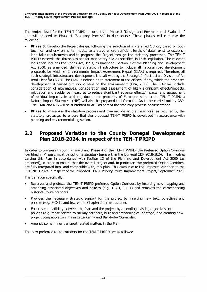
Phase 1 to Phase 4 in accordance with the Transport Infrastructure Ireland Project Management Guidelines (“PMGs”) (TII, 2019), see Figure 2.1 below. The purpose of the proposed Variation to the
Donegal CDP is to ensure integration and compatibility of the TEN-T PRIPD with the Donegal CDP 2018-2024; in this regard the SEA of the proposed Variation has no influence upon the Option Corridor
selection process.
Figure 2.1 TII PMG Project Phases 1 to Phase 4
Phase 1 “Concept and Feasibility” and Phase 2 “Option Selection” of the TEN-T PRIPD have been
completed to date, involving:
Phase 1: A scheme feasibility report, which identified the need for the scheme;
Phase 2: A preliminary options assessment to shortlist route options, the appraisal of the
shortlisted options, the identification of an Emerging Preferred Option Corridor/s for each of the
above sections, and finally a Preferred Option Corridor for each section which identify the preferred route corridors in which the road improvement schemes will take place.
Environmental Report of the Proposed Variation to the County Donegal Development Plan 2018-2024 in respect of the TEN-T Priority Route Improvement Project, Donegal
11
The project level for the TEN-T PRIPD is currently in Phase 3 “Design and Environmental Evaluation”
and will proceed to Phase 4 ”Statutory Process” in due course. These phases will comprise the
following:
Phase 3: Develop the Project design, following the selection of a Preferred Option, based on both
technical and environmental inputs, to a stage where sufficient levels of detail exist to establish
land take requirements and to progress the Project through the statutory processes. The TEN-T PRIPD exceeds the thresholds set for mandatory EIA as specified in Irish legislation. The relevant
legislation includes the Roads Act, 1993, as amended. Section 2 of the Planning and Development
Act 2000, as amended, defines strategic infrastructure to include all national road development proposals for which an Environmental Impact Assessment Report (EIAR) is required. Therefore, all
such strategic infrastructure development is dealt with by the Strategic Infrastructure Division of An Bord Pleanála (ABP). The EIAR is defined as “a statement of the effects, if any, which the proposed
development, if carried out, would have on the environment” (EPA, 2017). The EIAR will include consideration of alternatives, consideration and assessment of likely significant effects/impacts,
mitigation and avoidance measures to reduce significant adverse effects/impacts, and assessment
of residual impacts. In addition, due to the proximity of European sites to the TEN-T PRIPD a Natura Impact Statement (NIS) will also be prepared to inform the AA to be carried out by ABP.
The EIAR and NIS will be submitted to ABP as part of the statutory process documentation.
Phase 4: Phase 4 is the statutory process and may include an oral hearing(s) as required by the
statutory processes to ensure that the proposed TEN-T PRIPD is developed in accordance with
planning and environmental legislation.
2.2 Proposed Variation to the County Donegal Development Plan 2018-2024, in respect of the TEN-T PRIPD
In order to progress through Phase 3 and Phase 4 of the TEN-T PRIPD, the Preferred Option Corridors
identified in Phase 2 must be put on a statutory basis within the Donegal CDP 2018-2024. This involves varying this Plan in accordance with Section 13 of the Planning and Development Act 2000 (as
amended), in order to ensure that the overall project and, in particular, the preferred Option Corridors,
are fully integrated into, and compatible with, this plan. This gives rise to the Proposed Variation to the CDP 2018-2024 in respect of the Proposed TEN-T Priority Route Improvement Project, September 2020.
The Variation specifically:
Reserves and protects the TEN-T PRIPD preferred Option Corridors by inserting new mapping and
amending associated objectives and policies (e.g. T-O-1, T-P-1) and removes the corresponding
historical route corridors.
Provides the necessary strategic support for the project by inserting new text, objectives and
policies (e.g. S-O-11 and text within Chapter 5 Infrastructure).
Ensures compatibility between the Plan and the project by amending existing objectives and
policies (e.g. those related to railway corridors, built and archaeological heritage) and creating new
project compatible zonings in Letterkenny and Ballybofey/Stranorlar.
Amends some minor transport related matters in the Plan.
The new preferred route corridors for the TEN-T PRIPD are as follows:

Environmental Report of the Proposed Variation to the County Donegal Development Plan 2018-2024 in respect of the TEN-T Priority Route Improvement Project, Donegal
12
The preferred route corridor for Section 1 (N15/N13 Ballybofey/Stranorlar Urban
Region) which, relative to the route corridor in the existing County Development Plan,
generally runs to the north-west, north, and north-east of said urban region (Figure 2.2).
Figure 2.2 Preferred route corridor for Section 1 (N15/N13 Ballybofey/Stranorlar Urban Region)

Environmental Report of the Proposed Variation to the County Donegal Development Plan 2018-2024 in respect of the TEN-T Priority Route Improvement Project, Donegal
13
The preferred route corridor for Section 2 (N56/N13 Letterkenny to Manorcunningham)
which, relative to the route corridor in the existing County Development Plan, includes a widened
section in the townlands of Bunagee and Milk Isle, and additional corridor sections in the townlands
of Dromore and Drumany and along the route of the existing N14 National route (Figure 2.3).
Figure 2.3 Preferred route corridor for Section 2 (N56/N13 Letterkenny to Manorcunningham)

Environmental Report of the Proposed Variation to the County Donegal Development Plan 2018-2024 in respect of the TEN-T Priority Route Improvement Project, Donegal
14
The preferred route corridor for Section 3 (N14 Manorcunningham to Lifford/Strabane/A5
Link) which has minor deviations from the route corridor shown in the existing County
Development Plan (Figure 2.4).
Figure 2.4 Preferred route corridor for Section 3 (N14 Manorcunningham to Lifford/Strabane/A5 Link)
A full description of the amendments included in the Proposed Variation are set out in Section 7, in Table 7.3 and Table 7.4. A total of 33 no. textual amendments and 11 no. mapping amendments to
the Donegal CDP 2018-2024 have been proposed, which require assessment within this environmental report.
2.2.1 Geographical Scope
The geographical scope of the Donegal CDP 2018-2024 includes the County of Donegal in its entirety, along with areas in Northern Ireland wherein transboundary effects could potentially occur. The
Proposed Variation to the Donegal CDP 2028-2024, in respect of the TEN-T PRIPD, only affects the Objectives and Policies provided within the preferred TEN-T Option Corridors that are being developed
by the TEN-T PRIPD.
2.2.2 Temporal Scope
The temporal scope of the Proposed Variation to the Donegal CDP remains as per the Donegal CDP, i.e.
2018-2024.
Environmental Report of the Proposed Variation to the County Donegal Development Plan 2018-2024 in respect of the TEN-T Priority Route Improvement Project, Donegal
15
2.3 Relationship with Other Relevant Plans
This Section focuses on statutory land use plans of relevance to the Proposed Variation. The principal
statutory land use plans that are relevant to the Proposed Variation are discussed in the following Section 2.3.1 to 2.3.5.
For the purposes of clarity, and in accordance with Schedule 2B(e) of the Planning and Development
Regulations, 2001 (as amended), a much broader range of plans and programmes (and the environmental protection objectives contained therein) of relevance to the Proposed Variation is
addressed in Section 6 of this report and Appendix B: Plans and Programmes.
Section 6 contains an overview of the key plans and programmes by environmental topic area.
Appendix B contains two tables. Table B1 contains a synopsis of relevant plans and programmes
established at the international, European and national level and identifies Environmental Protection Objectives (EPO) where possible which are relevant to the Proposed Variation. The table also identifies
how these plans, programmes, and policies have informed the development of the Strategic Environmental Objectives (SEOs) used in the environmental assessment of the Proposed Variation.
Table B2 focuses in on a more targeted schedule of key plans and programmes, identifies the key environmental objectives contained therein, and finally documents how those objectives and any
environmental considerations have been taken into account during the preparation of the Proposed
Variation.
2.3.1 Ireland 2040 Our Plan National Planning Framework
The National Planning Framework (NPF), published in April 2018, includes a section on Donegal within Section 3.3 Northern and Western Region. The county is identified as “spatially unique”, given its
location relative to the other counties in Ireland, and its substantial border with Northern Ireland. The
need to address connectivity in this area is highlighted in order to enable growth, competitiveness, secure investment and grow sustainably.
The NPF establishes National Strategic Outcomes that will be achieved by the implementation of the policy objectives of the NPF. Of particular relevance to Donegal is National Strategic Outcome 2 – Enhanced Regional Accessibility, which specifically identifies the upgrading of access to the northwest border area, and provides for the improvement of average journey times and an average inter-urban speed of 90km/h (NPF, 2018).
National Strategic Outcome 2, highlights plans for Accessibility to the North-West which include:
“upgrading access to the North-West border area, utilising existing routes (N2/N14/A5)”; sections of the N17 northwards, where required and upgrading the N15/N13 link”.
The “North West City Region”, consisting of Letterkenny, Derry and Strabane, is the focus of National Policy Objective 45 in the NPF, and aims to develop greater inter-urban transport infrastructure in the northwest:
“In co-operation with relevant Departments in Northern Ireland, support and promote the development of the North West City Region as interlinked areas of strategic importance in the North-West of Ireland, through collaborative structures and a joined-up approach to spatial planning.”
“Progressive development of the Atlantic Economic Corridor from Galway northwards by upgrading sections of the N17 northwards, where required and upgrading the N15/N13 link”.
The “North West City Region”, consisting of Letterkenny, Derry and Strabane, is the focus of National Policy Objective 45 in the NPF, and aims to develop greater inter-urban transport infrastructure in the northwest:

Environmental Report of the Proposed Variation to the County Donegal Development Plan 2018-2024 in respect of the TEN-T Priority Route Improvement Project, Donegal
16
“In co-operation with relevant Departments in Northern Ireland, support and promote the development of the North West City Region as interlinked areas of strategic importance in the North-West of Ireland, through collaborative structures and a joined-up approach to spatial planning.”
National Policy Objective 46 also supports cross-border initiatives in transport: “In co-operation with relevant Departments in Northern Ireland, enhanced transport connectivity between Ireland and Northern Ireland, …”.
The NPF also requires each Regional Assembly area to produce a RSES as provided for under the Local Government Reform Act, 2014.
2.3.2 Project Ireland National Development Plan 2018-2027
The National Development Plan (NDP) sets out the investment priorities that will underpin the successful implementation of the National Planning Framework (NPF) through a total investment of
approximately €116 billion.
The NDP supports the NPF and sets priorities for investment including the “N15 Ballybofey Bypass”, “N13/N14/N56 Letterkenny Bypass and Dual Carriageway to Manorcunningham” and the “N14 Manorcunningham to Lifford”.
2.3.3 Northern and Western Regional Assembly Spatial and Economic Strategy 2020-2032 (NWRA RSES)
The NWRA RSES, was made by the Northern and Western Regional Assembly in January 2020. The
RSES includes specific reference to the development of the TEN-T network and is embedded in the principles and objectives for place-making across the northwest area and the Letterkenny Regional
Centre. Regional Policy Objective RPO 3.7.30 states the following:
“To deliver the TEN-T priority route improvement for Donegal and Letterkenny by 2028, including the N-56 Link, and also progress the Southern Relief Road (Leck Road), the N-14 Manorcunningham – Lifford and N-13 Letterkenny - Ballybofey “
Section 6 Growth Ambition No. 3 (Connectivity – Connected Region), outlines the importance of
transport infrastructure to support future visions for “community interaction, economic prosperity and environmental quality” locally and internationally. Completion of the TEN-T PRIPD is identified as an
example of how this may be achieved.
There are a number of Protective Regional Policy Objectives contained within the RSES to ensure
sustainable development and protection of the environment.
2.3.4 Seven Strategic Towns Local Area Plan 2018-2024
The Seven Strategic Towns Local Area Plan 2018-2024 is a subservient plan to the County Donegal Development Plan 2018-2024. It provides a detailed spatial and policy planning framework for the
towns of An Clochan Liath (Dungloe), Ballybofey-Stranorlar, Ballyshannon, Bridgend, Carndonagh,
Donegal Town and Killybegs. Specifically Chapter 5 of the LAP provides a specific policy framework for Ballybofey-Stranorlar whilst the spatial planning framework is contained within accompanying Map No.
3 Land Use Zoning Map.
Environmental Report of the Proposed Variation to the County Donegal Development Plan 2018-2024 in respect of the TEN-T Priority Route Improvement Project, Donegal
17
Ballybofey-Stranorlar is strategically located along, and at the intersection of, the N15 and N13 and
National Primary Routes which form part of the TEN-T Network. The Local Area Plan (LAP) reserves
the historic route corridor of the Ballybofey/Stranorlar Bypass which runs to the south and east of the town This historic corridor will be superseded by the Section 1 preferred route corridor identified the in
the Proposed Variation. Section 5.4 Town Centre of the LAP states that ‘traffic congestion is a major issue for the town and this will remain the case until the such times as the Ballybofey-Stranorlar bypass is completed’. Section 5.7 cites that fact that the passage of
strategic traffic through the town ‘paradoxically acts as a major impediment to commercial activity and progress in the town generally’ and that it is imperative that the longstanding Ballybofey-Stranorlar Bypass proposal is brought to fruition as soon as possible’. In turn objective BS-IS-1 of the LAP states of the Council to secure the implementation of the Ballybofey-Stranorlar Bypass project, inclusive of the proposed link road, as an urgent priority.”
In particular the Section 1 Preferred Route Corridor identified in the Proposed Variation traverses the
following zonings identified in the LAP: Local Environment, Recreation and Amenity, Established Development, and Strategic Residential Reserve and Opportunity Site 4. Specifically the plan identifies
Opportunity Site 4 as being appropriate for mixed bulky goods retain and residential development. The Proposed Variation amends the associated settlement framework map for Ballybofey/Stranorlar
contained within Map 15.2 of the County Development Plan 2018-2024 to provide for new dual zonings
which will facilitate both the TEN-T PRIPD and land uses permitted under the abovementioned LAP zonings.
In addition it is an objective of the LAP to identify additional suitable lands on the western side of Ballybofey for employment and economic development purposes (BS-ED-2 refers), zones
lands for said purpose (ED2 and ED3 refer) but acknowledges that development in this area will only be realised as and when the Ballybofey-Stranorlar Bypass is completed and the current National Primary
Road is 'down-graded'.
On the basis of the above the proposed variation is likely to affect/influence the implementation of the Local Area Plan in a number of different ways.
Achieving the overall strategic vision for Ballybofey/Stranorlar cited in the LAP through the provision
of strategic infrastructural improvements.
Realising Objective BS-IS-1 through the implementation of a bypass for Ballybofey/Stranorlar.
Enhancing the commercial viability and vitality of the town centre by reducing traffic congestion in
the urban core of Ballybofey/Stranorlar.
Improving the commercial viability of Opportunity Site 4 for bulky retail by providing a link road
facilitating direct access to/from the upgraded N15 as part of the TEN-T PRIPD.
Facilitating the development of lands zoned Economic Development on the western side of
Ballybofey/Stranorlar.
Resulting in a slight reduction in the overall amount of land currently zoned for recreation and
amenity and local environment uses in the north western and eastern periphery of
Ballybofey/Stranorlar. However given the extensive nature of these zonings this is unlikely to have
a significant impact on the overall quantity or quality of the recreational/amenity space or the local
environment.
Resulting in a slight reduction in the amount zoned Strategic Residential Reserve in Ballybofey/Stranorlar. However given the overall quantum of undeveloped land currently zoned
Primarily Residential in the area this is unlikely to have any appreciable impact on the delivery of
residential development in the wider urban area.

Environmental Report of the Proposed Variation to the County Donegal Development Plan 2018-2024 in respect of the TEN-T Priority Route Improvement Project, Donegal
18
2.3.5 Draft Letterkenny Plan and Local Transport Plan (pre-draft stage)
Donegal County Council is currently preparing a Plan and a Local Transport Plan for Letterkenny. In line with the designation of Letterkenny as a Regional Centre in the NPF and the RSES the preferred
strategic growth proposition envisaged for the plan is for Letterkenny to develop into a future city of
+35,000 population and be a regional economic driver in the North West City Region. Following extensive public consultation and in line with the national strategic objectives of the NPF, nine strategic
themes have been established for the plan namely: sustainable neighbourhoods, rebalancing the footprint, regenerate and infill, choice in housing location and type, a strong town centre improve
liveability through our natural assets, prioritise key physical infrastructure, plan for public transport and
support economic development through place making.
The TEN-T PRIPD Section 2 Preferred Route Corridor identified in the Proposed Variation will provide for
both a new strategic infrastructure link across the River Swilly between the N56 at Ballyraine and the N13 as well as an improved alignment to the N13 National Route.
Based on the above it is likely that the Proposed Variation will influence the Draft Letterkenny Plan and Local Transport Plan in the following overall ways:
Facilitate the future growth of Letterkenny as a Regional economic driver for the North West
through the provision of key physical infrastructure which will improve the efficiency and capacity of
the road network and allow it to compete for inward investment.
Improving liveability by reducing traffic congestion, journey times and air pollution caused by
congestion queuing.
Facilitating sustainable modes of transportation (e.g. buses, walking and cycling) by segregating
strategic traffic from local traffic, freeing up road space and easing traffic congestion generally.
Influencing he location and quantum of new commercial and residential development.

Environmental Report of the Proposed Variation to the County Donegal Development Plan 2018-2024 in respect of the TEN-T Priority Route Improvement Project, Donegal
19
3 Relevant Aspects of the Current State of the Environment and Likely Evolution Thereof Without Implementation of the Proposed Variation
This section of the Environmental Report describes the relevant aspects of the current state of the
environment within the study area of the variation to the CDP. The baseline environmental information of relevance is presented in Sections 3.1 to 3.10 and provides the environmental context for the
Proposed Variation..
The current state of the environment is considered under the environmental headings as outlined in the SEA Directive, as follows:
Biodiversity, Fauna and Flora
Population
Human Health
Soil
Water
Air
Climatic factors
Material Assets
Cultural heritage, including Architectural and Archaeological
Landscape
The interrelationship between the above topics
3.1 Biodiversity, Flora and Fauna
This section provides a description of the biodiversity, flora and fauna baseline information of relevance
to the Proposed Variation and each section of the TEN-T PRIPD.
Ireland has obligations under EU law to protect and conserve biodiversity. This relates to habitats and species both within and outside designated sites. Nationally, Ireland has developed a Biodiversity Plan
which has been updated to cover the period 2017‐20211 to address issues and halt the loss of biodiversity, in line with international commitments. The overall target for Ireland’s National Biodiversity
Plan is that biodiversity loss and degradation are reduced by 2016 and progress is made towards
substantial recovery by 2020. This follows on from the European Commission EU Biodiversity Strategy to 2020 which has a headline target to halt the loss of biodiversity and ecosystem services by 2020, to
restore ecosystems in so far as is feasible and to step up the EU contribution to averting global biodiversity loss. This implements EU commitments under the Convention on Biological Diversity (1992).
1 https://www.npws.ie/sites/default/files/publications/pdf/National%20Biodiversity%20Action%20Plan%20English.pdf

Environmental Report of the Proposed Variation to the County Donegal Development Plan 2018-2024 in respect of the TEN-T Priority Route Improvement Project, Donegal
20
Relevant legislative protections for biodiversity include EU Council Directive 92/43/EEC on the
Conservation of Natural Habitats and of Wild Fauna and Flora (as amended) – (commonly referred to as
the Habitats Directive) - and Directive 2009/147/EC of the European Parliament and of the Council on the conservation of wild birds (commonly referred to as the Birds Directive). These Directives are
transposed into Irish law by the European Communities (Birds and Natural Habitats) Regulations 2011 (S.I. No. 477 of 2011, as amended by S.I. No. 499 of 2013 and S.I. No. 355 of 2015) and requires that
any plan or project not directly connected with or necessary to the management of a European Site but
likely to have a significant effect on such a site must undergo an Appropriate Assessment in view of best scientific knowledge and in view of the conservation objectives of the site.
The Proposed Variation falls under the remit of these regulations, and an NIR is being prepared to inform the Appropriate Assessment which is being undertaken pursuant to these regulations. The
Proposed Variation must have regard for these commitments and associated legal obligations.
3.1.1 Protected Habitats and Species
Under Article 11 of the Habitats Directive, each member state is obliged to undertake surveillance of the
conservation status of the natural habitats and species in the Annexes and under Article 17, to report to the European Commission every six years on their status and on the implementation of the measures
taken under the Directive.
The NPWS updated the “Status of EU Protected Habitats and Species in Ireland” (2013) to the following:
NPWS (2019), The Status of EU Protected Habitats and Species in Ireland. Habitat Assessments Volume 2. Version 1.0. Unpublished Report, National Parks and Wildlife Services. Department of Arts, Heritage and the Gaeltacht, Dublin, Ireland; and
NPWS (2019), The Status of EU Protected Habitats and Species in Ireland. Species Assessments Volume 3, Version 1.0. Unpublished Report, National Parks and Wildlife Services. Department of Arts, Heritage and the Gaeltacht, Dublin, Ireland.
The 2019 Report States the following with regard to status of habitats and species:
“Many of the changes from previous assessments are due to improved knowledge e.g. marine habitats, changes of interpretation of the ecology of the habitat e.g. Rhynchosporion depressions, or changes in the thresholds for Structure and Functions e.g. Juniper scrub. Therefore the actual status (i.e. Favourable, Unfavourable- Inadequate or Unfavourable-Bad) of habitats has remained largely unchanged over time but with ongoing declining trends impacting almost half of all habitats.
Pressures and threats are recorded in 54 of the 59 habitats assessed. The most frequent pressures recorded in habitats relate to the agriculture category (Figure 2). Over 70% of habitats are impacted by pressures relating to agricultural practices, and the pressure is ranked as High importance in more than 50% of habitats.”
61 Annex 1 Habitats as listed in the Habitats Directive are found in Ireland, and 41 of these habitats are
represented within the SACs in County Donegal. Of the 61 Annex 1 Habitats in Ireland, 16 are priority
habitats and 9 of these are found in the SACs in County Donegal. Annex II of the Habitats Directive lists species of Community interest to be maintained at, or restored to favourable conservation status, and
some 17 of these species also occur in County Donegal.

Environmental Report of the Proposed Variation to the County Donegal Development Plan 2018-2024 in respect of the TEN-T Priority Route Improvement Project, Donegal
21
Ireland’s National Biodiversity Plan 2017-20212 outlines Ireland’s vision for biodiversity protection and
management.
3.1.2 Designated Sites
In Ireland, the Natura 2000 network of European sites which comprise Special Areas of Conservation (SACs), and Special Protection Areas (SPAs). SACs are selected for conservation under the Habitats
Directive 92/43/EEC and include habitats listed on Annex I (including priority types which are in danger
of disappearance) and Annex II listed species. SPAs are selected for the conservation under the EU Birds Directive protecting birds listed on Annex I and other regularly occurring migratory birds and their
habitats.
The conservation objectives for European Sites are set out to ensure that the qualifying interests special conservation interests for which an SAC or SPA has been designated are maintained or restored to a
favourable conservation condition. Article 1 of the Habitats Directive states that for the purpose of the
Directive "Conservation means a series of measures required to maintain or restore the natural habitats and the populations of species of wild fauna and flora at a favourable status…". Maintenance of
favourable conservation condition of habitats and species at a site level in turn contributes to maintaining or restoring favourable conservation status of habitats and species at a national level and
ultimately at the Natura 2000 Network level. In Ireland, ‘generic’ conservation objectives have been
prepared for all European Sites, while ‘site specific’ conservation objectives have been prepared for a number of individual Sites to take account of the specific QIs/ SCIs of that Site. Both the generic and
site specific conservation objectives aim to define the favourable conservation condition for habitats and species at the site level. The conservation objectives of European Sites within the Zone of Influence
(ZoI) of the TEN-T PRIPD are provided in Appendix C.
The Wildlife Amendment Act 2000 (as amended) provides the legal basis for the establishment of a
national network of sites known as Natural Heritage Areas (NHAs). NHAs are also designated to conserve and protect nationally important landforms, geological or geomorphological features.
Proposed Natural Heritage Areas (pNHAs) pNHAs were published on a non-statutory basis in 1995, but have not since been statutorily proposed or designated, however they do have some protection under
schemes such as Rural Environment Protection Scheme (REPS), Agri-Environmental Options Scheme
(AEOS) and County Development Plans, and many pNHAs are also designated as SACs or SPAs.
CDP Variation TEN-T PRIPD: Section 1
Fifteen European sites lie within ZoI of Section 1, however one site, namely the River Finn SAC (Site Code: 002301) will be crossed by the proposed road west of Ballybofey near Cappry. In addition, there
are four nationally designated Natural Heritage Areas (NHAs) and sixteen proposed Natural Heritage Areas (pNHAs) within the ZoI of Section 1. A summary is provided in Table 3.1.
2 https://www.npws.ie/sites/default/files/publications/pdf/National%20Biodiversity%20Action%20Plan%20English.pdf
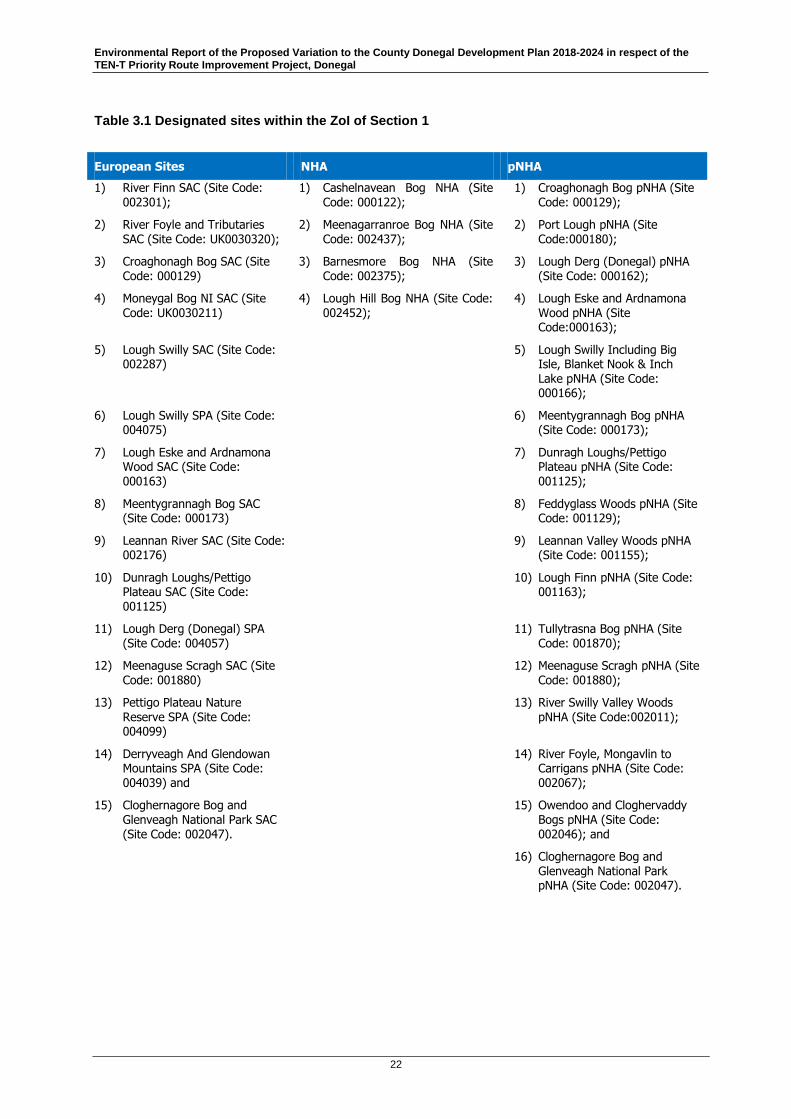
Environmental Report of the Proposed Variation to the County Donegal Development Plan 2018-2024 in respect of the TEN-T Priority Route Improvement Project, Donegal
22
Table 3.1 Designated sites within the ZoI of Section 1
European Sites NHA pNHA
1) River Finn SAC (Site Code: 002301);
1) Cashelnavean Bog NHA (Site Code: 000122);
1) Croaghonagh Bog pNHA (Site Code: 000129);
2) River Foyle and Tributaries SAC (Site Code: UK0030320);
2) Meenagarranroe Bog NHA (Site Code: 002437);
2) Port Lough pNHA (Site Code:000180);
3) Croaghonagh Bog SAC (Site Code: 000129)
3) Barnesmore Bog NHA (Site Code: 002375);
3) Lough Derg (Donegal) pNHA (Site Code: 000162);
4) Moneygal Bog NI SAC (Site
Code: UK0030211)
4) Lough Hill Bog NHA (Site Code:
002452);
4) Lough Eske and Ardnamona
Wood pNHA (Site Code:000163);
5) Lough Swilly SAC (Site Code: 002287)
5) Lough Swilly Including Big Isle, Blanket Nook & Inch Lake pNHA (Site Code: 000166);
6) Lough Swilly SPA (Site Code: 004075)
6) Meentygrannagh Bog pNHA (Site Code: 000173);
7) Lough Eske and Ardnamona Wood SAC (Site Code: 000163)
7) Dunragh Loughs/Pettigo Plateau pNHA (Site Code: 001125);
8) Meentygrannagh Bog SAC (Site Code: 000173)
8) Feddyglass Woods pNHA (Site Code: 001129);
9) Leannan River SAC (Site Code: 002176)
9) Leannan Valley Woods pNHA (Site Code: 001155);
10) Dunragh Loughs/Pettigo Plateau SAC (Site Code: 001125)
10) Lough Finn pNHA (Site Code: 001163);
11) Lough Derg (Donegal) SPA (Site Code: 004057)
11) Tullytrasna Bog pNHA (Site Code: 001870);
12) Meenaguse Scragh SAC (Site Code: 001880)
12) Meenaguse Scragh pNHA (Site Code: 001880);
13) Pettigo Plateau Nature
Reserve SPA (Site Code: 004099)
13) River Swilly Valley Woods
pNHA (Site Code:002011);
14) Derryveagh And Glendowan Mountains SPA (Site Code: 004039) and
14) River Foyle, Mongavlin to Carrigans pNHA (Site Code: 002067);
15) Cloghernagore Bog and Glenveagh National Park SAC (Site Code: 002047).
15) Owendoo and Cloghervaddy Bogs pNHA (Site Code: 002046); and
16) Cloghernagore Bog and Glenveagh National Park pNHA (Site Code: 002047).

Environmental Report of the Proposed Variation to the County Donegal Development Plan 2018-2024 in respect of the TEN-T Priority Route Improvement Project, Donegal
23
CDP Variation TEN-T PRIPD: Section 2
Section 2 intersects the Lough Swilly SAC, Lough Swilly SPA and Lough Swilly including Big Isle, Blanket Nook and Inch Lake pNHA. In addition, there are fourteen European sites, four nationally designated NHAs and nineteen proposed Natural Heritage Areas (pNHAs) within the ZoI of Section 2. A summary is provided in Table 3.2.
Table 3.2 Designated sites within the ZoI of Section 2
European Sites NHA pNHA
1) North Inishowen Coast SAC (Site Code: 002012);
1) Umrycam Bog NHA (Site Code: 002406);
1) Ballyar wood pNHA (Site Code: 000116);
2) Lough Swilly SAC (Site Code: 002287);
2) Illies Hill Bog NHA (Site Code: 001127);
2) Bulbin Mountain pNHA (Site Code: 000120);
3) Meentygrannagh Bog SAC (Site Code:000173);
3) Camowen River Bog NHA (Site Code: 002405);
3) Ballyhoorisky Point to Fanad Head pNHA (Site Code: 001975);
4) Clogernagore Bog and Glenveagh SAC (Site Code: 002047);
4) Slieve Snaght Bogs NHA (Site Code: 002322)
4) Old Rectory Fahan pNHA (Site Code:002056);
5) Leannan River SAC (Site Code: 002176);
5) Lough Fern pNHA (Site Code:001162);
6) Ballyarr Wood SAC (Site Code: 000116);
6) Ramelton Mill pNHA (Site Code:002057);
7) Ballyhoorisky Point to Fanad Head SAC (Site Code: 001975);
7) Lough Swilly Incl. Big Isle, Blanket Nook and Inch Lake pNHA (Site Code: 000166);
8) Lough Swilly SPA (Site Code: 004075);
8) River Swilly Valley Woods pNHA (Site Code: 002011);
9) Horn Head to Fanad Head SPA (Site Code:004194);
9) Leannan Valleys Woods pNHA (Site Code: 001155);
10) Lough Fern SPA (Site Code: 004060);
10) Lough Akibbon and Gartan Lough pNHA (Site Code: 000158);
11) Derryveagh and Glendowan Mountains SPA (Site Code: 004039)
11) Cloghernagore Bog and Glenvaeagh National Park pNHA (Site Code: 002047);
12) Fanad Head SPA (Site Code: 004148)
12) Meentygrannagh Bog pNHA (Site Code: 000173);
13) River Foyle and Tributaries SAC (Site Code: UK0030320)
13) North Inishowen Coast pNHA (Site Code: 002012);
14) River Finn SAC (Site Code: 002301).
14) Tullytresna bog pNHA (Site Code: 001870);
15) River Foyle, Mongavlin To
Carrigans pNHA (Site Code: 002067);
16) Port Lough pNHA (Site Code: 000180);
17) Feddyglass Woods pNHA (Site Code: 001129);

Environmental Report of the Proposed Variation to the County Donegal Development Plan 2018-2024 in respect of the TEN-T Priority Route Improvement Project, Donegal
24
European Sites NHA pNHA
18) Derriscligh Bog pNHA (Site Code: 001114); and
19) Ballymastocker Dunes pNHA (Site Code: 001089).
CDP Variation TEN-T PRIPD: Section 3
The Deele Swilly Burn and River Finn both all flow through Section 3 and consequently flow into the River Foyle which is designated as the River Foyle and Tributaries SAC. The River Finn SAC marks the
southern boundary of the study area which is designated under the River Finn SAC. In addition, there are fourteen European sites, four nationally designated NHAs and nineteen proposed Natural Heritage
Areas (pNHAs) within the ZoI of Section 3. A summary is provided in Table 3.3.
Table 3.3 Designated sites within the ZoI of Section 3
European Sites NHA pNHA
1) River Finn SAC (Site Code: 002301);
1) Cashelnavean Bog NHA (Site Code: 000122);
1) Port Lough pNHA (Site Code: 000180);
2) Lough Swilly SAC (Site Code:
002287);
2) Meengarranroe Bog NHA (Site
Code: 000173);
2) River Foyle, Mongavlin to
Carrigans pNHA (Site Code:002067);
3) River Foyle and Tributaries SAC (Site Code: UK0030320);
3) Barnesmore Bog NHA (Site Code: 002375);
3) Lough Finn pNHA (Site Code: 001163);
4) Lough Swilly SPA (Site Code: 004075);
4) Lough Hill Bog NHA (Site Code: 002452);
4) Feddyglass Woods pNHA (Site Code: 001129);
5) Leannan River SAC (Site Code: 002176);
5) Umrycam Bog NHA (Site Code: 002406);
5) Meentygrannagh Bog pNHA (Site Code: 000173);
6) Ballyarr Wood SAC (Site Code: 000116);
6) Illies Hill Bog NHA (Site Code: 001127);
6) Tullytresna Bog pNHA (Site Code: 001870);
7) Lough Fern SPA (Site Code:
004060);
7) Camowen River Bog NHA (Site
Code: 002405);
7) Meenaguse Scragh pNHA (Site
Code: 01880);
8) Moneygal Bog SAC (Site Code: UK0030211);
8) Slieve Snaght Bogs NHA (Site Code: 002322);
8) Owendoo and Cloghervaddy Bogs pNHA (Site Code:002046);
9) Owenkillew River SAC (Site Code: UK0030233);
9) Croaghonagh Bog pNHA (Site Code: 000129);
10) Derryveagh And Glendowan Mountains SPA (Site Code: 004039);
10) Cloghernagore and Glenveagh National Park pNHA (Site Code: 002047);
11) Cloghernagore Bog and Glenveagh National Park SAC (Site Code: 002047);
11) Dunragh Loughs/Pettigo Plateau pNHA (Site Code: 001125);
12) Meentygrannagh Bog SAC (Site Code: 000173);
12) Lough Derg (Donegal) pNHA (Site Code: 000162);
13) Horn Head to Fanad Head SPA (Site Code: 004194);
13) North Inishowen Coast pNHA (Site Code: 002012);
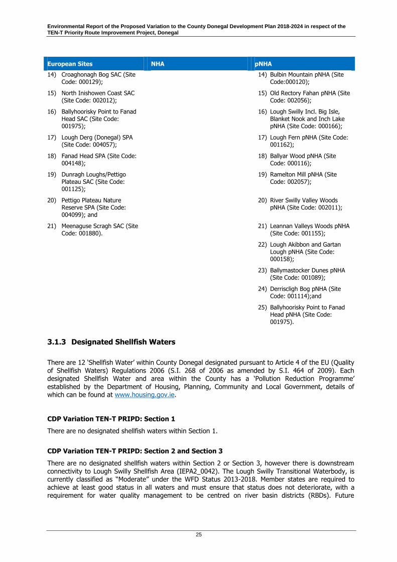
Environmental Report of the Proposed Variation to the County Donegal Development Plan 2018-2024 in respect of the TEN-T Priority Route Improvement Project, Donegal
25
European Sites NHA pNHA
14) Croaghonagh Bog SAC (Site Code: 000129);
14) Bulbin Mountain pNHA (Site Code:000120);
15) North Inishowen Coast SAC (Site Code: 002012);
15) Old Rectory Fahan pNHA (Site Code: 002056);
16) Ballyhoorisky Point to Fanad Head SAC (Site Code: 001975);
16) Lough Swilly Incl. Big Isle, Blanket Nook and Inch Lake pNHA (Site Code: 000166);
17) Lough Derg (Donegal) SPA (Site Code: 004057);
17) Lough Fern pNHA (Site Code: 001162);
18) Fanad Head SPA (Site Code: 004148);
18) Ballyar Wood pNHA (Site Code: 000116);
19) Dunragh Loughs/Pettigo Plateau SAC (Site Code: 001125);
19) Ramelton Mill pNHA (Site Code: 002057);
20) Pettigo Plateau Nature Reserve SPA (Site Code: 004099); and
20) River Swilly Valley Woods pNHA (Site Code: 002011);
21) Meenaguse Scragh SAC (Site Code: 001880).
21) Leannan Valleys Woods pNHA (Site Code: 001155);
22) Lough Akibbon and Gartan Lough pNHA (Site Code: 000158);
23) Ballymastocker Dunes pNHA (Site Code: 001089);
24) Derriscligh Bog pNHA (Site Code: 001114);and
25) Ballyhoorisky Point to Fanad Head pNHA (Site Code: 001975).
3.1.3 Designated Shellfish Waters
There are 12 ‘Shellfish Water’ within County Donegal designated pursuant to Article 4 of the EU (Quality
of Shellfish Waters) Regulations 2006 (S.I. 268 of 2006 as amended by S.I. 464 of 2009). Each designated Shellfish Water and area within the County has a ‘Pollution Reduction Programme’
established by the Department of Housing, Planning, Community and Local Government, details of which can be found at www.housing.gov.ie.
CDP Variation TEN-T PRIPD: Section 1
There are no designated shellfish waters within Section 1.
CDP Variation TEN-T PRIPD: Section 2 and Section 3
There are no designated shellfish waters within Section 2 or Section 3, however there is downstream
connectivity to Lough Swilly Shellfish Area (IEPA2_0042). The Lough Swilly Transitional Waterbody, is currently classified as “Moderate” under the WFD Status 2013-2018. Member states are required to
achieve at least good status in all waters and must ensure that status does not deteriorate, with a requirement for water quality management to be centred on river basin districts (RBDs). Future
Environmental Report of the Proposed Variation to the County Donegal Development Plan 2018-2024 in respect of the TEN-T Priority Route Improvement Project, Donegal
26
planning through the CDP Variation should contribute to the fulfilment of the environmental protection
objectives required under the WFD through participation in river basin management planning at a
County level.
3.1.4 Freshwater Pearl Mussel
The Freshwater Pearl Mussel (FPM) (Margaritifera margaritifera) is a filter feeder (filtering up to 50
litres of water per day) and is associated with salmonid waters but requiring a higher water quality than salmonids. There are a total of 27 populations that have been designated within 19 SACs. The FPM is
protected under Annex II and V of the Habitats Directive and is legally protected in Ireland under Schedule 1 of the Wildlife Act 1976 as amended. There has been a considerable decline in species
distribution and numbers of FPM in Ireland and across the EU. In Ireland, the Article 17 Report (2019) produced by NPWS indicates that the conservation status for FPM is “bad” and declining, with few
locations with recruiting populations showing near‐adequate replenishment.
In 2009, legislation was enacted to support the achievement of favourable conservation status for FPMs
European Communities Environmental Objectives (Freshwater Pearl Mussel) Regulations 2009 (S.I. 296 of 2009) and the NPWS developed 27 FPM Sub‐basin Management Plans under these regulations, six of
which are within County Donegal, which demonstrates that the County is a stronghold for the species.
None of the TEN-T PRIPD road sections are within these sub-basins. However, Section 1 is located
within the Finn Margaritifera sensitive area. The River Finn is a Margaritifera Sensitive Catchment classified as a “Catchment of other extant populations” (NPWS, 2017b). NPWS hold two historical
records for FPM on the River Finn, near Castlefinn: 1 live adult (1989), 1 dead shell (1994). Mussels
appear currently absent on the Finn, even though suitable habitat exists, which is suggested to be owing to pearl fishing having severely reduced or eliminated the species (Beasley & Roberts, 1999), and
current poor water quality of the River Finn.
3.1.5 Ecological Networks
Article 10 of the Habitats Directive refers to features of the landscape outside designated sites which
are of major importance for wild flora and fauna. Stepping stones and ecological corridors can include nature conservation sites (other than European sites), habitat areas and species’ locations covered by
the wider obligations of the Habitats Directive. Landscape features, can also function as ecological stepping stones or corridors, which are of importance to wildlife. There is a diversity of habitats (e.g.
woodlands, hedgerows, field boundaries, sand dunes, saltmarshes, rivers, streams and associated
riparian zones, canals, marine habitats and wetlands) that are not subject to legislative protection although they are of high biodiversity and conservation value and contribute to the concept of “green
infrastructure”.
The need for the management of these areas is recognised through land use planning and development
policies.
CDP Variation TEN-T PRIPD: Section 1
Ecological networks present within Section 1 include the River Foyle/ River Finn system. Watercourses
intersected by Section 1 lie within the River Finn and River Deele (Cloghroe River) sub-catchments of the greater River Foyle catchment. The majority of the potentially affected surface waters are of the
River Finn catchment, with one small tributary potentially affected in the Cloghroe River. The main
channel of the River Finn is also a designated Salmonid Water EC (Quality of Salmonid Waters) Regulations 1988.
Environmental Report of the Proposed Variation to the County Donegal Development Plan 2018-2024 in respect of the TEN-T Priority Route Improvement Project, Donegal
27
CDP Variation TEN-T PRIPD: Section 2
Watercourses intersected by the Section 2 lie within the Lough Swilly and tributaries catchment,
specifically the River Swilly and Isle Burn/Corkey River sub-catchments. Lough Swilly is an important fisheries resource with evidence that it is nursery to a number of commercially important fish species.
The River Swilly at the crossing location is also an important migration option for anadromous fish species (salmon, sea trout, eel, lampreys) in and out of the upstream catchment. In addition,
watercourses and their riparian zone connected to the Lough Swilly within Section 2 are considered to
provide potential habitat for otter.
CDP Variation TEN-T PRIPD: Section 3
Ecological networks present within Section 3 include the River Foyle/ River Finn system. Section 3 entails a crossing of the River Deele at Cavanacor where flood embankments on the river provide a high
local importance. Similarly, Section 3 crosses the Swilly Burn flood embankments and wet grassland and scrub embankments which are also high local importance. The historic floodplain of the river here has
low-lying open agricultural grassland on both sides of the river and is used frequently by wintering
Whooper swan as a foraging ground.
3.1.6 Invasive Species
Under Regulation 49(2) of the European Communities (Birds and Natural Habitats) Regulations 2011 (S.I.477 of 2011 as amended), it is an offence to plant, disperse, allow or cause to disperse, spread or
otherwise cause to grow in any place, any plant included in Part 1 of the Third Schedule without a
licence from the Minister for Arts, Heritage and the Gaeltacht.
Regulation (EU) No 1143/2014 of the European Parliament and of the council of 22nd October 2014 on the prevention and management of the introduction and spread of invasive alien species includes
provisions which deal with, among other things, bringing into the territory of the Union, keeping,
breeding, transporting and placing on the market, species included on the list of invasive alien species of Union concern (the “Union list”). The Regulation come into force on the 3rd August, 2016.
A full list of invasive species can be sourced from Invasive Species Ireland
http://www.invasivespeciesireland.com, the National Biodiversity Data Centre www.biodiversityireland.ie and the Union List can be found on the NPWS website
https://www.npws.ie/sites/default/files/files/Union%20list%20of%20IAS.pdf.
CDP Variation TEN-T PRIPD: Section 1
Various riparian and terrestrial habitats across Section 1 were found to have invasive plant species. Invasive plant species were recorded along the whole reach of the River Finn surveyed, encompassing
all three proposed crossing points with Himalayan balsam (Impatiens glandulifera), montbretia
(Crocosmia x crocosmiiflora), and dense stands of Japanese knotweed (Fallopia japonica). Invasive species (Snowberry and Japanese knotweed) were also recorded along some of the existing local road
networks in proximity of the options and Grey Squirrel was observed within several woodlands.
Himalayan balsam, Japanese knotweed, giant rhubarb, rhododendron and grey squirrel are listed under the Third Schedule of 2011 Regulations and are subject to restrictions under Regulation 49.
Snowberry and montbretia are not listed in the Third Schedule of the 2011 Regulations, however as they are an amber listed species under Invasive Species Ireland, measures to avoid interaction and
spread of the species are recommended and should be managed in accordance with the NRA Guidance
document Guidelines for the Management of Noxious Weeds and Non- Native Invasive Plant Species on National Roads (NRA, 2010).

Environmental Report of the Proposed Variation to the County Donegal Development Plan 2018-2024 in respect of the TEN-T Priority Route Improvement Project, Donegal
28
CDP Variation TEN-T PRIPD: Section 2
Invasive species were identified in locations throughout Section 2, species identified include; Japanese
knotweed, Himalayan balsam, Himalayan Knotweed, and Rhododendron (Rhododendron ponticum), which are listed under the Third Schedule of 2011 Regulations and are subject to restrictions under
Regulation 49.
Snowberry (Symphoricarpos albus) is an amber listed species under Invasive Species Ireland, measures
to avoid interaction and spread of the species are recommended and should be managed in accordance with the NRA Guidance document Guidelines for the Management of Noxious Weeds and Non- Native Invasive Plant Species on National Roads (NRA, 2010).
CDP Variation TEN-T PRIPD: Section 3
Abundant Himalayan Balsam was recorded at the River Deele crossing. Himalayan Balsam and Japanese Knotweed were recorded in the Broadlea and Pluck townlands. The invasive Asian clam (Corbicula fluminea) has been confirmed present within the River Foyle. This highly invasive species can
potentially represent a significant threat to freshwater environments.
All of these species are listed under the Third Schedule of 2011 Regulations and are subject to restrictions under Regulation 49. Therefore, increased biosecurity awareness and enforcement of
existing legislation is needed to prevent further spread.
3.2 Population and Human Health
This section provides the baseline information regarding population and human health of relevance to
the CDP Variation and each section of the TEN-T PRIPD.
Population and human health are broad topic areas within the assessment framework which encompass
consideration of the presence of people, their activities, their use of the receiving environment and their wellbeing. Population distribution and growth forecasts are important indicators of both pressure on
infrastructure and resources, and potential exposure to pollution and risk. In terms of health and wellbeing, these can be affected by a number of direct and indirect environmental pathways, typically
through emissions to air and water, and noise exposure. These emissions are generally considered in
the context of reference to international and national standards of safety in doses, exposure and risk.3
CDP Variation TEN-T PRIPD: Section 1
The population of Ballybofey-Stranorlar was 4,852 in the 2016 census. There was a 0% change in
population since the 2011 census.
CDP Variation TEN-T PRIPD: Section 2
The population of Letterkenny was 19,274 in the 2016 census. There has been a decrease in population since the 2011 census, which was a population of 19,588.
3 EPA (May 2017) Revised Guidelines on the information to be contained in Environmental Impact Assessment Reports.

Environmental Report of the Proposed Variation to the County Donegal Development Plan 2018-2024 in respect of the TEN-T Priority Route Improvement Project, Donegal
29
CDP Variation TEN-T PRIPD: Section 3
Manorcunningham had a population increase of 5% between the 2011 and 2016 census. The
population increased from 643 to 675 people. Lifford had a 1.9% decrease in population between the 2011 and 2016 census. The population decreased from 1,658 to 1,626 people.
3.2.1 Population Trends
This section provides the baseline information regarding population trends of relevance to the CDP Variation and each section of the TEN-T PRIPD.
The most recent census data is from 2016. Regional projections for the period 2017-2036 were
published by CSO in June 2019. This report uses the Census 2016 ‘usually resident’ population (4,739,597 persons) as the base population for its predictions.
The usually resident population for the Border4 was 391.9 in 2011 and 393.3 in 2016. There are two average annual increase % calculated for the 2017-2036 projections. One is for the Dublin inflow
scenario and the other is calculated for the Dublin Outflow scenario. The Dublin Outflow scenario is based off the 2016 trend of internal migration outflows from Dublin to the other regions returns to 2006
levels. Under this scenario the Borders region has an average annual increase of 0.8%. The Dublin
Inflow scenario is if internal migration returns to more traditional patterns and reflects inflows to Dublin from the other regions. Under this scenario the Borders have an average annual increase of 0.2%.
Table 3.4 below uses the Dublin Inflow scenario to predict the 2024 population for the Border and
Donegal and Table 3.5 shows the 2024 population prediction within the PRIPD.
Table 3.4 Regional Population Projections to 2024 and the County Donegal Context
Border County Donegal
2011 actual population 391.9 161137
2016 population applying 0.2% per annum growth 395.8 162748
Actual 2016 census 393.3 158755
Projected population 2024 by application of 0.2% per annum growth to the actual 2016 census
399.6 161295
Table 3.5 Population Projections to 2024 within the TEN-T PRIPD
Ballybofey-Stranorlar
Letterkenny Manorcunningham Lifford
2016 census 4852 19274 675 1626
Projected population 2024 by application of 0.2% per annum growth to the actual 2016 census
4931 19639 686 1652
4 The Border Region for the purposes of the CSO Regional Population Projections to 2036 made up of Donegal, Cavan, Sligo, Monaghan and Leitrim. Louth is not included in these projections.
Environmental Report of the Proposed Variation to the County Donegal Development Plan 2018-2024 in respect of the TEN-T Priority Route Improvement Project, Donegal
30
3.2.2 Human Health
This section provides the baseline information regarding human health of relevance to the CDP
Variation and each section of the TEN-T PRIPD.
The state of the environment directly and indirectly affects human health and is inextricably linked to
the physical and mental wellbeing of people. The significant natural, built and cultural heritage of Donegal contribute positively to human health and these positive environmental elements include, inter
alia, good air quality, high water quality, scenic landscapes, protected structures, vernacular
architecture, settlement patterns and language.
The 2016 CSO data showed that overall the perception of general health within the County was very
good and good.
Although physically the environment contributes positively to human health, there is evidence of
relative social deprivation. The Haase Pratschke Relative Deprivation score attributed to County Donegal in 2016 was -6.42. Donegal has now taken over from Limerick and is now the most deprived county in
Ireland. The key drivers of the low deprivation score being a low educational attainment and high male
unemployment.5
The Spatial representation of this data is available on http://airo.maynoothuniversity.ie/mapping-
resources/airocensus-mapping/national-viewers/atlas-island-ireland.
Section 1, Section 2 and Section 3 of the PRIPD is generally marginally below the average 2016 Pobal
HP Deprivation Index for Ireland.
3.2.2.1 Noise
Noise is also recognised as affecting health and wellbeing. Exposure to noise is recognised as being
both an environmental pressure to wildlife as well as human beings and can affect human health and general well‐being by causing stress, anxiety and disruption of activities such as sleep.
The degree to which noise exposure impacts disease incidence is less well understood compared to air
pollutant exposure. Exposure to excessive noise has also been linked to an increased risk of heart attack, stroke and premature death.6 People are generally exposed to the most noise from
transport‐related sources, particularly road traffic. Railways, airports and industrial activities are also sources of noise. Urban areas can exacerbate the impacts of noise to human health, in particular
because air pollution levels are often higher, creating in‐combination effects. Noise is discussed in greater detail in Section 3.7.
3.2.2.2 Air Pollution
Air pollution is also recognised as a significant public health burden in terms of illness and premature death associated with air pollution generally, and from the transport sector in particular. Continued use
of solid fossil fuels for domestic usage and the increasing vehicle fleet leading to emissions of particulate matter and nitrous oxides are significant issues. It should be noted that the National Clean
Air Strategy is currently being prepared by DCCAE with the intention of developing the necessary
policies and measures to comply with new and emerging EU legislation, in addition to supporting climate change mitigation. Air quality is discussed in detail in the Climate and Air Quality in Section 3.5.
5 The Donegal Local Economic and Community Plan 2016-2022, Appendix 1, The Profile of the County 6 EEA (2015) The European Environment State and Outlook Synthesis Report.

Environmental Report of the Proposed Variation to the County Donegal Development Plan 2018-2024 in respect of the TEN-T Priority Route Improvement Project, Donegal
31
3.2.2.3 Water Pollution
Clean water is important to a population’s general health. Donegal has in general good water quality
and consequently the health of the population benefits from having it. There are many potential contaminant sources that pose a risk to Donegal’s clean water supply. The main potential risks to
human health come from biological sources (verotoxigenic E. coli [VTEC], Cryptosporidium etc.) and chemical sources (fertilisers, pesticides, herbicides, trihalomethanes (THMs), heavy metals and
pharmaceuticals etc.). In addition, the development of infrastructure may have the potential to have a
negative impact on water quality in some instances. Water supply and drinking water quality are discussed under the Section 3.4.
3.2.2.4 Cycleways
Cycle facilities are being provided by means of new infrastructure adjacent to the proposed mainline
alignment which will encourage non-motorised travel on strategic routes. The reduction in traffic through the towns and villages will encourage non-motorised travel in the towns / villages.
3.3 Soil and Geology
This section provides the baseline information regarding soil and geology of relevance to the CDP Variation and each section of the TEN-T PRIPD.
The EU’s Seventh Environmental Action Programme to 2020, recognises Ireland (therefore, Donegal) as
having soil quality which is regarded as good. The Irish Geological Heritage (IGH) Programme identified about 114 sites of interest as County Geological Sites (CGS) (including those to be designated as
geological NHAs).
The Geological Heritage of Donegal is currently being finalised (November 2020). The audit of County
Geological Sites in Donegal is a compilation of two reports:
1. An audit of County Geological and Geomorphological Sites in north Donegal carried out
by Ronan Hennessy, Robert Meehan, Vincent Gallagher, Matthew Parkes and Sarah Gatley and
2. An audit of County Geological Sites in south Donegal carried out by Malcolm McClure, Vincent
Gallagher, Robert Meehan and Sarah Gatley
The Geological Heritage listed sites relevant to the TEN-T PRIPD, as per online resources assessed in December 20207, are as follows:
Section 1 - There are two sites of Geological Heritage located on the N15, south of the study area location:
− Barnesmore Gap - consisting of lateral moraines.
− Barnesmore Gap - consisting of secondary uranium minerals. Section 2 - No sites of Geological Heritage were identified within the study area.
Section 3 - No sites of Geological Heritage were identified within the study area.
7 https://www.gsi.ie/en-ie/publications/Pages/The-Geological-Heritage-of-Donegal.aspx

Environmental Report of the Proposed Variation to the County Donegal Development Plan 2018-2024 in respect of the TEN-T Priority Route Improvement Project, Donegal
32
3.3.1 Land Cover
Corine Land Cover (CLC) inventory is a Pan-European landuse and landcover mapping programme. It
supplies spatial data on the state of the European environmental landscape and how it is changing over time. Based on the interpretation of satellite imagery, CLC provides national scale maps of landcover
and landcover change on a six year basis for thirty nine countries in Europe.
Land cover includes vegetation, man-made structures and surface water features. The Corine Land
Cover was updated in 2018, as outlined in Table 3.6 below for each section of the TEN-T PRIPD.
Table 3.6 Corine Land Use Cover within TEN-T PRIPD (CORINE, 2018)
Land Use Class Name Total Area Km2 % Cover
Section 1
Discontinuous urban fabric Total 0.09 2.09
Pastures Total 3.52 79.74
Land principally occupied by agriculture, with significant areas of natural vegetation Total
0.66 14.97
Mixed forest Total 0.14 3.14
Transitional woodland-shrub Total 0.026 0.06
Section 1 Total 4.41
Section 2
Discontinuous urban fabric Total 0.57 22.94
Industrial or commercial units Total 0.14 5.82
Pastures Total 1.76 71.24
Section 2 Total 2.47
Section 3
Discontinuous urban fabric Total 0.019 0.04
Non-irrigated arable land Total 0.32 5.93
Pastures Total 4.5 84.55
Complex cultivation patterns Total 0.51 9.51
Section 3 Total 5.33
CDP Variation TEN-T PRIPD: Section 1
The dominant land use type within Section 1 is pastures. This make up 79.74% of the land cover. The
next most common land use type within Section 1 is land principally occupied by agriculture, with significant areas of natural vegetation. There are also small areas of discontinuous urban fabric, mixed
forest and transitional woodland-shrub present within Section 1.

Environmental Report of the Proposed Variation to the County Donegal Development Plan 2018-2024 in respect of the TEN-T Priority Route Improvement Project, Donegal
33
CDP Variation TEN-T PRIPD: Section 2
The dominant land use type within Section 2 is pastures. This make up 84.55% of the land cover. The
next most common land use type is discontinuous urban fabric which covers 22.94% of Section 2. The remaining land in Section one is covered by industrial or commercial units.
CDP Variation TEN-T PRIPD: Section 3
The dominant land use type within Section 1 is pastures. This make up 84.55% of the land cover. The
next most common land use type is complex cultivation patterns which covers 9.52% of Section 3.
There are also areas of non-irrigated arable land and discontinuous urban fabric within Section 3.
3.4 Water
This section outlines the baseline information regarding water of relevance to the relevance to the CDP
Variation and each section of the TEN-T PRIPD.
European and national legislation, policies and Directives provide a broad corporate framework for
control on the utilisation of natural waters and activities affecting water bodies. These provisions include the Water Framework Directive (2000/60/EC as amended), the Urban Waste Water Treatment
Directive (91/271/EC), the Drinking Water Directive (98/83/EC) and the Waste Framework Directive (2008/98/EC).
The water bodies are subject to a range of environmental pressures including pollution from agriculture
(e.g. farmyard wastes and land spreading of fertilisers), deficient municipal wastewater, treatment plants, domestic wastewater treatment systems, urban runoff, forestry, the extractive, industry,
industrial discharges, and waste, hydromorphology (i.e. physical modification to rivers banks, and shorelines), and water abstraction.
3.4.1 River Basin District Sub-Catchments
The Water Framework Directive (WFD) (2000/60/EC) aims at improving the aquatic environment and as
such it applies to rivers, lakes, estuaries, coastal waters and groundwater. Member states are required to achieve at least good status in all waters and must ensure that status does not deteriorate, with a
requirement for water quality management to be centred on river basin districts (RBDs). Ireland
published its second cycle River Basin Management Plan covering the period 2018‐2021 in Q1 of 2018.
Since the first cycle, there have been new approaches to governance, river basin planning and catchment science. A more integrated approach between key governmental departments, the EPA and
local authorities was considered necessary to meet the challenges. The second cycle Programme of Measures will be implemented by the local authorities and have been developed to allow for the
protection of good status, or the restoration of good status, for all water bodies. The outcomes are then
monitored in order to feed into further characterisation and setting of measures as the cycle moves forward.
Future planning through the CDP Variation should contribute to the fulfilment of the environmental
protection objectives required under the WFD through participation in river basin management planning
at a County level.
CDP Variation TEN-T PRIPD: Section 1
Watercourses intersected by the Section 1 proposed route lie within the River Finn and River Deele (Cloghroe River) sub-catchments of the greater River Foyle catchment. The majority of the potentially

Environmental Report of the Proposed Variation to the County Donegal Development Plan 2018-2024 in respect of the TEN-T Priority Route Improvement Project, Donegal
34
affected surface waters are of the River Finn catchment, with one small tributary of the Cloghroe River (Deele catchment) affected.
CDP Variation TEN-T PRIPD: Section 2
Watercourses intersected by Section 2 lie within the Lough Swilly catchment, specifically the River Swilly and Isle Burn/Corkey River sub-catchments. The Lough Swilly catchment is largely located within County Donegal with a very small portion of the upper Corkey sub-catchment located in Northern Ireland.
CDP Variation TEN-T PRIPD: Section 3
Watercourses intersected by the Section 3 proposed route lie within the Leslie Hill Stream, Swilly Burn/Johnston Stream, Deele, and Finn River sub-catchments of the greater River Foyle and Lough Swilly catchments.
3.4.2 Groundwater Status
This section outlines the baseline information regarding groundwater status of relevance to the
Proposed Variation and each section of the TEN-T PRIPD.
From the EPA Water Quality in Ireland 2013 – 20188 the following analysis of groundwater bodies is provided:
- 474 out of a total of 514 groundwater bodies (92%) met their good chemical and good quantitative status objectives, accounting for 98% of the country (69,944 km2) by area.
- 38 groundwater bodies (7.4%) were at poor chemical status, a reduction of six groundwater
bodies on the previous assessment 2010-2015. These are generally small groundwater bodies impacted by historic contamination from point sources including mines, landfills and industry.
The Water Framework Directive (WFD) Status 2013-2018 classifying water quality status and risk
category for groundwater bodies is provided for each road section for the TEN-T PIRPD.
CDP Variation TEN-T PRIPD: Section 1
Ballybofey GWB –water quality status (Good) and risk category (not at risk).
Raphoe GWB - water quality status (Good) and risk category (not at risk).
CDP Variation TEN-T PRIPD: Section 2
Lough Swilly GWB - water quality status (Good) and risk category (not at risk).
Manorcunningham GWB - water quality status (Good) and risk category (not at risk).
CDP Variation TEN-T PRIPD: Section 3
Ballybofey GWB – water quality status (Good) and risk category (not at risk).
Raphoe GWB - water quality status (Good) and risk category (not at risk).
Manorcunningham GWB - water quality status (Good) and risk category (not at risk).
River Foyle GWB - water quality status (Good) and risk category (not at risk).
Foyle Gravels - water quality status (Good) and risk category (not at risk).
8 https://www.epa.ie/pubs/reports/water/waterqua/Water%20Quality%20in%20Ireland%202013-2018%20(web).pdf

Environmental Report of the Proposed Variation to the County Donegal Development Plan 2018-2024 in respect of the TEN-T Priority Route Improvement Project, Donegal
35
3.4.3 Surface Water Status
The catchments with the lowest percentage of satisfactory river water bodies below the national
average were mainly located in the north-west, east, south-west and midlands. Less than 40% of the river water bodies monitored in the following catchments were in satisfactory ecological status from the
EPA Water Quality in Ireland 2013 – 2018. Below list catchments in Donegal:
- 01_Foyle (12 waterbody declined)
- 36_Erne (15 water bodies declined);
- 40_Donagh-Moville
Best net improvement between 2010-2018;
- 38_Gweebarra- Sheephaven and 37_Donegal Bay North (14 water bodies improved).
The National Ecological Status of the 2,355 monitored river water bodies, 1,247 (53%) are in high or
good ecological status; 1,108 (47%) were at less than good ecological status. Of the less than good status water bodies, 656 (28%) were of moderate status, 443 (19%) were of poor status, and nine
were of bad status (< 0.4%).
River Waterbody Status in County Donegal is as follows:
- High No. 21
- Good No. 73
- Moderate No.21
- Poor No. 67
- Bad No. 2
Water Quality records for watercourses in the road sections of the TEN-T PRIPD study area are sourced
from EPA online database9 referring to the River Waterbody WFD Status 2013-2018.
CDP Variation TEN-T PRIPD: Section 1
- Burn Daurnett - Poor
- River Finn - Poor
- Cloghroe - Moderate
- Deele Rivers – Poor
CDP Variation TEN-T PRIPD: Section 2
- River Swilly - High - Corravaddy Burn - Poor
- Dooballagh Burn - Good
- Leslie Hill (Stream) - Poor
CDP Variation TEN-T PRIPD: Section 3
- Swilly Burn_020 – unassigned
- Swilly Burn_030 - unassigned
- Leslie Hill_020 – unassigned
- Leslie Hill_010 - Poor
- Deele (Donegal__050) – unassigned
9 https://gis.epa.ie/EPAMaps/

Environmental Report of the Proposed Variation to the County Donegal Development Plan 2018-2024 in respect of the TEN-T Priority Route Improvement Project, Donegal
36
3.4.4 Drinking Water and Wastewater
This section outlines the baseline information regarding drinking water and wastewater of relevance to
the Proposed Variation and each section of the TEN-T PRIPD.
Irish Water’s Draft Capital Investment Plan (CIP 2017-2021) identifies c. €140 million investment in
Projects and Programmes in County Donegal over the next 4 years in accordance with the provisions of the Water Services Investment Programme.
The following Irish Water drinking water and wastewater projects that have been identified for inclusion
in the Investment Portfolio which are relevant to the TEN-T PRIPD as provided in Table 3.7 below. Note this list is subject to CER approval.10
Table 3.7 Drinking Water and Wastewater Projects
Asset Class AS Project Name Relevance to TEN-T Study Area
Wastewater Ballybofey/Stranorlar WW Network Section 1
Wastewater Ballybofey-Stranorlar WWTP Section 1
Drinking Water Water Letterkenny WTW Goldrum Section 2
Wastewater Letterkenny Sewerage Scheme (Network) All contracts Section 2
Wastewater Raphoe WWTP Section 3
3.4.5 Wastewater Treatment
The wastewater treatment infrastructure of relevance to the environmental considerations of the TEN-T
PRIPD are as follows:
CDP Variation TEN-T PRIPD: Section 1
The Ballybofey-Stranorlar WWTP was assigned as a “priority area” requiring improvements in the EPA
Urban Waste Water Treatment in 2017 report.
CDP Variation TEN-T PRIPD: Section 2
The primary WWTP for Letterkenny is located at Magheranan, north of the River Swilly. The WWTP was upgraded in 2012 and Irish Water and Donegal County Council commenced work on Phase 3 of the
Letterkenny sewerage scheme in September 2018.
CDP Variation TEN-T PRIPD: Section 3
There is one WWTP within the study area which is situated on the north-eastern boundary of Lifford
town, approximately 0.4km upstream of Lifford Bridge. This facility is within the NWIRBD area and located in the Finn/ Derg/ Foyle Water Management Unit (WMU) Action Plan area. The WWTP was
10 https://www.water.ie/about-us/freedom-of-information/model-publication-scheme/about/160819-Investment-Plan-2017-2021-v1.1.pdf
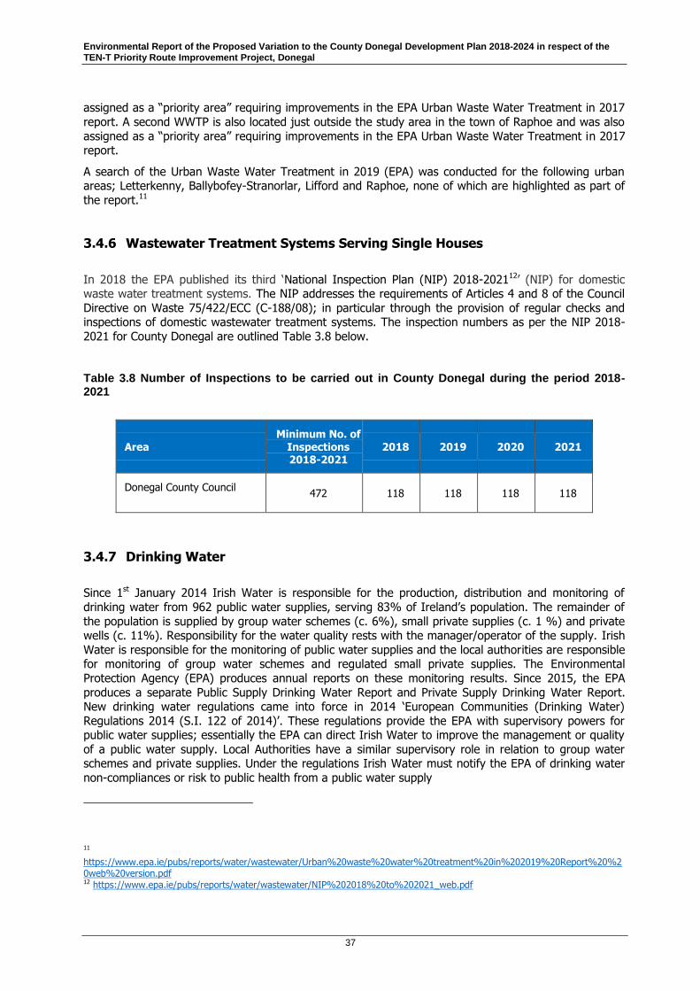
Environmental Report of the Proposed Variation to the County Donegal Development Plan 2018-2024 in respect of the TEN-T Priority Route Improvement Project, Donegal
37
assigned as a “priority area” requiring improvements in the EPA Urban Waste Water Treatment in 2017
report. A second WWTP is also located just outside the study area in the town of Raphoe and was also
assigned as a “priority area” requiring improvements in the EPA Urban Waste Water Treatment in 2017 report.
A search of the Urban Waste Water Treatment in 2019 (EPA) was conducted for the following urban areas; Letterkenny, Ballybofey-Stranorlar, Lifford and Raphoe, none of which are highlighted as part of
the report.11
3.4.6 Wastewater Treatment Systems Serving Single Houses
In 2018 the EPA published its third ‘National Inspection Plan (NIP) 2018-202112’ (NIP) for domestic waste water treatment systems. The NIP addresses the requirements of Articles 4 and 8 of the Council
Directive on Waste 75/422/ECC (C-188/08); in particular through the provision of regular checks and inspections of domestic wastewater treatment systems. The inspection numbers as per the NIP 2018-
2021 for County Donegal are outlined Table 3.8 below.
Table 3.8 Number of Inspections to be carried out in County Donegal during the period 2018-2021
Area
Minimum No. of
Inspections 2018-2021
2018 2019 2020 2021
Donegal County Council 472 118 118 118 118
3.4.7 Drinking Water
Since 1st January 2014 Irish Water is responsible for the production, distribution and monitoring of
drinking water from 962 public water supplies, serving 83% of Ireland’s population. The remainder of
the population is supplied by group water schemes (c. 6%), small private supplies (c. 1 %) and private wells (c. 11%). Responsibility for the water quality rests with the manager/operator of the supply. Irish
Water is responsible for the monitoring of public water supplies and the local authorities are responsible for monitoring of group water schemes and regulated small private supplies. The Environmental
Protection Agency (EPA) produces annual reports on these monitoring results. Since 2015, the EPA
produces a separate Public Supply Drinking Water Report and Private Supply Drinking Water Report. New drinking water regulations came into force in 2014 ‘European Communities (Drinking Water)
Regulations 2014 (S.I. 122 of 2014)’. These regulations provide the EPA with supervisory powers for public water supplies; essentially the EPA can direct Irish Water to improve the management or quality
of a public water supply. Local Authorities have a similar supervisory role in relation to group water schemes and private supplies. Under the regulations Irish Water must notify the EPA of drinking water
non-compliances or risk to public health from a public water supply
11 https://www.epa.ie/pubs/reports/water/wastewater/Urban%20waste%20water%20treatment%20in%202019%20Report%20%20web%20version.pdf 12 https://www.epa.ie/pubs/reports/water/wastewater/NIP%202018%20to%202021_web.pdf

Environmental Report of the Proposed Variation to the County Donegal Development Plan 2018-2024 in respect of the TEN-T Priority Route Improvement Project, Donegal
38
In 2019, the EPA published the Drinking Water Quality for Public Water Supplies 2019. This report
provides an overview of the Quality of drinking water in public supplies in Ireland during 2015. Table
3.9 below provides the quality and enforcement for Public Water Supplies in County Donegal.
There are no drinking water public water supplies on the remedial action list for the TEN-T PRIPD.
Table 3.9 Quality and Enforcement Statistics for Public Supplies by County or Area for 2019
County No. of public supplies
Micro-biological Compliance
Chemical Compliance
No. of Boil Notice
Popn. affected
No. of water restriction
Popn. affected
Supplies with direction
No. of Audits by EPA
Donegal 33 100 99.6 - - - - - 3
CDP Variation TEN-T PRIPD: Section 1
Lough Mourne adjacent the N15 at the southern end of Section 1 is the current drinking water source for people and business in the Finn Valley from Ballinamore to Ballybofey to Lifford and the Deele Valley
from Drumkeen to Raphoe to St. Johnston. There are no Group Water Schemes, municipal or industrial abstraction points within the study area.
CDP Variation TEN-T PRIPD: Section 2
There are no drinking water abstraction points within the study area. There are no Group Water
Schemes, municipal or industrial abstraction points within the study area.
CDP Variation TEN-T PRIPD: Section 3
Public Water supply wells are present at Raymoghy, Doorabble and Galdonagh Cross Roads, a drinking
water protection area is identified at Galdonagh Cross Roads.
3.4.8 Bathing Water Quality
The EPA Bathing Waters in County Donegal for the period 2016-2019 (EPA, 2020) sets out bathing
water quality at Ireland's beaches during the summer 2019.
CDP Variation TEN-T PRIPD: Section 1
There are no bathing waters areas with green coast awards within Section 1.
CDP Variation TEN-T PRIPD: Section 2
There are no bathing waters within Section 2, however Lisfannon and Rathmullan bathing waters are located within Lough Swilly which is downstream of Section 2.
There are no Blue Flag beaches within close proximity to Section 2, however Magherawarden
(Portsalon) Blue Flag beach is located downstream of Section 2 in Lough Swilly.
There are no areas with Green Coast Awards within close proximity to the Section 2.

Environmental Report of the Proposed Variation to the County Donegal Development Plan 2018-2024 in respect of the TEN-T Priority Route Improvement Project, Donegal
39
CDP Variation TEN-T PRIPD: Section 3
There are no bathing waters within Section 3, however Lisfannon and Rathmullan bathing waters are
located within Lough Swilly which is downstream of Section 3.
There are no Blue Flag beaches within close proximity to Section 3, however Magherawarden (Portsalon) Blue Flag beach is located downstream of Section 3 in Lough Swilly.
There are no areas with Green Coast Awards within close proximity to Section 3.
3.5 Climate Change and Air Quality
This section outlines the baseline information regarding air quality and climate change of relevance to
the relevance to the CDP Variation and each section of the TEN-T PRIPD.
Donegal County Council has now produced its climate action plan titled ‘Donegal County Council Climate
Adaptation Strategy’. This report has been created under The Climate Action and Low Carbon Development Act 2015. The strategy was accepted and published in September 2019 and, covers the
period 2019 to 2024.
The strategy itself sets out 5 steps for effective adaptation to climate change:
Step 1 – Preparing the Ground
Step 2 – Assessing the Current Baseline
Step 3 – Identification of Climate Risks & Opportunities
Step 4 – Goals, Objectives & Actions
Step 5 – Implementation
Each of these steps seek to identify and mitigate the projected impacts of climate change in Donegal over the coming years and decades through action. Some of the key impacts of climate change that are
expected to affect Donegal include changes in precipitation, sea levels, storm events, hydrological regimes and surface air temperature. These impacts are largely aligned with projected changes to the
climate for the whole island of Ireland by mid-century.
The Climate Action Plan 2019 is Ireland's all of Government Plan to tackle climate break down and
achieve net zero greenhouse gas emissions by 2050. The full report contains 183 actions to ensure
Ireland meets its targets.
In 2017, transport accounted for 19.8% of Ireland's greenhouse gases. The Climate Action Plan tries to
arrest those concerns and emphasises the need for acceleration in the use of electric vehicles (EVs) and the electrification of transport more generally. In order to meet its emission reduction goals by 2030,
the government has targeted an increase in the number of EVs to 936,000. The targets for Transport
are as follows:
Reduce CO2 eq. emissions from the sector by 45–50% relative to 2030 pre-NDP projections
Increase the number of EVs to 936,000, comprised of:
o 840,000 passenger EVs
o 95,000 electric vans and trucks
o 1,200 electric buses
Build the EV charging network to support the growth of EVs at the rate required, and develop our fast-charging infrastructure to stay ahead of demand
Require at least one recharging point in new non-residential buildings with more than 10 parking spaces
Raise the blend proportion of biofuels in road transport to 10% in petrol and 12% in diesel.

Environmental Report of the Proposed Variation to the County Donegal Development Plan 2018-2024 in respect of the TEN-T Priority Route Improvement Project, Donegal
40
The requirements under the Climate Action Plan 2019 will be given careful consideration as part of the
development of the TEN-T PRIPD project.
Air quality impacts can be on a local scale or a regional/ national scale. Local air quality impacts such as dust can have health and nuisance impacts in the vicinity of construction activities and vehicle and plant
emissions generate greenhouse gases (GHGs) such as carbon dioxide (CO2).
The latest report from the EEA on the data submitted by Member States under the NEC Directive
indicates that air pollution is the greatest environmental health risk in Europe. Under the revised
National Emissions Ceiling (NEC) Directive (2016/2284/EU), Ireland is therefore required to limit the annual national emissions of the following transboundary pollutants: sulphur dioxide (SO2), nitrogen
oxides (NOx) volatile organic compounds (VOC), ammonia (NH3) and fine particulate matter (PM2.5).
The EPA releases an annual report titled ‘Air quality in Ireland’. The most recent revision of the report
provides a synopsis of air quality in the country during 2019. The report was published in May 2020. In total, there are 84 monitoring stations in the national network. Of these, 3 are located in County
Donegal, specifically Letterkenny, Buncrana and Malin Head. Note that Letterkenny and Malin Head are
national air quality monitoring sites, whereas Buncrana is a local air quality monitoring station. Air quality ratings at each of the stations can be checked in real time by logging on to www.airquality.ie.
Air quality ratings for each of the three Donegal stations are as follows (as of 12th November 2020):
Letterkenny = 1 (Good)
Buncrana = 1 (Good)
Malin Head = 3 (Good)
The air quality monitoring station within closest proximity to the study areas for Section 1, Section 2
and Section 3 is located in Letterkenny, Co. Donegal; this is categorised as Zone C. The air quality at
this location is assigned as “Good”, which is calculated on measurements of ozone, nitrogen dioxide, and PM10. For example the air quality levels in Letterkenny between the 2nd December 2020 and the 14
December 2020 is provided for in Figure 3.1.
Figure 3.1 PM10 and PM2.5 Air Quality Monitoring Letterkenny Station (02/12/20 to 14/12/20)

Environmental Report of the Proposed Variation to the County Donegal Development Plan 2018-2024 in respect of the TEN-T Priority Route Improvement Project, Donegal
41
The particulate matter, PM10 daily limit of 50 ug m-3 is deemed breached if more than 35 exceedances
occur in a calendar year. As can be seen from Figure 3.113, in Letterkenny, the daily limit has been
breached on a number of occasions in a 2 week period. The particulate matter, PM2.5 annual limit value is 25 ug m-3. There is no hourly or daily limit value for PM2.5.
In Ireland, the main sources of PM10 are solid fuel burning and vehicular traffic. Other sources are soil and road surfaces, construction works and industrial emissions or natural sources such as windblown
salt, plant spores and pollens. These direct emissions are known as primary PM. There are high levels
of PM10 in many cities and towns.
The EPA have developed a National Ambient Air Quality Programme (published November 2017) and
published a consultation paper entitled ‘National Ambient Air Quality Monitoring Programme 2017-2022, October 2022’. The programme includes a review of the monitoring network against current and future
legal requirements and explore potential areas for further development and communication of ambient air monitoring in Ireland.
3.6 Climate Change, Marine and Coastal Management
The Marine Strategy Framework Directive (MSFD) (2008/56/EC) has adopted an ecosystem‐based approach to protect and manage the marine environment. This forms an integral component of
maritime spatial planning within the EU and requires Member States to develop a strategy to achieve or
maintain good environmental status in their marine waters by 2020. Ireland has developed a Programme of Measures that will meet targets set in order to achieve or maintain good environmental
status.
The Maritime Spatial Planning Directive also obliges all coastal Member States to establish marine
spatial plans (MSPs) as soon as possible and at the latest by 31st March 2021. This will help promote
sustainable growth of maritime activities recognising the ever increasing use and exploitation of the maritime space and its resources by a number of sectors such as fishing, shipping, leisure, aquaculture
and renewable energy.
Of relevance to TEN-T PRIPD Section 2 and Section 3 is the IMCORE Lough Swilly and Climate Change
2008-2011 study, which comprises a case study on Lough Swilly which assessed the potential impacts on the Lough as a result of Climate Change.
The main climate change drivers likely to affect Lough Swilly were found to be sea level rise and
increases in sea temperature, although an increased storminess may also have detrimental effects. The main commercial town, Letterkenny, was identified as the area in which sea level rise and increased
storminess will have the most significant impact in Lough Swilly. Its low-lying location is at risk of flooding and agricultural areas located on reclaimed land around the Lough, such as Inch Levels, are
also at risk of flooding as a result of higher sea levels and increased storminess. Higher sea levels may
also impact on the social structure of the wider Lough Swilly area as erosion and/or flooding of coastal infrastructure may persist.
The TEN-T PRIPD will be designed and planned for to be resilient to climatic change.
3.7 Noise
Regulation of noise comes under the remit of the Environmental Noise Directive (END) (2002/49/EC),
with the requirement for Member States to produce noise maps and noise action plans based on those
13 http://www.epa.ie/air/quality/data/lk/pm/

Environmental Report of the Proposed Variation to the County Donegal Development Plan 2018-2024 in respect of the TEN-T Priority Route Improvement Project, Donegal
42
maps; each local authority in Ireland is required to produce a Noise Action Plan for their administrative
area.
Under the Environmental Noise Regulations (S.I. No. 140/2006) Strategic Noise Maps and Noise Action Plans were required to be prepared in respect of noise from the following sources:
Sections of rail route above a flow threshold of 30,000 train passages per year;
Major airports with more than 50,000 movements per year, a movement being a take‐off or
landing; Sections of major roads with a flow threshold of 3 million vehicles per annum; and
Agglomerations with more than 100,000 inhabitants.
Donegal Local Authorities’ Noise Action Plan 2013–2018 has been prepared to address environmental noise from sections of major roads in the county with more than three million vehicles per annum. The
Donegal County Council Draft Noise Action Plan 2018-2023 was published in 2018 but has not, as of the
date of this report, been adopted.
The Round 3 Strategic Noise Mapping for County Donegal maps are included in Appendix C of the Draft Noise Action Plan 2018-2023. The mapping for Lden and Lnight includes estimates on the number of
dwellings and people affected by levels of noise ranging from 55dB up to greater than 75dB. The
Round 3 Noise Mapping for County Donegal is available online at: http://donegal.maps.arcgis.com/apps/View/index.html?appid=cf49cd4f4b65453eb2f6f3e00ca9a575&ext
ent=-8.3033,54.6994,-7.1497,55.0781. All three sections of the TEN-T PRIPD fall within the thresholds as set out in the 2006 Regulations, as shown in the extracts from this mapping for the three sections of
the TEN-T PRIPD in Figure 3.2, Figure 3.3 and Figure 3.4.
Figure 3.2 Lden mapping for Section 1 (N15/N13 Ballybofey / Stranorlar Urban Region)

Environmental Report of the Proposed Variation to the County Donegal Development Plan 2018-2024 in respect of the TEN-T Priority Route Improvement Project, Donegal
43
Figure 3.3 Lden mapping for Section 2 (N56/N13 Letterkenny to Manorcunningham) (source: Donegal County Council Draft Noise Action Plan 2018-2023)
Figure 3.4 Lden mapping for Section 3 (N14 Manorcunningham to Lifford / Strabane / A5 Link) (Donegal County Council Draft Noise Action Plan 2018-2023)
Environmental Report of the Proposed Variation to the County Donegal Development Plan 2018-2024 in respect of the TEN-T Priority Route Improvement Project, Donegal
44
3.8 Material Assets
This section outlines the baseline information regarding material assets of relevance to the relevance to
the CDP Variation and each section of the TEN-T PRIPD.
Material assets include a wide range of natural and man-made assets including infrastructural services
and facilities, cultural heritage, built heritage, landscape, towns and villages, quarries, coastal and
water resources and coastal defences among others.
There is a high level of residential and commercial vacancy within study area. These properties
represent an underutilized resource and if left idle, they can over time deteriorate and detract from the character of urban areas.
The current Commercial vacancy rate is 15.6% Q4 2018, and the Residential vacancy rate 10.2% Q2
2018.
3.9 Cultural, Archaeological and Architectural Heritage
This section outlines the baseline information regarding cultural, archaeological and architectural heritage of relevance to the relevance to the CDP Variation and each section of the TEN-T PRIPD.
The management and protection of cultural heritage in Ireland is achieved through a framework of international conventions and national laws and policies (Framework and Principles for the protection of the Archaeological Heritage, Department of Arts, Heritage, Gaeltacht and the Islands 1999, 35). This is undertaken in accordance with the provisions of the ‘European Convention on the Protection of the
Archaeological Heritage’ (the Valletta Convention, ratified in 1997) and ‘European Convention on the
Protection of Architectural Heritage’ (Grenada Convention, ratified in 1997).
The Code of Practice for Archaeology agreed between the Minister for Arts, Heritage, Regional, Rural and Gaeltacht Affairs and Transport Infrastructure Ireland (TII) (2017) provides ‘a framework within existing legislation (National Monuments Act 1930 to 2014 and Roads Act 2015) and policy to enable TII to progress with its programme of work in accordance with the Government’s transport strategy, whilst carrying out appropriate archaeological assessment and mitigation having regard to a set of principles and actions agreed by both parties’. Due cognisance of the agreed principles in the Code of Practice (2017) has been taken in the preparation of this assessment report.
The Minister for Tourism, Culture, Arts, Gaeltacht, Sport and Media is presently responsible for the
statutory functions and the administration of the national policy in relation to archaeological heritage
management. The National Monuments Act 1930 (as amended), the Heritage Act 1995 and relevant provisions of the National Cultural Institutions Act 1997 are the primary means of ensuring the
satisfactory protection of archaeological remains, which are held to include all man-made structures of whatever form or date except buildings habitually used for ecclesiastical purposes.
There are a number of mechanisms under the National Monuments Act that are applied to secure the protection of archaeological monuments. These include designating sites of national significance as
National Monuments, or entering them on the Register of Historic Monuments, the Record of Monuments and Places (RMP), the Sites and Monuments Record or placing Preservation Orders and
Temporary Preservation Orders on endangered sites. The County Donegal Development Plan 2018-2024 outlines the Council’s policies for the protection of the archaeological resource within their
administrative area.
Protection of the architectural heritage in Ireland is provided for through a range of legal instruments
that include the Heritage Act, 1995, the Architectural Heritage (National Inventory) and National Monuments (Misc. Provisions) Act, 1999, and the Local Government (Planning and Development) Act

Environmental Report of the Proposed Variation to the County Donegal Development Plan 2018-2024 in respect of the TEN-T Priority Route Improvement Project, Donegal
45
2000. Under the Local Government (Planning and Development) Act, 2000, all Planning Authorities are
obliged to keep a ‘Record of Protected Structures’ (RPS) of special architectural, historical,
archaeological, artistic, cultural, scientific, social or technical interest. The County Development Plan 2018-2024 outlines the Council’s policies for the protection of the architectural heritage resource within
their administrative area.
The cultural heritage interests within the TEN-T PRIPD are outlined for each section below.
CDP Variation TEN-T PRIPD: Section 1
Section 1 has a total of 10 no. cultural heritage assets located within the study area. These consist of
two ringforts, a church site and a potential ringfort/enclosure aerial photographic site and are summarised in Table 3.10.
At Drumboe Lower there is ‘Holy Well Woods’ and its associated well site (S1-CH01, not an RMP site), whilst the woods are also within the overall original garden demesne lands associated with Drumboe
Castle (DG0047). There is a protected structure (house) at Drumboe Upper as well as a NIAH recorded
outbuilding at Cappry and a corn mill at Ironworks. There is also a possible 18th century farmstead Ref. S1-BH02 at Drumboe Upper, identified from aerial and historic cartographic sources.
It should also be noted that outside the corridor there is a protected structure RPS 40907836 Workhouse/Famine graveyard at St. Joseph’s Community Hospital in Stranorlar, Finn View House (NIAH
Ref. 40907838), and outbuildings at Castlebane (NIAH Ref. 40907837).
The corridor also traverses through five areas of archaeological potential: S1AAP_01 to S1AAP_02 and S1AAP_04 to S1AAP_06.
Table 3.10 Cultural Heritage Items located within Section 1
Monument Reference Number
Townland Type
DG078-005--- DRUMBOE LOWER Church (site of)
DG078-003--- BACKLEES, DUNWILEY Ringfort - rath
DG069-028--- TEEVICKMOY Ringfort - unclassified
40907708 IRONWORKS Corn Mill
40907720 CAPPRY Outbuilding
40907834
(incl. RPS) DRUMBOE UPPER House
S1-CH01 DRUMBOE LOWER Holy Well Woods (well site)
DG0047 DRUMBOE LOWER Drumboe Castle Garden Demesne
S1-AP01 BALLYNAGLACK AP Site - Possible ringfort/enclosure
S1-BH02 DRUMBOE UPPER Possible 18thC farmstead
Section 2 CDP Variation TEN-T PRIPD: Section 2
There are a total of 12 no. cultural heritage assets located within the study area of Section 2 as
summarised in Table 3.11. These consist of a ringfort site at Ballyraine, four ‘sites of’ rock art at Trimragh, and the ‘site of’ a church and graveyard (also at Trimragh). There is a NIAH recorded mill
and pair of detached houses at Dromore and a disused railway bridge at Bunnagee on the southern environs of Letterkenny town, and at Dromore (Magheraboy).
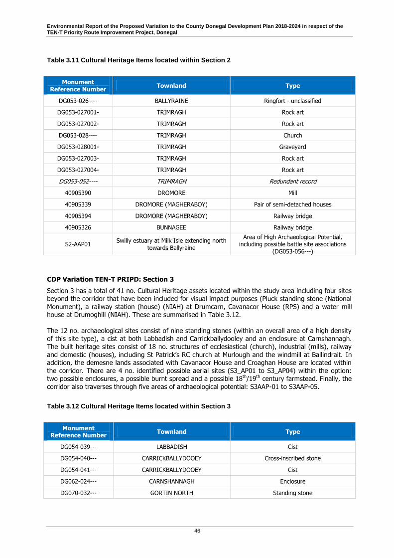
Environmental Report of the Proposed Variation to the County Donegal Development Plan 2018-2024 in respect of the TEN-T Priority Route Improvement Project, Donegal
46
Table 3.11 Cultural Heritage Items located within Section 2
Monument Reference Number
Townland Type
DG053-026---- BALLYRAINE Ringfort - unclassified
DG053-027001- TRIMRAGH Rock art
DG053-027002- TRIMRAGH Rock art
DG053-028---- TRIMRAGH Church
DG053-028001- TRIMRAGH Graveyard
DG053-027003- TRIMRAGH Rock art
DG053-027004- TRIMRAGH Rock art
DG053-052---- TRIMRAGH Redundant record
40905390 DROMORE Mill
40905339 DROMORE (MAGHERABOY) Pair of semi-detached houses
40905394 DROMORE (MAGHERABOY) Railway bridge
40905326 BUNNAGEE Railway bridge
S2-AAP01 Swilly estuary at Milk Isle extending north
towards Ballyraine
Area of High Archaeological Potential, including possible battle site associations
(DG053-056---)
CDP Variation TEN-T PRIPD: Section 3
Section 3 has a total of 41 no. Cultural Heritage assets located within the study area including four sites beyond the corridor that have been included for visual impact purposes (Pluck standing stone (National
Monument), a railway station (house) (NIAH) at Drumcarn, Cavanacor House (RPS) and a water mill house at Drumoghill (NIAH). These are summarised in Table 3.12.
The 12 no. archaeological sites consist of nine standing stones (within an overall area of a high density of this site type), a cist at both Labbadish and Carrickballydooley and an enclosure at Carnshannagh.
The built heritage sites consist of 18 no. structures of ecclesiastical (church), industrial (mills), railway
and domestic (houses), including St Patrick’s RC church at Murlough and the windmill at Ballindrait. In addition, the demesne lands associated with Cavanacor House and Croaghan House are located within
the corridor. There are 4 no. identified possible aerial sites (S3_AP01 to S3_AP04) within the option: two possible enclosures, a possible burnt spread and a possible 18th/19th century farmstead. Finally, the
corridor also traverses through five areas of archaeological potential: S3AAP-01 to S3AAP-05.
Table 3.12 Cultural Heritage Items located within Section 3
Monument Reference Number
Townland Type
DG054-039--- LABBADISH Cist
DG054-040--- CARRICKBALLYDOOEY Cross-inscribed stone
DG054-041--- CARRICKBALLYDOOEY Cist
DG062-024--- CARNSHANNAGH Enclosure
DG070-032--- GORTIN NORTH Standing stone

Environmental Report of the Proposed Variation to the County Donegal Development Plan 2018-2024 in respect of the TEN-T Priority Route Improvement Project, Donegal
47
Monument Reference Number
Townland Type
DG070-033--- GORTIN NORTH Standing stone
DG070-048--- MURLOUGH (Clonleigh South ED) Standing stone
DG070-049--- MURLOUGH (Clonleigh South ED) Standing stone
DG070-050--- MURLOUGH (Clonleigh South ED) Standing stone
DG071-005--- LIFFORD Standing stone
DG071-007--- TOWNPARKS (Clonleigh South ED) Standing stone
40906216 BALLYHOLEY FAR Metal building
40905447 DRUMOGHILL (KINCRAIGHY) Bridge
40905452 BALLYBOE (KINCRAIGY) Bridge
40835028 CARRICKNASLATE Croaghan House
DG0040 CARRICKNASLATE Croaghan House Garden & Demesne
40834011 BALLINDRAIT Station Master’s House
40834014 TAMNAWOOD Worker’s House/Level crossing
40834002 MURLOUGH (CLONLEIGH SOUTH) House
40834003 (incl. 40907020 RPS) LIFFORD COMMON St Patrick’s Church
40834004 MURLOUGH (CLONLEIGH SOUTH) St Patrick’s Bell tower
40834005 MURLOUGH (CLONLEIGH SOUTH) Ballindrait Wind Mill
40834006 MURLOUGH (CLONLEIGH SOUTH) Outbuilding
40906245 MONDOOEY LOWER Outbuilding
40834017 BALLINDRAIT Goods shed
40906262 CARNSHANNAGH House
40827011 GLEBE (MANORCUNNINGHAM) Gort Presbyterian Manse
40905446 DRUMOGHILL (KINCRAIGHY) Mill House (water) (visual)
40834001
(incl RPS) CAVANACOR Cavanacor House (visual)
DG0028 CAVANACOR
Cavanacor House
Garden & Demesne
40905457 DRUMCARN Railway Station (visual)
S3-AAP01 Corkey River crossing and Pluck
hinterland Area of High Archaeological Potential
S3-AAP02 Drumlin ridge at Mullafin Doorable and
Ballyholey Near/Far Area of High Archaeological Potential
S3-AAP03
Drumlin terrain and riverine environment of the Swilly Burn at Drumfad/Tullyrap/
Mullnaveagh Area of High Archaeological Potential
S3-AAP04
Deele River crossing and drumlin terrain at Tamnawood, Moneen, Tyleford and
Ballindrait Area of High Archaeological Potential

Environmental Report of the Proposed Variation to the County Donegal Development Plan 2018-2024 in respect of the TEN-T Priority Route Improvement Project, Donegal
48
Monument Reference Number
Townland Type
S3-AAP05
South-eastern slopes of Croaghan Hill, and northern banks of the River
Finn/urban environs of Lifford town Area of High Archaeological Potential
DG054-038---(Nat Mon 453) Pluck Standing Stone (visual)
S3-AP01 Carnshannagh Possible enclosure
S3-AP02 Dromore Big Possible bi-vallate enclosure
S3-AP03 Drumbeg Possible burnt spread
S3-AP04 Lifford Common Possible 18th/19th C farmstead
3.10 Landscape and Visual
This section outlines the baseline information regarding landscape and visual features of relevance to
the relevance to the CDP Variation and each section of the TEN-T PRIPD.
Landscape Character Types (LCT) were identified in the Landscape Character Assessment of County Donegal (2016). There are 23 different LCTs throughout County Donegal of which the seven LCTs
below are located within the study areas of the TEN-T PRIPD, including the following:
Agricultural arable and pasture, agricultural riverine, agricultural coastal, agricultural drumlin and agricultural estuarine;
Natural grassland;
Forestry/woodland;
Atlantic, mountainous and highland blanket bog;
Urban fabric and golf courses;
Dunes and beach, inter-tidal flats, inland marsh, salt marsh; and
Mountain peaks, bare rock, sparsely vegetated, heath, upland heath and moorland and water bodies.
14
Donegal is further divided into 44 Landscape Character Assessment (LCAs) areas. The LCAs in which
the study area sections are situated are described in detail in Table 3.13 below.
Foyle Valley LCA 27 is identified as part of the Northern Ireland Landscape Character Assessment
(2000). It is the only proximal LCA designated in Northern Ireland associated with the study areas
assessed within this report.
14 Landscape Character Assessment of County Donegal http://www.donegalcoco.ie/media/donegalcountyc/planning/pdfs/viewdevelopmentplans/landscapecharacterassessmentofcountydonegal/landscapecharacterassessmentofcountydonegal/Landscape%20Character%20Assessment%20Part%201.pdf

Environmental Report of the Proposed Variation to the County Donegal Development Plan 2018-2024 in respect of the TEN-T Priority Route Improvement Project, Donegal
49
Table 3.13 Landscape Character Assessments of Study Areas15
CDP Variation
TEN-T PRIPD: Section
Landscape Character Assessment
Description
Section 1 Finn Valley LCA 14 Finn Valley LCA is dominated by the River Finn, its tributaries and associated valleys carved from the surrounding uplands. The LCA has 3 distinct areas within that change from west to east following the meandering River Finn through this LCA.
In the west of this LCA the Rivers Finn and Reelan cut through highland bog areas creating 2 steep narrow river valleys that have an interesting rectilinear field pattern of strips extending from the river edge into the upland bog in a ‘rundale’ fashion.
These smaller rivers converge as the River Finn close to Cloghan into a notably broader and more level valley of larger square agricultural fields overlooked by mountainous areas of upland bog. The landscape eastwards from Ballybofey Stranorlar towards Castlefinn is a fertile agricultural plain alongside the river within a wider gently undulating agricultural landscape of large square fields similar to the adjoining Lagan Valley and Foyle Valley LCAs.
Finn Valley LCA borders Northern Ireland at its eastern extremity and abuts 2 separate LCAs within NI sharing a similar landscape type and
character area. The local road network affords multiple physical linkages with the adjoining landscape in Northern Ireland.
The eastern edge of this LCA borders Northern Ireland and the Northern Ireland Landscape Character Areas Foyle Valley (27) and Derg Valley (20), a continuum of the landscape type of the Finn Valley, namely good quality agricultural riverine lands of semi-improved geometric fields, with scattered farms, farmsteads and one-off rural dwellings served by a number of rural villages and towns.
Section 2 Letterkenny Estuary & Farmland LCA 15
Letterkenny Estuary and Farmland LCA is characterised by a wide, fertile valley of the River Swilly flowing through heath and bog covered uplands east towards Lough Swilly, a large intertidal estuary encircled by higher hills and mountains to the north and south and rolling arable lands in the east. Letterkenny is the largest town in the County and dominates much of this LCA; the town sprawls out from its historic core in the centre of this LCA in all directions, only somewhat curtailed by the floodplains of the River Swilly and steep rugged land to the north and west of the town.
The area is accessible from all directions via a network of National Primary, Regional and county roads.
Section 3 Lagan Valley LCA 12
Foyle Valley LCA 13
Foyle Valley LCA 2716
Lagan Valley LCA is a vast undulating agricultural landscape of good quality pasture and arable land characterised by large, geometric, hedge trimmed agricultural fields extending over a wide geographical area, with a long shore along Lough Swilly. This LCA is permeated by
15 Landscape Character Assessment Breakdown http://www.donegalcoco.ie/services/planning/viewdevelopmentplans/landscape%20character%20assessment%20of%20county%20donegal/landscape%20character%20assessment%20of%20county%20donegal/
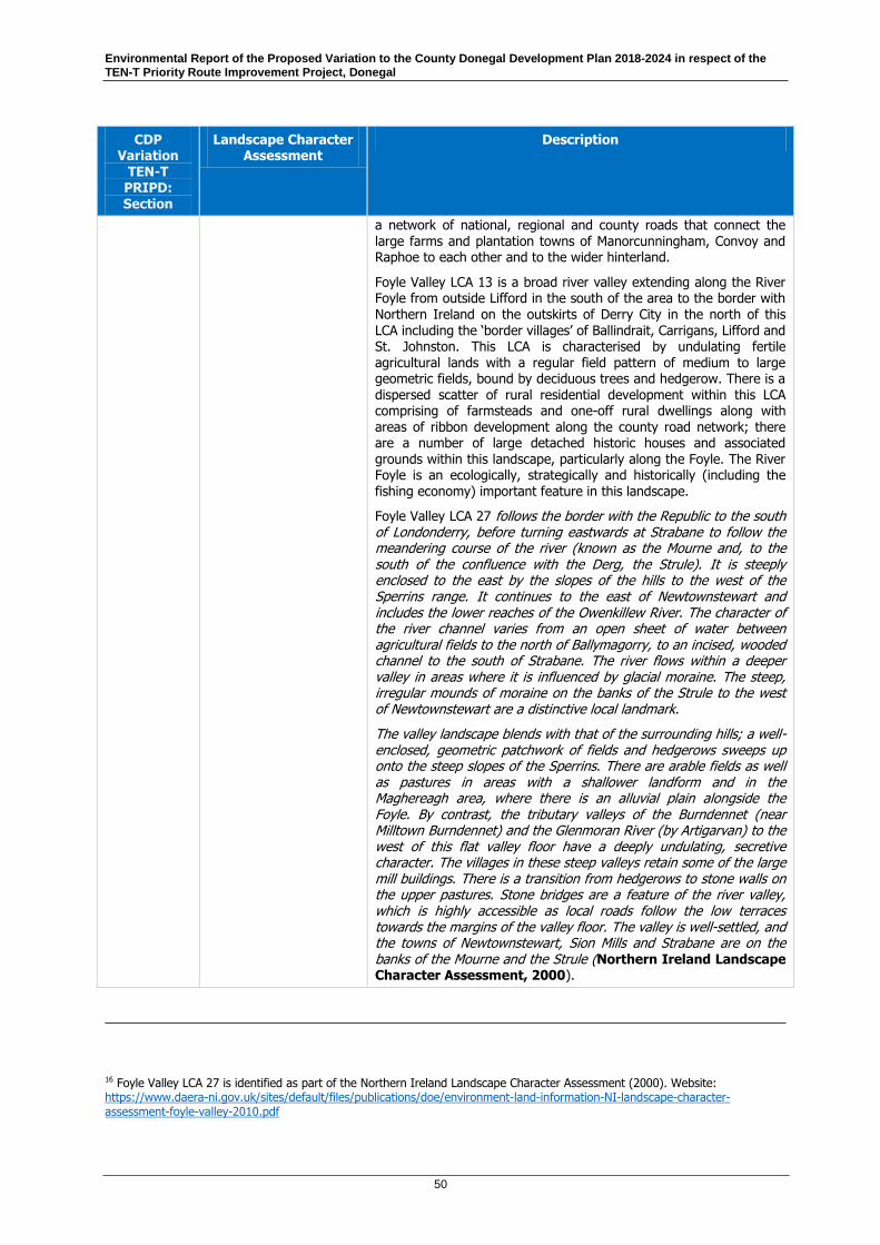
Environmental Report of the Proposed Variation to the County Donegal Development Plan 2018-2024 in respect of the TEN-T Priority Route Improvement Project, Donegal
50
CDP Variation
TEN-T PRIPD: Section
Landscape Character Assessment
Description
a network of national, regional and county roads that connect the large farms and plantation towns of Manorcunningham, Convoy and Raphoe to each other and to the wider hinterland.
Foyle Valley LCA 13 is a broad river valley extending along the River Foyle from outside Lifford in the south of the area to the border with Northern Ireland on the outskirts of Derry City in the north of this LCA including the ‘border villages’ of Ballindrait, Carrigans, Lifford and St. Johnston. This LCA is characterised by undulating fertile agricultural lands with a regular field pattern of medium to large geometric fields, bound by deciduous trees and hedgerow. There is a dispersed scatter of rural residential development within this LCA comprising of farmsteads and one-off rural dwellings along with areas of ribbon development along the county road network; there are a number of large detached historic houses and associated grounds within this landscape, particularly along the Foyle. The River Foyle is an ecologically, strategically and historically (including the fishing economy) important feature in this landscape.
Foyle Valley LCA 27 follows the border with the Republic to the south of Londonderry, before turning eastwards at Strabane to follow the meandering course of the river (known as the Mourne and, to the south of the confluence with the Derg, the Strule). It is steeply enclosed to the east by the slopes of the hills to the west of the Sperrins range. It continues to the east of Newtownstewart and includes the lower reaches of the Owenkillew River. The character of the river channel varies from an open sheet of water between agricultural fields to the north of Ballymagorry, to an incised, wooded channel to the south of Strabane. The river flows within a deeper valley in areas where it is influenced by glacial moraine. The steep, irregular mounds of moraine on the banks of the Strule to the west of Newtownstewart are a distinctive local landmark.
The valley landscape blends with that of the surrounding hills; a well-enclosed, geometric patchwork of fields and hedgerows sweeps up onto the steep slopes of the Sperrins. There are arable fields as well as pastures in areas with a shallower landform and in the Maghereagh area, where there is an alluvial plain alongside the Foyle. By contrast, the tributary valleys of the Burndennet (near Milltown Burndennet) and the Glenmoran River (by Artigarvan) to the west of this flat valley floor have a deeply undulating, secretive character. The villages in these steep valleys retain some of the large mill buildings. There is a transition from hedgerows to stone walls on the upper pastures. Stone bridges are a feature of the river valley, which is highly accessible as local roads follow the low terraces towards the margins of the valley floor. The valley is well-settled, and the towns of Newtownstewart, Sion Mills and Strabane are on the banks of the Mourne and the Strule (Northern Ireland Landscape Character Assessment, 2000).
16 Foyle Valley LCA 27 is identified as part of the Northern Ireland Landscape Character Assessment (2000). Website: https://www.daera-ni.gov.uk/sites/default/files/publications/doe/environment-land-information-NI-landscape-character-assessment-foyle-valley-2010.pdf

Environmental Report of the Proposed Variation to the County Donegal Development Plan 2018-2024 in respect of the TEN-T Priority Route Improvement Project, Donegal
51
The County Donegal Development Plan 2018-2024 defines rural Areas of Especially High Scenic Amenity
(EHSA) as “areas of highest quality landscape in the County, with characteristics of wilderness, and few if any manmade structures. They include the high-cliffed coastal zone, and upland mountain areas.”
Areas of Especially High Scenic Amenity (EHSA); High Scenic Amenity (HSA); and Moderate Scenic
Amenity (MSA) areas within County Donegal are considered below for each of the TEN-T PRIPD sections.
Section 1 is situated in close proximity to, but not overlapping with, an area of EHSA. It does overlap
with a HSA region extending northwards from Ballybofey. Manorcunningham, just north of the overlapping study areas of Section 2 and Section 3, although not located within an EHSA, does however
support views and prospects towards Lough Swilly. The Wild Atlantic Way (WAW) travels the route of the National Primary Road through the north west of this LCA and there is a ‘WAW’ discovery point at
‘Manorcunningham Viewpoint’, overlooking Lough Swilly. Lifford is neither located in an EHSA nor supports views or prospects. See Figure 3.5 for the Scenic Amenity Designation in proximity to the CDP
Variation.
Figure 3.5 Scenic Amenity Designations (County Donegal Development Plan 2018-2024)

Environmental Report of the Proposed Variation to the County Donegal Development Plan 2018-2024 in respect of the TEN-T Priority Route Improvement Project, Donegal
52
3.11 Evolution of the Environment Without the Implementation of the Proposed Variation to the CDP, in Respect of the TEN-T PRIPD
The SEA Directive requires the consideration of the likely evolution of the environment in the absence of the implementation of the Plan. In the absence of the Proposed Variation to the Donegal CDP 2018-
2024 in respect of the TEN-T PRIPD, the Donegal CDP 2018-2024 would remain in its current form. As
outlined in Section 9, the historical TEN-T corridors in the current CDP were not identified as the preferred options. These corridors were discounted at the Option Selection stage of the current TEN-T
PRIPD as they scored less favourably than other options in the assessment. Therefore, if the CDP were to remain unchanged there would either be no development of the TEN-T PRIPD or the project would
be developed within the historical TEN-T corridors currently contained in the CDP at a much greater
adverse impact. These two scenarios are described in the following sections.
3.11.1 TEN-T PRIPD Does Not Proceed
The most likely scenario if the Proposed Variation is not adopted is that the TEN-T PRIPD will not proceed. The Option Selection process that has been published for the project, clearly demonstrates
that there are alternative corridors that would result in less significant environmental impacts. Therefore, it would prove extremely difficult, if not impossible, for the project to proceed through the
statutory approval process with the corridors currently contained within the CDP.
The previous Sections 3.1 to 3.10 outline the characteristics of the environment in the area of the
Proposed Variation Table 3.14 outlines the likely evolution of the environment in the absence of the Proposed Variation and in the case where the TEN-T PRIPD does not proceed.
Table 3.14 Evolution of the Environment without the Implementation of the Proposed Variation and Where the TEN-T PRIPD Does Not Proceed
Key Issue Likely Evolution of the Environment
Biodiversity, Flora & Fauna
Without the Proposed Variation to the CDP, the pressure on aquatic and terrestrial flora, fauna and habitats is likely to continue with key drivers continuing to occur at the area from development and land‐use changes, in addition to intensification of agriculture through national initiatives such as Food Wise 2025. This is likely to lead to habitat loss and/ or fragmentation. In addition, there are changes expected to occur through climate change that may alter species and habitat ranges, with potential for range expansion of some invasive alien species which are an increasing concern.
In the absence of the TEN-T PRIPD, areas of open space and natural habitat outlined for the development will remain unaffected.
In Section 2 Letterkenny, untreated and unattenuated runoff from the existing N14 will continue to discharge to Lough Swilly SAC and SPA.
Population/ Human Health
Without the Proposed Variation to the CDP, the objectives of the NPF and CDP relating to the TEN-T will not be realised. Donegal is now the most deprived county in Ireland and in the absence of adequate infrastructure, future development and economic growth within the area will be restricted.
In the absence of the Proposed Variation issues relating to air and noise pollution near sensitive receptors caused by congestive queuing would continue within the towns Ballybofey, Stranorlar, Letterkenny and Lifford.
Soil In the absence of the Proposed Variation to the CDP the soils, geology and hydrogeology within the area would continue to exist in much the same pattern. There is currently little or no

Environmental Report of the Proposed Variation to the County Donegal Development Plan 2018-2024 in respect of the TEN-T Priority Route Improvement Project, Donegal
53
Key Issue Likely Evolution of the Environment
legislation relating directly to soils and soil protection.
Water Without the Proposed Variation to the CDP, the existing directives and regulations governing the protection of water would continue to be implemented and enforced. The existing planning system will need to account for water quality and refer to the programme of measures implemented through the RBMP.
In the absence of the TEN-T project in Section 2 Letterkenny, untreated and unattenuated runoff from the existing N14 will continue to discharge to Lough Swilly.
Air, Noise and Climate
Air quality within the study area is of a high standard, meeting all EU air quality standards, according to the EPA and the National Clean Air Strategy is currently being prepared by DCCAE with the intention of developing the necessary policies and measures to comply with new and emerging EU legislation, in addition to supporting climate change mitigation.
However, even though the air quality is classified as “Good” within the study area of the Proposed Variation to the CDP, localised issues have arisen, particularly in urban areas where challenges are emerging. In the absence of the Proposed Variation issues relating to air and noise pollution near sensitive receptors caused by congestive queuing within the towns of Ballybofey, Stranorlar, Letterkenny and Lifford.
As a result of manmade GHG emissions, climate change is predicted to occur in the future regardless of action. The UN Intergovernmental Panel on Climate Change (IPCC) in their Climate Change 2014: Climate Change Impacts, Adaptation and Vulnerability Report predict sea level rise, changes in rainfall patterns and temperatures as well as changes in the frequency of droughts and extreme weather events. Climate change impacts are projected to increase in the coming decades and during the rest of this century. This absence of the Proposed Variation to the CDP, is not expected to affect this trend.
Material Assets Existing directives, regulations and measures requires local authorities through planning, enforcement and regulation at the local level to reduce impacts to the environment and to examine how activities are impacting the wider environment and the measures needed to address these negative effects. In the absence of the Proposed Variation to the CDP, bodies such as Irish Water would continue to invest in water services bringing improvements to water bodies. However, in the Proposed Variation to the CDP, objectives of the NPF and CDP relating to the TEN-T will not be realised and may impact on the prioritisation of development and targeting of resources in an area with the greatest need.
Cultural Heritage
In the absence of the Proposed Variation to the CDP, at a local level the existing development planning processes should provide the necessary protection to features of cultural heritage.
Landscape In the absence of the Proposed Variation to the CDP, at a local level the existing development planning processes should provide the necessary protection to landscape features.
3.11.2 TEN-T PRIPD Proceeds with Historical Route Corridors
If the Proposed Variation is not adopted and the decision is made to progress with the historical TEN-T
PRIPD corridors contained in the current CDP it will result in greater impacts on the environment as well as other impacts such as economic and engineering.
The Option Selection process considered the historical corridors for each of the sections. The
assessments contained in the Option Selection report are based on either the entire historical corridors
(as in Section 1 and Section 2) or combinations of sections of the corridor (Section 3). The Option Selection report discounted the historical routes on the basis that they were less favourable in terms of
environmental impact, as well as economic and engineering criteria. Further detail on the historical corridors in each section is described below.
Environmental Report of the Proposed Variation to the County Donegal Development Plan 2018-2024 in respect of the TEN-T Priority Route Improvement Project, Donegal
54
Section 1: The historical corridor for the Ballybofey/ Stranorlar Bypass was assessed as part of the
TEN-T PRIPD project during the Option Selection process. This corridor is identified as Option 1.21. This
option was discounted at the first step in the Option Selection process due to the following concerns: high cost, high impact on area prone to flooding, high ecology impact and high community impact.
Section 2: The historical corridor for the Letterkenny section of the TEN-T PRIPD consisted of the N56
relief road (including Swilly Crossing) but no other aspects of the project such as the improvement of
the N13 between Manorcunningham, Dry Arch and Lurgybrack. As part of the Option Selection process, the historical corridor was assessed along with options that included the N13 improvements.
Section 3: The historical corridor between Manorcunningham and Lifford was assessed as part of a
number of different options within the Option Selection process. Given the scale of the project, there were a number of variations on corridors within the study area that included sections of the historical
corridor.
The previous Sections 3.1 to 3.10 outline the characteristics of the environment in the area of the
Proposed Variation. Table 3.15 outlines the likely differences in the evolution of the environment in the absence of the Proposed Variation and where the TEN-T PRIPD proceeds with the historical route
corridors contained in the current CDP. This table presents the evolution of the environment only where
it would likely be different from the TEN-T PRIPD proposed as part of this Proposed Variation.
Table 3.15 Evolution of the Environment without the Implementation of the Proposed Variation and Where the TEN-T PRIPD Advances with the Historical Route Corridors
Key Issue Differences in the Likely Evolution of the Environment between the Historical
Corridors and the Proposed Variation
Biodiversity, Flora & Fauna
Section 1: The historical corridor has a significantly greater length which would result in a greater footprint and therefore a greater ecological impact. This would negatively impact overall on biodiversity, flora and fauna.
Section 2: The historical corridor would have a lesser impact on biodiversity, flora and fauna as it does not include the N13 corridor. However, untreated and unattenuated runoff from the existing N14 will continue to discharge to Lough Swilly SAC and SPA. The biodiversity impacts of the N56 link from Dry Arch crossing the Swilly to Ballyraine would be largely the same.
Section 3: The historical corridor would have a greater impact on biodiversity, flora and fauna as it traverses more sensitive areas. This could lead to reduction in the integrity and viability of habitats, reduction or severance of environmental corridors, and reduced areas for foraging birds.
Population/ Human Health
Section 1: The historical corridor is located in an area of higher population density. This could have a positive effect in terms of the evolution of housing and business in areas with easier access to the TEN-T network. However, it could also have a negative effect due to the proximity of a major transport route close to population centres creating air pollution and noise which may disincentivise development of residential properties.
Section 2: The historical corridor does not provide for the improvement of the N13. Therefore, population will be more negatively affected as there will be no improved access to/ from Letterkenny and the objectives of the NPF and CDP relating to the TEN-T will not be realised. Donegal is now the most deprived county in Ireland and in the absence of adequate infrastructure, future development and economic growth within the area will be restricted. Human health will be negatively affected as traffic congestion on the N13 and from the N56 will not be addressed resulting in poorer air quality and greater noise impacts.
Section 3: There would be little or no difference in the likely evolution of the environment.
Soil Section 1: The historical corridor has a significantly greater length and as such would require significantly greater excavation of soils and rock with a resultant impact on hydrogeology. This would reduce the availability of this natural resources and have potential knock-on effects in
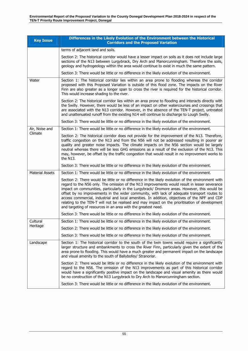
Environmental Report of the Proposed Variation to the County Donegal Development Plan 2018-2024 in respect of the TEN-T Priority Route Improvement Project, Donegal
55
Key Issue Differences in the Likely Evolution of the Environment between the Historical
Corridors and the Proposed Variation
terms of adjacent land and soils.
Section 2: The historical corridor would have a lesser impact on soils as it does not include large sections of the N13 between Lurgybrack, Dry Arch and Manorcunningham. Therefore the soils, geology and hydrogeology within the area would continue to exist in much the same pattern.
Section 3: There would be little or no difference in the likely evolution of the environment.
Water Section 1: The historical corridor lies within an area prone to flooding whereas the corridor proposed with this Proposed Variation is outside of this flood zone. The impacts on the River Finn are also greater as a longer span to cross the river is required for the historical corridor. This would increase shading to the river.
Section 2: The historical corridor lies within an area prone to flooding and interacts directly with the Swilly. However, there would be less of an impact on other watercourses and crossings that are associated with the N13 corridor. However, in the absence of the TEN-T project, untreated and unattenuated runoff from the existing N14 will continue to discharge to Lough Swilly.
Section 3: There would be little or no difference in the likely evolution of the environment.
Air, Noise and Climate
Section 1: There would be little or no difference in the likely evolution of the environment.
Section 2: The historical corridor does not provide for the improvement of the N13. Therefore, traffic congestion on the N13 and from the N56 will not be addressed resulting in poorer air quality and greater noise impacts. The climate impacts on the N56 section would be largely neutral whereas there will be less GHG emissions as a result of the exclusion of the N13. This may, however, be offset by the traffic congestion that would result in no improvement works to
the N13.
Section 3: There would be little or no difference in the likely evolution of the environment.
Material Assets Section 1: There would be little or no difference in the likely evolution of the environment.
Section 2: There would be little or no difference in the likely evolution of the environment with regard to the N56 only. The omission of the N13 improvements would result in lesser severance impact on communities, particularly in the Lurgybrack/ Dromore areas. However, this would be offset by no improvements in the wider community, with lack of adequate transport routes to access commercial, industrial and local amenities. In addition, objectives of the NPF and CDP relating to the TEN-T will not be realised and may impact on the prioritisation of development and targeting of resources in an area with the greatest need.
Section 3: There would be little or no difference in the likely evolution of the environment.
Cultural Heritage
Section 1: There would be little or no difference in the likely evolution of the environment.
Section 2: There would be little or no difference in the likely evolution of the environment.
Section 3: There would be little or no difference in the likely evolution of the environment.
Landscape Section 1: The historical corridor to the south of the twin towns would require a significantly larger structure and embankments to cross the River Finn, particularly given the extent of the area prone to flooding. This would have a much greater and permanent impact on the landscape and visual amenity to the south of Ballybofey/ Stranorlar.
Section 2: There would be little or no difference in the likely evolution of the environment with regard to the N56. The omission of the N13 improvements as part of this historical corridor would have a significantly positive impact on the landscape and visual amenity as there would be no construction of the N13 Lurgybrack to Dry Arch to Manorcunningham section.
Section 3: There would be little or no difference in the likely evolution of the environment.

Environmental Report of the Proposed Variation to the County Donegal Development Plan 2018-2024 in respect of the TEN-T Priority Route Improvement Project, Donegal
56
4 Environmental Characteristics of the Areas Likely to be Significantly Affected by the Proposed Variation
The environmental characteristics of the areas of the Proposed Variation and the TEN-T PRIPD likely to
be significantly affected are outlined in Table 4.1.
Table 4.1 Environmental Characteristics of Areas likely to be Significantly affected by the CDP Variation and the TEN-T PRIPD
Biodiversity, Flora & Fauna
Section 1:
There are fifteen European sites, designated pursuant to the Birds Directive (SPA) or Habitats Directive (SAC), within the ZoI of Section 1, however one site, namely the River Finn SAC (Site Code: 002301) will be crossed by the proposed road west of Ballybofey near Cappry. In addition, the River Finn flows into the River Foyle and Tributaries SAC downstream. In addition, there are four nationally designated Natural Heritage Areas (NHAs) and sixteen proposed Natural Heritage Areas (pNHAs) within the ZoI of Section 1. The conservation objectives of SAC and SPAs are based on maintaining/restoring the favourable conservation condition of the habitats and species for which sites are selected. Therefore there is potential for significant effects to the European and nationally designated sites as a result of the CDP variation.
A number of the watercourses within Section 1 of the TEN-T PRIPD CDP Variation are of “Poor” water quality from the River Waterbody WFD Status 2013-2018. These include the Burn Daurnett, River Finn and River Deele. These watercourses are designated as SACs or are tributaries of same also support Annex I species such as otter and Atlantic Salmon. Therefore, future road development is required to consider the conservation objectives of the European sites.
Section 2:
Section 2 intersects the Lough Swilly SAC, Lough Swilly SPA and Lough Swilly including Big Isle, Blanket Nook and Inch Lake pNHA. In addition, there are fourteen European sites, four nationally designated NHAs and nineteen proposed Natural Heritage Areas (pNHAs) within the ZoI of Section 2. Therefore there is potential for significant effects to the European and nationally designated sites as a result of the CDP variation.
Section 2 also crosses a number of the watercourses that are of “Poor” water quality including the Corravaddy Burn and Leslie Hill (Stream). These watercourses are designated as SACs or are tributaries of same also support Annex I species such as otter and Atlantic Salmon. Therefore, future road development is required to consider the conservation objectives of the European sites.
Section 2 has downstream connectivity to Lough Swilly Shellfish Area. Therefore impacts to water quality during the construction and operation of the road may impact the productivity of the shellfish area downstream.
Section 3:
The Deele, Swilly Burn and River Finn all flow through Section 3 and consequently flow into the River Foyle which is designated as the River Foyle and Tributaries SAC. In addition, there are fourteen European sites, four nationally designated NHAs and nineteen proposed Natural Heritage Areas (pNHAs)

Environmental Report of the Proposed Variation to the County Donegal Development Plan 2018-2024 in respect of the TEN-T Priority Route Improvement Project, Donegal
57
within the ZoI of Section 3. Therefore there is potential for significant effects to the European and nationally designated sites as a result of the CDP variation.
Section 3 also crosses a number of the watercourses that are of “Poor” water quality including Leslie Hill (Stream) and River Deele. These watercourses are tributaries of same also support Annex I species such as otter and Atlantic Salmon. Therefore, future road development is required to consider the conservation objectives of the European sites.
Section 3 has downstream connectivity to Lough Swilly Shellfish Area. Therefore impacts to water quality during the construction and operation of the road may impact the productivity of the shellfish area downstream.
All Sections
There is also an extensive network of ecological corridors within the TEN-T PRIPD with connectivity to designated sites and the wider landscape. Extensive linear infrastructure can result in severance of these important commuting corridors.
A number of invasive alien species have been recorded in the area including Asian clam in the River Foyle, and Japanese knotweed and Himalayan balsam throughout the study area. These species can compete with and displace native species and can contribute to river bank destabilisation as well as infrastructural damage. There is potential for transboundary impacts associated with the introduction or spread of invasive alien species and development in the border area through infrastructure development, through both terrestrial and aquatic pathways.
There is potential for impacts to protected sites and environmentally sensitive areas from potentially
increased visitor pressures from the development of the tourism sector through improvements in the transport network as a result of the CDP Variation.
Road infrastructure development may contribute to cumulative impacts on the environment, which may be exacerbated by the effects of climate change in the absence of any mitigation and adaptation.
There is also potential impacts on protected sites and environmentally sensitive areas associated with fuel combustion from vehicles include nitrogen/sulphur deposition leading to acidification and eutrophication of soils/water, deposition of particulate matter leading to vegetation change and damage.
Hydromorphological issues arising from construction can impact on water bodies; hydrological changes from road drainage are common pressures which can damage habitats or even result in habitat loss, thereby reducing biodiversity. These changes physically alter the flow of the river with impacts such as accumulation of sediment or bank erosion. Other in‐stream pressures such as culverts can have negative
impacts on the migration of some fish species.
Potential for in‐combination/ cumulative effects with other land use plans and programmes e.g. forestry, fisheries, agriculture.
Population and Human Health
Sections 1
The population of Ballybofey/ Stranorlar in 2016 was 4,852.
The Twin towns are, cumulatively, the third largest settlement in the County.
The area has a strongly-populated rural hinterland that includes the broader Finn Valley.
Sections 2
The population of Letterkenny in 2016 was 19,274.

Environmental Report of the Proposed Variation to the County Donegal Development Plan 2018-2024 in respect of the TEN-T Priority Route Improvement Project, Donegal
58
Sections 3
The population of Letterkenny in 2016 was 19,274.
The population of Lifford in 2016 was 1,626.
The population of Strabane, which is located across the border from Lifford, was 13,172 (2011).
The catchment for the N14 includes smaller settlements located between Lifford and Manorcunningham and includes links to rural population centres of Drumoghill, Raphoe, St. Johnston and Ballindrait.
All Sections
County Donegal has a population of 159,192 (2016 Census), and the county has enjoyed a long-term, positive relationship with its neighbouring counties in Northern Ireland. This relationship has strengthened since the onset of the Good Friday Agreement/Belfast Agreement in 1998. This has culminated in a strong connection between communities on both sides of the border in the North West, creating a population of approximately 350,000 in what is recognised as a cross-border city region..
In the 2016 census, 56.7% rated their health as Very Good with a further 28.9% rating their health as Good. Less than 2.0% rated their health as Bad or Very Bad.
Soil
Section 1
Topography is elevated in the north-west and south west, and, to a lesser degree, in the north-east and south-east area in Ballybofey/ Stranorlar. The topography slopes towards the River Finn which bisects the area in an east to west direction.
The dominant subsoil is metamorphic till. It is present both north and south of Ballybofey and Stranorlar. Pockets of blanket bog and rock outcrop at surface are present in the north-west, the area of highest elevation.
The overlying soil reflects the underlying till. In the north-west, it is predominantly poorly drained acid soils (surface water gleys). In the south, the poorly drained acid soils (surface water gleys) are mixed with areas of well drained acid soils. There are alluvial (river/floodplain) deposits along the River Finn
which intersects west to east across the centre of the study area.
The area is underlain by three metamorphic rock types which were originally sedimentary rocks that subsequently metamorphosed. The Precambrian bedrock stratigraphy in this part of Donegal trends roughly south-west to north-east. The dominant underlying geology is Lough Eske Psammite Formate which is comprised of feldspatic psammite and quartzite. North of Stranorlar are narrow bands of Killeter Quartzite and Aghyaran and Killygordon Limestone.
The area is underlain by the Ballybofey and Raphoe Groundwater Bodies (GWB). Groundwater quality is currently at ‘Good’ status for the 2010-2015 Water Framework Directive (WFD) reporting period for both groundwater bodies.
Section 2
Metamorphic till is the predominant subsoil type across the south-west, south, south-east and east. The River Swilly flows from west to east across the centre of the area and, therefore, alluvium deposits are present from west to east across the area. The north-west of the area, around Letterkenny town, the subsoil and soil types are classed as made ground. Across the northern tip of the area, there are portions of metamorphic till with areas of rock outcrop. The soils in the south and south-east of the area are predominantly acid brown earths with pockets of surface water gleys. The south-east and northern-

Environmental Report of the Proposed Variation to the County Donegal Development Plan 2018-2024 in respect of the TEN-T Priority Route Improvement Project, Donegal
59
western tip of the area is predominantly surface water gleys
The area is underlain by three metamorphic rock types which were originally sedimentary rocks that subsequently metamorphosed. The north-western, south-western and southern part of Section 2 is underlain by the Termon Formation, which consists of banded semi-pelitic and psammitic schist. The centre of the area is comprised of a band of Killeter Quartzite Limestone Formation; this formation consists of slightly impure quartzite. The north and east of are made up of Aghyaran and Killgordon Limestone Formation, this bedrock is comprised of marble, quartzite, psammite and graphite.
The area is underlain by the Lough Swilly Groundwater Body (GWB). Groundwater quality is currently at ‘Good’ status for the 2010-2015 Water Framework Directive (WFD) reporting period for both groundwater bodies.
Section 3
The area contains four rock types which are: Aghyaran & Killygordon Limestone Formation which comprises commonly dark coloured and graphitic. Marble and pelitic and psammitic schists with some quartzites and minor basic volcanics; Lough Foyle Succession, pelitic and psammitic schists and phyllites, graded grits and pebbly grits and thin marble units; Lifford Volcanic member, volcaniclastic green beds with pillow lava; and Claudy Formation, psammitic schist with intercalated coarse psammitic and pebbly grit units, thin marble lenses and quartzite.
The area is predominantly underlain by Tills derived chiefly from metamorphic rock. There are differing volumes of alluvium, at present the depth of the alluvium is unknown, it is also unknown if this alluvium is cohesive or granular as some of the alluvium mapping corresponds to areas identified as being gravel aquifers, or if the material will provide a suitable founding stratum.
There are five groundwater bodies (GWB) underlying the area: Ballybofey, Raphoe, Manorcunningham, River Foyle and Foyle gravels. Groundwater quality is currently at ‘Good’ status for the 2010-2015 Water Framework Directive (WFD) reporting period for all five groundwater bodies.
Water
Section 1
Watercourses intersected by the Section 1 proposed route lie within the River Finn and River Deele (Cloghroe River) sub-catchments of the greater River Foyle catchment.
A number of the watercourses within Section 1 of the TEN-T PRIPD CDP Variation are of “Poor” water quality from the River Waterbody WFD Status 2013-2018. These include the Burn Daurnett, River Finn and River Deele. These watercourses are designated as SACs or are tributaries of same also support Annex I species such as otter and Atlantic Salmon. Future road development may further exacerbate water quality issues particularly during the construction phase of development. Therefore, future road development is required to consider the objectives of the WFD to halt further degradation of water quality and the objective to restore the water quality to “Good” status.
Section 2
Watercourses intersected by Section 2 lie within the Lough Swilly catchment, specifically the River Swilly and Isle Burn/Corkey River sub-catchments. The Lough Swilly catchment is largely located within County Donegal with a very small portion of the upper Corkey sub-catchment located in Northern Ireland.
Corravaddy Burn and Leslie Hill (Stream) are of “Poor” water quality. Future road development may further exacerbate water quality issues particularly during the construction phase of development. Therefore, future road development is required to consider the objectives of the WFD to halt further degradation of water quality and the objective to restore the water quality to “Good” status.

Environmental Report of the Proposed Variation to the County Donegal Development Plan 2018-2024 in respect of the TEN-T Priority Route Improvement Project, Donegal
60
Section 3
Watercourses intersected by the Section 3 proposed route lie within the Leslie Hill Stream, Swilly Burn/Johnston Stream, Deele, and Finn River sub-catchments of the greater River Foyle and Lough Swilly catchments.
The Leslie Hill (Stream) and River Deele are of “Poor” water quality within the study area. Future road development may further exacerbate water quality issues particularly during the construction phase of development. Therefore, future road development is required to consider the objectives of the WFD to halt further degradation of water quality and the objective to restore the water quality to “Good” status.
Air, Noise and Climate
Section 1
Air quality in Section 1 is categorized as Zone D Rural Ireland, by the EPA. The air quality rating for the area is “Good” as a result of the relative absence of air pollution sources in the area and those existing sources such as road traffic have a low impact given the low volumes and ongoing legislative changes to vehicle emissions and fuel requirements.
Noise in the area is predominantly related to traffic. TII has published Strategic Noise Mapping which illustrate transport noise on national roads in Section 1. Construction of the TEN-T PRIPD will result in significantly less traffic related noise in the urban areas of Ballybofey/ Stranorlar.
Section 2
Air quality in Section 2 is categorized as Zone C Cities or Large Towns (including Letterkenny) and Zone D Rural Ireland (areas outside Letterkenny), by the EPA. The air quality rating for both zones in Section 2 is “Good” as a result of the relative absence of air pollution sources in the area and those existing sources such as road traffic have a low impact given the low volumes and ongoing legislative changes to vehicle emissions and fuel requirements.
Noise in the area is predominantly related to traffic. TII has published Strategic Noise Mapping which illustrate transport noise on national roads in Section 2. Construction of the TEN-T PRIPD should result in significantly less traffic related noise in the area of Lurgybrack on the old N13 and along the existing Four Lane Road as traffic is expected to use the newly constructed N13 and the N56 link and new bridge over the River Swilly. There will be an increase in traffic related noise in Dromore where the interchange between the N13 and N56 is located just east of Dry Arch roundabout.
Section 3
Air quality in Section 3 is categorized as Zone D Rural Ireland, by the EPA. The air quality rating for the area is “Good” as a result of the relative absence of air pollution sources in the area and those existing sources such as road traffic have a low impact given the low volumes and ongoing legislative changes to vehicle emissions and fuel requirements.
Noise in the area is predominantly related to traffic. TII has published Strategic Noise Mapping which illustrate transport noise on national roads in Section 3. Traffic related noise will increase in greenfield areas taken for development of the TEN-T PRIPD whereas traffic related noise on the existing N14 should decrease proportionately.
All Sections
Climate is the largely the same across all three sections: it is a mild and temperate maritime climate. At Finner Camp Weather Station near Ballyshannon, over the last 10 years the mean daily temperature has been 10 deg. C and the average annual rainfall was 1,252mm.

Environmental Report of the Proposed Variation to the County Donegal Development Plan 2018-2024 in respect of the TEN-T Priority Route Improvement Project, Donegal
61
Over the past century, rainfall patterns, sea level rise, warmer temperatures and more extreme weather events have been observed in the county and these changes have been measured and documented. There has been a notable increase in the frequency of extreme weather events in recent years that have brought strong winds, low temperatures and high rainfall and at other times high temperatures and low rainfall.
Material Assets
Section 1
Section 1 hosts 2 no. 110kV Eirgrid transmission lines, one on either side of N15 along with one 110kV Eirgrid station west of the Drumkeen area. A 38kV Eirgrid distribution line transects the area in a south-west to north-east direction overlapping with Ballybofey/ Stranorlar and the N15 in several places. This line continues to the Convoy area where it also connects to Letterkenny, within the Section 2 study area. The Ballybofey area hosts the 38kV substation associated with this 38kV line.
The primary waste water treatment (WWT) plant located with the area is Ballybofey/ Stranorlar WWT. The WWT was assigned a “Pass” grade by the EPA’s Urban WWT 2015 assessment.
The existing N15 runs from the border with Northern Ireland at Lifford through Ballybofey/ Stranorlar to Leitrim and Sligo, forming the key route to Galway. It is the only national primary route connecting Donegal directly to the rest of the Republic of Ireland and is also a key route linking south Donegal to Derry and Belfast. Section 1 also contains the regional roads R252 to Fintown which connects to the N15 at Ballybofey and the R236 north of Stranorlar linking the N15 to Convoy and Raphoe.
Ballybofey-Stranorlar is a Strategic Town as identified within the core strategy of the Donegal County
Development Plan 2018-2024 with associated settlement, zoning and policy objectives to support this.
There is a significant length of the corridor inside the settlement boundary. The corridor intersects with pedestrian linkages in CDP and Local Environment, Recreation and Amenity and Masterplan Area in the zoning map. It also bisects an amenity zoning and is partially within high scenic amenity area.
The corridor intersects agricultural areas and there are equine and horticultural businesses in the locality.
Section 2
The Section 2 area contains a 110kV substation with 110kV transmission and 38kV distribution overhead electricity cables. The Letterkenny 110kV substation is located south of Lurgybrack in the townland of Listellian. Two 38kV lines run through Lurgybrack and transect the study area boundary in several places. A 110kV transmission line transects the N56/N13 in south-north direction close to the Polestar Roundabout. None of the options impact existing substations to road network will provide community services including cycleway facilities.
The primary waste water treatment (WWT) plant located with the area is Letterkenny WWT. The WWT was assigned a “Pass” grade by the EPA’s Urban WWT 2015 assessment.
The main national roads in Section 2 are the N13, the N14 and the N56. Currently, there is only one bridge over the River Swilly on Four Lane Road linking south and northeast Donegal with Letterkenny and northwest Donegal.
The corridor is partially online through built-up parts of existing settlement. The corridor intersects areas of strategic residential reserve and long-established residential areas. It is also located partially in a high scenic amenity area.
The corridor is predominantly in an area located between urban and rural areas. It will intersect an area of forestry at Drumany and traverses agricultural land between Lurgybrack and Dromore.

Environmental Report of the Proposed Variation to the County Donegal Development Plan 2018-2024 in respect of the TEN-T Priority Route Improvement Project, Donegal
62
Section 3
The Section 3 area contains a 110kV transmission and 38kV distribution overhead electricity cables.
The primary waste water treatment (WWT) plant located with the area is in Lifford which is a primary treatment facility only.
The main road in Section 3 is the N14 linking Manorcunningham with Lifford. The N14 is crossed by the R236 linking Raphoe and St Johnston. The R264 from Raphoe to Murlog will be crossed and a link to Ballindarit will also be created. South of Lifford the proposed TEN-T PRIPD will cross the existing N15 (Lifford to Stranorlar) and create a tie in point to the N15 and facilitate connection to the planned A5 crossing of the River Finn from Northern Ireland.
The corridor is in a rural area with agricultural lands.
Cultural Heritage
Section 1
Section 1 has 10 no. cultural heritage assets. 8no. direct (significant/moderate) impacts on the known recorded resources including 3 no. significant impacts on Dunwiley Fort, a protected structure (long-house), and the site of Drumboe Abbey; as well as 5 no. moderate impacts on a garden demesne (Drumboe Castle), a well site at Holy Well Woods, an outbuilding, a cornmill and a C18th farmstead.
Section 2
Section 2 has 12 no. cultural heritage assets. There are no direct (significant) impacts on the known recorded cultural heritage resource with 4 direct (moderate) impacts on the known recorded cultural heritage resource. This option is largely online, save for an area between Lurgybrack and Dromore.
Sections 3
Section 3 has 41 no. cultural heritage assets. There are no direct (significant) impacts but 10 no. direct (moderate) impacts on the known recorded resource. These include sites of standing stones and grounds associated with Croaghan House and Cavancor House.
There is the potential for impacts to heritage sites and their cultural/historic setting in the border area,
particularly cross-border assets and those adjacent to the border (both at county level and within Northern Ireland).
All Sections
There is potential to impacts on items and features of heritage value including items of landscape, architectural, archaeological and historical importance, and cultural value.
Landscape
Section 1
Section 1 is situated in close proximity to, but not overlapping with, an area of EHSA and overlaps with a HSA region.
The landuse in Section 1 is primarily pasture and road development may impact the agricultural landscape and the rural character of the area.

Environmental Report of the Proposed Variation to the County Donegal Development Plan 2018-2024 in respect of the TEN-T Priority Route Improvement Project, Donegal
63
There will be an impact on the woodland to the west of Drumboe Lower.
The corridor is in relatively close proximity to Ballybofey and therefore the visual impact will be less intrusive than it would be in a more rural setting.
Section 2
Manorcunningham, just north of the overlapping study areas of Section 2 and Section 3, although not located within an EHSA, does however support views and prospects towards Lough Swilly. The Wild Atlantic Way (WAW) travels the route of the National Primary Road through the north west of this LCA and there is a ‘WAW’ discovery point at ‘Manorcunningham Viewpoint’, overlooking Lough Swilly. Therefore, there is potential for impacts of development on visually sensitive areas including scenic landscapes and seascapes.
Section 3
On Section 3, there may be potential impacts to the landscape in the border area including natural, built and cultural environment including impacts on the aesthetic landscape and sensitive view, particularly cross-border assets and those adjacent to the border.
The landuse in Section 3 is primarily pasture and road development may impact the agricultural landscape and the rural character of the area.
All Sections
Road development bypassing the main towns may impact on development of the vitality and vibrancy of
towns, villages and small settlements/clachans. However, this may also result in positive effects from the potential pedestrianisation of roads and improving the quality of life within towns and villages.
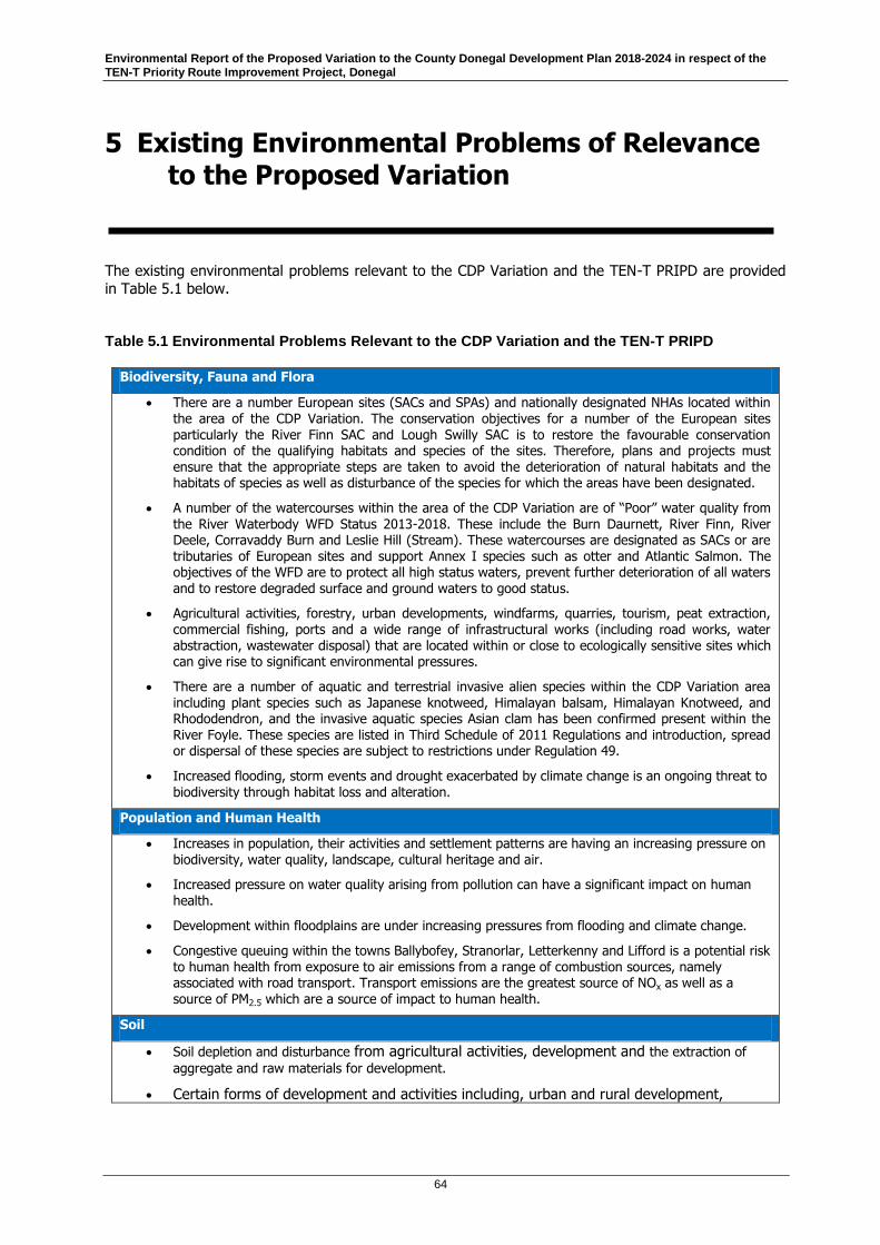
Environmental Report of the Proposed Variation to the County Donegal Development Plan 2018-2024 in respect of the TEN-T Priority Route Improvement Project, Donegal
64
5 Existing Environmental Problems of Relevance to the Proposed Variation
The existing environmental problems relevant to the CDP Variation and the TEN-T PRIPD are provided
in Table 5.1 below.
Table 5.1 Environmental Problems Relevant to the CDP Variation and the TEN-T PRIPD
Biodiversity, Fauna and Flora
There are a number European sites (SACs and SPAs) and nationally designated NHAs located within the area of the CDP Variation. The conservation objectives for a number of the European sites particularly the River Finn SAC and Lough Swilly SAC is to restore the favourable conservation condition of the qualifying habitats and species of the sites. Therefore, plans and projects must ensure that the appropriate steps are taken to avoid the deterioration of natural habitats and the habitats of species as well as disturbance of the species for which the areas have been designated.
A number of the watercourses within the area of the CDP Variation are of “Poor” water quality from the River Waterbody WFD Status 2013-2018. These include the Burn Daurnett, River Finn, River Deele, Corravaddy Burn and Leslie Hill (Stream). These watercourses are designated as SACs or are tributaries of European sites and support Annex I species such as otter and Atlantic Salmon. The objectives of the WFD are to protect all high status waters, prevent further deterioration of all waters and to restore degraded surface and ground waters to good status.
Agricultural activities, forestry, urban developments, windfarms, quarries, tourism, peat extraction, commercial fishing, ports and a wide range of infrastructural works (including road works, water abstraction, wastewater disposal) that are located within or close to ecologically sensitive sites which can give rise to significant environmental pressures.
There are a number of aquatic and terrestrial invasive alien species within the CDP Variation area including plant species such as Japanese knotweed, Himalayan balsam, Himalayan Knotweed, and Rhododendron, and the invasive aquatic species Asian clam has been confirmed present within the River Foyle. These species are listed in Third Schedule of 2011 Regulations and introduction, spread or dispersal of these species are subject to restrictions under Regulation 49.
Increased flooding, storm events and drought exacerbated by climate change is an ongoing threat to
biodiversity through habitat loss and alteration.
Population and Human Health
Increases in population, their activities and settlement patterns are having an increasing pressure on biodiversity, water quality, landscape, cultural heritage and air.
Increased pressure on water quality arising from pollution can have a significant impact on human health.
Development within floodplains are under increasing pressures from flooding and climate change.
Congestive queuing within the towns Ballybofey, Stranorlar, Letterkenny and Lifford is a potential risk to human health from exposure to air emissions from a range of combustion sources, namely associated with road transport. Transport emissions are the greatest source of NOx as well as a source of PM2.5 which are a source of impact to human health.
Soil
Soil depletion and disturbance from agricultural activities, development and the extraction of
aggregate and raw materials for development.
Certain forms of development and activities including, urban and rural development,

Environmental Report of the Proposed Variation to the County Donegal Development Plan 2018-2024 in respect of the TEN-T Priority Route Improvement Project, Donegal
65
windfarms, waste disposal, afforestation, recreation and agricultural activities can place a significant pressure in soils. Changes in precipitation arising from global warming could
have significant impacts on slope stability and could impact on soil and water quality.
Water
A number of the watercourses within the area of the CDP Variation are of “Poor” water quality from the River Waterbody WFD Status 2013-2018. These include Section 1 the Burn Daurnett, River Finn and River Deele. Section 2 the Corravaddy Burn and Leslie Hill (Stream), and in Section 3 Leslie Hill (Stream) and River Deele.
Spread of invasive alien animal and plant species (e.g. zebra mussel, Asian clam, Japanese knotweed, Himalayan balsam etc.) found within the CDP area can compete with and can displace native species and can contribute to river bank destabilisation.
Uncontrolled and untreated run off from road infrastructure.
Air, Noise and Climate
A dispersed settlement pattern can give rise to a high dependency on the use of the car particularly where there are limited public transport options. This in turn gives rise to an increase in greenhouse gasses as well as other environmental problems such as unsustainable demand on non-renewal resources, air pollution, traffic congestion, road safety, increased travel times and associated quality of life issues. In 2017, transport accounted for 19.8% of Ireland's greenhouse gases.
Traffic congestion in towns and villages can generate increased greenhouse gas air emissions. Fuel combustion from road vehicles include emissions of nitrogen/sulphur and increased atmospheric CO and CO2 accelerating climate change.
Transport emissions are the greatest source of NOx as well as a source of PM2.5 which are a source of
impact to human health.
Material Assets
There is a high level of residential and commercial vacancy within the CDP Variation area. The current Commercial vacancy rate is 15.6% Q4 2018, and the Residential vacancy rate 10.2% Q2 2018. These properties represent an underutilized resource and if left idle, they can over time deteriorate and detract from the character of urban areas
Cultural Heritage
Section 1 has a total of 10 no. cultural Heritage assets, Section 2 has 12 and Section 3 has 41 no. cultural Heritage assets.
Pressures can arise from certain developments and activities on or near sites of heritage value. The visual amenities and character of urban and rural areas and items of architectural, archaeological and
historical importance, may be placed under pressure by such works. It is acknowledged that development works can often have a positive impact on our cultural heritage.
Potential for impacts to heritage sites and their cultural/historic setting in the border area, particularly cross-border assets and those adjacent to the border (both at county level and within Northern Ireland).
Landscape
Developments and activities can impact on visually sensitive areas including designated landscape
Inter-county and Transboundary Problems
Many of the environmental problems raised in the section above have an inter-county, and cross border (transboundary) dimension. Accordingly, responding to such issues require a coordinated and targeted approach by the many agencies involved in the management of the environment. Of particular note in terms of inter-county and cross border issues include; sensitive landscapes and sites of ecological importance, items and places of cultural heritage, sites of geological interest, water quality, marine and coastal management, waste disposal, transportation, energy supply and telecommunications. There is a requirement for co-operation at a catchment level as evidenced in the River Basin Management Plan 2018-2021.

Environmental Report of the Proposed Variation to the County Donegal Development Plan 2018-2024 in respect of the TEN-T Priority Route Improvement Project, Donegal
66
6 Environmental Protection Objectives of Relevance to the Proposed Variation
6.1 Relationship of the Proposed Variation with Environmental Protection Objectives in other Plans, Programmes and Policies
Section 2.3 identified and summarised statutory land use plans of relevance to the Proposed Variation. This Section 6 and Appendix B identify the environmental protection objectives (EPO) contained in a
broader range of plans and programmes with potential to be relevant to the Proposed Variation in accordance with Schedule 2B(e) of the Planning and Development Regulations, 2001 (as amended).
Table B1 contains a synopsis of relevant plans and programmes established at the international, European and national level and identifies Environmental Protection Objectives (EPO) where possible
which are relevant to the Proposed Variation. The table also identifies how these plans, programmes,
and policies have informed the development of the Strategic Environmental Objectives (SEOs) used in the environmental assessment of the Proposed Variation. Table B2 focuses in on a more targeted
schedule of key plans and programmes, identifies the key environmental objectives contained therein, and finally documents how those objectives and any environmental considerations have been taken into
account during the preparation of the Proposed Variation.
The EPOs have directly informed, and formed the basis of, consolidated Strategic Environmental
Objectives (SEOs) which are, in effect, the environmental test criteria used to assess the likely significant effects of the proposed variation on the various environmental aspects detailed in Schedule
2B(f) of the Planning and Development Regulations (as amended). In this regard the consolidated
SEOs combine the fundamental goal of a number of EPOs into single manageable assessment criteria. In this way the assessment in this Environmental Report is directly linked to, and based upon, the
relevant EPOs identified in Section 2.3 and Appendix B..
A summary of the relevant EPOs relating to spatial planning and environmental factors is provided below.
6.1.1 Spatial Planning
The development of the CDP Variation will provide a strong focus to guide and inform future planning of the TEN-T PRIPD. The CDP Variation is required to take account of other plans and programmes in
addition to transboundary plans policies and strategies to ensure that sustainable development is an
integral element. The NPF and the North West RSES set long term national, regional and local development frameworks from within which sectors will work together to ensure proper planning and
sustainable development. In Northern Ireland, regional spatial policy is directed through the Regional Development Strategy (RDS) 2025 (published 2010) which provides an overarching strategic planning
framework influencing spatial development for Northern Ireland up to 2035. It is aimed at guiding both
the public and private sectors and it informs the spatial aspects of the strategies of all government departments.

Environmental Report of the Proposed Variation to the County Donegal Development Plan 2018-2024 in respect of the TEN-T Priority Route Improvement Project, Donegal
67
6.1.2 Biodiversity
Ireland is a party to the UN Convention on Biological Diversity and is therefore committed to measures
to conserve biodiversity. The measures include conservation of ecosystems, habitats and species in their natural surroundings both inside and outside protected areas, conservation of the components of
biological diversity outside their natural habitats and impact assessment. The EU Biodiversity Strategy to 2020 aims to halt the loss of biodiversity and the degradation of ecosystems in the European Union
(EU) by 2020. The Habitats Directive (92/43/EC) and the Birds Directive (2009/147/EC) are now
transposed into Irish law principally through the European Communities (Birds and Natural Habitats) Regulations 2011, as amended and Part XAB of the Planning and Development Act 2000, as amended.
Article 6 of the Habitats Directive requires that any plan or project (which includes the CDP Variation), to be screened to determine if it, alone or in combination with other plans and projects, has the
potential to give rise to likely significant effects on a European Site. This screening has been undertaken in parallel to development of the CDP Variation and it was concluded that a Stage 2 AA was required.
Further detail of the screening and the subsequent assessment can be found in the NIR which
accompanies this SEA Environmental Report and the CDP Variation.
At a national level, protection and conservation is outlined in the National Biodiversity Plan and the
National Parks and Wildlife Conservation Plans Conservation Objectives for SACs and SPAs. Ireland’s second National Biodiversity Plan (BAP) covered the period 2011‐2016, and a third has been published
covering 2017‐ 2021. This outlines Ireland’s vision for biodiversity protection and management.
A key consideration will be that future growth and infrastructure is developed in a manner that ensures that the biodiversity of Ireland is maintained. Whilst the CDP Variation will look to the future of the
Republic of Ireland it will also take cognisance of the natural heritage within Northern Ireland and as such will take into account plans such as: the Regional Development Strategy 2035; Valuing Nature ‐ a
Biodiversity Strategy for Northern Ireland to 2020; and the Conservation (Natural Habitats etc.)
Regulations (Northern Ireland) 1995 (as amended); The Environment (Northern Ireland) Order 2002; The Wildlife (Northern Ireland) Order 1985 and The Wildlife and Natural Environmental Act (Northern
Ireland) 2011. Protected sites and known priority habitats in Northern Ireland can be identified using the Department of Agriculture, Environmental and Rural Affairs (DAERA) map browser:
https://www.daera‐ ni.gov.uk/services/natural‐environment‐map‐viewer.
6.1.3 Population and Human Health
The Donegal CDP and Variation takes account of growth patterns, populations change and changing
demographics. Healthy Ireland 2013‐2025 is the HSE’s framework strategy for improving health and wellbeing. The main aims of Healthy Ireland therefore are to: increase the numbers of people
experiencing good health (mental and physical) at all life stages; reduce health inequalities with a focus on social factors; protect the public and increase preparedness for threats to public health; and to
encourage every individual and society as a whole to collaboratively engage with its own health and
wellbeing.
6.1.4 Soils
The Connaught‐Ulster Regional Waste Management Plan was published in 2015 to provide a framework for the prevention and management of wastes for the regional area. This Plan include policies and
actions, in particular those addressing remediation of historic and illegal landfills and the promotion of
reuse and recycling. In addition the National Hazardous Waste Management Plan 2010‐2020, prepared by the EPA, identifies priority actions to prevent hazardous waste, improve the collection rate of
hazardous waste in certain categories, movement towards self‐sufficiency in hazardous waste management for Ireland and the identification and regulation of legacy issues in relation to hazardous
waste.

Environmental Report of the Proposed Variation to the County Donegal Development Plan 2018-2024 in respect of the TEN-T Priority Route Improvement Project, Donegal
68
6.1.5 Water
The Water Framework Directive (WFD) (2000/60/EC) aims at improving the aquatic environment and as
such it applies to rivers, lakes, estuaries, coastal waters and groundwater. Member states are required to achieve at least good status in all waters and must ensure that status does not deteriorate, with a
requirement for water quality management to be centred on RBDs. Ireland published its second cycle River Basin Management Plan covering the period 2018‐ 2021 in Q1 of 2018.
Since the first cycle, there have been new approaches to governance, river basin planning and
catchment science. A more integrated approach between key governmental departments, the EPA and local authorities was considered necessary to meet the challenges. The second cycle Programme of
Measures will be implemented by the local authorities and have been developed to allow for the protection of good status, or the restoration of good status, for all water bodies. The outcomes are then
monitored in order to feed into further characterisation and setting of measures as the cycle moves forward. Future planning through the NPF should contribute to the fulfilment of the environmental
protection objectives required under the WFD through participation in river basin management planning
at a national level.
6.1.6 Coast and Marine Resource
The Marine Strategy Framework Directive (MSFD) (2008/56/EC) has adopted an ecosystem‐based approach to protect and manage the marine environment. This forms an integral component of
maritime spatial planning within the EU and requires Member States to develop a strategy to achieve or
maintain good environmental status in their marine waters by 2020. Ireland has developed a Programme of Measures that will meet targets set in order to achieve or maintain good environmental
status. The Maritime Spatial Planning Directive also obliges all coastal Member States to establish marine spatial plans (MSPs) as soon as possible and at the latest by 31st March 2021. This will help
promote sustainable growth of maritime activities recognising the ever increasing use and exploitation
of the maritime space and its resources by a number of sectors such as fishing, shipping, leisure, aquaculture and renewable energy.
6.1.7 Air/Climatic Factors
The EPA has reported that Ireland’s air quality is currently good, albeit with increasing pressure on
maintaining appropriate levels of particulate matter, and reducing nitrogen dioxide levels. The
Gothenburg Protocol 1999 (as amended) is part of the Convention on Long‐Range Transboundary Air Pollution (CLRTAP) and aims to control and reduce local and long‐range air pollution. The protocol is
enacted in the (EU) 2016/2284 of the European Parliament and of the Council of 14 December 2016 on the reduction of national emissions of certain atmospheric pollutants, amending Directive 2003/35/EC
and repealing Directive 2001/81/EC (National Emissions Ceiling Directive (NECD) (2016/2284/EU)). The
reduction of national emissions of certain atmospheric pollutants (2016/2284/EC) sets national reduction commitments from 2020 to 2029 and from 2030 onwards for five pollutants (sulphur dioxide,
nitrogen oxides, volatile organic compounds, ammonia and fine particulate matter) in accordance with the revised Gothenburg Protocol. These pollutants are responsible for long‐range transboundary air
pollution such as acidification, eutrophication and ground‐level ozone pollution. Data on these four pollutants are reported to the European Commission under the Directive on an annual basis. The
Stockholm Convention on persistent organic pollutants (POPs), a global treaty entered into force in
Ireland in 2010, requires that the state protect human health and the environment from POPs.
The Ambient Air Quality and Cleaner Air for Europe Directive (2008/50/EC, known as the “CAFE”
Directive) sets out the requirements for ambient air quality to protect human health and the environment as a whole. The CAFE Directive has been implemented in Ireland through the Air Quality
Standards Regulations 2011 (S.I. No. 180 of 2011). The CAFE Directive replaces the Air Framework

Environmental Report of the Proposed Variation to the County Donegal Development Plan 2018-2024 in respect of the TEN-T Priority Route Improvement Project, Donegal
69
Directive and the First, Second and Third Daughter Directives. The Fourth Daughter Directive
(2004/107/EC) will be included in CAFE at a later stage. The Regulations set ambient air quality limits
and target values for pollutants such as oxides of nitrogen (NOx) as well as fine particulates (PM10 and PM2.5) amongst others. These limits are largely in line with the recommendations of the “WHO Air quality guidelines for particulate matter, ozone, nitrogen dioxide and sulphur dioxide” (Global Update 2005) with the exception of fine particulates which are considerably lower under the WHO guidelines.
Air quality is regulated both at the local level through ambient air quality limits and at the
national level through emission ceilings. The drivers for air quality are largely at international and EU level, but in 2015 the Department of the Environment, Community and Local Government
(now Department of the Environment, Climate and Communications) announced the intention to publish Ireland’s first National Clean Air Strategy. This Strategy which has now been published
provides a policy framework by which Ireland can develop the necessary policies and measures to comply with new and emerging EU legislation, as well as helping to tackle climate change.
In seeking to achieve a transition to a low carbon climate resilient society by use of e.g. biomass and
biofuel combustion, this can generate a range of air pollutants (gaseous and particulate) with levels of emissions depending on the type of fuel inputted and the type of technology used, along with
maintenance of such technology. Pollutants more commonly include particulate matter (PM10 and PM2.5), POPs and nitrogen oxides (NOx) and hence the CDP Variation need to consider local land
use planning policy with national and regional air quality policies and restrictions in place to
protect human health and the environment.
Exposure to noise is recognised as being both an environmental pressure to wildlife as well as
human beings, and can affect human health and general well‐being by causing stress, anxiety and disruption of activities such as sleep. Donegal Local Authorities’ Noise Action Plan 2013–2018 has been
prepared to address environmental noise from sections of major roads in the county with more than three million vehicles per annum. The Donegal County Council Draft Noise Action Plan 2018-2023 was
published in 2018 but has not, as of the date of this report, been adopted.
6.1.8 Material Assets
The Office of Public Works (OPW) is responsible for the implementation of the Floods Directive
(2007/60/EC) which is being carried out through a Catchment‐based Flood Risk Assessment and Management Studies (CFRAMS) Programme. The CFRAM Programme focused on 300 communities at
potentially significant flood risk, referred to as Areas for Further Assessment (AFAs). These were initially
identified through the 2012 Preliminary Flood Risk Assessment (PFRA) a national screening exercise based on available information, taking into account all sources of flood risk, to scope the CFRAM
Programme and identify areas of potentially significant flood risk.
Following the PFRA six CFRAM study areas were assigned (covering 29 River Basins) under the National
CFRAM Programme. In 2015 the preparation of flood maps was undertaken by the OPW in consultation
with Local Authorities, assisted by engineering consultants to assess and map the risk of flooding in the AFAs.
Following the completion of the flood mapping, 29 Flood Risk Management Plans (FRMPs) have been developed setting out the proposed measures, both structural and non‐structural, to manage the flood
risk in each of the 300 AFAs. The EU ‘Floods’ Directive also requires that the Member States review the PFRA, the flood maps and the Plans on a six‐yearly cycle.

Environmental Report of the Proposed Variation to the County Donegal Development Plan 2018-2024 in respect of the TEN-T Priority Route Improvement Project, Donegal
70
6.1.9 Cultural Heritage
The Government Policy on Architecture (GPA) was launched in 2009 and provides the framework for
architectural policy to 2015 and beyond, with a review of on‐going policy underway. The emphasis is on a holistic approach to quality, sustainable development having regard to both the environment and
urban design. The implementation programme for the GPA encourages sensitive, sustainable and adaptive use of existing historic building stock. Other initiatives include the Historic Towns Initiative, the
Living City Initiative (2015) for the six large urban areas as developed by the Department of Finance
and the European Regional Development Fund‐supported Designated Urban Centres Grants Scheme 2014 – 2020. The aims of these are to encourage urban regeneration and facilitate consolidation of
towns and cities.
The Government has indicated the intention to update the National Heritage Plan (2002‐2007). The
Department of Culture, Heritage and the Gaeltacht recognised that the heritage sector is comprised of many different sub‐sectors and interests and is currently considering how best to develop the successor
plan with the intention to utilise a framework similar to the one used successfully for Culture 2025.
Culture 2025 is a Framework Policy to 2025 which sets the vision for the future of culture and the arts in Ireland and prioritises actions. It recognises the diverse and multi‐faceted nature of culture in Ireland
and the contribution of ‘culture’ to sense of self, national identity and the arts.
Investing in our Culture, Language and Heritage 2018‐2027 is the Governments 10 year plan outlining
the integrated approach to supporting Ireland’s culture, language and heritage. The plan identifies the
need for high quality infrastructure to support this area and highlights the importance of investment in our cultural heritage as a means to support social cohesion and a strong, sustainable economic growth.
The heritage priorities identified in the plan for 2018‐2027 include investment in nature reserves and national parks; caring for our historic environment; celebrating and investing in our built heritage;
caring for our national monuments; and protecting our natural heritage and biodiversity.
6.1.10 Landscape
The National Landscape Strategy for Ireland (2015‐2025) was produced in line with Ireland’s
obligations under the European Landscape Convention. The strategy contains data outlined to assist with future decision‐making processes in Ireland, ensuring that decisions are made on the basis of
factual evidence collected and that there is consistency in the decision making across the country.
Objectives are to provide a cross-sector approach at government level to plan and manage the landscape (rural and urban) alongside communities and stakeholders. An implementation programme is
included in the Landscape Strategy and will take place over the duration of the strategy period. The key objectives of the strategy are:
To recognise landscapes in law;
The provision of a policy framework to put measures in place for the management and protection
of landscape;
To develop a National Landscape Character Assessment through data-gathering and an evidence-
based description of character assessment;
To develop landscape policies;
To increase awareness of the landscape and public consultation; and
To identify education and training needs.

Environmental Report of the Proposed Variation to the County Donegal Development Plan 2018-2024 in respect of the TEN-T Priority Route Improvement Project, Donegal
71
7 Assessment of Likely Significant Effects on the Environment of Implementing the Proposed Variation
7.1 Assessment Methodology
For reasons of clarity and consistency the environmental assessment of the proposed Variation to the
County Donegal Development Plan in respect of the TEN-T PRIPD follows the same process as set out in Section 8.2 and Table 8.4 of Part D: The Environmental Report of the Donegal CDP 2018-2024.
Each amendment to an Objective, Policy, text change or mapping change is examined and an
assessment is made as to whether or not the proposed alteration shall have an effect (which categories of effect are set out in Table 7.1) on each Strategic Environmental Objective (SEO) (which SEOs are set
out in Table 7.2).
Section 2.3, Section 6 and Appendix B of this Environmental Report further demonstrate how the
formulation of the SEO’s were informed by relevant environmental protection objectives of higher level plans and programmes.
7.1.1 Level of Assessment
Schedule 2B(f) of the Planning and Development Regulations 2001 (as amended) requires that the Environmental Report includes an assessment of the ‘likely significant effects on the environment’ across a range of environmental criteria. In turn A.13N(1) of said regulations requires
that an Environmental Report ‘shall identify, describe, and evaluate the likely significant effects on the environment of implementing the proposed variation’ In addition A.13N(2)
states that an Environmental Report ‘shall include the information that may be reasonably be required taking into account’, inter alia …’(b) the contents and level of detail of the proposed variation’ and ‘(d) the extent to which certain matters are more appropriately assessed at different levels in the decision making process’.
The Proposed Variation is designed solely to facilitate the strategic roads project namely the TEN-T PRIPD. The exact location and detailed design of said roads project has not yet been decided.
Consequently it is considered appropriate to assess the likely significant effects of the Proposed Variation on the environment at a strategic level and to leave over for detailed project level assessment
matters connected with the exact location and detailed design of the project.
In turn the Environmental Report having assessed the impact on specific aspects of the environment
identifies possible overall measures which may prevent, reduce, or offset such impacts (i.e. mitigation measures). Again, as a detailed design and specific location for the TEN-T PRIPD has not yet been
decided, these mitigation measures are appropriately strategic and generic, rather than specific, in
nature. However, once the exact design and location of the TEN-T PRIPD has been decided, more specific project level mitigation measures will be developed (as appropriate) as part of the project level
EIA.

Environmental Report of the Proposed Variation to the County Donegal Development Plan 2018-2024 in respect of the TEN-T Priority Route Improvement Project, Donegal
72
7.1.2 Assessment Criteria
The assessment criteria are set out in Table 7.1.
Table 7.1 Assessment Criteria
Probable Conflict with status of SEOs-unlikely to be
mitigated to an *acceptable level
Potential Conflict with status of SEOs – likely to be
mitigated to an *acceptable level
Uncertain interaction with status of SEOs
Neutral interaction with status of SEOs
No Likely interaction with status of SEOs
Likely to Improve the status of the SEOs
*An acceptable level means where the conflict with the status of the SEO would be rendered benign or reduced through mitigation measures and thereby become acceptable in terms of well-established principles of proper planning and sustainable development.
7.1.3 Strategic Environmental Objectives
In many cases there is significant convergence of EPOs for the same environmental topic. For this
reason, the EPOs have been consolidated into Strategic Environmental Objectives (SEOs) which are, in effect, the environmental test criteria used to assess the likely significant effects of the Proposed
Variation on those environmental aspects detailed in Schedule 2B(f) of the Planning and Development
Regulations 2001 (as amended). In this regard the consolidated SEOs combine the fundamental goals of a number of EPOs into structured assessment criteria. In this way the assessment in this
Environmental Report is directly linked to, and based upon, the relevant EPOs identified in Appendix B
The consolidated SEOs based on the EPOs (Section 6.1) and in Appendix B are provided in Table 7.2.
Table 7.2 Strategic Environmental Objectives of the Donegal CDP 2018-2024
Environmental Component
SEO code:
Strategic Environmental Objective
Biodiversity,
Fauna and Flora
BIO1 Ensure compliance with the Habitats Directive by protecting all Natura 2000 sites and habitats of species (SACs and SPAs) within the County and within a surrounding
15km buffer including cross border linkages, or a wider zone of influence where potential impact is considered possible, including Freshwater Pearl Mussel catchment areas.
Biodiversity, Fauna and Flora
BIO2 Conserve and enhance the diversity of habitats and protected species and promote the sustainable management of these areas within the County and within a surrounding 15km buffer including cross border linkages, or a wider zone of influence where potential impact is considered possible.
Biodiversity, Fauna and Flora
BIO3 Protect the marine environment within the County and within a surrounding 15km buffer including cross border linkages, or a wider zone of influence where potential impact is considered possible, and promote integrated coastal zone management strategies.
Biodiversity, Fauna and Flora
BIO4 Protect macro-corridors and contiguous areas of habitat within the County and within a surrounding 15km buffer including cross border linkages, or a wider zone of influence where potential impact is considered possible.
Population POP1 Facilitate a good quality of life based on high-quality residential, working and
recreational environments.
Population POP2 Facilitate more sustainable travel patterns.

Environmental Report of the Proposed Variation to the County Donegal Development Plan 2018-2024 in respect of the TEN-T Priority Route Improvement Project, Donegal
73
Environmental Component
SEO code:
Strategic Environmental Objective
Human Health HH1 Minimise noise, vibration and emissions from traffic, industrial processes and
extractive industry.
Soil (Including Minerals)
SL1 Protect and maintain the quality of soils.
Soil (Including Minerals)
SL2 Protect and conserve geological sites.
Soil (Including Minerals)
SL3 Give preference to the re-use of brownfield lands, rather than developing greenfield lands.
Soil (Including Minerals)
SL4 Minimise the amount of waste to landfill
Water WR1 Protect and enhance the status of aquatic ecosystems and, with regard to their
water needs, terrestrial ecosystems and wetlands directly depending on the aquatic ecosystems, in accordance with the relevant River Basin Management Plan (RBMP).
Water WR2 Protect the quality of surface and drinking water quality as sources of drinking
water, assets for amenity, and recreation and ecosystem purposes.
Water WR3 Promote sustainable water use based on a long-term protection of available water
resources.
Water WR4 Reduce progressively discharges of polluting substances to waters.
Water WR5 Manage the risk of coastal, estuarine and fluvial flooding.
Manage the risk of droughts.
Coast/Marine Resource
CM1 Avoid coastal erosion and promote coastal protection.
Coast/Marine Resource
CM2 Manage the coastal zone as an environmental and tourist resource.
Coast/Marine Resource
CM3 Protect Designated Shellfish Waters.
Air/Climatic Factors
AC1 Support implementation of National Climate Strategy 2007-2012.
Air/Climatic Factors
AC2 Reduce all forms of air pollution.
Air/Climatic Factors
AC3 Promote and support a shift from fossil fuel dependent energy to more sustainable energy.
Promote and support a shift from fossil fuel dependant vehicles to more sustainable modes of travel.
Material Assets
MA1 Maintain and improve the availability and quality of community related infrastructure, services and facilities and ensure the prudent management of environmental resources.
Material Assets
MA2 Avoid flood risk and/or coastal erosion in selecting sites for development.
Cultural
Heritage
CH1 Promote the protection and conservation of the cultural, including architectural and
archaeological, heritage.
Landscape LD1 Conserve and enhance valued natural, historic and cultural landscapes and features
within them and avoid adverse impacts.

Environmental Report of the Proposed Variation to the County Donegal Development Plan 2018-2024 in respect of the TEN-T Priority Route Improvement Project, Donegal
74
7.2 Alternative Approaches to the Proposed Variation to the Donegal CDP
From a strategic perspective, there are two alternative scenarios that can be considered for this CDP
Variation:
Alternative No.1: Do-Nothing Approach or continuation of the existing County Donegal
Development Plan 2018-2024.
Alternative No.2: Implementation of the Variation comprising amendments to facilitate the TEN-
T PRIPD.
It should be noted that these two alternatives are also summarised in Section 9, which also provides an
overall summary of the assessment of alternatives to the TEN-T PRIPD including at a project level.
This section provides a comparative evaluation of the environmental effects of implementing these two alternatives and determines which alternatives are likely to have a positive or negative relationship with
environmental objectives.
If the Proposed Variation is not adopted, the TEN-T PRIPD and associated preferred Option Corridors
would not be incorporated into the Donegal CDP. There would be no changes to the historical TEN-T route corridors as described in the CDP, to land zonings for Letterkenny and Ballybofey/Stranorlar and
to other transport related matters in the CDP.
As outlined in Section 9, the historical TEN-T routes in the current CDP were not identified as the preferred options. These routes were discounted at the Option Selection stage of the current TEN-T
PRIPD as they scored less favourably than other options in the multi-criteria analysis. Therefore, if the CDP were to remain unchanged, the TEN-T routes currently contained in the CDP would either be
constructed at a much greater adverse impact or, alternatively, there would be no development of the
TEN-T under the current CDP. Uncertain effects on Biodiversity, Soils, Water, Coast/Marine Resource, Cultural Heritage and Landscape SEOs are present in this scenario, as development unrelated to the
TEN-T road network will still progress under the CDP as it stands. There is potential for long-term negative effects on the Population SEO POP1 (facilitate a good quality of life, based on high-quality
residential, working and recreational environments) and Material Assets SEO MA1 (maintain and
improve the availability and quality of community related infrastructure, services and facilities and ensure the prudent management of environmental resources), as the increased connectivity and
associated benefits to people within the plan area, outlined in the CDP, will be adversely affected. There is also potential for short to long-term negative effects on the Air Quality SEO AC2 (reduce all forms of
air pollution) and Human Health SEO HH1 (minimise noise, vibration and emissions from traffic, industrial processes and extractive industry) owing to continuing traffic issues and their associated
emissions within urban centres.
The assessment of implementing the Proposed Variation, i.e. Alternative No.2, has been undertaken in detail in the following Section 7.3. In this scenario, development of the TEN-T PRIPD will be progressed
within the preferred option corridors established by the project.
7.3 Assessment of the Proposed Variation
The environmental assessment of the 33 no. proposed textual amendments and 11 no. proposed
mapping amendments is set out in Table 7.3 and Table 7.4, respectively. Where a potential conflict with the status of SEOs is found to be likely, proposed mitigation is set out in a row below each assessment
in Table 7.3 and Table 7.4. Note that the assessment is based solely on the proposed text and mapping
amendments included in the proposed Variation. Further information regarding the wider works requirements associated with the TEN-T PRIPD is not available at this stage and is not possible to
assess in this report.
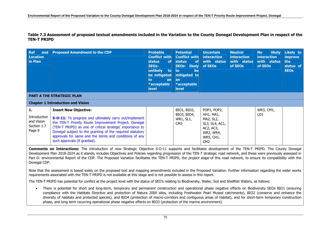
Environmental Report of the Proposed Variation to the County Donegal Development Plan 2018-2024 in respect of the TEN-T Priority Route Improvement Project, Donegal
75
Table 7.3 Assessment of proposed textual amendments included in the Variation to the County Donegal Development Plan in respect of the TEN-T PRIPD
Ref and
Location
in Plan
Proposed Amendment to the CDP Probable
Conflict with
status of
SEOs-
unlikely to
be mitigated
to an
*acceptable
level
Potential
Conflict with
status of
SEOs- likely
to be
mitigated to
an
*acceptable
level
Uncertain
interaction
with status
of SEOs
Neutral
interaction
with status
of SEOs
No likely
interaction
with status
of SEOs
Likely to
improve
the
status of
SEOs
PART A THE STRATEGIC PLAN
Chapter 1 Introduction and Vision
1.
Introduction
and Vision
Section 1.7
Page 9
Insert New Objective:
S-O-11: To progress and ultimately carry out/implement
the TEN-T Priority Route Improvement Project, Donegal
(TEN-T PRIPD) as one of critical strategic importance to
Donegal subject to the granting of the required statutory
approvals for same and the terms and conditions of any
such approvals (if granted).
BIO1, BIO2,
BIO3, BIO4,
WR1, SL1,
CM3
POP1, POP2,
HH1, MA1,
MA2, SL2,
SL3, SL4, AC1,
AC2, AC3,
WR2, WR4,
WR5, CH1,
CM2
WR3, CM1,
LD1
Comments on Interactions: The introduction of new Strategic Objective S-O-11 supports and facilitates development of the TEN-T PRIPD. The County Donegal
Development Plan 2018-2024 as it stands, includes Objectives and Policies regarding progression of the TEN-T strategic road network, and these were previously assessed in
Part D: environmental Report of the CDP. The Proposed Variation facilitates the TEN-T PRIPD, the project stage of this road network, to ensure its compatibility with the
Donegal CDP.
Note that the assessment is based solely on the proposed text and mapping amendments included in the Proposed Variation. Further information regarding the wider works requirements associated with the TEN-T PRIPD is not available at this stage and is not possible to assess in this report.
The TEN-T PRIPD has potential for conflict at the project level with the status of SEO’s relating to Biodiversity, Water, Soil and Shellfish Waters, as follows:
There is potential for short and long-term, temporary and permanent construction and operational phase negative effects on Biodiversity SEOs BIO1 (ensuring
compliance with the Habitats Directive and protection of Natura 2000 sites, including Freshwater Pearl Mussel catchments), BIO2 (conserve and enhance the
diversity of habitats and protected species), and BIO4 (protection of macro-corridors and contiguous areas of habitat), and for short-term temporary construction
phase, and long term recurring operational phase negative effects on BIO3 (protection of the marine environment).

Environmental Report of the Proposed Variation to the County Donegal Development Plan 2018-2024 in respect of the TEN-T Priority Route Improvement Project, Donegal
76
Ref and
Location
in Plan
Proposed Amendment to the CDP Probable
Conflict with
status of
SEOs-
unlikely to
be mitigated
to an
*acceptable
level
Potential
Conflict with
status of
SEOs- likely
to be
mitigated to
an
*acceptable
level
Uncertain
interaction
with status
of SEOs
Neutral
interaction
with status
of SEOs
No likely
interaction
with status
of SEOs
Likely to
improve
the
status of
SEOs
There is potential for short-term temporary construction phase, and long term recurring operational phase negative effects on Water SEO WR1 (protection of the
status of aquatic ecosystems).
There is potential for short-term, construction phase negative effects on Soil SEO SL1 (protect and maintain the quality of soils).
There is potential for short-term temporary construction phase, and long term recurring operational phase negative effects on Coast/Marine Resource SEO CM3
(protection of Designated Shellfish Waters).
Potentially uncertain effects may arise from project implementation on SEO’s relating to Population, Air/Climatic Factors, Material Assets, Soil, Water, and Cultural Heritage.
For the Population SEO POP2 (facilitation of more sustainable travel patterns) and Air/Climatic Factors SEO AC3 (promote a shift from fossil fuel dependent vehicles to more
sustainable modes of travel), uncertainty with regard to short to long-term effects is dependent upon the provision and uptake of more sustainable travel modes and vehicles.
For the Material Assets SEO MA2 (avoidance of flood risk and/or coastal erosion in selecting sites for development), and Soils SEOs SL2 (protection of geological sites) and
SL3 (re-use of brownfield sites), uncertainty with regard to long-term effects is dependent on the selection of land at the project level, and for the Cultural Heritage SEO CH1
(protection and conservation of cultural, including architectural and archaeological, heritage) is dependent upon whether these feature are present within the project area. As
the Indicators for LD1 relate only to Especially High Scenic Amenity areas, there is no potential for conflict with the status of LD1 (conserve and enhance valued natural and
historic landscapes and features within them and avoid adverse impacts) from this amendment. However there is potential for temporary to permanent negative effects on
landscape features other than those of Especially High Scenic Amenity.
In the following cases, the overall interaction of the amendment with the SEO is uncertain as it comprises the potential for a combination of both positive and negative,
temporary to permanent effects.
There is potential for long-term positive effects on the Population SEO POP1 (relating to the provision of high quality residential working and recreational
environments), as increased connectivity may indirectly increase the attractiveness of the area to potential investors in business and housing which in turn may lead
to improved recreational facilities in response to increased demand. The potential for long-term negative effects on this SEO relates to the rezoning of land to
accommodate the TEN-T PRIPD, which may affect existing and future residential environments.
There is potential for long-term positive effects on the Human Health SEO HH1 (relating to noise, vibration and traffic emissions) within urban centres, as the easing
of traffic congestion is expected to lead to reduced noise and traffic emissions. There is also potential for long-term negative effects on this SEO, as there is likely to
be some increase in noise and emissions in the vicinity of the proposed TEN-T PRIPD route corridors.
There is potential for long-term positive effects on the Air/Climatic Factors SEOs AC1 (supporting implementation of the National Climate Strategy) and AC2 (relating
to the reduction of all forms of air pollution) within urban centres, as the easing of traffic congestion is expected to lead to a reduction in traffic emissions. There is

Environmental Report of the Proposed Variation to the County Donegal Development Plan 2018-2024 in respect of the TEN-T Priority Route Improvement Project, Donegal
77
Ref and
Location
in Plan
Proposed Amendment to the CDP Probable
Conflict with
status of
SEOs-
unlikely to
be mitigated
to an
*acceptable
level
Potential
Conflict with
status of
SEOs- likely
to be
mitigated to
an
*acceptable
level
Uncertain
interaction
with status
of SEOs
Neutral
interaction
with status
of SEOs
No likely
interaction
with status
of SEOs
Likely to
improve
the
status of
SEOs
also potential for temporary short-term construction phase negative effects, and long-term negative effects on these SEOs, as there is likely to be some increase in
emissions in the vicinity of the proposed TEN-T PRIPD route corridors.
There is potential for the TEN-T PRIPD to produce waste in the short-term during construction activities. This waste may end up in landfill which would be a negative
impact on SL4 (minimise the amount of waste to landfill). However, this can be mitigated by project specific waste and by-product management at the planning,
design and construction stages that are required to apply the waste hierarchy with avoidance of waste being the preference.
There is potential for long-term positive effects on the SEO MA1 (maintain and improve the availability and quality of community related infrastructure, services and
facilities and ensure the prudent management of environmental resources) by connecting rural with urban areas and providing safer and more direct access to
community related infrastructure. The TEN-T PRIDP will also reduce commercial traffic on urban streets thereby making these safer for local communities accessing
facilities. However, there will also be long-term negative impacts through the severance of local areas and communities through which the TEN-T PRIDP passes.
Short-term negative effects will also be experienced during construction.
There is the potential for long-term positive effects on WR2 and WR4 through the application of best practice surface water management from operational roads.
The impacts on flooding (WR5) will also be managed through surface water and drainage systems designed in accordance with best practice. However, there
remains the potential for short-term negative effects during construction activities with accidental/ unplanned releases of pollution, silt and other construction
materials into watercourses.
There is potential for long-term positive effects on the CM2 (manage the coastal zone as an environmental and tourist resource) as the TEN-T PRIDP will provide
safer and more efficient travel to and from Donegal from a tourism perspective. However, increases in tourism can bring other impacts on coastal environments due
to human activities increasing pressure on sensitive areas. This can have long-term negative effects.
In-combination and cumulative impacts: Strategic Objective S-O-11 facilitates the development of the TEN-TPRIPD, as part of the strategic road network of the County.
The TEN-T PRIPD has potential for short and long-term in-combination growth and development impacts (both positive and negative) within the areas connected by the
preferred Option Corridors (e.g. population, material assets, human health, air quality and infrastructure). There is potential for short and long term, temporary recurring or
permanent in-combination or cumulative effects on SEOs with other plans, programmes or developments within or in the zone of influence of the TEN-T PRIPD Option
Corridors, which will need to be assessed at the project planning stage.
Mitigation:
Any potential impacts may be mitigated by the following avoidance and mitigation strategy:

Environmental Report of the Proposed Variation to the County Donegal Development Plan 2018-2024 in respect of the TEN-T Priority Route Improvement Project, Donegal
78
Ref and
Location
in Plan
Proposed Amendment to the CDP Probable
Conflict with
status of
SEOs-
unlikely to
be mitigated
to an
*acceptable
level
Potential
Conflict with
status of
SEOs- likely
to be
mitigated to
an
*acceptable
level
Uncertain
interaction
with status
of SEOs
Neutral
interaction
with status
of SEOs
No likely
interaction
with status
of SEOs
Likely to
improve
the
status of
SEOs
Project level measures to prevent, reduce and as fully as possible offset any significant adverse effects on the environment will be contained in the Environmental
Impact Assessment Report (EIAR) and Natura Impact Statement (NIS) submitted as part of the statutory approvals process. These measures are typically referred to
as ‘mitigation’. Where reasonably practicable, likely significant impacts may be mitigated by locating and designing the development in a manner which avoids likely
significant effects on the environment.
Avoidance: Potential impacts may be avoided by locating and designing the development in a manner which avoids likely significant effects on the environment and
reduces the likelihood of conflict with the above-mentioned SEOs where practicable. The Council will have due regard for the Environmental Protection policies and
objectives of the County Development Plan when finalising the exact location and design for the development to ensure, where practicable, that such conflicts with
SEOs do not arise in the first instance. In this regard:
o Transport Policies T-P-1, T-P-2 and T-P-5 facilitate development of the TEN-T network, Donegal’s transport network and strategic road network,
respectively, each with a caveat that this is ‘subject to environmental, safety and other planning considerations’, while CS-O-7 stipulates that investment in
infrastructure will be subject to environmental considerations.
o Potential negative impacts on Biodiversity SEOs will be protected by having regard for the Natural Heritage Objectives NH-O-1 to NH-O-3, NH-O-6, NH-O-8
to NH-O-11 and Policies NH-P-1 to NH-P-5, NH-P-10 and NH-P-18, which relate to the protection of biodiversity, including protected habitats and species.
Potential negative impacts on the Water SEO WR1 and Coast/Marine Resource CM3 (protection of Designated Shellfish Waters) will be protected by having
regard for WES-O-5, WES-O-6, WES-P-4, WES-P-8 and WES-P-12. Potential negative impacts on Soil SEO SL1 during construction will be protected by WES-
O-6.
o Uncertain impacts on Population SEOs POP1 and POP2, and MA1 will be protected by having regard for Transport Objectives/Policies such as T-O-10, T-P-
11, T-P-26 and T-P-30, Community Culture and the Gaeltacht Objectives/Policies such as CCG-O-1, CCG-O-7 and CCG-P-12, and objectives and policies
contained within Part B, chapter 6 (Urban Housing). Uncertain impacts on the Human Health SEO HH1 will be protected by having regard for WES-O-6.
Uncertain impacts on the Material Assets SEO M2 will be protected by having regard for the Objectives and Policies in Section 5.4 (flood risk). Uncertain
impacts on the Soil SEO SL2 will be protected by having regard for the Natural Heritage Policy NH-P-19 and Geological Policy G-P-1; SL4 will be protected
by having regard for WES-O-7, WES-P-4 and WES-P-5. Potential uncertain impacts on the Cultural Heritage SEO will be protected by having regard for Built
Heritage Objectives/Policies BH-O-1, BH-P-1 and BH-P-18 and Archaeological Heritage Objectives / Policies AH-O-1 and AH-P-1, AH-P-4, AH-P-5. Potential
uncertain impacts on the Air/Climatic Factors SEO AC1 to AC3 will be protected by having regard for CS-O-17 and WES-O-6.
General Project Level Mitigation: Potential impacts will be mitigated through detailed surveys, construction management plans and techniques, pollution control
measures, monitoring and post construction reinstatement.
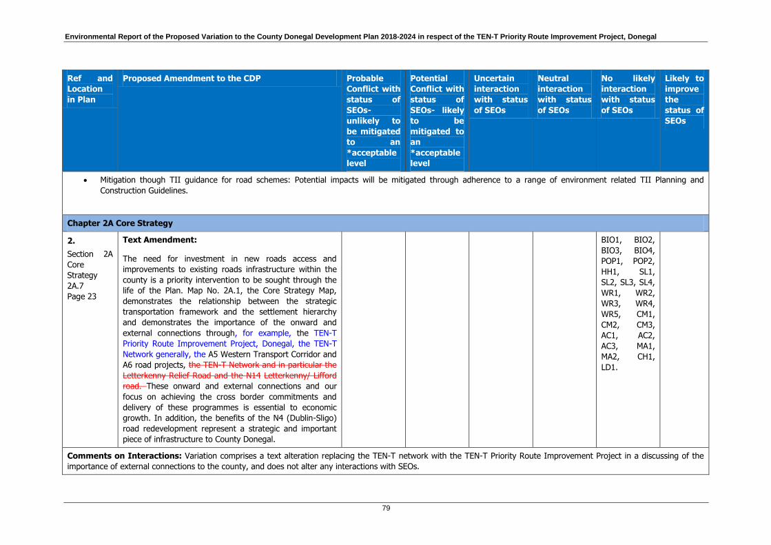
Environmental Report of the Proposed Variation to the County Donegal Development Plan 2018-2024 in respect of the TEN-T Priority Route Improvement Project, Donegal
79
Ref and
Location
in Plan
Proposed Amendment to the CDP Probable
Conflict with
status of
SEOs-
unlikely to
be mitigated
to an
*acceptable
level
Potential
Conflict with
status of
SEOs- likely
to be
mitigated to
an
*acceptable
level
Uncertain
interaction
with status
of SEOs
Neutral
interaction
with status
of SEOs
No likely
interaction
with status
of SEOs
Likely to
improve
the
status of
SEOs
Mitigation though TII guidance for road schemes: Potential impacts will be mitigated through adherence to a range of environment related TII Planning and
Construction Guidelines.
Chapter 2A Core Strategy
2.
Section 2A
Core
Strategy
2A.7
Page 23
Text Amendment:
The need for investment in new roads access and
improvements to existing roads infrastructure within the
county is a priority intervention to be sought through the
life of the Plan. Map No. 2A.1, the Core Strategy Map,
demonstrates the relationship between the strategic
transportation framework and the settlement hierarchy
and demonstrates the importance of the onward and
external connections through, for example, the TEN-T
Priority Route Improvement Project, Donegal, the TEN-T
Network generally, the A5 Western Transport Corridor and
A6 road projects, the TEN-T Network and in particular the
Letterkenny Relief Road and the N14 Letterkenny/ Lifford
road. These onward and external connections and our
focus on achieving the cross border commitments and
delivery of these programmes is essential to economic
growth. In addition, the benefits of the N4 (Dublin-Sligo)
road redevelopment represent a strategic and important
piece of infrastructure to County Donegal.
BIO1, BIO2,
BIO3, BIO4,
POP1, POP2,
HH1, SL1,
SL2, SL3, SL4,
WR1, WR2,
WR3, WR4,
WR5, CM1,
CM2, CM3,
AC1, AC2,
AC3, MA1,
MA2, CH1,
LD1.
Comments on Interactions: Variation comprises a text alteration replacing the TEN-T network with the TEN-T Priority Route Improvement Project in a discussing of the
importance of external connections to the county, and does not alter any interactions with SEOs.

Environmental Report of the Proposed Variation to the County Donegal Development Plan 2018-2024 in respect of the TEN-T Priority Route Improvement Project, Donegal
80
Ref and
Location
in Plan
Proposed Amendment to the CDP Probable
Conflict with
status of
SEOs-
unlikely to
be mitigated
to an
*acceptable
level
Potential
Conflict with
status of
SEOs- likely
to be
mitigated to
an
*acceptable
level
Uncertain
interaction
with status
of SEOs
Neutral
interaction
with status
of SEOs
No likely
interaction
with status
of SEOs
Likely to
improve
the
status of
SEOs
Mitigation: No mitigation required.
3.
Section
2A.10 Core
Strategy
Objectives
Page 26
And
Part A
Chapter 2B
Section 2B.3
Page 34
Text Amendment to Objective:
CS-O-9: To coordinate and promote the delivery of key
roads and access infrastructure (including the A5 Western
Transport Corridor and A6 road projects, the TEN-T
Priority Route Improvement Project and the TEN-T
network generally) lthe Ten- T Network, Letterkenny
Relief Road and the N14 Letterkenny/ Lifford road) with
the other relevant authorities including partners in the
North West Strategic Growth Partnership and within the
Northern and Western Regional Assembly so as to result
in effective strategic connections to and throughout the
County.
BIO1, BIO2,
BIO3, BIO4,
WR1, SL1,
CM2
POP1, POP2,
HH1, MA1,
MA2, SL2,
SL3, SL4, AC1,
AC2, AC3,
WR2, WR4,
WR5, CH1
WR3, CM1,
LD1
Comments on Interactions: The variation to Core Strategy Objective CS-O-9 supports the delivery of key roads, including the TEN-T PRIPD. See assessment of S-O-11.
In-combination and cumulative impacts: See assessment of S-O-11.
Mitigation:
See mitigation outlined for S-O-11. Any potential impacts can be mitigated to an acceptable level through implementation of objectives and policies contained within Part B of
the Donegal CDP 2018-2024, in particular Chapters 5 (Infrastructure) and 7 (Natural and Built Heritage).

Environmental Report of the Proposed Variation to the County Donegal Development Plan 2018-2024 in respect of the TEN-T Priority Route Improvement Project, Donegal
81
Ref and
Location
in Plan
Proposed Amendment to the CDP Probable
Conflict with
status of
SEOs-
unlikely to
be mitigated
to an
*acceptable
level
Potential
Conflict with
status of
SEOs- likely
to be
mitigated to
an
*acceptable
level
Uncertain
interaction
with status
of SEOs
Neutral
interaction
with status
of SEOs
No likely
interaction
with status
of SEOs
Likely to
improve
the
status of
SEOs
PART B: OBJECTIVES AND POLICIES OF THE PLAN
Chapter 5 Infrastructure
4.
5.1.1
Background
Page 77
Text Amendment:
Donegal’s strategic road network is identified on Map
5.1.2 and in the Core Strategy. It comprises Trans
European Transport Network roads (TEN-T), other
National roads and a number of regional roads recognised
by the Council as being of strategic importance as these
roads facilitate high volumes of vehicular traffic, allowing
for the efficient movement of traffic between settlements
within and outside of the County.22 Currently the TEN‐T
Priority Route Improvement Project Donegal is at
Constraints Stage / Route Selection. The Route Selection
will be completed by Q2/Q3 2018 and upon adoption of
the preferred routes, a Material Alteration of the County
Development Plan will be required. The new TEN‐T
Priority Route Improvement Project Donegal Route
Corridors will supersede those „historical project reserved
corridors‟ currently within the County Development Plan
as necessary, namely:
N13‐N15 Ballybofey Stranorlar Bypass
N56 Letterkenny Relief Road
N14 Letterkenny to Lifford
BIO1, BIO2,
BIO3, BIO4,
POP1, POP2,
HH1, SL1,
SL2, SL3, SL4,
WR1, WR2,
WR3, WR4,
WR5, CM1,
CM2, CM3,
AC1, AC2,
AC3, MA1,
MA2, CH1,
LD1.
Comments on Interactions: Variation comprises a deletion of text that is no longer relevant regarding the future planning of the TEN-T PRIPD. It does not alter any
interactions with SEOs.

Environmental Report of the Proposed Variation to the County Donegal Development Plan 2018-2024 in respect of the TEN-T Priority Route Improvement Project, Donegal
82
Ref and
Location
in Plan
Proposed Amendment to the CDP Probable
Conflict with
status of
SEOs-
unlikely to
be mitigated
to an
*acceptable
level
Potential
Conflict with
status of
SEOs- likely
to be
mitigated to
an
*acceptable
level
Uncertain
interaction
with status
of SEOs
Neutral
interaction
with status
of SEOs
No likely
interaction
with status
of SEOs
Likely to
improve
the
status of
SEOs
Mitigation: No mitigation required.
5.
5.1.1
Background
Page 77-78
(located
after text:
N14
Letterkenny
to Lifford)
Insertion of New Table and Text Amendment:
The critical TEN-T network is comprised of the following
National Primary Roads (refer Map 5.1.1):
The N15 road from Bundoran and on to Donegal
Town and to Ballybofey/Stranorlar;
The N13 Ballybofey/Stranorlar to Letterkenny to
Bridgend road (and Derry via the A6); and
The N14 Letterkenny to Lifford road (and Strabane
via the A5).
These routes provide critical connectivity both:
To Dublin and the south-east (via the N14 and A5
roads); and to the broader North-West City Region
area (with Derry via the N13/A6 route; and with
Strabane via the N14/A5 route); and
Along much of the length of the County and to the
south and the broader Northern and-Western
Regional Assembly ,area, and the Atlantic Corridor
area (via the N15 and N13 roads).
The N15 Ballybofey/Stranorlar to Lifford road, whilst not
on the TEN-T network, is a National Primary Road and
provides another vital element of the strategic road
network in the east of the County. The N3 Ballyshannon
to Belleek road is another National Primary Road which
connects the south east of the County to
Dublin and the south-east (via the N4) via Enniskillen.
BIO1, BIO2,
BIO3, BIO4,
POP1, POP2,
HH1, SL1,
SL2, SL3, SL4,
WR1, WR2,
WR3, WR4,
WR5, CM1,
CM2, CM3,
AC1, AC2,
AC3, MA1,
MA2, CH1,
LD1.

Environmental Report of the Proposed Variation to the County Donegal Development Plan 2018-2024 in respect of the TEN-T Priority Route Improvement Project, Donegal
83
Ref and
Location
in Plan
Proposed Amendment to the CDP Probable
Conflict with
status of
SEOs-
unlikely to
be mitigated
to an
*acceptable
level
Potential
Conflict with
status of
SEOs- likely
to be
mitigated to
an
*acceptable
level
Uncertain
interaction
with status
of SEOs
Neutral
interaction
with status
of SEOs
No likely
interaction
with status
of SEOs
Likely to
improve
the
status of
SEOs
The N56 National Secondary road serving the south, west
and north-west and north of the County is a second
critical element of the County’s National Roads network.
As well as providing a vital transport corridor for the
residents and businesses of the area, the road also aligns
significantly with the Wild Atlantic Way tourism route.
Finally, the Council also recognises the vital importance of
the under-noted the sections of the Regional Road
network identified in Map 5.1.2 as part of the Strategic
Road network including:
The R250, R252 and R251 routes connecting the west of the County with the centre and east;
The R238, R244, R240, and R241 serving the Inishowen area; and
The R245 between Letterkenny and Ramelton Milford and connecting serving the Fanad and Rossgill peninsulas., respectively; and
The short, but important, stretch of the R263 linking Killybegs and the N56 National Secondary road; and,.
22 (*In December 2013 the European parliament adopted
Regulation (EU) No.315/2013 on Guidelines for the
development of the Trans European Transport Network
(Ten-T), (amended in 2014 to include supplementary
maps (EU) No.473/2014). The Guidelines set out that
member states shall “take appropriate measures” to
complete their core network by 2030; the maps associated

Environmental Report of the Proposed Variation to the County Donegal Development Plan 2018-2024 in respect of the TEN-T Priority Route Improvement Project, Donegal
84
Ref and
Location
in Plan
Proposed Amendment to the CDP Probable
Conflict with
status of
SEOs-
unlikely to
be mitigated
to an
*acceptable
level
Potential
Conflict with
status of
SEOs- likely
to be
mitigated to
an
*acceptable
level
Uncertain
interaction
with status
of SEOs
Neutral
interaction
with status
of SEOs
No likely
interaction
with status
of SEOs
Likely to
improve
the
status of
SEOs
with the Regulations show the core network corridors of
the TEN-T extending from Dublin to Belfast, and Dublin to
Cork only. Nationally, as a result of the directive, parts of
the N13, N14 and N15 have also been identified as part of
the TEN-T network. These routes are identified as
strategic and important inter-urban transport corridors
giving access to regional and international markets;
identified on Map 5.1.1.)
22 (*In December 2013 Regulation (EU) No.1315/2013 on
Guidelines for the development of the Trans European
Transport Network (TEN-T) was adopted. The TEN-T
Network includes: roads, railway lines, shipping routes,
ports, airports etc. It comprises of 2 network layers
namely: 1) The Core Network: the most important
connections between large cities and; 2) The
Comprehensive Network: other connections throughout
European Regions including in Donegal the N13, N14 and
most of the N15 national routes. Said regulations identify:
enhanced regional accessibility and connectivity, removing
bottlenecks particularly in cross border sections,
increasing capacity, and improving safety as general
priorities for the comprehensive network layer. In
December 2016 Regulation (EU) 2017/849 changed the
status of the TEN-T Network roads in Donegal from
‘Road/Completed’ to ‘Road/To be upgraded’.
The R265 The regional road network from Carrigans
to Rossgier.
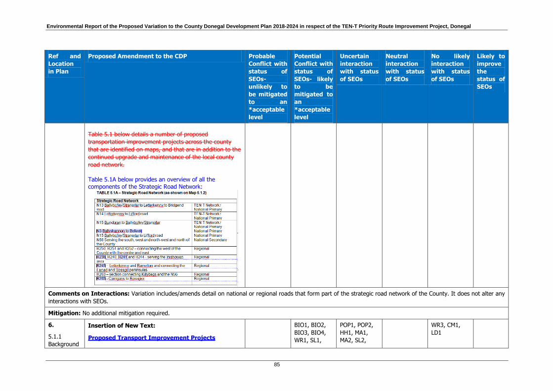
Environmental Report of the Proposed Variation to the County Donegal Development Plan 2018-2024 in respect of the TEN-T Priority Route Improvement Project, Donegal
85
Ref and
Location
in Plan
Proposed Amendment to the CDP Probable
Conflict with
status of
SEOs-
unlikely to
be mitigated
to an
*acceptable
level
Potential
Conflict with
status of
SEOs- likely
to be
mitigated to
an
*acceptable
level
Uncertain
interaction
with status
of SEOs
Neutral
interaction
with status
of SEOs
No likely
interaction
with status
of SEOs
Likely to
improve
the
status of
SEOs
Table 5.1 below details a number of proposed
transportation improvement projects across the county
that are identified on maps, and that are in addition to the
continued upgrade and maintenance of the local county
road network.
Table 5.1A below provides an overview of all the
components of the Strategic Road Network:
Comments on Interactions: Variation includes/amends detail on national or regional roads that form part of the strategic road network of the County. It does not alter any
interactions with SEOs.
Mitigation: No additional mitigation required.
6.
5.1.1
Background
Insertion of New Text:
Proposed Transport Improvement Projects
BIO1, BIO2,
BIO3, BIO4,
WR1, SL1,
POP1, POP2,
HH1, MA1,
MA2, SL2,
WR3, CM1,
LD1

Environmental Report of the Proposed Variation to the County Donegal Development Plan 2018-2024 in respect of the TEN-T Priority Route Improvement Project, Donegal
86
Ref and
Location
in Plan
Proposed Amendment to the CDP Probable
Conflict with
status of
SEOs-
unlikely to
be mitigated
to an
*acceptable
level
Potential
Conflict with
status of
SEOs- likely
to be
mitigated to
an
*acceptable
level
Uncertain
interaction
with status
of SEOs
Neutral
interaction
with status
of SEOs
No likely
interaction
with status
of SEOs
Likely to
improve
the
status of
SEOs
Page 77-78
Table 5.1B below details a number of proposed
transportation improvement projects across the county
that are identified on maps, and that are in addition to the
continued upgrade and maintenance of the local county
road network.
This includes the TEN-T Priority Route Improvement
Project, Donegal which consists of and prioritises 3 key
sections of the TEN-T network in Donegal for
improvement namely:
Section 1 – N15/N13 Ballybofey/Stranorlar Urban
Region.
Section 2 – N56/N13 Letterkenny to
Manorcunningham.
Section 3 – N14 Manorcunningham to
Lifford/Strabane /A5 Link.
The preferred route corridors for those sections are now
show on Map 5.1.5, Map 5.1.6 and Map 5.1.4,
respectively.
These preferred route corridors replace the historic
reserved route corridors (the N13-N15 Ballybofey
Stranorlar Bypass, the N56 Letterkenny Relief Road, and
the N14 Letterkenny to Lifford) previously detailed in this
plan.
The benefits of the TEN-T Priority Route Improvement
CM3 SL3, SL4, AC1,
AC2, AC3,
WR2, WR4,
WR5, CH1,
CM2

Environmental Report of the Proposed Variation to the County Donegal Development Plan 2018-2024 in respect of the TEN-T Priority Route Improvement Project, Donegal
87
Ref and
Location
in Plan
Proposed Amendment to the CDP Probable
Conflict with
status of
SEOs-
unlikely to
be mitigated
to an
*acceptable
level
Potential
Conflict with
status of
SEOs- likely
to be
mitigated to
an
*acceptable
level
Uncertain
interaction
with status
of SEOs
Neutral
interaction
with status
of SEOs
No likely
interaction
with status
of SEOs
Likely to
improve
the
status of
SEOs
Project, Donegal are significant and wide ranging
including:
Economic: Facilitating economic growth and allowing
Donegal to successfully compete for inward
investment by improving the efficiency and capacity
of the road network including improving journey time
and journey time reliability at a local, regional and
national level.
Safety: Reducing the frequency and severity of
collisions/improving safety on our national roads and
enhancing road safety in towns, villages and rural
areas by segregating strategic traffic from local traffic.
Environmental: Reducing air pollution caused by
congestive queuing and reducing noise levels near
noise sensitive receptors.
Quality of life: Reducing journey times, reducing
traffic and thus freeing up road space in our towns
and villages for sustainable transport modes (i.e.
walking, cycling and public transport), providing new
walking and cycling infrastructure as part of the
scheme and improving access to health and education
services.
Enhancing Regional Accessibility: Improving
accessibility to/from Donegal for employers,
exporters, tourists and the general public.
Strategic/Cross border: Improving cross border
connectivity, unlocking the potential of the North
West City Region and the Atlantic Economic Corridor.

Environmental Report of the Proposed Variation to the County Donegal Development Plan 2018-2024 in respect of the TEN-T Priority Route Improvement Project, Donegal
88
Ref and
Location
in Plan
Proposed Amendment to the CDP Probable
Conflict with
status of
SEOs-
unlikely to
be mitigated
to an
*acceptable
level
Potential
Conflict with
status of
SEOs- likely
to be
mitigated to
an
*acceptable
level
Uncertain
interaction
with status
of SEOs
Neutral
interaction
with status
of SEOs
No likely
interaction
with status
of SEOs
Likely to
improve
the
status of
SEOs
Furthermore the strategic importance of said project to
the County is highlighted by the fact that:
Enhanced Regional accessibility, including upgrading
access to the North West utilising routes such as the
N14 and progressive development of the Atlantic
Economic Corridor Northwards by upgrading the
N15/N13 link, is a National Strategic Outcome of the
National Planning Framework Project Ireland 2040.
The “N15 Ballybofey Bypass”, “N13/N14/N56
Letterkenny Bypass and Dual Carriageway to
Manorcunningham” and the “N14 Manorcunningham
to Lifford” are all listed as priorities for investment
within the National Development Plan 2018-2027.
It is an objective of the Regional Spatial and
Economic Strategy for the Northern and Western
Regional Assembly Area to deliver the project by
2028. (Objective RPO 3.7.30 of said document
refers).
The project is fundamental to both the success of the
North West City Region and enhanced transport
connectivity between Ireland and Northern Ireland,
each of which in turn are National Policy Objectives of
the National Planning Framework (NPO 45 and 46 of
said document refers).
The TEN-T Priority Route Improvement Project, Donegal
includes: The mainline and all associated temporary and
permanent works including, but not restricted to, all
junctions, associated link and other new roads,

Environmental Report of the Proposed Variation to the County Donegal Development Plan 2018-2024 in respect of the TEN-T Priority Route Improvement Project, Donegal
89
Ref and
Location
in Plan
Proposed Amendment to the CDP Probable
Conflict with
status of
SEOs-
unlikely to
be mitigated
to an
*acceptable
level
Potential
Conflict with
status of
SEOs- likely
to be
mitigated to
an
*acceptable
level
Uncertain
interaction
with status
of SEOs
Neutral
interaction
with status
of SEOs
No likely
interaction
with status
of SEOs
Likely to
improve
the
status of
SEOs
realignment of existing roads necessitated by the Project
along with all earthworks, structures and bridges,
drainage, signage, construction compounds, borrow pits
and deposition areas related to said project.
7.
5.1.1
Background
Page 78
TABLE 5.1B: Proposed Transportation
Improvement Projects Identified on Maps Listed
Below.
BIO1, BIO2,
BIO3, BIO4,
WR1, SL1,
CM3
POP1, POP2,
HH1, MA1,
MA2, SL2,
SL3, SL4, AC1,
AC2, AC3,
WR2, WR4,
WR5, CH1,
CM2
WR3, CM1,
LD1
Comments on Interactions: This text variation (amendment 6) and additional of new Table 5.1B (amendment 7) provide details of the TEN-T PRIPD and the proposed Option Corridors of said project. See assessment of S-O-11. Note that the assessment is based solely on the proposed text and mapping amendments included in the proposed Variation. Further information regarding the wider works requirements associated with the TEN-T PRIPD is not available at this stage and is not possible to assess in this report.
In-combination and cumulative impacts: See assessment of S-O-11.
Mitigation: See mitigation outlined for S-O-11. Any potential impacts can be mitigated to an acceptable level through implementation of objectives and policies contained
within Part B of the Donegal CDP 2018-2024, in particular Chapters 5 (Infrastructure) and 7 (Natural and Built Heritage).
8.
5.1.2
Objectives
Page 77
And
Amendment to Objective:
T-O-1: To deliver improvements to the Trans European
Transport Network (TEN-T), (as required by EU Regulation
(EU) No.1315/2013 “Guidelines for the development of
the Trans European Transport Network (TENen-T)”) as
BIO1, BIO2,
BIO3, BIO4,
WR1, SL1,
SL3, MA1,
CM3
POP1, POP2,
HH1, MA2,
SL2, SL4, AC1,
AC2, AC3,
WR2, WR4,
WR5, CH1,
WR3, CM1,
LD1

Environmental Report of the Proposed Variation to the County Donegal Development Plan 2018-2024 in respect of the TEN-T Priority Route Improvement Project, Donegal
90
Ref and
Location
in Plan
Proposed Amendment to the CDP Probable
Conflict with
status of
SEOs-
unlikely to
be mitigated
to an
*acceptable
level
Potential
Conflict with
status of
SEOs- likely
to be
mitigated to
an
*acceptable
level
Uncertain
interaction
with status
of SEOs
Neutral
interaction
with status
of SEOs
No likely
interaction
with status
of SEOs
Likely to
improve
the
status of
SEOs
Part A
Chapter 2B
2B.3
Restatemen
t of
Narrative,
Objectives
and Policies
of Direct
Relevance
to the
Border
Dimension
part of the core and comprehensive transport network of
Ireland.”
In this regard it is a specific objective of the Council to:
a) Progress and ultimately carry out/implement the TEN-T
Priority Route Improvement Project, Donegal as one of
critical strategic importance to Donegal subject to the
granting of the required statutory approvals for same and
the terms and conditions of any such approvals (if
granted).
b) Reserve the preferred route corridors of the TEN-T
Priority Route Improvement Project, Donegal as shown on
maps 5.1.4, 5.1.5, and 5.1.6 for the purposes of the
project and the ancillary facilities to service the same and
not to permit other development within those corridors
where such development may prejudice the carrying
out/implementation of the said project.
CM2
Comments on Interactions: The variation to Transport Objective T-O-1 supports the development of the TEN-T PRIPD and reserves the preferred route corridors.
There is potential for conflict with the status of SEO’s relating to Biodiversity (BIO1, BIO2, BIO3, BIO4), Soils (SL1), Water (WR1), and Shellfish Waters (CM2), as assessed for
S-O-11, from progression of the TEN-T PRIPD. There is also potential for conflict with the status of Soil SEO SL3, and Material Assets SEO MA1 from reservation of the
preferred route corridors, as assessed for T-O-7 (amendment no.10).
In-combination and cumulative impacts: See assessment of S-O-11.
Mitigation: See mitigation outlined for S-O-11. Any potential impacts can be mitigated to an acceptable level through implementation of objectives and policies contained
within Part B of the Donegal CDP 2018-2024, in particular Chapters 5 (Infrastructure) and 7 (Natural and Built Heritage).
9. Insert New Objective: BIO1, BIO2, POP1, POP2, WR3, CM1,

Environmental Report of the Proposed Variation to the County Donegal Development Plan 2018-2024 in respect of the TEN-T Priority Route Improvement Project, Donegal
91
Ref and
Location
in Plan
Proposed Amendment to the CDP Probable
Conflict with
status of
SEOs-
unlikely to
be mitigated
to an
*acceptable
level
Potential
Conflict with
status of
SEOs- likely
to be
mitigated to
an
*acceptable
level
Uncertain
interaction
with status
of SEOs
Neutral
interaction
with status
of SEOs
No likely
interaction
with status
of SEOs
Likely to
improve
the
status of
SEOs
5.1.2
Objectives
Page 77
T-O-1A:
Should there be any ostensible or apparent conflict
between, on the one hand, the Objectives, Policies and/or
provisions of the development plan herein providing for
the development of the TEN-T Priority Route
Improvement Project, Donegal (TEN-T PRIPD) and, on the
other hand, any other Objectives, Policies and/or
provisions of the development plan, those Objectives,
Policies and Provisions which provide for the development
of the TEN-T PRIPD shall take priority over all or any
other provisions of the development plan and any such
other provisions or Objectives shall be read and construed
as subservient to and not in any material way
contravening so much of the Objectives, Policies and
provisions contained within this development plan as
provide for the development of the TEN-T PRIPD.
BIO3, BIO4,
WR1, CM3,
SL1
HH1, MA2,
SL2, SL3, SL4,
AC1, AC2,
AC3, WR2,
WR4, WR5,
CM2, CH1,
MA1
LD1
Comments on Interactions: The introduction of new Transport Objective T-O-1A prioritises objectives, policies and/or provisions of the development plan for the
development of the TEN-T PRIPD above other objectives, policies and/or provisions of the development plan where a conflict may arise. The County Donegal Development
Plan 2018-2024 as it stands, includes Objectives and Policies regarding progression of the TEN-T strategic road network, and these were previously assessed in Part D:
environmental Report of the CDP. The Proposed Variation facilitates the TEN-T PRIPD, the project stage of this road network, to ensure its compatibility with the Donegal
CDP.
Note that the assessment is based solely on the proposed text and mapping amendments included in the Proposed Variation. Further information regarding the wider works associated with the TEN-T PRIPD is not available at this stage and is not possible to assess in this ER.
The TEN-T PRIPD has potential for conflict at the project level with the status of SEO’s relating to Biodiversity, Soil, Water, and Shellfish Waters, as follows:
There is potential for short and long term, temporary and permanent construction and operational phase negative effects on Biodiversity SEOs BIO1 (ensuring

Environmental Report of the Proposed Variation to the County Donegal Development Plan 2018-2024 in respect of the TEN-T Priority Route Improvement Project, Donegal
92
Ref and
Location
in Plan
Proposed Amendment to the CDP Probable
Conflict with
status of
SEOs-
unlikely to
be mitigated
to an
*acceptable
level
Potential
Conflict with
status of
SEOs- likely
to be
mitigated to
an
*acceptable
level
Uncertain
interaction
with status
of SEOs
Neutral
interaction
with status
of SEOs
No likely
interaction
with status
of SEOs
Likely to
improve
the
status of
SEOs
compliance with the Habitats Directive and protection of Natura 2000 sites, including Freshwater Pearl Mussel catchments), BIO2 (conserve and enhance the
diversity of habitats and protected species), and BIO4 (protection of macro-corridors and contiguous areas of habitat), and for short-term temporary construction
phase, and long term recurring operational phase negative effects on BIO3 (protection of the marine environment).
There is potential for short-term, construction phase negative effects on Soil SEO SL1 (protect and maintain the quality of soils).
There is potential for short-term temporary construction phase, and long term recurring operational phase negative effects on Water SEO WR1 (protection of the
status of aquatic ecosystems).
There is potential for short-term temporary construction phase, and long term recurring operational phase negative effects on Coast/Marine Resource SEO CM3
(protection of Designated Shellfish Waters).
Potentially uncertain effects may arise from project implementation on SEO’s relating to Population, Material Assets, Soil, Water, and Cultural Heritage. For the Population SEO
POP2 (facilitation of more sustainable travel patterns) and Air Quality SEO AC3 (promote a shift from fossil fuel dependent vehicles to more sustainable modes of travel),
uncertainty with regard to short to long-term effects is dependent upon the provision and uptake of more sustainable travel modes and vehicles. For the Material Assets SEO
MA2 (avoidance of flood risk and/or coastal erosion in selecting sites for development), and Soils SEOs SL2 (protection of geological sites) and SL3 (re-use of brownfield
sites), uncertainty with regard to long-term effects is dependent on the selection of land at the project level, and for the Cultural Heritage SEO CH1 (protection and
conservation of cultural, including architectural and archaeological, heritage) is dependent upon whether these feature are present within the project area. As the Indicators
for LD1 relate only to Especially High Scenic Amenity areas, there is no potential for conflict with the status of LD1 (conserve and enhance valued natural and historic
landscapes and features within them and avoid adverse impacts) from this amendment. However there is potential for temporary to permanent negative effects on landscape
features other than those of Especially High Scenic Amenity.
In the following cases, the overall interaction of the amendment with the SEO is uncertain as it comprises the potential for a combination of both positive and negative,
temporary to permanent effects.
There is potential for long-term positive effects on the Population SEO POP1 (relating to the provision of high quality residential working and recreational
environments), as increased connectivity may indirectly increase local employment. The potential for long-term negative effects on this SEO relates to the rezoning
of land to accommodate the TEN-T PRIPD, which may affect existing and future residential environments.
There is potential for long-term positive effects on the Human Health SEO HH1 (relating to noise, vibration and traffic emissions) within urban centres, as the easing
of traffic congestion is expected to lead to reduced noise and traffic emissions. There is also potential for long-term negative effects on this SEO, as there is likely to
be some increase in noise and emissions in the vicinity of the proposed TEN-T PRIPD route corridors.

Environmental Report of the Proposed Variation to the County Donegal Development Plan 2018-2024 in respect of the TEN-T Priority Route Improvement Project, Donegal
93
Ref and
Location
in Plan
Proposed Amendment to the CDP Probable
Conflict with
status of
SEOs-
unlikely to
be mitigated
to an
*acceptable
level
Potential
Conflict with
status of
SEOs- likely
to be
mitigated to
an
*acceptable
level
Uncertain
interaction
with status
of SEOs
Neutral
interaction
with status
of SEOs
No likely
interaction
with status
of SEOs
Likely to
improve
the
status of
SEOs
There is potential for long-term positive effects on the Air Quality SEOs AC1 (supporting implementation of the National Climate Strategy) and AC2 (relating to the
reduction of all forms of air pollution) within urban centres, as the easing of traffic congestion is expected to lead to a reduction in traffic emissions. There is also
potential for temporary short-term construction phase negative effects, and long-term negative effects on these SEOs, as there is likely to be some increase in
emissions in the vicinity of the proposed TEN-T PRIPD route corridors.
There is potential for the TEN-T PRIPD to produce waste in the short-term during construction activities. This waste may end up in landfill which would be a negative
impact on SL4 (minimise the amount of waste to landfill). However, this can be mitigated by project specific waste and by-product management at the planning,
design and construction stages that are required to apply the waste hierarchy with avoidance of waste being the preference.
There is potential for long-term positive effects on the SEO MA1 (maintain and improve the availability and quality of community related infrastructure, services and
facilities and ensure the prudent management of environmental resources) by connecting rural with urban areas and providing safer and more direct access to
community related infrastructure. The TEN-T PRIDP will also reduce commercial traffic on urban streets thereby making these safer for local communities accessing
facilities. However, there will also be long-term negative impacts through the severance of local areas and communities through which the TEN-T PRIDP passes.
Short-term negative effects will also be experienced during construction.
There is the potential for long-term positive effects on WR2 and WR4 through the application of best practice surface water management from operational roads.
The impacts on flooding (WR5) will also be managed through surface water and drainage systems designed in accordance with best practice. However, there
remains the potential for short-term negative effects during construction activities with accidental/ unplanned releases of pollution, silt and other construction
materials into watercourses.
There is potential for long-term positive effects on the CM2 (manage the coastal zone as an environmental and tourist resource) as the TEN-T PRIDP will provide
safer and more efficient travel to from Donegal from a tourism perspective. However, increases in tourism can bring other impacts on coastal environments due to
human activities increasing pressure on sensitive areas. This can have long-term negative effects.
In-combination and cumulative impacts: The TEN-T PRIPD has potential for short and long-term in-combination growth and development impacts (both positive and
negative) within the areas connected by the preferred Option Corridors (e.g. population, material assets, human health, air quality and infrastructure). There is potential for
short and long term, temporary recurring or permanent in-combination or cumulative effects on SEOs with other plans, programmes and developments within or in the zone
of influence of the TEN-T PRIPD Option Corridors, which will need to be assessed at the project planning stage.
Mitigation:
The addition of Transport Objective T-O-1A prioritises objectives, policies and/or provisions of the development plan for the development of the TEN-T PRIPD above other

Environmental Report of the Proposed Variation to the County Donegal Development Plan 2018-2024 in respect of the TEN-T Priority Route Improvement Project, Donegal
94
Ref and
Location
in Plan
Proposed Amendment to the CDP Probable
Conflict with
status of
SEOs-
unlikely to
be mitigated
to an
*acceptable
level
Potential
Conflict with
status of
SEOs- likely
to be
mitigated to
an
*acceptable
level
Uncertain
interaction
with status
of SEOs
Neutral
interaction
with status
of SEOs
No likely
interaction
with status
of SEOs
Likely to
improve
the
status of
SEOs
objectives, policies and/or provisions of the development plan, where a conflict may arise. Potential impacts may be avoided by locating and designing the development in a
manner which avoids likely significant effects on the environment and reduces the likelihood of conflict with the above-mentioned SEOs where practicable. The Council will
have due regard for the Environmental Protection policies and objectives of the County Development Plan when finalising the exact location and design for the development
to ensure, where practicable, that such conflicts with SEO’s do not arise in the first instance.
As stated in Strategic Objective S-O-11, and Transport Objective T-O-1, the progression and implementation of the TEN-T PRIPD will be “subject to the granting of the
required statutory approvals for same and the terms and conditions of any such approvals (if granted)”. Project level measures to prevent, reduce and as fully as possible
offset any significant adverse effects on the environment will be contained in the Environmental Impact Assessment Report (EIAR) and Natura Impact Statement (NIS)
submitted as part of the statutory approvals process. These measures are typically referred to as ‘mitigation’. The project will be subject to an application to ABP and will
require AA and EIA.
Potential negative impacts on Biodiversity SEOs BIO1, BIO2 and BIO4 will be protected by measures developed during the project detailed design process to prevent, reduce,
and offset and as fully as possible adverse environmental effects. The NIR concluded that a number of the proposed amendments, including S-O-11 have the potential to
result in significant impacts on Natura 2000 sites, however during the project planning stage, the TEN-T PRIPD will be considered in terms of its potential impact on Natura
2000 sites, and project-level AA will ensure the compliance with Article 6 of the Habitats Directive in having regard to the relevant conservation objectives, qualifying interests
and threats to the integrity of Natura 2000 sites. Potential negative impacts on the Water SEO WR1, Coast/Marine Resource SEO CM3 (Designated Shellfish Waters), and
Biodiversity SEO BIO3 will be protected by the requirements of the WFD. Potential negative impacts on Soil SEO SL1 will be protected by the requirements of the EIA
Directive, where soil is one of the environmental factors.
10.
5.1.2
Policies
Page 79
Amendment to Objective
T-O-7: To protect the corridors and routes and acquire
the lands necessary for transportation improvement
projects as identified in Table 5.1B above.
BIO4, POP1,
POP2, SL3,
MA1
BIO1, BIO2,
BIO3, HH1,
SL1, SL2, SL4,
WR1, WR2,
WR3, WR4,
WR5, CM1,
CM2, CM3,

Environmental Report of the Proposed Variation to the County Donegal Development Plan 2018-2024 in respect of the TEN-T Priority Route Improvement Project, Donegal
95
Ref and
Location
in Plan
Proposed Amendment to the CDP Probable
Conflict with
status of
SEOs-
unlikely to
be mitigated
to an
*acceptable
level
Potential
Conflict with
status of
SEOs- likely
to be
mitigated to
an
*acceptable
level
Uncertain
interaction
with status
of SEOs
Neutral
interaction
with status
of SEOs
No likely
interaction
with status
of SEOs
Likely to
improve
the
status of
SEOs
AC1, AC3,
MA2, CH1,
LD1
Comments on Interactions: The variation to Transport Objective T-O-7 makes reference to Table 5.1B, which has been altered to include specific reference to the route
corridors of the TEN-T PRIPD. The TEN-T PRIPD preferred Option Corridors include land previously zoned solely for Established Development, Strategic Residential Reserve,
General Employment, Open Space or Amenity Space within Letterkenny and Settlement Frameworks.
There is potential for conflict with the status of SEOs arising from this amendment, as follows:
There is potential for permanent negative effects on the Population SEO POP1 (relating to the provision of high quality residential working and recreational
environments), relating to the rezoning of ‘Established Development’ and ‘Strategic Residential Reserve’ land to accommodate the TEN-T PRIPD, which may affect
existing and future residential environments.
There is potential for permanent negative effects on the Population SEO POP2 (facilitation of more sustainable travel patterns), relating to the rezoning of ‘Open
Space’ and ‘Amenity’ land to accommodate the TEN-T PRIPD.
There is potential for permanent negative effects on the Material Assets SEO MA1 (availability and quality of community related infrastructure, services and facilities,
and ensure the prudent management of environmental resources), relating to the rezoning of ‘General Employment, ‘Open Space’ and ‘Amenity’ land to
accommodate the TEN-T PRIPD.
There is potential for permanent negative effects on the Biodiversity SEO BIO4 (protect macro-corridors and contiguous areas of habitat), and Soil SEO SL3 (give
preference to the re-use of brownfield lands rather than developing greenfield lands) relating to the rezoning of ‘Open Space’ and ‘Amenity’ land to accommodate the
TEN-T PRIPD.
In-combination and cumulative impacts: See assessment of S-O-11.
Mitigation:
Any potential impacts can be mitigated to an acceptable level through implementation of Objectives and Policies contained within Part B of the Donegal CDP 2018-2024, in
particular Chapters 5 (Infrastructure) and 7 (Natural and Built Heritage), and Chapter 6 (Urban Housing). See mitigation for conflict with these SEOs outlined for S-O-11.
Development of the TEN-T PRIPD will be subject to relevant material planning considerations, and national/regional policy/guidance.

Environmental Report of the Proposed Variation to the County Donegal Development Plan 2018-2024 in respect of the TEN-T Priority Route Improvement Project, Donegal
96
Ref and
Location
in Plan
Proposed Amendment to the CDP Probable
Conflict with
status of
SEOs-
unlikely to
be mitigated
to an
*acceptable
level
Potential
Conflict with
status of
SEOs- likely
to be
mitigated to
an
*acceptable
level
Uncertain
interaction
with status
of SEOs
Neutral
interaction
with status
of SEOs
No likely
interaction
with status
of SEOs
Likely to
improve
the
status of
SEOs
11.
5.1.2
Policies
Page 79
Amendment to Policy:
T-P-1: It is a policy of the Council to support and
facilitate the appropriate development, extension and
improvement of the TEN-T network (Map 5.1.1 refers)
within Donegal in accordance with the Core Strategy
and subject to environmental, safety and other planning
considerations. In this regard it is a specific policy of the
Council to:
a) Progress and ultimately carry out/implement the TEN-T
Priority Route Improvement Project, Donegal as one of
critical strategic importance to Donegal subject to the
granting of the required statutory approvals for same and
the terms and conditions of any such approvals (if
granted).
b) Reserve the preferred route corridors of the TEN-T
Priority Route Improvement Project, Donegal as shown on
maps 5.1.4, 5.1.5, and 5.1.6 for the purposes of the
project and the ancillary facilities to service the same and
not to permit other development within those corridors
where such development may prejudice the carrying
out/implementation of the said project.
c) Facilitate any development related to the TEN-T Priority
Route Improvement Project, Donegal within lands zoned:
o TEN-T PRIPD/Established Development.
o TEN-T PRIPD/Strategic Residential Reserve.
o TEN-T PRIPD/General Employment.
o TEN-T PRIPD/Open Space.
BIO1, BIO2,
BIO3, BIO4,
WR1, SL1,
SL3, MA1,
CM3
POP1, POP2,
HH1, MA2,
SL2, SL4, AC1,
AC2, AC3,
WR2, WR4,
WR5, CH1,
CM2
WR3, CM1,
LD1

Environmental Report of the Proposed Variation to the County Donegal Development Plan 2018-2024 in respect of the TEN-T Priority Route Improvement Project, Donegal
97
Ref and
Location
in Plan
Proposed Amendment to the CDP Probable
Conflict with
status of
SEOs-
unlikely to
be mitigated
to an
*acceptable
level
Potential
Conflict with
status of
SEOs- likely
to be
mitigated to
an
*acceptable
level
Uncertain
interaction
with status
of SEOs
Neutral
interaction
with status
of SEOs
No likely
interaction
with status
of SEOs
Likely to
improve
the
status of
SEOs
o TEN-T PRIPD/Amenity.
Comments on Interactions: The variations to Transport Objective T-O-1 and Transport Policy T-P-1 support the development of the TEN-T PRIPD.
There is potential for conflict with the status of SEO’s relating to Biodiversity (BIO1, BIO2, BIO3, BIO4), Soil (SL1), Water (WR1), and Shellfish Waters (CM3), as assessed for
S-O-11, from progression of the TEN-T PRIPD. There is also potential for conflict with the status of Soil SEO SL3, and Material Assets SEO MA1 from reservation of the
preferred route corridors, as assessed for T-O-7 (amendment no.10).
In-combination and cumulative impacts: See assessment of S-O-11 and T-O-1.
Mitigation:
See mitigation outlined for S-O-11. Any potential impacts can be mitigated to an acceptable level through implementation of objectives and policies contained within Part B of
the Donegal CDP 2018-2024, in particular Chapters 5 (Infrastructure) and 7 (Natural and Built Heritage).
12.
5.1.3
Policies
Page 82
Amendment to Policy:
T-P-24: Save to the extent necessary to allow for the
provision of the TEN-T Priority Route Improvement
Project, Donegal iIt is a policy of the Council to protect
established/historic railway corridors throughout the
County primarily for strategic infrastructure provision
(such as rail/road/greenway projects) and secondly for
recreational development. Along these corridors other
uses shall not be considered. Where these corridors have
already been compromised by development, adjacent
lands which could provide opportunities to bypass such an
impediment and reconnect these routes for amenity
purposes (walking/cycling) shall be protected for this
purpose. However, in all instances, the over-riding
objective shall be the provision of strategic infrastructure.
BIO1, BIO2,
BIO3, BIO4,
POP1, POP2,
HH1, SL1,
SL2, SL3, SL4,
WR1, WR2,
WR3, WR4,
WR5, CM1,
CM2, CM3,
AC1, AC2,
MA1, MA2,
CH1, LD1
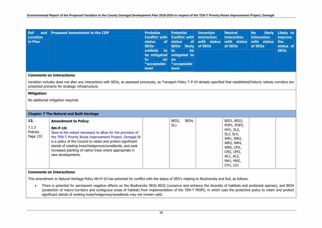
Environmental Report of the Proposed Variation to the County Donegal Development Plan 2018-2024 in respect of the TEN-T Priority Route Improvement Project, Donegal
98
Ref and
Location
in Plan
Proposed Amendment to the CDP Probable
Conflict with
status of
SEOs-
unlikely to
be mitigated
to an
*acceptable
level
Potential
Conflict with
status of
SEOs- likely
to be
mitigated to
an
*acceptable
level
Uncertain
interaction
with status
of SEOs
Neutral
interaction
with status
of SEOs
No likely
interaction
with status
of SEOs
Likely to
improve
the
status of
SEOs
Comments on Interactions:
Variation includes does not alter any interactions with SEOs, as assessed previously, as Transport Policy T-P-24 already specified that established/historic railway corridors are
protected primarily for strategic infrastructure.
Mitigation:
No additional mitigation required.
Chapter 7 The Natural and Built Heritage
13.
7.1.3
Policies
Page 132
Amendment to Policy:
NH-P-10:
Save to the extent necessary to allow for the provision of
the TEN-T Priority Route Improvement Project, Donegal iIt
is a policy of the Council to retain and protect significant
stands of existing trees/hedgerows/woodlands, and seek
increased planting of native trees where appropriate in
new developments.
BIO2, BIO4,
SL1
BIO1, BIO3,
POP1, POP2,
HH1, SL2,
SL3, SL4,
WR1, WR2,
WR3, WR4,
WR5, CM1,
CM2, CM3,
AC1, AC2,
MA1, MA2,
CH1, LD1
Comments on Interactions:
This amendment to Natural Heritage Policy NH-P-10 has potential for conflict with the status of SEO’s relating to Biodiversity and Soil, as follows:
There is potential for permanent negative effects on the Biodiversity SEOs BIO2 (conserve and enhance the diversity of habitats and protected species), and BIO4
(protection of macro-corridors and contiguous areas of habitat) from implementation of the TEN-T PRIPD, in which case the protective policy to retain and protect
significant stands of existing trees/hedgerows/woodlands may not remain valid.
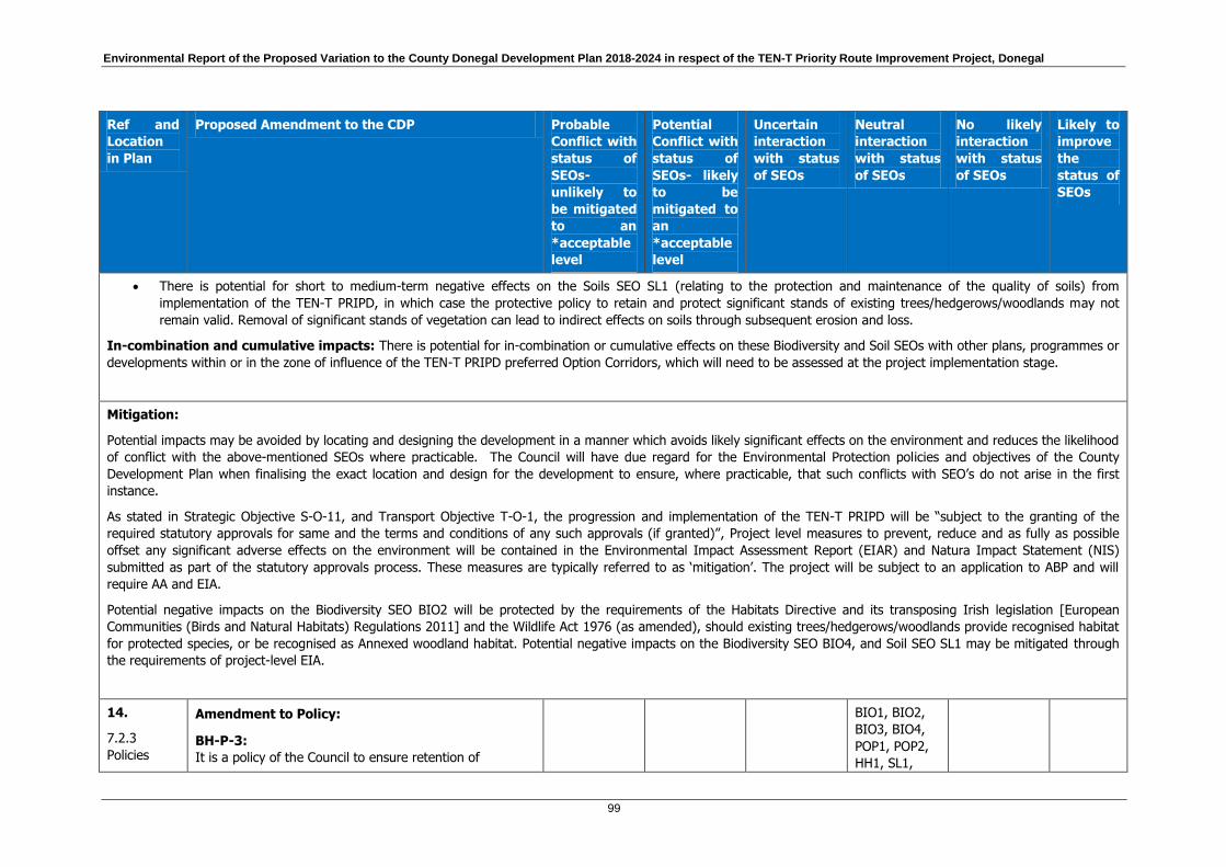
Environmental Report of the Proposed Variation to the County Donegal Development Plan 2018-2024 in respect of the TEN-T Priority Route Improvement Project, Donegal
99
Ref and
Location
in Plan
Proposed Amendment to the CDP Probable
Conflict with
status of
SEOs-
unlikely to
be mitigated
to an
*acceptable
level
Potential
Conflict with
status of
SEOs- likely
to be
mitigated to
an
*acceptable
level
Uncertain
interaction
with status
of SEOs
Neutral
interaction
with status
of SEOs
No likely
interaction
with status
of SEOs
Likely to
improve
the
status of
SEOs
There is potential for short to medium-term negative effects on the Soils SEO SL1 (relating to the protection and maintenance of the quality of soils) from
implementation of the TEN-T PRIPD, in which case the protective policy to retain and protect significant stands of existing trees/hedgerows/woodlands may not
remain valid. Removal of significant stands of vegetation can lead to indirect effects on soils through subsequent erosion and loss.
In-combination and cumulative impacts: There is potential for in-combination or cumulative effects on these Biodiversity and Soil SEOs with other plans, programmes or
developments within or in the zone of influence of the TEN-T PRIPD preferred Option Corridors, which will need to be assessed at the project implementation stage.
Mitigation:
Potential impacts may be avoided by locating and designing the development in a manner which avoids likely significant effects on the environment and reduces the likelihood
of conflict with the above-mentioned SEOs where practicable. The Council will have due regard for the Environmental Protection policies and objectives of the County
Development Plan when finalising the exact location and design for the development to ensure, where practicable, that such conflicts with SEO’s do not arise in the first
instance.
As stated in Strategic Objective S-O-11, and Transport Objective T-O-1, the progression and implementation of the TEN-T PRIPD will be “subject to the granting of the
required statutory approvals for same and the terms and conditions of any such approvals (if granted)”, Project level measures to prevent, reduce and as fully as possible
offset any significant adverse effects on the environment will be contained in the Environmental Impact Assessment Report (EIAR) and Natura Impact Statement (NIS)
submitted as part of the statutory approvals process. These measures are typically referred to as ‘mitigation’. The project will be subject to an application to ABP and will
require AA and EIA.
Potential negative impacts on the Biodiversity SEO BIO2 will be protected by the requirements of the Habitats Directive and its transposing Irish legislation [European
Communities (Birds and Natural Habitats) Regulations 2011] and the Wildlife Act 1976 (as amended), should existing trees/hedgerows/woodlands provide recognised habitat
for protected species, or be recognised as Annexed woodland habitat. Potential negative impacts on the Biodiversity SEO BIO4, and Soil SEO SL1 may be mitigated through
the requirements of project-level EIA.
14.
7.2.3
Policies
Amendment to Policy:
BH-P-3:
It is a policy of the Council to ensure retention of
BIO1, BIO2,
BIO3, BIO4,
POP1, POP2,
HH1, SL1,
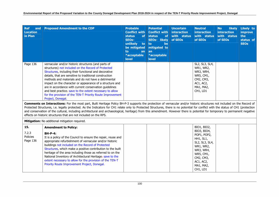
Environmental Report of the Proposed Variation to the County Donegal Development Plan 2018-2024 in respect of the TEN-T Priority Route Improvement Project, Donegal
100
Ref and
Location
in Plan
Proposed Amendment to the CDP Probable
Conflict with
status of
SEOs-
unlikely to
be mitigated
to an
*acceptable
level
Potential
Conflict with
status of
SEOs- likely
to be
mitigated to
an
*acceptable
level
Uncertain
interaction
with status
of SEOs
Neutral
interaction
with status
of SEOs
No likely
interaction
with status
of SEOs
Likely to
improve
the
status of
SEOs
Page 136
vernacular and/or historic structures (and parts of
structures) not included on the Record of Protected
Structures, including their functional and decorative
details, that are sensitive to traditional construction
methods and materials and do not have a detrimental
impact on the character or appearance of a structure and
are in accordance with current conservation guidelines
and best practice. save to the extent necessary to allow
for the provision of the TEN-T Priority Route Improvement
Project, Donegal.
SL2, SL3, SL4,
WR1, WR2,
WR3, WR4,
WR5, CM1,
CM2, CM3,
AC1, AC2,
MA1, MA2,
CH1, LD1
Comments on Interactions: For the most part, Built Heritage Policy BH-P-3 supports the protection of vernacular and/or historic structures not included on the Record of
Protected Structures, i.e. legally protected. As the Indicators for CH1 relate only to Protected Structures, there is no potential for conflict with the status of CH1 (protection
and conservation of the cultural, including architectural and archaeological, heritage) from this amendment. However there is potential for temporary to permanent negative
effects on historic structures that are not included on the RPS.
Mitigation: No additional mitigation required.
15.
7.2.3
Policies
Page 136
Amendment to Policy:
BH-P-4:
It is a policy of the Council to ensure the repair, reuse and
appropriate refurbishment of vernacular and/or historic
buildings not included on the Record of Protected
Structures, which make a positive contribution to the built
heritage of the area including those as referred to on the
National Inventory of Architectural Heritage. save to the
extent necessary to allow for the provision of the TEN-T
Priority Route Improvement Project, Donegal.
BIO1, BIO2,
BIO3, BIO4,
POP1, POP2,
HH1, SL1,
SL2, SL3, SL4,
WR1, WR2,
WR3, WR4,
WR5, CM1,
CM2, CM3,
AC1, AC2,
MA1, MA2,
CH1, LD1
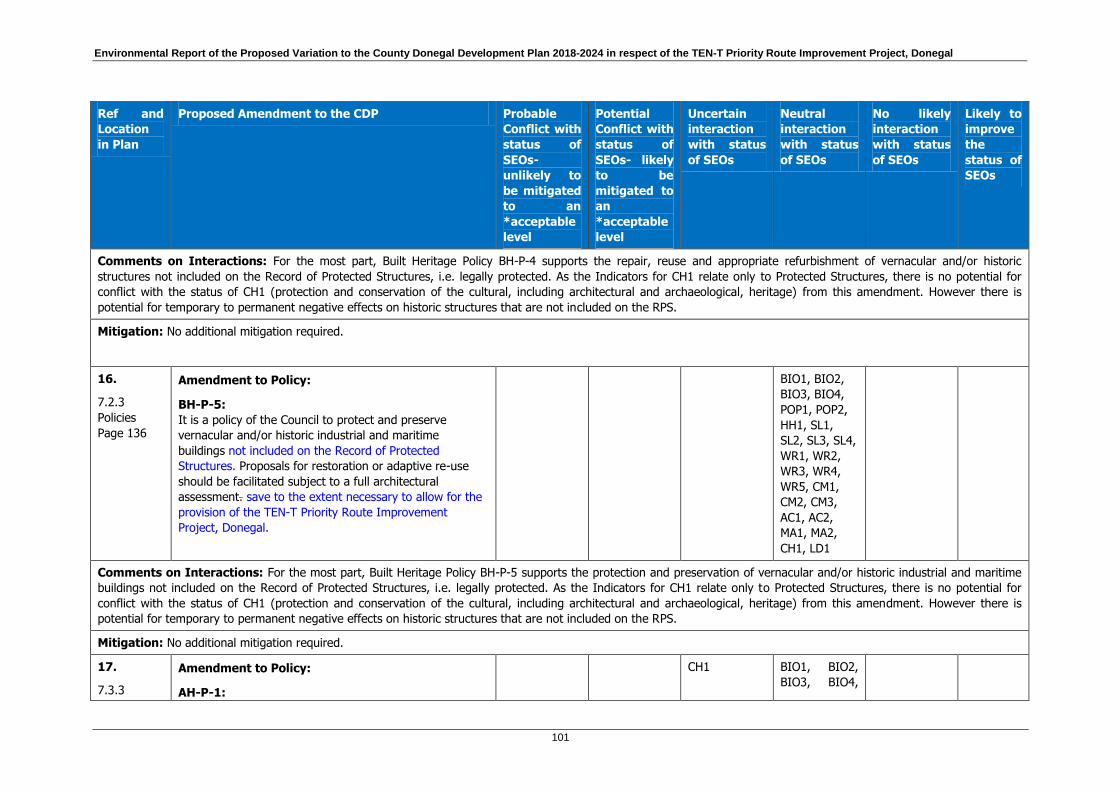
Environmental Report of the Proposed Variation to the County Donegal Development Plan 2018-2024 in respect of the TEN-T Priority Route Improvement Project, Donegal
101
Ref and
Location
in Plan
Proposed Amendment to the CDP Probable
Conflict with
status of
SEOs-
unlikely to
be mitigated
to an
*acceptable
level
Potential
Conflict with
status of
SEOs- likely
to be
mitigated to
an
*acceptable
level
Uncertain
interaction
with status
of SEOs
Neutral
interaction
with status
of SEOs
No likely
interaction
with status
of SEOs
Likely to
improve
the
status of
SEOs
Comments on Interactions: For the most part, Built Heritage Policy BH-P-4 supports the repair, reuse and appropriate refurbishment of vernacular and/or historic
structures not included on the Record of Protected Structures, i.e. legally protected. As the Indicators for CH1 relate only to Protected Structures, there is no potential for
conflict with the status of CH1 (protection and conservation of the cultural, including architectural and archaeological, heritage) from this amendment. However there is
potential for temporary to permanent negative effects on historic structures that are not included on the RPS.
Mitigation: No additional mitigation required.
16.
7.2.3
Policies
Page 136
Amendment to Policy:
BH-P-5:
It is a policy of the Council to protect and preserve
vernacular and/or historic industrial and maritime
buildings not included on the Record of Protected
Structures. Proposals for restoration or adaptive re-use
should be facilitated subject to a full architectural
assessment. save to the extent necessary to allow for the
provision of the TEN-T Priority Route Improvement
Project, Donegal.
BIO1, BIO2,
BIO3, BIO4,
POP1, POP2,
HH1, SL1,
SL2, SL3, SL4,
WR1, WR2,
WR3, WR4,
WR5, CM1,
CM2, CM3,
AC1, AC2,
MA1, MA2,
CH1, LD1
Comments on Interactions: For the most part, Built Heritage Policy BH-P-5 supports the protection and preservation of vernacular and/or historic industrial and maritime
buildings not included on the Record of Protected Structures, i.e. legally protected. As the Indicators for CH1 relate only to Protected Structures, there is no potential for
conflict with the status of CH1 (protection and conservation of the cultural, including architectural and archaeological, heritage) from this amendment. However there is
potential for temporary to permanent negative effects on historic structures that are not included on the RPS.
Mitigation: No additional mitigation required.
17.
7.3.3
Amendment to Policy:
AH-P-1:
CH1 BIO1, BIO2,
BIO3, BIO4,

Environmental Report of the Proposed Variation to the County Donegal Development Plan 2018-2024 in respect of the TEN-T Priority Route Improvement Project, Donegal
102
Ref and
Location
in Plan
Proposed Amendment to the CDP Probable
Conflict with
status of
SEOs-
unlikely to
be mitigated
to an
*acceptable
level
Potential
Conflict with
status of
SEOs- likely
to be
mitigated to
an
*acceptable
level
Uncertain
interaction
with status
of SEOs
Neutral
interaction
with status
of SEOs
No likely
interaction
with status
of SEOs
Likely to
improve
the
status of
SEOs
Policies
Page 138
It is a policy of the Council to protect and enhance the
integrity of Archaeological Monuments and their settings
and to secure the preservation in- situ of all archaeological
monuments included on the Record of Monuments and
Places. Preservation by record shall only be considered in
exceptional circumstances where the principles of the
Department of Arts, Heritage, Gaeltacht and the Islands
publication entitled; ‘Framework and Principles for the
Protection of Archaeological Heritage’ can be satisfied.
It is a policy of the Council to:
a) Protect and enhance the integrity of Archaeological
Monuments and to secure the preservation in situ of all
archaeological monuments included on the Record of
Monuments and Places. Preservation by record shall only
be considered in exceptional circumstances where the
principles of the Department of Arts, Heritage, Gaeltacht
and the Islands publication entitled; ‘Framework and
Principles for the Protection of Archaeological Heritage’
can be satisfied.
b) Protect the settings of such archaeological monuments
save to the extent necessary to allow for the provision of
the TEN-T Priority Route Improvement Project, Donegal.
POP1, POP2,
HH1, SL1,
SL2, SL3, SL4,
WR1, WR2,
WR3, WR4,
WR5, CM1,
CM2, CM3,
AC1, AC2,
MA1, MA2,
LD1
Comments on Interactions: Archaeological Heritage Policy AH-P-1 supports the protection of Archaeological Monuments included on the Record of Monuments and Places,
i.e. legally protected. This amendment has uncertain interaction with the status of Cultural Heritage SEO CH1 (relating to the protection and conservation of the cultural,
including architectural and archaeological, heritage). There is potential for permanent negative effects on the settings of archaeological monuments from implementation of
the TEN-T PRIPD, in which case the policy to protect the settings of archaeological monuments included on the Record of Monuments and Places may not remain valid. As the
Indicators for CH1 relate only to Protected Structures, and not their settings, in many cases there will be no potential for conflict with the status of his SEO. However, in
certain cases, where the setting is recognised as an integral part of a protected structure, there will be potential for temporary to permanent negative effects.

Environmental Report of the Proposed Variation to the County Donegal Development Plan 2018-2024 in respect of the TEN-T Priority Route Improvement Project, Donegal
103
Ref and
Location
in Plan
Proposed Amendment to the CDP Probable
Conflict with
status of
SEOs-
unlikely to
be mitigated
to an
*acceptable
level
Potential
Conflict with
status of
SEOs- likely
to be
mitigated to
an
*acceptable
level
Uncertain
interaction
with status
of SEOs
Neutral
interaction
with status
of SEOs
No likely
interaction
with status
of SEOs
Likely to
improve
the
status of
SEOs
In-combination and cumulative impacts: There is potential for in-combination or cumulative effects on Cultural Heritage SEO with other developments within or in the
zone of influence of the TEN-T PRIPD preferred Option Corridors, which will need to be assessed at the project implementation stage.
Mitigation:
Mitigation of potential adverse environmental effects is reliant on the statutory approvals required for progression of road schemes, as well as the statutory protection
afforded to certain environmental features. As stated in Strategic Objective S-O-11, and Transport Objective T-O-1, the progression and implementation of the TEN-T PRIPD
will be “subject to the granting of the required statutory approvals for same and the terms and conditions of any such approvals (if granted)”. At the project-level assessment
stage, detailed avoidance and/or mitigation measures will be developed aimed reducing any identified adverse impacts of the scheme on environmental features given
statutory protection. Potential negative impacts on the Cultural Heritage SEO CH1 will be mitigated by the statutory protection given to these features, and the relevant
consents required for any works in their vicinity.
18.
7.3.3
Policies
Page 139
Amendment to Policy:
AH-P-3:
It is the policy of the Council to protect the character,
settings of and views from National Monuments and
Recorded Monuments and to manage development which
would be considered to (visually or physically) intrude
upon or inhibit the enjoyment of the amenities of these
sites.
It is a policy of the Council to:
a) Protect the character of National Monuments and
Recorded Monuments and to manage development which
would be considered to (physically) intrude upon or inhibit
the enjoyment of the amenities of these sites.
b) Protect the settings of and views from such
archaeological monuments save to the extent necessary
to allow for the provision of the TEN-T Priority Route
Improvement Project, Donegal.
CH1 BIO1, BIO2,
BIO3, BIO4,
POP1, POP2,
HH1, SL1,
SL2, SL3, SL4,
WR1, WR2,
WR3, WR4,
WR5, CM1,
CM2, CM3,
AC1, AC2,
MA1, MA2,
LD1

Environmental Report of the Proposed Variation to the County Donegal Development Plan 2018-2024 in respect of the TEN-T Priority Route Improvement Project, Donegal
104
Ref and
Location
in Plan
Proposed Amendment to the CDP Probable
Conflict with
status of
SEOs-
unlikely to
be mitigated
to an
*acceptable
level
Potential
Conflict with
status of
SEOs- likely
to be
mitigated to
an
*acceptable
level
Uncertain
interaction
with status
of SEOs
Neutral
interaction
with status
of SEOs
No likely
interaction
with status
of SEOs
Likely to
improve
the
status of
SEOs
Comments on Interactions: Archaeological Heritage Policy AH-P-3 supports the protection of the character of National Monuments and Recorded Monuments and the
settings and views from same. This amendment has uncertain interaction with the status of Cultural Heritage SEO CH1 (relating to the protection and conservation of the
cultural, including architectural and archaeological, heritage). There is potential for permanent negative effects on the settings of, and views from, archaeological monuments
from implementation of the TEN-T PRIPD, in which case the policy to protect the settings of archaeological monuments (National Monuments and Recorded Monuments) may
not remain valid. As the Indicators for CH1 relate only to Protected Structures, and not their settings, in many cases there will be no potential for conflict with the status of his
SEO. However, in certain cases, where the setting is recognised as an integral part of a protected structure, there will be potential for temporary to permanent negative
effects.
In-combination and cumulative impacts: There is potential for in-combination or cumulative effects on Cultural Heritage SEO with other developments within or in the
zone of influence of the TEN-T PRIPD preferred Option Corridors, which will need to be assessed at the project implementation stage.
Mitigation:
Mitigation of potential adverse environmental effects is reliant on the statutory approvals required for progression of road schemes, as well as the statutory protection
afforded to certain environmental features. As stated in Strategic Objective S-O-11, and Transport Objective T-O-1, the progression and implementation of the TEN-T PRIPD
will be “subject to the granting of the required statutory approvals for same and the terms and conditions of any such approvals (if granted)”. At the project-level assessment
stage, detailed avoidance and/or mitigation measures will be developed aimed reducing any identified adverse impacts of the scheme on environmental features given
statutory protection. Potential negative impacts on the Cultural Heritage SEO CH1 will be mitigated by the statutory protection given to these features, and the relevant
consents required for any works in their vicinity.
19.
7.3.3
Policies
Page 139
Amendment to Policy:
AH-P-4:
It is the policy of the Council to protect where
appropriate, the character and setting of any unrecorded
archaeological object or site.
It is a policy of the Council to:
a) Protect where appropriate, the character of any
unrecorded archaeological object or site.
BIO1, BIO2,
BIO3, BIO4,
POP1, POP2,
HH1, SL1,
SL2, SL3, SL4,
WR1, WR2,
WR3, WR4,
WR5, CM1,
CM2, CM3,
Environmental Report of the Proposed Variation to the County Donegal Development Plan 2018-2024 in respect of the TEN-T Priority Route Improvement Project, Donegal
105
Ref and
Location
in Plan
Proposed Amendment to the CDP Probable
Conflict with
status of
SEOs-
unlikely to
be mitigated
to an
*acceptable
level
Potential
Conflict with
status of
SEOs- likely
to be
mitigated to
an
*acceptable
level
Uncertain
interaction
with status
of SEOs
Neutral
interaction
with status
of SEOs
No likely
interaction
with status
of SEOs
Likely to
improve
the
status of
SEOs
b) Protect the settings of such archaeological objects or
sites save to the extent necessary to allow for the
provision of the TEN-T Priority Route Improvement
Project, Donegal.
AC1, AC2,
MA1, MA2,
CH1, LD1
Comments on Interactions: For the most part, Archaeological Heritage Policy AH-P-4 supports the protection of unrecorded archaeological objects or sites. As the
Indicators for CH1 relate only to Protected Structures and Sites, there is no potential for conflict with the status of CH1 (protection and conservation of the cultural, including
architectural and archaeological, heritage) from this amendment. However there is potential for temporary to permanent negative effects on the setting of archaeological
objects or sites that are not yet recorded.
Mitigation: No additional mitigation required.
20.
7.3.3
Policies
Page 139
Amendment to Policy:
AH-P-5:
It is the policy of the Council to protect and preserve
archaeological sites, their characters and settings which
have been identified subsequent to the publication of the
Record of Monument and Places.
It is a policy of the Council to:
a) Protect and preserve archaeological sites and their
characters which have been identified subsequent to the
publication of the Record of Monument and Places.
b) Protect the settings of such archaeological sites save to
the extent necessary to allow for the provision of the TEN-
T Priority Route Improvement Project, Donegal.
BIO1, BIO2,
BIO3, BIO4,
POP1, POP2,
HH1, SL1,
SL2, SL3, SL4,
WR1, WR2,
WR3, WR4,
WR5, CM1,
CM2, CM3,
AC1, AC2,
MA1, MA2,
CH1, LD1
Comments on Interactions: For the most part, Archaeological Heritage Policy AH-P-5 supports the protection of unrecorded archaeological objects or sites. As the
Indicators for CH1 relate only to Protected Structures and Sites, there is no potential for conflict with the status of CH1 (protection and conservation of the cultural, including
Environmental Report of the Proposed Variation to the County Donegal Development Plan 2018-2024 in respect of the TEN-T Priority Route Improvement Project, Donegal
106
Ref and
Location
in Plan
Proposed Amendment to the CDP Probable
Conflict with
status of
SEOs-
unlikely to
be mitigated
to an
*acceptable
level
Potential
Conflict with
status of
SEOs- likely
to be
mitigated to
an
*acceptable
level
Uncertain
interaction
with status
of SEOs
Neutral
interaction
with status
of SEOs
No likely
interaction
with status
of SEOs
Likely to
improve
the
status of
SEOs
architectural and archaeological, heritage) from this amendment. However there is potential for temporary to permanent negative effects on the setting of archaeological sites
that are not yet recorded.
Mitigation: No additional mitigation required.
Chapter 9 Tourism
21.
9.2
Objectives
Page 157
Amendment to Objective:
TOU-O-11:
To protect and enhance the built and historical heritage of
the county (including structures on the RPS, NIAH,
recorded monuments, heritage towns and battlefield sites)
as an important element of the County’s overall tourism
product in accordance with, and to the extent provided
for, in the built heritage policies and objectives of this
plan.
CH1 BIO1, BIO2,
BIO3, BIO4,
POP1, POP2,
HH1, SL1,
SL2, SL3, SL4,
WR1, WR2,
WR3, WR4,
WR5, CM1,
CM2, CM3,
AC1, AC2,
MA1, MA2,
LD1
Comments on Interactions: Tourism Objective TOU-O-11 supports the protection and enhancement of built and historical heritage. This amendment has uncertain
interaction with the status of Cultural Heritage SEO CH1 (relating to the protection and conservation of the cultural, including architectural and archaeological, heritage).
There is potential for permanent negative effects on the settings of archaeological monuments from implementation of the TEN-T PRIPD, in which case the policy to protect
the settings of archaeological monuments, objects and sites may not remain valid. As the Indicators for CH1 relate only to Protected Structures, and not their settings, in
many cases there will be no potential for conflict with the status of his SEO. However, in certain cases, where the setting is recognised as an integral part of a protected
structure, there will be potential for temporary to permanent negative effects from implementation of the TEN-T PRIPD.
In-combination and cumulative impacts: There is potential for in-combination or cumulative effects on Cultural Heritage SEO with other developments within or in the
zone of influence of the TEN-T PRIPD preferred Option Corridors, which will need to be assessed at the project implementation stage.

Environmental Report of the Proposed Variation to the County Donegal Development Plan 2018-2024 in respect of the TEN-T Priority Route Improvement Project, Donegal
107
Ref and
Location
in Plan
Proposed Amendment to the CDP Probable
Conflict with
status of
SEOs-
unlikely to
be mitigated
to an
*acceptable
level
Potential
Conflict with
status of
SEOs- likely
to be
mitigated to
an
*acceptable
level
Uncertain
interaction
with status
of SEOs
Neutral
interaction
with status
of SEOs
No likely
interaction
with status
of SEOs
Likely to
improve
the
status of
SEOs
Mitigation: Built Heritage and Archaeological Heritage Policies provide protection to built and historical structures, both legally protected and otherwise, however Built
Heritage Policies BH-P-3, BH-P-4 and BH-P-5 and Archaeological Heritage Policies AH-P-1, AH-P-2, AH-P-3, AH-P-4 and AH-P-5 have been amended to state that the settings
of these monuments, objects and sites will be protected “save to the extent necessary to allow for the provision of the TEN-T PRIPD”.
Mitigation of potential adverse environmental effects is reliant on the statutory approvals required for progression of road schemes, as well as the statutory protection
afforded to certain environmental features. As stated in Strategic Objective S-O-11, and Transport Objective T-O-1, the progression and implementation of the TEN-T PRIPD
will be “subject to the granting of the required statutory approvals for same and the terms and conditions of any such approvals (if granted)”. At the project-level assessment
stage, detailed avoidance and/or mitigation measures will be developed aimed reducing any identified adverse impacts of the scheme on environmental features given
statutory protection. Potential negative impacts on the Cultural Heritage SEO CH1 will be mitigated by the statutory protection given to these features, and the relevant
consents required for any works in their vicinity.
Chapter 10 The Marine Resource and Coastal Management
22.
10.3
Policies
Page 168
Amendment to Policy:
MRCM-P-7:
It is a policy of the Council not to permit developments at
locations at risk from coastal flooding in accordance with
the flooding policies of this Plan. save to the extent
necessary to allow for the provision of the TEN-T Priority
Route Improvement Project, Donegal.
MA2, BIO1,
BIO2, WR1
BIO3, BIO4,
POP1,POP2,
HH1, SL1,
SL2, SL3, SL4,
WR2, WR3,
WR4, WR5,
CM1, CM2,
CM3, AC1,
AC3, MA1,
CH1, LD1
Comments on Interactions: Marine Resource and Coastal Management Policy MRCM-P-7 supports the avoidance of developments at locations at risk from coastal flooding.
This amendment has potential for conflict with the status of Material Assets SEO MA2 (Avoid flood risk and/or coastal erosion in selecting sites for development), Biodiversity
SEOs BIO1 (ensure compliance with the Habitats Directive by protecting all Natura 2000 sites and habitats of species (SACs and SPAs)) within the County, including
Freshwater Pearl Mussel catchment areas) and BIO2 (Conserve and enhance the diversity of habitats and protected species and promote the sustainable management of
these areas), and Water SEO WR1 (Protect and enhance the status of aquatic ecosystems and, with regard to their water needs, terrestrial ecosystems and wetlands directly

Environmental Report of the Proposed Variation to the County Donegal Development Plan 2018-2024 in respect of the TEN-T Priority Route Improvement Project, Donegal
108
Ref and
Location
in Plan
Proposed Amendment to the CDP Probable
Conflict with
status of
SEOs-
unlikely to
be mitigated
to an
*acceptable
level
Potential
Conflict with
status of
SEOs- likely
to be
mitigated to
an
*acceptable
level
Uncertain
interaction
with status
of SEOs
Neutral
interaction
with status
of SEOs
No likely
interaction
with status
of SEOs
Likely to
improve
the
status of
SEOs
depending on the aquatic ecosystems, in accordance with the North Western RBMP). There is potential for short to long-term recurring negative effects on these SEOs arising
from implementation of the TEN-T PRIPD.
Mitigation:
Potential negative impacts on Biodiversity SEOs will be protected by the Natural Heritage Objectives NH-O-1 to NH-O-3, NH-O-6, NH-O-11 and Policies NH-P-1 to NH-P-5, and
NH-P-18, which relate to the protection of biodiversity, including protected habitats and species. Potential negative impacts on the Water SEO WR1 will be protected by WES-
O-5, WES-O-6, WES-P-4 and WES-P-8.
The County Donegal Development Plan 2018-2024 as it stands, includes Objectives and Policies in Chapter 5 (Flooding) that manage development proposals within flood risk
areas. The amendment to MRCM-P-7 over-rides these plan level mitigation measures. However, as stated in Strategic Objective S-O-11, and Transport Objective T-O-1, the
progression and implementation of the TEN-T PRIPD will be “subject to the granting of the required statutory approvals for same and the terms and conditions of any such
approvals (if granted)”. It must be carried out in accordance with the various environmental regulations and EU Directives.
Potential conflict with the status of Material Assets SEO MA2 will be mitigated for by SFRA work being undertaken in parallel with this process, as detailed below:
A site-specific Flood Risk Assessment (FRA) is required in accordance with the OPW document “The Planning System and Flood Risk Management” when the local authority
considers there is a risk of flooding. Planning authorities require a site specific Flood Risk Assessment and they will ensure that development is not permitted in areas of flood
risk, particularly floodplains, except where the proposed development passes the sequential approach and, if necessary, a justification test. The CDP Variation in respect of
the TEN-T PRIPD is subject to Strategic Flood Risk Assessment (SFRA) under this guidance, which will be followed by site-specific FRA. It will only proceed in this process
following satisfaction of a justification test.
PART C OBJECTIVES AND POLICIES OF THE TOWNS
Chapter 12 Letterkenny
23. Insert New Zoning Objective as New Row in Table: POP1 BIO1, BIO2,
Environmental Report of the Proposed Variation to the County Donegal Development Plan 2018-2024 in respect of the TEN-T Priority Route Improvement Project, Donegal
109
Ref and
Location
in Plan
Proposed Amendment to the CDP Probable
Conflict with
status of
SEOs-
unlikely to
be mitigated
to an
*acceptable
level
Potential
Conflict with
status of
SEOs- likely
to be
mitigated to
an
*acceptable
level
Uncertain
interaction
with status
of SEOs
Neutral
interaction
with status
of SEOs
No likely
interaction
with status
of SEOs
Likely to
improve
the
status of
SEOs
Table 12.2
Zoning
Objectives
in relation
to
Letterkenny
Page 5
BIO3, BIO4,
POP2, HH1,
SL1, SL2, SL3,
SL4, WR1,
WR2, WR3,
WR4, WR5,
CM1, CM2,
CM3, AC1,
AC3, MA1,
MA2 CH1, LD1
Comments on Interactions: Zoning Objectives in relation to Letterkenny support landuse including protection of residential amenity and facilitation of appropriate
development. This amendment has uncertain interaction with the status of Population SEO POP1. The change to a dual zoning Objective has potential for a combination of
both positive and negative effects, as follows:
There is potential for long-term positive effects on the Population SEO POP1 (relating to the provision of high quality residential working and recreational
environments), as increased connectivity may indirectly increase local employment. The potential for long-term negative effects on this SEO relates to the rezoning
of land to accommodate the TEN-T PRIPD, which may affect existing residential environments.
In-combination and cumulative impacts: The amendment to a dual zoning Objective has potential for in-combination growth and development impacts (both positive
and negative) within Letterkenny (population, material assets, human health, air quality and infrastructure).
Mitigation: See mitigation outlined for S-O-11, as well as mitigation included in the text of this Zoning Objective; development of the TEN-T PRIPD will be subject to relevant
material planning considerations, national/regional policy/guidance and to the proper planning and sustainable development of the area.
24.
Table 12.2
Zoning
Insert New Zoning Objective as New Row in Table: POP1
BIO1, BIO2,
BIO3, BIO4,
POP2, HH1,
Environmental Report of the Proposed Variation to the County Donegal Development Plan 2018-2024 in respect of the TEN-T Priority Route Improvement Project, Donegal
110
Ref and
Location
in Plan
Proposed Amendment to the CDP Probable
Conflict with
status of
SEOs-
unlikely to
be mitigated
to an
*acceptable
level
Potential
Conflict with
status of
SEOs- likely
to be
mitigated to
an
*acceptable
level
Uncertain
interaction
with status
of SEOs
Neutral
interaction
with status
of SEOs
No likely
interaction
with status
of SEOs
Likely to
improve
the
status of
SEOs
Objectives
in relation
to
Letterkenny
Page 5
SL1, SL2, SL3,
SL4, WR1,
WR2, WR3,
WR4, WR5,
CM1, CM2,
CM3, AC1,
AC3, MA1,
MA2 CH1, LD1
Comments on Interactions: Zoning Objectives in relation to Letterkenny support landuse including reservation of land for residential development. This amendment has
uncertain interaction with the status of Population SEO POP1. The change to a dual zoning Objective has potential for a combination of both positive and negative effects, as
follows:
There is potential for long-term positive effects on the Population SEO POP1 (relating to the provision of high quality residential working and recreational
environments), as increased connectivity may indirectly increase local employment. The potential for long-term negative effects on this SEO relates to the rezoning
of land to accommodate the TEN-T PRIPD, which may adversely affect future residential environments.
In-combination and cumulative impacts: The amendment to a dual zoning Objective has potential for in-combination growth and development impacts (both positive
and negative) within Letterkenny (population, material assets, human health, air quality and infrastructure).
Mitigation: See mitigation outlined for S-O-11. Development of the TEN-T PRIPD will be subject to relevant material planning considerations, national/regional
policy/guidance and to the proper planning and sustainable development of the area.
25. Insert New Zoning Objective as New Row in Table: POP1 BIO1, BIO2,

Environmental Report of the Proposed Variation to the County Donegal Development Plan 2018-2024 in respect of the TEN-T Priority Route Improvement Project, Donegal
111
Ref and
Location
in Plan
Proposed Amendment to the CDP Probable
Conflict with
status of
SEOs-
unlikely to
be mitigated
to an
*acceptable
level
Potential
Conflict with
status of
SEOs- likely
to be
mitigated to
an
*acceptable
level
Uncertain
interaction
with status
of SEOs
Neutral
interaction
with status
of SEOs
No likely
interaction
with status
of SEOs
Likely to
improve
the
status of
SEOs
Table 12.2
Zoning
Objectives
in relation
to
Letterkenny
Page 5
BIO3, BIO4,
POP2, HH1,
SL1, SL2, SL3,
SL4, WR1,
WR2, WR3,
WR4, WR5,
CM1, CM2,
CM3, AC1,
AC3, MA1,
MA2 CH1, LD1
Comments on Interactions: Zoning Objectives in relation to Letterkenny support landuse including reservation of land for commercial, industrial and non- retail purposes.
This amendment has uncertain interaction with the status of Population SEO POP1. The change to a dual zoning Objective has potential for a combination of both positive and
negative effects, as follows:
There is potential for long-term positive effects on the Population SEO POP1 (relating to the provision of high quality residential working and recreational
environments), as increased connectivity may indirectly increase local employment. The potential for long-term negative effects on this SEO relates to the rezoning
of land to accommodate the TEN-T PRIPD, which may adversely affect availability of land for commerce and industry.
In-combination and cumulative impacts: The amendment to a dual zoning Objective has potential for in-combination growth and development impacts (both positive
and negative) within Letterkenny (population, material assets, human health, air quality and infrastructure).
Mitigation: See mitigation outlined for S-O-11, as well as mitigation included in the text of this Zoning Objective; development of the TEN-T PRIPD will be subject to relevant
material planning considerations, national/regional policy/guidance and to the proper planning and sustainable development of the area.
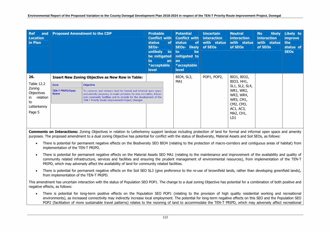
Environmental Report of the Proposed Variation to the County Donegal Development Plan 2018-2024 in respect of the TEN-T Priority Route Improvement Project, Donegal
112
Ref and
Location
in Plan
Proposed Amendment to the CDP Probable
Conflict with
status of
SEOs-
unlikely to
be mitigated
to an
*acceptable
level
Potential
Conflict with
status of
SEOs- likely
to be
mitigated to
an
*acceptable
level
Uncertain
interaction
with status
of SEOs
Neutral
interaction
with status
of SEOs
No likely
interaction
with status
of SEOs
Likely to
improve
the
status of
SEOs
26.
Table 12.2
Zoning
Objectives
in relation
to
Letterkenny
Page 5
Insert New Zoning Objective as New Row in Table:
BIO4, SL3,
MA1
POP1, POP2,
BIO1, BIO2,
BIO3, HH1,
SL1, SL2, SL4,
WR1, WR2,
WR3, WR4,
WR5, CM1,
CM2, CM3,
AC1, AC3,
MA2, CH1,
LD1
Comments on Interactions: Zoning Objectives in relation to Letterkenny support landuse including protection of land for formal and informal open space and amenity
purposes. The proposed amendment to a dual zoning Objective has potential for conflict with the status of Biodiversity, Material Assets and Soil SEOs, as follows:
There is potential for permanent negative effects on the Biodiversity SEO BIO4 (relating to the protection of macro-corridors and contiguous areas of habitat) from
implementation of the TEN-T PRIPD.
There is potential for permanent negative effects on the Material Assets SEO MA1 (relating to the maintenance and improvement of the availability and quality of
community related infrastructure, services and facilities and ensuring the prudent management of environmental resources), from implementation of the TEN-T
PRIPD, which may adversely affect the availability of land for community related facilities.
There is potential for permanent negative effects on the Soil SEO SL3 (give preference to the re-use of brownfield lands, rather than developing greenfield lands),
from implementation of the TEN-T PRIPD.
This amendment has uncertain interaction with the status of Population SEO POP1. The change to a dual zoning Objective has potential for a combination of both positive and
negative effects, as follows:
There is potential for long-term positive effects on the Population SEO POP1 (relating to the provision of high quality residential working and recreational
environments), as increased connectivity may indirectly increase local employment. The potential for long-term negative effects on this SEO and the Population SEO
POP2 (facilitation of more sustainable travel patterns) relates to the rezoning of land to accommodate the TEN-T PRIPD, which may adversely affect recreational
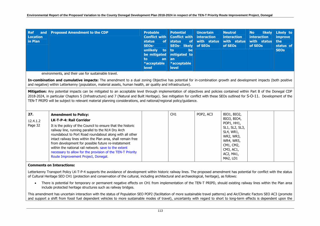
Environmental Report of the Proposed Variation to the County Donegal Development Plan 2018-2024 in respect of the TEN-T Priority Route Improvement Project, Donegal
113
Ref and
Location
in Plan
Proposed Amendment to the CDP Probable
Conflict with
status of
SEOs-
unlikely to
be mitigated
to an
*acceptable
level
Potential
Conflict with
status of
SEOs- likely
to be
mitigated to
an
*acceptable
level
Uncertain
interaction
with status
of SEOs
Neutral
interaction
with status
of SEOs
No likely
interaction
with status
of SEOs
Likely to
improve
the
status of
SEOs
environments, and their use for sustainable travel.
In-combination and cumulative impacts: The amendment to a dual zoning Objective has potential for in-combination growth and development impacts (both positive
and negative) within Letterkenny (population, material assets, human health, air quality and infrastructure).
Mitigation: Any potential impacts can be mitigated to an acceptable level through implementation of objectives and policies contained within Part B of the Donegal CDP
2018-2024, in particular Chapters 5 (Infrastructure) and 7 (Natural and Built Heritage). See mitigation for conflict with these SEOs outlined for S-O-11. Development of the
TEN-T PRIPD will be subject to relevant material planning considerations, and national/regional policy/guidance.
27.
12.4.1.2
Page 32
Amendment to Policy:
LK-T-P-4: Rail Corridor
It is the policy of the Council to ensure that the historic
railway line, running parallel to the N14 Dry Arch
roundabout to Port Road roundabout along with all other
intact railway lines within the Plan area, shall remain free
from development for possible future re-instatement
within the national rail network. save to the extent
necessary to allow for the provision of the TEN-T Priority
Route Improvement Project, Donegal.
CH1 POP2, AC3 BIO1, BIO2,
BIO3, BIO4,
POP1, HH1,
SL1, SL2, SL3,
SL4, WR1,
WR2, WR3,
WR4, WR5,
CM1, CM2,
CM3, AC1,
AC2, MA1,
MA2, LD1
Comments on Interactions:
Letterkenny Transport Policy LK-T-P-4 supports the avoidance of development within historic railway lines. The proposed amendment has potential for conflict with the status
of Cultural Heritage SEO CH1 (protection and conservation of the cultural, including architectural and archaeological, heritage), as follows:
There is potential for temporary or permanent negative effects on CH1 from implementation of the TEN-T PRIPD, should existing railway lines within the Plan area
include protected heritage structures such as railway bridges.
This amendment has uncertain interaction with the status of Population SEO POP2 (facilitation of more sustainable travel patterns) and Air/Climatic Factors SEO AC3 (promote
and support a shift from fossil fuel dependent vehicles to more sustainable modes of travel), uncertainty with regard to short to long-term effects is dependent upon the

Environmental Report of the Proposed Variation to the County Donegal Development Plan 2018-2024 in respect of the TEN-T Priority Route Improvement Project, Donegal
114
Ref and
Location
in Plan
Proposed Amendment to the CDP Probable
Conflict with
status of
SEOs-
unlikely to
be mitigated
to an
*acceptable
level
Potential
Conflict with
status of
SEOs- likely
to be
mitigated to
an
*acceptable
level
Uncertain
interaction
with status
of SEOs
Neutral
interaction
with status
of SEOs
No likely
interaction
with status
of SEOs
Likely to
improve
the
status of
SEOs
provision and uptake of more sustainable travel modes and vehicles.
Mitigation: Any potential impacts can be mitigated to an acceptable level through implementation of objectives and policies contained within Part B of the Donegal CDP
2018-2024, in particular chapters 5 (Infrastructure) and 7 (Natural and Built Heritage). See mitigation for conflict with these SEOs outlined for S-O-11. Development of the
TEN-T PRIPD will be subject to relevant material planning considerations, and national/regional policy/guidance.
Chapter 15 Settlement Frameworks
28.
Table 15.2
Land Use
Zoning
Objectives
related to
Settlement
Framework
Maps
Page 95
Insert New Zoning Objective as Last Row in Table:
BIO4, SL3,
MA1
POP1, POP2,
BIO1, BIO2,
BIO3, HH1,
SL1, SL2, SL4,
WR1, WR2,
WR3, WR4,
WR5, CM1,
CM2, CM3,
AC1, AC3,
MA2, CH1,
LD1
Comments on Interactions: Zoning Objectives in relation to Settlement Frameworks support landuse including protection of land for formal and informal open space and
amenity purposes. The proposed amendment to a dual zoning Objective has potential for conflict with the status of Biodiversity, Material Assets and Soil SEOs, as follows:
There is potential for permanent negative effects on the Biodiversity SEO BIO4 (relating to the protection of macro-corridors and contiguous areas of habitat) from
implementation of the TEN-T PRIPD.
There is potential for permanent negative effects on the Material Assets SEO MA1 (relating to the maintenance and improvement of the availability and quality of
community related infrastructure, services and facilities and ensuring the prudent management of environmental resources), from implementation of the TEN-T
PRIPD, which may adversely affect the availability of land for community related facilities.

Environmental Report of the Proposed Variation to the County Donegal Development Plan 2018-2024 in respect of the TEN-T Priority Route Improvement Project, Donegal
115
Ref and
Location
in Plan
Proposed Amendment to the CDP Probable
Conflict with
status of
SEOs-
unlikely to
be mitigated
to an
*acceptable
level
Potential
Conflict with
status of
SEOs- likely
to be
mitigated to
an
*acceptable
level
Uncertain
interaction
with status
of SEOs
Neutral
interaction
with status
of SEOs
No likely
interaction
with status
of SEOs
Likely to
improve
the
status of
SEOs
There is potential for permanent negative effects on the Soil SEO SL3 (give preference to the re-use of brownfield lands, rather than developing greenfield lands),
from implementation of the TEN-T PRIPD.
This amendment has uncertain interaction with the status of Population SEO POP1. The change to a dual zoning Objective has potential for a combination of both positive and
negative effects, as follows:
There is potential for long-term positive effects on the Population SEO POP1 (relating to the provision of high quality residential working and recreational
environments), as increased connectivity may indirectly increase local employment. The potential for long-term negative effects on this SEO and the Population SEO
POP2 (facilitation of more sustainable travel patterns) relates to the rezoning of land to accommodate the TEN-T PRIPD, which may adversely affect recreational
environments, and their use for sustainable travel.
In-combination and cumulative impacts: The amendment to a dual zoning Objective has potential for in-combination growth and development impacts (both positive
and negative) within Settlement Frameworks (population, material assets, human health, air quality and infrastructure).
Mitigation: Any potential impacts can be mitigated to an acceptable level through implementation of objectives and policies contained within Part B of the Donegal CDP
2018-2024, in particular chapters 5 (Infrastructure) and 7 (Natural and Built Heritage). See mitigation for conflict with these SEOs outlined for S-O-11. Development of the
TEN-T PRIPD will be subject to relevant material planning considerations, and national/regional policy/guidance.
29.
Table 15.2
Land Use
Zoning
Objectives
related to
Settlement
Framework
Maps
Page 95
Insert New Zoning Objective:
POP1
BIO1, BIO2,
BIO3, BIO4,
POP2, HH1,
SL1, SL2, SL3,
SL4, WR1,
WR2, WR3,
WR4, WR5,
CM1, CM2,
CM3, AC1,
AC3, MA1,
MA2 CH1, LD1
Comments on Interactions: Zoning Objectives in relation to Settlement Frameworks support landuse including protection of residential amenity and facilitation of

Environmental Report of the Proposed Variation to the County Donegal Development Plan 2018-2024 in respect of the TEN-T Priority Route Improvement Project, Donegal
116
Ref and
Location
in Plan
Proposed Amendment to the CDP Probable
Conflict with
status of
SEOs-
unlikely to
be mitigated
to an
*acceptable
level
Potential
Conflict with
status of
SEOs- likely
to be
mitigated to
an
*acceptable
level
Uncertain
interaction
with status
of SEOs
Neutral
interaction
with status
of SEOs
No likely
interaction
with status
of SEOs
Likely to
improve
the
status of
SEOs
appropriate development. This amendment has uncertain interaction with the status of Population SEO POP1. The change to a dual zoning Objective has potential for a
combination of both positive and negative effects, as follows:
There is potential for long-term positive effects on the Population SEO POP1 (relating to the provision of high quality residential working and recreational
environments), as increased connectivity may indirectly increase local employment. The potential for long-term negative effects on this SEO relates to the rezoning
of land to accommodate the TEN-T PRIPD, which may affect existing residential environments.
In-combination and cumulative impacts: The amendment to a dual zoning Objective has potential for in-combination growth and development impacts (both positive
and negative) within Settlement Frameworks (population, material assets, human health, air quality and infrastructure).
Mitigation: See mitigation outlined for S-O-11. Development of the TEN-T PRIPD will be subject to relevant material planning considerations, national/regional
policy/guidance and to the proper planning and sustainable development of the area.
30.
Table 15.2
Land Use
Zoning
Objectives
related to
Settlement
Framework
Maps
Page 95
Insert New Zoning Objective:
POP1
BIO1, BIO2,
BIO3, BIO4,
POP2, HH1,
SL1, SL2, SL3,
SL4, WR1,
WR2, WR3,
WR4, WR5,
CM1, CM2,
CM3, AC1,
AC3, MA1,
MA2 CH1, LD1
Comments on Interactions: Zoning Objectives in relation to Settlement Frameworks support landuse including reservation of land for specific economic developments. This
amendment has uncertain interaction with the status of Population SEO POP1. The change to a dual zoning Objective has potential for a combination of both positive and
negative effects, as follows:
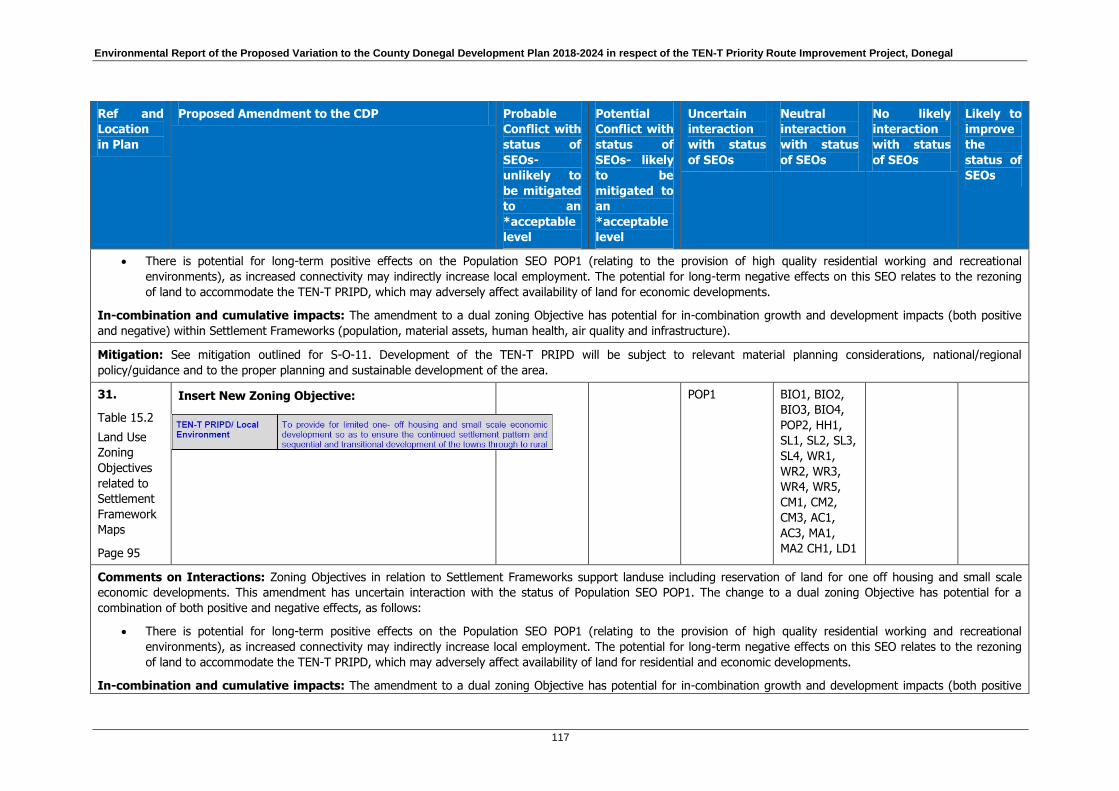
Environmental Report of the Proposed Variation to the County Donegal Development Plan 2018-2024 in respect of the TEN-T Priority Route Improvement Project, Donegal
117
Ref and
Location
in Plan
Proposed Amendment to the CDP Probable
Conflict with
status of
SEOs-
unlikely to
be mitigated
to an
*acceptable
level
Potential
Conflict with
status of
SEOs- likely
to be
mitigated to
an
*acceptable
level
Uncertain
interaction
with status
of SEOs
Neutral
interaction
with status
of SEOs
No likely
interaction
with status
of SEOs
Likely to
improve
the
status of
SEOs
There is potential for long-term positive effects on the Population SEO POP1 (relating to the provision of high quality residential working and recreational
environments), as increased connectivity may indirectly increase local employment. The potential for long-term negative effects on this SEO relates to the rezoning
of land to accommodate the TEN-T PRIPD, which may adversely affect availability of land for economic developments.
In-combination and cumulative impacts: The amendment to a dual zoning Objective has potential for in-combination growth and development impacts (both positive
and negative) within Settlement Frameworks (population, material assets, human health, air quality and infrastructure).
Mitigation: See mitigation outlined for S-O-11. Development of the TEN-T PRIPD will be subject to relevant material planning considerations, national/regional
policy/guidance and to the proper planning and sustainable development of the area.
31.
Table 15.2
Land Use
Zoning
Objectives
related to
Settlement
Framework
Maps
Page 95
Insert New Zoning Objective:
POP1
BIO1, BIO2,
BIO3, BIO4,
POP2, HH1,
SL1, SL2, SL3,
SL4, WR1,
WR2, WR3,
WR4, WR5,
CM1, CM2,
CM3, AC1,
AC3, MA1,
MA2 CH1, LD1
Comments on Interactions: Zoning Objectives in relation to Settlement Frameworks support landuse including reservation of land for one off housing and small scale
economic developments. This amendment has uncertain interaction with the status of Population SEO POP1. The change to a dual zoning Objective has potential for a
combination of both positive and negative effects, as follows:
There is potential for long-term positive effects on the Population SEO POP1 (relating to the provision of high quality residential working and recreational
environments), as increased connectivity may indirectly increase local employment. The potential for long-term negative effects on this SEO relates to the rezoning
of land to accommodate the TEN-T PRIPD, which may adversely affect availability of land for residential and economic developments.
In-combination and cumulative impacts: The amendment to a dual zoning Objective has potential for in-combination growth and development impacts (both positive

Environmental Report of the Proposed Variation to the County Donegal Development Plan 2018-2024 in respect of the TEN-T Priority Route Improvement Project, Donegal
118
Ref and
Location
in Plan
Proposed Amendment to the CDP Probable
Conflict with
status of
SEOs-
unlikely to
be mitigated
to an
*acceptable
level
Potential
Conflict with
status of
SEOs- likely
to be
mitigated to
an
*acceptable
level
Uncertain
interaction
with status
of SEOs
Neutral
interaction
with status
of SEOs
No likely
interaction
with status
of SEOs
Likely to
improve
the
status of
SEOs
and negative) within Settlement Frameworks (population, material assets, human health, air quality and infrastructure).
Mitigation: See mitigation outlined for S-O-11. Development of the TEN-T PRIPD will be subject to relevant material planning considerations, national/regional
policy/guidance and to the proper planning and sustainable development of the area.
32.
Table 15.2
Land Use
Zoning
Objectives
related to
Settlement
Framework
Maps
Page 95
Insert New Zoning Objective:
BIO4, SL3,
MA1
POP1, POP2,
BIO1, BIO2,
BIO3, HH1,
SL1, SL2, SL4,
WR1, WR2,
WR3, WR4,
WR5, CM1,
CM2, CM3,
AC1, AC3,
MA2, LD1
Comments on Interactions: Zoning Objectives in relation to Settlement Frameworks support landuse including protection of land for formal and informal open space and
amenity purposes. The proposed amendment to a dual zoning Objective has potential for conflict with the status of Biodiversity, Material Assets and Soil SEOs, as follows:
There is potential for permanent negative effects on the Biodiversity SEO BIO4 (relating to the protection of macro-corridors and contiguous areas of habitat) from
implementation of the TEN-T PRIPD.
There is potential for permanent negative effects on the Material Assets SEO MA1 (relating to the maintenance and improvement of the availability and quality of
community related infrastructure, services and facilities and ensuring the prudent management of environmental resources), from implementation of the TEN-T
PRIPD, which may adversely affect the availability of land for community related facilities.
There is potential for permanent negative effects on the Soil SEO SL3 (give preference to the re-use of brownfield lands, rather than developing greenfield lands),
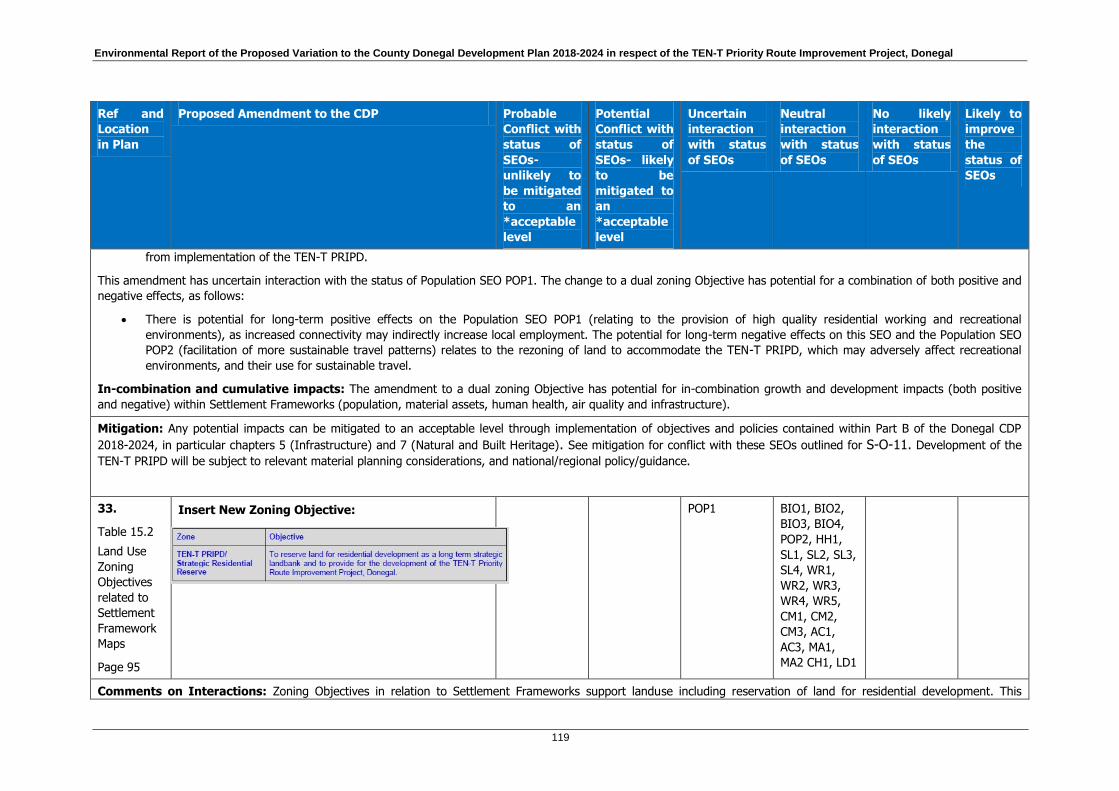
Environmental Report of the Proposed Variation to the County Donegal Development Plan 2018-2024 in respect of the TEN-T Priority Route Improvement Project, Donegal
119
Ref and
Location
in Plan
Proposed Amendment to the CDP Probable
Conflict with
status of
SEOs-
unlikely to
be mitigated
to an
*acceptable
level
Potential
Conflict with
status of
SEOs- likely
to be
mitigated to
an
*acceptable
level
Uncertain
interaction
with status
of SEOs
Neutral
interaction
with status
of SEOs
No likely
interaction
with status
of SEOs
Likely to
improve
the
status of
SEOs
from implementation of the TEN-T PRIPD.
This amendment has uncertain interaction with the status of Population SEO POP1. The change to a dual zoning Objective has potential for a combination of both positive and
negative effects, as follows:
There is potential for long-term positive effects on the Population SEO POP1 (relating to the provision of high quality residential working and recreational
environments), as increased connectivity may indirectly increase local employment. The potential for long-term negative effects on this SEO and the Population SEO
POP2 (facilitation of more sustainable travel patterns) relates to the rezoning of land to accommodate the TEN-T PRIPD, which may adversely affect recreational
environments, and their use for sustainable travel.
In-combination and cumulative impacts: The amendment to a dual zoning Objective has potential for in-combination growth and development impacts (both positive
and negative) within Settlement Frameworks (population, material assets, human health, air quality and infrastructure).
Mitigation: Any potential impacts can be mitigated to an acceptable level through implementation of objectives and policies contained within Part B of the Donegal CDP
2018-2024, in particular chapters 5 (Infrastructure) and 7 (Natural and Built Heritage). See mitigation for conflict with these SEOs outlined for S-O-11. Development of the
TEN-T PRIPD will be subject to relevant material planning considerations, and national/regional policy/guidance.
33.
Table 15.2
Land Use
Zoning
Objectives
related to
Settlement
Framework
Maps
Page 95
Insert New Zoning Objective:
POP1
BIO1, BIO2,
BIO3, BIO4,
POP2, HH1,
SL1, SL2, SL3,
SL4, WR1,
WR2, WR3,
WR4, WR5,
CM1, CM2,
CM3, AC1,
AC3, MA1,
MA2 CH1, LD1
Comments on Interactions: Zoning Objectives in relation to Settlement Frameworks support landuse including reservation of land for residential development. This

Environmental Report of the Proposed Variation to the County Donegal Development Plan 2018-2024 in respect of the TEN-T Priority Route Improvement Project, Donegal
120
Ref and
Location
in Plan
Proposed Amendment to the CDP Probable
Conflict with
status of
SEOs-
unlikely to
be mitigated
to an
*acceptable
level
Potential
Conflict with
status of
SEOs- likely
to be
mitigated to
an
*acceptable
level
Uncertain
interaction
with status
of SEOs
Neutral
interaction
with status
of SEOs
No likely
interaction
with status
of SEOs
Likely to
improve
the
status of
SEOs
amendment has uncertain interaction with the status of Population SEO POP1. The change to a dual zoning Objective has potential for a combination of both positive and
negative effects, as follows:
There is potential for long-term positive effects on the Population SEO POP1 (relating to the provision of high quality residential working and recreational
environments), as increased connectivity may indirectly increase local employment. The potential for long-term negative effects on this SEO relates to the rezoning
of land to accommodate the TEN-T PRIPD, which may adversely affect availability of land for residential and economic developments.
In-combination and cumulative impacts: The amendment to a dual zoning Objective has potential for in-combination growth and development impacts (both positive
and negative) within Settlement Frameworks (population, material assets, human health, air quality and infrastructure).
Mitigation: See mitigation outlined for S-O-11. Development of the TEN-T PRIPD will be subject to relevant material planning considerations, national/regional
policy/guidance and to the proper planning and sustainable development of the area.

Environmental Report of the Proposed Variation to the County Donegal Development Plan 2018-2024 in respect of the TEN-T Priority Route Improvement Project, Donegal
121
Table 7.4 Assessment of proposed mapping amendments included in the Variation to the CDP in respect of the TEN-T PRIPD
Ref and
Location
in Plan
Proposed Amendment to the CDP Probable
Conflict with
status of
SEOs- unlikely
to be
mitigated to
an
*acceptable
level
Potential
Conflict with
status of
SEOs- likely
to be
mitigated to
an
*acceptable
level
Uncertain
interactio
n with
status of
SEOs
Neutral
interaction
with status
of SEOs
No likely
interaction
with status
of SEOs
Likely to
improve the
status of
SEOs
PART A THE STRATEGIC PLAN
Chapter 1 Introduction and Vision
1.
Map 2.1
Remove existing Map 2.1 Core Strategy Schematic and
replace with new Map 2A.1 Core Strategy Schematic.
BIO1, BIO2,
BIO3, BIO4,
POP1, POP2,
HH1, SL1,
SL2, SL3, SL4,
WR1, WR2,
WR3, WR4,
WR5,CM1,
CM2, CM3,
AC1, AC2,
MA1, MA2,
CH1, LD1
Comments on Interactions: Map 2.1 has been amended to show two roads described within the text of the CDP as comprising part of the SRN of the County. Their
addition to Map 2.1 is for the purpose of clarity and does not affect the SEA assessment of the CDP.
Mitigation: None required.

Environmental Report of the Proposed Variation to the County Donegal Development Plan 2018-2024 in respect of the TEN-T Priority Route Improvement Project, Donegal
122
Ref and
Location
in Plan
Proposed Amendment to the CDP Probable
Conflict with
status of
SEOs- unlikely
to be
mitigated to
an
*acceptable
level
Potential
Conflict with
status of
SEOs- likely
to be
mitigated to
an
*acceptable
level
Uncertain
interactio
n with
status of
SEOs
Neutral
interaction
with status
of SEOs
No likely
interaction
with status
of SEOs
Likely to
improve the
status of
SEOs
2.
Map
5.1.1
Remove existing Map 5.1.1 Ten T Network and replace
with new Map 5.1.1 TEN-T Network.
BIO1, BIO2,
BIO3, BIO4,
POP1, POP2,
HH1, SL1,
SL2, SL3, SL4,
WR1, WR2,
WR3, WR4,
WR5,CM1,
CM2, CM3,
AC1, AC2,
MA1, MA2,
CH1, LD1
Comments on Interactions: Map 5.1.1 has been amended to show two roads described within the text of the CDP as comprising part of the SRN of the County. These
roads are described within the text of the CDP as comprising part of the SRN of the County. Their addition to Map 5.1.1 is for the purpose of clarity and does not affect the
assessment of the CDP variation.
Mitigation: None required.
3.
Map
5.1.2
Remove existing Map 5.1.2 Strategic Transport Network
and replace with new Map 5.1.2 Strategic Transport
Network.
BIO1, BIO2,
BIO3, BIO4,
POP1, POP2,
HH1, SL1,
SL2, SL3, SL4,
WR1, WR2,
WR3, WR4,
WR5,CM1,
CM2, CM3,
AC1, AC2,
MA1, MA2,

Environmental Report of the Proposed Variation to the County Donegal Development Plan 2018-2024 in respect of the TEN-T Priority Route Improvement Project, Donegal
123
Ref and
Location
in Plan
Proposed Amendment to the CDP Probable
Conflict with
status of
SEOs- unlikely
to be
mitigated to
an
*acceptable
level
Potential
Conflict with
status of
SEOs- likely
to be
mitigated to
an
*acceptable
level
Uncertain
interactio
n with
status of
SEOs
Neutral
interaction
with status
of SEOs
No likely
interaction
with status
of SEOs
Likely to
improve the
status of
SEOs
CH1, LD1
Comments on Interactions: Map 5.1.2 has been amended to show two roads described within the text of the CDP as comprising part of the SRN of the County. These
roads are described within the text of the CDP as comprising part of the SRN of the County. Their addition to Map 5.1.2 is for the purpose of clarity and does not affect the
assessment of the CDP variation.
Mitigation: None required.
4.
Map
5.1.4
Remove existing Map 5.1.4 Letterkenny to Lifford and
replace with new Map 5.1.4 TEN-T Priority Route
Improvement Project Section 3 N14 Manorcunningham
to Lifford/Strabane/A5 Link.
BIO1, BIO2,
BIO3, BIO4,
WR1, SL1, CM3
POP1,
POP2,
HH1, MA1,
MA2, SL2,
SL3, SL4,
AC1, AC2,
AC3, WR2,
WR4,
WR5, CH1,
CM2
WR3, CM1,
LD1
Comments on Interactions: This variation amends mapping to illustrate the new preferred Option Corridor for Section 3 of the TEN-T PRIPD. See assessment of S-O-11.
Mitigation: See mitigation outlined for S-O-11.
5.
Map
5.1.5
Remove existing Map 5.1.5 N13-N15 Ballybofey
Stranorlar Bypass and replace with new Map 5.1.5 TEN-
T Priority Route Improvement Project, Donegal Section 1
- N15/N13 Ballybofey/Stranorlar Urban Region.
BIO1, BIO2,
BIO3, BIO4,
WR1, SL1, CM3
POP1,
POP2,
HH1, MA1,
MA2, SL2,
SL3, SL4,
AC1, AC2,
AC3, WR2,
WR4,
WR3, CM1,
LD1

Environmental Report of the Proposed Variation to the County Donegal Development Plan 2018-2024 in respect of the TEN-T Priority Route Improvement Project, Donegal
124
Ref and
Location
in Plan
Proposed Amendment to the CDP Probable
Conflict with
status of
SEOs- unlikely
to be
mitigated to
an
*acceptable
level
Potential
Conflict with
status of
SEOs- likely
to be
mitigated to
an
*acceptable
level
Uncertain
interactio
n with
status of
SEOs
Neutral
interaction
with status
of SEOs
No likely
interaction
with status
of SEOs
Likely to
improve the
status of
SEOs
WR5, CH1,
CM2
Comments on Interactions: This variation amends mapping to illustrate the new preferred Option Corridor for Section 1 of the TEN-T PRIPD. See assessment of S-O-11.
Mitigation: See mitigation outlined for S-O-11.
6.
Map
5.1.6
Remove existing Map 5.1.6 N56 Letterkenny Relief Road
and replace with new Map 5.1.6 TEN-T Priority Route
Improvement Project, Donegal Section 2 - N56/N13
Letterkenny to Manorcunningham.
BIO1, BIO2,
BIO3, BIO4,
WR1, SL1, CM3
POP1,
POP2,
HH1, MA1,
MA2, SL2,
SL3, SL4,
AC1, AC2,
AC3, WR2,
WR4,
WR5, CH1,
CM2
WR3, CM1,
LD1
Comments on Interactions: This variation amends mapping to illustrate the new preferred Option Corridor for Section 2 of the TEN-T PRIPD. See assessment of S-O-11.
Mitigation: See mitigation outlined for S-O-11.
7.
Map
7.1.1
Remove existing Map 7.1.1 Scenic Amenity and replace
with new Map 7.1.1 Scenic Amenity.
BIO1, BIO2,
BIO3, BIO4,
POP1, POP2,
HH1, SL1,
SL2, SL3, SL4,

Environmental Report of the Proposed Variation to the County Donegal Development Plan 2018-2024 in respect of the TEN-T Priority Route Improvement Project, Donegal
125
Ref and
Location
in Plan
Proposed Amendment to the CDP Probable
Conflict with
status of
SEOs- unlikely
to be
mitigated to
an
*acceptable
level
Potential
Conflict with
status of
SEOs- likely
to be
mitigated to
an
*acceptable
level
Uncertain
interactio
n with
status of
SEOs
Neutral
interaction
with status
of SEOs
No likely
interaction
with status
of SEOs
Likely to
improve the
status of
SEOs
WR1, WR2,
WR3, WR4,
WR5,CM1,
CM2, CM3,
AC1, AC2,
MA1, MA2,
CH1, LD1
Comments on Interactions: The proposed variation to Map 7.1.1 corrects labelling for the purpose of clarity and does not affect the assessment of the CDP variation.
Mitigation: None required.
8.
Map
12.1B
Remove existing Map 12.1 B Letterkenny Land Use Zoning
Map and replace with new Map 12.1 B Letterkenny Land Use
Zoning Map.
BIO4, SL3, MA1 POP1,
POP2
BIO1, BIO2,
BIO3, HH1,
SL1, SL2,
SL4, WR1,
WR2, WR3,
WR4, WR5,
CM1, CM2,
CM3, AC1,
AC3, MA2,
LD1
Comments on Interactions: This variation amends mapping to illustrate the new land use zoning for Letterkenny. See assessment of amendments 23-26.
Mitigation: See mitigation outlined for amendments 23-26.

Environmental Report of the Proposed Variation to the County Donegal Development Plan 2018-2024 in respect of the TEN-T Priority Route Improvement Project, Donegal
126
Ref and
Location
in Plan
Proposed Amendment to the CDP Probable
Conflict with
status of
SEOs- unlikely
to be
mitigated to
an
*acceptable
level
Potential
Conflict with
status of
SEOs- likely
to be
mitigated to
an
*acceptable
level
Uncertain
interactio
n with
status of
SEOs
Neutral
interaction
with status
of SEOs
No likely
interaction
with status
of SEOs
Likely to
improve the
status of
SEOs
9.
Map
12.3
Remove existing Map 12.3 Letterkenny Transport Map and
replace with new Map 12.3 Letterkenny Transport Map.
BIO1, BIO2,
BIO3, BIO4,
WR1, SL1, CM3
POP1,
POP2,
HH1, MA1,
MA2, SL2,
SL3, SL4,
AC1, AC2,
AC3, WR2,
WR4,
WR5, CH1,
CM2
WR3, CM1,
LD1
Comments on Interactions: This variation amends mapping to illustrate the new preferred Option Corridor for Section 2 of the TEN-T PRIPD. See assessment of S-O-11.
Mitigation: See mitigation outlined for S-O-11.
10.
Map
15.2
Remove existing Map 15.2 Ballybofey-Stranorlar and replace
with new Map 15.2 Ballybofey-Stranorlar.
BIO4, SL3, MA1 POP1,
POP2
BIO1, BIO2,
BIO3, HH1,
SL1, SL2,
SL4, WR1,
WR2, WR3,
WR4, WR5,
CM1, CM2,
CM3, AC1,
AC3, MA2,
CH1, LD1
Comments on Interactions: This variation amends mapping to illustrate the new zonings for Ballybofey-Stranorlar. See assessment of amendments 28-31.

Environmental Report of the Proposed Variation to the County Donegal Development Plan 2018-2024 in respect of the TEN-T Priority Route Improvement Project, Donegal
127
Ref and
Location
in Plan
Proposed Amendment to the CDP Probable
Conflict with
status of
SEOs- unlikely
to be
mitigated to
an
*acceptable
level
Potential
Conflict with
status of
SEOs- likely
to be
mitigated to
an
*acceptable
level
Uncertain
interactio
n with
status of
SEOs
Neutral
interaction
with status
of SEOs
No likely
interaction
with status
of SEOs
Likely to
improve the
status of
SEOs
Mitigation: See mitigation proposed for amendments 28-31.
11.
Map
15.17
Remove existing Map 15.17 Lifford and replace with new
Map 15.17 Lifford.
BIO4, SL3, MA1 POP1,
POP2
BIO1, BIO2,
BIO3, HH1,
SL1, SL2,
SL4, WR1,
WR2, WR3,
WR4, WR5,
CM1, CM2,
CM3, AC1,
AC3, MA2,
CH1, LD1
Comments on Interactions: This variation amends mapping to illustrate the new zonings for Ballybofey-Stranorlar. See assessment of amendments 28-31.
Mitigation: See mitigation proposed for amendments 28-31.

Environmental Report of the Proposed Variation to the County Donegal Development Plan 2018-2024 in respect of the TEN-T Priority Route Improvement Project, Donegal
128
7.4 Summary of Assessment
Of the 33 no. proposed textual amendments to the Donegal County Development Plan comprising the
Proposed Variation, the assessment concluded that 24 no. had potential for conflict or uncertain interaction with the status of SEOs. The potential for conflict or uncertain interaction can be mitigated
for by objectives and policies contained within the CDP that protect the environment by objectives and
policies contained within the CDP that protect the environment.
Of the 11 no. mapping amendments to the Donegal CDP comprising the proposed Variation, the
assessment concluded that 7 no. had potential for conflict or uncertain interaction with the status of SEOs. In all cases, these conflicts can be mitigated for by objectives and policies contained within the
CDP that protect the environment.
7.5 In-combination and Cumulative Impacts
Strategic Objective S-O-11 facilitates the development of the TEN-TPRIPD, as part of the strategic road
network of the County. The TEN-T PRIPD has potential for short and long-term in-combination growth and development impacts (both positive and negative) within the areas connected by the preferred
Option Corridors (e.g. population, material assets, human health, air quality and infrastructure). There
is potential for short and long-term, temporary recurring or permanent in-combination or cumulative effects on SEOs with other plans, programmes or developments within or in the zone of influence of the
TEN-T PRIPD Option Corridors, which will need to be assessed at the project planning stage. Several known road schemes that are currently at various stages of planning or construction may have in-
combination or cumulative effects with the TEN-T PRIPD. These road schemes are outlined in Table
7.5.
Table 7.5 Other Road Projects potential for In-Combination or Cumulative Effects with the TEN-T PRIPD
Roads Planning Stage
Proximity to TEN-T
PRIPD Road project Section
Assessment
Ballybofey / Stranorlar
Western Link Road
At
Tender/Construction
Section 1 Adherence to the
overarching policies and objectives of the
Donegal County Council Development
Plan 2018-2024
ensure that road projects comply with
their planning approvals and core
strategy of proper planning and
sustainability and
with the requirements of
relevant EU Directives and environmental
considerations, there
Four Lane Road,
Letterkenny
At
Tender/Construction Section 2
Joe Bonnar Link At Tender/Construction
Section 2
Port Bridge
Roundabout/Polestar Junction: 2021 (check with
Cahal Moss)
At Tender/Construction
Section 2
Justice Walsh Junction: 2020/2021
At Tender/Construction
Section 2
N14/N15 to A5 Link (Approved 2012, ABP Ref.
05.HA003)
Schemes through or in the Planning Process Section 3
Town Centre (Cathedral One-way) Part 8 Planning
is in place
Schemes through or in the Planning Process Section 2

Environmental Report of the Proposed Variation to the County Donegal Development Plan 2018-2024 in respect of the TEN-T Priority Route Improvement Project, Donegal
129
A5 Western Transport
Corridor
Advancing through the
Statutory Process Section 3
will be no potential
for in combination
effects. A2 Buncranna Road, Derry
Advancing through the Statutory Process
Section 3
N2 Clontibret to the Border Early Planning Process Section 3
N2 Ardee to South
of Castleblaney Early Planning Process Section 3
Northwest Greenway Early Planning Process Section 3
Southern Relief Road,
Letterkenny Early Planning Process Section 2
N13 Bridgend Early Planning Process Section 2
Environmental Report of the Proposed Variation to the County Donegal Development Plan 2018-2024 in respect of the TEN-T Priority Route Improvement Project, Donegal
130
8 Measures Envisaged to Prevent, Reduce and as Fully as Possible Offset Any Significant Adverse Environmental Effects on the Environment of the Proposed Variation
8.1 Measures
Measures are required to prevent, reduce and as fully as possible offset any significant adverse effects
on the environment of implementing the Plan. A high-level overview of project level measures is included here for reference only as the design for the TEN-T PRIPD has not yet been finalised.
However, measures will be a central component of the design process for the project and will typically follow the hierarchy of prevention, reduction and offsetting.
8.1.1 Measures to Prevent, Reduce and as Fully as Possible Offset at the Project Level
Potential impacts may be avoided by locating and designing the development in a manner which avoids
likely significant effects on the environment and reduces the likelihood of conflict with SEOs where practicable. The Council will have due regard for the Environmental Protection policies and objectives
of the County Development Plan when finalising the exact location and design for the development to
ensure, where practicable, that such conflicts with SEO’s do not arise in the first.
The exact location and detailed design of the TEN-T PRIPD has not yet been finalized. However in accordance with the mitigation hierarchy the TEN-T PRIPD can be located and designed in a manner
that seeks to prevent, reduce and as fully as possible offset significant environmental effects in so far
as is reasonably practicable. The following are project specific measures that, although outside of the scope of a strategic assessment, are considered reasonably practicable.
The principal measure at a project-specific level is that the predicted adverse environmental effects
should be considered further during the detailed planning and design of the TEN-T PRIPD, when the specifics of the options can be optimised through detailed feasibility studies and design in order to limit
the potential impacts on sensitive receptors. Further environmental studies based on the more detailed
designs and construction methodologies should be undertaken as appropriate. These studies may involve, but are not limited to, marine, aquatic and terrestrial ecology surveys, ornithological and bat
surveys, fish surveys, landscape and visual assessments, WFD assessments, geotechnical investigations and heritage surveys.
The preferred route corridors identified in the Proposed Variation do intersect or contain: Natura 2000 sites, other terrestrial and marine habitats, residential properties, watercourses, built heritage
structures, archaeological heritage, and sensitive landscape features and the scheme may impact on same. However the preferred route corridors provide scope to locate the project in a manner that
would significantly reduce the impact on a range of environmental receptors and assets. For example: the road scheme can be located within the corridor in a manner that: maximizes the setback from
Natura 2000 sites and residential properties, avoids certain woodlands or other natural habitats, avoids
certain built and archaeological heritage features (e.g. structures on the RPS, NIAH and Record of Monument and Places) and minimizes landscape/visual impacts.

Environmental Report of the Proposed Variation to the County Donegal Development Plan 2018-2024 in respect of the TEN-T Priority Route Improvement Project, Donegal
131
Furthermore the finalized design of the development itself will be prepared in a manner that seeks, in
so far as it is reasonably practicable, to avoid significant impacts on environmental receptors such as:
habitats, sensitive noise receptors, water quality and landscape. In this regard the footprint, land take requirements, structures and bridges, drainage system, construction compounds, borrow pits and
deposition areas related to the project will be designed and laid out in a manner which aims to avoid such potential impacts as: the loss or fragmentation of habitat, impacts on water quality or disturbance
or displacement of species. For example: the construction of clear span bridges on the River Finn and
Lough Swilly can help to avoid direct impacts on Natura 2000 sites, landscape treatments (such as berms and planting) can help to avoid significant visual and noise impacts and resulting disturbance to
humans, flora and fauna and the design of lighting can be optimized to avoid light overspill.
It is not possible and nor is it appropriate at the strategic plan level assessment stage, to prescribe detailed and location-specific project level measures required to prevent, reduce and as fully as possible
offset any significant adverse effects on the environment. National and European Law and the Policies
and Objectives of the Donegal CDP 2018-2024 currently require compliance with relevant EU Directives and environmental considerations and compliance with the provisions of the Habitats Directive and
other European and national legislation will continue to be required if the Proposed Variation is adopted. The TEN-T PRIPD will be subject to an application to ABP and will require AA and EIA. The
project will be subject to ABP being satisfied that the project complies with European Law including the
relevant Directives as transposed into Irish Law along with Irish legislation.
All works and planning of works should be undertaken with regard to the environmental setting. All relevant legislation, licensing and consent requirements, and recommended best practice guidelines
should be considered within the design and implementation of any project arising from the Proposed Variation to the Donegal CDP 2018-2024.
Before any works are carried out, detailed method statements and management plans (construction and environmental) should be prepared, including timing of works, information on the specific
mitigation measures to be employed for each works area, and mechanisms for ensuring compliance with environmental legislation and statutory consents. Contractors should be required to prepare
Construction Environmental Management Plans (CEMPs), which would include a requirement for related
plans to be prepared, as appropriate, for project implementation, such as Erosion and Sediment Control, Invasive Species Management, Emergency Response, Traffic and Safety Management, Dust
and Noise Minimisation, and Stakeholder Communication Plans.
Monitoring of project-level measures should be undertaken during and after works, to ensure
effectiveness in those measures to prevent, reduce and as fully as possible offset any significant adverse effects on the environment.
8.1.2 Measures to Prevent, Reduce and as Fully as Possible Offset through TII Guidance for Road Schemes
The TEN-T PRIPD will be assessed in accordance with European and national legislation and developed
in accordance with the TII Project Management Guidelines (PMGs) (TII, 2019), and Project Appraisal Guidelines for National Roads, Unit 4.0, (PE-PAG-02013). These guidelines require that the option
selection and design of the TEN-T PRIPD is an iterative process between the engineering design team, environmental experts and stakeholders, with the objective to identify an option which would prevent,
reduce and as fully as possible offset any significant adverse effects on the environment.
The TII Planning and Construction Guidelines also ensure that various environmental issues are
integrated into national road scheme planning and delivered during the construction phase of the
project. These Guidelines have been developed through consultation with national experts and various relevant stakeholders to ensure that a national approach for the treatment of environmental issues is
adopted and that they contribute to the development of national road infrastructure in a sustainable fashion.

Environmental Report of the Proposed Variation to the County Donegal Development Plan 2018-2024 in respect of the TEN-T Priority Route Improvement Project, Donegal
132
In addition there is integration between the discipline guidelines. The landscape guidelines (NRA, 2006)
for example promote an ‘Ecological Landscape Design’ and synergy between the landscape and
ecological disciplines, to minimise the impact biological diversity and severance of commuting corridors and connectivity in the landscape. The guidelines also promote the use of native species in line with
national and international policy including the National Biodiversity Plan (2002) and the UN Convention on Biological Diversity (1992) and contributes to Ireland’s commitments under the EU Habitats
Directive, 92/43/EEC. In addition the TII/NRA construction guidelines for the Protection and Preservation of Trees, Hedgerows and Scrub Prior to, During and Post Construction of National Road Schemes (NRA, 2006) include measures to minimise impacts to trees and linear vegetation.
TII/NRA planning and construction guidelines are available for the following environmental aspects:
Planning Guidelines
EIA: Environmental Impact Assessment of National Road Schemes - A Practical Guide (NRA,
Rev. 1, 2008);
Biodiversity, Fauna and Flora: Guidelines for Assessment of Ecological Impacts of National
Road Schemes (NRA, Rev. 2 June 2009) and Ecological Surveying Techniques for Protected
Flora and Fauna during the Planning of National Road Schemes (NRA, 2009); Best Practice
Guidelines for the Conservation of Bats in the Planning of National Road Schemes (NRA, 2006);
Land, Soil and Water: Guidelines on Procedures for Assessment and Treatment of Geology,
Hydrology and Hydrogeology for National Road Schemes (NRA, 2008);
Air and Climate: Guidelines for the Treatment of Air Quality During the Planning and
Construction of National Road Schemes (National Roads Authority, 2006),
Noise and Vibration: Good Practice Guidance for the Treatment of Noise during the Planning
of National Road Schemes (NRA, 2014);
The Built, Natural and Cultural Heritage: Guidelines for the Assessment of Archaeological
Heritage Impacts of National Road Schemes (NRA, 2005);
Landscape: A Guide to Landscape Treatments for National Road Schemes in Ireland (NRA,
2006).
Construction Guidelines
Biodiversity Flora and Fauna: Guidelines for the Treatment of Otters prior to the
Construction of National Road Schemes (NRA, 2008); Guidelines for the Treatment of Badgers
prior to the Construction of National Road Schemes (NRA, 2005); Guidelines for the Treatment
of Bats during the Construction of National Road Schemes (NRA, 2005); Guidelines on the
Management of Noxious Weeds and Non-Native Invasive Plant Species on National Road
Schemes (NRA, Rev 1. 2010)
Water: Guidelines for the Crossing of Watercourses during the Construction of National Road
Schemes (NRA, 2008);
The Built, Natural and Cultural Heritage: Guidelines for the Testing and Mitigation of the
Wetland Archaeological Heritage for National Road Schemes (NRA, 2005);
Landscape: Guidelines for the Protection and Preservation of Trees, Hedgerows and Scrub
Prior to, During and Post Construction of National Road Schemes (NRA, 2006); Guidelines on
the Implementation of Landscape Treatments on National Road Schemes (TII, 2012).
General Environmental Management: Guidelines for the Creation, Implementation and
Maintenance of an Environmental Operating Plan (NRA, 2012); and
Waste: Management of Waste from National Road Construction Projects (TII, 2017)

Environmental Report of the Proposed Variation to the County Donegal Development Plan 2018-2024 in respect of the TEN-T Priority Route Improvement Project, Donegal
133
9 Selection of Alternatives to the Proposed Variation
9.1 Overview of Alternatives
The alternatives considered are set out in Sections 9.2 and 9.3 and include: Strategic Alternatives to
Implementing the Proposed Variation; TEN-T PRIPD Alternatives comprised of two sub-groups – Historical Corridors Included in CDP 2018-2024; and the TEN-T PRIPD Options Selection Process
(options considered).
9.2 Strategic Alternatives to Implementing the Proposed Variation
As discussed in Section 7.2, from a strategic perspective, there are two alternative scenarios that can be considered for this CDP Variation:
Alternative No.1: Do-Nothing Approach or continuation of the existing County Donegal
Development Plan 2018-2024.
Alternative No.2: Implementation of the Variation comprising amendments to facilitate the TEN-
T PRIPD.
In the absence of implementing the Proposed Variation to the CDP, the TEN-T PRIPD and associated preferred Option Corridors would not be incorporated into the Donegal CDP. There would be no
changes to the TEN-T route corridor as described in the CDP, to land zonings for Letterkenny and
Ballybofey/Stranorlar and to other transport related matters in the CDP. As outlined in the following section, the historical TEN-T routes in the current CDP were not identified as the preferred options.
These routes were discounted at the Option Selection stage of the current TEN-T PRIPD as they scored less favourably than other options in the multi-criteria analysis. Therefore, if the CDP were to remain
unchanged, the TEN-T routes currently contained in the CDP would either be constructed at a much
greater adverse impact or, alternatively, there would be no development of the TEN-T under the current CDP, within the Plan period. To continue to implement the CDP without the Variation would
then be in conflict with several of the CDP Objectives and Policies which support the development of the TEN-T. Donegal County Council is therefore proposing the Variation to support the TEN-T PRIPD,
with amendment to objectives, policies and maps within the CDP.
9.3 TEN-T PRIPD Alternatives
9.3.1 Historical TEN-T Corridors included in Donegal CDP 2018-2024
The CDP Variation relates to a modification of the historical TEN-T route corridors previously assessed for the Donegal CDP 2018-2024. These corridors were previously advanced under separate projects to various stages of planning and design. Further details on each of these previous projects are provided below. N13/ N15 Ballybofey/Stranorlar Urban Region

Environmental Report of the Proposed Variation to the County Donegal Development Plan 2018-2024 in respect of the TEN-T Priority Route Improvement Project, Donegal
134
The N15/N13 Ballybofey/Stranorlar project has been the subject of previous planned road improvement. Between 2000 and 2008, a Constraints Study, Route Selection Report and CPO / EIS for the N13 / N15 through Ballybofey/Stranorlar was completed. The project progressed to Oral Hearing in 2008, proposing a preferred route corridor located to the south and east of the Twin Towns. In 2009 An Bord Pleanála (ABP) refused approval for the scheme. This corridor for this route is provided for within the CDP Map 5.1.5. N56/N13 Letterkenny to Manorcunningham
The proposed scheme has not been promoted previously in its current form, however, a proposed Relief Road for Letterkenny (known as the N56 Letterkenny Inner Relief Road) has previously been proposed from the Dry Arch Roundabout connecting to the N56/R245 junction north of the Polestar Roundabout. This scheme includes a new bridge crossing over the River Swilly and a reserved corridor for this route was provided for within the CDP Map 5.1.6. N14 Manorcunningham to Lifford/Strabane/A5 Link
The N14 Manorcunningham to Lifford road has been the subject of previous planned road improvements. In 2001, a Constraints Study and Route Selection for the N14 between Manorcunningham and Lifford was published. A selected preferred route corridor emerged but the scheme was not progressed further due to lack of funding. This corridor for this route is provided for within the CDP Map 5.1.4.
9.3.2 TEN-T PRIPD Phase 2 Option Selection Process
The Phase 2 Option Selection for the TEN-T project was completed in 2019 and comprised three stages, Stage 1 Preliminary Options Assessment, Stage 2 Project Appraisal of Options and Stage 3 Selection of a Preferred Option Corridor. The preferred route options for the three road sections have been used to inform the CDP Variation.
9.3.2.1 TEN-T PRIPD Assessment of Alternatives
As part of the option selection process, alternative options were considered prior to establishing a road solution as the most suitable infrastructure to address the needs of the project. The extent to which these potential alternatives address the goals and objectives were considered. Four alternatives were considered for the TEN-T PRIPD, as follows:
1. Do Nothing; 2. Do Minimum; 3. Do Something Non-Road Improvement Alternatives; and 4. Do Something Road Improvement Alternatives.
9.3.2.2 Do Nothing
The Do Nothing alternative regarding the TEN-T PRIPD is outlined in the following sections.
Section 1
For Section 1, the existing N13 is a key strategic route through the twin towns of Ballybofey and
Stranorlar that is currently operating beyond its capacity and is performing poorly with respect to safety and travel times. Considering future traffic growth, the retention of this existing road network, without
any improvement, would fail to meet the core objective of the TEN-T project and this was accordingly ruled out from further consideration.

Environmental Report of the Proposed Variation to the County Donegal Development Plan 2018-2024 in respect of the TEN-T Priority Route Improvement Project, Donegal
135
Section 2
For Section 2, the existing N13 and N56 routes are key strategic routes operating beyond capacity and
performing poorly with respect to safety and engineering standards. The retention of the existing N13 and N56 routes, without any improvement, would fail to meet the core objective of the project. It was
concluded, therefore, at this early stage of the Option Selection process, that the Do Nothing option was ruled out from further consideration.
Section 3
In Section 3, the existing N14 is currently operating beyond its capacity and performing poorly with respect to safety. Considering future traffic growth and increased demand for higher quality border
crossings, a Do Nothing Option was ruled out from further consideration.
9.3.2.3 Do Minimum
The Do Minimum alternative regarding the TEN-T PRIPD is outlined in the following sections.
Section 1
The Do Minimum option for Section 1 consisted of retaining the existing road with minimum online
improvements. However, an online improvement scheme, through the twin towns of Ballybofey and Stranorlar, would not provide the appropriate cross-section and junctions required to achieve the level
of service, journey time reliability, safety and economic benefit required in the project objectives. It was concluded, therefore, at an early stage of the Option Selection process, that the Do Minimum option
was ruled out from further consideration.
Section 2
The Do Minimum option considered for Option 2 included retaining the existing N13 and N56 routes and
including other committed schemes with traffic management considerations. However, the N13 and N56 routes include multiple public and private direct accesses that fall outside design standards. In
addition, existing sections of N13 include vertical gradients that far exceed national road design standards. The existing N56 section carries significant (>32,000) daily traffic volumes, has numerous
commercial premises with direct access onto the adjacent existing carriageway, runs alongside
designated SAC lands and would result in significant buildability issues. A do minimum online improvement option will not provide the appropriate cross-section and junction arrangements required
to achieve the level of service, journey time reliability, safety and economic benefits required in the project objectives. It was concluded, therefore, at an early stage of the Option Selection process, that
the Do Minimum option was ruled out from further consideration.
Section 3
The Do Minimum option for Section 3 consisted of a combination of online and offline improvements. A
Type 2 dual carriageway cross-section was applied to this option to ensure future traffic volumes could be accommodated. Additionally, direct access to the dual carriageway would be restricted to junctions,
presenting additional challenges with respect to the ribbon development along the existing N14 and the
substantial direct impacts the Do Minimum alignment would have on several existing properties. Furthermore, due to the existing alignment of the N14, restricting a new road improvement to parts of
the existing road corridor has a significant influence on the overall desire line of the road and subsequently the curvature of the alignment. Therefore, the Do Minimum option was discounted for
Section 3 of the TEN-T Project.
9.3.2.4 Do Something - Non-Road Improvement Alternatives

Environmental Report of the Proposed Variation to the County Donegal Development Plan 2018-2024 in respect of the TEN-T Priority Route Improvement Project, Donegal
136
As part of the TEN-T PRIPD Option Selection process, constraints and alternatives were considered. Alternatives must be considered prior to establishing that a road solution is the most suitable infrastructure to address the needs of the project. When identifying alternatives, the extent to which the potential alternative responds to the needs of the project and the transport problems are considered. The extent to which the potential alternatives address the goals and objectives are also reviewed.
The options that were considered as alternatives to improving / upgrading the existing road network included the following:
Improved broadband;
Staggering work times; and
Encouraging alternative sustainable forms of transport.
Improved Broadband
Improved broadband may accommodate more uptake of remote working with the aim of reducing
reliance of workers on the transport network daily. However, The Donegal Local Economic and
Community Plan 2016-2022 highlights that the “functionality of digital technologies provides an
opportunity to counteract” the region’s reliance on the road network. However, the opportunity for
increased homeworking, will be limited to a few industries (for example on line services, consultancy
services, IT support services) and would not apply to other labour-intensive industries. The 2016
census has highlighted that Donegal has a higher than average percentage of workers in unskilled,
semi-skilled and skilled manual work and a lower than average percentage of professional workers.
Therefore, improvement in broadband alone is unlikely to result in increased working from home or
have any notable impact on the road network. The plan also highlights that the “road network is the
artery for the region’s economy with 100% of goods and people being transported by road”. As such,
improvement in broadband is not identified as a suitable alternative to meet the objectives of the TEN-T
PRIPD.
Staggered Work Times
Staggering worktimes / school times is a useful measure to spread peak hour traffic flows across longer
periods of the day thereby reducing peak hour traffic flows on the existing road network. This has the
potential to alleviate the delays experienced, particularly on Sections 1 and 2, during peak hours. Such
measures are applied to localised capacity problems such as junctions in the vicinity of school and
factories, for example. However, the need to implement the TEN-T PRIPD is not aimed at solving
localised traffic problems (although in some cases, that may be a side effect of the scheme) but to
provide a high quality transport network that will open up areas of the county and region that have
been deprived of high-quality infrastructure in the past. Therefore, staggering worktimes and
implementing localised improvements will not meet the objectives of the TEN-T PRIPD.
Alternative Forms of Transport
Encouraging alternative sustainable forms of transport, such as public transport, to reduce the traffic
demand on the existing road and reduce the need to improve road capacity. Transport infrastructure in
Donegal is focused on the road network due to the lack of a rail network in the county. Re-opening
former rail routes has been considered in previous years: a consultation paper entitled Future Railway
Investment was published by Northern Ireland's Department for Regional Development in 2013. This
included an option to reopen cross-border rail links from Derry to Letterkenny and Donegal town. An
initial appraisal concluded that the benefit/cost ratio was insufficient to warrant further detailed
investigation. Extending the Iarnród Éireann network north from Sligo to Donegal, Letterkenny,
Strabane and Derry has been considered, as the final stage of a Western Rail Corridor. However, the
Irish Government’s stated position is that maintaining the existing rail network takes priority over future

Environmental Report of the Proposed Variation to the County Donegal Development Plan 2018-2024 in respect of the TEN-T Priority Route Improvement Project, Donegal
137
extension plans. As such implementation of a rail-based alternative is considered not viable, this
alternative was discounted during Phase 1 of the option selection for TEN-T PRIPD.
Conclusion of Non-Road Improvement Alternatives
The sections above detail why improved broadband, alternative working times/localised improvements
and alternative forms of transport were discounted as viable alternatives to address the needs of the
TEN T PRIPD or meet the project objectives.
9.3.2.5 Do Something - Road Improvement Alternatives
The methodology utilised in the Phase 2 Option Selection process for all three sections of the TEN-T PRIPD covered the following steps in the process:
Stage 1 Preliminary Options Assessment
Stage 2 Project Appraisal
Stage 3 Preferred Option
Option selection is an iterative process between the engineering design team and environmental experts with the objective to identify an option which would avoid, where possible, likely significant
effects on the environment.
The scheme is assessed against project objectives which are based on multiple criteria outlined by the
Department of Transport in their publication ‘Common Appraisal Framework for Transport Projects and
Programmes’, dated March 2016. Multi-criteria headings are as follows:
Economy
Safety
Environment
Accessibility & Social Inclusion
Integration
Physical Activity
The objectives of the proposed road development are summarised below. These objectives have been derived based on the deficiencies of the existing corridors and responding to the aspirations of
European, national and strategic policy documentation.
Economy To improve the efficiency of the transport network by improving journey time and journey time reliability.
Safety To reduce the frequency and severity of collisions and to improve the overall safety of the national road network in Donegal.
To improve safety for users by separating strategic traffic from local traffic through towns, villages and rural communities.
Environment To reduce overall air pollution levels near sensitive receptors caused by congestive queuing of vehicles and/or excessive vertical gradients.
To reduce overall traffic noise levels near sensitive receptors; includes ribbon
developments. To reduce risk of watercourse pollution along the existing road network.
Accessibility and Social Inclusion
Improve accessibility to/from the North West region, helping to reduce deprivation caused by the geographic location of Donegal, which is currently an area covered by the Rural Social Scheme.
Remove strategic and commercial traffic from local towns and communities, thereby making these communities more inviting and encouraging more travel independence for non-motorised users and vulnerable groups.

Environmental Report of the Proposed Variation to the County Donegal Development Plan 2018-2024 in respect of the TEN-T Priority Route Improvement Project, Donegal
138
Improve accessibility to employment in regional and national centres including Donegal, Letterkenny, Derry, Belfast, Dublin, Sligo and Galway.
Improve accessibility to regional health services including hospitals in Letterkenny and Sligo.
Improve network resilience such as access to Letterkenny where the N56 (four lane road) is a “Lifeline Route” being the only access into Letterkenny and northwest Donegal.
Integration Meet the objectives of the TEN-T Regulations 1315/2013 to enhance geographic integration.
To support the transport objectives contained in national, regional and local planning policies and strategies, including provision of “efficient and integrated national transport system with adequate capacity, and levels of service comparable to other countries”, to equip Ireland and the North West region to “compete for investment”17.
To be compatible with land use objectives as set out in regional and local land use plans.
To improve connectivity to/from other transport modes, such as ports at Killybegs, Foyle (Derry), Belfast, Shannon and Dublin, and airports at Derry, Knock, Belfast, Dublin and Shannon.
Physical Activity
To encourage active travel in towns/villages and longer distance non-motorised travel on strategic routes.
For the Stage 1 assessment each of the preliminary options were examined against the Stage 1 criteria, namely:
Engineering
Environment
Economy
Following completion of Stage 1, a shortlist of options was identified for each section to be taken
forward to the Stage 2 assessment process. The shortlisted options were identified as feasible options having greater benefits / less impacts than the options eliminated at the end of Stage 1.
At the beginning of Stage 2, the shortlisted options were further developed to include preliminary
designs for online improvements, link roads, grade separated junctions, termination roundabouts, etc.
In all cases the objectives were to reduce impacts where feasible. Following this further refinement, a more detailed assessment of each of the shortlisted options was undertaken, using the six common
appraisal framework (CAF) criteria and the relevant sub-criteria, as listed below. In addition, the Stage 2 appraisal included the Road Safety Audit and Road Safety Impact Assessment required under TII
PMGs to inform option selection.
At the beginning of Stage 2, the shortlisted options were further developed to include preliminary
designs for online improvements, link roads, grade separated junctions, termination roundabouts, etc. In all cases the objectives were to reduce impacts where feasible. Following this further refinement, a
more detailed assessment of each of the shortlisted options was undertaken, using the six common appraisal framework (CAF) criteria and the relevant sub-criteria, as listed below. In addition, the Stage
2 appraisal included the Road Safety Audit and Road Safety Impact Assessment required under TII
PMGs to inform option selection.
Economy
- Transport efficiency and effectiveness
- Wider economic impacts
- Funding impacts
17 Action Plan for Jobs 2016
Environmental Report of the Proposed Variation to the County Donegal Development Plan 2018-2024 in respect of the TEN-T Priority Route Improvement Project, Donegal
139
Safety
- Collision Reduction - Security - Road Safety Audit
- Road Safety Impact Assessment
Environment
- Air Quality & Climate - Noise
- Landscape & visual - Biodiversity (Terrestrial and Aquatic)
- Waste - Soils, Geology and Hydrogeology
- Hydrology
- Architectural heritage, Archaeology and Cultural Heritage - Material Assets (Agricultural)
- Material Assets (Non-agricultural)
Accessibility & Social Inclusion
- Deprived geographical areas - Vulnerable groups
Integration
- Transport integration
- Land use integration
- Geographical integration - Other government policy integration
Physical Activity
The project appraisal of options followed the relevant TII Guidance documents produced for the
different elements of consideration, in accordance with the TII Project Appraisal Guidelines for National Roads Unit 7.0 – Multi-Criteria Analysis, PE-PAG-02031 (2016).
The corridors in the current CDP were included in the full list of options at Stage 1 of the option selection process and were assessed in the same manner as any of the newly identified options.
However, through the option selection process they did not score as highly as the preferred corridors.
The outcome of the option selection process for each section of the TEN-T RPRIPD is outlined below. Figures showing the options considered for each section are also included.
Section 1
For Section 1, a total of 38 Preliminary Options were identified in the Stage 1 assessment, using the three criteria of Environment, Engineering and Economy, resulted in a total of 13 options which were considered during the Stage 2 appraisal of options. As the River Finn flows through Ballybofey and Stranorlar, a crossing of the River is unavoidable. The River is designated as the River Finn SAC, therefore the extent to which the River might be impacted by an option was considered in the assessment. Following the multi criteria assessment Option 1G was identified as the preferred corridor, which is illustrated in the CDP Variation Map 5.1.5 TEN-T Priority Route Improvement Project, Donegal Section 1 N15/N13 Ballybofey/Stranorlar Urban Region.
The preferred option is approximately 8.3km long. It commences west of Ballybofey near Blackburn Bridge and heads in a north-easterly direction through Cappry. The option crosses the River Finn and

Environmental Report of the Proposed Variation to the County Donegal Development Plan 2018-2024 in respect of the TEN-T Priority Route Improvement Project, Donegal
140
continues north-easterly passing through Drumboe Lower, Backlees where the option aligns in a more
northerly direction before terminating at the existing N13, near Callan Bridge. Two links connect the
preferred option to the urban centres of Ballybofey and Stranorlar, one west of the River Finn that connects to the existing N15 in Ballybofey and a second near Backlees that connects with the existing
N13 north of Stranorlar and the existing N15 west of Stranorlar.
Figure 9.1 Stage 1 Options Considered for Section 1

Environmental Report of the Proposed Variation to the County Donegal Development Plan 2018-2024 in respect of the TEN-T Priority Route Improvement Project, Donegal
141
Figure 9.2 Stage 2 Options Considered for Section 1
Section 2
For Section 2, a total of nine Preliminary Options were identified, in addition seven link options were identified and assessed during the Stage 1 assessment, resulting in seven shortlisted options, being brought forward to the Stage 2 assessment process. In addition, three link options were carried forward for continued assessment. Following the Stage 2 multi criteria assessment Option 2D was identified as the preferred corridor, which is illustrated in the CDP Variation Map 5.1.6 TEN-T Priority Route Improvement Project, Donegal Section 2 - N56/N13 Letterkenny to Manorcunningham. The preferred option is approximately 6.0km long with a 2.5km strategic link connecting to the existing N56/R245 junction north of Polestar roundabout. The preferred option commences near the townland of Listellian on the existing N13 approximately 2km south of the existing Dry Arch Roundabout at Bonagee. The option travels in a north north-easterly direction, offline, until it intersects with the existing N13 again at Dromore, approximately 0.6km east of the Dry Arch Roundabout. From here the preferred option travels easterly along the existing N13 corridor until it reaches its termination point at the existing N13/N14 junction in Raymoghy. The 2.5km strategic link connects with the preferred option at the existing N13 in Dromore and travels northwest across the River Swilly until it reaches its termination point at the existing N56 junction with the R245, in the townland of Ballyraine. The River Swilly is designated as part of Lough Swilly SAC and Lough Swilly SPA at this location.

Environmental Report of the Proposed Variation to the County Donegal Development Plan 2018-2024 in respect of the TEN-T Priority Route Improvement Project, Donegal
142
Figure 9.3 Stage 1 Options Considered for Section 2
Figure 9.4 Stage 2 Options Considered for Section 2

Environmental Report of the Proposed Variation to the County Donegal Development Plan 2018-2024 in respect of the TEN-T Priority Route Improvement Project, Donegal
143
Section 3
A total of 42 Preliminary Options were identified for Section 3. The Stage 1 assessment, resulted in nine
shortlisted options, resulting in six shortlisted route corridors, being brought forward to Stage 2 of the option selection process.
Following the Stage 2 multi criteria assessment Option 3B2 was identified as the preferred corridor,
which is illustrated in the CDP Variation Map 5.1.4 TEN-T Priority Route Improvement Project, Donegal
Section 3 N14 Manorcunningham to Lifford/Strabane/A5 Link.
The preferred option is approximately 17.6km long. It commences at the N13/N14 junction and runs along a similar alignment as the existing N14 for approximately 800m. The option then continues in a
similar westerly direction offline towards Drumoghill before turning south through Drumcairn. The option continues towards the existing N14 at Sheskinapoll. The option then aligns in a south-easterly
direction for approximately 4km to Feddyglass running close to the existing N14. At this point, the
option crosses the existing N14 continuing to the townland of Tamnawood. From here the option continues in a south easterly direction to Murlough and then curves around to the east side of
Croaghan Hill and subsequently in a southerly direction between Coneyburrow and Beechwood Park. Here the termination point occurs next to the existing N15 on greenfield land.
Figure 9.5 Stage 1 Options Considered for Section 3
Figure 9.6 Stage 2 Options Considered for Section 3
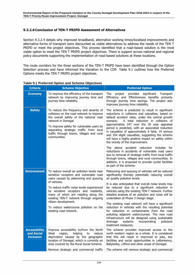
Environmental Report of the Proposed Variation to the County Donegal Development Plan 2018-2024 in respect of the TEN-T Priority Route Improvement Project, Donegal
144
9.3.2.6 Conclusion of TEN-T PRIPD Assessment of Alternatives
Section 9.3.2.4 details why improved broadband, alternative working times/localised improvements and
alternative forms of transport were discounted as viable alternatives to address the needs of the TEN T PRIPD or meet the project objectives. This process identified that a road-based solution is the most
viable option to meet the TEN T PRIPD project objectives. There is support across national and regional policy documents supporting the implementation of road-based solutions at these locations.
The route corridors for the three sections of the TEN-T PRIPD have been identified through the Option
Selection process and have informed the Variation to the CDP. Table 9.1 outlines how the Preferred Options meets the TEN T PRIPD project objectives.
Table 9.1 Preferred Option and Scheme Objectives
Criteria Scheme Objective Preferred Option
Economy To improve the efficiency of the transport network by improving journey time and journey time reliability.
The project provides significant Transport Efficiency and Effectiveness benefits primarily through journey time savings. The project also improves journey time reliability.
Safety To reduce the frequency and severity of collisions on the road network to improve the overall safety of the national road network in Donegal.
To improve safety for vulnerable users by separating strategic traffic from local traffic through towns, villages and rural communities.
The scheme is predicted to result in significant reductions in collisions and casualties, based on default accident rates, under the central growth scenario. A total reduction in collisions of
approximately 247 over the 30 year appraisal period is predicted, with an associated reduction in casualties of approximately 6 fatal, 19 serious and 354 slight casualties, suggesting the scheme will have a highly positive impact on safety within the vicinity of the improvement.
The above accident reduction includes for reductions in accidents of vulnerable road users due to removal of strategic traffic from local traffic through towns, villages and rural communities. In addition, it is proposed to provide cyclist facilities as part of the scheme.
Environment To reduce overall air pollution levels near
sensitive receptors and vulnerable road users caused by platooning and queuing of vehicles.
To reduce traffic noise levels experienced by sensitive receptors and residents, many of which are residing along the existing TEN-T network through ongoing ribbon development.
To reduce watercourse pollution on the existing road network.
Platooning and queuing of vehicles will be reduced
significantly thereby potentially reducing overall air quality pollution levels.
It is also anticipated that overall noise levels may be reduced due to a significant reduction in vehicles using the existing TEN-T network. Further detailed analysis of air pollution and noise will be undertaken at Phase 3 Design stage.
The existing road network will have a significant reduction in vehicles with the resulting potential for reduction in contaminants from the road polluting adjacent watercourses. The new road infrastructure will be designed using sustainable drainage systems incorporating pollutant
treatment measures.
Accessibility and Social Inclusion
Improve accessibility to/from the North West region, helping to reduce deprivation caused by the geographic location of Donegal, which is currently an area covered by the Rural Social Scheme.
Remove strategic and commercial traffic
The scheme provides improved access to the north western region as a whole. It is considered that this will result in improved to jobs, key facilities and social opportunities in Letterkenny, Ballybofey, Lifford and other areas of Donegal.
The scheme will remove strategic and commercial
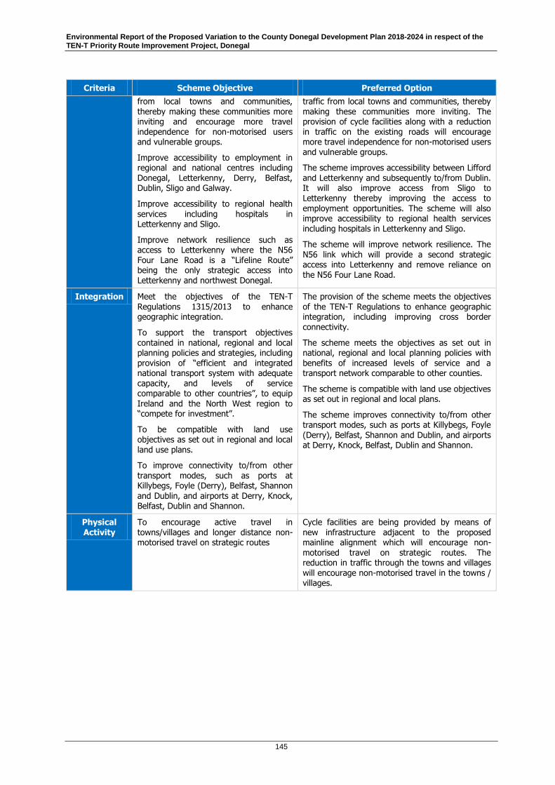
Environmental Report of the Proposed Variation to the County Donegal Development Plan 2018-2024 in respect of the TEN-T Priority Route Improvement Project, Donegal
145
Criteria Scheme Objective Preferred Option
from local towns and communities, thereby making these communities more inviting and encourage more travel independence for non-motorised users and vulnerable groups.
Improve accessibility to employment in regional and national centres including Donegal, Letterkenny, Derry, Belfast, Dublin, Sligo and Galway.
Improve accessibility to regional health
services including hospitals in Letterkenny and Sligo.
Improve network resilience such as access to Letterkenny where the N56 Four Lane Road is a “Lifeline Route” being the only strategic access into Letterkenny and northwest Donegal.
traffic from local towns and communities, thereby making these communities more inviting. The provision of cycle facilities along with a reduction in traffic on the existing roads will encourage more travel independence for non-motorised users and vulnerable groups.
The scheme improves accessibility between Lifford and Letterkenny and subsequently to/from Dublin. It will also improve access from Sligo to Letterkenny thereby improving the access to employment opportunities. The scheme will also improve accessibility to regional health services including hospitals in Letterkenny and Sligo.
The scheme will improve network resilience. The N56 link which will provide a second strategic access into Letterkenny and remove reliance on the N56 Four Lane Road.
Integration Meet the objectives of the TEN-T Regulations 1315/2013 to enhance geographic integration.
To support the transport objectives contained in national, regional and local planning policies and strategies, including
provision of “efficient and integrated national transport system with adequate capacity, and levels of service comparable to other countries”, to equip Ireland and the North West region to “compete for investment”.
To be compatible with land use objectives as set out in regional and local land use plans.
To improve connectivity to/from other transport modes, such as ports at Killybegs, Foyle (Derry), Belfast, Shannon
and Dublin, and airports at Derry, Knock, Belfast, Dublin and Shannon.
The provision of the scheme meets the objectives of the TEN-T Regulations to enhance geographic integration, including improving cross border connectivity.
The scheme meets the objectives as set out in national, regional and local planning policies with
benefits of increased levels of service and a transport network comparable to other counties.
The scheme is compatible with land use objectives as set out in regional and local plans.
The scheme improves connectivity to/from other transport modes, such as ports at Killybegs, Foyle (Derry), Belfast, Shannon and Dublin, and airports at Derry, Knock, Belfast, Dublin and Shannon.
Physical Activity
To encourage active travel in towns/villages and longer distance non-motorised travel on strategic routes
Cycle facilities are being provided by means of new infrastructure adjacent to the proposed mainline alignment which will encourage non-motorised travel on strategic routes. The reduction in traffic through the towns and villages will encourage non-motorised travel in the towns / villages.

Environmental Report of the Proposed Variation to the County Donegal Development Plan 2018-2024 in respect of the TEN-T Priority Route Improvement Project, Donegal
146
9.4 Difficulties Encountered
Difficulties encountered in compiling the required information for the ER are related to the level of detail
on the environment that is available given the current status of the TEN-T PRIPD project. Stage 2 Option Selection of the project has been completed and suitable corridors have been identified for
TEN-T PRIPD and which are the subject of this Proposed Variation. However, detailed assessment is not
possible at this stage in the project and is more appropriately dealt with at the project level. This includes inter alia detailed information on the population, human health, biodiversity, land, soil, water,
air, climate, material assets, cultural heritage and landscape factors. The detailed design stage of the project will provide a greater level of information on these factors of the environment that will be
impacted by the project along with measures taken to prevent, reduce and as fully as possible offset
any significant adverse environmental effects. A project EIA and AA will be undertaken as part of the statutory approval process for the development. The protections for the environment are enshrined in
European and national legislation, and the Council has a responsibility to ensure adherence to those protections.
The proposed variation is related to the ongoing detailed design process for the proposed TEN-T
PRIPD, which will include the production of an EIAR and NIS to fulfil obligations of the EIA and AA
directives respectively. The level of detail included in assessments to inform project level EIA and AA are, by their nature, of much finer detail and include detailed fieldwork. This does not sit easily
alongside a more strategic level of detail included in a plan and presents difficulties in aligning the two to present a coherent assessment and mitigation. To address this the SEA of the Proposed Variation has
collated available baseline information and referred, as appropriate, to information contained in the
published Option Selection report for the TEN-T PRIPD in order to ensure there are no gaps.
For consistency, the assessment methodology used for the Proposed Variation also utilised and updated information available from the previous SEA of the CDP. As this was applied to strategic policy making
at CDP level it did not clearly identify significant effects where specific route and detail was presented. To address this the SEA has presented supporting text in the assessment to better articulate the full
extent of the impacts.
The Proposed Variation has included a number of policies changes specific to TEN-T PRIPD. This has
resulted in overarching environmental protection policies being varied as they relate to TEN-T PRIPD. This presented difficulties with the current CDP in terms of sustainability. To address this the SEA has
analysed the changes and assessed the impacts of same. The assessment clearly shows that possible
effects can be mitigated through the implementation of project level measures to prevent, reduce and as fully as possible offset any significant adverse environmental effects.
The difficulties encountered during this process have all been adequately addressed in this
Environmental Report.
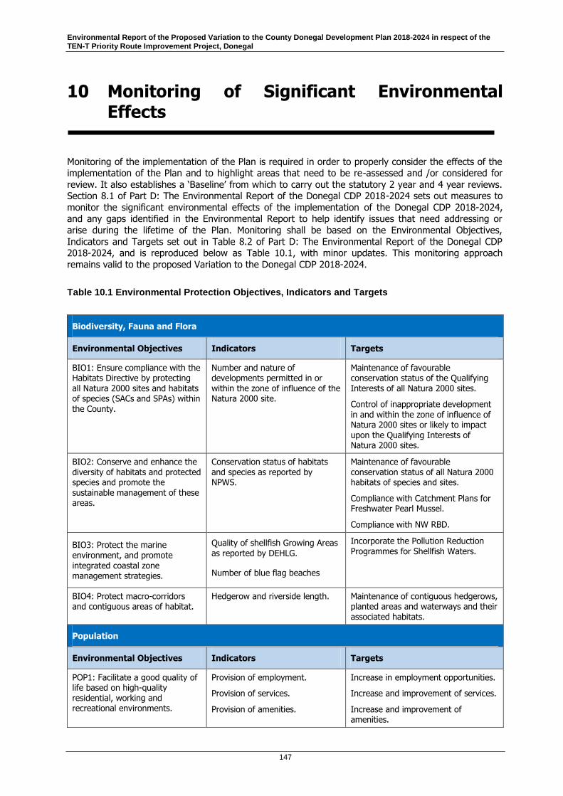
Environmental Report of the Proposed Variation to the County Donegal Development Plan 2018-2024 in respect of the TEN-T Priority Route Improvement Project, Donegal
147
10 Monitoring of Significant Environmental Effects
Monitoring of the implementation of the Plan is required in order to properly consider the effects of the implementation of the Plan and to highlight areas that need to be re-assessed and /or considered for
review. It also establishes a ‘Baseline’ from which to carry out the statutory 2 year and 4 year reviews. Section 8.1 of Part D: The Environmental Report of the Donegal CDP 2018-2024 sets out measures to
monitor the significant environmental effects of the implementation of the Donegal CDP 2018-2024, and any gaps identified in the Environmental Report to help identify issues that need addressing or
arise during the lifetime of the Plan. Monitoring shall be based on the Environmental Objectives,
Indicators and Targets set out in Table 8.2 of Part D: The Environmental Report of the Donegal CDP 2018-2024, and is reproduced below as Table 10.1, with minor updates. This monitoring approach
remains valid to the proposed Variation to the Donegal CDP 2018-2024.
Table 10.1 Environmental Protection Objectives, Indicators and Targets
Biodiversity, Fauna and Flora
Environmental Objectives Indicators Targets
BIO1: Ensure compliance with the Habitats Directive by protecting all Natura 2000 sites and habitats of species (SACs and SPAs) within the County.
Number and nature of developments permitted in or within the zone of influence of the Natura 2000 site.
Maintenance of favourable conservation status of the Qualifying Interests of all Natura 2000 sites.
Control of inappropriate development in and within the zone of influence of Natura 2000 sites or likely to impact upon the Qualifying Interests of Natura 2000 sites.
BIO2: Conserve and enhance the diversity of habitats and protected species and promote the sustainable management of these areas.
Conservation status of habitats and species as reported by NPWS.
Maintenance of favourable conservation status of all Natura 2000 habitats of species and sites.
Compliance with Catchment Plans for Freshwater Pearl Mussel.
Compliance with NW RBD.
BIO3: Protect the marine environment, and promote integrated coastal zone management strategies.
Quality of shellfish Growing Areas as reported by DEHLG.
Number of blue flag beaches
Incorporate the Pollution Reduction Programmes for Shellfish Waters.
BIO4: Protect macro-corridors and contiguous areas of habitat.
Hedgerow and riverside length.
Maintenance of contiguous hedgerows, planted areas and waterways and their associated habitats.
Population
Environmental Objectives Indicators Targets
POP1: Facilitate a good quality of life based on high-quality residential, working and recreational environments.
Provision of employment.
Provision of services.
Provision of amenities.
Increase in employment opportunities.
Increase and improvement of services.
Increase and improvement of amenities.

Environmental Report of the Proposed Variation to the County Donegal Development Plan 2018-2024 in respect of the TEN-T Priority Route Improvement Project, Donegal
148
POP2: Facilitate more sustainable travel patterns.
Provision of sustainable travel modes.
Increase and improvement of sustainable travel in the County.
Human Health
Environmental Objectives Indicators Targets
HH1: Minimise noise, vibration and emissions from traffic, industrial processes and extractive industry.
Occurrence of a spatially concentrated incidences of deterioration in human health (EPA, Local Reports).
No spatially occurring incidences.
Soil (including minerals)
Environmental Objectives Indicators Targets
SL1: Protect and maintain the quality of soils.
EPA/Teagasc National Soils Mapping Project
Conservation of soil.
SL2: Protect and conserve geological sites.
Number and area of geological heritage sites as mapped by GSI
Retain/increase the number of geological heritage sites in the County.
SL3: Give preference to the re-use of brownfield lands, rather than developing greenfield lands.
Location and area of brownfield sites developed and permitted for development over the plan
period.
Develop as many brownfield sites as appropriate and possible.
SL4: Minimise the consumption of non-renewable sand, gravel and rock deposits.
SL5: Minimise the amount of waste to landfill.
Amount and nature of waste to landfill and location of landfill.
Reduce amount of waste to landfill.
Water
Environmental Objectives Indicators Targets
WR1: Protect and enhance the status of aquatic ecosystems and,
with regard to their water needs, terrestrial ecosystems and wetlands directly depending on the aquatic ecosystems, in accordance with the River Basin Management Plan for Ireland 2018 – 2021.
Water quality monitoring results by the EPA and County Lab, for:
Surface water ecological and chemical status
Status of Estuarine and Coastal Waters
Bathing Water Quality
Groundwater Quality
Drinking Water quality.
Protect and restore areas identified in the NW RBD and achieve ‘good’ status
in accordance with the NW RBD objectives.
Improvements in levels of compliance with drinking water quality standards and promotion to above national average compliance rate.
WR2: Protect the quality of surface and drinking water quality as sources of drinking water, assets for amenity, and recreation and ecosystem purposes.
Number of Public Water Supplies on EPA remedial Action list.
EPA data under ‘Urban Wastewater Discharges in Ireland population Equivalents greater than 500 persons report for 2010-2011.
Agglomerations over 500 in the County without Secondary Treatment.
Commission secondary treatment plants in areas with low assimilative capacity for waste water or where primary treatment is adequate.

Environmental Report of the Proposed Variation to the County Donegal Development Plan 2018-2024 in respect of the TEN-T Priority Route Improvement Project, Donegal
149
Proportion of discharge licenses granted by the EPA that are compliant.
WR3: Promote sustainable water use based on a long-term protection of available water resources.
Water meter readings. Improve water conservation.
WR4: Reduce progressively discharges of polluting substances to waters.
Water quality monitoring results by the EPA and County Lab, for:
Surface water ecological and chemical status
Status of Estuarine and Coastal Waters
Bathing Water Quality
Groundwater Quality
Drinking Water quality.
Protect and restore areas identified in the NW RBD and achieve ‘good’ status in accordance with the NW RBD objectives.
Improvements in levels of compliance with drinking water quality standards and promotion to above national average compliance rate.
Commission secondary treatment plants in areas with low assimilative capacity for waste water or where primary treatment is adequate.
WR5: Manage the risk of coastal, estuarine and fluvial flooding.
Manage the risk of droughts.
Number of housing developments permitted on flood plains or lands likely to flood
Improved flood risk management in areas prone to flooding.
Reduction in incidences of flood damage to properties.
Coast / Marine Resource
Environmental Objectives Indicators Targets
CM1: Avoid coastal erosion and promote coastal protection.
Manage the coastal zone as an environmental and tourist resource.
Conserve and enhance the coastal source as an environment, amenity and resource.
Air / Climatic Factors
Environmental Objectives Indicators Targets
AC1: Support implementation of National Climate Strategy 2007-2012.
Reduce all forms of air pollution.
National level of carbon emissions.
Local air quality monitoring results.
20% reduction in greenhouse gas emissions from 1990 levels by 2020.
Full delivery of Climate Change strategies and Preparation of County Climate Change Strategies.
AC2: Promote and support a shift from fossil fuel dependent energy to more sustainable energy.
Promote and support a shift from fossil fuel dependant vehicles to more sustainable modes of travel.
I-Plan results of numbers of developments permitted with renewable energies.
Average daily motor vehicle flows.
Proportion of travel by mode.
Investment in public transport.
Reduce road traffic in line with Smarter Travel, A Sustainable Transport Future.
Increased investment in cycle paths and footpaths.
Consider recommendations of OREDP
in off shore wind energy developments.
Material Assets
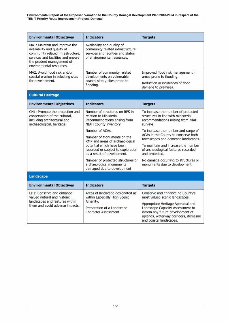
Environmental Report of the Proposed Variation to the County Donegal Development Plan 2018-2024 in respect of the TEN-T Priority Route Improvement Project, Donegal
150
Environmental Objectives Indicators Targets
MA1: Maintain and improve the availability and quality of community related infrastructure, services and facilities and ensure the prudent management of environmental resources.
Availability and quality of community related infrastructure, services and facilities and status of environmental resources.
MA2: Avoid flood risk and/or coastal erosion in selecting sites for development.
Number of community related developments on vulnerable coastal sites / sites prone to flooding.
Improved flood risk management in areas prone to flooding.
Reduction in incidences of flood damage to premises.
Cultural Heritage
Environmental Objectives Indicators Targets
CH1: Promote the protection and conservation of the cultural, including architectural and archaeological, heritage.
Number of structures on RPS in relation to Ministerial Recommendations arising from NIAH County inventory.
Number of ACAs.
Number of Monuments on the RMP and areas of archaeological
potential which have been recorded or subject to exploration as a result of development.
Number of protected structures or archaeological monuments damaged due to development
To increase the number of protected structures in line with ministerial recommendations arising from NIAH surveys.
To increase the number and range of ACAs in the County to conserve both townscapes and demesne landscapes.
To maintain and increase the number of archaeological features recorded and protected.
No damage occurring to structures or monuments due to development.
Landscape
Environmental Objectives Indicators Targets
LD1: Conserve and enhance valued natural and historic landscapes and features within them and avoid adverse impacts.
Areas of landscape designated as within Especially High Scenic Amenity.
Preparation of a Landscape Character Assessment.
Conserve and enhance he County’s most valued scenic landscapes.
Appropriate Heritage Appraisal and Landscape Capacity Assessment to inform any future development of uplands, waterway corridors, demesne and coastal landscapes.
Environmental Report of the Proposed Variation to the County Donegal Development Plan 2018-2024 in respect of the TEN-T Priority Route Improvement Project, Donegal
151
11 Conclusions
This document comprises the Environmental Report of the Proposed Variation to the County Donegal
Development Plan 2018-2024 in respect of the TEN-T PRIPD.
In carrying out the SEA Screening, Donegal County Council, determined in accordance with Article13K(2) of the Planning and Development Regulations 2001 (as amended), that the Proposed
Variation to the County Donegal Development Plan 2018-2024 in respect of the TEN-T Priority Route
Improvement Project, would be likely to have significant effects on the environment and that Strategic Environmental Assessment (SEA) is required of said Proposed Variation. These 33 no. proposed textual
amendments and 11 no. mapping amendments that comprise the Proposed Variation have been subjected to SEA as detailed in this report.
As discussed in Section 9, Stage 1 and 2 assessment of alternatives to the TEN-T PRIPD and alternative
routes, at the project level, concluded that the routes provided in this CDP Variation were the only
option that met the core objective of the TEN-T project for development of the TEN-T. Within this Environmental Report the two alternatives available were the Do Nothing – To continue to implement
the CDP as it stands or to implement the CDP Variation in respect of the TEN-T PRIPD. The assessment of these alternatives is provided in Section 7.2 and Section 9 of this Environmental Report. As it was
concluded in the option selection of the TEN-T PRIPD that the routes provided in the original County
Donegal Development Plan 2018-2024 could not achieve the core objective of the project, to continue to implement the CDP without the variation would then be in conflict with several of the CDP Objectives
and Policies which support the development of the TEN-T. Donegal County Council are therefore proposing the variation to support the TEN-T PRIPD, with amendment to Objectives, Policies and Maps
within the CDP. The full assessment of these proposed amendments is given in Section 7 of this
Environmental Report.
For reasons of clarity and consistency the Strategic Environmental Assessment of the Proposed Variation follows the same process as set out in Section 8.2 and Table 8.4 of Part D: The Environmental
Report of the Donegal CDP 2018-2024. Each amendment to an Objective, Policy, text change or mapping change was examined and an assessment was made as to whether or not the proposed
variation shall have an effect (as set out in Table 7.1) on each Strategic Environmental Objective (SEO)
(as set out in Table 7.2). These SEOs were derived from Environmental Protection Objectives (EPOs), established at international, European Union or national level, which are relevant to the Plan. Section
2.3, Section 6 and Appendix B of this Environmental Report further demonstrate how the EPOs of higher level plans and programmes have informed the development of the SEOs used in the
environmental assessment of this Proposed Variation.
The assessment of the amendments contained within Table 7.3 and Table 7.4 indicate the following:
A number of amendments comprising the Proposed Variation to the County Donegal Development Plan in respect of the TEN-T PRIPD have been identified as having a potential conflict with the Strategic Environmental Objectives of the County Donegal Development Plan 2018-2024; where this arises the Objectives and Policies should be mitigated to an acceptable level;
The impact of some objectives and policies may be uncertain;
Where the Proposed Variations has been identified as having potential impact on SEOs and/or uncertain interaction with SEOs, mitigation measures have been proposed. The County Donegal Development
Plan 2018-2024 provides Plan level mitigation through the adoption of environmental objectives and
policies.
General and road scheme specific environmental mitigation measures have also been recommended, which can be utilised at the next stages of design and development of the TEN-T PRIPD. The principal

Environmental Report of the Proposed Variation to the County Donegal Development Plan 2018-2024 in respect of the TEN-T Priority Route Improvement Project, Donegal
152
mitigation recommendation is that at a project-specific level the predicted negative effects should be
considered further during the detailed planning and design of the TEN-T PRIPD, when the specifics of
the options can be optimised through detailed feasibility studies and design in order to limit the potential impacts on sensitive receptors. The TEN-T PRIPD will be subject to an application to ABP and
will require AA and EIA. The project will be subject to ABP being satisfied that the project complies with relevant national and European legislation as transposed in to Irish Law.
The document entitled ‘Proposed Variation to the County Donegal Development Plan 2018-2024 in respect of the TEN-T Priority Route Improvement Project, Donegal (Variation No. 1)’, along with this
Environmental Report, the Natura Impact Report, and the Strategic Flood Risk Assessment of the Proposed Variation shall be made available for public consultation. The public will be invited to make
submissions as part of this public consultation process.

Environmental Report of the Proposed Variation to the County Donegal Development Plan 2018-2024 in respect of the TEN-T Priority Route Improvement Project, Donegal
153
12 Non-Technical Summary
12.1 Introduction
This is a Non-Technical Summary of the Environmental Report of the Proposed Variation to the County Donegal Development Plan (CDP) 2018-2024 in respect of the TEN-T Priority Route Improvement
Project, Donegal (TEN-T PRIPD). The TEN-T is a selection of strategic transport corridors throughout
the European Union (EU) that have been identified to play a key role in the mobility of goods and passengers through the EU. Three sections of the TEN-T strategic road network in Donegal have been
identified and prioritised for improvement and together they form the TEN-T PRIPD. These sections are also prioritised within the National Planning Framework, Project Ireland 2040, and the National
Development Plan 2018-2027. These sections are:
Section 1 (N15/N13 Ballybofey / Stranorlar Urban Region);
Section 2 (N56/N13 Letterkenny to Manorcunningham);
Section 3 (N14 Manorcunningham to Lifford / Strabane / A5 Link).
This Environmental Report outlines the environmental assessment of the Proposed Variation and
identifies mitigation, where required.
In carrying out the SEA Screening, Donegal County Council, determined in accordance with Article13K(2) of the Planning and Development Regulations 2001 (as amended), that the Proposed
Variation would be likely to have significant effects on the environment and that SEA was required. This
Environmental Report is the primary element in the SEA process and shall be published alongside the proposed Variation to the Donegal CDP 2018-2024 in respect of the TEN-T PRIPD.
12.2 Proposed Variation to the CDP
In order to progress through Phase 3 and Phase 4 of the TEN-T PRIPD, the Preferred Option Corridors
identified in Phase 2 of the project must be put on a statutory basis within the Donegal CDP 2018-2024.
This involves varying this Plan in accordance with Section 13 of the Planning and Development Act 2000 (as amended), in order to ensure that the overall project and, in particular, the preferred Option
Corridors (as identified through the Option Selection process), are fully integrated into, and compatible with, this Plan. This gives rise to the Proposed Variation to the CDP 2018-2024 in respect of the
Proposed TEN-T Priority Route Improvement Project, September 2020.
The Proposed Variation specifically:
Reserves and protects the TEN-T PRIPD preferred Option Corridors by inserting new mapping and
amending associated objectives and policies (e.g. T-O-1, T-P-1) and removes the corresponding
historical route corridors.
Provides the necessary strategic support for the project by inserting new text, objectives and
policies (e.g. S-O-11 and text within Chapter 5 Infrastructure).
Ensures compatibility between the Plan and the project by amending existing objectives and
policies (e.g. those related to railway corridors, built and archaeological heritage) and creating new project compatible zonings in Letterkenny and Ballybofey/Stranorlar.
Amends some minor transport related matters in the Plan.
Environmental Report of the Proposed Variation to the County Donegal Development Plan 2018-2024 in respect of the TEN-T Priority Route Improvement Project, Donegal
154
12.3 Relationship with Other Plans and Programmes
The relationship with other relevant plans are summarised in Section 2.3 of this Environmental Report.
Plans and Programmes established at international, EU and national level, their Environmental Protection Objectives (EPOs), and how these plans and programmes have informed the development of
the Strategic Environmental Objectives (SEOs) used in the environmental assessment of the CDP and this proposed variation are identified in Section 6 and Appendix B.
12.4 Relevant Aspects of the Current State of the Environment
This section of the Environmental Report describes the relevant aspects of the current state of the environment within the study area of the Proposed Variation. The baseline environmental information of
relevance is presented in Sections 3.1 to 3.10 and provides the environmental context for the Proposed
Variation.
The current state of the environment of the Proposed Variation is considered under the environmental
headings as outlined in the SEA Directive, as follows:
Biodiversity, Fauna and Flora
Population
Human Health
Soil and Geology
Water
Climate Change and Air Quality
Climate Change, Marine and Coastal Management
Noise
Material Assets
Cultural, Archaeological and Architectural heritage
Landscape and Visual
12.5 Likely Evolution of the Environment Without Implementation of the Proposed Variation
The SEA Directive requires the consideration of the likely evolution of the environment in the absence of the implementation of the Proposed Variation. In the absence of the Proposed Variation the Donegal
CDP 2018-2024 would remain in its current form. As outlined in Section 9, the historical TEN-T routes in the current CDP were not identified as the preferred options. These routes were discounted at the
Option Selection stage of the current TEN-T PRIPD as they scored less favourably than other options in
the multi-criteria analysis. Therefore, if the CDP were to remain unchanged, the TEN-T routes currently contained in the CDP would either be constructed at a much greater adverse impact or, alternatively,
there would be no development of the TEN-T under the current CDP.
Section 3.11 of this Environmental Report outlines the likely evolution of the environment if the Proposed Variation is not adopted.

Environmental Report of the Proposed Variation to the County Donegal Development Plan 2018-2024 in respect of the TEN-T Priority Route Improvement Project, Donegal
155
12.6 Environmental Characteristics of the Areas Likely to be Significantly Affected by the Proposed Variation
Section 4 of the Environmental Report establishes the environmental characteristics of the area likely to be significantly affected by the Proposed Variation, by environmental topic. These include designated
European Sites, ecological corridors, WFD designated watercourses, areas sensitive to noise and air
pollution, areas and features of heritage value, and areas of high scenic amenity.
12.7 Existing Environmental Problems of Relevance to the Proposed Variation
Section 5 of the Environmental Report establishes the existing environmental problems relevant to the Proposed Variation and the TEN-T PRIPD, by environmental topic. These include the status and
condition of designated European sites, numbers of aquatic and terrestrial invasive alien species, pressures associated with development and population increase, waterbody status, air quality, levels of
residential and commercial vacancy, and potentially sensitive heritage features and sensitive
landscapes.
12.8 Environmental Protection Objectives of Relevance to the Proposed Variation
The Environmental Report identifies a diverse range of Environmental Protection Objectives established at International, European Union and national level which are relevant to the proposed variation and
detailed the way those EPOs were taken into account during the preparation of the Proposed Variation. In many cases there is significant overlap between different EPO’s for the same environmental criteria.
In turn these EPOs have directly informed, and formed the basis of, consolidated Strategic
Environmental Objectives (SEOs) which are, in effect, the environmental test criteria used to assess the likely significant effects of the proposed variation on the various environmental aspects detailed in
Schedule 2B(f) of the Planning and Development Regulations (as amended). In this regard the consolidated SEOs combine the fundamental goal of a number of EPOs into single manageable
assessment criteria.
12.9 Assessment of Likely Significant Effects on the Environment of Implementing the Variation
For reasons of clarity and consistency the environmental assessment of the proposed Variation to the County Donegal Development Plan in respect of the TEN-T PRIPD follows the same process as set out
in Section 8.2 and Table 8.4 of Part D: The Environmental Report of the Donegal CDP 2018-2024, and
in accordance with the Planning and Development Regulations 2001 (as amended). Each amendment to an Objective, Policy, text change or mapping change in the proposed variation is examined in Section 7
and an assessment is made as to whether or not the proposed alteration shall have an effect on each SEO.
The environmental assessment of the 33 no. proposed textual amendments and 11 no. proposed mapping amendments included in the Proposed Variation to the County Donegal Development Plan
2018-2024 in respect of the TEN-T PRIPD are set out in Table 7.3 and Table 7.4, respectively. Where a potential conflict with the status of SEOs is found to be likely, proposed mitigation is set out in a row
below each assessment in Table 7.3 and Table 7.4.
Of the 33 no. proposed textual amendments to the Donegal County Development Plan comprising the
Proposed Variation, the assessment concluded that 24 no. had potential for conflict or uncertain interaction with the status of SEOs. The potential for conflict or uncertain interaction can be mitigated

Environmental Report of the Proposed Variation to the County Donegal Development Plan 2018-2024 in respect of the TEN-T Priority Route Improvement Project, Donegal
156
for by objectives and policies contained within the CDP that protect the environment by objectives and
policies contained within the CDP that protect the environment.
Of the 11 no. mapping amendments to the Donegal CDP comprising the proposed Variation, the
assessment concluded that 7 no. had potential for conflict or uncertain interaction with the status of SEOs. In all cases, these conflicts can be mitigated for by objectives and policies contained within the
CDP that protect the environment.
12.10 Measures Envisaged to Prevent, Reduce and as Fully as Possible Offset Any Significant Adverse Environmental Effects on the Environment of the Proposed Variation
Measures are required to prevent, reduce and as fully as possible offset any significant adverse effects on the environment as a result of implementation of the Proposed Variation. In the first instance,
mitigation was considered throughout the drafting of Objectives and Policies contained within the CDP, and also by amending, adding and replacing Objectives and Policies to ensure mitigation at
implementation stage through best practice in the development management process and
implementation of the Plan. In addition, it was stated that certain individual applications for developments within the County may be subject to individual Environmental Impact Assessments (EIA)
and Appropriate Assessment processes.
Section 8 of this Environmental Report provides further detail on measures to prevent, reduce and as fully as possible offset any significant adverse effects on the environment as a result of implementation
of the Proposed Variation for any potential impacts identified in Section 7. Project level and road
scheme specific measures have been recommended, which can be utilised at the next stages of design and development of the TEN-T PRIPD. The principal mitigation recommendation is that at a project-
level the predicted negative effects should be considered further during the detailed planning and design of the TEN-T PRIPD, when the specifics of the options can be optimised through detailed studies
and design in order to prevent, reduce and as fully as possible offset any significant adverse effects on
the environment. The TEN-T PRIPD will be subject to an application to ABP and will require AA and EIA. The project will be subject to ABP being satisfied that the project complies with various directives.
12.11 Selection of Alternatives to the Proposed Variation
Sections 7.2 and Section 9 set out both strategic and project level alternatives to the Proposed Variation There were two strategic alternative scenarios that could be considered for this CDP Variation:
Alternative No.1: Do-Nothing Approach or continuation of the existing County Donegal Development Plan 2018-2024.
Alternative No.2: Implementation of the Variation comprising amendments to facilitate the TEN-T PRIPD.
A comparative assessment of the two alternatives shows that the primary difference between Alternative No. 1 and Alternative No.2 relates to the progression of the TEN-T strategic road network
within the Plan area. If the Proposed Variation is not adopted, the TEN-T PRIPD and associated preferred Option Corridors would not be incorporated into the Donegal CDP. There would be no
changes to the TEN-T route corridor, as described in the CDP, to land zonings for Letterkenny and
Ballybofey/ Stranorlar and to other transport related matters in the CDP. The TEN-T routes in the current CDP were not identified as the preferred options during the option selection process, and
therefore there would be no development of the TEN-T under the current Plan. To continue to implement the CDP without the variation would then be in conflict with several of the CDP Objectives
and Policies which support the development of the TEN-T. Donegal County Council is therefore
proposing the variation to support the TEN-T PRIPD, with amendment to Objectives, policies and maps within the CDP.

Environmental Report of the Proposed Variation to the County Donegal Development Plan 2018-2024 in respect of the TEN-T Priority Route Improvement Project, Donegal
157
12.12 Monitoring of Significant Environmental Effects
Monitoring of the implementation of the Proposed Variation is required in order to properly consider the
effects of the implementation of the Proposed Variation and to highlight areas that need re-assessed and /or considered for review. It also establishes a ‘Baseline’ from which to carry out the statutory 2
year and 4 year reviews. Part of this monitoring shall be that required by the SEA process and shall be based on the Environmental Objectives, Indicators and Targets as set out in Section 8 of Part D:
Environmental Report of the CDP 2018-2024 and Section 10 of this Environmental Report.

A-1
Appendix A SEA Screening / Scoping Submissions

A-2
A-3

A-4

A-5

A-6

A-7
A-8

A-9

A-10

A-11

A-12

A-13
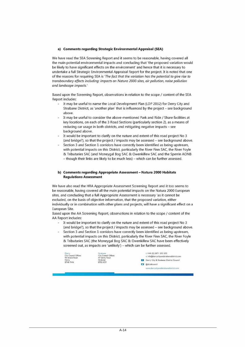
A-14

A-15

A-16

A-17

A-18

A-19

A-20

B-1
Appendix B Plans and Programmes

B-2
The Environmental Protection Objectives established at the International, European and National level which are relevant to the Proposed Variation are detailed
below in accordance with Schedule 2B of the Planning and Development Regulations 2001(as amended). How these Plans, Programmes, and Policies have informed the development of the SEOs used in the environmental assessment of the Proposed Variation are also provided.
Table B.1 Review of International Level Plans, Programmes, Policies and Legislation
Topic Title Summary of Objectives: International
How Plans, Programmes and
Policies have informed the
development of SEOs
Biodiversity
UN Convention on
Biological Diversity
(1992)
The Convention on Biological Diversity (CBD), known informally as the Biodiversity
Convention, is a multilateral treaty. The Convention has three main goals:
Conservation of biological diversity (or biodiversity);
Sustainable use of its components; and
Fair and equitable sharing of benefits arising from genetic resources.
In other words, its objective is to develop national strategies for the conservation and
sustainable use of biological diversity. It is often seen as the key document regarding
sustainable development. The Convention was opened for signature at the Earth
Summit in Rio de Janeiro on 5 June 1992 and entered into force on 29 December
1993.
Biodiversity, Flora and Fauna SEO BIO2
is derived in part from these
conventions, which aims to “Conserve
and enhance the diversity of habitats
and protected species and promote the
sustainable management of these areas
within the County”.
Material Assets SEO MA1 aims to
“ensure the prudent management of
environmental resources”.
CDP variation is obliged to comply with,
as relevant and appropriate, the
requirements of these Strategies and
Policies.
At the project stage, assessments
required to inform statutory EIA and AA
process for the TEN-T PRIPD will include
an assessment of the habitats and
species as per these conventions.
Ramsar Convention on
Wetlands of
International
Importance (1971 and
amendments 1982 and
1987)
Objectives include protection and conservation of wetlands, particularly those of
importance to waterfowl as Waterfowl Habitat.
Bern Convention
(Convention on
European Wildlife and
Natural Habitats) 1982
The Bern Convention is a binding international legal instrument in the field of nature
conservation, covering most of the natural heritage of the European continent and
extending to some States of Africa.

B-3
Topic Title Summary of Objectives: International
How Plans, Programmes and
Policies have informed the
development of SEOs
The Convention for the
Protection of the marine
Environment of the
North-East Atlantic
(OSPAR) (1992)
Objectives include international cooperation on the protection of the marine
environment of the north-east Atlantic.
Biodiversity, Flora and Fauna SEO BIO3
is derived in part from this convention,
which aims to “Protect the marine
environment within the County and
within a surrounding 15km buffer
including cross border linkages, or a
wider zone of influence where potential
impact is considered possible, and
promote integrated coastal zone
management strategies”.
Climate Change Paris Agreement
(UNFCCC, 2015)
The Paris Agreement central aim is to strengthen the global response to the threat of
climate change by keeping a global temperature rise this century well below 2 degrees
Celsius above pre-industrial levels and to pursue efforts to limit the temperature
increase even further to 1.5 degrees Celsius. Additionally, the agreement aims to
strengthen the ability of countries to deal with the impacts of climate change. To
reach these ambitious goals, appropriate financial flows, a new technology framework
and an enhanced capacity building framework will be put in place, thus supporting
action by developing countries and the most vulnerable countries, in line with their
own national objectives. The Agreement also provides for enhanced transparency of
action and support through a more robust transparency framework.
The Paris Agreement and the outcomes cover all the crucial areas identified as
essential for a landmark conclusion:
Mitigation – reducing emissions fast enough to achieve the temperature goal;
A transparency system and global stock-take – accounting for climate action;
Adaptation – strengthening ability of countries to deal with climate impacts;
Loss and damage – strengthening ability to recover from climate impacts; and
Support – including finance, for nations to build clean, resilient futures.
Air/Climatic Factors SEO AC2 and AC3
are derived in part from these
conventions, as follows:
AC2: Reduce all forms of air pollution.
AC3: Promote and support a shift from
fossil fuel dependent energy to more
sustainable energy. Promote and
support a shift from fossil fuel
dependant vehicles to more sustainable
modes of travel.
The climate change agreements will be
assessed, in combination with other
legislation and regulations, on the
provisions of the CDP variation.
The project stage TEN-T PRIPD should
aim to contribute towards climate
change mitigation and infrastructure to
be planned for and resilient to climatic
change.

B-4
Topic Title Summary of Objectives: International
How Plans, Programmes and
Policies have informed the
development of SEOs
Cultural Heritage
Convention for the
Protection of the
Archaeological Heritage
of Europe (revised)
(Valletta, 1992)
Objective is to protect the archaeological heritage as a source of the European
collective memory and as an instrument for historical and scientific study.
Cultural Heritage SEO CH1 sets out the
following for the protection of cultural
heritage: CH1: Promote the protection
and conservation of the cultural,
including architectural and
archaeological, heritage.
The CDP variation will consider
architectural heritage and ensure it is
protected from loss or damage resulting
from developmental infrastructure plans.
The project stage TEN-T PRIPD should
look to enhance architectural heritage
where possible.
Convention for the
Protection of the
Architectural Heritage of
Europe (Granada, 1985)
Objectives seek to provide a basis for protection of architectural heritage and are a
means for proclaiming conservation principles, including a definition of what is meant
by architectural heritage, such as monuments, groups of buildings and sites. The
Convention also seeks to define a European standard of protection for architectural
heritage and to create legal obligations that the signatories undertake to implement.
World Heritage
Convention United
Nations Convention
Concerning the
Protection of the World
Cultural and Natural
Heritage (Paris, 1972)
Objectives seek to ensure the identification, protection, conservation, presentation and
transmission to future generations of the cultural and natural heritage and ensure that
effective and active measures are taken for these.
Human Health/ Air
Quality
World Health
Organisation (WHO) Air
Quality Guidelines
(1999) (updated 2005)
and Guidelines for
Europe (1987)
Objectives seek the elimination or minimisation of certain airborne pollutants for the
protection of human health.
Human Health SEO HH1 and Air/Climatic
Factors SEO AC2 are derived in part
from these Conventions.
HH1: Minimise noise, vibration and
emissions from traffic, industrial
processes and extractive industry
AC2: Reduce all forms of air pollution.
The CDP variation is obliged to consider
the Human Health/ Air Quality
agreements, guidelines and protocols, in
combination with other legislation and
regulations, on the compliance of the
provisions of the CDP variation.
The Gothenburg
Protocol (1999)
The 1999 Gothenburg Protocol to Abate Acidification, Eutrophication and Ground-level
Ozone (known as the Multi-effect Protocol or the Gothenburg Protocol) is a multi-
pollutant protocol designed to reduce acidification, eutrophication and ground-level
ozone by setting emissions ceilings for sulphur dioxide, nitrogen oxides, volatile
organic compounds and ammonia to be met by 2010. As of August 2014, the Protocol
had been ratified by 26 parties, which includes 25 states and the European Union.

B-5
Review of European Level Plans, Programmes and Policies
Topic Title Summary of Objectives: European
How Plans, Programmes and
Policies have informed the
development of SEOs
Biodiversity
EU Biodiversity Strategy
to 2020 (COM(2011)
244)
The EU Biodiversity Strategy aims to prevent and eliminate the causes of biodiversity
loss and maintain and enhance current levels of biodiversity. The EU strategy has six
main targets which focus on: full implementation of EU nature legislation; better
protection for ecosystems and more use of green infrastructure; more sustainable
agriculture and forestry; more sustainable fisheries; tighter controls on invasive alien
species; and a greater contribution to averting global biodiversity loss. Key objectives:
To mainstream biodiversity in the decision making process across all sectors;
To substantially strengthen the knowledge base for conservation, management
and sustainable use of biodiversity;
To increase awareness and appreciation of biodiversity and ecosystems services;
To conserve and restore biodiversity and ecosystem services in the wider
countryside;
To conserve and restore biodiversity and ecosystem services in the marine
environment;
To expand and improve on the management of protected areas and legally
protected species; and
To substantially strengthen the effectiveness of international governance for
biodiversity and ecosystem services.
Biodiversity, Flora and Fauna SEOs BIO1,
BIO2, BIO3, and BIO4, are derived in
part from these conventions and which
aim to protect, conserve and restore
biodiversity within the County.
Material Assets SEO MA1 aims to “ensure
the prudent management of
environmental resources”.
The CDP variation should have regard for
this strategy and associated regulatory
framework for environmental protection
and management and look for
opportunities to conserve, and, where
possible, restore or enhance biodiversity.
Freshwater Fish
Directive (2006/44/EC)
Objectives seek to protect those fresh water bodies identified by Member States as
waters suitable for sustaining fish populations.
Water SEOs WR1 and WR2 are derived
in part from these conventions and which
aim to protect, conserve and restore
aquatic ecosystems within the County.
Material Assets SEO MA1 aims to “ensure
the prudent management of
environmental resources”.
The CDP variation is also obliged to
comply with, as relevant and appropriate,
the requirements of the Directive and
transposing Regulations.
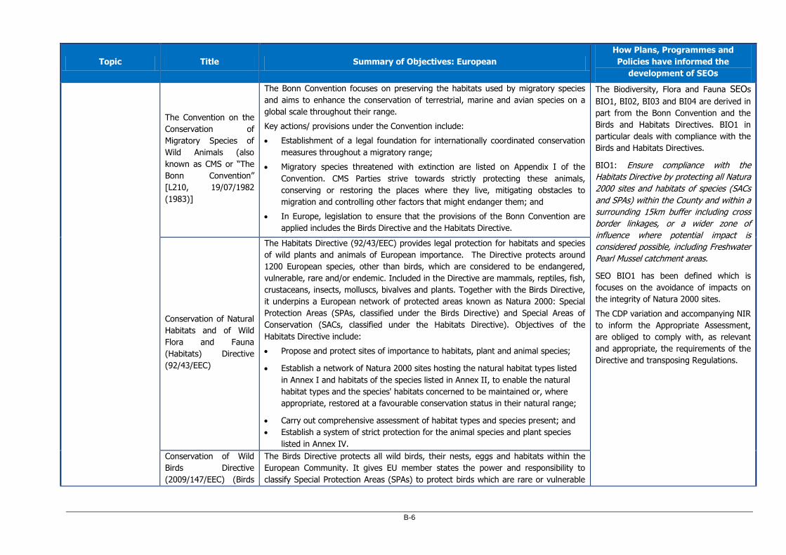
B-6
Topic Title Summary of Objectives: European
How Plans, Programmes and
Policies have informed the
development of SEOs
The Convention on the
Conservation of
Migratory Species of
Wild Animals (also
known as CMS or “The
Bonn Convention”
[L210, 19/07/1982
(1983)]
The Bonn Convention focuses on preserving the habitats used by migratory species
and aims to enhance the conservation of terrestrial, marine and avian species on a
global scale throughout their range.
Key actions/ provisions under the Convention include:
Establishment of a legal foundation for internationally coordinated conservation
measures throughout a migratory range;
Migratory species threatened with extinction are listed on Appendix I of the
Convention. CMS Parties strive towards strictly protecting these animals,
conserving or restoring the places where they live, mitigating obstacles to
migration and controlling other factors that might endanger them; and
In Europe, legislation to ensure that the provisions of the Bonn Convention are
applied includes the Birds Directive and the Habitats Directive.
The Biodiversity, Flora and Fauna SEOs
BIO1, BI02, BI03 and BI04 are derived in
part from the Bonn Convention and the
Birds and Habitats Directives. BIO1 in
particular deals with compliance with the
Birds and Habitats Directives.
BIO1: Ensure compliance with the
Habitats Directive by protecting all Natura
2000 sites and habitats of species (SACs
and SPAs) within the County and within a
surrounding 15km buffer including cross
border linkages, or a wider zone of
influence where potential impact is
considered possible, including Freshwater
Pearl Mussel catchment areas.
SEO BIO1 has been defined which is
focuses on the avoidance of impacts on
the integrity of Natura 2000 sites.
The CDP variation and accompanying NIR
to inform the Appropriate Assessment,
are obliged to comply with, as relevant
and appropriate, the requirements of the
Directive and transposing Regulations.
Conservation of Natural
Habitats and of Wild
Flora and Fauna
(Habitats) Directive
(92/43/EEC)
The Habitats Directive (92/43/EEC) provides legal protection for habitats and species
of wild plants and animals of European importance. The Directive protects around
1200 European species, other than birds, which are considered to be endangered,
vulnerable, rare and/or endemic. Included in the Directive are mammals, reptiles, fish,
crustaceans, insects, molluscs, bivalves and plants. Together with the Birds Directive,
it underpins a European network of protected areas known as Natura 2000: Special
Protection Areas (SPAs, classified under the Birds Directive) and Special Areas of
Conservation (SACs, classified under the Habitats Directive). Objectives of the
Habitats Directive include:
Propose and protect sites of importance to habitats, plant and animal species;
Establish a network of Natura 2000 sites hosting the natural habitat types listed
in Annex I and habitats of the species listed in Annex II, to enable the natural
habitat types and the species' habitats concerned to be maintained or, where
appropriate, restored at a favourable conservation status in their natural range;
Carry out comprehensive assessment of habitat types and species present; and
Establish a system of strict protection for the animal species and plant species
listed in Annex IV.
Conservation of Wild
Birds Directive
(2009/147/EEC) (Birds
The Birds Directive protects all wild birds, their nests, eggs and habitats within the
European Community. It gives EU member states the power and responsibility to
classify Special Protection Areas (SPAs) to protect birds which are rare or vulnerable

B-7
Topic Title Summary of Objectives: European
How Plans, Programmes and
Policies have informed the
development of SEOs
Directive) in Europe, as well as all migratory birds which are regular visitors.
Objectives seek to prevent and eliminate the causes of bird species loss and maintain
and enhance current levels of biodiversity;
Preserve, maintain or re-establish a sufficient diversity and area of habitats for all
the species of birds referred to in Annex I;
Preserve, maintain and establish biotopes and habitats to include the creation of
protected areas (Special Protection Areas);
Ensure the upkeep and management in accordance with the ecological needs of
habitats inside and outside the protected zones, re-stablish destroyed biotopes
and creation of biotopes;
Measures for regularly occurring migratory species not listed in Annex I is
required as regards their breeding, moulting and wintering areas and staging
posts along their migration routes; and
Ensuring the protection of wetlands and particularly wetlands of international
importance.
Human Health/Air
Quality/ Noise
EU Clean Air Package
(2013) & A Clean Air
Programme for Europe
(COM(2013) 918)
The clean air package aims to substantially reduce air pollution across the EU. The
proposed strategy sets out objectives for reducing the health and environmental
impacts of air pollution by 2030, and contains legislative proposals to implement
stricter standards for emissions and air pollution. The package was published by the
Commission on 18 December 2013, and consists of a communication on the 'clean air
programme for Europe', plus three legislative proposals on emissions and air pollution.
Human Health SEO HH1 and Air/Climatic
Factors SEO AC2 are derived in part from
these Directives.
The CDP variation should have regard to
the requirements of the programmes,
Directives and transposing regulations to
protect the human environment against
air pollution and to gradually reduce and
prevent air pollution, including long-
range transboundary air pollution.
Ambient Air Quality and
Cleaner Air for Europe
(CAFE) Directive
(2008/50/EC)
(Amended by Directive
2015/1480/EC) and
Fourth Daughter
Directive
(2004/107/EC)
The Ambient Air Quality and Cleaner Air for Europe (CAFE) Directive (2008/50/EC)
was published in May 2008. It replaced the Framework Directive and the first, second
and third Daughter Directives.
The CAFE Directive was transposed into Irish legislation by the Air Quality Standards
Regulations 2011 (S.I. No. 180 of 2011) amended by Air Quality Standards
(Amendment) S.I. No. 659/2016. It replaces the Air Quality Standards Regulations
2002 (S.I. No. 271 of 2002), the Ozone in Ambient Air Regulations 2004 (S.I. No. 53
of 2004) and S.I. No. 33 of 1999.
The fourth Daughter Directive was transposed into Irish legislation by the Arsenic,
Cadmium, Mercury, Nickel and Polycyclic Aromatic Hydrocarbons in Ambient Air
Regulations 2009 (S.I. No. 58 of 2009) as amended.
B-8
Topic Title Summary of Objectives: European
How Plans, Programmes and
Policies have informed the
development of SEOs
The 1979 Geneva
Convention on Long-
range Transboundary
Air Pollution (LRTAP)
The LRTAP was the first international legally binding instrument to deal with problems
of air pollution on a broad regional basis. It was signed in 1979 and entered into force
in 1983. It has since been extended by eight specific protocols. The Convention is one
of the central means for protecting our environment. It has substantially contributed
to the development of international environmental law and has created the essential
framework for controlling and reducing the damage to human health and the
environment caused by transboundary air pollution.
Environmental Noise
Directive (END)
(2002/49/EC)
Objectives seek to limit the harmful effects to human health from environmental
noise.
National Emissions
Ceiling Directive
(2016/2284/EU)
This Directive sets national reduction commitments for the five pollutants (sulphur
dioxide, nitrogen oxides, volatile organic compounds, ammonia and fine particulate
matter) The NECD sets national emission ceilings for four main pollutants, namely
that of sulphur dioxide (SO2), nitrogen oxides (NOx), volatile organic compounds
(VOCs) and ammonia (NH3). These pollutants are responsible for long-range
transboundary air pollution such as acidification, eutrophication and ground-level
ozone pollution. Data on these four pollutants are reported to the European
Commission under the National Emissions Ceiling Directive on an annual basis.
The CDP variation is obliged to comply
with, as relevant and appropriate, the
requirements of the Directive and
transposing regulations.
IPC/IED licenced industries should be
assessed cumulatively with the TEN-T
PRIPD at project stage during statutory
assessments
Sustainable
Development
Seventh Environmental
Action Programme to
2020 of the European
Community
Objectives seek to make the future development of the EU more sustainable. It
identifies three key objectives:
To protect, conserve and enhance the Union’s natural capital;
To turn the Union into a resource-efficient, green, and competitive low-carbon
economy; and
To safeguard the Union's citizens from environment-related pressures and risks
to health and wellbeing.
Two additional horizontal priority objectives complete the programme:
To make the Union's cities more sustainable; and
To help the Union address international environmental and climate challenges
more effectively.
SEOs for Population POP1 and POP1 are
derived in part from this Directive.
POP1: Facilitate a good quality of life
based on high-quality residential, working
and recreational environments.
POP2: Facilitate more sustainable
travel patterns.
Material Assets SEO MA1 aims to “ensure
the prudent management of
environmental resources”.
The overall aim of the CDP variation is to

B-9
Topic Title Summary of Objectives: European
How Plans, Programmes and
Policies have informed the
development of SEOs
EUROPE 2020 A
strategy for smart,
sustainable and
inclusive growth
(COM/2010/2020)
Europe 2020 is a 10-year strategy proposed by the European Commission on 3 March
2010 for advancement of the economy of the European Union. It aims at "smart,
sustainable, inclusive growth" with greater coordination of national and European
policy. It follows the Lisbon Strategy for the period 2000–2010.
be consistent with this Programme and
Strategy.
EU Sustainable
Development Strategy
(EU SDS)
The overarching sustainable development policy document in the EU. During the
2009 review the EU noted a number of unsustainable trends that require urgent
action including a decrease in high energy consumption in the transport sector in line
with the 2020 Strategy.
Innovating for
Sustainable Growth: A
Bio-economy for
Europe (EU, 2012)
Launched and adopted on 13 February 2012, Europe's Bio-economy Strategy
addresses the production of renewable biological resources and their conversion into
vital products and bio-energy. It aims to focus Europe's common efforts in the right
direction in this diverse and fast-changing part of the economy. Its main purpose is to
streamline existing policy approaches in this area. The Strategy is also needed to
ensure that fossil fuels are replaced with sustainable natural alternatives as part of
the shift to a post-petroleum society.
SEA Directive
(2001/42/EC)
This Directive requires that Plans & Programmes must take into account protection of
the environment and integration of the Plan into the sustainable planning of the
country as a whole. Eleven sectors are specified in the Directive and Competent
Authorities (Plan/ Programme makers) must subject specific Plans and Programmes
for these sectors to an environmental assessment where they are likely to have
significant effects on the environment. The SEA Directive was transposed into Irish
law under S.I. 435/2004, as amended in 2011.
The Directive sets in motion the process
of assessing the likely significant
environmental effects of implementing
the CDP variation before the plan is
adopted.
EIA Directive
(85/337/EEC), as
amended by Directive
97/11/EC, Directive
2011/92/EU & Directive
2014/52/EU
The Directive has been amended three times, in 1997, 2003 and 2009. The initial
Directive of 1985 and its three amendments have been codified by Directive
2011/92/EU of 13 December 2011. Directive 2011/92/EU has been amended in 2014
by Directive 2014/52/EU.
Under the Directive Member States are required to carry out Environmental Impact
Assessments (EIA) of certain public and private projects, before they are authorised,
where projects are likely to have a significant impact on the environment.
While no specific SEO has been derived
based on this Directive, the objectives
related to the protection of the
environment would be supportive of the
aims of the EIA Directive.
At project stage, the TEN-T PRIPD will be
assessed in accordance with the EIA
Directive and transposing Regulations, in
combination with other legislation by the
relevant competent authorities.

B-10
Topic Title Summary of Objectives: European
How Plans, Programmes and
Policies have informed the
development of SEOs
Environmental Liability
Directive (2004/35/EC)
as amended by
2005/21/EC,
2009/31/EC and
2013/30/EU) amended
by Regulation - (EU)
2019/1010]
The Directive was transposed onto Irish law under S.I. 547/2008. The objective is the
‘polluter pays’ principle wherein those whose activities have caused environmental
damage are held financially liable for remedying that damage; the legislation is
particularly aimed at impacts to water quality status under the Water Framework
Directive.
While no specific SEO has been derived
based on this Directive, the objectives
related to the protection of the
environment would be supportive of the
aims of the Environmental Liability
Directive.
The CDP variation will be obliged to
comply with the requirements of the
regulations and to prevent environmental
damage. Maintenance and construction
of transport infrastructure should aim to
avoid or minimise damage and to
enhance the wider environment.
Water
Water Framework
Directive (WFD)
(2000/60/EC) (as
amended by Decision
2455/2001/EC and
Directives 2008/32/EC,
2008/105/EC and
2009/31/EC
The following Directives
have been subsumed
into the Water
Framework Directive:
The Drinking Water
Abstraction
Directive;
The Sampling
Drinking Water
Directive;
The Exchange of
Information on
WFD objectives overall seek to maintain and enhance the quality and quantity of all
surface waters, i.e. rivers, estuaries, coasts and aquifers, in the EU and to prevent the
deterioration of aquatic ecosystems and associated wetlands by setting out a
timetable until 2027 to achieve good ecological status or potential. Member States are
required to manage the effects on the ecological quality of water which result from
changes to the physical characteristics of water bodies. Action is required in those
cases where these “hydro-morphological” pressures are having an ecological impact
which will interfere with the ability to achieve WFD objectives. The assessment of
potential impacts on water quality needs to be considered in the context of the WFD
and the River Basin Management Plan and Programme of Measures for the River
Basin districts which lays out the objectives for all waters within the individual district.
Key objectives of the WFD include:
Identification and establishment of individual river basin districts;
Preparation of individual river basin management plans for each of the
catchments. These contain the main issues for the water environment and
the actions needed to deal with them;
Establishment of a programme of monitoring water quality in each RBD; and
Establishment of a Register of Protected Areas (includes areas previously
designated under the Freshwater Fish and Shellfish Directives which have
SEOs for Water WR1, WR2, WR3 and
WR4 are derived in part from the WFD
Directive, which aims to protect,
conserve and restore water resources
within the County. WR1 deals specifically
with the WFD and River Basin
Management Plan.
Material Assets SEO MA1 aims to “ensure
the prudent management of
environmental resources”.
The CDP variation is also obliged to
comply with, as relevant and appropriate,
the requirements of the Directive and
transposing Regulations.
The CDP variation will consider the
requirements of the WFD and ensure that
it does not compromise its objectives,
and that it contributes to achieving its
aims.

B-11
Topic Title Summary of Objectives: European
How Plans, Programmes and
Policies have informed the
development of SEOs
Quality of Surface
Freshwater
Directive;
The Shellfish
Directive ;
The Freshwater
Fish Directive;
The Groundwater
(Dangerous
Substances)
Directive; and
The Dangerous
Substances
Directive.
become sites designated for the protection of economically significant
aquatic species under WFD and placed on the Protected Areas register).
Promotion of sustainable management of the water environment by carefully
considering current land use and future climate scenarios, minimising the effects of
flooding and drought events and facilitating long term improvements in water quality,
including the protection of groundwater near landfill sites, as well as minimising
agricultural runoff.
The CDP variation should have regard for
any implications on water quality.
Drinking Water
Directive (80/778/EEC)
as amended by
Directive 98/83/EC and
Directive (EU)
2015/1787
The primary objective is to protect the health of the consumers in the European Union
and to make sure drinking water is wholesome and clean.

B-12
Topic Title Summary of Objectives: European
How Plans, Programmes and
Policies have informed the
development of SEOs
Marine Strategy
Framework Directive
(MSFD) (2008/56/EC)
The aims of the MSFD are to protect the marine environment across Europe through
achieving and maintaining good environmental status of marine waters by 2020, and
acts as complimentary legislation to the WFD. To achieve this goal the directive has
set out marine regions; Ireland falls within the North-east Atlantic Ocean Region and
for the purposes of the MSFD Ireland is required to produce a Maritime Spatial Plan
(MSP), preparation of which is underway and required on or before March 2021 at the
latest. The first phase of work and public consultation has been completed and
involved the assessment and characterisation of Ireland’s marine waters. The draft
Marine Strategy Framework Programme of Measures has been prepared and the next
phase will involve the eventual implementation of environmental targets. The MSP will
ensure there is a system in place for managing human activities and to achieve and
maintain good environmental status of marine waters.
Biodiversity, Flora and Fauna SEO BIO3
is derived in part from this Directive,
which aims to “Protect the marine
environment within the County and
within a surrounding 15km buffer
including cross border linkages, or a
wider zone of influence where potential
impact is considered possible, and
promote integrated coastal zone
management strategies”.
The potential implications CDP variation
on the environmental status of marine
waters will be considered.
Floods Directive
(2007/60/EC)
The Floods Directive applies to river basins and coastal areas at risk of flooding. It
basically prescribes a three-step procedure for the assessment and management of
flood risks: First step: Preliminary Flood Risk Assessment; Second step: Risk
Assessment; and Third step: Flood Risk Management Plans.
Water SEO WR5 and Material Assets SEO
MA2 aim to contribute to the
management of flood risk in line with the
Floods Directive.
Bathing Water Directive
(2006/7/EC)
The overall objective of the revised directive remains the protection of public health
whilst bathing, but it also offers an opportunity to improve management practices at
bathing waters and to standardise the information provided to bathers across Europe.
Bathing waters are an important resource and it is therefore essential that the
standards within the Bathing Water Directive are adhered to. The Directive was
transposed onto Irish law under the Bathing Water (Amendment) Regulations S.I.
79/2008.
The SEO for Water, WR2, aims to
protect the quality of surface water
assets for amenity. CDP variation is
obliged to comply with, as relevant and
appropriate, the requirements of the
Directive and transposing Regulations.

B-13
Topic Title Summary of Objectives: European
How Plans, Programmes and
Policies have informed the
development of SEOs
Groundwater Directive
(2006/118/EC)
Objectives seek to maintain and enhance the quality of all groundwaters in the EU.
The Environmental Objectives (Groundwater) Regulations S.I. 9/2010 was transposed
into Irish Law and gives effect to the Groundwater Directive
While no specific SEO has been derived
based on the Groundwater Directive, the
SEOs related to the protection of Water
would be supportive of the aims of this
Directive.
CDP variation is obliged to comply with,
as relevant and appropriate, the
requirements of the Directive and
transposing Regulations.
The CDP variation should, where
possible, contribute to the protection of
groundwater from point source and
diffuse pollution that could be caused or
exacerbated by road project.
Waste
Waste Framework
Directive (2008/98/EC)
The directive sets out the definitions of waste and basic management principles for
waste in order to ensure waste is managed so as to not impact the environment or
human health. The Directive lays down some basic waste management principles: it
requires that waste be managed without endangering human health and harming the
environment, and in particular without risk to water, air, soil, plants or animals,
without causing a nuisance through noise or odours, and without adversely affecting
the countryside or places of special interest. The Directive requires that waste
legislation and policy of EU Member States is applied according to a waste
management hierarchy.
The Soil (Including Minerals) SEO SL4,
deals specifically with waste as follows:
SL4: Minimise the amount of waste to
landfill
Material Assets SEO MA1 aims to “ensure
the prudent management of
environmental resources”.
The CDP variation should consider the
implications of this Directive with the
development of the CDP variation which
is likely to result in waste being
generated.
CDP variation is obliged to comply with,
as relevant and appropriate, the
requirements of the Directive and
transposing Regulations.
EU Circular Economy
Strategy (2015)
The European Commission adopted an ambitious Circular Economy Package, which
includes revised legislative proposals on waste to stimulate Europe's transition
towards a circular economy which will boost global competitiveness, foster sustainable
economic growth and generate new jobs.
The Circular Economy Package consists of an EU Action Plan for the Circular Economy
that establishes a concrete and ambitious programme of action, with measures
covering the whole cycle: from production and consumption to waste management
and the market for secondary raw materials. The annex to the action plan sets out
the timeline when the actions will be completed. The proposed actions will contribute

B-14
Topic Title Summary of Objectives: European
How Plans, Programmes and
Policies have informed the
development of SEOs
to "closing the loop" of product lifecycles through greater recycling and re-use, and
bring benefits for both the environment and the economy.
Climate/ Energy
The EU 20-20-20
Climate and Energy
Package Agreement
(2007)
The climate and energy package is a set of binding legislation which aims to ensure
the European Union meets its ambitious climate and energy targets for 2020. The
targets were set by EU leaders in March 2007, when they committed Europe to
become a highly energy-efficient, low carbon economy, and were enacted through the
climate and energy package in 2009. These targets, known as the "20-20-20"
targets, set three key objectives for 2020:
A 20% reduction in EU greenhouse gas emissions from 1990 levels;
Raising the share of EU energy consumption produced from renewable resources
to 20%; and
A 20% improvement in the EU's energy efficiency.
These targets represent an important first step towards building a low-carbon
economy. They are also headline targets of the Europe 2020 strategy for smart,
sustainable and inclusive growth. This recognises that tackling climate and energy
challenge contributes to the creation of jobs, the generation of "green" growth and a
strengthening of Europe's competitiveness. In relation to reductions in GHG
emissions, the 2009 Effort Sharing Decision (Decision No. 406/2009/EU) set individual
Member State targets for reductions in non-ETS GHG emissions. The two main
directives which set about achieving this target are the Energy Efficiency Directive
(2012/27/EC (Amended by Energy Performance of Buildings Directive (EU) 2018/844
of the European Parliament and of the Council of 30 May 2018), transposed into Irish
law by the Energy Efficiency Obligation Scheme Regulations 2014 S.I. 131/2014) and
the Renewable Energy Sources (RES) Directive (2009/28/EC, transposed into Irish law
by the Renewable Energy Regulations S.I. 147/2011).
Air/Climatic Factors SEO AC2 and AC3 are
derived in part from these agreements,
strategies and frameworks, as follows:
AC2: Reduce all forms of air pollution.
AC3: Promote and support a shift from
fossil fuel dependent energy to more
sustainable energy. Promote and support
a shift from fossil fuel dependant vehicles
to more sustainable modes of travel.
Material Assets SEO MA1 aims to “ensure
the prudent management of
environmental resources”.
The climate change agreements and
protocols will be assessed, in combination
with other legislation and regulations, on
the provisions of the CDP variation.
The CDP variation should aim to
contribute towards climate change
mitigation and infrastructure to be
planned for and resilient to climatic
change.
The EU Policy
Framework for Climate
and Energy in the
period from 2020 to
2030
Sets targets for the period 2020 to 2030:
Target of 27% renewable energy in the EU;
Increase energy efficiency by 27% by 2020; and
Reaching electricity interconnection target of 15% between EU countries by
2030.
EU Strategy on The strategy was adopted by the EC in April 2013. It outlines the measures for taking

B-15
Topic Title Summary of Objectives: European
How Plans, Programmes and
Policies have informed the
development of SEOs
Adaptation to Climate
Change 2013
climate change preparedness to a new level. The strategy has three main objectives:
Promote climate action in Member States through encouraging the adoption of
adaptation strategies;
The promotion of informed decision-making through addressing knowledge gaps
and the development of the European Climate Adaptation Platform for better
knowledge dissemination; and
Promoting adaptation in key vulnerable sectors.
Second European
Climate Change
Programme (ECCP II)
2005
The objectives seek to develop the necessary elements of a strategy to implement the
Kyoto Protocol.
Directive (UE)
2015/1513 amending
Directives 98/70/CE
and 2009/28/CE -
Regarding the
promotion of renewable
energy usage
The Directive (EU) 2015/1513 of the European Parliament and of the Council of
September 9th 2015 was issued, amending Directive 98/70/EC relating to the quality
of petrol and diesel fuels and amending Directive 2009/28/EC on the promotion of the
use of energy from renewable sources. Member States shall bring into force the laws,
regulations and administrative provisions necessary to comply with this Directive by
10 September 2017.
EU Transport
Greenhouse Gas:
Routes to 2050 (2010)
This was a 15-month project funded by the European Commission's DG Climate Action
that started in January 2011 and was completed in July 2012. The context of the
project was the Commission's long-term objective for tackling climate change.
Landscape European Landscape
Convention, 2000
The Convention’s purpose is to promote landscape protection, management and
planning of European landscapes and to organise European co-operation on
landscape issues. It is the first international treaty to be exclusively concerned with
protection, management and enhancement of European landscape. It is extremely
wide in scope: the Convention applies to the Parties’ entire territory and covers
natural, rural, urban and rural-urban transitional areas, also including land, inland
water and marine areas. The Convention covers every-day or degraded landscapes as
well as those that can be considered outstanding i.e. recognition of the importance of
all landscape types.
The Convention incorporates a number of measures which are to be undertaken to
put into effect at national level General Measures, including:
The Landscape SEO LD1 is derived in
part from this convention.
LD1: Conserve and enhance valued
natural, historic and cultural landscapes
and features within them and avoid
adverse impacts.
CDP variation will comply with, as
relevant and appropriate, the
requirements of this Convention.

B-16
Topic Title Summary of Objectives: European
How Plans, Programmes and
Policies have informed the
development of SEOs
To recognise landscapes in law as being an essential component of people’s
surroundings;
The establishment and implementation of policies which aim to protect
landscapes, and to inform landscape management and planning considerations;
To better incorporate the public, local and regional authorities as well as
other organisations in defining and implementing landscape policies; and
The integration of landscape into local and regional planning policies that
have possible direct or indirect impacts on the landscape.
Review of National Level Plans, Programmes, Policies and Legislation
Topic Title Summary of Objectives: National How Plans, Programmes and Policies
have informed the development of SEOs
Biodiversity
European Communities
(Birds and Natural
Habitats) Regulations
2011 (S.I. 477 of 2011)
as amended by S.I. 355
of 2015
These Regulations give effect to Council Directive 92/43/EEC on the conservation of
natural habitats and of wild fauna and flora (Habitats Directive) and the Minister to
designate special areas of conservation (endangered species and habitats of
endangered species) as a contribution to an EU Community network to be known as
NATURA 2000. See EU Habitats Directive.
Regulation 42 deals with the control of non-native invasive species.
Biodiversity, Flora and Fauna SEOs BIO1,
BIO2, BIO3, and BIO4 are derived in part
from the national biodiversity and wildlife
Plans, Orders and Regulations, which aim to
protect, conserve and restore biodiversity
within the County.
The CDP variation should have regard for
national plans and associated regulatory
framework for environmental protection and
management and look for opportunities to
support the aims of such plans and
regulations to conserve, and, where possible,
restore or enhance biodiversity as part of the
CDP variation.
Wildlife Acts 1976 – 2020
(as amended)
The purpose of the Wildlife Acts 1976-2020 is to provide for the protection of wildlife
(both flora and fauna) and the control of activities, which may impact adversely on the
conservation of wildlife.
Flora Protection Order
2015
Objectives are to protect listed flora and their habitats from alteration, damage or
interference in any way. This protection applies wherever the plants are found and is
not confined to sites designated for nature conservation.
National Biodiversity
Action Plan 2017 – 2021
In response to the requirements set out in Article 6 of the UN Convention of Biological
Diversity 1992, the first Biodiversity Action Plan (BAP) was prepared by the Department
of Arts, Heritage and the Gaeltacht, subsequently revised in 2011. The aims are to
achieve Ireland’s Vision for Biodiversity through addressing issues ranging from
improving the management of protected areas to increasing awareness and
appreciation of biodiversity and ecosystem services. Ireland’s third iteration of the BAP
B-17
Topic Title Summary of Objectives: National How Plans, Programmes and Policies
have informed the development of SEOs
for conserving and restoring Ireland’s biodiversity covers the period 2017 to 2021.
All Ireland Pollinator Plan
2015-2020
Ireland has developed a strategy to address pollinator decline and protect pollinator
service. A total of 81 actions have been identified in order to achieve this. It is about
raising awareness about pollinators and how to protect them.
NPWS Conservation Plans
for SACs and SPAs and
NHAs
The NPWS produces a draft conservation plan for each SAC, SPA and NHA. Each plan
lists the wildlife resources of the area, the current human uses, any conflicts between
the two, and strategies for retaining the conservation value. These documents are
made available on the NPWS website and to interested parties for a consultation
period, following which the final version of the conservation plan is completed. It is
intended that plans will be reviewed every 5 years. It is expected that these plans will
be consulted/referenced during the preparation of farm management plans for holdings
within and nearby the nature conservation site.
National Peatland
Strategy (DAHG, 2015)
and
National Peatlands
Strategy Progress Report
2017 (DCHG, 2018)
In April 2011 the Government made a number of key decisions relating to the
conservation and management of Ireland’s peatlands, particularly those sites
nominated for designation as Special Areas of Conservation and Natural Heritage
Areas. A commitment was made to draw up a national strategy on peatlands
conservation and management, in cconsultation with bog owners and other
stakeholders, to deal with long-term issues such as land management & development,
restoration, conservation, tourism potential, carbon accounting and community
participation in managing this resource.
In order to ensure that actions are implemented, the Peatlands Strategy
Implementation Group (PSIG) was established, which comprises a cross-departmental
group to monitor the strategy’s implementation. The group published its progress
report in August 2018.
Quality of Salmonid
Waters Regulations 1988
(S.I. 293/1988)
Prescribe quality standards for salmonid waters and designate the waters to which they
apply, together with the sampling programmes and the methods of analysis and
inspection to be used by local authorities to determine compliance with the standards.
Also, give effect to Council Directive No. 78/659/EEC on the quality of fresh waters
needing protection or improvement in order to support fish life. See EU Water
Framework Directive.
Water SEOs WR1 and WR 2 are derived in
part from these Regulations which aim to
protect, conserve and restore aquatic
ecosystems within the County.
The CDP variation is also obliged to comply
with, as relevant, the requirements of the
Regulations.
B-18
Topic Title Summary of Objectives: National How Plans, Programmes and Policies
have informed the development of SEOs
Fisheries Natura Plans &
Declarations made under
European Union (Birds
and Natural Habitats)
(Sea-fisheries)
Regulations 2013 (as
amended by S.I. 565 of
2014)
Sea-fisheries are in Natura 2000 areas are regulated in accordance with:
The European Communities (Birds and natural Habitats) Regulations 2011
(S.I. 477/2011); and
The European Union (Birds and Natural Habitats) (Sea-fisheries) Regulations
2013 (S.I. 290/2013).
These two sets of Regulations transpose into Irish law the obligations on the Minister
with regard to sea-fisheries arising from the EU Habitats and Birds Directives.
Regulation 27 of SI 477 of 2011 places legal obligations on the Minister for Agriculture
Food and the Marine in relation to his functions. These obligations transpose article 6.2
of the Habitats Directive and in short require the Minister to manage sea-fisheries to
ensure that significant impacts on designated habitats and species are avoided.
Regulation 42 of S.I. 477/2011 places legal obligations on the Minister for Agriculture
Food and the Marine in consenting to or adopting a plan or project that may have
significant impacts on a Natura 2000 site. These obligations transpose article 6.3 of the
Habitats Directive. In short, the Minister is required to conduct a screening for
appropriate assessment before consenting to or adopting the plan or project. On the
basis of that screening assessment, the Minister must determine if an appropriate
assessment is required. He must conclude that it is required where he cannot exclude
significant impacts based on objective scientific information. The Minister may only
consent to a plan or project or adopt or implement the plan or project where he has
determined that it will not affect the integrity of the Natura 2000 site.
Biodiversity, Flora and Fauna SEO BIO3 is
derived in part from these Regulations, which
aims to protect the marine environment and
transboundary influences.
The CDP variation is also obliged to comply
with, as relevant, the requirements of the
Regulations.
Population/
Human Health
Healthy Ireland – a
Framework for Improved
Health and Wellbeing
2015-2025
The main aims of Healthy Ireland are: to increase the numbers of people experiencing
good health (mental and physical) at all life stages; reduce health inequalities with a
focus on social factors; protect the public and increase preparedness for threats to
public health; and to encourage every individual and society as a whole to
collaboratively engage with its own health and wellbeing. The first Implementation
Plan has been published covering 2015-2017.
Human Health SEO HH1 is derived in part
from these framework.
The CDP variation is obliged to comply with,
as relevant and appropriate, the aims of this
framework.
Classified Shellfish
Production Areas under
Regulation (EC) No.
85412004
Shellfish areas which are classified by the Sea-Fisheries Protection Authority for food
safety and consumer protection purposes
Biodiversity, Flora and Fauna SEO BIO3 is
derived in part from these Regulations, which
aims to protect the marine environment and
transboundary influences.
The CDP variation is also obliged to comply
with, as relevant, the requirements of the

B-19
Topic Title Summary of Objectives: National How Plans, Programmes and Policies
have informed the development of SEOs
Regulations and have regard for any
implications on water quality.
Climate/
Energy
Climate Action and Low
Carbon Development
(Amendment) Bill 2020
The National Policy Position establishes the fundamental national objective of achieving
transition to a competitive, low carbon, climate-resilient and environmentally economy
by 2050. It sets out the context for the objective, clarifies the level of GHG mitigation
ambition envisaged and establishes the process to pursue and achieve the overall
objective.
Air/Climatic Factors SEOs AC2 and AC3 are
derived in part from the Climate Bills,
Strategies and Frameworks.
The climate change agreements and protocols
will be assessed, in combination with other
legislation and regulations, on the provisions
of the CDP variation.
The CDP variation should aim to contribute
towards climate change mitigation and
infrastructure to be planned for and resilient
to climatic change.
The target for transport under the Climate
Action Plan will be given careful consideration
as part of the CDP variation
National Climate Change
Adaptation Framework
2012
Sets out how Ireland is to meet its adaptation objectives under the Kyoto Protocol. The
Strategy sits within the National Climate Change Adaptation Framework which provides
the policy context for the national response to achieving the objectives in a strategic
manner. The Framework also requires Local Authorities, relevant agencies and
Government Departments to prepare and publish draft adaptation plans.
With the establishment of the Climate Action and Low Carbon Development Act 2015,
there is now a statutory basis on which National Climate Change Adaptation
Frameworks and Sectoral Adaptation Plans are to be established. It is expected that
the National Climate Change Adaptation Framework will be finalised in late 2017
followed by the development of sectoral adaptation plans.
National Climate Change
Strategy 2007-2012
In 2007, the Government published the National Climate Change Strategy 2007-2012,
which set out a range of measures, building on those already in place under the 2000
Strategy, to meet Ireland's commitments under the Kyoto Protocol.
The Strategy projected a reduction in emissions from the agricultural sector through a
number of measures including Common Agricultural Policy Reforms, participation in
REPS, AEOS and Organic Schemes, supports for management of manure in line with
the EU Nitrates Directive, supports for afforestation, and through development of
renewable energy resources.
Climate Action Plan 2019
The Climate Action Plan 2019 is Ireland's all of Government Plan to tackle climate break
down and achieve net zero greenhouse gas emissions by 2050. The full report contains
183 actions to ensure Ireland meets its targets.
In 2017, transport accounted for 19.8% of Ireland's greenhouse gases. The Climate
Action Plan tries to arrest those concerns and emphasises the need for acceleration in
the use of electric vehicles (EVs) and the electrification of transport more generally. In
order to meet its emission reduction goals by 2030, the government has targeted an
increase in the number of EVs to 936,000. The targets for Transport are as follows:

B-20
Topic Title Summary of Objectives: National How Plans, Programmes and Policies
have informed the development of SEOs
Reduce CO2 eq. emissions from the sector by 45–50% relative to 2030 pre-NDP
projections
Increase the number of EVs to 936,000, comprised of:
o 840,000 passenger EVs
o 95,000 electric vans and trucks
o 1,200 electric buses
Build the EV charging network to support the growth of EVs at the rate required,
and develop our fast-charging infrastructure to stay ahead of demand
Require at least one recharging point in new non-residential buildings with more
than 10 parking spaces
Raise the blend proportion of biofuels in road transport to 10% in petrol and 12%
in diesel
Planning
Project Ireland 2040 Our
Plan: The National
Planning Framework and
National Development
Plan 2018 – 2027
Project Ireland 2040 is the governments overarching strategy for Ireland. The National
Development Plan (NDP) and the National Planning Framework (NPF) combine to form
Project Ireland 2040. The NPF sets the vision and strategy for the development of our
country to 2040 and the National Development Plan (NDP) provides enabling
investment to implement the strategy to 2027. The National Planning Framework is a
long-term, 20 year strategy for the spatial development of Ireland that will promote a
better quality of life for all, with sustainable economic growth and an environment of
the highest quality as key underlying principles. A summary of the relevant National
Policy Objectives are as follows:
Natural Heritage
NPO 59. Enhance the conservation status and improve the management of
protected areas and protected species
Human Health
NPO 65: Promote the pro-active management of noise where likely to have
significant effects on health and quality of life.
Sustainable Land Management and Resource Efficiency
NPO 53: Support the circular and bio economy including in particular through
greater efficiency in land management
The CDP variation should cumulatively
contribute towards, in combination with other
users and bodies, the achievement of the
objectives of the regulatory framework for
environmental protection and management.
The NPF Natural Heritage NPOs are
integrated into the Biodiversity, Flora and
Fauna SEOs BIO1, BIO2, BIO3, and BIO4 to
ensure the implementation of EU Directives,
development of licencing and consent
procedures to facilitate sustainable activities
within Natura 2000 sites and continued
research, and monitoring, which aim to
protect, conserve and restore biodiversity
within the County.
The NPF Human Health NPOs are integrated
into the Human Health SEO HH1, relating to
the minimisation of noise, vibration and
emissions.
The NPF Sustainable Land Management and

B-21
Topic Title Summary of Objectives: National How Plans, Programmes and Policies
have informed the development of SEOs
Water
NPO 57: Enhance water quality and resource management
NPO 63: Ensure efficient and sustainable, use and development of water resources
and water services
Air and climate
NPO 54: Reduce carbon footprint by integrating climate action into the planning
system
NPO 55: Promote renewable energy use and generation
NPO 64: Improve air quality and help people being exposed to unacceptable levels
of pollution in our urban and rural areas
Landscape
NPO 14: Rural Landscape
NPO 41a: Costal Resource
Built Heritage
NPO 17: Built Heritage
NPO 6: Natural and Cultural Heritage
Environmental Protection
NPO 43: Work with relevant Departments in Northern Ireland for environmental
protection and management
NPO 50: Work with relevant Departments in Northern Ireland ensuring effective
management of shared landscapes, heritage, water catchments, habitats, species
and transboundary issues in relation to environmental policy
NPO 52: Planning system to ensure that development occurs within environmental
limits
NPO 56: Sustainably manage waste generation
NPO 58: Integrated planning for green infrastructure and ecosystem services will
be incorporated into the preparation of statutory land use plans
Resource Efficiency NPO is integrated into the
Soil (Including Minerals) SEOs SL1 SL2, SL3
and SL4 and Material Assets SEO MA1 aims to
“ensure the prudent management of
environmental resources”.
CDP variation is obliged to comply with, as
relevant and appropriate, the requirements of
these Strategies and Policies.
The NPF Water NPOs are integrated into the
Water SEOs WR1, WR2, WR3 and WR4,
which aim to protect, conserve and restore
water resources within the County.
The NPF Air and Climate NPOs are integrated
into the Air/Climatic Factors SEO AC1, AC2
and AC3 to implement climate action, reduce
air pollution and support a shift from fossil
fuel dependency.
The NPF Landscape NPOs are integrated into
the Landscape SEO LD1 to conserve and
enhance valued natural, historic and cultural
landscapes and Coast/Marine Resource SEOs
CM1, CM2 and CM3 aim to protect and
manage the coastal zone. CM2 in particular
deals with the management of the coastal
zone as an environmental and tourist
resource.
The NPF Built Heritage NPOs are integrated
into the Cultural Heritage SEO CH1 to
promote the protection and conservation of
the cultural, including architectural and
archaeological, heritage.
The NPOs considered under Environmental
B-22
Topic Title Summary of Objectives: National How Plans, Programmes and Policies
have informed the development of SEOs
Protection are integrated into a number of the
SEOs including SEOs BIO1, BIO2, BIO3, and
BIO4, POP2, WR2, SL4, MA1 and AC3.
Planning and
Development Act 2000
(as amended) and the
Planning and
Development Regulations
2001 (as amended)
Revised and consolidated the law relating to planning and development by repealing
and re-enacting with amendments the Local Government (Planning and Development)
Acts, 1963 to 1999; to provide, in the interests of the common good, for proper
planning and sustainable development including the provision of housing; to provide
for the licensing of events and control of funfairs; to amend the Environmental
Protection Agency Act 1992, the Roads Act 1993, the Waste Management Act 1996 (as
amended), and certain other enactments.
While no specific SEO has been derived based
on this Act, the Donegal CDP and Variations
are subject to Part II Chapter I of the
Planning and Development Act. A Natura
Impact Report is also being prepared in
accordance with Part XAB of the Act. The
SEOs related to the proper planning and
sustainable development would be supportive
of the aims of the Planning and Development
Act.
At project stage, the TEN-T PRIPD will be
assessed in accordance with the Planning and
Development Act and Regulations, in
combination with other legislation by the
relevant competent authorities.
Planning and
Development (Strategic
Infrastructure) Act 2006
An act to provide for the making directly to An Bord Pleanála of applications for
planning permission in respect of developments of strategic importance to the State.
At project stage, the TEN-T PRIPD may be
assessed in accordance with the Planning and
Development (Strategic Infrastructure) Act
2006, in combination with other legislation by
the relevant competent authorities.
The Planning System and
Flood Risk Management
Guidelines (DHPCLG,
2009)
The flood risk guidelines were issued under Section 28 of the Planning and
Development Act 2000 (as amended) and sets out that development plans and local
area plans, must establish the flood risk assessment requirements for their functional
area. Flood risk assessment is required by planning authorities to be an integral and
leading element of their development planning functions. The guidelines are
specifically aimed at linking planning and development with flood protection and flood
risk assessment and recommend a clear and transparent assessment of flood risk at all
stages in the planning process. It is a requirement of the guidelines that Plans and all
future planning decisions have regard to the guidelines.
Water SEO WR5 and Material Assets SEO MA2
aim to contribute to the management of flood
risk.
A Strategic Flood Risk Assessment (SFRA)
was carried out on the CDP variation to
assess the risk of flooding. This assessment
was prepared having regard to the Guidelines
to identify flood risk areas together with
mitigation measures to be implemented.

B-23
Topic Title Summary of Objectives: National How Plans, Programmes and Policies
have informed the development of SEOs
Sustainable
Development
Ireland’s Environment –
An Integrated
Assessment 2020 (EPA,
2020)
Ireland’s Environment – An Integrated Assessment 2020 report is the latest in the EPA
State of the Environment series, which is published every 4 years. The report provides
an assessment of the overall quality of Ireland’s environment, the pressures being
placed on it and the societal responses to current and emerging environmental issues.
A summary of the overall key messages from the 2020 state of environment report for
Ireland are as follows:
We need we need vision and implementation to protect Ireland’s environment
and our health and wellbeing; SOE1 Environmental Policy Position, SOE2 Full
Implementation and SOE3 Health and Wellbeing
Step up to protect the environment around us as it is under increasing threat
– SOE4 Climate, SOE5 Air Quality, SOE6 Nature, SOE7 Water Quality and
SOE8 Marine
System Change – Delivery on Sectoral and Societal Outcomes Needs to be
Accelerated – SOE9 Clean Energy, SOE10 Environmentally Sustainable
Agriculture, SOE11 Water Services, SOE12 Circular Economy and SOE13 Land
Use
The recommendations, key issues and
challenges described in the most recent State
of the Environment Report ‘Ireland’s
Environment – An Integrated Assessment
2020 is considered in the Environmental
Report for the SEA of the Variation to the
County Donegal Development Plan 2018-2024
in respect of the TEN-T PRIPD.
Our Sustainable Future: A
Framework for
Sustainable Development
in Ireland (2012)
This framework takes account of developments at international and EU level designed
to deliver an effective transition to an innovative, low carbon and resource efficient
future. It has followed the model used in the EU Sustainable Development Strategy,
which focuses on identifying key gaps where progress has been limited since the 1997
National Sustainable Development Strategy and it aims to set out a range of measures
to address the outstanding challenges.
While no specific SEO has been derived based
on this Act, the SEOs related to the proper
planning and sustainable development would
be supportive of the aims of this Framework.
Environmental Liability
Regulations, S.I.
547/2008
These Regulations (SI 547 of 2008) transpose EU Directive 2004/35/CE on
environmental liability with regard to the prevention and remedying of environmental
damage.
The CDP variation will be obliged to comply
with the requirements of the Regulations and
to prevent environmental damage.
Maintenance and construction of transport
infrastructure should aim to cause no damage
and to enhance the wider environment.
European Communities
(Environmental
Assessment of Certain
Plans and Programmes
Regulations 2004, (S.I.
435 of 2004) as amended
These regulations transpose the SEA Directive into Irish law.
The Regulations set in motion the process of
assessing the likely significant environmental
effects of implementing the CDP variation
before the plan is adopted.

B-24
Topic Title Summary of Objectives: National How Plans, Programmes and Policies
have informed the development of SEOs
by S.I. 200 of 2011
European Union
(Planning and
Development)
(Environmental Impact
Assessment) Regulations
2018 (S.I. 296/2018) (as
amended)
The Regulations give further effect to Directive 2011/92/EU of the European Parliament
and of the Council of 13 December 2011 on the assessment of the effects of certain
public and private projects on the environment, as amended by Directive 2014/52/EU
of the European Parliament and of the Council of 16 April 20142 amending Directive
2011/92/EU. These Regulations provide a framework for the application of
Environmental Impact Assessment (EIA) and amend the Planning and Development Act
2000 and the Planning and Development Regulations 2001 in order to transpose into
Irish law the provisions of EIA Directive.
Under the Directive Member States are required to carry out Environmental Impact
Assessments (EIA) of certain public and private projects, before they are authorised,
where projects are likely to have a significant impact on the environment.
While no specific SEO has been derived based
on this Directive, the objectives related to the
protection of the environment would be
supportive of the aims of the EIA Directive.
At project stage, the TEN-T PRIPD will be
assessed in accordance with the EIA Directive
and transposing Regulations, in combination
with other legislation by the relevant
competent authorities.
Transport
Smarter Travel – A
Sustainable Transport
Future, ‘A New Transport
Policy for Ireland’ 2009-
2020
Smarter Travel aims to encourage consideration of travel choices and sets out the
strategic vision of achieving sustainable travel and transport system. The Smarter
Travel programme also provides funding to provide information and improve facilities
for cyclists, p and public transport users.
As an Action Plan developed by the Government, it has been designed to show how we
can reverse current unsustainable transport and travel patterns and reduce the health
and environmental impacts of current trends and improve our quality of life. It sets out
five key goals: to reduce overall travel demand; to maximise the efficiency of the
transport network; to reduce reliance on fossil fuels; to reduce transport emissions;
and to improve accessibility to transport. In order to achieve these goals the policy
establishes targets, outlines the forty nine actions to be undertaken and details the
funding which must be secured. It will be the role of the Framework to secure the
funding necessary to continue to implement key remaining actions.
No specific SEA Objective has been developed
from Smarter Travel. However, the Population
SEO POP2 aims to facilitate more sustainable
travel patterns.
Investing in our
Transport Future: A
Strategic Framework for
Integrated Land
Transport
Investing in our Transport Future is an integrated, evidence-based framework which
establishes the overall principles guiding expenditure decisions in transport. It outlines
the business case for investment in transport infrastructure including road, heavy and
light rail, pedestrian and cycle facilities. This land transport funding framework is
required for delivering projects based on policy in the context of exchequer funds. The
Framework will guide key land transport investment decisions based on a number of
The CDP and its proposed variation should
contribute towards smarter travel priorities.
B-25
Topic Title Summary of Objectives: National How Plans, Programmes and Policies
have informed the development of SEOs
identified priorities, however, it does not set out a list or identify specific projects to be
prioritised.
Water/
Wastewater
Irish Coastal Protection
Strategy Study
The Irish Coastal Protection Strategy Study (ICPSS) was commissioned as a national
study in 2003 with the aim of providing information to aid decision-making at a
strategic level regarding the issues of coastal flooding and coastal erosion, and to
inform planning and development in and around coastal areas. Phase 1 of the study
was completed in 2013 and contains strategic coastal erosion maps and flood hazard
maps for the present scenario and looking forward to the future (to 2100). Phases 2,
3, 4 and 5 have now been completed covering the South East Coast, North East &
South Coast, South West & West Coast, and North West Coast.
Biodiversity, Flora and Fauna SEO BIO3 aims
to promote integrated coastal zone
management strategies.
River Basin Management
Plan (RBMP) 2018-2021
The Water Framework Directive (WFD) (2000/60/EC) aims at improving the aquatic
environment and as such it applies to rivers, lakes, estuaries, coastal waters and
groundwater. Member states are required to achieve at least good status in all waters
and must ensure that status does not deteriorate, with a requirement for water quality
management to be centred on river basin districts (RBDs). Ireland published its second
cycle River Basin Management Plan covering the period 2018‐2021 in Q1 of 2018.
The second cycle Programme of Measures will be implemented by the local authorities
and have been developed to allow for the protection of good status, or the restoration
of good status, for all water bodies. The outcomes are then monitored in order to feed
into further characterisation and setting of measures as the cycle moves forward.
SEOs for Water WR1, WR2, WR3 and WR4
are derived in part from the WFD Directive,
which aims to protect, conserve and restore
water resources within the County. WR1 deals
specifically with the WFD and River Basin
Management Plan.
The CDP variation is also obliged to comply
with, as relevant and appropriate, the
requirements of the Directive and transposing
Regulations.
The CDP variation will consider the
requirements of the WFD and ensure that it
does not compromise its objectives, and that
it contributes to achieving its aims.
The CDP variation should have regard for any
implications on water quality.
Assessment and
Management of Flood
Risks Regulations (S.I.
122/2010) as amended
The Floods Directive (2007/60/EC) was transposed into Irish law by the European
Communities (Assessment and Management of Flood Risks) Regulations (S.I.
122/2010). The Regulations set out the responsibilities of the OPW and other public
bodies in the implementation of the Directive. With trends such as climate change and
increased domestic and economic development in flood risk zones, this poses a threat
Water SEO WR5 and Material Assets SEO MA2
aim to contribute to the management of flood
risk in line with the Floods Directive.
A Strategic Flood Risk Assessment (SFRA)
was carried out on the CDP variation to

B-26
Topic Title Summary of Objectives: National How Plans, Programmes and Policies
have informed the development of SEOs
of flooding in coastal and river basin areas. assess the risk of flooding. This assessment
was prepared having regard to the Guidelines
to identify flood risk areas together with
mitigation measures to be implemented.
Water Services Strategic
Plan
Irish Water has prepared a Water Services Strategic Plan (WSSP, 2015), under Section
33 of the Water Service No. 2 Act of 2013 to address the delivery of strategic
objectives which will contribute towards improved water quality and WFD
requirements. The WSSP forms the highest tier of asset management plans (Tier 1)
which Irish Water prepare and it sets the overarching framework for subsequent
detailed implementation plans (Tier 2) and water services projects (Tier 3).
The WSSP sets out the challenges we face as a country in relation to the provision of
water services and identifies strategic national priorities. It includes Irish Water’s short,
medium and long term objectives and identifies strategies to achieve these objectives.
As such, the plan provides the context for subsequent detailed implementation plans
(Tier 2) which will document the approach to be used for key water service areas such
as water resource management, wastewater compliance and sludge management. The
WSSP also sets out the strategic objectives against which the Irish Water Capital
Investment Programme is developed. The current version of the CAP outlines the
proposals for capital expenditure in terms of upgrades and new builds within the Irish
Water owned asset.
The CDP variation is obliged to assess
potential interactions, water supply and
quality, as relevant and appropriate, with the
requirements of water services Plans,
Programmes and Regulations.
SEOs for Water WR1, WR2, WR3 and WR4
aims to protect, conserve and restore water
resources within the County.
The CDP variation is to contribute towards, in
combination with other users and bodies, the
achievement of objectives of the regulatory
framework for environmental protection and
management.
Waste Water Discharge
(Authorisation)
Regulations (S.I.
684/2007
This has been derived from the Dangerous Substances Directive 2006/11/EC, to
address pollution caused by certain toxic substances that are discharged to the aquatic
environment and to establish a framework for Community action in the field of water
policy.
Drinking Water
Regulations (S.I.
122/2014)
The Drinking Water Regulations S.I. 122/2014 provides the EPA with supervisory
powers for public water supplies.
Water Policy Regulations
(S.I. 350/2014)
These Regulations provide for the establishment and composition of a Water Policy
Advisory Committee and related procedural and ancillary matters. The Regulations also
transfer certain local authority responsibilities provided for in the European
Communities (Water Policy) Regulations 2003 to the Environmental Protection Agency
and to the Minister for the Environment, Community and Local Government.
The Water Policy
Regulations 2003 (S.I.
The Water Policy Regulations (S.I. 722/2003), Environmental Objectives (Surface
Water) Regulations (S.I. 272/2009) and Groundwater Regulations (S.I. 9/ 2010) govern

B-27
Topic Title Summary of Objectives: National How Plans, Programmes and Policies
have informed the development of SEOs
722/2003),
Environmental Objectives
(Surface Water)
Regulations 2009 (S.I.
272/2009) and
Groundwater
Regulations (S.I. 9/
2010)
the shape of the WFD characterisation, monitoring and status assessment programmes
in terms of assigning responsibilities for the monitoring of different water categories,
determining the quality elements and undertaking the characterisation and
classification assessments.
The Surface Water Regulations institute a wide-ranging set of environmental standards
for Irish surface waters. The Groundwater Regulations establish environmental
objectives to be achieved in groundwater bodies and include groundwater quality
standards and threshold values for the classification of groundwater and the protection
of groundwater against pollution and deterioration in groundwater quality.
European Communities
Environmental Objectives
(Freshwater Pearl Mussel)
Regulations 2009 (S.I.
296/2009)
The Regulations require the EPA, when classifying surface waters in accordance with
the ecological objectives approach of the Water Framework Directive, to assign a status
of “less than good ecological status” where Margaritifera is found to be in unfavourable
conservation status. This will trigger further actions as waters classified as less than
good must be restored to at least good status within a prescribed timeframe.
The Biodiversity, Flora and Fauna SEO BIO1
is derived in part from this Regulation.
BIO1: Ensure compliance with the Habitats
Directive by protecting all Natura 2000 sites
and habitats of species (SACs and SPAs)
within the County and within a surrounding
15km buffer including cross border linkages,
or a wider zone of influence where potential
impact is considered possible, including
Freshwater Pearl Mussel catchment areas.
SEOs for Water WR1, WR2, WR3 and WR4
aim to protect, conserve and restore water
resources within the County.
The CDP variation is obliged to comply with,
as relevant and appropriate, the requirements
of these Regulations.
Foreshore Act (as
amended) 1933-2011
The foreshore is classed as the land and seabed between the high water of ordinary or
medium tides and the twelve nautical mile limit. Under the Foreshore Act, a
lease/licence must be obtained from the Minister for Agriculture, Food and the Marine
for certain works undertaken on the foreshore which are deemed to be in relation to a
fishery harbour centre or any function relating to: the use, development or support of
aquaculture; or an activity involved in the use, development or support of sea-fishing
including the processing and sale of sea-fish and manufacture of products derived from
sea-fish.
Biodiversity, Flora and Fauna SEO BIO3 is
derived in part from these Regulations, which
aims to protect the marine environment and
transboundary influences.
The CDP variation is also obliged to comply
with, as relevant, the requirements of the
Regulations.
B-28
Topic Title Summary of Objectives: National How Plans, Programmes and Policies
have informed the development of SEOs
Quality of Bathing Waters
Regulations 1988 (S.I.
84/1988) as amended
These Regulations prescribe bathing water quality standards and the bathing areas to
which they apply, together with the sampling programmes and the methods of analysis
and inspection to be used by local authorities to determine compliance with the
standards. The Regulations give effect to Council Directive No. 76/160/EEC of 8
December, 1975 (O.J. No. L31/1,5 February, 1976) concerning the quality of bathing
water.
The SEO for Water, WR2, aims to protect the
quality of surface water assets for amenity.
CDP variation is obliged to comply with, as
relevant and appropriate, the requirements of
the Regulations.
European Communities
(Quality of Shellfish
Waters) Regulations 2006
(S.I. 268/2006
The Shellfish Waters Directive was transposed into legislation in Ireland by the
European Communities (Quality of Shellfish Waters) Regulations 2006 (S.I. 268/2006),
which were subsequently amended by the European Communities (Quality of Shellfish
Waters) (Amendment) Regulations 2009 (S.I. 55/2009).
Coast/Marine Resource SEO CM3 is derived in
part from these Regulations, which aims to
protect Designated Shellfish Waters.
The CDP variation is also obliged to comply
with, as relevant, the requirements of the
Regulations and have regard for any
implications on water quality.
Marine Strategy
Framework Regulations
S.I. 249/2011.
The Marine Strategy Framework Directive (MSFD) was transposed onto Irish law under
the Marine Strategy Framework Regulations S.I. 249/2011. The programme of
measures are as follows:
1) Input controls: management measures that influence the amount of a human
activity that is permitted.
(2) Output controls: management measures that influence the degree of perturbation
of an ecosystem component that is permitted.
(3) Spatial and temporal distribution controls: management measures that influence
where and when an activity is allowed to occur.
(4) Management coordination measures: tools to ensure that management is
coordinated.
(5) Measures to improve the traceability, where feasible, of marine pollution.
(6) Economic incentives: management measures which make it in the economic
interest of those using the marine ecosystems to act in ways which help to achieve the
good environmental status objective.
(7) Mitigation and remediation tools: management tools which guide human activities
to restore damaged components of marine ecosystems.
Biodiversity, Flora and Fauna SEO BIO3 is
derived in part from these Regulations, which
aims to protect the marine environment and
transboundary influences.
Coast/Marine Resource SEOs CM1 and CM2
aim to protect and manage the coastal zone.
The CDP variation is also obliged to comply
with, as relevant, the requirements of the
Regulations and have regard for any
implications on water quality.

B-29
Topic Title Summary of Objectives: National How Plans, Programmes and Policies
have informed the development of SEOs
(8) Communication, stakeholder involvement and raising public awareness
Harnessing Our Ocean
Wealth - An Integrated
Marine Plan for Ireland
(2012)
Ireland aims to have the ocean become a key component for economic recovery and
sustainable growth. As a national asset the potential of the Irish Sea is seen as
something to be harnessed as outlined in Harnessing our Ocean Wealth an Integrated
Marine Plan for Ireland 2012. Three high-level goals have been developed: Ireland will
utilise market opportunities to improve the maritime economy and create sustainable
growth; Improve the health of the sea ecosystems for economic benefit, and goods
and services such as food, climate, health and well-being; and Encourage engagement
with the sea to increase awareness of its value. There are two key targets: Double the
value of our ocean wealth to 2.4% of GDP by 2030; and increase the turnover from our
ocean economy to exceed €6.4bn by 2020.
Coast/Marine Resource SEOs CM1, CM2 and
CM3 aim to protect and manage the coastal
zone. CM2 in particular deals with the
management of the coastal zone as an
environmental and tourist resource.
Material Assets SEO MA1 aims to “ensure the
prudent management of environmental
resources”.
Air Quality Standards
Regulations 2011 (S.I.
180/2011) as amended
These Regulations transpose the Directive on ambient air quality and cleaner air for
Europe (CAFE) into Irish law. They introduce a limit value to PM2.5 in addition to the
existing limit values for PM10, nitrogen dioxide and oxides of nitrogen, sulphur dioxide,
lead, ozone, carbon monoxide and benzene.
Human Health SEO HH1 and Air/Climatic
Factors SEO AC2 are derived in part from
these Conventions.
HH1: Minimise noise, vibration and
emissions from traffic, industrial processes
and extractive industry
AC2: Reduce all forms of air pollution.
The CDP variation is obliged to consider the
Air Quality regulations, and strategies, in
combination with other legislation and
regulations, on the compliance of the
provisions of the CDP variation.
Arsenic, Cadmium,
Mercury, Nickel and
Polycyclic Aromatic
Hydrocarbons in Ambient
Air Regulations 2009 (S.I.
No. 58 of 2009) as
amended
The Ambient Air Quality and Cleaner Air for Europe (CAFE) Directive (2008/50/EC) was
published in May 2008 and amended by Directive 2015/1480/EC. It replaced the
Framework Directive and the first, second and third Daughter Directives. The fourth
Daughter Directive (2004/107/EC) will be included in CAFE at a later stage. The limit
and target values for both Directives are outlined below.
The CAFE Directive was transposed into Irish legislation by the Air Quality Standards
Regulations 2011 (S.I. 180/2011). It replaces the Air Quality Standards Regulations
2002 (S.I. No. 271 of 2002), the Ozone in Ambient Air Regulations 2004 (S.I. 53/2004)
and S.I. 33/1999. The fourth Daughter Directive was transposed into Irish legislation
by the Arsenic, Cadmium, Mercury, Nickel and Polycyclic Aromatic Hydrocarbons in
Ambient Air Regulations 2009 (S.I. 58/2009) and amended in 2016.
National Clean Air
Strategy (DCCAE) (in
preparation)
With improvement in the scientific knowledge of the threats posed to people’s health
and the environment by air pollutants, it is now clear that air pollution causes more
damage than previously understood. The DCCAE are therefore currently developing a
national Clean Air Strategy.
Establishing a National Strategy will provide a policy framework by which Ireland can
develop the necessary policies and measures to comply with new and emerging EU
B-30
Topic Title Summary of Objectives: National How Plans, Programmes and Policies
have informed the development of SEOs
legislation, as well helping to tackle climate change. The Strategy will also necessarily
consider a wider range of national policies that are relevant to clean air policy such as
transport, energy, home heating and agriculture. In any discussion relating to clean air
policy, the issue of people’s health is paramount and this will be a strong theme of the
Strategy.
Waste
Waste Management
(Amendment) Act 2001
Objectives include (amongst others) the more effective and environmentally sensitive
management of wastes in Ireland.
The Soil (Including Minerals) SEO SL4, deals
specifically with waste as follows:
SL4: Minimise the amount of waste to landfill
Material Assets SEO MA1 aims to “ensure the
prudent management of environmental
resources”.
The CDP variation is obliged to comply with,
as relevant and appropriate, the requirements
of the Strategies and Regulations.
At project stage the TEN-T PRIPD should
consider the implications of waste Strategies
and Regulations with the development of the
project which is likely to result in waste being
generated.
The National Strategy on
Biodegradable Waste
(DEHLG, 2006)
The National Strategy on Biodegradable Waste was published in April 2006 and set out
measures to progressively divert biodegradable municipal waste from landfill in
accordance with the agreed targets in EU Directive 1999/31/EC on the landfill of waste.
Waste Management Act
1996 (as amended) and
the European
Communities (Waste
Directive) Regulations
2011 (S.I. 323 of 2011 &
S.I. 126 of 2011)
The Waste Framework Directive sets out the approach for the sustainable management
of waste in the Member States of the European Community and this has been
transposed into Irish law by the Waste Management Act 1996 and the European
Communities (Waste Directive) Regulations 2011. This legislation requires the
preparation of a regional waste management plan for all regions within the state.
Changing our Ways
(1998)
Objectives include better waste management in Ireland including improved
infrastructure, higher recycling rates and diversion of waste from landfill.
National Waste
Prevention Programme
’Towards a Resource
Efficient Ireland’
The National Waste Prevention Programme is a non-statutory strategic plan which sets
out the framework for waste prevention and resource efficiency in Ireland. This plan
seeks to continue to work with established links within local authorities and seeks to
work in partnership with the newly established waste planning regions.
National Hazardous
Waste Management Plan
2014-2020
The EPA has published the 3rd National Hazardous Waste Management Plan which sets
out priorities to improve the management of hazardous waste in Ireland. Their priority
actions include in the first instance the prevention of hazardous waste. In addition, the
plan seeks to improve Ireland’s self-sufficiency for the management hazardous waste
and continued identification and regulation of legacy issues, such as the remediation of
historic unregulated waste disposal sites. A key aspect of the plan is the continuation
of prevention projects to reduce the generation of hazardous waste in certain priority
sectors, led by the EPA through the National Waste Prevention Programme including
coordination with the Regional Waste Management Plans.
The Environment An Act to make provision for transfer of certain functions under the Bourn Vincent
B-31
Topic Title Summary of Objectives: National How Plans, Programmes and Policies
have informed the development of SEOs
(Miscellaneous Provisions
Act 2015 (No. 29 of
2015))
Memorial Park Act 1932 to the Minister for Arts, Heritage and the Gaeltacht; to amend
and extend the Finance (Excise Duties) (Vehicles) Act 1952 , the Air Pollution Act 1987,
the Environmental Protection Agency Act 1992 , the Waste Management Act 1996 ,
section 6 of the Local Government Act 1998; to amend the Water Services Act 2007,
the Water Services (No. 2) Act 2013 and the Water Services Act 2014 ; to amend other
Acts and to provide for related matters.
Landscape National Landscape
Strategy 2015-2025
Objectives are to provide a cross-sector approach at government level to plan and
manage the landscape (rural and urban) alongside communities and stakeholders. An
implementation programme is included in the Landscape Strategy and will take place
over the duration of the strategy period. The key objectives of the strategy are:
To recognise landscapes in law;
The provision of a policy framework to put measures in place for the management
and protection of landscape;
To develop a National Landscape Character Assessment through data-gathering
and an evidence-based description of character assessment;
To develop landscape policies;
To increase awareness of the landscape and public consultation; and
To identify education and training needs.
The Landscape SEO LD1 is derived in part
from this Strategy.
LD1: Conserve and enhance valued natural,
historic and cultural landscapes and features
within them and avoid adverse impacts.
CDP variation will comply with, as relevant
and appropriate, the requirements of this
Strategy.
Cultural
Heritage
National Heritage Plan
2002 – 2007 (to be
replaced by Heritage
Ireland 2030)
Core objective is to protect Ireland’s heritage. Plan uses the “polluter pays principle”
and the “precautionary principle.” Sets out archaeological policies and principles that
should be applied by all bodies when undertaking a development. The department has
identified the intention to update the plan.
The policies of the National Heritage Plan are
inherent in the Strategic Environmental
Appraisal of the Development Pans, Local
Area Plans and have also been considered as
part of the CDP variation. Heritage Council Strategy
2018-2022
Outlines strategic themes, high-level targets, policies and actions for the protection of
the National heritage.
Government Policy on
Architecture 2009-2015
This paper addresses issues that have arisen in the years since the publication of the
first policy on architecture by setting out a number of goals: emphasising sustainable
development of the environment and urban design; the encouragement and support of
high quality modern architecture; the incorporation of architectural heritage in a more
holistic and integrated manner; and developing actions which respond to and promote
awareness in these areas. This Policy in tandem with the government’s policy “Building
Ireland’s Smart Economy: A Framework for Sustainable Economic Renewal” sets out a
number of priorities and actions that the Government will be taking in the short and
medium term. Key elements include investment in research and development, a focus

B-32
Topic Title Summary of Objectives: National How Plans, Programmes and Policies
have informed the development of SEOs
on co-ordinated “forward planning” and investment in renewable energy together with
the promotion of the green enterprise sector and the creation of jobs.
Framework and Principles
for the Protection of
Archaeological Heritage
(1999)
The document sets out the basic principles of national policy regarding the protection
of archaeological heritage. The document focuses particularly on the principles which
should apply in respect of development and archaeological heritage.
Heritage Act 1995
amended by the Heritage
Act 2018
Protection and conservation of the built, natural and cultural heritage of Ireland.
The National Monuments
Acts (1930 to 2004)
Objectives seek to protect monuments of national importance by virtue of the
historical, architectural, traditional, artistic or archaeological interest attaching to them
and includes the site of the monument, the means of access to it and any land required
to preserve the monument from injury or to preserve its amenities.
The Architectural
Heritage (National
Inventory) and Historic
Monuments
(Miscellaneous
Provisions) Act 1999
Provides for the establishment of a National Inventory of Architectural Heritage (NIAH).
The objective of the NIAH is to aid in the protection and conservation of the built
heritage, especially by advising planning authorities on the inclusion of particular
structures in the Record of Protected Structures (RPS).
Guidelines for Planning
Authorities: Architectural
Heritage Protection, 2004
The Planning and Development Act 2000, required additional development objectives
relating to the protection of structures which are deemed to be of special architectural,
historical, archaeological, artistic, cultural, scientific, social or technical interest and to
preserve the character of architectural conservation areas.
The Planning and
Development Act 2000
Under this Act the County Councils are required to compile and maintain a Record of
Protected Structures (RPS) in their Development Plans. Sites included in the RPS are
awarded automatic protection and may not be demolished or materially altered without
grant of permission under the Planning Acts.

B-33
Topic Title Summary of Objectives: National How Plans, Programmes and Policies
have informed the development of SEOs
Material Assets Grid Implementation Plan
2017-2022 (EirGrid)
The Grid Implementation Plan 2017-2022 identifies, at a strategic level, the current
best understanding of those parts of the transmission system that are likely to be
developed over the period 2017- 2022 and identifies the issues, policies and objectives
that will be addressed in developing the grid. It also takes account of the approved
TDP 2016-2026, as this was the most up-to-date list of projects envisaged to be
developed over the next decade during preparation of the Grid IP and SEA. It
establishes the parameters and criteria for the core processes by which subsequent
decisions will be made. The final Grid IP was approved in December 2018.
Material Assets SEO MA1 aims maintain and
improve the availability and quality of
community related infrastructure, services
and facilities and ensure the prudent
management of environmental resources.
CDP variation and subsequent TEN-T PRIPD
project is obliged assess potential interactions
with the Grid Implementation Plan 2017-
2022.
Review of Regional and Local Level Plans, Programmes and Policies
Topic Title Summary of Objectives: Regional How Plans, Programmes and Policies
have informed the development of SEOs
Biodiversity
Hen Harrier Threat
Response Plan
(see also Hen Harrier
Conservation and the
Forestry Sector in Ireland
(2015)
Under regulation 39 of the European Communities (Birds and Natural Habitats)
Regulations 2011 provision is made to develop and implement appropriate threat
response plans. The purpose of such a plan would be to cease, avoid, reduce or prevent
threats, pressures or hazards that may be having an adverse effect on the conservation
status of a species of bird referred to in Article 1 of the Birds Directive and/or causing
the deterioration of the habitats of species for which a European Site has been classified
pursuant to the Birds Directive.
CDP variation is obliged to comply with, as
relevant and appropriate, the requirements of
this Plan.
Planning
The North West Regional
Spatial and Economic
Strategy 2020-2032
(RSES)
The North West RSES 2020-2032, was made by the Northern and Western Regional
Assembly in January 2020.
Regional Policy Objective RPO 3.7.30 states the following: “To deliver the TEN-T priority
route improvement for Donegal and Letterkenny by 2028, including the N-56 Link, and
also progress the Southern Relief Road (Leck Road), the N-14 Manorcunningham –
Lifford and N-13 Letterkenny - Ballybofey “
Section 6 Growth Ambition No. 3 (Connectivity – Connected Region), outlines the
importance of transport infrastructure to support future visions for “community
interaction, economic prosperity and environmental quality” locally and internationally.
Completion of the TEN-T PRIPD is identified as an example of how this may be
achieved.
The RSES includes specific reference to the
development of the TEN-T network and is
embedded in the principles and objectives for
place-making across the northwest area and
the Letterkenny Regional Centre.
The Regional, County and Local Area Plans
will contribute towards to achieving the TEN-T
PRIPD and provide protective policies and
objectives in the implementation of such
measures.

B-34
Topic Title Summary of Objectives: Regional How Plans, Programmes and Policies
have informed the development of SEOs
County Donegal
Development Plan 2012-
2018 (as varied) (updated
2018 to County Donegal
Development Plan 2018-
2024
Sets statutory policy for County Donegal. This Development Plan is the county’s
principle strategic planning policy document. Detailed land-use zoning maps for the
main settlements of the county are contained in the Electoral Area Local Area Plans and
the Special Local Area Plans.
It is a six year development plan for the County that sets out, the overall planning and
sustainable development strategy for the County.
Seven Strategic Towns
Local Area Plan 2018-2024
The Seven Strategic Towns Local Area Plan 2018-2024 is a subservient plan to the
County Donegal Development Plan 2018-2024. It provides a detailed spatial and policy
planning framework for the towns of An Clochan Liath (Dungloe), Ballybofey-Stranorlar,
Ballyshannon, Bridgend, Carndonagh, Donegal Town and Killybegs. Specifically Chapter
5 of the LAP provides a specific policy framework for Ballybofey-Stranorlar whilst the
spatial planning framework is contained within accompanying Map No. 3 Land Use
Zoning Map. Objective BS-IS-1 relates to the bypass project of Ballybofey Stranorlar as
follows:
“It is an objective of the Council to secure the implementation of the Ballybofey-
Stranorlar Bypass project, inclusive of the proposed link road, as an urgent priority.”
Draft Local Transport Plan
for Letterkenny
Donegal County Council are currently drafting a Local Area Plan for Letterkenny. In line
with the designation of Letterkenny as a Regional Centre in the NPF and the RSES the
preferred strategic growth proposition envisaged for the plan is for Letterkenny to
develop into a future city of +35,000 population and be a regional economic driver in
the North West City Region.
Northern Ireland Regional
Development Strategy
2025
The Regional Development Strategy (RDS) is a document published in 2010 by the
Department of Regional Development. This document provides an overarching strategic
planning framework influencing spatial development for Northern Ireland up to 2035,
aimed at guiding both the public and private sectors. It complements the policy
document Strategic Planning Policy Statement (Department of the Environment, 2015):
the Sustainable Development Strategy and informs the spatial aspects of the strategies
of all Government Departments. Key objectives of the RDS are:
Support strong, sustainable growth for the benefit of all parts of Northern Ireland;
Strengthen Belfast as the regional economic driver and Londonderry as the
principal city of the North West;
Support towns, villages and rural communities to maximise their potential;
Promote development which improves the health and wellbeing of communities;

B-35
Topic Title Summary of Objectives: Regional How Plans, Programmes and Policies
have informed the development of SEOs
Improve connectivity to enhance the movement of people, goods, energy and
information between places;
Protect and enhance the environment for its own sake;
Take action to reduce carbon footprint and facilitate adaptation to climate change;
and
Strengthen links between north and south, east and west, with Europe and the rest
of the world.
Strategic Planning Policy
Statement (NI Department
of the Environment, 2015)
This policy document represents a statement of the Department of the Environment’s
policy on important planning matters, reflecting the Environment Ministers expectations
for delivery of the planning system. It key aims are:
Delivering sustainable planning policies and plans;
Integrating and balancing social, economic and environmental factors when plan-
making and decision-taking; and
Helping to mitigate and adapt to climate change and the reduction of greenhouse
gases.
Derry City and Strabane
District Local Development
Plan 2032 (In preparation
– once adopted will
replace the Strabane and
Derry Area Plans)
Policy framework and land use proposals that will implement the strategic objectives of
the Regional Development Strategy and guide development decisions within Derry City
and Strabane District up to 2032.
Donegal County Council
Tourism Strategy 2017 -
2020
The purpose of this Strategy is to provide an agreed framework to guide the actions of
the many interests involved in the tourism sector. It includes priorities and
recommended actions to achieve the tourism vision for a County. Improvements to the
road network will be an important objective for Donegal County Council in supporting
the Tourism Strategy.
Cultural
Heritage Heritage Plans
The Heritage Plans identify objectives and actions to achieve those objectives as well as
providing a mechanism to measure progress.
Cultural Heritage SEO CH1 sets out the
following for the protection of cultural
heritage: CH1: Promote the protection and
conservation of the cultural, including
architectural and archaeological, heritage.
The CDP variation will consider architectural
heritage and ensure it is protected from loss

B-36
Topic Title Summary of Objectives: Regional How Plans, Programmes and Policies
have informed the development of SEOs
or damage resulting from developmental
infrastructure plans. At project stage, the
TEN-T PRIPD should look to enhance cultural
heritage where possible.
Water and
Wastewater
Catchment Flood Risk and
Management Studies
(CFRAMS)
The Office of Public Works (OPW) is responsible for the implementation of the Floods
Directive 2007/60/EC which is being carried out through a Catchment-based Flood Risk
Assessment and Management (CFRAM) Programme. As part of the directive Ireland is
required to undertake a Preliminary Flood Risk Assessment (PFRA), to identify areas of
existing or potentially significant future flood risk and to prepare flood hazard and risk
maps for these areas. Following this, Flood Risk Management Plans (FRMPs) are
developed for these areas setting objectives for managing the flood risk and setting out
a prioritised set of measures to achieve the objectives. The CFRAM programme is
currently being rolled out and Draft FRMPs have been prepared.
A Strategic Flood Risk Assessment (SFRA) was
carried out on the CDP variation to assess the
risk of flooding. This assessment was
prepared having regard to the CFRAMS to
identify flood risk areas.
Water Services Strategic
Plan
The Water Services Act 2014 provides that the water services authority makes a Water
Services Strategic Plan (WSSP) with regard to the provision of water services. As such,
Irish Water, as the national water service utility for Ireland, has developed a Water
Services Strategic Plan for the next 25 years. The priorities for Irish Water under the
WSSP are the delivery of improved and affordable water services, remediation of
existing water quality problems (e.g. boil notices), complying with the Urban
Wastewater Treatment Directive, reduction of leaks in the water system and the capture
of water infrastructure information in databases. The WSSP’s objectives also have
regard to flood risk management.
Transport Infrastructure Ireland is obliged to
comply with, as relevant and appropriate, the
requirements of this Plan.
Groundwater Protection
Schemes
Groundwater protection schemes are undertaken jointly between the Geological Survey
of Ireland and the local authorities. The objectives of such schemes are to preserve
groundwater quality, in particular having regard to extraction for drinking water
purposes. The schemes do not have any statutory authority but do set out a framework
to help inform decision-making and provide guidelines for the local authorities in
carrying out their functions. The Plan should have regard to any such groundwater
protection schemes.
CDP variation is obliged to comply with, as
relevant and appropriate, the requirements of
the Directive and transposing Regulations.
The CDP variation should, where possible,
contribute to the protection of groundwater
from point source and diffuse pollution that
could be caused or exacerbated by road
project.
Shellfish Pollution
Reduction Programmes
The aim of the Shellfish Waters Directive is to protect or improve shellfish waters (see
Shellfish Waters Directive, 2006/113/EC). The Directive requires Member States to
designate waters that need protection in order to support shellfish life and growth. The
Directive also provides for the establishment of pollution reduction programmes for the
Biodiversity, Flora and Fauna SEO BIO3 is
derived in part from this programme, which
aims to protect the marine environmental and
transboundary influences.
B-37
Topic Title Summary of Objectives: Regional How Plans, Programmes and Policies
have informed the development of SEOs
designated waters, of which there are 63 nationally.
The CDP variation is also obliged to comply
with, as relevant, the requirements of the
Programme and have regard for any
implications on water quality.
Freshwater Pearl Mussel
Sub-basin Management
Plans (Draft)
The draft Sub-basin Management Plans identify issues relevant to mussel conservation
and propose realistic solutions.
The Biodiversity, Flora and Fauna SEOs BIO1:
Ensures compliance with the Habitats
Directive by protecting all Natura 2000 sites
and habitats of species (SACs and SPAs)
within the County and within a surrounding
15km buffer including cross border linkages,
or a wider zone of influence where potential
impact is considered possible, including
Freshwater Pearl Mussel catchment areas.
The CDP variation is also obliged to comply
with, as relevant, the requirements of the
Plans and have regard for any implications on
water quality, hydrology and
hydromorphology.
Waste
Regional Waste
Management Plans 2015-
2021
Ireland is divided into 3 regions for the purposes of waste management – Eastern-
Midlands, Southern and Connacht-Ulster Regions. The plans set out the framework for
the management of waste in a sustainable way, with overall targets to reduce the
quantity of household waste generated per capita per year on year, to eliminate the
disposal of residual waste to landfill and to aim for a reuse and recycle target of 50% of
municipal waste by 2020.
The Soil (Including Minerals) SEO SL4, deals
specifically with waste as follows:
SL4: Minimise the amount of waste to landfill.
At project stage, the TEN-T PRIPD should
consider the implications of waste plans and
strategies with the development of the TEN-T
PRIPD which is likely to result in waste being
generated.
Delivering Resource
Efficiency: Northern
Ireland Waste
Management Strategy,
(DOE, 2013)
This Strategy follows the priority order for waste treatment set out in the Waste
Hierarchy, a cornerstone of EU waste policy and legislation, with Part 2 divided into
seven sections containing policy measures that build on the core principles of the 2006
Strategy. The Strategy has a renewed focus on waste prevention (including re-use),
preparing for re-use and recycling, and moves the emphasis of waste management in
Northern Ireland from resource management to resource efficiency i.e. using resources
in the most efficient way while minimising the impact of their use on the environment.
B-38
Topic Title Summary of Objectives: Regional How Plans, Programmes and Policies
have informed the development of SEOs
Waste Management –
Changing our Ways (1998)
This was the first in a series of comprehensive government policy documents on the
management of waste in Ireland. It endorsed the integrated waste management
approach, based on the internationally adopted hierarchy of options which places
greatest emphasis on waste prevention, followed by minimisation, re-use, recycling,
energy recovery and finally, the environmentally sustainable disposal of residual waste.
Preventing and Recycling
Waste – Delivering Change
(2002)
This government policy document built on Changing Our Ways moving to concrete
proposals to give authorities more power to tackle the problem of waste. The document
also announced the establishment of a National Waste Prevention Programme in the
Environmental Protection Agency.
Waste Management –
Taking Stock and Moving
Forward (2004)
This document (published April 2004) reviews progress and the continuing challenges in
dealing with waste. It envisages the near-term introduction of thermal waste treatment
as an alternative to landfill.
A Resource Opportunity:
Waste Management Policy
in Ireland (DECLG, 2012)
National policy on waste management is set out in A Resource Opportunity, published
in July 2012, and which sets out the measures through which Ireland will make the
further progress necessary to become a recycling society, with a clear focus on resource
efficiency and the virtual elimination of landfilling of municipal waste.

B-39
Table B.2 Environmental Protection Objectives Established at an International, European Union or National Level which are relevant to the
plan or programme and the way those objectives and any environmental considerations have been taken into account during the preparation of
the Proposed Variation.
Title Relevant Environmental Protection objective
How the EPO and any environmental considerations have been taken into
account during the preparation of the Proposed Variation
How the EPO has informed the development of SEOs
Biodiversity
International
UN Convention on Biological Diversity (1992)
The objectives of this Convention, to be pursued in accordance with its relevant provisions, are the conservation of biological diversity. the sustainable use of its components and the fair and equitable sharing of the benefits arising out of the utilization of genetic resources, including by
appropriate access to genetic resources and by appropriate transfer of relevant technologies, taking into account all rights over those resources and to technologies, and by appropriate funding.
The fundamental purpose of the Proposed Variation is to create a spatial and policy framework to facilitate the TEN-T PRIPD principally by identifying and protecting the Preferred Route Corridors which have been
identified for and as part of said project.
The identification of said Preferred Route Corridors was based on inter alia:
1. A constraints report which identified various environmental constraints in the study area for each Section of the project including biodiversity.
2. A 2 Stage route selection process including a detailed multi criteria analysis of the impact of various route options on specific environmental criteria including biodiversity.
The constraints report was based on an assessment of: specific habitat types; designated sites of conservation importance (including SAC’s SPA’s and NHA’s), and flora and
fauna and identified the following biodiversity
Biodiversity, Flora and Fauna SEO BIO2 is derived in part from these conventions, which aims to “Conserve and enhance the diversity of habitats and protected species and promote the sustainable management of these areas within the County”.
Material Assets SEO MA1 aims to “ensure the prudent management of environmental resources”. CDP variation is obliged to comply with, as relevant and appropriate, the requirements of these Strategies and Policies.
At the project stage, assessments required to inform statutory EIA and AA process for the TEN-T PRIPD will include an assessment of the habitats and species as per these conventions.
Bern Convention (Convention on European Wildlife and Natural Habitats) 1982
The aims of this Convention are to conserve wild flora and fauna and their natural habitats, especially those species and habitats whose conservation requires the co-operation of several States, and to promote such co-operation.

B-40
Title Relevant Environmental Protection objective
How the EPO and any environmental considerations have been taken into
account during the preparation of the Proposed Variation
How the EPO has informed the development of SEOs
constraints in the study area of each project section.
Section 1:
Oligotrophic waters containing very few minerals of sandy plains (Littorelletalia uniflorae) [3110];
Northern Atlantic wet heaths with Erica tetralix [4010];
Blanket bogs (* if active bog) [7130]; Transition mires and quaking bogs [7140]; Salmo salar (Salmon) [1106]; Otter (Lutra lutra) [1355].
Section 2:
Estuaries [1130]; Coastal lagoons [1150]; Atlantic salt meadows (Glauco-
Puccinellietalia maritimae) [1330]; Molinia meadows on calcareous, peaty or
clayey-silt-laden soils (Molinion caeruleae) [6410];
Old sessile oak woods with Ilex and Blechnum in the British Isles [91A0]; and
Otter (Lutra lutra) [1355].
Section 3:
Oligotrophic waters containing very few minerals of sandy plains (Littorelletalia uniflorae) [3110];
Northern Atlantic wet heaths with Erica tetralix [4010];
Blanket bogs (* if active bog) [7130];
Transition mires and quaking bogs [7140];
European Union
EU Biodiversity Strategy to 2030
Aims to ensure that Europe's biodiversity will be on the path to recovery by 2030 for the benefit of people, the planet, the climate and our economy.
It contains 3 key nature protection commitments:
1. Legally protect a minimum of 30% of the EU’s land area and 30% of the EU’s sea area and integrate ecological corridors, as part of a true Trans-European Nature
Network. 2. Strictly protect at least a third of the EU’s protected
areas, including all remaining EU primary and old-growth forests.
3. Effectively manage all protected areas, defining clear conservation objectives and measures, and monitoring them appropriately.
Biodiversity, Flora and Fauna SEOs BIO1, BIO2, BIO3, and BIO4, are derived in part from these conventions and which aim to protect, conserve and restore biodiversity within the County. Material Assets SEO MA1 aims to “ensure the prudent management of environmental resources”.
The CDP variation should have regard for this strategy and associated regulatory framework for environmental protection and management and look for opportunities to conserve, and, where possible, restore or enhance biodiversity.
Freshwater Fish Directive (2006/44/EC)
The aim of this Directive is to protect or improve the quality of those running or standing fresh waters which support, or which, if pollution were reduced or eliminated, would become capable of supporting, fish belonging to:
a) indigenous species offering a natural diversity; b) species the presence of which is judged desirable for
Water SEOs WR1 and WR2 are derived in part from these conventions and which aim to protect, conserve and restore aquatic ecosystems within the County.
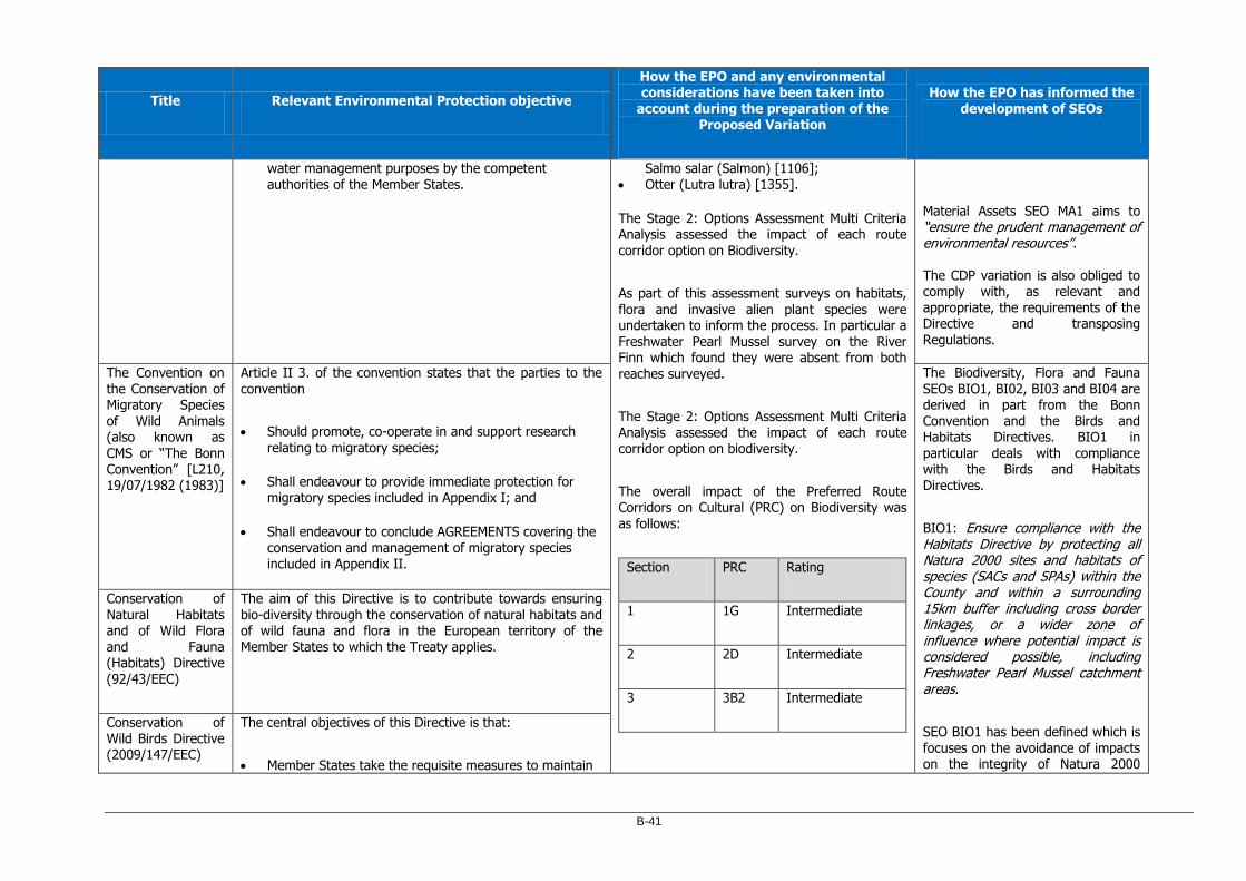
B-41
Title Relevant Environmental Protection objective
How the EPO and any environmental considerations have been taken into
account during the preparation of the Proposed Variation
How the EPO has informed the development of SEOs
water management purposes by the competent authorities of the Member States.
Salmo salar (Salmon) [1106]; Otter (Lutra lutra) [1355].
The Stage 2: Options Assessment Multi Criteria Analysis assessed the impact of each route
corridor option on Biodiversity.
As part of this assessment surveys on habitats, flora and invasive alien plant species were undertaken to inform the process. In particular a Freshwater Pearl Mussel survey on the River Finn which found they were absent from both reaches surveyed.
The Stage 2: Options Assessment Multi Criteria Analysis assessed the impact of each route corridor option on biodiversity.
The overall impact of the Preferred Route Corridors on Cultural (PRC) on Biodiversity was as follows:
Section PRC Rating
1 1G Intermediate
2 2D Intermediate
3 3B2 Intermediate
Material Assets SEO MA1 aims to “ensure the prudent management of environmental resources”. The CDP variation is also obliged to comply with, as relevant and appropriate, the requirements of the Directive and transposing Regulations.
The Convention on the Conservation of Migratory Species
of Wild Animals (also known as CMS or “The Bonn Convention” [L210, 19/07/1982 (1983)]
Article II 3. of the convention states that the parties to the convention
Should promote, co-operate in and support research relating to migratory species;
Shall endeavour to provide immediate protection for migratory species included in Appendix I; and
Shall endeavour to conclude AGREEMENTS covering the conservation and management of migratory species included in Appendix II.
The Biodiversity, Flora and Fauna SEOs BIO1, BI02, BI03 and BI04 are derived in part from the Bonn
Convention and the Birds and Habitats Directives. BIO1 in particular deals with compliance with the Birds and Habitats Directives.
BIO1: Ensure compliance with the Habitats Directive by protecting all Natura 2000 sites and habitats of species (SACs and SPAs) within the County and within a surrounding 15km buffer including cross border linkages, or a wider zone of influence where potential impact is considered possible, including Freshwater Pearl Mussel catchment areas.
SEO BIO1 has been defined which is
focuses on the avoidance of impacts on the integrity of Natura 2000
Conservation of Natural Habitats and of Wild Flora and Fauna (Habitats) Directive (92/43/EEC)
The aim of this Directive is to contribute towards ensuring bio-diversity through the conservation of natural habitats and of wild fauna and flora in the European territory of the Member States to which the Treaty applies.
Conservation of Wild Birds Directive (2009/147/EEC)
The central objectives of this Directive is that:
Member States take the requisite measures to maintain

B-42
Title Relevant Environmental Protection objective
How the EPO and any environmental considerations have been taken into
account during the preparation of the Proposed Variation
How the EPO has informed the development of SEOs
(Birds Directive) the population of the species referred to in Article 1 of the directive at a level which corresponds in particular to ecological, scientific and cultural requirements, while taking account of economic and recreational requirements, or to adapt the population of these
species to that level.
Member States shall take the requisite measures to preserve, maintain or re-establish a sufficient diversity and area of habitats for all the species of birds referred to in Article 1 of the directive:
Note: Article 1 relates to relates to the conservation of all species of naturally occurring birds in the wild state in the European territory of the Member States to which the Treaty applies. It covers the protection, management and control of these species and lays down rules for their exploitation.
sites. The CDP variation and accompanying NIR to inform the Appropriate Assessment, are obliged
to comply with, as relevant and appropriate, the requirements of the Directive and transposing Regulations.
National
National Biodiversity Action Plan 2017 – 2021
This plan has 7 key objectives:
1. Mainstream biodiversity into decision-making across all sectors
2. Strengthen the knowledge base for conservation, management and sustainable use of biodiversity
3. Increase awareness and appreciation of biodiversity and ecosystems services
4. Conserve and restore biodiversity and ecosystem services in the wider countryside
5. Conserve and restore biodiversity and ecosystem services in the marine environment
6. Expand and improve management of protected areas and species
7. Strengthen international governance for biodiversity and
Biodiversity, Flora and Fauna SEOs BIO1, BIO2, BIO3, and BIO4 are derived in part from the national biodiversity and wildlife Plans, Orders and Regulations, which aim to protect, conserve and restore biodiversity within the County.
The CDP variation should have regard for national plans and associated regulatory framework for environmental protection and management and look for opportunities to support the aims of

B-43
Title Relevant Environmental Protection objective
How the EPO and any environmental considerations have been taken into
account during the preparation of the Proposed Variation
How the EPO has informed the development of SEOs
ecosystem services
such plans and regulations to conserve, and, where possible, restore or enhance biodiversity as part of the CDP variation.
All Ireland Pollinator Plan 2015-2020
This plan has 5 main objectives:
1. Making Ireland pollinator friendly 2. Raising awareness of pollinators and how to protect
them 3. Managed pollinators – supporting beekeepers and
growers 4. Expanding our knowledge on pollinators and pollination
service 5. Collecting evidence to track change and measure
success
National Peatland Strategy (DAHG, 2015)
The vision statement of the National Peatlands Strategy states that:
This Strategy aims to provide a long-term framework within which all of the peatlands within the State can be managed responsibly in order to optimise their social, environmental and economic contribution to the well-
being of this and future generations.
Climate Change
International
Paris Agreement (UNFCCC, 2015)
This Agreement aims to strengthen the global response to the threat of climate change, in the context of sustainable development and efforts to eradicate poverty, including by:
Climate Change related environmental protection objectives are integrated into the overall project objectives and design elements of the TEN-T
Air/Climatic Factors SEO AC2 and AC3 are derived in part from these conventions, as
follows:
B-44
Title Relevant Environmental Protection objective
How the EPO and any environmental considerations have been taken into
account during the preparation of the Proposed Variation
How the EPO has informed the development of SEOs
a) Holding the increase in the global average temperature to well below 2°C above pre-industrial levels and pursuing efforts to limit the temperature increase to 1.5°C above pre-industrial levels, recognizing that this would significantly reduce the risks and impacts of climate change;
b) Increasing the ability to adapt to the adverse impacts of climate change and foster climate resilience and low greenhouse gas emissions development, in a manner that does not threaten food production; and
c) Making finance flows consistent with a pathway towards low greenhouse gas emissions and climate-resilient
development.
PRIPD in the following ways:
Project Objective: To reduce overall air pollution levels near sensitive receptors caused by congestive queuing of vehicles and/or excessive vertical gradients.: A reduction in congestive queuing (particularly in Letterkenny and Ballybofey/Stranorlar) as a result of the project may lead to a decrease in the emissions of greenhouses gases such as carbon dioxide (CO2) and nitrous oxides (NOx).
Project Objective: Remove strategic and commercial traffic from local towns and communities: The reduction in traffic levels within the urban areas of Letterkenny and Ballybofey/Stranorlar as a result of the project will free up road space for, and encourage, more sustainable modes of transportation such as buses, walking and cycling, and thus reduce greenhouse gas emissions.
Design: The provision of walking and cycling infrastructure as part of the scheme.
AC2: Reduce all forms of air pollution. AC3: Promote and support a shift from fossil fuel dependent energy to more sustainable energy. Promote and support a shift from fossil fuel dependant vehicles to more sustainable modes of travel. The climate change agreements will be assessed, in combination with other legislation and regulations, on the provisions of the CDP variation.
European Union
The EU Policy Framework for Climate and Energy in the period from 2020 to 2030
In December 2020, in light of the need to increase climate ambition, also as required by the Paris Agreement, the European Council endorsed a new 2030 target for emission reduction. EU leaders agreed on a binding EU target for a net domestic reduction of at least 55% in greenhouse gas
emissions by 2030 compared to 1990.
The greenhouse gas target is implemented by the EU Emissions Trading System, the Effort Sharing Regulation with Member States' emissions reduction targets and the Land use, land use change and forestry Regulation.
The EU Emissions Trading System, limits emissions from more than 11,000 heavy energy-using installations (power stations & industrial plants) and airlines operating between
Air/Climatic Factors SEO AC2 and AC3 are derived in part from these agreements, strategies and frameworks, as follows:
AC2: Reduce all forms of air pollution. AC3: Promote and support a shift from fossil fuel dependent energy to more sustainable energy. Promote and support a shift from fossil fuel dependant vehicles to more sustainable modes of travel.

B-45
Title Relevant Environmental Protection objective
How the EPO and any environmental considerations have been taken into
account during the preparation of the Proposed Variation
How the EPO has informed the development of SEOs
these countries
The Effort Sharing legislation establishes binding annual greenhouse gas emission targets for Member States for the periods 2013–2020 and 2021–2030. These targets concern emissions from most sectors not included in the EU Emissions Trading System (EU ETS), such as transport, buildings, agriculture and waste.
All three pieces of climate legislation will now be updated with a view to implement the proposed at least 55% net greenhouse gas emissions reduction target. The Commission will come forward with the proposals by June 2021.
Material Assets SEO MA1 aims to “ensure the prudent management of environmental resources”. The climate change agreements and protocols will be assessed, in combination with other legislation and regulations, on the provisions of the CDP variation. The CDP variation should aim to contribute towards climate change mitigation and infrastructure to be planned for and resilient to climatic
change. The EU Strategy on
Adaptation to Climate Change 2013
The EU Adaptation Strategy has three objectives.
1. Promoting action by Member States: The Commission encourages all Member States to adopt comprehensive adaptation strategies (15 had strategies as of mid-2013) and will provide guidance and funding to help them build up their adaptation capacities and take action. The Commission will also support adaptation in cities by launching a voluntary commitment based on the
Covenant of Mayors initiative.
2. Promoting better informed decision-making by addressing gaps in knowledge about adaptation and further developing the European Climate Adaptation Platform (Climate-ADAPT) as the ‘one-stop shop’ for adaptation information in Europe.
3. Promoting adaptation in key vulnerable sectors through agriculture, fisheries and cohesion policy, ensuring that Europe’s infrastructure is made more resilient, and encouraging the use of insurance against natural and

B-46
Title Relevant Environmental Protection objective
How the EPO and any environmental considerations have been taken into
account during the preparation of the Proposed Variation
How the EPO has informed the development of SEOs
man-made disasters.
National
Climate Action and Low Carbon Development (Amendment) Bill 2020
Section 3. (1) of the Bill establishes the following National Climate Change objective.
The State shall pursue the transition to a climate resilient and climate neutral economy by the end of the year 2050 (in this Act referred to as the ‘national 2050 climate objective’).
Air/Climatic Factors SEOs AC2 and AC3 are derived in part from the Climate Bills, Strategies and Frameworks. The climate change agreements and protocols will be assessed, in combination with other legislation and regulations, on the provisions of the CDP variation. The CDP variation should aim to contribute towards climate change mitigation and infrastructure to be planned for and resilient to climatic change. The target for transport under the Climate Action Plan will be given careful consideration as part of the CDP variation.
National Adaptation Framework Planning for a Climate Resilient Ireland
The overall objective of this Framework is to enable the State to pursue the transition to a low carbon, climate resilient and environmentally sustainable economy by 2050.
Climate Action Plan 2019
The Climate Action Plan 2019 supports the adoption of an EU net zero greenhouse gas emissions by 2050. The plan also reiterates that Ireland will need to reduce its non-ETS sector greenhouse gas emissions consistent with a 30% reduction by 2030.
The full report contains 183 actions to ensure Ireland meets its targets. In 2017, transport accounted for 19.8% of Ireland's greenhouse gases. The Action Plan sets the following targets for the Transport Sector.
Reduce CO2 eq. emissions from the sector by 45–50%
relative to 2030 pre-NDP projections

B-47
Title Relevant Environmental Protection objective
How the EPO and any environmental considerations have been taken into
account during the preparation of the Proposed Variation
How the EPO has informed the development of SEOs
Increase the number of EVs to 936,000, comprised of:
o 840,000 passenger EVs
o 95,000 electric vans and trucks
o 1,200 electric buses
Build the EV charging network to support the growth of EVs at the rate required, and develop our fast-charging infrastructure to stay ahead of demand
Require at least one recharging point in new non-residential buildings with more than 10 parking spaces
Raise the blend proportion of biofuels in road transport to 10% in petrol and 12% in diesel.
Cultural Heritage
International
Convention for the Protection of the Archaeological Heritage of Europe (revised) (Valletta, 1992)
Objective is to protect the archaeological heritage as a source of the European collective memory and as an instrument for historical and scientific study.
The identification of the Preferred Route Corridors was based on inter alia:
1. A constraints report which identified various environmental constraints in the study area for each Section of the project including Cultural Heritage
2. A 2 Stage route selection process including a detailed multi criteria analysis of the impact of various route options on specific environmental criteria including Cultural Heritage.
Cultural Heritage SEO CH1 sets out the following for the protection of cultural heritage: CH1: Promote the protection and conservation of the cultural, including architectural and archaeological, heritage. The CDP variation will consider architectural heritage and ensure it is protected from loss or damage resulting from developmental infrastructure plans.
Convention for the Protection of the Architectural Heritage of Europe (Granada, 1985)
The broad objective of this convention is that each party:
Take statutory measures to protect the architectural heritage;
Within the framework of such measures and by means specific to each State or region, to make provision for

B-48
Title Relevant Environmental Protection objective
How the EPO and any environmental considerations have been taken into
account during the preparation of the Proposed Variation
How the EPO has informed the development of SEOs
the protection of monuments, groups of buildings and sites.
The Constraints report was based on the identification and assessment of archaeological monuments, protected (architectural) structures and other features of cultural heritage significance within the study area of each
project section. The report found that the combined study area for Sections 1, 2 and 3, cumulatively contained
137 recorded archaeological sites including one National Monument a standing stone (DG054-038---- / National Monument No. 453).
173 buildings and structures that are listed
in the NIAH and 28 structures listed on the Record of Protected Structures.
The Stage 2: Options Assessment Multi Criteria Analysis assessed the impact of each route corridor option on Cultural Heritage.
The overall impact of the Preferred Route Corridors on Cultural (PRC) on Cultural Heritage was as follows:
Section PRC Rating
1 1G Intermediate
2 2D Intermediate
3 3B2 Intermediate
National
National Heritage Plan 2002 – 2007 (to be replaced by Heritage Ireland 2030 – not yet published)
The Government Policy Statement on Heritage, contained in the Plan, states it is an objective of Government to ensure the protection of our heritage and to promote its enjoyment by all.
The policies of the National Heritage Plan are inherent in the Strategic Environmental Appraisal of the Development Pans, Local Area Plans and have also been considered as part of the CDP variation.
Heritage Council
Strategy 2018-2022
The vision set out in the strategy is that:
heritage will be at the heart of Irish society and decision-making and that Ireland will be internationally recognised as a centre of excellence in heritage management, conservation and community engagement.
Framework and Principles for the Protection of
Archaeological Heritage (1999)
The document sets out the basic principles of national policy regarding the protection of archaeological heritage. The document focuses particularly on the principles which should
apply in respect of development and archaeological heritage.
Architectural heritage protection Guidelines For Planning Authorities 2011
Section 1.5.1 of these guidelines state that under the Planning and Development Act 2000 the Minister is obliged to issue guidelines to planning authorities concerning development objectives:
a) for protecting structures, or parts of structures, which

B-49
Title Relevant Environmental Protection objective
How the EPO and any environmental considerations have been taken into
account during the preparation of the Proposed Variation
How the EPO has informed the development of SEOs
are of special architectural, historical, archaeological, artistic, cultural, scientific, social, or technical interest, and
b) for preserving the character of architectural conservation areas.
Human Health/Air Quality
International
World Health Organisation (WHO) Air Quality Guidelines (1999) (updated 2005) and Guidelines for Europe (1987)
The WHO air quality guidelines (AQGs) support actions to achieve air quality that protects public health in different context including the setting of air quality guidelines for specific pollutants.
The identification of the Preferred Route Corridors was based on inter alia:
1. A constraints report which identified various environmental constraints in the study area for each Section of the project including Human Health and Air Quality.
2. A 2 Stage route selection process including
a detailed multi criteria analysis of the impact of various route options on specific environmental criteria including Human Health and Air Quality.
The Constraints report was based on an assessment of inter alia:
Population and Human Health including the spatial distribution of population and health facilities.
Human Health SEO HH1 and Air/Climatic Factors SEO AC2 are derived in part from these Conventions. HH1: Minimise noise, vibration and emissions from traffic, industrial processes and extractive industry AC2: Reduce all forms of air pollution. The CDP variation is obliged to consider the Human Health/ Air Quality agreements, guidelines and protocols, in combination with other legislation and regulations, on the compliance of the provisions of the CDP variation.
The Gothenburg
Protocol (1999)
The objective of the Protocol is to control and reduce
emissions of sulphur, nitrogen oxides, ammonia and volatile organic compounds that are caused by anthropogenic activities and are likely to cause adverse effects on human health, natural ecosystems, materials and crops, due to acidification, eutrophication or ground-level ozone as a result of long-range transboundary atmospheric transport, and to ensure, as far as possible, that in the long term and in a stepwise approach, taking into account advances in scientific knowledge, atmospheric depositions or concentrations do not exceed the thresholds set out in the protocol.

B-50
Title Relevant Environmental Protection objective
How the EPO and any environmental considerations have been taken into
account during the preparation of the Proposed Variation
How the EPO has informed the development of SEOs
The 1979 Geneva Convention on Long-range Transboundary Air Pollution (LRTAP)
The principle aim of this Convention as expressed in Article 2 is to:
limit and, as far as possible, gradually reduce and
prevent air pollution including long-range transboundary air pollution.
Air quality data for the Letterkenny EPA air quality sampling station.
Strategic Noise Mapping for Donegal included in the Draft Donegal Noise Action Plan 2018-2023.
In relation to air and human health constraints the report identified the sensitive receptors as being high numbers of amenities and residential receptors along the existing N15 Ballybofey–Stranorlar Urban Region, N56/N13 Letterkenny to Manorcunningham, and N14 Manorcunningham–Lifford/A5 routes, particularly in the urban environs. In relation to noise the
report identified inter alia a significant number of residential properties in each study area.
The Stage 2: Options Assessment Multi Criteria Analysis assessed the impact of each route corridor option on air quality and noise.
The overall impact of the Preferred Route Corridors on air quality was as follows:
Section PRC Rating
1 1G Preferred
2 2D Intermediate
European Union
A Clean Air Programme for Europe (COM(2013) 918)
This strategy aims to:
Tackles the reasons for the widespread non-compliance
with air quality standards
Proposes legislation to reduce harmful emissions in the longer term which contribute to poor air quality and damage the natural environment.
Promote measures which also mitigate atmospheric warming and climate change.
Human Health SEO HH1 and Air/Climatic Factors SEO AC2 are derived in part from these Directives. The CDP variation should have regard to the requirements of the programmes, Directives and transposing regulations to protect the human environment against air pollution and to gradually reduce and prevent air pollution, including long-range transboundary air pollution. Air Quality Clean Air
For Europe Directive (2008/50/EC)
This Directive lays down measures aimed at the following:
1. defining and establishing objectives for ambient air quality designed to avoid, prevent or reduce harmful effects on human health and the environment as a whole;
2. assessing the ambient air quality in Member States on the basis of common methods and criteria;
3. obtaining information on ambient air quality in order to help combat air pollution and nuisance and to monitor

B-51
Title Relevant Environmental Protection objective
How the EPO and any environmental considerations have been taken into
account during the preparation of the Proposed Variation
How the EPO has informed the development of SEOs
long-term trends and improvements resulting from national and Community measures;
4. ensuring that such information on ambient air quality is made available to the public;
5. maintaining air quality where it is good and improving it in other cases;
6. promoting increased cooperation between the Member States in reducing air pollution.
3 3B2 Intermediate
The impact of the Preferred Route Corridors on Noise was as follows:
Section PRC Rating
1 1G Preferred
2 2D Intermediate
3 3B2 Intermediate
Environmental Noise Directive (END) (2002/49/EC)
The aim of this Directive (Article 1) refers is to:
Define a common approach intended to avoid, prevent or reduce on a prioritised basis the harmful effects, including annoyance, due to exposure, to environmental noise.
National Emissions Ceiling Directive (2016/2284/EU)
Article 1 of the Directive states that Objectives of the Directive are as follows:
1. In order to move towards achieving levels of air quality that do not give rise to significant negative impacts on
and risks to human health and the environment, this Directive establishes the emission reduction commitments for the Member States' anthropogenic atmospheric emissions of sulphur dioxide (SO2), nitrogen oxides (NOx), non-methane volatile organic compounds (NMVOC), ammonia (NH3) and fine particulate matter (PM2,5) and requires that national air pollution control programmes be drawn up, adopted and implemented and that emissions of those pollutants and the other pollutants referred to in Annex I, as well as their impacts, be monitored and reported.
The CDP variation is obliged to comply with, as relevant and appropriate, the requirements of the Directive and transposing regulations.
IPC/IED licensed industries should be assessed cumulatively with the TEN-T PRIPD at project stage during statutory assessments.

B-52
Title Relevant Environmental Protection objective
How the EPO and any environmental considerations have been taken into
account during the preparation of the Proposed Variation
How the EPO has informed the development of SEOs
2. This Directive also contributes to achieving:
a) the air quality objectives set out in Union legislation and progress towards the Union's long-term objective of achieving levels of air quality in line
with the air quality guidelines published by the World Health Organisation;
b) the Union's biodiversity and ecosystem objectives in line with the 7th Environment Action Programme;
c) enhanced synergies between the Union's air quality policy and other relevant Union policies, in particular climate and energy policies.
National
Healthy Ireland – a Framework for Improved Health and Wellbeing 2015-2025
The 4 stated Goals of Healthy Ireland are to:
1. Increase the proportion of people who are healthy at all stages of life.
2. Reduce health inequalities
3. Protect the public from threats to health and wellbeing Create an environment where every individual and sector of society can play their part in achieving a healthy Ireland
Human Health SEO HH1 is derived in part from this framework. The CDP variation is obliged to comply with, as relevant and appropriate, the aims of this framework.
Sustainable Development
European Union
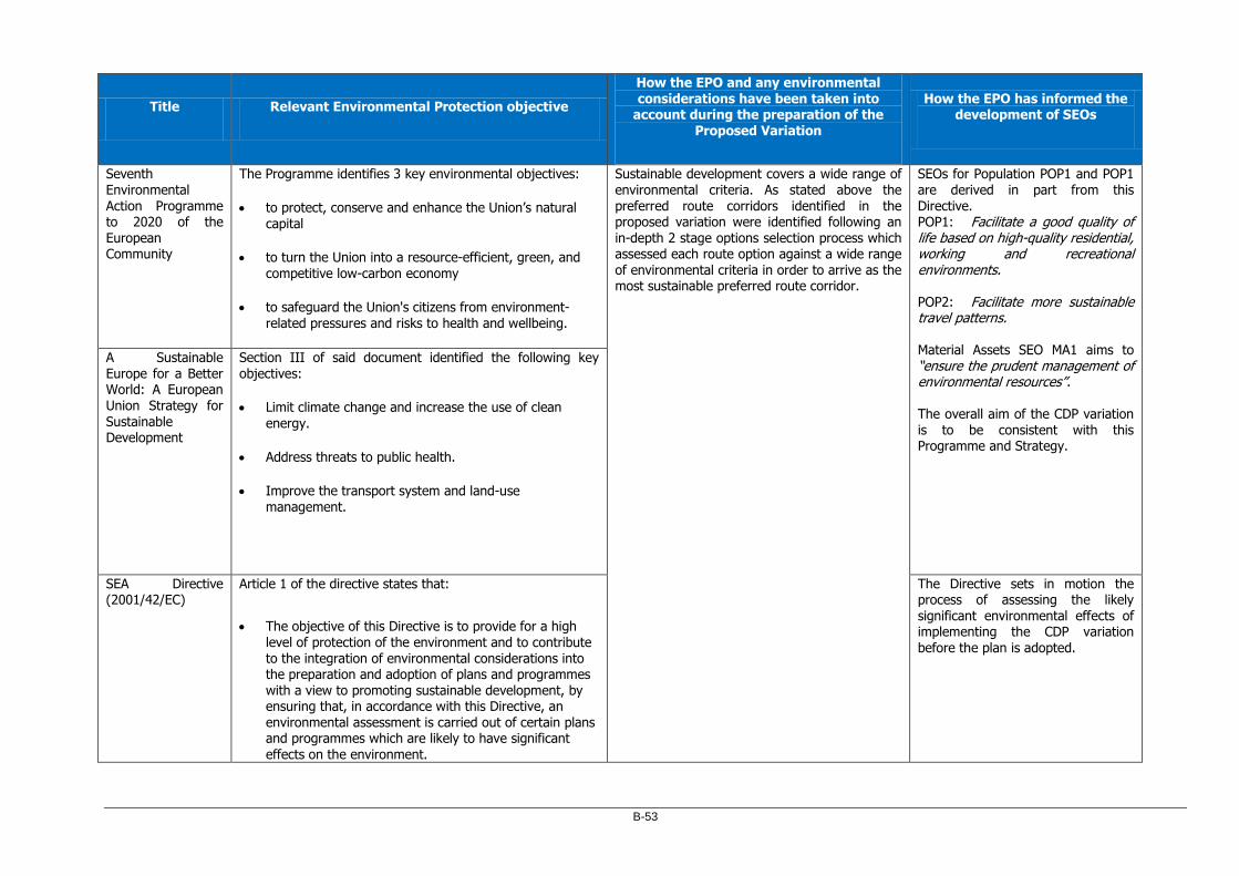
B-53
Title Relevant Environmental Protection objective
How the EPO and any environmental considerations have been taken into
account during the preparation of the Proposed Variation
How the EPO has informed the development of SEOs
Seventh Environmental Action Programme to 2020 of the European Community
The Programme identifies 3 key environmental objectives:
to protect, conserve and enhance the Union’s natural capital
to turn the Union into a resource-efficient, green, and competitive low-carbon economy
to safeguard the Union's citizens from environment-related pressures and risks to health and wellbeing.
Sustainable development covers a wide range of environmental criteria. As stated above the preferred route corridors identified in the proposed variation were identified following an in-depth 2 stage options selection process which assessed each route option against a wide range of environmental criteria in order to arrive as the most sustainable preferred route corridor.
SEOs for Population POP1 and POP1 are derived in part from this Directive. POP1: Facilitate a good quality of life based on high-quality residential, working and recreational environments. POP2: Facilitate more sustainable travel patterns. Material Assets SEO MA1 aims to “ensure the prudent management of environmental resources”. The overall aim of the CDP variation is to be consistent with this Programme and Strategy.
A Sustainable Europe for a Better World: A European Union Strategy for
Sustainable Development
Section III of said document identified the following key objectives:
Limit climate change and increase the use of clean
energy.
Address threats to public health.
Improve the transport system and land-use management.
SEA Directive (2001/42/EC)
Article 1 of the directive states that:
The objective of this Directive is to provide for a high level of protection of the environment and to contribute to the integration of environmental considerations into the preparation and adoption of plans and programmes with a view to promoting sustainable development, by ensuring that, in accordance with this Directive, an environmental assessment is carried out of certain plans and programmes which are likely to have significant
effects on the environment.
The Directive sets in motion the process of assessing the likely significant environmental effects of implementing the CDP variation before the plan is adopted.

B-54
Title Relevant Environmental Protection objective
How the EPO and any environmental considerations have been taken into
account during the preparation of the Proposed Variation
How the EPO has informed the development of SEOs
EIA Directive (85/337/EEC), as amended by Directive 97/11/EC,
Directive 2011/92/EU & Directive 2014/52/EU
Article 2 of the directive as amended provides the broad objective of the directive, namely that:
Member States shall adopt all measures necessary to ensure that, before development consent is given, projects likely to have significant effects on the environment by virtue, inter alia, of their nature, size or location are made subject to a requirement for development consent and an assessment with regard to their effects on the environment. Those projects are defined in Article 4.
While no specific SEO has been derived based on this Directive, the objectives related to the protection of the environment would be
supportive of the aims of the EIA Directive. At project stage, the TEN-T PRIPD will be assessed in accordance with the EIA Directive and transposing Regulations, in combination with other legislation by the relevant competent authorities.
Environmental Liability Directive (2004/35/EC) as amended by 2005/21/EC, 2009/31/EC and 2013/30/EU) amended by Regulation - (EU) 2019/1010]
Article 1 of the directive states that:
The purpose of this Directive is to establish a framework of environmental liability based on the ‘polluter-pays' principle, to prevent and remedy environmental damage
While no specific SEO has been derived based on this Directive, the objectives related to the protection of the environment would be supportive of the aims of the Environmental Liability Directive. The CDP variation will be obliged to comply with the requirements of the regulations and to prevent environmental damage.
Maintenance and construction of transport infrastructure should aim to avoid or minimise damage and to enhance the wider environment.
National
Our Sustainable Future: A Framework for Sustainable Development in
This framework sets out a number of principles for sustainable development including:
Satisfaction of human needs by the efficient use of resources: Prices should reflect the real costs to

B-55
Title Relevant Environmental Protection objective
How the EPO and any environmental considerations have been taken into
account during the preparation of the Proposed Variation
How the EPO has informed the development of SEOs
Ireland (2012) society of production and consumption activities and polluters should pay for the damage they cause to human health and the environment.
Respect for ecological integrity and biodiversity:
The abundance of wildlife and extent of habitats should be maintained, improved and restored where necessary, through sustainable management.
Respect for cultural heritage /diversity: The quality of landscapes, the heritage of the man-made environment and historic and cultural resources should be maintained and improved.
Water
European Union
Water Framework Directive (WFD) (2000/60/EC) (as amended by
Decision 2455/2001/EC and Directives 2008/32/EC, 2008/105/EC and 2009/31/EC The following Directives have been subsumed into the Water Framework
Article 1 of the Directive describes the purpose of the objective as follows:
The purpose of this Directive is to establish a framework for the protection of inland surface waters, transitional waters, coastal waters and groundwater which:
a) prevents further deterioration and protects and enhances the status of aquatic ecosystems and, with regard to their water needs, terrestrial ecosystems and wetlands directly depending on the aquatic ecosystems;
b) promotes sustainable water use based on a long-term protection of available water resources;
The identification of the Preferred Route Corridors was based on inter alia:
1. A constraints report which identified various environmental constraints in the study area for each Section of the project including hydrology.
2. A 2 Stage route selection process including a detailed multi criteria analysis of the impact of various route options on specific environmental criteria including hydrology.
The Constraints report was based on an assessment of inter alia:
SEOs for Water WR1, WR2, WR3 and WR4 are derived in part from the WFD Directive, which aims to protect, conserve and
restore water resources within the County. WR1 deals specifically with the WFD and River Basin Management Plan.
Material Assets SEO MA1 aims to “ensure the prudent management of environmental resources”. The CDP variation is also obliged to comply with, as relevant and
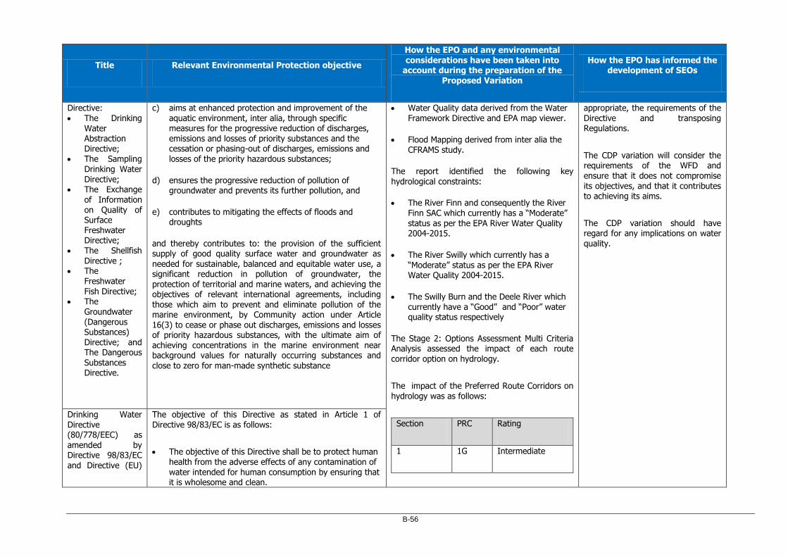
B-56
Title Relevant Environmental Protection objective
How the EPO and any environmental considerations have been taken into
account during the preparation of the Proposed Variation
How the EPO has informed the development of SEOs
Directive: The Drinking
Water Abstraction Directive;
The Sampling Drinking Water Directive;
The Exchange of Information on Quality of Surface Freshwater Directive;
The Shellfish
Directive ; The
Freshwater Fish Directive;
The Groundwater (Dangerous Substances) Directive; and The Dangerous Substances Directive.
c) aims at enhanced protection and improvement of the aquatic environment, inter alia, through specific measures for the progressive reduction of discharges, emissions and losses of priority substances and the cessation or phasing-out of discharges, emissions and
losses of the priority hazardous substances;
d) ensures the progressive reduction of pollution of groundwater and prevents its further pollution, and
e) contributes to mitigating the effects of floods and droughts
and thereby contributes to: the provision of the sufficient supply of good quality surface water and groundwater as
needed for sustainable, balanced and equitable water use, a significant reduction in pollution of groundwater, the protection of territorial and marine waters, and achieving the objectives of relevant international agreements, including those which aim to prevent and eliminate pollution of the marine environment, by Community action under Article 16(3) to cease or phase out discharges, emissions and losses of priority hazardous substances, with the ultimate aim of achieving concentrations in the marine environment near background values for naturally occurring substances and
close to zero for man-made synthetic substance
Water Quality data derived from the Water Framework Directive and EPA map viewer.
Flood Mapping derived from inter alia the CFRAMS study.
The report identified the following key hydrological constraints:
The River Finn and consequently the River Finn SAC which currently has a “Moderate” status as per the EPA River Water Quality 2004-2015.
The River Swilly which currently has a
“Moderate” status as per the EPA River Water Quality 2004-2015.
The Swilly Burn and the Deele River which currently have a “Good” and “Poor” water quality status respectively
The Stage 2: Options Assessment Multi Criteria Analysis assessed the impact of each route corridor option on hydrology.
The impact of the Preferred Route Corridors on hydrology was as follows:
Section PRC Rating
1 1G Intermediate
appropriate, the requirements of the Directive and transposing Regulations.
The CDP variation will consider the requirements of the WFD and ensure that it does not compromise its objectives, and that it contributes to achieving its aims.
The CDP variation should have regard for any implications on water quality.
Drinking Water Directive (80/778/EEC) as amended by Directive 98/83/EC and Directive (EU)
The objective of this Directive as stated in Article 1 of Directive 98/83/EC is as follows:
The objective of this Directive shall be to protect human health from the adverse effects of any contamination of
water intended for human consumption by ensuring that it is wholesome and clean.

B-57
Title Relevant Environmental Protection objective
How the EPO and any environmental considerations have been taken into
account during the preparation of the Proposed Variation
How the EPO has informed the development of SEOs
2015/1787 2 2D Intermediate
3 3B2 Preferred
In relation to Groundwater the Constraints report assessed thee GSI online database for the underlying aquifer type and groundwater vulnerability of the study areas.
It identified the key groundwater constraints as:
Public Water supply wells at Raymoghy,
Doorabble and Galdonagh Cross Roads.
A drinking water protection area at Galdonagh Cross Roads.
a number of private wells
The Stage 2: Options Assessment Multi Criteria Analysis assessed the combined impact of each route corridor option on soils, geology and hydrogeology.
The combined impact of the Preferred Route Corridors on soils, geology and hydrogeology was as follows:
Section PRC Rating
Marine Strategy Framework
Directive (MSFD) (2008/56/EC)
Article 1 of the directive states that:
1. This Directive establishes a framework within which Member States shall take the necessary measures to achieve or maintain good environmental status in the marine environment by the year 2020 at the latest.
2. For that purpose, marine strategies shall be developed and implemented in order to:
a) protect and preserve the marine environment, prevent its deterioration or, where practicable, restore marine ecosystems in areas where they have been adversely affected;
b) prevent and reduce inputs in the marine environment, with a view to phasing out pollution as defined in Article 3(8), so as to ensure that there are no significant impacts on or risks to marine biodiversity, marine ecosystems, human health or legitimate uses of the sea.
Biodiversity, Flora and Fauna SEO BIO3 is derived in part from
this Directive, which aims to “Protect the marine environment within the County and within a surrounding 15km buffer including cross border linkages, or a wider zone of influence where potential impact is considered possible, and promote integrated coastal zone management strategies”.
The potential implications CDP variation on the environmental status of marine waters will be considered.
Floods Directive (2007/60/EC)
Article 1 of this directive states that:
The purpose of this Directive is to establish a framework for the assessment and management of flood risks, aiming at the reduction of the adverse consequences for human health, the environment, cultural heritage and economic activity associated with floods in the Community.
Water SEO WR5 and Material Assets SEO MA2 aim to contribute to the management of flood risk in line with the Floods Directive.

B-58
Title Relevant Environmental Protection objective
How the EPO and any environmental considerations have been taken into
account during the preparation of the Proposed Variation
How the EPO has informed the development of SEOs
Bathing Water Directive (2006/7/EC)
Article 1 of this directive states that:
The purpose of this Directive is to preserve, protect and improve the quality of the environment and to protect human health by complementing Directive 2000/60/EC.
1 1G Intermediate
2 2D Intermediate
3 3B2 Intermediate
The SEO for Water, WR2, aims to protect the quality of surface water assets for amenity. CDP variation is obliged to comply with, as relevant and appropriate, the
requirements of the Directive and transposing Regulations.
Groundwater Directive (2006/118/EC)
Article 1 of this directive states its purpose as follows:
1. This Directive establishes specific measures as provided for in Article 17(1) and (2) of Directive 2000/60/EC in order to prevent and control groundwater pollution. These measures include in particular:
a. criteria for the assessment of good groundwater chemical status; and
b. criteria for the identification and reversal of significant and sustained upward trends and for the definition of starting points for trend reversals.
2. This Directive also complements the provisions preventing or limiting inputs of pollutants into groundwater already contained in Directive 2000/60/EC,
and aims to prevent the deterioration of the status of all bodies of groundwater.
While no specific SEO has been derived based on the Groundwater Directive, the SEOs related to the protection of Water would be supportive of the aims of this Directive. CDP variation is obliged to comply with, as relevant and appropriate, the requirements of the Directive and transposing Regulations. The CDP variation should, where possible, contribute to the protection of groundwater from point source and diffuse pollution that could be caused or exacerbated by road
project.
National
River Basin Management Plan (RBMP) 2018-2021
The plan identifies the following evidence based priorities:
Ensure full compliance with relevant EU legislation
Prevent deterioration.
SEOs for Water WR1, WR2, WR3 and WR4 are derived in part from the WFD Directive, which
aims to protect, conserve and restore water resources within

B-59
Title Relevant Environmental Protection objective
How the EPO and any environmental considerations have been taken into
account during the preparation of the Proposed Variation
How the EPO has informed the development of SEOs
Meet the objectives for designated protected areas
Protect high-status waters.
Implement targeted actions and pilot schemes in
focused sub-catchments aimed at (1) targeting water bodies close to meeting their objective and (2) addressing more complex issues that will build knowledge for the third cycle
the County. WR1 deals specifically with the WFD and River Basin Management Plan.
The CDP variation is also obliged to comply with, as relevant and appropriate, the requirements of the Directive and transposing Regulations.
The CDP variation will consider the requirements of the WFD and ensure that it does not compromise its objectives, and that it contributes
to achieving its aims.
The CDP variation should have regard for any implications on water quality.
(Surface Water) Regulations 2009 (S.I. 272/2009)
Part II of these regulations contain the following Environmental Objectives for Groundwater:
4 A public authority that has functions the performance of which may affect the achievement of the environmental objectives established by these Regulations shall undertake those functions in a manner that will, as far as practicable, promote compliance with the requirements of these Regulations and, in particular shall—
a) ensure, in so far as its functions allow, that— (i) surface water bodies comply with the relevant environmental quality standards specified in the Schedules contained in these Regulations, and (ii) protected areas achieve compliance with any standards and objectives laid down
The CDP variation is obliged to assess potential interactions, water supply and quality, as relevant and appropriate, with the requirements
of water services Plans, Programmes and Regulations. SEOs for Water WR1, WR2, WR3 and WR4 aims to protect, conserve and restore water resources within the County.
The CDP variation is to contribute
towards, in combination with other users and bodies, the achievement

B-60
Title Relevant Environmental Protection objective
How the EPO and any environmental considerations have been taken into
account during the preparation of the Proposed Variation
How the EPO has informed the development of SEOs
for such areas at the latest by 22 December 2015 unless otherwise specified in the national legislation under which the individual protected areas have been established. Where one or more of the objectives or standards under this subparagraph relates to a given
body of water, the most stringent shall apply
b) establish or make operational within the timeframes prescribed such measures appropriate to its functions as are necessary to achieve the environmental objectives and quality standards established, including the objective of progressively reducing pollution by priority substances and the ceasing or phasing out of emissions, discharges and losses of priority hazardous substances, and
c) consult, co-operate and liaise with other public authorities within the river basin district and, where appropriate with the relevant competent authorities in Northern Ireland, in such a manner and to such extent as is necessary to co-ordinate compliance with these Regulations.
5. A public authority shall not, in the performance of its functions, undertake those functions in a manner that knowingly causes or allows deterioration in the 10 [272] chemical status or ecological status (or ecological potential as the case may be) of a body of surface water.
of objectives of the regulatory framework for environmental protection and management.
European Communities Environmental Objectives
(Groundwater) Regulations 2010.
Part II of these regulations contain the following Environmental Objectives for Groundwater:

B-61
Title Relevant Environmental Protection objective
How the EPO and any environmental considerations have been taken into
account during the preparation of the Proposed Variation
How the EPO has informed the development of SEOs
(S.I. No. 9/2010)
Duty on Public Authorities
4. A public authority shall, insofar as its functions allow and subject to any provisions and limitations listed elsewhere in this Part, promote compliance with the requirements of these Regulations and take all reasonable steps including, where necessary, the implementation of programmes of measures, to:
a) prevent or limit, as appropriate, the input of pollutants into groundwater and prevent the deterioration of the status of all bodies of groundwater;
b) protect, enhance and restore all bodies of groundwater
and ensure a balance between abstraction and recharge of groundwater with the aim of achieving good groundwater quantitative status and good groundwater chemical status by not later than 22 December 2015;
c) reverse any significant and sustained upward trend in the concentration of any pollutant resulting from the impact of human activity in order to progressively reduce pollution of groundwater;
d) achieve compliance with any standards and objectives established for a groundwater dependant protected area included in the register of protected areas established under Regulation 8 of the 2003 Regulations by not later than 22 December 2015, unless otherwise specified in the Community legislation under which the individual protected areas have been established.
5. A public authority shall not, in the performance of its functions, undertake those functions in a manner that
knowingly causes or allows deterioration in the quantitative

B-62
Title Relevant Environmental Protection objective
How the EPO and any environmental considerations have been taken into
account during the preparation of the Proposed Variation
How the EPO has informed the development of SEOs
status or chemical status of a body of groundwater.
Harnessing Our Ocean Wealth - An Integrated Marine Plan for Ireland (2012)
Goal 2 of said Plan is to:
achieve healthy ecosystems that provide monetary and non-monetary goods and services (e.g. food, climate, health and well-being).
Coast/Marine Resource SEOs CM1, CM2 and CM3 aim to protect and manage the coastal zone. CM2 in particular deals with the management of the coastal zone as an environmental and tourist resource.
Material Assets SEO MA1 aims to “ensure the prudent management of environmental resources”.
The Planning System and Flood Risk Management Guidelines (DHPCLG, 2009)
The core objectives of the Guidelines are to:
Avoid inappropriate development in areas at risk of flooding;
Avoid new developments increasing flood risk elsewhere, including that which may arise from surface water run-off;
Ensure effective management of residual risks for
development permitted in floodplains;
Avoid unnecessary restriction of national, regional or local economic and social growth;
Improve the understanding of flood risk among relevant stakeholders;
Ensure that the requirements of EU and national law in relation to the natural environment and nature conservation are complied with at all stages of flood risk management.
Water SEO WR5 and Material Assets SEO MA2 aim to contribute to the management of flood risk.
A Strategic Flood Risk Assessment (SFRA) was carried out on the CDP variation to assess the risk of flooding. This assessment was prepared having regard to the Guidelines to identify flood risk areas together with mitigation measures to be implemented.
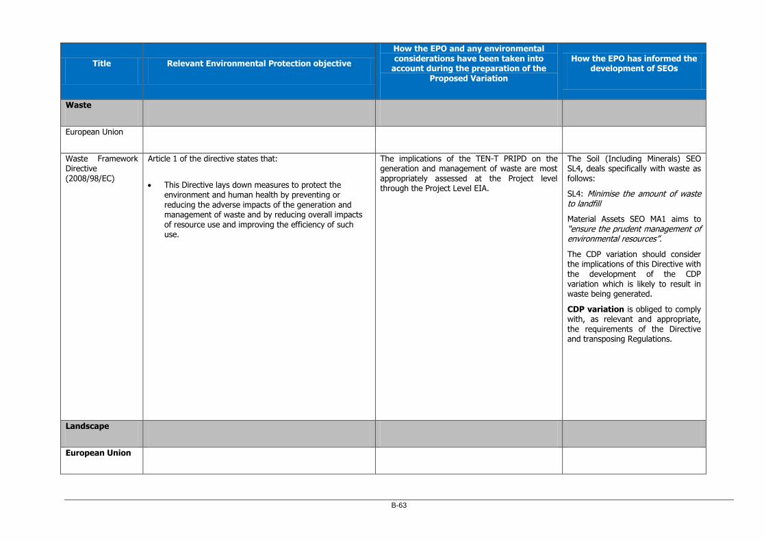
B-63
Title Relevant Environmental Protection objective
How the EPO and any environmental considerations have been taken into
account during the preparation of the Proposed Variation
How the EPO has informed the development of SEOs
Waste
European Union
Waste Framework Directive (2008/98/EC)
Article 1 of the directive states that:
This Directive lays down measures to protect the environment and human health by preventing or reducing the adverse impacts of the generation and management of waste and by reducing overall impacts of resource use and improving the efficiency of such use.
The implications of the TEN-T PRIPD on the generation and management of waste are most appropriately assessed at the Project level through the Project Level EIA.
The Soil (Including Minerals) SEO SL4, deals specifically with waste as follows:
SL4: Minimise the amount of waste to landfill
Material Assets SEO MA1 aims to “ensure the prudent management of environmental resources”.
The CDP variation should consider the implications of this Directive with the development of the CDP variation which is likely to result in waste being generated.
CDP variation is obliged to comply with, as relevant and appropriate, the requirements of the Directive and transposing Regulations.
Landscape
European Union

B-64
Title Relevant Environmental Protection objective
How the EPO and any environmental considerations have been taken into
account during the preparation of the Proposed Variation
How the EPO has informed the development of SEOs
European Landscape Convention, 2000
Article 3 of this convention states that:
The aims of this Convention are to promote landscape protection, management and planning, and to organise European co-operation on landscape issues.
The identification of the Preferred Route Corridors was based on inter alia:
1. A constraints report which identified various environmental constraints in the study area for each Section of the project including landscape.
2. A 2 Stage route selection process including a detailed multi criteria analysis of the impact of various route options on specific environmental criteria including landscape.
The constraints report was based on an assessment of inter alia: the Landscape
Character Assessment of Donegal (DCC), and scenic amenity designations in the County Donegal Development Plan 2018-2024.
The report identified the following as being the key landscape constraints:
Landscape Character Areas:
o Finn Valley (LCA14)
o Letterkenny Estuary and Farmland (LCA15)
o Lagan Valley (LCA 12)
o Foyle Valley (LCA 13)
Scenic Designations:
o High Scenic Amenity Area
o Moderate Scenic Amenity Areas.
The Landscape SEO LD1 is derived in part from this convention.
LD1: Conserve and enhance valued natural, historic and cultural landscapes and features within them and avoid adverse impacts.
CDP variation will comply with, as relevant and appropriate, the requirements of this Convention.
National
National Landscape Strategy 2015-2025
The objectives of the National Landscape Strategy are to:
implement the European Landscape Convention by integrating landscape into our approach to sustainable development;
establish and embed a public process of gathering, sharing and interpreting scientific, technical and cultural information in order to carry out evidence-based identification and description of the character, resources
and processes of the landscape;
provide a policy framework, which will put in place measures at national, sectoral - including agriculture, tourism, energy, transport and marine - and local level, together with civil society, to protect, manage and properly plan through high quality design for the sustainable stewardship of our landscape;
ensure that we take advantage of opportunities to
implement policies relating to landscape use that are complementary and mutually reinforcing and that
The Landscape SEO LD1 is derived in part from this Strategy.
LD1: Conserve and enhance valued natural, historic and cultural landscapes and features within them and avoid adverse impacts.
CDP variation will comply with, as relevant and appropriate, the requirements of this Strategy.

B-65
Title Relevant Environmental Protection objective
How the EPO and any environmental
considerations have been taken into account during the preparation of the
Proposed Variation
How the EPO has informed the development of SEOs
conflicting policy objectives are avoided in as far as possible.
The Stage 2: Options Assessment Multi Criteria Analysis assessed the impact of each route corridor option on landscape and visual amenities.
The impact of the Preferred Route Corridors on
landscape and visual amenities was as follows:
Section PRC Rating
1 1G Preferred
2 2D Intermediate
3 3B2 Intermediate
Planning
Project Ireland 2040 Our Plan: The National Planning Framework and National Development Plan 2018 – 2027
The National Planning Framework contains the following Environmental Protection Objectives.
Natural Heritage
NPO 59. Enhance the conservation status and improve the management of protected areas and protected species.
Human Health
NPO 65: Promote the pro-active management of noise where likely to have significant effects on health and quality of life.
Sustainable Land Management and Resource
The Environmental Protection Objectives in the National Planning Framework encompass a range of environmental criteria (e.g. biodiversity, human health,, water quality etc). The other sections of this table detail how such environmental criteria were taken into taken during the preparation of the proposed variation through the constraints reports and options selection process leading to the identification of the preferred route corridors.
The CDP variation should cumulatively contribute towards, in combination with other users and bodies, the achievement of the objectives of the regulatory framework for environmental protection and management. The NPF Natural Heritage NPOs are integrated into the Biodiversity, Flora and Fauna SEOs BIO1, BIO2, BIO3, and BIO4 to ensure the implementation of EU Directives,

B-66
Title Relevant Environmental Protection objective
How the EPO and any environmental considerations have been taken into
account during the preparation of the Proposed Variation
How the EPO has informed the development of SEOs
Efficiency
NPO 53: Support the circular and bio economy including in particular through greater efficiency in land management.
Water
NPO 57: Enhance water quality and resource management.
NPO 63: Ensure efficient and sustainable, use and development of water resources and water services.
Air and climate
NPO 54: Reduce carbon footprint by integrating climate action into the planning system.
NPO 55: Promote renewable energy use and generation.
NPO 64: Improve air quality and help people being exposed to unacceptable levels of pollution in our urban and rural areas.
Landscape
NPO 14: Rural Landscape.
NPO 41a: Costal Resource.
Built Heritage
NPO 17: Built Heritage.
NPO 6: Natural and Cultural Heritage.
Environmental Protection
NPO 43: Work with relevant Departments in Northern Ireland for environmental protection and management.
NPO 50: Work with relevant Departments in Northern Ireland ensuring effective management of shared
development of licencing and consent procedures to facilitate sustainable activities within Natura 2000 sites and continued research, and
monitoring, which aim to protect, conserve and restore biodiversity within the County.
The NPF Human Health NPOs are integrated into the Human Health SEO HH1, relating to the minimisation of noise, vibration and emissions.
The NPF Sustainable Land Management and Resource Efficiency NPO is integrated into the Soil (Including Minerals) SEOs SL1 SL2, SL3 and SL4 and Material Assets SEO MA1 aims to “ensure the prudent management of environmental resources”.
CDP variation is obliged to comply with, as relevant and appropriate,
the requirements of these Strategies and Policies.
The NPF Water NPOs are integrated into the Water SEOs WR1, WR2, WR3 and WR4, which aim to protect, conserve and restore water resources within the County.
The NPF Air and Climate NPOs
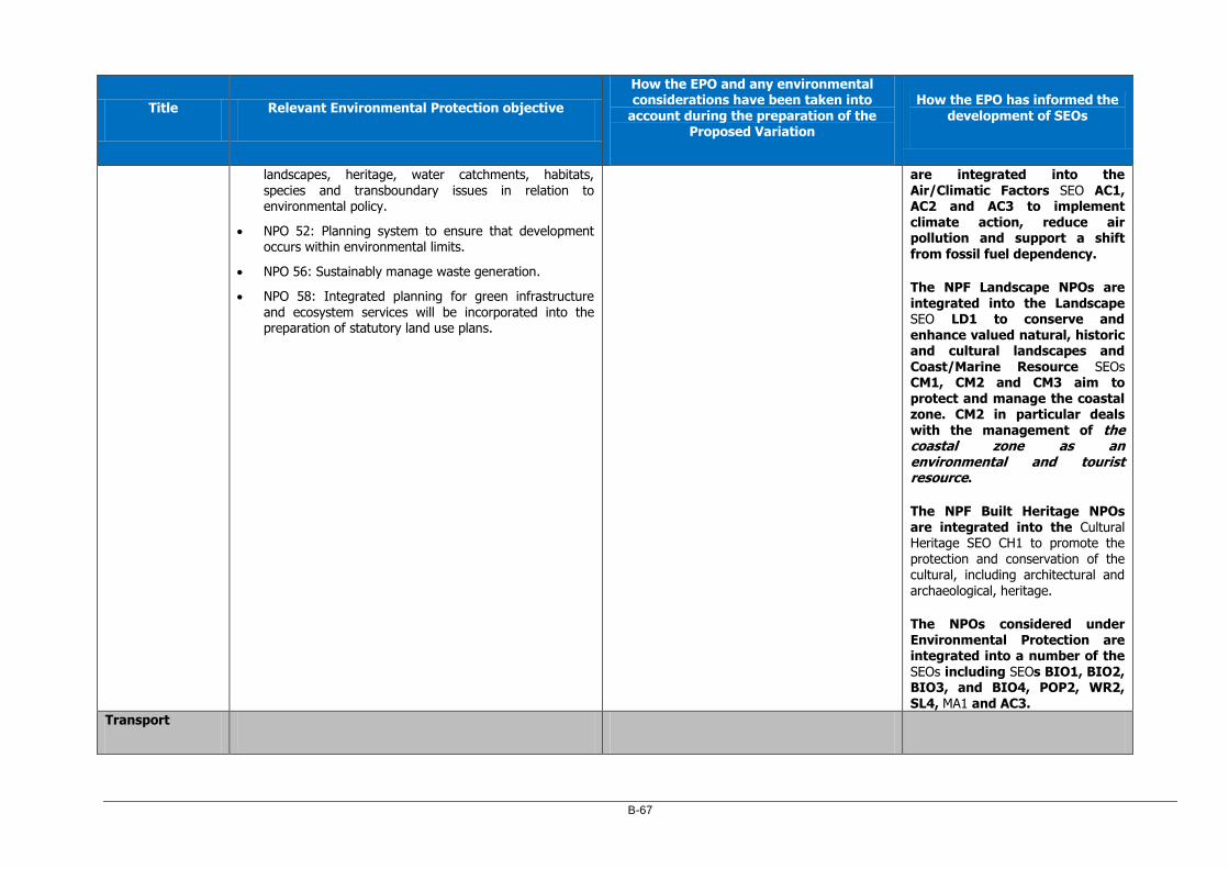
B-67
Title Relevant Environmental Protection objective
How the EPO and any environmental considerations have been taken into
account during the preparation of the Proposed Variation
How the EPO has informed the development of SEOs
landscapes, heritage, water catchments, habitats, species and transboundary issues in relation to environmental policy.
NPO 52: Planning system to ensure that development occurs within environmental limits.
NPO 56: Sustainably manage waste generation.
NPO 58: Integrated planning for green infrastructure and ecosystem services will be incorporated into the preparation of statutory land use plans.
are integrated into the Air/Climatic Factors SEO AC1, AC2 and AC3 to implement climate action, reduce air pollution and support a shift
from fossil fuel dependency.
The NPF Landscape NPOs are integrated into the Landscape SEO LD1 to conserve and enhance valued natural, historic and cultural landscapes and Coast/Marine Resource SEOs CM1, CM2 and CM3 aim to protect and manage the coastal zone. CM2 in particular deals with the management of the coastal zone as an environmental and tourist resource.
The NPF Built Heritage NPOs are integrated into the Cultural Heritage SEO CH1 to promote the protection and conservation of the cultural, including architectural and archaeological, heritage.
The NPOs considered under Environmental Protection are integrated into a number of the SEOs including SEOs BIO1, BIO2, BIO3, and BIO4, POP2, WR2, SL4, MA1 and AC3.
Transport

B-68
Title Relevant Environmental Protection objective
How the EPO and any environmental considerations have been taken into
account during the preparation of the Proposed Variation
How the EPO has informed the development of SEOs
National
Smarter Travel – A Sustainable Transport Future, ‘A New Transport Policy for Ireland’ 2009-2020
This document sets out 5 key environmental related goals:
1) to reduce overall travel demand, 2) to maximise the efficiency of the transport network 3) to reduce reliance on fossil fuels 4) to reduce transport emissions 5) to improve accessibility to transport
The fundamental purpose of the Proposed Variation is to create a spatial and policy framework to facilitate the TEN-T PRIPD which is a strategic transport project.
The stated project objectives of the TEN-T PRIPD are intended to achieve a number of transport related environmental objectives and address existing environmental considerations including:
To reduce overall air pollution levels near sensitive receptors caused by congestive queuing of vehicles and/or excessive vertical gradients.
To reduce overall traffic noise levels near sensitive receptors; includes ribbon developments.
To reduce risk of watercourse pollution along the existing road network.
In addition by segregating strategic traffic from local traffic in urban areas the project will free up road space for more sustainable transportation modes including walking, cycling and bus transport.
No specific SEA Objective has been developed from Smarter Travel. However, the Population SEO POP2 aims to facilitate more sustainable travel patterns.

C-1
Appendix C Conservation Objectives of European Sites

C-2
Site
Code
Site Name TEN-T
PRIPD
Qualifying Interests / Special Conservation
Interests
Conservation Objectives
002301
River Finn SAC Section 1
Section 2
Section 3
3110 Oligotrophic waters containing very few minerals of sandy plains (Littorelletalia uniflorae)
4010 Northern Atlantic wet heaths with Erica tetralix
7130 Blanket bogs (* if active bog)
7140 Transition mires and quaking bogs
1106 Salmon Salmo salar
1355 Otter Lutra lutra
31st May 2017 Version 1
To restore the favourable conservation condition of Oligotrophic waters, as defined by 18 no. attributes and targets;
To restore the favourable conservation condition of Northern Atlantic wet heaths, as defined by 20 no. attributes and targets;
To restore the favourable conservation condition of Blanket bogs, as defined by 19 no. attributes and targets;
To restore the favourable conservation condition of Transition mires and quaking bogs, as defined by 13 no. attributes and targets;
To maintain the favourable conservation condition of Salmon, as defined by 6 no. attributes and targets;
To maintain the favourable conservation condition of Otter, as defined by 7 no. attributes and targets;
UK0030320
River Foyle and Tributaries NI SAC
Section 1
Section 2
Section 3
3260 Water courses of plain to montane levels with the Ranunculion fluitantis and Callitricho-Batrachion vegetation
1106 Atlantic salmon Salmo salar
1355 Otter Lutra lutra
27th July 2017 Version 3 DAERA
To maintain (or restore where appropriate) the Qualifying Interests to favourable condition, as defined by:
2 no. objectives for Atlantic Salmon;
4 no. objectives for Water courses of plain to montane levels; and
2 no. objectives for Otter.
000129 Croaghonagh Bog SAC Section 1
Section 3
7130 Blanket bogs (* if active bog) 15th May 2017 Version 1
To restore the favourable conservation condition of Blanket bogs
(* if active bog), as defined by 19 no. attributes and targets.
UK0030211 Moneygal Bog NI SAC Section 1
Section 3
7110 Active raised bog
01st April 2015 Version 2 DAERA
To maintain (or restore where appropriate) the Qualifying

C-3
Site
Code
Site Name TEN-T
PRIPD
Qualifying Interests / Special Conservation
Interests
Conservation Objectives
Interests to favourable condition, as defined by:
6 no. objectives for Active raised bog.
002287
Lough Swilly SAC Section 1
Section 2
Section 3
1130 Estuaries
1150 * Coastal lagoons
1330 Atlantic salt meadows (Glauco‐Puccinellietalia maritimae)
1355 Otter Lutra lutra
91A0 Old sessile oak woods with Ilex and Blechnum in the British Isles
19th July 2011 Version 1
To maintain the favourable conservation condition of Estuaries, as defined by 2 no. attributes and targets;
To restore the favourable conservation condition of Coastal Lagoons, as defined by 11 no. attributes and targets;
To restore the favourable conservation condition of Atlantic salt meadows, as defined by 10 no. attributes and targets;
To restore the favourable conservation condition of Otter, as defined by 8 no. attributes and targets; and
To restore the favourable conservation condition of Old sessile oak woods, as defined by 12 no. attributes and targets.
004075 Lough Swilly SPA Section 1
Section 2
Section 3
A005 Great Crested Grebe Podiceps cristatus
A028 Grey Heron Ardea cinerea
A038 Whooper Swan Cygnus cygnus
A043 Greylag Goose Anser anser
A048 Shelduck Tadorna tadorna
A050 Wigeon Anas penelope
A052 Teal Anas crecca
A053 Mallard Anas platyrhynchos
A056 Shoveler Anas clypeata
A062 Scaup Aythya marila
A067 Goldeneye Bucephala clangula
A069 Red‐breasted Merganser Mergus serrator
A125 Coot Fulica atra
A130 Oystercatcher Haematopus ostralegus
19th July 2011 Version 1 NPWS
To maintain the favourable conservation condition of Great Crested Grebe, as defined by 2 no. attributes and targets;
To maintain the favourable conservation condition of Grey Heron, as defined by 2 no. attributes and targets;
To maintain the favourable conservation condition of Whooper Swan, as defined by 2 no. attributes and targets;
To maintain the favourable conservation condition of Greylag
Goose, as defined by 2 no. attributes and targets;
To maintain the favourable conservation condition of Shelduck, as defined by 2 no. attributes and targets;
To maintain the favourable conservation condition of Wigeon, as defined by 2 no. attributes and targets;
To maintain the favourable conservation condition of Teal, as defined by 2 no. attributes and targets;
To maintain the favourable conservation condition of Mallard,
as defined by 2 no. attributes and targets;

C-4
Site Code
Site Name TEN-T PRIPD
Qualifying Interests / Special Conservation Interests
Conservation Objectives
A143 Knot Calidris canutus
A149 Dunlin Calidris alpina
A160 Curlew Numenius arquata
A162 Redshank Tringa totanus
A164 Greenshank Tringa nebularia
A179 Black‐headed Gull Chroicocephalus ridibundus
A182 Common Gull Larus canus
A191 Sandwich Tern Sterna sandvicensis
A193 Common Tern Sterna hirundo
A395 Greenland White‐fronted goose Anser albifrons flavirostris wintering
A999 Wetlands & Waterbirds
To maintain the favourable conservation condition of Shoveler, as defined by 2 no. attributes and targets;
To maintain the favourable conservation condition of Scaup, as defined by 2 no. attributes and targets;
To maintain the favourable conservation condition of
Goldeneye, as defined by 2 no. attributes and targets;
To maintain the favourable conservation condition of Red‐breasted Merganser, as defined by 2 no. attributes and targets;
To maintain the favourable conservation condition of Coot, as defined by 2 no. attributes and targets;
To maintain the favourable conservation condition of Oystercatcher, as defined by 2 no. attributes and targets;
To maintain the favourable conservation condition of Knot, as defined by 2 no. attributes and targets;
To maintain the favourable conservation condition of Dunlin, as defined by 2 no. attributes and targets;
To maintain the favourable conservation condition of Curlew, as defined by 2 no. attributes and targets;
To maintain the favourable conservation condition of Redshank, as defined by 2 no. attributes and targets;
To maintain the favourable conservation condition of
Greenshank, as defined by 2 no. attributes and targets;
To maintain the favourable conservation condition of Black‐headed Gull, as defined by 3 no. attributes and targets;
To maintain the favourable conservation condition of Common Gull, as defined by 2 no. attributes and targets;
To maintain the favourable conservation condition of Sandwich Tern, as defined by 3 no. attributes and targets;
To maintain the favourable conservation condition of Common Tern, as defined by 3 no. attributes and targets;
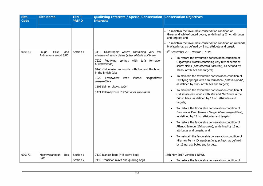
C-5
Site
Code
Site Name TEN-T
PRIPD
Qualifying Interests / Special Conservation
Interests
Conservation Objectives
To maintain the favourable conservation condition of Greenland White‐fronted goose, as defined by 2 no. attributes and targets; and
To maintain the favourable conservation condition of Wetlands & Waterbirds, as defined by 1 no. attribute and target.
000163 Lough Eske and Ardnamona Wood SAC
Section 1
3110 Oligotrophic waters containing very few minerals of sandy plains (Littorelletalia uniflorae)
7220 Petrifying springs with tufa formation (Cratoneurion)
91A0 Old sessile oak woods with Ilex and Blechnum in the British Isles
1029 Freshwater Pearl Mussel Margaritifera margaritifera
1106 Salmon Salmo salar
1421 Killarney Fern Trichomanes speciosum
11th September 2019 Version 1 NPWS
To restore the favourable conservation condition of
Oligotrophic waters containing very few minerals of
sandy plains (Littorelletalia uniflorae), as defined by
18 no. attributes and targets;
To maintain the favourable conservation condition of
Petrifying springs with tufa formation (Cratoneurion)*,
as defined by 9 no. attributes and targets;
To maintain the favourable conservation condition of
Old sessile oak woods with Ilex and Blechnum in the
British Isles, as defined by 13 no. attributes and
targets;
To restore the favourable conservation condition of
Freshwater Pearl Mussel (Margaritifera margaritifera),
as defined by 13 no. attributes and targets;
To restore the favourable conservation condition of
Atlantic Salmon (Salmo salar), as defined by 13 no.
attributes and targets; and
To maintain the favourable conservation condition of
Killarney Fern (Vandenboschia speciosa), as defined
by 16 no. attributes and targets.
000173 Meentygrannagh Bog SAC
Section 1
Section 2
7130 Blanket bogs (* if active bog)
7140 Transition mires and quaking bogs
15th May 2017 Version 1 NPWS
To restore the favourable conservation condition of
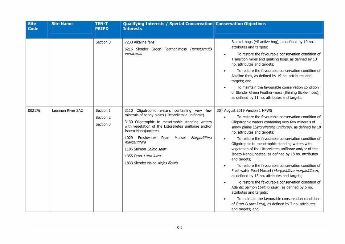
C-6
Site Code
Site Name TEN-T PRIPD
Qualifying Interests / Special Conservation Interests
Conservation Objectives
Section 3
7230 Alkaline fens
6216 Slender Green Feather-moss Hamatocaulis vernicosus
Blanket bogs (*if active bog), as defined by 19 no.
attributes and targets;
To restore the favourable conservation condition of
Transition mires and quaking bogs, as defined by 13
no. attributes and targets;
To restore the favourable conservation condition of
Alkaline fens, as defined by 19 no. attributes and
targets; and
To maintain the favourable conservation condition
of Slender Green Feather-moss (Shining Sickle-moss),
as defined by 11 no. attributes and targets.
002176 Leannan River SAC Section 1
Section 2
Section 3
3110 Oligotrophic waters containing very few
minerals of sandy plains (Littorelletalia uniflorae)
3130 Oligotrophic to mesotrophic standing waters with vegetation of the Littorelletea uniflorae and/or Isoeto-Nanojuncetea
1029 Freshwater Pearl Mussel Margaritifera margaritifera
1106 Salmon Salmo salar
1355 Otter Lutra lutra
1833 Slender Naiad Najas flexilis
30th August 2019 Version 1 NPWS
To restore the favourable conservation condition of
Oligotrophic waters containing very few minerals of
sandy plains (Littorelletalia uniflorae), as defined by 18
no. attributes and targets;
To restore the favourable conservation condition of
Oligotrophic to mesotrophic standing waters with
vegetation of the Littorelletea uniflorae and/or of the
Isoëto-Nanojuncetea, as defined by 18 no. attributes
and targets;
To restore the favourable conservation condition of
Freshwater Pearl Mussel (Margaritifera margaritifera),
as defined by 13 no. attributes and targets;
To restore the favourable conservation condition of
Atlantic Salmon (Salmo salar), as defined by 6 no.
attributes and targets;
To maintain the favourable conservation condition
of Otter (Lutra lutra), as defined by 7 no. attributes
and targets; and
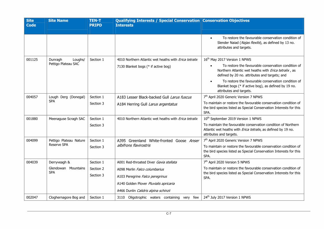
C-7
Site
Code
Site Name TEN-T
PRIPD
Qualifying Interests / Special Conservation
Interests
Conservation Objectives
To restore the favourable conservation condition of
Slender Naiad (Najas flexilis), as defined by 13 no.
attributes and targets.
001125 Dunragh Loughs/
Pettigo Plateau SAC
Section 1
4010 Northern Atlantic wet heaths with Erica tetralix
7130 Blanket bogs (* if active bog)
16th May 2017 Version 1 NPWS
To restore the favourable conservation condition of
Northern Atlantic wet heaths with Erica tetralix , as
defined by 20 no. attributes and targets; and
To restore the favourable conservation condition of
Blanket bogs (* if active bog), as defined by 19 no.
attributes and targets.
004057 Lough Derg (Donegal) SPA
Section 1
Section 3
A183 Lesser Black-backed Gull Larus fuscus
A184 Herring Gull Larus argentatus
7th April 2020 Generic Version 7 NPWS
To maintain or restore the favourable conservation condition of
the bird species listed as Special Conservation Interests for this
SPA.
001880 Meenaguse Scragh SAC Section 1
Section 3
4010 Northern Atlantic wet heaths with Erica tetralix 10th September 2019 Version 1 NPWS
To maintain the favourable conservation condition of Northern
Atlantic wet heaths with Erica tetralix, as defined by 19 no.
attributes and targets.
004099 Pettigo Plateau Nature Reserve SPA
Section 1
Section 3
A395 Greenland White-fronted Goose Anser albifrons flavirostris
7th April 2020 Generic Version 7 NPWS
To maintain or restore the favourable conservation condition of
the bird species listed as Special Conservation Interests for this
SPA.
004039 Derryveagh &
Glendowan Mountains SPA
Section 1
Section 2
Section 3
A001 Red-throated Diver Gavia stellata
A098 Merlin Falco columbarius
A103 Peregrine Falco peregrinus
A140 Golden Plover Pluvialis apricaria
A466 Dunlin Calidris alpina schinzii
7th April 2020 Version 5 NPWS
To maintain or restore the favourable conservation condition of
the bird species listed as Special Conservation Interests for this
SPA.
002047 Cloghernagore Bog and Section 1 3110 Oligotrophic waters containing very few 24th July 2017 Version 1 NPWS

C-8
Site
Code
Site Name TEN-T
PRIPD
Qualifying Interests / Special Conservation
Interests
Conservation Objectives
Glenveagh National
Park SAC Section 2
Section 3
minerals of sandy plains (Littorelletalia uniflorae)
3260 Water courses of plain to montane levels with the Ranunculion fluitantis and Callitricho-Batrachion vegetation
4010 Northern Atlantic wet heaths with Erica tetralix
4030 European dry heaths
4060 Alpine and Boreal heaths
6410 Molinia meadows on calcareous, peaty or clayey-silt-laden soils (Molinion caeruleae)
7130 Blanket bogs (* if active bog)
7150 Depressions on peat substrates of the Rhynchosporion
91A0 Old sessile oak woods with Ilex and Blechnum in the British Isles
1029 Freshwater Pearl Mussel Margaritifera margaritifera
1106 Salmon Salmo salar
1355 Otter Lutra lutra
1421 Killarney Fern Trichomanes speciosum
To maintain the favourable conservation condition of
Oligotrophic waters containing very few minerals of
sandy plains (Littorelletalia uniflorae), as defined by 18
no. attributes and targets;
To maintain the favourable conservation condition of
Water courses of plain to montane levels with the
Ranunculion fluitantis and Callitricho-Batrachion
vegetation, as defined by 9 no. attributes and targets;
To restore the favourable conservation condition of
Northern Atlantic wet heaths with Erica tetralix, as
defined by 20 no. attributes and targets;
To restore the favourable conservation condition of
European dry heaths, as defined by 19 no. attributes
and targets;
To restore the favourable conservation condition of
Alpine and Boreal heaths, as defined by 14 no.
attributes and targets;
To maintain the favourable conservation condition of
Molinia meadows on calcareous, peaty or clayey-silt-
laden soils (Molinion caeruleae), as defined by 13 no.
attributes and targets;
To restore the favourable conservation condition of
Blanket bogs (* if active bog), as defined by 19 no.
attributes and targets;
To restore the favourable conservation condition of
Depressions on peat substrates of the Rhynchosporion,
as defined by 16 no. attributes and targets;
To restore the favourable conservation condition of
Old sessile oak woods with Ilex and Blechnumin the
British Isles, as defined by 12 no. attributes and
targets;
To restore the favourable conservation condition of

C-9
Site Code
Site Name TEN-T PRIPD
Qualifying Interests / Special Conservation Interests
Conservation Objectives
Freshwater Pearl Mussel, as defined by 16 no.
attributes and targets;
To maintain the favourable conservation condition of
Atlantic Salmon, as defined by 6 no. attributes and
targets;
To maintain the favourable conservation condition of
Otter, as defined by 7 no. attributes and targets; and
To maintain the favourable conservation condition of
Killarney Fern, as defined by 16 no. attributes and
targets.
002012 North Inishowen Coast
SAC
Section 2
Section 3
1140 Mudflats and sandflats not covered by seawater
at low tide
1220 Perennial vegetation of stony banks
1230 Vegetated sea cliffs of the Atlantic and Baltic
coasts
2130 Fixed coastal dunes with herbaceous vegetation
(grey dunes)
21A0 Machairs (* in Ireland)
4030 European dry heaths
1014 Narrow-mouthed Whorl Snail Vertigo angustior
1355 Otter Lutra lutra
24th November 2014 Version 1 NPWS
To maintain the favourable conservation condition of
Mudflats and sandflats not covered by seawater at low
tide, as defined by 4 no. attributes and targets;
To maintain the favourable conservation condition of
Perennial vegetation of stony banks, as defined by 6
no. attributes and targets;
To maintain the favourable conservation condition of
Vegetated sea cliffs of the Atlantic and Baltic coasts,
as defined by 8 no. attributes and targets;
To restore the favourable conservation condition of
Fixed coastal dunes with herbaceous vegetation ('grey
dunes'), as defined by 9 no. attributes and targets;
To restore the favourable conservation condition of
Machairs, as defined by 10 no. attributes and targets;
To maintain the favourable conservation condition of
European dry heaths, as defined by 17 no. attributes
and targets;
To maintain the favourable conservation condition of
Narrow-mouthed Whorl Snail, as defined by 7 no.
attributes and targets; and

C-10
Site
Code
Site Name TEN-T
PRIPD
Qualifying Interests / Special Conservation
Interests
Conservation Objectives
To maintain the favourable conservation condition of
Otter, as defined by 8 no. attributes and targets.
004060 Lough Fern SPA Section 1
Section 2
Section 3
A059 Pochard Aythya ferina 7th April 2020 Generic Version 7 NPWS
To maintain or restore the favourable conservation condition of the bird species listed as Special Conservation Interests for this SPA.
000116 Ballyarr Wood SAC Section 2
Section 3
91A0 Old sessile oak woods with Ilex and Blechnum
in the British Isles
7th April 2020 Generic Version 7 NPWS
To maintain or restore the favourable conservation condition of
the Annex I habitat(s) and/or the Annex II species for which
the SAC has been selected
001975 Ballyhoorisky Point to Fanad Head SAC
Section 2
Section 3
1220 Perennial vegetation of stony banks
1230 Vegetated sea cliffs of the Atlantic and Baltic coasts
3130 Oligotrophic to mesotrophic standing waters with vegetation of the Littorelletea uniflorae and/or Isoeto-Nanojuncetea
3140 Hard oligo-mesotrophic waters with benthic vegetation of Chara spp.
1014 Narrow-mouthed Whorl Snail Vertigo angustior
1833 Slender Naiad Najas flexilis
27th January 2017 Version 1 NPWS
To restore the favourable conservation condition of
Perennial vegetation of stony banks, as defined by 6 no. attributes and targets;
To maintain the favourable conservation condition of Vegetated sea cliffs of the Atlantic and Baltic coasts, as defined by 8 no. attributes and targets;
To maintain the favourable conservation condition of Oligotrophic to mesotrophic standing waters with vegetation of the Littorelletea uniflorae and/or of the Isoëto-Nanojuncetea, as defined by 18 no. attributes and targets;
To maintain the favourable conservation condition of Hard oligo-mesotrophic waters with benthic vegetation of Chara spp., as defined by 18 no. attributes and targets;
To maintain the favourable conservation condition of Narrow-mouthed Whorl Snail, as defined by 4 no. attributes and targets; and
To maintain the favourable conservation condition of
Slender Naiad, as defined by 13 no. attributes and targets.

C-11
Site Code
Site Name TEN-T PRIPD
Qualifying Interests / Special Conservation Interests
Conservation Objectives
004194 Horn Head to Fanad Head SPA
Section 2
Section 3
A009 Fulmar Fulmarus glacialis
A017 Cormorant Phalacrocorax carbo
A018 Shag Phalacrocorax aristotelis
A045 Barnacle Goose Branta leucopsis
A103 Peregrine Falco peregrinus
A188 Kittiwake Rissa tridactyla
A199 Guillemot Uria aalge
A200 Razorbill Alca torda
A346 Chough Pyrrhocorax pyrrhocorax
A395 Greenland White-fronted Goose Anser albifrons flavirostris
7th April 2020 Generic Version 7 NPWS
To maintain or restore the favourable conservation condition of the bird species listed as Special Conservation Interests for this SPA.
004148 Fanad Head SPA Section 2
Section 3
A122 Corncrake Crex crex 7th April 2020 Generic Version 7 NPWS
To maintain or restore the favourable conservation condition of the bird species listed as Special Conservation Interests for this SPA.
UK0030233 Owenkillew River NI SAC
Section 3 3260 Water courses of plain to montane levels with the Ranunculus fluitans and Callitricho-Batrachion vegetation
91A0 Old Sessile Oak woods with Ilex and Blechnum in the British Isles
91D0 Bog Woodland
1355 Otter Lutra lutra
1106 Atlantic Salmon Salmo salar
27th July 2017 Version 3 DAERA
To maintain (or restore where appropriate) the Qualifying Interests to favourable condition, as defined by:
6 no. objectives for Freshwater Pearl Mussel;
4 no. objectives for Water courses of plain to montane levels with the Ranunculus fluitans and Callitricho-Batrachion vegetation;
5 no. objectives for Old Sessile Oak woods with Ilex and Blechnum in the British Isles;
5 no. objectives for Bog woodland;
2 no. objectives for Otter; and
2 no. objectives for Atlantic Salmon.

C-12