Embed Size (px)
Citation preview
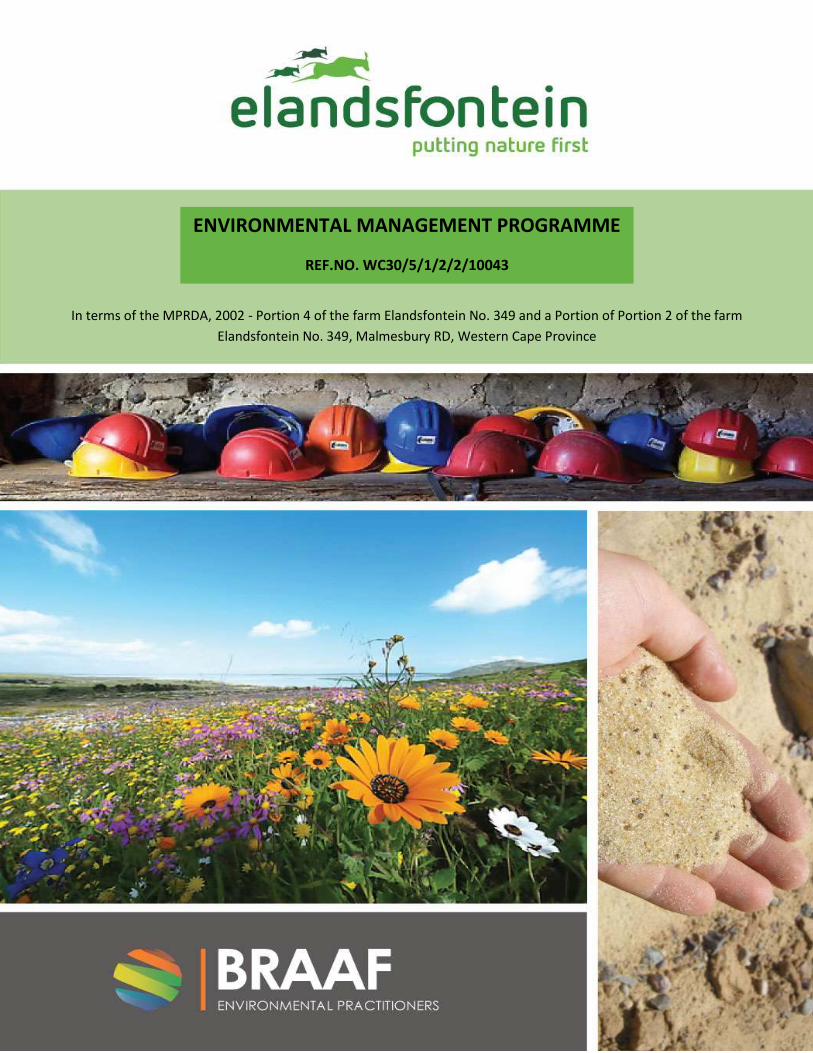
ENVIRONMENTAL MANAGEMENT PROGRAMME
REF.NO. WC30/5/1/2/2/10043
In terms of the MPRDA, 2002 - Portion 4 of the farm Elandsfontein No. 349 and a Portion of Portion 2 of the farm
Elandsfontein No. 349, Malmesbury RD, Western Cape Province
ENVIRONMENTAL IMPACT ASSESSMENT AND
ENVIRONMENTAL MANAGEMENT PROGRAMME
SUBMITTED FOR AN APPLICATION
FOR A MINING RIGHT
IN TERMS OF SECTION 39 AND OF
REGULATIONS 50 AND 51 OF THE MINERAL
AND PETROLEUM RESOURCES DEVELOPMENT
ACT, 2002, (ACT NO. 28 OF 2002) (the Act)

STANDARD DIRECTIVE
All applicants for mining rights are herewith, in terms of the provisions of Section 29 (a) and in terms
of section 39 (5) of the Mineral and Petroleum Resources Development Act, directed to submit an
environmental Impact Assessment, and an Environmental Management Programme strictly in
accordance with the subject headings herein, and to compile the content according to all the sub
items to the said subject headings referred to in the guideline published on the Departments
website, within 30 days of notification by the Regional Manager of the acceptance of such
application.
PROJECT NUMBER: 10043 PAGE: i
REPORT NUMBER: 10043EMP DATE:2/09/2014
PROJECT INFORMATION
TITLE :
REVISED SCOPING REPORT FOR A PROPOSED PHOSPHATE MINE ON FARM ELANDSFONTEIN NO. 349, PORTION 4
AND A PORTION OF PORTION 2, MALMESBURY RD
REPORT NO. : DATE : REPORT STATUS :
BEP EMP0701-1 2014-09-01 Revision (Draft)
CARRIED OUT BY : PREPARED FOR:
Billet Trade (Pty) Ltd T/A Braaf Environmental
Practitioners
Elandsfontein Exploration and Mining (Pty) Ltd
P O Box 692 P.O. Box 12559
KUILS RIVER N1 CITY
7579 7463
Tel (0860) 111 382 Tel (021) 930 0927
Fax (086) 658 7676 Fax (021) 930 2587
Email: [email protected] Email: [email protected]
AUTHOR : CLIENT CONTACT PERSONS :
Olivia Braaf Michelle Schroder
SYNOPSIS :
EIA/EMP for Elandsfontein Phosphate Mine

PROJECT NUMBER: 10043 PAGE: ii
REPORT NUMBER: 10043EMP DATE:2/09/2014
KEY WORDS :
EIA/EMP
© COPYRIGHT: Braaf Environmental Practitioners
PROJECT NUMBER: 10043 PAGE: iii
REPORT NUMBER: 10043EMP DATE:2/09/2014
Verification Capacity Name Signature Date
By Author Director O J Braaf
Checked by
Authorised by
Rev No Date Revision Details
0 01/09/2014
PROJECT NUMBER: 10043 PAGE: iv
REPORT NUMBER: 10043EMP DATE:2/09/2014
Issue Control
Copy No Controlled copy issued to:
Revision
1 2 3 4 5 6 7
1
2
3
4
5
6
7
PROJECT NUMBER: 10043 PAGE: v
REPORT NUMBER: 10043EMP DATE:2/09/2014
1. TABLE OF CONTENTS
1. INTRODUCTION AND SCOPE OF REPORT ................................................................................ 1
1.1. Project details ....................................................................................................................................... 2
1.2. Proponent details .................................................................................................................................. 2
1.3. Details of the properties affected by proposed project ........................................................................ 3
1.4. Details of Environmental Assessment Practitioner ............................................................................... 3
1.5. Competent authorities .......................................................................................................................... 3
1.6. Local authorities .................................................................................................................................... 4
1.7. Document Structure .............................................................................................................................. 6
2. LEGAL REQUIREMENTS FOR AUTHORISATION FOR ELANDSFONTEIN MINE ............................. 8
2.1. Legislative Framework .......................................................................................................................... 8
2.2. National Legislative and Policy requirements ....................................................................................... 8
2.2.1. Mineral and Petroleum Resources Development Act (No. 28 of 2002) ....................................... 8
2.2.2. National Environmental Management Act (No 107 of 1998) (NEMA) and the National
Environmental Management Amendment Act (No 62 of 2008) .................................................................... 9
2.2.3. National Environmental Management: Waste Act, 2008 (No. 59 of 2008) (NEMWA)............... 16
2.2.4. National Heritage Resources Act (No. 25 of 1999) ..................................................................... 17
2.2.5. National Water Act (No. 36 of 1998) (NWA) .............................................................................. 18
2.2.6. The National Environmental Management: Biodiversity Act, 2008 (No. 10 of 2004) (NEMBA)
and associated legislation ............................................................................................................................ 19
2.2.7. Conservation of Agricultural Resources Act (No. 43 of 1983) .................................................... 19
2.2.8. National Forest Act (No. 84 of 1998) .......................................................................................... 20
2.2.9. Legal Process Followed to Date for Obtaining the Mining Rights .............................................. 21
2.2.10. Broader Policy and Planning Context ......................................................................................... 25
3. PROJECT BACKGROUND AND MOTIVATION ......................................................................... 33
3.1. Introduction ........................................................................................................................................ 33
3.1.1. Project History ............................................................................................................................ 33
3.1.2. Proposed motivation .................................................................................................................. 34
PROJECT NUMBER: 10043 PAGE: vi
REPORT NUMBER: 10043EMP DATE:2/09/2014
4. PROJECT DESCRIPTION ........................................................................................................ 39
4.1. Project Location .................................................................................................................................. 39
4.2. Proposed Project ................................................................................................................................. 39
4.3. Property Details .................................................................................................................................. 39
4.4. Mining ................................................................................................................................................. 41
4.4.1. Estimate Reserves And Extent Of Target Area ........................................................................... 41
4.4.2. Proposed Layout and Pit Design ................................................................................................. 42
4.4.3. Mining Method ........................................................................................................................... 45
4.5. Mining Sequence ................................................................................................................................. 47
4.6. Ore Processing Facilities ...................................................................................................................... 48
4.7. Softs Stockpiles (Waste Rock) ............................................................................................................. 49
4.8. Overview Of Processing Method......................................................................................................... 54
4.8.1. Chemicals Used .......................................................................................................................... 54
4.9. Support Services .................................................................................................................................. 56
4.9.1. Waste Facilities ........................................................................................................................... 56
4.9.2. Water Management ................................................................................................................... 59
4.10. Construction Phase ............................................................................................................................. 79
4.10.1. Job Creation during the Construction Phase .............................................................................. 79
4.10.2. Construction Camp Infrastructure (Office, Workshop, Temporary Storage of Fuels and Wastes)
79
4.10.3. Bulk Service Requirements for the Construction Camp ............................................................. 80
4.10.4. Power ......................................................................................................................................... 80
4.10.5. Fuel and Lubricants .................................................................................................................... 80
4.10.6. Sewage ....................................................................................................................................... 81
4.10.7. Access Roads .............................................................................................................................. 81
4.10.8. Non-mineral Waste Management .............................................................................................. 81
4.11. Project phases and activities ............................................................................................................... 81
5. PROJECT ALTERNATIVES ...................................................................................................... 88
PROJECT NUMBER: 10043 PAGE: vii
REPORT NUMBER: 10043EMP DATE:2/09/2014
5.1. Introduction ........................................................................................................................................ 88
5.2. Mitigation Hierarchy: Avoidance, Prevention And Minimization Of Impacts ..................................... 88
5.3. Analysis Of Open Pit And Underground Mining Techniques............................................................... 89
5.3.1. Open Pit VS Underground Mining .............................................................................................. 89
5.3.2. Alternatives Considered For Surface Mining (Open Pit) ............................................................. 89
5.3.3. Location alternatives for mine infrstructure .............................................................................. 90
5.4. Planning and design ............................................................................................................................ 92
5.5. Outcomes Of Avoidance...................................................................................................................... 99
5.5.1. Softs Stockpiles ........................................................................................................................... 99
5.5.2. Open Pit .................................................................................................................................... 101
5.6. Summary Of Alternatives .................................................................................................................. 104
5.7. Modification Of Project Design And Layout ...................................................................................... 111
5.8. Comparative Analysis Of Alternatives From The Mining Right Application Phase (Scoping To
Eia/Emp) ......................................................................................................................................................... 111
5.9. No Project Alternative ....................................................................................................................... 112
6. DESCRIPTION OF THE BASELINE ENVIRONMENT ................................................................ 113
6.1. Biophysical Environment ................................................................................................................... 113
6.1.1. Climate ..................................................................................................................................... 113
6.1.2. Topography .............................................................................................................................. 115
6.1.3. Geology..................................................................................................................................... 116
6.1.4. Prospecting Activities ............................................................................................................... 122
6.1.5. Groundwater ............................................................................................................................ 126
6.1.6. Surface Water ........................................................................................................................... 129
6.1.7. Geochemistry ........................................................................................................................... 129
6.1.8. Soil And Land Capability ........................................................................................................... 131
6.1.9. Flora .......................................................................................................................................... 131
6.2. Socio-Economic environment ........................................................................................................... 148
6.2.1. Introduction .............................................................................................................................. 148
PROJECT NUMBER: 10043 PAGE: viii
REPORT NUMBER: 10043EMP DATE:2/09/2014
6.2.2. Western Cape Province ............................................................................................................ 148
6.2.3. West Coast District Municipality .............................................................................................. 149
6.2.4. Saldanha Bay Municipality ....................................................................................................... 150
6.2.5. Description Of The Baseline Economic Environment ............................................................... 152
6.2.6. Land Use ................................................................................................................................... 159
6.2.7. Surrounding Land Use .............................................................................................................. 159
6.3. Visual ................................................................................................................................................. 162
6.4. Heritage, archaeology and paleontology .......................................................................................... 163
6.5. Traffic ................................................................................................................................................ 165
6.6. Air Quality ......................................................................................................................................... 165
6.6.1. Existing air quality .................................................................................................................... 165
6.6.2. Emissions From The Proposed Activities .................................................................................. 165
7. WASTE MANAGEMENT AND CLASSIFICATION .................................................................... 168
7.1. Introduction ...................................................................................................................................... 168
7.2. Application Of A Waste Hierarchy Approach .................................................................................... 168
7.3. Waste Generation And Classification ................................................................................................ 169
7.3.1. Mineral Wastes ........................................................................................................................ 169
7.3.2. Non-mineral Wastes ................................................................................................................. 169
7.4. Assessment Of Potential Environmental Impacts ............................................................................. 175
7.5. Waste Management .......................................................................................................................... 179
7.5.1. Hazardous and Non-hazardous Solid Waste Disposal .............................................................. 179
7.5.2. Cleaner Production and Design ................................................................................................ 179
7.5.3. Waste Management Infrastructure .......................................................................................... 179
7.5.4. Implementing the Waste Hierarchy ......................................................................................... 181
7.5.5. Conclusion ................................................................................................................................ 183
8. ENVIRONMENTAL IMPACT ASSESSMENT METHODOLOGY ................................................. 185
8.1. Flora Impacts ..................................................................................................................................... 187
8.2. Avifauna ............................................................................................................................................ 196
PROJECT NUMBER: 10043 PAGE: ix
REPORT NUMBER: 10043EMP DATE:2/09/2014
8.3. Visual Assessment ............................................................................................................................. 203
8.4. Heritage, Archaeology And Paleontology Assessment ..................................................................... 212
8.5. Traffic Impact .................................................................................................................................... 218
8.6. Fauna assessment ............................................................................................................................. 223
8.7. Freshwater Assessment .................................................................................................................... 225
8.8. Groundwater Impact ......................................................................................................................... 227
8.9. Air Quality ......................................................................................................................................... 232
8.10. Socio-Economic ................................................................................................................................. 235
8.10.1. Impacts linked to Project Expenditure ..................................................................................... 235
9. ENVIRONMENTAL MANAGEMENT PROGRAMME............................................................... 246
9.1. Objectives Of The Empr..................................................................................................................... 246
9.2. Roles And Responsibilities................................................................................................................. 247
9.3. Construction Environmental Management Programme (Cempr) ..................................................... 249
9.3.1. Application ............................................................................................................................... 250
9.3.2. Method Statements .................................................................................................................. 250
9.3.3. Environmental Awareness Training .......................................................................................... 251
9.3.4. Temporary Construction Camp and Site Division ..................................................................... 251
9.3.5. Vegetation Clearing .................................................................................................................. 251
9.3.6. Access/Haul Routes .................................................................................................................. 251
9.3.7. Fuel Storage and Use ................................................................................................................ 251
9.3.8. Solid Waste Management ........................................................................................................ 252
9.3.9. Contaminated Water ................................................................................................................ 252
9.3.10. Hazardous Substances .............................................................................................................. 252
9.3.11. Cement and Concrete Batching ................................................................................................ 252
9.3.12. Emergency Procedures and Equipment ................................................................................... 252
9.3.13. Erosion and Sedimentation Control ......................................................................................... 252
9.3.14. Traffic management ................................................................................................................. 253
9.3.15. Site Establishment .................................................................................................................... 253
PROJECT NUMBER: 10043 PAGE: x
REPORT NUMBER: 10043EMP DATE:2/09/2014
9.3.16. Access Routes/ Haul Roads ....................................................................................................... 254
9.3.17. General Requirements .............................................................................................................. 254
9.3.18. Fuel (Petrol and Diesel) and Oils (Heavy fuel oils included) ..................................................... 254
9.3.19. Solid Waste Management ........................................................................................................ 256
9.3.20. Ablution Facilities ..................................................................................................................... 257
9.3.21. Eating Areas .............................................................................................................................. 258
9.3.22. Drinking Water ......................................................................................................................... 258
9.3.23. Contaminated Water ................................................................................................................ 258
9.3.24. Hazardous Substances .............................................................................................................. 258
9.3.25. Site Structures .......................................................................................................................... 259
9.3.26. Lights ........................................................................................................................................ 259
9.3.27. Workshop, Equipment Maintenance and Storage ................................................................... 259
9.3.28. Noise ......................................................................................................................................... 260
9.3.29. Environmental Awareness Training .......................................................................................... 260
9.3.30. Contractor’s Environmental Officer .......................................................................................... 261
9.3.31. "No go" Areas ........................................................................................................................... 261
9.3.32. Construction Personnel Information Posters ........................................................................... 261
9.3.33. Fire Control ............................................................................................................................... 261
9.3.34. Concrete and Cement Work ..................................................................................................... 262
9.3.35. Emergency Procedures ............................................................................................................. 262
9.3.36. Safety ........................................................................................................................................ 263
9.3.37. Security ..................................................................................................................................... 263
9.3.38. Community Relations ............................................................................................................... 263
9.3.39. Protection of Natural Features ................................................................................................. 264
9.3.40. Protection of Flora and Fauna .................................................................................................. 264
9.3.41. Erosion and Sedimentation Control ......................................................................................... 264
9.3.42. Aesthetics ................................................................................................................................. 265
9.3.43. Dust Control.............................................................................................................................. 265
PROJECT NUMBER: 10043 PAGE: xi
REPORT NUMBER: 10043EMP DATE:2/09/2014
9.3.44. Pollution ................................................................................................................................... 265
9.3.45. Working Hours .......................................................................................................................... 265
9.3.46. Excavation and Trenching ......................................................................................................... 265
9.3.47. Stockpiling ................................................................................................................................ 266
9.3.48. Temporary Site Closure ............................................................................................................ 266
9.3.49. Site Clean Up And Rehabilitation .............................................................................................. 267
9.3.50. Tolerances ................................................................................................................................ 268
9.3.51. Measurement And Payment ..................................................................................................... 268
9.3.52. Basic Principles ......................................................................................................................... 268
9.3.53. Scheduled Items ....................................................................................................................... 269
9.3.54. Construction Phase Compliance: Summary Tables ................................................................... 269
9.3.55. Air Quality And Dust ................................................................................................................. 270
9.3.56. Hydrology ................................................................................................................................. 271
9.3.57. Hydrogeology ........................................................................................................................... 272
9.3.58. Flora, Fauna And Avifauna........................................................................................................ 273
9.3.59. Noise ......................................................................................................................................... 278
9.3.60. Socio-Economic ........................................................................................................................ 279
9.3.61. Heritage, Archaeology And Palaeontology ............................................................................... 280
9.3.62. Visual ........................................................................................................................................ 281
9.3.63. Traffic And Transport................................................................................................................ 283
9.4. Operational Environmental Management Programme (Oempr) ...................................................... 285
9.4.1. Scope ........................................................................................................................................ 285
9.4.2. Aim And Purpose Of The Oempr .............................................................................................. 285
9.4.3. Application ............................................................................................................................... 285
9.4.4. Environmental Liaison Committee (Elc) ................................................................................... 286
9.4.5. Elandsfontein Exploration And Mining ..................................................................................... 286
9.4.6. Environmental Site Manager (Esm) .......................................................................................... 286
9.4.7. Independent Environmental Auditor ........................................................................................ 287
PROJECT NUMBER: 10043 PAGE: xii
REPORT NUMBER: 10043EMP DATE:2/09/2014
9.5. Financing For Environmental Management ...................................................................................... 287
9.5.1. Detailed Operational Environmental Specifications ................................................................. 287
9.5.2. Operational Empr Review And Audit ........................................................................................ 289
9.5.3. Summary Of Operational Environmental Specifications .......................................................... 290
9.6. Decommissioning, Post Closure And Rehabilitation.......................................................................... 308
9.6.1. Scope ........................................................................................................................................ 308
9.6.2. Closure Vision ........................................................................................................................... 308
9.6.3. Closure objectives .................................................................................................................... 309
9.6.4. Closure Plan .............................................................................................................................. 309
9.6.5. Closure Assumptions ................................................................................................................ 309
9.6.6. Mining Methods ....................................................................................................................... 310
9.6.7. Maintenance ............................................................................................................................ 315
9.6.8. Monitoring And Evaluation ...................................................................................................... 315
9.6.9. Alien Vegetation Management ................................................................................................ 315
9.6.10. Vegetation Management Of Balance Of Property ................................................................... 316
9.6.11. Fire Prevention And Management ........................................................................................... 316
9.6.12. Infrastructure Rehabilitation .................................................................................................... 316
10. IDENTIFIED KNOWLEDGE GAPS ......................................................................................... 318
11. FINANCIAL PROVISION ...................................................................................................... 319
11.1. Closure Costs ..................................................................................................................................... 319
11.2. Calculation ......................................................................................................................................... 319
11.3. Confirmation Of The Amount That Will Be Provided Should The Right Be Granted ......................... 319
11.4. The Method Of Providing Financial Provision Contemplated In Regulation 53 ................................ 319
12. UNDERTAKING TO COMPLY WITH THE PROVISION OF THE ACT .......................................... 321
13. CONCLUSION .................................................................................................................... 322
14. REFERENCES ..................................................................................................................... 323
PROJECT NUMBER: 10043 PAGE: xiii
REPORT NUMBER: 10043EMP DATE:2/09/2014
List of Tables:
Table 1-1: Project Area in relation to adjacent towns and villages 1
Table 1-2: Name and address of applicant 2
Table 1-3: Properties where proposed mining activities will occur 3
Table 1-4: EAP details 3
Table 1-5: Competent Authority Details. 4
Table 1-6: Municipality Details 4
Table 2-1: NEMA Listed Activities for the Elandsfontein Phosphate Mine Project 11
Table 2-2: Listed activities in terms of NEMA:WA Regulations 16
Table 3-1: Sedimentary Phosphate Projects in South Africa 35
Table 4-1: Updated Mineral Resource for Elandsfontein 41
Table 4-2: Proposed Mine Plan 41
Table 4-3: Daily domestic water demand 69
Table 4-4: Advantages and disadvantages of using the alternative routes to haul material from the mine to the
harbour 74
Table 4-5: Estimated building requirements 78
Table 4-6: Construction, operational and closure details 82
Table 4-7: Project Life-Cycle of Elandsfontein Phosphate Mine 87
Table 5-1: Mitigation hierarchy 88
Table 5-2: Summary of alternatives screened out and preferred options (highlighted in blue) taken to detailed
impact assessment 105
Table 6-1: Showing Stratigraphy of Top Sand, Overburden and Ore from EEM Exploration Boreholes 125
Table 6-2: Composition of Elandsfontein Tailings (TC – Total Concentration) 130
Table 6-3: Species of Conservation Concern Present in the Study Area 133
Table 6-4: Tortoises Occurring in the Greater Area Including Elandsfontein Farm 349/2 & 4 138
Table 6-5: Snakes Occurring in the Greater Area Including Elandsfontein Farm 349/2 & 4 138
Table 6-6: List of Lizard Occurring in the Greater Area Including Elandsfontein Farm 349/2 & 139
Table 6-7: Small Mammals Occurring in the Greater Area Including Elandsfontein Farm 349/2 & 4 141
PROJECT NUMBER: 10043 PAGE: xiv
REPORT NUMBER: 10043EMP DATE:2/09/2014
Table 6-8: Priority species considered likely to occur within the impact zone of the proposed mining area, with
estimates of their relative susceptibility to the environmental impacts of the construction and operational
phases of the development. National and global conservation status is listed as per the most recent
assessment (Taylor In press, http://www.iucnredlist.org/search. Red-listed endemic species are highlighted in
grey. 146
Table 6-9: Age distribution in Ward 7, Saldanha Bay and West Coast District Municipality (%) 151
Table 6-10: Education levels in Ward 7, Saldanha Bay and West Coast District Municipality (%) 152
Table 7-1: Types of Non-mineral Wastes that will be Generated by the Project and Possible Management
Options 170
Table 7-2: Waste Management Impacts that May Occur During Construction, Operation and Decommissioning
176
Table 1-1: Potential Waste Management Infrastructure/Facilities Required 180
Table 8-1: Criteria for assessing significance of impacts 185
Table 8-2: Interpretation of Impact Rating 186
Table 8-3: Truck traffic on the TR21/2 during the construction phase of the mine 219
Table 8-4: Cumulative truck traffic on the TR21/2 during the operation of the mine 219
Table 12-1: Closure Cost Calculation 320
List of Figures:
Figure 1-1: Location of Elandsfontein Study Area 5
Figure 2-1: Critical Biodiversity Areas 32
Figure 4-1: Cadastral Map of Mining Rights Areas and associated infrastructure (access road and powerline) 40
Figure 4-2: Showing the pit shell and mining phases 44
Figure 4-3: Typical Strip Mine 46
Figure 4-4: Multiple benches being mined in a Strip mine 46
Figure 4-5: Showing Mining Sequence for the first 10 years 48
Figure 4-6: Example of a starter ramp and conveyor 50
Figure 4-7: Bulldozer pushing material at the end of the conveyor stockpile 50
Figure 4-8: General Mine Layout Plan 51
Figure 4-9: Development of a stockpile similar to the SS 52
PROJECT NUMBER: 10043 PAGE: xv
REPORT NUMBER: 10043EMP DATE:2/09/2014
Figure 4-10: Conceptual Layout of Soft Stockpile 53
Figure 4-11: Elandsfontein sample showing silica sand interspersed with phosphate grains 55
Figure 4-12: Existing Road on Elandsfontein (proposed to use these roads for hauling where possible) and
proposed main road. 73
Figure 4-13: Alternative Route Selection 76
Figure 5-1: Original Layout Plan 95
Figure 5-2: Habitat Sensitivity Map 96
Figure 5-3: Archaeological Sensitivity Map 97
Figure 5-4: Noise Sensitivity Map 98
Figure 5-5: Soft Stockpile location alternatives 103
Figure 6-1: Annual Rainfall for Rainfall Station Langebaan Road 185-1R 113
Figure 6-2: Monthly Rainfall Data obtained for Rainfall Station: BG00074 (source: GEOSS.2014) 114
Figure 6-3: Long Term Monthly Rainfall and Evaporation Data for the Area (GEOSS, 2014) 114
Figure 6-4: Windroses for Area (Source: DDA) 115
Figure 6-5: Strategraphic Column at Elandsfontein Farm 118
Figure 6-6: Description of Main Ore Body for the Elandsfontein Project 120
Figure 6-7: Exploratory borehole location on Elandsfontein 122
Figure 6-8: Thickness Distribution of Main Ore Zone (“F”) 123
Figure 6-9: Phosphate Grade Variation within the Elandsfontein Ore Body 124
Figure 6-10: Subdivision of the Upper and Lower Aquifer Systems (UAS and LAS). The depths indicated are
approximate 127
Figure 6-11: Extract of the Saldanha Municipality Fine Scale Vegetation Map (Helme & Koopman 2007),
showing the vegetation types in the greater study area (yellow outline) and proposed project area (green
outline). 132
Figure 6-12: Saldanha Flats Strandveld in the main pit development area, looking east across the proposed
mining area. 134
Figure 6-13: Simplified vegetation map of the project area and original study area, with proposed development
shown as white outline, access road as yellow line and powerline as pink line. Unshaded areas are a mosaic of
Saldanha Limestone Strandveld and Langebaan Dune Strandveld (Helme, 2014). 135
Figure 6-14: Critical Biodiversity Areas Map for the Study Area and Surrounds 145
Figure 6-15: Comparative GDPR Growth Rate (Theta, 2014) 154
PROJECT NUMBER: 10043 PAGE: xvi
REPORT NUMBER: 10043EMP DATE:2/09/2014
Figure 6-16: Provides the growth performance of the various sectors of the district economy both in terms of
growth as well as GGP. 155
Figure 6-17: Current Land Use at Elandsfontein 159
Figure 6-18: West Coast National Park Buffer 161
Figure 6-19: Sensitive receptor locations 167
Figure 7-1: Waste Hierarchy 168
Figure 8-1: Location of production and exploration boreholes on Elandsfontein 228
LIST OF APPENDICES
APPENDIX A: MAPS AND PLANS
Appendix A1 – Regulation 2(2) Map
APPENDIX B - PUBLIC PARTICIPATION
Appendix B1 – I&AP Stakeholder Database
Appendix B2 – I&AP notification letter
Appendix B3 - Newspaper adverts
Appendix B4 - Site notices and Posters
Appendix B5 – Minutes and attendance register of meetings
Appendix B6 – Comments and Responses Report including comments received from IAPs
APPENDIX C – SPECIALIST STUDIES
Appendix C1: Heritage and Paleontology Study
Appendix C2: Botanical Study
Appendix C3: Visual Assessment
Appendix C4: Geohydrological Study
Appendix C5: Freshwater Study
Appendix C6: Avifauna Study
Appendix C7: Noise and Air Quality Assessment
Appendix C8: Traffic Impact Assessment
Appendix C9: Fauna Study
PROJECT NUMBER: 10043 PAGE: xvii
REPORT NUMBER: 10043EMP DATE:2/09/2014
Appendix C10: Socio-economic Study
Appendix C11: Waste Management Study
Appendix C12: Rehabilitation Plan
Appendix C13: Economic and Strategic Significance of Elandsfontein Phosphate Deposit
APPENDIX D: DEA&DP ACKNOWLEDGEMENT AND RECEIPT OF EIA APPLICATION FORMS
APPENDIX E:DRA’S MINING TECHNIQUE ANALYSIS
APPENDIX F: REAGENT MSDS
APPENDIX G: GEOLOGICAL REPORT
PROJECT NUMBER: 10043 PAGE: xviii
REPORT NUMBER: 10043EMP DATE:2/09/2014
DEFINITIONS
Buffer zone
Includes the immediate setting of the national park and attributes that are functionally important as a support
to the national park and its protection;
Environment:
The surroundings (biophysical, social and economic) within which humans exist and that are made up
of:
The land, water and atmosphere of the earth;
Micro-organisms, plant and animal life;
Any part or combination of (i) and (ii) and the interrelationships among and between them; and
The physical, chemical, aesthetic and cultural properties and conditions of the foregoing that
influence human health and wellbeing.
Environmental aspects:
Environmental aspects are elements of an organization’s activities, products or services that can interact with
the environment.
Environmental degradation:
Refers to pollution, disturbance, resource depletion, loss of biodiversity, and other kinds of environmental
damage; usually refers to damage occurring accidentally or intentionally as a result of human activities.
Environmental impacts:
Any change to the environment, whether adverse or beneficial, wholly or partially resulting from an
organisation’s activities, products or services.
Environmental impact assessment (EIA):
An EIA is a study of the environmental consequences of a proposed course of action.
Environmental impact report:
A report assessing the potential significant impacts as identified during the EIA.
Environmental impact:
An environmental change caused by some human act.
Land use:
Land use is the various ways in which land may be employed or occupied. Planners compile, classify, study and
analyse land use data for many purposes, including the identification of trends, the forecasting of space and
infrastructure requirements, the provision of adequate land area for necessary types of land use, and the
development or revision of comprehensive plans and land use regulations.
Pollution prevention:
This is any activity that reduces or eliminates pollutants prior to recycling, treatment, control or disposal.
PROJECT NUMBER: 10043 PAGE: xix
REPORT NUMBER: 10043EMP DATE:2/09/2014
Public participation process:
A process of involving the public in order to identify needs, address concerns, in order to contribute to more
informed decision making relating to a proposed project, programme or development.
Topography:
Topography is a term in geography, referring to the "lay of the land” or the physio- geographic characteristics
of land in terms of elevation, slope and orientation.
Vegetation:
Vegetation is all of the plants growing in and characterizing a specific area or region; the combination of
different plant communities found there.
Waste:
Waste is unwanted or undesired material left over after the completion of a process. "Waste" is a human
concept: in natural processes there is no waste, only inert end products.
PROJECT NUMBER: 10043 PAGE: xx
REPORT NUMBER: 10043EMP DATE:2/09/2014
ABBREVIATIONS
Average Annual Daily Demand AADD
Background Information document BID
Department of Environmental Affairs and Development Planning DEA&DP
Department of Environmental Affairs DEA
Department of Mineral Resources DMR
Environmental Authorisation EA
Elandsfontyn Aquifer System EAS
Electrical Conductivity EC
Environmental impact assessment EIA
Environmental management programme EMPR
Environmental scoping report ESR
Heritage impact assessment HIA
Heritage Western Cape HWC
Integrated water use license IW ULA
Interested and affected parties IAPs
Lower Aquifer Unit LAU
Life of Mine LOM
metres above mean sea level mamsl
metres below ground level mbgl
Langebaan Road Aquifer System LRAS
milliSiemens per meter mS/m
Minerals and Petroleum Resources Development Act no 28 of 2002 MPRDA
Mining works programme MW P
Million tons Mt
Department of Water Affairs DW A
National Environmental Management Act no 107 of 1998 NEMA
National Environmental Management: Air Quality Act No. 39 of 2004 NEM:AQA
National Environmental Management: Biodiversity Act No. 10 of 2004 NEMBA
National Environmental Management: Waste Act No. 59 of 2008 NEMW A
National Water Act no 36 of 1998 NW A
National Groundwater Archive NGA
Natural ground level ngl
not measured nm
West Coast District Municipality WCDM
Public participation process PPP
Pollution control dam PCD
PROJECT NUMBER: 10043 PAGE: xxi
REPORT NUMBER: 10043EMP DATE:2/09/2014
Residual Deposit Facility RDF
Run-of-mine ROM
Raw Water Dam RWD
South African National Parks SANParks
Social impact assessment SIA
Social and labour plan SLP
South African Heritage Resource Agency SAHRA
Saldanha Bay Municipality SBM
Tons per annum tpa
Upper Aquifer Unit. UAU
Waste Management Licence WML
Waste rock dump WRD
Water Use License WUL
CLIENT NAME: EEM EMPR
PROJECT NAME: ELANDSFONTEIN
PHOSPHATE MINE
OWNER: BRAAF ENVIRONMENTAL
PRACTITIONERS
PROJECT NUMBER: 10043 PAGE: 1
REPORT NUMBER: 10043EMP DATE:2/09/2014
1. INTRODUCTION AND SCOPE OF REPORT
The Elandsfontein phosphate deposit is currently the second biggest known resource in South Africa. The
deposit is located on the farm Elandsfontein 349, approximately 95km to the NNW of Cape Town and 14km to
the east of Langebaan. The nearest towns/villages Elandsfontein Phosphate Mine Operations are identified
below (line of sight distances) in Table 1-1.
Table 1-1: Project Area in relation to adjacent towns and villages
Town/Village Approximate Distance & Direction from mine
property boundary
Langebaan 14.5km to the west
Hopefield 13 km to the east
Saldanha 20km to the west
Vredenburg 30km to the north west
Phosphate has no natural or synthetic substitute and as a finite and limited resource it can be expected that a
growing demand as a result of increasing population will place a strain on the existing phosphate resources in
the future.
The company Samancor, that operated a phosphate mine near Langebaan, identified and drilled the deposit
during 1985. Although the phosphate mineralisation was initially identified on portion 3 of Elandsfontein 349,
drilling results indicated the extension of the deposit onto portion 4 of Elandsfontein.
During 2009, Elandsfontein Exploration and Mining (Pty) Ltd (EEM) applied for a prospecting right over portion
4 and a portion of portion 2 (1,428.81ha) of Elandsfontein 349. The prospecting right was subsequently
granted by the Department of Mineral Resources (DMR) on 30 April 2013, with a validity of 3 years. The
Environmental Management Program (EMP) for the EEM prospecting program was approved by the DMR on
26th July 2013. The surface owner of Elandsfontein 349, Elandsfontein Land Holdings (Pty) Ltd (ELH) granted
written permission to EEM to undertake prospecting on the property. The company is currently fully compliant
with all conditions, fees and limitations prescribed by the DMR.
EEM is considering an open-cast mining operation, using the method of strip mining to mitigate environmental
impact to the surrounding area. Turgis Consulting (Pty) Ltd, now part of Royal Haskoning DHV, was appointed
to complete a scoping study on the project in 2013. DRA International (Pty) Ltd is currently busy with a
feasibility study to finalise the design of the mine and metallurgical facility and increase the accuracy of the
associated capital and operating cost estimates.
EEM must comply with Section 102, read with the environmental requirements covered by Section 37 – 39 and
regulations 50 & 51 of the MPRDA, which stipulates the environmental process to be followed when applying
for a mining right. The mining right and associated EMP must be compiled and approved by the Department of
Mineral Resources (DMR). The mining right process in terms of the MPRDA requires the compilation of a
Scoping Report and an Environmental Impact Assessment (EIA) in terms of Regulation 50 and 51 of the MPRDA
(This Report).
CLIENT NAME: EEM EMPR
PROJECT NAME: ELANDSFONTEIN
PHOSPHATE MINE
OWNER: BRAAF ENVIRONMENTAL
PRACTITIONERS
PROJECT NUMBER: 10043 PAGE: 2
REPORT NUMBER: 10043EMP DATE:2/09/2014
Billet Trade (Pty) Ltd T/A Braaf Environmental Practitioners has been appointed as the independent
environmental consultant, by EEM, to conduct the environmental authorisation for the proposed project. This
report serves the objectives of the EMPR phase (of the MPRDA) and will be finalized after the 30 day review
period by stakeholders.
This report is the EIA / Environmental Management Program (EMP) Report which includes a background
description of the proposed project including an overview of the EIA process, together with public
participation followed to date. A baseline description of the current environmental status quo as well as the
identification of potential environmental issues and impacts which have been identified is provided for in this
report. The EIA-EMP Report provides a comprehensive Impact Assessment of the proposed impacts in relation
to the surrounding environment and land use.
This EIA serves to document the results of work undertaken during the Scoping and Impact Assessment Phase
of this project. The EIA/EMP will be submitted to the lead regulatory authority, DMR, for approval. The EIA-
EMP process will include the following:
MPRDA Application;
o Scoping Phase;
o EIA/EMP phase;
A Public Participation Process.
1.1. PROJECT DETAILS
The following sections provide details of the various parties involved in the Elandsfontein Phosphate Mine, the
affected surface areas as well as the report structure of this EIA/EMP Report.
1.2. PROPONENT DETAILS
Table 1-2 presents the details of the applicant and mine owner in terms of the proposed project.
Table 1-2: Name and address of applicant
Name of Mine Elandsfontein Phosphate Mine
Applicant Elandsfontein Exploration and Mining (Pty) Ltd
Postal Address P O Box 12599, N1 City, 7463
Responsible Person Mr. Philip le Roux
Telephone Number 021 930 0927
Facsimile Number 021 930 2587
Email Address [email protected]
Company Registration No. 2010/006791/07
CLIENT NAME: EEM EMPR
PROJECT NAME: ELANDSFONTEIN
PHOSPHATE MINE
OWNER: BRAAF ENVIRONMENTAL
PRACTITIONERS
PROJECT NUMBER: 10043 PAGE: 3
REPORT NUMBER: 10043EMP DATE:2/09/2014
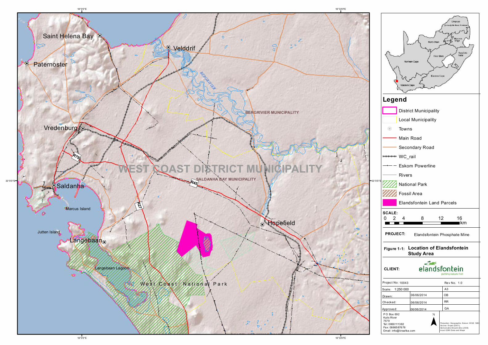
1.3. DETAILS OF THE PROPERTIES AFFECTED BY PROPOSED PROJECT
The affected surface areas where the proposed project activities will occur are tabulated in Table 1-3 and
illustrated in Figure 1-1.
Table 1-3: Properties where proposed mining activities will occur
Farm Name Portions Owners
Elandsfontein 349 2 Elandsfontein Land Holding (Pty) Ltd
Elandsfontein 349 4 Elandsfontein Land Holding (Pty) Ltd
1.4. DETAILS OF ENVIRONMENTAL ASSESSMENT PRACTITIONER
Braaf Environmental Practitioners has been appointed as lead Environmental Assessment Practitioner (EAP)
and the associated project team to undertake the necessary environmental authorisation process. The EAP
and project team’s details are provided in Table 1-4.
Table 1-4: EAP details
Name of firm Braaf Environmental Practitioners
Postal Address P O Box 692, Kuils River, 7579
Telephone Number 0860 111 382
Facsimile Number 086 658 7676
Email Address [email protected]
EIA project team
Name Qualifications Responsibility
Olivia Braaf BSc Hons Zoology Report compilation
Regan Rose BSc Hons Geohydrology Technical reviewer
Braaf Environmental Practitioners (BEP) was appointed by EEM as the independent environmental
practitioners to facilitate the environmental authorisation process for the proposed Elandsfontein Phosphate
project. The project team assigned to this project has over 20 years experience in the environmental field. The
professional staff member assisting on this project has an Honours Degree in Geohydrology and is a
professionally registered scientist with the South African Council of Natural Scientific Professionals support Ms.
Braaf. BEP is also supported by specialists in the field of natural sciences, social sciences and the
economic fields.
1.5. COMPETENT AUTHORITIES
As per the MPRDA, the DMR is identified as the competent authority for the mining right authorisation which
includes the Scoping and EIA/EMP. Approval is also needed from the National Department of Environmental
Affairs (DEA) in terms of National Environmental Management: Waste Act (No. 59 of 2008) (NEM:WA), and the
CLIENT NAME: EEM EMPR
PROJECT NAME: ELANDSFONTEIN
PHOSPHATE MINE
OWNER: BRAAF ENVIRONMENTAL
PRACTITIONERS
PROJECT NUMBER: 10043 PAGE: 4
REPORT NUMBER: 10043EMP DATE:2/09/2014
Western Cape Provincial Department of Environmental Affairs and Development Planning (DEA&DP) in terms
of the National Environmental Management Act (No. 107 of 1998) (NEMA) and associated Environmental
Impact Assessment (EIA) Regulations GN.R543 (as amended) (NEMA EIA Regulations) which has commenced.
The Department of Water Affairs (DWA) is the competent authority for the Water Use License Application
(WULA). Further approvals are required from the competent heritage authority in terms of the National
Heritage Resources Act (No. 25 of 1999) (NHRA) and Saldanha Bay Municipality (SBM) in terms of the land use.
Table 1-5 outlines the applicable legislative approvals and competent authorities responsible.
Table 1-5: Competent Authority Details.
Department Legal Process
DMR MPRDA
DEA NEM:WA
DEA&DP NEMA: EIA
DWA NWA
SBM LUPO
HWC HIA
1.6. LOCAL AUTHORITIES
The project area falls within the jurisdiction of the Saldanha Bay Municipality (SBM) of the West Coast District
Municipality (WCDM), Western Cape Province. Local ward councillors have been identified within the
municipal area and specifically the affected ward. Details of the relevant municipality are given in Table 1-6.
Table 1-6: Municipality Details
Municipality Contact Person
WCDM (Municipal Manager) Mr. H. Prins
WCDM (Town Planner) Mr. C. Malherbe
SBM (Mayor) Mr. F. Schippers
SBM (Municipal Manager) Mr. L.A. Scheepers
SBM (Environmental Officer) Mrs. N. Duarte
")R45
")R27
")R79
BERGRIVIER
BOESMANSRIVIER
W e s t C o a s t N a t i o n a l P a r kW e s t C o a s t N a t i o n a l P a r k
Langebaan Lagoon
Jutten Island
Marcus Island
WEST COAST DISTRICT MUNICIPALITY
Aurora
Velddrif
Hopefield
Saldanha
Langebaan
Paternoster
Vredenburg
Saint Helena Bay
SALDANHA BAY MUNICIPALITY
BERGRIVIER MUNICIPALITY
SWARTLAND MUNICIPALITY18°30'0"E
18°30'0"E
18°0'0"E
18°0'0"E
33°0'0"S 33°0'0"S
SCALE:
PROJECT:
Figure 1-1:
CLIENT:
Project No: Scale:
Re v No. A3
Drawn:Ch ecked:Approve d:
10043 1.0
06/06/2014
06/06/201406/06/2014
OBRRGA
Location of ElandsfonteinStudy Area
Elandsfontein Phosphate Mine
P O Box 692Kuils River7579Tel: 0860111382Fax: 0866587676Email : [email protected]
0 4 8 12 162 km
¯
1:250 000
Projection: Geographic, Datum : W GS 1984Source: E npat (2001), Dem arc ation B oard (Dec 2005)Ins et: E SRI Data and M aps
LegendDistrict MunicipalityLocal MunicipalityTownsMain RoadSecondary RoadWC_rail
ââ Eskom PowerlineRiversNational ParkFossil AreaElandsfontein Land Parcels
CLIENT NAME: EEM EMPR
PROJECT NAME: ELANDSFONTEIN
PHOSPHATE MINE
OWNER: BRAAF ENVIRONMENTAL
PRACTITIONERS
PROJECT NUMBER: 10043 PAGE: 6
REPORT NUMBER: 10043EMP DATE:2/09/2014
1.7. DOCUMENT STRUCTURE
Information presented in this report is set out as follows:
CHAPTER DESCRIPTION MPRDA REGULATION
FULFILMMENT
Chapter 1: Introduction This chapter provides background to EEM
and the proposed Elandsfontein Phosphate
Project. It presents information regarding
the applicant and the EAP, as well as the
competent authority.
Chapter 2: Legal
Framework
This chapter describes the environmental
authorization process followed to date for
the proposed Elandsfontein Mine and
explains the legislative framework under
which a mining right is necessary and
application compiled.
This chapter describes the public
engagement process that was
followed for this project in
fulfilment of Section (39)(b)(ii) of
the MPRDA read together with
Regulation 50(f).
Chapter 3: Project
Background and
Motivation
Discusses the benefits of the projects. In fulfilment of MPRDA Regulation
50(b) and (d).
Chapter 4: Project
Description
The proposed project details and
infrastructure required for the proposed
Elandsfontein Phosphate Project are
provided.
Chapter 5: Project
alternatives
Discusses the alternatives considered for
this project as well as the No-Go Option.
In fulfilment of MPRDA Regulation
50(b) and (d).
Chapter 6: Description of
the Baseline Environment
Provides a description of the environment
(baseline status) prior to the
commencement of the construction, and
subsequent operation, of the proposed
project.
In compliance with Section
39(3)(a) of the MPRDA Act read
together with Regulation 50(a).
Chapter 7: Waste Management
Chapter 8: Methodology
for the assessment of
impacts &
Impact Assessment
Provides details on the methodology used
to assess the anticipated impacts
associated with the proposed project.
In fulfilment of Section 39(3)(b)(i)(ii) and (iii) of the MPRDA Act read together with Regulation 50(c) and (e).
Identifies all the anticipated impacts and an
assessment of these based on the
information provided by both specialists
(on information available at the time of
compilation of this report)
Chapter 9: Environmental Provides mitigation / management In compliance with Section
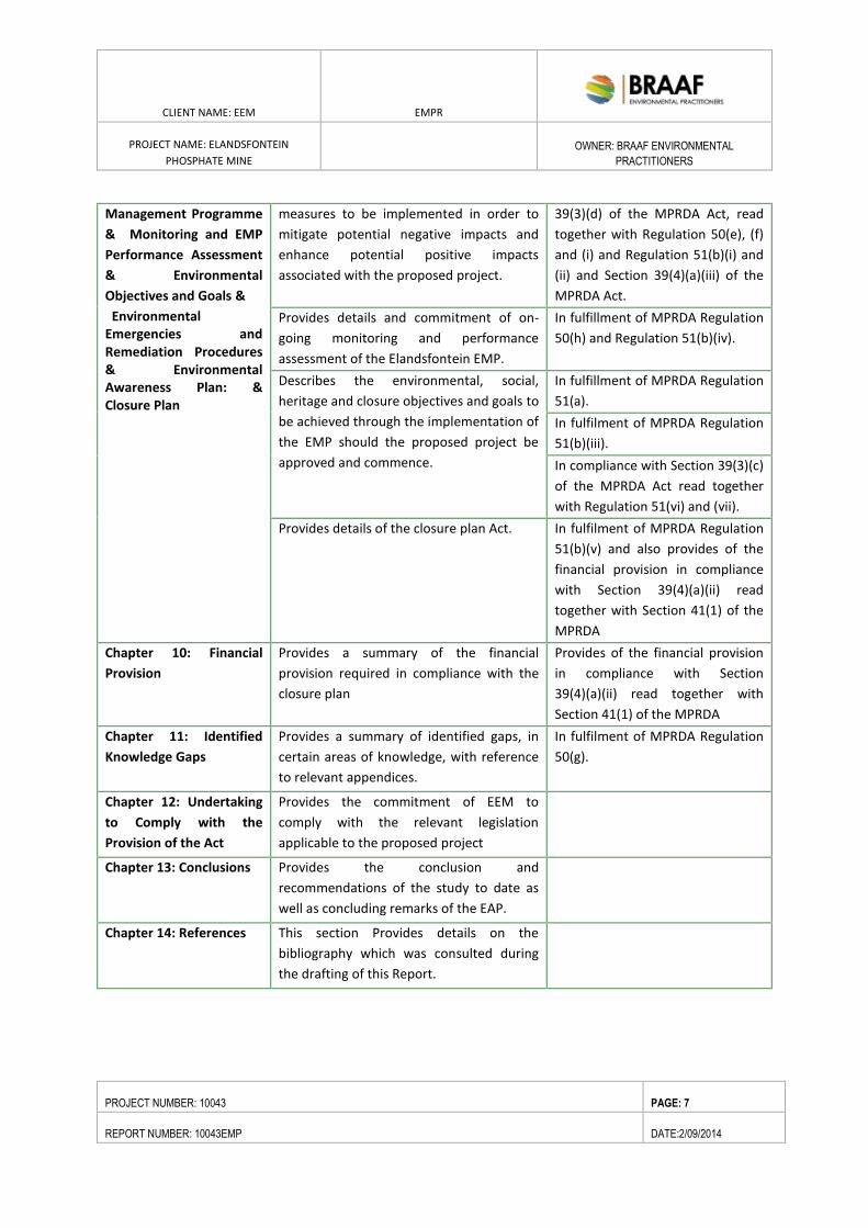
CLIENT NAME: EEM EMPR
PROJECT NAME: ELANDSFONTEIN
PHOSPHATE MINE
OWNER: BRAAF ENVIRONMENTAL
PRACTITIONERS
PROJECT NUMBER: 10043 PAGE: 7
REPORT NUMBER: 10043EMP DATE:2/09/2014
Management Programme
& Monitoring and EMP
Performance Assessment
& Environmental
Objectives and Goals &
Environmental Emergencies and Remediation Procedures & Environmental Awareness Plan: & Closure Plan
measures to be implemented in order to
mitigate potential negative impacts and
enhance potential positive impacts
associated with the proposed project.
39(3)(d) of the MPRDA Act, read
together with Regulation 50(e), (f)
and (i) and Regulation 51(b)(i) and
(ii) and Section 39(4)(a)(iii) of the
MPRDA Act.
Provides details and commitment of on-
going monitoring and performance
assessment of the Elandsfontein EMP.
In fulfillment of MPRDA Regulation
50(h) and Regulation 51(b)(iv).
Describes the environmental, social,
heritage and closure objectives and goals to
be achieved through the implementation of
the EMP should the proposed project be
approved and commence.
In fulfillment of MPRDA Regulation
51(a).
In fulfilment of MPRDA Regulation
51(b)(iii).
In compliance with Section 39(3)(c)
of the MPRDA Act read together
with Regulation 51(vi) and (vii).
Provides details of the closure plan Act. In fulfilment of MPRDA Regulation
51(b)(v) and also provides of the
financial provision in compliance
with Section 39(4)(a)(ii) read
together with Section 41(1) of the
MPRDA
Chapter 10: Financial
Provision
Provides a summary of the financial
provision required in compliance with the
closure plan
Provides of the financial provision
in compliance with Section
39(4)(a)(ii) read together with
Section 41(1) of the MPRDA
Chapter 11: Identified
Knowledge Gaps
Provides a summary of identified gaps, in
certain areas of knowledge, with reference
to relevant appendices.
In fulfilment of MPRDA Regulation
50(g).
Chapter 12: Undertaking
to Comply with the
Provision of the Act
Provides the commitment of EEM to
comply with the relevant legislation
applicable to the proposed project
Chapter 13: Conclusions Provides the conclusion and
recommendations of the study to date as
well as concluding remarks of the EAP.
Chapter 14: References This section Provides details on the
bibliography which was consulted during
the drafting of this Report.
CLIENT NAME: EEM EMPR
PROJECT NAME: ELANDSFONTEIN
PHOSPHATE MINE
OWNER: BRAAF ENVIRONMENTAL
PRACTITIONERS
PROJECT NUMBER: 10043 PAGE: 8
REPORT NUMBER: 10043EMP DATE:2/09/2014
2. LEGAL REQUIREMENTS FOR AUTHORISATION FOR ELANDSFONTEIN MINE
2.1. LEGISLATIVE FRAMEWORK
The proposed Elandsfontein mine is subject to legislative and policy requirements at national, provincial and
local level as well as international guidelines and conventions. This chapter presents a summary of the
administrative framework governing the development of the proposed mine. It focuses on legal requirements
related to environmental licensing of activities, as well as legal requirements for environmental protection
such as: standards for environmental quality control and pollution, biodiversity protection, and natural,
cultural and historic heritage sites.
There are a number of regulatory requirements at local, provincial and national level with which the proposed
project must conform. Some of the key environmental legal requirements include the following:
Mineral and Petroleum Resources Development Act (No. 28 of 2002) (MPRDA);
National Environmental Management Act 107 of 1998, as amended (NEMA);
Environmental Impact Assessment (EIA) Regulations 2010;
National Environmental Management: Waste Act 59 of 2008 (NEM:WA);
National Water Act 36 of 1998 (NWA);
National Heritage Resources Act 25 of 1999 (NHRA); and
National Environmental Management: Biodiversity Act 10 of 2004 (NEM:BA).
A brief summary of BEP’s understanding of the relevant Acts and Regulations that are applicable to this study
is provided below. Note that other legislative requirements may also pertain to the proposed project. As such,
the summary provided below is not intended to be definitive or exhaustive, and serves only to highlight key
environmental legislation and obligations.
2.2. NATIONAL LEGISLATIVE AND POLICY REQUIREMENTS
2.2.1. MINERAL AND PETROLEUM RESOURCES DEVELOPMENT ACT (NO.
28 OF 2002)
The MPRDA makes provision for equitable access to and sustainable development of South Africa’s mineral
resources. It further promotes equitable access to the nations minerals and petroleum resources, expand
opportunities for previously disadvantaged individuals, promote economic growth and mineral and petroleum
resources development (objective), employment opportunities and ensure that the holders of the mining right
contribute to the socio-economic development on the surrounding communities.
In order for EEM to mine the phosphate resources within the Elandsfontein project area, a mining right must
be obtained from the Department of Mineral Resources (DMR). Section 22 of the MPRDA specifies that an
Environmental Impact Assessment (EIA) must be undertaken and an Environmental Management Programme
(EMP) submitted to the DMR prior to the authorisation of the mining right. In addition it specifies that a public
should be consulted as part of the application process.
CLIENT NAME: EEM EMPR
PROJECT NAME: ELANDSFONTEIN
PHOSPHATE MINE
OWNER: BRAAF ENVIRONMENTAL
PRACTITIONERS
PROJECT NUMBER: 10043 PAGE: 9
REPORT NUMBER: 10043EMP DATE:2/09/2014
The following regulations contained in Government Notice R. 527 Mineral and Petroleum Resources
Development Act (28/2002): Mineral and Petroleum Resources Development Regulations have particular
relevance to the contents of EIA/EMP’s:
Provide baseline information concerning the affected environment to determine protection, remedial
measures and environmental management objectives;
Investigate, assess and evaluate the impact of his or her prospecting or mining operations on –
o The environment;
o The socio-economic conditions of any person who might be directly affected by the
prospecting or mining operation; and
o Any national estate referred to in section 3(2) of the National Heritage Resources Act, 1999
(Act No. 25 of 1999), with the exception of the national estate contemplated in section
3(2)(i)(vi)and (vii) of that Act;
Develop an environmental awareness plan describing the manner in which the applicant intends to
inform their work and the manner in which the risks must be dealt with in order to avoid pollution or
the degradation of the environment; and
Describe the manner in which he or she intends to-
o Modify, remedy, control or stop any action, activity or process which causes pollution or
environmental degradation;
o Contains or remedy the cause of pollution or degradation and migration of pollutions; and
o Comply with any prescribed waste standard or management standards or practices.
2.2.2. NATIONAL ENVIRONMENTAL MANAGEMENT ACT (NO 107 OF
1998) (NEMA) AND THE NATIONAL ENVIRONMENTAL MANAGEMENT
AMENDMENT ACT (NO 62 OF 2008)
NEMA requires that the potential impact on the environment, socio-economic conditions, and cultural
heritage of activities that require authorisation or permission by law must be considered, investigated and
assessed prior to implementation, and reported to the relevant authority.
An EIA Application must be submitted to the Western Cape Provincial Department of Environmental Affairs
and Development Planning (DEA&DP). This process has now commenced.
The EIA Regulations (R543) promulgated in terms of the NEMA, identifies a suite of activities, which “could
have a substantial detrimental effect on the environment”. The listed activities identified require an
environmental authorisation from the environmental authority, i.e. the Provincial Department of
Environmental Affairs and Development Planning (DEA&DP), prior to commencement of the activity. The
proposed phosphate mine and associated infrastructure triggers a list of activities, tabulated in Table 2-1
below.
Activities listed in terms of R544 and R546 require a Basic Assessment, while activities listed in R545 require a
full Scoping and EIA process. Despite the proposed project triggering the need for a Basic Assessment process,
a single Scoping and ESIA process will be undertaken to meet the requirements in terms of NEMA. However,
CLIENT NAME: EEM EMPR
PROJECT NAME: ELANDSFONTEIN
PHOSPHATE MINE
OWNER: BRAAF ENVIRONMENTAL
PRACTITIONERS
PROJECT NUMBER: 10043 PAGE: 10
REPORT NUMBER: 10043EMP DATE:2/09/2014
due to Eskom requirements related to the eventual transfer of rights associated to components of the
electrical infrastructure EEM has submitted a separate environmental application. Hence a Basic Assessment
Process will be undertaken for the powerlines which the competent authority DEA&DP has agreed to.
However, one public participation process will be undertaken for the powerlines and remainder of the mine
application.
Refer to Appendix D for DEA&DP’s acknowledgement letters.
CLIENT NAME: EEM EMPR
PROJECT NAME: ELANDSFONTEIN PHOSPHATE MINE
OWNER: BRAAF ENVIRONMENTAL PRACTITIONERS
PROJECT NUMBER: PAGE: 11
REPORT NUMBER: DATE:2/09/2014
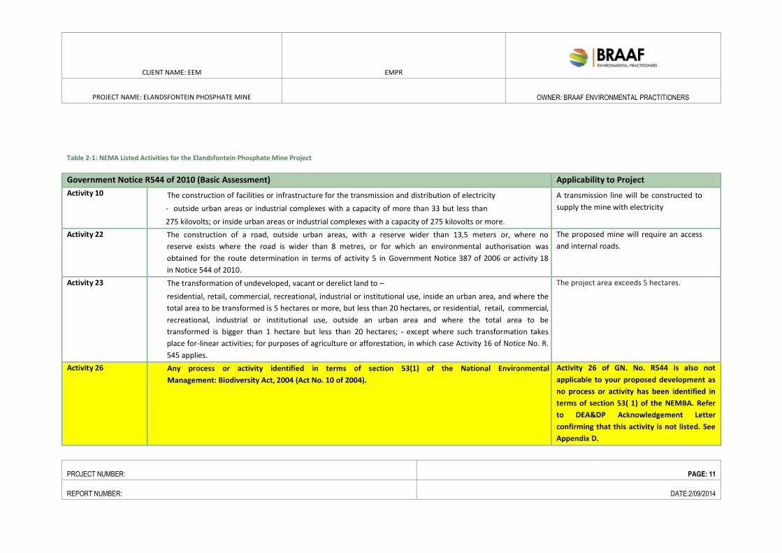
Table 2-1: NEMA Listed Activities for the Elandsfontein Phosphate Mine Project
Government Notice R544 of 2010 (Basic Assessment) Applicability to Project
Activity 10 The construction of facilities or infrastructure for the transmission and distribution of electricity
- outside urban areas or industrial complexes with a capacity of more than 33 but less than
275 kilovolts; or inside urban areas or industrial complexes with a capacity of 275 kilovolts or more.
A transmission line will be constructed to
supply the mine with electricity
Activity 22 The construction of a road, outside urban areas, with a reserve wider than 13,5 meters or, where no
reserve exists where the road is wider than 8 metres, or for which an environmental authorisation was
obtained for the route determination in terms of activity 5 in Government Notice 387 of 2006 or activity 18
in Notice 544 of 2010.
The proposed mine will require an access
and internal roads.
Activity 23 The transformation of undeveloped, vacant or derelict land to –
residential, retail, commercial, recreational, industrial or institutional use, inside an urban area, and where the
total area to be transformed is 5 hectares or more, but less than 20 hectares, or residential, retail, commercial,
recreational, industrial or institutional use, outside an urban area and where the total area to be
transformed is bigger than 1 hectare but less than 20 hectares; - except where such transformation takes
place for-linear activities; for purposes of agriculture or afforestation, in which case Activity 16 of Notice No. R.
545 applies.
The project area exceeds 5 hectares.
Activity 26 Any process or activity identified in terms of section 53(1) of the National Environmental
Management: Biodiversity Act, 2004 (Act No. 10 of 2004).
Activity 26 of GN. No. R544 is also not
applicable to your proposed development as
no process or activity has been identified in
terms of section 53( 1) of the NEMBA. Refer
to DEA&DP Acknowledgement Letter
confirming that this activity is not listed. See
Appendix D.
CLIENT NAME: EEM EMPR
PROJECT NAME: ELANDSFONTEIN PHOSPHATE MINE
OWNER: BRAAF ENVIRONMENTAL PRACTITIONERS
PROJECT NUMBER: PAGE: 12
REPORT NUMBER: DATE:2/09/2014
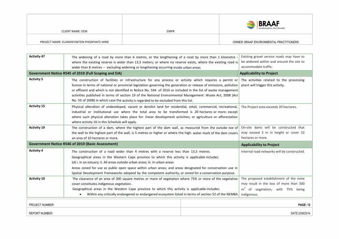
Activity 47 The widening of a road by more than 6 metres, or the lengthening of a road by more than 1 kilometre -
where the existing reserve is wider than 13,5 meters; or where no reserve exists, where the existing road is
wider than 8 metres – excluding widening or lengthening occurring inside urban areas.
Existing gravel service roads may have to
be widened within and around the site to
accommodate traffic.
Government Notice R545 of 2010 (Full Scoping and EIA) Applicability to Project
Activity 5 The construction of facilities or infrastructure for any process or activity which requires a permit or
license in terms of national or provincial legislation governing the generation or release of emissions, pollution
or effluent and which is not identified in Notice No. 544 of 2010 or included in the list of waste management
activities published in terms of section 19 of the National Environmental Management: Waste Act, 2008 (Act
No. 59 of 2008) in which case the activity is regarded to be excluded from this list.
The activities related to the processing
plant will trigger this activity.
Activity 15 Physical alteration of undeveloped, vacant or derelict land for residential, retail, commercial, recreational,
industrial or institutional use where the total area to be transformed is 20 hectares or more; except
where such physical alteration takes place for: linear development activities; or agriculture or afforestation
where activity 16 in this Schedule will apply.
The Project area exceeds 20 hectares.
Activity 19 The construction of a dam, where the highest part of the dam wall, as measured from the outside toe of
the wall to the highest part of the wall, is 5 metres or higher or where the high- water mark of the dam covers
an area of 10 hectares or more.
On-site dams will be constructed that
may exceed 5 m in height or cover 10
hectares or more.
Government Notice R546 of 2010 (Basic Assessment) Applicability to Project
Activity 4 The construction of a road wider than 4 metres with a reserve less than 13,5 metres.
Geographical areas in the Western Cape province to which this activity is applicable includes:
(d) i. In an estuary; ii. All areas outside urban areas; iii. In urban areas:
Areas zoned for use as public open space within urban areas; and areas designated for conservation use in
Spatial Development Frameworks adopted by the competent authority, or zoned for a conservation purpose.
Internal road networks will be constructed.
Activity 10 The clearance of an area of 300 square metres or more of vegetation where 75% or more of the vegetative
cover constitutes indigenous vegetation.
Geographical areas in the Western Cape province to which this activity is applicable includes:
Within any critically endangered or endangered ecosystem listed in terms of section 52 of the NEMBA
The proposed establishment of the mine
may result in the loss of more than 300
m2
of vegetation, with 75% being
indigenous.
CLIENT NAME: EEM EMPR
PROJECT NAME: ELANDSFONTEIN PHOSPHATE MINE
OWNER: BRAAF ENVIRONMENTAL PRACTITIONERS
PROJECT NUMBER: PAGE: 13
REPORT NUMBER: DATE:2/09/2014
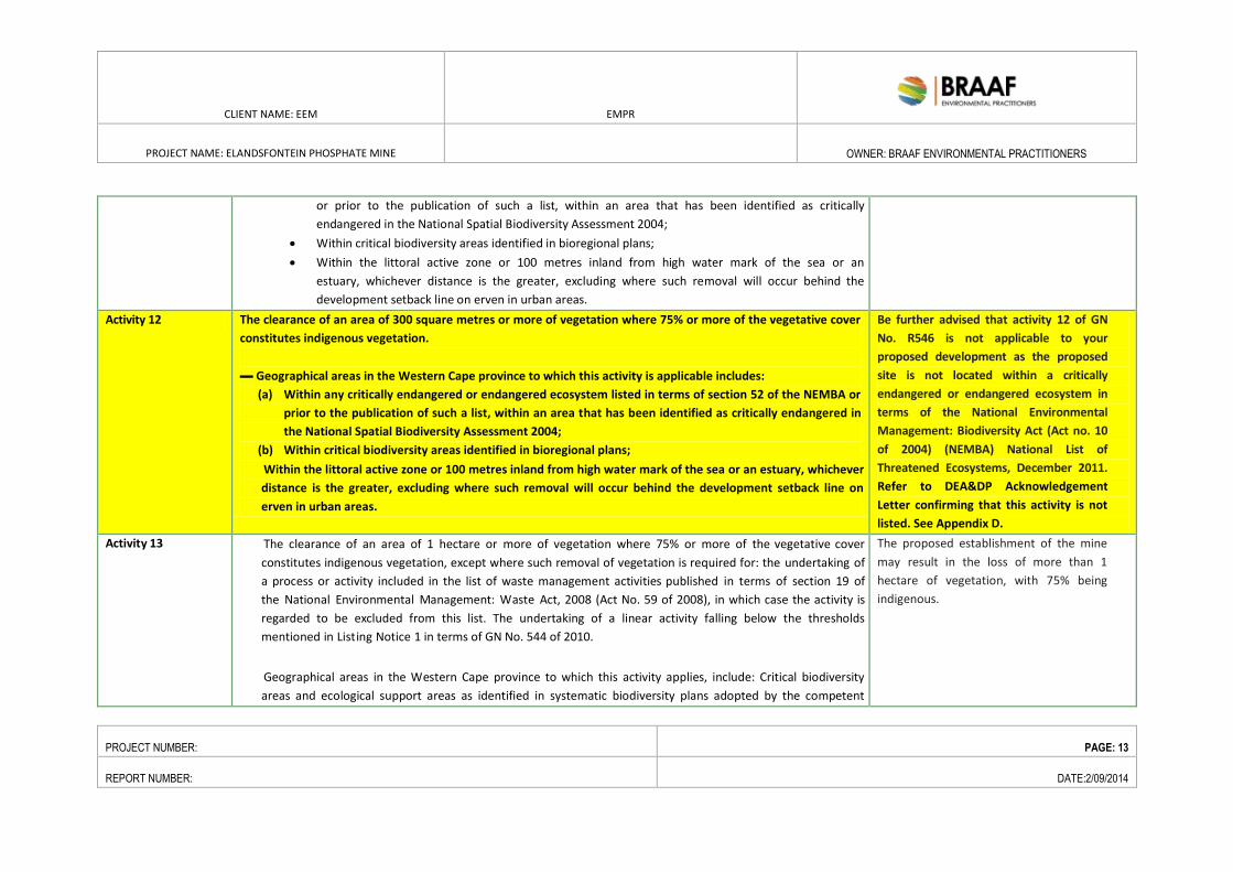
or prior to the publication of such a list, within an area that has been identified as critically
endangered in the National Spatial Biodiversity Assessment 2004;
Within critical biodiversity areas identified in bioregional plans;
Within the littoral active zone or 100 metres inland from high water mark of the sea or an
estuary, whichever distance is the greater, excluding where such removal will occur behind the
development setback line on erven in urban areas.
Activity 12 The clearance of an area of 300 square metres or more of vegetation where 75% or more of the vegetative cover
constitutes indigenous vegetation.
▬ Geographical areas in the Western Cape province to which this activity is applicable includes:
(a) Within any critically endangered or endangered ecosystem listed in terms of section 52 of the NEMBA or
prior to the publication of such a list, within an area that has been identified as critically endangered in
the National Spatial Biodiversity Assessment 2004;
(b) Within critical biodiversity areas identified in bioregional plans;
Within the littoral active zone or 100 metres inland from high water mark of the sea or an estuary, whichever
distance is the greater, excluding where such removal will occur behind the development setback line on
erven in urban areas.
Be further advised that activity 12 of GN
No. R546 is not applicable to your
proposed development as the proposed
site is not located within a critically
endangered or endangered ecosystem in
terms of the National Environmental
Management: Biodiversity Act (Act no. 10
of 2004) (NEMBA) National List of
Threatened Ecosystems, December 2011.
Refer to DEA&DP Acknowledgement
Letter confirming that this activity is not
listed. See Appendix D.
Activity 13 The clearance of an area of 1 hectare or more of vegetation where 75% or more of the vegetative cover
constitutes indigenous vegetation, except where such removal of vegetation is required for: the undertaking of
a process or activity included in the list of waste management activities published in terms of section 19 of
the National Environmental Management: Waste Act, 2008 (Act No. 59 of 2008), in which case the activity is
regarded to be excluded from this list. The undertaking of a linear activity falling below the thresholds
mentioned in Listing Notice 1 in terms of GN No. 544 of 2010.
Geographical areas in the Western Cape province to which this activity applies, include: Critical biodiversity
areas and ecological support areas as identified in systematic biodiversity plans adopted by the competent
The proposed establishment of the mine
may result in the loss of more than 1
hectare of vegetation, with 75% being
indigenous.

CLIENT NAME: EEM EMPR
PROJECT NAME: ELANDSFONTEIN PHOSPHATE MINE
OWNER: BRAAF ENVIRONMENTAL PRACTITIONERS
PROJECT NUMBER: PAGE: 14
REPORT NUMBER: DATE:2/09/2014
authority.
National Protected Area Expansion Strategy Focus areas. (other areas also identified in the Western Cape
province): In an estuary;
Outside urban areas, the following:
A protected area identified in terms of NEMPAA, excluding conservancies; National Protected Area
Expansion Strategy Focus areas;
Sensitive areas as identified in an environmental management framework as contemplated in
chapter 5 of the Act and as adopted by the competent authority;
Sites or areas identified in terms of an International Convention; Core areas in biosphere reserves;
Areas within10 kilometres from national parks or world heritage sites or 5 kilometres from any
other protected area identified in terms of NEMPAA or from the core area of a biosphere reserve;
Areas seawards of the development setback line or within 1 kilometre from the high-water
mark of the sea if no such development setback line is determined. In urban areas, the following:
Areas zoned for use as public open space;
Areas designated for conservation use in Spatial Development Frameworks adopted by the
competent authority or zoned for a conservation purpose; Areas seawards of the development
setback line;
Areas on the watercourse side of the development setback line or within 100 metres from the edge
of a watercourse where no such setback line has been determined.
Activity 14 The clearance of an area of 5 hectares or more of vegetation where 75% or more of the vegetative cover
constitutes indigenous vegetation, except where such removal of vegetation is required for:
purposes of agriculture or afforestation inside areas identified in spatial instruments adopted by the
competent authority for agriculture or afforestation purposes;
the undertaking of a process or activity included in the list of waste management activities
published in terms of section 19 of the National Environmental Management: Waste Act,
2008 (Act No. 59 of 2008) in which case the activity is regarded to be excluded from this list;
the undertaking of a linear activity falling below the thresholds in Notice 544 of 2010.
The proposed establishment of the mine
may result in the loss of more than 5
hectares of vegetation, with 75% being
indigenous.
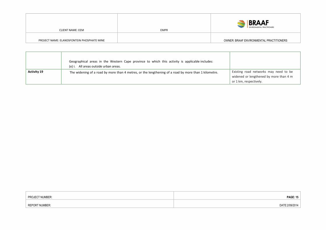
CLIENT NAME: EEM EMPR
PROJECT NAME: ELANDSFONTEIN PHOSPHATE MINE
OWNER: BRAAF ENVIRONMENTAL PRACTITIONERS
PROJECT NUMBER: PAGE: 15
REPORT NUMBER: DATE:2/09/2014
Geographical areas in the Western Cape province to which this activity is applicable includes:
(e) i. All areas outside urban areas.
Activity 19 The widening of a road by more than 4 metres, or the lengthening of a road by more than 1 kilometre.
Existing road networks may need to be
widened or lengthened by more than 4 m
or 1 km, respectively.
CLIENT NAME: EEM EMPR
PROJECT NAME: ELANDSFONTEIN
PHOSPHATE MINE
OWNER: BRAAF ENVIRONMENTAL
PRACTITIONERS
PROJECT NUMBER: 10043 PAGE: 16
REPORT NUMBER: 10043EMP DATE:2/09/2014
2.2.3. NATIONAL ENVIRONMENTAL MANAGEMENT: WASTE ACT, 2008
(NO. 59 OF 2008) (NEMWA)
The NEM:WA aims to (amongst other things) regulate waste management in order to protect health and the
environment by providing reasonable measures for the prevention of pollution and ecological degradation
and for securing ecologically sustainable development.
The Act makes provision for the listing of waste management activities that have, or are likely to have, a
detrimental effect on the environment and may not be undertaken without a Waste Management Licence
(WML) issued by the competent authority. The competent authority for WML applications is the national
Department of Environmental Affairs (DEA) for applications involving hazardous waste. NEM:WA must be read
in conjunction with NEMA (see above). The principles of NEMA and the NEMA EIA Regulations, 2010
(specifically GN 543), are applicable to the application process for WMLs.
Two categories of listed waste management activities were published in terms of NEM:WA in GN R718 on 3
July 2009. A person wishing to undertake:
• An activity listed under Category A, must conduct a BA process,
• An activity listed under Category B, must conduct a S&EIR process, as set out in the NEMA EIA
Regulations, 2010 (see above), as part of the WML application process.
The Act makes provision for a single environmental assessment process in instances where both EA and WML
applications are required. A separate application form must be submitted at the beginning of the EIA process,
and additional stakeholder engagement (advertising) would apply to an EIA process for a WML application. The
WML process has not been commenced with as yet.
In light of the nature of the proposed project, the following activities identified in terms of Government Notice
718, Category A and B, are anticipated to be triggered:
Table 2-2: Listed activities in terms of NEMA:WA Regulations
Category A: Requiring a Basic Assessment Process
Activity 1 The storage, including the temporary storage of general waste at a facility that has the capacity to
store in excess of 100m3
of general waste at any one time, excluding the storage of waste in
lagoons.
Activity2 The storage, excluding the temporary storage, of hazardous waste at a facility that has the
capacity to store in excess of 80m3
of hazardous waste at an one time.
Activity 4 The storage of waste tyres in a storage area exceeding 500m2
CLIENT NAME: EEM EMPR
PROJECT NAME: ELANDSFONTEIN
PHOSPHATE MINE
OWNER: BRAAF ENVIRONMENTAL
PRACTITIONERS
PROJECT NUMBER: 10043 PAGE: 17
REPORT NUMBER: 10043EMP DATE:2/09/2014
Activity 7 The recycling of general waste at a facility that has an operational area in 500m2
Activity 12 The remediation of contaminated land
Activity 18 The construction of facilities for activities listed in Category A of this Schedule (not in isolation to
associated activity)
Category B: Requiring a Full Scoping and EIA
Activity 2 The reuse and recycling of hazardous wastes
Activity 5 The treatment of hazardous waste using any form of treatment regardless of the size or
capacity of such a facility to treat such waste
Activity 7 The treatment of effluent, wastewater or sewage with an annual throughput capacity of 15
000 cubic metres or more.
Activity 9 The disposal of any quantity of hazardous waste to land
Activity 10 The disposal of general waste to land covering an area in excess of 200m2
Activity 11 The construction of facilities for activities listed in Category B of this Schedule (not in
isolation to associated activity).
2.2.4. NATIONAL HERITAGE RESOURCES ACT (NO. 25 OF 1999)
The National Heritage Resources Act (Act No. 25 of 1999) makes provision for a compulsory Heritage Impact
Assessment (HIA) when an area exceeding 5000 m² is being developed. This is to determine if the area
contains heritage sites and to take the necessary steps to ensure that they are not damaged or destroyed
during development.
The NHRA provides protection for the following categories of heritage resources:
Landscapes, cultural or natural (Section 3 (3))
Buildings or structures older than 60 years (Section 34);
Archaeological sites, palaeontological material and meteorites (Section 35);
Burial grounds and graves (Section 36);
The mining of the proposed open pit may trigger the following heritage activities:
2.2.4.1. PERMIT APPLICATION SECTION 38 (REF: NHRA 1999: 62)
a. the construction of a road, wall, powerline, pipeline, canal or other similar form of linear development or
barrier exceeding 300 m in length;
CLIENT NAME: EEM EMPR
PROJECT NAME: ELANDSFONTEIN
PHOSPHATE MINE
OWNER: BRAAF ENVIRONMENTAL
PRACTITIONERS
PROJECT NUMBER: 10043 PAGE: 18
REPORT NUMBER: 10043EMP DATE:2/09/2014
b. the construction of a bridge or similar structure exceeding 50 m in length;
c. any development or other activity which will change the character of a site exceeding 5000 m2 in extent; or
i. involving three or more existing erven or subdivisions thereof; or
ii. involving three or more erf or divisions thereof which have been consolidated within the past five
years; or
iii. the costs of which will exceed a sum set in terms of regulations by SAHRA or a provincial heritage
resources authority;
d. the re-zoning of a site exceeding 10 000 m2 in extent; or
e. any other category of development provided for in regulations by SAHRA or a provincial heritage resources
authority.
2.2.4.2. PERMIT APPLICATION SECTION 35 – FOSSILS, BUILT ENVIRONMENT
FEATURES, SHIPWRECKS, AND STONE AGE ARCHAEOLOGY (REF: NHRA
1999: 58):
a. destroy, damage, excavate, alter, deface or otherwise disturb any archaeological or paleontological site or
any meteorite;
b. destroy, damage, excavate, remove from its original position, collect or own any
archaeological or paleontological material or object or any meteorite;
c. trade in, sell for private gain, export or attempt to export from the Republic any category of archaeological
or paleontological material or object, or any meteorite.
2.2.4.3. PERMIT APPLICATION SECTION 36 – BURIAL GROUNDS AND GRAVES
(REF: NHRA 1999: 60)
a. destroy, damage, alter, exhume or remove from its original position or otherwise disturb the grave of
a victim of conflict, or any burial ground or part thereof which contains such graves;
b. destroy, damage, alter, exhume, remove from its original position or otherwise disturb any
grave or burial ground older than 60 years which is situated outside a formal cemetery administered by a local
authority;
c. bring onto or use at a burial ground or grave referred to in paragraph (a) or (b) any excavation
equipment, or any equipment which assists in the detection or recovery of metals; or
d. SAHRA or a provincial heritage resources authority may not issue a permit for The destruction or
damage of any burial ground or grave referred to in subsection (3)(a) unless it is satisfied that the applicant has
made satisfactory arrangements for the exhumation and re-interment of the contents of such graves, at the
cost of the applicant.
The heritage practitioner will determine which activities in terms of the NHRA will be triggered and include
these in the application to Heritage Western Cape.
2.2.5. NATIONAL WATER ACT (NO. 36 OF 1998) (NWA)
The NWA recognises that water is a scarce and unevenly distributed national resource which must managed
encompassing all aspects of water resources.
CLIENT NAME: EEM EMPR
PROJECT NAME: ELANDSFONTEIN
PHOSPHATE MINE
OWNER: BRAAF ENVIRONMENTAL
PRACTITIONERS
PROJECT NUMBER: 10043 PAGE: 19
REPORT NUMBER: 10043EMP DATE:2/09/2014
In terms of Chapter 4 of the NWA, activities and processes associated with the Elandsfontein Phosphate Mine
project are required to be licensed by the Department of Water Affairs. An Integrated Water Use Licence
Application (IWULA) will be lodged with the DWA. Furthermore, an Integrated Water and Waste Management
Plan (IWWMP) will be compiled in support of the IWULA.
Section 21 of the NWA lists 11 water uses that require a Water Use Licence from the DWA. In terms of Section
21 of the NWA the mining of the proposed open pit will trigger the following water use activities:
a. taking water from a water source;
b. storing water;
g. disposing of wastes that may impact water resources; and
j. removing, discharging or disposing of water found underground.
Please note this list may be revised during the WULA depending on the specific designs.
2.2.6. THE NATIONAL ENVIRONMENTAL MANAGEMENT: BIODIVERSITY
ACT, 2008 (NO. 10 OF 2004) (NEMBA) AND ASSOCIATED LEGISLATION
The purpose of the NEM:BA is to provide for the management and conservation of South Africa’s biodiversity
and the protection of species and ecosystems that warrant national protection. Threatened or Protected
Species (TOPS) Regulations (2007) and a National List of Ecosystems that are Threatened and in Need of
Protection (2011) have been promulgated in terms of NEM:BA. In terms of Section 56(1) of NEM:BA a person
may not carry out a restricted activity involving a specimen of a listed threatened or protected species without
a permit issued in terms of Chapter 7.
Should a project result in the loss of biodiversity identified in terms of GN 151 of 2010, a permit application
will need to be submitted to the Provincial Department of Environmental Affairs and Development Planning
for approval, before proceeding with the activity. A specialist botanical impact assessment has been
undertaken as part of the EIA/EMP phase of the proposed project.
The Act also identifies ecosystems as critically endangered, endangered, vulnerable and protected species. The
Elandsfontein Phosphate Mine area consists of four distinct vegetation types which have been assigned the
following ratings in terms of the National List of Threatened Ecosystems:
• Hopefield Sand Fynbos is rated as Vulnerable;
• Saldanha Flats Strandveld is rated as Vulnerable;
• Langebaan Dune Strandveld is rated as Least Threatened; and
• Saldanha Limestone Strandveld is rated as Least Threatened.
2.2.7. CONSERVATION OF AGRICULTURAL RESOURCES ACT (NO. 43 OF
1983)
The Conservation of Agricultural Resources Act (No. 43 of 1983) (CARA) includes the use and protection of
land, soil, wetlands and vegetation and the control of weeds and invader plants. This is the only legislation that
is directly aimed at conservation of wetlands in agriculture. In 1984, regulations were passed in terms of the
CLIENT NAME: EEM EMPR
PROJECT NAME: ELANDSFONTEIN
PHOSPHATE MINE
OWNER: BRAAF ENVIRONMENTAL
PRACTITIONERS
PROJECT NUMBER: 10043 PAGE: 20
REPORT NUMBER: 10043EMP DATE:2/09/2014
CARA regulations declaring about 50 species “weeds” or “invader plants”. On 30 March 2001 the Minister of
Agriculture promulgated an amendment to these regulations. This amendment now contains a comprehensive
list of species that are declared weeds and invader plants dividing them into three categories. These categories
are as follows:
• Category 1: Declared weeds that are prohibited on any land or water surface in South Africa. These
species must be controlled, or eradicated where possible.
• Category 2: Declared invader species that are only allowed in demarcated areas under controlled
conditions and prohibited within 30m of the 1:50 year floodline of any watercourse or wetland.
• Category 3: Declared invader species that may remain, but must be prevented from spreading. No
further planting of these species are allowed.
In terms of the amendments to the regulations under the CARA, landowners are legally responsible for the
control of alien species on their properties. Various Acts administered by the DEA and DWA, as well as other
laws (including local by-laws), spell out the fines, terms of imprisonment and other penalties for contravening
the law. Although no fines have yet been placed against landowners who do not remove invasive species, the
authorities may clear their land of invasive alien plants and other alien species entirely at the landowners cost
and risk.
Specific management measures for the conservation of agricultural resources will be included in the project
and the areas disturbed from mining activities will be rehabilitated to a predefined land use.
2.2.8. NATIONAL FOREST ACT (NO. 84 OF 1998)
One of the objectives of this Act is to provide special measures for the protection of certain forests and tree
species and to promote the sustainable use of forests for environmental, economic, educational, recreational,
cultural, health and spiritual purposes. Section 15(1) – Protected Tree Species, forest trees or protected tree
species may not be cut, disturbed, damaged, destroyed and their products may not be possessed, collected,
removed, transported, exported, donated, purchased or sold; except under license granted by the DWA/ DEA
(or a delegated authority). GNR.817 of 2007 comprises lists of protected tree species under the National
Forests Act (No. 84 of 1998). The criteria used to select tree species for inclusion in the protected tree list
were:
• Red List Status (rare or threatened species);
• Keystone Species Value (whether species play a dominant role in an ecosystem’s functioning);
• Sustainability of Use (whether a species is threatened by heavy use of its products such as timber,
bark etc.);
• Cultural or Spiritual Importance (outstanding landscape value or spiritual meaning attached to certain
tree species);
• Other Legislation (whether a species is already adequately protected by other legislation).
The botanical specialist will be responsible for assessing the target area and identifying any protected tree
species. The trees identified will be protected, as far as is practical. Should the removal of any protected
CLIENT NAME: EEM EMPR
PROJECT NAME: ELANDSFONTEIN
PHOSPHATE MINE
OWNER: BRAAF ENVIRONMENTAL
PRACTITIONERS
PROJECT NUMBER: 10043 PAGE: 21
REPORT NUMBER: 10043EMP DATE:2/09/2014
species be required, the necessary authorisation will be sought prior to removal. This will commence during
the ESIA phase.
2.2.9. LEGAL PROCESS FOLLOWED TO DATE FOR OBTAINING THE
MINING RIGHTS
The DMR granted EEM a Prospecting Right on 30 April 2013. Currently these rights are being exercised in line
with the approval over the prospecting area. Subsequent to this EEM, appointed BEP to conduct the
Environmental Impact Assessment (EIA) in terms of section 39(1) of the MPRDA i.e., to compile a Scoping
Report, Environmental Management Plan and EIA report as required by the MPRDA for the granting of a
Mining Right for the phosphate deposit. In addition, BEP were also appointed to undertake an EIA process in
terms of NEMA for those activities triggered by the mining of phosphate. The NEMA Process has now
commenced.
The potential significant environmental, social and cultural impacts of the Proposed Elandsfontein Mining
Project (including the cumulative effects) necessitates the undertaking of additional specialist studies, to
determine the significance of the potential impacts and put forward mitigation to reduce such potential
impacts. Some of these preliminary studies have already been completed and their results were included into
the Scoping Report. These specific specialist studies were undertaken in order to guide the Environmental
Impact Assessment (EIA) process required in terms of section 39(1) of the MPRDA, which will in so-doing
ensure the most appropriate procedure to plan and develop the proposed mining operation.
At the onset of the public participation process (PPP) required in terms of the MPRDA (Scoping) the following
activities were undertaken:
Identification of Interested and Affected Parties
A key principle informing the PPP is that it should be an inclusive process. Given the sensitivities around the
biodiversity associated with the Project location and high rate of unemployment in the region, it is important
that stakeholders from the district and local municipalities, environmental bodies and landowners are given
the opportunity to participate in the process.
Notification activities have been designed to ensure that stakeholders are invited to be involved in the process.
Stakeholders were invited to become part of the process in two ways:
• Through notification activities which were designed to ensure that the broader public were informed
of the process and invited to be involved;
• Through BEP proactively registering stakeholders identified as potentially interested or affected
through the mining right application process; and
• Networking with key stakeholders throughout consultations.
Stakeholders have been notified and invited to register as I&APs in the Project through a series of English and
Afrikaans PPP notification materials.
CLIENT NAME: EEM EMPR
PROJECT NAME: ELANDSFONTEIN
PHOSPHATE MINE
OWNER: BRAAF ENVIRONMENTAL
PRACTITIONERS
PROJECT NUMBER: 10043 PAGE: 22
REPORT NUMBER: 10043EMP DATE:2/09/2014
Stakeholders are grouped into the following categories:
• Government: National, Provincial, District and Local authorities;
• Landowners: Directly affected and surrounding landowners;
• Communities: Surrounding communities;
• Adjacent Landowners: Neighbouring farm owners and communities;
• Non-Governmental Organisations (NGOs): Environmental organisations and social focused
organisations; and
• Business: small medium enterprises and formal organisations.
A stakeholder database has been compiled and will continue to be updated throughout the PPP. The existing
stakeholder database is appended as Appendix B1.
First Notification of the Scoping Process:
Notification of the scoping process and availability of information was advertised for public comment (as
required in terms of regulation 49(f) of the MPRDA) (on 19 December 2013 in the local Weslander newspaper
[English and Afrikaans] and in the regional Die Burger newspaper [Afrikaans]) in order to include the views and
concerns of IAPs. I&APs were provided with a 30 day comment period. I&APs were informed that all
comments submitted to BEP by 8 January 2014 would be included in the Scoping Report submission to DMR on
10 January 2014 in order to meet the deadline, but that comments received afterward within the 30 day
comment period, ending 19 January 2014 would be included in the EIA/EMP. These comments were however,
included in the revised Scoping Report. Comments were categorised into key environmental categories, which
in turn were divided into key issues. All the key issues were responded to by BEP.
Two Open Days and Public Meetings (see table below) were held and notes were taken at the meetings.
Date and Time Meeting format Venue
Monday, 6 January 2014 Open House Session (posters and one-on-
one sessions was held with the project team)
from 16h00 – 18h00
Public Meeting (a formal presentation by the
project team followed by a question and
answer session) from 18h00-20h00
Language: English/Afrikaans
Hopefield Self-Catering
Chalets and Recreational Park
Wednesday, 8 January 2014 Dial Rock Hall, Saldanha Bay
On submission of the results of scoping to the DMR, they consulted the Scoping Report with other
Government Departments in terms of Regulation 49(3) of GN No. R 527 of 23 April 2004, under section 107(1)
of MPRDA, and requested for these organs of state to provide written comment, namely:
DEA&DP;
CapeNature;
Department of Water Affairs;
CLIENT NAME: EEM EMPR
PROJECT NAME: ELANDSFONTEIN
PHOSPHATE MINE
OWNER: BRAAF ENVIRONMENTAL
PRACTITIONERS
PROJECT NUMBER: 10043 PAGE: 23
REPORT NUMBER: 10043EMP DATE:2/09/2014
SANParks;
Local Authority (Saldanha Bay Municipality); and
Heritage Western Cape.
After review of the Scoping Report by DMR and the organs of state listed above they sent a letter to EEM on 14
March 2014 providing them with the key issues that required further input. Amongst others, EEM were
requested to submit a revised scoping report addressing the outstanding issues indicted by DMR.
Second Notification of the Scoping Process- Scoping Report:
This report was made available for public review and comment from 2 May 2014 till 2 June 2014 at the
following venues.
Hopefield Public Library Diazville Public Library Louwville Public Library
Saldanha Bay Library Langebaan Public Library Project website:
www.braafsa.com
The release and availability of the report was advertised in the Weslander and Die Burger. All registered I&APs
were notified of the release and availability of the report. All comments received by 2 June 2014 were
incorporated as part of the draft EIA/EMP which is to be submitted to the DMR on 10 June 2014. The EIA/EMP
will be released for a 30 day public comment after which all comments will be submitted to the DMR for
consideration as part of the EIA/EMP. Registered I&APs was notified of the release and availability of the
EIA/EMP and related comment period. All public participation material related to this project is attached as
Appendix B.
Notification of the EIA-EMP for comment and Public Meetings
Release and availability of the EIA/EMPR in terms of the MPRDA as well as the 30 day comment period .The
DMR has requested the submission of the proof of I&AP consultation on the EIA/EMP by 16 September 2014.
For your comments to be submitted as a part of the proof of consultation to the DMR please forward your
comments to BEP by 15 September 2014. All comments received after 15 September 2014 will be forwarded
to the DMR for consideration as part of the application process.
The report has been made available at the following venues:
• Langebaan Public Library
• Hopefield Public Library
• Saldanha Bay Public Library
• Vredenberg Public Library
• Project website: www.braafsa.com
All registered I&APs have been informed of the release of the EIA/EMP, the respective comment period as well
as the Public Meetings:
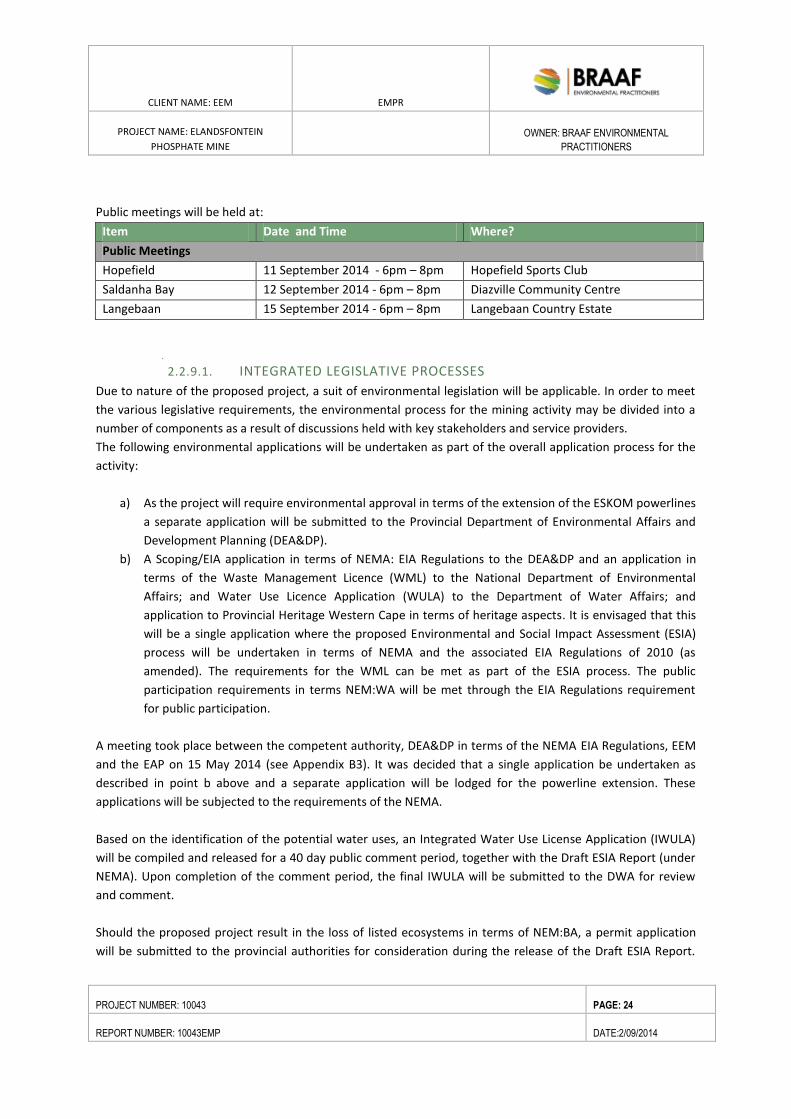
CLIENT NAME: EEM EMPR
PROJECT NAME: ELANDSFONTEIN
PHOSPHATE MINE
OWNER: BRAAF ENVIRONMENTAL
PRACTITIONERS
PROJECT NUMBER: 10043 PAGE: 24
REPORT NUMBER: 10043EMP DATE:2/09/2014
Public meetings will be held at:
Item Date and Time Where?
Public Meetings
Hopefield 11 September 2014 - 6pm – 8pm Hopefield Sports Club
Saldanha Bay 12 September 2014 - 6pm – 8pm Diazville Community Centre
Langebaan 15 September 2014 - 6pm – 8pm Langebaan Country Estate
2.2.9.1. INTEGRATED LEGISLATIVE PROCESSES
Due to nature of the proposed project, a suit of environmental legislation will be applicable. In order to meet
the various legislative requirements, the environmental process for the mining activity may be divided into a
number of components as a result of discussions held with key stakeholders and service providers.
The following environmental applications will be undertaken as part of the overall application process for the
activity:
a) As the project will require environmental approval in terms of the extension of the ESKOM powerlines
a separate application will be submitted to the Provincial Department of Environmental Affairs and
Development Planning (DEA&DP).
b) A Scoping/EIA application in terms of NEMA: EIA Regulations to the DEA&DP and an application in
terms of the Waste Management Licence (WML) to the National Department of Environmental
Affairs; and Water Use Licence Application (WULA) to the Department of Water Affairs; and
application to Provincial Heritage Western Cape in terms of heritage aspects. It is envisaged that this
will be a single application where the proposed Environmental and Social Impact Assessment (ESIA)
process will be undertaken in terms of NEMA and the associated EIA Regulations of 2010 (as
amended). The requirements for the WML can be met as part of the ESIA process. The public
participation requirements in terms NEM:WA will be met through the EIA Regulations requirement
for public participation.
A meeting took place between the competent authority, DEA&DP in terms of the NEMA EIA Regulations, EEM
and the EAP on 15 May 2014 (see Appendix B3). It was decided that a single application be undertaken as
described in point b above and a separate application will be lodged for the powerline extension. These
applications will be subjected to the requirements of the NEMA.
Based on the identification of the potential water uses, an Integrated Water Use License Application (IWULA)
will be compiled and released for a 40 day public comment period, together with the Draft ESIA Report (under
NEMA). Upon completion of the comment period, the final IWULA will be submitted to the DWA for review
and comment.
Should the proposed project result in the loss of listed ecosystems in terms of NEM:BA, a permit application
will be submitted to the provincial authorities for consideration during the release of the Draft ESIA Report.
CLIENT NAME: EEM EMPR
PROJECT NAME: ELANDSFONTEIN
PHOSPHATE MINE
OWNER: BRAAF ENVIRONMENTAL
PRACTITIONERS
PROJECT NUMBER: 10043 PAGE: 25
REPORT NUMBER: 10043EMP DATE:2/09/2014
The outcome of this permit application will be advertised, together with the decision made in terms of NEMA,
NEM:WA, and NHRA.
2.2.10. BROADER POLICY AND PLANNING CONTEXT
This section discusses a number of key formal planning policies relevant to the project. As this is a large-scale
project backed by State departments and empowerment funds, national plans are also considered in this
section, in addition to regional and local policies. The policies and plans briefly discussed below include:
• National development plans and policies, such as the:
o National Development Plan: Vision for 2030 (NDP);
o National Industrial Policy Framework (NIPF).
• Regional and local development and spatial plans, such as the:
o Integrated Development Plans (IDPs) for district and local municipalities, which formulate the specific
needs in, and desirable developments for, municipalities;
o Spatial Development Frameworks (SDFs) for the province, and district and local municipalities, which
translate the aims of the IDP into a spatial dimension and, together with the IDP, aim to give effect to
the national imperative to increase economic growth and promote social inclusion whilst ensuring
that such growth is environmentally sustainable (DEA&DP, 2009);
o Saldanha Bay Industrial Development Zone (IDZ);
o Saldanha Bay Municipality Local Economic Development (LED) Strategy; and
o Draft Environmental Management Framework (EMF), currently under development for the Greater
Saldanha Bay area.
2.2.10.1. NATIONAL DEVELOPMENT PLAN: VISION FOR 2030 (NDP)
The NDP: Vision for 2030 was released by the National Planning Commission in November 2011. The National
Planning Commission comprises 26 commissioners appointed by the President of South Africa to advise on
issues affecting long-term development in South Africa. The overarching vision of the NDP is to eliminate
poverty and reduce inequality by 2030 by addressing a number of key priority areas in the South African
economy and society.
The NDP proposes to create 11 million jobs by 2030 by:
• Realising an environment for sustainable employment and inclusive economic growth;
• Promoting employment in labour-absorbing industries;
• Raising exports and competitiveness;
• Strengthening government’s capacity to give leadership to economic development; and
• Mobilising all sectors of society around a national vision.
The NDP proposes to increase employment and growth by raising exports, focussing on those areas where
South Africa already has the endowments and comparative advantage, such as mining, construction, mid-skill
manufacturing, agriculture and agri-processing, tourism and business services.
2.2.10.2. NATIONAL INDUSTRIAL POLICY FRAMEWORK (NIPF);
CLIENT NAME: EEM EMPR
PROJECT NAME: ELANDSFONTEIN
PHOSPHATE MINE
OWNER: BRAAF ENVIRONMENTAL
PRACTITIONERS
PROJECT NUMBER: 10043 PAGE: 26
REPORT NUMBER: 10043EMP DATE:2/09/2014
The NIPF sets out the South African Government’s approach to South Africa’s industrialisation trajectory to
help align both private and public sector efforts towards this end. The NIPF vision for this industrialisation
trajectory is as follows (DTI, 2008):
• To facilitate diversification beyond South Africa’s current reliance on traditional commodities and
non-tradable services. This requires the promotion of increased value-addition per capita characterised
particularly by movement into non-traditional tradable goods and services that are competitive in both export
markets and the domestic economy;
• The long-term intensification of South Africa’s industrialisation process, and movement towards a
twenty-first century knowledge economy;
• The promotion of a more labour-absorbing industrialisation path with a particular emphasis on
tradable labour-intensive goods and services and economic linkages that catalyse employment creation;
• The promotion of a broader-based industrialisation path characterised by greater levels of
participation by historically disadvantaged economic citizens and marginalised regions in the mainstream of
the industrial economy; and
• Contributing to industrial development in Africa, with a strong emphasis on building regional
productive capabilities.
The NIPF indicates five sectors with particular potential for industrial growth and employment opportunities.
Three of those are of particular relevance to the proposed project (DTI, 2008):
• Natural resource-based sectors: Secondary, new value-adding opportunities may arise through new
primary activities such as mining or agriculture as well as the further processing of the resource base.
• Medium technology sectors (including downstream mineral beneficiation): While it does not
automatically follow that because South Africa possesses the underlying natural resource, it should
automatically be producing a more beneficiated product further down the value chain, a number of
opportunities arise for downstream processing of South Africa’s mineral base. These include various sources of
local demand, existing capabilities and underdeveloped value chains. Further development of these value
chains could add significant value and employment opportunities due to the much higher labour intensity than
their upstream counterparts.
• Advanced manufacturing sectors: The predominance of medium- to high-tech products in global trade
signifies that more efforts should be directed to value- addition and improving efficiencies along
manufacturing value chains. More importantly, new advanced manufacturing processes need to be promoted
and accumulated industrial capabilities enhanced. This is particularly important in the context of relatively
sluggish export performance in terms of both growth and technological composition.
• Advanced manufacturing is generally characterized by relatively high levels of skills and technology
requirements. These sectors are often driven by foreign direct investors who own the proprietary knowledge
involved and who subcontract original equipment manufacturing. However, there are areas in which South
Africa is developing its own proprietary technologies, such as in mining capital goods and nuclear energy.
2.2.10.3. WEST COAST DISTRICT MUNICIPALITY INTEGRATED DEVELOPMENT
PLAN (2011-2015 ((DRAFT)
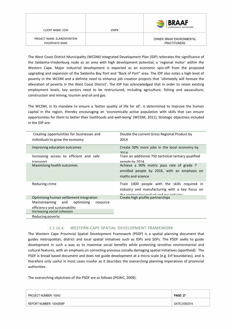
CLIENT NAME: EEM EMPR
PROJECT NAME: ELANDSFONTEIN
PHOSPHATE MINE
OWNER: BRAAF ENVIRONMENTAL
PRACTITIONERS
PROJECT NUMBER: 10043 PAGE: 27
REPORT NUMBER: 10043EMP DATE:2/09/2014
The West Coast District Municipality (WCDM) Integrated Development Plan (IDP) reiterates the significance of
the Saldanha-Vredenburg node as an area with high development potential, a ‘regional motor’ within the
Western Cape. Major industrial development is expected as an economic spin-off from the proposed
upgrading and expansion of the Saldanha Bay Port and “Back of Port” area. The IDP also notes a high level of
poverty in the WCDM and a definite need to enhance job creation projects that ’ultimately will foresee the
alleviation of poverty in the West Coast District’. The IDP has acknowledged that in order to retain existing
employment levels, key sectors need to be restructured, including agriculture, fishing and aquaculture,
construction and mining, tourism and oil and gas.
The WCDM, in its mandate to ensure a ‘better quality of life for all’, is determined to improve the human
capital in the region, thereby encouraging an ‘economically active population with skills that can ensure
opportunities for them to better their livelihoods and well-being’ (WCDM, 2011). Strategic objectives included
in the IDP are:
Creating opportunities for businesses and
individuals to grow the economy
Double the current Gross Regional Product by
2014
Improving education outcomes Create 50% more jobs in the local economy by
2014 Increasing access to efficient and safe
transport
Train an additional 750 technical tertiary qualified
people by 2014 Maximising health outcomes Achieve a 90% matric pass rate of grade 7
enrolled people by 2016, with an emphasis on
maths and science
Reducing crime Train 1000 people with the skills required in
industry and manufacturing with a key focus on
the engineering and oil and gas industry Optimising human settlement integration Create high profile partnerships Mainstreaming and optimising resource
efficiency and sustainability
Increasing social cohesion
Reducing poverty
2.2.10.4. WESTERN CAPE SPATIAL DEVELOPMENT FRAMEWORK
The Western Cape Provincial Spatial Development Framework (PSDF) is a spatial planning document that
guides metropolitan, district and local spatial initiatives such as IDPs and SDFs. The PSDF seeks to guide
development in such a way as to maximise social benefits while protecting sensitive environmental and
cultural features, with an emphasis on correcting previous socially damaging spatial initiatives (apartheid). The
PSDF is broad based document and does not guide development at a micro-scale (e.g. Erf boundaries), and is
therefore only useful in most cases insofar as it describes the overarching planning imperatives of provincial
authorities.
The overarching objectives of the PSDF are as follows (PGWC, 2009):
CLIENT NAME: EEM EMPR
PROJECT NAME: ELANDSFONTEIN
PHOSPHATE MINE
OWNER: BRAAF ENVIRONMENTAL
PRACTITIONERS
PROJECT NUMBER: 10043 PAGE: 28
REPORT NUMBER: 10043EMP DATE:2/09/2014
Socio-Economic Development Objectives:
• Align the future settlement pattern of the Province with areas of economic potential and the location
of environmental resources.
• Deliver human development programs and basic needs programs wherever they are required.
• Strategically invest scarce public resources where they will generate the highest socio-economic
returns.
• Support Land Reform.
• Conserve and strengthen the sense of place of important natural, cultural and productive
landscapes, artefacts and buildings.
Urban Restructuring Objectives:
• End the apartheid structure of urban settlements.
• Conveniently locate urban activities and promote public and non-motorised transport.
Environmental Sustainability Objectives:
• Protect biodiversity and agricultural resources.
• Minimise the consumption of scarce environmental resources, particularly water, fuel, building
materials, mineral resources, electricity and land – in the latter case especially pristine and other rural land,
which is the Province’s ‘goldmine-above-the- ground’.
The PSDF identifies the Saldanha-Vredenburg node as a ‘regional motor’ with a ‘growing industrial hub’ which
does, however, face constraints mainly in the form of water shortages. At the same time, the Langebaan-
Velddrif tourism development area is one of the eleven identified tourism development areas in the Western
Cape and is within a coastal ecological corridor and hence core biodiversity area (PGWC, 2009).
A number of issues and strategies were identified specifically for the West Coast region within the PSDF:
Issues:
• Saldanha Bay oil and gas potential;
• Drought;
• Access to the Olifants River irrigation scheme;
• Cederberg / West Coast tourism;
• How to balance pressure for urbanisation vs. water shortages vs. demands from agriculture; and
• South African region that is likely to be most extremely affected by global climate change.
Strategies:
• Prepare an industrial development / environmental conservation plan for Saldanha Bay that
acknowledges this sub-region's extreme environmental and economic sensitivities;
• Prepare an action plan to adapt to global climate change;
• Investigate the potential for an Olifants River development corridor with particular emphasis on
improved access to land for small farmers;
• Formulate a coastal management plan to address pressure for development along the coast; and
• Promote ecological corridors linking the coastal zone to the Cederberg Mountains.
CLIENT NAME: EEM EMPR
PROJECT NAME: ELANDSFONTEIN
PHOSPHATE MINE
OWNER: BRAAF ENVIRONMENTAL
PRACTITIONERS
PROJECT NUMBER: 10043 PAGE: 29
REPORT NUMBER: 10043EMP DATE:2/09/2014
2.2.10.5. SALDANHA BAY MUNICIPALITY INTEGRATED DEVELOPMENT PLAN
(2012 – 2017)
The Saldanha Bay Municipality (SBM) IDP 2012 – 2017 (SBM, 2012) defines a number of strategic objectives
and key strategies that serve as the foundation on which the municipality will be able to realise its vision, help
to drive National and Provincial Government’s agenda, expand and enhance infrastructure, and make sure that
all residents have access to essential services.
Strategic objectives include the diversification of the economic base of the municipality through
industrialisation, whilst at the same time nurturing traditional economic sectors while also developing safe,
integrated and sustainable neighbourhoods. Some relevant key strategies in this regard include:
• To create an enabling environment for the promotion of economic development as well as tourism
and the elevation of the industrial potential;
• To grow IDZ initiatives as one of the key focus areas of this IDP period; and
• To promote the conservation of the environment and facilitating responsible spatial development and
use of resources.
The IDP notes that the most important economic assets of the municipal area are the Saldanha Port and its
pristine coastline and that the region’s potential to create more sustainable jobs and expand its business
activity should be closely linked to industrial development and the tourist opportunities the coastline offer.
The industrial, tourism and agricultural sectors are seen as the primary economic drivers in the SBM economy.
However, employment in the agricultural sector has declined substantially due to increased mechanization,
and farm workers have migrated to urban areas in search of employment opportunities, which could for
example be provided by the industrial and tourism sectors. As the natural environment is the main attraction
for tourists in the area, industrial development should take place in such a way that the natural environment
and tourist attractions are not affected negatively.
2.2.10.6. SALDANHA BAY MUNICIPALITY SPATIAL DEVELOPMENT FRAMEWORK
(2010)
The objective of the overarching Spatial Management Concept for the SBM area, as contained in the SDF, is to
provide a broad guide to future development and land use management at the conceptual level. The primary
elements that have informed the proposed Spatial Management Concept are as follows:
• The need to protect areas which;
• Have a high irreplaceability factor in terms of meeting targets for biodiversity conservation;
• Are important for the maintenance of ecological and evolutionary processes; and
• Are critical to the provision of ecological services and special habitats;
• The integration of the river systems and coastline as ecological corridors into the regional open space
system;
• The incorporation of protected natural areas and areas under conservation management into the
regional open space system;
CLIENT NAME: EEM EMPR
PROJECT NAME: ELANDSFONTEIN
PHOSPHATE MINE
OWNER: BRAAF ENVIRONMENTAL
PRACTITIONERS
PROJECT NUMBER: 10043 PAGE: 30
REPORT NUMBER: 10043EMP DATE:2/09/2014
• The protection of high soil-based agricultural production potential areas;
• The promotion of urban development and growth within an established growth potential hierarchy
which takes cognisance of the main functions, growth potentials, comparative economic advantages and
specific location and spatial capacities of the various urban areas; and
• The maintenance, protection and promotion of high quality urban (including historical/cultural
environments) and natural environments.
Service infrastructure, including road linkages, is however lacking at present and their provision is regarded to
be a key public investment required to unlock the development potential of the mine area on Farm 349/4 and
a portion of Farm 349/2 as well as the associated infrastructure which includes roads and powerline
extensions.
2.2.10.7. SALDANHA BAY MUNICIPALITY LOCAL ECONOMIC DEVELOPMENT
STRATEGY (2005)
The goals of the LED Strategy (2005) for the SBM area are:
• The alleviation of poverty through the broadening of the economic base in the agriculture,
manufacturing, trade and tourism sectors. Implied in this goal is a lesser dependence on the local
manufacturing sector as a provider of jobs and income;
• To become a world-class economical manufacturer and exporter of steel and steel products;
• To create opportunities in the agricultural, manufacturing and tourism sectors that would result in the
community increasing their involvement in the economy and increasing their skills levels, becoming more
competitive within the regional labour force and increasing employment opportunities;
• To provide more effective infrastructure, especially tourism infrastructure that will help the
community in attaining supplies. This will also help local businesses and SMMEs by boosting investor’s
confidence in the area;
• To address the various problems of the different sectors, such as water shortage, unemployment etc.,
in order to remain economically competitive and environmentally sustainable in the future;
• To create a fertile environment for economic growth through developmental planning policies and
land use management regulations that is conducive to local small business development;
• To deliver basic services to all areas and people, which will enhances participation in the mainstream
economy; and
• The municipality to champion a process to encourage all major employment creators to use
procurement and employment policies that favour local entrepreneurs.
The outcomes for economic growth in the SBM area were identified together with nine associated strategic
interventions:
• Industrial development;
• Well-developed tourism Infrastructure;
• Promotion of SMME development;
• Conducive environment for investment;
• Creation of employment opportunities;
CLIENT NAME: EEM EMPR
PROJECT NAME: ELANDSFONTEIN
PHOSPHATE MINE
OWNER: BRAAF ENVIRONMENTAL
PRACTITIONERS
PROJECT NUMBER: 10043 PAGE: 31
REPORT NUMBER: 10043EMP DATE:2/09/2014
• Diversity of the economic base in the SBM area;
• Empowerment of local communities to participate in local economic activities;
• Environmental sustainability;
• Promotion of value added agricultural activities; and
• Skills development.
2.2.10.8. GREATER SALDANHA BAY AREA DRAFT ENVIRONMENTAL
MANAGEMENT FRAMEWORK
The Draft EMF was released in February 2013 and is briefly summarised below. The EMF may still be amended
during the finalisation process and must be adopted by the Minister. Once adopted, EMFs must be taken into
consideration in decision making.
The Draft EMF highlights a number of key trends that are relevant to the proposed project, including the
following (MEGA, 2013):
• Development capacity is limited by water scarcity, as there is limited opportunity for abstracting
additional water from surface water (i.e. Lower Berg River tributaries) or aquifers;
• Climate change is likely to result in:
o Changes in flood patterns and flooding;
o Increasingly stormy seas, which could impact on port activities;
o Increasing coastal erosion and resulting impacts on recreation and tourism opportunities;
o Decreasing farming and fishing productivity; and o Increasing demand for water;
o Biodiversity resources are lost through transformation of land, particularly urban
development;
• Air pollution modelling undertaken for the IDZ feasibility study has indicated that particulate
emissions are of concern at certain locations. Areas most affected are located in the vicinity of the iron ore
handling facility and the ArcelorMittal and Tronox plants;
• Pollutants associated with heavy industrial activity and increased urbanization are entering Saldanha
Bay and place strain on the supporting environment and fisheries; and
• The poverty gap within the community in the SBM has expanded between 1996 and 2002, implying
that many people in the area are becoming poorer. This is related to the general scarcity of available jobs and
the low skills level of the local population (Urban-Econ, 2005, cited in MEGA, 2013).
According to the maps contained in the Draft EMF, the proposed location of the Elandsfontein Mine area on
Farm 349/4 and a portion of Farm 349/2 fall within an area identified as a Critical Biodiversity Area (see Figure
6-14).
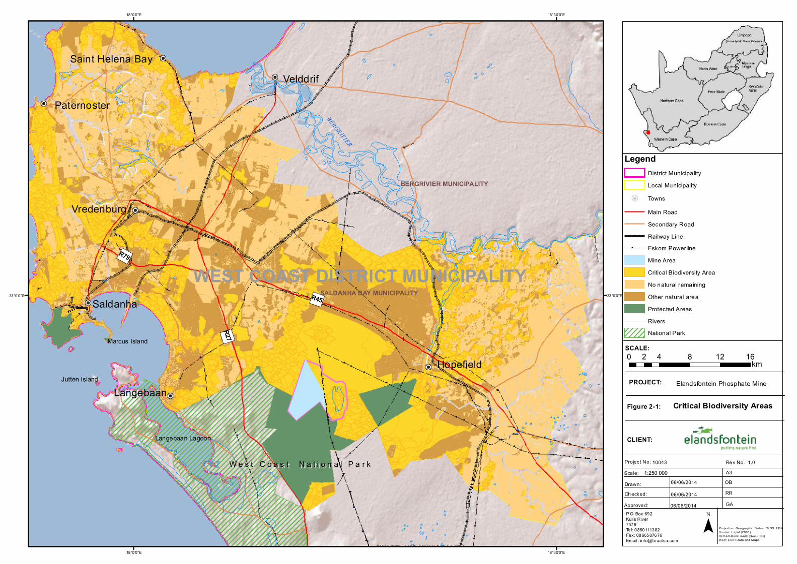
")R45
")R27
")R79
BERGRIVIER
BOESMANSRIVIER
W e s t C o a s t N a t i o n a l P a r kW e s t C o a s t N a t i o n a l P a r k
Langebaan Lagoon
Jutten Island
Marcus Island
WEST COAST DISTRICT MUNICIPALITY
Aurora
Velddrif
Hopefield
Saldanha
Langebaan
Paternoster
Vredenburg
Saint Helena Bay
SALDANHA BAY MUNICIPALITY
BERGRIVIER MUNICIPALITY
SWARTLAND MUNICIPALITY18°30'0"E
18°30'0"E
18°0'0"E
18°0'0"E
33°0'0"S 33°0'0"S
SCALE:
PROJECT:
Figure 2-1:
CLIENT:
Project No: Scale:
Re v No. A3
Drawn:Ch ecked:Approve d:
10043 1.0
06/06/2014
06/06/201406/06/2014
OBRRGA
Critical Biodiversity Areas
Elandsfontein Phosphate Mine
P O Box 692Kuils River7579Tel: 0860111382Fax: 0866587676Email : [email protected]
0 4 8 12 162 km
¯
1:250 000
Projection: Geographic, Datum : W GS 1984Source: E npat (2001), Dem arc ation B oard (Dec 2005)Ins et: E SRI Data and M aps
LegendDistrict Municipa lityLocal MunicipalityTownsMain RoadSecondary RoadRailway Line
ââ Eskom PowerlineMine AreaCritical Biodiversity AreaNo natural remainingOther natura l areaProtected AreasRiversNational Park
CLIENT NAME: EEM EMPR
PROJECT NAME: ELANDSFONTEIN
PHOSPHATE MINE
OWNER: BRAAF ENVIRONMENTAL
PRACTITIONERS
PROJECT NUMBER: 10043 PAGE: 33
REPORT NUMBER: 10043EMP DATE:2/09/2014
3. PROJECT BACKGROUND AND MOTIVATION
3.1. INTRODUCTION
3.1.1. PROJECT HISTORY
The Geological Survey (currently the Council of Geoscience) initiated a multidisciplinary project in 1975 to
study the recent sediments on the coastal plain between Cape Town and the Olifants River. During this study a
potential economic phosphate deposit was discovered on the farm Elandsfontein 349, situated some 15km
southeast of the Langebaan Phosphate Works, which was then in operation.
Samancor, the company that operated the Langebaan Mine, obtained an option to purchase the surface and
mineral rights over Portion 3 of Elandsfontein, adjacent to Portion 4 currently investigated by Elandsfontein
Mining and Exploration (Pty) Ltd. (EEM), where the phosphate was intersected during the regional exploration
program conducted by the Geological Survey.
Subsequent drilling program by Samancor confirmed the presence of phosphate on Portion 3, and also
indicated the extension of the ore body to the northwest into Portion 4 of Elandsfontein 349. A drilling
program between 1984 and 1986, consisting of 18 boreholes on Portion 4 (533m), confirmed the presence of
potentially economical phosphate. A deposit restricted to the inside of the drilling indicated a resource of
50Mt at grade of 10.1% P2O5.
Metallurgical test work has also conducted on the samples that prove that the ore could be upgraded to a
saleable grade of 32% P2O5 by means of flotation.
EEM applied for prospecting rights over Portion 4 and a sub-portion of Portion 2, with the Department of
Mineral Resources during 2009. The right was granted on 30 April 2013. The Samancor data (including drilling
logs, assay results and metallurgical test results) was purchased by EEM from the Council of Geoscience in
2012.
Using this information a 3D geological model was built, to assist with the planning of EEM drilling. EEM
initiated its drilling campaign in October 2013, the initial aim of replicating 3 of the previous Samancor holes,
to verify the historical Samancor results. The results from the initial drilling and assays by an independent
laboratory (SGS South Africa (Pty) Ltd), ascertained that the Samancor data could be used for the resource
calculations. EEM drilled an additional 4 holes to verify and confirm the 3D geological resource model.
In addition, a Lidar survey of the area was also conducted to assist with the generation a resource model.
EEM is currently conducting additional exploration drilling outside of the planned mining area to increase the
resource. Metallurgical test work is currently underway to finalise the plant configuration.
CLIENT NAME: EEM EMPR
PROJECT NAME: ELANDSFONTEIN
PHOSPHATE MINE
OWNER: BRAAF ENVIRONMENTAL
PRACTITIONERS
PROJECT NUMBER: 10043 PAGE: 34
REPORT NUMBER: 10043EMP DATE:2/09/2014
Following the findings of a series of investigations into updated reserve estimates, product handling and ship
loading, it was decided that the final product would be transported via road in containerized trucks directly
from the mine site to the Saldanha Port. The motivation for the change in transport options is detailed in
chapter 5.
3.1.2. PROPOSED MOTIVATION
Phosphate rock is a naturally occurring compound of the element phosphorus, found in rocks, soils and organic
material. Phosphorus is a key element in all known forms of life, both plant and animal. Phosphate rock is a
non-renewable resource that has taken millions of years to be formed through geological cycles and events.
The dominant application of phosphorus is in fertilisers. Due to the essential nature of phosphorus to living
organisms, the low solubility of natural phosphorus-containing compounds, and the slow natural cycle of
phosphorus, the agricultural industry relies on fertilisers that contain phosphate.
The most important characteristic of phosphorus is that there are no substitutes for it.
Global phosphate demand is rising due to a growing world population and increasing food demand. The
significance of phosphate for the future existence of humanity was realised some decades ago when
phosphate was declared a strategic mineral based on its significant role in food production (USGS, 1984). Food
security not just in South Africa but the world over became an ever growing issue in the last decade. The
Langebaan phosphate deposit has been listed as a strategic phosphate resource by the International Strategic
Minerals Inventory (ISMI Working Group).
According to phosphate marketing company CRU, the long-term industry forecast shows that the growth in
phosphate rock demand will require that new mining capacity will be required before 2022.
Increased consumption is envisaged within the Africa region, when compared to the anticipated production.
However, it is forecast that no African country will become a net importer of phosphate rock in the near
future.
Within South Africa, South Africa has fourteen known phosphate deposits of which four are igneous deposits
(Phalaborwa, Schiel, Glenover and Spitskop) with the other ten being sedimentary deposits located in the
Varswater formation in the Western Cape.
Refer to Appendix C13 for the Economic and Strategic Significance Study by Dr. J. Hattingh.
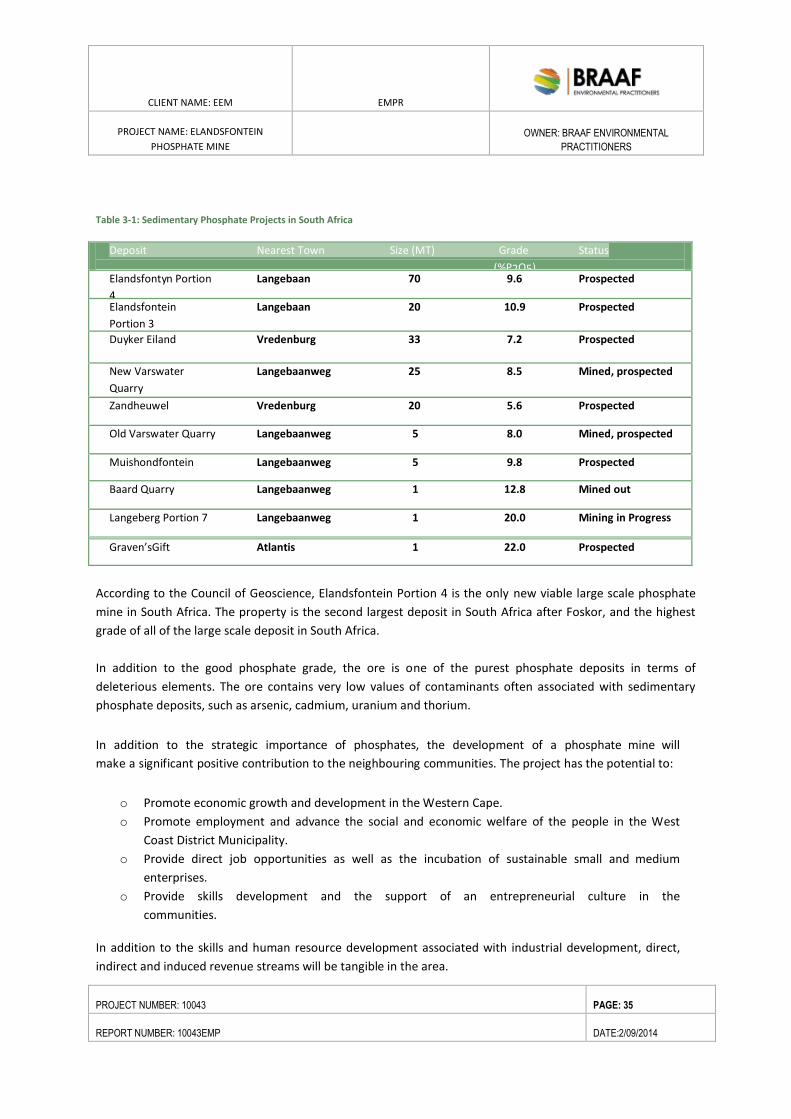
CLIENT NAME: EEM EMPR
PROJECT NAME: ELANDSFONTEIN
PHOSPHATE MINE
OWNER: BRAAF ENVIRONMENTAL
PRACTITIONERS
PROJECT NUMBER: 10043 PAGE: 35
REPORT NUMBER: 10043EMP DATE:2/09/2014
Table 3-1: Sedimentary Phosphate Projects in South Africa
Deposit Nearest Town Size (MT) Grade Status
(%P2O5) Elandsfontyn Portion Langebaan 70 9.6 Prospected
4 Elandsfontein Langebaan 20 10.9 Prospected
Portion 3
Duyker Eiland Vredenburg 33 7.2 Prospected
New Varswater Langebaanweg 25 8.5 Mined, prospected
Quarry
Zandheuwel Vredenburg 20 5.6 Prospected
Old Varswater Quarry Langebaanweg 5 8.0 Mined, prospected
Muishondfontein Langebaanweg 5 9.8 Prospected
Baard Quarry Langebaanweg 1 12.8 Mined out
Langeberg Portion 7 Langebaanweg 1 20.0 Mining in Progress
Graven’sGift Atlantis 1 22.0 Prospected
According to the Council of Geoscience, Elandsfontein Portion 4 is the only new viable large scale phosphate
mine in South Africa. The property is the second largest deposit in South Africa after Foskor, and the highest
grade of all of the large scale deposit in South Africa.
In addition to the good phosphate grade, the ore is one of the purest phosphate deposits in terms of
deleterious elements. The ore contains very low values of contaminants often associated with sedimentary
phosphate deposits, such as arsenic, cadmium, uranium and thorium.
In addition to the strategic importance of phosphates, the development of a phosphate mine will
make a significant positive contribution to the neighbouring communities. The project has the potential to:
o Promote economic growth and development in the Western Cape.
o Promote employment and advance the social and economic welfare of the people in the West
Coast District Municipality.
o Provide direct job opportunities as well as the incubation of sustainable small and medium
enterprises.
o Provide skills development and the support of an entrepreneurial culture in the
communities.
In addition to the skills and human resource development associated with industrial development, direct,
indirect and induced revenue streams will be tangible in the area.
CLIENT NAME: EEM EMPR
PROJECT NAME: ELANDSFONTEIN
PHOSPHATE MINE
OWNER: BRAAF ENVIRONMENTAL
PRACTITIONERS
PROJECT NUMBER: 10043 PAGE: 36
REPORT NUMBER: 10043EMP DATE:2/09/2014
According to 2012 statistics released by the Chamber of Mines, mining in South Africa created 524 632 jobs
directly with another 841 260 jobs were created in the industries that either supply goods and services to
the mining sector, or use mining products for downstream value addition, or which are related to the
spending multipliers from mining and mining employees in the economy. In addition to direct and
indirect jobs created, it must be noted that the social multiplier of mining is very significant for South
Africa, who has a dependency ratio of about 10 to 1.
Expenditure
Construction phase – Mine development is expected to take approximately 12-15 months with a capital
investment of USD 120 million.
Operational phase – At full production, annual costs associated with the mining activity are estimated to be
in the order of USD800million, of which R430million is direct labour costs. Of the total expenditure,
approximately 40% is targeted to be spent on BEE / HDSA suppliers and contractors at full production.
Mine closure – Mine closure will inject money into the regional and local economy largely through use of
contractors in dismantling surface infrastructure and finalizing the rehabilitation process of any remaining
spoil dumps and pits in the opencast mining areas.
Employment
Construction phase – During the 12-15 month construction period, contractor labour levels will peak at
approximately 800, of which a large percentage will be targeted to be drawn from the local area and be
employed for construction activities.
Operational phase – • The proposed new development will employ approximately 300 permanent
employees with varying skills. Approximately 82 skilled and management and 218 low and semi-skilled. This
implies an impact on the direct livelihood (direct workers and dependents) of approximately 1495 people.
Indirect employment opportunities amount to 32,908 during the operational phase. The average wage bill
would be R430 million over 15 years.
Mine closure – The mine closure operation will provide employment for between 60 -100 people (declining)
over the three to five-year period, following the end of mining activities.
Income profile
According to the socio-economic study the total Gross Domestic Product (GDP) impact in South Africa of the
construction phase will amount to R1 billion over the three year construction period.
Broad-Based Black Economic Empowerment
Elandsfontein Exploration and Mining (Pty) Ltd is a 30 % BEE owned company of which the shares are held by
the following entities:
CLIENT NAME: EEM EMPR
PROJECT NAME: ELANDSFONTEIN
PHOSPHATE MINE
OWNER: BRAAF ENVIRONMENTAL
PRACTITIONERS
PROJECT NUMBER: 10043 PAGE: 37
REPORT NUMBER: 10043EMP DATE:2/09/2014
Pico Diamonds (Pty) Ltd 15%
Adistra 11 CC 15%
Phosfanatio (Pty) Ltd 70%
In terms of employment equity targets in the empowerment charter to ensure diversity as well as participation
of HDSA at all decision-making positions and core occupational categories, Elandsfontein mine will strive to
achieve a minimum of 40% HDSA demographic representation at:
o Executive Management (Board) level
o Senior management (EXCO)
o Core and Critical skills
o Middle management
o Junior management
The intention of the Mine is to comply with the provisions of the Employment Equity Act (Act No.55 of 1998),
and to implement an Employment Equity Plan (EEP) in compliance with the Mining Charter. The Mine’s EEP
will continue to be implemented until the Mine’s workforce is sufficiently reflecting the demographics of the
region - and of SA at large. Three specific targets areas will be focused on:
a) HDSA participation in management
b) Women participation in mining
c) Empowerment of the disabled
Environmental commitment EEM is committed to:
o Sustainable business models for all stakeholders, including shareholders, employees, communities
and the environment;
o Compliance with all applicable environmental legislation;
o Environmental best practice;
o Adherence to first world standards;
o Restoring and rehabilitating affected areas;
o Establishing appropriate and effective mitigation measures;
o Progressive and innovative programmes to minimise environmental impacts
o In line with the environmental commitment, the following potential biodiversity offset and
rehabilitation programmes have been identified and will be investigated further and implemented if
feasible during the life of mine. The detail regarding this process :
Restoration of degraded/areas infested with alien vegetation such as the fossil site in
collaboration with SANParks;
Donating areas of heritage importance (fossil area in –dunefield) within the project area and
where the surface rights is held by Elandsfontein Land Holdings (Pty) Ltd for declaration,
management and use for further research by relevant parties (tertiary institutions and
students such as UCT); as well as possible development as a paleo tourist attraction for the
West Coast (fossil park).
CLIENT NAME: EEM EMPR
PROJECT NAME: ELANDSFONTEIN
PHOSPHATE MINE
OWNER: BRAAF ENVIRONMENTAL
PRACTITIONERS
PROJECT NUMBER: 10043 PAGE: 38
REPORT NUMBER: 10043EMP DATE:2/09/2014
Provide bursaries to tertiary students at institutions such as UWC and to encourage
postgraduate students to focus their studies on aspects related to the mine including earth
sciences, life sciences (monitoring and rehabilitation, etc).
Local Economic Development Injection as per projects identified in the Social and Labour
Plan (SLP) a requirement of all mining right applications (in terms of the MPRDA).
o Possible offset areas related to the impact on sensitive vegetation (this will however, be investigated
as part of the ESIA where potential impacts cannot be mitigated, such as removal of vegetation over
areas which will accommodate the mine and related infrastructure).
o Improvement of the conservation contribution of land areas to be affected.
o Establishment of a “Sustainable Science and Technology Research, Education and Visitor Centre” as a
Major Attraction on the West Coast.
o Development of Satellite Fossil Sites.
o Small scale farming injection.
o Utilising grey water from the Vredenburg Wastewater Treatment Works (WWTW) which will be
purified to a level required for use in the processing plant. Currently the treated effluent is being
disposed into a well and eventually ends up in the Langebaan Lagoon. By utilizing the grey water as
part of the processing plant, this will eliminate the need to dispose of it in the manner it currently is
which may affect the groundwater and surface water of adjacent water bodies, such as the
Langebaan Lagoon. The use of recycled water eliminates the need to use potable water (such as
abstracting water from the aquifer) and minimising the potential to impact groundwater sources at
the mine site. Utilising recycled water as part of the process adds to water conservation and
management measures currently being promoted by National and Provincial Department of
Environmental Affairs in light of climate change adaptation strategies.
Information extrapolated from the EEM Social and Labour Plan.
CLIENT NAME: EEM EMPR
PROJECT NAME: ELANDSFONTEIN
PHOSPHATE MINE
OWNER: BRAAF ENVIRONMENTAL
PRACTITIONERS
PROJECT NUMBER: 10043 PAGE: 39
REPORT NUMBER: 10043EMP DATE:2/09/2014
4. PROJECT DESCRIPTION
4.1. PROJECT LOCATION
The proposed mine site is located at 33°06’05.69’’S and 18°12’26.85’’E. EEM holds the prospecting rights to
the Elandsfontein deposit over Portion 4 and a portion of Portion 2 of the Farm Elandsfontein No. 349. All
comments including infrastructure will be located on the aforementioned farms. Excluded from this are
portions of the powerline and main access road requirements, which will cross additional properties, not
owned by Elandsfontein Land Holdings (Pty) Ltd (see Figure 1-1).
4.2. PROPOSED PROJECT
The Elandsfontein deposit is a greenfield project (a project which lacks any constraints imposed by prior work).
The intent is to adopt an open-pit strip mining method using a combination of truck and shovel, and conveyor
belts to extract the deposit, phosphate ore. The deposit is sandy in nature, and no blasting will be required.
4.3. PROPERTY DETAILS
The table below indicates the properties found within the Elandsfontein Phosphate Mine project boundary
areas and associated land owners. The properties found within the Elandsfontein Phosphate Mine project
boundary area is illustrated in (refer to Figure 4-1). The project boundary covers an area of 942.185ha at
Elandsfontein.
Component Farm Name Portion Extent (Ha) Landowner
Main mine (pit,
buildings,
processing
plant)
Elandsfontein 2/349 1999.1217 Elandsfontein Land Holdings (Pty) Ltd
Elandsfontein 4/349 942.1852 Elandsfontein Land Holdings (Pty) Ltd
Powerline Elandsfontein 6/178 697.6567 QCK Lezmin 4443 CC
2/349 and
4/349
Elandsfontein Land Holdings (Pty) Ltd
Mine access
road
Langverwacht 6/178 697.6567 QCK Lezmin 4443 CC
Elandsfontein 2/349 and
4/349
Elandsfontein Land Holdings (Pty) Ltd
Langverwacht RE/178 667.5264 Horseshoe Investments 0025 CC
Elandsfontein 1141 527.7263 L. Scullard
Elandsfontein 7/304 Saldanha Bay Municipality
")R45
")R27
W e s t C o a s t N a t i o n a l P a r kW e s t C o a s t N a t i o n a l P a r k
Langebaan Lagoon
Hopefield
183
995West Coast National Park
296
1/348
315
7/304
1162
2/349
4/377 1/384
3/349
RE/360
179
1/353
7/172
6/139
RE/305
RE/176
RE/81
3/307
RE/141
4/307
300
RE/298
RE/168
RE/80
8/178
1/305
4/349
1223
2/69
RE/386
RE/139
171
RE/167174
RE/353
2/305
301
RE/348
RE/177
347
RE/69
3/378
5/349299
6/178
173
RE/190
RE/320
4/378
RE/298
3/132
1141
6/349
378/348
West Coast National Park
RE/140
RE/346
7/185
RE/378
RE/178
RE/188
5/378
2/378
RE/168
RE/188
1/187
RE/1029
2/360
5/178
RE/167
1/378
4/386
RE/384
RE/187
RE/129
Elandsfontein Project Area - Mining Righ
316
RE/169
RE/164
2/167
RE/143
3/386
RE/7/185
7/349
1/304
RE/1043 4/137
RE/140
25/346
1/164165
18/132
RE/1/187
12/185
1/189
25/346
19/1853/175
3/178
RE/138
1/349
3/293
1/377
1/180
17/132
2/172
5/377
295
1/1051
6/304
1/176
3/292
2/166
RE/81
4/139 3/139
2/184
1/139 1/143
1/175
RE/386
6/188
1131
RE/6/137
RE/69
1130
RE/187
RE/1029
RE/4/187
1068
1072
RE/1661/166
4/176
6/185
RE/307
7/188
361
7/372
9/3725/372
2/372
6/372
4/3728/372
22/372
29/37217/372
11/362
181
11/37212/37214/372
21/372
23/37210/372
RE/297
13/372
25/37216/372
20/37218/372
19/372
66/185
RE/175
RE/12/191
3/440
27/135
3/176
11/187
24/372
2/386
RE/189
86/372
5522/135
87/372
170
1/386
2/377
RE/297
2/353
88/372
35/185
RE/141
4/177
142
5/62
1/167
5/136RE/1043
3/781/62
50/1353/135
1/346
9/185
7/187
1/81
10/137
1/190
2/137
4/175
1/1029
6/177
1/307
38/185
Towns
1/297
5/137
RE/138RE/8/185
45/372
8/137
47/185
6/187
44/372
18/185
434
4/62
5/187
27/185
33/372
40/18521/185
11/18530/185
1/138
3/140
41/185
3/305
RE/169
RE/52/185
13/346
RE/50/185
5/177
56/185
33°0'0"S 33°0'0"S
SCALE:
PROJECT:
Figure 4-1:
CLIENT:
Project No: Scale:
Re v No. A3
Drawn:Ch ecked:Approve d:
10043 1.0
06/06/2014
06/06/201406/06/2014
OBRRGA
Cadastral Map
Elandsfontein Phosphate Mine
P O Box 692Kuils River7579Tel: 0860111382Fax: 0866587676Email : [email protected]
0 2 4 6 81 km
¯
1:125 000
Projection: Geographic, Datum : W GS 1984Source: E npat (2001), Dem arc ation B oard (Dec 2005)Ins et: E SRI Data and M aps
LegendDistrict MunicipalityLocal MunicipalityTownsMain RoadSecondary RoadRailway Line
ââ Eskom PowerlineFarm PortionMine AreaElandsfontein Land ParcelsRiversNational ParkFossil Area
CLIENT NAME: EEM EMPR
PROJECT NAME: ELANDSFONTEIN
PHOSPHATE MINE
OWNER: BRAAF ENVIRONMENTAL
PRACTITIONERS
PROJECT NUMBER: 10043 PAGE: 41
REPORT NUMBER: 10043EMP DATE:2/09/2014
4.4. MINING
4.4.1. ESTIMATE RESERVES AND EXTENT OF TARGET AREA
4.4.1.1. RESOURCE ESTIMATE
A summary of the Mineral Resource is shown below. On 28 November 2013, based on drilling results of 18
boreholes drilled by Samancor and 3 boreholes drilled by EEM, a resource of 70 million tonnes was declared.
The resource estimate was updated on 8 April 2014, based on an additional 26 boreholes drilled by EEM. The
average drill spacing of the boreholes is has been reduced 300m, which would classify the resource as an
indicated resource, with the resource on the drilling perimeter being classified as inferred.
Table 4-1: Updated Mineral Resource for Elandsfontein
Classification Date Grade In Situ
Volume
In Situ Mass Geological
Loss
Resource
Mass
(%P2O5) (m3) (Tonnes) (%) (Tonnes)
Inferred Nov 13 9.65 46,903,550 75,983,751 7.5 70,284,970
Indicated Apr 14 10.83 54,335 91,283 5.0 86,719,506
Inferred Apr 14 9.80 30,957,757 52,009,031 7.5 48,380,494
EEM has a Total Resource of 135Mt at an average grade of 10.46% P2O5 as at 8 April 2014.
The Run of Mine (ROM) ore to the plant is expected to contain an average grade of 10.5% P2O5. The ore will
be upgraded to a concentrate grade of 32.5% P2O5.through several flotation stages. The concentrate will be
upgraded at the mine site and hauled via containerized trucks to the Saldanha Port.
Table 4-2: Proposed Mine Plan
Project Activity Detail
Mine Products A concentrated rock phosphate (at 32.5% P2O5) will be produced through a
beneficiation plant on the mine site Mining Rate 5,000,000 tonnes per annum
Estimated Reserves 132,000,000 tonnes
Planned Life of Mine 20 years
Production Rate 1,500,000 tonnes per annum
Extent of area 431 ha
CLIENT NAME: EEM EMPR
PROJECT NAME: ELANDSFONTEIN
PHOSPHATE MINE
OWNER: BRAAF ENVIRONMENTAL
PRACTITIONERS
PROJECT NUMBER: 10043 PAGE: 42
REPORT NUMBER: 10043EMP DATE:2/09/2014
4.4.2. PROPOSED LAYOUT AND PIT DESIGN
The mine design was based on the geological model information and using various grades, varying recoveries,
mining cost, process costs and selling costs as well as the predicted phosphate commodity prices to optimise
and prove the economical viable of the mineral resource that could be declared as a mineral reserve and
feasibly mined. Based on these factors the planned mining depletion has been categorised into phases one to
four as depicted in Figure 4-2. Due to the shallow and uniform nature of the deposit, only surface mining
methods were considered. The results from the current prospecting indicate that the material to be mined is
sandy in nature, with only occasional lenses of hard calcrete, and the operation would not require drilling or
blasting.
Apart from the economic parameters used to draft the mine design, the following technical considerations
have been applied:
Pit Slope angle: 35˚
Max Bench height: 5m
Min berm width: 5m
Minimum pit bottom width: 30m
The type of mining method applied influenced the layout and design to a degree. A number of surface mining
methods were investigated, and strip mining has been selected as the preferred option, based primarily on
environmental considerations. The strip mining will take place in a number of discrete phases, which will
reduce the overall mining, foot print:
a) topsoil is removed and stockpiled;
b) overburden layer is stripped and stockpiled;
c) phosphate ore is mined; then
d) the strip is backfilled with the overburden and slimes from the plant; and
e) the topsoil returned to the strip and rehabilitated.
With this type of mining method concurrent rehabilitation (i.e. after mining a strip, rehabilitation can
commence) can be employed which was considered a key element by EEM.
The draft production schedule will be updated once the definitive geological model and metallurgical test work
is completed to allow for a final optimised production schedule to be generated. The draft schedule with the
first 6 years highlighted in yellow is shown in table the below.
ELANDSFONTEIN PHOSPHATE LOM PRODUCTION SCHEDULE
Area/Year Topsoil BCMs Soft Burden BCMs ROM Ore BCMs Total BCMs/A
2015 37,450 2,623,069 - 2,660,519
2016 77,749 7,482,631 2,366,001 9,926,381
2017 54,074 7,483,748 2,653,458 10,191,280
CLIENT NAME: EEM EMPR
PROJECT NAME: ELANDSFONTEIN
PHOSPHATE MINE
OWNER: BRAAF ENVIRONMENTAL
PRACTITIONERS
PROJECT NUMBER: 10043 PAGE: 43
REPORT NUMBER: 10043EMP DATE:2/09/2014
2018 61,436 7,486,634 2,520,568 10,068,637
2019 73,559 7,482,864 2,539,322 10,095,746
2020 57,430 9,557,571 2,653,458 12,268,459
2021 66,693 9,368,935 2,635,265 12,070,893
2022 64,746 9,057,835 2,560,819 11,683,400
2023 71,705 9,348,118 2,637,927 12,057,750
2024 102,407 8,700,752 2,653,458 11,456,617
2025 75,067 9,028,759 2,592,667 11,696,493
2026 178,009 9,611,091 2,507,831 12,296,931
2027 106,002 9,614,519 2,653,458 12,373,979
2028 18,672 9,464,047 1,272,754 10,755,473
2029 34,618 9,438,675 1,052,667 10,525,960
2030 10,742 6,972,824 531,593 7,515,159
LOM Total 1,090,359 132,722,071 33,831,247 167,643,677
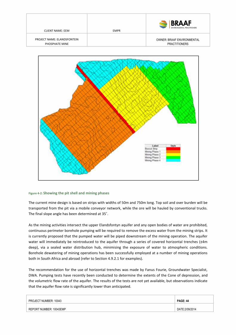
CLIENT NAME: EEM EMPR
PROJECT NAME: ELANDSFONTEIN
PHOSPHATE MINE
OWNER: BRAAF ENVIRONMENTAL
PRACTITIONERS
PROJECT NUMBER: 10043 PAGE: 44
REPORT NUMBER: 10043EMP DATE:2/09/2014
Figure 4-2: Showing the pit shell and mining phases
The current mine design is based on strips with widths of 50m and 750m long. Top soil and over burden will be
transported from the pit via a mobile conveyor network, while the ore will be hauled by conventional trucks.
The final slope angle has been determined at 35˚.
As the mining activities intersect the upper Elandsfontyn aquifer and any open bodies of water are prohibited,
continuous perimeter borehole pumping will be required to remove the excess water from the mining strips. It
is currently proposed that the pumped water will be piped downstream of the mining operation. The aquifer
water will immediately be reintroduced to the aquifer through a series of covered horizontal trenches (±4m
deep), via a sealed water distribution hub, minimising the exposure of water to atmospheric conditions.
Borehole dewatering of mining operations has been successfully employed at a number of mining operations
both in South Africa and abroad (refer to Section 4.9.2.1 for examples).
The recommendation for the use of horizontal trenches was made by Fanus Fourie, Groundwater Specialist,
DWA. Pumping tests have recently been conducted to determine the extents of the Cone of depression, and
the volumetric flow rate of the aquifer. The results of the tests are not yet available, but observations indicate
that the aquifer flow rate is significantly lower than anticipated.
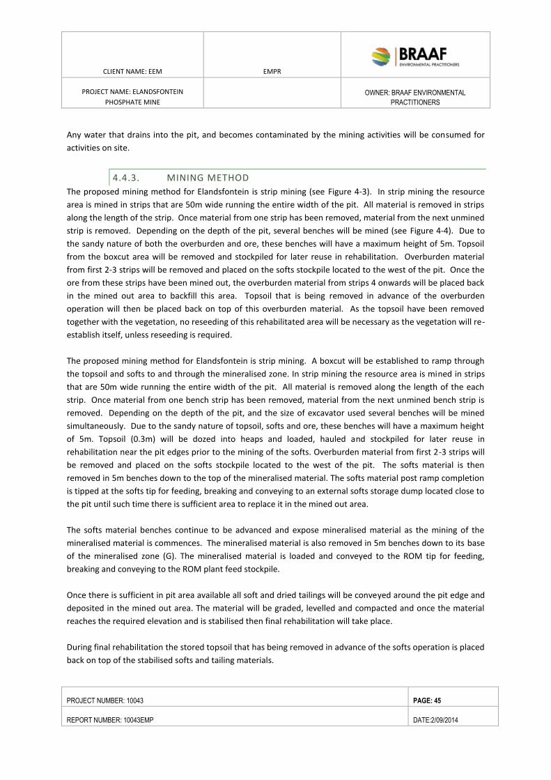
CLIENT NAME: EEM EMPR
PROJECT NAME: ELANDSFONTEIN
PHOSPHATE MINE
OWNER: BRAAF ENVIRONMENTAL
PRACTITIONERS
PROJECT NUMBER: 10043 PAGE: 45
REPORT NUMBER: 10043EMP DATE:2/09/2014
Any water that drains into the pit, and becomes contaminated by the mining activities will be consumed for
activities on site.
4.4.3. MINING METHOD
The proposed mining method for Elandsfontein is strip mining (see Figure 4-3). In strip mining the resource
area is mined in strips that are 50m wide running the entire width of the pit. All material is removed in strips
along the length of the strip. Once material from one strip has been removed, material from the next unmined
strip is removed. Depending on the depth of the pit, several benches will be mined (see Figure 4-4). Due to
the sandy nature of both the overburden and ore, these benches will have a maximum height of 5m. Topsoil
from the boxcut area will be removed and stockpiled for later reuse in rehabilitation. Overburden material
from first 2-3 strips will be removed and placed on the softs stockpile located to the west of the pit. Once the
ore from these strips have been mined out, the overburden material from strips 4 onwards will be placed back
in the mined out area to backfill this area. Topsoil that is being removed in advance of the overburden
operation will then be placed back on top of this overburden material. As the topsoil have been removed
together with the vegetation, no reseeding of this rehabilitated area will be necessary as the vegetation will re-
establish itself, unless reseeding is required.
The proposed mining method for Elandsfontein is strip mining. A boxcut will be established to ramp through
the topsoil and softs to and through the mineralised zone. In strip mining the resource area is mined in strips
that are 50m wide running the entire width of the pit. All material is removed along the length of the each
strip. Once material from one bench strip has been removed, material from the next unmined bench strip is
removed. Depending on the depth of the pit, and the size of excavator used several benches will be mined
simultaneously. Due to the sandy nature of topsoil, softs and ore, these benches will have a maximum height
of 5m. Topsoil (0.3m) will be dozed into heaps and loaded, hauled and stockpiled for later reuse in
rehabilitation near the pit edges prior to the mining of the softs. Overburden material from first 2-3 strips will
be removed and placed on the softs stockpile located to the west of the pit. The softs material is then
removed in 5m benches down to the top of the mineralised material. The softs material post ramp completion
is tipped at the softs tip for feeding, breaking and conveying to an external softs storage dump located close to
the pit until such time there is sufficient area to replace it in the mined out area.
The softs material benches continue to be advanced and expose mineralised material as the mining of the
mineralised material is commences. The mineralised material is also removed in 5m benches down to its base
of the mineralised zone (G). The mineralised material is loaded and conveyed to the ROM tip for feeding,
breaking and conveying to the ROM plant feed stockpile.
Once there is sufficient in pit area available all soft and dried tailings will be conveyed around the pit edge and
deposited in the mined out area. The material will be graded, levelled and compacted and once the material
reaches the required elevation and is stabilised then final rehabilitation will take place.
During final rehabilitation the stored topsoil that has being removed in advance of the softs operation is placed
back on top of the stabilised softs and tailing materials.
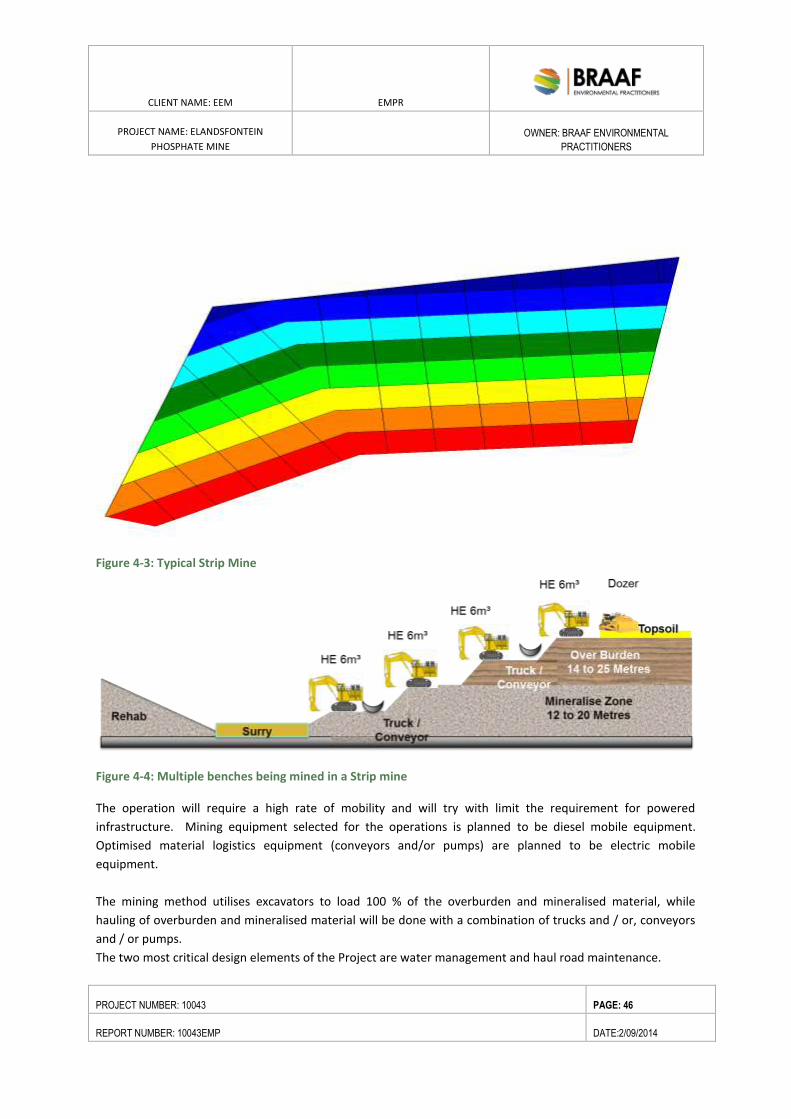
CLIENT NAME: EEM EMPR
PROJECT NAME: ELANDSFONTEIN
PHOSPHATE MINE
OWNER: BRAAF ENVIRONMENTAL
PRACTITIONERS
PROJECT NUMBER: 10043 PAGE: 46
REPORT NUMBER: 10043EMP DATE:2/09/2014
Figure 4-3: Typical Strip Mine
Figure 4-4: Multiple benches being mined in a Strip mine
The operation will require a high rate of mobility and will try with limit the requirement for powered
infrastructure. Mining equipment selected for the operations is planned to be diesel mobile equipment.
Optimised material logistics equipment (conveyors and/or pumps) are planned to be electric mobile
equipment.
The mining method utilises excavators to load 100 % of the overburden and mineralised material, while
hauling of overburden and mineralised material will be done with a combination of trucks and / or, conveyors
and / or pumps.
The two most critical design elements of the Project are water management and haul road maintenance.
CLIENT NAME: EEM EMPR
PROJECT NAME: ELANDSFONTEIN
PHOSPHATE MINE
OWNER: BRAAF ENVIRONMENTAL
PRACTITIONERS
PROJECT NUMBER: 10043 PAGE: 47
REPORT NUMBER: 10043EMP DATE:2/09/2014
First, all mining areas must be dewatered in advance of mining activities. In addition to advance dewatering,
in-pit water management is also critical (see Section 4.9.2). Pollution control berms and trenches will limit the
ingress of any rain / flood water into the pit. Roads must be well-graded and crowned with a thick layer works
of appropriately sized materials. Mobile equipment (excavators, trucks, and auxiliary mobile equipment) will
require good roads throughout the active mine at all times to ensure productive operations.
The five key factors driving the mining schedule are listed below in decreasing order of importance:
annual product target,
mineralised material grade,
product yield recovery,
stripping ratio, and
backfill opportunities.
Backfilling was maximised to minimise re-handle and related controllable operating costs for the Project. A
constant ± 1.0 Mt of beneficiated phosphate rock concentrate product was targeted each year with stripping
ratio increasing from low to high to defer capital and operating costs and to minimise investment risk.
4.5. MINING SEQUENCE
Based on the maximum pit-shell (Figure 4-2: Showing the pit shell and mining phases) a detailed mine
production schedule (targeting 5 million ore tonnes per annum) was developed and evaluated to determine
the economic pit limit as depicted in Figure 4-2 Should the commodity price improve this economic mining
limit may increase.
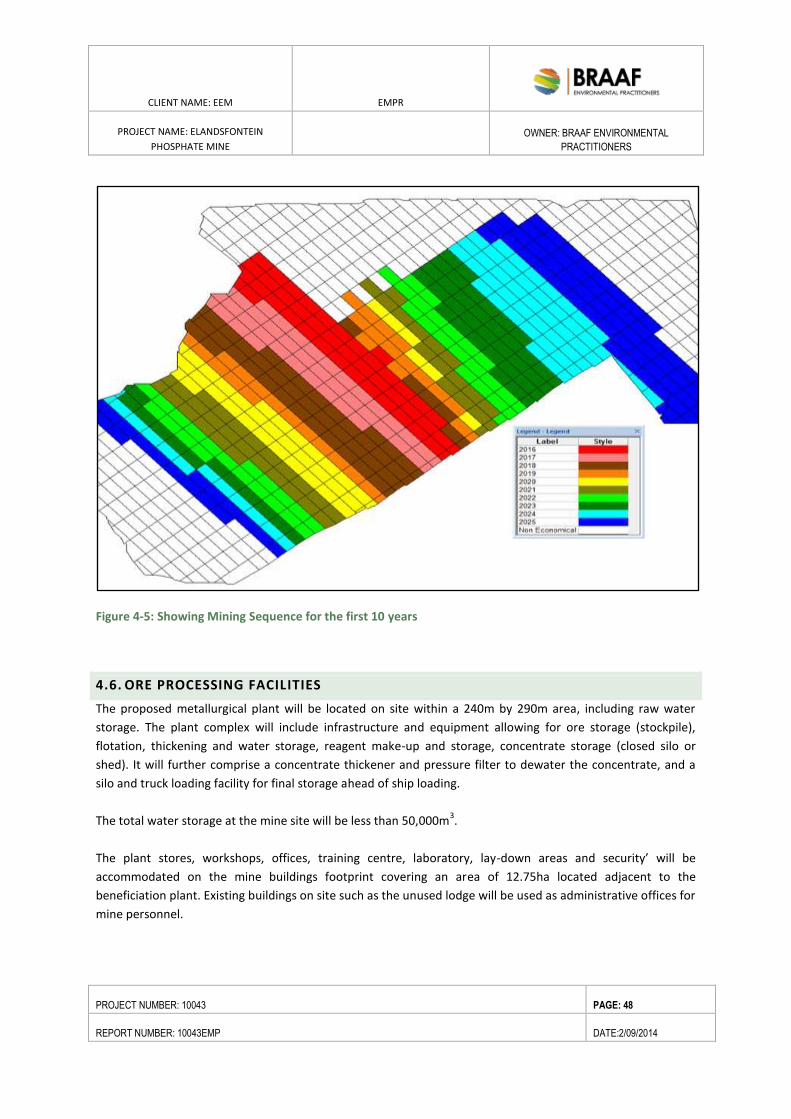
CLIENT NAME: EEM EMPR
PROJECT NAME: ELANDSFONTEIN
PHOSPHATE MINE
OWNER: BRAAF ENVIRONMENTAL
PRACTITIONERS
PROJECT NUMBER: 10043 PAGE: 48
REPORT NUMBER: 10043EMP DATE:2/09/2014
Figure 4-5: Showing Mining Sequence for the first 10 years
4.6. ORE PROCESSING FACILITIES
The proposed metallurgical plant will be located on site within a 240m by 290m area, including raw water
storage. The plant complex will include infrastructure and equipment allowing for ore storage (stockpile),
flotation, thickening and water storage, reagent make-up and storage, concentrate storage (closed silo or
shed). It will further comprise a concentrate thickener and pressure filter to dewater the concentrate, and a
silo and truck loading facility for final storage ahead of ship loading.
The total water storage at the mine site will be less than 50,000m3.
The plant stores, workshops, offices, training centre, laboratory, lay-down areas and security’ will be
accommodated on the mine buildings footprint covering an area of 12.75ha located adjacent to the
beneficiation plant. Existing buildings on site such as the unused lodge will be used as administrative offices for
mine personnel.
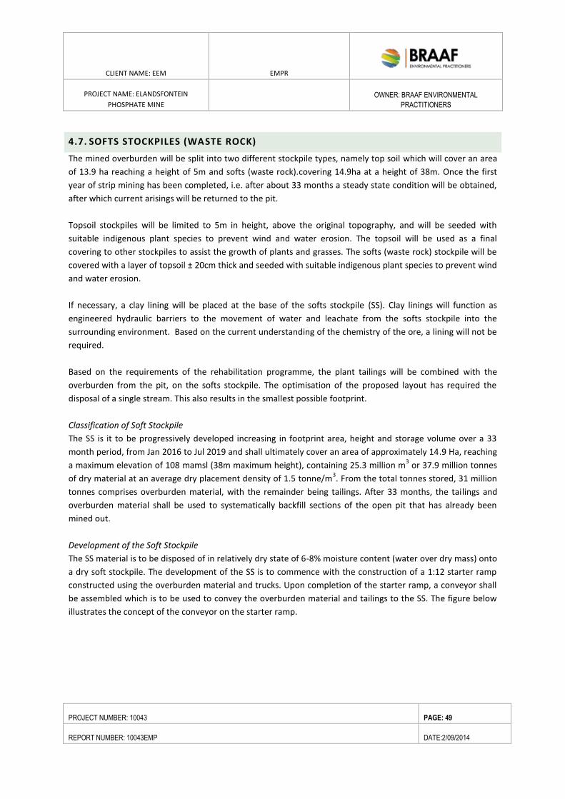
CLIENT NAME: EEM EMPR
PROJECT NAME: ELANDSFONTEIN
PHOSPHATE MINE
OWNER: BRAAF ENVIRONMENTAL
PRACTITIONERS
PROJECT NUMBER: 10043 PAGE: 49
REPORT NUMBER: 10043EMP DATE:2/09/2014
4.7. SOFTS STOCKPILES (WASTE ROCK)
The mined overburden will be split into two different stockpile types, namely top soil which will cover an area
of 13.9 ha reaching a height of 5m and softs (waste rock).covering 14.9ha at a height of 38m. Once the first
year of strip mining has been completed, i.e. after about 33 months a steady state condition will be obtained,
after which current arisings will be returned to the pit.
Topsoil stockpiles will be limited to 5m in height, above the original topography, and will be seeded with
suitable indigenous plant species to prevent wind and water erosion. The topsoil will be used as a final
covering to other stockpiles to assist the growth of plants and grasses. The softs (waste rock) stockpile will be
covered with a layer of topsoil ± 20cm thick and seeded with suitable indigenous plant species to prevent wind
and water erosion.
If necessary, a clay lining will be placed at the base of the softs stockpile (SS). Clay linings will function as
engineered hydraulic barriers to the movement of water and leachate from the softs stockpile into the
surrounding environment. Based on the current understanding of the chemistry of the ore, a lining will not be
required.
Based on the requirements of the rehabilitation programme, the plant tailings will be combined with the
overburden from the pit, on the softs stockpile. The optimisation of the proposed layout has required the
disposal of a single stream. This also results in the smallest possible footprint.
Classification of Soft Stockpile
The SS is it to be progressively developed increasing in footprint area, height and storage volume over a 33
month period, from Jan 2016 to Jul 2019 and shall ultimately cover an area of approximately 14.9 Ha, reaching
a maximum elevation of 108 mamsl (38m maximum height), containing 25.3 million m3 or 37.9 million tonnes
of dry material at an average dry placement density of 1.5 tonne/m3. From the total tonnes stored, 31 million
tonnes comprises overburden material, with the remainder being tailings. After 33 months, the tailings and
overburden material shall be used to systematically backfill sections of the open pit that has already been
mined out.
Development of the Soft Stockpile
The SS material is to be disposed of in relatively dry state of 6-8% moisture content (water over dry mass) onto
a dry soft stockpile. The development of the SS is to commence with the construction of a 1:12 starter ramp
constructed using the overburden material and trucks. Upon completion of the starter ramp, a conveyor shall
be assembled which is to be used to convey the overburden material and tailings to the SS. The figure below
illustrates the concept of the conveyor on the starter ramp.
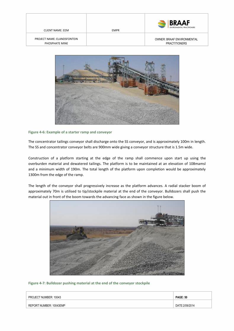
CLIENT NAME: EEM EMPR
PROJECT NAME: ELANDSFONTEIN
PHOSPHATE MINE
OWNER: BRAAF ENVIRONMENTAL
PRACTITIONERS
PROJECT NUMBER: 10043 PAGE: 50
REPORT NUMBER: 10043EMP DATE:2/09/2014
Figure 4-6: Example of a starter ramp and conveyor
The concentrator tailings conveyor shall discharge onto the SS conveyor, and is approximately 100m in length.
The SS and concentrator conveyor belts are 900mm wide giving a conveyor structure that is 1.5m wide.
Construction of a platform starting at the edge of the ramp shall commence upon start up using the
overburden material and dewatered tailings. The platform is to be maintained at an elevation of 108mamsl
and a minimum width of 190m. The total length of the platform upon completion would be approximately
1300m from the edge of the ramp.
The length of the conveyor shall progressively increase as the platform advances. A radial stacker boom of
approximately 70m is utilised to tip/stockpile material at the end of the conveyor. Bulldozers shall push the
material out in front of the boom towards the advancing face as shown in the figure below.
Figure 4-7: Bulldozer pushing material at the end of the conveyor stockpile
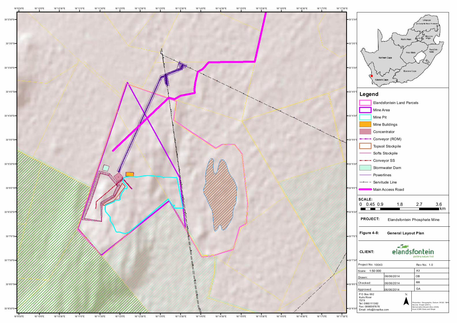
18°17'30"E
18°17'30"E
18°17'0"E
18°17'0"E
18°16'30"E
18°16'30"E
18°16'0"E
18°16'0"E
18°15'30"E
18°15'30"E
18°15'0"E
18°15'0"E
18°14'30"E
18°14'30"E
18°14'0"E
18°14'0"E
18°13'30"E
18°13'30"E
18°13'0"E
18°13'0"E
18°12'30"E
18°12'30"E
18°12'0"E
18°12'0"E
18°11'30"E
18°11'30"E
18°11'0"E
18°11'0"E
18°10'30"E
18°10'30"E
18°10'0"E
18°10'0"E
18°9'30"E
18°9'30"E
33°2'30"S 33°2'30"S
33°3'0"S 33°3'0"S
33°3'30"S 33°3'30"S
33°4'0"S 33°4'0"S
33°4'30"S 33°4'30"S
33°5'0"S 33°5'0"S
33°5'30"S 33°5'30"S
33°6'0"S 33°6'0"S
33°6'30"S 33°6'30"S
33°7'0"S 33°7'0"S
33°7'30"S 33°7'30"S
33°8'0"S 33°8'0"S
33°8'30"S 33°8'30"S
SCALE:
PROJECT:
Figure 4-8:
CLIENT:
Project No: Scale:
Re v No. A3
Drawn:Ch ecked:Approve d:
10043 1.0
06/06/2014
06/06/201406/06/2014
OBRRGA
General Layout Plan
Elandsfontein Phosphate Mine
P O Box 692Kuils River7579Tel: 0860111382Fax: 0866587676Email : [email protected]
0 0.9 1.8 2.7 3.60.45 km
¯
1:50 000
Projection: Geographic, Datum : W GS 1984Source: E npat (2001), Dem arc ation B oard (Dec 2005)Ins et: E SRI Data and M aps
LegendElandsfontein Land ParcelsMine AreaMine PitMine BuildingsConcentratorConveyor (ROM)Topsoil StockpileSofts StockpileConveyor SSStormwater DamPowerlines
ââ Servitude LineMain Access Road
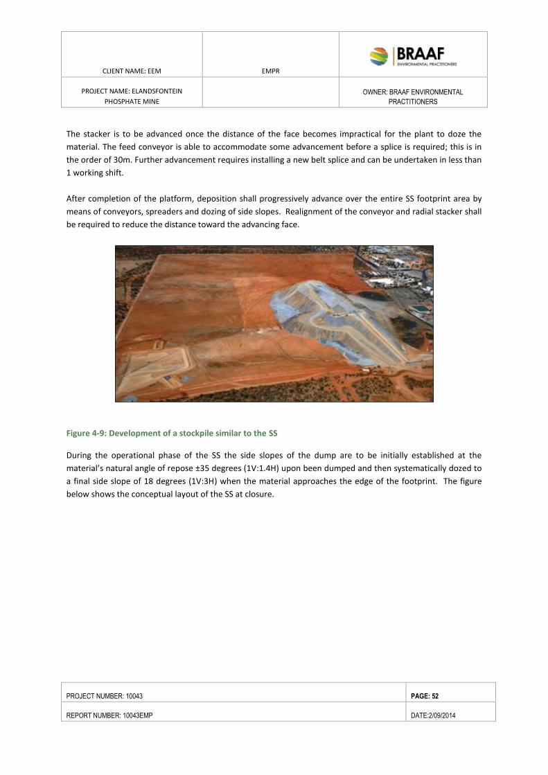
CLIENT NAME: EEM EMPR
PROJECT NAME: ELANDSFONTEIN
PHOSPHATE MINE
OWNER: BRAAF ENVIRONMENTAL
PRACTITIONERS
PROJECT NUMBER: 10043 PAGE: 52
REPORT NUMBER: 10043EMP DATE:2/09/2014
The stacker is to be advanced once the distance of the face becomes impractical for the plant to doze the
material. The feed conveyor is able to accommodate some advancement before a splice is required; this is in
the order of 30m. Further advancement requires installing a new belt splice and can be undertaken in less than
1 working shift.
After completion of the platform, deposition shall progressively advance over the entire SS footprint area by
means of conveyors, spreaders and dozing of side slopes. Realignment of the conveyor and radial stacker shall
be required to reduce the distance toward the advancing face.
Figure 4-9: Development of a stockpile similar to the SS
During the operational phase of the SS the side slopes of the dump are to be initially established at the
material’s natural angle of repose ±35 degrees (1V:1.4H) upon been dumped and then systematically dozed to
a final side slope of 18 degrees (1V:3H) when the material approaches the edge of the footprint. The figure
below shows the conceptual layout of the SS at closure.
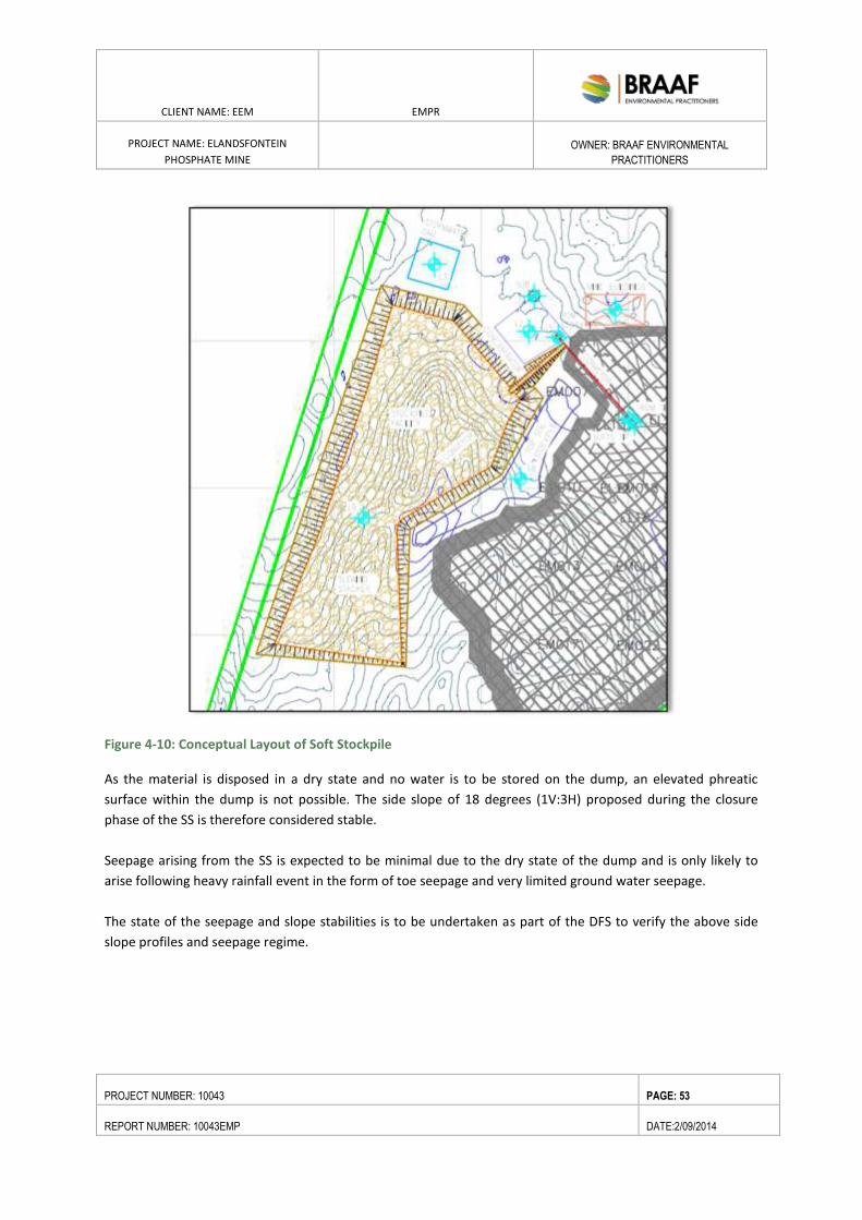
CLIENT NAME: EEM EMPR
PROJECT NAME: ELANDSFONTEIN
PHOSPHATE MINE
OWNER: BRAAF ENVIRONMENTAL
PRACTITIONERS
PROJECT NUMBER: 10043 PAGE: 53
REPORT NUMBER: 10043EMP DATE:2/09/2014
Figure 4-10: Conceptual Layout of Soft Stockpile
As the material is disposed in a dry state and no water is to be stored on the dump, an elevated phreatic
surface within the dump is not possible. The side slope of 18 degrees (1V:3H) proposed during the closure
phase of the SS is therefore considered stable.
Seepage arising from the SS is expected to be minimal due to the dry state of the dump and is only likely to
arise following heavy rainfall event in the form of toe seepage and very limited ground water seepage.
The state of the seepage and slope stabilities is to be undertaken as part of the DFS to verify the above side
slope profiles and seepage regime.
CLIENT NAME: EEM EMPR
PROJECT NAME: ELANDSFONTEIN
PHOSPHATE MINE
OWNER: BRAAF ENVIRONMENTAL
PRACTITIONERS
PROJECT NUMBER: 10043 PAGE: 54
REPORT NUMBER: 10043EMP DATE:2/09/2014
4.8. OVERVIEW OF PROCESSING METHOD
The concentrate plant will cover an area of 6500m2. The ROM conveyor from the pit to the plant is 590m
long. The softs conveyor length will increase as the stockpile is developed. The final length is estimated at
1845 m. The concentrator tails conveyor will discharge onto the softs conveyor and will be 100m in length. All
these belts will be 900 mm wide resulting in a conveyor structure that is 1.5 m wide.
Run of Mine (ROM) material from the mine will be conveyed to a stockpile located adjacent to the pit, which
will decouple the mining and metallurgical processing facilities. The sand will be screened to remove any
oversized material.
The sand will be conveyed a short distance to an agitated pulping tank. Dilution water will be added into the
pulping tank, to obtain a suitable density, before the material is pumped to the flotation section of the plant.
Concentrate will be collected as final concentrate, before being collected in a thickener, ahead of a filter. The
filtered product will then be stored in a closed shed. It will be loaded onto trucks for haulage to the quay, for
final shipping.
The tailings stream will be dewatered using stacker cyclones and conveyed to the softs stockpile, for ultimate
co-disposal into the pit. The plant tailings will contain approximately 15 – 20% moisture with 6-8% moisture
content (water over dry mass) for disposed tailings, and will constitute 18% of the total softs stockpile and
backfill into the pit. Assuming dry softs from the pit contain a moisture content of 2%, the overall moisture
content of the stockpile will be approximately 5.6% (excluding any precipitation and evaporation). The water
from the processing facility is not expected to be detrimental to any water resource.
It is further estimated that the high evaporation rate (>2,000mm/annum) in comparison with the very low
precipitation (<300mm/annum) will further contribute to the low moisture content in the softs stockpile and
backfill material.
Thickener overflow and clarified filtrate will be recycled back to the processing water tank to be recycled
through the process, thus reducing the overall process water demand.
Dirty water from the pit will be used as process water where possible. Process water will be stored in a large
process water tank, integrated with the stormwater dam. Thickener overflows from the feed, tailings and
concentrate thickeners will gravitate to the process water tank in recycle streams, allowing up to 70% of the
water to be recycled. Water losses will occur through evaporation, remaining water in filtered product, and in
the tailings stream.
4.8.1. CHEMICALS USED
The latest test work results indicate that only two reagents, tall oil and sodium silicate, are required for the
upgrade of the phosphate rock from the in-situ grade to the final product specification grade. A third reagent,
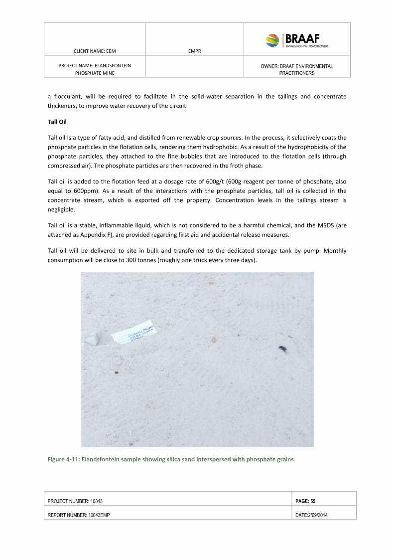
CLIENT NAME: EEM EMPR
PROJECT NAME: ELANDSFONTEIN
PHOSPHATE MINE
OWNER: BRAAF ENVIRONMENTAL
PRACTITIONERS
PROJECT NUMBER: 10043 PAGE: 55
REPORT NUMBER: 10043EMP DATE:2/09/2014
a flocculant, will be required to facilitate in the solid-water separation in the tailings and concentrate
thickeners, to improve water recovery of the circuit.
Tall Oil
Tall oil is a type of fatty acid, and distilled from renewable crop sources. In the process, it selectively coats the
phosphate particles in the flotation cells, rendering them hydrophobic. As a result of the hydrophobicity of the
phosphate particles, they attached to the fine bubbles that are introduced to the flotation cells (through
compressed air). The phosphate particles are then recovered in the froth phase.
Tall oil is added to the flotation feed at a dosage rate of 600g/t (600g reagent per tonne of phosphate, also
equal to 600ppm). As a result of the interactions with the phosphate particles, tall oil is collected in the
concentrate stream, which is exported off the property. Concentration levels in the tailings stream is
negligible.
Tall oil is a stable, inflammable liquid, which is not considered to be a harmful chemical, and the MSDS (are
attached as Appendix F), are provided regarding first aid and accidental release measures.
Tall oil will be delivered to site in bulk and transferred to the dedicated storage tank by pump. Monthly
consumption will be close to 300 tonnes (roughly one truck every three days).
Figure 4-11: Elandsfontein sample showing silica sand interspersed with phosphate grains
CLIENT NAME: EEM EMPR
PROJECT NAME: ELANDSFONTEIN
PHOSPHATE MINE
OWNER: BRAAF ENVIRONMENTAL
PRACTITIONERS
PROJECT NUMBER: 10043 PAGE: 56
REPORT NUMBER: 10043EMP DATE:2/09/2014
Sodium Silicate
Sodium silicate is made from quartz sand, water and caustic soda. It is generally used as a dispersant, i.e. to
separate the quartz grains from the phosphate grains, to allow the effective interaction of the phosphate with
the tall oil. The mechanism of the interaction between sodium silicate and mineral surfaces is still not well
understood, but it is commonly used in the mining industry.
Sodium silicate will be added to the flotation circuit at a dosage of 200g/t (equating to roughly 100g/t). It will
be delivered to site in a bulk liquid form (40% silicate, 60% water), and again, will be transferred from the
tanker directly to the dedicated storage tank. All safe handling procedures are included in the MSDS (see
attached as Appendix F).
Flocculant
Flocculants are widely used to improve solid liquid separation, to assist in the recovery of water from final
concentrate and tailings streams. Flocculant is a non-hazardous substance and non-toxic substance, also used
in the water treatment process.
Flocculant will be delivered to site as a solid, in bulk (500kg) bags, and mixed with water on site. The required
dosage is small, with only 50g/t (or 25 tonnes per month) required to optimise the water recovery.
4.9. SUPPORT SERVICES
4.9.1. WASTE FACILITIES
4.9.1.1. SEWAGE TREATMENT FACILITIES
A sewage treatment facility shall be established at the proposed mine site which will be based on the
sequential batch principle which is ideally suited for smaller applications (up to 350 people per day). The plant
will be manufactured from standard low density polyethylene tanks. Operation of the plant is largely
automatic by means of a PLC to control the various time sequences.
The plant consists of the following items:
Coarse screen for incoming
Primary receiving tank – 5 000 liter
Transfer pump - duty / standby
Raw sewage buffer tank – 20 000 liter x 2
Raw sewage transfer pump – duty / standby
Reaction tank – 20 000 liter x 3
Air blower x 2
Floating decant x 3
Flocculant dosing x 3
CLIENT NAME: EEM EMPR
PROJECT NAME: ELANDSFONTEIN
PHOSPHATE MINE
OWNER: BRAAF ENVIRONMENTAL
PRACTITIONERS
PROJECT NUMBER: 10043 PAGE: 57
REPORT NUMBER: 10043EMP DATE:2/09/2014
Chlorine dosing x 2
Clarified sewage batch tank x 3
The operational sequence of the plant will consist of collecting raw sewage, transfer to the reacting tank,
primary aeration for 4 to 6 hours for digestion of organic matter, stagnation to create anoxic conditions for
nitrification, secondary aeration, flocculant dosing and settling for 60 minutes, decanting with chlorination,
reaction time for chlorine and finally discharge to the process water tank.
Sludge is removed according to a sequence controlled by the PLC. Sludge will be collected in drying beds
consisting of sand beds in shallow concrete beds or earthen containments. Dried sludge will removed and
disposed of, and the sand is replenished
The following parameters will be monitored:
Incoming pH
Incoming conductivity
Incoming COD
Outgoing pH
Outgoing conductivity
Outgoing COD
Final chlorine
Final nitrogen and final phosphate
Expected Treated effluent quality (final effluent) is shown in the table below.
Sample Discharge (Final Effluent)
COD 40
Conductivity 90
E.Coli (cfu.100mL) 0
Faecal Coliforms (cfu/100mL) 0
Ortho Phosphate (mg/L) 5
Total Nitrogen (mg/l as N) 10
4.9.1.2. GENERAL AND HAZARDOUS WASTE FACILITIES
4.9.1.2.1. GENERAL WASTE
Domestic wastes are considered to be those that are generated by offices and domestic installations.
Domestic and general wastes will include food waste, food packaging, drinking containers, metal cans, paper,
cardboard, plastics, general packaging materials, light bulbs and fluorescent tubes.
Domestic waste will be accumulated within the canteen and other infrastructure. The waste stream will be
domestic waste, and business and commercial waste, which are all non- hazardous. The Council for Scientific
CLIENT NAME: EEM EMPR
PROJECT NAME: ELANDSFONTEIN
PHOSPHATE MINE
OWNER: BRAAF ENVIRONMENTAL
PRACTITIONERS
PROJECT NUMBER: 10043 PAGE: 58
REPORT NUMBER: 10043EMP DATE:2/09/2014
and Industrial Research’s Human Settlement Planning and Design (2000) and the Department of Water Affair’s
Minimum Requirements for Waste by Landfill (1998) were used to calculate the volume of waste and
subsequent disposal or conveyance of the waste.
The conventional hierarchy of waste reduction and management will be employed at the mine:
o Reduce: Modify processes to reduce the amount of waste going into the waste stream and/or reduce
the amount of packaging that will eventually enter the waste stream;
o Reuse: Wash and reuse bottles to eliminate them from the waste stream;
o Recycle: Remove recyclable materials from the waste stream, preferably by source separation;
o Treat: Compost organic material separated from the waste stream, preferably by source separation;
and
o Landfill: Final disposal of materials, which cannot be economically or technically removed from the
waste stream.
The aim of this approach is to minimise the amount of waste generated by applying waste reduction
strategies, and then to maximise alternative uses of waste so as to minimise the amount of waste requiring
final disposal to landfill.
The initial rate of deposition per capita per day is assumed to be 2kg (range 0.5- 3.5kg/capita/day). For
400 personnel the initial rate of deposition is assumed to be 0.8t/day. If the waste density is assumed to be
0.5t/m3, the total waste requiring handling is 1.6m
3/day. The total storage area required is 50m
3. It is
suggested that on site storage be used in the form of 11m3 load luggers which would be stored on the
foundations provided or within waste skips which are to be placed on surfaced foundations.
A waste collection contractor will be employed to collect and dispose domestic wastes.
Domestic wastes:
Paper and plastics will be recycled;
Disposed of at a registered landfill facility –Existing landfill facility at Vredenburg/ Langebaan will be
used;
Industrial waste include steel, packaging material and material off-cuts.
4.9.1.3. HAZARDOUS WASTE FACILITY
Hazardous wastes are those wastes, which can, even in low concentrations, have a significant adverse effect
on public health and / or the environment. Based on the current mine design, the main source of hazardous
wastes will be empty reagent storage containers (IBC and bulk bags from sodium silicate and flocculant) and
grease. Hazardous wastes and greases accumulated at the proposed site shall be handled in a similar manner
to domestic waste, namely, stored on-site in suitable containers located on areas built in accordance with
requirements from the recognised authority, that will include linings, bunds, roofing. Hazardous waste will be
temporarily stored on site prior to disposal in a storage area (building) with a footprint of 100m2 and have a
maximum height of two meters, with a total storage capacity of 200m3.
CLIENT NAME: EEM EMPR
PROJECT NAME: ELANDSFONTEIN
PHOSPHATE MINE
OWNER: BRAAF ENVIRONMENTAL
PRACTITIONERS
PROJECT NUMBER: 10043 PAGE: 59
REPORT NUMBER: 10043EMP DATE:2/09/2014
All hazardous waste collected will be transferred to either the Cape Town Municipality’s Vissershok or
EnviroServ’s Vissershok hazardous waste disposal facility. Hazardous waste generated by the mine shall be
collected by a waste contractor and disposed of at appropriately licensed waste facility, such as Vissershok
Waste Facility. Hazardous waste will be classified, handled, treated and disposed according to the SANS 10234
and the Regulations and Standards being developed by the Department of Environment Affairs. EEM has
submitted a waste license application to the Department of Environmental Affairs.
4.9.2. WATER MANAGEMENT
4.9.2.1. WATER BALANCE
A water balance has been completed for the whole mining operation, to confirm the water requirements and
losses associated with the potential operation. The balance was completed by EEM, with technical inputs
provided by Epoch Resources (responsible for the design of the softs stockpile), DRA International (responsible
for the mine and plant design), and Julian Conrad (the specialist geohydrologist).
The balance was completed on an annual basis, as well as wet (May to September) and dry (October to April)
periods of the year. For each of the rainfall periods, the water balance was further interrogated for the first 33
months of proposed operation, i.e. the period prior to the backfill of the pit, while material is being deposited
on the softs stockpile, and then for the steady state Life of Mine (LOM), i.e. from Month 33 until mine closure.
4.9.2.2. PROCESS WATER SOURCE
The water required for the beneficiation process and dust suppression in and around the operations will be
provided by the Saldanha Bay Municipality. EEM has entered into an agreement with the municipality, to be
provided with treated effluent water from the Vredenburg Waste Water Treatment Works (WWTP). The
effluent water will be re-processed at the WWTP, to ensure that water of a suitable quality supplied to the
mine.
The supply of treated effluent to industry is part of a larger phase approach to deal with the current issues of
sewage effluent discharge into clean water sources. A long term solution is being developed between local
government and industry, to allow development without impacting on the fresh water supplies to the area.
A potable water treatment plant will further purify the water for human consumption. A small volume of
water will be bled to the potable water storage tank, from the water storage tank. A filter feed pump will
pump the water from the storage tank through dual media filters. Flocculant and pH correction will be dosed
into the pump discharge line. The chemically charged raw water will then pass through the inline static mixers
where the chemicals are flash mixed prior to feed into the retention lines. The filtered discharge water will
then feed through the carbon columns at a flow rate of approximately 10m3/h. The fully treated water will be
dosed with chlorine and discharge into the treated water storage tank.
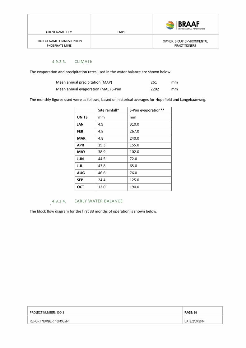
CLIENT NAME: EEM EMPR
PROJECT NAME: ELANDSFONTEIN
PHOSPHATE MINE
OWNER: BRAAF ENVIRONMENTAL
PRACTITIONERS
PROJECT NUMBER: 10043 PAGE: 60
REPORT NUMBER: 10043EMP DATE:2/09/2014
4.9.2.3. CLIMATE
The evaporation and precipitation rates used in the water balance are shown below.
Mean annual precipitation (MAP) 261 mm
Mean annual evaporation (MAE) S-Pan 2202 mm
The monthly figures used were as follows, based on historical averages for Hopefield and Langebaanweg.
Site rainfall* S-Pan evaporation**
UNITS mm mm
JAN 4.9 310.0
FEB 4.8 267.0
MAR 4.8 240.0
APR 15.3 155.0
MAY 38.9 102.0
JUN 44.5 72.0
JUL 43.8 65.0
AUG 46.6 76.0
SEP 24.4 125.0
OCT 12.0 190.0
4.9.2.4. EARLY WATER BALANCE
The block flow diagram for the first 33 months of operation is shown below.
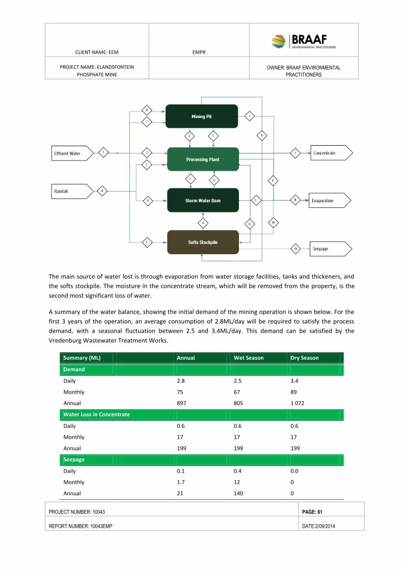
CLIENT NAME: EEM EMPR
PROJECT NAME: ELANDSFONTEIN
PHOSPHATE MINE
OWNER: BRAAF ENVIRONMENTAL
PRACTITIONERS
PROJECT NUMBER: 10043 PAGE: 61
REPORT NUMBER: 10043EMP DATE:2/09/2014
The main source of water lost is through evaporation from water storage facilities, tanks and thickeners, and
the softs stockpile. The moisture in the concentrate stream, which will be removed from the property, is the
second most significant loss of water.
A summary of the water balance, showing the initial demand of the mining operation is shown below. For the
first 3 years of the operation, an average consumption of 2.8ML/day will be required to satisfy the process
demand, with a seasonal fluctuation between 2.5 and 3.4ML/day. This demand can be satisfied by the
Vredenburg Wastewater Treatment Works.
Summary (ML) Annual Wet Season Dry Season
Demand
Daily
2.8 2.5 3.4
Monthly
75 67 89
Annual
897 805 1 072
Water Loss in Concentrate
Daily
0.6 0.6 0.6
Monthly
17 17 17
Annual
199 199 199
Seepage
Daily
0.1 0.4 0.0
Monthly
1.7 12 0
Annual 21 140 0
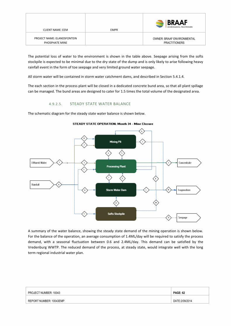
CLIENT NAME: EEM EMPR
PROJECT NAME: ELANDSFONTEIN
PHOSPHATE MINE
OWNER: BRAAF ENVIRONMENTAL
PRACTITIONERS
PROJECT NUMBER: 10043 PAGE: 62
REPORT NUMBER: 10043EMP DATE:2/09/2014
The potential loss of water to the environment is shown in the table above. Seepage arising from the softs
stockpile is expected to be minimal due to the dry state of the dump and is only likely to arise following heavy
rainfall event in the form of toe seepage and very limited ground water seepage.
All storm water will be contained in storm water catchment dams, and described in Section 5.4.1.4.
The each section in the process plant will be closed in a dedicated concrete bund area, so that all plant spillage
can be managed. The bund areas are designed to cater for 1.5 times the total volume of the designated area.
4.9.2.5. STEADY STATE WATER BALANCE
The schematic diagram for the steady state water balance is shown below.
A summary of the water balance, showing the steady state demand of the mining operation is shown below.
For the balance of the operation, an average consumption of 1.4ML/day will be required to satisfy the process
demand, with a seasonal fluctuation between 0.6 and 2.4ML/day. This demand can be satisfied by the
Vredenburg WWTP. The reduced demand of the process, at steady state, would integrate well with the long
term regional industrial water plan.
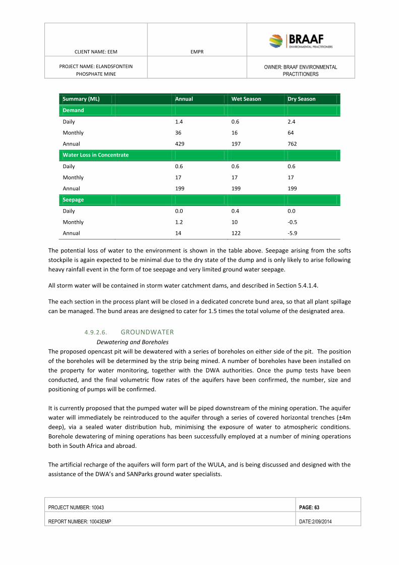
CLIENT NAME: EEM EMPR
PROJECT NAME: ELANDSFONTEIN
PHOSPHATE MINE
OWNER: BRAAF ENVIRONMENTAL
PRACTITIONERS
PROJECT NUMBER: 10043 PAGE: 63
REPORT NUMBER: 10043EMP DATE:2/09/2014
Summary (ML) Annual Wet Season Dry Season
Demand
Daily
1.4 0.6 2.4
Monthly
36 16 64
Annual
429 197 762
Water Loss in Concentrate
Daily
0.6 0.6 0.6
Monthly
17 17 17
Annual
199 199 199
Seepage
Daily
0.0 0.4 0.0
Monthly
1.2 10 -0.5
Annual 14 122 -5.9
The potential loss of water to the environment is shown in the table above. Seepage arising from the softs
stockpile is again expected to be minimal due to the dry state of the dump and is only likely to arise following
heavy rainfall event in the form of toe seepage and very limited ground water seepage.
All storm water will be contained in storm water catchment dams, and described in Section 5.4.1.4.
The each section in the process plant will be closed in a dedicated concrete bund area, so that all plant spillage
can be managed. The bund areas are designed to cater for 1.5 times the total volume of the designated area.
4.9.2.6. GROUNDWATER
Dewatering and Boreholes
The proposed opencast pit will be dewatered with a series of boreholes on either side of the pit. The position
of the boreholes will be determined by the strip being mined. A number of boreholes have been installed on
the property for water monitoring, together with the DWA authorities. Once the pump tests have been
conducted, and the final volumetric flow rates of the aquifers have been confirmed, the number, size and
positioning of pumps will be confirmed.
It is currently proposed that the pumped water will be piped downstream of the mining operation. The aquifer
water will immediately be reintroduced to the aquifer through a series of covered horizontal trenches (±4m
deep), via a sealed water distribution hub, minimising the exposure of water to atmospheric conditions.
Borehole dewatering of mining operations has been successfully employed at a number of mining operations
both in South Africa and abroad.
The artificial recharge of the aquifers will form part of the WULA, and is being discussed and designed with the
assistance of the DWA’s and SANParks ground water specialists.
CLIENT NAME: EEM EMPR
PROJECT NAME: ELANDSFONTEIN
PHOSPHATE MINE
OWNER: BRAAF ENVIRONMENTAL
PRACTITIONERS
PROJECT NUMBER: 10043 PAGE: 64
REPORT NUMBER: 10043EMP DATE:2/09/2014
Examples of similar case studies where the successful discharge and downstream recharge of aquifers has
been implemented for the dewatering of open cast mining operations include:
Finsch Diamond Mine, South Africa
Lethlakane Diamond Mine, South Africa
iGrootgeluk Coal Mine, South Africa
Kolwezi and Kamoto Copper Mines, DRC
Robinson Copper, Molybdenum, Gold Mine, United States
Premier Coal Mine, Australia
4.9.2.7. GROUND WATER MANAGEMENT
The information obtained from previous studies and site investigations allow for a conceptual groundwater
model to be developed. A multiple aquifer system is present at the proposed Mine Site, which can be
summarised as:
An upper aquifer in the overburden / mineralised material zones;
A lower aquifer below the mineralised material zone.
Bore holes will be sited and maintained along the pit edge to draw down the upper aquifer and prevent clean
water from flowing into the pit and thus becoming contaminated. This water will be piped to a down-stream
location where it will be used to recharge the aquifer.
4.9.2.8. IN-PIT PUMPING
In pit sumps will be required to:
Provide lowest drainage points within the pit to collect residual groundwater seepage;
Direct and contain pit slope seepages and precipitation run-off; and
House the in-pit sump pumps.
If possible mobile sumps should be provided, as this will provide buffer storage and allow for sufficient
pumping capacity.
Drainage channels will be required within the pit to transport the water from all areas of the pit to the sumps,
and to keep the working areas as free from surface water as possible. The volume and location of the sumps
should be finalised during the detailed design stage. The sumps will be re-located with each new strip that is
mined.
4.9.2.9. SURFACE WATER
Cut-off trenches, culverts and berms will be established around the pit, roads, overburden dumps and other
infrastructure to prevent the inflow of surface water into these areas and ensure that such water does not
become contaminated. Any water that ends up within these bermed-off areas will be regarded as
contaminated and used in the beneficiation processes or to suppress dust on roads.
CLIENT NAME: EEM EMPR
PROJECT NAME: ELANDSFONTEIN
PHOSPHATE MINE
OWNER: BRAAF ENVIRONMENTAL
PRACTITIONERS
PROJECT NUMBER: 10043 PAGE: 65
REPORT NUMBER: 10043EMP DATE:2/09/2014
All excess water and precipitation which accumulates within the pit and other areas on the mine will be
pumped or gravitated along concrete channels (to mitigate any infiltration) directly into the Stormwater Dam
(SWD).
The process plant area
All waste water within the processing plant will be pumped or gravitated along concrete channels (to mitigate
any infiltration) directly into the SWD. This water will not require any further treatment, as by volume it will be
diluted within the raw water, which will be supplied by the chosen water source.
The plant will be the main consumer of water on the mine, with an expected total water demand estimated at
3,260m3/day. As much as 80% of the process water will be recycled.
Following discussions with the Saldanha Bay Municipality (SBM), Elandsfontein has been granted the rights to
source treated effluent from the sewage treatment plant at Vredenburg. Initial discussions have been held
with SBM, and final pumping and pipeline arrangements will be developed. It is planned that the pipe route
will use existing servitudes and run along servitudes already negotiated with private land owners.
The water supply line will be approximately 250mm diameter, and will be buried below ground level. The
water will be upgraded by Elandsfontein’s own treatment plant (not on the main mine site), such that cleaned
water is piped to the mine site.
The total water to be used for dust suppression in the mine and irrigation of the rehabilitated rock
dumps will be determined by specialist civil engineers appointed to the project. Raw process water will be
primarily supplied from within the pit. Additional water will be supplied by the Saldanha Bay Municipality as
treated sewage water which will be upgraded prior to piping to the mine site.
All roads within the catchment area:
All run-off water along the roads will be gravitated along concrete channels or safety berms directly into the
SWD. The concrete channels dedicated to convey the dirty storm-water will be sized accordingly and necessary
silt traps will be placed consequently. All other run off which falls within the proposed catchment area will be
deemed as clean storm-water. This water will be allowed to infiltrate and gravitate towards its natural
watercourse. Some of it may however gravitate towards the SWD and allowances will be made for this
potential in-flow.
Stormwater dam
The run-off from the SS is classified as “dirty” water and shall be intercepted by storm water collection
channels along the perimeter of the SS. A second diversion channel along the upstream sections of the SS
perimeter shall divert clean storm water runoff around and away from the SS.
All storm water diversion channels are be sized to accommodate the 1 in 50 storm event using an average run-
off coefficient of 0.5 as calculated using the South African National Road Agency’s Road Drainage Manual.
Energy dissipaters built from gabion baskets shall be constructed downstream of all the clean storm water
CLIENT NAME: EEM EMPR
PROJECT NAME: ELANDSFONTEIN
PHOSPHATE MINE
OWNER: BRAAF ENVIRONMENTAL
PRACTITIONERS
PROJECT NUMBER: 10043 PAGE: 66
REPORT NUMBER: 10043EMP DATE:2/09/2014
diversion channels. Dirty water channeled from the SS shall feed into a concrete lined energy dissipater and silt
trap before it flows into a storm water dam. All channels shall be unlined.
An unlined storm water dam (SWD) positioned downstream of the SS is sized to accommodate the 1 in 100, 7
day storm event run-off from the plant area and SS. An average run-off coefficient of 0.7 has been used for the
SS and 1.0 for the plant area.
The stormwater dam will have a total storage capacity of approximately 1 150 000m3, covering an area of 3 ha.
The dam will have a wall height of 5m above ground, the remaining infrastructure excavated below ground
level.
As part of the integrated water management, a Storm Water Management Plan (based on the Best Practice
Guidelines G1 (DWAF, 2006)) will be developed by EEM. The mentioned plan will describe the water flow over
and around the proposed site, and provides strategies for optimizing the separation of clean and affected
runoff water. The following sections however make reference to mechanisms that will be implemented to
manage stormwater runoff.
Stormwater management – Softs Stockpiles
The run-off from the SS is classified as “dirty” water and shall be intercepted by storm water collection
channels along the perimeter of the SS. A second diversion channel along the upstream sections of the SS
perimeter shall divert clean storm water runoff around and away from the SS.
All storm water diversion channels are be sized to accommodate the 1 in 50 storm event using an average run-
off coefficient of 0.5 as calculated using the South African National Road Agency’s Road Drainage Manual.
Energy dissipaters built from gabion baskets shall be constructed downstream of all the clean storm water
diversion channels. Dirty water channeled from the SS shall feed into a concrete lined energy dissipater and silt
trap before it flows into a storm water dam. All channels shall be unlined.
An unlined storm water dam (SWD) positioned downstream of the SS is sized to accommodate the 1 in 100, 7
day storm event run-off from the plant area and SS. The SWD capacity is in the order of ±1 150 000m3.
The preparatory works associated with the SS comprise the following:
Progressively stripping and stockpiling of the top 300mm of topsoil as the SS footprint develops;
A 1m deep and 1m high collection trench and bund wall around the perimeter of the SS footprint
area. This demarcates the extent of the SS footprint and collects any runoff water and shallow
subsurface seepage arising from the dump;
A 1m deep storm water trench along the upstream ends of the SS to divert any clean storm water
runoff around and away from the dump;
silt trap, energy dissipater and a SWD downstream of the SS into which the dirty water collection
trenches discharge. The SWD is unlined with an earth embankment constructed out of borrow
material sourced from within the dam basin area.
CLIENT NAME: EEM EMPR
PROJECT NAME: ELANDSFONTEIN
PHOSPHATE MINE
OWNER: BRAAF ENVIRONMENTAL
PRACTITIONERS
PROJECT NUMBER: 10043 PAGE: 67
REPORT NUMBER: 10043EMP DATE:2/09/2014
Dirty storm water and spilled water from the concentrator plant area and softs stockpile will reticulate to a
SWD. The SWD will be positioned down gradient of the plant and designed to accommodate the 1:100 year
flood rain fall over the surface area of the softs stockpile and the concreted surface of the plant. Storm water
from the softs stockpile will be pumped to the plant facility.
It is the responsibility of EEM to ensure that storm water control measures are designed and constructed to be
capable of withstanding the maximum design flood. It should be taken into consideration that the potential for
erosion increases where the surface runoff is concentrated and will be addressed within the designs. Designs
will incorporate gradual drainage to avoid siltation of storm water infrastructure.
Storm water management measures discussed will be prioritized to prevent damage or failures during flood
events. After implementation of the storm water management plan, regular inspections and maintenance
should be conducted to ensure that all infrastructures are functioning according to design capabilities.
Effective management of surface water runoff and clean/affected water separation at the Elandsfontein
Phosphate ore project will contribute to conservation of downstream clean water resources and groundwater
resources.
Plant, overburden- and discard dump and haul roads
The plant, overburden dump and discard dump will be located less than 400m west of the pit area. These are
largely contained in the lower lying areas on the site (valley) and hence the surface runoff will gravitate toward
the stormwater dam where the water will be used in the process.
Pit area, haul roads and Softs Stockpile
Mining of phosphate ore will take place in the south-western section of the Elandsfontein property. The size of
the pit and the Softs Stockpile is 388ha and 14.9ha, respectively. There is one non-perennial drainage line
which originates from the higher- lying hills toward the fossil area which is within the mine area (refer to the
Freshwater Assessment – Appendix C).
Erosion berms should be installed to prevent gully formation and run off. The following points will serve to
guide the placement of erosion berms:
Where the track has slope of less than 2%, berms every 50m should be installed
Where the track slopes between 2% and 10%, berms every 25m should be installed
Where the track slopes between 10%-15%, berms every 20m should be installed
Where the track has slope greater than 15%, berms every 10m should be installed.
There are no significant dams or open water within the project area. As a consequence of the area’s limited
rainfall, the sandy nature of the soil and generally flat topography, very little water accumulates on surface,
even in the rainy season. It was thought that drainage from sections of the proposed project area may be
expected to be towards the Langebaan lagoon, however results from the geohydrological study indicates that
freshwater inflow into the southern end of the Langebaan Lagoon is groundwater derived coming in from the
due east and not the Elandsfontein area (refer to Geohydrological Study – Appendix C).
CLIENT NAME: EEM EMPR
PROJECT NAME: ELANDSFONTEIN
PHOSPHATE MINE
OWNER: BRAAF ENVIRONMENTAL
PRACTITIONERS
PROJECT NUMBER: 10043 PAGE: 68
REPORT NUMBER: 10043EMP DATE:2/09/2014
The design concept is to recover all dirty storm water and return water from the Plant, Pit and Softs Stockpile
into the Plant operations, there should be no material impact on the aquifer system. Groundwater is
ecologically significant in the area and flows out at a number of springs in the area (many farm names in the
area relate to springs).
Ground water management measures that are proposed for the site include:
Separate clean and dirty water through sound storm water management principles. This will include a
sufficiently sized cut-off trench and berm to be constructed up gradient of the proposed plant and
mine sites and softs stockpile to capture and divert clean surface runoff around the site;
Contain dirty water in adequately sized storm water dams to avoid spillage and overflow into the
catchment;
Compaction of the base of the proposed softs stockpile site to reduce infiltration to the ground water
regime. It was assumed that the hydraulic conductivity of the compacted base at the softs stockpile
will be significantly reduced during this process.
Continuation and expansion of the current ground water monitoring programme;
Monitoring of piezometric head within the softs stockpile to ensure that there are no stability
concerns; and
Continuation of the ground water monitoring programme and implementation of the proposed
amendments;
Ground water management measures for the Closure Phase include:
o Sloping, top soiling and re-vegetation of the top and side slopes of the proposed softs
stockpile, to reduce ingress of rainfall;
o Containing dirty water and seepage from the proposed softs stockpile to prevent spillage
into the catchment.
4.9.2.10. POTABLE WATER
Analysis of the aquifer water show that dissolved solid levels are all within the prescribed limits of SANS
241:2005 Class 1 Drinking Water Specification. As a result, treatment by flocculation, filtration and chlorination
will suffice.
A small volume of water (less than 10m3/h) will be bled to the potable water storage tank, from the aquifer
discharge pumps. A filter feed pump will pump the water from the storage tank through dual media filters.
Flocculant and pH correction will be dosed into the pump discharge line. The chemically charged raw water will
then pass through the inline static mixers where the chemicals are flash mixed prior to feed into the retention
lines. The filtered discharge water will then feed through the carbon.
The fully treated water will be dosed with chlorine and discharge into the treated water storage tank.
Domestic water demand
The estimated areas for the offices and other occupied buildings on site are shown below. For each building,
the assumed daily water demand per 100m² floor area, based upon the recommendations of the “Guidelines
for human settlement planning and design” is used, to determine the total daily domestic water demand. The
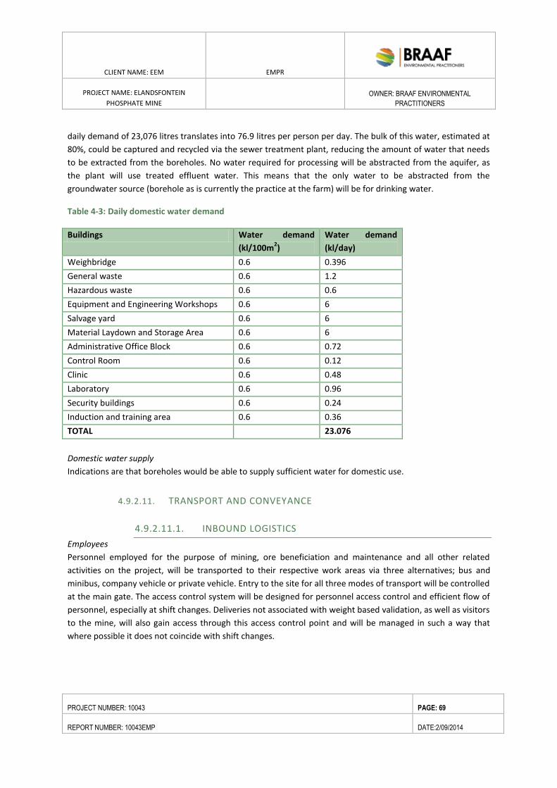
CLIENT NAME: EEM EMPR
PROJECT NAME: ELANDSFONTEIN
PHOSPHATE MINE
OWNER: BRAAF ENVIRONMENTAL
PRACTITIONERS
PROJECT NUMBER: 10043 PAGE: 69
REPORT NUMBER: 10043EMP DATE:2/09/2014
daily demand of 23,076 litres translates into 76.9 litres per person per day. The bulk of this water, estimated at
80%, could be captured and recycled via the sewer treatment plant, reducing the amount of water that needs
to be extracted from the boreholes. No water required for processing will be abstracted from the aquifer, as
the plant will use treated effluent water. This means that the only water to be abstracted from the
groundwater source (borehole as is currently the practice at the farm) will be for drinking water.
Table 4-3: Daily domestic water demand
Buildings Water demand
(kl/100m2)
Water demand
(kl/day)
Weighbridge 0.6 0.396
General waste 0.6 1.2
Hazardous waste 0.6 0.6
Equipment and Engineering Workshops 0.6 6
Salvage yard 0.6 6
Material Laydown and Storage Area 0.6 6
Administrative Office Block 0.6 0.72
Control Room 0.6 0.12
Clinic 0.6 0.48
Laboratory 0.6 0.96
Security buildings 0.6 0.24
Induction and training area 0.6 0.36
TOTAL 23.076
Domestic water supply
Indications are that boreholes would be able to supply sufficient water for domestic use.
4.9.2.11. TRANSPORT AND CONVEYANCE
4.9.2.11.1. INBOUND LOGISTICS
Employees
Personnel employed for the purpose of mining, ore beneficiation and maintenance and all other related
activities on the project, will be transported to their respective work areas via three alternatives; bus and
minibus, company vehicle or private vehicle. Entry to the site for all three modes of transport will be controlled
at the main gate. The access control system will be designed for personnel access control and efficient flow of
personnel, especially at shift changes. Deliveries not associated with weight based validation, as well as visitors
to the mine, will also gain access through this access control point and will be managed in such a way that
where possible it does not coincide with shift changes.
CLIENT NAME: EEM EMPR
PROJECT NAME: ELANDSFONTEIN
PHOSPHATE MINE
OWNER: BRAAF ENVIRONMENTAL
PRACTITIONERS
PROJECT NUMBER: 10043 PAGE: 70
REPORT NUMBER: 10043EMP DATE:2/09/2014
SUV’s and Company Vehicles
There will be 36 cars/SUVs arriving and departing from the mine each weekday morning and afternoon, used
by management, skilled and administrative staff and it is assumed that they will travel from
Saldanha/Langebaan/Vredenburg on TR21/2.
It is estimated that management and skilled staff will generate 36 inbound car/SUV vehicle trips inbound in the
morning (06h30 – 07h30) and the same number of trips outbound in the afternoon (15h00 – 16h00) per
weekday.
Minibus Transportation
Employees will be sourced from the local labour sending areas in close proximity to the site such as Hopefield
and other areas within the Saldanha Bay Municipal Area. Potential labour sending communities are located to
the west and east of the project in Hopefield, Langebaan, Saldanha and Vredenburg approximately 14-20km
from site.
Personnel will be collected from the various informal and formal settlement locations in the labour sending
communities by minibus, operated by a bussing enterprise. These minibuses will travel mainly on the R45 from
Hopefield to the mine and from the R45 from Saldanha, Vredenburg, Langebaan via surfaced roads to the site
and deliver personnel to the security and access control point.
Operations staff will be transported by 10 minibuses each day.
The day shift will start at 07h00 and end at 15h00, the afternoon/evening shift will be from 15h00 to
23h00 and the night shift will be from 23h00 to 07h00;
Minibuses will off-load staff to start a shift and will wait and load up with staff that is ending a shift
before travelling back to their homes.
Operation vehicles
It is envisaged that a logistic contractor will be identified through a tendering process. It is estimated that
there will be 3 bulk tankers delivering consumables to the mine each weekday and 4 trucks bringing in solid
reagents, maintenance materials and parts each weekday. It is assumed that these tankers and trucks will
travel to the site along TR21/2 from the east (N7) and return in that direction after delivering to the mine.
Roads and parking areas
Haul roads
The mine site currently has no formal access road from TR21/2, only an informal farm track. A nine km long
access road is proposed to connect the mine to TR21/2. The access road and intersection on TR21/2 will have
to be designed for 30 heavy vehicles per direction per day turning in and out of the access for the first 3
months of the construction period and 10 heavy vehicles per direction per day during the remaining 9 months
of construction. There will also be additional light vehicles turning in and out of the access during the morning
and afternoon peak hours. Haul trucks will travel down to the process area and return along the same route,
empty.
There are a number of existing unsurfaced roads on the mine property. Where possible the intention is to
make use of these existing roads as haul roads.
CLIENT NAME: EEM EMPR
PROJECT NAME: ELANDSFONTEIN
PHOSPHATE MINE
OWNER: BRAAF ENVIRONMENTAL
PRACTITIONERS
PROJECT NUMBER: 10043 PAGE: 71
REPORT NUMBER: 10043EMP DATE:2/09/2014
Plant internal roads
It is estimated that the length of internal plant roads will be 4km of the total plant area with widths varying
between 6m and 12m depending on function. It is assumed that the bulk of the material required for the
construction of the roads will be sourced from the site as well as from the mining discard.
Parking areas
A total area of 500m2 has been set aside to provide for:
minibuses to collect and drop-off staff and park whilst waiting for staff during shifts; and
staff parking outside the main office block for permanent employee’s using their private vehicles;
visitor parking.
4.9.2.11.2. OUTBOUND LOGISTICS
Security and Weighbridge
The validation and control of saleable ore products will be weight based and will therefore be transported
from the final concentrate silo over a single lane weighbridge, with an upgrade to a double lane weighbridge
planned during the life of the project. Loading flasks will be fitted with load cells to streamline the process.
This will further assist in reducing dust impacts related to loading of the final product.
Product Logistics
All saleable ore will be road hauled from the mine after beneficiation via containerized trucks to the Saldanha
Bay Port for ship loading.
Final Product
The upgraded phosphate will be sorted in a covered silo, which is approximately 30m in height and 23m in
diameter with a capacity of 75 000 tonnes. Containerized trucks will be loaded from the silo via a covered rapid
load out facility from where the product will be transported via road to the port.
Road Haul
The proposed mine is located on the farms Elandsfontein 349/2 and 349/4, Malmesbury RD in the Western
Cape. The farms are not directly bordered by any major thoroughfares but are accessed from the R27 via
proclaimed roads over SANParks property. As there is no direct access to the mine, an access from R45
(TR21/2) is proposed, via a nine km long access road which will largely follow existing servitudes/farm road
tracks . The access road from the R45, which is a dedicated freight route, will open up the town of Hopefield as
the main source of labour and property upgrades.
The table below indicated the areas to be affected by the proposed access road from the R45.
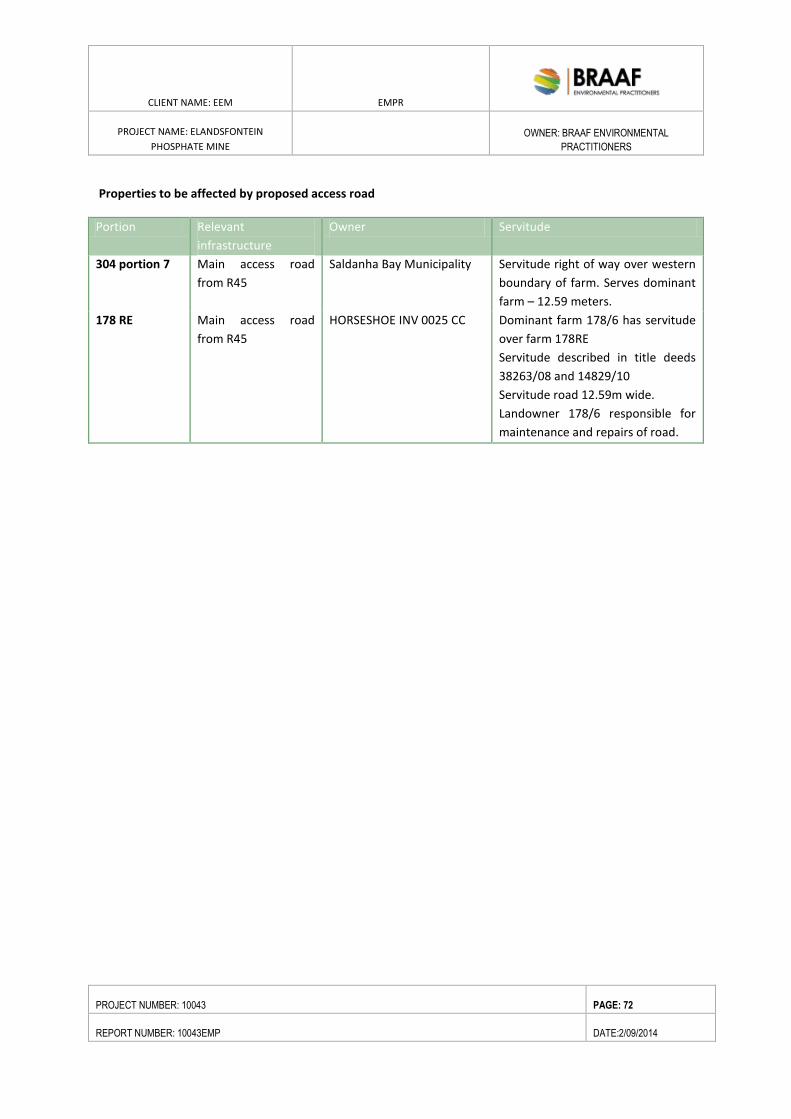
CLIENT NAME: EEM EMPR
PROJECT NAME: ELANDSFONTEIN
PHOSPHATE MINE
OWNER: BRAAF ENVIRONMENTAL
PRACTITIONERS
PROJECT NUMBER: 10043 PAGE: 72
REPORT NUMBER: 10043EMP DATE:2/09/2014
Properties to be affected by proposed access road
Portion Relevant
infrastructure
Owner Servitude
304 portion 7
Main access road
from R45
Saldanha Bay Municipality Servitude right of way over western
boundary of farm. Serves dominant
farm – 12.59 meters.
178 RE
Main access road
from R45
HORSESHOE INV 0025 CC Dominant farm 178/6 has servitude
over farm 178RE
Servitude described in title deeds
38263/08 and 14829/10
Servitude road 12.59m wide.
Landowner 178/6 responsible for
maintenance and repairs of road.
18°17'30"E
18°17'30"E
18°17'0"E
18°17'0"E
18°16'30"E
18°16'30"E
18°16'0"E
18°16'0"E
18°15'30"E
18°15'30"E
18°15'0"E
18°15'0"E
18°14'30"E
18°14'30"E
18°14'0"E
18°14'0"E
18°13'30"E
18°13'30"E
18°13'0"E
18°13'0"E
18°12'30"E
18°12'30"E
18°12'0"E
18°12'0"E
18°11'30"E
18°11'30"E
18°11'0"E
18°11'0"E
18°10'30"E
18°10'30"E
18°10'0"E
18°10'0"E
18°9'30"E
18°9'30"E
33°2'30"S 33°2'30"S
33°3'0"S 33°3'0"S
33°3'30"S 33°3'30"S
33°4'0"S 33°4'0"S
33°4'30"S 33°4'30"S
33°5'0"S 33°5'0"S
33°5'30"S 33°5'30"S
33°6'0"S 33°6'0"S
33°6'30"S 33°6'30"S
33°7'0"S 33°7'0"S
33°7'30"S 33°7'30"S
33°8'0"S 33°8'0"S
33°8'30"S 33°8'30"S
SCALE:
PROJECT:
Figure 4-12:
CLIENT:
Project No: Scale:
Re v No. A3
Drawn:Ch ecked:Approve d:
10043 1.0
06/06/2014
06/06/201406/06/2014
OBRRGA
Existing Roads
Elandsfontein Phosphate Mine
P O Box 692Kuils River7579Tel: 0860111382Fax: 0866587676Email : [email protected]
0 0.9 1.8 2.7 3.60.45 km
¯
1:50 000
Projection: Geographic, Datum : W GS 1984Source: E npat (2001), Dem arc ation B oard (Dec 2005)Ins et: E SRI Data and M aps
LegendExisting RoadsElandsfontein Land ParcelsMine AreaMine PitMine BuildingsConcentratorConveyor (ROM)Topsoil StockpileSofts StockpileConveyor SSStormwater DamPowerlines
ââ Servitude LineMain Access Road
CLIENT NAME: EEM EMPR
PROJECT NAME: ELANDSFONTEIN
PHOSPHATE MINE
OWNER: BRAAF ENVIRONMENTAL
PRACTITIONERS
PROJECT NUMBER: 10043 PAGE: 74
REPORT NUMBER: 10043EMP DATE: 2/09/2014
Routes from access point to TR21/2 to Port
Three alternative routes were investigated that could be used by trucks to transport the mined phosphate to
Saldanha Bay harbour, until such time as the Department of Transport and Public Work’s planned link road
between TR21/2 and TR85/1 is constructed, which will provide a more direct route than the existing three
alternative routes that are shown in . These alternative routes were each inspected to determine their
suitability for use by 22m long interlink truck-trailers carrying a load of 48 tonnes. The travel distance along
each route and the advantages and disadvantages of their use as a haul route, until such time as the new
freight road link is constructed between TR21/2 and TR85/1, is summarized in Table 4-4.
On evaluation of these three alternative routes it was found that Route B is the preferred route, but that it
requires a left-turn deceleration lane on TR21/1 at the OP07643 intersection and the reduction of the speed
limit on TR85/1 westbound from 120km/hr to 100km/hr from the rail bridge to the OP07643 intersection
where the shoulder sight distance from OP07643 to the crest of the rail bridge is insufficient for trucks. Also,
the haul road south from TR85/1 to OP07645 requires improvement to accommodate 22m interlink trucks.
The advantages and disadvantages to the three routes are tabled below:
Table 4-4: Advantages and disadvantages of using the alternative routes to haul material from the mine to
the harbour
Route A
Roads used TR21/2, MR233, MR559, OP07645
Total length (km) 37,0
Advantages Disadvantages
Least existing traffic volume of the 3
alternatives
Road widening required at the TR21/MR233 intersection to
enable separate left-turn and right-turn deceleration lanes
on the approaches to the intersection
Longest route of the 3 alternatives
Crossing of TR77/1 which is a tourist route
Widening and surfacing required on the off-ramp from
MR559 to OP07645
The section of road on the MR559 in the vicinity of the Curro
School is considered to be a high accident zone.
Route B
Roads used TR21/2, OP07643, Haul Road, OP07645
Total length (km) 32,5
Advantages Disadvantages
Shortest route length of the 3
alternatives
Highest existing traffic volume of the 3 alternatives
Road widening required at the TR21/OP07643 intersection
to provide a left-turn deceleration lane on the approach on
TR21/2
Required shoulder sight distance from OP07643 eastwards
CLIENT NAME: EEM EMPR
PROJECT NAME: ELANDSFONTEIN
PHOSPHATE MINE
OWNER: BRAAF ENVIRONMENTAL
PRACTITIONERS
PROJECT NUMBER: 10043 PAGE: 75
REPORT NUMBER: 10043EMP DATE: 2/09/2014
on TR85/1 to rail bridge is not achieved for 120km/hr speed
limit.
It is recommended that the speed limit on TR85/1 be
reduced from rail bridge to OP07643 to 100km/hr to meet
the minimum SSD.
Haul road south of TR85/1 in the vicinity of the adjacent rail
bridge is currently not suitable to accommodate the 22m
interlink trucks.
Route C
Roads used TR21/2, MR233, TR77/1, TR85/1, Haul Road, OP07645
Total length (km) 34,0
Advantages Disadvantages
Shorter than Route A TR77/1 is a popular tourist route and the trucks would be
travelling on the section of the route between MR233 and
TR85/1 for a distance of 5,6 km which has a speed limit of
120km/h. The slow moving heavy trucks would
inconvenience tourist traffic and can be regarded as
increasing the accident potential due to more overtaking
attempts.
The activities at the weigh bridge located on the southern
side of the TR85/1 west of the TR77/1 intersection will
increase the travel time of trucks that are required to stop
here.
Minimum shoulder sight distance on the haul road for
returning trucks to turn onto TR85/1 in the easterly direction
is not achieved for 120km/hr speed limit.
It is recommended that the speed limit on TR85/1 in the
westbound direction be reduced to 100km/hr from the rail
bridge to the OP07643/Haul Road junction to meet the
minimum SSD.
The Haul Road south of TR85/1 in the vicinity of the rail
bridge is currently not suitable to accommodate the 22m
interlink trucks.
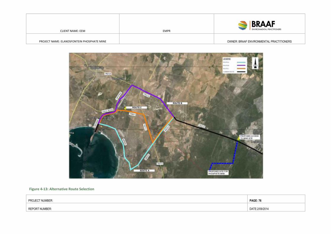
CLIENT NAME: EEM EMPR
PROJECT NAME: ELANDSFONTEIN PHOSPHATE MINE
OWNER: BRAAF ENVIRONMENTAL PRACTITIONERS
PROJECT NUMBER: PAGE: 76
REPORT NUMBER: DATE:2/09/2014
Figure 4-13: Alternative Route Selection
CLIENT NAME: EEM EMPR
PROJECT NAME: ELANDSFONTEIN
PHOSPHATE MINE
OWNER: BRAAF ENVIRONMENTAL
PRACTITIONERS
PROJECT NUMBER: PAGE: 77
REPORT NUMBER: DATE:2/09/2014
4.9.2.12. POWER SUPPLY
Royal Haskoning DHV has been employed to secure bulk power supply the mine site. The power supply option
will be constructed in accordance with Eskom’s HV self-build procedure.
The initial power requirements are 12MVA in the Eskom application. Load will only be determined once the
mechanical equipment list is finalised. The operating cost estimate has been based on 8kWh/tonne processed,
which equates to 3000MWh per month.
Power supply to the mine will be from the existing Aurora-Moorreesburg 132kV overhead line, which runs
approximately 2km to the north of Portion 2 of the farm Elandsfontyn 349. Eskom’s Network Planning
Department has provisionally approved a loop in – loop out arrangement, in which a 2km length of double
circuit 132kV overhead line will connect to a new Eskom substation, located on the mine property near the
concentrator plant. The substation will consist of two 132kV line bays, two 132kV transformer bays and two
132kV step down transformers to supply to the mine’s MV board. The substation will cover a total area of
600m2 and reach a total height of 15m.
132 kV distribution lines
The connecting distribution lines will extend for 5km and require 20 pylons, with a span length of 250m each.
The distribution lines will cover a total distance of 5km and total footprint of 1.5 Ha.
The overhead line corridors shown are based on minimising the number of line deviations (which reduces the
costs). The preferred alternative is based on the latest road planning along the western boundary of Farm
6/178. The mine access road will not cross beneath the 132 kV preferred option (but will cross-beneath the
existing lines). A number of options were initially considered for the mine power supply. The options are
discussed in alternatives section.
4.9.2.13. CHEMICAL AND HAZARDOUS SUBSTANCES FACILITIES
4.9.2.13.1. DIESEL AND LUBRICATION STORAGE FACILITY
Provision will be made for an on-site diesel and lubrication oil storage facility. The facility will be constructed to
the requirements of the chosen fuel supply company. Bulk supply of fuel and lubricants would be by road from
the bulk storage facilities in the area. The 50m2 facility will house approximately 30m
3 of diesel and
accommodate 2 re-fueling bays. A storage area of 80m2 will accommodate 100 litres of lubricant.
4.9.2.14. MAINTENANCE FACILITIES
The following maintenance facilities are proposed:
Equipment and Engineering Workshop 1000m2.
4.9.2.15. ADMINISTRATION AND OTHER BUILDINGS
The buildings will be divided into prefabricated structures for administrative use, whilst cladded, steel
structures with concrete flooring will normally be constructed for workshops and similar applications.
CLIENT NAME: EEM EMPR
PROJECT NAME: ELANDSFONTEIN
PHOSPHATE MINE
OWNER: BRAAF ENVIRONMENTAL
PRACTITIONERS
PROJECT NUMBER: PAGE: 78
REPORT NUMBER: DATE:2/09/2014
The estimated building requirements are summarised in Table 4-5: Estimated building requirements below.
Table 4-5: Estimated building requirements
Structure Area (m2)
Weighbridge 66
General waste 200
Hazardous waste 100
Equipment and Engineering Workshops 1000
Salvage yard 1000
Material Laydown and Storage Area 1000
Administrative Office Block 120
Control Room 20
Clinic 80
Laboratory 160
Security buildings 40
Induction and training area 60
Total ±3846
4.9.2.16. HOUSING, RECREATION AND OTHER EMPLOYEE FACILITIES
There are 300 employees including senior management required for a proposed 1.5 Mtpa open pit production
scenario. Key skills required are management, technical and operational skills and it is planned to recruit these
during the construction phase. Skilled and semi-skilled labour recruitment will primarily focus on the local
communities and will focus on Historically Disadvantaged South Africans (“HDSA”) and Women in Mining
(“WIM”). It is planned that the requirements of the Mining Charter, with staffing for HDSA at 40% and 30%
WIM (target is 10%).
No permanent accommodation will be constructed on site as workers will be recruited from the nearby local
communities.
4.9.2.17. SECURITY AND LIGHTING
Project area
Farm 349/2 and 349/4 is currently fenced and access controlled. Further security on site includes an allowance
has been made for 3,000m of fencing around the mining site. The fencing will be 2.4m section diamond mesh
fencing. This will prevent wildlife (existing game on farm etc) from entering the mine area and prevent access
to no-go areas such as the fossil area.
Security building
Plant security will consist of a permanent gatehouse with boom gates, a 2.4m high diamond mesh (or
equivalent) security perimeter fence, four card operated double turnstiles and several in- plant vehicle and
CLIENT NAME: EEM EMPR
PROJECT NAME: ELANDSFONTEIN
PHOSPHATE MINE
OWNER: BRAAF ENVIRONMENTAL
PRACTITIONERS
PROJECT NUMBER: PAGE: 79
REPORT NUMBER: DATE:2/09/2014
pedestrian gates to control access in and around the plant. From here the security will control trucks and
visitors both entering and leaving the building. Access control and a time attendance system have been
allowed for.
4.10. CONSTRUCTION PHASE
The construction of the mine, beneficiation plant and associated infrastructure will be outsourced to an
engineering contractor.
Key activities that will be undertaken during the construction phase of the Project include the following:
Construction of the main mine access road from the R45;
earth-moving, levelling, grading and excavations;
site clearance;
pre-stripping;
installation of equipment;
construction of temporary construction camp;
construction of all mine infrastructures and facilities; and
construction of bulk services facilities (i.e. power infrastructure, waste facilities and water supply
system and sewerage treatment plant).
This section focuses on the construction phase of the project and describes the following:
Job creation during the construction phase;
Construction camp infrastructure (office, workshop, temporary storage of fuels and wastes);
Non-mineral waste management;
Storm water management; and
Concentrator plant.
4.10.1. JOB CREATION DURING THE CONSTRUCTION PHASE
The construction phase of the Project will result in between approximately 800 construction phase jobs. The
estimated direct temporary employment during the peak construction period will be up to 800 people on site.
The breakdown of people employed in terms of low skilled, semi-skilled and skilled are estimated at 40:40:20.
Direct household income impacts would flow from all wages, estimated at USD10 – 15 million (including
manufacturing labour) paid during construction. Approximately R80 million of this total would probably
accrue to workers currently resident in Hopefield.
4.10.2. CONSTRUCTION CAMP INFRASTRUCTURE (OFFICE, WORKSHOP,
TEMPORARY STORAGE OF FUELS AND WASTES)
A construction camp will be established during the construction phase of the Project, which will cover a total
area of approximately 0.8 to 1.2 hectares. It is proposed to locate the construction camp within the existing
disturbed area on site, which currently accommodates existing stores and outbuildings and borehole. The
following areas will be needed for the construction camp:
CLIENT NAME: EEM EMPR
PROJECT NAME: ELANDSFONTEIN
PHOSPHATE MINE
OWNER: BRAAF ENVIRONMENTAL
PRACTITIONERS
PROJECT NUMBER: PAGE: 80
REPORT NUMBER: DATE:2/09/2014
an office complex;
workshops;
servicing areas;
temporary storage of materials;
bulk fuel storage (100 m³);
bulk lubricant storage (20 m3); and
truck yard and vehicle parking.
It is expected that the following variety of large equipment will be required during the construction phase:
cranes;
dump trucks;
front end loaders;
shovels;
concrete batch plant;
excavators;
boom placers; and
road rollers.
4.10.3. BULK SERVICE REQUIREMENTS FOR THE CONSTRUCTION CAMP
Water
Elandsfontein Farm currently obtains water via the existing borehole on the site. According to current
estimations, the water requirement for the construction phase is approximately 75m3/day and will be sourced
from the existing borehole on the farm.
Should the existing borehole not be able to supply the needed volumes, the water requirement will be
transported to site via road tankers.
4.10.4. POWER
Each contractor will be required to bring their own generators to supply power where required.
4.10.5. FUEL AND LUBRICANTS
The expected bulk fuel requirements for all on-site equipment during the construction phase will be
approximately 30 m3 per day, without exceeding more than two days of storage at any one time. The fuel will
be stored in a bunded area of 25 m² within the construction camp. In addition to this, approximately 5 m3 of
lubricants and oils will be stored in the contractor’s camp site, for the duration of construction. The lubricant
and oil containers will also be stored within a bunded area of approximately 15 m².
CLIENT NAME: EEM EMPR
PROJECT NAME: ELANDSFONTEIN
PHOSPHATE MINE
OWNER: BRAAF ENVIRONMENTAL
PRACTITIONERS
PROJECT NUMBER: PAGE: 81
REPORT NUMBER: DATE:2/09/2014
4.10.6. SEWAGE
In order to manage the sewage generated during the construction period, all contractors will provide portable
chemical toilets for workers. A waste contractor will be appointed to manage the portable toilets to ensure
that they are emptied regularly and the waste disposed of at a licensed waste disposal facility.
4.10.7. ACCESS ROADS
Access to the mine, will be facilitated via the proposed 9km access road linking the site to the R45 (refer to
Figure 4-13). The proposed road will follow existing disturbed tracks and servitudes to minimise the overall
impact on the environment. This road will serve as the main mine access road and will be used by various
construction vehicles (eg cranes, dump trucks, front end loaders, shovels, excavators etc.) to prepare the open
pit for operation.
4.10.8. NON-MINERAL WASTE MANAGEMENT
Domestic waste from the contractor’s camp and the construction operations will be separated. Paper and
plastics will be recycled, with the remaining domestic wastes and disposed of at the existing municipal landfill
site. General industrial waste produced would include respectively. A total of 5-10 ton/month of domestic
wastes are expected to be generated during construction. Domestic wastes will be stored within the
contractor’s camp site, covering a total area of half a hectare. All non-hazardous wastes will be disposed of at
the municipal landfill site (which is a registered landfill site), as and when steel, packaging material and
material off-cuts. The temporary waste disposal site will be divided between general/ domestic and hazardous
wastes and cover a total area of 100 m2 and 200m
2 required.
Hazardous waste will mainly include oil contaminated wastes, which will be collected and disposed of as and
when required. Hazardous wastes will be temporarily stored within closed containers (possibly within covered
skips) and removed, as and when needed (about every two weeks). The hazardous waste storage area within
the contractors yard is expected to cover an area of approximately 50m2. EEM will employ an authorised waste
management contractor on site, who will be responsible for general and hazardous waste collection and
removal. All hazardous wastes will be disposed of at the Vissershok hazardous waste facility/EnviroServ
Facility.
Proof will be obtained from the contractor as to the final disposal location and volume of domestic and
hazardous wastes.
4.11. PROJECT PHASES AND ACTIVITIES
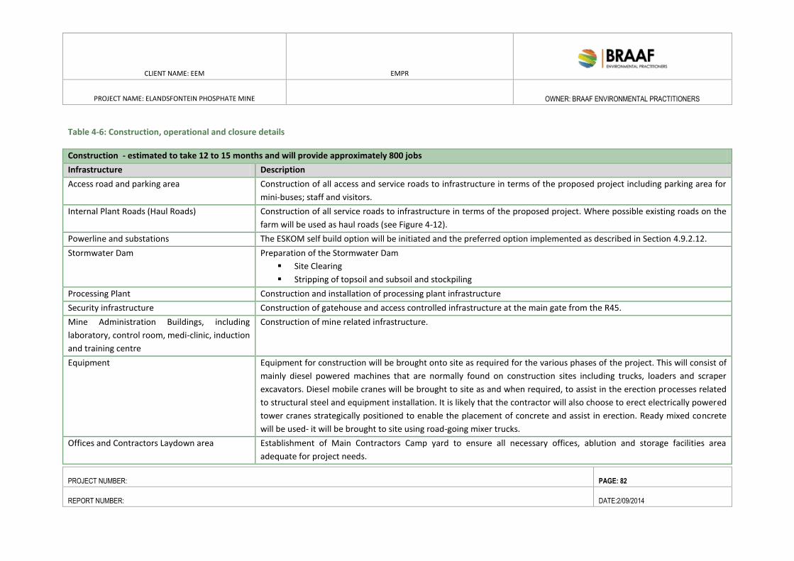
CLIENT NAME: EEM EMPR
PROJECT NAME: ELANDSFONTEIN PHOSPHATE MINE
OWNER: BRAAF ENVIRONMENTAL PRACTITIONERS
PROJECT NUMBER: PAGE: 82
REPORT NUMBER: DATE:2/09/2014
Table 4-6: Construction, operational and closure details
Construction - estimated to take 12 to 15 months and will provide approximately 800 jobs
Infrastructure Description
Access road and parking area Construction of all access and service roads to infrastructure in terms of the proposed project including parking area for
mini-buses; staff and visitors.
Internal Plant Roads (Haul Roads) Construction of all service roads to infrastructure in terms of the proposed project. Where possible existing roads on the
farm will be used as haul roads (see Figure 4-12).
Powerline and substations The ESKOM self build option will be initiated and the preferred option implemented as described in Section 4.9.2.12.
Stormwater Dam Preparation of the Stormwater Dam
Site Clearing
Stripping of topsoil and subsoil and stockpiling
Processing Plant Construction and installation of processing plant infrastructure
Security infrastructure Construction of gatehouse and access controlled infrastructure at the main gate from the R45.
Mine Administration Buildings, including
laboratory, control room, medi-clinic, induction
and training centre
Construction of mine related infrastructure.
Equipment Equipment for construction will be brought onto site as required for the various phases of the project. This will consist of
mainly diesel powered machines that are normally found on construction sites including trucks, loaders and scraper
excavators. Diesel mobile cranes will be brought to site as and when required, to assist in the erection processes related
to structural steel and equipment installation. It is likely that the contractor will also choose to erect electrically powered
tower cranes strategically positioned to enable the placement of concrete and assist in erection. Ready mixed concrete
will be used- it will be brought to site using road-going mixer trucks.
Offices and Contractors Laydown area Establishment of Main Contractors Camp yard to ensure all necessary offices, ablution and storage facilities area
adequate for project needs.
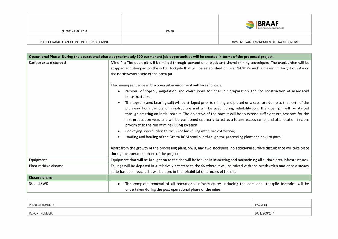
CLIENT NAME: EEM EMPR
PROJECT NAME: ELANDSFONTEIN PHOSPHATE MINE
OWNER: BRAAF ENVIRONMENTAL PRACTITIONERS
PROJECT NUMBER: PAGE: 83
REPORT NUMBER: DATE:2/09/2014
Operational Phase- During the operational phase approximately 300 permanent job opportunities will be created in terms of the proposed project.
Surface area disturbed Mine Pit: The open pit will be mined through conventional truck and shovel mining techniques. The overburden will be
stripped and dumped on the softs stockpile that will be established on over 14.9ha’s with a maximum height of 38m on
the northwestern side of the open pit
The mining sequence in the open pit environment will be as follows:
removal of topsoil, vegetation and overburden for open pit preparation and for construction of associated
infrastructures.
The topsoil (seed bearing soil) will be stripped prior to mining and placed on a separate dump to the north of the
pit away from the plant infrastructure and will be used during rehabilitation. The open pit will be started
through creating an initial boxcut. The objective of the boxcut will be to expose sufficient ore reserves for the
first production year, and will be positioned optimally to act as a future access ramp, and at a location in close
proximity to the run of mine (ROM) location.
Conveying overburden to the SS or backfilling after ore extraction;
Loading and hauling of the Ore to ROM stockpile through the processing plant and haul to port.
Apart from the growth of the processing plant, SWD, and two stockpiles, no additional surface disturbance will take place
during the operation phase of the project.
Equipment Equipment that will be brought on to the site will be for use in inspecting and maintaining all surface area infrastructures.
Plant residue disposal Tailings will be deposed in a relatively dry state to the SS where it will be mixed with the overburden and once a steady
state has been reached it will be used in the rehabilitation process of the pit.
Closure phase
SS and SWD The complete removal of all operational infrastructures including the dam and stockpile footprint will be
undertaken during the post operational phase of the mine.
CLIENT NAME: EEM EMPR
PROJECT NAME: ELANDSFONTEIN PHOSPHATE MINE
OWNER: BRAAF ENVIRONMENTAL PRACTITIONERS
PROJECT NUMBER: PAGE: 84
REPORT NUMBER: DATE:2/09/2014
Roads: Roads not needed for closure and post-closure uses at the site will be closed by ripping compacted surfaces, re-
grading as needed to promote proper surface drainage, covered with growth media where needed and re-
vegetated.
Site roads constructed using the cut-only or fill-only method of construction. Cut-only roads will have cover
placed on the road surface to control runoff and facilitate soil placement and re-vegetation. Fill-only road
segments will be ripped to loosen compacted surfaces. Any roads constructed using cut-to-fill methods will be
reshaped using fill material. All closed roads will be covered with soil and re-vegetated.
Demolition of Infrastructure All power and water services to be disconnected and certified as safe prior to commencement of any demolition
works.
Salvageable equipment will be removed and transported offsite prior to the commencement of demolition.
All above ground electrical, water and other service infrastructure and equipment to be removed and at
designated salvage yards.
Electrical, water and other services that are more than 500 mm below ground surface will remain.
All pipes and structures deeper than 500 mm need to be sealed to prevent possible ingress and ponding of
water.
Concrete slabs and footings will be removed to a depth of 500 mm below ground surface. This concrete (and
metal) will be broken up and disposed of in the designated landfill.
All concrete below 500 mm depth will remain underground with the invert of all structures broken/sealed to
prevent possible ingress and ponding of water.
Establish appropriate vegetation as per the Vegetation Management Plan.
Contaminated Soils: Undertake soil investigations to characterize the nature of possible contaminants and design a site specific soil
remediation strategy. Identify appropriate risk based guideline levels against which to assess contamination. As
a point of departure the guidelines given in the Draft National Framework for Soil Contamination (DEA, 2010)
will be used
CLIENT NAME: EEM EMPR
PROJECT NAME: ELANDSFONTEIN PHOSPHATE MINE
OWNER: BRAAF ENVIRONMENTAL PRACTITIONERS
PROJECT NUMBER: PAGE: 85
REPORT NUMBER: DATE:2/09/2014
If contamination is primarily hydrocarbon, with soil concentrations exceeding an appropriate risk based
guideline, the following will be undertaken.
o Volumes less than 100 m3 – On site bioremediation will be undertaken by collecting the affected soils
and transporting them to a dedicated bioremediation facility.
o Volumes greater than 100 m3
– Disposal at hazardous waste
If contamination is primarily inorganic a risk based approach will be adopted in determining final soil
remediation technology adopted.
Where risk based assessment indicates that residual contamination is unlikely to present an unacceptable
human or ecological risk, contaminated soils to be covered with a soils suitable as a plant growth media and
vegetation established. These areas to be clearly demarcated as areas not for use by local communities.
Groundwater: With the cessation of the deposition of slurry onto the Temporary Tailings Storage Facility and then SS, it is
expected that the primary source of salts potentially seeping from the facility will be removed and it is expected
that groundwater quality around either of the SS will improve. Furthermore, as groundwater at various locations
around the mine may be impacted on by both mining and processing activities, a groundwater management
plan will be developed for the entire operation based on a needs analysis within the entire mine lease area.
Therefore, no detailed groundwater remediation requirements are included in the action plan relating to this
specific project.
Pit The decommissioning phase will include the final backfilling of the pit, reshaping of the final void, rehabilitation of mine
residue deposits, rehabilitation of final footprints including shaping, replacement of topsoil and re-vegetation. The final
mining void will be infilled, it is estimated that the final levels will be approximately 2 metres or less lower than the
current levels. The mine path will largely ignore the subtle variations in the current topography. It is however important
to retain the diversity of structure in the landscape that ranges from sand dunes to exposed calcrete that supports the
diversity of plant and animal life. It is therefore proposed that the different substrates be harvested judiciously and that
the placement will be done with skill under guidance of an expert in field of landscape scale rehabilitation in order to re-
create a post mining environment very similar to the pre-mining condition. The entire area will be revegetated for the
CLIENT NAME: EEM EMPR
PROJECT NAME: ELANDSFONTEIN PHOSPHATE MINE
OWNER: BRAAF ENVIRONMENTAL PRACTITIONERS
PROJECT NUMBER: PAGE: 86
REPORT NUMBER: DATE:2/09/2014
purposes of:
Rehabilitating the mined area to allow the reestablishment of indigenous vegetation and return of animal
species;
Minimise the visual scar on the landscape;
Prevent erosion of transformed areas.
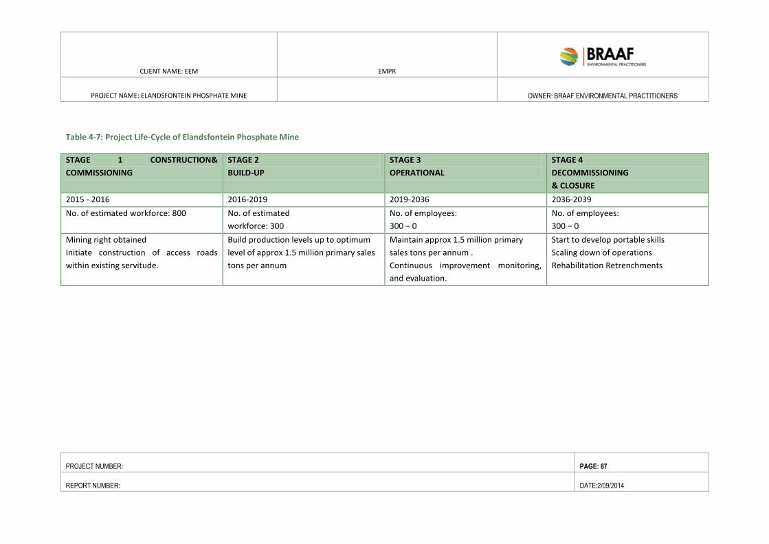
CLIENT NAME: EEM EMPR
PROJECT NAME: ELANDSFONTEIN PHOSPHATE MINE
OWNER: BRAAF ENVIRONMENTAL PRACTITIONERS
PROJECT NUMBER: PAGE: 87
REPORT NUMBER: DATE:2/09/2014
Table 4-7: Project Life-Cycle of Elandsfontein Phosphate Mine
STAGE 1 CONSTRUCTION&
COMMISSIONING
STAGE 2
BUILD-UP
STAGE 3
OPERATIONAL
STAGE 4
DECOMMISSIONING
& CLOSURE
2015 - 2016 2016-2019 2019-2036 2036-2039
No. of estimated workforce: 800 No. of estimated
workforce: 300
No. of employees:
300 – 0
No. of employees:
300 – 0
Mining right obtained
Initiate construction of access roads
within existing servitude.
Build production levels up to optimum
level of approx 1.5 million primary sales
tons per annum
Maintain approx 1.5 million primary
sales tons per annum .
Continuous improvement monitoring,
and evaluation.
Start to develop portable skills
Scaling down of operations
Rehabilitation Retrenchments
CLIENT NAME: EEM EMPR
PROJECT NAME: ELANDSFONTEIN
PHOSPHATE MINE
OWNER: BRAAF ENVIRONMENTAL
PRACTITIONERS
PROJECT NUMBER: PAGE: 88
REPORT NUMBER: DATE:2/09/2014
5. PROJECT ALTERNATIVES
5.1. INTRODUCTION
The purpose of this Section is to present a detailed description of project alternatives considered in the
EIA/EMP process. A detailed motivation for selecting specific alternatives, in line with the mitigation hierarchy
of avoid, abate, mitigate and replace/compensate is presented. The assessment of alternatives is based on
new information gathered during the present mining right application process (MPRDA).
5.2. MITIGATION HIERARCHY: AVOIDANCE, PREVENTION AND MINIMIZATION OF
IMPACTS
The biodiversity sensitivity of the project area requires that the consideration of alternatives is closely aligned
with the Mitigation Hierarchy. The priority in mitigation is to first avoid or reduce at source the magnitude of
the impact from the associated Project activity through the design of the project i.e. avoid by siting or
rerouting the activities away from sensitive areas. Once this is achieved, the resultant effect to the
resource/receptor can be addressed via abatement at a site then the receptor level. Restoration or
rehabilitation can then be undertaken and only once the above have been considered can compensatory
measures or offsets be considered (i.e. to reduce the significance of the effect once all reasonably practicable
mitigations have been applied to reduce the impact magnitude). In line with good practice, avoidance has
been applied to help guide the location alternatives.
Table 5-1: Mitigation hierarchy
Avoid at Source/Reduce at Source Avoiding or reducing at source through the design of the Project (e.g., avoiding
by siting or re-routing activity away from sensitive areas or changing the time of
the activity).
Decrease on Site Add design controls to decrease the impact (e.g., pollution control equipment,
traffic controls).
Abate at Receptor if an impact cannot be minimise on-site then control measures can be
implemented off-site (e.g. fencing to prevent animals straying onto the site).
Repair or Remedy If unavoidable damage to a resource cannot be avoided (e.g. agricultural
/conservation land due to creating access, ore extraction or materials storage
areas) and these impacts can be addressed through repair, restoration or
reinstatement measures.
Compensate in Kind; Compensate
Through Other Means:
Where other mitigation approaches outlined above are not possible or fully
effective, then compensation for loss, damage and disturbance might be
appropriate (e.g., planting to replace damaged vegetation, financial
compensation for damaged crops or recreation and amenity space or
compensation with biodiversity rich land where biophysical loss is unavoidable).
CLIENT NAME: EEM EMPR
PROJECT NAME: ELANDSFONTEIN PHOSPHATE MINE
OWNER: BRAAF ENVIRONMENTAL PRACTITIONERS
PROJECT NUMBER: PAGE: 89
REPORT NUMBER: DATE:2/09/2014
5.3. ANALYSIS OF OPEN PIT AND UNDERGROUND MINING TECHNIQUES
EEM’s base case for this project included the open pit mining option. However, it was broadly understood that
open pit mining would result in a greater impact on the biodiversity resources that an Underground mining
option. As a result, and to adhere to the mitigation hierarchy of firstly avoiding the impacts, EEM was
requested to consider the potential to adopt an underground mining technique as per Department of Mineral
Resources (DMR) request.
EEM appointed DRA Engineers to consider the technical and commercial viability of undertaking underground
and open pit mining at the Elandsfontein Phosphate Mine.
5.3.1. OPEN PIT VS UNDERGROUND MINING
The Elandsfontein Phosphate deposit is confined to a sedimentary deposit located in the Varswater formation
in the Western Cape.
Due to the fact that that the overburden material is of a sandy nature (no in-situ hard rock), underground
mining would not be an option. The soft overburden has a zero rock mass rating and as such any attempt to go
underground would result in a total collapse. The maximum competent slope angle in the deposit is 35
degrees. Underground mining is not a viable or safe mining method.
For this reason open pit mining, and more specifically, strip mining was selected as the preferred mining
technique to allow continuous rehabilitation of the area, that would commence 33 months after mining has
commenced.
Refer to Appendix E for DRA’s Mining Technique Analysis.
5.3.2. ALTERNATIVES CONSIDERED FOR SURFACE MINING (OPEN PIT)
Four surface mining methods have been considered and part of the option study for the project.
5.3.2.1. DREDGING
Due to the sandy nature of the ore body, and the presence of a shallow water (in the Elandsfontyn upper
aquifer), dredge mining was initially considered as a low cost mining solution. The top soil and overburden
above the water table would have been removed using conventional excavation methods, until the water
table was intersected. The ore would then have been dredged using long suction hoses, connected to large
pumps resting on barges.
CLIENT NAME: EEM EMPR
PROJECT NAME: ELANDSFONTEIN PHOSPHATE MINE
OWNER: BRAAF ENVIRONMENTAL PRACTITIONERS
PROJECT NUMBER: PAGE: 90
REPORT NUMBER: DATE:2/09/2014
Following initial meetings with the Department of Water Affairs, it was noted that large volumes of open water
would not be favoured, so the option of dredge mining was closed.
5.3.2.2. HYDRAULIC MINING (OR SLUICING)
The second mining option investigated was the hydraulic mining or sluicing method, often employed for the
re-mining of historical tailings dumps. As for the dredging option, the top soil and over burden would be
removed through conventional excavation methods, and deposited on large stockpiles adjacent to the final
planned pit limits. The pit would have been dewatered around the perimeter.
High pressure water, produced by a monitor gun, would then be used for the excavation of the deposit. The
pulped ore would have flowed via a sluice, to a central collection point for pumping to the plant. The water
extracted from the water table would have been used for the hydraulic mining process.
After further consultation with the Department of Water Affairs, the client was advised to consider a dry
mining method that would not result in large water consumption and possible environmental considerations.
For these reasons conventional open cast and strip mining was then considered, with strip mining being the
preferred option.
5.3.2.3. CONVENTIONAL OPEN CAST MINING
Conventional open cast mining was also considered. In the process of conventional open cast mining, as with
the previous mining methods discussed above, a single large pit is created, until the mineral resource is
exhausted. Waste rock, extracted over the life of mine, is piled up at the surface, near the final expected limit
of the open pit. Rehabilitation of the pit can only commence once mining is complete, i.e. after the full 20 year
mining period.
5.3.2.4. STRIP MINING (PREFERRED)
In an attempt to mitigate the environmental impacts of the mine, strip mining was investigated. The strip
mining will take place in a number of discrete phases, which will reduce the overall mining, foot print:
a) topsoil is removed and stockpiled;
b) overburden layer is stripped and stockpiled;
c) phosphate ore is mined; then
d) the strip is backfilled with the overburden and slimes from the plant; and
e) the topsoil returned to the strip and rehabilitated.
Initial design was based on large strips, of approximately 250m in width, but further optimisation of the
process has indicated that smaller strips, of as little as 50m, can still be feasible. Strip mining has been selected
as the preferred mining method, to allow continuous rehabilitation of the area, that would commence 33
months after mining has commenced.
5.3.3. LOCATION ALTERNATIVES FOR MINE INFRSTRUCTURE
CLIENT NAME: EEM EMPR
PROJECT NAME: ELANDSFONTEIN PHOSPHATE MINE
OWNER: BRAAF ENVIRONMENTAL PRACTITIONERS
PROJECT NUMBER: PAGE: 91
REPORT NUMBER: DATE:2/09/2014
The original layout plan identified the potential location or location alternatives for all major infrastructure
required for the project. The original layout plan is presented in Figure 5-1 below. This included the following
project components:
5.3.3.1. LOCATION OF ALL INFRASTRUCTURE ON MINE AREA
The original layout plan identified the potential location or location alternatives for all major infrastructure
required for the project.
This included the following project components:
Stockpile (Topsoil and waste rock);
A tailings dam;
A pollution control dam;
Open pit;
Plant;
Contractor area; and
Access alternatives (road or conveyor belt).
Locations were identified for the open pit, and plant based on discussions between the environmental and
engineering teams. The locations were finalised primarily based on avoidance of sensitive habitats and
previous assessment undertaken as part of the prospecting application.
Discussions were initiated with the applicant’s technical team regarding the potential relocation of these
specific infrastructure components, based on the presence of sensitivities. It was agreed that the plant area
and concentrate transport option could be –changed. This resulted in the second layout alternative – i.e. the
inland port site where a portion of the mine infrastructure and plant would be located.
However, due to the location and dimensions of the ore body, the location of the open pit could not be
relocated, as it would result in the sterilisation of parts of the ore body.
In adopting a conservative approach, all estimations of footprints were based on worst case scenarios. It is
understood that as detailed design is complete, the expected footprints of the development will be refined.
5.3.3.2. INLAND PORT SITE
The original layout plan was then updated to exclude the processing plant on the main mine site. It was
decided that to minimise the overall footprint on the mining area, a portion of the processing plant would be
moved to the Inland Port Site.
The proposed metallurgical plant will be located on site within a 240m by 290m area, including raw water
storage and pollution control dams. The plant complex will include infrastructure and equipment allowing for
ore storage, flotation, thickening and water storage, reagent make- up and storage, concentrate storage, plant
CLIENT NAME: EEM EMPR
PROJECT NAME: ELANDSFONTEIN PHOSPHATE MINE
OWNER: BRAAF ENVIRONMENTAL PRACTITIONERS
PROJECT NUMBER: PAGE: 92
REPORT NUMBER: DATE:2/09/2014
stores, engineering workshops, lay-down area and security. In order to limit the extent of development on the
Elandsfontein site, the mine administrative office, training and induction centres and laboratory will be located
off site, at the inland port facility, near Saldanha. The inland port facility will contain a concentrate thickener
and pressure filter to dewater the concentrate, and a silo and truck loading facility for final storage ahead of
ship loading. The administrative offices, laboratories, clinic and training and induction centre will be located at
the inland port site.
5.4. PLANNING AND DESIGN
Previous investigations undertaken as part of the prospecting application for Elandsfontein Phosphate Mine
identified a number of sensitive receptors within the area of influence. Taking cognisance of these receptors,
the baseline specialist studies were undertaken as part of the initial scoping exercise via site visits, collation of
existing information in order to update existing baseline information and produce a variety of sensitivity
mapping. In line with the mitigation hierarchy, the sensitivity mapping was used to guide the layout of the
mine based on the sensitivities present.
EEM developed a conceptual layout plan (refer to Figure 4-8) and associated alternatives based on technical
feasibility and input from specialist consultants and issues raised through the mining right process by key
stakeholders and interested and affected parties, where feasible. However, as the layout plan is based on
conceptual design and the suggested locations and footprints will be subject to further refinement in the
detailed design phase. The conceptual layout plan was presented to the ESIA specialist team for consideration.
Based on the inputs from the various specialists the mine layout plan and alternatives has been updated.
The layout plan assessed by specialists as part of this EIA/EMP which is the preferred option is presented as
Figure 4-8. It will comprise the location of all mine infrastructure and processing plant on the application area
on Elandsfontein Farm.
It will include:
Softs Stockpile (overburden and tailings);
Topsoil Stockpile;
A stormwater dam;
Open pit;
Plant;
Mine Buildings;
Access road.
Throughout the planning and design phase, mine closure objectives have been developed to inform the post
mining land use and rehabilitation process. The mine closure objectives will be informed through the mining
charter and requirements set out by the Department of Mineral Resources. Furthermore, consideration of
post-mining land use and associated rehabilitation efforts was addressed as part of the specialist
investigations.
CLIENT NAME: EEM EMPR
PROJECT NAME: ELANDSFONTEIN PHOSPHATE MINE
OWNER: BRAAF ENVIRONMENTAL PRACTITIONERS
PROJECT NUMBER: PAGE: 93
REPORT NUMBER: DATE:2/09/2014
These two layout options identified in sections 5.3.3.1 and 5.3.3.2 (see Figure 5-1 for the original layout plan)
were provided to the specialist team to assess as part of the Scoping Study. This yielded a number of sensitivity
maps which were used to inform the current layout plan.
The following sensitivity maps were presented to commence with the first mitigation hierarchy measure (i.e.
Avoidance):
1 Habitat Sensitivity Map.
2 Archaeological and Heritage Sensitivity Map.
3. Visual Sensitivity Map.
4. Noise Sensitivity Map.
Note that hydrological sensitivities were derived from satellite imagery and topographical surveys undertaken.
In addition, the visual specialist provided preliminary feedback on the initial layout options, which are
contained below.
Upon receipt of these specialist sensitivity maps and feedback on hydrological and visual sensitivities, the
proposed location alternatives were reviewed in light of the specialist mapping and amended whenever
feasible to avoid or prevent significant impacts/ conflict areas.
Although archaeological, visual, hydrological and noise sensitivities were considered and incorporated into the
layout planning, the primary driver for avoidance was that of the habitat sensitivity map. A copy of the initial
specialist sensitivity maps are presented below.
5.4.1.1. HABITAT SENSITIVITIES
In order to manage the impacts associated with the habitats and species of special concern, the botanical
specialist has mapped areas of sensitivity. The habitat sensitivity map helped with delineating areas of
conservation importance and thereby guided the location of Project related infrastructure.
Biodiversity “features of conservation concern” were identified based on quantifiable criteria such as their
uniqueness to the site (i.e. local endemic); rarity; threatened status (i.e. risk of going extinct); cultural value;
or, sensitivity to disturbance. Three categories of features of conservation can be defined, i.e. species, habitats
and sites. In line with these categories of features, a flexibility map was developed to define constraints within
the affected environment. A botanical sensitivity map was produced indicating area of high, medium and low
sensitivity (refer to Figure 5-2).
5.4.1.2. ARCHAEOLOGICAL/ HERITAGE SENSITIVITIES
The archaeological study has indicated that the Saldanha Bay region is of very high archaeological and
palaeontological importance, particularly with regard to Pleistocene fossil fauna (bone) and associated
archaeology. Elandsfontyn Farm 349, for example, has produced Middle (MSA) and Early Stone Age (ESA) tools
with associated fauna more than 200 000 years old, while the `Saldanha Man’ skull from the fossil site (nearly
3 kms east of the proposed mining area), is the oldest known human in the Cape, with a date between 700 000
and 400 000 years ago. Archaeological and palaeontological research started at Elandsfontein more than 60
years ago, and has seen the production of more than 20 scientific reports dedicated to the site. Internationally,
CLIENT NAME: EEM EMPR
PROJECT NAME: ELANDSFONTEIN PHOSPHATE MINE
OWNER: BRAAF ENVIRONMENTAL PRACTITIONERS
PROJECT NUMBER: PAGE: 94
REPORT NUMBER: DATE:2/09/2014
it is one of the most recognised Pleistocene archaeological sites in South Africa. Refer to Figure 5-3 for the
archaeological sensitivity map.
5.4.1.3. NOISE SENSITIVITIES
The Elandsfontein Farm is located in an area that is sparsely populated, with limited sensitive noise receptors
in the immediate area (Figure 5-4). Sensitive receptors in the area include the town of Hopefield, neighbouring
farm and wildlife and road users (R27 and R45). The proposed Elandsfontein mine will result in the generation
of noise through the use of diesel equipment, concentrating and activity of mining such as drilling and hauling
of concentrate.
Presently, there are no major noise sources in the areas surrounding the mine site. The main activities in the
area are animal farming, nature conservation, subsistence agricultural farming and related operations, which
serve the local communities. The general area around the site is rural, and noise levels are expected to be in
the range of between 45 dBA and 35 dBA during daytime and night-time respectively. The only areas with
higher noise levels are expected to be in the immediate vicinity of the existing main roads of R27 and R45.
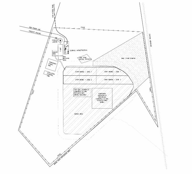
K Hansen Landscape Architect, Somerset West 8 Elandsfontein Mine: Scoping Phase: January 2014 Revision nr: 00
2.0 PROJECT CONTEXT
2.1 Overview of the Proposed Mine: Technical Context
Figure 2.1 the actual portions of the farm and mining right application area are illustrated here and bounded by a proposed fence. The proposed strip mining area is shown, and includes the sites for temporary overburden. The area required for mine set up – establishment is shown adjacent. Around the dwelling house, where there will be mine infrastructure control, the beneficiation plant, etc, is proposed. It is from there that the material will be sent of site.
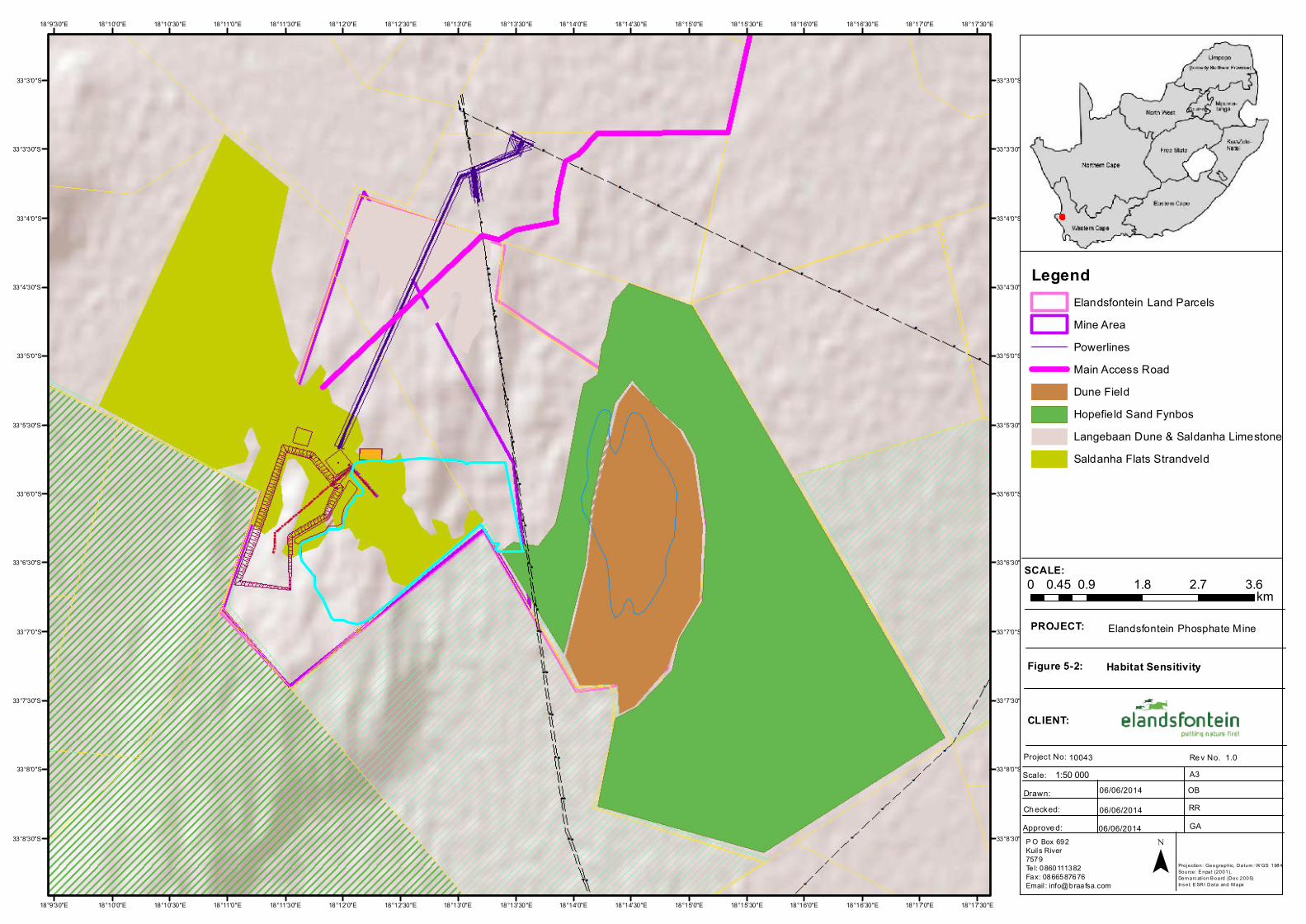
18°17'30"E
18°17'30"E
18°17'0"E
18°17'0"E
18°16'30"E
18°16'30"E
18°16'0"E
18°16'0"E
18°15'30"E
18°15'30"E
18°15'0"E
18°15'0"E
18°14'30"E
18°14'30"E
18°14'0"E
18°14'0"E
18°13'30"E
18°13'30"E
18°13'0"E
18°13'0"E
18°12'30"E
18°12'30"E
18°12'0"E
18°12'0"E
18°11'30"E
18°11'30"E
18°11'0"E
18°11'0"E
18°10'30"E
18°10'30"E
18°10'0"E
18°10'0"E
18°9'30"E
18°9'30"E
33°3'0"S 33°3'0"S
33°3'30"S 33°3'30"S
33°4'0"S 33°4'0"S
33°4'30"S 33°4'30"S
33°5'0"S 33°5'0"S
33°5'30"S 33°5'30"S
33°6'0"S 33°6'0"S
33°6'30"S 33°6'30"S
33°7'0"S 33°7'0"S
33°7'30"S 33°7'30"S
33°8'0"S 33°8'0"S
33°8'30"S 33°8'30"S
SCALE:
PROJECT:
Figure 5-2:
CLIENT:
Project No: Scale:
Re v No. A3
Drawn:Ch ecked:Approve d:
10043 1.0
06/06/2014
06/06/201406/06/2014
OBRRGA
Habitat Sensitivity
Elandsfontein Phosphate Mine
P O Box 692Kuils River7579Tel: 0860111382Fax: 0866587676Email : [email protected]
0 0.9 1.8 2.7 3.60.45 km
¯
1:50 000
Projection: Geographic, Datum : W GS 1984Source: E npat (2001), Dem arc ation B oard (Dec 2005)Ins et: E SRI Data and M aps
LegendElandsfontein Land ParcelsMine AreaPowerlinesMain Access RoadDune FieldHopefield Sand FynbosLangebaan Dune & Saldanha LimestoneSaldanha Flats Strandveld
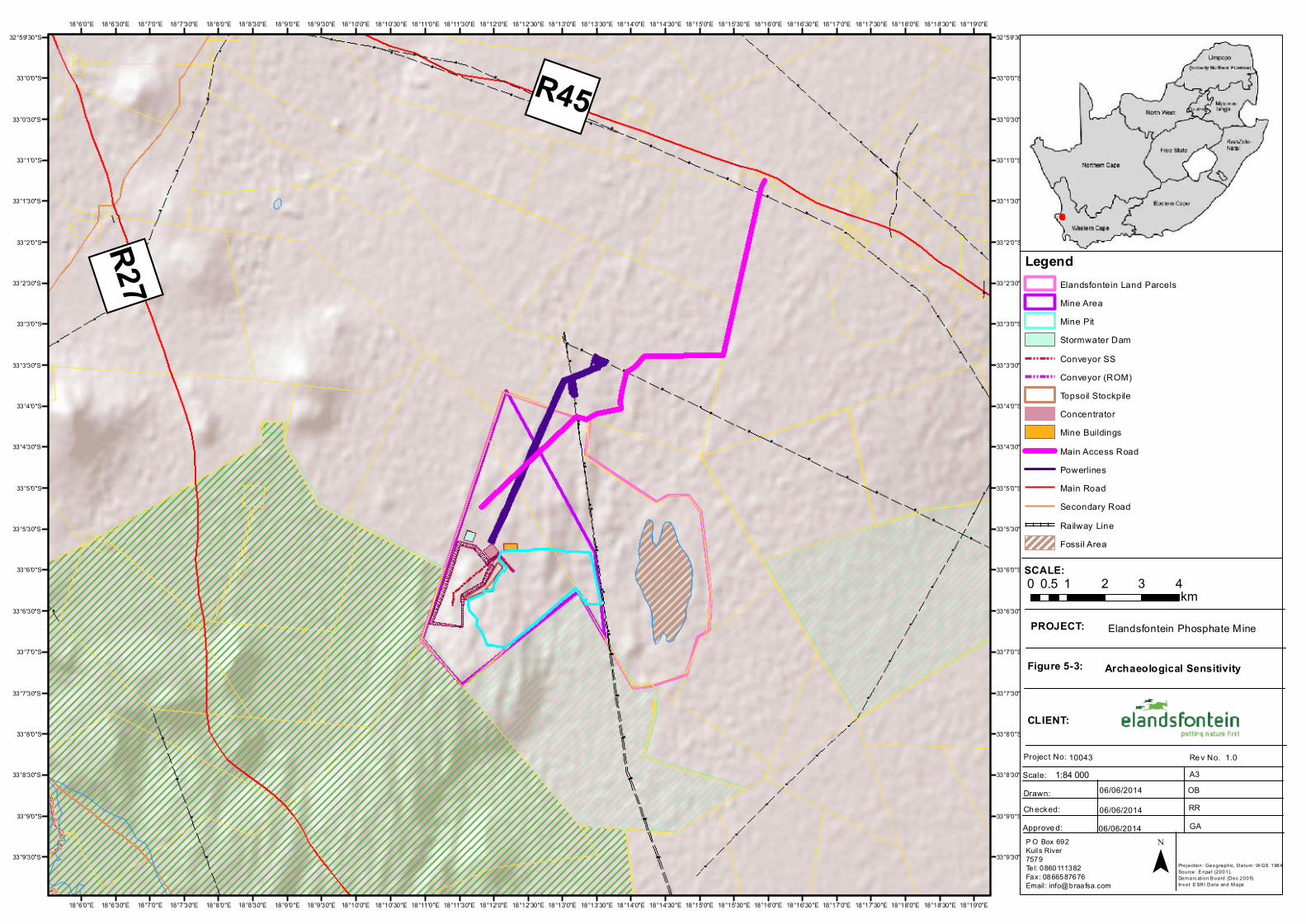
")R45
") R27
Langebaan Lagoon
18°19'0"E
18°19'0"E
18°18'30"E
18°18'30"E
18°18'0"E
18°18'0"E
18°17'30"E
18°17'30"E
18°17'0"E
18°17'0"E
18°16'30"E
18°16'30"E
18°16'0"E
18°16'0"E
18°15'30"E
18°15'30"E
18°15'0"E
18°15'0"E
18°14'30"E
18°14'30"E
18°14'0"E
18°14'0"E
18°13'30"E
18°13'30"E
18°13'0"E
18°13'0"E
18°12'30"E
18°12'30"E
18°12'0"E
18°12'0"E
18°11'30"E
18°11'30"E
18°11'0"E
18°11'0"E
18°10'30"E
18°10'30"E
18°10'0"E
18°10'0"E
18°9'30"E
18°9'30"E
18°9'0"E
18°9'0"E
18°8'30"E
18°8'30"E
18°8'0"E
18°8'0"E
18°7'30"E
18°7'30"E
18°7'0"E
18°7'0"E
18°6'30"E
18°6'30"E
18°6'0"E
18°6'0"E32°59'30"S 32°59'30"S
33°0'0"S 33°0'0"S
33°0'30"S 33°0'30"S
33°1'0"S 33°1'0"S
33°1'30"S 33°1'30"S
33°2'0"S 33°2'0"S
33°2'30"S 33°2'30"S
33°3'0"S 33°3'0"S
33°3'30"S 33°3'30"S
33°4'0"S 33°4'0"S
33°4'30"S 33°4'30"S
33°5'0"S 33°5'0"S
33°5'30"S 33°5'30"S
33°6'0"S 33°6'0"S
33°6'30"S 33°6'30"S
33°7'0"S 33°7'0"S
33°7'30"S 33°7'30"S
33°8'0"S 33°8'0"S
33°8'30"S 33°8'30"S
33°9'0"S 33°9'0"S
33°9'30"S 33°9'30"S
SCALE:
PROJECT:
Figure 5-3:
CLIENT:
Project No: Scale:
Re v No. A3
Drawn:Ch ecked:Approve d:
10043 1.0
06/06/2014
06/06/201406/06/2014
OBRRGA
Archaeological Sensitivity
Elandsfontein Phosphate Mine
P O Box 692Kuils River7579Tel: 0860111382Fax: 0866587676Email : [email protected]
0 1 2 3 40.5km
¯
1:84 000
Projection: Geographic, Datum : W GS 1984Source: E npat (2001), Dem arc ation B oard (Dec 2005)Ins et: E SRI Data and M aps
LegendElandsfontein Land ParcelsMine AreaMine PitStormwater DamConveyor SSConveyor (ROM)Topsoil StockpileConcentratorMine BuildingsMain Access RoadPowerlinesMain RoadSecondary RoadRailway LineFossil Area
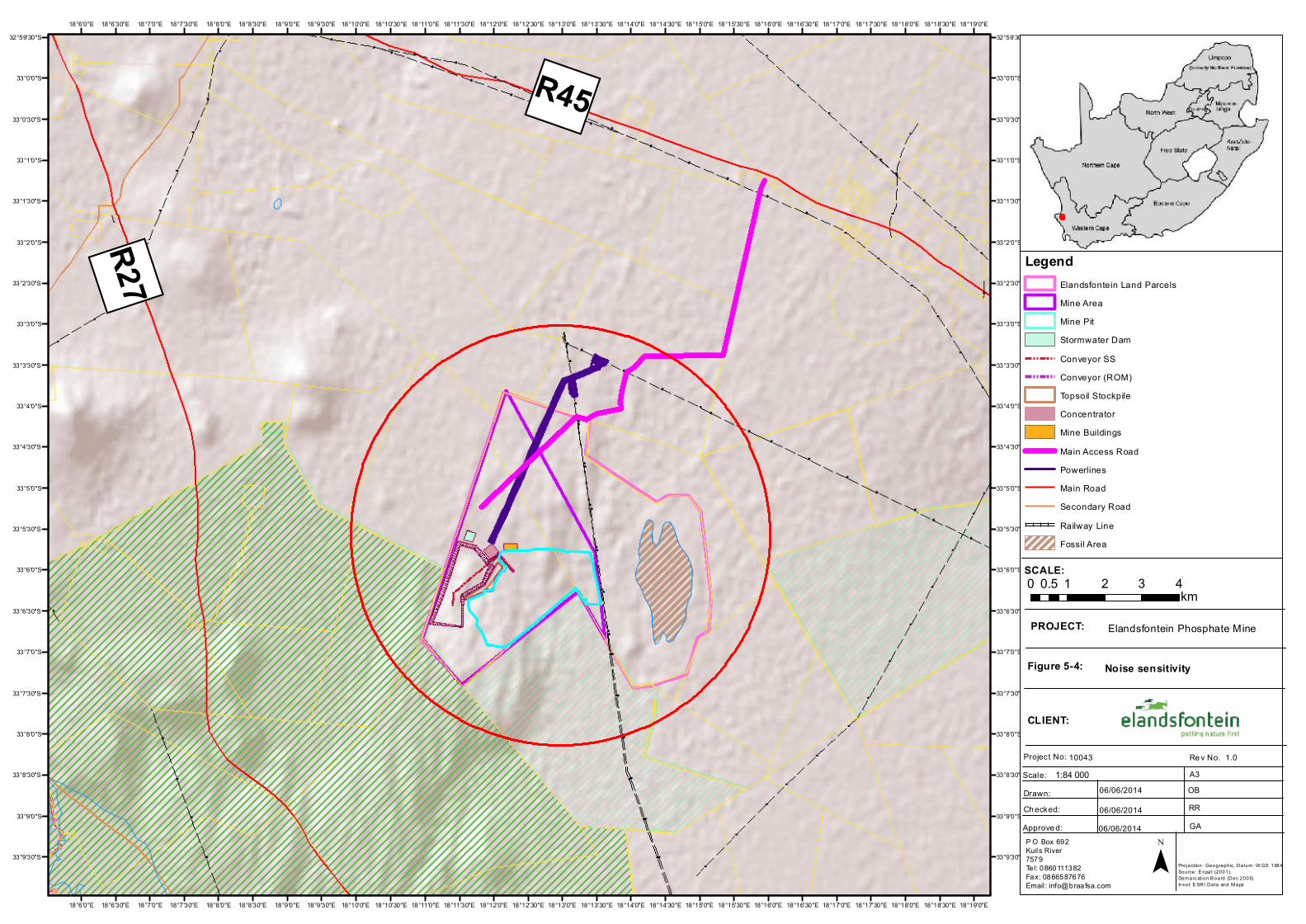
")R45
") R27
Langebaan Lagoon
18°19'0"E
18°19'0"E
18°18'30"E
18°18'30"E
18°18'0"E
18°18'0"E
18°17'30"E
18°17'30"E
18°17'0"E
18°17'0"E
18°16'30"E
18°16'30"E
18°16'0"E
18°16'0"E
18°15'30"E
18°15'30"E
18°15'0"E
18°15'0"E
18°14'30"E
18°14'30"E
18°14'0"E
18°14'0"E
18°13'30"E
18°13'30"E
18°13'0"E
18°13'0"E
18°12'30"E
18°12'30"E
18°12'0"E
18°12'0"E
18°11'30"E
18°11'30"E
18°11'0"E
18°11'0"E
18°10'30"E
18°10'30"E
18°10'0"E
18°10'0"E
18°9'30"E
18°9'30"E
18°9'0"E
18°9'0"E
18°8'30"E
18°8'30"E
18°8'0"E
18°8'0"E
18°7'30"E
18°7'30"E
18°7'0"E
18°7'0"E
18°6'30"E
18°6'30"E
18°6'0"E
18°6'0"E32°59'30"S 32°59'30"S
33°0'0"S 33°0'0"S
33°0'30"S 33°0'30"S
33°1'0"S 33°1'0"S
33°1'30"S 33°1'30"S
33°2'0"S 33°2'0"S
33°2'30"S 33°2'30"S
33°3'0"S 33°3'0"S
33°3'30"S 33°3'30"S
33°4'0"S 33°4'0"S
33°4'30"S 33°4'30"S
33°5'0"S 33°5'0"S
33°5'30"S 33°5'30"S
33°6'0"S 33°6'0"S
33°6'30"S 33°6'30"S
33°7'0"S 33°7'0"S
33°7'30"S 33°7'30"S
33°8'0"S 33°8'0"S
33°8'30"S 33°8'30"S
33°9'0"S 33°9'0"S
33°9'30"S 33°9'30"S
SCALE:
PROJECT:
Figure 5-4:
CLIENT:
Project No: Scale:
Re v No. A3
Drawn:Ch ecked:Approve d:
10043 1.0
06/06/2014
06/06/201406/06/2014
OBRRGA
Noise sensitivity
Elandsfontein Phosphate Mine
P O Box 692Kuils River7579Tel: 0860111382Fax: 0866587676Email : [email protected]
0 1 2 3 40.5km
¯
1:84 000
Projection: Geographic, Datum : W GS 1984Source: E npat (2001), Dem arc ation B oard (Dec 2005)Ins et: E SRI Data and M aps
LegendElandsfontein Land ParcelsMine AreaMine PitStormwater DamConveyor SSConveyor (ROM)Topsoil StockpileConcentratorMine BuildingsMain Access RoadPowerlinesMain RoadSecondary RoadRailway LineFossil Area
CLIENT NAME: EEM EMPR
PROJECT NAME: ELANDSFONTEIN PHOSPHATE MINE
OWNER: BRAAF ENVIRONMENTAL PRACTITIONERS
PROJECT NUMBER: PAGE: 99
REPORT NUMBER: DATE:2/09/2014
5.4.1.4. VISUAL SENSITIVITIES
The visual specialist was requested to consider the initial design and provide feedback in terms of key
sensitivities. The specialist was of the opinion that the Project will have a visual impact but that infrastructure
with height should be located within the lower lying portions of the mine area to minimise the overall impact
on sensitive receptors. The relative scale and physical presence of project components, in essentially a 'green
fields' location, make it difficult to mitigate. The specialist suggested that the location of facilities must try to
be 'consolidated' into the smallest 'footprint' possible and preferably within the valley area on the site to
maximise the visual absorption capacity of the impacted landscape.
5.4.1.5. HYDROLOGICAL SENSITIVITIES
As outlined above, the hydrological sensitivities identified were based on satellite imagery, topographical
surveys and the freshwater assessment.
The main aquatic features within the wider study area consist of the Salt River System, a tributary of the lower
Berg River, to the east of the site and the Langebaan Lagoon to the west of the site. The site occurs
approximately 2km west of the watershed between these two larger freshwater features. Thus the surface
water drainage is to the south west, to the Langebaan Lagoon. There are no seasonal or permanent wetlands
in the immediate study area, only a poorly defined drainage channel that is orientated towards the south and
falls outside of the mine area. It is unlikely that there is any significant surface water flow in the channel and
that the movement of water within the channel is relatively insignificant and is subsurface flow. There is no
visible aquatic ecosystem associated with the channel.
The exploration site overlies two aquifers. The upper aquifer is low yielding and the lower aquifer is higher
yielding. The groundwater quality is good and, due to the porous nature of the unconsolidated sand, the
aquifer (particularly the Upper Aquifer Unit) is susceptible to contamination. For this reason mine design plays
a vital role in eliminating and/or minimising the potential negative impacts which may occur as a result of the
project on groundwater.
5.5. OUTCOMES OF AVOIDANCE
As previously indicated, the habitat sensitivities were used as the primary driver to determine locations of
project infrastructure. The aforementioned sensitivity maps were overlaid onto the original layout plan and
subsequently used by the engineering team to shift infrastructure to avoid areas of high sensitivity as much as
possible.
5.5.1. SOFTS STOCKPILES
Habitat
The habitat sensitivity map identified sensitive habitats within various sections of the Elandsfontein Farm.
Based on the conceptual softs stockpiles plan all options are located within an area identified as medium
sensitivity and hence that this factor did not make a difference.
CLIENT NAME: EEM EMPR
PROJECT NAME: ELANDSFONTEIN PHOSPHATE MINE
OWNER: BRAAF ENVIRONMENTAL PRACTITIONERS
PROJECT NUMBER: PAGE: 100
REPORT NUMBER: DATE:2/09/2014
Archaeological/ Heritage
The archaeologist has noted that the Elandsfontein Farm does contain fossils associated to fauna. This is
largely concentrated to the dune field on Portion 2 which falls outside of the mine area, but it is possible that
heritage material may be intercepted within the affected area. Strict controls will be put in place during
excavation to ensure that no fossil resources are impacted.
Noise
Neither of the softs stockpile options was considered to impact sensitive noise receptors in the surrounding
region. The noise specialist has not identified any preference with regard to the softs stockpile options.
Hydrogeology
The softs stockpile will be located on the site which overlies two aquifers. From a geohydrological perspective,
at this stage of the project, the plans in place indicate both the upper and lower aquifer systems will not be
impacted significantly and there will be no long term impacts.
Visual
Based on softs stockpile options, the final option in brown indicates an area that would be the “easiest” to
partially absorb the visual impact of this huge feature, as it would be 'enclosed' by the natural koppie to its
west and partially as it will be located within a lower lying area, although a portion is on a high lying area. The
final option would ensure the provision of an area which is large enough to contain the overburden and
tailings.
Based on habitat sensitivities identified around the final option for the softs stockpile, due consideration was
given to both the visual and ecological sensitivities.
Technical assessment
A Site Selection process was undertaken during the pre-feasibility phase of the project, to assess options for a
new surface SS at Elandsfontein Mine. Six sites were identified in, and around, the Elandsfontein Mine, as
possible softs stockpile areas at a desktop level, on the basis of space available to accommodate a softs
stockpile with sufficient capacity required for the Elandsfontein tailings. A further high level site selection
assessment was undertaken by the tailings engineer for each of the sites as a means of ranking them in terms
of suitability as tailings disposal facilities.
The following criteria were used to evaluate each SS site alternative:
Environmental Criteria Interference of potential land use
Loss of previously undisturbed land
Risk to surface water catchment regimes
Risk of changing visual characteristics
Risk of airborne releases
Proximity to farm homesteads/developed areas in terms of dust
Road and Air Safety
Public acceptance criteria Displacement of local inhabitants
CLIENT NAME: EEM EMPR
PROJECT NAME: ELANDSFONTEIN PHOSPHATE MINE
OWNER: BRAAF ENVIRONMENTAL PRACTITIONERS
PROJECT NUMBER: PAGE: 101
REPORT NUMBER: DATE:2/09/2014
Visibility of site to surrounding community
Wind direction in relation to sensitive receptors.
Distance to nearest residential areas
Landownership
Economic and engineering criteria Required capacity and footprint area;
Method of deposition;
Structural geology, hydrogeological and geotechnical constraints;
The proximity to the plant;; and
Potential expansion if the life of the mine is extended or the
tailings production rate is increased.
To determine a possible preferred site for the softs stockpile, the following components were taken into
account:
The location of the open pits, process plant and open pit mine waste dumps;
The required storage capacity of the necessary tailings/water volumes;
The configuration of the mine lease area and terrain; and
The location of sensitive areas in the surrounding environment.
Summary of Preferred Option
Based on the aforementioned inputs, softs stockpile final option was selected to be the preferred choice, with
specific refinements required to avoid irreplaceable ecological habitat located to the north.
Six possible SS sites were considered; refer to Figure 5-5.
Reduced environmental impact (all mine activities are contained in the southern portion of the
property.
Proximity to plant and pit (reduced pipeline and future conveyor lengths).
Lower crest height, i.e. reduced visual impact on surrounding areas.
5.5.2. OPEN PIT
Habitat
The sensitivity mapping within the footprint of the pit is indicated as medium with a small portion overlapping
into the high sensitivity area. The expected footprint of the open pit is based on the dimensions of the ore
body as well as technical requirements to access the reserve. Due to the technical limitations of the proposed
open pit the extent of the area to be mined was not extended any further into the high sensitive so as to avoid
further impact on the resources. This technical limitation would reduce the financial viability of the Project and
was therefore screened out. However, the design engineers have explored the potential to limit the extent of
the proposed open pit so as to avoid the further impact on a area of high sensitivity as far as reasonable
possible.
Archaeological/Heritage
The archaeological specialist has identified specific areas of concern with regard to the location of the
proposed open pit which includes the fossil dune field to the northeast and hence the footprint has been

CLIENT NAME: EEM EMPR
PROJECT NAME: ELANDSFONTEIN PHOSPHATE MINE
OWNER: BRAAF ENVIRONMENTAL PRACTITIONERS
PROJECT NUMBER: PAGE: 102
REPORT NUMBER: DATE:2/09/2014
restricted to terminated on the southern side of the Eskom Powerline servitude about 2km’s form the
sensitive area.
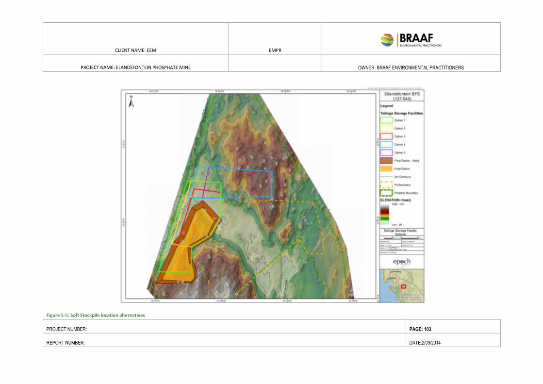
CLIENT NAME: EEM EMPR
PROJECT NAME: ELANDSFONTEIN PHOSPHATE MINE
OWNER: BRAAF ENVIRONMENTAL PRACTITIONERS
PROJECT NUMBER: PAGE: 103
REPORT NUMBER: DATE:2/09/2014
Figure 5-5: Soft Stockpile location alternatives
CLIENT NAME: EEM EMPR
PROJECT NAME: ELANDSFONTEIN PHOSPHATE MINE
OWNER: BRAAF ENVIRONMENTAL PRACTITIONERS
PROJECT NUMBER: PAGE: 104
REPORT NUMBER: DATE:2/09/2014
Hydrology
There is a poorly defined drainage channel that is orientated towards the south of the mine area within the pit.
It is unlikely that there is any significant surface water flow in the channel and that the movement of water
within the channel is relatively insignificant and is as subsurface flow. As there is no visible aquatic ecosystem
associated with the channel, no freshwater mitigation measures would be required on site.
Geohydrology
The mine will be located on top of two aquifers, one the Upper (unconfined) and the Lower (confined) Aquifer
Unit. The stormwater management measures and waste management mitigation measures for reducing in pit
pollution and subsequent impact on groundwater resources. Design measures must take cognisance of the
groundwater aspects.
Visual
The proposed open pit would be located within the valley and would therefore not be visible from the
R27/R45 but will be visible from the adjacent WCNP along the southern boundary of the pit. A suitable buffer
must be implemented between the boundary of 5m high berm with vegetation removed during clearing of the
mine pit at angle of repose (about 35degrees), along the southeastern around the pit where it borders
adjacent properties.
Summary of Preferred Options
In light of the aforementioned comments, together with the technical limitations to the dimensions of the
open pit, the location of the pit will not be moved. However, to minimise the potential visual impact on the
surrounds (i.e. adjacent neighbours) a vegetated berm will be established on the boundary of the pit along the
southern end while maintaining a technically safe slope angle.
5.6. SUMMARY OF ALTERNATIVES
During the mining right application process, a suite of project alternatives were considered, such as:
Location alternatives for various major infrastructure components
Product handling and Transport Alternatives
Access alternatives
Mine Power Route Alternatives
Pit Dewatering Alternatives
Process Water Alternatives
The final list of alternatives that were considered is tabulated below. A tabulated summary of the various
alternatives considered during the Scoping process together with the reasons why these have been screened
out is presented in Table 5-2 below as well as the preferred alternatives considered and taken forward for
detailed impact assessment refer to Final Layout Plan included in Figure 4-8
CLIENT NAME: EEM EMPR
PROJECT NAME: ELANDSFONTEIN PHOSPHATE MINE
OWNER: BRAAF ENVIRONMENTAL PRACTITIONERS
PROJECT NUMBER: PAGE: 105
REPORT NUMBER: DATE:2/09/2014
Table 5-2: Summary of alternatives screened out and preferred options (highlighted in blue) taken to detailed impact assessment
Alternative Type Alternative Motivation as to why alternative was screened out or is now
preferred
Location Alternatives
Inland Port Site Site 1: Location of a portion of the processing plant at an
Inland Port Site - The inland port facility will contain a
concentrate thickener and pressure filter to dewater the
concentrate, and a silo and truck loading facility for final
storage ahead of ship loading. The administrative offices,
laboratories, clinic and training and induction centre will be
located at the inland port site.
Subsequent investigations has shown that pumping the ore
concentrate in a pipeline extending 18.5 km through properties
held by 5 different land owners and crossing below the R27 and
R45 was no longer favoured as it would generate the same number
of trucks as the product being trucked directly from the mine to
the port. The direct trucking option is a more feasible option for
EEM.
The specialist studies have indicated that discretionary
infrastructure (buildings, stockpiles, stores, roads, etc.), should be
concentrated in the Low and Medium Sensitivity, and should be as
close to the mine area as possible, and occupy as small an area as
possible. For this reason the current mine layout has concentrated
infrastructure around the main area of impact to minimise the
overall footprint.
Locate all infrastructure on mine
application area (Elandsfontein
Farm)
Site 2: Locate all mine infrastructure, processing plant and
buildings on Portions 4 and 2 of Farm 349, Elandsfontein
Mine Access Alternatives
The Elandsfontein mine site can be
accessed by three proclaimed public
roads:
Route 1: OP05544 (via Hopefield) – 19km
In considering main access to the site, the shortest, most
direct route has desired. In addition, it has been repeatedly
requested that the mine access opens up an employment
opportunity for the residents of Hopefield..
Therefore, despite a number of public roads being available, the
preferred route currently runs directly north of the property,
joining the R45 near Hopefield, with an approximate distance of 9
km
CLIENT NAME: EEM EMPR
PROJECT NAME: ELANDSFONTEIN PHOSPHATE MINE
OWNER: BRAAF ENVIRONMENTAL PRACTITIONERS
PROJECT NUMBER: PAGE: 106
REPORT NUMBER: DATE:2/09/2014
Alternative Type Alternative Motivation as to why alternative was screened out or is now
preferred
Route 2: OP05545 (via the R45 near Langebaanweg) – 12km
Route 3: OP05546 (via the R27) – 9.5km. Currently, being
used for access to the farm.
This route runs from the R27 through SANParks property and is
therefore not an option to pursue as an access road.
Route 4: The fourth access proposal investigated is the
construction of a nine km long access road which largely
follows existing servitudes over three farms to the north of
the mine connecting to TR21/2 (R45), at a point about 13km
from Hopefield.
Reasons’ making this option preferred is the fact that it provides a
link from the mine to Hopefield, a request from the SBM and
secondly, unlike the option OP05546, which runs from the R27
through SANParks property to the mine property, the proposed
access route largely follows existing servitudes.
Concentrate Transport Alternatives
Rail Transport Route 1: Mine Site to Hopefield The first rail option
considered the construction of a rail line connecting the mine
site to the existing Spoornet rail way line in Hopefield, for
transfer to the port site.
The routing of the new rail way line needed to cross SANParks land
however, and an immediate alternative was considered. In
addition, there was a possibility that the rail line may have to cross
the Sout River en route to Hopefield. This option was therefore
excluded due to its potential negative impacts.
Route 2: The construction of a new railway line from the
mine site to Saldanha was then considered, and traded off
against a similar routing for a haul road, to be used by trucks
or road trains.
The available routes would cross through agricultural land, causing
negative impacts for the landowners, including increased noise and
dust, and undesirable visual impacts. The haul roads or rail lines
would also need to cross several provincial roads.
CLIENT NAME: EEM EMPR
PROJECT NAME: ELANDSFONTEIN PHOSPHATE MINE
OWNER: BRAAF ENVIRONMENTAL PRACTITIONERS
PROJECT NUMBER: PAGE: 107
REPORT NUMBER: DATE:2/09/2014
Alternative Type Alternative Motivation as to why alternative was screened out or is now
preferred
Conveyor transport DRA International (Pty) Ltd was then commissioned to
investigate further alternatives, with a primary objective of
reducing overall environmental impact. In this study, a
number of conveyor technologies (conventional belt, rope
conveyor and pipe conveyor) were considered, and
compared to the option of pumping a slurry from the mine
site to the inland port. Although the conveyor belts offered a
number of significant advantages over the haul road and rail
options, the pipe line was recommended. The pipe line
alternative requires a narrow servitude between the mine
and port site, simpler road crossings, and reduced noise, dust
and visual impacts. The pipeline would comprise a 250NB
HDPE pipeline will be suitable for slurry transport. The slurry
will be pumped using a series of six high pressure centrifugal
pumps, located at the mine. A 200NB return water pipeline
would be required for returning the thickener overflow and
filtrate to the plant process.
Some of the benefits of the direct trucking route are highlighted
below:
The pipeline length was 18.5km from mine site to the
inland port. The route crossed through properties held by
5 different land owners. The pipe line would need to be
accessed by a service road which would need to run
parallel to the pipeline for the entire distance. The
pipeline also needed to be jacked under three provincial
roads (the R27, Langebaanweg Road and TR45). The direct
trucking route would make use of the mine access road,
which would have been constructed in the pumping
solution.
For the pumping option the concentrate would be
transported to an inland port facility for dewatering and
storage. From the inland port storage facility, the
concentrate would be trucked 8.5km to the multi-purpose
terminal. In the direct trucking option the distance
travelled will be 30km from the intersection from the
mine access road and the R45, to port.
The number of trucks required for both options will
remain unchanged
The direct trucking option can save the project the capital
expenditure associated with the pipeline and the inland
Road Transport Elandsfontein Exploration and Mining have investigated a
number of concentrate transport options. The most recent
trade off study showed that the pumping of the concentrate
to an inland port site had a lower environmental impact and
was more cost effective than any of the previous methods
investigated.
CLIENT NAME: EEM EMPR
PROJECT NAME: ELANDSFONTEIN PHOSPHATE MINE
OWNER: BRAAF ENVIRONMENTAL PRACTITIONERS
PROJECT NUMBER: PAGE: 108
REPORT NUMBER: DATE:2/09/2014
Following the receipt of some new information, another
option was investigated. This involved the loading of trucks
(containerized trucks) at the mine site for transportation of
the concentrate directly to the port.
port, to the order of R270 million.
Alternative Type Alternative Motivation as to why alternative was screened out or is now
preferred
Power Supply Alternatives Four power supply alternatives were considered by
Elandsfontein.
Each option was evaluated against four criteria:
• Line length, space on existing servitudes or
corridors, environmental foot print
• Stability of power supply
• Expected delivery date of power supply
• Cost of power supply to mine
The loop in – loop out option has been selected as the preferred
alternative, scoring the highest on all four evaluation criteria.
In addition, two alternatives were investigated regarding the
location of the substation. The first option was to locate the
substation nearer to the loop in loop out connection. Further
investigation has now indicated that to minimise the overall
footprint outside of the direct area which will be affected by
mining it is preferred that the substation be located as close to the
plant and pit. In this way the mine footprint will be restricted to
the mine application area in close proximity to the area to be
directly affected by mining activities.
Option 1: A 66kV supply from Blouwater Substation (20km
line length)
Option 2: A 132kV supply from Aurora Substation (10km line
length)
Option 3: 66kV line from Hopefield Substation (13 km line
length)
Option 4: Loop In – Loop Out from 132kV Aurora
Moorreesburg line (4km line length)
Pit Dewatering Alternatives
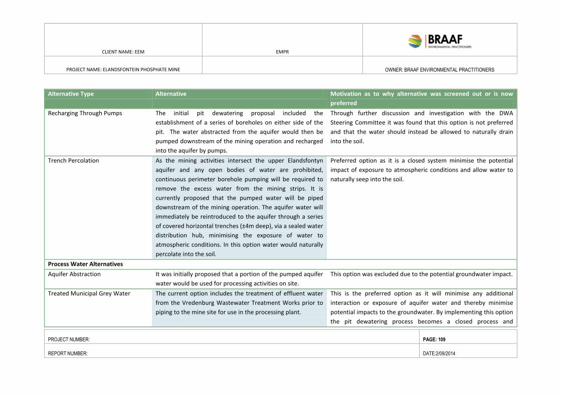
CLIENT NAME: EEM EMPR
PROJECT NAME: ELANDSFONTEIN PHOSPHATE MINE
OWNER: BRAAF ENVIRONMENTAL PRACTITIONERS
PROJECT NUMBER: PAGE: 109
REPORT NUMBER: DATE:2/09/2014
Alternative Type Alternative Motivation as to why alternative was screened out or is now
preferred
Recharging Through Pumps The initial pit dewatering proposal included the
establishment of a series of boreholes on either side of the
pit. The water abstracted from the aquifer would then be
pumped downstream of the mining operation and recharged
into the aquifer by pumps.
Through further discussion and investigation with the DWA
Steering Committee it was found that this option is not preferred
and that the water should instead be allowed to naturally drain
into the soil.
Trench Percolation As the mining activities intersect the upper Elandsfontyn
aquifer and any open bodies of water are prohibited,
continuous perimeter borehole pumping will be required to
remove the excess water from the mining strips. It is
currently proposed that the pumped water will be piped
downstream of the mining operation. The aquifer water will
immediately be reintroduced to the aquifer through a series
of covered horizontal trenches (±4m deep), via a sealed water
distribution hub, minimising the exposure of water to
atmospheric conditions. In this option water would naturally
percolate into the soil.
Preferred option as it is a closed system minimise the potential
impact of exposure to atmospheric conditions and allow water to
naturally seep into the soil.
Process Water Alternatives
Aquifer Abstraction It was initially proposed that a portion of the pumped aquifer
water would be used for processing activities on site.
This option was excluded due to the potential groundwater impact.
Treated Municipal Grey Water The current option includes the treatment of effluent water
from the Vredenburg Wastewater Treatment Works prior to
piping to the mine site for use in the processing plant.
This is the preferred option as it will minimise any additional
interaction or exposure of aquifer water and thereby minimise
potential impacts to the groundwater. By implementing this option
the pit dewatering process becomes a closed process and
CLIENT NAME: EEM EMPR
PROJECT NAME: ELANDSFONTEIN PHOSPHATE MINE
OWNER: BRAAF ENVIRONMENTAL PRACTITIONERS
PROJECT NUMBER: PAGE: 110
REPORT NUMBER: DATE:2/09/2014
minimises exposure of the aquifer water to atmospheric conditions
prior to recharging.
CLIENT NAME: EEM EMPR
PROJECT NAME: ELANDSFONTEIN
PHOSPHATE MINE
OWNER: BRAAF ENVIRONMENTAL
PRACTITIONERS
PROJECT NUMBER: PAGE: 111
REPORT NUMBER: DATE:2/09/2014
5.7. MODIFICATION OF PROJECT DESIGN AND LAYOUT
Based on the aforementioned screening process, a project layout was developed and distributed to the
specialist team. The specialists undertook their impact assessments based on the initial layout plan (refer to
Figure 5-1). Based on the initial findings of the specialist studies, the following changes as indicated by
specialists, consultation with stakeholders and best practice design and technological requirements were
made:
Concentrate mine infrastructure and ancillary services close to the mine area as possible and on low
to medium sensitivity areas;
Locate components with height in lower lying areas/depressions;
Decrease in size of the softs stockpile from to 61 hectares to 14.9 hectares.
Note that each specialist has been requested to confirm the aforementioned refinements to the project
design, in relation to their specialist impact assessment. It was confirmed that all specialist findings and impact
ratings were not going to change, as compared to the impacts assessed against the initial layout plan.
The final layout plan, which reflects the concentration of the plant and stockpiles around the pit and increase
in footprint of the softs stockpile was compiled, in which Report is based on is included as Figure 4-8..
5.8. COMPARATIVE ANALYSIS OF ALTERNATIVES FROM THE MINING RIGHT
APPLICATION PHASE (SCOPING TO EIA/EMP)
Based on a review of the alternatives considered during the application process, the proposed location of the
following infrastructure is consistent (i.e. on the main mine site) as presented to date:
Open pit;
Softs Stockpile;
Mine Buildings;
Powerline;
Portion of Processing Plant; and
Stormwater Dam.
There have been a number of changes from the original design to the final design plan which is now being
assessed. The original design included, a pollution control dam and a tailings dam, which no longer form part
of the mine infrastructure.
In light of the design changes the overall location of the mine infrastructure and plant is still contained within
the 942 ha application area but have been moved further southward. Based on the design changes the
biodiversity sensitivities (botanical sensitivity), and topographical characteristics have been taken into
consideration when siting the components with height, such as the softs stockpile. All elements of the mine
with height have been located on areas with medium sensitivity and on the lower lying areas. The new mine
CLIENT NAME: EEM EMPR
PROJECT NAME: ELANDSFONTEIN
PHOSPHATE MINE
OWNER: BRAAF ENVIRONMENTAL
PRACTITIONERS
PROJECT NUMBER: PAGE: 112
REPORT NUMBER: DATE:2/09/2014
infrastructural components and the plant is consistent with the technical requirement to locate these
elements within close proximity to each other for optimization purposes and to minimise the overall footprint.
5.9. NO PROJECT ALTERNATIVE
In terms of the No-Go option, the current status land use Farm 349/4 and Farm 349/2 will remain agricultural
and the landowner may look to develop commercial farming. Although the farm was previously operated as a
private nature reserve with tourism facilities (a lodge) it is no longer operational. The No- Go option could also
potentially mean that the large area currently under investigation for off sets (up to 4,000ha) would be lost for
conservation.
It must however be noted that current activities on the land includes prospecting which was awarded to
Elandsfontein Exploration and Mining (Pty) Ltd in 2013 by the DMR. The land was also re-zoned in accordance
with the Saldanha Bay Municipality.
The no-go alternative will also be considered, in which the status quo for the area will remain. The economic
and social impacts of mining on the current and future conservation activities will also be considered.
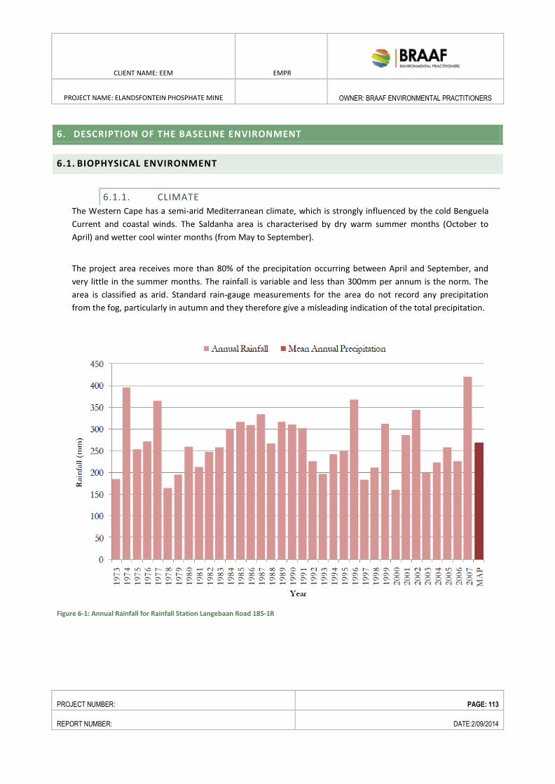
CLIENT NAME: EEM EMPR
PROJECT NAME: ELANDSFONTEIN PHOSPHATE MINE
OWNER: BRAAF ENVIRONMENTAL PRACTITIONERS
PROJECT NUMBER: PAGE: 113
REPORT NUMBER: DATE:2/09/2014
6. DESCRIPTION OF THE BASELINE ENVIRONMENT
6.1. BIOPHYSICAL ENVIRONMENT
6.1.1. CLIMATE
The Western Cape has a semi-arid Mediterranean climate, which is strongly influenced by the cold Benguela
Current and coastal winds. The Saldanha area is characterised by dry warm summer months (October to
April) and wetter cool winter months (from May to September).
The project area receives more than 80% of the precipitation occurring between April and September, and
very little in the summer months. The rainfall is variable and less than 300mm per annum is the norm. The
area is classified as arid. Standard rain-gauge measurements for the area do not record any precipitation
from the fog, particularly in autumn and they therefore give a misleading indication of the total precipitation.
Figure 6-1: Annual Rainfall for Rainfall Station Langebaan Road 185-1R
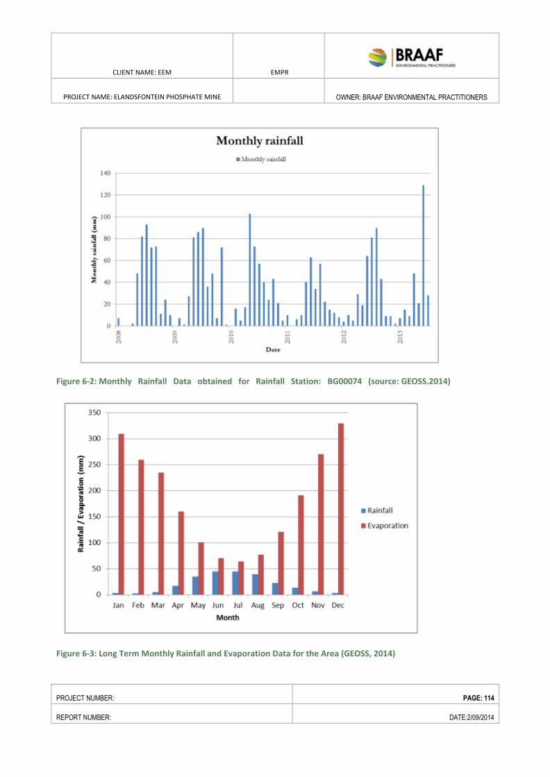
CLIENT NAME: EEM EMPR
PROJECT NAME: ELANDSFONTEIN PHOSPHATE MINE
OWNER: BRAAF ENVIRONMENTAL PRACTITIONERS
PROJECT NUMBER: PAGE: 114
REPORT NUMBER: DATE:2/09/2014
Figure 6-2: Monthly Rainfall Data obtained for Rainfall Station: BG00074 (source: GEOSS.2014)
Figure 6-3: Long Term Monthly Rainfall and Evaporation Data for the Area (GEOSS, 2014)
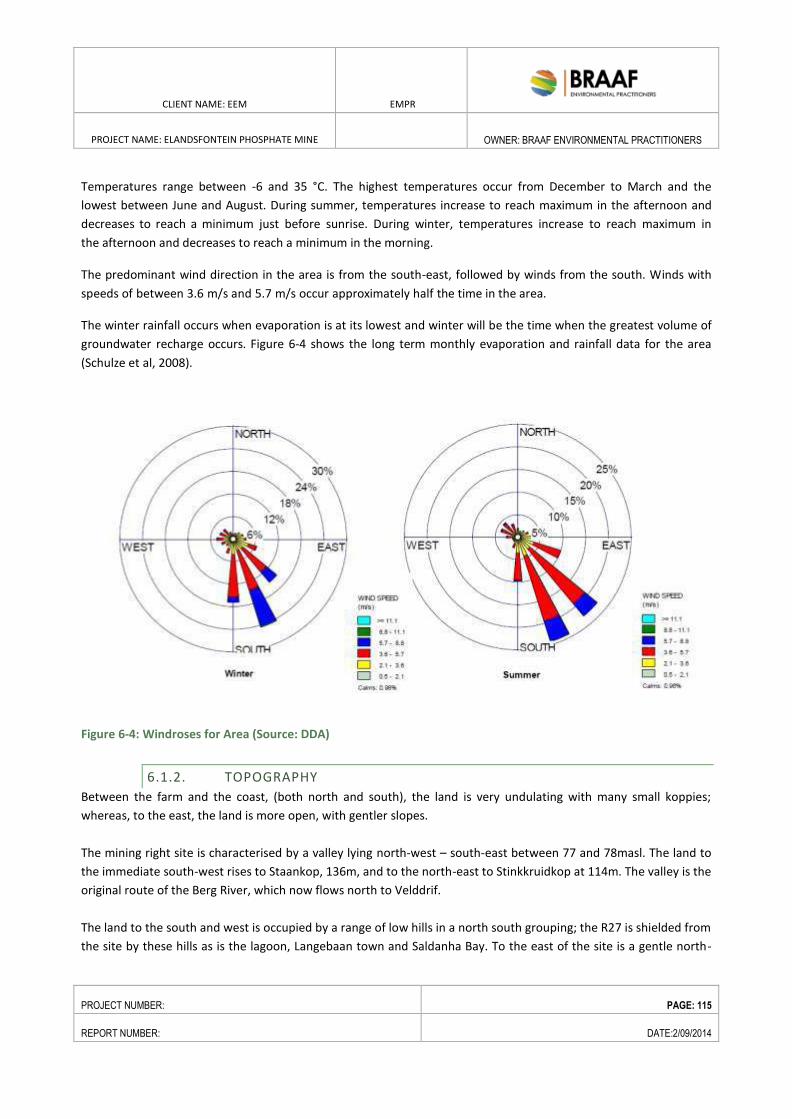
CLIENT NAME: EEM EMPR
PROJECT NAME: ELANDSFONTEIN PHOSPHATE MINE
OWNER: BRAAF ENVIRONMENTAL PRACTITIONERS
PROJECT NUMBER: PAGE: 115
REPORT NUMBER: DATE:2/09/2014
Temperatures range between -6 and 35 °C. The highest temperatures occur from December to March and the
lowest between June and August. During summer, temperatures increase to reach maximum in the afternoon and
decreases to reach a minimum just before sunrise. During winter, temperatures increase to reach maximum in
the afternoon and decreases to reach a minimum in the morning.
The predominant wind direction in the area is from the south-east, followed by winds from the south. Winds with
speeds of between 3.6 m/s and 5.7 m/s occur approximately half the time in the area.
The winter rainfall occurs when evaporation is at its lowest and winter will be the time when the greatest volume of
groundwater recharge occurs. Figure 6-4 shows the long term monthly evaporation and rainfall data for the area
(Schulze et al, 2008).
Figure 6-4: Windroses for Area (Source: DDA)
6.1.2. TOPOGRAPHY
Between the farm and the coast, (both north and south), the land is very undulating with many small koppies;
whereas, to the east, the land is more open, with gentler slopes.
The mining right site is characterised by a valley lying north-west – south-east between 77 and 78masl. The land to
the immediate south-west rises to Staankop, 136m, and to the north-east to Stinkkruidkop at 114m. The valley is the
original route of the Berg River, which now flows north to Velddrif.
The land to the south and west is occupied by a range of low hills in a north south grouping; the R27 is shielded from
the site by these hills as is the lagoon, Langebaan town and Saldanha Bay. To the east of the site is a gentle north-
CLIENT NAME: EEM EMPR
PROJECT NAME: ELANDSFONTEIN PHOSPHATE MINE
OWNER: BRAAF ENVIRONMENTAL PRACTITIONERS
PROJECT NUMBER: PAGE: 116
REPORT NUMBER: DATE:2/09/2014
south ridge to 105masl, beyond which, further east, is Hopefield. Hopefield lies in the Soutrivier valley at 20 to 60m
elevation.
6.1.3. GEOLOGY
The Elandsfontein phosphate deposit occurs in the known mineralised Varswater Formation that is present along
the west coast of South Africa between Cape Hangklip in the southeast to Elands Bay in the northeast. Phosphate
mineralisation was initially identified by Samancor in 1985. The company drilled 28 RC boreholes which were
analysed for P2O5 and described. The average thickness of P2O5 mineralisation varies between 6.0m and 26.0m.
6.1.3.1. REGIONAL GEOLOGY
The regional geology is marked by the presence of numerous outcrops of Cambrian/Neoproterozoic granites of
the Cape Suite, and Tertiary/Quaternary sediments consisting of calcareous aeolian sands, calcretes and
phoscretes. Regionally extensive outcrops of the Malmesbury Group occur to the west near Saldanha and
granites of the Darling pluton in the south. The area immediately surrounding the property is however covered
by calcrete ridges and aeolian sand with a surface expression of a relatively flat relief. The Elandsfontein property
represents a palaeo-basin setting that has been filled up with a sequence of sedimentary units. Historical drilling
indicated the presence of marine and fluvial sequences represented by the Elandsfontein and Varswater
Formations. More recent sediments are represented by the Pliocene Langebaan Formation and Quaternary
Witzand Formation, which represent the current surface geology.
The phosphate deposits of the South African continental margin and coastal terrace were described in detail by
Birch (1961), who indicated that diagenetic phosphorites are ubiquitous in the western and southern margins of
South Africa. According to Birch (1961), authigenic phosphorites form in shallow estuaries or embayments, in
environments of intense, wind-generated upwelling and high biological productivity. In such conditions, phosphate-
rich sediments deposit into the sea floor by decay of siliceous phytoplankton, which facilitates the interstitial
precipitation of apatite to form phosphatic packstones and oolitic pellets at the water-sediment inter-phase.
6.1.3.2. LOCAL GEOLOGY
The lithostratigraphic units in the Elandsfontein region are combined as the Sandveld Group, which is present
from Cape Hangklip in the southeast to Elands Bay in the northwest. This sedimentary group overlies the pre-
Mesozoic basement rocks of the Malmesbury Group and the Cape Granite Suite.
The naming of the Formations and Member units has been changed in recent years, in accordance with
Roberts (2006), whom applied the Member names for sub-units as previously defined by Tankard (1974). Three
Formations are present at Elandsfontein:
Elandsfontyn Formation (oldest)
Varswater Formation
CLIENT NAME: EEM EMPR
PROJECT NAME: ELANDSFONTEIN PHOSPHATE MINE
OWNER: BRAAF ENVIRONMENTAL PRACTITIONERS
PROJECT NUMBER: PAGE: 117
REPORT NUMBER: DATE:2/09/2014
Langebaan Formation and
Witzand Formation (youngest).
The Varswater Formation has in turn been divided into four sub-units namely,
the Langeenheid Clay Member;
the Konings Vlei Clay Member;
the Langeberg Quartzose Sand Member ;and
the Muishond Fontein.
Figure 6-5 presents a stylised stratigraphic succession for the proposed Project area, with specific detail of the
Elandsfontein ore body that is targeted in this Project.
The following section describes the formations and members of the Varswater Formation.
6.1.3.3. WITZAND FORMATION
The Witzand Formation is the youngest formation present at Elandsfontein. It is made up of unconsolidated
aeolian material and is part of the same depositional system which led to the deposition of the underlying
Langebaan Member of the Sandveld Group. Mass movement of beach sand is thought to have periodically
occurred during regression. The prevailing southerly winds transported the beach sand inland as dunes.
However, the most recent transport event is thought to have occurred during a mid-Holocene high sea-level
stand, when sand eroded from previously stabilised dunes. The base of the Witzand Formation is in contact
with the Langebaan Formation.
6.1.3.4. LANGEBAAN FORMATION
The calcarenites of the Langebaan Formation, of Pliocene age, are found from sea level to altitudes exceeding
200m amsl. It forms extensive areas of undulating topography which rises inland to a broad sandy plain
that extends towards Hopefield. The Langebaan Formation rests on the Varswater Formation and is in turn,
locally overlain by the Witzand Formation. Sediments of the Formation accumulated during the last glacial
lowering of the sea-level when large tracks of un-vegetated land were exposed on exposed sea floor.
The Langebaan Formation is generally medium grained and slightly greyish to cream coloured with quartz
grains and shell fragments clearly visible. It can be coarse or gritty to extremely fine grained and the
degree of sedimentation and hardness of the rock is variable. Outcrops along the Langebaan Lagoon
display large-scale cross-bedding. Prevailing southerly palaeowinds are clearly indicated by the cross-bedding
and consensus exists that most of the Langebaan Formation accumulated during the last lowering of the sea
level when the sand was exposed to the southerly winds. The absence of marine shells in most
outcrops point to a coastline that was located considerably further to the south.
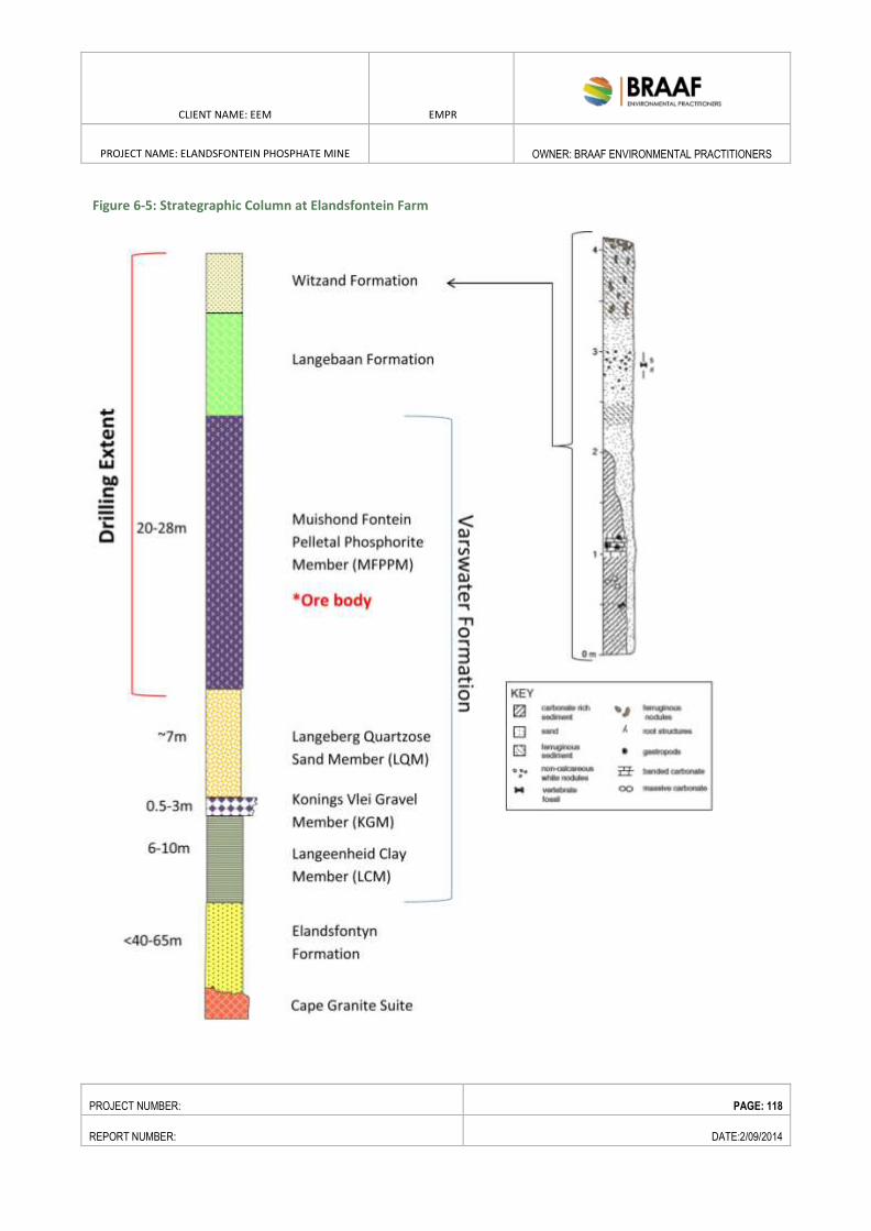
CLIENT NAME: EEM EMPR
PROJECT NAME: ELANDSFONTEIN PHOSPHATE MINE
OWNER: BRAAF ENVIRONMENTAL PRACTITIONERS
PROJECT NUMBER: PAGE: 118
REPORT NUMBER: DATE:2/09/2014
Figure 6-5: Strategraphic Column at Elandsfontein Farm
CLIENT NAME: EEM EMPR
PROJECT NAME: ELANDSFONTEIN PHOSPHATE MINE
OWNER: BRAAF ENVIRONMENTAL PRACTITIONERS
PROJECT NUMBER: PAGE: 119
REPORT NUMBER: DATE:2/09/2014
6.1.3.5. MUISHOND FONTEIN PELLATAL PHOSPHATE MEMBER (MFPPM) -VARSWATER
FORMATION
The MFPPM, which in places rest directly on the KGM or on the Elandsfontyn Formation, was deposited
during an Early Pliocene transgression. Cold temperatures prevailed during this period.
The unit consists of very fine to medium grained quartz sand which is characterized by rounded and
polished grains and includes up to 20% P2O5. The apatite (phosphate minerals) pellets are rounded or
elliptical and have both concentric and erosional features. The phosphates indicate marine, littoral and
fluviatile depositional environments for the Member. This member is expected to be the primary target for
the phosphate exploration drilling.
6.1.3.6. LANGEBERG QUARTZOSE MEMBER (LQM) – VARSWATER FORMATION
These deposits were laid down during an early stage in the Early Pliocene transgression (5 Ma). The unit is
approximately is thin at Elandsfontein and consist of fine to coarse grained, non-phosphatic sand.
At the time of LQM deposition a channel formed to the north that linked Saldanha Bay with St Helena Bay,
with the high ground in the Saldanha-Vredenburg area forming a series of islands which sheltered the
mainland from the sea. The paleo Berg River met this channel from the east where the river’s estuary was
separated from the channel by a sand bar. Subsequent deposits formed an estuarine complex consisting of
flood plain salt marshes and tidal flat deposits which include quartzose sands, peats and clays.
6.1.3.7. KONINGS VLEI GRAVEL MEMBER (KGM) – VARSWATER FORMATION
This conglomeratic phosphorite was first described from occurrences in a mining quarry at Langebaanweg.
Sediments consist of a 0.5m – 3m conglomerate which includes abraded primary and secondary phosphatic
material and a semi-consolidated sand matrix. This member is poorly developed at Elandsfontein.
The deposition of the KGM reflects a marine transgression in the Middle Miocene which succeeded the
fluviatile deposits of the Elandsfontyn Formation. Fossils present in the Member indicate warmer water
conditions, when compared to present conditions, and indicates an age dating to the Miocene-Pliocene.
6.1.3.8. LANGEENHEID CLAY MEMBER (LCM) – VARSWATER FORMATION
This member forms the lowermost unit of the Varswater Formation and consists mostly of clayey sands. The
LCM has only recently been classified as a Member and seems to be absent on the Elandsfontein Property.
An age of Middle to Late Miocene can be assumed for this unit.
Regionally, sediments consist of inter-tidal kaolinitic clays and clayey sands with a combined thickness of
approximately 6m to 10m. The LCM was deposited after the Elandsfontyn Formation and represents a
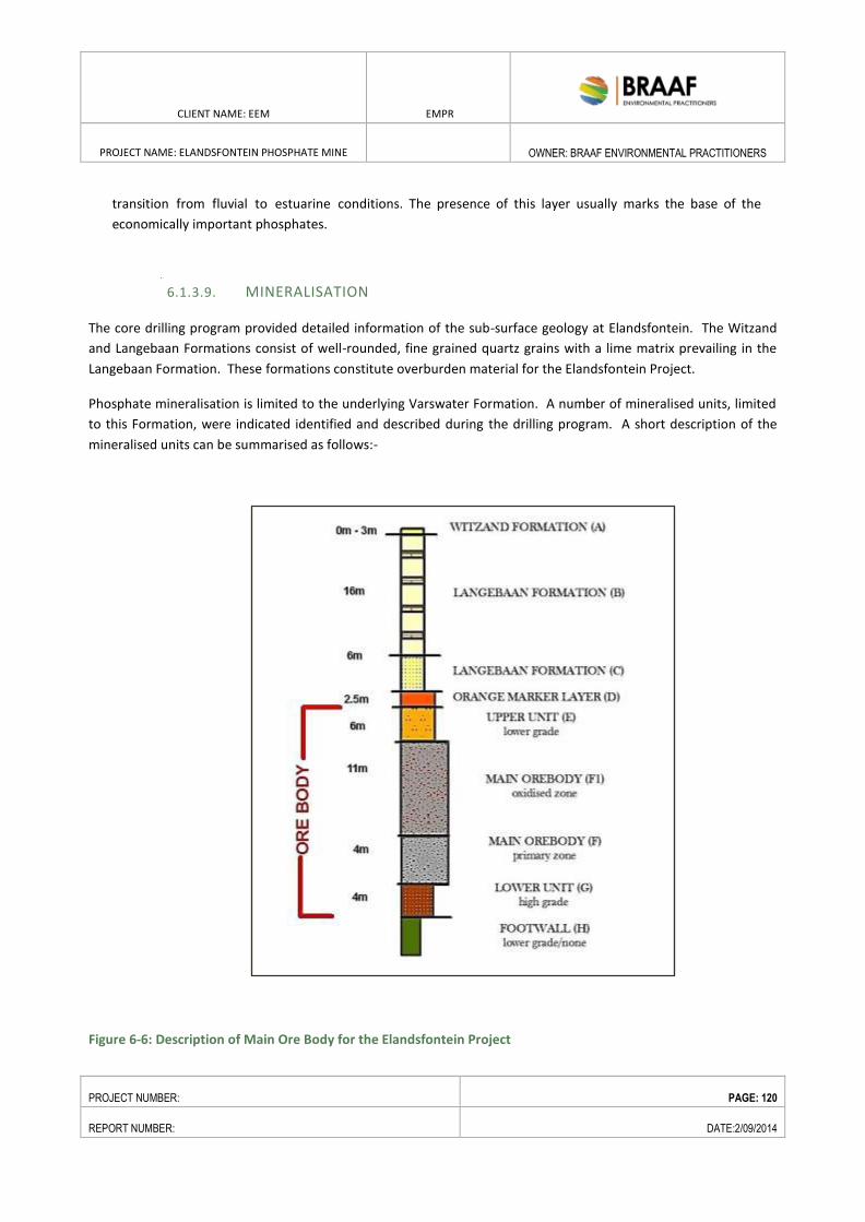
CLIENT NAME: EEM EMPR
PROJECT NAME: ELANDSFONTEIN PHOSPHATE MINE
OWNER: BRAAF ENVIRONMENTAL PRACTITIONERS
PROJECT NUMBER: PAGE: 120
REPORT NUMBER: DATE:2/09/2014
transition from fluvial to estuarine conditions. The presence of this layer usually marks the base of the
economically important phosphates.
6.1.3.9. MINERALISATION
The core drilling program provided detailed information of the sub-surface geology at Elandsfontein. The Witzand
and Langebaan Formations consist of well-rounded, fine grained quartz grains with a lime matrix prevailing in the
Langebaan Formation. These formations constitute overburden material for the Elandsfontein Project.
Phosphate mineralisation is limited to the underlying Varswater Formation. A number of mineralised units, limited
to this Formation, were indicated identified and described during the drilling program. A short description of the
mineralised units can be summarised as follows:-
Figure 6-6: Description of Main Ore Body for the Elandsfontein Project
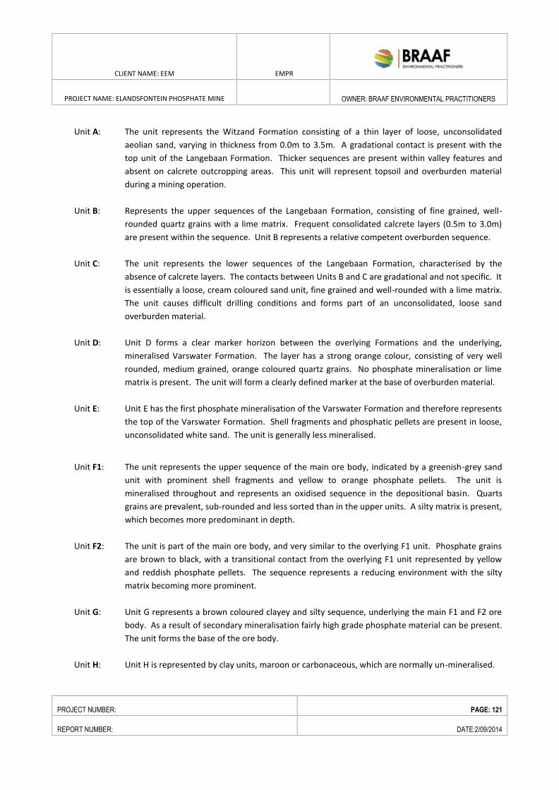
CLIENT NAME: EEM EMPR
PROJECT NAME: ELANDSFONTEIN PHOSPHATE MINE
OWNER: BRAAF ENVIRONMENTAL PRACTITIONERS
PROJECT NUMBER: PAGE: 121
REPORT NUMBER: DATE:2/09/2014
Unit A: The unit represents the Witzand Formation consisting of a thin layer of loose, unconsolidated
aeolian sand, varying in thickness from 0.0m to 3.5m. A gradational contact is present with the
top unit of the Langebaan Formation. Thicker sequences are present within valley features and
absent on calcrete outcropping areas. This unit will represent topsoil and overburden material
during a mining operation.
Unit B: Represents the upper sequences of the Langebaan Formation, consisting of fine grained, well-
rounded quartz grains with a lime matrix. Frequent consolidated calcrete layers (0.5m to 3.0m)
are present within the sequence. Unit B represents a relative competent overburden sequence.
Unit C: The unit represents the lower sequences of the Langebaan Formation, characterised by the
absence of calcrete layers. The contacts between Units B and C are gradational and not specific. It
is essentially a loose, cream coloured sand unit, fine grained and well-rounded with a lime matrix.
The unit causes difficult drilling conditions and forms part of an unconsolidated, loose sand
overburden material.
Unit D: Unit D forms a clear marker horizon between the overlying Formations and the underlying,
mineralised Varswater Formation. The layer has a strong orange colour, consisting of very well
rounded, medium grained, orange coloured quartz grains. No phosphate mineralisation or lime
matrix is present. The unit will form a clearly defined marker at the base of overburden material.
Unit E: Unit E has the first phosphate mineralisation of the Varswater Formation and therefore represents
the top of the Varswater Formation. Shell fragments and phosphatic pellets are present in loose,
unconsolidated white sand. The unit is generally less mineralised.
Unit F1: The unit represents the upper sequence of the main ore body, indicated by a greenish-grey sand
unit with prominent shell fragments and yellow to orange phosphate pellets. The unit is
mineralised throughout and represents an oxidised sequence in the depositional basin. Quarts
grains are prevalent, sub-rounded and less sorted than in the upper units. A silty matrix is present,
which becomes more predominant in depth.
Unit F2: The unit is part of the main ore body, and very similar to the overlying F1 unit. Phosphate grains
are brown to black, with a transitional contact from the overlying F1 unit represented by yellow
and reddish phosphate pellets. The sequence represents a reducing environment with the silty
matrix becoming more prominent.
Unit G: Unit G represents a brown coloured clayey and silty sequence, underlying the main F1 and F2 ore
body. As a result of secondary mineralisation fairly high grade phosphate material can be present.
The unit forms the base of the ore body.
Unit H: Unit H is represented by clay units, maroon or carbonaceous, which are normally un-mineralised.
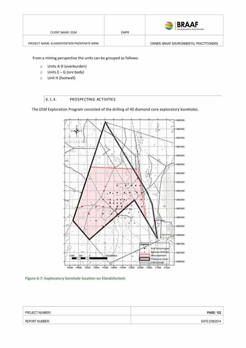
CLIENT NAME: EEM EMPR
PROJECT NAME: ELANDSFONTEIN PHOSPHATE MINE
OWNER: BRAAF ENVIRONMENTAL PRACTITIONERS
PROJECT NUMBER: PAGE: 122
REPORT NUMBER: DATE:2/09/2014
From a mining perspective the units can be grouped as follows:
o Units A-D (overburden)
o Units E – G (ore body)
o Unit H (footwall)
6.1.4. PROSPECTING ACTIVITIES
The EEM Exploration Program consisted of the drilling of 40 diamond core exploratory boreholes.
Figure 6-7: Exploratory borehole location on Elandsfontein
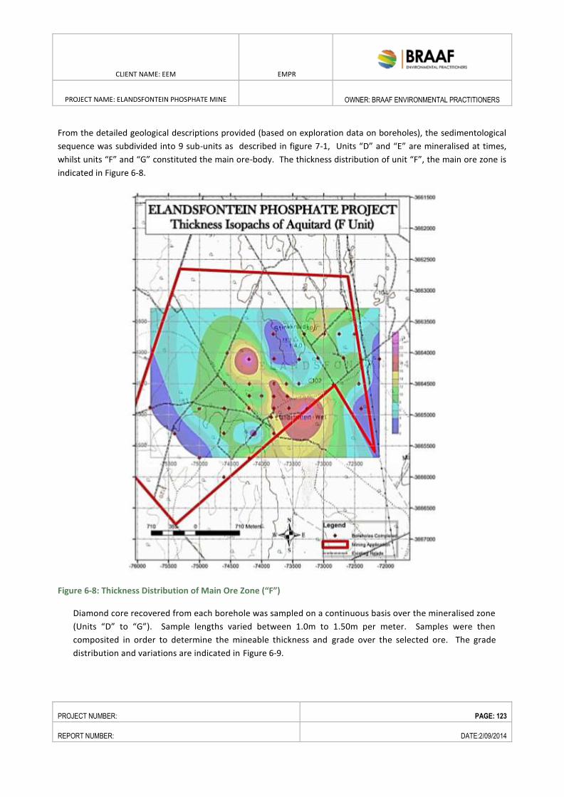
CLIENT NAME: EEM EMPR
PROJECT NAME: ELANDSFONTEIN PHOSPHATE MINE
OWNER: BRAAF ENVIRONMENTAL PRACTITIONERS
PROJECT NUMBER: PAGE: 123
REPORT NUMBER: DATE:2/09/2014
From the detailed geological descriptions provided (based on exploration data on boreholes), the sedimentological
sequence was subdivided into 9 sub-units as described in figure 7-1, Units “D” and “E” are mineralised at times,
whilst units “F” and “G” constituted the main ore-body. The thickness distribution of unit “F”, the main ore zone is
indicated in Figure 6-8.
Figure 6-8: Thickness Distribution of Main Ore Zone (“F”)
Diamond core recovered from each borehole was sampled on a continuous basis over the mineralised zone
(Units “D” to “G”). Sample lengths varied between 1.0m to 1.50m per meter. Samples were then
composited in order to determine the mineable thickness and grade over the selected ore. The grade
distribution and variations are indicated in Figure 6-9.
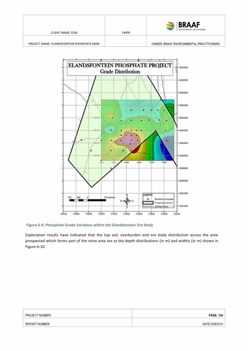
CLIENT NAME: EEM EMPR
PROJECT NAME: ELANDSFONTEIN PHOSPHATE MINE
OWNER: BRAAF ENVIRONMENTAL PRACTITIONERS
PROJECT NUMBER: PAGE: 124
REPORT NUMBER: DATE:2/09/2014
Figure 6-9: Phosphate Grade Variation within the Elandsfontein Ore Body
Exploration results have indicated that the top soil; overburden and ore body distribution across the area
prospected which forms part of the mine area are at the depth distributions (in m) and widths (in m) shown in
Figure 6-10.
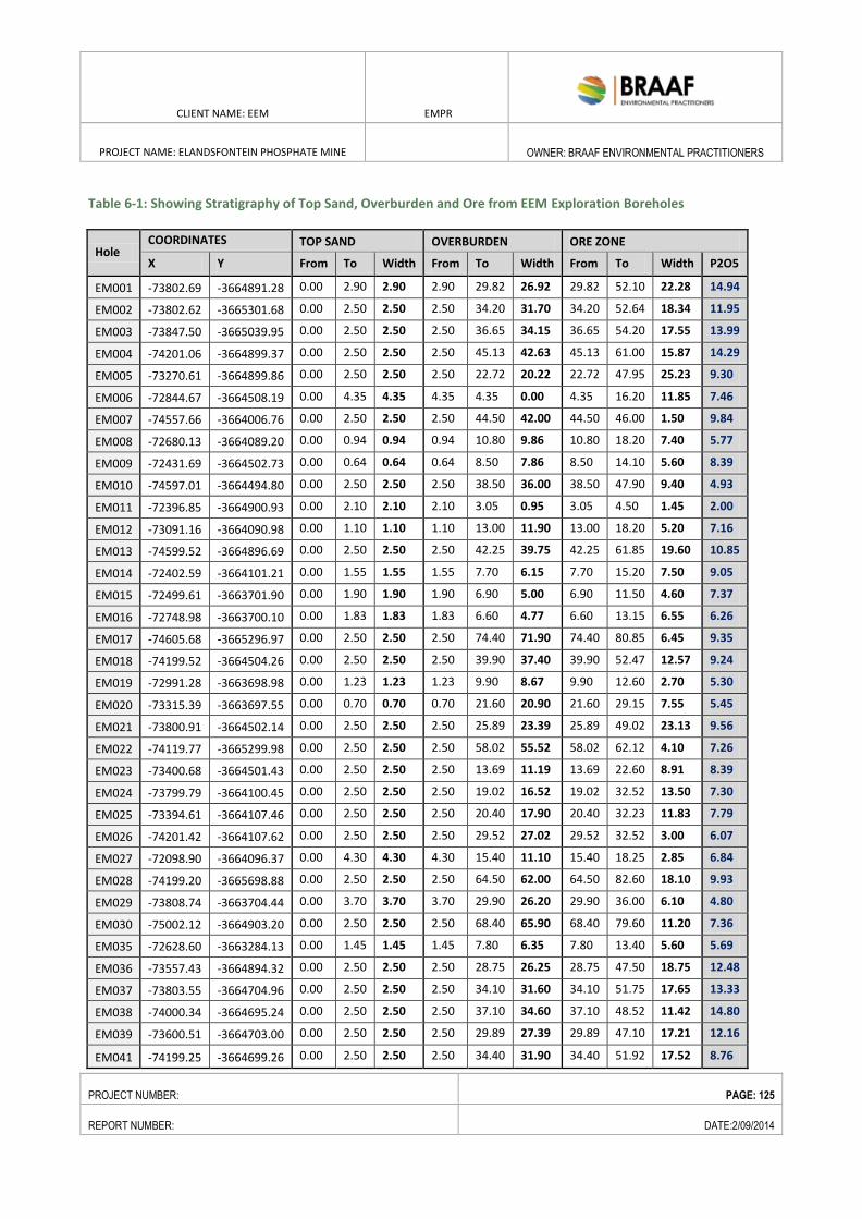
CLIENT NAME: EEM EMPR
PROJECT NAME: ELANDSFONTEIN PHOSPHATE MINE
OWNER: BRAAF ENVIRONMENTAL PRACTITIONERS
PROJECT NUMBER: PAGE: 125
REPORT NUMBER: DATE:2/09/2014
Table 6-1: Showing Stratigraphy of Top Sand, Overburden and Ore from EEM Exploration Boreholes
Hole COORDINATES TOP SAND OVERBURDEN ORE ZONE
X Y From To Width From To Width From To Width P2O5
EM001 -73802.69 -3664891.28 0.00 2.90 2.90 2.90 29.82 26.92 29.82 52.10 22.28 14.94
EM002 -73802.62 -3665301.68 0.00 2.50 2.50 2.50 34.20 31.70 34.20 52.64 18.34 11.95
EM003 -73847.50 -3665039.95 0.00 2.50 2.50 2.50 36.65 34.15 36.65 54.20 17.55 13.99
EM004 -74201.06 -3664899.37 0.00 2.50 2.50 2.50 45.13 42.63 45.13 61.00 15.87 14.29
EM005 -73270.61 -3664899.86 0.00 2.50 2.50 2.50 22.72 20.22 22.72 47.95 25.23 9.30
EM006 -72844.67 -3664508.19 0.00 4.35 4.35 4.35 4.35 0.00 4.35 16.20 11.85 7.46
EM007 -74557.66 -3664006.76 0.00 2.50 2.50 2.50 44.50 42.00 44.50 46.00 1.50 9.84
EM008 -72680.13 -3664089.20 0.00 0.94 0.94 0.94 10.80 9.86 10.80 18.20 7.40 5.77
EM009 -72431.69 -3664502.73 0.00 0.64 0.64 0.64 8.50 7.86 8.50 14.10 5.60 8.39
EM010 -74597.01 -3664494.80 0.00 2.50 2.50 2.50 38.50 36.00 38.50 47.90 9.40 4.93
EM011 -72396.85 -3664900.93 0.00 2.10 2.10 2.10 3.05 0.95 3.05 4.50 1.45 2.00
EM012 -73091.16 -3664090.98 0.00 1.10 1.10 1.10 13.00 11.90 13.00 18.20 5.20 7.16
EM013 -74599.52 -3664896.69 0.00 2.50 2.50 2.50 42.25 39.75 42.25 61.85 19.60 10.85
EM014 -72402.59 -3664101.21 0.00 1.55 1.55 1.55 7.70 6.15 7.70 15.20 7.50 9.05
EM015 -72499.61 -3663701.90 0.00 1.90 1.90 1.90 6.90 5.00 6.90 11.50 4.60 7.37
EM016 -72748.98 -3663700.10 0.00 1.83 1.83 1.83 6.60 4.77 6.60 13.15 6.55 6.26
EM017 -74605.68 -3665296.97 0.00 2.50 2.50 2.50 74.40 71.90 74.40 80.85 6.45 9.35
EM018 -74199.52 -3664504.26 0.00 2.50 2.50 2.50 39.90 37.40 39.90 52.47 12.57 9.24
EM019 -72991.28 -3663698.98 0.00 1.23 1.23 1.23 9.90 8.67 9.90 12.60 2.70 5.30
EM020 -73315.39 -3663697.55 0.00 0.70 0.70 0.70 21.60 20.90 21.60 29.15 7.55 5.45
EM021 -73800.91 -3664502.14 0.00 2.50 2.50 2.50 25.89 23.39 25.89 49.02 23.13 9.56
EM022 -74119.77 -3665299.98 0.00 2.50 2.50 2.50 58.02 55.52 58.02 62.12 4.10 7.26
EM023 -73400.68 -3664501.43 0.00 2.50 2.50 2.50 13.69 11.19 13.69 22.60 8.91 8.39
EM024 -73799.79 -3664100.45 0.00 2.50 2.50 2.50 19.02 16.52 19.02 32.52 13.50 7.30
EM025 -73394.61 -3664107.46 0.00 2.50 2.50 2.50 20.40 17.90 20.40 32.23 11.83 7.79
EM026 -74201.42 -3664107.62 0.00 2.50 2.50 2.50 29.52 27.02 29.52 32.52 3.00 6.07
EM027 -72098.90 -3664096.37 0.00 4.30 4.30 4.30 15.40 11.10 15.40 18.25 2.85 6.84
EM028 -74199.20 -3665698.88 0.00 2.50 2.50 2.50 64.50 62.00 64.50 82.60 18.10 9.93
EM029 -73808.74 -3663704.44 0.00 3.70 3.70 3.70 29.90 26.20 29.90 36.00 6.10 4.80
EM030 -75002.12 -3664903.20 0.00 2.50 2.50 2.50 68.40 65.90 68.40 79.60 11.20 7.36
EM035 -72628.60 -3663284.13 0.00 1.45 1.45 1.45 7.80 6.35 7.80 13.40 5.60 5.69
EM036 -73557.43 -3664894.32 0.00 2.50 2.50 2.50 28.75 26.25 28.75 47.50 18.75 12.48
EM037 -73803.55 -3664704.96 0.00 2.50 2.50 2.50 34.10 31.60 34.10 51.75 17.65 13.33
EM038 -74000.34 -3664695.24 0.00 2.50 2.50 2.50 37.10 34.60 37.10 48.52 11.42 14.80
EM039 -73600.51 -3664703.00 0.00 2.50 2.50 2.50 29.89 27.39 29.89 47.10 17.21 12.16
EM041 -74199.25 -3664699.26 0.00 2.50 2.50 2.50 34.40 31.90 34.40 51.92 17.52 8.76
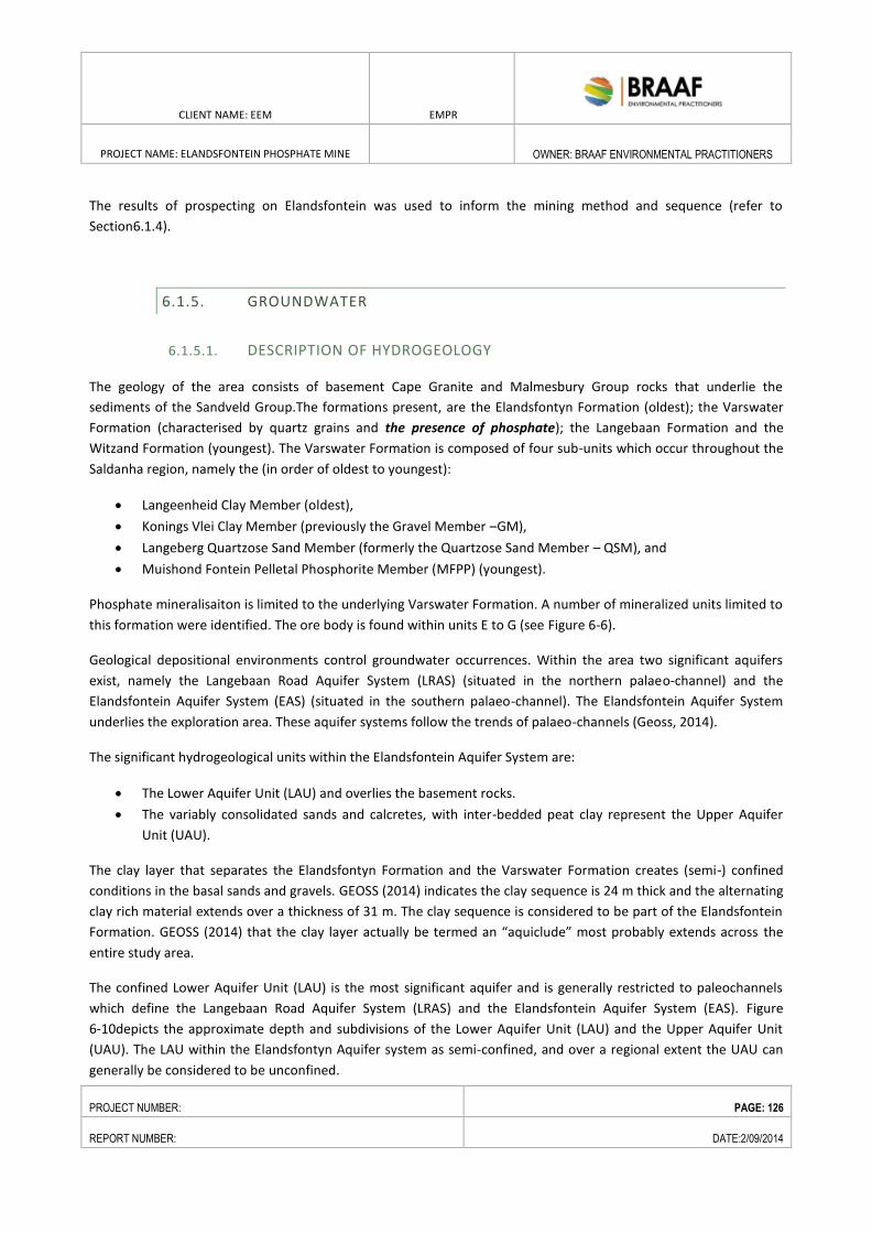
CLIENT NAME: EEM EMPR
PROJECT NAME: ELANDSFONTEIN PHOSPHATE MINE
OWNER: BRAAF ENVIRONMENTAL PRACTITIONERS
PROJECT NUMBER: PAGE: 126
REPORT NUMBER: DATE:2/09/2014
The results of prospecting on Elandsfontein was used to inform the mining method and sequence (refer to
Section6.1.4).
6.1.5. GROUNDWATER
6.1.5.1. DESCRIPTION OF HYDROGEOLOGY
The geology of the area consists of basement Cape Granite and Malmesbury Group rocks that underlie the
sediments of the Sandveld Group.The formations present, are the Elandsfontyn Formation (oldest); the Varswater
Formation (characterised by quartz grains and the presence of phosphate); the Langebaan Formation and the
Witzand Formation (youngest). The Varswater Formation is composed of four sub-units which occur throughout the
Saldanha region, namely the (in order of oldest to youngest):
Langeenheid Clay Member (oldest),
Konings Vlei Clay Member (previously the Gravel Member –GM),
Langeberg Quartzose Sand Member (formerly the Quartzose Sand Member – QSM), and
Muishond Fontein Pelletal Phosphorite Member (MFPP) (youngest).
Phosphate mineralisaiton is limited to the underlying Varswater Formation. A number of mineralized units limited to
this formation were identified. The ore body is found within units E to G (see Figure 6-6).
Geological depositional environments control groundwater occurrences. Within the area two significant aquifers
exist, namely the Langebaan Road Aquifer System (LRAS) (situated in the northern palaeo-channel) and the
Elandsfontein Aquifer System (EAS) (situated in the southern palaeo-channel). The Elandsfontein Aquifer System
underlies the exploration area. These aquifer systems follow the trends of palaeo-channels (Geoss, 2014).
The significant hydrogeological units within the Elandsfontein Aquifer System are:
The Lower Aquifer Unit (LAU) and overlies the basement rocks.
The variably consolidated sands and calcretes, with inter-bedded peat clay represent the Upper Aquifer
Unit (UAU).
The clay layer that separates the Elandsfontyn Formation and the Varswater Formation creates (semi-) confined
conditions in the basal sands and gravels. GEOSS (2014) indicates the clay sequence is 24 m thick and the alternating
clay rich material extends over a thickness of 31 m. The clay sequence is considered to be part of the Elandsfontein
Formation. GEOSS (2014) that the clay layer actually be termed an “aquiclude” most probably extends across the
entire study area.
The confined Lower Aquifer Unit (LAU) is the most significant aquifer and is generally restricted to paleochannels
which define the Langebaan Road Aquifer System (LRAS) and the Elandsfontein Aquifer System (EAS). Figure
6-10depicts the approximate depth and subdivisions of the Lower Aquifer Unit (LAU) and the Upper Aquifer Unit
(UAU). The LAU within the Elandsfontyn Aquifer system as semi-confined, and over a regional extent the UAU can
generally be considered to be unconfined.
CLIENT NAME: EEM EMPR
PROJECT NAME: ELANDSFONTEIN PHOSPHATE MINE
OWNER: BRAAF ENVIRONMENTAL PRACTITIONERS
PROJECT NUMBER: PAGE: 127
REPORT NUMBER: DATE:2/09/2014
Figure 6-10: Subdivision of the Upper and Lower Aquifer Systems (UAS and LAS). The depths indicated are
approximate
6.1.5.2. GROUNDWATER LEVELS AND FLOW
DWA groundwater level data (see Appendix C for the Geohydrological Study) shows groundwater levels range from
approximately 2 m to 28 meters below ground level (mbgl) for the Elandsfontein area. From the water level data
obtained and measured it is evident that the water level ranges from 2 to 27 mbgl regionally. Within the proposed
mining area the groundwater level is mostly between 10 and 20 mbgl (GEOSS, 2014).
To characterise the flow of the upper aquifer two boreholes were drilled within the phosphate member and
pumping tests were completed. The yield of the boreholes was approximately 2.5 ℓ/s and 0.8 ℓ/s respectively.
During the pumping tests five exploration boreholes were monitored and they showed no response to the
abstraction.
6.1.5.3. GROUNDWATER QUALITY
Groundwater sampling and analysis was undertaken by GEOSS. The Electrical Conductivity (EC) and pH levels were
measures at locations within and around the Elandsfontein Mine Area. The groundwater is of good quality. The only
parameter to be aware of is iron, however as the groundwater is to be abstracted and recharged without coming
into contact with the atmosphere, there shouldn’t be iron precipitation in the recharge process.
Field measurements of EC for a number of boreholes in the exploration area showed ECs ranging from 60 mS/m to
80 mS/m and based on this data the water quality for the exploration area is considered to be good.
CLIENT NAME: EEM EMPR
PROJECT NAME: ELANDSFONTEIN PHOSPHATE MINE
OWNER: BRAAF ENVIRONMENTAL PRACTITIONERS
PROJECT NUMBER: PAGE: 128
REPORT NUMBER: DATE:2/09/2014
6.1.5.4. GROUNDWATER RECHARGE AND AQUIFER YIELD
The Langebaan Road and Elandsfontein Aquifer Systems share a common recharge area, namely the dune field to
the west of Hopefield. Theses aquifer systems are defined by palaeo-channels that have been filled with gravels of
the Elandsfontyn Formation and represent preferred groundwater flow paths. The Elandsfontein Aquifer System is
also recharged by rain falling in the vicinity of Rietfontein to the south-east of the study area.
Groundwater recharge in the area is between 16 and 24 mm/a (in the order of 7 % of MAP) and although recharge
possibly occurs further east this still gives an indication of the need to manage and conserve the groundwater
resource appropriately. From the DWAF 1:500 000 hydrogeological map series the exploration area plots in an
intergranular aquifer with a groundwater yield of 0.1 - 0.5 ℓ/s and is near an area with a mapped yield of 0.5 – 2.0
ℓ/s. DWA (DWAF, 2008) modelling of the Langebaan and Elandsfontyn aquifers which shows the major groundwater
flow passes through the exploration area (see Appendix C for the Geohydrological Study).
6.1.5.5. GROUNDWATER AND ECOSYSTEMS
The high conservation status Langebaan lagoon is not fed by overland streams or rivers due to the porous nature of
the sediments and the arid conditions, but it has been suggested that groundwater plays a significant role in
sustaining the marsh ecosystem. Boreholes drilled around the edge of the lagoon as well as geophysical surveys
have shown a significant inland hydraulic freshwater head intruding into the lagoon. Borehole information, yield
tests and borehole construction information were collated so as to be able to determine the flow rates per
geological formation. Results show high flow rates within the calcrete of the area, which are typically low yielding
geological formation. Also of relevance are the very high flow rates of the shallow sands in close proximity to the
lagoon edge.
There are a number of factors that result in the groundwater outflow in the Geelbek area. These are:
The steep hydraulic gradient towards the lagoon from inland.
The high flow rate (hydraulic conductivity of the calcrete) – permitting the flow of groundwater.
The very high groundwater flow rate of the shallow sands in close proximity to the lagoon.
The presence of the clay beneath the lagoon, which will force the deeper groundwater flow upwards
towards the lagoon.
Studies have shown that groundwater abstraction and recharge at Elandsfontein Mine will not affect this flow of
fresh groundwater into the Langebaan Lagoon (GEOSS, 2014). Assessment of the groundwater flow directions of the
area indicates that the flow into the lagoon is directly from the east of the Geelbek area (and not from the north-
east where the Elandsfontein site is) from the Upper Aquifer Unit (Geoss, 2014).
6.1.5.6. AQUIFER CLASSIFICATION/STRATEGIC VALUE
Due to the intergranular nature of the sands the vulnerability rating is “high” to “very high”. The Elandsfontyn
Aquifer underlying the exploration area is classified as a “Special Aquifer System” and requires a “high” to “strictly
non-degradation” level of groundwater protection in accordance with “A South African Aquifer System Management
CLIENT NAME: EEM EMPR
PROJECT NAME: ELANDSFONTEIN PHOSPHATE MINE
OWNER: BRAAF ENVIRONMENTAL PRACTITIONERS
PROJECT NUMBER: PAGE: 129
REPORT NUMBER: DATE:2/09/2014
Classification, (1995).” This classification, along with the “high” to “very high” vulnerability classification (DWAF,
2005), means that the susceptibility of the aquifer to contamination from anthropogenic activities is high.
6.1.5.7. SOIL MOISTURE CONTENT
The soil moisture was monitored during the pumping tests On average the water content of the soil between 600
and 1000 mm remain constant while that shallower than 500 mm tend to decrease during the measuring period (67
hours). This is mainly due to evaporation from the soil surface and water uptake off the fynbos. Extraction of water
from the boreholes did not influence the soil water content of the soils surrounding the two boreholes. The changes
in soil water content that did occur can be ascribed to redistribution of water, evaporation from the soil surface and
water uptake by the plants (Geoss, 2014).
6.1.6. SURFACE WATER
The proposed mining site is located in the Berg River Catchment area which is subdivided into 12 quaternary
catchments which has a surface size of 9000 km².
The key aquatic features in the area surrounding the proposed Elandsfontein Phosphate Mine are the Langebaan
Lagoon (approximately 9km to the south-west, Quaternary catchment G10M), and the Groen/Sout River System
(approximately 6km to the east, Quaternary catchment G10L). There are no seasonal or permanent wetlands in the
immediate study area, only a poorly defined drainage channel that is orientated towards the south.
6.1.7. GEOCHEMISTRY
Key findings of a geochemical study of Elandsfontein mine waste materials conducted by Mintek are presented
below.
Softs stockpiles
Mintek undertook a leaching study on simulated overburden material that would report to the softs stockpile. The
test results indicate that the softs is a low risk to the environment with the exception of Sb (Antimony) in the borate
leach. The results further indicate the presence of soluble salts because of the leachable calcium and possibly
sulphate. Further detail is required as the salts could impact on the environment, this data is potentially important.
In addition, although volatile or semi-volatile organic compounds in the material are highly unlikely, at least one
sample should be done to demonstrate this to the authorities.
Clearly, more information is required but the results seem to indicate that the softs will have a low impact on the
environment provided it is managed correctly.
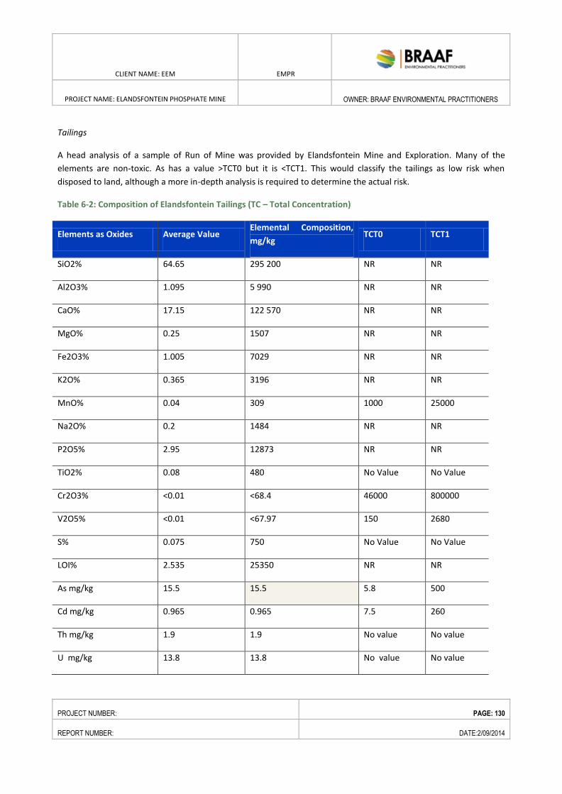
CLIENT NAME: EEM EMPR
PROJECT NAME: ELANDSFONTEIN PHOSPHATE MINE
OWNER: BRAAF ENVIRONMENTAL PRACTITIONERS
PROJECT NUMBER: PAGE: 130
REPORT NUMBER: DATE:2/09/2014
Tailings
A head analysis of a sample of Run of Mine was provided by Elandsfontein Mine and Exploration. Many of the
elements are non-toxic. As has a value >TCT0 but it is <TCT1. This would classify the tailings as low risk when
disposed to land, although a more in-depth analysis is required to determine the actual risk.
Table 6-2: Composition of Elandsfontein Tailings (TC – Total Concentration)
Elements as Oxides Average Value Elemental Composition,
mg/kg TCT0 TCT1
SiO2% 64.65 295 200 NR NR
Al2O3% 1.095 5 990 NR NR
CaO% 17.15 122 570 NR NR
MgO% 0.25 1507 NR NR
Fe2O3% 1.005 7029 NR NR
K2O% 0.365 3196 NR NR
MnO% 0.04 309 1000 25000
Na2O% 0.2 1484 NR NR
P2O5% 2.95 12873 NR NR
TiO2% 0.08 480 No Value No Value
Cr2O3% <0.01 <68.4 46000 800000
V2O5% <0.01 <67.97 150 2680
S% 0.075 750 No Value No Value
LOI% 2.535 25350 NR NR
As mg/kg 15.5 15.5 5.8 500
Cd mg/kg 0.965 0.965 7.5 260
Th mg/kg 1.9 1.9 No value No value
U mg/kg 13.8 13.8 No value No value
CLIENT NAME: EEM EMPR
PROJECT NAME: ELANDSFONTEIN PHOSPHATE MINE
OWNER: BRAAF ENVIRONMENTAL PRACTITIONERS
PROJECT NUMBER: PAGE: 131
REPORT NUMBER: DATE:2/09/2014
As indicated previously, although the tailings may have a composition similar to the original ore body, the physical
characteristics such as particle size, permeability and the pH in water may have changed. Thus, it is very important
that a full characterisation is undertaken, e.g. of test samples and later in samples from the beneficiation plant to
ensure that the environmental risks are the same.
6.1.8. SOIL AND LAND CAPABILITY
The land capability of the proposed site can be defined as relatively flat and undulating characterised largely
by fynbos in the north, west and south, a fossil area to the northeast which is largely overgrown with invasive
alien vegetation which continues further eastward. Portion 4 and 2 of the Farm Elandsfontein has been
identified as a Critical Biodiversity Area by Saldanha Bay Municipality, separating the two eastern portions of
the West Coast National Park (WCNP). It was previously a Private Nature Reserve and due to the nature of the
vegetation on site can be seen to form the natural northern extension of the WCNP.
Sand and limestone substrates present in the area are largely recent to Tertiary deposits of marine origin over-
lying Malmesbury Group shales intruded by Cape Granites, belonging to the Saldanha-Langebaan Pluton. A large
Pleistocene dune field with both loose and stable dune sand crosses the area south and east of Langebaan town,
along a generally north- south axis originating at Yzerfontein (Boucher 1981).
Calcareous sands and granitic soils form the lower-lying flats. Some limestone deposits form prominent ridges
with an approximate north-south longitudinal axis, and are located over Elandsfontein Farm.
6.1.9. FLORA
6.1.9.1. REGIONAL BOTANCIAL CONTEXT
Elandsfontein Farm is considered to be part of the Southwest Fynbos bioregion (Mucina & Rutherford 2006), and is
part of the Fynbos biome, located within what is now known as the Core Region of the Greater Cape Floristic Region
(GCFR; Manning & Goldblatt 2012).
The GCFR is one of only six Floristic Regions in the world, and is the only one largely confined to a single country and
is the smallest floristic region of the world’s land surface supporting about 11500 plant species, over half of all the
plant species in South Africa.
At least 70% of all the species in the Cape region do not occur elsewhere, and many have very small home ranges
(these are known as narrow endemics). Data from the nationwide plant Red Listing project indicate that 67% of the
threatened plant species in the country occur only in the southwestern Cape, and these total over 1800 species
(Raimondo et al 2009). It should thus be clear that the southwestern Cape is a major national and global
conservation priority, and is quite unlike anywhere else in the country in terms of the number of threatened plant
species.
The study area falls within what is generally known as the Sandveld. The Sandveld supports various different
vegetation types, each with distinct floras (with some overlap), and large numbers of threatened plant species
(Helme & Koopman 2007; Helme 2012). The point at which two (or more) ecosystems or vegetation types meet is
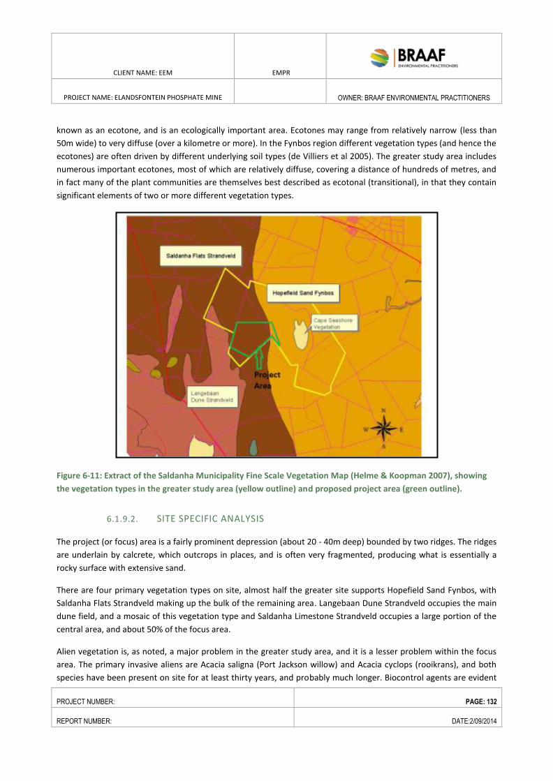
CLIENT NAME: EEM EMPR
PROJECT NAME: ELANDSFONTEIN PHOSPHATE MINE
OWNER: BRAAF ENVIRONMENTAL PRACTITIONERS
PROJECT NUMBER: PAGE: 132
REPORT NUMBER: DATE:2/09/2014
known as an ecotone, and is an ecologically important area. Ecotones may range from relatively narrow (less than
50m wide) to very diffuse (over a kilometre or more). In the Fynbos region different vegetation types (and hence the
ecotones) are often driven by different underlying soil types (de Villiers et al 2005). The greater study area includes
numerous important ecotones, most of which are relatively diffuse, covering a distance of hundreds of metres, and
in fact many of the plant communities are themselves best described as ecotonal (transitional), in that they contain
significant elements of two or more different vegetation types.
Figure 6-11: Extract of the Saldanha Municipality Fine Scale Vegetation Map (Helme & Koopman 2007), showing
the vegetation types in the greater study area (yellow outline) and proposed project area (green outline).
6.1.9.2. SITE SPECIFIC ANALYSIS
The project (or focus) area is a fairly prominent depression (about 20 - 40m deep) bounded by two ridges. The ridges
are underlain by calcrete, which outcrops in places, and is often very fragmented, producing what is essentially a
rocky surface with extensive sand.
There are four primary vegetation types on site, almost half the greater site supports Hopefield Sand Fynbos, with
Saldanha Flats Strandveld making up the bulk of the remaining area. Langebaan Dune Strandveld occupies the main
dune field, and a mosaic of this vegetation type and Saldanha Limestone Strandveld occupies a large portion of the
central area, and about 50% of the focus area.
Alien vegetation is, as noted, a major problem in the greater study area, and it is a lesser problem within the focus
area. The primary invasive aliens are Acacia saligna (Port Jackson willow) and Acacia cyclops (rooikrans), and both
species have been present on site for at least thirty years, and probably much longer. Biocontrol agents are evident
CLIENT NAME: EEM EMPR
PROJECT NAME: ELANDSFONTEIN PHOSPHATE MINE
OWNER: BRAAF ENVIRONMENTAL PRACTITIONERS
PROJECT NUMBER: PAGE: 133
REPORT NUMBER: DATE:2/09/2014
on both species and active spread and seed set seems to have been curtailed, but numerous mature plants are still
healthy. There are patches (<5ha) of planted gum trees (Eucalyptus spp) in the southeastern parts of the dune field,
and this area is particularly degraded, which is probably at least partly a result of the toxins released into the soil by
these trees. There is also a small patch of these trees around the old farmhouse (Elandsfontein Wes) and werf in
the proposed mine area.
According to the National List of Threatened Ecosystems the four vegetation types found on the site are listed are
follows:
Hopefield Sand Fynbos – Vulnerable;
Saldanha Flats Strandveld – Vulnerable;
Langebaan Dune Strandveld – Least Threatened; and
Saldanha Limestone Strandveld – Least Threatened.
The primary plant communities identified by Boucher (2010) within the current focus area are:
Saldanha Flats Strandveld elements:
Salvia africana-lutea - Indigofera procumbens Fynbos Shrubland
Salvia africana-lutea - Anthospermum spathulatum Fynbos Restioland
Willdenowia incurvata - Diospyros austro-africana Shrubland
Langebaan Dune Strandveld elements:
Euclea racemosa - Zygophyllum morgsana Dune Strandveld Scrub
Saldanha Limestone Strandveld elements:
Maytenus lucida – Crassula ammophila Tall Shrubland
Olea exasperata – Muraltia harveyana (demissa) Restioland
A total of 74 plant species were identified and recorded in the study area.
6.1.9.3. SPECIES OF CONSERVATION CONCERN
Seventeen plant Species of Conservation Concern (SCC; Raimondo et al 2009 and annual online updates at
redlist.sanbi.org; previously referred to as Red Data Book species) were recorded in the greater study area, but only
four of these were confirmed from within the project area, excluding the access road footprint.
Table 6-3: Species of Conservation Concern Present in the Study Area
Species Red List status
Echiostachys spicatus Endangered
Caesia sabulosa Vulnerable
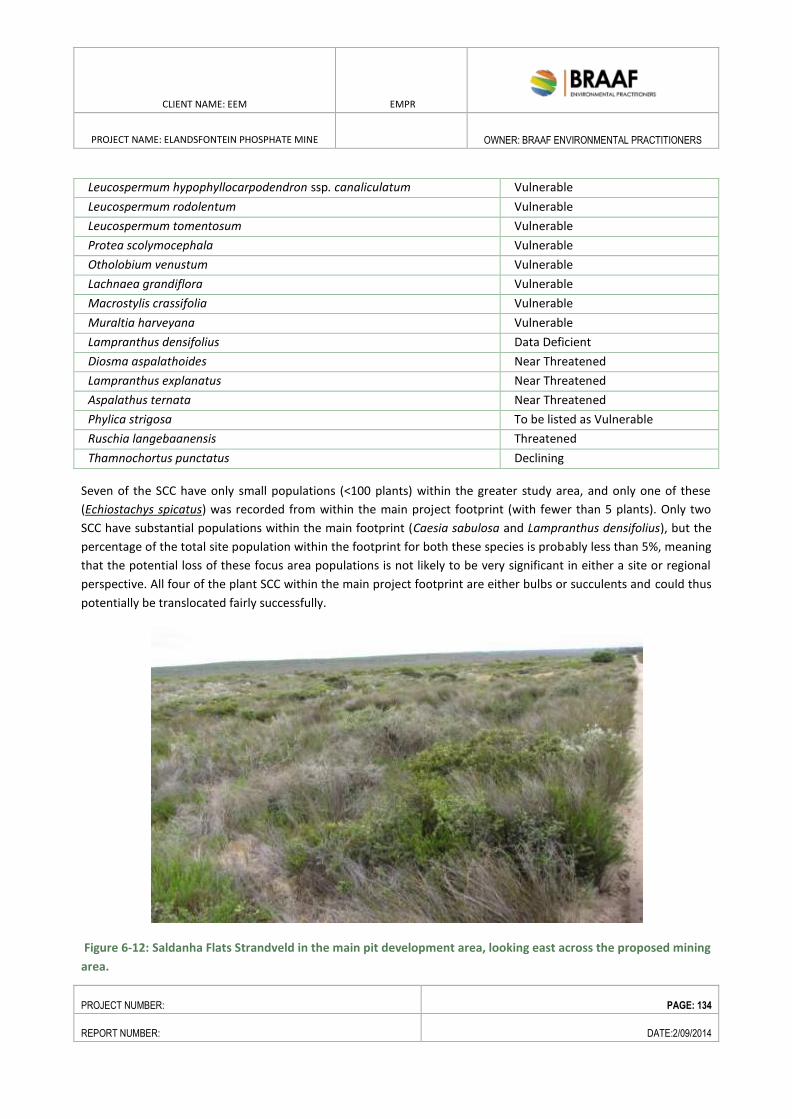
CLIENT NAME: EEM EMPR
PROJECT NAME: ELANDSFONTEIN PHOSPHATE MINE
OWNER: BRAAF ENVIRONMENTAL PRACTITIONERS
PROJECT NUMBER: PAGE: 134
REPORT NUMBER: DATE:2/09/2014
Leucospermum hypophyllocarpodendron ssp. canaliculatum Vulnerable
Leucospermum rodolentum Vulnerable
Leucospermum tomentosum Vulnerable
Protea scolymocephala Vulnerable
Otholobium venustum Vulnerable
Lachnaea grandiflora Vulnerable
Macrostylis crassifolia Vulnerable
Muraltia harveyana Vulnerable
Lampranthus densifolius Data Deficient
Diosma aspalathoides Near Threatened
Lampranthus explanatus Near Threatened
Aspalathus ternata Near Threatened
Phylica strigosa To be listed as Vulnerable
Ruschia langebaanensis Threatened
Thamnochortus punctatus Declining
Seven of the SCC have only small populations (<100 plants) within the greater study area, and only one of these
(Echiostachys spicatus) was recorded from within the main project footprint (with fewer than 5 plants). Only two
SCC have substantial populations within the main footprint (Caesia sabulosa and Lampranthus densifolius), but the
percentage of the total site population within the footprint for both these species is probably less than 5%, meaning
that the potential loss of these focus area populations is not likely to be very significant in either a site or regional
perspective. All four of the plant SCC within the main project footprint are either bulbs or succulents and could thus
potentially be translocated fairly successfully.
Figure 6-12: Saldanha Flats Strandveld in the main pit development area, looking east across the proposed mining
area.
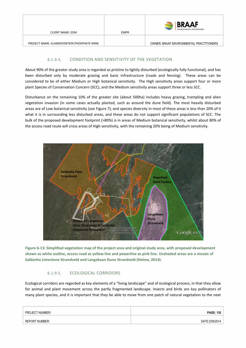
CLIENT NAME: EEM EMPR
PROJECT NAME: ELANDSFONTEIN PHOSPHATE MINE
OWNER: BRAAF ENVIRONMENTAL PRACTITIONERS
PROJECT NUMBER: PAGE: 135
REPORT NUMBER: DATE:2/09/2014
6.1.9.4. CONDITION AND SENSITIVITY OF THE VEGETATION
About 90% of the greater study area is regarded as pristine to lightly disturbed (ecologically fully functional), and has
been disturbed only by moderate grazing and basic infrastructure (roads and fencing). These areas can be
considered to be of either Medium or High botanical sensitivity. The High sensitivity areas support four or more
plant Species of Conservation Concern (SCC), and the Medium sensitivity areas support three or less SCC.
Disturbance on the remaining 10% of the greater site (about 500ha) includes heavy grazing, trampling and alien
vegetation invasion (in some cases actually planted, such as around the dune field). The most heavily disturbed
areas are of Low botanical sensitivity (see Figure 7), and species diversity in most of these areas is less than 20% of it
what it is in surrounding less disturbed areas, and these areas do not support significant populations of SCC. The
bulk of the proposed development footprint (>80%) is in areas of Medium botanical sensitivity, whilst about 80% of
the access road route will cross areas of High sensitivity, with the remaining 20% being of Medium sensitivity.
Figure 6-13: Simplified vegetation map of the project area and original study area, with proposed development
shown as white outline, access road as yellow line and powerline as pink line. Unshaded areas are a mosaic of
Saldanha Limestone Strandveld and Langebaan Dune Strandveld (Helme, 2014).
6.1.9.5. ECOLOGICAL CORRIDORS
Ecological corridors are regarded as key elements of a “living landscape” and of ecological process, in that they allow
for animal and plant movement across the partly fragmented landscape. Insects and birds are key pollinators of
many plant species, and it is important that they be able to move from one patch of natural vegetation to the next
CLIENT NAME: EEM EMPR
PROJECT NAME: ELANDSFONTEIN PHOSPHATE MINE
OWNER: BRAAF ENVIRONMENTAL PRACTITIONERS
PROJECT NUMBER: PAGE: 136
REPORT NUMBER: DATE:2/09/2014
relatively easily, without having to cross large areas of hostile, barren terrain with little or no natural vegetation.
These corridors also allow for seed movement, which may be by means of animals or by the wind.
Existing ecological corridors can be inferred wherever there is natural vegetation, and thus one should not take a
single line on a map too seriously – in reality it is more like a web than a corridor, with numerous lateral connections
and interconnections, and it is important to maintain as many as these as possible, and the broader and more
numerous the links the better.
Ecological connectivity across the site is currently regarded as fully functional, and care should be taken not to
disrupt this connectivity, especially on a site bordering on a National Park.
6.1.9.6. ECOLOGICAL DRIVERS
Fire is widely acknowledged to be one of the primary drivers of Fynbos ecosystem dynamics (de Villiers et al 2005)
and is one of two extremely important ecological drivers on this site. The other is soil type, although this cannot be
manipulated, and is therefore not further discussed. Soil moisture is important in determining species composition
(plant communities) but is not a major ecological driver on this site.
Optimum fire frequency for Sand Fynbos in this region is once every twelve to twenty years, with a fairly high degree
of variance in terms of natural frequency. Fire more often than at the optimum frequency will result in certain slow
growing species being eliminated, and will change plant community structure, whilst for Sand Fynbos fire at less
regular intervals will have a similar effect, but usually on slightly different species. Many Sand Fynbos species
germinate only immediately after a fire, and in the absence of fire will not establish young plants. Lack of fire also
means that many bulbs and annuals that normally flourish only in the first few years after a fire, when there is
plenty of light and open space, struggle to flower and hence set seed. Alien invasive Acacia species produce vast
quantities of seed (at least until the recent introduction of biocontrol agents which limit or even prevent seed
production) and this seed falls to the ground and persists for up to forty years as an underground seedbank. It is
thus very likely that there is a fairly large soil stored seedbank (millions of seeds may be produced annually, at least
until the introduction of biocontrol some years ago) on many parts of the site just waiting to germinate after a fire,
but this can be systematically dealt with as it comes up, as part of a Management Plan.
6.1.9.7. CRITICAL BIODIVERISTY AREAS
According to the Saldanha Bay Municipal Spatial Development Framework the study area is located in a terrestrial
CBA, connecting two existing parts of the West Coast National Park (WCNP) (see Figure 6-14). Critical Biodiversity
Areas (CBAs) represent biodiversity priority areas which should be maintained in a natural to near natural state. The
CBA maps indicate the most efficient selection and classification of land portions requiring safeguarding in order to
maintain ecosystem functioning and meet national biodiversity objectives. The West Coast National Park (WCNP) is
expanding towards the east and northeast, and the proposed mine is within the proposed expansion corridor, and
will in fact also border on the existing WCNP boundary.
CLIENT NAME: EEM EMPR
PROJECT NAME: ELANDSFONTEIN PHOSPHATE MINE
OWNER: BRAAF ENVIRONMENTAL PRACTITIONERS
PROJECT NUMBER: PAGE: 137
REPORT NUMBER: DATE:2/09/2014
6.1.9.8. FAUNA STUDY
Faunal baseline studies were undertaken by Ecolife Consulting .The findings of these investigations are presented
below.
6.1.9.8.1. TERRESTRIAL INVERTEBRATES
Based on the field work and observations undertaken, it was confirmed the alien invasive land snail Theba pisana is
the only invertebrate found in large numbers in the study area. Given the very high densities that T. pisana can
attain at some sites, plus their apparently catholic feeding habits, their potential impact on the vegetation of the
study area is cause for concern and should be further investigated.
6.1.9.8.2. AMPHIBIANS
Hanekom N., Randall R.M., Nel, P. & Kruger, N. (2009) states that very little is known about the amphibians in the
West Coast National Park which has been found to also be the case in Elandsfontein.
Of the 16 species occurring in the greater area , only the Namaqua Rain Frog (Breviceps namaquensis) and the
Namaqua Caco (Cacosternum namaquense) potentially occur within the study area. The Karoo Toad (Bufo
gariepensis) may be present further inland. The Namaqua Rain Frog breeds terrestrially, i.e., there is no larval stage
and no water body required for breeding. The Namaqua Cao, on the other hand, needs at least a temporary water
body for breeding. None of the three species potentially occurring in the study area are classified as Red Data
species (Minter et al., 2004).
6.1.9.8.3. REPTILES
A series of studies have been done on the angulate tortoise (Chersina angulate) in this region. Angulate tortoises at
Elandsfontein have a cyclic reproductive pattern, initiating egg production in February and were highly variable and
correlated to ambient temperature (inversely) and rainfall (positively) (Hofmeyr 2004).
The tortoises are active throughout most of the year. Clutch frequency ranged from one to six per year, with annual
fecundity being influenced by the date of reproductive onset and egg-retention time. The retention is throughout
the day, but become bimodal in the warmer and drier summer and autumn months (Ramsay et al. 2002).
A variety of lizards tortoises and snakes occur in the greater area, and according to Mouton (2008) three are
classified as Vulnerable:
i. Lomi’s Blind Legless Skink (Typhlosaurus lomii) is found in sand dunes along the West Coast. It is
threatened due to habitat destruction from alluvial diamond mining. This species was recorded in the inland
Succulent Karoo habitat just south of Groenriviermond (Mouton et al., 2007) and it may be present further south as
far as the present study area.
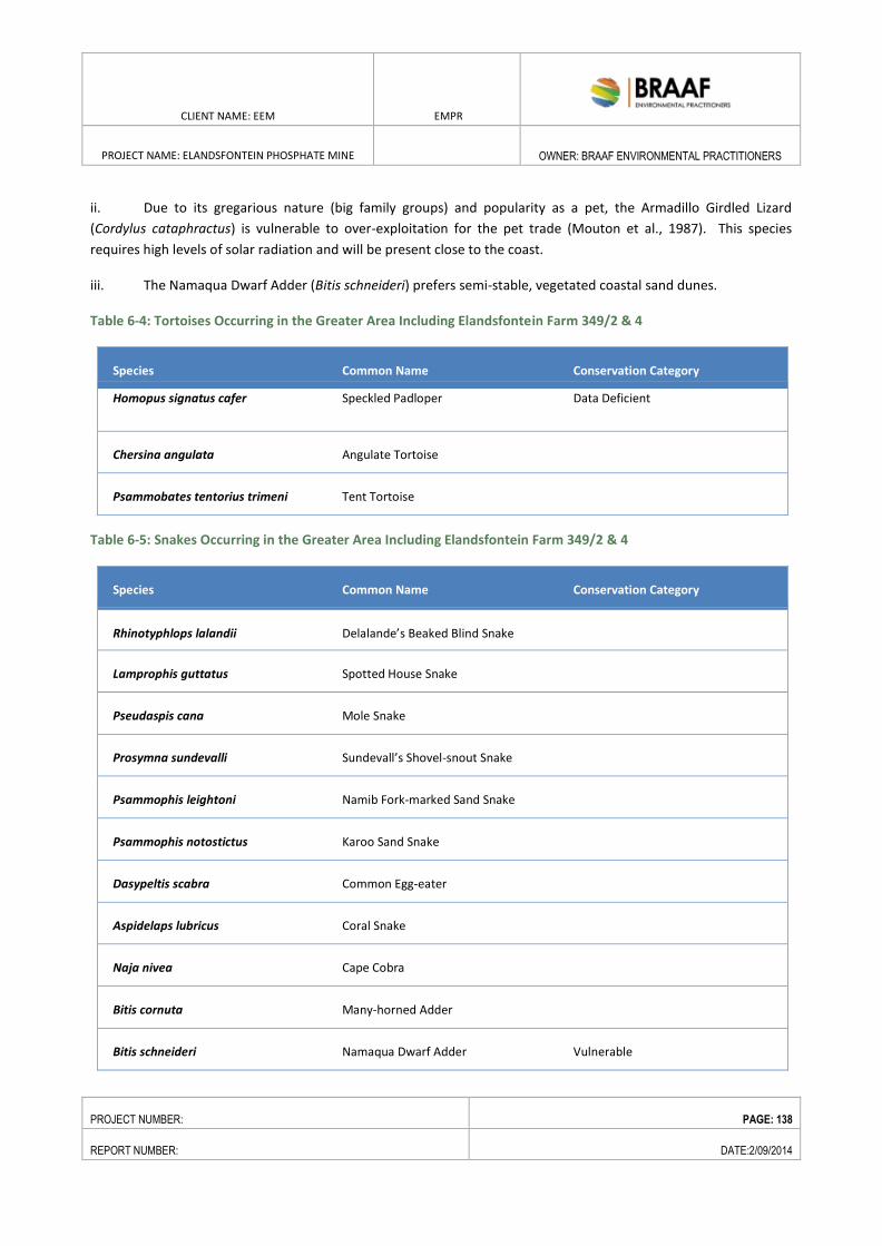
CLIENT NAME: EEM EMPR
PROJECT NAME: ELANDSFONTEIN PHOSPHATE MINE
OWNER: BRAAF ENVIRONMENTAL PRACTITIONERS
PROJECT NUMBER: PAGE: 138
REPORT NUMBER: DATE:2/09/2014
ii. Due to its gregarious nature (big family groups) and popularity as a pet, the Armadillo Girdled Lizard
(Cordylus cataphractus) is vulnerable to over-exploitation for the pet trade (Mouton et al., 1987). This species
requires high levels of solar radiation and will be present close to the coast.
iii. The Namaqua Dwarf Adder (Bitis schneideri) prefers semi-stable, vegetated coastal sand dunes.
Table 6-4: Tortoises Occurring in the Greater Area Including Elandsfontein Farm 349/2 & 4
Species Common Name Conservation Category
Homopus signatus cafer Speckled Padloper Data Deficient
Chersina angulata Angulate Tortoise
Psammobates tentorius trimeni Tent Tortoise
Table 6-5: Snakes Occurring in the Greater Area Including Elandsfontein Farm 349/2 & 4
Species Common Name Conservation Category
Rhinotyphlops lalandii Delalande’s Beaked Blind Snake
Lamprophis guttatus Spotted House Snake
Pseudaspis cana Mole Snake
Prosymna sundevalli Sundevall’s Shovel-snout Snake
Psammophis leightoni Namib Fork-marked Sand Snake
namibiensis Psammophis notostictus Karoo Sand Snake
Dasypeltis scabra Common Egg-eater
Aspidelaps lubricus Coral Snake
Naja nivea Cape Cobra
Bitis cornuta Many-horned Adder
Bitis schneideri Namaqua Dwarf Adder Vulnerable
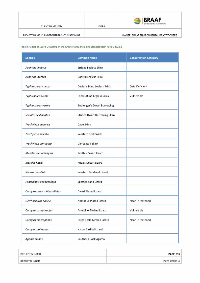
CLIENT NAME: EEM EMPR
PROJECT NAME: ELANDSFONTEIN PHOSPHATE MINE
OWNER: BRAAF ENVIRONMENTAL PRACTITIONERS
PROJECT NUMBER: PAGE: 139
REPORT NUMBER: DATE:2/09/2014
Table 6-6: List of Lizard Occurring in the Greater Area Including Elandsfontein Farm 349/2 &
Species Common Name Conservation Category
Acontias lineatus Striped Legless Skink
Acontias litoralis Coastal Legless Skink
Typhlosaurus caecus Cuvier’s Blind Legless Skink Data Deficient
Typhlosaurus lomii Lomi’s Blind Legless Skink Vulnerable
Typhlosaurus vermis Boulenger’s Dwarf Burrowing
Skink
Scelotes sexlineatus Striped Dwarf Burrowing Skink
Trachylepis capensis Cape Skink
Trachylepis sulcata Western Rock Skink
Trachylepis variegata Variegated Skink
Meroles ctenodactylus Smith’s Desert Lizard
Meroles knoxii Knox’s Desert Lizard
Nucras tessellata Western Sandveld Lizard
Pedioplanis lineoocellata Spotted Sand Lizard
Cordylosaurus subtessellatus Dwarf Plated Lizard
Gerrhosaurus typicus Namaqua Plated Lizard Near Threatened
Cordylus cataphractus Armidillo Girdled Lizard Vulnerable
Cordylus macropholis Large-scale Girdled Lizard Near Threatened
Cordylus polyzonus Karoo Girdled Lizard
Agama sp nov. Southern Rock Agama
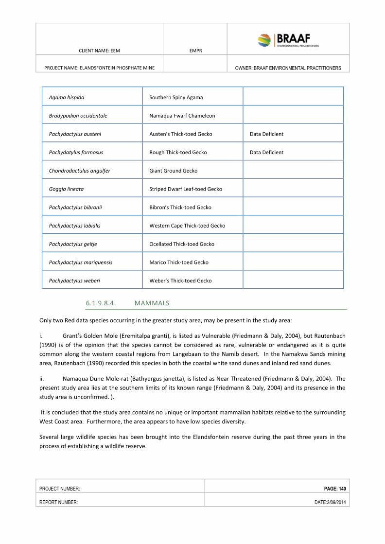
CLIENT NAME: EEM EMPR
PROJECT NAME: ELANDSFONTEIN PHOSPHATE MINE
OWNER: BRAAF ENVIRONMENTAL PRACTITIONERS
PROJECT NUMBER: PAGE: 140
REPORT NUMBER: DATE:2/09/2014
Agama hispida Southern Spiny Agama
Bradypodion occidentale Namaqua Fwarf Chameleon
Pachydactylus austeni Austen’s Thick-toed Gecko Data Deficient
Pachydatylus formosus Rough Thick-toed Gecko Data Deficient
Chondrodactulus angulfer Giant Ground Gecko
Goggia lineata Striped Dwarf Leaf-toed Gecko
Pachydactylus bibronii Bibron’s Thick-toed Gecko
Pachydactylus labialis Western Cape Thick-toed Gecko
Pachydactylus geitje Ocellated Thick-toed Gecko
Pachydactylus mariquensis Marico Thick-toed Gecko
Pachydactylus weberi Weber’s Thick-toed Gecko
6.1.9.8.4. MAMMALS
Only two Red data species occurring in the greater study area, may be present in the study area:
i. Grant’s Golden Mole (Eremitalpa granti), is listed as Vulnerable (Friedmann & Daly, 2004), but Rautenbach
(1990) is of the opinion that the species cannot be considered as rare, vulnerable or endangered as it is quite
common along the western coastal regions from Langebaan to the Namib desert. In the Namakwa Sands mining
area, Rautenbach (1990) recorded this species in both the coastal white sand dunes and inland red sand dunes.
ii. Namaqua Dune Mole-rat (Bathyergus janetta), is listed as Near Threatened (Friedmann & Daly, 2004). The
present study area lies at the southern limits of its known range (Friedmann & Daly, 2004) and its presence in the
study area is unconfirmed. ).
It is concluded that the study area contains no unique or important mammalian habitats relative to the surrounding
West Coast area. Furthermore, the area appears to have low species diversity.
Several large wildlife species has been brought into the Elandsfontein reserve during the past three years in the
process of establishing a wildlife reserve.
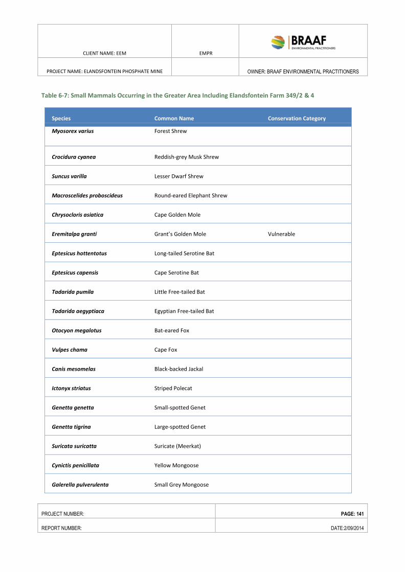
CLIENT NAME: EEM EMPR
PROJECT NAME: ELANDSFONTEIN PHOSPHATE MINE
OWNER: BRAAF ENVIRONMENTAL PRACTITIONERS
PROJECT NUMBER: PAGE: 141
REPORT NUMBER: DATE:2/09/2014
Table 6-7: Small Mammals Occurring in the Greater Area Including Elandsfontein Farm 349/2 & 4
Species Common Name Conservation Category
Myosorex varius Forest Shrew
Crocidura cyanea Reddish-grey Musk Shrew
Suncus varilla Lesser Dwarf Shrew
Macroscelides proboscideus Round-eared Elephant Shrew
Chrysocloris asiatica Cape Golden Mole
Eremitalpa granti Grant’s Golden Mole Vulnerable
Eptesicus hottentotus Long-tailed Serotine Bat
Eptesicus capensis Cape Serotine Bat
Tadarida pumila Little Free-tailed Bat
Tadarida aegyptiaca Egyptian Free-tailed Bat
Otocyon megalotus Bat-eared Fox
Vulpes chama Cape Fox
Canis mesomelas Black-backed Jackal
Ictonyx striatus Striped Polecat
Genetta genetta Small-spotted Genet
Genetta tigrina Large-spotted Genet
Suricata suricatta Suricate (Meerkat)
Cynictis penicillata Yellow Mongoose
Galerella pulverulenta Small Grey Mongoose
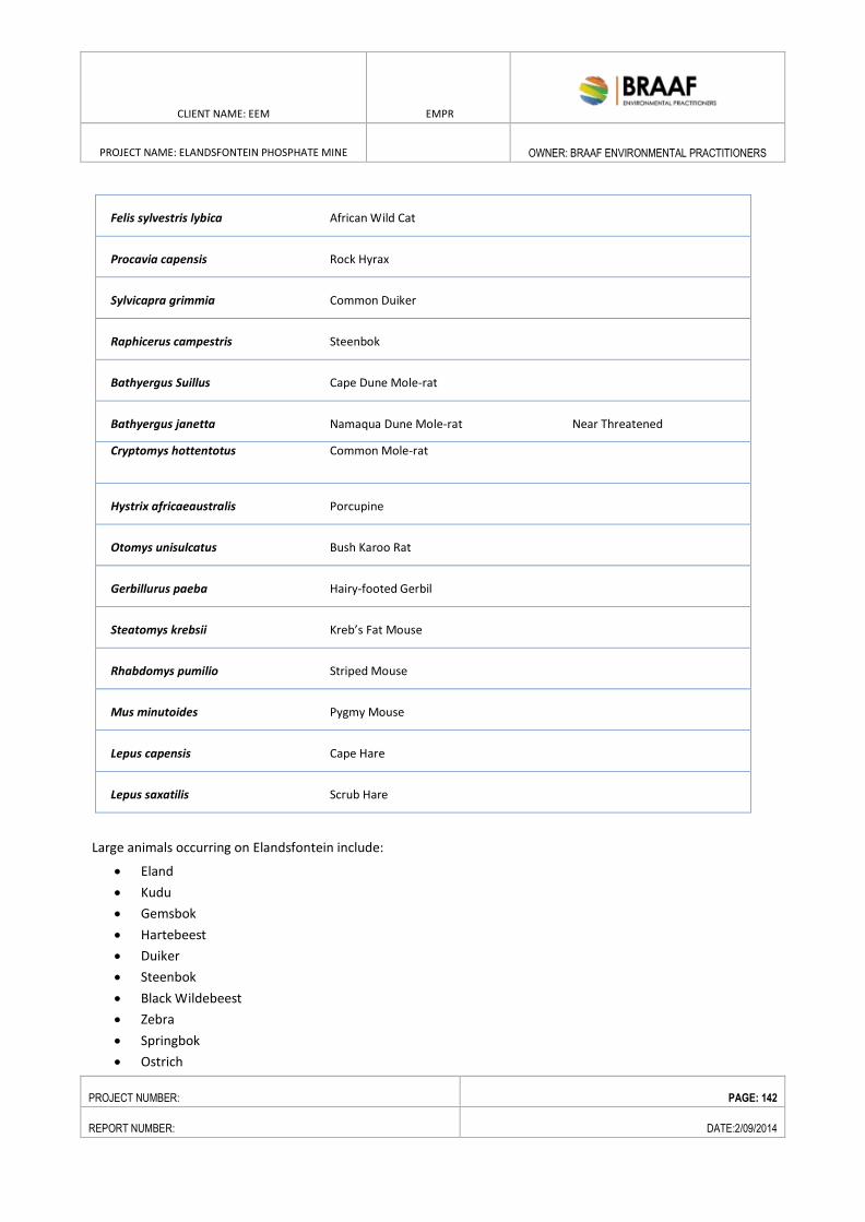
CLIENT NAME: EEM EMPR
PROJECT NAME: ELANDSFONTEIN PHOSPHATE MINE
OWNER: BRAAF ENVIRONMENTAL PRACTITIONERS
PROJECT NUMBER: PAGE: 142
REPORT NUMBER: DATE:2/09/2014
Felis sylvestris lybica African Wild Cat
Procavia capensis Rock Hyrax
Sylvicapra grimmia Common Duiker
Raphicerus campestris Steenbok
Bathyergus Suillus Cape Dune Mole-rat
Bathyergus janetta Namaqua Dune Mole-rat Near Threatened
Cryptomys hottentotus Common Mole-rat
Hystrix africaeaustralis Porcupine
Otomys unisulcatus Bush Karoo Rat
Gerbillurus paeba Hairy-footed Gerbil
Steatomys krebsii Kreb’s Fat Mouse
Rhabdomys pumilio Striped Mouse
Mus minutoides Pygmy Mouse
Lepus capensis Cape Hare
Lepus saxatilis Scrub Hare
Large animals occurring on Elandsfontein include:
Eland
Kudu
Gemsbok
Hartebeest
Duiker
Steenbok
Black Wildebeest
Zebra
Springbok
Ostrich
CLIENT NAME: EEM EMPR
PROJECT NAME: ELANDSFONTEIN PHOSPHATE MINE
OWNER: BRAAF ENVIRONMENTAL PRACTITIONERS
PROJECT NUMBER: PAGE: 143
REPORT NUMBER: DATE:2/09/2014
6.1.9.9. AVIFAUNA STUDY
The proposed Elandsfontein Phosphate Mine is located on the farm Elandsfontein 349, that falls within the Fynbos
Biome on the western edge of the West Strandveld Bioregion. The area is likely to support over 200 bird species,
including eight red-listed species, 33 endemics, and five red-listed endemics, at least three of which - Southern Black
Hottentot Buttonquail and Black Harrier– could breed on or close to the development area, in association with the
tracts of unmodified coastal vegetation which characterise the site. The latter species, a suite of Strandveld/Fynbos
endemic passerines, and various additional raptor, large terrestrial and wetland species that may be implicated,
make up the short-list of priority species considered as central to the findings of this assessment.
The proposed development area is located directly adjacent to the West Coast National Park and Saldanha Bay
Islands Important Bird Area (IBA) which regularly supports >35 000 wetland birds in summer (sometimes >50 000
shorebirds alone) and >10 500 birds in winter, and is listed as one of only 20 Ramset sites in the country. Also, the
Lower Berg River Wetlands IBA (SA104) is situated only about 15 km to the north, and is a feeding and/or roosting
site for 10 000s of wetland and coastal birds. However, the development site does not have any significant seasonal
or permanent water sources or exposed water bodies (other than small, artificial drinking holes established to
sustain herds of game), so it is unlikely to attract significant numbers of birds from either of these critical wetland
areas. Also, while it falls more or less on a predicted fly-way for these birds between the two IBAs and between
Langebaan Lagoon and the Soutrivier to the north-east, such commuting birds are unlikely to be directly and
adversely affected by the proposed mining activities.
The site overlaps with the known distribution of the Hottentot Buttonquail, a nationally endangered and endemic
species. The generally good condition of the vegetation indicates that the area could support a viable population of
this species (Hockey et al. 2005). However, this is a small, inconspicuous and cryptic bird that is easily overlooked
and very difficult to survey.
The location of an active Jackal Buzzard nest on the existing Ankerlig-Aurora 132kV line. The proximity of this
nest to the mining pit suggests that it will be subject to significant levels of harmful disturbance.
A Southern Black Korhaan was seen in the national park property just west of the development area. This
species could occur in numbers on the site, especially if the vegetation is subject to more regular burning,
introducing a mosaic of different vegetation heights and densities.
The location of a disused quarry about 5 km west of the proposed pit which could host a suite of cliff-nesting,
possibly impact susceptible birds, including two red-listed species - Verreaux’s Eagle Aquila verreauxii and
Lanner Falcon Falco biarmicus, and a range of other predatory birds that could play an important role in
shaping the ecology of the area, e.g. Peregrine Falcon Falco peregrinus, Cape Eagle-Owl Bubo capensis, Barn
Owl Tyto alba and Rock Kestrel Falco rupicolus.
The proximity of the proposed development to a previously known Martial Eagle Polemaetus bellicosus nest
site, located some 8 km to the north-west. This is a globally red-listed species with huge range requirements
(Hockey et al. 2005). It is conceivable, but perhaps not likely, that this pair of eagles could be impacted by the
proposed mine development.
CLIENT NAME: EEM EMPR
PROJECT NAME: ELANDSFONTEIN PHOSPHATE MINE
OWNER: BRAAF ENVIRONMENTAL PRACTITIONERS
PROJECT NUMBER: PAGE: 144
REPORT NUMBER: DATE:2/09/2014
On the basis of these on-site observations, and in combination with the available SABAP2 data for the general area,
10 priority species are recognised as key in the assessment of avian impacts of the proposed Elandsfontein
Phosphate Mine. These are mostly nationally and/or globally threatened species which are known or suspected to
occur in relatively high numbers in the development area, and which could be negatively affected the proposed
development.
6.1.9.10. NOISE AND AIR QUALITY
The site is surrounded by other private farms and borders the West Coast Nature Reserve towards the south.
The closest communities are Langebaan and Hopefield, situated approximately 14 km to the west and east of
the site respectively. The Farm Elandsfontein 349 is situated between the West Coast Road (R27), which
provides access to the site, and the R45. Potentially sensitive receptors within the study area are the
neighbouring farms and the communities in Langebaan and Hopefield.
There are no major noise sources in the areas surrounding the mine application site. The main activities in
the area are animal farming, subsistence agricultural farming and related operations, which serve the local
communities. The general area around the site is rural, and noise levels are expected to be in the range of
between 45 dBA and 35 dBA during daytime and night-time respectively. The only areas with higher noise
levels are expected to be in the immediate vicinity of the existing main roads of R27 and R45, with noise
levels expected to be between 55 dBA and 45 dBA. The existing noise levels within and around the mine
application site and at relevant communities will be determined via measurements in the detailed EIA. In
addition, the noise generated by the mine operations and local traffic on the R27 and R45 will be modelled
and the noise impact determined for each community and noise sensitive receptor.
Presently, there are no heavy industries in the general area of the site. The main dust generating source in
the region is the existing road network within and around the farms and the R27 and R45 roads.
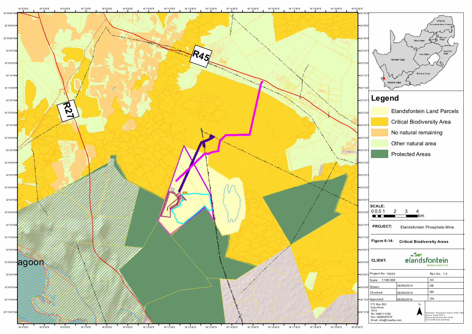
")R45
")R27
Langebaan Lagoon
Hopefield
18°20'30"E
18°20'30"E
18°19'30"E
18°19'30"E
18°18'30"E
18°18'30"E
18°17'30"E
18°17'30"E
18°16'30"E
18°16'30"E
18°15'30"E
18°15'30"E
18°14'30"E
18°14'30"E
18°13'30"E
18°13'30"E
18°12'30"E
18°12'30"E
18°11'30"E
18°11'30"E
18°10'30"E
18°10'30"E
18°9'30"E
18°9'30"E
18°8'30"E
18°8'30"E
18°7'30"E
18°7'30"E
18°6'30"E
18°6'30"E
18°5'30"E
18°5'30"E
18°4'30"E
18°4'30"E32°58'30"S 32°58'30"S
32°59'0"S 32°59'0"S
32°59'30"S 32°59'30"S
33°0'0"S 33°0'0"S
33°0'30"S 33°0'30"S
33°1'0"S 33°1'0"S
33°1'30"S 33°1'30"S
33°2'0"S 33°2'0"S
33°2'30"S 33°2'30"S
33°3'0"S 33°3'0"S
33°3'30"S 33°3'30"S
33°4'0"S 33°4'0"S
33°4'30"S 33°4'30"S
33°5'0"S 33°5'0"S
33°5'30"S 33°5'30"S
33°6'0"S 33°6'0"S
33°6'30"S 33°6'30"S
33°7'0"S 33°7'0"S
33°7'30"S 33°7'30"S
33°8'0"S 33°8'0"S
33°8'30"S 33°8'30"S
33°9'0"S 33°9'0"S
33°9'30"S 33°9'30"S
33°10'0"S 33°10'0"S
33°10'30"S 33°10'30"S
SCALE:
PROJECT:
Figure 6-14:
CLIENT:
Project No: Scale:
Re v No. A3
Drawn:Ch ecked:Approve d:
10043 1.0
06/06/2014
06/06/201406/06/2014
OBRRGA
Critical Biodiversity Areas
Elandsfontein Phosphate Mine
P O Box 692Kuils River7579Tel: 0860111382Fax: 0866587676Email : [email protected]
0 1 2 3 40.5 km
¯
1:100 000
Projection: Geographic, Datum : W GS 1984Source: E npat (2001), Dem arc ation B oard (Dec 2005)Ins et: E SRI Data and M aps
LegendElandsfontein Land ParcelsCritical Biodiversity AreaNo natural remainingOther natural areaProtected Areas
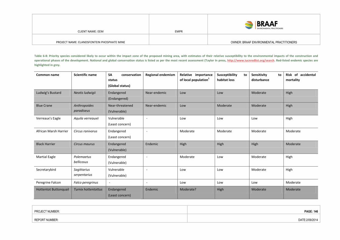
CLIENT NAME: EEM EMPR
PROJECT NAME: ELANDSFONTEIN PHOSPHATE MINE
OWNER: BRAAF ENVIRONMENTAL PRACTITIONERS
PROJECT NUMBER: PAGE: 146
REPORT NUMBER: DATE:2/09/2014
Table 6-8: Priority species considered likely to occur within the impact zone of the proposed mining area, with estimates of their relative susceptibility to the environmental impacts of the construction and
operational phases of the development. National and global conservation status is listed as per the most recent assessment (Taylor In press, http://www.iucnredlist.org/search. Red-listed endemic species are
highlighted in grey.
Common name Scientific name SA conservation
status
(Global status)
Regional endemism Relative importance
of local population1
Susceptibility to
habitat loss
Sensitivity to
disturbance
Risk of accidental
mortality
Ludwig’s Bustard Neotis ludwigii Endangered
(Endangered)
Near-endemic Low Low Moderate High
Blue Crane Anthropoides
paradiseus
Near-threatened
(Vulnerable)
Near-endemic Low Moderate Moderate High
Verreaux’s Eagle Aquila verreauxii Vulnerable
(Least concern)
- Low Low Low High
African Marsh Harrier Circus ranivorus Endangered
(Least concern)
- Moderate Moderate Moderate Moderate
Black Harrier Circus maurus Endangered
(Vulnerable)
Endemic High High High Moderate
Martial Eagle Polemaetus
bellicosus
Endangered
(Vulnerable)
- Moderate Low Moderate High
Secretarybird Sagittarius
serpentarius
Vulnerable
(Vulnerable)
- Low Low Moderate High
Peregrine Falcon Falco peregrinus - - Low Low Low Moderate
Hottentot Buttonquail Turnix hottentottus Endangered
(Least concern)
Endemic Moderate? High Moderate Moderate
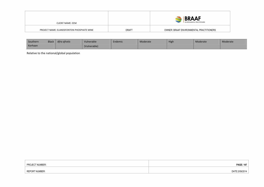
CLIENT NAME: EEM
PROJECT NAME: ELANDSFONTEIN PHOSPHATE MINE DRAFT OWNER: BRAAF ENVIRONMENTAL PRACTITIONERS
PROJECT NUMBER: PAGE: 147
REPORT NUMBER: DATE:2/09/2014
Southern Black
Korhaan
Afra afrotis Vulnerable
(Vulnerable)
Endemic Moderate High Moderate Moderate
Relative to the national/global population
CLIENT NAME: EEM EMPR
PROJECT NAME: ELANDSFONTEIN PHOSPHATE MINE
OWNER: BRAAF ENVIRONMENTAL PRACTITIONERS
PROJECT NUMBER: PAGE: 148
REPORT NUMBER: DATE:2/09/2014
6.2. SOCIO-ECONOMIC ENVIRONMENT
6.2.1. INTRODUCTION
The socio-economic baseline report provides a demographic, cultural and economic overview of the Project area
and also describes the physical infrastructure and services available in the communities visited. The purpose of
collecting this information is to provide a basis upon which the impact assessment can be conducted, and to enable
the monitoring and measurement of changes over time.
6.2.1.1. METHODOLOGY
This socio-economic baseline is primarily based on the socio-economic baseline report undertaken in 2014 for the
Project.
A combination of qualitative and quantitative methods was used. This involved key informant discussions, focus
group discussions with the community, and a survey of businesses in the surrounding areas.
Discussions and interviews were conducted with key stakeholder groupings in the area, i.e. Saldanha Bay Industrial
Development Zone (IDZ), Saldanha Bay Tourism Association, West Coast Chamber of Business, South African
National Parks (SANPARKs), SMME’s, NGO sector, Saldanha Bay Municipality (SBM), Ward committee of Ward 7
which includes Hopefield and the proposed Elandsfontein mine.
The study further included a community engagement component wherein a meeting with the Mayor, Speaker and
Mayoral Committee member for economic development, indicated that the Saldanha Bay Municipality approach to
community engagement in projects is based on a Ward system. According to this system, if a project is located in a
particular ward then the community of that ward has to be engaged in the project. This approach was adopted and
the community of Hopefield was engaged through the ward committee of Ward 7.
6.2.2. WESTERN CAPE PROVINCE
The Provincial Government of the Western Cape has formulated a Provincial Strategic Plan (PSP) that is branded on
three pillars namely: Growth, Development and Inclusivity. The PSP is based on 12 Strategic Objectives (SOs). SO1
concerns increasing opportunity for growth and job creation, the principles of which are that:
Economic growth is the foundation of successful development;
Growth is driven by the private sector business operating in a market environment; and
Saldanha Bay Industrial Development Zone (IDZ) Feasibility Study.
CLIENT NAME: EEM EMPR
PROJECT NAME: ELANDSFONTEIN PHOSPHATE MINE
OWNER: BRAAF ENVIRONMENTAL PRACTITIONERS
PROJECT NUMBER: PAGE: 149
REPORT NUMBER: DATE:2/09/2014
The role of the state is:
to create and maintain an enabling environment for business and
to support demand-led, private sector driven support for growth sectors, industries and business.
The other relevant Strategic Objectives are relevant strategic objectives are SO7: mainstreaming sustainability and
optimizing resource-use efficiency; SO11: creating opportunities for growth and development in rural areas.
WCPG’s Department of Finance, Economic Development and Tourism (MEC: Alan Winde) is the lead/custodian
department for SO1, and has compiled a strategic directive or a multi- functional programme plan to implement
SO1. An Economic & Infrastructure Strategic Sector Committee Steering Group (EISSSG) has been established to
drive a coherent approach and implementation plan supported by other key provincial departments, including the
Departments of the Premier, the Department of Transport and Public Works, the Provincial Treasury, the
Department of Environmental Affairs and Development Planning, and the Department of Agriculture.
There are four high level objectives for SO1:
To create an enabling environment that minimizes hurdles to sustainable business growth, investment and
job creation
To facilitate demand-led, private sector-driven government support for growth sectors, industries and
business
To improve competitiveness of the region through infrastructure-led economic growth, and
To facilitate through EPWP the skills required for shared economic growth and work opportunities.
Each high level objective will be realized through the implementation of a number of key economic initiatives.
6.2.3. WEST COAST DISTRICT MUNICIPALITY
West Coast District total population is 391 766, representing 6.73% of the Western Cape Province total population
of 5 822 734 million. Saldanha Bay has the 2nd largest population in the West Coast District, the population was
estimated at 99 193 in the 2011 census, which represents a 41% change from 2001-2011.
In 2007, WCDM GDP amounted to R11 billion and contributed 0.63% to National GDP and 4.31% to Western Cape
GDP (IDP, 2011-2015). WCDM GDP per capita was 7.1% lower than national GDP per capita (IDP, 2011-2015).
Important sectors of the formal economy are manufacturing, agriculture, fishing, retail and tourism.
Some 56.5% of the WCDM population is not economically active. Of those who are, roughly 141 177 (or 36% of the
WCDM population) were employed and 24 204 (or 6.2% of the population) were unemployed, while 5 524 (or
1.4% of the population) were discouraged job seekers in 2011 (Census, 2011). As such, approximately 14% of the
economically active population in the WCDM was unemployed.
CLIENT NAME: EEM EMPR
PROJECT NAME: ELANDSFONTEIN PHOSPHATE MINE
OWNER: BRAAF ENVIRONMENTAL PRACTITIONERS
PROJECT NUMBER: PAGE: 150
REPORT NUMBER: DATE:2/09/2014
The focus is on ways to retain existing and create employment through restructuring the following key existing
sectors/clusters which includes construction and mining, and tourism. The former issues are in alignment with the
proposed Saldanha IDZ. There may however, potential conflict between tourism and mining/ industrial
development.
The WCDM is the biggest contributor of crop-based agriculture in the Western Cape, contributing 59% of the value
of crops in the province (RED, 2007). The fishing industry in the Western Cape is centered along the West Coast, as
the Benguela upwelling system increases the biological activity in this region. Over 60% of the jobs in the Western
Cape’s fishing industry are along the West Coast and approximately 73% of the income earned in the Western Cape
fishing industry is earned in the harbour towns of the West Coast (WCDM RED, 2007). The aquaculture sector is
expanding rapidly with many companies applying for aquaculture rights, especially in the sheltered portions of
Saldanha Bay. The tourism sector is also increasing rapidly, with the West Coast becoming a popular domestic and
international destination, supporting employment. The oil and gas industry is an important current and future
potential contributor to the economy and the proposed Saldanha Bay IDZ is focused on supporting upstream service
companies operating in oil and gas fields in sub Saharan Africa.
The WCDM is determined to improve the human capital in the region, which in turn will encourage an economically
active population with skills that can ensure opportunities for them to better their livelihoods and well-being (IDP
2011-2015).
The West Coast draws tourists from all over the world, attracted by the unspoilt white beaches, mountain ranges
and Spring wild flowers. The West Coast region comprises six main tourist areas, namely: Saldanha Bay and
Langebaan Lagoon, St Helena Bay, the Cederberg, the Olifants River Valley, the Swartland and the Sandveld.
The West Coast District Municipality Spatial Development Framework attempts to do just this by aligning future
settlement and investment with places of economic and resource potential, also taking into account efficiency at
regional level:
Enhancing job creation opportunities
Correcting existing negative developmental legacies of the past
Conserving and strengthening a sense of place for all
Ensuring the wise use of existing resources
Conserving biodiversity resources
6.2.4. SALDANHA BAY MUNICIPALITY
The mining site is situated within the Saldanha Bay Municipality (SBM) (WC014). The locality of the excavation site is
roughly between Hopefield and Langebaan. SBM is a local municipality located on the West Coast of South Africa,
approximately 140 kilometers north of Cape Town. It forms part of the West Coast District Municipality (DC1),
situated in the Western Cape Province. The Swartland Municipality borders the municipality in the west by the
Atlantic Ocean, in the north by the Bergrivier Municipality and the east.
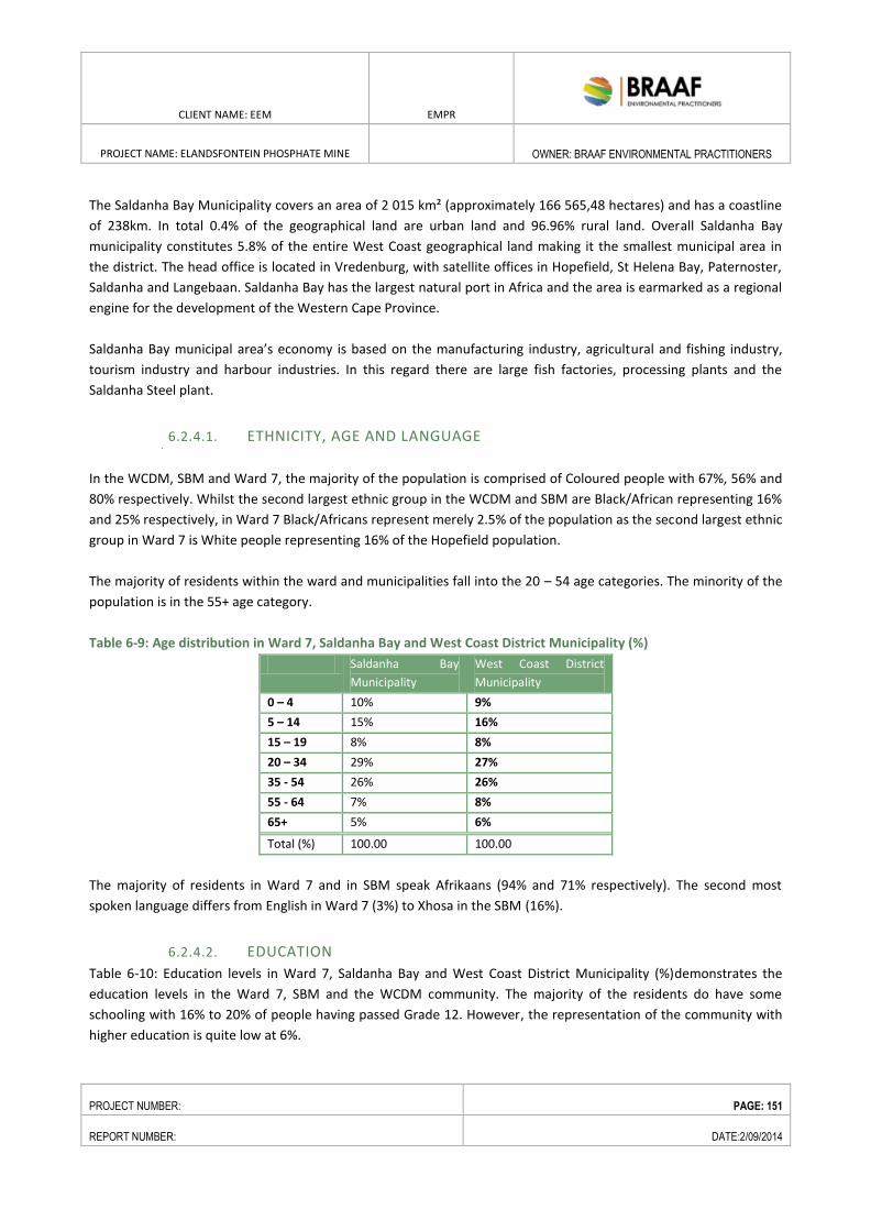
CLIENT NAME: EEM EMPR
PROJECT NAME: ELANDSFONTEIN PHOSPHATE MINE
OWNER: BRAAF ENVIRONMENTAL PRACTITIONERS
PROJECT NUMBER: PAGE: 151
REPORT NUMBER: DATE:2/09/2014
The Saldanha Bay Municipality covers an area of 2 015 km² (approximately 166 565,48 hectares) and has a coastline
of 238km. In total 0.4% of the geographical land are urban land and 96.96% rural land. Overall Saldanha Bay
municipality constitutes 5.8% of the entire West Coast geographical land making it the smallest municipal area in
the district. The head office is located in Vredenburg, with satellite offices in Hopefield, St Helena Bay, Paternoster,
Saldanha and Langebaan. Saldanha Bay has the largest natural port in Africa and the area is earmarked as a regional
engine for the development of the Western Cape Province.
Saldanha Bay municipal area’s economy is based on the manufacturing industry, agricultural and fishing industry,
tourism industry and harbour industries. In this regard there are large fish factories, processing plants and the
Saldanha Steel plant.
6.2.4.1. ETHNICITY, AGE AND LANGUAGE
In the WCDM, SBM and Ward 7, the majority of the population is comprised of Coloured people with 67%, 56% and
80% respectively. Whilst the second largest ethnic group in the WCDM and SBM are Black/African representing 16%
and 25% respectively, in Ward 7 Black/Africans represent merely 2.5% of the population as the second largest ethnic
group in Ward 7 is White people representing 16% of the Hopefield population.
The majority of residents within the ward and municipalities fall into the 20 – 54 age categories. The minority of the
population is in the 55+ age category.
Table 6-9: Age distribution in Ward 7, Saldanha Bay and West Coast District Municipality (%)
Saldanha Bay
Municipality
West Coast District
Municipality
0 – 4 10% 9%
5 – 14 15% 16%
15 – 19 8% 8%
20 – 34 29% 27%
35 - 54 26% 26%
55 - 64 7% 8%
65+ 5% 6%
Total (%) 100.00 100.00
The majority of residents in Ward 7 and in SBM speak Afrikaans (94% and 71% respectively). The second most
spoken language differs from English in Ward 7 (3%) to Xhosa in the SBM (16%).
6.2.4.2. EDUCATION
Table 6-10: Education levels in Ward 7, Saldanha Bay and West Coast District Municipality (%)demonstrates the
education levels in the Ward 7, SBM and the WCDM community. The majority of the residents do have some
schooling with 16% to 20% of people having passed Grade 12. However, the representation of the community with
higher education is quite low at 6%.
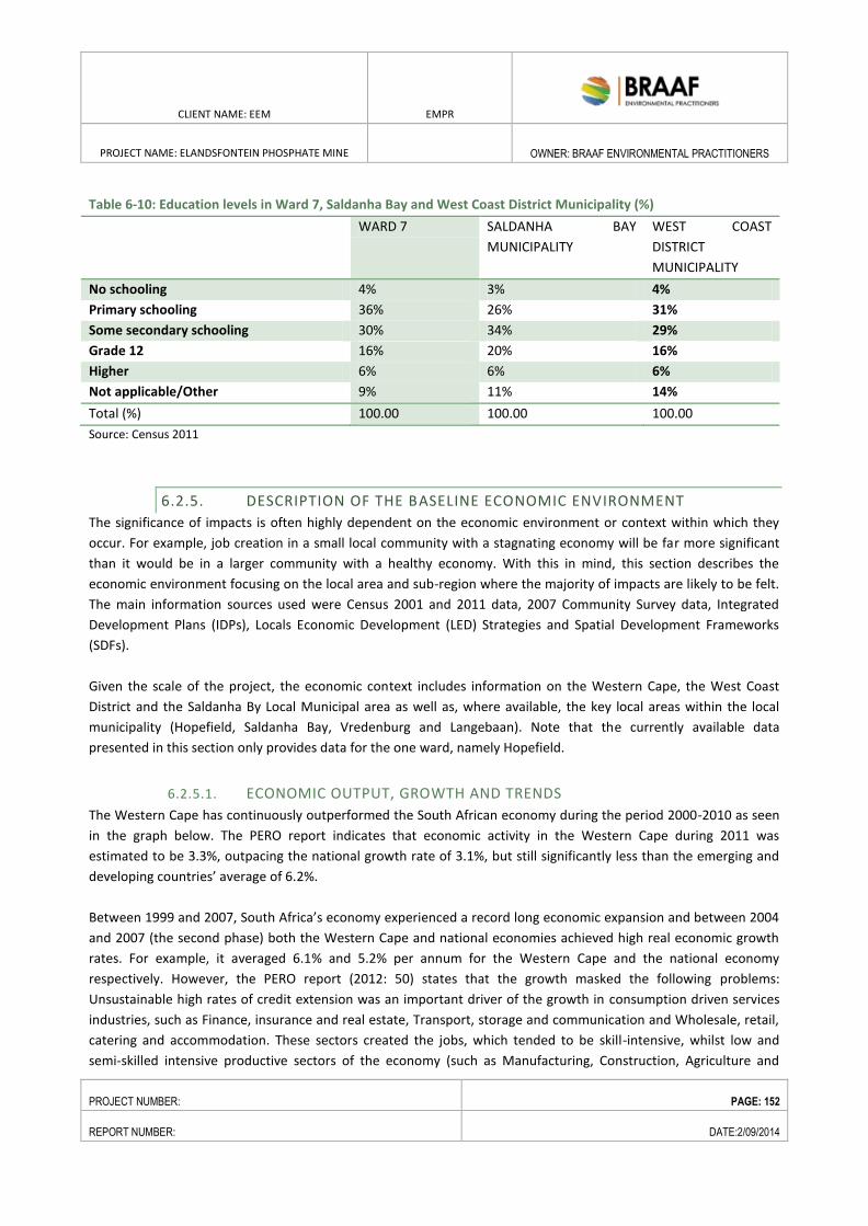
CLIENT NAME: EEM EMPR
PROJECT NAME: ELANDSFONTEIN PHOSPHATE MINE
OWNER: BRAAF ENVIRONMENTAL PRACTITIONERS
PROJECT NUMBER: PAGE: 152
REPORT NUMBER: DATE:2/09/2014
Table 6-10: Education levels in Ward 7, Saldanha Bay and West Coast District Municipality (%)
WARD 7 SALDANHA BAY
MUNICIPALITY
WEST COAST
DISTRICT
MUNICIPALITY
No schooling 4% 3% 4%
Primary schooling 36% 26% 31%
Some secondary schooling 30% 34% 29%
Grade 12 16% 20% 16%
Higher 6% 6% 6%
Not applicable/Other 9% 11% 14%
Total (%) 100.00 100.00 100.00
Source: Census 2011
6.2.5. DESCRIPTION OF THE BASELINE ECONOMIC ENVIRONMENT
The significance of impacts is often highly dependent on the economic environment or context within which they
occur. For example, job creation in a small local community with a stagnating economy will be far more significant
than it would be in a larger community with a healthy economy. With this in mind, this section describes the
economic environment focusing on the local area and sub-region where the majority of impacts are likely to be felt.
The main information sources used were Census 2001 and 2011 data, 2007 Community Survey data, Integrated
Development Plans (IDPs), Locals Economic Development (LED) Strategies and Spatial Development Frameworks
(SDFs).
Given the scale of the project, the economic context includes information on the Western Cape, the West Coast
District and the Saldanha By Local Municipal area as well as, where available, the key local areas within the local
municipality (Hopefield, Saldanha Bay, Vredenburg and Langebaan). Note that the currently available data
presented in this section only provides data for the one ward, namely Hopefield.
6.2.5.1. ECONOMIC OUTPUT, GROWTH AND TRENDS
The Western Cape has continuously outperformed the South African economy during the period 2000-2010 as seen
in the graph below. The PERO report indicates that economic activity in the Western Cape during 2011 was
estimated to be 3.3%, outpacing the national growth rate of 3.1%, but still significantly less than the emerging and
developing countries’ average of 6.2%.
Between 1999 and 2007, South Africa’s economy experienced a record long economic expansion and between 2004
and 2007 (the second phase) both the Western Cape and national economies achieved high real economic growth
rates. For example, it averaged 6.1% and 5.2% per annum for the Western Cape and the national economy
respectively. However, the PERO report (2012: 50) states that the growth masked the following problems:
Unsustainable high rates of credit extension was an important driver of the growth in consumption driven services
industries, such as Finance, insurance and real estate, Transport, storage and communication and Wholesale, retail,
catering and accommodation. These sectors created the jobs, which tended to be skill-intensive, whilst low and
semi-skilled intensive productive sectors of the economy (such as Manufacturing, Construction, Agriculture and
CLIENT NAME: EEM EMPR
PROJECT NAME: ELANDSFONTEIN PHOSPHATE MINE
OWNER: BRAAF ENVIRONMENTAL PRACTITIONERS
PROJECT NUMBER: PAGE: 153
REPORT NUMBER: DATE:2/09/2014
Mining) grew at low rates and barely added to their workforces, if at all. The outcome was a high current account
deficit (averaging 7% of GDP in 2007) and unemployment not falling below 22.8% despite the 5% annual growth
between 2005 and 2007.The growth in the economy was not pro-poor with very little impact on the high levels of
inequality prevalent in the economy.
“The high-growth sectors (7-9% real value-added growth) in the province (e.g. Finance & insurance, Construction,
Communication; furniture, other transport equipment, including boat building) are poor labour absorbers. A whole
range of primary and secondary industries shed jobs despite the better economic conditions over the biggest part of
the 2000-9 periods. This group is led by the job-shedding that occurred in the Agricultural and Manufacturing sub-
sectors specifically clothing & textiles, non-metal minerals, electronics, food & beverages, petrochemicals (all
exhibiting below-average growth) furniture, leather & footwear and automotives (exhibiting high growth).
A whole range of primary and secondary industries shed jobs despite the better economic conditions over the
biggest part of the 2000-9 periods. This group is led by the job-shedding that occurred in the Agricultural and
Manufacturing sub-sectors specifically clothing & textiles, non-metal minerals, electronics, food & beverages,
petrochemicals (all exhibiting below-average growth) furniture, leather & footwear and automotives (exhibiting high
growth).
Even though these sectors are the largest contributors to GDPR, the greatest growth between 2000 and 2008 was
recorded in the Construction sector (7.7%) followed by Finance, real estate and business services (6.1%) and
Transport & Communication (5.3%). Low growth was primarily recorded in the primary sectors of the economy, i.e.
Agriculture, forestry and fishing and Mining & Quarrying.
The PERO report (2012) states that Agriculture, Forestry and Fishing sector grew by 2.2 % between 2000 and 2010,
with a significant decline in 2011. This sector also shed significant jobs - occurring alongside the retrenchment of
farm workers at an annual rate of 7.8%.
According to the Department of Agriculture (2007), agricultural activity in the Western Cape covers an area of 11, 5
million hectares (ha). Although this is only approximately 12, 4% of the total agricultural land available in South
Africa, the Western Cape produces between 55% and 60% of South Africa’s agricultural exports. The Western Cape
also contributes approximately 20% towards South Africa’s total agricultural production.
The Western Cape has a diverse production capacity with 11 commodities contributing significantly to agricultural
production. Agricultural production like fruit, poultry and eggs, winter grains such as barley, wheat and hops,
viticulture and vegetables together contribute more than 75% of the total output. Consequently, the diversity of the
agricultural enterprises also contributes to the sector’s general stability.
The manufacturing sector is a significant sector in the Western Cape economy. Its share of the GDPR is 17.3%. It
expanded by 2.6 % per annum during 2000 – 2010. Job losses in this sector has been substantial - 63 590 jobs were
lost during the period 2000 – 2010, with 85% of all employment opportunities lost occurring in the Cape Metro.
The services sector is the largest contributing sector in terms of GDPR. It is interesting to note that the increased
employment in the services sector (2000-2010) compensated for the loss of employment in the agricultural,
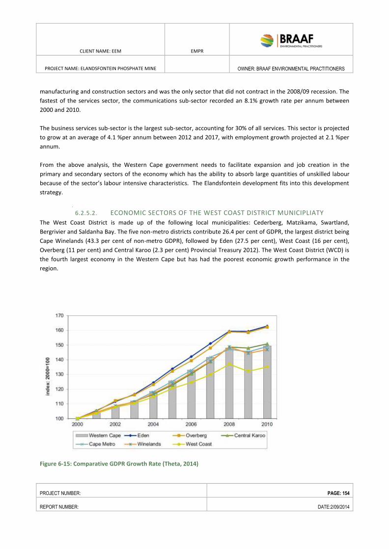
CLIENT NAME: EEM EMPR
PROJECT NAME: ELANDSFONTEIN PHOSPHATE MINE
OWNER: BRAAF ENVIRONMENTAL PRACTITIONERS
PROJECT NUMBER: PAGE: 154
REPORT NUMBER: DATE:2/09/2014
manufacturing and construction sectors and was the only sector that did not contract in the 2008/09 recession. The
fastest of the services sector, the communications sub-sector recorded an 8.1% growth rate per annum between
2000 and 2010.
The business services sub-sector is the largest sub-sector, accounting for 30% of all services. This sector is projected
to grow at an average of 4.1 %per annum between 2012 and 2017, with employment growth projected at 2.1 %per
annum.
From the above analysis, the Western Cape government needs to facilitate expansion and job creation in the
primary and secondary sectors of the economy which has the ability to absorb large quantities of unskilled labour
because of the sector’s labour intensive characteristics. The Elandsfontein development fits into this development
strategy.
6.2.5.2. ECONOMIC SECTORS OF THE WEST COAST DISTRICT MUNICIPLIATY
The West Coast District is made up of the following local municipalities: Cederberg, Matzikama, Swartland,
Bergrivier and Saldanha Bay. The five non-metro districts contribute 26.4 per cent of GDPR, the largest district being
Cape Winelands (43.3 per cent of non-metro GDPR), followed by Eden (27.5 per cent), West Coast (16 per cent),
Overberg (11 per cent) and Central Karoo (2.3 per cent) Provincial Treasury 2012). The West Coast District (WCD) is
the fourth largest economy in the Western Cape but has had the poorest economic growth performance in the
region.
Figure 6-15: Comparative GDPR Growth Rate (Theta, 2014)
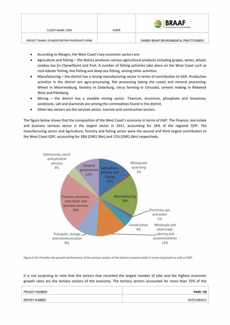
CLIENT NAME: EEM EMPR
PROJECT NAME: ELANDSFONTEIN PHOSPHATE MINE
OWNER: BRAAF ENVIRONMENTAL PRACTITIONERS
PROJECT NUMBER: PAGE: 155
REPORT NUMBER: DATE:2/09/2014
According to Wesgro, the West Coast’s key economic sectors are:
Agriculture and fishing – the district produces various agricultural products including grapes, wines, wheat,
rooibos tea (in Clanwilliam) and fruit. A number of fishing activities take place on the West Coast such as
rock-lobster fishing, line fishing and deep-sea fishing, among other activities.
Manufacturing – the district has a strong manufacturing sector in terms of contribution to GGP. Production
activities in the district are agro-processing, fish processing (along the coast) and mineral processing.
Wheat in Moorreesburg, forestry in Cedarburg, citrus farming in Citrusdal, cement making in Riebeeck
West and Piketberg.
Mining – the district has a sizeable mining sector. Titanium, zirconium, phosphate and limestone,
sandstone, salt and diamonds are among the commodities found in the district.
Other key sectors are the services sector, tourism and construction sectors.
The figure below shows that the composition of the West Coast’s economy in terms of GGP. The Finance, real estate
and business services sector is the largest sector in 2011, accounting for 26% of the regional GDP. The
manufacturing sector and Agriculture, forestry and fishing sector were the second and third largest contributors to
the West Coast GDP, accounting for 18% (ZAR1.9bn) and 15% (ZAR1.6bn) respectively.
Figure 6-16: Provides the growth performance of the various sectors of the district economy both in terms of growth as well as GGP.
It is not surprising to note that the sectors that recorded the largest number of jobs and the highest economic
growth rates are the tertiary sectors of the economy. The tertiary sectors accounted for more than 75% of the
CLIENT NAME: EEM EMPR
PROJECT NAME: ELANDSFONTEIN PHOSPHATE MINE
OWNER: BRAAF ENVIRONMENTAL PRACTITIONERS
PROJECT NUMBER: PAGE: 156
REPORT NUMBER: DATE:2/09/2014
growth, whist the productive sectors like Agriculture, etc and Manufacturing was job shedders. The Mining sector
was the only productive sector that registered employment creation.
According to Wesgro (2014), the West Coast district is a key driver of exports in the Western Cape. Wesgro’s data
suggests that both exports and imports increased from 2003 to 2005 before declining from 2006 to 2007. In 2008,
both exports and imports reached their highest level before declining from 2009 to 2011, however in 2012 both
exports and imports experienced strong growth. The West Coast has maintained a positive trade balance during the
period 2003 to 2012.
6.2.5.3. SALDANHA BAY ECONOMIC SECTORS AND LOCAL GDP
The Saldanha economy has been the best performing economy in the West Coast district. Its annual economic
growth rate between 2000 and 2010 was 4.6% which is significantly higher than that of the other local municipalities
in the West Coast district. The key growth sectors in Saldanha were; Finance, insurance, real estate & business
services followed by Mining and quarrying and general government services. The sectors that contracted were
Manufacturing and Electricity, gas and water.
In terms of the sectoral contribution of economic activity in the Saldanha Bay municipality, Finance, insurance, real
estate & business services is the largest sector; this is followed by general government, Manufacturing and
Wholesale and retail trade, catering and accommodation. Mining and quarrying, despite its significant growth rate,
only represents 1.2% of the municipality’s GGP.
The principal sectors are briefly described in the table below:
Sector Method Mining Several mining activities have established near Saldanha and
Langebaan and include mining of construction materials such as lime
scales and sand.
Industry / manufacturing Development of the Port of Saldanha for iron ore export promoted large
scale industrial growth in the area e.g. establishment of the
ArcelorMittal steel plant, the Namakwa Sands smelter.
Additional industrial development, e.g. through the increase of port
capacity and establishment of the IDZ, is currently being promoted.
Agriculture Crops grown in the SBM include wheat, canola, rooibos tea, fruit,
grapes and vegetables.
Animal products include poultry, fresh milk and dairy products, beef,
mutton, lamb and pork. Due to increased mechanisation, the sector is
becoming less important for employment generation; Fishing Historically an important economic activity - fishing activities
represented in SBM include deep-sea fishing, line fishing, lobster,
trapping and aquaculture.
Aquaculture takes place both in Saldanha Bay and St. Helena Bay.
Fish is processed locally in various fishmeal, fish canning and other fish
processing plants located primarily in St. Helena Bay and Saldanha
CLIENT NAME: EEM EMPR
PROJECT NAME: ELANDSFONTEIN PHOSPHATE MINE
OWNER: BRAAF ENVIRONMENTAL PRACTITIONERS
PROJECT NUMBER: PAGE: 157
REPORT NUMBER: DATE:2/09/2014
Tourism SBM is a well-known and popular tourist destination and the sector
plays an increasingly important role in the economy
The previous dependency of the SBM economy from the principal economic sectors of fishing and agriculture is
diversifying to include manufacturing and tourism as major economic sectors. Since 1995 over 9000 jobs have been
lost in the agricultural, manufacturing, construction and trade sectors, especially in the agricultural sector.
Employment in the other sectors - particularly in the finance, transport and service sectors, which are now the
largest employers in the area - has increased since 1995, with approximately 13 300 new jobs added by 2010.This
diversification should deliver major economic growth, but can also lead to social displacement, with social cohesion
of the municipality threatened if locals are not able to take advantage of opportunities due to a lack of skills (SBM
IDP, 2006).
6.2.5.4. EMPLOYMENT
In accordance with the Census 2011 statistics, approximately 76% of the population active in the labour market)
were employed, while 10 470 (24%) were unemployed in 2011. Amongst the various population groups,
employment rates are lower for Black African and Coloureds than Whites, while a larger proportion of the White
and Coloured population is not economically active. The wards with the most people in employment are those that
include towns (e.g. Saldanha and Vredenburg). The sectors in which most people were employed are:
Finance, insurance, real estate and business services;
General government services;
Community, social and personal series;
Mining and quarrying; and
Wholesale and retail trade, catering and accommodation
Employment in the agriculture, manufacturing, trade and construction sectors have decreased since 1995. In all the
remaining sectors (mining, transport, finance and service) employment has shown an increase since 1995.
Particularly noticeable is the sharp increase in mining since 2004.
6.2.5.5. HOUSING
The total number of households within the municipal area increased from 18 889 households in 2001 to a total of 28
811 households in 2011, representing a growth rate of nearly 53%. The number of households per ward in Saldanha
Bay Municipality ranges from 1 247 to 3 533.
The current status of housing in the community is as follows:
i. The majority of households (80%) in Saldanha Bay Municipality live in formal dwellings (houses, flats and
townhouses);
ii. About 18% of households live in informal and/or traditional dwellings;
iii. Since 2010 the percentage of informal houses increased from 9% to 18%;
iv. 5084 households will form part of the municipality’s housing backlog. The number of households that have
a house, flat or room in a backyard has increased by 71% from 2010.
CLIENT NAME: EEM EMPR
PROJECT NAME: ELANDSFONTEIN PHOSPHATE MINE
OWNER: BRAAF ENVIRONMENTAL PRACTITIONERS
PROJECT NUMBER: PAGE: 158
REPORT NUMBER: DATE:2/09/2014
6.2.5.6. SERVICE PROVISION
6.2.5.6.1. WATER
The bulk sources of fresh water for the municipal area are wet catchment areas that are naturally recharged by
rainfall. Water is provided to the Saldanha Bay Municipal area by the District Council through the Saldanha-Berg
River Water Provision Scheme (VKE Engineers, 1999, cited in Urban Dynamics Western Cape, 2011). The main bulk
water source is the Berg River, which feeds to the Misverstand Dam from where the water is pumped to a
purification facility. It is then stored in the Bezaansklip and Vergeleë reservoirs (Urban Dynamics Western Cape,
2011). Due to the growing population of the municipal area, the demand for potable water is due to increase
significantly. In cooperation with the WCDM, the SBM has instituted a water demand management programme to
ensure effective, affordable and sustainable water services.
6.2.5.6.2. SEWERAGE
There are 3 major pump stations with high capacity in the municipal area. There are five sewage treatment plants in
the municipal area and they are located at Saldanha, Vredenburg, Langebaan, Laingville and Paternoster. Most of
the freshwater inputs that are discharged annually through the sewage treatment works are not recycled and
discharge into environmental sinks. In general the sewerage treatment system is adequate to address the
demands of the study area although a number of improvements are required which includes upgrades to Saldanha
wastewater treatment works (WWTW) is now approaching the maximum annual limit (Urban Dynamics Western
Cape, 2011). Both the WWTW and pump stations at Saldanha will have to be upgraded / extended in anticipation of
a population increase.
6.2.5.6.3. ELECTRICITY
Bulk electricity (400 kV) is supplied by Eskom throughout the municipal area. Saldanha Steel receives electricity (132
kV) directly from Eskom. There is a 132 kV substation in Blue Water Bay that distributes electricity to the industrial
areas. 66kV networks supply electricity to Vredenburg, Saldanha, St Helena Bay and Velddrif, while 11 kV networks
supply Langebaan, Jacobs Bay and Paternoster. The bulk of the municipal areas electricity is provided by Council
except for St Helena Bay and the rural areas that receive electricity directly from Eskom. (Urban Dynamics Western
Cape, 2011).
6.2.5.6.4. SOLID WASTE MANAGEMENT
The Saldanha Bay Municipal area produces 634 tons of solid waste per week (Entech Consultants, 2001 cited in
Urban Dynamics Western Cape, 2011), which is serviced from 16 611 service points. The solid waste is transported
to the following municipal solid waste disposal sites: Vredenburg Landfill and Langebaan Landfill Site. Of these, only
the Vredenburg landfill has medium to long term capacity.
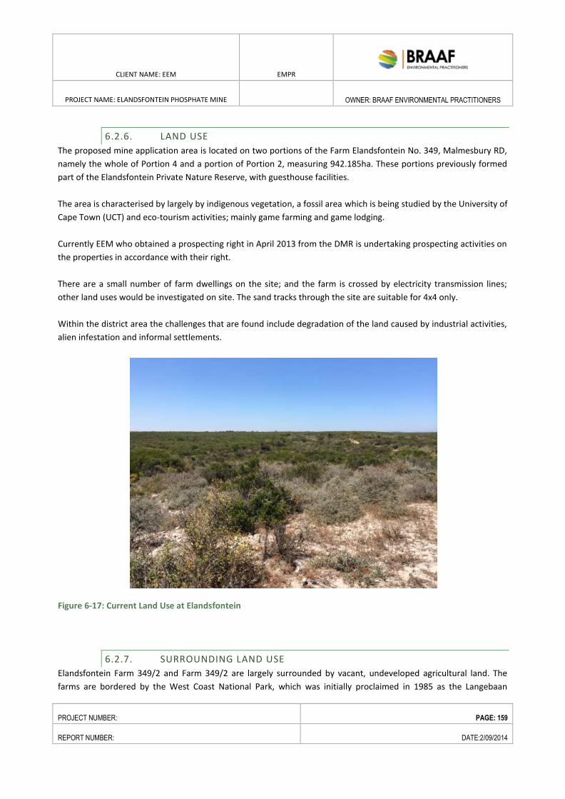
CLIENT NAME: EEM EMPR
PROJECT NAME: ELANDSFONTEIN PHOSPHATE MINE
OWNER: BRAAF ENVIRONMENTAL PRACTITIONERS
PROJECT NUMBER: PAGE: 159
REPORT NUMBER: DATE:2/09/2014
6.2.6. LAND USE
The proposed mine application area is located on two portions of the Farm Elandsfontein No. 349, Malmesbury RD,
namely the whole of Portion 4 and a portion of Portion 2, measuring 942.185ha. These portions previously formed
part of the Elandsfontein Private Nature Reserve, with guesthouse facilities.
The area is characterised by largely by indigenous vegetation, a fossil area which is being studied by the University of
Cape Town (UCT) and eco-tourism activities; mainly game farming and game lodging.
Currently EEM who obtained a prospecting right in April 2013 from the DMR is undertaking prospecting activities on
the properties in accordance with their right.
There are a small number of farm dwellings on the site; and the farm is crossed by electricity transmission lines;
other land uses would be investigated on site. The sand tracks through the site are suitable for 4x4 only.
Within the district area the challenges that are found include degradation of the land caused by industrial activities,
alien infestation and informal settlements.
Figure 6-17: Current Land Use at Elandsfontein
6.2.7. SURROUNDING LAND USE
Elandsfontein Farm 349/2 and Farm 349/2 are largely surrounded by vacant, undeveloped agricultural land. The
farms are bordered by the West Coast National Park, which was initially proclaimed in 1985 as the Langebaan
CLIENT NAME: EEM EMPR
PROJECT NAME: ELANDSFONTEIN PHOSPHATE MINE
OWNER: BRAAF ENVIRONMENTAL PRACTITIONERS
PROJECT NUMBER: PAGE: 160
REPORT NUMBER: DATE:2/09/2014
National Park (Proclamation 138 in GG 9904 of 30 August 1985), with the name later being changed to the West
Coast National Park (WCNP) (GN 1135 in GG 10789 of 26 June 1987). In October 2013, two additional portions,
namely, Farm 349/3 and the Farm Grootfontyn No. 305, Malmesbury RD was declared as forming part of the WCNP.
The Elandsfontein Prospecting Right was issued by the DMR prior to the latter coming into effect. Figure 6-18 shows
the relation of the proposed mine area to the WCNP. The areas earmarked for the mining operation (Farm 349/4
and 349/2) is within the buffer zone of the WCNP and has been identified as forming part of the parks expansion
area.
The Biodiversity Policy and Strategy for South Africa: Strategy on Buffer Zones For National Parks
(Government Notice 106 of 102), came into effect on 8 February 2012, with its purpose of function to reduce or
mitigate the negative influences of activities taking place outside the parks on the parks and, to better integrate
parks into their surrounding landscapes. This concept has been widely recommended, including in the operational
guidelines of UNESCO's World Heritage Convention.
Therefore, the purpose of a buffer zone is to:
Protect the purpose and values of the national park, which is to be explicitly defined in the management
plan submitted in terms of section 39(2) of the Act;
Protect important areas of high value for biodiversity and/or to society where these extend beyond the
boundary of the Protected Area;
Assist adjacent and affected communities to secure appropriate and sustainable benefits from the national
park and buffer zone area itself by promoting a conservation economy, ecotourism and its supporting
infrastructure and services, and sustainability through properly planned harvesting.
A buffer zone may be established around a national park when considered necessary for the proper conservation
and effective protection of the national park in achieving its objectives. This includes the immediate setting of the
national park, important views and other areas or attributes that are functionally important as a support to the
national park and its protection. Figure 6-18 indicates the borders of the WCNP and the core expansion area to the
north which includes the Elandsfontein Mine area.
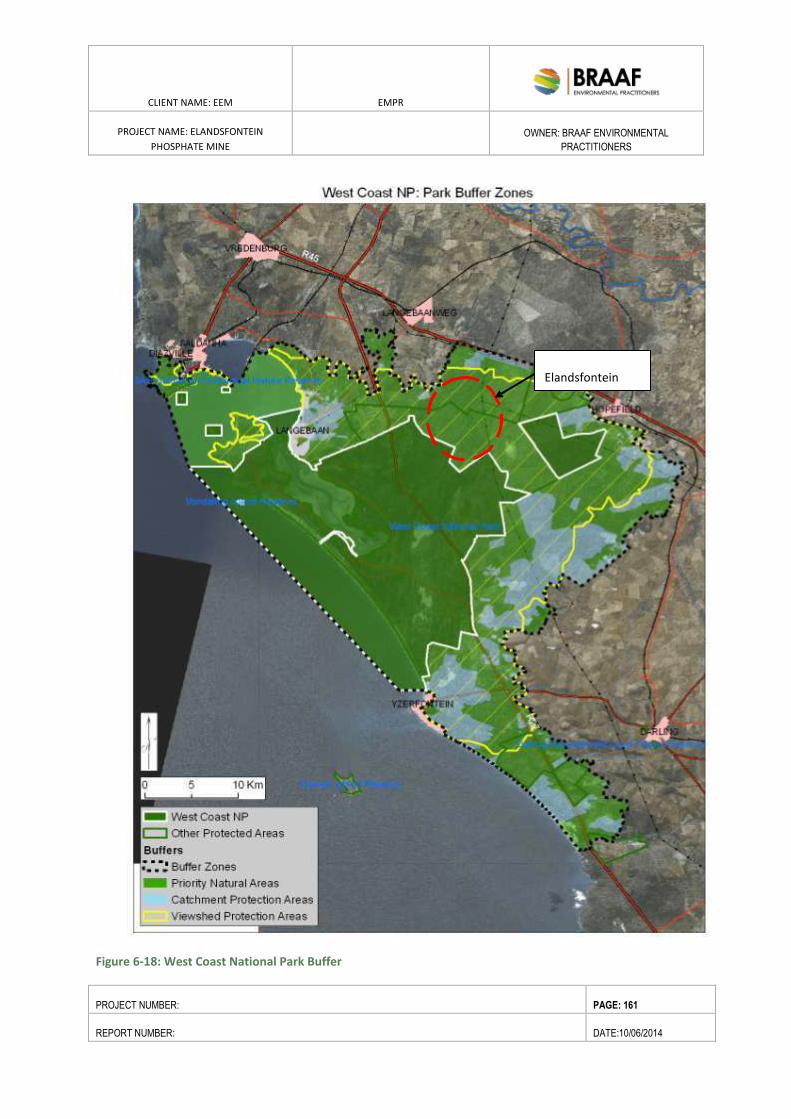
CLIENT NAME: EEM EMPR
PROJECT NAME: ELANDSFONTEIN
PHOSPHATE MINE
OWNER: BRAAF ENVIRONMENTAL
PRACTITIONERS
PROJECT NUMBER: PAGE: 161
REPORT NUMBER: DATE:10/06/2014
Figure 6-18: West Coast National Park Buffer
Elandsfontein
CLIENT NAME: EEM EMPR
PROJECT NAME: ELANDSFONTEIN
PHOSPHATE MINE
OWNER: BRAAF ENVIRONMENTAL
PRACTITIONERS
PROJECT NUMBER: PAGE: 162
REPORT NUMBER: DATE:10/06/2014
6.3. VISUAL
Karen Hansen Landscape Architects were commissioned to carry out a Visual Assessment for the Mine
and associated infrastructure (refer to Annex C for the full report).
6.3.1.1. LANDSCAPE CHARACTER
Between the farm and the coast, (both north and south), the land is very undulating with many small
koppies; whereas, to the east, the land is more open, with gentler slopes.
The mining right site is characterised by a valley lying north-west – south-east between 77 and 78m
asl.; the whole of the works will be at 77 and 120m asl. The land to the immediate south-west rises
to Staankop, 136m, and to the north-east to Stinkkruidkop at 114m. The valley is the original route of
the Berg River, which now flows north to Velddrif.
The land to the south and west is occupied by a range of low hills in a north-south grouping; the R27
is shielded from the site by these hills as is the lagoon, Langebaan town and Saldanha Bay. To the east
of the site is a gentle north-south ridge to 105m asl., beyond which, further east, is Hopefield.
Hopefield lies in the Soutrivier valley at 20 to 60m elevation. The flora has been grazed by cattle, and
there are antelope on the farm now. The farm lies within the Fynbos biome with the vegetation
reaching heights of around 2 metres.
6.3.1.2. SENSITIVE VIEW LOCATIONS
Sensitive viewer locations would be views from users of the R27 and R45 and local roads.
Potential Receptor
Users of existing transport corridors including in each case, travelling in each
direction, i.e. roads, R45, R27, local roads and rail line
People living and working locally in Agriculture; no major farmsteads within
7km, but there are a few scattered buildings in the area: sensitive receptors
Local tourist facilities and routes: the R27 is a tourist route; no tourist facilities
within the zone of visual impact
Local protected landscapes, West Coast National Park; areas currently publicly
accessible are not within the zone of visual impact
Local population centres, such as Hopefield, Langebaanweg, etc, beyond the
zone of visual impact
CLIENT NAME: EEM EMPR
PROJECT NAME: ELANDSFONTEIN
PHOSPHATE MINE
OWNER: BRAAF ENVIRONMENTAL
PRACTITIONERS
PROJECT NUMBER: PAGE: 163
REPORT NUMBER: DATE:10/06/2014
6.4. HERITAGE, ARCHAEOLOGY AND PALEONTOLOGY
A Heritage and Archaeological Impact Assessment was undertaken by Dr. David Braun, Mr. Jonathan Kaplan
and Mr. Henry Aikman. In order to outline the nature of paleontological artefacts (fossils) in the subsurface of
the Project area, which may potentially be affected by construction and operational activities, Mr. John Pether
was appointed to undertake a desktop Paleontological Impact Assessment.
6.4.1.1. FARM ELANDSFONTEIN 349/4 AND FARM 349/2
The following information was extracted from the Heritage Scoping Report for the proposed mining
right on Portion 4 and a portion of Portion 2 of the Farm Elandsfontein 349; dated December; compiled
by the Agency for Cultural Resource Management.
The proposed mining application area is located adjacent to the well-known `Elandsfontein Fossil Site’.
The fossil site (about 3 kms to the east of the proposed mining area) is known for producing Middle
Stone Age tools with associated fauna (bone) more than 200 000 years old (Goodwin 1953; Klein
1988; Braun & Archer 2010) and the `Saldanha or `Hopefield’ Man’ skull from the fossil site, is the
oldest known human in the Cape, with a date between 700 000 and 400 000 years ago (Drennan
1953, 1954; Singer & Wymer 1968). Early Stone Age tools more than 1 million years old have also
been found on the ancient fossil floors (or palaeosoils), exposed by wind erosion. The fossil site is only
one of a few localities in South Africa that preserves both archaeological and organic remains (bones) in
an open air context (Braun 2013).
6.4.1.2. ARCHAEOLOGY
The history of scientific research at Elandsfontein spans more than 60 years, with the initial survey of
fossil and archaeological material taking place in the 1950s (Braun et al 2013). This research has seen
more than 20 scientific reports/published papers dedicated to the site. Internationally, it is one of the
most recognised Pleistocene heritage sites in South Africa. The `Elandsfontein Fossil Beds’, known for
producing Early Stone Age (ESA) artefacts older than 1 million years, are of global scientific importance
(Pether 2013).
It is well-known that the Saldanha Bay area is a region of high archaeological importance, particularly
with regard to Pleistocene archaeology. The Elandsfontein fossil site is also only one of a few
localities in South Africa that preserves both archaeological and organic remains (bones) in an in situ
(open air) context, allowing archaeologists a unique opportunity to study the evolution of early
modern humans and how they interacted with their ecosystems more than 200 000 years ago (Braun
2013).
New observations at the site indicate that the main assemblage at Elandsfontein may now be as old as
~1 million years (Braun et al 2013). The context of fossil bones and artefacts in aeolian sands is well-
illustrated by the `Elandsfontein Fossil Beds’ which include a sparse bone content in the uppermost
Langebaan Formation, and a more persistent bone and artefact content in the overlying Springfontyn
Formation sands.
CLIENT NAME: EEM EMPR
PROJECT NAME: ELANDSFONTEIN
PHOSPHATE MINE
OWNER: BRAAF ENVIRONMENTAL
PRACTITIONERS
PROJECT NUMBER: PAGE: 164
REPORT NUMBER: DATE:10/06/2014
Dr Braun, who currently has a research permit for the archaeological site, has noted that the area is
`one of the richest sites of its kind in Africa’ (in Bluff & Hart 2010:10). Current research, however,
suggest that if this ancient landscape extends outside of the (now stable) dunefield, that any artefacts
or fossils recovered from it will be patchily distributed (Braun et al 2013), but that if fossils are
encountered, they will likely be `numerous and densely concentrated’ (Braun 2013:5).
Plasket (2013) logged a few Middle Stone Age (MSA) flakes, fossil bone and coprolites during a
survey of the proposed mining application area, while Kaplan (2013) found only one MSA silcrete flake
during an assessment of the 17 proposed prospecting drill sites.
While little is known about the Holocene Later Stone Age (LSA) archaeology in the area, Kaplan (2011)
did document relatively large numbers of LSA silcrete stone flakes on a limestone ridge (outside the
application area) on Farm 349, alongside the Eskom servitude that runs between the Elandsfontyn fossil
site, and the proposed mining area. Orton (2007) identified a single LSA flake on Farm 349/6.
6.4.1.3. PALAEONTOLOGY
The specialist report by Pether (2013), addresses the palaeontological sensitivity of the stratigraphic
section below the near-surface, fossiliferous deposits, viz. the Langebaan and Varswater formations. It is
the calcareous Langebaan Formation that contains much of the archaeological and fossil remains which
have been encountered at the nearby fossil site (Singer and Wymer 1968). The high fossil potential
of the Langebaan Formation is therefore well known and according to Pether (2013), most of Farm
349 is underlain by this formation.
Pether (2013) notes, that it is generally not possible to predict the buried fossil content of an area
other than in general terms, based on what has been previously observed of the fossil content of a
particular formation in a particular area. But, as Pether (2013) argues, there is ample information (more
than 100 scientific papers for the region have been published), to predict with some probability, the
impact of a proposed mining operation on the palaeontological heritage.
In coastal-plain deposits of the Langebaan Formation, for example, the important fossil bone
material is generally sparsely scattered and unless large and obvious, is not generally seen,
underestimating the fossil prevalence. Much therefore depends on careful scrutiny of exposures and on
spotting this material as it is uncovered during digging i.e. by monitoring excavations.
While the high fossil potential of the Langebaan Formation is well known, the pre- Langebaan
Formation (i. e. the Varswater Formation) phosphatic aeolianite (the target area for mining), have
an unproven, `but strong potential’ to yield fossil remains additional to the known marine microfossil
content, such as land snails and micro mammals (Pether 2013:36). Bluff & Hart (2010) note that the
Varswater Formation at Langebaanweg (the old Samancor Chemo’s Mine and now the West Coast
Fossil Park), for example, is highly fossiliferous, containing the world’s densest known concentration of
CLIENT NAME: EEM EMPR
PROJECT NAME: ELANDSFONTEIN
PHOSPHATE MINE
OWNER: BRAAF ENVIRONMENTAL
PRACTITIONERS
PROJECT NUMBER: PAGE: 165
REPORT NUMBER: DATE:10/06/2014
Pliocene vertebrate fossils, about 5 million years old. Preservation of cores from the phosphate
prospecting programme, including sub sampling of selected intervals, sample disaggregation, sieving
and macro - and optical microscopic inspection, may yield interesting observations and inform further
investigations (Pether 2013).
6.4.1.4. GRAVES
Historical graves are usually well marked and mostly occur in small farm graveyards. Pre- colonial
graves, on the other hand, can occur at any location where sand suitable for excavation and burial
exists. This is particularly the case in the coastal area where dunes abound. Pre-colonial graves are
unmarked and their locations cannot be predicted and no plans can be made to avoid intersecting such
graves.
6.5. TRAFFIC
The baseline traffic loads have been determined a n d t wo main points of impact need to be
considered, at the mine access and roads leading to the Port. The mine access road will intersect the
R45 between Hopefield and the Aurora substation, at coordinates 33° 1'18.40"S, 18°15'54.52"E. Refer
to Appendix C for the Traffic Impact Assessment.
6.6. AIR QUALITY
6.6.1. EXISTING AIR QUALITY
The area around the Elandsfontein mine is that of a typical rural environment, and as such the air quality in the
area is expected to be of a good standard with low pollution levels. Based on Demos Dracoulide’s (appointed
specialist) observation during a site visit, the area’s air quality appears to be generally good and there are no
major dust or PM10/PM2.5 sources that were identified within or around the proposed mine, other than
windblown dust and dust re-entrainment due to traffic on the existing gravel road network.
6.6.2. EMISSIONS FROM THE PROPOSED ACTIVITIES
The main emission sources were identified as the concentrate transportation trucks travelling on unpaved
roads (the air quality study assumed all roads as unsurfaced, however the main access road will be a tarred
road and hence greatly reduce dust emissions around this route), the mining activities within the mining pit,
the stockpiling of overburden and topsoil, as well as wind erosion at exposed areas and stockpiles. The latter
sources, the transportation trucks on the access road and the haul trucks were the main contributors to the
CLIENT NAME: EEM EMPR
PROJECT NAME: ELANDSFONTEIN
PHOSPHATE MINE
OWNER: BRAAF ENVIRONMENTAL
PRACTITIONERS
PROJECT NUMBER: PAGE: 166
REPORT NUMBER: DATE:10/06/2014
total emissions. Therefore, during the operational phase the main effort in reducing the project’s impact on
the ambient air quality should be focused primarily on minimising the emissions from the access road, the haul
roads and haul truck loading area.
The heavy dust deposition (> 500 mg/m2/d) occurs primarily within the mining area and in close proximity to
the access road. The dust deposition, at a distance of 100 m away from the access road and the mining pit, will
be less than 250 mg/m2/d, i.e. light.
Sensitive receptors were identified as largely adjacent farm houses (see Figure 6-19). The average daily dust
depositions at all receptors are expected to be below the guideline of 600 (mg/m2/day), except for R01 and
R02, which are located within the mining pit area.
The average 24 hour PM10 concentration levels were above the South African Standard for four times of the
year at an area between 600m to 1000m from the mining pit. The predicted PM10 annual maximum
concentrations exceed the annual guideline of 40 μg/m3 (as applicable from 2015) only within the mining pit
and within a few meters from the access road. It can be seen that the maximum 24-hour concentrations are
below the guideline of 65 μg/m3 contour (as applicable from 2015), but exceed the future guideline of 40
μg/m3 and 25 μg/m3, primarily around the mining pit. The number of exceedances great than 4 times a year
are expected to occur only at vicinity of the mining pit. The modelled annual PM2.5 concentrations are below
15 μg/m3. Therefore there will be no guideline exceedances expected to occur.
The essential mitigation measures for the operational phase are summarised in the emissions reduction should
include:
Dust fallout monitoring should be conducted before and after the commencement of the project, in
order to collect background data and verify modelling results. During the operational phase of the
project, annual monitoring should take place for dust fallout at 4 selected locations around the site
boundaries and 2 locations along the access road.
The performance targets for the monitoring should be set to a maximum total daily dust deposition
(calculated from the monthly dust deposition) to be less than 600 mg/m2/day for residential areas,
and the maximum annual average dust deposition within the site to be less than 1,200 mg/m2/day.
Along the access road, a reduction of speed is recommended in order to reduce the dust generation.
The dust deposition levels at 2 locations along the road should be monitored, and if these exceed the
limit then additional measures, such as chemical stabilisation, should be considered.
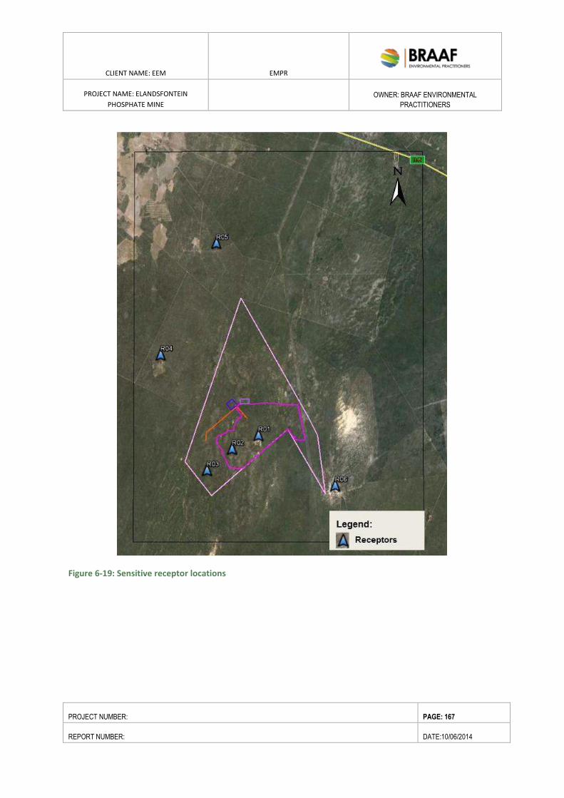
CLIENT NAME: EEM EMPR
PROJECT NAME: ELANDSFONTEIN
PHOSPHATE MINE
OWNER: BRAAF ENVIRONMENTAL
PRACTITIONERS
PROJECT NUMBER: PAGE: 167
REPORT NUMBER: DATE:10/06/2014
Figure 6-19: Sensitive receptor locations
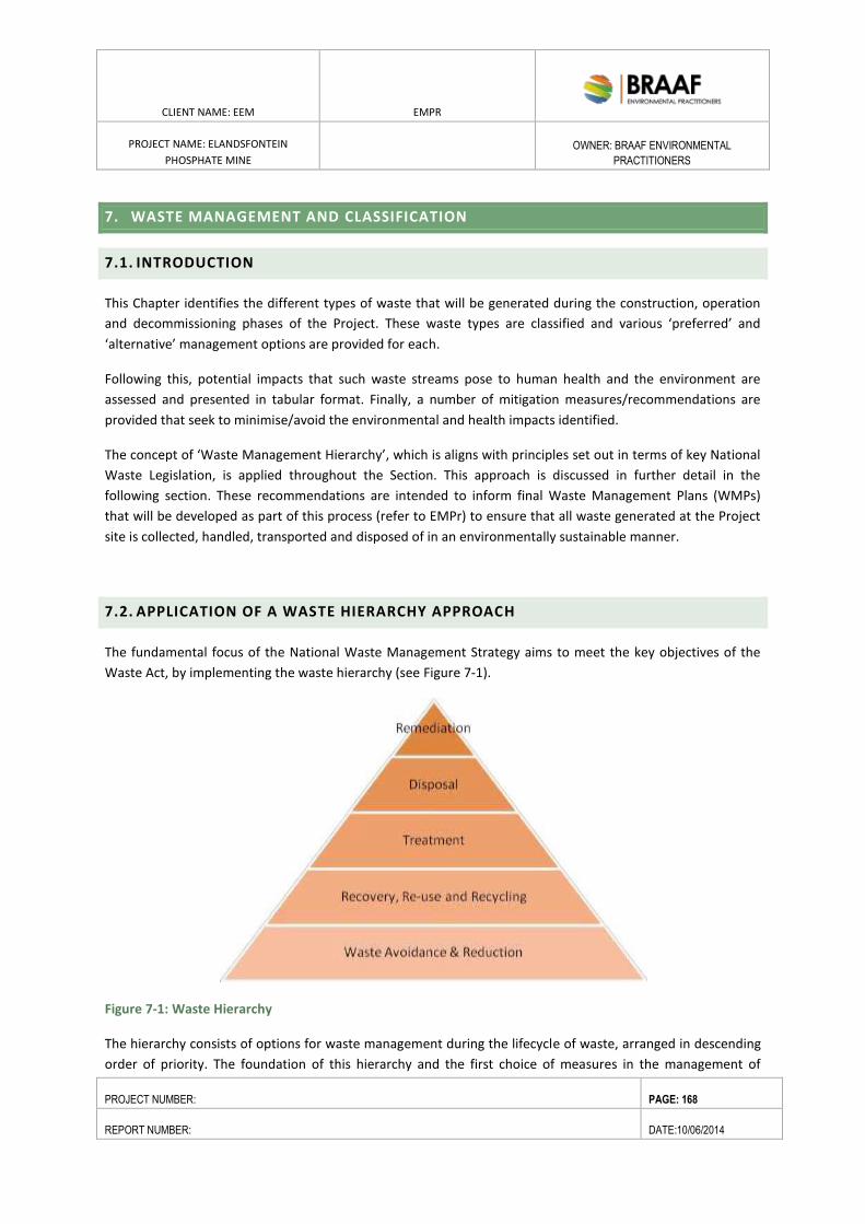
CLIENT NAME: EEM EMPR
PROJECT NAME: ELANDSFONTEIN
PHOSPHATE MINE
OWNER: BRAAF ENVIRONMENTAL
PRACTITIONERS
PROJECT NUMBER: PAGE: 168
REPORT NUMBER: DATE:10/06/2014
7. WASTE MANAGEMENT AND CLASSIFICATION
7.1. INTRODUCTION
This Chapter identifies the different types of waste that will be generated during the construction, operation
and decommissioning phases of the Project. These waste types are classified and various ‘preferred’ and
‘alternative’ management options are provided for each.
Following this, potential impacts that such waste streams pose to human health and the environment are
assessed and presented in tabular format. Finally, a number of mitigation measures/recommendations are
provided that seek to minimise/avoid the environmental and health impacts identified.
The concept of ‘Waste Management Hierarchy’, which is aligns with principles set out in terms of key National
Waste Legislation, is applied throughout the Section. This approach is discussed in further detail in the
following section. These recommendations are intended to inform final Waste Management Plans (WMPs)
that will be developed as part of this process (refer to EMPr) to ensure that all waste generated at the Project
site is collected, handled, transported and disposed of in an environmentally sustainable manner.
7.2. APPLICATION OF A WASTE HIERARCHY APPROACH
The fundamental focus of the National Waste Management Strategy aims to meet the key objectives of the
Waste Act, by implementing the waste hierarchy (see Figure 7-1).
Figure 7-1: Waste Hierarchy
The hierarchy consists of options for waste management during the lifecycle of waste, arranged in descending
order of priority. The foundation of this hierarchy and the first choice of measures in the management of
CLIENT NAME: EEM EMPR
PROJECT NAME: ELANDSFONTEIN
PHOSPHATE MINE
OWNER: BRAAF ENVIRONMENTAL
PRACTITIONERS
PROJECT NUMBER: PAGE: 169
REPORT NUMBER: DATE:10/06/2014
waste are waste avoidance and reduction. As such waste that cannot be avoided should be recovered, reused,
recycled and treated (with recovery, re-use and recycling being preferred management options to the
treatment of waste). Furthermore, waste should only be disposed of as a last resort.
The NEMWA and the NWMS place an emphasis on Industry Waste Management Plans (IndWMPs), which are
the central element in the co-regulatory system. These WMPs are expected to report on, amongst other
things, how the site is going to manage its waste and to provide targets for achieving waste hierarchy issues,
particularly with regard to waste reduction and recycling. As such, it is essential to introduce the principles of
clean technology and the waste hierarchy during the design phase of the project.
Table 8.1 below details the types of waste generated by the Project and provides some preferred management
options that speak to the waste hierarchy concept as described above. Further application of the Waste
Hierarchy is given in Section 8.5.2 below, whereby specific recommendations to minimise, reduce, recycle and
re-use certain types of waste generated by the Project are listed.
7.3. WASTE GENERATION AND CLASSIFICATION
The Project will generate two primary waste streams, which can be categorised as mineral and non-mineral
wastes.
7.3.1. MINERAL WASTES
Mineral wastes that will be generated by Project activities will include overburden and a waste stream
generated from ore processing (tailings).
7.3.2. NON-MINERAL WASTES
Non-mineral wastes (domestic, non-hazardous and hazardous) are generated during construction works and
mine operations, particularly at maintenance workshops, administrative offices and processing plant. Specific
types of that will be generated as a result of the Project are listed in Table 8.1 below. In addition to listing the
types of wastes generated, Table 8.1 also provides ‘preferred’ and ‘alternative’ management options for each
waste stream identified.
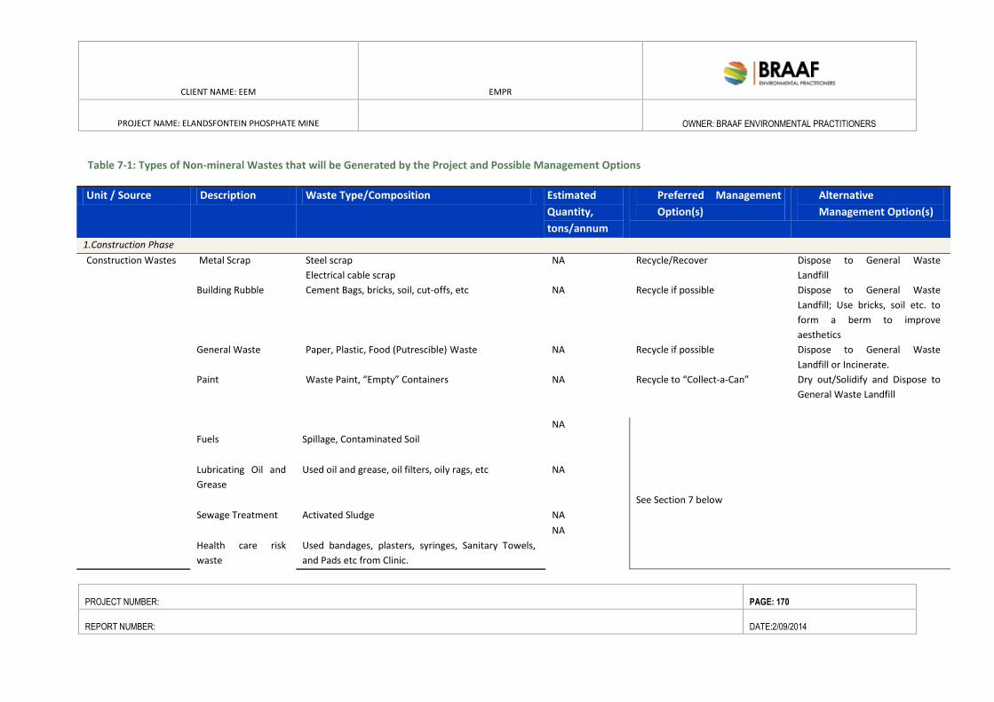
CLIENT NAME: EEM EMPR
PROJECT NAME: ELANDSFONTEIN PHOSPHATE MINE
OWNER: BRAAF ENVIRONMENTAL PRACTITIONERS
PROJECT NUMBER: PAGE: 170
REPORT NUMBER: DATE:2/09/2014
Table 7-1: Types of Non-mineral Wastes that will be Generated by the Project and Possible Management Options
Unit / Source Description Waste Type/Composition Estimated
Quantity,
tons/annum
Preferred Management
Option(s)
Alternative
Management Option(s)
1.Construction Phase
Construction Wastes Metal Scrap Steel scrap
Electrical cable scrap
NA Recycle/Recover Dispose to General Waste
Landfill
Building Rubble Cement Bags, bricks, soil, cut-offs, etc NA Recycle if possible Dispose to General Waste
Landfill; Use bricks, soil etc. to
form a berm to improve
aesthetics
General Waste Paper, Plastic, Food (Putrescible) Waste NA Recycle if possible Dispose to General Waste
Landfill or Incinerate.
Paint Waste Paint, “Empty” Containers NA Recycle to “Collect-a-Can” Dry out/Solidify and Dispose to
General Waste Landfill
Fuels
Spillage, Contaminated Soil
NA
See Section 7 below
Lubricating Oil and
Grease
Used oil and grease, oil filters, oily rags, etc
NA
Sewage Treatment Activated Sludge NA
Health care risk
waste
Used bandages, plasters, syringes, Sanitary Towels,
and Pads etc from Clinic.
NA
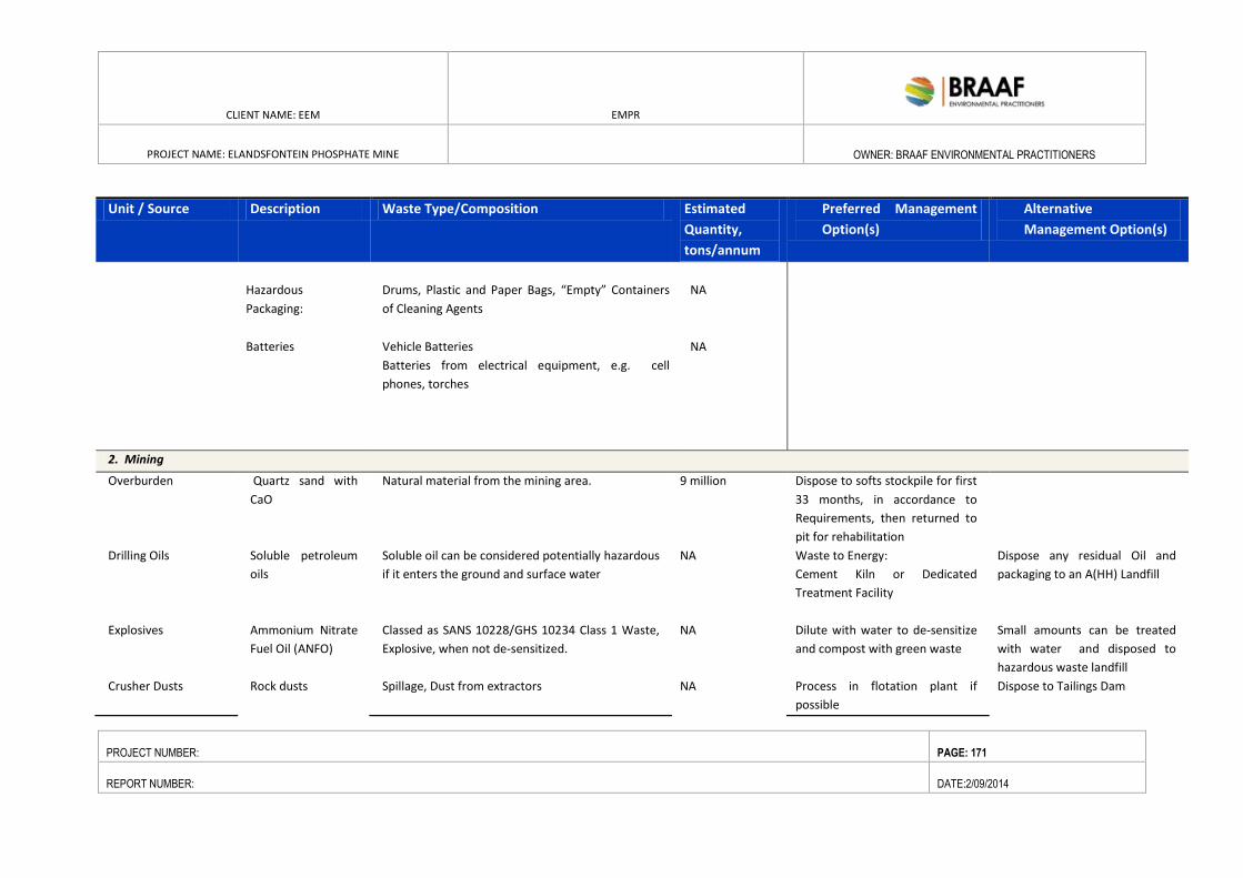
CLIENT NAME: EEM EMPR
PROJECT NAME: ELANDSFONTEIN PHOSPHATE MINE
OWNER: BRAAF ENVIRONMENTAL PRACTITIONERS
PROJECT NUMBER: PAGE: 171
REPORT NUMBER: DATE:2/09/2014
Unit / Source Description Waste Type/Composition Estimated
Quantity,
tons/annum
Preferred Management
Option(s)
Alternative
Management Option(s)
Hazardous
Packaging:
Drums, Plastic and Paper Bags, “Empty” Containers
of Cleaning Agents
NA
Batteries
Vehicle Batteries
Batteries from electrical equipment, e.g. cell
phones, torches
NA
2. Mining NA
Overburden Quartz sand with
CaO
Natural material from the mining area. 9 million Dispose to softs stockpile for first
33 months, in accordance to
Requirements, then returned to
pit for rehabilitation
Drilling Oils Soluble petroleum
oils
Soluble oil can be considered potentially hazardous
if it enters the ground and surface water
NA Waste to Energy:
Cement Kiln or Dedicated
Treatment Facility
Dispose any residual Oil and
packaging to an A(HH) Landfill
Explosives Ammonium Nitrate
Fuel Oil (ANFO)
Classed as SANS 10228/GHS 10234 Class 1 Waste,
Explosive, when not de-sensitized.
NA Dilute with water to de-sensitize
and compost with green waste
Small amounts can be treated
with water and disposed to
hazardous waste landfill
Crusher Dusts Rock dusts Spillage, Dust from extractors NA Process in flotation plant if
possible
Dispose to Tailings Dam
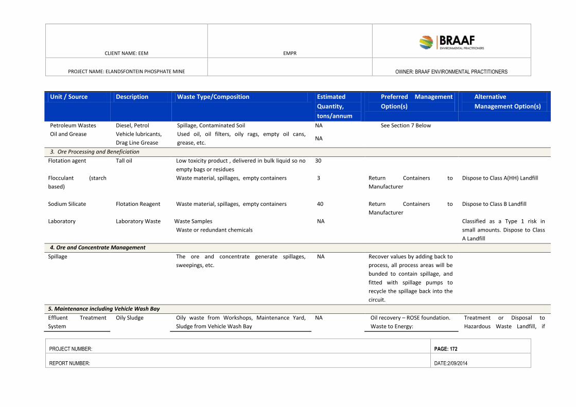
CLIENT NAME: EEM EMPR
PROJECT NAME: ELANDSFONTEIN PHOSPHATE MINE
OWNER: BRAAF ENVIRONMENTAL PRACTITIONERS
PROJECT NUMBER: PAGE: 172
REPORT NUMBER: DATE:2/09/2014
Unit / Source Description Waste Type/Composition Estimated
Quantity,
tons/annum
Preferred Management
Option(s)
Alternative
Management Option(s)
Petroleum Wastes Diesel, Petrol Spillage, Contaminated Soil NA See Section 7 Below
Oil and Grease Vehicle lubricants,
Drag Line Grease
Used oil, oil filters, oily rags, empty oil cans,
grease, etc. NA
3. Ore Processing and Beneficiation
Flotation agent Tall oil Low toxicity product , delivered in bulk liquid so no
empty bags or residues
30
Flocculant (starch
based)
Waste material, spillages, empty containers
3 Return Containers to
Manufacturer
Dispose to Class A(HH) Landfill
Sodium Silicate Flotation Reagent
Waste material, spillages, empty containers
40 Return Containers to
Manufacturer
Dispose to Class B Landfill
Laboratory Laboratory Waste Waste Samples
Waste or redundant chemicals
NA Classified as a Type 1 risk in
small amounts. Dispose to Class
A Landfill
4. Ore and Concentrate Management
Spillage The ore and concentrate generate spillages,
sweepings, etc.
NA Recover values by adding back to
process, all process areas will be
bunded to contain spillage, and
fitted with spillage pumps to
recycle the spillage back into the
circuit.
5. Maintenance including Vehicle Wash Bay
Effluent Treatment
System
Oily Sludge Oily waste from Workshops, Maintenance Yard,
Sludge from Vehicle Wash Bay
NA Oil recovery – ROSE foundation.
Waste to Energy:
Treatment or Disposal to
Hazardous Waste Landfill, if
CLIENT NAME: EEM EMPR
PROJECT NAME: ELANDSFONTEIN PHOSPHATE MINE
OWNER: BRAAF ENVIRONMENTAL PRACTITIONERS
PROJECT NUMBER: PAGE: 173
REPORT NUMBER: DATE:2/09/2014
Unit / Source Description Waste Type/Composition Estimated
Quantity,
tons/annum
Preferred Management
Option(s)
Alternative
Management Option(s)
1) Cement Kiln or
2) Dedicated On-Site Facility
permitted
Oily Wastes “Empty” oil cans, oily rags NA Oily Cans to Recycling
Oily Rags to Landfill, if permitted
6. Tailings
Tailings Residues from
flotation process.
Analytical data still required. 3.8Mtpa Dispose to softs stockpile ensure
pH of 8 to 9 and a high alkalinity
to minimise possibility of
leaching of heavy metals and
fluoride.
7. Effluent Treatment System
Bio Sludge Activated Sludge
NA Agricultural Use,
Compost
Treatment/Disposal to Landfill, if
permitted
Water Treatment
Sludge
Mainly Inorganic Solids NA Could be used in the
manufacture of clay bricks
Treatment/Disposal to Tailings
Dam or Class A or B Landfill, if
permitted
8. Plant and Office Buildings
Office waste Non-hazardous Paper, packaging waste, plastics,
putrescibles
320 Recycle where possible. Treatment/Disposal of Residues
to General Waste Landfill
Garden waste Green waste from gardens NA Compost Excess and non-compostable
material, dispose to General
CLIENT NAME: EEM EMPR
PROJECT NAME: ELANDSFONTEIN PHOSPHATE MINE
OWNER: BRAAF ENVIRONMENTAL PRACTITIONERS
PROJECT NUMBER: PAGE: 174
REPORT NUMBER: DATE:2/09/2014
Unit / Source Description Waste Type/Composition Estimated
Quantity,
tons/annum
Preferred Management
Option(s)
Alternative
Management Option(s)
Waste Landfill.
Empty Metal
Containers
Soft drink cans, paint cans, empty oil cans, etc. NA Recycle to Collect-a-Can Dispose to licensed to General
Waste Landfill, if permitted.
Scrap Tyres and
rubber waste
Scrap tyres from cars, trucks plus conveyer belt
waste.
NA Utilise/Recover to reclaim
rubber and recycle steel.
Waste to Energy:
1) Cement Kiln or
2) Dedicated On-Site Facility
Landfill of tyres whole or
quartered to be prohibited: see
text and table 3(a)
Batteries 1) Lead-acid Batteries from Vehicles
2) Dry Cell Batteries, e.g. from cell phones,
torches and other equipment.
NA 1) Recycle Lead-Acid Batteries
2) Dry Batteries recycle, if
possible.
Treatment/Disposal of Residues
to Landfill, if permitted: see
text.
Waste Electric and
Electronic
Equipment (WEEE)
1) Lamps
2) Other, e.g. Computers, Cell Phones
NA Recycle through licensed WEEE
management company.
Incinerate
Cleaning Materials Hazardous Packaging: Drums, Plastic and Paper
Bags, “Empty” Containers of Cleaning Agents,
Aerosols, Pesticides, etc.
NA Clean and recycle if possible.
Use principles of the
Responsible Packaging
Management Association of
South Africa (RPMASA, 2013)
Dispose to Licensed General or
Hazardous Waste Landfill as
required by regulations.
Health care risk
waste
Used bandages, plasters, syringes, Sanitary Towels,
and Pads etc.
NA Incinerate or preferably Sterilise,
e.g. by Autoclaving before
disposal to landfill
Direct Disposal to landfill not
permitted
CLIENT NAME: EEM EMPR
PROJECT NAME: ELANDSFONTEIN
PHOSPHATE MINE
OWNER: BRAAF ENVIRONMENTAL
PRACTITIONERS
PROJECT NUMBER: PAGE: 175
REPORT NUMBER: DATE:2/09/2014
7.4. ASSESSMENT OF POTENTIAL ENVIRONMENTAL IMPACTS
Table 7-2 below provides an assessment of the impacts associated with the handling, storage and disposal of
the different waste types identified above.
From this table, it is evident that there are a number of potentially significant risks (particularly related to
human health, air quality, pests and fire) that may be associated with the handling, storage and disposal of
waste, both on- and off-site. Furthermore, it illustrates how the use of innovative technology/designs can
create instances where the management of a particular waste stream can result in a positive impact (eg
recycling initiatives that create new job opportunities and composting which provides additional nutrients for
the soil).
Section 8.5 provides some important management approaches/activities to the mitigation of the
environmental and health risks identified in this section.
Furthermore, a number of best practice management options are provided for consideration. This specifically
relates to the use of cleaner design and production options that relates to an improvement in a company’s
environmental efficiency and the subsequent improvement of their financial bottom line
As discussed before, these waste management measures/recommendations have been incorporated into
Waste Management Plans (WMPs) developed for the construction, operation and decommissioning phases of
the Project. These WMPs will then inform management procedures to ensure environmentally friendly and
safe collection, transport, handling, storage and disposal of waste generated at the Project site.
CLIENT NAME: EEM EMPR
PROJECT NAME: ELANDSFONTEIN PHOSPHATE MINE
OWNER: BRAAF ENVIRONMENTAL PRACTITIONERS
PROJECT NUMBER: PAGE: 176
REPORT NUMBER: DATE:10/06/2014
Table 7-2: Waste Management Impacts that May Occur During Construction, Operation and Decommissioning
General Non-Hazardous Waste Management
ACTIVITY NATURE OF IMPACT/ASPECT EXTENT DURATION IMPACT
PHASE
SEVERITY PROBAB-
ILITY
IMPACT
RATING
INTERPRET-
ATION
Collection of general non-
hazardous waste
Air – diesel/petrol fumes.
1 2 2 1 2 6 Moderate Low
Handling and storage of
builders rubble, soil, etc.
Air – dust 1 1 1 1 1 4 Low
Re-use of builders rubble Reduction of waste to landfill. In line with
government waste minimization policies.
Decrease in use of resources.
1 1 1 1 1 4 Moderate Low
Handling and Storage of
general waste, including
office waste, garden waste
and recyclable wastes
including paper, tins, glass
and plastics at Salvage Yard
Contamination due to bulking at salvage
yard.
Wind-blown litter
2 2 2 1 2 7 Low
Recycling or re-use of
packaging material and
other recyclables
Positive impact – reduction of waste to
landfill. In line with government waste
minimization policies.
Protection of a natural resource.
1 1 1 1 1 4 Moderate Low
CLIENT NAME: EEM EMPR
PROJECT NAME: ELANDSFONTEIN PHOSPHATE MINE
OWNER: BRAAF ENVIRONMENTAL PRACTITIONERS
PROJECT NUMBER: PAGE: 177
REPORT NUMBER: DATE:10/06/2014
Handling and storage of
scrap tyres and rubber
waste
Storage - fire hazard
Storage – provide receptacles for the
collection of rain water which stagnates.
Provides receptacle for living and
breeding of vermin.
1 2 2 1 1 5 Moderate Low
Disposal to landfill of scrap
tyres and rubber waste
Difficulty in handling on landfill – non
compactable, fire hazard, vermin
breeding receptacles, damage to landfill
equipment and do not remain buried.
Landfilling will be not be allowed by
August 2018.
2 2 2 2 2 6 Moderate Low
Utilisation of scrap tyres
and rubber waste in a
cement kiln or on On-site
facility
Positive Impact – energy recovery,
decrease in use of natural resources, and
reduction in amounts of solid waste
disposed to landfill.
2 2 2 2 2 8 Low
Recycling or re-use of scrap
tyres and rubber waste
Positive impact – reduction of waste to
landfill/incineration. In line with
government waste minimization policies.
Decrease in use of resources
2 2 2 2 1 8 Low
Disposal to landfill of
general waste
Reduction in landfill airspace
2 2 2 2 1 9 Low
Disposal to landfill of
general waste, including
Wind-blown litter.
3 2 2 2 2 9 Low
CLIENT NAME: EEM EMPR
PROJECT NAME: ELANDSFONTEIN PHOSPHATE MINE
OWNER: BRAAF ENVIRONMENTAL PRACTITIONERS
PROJECT NUMBER: PAGE: 178
REPORT NUMBER: DATE:10/06/2014
office waste, garden waste
and paper, tins, glass and
plastic waste, scrap tyres
and rubber waste
Composting of vegetation
from On-site
Positive – reduction of waste to landfill. In
line with government waste reduction
policies.
Addition of nutrients to soil.
1 2 2 1 2 6 Moderate Low
Re-use of clean storm water
run-off
Positive impact – in line with government
waste minimization policies. Protection of
a scarce natural resource.
1 2 1 1 1 4 Moderate Low
CLIENT NAME: EEM EMPR
PROJECT NAME: ELANDSFONTEIN
PHOSPHATE MINE
OWNER: BRAAF ENVIRONMENTAL
PRACTITIONERS
PROJECT NUMBER: PAGE: 179
REPORT NUMBER: DATE:10/06/2014
7.5. WASTE MANAGEMENT
7.5.1. HAZARDOUS AND NON-HAZARDOUS SOLID WASTE DISPOSAL
Disposal is viewed as the last option in the management of waste and should only be undertaken if the
avoidance, re-use or recycling of the waste in question is not practical. In such instances, only transport
operators or companies that are licensed (by the competent authorities) shall be contracted to remove waste
from the Project site. General waste which cannot be either re-used or recycled; shall be sent to a licensed
landfill that may accept that category of waste. All hazardous wastes shall be transported to EnviroServ’s
Vissershok HH Waste Management Facility Landfill in Cape Town. Removal of waste materials at end of mine
will be handled as part of the mine rehabilitation closure plan.
7.5.2. CLEANER PRODUCTION AND DESIGN
Cleaner Production and design are possible mechanisms, which could be used to enhance the Projects
efficiency particularly during the beneficiation of ores. This would assist any company in attaining an improved
environmental efficiency and subsequent improved financial bottom line. The long-term objective for waste
prevention, minimisation and recycling is to ensure that minimisation and recycling procedures and practices
are adopted by all sectors of society as part of a broader initiative focusing on cleaner production. This
includes measures to:
Harness renewable materials and energy sources or reduce the use of natural resources by using
them more efficiently and productively.
Reduce or eliminate pollution and toxic wastes.
Deliver equal or superior performance compared with conventional offerings.
Provide investors, companies, and customers with the promise of increased returns, reduced costs,
and lower prices.
Create quality jobs in management, production, and deployment.
Clearly, for a project of this size and nature, the proponent has the opportunity to select the
technologies for each part of the process that that would be more efficient, thereby minimising waste
production.
7.5.3. WASTE MANAGEMENT INFRASTRUCTURE
Certain waste management infrastructure will be required in order for waste to be appropriately managed
throughout the lifecycle of the Project. Specific infrastructure and facilities that are applicable to the Project
are detailed in the table below. The waste storage facilities required for the Project will be housed within the
confines of the Concentrator Plant.
CLIENT NAME: EEM EMPR
PROJECT NAME: ELANDSFONTEIN
PHOSPHATE MINE
OWNER: BRAAF ENVIRONMENTAL
PRACTITIONERS
PROJECT NUMBER: PAGE: 180
REPORT NUMBER: DATE:10/06/2014
Table 7-1: Potential Waste Management Infrastructure/Facilities Required
Waste Infrastructure/ Facilities Description
Chemical and Waste Storage Facilities Storage facilities will be necessary for hazardous chemicals and any
hazardous wastes used and generated during the construction, operation
and decommissioning phases of the Project. Note that storage facilities will
require either a basic assessment or possibly a full EIA assessment, although
these can be included in the final authorisation for the whole facility: (Draft
NEMWA Amendment, Government Gazette 33880, 14th December 2010).
Specific requirements that must be considered when designing such facilities
include:
They must be built in accordance with requirements from the
Department of Environmental Affairs and will include linings, bunds,
roofing (except for large stockpiles such as ore, rock and tailings).
A hazardous chemical and waste storage facility should include a low
permeability surface, preferably concrete, that is protected from the
ingress of storm water from surrounding areas to ensure that accidental
spillage does not pollute local soil or water resources.
All storage areas must also be properly demarcated and, if the material
is hazardous, there should be adequate labelling and security at the
facility.
A facility must provide for separate storage of incompatible chemicals
or wastes (ie acids and bases; calcium cyanide and acid) and for
flammable materials.
The migration of spillage into the ground and groundwater regime
around storage areas must be prevented. This is particularly important
for temporary storage areas that may be required during construction.
Flammable materials must be kept separate from other hazardous
materials and be well ventilated in order to prevent build-up of
explosive vapours and gases.
A Disposal Facility for Uncontaminated
Construction Waste.
Uncontaminated construction waste (Inert waste or very low risk waste) can
be disposed of at a Class D site. Alternatively, the material could be used to
landscape the Project area to ensure the correct run-off of rainfall from clean
areas and its diversion from potentially contaminated areas to a holding
dam. In addition, construction waste could be used as cover material in the
General Waste Site or be crushed and used as backfill or building bunds, etc.
A Potable Water Treatment Plant
Analysis of the aquifer water show that dissolved solid levels are all within
the prescribed limits of SANS 241:2005 Class 1 Drinking Water Specification.
As a result, treatment by flocculation, filtration and chlorination will suffice
(Braaf, 2014) A potable water treatment plant for the purification of water
for the offices and plant a flocculent, pH correction, carbon filtration to
remove any trihalomethanes generated in the first stage chlorination step.
Usually, any solids generated for disposal can be disposed to a general
waste, if demonstrated to be a low hazard, or, alternatively, as hazardous
waste
Water Containment Dam(s). Dams for storage of potentially contaminated water such as the stormwater
CLIENT NAME: EEM EMPR
PROJECT NAME: ELANDSFONTEIN
PHOSPHATE MINE
OWNER: BRAAF ENVIRONMENTAL
PRACTITIONERS
PROJECT NUMBER: PAGE: 181
REPORT NUMBER: DATE:10/06/2014
dam(s) which will receive all process and in pit runoff as well as general
runoff around the mine.
General Waste and a Central Recycling
and/or Reclamation Yard.
Storage Areas for General Waste and a Central Recycling and/or Reclamation
will be necessary. A Central Recycling area would recycle and recover general
waste materials and possibly collect and store selected generic hazardous
wastes such as used oil, fluorescent tubes, batteries and electronic wastes
for bulking and final collection for recycling or possibly disposal.
Lubricating oils from workshops and
other areas.
Lubricating oils from workshops and any other areas can be stored on-site
and the waste collected for recycling by a company approved by the
Recycling Oil Saves the Environment Programme. Up to 80% of South Africa’s
recoverable oil is already collected by this country wide programme. An area
at the central recycling/reclamation yard would be required for storage
On-site health care risk waste. As the amount of health care risk waste, including sanitary waste generated
at the proposed Facility, is expected to be very low, it is recommended that
the licensed removal service be used to collect and remove this waste from
the site.
Treatment Area for Potentially
Contaminated Soil.
A Treatment Area for Potentially Contaminated Soil should be made
available. Soil that is inadvertently contaminated with petroleum
hydrocarbons, eg lubricating oil, can be treated by biodegradation
technologies to a standard that would be acceptable for using as a fill, as
landfill cover or even to bulk compost. A central facility is normally
preferable to using in-situ technologies where less control can be maintained
over the processing. Bioremediation of contaminated soil will be undertaken
at the onsite EEM facility unless quantities exceed the carrying capacity of
the site, in which case, this soil will be transported to HH facility.
7.5.4. IMPLEMENTING THE WASTE HIERARCHY
7.5.4.1. METHODS TO MINIMISE WASTE PRODUCTION
Specifications of construction material quantities for contractors are to be as accurate as possible to
avoid the over-ordering of materials and the potential for excess waste.
The ordering of stock during the operation of the mine will be regularly reviewed to ensure efficient
stock control and to avoid wastage.
The use of degreasers is regulated in workshop areas to ensure the efficiency of the oil-water
separator.
All waste areas are to be clearly identified and marked as waste storage areas. This includes bins and
other receptacles for domestic waste, which would be marked according to the type of waste being
accepted (eg scrap metal, oil filters and oily rages, other recyclables, general waste, etc.).
Clear written instructions are to be erected at appropriate locations detailing recycling and waste
separation information. There shall be no long term storage of any waste materials on the Project
site.
CLIENT NAME: EEM EMPR
PROJECT NAME: ELANDSFONTEIN
PHOSPHATE MINE
OWNER: BRAAF ENVIRONMENTAL
PRACTITIONERS
PROJECT NUMBER: PAGE: 182
REPORT NUMBER: DATE:10/06/2014
7.5.4.2. RECYCLING
Facilities should be provided for recycling paper and cardboard.
Used metals should be stored for reuse or recycled as scrap metal and placed into large skip bins,
which shall be collected by a metal recycler as sufficient quantities are available.
Waste Oil should be collected within bunded fuel storage, refueling and maintenance areas and
stored within waste oil bins once it has passed through an oil-water separator. The waste oil shall be
removed from site by a licensed waste oil contractor for recycling.
Batteries are removed from site for delivery to a facility able to despatch them to an appropriate
recycling facility.
The Environment Control Officer shall undertake regular inspections of waste storage locations to
check that appropriate separation and collection of waste is being undertaken.
EEM will maintain a register of recycled material at the Mine site.
7.5.4.3. REUSE
Opportunities for the re-use of materials on site should be evaluated on a regular basis. Investigations shall be
undertaken for the use of effluent from the site office, bathhouse and other amenities once treated to be re-
used as irrigation water on rehabilitation and landscaped areas in accordance with relevant standards.
7.5.4.4. OTHER RECOMMENDATIONS
Training and Awareness
Waste management requirements are incorporated into existing induction and awareness training
systems.
Additional waste specific communication will be included in Tool Box Talks and rolled out across the
site on an as required basis.
The site requirements for waste management are displayed at prominent positions across the mine in
the form of charts outlining the correct disposal methods for the different waste streams.
7.5.4.5. WASTE INVENTORY
A comprehensive waste inventory containing information on all wastes generated, handled and disposed of,
whether on or offsite is maintained by the Environment and Community Officer. The waste inventory is a
database that focuses on the procedures for safe storage, handling, treatment, recycling and disposal of non-
mineral wastes. This inventory will be further developed and updated over the first year of mine operation.
CLIENT NAME: EEM EMPR
PROJECT NAME: ELANDSFONTEIN
PHOSPHATE MINE
OWNER: BRAAF ENVIRONMENTAL
PRACTITIONERS
PROJECT NUMBER: PAGE: 183
REPORT NUMBER: DATE:10/06/2014
7.5.4.6. MONITORING
Waste handling and storage facilities shall be managed by operational staff within each department. Waste
quantities, including hazardous materials (eg waste oil/grease), are monitored accordingly by operational staff
and collection schedules are arranged as required.
7.5.4.7. FACILITY INSPECTIONS AND AUDITS
Onsite waste storage, treatment and disposal facilities are inspected on a regular monthly basis to ensure
compliance with procedures. These facility inspections are incorporated into existing workplace inspections
and carried out by the relevant area personnel.
7.5.4.8. EMERGENCY RESPONSE
A suitable emergency response procedure must be in place (eg provision of appropriate absorbents) for the
clean-up of any accidental spills. Note that spilled materials are classified as wastes.
With respect to this, the following should be noted:
Separation of incompatible materials (so that they cannot come into contact with one another) is
essential (eg alkali and acid materials). The following standard is available - SANS 310-1:2007, Storage
Tank Facilities for Hazardous Chemicals P1, Above Ground facilities for Non-flammable Substances;
and
SABS approved tanks should be utilised in all cases. These tanks should have installation certificates,
as well as annual certificates when they are inspected Complaints
Any complaints as to the management regarding waste generated at the site will be directed to the
relevant Department Manager and the Environment Control Officer for investigation and
rectification. Complaints and actions arising from a complaint will be recorded in a complaints
register to be maintained by the Environment Control Officer.
7.5.5. CONCLUSION
From an environmental point of view, the Project could pose a significant risk to human health and the
environment, if the wastes are not managed in an environmentally sustainable manner. Some key risks
identified in terms of this Section include:
Incorrect storage of hazardous waste could result in contamination of air, soil and water resources.
Disposal of hazardous waste to landfill will result in a reduction in landfill airspace, the production of
leachate and reduction in quality of leachate.
Emissions from incinerator are likely to impact on air quality.
Health risks associated with personnel exposure to hazardous, infectious and/or toxic wastes.
CLIENT NAME: EEM EMPR
PROJECT NAME: ELANDSFONTEIN
PHOSPHATE MINE
OWNER: BRAAF ENVIRONMENTAL
PRACTITIONERS
PROJECT NUMBER: PAGE: 184
REPORT NUMBER: DATE:10/06/2014
Although significant risks have been identified, these are generally associated with poor management
practices and the absence of mitigation measures to reduce the chance of such impacts occurring. As such,
should the prescribed mitigation measures, identified in the previous Section, be suitably implemented, the
residual risk that waste streams generated at the Site would pose to the environment and human health
should be dramatically reduced or avoided altogether. In addition to this, should EEM decide to
employ/implement some of the innovative design/technologies presented in this Section (i.e. clean
technologies, energy recovery measures, recycling practices etc), it is possible that a number of a positive
impacts could stem from the Project.
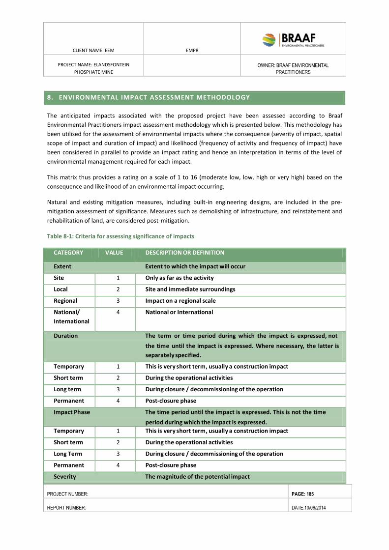
CLIENT NAME: EEM EMPR
PROJECT NAME: ELANDSFONTEIN
PHOSPHATE MINE
OWNER: BRAAF ENVIRONMENTAL
PRACTITIONERS
PROJECT NUMBER: PAGE: 185
REPORT NUMBER: DATE:10/06/2014
8. ENVIRONMENTAL IMPACT ASSESSMENT METHODOLOGY
The anticipated impacts associated with the proposed project have been assessed according to Braaf
Environmental Practitioners impact assessment methodology which is presented below. This methodology has
been utilised for the assessment of environmental impacts where the consequence (severity of impact, spatial
scope of impact and duration of impact) and likelihood (frequency of activity and frequency of impact) have
been considered in parallel to provide an impact rating and hence an interpretation in terms of the level of
environmental management required for each impact.
This matrix thus provides a rating on a scale of 1 to 16 (moderate low, low, high or very high) based on the
consequence and likelihood of an environmental impact occurring.
Natural and existing mitigation measures, including built-in engineering designs, are included in the pre-
mitigation assessment of significance. Measures such as demolishing of infrastructure, and reinstatement and
rehabilitation of land, are considered post-mitigation.
Table 8-1: Criteria for assessing significance of impacts
CATEGORY VALUE DESCRIPTION OR DEFINITION
Extent Extent to which the impact will occur
Site 1 Only as far as the activity
Local 2 Site and immediate surroundings
Regional 3 Impact on a regional scale
National/
International
4 National or International
Duration The term or time period during which the impact is expressed, not
the time until the impact is expressed. Where necessary, the latter is
separately specified.
Temporary 1 This is very short term, usually a construction impact
Short term 2 During the operational activities
Long term 3 During closure / decommissioning of the operation
Permanent 4 Post-closure phase
Impact Phase The time period until the impact is expressed. This is not the time
period during which the impact is expressed.
Temporary 1 This is very short term, usually a construction impact
Short term 2 During the operational activities
Long Term 3 During closure / decommissioning of the operation
Permanent 4 Post-closure phase
Severity The magnitude of the potential impact
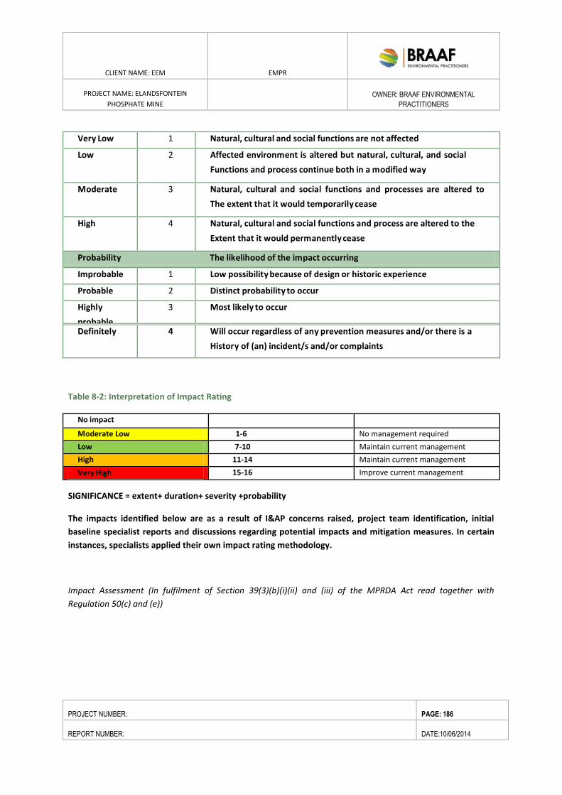
CLIENT NAME: EEM EMPR
PROJECT NAME: ELANDSFONTEIN
PHOSPHATE MINE
OWNER: BRAAF ENVIRONMENTAL
PRACTITIONERS
PROJECT NUMBER: PAGE: 186
REPORT NUMBER: DATE:10/06/2014
Very Low 1 Natural, cultural and social functions are not affected
Low 2 Affected environment is altered but natural, cultural, and social
Functions and process continue both in a modified way
Moderate 3 Natural, cultural and social functions and processes are altered to
The extent that it would temporarily cease
High 4 Natural, cultural and social functions and process are altered to the
Extent that it would permanently cease
Probability The likelihood of the impact occurring
Improbable 1 Low possibility because of design or historic experience
Probable 2 Distinct probability to occur
Highly
probable
3 Most likely to occur
Definitely 4 Will occur regardless of any prevention measures and/or there is a
History of (an) incident/s and/or complaints
Table 8-2: Interpretation of Impact Rating
No impact
Moderate Low 1-6 No management required
Low 7-10 Maintain current management
High 11-14 Maintain current management
Very High 15-16 Improve current management
SIGNIFICANCE = extent+ duration+ severity +probability
The impacts identified below are as a result of I&AP concerns raised, project team identification, initial
baseline specialist reports and discussions regarding potential impacts and mitigation measures. In certain
instances, specialists applied their own impact rating methodology.
Impact Assessment (In fulfilment of Section 39(3)(b)(i)(ii) and (iii) of the MPRDA Act read together with
Regulation 50(c) and (e))
ENVIRONMENTAL RESOURCES MANAGEMENT GAMSBERG ZINC MINE EMPR
DATE: MAY 2013 REV 1.0
CLIENT NAME: EEM EMPR
PROJECT NAME: ELANDSFONTEIN
PHOSPHATE MINE
OWNER: BRAAF ENVIRONMENTAL
PRACTITIONERS
PROJECT NUMBER: PAGE: 187
REPORT NUMBER: DATE:2/09/2014
8.1. FLORA IMPACTS
Immediate and direct impacts on plant diversity that may result from the proposed mining and road construction
in this area include:
The alteration and degradation of currently natural habitat within the main footprint area, including the
disruption of critical ecological linkages (only partially restored after rehabilitation);
The loss of site subpopulations of plant Species of Conservation Concern (SCC), and potential local (site)
extinction of these species; and
The fragmentation of the landscape as a whole, including significant loss of habitat mapped as CBAs.
Indirect impacts of mining include immediate spatial impacts on the biodiversity of the surrounding landscape
(such as the “sink effect” outlined below), and temporally delayed impacts that will only become apparent through
time. Indirect impacts are nearly always difficult to measure and observe, and would require extensive pre and
post development measurements in order to document them. Some of the main indirect impacts may include:
Disruption of metapopulation structure and dynamics for specific species, with potential consequences
for their survival in the local or regional landscape beyond the mine. This impact includes the “sink
effect”, whereby seeds from reintroduced topsoil and surrounding natural areas arrive in the
rehabilitation areas, but due to unsuitable soil chemistry and structure are unable to establish and/or
grow to maturity, reducing the overall availability of seed (reproductive potential) in the area over time,
and thus severely reducing or even eliminating local populations of these species.
Disruption of key ecological processes – including invasive alien Argentine ants and their negative impacts
on seed dispersal. Also included here is windblown sand impacting on adjacent sensitive areas.
Reduction in the total amount of available habitat for species, with potential impacts on species whose
minimum viable area thresholds for persistence are compromised.
Impacts related to the dewatering of the pit and the creation of 4m deep trenches downstream of the pit
where this water will be reintroduced to the subsoil aquifer. This may impact on plant species
downstream (extra water), and in the areas where the drawdown cones around the pit make less soil
water available to plants outside the direct development footprint.
Loss of specialised pollinators and seed dispersers, with resultant impacts on both seed set and seed
dispersal of certain plant species.
Facilitated spread of alien invasive plants. Soil disturbance is known to be a primary facilitator of alien
invasive plant spread.
Loss of mapped CBAs, which may have knock on implications for conservation planning in the region, as
current CBAs are designed to be the least “land hungry” layouts required in order to achieve conservation
targets. Thus if a CBA is lost the total available area for conservation decreases, necessitating a
recalculation of targets and optimum CBA layouts on the remaining natural areas.
Disruption of natural fire regime in surrounding areas of natural vegetation.
Impact Assessment
The nature of the impact would be medium to long term loss of natural vegetation in the project area. The sources
of loss would be all mining related pits, storage areas, dams, buildings and roads. The impact would occur at the
local (site) scale, and would take place when topsoil is stripped. The impact would not be reversed until the same
ENVIRONMENTAL RESOURCES MANAGEMENT GAMSBERG ZINC MINE EMPR
DATE: MAY 2013 REV 1.0
CLIENT NAME: EEM EMPR
PROJECT NAME: ELANDSFONTEIN
PHOSPHATE MINE
OWNER: BRAAF ENVIRONMENTAL
PRACTITIONERS
PROJECT NUMBER: PAGE: 188
REPORT NUMBER: DATE:2/09/2014
area has regained a significant degree of the original ecological functionality, at which point it could be termed to
be “adequately rehabilitated”. About 75ha of High sensitivity vegetation would be lost (11%), about 10ha would
be of Low sensitivity vegetation (1%), and the remainder (590ha; 88%) would be of Medium sensitivity. No
Critically Endangered vegetation types would be impacted.
It is unlikely that more than 75% of the floristic diversity will return in less than twenty years after the cessation of
mining, and some of the more specialised species are likely to take longer to return, and not until soil chemistry
and structure is functionally similar to the original, undisturbed soils (which may take many decades). Full
ecological functionality may thus take in excess of fifty years.
The proposed 5km powerline link will have a Very Low negative botanical impact, and is not likely to result in loss
of more than 1ha of natural vegetation.
The proposed 11km access road will result in the loss of at least 15ha, and probably at least 18ha, of natural
vegetation, including at least 9 SCC. Overall botanical impact of this road is Medium negative at a regional scale.
Proposed mitigation measures: Primary mitigation would involve use of the best rehabilitation measures possible,
as determined by Vula Environmental Services, who has undertaken extensive rehabilitation of the old Foskor
mine some 17km northwest of this site. All disturbed areas should be rehabilitated once disturbance to these
areas has ceased (in the case of the pit this would be ongoing from 33 months), with the possible exception of the
access road, which will presumably remain. Secondary mitigation would include Search and Rescue for all
translocatable plant Species of Conservation Concern from within the development footprints. Critical additional
mitigation for this primary impact would be a biodiversity offset, in order to further reduce the residual medium
negative impacts.
Assessment of impact: The proposed development would have a High negative impact, before mitigation. Primary
and secondary mitigation (ongoing vegetation rehabilitation and Search & Rescue respectively) could possibly
reduce the overall impact to Medium negative. An appropriate biodiversity offset could further reduce the residual
medium negative impacts to low negative.
Statement of acceptability: Currently natural vegetation will be lost, and all of this is in areas mapped as CBAs
(which are flags in terms of the area’s ecological value), 88% of the development will take place in areas of
Medium botanical sensitivity, and only 11% in areas of High sensitivity. The impact is acceptable provided that all
essential mitigation is put in place, and a biodiversity offset is strongly recommended (but is not factored into the
assessment) in order to help minimise the unavoidable Medium negative residual impacts of loss and degradation
of habitat.
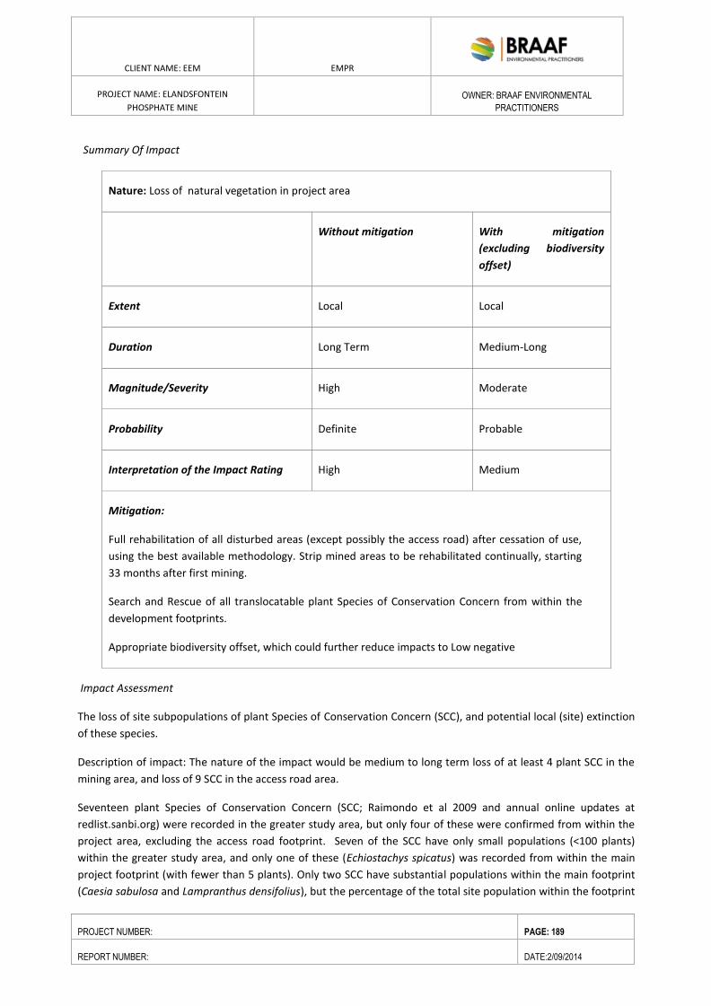
ENVIRONMENTAL RESOURCES MANAGEMENT GAMSBERG ZINC MINE EMPR
DATE: MAY 2013 REV 1.0
CLIENT NAME: EEM EMPR
PROJECT NAME: ELANDSFONTEIN
PHOSPHATE MINE
OWNER: BRAAF ENVIRONMENTAL
PRACTITIONERS
PROJECT NUMBER: PAGE: 189
REPORT NUMBER: DATE:2/09/2014
Summary Of Impact
Nature: Loss of natural vegetation in project area
Without mitigation With mitigation
(excluding biodiversity
offset)
Extent Local Local
Duration Long Term Medium-Long
Magnitude/Severity High Moderate
Probability Definite Probable
Interpretation of the Impact Rating High Medium
Mitigation:
Full rehabilitation of all disturbed areas (except possibly the access road) after cessation of use,
using the best available methodology. Strip mined areas to be rehabilitated continually, starting
33 months after first mining.
Search and Rescue of all translocatable plant Species of Conservation Concern from within the
development footprints.
Appropriate biodiversity offset, which could further reduce impacts to Low negative
Impact Assessment
The loss of site subpopulations of plant Species of Conservation Concern (SCC), and potential local (site) extinction
of these species.
Description of impact: The nature of the impact would be medium to long term loss of at least 4 plant SCC in the
mining area, and loss of 9 SCC in the access road area.
Seventeen plant Species of Conservation Concern (SCC; Raimondo et al 2009 and annual online updates at
redlist.sanbi.org) were recorded in the greater study area, but only four of these were confirmed from within the
project area, excluding the access road footprint. Seven of the SCC have only small populations (<100 plants)
within the greater study area, and only one of these (Echiostachys spicatus) was recorded from within the main
project footprint (with fewer than 5 plants). Only two SCC have substantial populations within the main footprint
(Caesia sabulosa and Lampranthus densifolius), but the percentage of the total site population within the footprint
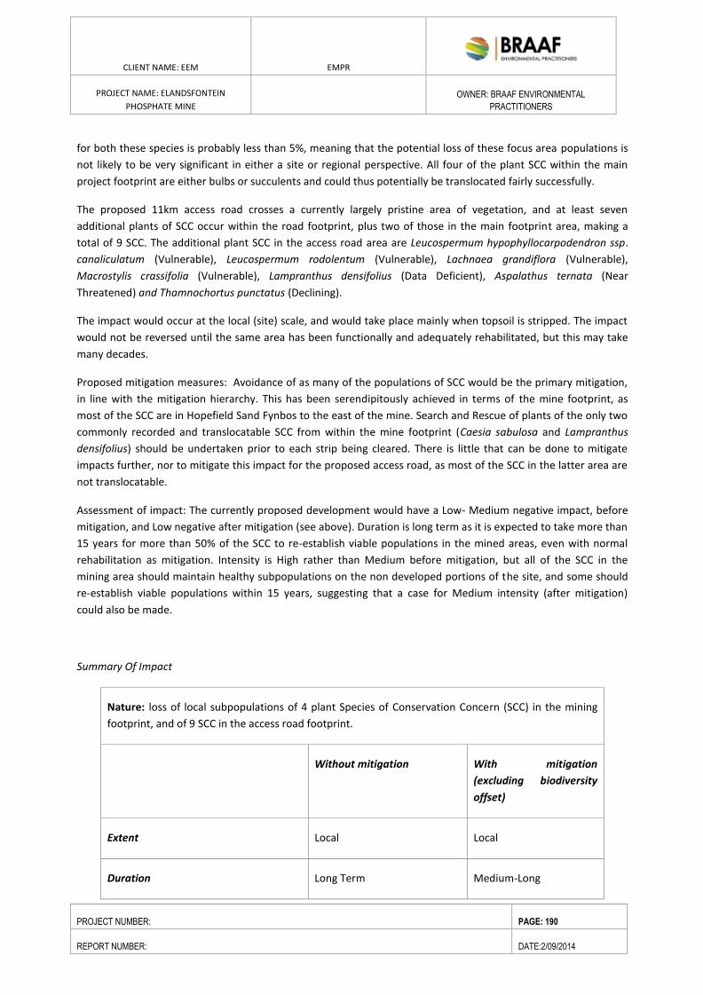
ENVIRONMENTAL RESOURCES MANAGEMENT GAMSBERG ZINC MINE EMPR
DATE: MAY 2013 REV 1.0
CLIENT NAME: EEM EMPR
PROJECT NAME: ELANDSFONTEIN
PHOSPHATE MINE
OWNER: BRAAF ENVIRONMENTAL
PRACTITIONERS
PROJECT NUMBER: PAGE: 190
REPORT NUMBER: DATE:2/09/2014
for both these species is probably less than 5%, meaning that the potential loss of these focus area populations is
not likely to be very significant in either a site or regional perspective. All four of the plant SCC within the main
project footprint are either bulbs or succulents and could thus potentially be translocated fairly successfully.
The proposed 11km access road crosses a currently largely pristine area of vegetation, and at least seven
additional plants of SCC occur within the road footprint, plus two of those in the main footprint area, making a
total of 9 SCC. The additional plant SCC in the access road area are Leucospermum hypophyllocarpodendron ssp.
canaliculatum (Vulnerable), Leucospermum rodolentum (Vulnerable), Lachnaea grandiflora (Vulnerable),
Macrostylis crassifolia (Vulnerable), Lampranthus densifolius (Data Deficient), Aspalathus ternata (Near
Threatened) and Thamnochortus punctatus (Declining).
The impact would occur at the local (site) scale, and would take place mainly when topsoil is stripped. The impact
would not be reversed until the same area has been functionally and adequately rehabilitated, but this may take
many decades.
Proposed mitigation measures: Avoidance of as many of the populations of SCC would be the primary mitigation,
in line with the mitigation hierarchy. This has been serendipitously achieved in terms of the mine footprint, as
most of the SCC are in Hopefield Sand Fynbos to the east of the mine. Search and Rescue of plants of the only two
commonly recorded and translocatable SCC from within the mine footprint (Caesia sabulosa and Lampranthus
densifolius) should be undertaken prior to each strip being cleared. There is little that can be done to mitigate
impacts further, nor to mitigate this impact for the proposed access road, as most of the SCC in the latter area are
not translocatable.
Assessment of impact: The currently proposed development would have a Low- Medium negative impact, before
mitigation, and Low negative after mitigation (see above). Duration is long term as it is expected to take more than
15 years for more than 50% of the SCC to re-establish viable populations in the mined areas, even with normal
rehabilitation as mitigation. Intensity is High rather than Medium before mitigation, but all of the SCC in the
mining area should maintain healthy subpopulations on the non developed portions of the site, and some should
re-establish viable populations within 15 years, suggesting that a case for Medium intensity (after mitigation)
could also be made.
Summary Of Impact
Nature: loss of local subpopulations of 4 plant Species of Conservation Concern (SCC) in the mining
footprint, and of 9 SCC in the access road footprint.
Without mitigation With mitigation
(excluding biodiversity
offset)
Extent Local Local
Duration Long Term Medium-Long
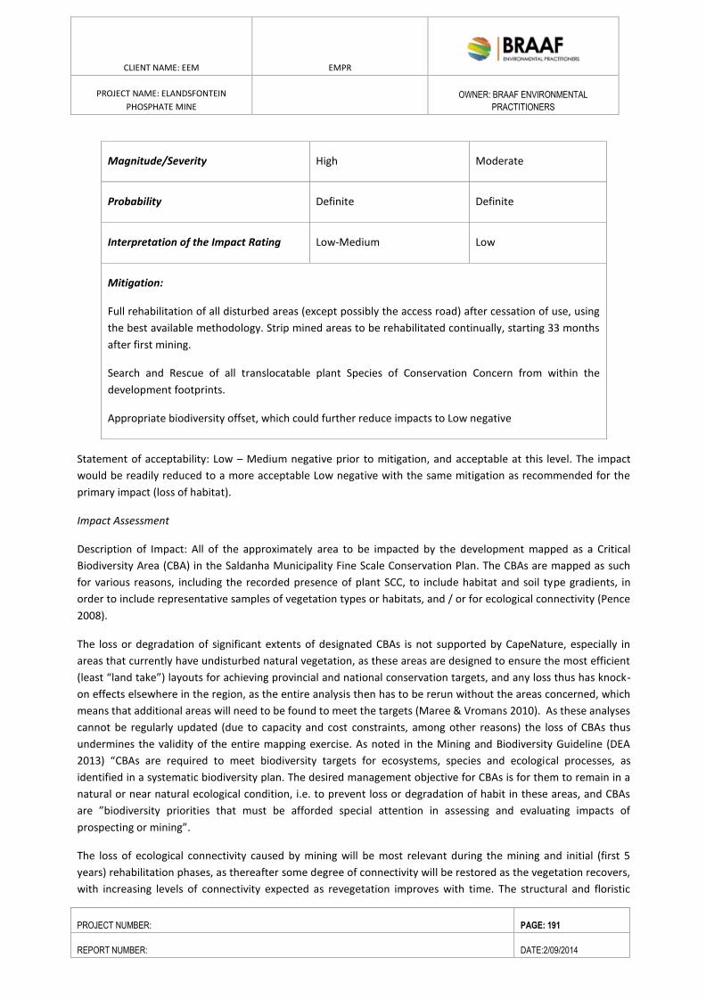
ENVIRONMENTAL RESOURCES MANAGEMENT GAMSBERG ZINC MINE EMPR
DATE: MAY 2013 REV 1.0
CLIENT NAME: EEM EMPR
PROJECT NAME: ELANDSFONTEIN
PHOSPHATE MINE
OWNER: BRAAF ENVIRONMENTAL
PRACTITIONERS
PROJECT NUMBER: PAGE: 191
REPORT NUMBER: DATE:2/09/2014
Magnitude/Severity High Moderate
Probability Definite Definite
Interpretation of the Impact Rating Low-Medium Low
Mitigation:
Full rehabilitation of all disturbed areas (except possibly the access road) after cessation of use, using
the best available methodology. Strip mined areas to be rehabilitated continually, starting 33 months
after first mining.
Search and Rescue of all translocatable plant Species of Conservation Concern from within the
development footprints.
Appropriate biodiversity offset, which could further reduce impacts to Low negative
Statement of acceptability: Low – Medium negative prior to mitigation, and acceptable at this level. The impact
would be readily reduced to a more acceptable Low negative with the same mitigation as recommended for the
primary impact (loss of habitat).
Impact Assessment
Description of Impact: All of the approximately area to be impacted by the development mapped as a Critical
Biodiversity Area (CBA) in the Saldanha Municipality Fine Scale Conservation Plan. The CBAs are mapped as such
for various reasons, including the recorded presence of plant SCC, to include habitat and soil type gradients, in
order to include representative samples of vegetation types or habitats, and / or for ecological connectivity (Pence
2008).
The loss or degradation of significant extents of designated CBAs is not supported by CapeNature, especially in
areas that currently have undisturbed natural vegetation, as these areas are designed to ensure the most efficient
(least “land take”) layouts for achieving provincial and national conservation targets, and any loss thus has knock-
on effects elsewhere in the region, as the entire analysis then has to be rerun without the areas concerned, which
means that additional areas will need to be found to meet the targets (Maree & Vromans 2010). As these analyses
cannot be regularly updated (due to capacity and cost constraints, among other reasons) the loss of CBAs thus
undermines the validity of the entire mapping exercise. As noted in the Mining and Biodiversity Guideline (DEA
2013) “CBAs are required to meet biodiversity targets for ecosystems, species and ecological processes, as
identified in a systematic biodiversity plan. The desired management objective for CBAs is for them to remain in a
natural or near natural ecological condition, i.e. to prevent loss or degradation of habit in these areas, and CBAs
are ”biodiversity priorities that must be afforded special attention in assessing and evaluating impacts of
prospecting or mining”.
The loss of ecological connectivity caused by mining will be most relevant during the mining and initial (first 5
years) rehabilitation phases, as thereafter some degree of connectivity will be restored as the vegetation recovers,
with increasing levels of connectivity expected as revegetation improves with time. The structural and floristic
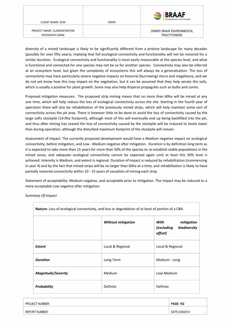
ENVIRONMENTAL RESOURCES MANAGEMENT GAMSBERG ZINC MINE EMPR
DATE: MAY 2013 REV 1.0
CLIENT NAME: EEM EMPR
PROJECT NAME: ELANDSFONTEIN
PHOSPHATE MINE
OWNER: BRAAF ENVIRONMENTAL
PRACTITIONERS
PROJECT NUMBER: PAGE: 192
REPORT NUMBER: DATE:2/09/2014
diversity of a mined landscape is likely to be significantly different from a pristine landscape for many decades
(possibly for over fifty years), implying that full ecological connectivity and functionality will not be restored for a
similar duration. Ecological connectivity and functionality is most easily measurable at the species level, and what
is functional and connected for one species may not be so for another species. Connectivity may also be inferred
at an ecosystem level, but given the complexity of ecosystems this will always be a generalisation. The loss of
connectivity may have particularly severe negative impacts on fossorial (burrowing) micro and megafauna, and we
do not yet know how this may impact on the vegetation, but it can be assumed that they help aerate the soils,
which is usually a positive for plant growth. Some may also help disperse propagules such as bulbs and corms.
Proposed mitigation measures: The proposed strip mining means that no more than 60ha will be mined at any
one time, which will help reduce the loss of ecological connectivity across the site. Starting in the fourth year of
operation there will also be rehabilitation of the previously mined strips, which will help maintain some sort of
connectivity across the pit area. There is however little to be done to avoid the loss of connectivity caused by the
large softs stockpile (14.9ha footprint), although most of this will eventually end up being backfilled into the pit,
and thus after mining has ceased the loss of connectivity caused by the stockpile will be reduced to levels lower
than during operation, although the disturbed maximum footprint of the stockpile will remain.
Assessment of impact: The currently proposed development would have a Medium negative impact on ecological
connectivity, before mitigation, and Low - Medium negative after mitigation. Duration is by definition long term as
it is expected to take more than 15 years for more than 50% of the species to re-establish viable populations in the
mined areas, and adequate ecological connectivity cannot be expected again until at least this 50% level is
achieved. Intensity is Medium, and extent is regional. Duration of impact is reduced by rehabilitation (commencing
in year 4) and by the fact that mined strips will be no larger than 60ha at a time, and rehabilitation is likely to have
partially restored connectivity within 10 - 15 years of cessation of mining each strip.
Statement of acceptability: Medium negative, and acceptable prior to mitigation. The impact may be reduced to a
more acceptable Low negative after mitigation.
Summary Of Impact
Nature: Loss of ecological connectivity, and loss or degradation of at least of portion of a CBA.
Without mitigation With mitigation
(excluding biodiversity
offset)
Extent Local & Regional Local & Regional
Duration Long Term Medium - Long
Magnitude/Severity Medium Low-Medium
Probability Definite Definite
ENVIRONMENTAL RESOURCES MANAGEMENT GAMSBERG ZINC MINE EMPR
DATE: MAY 2013 REV 1.0
CLIENT NAME: EEM EMPR
PROJECT NAME: ELANDSFONTEIN
PHOSPHATE MINE
OWNER: BRAAF ENVIRONMENTAL
PRACTITIONERS
PROJECT NUMBER: PAGE: 193
REPORT NUMBER: DATE:2/09/2014
Interpretation of the Impact Rating Medium Low- Medium
Mitigation:
Full rehabilitation of all disturbed areas (except possibly the access road) after cessation of use, using
the best available methodology. Strip mined areas to be rehabilitated continually, starting 33 months
after first mining.
Mining of no more than 60ha strips at a time
Impact Assessment
The indirect impacts of mining include immediate spatial impacts on the biodiversity of the surrounding landscape,
and temporally delayed impacts that will only become apparent through time and which are often a result of the
direct impacts. Indirect impacts are nearly always difficult to measure and observe, and would require extensive
pre and post development measurements in order to document them. Because of these data deficiencies the
indirect impacts are assessed together, as one. Some of the main potential indirect impacts include:
Disruption of metapopulation structure and dynamics for specific species, with potential consequences for their
survival in the local or regional landscape beyond the mine. This impact includes the “sink effect”, whereby seeds
from reintroduced topsoil and surrounding natural areas arrive in the rehabilitation areas, but due to unsuitable
soil chemistry and structure are unable to establish and/or grow to maturity, reducing the overall availability of
seed (reproductive potential) in the area over time, and thus severely reducing or even eliminating local
populations of these species.
Disruption of key ecological processes – including invasive alien Argentine ants and their negative impacts on seed
dispersal. Also included here is windblown sand impacting on adjacent sensitive areas. Argentine ants
(Iridomyrmex/Linepithema humile) are a worldwide problem, as these aggressive alien species displace indigenous
ants, and in the Fynbos this is a problem as many Fynbos plants have co-evolved with the indigenous ants, which
disperse and bury their seeds in their underground nest. The alien ants eat the attractant on the seed and then
just leave the seeds on the ground, which are then eaten by birds and rodents, making the seeds unavailable for
regeneration, which can lead to complete failure of recruitment for these species. Argentine ants are strongly
associated with human development, and with refuse and structures in particular, and fortunately seldom spread
more than 50m into undisturbed vegetation, which limits their impacts to the immediate surrounds of
disturbance.
Reduction in the total amount of available habitat for species, with potential impacts on species whose minimum
viable area thresholds for persistence are compromised. This is not likely to be a major issue in this area as there is
ample nearby natural habitat.
Impacts related to the dewatering of the pit and the creation of 4m deep trenches downstream of the pit where
this water will be reintroduced to the subsoil aquifer. This may impact on plant species downstream (extra water,
which may lead to unnatural dominance of certain species capable of exploiting this), and in the areas where the
drawdown cones around the pit make less soil water available to plants outside the direct development footprint.
The latter may result in death of many plant species in the impacted area. This needs to be closely monitored, as it
ENVIRONMENTAL RESOURCES MANAGEMENT GAMSBERG ZINC MINE EMPR
DATE: MAY 2013 REV 1.0
CLIENT NAME: EEM EMPR
PROJECT NAME: ELANDSFONTEIN
PHOSPHATE MINE
OWNER: BRAAF ENVIRONMENTAL
PRACTITIONERS
PROJECT NUMBER: PAGE: 194
REPORT NUMBER: DATE:2/09/2014
could be a significant indirect negative impact on the vegetation within up to 300m of the pit. The digging of the
4m deep trenches would be a direct negative impact on the vegetation.
Loss of specialised pollinators and seed dispersers, with resultant impacts on both seed set and seed dispersal of
certain plant species. Fortunately the large areas of intact natural vegetation around the project area should
ensure that key pollinators and seed dispersers persist in the area, and the impacts are thus likely to be negligible.
Facilitated spread of alien invasive plants. Soil disturbance is known to be a primary facilitator of alien invasive
plant spread, and thus all aspects of the proposed project can be expected to facilitate invasion of alien plant
species, including grasses, herbs, shrubs and trees. This is relatively easily mitigated, in the form of alien invasive
plant management, but it needs to be ongoing for the duration of the project, and invasives need to be removed
as soon as possible to limit overall negative impacts. The access road also needs to be part of the managed area, as
its length through otherwise pristine vegetation means that it could have a significant negative impact in terms of
introduction of alien invasive vegetation.
Loss of mapped CBAs, which may have knock on implications for conservation planning in the region, as current
CBAs are designed to be the least “land hungry” layouts required in order to achieve conservation targets. Thus if a
CBA is lost the total available area for conservation decreases, necessitating a recalculation of targets and
optimum CBA layouts on the remaining natural areas.
Disruption of natural fire regime in surrounding areas of natural vegetation. The fire history in the surrounding
areas of natural vegetation is not known, although it appears that most of the vegetation has not burnt in the last
ten years, and in most nearby areas this fire return interval would appear to be longer than twenty years. The only
one of the four vegetation types in the area that really requires fire for optimum ecological functioning is
Hopefield Sand Fynbos, and much of the vegetation of this type in the greater study area is now overdue for a fire,
being more than twenty years old. The infrastructure associated with the proposed mine means that fire is likely
to be suppressed in the immediate surrounds of the mine, but this should not have a significant negative impact
on the vegetation, as only a small portion (<15%) of the bordering vegetation is in fact Hopefield Sand Fynbos. A
fire management plan should ensure that the Hopefield Sand Fynbos up to 100m from the edge of the mine area
burns at the appropriate intervals (which are once every 12 – 15 years).
Proposed mitigation measures: Many of the indirect impacts cannot be effectively mitigated, but the impacts of
windblown dust can usually can be mitigated by erecting wind fences if necessary, and can usually be avoided or at
least minimised by minimising the total extent of exposed soil. In the case of the strip mining the exposed areas
are likely to be less than 60ha, but some of the stockpiles (softs and topsoil) may be significantly larger than this.
Annual monitoring of the vegetation around the project area needs to be undertaken, and in particular in the
areas where windblown dust may be an issue, where the drawdown cones caused by the dewatering boreholes
around the pit may impact on the natural vegetation outside the pit, and where the surplus water is reintroduced
into the upper aquifer. This would probably be best undertaken by suitably qualified members of the vegetation
rehabilitation team, or otherwise by a botanical consultant.
Alien invasive vegetation management needs to be part of the ongoing rehabilitation program, and must continue
for the Life of Mine and beyond, until mine closure and land handover. The work would be ideally undertaken by
the rehabilitation contractors, and they should remove all invasive alien plant species as and when they are
observed. It should not be necessary to use herbicides, and indeed this is not desirable, due to the impacts on
nearby non-target plants.
ENVIRONMENTAL RESOURCES MANAGEMENT GAMSBERG ZINC MINE EMPR
DATE: MAY 2013 REV 1.0
CLIENT NAME: EEM EMPR
PROJECT NAME: ELANDSFONTEIN
PHOSPHATE MINE
OWNER: BRAAF ENVIRONMENTAL
PRACTITIONERS
PROJECT NUMBER: PAGE: 195
REPORT NUMBER: DATE:2/09/2014
It is not possible to mitigate for the loss of areas mapped as CBAs. The impacts of Argentine ants are best
mitigated by making sure that all refuse (and particularly organic and food waste) is disposed of in bins that are
located well within the development footprint (not on the periphery) and are regularly emptied at formal
municipal dumps.
A fire management plan should ensure that the Hopefield Sand Fynbos up to 100m from the edge of the mine area
burns at the appropriate intervals (which are once every 12 – 15 years).
Assessment of impact: The currently proposed development is likely to have an overall Medium negative impact in
terms of indirect impacts, although some of the potential impacts are difficult to assess and monitor, with the
exception of dust and its impacts, changes in soil moisture, and alien invasive vegetation. Duration is long term as
it is expected to take more than 15 years for more than 50% of the species to re-establish viable populations in the
mined areas, which will in turn then minimise dust moving into sensitive areas. Intensity is Medium, and extent is
mainly local. Duration of impact is reduced by rehabilitation, and rehabilitation is likely to have partially restored
connectivity within 15 years of cessation of mining. Alien vegetation management should be ongoing until mine
closure, and should be able to effectively restrict that particular impact to Low negative. The changes to soil
moisture and the impacts on vegetation in these areas may have a Medium negative at a local scale, and need to
be closely monitored.
Statement of acceptability: Medium negative, and acceptable prior to mitigation, although can and should be
mitigated. The impact may be reduced to Low negative after mitigation.
Summary of Impact
Nature: Indirect impacts, including dust, invasive alien vegetation spread, changes to nearby soil
moisture, disruption of ecological processes and metapopulation dynamics
Without mitigation With mitigation
(excluding biodiversity
offset)
Extent Local & Regional Local & Regional
Duration Long Term Medium - Long
Magnitude/Severity Medium Low
Probability Definite Definite
Interpretation of the Impact Rating Medium High
Mitigation:
ENVIRONMENTAL RESOURCES MANAGEMENT GAMSBERG ZINC MINE EMPR
DATE: MAY 2013 REV 1.0
CLIENT NAME: EEM EMPR
PROJECT NAME: ELANDSFONTEIN
PHOSPHATE MINE
OWNER: BRAAF ENVIRONMENTAL
PRACTITIONERS
PROJECT NUMBER: PAGE: 196
REPORT NUMBER: DATE:2/09/2014
Full rehabilitation of all disturbed areas (except possibly the access road) after cessation of use, using
the best available methodology. Strip mined areas to be rehabilitated continually, starting 33 months
after first mining.
Mining of no more than 60ha strips at a time
Ongoing alien invasive vegetation management until mine closure
Annual monitoring of vegetation in dewatering drawdown cones and in water reintroduction areas
Erection of wind fences if windblown dust and sand becomes an issue
All organic refuse to be disposed of in regularly cleared bins placed well inside the development
footprint and not on the perimeter
Fire management plan for all natural vegetation surrounding the project area, to be approved by
SANParks. The Hopefield Sand Fynbos portions bordering the project area (in the south and
southeast) are the only areas requiring fire during Life of Mine, and this should be part of the plan.
Overall botanical impacts of the proposed project (mine, road and powerline) are likely to be High negative prior
to mitigation, and Medium negative after standard mitigation. An appropriate biodiversity offset could reduce the
overall botanical impact to Low negative, by means of securing conservation priority areas of threatened natural
habit in the region.
8.2. AVIFAUNA
Each of the three phases of the greater mining project (construction, operation and decommissioning/closure) will
have a suite of impacts on both resident and peripheral bird communities. Levels of habitat modification in the
proposed pit area during the operational phase of the mine will be extreme, involving total loss of functional
habitat. Although some aspects of the local avifauna may persist in the surrounding areas, the species most
severely affected by all three phases of the mine will be those most closely linked with and dependent on the
availability of relatively pristine, natural vegetation – most importantly Black Harrier, Southern Black Korhaan,
Hottentot Buttonquail, and a suite of endemic passerines.
The directly impacted areas of Strandveld and Fynbos cannot reasonably be considered as safe and serviceable
habitat for any of these key species for the lifetime of the mine, hence the actively mined area will effectively be
lost habitat. Such loss of habitat is likely to be expressed at least for the medium to long-term, and perhaps more
permanently. While some level of rehabilitation of the natural vegetation may be possible after the closure of the
mine, this is unlikely to restore the habitat to its original functional levels, sufficient to maintain densities or
diversities of birds comparable with those supported now.
Hence, at this provisional stage, the impacts of all three phases of the mine are generally considered to be of
Moderate-Low significance, except for the imposed destruction of habitat and the risk of mortality for key species
which could be of High significance. However, there are mitigation options available for most impact factors which
should reduce the impacts of mine to sustainable levels.
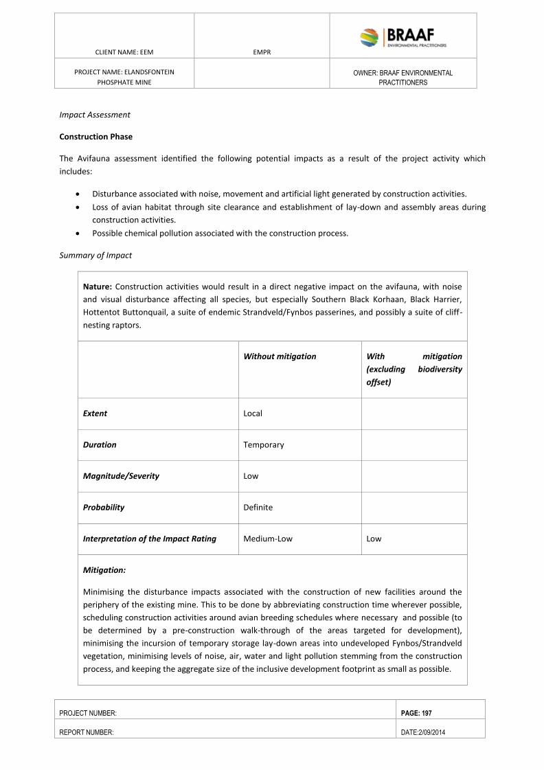
ENVIRONMENTAL RESOURCES MANAGEMENT GAMSBERG ZINC MINE EMPR
DATE: MAY 2013 REV 1.0
CLIENT NAME: EEM EMPR
PROJECT NAME: ELANDSFONTEIN
PHOSPHATE MINE
OWNER: BRAAF ENVIRONMENTAL
PRACTITIONERS
PROJECT NUMBER: PAGE: 197
REPORT NUMBER: DATE:2/09/2014
Impact Assessment
Construction Phase
The Avifauna assessment identified the following potential impacts as a result of the project activity which
includes:
Disturbance associated with noise, movement and artificial light generated by construction activities.
Loss of avian habitat through site clearance and establishment of lay-down and assembly areas during
construction activities.
Possible chemical pollution associated with the construction process.
Summary of Impact
Nature: Construction activities would result in a direct negative impact on the avifauna, with noise
and visual disturbance affecting all species, but especially Southern Black Korhaan, Black Harrier,
Hottentot Buttonquail, a suite of endemic Strandveld/Fynbos passerines, and possibly a suite of cliff-
nesting raptors.
Without mitigation With mitigation
(excluding biodiversity
offset)
Extent Local
Duration Temporary
Magnitude/Severity Low
Probability Definite
Interpretation of the Impact Rating Medium-Low Low
Mitigation:
Minimising the disturbance impacts associated with the construction of new facilities around the
periphery of the existing mine. This to be done by abbreviating construction time wherever possible,
scheduling construction activities around avian breeding schedules where necessary and possible (to
be determined by a pre-construction walk-through of the areas targeted for development),
minimising the incursion of temporary storage lay-down areas into undeveloped Fynbos/Strandveld
vegetation, minimising levels of noise, air, water and light pollution stemming from the construction
process, and keeping the aggregate size of the inclusive development footprint as small as possible.
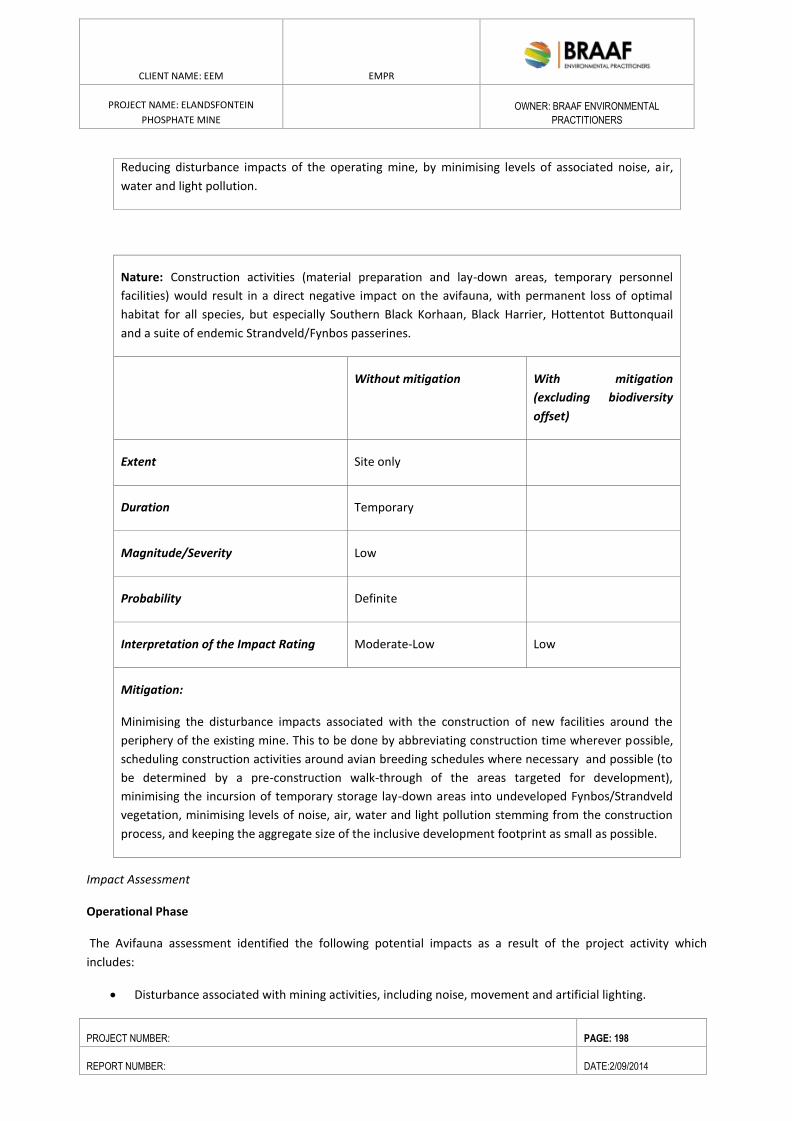
ENVIRONMENTAL RESOURCES MANAGEMENT GAMSBERG ZINC MINE EMPR
DATE: MAY 2013 REV 1.0
CLIENT NAME: EEM EMPR
PROJECT NAME: ELANDSFONTEIN
PHOSPHATE MINE
OWNER: BRAAF ENVIRONMENTAL
PRACTITIONERS
PROJECT NUMBER: PAGE: 198
REPORT NUMBER: DATE:2/09/2014
Reducing disturbance impacts of the operating mine, by minimising levels of associated noise, air,
water and light pollution.
Nature: Construction activities (material preparation and lay-down areas, temporary personnel
facilities) would result in a direct negative impact on the avifauna, with permanent loss of optimal
habitat for all species, but especially Southern Black Korhaan, Black Harrier, Hottentot Buttonquail
and a suite of endemic Strandveld/Fynbos passerines.
Without mitigation With mitigation
(excluding biodiversity
offset)
Extent Site only
Duration Temporary
Magnitude/Severity Low
Probability Definite
Interpretation of the Impact Rating Moderate-Low Low
Mitigation:
Minimising the disturbance impacts associated with the construction of new facilities around the
periphery of the existing mine. This to be done by abbreviating construction time wherever possible,
scheduling construction activities around avian breeding schedules where necessary and possible (to
be determined by a pre-construction walk-through of the areas targeted for development),
minimising the incursion of temporary storage lay-down areas into undeveloped Fynbos/Strandveld
vegetation, minimising levels of noise, air, water and light pollution stemming from the construction
process, and keeping the aggregate size of the inclusive development footprint as small as possible.
Impact Assessment
Operational Phase
The Avifauna assessment identified the following potential impacts as a result of the project activity which
includes:
Disturbance associated with mining activities, including noise, movement and artificial lighting.
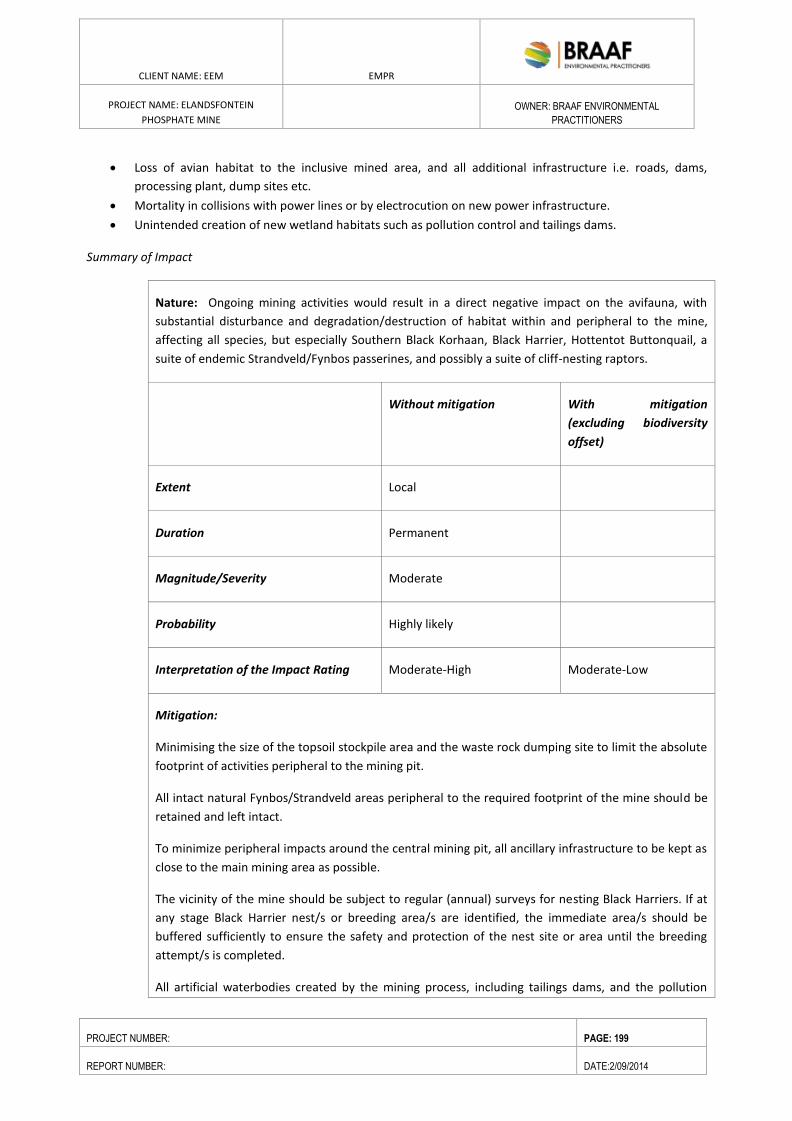
ENVIRONMENTAL RESOURCES MANAGEMENT GAMSBERG ZINC MINE EMPR
DATE: MAY 2013 REV 1.0
CLIENT NAME: EEM EMPR
PROJECT NAME: ELANDSFONTEIN
PHOSPHATE MINE
OWNER: BRAAF ENVIRONMENTAL
PRACTITIONERS
PROJECT NUMBER: PAGE: 199
REPORT NUMBER: DATE:2/09/2014
Loss of avian habitat to the inclusive mined area, and all additional infrastructure i.e. roads, dams,
processing plant, dump sites etc.
Mortality in collisions with power lines or by electrocution on new power infrastructure.
Unintended creation of new wetland habitats such as pollution control and tailings dams.
Summary of Impact
Nature: Ongoing mining activities would result in a direct negative impact on the avifauna, with
substantial disturbance and degradation/destruction of habitat within and peripheral to the mine,
affecting all species, but especially Southern Black Korhaan, Black Harrier, Hottentot Buttonquail, a
suite of endemic Strandveld/Fynbos passerines, and possibly a suite of cliff-nesting raptors.
Without mitigation With mitigation
(excluding biodiversity
offset)
Extent Local
Duration Permanent
Magnitude/Severity Moderate
Probability Highly likely
Interpretation of the Impact Rating Moderate-High Moderate-Low
Mitigation:
Minimising the size of the topsoil stockpile area and the waste rock dumping site to limit the absolute
footprint of activities peripheral to the mining pit.
All intact natural Fynbos/Strandveld areas peripheral to the required footprint of the mine should be
retained and left intact.
To minimize peripheral impacts around the central mining pit, all ancillary infrastructure to be kept as
close to the main mining area as possible.
The vicinity of the mine should be subject to regular (annual) surveys for nesting Black Harriers. If at
any stage Black Harrier nest/s or breeding area/s are identified, the immediate area/s should be
buffered sufficiently to ensure the safety and protection of the nest site or area until the breeding
attempt/s is completed.
All artificial waterbodies created by the mining process, including tailings dams, and the pollution
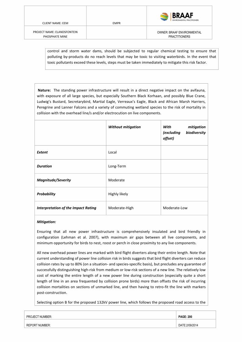
ENVIRONMENTAL RESOURCES MANAGEMENT GAMSBERG ZINC MINE EMPR
DATE: MAY 2013 REV 1.0
CLIENT NAME: EEM EMPR
PROJECT NAME: ELANDSFONTEIN
PHOSPHATE MINE
OWNER: BRAAF ENVIRONMENTAL
PRACTITIONERS
PROJECT NUMBER: PAGE: 200
REPORT NUMBER: DATE:2/09/2014
control and storm water dams, should be subjected to regular chemical testing to ensure that
polluting by-products do no reach levels that may be toxic to visiting waterbirds. In the event that
toxic pollutants exceed these levels, steps must be taken immediately to mitigate this risk factor.
Nature: The standing power infrastructure will result in a direct negative impact on the avifauna,
with exposure of all large species, but especially Southern Black Korhaan, and possibly Blue Crane,
Ludwig’s Bustard, Secretarybird, Martial Eagle, Verreaux’s Eagle, Black and African Marsh Harriers,
Peregrine and Lanner Falcons and a variety of commuting wetland species to the risk of mortality in
collision with the overhead line/s and/or electrocution on live components.
Without mitigation With mitigation
(excluding biodiversity
offset)
Extent Local
Duration Long-Term
Magnitude/Severity Moderate
Probability Highly likely
Interpretation of the Impact Rating Moderate-High Moderate-Low
Mitigation:
Ensuring that all new power infrastructure is comprehensively insulated and bird friendly in
configuration (Lehman et al. 2007), with maximum air gaps between all live components, and
minimum opportunity for birds to nest, roost or perch in close proximity to any live components.
All new overhead power lines are marked with bird flight diverters along their entire length. Note that
current understanding of power line collision risk in birds suggests that bird flight diverters can reduce
collision rates by up to 80% (on a situation- and species-specific basis), but precludes any guarantee of
successfully distinguishing high-risk from medium or low-risk sections of a new line. The relatively low
cost of marking the entire length of a new power line during construction (especially quite a short
length of line in an area frequented by collision prone birds) more than offsets the risk of incurring
collision mortalities on sections of unmarked line, and then having to retro-fit the line with markers
post-construction.
Selecting option B for the proposed 132kV power line, which follows the proposed road access to the
ENVIRONMENTAL RESOURCES MANAGEMENT GAMSBERG ZINC MINE EMPR
DATE: MAY 2013 REV 1.0
CLIENT NAME: EEM EMPR
PROJECT NAME: ELANDSFONTEIN
PHOSPHATE MINE
OWNER: BRAAF ENVIRONMENTAL
PRACTITIONERS
PROJECT NUMBER: PAGE: 201
REPORT NUMBER: DATE:2/09/2014
site from the north, rather than option A which runs directly to the tie-in point with the existing
transmission line, but requires a new and dedicated corridor through an area of natural vegetation.
Option B concentrates the impacts of the power line and the new road into a single corridor, and
positions the power line in an area of increased human disturbance, where it is less likely to pose a
collision risk to overflying birds.
Impact Assessment
The Avifauna assessment identified the following potential impacts as a result of the project activity which
includes:
Decommissioning Phase
Disturbance associated with noise, movement and artificial light generated by construction equipment
/personnel.
Possible chemical pollution derived from the decommissioning process.
Summary of Impacts
Nature: Decommissioning/Closure activities would result in a direct negative impact on the avifauna,
with noise and visual disturbance affecting all species, but especially Southern Black Korhaan, Black
Harrier, Hottentot Buttonquail, a suite of endemic Strandveld/Fynbos passerines, and possibly a suite
of cliff-nesting raptors.
Without mitigation With mitigation
(excluding biodiversity
offset)
Extent Local
Duration Only until decommissioning is
complete
Magnitude/Severity Low
Probability Definite
Interpretation of the Impact Rating Moderate-Low
Mitigation:
Rehabilitation of disturbed or degraded Fynbos/Strandveld as soon as sources of
disturbance/degradation are removed (e.g. after construction activities are complete and post-
ENVIRONMENTAL RESOURCES MANAGEMENT GAMSBERG ZINC MINE EMPR
DATE: MAY 2013 REV 1.0
CLIENT NAME: EEM EMPR
PROJECT NAME: ELANDSFONTEIN
PHOSPHATE MINE
OWNER: BRAAF ENVIRONMENTAL
PRACTITIONERS
PROJECT NUMBER: PAGE: 202
REPORT NUMBER: DATE:2/09/2014
closure of the mine). In some areas at least, it should be possible to restore original levels of avian
biodiversity (Little et al. 2005).
Nature: Decommissioning/Closure activities (material preparation and lay-down areas, temporary
personnel facilities) would result in a direct negative impact on the avifauna, with permanent loss of
optimal habitat for all species, but especially Southern Black Korhaan, Black Harrier, Hottentot
Buttonquail and a suite of endemic Strandveld/Fynbos passerines.
Without mitigation With mitigation
(excluding biodiversity
offset)
Extent Site only
Duration Temporary
Magnitude/Severity Low
Probability Definite
Interpretation of the Impact Rating Moderate-Low
Mitigation:
Rehabilitation of disturbed or degraded Fynbos/Strandveld as soon as sources of
disturbance/degradation are removed (e.g. after construction activities are complete and post-
closure of the mine). In some areas at least, it should be possible to restore original levels of avian
biodiversity (Little et al. 2005).
Offsets
Even after rehabilitation it seems unlikely that the area of the mine subjected to its core activities (strip mining and
additional destruction of habitat through construction and operational activities) will ever be meaningfully
restored. Hence the inclusive footprint of the mine should probably be considered as permanently lost to the
natural environment, and efforts should be made to compensate for this biodiversity loss by exploring
conservation off-set opportunities. An area covering 4000 ha surrounding the proposed mine is currently under
investigation for conservation offset purposes. Because of the close proximity of the proposed Elandsfontein
Phosphate Mine and the West Coast National Park, an off-sets approach presents opportunities to commit more
land to effective conservation management (under SANParks), and also to create corridors between fragments of
natural vegetation that are currently isolated, and might otherwise be lost to agriculture or mismanagement. The
ENVIRONMENTAL RESOURCES MANAGEMENT GAMSBERG ZINC MINE EMPR
DATE: MAY 2013 REV 1.0
CLIENT NAME: EEM EMPR
PROJECT NAME: ELANDSFONTEIN
PHOSPHATE MINE
OWNER: BRAAF ENVIRONMENTAL
PRACTITIONERS
PROJECT NUMBER: PAGE: 203
REPORT NUMBER: DATE:2/09/2014
resulting increase in the extent of contiguous protected Fynbos/Strandveld vegetation could significantly benefit
those species identified in this study as most dependent on the availability of tracts of intact, properly managed
natural habitat, most notably Black Harrier, Southern Black Korhaan and Hottentot Buttonquail.
8.3. VISUAL ASSESSMENT
The visual study identified the following potential receptors which may be impacted by the mining activity. Below
a table identifying potential receptors and the potential direct and indirect impacts.
Potential Receptor Reason
Users of existing transport corridors
including in each case, travelling in each
direction, i.e. roads, R45, R27, local roads
and rail line: sensitive receptors
Direct Impacts: on the R27 southbound from
where the mine infrastructure could be visible.
Indirect impacts: on the R45, due to increased
heavy and light vehicles and due to the creation of
a potentially busy junction with the mine access
road; and on other local roads between the mine
and the port.
No impact on the rail line.
The development could be held in view resulting in
changed landscape character from increased road
use and visual clutter.
People living and working locally in
Agriculture; no major farmsteads within
7km, but there are a few scattered buildings
in the area: sensitive receptors
Direct Impact: no farm dwellings within the zone
of visual influence, but the works would be visible
to receptors working on the land; could be aware
of different land use; the proposed development
may be considered a discordant element in the
landscape
Local tourist facilities and routes: the R27 is
a tourist route; no tourist facilities within
the zone of visual impact
Direct and Indirect Impacts: on the R27
Local protected landscapes, West Coast
National Park; areas currently publicly
accessible are not within the zone of visual
impact
Indirect Impacts: Users of the landscapes and sites
could be affected by off-site infrastructure
Local population centres, such as Hopefield,
Langebaanweg, etc, beyond the zone of
visual impact
Indirect Impacts: Users of the towns would
experience indirect impacts such as increased
numbers of heavy and light vehicles
ENVIRONMENTAL RESOURCES MANAGEMENT GAMSBERG ZINC MINE EMPR
DATE: MAY 2013 REV 1.0
CLIENT NAME: EEM EMPR
PROJECT NAME: ELANDSFONTEIN
PHOSPHATE MINE
OWNER: BRAAF ENVIRONMENTAL
PRACTITIONERS
PROJECT NUMBER: PAGE: 204
REPORT NUMBER: DATE:2/09/2014
Impact Assessment
Construction Phase
The potential construction of the following may impact on the aesthetics of the surrounds:
Establishment of the construction camp, haul roads and ramps from locally sourced material
Establishment of all buildings and other mine infrastructure, silo, beneficiation plant, control centre
Establishment of the fencing and security access.
Summary of Impact
Nature:
Establish construction camp, haul roads and ramps from locally sourced material
Establish all buildings and other mine infrastructure, silo, beneficiation plant, control centre
Establish fencing and security access.
Without mitigation With mitigation
Extent Local (2) Local (2)
Duration Temporary (1) Temporary (1)
Magnitude/Severity Moderate (3) Moderate (3)
Probability Highly Probable (3) Probable (2)
Interpretation of the Impact Rating Low (9) Low (8)
Mitigation:
Keep disturbed areas to a minimum.
No clearing of land to take place outside the demarcated footprint.
Utilise existing roads and tracks to the extent possible. Where new roads are required, they
should be gravel roads, maintained to prevent dust plumes and erosion.
Surfacing of roads in locally sourced material would ensure that the colour is appropriate
Impact Assessment
The potential construction of the following may impact on the aesthetics of the surrounds:
ENVIRONMENTAL RESOURCES MANAGEMENT GAMSBERG ZINC MINE EMPR
DATE: MAY 2013 REV 1.0
CLIENT NAME: EEM EMPR
PROJECT NAME: ELANDSFONTEIN
PHOSPHATE MINE
OWNER: BRAAF ENVIRONMENTAL
PRACTITIONERS
PROJECT NUMBER: PAGE: 205
REPORT NUMBER: DATE:2/09/2014
Construction of the new road access from the R45 to the site.
Road transport of deliveries by truck to the site.
Summary of Impact
Nature:
Construction of the new road access from the R45 to the site.
Road transport of deliveries by truck to the site.
Without mitigation With mitigation
Extent Local (2) Local (2)
Duration Long Term (3) Long Term (3)
Magnitude/Severity Moderate (3) Low (2)
Probability Highly Probable (3) Probable (2)
Interpretation of the Impact Rating High (11) Low (9)
Mitigation:
Keep disturbed areas to a minimum.
No clearing of land to take place outside the demarcated footprint.
Route is proclaimed and not directly affecting sensitive receptors.
Junction standards with R45 must reflect eventual frequency of heavy and light vehicles with
good sightlines; road to be regularly cleaned
The increased mine traffic on the R45, generally is not capable of being mitigated
Impact Assessment
The potential construction of the following may impact on the aesthetics of the surrounds:
132kV Transmission Line via loop in-loop out from existing lines.
Summary Of Impact
ENVIRONMENTAL RESOURCES MANAGEMENT GAMSBERG ZINC MINE EMPR
DATE: MAY 2013 REV 1.0
CLIENT NAME: EEM EMPR
PROJECT NAME: ELANDSFONTEIN
PHOSPHATE MINE
OWNER: BRAAF ENVIRONMENTAL
PRACTITIONERS
PROJECT NUMBER: PAGE: 206
REPORT NUMBER: DATE:2/09/2014
Nature:
132kV Transmission Line via loop in-loop out from existing lines.
Without mitigation With mitigation
Extent Local (2) Local (2)
Duration Long Term (3) Long Term (3)
Magnitude/Severity Low (2) Low (2)
Probability Highly Probable (3) Probable (2)
Interpretation of the Impact Rating Low (10) Low (9)
Mitigation:
This appears to be the shortest feasible route, sited away from sensitive receptors and in a
landscape where there is context from other power lines.
Keep disturbed areas to a minimum.
No clearing of land to take place outside the demarcated footprint.
Associated maintenance track should be gravel, maintained to prevent dust plumes and erosion.
Impact Assessment
Operational Phase
These potential operational phase activities may impact on the aesthetics of the surrounds:
Development of the strip mine, haulage operations
Summary of Impact
Nature:
Development of the strip mine, haulage operations
Without mitigation With mitigation
ENVIRONMENTAL RESOURCES MANAGEMENT GAMSBERG ZINC MINE EMPR
DATE: MAY 2013 REV 1.0
CLIENT NAME: EEM EMPR
PROJECT NAME: ELANDSFONTEIN
PHOSPHATE MINE
OWNER: BRAAF ENVIRONMENTAL
PRACTITIONERS
PROJECT NUMBER: PAGE: 207
REPORT NUMBER: DATE:2/09/2014
Extent Local (2) Local (2)
Duration Long Term (3) Long Term (3)
Magnitude/Severity Moderate (3) Low (2)
Probability Highly Probable (3) Probable (2)
Interpretation of the Impact Rating High (11) Low (9)
Mitigation:
Strip mining has been demonstrated to be acceptable in terms of no blasting, etc, and facilitating
on-going environmental rehabilitation.
Keep disturbed areas to a minimum.
No clearing of land to take place outside the demarcated footprint.
The excavations and the gravel roads, maintained to prevent dust plumes and erosion.
Impact Assessment
Operational Phase
These potential operational phase activities may impact on the aesthetics of the surrounds:
Establishment of stockpiles and conveyors
Summary Impact
Nature:
Establishment of stockpiles and conveyors
Without mitigation With mitigation
Extent Local (2) Local (2)
Duration Long Term (3) Long Term (3)
ENVIRONMENTAL RESOURCES MANAGEMENT GAMSBERG ZINC MINE EMPR
DATE: MAY 2013 REV 1.0
CLIENT NAME: EEM EMPR
PROJECT NAME: ELANDSFONTEIN
PHOSPHATE MINE
OWNER: BRAAF ENVIRONMENTAL
PRACTITIONERS
PROJECT NUMBER: PAGE: 208
REPORT NUMBER: DATE:2/09/2014
Magnitude/Severity Moderate (3) Moderate (3)
Probability Highly Probable (3) Probable (2)
Interpretation of the Impact Rating High (11) Low (10)
Mitigation:
Anticipated height of 38m could be visually intrusive; perceived movement of conveyors on top
of the softs stockpile could raise visual awareness; mitigate by a) considering an angle of repose
on the north and west facing slopes at a lesser gradient; soiling and seed the most visible slopes,
(north and west facing). The softs stockpile would also be visible down the ‘valley’ towards the
south east, where it will ‘background’ some of the visible clutter from mine infrastructure.
Maintain to prevent dust plumes and erosion.
Keep disturbed areas to a minimum.
No clearing of land to take place outside the demarcated footprint.
Impact Assessment
Operational Phase
These potential operational phase activities may impact on the aesthetics of the surrounds:
Beneficiation Control Centre and Silo
Summary Of Impact
Nature:
Beneficiation Control Centre and Silo
Without mitigation With mitigation
Extent Local (2) Local (2)
Duration Long Term (3) Long Term (3)
Magnitude/Severity Moderate (3) Moderate (3)
Probability Highly Probable (3) Probable (2)
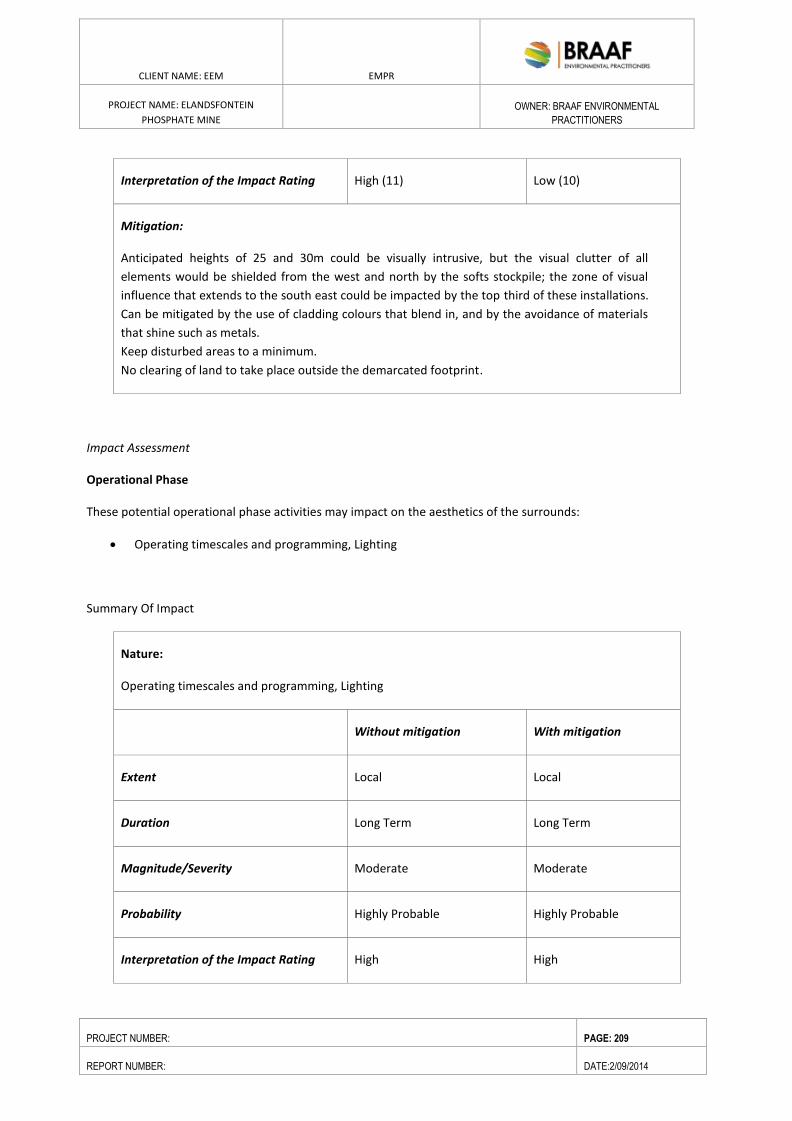
ENVIRONMENTAL RESOURCES MANAGEMENT GAMSBERG ZINC MINE EMPR
DATE: MAY 2013 REV 1.0
CLIENT NAME: EEM EMPR
PROJECT NAME: ELANDSFONTEIN
PHOSPHATE MINE
OWNER: BRAAF ENVIRONMENTAL
PRACTITIONERS
PROJECT NUMBER: PAGE: 209
REPORT NUMBER: DATE:2/09/2014
Interpretation of the Impact Rating High (11) Low (10)
Mitigation:
Anticipated heights of 25 and 30m could be visually intrusive, but the visual clutter of all
elements would be shielded from the west and north by the softs stockpile; the zone of visual
influence that extends to the south east could be impacted by the top third of these installations.
Can be mitigated by the use of cladding colours that blend in, and by the avoidance of materials
that shine such as metals.
Keep disturbed areas to a minimum.
No clearing of land to take place outside the demarcated footprint.
Impact Assessment
Operational Phase
These potential operational phase activities may impact on the aesthetics of the surrounds:
Operating timescales and programming, Lighting
Summary Of Impact
Nature:
Operating timescales and programming, Lighting
Without mitigation With mitigation
Extent Local Local
Duration Long Term Long Term
Magnitude/Severity Moderate Moderate
Probability Highly Probable Highly Probable
Interpretation of the Impact Rating High High

ENVIRONMENTAL RESOURCES MANAGEMENT GAMSBERG ZINC MINE EMPR
DATE: MAY 2013 REV 1.0
CLIENT NAME: EEM EMPR
PROJECT NAME: ELANDSFONTEIN
PHOSPHATE MINE
OWNER: BRAAF ENVIRONMENTAL
PRACTITIONERS
PROJECT NUMBER: PAGE: 210
REPORT NUMBER: DATE:2/09/2014
Mitigation:
As the mine will operate through 24 hours, the roads and road junctions will be affected during
these periods.
As the mine will operate through 24 hours it will be lit at night, both security and work lights will
function; lighting should be managed in accord with western cape guidelines.
Impact Assessment
Operational Phase
These potential operational phase activities may impact on the aesthetics of the surrounds:
Road transport of deliveries and personnel
Summary Of Impacts
Nature:
Road transport of deliveries and personnel
Without mitigation With mitigation
Extent Regional (3) Regional (3)
Duration Long Term (3) Long Term (3)
Magnitude/Severity Low (2) Low (2)
Probability Highly Probable (3) Probable (2)
Interpretation of the Impact Rating High (11) Low (10)
Mitigation:
Three shifts per 24hour period, to bring in and collect labour using about 10 minibuses or
equivalent has a significant impact which could be reduced visually by ‘staggering’ the vehicles or
by providing a traffic control at the junction with the R45 to facilitate local road users.
Utilise existing roads and tracks to the extent possible; gravel roads, maintained to prevent dust
plumes and erosion.
Impact Assessment
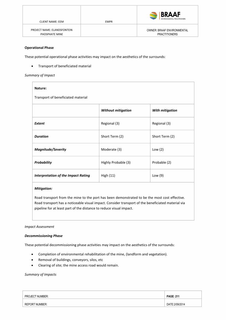
ENVIRONMENTAL RESOURCES MANAGEMENT GAMSBERG ZINC MINE EMPR
DATE: MAY 2013 REV 1.0
CLIENT NAME: EEM EMPR
PROJECT NAME: ELANDSFONTEIN
PHOSPHATE MINE
OWNER: BRAAF ENVIRONMENTAL
PRACTITIONERS
PROJECT NUMBER: PAGE: 211
REPORT NUMBER: DATE:2/09/2014
Operational Phase
These potential operational phase activities may impact on the aesthetics of the surrounds:
Transport of beneficiated material
Summary of Impact
Nature:
Transport of beneficiated material
Without mitigation With mitigation
Extent Regional (3) Regional (3)
Duration Short Term (2) Short Term (2)
Magnitude/Severity Moderate (3) Low (2)
Probability Highly Probable (3) Probable (2)
Interpretation of the Impact Rating High (11) Low (9)
Mitigation:
Road transport from the mine to the port has been demonstrated to be the most cost effective.
Road transport has a noticeable visual impact. Consider transport of the beneficiated material via
pipeline for at least part of the distance to reduce visual impact.
Impact Assessment
Decommissioning Phase
These potential decommissioning phase activities may impact on the aesthetics of the surrounds:
Completion of environmental rehabilitation of the mine, (landform and vegetation).
Removal of buildings, conveyors, silos, etc
Clearing of site; the mine access road would remain.
Summary of Impacts
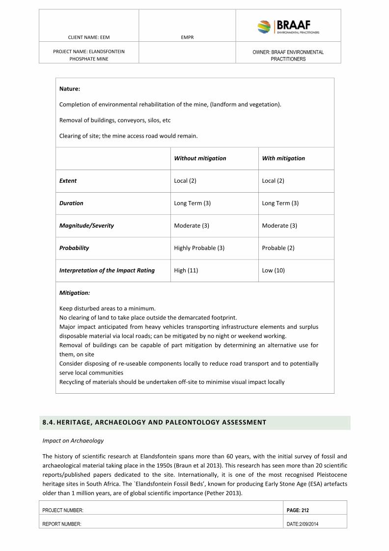
ENVIRONMENTAL RESOURCES MANAGEMENT GAMSBERG ZINC MINE EMPR
DATE: MAY 2013 REV 1.0
CLIENT NAME: EEM EMPR
PROJECT NAME: ELANDSFONTEIN
PHOSPHATE MINE
OWNER: BRAAF ENVIRONMENTAL
PRACTITIONERS
PROJECT NUMBER: PAGE: 212
REPORT NUMBER: DATE:2/09/2014
Nature:
Completion of environmental rehabilitation of the mine, (landform and vegetation).
Removal of buildings, conveyors, silos, etc
Clearing of site; the mine access road would remain.
Without mitigation With mitigation
Extent Local (2) Local (2)
Duration Long Term (3) Long Term (3)
Magnitude/Severity Moderate (3) Moderate (3)
Probability Highly Probable (3) Probable (2)
Interpretation of the Impact Rating High (11) Low (10)
Mitigation:
Keep disturbed areas to a minimum.
No clearing of land to take place outside the demarcated footprint.
Major impact anticipated from heavy vehicles transporting infrastructure elements and surplus
disposable material via local roads; can be mitigated by no night or weekend working.
Removal of buildings can be capable of part mitigation by determining an alternative use for
them, on site
Consider disposing of re-useable components locally to reduce road transport and to potentially
serve local communities
Recycling of materials should be undertaken off-site to minimise visual impact locally
8.4. HERITAGE, ARCHAEOLOGY AND PALEONTOLOGY ASSESSMENT
Impact on Archaeology
The history of scientific research at Elandsfontein spans more than 60 years, with the initial survey of fossil and
archaeological material taking place in the 1950s (Braun et al 2013). This research has seen more than 20 scientific
reports/published papers dedicated to the site. Internationally, it is one of the most recognised Pleistocene
heritage sites in South Africa. The `Elandsfontein Fossil Beds’, known for producing Early Stone Age (ESA) artefacts
older than 1 million years, are of global scientific importance (Pether 2013).
ENVIRONMENTAL RESOURCES MANAGEMENT GAMSBERG ZINC MINE EMPR
DATE: MAY 2013 REV 1.0
CLIENT NAME: EEM EMPR
PROJECT NAME: ELANDSFONTEIN
PHOSPHATE MINE
OWNER: BRAAF ENVIRONMENTAL
PRACTITIONERS
PROJECT NUMBER: PAGE: 213
REPORT NUMBER: DATE:2/09/2014
It is well-known that the Saldanha Bay area is a region of high archaeological importance, particularly with regard
to Pleistocene archaeology. The Elandsfontein fossil site is also only one of a few localities in South Africa that
preserves both archaeological and organic remains (bones) in an in situ (open air) context, allowing archaeologists
a unique opportunity to study the evolution of early modern humans and how they interacted with their
ecosystems more than 200 000 years ago (Braun 2013).
New observations at the site indicate that the main assemblage at Elandsfontein may now be as old as ~1 million
years (Braun et al 2013). The context of fossil bones and artefacts in aeolian sands is well-illustrated by the
`Elandsfontein Fossil Beds’ which include a sparse bone content in the uppermost Langebaan Formation, and a
more persistent bone and artefact content in the overlying Springfontyn Formation sands.
Dr Braun, who currently holds the research permit for the archaeological site (fossil area), has noted that the .area
is `one of the richest sites of its kind in Africa’ (in Bluff & Hart 2010:10). Current research, however, suggest that if
this ancient landscape extends outside of the (now stable) dunefield, that any artefacts or fossils recovered from it
will be patchily distributed (Braun et al 2013), but that if fossils are encountered, they will likely be `numerous and
densely concentrated’ (Braun 2013:5). The latter fossil area falls outside of the mine area, some 2-3 km’s away.
The mine area will be fenced off from the fossil area.
Plasket (2013) logged a few Middle Stone Age flakes, fossil bone and coprolites during a survey of the proposed
mining application area, while Kaplan (2013) found only one MSA silcrete flake during an assessment of the 17
proposed prospecting drill sites.
While little is known about the Holocene Later Stone Age (LSA) archaeology in the area, Kaplan (2011) did
document relatively large numbers of LSA silcrete stone flakes on a limestone ridge (outside the application area)
on Farm 349, alongside the Eskom servitude that runs between the Elandsfontyn fossil site, and the proposed
mining area. Orton (2007) identified a single LSA flake on Farm 349/6.
Impact Assessment
The project activity could impact on archaeological resources during the construction and operational phase.
Construction and Operational Phase Impacts
Construction phase activities will include land clearance and excavation of different parts of the site in preparation
of infrastructural development. The primary construction activities will include the following:
Pre-stripping of the open pit;
Excavation of the softs stockpile area;
Construction of the concentrator plant (including some of associated infrastructure); and
Construction of bulk service requirements (ie water, sewage and power infrastructure) and mine access
roads.
The following activities will be characteristic of the operational phase of the Project:
Further expansion of open pit;
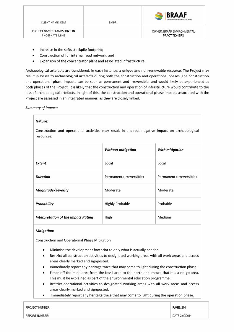
ENVIRONMENTAL RESOURCES MANAGEMENT GAMSBERG ZINC MINE EMPR
DATE: MAY 2013 REV 1.0
CLIENT NAME: EEM EMPR
PROJECT NAME: ELANDSFONTEIN
PHOSPHATE MINE
OWNER: BRAAF ENVIRONMENTAL
PRACTITIONERS
PROJECT NUMBER: PAGE: 214
REPORT NUMBER: DATE:2/09/2014
Increase in the softs stockpile footprint;
Construction of full internal road network; and
Expansion of the concentrator plant and associated infrastructure.
Archaeological artefacts are considered, in each instance, a unique and non-renewable resource. The Project may
result in losses to archaeological artefacts during both the construction and operational phases. The construction
and operational phase impacts can be seen as permanent and irreversible, and would likely be experienced at
both phases of the Project. It is likely that the construction and operation of infrastructure would contribute to the
loss of archaeological artefacts. In light of this, the construction and operational phase impacts associated with the
Project are assessed in an integrated manner, as they are closely linked.
Summary of Impacts
Nature:
Construction and operational activities may result in a direct negative impact on archaeological
resources.
Without mitigation With mitigation
Extent Local Local
Duration Permanent (Irreversible) Permanent (Irreversible)
Magnitude/Severity Moderate Moderate
Probability Highly Probable Probable
Interpretation of the Impact Rating High Medium
Mitigation:
Construction and Operational Phase Mitigation
Minimise the development footprint to only what is actually needed.
Restrict all construction activities to designated working areas with all work areas and access
areas clearly marked and signposted.
Immediately report any heritage trace that may come to light during the construction phase.
Fence off the mine area from the fossil area to the north and ensure that it is a no-go area.
This must be explained as part of the environmental education programme.
Restrict operational activities to designated working areas with all work areas and access
areas clearly marked and signposted.
Immediately report any heritage trace that may come to light during the operation phase.
ENVIRONMENTAL RESOURCES MANAGEMENT GAMSBERG ZINC MINE EMPR
DATE: MAY 2013 REV 1.0
CLIENT NAME: EEM EMPR
PROJECT NAME: ELANDSFONTEIN
PHOSPHATE MINE
OWNER: BRAAF ENVIRONMENTAL
PRACTITIONERS
PROJECT NUMBER: PAGE: 215
REPORT NUMBER: DATE:2/09/2014
EEM, HWC and SANParks have signed a draft Memorandum of Understanding, where a
portion of Portion 2 of the Farm Elandsfontein 349 will be donated to SANParks for
preservation as an area of paleontological and archeological importance.
Residual Impact
The implementation of the above mitigation measures would reduce the decommissioning phase impacts from
Major to Moderate significance.
Construction and Operational Phase Impacts
Similarly to the impact on archaeology, the construction and operational phase impacts to cultural heritage and
sense of place will overlap between the two phases. As these impacts are closely linked, the construction and
operational phase impacts will be jointly assessed.
Impact on Paleontology
A Paleontological Impact Assessment (PIA) was undertaken by John Pether in (refer to Annex C for the report) to
outline the nature of paleontological heritage resources (fossils) in the subsurface of the Project area, which may
potentially be affected by construction and operation activities (eg bulk earth works) during the development of
the mine.
The specialist report by Pether (2013), addresses the palaeontological sensitivity of the stratigraphic section below
the near-surface, fossiliferous deposits, viz. the Langebaan and Varswater formations. It is the calcareous
Langebaan Formation that contains much of the archaeological and fossil remains which have been encountered
at the nearby fossil site (Singer and Wymer 1968). The high fossil potential of the Langebaan Formation is
therefore well known and according to Pether (2013), most of Farm 349 is underlain by this formation.
Pether (2013) notes, that it is generally not possible to predict the buried fossil content of an area other than in
general terms, based on what has been previously observed of the fossil content of a particular formation in a
particular area. But, as Pether (2013) argues, there is ample information (more than 100 scientific papers for the
region have been published), to predict with some probability, the impact of a proposed mining operation on the
palaeontological heritage.
In coastal-plain deposits of the Langebaan Formation, for example, the important fossil bone material is generally
sparsely scattered and unless large and obvious, is not generally seen, underestimating the fossil prevalence.
Much therefore depends on careful scrutiny of exposures and on spotting this material as it is uncovered during
digging i.e. by monitoring excavations.
While the high fossil potential of the Langebaan Formation is well known, the pre-Langebaan Formation (i. e. the
Varswater Formation) phosphatic aeolianites (the target area for mining), have an unproven, `but strong potential’
to yield fossil remains additional to the known marine microfossil content, such as land snails and micro mammals
(Pether 2013:36). Bluff & Hart (2010) note that the Varswater Formation at Langebaanweg (the old Samancor
Chemfos Mine and now the West Coast Fossil Park), for example, is highly fossiliferous, containing the world’s
densest known concentration of Pliocene vertebrate fossils, about 5 million years old. Preservation of cores from
the phosphate prospecting programme, including subsampling of selected intervals, sample disaggregation,
sieving and macro - and optical microscopic inspection, may yield interesting observations and inform further
investigations (Pether 2013).
ENVIRONMENTAL RESOURCES MANAGEMENT GAMSBERG ZINC MINE EMPR
DATE: MAY 2013 REV 1.0
CLIENT NAME: EEM EMPR
PROJECT NAME: ELANDSFONTEIN
PHOSPHATE MINE
OWNER: BRAAF ENVIRONMENTAL
PRACTITIONERS
PROJECT NUMBER: PAGE: 216
REPORT NUMBER: DATE:2/09/2014
The potential impacts of this development on paleontological resources are assessed and mitigation measures to
reduce the impacts are outlined below.
Impact Assessment
The impacts of the proposed activities during both construction and operation could have the following impact.
The long-term impact from potential mining in the future, involving the excavations of large volumes and
continuous exposure and destruction of large vertical sections through the deposits.
Nature of the Impact of Mining
Mining and ancillary construction activities (excavations) will result in a negative direct impact on the fossil
content of the affected subsurface. Fossils and significant observations will be lost in the absence of management
actions to mitigate such loss. This loss of the opportunity to recover fossils and their contexts when exposed at a
particular site is irreversible.
Conversely, mine pits and construction excavations furnish the “windows” into the coastal plain depository that
would not otherwise exist and thereby provide access to the hidden fossils. The impact is positive for
palaeontology, provided that efforts are made to watch out for and rescue the fossils. There remains a medium to
high risk of valuable fossils being lost in spite of management actions to mitigate such loss.
Extent
There is a duality in the assigning of the “extent” of the impact of bulk excavations on fossil resource. The physical
extent of impacts on potential palaeontological resources relates directly to the extents of subsurface disturbance,
i.e. site specific.
The cultural, heritage and scientific impacts are of regional to national extent, as is implicit in the NHRA 25 (1999)
legislation and, if scientifically important specimens or assemblages are uncovered, are of international interest.
This is evident in the amount of foreign-funded research that takes place by scientists of other nationalities. Loss
of opportunities that may arise from a significant fossil occurrence (tourism, employment) filters down to
regional/local levels.
Duration
The impact of both the finding or the loss of fossils is permanent. The found fossils must be preserved “for
posterity”; the lost, overlooked or destroyed fossils are lost to posterity.
Intensity
The intensity of potential impact of bulk earthworks on fossil resources is determined by the palaeontological
sensitivity of the affected formations (see Appendix 3). The Langebaan Formation is known to contain
palaeontological resources that include rare, well-preserved fossil materials important to on-going palaeoclimatic,
palaeobiological and/or evolutionary studies. Fossils of land-dwelling vertebrates are typically considered
significant. For the Langebaan Formation the intensity of impact is high in the absence of effective mitigation.
The palaeontological potential of the postulated older aeolianite is not objectively determinable due to lack of
exposure and observations, but is likely to be reduced cf. the younger Langebaan Fm aeolianites.
ENVIRONMENTAL RESOURCES MANAGEMENT GAMSBERG ZINC MINE EMPR
DATE: MAY 2013 REV 1.0
CLIENT NAME: EEM EMPR
PROJECT NAME: ELANDSFONTEIN
PHOSPHATE MINE
OWNER: BRAAF ENVIRONMENTAL
PRACTITIONERS
PROJECT NUMBER: PAGE: 217
REPORT NUMBER: DATE:2/09/2014
Nevertheless, some macrofossil fossil content is expected to occur. In view of the scientific importance of such
fossils finds, as elucidated above, the palaeontological sensitivity must remain on par with the Langebaan Fm.
Probability
The likelihood of impact is definite with respect to future mining.
Reversibility
The loss of fossil material such as rare fossil bone is irreversible.
Status of the Impact
Negative without mitigation, positive with mitigation.
Confidence
The level of confidence of the probability and intensity of impact is certain with respect to the mining.
Significance
Note that the presence of fossils in the subsurface does not have an a priori influence on the decision to proceed
with the mining. However, mitigation measures are essential. It is probable that sparse, valuable bone fossils will
go undetected, even with the most diligent mitigation practicable. On the other hand, the finding and recovery
fossils will have a positive impact ranging from local to international in extent, depending on the nature of the
finds.
The general significance of coastal-plain fossils involves:
history of coastal-plain evolution.
The history of past climatic changes, past biota and environments.
Associations of fossils with buried archaeological material and human prehistory.
For radiometric and other dating techniques (rates of coastal change).
Preservation of materials for the application of yet unforeseen investigative techniques.
The significance of the fossil content for resolving outstanding questions the stratigraphic status and age of the
various formations has been outlined above.
Summary of Impact
Nature:
Completion of environmental rehabilitation of the mine, (landform and vegetation).
Removal of buildings, conveyors, silos, etc
Clearing of site; the mine access road would remain.
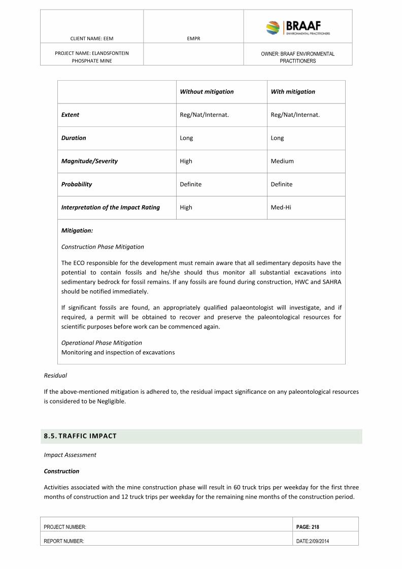
ENVIRONMENTAL RESOURCES MANAGEMENT GAMSBERG ZINC MINE EMPR
DATE: MAY 2013 REV 1.0
CLIENT NAME: EEM EMPR
PROJECT NAME: ELANDSFONTEIN
PHOSPHATE MINE
OWNER: BRAAF ENVIRONMENTAL
PRACTITIONERS
PROJECT NUMBER: PAGE: 218
REPORT NUMBER: DATE:2/09/2014
Without mitigation With mitigation
Extent Reg/Nat/Internat. Reg/Nat/Internat.
Duration Long Long
Magnitude/Severity High Medium
Probability Definite Definite
Interpretation of the Impact Rating High Med-Hi
Mitigation:
Construction Phase Mitigation
The ECO responsible for the development must remain aware that all sedimentary deposits have the
potential to contain fossils and he/she should thus monitor all substantial excavations into
sedimentary bedrock for fossil remains. If any fossils are found during construction, HWC and SAHRA
should be notified immediately.
If significant fossils are found, an appropriately qualified palaeontologist will investigate, and if
required, a permit will be obtained to recover and preserve the paleontological resources for
scientific purposes before work can be commenced again.
Operational Phase Mitigation
Monitoring and inspection of excavations
Residual
If the above-mentioned mitigation is adhered to, the residual impact significance on any paleontological resources
is considered to be Negligible.
8.5. TRAFFIC IMPACT
Impact Assessment
Construction
Activities associated with the mine construction phase will result in 60 truck trips per weekday for the first three
months of construction and 12 truck trips per weekday for the remaining nine months of the construction period.
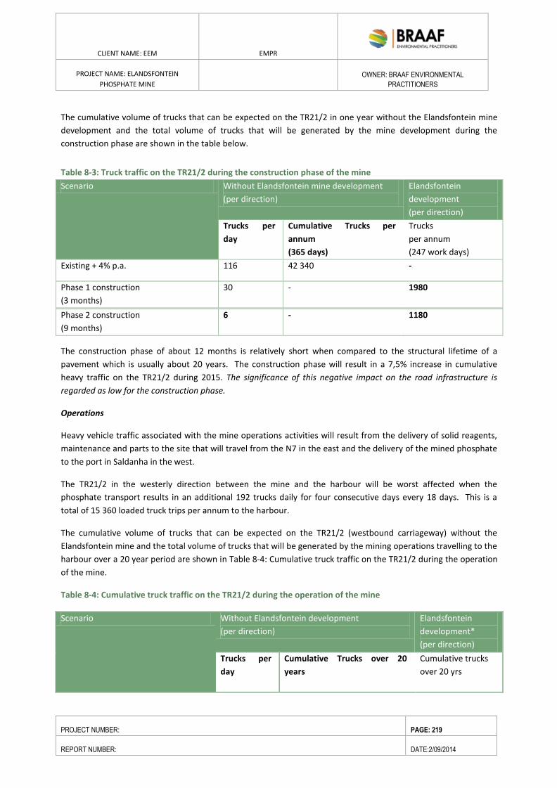
ENVIRONMENTAL RESOURCES MANAGEMENT GAMSBERG ZINC MINE EMPR
DATE: MAY 2013 REV 1.0
CLIENT NAME: EEM EMPR
PROJECT NAME: ELANDSFONTEIN
PHOSPHATE MINE
OWNER: BRAAF ENVIRONMENTAL
PRACTITIONERS
PROJECT NUMBER: PAGE: 219
REPORT NUMBER: DATE:2/09/2014
The cumulative volume of trucks that can be expected on the TR21/2 in one year without the Elandsfontein mine
development and the total volume of trucks that will be generated by the mine development during the
construction phase are shown in the table below.
Table 8-3: Truck traffic on the TR21/2 during the construction phase of the mine
Scenario Without Elandsfontein mine development
(per direction)
Elandsfontein
development
(per direction)
Trucks per
day
Cumulative Trucks per
annum
(365 days)
Trucks
per annum
(247 work days)
Existing + 4% p.a. 116 42 340 -
Phase 1 construction
(3 months)
30 - 1980
Phase 2 construction
(9 months)
6 - 1180
The construction phase of about 12 months is relatively short when compared to the structural lifetime of a
pavement which is usually about 20 years. The construction phase will result in a 7,5% increase in cumulative
heavy traffic on the TR21/2 during 2015. The significance of this negative impact on the road infrastructure is
regarded as low for the construction phase.
Operations
Heavy vehicle traffic associated with the mine operations activities will result from the delivery of solid reagents,
maintenance and parts to the site that will travel from the N7 in the east and the delivery of the mined phosphate
to the port in Saldanha in the west.
The TR21/2 in the westerly direction between the mine and the harbour will be worst affected when the
phosphate transport results in an additional 192 trucks daily for four consecutive days every 18 days. This is a
total of 15 360 loaded truck trips per annum to the harbour.
The cumulative volume of trucks that can be expected on the TR21/2 (westbound carriageway) without the
Elandsfontein mine and the total volume of trucks that will be generated by the mining operations travelling to the
harbour over a 20 year period are shown in Table 8-4: Cumulative truck traffic on the TR21/2 during the operation
of the mine.
Table 8-4: Cumulative truck traffic on the TR21/2 during the operation of the mine
Scenario Without Elandsfontein development
(per direction)
Elandsfontein
development*
(per direction)
Trucks per
day
Cumulative Trucks over 20
years
Cumulative trucks
over 20 yrs
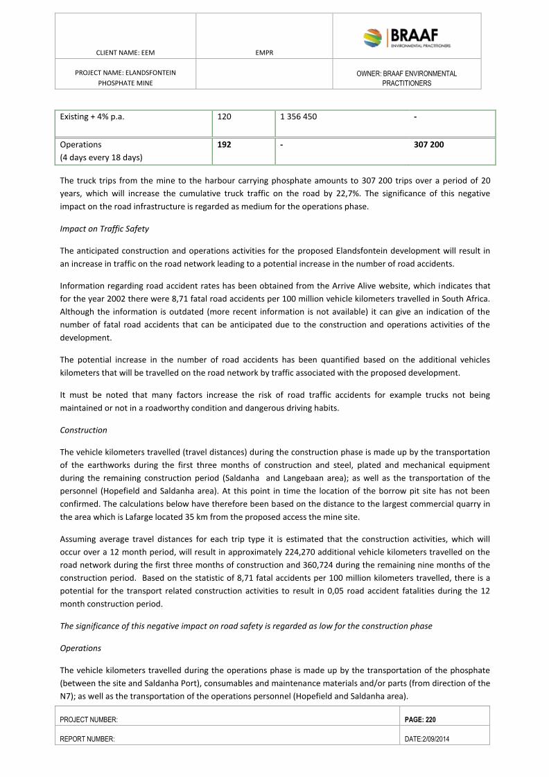
ENVIRONMENTAL RESOURCES MANAGEMENT GAMSBERG ZINC MINE EMPR
DATE: MAY 2013 REV 1.0
CLIENT NAME: EEM EMPR
PROJECT NAME: ELANDSFONTEIN
PHOSPHATE MINE
OWNER: BRAAF ENVIRONMENTAL
PRACTITIONERS
PROJECT NUMBER: PAGE: 220
REPORT NUMBER: DATE:2/09/2014
Existing + 4% p.a.
120 1 356 450 -
Operations
(4 days every 18 days)
192 - 307 200
The truck trips from the mine to the harbour carrying phosphate amounts to 307 200 trips over a period of 20
years, which will increase the cumulative truck traffic on the road by 22,7%. The significance of this negative
impact on the road infrastructure is regarded as medium for the operations phase.
Impact on Traffic Safety
The anticipated construction and operations activities for the proposed Elandsfontein development will result in
an increase in traffic on the road network leading to a potential increase in the number of road accidents.
Information regarding road accident rates has been obtained from the Arrive Alive website, which indicates that
for the year 2002 there were 8,71 fatal road accidents per 100 million vehicle kilometers travelled in South Africa.
Although the information is outdated (more recent information is not available) it can give an indication of the
number of fatal road accidents that can be anticipated due to the construction and operations activities of the
development.
The potential increase in the number of road accidents has been quantified based on the additional vehicles
kilometers that will be travelled on the road network by traffic associated with the proposed development.
It must be noted that many factors increase the risk of road traffic accidents for example trucks not being
maintained or not in a roadworthy condition and dangerous driving habits.
Construction
The vehicle kilometers travelled (travel distances) during the construction phase is made up by the transportation
of the earthworks during the first three months of construction and steel, plated and mechanical equipment
during the remaining construction period (Saldanha and Langebaan area); as well as the transportation of the
personnel (Hopefield and Saldanha area). At this point in time the location of the borrow pit site has not been
confirmed. The calculations below have therefore been based on the distance to the largest commercial quarry in
the area which is Lafarge located 35 km from the proposed access the mine site.
Assuming average travel distances for each trip type it is estimated that the construction activities, which will
occur over a 12 month period, will result in approximately 224,270 additional vehicle kilometers travelled on the
road network during the first three months of construction and 360,724 during the remaining nine months of the
construction period. Based on the statistic of 8,71 fatal accidents per 100 million kilometers travelled, there is a
potential for the transport related construction activities to result in 0,05 road accident fatalities during the 12
month construction period.
The significance of this negative impact on road safety is regarded as low for the construction phase
Operations
The vehicle kilometers travelled during the operations phase is made up by the transportation of the phosphate
(between the site and Saldanha Port), consumables and maintenance materials and/or parts (from direction of the
N7); as well as the transportation of the operations personnel (Hopefield and Saldanha area).
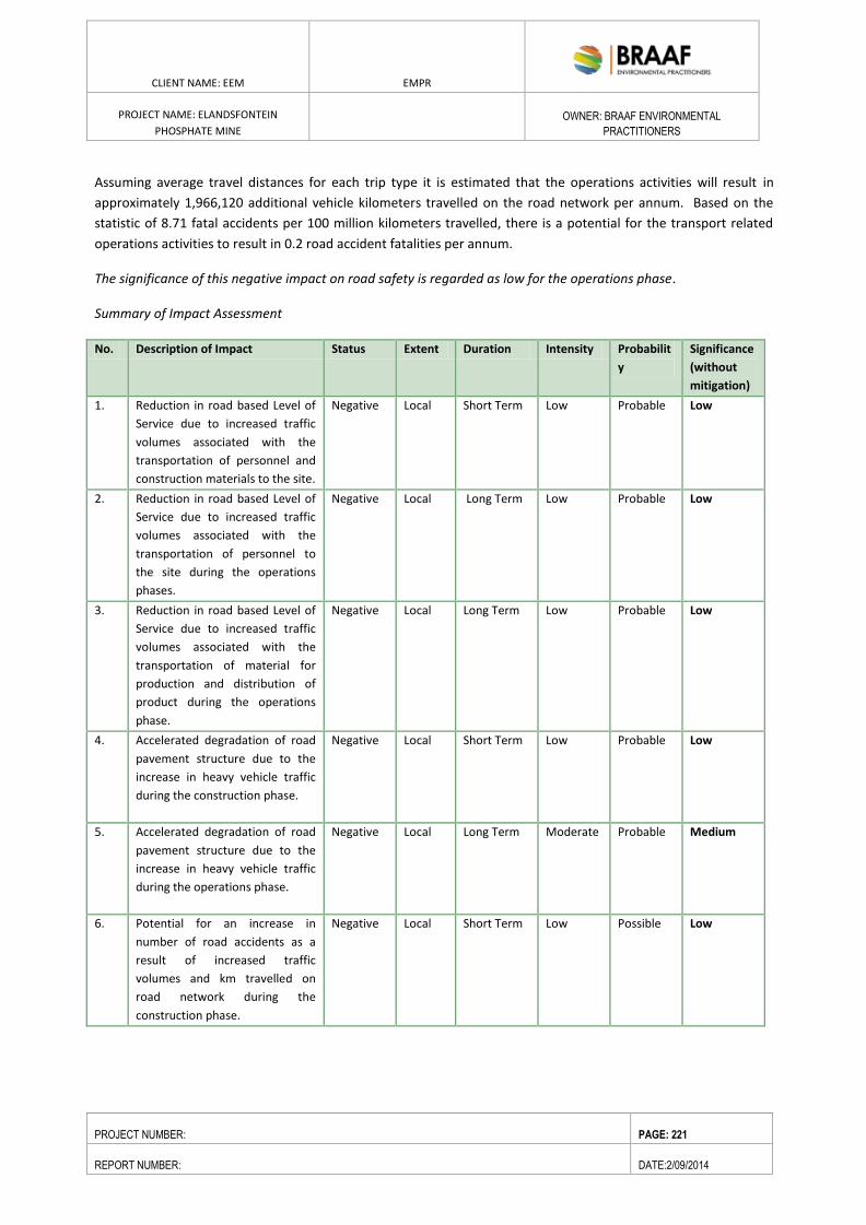
ENVIRONMENTAL RESOURCES MANAGEMENT GAMSBERG ZINC MINE EMPR
DATE: MAY 2013 REV 1.0
CLIENT NAME: EEM EMPR
PROJECT NAME: ELANDSFONTEIN
PHOSPHATE MINE
OWNER: BRAAF ENVIRONMENTAL
PRACTITIONERS
PROJECT NUMBER: PAGE: 221
REPORT NUMBER: DATE:2/09/2014
Assuming average travel distances for each trip type it is estimated that the operations activities will result in
approximately 1,966,120 additional vehicle kilometers travelled on the road network per annum. Based on the
statistic of 8.71 fatal accidents per 100 million kilometers travelled, there is a potential for the transport related
operations activities to result in 0.2 road accident fatalities per annum.
The significance of this negative impact on road safety is regarded as low for the operations phase.
Summary of Impact Assessment
No. Description of Impact Status Extent Duration Intensity Probabilit
y
Significance
(without
mitigation)
1. Reduction in road based Level of
Service due to increased traffic
volumes associated with the
transportation of personnel and
construction materials to the site.
Negative Local Short Term Low Probable Low
2. Reduction in road based Level of
Service due to increased traffic
volumes associated with the
transportation of personnel to
the site during the operations
phases.
Negative Local Long Term Low Probable Low
3. Reduction in road based Level of
Service due to increased traffic
volumes associated with the
transportation of material for
production and distribution of
product during the operations
phase.
Negative Local Long Term Low Probable Low
4. Accelerated degradation of road
pavement structure due to the
increase in heavy vehicle traffic
during the construction phase.
Negative Local Short Term Low Probable Low
5. Accelerated degradation of road
pavement structure due to the
increase in heavy vehicle traffic
during the operations phase.
Negative Local Long Term Moderate Probable Medium
6. Potential for an increase in
number of road accidents as a
result of increased traffic
volumes and km travelled on
road network during the
construction phase.
Negative Local Short Term Low Possible Low
ENVIRONMENTAL RESOURCES MANAGEMENT GAMSBERG ZINC MINE EMPR
DATE: MAY 2013 REV 1.0
CLIENT NAME: EEM EMPR
PROJECT NAME: ELANDSFONTEIN
PHOSPHATE MINE
OWNER: BRAAF ENVIRONMENTAL
PRACTITIONERS
PROJECT NUMBER: PAGE: 222
REPORT NUMBER: DATE:2/09/2014
7. Potential for an increase in
number of road accidents as a
result of increased traffic
volumes and km travelled on
road network during the
operation phase.
Negative Local Long Term Low Possible Low
Recommended Mitigation Measures
The following mitigation measures have been identified in order to minimize the impacts that will arise from the
construction and operation activities of the Elandsfontein development.
Traffic conditions (road capacity and intersections)
In order to minimize the impact of the additional traffic that will be added to the road network due to the
construction and operations activities of the proposed Elandsfontein development, the following mitigation
measures are recommended.
Construction materials
During the construction phase deliveries of material by truck to the site could be scheduled to avoid peak hour
traffic. The weekday AM (06h30 – 07h30) and PM (16h30 – 17h30) peak hours will be the two busiest periods on
the road with the highest traffic volumes. Heavy vehicle arrivals and departures will have less of an impact if
occurring outside of the aforementioned time periods.
Operations materials
During the operations phase material deliveries to the site (solid reagents, maintenance and parts) and phosphate
transport to Saldanha could also be scheduled to avoid peak hour traffic, as discussed under construction
materials above.
Road infrastructure (heavy vehicle impact)
The construction phase will result in minimal impact due to the low volumes of heavy vehicle traffic especially
considering that the 12+ months construction phase is relatively short when compared to the structural lifetime of
a road pavement. The operations phase will result in moderate heavy vehicle traffic volumes.
In order to mitigate the effect of heavy vehicles on the roads within the study area it is essential that roads are
properly and regularly maintained (by the relevant authorities) and that heavy vehicle overloading is curbed by
traffic enforcement officials. Traffic enforcement officials should monitor overloading of heavy vehicles to limit the
impact on the structural integrity of the roads surrounding the site. The existing weighbridge that is located on
TR85/1 can be used to inspect vehicles for overloading.
Traffic Safety
The anticipated construction and operations activities for the proposed Elandsfontein development will result in
an increase in traffic on the road network and vehicle kilometres travelled, which means that there is a potential
for an increase in the number of road accidents.
ENVIRONMENTAL RESOURCES MANAGEMENT GAMSBERG ZINC MINE EMPR
DATE: MAY 2013 REV 1.0
CLIENT NAME: EEM EMPR
PROJECT NAME: ELANDSFONTEIN
PHOSPHATE MINE
OWNER: BRAAF ENVIRONMENTAL
PRACTITIONERS
PROJECT NUMBER: PAGE: 223
REPORT NUMBER: DATE:2/09/2014
It is important to note that various factors influence the risk of road accidents for example vehicles (especially
trucks) not being maintained to a roadworthy condition and dangerous driving habits. To limit the potential for
accidents competent trained drivers must operate well maintained vehicles. Visible law enforcement should be
present with traffic officers regularly conducting random inspections of vehicles for roadworthy conditions and
drivers for the correct driving licenses and permits.
Impact assessment after implementation of mitigation measures
The significance of the majority of the impacts that will occur during the construction and operation phases of the
development is regarded as low without mitigation. The majority of impacts will remain low even with the
implementation of the recommended mitigation measures. This can be explained due to the significance of most
of the impacts being rated as low, i.e. with the mitigation in place the impact is reduced and not removed.
The majority of impacts will remain low with the implementation of the recommended mitigation measures.
8.6. FAUNA ASSESSMENT
Impact Assessment
The fauna study undertook a risk assessment to determine the impact of the activity on the faunal populations on
the site.
The risk assessment investigates direct mortality as a risk. This would occur when a species that cannot flee from
the affected area by themselves during the mining activity and more regular use of the access road to the site
could potentially suffer direct mortality.
Birds, large snakes and medium-sized mammals and large mammals would be able to move away from the
affected areas but will get very used to any form of activity that does not pose a threat to them. Tortoises and
many other reptiles, as well as amphibians and small mammals, will flee effectively albeit slower. Therefore except
for the incidental invertebrate that could be killed by vehicles no faunal mortalities should occur during the
construction and operational phase.
In the study area, the Red Data species which may be present, Lomi’s Blind Legless Skink, the Namaqua Dwarf
Adder, and Grant’s Golden Mole, would not be affected to any large degree by road kills as the skink and the mole
are subterranean species and the adder has low mobility. Grant’s Golden Mole would probably only on occasion
attempt to cross roads.
Due to the increase in traffic associated to the construction and operational phase of the mine it is envisaged that
the mine area be fenced off to minimise any accidental deaths. Good road traffic rules will be implemented which
will include adherence to speed limits. Should these measures be implemented the overall risk will be low.
As opposed to direct road kills, the barrier effect of roads probably impacts more species than the effects of either
road kills or road avoidance. While it is particularly mammals, with their greater mobility and larger home ranges,
that are seemingly heavily impacted on by road kills, lower vertebrates and invertebrates, on the other hand, may
find hard road surfaces impassable barriers. The barrier effect of roads and fencing will only impact on species in
the long term. The project will entail the construction of new roads and additional vehicular movement on the
ENVIRONMENTAL RESOURCES MANAGEMENT GAMSBERG ZINC MINE EMPR
DATE: MAY 2013 REV 1.0
CLIENT NAME: EEM EMPR
PROJECT NAME: ELANDSFONTEIN
PHOSPHATE MINE
OWNER: BRAAF ENVIRONMENTAL
PRACTITIONERS
PROJECT NUMBER: PAGE: 224
REPORT NUMBER: DATE:2/09/2014
sandy roads and main mine access road which will be surfaced where one at times find the diggings of Golden
Moles. Of these species, only Lomi’s Blind Legless Skink and Grant’s Golden Mole are Red Data species. Because
of the low number of Red Data species that may be affected, the impact will only be of local extent.
The potential impact of the barrier effect will be minor and this also applies to fencing. The larger antelope species
are contained on the larger reserve by a game proof fence of 2.2m in height (Bonox). All animals smaller than a
Duiker are not restricted by this fence.
Prior to construction commencing on site, a fence must be erected to prevent animals from accessing areas which
receive high levels of traffic. This must be maintained during the operational phase of the mine.
Other risks include:
Habitat loss and degradation; dispersal barriers and habitat fragmentation; reduced access to water; uncontrolled
collecting and illegal hunting.
Additional mitigation measures include:
Wildlife management plan by EEM focused on management of the medium to large faunal species and
their habitat requirements to avoid habitat destruction through overgrazing;
Fauna translocation plan from areas prior to disturbance when appropriate
General awareness training will be done as part of the mine induction to inform all staff and contractors
of the sensitivities of the biodiversity aspects of the mine and surrounds and appropriate environmental
work-place etiquette;
Measures to manage emergency, accident or upset conditions where biodiversity may be adversely
affected.
There are a number of measures that will be implemented to minimise the impact on fauna and flora.
Measures to reduce at site:
Barriers to terrestrial faunal movement, eg fine mesh fences, walls, trenches, a raised concrete base along
a conveyor, will be avoided where possible, and measures implemented to reduce their fragmentation
impacts.
The following activities will be prohibited by staff and contractors: Hunting of wildlife within the mine
property or mine controlled areas;
Purchase, sale or transport of any wildlife products from local communities or passing traders;
Collection of any animals or products thereof for consumption, medicinal use, cultivation or keeping as
pets;
Intentional killing of any animals including snakes, lizards, birds or other animals.
All trenches and pits that are excavated for pipelines, caballing etc will be backfilled as soon as practically
possible to avoid acting as a trap for small fauna.
Escape routes for fauna will be provided within pitfall features and concreted drainage lines, and
potentially dangerous situations inspected regularly to save trapped species.
All new power line infrastructure should be bird-friendly in configuration (eg pylon designs that widely
separate live wires to reduce electrocution of vultures and other large raptors) and adequately insulated
to minimise the loss of raptors and other large birds. These activities should be supervised by someone
with experience in this field.
Redundant infrastructure will be removed at the earliest opportunity and these areas rehabilitated.
ENVIRONMENTAL RESOURCES MANAGEMENT GAMSBERG ZINC MINE EMPR
DATE: MAY 2013 REV 1.0
CLIENT NAME: EEM EMPR
PROJECT NAME: ELANDSFONTEIN
PHOSPHATE MINE
OWNER: BRAAF ENVIRONMENTAL
PRACTITIONERS
PROJECT NUMBER: PAGE: 225
REPORT NUMBER: DATE:2/09/2014
All roads within the mine properties and mine controlled areas to minimise the incidence of faunal road
kills.
Driver training will be provided to sensitise them to the importance of avoiding faunal road kills and the
mine site, within the mine properties and on public roads.
Trained mine personnel with capacity to safely capture and translocate dangerous snakes from
construction sites and mine operational areas to safe areas of similar habitat within the mine property.
Other nondangerous faunal species at risk from construction activities will be captured and translocated
to safe areas as appropriate.
Ongoing development of an inventory of species diversity within the mine sites will be maintained. EEM
will collaborate with academic institutions with adequate competence to conduct research and monitor
unexpected changes to the faunal baseline. Emphasis should be placed on the species considered to be at
high and medium risk although not only restricted to these species. Such research may lead to improved
mitigation to conserve the natural environments and species diversity.
EEM will collaborate with academic institutions to conduct and interpret regular faunal monitoring
studies to both expand on the current baseline study. The following aspects will be considered:
Additional conservation enhancement measures:
There are a number of measures that EEM could consider in improving the general conservation status of the area.
These include the following:
Efforts will be supported to promote an appreciation of biodiversity features of the mine property and mine
controlled areas among staff, contractors and their dependents as mentioned in the EMP.
Biodiversity offsets will be considered to remedy these and other residual impacts on biodiversity. Special
consideration needs to be given towards choice of an offset that includes the plant and animal species of
conservation concern; offset areas required to remedy residual negative impacts on habitat and flora may be
sufficient to address the offset needs of fauna. Rare and undescribed plant and animal species may not be
widespread and if not present in an offset, additional precautions to protect their populations in situ.
8.7. FRESHWATER ASSESSMENT
This section provides a description of the potential impacts the Project may have on surface water hydrology. The
key receptors or resources considered are all affected sub-catchments and watercourses.
The main aquatic features within the wider study area consist of the Sout River System, a tributary of the lower
Berg River, to the east of the site and the Langebaan Lagoon to the west of the site. The site occurs approximately
2km west of the watershed between these two larger freshwater features. Thus the surface water drainage is
predominantly to the south west, towards Langebaan Lagoon. There are no seasonal or permanent wetlands in
the immediate study area, only a poorly defined drainage channel that is orientated towards the south.
Impact Assessment
The only likely impact of the proposed mining activities on the surrounding freshwater features is that associated
with the cumulative longer term impact of these activities on Langebaan Lagoon. This impact is deemed to be
highly unlikely in terms of the distance between the proposed mining activities and given the fact that the
ENVIRONMENTAL RESOURCES MANAGEMENT GAMSBERG ZINC MINE EMPR
DATE: MAY 2013 REV 1.0
CLIENT NAME: EEM EMPR
PROJECT NAME: ELANDSFONTEIN
PHOSPHATE MINE
OWNER: BRAAF ENVIRONMENTAL
PRACTITIONERS
PROJECT NUMBER: PAGE: 226
REPORT NUMBER: DATE:2/09/2014
activities will not entail any substantial consumptive use of water or pose any significant risk of water pollution to
the resource. In addition, should there be any impact on the water resources in the area, it would be identified
within the groundwater resources in the area long before becoming apparent in the lagoon. Given the distance
between the proposed Elandsfontein Mine and the closest significant water resources, it should also be noted that
there are many other activities within the immediate area that are far more likely to exert an impact on these
freshwater features than the proposed mine and that establishing any cause and effect relationship between the
mine’s activities and any impact observed for these freshwater features would be extremely difficult.
Summary of Impact
Nature:
Cumulative longer term impact of mining activities on Langebaan Lagoon - Loss of freshwater wetland
areas associated with Langebaan Lagoon (predominantly Typha and Phagmites reed beds near
Geelbek)
Cumulative Impact without
mitigation
Cumulative Impact with
mitigation
Extent Localised longer term impacts Localised longer term
impacts
Duration Long Long
Magnitude/Severity Very Low Very Low
Probability Improbable Improbable
Interpretation of the Impact Rating Very low to insignificant Very low to insignificant
Mitigation:
Monitor groundwater level and water quality between Elandsfontein site and Langebaan Lagoon to
allow for early detection of any potential impact to this freshwater feature and allow for mitigation
thereof prior to any possible impact on the lagoon;
Longer term mapping and monitoring of the groundwater dependant ecosystems within Langebaan
Lagoon (Typha and Phagmites reed beds near Geelbek) should be undertaken. This should form part
of a wider monitoring programme such as the State of the Bay monitoring and assessment
programme to evaluate the longer term and cumulative impacts of development of the Langebaan
and Saldanha area.
ENVIRONMENTAL RESOURCES MANAGEMENT GAMSBERG ZINC MINE EMPR
DATE: MAY 2013 REV 1.0
CLIENT NAME: EEM EMPR
PROJECT NAME: ELANDSFONTEIN
PHOSPHATE MINE
OWNER: BRAAF ENVIRONMENTAL
PRACTITIONERS
PROJECT NUMBER: PAGE: 227
REPORT NUMBER: DATE:2/09/2014
8.8. GROUNDWATER IMPACT
Potential groundwater impacts from the Project will be associated with impacts on groundwater level changes
associated with drawdown cones resulting from dewatering. Groundwater quality impacts may be anticipated as a
result of possible contamination resulting from mining sources or activities.
Impact of Drawdown on the Groundwater Resource
Background
To determine the potential impact of pit dewatering and aquifer recharging, a number of production boreholes
were established within the mine area.
These aquifer systems are defined by palaeo-channels that have been filled with gravels of the Elandsfontyn
Formation and represent preferred groundwater flow paths. The Langebaan Road and Elandsfontein Aquifer
Systems share a common recharge area, namely the dune field to the west of Hopefield. The Elandsfontein Aquifer
System is also recharge by rain falling in the vicinity of Rietfontein to the south-east of the study area.
Pumping tests were conducted on the production boreholes and the impact on the adjacent exploration
boreholes measured. The results indicate that they showed no response to the abstraction, meaning that the
groundwater level did not change.
It is important to note that no groundwater will be used for processing.
DWA groundwater level data (see Appendix C for the Geohydrological Study) shows groundwater levels range
from approximately 2 m to 28 meters below ground level (mbgl) for the Elandsfontein area. From the water level
data obtained and measured it is evident that the water level ranges from 2 to 27 mbgl regionally. Within the
proposed mining area the groundwater level is mostly between 10 and 20 mbgl (GEOSS, 2014).
To characterise the flow of the upper aquifer two boreholes were drilled to within the phosphate member and
pumping tests were completed. The yield of the boreholes was approximately 2.5 ℓ/s and 0.8 ℓ/s respectively.
During the pumping tests five exploration boreholes were monitored and they showed no response to the
abstraction. See Figure 8-1 for the production borehole and exploration borehole locations. Due to the distance
and results obtained from the test it is unlikely that any impact would extend to groundwater users outside of the
project area.
ENVIRONMENTAL RESOURCES MANAGEMENT GAMSBERG ZINC MINE EMPR
DATE: MAY 2013 REV 1.0
CLIENT NAME: EEM EMPR
PROJECT NAME: ELANDSFONTEIN
PHOSPHATE MINE
OWNER: BRAAF ENVIRONMENTAL
PRACTITIONERS
PROJECT NUMBER: PAGE: 228
REPORT NUMBER: DATE:2/09/2014
Figure 8-1: Location of production and exploration boreholes on Elandsfontein
When the proposed mine reaches its full size, approximately 23 ℓ/s will have to be removed from the mine on all
four sides of the pit. It is strongly recommended that a numerical flow model be established to verify these
findings and also to optimise the borehole design and configuration.
A 5 km hydrocensus needs to be completed in order to support the geohydrological report which must accompany
the Water Use License Application. The hydrocensus and geohydrological report is to commence soon.
ENVIRONMENTAL RESOURCES MANAGEMENT GAMSBERG ZINC MINE EMPR
DATE: MAY 2013 REV 1.0
CLIENT NAME: EEM EMPR
PROJECT NAME: ELANDSFONTEIN
PHOSPHATE MINE
OWNER: BRAAF ENVIRONMENTAL
PRACTITIONERS
PROJECT NUMBER: PAGE: 229
REPORT NUMBER: DATE:2/09/2014
Impact Assessment
Construction Phase Impact: During construction water from the existing Elandsfontein water borehole may be
used, however, all contractors will be required to provide onsite mobile water storage tanks or truck in water with
tankers.
It is anticipated that groundwater will be used during the construction phase which may result in localised
groundwater level drawdown. This is, however, not expected to have noticeable impact on the groundwater
resource. The significance rating is therefore NEGLIGIBLE.
Operational Phase Impact: The planned open pit mining operation will dewater the aquifer in the pit area, initial
test results (see Appendix: Geohydrological Report) indicate that no response to abstraction was observed.
The impact magnitude is therefore rated as Low and the impact significance (post-mitigation) is Low. However,
further studies such as a numerical flow model must be established to verify these findings and also to optimise
the borehole design and configuration as well as a 5 km hydrocensus (see above).
Operational Phase Mitigation
A groundwater steering committee has been established by the Department of Water Affairs for this project and
one of the recommendations is the establishment of a monitoring network both prior to and during operations.
Groundwater level loggers should also be installed at monitoring borehole sites and they must also be designed so
that accurate groundwater sampling can be carried out. A groundwater monitoring protocol must be developed
for the proposed mine, including groundwater level monitoring.
Post-Closure Phase Impacts
It is expected that groundwater levels will recover after mine closure as the pit will be backfilled and the final mine
platform level will be approximately 2m lower the current landform height.
The importance of the groundwater resource remains High as the resource is an important water supply and is
currently used. The planned activity will not result in the loss of irreplaceable resource with regards to the
groundwater resource.
No groundwater level change is expected and if any are expected to recover after mine closure The impact
magnitude is therefore rated as Medium and the impact significance (post-mitigation) is Low.
Post-Closure Phase Mitigation
Groundwater monitoring data collected throughout the operational phase should be used for post-closure
planning and to determine the extent and frequency of post closure groundwater level monitoring.
Residual Impact
As the tests have shown that abstraction from the pit will have no impact on groundwater level, the impact
remains low.
ENVIRONMENTAL RESOURCES MANAGEMENT GAMSBERG ZINC MINE EMPR
DATE: MAY 2013 REV 1.0
CLIENT NAME: EEM EMPR
PROJECT NAME: ELANDSFONTEIN
PHOSPHATE MINE
OWNER: BRAAF ENVIRONMENTAL
PRACTITIONERS
PROJECT NUMBER: PAGE: 230
REPORT NUMBER: DATE:2/09/2014
Impact on Groundwater Quality
The results of the leaching study on simulated softs stockpile and head assay results on the tailings composition
indicated that:
The tailings may have a composition similar to the original ore body. It must be noted that , the physical
characteristics such as particle size, permeability and the pH in water may changes and thus, it is
important that a full characterisation is undertaken, e.g. of test samples and later in samples from the
beneficiation plant to ensure that the environmental risks are the same.
The test results indicate that the softs are a low risk to the environment with the exception of Sb
(Antimony) in the borate leach. The results further indicate the presence of soluble salts because of the
leachable calcium and possibly sulphate. Further detail is required as the salts could impact on the
environment, this data is potentially important.
Impact Assessment
Construction Phase: Accidental spillage from construction equipment and chemicals storage areas.
The sensitivity and vulnerability of the groundwater resource to contamination is rated Medium.
It is anticipated that large volumes of chemicals, that have a potential to contaminate groundwater will be
stored/used on site during the construction phase however the impact magnitude is small and it is not anticipated
that the activity will result in the loss of an irreplaceable source. The impact significance (post mitigation) is Minor
and the degree of confidence is Medium.
Construction Phase Mitigation
A construction environmental management plan (EMP) needs to be in place including, but not limited to:
Adhere to best practice principles;
Construction equipment should be up to standards and serviced regularly to prevent oil spills;
A spill response plan should be in place and construction workers should be trained accordingly; and
On-site storage areas for hydrocarbons and other chemicals should be constructed in a way that potential
tank failures can be contained including bunds and surface hardstanding.
Operational Phase: Contaminated leachate from the Softs stockpile (SS). Spillage from mining equipment.
Although tailings may have a composition similar to the original ore body, it must be noted that, the physical
characteristics such as particle size, permeability and the pH in water may changes and thus, it is important that a
full characterisation is undertaken, e.g. of test samples and later in samples from the beneficiation plant to ensure
that the environmental risks are the same.
The test results indicate that the softs are a low risk to the environment with the exception of Sb (Antimony) in the
borate leach. The results further indicate the presence of soluble salts because of the leachable calcium and
possibly sulphate.
The Softs Stockpile is located to the west of the mine pit behind the Topsoil Stockpile. There is the potential of
seepage from the SS into the pit. It is unlikely that water will be visible in the pit except following heavy rain events
as all runoff will be directed to the stormwater dam where the water will be reused in the processing plant. The
ENVIRONMENTAL RESOURCES MANAGEMENT GAMSBERG ZINC MINE EMPR
DATE: MAY 2013 REV 1.0
CLIENT NAME: EEM EMPR
PROJECT NAME: ELANDSFONTEIN
PHOSPHATE MINE
OWNER: BRAAF ENVIRONMENTAL
PRACTITIONERS
PROJECT NUMBER: PAGE: 231
REPORT NUMBER: DATE:2/09/2014
potential exists that due to the high evaporation rate, salts and other contaminants could accumulate in the pit
and can be dissolved and mobilised during rain events. Pumped water from the pit following rain events could
therefore be contaminated. Further, toe seepage is expected to occur at the base of the Softs Stockpile following
rain events. Current test results on the softs indicate that it represents a low risk to the environment except for
the SB in the borate leach.
Water quality impacts are expected to be limited in extent to the footprints of the Softs Stockpile and are
therefore on-site and local in extent. The impact magnitude is rated as Medium and the impact significance (post-
mitigation) is Moderate-Low. The degree of confidence in this assessment is medium.
Operational Phase Mitigation
In keeping with the mitigation hierarchy, the priority in mitigation is to apply mitigation measures to the source of
the impact, main sources being the SS.
Mitigation measures required to reduce the impact on groundwater quality include the following:
Prior to construction of SS, the ground of the facility’s footprint should be prepared to reduce the hydraulic
conductivity of the material, i.e. through means of compaction, so that seepage water is forced out of the facility
at ground level rather than infiltrating into groundwater.
Toe drains (interception trenches) along the base of SS to intercept drainage and convey to a stormwater dam. Toe
seepage from these facilities may be contaminated and suitable management measures should be in place to
prevent the release of this contaminated water into the environment. It is recommended to recycle as much water
as possible and re-use it.
Management options specifically for the SS include the following:
Short deposition cycles should be followed by regularly covering fresh tailings soon after deposition to
prevent them oxidising on placement. Cladding the SS side slopes with softs material, concurrently with
deposition, to minimise both oxygen ingress and sideslope erosion.
Pumped water from the pit following heavy rain events may be contaminated and will need to be
contained, or treated to applicable standards if it is to be released into the environment, in accordance
with the water use licence requirements.
It is further recommended that these mitigation measures be complemented with groundwater quality
monitoring in the vicinity of contamination sources increasing distance from them. Monitoring should be
carried out on a regular basis throughout the construction and operational phases.
Post Closure Phase: Contaminated leachate from the Softs stockpile (SS).
All softs stockpiles (i.e. overburden and dried tailings will be co-disposed on the SS) this will be used to backfill the
pit. Initial results do not show any reason for concern why co-disposal may not occur and hence based on this it is
predicted that groundwater quality will remain unchanged from its pre-mining state.
Additional concerns raised regarding the mining operation on groundwater include:
1. The impact on groundwater quality and indirect impact on the Langebaan Lagoon -Studies have shown
that groundwater abstraction and recharge at Elandsfontein Mine will not affect this flow of fresh
groundwater into the Langebaan Lagoon (GEOSS, 2014). Assessment of the groundwater flow directions
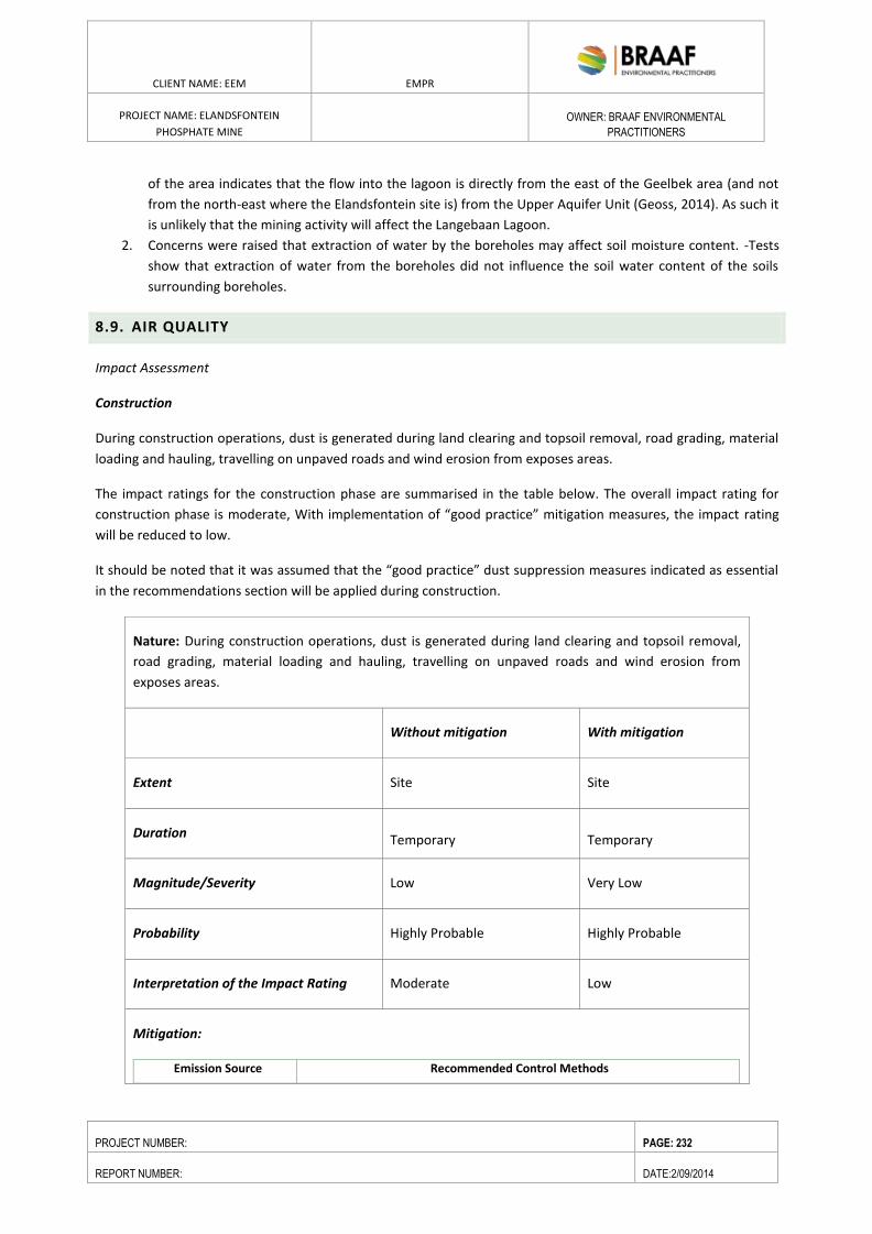
ENVIRONMENTAL RESOURCES MANAGEMENT GAMSBERG ZINC MINE EMPR
DATE: MAY 2013 REV 1.0
CLIENT NAME: EEM EMPR
PROJECT NAME: ELANDSFONTEIN
PHOSPHATE MINE
OWNER: BRAAF ENVIRONMENTAL
PRACTITIONERS
PROJECT NUMBER: PAGE: 232
REPORT NUMBER: DATE:2/09/2014
of the area indicates that the flow into the lagoon is directly from the east of the Geelbek area (and not
from the north-east where the Elandsfontein site is) from the Upper Aquifer Unit (Geoss, 2014). As such it
is unlikely that the mining activity will affect the Langebaan Lagoon.
2. Concerns were raised that extraction of water by the boreholes may affect soil moisture content. -Tests
show that extraction of water from the boreholes did not influence the soil water content of the soils
surrounding boreholes.
8.9. AIR QUALITY
Impact Assessment
Construction
During construction operations, dust is generated during land clearing and topsoil removal, road grading, material
loading and hauling, travelling on unpaved roads and wind erosion from exposes areas.
The impact ratings for the construction phase are summarised in the table below. The overall impact rating for
construction phase is moderate, With implementation of “good practice” mitigation measures, the impact rating
will be reduced to low.
It should be noted that it was assumed that the “good practice” dust suppression measures indicated as essential
in the recommendations section will be applied during construction.
Nature: During construction operations, dust is generated during land clearing and topsoil removal,
road grading, material loading and hauling, travelling on unpaved roads and wind erosion from
exposes areas.
Without mitigation With mitigation
Extent Site Site
Duration Temporary Temporary
Magnitude/Severity Low Very Low
Probability Highly Probable Highly Probable
Interpretation of the Impact Rating Moderate Low
Mitigation:
Emission Source Recommended Control Methods
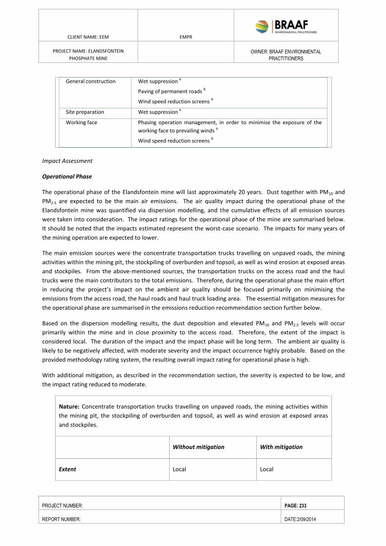
ENVIRONMENTAL RESOURCES MANAGEMENT GAMSBERG ZINC MINE EMPR
DATE: MAY 2013 REV 1.0
CLIENT NAME: EEM EMPR
PROJECT NAME: ELANDSFONTEIN
PHOSPHATE MINE
OWNER: BRAAF ENVIRONMENTAL
PRACTITIONERS
PROJECT NUMBER: PAGE: 233
REPORT NUMBER: DATE:2/09/2014
General construction Wet suppression a
Paving of permanent roads b
Wind speed reduction screens b
Site preparation Wet suppression a
Working face Phasing operation management, in order to minimise the exposure of the
working face to prevailing winds a
Wind speed reduction screens b
Impact Assessment
Operational Phase
The operational phase of the Elandsfontein mine will last approximately 20 years. Dust together with PM10 and
PM2.5 are expected to be the main air emissions. The air quality impact during the operational phase of the
Elandsfontein mine was quantified via dispersion modelling, and the cumulative effects of all emission sources
were taken into consideration. The impact ratings for the operational phase of the mine are summarised below.
It should be noted that the impacts estimated represent the worst-case scenario. The impacts for many years of
the mining operation are expected to lower.
The main emission sources were the concentrate transportation trucks travelling on unpaved roads, the mining
activities within the mining pit, the stockpiling of overburden and topsoil, as well as wind erosion at exposed areas
and stockpiles. From the above-mentioned sources, the transportation trucks on the access road and the haul
trucks were the main contributors to the total emissions. Therefore, during the operational phase the main effort
in reducing the project’s impact on the ambient air quality should be focused primarily on minimising the
emissions from the access road, the haul roads and haul truck loading area. The essential mitigation measures for
the operational phase are summarised in the emissions reduction recommendation section further below.
Based on the dispersion modelling results, the dust deposition and elevated PM10 and PM2.5 levels will occur
primarily within the mine and in close proximity to the access road. Therefore, the extent of the impact is
considered local. The duration of the impact and the impact phase will be long term. The ambient air quality is
likely to be negatively affected, with moderate severity and the impact occurrence highly probable. Based on the
provided methodology rating system, the resulting overall impact rating for operational phase is high.
With additional mitigation, as described in the recommendation section, the severity is expected to be low, and
the impact rating reduced to moderate.
Nature: Concentrate transportation trucks travelling on unpaved roads, the mining activities within
the mining pit, the stockpiling of overburden and topsoil, as well as wind erosion at exposed areas
and stockpiles.
Without mitigation With mitigation
Extent Local Local
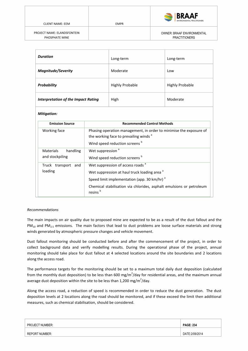
ENVIRONMENTAL RESOURCES MANAGEMENT GAMSBERG ZINC MINE EMPR
DATE: MAY 2013 REV 1.0
CLIENT NAME: EEM EMPR
PROJECT NAME: ELANDSFONTEIN
PHOSPHATE MINE
OWNER: BRAAF ENVIRONMENTAL
PRACTITIONERS
PROJECT NUMBER: PAGE: 234
REPORT NUMBER: DATE:2/09/2014
Duration Long-term Long-term
Magnitude/Severity Moderate Low
Probability Highly Probable Highly Probable
Interpretation of the Impact Rating High Moderate
Mitigation:
Emission Source Recommended Control Methods
Working face Phasing operation management, in order to minimise the exposure of
the working face to prevailing winds a
Wind speed reduction screens b
Materials handling
and stockpiling
Wet suppression a
Wind speed reduction screens b
Truck transport and
loading
Wet suppression of access roads a
Wet suppression at haul truck loading area a
Speed limit implementation (app. 30 km/hr) a
Chemical stabilisation via chlorides, asphalt emulsions or petroleum
resins b
Recommendations
The main impacts on air quality due to proposed mine are expected to be as a result of the dust fallout and the
PM10 and PM2.5 emissions. The main factors that lead to dust problems are loose surface materials and strong
winds generated by atmospheric pressure changes and vehicle movement.
Dust fallout monitoring should be conducted before and after the commencement of the project, in order to
collect background data and verify modelling results. During the operational phase of the project, annual
monitoring should take place for dust fallout at 4 selected locations around the site boundaries and 2 locations
along the access road.
The performance targets for the monitoring should be set to a maximum total daily dust deposition (calculated
from the monthly dust deposition) to be less than 600 mg/m2/day for residential areas, and the maximum annual
average dust deposition within the site to be less than 1,200 mg/m2/day.
Along the access road, a reduction of speed is recommended in order to reduce the dust generation. The dust
deposition levels at 2 locations along the road should be monitored, and if these exceed the limit then additional
measures, such as chemical stabilisation, should be considered.
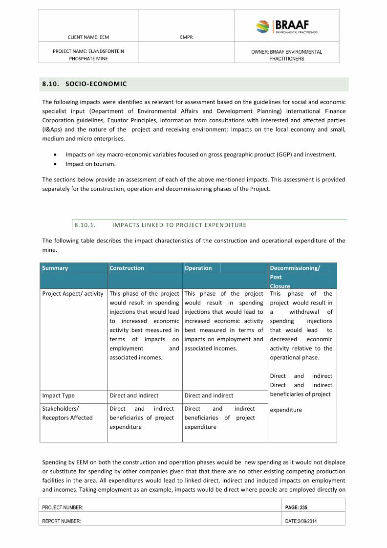
ENVIRONMENTAL RESOURCES MANAGEMENT GAMSBERG ZINC MINE EMPR
DATE: MAY 2013 REV 1.0
CLIENT NAME: EEM EMPR
PROJECT NAME: ELANDSFONTEIN
PHOSPHATE MINE
OWNER: BRAAF ENVIRONMENTAL
PRACTITIONERS
PROJECT NUMBER: PAGE: 235
REPORT NUMBER: DATE:2/09/2014
8.10. SOCIO-ECONOMIC
The following impacts were identified as relevant for assessment based on the guidelines for social and economic
specialist input (Department of Environmental Affairs and Development Planning) International Finance
Corporation guidelines, Equator Principles, information from consultations with interested and affected parties
(I&Aps) and the nature of the project and receiving environment: Impacts on the local economy and small,
medium and micro enterprises.
Impacts on key macro-economic variables focused on gross geographic product (GGP) and investment.
Impact on tourism.
The sections below provide an assessment of each of the above mentioned impacts. This assessment is provided
separately for the construction, operation and decommissioning phases of the Project.
8.10.1. IMPACTS LINKED TO PROJECT EXPENDITURE
The following table describes the impact characteristics of the construction and operational expenditure of the
mine.
Spending by EEM on both the construction and operation phases would be new spending as it would not displace
or substitute for spending by other companies given that that there are no other existing competing production
facilities in the area. All expenditures would lead to linked direct, indirect and induced impacts on employment
and incomes. Taking employment as an example, impacts would be direct where people are employed directly on
Summary Construction Operation Decommissioning/
Post
Closure Project Aspect/ activity This phase of the project
would result in spending
injections that would lead
to increased economic
activity best measured in
terms of impacts on
employment and
associated incomes.
This phase of the project
would result in spending
injections that would lead to
increased economic activity
best measured in terms of
impacts on employment and
associated incomes.
This phase of the
project would result in
a withdrawal of
spending injections
that would lead to
decreased economic
activity relative to the
operational phase.
Direct and indirect
Direct and indirect
beneficiaries of project
expenditure
Impact Type Direct and indirect Direct and indirect
Stakeholders/
Receptors Affected
Direct and indirect
beneficiaries of project
expenditure
Direct and indirect
beneficiaries of project
expenditure
ENVIRONMENTAL RESOURCES MANAGEMENT GAMSBERG ZINC MINE EMPR
DATE: MAY 2013 REV 1.0
CLIENT NAME: EEM EMPR
PROJECT NAME: ELANDSFONTEIN
PHOSPHATE MINE
OWNER: BRAAF ENVIRONMENTAL
PRACTITIONERS
PROJECT NUMBER: PAGE: 236
REPORT NUMBER: DATE:2/09/2014
the project in question (e.g. jobs such as construction workers), indirect - where the direct expenditure associated
with a project leads to jobs and incomes in other sectors (e.g. purchasing building materials maintains jobs in that
sector) and induced where jobs are created due to the expenditure of employees and other consumers that
gained from the project.
Direct impacts are the most important of these three categories as they are the largest and more likely to be felt in
the local area. Their estimation also involves the lowest level of uncertainty. The quantification of indirect and
induced impacts is a far less certain exercise due to uncertainty surrounding accurate multipliers particularly at a
local and regional level. This uncertainty makes it inadvisable to quantify indirect employment unless an in-depth
analysis of this aspect is absolutely essential to decision making. Potential direct employment and income impacts
are consequently quantified here and likely indirect impacts are borne in mind qualitatively when providing overall
impact ratings.
The construction and operational phase of the project would result in spending injections that would lead to
increased economic activity best measured in terms of impacts on employment and associated incomes focusing
on the local area and region.
Construction Phase
Estimated Project Expenditure / Investment: USD120million
Duration: 12–15months (including access road)
Activity Description: The construction phase will involve earthworks (clearing and terracing), concrete works,
sealing and proofing of concrete, piping and structural steel work, paving, metal work, buildings, plastering,
plumbing, painting, mechanical equipment installation, roadworks, parking, water supply, sewerage system,
assistance with construction and commissioning.
Direct Effects:
Economic – employment in the area
Environmental – limited noise, dust, disturbance of vegetation.
Water – water required for construction.
Increased traffic in area.
Indirect Effects (Suppliers/Vendors to mine):
Economic – procurement from local businesses, employment in area.
Social – improved quality of living, access to training, skills development.
Tourism – mining and archaeological tourism plans, limited impact on current tourism since all mine
access/traffic will be via R45.
Indirect Effects (suppliers of suppliers in value chain):
Possible suppliers include:
Engineering works including structural steel and piping.
Pump and valve supplier.
Major mechanical equipment suppliers (20% of capex, typically beyond WCDM boundaries).
Electrical and instrumentation contractors.
Civil and earthworks contractors.
Building (including painting, plastering, paving, plumbing, roofing, office equipment) suppliers.
Transport contractors.
Catering
ENVIRONMENTAL RESOURCES MANAGEMENT GAMSBERG ZINC MINE EMPR
DATE: MAY 2013 REV 1.0
CLIENT NAME: EEM EMPR
PROJECT NAME: ELANDSFONTEIN
PHOSPHATE MINE
OWNER: BRAAF ENVIRONMENTAL
PRACTITIONERS
PROJECT NUMBER: PAGE: 237
REPORT NUMBER: DATE:2/09/2014
Cleaning
Induced Effects:
Due to the increased expenditures of households enabled by the increased incomes generated by the
direct and indirect effects there will be increased economic benefit.
Employment during construction: The estimated direct temporary employment during the peak
construction period will be up to 800 people on site. The breakdown of people employed in terms of low
skilled, semi-skilled and skilled are estimated at 40:40:20.
Major contractors (civil, earthworks, SMPP, electrical) will be required to employ people from the local
community. A recruitment mechanism will be required to assist in the process. The existing ward
committee of Ward 7 in the Saldanha Bay municipal area, where the mine and the nearest community
are located took a decision to conduct a skills audit of the Hopefield community. It was decided that the
Ward Committee would facilitate the process of developing a skills register that would be used by the
applicant and contractors for sourcing low skilled, semi- and skilled labour.
Direct household income impacts during construction: Direct household income impacts would flow
from all wages, estimated at USD10 – 15 million (including manufacturing labour) paid during
construction. Approximately R80 million of this total would probably accrue to workers currently
residing in Hopefield.
Project construction expenditure / investment: Construction expenditure would constitute a positive
injection of new investment. The applicant’s preliminary estimates indicate that a total of approximately
USD 120 million would be spent on all aspects of the construction phase over roughly 12-15 months.
The project has the potential to have a significantly positive impact on commercial activity in the local
area during construction given its size and the expenditure associated with it outlined above.
Local economic sectors: During the construction phase the building construction, civil and other
construction and specialist industrial machinery sectors would benefit substantially. The engineering,
structural metal products, wholesale and retail trade, catering, housing, transport, waste management
and construction materials sectors would also stand to gain due to indirect linkages.
Small, medium and micro enterprises (SMME’s): The project would provide a major injection for
SMME’s, contractors and workers in the local area, region and province leading to positive impacts.
Skills Development: There will be opportunities for on the job training for low skilled and semi-skilled
labour.
Sourcing components, supplies and services: At least 75% (USD90 million) of components, supplies and
services will be South African, with the imports comprising specialised machinery, equipment and
spares and some electrical inputs that are not available in South Africa.
Indirect opportunities during construction
In addition to the above direct employment and associated income opportunities, a significant number of
temporary indirect opportunities would be associated with the project. These would stem primarily from
expenditure by the proponent and contractors in the local area and region as well as expenditure by workers
hired for the construction phase.
Construction Phase Mitigation
The objective of mitigation is to maximise economic benefit from jobs and expenditure particularly at a local and
regional scale. The proponent’s social and labour plan (SLP) should act as a departure point and take the lead
when considering and enforcing benefit enhancement measures.
ENVIRONMENTAL RESOURCES MANAGEMENT GAMSBERG ZINC MINE EMPR
DATE: MAY 2013 REV 1.0
CLIENT NAME: EEM EMPR
PROJECT NAME: ELANDSFONTEIN
PHOSPHATE MINE
OWNER: BRAAF ENVIRONMENTAL
PRACTITIONERS
PROJECT NUMBER: PAGE: 238
REPORT NUMBER: DATE:2/09/2014
The socio-economic study provides specific guidance on actions such as giving preference to local and historically
disadvantaged individuals and companies. It was drawn up with care and in full consultation with all relevant
stakeholders and as per the requirements of the Department of Mineral Resources.
Other mitigation measures that will be implemented during the construction phase include:
All construction traffic to use R45 instead of R27 to mitigate impact on tourism
Contractors will not be housed on site, but will stay in accommodation in Hopefield.
Contractors will be bussed in to site to minimise the number of vehicles on the road.
Dust suppression by use of water spray.
No neighbouring communities in the area to be affected by noise.
Overall Impacts and Impact Significance
An assessment of the significance of the combined impacts of project-related expenditure based on the findings
above is presented in the Box below.
Summary of Construction Phase Impact: Impacts linked to Construction Expenditure
Operational Phase
Estimated Project Expenditure / Investment: USD 800 million
Duration: 20 years
Activity Description: Mining, pumping, conveying, flotation, thickening, filtration, trucking, associated
maintenance.
SENSITIVITY/VULNERABILITY/IMPORTANCE OF RESOURCE/RECEPTOR - Low
IRREPLACEABILITY - The impact will include some loss of irreplaceable resources. Construction access roads, will berehabilitated if not required for the operational stage but water used during construction will be lost.
IMPACT MAGNITUDE - High
Extent: The extent of the impact is national (though impacts would be proportionately greater at a regional and local scale).
Duration: The expected impact will be short-term (i.e. reversible).
Scale: The impact will result in a notable change to the receptor (i.e. the economy).
Frequency: The frequency of the impact will be once off but for the duration of construction.
Likelihood: Impacts from expenditure are a certainty in the economy.
IMPACT SIGNIFICANCE (PRE-MITIGATION) - MODERATE
Degree of Confidence: High degree of confidence.
NATURE Expenditure on construction would result in a positive impact on the economy,
increasing commercial activity, creating jobs and increasing incomes.
ENVIRONMENTAL RESOURCES MANAGEMENT GAMSBERG ZINC MINE EMPR
DATE: MAY 2013 REV 1.0
CLIENT NAME: EEM EMPR
PROJECT NAME: ELANDSFONTEIN
PHOSPHATE MINE
OWNER: BRAAF ENVIRONMENTAL
PRACTITIONERS
PROJECT NUMBER: PAGE: 239
REPORT NUMBER: DATE:2/09/2014
Direct Effects:
Economic – employment in area
Environmental – limited noise, dust, disturbance of vegetation.
Water – water required for processing.
Increased traffic in area
Indirect Effects (Suppliers/Vendors to mine):
Economic – procurement from local businesses, employment in area.
Social – improved quality of living, access to training, skills development.
Tourism – mining and archaeological tourism plans, limited impact on current tourism since all mine
access/traffic will be via R45.
Indirect Effects (suppliers of suppliers in value chain):
Possible suppliers include:
Engineering works including structural steel and piping.
Pump and valve supplier.
Major mechanical equipment suppliers (20% of capex, typically beyond WCDM boundaries).
Electrical and instrumentation contractors.
Civil and earthworks contractors.
Building (including painting, plastering, paving, plumbing, roofing, office equipment) suppliers.
Transport contractors
Catering contractors
Cleaning contractors
Induced Effects: due to the increased expenditures of households enabled by the increased incomes generated
by the direct and indirect effects there will be increased economic benefit.
Employment during operational phase:
The proposed new development will employ approximately 300 permanent employees with varying
skills. Approximately 82 skilled and management and 218 low and semi-skilled. This implies an impact on
the direct livelihood (direct workers and dependents) of approximately 1495 people. Indirect
employment opportunities amount to 32,908 during the operational phase.
Direct household income impacts during operational phase:
Direct household income impacts would flow from all salaries paid during operations. The average wage
bill would be R430 million over 15 years.
Operational expenditure:
The key operational phase impacts associated with the project would flow from expenditure on
operations at the mine and plant.
Local economic sectors: During the operational phase the industrial, engineering, housing, retail,
catering, waste management and transport sectors would benefit substantially.
ENVIRONMENTAL RESOURCES MANAGEMENT GAMSBERG ZINC MINE EMPR
DATE: MAY 2013 REV 1.0
CLIENT NAME: EEM EMPR
PROJECT NAME: ELANDSFONTEIN
PHOSPHATE MINE
OWNER: BRAAF ENVIRONMENTAL
PRACTITIONERS
PROJECT NUMBER: PAGE: 240
REPORT NUMBER: DATE:2/09/2014
Small, medium and micro enterprises (SMME’s): The project would provide a major injection for SMME’s,
contractors and workers in the local area, region and province leading to positive impacts.
Indirect opportunities during operational phase
In addition to the above direct employment and associated income opportunities, a significant number of
temporary indirect opportunities would be associated with the project. These would stem primarily from
expenditure by the proponent and contractors in the local area and region as well as expenditure by
workers hired during the operations phase.
Local Economic Development
It is the intention of the proponent to provide 5-Year local economic development (LED) plans that are supportive
of municipal poverty alleviation and infrastructural development programmes. To this end the proponent has an
agreement with the Saldanha Bay Municipality and SANParks to provide the following:
The establishment of a Sustainable Science and Technology, Research, Education and Visitor Centre as a
major attraction on the West Coast; and the development of a visitor centre at a Fossil site on the
Elandsfontein Farm.
A Farmer Support Programme.
Sustainable Science and Technology Research, Education, Production and Visitor Centre
Focus Area: Infrastructure, skills development and income generation
Sectoral Focus: Higher Education, Basic Education, Science & Technology, Manufacturing, Tourism
Socio-Economic Need to which project responds: Given the low skills base of the Saldanha Bay Municipality there
is a huge need to generate the skills demanded within the economy locally. Current models in the region of
privately funded Maths and Science Centres are not generating the required results. The aim of this project is to
establish an interactive and production-orientated Science and Technology Centre focused on the economic
demands of the region, such as: renewable energy (solar, wind, nuclear and waves) and sustainable service
delivery; archaeology and paleontology; sustainable resource management such as rivers, biodiversity and
marine environments; mining rehabilitation etc. The project will generate both short and long-term low and high-
skills jobs for communities in the Saldanha Local Municipality and offer sustainable business opportunities for
SMMEs. It would create a major regional economic infrastructure asset that would boost the tourism and related
industries on a sustainable basis. The Elandsfontein Fossil site will be developed. The sustainability strategy of the
Centre will be to develop a manufacturing plant for the production of fossil and skeleton models for the South
African and African market.
Direct Community Benefit:
100 short-term construction jobs
ENVIRONMENTAL RESOURCES MANAGEMENT GAMSBERG ZINC MINE EMPR
DATE: MAY 2013 REV 1.0
CLIENT NAME: EEM EMPR
PROJECT NAME: ELANDSFONTEIN
PHOSPHATE MINE
OWNER: BRAAF ENVIRONMENTAL
PRACTITIONERS
PROJECT NUMBER: PAGE: 241
REPORT NUMBER: DATE:2/09/2014
75 permanent job through the Research, Educator and Visitor components of the Centre
At the production facility:
o 27 unskilled/ semi-skilled labourers
o 22 semi/skilled staff
An asset that serves the entire West Coast region located within the SBM.
Increased accessibility for the community of Hopefield – link to the R 27 and link to Elandsfontein and
direct access to the West Coast National Park via Hopefield.
SMME opportunities: restaurant offering West Coast cuisine; shop marketing West Coast arts and crafts
and fossil & skeletal replicas; supplies and services required by the Centre.
Key Stakeholders: Primary stakeholders: Elandsfontein Mine, Saldanha Local Municipality, SANParks
New Farmer Support Programme in Hopefield
Focus Area: Infrastructure & income generation
Sectoral Focus: Agriculture
Socio-Economic Need to which project responds: Stimulating economic activity, in sectors such as agriculture is
essential to generate jobs and increase economic participation. Of a total ward population of 7546, at least 41%
of individuals have no monthly income. 40% earn between R1 -R3200 pm. The proposal is to develop small-scale
farmer infrastructure and businesses (such as abattoirs and broilers) that could link into the commercial
agricultural sector and contribute to job creation and regional food security.
Direct Community Benefit:
The proponent will engage indirectly through existing structures and networks with CASIDRA and WC Dept of
Agriculture during the first 5-year cycle of the Elandsfontein SLP to assess the needs of small farmers. It shall
provide professional planning support to small farmers and will develop a strategy, and identify projects to form
part of the MOU among the mine, organs of state and small farmer stakeholders. It will be implemented during
the 2nd cycle of the 5-year SLP.
The mining SLP contributions will promote small farmer Investment in:
Economic infrastructure for small farmers, such as: broiler houses, fencing, road upgrading, vehicles and
irrigation.
Skills development in farming, financial management and accounting.
Funds will be transferred from the mine to a Small Farmer Support Fund which will be managed by a partnership
between the community, the Mine, CASIDRA and the Western Cape Department of Agriculture.
Key Stakeholders: Elandsfontein Mine, Department of Agriculture (Western Cape), CASIDRA, Saldanha Local
Municipality, Small Farmers.
Operational Phase Mitigation
The objective of mitigation is to: maximise economic benefit from jobs and expenditure particularly at a local and
regional scale.
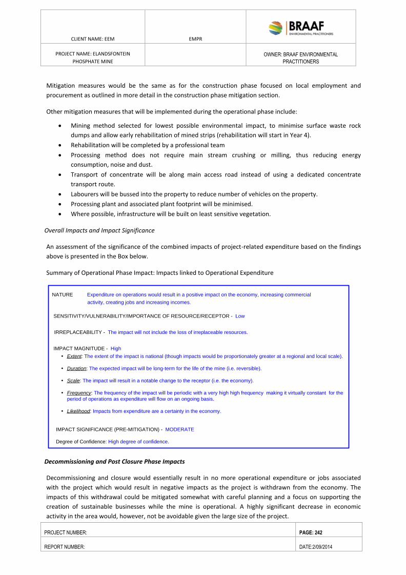
ENVIRONMENTAL RESOURCES MANAGEMENT GAMSBERG ZINC MINE EMPR
DATE: MAY 2013 REV 1.0
CLIENT NAME: EEM EMPR
PROJECT NAME: ELANDSFONTEIN
PHOSPHATE MINE
OWNER: BRAAF ENVIRONMENTAL
PRACTITIONERS
PROJECT NUMBER: PAGE: 242
REPORT NUMBER: DATE:2/09/2014
Mitigation measures would be the same as for the construction phase focused on local employment and
procurement as outlined in more detail in the construction phase mitigation section.
Other mitigation measures that will be implemented during the operational phase include:
Mining method selected for lowest possible environmental impact, to minimise surface waste rock
dumps and allow early rehabilitation of mined strips (rehabilitation will start in Year 4).
Rehabilitation will be completed by a professional team
Processing method does not require main stream crushing or milling, thus reducing energy
consumption, noise and dust.
Transport of concentrate will be along main access road instead of using a dedicated concentrate
transport route.
Labourers will be bussed into the property to reduce number of vehicles on the property.
Processing plant and associated plant footprint will be minimised.
Where possible, infrastructure will be built on least sensitive vegetation.
Overall Impacts and Impact Significance
An assessment of the significance of the combined impacts of project-related expenditure based on the findings
above is presented in the Box below.
Summary of Operational Phase Impact: Impacts linked to Operational Expenditure
Decommissioning and Post Closure Phase Impacts
Decommissioning and closure would essentially result in no more operational expenditure or jobs associated
with the project which would result in negative impacts as the project is withdrawn from the economy. The
impacts of this withdrawal could be mitigated somewhat with careful planning and a focus on supporting the
creation of sustainable businesses while the mine is operational. A highly significant decrease in economic
activity in the area would, however, not be avoidable given the large size of the project.
SENSITIVITY/VULNERABILITY/IMPORTANCE OF RESOURCE/RECEPTOR - Low
IRREPLACEABILITY - The impact will not include the loss of irreplaceable resources.
IMPACT MAGNITUDE - High
Extent: The extent of the impact is national (though impacts would be proportionately greater at a regional and local scale).
Duration: The expected impact will be long-term for the life of the mine (i.e. reversible).
Scale: The impact will result in a notable change to the receptor (i.e. the economy).
Frequency: The frequency of the impact will be periodic with a very high high frequency making it virtually constant for the
period of operations as expenditure will flow on an ongoing basis.
Likelihood: Impacts from expenditure are a certainty in the economy.
IMPACT SIGNIFICANCE (PRE-MITIGATION) - MODERATE
Degree of Confidence: High degree of confidence.
NATURE Expenditure on operations would result in a positive impact on the economy, increasing commercial
activity, creating jobs and increasing incomes.
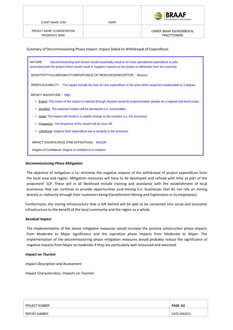
ENVIRONMENTAL RESOURCES MANAGEMENT GAMSBERG ZINC MINE EMPR
DATE: MAY 2013 REV 1.0
CLIENT NAME: EEM EMPR
PROJECT NAME: ELANDSFONTEIN
PHOSPHATE MINE
OWNER: BRAAF ENVIRONMENTAL
PRACTITIONERS
PROJECT NUMBER: PAGE: 243
REPORT NUMBER: DATE:2/09/2014
Summary of Decommissioning Phase Impact: Impact linked to Withdrawal of Expenditure
Decommissioning Phase Mitigation
The objective of mitigation is to: minimise the negative impacts of the withdrawal of project expenditure form
the local area and region. Mitigation measures will have to be developed and refined with time as part of the
proponent’ SLP. These will in all likelihood include training and assistance with the establishment of local
businesses that can continue to provide opportunities post-mining (i.e. businesses that do not rely on mining
directly or indirectly through their customers being Elandsfontein Mining and Exploration or its employees).
Furthermore, the mining infrastructure that is left behind will be able to be converted into social and economic
infrastructure to the benefit of the local community and the region as a whole.
Residual Impact
The implementation of the above mitigation measures would increase the positive construction phase impacts
from Moderate to Major significance and the operation phase impacts from Moderate to Major. The
implementation of the decommissioning phase mitigation measures would probably reduce the significance of
negative impacts from Major to moderate if they are particularly well resourced and executed.
Impact on Tourism
Impact Description and Assessment
Impact Characteristics: Impacts on Tourism
SENSITIVITY/VULNERABILITY/IMPORTANCE OF RESOURCE/RECEPTOR - Medium
IRREPLACEABILITY - The impact include the loss of mine expenditure in the area which would be irreplaceable to a degree.
IMPACT MAGNITUDE - High
Extent: The extent of the impact is national (though impacts would be proportionately greater at a regional and local scale).
Duration: The expected impact will be permanent (i.e. irreversible).
Scale: The impact will result in a notable change to the receptor (i.e. the economy).
Frequency: The frequency of the impact will be once-off.
Likelihood: Impacts from expenditure are a certainty in the economy.
IMPACT SIGNIFICANCE (PRE-MITIGATION) - MAJOR
Degree of Confidence: Degree of confidence is medium.
NATURE Decommissioning and closure would essentially result in no more operational expenditure or jobs
associated with the project which would result in negative impacts as the project is withdrawn from the economy.
ENVIRONMENTAL RESOURCES MANAGEMENT GAMSBERG ZINC MINE EMPR
DATE: MAY 2013 REV 1.0
CLIENT NAME: EEM EMPR
PROJECT NAME: ELANDSFONTEIN
PHOSPHATE MINE
OWNER: BRAAF ENVIRONMENTAL
PRACTITIONERS
PROJECT NUMBER: PAGE: 244
REPORT NUMBER: DATE:2/09/2014
Summary Construction Operation Decommissioning/ Post
Closure Project Aspect/ activity
All project aspects and
activities that could
impact on characteristics
of the area which support
tourism (i.e. visual quality,
air quality, biodiversity,
noise, etc.)
All project aspects and
activities that could impact
on characteristics of the
area which support tourism
(i.e. visual quality, air
quality, biodiversity, noise,
etc.)
Closure and rehabilitation
of project aspects and
activities that could
impact on characteristics
of the area which support
tourism (i.e. visual quality,
air quality, biodiversity,
noise, etc.)
Direct and indirect
Tourists and those that
rely on them for their
livelihoods.
Impact Type
Direct and indirect Direct and indirect
Stakeholders/
Receptors Affected Tourists and those that
rely on them for their
livelihoods.
Tourists and those that
rely on them for their
livelihoods.
As was outlined in the overall economic context section, tourism plays an important role in the economy of the
wider area and has the potential to play an increasingly prominent role as a driver of economic development. It is
thus important to consider the potential impacts of the proposed development on this sector.
In order to assess tourism impacts discussions were held with the Saldanha Bay Tourism Organisation and South
African National Parks (SANPARKs). The Saldanha Bay Tourism organisation is an executive and coordinating
organisation for the promotion of sustainable tourism and tourism development in the municipal region and the
representative body, by means of membership, for all private tourism businesses. SANParks manages a national
system of parks which represents the indigenous fauna, flora, landscapes and associated cultural heritage.
Where possible, a distinction has been made between impacts on tourism in the vicinity of the project site (i.e.
primarily on neighbouring properties and within close proximity to the site) and on tourism in the wider area
recognising that impacts at these scales overlap substantially.
Sources of positive impacts would stem from increased potential business- related visitors to the project.
The Tourism Development Context
The provincial, district and local municipality Integrated Development Plans (IDPs),Spatial Development
Frameworks (SDFs)and Local Economic Development strategies (LED’s) all point out the importance of tourism in
the wider area and focus on its future potential. Specifically at a local level, the Saldanha Bay Municipality’s
Medium Term Economic Development Strategy (2013: p 10) highlights the expansion of differentiated tourism
product range to extend stays in the locality as a one of its strategic result areas.
The concern raised by the Saldanha Bay Tourism Organisation was that the mine would potentially damage the
tourism brand strategy that seeks to position Saldanha Bay as a destination of “nature, tranquility, culture,
adventure and cuisine.” The view from SANParks was that there would be no impact on the West Coast national
park as the proposed mine is close to the eastern border of the park which has no tourism activity.
Key tourism attractions near the proposed mining site
1. Fossil Exhibition and Tourism Bureau
2. Langrietvlei National Monument
ENVIRONMENTAL RESOURCES MANAGEMENT GAMSBERG ZINC MINE EMPR
DATE: MAY 2013 REV 1.0
CLIENT NAME: EEM EMPR
PROJECT NAME: ELANDSFONTEIN
PHOSPHATE MINE
OWNER: BRAAF ENVIRONMENTAL
PRACTITIONERS
PROJECT NUMBER: PAGE: 245
REPORT NUMBER: DATE:2/09/2014
Impacts on specific tourism facilities and key tourism areas would be limited, however, given the project’s
location relative to these.
Construction and Operational Phase Mitigation
Impacts on tourism are primarily dependent on how the proponents operations are designed, constructed and
operated to minimise negative biophysical and social impacts and enhance positive ones. The measures
recommended in other specialist studies to minimise negative impacts (primarily visual, air quality, noise, traffic
and botanical measures) and enhance positive impacts would thus also reduce impacts on tourism and should be
implemented. These measures are not repeated here. With pro-active planning there may be possibilities to
allow controlled eco- tourism activities on the bio-diversity offset site. An investigation of appropriate options in
this regard should ideally form part of offset selection and planning.
Decommissioning and Post Closure Impacts
Decommissioning would essentially result in the reduction or removal of tourism risks as project elements are
closed. The eventual significance of impacts will be highly dependent on rigorous rehabilitation of the project site.
Decommissioning Phase Mitigation
If one takes a sample of mines throughout South Africa it is clear that the rehabilitation effort and the success
associated with it can be highly variable even if all mines are required to abide by the same rules. This variability
can be seen when comparing both operating and closed mines. It therefore stands to reason that, with regards to
minimising impacts, much will depend on how the proponents EMP is conceived and implemented in partnership
with the DMR and other local stakeholders. If rehabilitation is rigorously applied and well-funded both
concurrently and at closure to avoid visual scarring along with air pollution control measures, impacts are likely to
be significantly less than the case of the proponent simply doing the minimum to satisfy DMR requirements.
The implementation of the above mitigation measures would decrease the negative construction phase impacts
from Moderate to Minor significance and the operation phase impacts from Moderate/Major to Moderate. The
implementation of the decommissioning phase mitigation measures would probably introduce positive impacts of
a Moderate significance if they are particularly well resourced and executed.
ENVIRONMENTAL RESOURCES MANAGEMENT GAMSBERG ZINC MINE EMPR
DATE: MAY 2013 REV 1.0
CLIENT NAME: EEM EMPR
PROJECT NAME: ELANDSFONTEIN
PHOSPHATE MINE
OWNER: BRAAF ENVIRONMENTAL
PRACTITIONERS
PROJECT NUMBER: PAGE: 246
REPORT NUMBER: DATE:2/09/2014
9. ENVIRONMENTAL MANAGEMENT PROGRAMME
(In compliance with Section 39(3)(d) of the MPRDA Act, read together with Regulation 50(e), (f) and (i) and
Regulation 51(b)(i) and (ii) and Section 39(4)(a)(iii) of the MPRDA Act).
This section provides specifications which must be implemented as part of the design, construction and
operational and decommissioning phase. It outlines the roles and responsibilities for the implementation of the
control and monitoring.
9.1. OBJECTIVES OF THE EMPR
The aim of an EMPr is to facilitate appropriate bio-physical and socio- economic environmental controls during all
phases of the project. To achieve this, the EMPr must make recommendations for the planning and design (pre-
construction/design phase), specify the limitations the contractor must abide by during construction, detail the
issues that should be taken cognisance of and indicate specific actions that must be undertaken so as to mitigate
all impacts identified and assessed in the ESIA. The EMPr thus specifies the framework within which the
contractor(s) must carry out the construction activities. An operational and decommissioning phase management
plan is also included in the EMPr and specifies the framework within which the developer must carry out the
operations during the life of mine and during the decommissioning phases of the development.
In addition, the EMPr provides a clear indication of the environmental and social management requirements of
each of the role players involved during the construction, operational and decommissioning phases of the Project.
Guidance for the implementation of the EMPr is provided, including the management of method statements which
are required to be implemented to achieve compliance with the Environmental Specifications. Corrective actions
in the event of non-compliance with the EMPr are also defined.
The EMPr is required in order to:
assist in ensuring continuing compliance with South African legislation and international good practice;
provide a mechanism for ensuring that measures identified in the this Report designed to mitigate
potentially adverse impacts, are implemented;
provide a framework for mitigating impacts that may be unforeseen or unidentified until construction is
underway;
provide assurance to regulators and stakeholders that their requirements with respect to environmental
and socio-economic performance will be met; and
provide a framework for compliance auditing and inspection programs. The EMPr will remain a draft
document until it has been updated with the conditions stipulated in the environmental authorisation.
From then onwards
it is intended to be a living document that The overall EMPr contains sections that specifically deal with
the design and planning phase, the construction phase (Construction EMPr), the operational phase
(Operational EMPr) and decommissioning and closure plans. This document will address both bio-
physical and socio-economic aspects, and present these within the various phases of the Project.
ENVIRONMENTAL RESOURCES MANAGEMENT GAMSBERG ZINC MINE EMPR
DATE: MAY 2013 REV 1.0
CLIENT NAME: EEM EMPR
PROJECT NAME: ELANDSFONTEIN
PHOSPHATE MINE
OWNER: BRAAF ENVIRONMENTAL
PRACTITIONERS
PROJECT NUMBER: PAGE: 247
REPORT NUMBER: DATE:2/09/2014
9.2. ROLES AND RESPONSIBILITIES
The key role-players during the construction phase of the Project, for the purposes of environmental management
on site, include but are not limited to: the Developer (EEM), the Engineer, the main Contractors (direct
appointments including civil works contractor, building contractor, landscape contractor etc.), the Environmental
Control Officer, and representatives of the relevant Authority/ies.
Details of the responsibilities of each of the key role-players have been provided below. For the purposes of this
section it has been written in line with the DEA&DP requirements for construction environmental management
plans.
The Developer
For the purpose of this document, “the Developer” and its appointed facilitators refers to those to whom
permission has been granted to proceed with the Project (i.e. EEM), and who is thus ultimately responsible for
compliance with all conditions of approval of the Development or any aspect thereof by any authority.
With respect to the pre-construction phase of the Development, the Developer is to:
Implement the recommendations outlined in the pre-construction EMPr; and
Implement as many recommendations as possible that will lessen the total environmental impact of the
proposed Development from the design stage, through to construction and ultimately the operational
phase.
With respect to the construction phase of the Development, the Developer is to:
Ensure that all relevant approvals and permits have been obtained prior to the start of construction
activities on site;
Ensure that the EMPr has been approved by DMR prior to the start of construction activities on site;
Ensure that all conditions of approval have been complied with;
Appoint all the required specialists to make input into the pre- construction/design phase ;
Appoint a suitably qualified and experienced ECO prior to the start of construction activities on site, and
for the duration of the construction phase.
With respect to the operational phase of the Development, the developer is to:
Ensure that operation of the phosphate mine is undertaken in line with the requirements of the
operational phase EMPr; and
Continuously seek to improve any negative environmental impacts which result from the operational
phase.
Site Engineer
For the purposes of this document, “Site Engineer” refers to the engineer for the Development, or any other
person authorised by the Developer, to be responsible for the technical and contractual implementation of the
works to be undertaken.
The responsibilities of the Site Engineer are to:
ENVIRONMENTAL RESOURCES MANAGEMENT GAMSBERG ZINC MINE EMPR
DATE: MAY 2013 REV 1.0
CLIENT NAME: EEM EMPR
PROJECT NAME: ELANDSFONTEIN
PHOSPHATE MINE
OWNER: BRAAF ENVIRONMENTAL
PRACTITIONERS
PROJECT NUMBER: PAGE: 248
REPORT NUMBER: DATE:2/09/2014
Ensure that the requirements as set out in this EMPr and by the relevant Authorities are adhered to and
implemented;
Assist the ECO in ensuring that the conditions of the Construction EMPr are being adhered to and
promptly issuing instructions requested by the ECO, to the Contractor. All site instructions relating to
environmental matters issued by the Engineer are to be copied to the ECO;
Assist the ECO in making decisions and finding solutions to environmental problems that may
arise during the construction phase;
Review and approve construction method statements with input from the ECO;
Order the removal of person(s) and/or equipment not complying with the specifications (as required by
the ECO or otherwise); and
Provide input into the ECO’s ongoing internal review of the EMPr.
The Contractor
For the purposes of this document “The Contractor” refers to any directly appointed (by the Developer) company
or individual undertaking the implementation of the works.
The Contractor is to:
Ensure implementation of all applicable Environmental Specifications, including all additional
requirements related to approve method statements, during all works on site.
Ensure that all of its sub-contractors’, employees, suppliers, agents etc. are fully aware of the
environmental requirements detailed in the Environmental Specifications;
Liaise closely with the Engineer and the ECO and ensure that the works on site are conducted in an
environmentally controlled manner;
Inform the Engineer as well as the ECO should environmental conditions on site deteriorate, e.g.
dumping, pollution, littering and damage to vegetation; and
Carry out instructions issued by the Engineer, on request of the ECO, required to fulfil his/her compliance
with the Construction EMPr.
Environmental Control Officer
During the construction phase of the project, the ECO is to:
Ensure that the Contractor has a copy of the Construction EMPr and all agreed method statements;
Undertake weekly site inspections (frequency may change as required, depending on the activity) to audit
compliance of all parties with the requirements of the Construction EMPr;
Advise/recommend on actions or issues impacting on the environment to the Engineer, who shall issue
any required Site Instructions to the Contractor;
Environmentally educate and raise the awareness of the Contractor and his/her staff as to the sensitivity
of the site and to facilitate the spread of the correct attitude during works on site;
Review and approve construction/landscape method statements together with the Engineer/Landscaper
(when applicable);
Assist the Contractor in finding environmentally responsible solutions to problems;
ENVIRONMENTAL RESOURCES MANAGEMENT GAMSBERG ZINC MINE EMPR
DATE: MAY 2013 REV 1.0
CLIENT NAME: EEM EMPR
PROJECT NAME: ELANDSFONTEIN
PHOSPHATE MINE
OWNER: BRAAF ENVIRONMENTAL
PRACTITIONERS
PROJECT NUMBER: PAGE: 249
REPORT NUMBER: DATE:2/09/2014
Recommend to the Engineer the removal of person(s) and/or equipment not complying with the
Specifications;
Undertake photographic monitoring of the construction site;
Keep records of all activities/ incidents concerning the environment on site in a Site Diary;
Complete temporary and permanent site closure checklists;
Compile and maintain a complaints register;
Take immediate action on site to stop works where significant and irreparable damage is being
inflicted on the environment, and to inform the Engineer, EEM and relevant authorities immediately of
the occurrence and action taken; and
Undertake a continual internal review of the EMPr and make
recommendations regarding its updating to the Engineer and Developer.
The ECO has the authority to recommend to DEA&DP that works be stopped, if in his/her opinion serious harm to,
or impact on the environment is imminent, is likely to occur or has occurred and such actual or potential harm or
impact is in contravention of the EMPr, and which is, or may be, caused by construction or related works.
Upon failure by the Contractor or Contractor’s employee to show adequate consideration to the environmental
aspects of this contract, the ECO may recommend to the Engineer and the project management team to have the
Contractor’s representative or any employee(s) removed from the site or work suspended until the matter is
remedied. No extension of time will be considered in the case of such suspensions and all costs will be borne by
the Contractor.
The ECO shall keep a Site Diary in which events and concerns of environmental significance are to be recorded.
The ECO will compile a monthly report of such events, concerns, public complaints and general compliance of the
Contractor with the construction phase of the EMPr. This report will be submitted to the Engineer and if required,
to DEA&DP, DMR and the Namakwa District Municipality. The ECO is also required to attend regular site meetings
of the project management team to report on environmental issues and to minute the requirements that emerge.
The ECO will be responsible for the compilation of a final completion checklist for the project, completed when all
construction works related to the project have terminated and the site has been cleared of all construction related
debris, materials or equipment not forming part of the permanent works. This checklist will audit the Contractor’s
compliance with the construction phase of the EMPr throughout the duration of the construction phase and,
together with a final written report, will be submitted to DEA&DP, DEA, DMR and the Saldanha Bay Municipality in
order to achieve “environmental closure” for the construction phase of the project.
Upon finalization of the specialist studies all relevant mitigation and management comment as prescribed by their
reports (where feasible and practical) in accordance to the specific activity that will be undertaken during the
different phases of the Elandsfontein Mine Project.
9.3. CONSTRUCTION ENVIRONMENTAL MANAGEMENT PROGRAMME (CEMPR)
This Specification covers the requirements for controlling the impact on the environment of all construction
activities for the Project. All construction activities shall observe the requirements of this specification as well as
any relevant environmental legislation and in so doing shall be undertaken in such a manner as to minimise
impacts on the natural and social environment.
ENVIRONMENTAL RESOURCES MANAGEMENT GAMSBERG ZINC MINE EMPR
DATE: MAY 2013 REV 1.0
CLIENT NAME: EEM EMPR
PROJECT NAME: ELANDSFONTEIN
PHOSPHATE MINE
OWNER: BRAAF ENVIRONMENTAL
PRACTITIONERS
PROJECT NUMBER: PAGE: 250
REPORT NUMBER: DATE:2/09/2014
The construction period is expected to last for 12-18 months.
9.3.1. APPLICATION
This Specification contains clauses that are generally applicable to the undertaking of civil engineering works in
areas where it is necessary to impose pro-active controls on the extent to which the construction activities
impact on the environment. The roles and responsibilities in terms of the application and implementation of
this Specification have been outlined in above.
9.3.2. METHOD STATEMENTS
Any Method Statement required by the Engineer or the Environmental Specification shall be produced within
such reasonable time as the Engineer shall specify or as required by the Specification. The Contractor shall not
commence the activity until the Method Statement has been approved and shall, except in the case of
emergency activities, allow a period of two weeks for approval of the Method Statement by the Engineer.
Such approval shall not unreasonably be withheld.
The Engineer or ECO may request a Method Statement for any activity they believe may impact on the
environment. The Engineer in consultation with the ECO may also require changes to a Method Statement if the
proposal does not comply with the Specification or, if in the reasonable opinion of theEngineer, the proposal may
result in, or carry a greater than reasonable risk of, damage to the environment in excess of that permitted by
the Specifications. Approved Method Statements shall be readily available on the site and shall be communicated
to all relevant personnel. The Contractor shall carry out the Works in accordance with the approved Method
Statement. Approval of the Method Statement shall not absolve the Contractor from any of his/her obligations
or responsibilities in terms of the Contract.
The following Method Statements shall be provided by the Contractor and submitted to the Engineer and ECO
at least 7 working days before site establishment. The content of the Method Statement must be agreed to
with the ECO and site engineer.
Logistics for the environmental awareness course for all the Contractors employees.
Emergency procedures for fire, accidental leaks and spillages of hazardous materials including:
o who shall be notified in the event of an emergency, including contact numbers for the relevant
local authority,
o where and how any hazardous spills will be disposed of,
o the size of spillage which the emergency procedures could contain,
o location of all emergency equipment and an indication of how regularly the emergency
equipment will be checked to ensure that it is working properly.
Location and layout of the construction camp in the form of a plan showing offices, stores for fuels,
hazardous substances, vehicle parking, access point, equipment cleaning areas and staff toilet
placement.
ENVIRONMENTAL RESOURCES MANAGEMENT GAMSBERG ZINC MINE EMPR
DATE: MAY 2013 REV 1.0
CLIENT NAME: EEM EMPR
PROJECT NAME: ELANDSFONTEIN
PHOSPHATE MINE
OWNER: BRAAF ENVIRONMENTAL
PRACTITIONERS
PROJECT NUMBER: PAGE: 251
REPORT NUMBER: DATE:2/09/2014
Location, layout and preparation of cement / concrete batching facilities including the methods
employed for the mixing of concrete and the management of runoff water for such areas. An indication
shall be given of how concrete spoil will be minimised and cleared.
Method of undertaking earthworks, including spoil management, erosion.
Measures for the suppression of dust and noise emissions.
Method statement for the establishment of no-go areas, specifically with regard to the manner in which
sensitive ecological habitat will be avoided.
Location of stormwater management measures and visual representation of mechanisms to manage
clean and dirty water separation.
Management measures to be undertaken in instances where traffic flows may be interrupted.
Extent of areas to be cleared, the method of clearing and the preparation for this clearing so as to
ensure minimisation of exposed areas.
Measures to be put in place during temporary closure periods, e.g. December holidays.
Note that the contractor may only commence with any activity if a Method Statement which has been
approved by the ECO and site engineer is in place.
9.3.3. ENVIRONMENTAL AWARENESS TRAINING
The logistics for the environmental awareness training course, together with the subject matter, would need to
be outlined into a method statement. This will include, inter alia, the number of attendees, material to be
distributed and procedures to record and verify attendance.
9.3.4. TEMPORARY CONSTRUCTION CAMP AND SITE DIVISION
The location, layout and method of establishment of the temporary contractor camp (including all buildings,
offices, lay down yards, vehicle washing areas, fuel storage areas, batching areas and other infrastructure
required for the construction of the project).
9.3.5. VEGETATION CLEARING
Method of vegetation clearing during site establishment and disposal procedure for cleared material.
9.3.6. ACCESS/HAUL ROUTES
Details, including a drawing, showing where and how the access points and routes will be located and
managed, including traffic safety measures.
9.3.7. FUEL STORAGE AND USE
The design, location and construction of the fuel storage area, for the filling and dispensing from storage
tanks and management of drip trays.
ENVIRONMENTAL RESOURCES MANAGEMENT GAMSBERG ZINC MINE EMPR
DATE: MAY 2013 REV 1.0
CLIENT NAME: EEM EMPR
PROJECT NAME: ELANDSFONTEIN
PHOSPHATE MINE
OWNER: BRAAF ENVIRONMENTAL
PRACTITIONERS
PROJECT NUMBER: PAGE: 252
REPORT NUMBER: DATE:2/09/2014
9.3.8. SOLID WASTE MANAGEMENT
Expected solid waste types, quantities, methods of recycling to be employed, monitoring and record keeping
procedures, staff responsible for the oversight of waste management and recycling and frequency of collection
and disposal of the non-recycled component, as well as location of disposal sites.
9.3.9. CONTAMINATED WATER
Methods of minimising, controlling, collecting and disposing of contaminated water, including stormwater run-
off.
9.3.10. HAZARDOUS SUBSTANCES
Details of any hazardous substances / materials to be used, together with the transport, storage, handling and
disposal procedures for the substances.
9.3.11. CEMENT AND CONCRETE BATCHING
Location, layout and preparation of cement/ concrete mixing areas including the methods employed for the
mixing of concrete, and particularly the containment of runoff water from such areas, as well as the method of
transportation of concrete.
Batching to be undertaken on a smooth, impermeable surface and which is sloped towards a sump collection
point. All wastewater generated from the batching area shall be collected and disposed of via the
contaminated wastewater management system.
9.3.12. EMERGENCY PROCEDURES AND EQUIPMENT
Emergency procedures for fire, accidental leaks and spillages of hazardous substances (including fuel and oil).
Include details of risk reduction measures to be implemented, such as fire fighting equipment, fire prevention
procedures and spill kits (materials and compounds used to reduce the extent of spills and to breakdown or
encapsulate hydrocarbons). The contractor will also outline the type of emergency equipment required on site,
as well as the servicing requirements to ensure correctly functioning equipment.
Other Method Statements required by the Engineer and ECO during the course of construction are to be
provided by the Contractor a minimum of 14 working days prior to commencement of the works or activities to
which they apply (these activities may not commence on site before these Method Statements have been
approved except in the case of emergency activities).
9.3.13. EROSION AND SEDIMENTATION CONTROL
ENVIRONMENTAL RESOURCES MANAGEMENT GAMSBERG ZINC MINE EMPR
DATE: MAY 2013 REV 1.0
CLIENT NAME: EEM EMPR
PROJECT NAME: ELANDSFONTEIN
PHOSPHATE MINE
OWNER: BRAAF ENVIRONMENTAL
PRACTITIONERS
PROJECT NUMBER: PAGE: 253
REPORT NUMBER: DATE:2/09/2014
The proposed methods of sedimentation and erosion control for bulk earthworks in particular and the
remainder of the construction period, in order to ensure the prevention of sedimentation of water courses and
storm- water infrastructure.
9.3.14. TRAFFIC MANAGEMENT
The contractor must compile a method statement for the transportation of abnormal loads, or transport related
activities that will impact on surrounding traffic flows. The method statement must indicate timing of potential
disruption/ road closures, means of notification of surrounding road users, proof of correspondence from the
relevant traffic authorities and drawings of any potential changes to the existing road layout.
9.3.15. SITE ESTABLISHMENT
9.3.15.1. SITE DIVISION
The Contractor shall restrict all his activities, materials, equipment and personnel to within the area specified,
and shall restrict his activities to only those areas that are necessary to undertake the works.
A Method Statement detailing the layout and method of establishment of the temporary construction camp, all
buildings, offices, lay down areas, fuel storage areas, batching areas and other infrastructure required for the
running of the project shall be submitted.
Disturbed areas rather than pristine or intact landscape areas should preferably be used for the
temporary construction camp.
9.3.15.2. SITE DEMARCATION
The Contractor shall erect and maintain permanent and/ or temporary fences of the type and in the locations
directed by the Engineer. Such fences shall, if so specified, be erected before undertaking designated activities.
The temporary construction camp, material stores and lay-down areas should be screened and sited as far away
as possible from the local roads.
9.3.15.3. SITE CLEARANCE
Topsoil
Ideally, only about the top 30cm should be used. In some situations this generates too little to redistribute
effectively afterwards, and a little more is taken, but this has a negative effect on the recovery achieved when it
is reapplied. Also, the biological activity of stored topsoil declines over time and it should not be stored for more
than a few months and the benefit of putting it aside declines substantially after about 6 months. However if
stored for an extended period of time no natural regeneration from the soil-stored seed bank can be expected.
Due to the arid nature of the impacted environment, topsoil will not be retained for re-use during the
construction phase of the Project.
ENVIRONMENTAL RESOURCES MANAGEMENT GAMSBERG ZINC MINE EMPR
DATE: MAY 2013 REV 1.0
CLIENT NAME: EEM EMPR
PROJECT NAME: ELANDSFONTEIN
PHOSPHATE MINE
OWNER: BRAAF ENVIRONMENTAL
PRACTITIONERS
PROJECT NUMBER: PAGE: 254
REPORT NUMBER: DATE:2/09/2014
9.3.16. ACCESS ROUTES/ HAUL ROADS
The Contractor shall control the movement of all vehicles including that of his suppliers so that they remain on
designated routes, are distributed so as not to cause an undue concentration of traffic and that all relevant laws
are complied with. In addition, such vehicles shall be so routed and operated as to minimise disruption to regular
users of the routes not on the site. The vehicles of the Contractor and his suppliers shall not exceed a speed of 30
km/h on gravel or earth roads on site and within 500 m of the site.
During construction, arrangements and routes for abnormal loads (if required) must be agreed in advance with
the relevant authorities and the appropriate permit must be obtained for the use of public roads. Lastly, dust
suppression measures must be applied to all gravel roads, especially during period of strong winds.
9.3.17. GENERAL REQUIREMENTS
9.3.17.1. MATERIALS HANDLING, USE AND STORAGE
The Contractor shall ensure that any delivery drivers are informed of all procedures and restrictions (including
"no go" areas) required to comply with the Specifications. The Contractor shall ensure that these delivery drivers
are supervised during off loading, by someone with an adequate understanding of the requirements of the
Specifications.
Materials shall be appropriately secured to ensure safe passage between destinations. Loads including, but not
limited to, sand, stone chips, fine vegetation, refuse, paper and cement, shall have appropriate cover to prevent
them spilling from the vehicle during transit. The Contractor shall be responsible for any clean-up resulting from
the failure by his employees or suppliers to properly secure transported materials.
All manufactured and/ or imported material shall be stored within the Contractor's temporary construction
camp. All lay down areas outside of the temporary construction camp shall be subject to the Engineer's
approval. All building materials should be stored at least 50 m away from aquatic ecosystems and the areas
bunded appropriately such that there will be no runoff from these areas towards aquatic systems. All building
materials should be removed after construction.
9.3.18. FUEL (PETROL AND DIESEL) AND OILS (HEAVY FUEL OILS INCLUDED)
All fuel is to be stored within a demarcated area in the Contractor’s temporary construction camp. No refuelling
of vehicles or machinery is to take place outside of this demarcated area unless authorised by the Engineer. The
Engineer shall be advised of the area that the Contractor intends using for the storage of fuel.
The Contractor shall ensure that all liquid fuels (petrol and diesel) are stored in tanks with lids, which are kept
firmly shut. Only empty and externally clean tanks may be stored on the bare ground. All empty and externally
dirty tanks shall be sealed and stored in an area where the ground has been protected.
ENVIRONMENTAL RESOURCES MANAGEMENT GAMSBERG ZINC MINE EMPR
DATE: MAY 2013 REV 1.0
CLIENT NAME: EEM EMPR
PROJECT NAME: ELANDSFONTEIN
PHOSPHATE MINE
OWNER: BRAAF ENVIRONMENTAL
PRACTITIONERS
PROJECT NUMBER: PAGE: 255
REPORT NUMBER: DATE:2/09/2014
Tanks containing fuels shall be situated on a smooth impermeable surface (plastic or concrete) base with a
bund (if plastic, it must have sand on top to prevent perishing) to contain any possible spills and prevent
infiltration of fuel into the ground. The impermeable lining shall extend to the crest of the bund and the
volume inside the bund shall make up 110 percent of the total capacity of all the storage tanks.
The floor of the bund shall be sloped towards an oil trap or sump to enable any spilled fuel to be removed. An
Enretech or similar hydrocarbon absorption/remediation product approved by the ECO shall be installed in the
sump to reduce the risk of pollution. Bulk fuel storage and bunded areas shall have overhead cover to prevent
rain from entering the bunded area. The Contractor shall keep fuel under lock and key at all times.
If fuel is dispensed from 210 litre drums, the proper dispensing equipment shall be used, and the drum shall not
be tipped in order to dispense fuel. The dispensing mechanism used to dispense fuel from the drums shall be
stored in a waterproof container when not in use.
During fuel tanker delivery, the tanker driver must be present at all times during offloading of product. An
emergency cut-off switch must be installed to immediately stop fuel delivery should an accident occur. An anti-
flash nozzle must be installed at the end of the vent pipe with a fuel dispenser equipped with an automatic cut-
off switch to prevent fuel tank overfills.
No smoking shall be allowed in the vicinity of the stores. Symbolic safety signs depicting “No Smoking”, “No
Naked Lights” and “Danger” are to be provided, and are to conform to the requirement of SABS 1186. The
volume capacity of the tank shall be displayed. The product contained within the tank shall be clearly
identified using the emergency information system detailed in SABS 0232 Part 1. Any electrical or petrol-
driven pump shall be equipped and positioned so as not to cause any danger of ignition of the product.
Areas for storage of fuels and other flammable materials shall comply with standard fire safety regulations
and may require the approval of the Municipal Fire Prevention Officer.
The Contractor shall ensure that there is adequate fire-fighting equipment at the fuel stores.
Where reasonably practical, vehicles and equipment shall be refuelled at a designated re-fuelling area or at the
workshop as applicable. If it is not reasonably practical then the surface under the temporary refuelling area shall
be protected against pollution and drip trays used to the reasonable satisfaction of the Engineer prior to any
refuelling activities. The Contractor shall ensure that there is always a supply of appropriate material readily
available to absorb/ breakdown and where possible be designed to encapsulate minor hydrocarbon spillage. The
quantity of such materials shall be able to handle a minimum of 210 litre of hydrocarbon liquid spill. This
material must be approved by the Engineer prior to any refuelling or maintenance activities.
ENVIRONMENTAL RESOURCES MANAGEMENT GAMSBERG ZINC MINE EMPR
DATE: MAY 2013 REV 1.0
CLIENT NAME: EEM EMPR
PROJECT NAME: ELANDSFONTEIN
PHOSPHATE MINE
OWNER: BRAAF ENVIRONMENTAL
PRACTITIONERS
PROJECT NUMBER: PAGE: 256
REPORT NUMBER: DATE:2/09/2014
9.3.19. SOLID WASTE MANAGEMENT
For the purposes of these Environmental Specifications, solid waste includes all debris and waste (e.g. litter, food
waste, hardware discards, vegetation and tree stumps, building rubble, etc.), including hazardous waste (e.g. oils)
resulting from any construction activities on site.
The Contractor shall be responsible for the establishment of a waste control system (Waste Management Plan)
that is acceptable to the Engineer and ECO, and a method statement is required in this regard. The contractor
shall keep detailed records of all waste removed from site. The waste management hierarchy (see section on
Waste Management) must be adopted, when managing waste produced onsite.
The contractor must then provide proof of recycling or legal disposal at a registered landfill site (disposal
certificates). No refuse or waste material will be disposed of by burying on site. The specific disposal
requirements of wastes will be informed by the relevant hazard rating, as this will determine the landfill
requirements.
Refuse Control
The Contractor shall provide labourers to clean up the Contractor's temporary construction camp and working
areas on a daily basis.
Litter and waste materials (excluding rubble and hazardous waste materials) shall be disposed of into scavenger-
and weather-proof bins. The Contractor shall provide sufficient bins with lids on site to store the waste produced
on a daily basis. In order to facilitate recycling it is recommended that a number of bins be provided at each
location, and that such bins be clearly marked according to the category of waste being recycled (e.g. paper,
metals, plastics, glass, etc.) Bins shall not be allowed to become overfull and shall be emptied a minimum of once
daily. The waste may be temporarily stored on site in a central waste area that is weatherproof and scavenger-
proof, and which the Engineer has approved. The Contractor shall then remove the refuse collected from the Site
at least once a week. Any refuse not being re-cycled must be disposed of at a registered waste disposal facility.
The Contractor shall ensure that waste and surplus food, food packaging and organic waste are not deposited by
employees anywhere on the site except in refuse bins.
Empty Cement Bags
Empty cement bags must be collected from the construction area by the end of every day and before rain events
and shall be stored in bins that are either placed under cover or fitted with lids. This prevents the bags getting
wet and the cement powder leaching into the environment.
Hazardous Waste
Petroleum, chemicals, and other harmful and hazardous wastes are to be stored in enclosed and bunded areas.
The location of these sites is to be approved by the Engineer and the ECO. These wastes shall be disposed of at a
registered hazardous waste disposal site. The Contractor shall submit copies of receipts from such waste disposal
sites to the Engineer and ECO as proof of proper disposal. The storage, handling and disposal of hazardous waste
ENVIRONMENTAL RESOURCES MANAGEMENT GAMSBERG ZINC MINE EMPR
DATE: MAY 2013 REV 1.0
CLIENT NAME: EEM EMPR
PROJECT NAME: ELANDSFONTEIN
PHOSPHATE MINE
OWNER: BRAAF ENVIRONMENTAL
PRACTITIONERS
PROJECT NUMBER: PAGE: 257
REPORT NUMBER: DATE:2/09/2014
are also controlled through other relevant legislation which must be complied with, e.g. the Occupational Health
& Safety Act.
Builders rubble
The Contractor shall provide labourers to clean up the Contractor's camp and working areas of rubble generated
in the course of construction work, at least once a week.
Rubble shall be temporarily stockpiled in a waste skip or a central stockpile. Any rubble not being recycled (e.g.
sent for crushing) or reused shall be removed from site and disposed of at an approved landfill site as soon as it
constitutes a practical load for removal and before temporary closure of the site (e.g. over builders holidays). No
plastics, shrink wrap, paint buckets or any other debris that does not constitute clean building rubble, shall be
stored at such stockpile sites.
9.3.20. ABLUTION FACILITIES
Washing, whether of the person or of personal effects, and acts of excretion and urination are strictly prohibited
other than at the facilities provided. Latrine and ablution facilities and first-aid services shall comply with the
regulations of the local authority concerned and shall be maintained in a clean and sanitary condition to the
satisfaction of the Engineer.
The Contractor shall provide suitable sanitary arrangements at the Contractor’s temporary construction camp
and approved points around the designated work area to allow easy access for all employees on site. Project
staff are not permitted to commence with work on a site without suitable toilet facilities available for them.
Sanitary facilities shall be located within 100 m from any point of work, but not closer than 50 m to any water
body. One chemical toilet is to be provided on site for every 15 contract personnel at each working area. These
toilets must have doors and locks and shall be secured to prevent them blowing over. Toilet paper shall be
provided.
The Contractor shall ensure that suitable sanitation facilities are provided for or by all his sub-contractors on
site.
Toilets are to be emptied prior to builders’ holidays. The contractor shall ensure that no spillage occurs when the
toilets are cleaned or emptied and that the contents are removed from site. Discharge of waste from toilets into
the environment and burial of waste is strictly prohibited.
The Contractor shall keep the toilets in a clean, neat and hygienic condition. If the Contractor fails to provide
and/or maintain all site sanitation facilities in a clean and hygienic condition, the Engineer may order the
Contractor to suspend any or all work on the site until these requirements are met. No payment shall be made
for any delays or disruption of the Works caused thereby nor shall extensions of time be granted for such delays.
ENVIRONMENTAL RESOURCES MANAGEMENT GAMSBERG ZINC MINE EMPR
DATE: MAY 2013 REV 1.0
CLIENT NAME: EEM EMPR
PROJECT NAME: ELANDSFONTEIN
PHOSPHATE MINE
OWNER: BRAAF ENVIRONMENTAL
PRACTITIONERS
PROJECT NUMBER: PAGE: 258
REPORT NUMBER: DATE:2/09/2014
9.3.21. EATING AREAS
The Contractor shall designate eating areas to the approval of the Engineer, which shall be clearly demarcated.
Sufficient bins shall be present in this area. Any cooking on site shall be done on well-maintained gas cookers with
fire extinguishers present.
9.3.22. DRINKING WATER
The Contractor shall ensure that drinking water is available for all staff on site. If no potable water source is
available on site, then the Contractor shall import drinking water to the site.
9.3.23. CONTAMINATED WATER
Potential pollutants of any kind and in any form shall be kept, stored, and used in such a manner that any escape
can be contained and the water table not endangered. Water containing such pollutants as cements, concrete,
lime, chemicals, fuels and hydrocarbons shall be contained and discharged into an impermeable storage facility
for removal from the site or for recycling. This particularly applies to water emanating from concrete batching
plants and concrete swills, and to runoff from fuel depots, workshops and truck washing areas.
Wash down areas shall be placed and constructed in such a manner so as to ensure that the surrounding areas
are not polluted. The Contractor shall notify the Engineer immediately of any pollution incidents on Site. If
construction areas are to be dewatered (e.g. after rains), this water must first be pumped into a settlement area,
and not directly into a natural ecosystem.
A Method Statement shall be required for all wash areas where hydrocarbon and hazardous materials or other
pollutants are expected to be used. This includes, but is not limited to, vehicle washing, workshop wash bays
and paint equipment cleaning. Wash areas for domestic use shall ensure that the disposal of contaminated
“grey” water is sanctioned by the Engineer.
9.3.24. HAZARDOUS SUBSTANCES
Hazardous chemical substances (as defined in the Regulations for Hazardous Chemical Substances) used during
construction shall be stored in secondary containers. The relevant Material Safety Data Sheets (MSDS) shall be
available on Site. Procedures detailed in the MSDS shall be followed in the event of an emergency situation.
If potentially hazardous substances are to be stored on site, the Contractor shall provide a Method Statement
detailing the substances/ materials to be used, together with the storage, handling and disposal procedures
of the materials.
No paint products and chemical additives and cleaners such as thinners and turpentine, may be disposed of on
Site. Brush / roller washing facilities shall be established to the satisfaction of the Engineer. A Method
Statement, approved by the Engineer, is required for such washing activities.
ENVIRONMENTAL RESOURCES MANAGEMENT GAMSBERG ZINC MINE EMPR
DATE: MAY 2013 REV 1.0
CLIENT NAME: EEM EMPR
PROJECT NAME: ELANDSFONTEIN
PHOSPHATE MINE
OWNER: BRAAF ENVIRONMENTAL
PRACTITIONERS
PROJECT NUMBER: PAGE: 259
REPORT NUMBER: DATE:2/09/2014
9.3.25. SITE STRUCTURES
The Contractor shall supply and maintain adequate and suitable sheds for the storage of materials (mobile
containers). Sheds for the storage of materials that may deteriorate or corrode if exposed to the weather shall be
weatherproof, adequately ventilated and provided with raised floors.
All site establishment components (as well as equipment) shall be positioned to limit visual intrusion on
neighbours and the size of the area disturbed. The type and colour of roofing and cladding materials comprising
the Contractor's temporary structures shall be selected to reduce reflection. The Contractor’s camp shall be
fenced with a fence of at least 1.8 m high, and the camp area shall be screened via the attachment of shade cloth
to the fence surrounding the site camp.
9.3.26. LIGHTS
The Contractor shall ensure that any lighting installed on site for related activities does not interfere/impact with
road traffic or cause a reasonably avoidable disturbance to the surrounding road users or community members.
9.3.27. WORKSHOP, EQUIPMENT MAINTENANCE AND STORAGE
Where practical, all maintenance of plant on Site shall be performed in the workshop. If it is necessary to do
maintenance outside of the workshop area, the Contractor shall obtain the approval of the Engineer prior to
commencing activities.
The Contractor shall ensure that in his workshop and other plant maintenance facilities, including those areas
where, after obtaining the Engineer's approval, the Contractor carries out emergency plant maintenance, there is
no contamination of the soil or vegetation. The workshop shall have a smooth impermeable floor either
constructed of concrete or thick plastic covered with sufficient sand to protect the plastic from damage. If
constructed of concrete the floor shall be bunded and sloped towards an oil trap or sump to contain any spillages
of substances (e.g. oil). A Method Statement detailing the design and construction of the workshop must be
submitted.
When servicing equipment, drip trays shall be used to collect the waste oil and other lubricants. Drip trays shall
also be provided in construction areas for stationary plant (such as compressors) and for "parked" plant (such as
scrapers, loaders, vehicles). All wastes collected into the drip trays shall be collected in a bunded area and
disposed of into a hazardous waste facility, as and when required.
All vehicles and equipment shall be kept in good working order and serviced regularly. Leaking equipment shall
be repaired immediately or be removed from the Site.
The washing of equipment shall be restricted to preventative maintenance requirements only. All washing shall
be undertaken in wash bays within the workshop or maintenance areas, and these areas must be equipped
ENVIRONMENTAL RESOURCES MANAGEMENT GAMSBERG ZINC MINE EMPR
DATE: MAY 2013 REV 1.0
CLIENT NAME: EEM EMPR
PROJECT NAME: ELANDSFONTEIN
PHOSPHATE MINE
OWNER: BRAAF ENVIRONMENTAL
PRACTITIONERS
PROJECT NUMBER: PAGE: 260
REPORT NUMBER: DATE:2/09/2014
with a suitable impermeable floor and sump/oil trap. The use of detergents for washing shall be restricted to
low phosphate and nitrate containing and low sudsing-type detergents.
9.3.28. NOISE
The Contractor shall limit noise levels (e.g. install and maintain silencers/mufflers on machinery). When working
in any areas within audible distance of residents, the Contractor shall provide and use suitable and effective
silencing devices for pneumatic tools and other plant that would otherwise cause a noise level exceeding 85
dB(A) during excavations and other work.
Appropriate directional and intensity settings are to be maintained on all hooters and sirens.
No amplified music shall be allowed on site. The use of radios, tape recorders, compact disc players, television
sets, etc., shall not be permitted unless the volume is kept sufficiently low as to avoid any intrusion on members
of the public within range. The Contractor shall not use sound amplification equipment on Site unless in
emergency situations.
The Contractor’s attention is drawn to the Noise Regulations as promulgated in terms of the Environment
Conservation Act, relevant Local Authority bylaws and South African National Standards 10103 and Occupational
Health and Safety requirements.
9.3.29. ENVIRONMENTAL AWARENESS TRAINING
Environmental awareness training sessions shall be run for all personnel on site. Two types of course shall be
run, one for the Contractor's and Subcontractor's management and one for all site staff and labourers. Courses
shall be run in the morning during normal working hours at a suitable venue provided by the Contractor. All
attendees shall remain for the duration of the course and sign an attendance register on completion that clearly
indicates participant’s names, a copy of which shall be handed to the Engineer.
All staff is to attend an initial presentation of approximately 45 minutes, and approximately half an hour a month
thereafter for the duration of the contract shall be allowed for employees to attend any follow-up lectures,
should such follow-up lectures be deemed necessary by the ECO. If staff goes on an extended period of absence,
the environmental awareness training course must be undertaken, upon their return. In addition, all new staff
and sub- contractors as well as employees that spend more than one day a week or four days in a month, to
attend the environmental education session prior to commencement of work on site. The Contractor shall supply
the ECO with a monthly report indicating the number of employees that will be present on site during the
following month and any changes in this number that may occur during the month.
No more than 30 people shall attend each course and the cost, venue and logistics for this/ these course/s
shall be for the Developer’s responsibility. The ECO shall keep a register of all personnel attending the
Environmental awareness training sessions.
ENVIRONMENTAL RESOURCES MANAGEMENT GAMSBERG ZINC MINE EMPR
DATE: MAY 2013 REV 1.0
CLIENT NAME: EEM EMPR
PROJECT NAME: ELANDSFONTEIN
PHOSPHATE MINE
OWNER: BRAAF ENVIRONMENTAL
PRACTITIONERS
PROJECT NUMBER: PAGE: 261
REPORT NUMBER: DATE:2/09/2014
Notwithstanding the specific provisions of this clause, it is incumbent upon the Contractor to convey the
sentiments of the EMPr to all personnel involved with the works.
Training for management and foremen
The environmental awareness training session for management shall include all management and foremen. The
session, which will be presented by the ECO, will be of approximately one-hour duration. The initial session shall
be undertaken not less than seven days prior to commencement of work on site. Subsequent sessions shall be
held as and when required.
Training course for site staff and labour
The environmental awareness training session for site staff and labour shall be presented by the ECO. The course
will be approximately 45 minutes long. The course shall be run not more than seven days after commencement of
work on site with sufficient sessions to accommodate all available personnel. Subsequent sessions shall be held as
and when required.
9.3.30. CONTRACTOR’S ENVIRONMENTAL OFFICER
The Contractor shall designate a permanent onsite employee as the Environmental Officer who shall be
responsible for undertaking a daily site inspection to monitor compliance with this Specification. The
Contractor shall submit the name of the Contractor’s Environmental Officer to the Engineer and ECO for
approval seven days prior to the date of the environmental awareness training course.
9.3.31. "NO GO" AREAS
The demarcated buffer areas around the heritage sites, pans on site and other identified ecological sensitive
areas are to be “no go” areas. The Contractor shall ensure that, insofar as he has the authority, no person,
machinery, equipment or material enters the "no go" areas at any time.
9.3.32. CONSTRUCTION PERSONNEL INFORMATION POSTERS
The Contractor shall erect and maintain information posters for the information of his employees depicting
actions to be taken to ensure compliance with aspects of the Specifications. Such posters shall be erected at the
eating areas and any other locations specified by the Engineer.
9.3.33. FIRE CONTROL
No fires may be lit on site. Any fires which occur, shall be reported to the Engineer immediately. Smoking shall
not be permitted in those areas where it is a fire hazard. Such areas shall include the workshop and fuel storage
areas and any areas where the vegetation or other material is such as to make viable the rapid spread of an
initial flame. In terms of the National Environmental Management: Air Quality Act (39 of 2004), burning is not
permitted as a disposal method, unless authorised by the DEA&DP: Air Quality Directorate responsible for the
ENVIRONMENTAL RESOURCES MANAGEMENT GAMSBERG ZINC MINE EMPR
DATE: MAY 2013 REV 1.0
CLIENT NAME: EEM EMPR
PROJECT NAME: ELANDSFONTEIN
PHOSPHATE MINE
OWNER: BRAAF ENVIRONMENTAL
PRACTITIONERS
PROJECT NUMBER: PAGE: 262
REPORT NUMBER: DATE:2/09/2014
implementation of the National Environmental Management: Air Quality Act. The Contractor shall appoint a Fire
Officer who shall be responsible for ensuring immediate and appropriate actions in the event of a fire and shall
ensure that employees are aware of the procedure to be followed. The Contractor shall forward the name of the
Fire Officer to the Engineer for his approval seven days prior to the date of the environmental awareness training
course.
The Contractor shall ensure that there is basic fire fighting equipment available on Site at all times.
9.3.34. CONCRETE AND CEMENT WORK
Cement powder has a high pH value. Spillage of dry cement powder and concrete slurry will affect both soil and
water pH adversely. Careless handling of cement products resulting in spillage can have detrimental effects on the
surrounding environment.
The location of the batching area (including the location of cement stores and sand and aggregate stockpiles)
shall be indicated on the Site layout plan and approved by the ECO. A Method Statement indicating the layout
and preparation of this facility is required in this regard.
Cement is to be stored in a secure weatherproof location to avoid contamination of the environment and
wastage.
All runoff from batching areas shall be strictly controlled so that contaminated water does not enter storm water,
or groundwater. Plastering boards and mixing trays should be used at all mixing and supply points. Cleaning of
equipment and flushing of mixers shall not result in pollution of the surrounding environment.
Suitable screening and containment shall be in place to prevent windblown contamination associated with
bulk cement silos, loading and batching.
All visible remains of excess concrete shall be physically removed to an approved waste site on completion of
the plaster or concrete pour section and disposed of.
9.3.35. EMERGENCY PROCEDURES
The Contractor shall submit Method Statements covering the procedures for the following emergencies:
Fire
The Contractor shall advise the relevant authority of a fire as soon as one starts and shall not wait until he can no
longer control it. The Contractor shall ensure that his employees are aware of the procedure to be followed in the
event of a fire.
ENVIRONMENTAL RESOURCES MANAGEMENT GAMSBERG ZINC MINE EMPR
DATE: MAY 2013 REV 1.0
CLIENT NAME: EEM EMPR
PROJECT NAME: ELANDSFONTEIN
PHOSPHATE MINE
OWNER: BRAAF ENVIRONMENTAL
PRACTITIONERS
PROJECT NUMBER: PAGE: 263
REPORT NUMBER: DATE:2/09/2014
Accidental leaks and spillages
The Contractor shall ensure that his employees are aware of the procedure to be followed for dealing with spills
and leaks, which shall include notifying the Engineer and the relevant authorities. The Contractor shall ensure
that the necessary materials and equipment for dealing with spills and leaks is available on Site at all times.
Treatment and remediation of the spill areas shall be undertaken to the reasonable satisfaction of the Engineer.
In the event of a spill, the source of the spillage shall be isolated, and the spillage contained, provided it is safe to
do so. The area shall be cordoned off and secured.
9.3.36. SAFETY
The Contractor shall at all times observe proper and adequate safety precautions on the Site. Telephone
numbers of emergency services, including the local fire fighting service, shall be posted conspicuously in the
Contractor's office near the telephone. Detailed emergency procedures must be kept on- site and all staff must be
subject to the necessary training.
No unauthorised firearms are permitted on Site.
The Occupational Health and Safety Act (No 85 of 1993) and in particular the requirements of the Construction
Regulations issued in July 2003, must be complied with.
9.3.37. SECURITY
With the possible exception of any security staff who may be required to be present overnight at the Contractor’s
temporary construction camp, no personnel will be permitted to live on the mine. Security staff must be provided
with heating and cooking facilities (in order that they do not need to light fires), and access to toilet facilities and
communication equipment.
Any security lighting at the Contractor’s temporary construction camp is to be placed in such a way as to not
cause a nuisance to residents of the area and traffic on adjacent roads.
9.3.38. COMMUNITY RELATIONS
The Contractor shall erect and maintain information boards in the position, quantity, design and dimensions
specified. Such boards shall include contact details which members of the public can use to register complaints,
in accordance with details provided by the Engineer.
All interactions with the surrounding community shall be undertaken in terms of the Community Engagement Plan
to be developed by EEM.
ENVIRONMENTAL RESOURCES MANAGEMENT GAMSBERG ZINC MINE EMPR
DATE: MAY 2013 REV 1.0
CLIENT NAME: EEM EMPR
PROJECT NAME: ELANDSFONTEIN
PHOSPHATE MINE
OWNER: BRAAF ENVIRONMENTAL
PRACTITIONERS
PROJECT NUMBER: PAGE: 264
REPORT NUMBER: DATE:2/09/2014
The Contractor shall keep a "Complaints Register" on Site. The Register shall contain all contact details of the
person who made the complaint, and information regarding the complaint itself. All grievances raised shall be
dealt with in accordance with the EEM Grievance Procedure.
9.3.39. PROTECTION OF NATURAL FEATURES
The Contractor shall not deface, paint, damage or mark any natural features (e.g. rock formations) situated in or
around the Site for survey or other purposes unless agreed beforehand with the Engineer. Any features
affected by the Contractor in contravention of this clause shall be restored/ rehabilitated to the satisfaction of
the Engineer.
The Contractor shall not permit his employees to make use of any natural water sources (e.g. springs, streams
and open water bodies) for the purposes of swimming, personal washing and the washing of machinery or
clothes.
9.3.40. PROTECTION OF FLORA AND FAUNA
Except to the extent necessary for the carrying out of the Works, flora shall not be removed, damaged or
disturbed nor shall any vegetation be planted. Trapping, poisoning and/ or shooting of animals is strictly
forbidden. No domestic pets or livestock are permitted on the mining license area during the construction phase.
Where the use of herbicides, pesticides and other poisonous substances has been specified, the Contractor shall
submit a Method Statement.
9.3.41. EROSION AND SEDIMENTATION CONTROL
The Contractor shall take all reasonable measures to limit erosion and sedimentation due to the construction
activities. Where erosion and/or sedimentation, whether on or off the Site, occurs despite the Contractor
complying with the foregoing, rectification shall be carried out in accordance with details specified by the
Engineer. Where erosion and/or sedimentation occur due to the fault of the Contractor, rectification shall be
carried out to the reasonable requirements of the Engineer.
Any runnels or erosion channels developed during the construction period or during the maintenance period
shall be backfilled and compacted. Stabilisation to prevent and control erosion of cleared areas shall be actively
managed. Consideration and provision shall be made for various methods, namely, brush-cut packing, mulch or
chip cover, straw stabilising (at a rate of one bale/square metre and rotorvated into the top 100 mm of the
completed earthworks), watering, soil binders and anti-erosion compounds, mechanical cover or packing
structures (e.g. hessian cover).
Traffic and movement over stabilised areas shall be restricted and controlled, and damage to any stabilised area
shall be repaired and maintained to the satisfaction of the Engineer.
ENVIRONMENTAL RESOURCES MANAGEMENT GAMSBERG ZINC MINE EMPR
DATE: MAY 2013 REV 1.0
CLIENT NAME: EEM EMPR
PROJECT NAME: ELANDSFONTEIN
PHOSPHATE MINE
OWNER: BRAAF ENVIRONMENTAL
PRACTITIONERS
PROJECT NUMBER: PAGE: 265
REPORT NUMBER: DATE:2/09/2014
9.3.42. AESTHETICS
The Contractor shall take reasonable measures to ensure that construction activities do not have an
unreasonable impact on the aesthetics of the area. Waste facilities shall be enclosed and not visible to road
users of the R45 and R27.
9.3.43. DUST CONTROL
The Contractor shall take all reasonable measures to minimise the generation of dust as a result of construction
activities to the satisfaction of the Engineer and ECO. Dust control measures may include the stabilisation of
disturbed areas via the rotorvation of straw into the soil surface. In extreme instances, the use of specific
chemical dust suppressant additives such as “Dustex” may be necessary in order to limit dust generation from
haul roads.
During high wind conditions, the Contractor shall comply with the Engineer’s instructions regarding dust-
suppression measures. The Engineer may request the temporary cessation of all construction activities where
wind speeds are unacceptably high, and until such time as wind speeds return to acceptable levels.
9.3.44. POLLUTION
The Contractor shall take all reasonable measures to minimise any dust nuisance, pollution of streams and
inconvenience to or interference with the public (or others) as a result of the execution of the Works. A method
statement may be required in this regard as determined by the Engineer and ECO.
If in emergency situations as mentioned above washing of vehicles and machinery is required on site, this should
not take place within 50 m from any watercourse. All machinery should be regularly checked for leaks. No
runoff shall enter any watercourse.
9.3.45. WORKING HOURS
Working hours in terms of the planning approval shall be adhered to. If works are to take place outside of normal
working hours, the ECO, Engineer and adjacent landowners are to be notified and disturbance to the surrounding
residents or land users is to be prevented. The Engineer will, where required, in turn notify the Local Authority of
work done outside of normal working hours.
9.3.46. EXCAVATION AND TRENCHING
During excavation and trenching activities, care is to be taken to ensure that the stockpiling of top material is
kept separate from sub-soils. Top material thus saved is to be replaced as top material and is to be the final layer
when back-filling. The Contractor shall reinstate all working areas to the satisfaction of the Engineer.
ENVIRONMENTAL RESOURCES MANAGEMENT GAMSBERG ZINC MINE EMPR
DATE: MAY 2013 REV 1.0
CLIENT NAME: EEM EMPR
PROJECT NAME: ELANDSFONTEIN
PHOSPHATE MINE
OWNER: BRAAF ENVIRONMENTAL
PRACTITIONERS
PROJECT NUMBER: PAGE: 266
REPORT NUMBER: DATE:2/09/2014
Areas opened for trenching should be restricted to the minimum required to be worked in and closed up in a
working day or as dictated by technical requirements such as length of pipe or cable, in order to prevent them
from posing safety hazards to people, traffic and animals and to prevent rainwater erosion. Trenches left exposed
for more than one day shall be barricaded, subject to approval by the site engineer and ECO. Trenches shall be re-
filled to the same level as (or slightly higher, to allow for settlement) the surrounding land surface to minimise
erosion. Excess soil shall be stockpiled in an appropriate manner. No stockpiling must occur within 50 m of a
water course.
In the event of material removed during trenching being excessive after backfilling or being unsuitable as
overburden, the excess material must be removed from the construction site to a site agreed upon by the
Engineer and, where applicable, the Local Authority
9.3.47. STOCKPILING
The engineer will identify suitable areas for stockpiling of all materials. Each stockpile may not exceed 2 m in
height and cover a minimum footprint. The required precautions must be taken to prevent erosion or
compaction of stockpiles. The top materials shall not be left for a period exceeding 6 months. If unavoidable, the
topsoil must be analysed and if necessary, upgraded before placement.
9.3.48. TEMPORARY SITE CLOSURE
If the Site is closed for a period exceeding one week, a checklist procedure shall be carried out by the
Contractor in consultation with the ECO. Contractor’s Safety Officers (in terms of the Occupational Health and
Safety Act) are to check the Site and report to the Engineer regarding the following:
Fuels / flammables / hazardous materials stores:
Ensure fuel stores are as low in volume as possible;
No leaks;
Outlet secure / locked;
Bund empty;
Fire extinguisher serviced and accessible;
Secure area from accidental damage, e.g. vehicle collision;
Emergency and Management telephone numbers to be available and displayed; and
Adequate ventilation.
Other:
All trenches and manholes secured;
Fencing and barriers in place per the Occupational Health and Safety Act (No 85 of 1993);
Notice boards applicable and secured;
Security persons briefed and have facility for contact;
Night hazards checked, e.g. reflectors, lighting, traffic signage;
Fire hazards identified – local authority notified of any potential threats, e.g. large brush stockpiles,
fuels etc.;
ENVIRONMENTAL RESOURCES MANAGEMENT GAMSBERG ZINC MINE EMPR
DATE: MAY 2013 REV 1.0
CLIENT NAME: EEM EMPR
PROJECT NAME: ELANDSFONTEIN
PHOSPHATE MINE
OWNER: BRAAF ENVIRONMENTAL
PRACTITIONERS
PROJECT NUMBER: PAGE: 267
REPORT NUMBER: DATE:2/09/2014
Pipe stockpile wedged / secured;
Scaffolds secure; and
Inspection schedule and log by security or contracts staff.
The ECO is to check and report to the Engineer regarding the following issues:
• Wind and dust mitigation in place, e.g. straw, brush packs, irrigation;
• Slopes and stockpiles at stable angle;
• Landscape areas watering schedules and supply secured;
• Fuels/hazardous substances stores secure;
• Cement and materials stores secured;
• Toilets empty and secured;
• Refuse bins empty and lids secured;
• Bunding clean and treated, e.g. Spill Sorb or Enretech #1 powder;
• Drip trays empty and secure; and
• Structures vulnerable to high winds secure.
The Contractor is to ensure that all temporary closure requirements are met before leaving the Site.
9.3.49. SITE CLEAN UP AND REHABILITATION
9.3.49.1. SITE CLEAN UP
The Contractor shall ensure that all temporary structures, equipment, materials, waste and facilities used for
construction purposes are removed upon completion of the project. The site clean-up shall be to the satisfaction
of the Engineer and the ECO.
9.3.49.2. REHABILITATION
Where appropriate, the Contractor shall employ a suitably qualified person (a botanist) to suggest and
implement rehabilitation measures for areas damaged by construction activities but that will not be utilised
during the operational level. The Contractor shall be responsible for rehabilitating areas identified by the ECO
and the Engineer, or recommended by the aforementioned botanist. The Contractor's procedure for
rehabilitation shall be approved by the ECO and the Engineer and, where required, the Local Authority’s
environmental representative.
ENVIRONMENTAL RESOURCES MANAGEMENT GAMSBERG ZINC MINE EMPR
DATE: MAY 2013 REV 1.0
CLIENT NAME: EEM EMPR
PROJECT NAME: ELANDSFONTEIN
PHOSPHATE MINE
OWNER: BRAAF ENVIRONMENTAL
PRACTITIONERS
PROJECT NUMBER: PAGE: 268
REPORT NUMBER: DATE:2/09/2014
9.3.50. TOLERANCES
Environmental management is concerned not only with the final results of the Contractor's operations to carry
out the Works but also with the control of how those operations are carried out. Tolerance with respect to
environmental matters applies not only to the finished product but also to the standard of the day-to-day
operations required to complete the Works.
It is thus required that the Contractor shall comply with the environmental requirements on an ongoing basis
and any failure on his part to do so will entitle the Engineer to certify the imposition of a fine subject to the
details set out in the Environmental Specification.
9.3.51. MEASUREMENT AND PAYMENT
9.3.52. BASIC PRINCIPLES
Except as noted below and as per the Scheduled Items, no separate measurement and payment will be made to
cover the costs of complying with the provisions of this Specification and such costs shall be deemed to be
covered by the rates tendered for the items as contained in the Schedule of Quantities, as completed by the
Contractor when submitting his tender.
Some of the important cost items have been listed below to assist the Contractor in making provision for
implementation of the Specifications:
Protection of stock piles from blowing or washing away: The spraying or covering of stockpiles, including
the supply of the spray or cover material or vegetation, as required.
Storage of fuel and oils: The supply, construction, installation, transport, upkeep and removal of all
facilities required for storage and management of fuel and oils.
Cement-laden water management: The supply, construction, installation, transport, upkeep and removal
of all facilities required for the management of wastewater from concrete operations.
Contaminated water management: The supply, construction, installation, transport, upkeep and
removal of all facilities required for managing contaminated water.
Storm water and flood management: The supply, construction, installation, transport, upkeep and
removal of all facilities required for managing storm water run-off from the site and protection of works
from flooding.
Bunding and management of run-off from workshop areas and supply of drip trays for stationary and
“parked” plant: The supply, construction, installation, transport, upkeep and removal of all facilities
required for bunding and managing the run-off from workshop areas as well as all drip trays required.
Dust management: The supply, application, transport, upkeep and removal of all materials required to
ensure that dust is adequately controlled.
Solid waste management: The supply, application, transport, upkeep and removal of all materials
required to ensure that solid waste is adequately controlled in accordance with the specification
(including the recycling program).
Fire Control: The supply, transport, upkeep and removal of all material required for fire control.
ENVIRONMENTAL RESOURCES MANAGEMENT GAMSBERG ZINC MINE EMPR
DATE: MAY 2013 REV 1.0
CLIENT NAME: EEM EMPR
PROJECT NAME: ELANDSFONTEIN
PHOSPHATE MINE
OWNER: BRAAF ENVIRONMENTAL
PRACTITIONERS
PROJECT NUMBER: PAGE: 269
REPORT NUMBER: DATE:2/09/2014
Eating areas: The supply, construction, installation, transport, upkeep and removal at the end of the
construction of all eating areas structures.
Ablutions: The supply, maintenance, regular emptying and removal of toilets.
Site demarcation: The supply, installation and removal at the end of the construction of all
temporary fences.
Vegetation protection: The supply, installation and removal at the end of the construction of all
vegetation protection fences.
9.3.53. SCHEDULED ITEMS
a) Provision of venue and staff attendance at the environmental awareness training courses: The
provision of a venue and attendance at the environmental training courses will be measured as a lump
sum. The sum shall cover all costs incurred by the Contractor in providing the venue and facilities and
in ensuring the attendance of all relevant employees and sub-contractors at the training.
b) Method Statements: Additional Work: No separate measurement and payment will be made for the
provision of Method Statements where the Engineer requires a change on the basis of his opinion that
the proposal may result in, or carry a greater than warranted risk of, damage to the environment, in
excess of that warranted by the Specifications.
A stated sum is provided in the Schedule of Quantities to cover payment for such additional work.
9.3.54. CONSTRUCTION PHASE COMPLIANCE: SUMMARY TABLES
Each individual Construction EMPr outlines proposed management strategies in accordance with proposed
performance criteria for specified acceptable levels of environmental and social performance. The construction
EMPr identifies:
Project activities that result in environmental impacts;
potential impacts on environmental and social values;
mitigation strategies;
relevant monitoring;
appropriate indicators and performance criteria;
reporting requirements;
appropriate corrective actions should an undesirable impact or unforeseen levels of impact occur; and
responsible person/s for corrective actions and way forward.
ENVIRONMENTAL RESOURCES MANAGEMENT GAMSBERG ZINC MINE EMPR
DATE: MAY 2013 REV 1.0
CLIENT NAME: EEM EMPR
PROJECT NAME: ELANDSFONTEIN
PHOSPHATE MINE
OWNER: BRAAF ENVIRONMENTAL
PRACTITIONERS
PROJECT NUMBER: PAGE: 270
REPORT NUMBER: DATE:2/09/2014
9.3.55. AIR QUALITY AND DUST
Management of Air Quality
Activity and Element Construction activities, including pre-stripping, establishment of roads, contractor areas and
excavation will result in the generation of dust.
Policy The aim is to minimise dust impacts to surrounding sensitive habitats and human receptors.
Performance
Criteria
• Remain within the applicable air quality standards (i.e. SANS 1929 residential guidelines of
600 mg/m2/ day and South African National Ambient Air Quality Standards) for dust
deposition, at the time of construction.
• Respond to complaints received from adjacent landowners and road users of the R45
and R27.
Implementation
Strategy
• Regular maintenance of vehicles to reduce emission levels.
• Consult with and advise any residents or landowners who may likely be impacted by
temporary dust emissions before activities start.
• Activity sites and access roads shall be watered or dust suppressant applied as required to
minimise the potential for nuisance due to dust.
• Watering frequency will be increased during periods of high risk (e.g. high winds).
• A “no burning” policy will be implemented.
• Visual inspection will be undertaken to confirm no dust plumes over the R45 during high
wind conditions or dust generating activities. Should visible dust plumes cross the R45,
the Environmental Control Officer (ECO), together with the site
• Visual inspection will be undertaken to confirm no dust plumes over the R45 during high
wind conditions or dust generating activities. Should visible dust plumes cross the R45,
the Environmental Control Officer (ECO), together with the site
Dust fallout monitoring should be conducted before and after the commencement of the
project, in order to collect background data and verify modelling results. During the
operational phase of the project, annual monitoring should take place for dust fallout at
4 selected locations around the site boundaries and 2 locations along the access road.
The performance targets for the monitoring should be set to a maximum total daily dust
deposition (calculated from the monthly dust deposition) to be less than 600 mg/m2/day
for residential areas, and the maximum annual average dust deposition within the site to
be less than 1,200 mg/m2/day.
Monitoring and
Auditing
• Vehicles maintenance records must be kept.
• Record will be kept of air quality related complaints received.
• Ambient dust monitoring must be undertaken at a frequency in- line with the dust
monitoring plan and biodiversity monitoring plan.
• Based on results from dust monitoring, mitigation measures must be refined and adapted
to respond to climatic conditions and complaints received. This will be reached in
agreement with the ECO and site engineer. Botanical and air quality specialist input may be
brought in, as and when required.
• The ECO must record all instances of non-compliance with on-site burning policy and record
in the monthly ECO report.
• Any visual confirmation of dust plumes over the R45 must be recorded in the monthly
ECO Report.
ENVIRONMENTAL RESOURCES MANAGEMENT GAMSBERG ZINC MINE EMPR
DATE: MAY 2013 REV 1.0
CLIENT NAME: EEM EMPR
PROJECT NAME: ELANDSFONTEIN
PHOSPHATE MINE
OWNER: BRAAF ENVIRONMENTAL
PRACTITIONERS
PROJECT NUMBER: PAGE: 271
REPORT NUMBER: DATE:2/09/2014
Reporting and
Corrective Action
• Records of all monitoring and auditing activities will be kept, with results included into the
Monthly ECO Report, which must be submitted to the Department of Environment and
Nature Conservation (DEA&DP).
• Recommendations and corrective actions arising from ECO inspections and reviews will
be agreed to with the site engineer, before proceeding.
• Non-compliance and incident reports will be reviewed and closed out by the ECO and site
engineer. All non-compliances to be submitted to DEA&DP for their records.
Responsibility EEM is responsible for the appointment of the ECO and requirements outlined above. These
requirements must be fulfilled by the ECO, together with the site engineer and input from EEM.
9.3.56. HYDROLOGY
Management of Hydrology
Activity and Element The construction of Project related infrastructure would result in the diversion of water
courses, changes to sediment load and potential deterioration to water quality.
Policy To prevent the potential impacts associated with erosion and to prevent the release of
contaminants that may adversely affect surface water quality.
Performance
Criteria
• Avoidance of release of contaminants or unacceptable sediment release to
surface waters features.
• Any disturbances or crossings of to watercourses must be aligned with the water
use license issued by the Department of Water Affairs.
Implementation
Strategy
Implement dust suppression plan and stormwater management plan.
During construction, the surface water runoff from the dirty areas must be captured,
and wherever possible reused, in the construction process. Pollution control dams
must be utilisedand dirty runoff should be directed towards these dams through a
well-designed system of berms and channels. The dams should be designed to avoid
sediment deposition through the use of silt traps.
All areas where hydrocarbons, such as oils and petroleum fuels are handled or
stored should be bunded and strictly controlled to minimise the risk of accidental
spillages.
All relevant personnel trained in appropriate handling of spill materials and spill
prevention.
The construction process must remain outside of set-aside areas indicated as no-go
areas.
Installation of temporary drainage works (channels and bunds) where required for
sediment and erosion control and around construction sites.
Use of pumps to maintain dry working conditions in temporary excavations, rather
than constructing temporary open channels for gravity drainage of temporary
excavations where gravity channelling is not acceptable.
In cases where traversing a watercourse is unavoidable, the clearance path will,
where practical, be designed in order to limit the extent of disturbance.
Works in the vicinity of a watercourse or drainage line will be subject to a method
statement, layout/design plan approved by the ECO and site engineer before
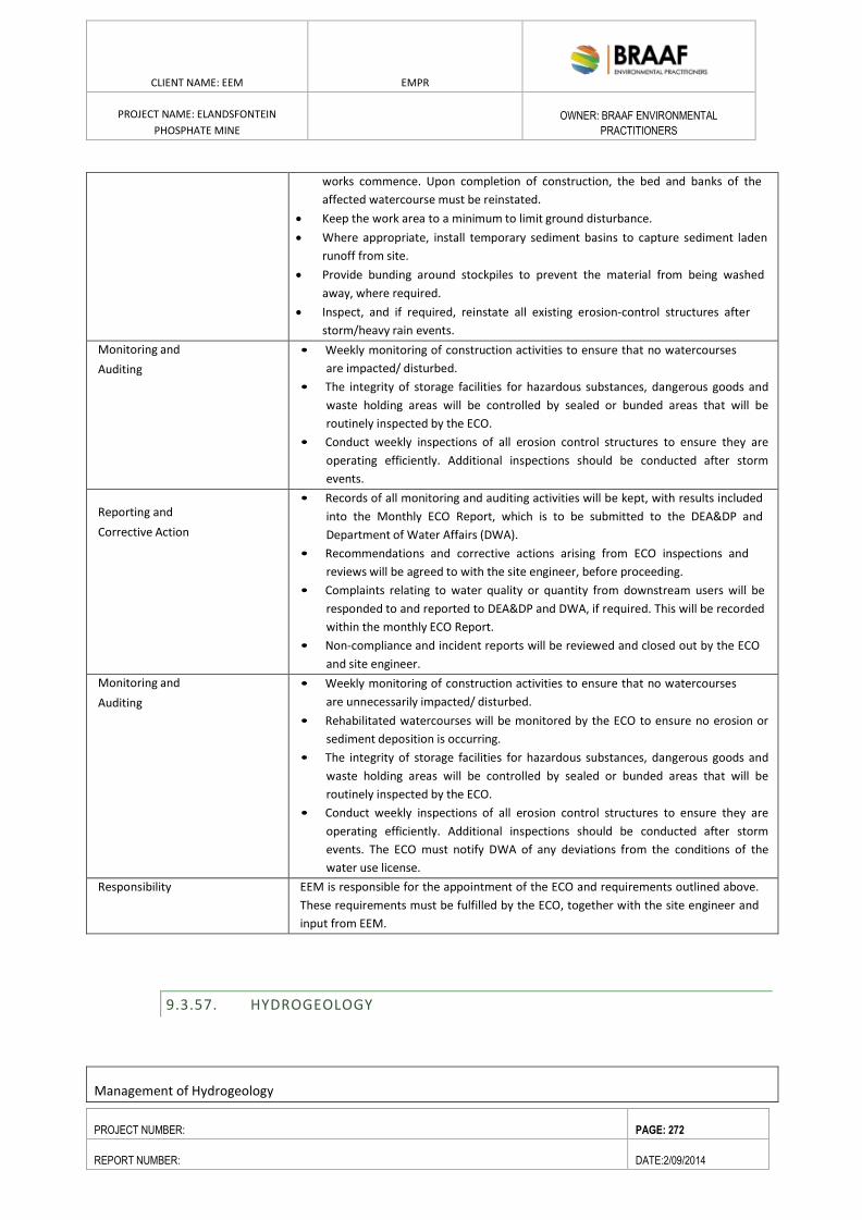
ENVIRONMENTAL RESOURCES MANAGEMENT GAMSBERG ZINC MINE EMPR
DATE: MAY 2013 REV 1.0
CLIENT NAME: EEM EMPR
PROJECT NAME: ELANDSFONTEIN
PHOSPHATE MINE
OWNER: BRAAF ENVIRONMENTAL
PRACTITIONERS
PROJECT NUMBER: PAGE: 272
REPORT NUMBER: DATE:2/09/2014
works commence. Upon completion of construction, the bed and banks of the
affected watercourse must be reinstated.
Keep the work area to a minimum to limit ground disturbance.
Where appropriate, install temporary sediment basins to capture sediment laden
runoff from site.
Provide bunding around stockpiles to prevent the material from being washed
away, where required.
Inspect, and if required, reinstate all existing erosion-control structures after
storm/heavy rain events.
Monitoring and
Auditing
• Weekly monitoring of construction activities to ensure that no watercourses
are impacted/ disturbed.
• The integrity of storage facilities for hazardous substances, dangerous goods and
waste holding areas will be controlled by sealed or bunded areas that will be
routinely inspected by the ECO.
• Conduct weekly inspections of all erosion control structures to ensure they are
operating efficiently. Additional inspections should be conducted after storm
events.
Reporting and
Corrective Action
• Records of all monitoring and auditing activities will be kept, with results included
into the Monthly ECO Report, which is to be submitted to the DEA&DP and
Department of Water Affairs (DWA).
• Recommendations and corrective actions arising from ECO inspections and
reviews will be agreed to with the site engineer, before proceeding.
• Complaints relating to water quality or quantity from downstream users will be
responded to and reported to DEA&DP and DWA, if required. This will be recorded
within the monthly ECO Report.
• Non-compliance and incident reports will be reviewed and closed out by the ECO
and site engineer.
Monitoring and
Auditing
• Weekly monitoring of construction activities to ensure that no watercourses
are unnecessarily impacted/ disturbed.
• Rehabilitated watercourses will be monitored by the ECO to ensure no erosion or
sediment deposition is occurring.
• The integrity of storage facilities for hazardous substances, dangerous goods and
waste holding areas will be controlled by sealed or bunded areas that will be
routinely inspected by the ECO.
• Conduct weekly inspections of all erosion control structures to ensure they are
operating efficiently. Additional inspections should be conducted after storm
events. The ECO must notify DWA of any deviations from the conditions of the
water use license.
Responsibility EEM is responsible for the appointment of the ECO and requirements outlined above.
These requirements must be fulfilled by the ECO, together with the site engineer and
input from EEM.
9.3.57. HYDROGEOLOGY
Management of Hydrogeology
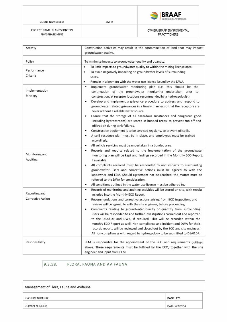
ENVIRONMENTAL RESOURCES MANAGEMENT GAMSBERG ZINC MINE EMPR
DATE: MAY 2013 REV 1.0
CLIENT NAME: EEM EMPR
PROJECT NAME: ELANDSFONTEIN
PHOSPHATE MINE
OWNER: BRAAF ENVIRONMENTAL
PRACTITIONERS
PROJECT NUMBER: PAGE: 273
REPORT NUMBER: DATE:2/09/2014
Activity Construction activities may result in the contamination of land that may impact
groundwater quality.
Policy To minimise impacts to groundwater quality and quantity.
Performance
Criteria
To limit impacts to groundwater quality to within the mining license area.
To avoid negatively impacting on groundwater levels of surrounding
users.
Remain in alignment with the water use license issued by the DWA.
Implementation
Strategy
• Implement groundwater monitoring plan (i.e. this should be the
continuation of the groundwater monitoring undertaken prior to
construction, at receptor locations recommended by a hydrogeologist).
• Develop and implement a grievance procedure to address and respond to
groundwater related grievances in a timely manner so that the receptors are
never without a reliable water source.
• Ensure that the storage of all hazardous substances and dangerous good
(including hydrocarbons) are stored in bunded areas, to prevent run-off and
infiltration during tank failures.
• Construction equipment is to be serviced regularly, to prevent oil spills.
• A spill response plan must be in place, and employees must be trained
accordingly.
• All vehicle servicing must be undertaken in a bunded area.
Monitoring and
Auditing
• Records and reports related to the implementation of the groundwater
monitoring plan will be kept and findings recorded in the Monthly ECO Report,
if available.
• All complaints received must be responded to and impacts to surrounding
groundwater users and corrective actions must be agreed to with the
landowner and EEM. Should agreement not be reached, the matter must be
referred to the DWA for consideration.
• All conditions outlined in the water use license must be adhered to.
Reporting and
Corrective Action
• Records of monitoring and auditing activities will be stored on-site, with results
included into the Monthly ECO Report.
• Recommendations and corrective actions arising from ECO inspections and
reviews will be agreed to with the site engineer, before proceeding.
• Complaints relating to groundwater quality or quantity from surrounding
users will be responded to and further investigations carried out and reported
to the DEA&DP and DWA, if required. This will be recorded within the
monthly ECO Report as well. Non-compliance and incident and DWA for their
records reports will be reviewed and closed out by the ECO and site engineer.
All non-compliances with regard to hydrogeology to be submitted to DEA&DP.
Responsibility EEM is responsible for the appointment of the ECO and requirements outlined
above. These requirements must be fulfilled by the ECO, together with the site
engineer and input from EEM.
9.3.58. FLORA, FAUNA AND AVIFAUNA
Management of Flora, Fauna and Avifauna
ENVIRONMENTAL RESOURCES MANAGEMENT GAMSBERG ZINC MINE EMPR
DATE: MAY 2013 REV 1.0
CLIENT NAME: EEM EMPR
PROJECT NAME: ELANDSFONTEIN
PHOSPHATE MINE
OWNER: BRAAF ENVIRONMENTAL
PRACTITIONERS
PROJECT NUMBER: PAGE: 274
REPORT NUMBER: DATE:2/09/2014
Activity Establishing the mine infrastructure, particularly excavation of the pit, and
processing ore would result in the loss of biodiversity.
Policy Aim of mitigation is to conserve all forms of biodiversity with an emphasis on
irreplaceable habitats, threatened and rare species through reducing the residual
impact. This must be aligned with Vedanta Biodiversity Policy, thus improving
conservation and minimising biodiversity impacts.
Performance
Criteria
Objectives of the mitigation are to facilitate development of a
Biodiversity Management Plan (BMP) and reduce the impacts of loss and
fragmentation of habitats, reduction of species diversity and spread of alien and
invasive species. These mitigation measures must be implemented, in conjunction
with a botanical and faunal specialist.
Implementation
Strategy
A detailed Biodiversity Management Plan (BMP) will be developed to
ensure that the proposed onsite (excluding offsets) avoidance,
minimisation and rehabilitation measures associated with mine
construction, operation and closure are consolidated for effective
implementation and subsequent auditing. The plan will, in broad terms,
include:
Optimal approach to management of the mine property and mine
controlled areas including setting aside a large conservation area
within these areas;
Approach towards implementing controlled access to the mine property
and mine controlled areas;
Management measures to ensure protection and appropriate
management of the biodiversity features on the mine property and mine
controlled areas involving:
Avoidance of any forms of fire within the area;
Wildlife management plan focused on management of the medium to
large faunal species and their habitat requirements to avoid habitat
destruction through overgrazing;
Flora and fauna translocation plan from areas prior to
disturbance when appropriate;
An ecological rehabilitation programme for impacted areas;
Independent monitoring and ongoing inventory development of the mine
property’s biological and physical environments to inform adaptive
management measures and/or corrective action as required;
Alien and invasive species control program;
General awareness training will be done as part of the mine induction to
inform all staff and contractors of the sensitivities of the biodiversity
aspects of the mine and surrounds and appropriate environmental work-
place etiquette;
The BMP will consider means of avoiding and mitigating “foot print” creep.
Measures to manage emergency, accident or upset conditions where
biodiversity may be adversely affected.
The following activities will be prohibited by staff and contractors:
Hunting of wildlife within the mine property or mine controlled areas;
Purchase, sale or transport of any wildlife products from local communities
or passing traders;
Collection of any plants or animals or products thereof for consumption,
ENVIRONMENTAL RESOURCES MANAGEMENT GAMSBERG ZINC MINE EMPR
DATE: MAY 2013 REV 1.0
CLIENT NAME: EEM EMPR
PROJECT NAME: ELANDSFONTEIN
PHOSPHATE MINE
OWNER: BRAAF ENVIRONMENTAL
PRACTITIONERS
PROJECT NUMBER: PAGE: 275
REPORT NUMBER: DATE:2/09/2014
medicinal use, cultivation or keeping as pets;
Keeping pets within the mine property, either domestic animals such as
cats or dogs, or native wildlife;
Intentional killing of any animals including snakes, lizards, birds or other
animals;
All forms of off-road driving.
There will be no grazing of livestock within the set aside conservation area.
Occasional patrolling of the mine property and mine controlled areas will
be conducted by the mine security to watch for evidence of prohibited
activities.
Mine Footprint related measures
Clearly demarcate areas of high conservation with appropriate barriers and
signage to ensure no unnecessary encroachment occurs.
Any infringements or encroachment will be reported and appropriate
penalties are to be enforced on the staff member or contractor.
The footprint of short-duration activities during construction, operation and
decommissioning phases of the mine and the projects outside of the EEM
mine concession will be minimised.
Linear infrastructure (e.g. roads, powerlines and pipelines) should be
grouped where possible to follow the same route adjacent to one another.
Design and construct the southern approach road within the available flat
surface, cutting of the slope should be limited to areas where the available
surface does not allow for the required surface width. Berms should be
constructed with materials cut from the slope and rocks rolling down the
slope are to be kept to a minimum.
No access of personnel to areas outside the disturbed areas, unless prior
approval gained from the relevant manager or ECO.
Groundwater drawdown related measures
The following approaches will be implemented:
Habitat fragmentation related measures
Small areas of natural vegetation will be maintained wherever possible as
islands for the refuge of species within the mine footprint to facilitate the
movement of species through disturbed areas.
Fencing of the set aside conservation area will be maintained in a good
state in the form of livestock fences that allow unrestricted movement of
small and medium-sized wildlife.
Gates will be locked gates and no entry signs prominently displayed.
Locally indigenous plant species will be used in landscaping projects around
offices and mine facilities.
Recommendations for protecting or enhancing species diversity
Annual monitoring of the vegetation around the project area needs to be
undertaken, and in particular in the areas where windblown dust may be an
issue, where the drawdown cones caused by the dewatering boreholes
around the pit may impact on the natural vegetation outside the pit, and
where the surplus water is reintroduced into the upper aquifer. This would
probably be best undertaken by suitably qualified members of the
vegetation rehabilitation team, or otherwise by a botanical consultant.
Particular attention should be paid to floristic and structural changes, and
to any plant mortality.
Search and Rescue of plants of the only two commonly recorded and
ENVIRONMENTAL RESOURCES MANAGEMENT GAMSBERG ZINC MINE EMPR
DATE: MAY 2013 REV 1.0
CLIENT NAME: EEM EMPR
PROJECT NAME: ELANDSFONTEIN
PHOSPHATE MINE
OWNER: BRAAF ENVIRONMENTAL
PRACTITIONERS
PROJECT NUMBER: PAGE: 276
REPORT NUMBER: DATE:2/09/2014
translocatable SCC from within the mine footprint (Caesia sabulosa and
Lampranthus densifolius) should be undertaken prior to each strip being
cleared. These plants should be translocated to areas in need of
rehabilitation, which will mean that plants from the first strip will need to
be maintained in a nursery until they can be planted out.
It may be necessary to erect wind fences around strip mined areas and
stockpiles in order to limit windblown dust. This should be assessed by the
rehabilitation consultant every six months during life of mine, and if it
proves necessary these should be put in place within one month of these
audits.
Topsoil harvesting should include as much topsoil as possible, and must be
500mm deep as a minimum, as numerous plants have corms, tubers and
bulbs that extend very deep (much deeper than 10cm). Topsoil should
ideally be used to immediately surface all available backfilled and mined
areas in need of rehabilitation, or failing this should be stockpiled for no
more than three months before being used.
All aspects of vegetation rehabilitation should be undertaken according to
the best available practice developed by Vula Environmental Services,
based on their rehabilitation work undertaken at the nearby Foskor mine,
and adapted to the specific needs at this site. The detailed vegetation
rehabilitation methodology is contained in a specialist report produced by
Vula Environmental Services.
The Hopefield Sand Fynbos portions of the greater study area that border
the project footprint (southeast corner of pit) need to be burnt in the next
ten years, and will not need a fire again during the Life of Mine. The
planning for this should be part of a Fire Management Plan that is drawn up
in conjunction with SANParks and the rehabilitation consultants.
Trenches and pits that are excavated for pipelines, cabling etc will be
backfilled as soon as practically possible to avoid acting as a trap for small
fauna.
Artificial barriers to species movements will be minimized and avoided
where possible, and measures taken to reduce their fragmentation impacts.
Night lighting for the plant and security purposes will be kept to a minimum
and both inward and downward facing to minimise the disturbance to the
movement of nocturnal species.
It is recommended that low pressure sodium vapour lights/or LED lights
should be used with wavelengths of limited attractiveness to insects.
Escape routes for fauna will be provided within pitfall features and
concreted drainage lines, and potentially dangerous situations inspected
regularly to save trapped species.
Check trenches for trapped fauna before backfilling.
All new power line infrastructure will be bird-friendly in configuration and
adequately insulated to minimise the loss of raptors and other large birds.
Speed restrictions as per applicable standards will be enforced on all roads
within the mine properties and mine controlled areas to minimise the
incidence of faunal road kills.
Driver training will be provided to sensitise them to the importance of
avoiding faunal road kills and the mine site, within the mine properties and
on public roads.
Trained mine personnel with capacity to safely capture and translocate
ENVIRONMENTAL RESOURCES MANAGEMENT GAMSBERG ZINC MINE EMPR
DATE: MAY 2013 REV 1.0
CLIENT NAME: EEM EMPR
PROJECT NAME: ELANDSFONTEIN
PHOSPHATE MINE
OWNER: BRAAF ENVIRONMENTAL
PRACTITIONERS
PROJECT NUMBER: PAGE: 277
REPORT NUMBER: DATE:2/09/2014
dangerous snakes will be available at all times.
Efforts will be supported to promote an appreciation of biodiversity
features of the mine property and mine controlled areas among staff,
contractors and their dependents.
Alien control measures
Only approved indigenous species will be used for all workplace
landscaping projects.
The introduction of foreign plant species onto the mine site and associated
projects will be controlled.
Presence of alien fauna, such as feral dogs and cats that threaten the local
ecology will be monitored. Ethical control measures will be implemented if
an increase in their presence is detected.
Routine monitoring conducted to identify any new incidence of weed
infestation. Provision of information for personnel on the identification of
declared weeds
Stockpile areas and haul roads required will be clearly defined, so that
weed establishment and the potential spread of plant diseases may be
contained. Stockpiles will be developed in previously cleared areas, with
adequate open-spaces buffers, where possible.
A suitable and appropriate biodiversity offset must be drawn up and
implemented within one year of any project approval, and this offset must
significantly expand the area of the West Coast National Park and should
incorporate priority natural habitat as identified by a specialist. The
implementation of this offset is the primary means of reducing the residual
Medium negative botanical impact to a more acceptable Low negative
level. For further details see the specialist biodiversity offset report by M.
Botha.
Appoint appropriate specialist to conduct a survey to determine the
breeding status of Black Harrier on the proposed development site and
surrounding area.
Monitoring, Auditing and further
studies
Monitoring of ecological dust impacts
Dust monitoring of sensitive habitat must be undertaken in alignment with
the air quality monitoring requirements, outlined above.
Monitoring of sensitive ecological receptors (particularly in response to
dust) will be implemented and include the following considerations:
A competent botanist will be contracted to oversee the monitoring
programme;
Monitoring will be conducted monthly.
Reporting and Corrective Action General
Records of all monitoring and auditing activities will be kept, with results
included into the Monthly ECO Report, which is to be submitted to the
DEA&DP.
Recommendations and corrective actions arising from ECO inspections and
reviews will be agreed to with the site engineer, before proceeding.
Biodiversity related complaints from surrounding users will be responded
to with further investigations carried out and reporting to the DEA&DP and
DWA, as required. This will be recorded within the monthly ECO Report as
well.
Non-compliance and incident reports will be reviewed and closed out by
the ECO and site engineer. All non-compliances with regard to
ENVIRONMENTAL RESOURCES MANAGEMENT GAMSBERG ZINC MINE EMPR
DATE: MAY 2013 REV 1.0
CLIENT NAME: EEM EMPR
PROJECT NAME: ELANDSFONTEIN
PHOSPHATE MINE
OWNER: BRAAF ENVIRONMENTAL
PRACTITIONERS
PROJECT NUMBER: PAGE: 278
REPORT NUMBER: DATE:2/09/2014
hydrogeology to be submitted to DEA&DP and DWA for their records.
Responsibility EEM is responsible for the appointment of the ECO and requirements outlined
above. These requirements must be fulfilled by the ECO, together with the site
engineer and input from EEM.
9.3.59. NOISE
Management of Noise
Activity The construction phase would result in the generation of noise heavy duty
equipment.
Policy To construct in a manner that minimises the impact of noise and vibrations on
surrounding properties.
Performance
Criteria
• No exceedence of SAN 10103 of noise at sensitive receptors.
• Respond to noise and vibration related complaints received from residents
and landholders and implement mitigation measures.
• Consultation with potentially affected sensitive receptors, prior to
commencement of construction.
• Respond to all complaints.
Implementation
Strategy
• Implement environmental noise and vibration monitoring along site
boundaries and at four selected locations within farm houses closest to the
mine and the Loop 10 road on an annual basis with more frequent targeted
monitoring at sensitive receptors, if required.
• Ensure all noise complaints are responded to and recorded by the
ECO.
• Ensure that all machinery and equipment is well maintained in good
working order.
• Regular maintenance of vehicle servicing is required. The intervals will vary
based on the vehicle and approved by the site engineer.
Monitoring and
Auditing
• ECO to review vehicle servicing records.
• Public or neighbours’ complaints relating to noise and vibration will be
recorded and responded to.
• Record noise and vibration monitoring results.
Reporting and
Corrective Action
• Complaints relating to noise will be addressed promptly, with further
investigations and reporting to the ECO and site engineer, if required.
• Routine work reports with maintenance records will be recorded and
reviewed by each supervisor or manager.
• All works that deviate from normal operating conditions will be reported and
action initiated (including reporting to relevant agencies where this is
warranted/required) to prevent a recurrence of the incident.
• Non-compliance and incident reports will be reviewed and closed out by
senior management.
• Regular reviews, recommendations and corrective actions shall be
implemented.
ENVIRONMENTAL RESOURCES MANAGEMENT GAMSBERG ZINC MINE EMPR
DATE: MAY 2013 REV 1.0
CLIENT NAME: EEM EMPR
PROJECT NAME: ELANDSFONTEIN
PHOSPHATE MINE
OWNER: BRAAF ENVIRONMENTAL
PRACTITIONERS
PROJECT NUMBER: PAGE: 279
REPORT NUMBER: DATE:2/09/2014
Responsibility EEM is responsible for the appointment of the ECO and requirements outlined above.
These requirements must be fulfilled by the ECO, together with the site engineer and
input from EEM.
9.3.60. SOCIO-ECONOMIC
Management of Socio-economic impacts
Activity The construction phase of the project will result in increased
expenditure/investment, net foreign exchange and tax earnings outflows while
negative impacts resulting from the Project may be associated with tourism
potential, impact adjacent land values and increase strain on municipal services.
Policy The aim is to minimise the negative impacts on tourism potential of the area, reduce
impacts associated with reduction in adjacent land values and reduce demand/
dependency on municipal services while enhancing the economic benefits associated
with the Project.
Performance
Criteria
• To enhance potential employment opportunities in the local communities
associated with the construction phase of the Project.
• Increase the potential for the use of local contractors and suppliers.
• To reduce the impacts of dust, lighting, visibility of project
infrastructure and loss of conservation worthy vegetation.
• Reduce demand (from Project employees) on municipal services.
Implementation
Strategy
Early notification to surrounding landowners and the nearby
communities of Hopefield, Saldanha, Langebaan and Vredenburg of the
commencement of construction.
Implement employment equity plan, recruitment and procurement policy and
local contractor and supplier policy.
Provide training prior to construction, to maximise employees from local
communities.
Work in collaboration with Local and District Municipality to align local
economic development initiatives and mine opportunities, as well as reduce
increased demand on municipal services through joint efforts to meet the
requirements of the mine and associated employees.
Early notification to surrounding landowners and the nearby communities of
Hopefield, Saldanha, Langebaan and Vredenburg of the commencement of
construction.
Monitoring and
Auditing
• Copy of employment equity plan, recruitment and procurement policy and
local contractor and supplier policy to be kept on-site.
• Contractual documents will be used to verify level of local
employment.
• Proof of notifications to stakeholders to be kept on-site.
Reporting and
Corrective Action
• EEM must submit verification of the use of local employees, suppliers and
contractors (including if targets have been met) to DMR. If targets have not
been met, a detailed motivation must be provided.
• Proof of notification and on the job training must be included into the
ENVIRONMENTAL RESOURCES MANAGEMENT GAMSBERG ZINC MINE EMPR
DATE: MAY 2013 REV 1.0
CLIENT NAME: EEM EMPR
PROJECT NAME: ELANDSFONTEIN
PHOSPHATE MINE
OWNER: BRAAF ENVIRONMENTAL
PRACTITIONERS
PROJECT NUMBER: PAGE: 280
REPORT NUMBER: DATE:2/09/2014
monthly ECO Report.
• EEM must distribute minutes of meeting of the employment forum,
once every three months.
Responsibility EEM is responsible for the appointment of the ECO and requirements outlined above.
These requirements must be fulfilled by the ECO, together with the site engineer and
input from EEM.
Monitoring and
Auditing
• Copy of employment equity plan, recruitment and procurement policy and
local contractor and supplier policy to be kept on-site.
• Contractual documents will be used to verify level of local
employment.
• Proof of notifications to stakeholders to be kept on-site.
9.3.61. HERITAGE, ARCHAEOLOGY AND PALAEONTOLOGY
Management of Heritage, Archaeology And Palaeontology
Activity Construction activities related to excavation and utilisation of heavy duty equipment
will result in the destruction of artefacts of heritage, archaeological and
paleontological value. Areas of sensitivity are contained below.
Policy Avoid or mitigate impacts on indigenous cultural/ heritage values, or artefacts of
archaeological and paleontological value.
Performance
Criteria
• Preventing the loss of artefacts of importance.
• Implementing effective mitigation for the salvage of artefacts of
importance.
• Compliance with policies and procedures set out in the Record of
Decision issued by Heritage Western Cape
Implementation
Strategy
• Minimise the development footprint to only what is actually needed.
• The fossil site (dune field) is to be considered as “no-go” areas, and are to be
cordoned off to avoid any direct impacts. A suitably qualified archaeologist
must be appointed to assist with delineating the sensitive areas to ensure
avoidance.
• Restrict all construction activities to designated working areas with all work
areas and access areas clearly marked and signposted.
• Immediately report any heritage trace that may come to light during the
construction phase.
• Physical salvage of sites would need to take place before commencement of
the construction phases.
Compile a heritage management plan with an awareness education component
for all contractors and labourers to make them aware of what fossils and
artefacts look like so they know when to stop the operation) and that they
alert the archaeologist/paleontologist (ECO) who is on the site
Access: Members of the heritage management team
(archaeologist/paleontologist) should be able to access all parts of the mining
operation at all times. They should have a clear line of communication with
the mining operation so that they can access any part of the mine in the
ENVIRONMENTAL RESOURCES MANAGEMENT GAMSBERG ZINC MINE EMPR
DATE: MAY 2013 REV 1.0
CLIENT NAME: EEM EMPR
PROJECT NAME: ELANDSFONTEIN
PHOSPHATE MINE
OWNER: BRAAF ENVIRONMENTAL
PRACTITIONERS
PROJECT NUMBER: PAGE: 281
REPORT NUMBER: DATE:2/09/2014
event materials are recovered. The mining company should provide means of
access in particular situations when access to the active parts of the mine is
difficult.
Training: The resident archaeologist/paleontologist should have regular access to
training seminars whereby they can update all members of the mining
operation about identification, documentation and recovery of fossil remains.
It is critical that all aspects of the mining operation are aware of the potential
risks to heritage resources.
Communication: It is important that the heritage management team has an open
line of dialogue with the operation of the mine. Specialists should be made
aware of potential finds and any concerns about the impact on heritage
materials at all times. The importance of contextual information in
association with the fossils means that a specialist needs to see the location
of a fossil or artifact find as soon after the recovery as possible. An active and
open dialogue regarding the mining process is critical for successful
mitigation.
Documentation: In the event that fossils and artefacts are recovered it is of utmost
importance that the heritage managers have the space necessary to properly
analyze, curate and identify the materials recovered. The mining operation
should provide the infrastructure to allow adequate analysis of these
materials and the cost of this operation should be the responsibility of the
mining operation.
Fence Around The Active Dune Zone
Monitoring and
Auditing
During construction phase, all excavated areas must be monitored for presence
of any artefacts of cultural/ heritage, archaeological or paleontological value.
The ECO must inspect newly opened trenches for potential presence of
artefacts.
Weekly visual inspections required to ensure that no heritage resources are not
impacted during construction.
Reporting and
Corrective Action
The ECO must record all instances of artefacts of importance identified
in the monthly audit report.
If any traces of heritage, archaeological or paleontological value are revealed,
HWC must be notified, a suitably qualified archaeologist/paleontologist must be
appointed. All construction work around the area in question must cease, until
approved by HWC to proceed.
If significant fossils are found, an appropriately qualified palaeontologist will
investigate, and if required, a permit will be obtained to recover and preserve
the paleontological resources for scientific purposes before work can be
commenced again.
Responsibility EEM is responsible for the appointment of the ECO and requirements outlined
above. These requirements must be fulfilled by the ECO, together with the site
engineer and input from EEM.
9.3.62. VISUAL
Management of Visual Aspects
Activity The construction phase will result in a change to the visual landscape through the
generation of dust, physical activities, project infrastructure and lighting.
ENVIRONMENTAL RESOURCES MANAGEMENT GAMSBERG ZINC MINE EMPR
DATE: MAY 2013 REV 1.0
CLIENT NAME: EEM EMPR
PROJECT NAME: ELANDSFONTEIN
PHOSPHATE MINE
OWNER: BRAAF ENVIRONMENTAL
PRACTITIONERS
PROJECT NUMBER: PAGE: 282
REPORT NUMBER: DATE:2/09/2014
Policy • To minimise impacts on visual impacts associated with the Project and
associated infrastructure.
• To reduce as much as practicable lighting impacts on sensitive receptors,
including adjacent landowners and R45 and R27 road users.
Performance
Criteria
• Respond to all complaints regarding visual amenity and lighting and, where
feasible, implement mitigation measures.
• Consultation with potentially affected sensitive receptors, prior to
construction.
• Dust suppression measures will be implemented in line with the air quality
recommendations.
Implementation
Strategy
Construction of plant and associated infrastructure
It is proposed that as little vegetation as possible be removed from building
and infrastructure areas.
Paint buildings and structures with colours that reflect and compliment
the natural colours of the surrounding landscape.
To further reduce the potential of glare, the external surfaces of buildings and
structures should be articulated or textured to create an interplay of light and
shade.
Minimise amount of vegetation and topsoil should be removed from the
Project area.
Ensure that conveyor belts are designed to follow the natural contours of
the land to avoid extensive cut or fill areas, as far as possible.
The negative effect of night lighting, glare and spotlight effects can be
mitigated using the following methods, as far as technical safe:
Install light fixtures that provide precisely directed illumination to reduce light
‘spillage’ beyond the immediate surrounds of the project structures and
activities.
Avoid high pole top flood and security lighting around the support infrastructure
and areas of activity e.g. roads.
To reduce the amount of glare, external surfaces of buildings and other
structures should be articulated or textured to increase the interplay of light
and shade.
Landscaping
Natural vegetation should be retained as far as possible, keeping clearing of
vegetation as close as possible to the footprint of structures and activities.
An ecological approach to landscaping is recommended
Access and Haul Roads
Utilise existing roads and tracks to the extent possible. Where new roads
are required, they should be gravel roads, maintained to prevent dust
plumes and erosion.
Surfacing of roads in locally sourced material would ensure that the colour is
appropriate
Route is proclaimed and not directly affecting sensitive receptors.
Junction standards with R45 must reflect eventual frequency of heavy and
light vehicles with good sightlines; road to be regularly cleaned
ENVIRONMENTAL RESOURCES MANAGEMENT GAMSBERG ZINC MINE EMPR
DATE: MAY 2013 REV 1.0
CLIENT NAME: EEM EMPR
PROJECT NAME: ELANDSFONTEIN
PHOSPHATE MINE
OWNER: BRAAF ENVIRONMENTAL
PRACTITIONERS
PROJECT NUMBER: PAGE: 283
REPORT NUMBER: DATE:2/09/2014
Monitoring and
Auditing
• Lighting will be monitored to ensure that it meets the aim of reducing
excessive leakage.
• Review of the complaints received.
• Monitoring dust generation and cleanliness of site.
Reporting and
Corrective Action
• All complaints received will be addressed.
• Any complaints received, together with the suggested mitigation measures
must be recorded in the ECO monthly audit report.
Responsibility • EEM is responsible for the appointment of the ECO and requirements outlined
above. These requirements must be fulfilled by the ECO, together with the site
engineer and input from EEM.
9.3.63. TRAFFIC AND TRANSPORT
Activity The construction phase would result in the generation of traffic on the R45, R27 and
access road to the surrounding towns.
Policy To reduce traffic impacts to surrounding landowners and road users, during the
construction phase.
Performance
Criteria
Minimal traffic-related complaints and incidents.
To minimise impacts on road pavements, or where this is not practicable, to
negotiate appropriate contributions or upgrades to road pavement impacts
with relevant authorities.
Implementation
Strategy
Obtain relevant approval/s from PGWC: Roads prior to commencement of
construction.
Implement traffic management plan.
Prepare the intersection of the R45 and the access to the site with the
appropriate construction warning signs and road markings.
Restrict all construction activities to designated working areas with all work
areas and access areas clearly marked and signposted.
Car pooling and bus services will be implemented where possible to minimise
worker journeys.
Dangerous goods will be transported along preferred routes in accordance
with relevant legislation.
The transport of oversize loads will be restricted to non-peak periods, in line
with traffic authority requirements.
Clear signs and signals will be installed on-site and at all entrance/exit points
to the mine to guide traffic movement and increase traffic safety.
Vehicles will observe on-site traffic regulations.
Impacts and subsequent rehabilitation requirements on road pavements will
be negotiated with the relevant authorities.
Where necessary, and in consultation with the relevant authorities, road
sections (e.g. intersections) may be upgraded.
Construction in road reserves will be planned to minimise disruption and
maximise safety of road users.
Monitoring and
Auditing
• The number of incidents or complaints received in relation to project
traffic will be monitored.
• Visual inspection of road quality at the entrance to the proposed access road
ENVIRONMENTAL RESOURCES MANAGEMENT GAMSBERG ZINC MINE EMPR
DATE: MAY 2013 REV 1.0
CLIENT NAME: EEM EMPR
PROJECT NAME: ELANDSFONTEIN
PHOSPHATE MINE
OWNER: BRAAF ENVIRONMENTAL
PRACTITIONERS
PROJECT NUMBER: PAGE: 284
REPORT NUMBER: DATE:2/09/2014
and R45.
Reporting and
Corrective Action
• The occurrence of any traffic incidents or complaints will be recorded by the
relevant ECO monthly audit report and reported to the site engineer.
• All traffic incidents involving Project personnel will be reported to the ECO and
site engineer and must be thoroughly investigated.
• In the event of a complaint/incident or failure to comply with
requirements, relevant corrective action will be taken.
Responsibility EEM is responsible for the appointment of the ECO and requirements outlined
above. These requirements must be fulfilled by the ECO, together with the site
engineer and input from EEM.
ENVIRONMENTAL RESOURCES MANAGEMENT GAMSBERG ZINC MINE EMPR
DATE: MAY 2013 REV 1.0
CLIENT NAME: EEM EMPR
PROJECT NAME: ELANDSFONTEIN
PHOSPHATE MINE
OWNER: BRAAF ENVIRONMENTAL
PRACTITIONERS
PROJECT NUMBER: PAGE: 285
REPORT NUMBER: DATE:2/09/2014
9.4. OPERATIONAL ENVIRONMENTAL MANAGEMENT PROGRAMME (OEMPR)
9.4.1. SCOPE
This Specification covers the requirements for controlling the impact on the environment of operational
activities.
9.4.2. AIM AND PURPOSE OF THE OEMPR
This Operational EMPr aims to provide EEM with the necessary tools to ensure that the potential impacts on the
environment during the operation of the Project are minimised. Moreover, it aims to ensure that the
infrastructure is operated and maintained according to Good Practice. The Operational EMPr is a working
document that may be amended to enhance its effectiveness for environmental control.
9.4.3. APPLICATION
The application and implementation of the Operational EMPr shall be the responsibility of EEM. EEM is to
appoint an Environmental Site Manager (ESM) to ensure that relevant requirements of the EMPr document are
implemented, and that the site is suitably managed. EEM may appoint a suitably qualified and experienced
person from within the existing staff to fulfil the role of ESM. EEM may also form an Environmental Liaison
Committee (ELC) to facilitate the implementation of the Operational EMPr. If the ELC is formed, many of the
responsibilities of EEM may be delegated to the ELC. The ELC should consist of at the very least the following:
Representative of EEM;
Representative of SANParks;
Representative of DEA&DP, DEA, DWA and DMR;
Environmental Site Manager; and
Representative of the local and authority.
Other members may include an independent environmental control officer or representatives from community
based organisations or environmental groups.
Should EEM sub-contract the running of the Project to a third party, the Operational EMPr must be part of the
contract and must be binding.
ENVIRONMENTAL RESOURCES MANAGEMENT GAMSBERG ZINC MINE EMPR
DATE: MAY 2013 REV 1.0
CLIENT NAME: EEM EMPR
PROJECT NAME: ELANDSFONTEIN
PHOSPHATE MINE
OWNER: BRAAF ENVIRONMENTAL
PRACTITIONERS
PROJECT NUMBER: PAGE: 286
REPORT NUMBER: DATE:2/09/2014
9.4.4. ENVIRONMENTAL LIAISON COMMITTEE (ELC)
Prior to the Operational Phase, EEM may establish an Environmental Liaison Committee (ELC). The ELC would
serve to provide strategic oversight on the Project, during the Operational Phase. The ELC, will play an advisory
role, and provide a forum for democratic decisions regarding EMPr implementation, as well as periodically
reviewing the EMPr in terms of its applicability to management requirements on site. They are to meet quarterly
(i.e. every 3 months) to receive a report back on environmental management at an operational level. This
frequency may need to be reviewed following the first year of operation, but should not be less than twice a year.
All members of the ELC will be expected to attend the meetings, and are to provide the chairperson of the
committee with a written apology if unable to attend. In such a case, the member will receive minutes of the
meeting, and may be expected to respond to certain issues.
The ELC must be comprised of, but not limited to, representatives from SANParks, WCBR, SBM, DEA&DP, DWA,
DMR and EEM. EEM will be responsible for the compilation and distribution of the meeting agenda and ELC
Progress Report, two weeks prior to the meeting date. The Progress Report must provide detailed feedback on,
inter alia, on-going monitoring efforts (i.e. air quality, groundwater quality and quantity), and incidences of non-
compliance and complaints received together with the agreed resolution.
9.4.5. ELANDSFONTEIN EXPLORATION AND MINING
The implementation of the EMPr, as well as the adherence to any conditions within the applicable authorisations
for this project is the responsibility of EEM. EEM will appoint an Environmental Site Manager and various
specialists as required to ensure that the specifications of this document as they relate to general site
management and maintenance, as well as environmental audits, are suitably implemented on site.
The roles and responsibilities of each of the above-mentioned environmental management bodies have been
detailed below:
9.4.6. ENVIRONMENTAL SITE MANAGER (ESM)
A suitably qualified and trained individual appointed by EEM prior to the operation of the mine, will fulfil the
role of the Environmental Site Manager.
The primary roles and responsibilities of the ESM will be: to oversee the implementation of the EMPr on site;
to visit the site on a monthly basis and advise on areas of environmental management, or compliance
with the EMPr, requiring attention;
to visit the site more regularly during the first three months of operation, during which more frequent
monitoring may be required for the establishment of certain programmes or aspects of environmental
management;
ENVIRONMENTAL RESOURCES MANAGEMENT GAMSBERG ZINC MINE EMPR
DATE: MAY 2013 REV 1.0
CLIENT NAME: EEM EMPR
PROJECT NAME: ELANDSFONTEIN
PHOSPHATE MINE
OWNER: BRAAF ENVIRONMENTAL
PRACTITIONERS
PROJECT NUMBER: PAGE: 287
REPORT NUMBER: DATE:2/09/2014
to be called to site in the case of any emergency situation which may impact on the local
environment;
to liaise with various specialists and the local authorities if required, regarding issues relating to
environmental management;
to report on compliance with the EMPr specifications to the ELC/EEM;
to facilitate environmental audits and ensure that they are undertaken, as required;
to keep a comprehensive record of environmental management, issues of non-compliance and minutes
of ELC meetings for audit purposes; and
to undertake any other tasks outlined in this document, on the behalf of EEM.
It is recommended that the ECO appointment, extend three months into operation, to ensure an
effective transfer of environmental management responsibilities to the EEM Operational Environmental
Manager.
9.4.7. INDEPENDENT ENVIRONMENTAL AUDITOR
EEM should make provision for a Environmental Manager to be an internal EEM appointment, EEM must contract
an independent Environmental Auditor with a post graduate degree in environmental studies and a minimum of
five years relevant experience to act as the independent environmental auditor for the site. The auditor is to be
contracted upon completion of the first year of operation, and is to perform an annual formal audit on the
management plan, and its implementation by the relevant parties for the duration for the operational phase of
the project. The findings of these yearly audits must be submitted to the ELC, for review and consideration.
9.5. FINANCING FOR ENVIRONMENTAL MANAGEMENT
The budget for the implementation of the EMPr shall come out of EEM’s operational budget. EEM must review
the EMPr and allocate the requisite funds to facilitate compliance. Since many of the items addressed in the EMPr
relate to required preventative maintenance, operator legal compliance, and responsible environmental
management, the costs have been accounted for.
9.5.1. DETAILED OPERATIONAL ENVIRONMENTAL SPECIFICATIONS
9.5.1.1. LITTER AND WASTE MANAGEMENT
A litter and waste management system must be established by EEM. Litter and waste management should
address the following:
ENVIRONMENTAL RESOURCES MANAGEMENT GAMSBERG ZINC MINE EMPR
DATE: MAY 2013 REV 1.0
CLIENT NAME: EEM EMPR
PROJECT NAME: ELANDSFONTEIN
PHOSPHATE MINE
OWNER: BRAAF ENVIRONMENTAL
PRACTITIONERS
PROJECT NUMBER: PAGE: 288
REPORT NUMBER: DATE:2/09/2014
Recycling
It is recommended that a recycling program be established for the site as a whole, but specifically for the
administration and maintenance buildings and all site residences. This may be achieved via an agreement with the
waste management contractor for the site. EEM must make adequate staff resources available to implement and
manage the recycling program. Waste separation is best conducted at source, and the recycling waste storage
area must as a minimum separate waste into the following categories:
Paper products;
Cardboard;
Glass;
Plastics; and
Metals.
Recycling will involve greater effort, but offers the reward of environmentally sustainable practices and potential
employment opportunities. The EEM should establish what recycling facilities are available within the broader
area and determine a recycling program that can support any community efforts already underway.
Solid waste
A distinction should be made between dry solid waste and wet solid waste. These should be separated and
collected in different containers for storage at a central waste depot before removal to a registered waste facility.
All waste storage areas are to be kept in a clean and hygienic condition to prevent odours, spreading of
litter, and scavengers.
The frequency of collection must be determined and specified by the ELC/ EEM in this EMPr.
Refuse and litter management is to be monitored visually by the ESM. Findings are to inform changes in
the waste management procedures to eliminate litter problems.
Hazardous Waste
Hazardous waste generated by the Project, must be disposed of at a registered hazardous waste facility and any
health and safety requirements for the storage, transport and disposal of hazardous waste must be adhered to.
9.5.1.2. MAINTENANCE OF DEVELOPMENT
This section refers to both on-site and off-site maintenance of the operation.
ENVIRONMENTAL RESOURCES MANAGEMENT GAMSBERG ZINC MINE EMPR
DATE: MAY 2013 REV 1.0
CLIENT NAME: EEM EMPR
PROJECT NAME: ELANDSFONTEIN
PHOSPHATE MINE
OWNER: BRAAF ENVIRONMENTAL
PRACTITIONERS
PROJECT NUMBER: PAGE: 289
REPORT NUMBER: DATE:2/09/2014
EEM must notify the ESM of any external maintenance to be undertaken. Any significant structural
maintenance should require compliance with the EMPr.
The ESM must specify any additional environmental procedures necessary to prevent contamination of
the environment.
EEM i s r e s p o n s i b l e for notifying the maintenance contractor of the conditions under which
maintenance is to be done.
9.5.1.3. EMERGENCY PROCEDURES
An appropriate and timeous response to emergency situations will ensure that the environmental consequences
of such situations are managed and curtailed.
Emergency contact details
A list of emergency services contact numbers shall be posted on site. As a minimum, the following emergency
services shall be included on the list:
Fire Department: 10111
Disaster Management: 107
Ambulance Services: 10177
South African Police Services: 10111
9.5.2. OPERATIONAL EMPR REVIEW AND AUDIT
Operational EMPr Review
A schedule for the review of the EMPr should be established by the ELC/EEM. It is recommended that the
effectiveness of the EMPr be reviewed on an annual basis, and possibly bi-annually in the first year of operation.
Operational EMPr Audit
Audits of the EMPr implementation in the Development should be undertaken on a regular basis. Internal audits (by
the ESM) should be done on a quarterly basis with an external audit conducted by an independent consultant
undertaken as specified below.
An independent environmental auditor is to be employed after the first year of operation, and annually thereafter,
to perform a formal audit on the management plan, and its implementation by the relevant parties. Each audit is to
be based on site visits by the auditor as well as a review of any records of environmental management to be kept
by the ESM. The audit must also determine whether the EMPr is adequately dealing with the range of
environmental impacts on the site, i.e. whether the plan is still appropriate, or whether it needs to be extended.
ENVIRONMENTAL RESOURCES MANAGEMENT GAMSBERG ZINC MINE EMPR
DATE: MAY 2013 REV 1.0
CLIENT NAME: EEM EMPR
PROJECT NAME: ELANDSFONTEIN
PHOSPHATE MINE
OWNER: BRAAF ENVIRONMENTAL
PRACTITIONERS
PROJECT NUMBER: PAGE: 290
REPORT NUMBER: DATE:2/09/2014
The audit report is to include recommendations of changes required to the EMPr document and management
practices to improve environmental management of the site. The results of this audit are to be submitted to the
district and local environmental authority, and to DEA&DP, DMR and, DWA.
9.5.3. SUMMARY OF OPERATIONAL ENVIRONMENTAL SPECIFICATIONS
In this section of the document, specifications for environmental management on site have been summarised, to
facilitate easy reference and implementation.
This section clearly lays out the management requirements, who is responsible for undertaking the required
actions, time frames within which they are required, as well as requirements for monitoring, or where applicable,
approval of the required action. Relevant references to these details have been provided in the tables below.
Where EEM has been identified as the responsible party, this should be read as EEM, or a suitable
individual/organisation employed by them to undertake such task. Where another party has been identified as
responsible for undertaking a management action, they are to fulfil this requirement, although EEM will
ultimately be held responsible for any requirements or specifications of this document which are not fulfilled.
9.5.3.1. AIR QUALITY AND DUST
Activity and Element Mining operations including hauling and ore processing as well as material handling
and stockpiles.
Policy To operate in a manner that minimises dust impacts on sensitive habitat and sensitive
receptors.
Performance
Criteria
• No exceedance of applicable air quality standards at sensitive human
receptors.
• Respond to complaints on air quality.
Implementation
Strategy
• Develop a detailed dust monitoring plan targeting areas in the vicinity of
sensitive habitats on site (with a suitably qualified ecologist), and in
addition at the site boundary and at four locations around the site and 2
locations along the road. This must be done prior to commencement and
after.
• Regular maintenance of vehicles to reduce exhaust emissions.
• Wet suppression or chemical dust suppressants will be used at the crusher, on
ENVIRONMENTAL RESOURCES MANAGEMENT GAMSBERG ZINC MINE EMPR
DATE: MAY 2013 REV 1.0
CLIENT NAME: EEM EMPR
PROJECT NAME: ELANDSFONTEIN
PHOSPHATE MINE
OWNER: BRAAF ENVIRONMENTAL
PRACTITIONERS
PROJECT NUMBER: PAGE: 291
REPORT NUMBER: DATE:2/09/2014
haul roads, during blasting, at materials handling and stockpile areas to reduce
dust emission at source, as required.
• Watering frequency will be increased during periods of high risk (e.g. high
winds).
• Adherence to speed limits on public and internal roads.
• The performance targets for the monitoring should be set to a maximum total
daily dust deposition (calculated from the monthly dust deposition) to be less
than 600 mg/m2/day for residential areas, and the maximum annual average
dust deposition within the site to be less than 1,200 mg/m2/day.
Monitoring and Auditing • Record all air quality related complaints received.
• Monitor dust deposition in line with the dust monitoring plan.
• Record dust monitoring results monthly, findings to be included in the annual
environmental audit report.
Reporting and
Corrective Action
• Records of all monitoring and auditing activities will be kept, with results
reported by the Environmental Manager to DEA&DP, annually.
• Recommendations and corrective actions arising from audits, inspections
and reviews will be implemented.
• All activities that deviate from normal operating conditions will be
reported and corrective action initiated (including reporting to DEA&DP
or delegated authority where this is warranted/required) to prevent a
recurrence of the incident.
• Complaints relating to air and dust emissions will be addressed promptly, with
further investigations carried out and reporting to the Environmental
Manager, if required.
• Non-compliance and incident reports will be reviewed and closed out by the
Environmental Manager.
Responsibility Environmental Manager
CLIENT NAME: EEM EMPR
PROJECT NAME: ELANDSFONTEIN
PHOSPHATE MINE
OWNER: BRAAF ENVIRONMENTAL
PRACTITIONERS
PROJECT NUMBER: 10043 PAGE: 292
REPORT NUMBER: 10043EMP DATE:10/06/2014
9.5.3.2. HYDROLOGY
Activity and Element The operation of the Project may result in changes to an existing drainage line
located within the pit area.
Policy To prevent the potential impacts associated with erosion and to prevent the
release of contaminants that may adversely affect downstream surface water
quality.
Performance Criteria • No release of contaminants to surface waters outside the boundary of the
mining license area.
• Avoid unnecessary diversion of watercourses on-site.
Implementation Strategy Develop a comprehensive Storm Water Management Plan (SWMP).
• Adhere to inspection procedures stipulated in the SWMP and keep
records.
• Only a poorly defined drainage channel that is orientated towards the
south (represented by the blue lines in the Google Earth image). It is
unlikely that there is any significant surface water flow in the channel
and that the movement of water within the channel is relatively
insignificant and is as subsurface flow. There is no visible aquatic
ecosystem associated with the channel. It can therefore be said that
there are no aquatic ecosystems of any significance identified within the
proposed mining development site. No freshwater mitigation measures
would be required on site.
• Water quality and flows will be monitored once a month in accordance
with the SWMP. Values obtained should be incorporated in the water and
salt balance for the mine and could serve as early warning indicators of
potential malfunctions or mismanagement.
• Regular water management training will be provided by the mine.
• Surface water runoff from the dirty areas (eg process plant, softs
stockpile) will be captured via berms and channeled to a stormwater dam
and reused in the mining process.
• All areas where dangerous goods and hazardous substances, such as oils
and petroleum fuels are handled (i.e. workshops and fuel storage facilities)
will be bunded and strictly controlled to minimise the risk of accidental
spillages.
• All relevant personnel trained in appropriate handling of spill
materials and spill prevention.
• Place erosion control structures such as diversion drains, silt fences
or traps at key locations (stormwater pit inlets, around stockpiles) to
capture the suspended sediment.
• Provide bunding around stockpiles to prevent the material from being
washed away. The height of the bund depends on the site location, the
volume and type of material being stockpiled, as well as the topography.
CLIENT NAME: EEM EMPR
PROJECT NAME: ELANDSFONTEIN
PHOSPHATE MINE
OWNER: BRAAF ENVIRONMENTAL
PRACTITIONERS
PROJECT NUMBER: 10043 PAGE: 293
REPORT NUMBER: 10043EMP DATE:10/06/2014
Sewage Package Plant
• A thorough, regular inspection and maintenance regime should be
implemented by EEM or its appointed operator.
• An emergency response unit should be established to undertake
Monitoring and Auditing None required.
Reporting and Corrective Action • Records of all monitoring and auditing activities will be kept, with results
reported by the Environmental Manager to DWA and DEA&DP, annually.
• Recommendations and corrective actions arising from audits,
inspections and reviews will be implemented.
• Non-compliance and incident reports will be reviewed and closed out by
the Environmental Manager.
Responsibility Environmental Manager
9.5.3.3. HYDROGEOLOGY
Activity and Element The Project may generate contaminated leachate from the Softs Stockpile,
potential spillages from mining equipment, fuel and chemical storage facilities.
Policy To minimise impacts to groundwater quality and quantity and avoid risk to
human health and ecological receptors.
Performance Criteria Groundwater users not to be impacted by drawdown or impacts associated
with deterioration of groundwater quality.
Implementation Strategy Implement the groundwater monitoring plan which will include monitoring
of strategically located and correctly installed boreholes/monitoring wells
(on- and off-site).
Develop a grievance procedure to address and respond to water related
grievances in a timely manner. The grievance procedure (including
response times) will be developed prior to construction and in consultation
with surrounding groundwater users. The grievance procedure will apply
and be adapted, as required, for the construction, operation,
decommissioning and after mine closure.
EEM should establish a Groundwater Monitoring Committee, for the
presentation and sharing of all groundwater monitoring data, as a
risk management measure to the mine. The Committee may
comprise of the management of the mine, regulatory bodies
(DWA/DEA/catchment management agency), local groundwater
users, and any other Interested and Affected Parties. It is
recommended that the Committee meet at least quarterly initially,
which could be relaxed to 6-monthly depending on monitoring
CLIENT NAME: EEM EMPR
PROJECT NAME: ELANDSFONTEIN
PHOSPHATE MINE
OWNER: BRAAF ENVIRONMENTAL
PRACTITIONERS
PROJECT NUMBER: 10043 PAGE: 294
REPORT NUMBER: 10043EMP DATE:10/06/2014
results.
Validate and update the groundwater model using the monitoring
data. This will be used as a management tool throughout the
operational phase (i.e. update predicted impacts in order to be
proactive) and for planning of the post-closure phase.
Inspect and ensure toe drains(interception trenches) along the base
of the SS are in working order and conveying water to pollution
control dams for recycling and re-use and ensure maintenance
activities are undertaken as and when required.
Short deposition cycles of softs will be followed by regularly covering fresh
tailings soon after deposition, to prevent them oxidising on placement.
Cladding TSF side slopes with overburden, concurrently with deposition,
to minimise oxygen ingress and side-slope erosion.
Handling of Dangerous Goods
Ensure storage of all hazardous substances and dangerous good
(including hydrocarbons) in bunded areas, to prevent run-off and
infiltration during tank failures.
Construction equipment is to be serviced regularly, to prevent oil
spills.
A spill response plan must be in place, and employees must be
trained accordingly.
All vehicle servicing must be undertaken in a bunded area.
Monitoring and Auditing Record all groundwater quality related complaints received.
Routinely monitor groundwater monitoring wells and boreholes for
water level and contaminants in accordance with the groundwater
monitoring plan.
Record monitoring results, findings to be included in the annual
environmental audit report.
Reporting and
Corrective Action
Records of all monitoring and auditing activities will be kept, with
results reported by the Environmental Manager to DWA and
DEA&DP, annually.
Recommendations and corrective actions arising from audits,
inspections and reviews will be implemented.
Complaints relating groundwater issues will be attended to
promptly, with further investigations carried out and reporting to
the Environmental Manager, if required.
Responsibility Environmental Management
CLIENT NAME: EEM EMPR
PROJECT NAME: ELANDSFONTEIN
PHOSPHATE MINE
OWNER: BRAAF ENVIRONMENTAL
PRACTITIONERS
PROJECT NUMBER: 10043 PAGE: 295
REPORT NUMBER: 10043EMP DATE:10/06/2014
9.5.3.4. FLORA, FAUNA AND AVIFAUNA MANAGEMENT
Activity and Element Operation of mine infrastructure, particularly excavation of the pit of the ore.
Policy Aim of mitigation is to conserve biodiversity with an emphasis on rare and
indigenous species through reducing the residual impact.
Performance Criteria Objectives of the mitigation are to facilitate development of a BMP and reduce
the impacts of loss and fragmentation of habitats, reduction of species diversity
and spread of alien and invasive species.
Implementation Strategy A Biodiversity Management Plan will be implemented cross-cutting all
mine activities as appropriate.
Mine Footprint related measures
Clearly demarcate areas of high conservation importance with
appropriate barriers and signage to ensure no unnecessary
encroachment occurs.
No access of personnel to areas outside the disturbed areas, unless
prior approval gained from the relevant manager.
Establish a nursery on site to cultivate indigenous vegetation from
seeds or genetic material collected within the area, and used in
landscaping projects around the mine offices and other facilities.
Habitat fragmentation related measures
Fencing of the set aside conservation area will be maintained in a
good state in the form of livestock fences that allow unrestricted
movement of small and medium-sized wildlife.
Gates will be locked gates and no entry signs prominently displayed.
Locally indigenous plant species will be used in landscaping projects
around offices and mine facilities.
Measures for protecting or enhancing species diversity
Speed restrictions will be enforced on all roads within the mine
properties and mine controlled areas to minimise the incidence of
faunal road kills.
Driver training will be provided to sensitise employees to the
importance of avoiding faunal road kills and the mine site, within the
mine properties and on public roads.
Trained mine personnel with capacity to safely capture and
translocate dangerous snakes will be available at all times.
Efforts will be supported to promote an appreciation of biodiversity
features of the mine property and mine controlled areas among
staff, contractors and their dependents.
Alien control measures
Controls will be implemented to reduce introduction of foreign plant
species onto the mine site and associated projects.
Presence of alien fauna, such as feral dogs and cats that threaten the
CLIENT NAME: EEM EMPR
PROJECT NAME: ELANDSFONTEIN
PHOSPHATE MINE
OWNER: BRAAF ENVIRONMENTAL
PRACTITIONERS
PROJECT NUMBER: 10043 PAGE: 296
REPORT NUMBER: 10043EMP DATE:10/06/2014
local ecology will be monitored. Ethical control measures will be
implemented if an increase in their presence is detected.
Routine monitoring conducted to identify any new incidences of
weed infestation.
Provision of information for personnel on the identification of
declared weeds. This will facilitate alien removal at the site.
Stockpile areas and haul roads required will be clearly defined, so
that weed establishment and the potential spread of plant diseases
may be contained. Stockpiles will be developed in previously cleared
areas, with adequate open-space buffers, where possible.
Search and Rescue of plants of the only two commonly recorded and
translocatable SCC from within the mine footprint (Caesia sabulosa
and Lampranthus densifolius) should be undertaken prior to each
strip being cleared. These plants should be translocated to areas in
need of rehabilitation, which will mean that plants from the first strip
will need to be maintained in a nursery until they can be planted out.
The Hopefield Sand Fynbos portions of the greater study area that
border the project footprint (southeast corner of pit) need to be
burnt in the next ten years, and will not need a fire again during the
Life of Mine. The planning for this should be part of a Fire
Management Plan that is drawn up in conjunction with SANParks and
the rehabilitation consultants.
A suitable and appropriate biodiversity offset must be drawn up and
implemented within one year of any project approval, and this offset
must significantly expand the area of the West Coast National Park
and should incorporate priority natural habitat as identified by a
specialist. The implementation of this offset is the primary means of
reducing the residual Medium negative botanical impact to a more
acceptable Low negative level. For further details see the specialist
biodiversity offset report by M. Botha.
o It may be necessary to erect wind fences around strip
mined areas and stockpiles in order to limit windblown
dust. This should be assessed by the rehabilitation
consultant every six months during life of mine, and if it
proves necessary these should be put in place within one
month of these audits.
o Topsoil harvesting should include as much topsoil as
possible, and must be 500mm deep as a minimum, as
numerous plants have corms, tubers and bulbs that extend
very deep (much deeper than 10cm). Topsoil should
ideally be used to immediately surface all available
backfilled and mined areas in need of rehabilitation, or
failing this should be stockpiled for no more than three
months before being used.
o All aspects of vegetation rehabilitation should be
undertaken according to the best available practice
developed by Vula Environmental Services, based on their
CLIENT NAME: EEM EMPR
PROJECT NAME: ELANDSFONTEIN
PHOSPHATE MINE
OWNER: BRAAF ENVIRONMENTAL
PRACTITIONERS
PROJECT NUMBER: 10043 PAGE: 297
REPORT NUMBER: 10043EMP DATE:10/06/2014
rehabilitation work undertaken at the nearby Foskor mine,
and adapted to the specific needs at this site. The detailed
vegetation rehabilitation methodology is contained in a
specialist report produced by Vula Environmental Services.
Annual monitoring of the vegetation around the project area needs
to be undertaken, and in particular in the areas where windblown
dust may be an issue, where the drawdown cones caused by the
dewatering boreholes around the pit may impact on the natural
vegetation outside the pit, and where the surplus water is
reintroduced into the upper aquifer. This would probably be best
undertaken by suitably qualified members of the vegetation
rehabilitation team, or otherwise by a botanical consultant.
Particular attention should be paid to floristic and structural changes,
and to any plant mortality.
Within one year of any project approval the applicant must develop a
scientifically valid and independently verified environmental
monitoring program as part of any EMP for the site. This should
include dust and windblown sand monitoring, monitoring of the
success of any Search and Rescue undertaken, monitoring of
dewatering drawdown cone areas, monitoring of water re-
introduction areas, monitoring of alien invasive vegetation and
monitoring of rehabilitation methodology and success (which needs
to be measured against pre-mining baseline vegetation data).
Monitoring and Auditing Monitoring of ecological dust impacts
Monitoring of sensitive ecological receptors (particularly in response to dust)
will be implemented and include the following considerations wherever
possible:
A competent botanist will be contracted to oversee the monitoring
programme;
Monitoring of faunal presence and loss
Routine monthly inspections of undisturbed areas by the ECO to
identify any evidence of habitat disturbance.
Road kills will be monitored daily in areas of irreplaceable and
constrained habitats and response strategies (e.g. reduced speed
zones) will be developed where required.
Records will be maintained of fauna casualties including species,
date, location and cause.
Monitoring of vegetation clearing and habitat loss
The ECO will monitor site clearing whenever this occurs to ensure
that:
o Vegetation areas and flora species to be cleared are well
defined
o There is no unauthorised disturbance of the surrounding
habitat area.
o Weed and pest monitoring
CLIENT NAME: EEM EMPR
PROJECT NAME: ELANDSFONTEIN
PHOSPHATE MINE
OWNER: BRAAF ENVIRONMENTAL
PRACTITIONERS
PROJECT NUMBER: 10043 PAGE: 298
REPORT NUMBER: 10043EMP DATE:10/06/2014
The ECO will monitor occurrence of alien plant (weed) species on a monthly
basis.
Regular surveys, through visual inspections or other means, of
potential weeds and pest species will be conducted by qualified
personnel.
Monitor disturbed areas for signs of pest invasions.
Regular inspections and weed hygiene logs will be maintained for
vehicles and machinery.
Further studies
EEM will collaborate with academic institutions to conduct ongoing
development of an inventory of species diversity within the mine
sites.
Reporting and Corrective Action Results from monitoring of ecological dust impacts
The appointed botanist will compile an annual report following each
survey which shall be submitted to the ECO and the DEA&DP.
Corrective actions to be taken if pre-determined thresholds are exceeded:
Additional measures to minimise dust will be implemented;
Corresponding increases in terms of the Offset metrics will need to be
implemented by the mine, and reported to the competent authority.
Results from monitoring of faunal presence and loss, vegetation clearing
and habitat loss
Results of monitoring will be reported by the ECO on a monthly basis
proposing adaptive management measures to improve mitigation where
appropriate, and success from implementation of previous actions.
Results of monitoring and recommendations will be reviewed by a
competent ecologist on a six monthly basis, or more frequently as
appropriate.
Results from monitoring of weed and pest presence
Results of monitoring will be reported by the ECO on a monthly basis
proposing adaptive management measures to improve mitigation where
appropriate, and success from implementation of previous actions.
Priority areas for alien control and required actions, resources and safety
procedures will be determined in advance.
Results of monitoring and recommendations will be reviewed by a
competent botanist on a six monthly basis, or more frequently as
appropriate.
Results from further studies
Organisations contracted to conduct further studies will present reports
on an annual basis to the ECO and DEA&DP.
Assessment of knowledge gaps and suggestions for addressing these gaps
will be included in the report.
General
Records of all monitoring and auditing activities will be kept, with results
included into the annual auditing report, which is to be submitted to the
DEA&DP.
Recommendations and corrective actions arising from ECO inspections
CLIENT NAME: EEM EMPR
PROJECT NAME: ELANDSFONTEIN
PHOSPHATE MINE
OWNER: BRAAF ENVIRONMENTAL
PRACTITIONERS
PROJECT NUMBER: 10043 PAGE: 299
REPORT NUMBER: 10043EMP DATE:10/06/2014
and reviews will be agreed to with the site engineer, before proceeding.
Biodiversity related complaints from surrounding users will be responded
to, with further investigations carried out and reporting to the DEA&DP
and DWA, if required.
Non-compliance and incident reports will be reviewed and closed out by
the ECO and site engineer.
Responsibility The person primarily responsible for implementation of mitigation and
subsequent monitoring is the appointed Environmental Site Manager (ESM).
9.5.3.5. NOISE
Activity and Element Mining operations, including hauling, and ore processing will generate noise
(but it excludes heavy noise making activities such as milling, blasting, etc).
Policy To operate in a manner that minimises the impact of noise and vibrations on
sensitive receptors.
Performance
Criteria
No exceedance of noise guideline levels at sensitive receptors.
Record and respond to noise-related complaints.
Consultation with potentially affected sensitive receptors
Implementation
Strategy
Undertake equipment noise audits at commissioning to construct
reference database which can be used to check equipment performance,
detect noise level increases and deterioration. On-going monitoring will
be required against noise specifications contained in the relevant
brochures.
Implement environmental noise and vibration monitoring along site
boundaries and at four selected locations within farm houses closest to
the mine and the Loop 10 road on an annual basis with more frequent
targeted monitoring at sensitive receptors, if required.
Ensure all noise complaints are recorded and addressed.
Ensure that all machinery and equipment is well maintained in good
working order
Monitoring and Auditing Complaints relating to noise and vibration will be recorded and closed out by
the Environmental Manager or delegate.
Reporting and
Corrective Action
Complaints relating to noise will be addressed promptly, with further
investigations and reporting to the Environmental Manager and site
manager, if required.
Routine work reports with maintenance records will be recorded and
reviewed by each supervisor or manager.
All works that deviate from normal operating conditions will be reported
and action initiated (including reporting to relevant agencies where this is
warranted/required) to prevent a recurrence of the incident.
Non-compliance and incident reports will be reviewed and closed out by
senior management.
Regular reviews, recommendations and corrective actions shall be
CLIENT NAME: EEM EMPR
PROJECT NAME: ELANDSFONTEIN
PHOSPHATE MINE
OWNER: BRAAF ENVIRONMENTAL
PRACTITIONERS
PROJECT NUMBER: 10043 PAGE: 300
REPORT NUMBER: 10043EMP DATE:10/06/2014
implemented.
Responsibility Environmental Site Manager
9.5.3.6. SOCIO-ECONOMIC MITIGATION ENHANCEMENT AND MANAGEMENT
Activity and Element Operation of the mine infrastructure, particularly human resource development
and local economic development.
Policy To operate in a manner that promotes sustainable development.
Performance
Criteria
Objectives of the mitigation and enhancement measures are to limit socio-
economic impacts and enhance benefits associated with the operation of the
Project.
Implementation
Strategy
EEM will implement a grievance procedure that is easily accessible to
stakeholders, through which complaints related to contractor or employee
road use infringements (e.g. speeding, accidents) can be lodged and
responded to. EEM will respond to all such complaints. Key steps of the
grievance mechanism include:
Circulation of contact details of ‘grievance officer’ or other key contact;
Awareness raising among local communities (including all directly affected
and neighbouring farmers) regarding the grievance procedure and how it
works; and
Establishment of a grievance register to be updated by EEM, including
all responses and response times.
EEM, in partnership with the local municipality, local education will
develop a Training Plan that enhances skills in the area in line with the
Project’s Social and Labour Plan. The Plan should:
Identify the skills gaps (between existing skills and Project needs) and
initiate mechanisms to train local people to meet the Project’s needs;
Identify the particular needs of the youth and women, based on
feedback from stakeholders; and
Prioritise the youth and women for training programs.
EEM will develop and implement a detailed Stakeholder Consultation and
Engagement Plan (SCEP) that identifies all defines responsibility for these
activities. This plan should be updated on an annual basis.
EEM and its appointed contractors are to develop an induction
programme and a Code of Conduct for all workers directly or indirectly
employed by the Project. The Code of Conduct is to form part of induction
of all employees related to the Project. All employees and sub-contractors
will adhere to the Code of Conduct. If workers are found to be in
contravention of the Code of Conduct, which they have signed, they will
face disciplinary procedures. If the breach of the code of conduct warrants
CLIENT NAME: EEM EMPR
PROJECT NAME: ELANDSFONTEIN
PHOSPHATE MINE
OWNER: BRAAF ENVIRONMENTAL
PRACTITIONERS
PROJECT NUMBER: 10043 PAGE: 301
REPORT NUMBER: 10043EMP DATE:10/06/2014
a dismissal, the dismissal must comply with the South African labour
legislation. The Code of Conduct should be available in all relevant
languages and at a minimum, English, Afrikaans and Setswana. The Code
of Conduct should address the following aspects, as a minimum:
respect for local residents;
respect for farm infrastructure and agricultural activities;
no unauthorised taking of natural resources;
respect for the natural environment and no littering or illegal dumping;
zero tolerance of illegal activities by Project related employees including:
soliciting prostitutes; illegal sale and purchase of alcohol; sale, purchase or
consume drugs; illegal gambling or fighting; and engaging in sexual acts
with minors;
compliance with the traffic regulations on site and all road traffic
regulations; and
description of disciplinary measures for infringement of the Code of
Conduct and company rules.
Implement all mitigation measures stipulated to enhance the levels of
employment, skills development and procurement in the LM and NDM,
giving priority to vulnerable groups such as women, and ensuring that the
youth are empowered to maximise these opportunities.
Employment
Implement provisions set out in terms of the prescribed recruitment and
human resources management policy for the Project.
Posting of employment opportunities;
Compilation of a database of the local labour force (skilled, semi-skilled
and skilled); and
Providing basic training (including labour laws and financial management
training). The training course will be targeted mainly to people from the
SBM (Hopefield area).
EEM will endeavour to ensure that contractor’s recruitment and human
resources management policies are in alignment with EEM’s policies.
EEM will provide all its local workers with induction/orientation.
Training and Skills Development
EEM will implement a skills and development training programme;
All capacity building and skills development initiatives and commitments
for core and non-core mining skills (including sustainable alternative
livelihoods) will be defined as commitments in the Mine’s Social and
Labour Plan (SLP).
EEM will support the development of literacy enhancement programmes
for the local community, in coordination with the local authorities, as part
of the community development plans.
EEM will provide local and national scholarships throughout the life of the
project to recognised public and private universities for courses that are
related to both core and non-core mining skills.
EEM will implement a bursary scheme aimed at members from the local
community.
CLIENT NAME: EEM EMPR
PROJECT NAME: ELANDSFONTEIN
PHOSPHATE MINE
OWNER: BRAAF ENVIRONMENTAL
PRACTITIONERS
PROJECT NUMBER: 10043 PAGE: 302
REPORT NUMBER: 10043EMP DATE:10/06/2014
On-the-job performance and training will be monitored through
performance reviews. Training needs will be identified and provided on an
on-going basis to foster continuous learning during the operation phase.
Procurement and Services
EEM will assist with building supplier capability in line with either
commitments in their SLP. This may entail the following:
Audit of suppliers in the SBM and WCDM;
Identify skills gaps and development needs;
Develop a supplier training programme; and
Target vulnerable groups to benefit from the supplier training initiative.
As part of the tendering process, EEM will encourage large companies to
demonstrate how they will partner with local or regional companies to
jointly supply a service if it is not possible to split a contract.
EEM will keep the communities regularly informed of on-going Project
activities through the ward councillors and community leaders. Method
and frequency of communications to be defined in the above-mentioned
SCEP.
Concerns regarding jobs and other expectations will be addressed in
accordance with the grievance procedure.
Maximise local employment and procurement.
EEM will identify appropriate Local Economic Development (LED) projects
in accordance with their Social and Labour Plan (SLP).
Monitoring and Auditing Monitoring to ensure operational activities adhere to conditions set out in the
Social Labour Plan.
Reporting and
Corrective Action
Records of all monitoring and auditing activities will be kept, with results
reported by the Environmental Manager to the DEA&DP annually.
Recommendations and corrective actions arising from audits, inspections and
reviews will be implemented.
Non-compliance and incident reports will be reviewed and closed out by the
Environmental Manager.
Responsibility Environmental Manager
9.5.3.7. ECONOMIC MITIGATION AND ENHANCEMENT MEASURES
Activity and Element The operational phase of the project will result in increased
expenditure/investment, net foreign exchange and tax earnings outflows while
negative impacts resulting from the Project may be associated with tourism
potential, impact adjacent land values and increase strain on municipal services.
Policy The aim is to minimise the negative impacts on tourism potential of the area,
reduce impacts associated with reduction in adjacent land values and reduce
demand/ dependency on municipal services while enhancing the economic
CLIENT NAME: EEM EMPR
PROJECT NAME: ELANDSFONTEIN
PHOSPHATE MINE
OWNER: BRAAF ENVIRONMENTAL
PRACTITIONERS
PROJECT NUMBER: 10043 PAGE: 303
REPORT NUMBER: 10043EMP DATE:10/06/2014
benefits associated with the Project.
Performance
Criteria
To enhance potential employment opportunities in the local
communities associated with the construction phase of the Project.
Increase the potential for the use of local contractors and suppliers.
Reduce demand (from Project employees) on municipal services.
Implementation
Strategy
Implement employment equity plan, recruitment and procurement policy
and local contractor and supplier policy.
Provide on the job training to maximise employment opportunities of local
community members.
Establish a target percentage of local employees and contractors/
suppliers utilised in the Project.
Monitoring and Auditing Review signed copies of proof of on the job training.
Copy of employment equity plan, recruitment and procurement policy
and local contractor and supplier policy to be kept on-site.
Contractual documents will be used to verify level of local employment.
Reporting and
Corrective Action
Records of all monitoring and auditing activities will be kept, with results
reported by the Environmental Manager to the DEA&DP and DMR,
annually.
Recommendations and corrective actions arising from audits, inspections
and reviews will be implemented.
Non-compliance and incident reports will be reviewed and closed out by
the Environmental Manager
Responsibility Environmental Manager
9.5.3.8. CULTURAL HERITAGE, ARCHAEOLOGY AND PALAEONTOLOGY
Activity and Element Loss of heritage resources through landscape/site disturbance. Management of
heritage resources relative to operation of the mine and associated
infrastructure
Policy Avoid or mitigate impacts on archaeological, paleontological or cultural
heritage resources.
Performance
Criteria
Compliance with conditions set out in the Record of Decision from HWC.
Implementation
Strategy
Cultural Heritage
Minimise the development footprint to only what is actually needed.
Restrict all construction activities to designated working areas with all
work areas and access areas clearly marked and signposted.
Immediately report any cultural heritage trace that may come to light
during the operational phase.
Physical salvage of sites would need to take place before
commencement of the construction and operational phases.
CLIENT NAME: EEM EMPR
PROJECT NAME: ELANDSFONTEIN
PHOSPHATE MINE
OWNER: BRAAF ENVIRONMENTAL
PRACTITIONERS
PROJECT NUMBER: 10043 PAGE: 304
REPORT NUMBER: 10043EMP DATE:10/06/2014
Restrict operational activities to designated working areas with all
work areas and access areas clearly marked and signposted.
Immediately report any cultural heritage trace that may come to light
during the operation phase.
Archaeology
Minimise the development footprint to only what is actually needed.
Restrict operational activities to designated working areas with all
work areas and access areas clearly marked and signposted.
Palaeontology
The environmental manager responsible for the development must
remain aware that all sedimentary deposits have the potential to
contain fossils and he/she should thus monitor all substantial
excavations into sedimentary bedrock for fossil remains. If any fossils
are found during construction and operation, HNC and SAHRA should
be notified immediately.
If significant fossils are found, an appropriately qualified
palaeontologist will investigate, and if required, a permit will be
obtained to recover and preserve the paleontological resources for
scientific purposes before work can be commenced again.
A Heritage Management Plan must be implemented as part of the
Heritage Impact Assessment Application Process with Heritage
Western Cape.
Access: Members of the heritage management team
(archaeologist/paleontologist) should be able to access all parts of
the mining operation at all times. They should have a clear line of
communication with the mining operation so that they can access
any part of the mine in the event materials are recovered. The mining
company should provide means of access in particular situations
when access to the active parts of the mine is difficult.
Training: The resident archaeologist/paleontologist should have
regular access to training seminars whereby they can update all
members of the mining operation about identification,
documentation and recovery of fossil remains. It is critical that all
aspects of the mining operation are aware of the potential risks to
heritage resources.
Communication: It is important that the heritage management team
has an open line of dialogue with the operation of the mine.
Specialists should be made aware of potential finds and any concerns
about the impact on heritage materials at all times. The importance
of contextual information in association with the fossils means that a
specialist needs to see the location of a fossil or artifact find as soon
after the recovery as possible. An active and open dialogue regarding
the mining process is critical for successful mitigation.
Documentation: In the event that fossils and artefacts are recovered
it is of utmost importance that the heritage managers have the space
necessary to properly analyze, curate and identify the materials
recovered. The mining operation should provide the infrastructure to
CLIENT NAME: EEM EMPR
PROJECT NAME: ELANDSFONTEIN
PHOSPHATE MINE
OWNER: BRAAF ENVIRONMENTAL
PRACTITIONERS
PROJECT NUMBER: 10043 PAGE: 305
REPORT NUMBER: 10043EMP DATE:10/06/2014
allow adequate analysis of these materials and the cost of this
operation should be the responsibility of the mining operation.
Costs: The mining operation needs to be prepared to cover the costs
associated with the recovery, curation, and analysis of the materials.
An outside consultant should review the methods and approaches for
this on a semi-regular basis. The costs of subsequent study of these
materials are the responsibility mining operation in association with
the relevant scientific organizations.
In the event of a large-scale recovery of fossils (>300 specimens in a
2m2 area) it will be necessary to mitigate the fossils with professional
excavation procedures. If these types of recoveries happen numerous
specialists should be contacted so that the proper recovery
techniques can be undertaken. The current heritage agreement that
has been signed by Heritage Western Cape and the mining operation
should be amended and updated as the mining operation continues.
Action Items Prior To The Development of the Mine
o Establish a fence around the active Dune Zone
o Remove Alien Vegetation Species
o Expand Community Interaction
Monitoring and Auditing Monitoring to ensure operational activities adhere to conditions set out in the
permits obtained from HWC and the Heritage Management Plan to be
prepared by EEM.
Reporting and
Corrective Action
Records of all monitoring and auditing activities will be kept, with results
reported by the Environmental Manager to the heritage authorities and
DEA&DP, annually.
Recommendations and corrective actions arising from audits, inspections
and reviews will be implemented.
Non-compliance and incident reports will be reviewed and closed out by
the Environmental Manager.
Responsibility Environmental Site Manager
9.5.3.9. TRAFFIC AND TRANSPORT
Activity and Element The operational phase will result in the generation of additional traffic on the
road to the Port as well as on the R27, R45.
Policy To reduce traffic impacts on surrounding landowners and road users, during
the operational phase.
Performance Criteria Minimal traffic-related complaints and incidents.
Implementation Strategy Ensure that a traffic and transportation management plan is in place
for the operational phase of the project.
The transport of fuels on public roads is governed by the National
Road Traffic Act and as such vehicles and drivers must meet stringent
safety controls.
CLIENT NAME: EEM EMPR
PROJECT NAME: ELANDSFONTEIN
PHOSPHATE MINE
OWNER: BRAAF ENVIRONMENTAL
PRACTITIONERS
PROJECT NUMBER: 10043 PAGE: 306
REPORT NUMBER: 10043EMP DATE:10/06/2014
Bulk road tankers must undergo regular maintenance/servicing
inspections to ensure that they remain in good working condition.
Adequate road signage and warning lights indicating working and
turning areas should be provided at and near the site.
Public transport facilities will be provided (bus stops and mini-bus taxi
stops within the site) for contractors and employees, to promote
public transport use.
Sidewalks to the site should be provided and made wide enough to
safely accommodate cyclists and pedestrians. Furthermore, the use
of non-motorised modes of transport (i.e. bicycles and walking)
should be promoted. In this regard, employees living in close
proximity to the site should be encouraged to use non-motorised
transport instead of using private vehicles.
All company vehicles will be regularly checked and maintained,
including tyre wear.
Contact details will be displayed on project vehicles to allow other
road users to report bad driving at any time.
All project drivers will be sensitised about potential accident risks to
local users and will be periodically checked for alcohol consumption.
EEM will ensure that vehicles are correctly and safely loaded to avoid
accidents, and all loads are secured and covered where they pose a
risk of windblown dust or material spillage.
EEM will work in conjunction with PGWC:Roads to erect appropriate
road traffic signage and road markings at the intersections of the
access road with the R45.
Movement of heavy vehicles through or close to residential areas in
Saldanha will be avoided or minimised to reduce potential impact on
local residents, specifically children.
EEM to monitor the impact on the road quality en route to the Port
and roads within the Project area.
Monitoring and Auditing The number of incidents or complaints received in relation to project traffic
will be monitored.
Visual inspection of road quality at the mine access and R45.
Reporting and Corrective Action The occurrence of any traffic incidents or complaints will be
reported to the Environmental Manager.
All traffic incidents involving Project personnel will be reported to
the Environmental Manager and/or site manager and must be
thoroughly investigated.
In the event of a complaint/incident or failure to comply with
requirements, relevant corrective action will be taken.
Responsibility Environmental Site Manager
CLIENT NAME: EEM EMPR
PROJECT NAME: ELANDSFONTEIN
PHOSPHATE MINE
OWNER: BRAAF ENVIRONMENTAL
PRACTITIONERS
PROJECT NUMBER: 10043 PAGE: 307
REPORT NUMBER: 10043EMP DATE:10/06/2014
9.5.3.10. VISUAL AMENITY AND LIGHTING
Activity and Element The Project will result in a change to the visual landscape, through the
generation of dust, physical activities, project infrastructure and lighting
Policy To minimise impacts on visual impacts associated with the Project and
associated infrastructure.
To reduce as much as practicable lighting impacts on sensitive receptors,
including adjacent landowners and R27 and R45.
Performance
Criteria
Respond to all complaints regarding visual amenity and lighting and, where
feasible, implement mitigation measures.
Dust suppression measures will be implemented in line with the air quality
recommendations.
Implementation
Strategy
Lighting
The negative effect of night lighting, glare and spotlight effects can be
mitigated using the following methods:
Install light fixtures that provide precisely directed illumination to
reduce light ‘spillage’ beyond the immediate surrounds of the
project structures and activities.
Avoid high pole top flood and security lighting around the support
infrastructure and areas of activity e.g. roads.
Softs Stockpile
Steep engineered slopes should be avoided as these could impose
an additional impact on the landscape by contrasting with the
form of the existing topography.
Final shaping and dumping should be implemented in such a way
that the final horizon of the dumps simulates the existing profile of
the landscape and that the sides of the dumps are articulated in a
fashion which resembles the existing topography.
Landscaping
Natural vegetation should be retained as far as possible, keeping
clearing of vegetation as close as possible to the footprint of
structures and activities.
An ecological approach to landscaping is recommended. Should
plants be introduced into the project site, plant selection should be
guided by ecological rather than horticultural principles. (i.e.
ecological communities of plants provide more bio-diversity and
habitat opportunities and would blend with the natural vegetation).
Access and Haul Roads
Access roads and haul roads will require an effective dust
suppression management programme, such as the application of
non-polluting dust suppressing agents or water.
Where paved surfaces are required, use paving materials with a
colour that would complement the natural colours (black or brown)
and textures of the area.
CLIENT NAME: EEM EMPR
PROJECT NAME: ELANDSFONTEIN
PHOSPHATE MINE
OWNER: BRAAF ENVIRONMENTAL
PRACTITIONERS
PROJECT NUMBER: 10043 PAGE: 308
REPORT NUMBER: 10043EMP DATE:10/06/2014
Monitoring and Auditing Lighting will be monitored to ensure that it meets the aim of
reducing excessive leakage.
Review of the complaints received.
Monitoring dust generation and cleanliness of site.
Reporting and
Corrective Action
All complaints will be responded to and recorded.
Responsibility Environmental Site Manager
9.6. DECOMMISSIONING, POST CLOSURE AND REHABILITATION
9.6.1. SCOPE
This Specification covers the requirements for controlling the impact on the environment of decommissioning
activities. The Project is expected to have a total duration of 19 years. However, it is anticipated that the
production levels will slow down during the last year of operation and therefore decommissioning phase will
commence. Note that although this EMPr provides a summary of the proposed decommission and post
closure process, a report outlining the decommissioning and closure is attached as Appendix C.
The planning for closure and rehabilitation is an on-going process, which will be adapted and updated during
the operational phase of the Project. Based on the current level of engineering design available and
understanding of DMR requirements, a Draft Conceptual Closure Plan will be developed. During the
operational phase, the closure criteria will need to be refined further, together with the associated costing to
develop a preliminary closure and rehabilitation plan.
As the Project approaches the end of the life of mine, a final closure and rehabilitation plan will need to be
compiled, based on further refinements of the above iterations, and submitted to the DMR for final approval.
The final closure plan will include an updated financial breakdown and allocation for closure, as well as
approved suggestions for post mining land use (based on further engagement with surrounding landowners
and key stakeholders).
9.6.2. CLOSURE VISION
Global targets for the restoration of natural capital are relatively clear and simple and include the prevention
of further global warming, reduction of species loss and retarding desertification. On a local scale, (such as at
Elandsfontein), these priorities are more diverse and driven by legislation as well as community expectations.
Elements such as habitat and species loss, aesthetics, and the limitation of long term local changes in the
ecological functionality are considered of great importance (Milton et al., 2007)
Ecological restoration, according to the Society for Ecological Restoration (SER), is the process of assisting the
recovery of a degraded, damaged or destroyed ecosystem with the goal of creating a resilient self-sustaining
ecosystem with respect to structure, species composition and function. (Arson et al, 2007).
CLIENT NAME: EEM EMPR
PROJECT NAME: ELANDSFONTEIN
PHOSPHATE MINE
OWNER: BRAAF ENVIRONMENTAL
PRACTITIONERS
PROJECT NUMBER: 10043 PAGE: 309
REPORT NUMBER: 10043EMP DATE:10/06/2014
The vision to restore the post mining environment is best served by integrating operational and closure
objectives, exploiting synergies that exist in order to improve cost effectiveness of the rehabilitation process.
Elandsfontein is the first opportunity on the West Coast to plan an opencast phosphate mine of this magnitude
with the potential to rehabilitate and re-integrate the post mining environment into the natural system. The
Langebaanweg rehabilitation example illustrated that post operational rehabilitation is hampered by
unsuitable landforms and lack of substrate to support growth. At Elandsfontein, the integration of the
rehabilitation process with the mining operation will however yield a suitable post mining topography. This
and judicious topsoil management is the key in ensuring that the vision of leaving an integrated functional
ecosystem behind that can function as an extension of the West Coast National Park.
9.6.3. CLOSURE OBJECTIVES
Obtaining a closure certificate from the Regulator within the shortest possible timeframe subsequent to the
end of the mining operations is in essence the concrete objective of the mine rehabilitation plan. This requires
compliance with all aspects finally entrenched in the EMPR that in turn must ensure adherence to all
stipulations laid down in the regulations sited
9.6.4. CLOSURE PLAN
Within the geographical context of the mine, the locality and the proximity of the West Coast National Park,
the Elandsfontein Fossil deposit, and the land that will be transferred to the West Coast national Park as
proposed offset and part of the mitigation of the impact of mining, clearly dictates the post mining land use.
Rehabilitation of the mine footprint would result in a land unit that can be integrated into the larger
conservation framework.
The post-mining environment will be similar in appearance to the pre-mining state and this will result in a
manageable and sustainable portion of land that will be added to the mosaic that forms the extended West
Coast National Park. The consideration of the increased land area that will be added to the core of the West
Coast Biosphere is also significant.
Financial provisions are calculated for the rehabilitation of operational mine blocks a well as the removal and
rehabilitation of all associated infrastructure in the event of cessation of activities.(Annexure B) Monitoring
and maintenance is allowed for until the rehabilitation has reached a level of self sustainability estimated at
two winter seasons following the final rehabilitation.
Pre-mining search and rescue, alien vegetation control and ongoing rehabilitation as part of the operational
phase of the mining has also been calculated.
9.6.5. CLOSURE ASSUMPTIONS
There are many examples of open cast mines that relied on autogenic recovery as a default method of
rehabilitation. Chemfos is a case in point where overburden dumps, tailing s and evaporation ponds as well as
CLIENT NAME: EEM EMPR
PROJECT NAME: ELANDSFONTEIN
PHOSPHATE MINE
OWNER: BRAAF ENVIRONMENTAL
PRACTITIONERS
PROJECT NUMBER: 10043 PAGE: 310
REPORT NUMBER: 10043EMP DATE:10/06/2014
the mine floor was inadequately prepared and treated. These mistakes had to be rectified in order to achieve
closure status of the mine. (van Eeden 2010)
There are a great number of examples in the Namaqualand lowland that although different in many respects,
have proven that the notion of spontaneous rehabilitation of a post mining environment is extremely unlikely
(Carrick & Kruger, 2007)
The primary assumption made in compiling this rehabilitation plan is development and retention of intellectual
capital and continuity in the ongoing rehabilitation that must co-inside with but follow behind active mining.
The high level of entrenched knowledge that is developed on any specific site has to be retained throughout
the rehabilitation process that is the last activity that will still take place before closure is achieved. (van Eeden
et al., 2007).
The planned continues rehabilitation, starting 33 months after the commencement of mining will use freshly
stripped topsoil placed on top of profiled overburden and tailings used to backfill old mine blocks and will
result in a relatively small-scale operation to be conducted after the operational life of the mine.
The complete removal of all operational infrastructure including the dam and stockpile footprint will be
undertaken during the post operational phase of the mine. Adequate provision for funding and material will be
made to ensure successful and complete rehabilitation. (Annexure B and C)
9.6.6. MINING METHODS
Large-scale surface disturbance is inherent in open cast mining. Minimizing the footprint of the surface area
exposed by mining at any given time, limits the impacts of wind erosion and dust pollution. It can however
pose challenges to operational aspects associated with mining.
The proposed strip mining technique will offer the opportunity to maximize the benefit associated with the
use of newly harvested topsoil as the primary rehabilitation strategy. The depth of the ore deposit necessitates
the use of several strip terraces
Elandsfontein offers a unique opportunity to integrate the rehabilitation on an ongoing basis during the
operational phase. Relying partly on techniques developed in recent years on the nearby open cast mine at
Langebaanweg. The opportunity to manage the single most valuable commodity that was not available at
Chemfos namely topsoil, provides an opportunity to greatly reduce cost and increase efficiencies.
In order to implement phased and systematic rehabilitation that follows the mine path, initial long term
preservation of topsoil will be required for the topsoil generated by the clearing of the initial operational
footprint. This material will then be used at the end of the mines life span to rehabilitate the last mining blocks
as well as the footprint of the de-commissioned infrastructure. The ongoing rehabilitation also provides
opportunity to increase the effectiveness of maintenance thus curtailing the cost to a minimum.
The proposed topsoil stockpile footprint will be close to 14 ha and will contain topsoil harvested from Phase 1
of the strip mining area generated during the first 33 months (68.5 ha)as well as the topsoil from the footprints
softs stockpile and the buildings and related infrastructure .
CLIENT NAME: EEM EMPR
PROJECT NAME: ELANDSFONTEIN
PHOSPHATE MINE
OWNER: BRAAF ENVIRONMENTAL
PRACTITIONERS
PROJECT NUMBER: 10043 PAGE: 311
REPORT NUMBER: 10043EMP DATE:10/06/2014
It is not proposed that the topsoil harvested from the road reserved be stockpiled since the road transects a
variety of soil and thus vegetation types. The
The following activities that form part of the rehabilitation plan will take place before and during the mining
operation:
9.6.6.1. SEARCH AND RESCUE
Initial search and rescue will cover the areas demarcated for development of all infrastructure including roads
buildings, initial stockpile areas for short and long-term topsoil placement and the first mine block footprint
must be surveyed.
All plant species of Significant Conservation Concern should be marked and then relocated or propagated at
the first appropriate opportunity according to the prescribed methods. All plants of SCC along the road and
powerline corridors that can be transplanted must be relocated to the nearest protected habitat similar to its
origin. In addition to the transplanting individual plants, propagation of each species should be done by the
appropriate means in the designated rehabilitation nursery. The resulting plant material can be re-integrated
into the areas surrounding the mine site as the required soil conditions are quite specific. Additional
propagation can be done of plants that occur in the Saldanha Flats Strandveld, Saldanha Limestone Strandveld
and Langebaan Dune Strandveld as listed in Annexure A. These species could possibly be successfully
established in the rehabilitated areas of the mine once initial vegetation cover has been achieved
All fauna should be relocated to the outside of the mine fence in consultation with the WCNP authorities.
A comprehensive vegetation search and rescue of the areas will yield many useful plants that cannot be used
or stored until the commencement of the mine rehabilitation process due to practical limitations and cost
effectiveness. It could however be of use to other landowners in the area that may require selected species for
their own rehabilitation. A mechanism for making the material available should be explored.
Once the succession process is in place, selected plants that readily transplant cost effectively can be relocated
during winter to the post-mining rehabilitation blocks in addition to the relocation of the geophytes. Seed
must be harvested from the areas during spring and summer and the seed collection can be augmented with
seeds from the surrounding areas if required.
Direct transplants of selected species can only be done after about three years so it is recommended that only
geophytes be collected during the first years and to establish these in an onsite nursery. Once the
rehabilitation succession process is in place, plants that readily transplant cost effectively can be relocated
during winter to the post-mining rehabilitation blocks in addition to the relocation of the geophytes.
9.6.6.2. TOPSOIL MANAGEMENT
CLIENT NAME: EEM EMPR
PROJECT NAME: ELANDSFONTEIN
PHOSPHATE MINE
OWNER: BRAAF ENVIRONMENTAL
PRACTITIONERS
PROJECT NUMBER: 10043 PAGE: 312
REPORT NUMBER: 10043EMP DATE:10/06/2014
Optimal timing for topsoil harvesting would be the end of summer as the seed loading is the highest at that
time. Topsoil handling between May en August should be avoided as much damage is done to propagules at
this time of year.
Double handling of topsoil must be avoided as far as possible and topsoil stripping and placement to the new
rehabilitation block should be one operation. This will however be impossible to achieve during the initial
ground breaking phase of the operation as all topsoil must be harvested from all areas that will be disturbed
for infrastructure development with no rehabilitation blocks being ready. The topsoil stockpile will be located
to the west of the pit between the Softs Stockpile and the pit, with an extent of 1.4ha.
The establishment of a long-term topsoil stockpile area is proposed. In this area, stripped vegetation and
topsoil from infrastructure footprint can be placed up to 1.2 meters thick and this can be protected against
wind erosion by the installation of 750mm high wind nets at 5 meter spacing. The area must be hydro seeded
with a local seed mixture @ 10 kg of pioneer seeds per ha during April to allow the soil to bind and recover and
re-establish to a natural state that will protect it till it is finally re-used at the end of the mining contract to
rehabilitate the infrastructure footprint.
The same process needs to be followed for the stripping and safekeeping of the topsoil of the first two mining
blocks. This material will likewise be used in the rehabilitation of the very last mining blocks.
9.6.6.3. POST MINING BACKFILLING OF MINE BLOCKS
The proposed backfilling of the mined out mine blocks with de-watered slimes, tailings and overburden will
render the new land form created approximately two meters below the average level of the current landscape.
The in-situ placement and shaping of this land form will assist in re-creating a varied topography that is free
draining and that can be rehabilitated. Placement of freshly harvested topsoil on the formed substrate will be
the initial steps in the rehabilitation process. The mine path will largely ignore the subtle variations in the
current topography. It is however important to retain the diversity of structure in the landscape that ranges
from sand dunes to exposed calcrete that supports the diversity of plant and animal life. It is therefore
proposed that the different substrates be harvested judiciously and that the placement will be done with skill
under guidance of an expert in field of landscape scale rehabilitation in order to re-create a post mining
environment very similar to the pre-mining condition. Allowance for final shaping or landscaping the topsoil
(and calcrete in selected areas) is included in the cost estimate (Annexure C)
9.6.6.4. TEMPORARY WIND EROSION PREVENTION
The backfilling of the mine blocks will be a continuous operation. The de-watered slimes, tailings and
overburden should be blended prior to placement and this will render it moist that should limit initial wind
erosion. Once dry, this mixture will be very prone to wind erosion that will result in dust and unfavorable
working conditions. Managing the erosion is most cost effective using custom nets that are 750 mm high and
installed on metal droppers in rows no more than 5 meters apart, installed perpendicular to the prevailing
summer winds. The nets will require continuous maintenance but this will extend the life span of the nets.
CLIENT NAME: EEM EMPR
PROJECT NAME: ELANDSFONTEIN
PHOSPHATE MINE
OWNER: BRAAF ENVIRONMENTAL
PRACTITIONERS
PROJECT NUMBER: 10043 PAGE: 313
REPORT NUMBER: 10043EMP DATE:10/06/2014
Nets will only be required to be in position for one summer after the first seeding of the area and can then be
removed for re-use in the newer rehabilitation blocks.
Short term and continuous dust suppression may also be required at in the area directly behind the mining
operations. Wind nets, Brush packing and Dustex (Pine bark resin) can be used for this purpose. It will be
extremely important to manage windblown sand and to prevent the form impacting on newly rehabilitated
areas. This is particularly important, as mining will progress in a generally southern direction into the summer
winds. It is expected that this will result in a substantial negative edge effect on any rehabilitation that is being
conducted downwind unless addressed during the operations as part of due care and diligence.
9.6.6.5. ESTABLISHMENT OF VEGETATION
The vegetation as well as 300 mm of topsoil will be harvested ahead of the mine path. This material will be
spread over the shaped and prepared mine block to be rehabilitated. Detail shaping of the topsoil will result in
a more varied micro topography that will inurn support greater species richness than a homogeneously
prepared surface. Wherever possible, topsoil stripping and placement should be restricted to the late summer
months to limit damage to propagules. The presence of the organic matter and vegetation in the topsoil mix
will limit wind erosion but provision has been made to address potential problems by netting and organic soil
binders should the need arise.
A number of factors will influence the development of vegetation from the freshly placed topsoil. These
include:
The age and condition of the vegetation of the harvested material
The soil seed bank
Timing and care of harvesting and placement
Topography of the rehabilitation areas
The majority of the vegetation on the proposed mine footprint has not been exposed to fire recently and it is
unsure what the status of quick germinating pioneer species in the seed bank would be. It is thus
recommended to collect selected seed from the surrounding areas and to overseed all areas prior to the
winter to ensure the establishment of initial cover vegetation to act as nurse plants.
Evaluation of the species composition of the rehabilitated areas at the end of the first growing season will
inform the augmentation of the species by means of direct relocations and the establishment of propagated
plants during the following winter.
The synopsis below forms the basis of the rehabilitation approach:
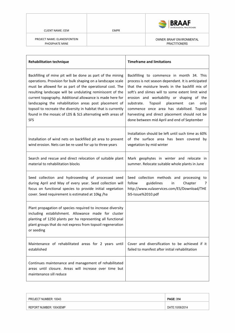
CLIENT NAME: EEM EMPR
PROJECT NAME: ELANDSFONTEIN
PHOSPHATE MINE
OWNER: BRAAF ENVIRONMENTAL
PRACTITIONERS
PROJECT NUMBER: 10043 PAGE: 314
REPORT NUMBER: 10043EMP DATE:10/06/2014
Rehabilitation technique Timeframe and limitations
Backfilling of mine pit will be done as part of the mining
operations. Provision for bulk shaping on a landscape scale
must be allowed for as part of the operational cost. The
resulting landscape will be undulating reminiscent of the
current topography. Additional allowance is made here for
landscaping the rehabilitation areas post placement of
topsoil to recreate the diversity in habitat that is currently
found in the mosaic of LDS & SLS alternating with areas of
SFS
Backfilling to commence in month 34. This
process is not season dependant. It is anticipated
that the moisture levels in the backfill mix of
soft's and slimes will to some extent limit wind
erosion and workability or shaping of the
substrate. Topsoil placement can only
commence once area has stabilised. Topsoil
harvesting and direct placement should not be
done between mid April and end of September
Installation of wind nets on backfilled pit area to prevent
wind erosion. Nets can be re-used for up to three years
Installation should be left until such time as 60%
of the surface area has been covered by
vegetation by mid winter
Search and rescue and direct relocation of suitable plant
material to rehabilitation blocks
Mark geophytes in winter and relocate in
summer. Relocate suitable whole plants in June
Seed collection and hydroseeding of processed seed
during April and May of every year. Seed collection will
focus on functional species to provide initial vegetation
cover. Seed requirement is estimated at 10kg /ha
Seed collection methods and processing to
follow guidelines in Chapter 7
http://www.vulaservices.com/ES/Download/THE
SIS-Issue%2010.pdf
Plant propagation of species required to increase diversity
including establishment. Allowance made for cluster
planting of 1250 plants per ha representing all functional
plant groups that do not express from topsoil regeneration
or seeding
Maintenance of rehabilitated areas for 2 years until
established
Cover and diversification to be achieved if it
failed to manifest after initial rehabilitation
Continues maintenance and management of rehabilitated
areas until closure. Areas will increase over time but
maintenance sill reduce
CLIENT NAME: EEM EMPR
PROJECT NAME: ELANDSFONTEIN
PHOSPHATE MINE
OWNER: BRAAF ENVIRONMENTAL
PRACTITIONERS
PROJECT NUMBER: 10043 PAGE: 315
REPORT NUMBER: 10043EMP DATE:10/06/2014
Monitoring, evaluation and reporting
Monitoring methods to measure cover, species
richness and landscape functionality
9.6.7. MAINTENANCE
Maintenance forms a vital part of the successful rehabilitation of post mining environments. The aim of the
maintenance is to ensure that localised problems with die back and erosion are addressed early on to prevent
large-scale degradation. The proposed management strategy is based on adaptive principals that will be
informed by formal monitoring and evaluation as well as continuous informal observations throughout.
Provision has been made for the introduction of specific species and functional groups that may not developed
form the topsoil or basic seeding.
9.6.8. MONITORING AND EVALUATION
Detail methods for the monitoring en evaluation protocols will be developed and it is proposed to use a
combination of techniques that include the following:
Establishment of baseline data relating to species composition and cover of all four vegetation types
Development of soil moisture profiles typical of all four vegetation types
Comparative evaluation of restored areas for a period of 5 years to assess species composition as well
as soil moisture profiles
Long term monitoring of soil moisture profiles upstream of the dewatered pit and downstream of the
recharge trenches
Long term monitoring of the species composition upstream of the dewatered pit and downstream of
the recharge trenches
Information obtained from monitoring must be fed back into the fine scale rehabilitation planning in order to
adjust for deficiencies or improvement of cost effectiveness of strategies employed.
9.6.9. ALIEN VEGETATION MANAGEMENT
The purpose of early commencement with the implementation of an alien vegetation control problem is to
reduce long term cost and to reduce the source of potential infestation of rehabilitation areas.
The techniques and approaches for the control of woody alien vegetation are well established and is widely
used in the surrounding area. Cutting of mature trees and chemical stump treatment (Acacia cyclops and
Eucalyptus spp) is the primary practice. The removal of usable biomass is recommended to reduce the fuel
loading. Follow up selective application of registered herbicides is the most cost effective method of
controlling seedlings and this would need to be done for several years until the surrounding vegetation has
sufficiently recovered to suppress large scale germination from the soil seed bank.
CLIENT NAME: EEM EMPR
PROJECT NAME: ELANDSFONTEIN
PHOSPHATE MINE
OWNER: BRAAF ENVIRONMENTAL
PRACTITIONERS
PROJECT NUMBER: 10043 PAGE: 316
REPORT NUMBER: 10043EMP DATE:10/06/2014
Particular attention should be paid to areas that were exposed to fire as large scale germination can be
expected from areas with large alien seed banks. Under these conditions, early initial and follow up control
using herbicides is the best practice.
9.6.10. VEGETATION MANAGEMENT OF BALANCE OF PROPERTY
The development of detailed management plan for the property is proposed and this will address the
provisions for alien vegetation control, managed ecological burns and the rehabilitation of degraded areas.
The implementation of the alien vegetation control and management of ecological burns are provided for in
Closure costing.
9.6.11. FIRE PREVENTION AND MANAGEMENT
Fire is an important ecological driver in the fynbos biome but can be destructive to indigenous vegetation if
not done property. In order to ensure that the existing plant communities flourish on the unaffected portions
of the site and to aid with rehabilitation a fire and alien invasive management plan will be implemented.
Fire and alien invasive plant management are two of the most important issues on the greater site. Alien
vegetation is relatively easy to deal with, and requires only a well structured plan and the will and money to
implement it. The alien density is fairly high in the main patches where it occurs (dune area), and because it
covers up to 500ha of the greater site substantial budget will be required in order to control this into the
future (there will be ongoing but gradually diminishing costs), and it is thus suggested that the applicants
factor this into their financial plans upfront. A management budget capitalised to at least R4m is likely to be
necessary, as initial clearing costs are in the order of R2000 – R8000/ha. The mining area itself will also be a
very likely site for alien plant invasion (soil disturbance being a primary factor in determining alien invasion
likelihood) and a significant budget will be needed to manage this in both the operational and rehabilitation
phases of the project.
As fire is a much more difficult issue to deal with, but cannot simply be ignored, as it is an essential ecological
element, but is difficult to control and potentially dangerous in terms of infrastructure.
Due to the location of the study area and the proposed after use of the land as an extension of the West Coast
National Park complex, it is proposed to integrate the fire management of the area with that the strategy
followed by the WCNP. Detail planning would be required to integrate the approach in collaboration with
SANParks. Provisions have been made in the cost estimates to developed and implement the controlled burn
strategy.
9.6.12. INFRASTRUCTURE REHABILITATION
During the decommissioning phase all non-operational structures and associated infrastructure will
be demolished and removed from site.
All equipment not being utilised will be removed from site.
CLIENT NAME: EEM EMPR
PROJECT NAME: ELANDSFONTEIN
PHOSPHATE MINE
OWNER: BRAAF ENVIRONMENTAL
PRACTITIONERS
PROJECT NUMBER: 10043 PAGE: 317
REPORT NUMBER: 10043EMP DATE:10/06/2014
All concrete foundations and contaminated underlying soil will be handled in terms of the closure
plan.
On the removal of all buildings and related infrastructures, the surface will be rehabilitated to a pre-
determined standard. A rehabilitation programme, as part of the closure plan, is to be implemented
to ensure that the area is completely rehabilitated.
The stormwater dam and all other water management structures will be rehabilitated in accordance
with the water management strategy to be developed. The fence and access gate around the dam will
remain and be adequately signposted
The access roads will remain open to allow access for maintenance and inspections. Any roads that do
not require usage will be ripped and vegetated.
All the fences and access gates will remain and be adequately signposted.
The Mine Closure Plan will have to identify decommissioning strategies for the following mine infrastructure
components:
Softs Stockpile
Open Pit
Stormwater Dam
Concentrator Plant
Workshops / Offices / Stores / Salvage Yard
Conveyor Belts
Fencing
Gravel Roads
Rehabilitation of Open Surfaces
CLIENT NAME: EEM EMPR
PROJECT NAME: ELANDSFONTEIN
PHOSPHATE MINE
OWNER: BRAAF ENVIRONMENTAL
PRACTITIONERS
PROJECT NUMBER: 10043 PAGE: 318
REPORT NUMBER: 10043EMP DATE:2/09/2014
10. IDENTIFIED KNOWLEDGE GAPS
One assumption made during the compilation of the Elandsfontein EIA/EMP Report, was that the project data,
mining related data and data used for the project specific drawings (including design, layout and height of the
structures) supplied by EEM, are assumed to be up to date and accurate and will remain unchanged for the
duration of the EIA/EMP Phase. In addition, due to stakeholders responses to some of the alternatives
identified during the scoping phase, changes have been made to the project description, specifically the
preferred option which now excludes the Inland Port Facility and the concentrate pipeline.
CLIENT NAME: EEM EMPR
PROJECT NAME: ELANDSFONTEIN
PHOSPHATE MINE
OWNER: BRAAF ENVIRONMENTAL
PRACTITIONERS
PROJECT NUMBER: 10043 PAGE: 319
REPORT NUMBER: 10043EMP DATE:2/09/2014
11. FINANCIAL PROVISION
11.1. CLOSURE COSTS
This section was compiled in terms of Section 39 (4) (a) (ii) of the Act, read together with Section 41(1). Refer
to Appendix A and Figure 4-8 showing the infrastructure and the mining layout respectively. The mitigations,
monitoring and reporting of the impacts have already been discussed in this document.
11.2. CALCULATION
The closure costs for Elandsfontein Mine were assessed using the “Guideline Document for the Evaluation of
the Closure-related Financial Provision Provided by a Mine – April 2004”). A rules-based approach was used
and related back to the surface area of the various components included in the closure costs. According to this
calculation an amount of R54 million (excluding VAT) needs to be provided as guarantee.
11.3. CONFIRMATION OF THE AMOUNT THAT WILL BE PROVIDED SHOULD THE RIGHT
BE GRANTED
Should the right be granted the necessary guarantees will be provided for the amount of R 54 753 799.71 (excl.
VAT) as calculated below. This closure liability will be reviewed and appropriately updated during the annual
review of mine closure costs for EEM.
11.4. THE METHOD OF PROVIDING FINANCIAL PROVISION CONTEMPLATED IN
REGULATION 53
The projected financial provision quantum will be provided as per regulation 53 requirements once the mining
right has been granted.
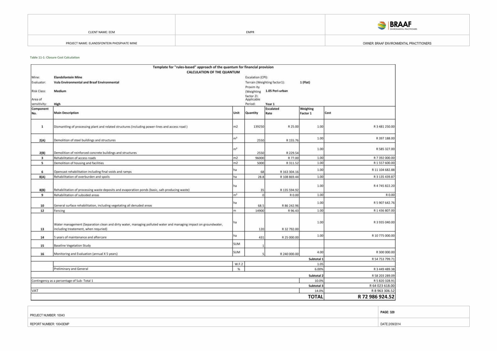
CLIENT NAME: EEM EMPR
PROJECT NAME: ELANDSFONTEIN PHOSPHATE MINE
OWNER: BRAAF ENVIRONMENTAL PRACTITIONERS
PROJECT NUMBER: 10043 PAGE: 320
REPORT NUMBER: 10043EMP DATE:2/09/2014
Table 11-1: Closure Cost Calculation
CLIENT NAME: EEM EMPR
PROJECT NAME: ELANDSFONTEIN
PHOSPHATE MINE
OWNER: BRAAF ENVIRONMENTAL
PRACTITIONERS
PROJECT NUMBER: 10043 PAGE: 321
REPORT NUMBER: 10043EMP DATE:2/09/2014
12. UNDERTAKING TO COMPLY WITH THE PROVISION OF THE ACT
I ___________________________________ the undersigned and duly authorised by Elandsfontein Exploration
and Mining (Pty) Ltd hereby undertake to give effect to every undertaking contained in Section 11 of this
document, and accept full responsibility therefore.
Signed at on this ______ day of .
Witnesses:
1. 2.
Signature Signature
Approved
Approved in terms of the provisions of the Minerals and Petroleum Resources Development Act (Act No. 28 of
2002) (MPRDA).
Signed at on this ______ day of .
Director
Region: ______________________________________________________________
CLIENT NAME: EEM EMPR
PROJECT NAME: ELANDSFONTEIN
PHOSPHATE MINE
OWNER: BRAAF ENVIRONMENTAL
PRACTITIONERS
PROJECT NUMBER: 10043 PAGE: 322
REPORT NUMBER: 10043EMP DATE:2/09/2014
13. CONCLUSION
Braaf Environmental Practitioners has undertaken an EIA/EMP for the proposed Elandsfontein Phosphate Mine
Project in accordance with the requirements of the MPRDA. To date this has provided for a public engagement
process as required in terms of the MPRDA.
Extensive specialist input has been sought for all key environmental aspects.
To date, there are no serious flaws that have been identified for the proposed Project. However, certain
impacts require careful mitigation and monitoring. The most significant of these are:
Groundwater contamination;
Archaeological /Paleontological impacts;
Biodiversity impacts in terms of the location of infrastructures on and within sensitive habitats;
Air quality impacts during construction phase; and
Heritage impact in terms of archaeological material and fossils. .
Some impacts, such Softs Stockpile and processing plant require mitigation to be built into the planning and
design.
An environmental management plan has been developed as part of this EIA-EMP to ensure the mitigation of
these impacts as well as others. It is anticipated that it will be possible to successfully mitigate the majority of
the environmental impacts to acceptable levels and the implementation will be monitored and audited to
determine its effectiveness.
EEM should, continue to examine its existing management measures for their entire operations and should put
initiatives in place to reduce its contribution to the environmental conditions of the Elandsfontein Farm. The
investigation by specialists into the potential impact of the mine on the existing environment has been
avoided, mitigated, and managed where possible. However, certain impacts are unavoidable, (removal of
indigenous vegetation, etc). For this reason it is imperative that the compensation approach be followed in
conjunction with avoidance and abatement. This will entail a Biodiversity Offset Process, in which EEM is to
purchase/donate land units with similar ecosystem services/status as the areas to be impacted on. It is likely
that the existing mine area as well as the areas that the mine will be offset against will be donated to SANParks
allowing the extension of the WCNP (which will include portions of the mine area, after rehabilitation).
Currently, EEM has drafted a heritage agreement with SANParks and Heritage Western Cape whereby the
fossil area on Portion 2 of the Farm 349 (Elandsfontein) will be donated to SANParks for conservation of the
heritage resource.
CLIENT NAME: EEM EMPR
PROJECT NAME: ELANDSFONTEIN
PHOSPHATE MINE
OWNER: BRAAF ENVIRONMENTAL
PRACTITIONERS
PROJECT NUMBER: 10043 PAGE: 323
REPORT NUMBER: 10043EMP DATE:2/09/2014
14. REFERENCES
i. BGIS (2010). Biodiversity GIS Online Mapping Tool. South African National Biodiversity
Institute (SANBI). Available online: http://bgis.sanbi.org, accessed April 2013.
ii. EEM Social and Labour Plan. 2013.
iii. Hansen, K. 2014. Visual Scoping Assessment for the Elandsfontein Phosphate Mining Right
Application
iv. Hattingh, J. 2013. The economic and strategic significance of the Elandsfontein phosphate deposit
and its ranking in the South African phosphate fraternity.
v. Helme, N. 2013. Botanical Scoping Study for the Elandsfontein Phosphate Mine. vi. Kaplan, J.
2013. Heritage Scoping Study for the Elandsfontein Phosphate Mine.
vii. GEOSS Report No. 2014/02-08. Geohydrological Assessment - Scoping Report - Elandsfontein, West
Coast.
viii. MEGA (Morris Environmental & Groundwater Alliances) (2013). Environmental Management
Framework for the Greater Saldanha Bay Area: Draft Environmental Management Framework. February
2013.
ix. National Planning Commission (2011). National Development Plan, November 2011.Available
online:http://www.npconline.co.za/medialib/downloads/home/NPC%20National%20Development%20Plan
%20Vision%202030%20-lo-res.pdf, accessed February 2013.
x. SBM (2013). Saldanha Bay Municipality Integrated Development Plan 2012-2017 Revision 1 - 2013.
Available online: http://www.saldanhabay.co.za/pages/IDP/IDP_Final_1st_Review_2013_2014.pdf,
accessed December 2013.
xi. SBM (2006). Saldanha Bay Municipality Integrated Development Plan, 2006- 2011. Saldanha
Bay Municipality (SBM). Available online:
http://www.saldanhabay.co.za/pages/IDP/idp.html#, accessed December 2013.
xii. West Coast District Municipality Integrated Development Plan (WCDM IDP 2010 – 2014);
xiii. The Social and Labour Plan compiled for the Mining Right Application (2013).
xiv. Urban Dynamics Western Cape and DeVilliers Brownlie Associates, 2011. Saldanha Bay
Municipality, Municipal Spatial Development Framework Final Document. Available online:
http://www.saldanhabay.co.za/pages/spatial- planning/SDF/plan_sdf.html#, accessed April 2013.