Embed Size (px)
Citation preview
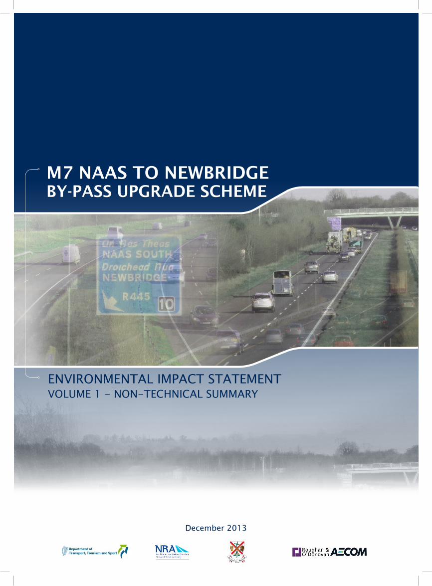
ENVIRONMENTAL IMPACT STATEMENTVOLUME 1 - NON-TECHNICAL SUMMARY
December 2013
Roughan & O’Donovan – AECOM Alliance Kildare County Council Consulting Engineers M7 Naas to Newbridge By-Pass Upgrade Scheme
Ref: 11.204.24 December 2013 Page i
M7 Naas to Newbridge By-Pass Upgrade Scheme
Non-Technical Summary of the Environmental Impact Statement
Table of Contents
Part I Background Information and General Description
1.0 INTRODUCTION ............................................................................................. II
2.0 RELATED SCHEMES ..................................................................................... II
3.0 PLANNING AND POLICY CONTEXT ............................................................. II
4.0 NEED FOR THE PROPOSED ROAD DEVELOPMENT ................................ IV
5.0 DESCRIPTION OF THE PROPOSED ROAD DEVELOPMENT .................... IV
6.0 ALTERNATIVES CONSIDERED ................................................................... VI
7.0 TRAFFIC ANALYSIS ................................................................................... VIII
Part II Likely Significant Environmental Effects & Proposed Mitigation Measures
8.0 ECOLOGY ....................................................................................................... X
9.0 HYDROGEOLOGY ......................................................................................... XI
10.0 HYDROLOGY................................................................................................ XII
11.0 SOILS AND GEOLOGY ................................................................................ XII
12.0 MATERIAL ASSETS .................................................................................... XIII
13.0 HUMAN BEINGS .......................................................................................... XV
14.0 ARCHAEOLOGY, ARCHITECTURE AND CULTURAL HERITAGE .......... XVI
15.0 LANDSCAPE AND VISUAL IMPACT ........................................................ XVII
16.0 NOISE AND VIBRATION .......................................................................... XVIII
17.0 AIR QUALITY AND CLIMATE .................................................................... XIX
18.0 RESOURCE AND WASTE MANAGEMENT ............................................... XIX
19.0 ASSESSMENT OF POTENTIAL CUMULATIVE IMPACTS ........................ XX
20.0 INTERRELATIONSHIPS AND INTERACTIONS ......................................... XX
21.0 MITIGATION MEASURES ........................................................................... XX
22.0 WHAT HAPPENS NEXT ............................................................................. XXI
Roughan & O’Donovan – AECOM Alliance Kildare County Council Consulting Engineers M7 Naas to Newbridge By-Pass Upgrade Scheme
Ref: 11.204.24 December 2013 Page ii
Part I Background Information and General Description
1.0 INTRODUCTION This Environmental Impact Statement (EIS) is a statement of the likely significant effects on the environment of the proposed M7 Naas to Newbridge Bypass Upgrade Scheme. The scheme proposes the widening of the M7 between Great Connell and Johnstown in County Kildare and the replacement of the Newhall Interchange with an enhanced interchange with the R445. A location plan for the proposed scheme is presented in Figure 1.1. The EIS, as presented, has been prepared by Roughan & O’Donovan – AECOM Alliance Consulting Engineers and a team of specialist sub-consultants in conjunction with Kildare National Roads Office. The EIS is presented in three volumes; the standalone Non-Technical Summary is Volume 1; this Volume, Volume 2, contains the main text including the Non-Technical Summary, while Volume 3 contains the associated Figures.
2.0 RELATED SCHEMES Kildare County Council, in conjunction with Osberstown Development Ltd, are currently progressing the planning and design of the proposed M7 Osberstown Interchange and R407 Sallins Bypass scheme, with support from ARUP Consulting Engineers. That scheme comprises the construction of a grade separated junction on the M7 at Osberstown, a new regional road comprising the Sallins Bypass and associated link roads. As the M7 Osberstown Interchange would be located between the Maudlins and Newhall Interchanges there is a clear interface between the two proposed schemes. This interface has been fully considered by both design teams and no amendment to the design of the proposed M7 Naas to Newbridge Bypass Upgrade Scheme is required to accommodate the proposed Osberstown Interchange. Potential environmental interactions between the two schemes have been addressed throughout the compilation of this EIS and are addressed and reviewed in Chapter 18 of EIS Volume 2 ‘Main Text’ - ‘Assessment of Potential Cumulative Impacts.’
3.0 PLANNING AND POLICY CONTEXT The Cork – Dublin – Belfast motorway is part of one of nine trans-European corridors, which will act as a backbone for transportation in Europe’s single market. The core network is to be completed by 2030. The national motorway system is the primary conduit for transportation of goods and services to large indigenous and foreign markets and facilitates the movement of goods, services and labour between national gateways and major employment centres. Motorways are very important public transport corridors for public bus and coach services.
The M7 motorway, from its interchange with the M9 and extending from there towards the M50 in Dublin is one of the most important and busiest motorway routes in Ireland.
Roughan & O’Donovan – AECOM Alliance Kildare County Council Consulting Engineers M7 Naas to Newbridge By-Pass Upgrade Scheme
Ref: 11.204.24 December 2013 Page iii
The proposed scheme has been designed as part fulfilment of the delivery of strategic motorway improvement infrastructure identified in EU, national, regional and local planning strategies and policies, and in government initiatives such as Transport 21 and Smarter Travel. The need for the proposed scheme has been identified in the following national, regional and local policy documents:
The National Spatial Strategy 2002 - 2020;
The National Development Plan 2007-2013;
Infrastructure and Capital Investment 2012-16: Medium Term Exchequer Framework;
Smarter Travel, 2009;
Department of Transport — Statement of Strategy (2011 to 20 14) (2011);
Spatial Planning and National Road – Guidelines for Planning Authorities 2012;
The Regional Planning Guidelines for the Greater Dublin Area 2010 – 2020;
Greater Dublin Area Draft Transportation Strategy 2011 – 2030;
Draft Integrated Implementation Plan for the Greater Dublin Area 2013-2018 (2013);
Kildare County Development Plan 2011 – 2017;
Naas Town Development Plan 2011 – 2017. The current development plan for Kildare is the Kildare County Development Plan 2011 – 2017 (CDP). The CDP takes cognisance of the role of the national road network in the county stating “the national road network primarily serves long and middle distance traffic originating in or passing through the county. These routes have an important role to play in the economic development of the county.” An objective of the CDP is “to proceed with development of the third lane in each direction along the M7/N7 including improvements of interchanges as the need arises” (6.5.3 RP1). In conjunction with other future proposed infrastructure improvements, the proposed M7 Naas to Newbridge By-Pass Upgrade Scheme will provide: -
Relief to existing motorway congestion along the route;
A more balanced distribution of traffic movements between the regional and national road network on the M7; and
An improved connection from the motorway network to the existing and proposed employment areas in Naas, Newbridge and beyond.
Having regard to the above, the construction of the proposed M7 Improvement Scheme will be in accordance with Government policy, with National strategies, with the policies of the Regional Planning Guidelines for the Greater Dublin Area, the Kildare County Development Plan, and the Naas Town Development Plan and will be consistent with the proper planning and sustainable development of the area.
Roughan & O’Donovan – AECOM Alliance Kildare County Council Consulting Engineers M7 Naas to Newbridge By-Pass Upgrade Scheme
Ref: 11.204.24 December 2013 Page iv
4.0 NEED FOR THE PROPOSED ROAD DEVELOPMENT The Cork – Dublin – Belfast motorway is part of one of nine trans-European corridors, which will act as a backbone for transportation in Europe’s single market. The core network is to be completed by 2030. EU Directive 2008/96/EC on Road Infrastructure Safety Management provides new legal requirements for the safety management of the Trans-European Road Network (TERN). The Road Safety Authority – Road Safety Strategy 2013 – 2020; Engineering Measures, emphasises value for money road improvements that will enhance the safety of the road system as a whole, including national roads in the context of EU Directive 2008/96. The M7 motorway, from its interchange with the M8 (Cork and Limerick) and M9 (Waterford) and extending from there towards the M50 in Dublin is one of the most important and busiest motorway routes in Ireland. With the increase in capacity and traffic movement on other parts of the motorway system, the restrictions in capacity that are evident on the subject section of motorway indicate a justification for works to provide for an improvement of capacity in the interests of service, safety, economy and environmental pollution. The pressure of traffic northeast of the M7/M9 interchange causes congestion and remediation requires an upgrade of that section of motorway extending from Great Connell to Maudlins at Naas north. The congestion is due to a number of factors, particularly relating to road and interchange capacity. The congestion and safety issues highlighted at the M7 Newhall Interchange during the peak hours are significant and need addressing as conditions are likely to deteriorate further as traffic flow increases over time. The primary need for the scheme is to provide a road network link that can provide the required capacity to cater for the anticipated future year flows and to improve safety along this section of the M7. The most appropriate and sustainable solution to remedy this congestion and to improve safety is to widen this section of road within the existing footprint of the M7 and address the local capacity problems at the Newhall interchange. The benefits of the proposed scheme in terms of economy, safety, environment, accessibility and social inclusion and integration will be significantly positive and long-term.
5.0 DESCRIPTION OF THE PROPOSED ROAD DEVELOPMENT The section of the M7/N7 under consideration commences at Junction 11, Great Connell, where the M9 merges with the M7 and extends to Junction 8, Johnstown (refer to Figure 1.1). The proposed scheme involves widening the motorway from two lanes to three lanes between the merge of the M7 and M9 and the commencement of the dual three lane all purpose road at Junction 9 Maudlins.
Roughan & O’Donovan – AECOM Alliance Kildare County Council Consulting Engineers M7 Naas to Newbridge By-Pass Upgrade Scheme
Ref: 11.204.24 December 2013 Page v
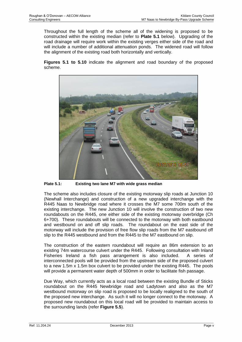
Throughout the full length of the scheme all of the widening is proposed to be constructed within the existing median (refer to Plate 5.1 below). Upgrading of the road drainage will require work within the existing verges either side of the road and will include a number of additional attenuation ponds. The widened road will follow the alignment of the existing road both horizontally and vertically. Figures 5.1 to 5.10 indicate the alignment and road boundary of the proposed scheme.
Plate 5.1: Existing two lane M7 with wide grass median
The scheme also includes closure of the existing motorway slip roads at Junction 10 (Newhall Interchange) and construction of a new upgraded interchange with the R445 Naas to Newbridge road where it crosses the M7 some 700m south of the existing interchange. The new Junction 10 will involve the construction of two new roundabouts on the R445, one either side of the existing motorway overbridge (Ch 6+700). These roundabouts will be connected to the motorway with both eastbound and westbound on and off slip roads. The roundabout on the east side of the motorway will include the provision of free flow slip roads from the M7 eastbound off slip to the R445 westbound and from the R445 to the M7 eastbound on slip. The construction of the eastern roundabout will require an 86m extension to an existing 74m watercourse culvert under the R445. Following consultation with Inland Fisheries Ireland a fish pass arrangement is also included. A series of interconnected pools will be provided from the upstream side of the proposed culvert to a new 1.5m x 1.5m box culvert to be provided under the existing R445. The pools will provide a permanent water depth of 500mm in order to facilitate fish passage. Due Way, which currently acts as a local road between the existing Bundle of Sticks roundabout on the R445 Newbridge road and Ladytown and also as the M7 westbound motorway on slip road is proposed to be locally realigned to the south of the proposed new interchange. As such it will no longer connect to the motorway. A proposed new roundabout on this local road will be provided to maintain access to the surrounding lands (refer Figure 5.5).
Roughan & O’Donovan – AECOM Alliance Kildare County Council Consulting Engineers M7 Naas to Newbridge By-Pass Upgrade Scheme
Ref: 11.204.24 December 2013 Page vi
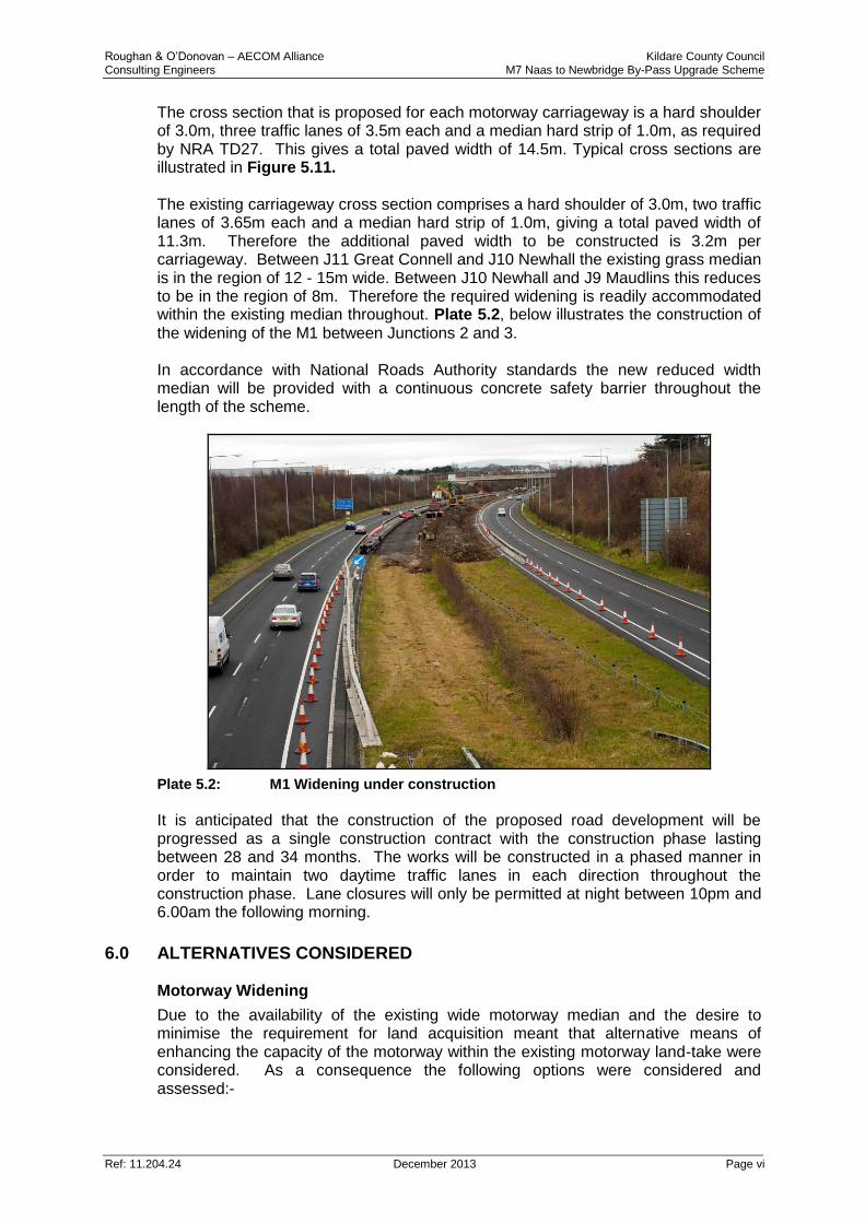
The cross section that is proposed for each motorway carriageway is a hard shoulder of 3.0m, three traffic lanes of 3.5m each and a median hard strip of 1.0m, as required by NRA TD27. This gives a total paved width of 14.5m. Typical cross sections are illustrated in Figure 5.11. The existing carriageway cross section comprises a hard shoulder of 3.0m, two traffic lanes of 3.65m each and a median hard strip of 1.0m, giving a total paved width of 11.3m. Therefore the additional paved width to be constructed is 3.2m per carriageway. Between J11 Great Connell and J10 Newhall the existing grass median is in the region of 12 - 15m wide. Between J10 Newhall and J9 Maudlins this reduces to be in the region of 8m. Therefore the required widening is readily accommodated within the existing median throughout. Plate 5.2, below illustrates the construction of the widening of the M1 between Junctions 2 and 3. In accordance with National Roads Authority standards the new reduced width median will be provided with a continuous concrete safety barrier throughout the length of the scheme.
Plate 5.2: M1 Widening under construction
It is anticipated that the construction of the proposed road development will be progressed as a single construction contract with the construction phase lasting between 28 and 34 months. The works will be constructed in a phased manner in order to maintain two daytime traffic lanes in each direction throughout the construction phase. Lane closures will only be permitted at night between 10pm and 6.00am the following morning.
6.0 ALTERNATIVES CONSIDERED Motorway Widening
Due to the availability of the existing wide motorway median and the desire to minimise the requirement for land acquisition meant that alternative means of enhancing the capacity of the motorway within the existing motorway land-take were considered. As a consequence the following options were considered and assessed:-
Roughan & O’Donovan – AECOM Alliance Kildare County Council Consulting Engineers M7 Naas to Newbridge By-Pass Upgrade Scheme
Ref: 11.204.24 December 2013 Page vii
Do Nothing Scenario;
Hard Shoulder Running;
Alternative Network Improvements; and
Construction of Additional Lane. The do nothing scenario has only negative impacts in terms of predicted congestion for all road users in the area. The hard shoulder running option requires the strengthening of the hard shoulder, widening into the median, provision of an additional traffic lane and significant additional long term inputs and costs with regard to the necessary electronic equipment and monitoring required. Construction of the Additional Lane was selected as the preferred option as it is possible to construct the additional lane within the very large median available and the provision of a widened carriageway best meets the future traffic needs of the M7. Upgrade of Junction 10
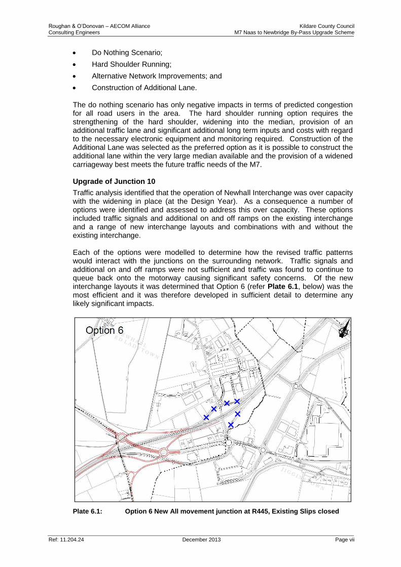
Traffic analysis identified that the operation of Newhall Interchange was over capacity with the widening in place (at the Design Year). As a consequence a number of options were identified and assessed to address this over capacity. These options included traffic signals and additional on and off ramps on the existing interchange and a range of new interchange layouts and combinations with and without the existing interchange. Each of the options were modelled to determine how the revised traffic patterns would interact with the junctions on the surrounding network. Traffic signals and additional on and off ramps were not sufficient and traffic was found to continue to queue back onto the motorway causing significant safety concerns. Of the new interchange layouts it was determined that Option 6 (refer Plate 6.1, below) was the most efficient and it was therefore developed in sufficient detail to determine any likely significant impacts.
Plate 6.1: Option 6 New All movement junction at R445, Existing Slips closed
Roughan & O’Donovan – AECOM Alliance Kildare County Council Consulting Engineers M7 Naas to Newbridge By-Pass Upgrade Scheme
Ref: 11.204.24 December 2013 Page viii
7.0 TRAFFIC ANALYSIS Traffic surveys and analysis were undertaken to assess the potential traffic impacts of the proposed M7 Naas to Newbridge By-Pass Upgrade Scheme. The additional capacity of the proposed scheme reduces delay on the M7 during the morning and evening Peak Hours. Time savings are gained during the morning Peak traffic in the east bound direction and in the west bound direction during the evening Peak. Opening Year (2015)
In summary, Annual Average Daily Traffic (AADT) on the M7 mainline increases by approximately 2% between the Base Year (2012) and scheme Opening Year (2015). Traffic flows on the M9 mainline increase by approximately 4% over this period. In the Do-Minimum scenario (scheme not in place) a small amount (~1%) of traffic avoids the M7 and reroutes to avoid the increased congestion along the M7 corridor. This traffic transfers back to the M7 with the opening of the proposed scheme as a result of the additional capacity it provides. In the Do-Something scenario (2015) (scheme in place) the total traffic using the four slips roads of the Newhall Interchange increases by approximately 7%. This is a result of traffic transferring from alternative routes as a result of the increased capacity of the Newhall Interchange and M7 mainline. At the Maudlins Interchange the total increase in traffic on the four slips roads in 2015 is approximately 3% between the Do-Minimum and Do-Something scenarios. Although it has been highlighted previously that there is congestion at the Maudlins Interchange at present, this congestion occurs on the westbound M7 mainline carriageway as a result of the lane drop from three lanes on the N7 to two lanes on the M7. The proposed continuation of the third lane as far as the M7/M9 split at Great Connell will address this issue. Therefore the 3% increase in traffic through the interchange in the Do-Something (2015) will be catered for within the existing capacity of the interchange. Design Year (2030)
In the Design Year (2030) traffic on the M7 increases by approximately 15 - 21% over the base year flows. There is an increase of approximately 17% over this period on the M9. As per the 2015 Do-Minimum (scheme not in place) scenario, a small amount (~4%) of traffic reroutes to avoid the increased congestion along the M7 corridor but transfers back to the M7 with the scheme in place. In the Do-Something (2030) scenario the total traffic using the four slips roads of the Newhall Interchange is approximately 8% greater than in the Do-Minimum scenario. At the Maudlins Interchange the total increase in traffic on the four slips roads is approximately 5% between the Do-Minimum and Do-Something scenarios. As previously highlighted, the existing congestion issue at the Maudlins Interchange will be address by the proposed continuation of the third lane as far as the M7/M9 split at Great Connell. Therefore the 5% increase in traffic through the interchange in the Do-Something (2030) scenario will be catered within the existing capacity of the interchange.
Roughan & O’Donovan – AECOM Alliance Kildare County Council Consulting Engineers M7 Naas to Newbridge By-Pass Upgrade Scheme
Ref: 11.204.24 December 2013 Page ix
In summary
The proposed scheme leads to a reduction in congestion on the M7 and reduction in travel times between the Johnstown Interchange and M7/M9 Interchanges. The relocation of the Newhall Interchange also reduces congestion and significantly improves the existing safety issues with traffic queuing on the off-ramps of the Interchange.
Roughan & O’Donovan – AECOM Alliance Kildare County Council Consulting Engineers M7 Naas to Newbridge By-Pass Upgrade Scheme
Ref: 11.204.24 December 2013 Page x
Part II Likely Significant Environmental Effects and Proposed
Ameliorative Measures
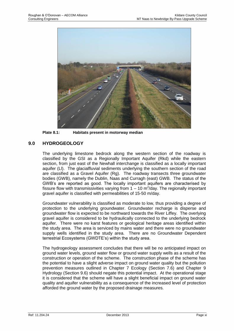
8.0 ECOLOGY There will be no direct impact on any site designated for nature conservation and the Habitats Directive Assessment Screening Report has concluded that there will be no likely significant effect on any Natura 2000 site. The Grand Canal proposed Natural Heritage Area (pNHA) is crossed by the motorway on an existing clear-span bridge at Osberstown (Chainage 11+160) and also runs adjacent to the motorway in the vicinity of Chainage 2+600 to 3+600. The scheme will have no impact on the nature conservation value of the canal. In addition to the canal there are a number of watercourses already culverted under the existing M7 which support stocks of trout and on which otter have been recorded. The existing attenuation pond to the south of the motorway at Osberstown (approximate chainage 10+500) was also recorded as being of ecological interest. The impact assessment has identified that the potential to cause deterioration in water quality during both construction and operation is the primary ecological concern. As a consequence water quality pollution prevention measures are recommended to ensure that there will be no impact on the canal and other watercourses crossed by the scheme. An existing watercourse, which is culverted under the R445, will be extended to allow for the construction of the new roundabout and will be diverted downstream. Downstream of the culvert, this watercourse possesses Brown Trout, Brook Lamprey and Freshwater Crayfish. These species will be salvaged under licence prior to construction and released downstream. A fish pass arrangement is also included in this culvert design. A series of interconnected pools will be provided from the upstream side of the proposed culvert to a new 1.5m x 1.5m box culvert to be provided under the existing R445. (refer Figure 5.5) The pools will provide a permanent water depth of 500mm in order to facilitate fish passage. The grassland and hedgerow habitats within the motorway median (refer Plate 8.1, below) and the immature woodland planting alongside the R445 which will be lost during construction do not possess any nature conservation value. The existing motorway fencing has a number of gaps through which Badger, Otter and other mammals could gain access to the motorway resulting in mortality. This fencing will be upgraded throughout the length of the scheme to reduce the risk of traffic related mortality.
Roughan & O’Donovan – AECOM Alliance Kildare County Council Consulting Engineers M7 Naas to Newbridge By-Pass Upgrade Scheme
Ref: 11.204.24 December 2013 Page xi
Plate 8.1: Habitats present in motorway median
9.0 HYDROGEOLOGY The underlying limestone bedrock along the western section of the roadway is classified by the GSI as a Regionally Important Aquifer (Rkd) while the eastern section, from just east of the Newhall interchange is classified as a locally important aquifer (Ll). The glacialfluvial sediments underlying the southern section of the road are classified as a Gravel Aquifer (Rg). The roadway transects three groundwater bodies (GWB), namely the Dublin, Naas and Curragh (east) GWB. The status of the GWB’s are reported as good. The locally important aquifers are characterised by fissure flow with transmissivities varying from 1 – 10 m2/day. The regionally important gravel aquifer is classified with permeabilities of 15-50 m/day. Groundwater vulnerability is classified as moderate to low, thus providing a degree of protection to the underlying groundwater. Groundwater recharge is disperse and groundwater flow is expected to be northward towards the River Liffey. The overlying gravel aquifer is considered to be hydraulically connected to the underlying bedrock aquifer. There were no karst features or geological heritage areas identified within the study area. The area is serviced by mains water and there were no groundwater supply wells identified in the study area. There are no Groundwater Dependent terrestrial Ecosystems (GWDTE’s) within the study area. The hydrogeology assessment concludes that there will be no anticipated impact on ground water levels, ground water flow or ground water supply wells as a result of the construction or operation of the scheme. The construction phase of the scheme has the potential to have a slight adverse impact on ground water quality but the pollution prevention measures outlined in Chapter 7 Ecology (Section 7.6) and Chapter 9 Hydrology (Section 9.6) should negate this potential impact. At the operational stage it is considered that the scheme will have a slight beneficial impact on ground water quality and aquifer vulnerability as a consequence of the increased level of protection afforded the ground water by the proposed drainage measures.
Roughan & O’Donovan – AECOM Alliance Kildare County Council Consulting Engineers M7 Naas to Newbridge By-Pass Upgrade Scheme
Ref: 11.204.24 December 2013 Page xii
10.0 HYDROLOGY The approach to the drainage design has been to assess the effects of the increased pavement areas on the road run-off and then design the new road drainage system to discharge to the existing outfalls and at the same rates as currently exists. At four of the fourteen existing outfalls there is a history of flooding. New attenuation ponds are proposed at these locations to reduce the existing discharge rate to Greenfield runoff rates. In the absence of mitigation measures, there is a moderate risk of pollution, primarily silt, entering watercourses and impacting water quality during the construction phase. Mitigation measures, including the requirement for containment of suspended solids on site, are included to minimise and reduce this risk. The principles of SuDS have been applied to the operational drainage design to improve the quality of runoff prior to discharge. In the verges where filter drains are used for road drainage, these will prevent the discharge of sediment and suspended solids from the road to the watercourse. In the median where linear drainage channels are used, the inspection chambers will contain silt traps to collect the sediment. Water quality improvement will be provided through the provision of oil and petrol interceptors; these interceptors will be Class 1 bypass oil and petrol separators. In addition to the SuDS measures and ponds provided at four of the outfalls, flow restricting devices will be provided upstream of the inlet to the remaining ten receiving waterbodies in order to restrict the outlet flows to that of the existing motorway drainage system. Oversized pipes will be provided in the verges to provide storage to the attenuated flow. This removes the risk of downstream flooding occurring as a result of the scheme. The existing channel upstream of the culvert to be extended under the R445 will be locally improved to ensure that the likely increase in afflux associated with the culvert extension is accommodated within the channel. A separate fish pass is also provided to permit fish passage to the section of watercourse currently cut off by the existing culvert and sluice gate arrangement. It is concluded that the scheme will have a beneficial impact on the local hydrology due to the reduced likelihood of a pollution event occurring as a result of the measures detailed above.
11.0 SOILS AND GEOLOGY The underlying bedrock along the proposed scheme is made up of Lower Carboniferous limestones. These are overlain by glacial tills and glaciofluvial sands & gravels. Depth to bedrock typically ranges from 5 – 10 m. There were no karst or geological heritage areas identified in the study area. Bedrock and soil deposits are not considered to be significant in regard to economic or mining heritage. Site investigation works indicated that suitable sub-grade material underlies the existing roadway and as such the extent of excavation works and fill material required are greatly reduced, thus minimising any potential impacts. Where possible existing material will be recycled and re-used on site thus reducing the use of aggregate resources and reducing the impact on local quarry and landfill resources. The potential impacts on the underlying soils and geology considered, as part of the
Roughan & O’Donovan – AECOM Alliance Kildare County Council Consulting Engineers M7 Naas to Newbridge By-Pass Upgrade Scheme
Ref: 11.204.24 December 2013 Page xiii
construction phase, are the loss of fertile soils, compaction of underlying soils/bedrock, importation of material and unsuitable sub-material are considered to imperceptible. There is not considered to be any impacts as a result of the operational phase of the roadway. Mitigation measures include for the proper management of materials when they arise in terms of the waste management regulations and the waste management plan.
12.0 MATERIAL ASSETS M7 Widening
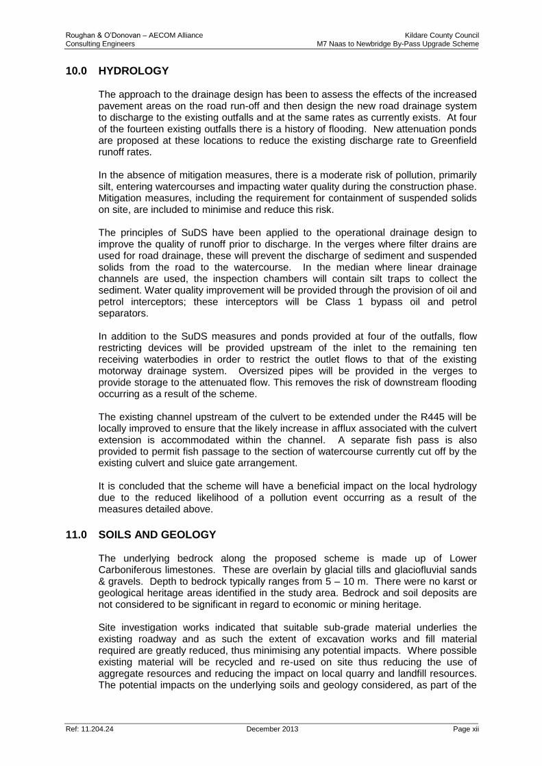
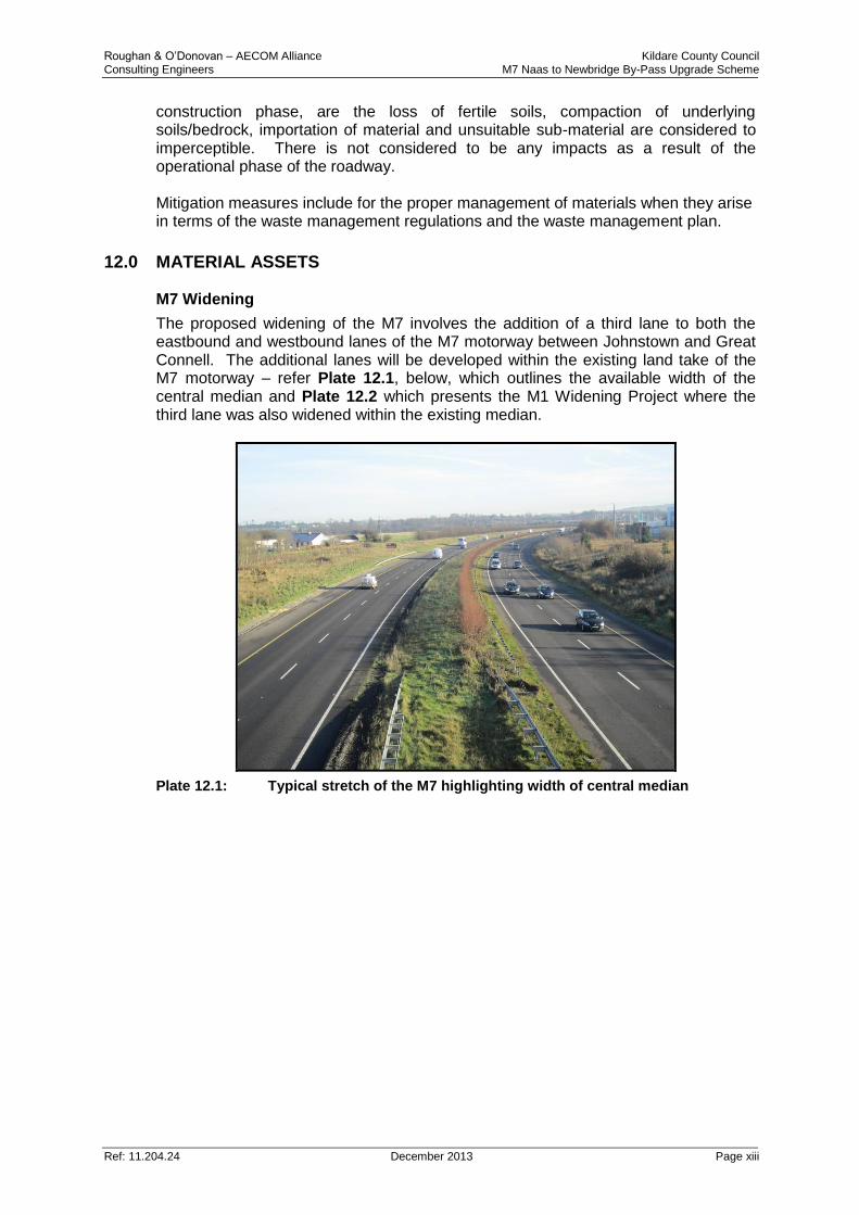
The proposed widening of the M7 involves the addition of a third lane to both the eastbound and westbound lanes of the M7 motorway between Johnstown and Great Connell. The additional lanes will be developed within the existing land take of the M7 motorway – refer Plate 12.1, below, which outlines the available width of the central median and Plate 12.2 which presents the M1 Widening Project where the third lane was also widened within the existing median.
Plate 12.1: Typical stretch of the M7 highlighting width of central median
Roughan & O’Donovan – AECOM Alliance Kildare County Council Consulting Engineers M7 Naas to Newbridge By-Pass Upgrade Scheme
Ref: 11.204.24 December 2013 Page xiv
Plate 12.2: M1 Widening project under construction
As no additional lands beyond the existing road land take will be required for the widening it is concluded that there will be no impact on Material Assets as a consequence of the widening. Newhall Interchange and Attenuation Ponds
Agricultural Property
The proposed Newhall Interchange and the additional attenuation ponds will directly affect 7 agricultural properties and require a total of 9.6ha of agricultural land. There are no impacts to farm buildings/facilities. The magnitude of impact on farm holdings ranges from Low on three farms to Medium on five farms. The significance of impact ranges from Slight on three farms to Moderate on five farms. For all of the farms with a Moderate significance of impact the farm enterprise can be continued as before but will require increased management. Mitigation measures including restoration of access, maintenance of drainage and permanent fencing are recommended to alleviate these impacts. Non Agricultural Property
There are three non-agricultural properties impacted effecting a total area of 0.43ha On all of these properties, the continued use of the properties will be possible. On one property the proposed scheme will involve a reduction in the property area and
Roughan & O’Donovan – AECOM Alliance Kildare County Council Consulting Engineers M7 Naas to Newbridge By-Pass Upgrade Scheme
Ref: 11.204.24 December 2013 Page xv
an impact on the commercial access and property boundary due to the proposed junction for the realigned Rathasker local road. On a second property there is a reduction in the property area and impact on property boundary due to the proposed Newhall interchange. On the third property there is a slight reduction to the area of the property. There is no impact on the existing property boundary. Mitigation measures such as the replacement of boundary walls on a like for like basis are recommended to alleviate these impacts.
13.0 HUMAN BEINGS The Traffic Analysis confirms that when operational the widening of the motorway from two to three lanes will reduce congestion and delay on the M7 during the morning and evening peak hours. It also identifies that traffic which currently diverts from the M7 into and around Naas in order to avoid the congestion on the motorway will actually reroute back to the M7 with the opening of the third lane, thus reducing congestion within Naas and on the local roads. Therefore, when operational more efficient running of the M7 will have positive economic benefits, for all the industrial, retail and business parks and associated enterprises located in the vicinity of the existing M7 Naas By-pass Interchanges. The more efficient operation of the M7 will also enhance the amenity felt by users of the M7 and by the local communities. Effective Traffic Management will minimise any disruption which occurs during the construction period. During construction, phasing and a traffic management system will be put in place and two carriageway lanes will be remain operational throughout (where required lane closures will only be permitted at night between 10pm and 6.00am the following morning). There will be a reduced speed limit along each length of active works and therefore some congestion and increase in journey times will occur during the morning and evening peak hours. However this will be temporary in nature and with effective traffic management in place it is considered that this will have no negative impact on the local economy or the operation of the adjacent retail and business parks. The potential for the construction of the new roundabouts and slip roads for the proposed upgrade of the Newhall Interchange to cause congestion has been recognised and incorporated into the construction phasing. This phasing ensures that the existing interchange is retained operational until the new interchange is completed and open. Proven traffic management (single lane contraflow) will be applied to the works on the R445 to ensure significant congestion does not occur during construction. With regard to the potential impact of construction traffic on journey times it is noted that the average number of truck movements is 292 per day, or 443 truck movements during the most intensive period of construction (during the first 12 months). This amounts to a 0.1% increase in the overall traffic levels on the motorway. This level of increased traffic will have no impact. With regard to potential impact on the regional and local road network, Chapter 4 confirms that there are a number of existing local quarries and landfill sites with access to the motorway on the existing regional road network. It is also noted that access to the works will be via the existing motorway interchanges and the proposed interchange only. It is considered that a maximum of 443 truck movements importing
Roughan & O’Donovan – AECOM Alliance Kildare County Council Consulting Engineers M7 Naas to Newbridge By-Pass Upgrade Scheme
Ref: 11.204.24 December 2013 Page xvi
and exporting material to and from the construction site split over a number of different routes will have no perceptible impact on journey times or residential amenity on the regional or local road network.
14.0 ARCHAEOLOGY, ARCHITECTURE AND CULTURAL HERITAGE There are no Recorded Monuments and Places (RMPs) located within the footprint of the proposed development area; however a total of eight individual or groups of sites are known within c. 500m. The nearest of these is a ringfort (RMP KD019-035) located immediately east of the M7 in Ladytown (chainage 5+950). This site comprises of a large, heavily overgrown enclosure which cannot currently be viewed from the road due to dense vegetation on the eastern verge of the road. Field inspection failed to identify any sites or features of archaeological significance; however there is the potential for burnt mound activity at Newhall and Jigginstown. Aerial images (Google Earth 2003) of the proposed attenuation site at Jigginstown and the southern section of the Newhall Interchange show possible burnt mound spreads in the ploughed fields. However, these may represent natural variations in the ploughed soil. The built heritage within this area is typified by the demesne landscapes of large country manors. Seven demesnes are highlighted within 500m of the current M7 footprint including Palmerstown, Kerdiffstown, Roseborough, Osberstown, Oldtown, Rose Cottage and Hillsborough. The current M7 truncates the original entranceways of three of these demesnes located on the northern side of Johnstown Village. A total of eight structures are recorded as Protected Structures within 500m of the proposed development area. Of these, seven are also recorded within the National Inventory of Architectural Heritage (NIAH) survey and one as a RMP (Record of Monuments and Places) - a standing stone (RPS B19-15/ RMP KD019-059). The nearest Protected Structure to the proposed development is the former hotel (RPS B19-37) located circa 30m south in Johnstown village. Osberstown House (RPS B19-14) is located c. 300m north of the M7. The landscape slopes south to the motorway providing a potential view of the manor house. Vegetation and trees planted along the northern verge of the road currently block any inter-visibility during summer and partially block inter-visibility during the winter. A total of 21 buildings or structures are recorded in the NIAH survey within 500m of proposed development area. These are all clustered in the northern tip of the scheme within proximity to Johnstown. Of these 21 structures the three nearest the proposed scheme comprise of the demesne entrances for Palmerstown, Kerdiffstown and Roseborough. Mitigation in the form of replacement planting is recommended to alleviate any potential visual impact on those monuments which are in close proximity to the M7. Archaeological testing will be undertaken within the previously undisturbed greenfield in the footprint of the proposed attenuation ponds and Newhall Interchange, to investigate the potential for archaeological remains such as burnt mound activity. The testing assessment will also include the edge of the former railway track, which borders the Osberstown attenuation area.
Roughan & O’Donovan – AECOM Alliance Kildare County Council Consulting Engineers M7 Naas to Newbridge By-Pass Upgrade Scheme
Ref: 11.204.24 December 2013 Page xvii
15.0 LANDSCAPE AND VISUAL IMPACT An assessment of the potential landscape and visual impacts was carried out within the study area with regard to a number of viewpoints and visual receptors and taking into account existing trends. The landscape character is that of urban and rural with the motorway considered a distinct landscape in itself. The study area falls into the ‘Northern Lowlands – Naas and Environs’ landscape character area which is classified as being of low landscape sensitivity, ‘tolerant to change’, with the ‘ability to accommodate development pressure’ within the County Development Plan. Landscape Impact
M7 Widening
Following construction, the proposed widening of the motorway will have only minor effects on the main elements and characteristics of the landscape. The landscape along the M7 is classified as low sensitivity, with the magnitude of works proposed considered negligible. There is no significant effect on the overall character and value of the landscape. The impact would be of low significance and neutral. Newhall Interchange
The magnitude of change in the landscape for the Newhall interchange is considered in both the wider and local landscape. The residential properties within close proximity to the Newhall interchange are of higher sensitivity to any change in landscape character and views. From the wider scale, given the potential effects of this change on the main elements and characteristics of the landscape, and its overall character and value, the proposed development would constitute a low magnitude of change. At operation the landscape impact from this perspective would be of low significance and neutral. At a local scale properties immediately adjacent to the proposed interchange will be impacted. The land east of the R445 overbridge between the R445 and the M7 (occupied by several houses, small businesses and fields) will be particularly affected. The proposed new west-bound off-ramp rising on an embankment to meet the new roundabout on the R445 would traverse a field beside the southernmost house. It is predicted that during construction the impact would be of high significance and adverse, and for the short to medium term thereafter (up to approximately 10 years) the significance of the impact would be medium. The impact would continue to lessen over time as new planting in the motorway corridor matures. A landscape mitigation plan has been prepared for the proposed new Interchange. Visual impact
The assessment of potential visual impact is carried out in terms of magnitude of change to the view and the sensitivity of the visual receptors. M7 Widening
The proposed changes to the motorway pavement and median will result in negligible or no change to the composition, character and quality of views. The existing vegetation within and along the boundary of the motorway corridor, in addition to any garden vegetation and boundary walls of the affected properties, will screen the changes from view. The noise barriers proposed between residential houses and the development largely screens the changes to the view with additional planting
Roughan & O’Donovan – AECOM Alliance Kildare County Council Consulting Engineers M7 Naas to Newbridge By-Pass Upgrade Scheme
Ref: 11.204.24 December 2013 Page xviii
proposed where necessary. The impact of the road widening on views and visual amenity will be of low significance and neutral. Newhall Interchange
The houses in the strip of land between the M7 and R445 east of the R445 overbridge would be screened by their garden boundary vegetation, however their domestic environment would nonetheless be altered. The cumulative impact of road infrastructure development in the immediate environs of these houses over the last two decades must be recognised. However, their location adjacent to a major existing motorway junction in a strategic development corridor tempers any assessment of significant impact. Generally, due to the relatively flat topography, the hedgerows and treelines dividing the agricultural fields, and the mature garden vegetation of the residential properties, the other nine views assessed would experience no greater than a negligible to low magnitude of change in their views and the impact significance on these residential properties can be classified as low, and neutral.
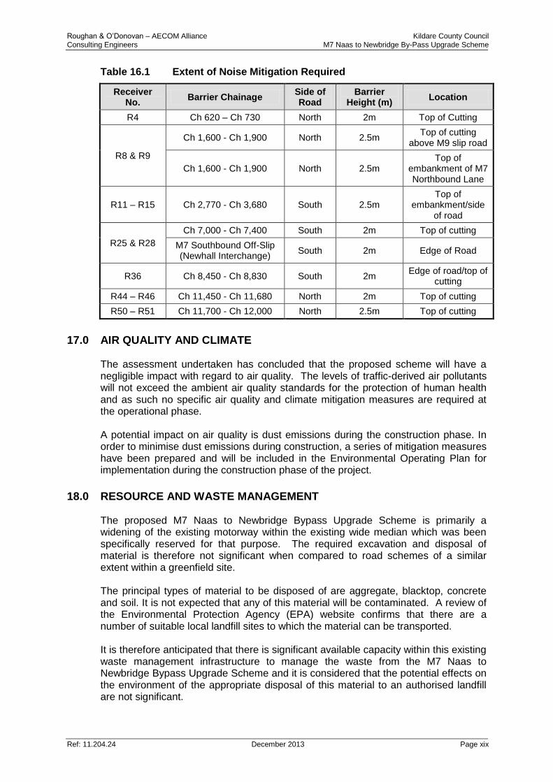
16.0 NOISE AND VIBRATION The noise environment in the vicinity of the M7 Naas to Newbridge By-Pass has been characterized by a traffic noise survey. Noise model predictions have been completed for a total of 58 receiver locations. Given that the M7 Motorway is currently in operation, the range of noise levels resulting from the exiting motorway are, for a large portion of locations, already above the NRA noise design goal for new roads. As part of this assessment, therefore, reference has been made to the Kildare Local Authorities Noise Action Plan, 2009 document which is considered to focus the aims of the NRA guidelines of noise management and reduction from road schemes. Mitigation measures have been developed based on the recommendations of the Kildare Local Authorities Noise Action Plan 2009. On review of the various options available, the most appropriate mitigation measure for this scheme is considered to be a combination of a Low Noise Road Surface along the full length of the widened section of the M7 and road side barriers where required. Noise barriers are required at seven separate locations – detailed below in Table 16.1.
Roughan & O’Donovan – AECOM Alliance Kildare County Council Consulting Engineers M7 Naas to Newbridge By-Pass Upgrade Scheme
Ref: 11.204.24 December 2013 Page xix
Table 16.1 Extent of Noise Mitigation Required
Receiver No.
Barrier Chainage Side of Road
Barrier Height (m)
Location
R4 Ch 620 – Ch 730 North 2m Top of Cutting
R8 & R9
Ch 1,600 - Ch 1,900 North 2.5m Top of cutting
above M9 slip road
Ch 1,600 - Ch 1,900 North 2.5m Top of
embankment of M7 Northbound Lane
R11 – R15 Ch 2,770 - Ch 3,680 South 2.5m Top of
embankment/side of road
R25 & R28
Ch 7,000 - Ch 7,400 South 2m Top of cutting
M7 Southbound Off-Slip (Newhall Interchange)
South 2m Edge of Road
R36 Ch 8,450 - Ch 8,830 South 2m Edge of road/top of
cutting
R44 – R46 Ch 11,450 - Ch 11,680 North 2m Top of cutting
R50 – R51 Ch 11,700 - Ch 12,000 North 2.5m Top of cutting
17.0 AIR QUALITY AND CLIMATE The assessment undertaken has concluded that the proposed scheme will have a negligible impact with regard to air quality. The levels of traffic-derived air pollutants will not exceed the ambient air quality standards for the protection of human health and as such no specific air quality and climate mitigation measures are required at the operational phase. A potential impact on air quality is dust emissions during the construction phase. In order to minimise dust emissions during construction, a series of mitigation measures have been prepared and will be included in the Environmental Operating Plan for implementation during the construction phase of the project.
18.0 RESOURCE AND WASTE MANAGEMENT The proposed M7 Naas to Newbridge Bypass Upgrade Scheme is primarily a widening of the existing motorway within the existing wide median which was been specifically reserved for that purpose. The required excavation and disposal of material is therefore not significant when compared to road schemes of a similar extent within a greenfield site. The principal types of material to be disposed of are aggregate, blacktop, concrete and soil. It is not expected that any of this material will be contaminated. A review of the Environmental Protection Agency (EPA) website confirms that there are a number of suitable local landfill sites to which the material can be transported. It is therefore anticipated that there is significant available capacity within this existing waste management infrastructure to manage the waste from the M7 Naas to Newbridge Bypass Upgrade Scheme and it is considered that the potential effects on the environment of the appropriate disposal of this material to an authorised landfill are not significant.
Roughan & O’Donovan – AECOM Alliance Kildare County Council Consulting Engineers M7 Naas to Newbridge By-Pass Upgrade Scheme
Ref: 11.204.24 December 2013 Page xx
The management of construction and demolition waste will reflect the waste management hierarchy, with waste prevention and minimisation being the first priority succeeded by reuse and recycling. A Waste Management Plan which meets the requirements of the DoEHLG Best Practice Guidelines on the Preparation of Waste Management Plans for Construction & Demolition Projects will be implemented. It is intended that all waste soils, rock and concrete will be used within the project area where possible for infilling or landscaping. At this preliminary stage it is anticipated that the bulk of surplus excavation arisings will be used on site. It is anticipated that a certain percentage of the surplus will not be suitable for use on site. These materials will be recovered or disposed of at appropriately authorised facilities.
19.0 ASSESSMENT OF POTENTIAL CUMULATIVE IMPACTS
The potential for cumulative impacts to arise on individual sensitive receptors as a consequence of the interaction between individual impacts arising from the M7 Naas to Newbridge Bypass Upgrade Scheme has been reviewed and assessed. The assessment has confirmed that two residential properties to the south west of the existing Newhall Interchange will experience a potentially significant temporary cumulative impact during construction as a consequence of the location of the new west bound off slip (refer Figure 5.5). The strict application of the construction mitigation measures laid out throughout this EIS will ameliorate this impact. The potential for cumulative impacts in association with the proposed M7 Osberstown Interchange and R407 Sallins Bypass Scheme has also been reviewed and assessed. With the application of the construction and operational mitigation measures identified in this EIS there are no anticipated negative cumulative impacts.
20.0 INTERRELATIONSHIPS AND INTERACTIONS Inter-relationships relate to the interactions between impacts within a project and the interaction between impacts and mitigation measures identified under one topic with impacts identified under another topic. Undertaking a systematic review of the main interactions between impacts ensures that the main effects of the scheme are assessed cumulatively rather than in isolation. Interactions identified include the influence of noise barriers on visual impact and the interaction between potential hydrological impacts (water quality) and ecology at both construction and operation. Based on the systematic review of the potential interactions between the identified impacts and mitigation measures which was undertaken it was concluded that all the potential interactions and required mitigation measures have been addressed in the relevant chapters of the EIS and no unforeseen cumulative impacts are likely to arise as a result of interactions.
21.0 MITIGATION MEASURES The principal mitigation measures proposed in the scheme are as follows:
Noise Mitigation measures have been developed based on the recommendations of the Kildare Local Authorities Noise Action Plan 2009: Low Noise Road Surface will be utilised along the full length of the scheme and noise barriers will be erected at seven separate locations;
Roughan & O’Donovan – AECOM Alliance Kildare County Council Consulting Engineers M7 Naas to Newbridge By-Pass Upgrade Scheme
Ref: 11.204.24 December 2013 Page xxi
Careful phasing of works and appropriate traffic management measures will be undertaken during the construction period to ensure that any adverse impact with respect to journey times and congestion are kept to a minimum. This will include the maintenance of two daytime traffic lanes in each direction on the M7 throughout the construction phase;
A suite of stringent pollution prevention measures will be adopted by the appointed contractor during construction to avoid water quality impacts;
At operation surface water run-off will be treated through the use of hydrocarbon interceptors and attenuation ponds;
The existing fencing along the motorway will be repaired or replaced to ensure that mammals cannot access the motorway;
Where practicable, tree and hedgerow clearance will be avoided between 1st March and 31st August during the bird nesting and breeding season;
Measures to prevent and control dust emissions shall be adhered to during construction;
Planting on road verges shall be reinstated using locally native species to prevent visual impact on adjacent properties, monuments and protected structures;
A landscape planting mitigation plan has been prepared for the proposed new Newhall Interchange.
22.0 WHAT HAPPENS NEXT Written submissions relating to the likely effects on the environment of the proposed road development may be made to An Bord Pleanála (the Board) by the public or by prescribed bodies prior to the date specified in published newspaper notices. An oral hearing may be held at the discretion of the Board. Written submissions, together with any representations made at any oral hearing, will be considered by the Board in making its decision on whether or not to approve the scheme with or without modifications. The Board’s decision will be published in one or more newspapers circulating in the area, including where appropriate, particulars of any modifications to the scheme. All submissions in relation to this development should be sent to the Board at the following address:
An Bord Pleanála,
64 Marborough Street,
Dublin 1.


![005014916 00443€¦ · FLOOD Laurence [397] 1 July Administration of the Estate of Laurence Flood late of Mayfield Kilmeao.ue Naas County Kildare Farmer who died 16 January 1910](https://img.pdfslide.us/doc/110x75/5f1fb5ac31df1a6f46661c0a/005014916-flood-laurence-397-1-july-administration-of-the-estate-of-laurence-flood.jpg)