Embed Size (px)
Citation preview

ENVIRONMENTAL IMPACT OF DEPOSITING DREDGE SPOILS IN AN AREA
BETWEEN FT. JAMES AND COVE BAY, ST. JOHN'S, ANTIGUA
August 25, 1987
Prepared for Ivor L. Jackson Associates, St. John's, Antigua
Prepared by
Mary Lou Pressick Coulston, Ph.D.
Island Resources Foundation, Inc. Red Hook Box 33, St. Thomas U. S. Virgin Islands 00802
(809) 775-6225 (809) 773-3246

Environmental Impact of Depositing Dredge Spoils in an Area Between Ft. James and Cove Bay, St. John's, Antigua
INTRODUCTION
On July 19-21, 1987, an assessment was undertaken to evaluate the impact of depositing dredge spoils, taken from St. John's deep water harbour, in the area between Ft. James and Cove Bay (Figure 1). Potentially impacted terrestrial and marine environments were surveyed for fauna and flora, sediment profiles within the dredge area were evaluated, currents in the vicinity of the fill area were studied and baseline water quality data was taken.
An evaluation was made of the impact of building the containment dikes as proposed by Devcon International Corp. (Figure 1) and putting the dredge spoils behind these containment dikes. A new plan (Figure 2) is presented which changes the dike and outfall location expecting to lessen the impact of escaping sediment from deposited spoils on the already highly stressed marine environment. A water quality monitoring program is recommended during dredging, along with other measures which must be taken to prevent sediment escape.
The result of the assessment of sediments and currents for this study is presented in a separate report prepared by Ian C. Jones. Reference is made to data and conclusions from that report in the analysis presented here on the impact of the containment of dredge spoils obtained from St. John's deep-water harbour.
SURVEY
The following terrestrial and marine environments (Figure 3) were surveyed:
1. Mangrove Community 2. Cove Lagoon Waters (inner and outer coves) 3. Cove Channel Waters and Mangrove 4. Dredge Cove Waters 5. Dredge Cove Seagrass Beds 6. Ft. James Point Waters
MANGROVE COMMUNITY. Mangroves and their associated lagoons are essential coastline habitats which serve as biological filters for run-off containing sediments, nutrients and pollutants. The lagoon acts as a settling pond to collect sediments and pollutants, preventing direct run-off into valuable seagrass meadows and coral reefs. The highly productive mangroves and other plants of the lagoon utilize these nutrients during the growth process.
Mangroves are a highly productive fringing plant community (see Appendix I). Fringing plant communities rely on a good supply of water and nutrients. The tidal flow and terrestrial run-off brings in water and nutrients and removes waste. In addition, high salinity in the mangroves must

- .. - .. ;.~ ...•... -.. -.
iSo1t Pan
.... '.
1',
!:'
A:re. of
Rec"lomotion
! .
~~~~-;. j ·~~l;· .~... ~
;'-;
,: ':~;:1;::':"-~~;1'~
r-::-l r.M~
. .: ....... ::::: .
MANGROVE···
r.~:J~1\ <l£J
MANGROVE
CoNTl1:.oL "'''''R~C.''UR..'E I
\-\-,..--00-'>&£ SII.:.- ·SCI2EE'~
~~ ~.:v
,0'::> ... (J
~iA.~ \)"
Figure 1. Proposed containment dikes and outfall proposed by the dredge company,D~v,c:on Ihternational Corp. for placement of dredge spoils from St. John's Harbour.

.,
.. _._-;....!. .. _ ... _. ;
ISait Pan
'--. '.
". PROPOSED: NEW LOCATION . . OF. CONTAINMENT DIKE
~" ..-cC..R .... ::..,~ :- ·:.~':::-'~:"-.;;;Jl''''' ... ~~~:. - -:-.. -'"""
I 1"""1 :' r ... at....A .
'---:"''.
·; ... dd\ .~rsJ
. ~:-:- ::::;
• ~ ,.,.. <tI""""f - '" Z!~:":.;:"_
.,~ '. . r /// 1 "\ I, ' ~' ,ArM 0( A«loMcWoo%:::::~~~ . ':: ! .... . I I INN1lR COVE POND \ "" WR ., " '. !
. .... , ~ ~ ; r· I \
" .. '
l· \ , . "\ '--.?
~f!/ \ I"~ \_-'-'-J.~v-
A.reo of
Reclomotlon
....
e "6" ! <:""" ; ...... ;>--
·-1/-V-tt~-vr
0an~rove :' .... ~
WATER Quillri STATIONS • ~1:7"
/.
,~...-
\ \ '- ........
'--
S' \.:<" Soc. ~e: E1'I
/q4' ~v
, /(;?.:>
.. 0 AiA'?; ~
( "\ \" \\ \\ \\ \\ '.\ \ \ • tis"
·i
@11tflIItr~tt:~mImM~i"'\'
Figure 2. Proposed alternative to Devcon's plan showing a new location of the containment dike and an alternative site for the outfall control structure.

'I i· • - .. , ~ . ~_ -'-'.1(,
't~! ---I·~r:':··~·£l '~=':;;F
'-.: !~/ .. -.)--)
/'·····1
Seagrass Beds
Dredge Cove
Figure 3. Terrestrial and marine habitats surveyed.
Outer Cove

be avoided as salt accumulation around roots prevents water uptake by the plants. Salts excluded or excreted by the mangroves must be washed away. The sediments around mangrove roots are anoxic favoring the activity of nitrogenfixing bacteria. The system is truly an important community between the terrestrial environment and the open sea. One that needs protecting and managing.
The mangrove swamp has a unique community of organisms. The roots and associated algae provide a substrate for attachment of animals such as barnacles, oysters, tube worms, tunicates and sponges which, in turn, provide a secure habitat for many fish and crustaceans. Juvenile fish, many of them important commercial species, also find shelter among the root systems. In the mud are burrowing crabs and clams, and other important economic species.
The mangroves of the cove lagoon, found on the northern side of St. John's Bay in Antigua, are especially critical. They filter the runoff from the town which is primarily wastewater. The mangrove system during the process of growth converts many of these added nutrients into plant material, returning them to the food chain. The water is shallow (average 1 ft) allowing penetration of sufficient light for algae and seagrass to carryon photosynthesis and thus put oxygen back into the.water for organisms to utilize. Photosynthesis and growth are interdependent processes and the lagoon system must be balanced for both essential processes to occur. Even though the physical appearance of the lagoon indicates that considerable runoff containing large amounts of sediment and wastewater are continually being dumped in the area, the lagoon system is still functioning as a balanced system. The tolerance of the lagoon to these excessive perturbations is quite notable.
Figure 4 is a terrestrial survey map of the mangrove community located between the channel on the east, the salt pan on the west, Dredge Cove on the south and the inner cove lagoon on the north. The area is densely populated by four species of mangroves: red mangrove, Rhizophora mangle; white mangrove, Laguncularia racemosa; black mangrove, Avicennia nitida; and buttonwood, Conocarpus erectus. Sparsely distributed among the mangrove species are other shoreline community species including casha, Acacia tortuosa; Portia tree, Thespesia populnea and railroad vine, Ipomoea pes-caprae.
Area 1 shown in Figure 4 contains red and black mangroves that have been,trampled by the dragline (Photographs 1 & 2). The construction of the containment dike is already in progress and is continuing to destroy valuable mangrove. On July 22, 1987, the drag line was located in area 2, Figure 4, where it was working on construction of the containment dike (Photograph 3).
The land areas of the mangrove are rich in wildlife, especially birds. Over twenty species of birds were sighted, including brown pelicans, snowy egrets, great egrets, cattle egrets, magnificent frigate birds, several species of sandpipers, gulls and terns. Area 3 in Figure 4 is a dense red mangrove area containing many species of birds. The area was already partially destroyed by the dragline as shown in Photograph 4. Appendix I presents information gathered on the wildlife of Antigua.
Area 4 in Figure 4, is an extensive and dense stand of small red mangroves (Photograph 5). This area will also be destroyed under the present plan. To the west of the area of small red mangroves is the salt pan which is

shown in Photograph 6. This is a more acceptable area for building containment dikes and dumping dredge spoils.
Mangrove habitats described and shown in Figure 4, including the waters of the inner cove, are destined to be destroyed under the present spoils containment plan. Both inner and outer coves of the lagoon are surrounded by lush and healthy red mangroves. The inner cove is especially luxuriant with the area entirely surrounded by red mangrove with many new plants becoming established. The entrance to the inner cove is shown in Photograph 7 (Area 6, Figure 4). Photographs 8 and 9 show the inner areas of the mangrove lagoon (Areas 7 and 8, Figure 4).
LAGOON WATERS (INNER AND OUTER COVES). Inshore marine waters such as estuaries and bays are of huge economic and recreational value as nurseries, fishing areas, shell-fisheries and crustacean production, boating and bathing. The cove lagoon at St. John's Harbour is a place that fits the description of a valuable body of water that must be preserved in its entirety and someday hopefully managed to enhance its value.
Figure 5 is a survey map showing the remalnlng areas of the mangrove including the channel, the mangroves surrounding the lagoon, and the waters of the lagoon. The two water quality stations (#1 and #2) are shown along with several depth measurements. The deepest part of the lagoon was 3 ft with most of the area less than 2 ft.
The cove lagoon already contains several feet of fine sediment. The bottom sediment was so deep and so soft it was impossible to stand up anywhere in the lagoon. Surveys were done using a rubber raft and paddle. However, the bottom contains dense mats of algae (mostly Dictyota sp.) and patches of turtle grass , Thalassia testudinum, and the cove waters teem with fish and invertebrates. Blue crabs (Callinectes sapidus), cockles, snappers and grunts are among some of those observed. Also reported from the area are Panaeid shrimp, mullet, barracuda, snook, mojarras and baitfish.
In the present state, it seems that the cove environment is coping with the daily input of effluent. The cove is already stressed with large amounts of sediment. Additional sediments could reduce light levels and interrupt photosynthesis of bottom algae and seagrasses thus reducing oxygen levels and eventually causing the pond to go anoxic and kill all the organisms.
The area indicated in Figure 2 for "proposed: outfall control structure" located in the southeast portion of the containment area is a better alternative to the outfall site location proposed by the dredge company inside the lagoon. The outside area has previously been dredged, the bottom near the area is sandy with very little plant life, and this area is deeper than the surrounding grassbeds. Material getting through the silt screen will spread over the bottom in a deep, already dredged area. Current studies show this silt will be transported to the western side of the cove and eventually out of the harbour into deep waters.
An impact of the alternate outfall site is that sediment will build up in the bay near water quality site #7 (Figure 2). The dye and drogue study (Jones, 1987) shows that there is very little circulation in that area and that

MANGROVE .
CD @
6
INNER COVE
MANGROVE
OurER COVE
MANGROVE
KEY:
R red mangrove Rhizophora mangle
W - white mangrove Laguncularia racemosa
Bk- black mangrove Avicennia nitida
B - buttonwood Conocarpus erectus
At- casha Acacia tortuosa
Tp- Portia tree Thespesia populnea
Figure 4. Environmental Survey Map. Areas of particular concern are indicated by numbers withing squares and described in the text. Plant species are designated by letters within circles and the key presented above.

• STA.1 .Sm
Tt Dd
MANGROVE
Tf,Sf,Pc,Hs Cc,Cm,Cp,Cs
Dredge Cove
Ca
Tt
Tt 1m
• STA.3
OUTER COVE LAGOON
• STA.3a
Key: Algae: Ac - Acetabularia crenulata As - Acanthophora spicifera Ca - Caulerpa ashmeadii Cc - Caulerpa cupressoides Cm - Caulerpa mexicana Cp - Caulerpa prolifera Cs - Caulerpa sertularioides Dd - Dictyota divaricata El - Enteromorpha lingulata Hs - Halimeda sp. Pc - Penicillus capitatus Seagrasses: Tt - Thalassia testudinum Sf - Syringodium filiforme 'Hb - Halophila baillonis
• STA.2
.Sm
Figure 5. Environmental Survey Map. Waters and mangrove of the inner cove, the outer cove and the channel are illustrated.

most of the movement is wind driven. Since prevailing winds are east to northeast a sediment pile-up is anticipated. However, sediments should slowly wash out past Ft. James Point and be transported offshore to deeper waters where they will do little damage. There is no indication that any of the sediment will be transported to the recreational beaches along Fort or Runaway Bays.
CHANNEL MANGROVE. Tall healthy red mangrove plants with deep prop roots line the channel. The waters of the channel were clear enough to observe marine life using a mask and snorkel. Many fish were seen, including bonefish (Albula vulpes), ballyhoo (Hemiramphus brasiliensis), barracuda (Sphyraena barracuda), mullet (Mugil sp.), grey and yellowtail snappers (Lutjanus griseus and Ocyurus chrysurus), blennies, butterfly fish, mojarras and many others.
Benthic flora consisted of mats of seagrass (Halophila baillonis and some Thalassia testudinum). The prop roots were rich in algae and many organisms including mangrove oysters, barnacles, tunicates, sponges, polychaete worms, hydroids and crabs. Dense patches of brine shrimp (Artemia salina) were observed swimming around the roots. Above water the mangrove crab (Goniopsis cruentata) and the mangrove periwinkle (Littorina angulifera) were observed. The dominant algae within the channel were Acetabularia crenulata and Enteromorpha lingulata.
Observations of the channel bottom revealed that the area had been recently filled with sand which was gradually being moved by tidal flow. In order to move the dragline into position to build the containment dikes in the mangrove area, the dragline had to be taken across the channel. It appears that the dragline took sand from the mouth of the channel and placed it in the channel to form a land bridge so that it could cross over to the other side. A very deep scar was found just at the mouth of the channel which we presume was excavated by the dragline.
The channel opens naturally by tidal flow. However, it should be emphasized that it is very important for this channel to remain open. The daily tidal flushing provides an exchange with the outer harbour, keeping the temperature and salinity of the cove lagoon near that of the outside waters. Should the area be closed off there would be excessive evaporation causing a rise in salinity and temperature leading to adverse conditions for life. Closure should be avoided or a productive lagoon will soon become an unproductive, anoxic and very dead salt pond.
DREDGE COVE SEAGRASS BEDS. The seagrass meadows were surveyed using snorkling gear, observations from the surface and by taking grab samples with a rebar anchor. The grass bed is fairly uniform throughout the area from water quality station #3 to station #7 (see Figure 6). One exception is the area around water quality station #6, which formerly had been dredged. This area is somewhat deeper (1.6m) than the surrounding area (1.2 - 1.4m) due to former dredging and has a sandy bottom. It is in this area that the new outfall has been proposed to be constructed.

The area is dominated by turtle grass Thalassia testudinum interspersed with manatee grass Syringodium filiforme. Algae interspersed with the seagrasses were identified as: Caulerpa sertulariodes, C. cupressoides, C. ashmeadii, C. mexicana, several species of Dictyota, and-several species of red algae not identified.
Fish were not especially abundant except for a variety of juvenile snappers, grouper, and parrotfish found sheltered among debris found on the bottom. There were very few invertebrates sighted.
A survey completed previously (Ivor Jackson, 1986) serves to satisfactorily describe the area. What is now more important is to control the quality of water from any further deterioration during the process of storing dredge spoils in the area. This can be accomplished with a water quality monitoring program and an on-site inspection of the containment dikes provided the dredge company is required to comply with proposed regulations.
FT. JAMES POINT WATERS. The waters around Ft. James Point were surveyed for water quality and current movement. Water quality Stations 8, 9 and 10 are found in that area (Figure 6). The water depths in those areas are considerably deeper than the bay. In the study by Jones (1987), he shows that waters passing the point at Stations 8 and 9 will continue flowing westward away from the island, depositing sediments offshore into deep water. Dye placed at Station 10 was also transported offshore. Under prevailing wind conditions no sediments from the cove should reach the recreational beaches along the west coast, north of Ft. James Point.
Data are presented in Table 1 on water quality and can be used as a baseline to monitor water quality once dredge and fill operations are underway.
WATER QUALITY
Ten water quality stations were set up as indicated in Figure 6. On July 21, 1987, measurements were taken for temperature, dissolved oxygen and water clarity using a Secchi disk at each of these stations. Water samples were collected and brought to the Ocean Systems Research Water Quality Laboratory in St. Croix where salinity and total suspended solids were measured. Table 1 presents the results of the water quality survey.
Total suspended solids are very high for the lagoon area. This indicates that additional suspended solids could decrease available light and threaten the survival of all organisms inhabiting the lagoon. To prevent unnecessary further siltation the outfall draining the containment area for dredge spoils must be changed to flow into the outer bay as indicated in Figure 2.
Oxygen levels in the lagoon are high, even higher than those of Dredge Cove, indicating that the lagoon's ecological balance is being maintained despite the high volume of effluent entering the area. However, since Secchi disk readings are low and suspended solids are high, a disruption of the balance could be triggered by an increase in additional sediment. Therefore, additional sediment load from containment overflow should be avoided.

• #10
• #9
,", , \ , \ , \ , ' .. , , , --, ;' Salt Pan I
\ \ I ... , '... ... ..' \
r
• #6 • #7
• #4
Dry Hill
Dredge Bay
Scale o 500 ft
• #3
Outer Cove
Lagoon
St. John I s Deep \vater Harbor
Figure 6. Water quality sampling stations.

Table 1. Water Quality Measurements Between Fort James and Cove Bay
Dissolved Secchi Suspended Temp. Oxygen Disk Depth Salinity Solids
Station C ppm Meters Meters ppt mg/l
1 29.5 9.4 .25 1.0 34.2 50.8
2 30.0 10.4 .25 1.0 36.2 58.8
3 27.0 6.4 1.0 1.8 34.2 24.8
3a 27.5 6.8 .8 1.4 34.4 29.2
4 27.5 9.6 3.0 3.0
5 27.5 8.1 1.2 1.2 34.2 33.2
6 27.5 7.7 1.6 1.6 34.0 19.6
7 28~0 8.7 1.2 1.2 34.6 27.2
8 27.0 8.1 2.6 >3.0 34.2 28.4
9 28.0 9.9 2.2 deep 33.5 27.6
10 28.0 10.4 3.0 deep 33.8 26.0
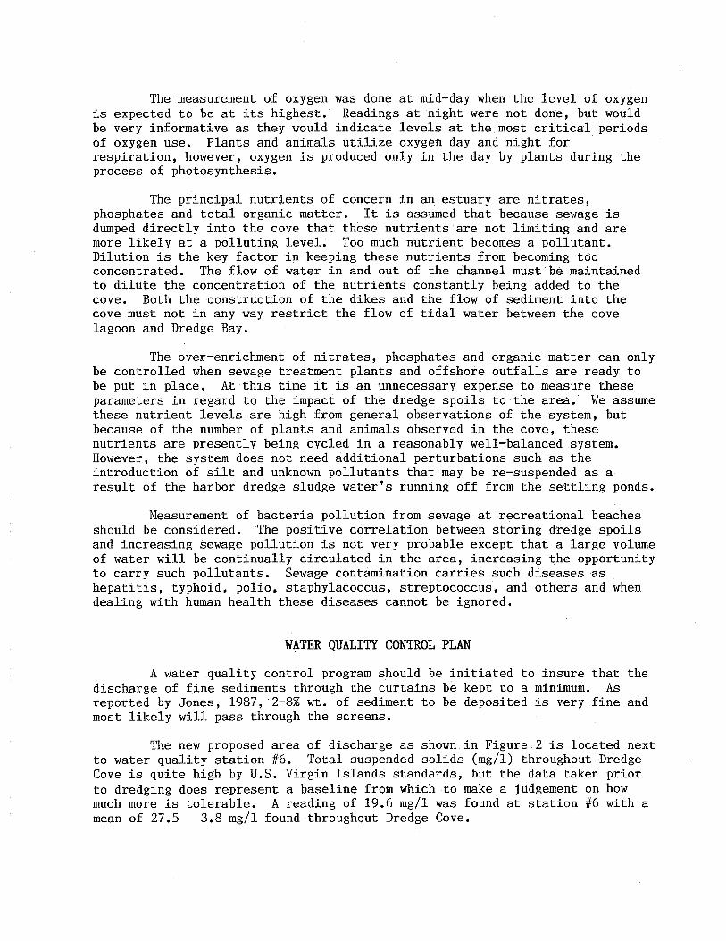
The measurement of oxygen was done at mid-day when the level of oxygen is expected to be at its highest. Readings at night were not done, but would be very informative as they would indicate levels at the most critical periods of oxygen use. Plants and animals utilize oxygen day and night for respiration, however, oxygen is produced only in the day by plants during the process of photosynthesis.
The principal nutrients of concern in an estuary are nitrates, phosphates and total organic matter. It is assumed that because sewage is dumped directly into the cove that these nutrients are not limiting and are more likely at a polluting level. Too much nutrient becomes a pollutant. Dilution is the key factor in keeping these nutrients from becoming too concentrated. The flow of water in and out of the channel must be maintained to dilute the concentration of the nutrients constantly being added to the cove. Both the construction of the dikes and the flow of sediment into the cove must not in any way restrict the flow of tidal water between the cove lagoon and Dredge Bay.
The over-enrichment of nitrates, phosphates and organic matter can only be controlled when sewage treatment plants and offshore outfalls are ready to be put in place. At this time it is an unnecessary expense to measure these parameters in regard to the impact of the dredge spoils to the area. We assume these nutrient levels are high from general observations of the system, but because of the number of plants and animals observed in the cove, these nutrients are presently being cycled in a reasonably well-balanced system. However, the system does not need additional perturbations such as the introduction of silt and unknown pollutants that may be re-suspended as a result of the harbor dredge sludge water's running off from the settling ponds.
Measurement of bacteria pollution from sewage at recreational beaches should be considered. The positive correlation between storing dredge spoils and increasing sewage pollution is not very probable except that a large volume of water will be continually circulated in the area, increasing the opportunity to carry such pollutants. Sewage contamination carries such diseases as hepatitis, typhoid, polio, staphylacoccus, streptococcus, and others and when dealing with human health these diseases cannot be ignored.
WATER QUALITY CONTROL PLAN
A water quality control program should be initiated to insure that the discharge of fine sediments through the curtains be kept to a mlnlmum. As reported by Jones, 1987, 2-8% wt. of sediment to be deposited is very fine and most likely will pass through the screens.
The new proposed area of discharge as shown in Figure 2 is located next to water quality station #6. Total suspended solids (mg/l) throughout Dredge Cove is quite high by U.S. Virgin Islands standards, but the data taken prior to dredging does represent a baseline from which to make a judgement on how much more is tolerable. A reading of 19.6 mg/l was found at station #6 with a mean of 27.5 3.8 mg/l found throughout Dredge Cove.

A considerable increase in total suspended solids (numbers above the baseline mean) should be an indicator that materials are passing through the screens and the dredge company should take measures to decrease the sediment flow. Since no standards have been previously set for maintaining water quality in the coastal waters of Antigua, it is recommended that this be brought to the attention of the government and recommendations made on maximum allowable increase in total suspended solids during filling of settling ponds in the area near the outfall.
Another quick and easy method for monitoring water quality on a daily basis is using a Secchi disk and recording the depth at which it can be read. It is recommended that stations 5, 6, 7, 8, 9 and 10 be monitored using a Secchi disk on a daily basis when dredging and fill operations are in progress. Baseline Secchi disk readings are presented in Table L By U.S. Virgin Islands standards a reading of 1 meter is required at water quality monitoring stations during dredging operations.
REDUCTION OF SEDIMENT DISCHARGES
The dredge company will be pumping very fine sediments into the settling basins. They propose to have two settling ponds constructed, one in which the dredge material will be received (receiving pond) and another to pump material from the receiving pond to an additional settling pond to further promote settling of particles before the water is returned to the harbour. A third settling pond would promote further settling and filtration of the water.
The receiving and settling pond(s) should be monitored to insure that the dredge company maintains the ponds. It may be necessary to remove the larger particles that have settled to insure that the dikes do not overflow. The dikes must be maintained against leakage, overflow or crumbling. At the present time, the dredge company plans only to use the available substrate in the construction of dikes. There is no plan for any stabilizing material such as rock or geofabric filter cloth to stabilize the soil. Stabilization is recommended.
At the discharge a double silt curtain should be maintained at all times. This silt curtain should be inspected at least weekly. If the curtain is leaking, substantially reducing water quality in the area, or is obviously torn, the repairs must be made promptly.

SUMMARY OF RECOMMENDATIONS
Surveys and analysis of the environments around the proposed dredge spoils site indicate that immediate action be taken as follows:
1. all further destruction of the mangrove be halted;
2. no additional sediment be added to the lagoon;
3. the outfall from the containment dike be relocated to discharge into the outer cove and not into the lagoon;
4. a new plan for containment of dredge spoils be established that excludes and preserves existing mangroves;
5. the channel connecting the lagoon to outer harbour be kept open to allow for tidal flow of water in and out of the area;
6. a water quality monitoring plan be put into effect when dredging begins and
7. containment dike monitoring be included in the water quality monitoring plan.
CONCLUSIONS
The coastal marine ecosystem consisting of mangroves and lagoon located on the northern side of St. John's deep water harbour in Antigua must be preserved, protected and managed. The waters of Dredge Cove, the outer harbor area, must also be protected against further deterioration of water quality.
The long term benefits of preservation far outweigh the use that is proposed for this area. A storage space for dredge spoils is no excuse for destroying one of the most productive coastal ecosystems known. The aesthetic and recreational value of the area cannot be reclaimed once it is covered by harbor muck. The cycling of nutrients and the food provided for locally valuable fisheries resources cannot be replaced by any other habitat of the area. The slow leaking of nutrients from mangroves provide food for nearby seagrass meadows and coral reefs. With the destruction of the mangrove, sediments and pollutants will directly be channeled to seagrass meadows and coral reefs.
With the understanding of just how important the mangrove ecosystem is at preserving other valuable resources, and how economically valuable it is to the community, protection and management is the only reasonable choice.

Photograph 1. Mangrove (Area 2, Fig. 4) destroyed by dragline as the containment dike is being constructed.
Photograph 2. Mangrove destroyed by dragline (Area 1, Fig. 4) Inner cove lagoon and mangrove are in the background. Entire area is scheduled to be filled by dredge spoils.

Photograph 3. Dragline building containment dike (Area 2, Fig. 4). Red and black mangroves of the area have already been destroyed.
--------------------------
Photograph 4. Partially destroyed red mangrove area (Area 3, Fig. 4) rich in wildlife.

Photograph 5. Stand of red mangroves (Rhizophora mangle) located in Area 4, Fig. 4, destined to be destroyed if the present plan is used.
Photograph 6. Edge of the red mangrove and the beginning of the salt pan (Area 5, Fig. 4).

Photograph 7. Entrance to the inner cove lagoon showing luxurious red mangrove (Area 6, Fig. 5).
Photograph 8. Inner cove lagoon and mangrove. This area (Area 7, Fig 5) is slated to be filled with dredge spoils under the present plan.

Photograph 9. Inner cove lagoon and mangrove. This area will be filled with dredge spoils if the present plan is not modified (Area 8, Fig. 5).
Photograph 10. Cove entrance channel showing extensive red mangrove root system.

Photograph 11. Cove entrance channel lined by red mangroves.
Photograph 12. Cove entrance channel. Pair of shorebirds were observed frequently at the clump of vegetation midchannel.

REFERENCES
Barnes, R.K. and K.H. Mann (Ed). 1978. Fundamentals of Aquatic Ecosystems. Blackwell Sci. Publ., London. p. 229.
Bond, J. 1980. Birds of the West Indies. Houghton Mifflin Company, Boston. p. 256.
Danforth, S.T. 1934. The birds of Antigua. Auk 51:350-363.
Cintron, G. and Y Schaeffer-Novelli. 1983. Mangrove Forests: Ecology and response to natural and man induced stressors. In: Coral reefs, seagrass beds and mangroves: Their interaction in the coastal zones of the Caribbean. Workshop West Indies Laboratory, St. Croix, U.S. Virgin Islands. May, 1982.
Harris, D.R. 1963. Plants, Animals, and Man in the Outer Leeward Islands, West Indies: An Ecological Study of Antigua, Barbuda and Anguilla. Ph.D Dissert. Univ. Calif. Berkeley. p. 298.
Island Resources Foundation. 1987. Water quality control monitoring plan for mitigating dredging and land fill impacts associated with construction of a liquid bulk cargo handling wharf at the Alucroix/Martin Marietta Channel Limetree Bay Area, St. Croix. Prepared for the Virgin Islands Port Authority.
Ivor Jackson and Associates. 1986. Environmental Impact investigation on offshore sand mining Fort James and Cove Bay, St. John's, Antigua. Prep. for Government of Antigua.
Jackson, I. 1985. Tourism and environmental case study of Fort James -Dickinson Bay, Antigua. Prep. Econ. Comm. for Latin Amer. and the Carib. p. 54.
Jones, I.C. 1987. Report on the sediments and currents in the St. John's Harbor, Antigua. Prep. for Ivor Jackson Assoc. by Island Resources Foundation, Inc. August 3, 1987.
Jones, J.K., Jr. and C.J. Phillips. 1970. Comments of Systemates and Zoogeography of Bats in the Lesser Antilles. Studies Fauna Curacao Carib. Is. 32:131-145.
Prince-Tams Joint Venture. 1984. Environmental Assessment Report for Third Port Project, South Shore - St. Croix - U.S. Virgin Islands, Vol. 1 & 2, Prep. V.I. Port Authority.

Appendix I. Mangrove Productivity

Annual production. levels of fringing benthic plant communities. Average levels are compiled from all available data and represent a range of environments though data from very unfavourable sites is probably not included. The maximum values are the highest that could be located. The data arc given in g organic matter (ash-free dry WI.) per ml per year.
Fringing community type
Bog Marshes, freshwater
Typha, cattail .Carex, sedge 'phragmites, reed Cyperlis, ·papyrus Freshwater, tidal
Marshes, salt water tidal Spartina Other grasses Salicornia
Swamps, freshwater, Bog, spruce Cedar, Cypress Hardwood .. Swamps, salt water Mangrove
Benthic microphytes Freshwater, lake Freshwater, spring Marine
Submerged macrophytes Freshwater, temperate
tropical Marine
sea grasses, tropical macroalgae, kelp rockweeds green algae. tropical
Floating, freshwater Duckweed Water hyacinth (Eichornia)
Average production
900
2700 1000 2100 7500 1600
2500 1500 3000
500 4000 1600
3000
170 3000 200
650
2000 3400
750
150
Maximum production
1500
3700 1700 3000
15000 2100
6000 8500
1560 3500 850
1300 1700
8500 4250 2100 4000
1500 3300

Appendix III Wildlife

BATS OF ANTIGUA. Taken from Jones and Philippine, 1970.
Noctilio leporinus fish-eating bat
Monophyllus plethodon fruit and nectar-eating bat
Brachyphylla cavernarum
Artibeus jamaicensis
Natalus stramineus
Tadarida brasiliensis
Molossus molossus
cave bat
fruit-eating bat
insect-eating
insect-eating
insect-eating
funnel-eared bat
free-tailed bat
common house bat

BIRDS OF ANTIGUA
SCIENTIFIC NAME COMMON NAME
Pelicans:
Pelecanus occidentalis brown pelican
Frigatebirds:
Fregata magnificens magnificent frigate bird
Pigeons and Doves:
Columba leucocephala white-crowned pigeon
Columba squamosa scaly-naped pigeon
Zenaida aurita Zenaida dove
Geotrygon mystacea bridled quail dove
Rails, Coots and Gallinules:
Rallus longirastris clapper rail
Herons and Egrets:
Bubulcus ibis cattle egret
Egretta alba great egret
Egretta thula snowy egret
Florida caerulea little blue heron
Flycatchers, Thrushes and Mimic Thruses:
Margarops fuscatus pearly-eyed thrasher
Elaenia martinica Caribbean elaenia
Tyrannus dominicensis gray kingbird
Myiarchus stolidus stolid flycatcher
HABITAT
coastal areas
low woodlands
ground dove coastal
dense forest undergrowth
mangrove swamps
pastures/farmland nests: mangrove swamp
coastal areas
coastal areas
mountains
woodland/mangrove

Tanagers and Finches:
Loxigilla noctis
Tiaris bicolor
Euphonia musica
Vireos and Warblers:
Coereba flaveola
Vireo altiloquus
Hummingbirds:
Sericotes holosericeus
Orthorhyncus cristatus
Eularnpis jugularis
Swallow:
Progne dominicensis
Lesser Antillian bullfinch
blacked-faced grassquit
blue-hooded euphonia
Bananaquit
black-wiskered vireo
green-throated Carib
Antillian crested hummingbird
purple-throated Carib
Caribbean martin
dry-scrub
open areas
thick mountain forest
broad niche
wooded areas
References: Bond, J. 1980, Danforth, S.T., 1934 and personal observation.