Embed Size (px)
Citation preview
“CAPACITY AUGMENTATION OF NATIONAL WATERWAY.1”
(Jal Marg Vikas Project)
ENVIRONMENTAL IMPACT ASSESSMENT REPORTS
VOLUME - 8: Environmental Management Plan (EMP)
for Maintenance Dredging
May 2016 (Revised September 2016)
IRG Systems South Asia Pvt. Ltd. Abnaki Infrastructure Applications &
Integrated Development Pvt. Ltd.
INLAND WATERWAYS AUTHORITY OF INDIA
Ministry of Shipping, Government of India
EQMS India Pvt. Ltd. In JV with
Consolidated Environmental Impact Assessment Report of National Waterways-1, Volume - 8
2
Table of Contents
1.1. Introduction ......................................................................................................................3 1.2. Description of Environment..............................................................................................4 1.3. Environmental Management Plans..................................................................................5 1.3.1. Environmental Management Plan for Maintenance Dredging........................................6
List of Tables
Table 1.1 : Salient Environmental Features along NW-1 Alignment ............................................. 4 Table 1.2 : Dredging and Disposal Management Plan for NW-1................................................... 7 Table 1.3 : Environmental Management Plan for Maintenance Dredging ..................................... 9
List of Figures
Figure 1.1 : Location Map ............................................................................................................... 3
List of Annexure
Annexure 1.1: Standards for onshore & off-shore disposal of dredged material ........................ 17
Consolidated Environmental Impact Assessment Report of National Waterways-1, Volume - 8
3
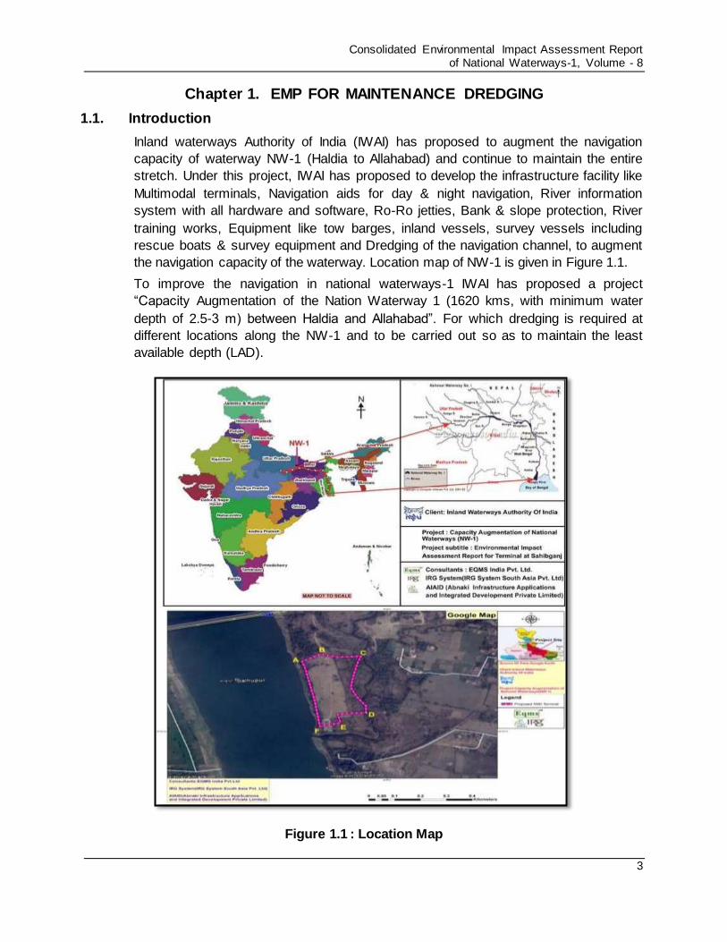
Chapter 1. EMP FOR MAINTENANCE DREDGING
1.1. Introduction
Inland waterways Authority of India (IWAI) has proposed to augment the navigation
capacity of waterway NW-1 (Haldia to Allahabad) and continue to maintain the entire
stretch. Under this project, IWAI has proposed to develop the infrastructure facility like
Multimodal terminals, Navigation aids for day & night navigation, River information
system with all hardware and software, Ro-Ro jetties, Bank & slope protection, River
training works, Equipment like tow barges, inland vessels, survey vessels including
rescue boats & survey equipment and Dredging of the navigation channel, to augment
the navigation capacity of the waterway. Location map of NW-1 is given in Figure 1.1.
To improve the navigation in national waterways-1 IWAI has proposed a project
“Capacity Augmentation of the Nation Waterway 1 (1620 kms, with minimum water
depth of 2.5-3 m) between Haldia and Allahabad”. For which dredging is required at
different locations along the NW-1 and to be carried out so as to maintain the least
available depth (LAD).
Figure 1.1 : Location Map
Consolidated Environmental Impact Assessment Report of National Waterways-1, Volume - 8
4
1.2. Description of Environment
The NW-1 stretch starts from Haldia to Allahabad (1620 KM long) on Ganga - Bhagirathi
- Hooghly river system. The Hooghly river portion of the waterway from Haldia to
Nabadwip is under tidal influence. From Nabadwip to Jangipur the NW-1 stretch is
formed by Bhagirathi river. Bhagirathi river flow is regulated through barges at Farakka
and Jangipur. From Farakka upstream the navigable route depends upon the main
Ganga river flow. The Feeder Canal and the navigation lock at Farakka become the link
between the Bhagirathi and main Ganga upstream of Farakka Barrage. NW-1 is passing
through four states namely UP, Bihar, Jharkhand and West Bengal. The salient
environmental features around NW-1 within, 500m, 2km and 10km stretches are
summarised in Table 1.1.
Table 1.1 : Salient Environmental Features along NW-1 Alignment
S.
No.
Environmental
Features
Within NW-1 (500 M) Within 2 km area
around NW-1
Within 10 km area
around NW-1
1 Ecological Environment
A Presence of National Park/Biosphere Reserves, Tiger reserve etc.
None
None None
Presence of Wildlife Sanctuary
Yes 1. Kashi Turtle
Sanctuary at Varanasi
2. Vikramshila Dolphin Sanctuary Kahalgaon to Sultanganj
3. Hilsa Sanctuary stretch in west Bengal
None Yes
Udhwa lake sanctuary
in Jharkhand (about 9
km away from NW-1
B Reserved /Protected Forests
None None Yes (Bethuadahari RF,
Bahadurpur RF & RF
near Rajmahal Hills)
C Wetland of state and national interest
None None Yes (Udhwa Bird sanctuary)
D Migratory route for
wild terrestrial
animals
None None None
E Presence of Schedule-I Terrestrial Fauna
None Yes Migratory birds near Farakka Barrage and
Yes Migratory birds at important birds’ areas
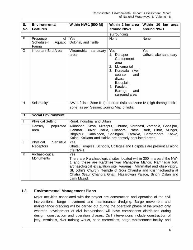
Consolidated Environmental Impact Assessment Report of National Waterways-1, Volume - 8
5
S.
No.
Environmental
Features
Within NW-1 (500 M) Within 2 km area
around NW-1
Within 10 km area
around NW-1
surrounding
F
Presence of Schedule-I Aquatic Fauna
Yes Dolphin, and Turtle
None None
G Important Bird Area Vikramshila sanctuary area
Yes 1. Danapur
Cantonment area
2. Mokama tal 3. Kurseala river
course and diyara floodplain.
4. Farakka Barrage and surround area
Yes Udhwa lake sanctuary
H Seismicity NW-1 falls in Zone-III (moderate risk) and zone IV (high damage risk
zone) as per Seismic Zoning Map of India
B. Social Environment
I Physical Setting Rural, Industrial and Urban
Densely populated area
Allahabad, Sirsa, Mirzapur, Chunar, Varanasi, Zamania, Ghazipur, Gahmar, Buxar, Ballia, Chappra, Patna, Barh, Bihat, Munger, Bhgalpur, Kahalgaon, Sahibganj, Farakka, Berhampore, Katwa, Kalna, Kolkatta and Haldia are densely populated areas.
J Physical Sensitive Receptors
Yes Ghats, Temples, Schools, Colleges and Hospitals are present all along the NW-1.
K Archaeological Monuments
Yes
There are 9 archaeological sites located within 300 m area of the NW-1 and these are Kardmeshwar Mahadeva Mandir, Ramnagar fort, archaeological excavation site, Varanasi, Manmahal and observatory, St. John's Church, Temple of Gour Chandra and Krishnachandra at Chatra (Gaur Chandra Ghat), Hazardwari Palace, Sindhi Dalan and Jami Masjid.
1.3. Environmental Management Plans
Major activities associated with the project are construction and operation of the civil
interventions, barge movement and maintenance dredging. Barge movement and
maintenance dredging will be carried out during the operation phase of the project only
whereas development of civil interventions will have components distributed during
design, construction and operation phases. Civil interventions include construction of
jetty, terminals, river training works, bend corrections, barge maintenance facility, and

Consolidated Environmental Impact Assessment Report of National Waterways-1, Volume - 8
6
RO-RO jetties. A detailed environmental management plan for each associated
development for all the three phases of the project, i.e. design/pre-construction,
construction and operation phase is prepared as applicable. EMP lists the activities
involved, associated impact with each activity on environment, suggestive mitigation
measures, allocated environment budget for impact mitigation, implementation plan
covering monitoring, reporting and implementation and supervisory responsibility.
1.3.1. Environmental Management Plan for Maintenance Dredging
Maintenance dredging will be carried out during operation phase of the project to
maintain LAD for navigation. Maintenance dredging will be carried out as per the
availability of the depth naturally and depth required for movement of the cargo
depending on the size of the cargo planned to ply in the stretch. The design consultant
estimates estimation of the required amount of maintenance dredging in different stretch
of the waterway. An analysis has been done during EIA study to establish the
environmental, biological and social sensitivity of the waterway and a dredging and
dredge disposal management plan is prepared which is presented in Table 1.2.
Environment Management Plan for Dredging Activity is given in Table 1.3.

Consolidated Environmental Impact Assessment Report of National Waterways-1, Volume - 8
7
Table 1.2 : Dredging and Disposal Management Plan for NW-1
Stretch/Dredging
Quantity &
Quality/Proposed
Disposal
Location
Biological, cultural, social
and religious Sensitivity
Aquatic sensitivity Management Measures
Sensitive
zone
Breeding &
Spawning
Period and
grounds
Stretch: Haldia to
Farakka
Dredged Qty:
3620000 cum
between Tribeni to
Farakka
Dredged Quality:
Not contaminated
Disposal Location:
In
river/shoals/scours
Imp. Bird area- Farakka
Barrage and adjoining area
(Surrounding NW-1)
Archaeological locations- St.
John's Church (300 m, E),
Temple of Gour Chandra and
Krishna Chandra at Chatra-
Gaur Chandra Ghat (0 m, W) &
Hazardwari Palace (30 m, E)
Fest & Festivals: Ganga Sagar
Mela at Sagar (January)
Hilda
Sanctuary
(Within
NW-1)- 4
locations
Peak spawning
season for Hilsa
is July-August
Breeding &
Spawning
grounds for
Hilsa: Stretch
between
Nischintpur
(Kolkata) &
Diamond
Harbour, Hoogly
ghat & Kalna
and Lalbagh to
Farakka1
Dredging should be regulated
during July-August
Dredge disposal should not be
carried out within Sanctuary
area and other defined
sensitive locations
Dredge disposal should be
carried out at minimum
distance of 100 m from bank
Dredging & disposal should not
be carried out during time &
location of festivals
Stretch: Farakka
to Barh
Dredged Qty:
3960000cum
Dredged Quality:
Not contaminated
Disposal Location:
In
river/shoals/scours
Imp. Bird Area- Udhwa Lake
Bird Sanctuary (9 km, W),
Vikramshila Gangetic Dolphin
Sanctuary-VGDS (within NW-
1), Mokama Taal (Barah)
Wetlands (Along NW-1) &
Kurseala River Course and
Diyara Flood Plains (Along NW-
1)
Archaeological locations- Sindhi
Dalan (300 m, W) & Jama
Masjid (140 m, W)
Religious locations: Community
Temple at Sahibganj Terminal
site (to be shifted)
Fest & Festivals: Chatt (Oct-
Nov)
Vikramshila
Gangetic
Dolphin
Sanctuary
(within NW-
1)
Major Birth
season for
Dolphin is
October to
March2
Breeding
Ground: Very
shallow waters
for giving birth
Dredging should be stopped if
Dolphins are sighted
Dredge disposal should not be
carried out within Sanctuary
area and other defined
sensitive locations
Dredge disposal should be
carried out at minimum
distance of 100 m from bank
Dredging & disposal should not
be carried out during time &
location of festivals
Stretch: Barh to
Patna
Dredged
Qty:16,00,000
cum
Dredged Quality:
Not contaminated
Disposal Location:
In
river/shoals/scours
Fest & Festivals: Chat (Oct-
Nov)
None
Peak spawning
season for
Indian Major
Carps is May-
August
Breeding &
Spawning
grounds:
Shallow waters
and areas
inundated
Dredging should be stopped if
any dolphin or big aquatic
species is sighted
Dredging should be avoided
during May-August
Dredge disposal should be
carried out at minimum
distance of 100 m from bank
Dredging & disposal should not
be carried out during time &
location of festivals
1Perspectives of reproductive biology and spawning behavior of Indian shad (Tenualosa ilisha)-A global review , Utpal Bhaumik, Former
Divisional Head, Riverine Ecology and Fisheries, Central Inland Fisheries Research Institute, Barrackpore, India 2Ganges River Dolphins, WWF
(http://w w f.panda.org/w hat_w e_do/endangered_species/cetaceans/about/river_dolphins/ganges_river_dolphin/)

Consolidated Environmental Impact Assessment Report of National Waterways-1, Volume - 8
8
Stretch/Dredging
Quantity &
Quality/Proposed
Disposal
Location
Biological, cultural, social
and religious Sensitivity
Aquatic sensitivity Management Measures
Sensitive
zone
Breeding &
Spawning
Period and
grounds
during monsoon
season3
Stretch: Patna to
Buxar
Dredged
Qty:27,70,000
cum
Dredged Quality:
Not contaminated
Disposal Location:
In
river/shoals/scours
Imp. Bird Area- Danapur
cantonment area (2 km, S)
Fest & Festivals: Chatt (Oct-
Nov)
None
Peak spawning
season for
Indian Major
Carps is May-
August
Breeding &
Spawning
grounds:
Shallow waters
and areas
inundated
during monsoon
season
Dredging should be stopped if
any dolphin or big aquatic
species is sighted
Dredging should be avoided
during May-August
Dredge disposal should be
carried out at minimum
distance of 100 m from bank
Dredging & disposal should not
be carried out during time &
location of festivals
Stretch: Buxar to
Varanasi
Dredged Qty:
29,00,000 cum
Dredged Quality:
Not contaminated
Disposal Location:
In
river/shoals/scours
Archaeological locations-
Kardmeshwar Mahadeva
Mandir (240 m, W), Ramnagar,
fort (40 m, E), archaeological
excavation site, Varanasi (130
m, E) & Manmahal and
observatory (40 m, W)
Cultural locations: Ghats
Fest & Festivals: Ganga
Mahotsav at Varanasi (Oct-
Nov) & Dhrupad Mela at Tulsi
Ghat of Varanasi (Feb to
March)
None
Peak spawning
season for
Indian Major
Carps is May-
August
Breeding &
Spawning
grounds:
Shallow waters
and areas
inundated
during monsoon
season
Dredging should be stopped if
any dolphin or big aquatic
species is sighted
Dredging should be avoided
during May-August
Dredge disposal should be
carried out at minimum
distance of 100 m from bank
Dredging & disposal should not
be carried out during time &
location of festivals
Stretch: Varanasi
to Allahabad
Dredged Qty: Nil
Dredged Quality:
NA
Disposal Location:
NA
Fest & Festivals: Ganga
Mahotsav at Varanasi (Oct-
Nov), Dhrupad Mela at Tulsi
Ghat of Varanasi (Feb to
March) & kumbh at Allahabad
(Jan-Feb)
Kashi
Turtle
Sanctuary
(within NW-
1)
Spawning
season for River
Turtles: March-
April
Breeding &
Spawning
grounds:
Wetlands/River
banks
Dredging should be regulated
during July-August
Dredge disposal should not be
carried out within Sanctuary
area and other defined
sensitive locations
Dredge disposal should be
carried out at minimum
distance of 100 m from bank
Dredging & disposal should not
be carried out during time &
location of festivals
3 Genetic Resources of Indian Major Carps, Their Distribution and Characterization, FAO
(http://w w w .fao.org/docrep/006/x3850e/X3850E02.htm)
Consolidated Environmental Impact Assessment Report of National Waterways-1, Volume - 8
9
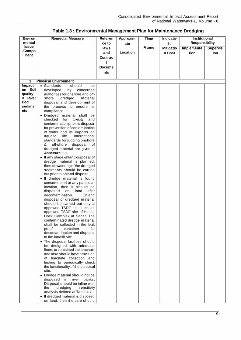
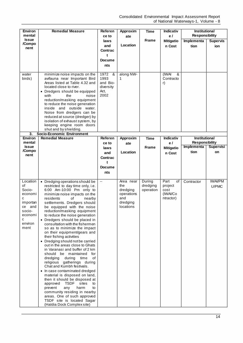
Table 1.3 : Environmental Management Plan for Maintenance Dredging
Environmental Issue
/Component
Remedial Measure Referen
ce to
laws
and
Contrac
t
Docume
nts
Approxim
ate
Location
Time
Frame
Indicativ
e /
Mitigatio
n Cost
Institutional Responsibility
Implementa
tion
Supervis
ion
1. Physical Environment Impact on Soil quality & River Bed sediments
Standards should be developed by concerned authorities for onshore and off-shore dredged material disposal and development of the process to ensure its compliance
Dredged material shall be checked for toxicity and contamination prior its disposal for prevention of contamination of water and its impacts on aquatic life. International standards for judging onshore & off-shore disposal of dredged material are given in Annexure 1.1.
If any stage onland disposal of dredge material is planned, then dewatering of the dredged sediments should be carried out prior to onland disposal.
If dredge material is found contaminated at any particular location, then it should be disposed on land after decontamination. Onland disposal of dredged material should be carried out only at approved TSDF site such as approved TSDF site of Haldia Dock Complex at Sagar. The contaminated dredge material shall be collected in the leak proof container for decontamination and disposal to the landfill site.
The disposal facilities should be designed with adequate liners to contained the leachate and also should have provision of leachate collection and testing to periodically check the functionality of the disposal site.
Dredge material should not be disposed in river banks, Disposal should be inline with the dredging sensitivity analysis defined at Table 4.4. .
If dredged material is disposed on land, then the care should

Consolidated Environmental Impact Assessment Report of National Waterways-1, Volume - 8
10
Environmental Issue
/Component
Remedial Measure Referen
ce to
laws
and
Contrac
t
Docume
nts
Approxim
ate
Location
Time
Frame
Indicativ
e /
Mitigatio
n Cost
Institutional Responsibility
Implementa
tion
Supervis
ion
be taken that the tail water is collected and made free from sediments prior to its discharge back to surface water body.
Water Quality
Attempt shall be made to minimizing and optimizing the dredging requirements by effective assessment and study of the Thalweg profiles of the river. This can be achieved some of the following measures: o Increase use of bandalling
which helps in diverting the flow of river towards the channel and reduces the quantity of dredging
o Low draft vessels should be deployed which will reduce the requirement of dredging
Dredged material shall be checked for toxicity and contamination prior its disposal onshore for prevention of contamination of water and its impacts on aquatic life. Standards for judging onshore & off-shore disposal of dredged material are given in Annexure 1.1.
Dredging should not be carried out during very low flow seasons so as to minimize the dispersion of fine sediments
Usage of silt or air bubble screens/curtains should be explored to minimize the sediment release during dredging operations. Silt/air bubble screens can hang from surface floats or stands attached to the bottom and held upright by sub-surface floats (PIANC). The use of silt curtains is reported to considerably reduce the loss of suspended sediments from the dredge area, by up to 75% where current velocities are very low. However, they are
Water Act, 1974
Within River
During Dredging Operation
Part of Project Cost (IWAI & Contractor)
Contractor IWAI/PM
U/PMC4
4 It is proposed to set up Project Unit (PMU) in IWAI to manager social and environmental aspect of NW1 augmentation. PMC (Project
Management Consultants) anticipated to be appointed for project management and quality check.

Consolidated Environmental Impact Assessment Report of National Waterways-1, Volume - 8
11
Environmental Issue
/Component
Remedial Measure Referen
ce to
laws
and
Contrac
t
Docume
nts
Approxim
ate
Location
Time
Frame
Indicativ
e /
Mitigatio
n Cost
Institutional Responsibility
Implementa
tion
Supervis
ion
generally ineffective in areas with high current velocities which exceed 0.5 m/s (UK Marine SACs Projects).
To minimize the sediment dispersal during disposal of dredge sediments, it should be place as close to the bed possible preferable at a level of 1m above the bed to minimise the dispersal of sediments.
Provision shall be made of emergency response equipment like floating blooms to deal with any emergency of oil spills or leakages. Regular servicing and maintenance of dredgers should be taken up so as to prevent any leakage of the dredged material. Leakage detection of the sediment transportation pipe shall be carried out regularly to prevent any sediment loss and water pollution at leakage location. Corrective actions should be taken immediately after detection of such leaks.
Cutter head of CSD should be selected according to material to be dredged so as to maximize the dredged material transport from dredging point to suction mouth and prevention of sediment loss and re-suspension.
Ratio of cutter revolutions and pump velocity should be adjusted to ensure that cutter advancement rate is not greater than the ability of the suction pump to remove the material that is cut. This will prevent the suspension of the dredged material.
Dredge cuts and lifts should be designed so as to prevent undercutting of material and hence a collapse of material locally at the cutter head, leading to an increase in the sediment being disturbed by dredging.
If dredge material is found contaminated at any particular
Consolidated Environmental Impact Assessment Report of National Waterways-1, Volume - 8
12
Environmental Issue
/Component
Remedial Measure Referen
ce to
laws
and
Contrac
t
Docume
nts
Approxim
ate
Location
Time
Frame
Indicativ
e /
Mitigatio
n Cost
Institutional Responsibility
Implementa
tion
Supervis
ion
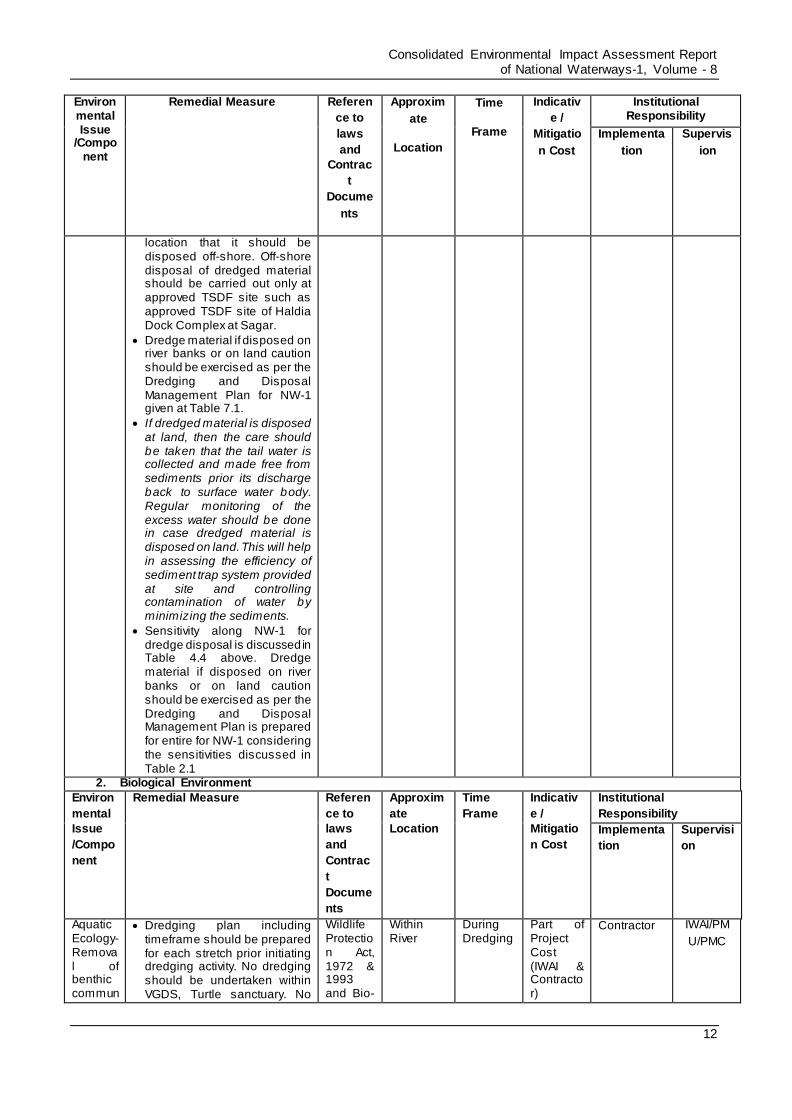
location that it should be disposed off-shore. Off-shore disposal of dredged material should be carried out only at approved TSDF site such as approved TSDF site of Haldia Dock Complex at Sagar.
Dredge material if disposed on river banks or on land caution should be exercised as per the Dredging and Disposal Management Plan for NW-1 given at Table 7.1.
If dredged material is disposed at land, then the care should be taken that the tail water is collected and made free from sediments prior its discharge back to surface water body. Regular monitoring of the excess water should be done in case dredged material is disposed on land. This will help in assessing the efficiency of sediment trap system provided at site and controlling contamination of water by minimizing the sediments.
Sensitivity along NW-1 for dredge disposal is discussed in Table 4.4 above. Dredge material if disposed on river banks or on land caution should be exercised as per the Dredging and Disposal Management Plan is prepared for entire for NW-1 considering the sensitivities discussed in Table 2.1
2. Biological Environment
Environ
mental
Issue
/Compo
nent
Remedial Measure Referen
ce to
laws
and
Contrac
t
Docume
nts
Approxim
ate
Location
Time
Frame
Indicativ
e /
Mitigatio
n Cost
Institutional
Responsibility
Implementa
tion
Supervisi
on
Aquatic Ecology-Removal of benthic commun
Dredging plan including timeframe should be prepared for each stretch prior initiating dredging activity. No dredging should be undertaken within VGDS, Turtle sanctuary. No
Wildlife Protection Act, 1972 & 1993 and Bio-
Within River
During Dredging
Part of Project Cost (IWAI & Contractor)
Contractor
IWAI/PM
U/PMC
Consolidated Environmental Impact Assessment Report of National Waterways-1, Volume - 8
13
Environmental Issue
/Component
Remedial Measure Referen
ce to
laws
and
Contrac
t
Docume
nts
Approxim
ate
Location
Time
Frame
Indicativ
e /
Mitigatio
n Cost
Institutional Responsibility
Implementa
tion
Supervis
ion
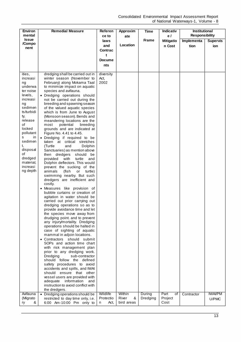
ities, increasing underwater noise levels, increasing sediments/turbidity, release of locked pollutants in sediment, disposal of dredged material, increasing depth
dredging shall be carried out in winter season (November to February) along Mokama Taal to minimize impact on aquatic species and avifauna.
Dredging operations should not be carried out during the breeding and spawning season of the valued aquatic species which is from June to August (Monsoon season). Bends and meandering locations are the most potential breeding grounds and are indicated at Figure No. 4.41 to 4.45.
Dredging if required to be taken at critical stretches (Turtle and Dolphin Sanctuaries) as mention above then dredgers should be provided with turtle and Dolphin deflectors. This would prevent the sucking of the animals (fish or turtle) swimming nearby. But such dredgers are inefficient and costly.
Measures like provision of bubble curtains or creation of agitation in water should be carried out prior carrying out dredging operations so as to provide avoidance time and let the species move away from drudging point. and to prevent any injury/mortality. Dredging operations should be halted in case of sighting of aquatic mammal in adjoin locations.
Contractors should submit SOPs and action time chart with risk management plan prior to any dredging work. Dredging sub-contractor should follow the defined safety procedures to avoid accidents and spills, and IWAI should ensure that other vessel users are provided with adequate information and instruction to avoid conflict with the dredgers.
diversity Act, 2002
Avifauna (Migratory &
Dredging operations should be restricted to day time only, i.e. 6:00 Am-10:00 Pm only to
Wildlife Protection Act,
Within River & bird areas
During Dredging
Part of Project Cost
Contractor IWAI/PM
U/PMC
Consolidated Environmental Impact Assessment Report of National Waterways-1, Volume - 8
14
Environmental Issue
/Component
Remedial Measure Referen
ce to
laws
and
Contrac
t
Docume
nts
Approxim
ate
Location
Time
Frame
Indicativ
e /
Mitigatio
n Cost
Institutional Responsibility
Implementa
tion
Supervis
ion
water birds)
minimize noise impacts on the avifauna near Important Bird Areas listed at Table 4.32 and located close to river.
Dredgers should be equipped with the noise reduction/masking equipment to reduce the noise generation inside and outside water. Noise from dredgers can be reduced at source (dredger) by isolation of exhaust system, by keeping engine room doors shut and by shielding.
1972 & 1993 and Bio-diversity Act, 2002
along NW-1
(IWAI & Contractor)
3. Socio-Economic Environment Environmental Issue
/Component
Remedial Measure Referen
ce to
laws
and
Contrac
t
Docume
nts
Approxim
ate
Location
Time
Frame
Indicativ
e /
Mitigatio
n Cost
Institutional Responsibility
Implementa
tion
Supervisi
on
Location of Socio-economic importance and socio-economic environment
Dredging operations should be restricted to day time only, i.e. 6:00 Am-10:00 Pm only to minimize noise impacts on the residents of nearby settlements. Dredgers should be equipped with the noise reduction/masking equipment to reduce the noise generation
Dredgers should be placed in consultation with the fishermen so as to minimize the impact on their equipment/gears and their fishing activities
Dredging should not be carried out in the areas close to Ghats in Varanasi and buffer of 2 km should be maintained for dredging during time of religious gatherings during Chat and Kumbh festivals.
In case contaminated dredged material is disposed on land, then it should be disposed at approved TSDF sites to prevent any harm to community residing in nearby areas. One of such approved TSDF site is located Sagar (Haldia Dock Complex site)
-- Area near the dredging operations and dredging locations
During dredging operation
Part of project cost (IWAI/Contractor)
Contractor
IWAI/PM
U/PMC
Consolidated Environmental Impact Assessment Report of National Waterways-1, Volume - 8
15
Environmental Issue
/Component
Remedial Measure Referen
ce to
laws
and
Contrac
t
Docume
nts
Approxim
ate
Location
Time
Frame
Indicativ
e /
Mitigatio
n Cost
Institutional Responsibility
Implementa
tion
Supervis
ion
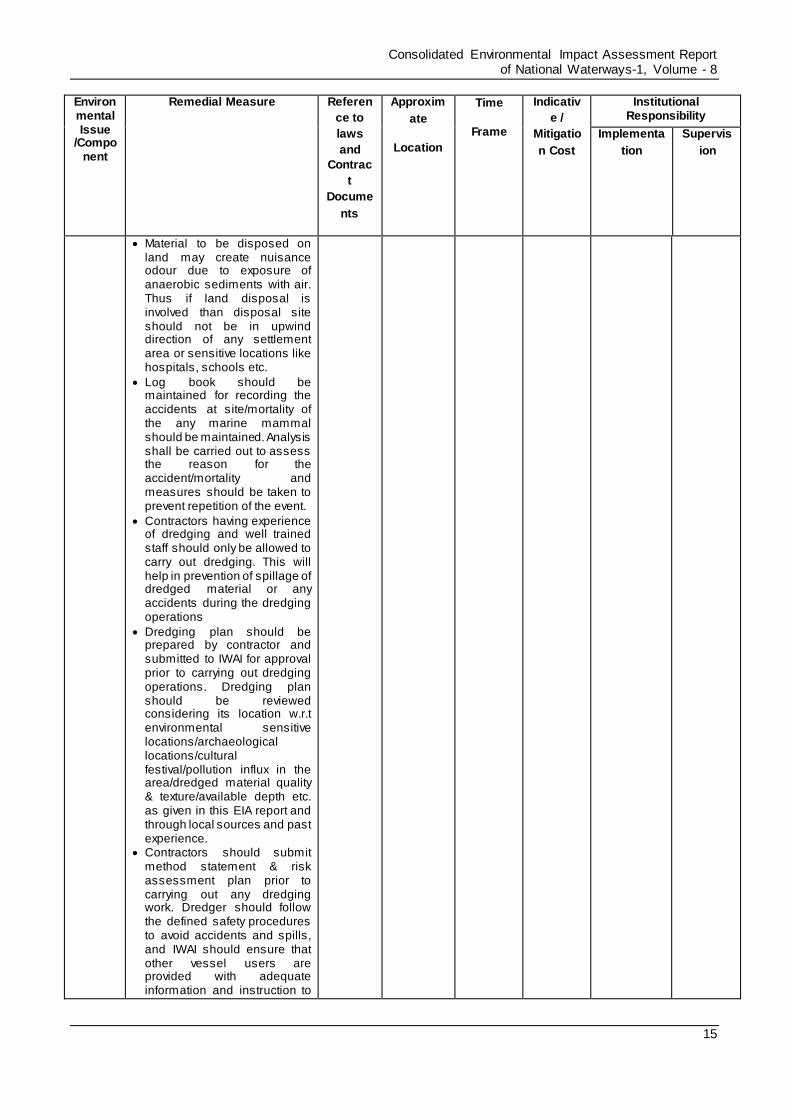
Material to be disposed on land may create nuisance odour due to exposure of anaerobic sediments with air. Thus if land disposal is involved than disposal site should not be in upwind direction of any settlement area or sensitive locations like hospitals, schools etc.
Log book should be maintained for recording the accidents at site/mortality of the any marine mammal should be maintained. Analysis shall be carried out to assess the reason for the accident/mortality and measures should be taken to prevent repetition of the event.
Contractors having experience of dredging and well trained staff should only be allowed to carry out dredging. This will help in prevention of spillage of dredged material or any accidents during the dredging operations
Dredging plan should be prepared by contractor and submitted to IWAI for approval prior to carrying out dredging operations. Dredging plan should be reviewed considering its location w.r.t environmental sensitive locations/archaeological locations/cultural festival/pollution influx in the area/dredged material quality & texture/available depth etc. as given in this EIA report and through local sources and past experience.
Contractors should submit method statement & risk assessment plan prior to carrying out any dredging work. Dredger should follow the defined safety procedures to avoid accidents and spills, and IWAI should ensure that other vessel users are provided with adequate information and instruction to

Consolidated Environmental Impact Assessment Report of National Waterways-1, Volume - 8
16
Environmental Issue
/Component
Remedial Measure Referen
ce to
laws
and
Contrac
t
Docume
nts
Approxim
ate
Location
Time
Frame
Indicativ
e /
Mitigatio
n Cost
Institutional Responsibility
Implementa
tion
Supervis
ion
avoid conflict with the dredgers.
Post-dredging monitoring of the sediment nature, rate of sedimentation shall be made part of contractor’s job as best dredging practise. This will provide information which can be taken into consideration before the next maintenance dredge is carried out.
Re-use of dredged material should be explored if dredged material is not contaminated. Economically and environmentally feasible options can be adopted to minimize the dredge spoil burdens. Some of such measures include
Dredged sediment can be used for beach nourishment/development of artificial beach/deposition on shoal & thus enrichment of habitat o Dredged material can be
explored for its usage for coast/bank protection purpose/flood protection
o Use of dredged material can be explored for land filling, as construction material for road foundations, dikes, mounds, noise/wind barriers .

Consolidated Environmental Impact Assessment Report of National Waterways-1, Volume - 8
17
Annexure 1.1: Standards for onshore & off-shore disposal of dredged material
Criteria for Disposal of Harmful Bottom Sediments: No specific standards are defined in India
for disposal of dredged material. If dredged material is toxic / harmful then these sediments should
either be disposed off in landfill or in Sea. Criteria followed in Japan are given in the Table 1.
Table 1: Criteria for Harmful Bottom Sediments, Japan (unit: mg/l)
Contaminated Material Dumping in Landfills (mg/l) Dumping at sea (mg/l)
Alkyl mercuric compounds Not detectable Not detectable
Mercury and its compounds 0.005 0.005
Cadmium and its compounds 0.1 0.1
Lead and its compounds 1 1
Organophosphorus compounds 1 1
Chromium (VI) compounds 0.5 0.5
Arsenic and its compounds 0.5 0.5
Cyanogen compounds 1 1
PCB 0.003 0.003
Copper and its compounds - 3
Zinc and its compounds - 5
Fluoride - 15
Note: Criteria are based on the examination of dissolution of contaminated materials
Source: Assessment of the Environmental Impact of Port Development, United Nations, New York, 1992
Criteria for Off-shore dumping of Dredged material: No criteria are defined for off-shore
disposal of dredged material in India, thus reference to the UN standards can be made and is given
in Table 2.
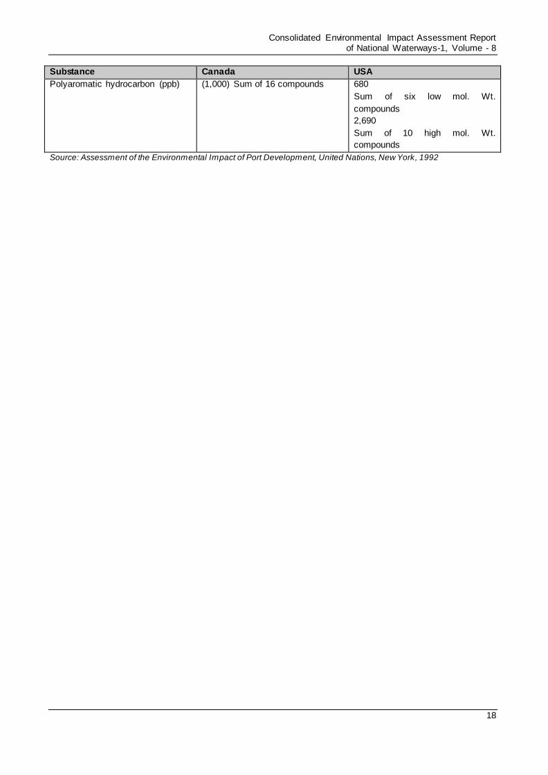
Table 2: Criteria for Off-Shore Dumping of Dredged Material (unit: ppm or ppb)
Substance Canada USA
PCB (ppb) 100 380
Hg (ppm) 0.5 0.15
Cd (ppm) 0.60 0.7
Zn (ppm) 169 105
Cu (ppm) 45 68
As (ppm) (5 – 25) 12.5
Pb (ppm) 45 33
Organochlorine pesticide (ppb) 10
for any compound
5.0
Sum of DDT, DDE and DDD
Consolidated Environmental Impact Assessment Report of National Waterways-1, Volume - 8
18
Substance Canada USA
Polyaromatic hydrocarbon (ppb) (1,000) Sum of 16 compounds 680
Sum of six low mol. Wt.
compounds
2,690
Sum of 10 high mol. Wt.
compounds
Source: Assessment of the Environmental Impact of Port Development, United Nations, New York, 1992