Embed Size (px)
Citation preview
This project is funded in part by a grant from the National Geographic Society Education Foundation.
Environmental Geography of Southeast Asia: Module Materials
TEKS Alignment
(8) Geography. The student understands how people, places, and environments are connectedand interdependent. The student is expected to:
(A) compare ways that humans depend on, adapt to, and modify the physicalenvironment, including the influences of culture and technology;(C) evaluate the economic and political relationships between settlements and theenvironment, including sustainable development and renewable/non-renewable resources.
(19) Science, technology, and society. The student understands the impact of technology andhuman modifications on the physical environment. The student is expected to:
(A) evaluate the significance of major technological innovations in the areas oftransportation and energy that have been used to modify the physical environment;(C) examine the environmental, economic, and social impacts of advances in technologyon agriculture and natural resources.
(20) Science, technology, and society. The student understands how current technology affectshuman interaction. The student is expected to:
(B) examine the economic, environmental, and social effects of technology such asmedical advancements or changing trade patterns on societies at different levels ofdevelopment.
Key Vocabulary Double cropping Deforestation Biodiversity
Module IntroductionEnvironmental Degradation is a global problem, but some regions of the world have more difficultyaddressing the issues and finding solutions than others. Less developed and newly industrializingcountries often lack the resources needed to reduce the destruction caused by the primary and secondaryeconomic activities which typically comprise the majority of their economic systems. In addition,governments in these countries may be unwilling to address environmental issues due to fear of losingindustries and jobs vital to the future economic progress of the nation. Or, these governments may beunwilling to divert resources from issues they feel are more immediately pressing – such as education,health care, housing and sanitation. The final remaining obstacle facing countries both willing and able toaddress environmental issues is enforcement. Illegal activities are often even more destructive than legal

Environmental Geography of Southeast Asia 2
Texas Alliance for Geographic Educationhttp://www.geo.txstate.edu/tage/
September 2013
ones and enforcing the laws that are present again places governments in the position of divertingresources from other important issues.
There are numerous resources available online which deal with the various forms of environmentaldegradation across the globe. A few of the resources below focus on issues specific to Southeast Asia,but others address topics globally. Since Southeast Asia is taught towards the end of the school year inmany districts, this unit provides an excellent opportunity to teach concepts at the regional level and applythem globally.
This module primarily deals with environmental issues such as deforestation and pollution. (Issuesconcerning climate change will be addressed in another module.) The video produced by TAGE providesan excellent introduction to the topic for teachers and students. The case study focuses on one of theworld’s largest mining operations and its effects on the environment in Indonesia. The lesson providedwith this module allows students to select a topic they are interested in pursuing. The students willproduce their own “documentary” introducing the issue and presenting possible solutions.
Case StudyGrasberg Mineral District – Power Point
Video Presentations Environmental Degradation
o http://stream.its.txstate.edu/users/tage/Fullll_Version_Env.mov Perspectives of Geography
o http://stream.its.txstate.edu/users/tage/PerspectiveOfGeo_Env.mov Dams along the Mekong River
o http://stream.its.txstate.edu/users/tage/Dams_Env.mov Deforestation
o http://stream.its.txstate.edu/users/tage/Deforest_Env.mov Global Warming
o http://stream.its.txstate.edu/users/tage/Global_Warming_Env.mov Wood Resources
o http://stream.its.txstate.edu/users/tage/WoodResources_Env.mov Tsunami
o http://stream.its.txstate.edu/users/tage/Tsunami_Env.mov Environmental Problems
o http://stream.its.txstate.edu/users/tage/Env_Problems_Env.mov Flooding
o http://stream.its.txstate.edu/users/tage/Flooding_Env.mov Physical Geography
o http://stream.its.txstate.edu/users/tage/Physical_Geo_Env.mov Resource Base
o http://stream.its.txstate.edu/users/tage/ResourceBase_Env.mov
Environmental Geography of Southeast Asia 3
Texas Alliance for Geographic Educationhttp://www.geo.txstate.edu/tage/
September 2013
Readings and Visual ResourcesDeforestation in Malaysian Borneo –
Collection of satellite photos, animations and a Google Earth kml file illustrating the impact plantationfarming is having on the forests. Images are provided by NASA and Visible Earth.
http://visibleearth.nasa.gov/view.php?id=40139
Earth Pulse: State of the Earth 2010 Vital Statistics Interactive Map – National Geographic
This interactive map contains multiple layers of data including information on deforestation, cropland andpasture density, Population density and meat consumption.
http://earthpulse.nationalgeographic.com/earthpulse/earthpulse-map
Environmental Issues in Southeast Asia
This map highlights some of the major environmental issues in Southeast Asia
http://www.roebuckclasses.com/105/regions/seasiaspac/seasia/seasiaphys/physseasia.htm#Environment

Environmental Geography of Southeast Asia 4
Texas Alliance for Geographic Educationhttp://www.geo.txstate.edu/tage/
September 2013
Agriculture
This map highlights some of the major crops and types of agriculture found in Southeast Asia
http://www.roebuckclasses.com/105/regions/seasiaspac/seasia/seasiaphys/physseasia.htm#Environment
Population and Natural Resources Case Study: Is population growth responsible for the loss ofrainforests?
This case study investigates deforestation in Vietnam and the effects of development, population andnatural resources policies. As the reading level might be challenging for high students, the case study islisted here as a background source for teachers. However, it might prove to be a good resource for an APHuman Geography course. The module is part of a collection of online modules designed for collegecourses by the AAG Center for Global Geographic Education.
http://cgge.aag.org/PopulationandNaturalResources1e/CS_Vietnam_Sep10/index.html
Lesson PlanEnvironmental Degradation in Southeast Asia Documentary Lesson
Environmental Degradation Documentary Lesson Outline
Environmental Degradation Documentary Student Handout
This project is funded in part by a grant from the National Geographic Society Education Foundation.
Environmental Geography of SE Asia:Environmental Degradation Documentary
Grade Level: 9-12
Created By TAGE Teacher Consultant: Michelle Crane
Time Frame: Five 55 minute periods + work outside of class as necessary.
Curriculum Connection: This lesson is intended to be used in a World RegionalGeography course in a unit on Southeast Asia. Since this unit tends to fall towards the end of theyear, it is assumed that students are already familiar with general concepts of economic activitiesand their effects on the environment, sustainable development, renewable and non-renewableresources, biodiversity, and the impact of technology on the environment. If students have notbeen exposed to these concepts prior to this lesson, a brief introduction will be necessary. Inaddition, prior to beginning this lesson, students should be familiar with economic activities andresources available in Southeast Asia.
Learning Outcomes:Upon completion of this lesson, students should be able to:
1. Compare ways humans modify the environment in Southeast Asian countries,2. Evaluate the economic and political relationships which effect renewable and non-
renewable resources and their production in Southeast Asia,3. Examine the economic, environmental, and social impacts of technological innovations in
agriculture and natural resources have had in Southeast Asia,4. Evaluate the significant technological innovations which have impacted the environment
of Southeast Asia and how these impacts vary depending upon levels of development,and
5. identify a problem, gather information, list and consider options, consider advantages anddisadvantages, choose and implement a solution, and evaluate the effectiveness of thesolution.
TEKS Strand(s) Objective(s):(8) Geography. The student understands how people, places, and environments are connectedand interdependent. The student is expected to:
(A) compare ways that humans depend on, adapt to, and modify the physicalenvironment, including the influences of culture and technology;(C) evaluate the economic and political relationships between settlements and theenvironment, including sustainable development and renewable/non-renewable resources.
(19) Science, technology, and society. The student understands the impact of technology andhuman modifications on the physical environment. The student is expected to:

Environmental Degradation of SE Asia Documentary 2
Texas Alliance for Geographic Educationhttp://www.geo.txstate.edu/tage/
September 2013
(A) evaluate the significance of major technological innovations in the areas oftransportation and energy that have been used to modify the physical environment;(C) examine the environmental, economic, and social impacts of advances in technologyon agriculture and natural resources.
(20) Science, technology, and society. The student understands how current technology affectshuman interaction. The student is expected to:
(B) examine the economic, environmental, and social effects of technology such asmedical advancements or changing trade patterns on societies at different levels ofdevelopment.
(22) Social studies skills. The student communicates in written, oral, and visual forms. Thestudent is expected to:
(B) generate summaries, generalizations, and thesis statements supported by evidence;(C) use geographic terminology correctly;(D) use standard grammar, spelling, sentence structure, and punctuation; and(E) create original work using proper citations and understanding and avoidingplagiarism.
(23) Social studies skills. The student uses problem-solving and decision-making skills, workingindependently and with others, in a variety of settings. The student is expected to:
(C) use problem-solving and decision-making processes to identify a problem, gatherinformation, list and consider options, consider advantages and disadvantages, chooseand implement a solution, and evaluate the effectiveness of the solution.
Materials :For Student Use:Environmental DegradationDocumentary Student Handout
One per student
Computer lab with access to theinternet and PhotoStory 3loaded; make sure the studentshave access to microphones forrecording their dialogue.
PhotoStory 3 is a free software program available online.Make sure it is installed on the computer lab prior tobeginning the lesson.
For Teacher Use:Land Use/Land Cover Map Located on the module websiteComputer with projection deviceand access to the internet
References:Gersmehl, C. a. (n.d.). Modes of Spatial Thinking. New York: NY Center for Geographic Learning.
Strategies: In this lesson, students will complete a map analysis activity based upon the BasicModes of Spatial Thinking as a warm up. Then, students will use the Geographic Inquiry

Environmental Degradation of SE Asia Documentary 3
Texas Alliance for Geographic Educationhttp://www.geo.txstate.edu/tage/
September 2013
method to explore a major environmental issue in Southeast Asia. Finally, students will use asoftware program entitled Photo Story to create a documentary film about the issue.
Procedures to conduct the lesson:
Starting the Lesson: 5 minutes
Warm Up: Display the map entitled Land Use/Land Cover. Found at:http://www.roebuckclasses.com/105/regions/seasiaspac/seasia/seasiaphys/physseasia.htm#Environment
Have students answer the following questions:
1. Conditions/Site: What major environmental issues are depicted on this map? What type ofland cover exists across the majority of the region?
2. Comparison: How are the issues found here similar or different to issues found in otherworld regions?
3. Aura/Influence: How would the issues depicted on this map affect the surrounding area (theareas adjacent to where each issue is found)?
4. Pattern: Is there a pattern to where these issues are found? If so, explain the pattern?
Asking Geographic Questions: 10-15 minutes
Each pair of students will create their own Geographic Question based upon the topic theychooses to explore. It is suggested that you give students some time to think about their topicbefore requiring them to submit their question for approval – perhaps 10 to 15 minutes. You mayprovide a basic question outline, if necessary, for example:o How can the problem of (insert topic here) be solved in Southeast Asia?o What are some possible examples of resource use that one would expect based on the
type of land cover and how may “resource use” become “resource depletion”?The Lesson:
Acquiring Geographic Information: Remainder of Day One
Students will use their handouts as guidelines for gathering information regarding their topic. Itis recommended that students work in pairs – one skimming information online while the othertakes notes.
Organizing Geographic Information: Day Two
Students will use the Storyboard handout to organize their information and write the script fortheir film. Once their storyboard has been completed, it is recommended that the teacher reviewthe storyboard before the students begin making their film. Once the teacher has approved thestoryboard, the students will use Photo Story to create their documentary. An excellent tutorialon how to use PhotoStory can be found at:http://www.schooltube.com/video/e63ee182f74e098c72fd/

Environmental Degradation of SE Asia Documentary 4
Texas Alliance for Geographic Educationhttp://www.geo.txstate.edu/tage/
September 2013
NOTE: There are other software programs that students can use to create their film. MicrosoftMovie Maker is an example. It is up to teacher discretion as to whether or not students may beallowed to use an alternate program. However, Photo Story is incredibly easy to use – the actualproduction of the film using this program goes very quickly. Movie Maker and other programswill give students more flexibility over their movie, but students often spend more time playingwith the software than they do on the content. In addition, the greater complexity of these otherprograms makes them more difficult and time consuming than necessary for completion of thisactivity.
Analyzing Geographic Information: Day Three
Students will conduct their own analysis of the information they have gathered. They will presenttheir analysis in their film.
End the Lesson:
Answering Geographic Questions: Days Four and Five
Students will answer their original question at the end of their film.
Once all of the films are completed, the films will be shown to the class. As a way to keep thestudents active during the films, have each student complete a brief review of each film –including his/her own. A template is provided below. If possible, the teacher can even createaward categories for the students to vote on: Best Overall, Most Informative, Most Entertaining,etc.
NOTE: While showing the films may take up a great deal of class time, this is an important stepfor a couple of reasons. First, if students know their peers will be assessing their work, they aremore likely to put more effort into the final product. Second, students need the opportunity topractice assessing their own and others’ work. By judging the quality of the films themselves,they begin to understand how to improve their own work in the future. To protect students andensure privacy, make sure that student film evaluations do not reveal the name of the studentcompleting the evaluation. If desired, you can assign numbers, or merely leave the reviewsanonymous. In addition, only the teacher’s assessment will determine the grade for the film. Ifawards are voted upon, the teacher may exercise the option to award bonus points for films whichwin awards, but the final grading will be done solely by the teacher.
Questions:Find and compare solutions other countries have implemented to solve this problem. The answers to this will vary depending upon the countries and the topic each group
chooses to research.
Explain how the level of development in this country impacts this issue. Higher levels of development are the result of stable governments, stable economies,
higher levels of education, and sophisticated communication networks, all of which areimportant when dealing with environmental destruction. Stable governments/economiesin countries where basic needs are being met are more able to spend resources on
Environmental Degradation of SE Asia Documentary 5
Texas Alliance for Geographic Educationhttp://www.geo.txstate.edu/tage/
September 2013
protecting the environment. In addition, people with higher levels of education are morelikely to promote protecting the environment and the communications networks arenecessary for people to be able to see and understand the issues.
Explain how advances in technology have impacted this issue. Answers will vary depending upon the issue, but in all of the issues – information about
the issue and how to resolve it is crucial. Advances in communications technologymakes it possible for people to see how areas far away from their location are beingaffected by their actions. Technology such as the internet allows people to network andlearn about issues and their solutions.
Evaluation/Assessment :Use the following rubric to assess the students’ films. Content grade will be determined by boththe completed storyboard AND the dialogue in the film. If desired, bonus points may be addedto films which win awards voted upon by the class.
Rubric: Total Points: 5Not There Yet Satisfactory Clearly Outstanding
Content 1 Point Storyboard is largely
missing or incomplete. Storyboard/film merely
describes the topic, withlittle to no attempt toanalyze the problem orprovide a solution.
Storyboard and film donot utilize appropriatevocabulary.
Storyboard is difficultto read due to spellingand/or grammar errors.
2 Points Storyboard is complete
and on time. Storyboard describes the
topic and presentspossible solutions. Anattempt is made tothoroughly analyze theissue.
Storyboard and filmcorrectly utilizeappropriate vocabulary.
Storyboard is generallyfree from spelling orgrammar errors.
3 Points Storyboard is well-
written and on time. Storyboard thoroughly
analyzes the issue,compares possiblesolutions and presentsone as the mostpromising.
Storyboard and filmdemonstrate mastery ofappropriate vocabulary.
Storyboard is largelyfree from spelling orgrammar errors.
Appearance& Sound
0.75 Points No maps are included. Few pictures are
included, and photosare difficult to see.
No music is added inthe background ormusic is too loud andmakes the dialoguedifficult to hear.
Dialogue is too quiet ordifficult to understand.
1.25 Points At least one map is
included. Photos are numerous and
easy to see. Music is added and does
not detract from thedialogue.
Dialogue is clear andeasy to hear.
2 Points Numerous maps are
included. A wide variety of visual
images are included.Images enhance thepresentation and reflectdialogue.
Music enhances thepresentation byreflecting images anddialogue.
Dialogue is clear andeasy to hear. Dialogueis well-spoken.

Environmental Degradation of SE Asia Documentary 6
Texas Alliance for Geographic Educationhttp://www.geo.txstate.edu/tage/
September 2013
Template for Student Reviews:Film Title and Production Crew Rating: see guide Comments:
Film content:Graphics:Sound:Total score:
Film content:Graphics:Sound:Total score:
Film content:Graphics:Sound:Total score:
Film content:Graphics:Sound:Total score:
Film content:Graphics:Sound:Total score:
Film content:Graphics:Sound:Total score:
Film content:Graphics:Sound:Total score:
Film content:Graphics:Sound:Total score:
Film content:Graphics:Sound:Total score:
Environmental Degradation of SE Asia Documentary 7
Texas Alliance for Geographic Educationhttp://www.geo.txstate.edu/tage/
September 2013
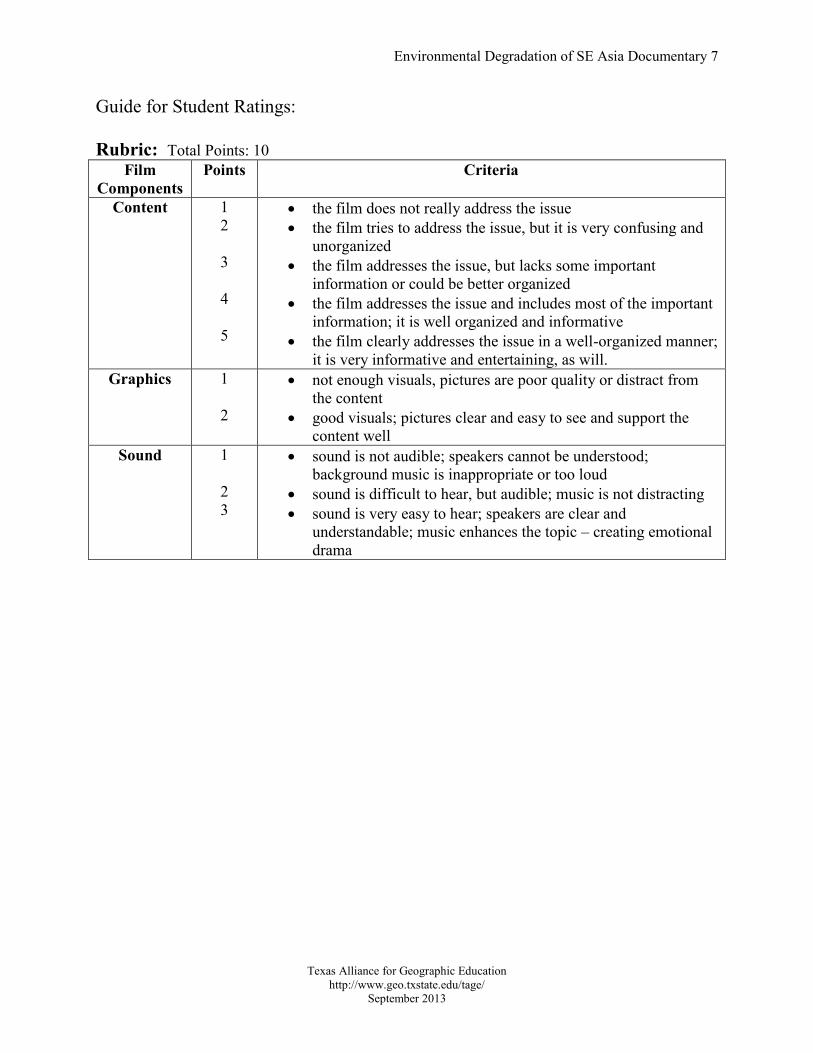
Guide for Student Ratings:
Rubric: Total Points: 10Film
ComponentsPoints Criteria
Content 12
3
4
5
the film does not really address the issue the film tries to address the issue, but it is very confusing and
unorganized the film addresses the issue, but lacks some important
information or could be better organized the film addresses the issue and includes most of the important
information; it is well organized and informative the film clearly addresses the issue in a well-organized manner;
it is very informative and entertaining, as will.Graphics 1
2
not enough visuals, pictures are poor quality or distract fromthe content
good visuals; pictures clear and easy to see and support thecontent well
Sound 1
23
sound is not audible; speakers cannot be understood;background music is inappropriate or too loud
sound is difficult to hear, but audible; music is not distracting sound is very easy to hear; speakers are clear and
understandable; music enhances the topic – creating emotionaldrama
Name: _________________________________ Name: ___________________________________
This project is funded in part by a grant from the National Geographic Society Education Foundation.
Environmental Degradation Documentary
Student HandoutYou and your partner will be investigating an environmental issue affecting Southeast Asiatoday. Your final product will be a documentary created using a software program called PhotoStory 3. Microsoft Photo Story is a free photo presentation program for Windows XP.
Your documentary will explain the issue you have selected and present a solution for solving it.
I. Topic: You will need to begin by selecting a topic to research. You may select atopic from the map your teacher presented in class, or you may spend a few minuteslooking online for another topic. Some topics to consider:a. Deforestationb. Air pollution over citiesc. Water pollutiond. Destruction of habitat – particularly the orangutanse. Overfishingf. Acid raing. Effects of mining
Our topic is: ______________________________________________
II. Asking Geographic Questions: Once you have selected your topic, you will need towrite a Guiding Question. This question will guide your research and help give yourproject focus.
Our Guiding Question: _______________________________________________
___________________________________________________________________
III. Acquiring Geographic Data: Using the matrix below, begin researching your topic.Make sure to address each question, but feel free to add more questions or details.Also, you will need to collect photos and maps to illustrate the issue in yourPhotoStory film. Your graphics should provide visual illustrations of the informationyou gather, so make sure you have one or more graphics for each set of informationbelow. Store these in a location designated by your teacher. You will also want asong or two to play in the background. Store the mp3 files in the same location asyour photos.

Name: _________________________________ Name: ___________________________________
Texas Alliance for Geographic Educationhttp://www.geo.txstate.edu/tage/
September 2013
Guiding Question - Answer this question lastafter investigating all of the other questions.This is the overall focus of your film.Location: Where is this issue occurring? Listseveral places in Southeast Asia affected by thisissue.
Region:How are the places affected by this issueconnected?What do they have in common with each other?
Movement:How is this issue affecting the distribution ofpeople in the area? Are people moving in? Arethey moving away?Is this issue affecting the migration of animals?
HEI:Are humans responsible for creating this issue?If so, how have they done this and why?Who in particular is responsible?Are humans attempting to fix this issue? If so,how and why?What groups or organizations are responsiblefor attempting to solve this issue?Are humans being affected by this issue? If so,how?Solutions: What is being done about this issue?Who is attempting to solve the problem? Arethese solutions working? Why or why not? Arethere other places where this is occurring thathave had more success finding a solution?What solutions have worked in these places?What is your recommendation about how tosolve this problem?
Is there anything else about this feature you feelshould be included in the film?

Name: _________________________________ Name: ___________________________________
Texas Alliance for Geographic Educationhttp://www.geo.txstate.edu/tage/
September 2013
IV. Organizing and Analyzing Geographic Information – Once you have completed yourresearch, you will need to organize your information in order to create your film.You will organize your information in a Storyboard – a technique used for writingfilms. For each illustration you choose to use in your film, you will write a shortdialogue piece explaining your topic and how the illustration relates to it. You canarrange your graphics and information as you see fit, but it is recommended that youfollow the order used in your research matrix. You may add as many rows asnecessary.
Graphic, map, picture or other illustration –write the name or sketch the image here.
Dialogue – write your text for each slide here

Name: _________________________________ Name: ___________________________________
Texas Alliance for Geographic Educationhttp://www.geo.txstate.edu/tage/
September 2013
V. Answering Geographic Questions: The final step in writing your story is to answerthe Guiding Question you wrote at the beginning of the project. Make sure to includeyour answer in your film.
VI. Assembling your PhotoStory:
There is an excellent tutorial on creating a PhotoStory at:http://gemini.utb.edu/jbutler/power_bytes/PS3manual/PS3manual.htm.
Some things to keep in mind:a. Make sure your pictures are clear. If they are too pixelated, choose another photo.b. Make sure your dialogue is spoken clearly and loudly. Speak directly into the
microphone.c. Make sure your background music is not too loud. There is a bar which will
allow you to turn the background music down.
September 2013Texas Alliance for Geographic Education; http://www.geo.txstate.edu/tage/
Environmental Geography ofSoutheast Asia Case Study:Grasberg Mineral Districtby Michelle CraneTeacher Consultant for the Texas Alliance for Geographic Education

September 2013Texas Alliance for Geographic Education; http://www.geo.txstate.edu/tage/
Grasberg Mineral District Located on New Guinea in Indonesia
Single largest reserve of gold in the world
Second largest reserve of copper
The mine is owned by Freeport McMoRan Copper and Gold, which has acontrolling interest, the Government of Indonesia and 2 other companies.
The mine is operated by PT Freeport Indonesia and employs 18,000 people.
September 2013Texas Alliance for Geographic Education; http://www.geo.txstate.edu/tage/
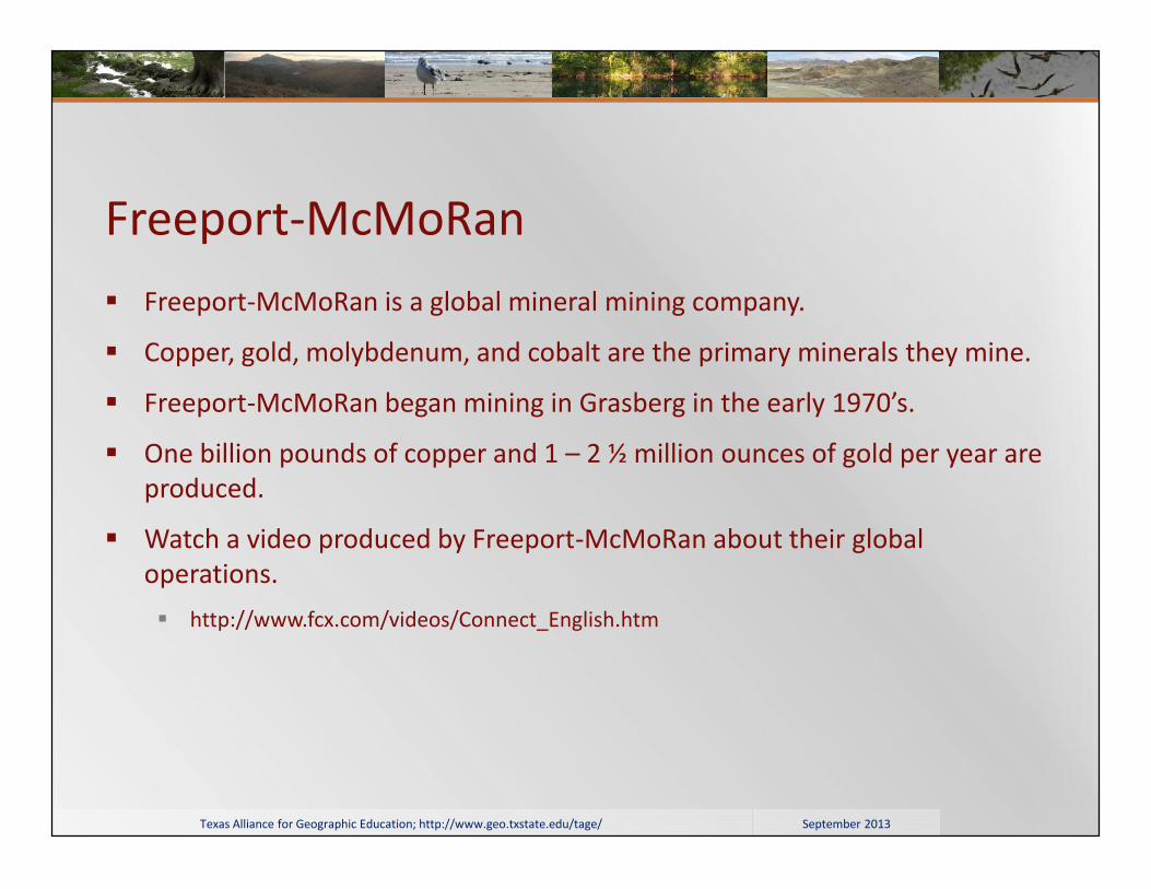
Freeport-McMoRan Freeport-McMoRan is a global mineral mining company.
Copper, gold, molybdenum, and cobalt are the primary minerals they mine.
Freeport-McMoRan began mining in Grasberg in the early 1970’s.
One billion pounds of copper and 1 – 2 ½ million ounces of gold per year areproduced.
Watch a video produced by Freeport-McMoRan about their globaloperations. http://www.fcx.com/videos/Connect_English.htm

September 2013Texas Alliance for Geographic Education; http://www.geo.txstate.edu/tage/
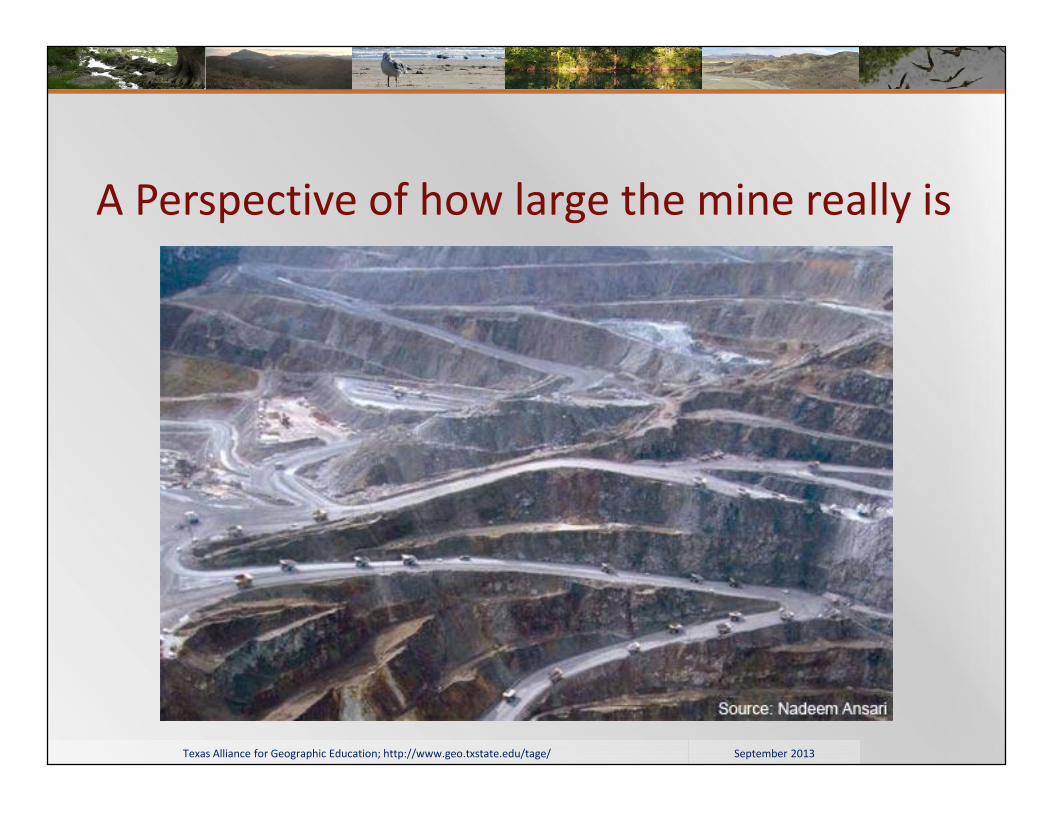
Open Pit Mine Mine was originally a mountain
over 4000 meters high.
The mine is 3000 meters deep atpresent.
Open pit will be exhausted around2015
September 2013Texas Alliance for Geographic Education; http://www.geo.txstate.edu/tage/
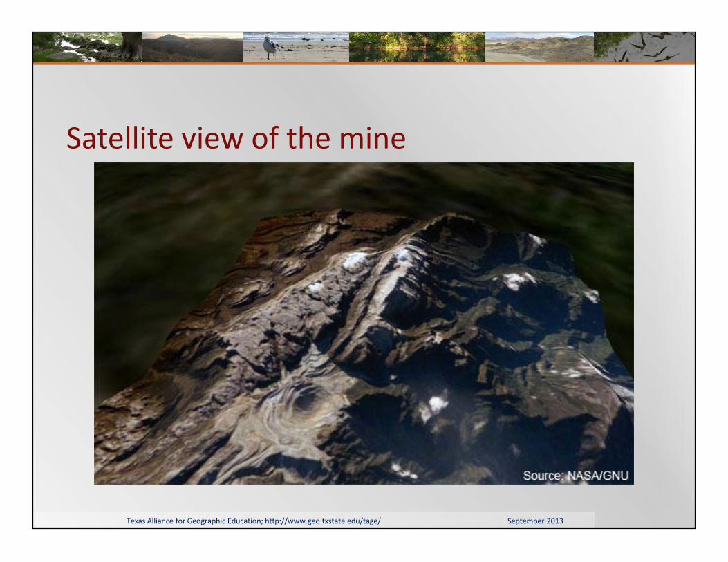
Satellite view of the mine
September 2013Texas Alliance for Geographic Education; http://www.geo.txstate.edu/tage/
A Perspective of how large the mine really is

September 2013Texas Alliance for Geographic Education; http://www.geo.txstate.edu/tage/
Environmental Impact After extracting the minerals, the overburden and waste rock are discharged
to the side of the mine.
Overburden and waste rock amount to about 360,000 to 510,000 tons a day.
A great deal of these tailings are discharged into the Aghawagon River andthen on into the Otomona River.
The tailings settle into the flood plain, which runs through the rainforest orare dumped into the Arafura sea.

September 2013Texas Alliance for Geographic Education; http://www.geo.txstate.edu/tage/
Grasberg mine tailings

September 2013Texas Alliance for Geographic Education; http://www.geo.txstate.edu/tage/
Environmental impact Waste rock is up to 900 feet deep and covers 3 square miles.
Waste rock contains sulphurous minerals, which create sulphuric acid whenexposed to water.
Other heavy metals also infiltrate the ground water.
September 2013Texas Alliance for Geographic Education; http://www.geo.txstate.edu/tage/
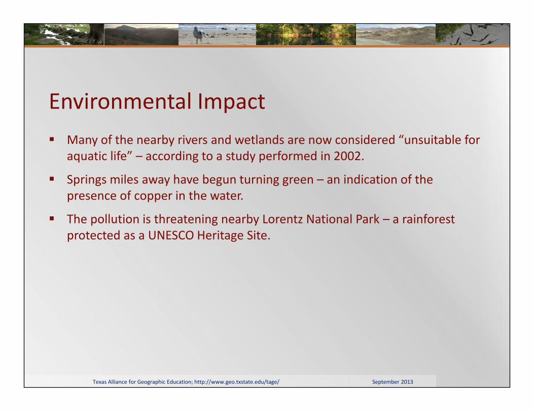
Environmental Impact Many of the nearby rivers and wetlands are now considered “unsuitable for
aquatic life” – according to a study performed in 2002.
Springs miles away have begun turning green – an indication of thepresence of copper in the water.
The pollution is threatening nearby Lorentz National Park – a rainforestprotected as a UNESCO Heritage Site.

September 2013Texas Alliance for Geographic Education; http://www.geo.txstate.edu/tage/
Social impact Local tribes do not always feel they are receiving their fair share.
The area has long felt isolated from the rest of the country due to itsdistance and its religious and cultural differences.
Freeport has invested heavily in Indonesia’s politicians in order to ensuretheir continued support of the project.
Freeport also spends a great deal of money on military in the area to protectfrom riots and insurrections like the one in 1996 which resulted in thedestruction of $3 million of equipment.

September 2013Texas Alliance for Geographic Education; http://www.geo.txstate.edu/tage/
Mine borders a Unesco heritage Site
This project is funded in part by a grant from the National Geographic Society Education Foundation.

September 2013Texas Alliance for Geographic Education; http://www.geo.txstate.edu/tage/
Notes & Credits Slide 3
Source: http://www.fcx.com/videos/Connect_English.htm
Slide 4
Source: http://www.mining-technology.com/projects/grasbergopenpit/
Slide 5
Source: http://www.mining-technology.com/projects/grasbergopenpit/grasbergopenpit2.html
Slide 6
http://www.mining-technology.com/projects/grasbergopenpit/grasbergopenpit4.html
Slide 7
Source: http://www.minesandcommunities.org/article.php?a=8809
Slide 8
Source: http://www.austinchronicle.com/news/2005-09-23/292540/
Slide 9
Source: http://www.nytimes.com/2005/12/27/international/asia/27gold.html?pagewanted=all&_r=0
Slide 11
Source: http://www.nytimes.com/2005/12/27/international/asia/27gold.html?pagewanted=all&_r=0
Slide 12
Screen clipping taken from Google Earth