Embed Size (px)
Citation preview
- 1 -
Environmental Assessment Report
Project Number: TA 7176-NEP September 2009
Nepal: Small Scale PPTA for Proposed Energy Access
and Efficiency Improvement Project
Initial Environmental Examination (IEE)
- 2 -
CURRENCY (As of 15 May 2009) 1 U.S. dollar ($) =79.40 Nepali Rupees (NRs)
Abbreviations ADB Asian Development Bank
AP Angle Point
APs Affected People
C Celsius
CF Community Forestry
CFL Compact Florescent Lamp
CFUG Community Forest User Group
DBH Diameter at Breast Height
DFO District Forest Office
EIA Environmental Impact Assessment
EMP Environmental Management Plan
EPA Environment Protection Act
EPR Environment Protection Rules
ESSD Environment and Social Studies Department
GoN Government of Nepal
IEE Initial Environmental Examination
LMHP Lower Marsyandi Hydropower Project
MMHP Middle Marsyangdi Hydropower Project
NEA Nepal Electricity Authority
NEP Nepal
No Number
NR Not Required
NTFP Non-timber Forest Product
RAP Resettlement Action Plan
RoW Right of Way
SIEE Summary Initial Environmental Examination
SS Sub-station
TA Technical Assistance
TL Transmission Line
VDC Village Development Committee
WEIGHTS AND MEASURES
m - meter cm - centimeter km - kilometer ha - hectare
MVA - megavolt-ampere kV - kilovolt (1,000 volts)
MW – megawatt mm – millimeter

- 3 -

- 4 -
A. INTRODUCTION
1. This document is the Initial Environmental Examination (IEE) for the connectivity augmentation and energy efficiency project under Asian Development Bank (ADB). Government of Nepal (GoN, the borrower) has requested the Asian Development Bank (ADB) to finance the proposed project that is expected to improve the efficiency of energy use and grid connectivity. This IEE presents the results and conclusions of environmental assessments for the project components and the subprojects defined based on the location or nature of the implementation in the proposed augmentation and energy efficiency enhancement program. Under the facilitation of access to clean energy component, seven sub-projects were assessed. These included four transmission lines (TLs) sections and three substations. Similarly, under the energy access quality enhancement, 8 substations and 3 switching sub-stations were assessed. The IEE also includes an environmental review of other project components: supply side energy efficiency improvement, renewable energy for street lighting, energy efficiency in lighting and public private partnership in distribution. 2. Environmental assessments have been carried out for twenty four subprojects in accordance with ADB‟s Environment Policy and Environmental Assessment Guidelines, 20031. It is to be noted here that, Nepal Electricity Authority (NEA) has either completed or in the process of completing environmental assessment reports separately to meet the previous requirements of the Government of Nepal (GoN) for the sub-projects under the Environmental Protection Act (EPA, 1997)2 and Environmental Protection Rules (EPR, 1997 as amended). A recent amendment on EPR (1997)3 covering the development of projects of transmission lines and substations was made effective on March 09, 2009 and that has relaxed most of these previous requirements. Although the major elements of environmental assessment requirements under the ADB Categorization and GoN legislation are similar, there are few noticeable differences. The latter assumes threshold criteria for carrying out Environmental Impact Assessment (EIA) or Initial Environmental Examination (IEE). 3. The environmental assessment requirements for GoN pertaining to the sub-projects is outlined in Table 1. As per the EPR (1997, as amended), the Dumre-Damauli TL falls under the category needing an IEE under the environmental assessment criteria of transmission line. However, the right of way (RoW) of the alignment of the TL covers more than 5 ha of forest land and hence an EIA is required under the criteria of forest area clearance. The EIA report of Dumre-Damauli TL to meet the requirement of GoN, which was initiated much earlier than the recent amendment date, is at an advanced stage of preparation.. The draft report of the EIA Study has been completed and public hearing is in progress. An EIA report for the MMHP-LMHP transmission line on which a second circuit extension has been proposed under this project was prepared by NEA in 2004, though is not a requirement under the present regulations4. Similarly, an IEE report of the construction of Markichowk SS5 and an EIA report covering Matatirtha SS had already been approved under the previous regulations6. The proposed project was assigned Category B under ADB Environmental Guidelines. Therefore an IEE and a SIEE have
1 Asian Development Bank (ADB) : Environment Assessment Guideline, 2003
2 Government of Nepal (GoN) : Environment Protection Act, 1997
3 Government of Nepal (GoN) : Environment Protection Rules, 1997
4 Nepal Electricity Authority (NEA): Environmental Impact Assessment Study of MMHP-LMHP 132 kV
Transmission Line, 2004 5 Nepal Electricity Authority (NEA): Initial Environmental Examination Report for Abukhaireni 132 kV
Transmission Line and Substation Project, 2008 6 Nepal Electricity Authority (NEA):Environmental Impact Assessment of Thankot –Chapagaon 132 kV
Transmission Line Project, 2004

- 5 -
been prepared covering all the subprojects based on the environmental assessments carried out for each subproject. Also the preparation of the IEE and SIEE included an extensive review of the EIA and IEE reports on the subprojects mentioned above. 4. The IEE of Markichowk SS was prepared based on EPR (1997 as amended on August 20, 2007) which was a requirement for 132kV TL up to a length of 3 km. Amendment of EPR (1997) on March 09, 2009 requires that an IEE is carried out for construction of 132kV or higher capacity TLs. Also an IEE is required if a new SS taps a line from a TL of 220kV or higher. These provisions rule out the necessity of carrying out an IEE for Markichowk SS or any other SS falling on 132kV TL. However under the previous requirements an EIA had been already conducted for the main TL from which the Markichowk SS will have about 1 km tapping. Further, none of the other sub-projects need any IEE or EIA studies under scope of the proposed project. B. DESCRIPTION OF THE SUB-PROJECTS 5. Years of underinvestment in Nepal‟s electricity generation, transmission and distribution facilities have led to the chronic supply shortages and network bottlenecks. As a consequence, the quality and reliability of supply provided to end consumers is one of the poorest in South Asia. The power sector therefore presents a severe infrastructure constraint for economic growth. The project has been designed to relieve the transmission and distribution network constraints and to improve systems ability to provide an enhanced supply to the consumers through increased energy efficiency, demand side management, generation rehabilitation and improved management efficiency. 6. The proposed project consists of seven components; (i) Facilitating Access to Clean Energy; (ii) Energy Access Quality Enhancement; (iii) Clean Energy Plant Improvement; (iv) Supply-side Energy Efficiency Improvement; (v) Energy Efficiency in Lighting; (vi)Renewable Energy for Street Lighting; and (vii) Capacity Building. These project components will address the urgent needs attributed to the electricity supply crisis in Nepal, directly through rehabilitation of two hydropower plants, supply-side energy efficiency and demand side management. The transmission network strengthening will also add supply capacity by increasing evacuation of power from hydropower stations in the mid western-region and allow increased energy imports across the eastern border, in the short term. In the medium term, the transmission network strengthening will allow cross border energy exports while distribution strengthening will facilitate additional consumer connections and increased energy efficiency. Assisting in public private partnerships in distribution under capacity building will help NEA to pilot private sector involvement in improving distribution efficiency. 7. The total estimated cost of the project is $93.7 million. ADB will provide $65 million of ADF loan and grants of $4.5 million, including $2 million from the Asian Clean Energy Fund7 under the Clean Energy Financing Partnership Facility and $2.5 million from the Clean Energy Fund8 under the Clean Energy Financing Partnership Facility. The government of Nepal and Nepal Electricity Authority will provide the remainder of $ 24.2 million. 8. There are twenty four (24) subprojects under different project components. The transmission subprojects are scattered in Midwestern and Western regions of Nepal while the generation and distribution components are mainly confined to the Western and Central regions. The energy efficiency in lighting will be a nation-wide program involving
7 Established by the Government of Japan and administered by the Asian Development Bank
8 Contributors: the governments of Australia, Norway, Spain and Sweden and administered by the Asian
Development Bank
- 6 -
distribution of one million compact fluorescent lamps to households. Renewable energy for street-lighting which will involve retrofitting existing street-lights and installing new street lights based on solar power systems or solar-wind hybrid systems, will be confined to Bhaktapur, Kathmandu and Lalithpur in Kathmandu Valley. 9. The components on generation, transmission and distribution subprojects have minimum adverse environmental impacts. All other components have positive impacts through more efficiency supply and use of energy. Considering all these environmental impacts of the individual components the proposed project has been assigned Category B by the ADB. 10. For seven substations multiple sites have been proposed and the final selection is yet to be made. A field visit along with the local NEA personnel was made to all candidate sites. An evaluation of all potential sites has been made in this IEE and a recommendation has also been made based on the environmental criteria. (i) Dumre-Damauli Transmission line 11. A 132kV transmission line runs from Pokhara to Bharatpur which is about 20km away from the 132kV TL running between MMHP to LMHP. In order to enhance the reliability of the power evacuation as well as to facilitate the opportunity to the candidate hydropower projects, it is envisioned that a second circuit be constructed between MMHP and LMHP and at the same time a double circuit TL will be established between Dumre and Damauli to enhance the performance of Integrated Nepal Power System (INPS). Upper Marsyangdi (50MW) power station is also scheduled to be commissioned by 2012, Nyadi (20 MW) and Marsyangdi III (34MW) in the same area are also in the pipeline further justifying the need of this sub-project. Dumre_Damauli transmission line section starts from Damauli sub-station in Tanahun district to Chyanlin VDC of Gorkha district. The total length of the section is 18km. There are 22 Angle points in total and total number of towers is estimated to be 52. It runs through one municipality and 3 VDCs in Tanahun and 1 VDC in Gorkha district. The topography of the alignment is undulating hills, valleys and terraces with occasional ridges and small hill areas. 12. Detailed survey of the 18 km stretch of Dumre-Damauli TL was conducted on February 2006. However, the local people launched complains on the route and demanded the change of alignment. Accordingly, two other surveys were conducted and the first 5.5 km of the alignment was re-routed. The selected option starts at Damauli Sub-station (AP-0)9 and joins the earlier surveyed route at Pulandry (AP-7). The changed alignment avoids the major settlement areas and agriculture land. However, it crosses Bagh Bhanjyang CF, Birta CF and Rani Pani CF. The portion of the alignment falling under these CFs are 0.57 km, 0.34 km and 0.30 km, respectively. This creates a significant loss of the trees in the CFs. Compensatory plantation and introduction of alternative crops are recommended mitigation measures which is discussed below in details. (ii) Middle-Marsyangdi Hydropower Project (MMHP)-Lower Marsyangdi Hydropower Project (LMHP) Transmission Line 13. The MMHP (70 MW) has been recently commissioned under German Co-operation Agency (Kfw) assistance. This project evacuates its power by interconnecting at MMHP through a single circuit 132kV TL. The TL has a double circuit tower with single circuit stringing. The activity under consideration will put a second circuit on the existing
9 AP refers to the Angle Point (Reference point on the surveyed route)
- 7 -
towers. An EIA study for this TL has already completed by NEA. Environmental mitigation measures were implemented and compensation for the affected people and resources has also been carried out. (iii) Butwal-Kohalpur Transmission Line 14. The TL is 236km long and runs from Butwal in Rupandehi district to Kohalpur in Banke district along the East-West Highway. The line has been constructed as single circuit on towers having provision for second circuit. The main reason for extending second circuit line is to provide abundant power to Mid-Western and Far-Western region which will also benefit the ADB-DANIDA funded rural electrification projects. In addition to this it will provide power to cement factories requiring power supply typically of 15MW in Purandhara of Dang district which is scheduled to be commissioned in 2012. There is an additional cement factory in the pipeline as well in Surkhet which is also expected to be benefited by this extension. Further to the east of Kusum, the TL originates at Butwal and Butuwal-Kusum is also a single circuit line. During the inception of this Project, the whole section between Butuwal-Mahendranagar was included in the project, however, due to environmental sensitivity of the section between Kohalpur-Mahendranagar where the TL passes through two national parks; the portion between Kohalpur-Mahendranagar was excluded. This second circuit TL is also required to evacuate power from Chamelia hydroelectric project (30MW) scheduled to be commissioned by 2013 and also the power imported from India connecting at Mahendranagar. (iv) Lainchaur-Chabel cable link sub-project 15. Currently central and northern part of the Kathmandu Distribution System is supplied from three grid sub-stations namely Balaju (90MVA), Lainchaur(45MVA) and New Chabel (45MVA). Further, the 11kV ring lines from Balaju and New Chabel feeds the 11 kV switching station at Maharajgunj and New Chabel feeds 11KV switching station at old Chabel. As a result of growing power within the vicinity of north and north-central Kathmandu, the new Chabel sub-station will be overloaded within near future. As a result of this, the double circuit ringmain between new Chabel and Maharajgung will be overloaded to meet the demand. The centrally located substation at Lainchaur is feeding important places in the capital. The proposed 66kV underground link between new Chabel Substation and the existing Lainchaur Substation will form 66kV ring for Lainchaur Substaion. With this the power outage rate of Lainchaur Substation will be reduced considerably and quality of power will be improved. (v) Chapali Substation 16. This will be 132kV/11kV (30MVA) substation and located at Chapali VDC W. No. 8 in Kathmandu district northern part of Kathmandu City (Fig. 3: Annex I). At present the northern area of Kathmandu Valley is being collectively fed from Balaju and New Chabel through Maharajgunj switching station. This substation will shift about 50% load of Maharajgunj substation which will further improve quality and reliability of the distribution system in northern Kathmandu. The proposed location is circumvented by three 132kV and 66Kv lines originating from Bhaktapur, Chabel and Balaju. (vi) Matatirtha Substation 17. The sub-project comprises of installation of 132/33kV and 132/11kV transformers, transfer of loads of western part of Kathmandu to Matatirtha Sub-station by re-adjusting the 11kV feeders and electrification of some villages of Lalitpur district (Fig. 8: Annex I). The existing substations in the proximity of Matatirtha substaions indicated maximum loads (Siuchatar -19MVA, Teku-21MVA and Patan-30.5MVA). Many feeders originating
- 8 -
from these substations were also found overloaded. Therefore, a concrete reinforcement program to improve 11kV networks by installing 132/33kV and 132/11kV transformers has been proposed. Most notable feature of this project is that a 132kV switching station is already in construction and will be completed by 2009 and hence 132kV TL is not required to be constructed. (vii) Markichowk Substation 18. It will be a 132/33kV substation located at Markichowk in Anbukhairani VDC of Tanahu district. The existing MMHP-LMHP 132kV transmission line will be looped-in-out at the substation. The TL will consist of approximately 7 towers to link the existing MM-LM TL with the substation. (viii) Installation of Capacitor Banks 19. Capacitor banks are used to improve the voltage profile of the transmission network by injecting reactive power to the system. The proposed subproject will involve installation of a total capacity of 220 MVAr of capacitor banks within eight existing transmission grid substations. (ix) Baniyani Substation 20. This will be a 33kV/11kV (6/8MVA) substation and located at Baniyani VDC W. No. 2 in Jhapa district (Fig. 1: Annex I). At present the existing 11kV line emanating from Bhadrapur Substaion and feeding Baniyani area is more than 25km exceeding the NEA standard of 20km for 11kV distribution feeder. The construction of this substation will reduce 11kV distribution feeder length and improve the voltage profile resulting in reliable power supply reducing technical losses. This substation can also be used as a transit point for power exchange with India. It will also enhance the supply capacity of the Bhadrapur substation, cater the load in the area under consideration, reduce the overall technical losses and shift partial load of the existing substation. (x) Mirchaiya Substation 21. This will be a 33kV/11kV (6/8MVA) substation. Two sites have been identified and these are located at Mirchaiya VDC W. No. 3 and Rampurbirta VDC W. No. 4 in Siraha district (Fig. 9: Annex I). Currently, the 11kV line originating from Bishnupur substation and feeding Mirchaiya area is more than 40 km extremely exceeding the technical limit of 20km. The proposed substation will reduce 11kV distribution feeder length and improve the voltage profile resulting in reliable power supply. The industries located along the East-West Highway will also be benefited by the sub-station. Both of the sites have been proposed for Mirchaiya substation, are close to Mahendra highway and are on uncultivated land. Site I has a few Simal (Bombax ceiba) trees on the proximity whereas Site II has a stream and a factory at the proximity. There is no significant difference on these two sites from the environmental point of view as far as the sensitive receivers in the proximity are not physically encroached. (xi) Dharapani Substation 22. This will be a 33kV/11kV (6/8 MVA) substation and located at Dhanusadham VDC W. No. 1 in Dhanusa district north-east of Janakpur (Fig. 4: Annex I). Currently, the existing 11kV line from Dhalkebar and Mujelia sub-stations is 50 km long which is 2.5 times of NEA standard of 20km. The proposed substation will reduce the 11kV distribution feeder length and improve the voltage profile resulting in reliable power supply. This will

- 9 -
enhance the supply capacity of both substations, reduces the technical losses and improve the overall efficiency of the system. (xii) Paraul Substation 23. This will be a 33kV/11kV (6/8MVA) substation. Three sites have been identified and these are located at Balwa VDC W. No. 1, 5 and 8 of Mahottari district (Fig. 12: Annex I). Currently, the existing 11kV line originating from Mujalia and Jaleshowr is longer than 50km which is 2.5 times of the technical standard of NEA. Although many VDCs in Mahottari district are electrified, the coverage of distribution network is still partial. The sub-station will reduce 11kV distribution feeder length and improve the voltage profile. Out of the four sites proposed for the Paraul substation, either of Site I (public land) or Site II (private land) are recommended on the environmental ground. (xiii) Barahthawa Substaion 24. This will be a 33kV/11kV (6/8MVA) substation and located at Barahthawa VDC W. No. 6 in Sarlahi district (Fig. 2: Annex I). There is an extension of 33kV line from Chandranigahpur to Durkauli at the moment and it will be further extended to Barahthawa with this project. Barahthawa being one of the old and potential commercial centers of the district is in acute shortage of good quality and reliable power supply. With the proposed activity, the supply capacity of Haripur and Malangawa Substation will be enhanced, technical losses will be reduced and partial load of existing substations will be shifted resulting into overall voltage improvement. Two sites have been identified for the proposed substation. Environmental attributes for both of the sites proposed for Barahthawa SS are similar, so any one of them can be selected. (xiv) Dhikurpokhari Substation 25. This will be a 33kV/11kV (6/8MVA) substation. Two sites have been identified and these are located at Hemja VDC W. No. 6 and Dhikurpokhari VDC W. No. 2 in Kaski district (Fig. 5: Annex I). Currently, the area surrounding the proposed substation is fed with 132kV/11kV susbstaion at Kundahar exceeding the NEA technical limits. The project area is a tourist destination and the demand of electricity is increasing. Therefore, the proposed substation will improve the voltage profile and reduce distribution losses. It will also share the excess load of Kundahar Sub-station. Site I is recommended in case of Dhikurpokhari SS, since the second site is located relatively in a more hazard prone area. (xv) Kushma Substation 26. This will be a 33kV/11kV (6/8MVA) substation. Five sites have been identified and these are located at Sivalaya VDC W. No. 7 and 9 of Parbat district (Fig. 6: Annex I). Currently, the Kushma area is being supplied by 33/0.4kV distribution transformer tapped at various locations of the 33kV line Modi-Tatopani Power house section. The frequent tripping of the transmission line has caused tremendous losses in terms of sales and increased public anger. With proposed substation, there will be significant reduction in tripping of entire 33kV line sections leading to the increase in the system reliability. Based on the environmental evaluation, either site II or site III is recommended in case of this SS. (xvi) Mainapokhari Substation 27. This will be a 33kV/11kV (6/8MVA) substation and is located at Mainapokhari VDC W. No. 3 in Bardiya district (Fig. 7: Annex I). Currently, the substation at Gularia caters the load in the Western and Southern part of Bardiya district and the consumers

- 10 -
are facing unscheduled load-shedding and frequent supply interruption problems. The proposed sub-station will take care of the loads in the Eastern part of the district currently fed from long 11kV distribution feeder from Gularia substation. This will reduce the voltage drop, interruption of supply and distribution losses in the project area. Since, the power is also essential for irrigation, commercial and industrial sectors in the project area, the proposed substation will make a substantial contribution to regulate the power and ensure a smooth supply. (xvii) Mirmi Substation 28. This substation is located at Mirmi VDC W. No. 1 and close to the intake of Kali Gandaki Hydropower Project (Fig. 10: Annex I). There is one 33kV/11kV (1MVA) substation which is fed from Aandhi Khola Power House. An 11kV switching substation is proposed at the same location which will utilize the power from Kaligandaki Power House through 11kV lines and the existing substation. This will reduce the tripping of existing network and increase the power availability. This will also help in providing the power supply to some part of Parbat, Gulmi and Syangja districts. Three sites have been proposed for this SS and site III, which is on the premises of old staff quarters, is recommended for the construction of SS. (xviii) Mulpani Substation 29. This will be a 11kV switching substation. The site is located at Mulpani VDC W. No. 5. of Kathmandu district east of Kathmandu city (Fig. 11: Annex I). Currently, Mulpani area is supplied from two 11kV feeders originating from Chabel and Minbhawan substations. A small fault in the system, leads to the problem in entire area. With the proposed activity, there will be substantial reduction in the distribution loss and improvement in power reliability in the area. Out of the two sites proposed, site I, located at upstream of the road recommended in case of Mulpani SS. (xix) Swayambhu Substation 30. This will be a 11kV switching substation located at NEA office in Swayambhu near the Swayambhunath Temple (Fig. 13: Annex I). The area gets supply from two 11kV feeders originating from Balaju sub-station and Siuchatar sub-station. A small fault in the system, leads to the problem in entire area. With the proposed activity, there will be substantial reduction in the distribution loss and improvement in power reliability in the area. (xx) Clean energy plant improvement
31. Under this component Marsyangdi (69MW) Gandak (15MW) hydropower plants will be partially rehabilitated. This work will increase availability at both power stations and will reduce self-consumption at Lower Marshyangdi, providing an estimated additional 4GWh of energy per year. This component is composed of (a) replacement of weir control system and modernization of excitation system at Marshyangdi; and (b) installation of trash rack cleaning system at Gandak for the improvement of plant availability. (xxi) Supply side energy efficiency improvement 32. This component is proposed to address high technical and non-technical losses in medium voltage and low voltage distribution networks in Kathmandu Valley. A series of pilot project have been prepared by NEA; 16 11kV feeders and downstream low voltage networks with unacceptably high losses have been identified and are to be rebuilt from the 11kV feeder circuit breaker down to the customer service connection and revenue meter.

- 11 -
These pilot projects will become “model networks” that can be replicated across Nepal. They will incorporate best international practice with respect to design, construction and commercial operation. (xxii) Renewable energy for street lighting
33. This component will facilitate the promotion of solar-powered street lighting in urban areas of Nepal and will fund a pilot project involving Bhaktapur, Kathmandu and Lalitpur areas. The identified areas are durbar squares in all three municipalities, areas around Pashupati Nath temple, Swoyambhu and Boudha Nath stupas, Thamel and New Road/Indra Chowk. The Project includes purchase of solar-powered street lighting systems, replacement/installation and setting up a system to ensure proper maintenance system either through NEA. It is estimated that around 1,200 street lights will be replaced with solar which will reduce peak load demand of about 0.2 MW and save about 700 MWh per year.
(xxiii) Energy efficiency in lighting
34. Presently NEA has a pilot CFL program targeting about 250,000 domestic consumers within 21 identified areas. This subproject involves scaling-up of this programme nationwide program with an estimated 1 million high quality CFLs of capacities 9W, 12W and 20W. The Project will target phase-wise domestic consumers in all electrified areas with emphasis on high impact areas. It is expected that this program will free up a minimum of 10MW of power plant and a potential reduction of 23GWh of consumption. Also, assistance will be provided for a public awareness campaign and for human and other resources required for the Demand-side Management (DSM) cell to be established by NEA. (xxiv) Capacity Building
35. NEA is committed to introducing a franchising modality for the management and operation of selected distribution areas. NEA will identify three cities in which it will form strategic partnerships with private sector entities for management and operation of the urban electricity supply systems. ADB is presently supporting development of a franchising model, bidding guidelines, and related legal and bidding documentation. Further NEA requires implementation support and capacity building relating to the component on supply side energy efficiency improvement.
Table 1 : List of sub-projects
Component Sub-project Capacity / Size GoN Env. Assessment
Facilitation of access to clean
energy
Dumre-Damauli TL 18km, double circuit, 132kV EIA1
MMHP-LMHP TL 39.3 km, second circuit, 132kV NR2
Butwal-Kohalpur TL 236 km, second circuit, 132kV NR
Lainchaur-Chabel Cable Link
66kV NR
Chapali SS, Kathmandu
132/11kV NR
Matatirtha SS, Kathmandu
132/33kV and 132/11kV NR3
Markichowk SS, Tahahu
132kV/33kV NR4
Installation of Capacitor Banks
220MVAr in eight SS NR
Energy access Baniyani SS, Jhapa 33/11kV, 6/8MVA NR

- 12 -
quality enhancement
Mirchaiya SS, Siraha 33/11kV, 6/8MVA NR
Dharapani SS, Dhanusa
33/11kV, 6/8MVA NR
Paraul SS, Mahottari 33/11kV, 6/8MVA NR
Barahthawa SS, Dhanusa
33/11kV, 6/8MVA NR
Dhikurpokhari SS, Kaski
33/11kV, 6/8MVA NR
Kushma SS, Parbat 33/11kV, 6/8MVA NR
Mainapokhari SS, Bardiya
33/11kV, 6/8MVA NR
Mirmi SS, Syangja 11kV, Switching NR
Mulpani SS, Kathmandu
11kV, Switching NR
Swayambhu SS, Kathmandu
11kV, Switching NR
Clean energy plant improvement
Marsyangdi (69 MW) and Gandak (15MW)
NR
Supply-side energy efficiency
improvement
Rehabilitation of feeders Kathmandu
11 kV NR
Renewable energy for street
lighting
Introduction of solar-powered street
lighting
NR
Energy efficiency in Lighting
Introduction of pilot CFL program
NR
Capacity Building Introduction of PPP in distribution and implementation
support for supply side energy efficiency
NR
1As per the scope of TL an IEE is essential, EIA is to meet the forest clearance criteria, ESSD of
NEA is carrying out the EIA study 2 ESSD of NEA has completed and executed EIA study while constructing the first circuit
3ESSD of NEA has completed and executed an EIA which covers the Thankot-Chapagaon 132 KV
TL and this SS 4ESSD of NEA has completed and approved an IEE which includes this SS and 1km 132kV TL
C. DESCRIPTION OF THE ENVIRONMENT (i) Physical Resources (a) Dumre-Damauli Transmission line 36. The Dumre-Damauli TL runs through undulating hills, valleys bottoms, valley sides and terraces (Photo 25, Photo 26, Photo 27 and Photo 28: Annex II) . The total length of the TL is 18 Km and originates from Damauli sub-station; near the local town Damauli; headquarter of Tanahun District and is in Byas municipality. The alignment runs mainly through community forest (45%), and scattered settlement and agriculture fields. There are two major streams falling on the TL alignment. A number of foot trails and dry stream channels were also observed on the alignment. However, there are not any schools, temples and other places of social and cultural importance within the right of way of the TL.
- 13 -
37. The area is characterized by sub-tropical climate with average annual rainfall 2500mm. The temperature of the area ranges from 3 to 41oC. There are four distinct seasons; winter, spring, summer and autumn. The area has cold and dry winter season whereas the summer season is with hot and humid. Summer season is characterized by heavy rainfall with maximum rainfall between mid-June and end of September delivering upto 80% of annual rainfall. The elevation of Dumre-Damauli section ranges from 345 to 747m above the sea level. The project area has flat cultivated land and terraces and forest areas on the moderate slope. No steep slopes were observed along the alignment. The soil type is characterized as clay mixed with gravel or with boulders and red clay deposits having low productivity and low water holding capacity. 38. The variation of altitude makes for a significant differences in the climate, settlement pattern and diversity of floral and faunal species. Air quality in the areas through with Dumre-Damauli TL passes is generally good. In the cities like Damauli and Dumre, the emissions are contributed by the urban development and the local industries. The TL runs parallel of Kathmnadu-Pokhara Highway, falling very close to the highway alignment in few locations and crosses the road connecting Dumre to Bensisahar. These areas are likely to be polluted by the vehicular emission. There are tracks being open in the VDCs through which the TL passes. A major source of air pollution is the dust arising from ground or soil disturbance. Near the earthen roads, when vehicle pass, dust levels are high enough to obscure vision significantly, due to disturbances of loose earth surface. 39. Though there are number of seasonal stream channels along the alignment, there is no water in dry winter season. However, they carry significant flow during the rainy seasons. Budhi Khola runs almost parallel to the alignment in km 0+000 to km 7+000 section10. Other major streams and rivers including the Marsyangdi run north to south. Visible surface water was observed during the field survey in the Budhi Khola. (b) Middle-Marsyangdi Hydropower Project (MMHP)-Lower Marsyangdi
Hydropower Project (LMHP) Transmission Line
40. The MMHP-LMHP TL runs through the flat alluvial terraces of Marsyangdi with gentle to steep hill slopes. It crosses Marsyangdi River at 14 places in different locations. The settlement in the vicinity of TL alignment is dispersed as well as clumped type with some linear pattern following the road that connects MMHP with Dumbre bazaar. 41. The climatic condition of the project area varies from north (MMHP area) to south (LMHP area). Warm temperate type of climate is found in MMHP where as Sub-tropical type of climate is found in LMHP area. The mean annual temperature of the area exceeds
25 C and the rainfall ranges from 1500mm to 2000mm. More than 80% of the annual rainfall occurs in summer season (Mid-June to end of September)11. 42. The topography of the TL alignment is of flat alluvial terraces with some undulating hills with gentle to steep slopes. Geologically, the region lies in the lesser Himalayas Tectono-strategraphic Zone. The soil in the area is dominated by co alluvial. The soils are loam, silty loam to sandy loam in texture and are grey to brownish in color. Numbers of landslides mostly of toppling type are seen around the vicinity. The numbers of tributaries present along the area have high effect on erosion of the area. 43. Since the TL runs along the flat terrain of Marsyangdi River, there is not much variation of altitude compared to Dumre-Damauli TL alignment. Air quality in the areas
10
km XY + 000 refers to the change point of the alignment of TL 11
Department of Hydrology and Meteorology (DHM): Climatological records of Nepal, 2002

- 14 -
through with MMHP-LMHP TL passes is generally good. In the cities like Bhoteodar, Sundarbazar and Dumre, the emissions are contributed by the urban development and the local industries. The TL runs parallel of Besisahar-Dumre road, crossing Marsyangdi River at several locations. These areas are likely to be polluted by the vehicular emission. There are tracks being open in the VDCs through which the TL passes. A major source of air pollution is the dust arising from ground or soil disturbance. Near the earthen roads, when vehicle pass, dust levels are high enough to obscure vision significantly, due to disturbances of loose earth surface. 44. The major streams crossed by the TL are Chiti Khola, Raudi Khola, Paudi Khola and Khani Khola. They carry significant flow during the rainy seasons. Since Marsyangdi river runs north to south, these streams run either east to west or west to east. Surface water quality in these streams and Marsyangdi river is of pristine quality. (c) Butwal-Kohalpur Transmission Line 45. Butwal-Kohalpur TL passes mainly through Chure and plains of Terai and runs parallel to the East-West Highway crossing it at several locations (Photo 29, Photo 30, Photo 31 and Photo 32 : Annex II). Major portion of the TL alignment falls in the forest area (58%) followed by agriculture (39%) and urban settlement (3%). The TL alignment area experiences tropical and sub-tropical climate. In the Siwalik and inner belts of Terai, summer is hot and winter remains cold and foggy in the morning and warm during day
time. The mean annual temperature of the area exceeds 25 C and the rainfall ranges from 1500mm to 2200mm. 46. The topography of the TL alignment is flat in the Terai and undulating to steep slopes in the Chure. Geologically, the alignment comprises sedimentary rocks in Chure and quaternary alluvium in Terai plain. Sedimentary rocks such as mudstone, siltstone, conglomerate and sandstone are highly altered. The incision by deep gullies results high rate of soil erosion forming unstable slope. The weathering pattern is variable with high rate of land degradation. The quaternary alluviums in the flat or Terai areas are drained by rivers and rivulets forming irregular terrain. 47. The transmission line runs either through the forest or through the rural areas where no activities contributing to the air pollution are found. But in some stretches of the alignment, like Butwal, Gorusinge, Lamahi and Kohalpur, the quality of air is found less pristine as of urban development, vehicular pollution, brick kilns and industries. Vehicular pollution to some extent is also visible on the areas close to the East-West Highway. 48. The major rivers crossing the TL alignment are Kanchan, Banganga, Rapti and tributaries of Rapti. The TL also crosses many streams and seasonal water courses. All of these water courses flow north to south and originate either in the Mahabharat Hills or Siwalik Hills. Since, these water courses flow mainly in the Terai region and lie in the proximity of the settlements, they are heavily exploited and polluted as well. During monsoon, the water courses carry tremendous amount of suspended solids which makes the water courses turbid and thus unfit for many domestic uses. (d) Lainchaur-Chabel cable link sub-project 49. The Lainchaur-Chabahil cable link connects Lainchaur SS in Ward No. 2 to Chabahil SS is located at Ward No. 7 of Kathmandu Metropolitan City. The proposed underground cable link (66 kV) will be of 7.5 km. The alignment route starts from the Chabahil sub-station and passes to Lainchaur along the ring road through Sukedhara, Dhumbahari, Narayangopal Chock, Maharajgunj, Sitalniwas, Panipokhari, Lazimpat, and reaches to Lainchaur sub-station. The area along the proposed cable link is in the center
- 15 -
of Kathmandu and densely populated. There are also several crossings of link roads, important places like; Sital Niwas, embassies, Teaching Hospital, Kanti Children Hospital, police training center, army barrack including residential and business premises along the alignment route. 50. Since the sub-project area lies in the densely populated zones, air pollution is highly prevalent. The major reasons for air pollution are urban development, emissions from industries and vehicular emission. Kathmandu is the single largest urban area in the country. Kathmandu Valley is bowl shaped and surrounded by hills. Dust pollution from exposed areas and construction activities is also a major issue related to air quality. The soil is highly fertile comprised of black clay and sand. Rivers and streams in Kathmandu are heavily polluted as of inadequate sewage treatment facilities. (e) Chapali Substation 51. Chapali SS is circumvented by three TLs; from Bhaktapur, Balaju and Chabahil. The site is cultivated private land with good drainage and settlement is present around the area. A narrow road connects the site to the main road linking Budanilkantha to Kathmandu. Since, the sub-project area do not lie in the core settlement and business area of Kathmandu, there is comparatively less air pollution. The major sources of air pollution are urban development, vehicular emission and emissions from other point sources. The soil in the sub-project proximity is highly fertile and comprised of black clay and sand. There is no perennial surface water source in the SS area. Clean groundwater wells in the proximity of SS sites supply water to the centralized water supply system in Kathmandu. (f) Matatirtha Substation
52. Matatirtha SS is located close to the residential area of Satungal, Kathmandu (Photo 12: Annex II). The construction of the substation is already in progress. The land for the project site development has already been acquired by NEA. The site has been developed using the terraced agriculture field. The soil in the sub-project area is highly fertile and comprised of alluvial soil with black clay and sand as major constituents. The sub-project area is very close to the densely populated Kathmandu and Kirtipur cities and, therefore, air pollution is prevalent. The major reasons for air pollution are urban development, emissions from industries and vehicular emission. Dust pollution from exposed areas and construction activities is also a major issue related to air quality. A stream flows close to the SS site and is heavily polluted as of inadequate sewage treatment facilities. (g) Markichowk Substation 53. Markichowk SS is on NEA land and is located in between Prithvi Highway and Marsyangdi river. Few Sissoo trees are on the proposed SS site. The substation area and the transmission line area to the tapping point passes through Marsyangdi watershed. The SS area comprises of alluvial deposits, boulders and gravel and sand mixed with brown soil. The air quality in the sub-project area is fairly good. Since, the SS site is located on the Prithvi Highway, air pollution from the vehicular emission and noise pollution from the vehicle movement to some extent is expected to be an issue of concern during the operation of the SS. (h) Baniyani Substation
54. The proposed site for Baniyani SS is located adjacent to the Mechi Highway (Photo 1: Annex II). The area is cultivated with paddy. As the site is located in lowland, it
- 16 -
gets flood during monsoon. The air quality in the SS area is fairly good. Although the SS is located on the highway, the vehicular contribution to emission is negligible as of the low traffic volume. Groundwater is the major source of water supply and irrigation in the SS area. The soil in the SS area is characterized by clay rich alluvial deposits. (i) Mirchaiya Substation 55. Two sites have been proposed for Mirchaiya substation. Both of them are close to Mahendra highway and are on uncultivated land. Site I has a few Simal trees on the proximity whereas Site II has stream and a factory at the proximity (Photo 13 and Photo 14: Annex II). Since, the SS site is located on the East-West Highway, air pollution from the vehicular emission and noise pollution from the vehicle movement to some extent is expected to be an issue of concern during the operation of the SS. The soil is characterized by clay rich alluvial deposits. Groundwater is the major source of water supply and irrigation in the SS area. (i) Dharapani Substation
56. Dharapani SS is located in uncultivated land (Photo 4: Annex II). The area is close to degraded and single tree forest (Sal forest) with absence of herbs and shrubs. The forest is being used for recreational activities. The soil is characterized by clay rich alluvial deposits. Groundwater is the major source of water supply and irrigation in the SS area. The air quality in the SS area is fairly good. Although the SS is located on the link road to Janakpur, the vehicular contribution to emission is negligible as of the low traffic volume. Groundwater is the major source of water supply and irrigation in the SS area. The soil in the SS area is characterized by clay rich alluvial deposits. (j) Paraul Substation
57. Four sites are proposed for the Paraul substation (Photo 20, Photo 21, Photo 22 and Photo 23: Annex II). Site I is close to public pond, Site II is on a private agriculture land, Site III is close to crematory yard, public pond and temple and Site IV is in recreational park, pond , orchard forest and area with mango fruit trees. The soil is characterized by clay rich alluvial deposits. Groundwater is the major source of water supply and irrigation in the SS area. The water table seems to be high as indicated by the numerous ponds in the area. The air quality is fairly good as of no major industries and highways. (l) Barahthawa Substaion 58. Two sites are proposed for the Barahthawa SS. Site I is close to road and located in lowland whereas the site II is surrounded by cultivated land (Photo 2 and Photo 3: Annex II). Soil of site I is of clay type and sandy type for site II. Both of the sites are partially cropped with maize. The air quality in the SS area is fairly good. Although the SS is located on the link road to East-West Highway, the vehicular contribution to emission is negligible as of the low traffic volume. The soil is characterized by clay rich alluvial deposits. Groundwater is the major source of water supply and irrigation in the SS area. (m) Dhikurpokhari Substation 59. Two sites are proposed for the Dhikurpokhari SS. Both of them are close to Pokhara-Baglung Highway. Site I is located in agricultural low land where as the site II is in agricultural highland (Photo 5 and Photo : Annex II). The location of Site I is a flat land lying in between a hill and the Highway. However, the location of Site II is in terraced agriculture land. Both SS areas comprise of alluvial deposits, boulders and gravel and

- 17 -
sand mixed with brown soil. The air quality in the sub-project area is extremely good. There are no significant sources of air pollution in the vicinity of the site. (n) Kushma Substation
60. Five sites are proposed for Kusma SS. Site I is close to forest and residential area where as site II and III are on highland (Bari maize crop) and scatter settlement in the proximity. Similarly, site IV and site V are located on Bari land (Photo 7, Photo 8, Photo 9, Photo 10, Photo 11: Annex II). Site II and Site V are in the forest areas. All the sites. The proposed substation sites lie on the terrace of the steep slope near the Kaligandaki river. The SS areas comprises of alluvial deposits, boulders and gravel and sand mixed with brown soil. The air quality in the sub-project area is extremely good. There are no significant sources of air pollution in the vicinity of the site. (o) Mainapokhari Substation 61. Mainapokhari SS is located in flat land of Terai. NEA owns the site. The air quality in the SS area is fairly good. Although the SS lies adjacent to the road, the vehicular contribution to emission is negligible as of the low traffic volume. Groundwater is the major source of water supply and irrigation in the SS area. The soil in the SS area is characterized by clay rich alluvial deposits. (p) Mirmi Substation 62. Three sites are proposed for Mirmi switching SS (Photo 15, Photo 16 and Photo 17: Annex II). All sites are located in NEA premises except for site I which need to acquire private land. The substation area lies on the moderate hill slope on the Kaligandaki watershed. The SS area comprises of alluvial deposits, boulders and gravel and sand mixed with brown soil. The air quality in the sub-project area is extremely good. There are no significant sources of air pollution in the vicinity of the site. (q) Mulpani Substation 63. Two sites are proposed for Mulpani switching SS. Site I is located upstream of the road where as site II on the downstream (Photo 18 and Photo 19 : Annex II). Both of the sites are below the ring main line. Cash crop like potato is grown in both of the sites. Site II is very close to Bagmati River. The soil in the sub-project area is highly fertile and comprised of alluvial soil with black clay and sand as major constituents. The sub-project area lies in between Bhaktapur and Kathmandu city, therefore, air pollution is prevalent. The major reasons for air pollution are urban development, emissions from industries and vehicular emission. Dust pollution from exposed areas and construction activities is also a major issue related to air quality. Bagmati river flowing near to proposed SS sites is heavily polluted as of inadequate sewage treatment facilities. (r) Swayambhu Substation
64. Swayambhu switching SS is proposed in NEA land (Photo 24 : Annex II). This is in built-up area of Kathmandu Metropolitan City with market and residential area and very close to world heritage site- Swayambhunath temple. The land for the project site development has already been acquired by NEA. The soil in the sub-project area is highly fertile and comprised of alluvial soil with black clay and sand as major constituents. The sub-project area lies within Kathmandu city, therefore, air pollution is highly prevalent. The major reasons for air pollution are urban development, emissions from industries and vehicular emission. Dust pollution from exposed areas and construction activities is also a major issue related to air quality.
- 18 -
(s) Clean energy plant improvement
65. The topography of the area where Marsyangdi hydropower plant (69MW, lower Marsyangdi) lies is characterized by deeply entrenched riverbed in 30 to 50 m deep gorge and flanked on either side by steep hill slopes. The soil in the Marsyangdi area is typically a boulder mixed soil with steep rocks. However, the topography of Gandak (15MW) hydropower plant is characterized by a shallow riverbed in the Terai area. The soil is characterized by clay rich alluvial deposits in the nearby agricultural lands but it is boulder mixed sandy soil in the river bed. Gandak area has a tropical climate while Marsyangdi power plant has a sub-tropical climate. (t) Supply side energy efficiency improvement and (u) Renewable energy for street lighting
66. These two components will cover the three municipalities in Kathmandu Valley. Kathmandu Valley has a bowl shaped terrain and surrounded by hills. The Valley also constitute a single largest urban conglomeration in the country. Kathmandu Valley is
surrounded by Mahabharat Hills. The soil is highly fertile and comprised of alluvial soil with black clay and sand as major constituents. Since the selected areas for this activity lie in the densely populated zones, air pollution is highly prevalent. The major reasons for air pollution are urban development, emissions from industries and vehicular emission. Dust pollution from exposed areas and construction activities is also a major issue related to air quality. Rivers and streams in Kathmandu are heavily polluted as of inadequate sewage treatment facilities.
(v) Energy efficiency in lighting
67. This component will cover the whole country. The topography of Nepal is characterized by lowland in the south called Terai ( with altitude of few hundred meter), Chure and Siwalik Hills (with an altitude of about 1000m), Mahabharat Hills (with an altitude of 2000m), and mountains (with an altitude of more than 5000m). As of this drastic variation in the altitude, the distinct climate pattern and subsequently the floral and faunal diversity is strongly visible while moving from the Terai to mountains. Terai areas are characterized by tropical climate, the Chure-Siwalik by sub-tropical, the Mahabharat range by temperate and the mountains by alpine climatic conditions. The variation also lies with soil and rock pattern and hydrology of the water courses. The air quality is relatively good in the cities other than those located in Kathmandu Valley. However, a concern of dust pollution is always there in other cities and the rural areas where construction activities particularly due to the opening of vehicle tracks. 68. Groundwater is heavily exploited in the Terai area but there is a very limited use in the hills. Both natural and anthropogenic contamination of groundwater is prevalent in Kathmandu. Anthropogenic contamination is mainly due to the sewage polluted stormwater infiltration. In Terai, the groundwater is mainly used for domestic water supply and irrigation. Many substations located in Terai are expected to utilize groundwater for meeting the daily demand and the floating demand during the construction period. 69. Nepal is a high risk earthquake zone, sitting over several seismic thrust and fault zones and it experiences several earthquakes every year. Two earthquakes measuring 5.5 and 4.5 on the Richter scale (at Listikot in the Sindhupalchowk district, 80km east of Kathmandu close to Nepal's border with Tibet) rocked central and eastern Nepal on 3rd January 2004. Recent studies indicate the presence of a so called “seismic gap” in western parts of Nepal. This dangerous region has had very few large earthquakes as compared to neighboring areas and hence it is thought to have greater potential for an intensive earthquake. The 500-800-km-long central segment (Garhwal-Kumaun Himalaya)
- 19 -
is generally referred to as the „central seismic gap' and purportedly defines an unruptured part of the Himalayan arc. Although the Garhwal sector has remained relatively quiet since historic times, several M<8 earthquakes have occurred to its east. In 1803 an event also occurred in the „gap‟. The western region therefore has the potential to generate more than one great earthquake in the immediate future. However contrary academic opinion has also postulated that the intervals in the central Himalaya in terms of generation of great earthquakes may run into more than 1000 years and that it seems to be undergoing a much longer period of quiescence. Therefore it is equally likely that the central Himalaya may remain a „seismic gap' for an indefinite period of time. Although no specific standards are followed so far for earthquake resistant structures in Nepal, there is a guideline for the construction of buildings. The guideline refers to the general requirements to be followed during the planning and construction of buildings. (ii) Ecological Resources (a) Dumre-Damauli Transmission line 70. Though there is not any protected area along the Dumre-Damauli TL alignment, it passes through eight patches of community forests having substantial social, economic and ecological significance. Young and regenerating forest patches of Shorea robusta are found to be dominant vegetation in these areas. In addition to Shorea robusta, Bombax ceiba, Castanopsis indica, Schima wallichii, Terminalia bellirica, Lantana camera, Acacia catechu, Michelia champaca etc also make remarkable presence in these forests. Further, agroforestry trees were also observed in the agricultural fields and terraces falling under the RoW of the alignment. 71. The plant species like Shorea robusta, Bombax ceiba, Acacia catechu and Michelia champaca are protected by the government under the forest regulation, 1995 (amended in 2001) and these timber trees are banned for felling, transportation and export. Acacia catechu is found in tropical riverine areas and is often mixed with Sisoo and thus it is localized in confined habitat. Terminalia bellirica is the medicinal plant which is threatened through over-collection for the export trade. 72. The Dumre-Damauli TL project area covers wide range of commonly found faunal diversity also. Since significant portion of the alignment falls in the forest areas, the forest and the surrounding area provide suitable habitat for the wild animals. Agricultural land also serves as food resource for the wildlife and avian fauna. The information on wildlife and avian fauna gathered from the local residents indicated that leopard (Panthera pardus), jackal (Canis aureus), yellow throated martin (Martes flavigula), rhesus monkey (Macaca mulata), langur monkey (Presbytis entellus), the common otter (Lutra lutra), flying squirrel (Pefawrista petaurista), squirrel (Funalbalus sp.), bat (Pteropus gigantier) common mongoose (Hespestes edwasdsi), hare (Lupus migricollis) and porcupine (Hystrix indica). Similarly, major birds reported in the project area include common myna (Acridotheres tristis), rock pigeon (Columba livia), dove (Streptopelia sp.), common cuckoo (Cuculus canorus), wood pecker (Picus sp.), Nepali Kaliz pheasant (Lophura leucomelanos), blue throated barbet (Megalina asiatica), common tailor bird (Orthotomus suforivs) and long-billed vulture (Gyps indicus). (b) Middle-Marsyangdi Hydropower Project (MMHP)-Lower Marsyangdi Hydropower Project (LMHP) Transmission Line 73. In the case of MMHP-LMHP TL alignment, the TL alignment runs through two types of biomes out of eight different types of biomes recorded along the Marsyandgi valley by Kojima (1983). These two biomes are shorea robusta zone and Schima-Catanopsis zone. In the shorea robusta zone, young and regenerating forest patches of
- 20 -
Shorea robusta are found to be dominant vegetation at many places due to Community Forestry approach. In addition to Shorea robusta, tree species like Bombax ceiba, Castanopsis indica, C. tribuloides, Terminalia spp., etc also show remarkable presence in these areas. The other Schima-Castanopsis zone is observed in the areas from Khudi upstream in Marsyangdi valley. The vegetation is best represented by Schima wallichi, Castanopsis indica, C. tribuloides and Englehardtia spicata. Other major species include Albizzia procera, Terminalia bellirica, Woodfordia fruiticosa, Lantana camara, Rubus ellipticus, Colebrokia oppositifolia, Osbekia stellata, Melastoma normale, Pogostemon plectranthoides, Vitex negundo, Mussaenda sp., Callicavpa arbkorea, etc. 74. Marsyangdi valley is rich in wild animals and avian fauna also. The existing woodlands, riverine areas, georges and wide spread valleys provide space for wildlife and avian fauna. The information upon the wildlife and avian fauna were gathered from the local residents. Squirrel (Funalbalus sp.), monkeys (Macaca mulata) and jungle cat (Felis chaus) are common in this area. Similarly, jungle crow (Corrus macrorhynchos), bat (Pteropus gigantier), wood pecker (Picus sp.) and Nepali kaliz pheasant (Lophura leucomelanos) are common avian fauna found in this area. (c) Butwal-Kohalpur Transmission Line 75. In Butwal-Kohalpur section, significant portion of the TL alignment runs through forest areas (mainly government forest and few community forests, CF) in Chure and Terai range and is characterized by the tropical and sub-tropical ecological zone that provides good habitats for a wide variety of plant species. Some CF falling under the TL alignment are Shiv Mandir CF, Kanchan CF, Shanti CF, Nawa Shanti CF, Bagar Baba CF, Birah CF, Tara Devi CF, Bhagwati CF, Janshakti CF, Jhimri CF, Laxmi CF and Saraswati CF. The forest type is predominantly composed of Shorea robusta in the whole TL alignment. Acacia catechu/Dalbergia sissoo forests replace Shorea robusta forests along streams and rivers. There are other riverine forests with mainly evergreen species such as Michelia champaca or deciduous species such as Bombax ceiba. Shorea robusta forests are replaced by Terminalia/Anogeissus forests in the foothills. NTFPs, especially medicinal plants from which underground parts (root, rhizome, tuber) and bark are collected, are Rauvolfia serpentina (Sarpagandha) from Siwalik Hills and Asparagus racemosus from Terai and are also reported in TL alignment.
76. The project area falls in tropical and sub-tropical ecological zone of Terai and Siwalik Hills and is rich in faunal diversity. The presence of leopard (Panthera pardus), Porcupine (Hystrix indica), Ghoral (Naemorhedus goral), Barking deer (Muantiacus muntjac), Tiger (Panthera tigris) and Indian hare are reported in the project area. Jackal (Canis aureus), Rhesus Macaque (Macaca mulata), common langur (Presbytis entellus) are the other animals reported in the project area. These wild animals are confined to the national parks and forest reserves. The forests in the project areas have commonly found wild animals as indicated above. (d) Sub-projects in Kathmandu Valley 77. Although 34 % of the land area is covered by forest in Kathmandu district and 50% is covered by it in Lalitpur district, the sub-projects in the Kathmandu Valley do not cover any forest areas. Two nearest reserves are Shivapuri National Park and Nagarjuna Forest Reserves. Common animal species and bird species are found in the sub-project locations such as Mulpani, Matatirtha and Chapali as these sites are located in the agriculture fields with sparse settlements.
- 21 -
(e) SSS in Hilly areas 78. Two substations sites in Kushma were found located in the forest. However, out of the five proposed sites, the field survey team and the NEA officials discussed and decided to select the alternative not falling in the forest area. (f) SSS in Terai areas 79. The Dharapani sub-station site was found close to the degraded and single tree Sal forest with the absence of any herbs and shrubs. Similarly, one of the proposed site in Paraul SS was found in the proximity of an orchard forest. The alternatives which were found sensitive in terms of forest resources were not recommended for the selection. (iii) Socio-economic and cultural Environment (a) Dumre-Damauli Transmission line 80. Agriculture is the dominant occupation in the areas falling under Dumre-Damauli TL alignment. The agricultural land is cultivated with different vegetables and seasonal crops. The seasonal crops include rice, millet, maize and wheat. However, the productivity of the area is less due to water scarcity and poor soil quality. In some cases, there is cultivation in sloping land of 20-30 degree. 81. The alignment runs through Vyas municipality and 3 VDCs( Barbhanjhyang, Bhanu and Ghasikuwa) in Tanahun and one VDC (Chyanlin) in Gorkha. The major settlements are Damauli, Ghasikuwa, Bhansar, Bar Bhyanjang, Salbisne, Jamune, Bimalnagar, Phusretar, Dumre, Kausaltar and Chyanlin. Bhraman, Chhetri, Gurung, Magar, Tamang, Newar, Kumal, Damai, Kami are the major casts settled in those settlement. Nepali is the major language for communication. However, native languages are also used within the ethnic groups. The major occupation of the people is agriculture though some people are engaged in non-agricultural activities. Hindu and Buddha are the major religions followed by the people of the area. There are not any sites which are of cultural and religious importance along the right of way of TL. However, there are few temples and shrines in the adjacent areas of the alignment. (b) Middle-Marsyangdi Hydropower Project (MMHP)-Lower Marsyangdi Hydropower Project (LMHP) Transmission Line 82. In the case of MMHP-LMHP TL project area, maize, rice, wheat and millet are the major agricultural products. Cash crops like mustard, sugarcane, ginger, turmeric power, garlic, onion, potato etc are also grown but not as a major agricultural production. Orange is the familiar fruit found in this area. 83. The TL comes across 4 VDCs (Bhote Odar, Sundarbazr, Tarkughat and Bharte) of Lamjung, 4 VDCs (Palungtar, Chyangli, Deurali and Manakamana) of Gorkha and 5 VDCs (Chowkchisapani, Purkot, Bhanu, Bandipur and Aanbukhaireni) of Tanahun districts. Brahmin, Chhetri, Newar, Gurung, Tamang, Magar, Damai, Kami and Sarki are the major ethnic groups inhabited in the area. Nepali is the major language though many other languages are spoken by different ethnic groups. Hinduism (86.9%) and Buddhism (12.6%) are the religions followed by the people in the project area12. Majority of people are engaged in agricultural activities in this area. However there is some population with
12
Central Bureau of Statistics (CBS) : Statistical Year Book of Nepal, 2001
- 22 -
different occupations like business and services. Though there are several religious and festival sites in the region of influence of TL, no significant impacts is anticipated. (c) Butwal-Kohalpur Transmission Line 84. Agriculture is the dominant occupation in the Butwal-Kohalpur TL project area. Rice, wheat and maize are the major agricultural products. Cash crops like sugarcane, ginger, garlic, onion, potato, turmeric, vegetables, etc are also grown in large scale in project area. The major settlement falling under the TL alignment are Butwal, Naya Gaon, Jitpur, Gorusinge, Chanauta, Shivpur, Bhalubang, Lamahi, Imlia, Kusum, Samsergunj and Kohalpur. Brahmin, Chhetri, Tharu, Yadav and Muslim are the major ethnic groups inhabited in the area. Nepali is the major means of communication. However, tharu and awadhi are also spoken by large number of people the respective ethnic groups. Hinduism and Muslims are the major religion followed by the people in the project area. Majority of the people are involved in the agricultural activities in the project area. (d) Sub projects in Kathmandu Valley 85. The population in urban centers in Kathmandu Valley is engaged in professional employment, services, industrial and other craft and trade centers. In the peri-urhan areas trade and business includes small shops, tea shops, small industries The population in the sub-project areas are dominated by multi caste/ethnic composition. Brahmin/Chhettri, Newar and other Janjatis. Minorities included Dalit, Magar, Tamang and Gurungs. (e) Sub projects in Terai 86. The majority of population in Terai areas is predominantly engaged in agriculture farming. However, there are industries and large scale factories in the industrial corridor. Butawal-Bhairahawa constitutes one of such corridor. (f) Sub projects in Hilly areas 87. The majority of population in Hilly areas is also predominantly engaged in agriculture farming. However, the practice of livestock raising and growing fruits and off-season vegetables is also increasing. D. POLICY AND LEGISLATION 88. The implementation of the sub-projects, corresponding environmental concerns and mitigation measures are linked with several regulatory frameworks and legislation also. The major policies, acts and regulations and guidelines related to the sub-projects are discussed below. (i) Interim Constitution of Nepal, 200713 89. Article (63) of the interim constitution of Nepal required the state to give priority to the protection of the environment and also to the prevention to its further damage due to physical development activities by increasing the awareness of the general public about the environmental cleanliness. The state shall also make arrangements for the special protection of the environment and the rare wildlife. Provision shall be made for the protection of the forest, vegetation and biodiversity, its sustainable use and for equitable distribution of the things derived from it. Hence, to prevent such damage the application of this article requires the study of environmental resources in all development works and
13
Government of Nepal (GoN): Interim Constitution of Nepal , 2007
- 23 -
assesses their impacts so that the measures could be taken up to prevent any harmful effects on the environment. These requirements are well addressed by the mitigation measures proposed in the environmental assessment studies and the best environmental practices to be followed where there the studies are not mandatory. (ii) Hydropower Development Policy, 200114 90. The hydropower development Policy 2001 emphasizes the need of implementation of mitigation measures in project affected area. The policy also stated that Resettlement and Rehabilitation works shall be conducted as per approved criteria of GON. The policy clearly stated that hydropower development shall be emphasized with due consideration of environmental conservation. Section 6.3 deals with the provision of investment in generation, transmission and distribution of electricity where as section 6.1.2.3 (a) deals with different kind of license required at different level of project development. The environmental considerations incorporated in the environmental assessment studies carried out by ESSD of NEA and this study are in line with the spirit of the this policy. (iii) Nepal Environmental Policy and Action Plan (NEPAP) 1993 and 199815 91. This was endorsed to further institutionalize environment protection in the development processes. NEPAP recognizes that a growing number of people are exposed to pollution from industrial enterprises. NEPAP emphasized the need for mitigating adverse environmental impacts to address urban and industrial development, air and water pollution and infrastructure development. The action plan for infrastructure development within NEPAP recommends the finalization of draft EIA guidelines for water resources development and the use of EIA when designing hydroelectric projects. Recently, a subsequent document NEPAP II has been finalized including recommendations for implementing environmental programs and action plans. The environmental considerations incorporated in the environmental assessment studies carried out by ESSD of NEA and this study are in line with the spirit of the NEPAP. (iv) Forest Sector Policy, 200016 92. Any hydropower project including transmission line attracts the Forest Policy 2000 (revised) that highlights the forest conservation, management and their sustainable use through people's participation. The long term objectives of the policy are; to meet people's basic needs fuel, fodder, timber and other forest products on sustainable yield basis, to protect land against degradation and to conserve the ecosystems and genetic resources. The implementation of the project should not hamper these objectives. (v) Land Acquisition Act, 199717 93. It is the major legislation to guide the compulsory acquiring of land in Nepal. Government of Nepal can acquire land at any place in any quantity by giving the compensation pursuant to the Act for the land required for any public purpose or for the operation of any development project initiated by government institution (Section 3 & 4). The powers given under these sections are very broad as Government is empowered to acquire any landing the name of a public work by paying compensation to the owner of the land. The land to be acquired for the construction of towers and substations will be compensated as per this legislation.
14
Government of Nepal (GoN) : Hydropower Development Policy, 2001 15
Government of Nepal (GoN) : Nepal Environment Policy and Action Plan (NEPAP) 1993 and 1998 16
Government of Nepal (GoN) : Forest Sector Policy, 2000 17
Government of Nepal (GoN) : Land Acquisition Act, 1977
- 24 -
(vi) Soil and watershed conservation act, 198218 94. The article 2 (B) of the act define the soil and water conservation. According to article-3, GoN can acquire area/land by giving written notice for the purpose of water conservation. But for such acquisition compensation shall be paid in case of private land in consultation with local authorities (VDC/municipality). Article 10 of the act collaborates the activities that are considered illegal in the area and are suspected for natural disaster. The project components are not within the declared or protected areas, no permission under this act needs to be taken. However, the project activities will comply with the routine provisions related to soil and watershed conservation normally followed during the construction and operation phases. (vii) Water Resources Act, 199219 95. The act was enacted to make arrangement for the rationale utilization, conservation, management and development of water resources in Nepal. Section 8, subsection 1 of the Act deals with the application procedure for utilization of water resource, section 9 of the act describes the use of water for hydroelectric purpose. Similarly, sections 18, 19 and 20 deals with water quality standards, water pollution and adverse effect on the environment. As per the Act, all the water resources either falling on the alignment of the project components or located near the project components sites must be investigated for the probable impacts on the services provided by them. (viii) Labor Act, 199220 96. This act classified people below 15 years as child and "Nabalik" for the age group of above 14 years and below 18 years. This has also made provision of department of labor and labor court. This allows time bond contract for the manpower required for development work. This also states that equal opportunity shall be given to women as men. According to this act, wage rates of the employees shall not be less than rate fixed by the concerned offices of GoN. The implementing authority will make sure that the contractor will comply with the provisions of the Act during the construction of the project activities. (ix) Forest Act, 199321 97. This act recognizes the importance of forests in maintaining a healthy environment. The act requires decision-makers to take account of all forest values, including environment services and biodiversity not just the production of timber and other commodities. The basis of the act's approach to forest and forest products is resource oriented rather than use oriented. As provisioned under the Act, while clearing the forest on the RoW of TL, the implementing authority will co-ordinate with the District Forest Office. Similarly, the compensatory re-plantation will also be carried out under the provision of the Act. (x) Environment Protection Act, 1997 and Environment Protection Rules, 1997 98. The environment Protection Rules (EPR) was endorsed as per the rule of Environment Protection Act (EPA) 1997 and amended in April 1999 and 2006. The EPR adopts the environmental assessment criteria mentioned in the Environmental Impact
18
Government of Nepal (GoN) : Soil and Watershed Conservation Act, 1982 19
Government of Nepal (GoN): Water Resources Act, 1992 20
Government of Nepal (GoN) : Labour Act, 1992 21
Government of Nepal (GoN) : Forest Act, 1993
- 25 -
Assessment (EIA) guidelines. The EPA and EPR provide a legal basis for the concerned authorities for regulating an EIA and/or Initial Environmental Assessment (IEE). The ESSD of NEA has either conducted or is conducting the environmental assessment studies to meet the statutory requirement under the Act and Rules. A detail discussion on this has been provided on para 3 and 4 of Section A. (xi) Local Self Governance Act, 199922 99. This act provides more autonomy to District Development Committees (DDCs), Municipalities, and Village Development Committees (VDCs). Section 23 of the Act provides the functions, rights and duties of the ward committee. Section 25 (e) of the act requires the ward to help for protection of environment through plantation over the bare land, cliff and mountains. Section 28 has mentioned the functions, rights and duties of VDC. As mandated by this Act, concerned DDCs, VDCs and the municipalities must be informed and co-ordinated while implementing the project components. (xii) Electricity Act, 199223 100. This is related to survey, generation, transmission and distribution of electricity. Electricity includes electric power generated from water, mineral oil, coal, gas, solar energy, wind energy or from any other sources. Survey, generation, transmission or distribution of electricity with obtaining license is prohibited under Section 3 of the Electricity Act. Section 4, sub-section 1 of the Act, requires any person or corporate body who wants to conduct survey, generation, transmission or distribution of electricity over 1 MW to submit an application to the designated authority along with the economic, technical and environmental study report. (xiii) Electricity Regulation, 199324 101. This regulation has been formulated for the implementation of the provisions made in the Electricity Act, 1992. Rule 12 (f) and 13 (g) are related to environmental studies which emphasize that the environmental study report should include the measures to be taken to minimize the adverse affects of the project on physical, biological, and social environments and should also elaborate utilization of local labor, source of materials, benefits to the local people after the completion of the project, training to local people in relation to construction, maintenance and operation, facilities required for construction site and safety arrangements. (xiv) Forest Regulation, 199525 102. Rule 65 of the Forest regulation stipulates that in case the execution of any project having national priority in any forest area causes any loss or harm to any local individual or community the proponents of the project itself shall bear the amount of compensation to be paid. Similarly, the entire expenses required for the cutting and transporting the forest products in a forest area to be used by the approved project should be borne by the proponents of the project. As provisioned under the Regulation, while clearing the forest on the RoW of TL, the implementing authority will co-ordinate with the District Forest Office. Similarly, the compensatory re-plantation will also be carried out under the provision of the Act.
22
Government of Nepal (GoN) : Local Self Governance Act, 1999 23
Government of Nepal (GoN) : Nepal Electricity Act, 1992 24
Government of Nepal (GoN) : Nepal Electricity Regulation, 1993 25
Government of Nepal (GoN): Forest Regulation, 1995
- 26 -
(xv) Water Resources Regulation, 199326 103. It is mandatory under rule 17(e) of the regulation that any person or corporate body, who desires to obtain a license for utilization of water resources must state in his application that appropriate measures will be taken to lessen the adverse effects due to the project on the overall environment. Measures are to be taken for the conservation of aquatic life and water environment and for mitigating social and economic effects of the project in the concerned area. As per the Regulation, all the water resources either falling on the alignment of the project components or located near the project components sites must be investigated for the probable impacts on the services provided by them. (xvi) Local Self Governance Regulation 200027 104. This empowers the local bodies to coordinate and implement development program and for rationale utilization of local natural resources. Article 7 (68) empowers the VDCs for monitoring and supervision of development work implemented in the VDC. Article 7 (210) focus on environmental studies and due consideration while implementing the project like sand quarry, stone quarry and coal mine etc. As mandated by this Regulation, concerned DDCs, VDCs and the municipalities must be informed and co-ordinated while implementing the project components. (xvii) National EIA Guidelines, 199328 105. This guideline provides criteria for project screening and Initial Environmental Examination (IEE). This includes preparation of terms of reference for IEE, methods of IEE report, impact identification and prediction, impact mitigation measures, impact monitoring, evaluation of impact studies, community participation, schedules and annexes. The guideline requires the proponent to consider alternatives to the proposed project. The proponent must consider the alternatives of scale, technology, location, fuel, raw materials, design, time schedule and economic aspects. (xviii) Forestry Sector EIA Guidelines, 199529 106. The forestry sector EIA guidelines aim to facilitate the sustainable use of forest resource for the socio-economic development and to meet the basic needs of the communities for forest products. The positive and negative impacts of any development projects in the forest area are to be identified and plans must be developed to minimize environmental damage, conserving genetic resources and bio-diversity. As provisioned under the Guideline, while clearing the forest on the RoW of TL, the implementing authority will co-ordinate with the District Forest Office. Similarly, the compensatory re-plantation will also be carried out under the provision of the Act. (xiv) Forest Product Collection and Sale / Distribution Guideline, 199830 107. The clauses 3 to 10 of the guidelines have specified various procedure and formats for getting approvals for vegetation clearance, delineation of lands for vegetation clearance, evaluation of the wood volume etc. and government offices and officials are responsible for the approval. These provisions have a direct relevance to the development of the project and need compliance to these provisions. The trees and the other resources
26
Government of Nepal (GoN) : Water Resources Regulation, 1993 27
Government of Nepal (GoN) : Local Self Governance Regulation, 2000 28
Government of Nepal (GoN) and IUCN: National EIA Guideline 1993 29
Government of Nepal (GoN): Forestry Sector EIA Guidelines, 1995 30
Government of Nepal (GoN) : Forest Product Collection and Sale / Distribution Guideline, 1998

- 27 -
which will be collected during the clearance of the forest in the RoW of TL will be disposed as per the Guideline. (xv) Community Forest Guideline, 200131 108. The guideline has been prepared by including amendments of acts, rules by officials of government of Nepal and related experts. Through these guidelines persons involved in the development of community forest like facilitators, user groups and others will get help to understand about the process and stages of development of community forest. Forest user group, forest officials, NGOs and INGOs are getting benefit by this guideline. As provisioned under the Guideline, while clearing the forest on the RoW of TL, the implementing authority will co-ordinate with the Community Forestry User Groups. Similarly, these groups will also be compulsorily co-ordinated while carrying out the compensatory re-plantation. (xvi) Community Forest Inventory Guideline, 200532 109. The guideline for inventory of community forests advises to classify the forests into timber, trees, pole size trees and regeneration on the basis of diameter. Plants having dbh (diameter at breast height, i.e. 1.3m above the ground) greater than 30 cm is considered as trees. Trees having dbh between 10 to 29.9cm are categorized as poles and plants having less than 10 cm dbh belong to regeneration species. The Guideline will be used while carrying out the field investigation to estimate the number of trees to be removed from the RoW of TL. (xvii) Working Procedures for Forest related with the Use of Forest Land for other Purposes, 200733 110. The guideline has been prepared by including amendments of acts, rules by officials or government of Nepal and related experts. Through these guidelines persons involved in the development of community forest like facilitators, user groups and others will get help to understand about the process and stages of development of community forest. Forest user's group, forest officials, NGOs and INGOs are getting benefit by this guidelines. The procedures will be followed during the replantation activities. E. SCREENING OF POTENTIAL ENVIRONMENTAL IMPACTS AND MITIGATION MEASURES (i) Environmental effects due to project location and design. (a) Dumre-Damauli Transmission line 111. The proposed construction of Dumre-Damauli TL will be a new project. Thus, there are some negative impacts on natural and socio-economic resources during the land acquisition and construction activities. The alignment route selection was very critical in determining the environmental impacts. During the EIA study of Dumre-Damauli TL, the first two surveyed alignments in the section nearing to Vyas Municipality were opposed by the local community. The reasons being the location of TL in emerging settlment areas
31
Government of Nepal (GoN) : Community Forestry Guideline, 2001 32
Government of Nepal (GoN) : Community Forest Inventory Guideline, 2005 33
Government of Nepal (GoN) : Working Procedures for Forest related with the use of Forest Land for other
Purposes
- 28 -
and fertile agriculture land. Therefore, NEA has carried out a third survey avoiding the settlement areas and the agriculture land. 112. The RoW of the 132 KV TL is 9m on each side from the center line. The forest areas and agricultural land to be affected by the TL construction was estimated accordingly. Detail design and pre construction assessment will avoid construction impacts by good design and to minimize the operational environmental pollution impacts as far as practicable. Since the TL alignment passes through the forests, routine matters such as avoiding unnecessary removing of trees and compensatory and enhancement planting will also require attention. Routine matters such as design and construction of the pedestrian facility, and lead off drains and assessment of the space requirement for siting of the equipments and cable must be addressed. Other items to be addressed at this stage will be: review impact assessment, mitigation and EMP, social impacts and resettlement, project disclosure, review of alignment if there will be an emerging issue, access roads, planning of construction camps, planning of materials management and waste disposal. (c) Middle-Marsyangdi Hydropower Project (MMHP)-Lower Marsyangdi
Hydropower Project (LMHP) Transmission Line 113. The scope of this component is to install a second circuit line in the 40km stretch in the MMHP powerhouse site to the LMHP powerhouse site. There is no room for the selection of alignment under the scope of this component. Since, the RoW of the 132 KV TL is 9m on eachside from the center line. There will be no forest clearance issue, however, an assessment should be made if there will be trees grown on the RoW of the TL. Other items to be addressed at this stage will be: review of impact assessment, mitigation and EMP, project disclosure, planning of construction camps, planning of materials management and waste disposal and temporary traffic management at the crossings. (d) Butwal-Kohalpur Transmission Line 114. The scope of this component is to install a second circuit line in the 236km stretch in between Butwal and Kohalpur. There is no room for the selection of alignment under the scope of this component. Since, the RoW of the 132 KV TL is 9m on eachside from the center line. There will be no forest clearance issue, however, an assessment should be made if there will be trees grown on the RoW of the TL. Other items to be addressed at this stage will be: review of impact assessment, mitigation and EMP, project disclosure, planning of construction camps, planning of materials management and waste disposal temporary traffic management at the crossings and wildlife disturbance. (e) Lainchaur-Chabel cable link sub-project 115. Since the sub-project covers the built-in area and a heavy movement of people and vehicles is expected on the alignment route. Therefore, provisional temporary pedestrian and traffic management plan are critical to this component. A strategy of minimizing the impacts on the important government and public buildings, residential dwellings and other sensitive receivers must be made. Other items to be addressed at this stage will be: review of impact assessment, mitigation and EMP, project disclosure, planning of construction camps, planning of materials management and waste disposal temporary and traffic management.

- 29 -
(f) Chapali Substation 116. Environmental impacts of the sub-project are limited to the SS site and the route of the tapping line. This SS site is circumvented by three TLs; from Bhaktapur, Balaju and Chabahil and the site is surrounded by residential dwellings. Since a narrow road connects the site to the main road linking Budanilkantha to Kathmandu, the requirement of access road must be assessed. Similarly, the land required for the sub-station will be acquired as per the existing rules. The social preparation will be completed prior to commencement of construction. All acquisition of lands and monetary compensation will be completed to minimize the prevailing uncertainties. Optimal architectural design of the SS is required so that land to be acquired will be as minimum. (g) Matatirtha Substation 117. The Matatirtha sub-station site is close to the residential area of Satungal, Kathmandu. The construction of sub-station is already in progress and there is no room for the further adjustment in terms of design of the sub-station. However, incorporation of the lessons learned from the previous construction work is essential. Further, there should be proper planning for the movement of equipments and labour camps. (h) Markichowk Substation 118. The land for proposed Markichowk sub-station belongs to NEA and, therefore, there will be no land acquisition issues. However, land acquisition and RoW clearance is essential for the in the route for tapping the line. Planning is essential for removing the single trees located in the premises of SS and the tapping route. The project has already been disclosed to the public during the public consultation for carrying out the IEE. Further consultation may be essential for removing the single trees and materials management and waste disposal.
(i) Baniyani Substation 119. The sub-station site is located adjacent to the Mechi Highway and away from the settlement and market areas. Pre-construction phase impacts include increase in the land price. Land acquisition and compensatory measures should be completed in this stage. Specific to this site is the planning of drainage structure as the area gets inundated during the rainy season and the water table is very high. (j) Mirchaiya Substation 120. The substation site is adjacent to East-West Highway and the growing town Mirchaiya. Few Simal trees, a factory and a stream are the sensitive receivers located in the proximity of the sub-project site. There may not be much increase on the land price on this site, nonetheless, land acquisition and compensatory provision is the major issue in the pre-construction stage. Similarly, the construction activities should be planned to minimize the direct impact on the sensitive receivers specified. (k) Dharapani Substation 121. Dharapani SS is close to single tree sal forest and located in uncultivated land. A stream is also located near the site. A provision of access road is essential to reach to SS site. There may not be much increase on the land price on this site, nonetheless, land acquisition and compensatory provision is the major issue in the pre-construction stage.

- 30 -
Similarly, the construction activities should be planned to minimize the direct impact on the sensitive receivers specified. (l) Paraul Substation 122. As the proposed sites have already been disclosed, there is a chance that land price will be increased substantially. Ponds are the major sensitive receivers in the SS sites. Access road is required to reach the SS site and moving heavy equipments. The implementing authority and the contractor should discuss the matter with the local authorities in identifying the most appropriate access road. Similarly, the construction activities should be planned to minimize the direct impact on the sensitive receivers specified. (m) Barahthawa Substaion 123. As the proposed sites have already been disclosed, there is a chance that land price will be increased substantially. Agriculture fields the major sensitive receivers in the SS sites. Access road is required to reach the SS site and moving heavy equipments. The implementing authority and the contractor should discuss the matter with the local authorities in identifying the most appropriate access road. Similarly, the construction activities should be planned to minimize the direct impact on the sensitive receivers specified. (n) Dhikurpokhari Substation 124. The land of both sites proposed for Dhikurpokhari sub-station belongs to private owners. Therefore, land acquisition and compensatory measures are pre-requisites for the construction stage. The sensitive receivers are the stream and forest. Therefore, the construction activities should be planned to minimize the direct impact on the sensitive receivers specified. (o) Kushma Substation 125. Forest, residential area, crops and a stream area the major sensitive receivers located in the proximity of five proposed sites for Kusma SS. The land of both sites proposed for Dhikurpokhari sub-station belongs to private owners. Therefore, land acquisition and compensatory measures are pre-requisites for the construction stage. The sensitive receivers are the stream and forest. Therefore, the construction activities should be planned to minimize the direct impact on the sensitive receivers specified. (p) Mainapokhari Substation 126. The land for proposed Mirmi sub-station belongs to NEA and, therefore, there will be no land acquisition issues. Direct impact to the resident in the staff quarter is an issue to be addressed during the pre-construction stage. (q) Mirmi Substation
127. The land for proposed Mirmi sub-station belongs to NEA and, therefore, there will be no land acquisition issues. Direct impact to the resident in the staff quarter is an issue to be addressed during the pre-construction stage.

- 31 -
(r) Mulpani Substation
128. As the proposed sites have already been disclosed, there is a chance that land price will be increased substantially. Agriculture fields and Bagmati river are the major sensitive receivers in the SS sites. Access road is required to reach the SS site and moving heavy equipments. The implementing authority and the contractor should discuss the matter with the local authorities in identifying the most appropriate access road. Similarly, the construction activities should be planned to minimize the direct impact on the sensitive receivers specified. (s) Swayambhu Substation 129. The land for proposed Swayambhu sub-station belongs to NEA and, therefore, there will be no land acquisition issues. Direct impact to the resident in the staff quarter is an issue to be addressed during the pre-construction stage. (t) Clean energy plant improvement
130. Since the scope of the work under this sub-project includes partial rehabilitation of the hydropower plants, no physical disturbances are expected. Careful plan is essential to reckon the movement of the equipment and the machinery. (u) Supply side energy efficiency improvement 131. The scope of the work under this component is rebuilding of feeders and low voltage networks. Thus no physical disturbances are expected other than the movement of cables, poles and essential equipments. Careful plan is essential to reckon the movement of the equipment, the machinery and the cables. (v) Renewable energy for street lighting
132. The scope of the work includes replacement, installation and setting up of solar-powered-street lighting. Planning is essential to ensure the safe movement of the equipment and machinery and pedestrian management during the construction.
(w) Energy efficiency in lighting 133. The scope of work under this component is the replacement of traditional bulbs with CFL ones and awareness program. The awareness program is expected to contain a strategy for disposing the bulbs in an appropriate manner.
(ii) Environmental effects during construction. (a) Dumre-Damauli Transmission line
134. The construction of new TL involves only small scale excavation for tower foundations at scattered locations that are refilled with excavated materials. Therefore, uncontrolled silt run-off is not expected. Further, the available best engineering practices will be undertaken to prevent soil erosion during the placement of transmission towers on slopes and erosion prone soils. Adequate steps will be taken to resurface the area after construction. Whenever sites are likely to be affected by active erosion or landslides, both biological and engineering treatment will be carried out which include provision of retaining walls, sowing soil binding grasses around the site and routine bio-engineering measures. Furthermore, construction works will be discouraged in rainy season.

- 32 -
135. Obsolete equipment, including any hazardous wastes, will be disposed of following the best practices and the local rules. Health hazards from potential explosions or fire, electric shocks, and accidents to staff and the public will be minimized through implementation of measures including (i) designs using appropriate technologies to minimize hazards, (ii) safety awareness raising for construction and operational staff and the public, (iii) substations equipped with modern fire control systems, (iv) provision of adequate water supply and sanitation facilities for substations and construction camps, (v) provision of adequate staff training in operations and maintenance, and (vi) security fences and barriers around substations and transmission towers in populated areas and in the proximity of public places such as schools. 136. Majority of the TL and sub-station locations were found near the highway and local roads. However, in some cases, the TL is about 1-2 km away from the highway. Therefore, temporary access tracks might be needed in some locations. The environmental impacts associated with the establishment of temporary access tracks may include disturbance of soils and disruption of small streams or other water bodies. Uncontrolled soil erosion and silt runoff are likely to be minor due to the limited amount of excavation required. Construction will generate noise for a short duration in predominantly rural locations, and is considered insignificant. 137. To minimize impacts to topography, soils, and surface water, established roads and tracks will be used wherever possible. Compensation will be paid for temporary loss in agricultural production in accordance with the resettlement action plan. Topsoil will be protected and reinstated after construction is completed, and damaged bunds and irrigation facilities will be maintained in working condition throughout project implementation. 138. In Dumre-Damauli section, nearly 12,000 trees bigger than pole size (10 cm DBH) needs to be removed and compensatory replantation of 300,000 trees is essential as per the existing 1:25 rule of the GoN. Similarly, the compensation is also essential for the agro-forestry trees standing on the backyard of the houses and agriculture areas. Since, the community forest user groups will either plant NTFP or herbs in the forest areas after the construction of the TL, it is recommended that the project should enhance the capacity of the affected communities and provide essential training and support in this endeavor. In order to promote the interest of the forest user groups, deep rooted fodder species, fruit trees as well as other NTFP species are recommended for the compensatory re-plantation. 139. As discussed above, the major forest areas are falling under the project locations are on Dumre-Damauli TL. Precautionary measures focused on the protection of vegetation and wildlife are essential while working in all of the forest areas particularly during the construction stages. Unnecessary felling of the trees and use of old trees for firewood by the workforce should be discouraged during the construction. RoW vegetation clearance should be done manually and herbicides should not be used in any case. As specified in the foregoing chapters, the forest areas of concern occupy commonly found floral and faunal species. In order to mitigate even the minor impacts, the destruction of forest resources at the edge of ROW should be minimized. No vegetation outside the ROW will be disturbed. If transmission line happens to cross migratory routes of wildlife, adequate scientific measures including change in alignment will be considered. The temporary paths constructed during the construction period will be dismantled and re-vegetated. A ban on poaching of birds and animals in the areas adjacent to the ROW will be enforced during the construction of the project components. A provision of regular spot checks of the mobility of the workforce in the forest areas is essential. Workforce will be oriented to make the encounter of the animals and birds smooth and friendly during the
- 33 -
construction. The construction work in national and community forest areas will be co-ordinated through DFO and CFUGS, respectively. (d) Middle-Marsyangdi Hydropower Project (MMHP)-Lower Marsyangdi
Hydropower Project (LMHP) Transmission Line 140. Significant forest areas are falling under the project locations are on this TL as well. However, as the scope of the work is limited to stringing of a second circuit line, there are less concerns compared to new construction. Nevertheless, precautionary measures focused on the protection of vegetation and wildlife are essential while working in all of the forest areas particularly during the construction stages. Unnecessary felling of the trees and use of old trees for firewood by the workforce should be discouraged during the construction. RoW vegetation clearance should be done manually and herbicides should not be used in any case. The forest areas falling under the alignment of TL occupy commonly found floral and faunal species. In order to mitigate even the minor impacts, the destruction of forest resources at the edge of ROW should be minimized. No vegetation outside the ROW will be disturbed. A ban on poaching of birds and animals in the areas adjacent to the ROW will be enforced during the construction of the project components. A provision of regular spot checks of the mobility of the workforce in the forest areas is essential. Workforce will be oriented to make the encounter of the animals and birds smooth and friendly during the construction. The construction work in national and community forest areas will be co-ordinated through DFO and CFUGS, respectively. 141. Obsolete equipment, including any hazardous wastes, will be disposed of following the best practices and the local rules. Health hazards from potential explosions or fire, electric shocks, and accidents to staff and the public will be minimized through implementation of measures including (i) designs using appropriate technologies to minimize hazards, (ii) safety awareness raising for construction and operational staff and the public, (iii) substations equipped with modern fire control systems, (iv) provision of adequate water supply and sanitation facilities for substations and construction camps, (v) provision of adequate staff training in operations and maintenance, and (vi) security fences and barriers around substations and transmission towers in populated areas and in the proximity of public places such as schools. 142. Majority of the TL lies near the highway and local roads. However, in some cases, the TL is about 1-2 km away from the highway and also on the other side of the river. Therefore, temporary access tracks might be needed in some locations. The environmental impacts associated with the establishment of temporary access tracks may include disturbance of soils and disruption of small streams or other water bodies. Uncontrolled soil erosion and silt runoff are likely to be minor due to the limited amount of excavation required. Construction will generate noise for a short duration in predominantly rural locations, and is considered insignificant. 143. The RoW in MMHP-LMHP has already been acquired and the affected people have been compensated. As far as the forest resources are concerned, the trees in the RoW of these this TL were removed during the construction so no new clearance is essential. However, the routine maintenance of tree chopping and bush clearance is essential prior putting the second circuit. (c) Butwal-Kohalpur Transmission Line

- 34 -
144. Significant forest areas are falling under the project locations are on this TL as well. However, as the scope of the work is limited to stringing of a second circuit line, there are less concerns compared to new construction. Nevertheless, precautionary measures focused on the protection of vegetation and wildlife are essential while working in all of the forest areas particularly during the construction stages. Unnecessary felling of the trees and use of old trees for firewood by the workforce should be discouraged during the construction. RoW vegetation clearance should be done manually and herbicides should not be used in any case. As specified in the foregoing chapters, the forest areas of concern occupy commonly found floral and faunal species. In order the mitigate even the minor impacts, the destruction of forest resources at the edge of ROW should be minimized. No vegetation outside the ROW will be disturbed. A ban on poaching of birds and animals in the areas adjacent to the ROW will be enforced during the construction of the project components. A provision of regular spot checks of the mobility of the workforce in the forest areas is essential. Workforce will be oriented to make the encounter of the animals and birds smooth and friendly during the construction. The construction work in national and community forest areas will be co-ordinated through DFO and CFUGS, respectively. 145. Majority of the TL was found near the highway. However, in some cases, the TL is about 3-4 km away from the highway. Therefore, temporary access tracks might be needed in some locations. The environmental impacts associated with the establishment of temporary access tracks may include disturbance of soils and disruption of small streams or other water bodies. Uncontrolled soil erosion and silt runoff are likely to be minor due to the limited amount of excavation required. Construction will generate noise for a short duration in predominantly rural locations, and is considered insignificant. (d) Lainchaur-Chabel cable link sub-project 146. The Chabahil-Lainchaur cable link runs through the dense settlement areas and along the roads with heavy traffic. The impacts / issues associated with the construction will be: noise pollution, disturbance to the traffic, runoff of excavated soil, and safety of the pedestrian. The measures proposed to mitigate these impacts are: restriction of activities during nighttime, proper diversion for pedestrian and vehicles during construction, putting signs of "Electric TL work" in the area and fencing of the trench till laying down the cable. Given that the cable link has to pass through congested areas, it is essential to focus on avoidance of community severance, and inconvenience to traffic, pedestrian and nearby population and specify a time frame for the completion of construction. In this context, while laying the cable, the contractor will ensure that any trenches dug out for laying of cables will be closed and restored within 72 hours. (e) Substations in the hilly areas 147. The common impact in the SS sites include damage to the crops in the field, and noise pollution and nuisance to the dwellers and pedestrian during the construction and movement of the equipments and SS components such as transformers. The crop damage will be compensated as per the existing rules. The local people will be informed in advance and requested for their co-operation during the construction. The construction activities will be carried out in such a way that noise disturbance will be minimized and restricted during the nighttime. Due to the small scale of the project, the impact on air quality is also limited and much localized. Very few trees need to be cleared as most of the proposed sub-station sites are either on agricultural or barren land. There is no any source of water that may be affected by the construction activities of the sub-stations. The sub-station sites are located in relatively stable geography and hence there are very low possibility of soil erosion and landslide. However, since significant quantity of soil is disturbed while leveling the ground and as of the terrace field in many sites.

- 35 -
(f) Substations in Terai areas 148. The SSs located in Terai are either in agriculture land or uncultivated land. Thus, damage to the crops, and noise pollution and nuisance to the dwellers and pedestrian during the construction and movement of the equipments and SS components such as transformers can be referred to the common impacts. The crop damage will be compensated as per the existing rules. The local people will be informed in advance and requested for their co-operation during the construction. The construction activities will be carried out in such a way that noise disturbance will be minimized and restricted during the nighttime. Due to the small scale of the project, the impact on air quality is also limited and much localized. Very few trees need to be cleared as most of the proposed sub-station sites are either on agricultural or barren land. There is no any source of water that may be affected by the construction activities of the sub-stations. The sub-station sites are located in relatively stable geography and hence there are very low possibility of soil erosion and landslide. However, since significant quantity of soil is disturbed while leveling the ground and as of the terrace field in many sites. Since the SS sites are located in the flat terrain, the chances of soil erosion and landslides during the construction of sub-station is negligible. (iii) Environmental effects during operation 149. During construction of TLs, RoW of 18m will be occupied and compensated for the land acquired and crop damaged. As per the existing rules, the land area underneath of the TL conductor can be used for agriculture purpose by the landowner. However, the footing of the Towers is acquired permanently and compensated 100 % as per the existing rules. Vegetation will be trimmed to ensure that the required vertical spacing between conductors and the tip of the trees are maintained. To minimize the risk of accidents and exposure to electric fields, houses and other structures will not be allowed within the right-of-way, but agricultural activities can be continued. 150. Impact of land fragmentation due to the installation of cables and restriction of farming in the RoW has been experienced in the other projects. Similarly, encroachment of the RoW and construction of buildings in RoW has also been noticed. These are some of the typical issues to be addressed during the operation period. (iv) Environmental Mitigation Cost 151. The total cost for the implementation of environmental mitigation measures has been estimated to be NRs 60 million. This covers the mitigation activities including compensatory plantation, compensation for agro-forestry trees, support to herb or vegetable farming, environmental monitoring, engineering measures such as drainage control and bioengineering and compensation for crop damage. The table 2 summarizes the environmental mitigation cost of the project for the construction and operation stages. The estimate for compensatory plantation was made for 300,000 plants based on the compensatory re-plantation provision of 1:25. The cost does not include the purchase of land as it is assumed that both the Government and CFUGs will provide the land for re-plantation. Agroforestry compensation is based on the field survey estimate of agriculture land and the single trees falling on the RoW. The number of agroforestry trees for the substation sites and the tapping connections were based on average estimates. The cost for herbal vegetable farming support is meant for 10 forest user groups. Environmental monitoring cost was estimated for both Transmission Lines and substations based on prior experience on other projects. The cost for engineering measures was tentatively

- 36 -
estimated based on the scale and size of the sub-projects and the nature of the terrain. Crop damage compensation was estimated based on the land required for RoW clearance.
Table 2. Cost Estimates for the Environmental Mitigation
SN Mitigation Measures Total Cost in Million (NRs)
1. Compensatory Plantation 10
2. Agro-forestry (Dumre-Damauli) 3
3. Agro-forestry (SSs) 15
4. Herbal/Vegetable farming support 6
5. Environmental Monitoring 10
6. Engineering Measures (drainage control, bio-engineering)
10
7. Crop Damage Compensation 6
Total 60
F. INSTITUTIONAL REQUIREMENTS AND ENVIRONMENTAL MONITORING PLAN
(i) Environmental Management Plan 152. An outline of environment management plan (EMP) including the institutional requirements and shown in Table 3. Similarly, the environmental monitoring requirement is shown in Table 4. The outline has included consideration of impacts during the pre-construction and design; construction and operation and maintenance stages. EMP ensures to minimize the impacts of the actions by applying appropriate mitigation measures and the monitoring plan ensures that these are taken in accordance with the EMP. The contractor company is responsible for the implementation of the proposed detailed and site specific mitigation measured in accordance with the environmental management plan proposed in the environmental assessment documents. NEA project is responsible for monitoring the mitigation measures and other tasks assigned in the EMP; and will implement the resettlement action plan (RAP). 153. Environment and Social Studies Department (ESSD) is the responsible cell for the activities related to environment and social assessment of the projects under NEA. ESSD is executed under the leadership of Director which is a managerial level position in NEA (11th level). There are three divisions in ESSD namely: Physical, Environmental and Social. Physical Division looks after the technical or engineering portion of the activities. These three divisions are administered with three Deputy Directors (10th level), however, two positions were found vacant during the preparation period of this report (June 2009). The hierarchy descends further down and the number of employees in different position was found as given below: Deputy Manager/Director (9th level) – 4, Asst. Deputy Manger/Director (8th level) – 5, Officer (7th level) – 7, Officer (6th level) – 2, Staff (5th level) – 6, Staff(4th level) – 1, Staff (3rd level) – 2, Staff (2nd level) – 4 and Staff(1st level) – 4. Nearly 20% of the positions were found vacant as of June 2009. 154. The responsibilities entrusted to ESSD include: preparation of IEE, EIA and SIA reports, submission of these reports to the concerned authorities, getting approval of the reports, implementation of mitigation measures in projects executed by NEA and monitoring of the activities falling under environmental and social assessment. The implementation includes activities such as compensatory plantation. ESSD prepares its annual program based on the inter-departmental agreements and negotiates its annual
- 37 -
budget accordingly. Specific activities such as vegetation or wildlife surveys during the EIA study or compensatory plantation are also executed by outsourcing to a third party. 155. Table 3 provides an overview of the EMP and indicates the role of ESSD of NEA. As highlighted in Table 3, ESSD of NES is responsible for both implementation of mitigation measures and monitoring activities. The current capacity of ESSD seems to be enough for implementing the activities under the subject project. However, if it will be overburdened with other activities during the implementation of this project, it is suggested that some of the activities be outsourced to third parties. In this case, it is proposed that ESSD will hire two environmental officers, one responsible for mitigation and another for monitoring, to provide the services essential. A detail of the expertise required and associated cost is given in Table 4. 156. The Angle Towers and Suspension Towers were found placed at the ridges as far as applicable in the alignment of Dumre-Damauli TL. However, it is suggested that during the pre-construction stage a policy of re-adjusting the alignment should be made open whenever there will be an opportunity. The adjustment should also cater the emerging issues and re-adjustment needs appeared in between the time period of alignment survey and construction stage. Nevertheless, any such issue should be addressed by taking the local people and the local authorities in confidence. In such situation, ESSD should include the issues of possible supplementary environmental assessment and revise or update the EMP.

- 38 -
Table 3. Environmental Management Plan
Environmental Concern
Objectives Mitigation Measures Recommended
Timing to implement MM34
Locations to implement MM
Resp. imp MM
DESIGN AND PRE-CONSTRUCTION STAGE
Alignment adjustment
To avoid dense or minimize human settlements, monuments of cultural or historical importance and damage to the existing forest resources
Detail study of various details like topographical and geotechnical details, forest and environmental details, etc in integration with engineering details of various situation/locations during planning and consultation with the local people
During design and pre-construction stage
Throughout the alignment
Design or survey engineers
Social Impacts and Resettlement
To ensure that the adverse impacts due to the property acquisition and resettlement are mitigated according to the RAP
Complete social preparation of the APs prior to commencement of construction Complete acquisition of lands Provide compensation as per the existing rules
Before the removal of houses and other infrastructures
Target APs and families
ESSD of NEA
CONSTRUCTION STAGE
Orientation for contractor and
To ensure that the contractor,
Conducting special briefing and /or on-site training for the contractors
Before commencement
Refresher course as
ESSD of NEA
34
Mitigation measures
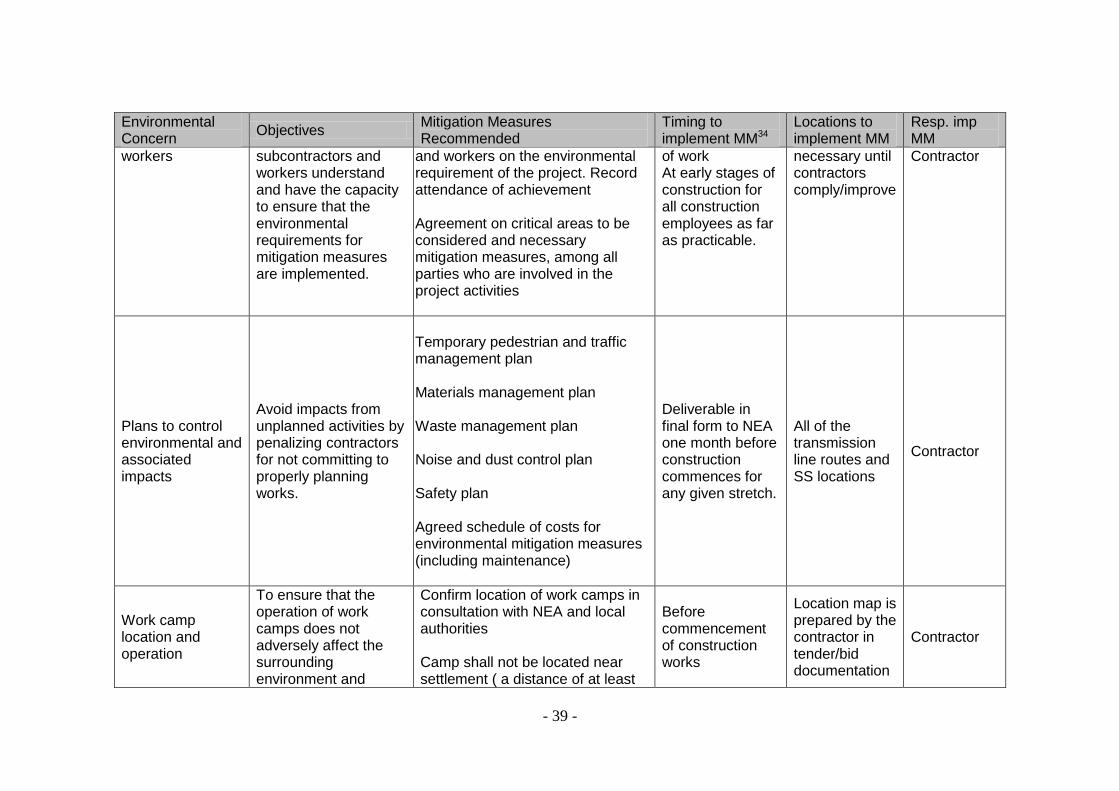
- 39 -
Environmental Concern
Objectives Mitigation Measures Recommended
Timing to implement MM34
Locations to implement MM
Resp. imp MM
workers subcontractors and workers understand and have the capacity to ensure that the environmental requirements for mitigation measures are implemented.
and workers on the environmental requirement of the project. Record attendance of achievement Agreement on critical areas to be considered and necessary mitigation measures, among all parties who are involved in the project activities
of work At early stages of construction for all construction employees as far as practicable.
necessary until contractors comply/improve
Contractor
Plans to control environmental and associated impacts
Avoid impacts from unplanned activities by penalizing contractors for not committing to properly planning works.
Temporary pedestrian and traffic management plan Materials management plan Waste management plan Noise and dust control plan Safety plan Agreed schedule of costs for environmental mitigation measures (including maintenance)
Deliverable in final form to NEA one month before construction commences for any given stretch.
All of the transmission line routes and SS locations
Contractor
Work camp location and operation
To ensure that the operation of work camps does not adversely affect the surrounding environment and
Confirm location of work camps in consultation with NEA and local authorities Camp shall not be located near settlement ( a distance of at least
Before commencement of construction works
Location map is prepared by the contractor in tender/bid documentation
Contractor
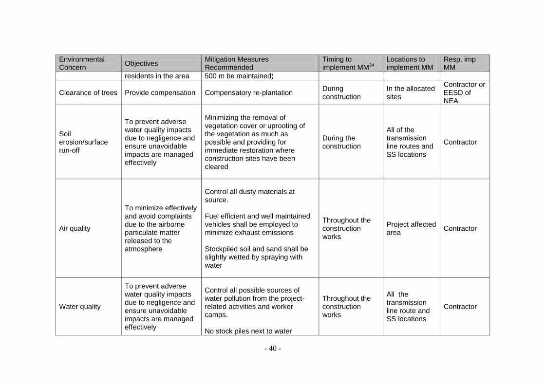
- 40 -
Environmental Concern
Objectives Mitigation Measures Recommended
Timing to implement MM34
Locations to implement MM
Resp. imp MM
residents in the area 500 m be maintained)
Clearance of trees Provide compensation Compensatory re-plantation During construction
In the allocated sites
Contractor or EESD of NEA
Soil erosion/surface run-off
To prevent adverse water quality impacts due to negligence and ensure unavoidable impacts are managed effectively
Minimizing the removal of vegetation cover or uprooting of the vegetation as much as possible and providing for immediate restoration where construction sites have been cleared
During the construction
All of the transmission line routes and SS locations
Contractor
Air quality
To minimize effectively and avoid complaints due to the airborne particulate matter released to the atmosphere
Control all dusty materials at source. Fuel efficient and well maintained vehicles shall be employed to minimize exhaust emissions Stockpiled soil and sand shall be slightly wetted by spraying with water
Throughout the construction works
Project affected area
Contractor
Water quality
To prevent adverse water quality impacts due to negligence and ensure unavoidable impacts are managed effectively
Control all possible sources of water pollution from the project-related activities and worker camps. No stock piles next to water
Throughout the construction works
All the transmission line route and SS locations
Contractor

- 41 -
Environmental Concern
Objectives Mitigation Measures Recommended
Timing to implement MM34
Locations to implement MM
Resp. imp MM
bodies. Storage of fuels, chemicals and other hydrocarbons in self-contained dedicated enclosures away from the water bodies. No discharge of any toxic materials (solid or liquid) in the water bodies.
Noise
To minimize noise level increase, nuisance and ground vibrations during construction operation
Contractor shall take adequate measures to minimize noise level increase and nuisance in the vicinity of construction sites by way of adopting available acoustic methods. Sensitive areas should be enclosed by using appropriate barriers
During the movement of equipments and vehicles
All the transmission line route and SS locations
Contractor
Blasting and ground vibration
To minimize the social and environmental impacts arising from any unexpected blasting or rock cutting
Prior notice to all local residents and the local authorities. No blasting will be allowed at night. All blasting shall be carried out in the daytime and at regular intervals after siren warnings.
Plan location before construction commences
Location approved by NEA cell/local authority
Contractor
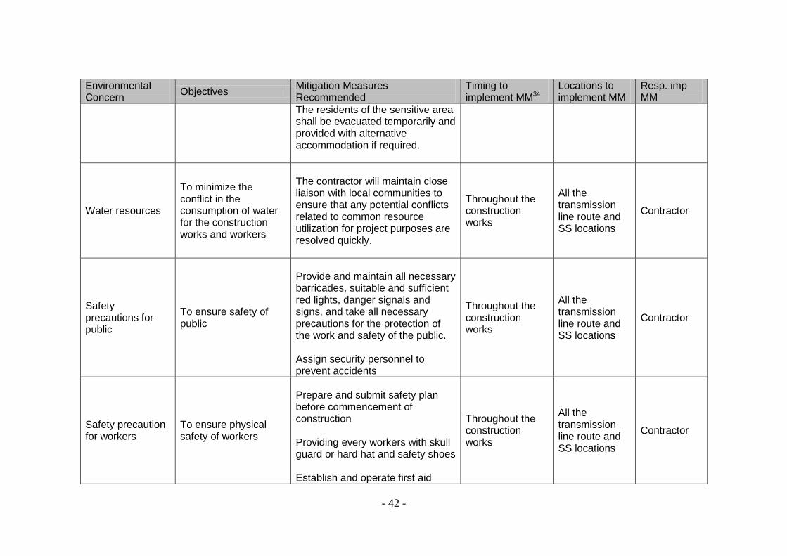
- 42 -
Environmental Concern
Objectives Mitigation Measures Recommended
Timing to implement MM34
Locations to implement MM
Resp. imp MM
The residents of the sensitive area shall be evacuated temporarily and provided with alternative accommodation if required.
Water resources
To minimize the conflict in the consumption of water for the construction works and workers
The contractor will maintain close liaison with local communities to ensure that any potential conflicts related to common resource utilization for project purposes are resolved quickly.
Throughout the construction works
All the transmission line route and SS locations
Contractor
Safety precautions for public
To ensure safety of public
Provide and maintain all necessary barricades, suitable and sufficient red lights, danger signals and signs, and take all necessary precautions for the protection of the work and safety of the public. Assign security personnel to prevent accidents
Throughout the construction works
All the transmission line route and SS locations
Contractor
Safety precaution for workers
To ensure physical safety of workers
Prepare and submit safety plan before commencement of construction Providing every workers with skull guard or hard hat and safety shoes Establish and operate first aid
Throughout the construction works
All the transmission line route and SS locations
Contractor

- 43 -
Environmental Concern
Objectives Mitigation Measures Recommended
Timing to implement MM34
Locations to implement MM
Resp. imp MM
treatment within camps Establish all relevant safety measures as required by law and good engineering practices Provide communication devices to all workers during laying of the cables particularly in forest areas
Impact to wildlife
Minimize the impact and contribute to their protection and conservation
If transmission line happens to cross migratory routes of wildlife, adequate scientific measures including change in alignment will be considered.
The temporary paths constructed during the construction period will be dismantled and re-vegetated A ban on poaching and trapping will be enforced
Construction period
Forest areas on which the alignment is falling
Contractor, Implementing cell and ESSD of NEA
Accidental spillage of oil in SS area
To avoid the contamination of soil in adjacent areas or nearby water bodies
Spilled oil is tapped within the substation area
In the event of accident
Specific SS
Contractor and Implementing cell of NEA
Public relation To avoid conflict and gain local support
Contractors will maintain close liaison with local communities to avoid any potential conflicts or resolve quickly
Throughout the construction works
All the transmission line route and SS locations
Contractor
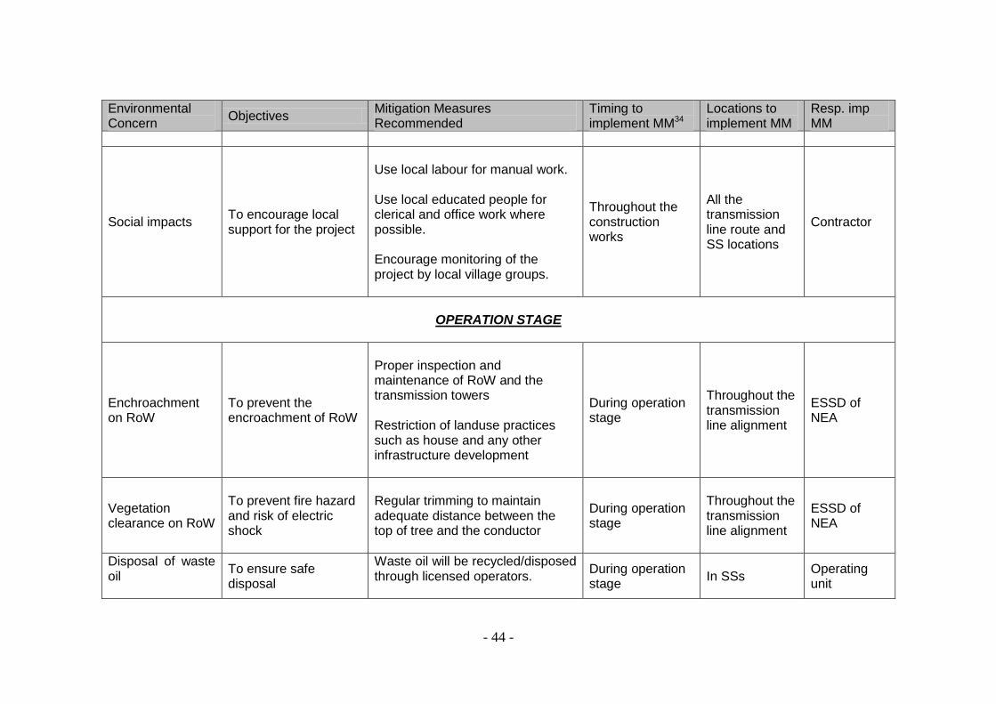
- 44 -
Environmental Concern
Objectives Mitigation Measures Recommended
Timing to implement MM34
Locations to implement MM
Resp. imp MM
Social impacts To encourage local support for the project
Use local labour for manual work. Use local educated people for clerical and office work where possible. Encourage monitoring of the project by local village groups.
Throughout the construction works
All the transmission line route and SS locations
Contractor
OPERATION STAGE
Enchroachment on RoW
To prevent the encroachment of RoW
Proper inspection and maintenance of RoW and the transmission towers Restriction of landuse practices such as house and any other infrastructure development
During operation stage
Throughout the transmission line alignment
ESSD of NEA
Vegetation clearance on RoW
To prevent fire hazard and risk of electric shock
Regular trimming to maintain adequate distance between the top of tree and the conductor
During operation stage
Throughout the transmission line alignment
ESSD of NEA
Disposal of waste oil
To ensure safe disposal
Waste oil will be recycled/disposed through licensed operators.
During operation stage
In SSs Operating unit

- 45 -
Table 4. Monitoring requirement matrix
Environmental Concern
Mitigation Measures Parameters to be monitored
Location to implement MM
Frequency Resp mon MM
DESIGN AND CONSTRUCTION STAGE
Alignment adjustment
Detail study of various details land consultation with the local people
Revised and adjusted alignment
Throughout the alignment
Once after the detail design
ESSD of NEA
Social Impacts and Resettlement
Social preparation, land acquisition and provide compensation
Compensation provided, No. of APs entitled
Target APs and families
Once after the compensation
ESSD of NEA
Dispute and emerging issues
Permits and approvals
All permits and approvals taken
All project sites Before construction starts
ESSD of NEA and contractor
CONSTRUCTION STAGE
Orientation for contractor and workers
Special briefing, on-site training for the contractors and workers on the environmental requirement of the project. Agreement on critical areas to be considered and necessary mitigation measures among stakeholders
Compliance with license and permits Participation in the meetings
All project sites
As and when it is needed
ESSD of NEA Local authorities Contractor
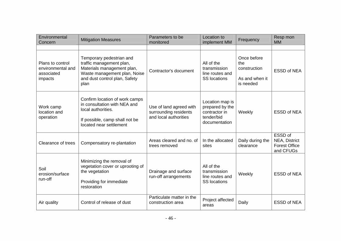
- 46 -
Environmental Concern
Mitigation Measures Parameters to be monitored
Location to implement MM
Frequency Resp mon MM
Plans to control environmental and associated impacts
Temporary pedestrian and traffic management plan, Materials management plan, Waste management plan, Noise and dust control plan, Safety plan
Contractor's document
All of the transmission line routes and SS locations
Once before the construction As and when it is needed
ESSD of NEA
Work camp location and operation
Confirm location of work camps in consultation with NEA and local authorities. If possible, camp shall not be located near settlement
Use of land agreed with surrounding residents and local authorities
Location map is prepared by the contractor in tender/bid documentation
Weekly ESSD of NEA
Clearance of trees Compensatory re-plantation Areas cleared and no. of trees removed
In the allocated sites
Daily during the clearance
ESSD of NEA, District Forest Office and CFUGs
Soil erosion/surface run-off
Minimizing the removal of vegetation cover or uprooting of the vegetation Providing for immediate restoration
Drainage and surface run-off arrangements
All of the transmission line routes and SS locations
Weekly ESSD of NEA
Air quality Control of release of dust
Particulate matter in the construction area
Project affected areas
Daily ESSD of NEA
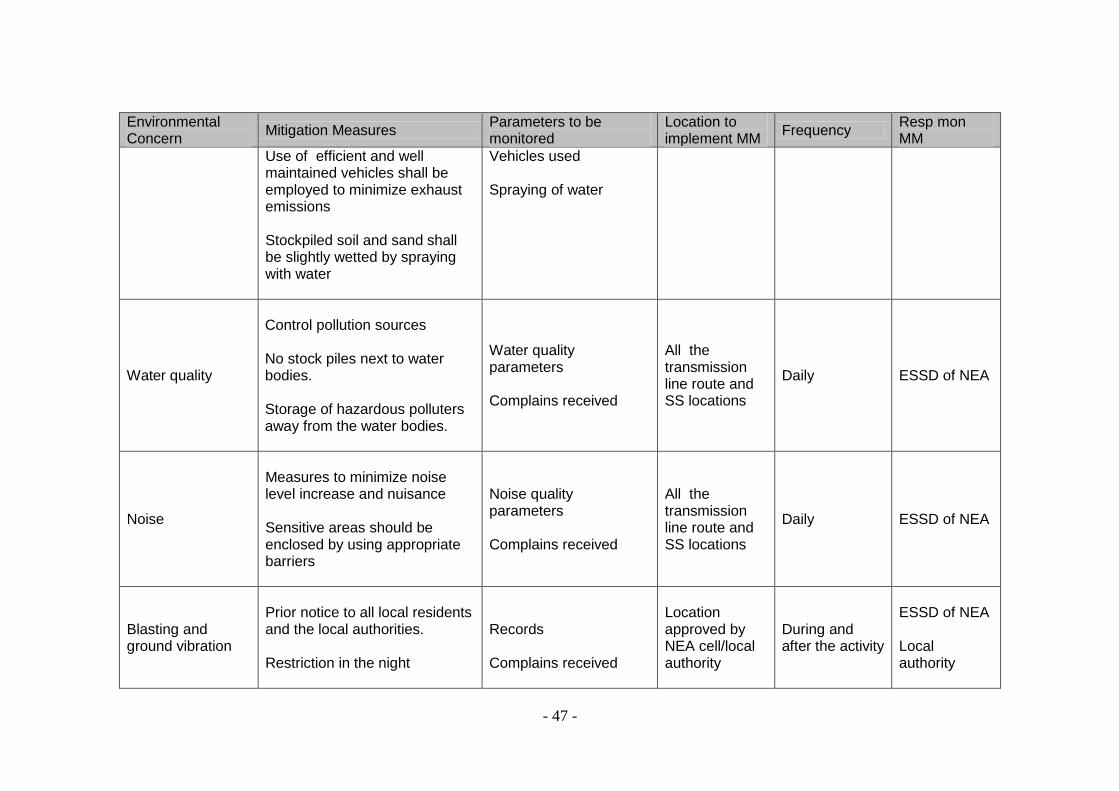
- 47 -
Environmental Concern
Mitigation Measures Parameters to be monitored
Location to implement MM
Frequency Resp mon MM
Use of efficient and well maintained vehicles shall be employed to minimize exhaust emissions Stockpiled soil and sand shall be slightly wetted by spraying with water
Vehicles used Spraying of water
Water quality
Control pollution sources No stock piles next to water bodies. Storage of hazardous polluters away from the water bodies.
Water quality parameters Complains received
All the transmission line route and SS locations
Daily ESSD of NEA
Noise
Measures to minimize noise level increase and nuisance Sensitive areas should be enclosed by using appropriate barriers
Noise quality parameters Complains received
All the transmission line route and SS locations
Daily ESSD of NEA
Blasting and ground vibration
Prior notice to all local residents and the local authorities. Restriction in the night
Records Complains received
Location approved by NEA cell/local authority
During and after the activity
ESSD of NEA Local authority
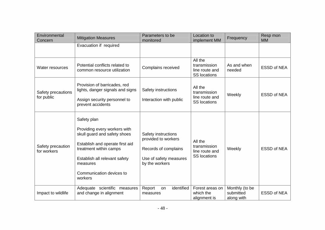
- 48 -
Environmental Concern
Mitigation Measures Parameters to be monitored
Location to implement MM
Frequency Resp mon MM
Evacuation if required
Water resources Potential conflicts related to common resource utilization
Complains received
All the transmission line route and SS locations
As and when needed
ESSD of NEA
Safety precautions for public
Provision of barricades, red lights, danger signals and signs Assign security personnel to prevent accidents
Safety instructions Interaction with public
All the transmission line route and SS locations
Weekly ESSD of NEA
Safety precaution for workers
Safety plan Providing every workers with skull guard and safety shoes Establish and operate first aid treatment within camps Establish all relevant safety measures Communication devices to workers
Safety instructions provided to workers Records of complains Use of safety measures by the workers
All the transmission line route and SS locations
Weekly ESSD of NEA
Impact to wildlife Adequate scientific measures and change in alignment
Report on identified measures
Forest areas on which the alignment is
Monthly (to be submitted along with
ESSD of NEA

- 49 -
Environmental Concern
Mitigation Measures Parameters to be monitored
Location to implement MM
Frequency Resp mon MM
Dismantling temporary paths and re-vegetation A ban on poaching and trapping of wildlife by contractors/workers will penal clause in construction contract
Report falling progress report)
Accidental spillage of oil in SS area
To avoid the contamination of soil in adjacent areas or nearby water bodies
Complains received The SS where accident occurs
As and when needed
Contractor and Implementing cell of NEA
Public relation
Contractors will maintain close liaison with local communities to avoid any potential conflicts or resolve quickly
Complains received
All the transmission line route and SS locations
Weekly ESSD of NEA
Social impacts
Use local labour for manual work. Use local educated people for clerical and office work where possible. Encourage monitoring of the project by local village groups
No. of individuals employed
All the transmission line route and SS locations
As and when needed
ESSD of NEA
OPERATION STAGE
Encroachment on Throughout the Once a year NEA project

- 50 -
Environmental Concern
Mitigation Measures Parameters to be monitored
Location to implement MM
Frequency Resp mon MM
RoW Inspection and maintenance of RoW and the transmission towers Restriction of landuse practices such as house and any other infrastructure development
transmission line alignment
cell
Vegetation clearance on RoW
Regular trimming to maintain adequate distance between the top of tree and the conductor
Throughout the transmission line alignment
Once a year NEA project cell
Disposal of waste oil
Recycling or disposal through licensed operators.
Stock of waste oil
SS store Once a year ESSD of NEA
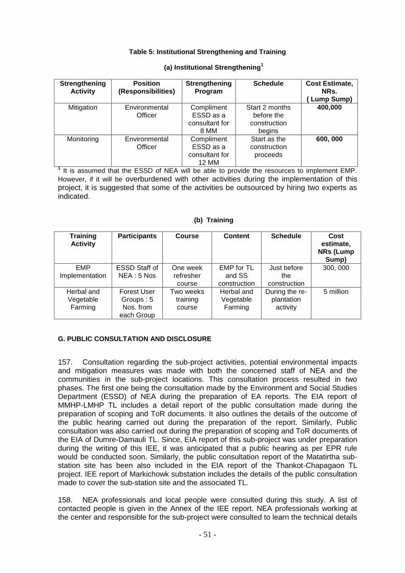
- 51 -
Table 5: Institutional Strengthening and Training
(a) Institutional Strengthening1
Strengthening Activity
Position (Responsibilities)
Strengthening Program
Schedule Cost Estimate, NRs.
( Lump Sump)
Mitigation Environmental Officer
Compliment ESSD as a
consultant for 8 MM
Start 2 months before the
construction begins
400,000
Monitoring Environmental Officer
Compliment ESSD as a
consultant for 12 MM
Start as the construction
proceeds
600, 000
1 It is assumed that the ESSD of NEA will be able to provide the resources to implement EMP.
However, if it will be overburdened with other activities during the implementation of this project, it is suggested that some of the activities be outsourced by hiring two experts as indicated.
(b) Training
Training Activity
Participants Course Content Schedule Cost estimate,
NRs (Lump Sump)
EMP Implementation
ESSD Staff of NEA : 5 Nos
One week refresher course
EMP for TL and SS
construction
Just before the
construction
300, 000
Herbal and Vegetable Farming
Forest User Groups : 5 Nos. from
each Group
Two weeks training course
Herbal and Vegetable Farming
During the re-plantation
activity
5 million
G. PUBLIC CONSULTATION AND DISCLOSURE
157. Consultation regarding the sub-project activities, potential environmental impacts and mitigation measures was made with both the concerned staff of NEA and the communities in the sub-project locations. This consultation process resulted in two phases. The first one being the consultation made by the Environment and Social Studies Department (ESSD) of NEA during the preparation of EA reports. The EIA report of MMHP-LMHP TL includes a detail report of the public consultation made during the preparation of scoping and ToR documents. It also outlines the details of the outcome of the public hearing carried out during the preparation of the report. Similarly, Public consultation was also carried out during the preparation of scoping and ToR documents of the EIA of Dumre-Damauli TL. Since, EIA report of this sub-project was under preparation during the writing of this IEE, it was anticipated that a public hearing as per EPR rule would be conducted soon. Similarly, the public consultation report of the Matatirtha sub-station site has been also included in the EIA report of the Thankot-Chapagaon TL project. IEE report of Markichowk substation includes the details of the public consultation made to cover the sub-station site and the associated TL.
158. NEA professionals and local people were consulted during this study. A list of contacted people is given in the Annex of the IEE report. NEA professionals working at the center and responsible for the sub-project were consulted to learn the technical details

- 52 -
and as well as the associated environmental attributes. For the TLs and the SSs, local NEA staff at the branch office, distribution centers and SS locations were consulted. The alternative sites for SS were visited together with the local NEA staff. Similarly, local individuals were also contacted and consulted for their opinions regarding the construction and operation of the sub-project facilities. 159. The local communities and the individuals consulted were found positive regarding the proposed investments. A description of the public consultation is given on Table 6. No serious concerns were raised by the local stakeholders in general. However, the following are some of the general concerns indicated.
- compensation to be provided to the affected households and landowners - compensatory plantation - safety issues near towers, particularly at locations where schools are in
proximity of the towers - monitoring and maintenance of TL after construction, this is of prime
importance when the TL under consideration has an inter-phase with other transmission or distribution lines
- avoidance of locations where there is a scope of development or recreational or other public facilities
Table 6: Details of public consultation and feedback received
Sub-project Date Major Feedback
Dumre-Damauli TL
February 15 and 16, 2009
-Local level employment
-Land acquisition and compensation
-Herbal and vegetable farming in the cleared forest
- Safety hazards
- Compensatory plantation
MMHP-LMHP TL and Markichowk SS
February 17, 2009 -Safety hazards
- Damage to standing trees and crops
Mulpani SS March 08, 2009 - Land acquisition and compensation
Sayambhu SS March 08, 2009 - Nuisance to the nearby residents
Matatirtha SS March 08, 2009 - Nuisance to the nearby residents
Chapali SS March 24, 2009 - Land acquisition and compensation
Lainchaur-Chabel cable link
March 24, 2009 - Nuisance to the pedestrian and market areas and important buildings
Mirchaiya SS March 27, 2009 - Land acquisition and compensation
Baniyani SS March 28, 2009 - Land acquisition and compensation
Paraul SS March 30, 2009 - Land acquisition and compensation
- Impact to the sensitive receivers
Dharapani SS March 30, 2009 - Land acquisition and compensation
- Impact to the sensitive receivers
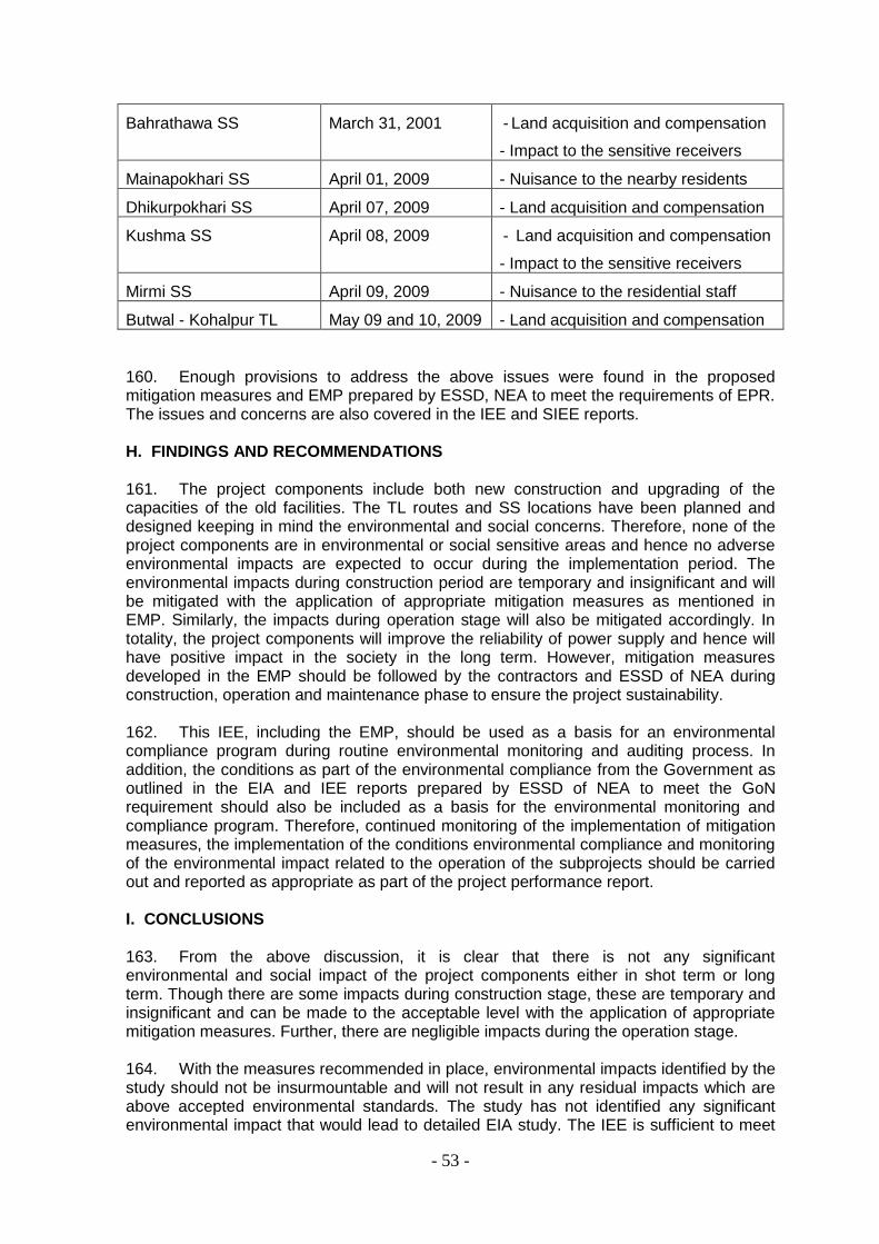
- 53 -
Bahrathawa SS March 31, 2001 - Land acquisition and compensation
- Impact to the sensitive receivers
Mainapokhari SS April 01, 2009 - Nuisance to the nearby residents
Dhikurpokhari SS April 07, 2009 - Land acquisition and compensation
Kushma SS April 08, 2009 - Land acquisition and compensation
- Impact to the sensitive receivers
Mirmi SS April 09, 2009 - Nuisance to the residential staff
Butwal - Kohalpur TL May 09 and 10, 2009 - Land acquisition and compensation
160. Enough provisions to address the above issues were found in the proposed mitigation measures and EMP prepared by ESSD, NEA to meet the requirements of EPR. The issues and concerns are also covered in the IEE and SIEE reports. H. FINDINGS AND RECOMMENDATIONS 161. The project components include both new construction and upgrading of the capacities of the old facilities. The TL routes and SS locations have been planned and designed keeping in mind the environmental and social concerns. Therefore, none of the project components are in environmental or social sensitive areas and hence no adverse environmental impacts are expected to occur during the implementation period. The environmental impacts during construction period are temporary and insignificant and will be mitigated with the application of appropriate mitigation measures as mentioned in EMP. Similarly, the impacts during operation stage will also be mitigated accordingly. In totality, the project components will improve the reliability of power supply and hence will have positive impact in the society in the long term. However, mitigation measures developed in the EMP should be followed by the contractors and ESSD of NEA during construction, operation and maintenance phase to ensure the project sustainability. 162. This IEE, including the EMP, should be used as a basis for an environmental compliance program during routine environmental monitoring and auditing process. In addition, the conditions as part of the environmental compliance from the Government as outlined in the EIA and IEE reports prepared by ESSD of NEA to meet the GoN requirement should also be included as a basis for the environmental monitoring and compliance program. Therefore, continued monitoring of the implementation of mitigation measures, the implementation of the conditions environmental compliance and monitoring of the environmental impact related to the operation of the subprojects should be carried out and reported as appropriate as part of the project performance report. I. CONCLUSIONS 163. From the above discussion, it is clear that there is not any significant environmental and social impact of the project components either in shot term or long term. Though there are some impacts during construction stage, these are temporary and insignificant and can be made to the acceptable level with the application of appropriate mitigation measures. Further, there are negligible impacts during the operation stage. 164. With the measures recommended in place, environmental impacts identified by the study should not be insurmountable and will not result in any residual impacts which are above accepted environmental standards. The study has not identified any significant environmental impact that would lead to detailed EIA study. The IEE is sufficient to meet

- 54 -
the needs of environmental assessment requirements for the project. Hence, no further environmental assessment is required. However, recommended mitigation measures should be incorporated in all stage of the project by the contractor and NEA; and regular monitoring by NEA is also required.
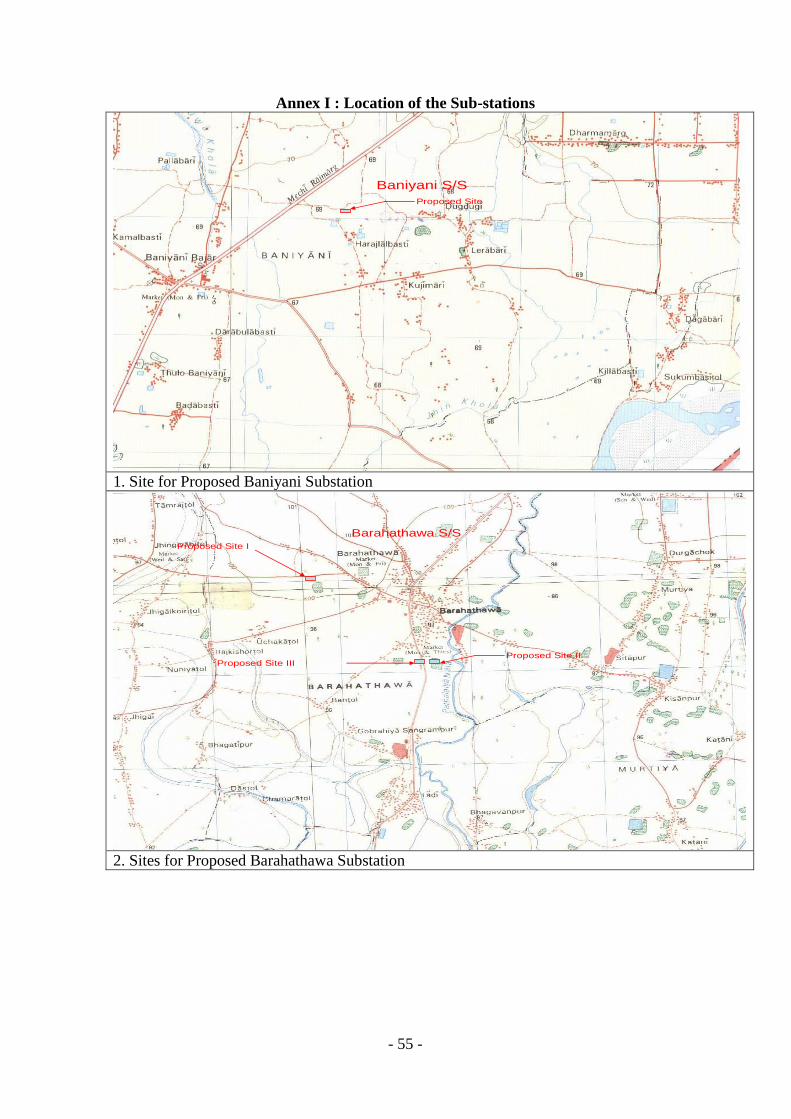
- 55 -
Annex I : Location of the Sub-stations
Proposed Site
Baniyani S/S
1. Site for Proposed Baniyani Substation
Proposed Site IIProposed Site III
Proposed Site I
Barahathawa S/S
2. Sites for Proposed Barahathawa Substation

- 56 -
Proposed Site
Chapali S/S
3. Site for Proposed Chapli Substation
Proposed Site
Dharapani S/S
4. Site for Proposed Dharapani Substation
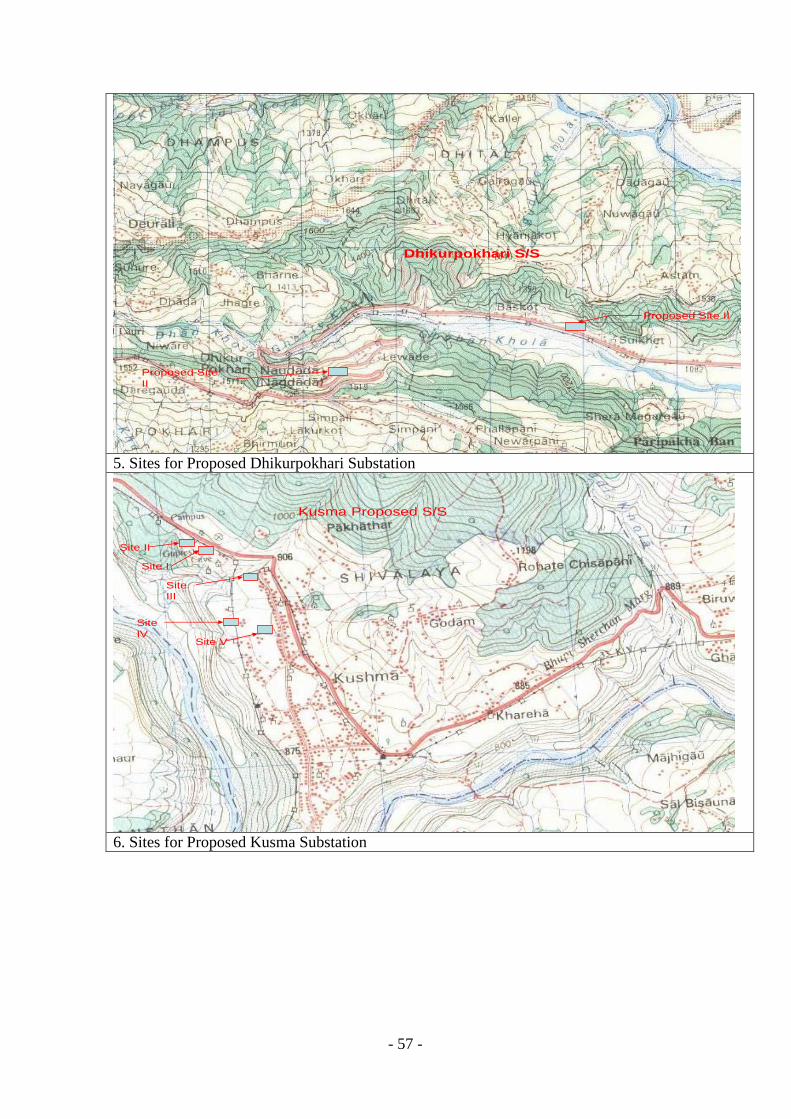
- 57 -
Proposed Site
II
Proposed Site II
Dhikurpokhari S/S
5. Sites for Proposed Dhikurpokhari Substation
Site II
Site I
Site
III
Site
IVSite V
Kusma Proposed S/S
6. Sites for Proposed Kusma Substation

- 58 -
Proposed Site II
Proposed Site I
Mainapokhari S/S
7. Sites for Proposed Mainapokhari Substation
Proposed Site
Matatirtha S/S
8. Site for Proposed Matatirtha Substation
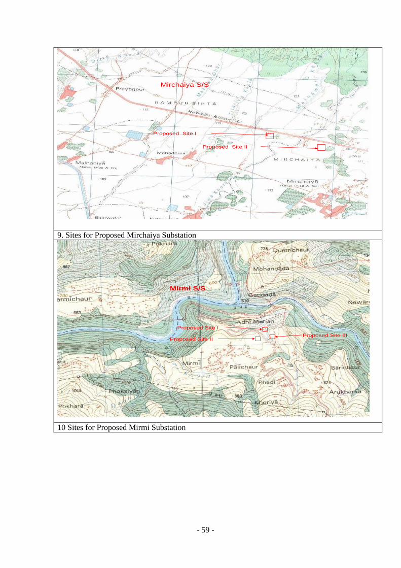
- 59 -
Proposed Site II
Proposed Site I
Mirchaiya S/S
9. Sites for Proposed Mirchaiya Substation
Proposed Site I
Proposed Site IIProposed Site III
Mirmi S/S
10 Sites for Proposed Mirmi Substation

- 60 -
Proposed Site I
Proposed Site II
Mulpani S/S
11. Sites for Proposed Mulpani Substation
Proposed Site II
Proposed Site I
Proposed Site III
Proposed Site IV
Paraul S/S
12. Sites for Proposed Paraul Substation
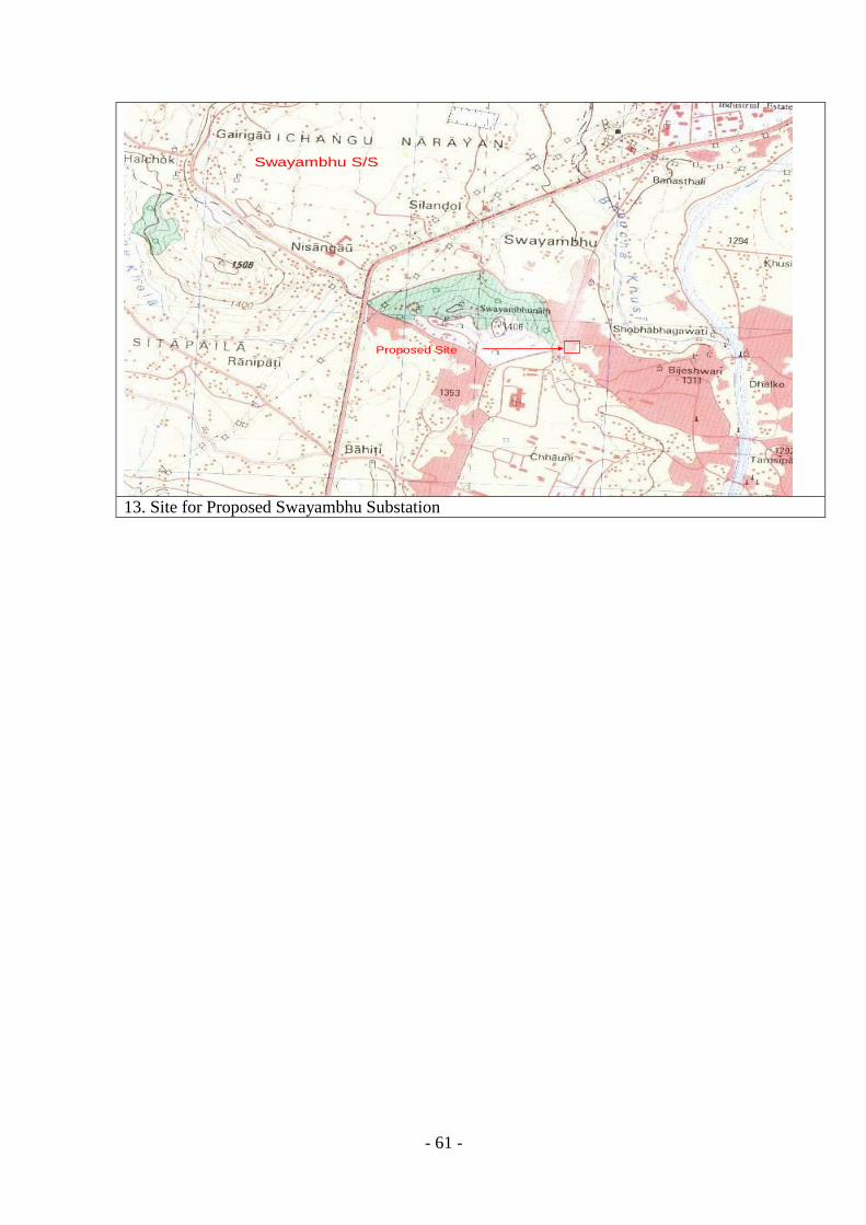
- 61 -
Proposed Site
Swayambhu S/S
13. Site for Proposed Swayambhu Substation
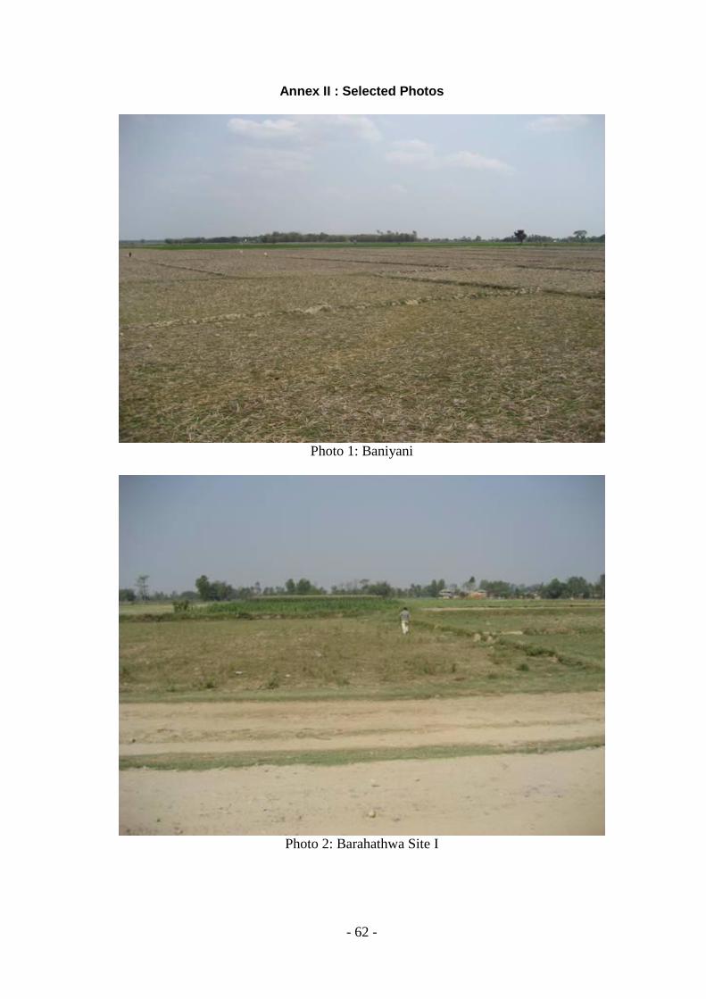
- 62 -
Annex II : Selected Photos
Photo 1: Baniyani
Photo 2: Barahathwa Site I

- 63 -
Photo 3:Barahathwa Site II
Photo 4:Dharapani
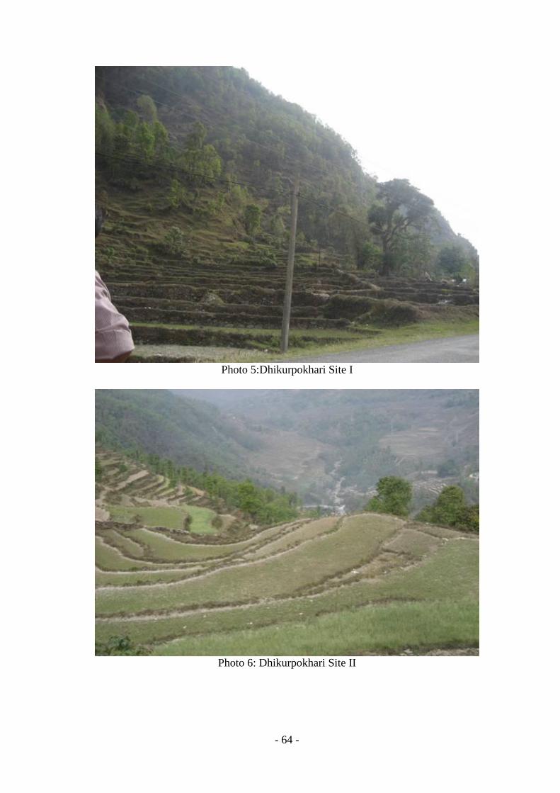
- 64 -
Photo 5:Dhikurpokhari Site I
Photo 6: Dhikurpokhari Site II
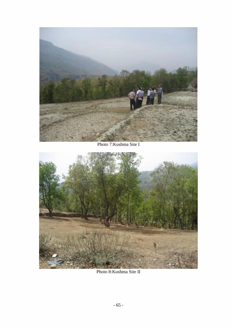
- 65 -
Photo 7:Kushma Site I
Photo 8:Kushma Site II

- 66 -
Photo 9:Kushma Site III
Photo 10:Kushma Site IV
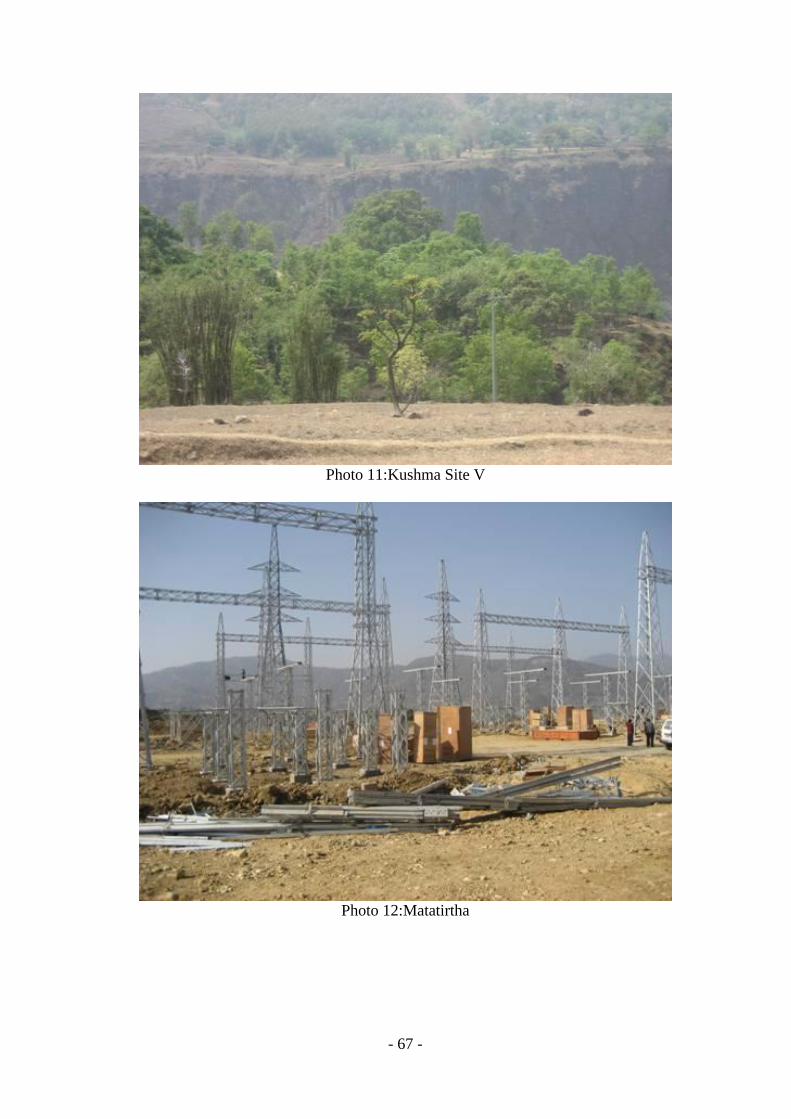
- 67 -
Photo 11:Kushma Site V
Photo 12:Matatirtha
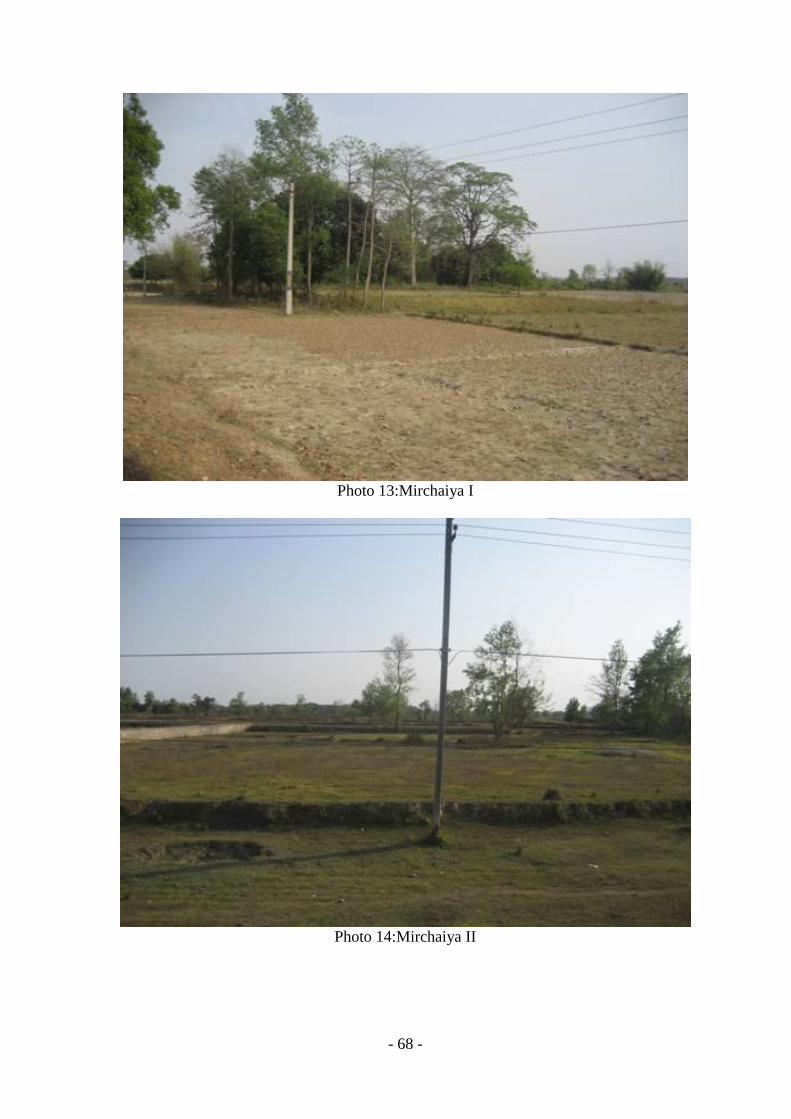
- 68 -
Photo 13:Mirchaiya I
Photo 14:Mirchaiya II

- 69 -
Photo 15: Mirmi Site I
Photo 16: Mirmi Site II

- 70 -
Photo 17: Mirmi Site III
Photo 18: Mulpani Site I

- 71 -
Photo 19:Mulpani Site II
Photo 20:Paraul Site I

- 72 -
Photo 21:Paraul Site II
Photo 22: Paraul Site III

- 73 -
Photo 23:Paraul Site IV
Photo 24: Swayambhu
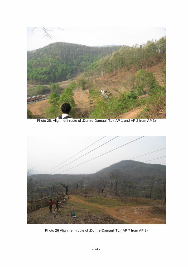
- 74 -
Photo 25: Alignment route of .Dumre-Damauli TL ( AP 1 and AP 2 from AP 3)
Photo 26 Alignment route of .Dumre-Damauli TL ( AP 7 from AP 8)
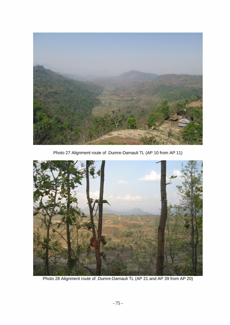
- 75 -
Photo 27 Alignment route of .Dumre-Damauli TL (AP 10 from AP 11)
Photo 28 Alignment route of .Dumre-Damauli TL (AP 21 and AP 39 from AP 20)
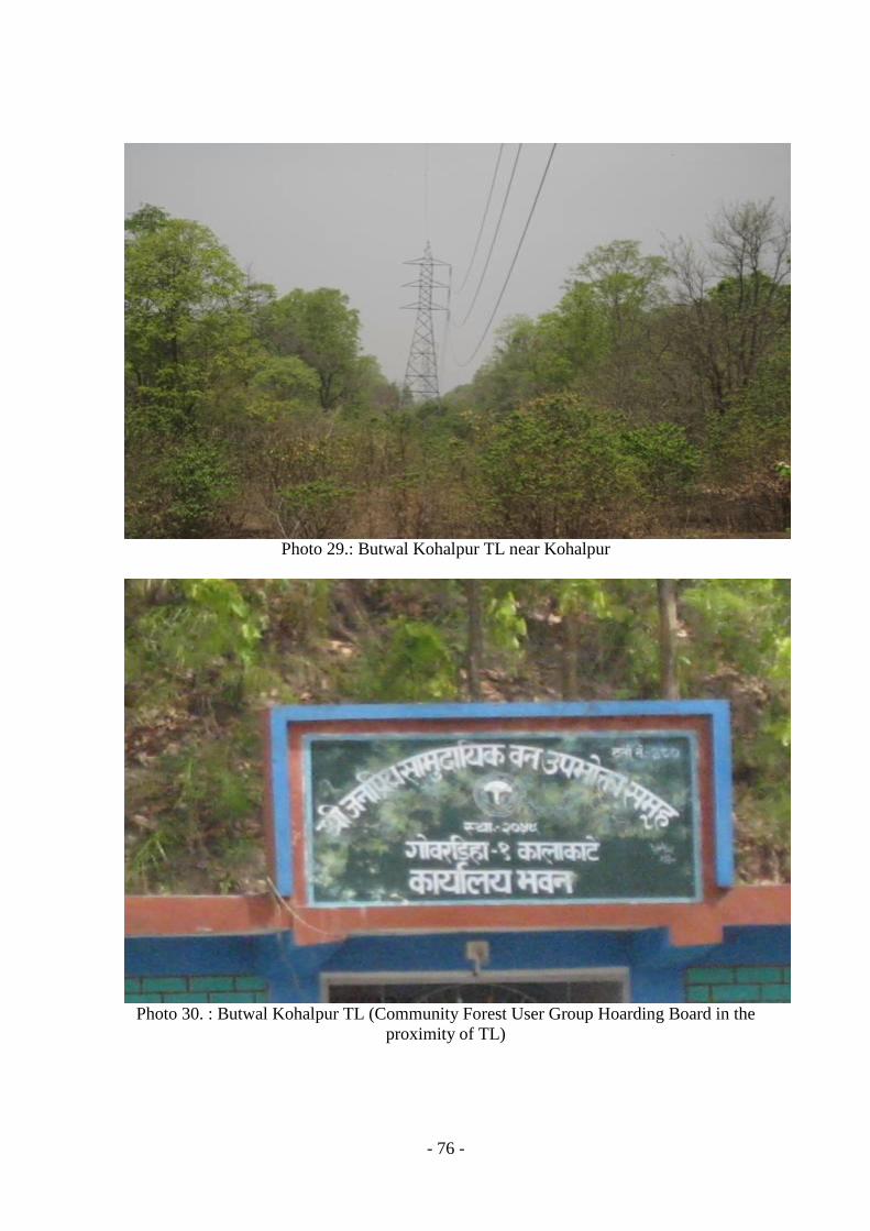
- 76 -
Photo 29.: Butwal Kohalpur TL near Kohalpur
Photo 30. : Butwal Kohalpur TL (Community Forest User Group Hoarding Board in the
proximity of TL)

- 77 -
Photo 31 : Butwal Kohalpur TL in Shivapur area
Photo 32 : Butwal Kohalpur TL ( In Butwal)
- 78 -
Annex III : List of people contacted
S. No.
Name Position Unit/Location
1 Mr. Deepak Upadhaya General Manager Dist. & Cons. Services, NEA
2 Mr. Harihar Man Palikhe Director Transmission, NEA
3 Mr. Rajeev Sharma Manager Transmission, NEA
4 Mr. Sunil K. Dhungel Director MMHP, NEA
5 Mr. Santosh K. Neupane Asst. Manger MMHP, NEA
6 Mr. Rishi Kesh Sharma Director ESSD, NEA
7 Mr. Rajendra P. Thanju Deputy Director ESSD, NEA
8 Mr. G. B. Bhattarai Project Manager NEA
9 Mr. Om K. Shrestha Asst. Manager NEA
10 Mr. Chiranjibi Poudel Manager Dist. & Cons. Services, NEA
11 Mr. Bidyut Poudel Asst. Manager Dist. & Cons. Services, NEA
12 Mr. Bodh Raj Dhakal Asst. Manager Dist. & Cons. Services, NEA
13 Mr. Braj Bhusan Choudhary Chief Baneshowr Distribution Center, NEA
14 Mr. Krishna Thapa Engineer Pulchowk Dist. Center, NEA
15 Mr. Raju KC Asst. Manager Bhaktapur Dist. Center, NEA
16 Mr. Kailash P. Atal Engineer Kathmandu West, NEA
17 Mr. Ram Chandra Poudel Manager Kathmandu Mid, NEA
18 Mr. Babu Ram Subedi Engineer Kathmandu West, NEA
19 Ms. Ritu Duwal Civil Engineer ESSD, NEA
20 Mr. Dhruba Sundar Shrestha ACRP Expert ESSD, NEA
21 Mr. Mohan Shrestha Acting. Forest Officer
District Forest Office, Damauli, Tanahu
22 Mr. Mohan B. Basnet Member Bagbhanjyang CF
23 Unknown User Birta CF
24 Unknown User Ranipani CF
25 Unknown User Paling CF
26 Unknown User Kali CF
27 Unknown User Kolgairi CF
28 Unknown User Basudev CF
29 Unknown User Nidhinswara CF
30 Unknown User Chandisthan CF
31 Mr. Sol Bahadur Magar Local people Khaireni, Markichowk
32 Mr. Babu Ram Koirala Local people Byas-5, Sewar
33 Mr. Bagan Singh Tamang Local people Bhanu VDC, W. No.1
34 Mr. Bibhuti Nath Misra Chief of Branch NEA Bhadrapur
35 Mr. Mithilesh Baibar Chief of Branch NEA Lahan
36 Mr. Chandeshowr P. Yadav Staff NEA Lahan
37 Mr. Ram Ekbal Shah Engineer NEA Jaleshowr
38 Mr. Aftab Alam Staff NEA Janakpur
39 Mr. Ram Swarat Shah Staff NEA Malangawa
40 Mr. Ram Chandra Mandal Regional Director NEA Hetauda
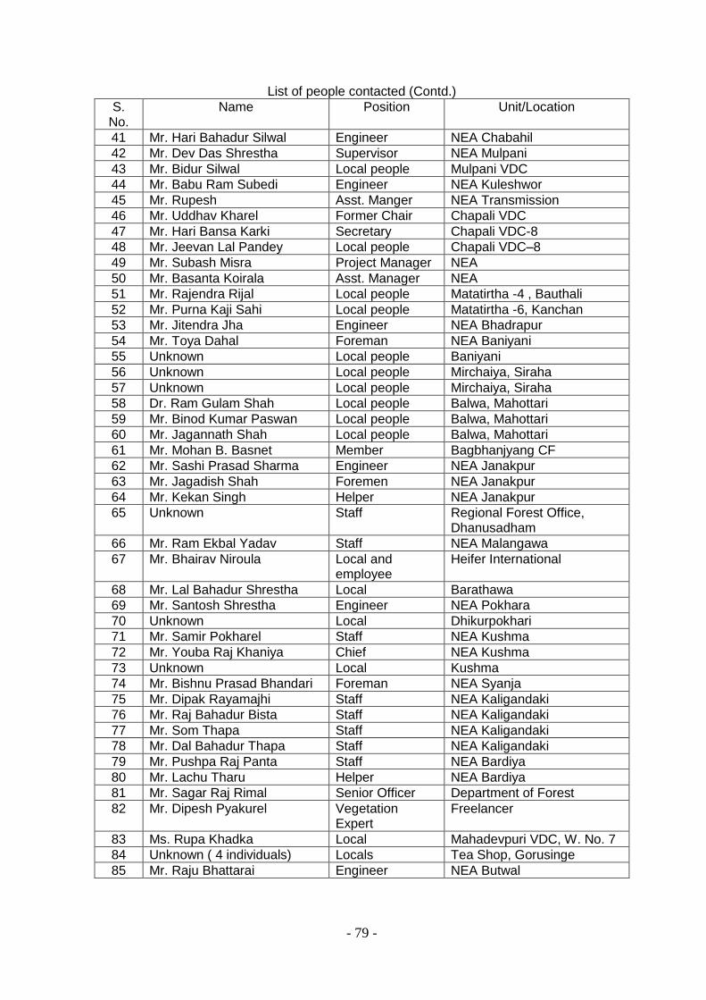
- 79 -
List of people contacted (Contd.)
S. No.
Name Position Unit/Location
41 Mr. Hari Bahadur Silwal Engineer NEA Chabahil
42 Mr. Dev Das Shrestha Supervisor NEA Mulpani
43 Mr. Bidur Silwal Local people Mulpani VDC
44 Mr. Babu Ram Subedi Engineer NEA Kuleshwor
45 Mr. Rupesh Asst. Manger NEA Transmission
46 Mr. Uddhav Kharel Former Chair Chapali VDC
47 Mr. Hari Bansa Karki Secretary Chapali VDC-8
48 Mr. Jeevan Lal Pandey Local people Chapali VDC–8
49 Mr. Subash Misra Project Manager NEA
50 Mr. Basanta Koirala Asst. Manager NEA
51 Mr. Rajendra Rijal Local people Matatirtha -4 , Bauthali
52 Mr. Purna Kaji Sahi Local people Matatirtha -6, Kanchan
53 Mr. Jitendra Jha Engineer NEA Bhadrapur
54 Mr. Toya Dahal Foreman NEA Baniyani
55 Unknown Local people Baniyani
56 Unknown Local people Mirchaiya, Siraha
57 Unknown Local people Mirchaiya, Siraha
58 Dr. Ram Gulam Shah Local people Balwa, Mahottari
59 Mr. Binod Kumar Paswan Local people Balwa, Mahottari
60 Mr. Jagannath Shah Local people Balwa, Mahottari
61 Mr. Mohan B. Basnet Member Bagbhanjyang CF
62 Mr. Sashi Prasad Sharma Engineer NEA Janakpur
63 Mr. Jagadish Shah Foremen NEA Janakpur
64 Mr. Kekan Singh Helper NEA Janakpur
65 Unknown Staff Regional Forest Office, Dhanusadham
66 Mr. Ram Ekbal Yadav Staff NEA Malangawa
67 Mr. Bhairav Niroula Local and employee
Heifer International
68 Mr. Lal Bahadur Shrestha Local Barathawa
69 Mr. Santosh Shrestha Engineer NEA Pokhara
70 Unknown Local Dhikurpokhari
71 Mr. Samir Pokharel Staff NEA Kushma
72 Mr. Youba Raj Khaniya Chief NEA Kushma
73 Unknown Local Kushma
74 Mr. Bishnu Prasad Bhandari Foreman NEA Syanja
75 Mr. Dipak Rayamajhi Staff NEA Kaligandaki
76 Mr. Raj Bahadur Bista Staff NEA Kaligandaki
77 Mr. Som Thapa Staff NEA Kaligandaki
78 Mr. Dal Bahadur Thapa Staff NEA Kaligandaki
79 Mr. Pushpa Raj Panta Staff NEA Bardiya
80 Mr. Lachu Tharu Helper NEA Bardiya
81 Mr. Sagar Raj Rimal Senior Officer Department of Forest
82 Mr. Dipesh Pyakurel Vegetation Expert
Freelancer
83 Ms. Rupa Khadka Local Mahadevpuri VDC, W. No. 7
84 Unknown ( 4 individuals) Locals Tea Shop, Gorusinge
85 Mr. Raju Bhattarai Engineer NEA Butwal

- 80 -
List of people contacted (Cont.)
S. No.
Name Position Unit/Location
86 Mr. Sanjaya Mishra Engineer NEA Butwal
87 Mr. Dadhi Ram Khanal Supervisor NEA Butwal
88 Mr. Milan Bahadur Bajracharya
Asst. Manager NEA Butwal

- 81 -
Annex IV : Terrain and Land Use Pattern in the Dumre-Damauli Transmission Line Alignment
Location/Km Terrain/Land Use Soli type/Crop Sensitive Receivers
Common Pool Resources
Comment/Remarks Length (Km)
0+00-0+015 Undulating Boulder mixed Substation area 0.015
0+015-0+050 Undulating/Settlement Boulder mixed 0.035
0+050-0+620 Undulating/Forest Boulder mixed Bagh Bhanjyang CF 0.57
0+700 Undulating Boulder mixed Road crossing
0+705 Undulating Boulder mixed Three phase elctric line crossing
0+620-0+880 Undulating/Mixed( Agri+Settlement)
Boulder mixed 0.26
0+880-1+000 Undulating/Forest Boulder mixed 0.12
1+000-1+050 Undulating/Mixed (Agri+Settlement)
0.05
1+050-1+390 Undulating/Forest Boulder mixed Birta CF 0.34
1+390-1+690 Undulating/Forest Boulder mixed Rani Pani CF 0.3
1+690-4+390 Undulating/Mixed (Agri+Settlement)
Boulder mixed 2.7
1+860 Undulating/Agriculture Boulder mixed
1+900 Undulating Boulder mixed Canal crossing
2+680 Undulating Boulder mixed Three phase electric line crossing
3+700 Undulating Boulder mixed Three phase electric line crossing
3+880 Undulating Boulder mixed Three phase electric line crossing
4+390-5+000 Undulating/Forest Boulder mixed Leasehold Forest 0.61
5+000-5+200 Undulating/Mixed (Agri+Settlement)
Boulder mixed 0.2
5+200 Undulating Boulder mixed Buldi Khola crossing
5+200-6+390 Undulating/Bushy vegetation Boulder mixed Private 1.19
6+390-7+645 Undulating/Agriculture Clay 1.255
6+800 Undulating Boulder mixed Kholsi crossing
7+645-8+830 Undulating/Forest Boulder mixed Paling CF 1.185
8+830-9+335 Undulating/Mixed (Agri+Settlement)
Boulder mixed 0.505
9+335-11+000 Undulating/Forest Boulder mixed Kali CF 1.665

- 82 -
Location/Km Terrain/Land Use Soli type/Crop Sensitive Receivers
Common Pool Resources
Comment/Remarks Length (Km)
9+775 Undulating/Forest Boulder mixed 33 KV electric line crossing
10+360 Undulating/Forest Boulder mixed Road crossing
11+000-12+420 Undulating/Mixed (Agri+Settlement)
Boulder mixed 1.42
11+600 Undulating/Mixed (Agri+Settlement)
Boulder mixed 33 KV electric line crossing
12+420-12+780 Undulating/Forest Boulder mixed Kolgairi CF 0.36
12+780-12+920 Undulating/Mixed (Agri+Settlement)
Boulder mixed 0.14
12+920-13+700 Undulating/Forest Boulder mixed Basudev CF 0.78
13+700-15+645 Undulating/Forest Boulder mixed Nidhin Swara CF 1.945
15+645 Undulating Boulder mixed Chudi Khola crossing
15+645-15+760 Undulating/Forest Boulder mixed Chandisthan CF 0.115
15+760 Undulating Boulder mixed Road crossing
15+760-16+700 Undulating/Mixed (Agri+Settlement)
Boulder mixed 0.94
15+800 Undulating Boulder mixed 11 KV crossing
15+880 Undulating Boulder mixed 33 KV crossing
16+700-1700 Undulating/Forest Boulder mixed Chandisthan CF 0.3
17+000 Undulating Boulder mixed Marshyangdi River Crossing 0
17+000-18+00 Undulating/Mixed (Agri+Settlement)
Clay 1
Sub-station Section 0.015
Major Settlement Section 0.035
Major Forest Section 9.48
Mix(Settlement+Agriculture) 8.47
Total 18

- 83 -