Embed Size (px)
Citation preview
Document No. 140019
Job No. 100031770
ENVIRONMENTAL ASSESSMENT FOR THE OIL AND GAS INDUSTRY CONSERVATION PLAN ASSOCIATED
WITH ISSUANCE OF ENDANGERED SPECIES ACT SECTION 10(A)(1)(B) PERMITS
FOR THE AMERICAN BURYING BEETLE IN OKLAHOMA
Prepared for:
U.S. Fish and Wildlife Service 9014 East 21st Street Tulsa, Oklahoma 74129
Prepared by:
Atkins 6504 Bridge Point Parkway
Suite 200 Austin, Texas 78730
May 22, 2014
Atkins 100031770/140019 ii
Contents
Page
List of Figures ................................................................................................................................................ v
List of Tables ................................................................................................................................................ vi
1.0 INTRODUCTION, NEED, AND PURPOSE ............................................................................................ 1‐1
1.1 PURPOSE AND NEED ......................................................................................................................... 1‐3
1.1.1 Purpose for the Proposed Action .................................................................................... 1‐3
1.1.2 Need for the Proposed Action ......................................................................................... 1‐3
2.0 ALTERNATIVES ................................................................................................................................. 2‐1
2.1 NO‐ACTION ALTERNATIVE ................................................................................................................ 2‐1
2.2 PROPOSED ALTERNATIVE: ACTIVITIES AS PROPOSED IN THE ICP .................................................. 2‐1
2.2.1 Upstream Production ....................................................................................................... 2‐1
2.2.2 Midstream Development ................................................................................................. 2‐3
3.0 AFFECTED ENVIRONMENT ............................................................................................................... 3‐1
3.1 GEOLOGY ........................................................................................................................................... 3‐1
3.2 SOILS, INCLUDING PRIME AND UNIQUE FARMLAND ..................................................................... 3‐2
3.2.1 Central Oklahoma ............................................................................................................. 3‐2
3.2.2 Eastern Oklahoma ............................................................................................................ 3‐2
3.2.3 Prime Farmland Soils ........................................................................................................ 3‐2
3.3 WATER RESOURCES........................................................................................................................... 3‐3
3.4 WATER QUALITY ................................................................................................................................ 3‐3
3.5 AIR QUALITY ....................................................................................................................................... 3‐4
3.6 VEGETATION ...................................................................................................................................... 3‐4
3.7 WETLANDS/WATERS OF THE U.S. .................................................................................................... 3‐6
3.8 GENERAL WILDLIFE ............................................................................................................................ 3‐7
3.9 THREATENED AND ENDANGERED SPECIES .................................................................................... 3‐16
3.9.1 Covered Species ............................................................................................................. 3‐16
3.9.2 Noncovered Species ....................................................................................................... 3‐18
3.10 LAND USE ......................................................................................................................................... 3‐24
3.10.1 State Planning Regions ................................................................................................... 3‐24
3.10.2 Transportation ................................................................................................................ 3‐24
3.11 AESTHETICS AND NOISE .................................................................................................................. 3‐30
3.11.1 Aesthetics ........................................................................................................................ 3‐30
3.11.2 Noise ............................................................................................................................... 3‐32
3.12 SOCIOECONOMICS .......................................................................................................................... 3‐33
3.13 ENVIRONMENTAL JUSTICE .............................................................................................................. 3‐33
3.14 TRIBAL JURISDICTION ...................................................................................................................... 3‐37
3.15 CULTURAL RESOURCES ................................................................................................................... 3‐38
4.0 ENVIRONMENTAL CONSEQUENCES ................................................................................................. 4‐1
4.1 GEOLOGY ........................................................................................................................................... 4‐2
Contents
Page
Atkins 100031770/140019 iii
4.1.1 No‐Action Alternative ...................................................................................................... 4‐2
4.1.2 Proposed Alternative: ICP with a 22‐year Duration ....................................................... 4‐3
4.2 SOILS, INCLUDING PRIME AND UNIQUE FARMLAND ..................................................................... 4‐3
4.2.1 No‐Action Alternative ...................................................................................................... 4‐3
4.2.2 Proposed Alternative: ICP with a 22‐year Duration ....................................................... 4‐4
4.3 WATER RESOURCES........................................................................................................................... 4‐4
4.3.1 No‐Action Alternative ...................................................................................................... 4‐4
4.3.2 Proposed Alternative: ICP with a 22‐year Duration ....................................................... 4‐6
4.4 WATER QUALITY ................................................................................................................................ 4‐7
4.4.1 No‐Action Alternative ...................................................................................................... 4‐7
4.4.2 Proposed Alternative: ICP with a 22‐year Duration ....................................................... 4‐8
4.5 AIR QUALITY ....................................................................................................................................... 4‐8
4.5.1 No‐Action Alternative ...................................................................................................... 4‐8
4.5.2 Proposed Alternative: ICP with a 22‐year Duration ....................................................... 4‐9
4.6 VEGETATION ...................................................................................................................................... 4‐9
4.6.1 No‐Action Alternative ...................................................................................................... 4‐9
4.6.2 Proposed Alternative: ICP with a 22‐year Duration ..................................................... 4‐12
4.7 WETLANDS/WATERS OF THE U.S. .................................................................................................. 4‐13
4.7.1 No‐Action Alternative .................................................................................................... 4‐13
4.7.2 Proposed Alternative: ICP with a 22‐year Duration ..................................................... 4‐14
4.8 GENERAL WILDLIFE .......................................................................................................................... 4‐15
4.8.1 No‐Action Alternative .................................................................................................... 4‐15
4.8.2 Proposed Alternative: ICP with a 22‐year Duration ..................................................... 4‐19
4.9 THREATENED AND ENDANGERED SPECIES .................................................................................... 4‐20
4.9.1 Covered Species ............................................................................................................. 4‐20
4.9.1.1 No‐Action Alternative .............................................................................. 4‐20
4.9.1.2 Proposed Alternative: ICP with a 22‐year Duration............................... 4‐21
4.9.2 Noncovered Species ....................................................................................................... 4‐22
4.9.2.1 No‐Action Alternative .............................................................................. 4‐22
4.9.2.2 Proposed Alternative: ICP with a 22‐year Duration............................... 4‐26
4.10 LAND USE ......................................................................................................................................... 4‐27
4.10.1 No‐Action Alternative .................................................................................................... 4‐27
4.10.2 Proposed Alternative: ICP with a 22‐year Duration ..................................................... 4‐30
4.11 AESTHETICS AND NOISE .................................................................................................................. 4‐31
4.11.1 Aesthetics ........................................................................................................................ 4‐31
4.11.1.1 No‐Action Alternative .............................................................................. 4‐31
4.11.1.2 Proposed Alternative: ICP with a 22‐year Duration............................... 4‐32
4.11.2 Noise ............................................................................................................................... 4‐32
4.11.2.1 No‐Action Alternative .............................................................................. 4‐32
4.11.2.2 Proposed Alternative: ICP with a 22‐year Duration............................... 4‐33
Contents
Page
Atkins 100031770/140019 iv
4.12 SOCIOECONOMICS .......................................................................................................................... 4‐33
4.12.1 No‐Action Alternative .................................................................................................... 4‐33
4.12.2 Proposed Alternative: ICP with a 22‐year Duration ..................................................... 4‐34
4.13 ENVIRONMENTAL JUSTICE .............................................................................................................. 4‐34
4.13.1 No‐Action Alternative .................................................................................................... 4‐34
4.13.2 Proposed Alternative: ICP with a 22‐year Duration ..................................................... 4‐35
4.14 TRIBAL JURISDICTION ...................................................................................................................... 4‐35
4.14.1 No‐Action Alternative .................................................................................................... 4‐35
4.14.2 Proposed Alternative: ICP with a 22‐year Duration ..................................................... 4‐36
4.15 CULTURAL RESOURCES ................................................................................................................... 4‐36
4.15.1 No‐Action Alternative .................................................................................................... 4‐36
4.15.2 Proposed Alternative: ICP with a 22‐year Duration ..................................................... 4‐37
5.0 CUMULATIVE IMPACTS .................................................................................................................... 5‐1
5.1 PAST AND PRESENT ACTIONS WITHIN THE PLANNING AREA ........................................................ 5‐1
5.2 REASONABLY FORESEEABLE ACTIONS WITHIN THE PLANNING AREA .......................................... 5‐3
5.3 EVALUATION OF CUMULATIVE EFFECTS .......................................................................................... 5‐5
5.3.1 Physical Resources ........................................................................................................... 5‐6
5.3.2 Ecological Resources ........................................................................................................ 5‐7
5.3.3 Social Resources ............................................................................................................... 5‐7
5.3.4 Cultural Resources ............................................................................................................ 5‐8
5.4 CLIMATE CHANGE AND CUMULATIVE EFFECTS .............................................................................. 5‐8
6.0 IRREVERSIBLE AND IRRETRIEVABLE COMMITMENT OF RESOURCES ................................................ 6‐1
7.0 SHORT‐TERM USE OF THE ENVIRONMENT VERSUS LONG‐TERM PRODUCTIVITY ............................ 7‐1
8.0 LIST OF PREPARERS .......................................................................................................................... 8‐1
9.0 CONSULTATION AND COORDINATION ............................................................................................. 9‐1
10.0 REFERENCES ................................................................................................................................... 10‐1
Appendix: Summary of Comments and U.S. Fish and Wildlife Service Response
Contents
Atkins 100031770/140019 v
Figures
Page
1‐1 The ICP Planning Area ......................................................................................................................... 1‐2
3‐1 The ICP Planning Area in Relation to the Federal Lands and Major Roads of Oklahoma ............. 3‐28
3‐2 The ICP Planning Area in Relation to the USGS Land Cover of Oklahoma ..................................... 3‐29
Contents
Atkins 100031770/140019 vi
Tables
Page
2‐1 Summary of Upstream Production Activities Within the ICP Planning Area ................................... 2‐5
2‐2 Summary of Midstream Development Activities Within the ICP Planning Area............................. 2‐6
3‐1 Dominant Plant Species in the Ecoregions within the ICP Planning Area ........................................ 3‐5
3‐2 Representative Amphibian and Reptile Species in the Biotic Provinces Within the ICP Planning Area ...................................................................................................................................... 3‐8
3‐3 Representative Common Avian Species in the Biotic Provinces Within the ICP Planning Area .................................................................................................................................................... 3‐11
3‐4 Representative Mammal Species in the Biotic Provinces Within the ICP Planning Area ............. 3‐14
3‐5 Representative Fish Species in the Biotic Provinces Within the ICP Planning Area ...................... 3‐15
3‐6 Noncovered Species Within the Planning Area............................................................................... 3‐19
3‐7 Major Land Uses by State Planning Region ..................................................................................... 3‐25
3‐8 Socioeconomic Data by Workforce Investment Area Within the Planning Area .......................... 3‐34
3‐9 Ethnicity Characteristics Within the Planning Area by County ....................................................... 3‐36
Atkins 100031770/140019 1‐1
1.0 INTRODUCTION, NEED, AND PURPOSE
TheU.S.FishandWildlifeService (Service)hasprepared thisEnvironmentalAssessment (EA) inaccordancewith theNational Environmental PolicyAct (NEPA) of 1969, as amended (42UnitedStates Code [USC] 4321 et seq.), as amended, and its implementing regulations in the Code ofFederalRegulations(CFR)at40CFR§§1500,andsection10(a)(1)(B)of theEndangeredSpeciesAct (ESA) of 1973, as amended (16 USC § 1532). This EA has evaluated the impacts of, andalternativestoimplementationoftheproposedOilandGasIndustryConservationPlan(ICP)thathas been prepared to support incidental take permits for the federally listed American buryingbeetle (ABB) (Nicrophorus americanus) resulting from activities associated with geophysicalexploration(seismic),development,extraction,transport,and/ordistributionofcrudeoil,naturalgas,and/orotherpetroleumproductsandmaintenance,operation,repair,anddecommissioningofoilandgaspipelinesandwell field infrastructure(referredtoascoveredactivities). Insummary,this EA provides an evaluation of potential impacts on the human environment resulting fromimplementingtheproposedICP, includingavoidanceandconservationmeasuresdescribed intheICP.
The ICP is a habitat conservation plan prepared by the Service for covered activitieswithin theproposedPlanningArea, inwhichfederally listedorprotectedspeciesareknown,orare likelytooccur. Should the ICP be approved, individual oil and gas companies would apply for an ESA10(a)(1)(B)permitforincidentaltakeoftheABBassociatedwithactivitiescoveredintheICPandagree to comply with the terms and conditions of the ICP. In the ICP, the Service has definedincidental take in terms of the number of acres of occupied ABB habitat disturbed by coveredactivities.
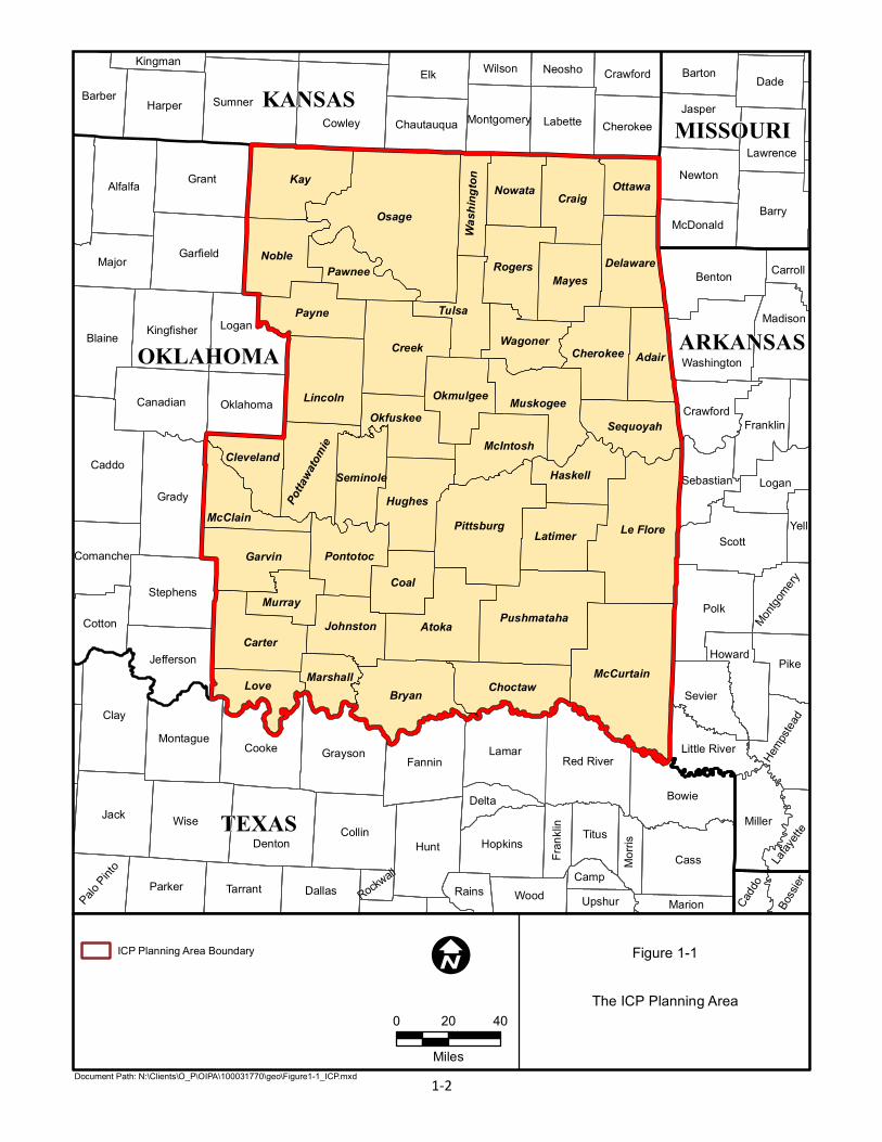
TheproposedICPPlanningAreaconsistsof45counties inOklahoma.Theyareas follows:Adair,Atoka,Bryan,Carter,Cherokee,Choctaw,Cleveland,Coal,Craig,Creek,Delaware,Garvin,Haskell,Hughes, Johnston, Kay, Latimer, Le Flore, Lincoln, Love, Marshall, Mayes, McClain, McCurtain,McIntosh,Murray,Muskogee,Noble,Nowata,Okfuskee,Okmulgee,Osage,Ottawa,Pawnee,Payne,Pittsburg,Pontotoc,Pottawatomie,Pushmataha,Rogers,Seminole,Sequoyah,Tulsa,Wagoner,andWashington (Figure 1‐1). The Planning Area covers approximately 22,858,163 acres (9,250,370hectares)or35,716squaremiles(92,504squarekilometers).
This document provides the required NEPA documentation for a Federal action (approval of aconservation plan and subsequent section 10(a)(1)(B) permit issuance), providing baselineinformationanddiscussionofimpactstothehumanandnaturalenvironmentthatmayoccurasaresultofimplementingtheICPandpotentiallyresultingfromthecoveredactivitiesduringtheICPterm.
TEXAS
OKLAHOMA
KANSASMISSOURI
ARKANSAS
Osage
Le Flore
McCurtain
Atoka
Creek
Bryan
Pittsburg
Lamar
Craig
Carter
GarvinCoal
Pushmataha
Love
Red River
Adair
Mayes
Tulsa
Hughes
Rogers
Latimer
Choctaw
Delaware
Haskell
Muskogee
Cherokee
Pontotoc
Nowata
McIntosh
Pawnee
McClain
Sequoyah
Okmulgee
Johnston
Ottawa
Wagoner
Okfuskee
Murray
Cleveland
Marshall
Seminole
Potta
watom
ie
Wash
ington
Clay
Kay
Jack
Polk
Cass
WiseHunt
Grady
Grant
Scott
Elk
Caddo
Collin
CowleySumner
Bowie
Barry
Blaine
Alfalfa
Cooke
Lincoln
Garfield
Denton
Fannin
NobleBenton
Logan
Miller
Harper
Grayson
Payne
Major
Pike
Hopkins
Parker
Montague
DadeJasper
Stephens
Canadian
Barber
Kingfisher
Sevier
Labette
Logan
Titus
Madison
Dallas
Jefferson
Newton
Tarrant
Washington
Cotton
Franklin
Howard
Barton
Oklahoma
Wood
Yell
Crawford
LawrenceCherokee
Comanche
Sebastian
Delta
McDonald
Little River
Chautauqua
CrawfordPalo
Pinto
Wilson
Rains
Neosho
Carroll
Marion Bossi
er
UpshurCamp
Kingman
Hempst
ead
Montgomery
Montgom
ery
Morris
Lafaye
tte
Frank
lin
CaddoRockw
all
Figure 1-1
The ICP Planning Area
Document Path: N:\Clients\O_P\OIPA\100031770\geo\Figure1-1_ICP.mxd
I0 20 40
Miles
ICP Planning Area Boundary
1-2
Atkins 100031770/140019 1‐3
1.1 PURPOSE AND NEED
This EA has been prepared to provide an assessment of potential impacts resulting from theproposedFederalaction(approvaloftheICPandsubsequentissuanceofincidentaltakepermits)onthehumanandnaturalenvironment.
1.1.1 Purpose for the Proposed Action
ThepurposeoftheproposedactionistoprovideameansbywhichapplicantsandtheServicecanstreamline theESA complianceprocess fornon‐Federalprojectswith thepotential to impact thefederally listed ABB within a defined area. Expediting the process would allow the Service toprocess incidental take permits in an expedited fashion, while meeting industry needs for anexpeditedESAcompliance.
1.1.2 Need for the Proposed Action
TheService’sneedfortheICPistoprovideamechanismunderwhichwecanissuepermitstocoverunavoidable take of ABB by a non‐Federal entity engaging in otherwise lawful activities in anexpedited fashion to reduce work load on Federal employees and meet industry schedulingrequests. Implementing the ICPwould eliminate need for processingmultiple, individualHabitatConservationPlans (HCPs)andensures consistentmitigationandminimizationmeasures for theABBrelated tooilandgasactivities.ProcessingHCPrequestsrequiresreviewofeachapplicant’sconservationplan in addition to reviewof avoidance,minimization, andmitigationmeasures foreachindividualproject,preparationofappropriateNEPAdocumentation,analysisunderanintra‐Serviceconsultation,andcoordinationthroughmultipleServiceoffices.
Theoilandgasindustry’sneedforincidentaltakeauthorizationoccurswhenthelikelihoodexiststhatthefederallylistedABBcouldbetaken,asthattermisdefinedbytheEndangeredSpeciesActof1973(ESA)byacoveredactivityandprojectschedulesandbudgetsareimpactedbylengthyfieldsurveys, compliance coordination, and identificationof appropriatemitigation.Theproposed ICPand subsequent consideration of incidental take permitswould streamline and expedite theESAcomplianceprocessforindustryapplicants.
Atkins 100031770/140019 2‐1
2.0 ALTERNATIVES
AnEAexaminestheimpactsofaproposedFederalactiononthehumanenvironment.Inthiscase,the Proposed Action is approval of the ICP and subsequent issuance of permits to authorizeincidentaltakeofthecoveredspeciesthatmayresultfromthecoveredactivities.
With respect to this EA, the Service has analyzed in detail theProposedAlternative and theNo‐ActionAlternative.TheNo‐ActionalternativedemonstratestheconsequencesofnotapprovingtheICPorissuingsubsequentpermits.
2.1 NO‐ACTION ALTERNATIVE
No incidental take permits would be issued under the proposed ICP. Oil and gas companies inOklahomawithintherangeoftheABBwouldcomplywiththeESAbyavoidingimpacts(take)tothecoveredspecieswherepracticable.IftakecouldnotbeavoidedandaFederalnexusexists(funded,authorized, or carried out by a Federal agency), an operator or individual may receive takecoveragethroughconsultationandabiologicalopinionissuedbytheServicetotheFederalactionagency.IfnoFederalinvolvementexists,applicantsorindividualscoulddevelopanHCPandapplyfor incidental take authorization from the Service on a project‐by‐project basis. Each applicationwouldrequireindependentevaluationunderNEPA.
2.2 PROPOSED ALTERNATIVE: ACTIVITIES AS PROPOSED IN THE ICP
The proposed action is approval of the proposed ICP, subsequent issuance of incidental takepermitsforcoveredspecieswithinthe22‐yeartermoftheICP,andimplementationoftheICPasproposed.ActionscoveredundertheICPmayresultintakeofcoveredspecies(theABB)associatedwith activities including, but not limited to exploration, development, and extraction (upstreamproduction);andtransportand/ordistribution(midstreamdevelopment)ofcrudeoil,naturalgas,andotherpetroleumproducts(describedbelowandwithinSection2oftheICP).Someoverlapmayoccur between these two categories and different Federal agencies may define “upstream” and“midstream” differently to the definition in the ICP. For a complete description of the coveredactivities,seeSection2oftheICP.
2.2.1 Upstream Production
Upstreamproduction,asdefinedbytheICP,includesactivitiesassociatedwithoil,naturalgas,andother petroleum products and development of the infrastructure required to extract thoseresources.Coveredactivitiesincludegeophysicalexploration(alsoknownasseismicexploration),which is the process of locating oil and gas deposits beneath the earth’s surface. This involvesgenerating seismic waves andmeasuring their reflectance through differing geologic structures.
Atkins 100031770/140019 2‐2
These seismic waves may be initiated by detonating explosives or through a process known as“land vibroseis.” Reflected seismic waves are recorded and interpreted to characterize subter‐ranean landforms. Seismic companies often design sound generation points to avoid identifiedsensitivehabitatsandhazardsandstillcollectmeaningfuldata.
Coveredactivitiesalsoincludeconstruction,operation,andmaintenanceofnewandexistingwellfieldinfrastructureanddecommissioningofobsoletefacilities,including:
Wellpads
Drillingandcompletionactivities
Wells
Gasflaring
Workandaccessroads
Electricdistributionlines
Offsiteimpoundments
Communicationtowers
Actionscommontotheseactivitiesincludevegetationclearing;removalandgradingofsoils;useofheavymachineryandoff‐roadvehicles;drillingwellsandhydraulic fracturing, increased levelsofnoise;installationoformodificationtofencing,walls,androads;increasedlighting;andincreasedhumanactivityinthearea.Itshouldbenotedthatalthoughelectrictransmissionanddistributionfacilities not related to oil and gas facilities were previously eliminated from consideration, theService determined that electric distribution lines 34.5 kV or less associated specificallywith oiland gas facilities should be included in the ICP so that industry impacts related to exploration,extraction,andtransportarecovered.
Commonly used, hydraulic fracturing for oil and gas drilling is the fracturing of rock by apressurizedliquidwherewaterandaproppant(typicallytreatedsandaddedtoafracturingfluid[gel, foam, or slickwater – water with a limited amount of sand, friction reducers, and otherchemical additives]) are pumped at extremely high pressures down the wellbore to keep aninducedhydraulic fractureopen.Oilandgascompanypersonnelcontinuouslymonitorandgaugepressures, fluids and proppants, studying how the sand reacts when it hits the bottom of thewellbore, slowly increasing the density of sand towater as the process progresses. This processmay be repeated multiple times, in “stages” to reach maximum areas of the formation(s). Thewellboreistemporarilypluggedbetweeneachstagetomaintainthehighestfluidpressurepossibleandgetmaximum fracturing results in the rock.Theplugs are thendrilledor removed from thewellbore and thewell is tested for results. Thepressure is reduced and the fracturing fluids arereturnedup thewellbore fordisposalor treatment and re‐use, leaving the sand inplace topropopenthefracturesandallowtheoil/gastoflow.
Atkins 100031770/140019 2‐3
The Service determined that all of the described activities should be covered by the ICP andsubsequentincidentaltakepermit(s)withthefollowingrestrictions:
Gas flaring (burning waste gases for disposal) with adequate flame enclosure—projectsrequiringsmall, constantlyburning flares throughout the lifeof theprojectwill cover theflametominimizeoreliminateemittedartificiallight,whichisattractivetobirdsandABBs.
Electricdistributionlinesmustbe34.5kilovoltsorless—thelimitonkilovoltsisassociatedwiththeheightofthelinesandriskofbirdstrikes.Linesunder34.5kilovoltsarelesslikelytoresultinbirdstrikes.
Communicationtowersmustbeunder200 feet(61meters),unlit (unlessrequiredbytheFederalAviationAdministration),andwithnoguywires—thisrestrictionisassociatedwiththeriskofimpactstofederallyprotectedbirdspecies.Tallertowershaveincreasedriskofbird strikesandeliminationofguywires further reduces the risk.Additionally, if FederalAviation Administration regulations permit, towers should be unlit to avoid attractingmigratory birds at night. These restrictions are consistent with those outlined in theService’sstandardguidancefortowerswithpotentialimpactstofederallylistedspeciesandmigratory birds. Industry indicated that they rarely need towers taller than 200 feet(61meters) and if, needed, they would be permitted through Federal AviationAdministrationandwiththeServiceindependentoftheICP.
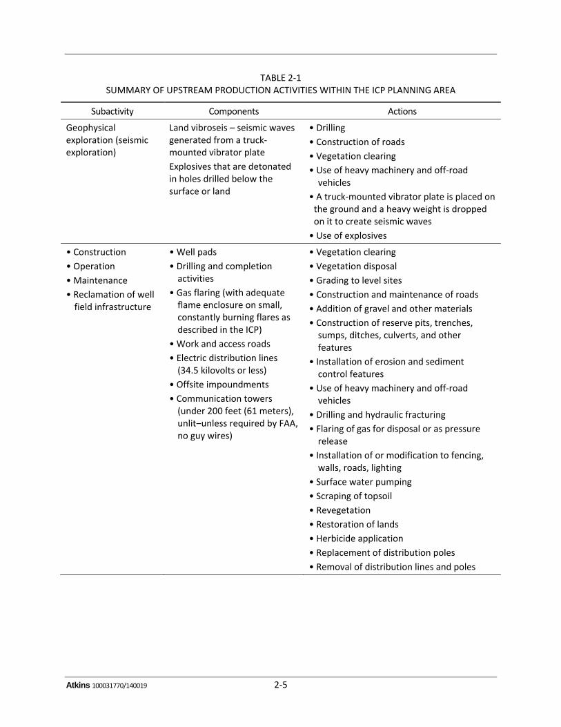
These activities, with restrictions, are included as part of the proposed action. Table 2‐1 sum‐marizesthesubactivities,components,andactionsassociatedwithupstreamproductionactivitieswithintheproposedPlanningArea.TheseactivitiesareexplainedindetailintheICP.
2.2.2 Midstream Development
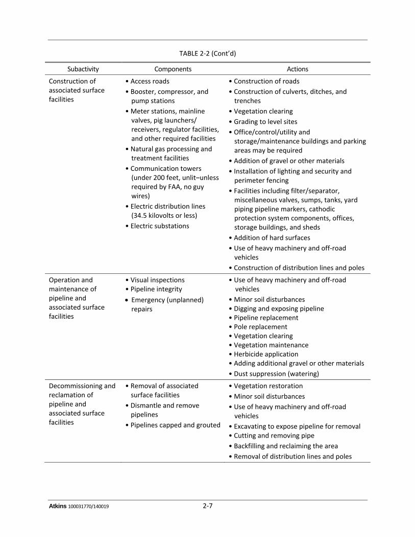
Midstream development, as defined in the ICP, includes gathering, processing and treatment,transmission,and/ordistributionofcrudeoil,naturalgas,orotherpetroleumproducts.Petroleumproductsmay includeunprocessednatural gas liquidor condensate streams (includingmethane,ethane, propane, butane, andpentane). Refined oil products including gasoline, diesel, and kero‐senemayalsobetransportedviapipeline.Pipelineslocatedwithintheboundariesofwellpadsareincluded in upstream production, while gathering, transmission, and distribution pipelines areconsidered midstream development. Covered activities associated with midstream developmentincludethefollowing:
Constructionofgathering,transmission,anddistributionpipelines
Constructionofassociatedsurfacefacilities,including:
Accessroads
Booster,compressor,andpumpstations
Meterstations,mainlinevalves,pig launchers/receivers, regulator facilities, andotherrequiredfacilities
Naturalgasprocessingandtreatmentfacilities
Atkins 100031770/140019 2‐4
Communicationtowers
Electricdistributionlines
Electricsubstations
Operationandmaintenanceofpipelineandassociatedsurfacefacilities
Decommissioningandreclamationofpipelineandassociatedsurfacefacilities
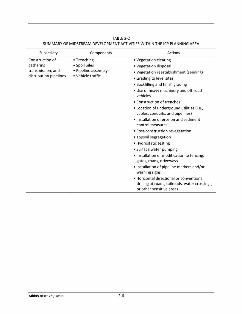
Actions common to these activities are similar to those described for upstream productionactivities.TheServicedeterminedthatalloftheabove‐listedactivitieswouldbecoveredbytheICPand incidental take permit(s). Table 2‐2 summarizes the subactivities, components, and actionsassociated with midstream development activities within the proposed Planning Area. TheseactivitiesareexplainedindetailintheICP.
Atkins 100031770/140019 2‐5
TABLE 2‐1 SUMMARY OF UPSTREAM PRODUCTION ACTIVITIES WITHIN THE ICP PLANNING AREA
Subactivity Components Actions
Geophysical exploration (seismic exploration)
Land vibroseis – seismic waves generated from a truck‐mounted vibrator plate
Explosives that are detonated in holes drilled below the surface or land
• Drilling
• Construction of roads
• Vegetation clearing
• Use of heavy machinery and off‐road vehicles
• A truck‐mounted vibrator plate is placed on the ground and a heavy weight is dropped on it to create seismic waves
• Use of explosives
• Construction
• Operation
• Maintenance
• Reclamation of well field infrastructure
• Well pads
• Drilling and completion activities
• Gas flaring (with adequate flame enclosure on small, constantly burning flares as described in the ICP)
• Work and access roads
• Electric distribution lines (34.5 kilovolts or less)
• Offsite impoundments
• Communication towers (under 200 feet (61 meters), unlit‒unless required by FAA, no guy wires)
• Vegetation clearing
• Vegetation disposal
• Grading to level sites
• Construction and maintenance of roads
• Addition of gravel and other materials
• Construction of reserve pits, trenches, sumps, ditches, culverts, and other features
• Installation of erosion and sediment control features
• Use of heavy machinery and off‐road vehicles
• Drilling and hydraulic fracturing
• Flaring of gas for disposal or as pressure release
• Installation of or modification to fencing, walls, roads, lighting
• Surface water pumping
• Scraping of topsoil
• Revegetation
• Restoration of lands
• Herbicide application
• Replacement of distribution poles
• Removal of distribution lines and poles
Atkins 100031770/140019 2‐6
TABLE 2‐2 SUMMARY OF MIDSTREAM DEVELOPMENT ACTIVITIES WITHIN THE ICP PLANNING AREA
Subactivity Components Actions
Construction of gathering, transmission, and distribution pipelines
• Trenching • Spoil piles • Pipeline assembly • Vehicle traffic
• Vegetation clearing
• Vegetation disposal
• Vegetation reestablishment (seeding)
• Grading to level sites
• Backfilling and finish grading
• Use of heavy machinery and off‐road vehicles
• Construction of trenches
• Location of underground utilities (i.e., cables, conduits, and pipelines)
• Installation of erosion and sediment control measures
• Post‐construction revegetation
• Topsoil segregation
• Hydrostatic testing
• Surface water pumping
• Installation or modification to fencing, gates, roads, driveways
• Installation of pipeline markers and/or warning signs
• Horizontal directional or conventional drilling at roads, railroads, water crossings, or other sensitive areas
Atkins 100031770/140019 2‐7
TABLE 2‐2 (Cont’d)
Subactivity Components Actions
Construction of associated surface facilities
• Access roads
• Booster, compressor, and pump stations
• Meter stations, mainline valves, pig launchers/ receivers, regulator facilities, and other required facilities
• Natural gas processing and treatment facilities
• Communication towers (under 200 feet, unlit‒unless required by FAA, no guy wires)
• Electric distribution lines (34.5 kilovolts or less)
• Electric substations
• Construction of roads
• Construction of culverts, ditches, and trenches
• Vegetation clearing
• Grading to level sites
• Office/control/utility and storage/maintenance buildings and parking areas may be required
• Addition of gravel or other materials
• Installation of lighting and security and perimeter fencing
• Facilities including filter/separator, miscellaneous valves, sumps, tanks, yard piping pipeline markers, cathodic protection system components, offices, storage buildings, and sheds
• Addition of hard surfaces
• Use of heavy machinery and off‐road vehicles
• Construction of distribution lines and poles
Operation and maintenance of pipeline and associated surface facilities
• Visual inspections • Pipeline integrity
Emergency (unplanned) repairs
• Use of heavy machinery and off‐road vehicles
• Minor soil disturbances • Digging and exposing pipeline • Pipeline replacement • Pole replacement • Vegetation clearing • Vegetation maintenance • Herbicide application • Adding additional gravel or other materials
• Dust suppression (watering)
Decommissioning and reclamation of pipeline and associated surface facilities
• Removal of associated surface facilities
• Dismantle and remove pipelines
• Pipelines capped and grouted
• Vegetation restoration
• Minor soil disturbances
• Use of heavy machinery and off‐road vehicles
• Excavating to expose pipeline for removal • Cutting and removing pipe
• Backfilling and reclaiming the area
• Removal of distribution lines and poles
Atkins 100031770/140019 3‐1
3.0 AFFECTED ENVIRONMENT
The ICP Planning Area is a 45‐county area covering approximately 22,858,163 acres (9,250,370hectares) or 35,716 squaremiles (92,504 square kilometers) and 10 ecoregions in Oklahoma, 2major river basins (Arkansas River and Red River), and many aquifers. Land use ranging fromundevelopedlandtoagriculturallandtourbandevelopmentispresentinthePlanningArea,aswellasnumerousnationalwildliferefuges,wildlifemanagementareas,stateparksandotherpreservedlands.ThepopulationinthePlanningAreaisapproximately2,317,969persons(U.S.CensusBureau2010),andthelargestcitiesinthePlanningAreaareTulsaandNormaninOklahoma.
Becauseof itsvastsize, thePlanningAreadisplayssignificantdiversity inhabitat, resources,anddegrees of urban development. Not all of the resources locatedwithin the Planning Areawouldpotentially be affected by the covered activities. Thus, this EA briefly describes the existingresourceswithinthePlanningArea,focusingprimarilyonthosewiththepotentialtobeaffectedbytheProposedAlternative.
3.1 GEOLOGY
The followingdescriptionofOklahoma’sgeology is fromtheOklahomaGeologicalSurvey(2008).PartsofOklahoma in thegeologicpastwerealternatelybeloworabovesea level.Thick layersofsedimentsaccumulatedinshallowseasthatcoveredlargeareas.Thesedimentswerelaterburiedand lithified intomarineshales, limestones,andsandstonesovergeologic time. Inareasnear theancientseas,sands,andclaysaccumulatedasalluvialanddeltaicdepositsthatsubsequentlywerelithified tosandstonesandshales.When theareaswere laterelevatedabove theseas, rocks,andsediments thathadbeendepositedearlierwereexposedanderoded.Upliftwasaccomplishedbythe gentle arching of broad areas, or by mountain building where rocks were intensely folded,faulted,andthrustupward.
Theprincipalmountainbelts, theOuachita,Arbuckle,andWichitaMountains,are inthesouthernthirdofOklahoma.Thesewerethesitesoffolding,faulting,andupliftingduringthePennsylvanianPeriod. The mountain belts exposed a great variety of geologic structures and brought igneousrocksandthicksequencesofPaleozoicsedimentarystratatothesurface.
Theprincipalsitesofsedimentationwereelongatebasinsthatsubsidedmorerapidlythanadjacentareas,andreceived10,000to40,000feetofsediment.Majorsedimentarybasinswereconfinedtothe southern half of Oklahoma and include Anadarko, Arkoma, Ardmore, Marietta, Hollis, andOuachita; theOuachitaBasin is the siteof today’sOuachitaMountains, andwasactive fromLateCambriantoEarlyPennsylvanian.Asmallerbasin,theDalhartBasin,isinthewesternPanhandle.
Atkins 100031770/140019 3‐2
3.2 SOILS, INCLUDING PRIME AND UNIQUE FARMLAND
SoildescriptionsprovidedforthePlanningAreaarebasedonregionalsoiltypesforOklahoma.Thefollowing description of the soil in Oklahoma is from the Oklahoma Geological Survey (2008),including informationfromGrayandGalloway(1959)andCarterandGregory(1996).ThemajorsoilassociationsarebrokendownbygeographicregionsandMajorLandResourceAreas.
3.2.1 Central Oklahoma
SoilsintheCentralRollingRedPrairiesaredarkandloamywithclayeytoloamysubsoilsdevelopedonPermianshales,mudstones,sandstones,and/oralluvialdepositsundertallgrasses.SoilsoftheCrossTimbersarelightcolored,sandywithreddishsubsoilsonvarioussandymaterialsdevelopedundermostlypostoak,blackjackoak,andsomehickoryforestswithprairieopenings(savannah).The BluestemHills‐Cherokee Prairies contain deep, dark‐colored soils,mostlywith clay subsoilsdeveloped on shales, sandstones, and limestones under tall grasses. Soils in the Grand Prairie‐Arbuckle Mountains Major Land Resource Areas are dark and loamy to clayey with subsoilsdeveloped in shales and limestones under tall grasses near the Arbuckle Mountains andsoutheastern Oklahoma. Thin and stony soils develop on Precambrian granites in the ArbuckleMountainsbeneathmidgrasses,scruboaks,cedars,andshrubs.
3.2.2 Eastern Oklahoma
The Ozark Highlands‐BostonMountains have brown to light‐brown, silty soilswith reddish claysubsoils on cherty limestones (OzarkHighlands) and sandstonesand shales (BostonMountains).Thesesoilsdevelopunderoak‐hickory‐pineforestsandtallgrasses.SoilsintheOuachitaMountainsarelightcolored,acidic,sandy,andloamywithclayeysubsoilsdevelopedonsandstonesandshalesunderoak‐hickory‐pineforests.ArkansasRidgeandValleysoilsareloamy,rocky,andwelldrainedwheredevelopedonsteepslopesandridgesorareverydeepandloamyongentleslopesandshalesin valleys. Coastal Plain soils are light colored, acidic, and sandywith clay loam to clay subsoilsdevelopedmostlyonsandstonesunderpine‐oak(east)andoak‐hickory(west)forests.
3.2.3 Prime Farmland Soils
Prime farmland isdefinedby theSecretaryofAgriculture in7CFR657as land thathas thebestcombinationofphysicalandchemicalcharacteristicsforproducingfood,feed,fiber,oroilseedandisalsoavailablefortheseuses.Ithasthesoilquality,growingseason,andmoisturesupplyneededtoeconomicallysustainhighyieldsofcropswhentreatedandmanagedproperly(SoilConservationService 1978). Some soils are considered prime farmland in their native state, while others areconsideredpotentialprimefarmlandorprimefarmlandiftheyaredrainedorirrigatedinordertogrowthemaincropsinthearea.
Atkins 100031770/140019 3‐3
The amount of acreage considered to be prime farmland in the 45 Oklahoma counties of thePlanning Area ranges from 55,305 acres (22,381 hectares) inMarshall County to 416,419 acres(168,519 hectares) inOsage County; by percentage of land in any given county, prime farmlandranges from 8.8 percent of the county’s soil in Pushmataha County, up to 68.3 percent primefarmlandinCraigCounty(NaturalResourcesConservationService2013).
3.3 WATER RESOURCES
Oklahomacanbedividedintotwomajorriversystems,theArkansasRiverandRedRiver.Atallyoflarger streams and tributaries within each river systems totals 20, with 5,171 linear miles(8,322kilometers)ofriverandstreamlengththroughoutthestate.Atotalof116majorreservoirsoccurinOklahoma,84ofwhichoccurinthePlanningArea.NumerousartificialandnaturalpondsandsmallerlakesarealsofoundthroughoutthePlanningArea(OklahomaWaterResourcesBoard2012).
ThePlanningAreacovers7of11majoraquifersand8of13minoralluvialaquifersinOklahoma.ThemajoralluvialaquifersincludetheArkansasRiver,CanadianRiver,GertySand,NorthCanadianRiver, Red River, Salt Fork of the Arkansas River, and Washita River aquifers. In addition, thePlanningAreaincludes5of10major,and14of19minorbedrockaquiferinOklahoma.Themajorbedrock aquifers consist of the Antlers, Arbuckle‐Simpson, Garber‐Wellington, Roubidoux, andVamoosa‐Adaaquifers(OklahomaWaterResourcesBoard2012).
The100‐yearfloodplainsinthePlanningAreaareassociatedwithnumerousriversandcreeksandare typically relatively low, flat areas. Floodplains formwhere overbank floodwaters spread outlaterallyanddepositfine‐grainedsediments.TheFederalEmergencyManagementAgencypreparesFloodInsuranceRateMapsthatdelineatefloodplainsforcountiesthatparticipateintheprogram.Not all counties participate in the Federal Emergency Management Agency program (FederalEmergencyManagementAgency2013).
3.4 WATER QUALITY
SurfacewaterqualitythroughoutthePlanningArearangesfrompoortogood,withsurfacewatersimpairedbyelevatedlevelsoftotaldissolvedsolids,chloride,sulfate,andchlorophyll‐a.Ingeneral,Oklahoma’smajoraquiferscontainwaterofacceptablequalityforirrigationofatleastsomecrops.Thestate’smajoraquifersprovidewatersuppliesthatgenerallymeetorexceedFederalandStatestandards fordrinkingwater;however,notallareasordepthswithin theaquifersprovidewatersuitableforpublicsupply.Waterfromalluvialaquifers, thoughtypicallyveryhard, isgenerallyofgoodqualityandisacceptableformostpurposes(OklahomaWaterResourcesBoard2012).
Atkins 100031770/140019 3‐4
3.5 AIR QUALITY
TheCleanAirActidentifiessixcommonairpollutantsfoundallovertheU.S.Thesepollutantscaninjure health, harm the environment, and cause property damage. The U.S. EnvironmentalProtection Agency calls these pollutants criteria air pollutants and has developed scientificallybased health criteria as the basis for setting permissible levels. National ambient air qualitystandardsexistforeachofthecriteriapollutantsandthesestandardsapplytotheconcentrationofa pollutant in outdoor air. If the air quality in a geographic areameets or does better than thenationalstandard,itiscalledanattainmentareaandareasthatdonotmeetthenationalstandardare called nonattainment areas. The Planning Area is currently in attainment for all air qualitycriteriapollutantsinallrelevantcounties(U.S.EnvironmentalProtectionAgency2012).
3.6 VEGETATION
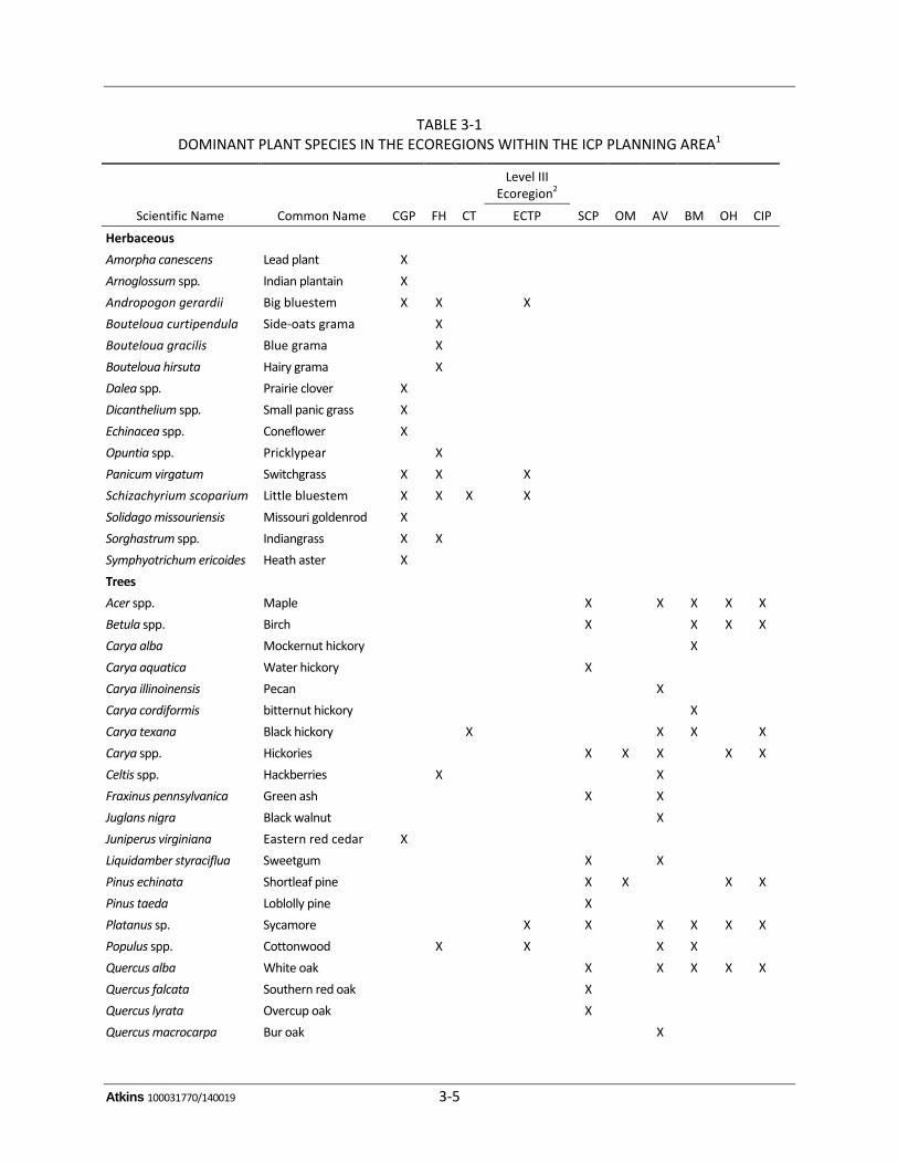
Ofthe12Level IIIecoregionsthathavebeendescribedbyWoodsetal. (2005) forOklahoma,10occurwithin the Planning Area. They are as follows: Central Great Plains (CGP), Flint Hills (FH,Cross Timbers (CT), East Central Texas Plains (ECTP), South Central Plains (SCP), OuachitaMountains(OM),ArkansasValley(AV),BostonMountains(BM),OzarkHighlands(OH),andCentralIrregularPlains(CIP).AsummaryofthedominantplantspeciesassociatedwiththeseecoregionsisshowninTable3‐1.ThevegetationdescriptionsbelowarepredominantlyfromWoodsetal.(2005)andOklahomaGeologicalSurvey(2008).
Vegetation varieswidely depending on the climactic and topographic elements that characterizeeacharea.ThewesternboundaryofthePlanningareaincludesscatteredhills,breaks,saltplains,lowmountains,gypsumkarst,sandy flats,andsanddunesto lowhills,cuestas,ridges,andplainsthat separate the forests of the east from the drier prairies of the west. Mean annual rainfallincreaseseastward,andvariesfromabout36to46inches(91.4to116.8centimeters).TopographyontheeasternsideofthePlanningAreaismorevaried,rangingfromlowhills,cuestasandplainsinthenorthtohighlydissectedplateauandmountainscentrally,andlowmountainsandprairieinthesouth.RainfallontheeasternboundaryofthePlanningArearangesfrom41to57inches(104.1to144.8 centimeters) per year. The terrain and vegetation on thewestern portion of the PlanningAreaaretransitionalbetweentheless‐rugged,grass‐coveredecoregionstothewestandthehilly,oaksavannahtotheeast.
Atkins 100031770/140019 3‐5
TABLE 3‐1 DOMINANT PLANT SPECIES IN THE ECOREGIONS WITHIN THE ICP PLANNING AREA1
Scientific Name Common Name CGP FH CT
Level III Ecoregion2
SCP OM AV BM OH CIP ECTP
Herbaceous
Amorpha canescens Lead plant X
Arnoglossum spp. Indian plantain X
Andropogon gerardii Big bluestem X X X
Bouteloua curtipendula Side‐oats grama X
Bouteloua gracilis Blue grama X
Bouteloua hirsuta Hairy grama X
Dalea spp. Prairie clover X
Dicanthelium spp. Small panic grass X
Echinacea spp. Coneflower X
Opuntia spp. Pricklypear X
Panicum virgatum Switchgrass X X X
Schizachyrium scoparium Little bluestem X X X X
Solidago missouriensis Missouri goldenrod X
Sorghastrum spp. Indiangrass X X
Symphyotrichum ericoides Heath aster X
Trees
Acer spp. Maple X X X X X
Betula spp. Birch X X X X
Carya alba Mockernut hickory X
Carya aquatica Water hickory X
Carya illinoinensis Pecan X
Carya cordiformis bitternut hickory X
Carya texana Black hickory X X X X
Carya spp. Hickories X X X X X
Celtis spp. Hackberries X X
Fraxinus pennsylvanica Green ash X X
Juglans nigra Black walnut X
Juniperus virginiana Eastern red cedar X
Liquidamber styraciflua Sweetgum X X
Pinus echinata Shortleaf pine X X X X
Pinus taeda Loblolly pine X
Platanus sp. Sycamore X X X X X X
Populus spp. Cottonwood X X X X
Quercus alba White oak X X X X X
Quercus falcata Southern red oak X
Quercus lyrata Overcup oak X
Quercus macrocarpa Bur oak X
Atkins 100031770/140019 3‐6
TABLE 3‐1 (CONT’D)
Scientific Name Common Name CGP FH CT
Level III Ecoregion2
SCP OM AV BM OH CIP ECTP
Quercus marilandica Blackjack oak X X X X
Quercus muehlenbergii Chinquapin oak X X
Quercus nigra Water oak X
Quercus phellos Willow oak X
Quercus rubra Northern red oak X
Quercus shumardii Shumard oak X
Quercus stellata Post oak X X X X
Quercus velutina Black oak X X
Quercus spp. Oaks X X X X
Salix sp. Willow X X X X X
Ulmus alata Winged elm X X
Ulmus americana American elm X X X
Ulmus spp. Elms X X X X X
Taxodium distichum Bald cypress X 1 According to Woods et al. (2005) and Oklahoma Geological Survey (2008). 2 CGP‒Central Great Plains; FH‒Flint Hills; CT‒Cross Timbers; SCP‒South Central Plains; OM‒Ouachita Mountains; AV‒Arkansas Valley; BM‒Boston Mountains; OH‒Ozark Highlands; CIP‒Central Irregular Plains.
3.7 WETLANDS/WATERS OF THE U.S.
Section10(33USC403)oftheRiversandHarborsActof1890(superseded)and1899(33USC401,etseq.)establishedpermitrequirementsforcertainactivitiesaffectingnavigablewatersoftheU.S.NavigablewatersoftheU.S.aredefined(33CFRPart329)as“thosewatersthataresubjecttotheebb and flow of the tide and/or are presently used, or have been used in the past, or may besusceptible touse to transport interstateor foreign commerce.”Furthermore, Section404of theCleanWaterAct(33USC1344)providedregulatoryauthoritytotheU.S.ArmyCorpsofEngineers(USACE) for activities involving the discharge of dredged or fillmaterial intowaters of the U.S.,includingwetlands.SomeofthewetlandhabitatsdescribedbelowmaybesubjecttoregulationbytheUSACE.
TheUSACE(1982)describeswetlandsas“thoseareasthatareinundatedorsaturatedbysurfaceorgroundwater at a frequency and duration sufficient to support, and that under normal circum‐stances,dosupport,aprevalenceofvegetationtypicallyadaptedforlifeinsaturatedsoilconditions.Wetlands generally include swamps, marshes, bogs, and similar areas.” The USACE providesguidelines for the determination of the areas under Section 404 jurisdiction (EnvironmentalLaboratory 1987). These guidelines require that at least one positive indicator for each of threecriteria(hydrophyticvegetation,hydricsoils,andwetlandhydrology)existinordertodesignateanarea as awetland. The numerous and varied indicators for each of the criteria are described indetailintheguidelines.
Atkins 100031770/140019 3‐7
If these areas meet the criteria necessary (Environmental Laboratory 1987) to define them asjurisdictional wetlands pursuant to Section 404 of the Clean Water Act, certain activities (e.g.,placement of fill) within these areas would be subject to USACE regulation. The Planning AreaencompassestheUSACETulsaDistrict.
Freshwaterwetlandsareclassifiedasriverine(rivers,streams,andcreeks), lacustrine(lakesandreservoirs),andpalustrine(forested,scrub‐shrub,andemergentwetlandsandponds)(Cowardinetal.1979).AlloftheseoccurwithinthePlanningArea.Bottomlandhardwoodforestscancontainavariety of species of trees, shrubs, and vines. Bogs are a type of wetland sometimes found inassociationwithbottomlandhardwoodforests.Bogsarepeat‐accumulatingwetlandsthathavenosignificantinflowsoroutflows.Wetlandfunctionsincludebiologicalproductivity,fishandwildlifehabitat, water quality improvement, aesthetics, and floodwater storage (U.S. EnvironmentalProtectionAgency2001).
3.8 GENERAL WILDLIFE
ThePlanningAreacontainsatleastaportionoffourofthefivebioticprovinceswithinOklahomathat were described by Blair (1950): the Texan, Carolinian, Kansan, and Austroriparian bioticprovinces; theNavahonianbioticprovinceoccursoutsideof thePlanningArea.TheTexanBioticProvince occupies the majority of the Planning area and is in the central portion, while theCarolinian Biotic Province occupies the eastern portion. The Kansan Biotic Province clips thenorthwestern corner of the Planning Area and the Austroriparian Biotic Province occurs in thesoutheasterncorner.
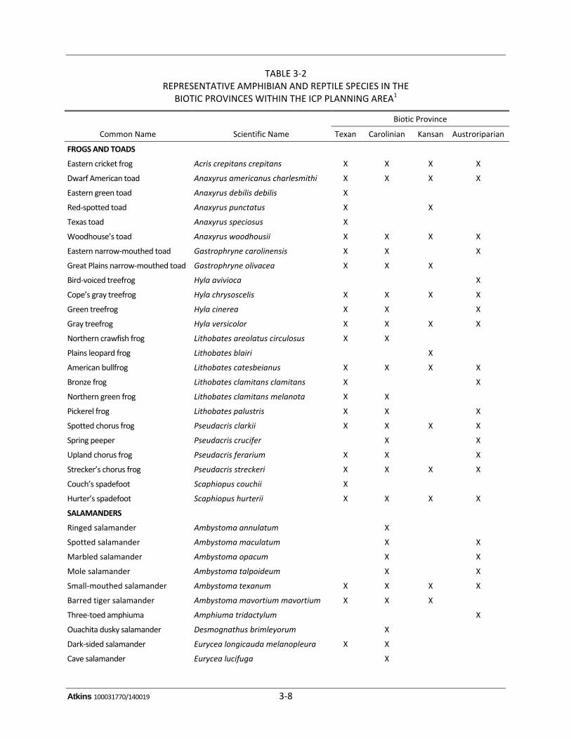
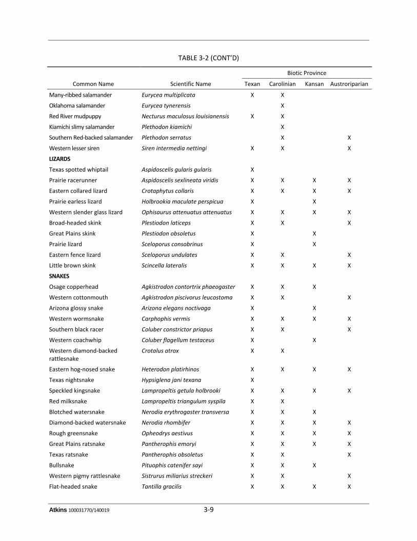
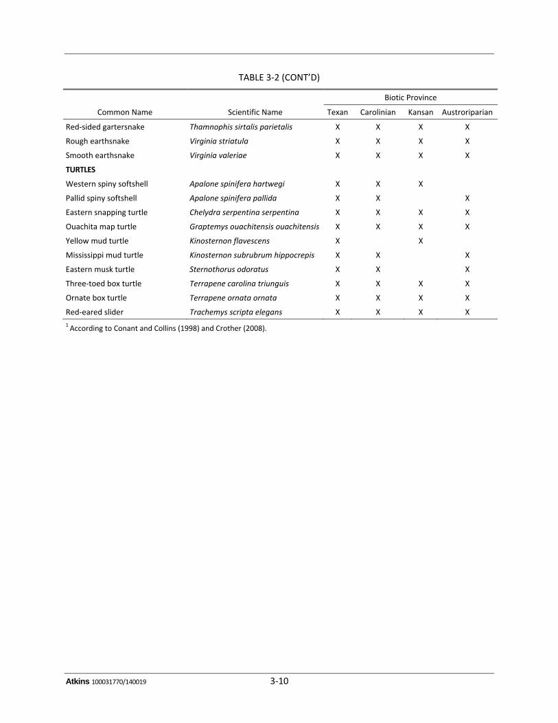
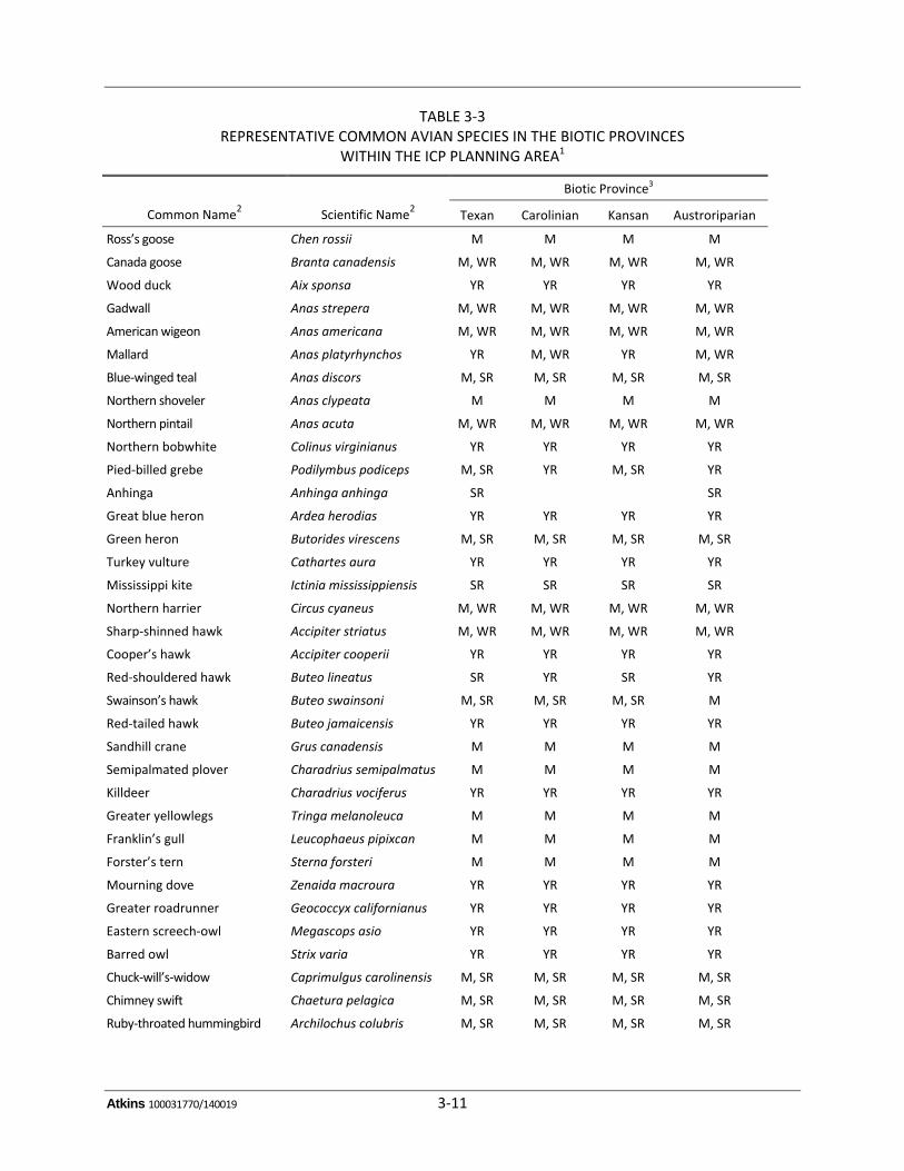
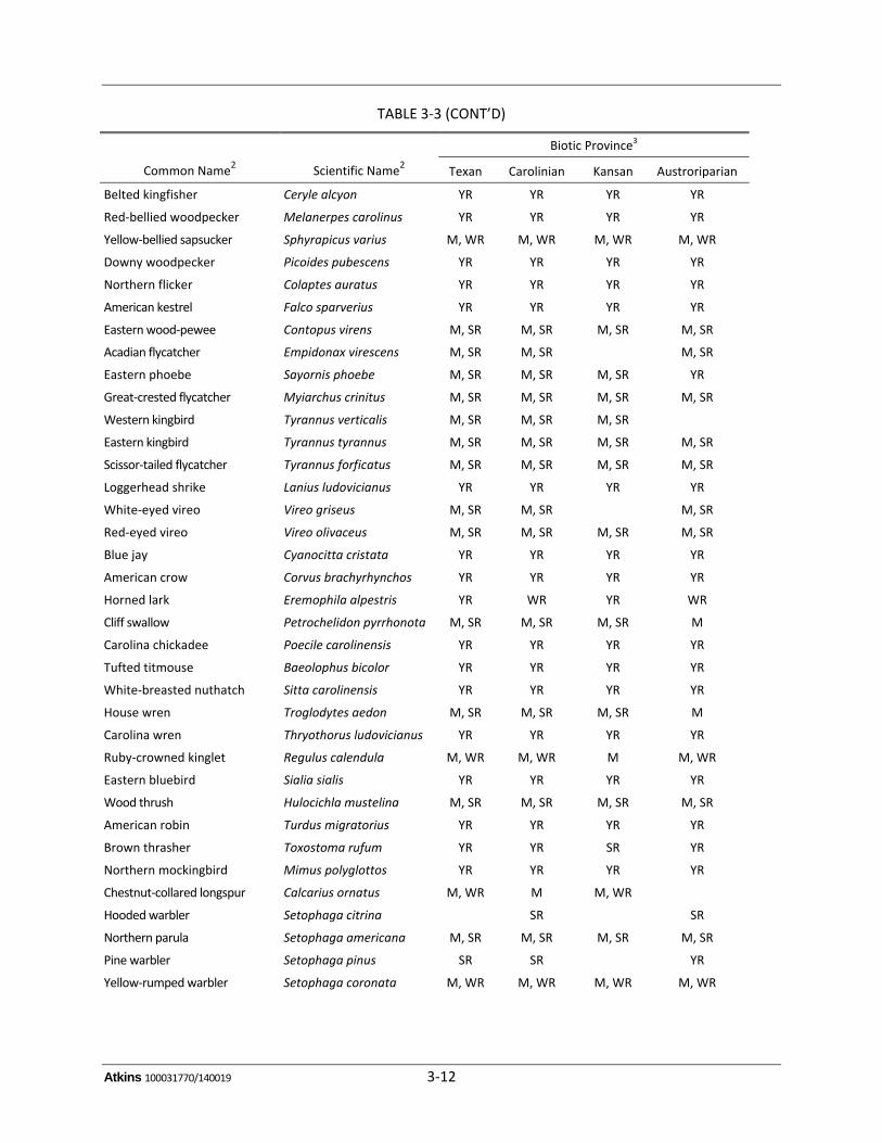
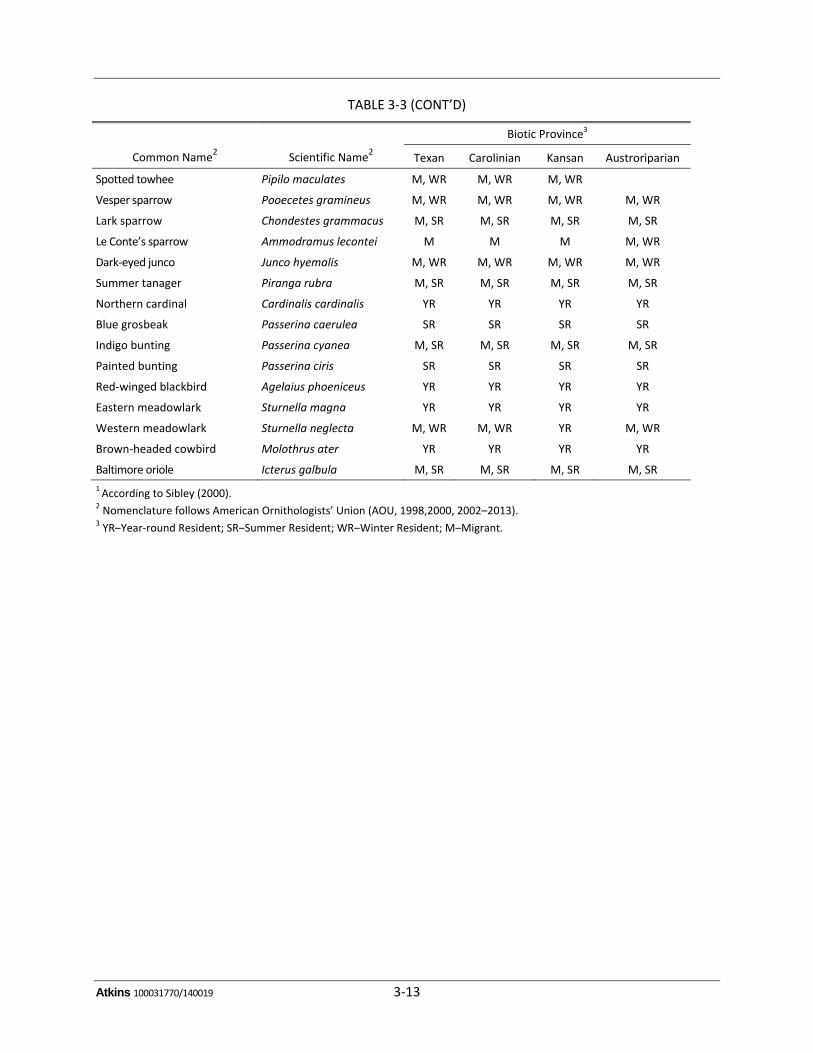
Thefaunarepresentedineachoftheseareascorrespondstodistinctivevegetational,climactic,andelevationalvariations thatcharacterize theregion.At least80speciesofamphibiansandreptilesoccurinthePlanningArea,includingfrogs,toads,salamanders,turtles,skinks,lizards,andsnakes(ConantandCollins1998).RepresentativespeciesarelistedinTable3‐2bybioticprovince.Morethan 300 avian species occur in the Planning Area, including passerines, (e.g., warblers, wrens,sparrows, crows),waterfowl (e.g., geese,ducks),wadingbirds, and raptors (Sibley2000).Repre‐sentativecommonavianspecies,bybioticprovince,areshowninTable3‐3.
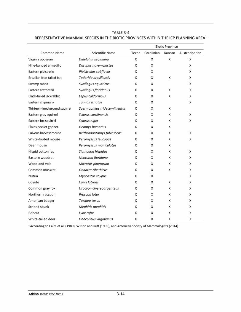
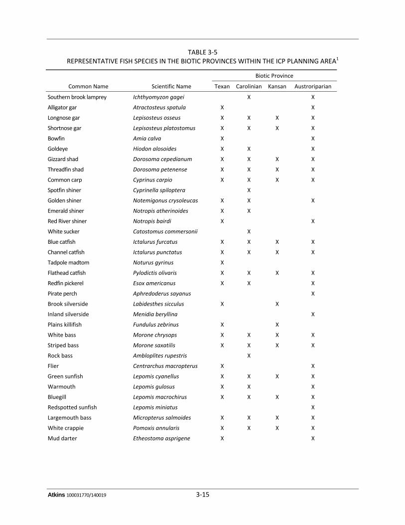
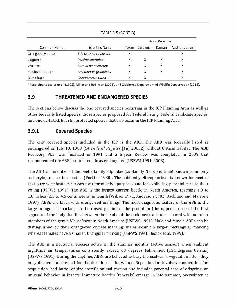
Numerousspeciesofmammalsoccur in thePlanningarea, includingdeer, coyotes,bobcats, riverotters,raccoons,opossums,armadillos,rabbits,squirrels,skunks,mice,andrats(Caireetal.1989,WilsonandRuff1999,AmericanSocietyofMammalogists2014).RepresentativespeciesarelistedinTable3‐4bybioticprovince.Gamefishspeciesincludebass,crappie,walleye,catfish,paddlefish,andalligatorgar,butmanynongameandsmall‐bodiedfishalsooccurinthePlanningArea,aswell(Jesteretal.1992,MillerandRobison2004,OklahomaDepartmentofWildlifeConservation2014).Table3‐5listsrepresentativefishspeciesfoundineachofthebioticprovinceswithinthePlanningArea.
Atkins 100031770/140019 3‐8
TABLE 3‐2 REPRESENTATIVE AMPHIBIAN AND REPTILE SPECIES IN THE
BIOTIC PROVINCES WITHIN THE ICP PLANNING AREA1
Biotic Province
Common Name Scientific Name Texan Carolinian Kansan Austroriparian
FROGS AND TOADS
Eastern cricket frog Acris crepitans crepitans X X X X
Dwarf American toad Anaxyrus americanus charlesmithi X X X X
Eastern green toad Anaxyrus debilis debilis X
Red‐spotted toad Anaxyrus punctatus X X
Texas toad Anaxyrus speciosus X
Woodhouse’s toad Anaxyrus woodhousii X X X X
Eastern narrow‐mouthed toad Gastrophryne carolinensis X X X
Great Plains narrow‐mouthed toad Gastrophryne olivacea X X X
Bird‐voiced treefrog Hyla avivioca X
Cope’s gray treefrog Hyla chrysoscelis X X X X
Green treefrog Hyla cinerea X X X
Gray treefrog Hyla versicolor X X X X
Northern crawfish frog Lithobates areolatus circulosus X X
Plains leopard frog Lithobates blairi X
American bullfrog Lithobates catesbeianus X X X X
Bronze frog Lithobates clamitans clamitans X X
Northern green frog Lithobates clamitans melanota X X
Pickerel frog Lithobates palustris X X X
Spotted chorus frog Pseudacris clarkii X X X X
Spring peeper Pseudacris crucifer X X
Upland chorus frog Pseudacris ferarium X X X
Strecker’s chorus frog Pseudacris streckeri X X X X
Couch’s spadefoot Scaphiopus couchii X
Hurter’s spadefoot Scaphiopus hurterii X X X X
SALAMANDERS
Ringed salamander Ambystoma annulatum X
Spotted salamander Ambystoma maculatum X X
Marbled salamander Ambystoma opacum X X
Mole salamander Ambystoma talpoideum X X
Small‐mouthed salamander Ambystoma texanum X X X X
Barred tiger salamander Ambystoma mavortium mavortium X X X
Three‐toed amphiuma Amphiuma tridactylum X
Ouachita dusky salamander Desmognathus brimleyorum X
Dark‐sided salamander Eurycea longicauda melanopleura X X
Cave salamander Eurycea lucifuga X
Atkins 100031770/140019 3‐9
TABLE 3‐2 (CONT’D)
Biotic Province
Common Name Scientific Name Texan Carolinian Kansan Austroriparian
Many‐ribbed salamander Eurycea multiplicata X X
Oklahoma salamander Eurycea tynerensis X
Red River mudpuppy Necturus maculosus louisianensis X X
Kiamichi slimy salamander Plethodon kiamichi X
Southern Red‐backed salamander Plethodon serratus X X
Western lesser siren Siren intermedia nettingi X X X
LIZARDS
Texas spotted whiptail Aspidoscelis gularis gularis X
Prairie racerunner Aspidoscelis sexlineata viridis X X X X
Eastern collared lizard Crotaphytus collaris X X X X
Prairie earless lizard Holbrookia maculate perspicua X X
Western slender glass lizard Ophisaurus attenuatus attenuatus X X X X
Broad‐headed skink Plestiodon laticeps X X X
Great Plains skink Plestiodon obsoletus X X
Prairie lizard Sceloporus consobrinus X X
Eastern fence lizard Sceloporus undulates X X X
Little brown skink Scincella lateralis X X X X
SNAKES
Osage copperhead Agkistrodon contortrix phaeogaster X X X
Western cottonmouth Agkistrodon piscivorus leucostoma X X X
Arizona glossy snake Arizona elegans noctivaga X X
Western wormsnake Carphophis vermis X X X X
Southern black racer Coluber constrictor priapus X X X
Western coachwhip Coluber flagellum testaceus X X
Western diamond‐backed rattlesnake
Crotalus atrox X X
Eastern hog‐nosed snake Heterodon platirhinos X X X X
Texas nightsnake Hypsiglena jani texana X
Speckled kingsnake Lampropeltis getula holbrooki X X X X
Red milksnake Lampropeltis triangulum syspila X X
Blotched watersnake Nerodia erythrogaster transversa X X X
Diamond‐backed watersnake Nerodia rhombifer X X X X
Rough greensnake Opheodrys aestivus X X X X
Great Plains ratsnake Pantherophis emoryi X X X X
Texas ratsnake Pantherophis obsoletus X X X
Bullsnake Pituophis catenifer sayi X X X
Western pigmy rattlesnake Sistrurus miliarius streckeri X X X
Flat‐headed snake Tantilla gracilis X X X X
Atkins 100031770/140019 3‐10
TABLE 3‐2 (CONT’D)
Biotic Province
Common Name Scientific Name Texan Carolinian Kansan Austroriparian
Red‐sided gartersnake Thamnophis sirtalis parietalis X X X X
Rough earthsnake Virginia striatula X X X X
Smooth earthsnake Virginia valeriae X X X X
TURTLES
Western spiny softshell Apalone spinifera hartwegi X X X
Pallid spiny softshell Apalone spinifera pallida X X X
Eastern snapping turtle Chelydra serpentina serpentina X X X X
Ouachita map turtle Graptemys ouachitensis ouachitensis X X X X
Yellow mud turtle Kinosternon flavescens X X
Mississippi mud turtle Kinosternon subrubrum hippocrepis X X X
Eastern musk turtle Sternothorus odoratus X X X
Three‐toed box turtle Terrapene carolina triunguis X X X X
Ornate box turtle Terrapene ornata ornata X X X X
Red‐eared slider Trachemys scripta elegans X X X X
1 According to Conant and Collins (1998) and Crother (2008).
Atkins 100031770/140019 3‐11
TABLE 3‐3 REPRESENTATIVE COMMON AVIAN SPECIES IN THE BIOTIC PROVINCES
WITHIN THE ICP PLANNING AREA1
Biotic Province3
Common Name2 Scientific Name
2 Texan Carolinian Kansan Austroriparian
Ross’s goose Chen rossii M M M M
Canada goose Branta canadensis M, WR M, WR M, WR M, WR
Wood duck Aix sponsa YR YR YR YR
Gadwall Anas strepera M, WR M, WR M, WR M, WR
American wigeon Anas americana M, WR M, WR M, WR M, WR
Mallard Anas platyrhynchos YR M, WR YR M, WR
Blue‐winged teal Anas discors M, SR M, SR M, SR M, SR
Northern shoveler Anas clypeata M M M M
Northern pintail Anas acuta M, WR M, WR M, WR M, WR
Northern bobwhite Colinus virginianus YR YR YR YR
Pied‐billed grebe Podilymbus podiceps M, SR YR M, SR YR
Anhinga Anhinga anhinga SR SR
Great blue heron Ardea herodias YR YR YR YR
Green heron Butorides virescens M, SR M, SR M, SR M, SR
Turkey vulture Cathartes aura YR YR YR YR
Mississippi kite Ictinia mississippiensis SR SR SR SR
Northern harrier Circus cyaneus M, WR M, WR M, WR M, WR
Sharp‐shinned hawk Accipiter striatus M, WR M, WR M, WR M, WR
Cooper’s hawk Accipiter cooperii YR YR YR YR
Red‐shouldered hawk Buteo lineatus SR YR SR YR
Swainson’s hawk Buteo swainsoni M, SR M, SR M, SR M
Red‐tailed hawk Buteo jamaicensis YR YR YR YR
Sandhill crane Grus canadensis M M M M
Semipalmated plover Charadrius semipalmatus M M M M
Killdeer Charadrius vociferus YR YR YR YR
Greater yellowlegs Tringa melanoleuca M M M M
Franklin’s gull Leucophaeus pipixcan M M M M
Forster’s tern Sterna forsteri M M M M
Mourning dove Zenaida macroura YR YR YR YR
Greater roadrunner Geococcyx californianus YR YR YR YR
Eastern screech‐owl Megascops asio YR YR YR YR
Barred owl Strix varia YR YR YR YR
Chuck‐will’s‐widow Caprimulgus carolinensis M, SR M, SR M, SR M, SR
Chimney swift Chaetura pelagica M, SR M, SR M, SR M, SR
Ruby‐throated hummingbird Archilochus colubris M, SR M, SR M, SR M, SR
Atkins 100031770/140019 3‐12
TABLE 3‐3 (CONT’D)
Biotic Province3
Common Name2 Scientific Name
2 Texan Carolinian Kansan Austroriparian
Belted kingfisher Ceryle alcyon YR YR YR YR
Red‐bellied woodpecker Melanerpes carolinus YR YR YR YR
Yellow‐bellied sapsucker Sphyrapicus varius M, WR M, WR M, WR M, WR
Downy woodpecker Picoides pubescens YR YR YR YR
Northern flicker Colaptes auratus YR YR YR YR
American kestrel Falco sparverius YR YR YR YR
Eastern wood‐pewee Contopus virens M, SR M, SR M, SR M, SR
Acadian flycatcher Empidonax virescens M, SR M, SR M, SR
Eastern phoebe Sayornis phoebe M, SR M, SR M, SR YR
Great‐crested flycatcher Myiarchus crinitus M, SR M, SR M, SR M, SR
Western kingbird Tyrannus verticalis M, SR M, SR M, SR
Eastern kingbird Tyrannus tyrannus M, SR M, SR M, SR M, SR
Scissor‐tailed flycatcher Tyrannus forficatus M, SR M, SR M, SR M, SR
Loggerhead shrike Lanius ludovicianus YR YR YR YR
White‐eyed vireo Vireo griseus M, SR M, SR M, SR
Red‐eyed vireo Vireo olivaceus M, SR M, SR M, SR M, SR
Blue jay Cyanocitta cristata YR YR YR YR
American crow Corvus brachyrhynchos YR YR YR YR
Horned lark Eremophila alpestris YR WR YR WR
Cliff swallow Petrochelidon pyrrhonota M, SR M, SR M, SR M
Carolina chickadee Poecile carolinensis YR YR YR YR
Tufted titmouse Baeolophus bicolor YR YR YR YR
White‐breasted nuthatch Sitta carolinensis YR YR YR YR
House wren Troglodytes aedon M, SR M, SR M, SR M
Carolina wren Thryothorus ludovicianus YR YR YR YR
Ruby‐crowned kinglet Regulus calendula M, WR M, WR M M, WR
Eastern bluebird Sialia sialis YR YR YR YR
Wood thrush Hulocichla mustelina M, SR M, SR M, SR M, SR
American robin Turdus migratorius YR YR YR YR
Brown thrasher Toxostoma rufum YR YR SR YR
Northern mockingbird Mimus polyglottos YR YR YR YR
Chestnut‐collared longspur Calcarius ornatus M, WR M M, WR
Hooded warbler Setophaga citrina SR SR
Northern parula Setophaga americana M, SR M, SR M, SR M, SR
Pine warbler Setophaga pinus SR SR YR
Yellow‐rumped warbler Setophaga coronata M, WR M, WR M, WR M, WR
Atkins 100031770/140019 3‐13
TABLE 3‐3 (CONT’D)
Biotic Province3
Common Name2 Scientific Name
2 Texan Carolinian Kansan Austroriparian
Spotted towhee Pipilo maculates M, WR M, WR M, WR
Vesper sparrow Pooecetes gramineus M, WR M, WR M, WR M, WR
Lark sparrow Chondestes grammacus M, SR M, SR M, SR M, SR
Le Conte’s sparrow Ammodramus lecontei M M M M, WR
Dark‐eyed junco Junco hyemalis M, WR M, WR M, WR M, WR
Summer tanager Piranga rubra M, SR M, SR M, SR M, SR
Northern cardinal Cardinalis cardinalis YR YR YR YR
Blue grosbeak Passerina caerulea SR SR SR SR
Indigo bunting Passerina cyanea M, SR M, SR M, SR M, SR
Painted bunting Passerina ciris SR SR SR SR
Red‐winged blackbird Agelaius phoeniceus YR YR YR YR
Eastern meadowlark Sturnella magna YR YR YR YR
Western meadowlark Sturnella neglecta M, WR M, WR YR M, WR
Brown‐headed cowbird Molothrus ater YR YR YR YR
Baltimore oriole Icterus galbula M, SR M, SR M, SR M, SR
1 According to Sibley (2000). 2 Nomenclature follows American Ornithologists’ Union (AOU, 1998,2000, 2002–2013). 3 YR‒Year‐round Resident; SR‒Summer Resident; WR‒Winter Resident; M‒Migrant.
Atkins 100031770/140019 3‐14
TABLE 3‐4 REPRESENTATIVE MAMMAL SPECIES IN THE BIOTIC PROVINCES WITHIN THE ICP PLANNING AREA1
Biotic Province
Common Name Scientific Name Texan Carolinian Kansan Austroriparian
Virginia opossum Didelphis virginiana X X X X
Nine‐banded armadillo Dasypus novemcinctus X X X
Eastern pipistrelle Pipistrellus subflavus X X X
Brazilian free‐tailed bat Tadarida brasiliensis X X X X
Swamp rabbit Sylvilagus aquaticus X X X
Eastern cottontail Sylvilagus floridanus X X X X
Black‐tailed jackrabbit Lepus californicus X X X X
Eastern chipmunk Tamias striatus X X X
Thirteen‐lined ground squirrel Spermophilus tridecemlineatus X X X
Eastern gray squirrel Sciurus carolinensis X X X X
Eastern fox squirrel Sciurus niger X X X X
Plains pocket gopher Geomys bursarius X X X
Fulvous harvest mouse Reithrodontomys fulvescens X X X X
White‐footed mouse Peromyscus leucopus X X X X
Deer mouse Peromyscus maniculatus X X X
Hispid cotton rat Sigmodon hispidus X X X X
Eastern woodrat Neotoma floridana X X X X
Woodland vole Microtus pinetorum X X X X
Common muskrat Ondatra zibethicus X X X X
Nutria Myocastor coypus X X X
Coyote Canis latrans X X X X
Common gray fox Urocyon cinereoargenteus X X X X
Northern raccoon Procyon lotor X X X X
American badger Taxidea taxus X X X X
Striped skunk Mephitis mephitis X X X X
Bobcat Lynx rufus X X X X
White‐tailed deer Odocoileus virginianus X X X X
1 According to Caire et al. (1989), Wilson and Ruff (1999), and American Society of Mammalogists (2014).
Atkins 100031770/140019 3‐15
TABLE 3‐5 REPRESENTATIVE FISH SPECIES IN THE BIOTIC PROVINCES WITHIN THE ICP PLANNING AREA1
Biotic Province
Common Name Scientific Name Texan Carolinian Kansan Austroriparian
Southern brook lamprey Ichthyomyzon gagei X X
Alligator gar Atractosteus spatula X X
Longnose gar Lepisosteus osseus X X X X
Shortnose gar Lepisosteus platostomus X X X X
Bowfin Amia calva X X
Goldeye Hiodon alosoides X X X
Gizzard shad Dorosoma cepedianum X X X X
Threadfin shad Dorosoma petenense X X X X
Common carp Cyprinus carpio X X X X
Spotfin shiner Cyprinella spiloptera X
Golden shiner Notemigonus crysoleucas X X X
Emerald shiner Notropis atherinoides X X
Red River shiner Notropis bairdi X X
White sucker Catostomus commersonii X
Blue catfish Ictalurus furcatus X X X X
Channel catfish Ictalurus punctatus X X X X
Tadpole madtom Noturus gyrinus X
Flathead catfish Pylodictis olivaris X X X X
Redfin pickerel Esox americanus X X X
Pirate perch Aphredoderus sayanus X
Brook silverside Labidesthes sicculus X X
Inland silverside Menidia beryllina X
Plains killifish Fundulus zebrinus X X
White bass Morone chrysops X X X X
Striped bass Morone saxatilis X X X X
Rock bass Ambloplites rupestris X
Flier Centrarchus macropterus X X
Green sunfish Lepomis cyanellus X X X X
Warmouth Lepomis gulosus X X X
Bluegill Lepomis macrochirus X X X X
Redspotted sunfish Lepomis miniatus X
Largemouth bass Micropterus salmoides X X X X
White crappie Pomoxis annularis X X X X
Mud darter Etheostoma asprigene X X
Atkins 100031770/140019 3‐16
TABLE 3‐5 (CONT’D)
Biotic Province
Common Name Scientific Name Texan Carolinian Kansan Austroriparian
Orangebelly darter Etheostoma radiosum X X
Logperch Percina caprodes X X X X
Walleye Stizostedion vitreum X X X X
Freshwater drum Aplodinotus grunniens X X X X
Blue tilapia Oreochromis aurea X X X
1 According to Jester et al. (1992), Miller and Robinson (2004), and Oklahoma Department of Wildlife Conservation (2014).
3.9 THREATENED AND ENDANGERED SPECIES
ThesectionsbelowdiscusstheonecoveredspeciesoccurringintheICPPlanningAreaaswellasotherfederallylistedspecies,thosespeciesproposedforFederallisting,Federalcandidatespecies,andonede‐listed,butstillprotectedspeciesthatalsooccurintheICPPlanningArea.
3.9.1 Covered Species
The only covered species included in the ICP is the ABB. The ABB was federally listed asendangeredon July13, 1989 (54FederalRegister [FR] 29652)withoutCriticalHabitat. TheABBRecovery Plan was finalized in 1991 and a 5‐year Review was completed in 2008 thatrecommendedtheABB’sstatusremainasendangered(USFWS1991,2008).
TheABBisamemberofthebeetlefamilySilphidae(subfamilyNicrophorinae),knowncommonlyas burying or carrion beetles (Perkins 1980). The subfamilyNicrophorinae is known for beetlesthatburyvertebratecarcassesforreproductivepurposesandforexhibitingparentalcaretotheiryoung (USFWS 1991). The ABB is the largest carrion beetle in North America, reaching 1.0 to1.8inches(2.5to4.6centimeters)inlength(Wilson1971,Anderson1982,BacklundandMarrone1997). ABBs are blackwith orange‐redmarkings. Themost diagnostic feature of the ABB is thelarge orange‐redmarking on the raised portion of the pronotum (the upper surface of the firstsegmentofthebodythatliesbetweentheheadandtheabdomen),afeaturesharedwithnoothermembersofthegenusNicrophorusinNorthAmerica(USFWS1991).MaleandfemaleABBscanbedistinguished by their orange‐red clypeal marking: males exhibit a larger, rectangular markingwhereasfemaleshaveasmaller,triangularmarking(USFWS1991,Bedicketal.1999).
The ABB is a nocturnal species active in the summer months (active season) when ambientnighttime air temperatures consistently exceed 60 degrees Fahrenheit (15.5degrees Celsius)(USFWS1991).Duringthedaytime,ABBsarebelievedtoburythemselvesinvegetationlitter;theybury deeper into the soil for the duration of thewinter. Reproduction involves competition for,acquisition, and burial of size‐specific animal carrion and includes parental care of offspring, anunusual behavior in insects. Immature beetles (tenerals) emerge in late summer, overwinter as
Atkins 100031770/140019 3‐17
adults, and comprise the breeding population the following summer (Kozol et al. 1988, USFWS1991).
InOklahoma,ABBsaretypicallyactivefrommid‐Maytolate‐September,withreproductiveactivitytypicallybeingcompletedbymid‐August,althoughindividualsmaybreedasearlyasApriloraslateasAugust.AdultABBsseekamatesoonafteremergencefollowingtheinactiveseason.Cooperativeburialby thematingpair is common, though individualsof either sexare capableof individuallyburyingthecarrion(Kozoletal.1988).ThefemaleABBlayseggsinthesoilnearthecarcass,whichis then used as a food source by larval ABBs until they emerge in approximately 48 to 65 days(Kozoletal.1988).Thereproductiveprocessfromcarcassburialtoeclosuretakesapproximately48to79days(Kozoletal.1988,Kozol1991,Bedicketal.1999,Ratcliffe1996).
Adults locate carcasses using chemoreceptors on their antennae. Burying beetles are capable offindingacarcassbetween1and48hoursaftertheanimal’sdeathatadistanceofupto18.6miles(30kilometers) (Jurzenskietal.2011).Astrong flier, theABB ischaracterizedbyhighnocturnalmobility and has been observed to travel between habitat types and over substantial distances.Reported maximum overnight movement distances are from 0.1 to 18.6 miles (0.2 to30kilometers)invariouspartsoftheirrange.
TheABBisconsideredtobeafeedinghabitatgeneralistandhasbeensuccessfullylive‐trappedinseveral vegetation types including native grasslands, grazed pasture, riparian zones, coniferousforests,matureforest,andoak‐hickoryforest,aswellasonavarietyofvarioussoiltypes(USFWS1991,Creightonetal.1993,LomolinoandCreighton1996,Lomolinoet al.1995).ABBhabitat inOklahoma consists of fragmented grassland/woodland matrices. The species is found within amixtureofvegetationtypesfromoak‐hickoryandconiferousforestsonlowlands,slopes,andridgetopstodeciduousripariancorridorsandvalleypasturelands(USFWS1991,Creightonetal.1993).
ThehistoricaldistributionoftheABBincludesover150counties in35states(PeckandKaulbars1987,USFWS1991).Thecurrentdistributionofthespeciescomposesonly10percentofitshistoricrange (Creightonet al.2007).Currently, theABB isknown tooccur innine states:Rhode Island,Massachusetts,Oklahoma,Arkansas(CarltonandRothwein1998),Nebraska(Ratcliffe1996,Bedicket al. 1999),Kansas (Sikes andRaithel2002), SouthDakota (BacklundandMarrone1995,1997;Ratcliffe1996),Texas(Godwin2003),andMissouri(USFWS2012).TheABBsinMissouriarepartofanonessentialexperimentalpopulation(undersection10(j)oftheESA)thatwasreintroducedin2012.
Foramore‐detaileddescriptionoftheABB,itslifehistory,habitat,range,reasonsfordecline,andthreats,seeSection3.1oftheICP.
Atkins 100031770/140019 3‐18
3.9.2 Noncovered Species
Severalotherfederallylistedspecies(18),aswellastwospeciesproposedforFederallisting,twocandidatespecies,andthede‐listedbaldeagle(Haliaeetusleucocephalus)alsooccurinthePlanningAreaandarediscussedbrieflyinTable3‐6.Whilethebaldeagleisnolongerfederallylisted,itstillreceivesprotectionundertheBaldandGoldenEagleProtectionActandtheMigratoryBirdTreatyAct.
The18federallylistedspeciesconsistof1plant,theendangeredharperella(Ptilimniumnodosum);5 mollusks, the endangered Ouachita Rock pocketbook (Arkansia wheeleri), scaleshell mussel(Leptodea leptodon), winged mapleleaf (Quadrula fragosa), and Neosho mucket (Lampsilisrafinesqueana) and the threatened rabbitsfoot (Quadrula cylindrica ssp. cylindrica); 4 threatenedfish, the Ozark cavefish (Amblyopsis nosae), Arkansas river shiner Neosho madtom (Noturusplacidus), and leopard darter (Percina pantherina); 1 reptile, the American alligator (Alligatormississippiensis), threatened due to similarity of appearance; 4 birds, the endangered whoopingcrane (Grus americana), interior least tern (Sterna antillarum), and red‐cockaded woodpecker(Picoides borealis), and the threatened piping plover (Charadrius melodus); and 3 endangeredmammals, the gray bat (Myotisgrisescens), Indiana bat (Myotis sodalis), andOzark big‐eared bat(Corynorhinus townsendii ingens). One bird species, the red knot (Calidris canutus rufa),andonemammalspecies,thenorthernlong‐earedbat(Myotisseptentrionalis)haverecentlybeenproposedtobefederallylistedasthreatenedandendangered,respectively(78FR69993and78FR61046,respectively).
Candidate species are those species forwhich enough information about their vulnerability andthreat(s)isavailabletoproposethemforlistingasendangeredorthreatened,buttheyhavebeenprecludedbyhigherpriority listingactivities.The threecandidatespecies inTable3‐6consistofone invertebrate, the rattlesnake‐master borermoth (Papaipemaeryngii); one fish, theArkansasdarter(Etheostomacragini);andonebird,Sprague’spipit(Anthusspragueii).
On July 9, 2007, the Service removed the bald eagle (Haliaeetus leucocephalus) from the list ofthreatened and endangered species under the ESA (72FR 37345). However, the bald eagle stillreceivesprotectionundertheBaldandGoldenEagleProtectionActandtheMigratoryBirdTreatyAct.
Additional information on these species can be found on theOklahomaEcological Services FieldOfficewebsite1andontheService’sInformation,Planning,andConservationSystem(IPAC)2.
1 http://www.fws‐gov/southwest/es/oklahoma/ABBICP
2 http://ecos.fws.gov/ipac/
3-19
TABLE 3-6 NONCOVERED SPECIES WITHIN THE PLANNING AREA1
Common Name2 Scientific Name2 Status3 Critical Habitat3 Description/Habitat Range4 Distribution in the
Planning Area4 Plants
Harperella Ptilimnium nodosum Endangered (53 Federal Register 37978, 28 September 1988)
No An aromatic annual herbaceous plant, ranges from a few inches to about 2 feet in height, with week stems. It has hollow tubular leaves and flat clusters of small white flowers on top of the stems. Harperella was first discovered in neighboring Arkansas in 1990, and since has been found in 11 streams within the Foruche LaFave and Ouachita River drainages (Arkansas Natural Heritage Commission 2013).
Alabama, Arkansas, Georgia, Maryland, North Carolina, South Carolina, Virginia, and West Virginia
McCurtain County in Oklahoma
Invertebrates
Ouachita rock pocketbook
Arkansia wheeleri Endangered (56 Federal Register 54950, 10 October 1991)
No Occurs in medium-sized rivers, in backwater or slackwater areas adjacent to the main channel, and from muddy or silty substrates. This species has also been reported in pools in small, low-current rivers. It prefers sand and cobble-gravel substrates (Howells et al. 1996)
Arkansas and Oklahoma Oklahoma counties : Atoka, Choctaw, Latimer, Le Flore, McCurtain, Pittsburg, and Pushmataha
Scaleshell mussel Leptodea leptodon Endangered (66 Federal Register 51322, 9 October 2001)
No Occurs in medium to large rivers, in stable riffles and runs with gravel or mud substrate and moderate current velocity. The species requires good water quality, often where a diversity of other mussels are found and is now consistently found in only the Meramec, Bourbeuse, and Gasconade rivers in Missouri (USFWS 2010a).
Arkansas, Missouri, Nebraska, Oklahoma, and South Dakota
Oklahoma counties : Choctaw, Le Flore, McCurtain, and Pushmataha
Winged mapleleaf Quadrula fragosa Endangered (50 Federal Register 28345, 20 June 1991)
No Occurs in clear, high quality water, and are found in riffles with clean gravel, sand, or rubble bottoms. Formerly, it may also have been found in large rivers and streams on mud, mud-covered gravel, and gravel bottoms. Only 5 extant populations currently remain. The remaining populations are found in the St. Croix River on the border between Minnesota and Wisconsin, the Saline and Ouachita rivers in Arkansas, the Little River in Oklahoma, and the Bourbeuse River in Missouri (USFWS 2009a).
Arkansas, Minnesota, Missouri, Oklahoma, and Wisconsin
Oklahoma counties: Choctaw, Le Flore, McCurtain, Ottawa, and Pushmataha
Neosho mucket Lampsilis rafinesqueana
Endangered (78 Federal Register 57076, 17 September 2013)
Proposed (78 Federal Register 52894, 27 August 2013)
A freshwater mussel with a slightly rounded shell, is found in stable gravel and finer sediment in near-shore and backwater portions of small rivers (Oklahoma Department of Wildlife Conservation 2013a). Over 90% of the lands draining the watersheds populated by the mussel are privately owned (USFWS 2010b). Currently within Oklahoma, the species is found in the Illinois River upstream from Tenkiller Reservoir, and may occur in stable portions of the Barren Fork, Caney Creek, and Flint Creek, which are larger tributaries of the Illinois River (Oklahoma Department of Wildlife Conservation 2013a).
Arkansas, Kansas, Missouri, and Oklahoma
Oklahoma counties: Adair, Cherokee, Craig, Delaware, Mayes, Nowata, Osage, Ottawa, Rogers, and Wagoner
Rabbitsfoot Quadrula cylindrica ssp. cylindrica
Threatened (78 Federal Register 57076, 17 September 2013)
Proposed (78 Federal Register 52894, 27 August 2013)
An elongated, rectangular freshwater mussel, with a green to dark brown shell and V-shaped zig-zag patterns. The shell surface is rough and has large knobs that run along its ridge. This species is found throughout the Mississippi, Ohio, Wabash, Cumberland, and Tennessee River drainages in 13 states. Typical habitat consists of sand and gravel of medium to large rivers or in gravel-bottomed small to medium, swift flowing streams. The decline in the rabbitsfoot can be attributed to significant habitat loss, range restriction, and population fragmentation and size reduction (USFWS 2009b). Today, the species remains extant nationwide in approximately 33% of the 136 rivers and streams in which it was documented historically (Roe 2002, Butler 2005).
Alabama, Arkansas, Illinois, Indiana, Kansas, Kentucky, Louisiana, Mississippi, Missouri, Ohio, Oklahoma, Pennsylvania, and Tennessee
Oklahoma counties: Adair, Cherokee, Delaware, McCurtain, and Rogers
TABLE 3-6 (Cont’d)
3-20
Common Name2 Scientific Name2 Status3 Critical Habitat3 Description/Habitat Range4 Distribution in the
Planning Area4 Rattlesnake – master borer moth
Papaipema eryngii Candidate No The rattlesnake-master borer moth, a member of the Noctuidae family (owlet moths), measures 1.4–1.9 inches (3.6–4.8 centimeters) as an adult, and is closely identified with the rattlesnake master or button eryngo plant (Eryngium yuccifolium), a warm-season perennial native forb used exclusively for the moth’s larval diet. Within Oklahoma, the host plant has been recorded in 20 eastern counties, 19 of which are in the Planning Area (USDA 2014); however, the rattlesnake-master borer moth is currently known from only three populations within The Nature Conservancy’s Tallgrass Nature Preserve in Osage County (USFWS 2013b).
Arkansas, Illinois, Kansas, North Carolina, and Oklahoma
Oklahoma counties: Osage (host plant occurs in 18 additional counties)
Fish Ozark cavefish Amblyopsis nosae Threatened (49
Federal Register 43965, 1 November 1984)
No A true troglobitic cavefish with a body nearly devoid of pigment, has apparently disappeared from over 40% of its historic locations. There are reports of it occurring in 52 caves; however, only 23 have been confirmed. It is currently known from only 13 caves in 6 counties of the Springfield Plateau of southwest Missouri, northwest Arkansas, and northeast Oklahoma (USFWS 1984).
Arkansas, Missouri, and Oklahoma Oklahoma counties: Delaware, Mayes, and Ottawa
Arkansas River shiner
Notropis girardi Threatened (63 Federal Register 64771, 23 November 1998)
Yes (70 Federal Register 59808, 13 October 2005)
A small straw-colored fish that historically occurred throughout the Arkansas River main stem and in that river’s major right bank tributary basins. The fish is extremely dependent upon flood flows from June through August for successful spawning, and declining streamflows have now restricted its former range to a few stream reaches within the Lower Arkansas, Salt Fork Arkansas, and possibly the Cimarron basins (Kansas Department of Wildlife, Parks and Tourism 2013a).
Arkansas, Kansas, New Mexico, Oklahoma, and Texas
Oklahoma counties: Cleveland, Garvin, Hughes, McClain, McIntosh, Noble, Payne, Pittsburg, Pontotoc, Pottawatomie, and Seminole
Neosho madtom Noturus placidus Threatened (55 Federal Register 21148, 22 May 1990)
No A small deep-bodied fish, is almost exclusively found in riffles (Cross and Collins 1975, Deacon 1961), with adults utilizing moderate to swift currents, and juveniles most often found in areas of low current. Impoundments, dredging activities, and increased water demands have isolated the madtom to 3 known populations in the Neosho, Cottonwood, and Spring rivers in southeast Kansas, southwestern Missouri, and northeastern Oklahoma (USFWS 1990a).
Kansas, Missouri, and Oklahoma Oklahoma counties : Craig and Ottawa
Leopard darter Percina pantherina Threatened (43 Federal Register 3711−3716, 27 January 1978)
Yes (43 Federal Register 3711−3716, 27 January 1978)
A rare small tan to olive percid fish, is endemic to the Little River Basin of southeast Oklahoma and southwest Arkansas. They typically inhabit pools containing predominantly rubble and boulder substrates with current velocities less than 48 centimeters/second (Jones 1984, Lechner et al. 1987). Because the leopard darter usually only spawns once in their lifetime, the remaining populations are susceptible to climatological changes, in particular precipitation (USFWS 2013c).
Arkansas and Oklahoma Oklahoma counties: Choctaw, Le Flore, McCurtain, and Pushmataha
Arkansas darter Etheostoma cragini Candidate, Listing Priority: 11, Magnitude: Moderate to Low, Immediacy: Non-imminent
No A small, stout-bodied member of the perch family. They prefer shallow, clear, spring-fed tributary and headwater streams having sand or sandy-gravel substrates. The Arkansas darter’s range has included sites in extreme northwestern Arkansas, southwestern Missouri, and northeastern Oklahoma, within the Neosho River watershed. Additional populations occur in the Cimarron watershed in northwest Oklahoma (USFWS 2013d). Currently, the only viable populations currently known are in suitable streams south of the Arkansas River in south central Kansas and in Spring River drainage in Cherokee County (Kansas Department of Wildlife, Parks and Tourism 2013b).
Arkansas, Colorado, Kansas, Missouri, and Oklahoma
Oklahoma counties: Cherokee, Craig, Delaware, Mayes, Ottawa, and Rogers
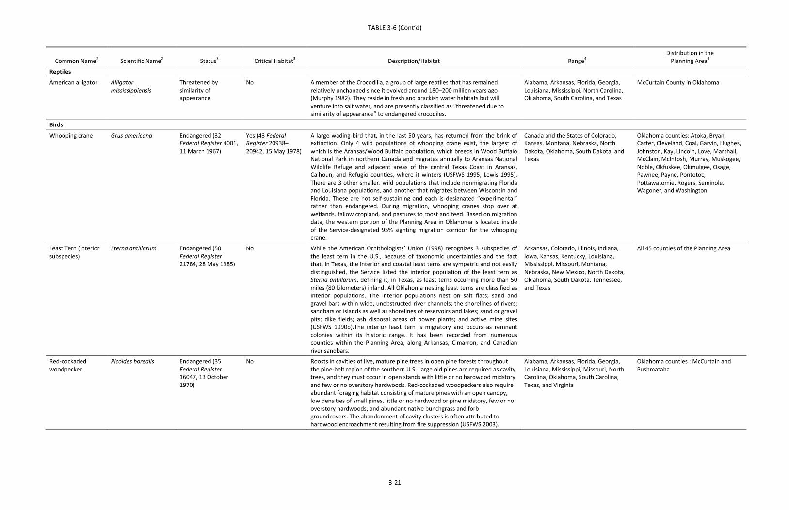
TABLE 3-6 (Cont’d)
3-21
Common Name2 Scientific Name2 Status3 Critical Habitat3 Description/Habitat Range4 Distribution in the
Planning Area4 Reptiles
American alligator Alligator mississippiensis
Threatened by similarity of appearance
No A member of the Crocodilia, a group of large reptiles that has remained relatively unchanged since it evolved around 180–200 million years ago (Murphy 1982). They reside in fresh and brackish water habitats but will venture into salt water, and are presently classified as “threatened due to similarity of appearance” to endangered crocodiles.
Alabama, Arkansas, Florida, Georgia, Louisiana, Mississippi, North Carolina, Oklahoma, South Carolina, and Texas
McCurtain County in Oklahoma
Birds
Whooping crane Grus americana Endangered (32 Federal Register 4001, 11 March 1967)
Yes (43 Federal Register 20938–20942, 15 May 1978)
A large wading bird that, in the last 50 years, has returned from the brink of extinction. Only 4 wild populations of whooping crane exist, the largest of which is the Aransas/Wood Buffalo population, which breeds in Wood Buffalo National Park in northern Canada and migrates annually to Aransas National Wildlife Refuge and adjacent areas of the central Texas Coast in Aransas, Calhoun, and Refugio counties, where it winters (USFWS 1995, Lewis 1995). There are 3 other smaller, wild populations that include nonmigrating Florida and Louisiana populations, and another that migrates between Wisconsin and Florida. These are not self-sustaining and each is designated “experimental” rather than endangered. During migration, whooping cranes stop over at wetlands, fallow cropland, and pastures to roost and feed. Based on migration data, the western portion of the Planning Area in Oklahoma is located inside of the Service-designated 95% sighting migration corridor for the whooping crane.
Canada and the States of Colorado, Kansas, Montana, Nebraska, North Dakota, Oklahoma, South Dakota, and Texas
Oklahoma counties: Atoka, Bryan, Carter, Cleveland, Coal, Garvin, Hughes, Johnston, Kay, Lincoln, Love, Marshall, McClain, McIntosh, Murray, Muskogee, Noble, Okfuskee, Okmulgee, Osage, Pawnee, Payne, Pontotoc, Pottawatomie, Rogers, Seminole, Wagoner, and Washington
Least Tern (interior subspecies)
Sterna antillarum Endangered (50 Federal Register 21784, 28 May 1985)
No While the American Ornithologists’ Union (1998) recognizes 3 subspecies of the least tern in the U.S., because of taxonomic uncertainties and the fact that, in Texas, the interior and coastal least terns are sympatric and not easily distinguished, the Service listed the interior population of the least tern as Sterna antillarum, defining it, in Texas, as least terns occurring more than 50 miles (80 kilometers) inland. All Oklahoma nesting least terns are classified as interior populations. The interior populations nest on salt flats; sand and gravel bars within wide, unobstructed river channels; the shorelines of rivers; sandbars or islands as well as shorelines of reservoirs and lakes; sand or gravel pits; dike fields; ash disposal areas of power plants; and active mine sites (USFWS 1990b).The interior least tern is migratory and occurs as remnant colonies within its historic range. It has been recorded from numerous counties within the Planning Area, along Arkansas, Cimarron, and Canadian river sandbars.
Arkansas, Colorado, Illinois, Indiana, Iowa, Kansas, Kentucky, Louisiana, Mississippi, Missouri, Montana, Nebraska, New Mexico, North Dakota, Oklahoma, South Dakota, Tennessee, and Texas
All 45 counties of the Planning Area
Red-cockaded woodpecker
Picoides borealis Endangered (35 Federal Register 16047, 13 October 1970)
No Roosts in cavities of live, mature pine trees in open pine forests throughout the pine-belt region of the southern U.S. Large old pines are required as cavity trees, and they must occur in open stands with little or no hardwood midstory and few or no overstory hardwoods. Red-cockaded woodpeckers also require abundant foraging habitat consisting of mature pines with an open canopy, low densities of small pines, little or no hardwood or pine midstory, few or no overstory hardwoods, and abundant native bunchgrass and forb groundcovers. The abandonment of cavity clusters is often attributed to hardwood encroachment resulting from fire suppression (USFWS 2003).
Alabama, Arkansas, Florida, Georgia, Louisiana, Mississippi, Missouri, North Carolina, Oklahoma, South Carolina, Texas, and Virginia
Oklahoma counties : McCurtain and Pushmataha
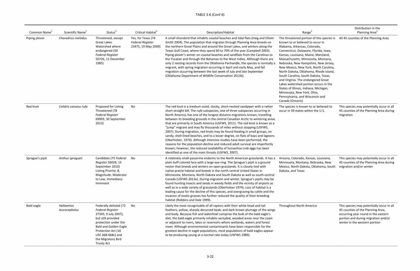
TABLE 3-6 (Cont’d)
3-22
Common Name2 Scientific Name2 Status3 Critical Habitat3 Description/Habitat Range4 Distribution in the
Planning Area4 Piping plover Charadrius melodus Threatened, except
Great Lakes Watershed where endangered (50 Federal Register 50726, 11 December 1985)
Yes, for Texas (74 Federal Register 23475, 19 May 2009)
A small shorebird that inhabits coastal beaches and tidal flats (Haig and Elliott-Smith 2004). The population that migrates through Planning Area breeds on the northern Great Plains and around the Great Lakes, and winters along the Texas Gulf Coast, where they spend 60 to 70% of the year (Campbell 2003). Piping plover’s winter on coastal beaches and sandflats from the Carolinas to the Yucatan and through the Bahamas to the West Indies. Although there are only 2 nesting records from the Oklahoma Panhandle, the species is normally a migrant, with spring migration occurring in April and early May, and fall migration occurring between the last week of July and late September (Oklahoma Department of Wildlife Conservation 2013b).
The threatened portion of this species is known to or believed to occur in Alabama, Arkansas, Colorado, Connecticut, Delaware, Florida, Iowa, Kansas, Louisiana, Maine, Maryland, Massachusetts, Minnesota, Montana, Nebraska, New Hampshire, New Jersey, New Mexico, New York, North Carolina, North Dakota, Oklahoma, Rhode Island, South Carolina, South Dakota, Texas, and Virginia. The endangered Great Lakes watershed portion occurs in the States of Illinois, Indiana, Michigan, Minnesota, New York, Ohio, Pennsylvania, and Wisconsin and Canada (Ontario)
All 45 counties of the Planning Area
Red knot Calidris canutus rufa Proposed for Listing Threatened (78 Federal Register 69993, 30 September 2013)
No The red knot is a medium-sized, stocky, short-necked sandpiper with a rather short straight bill. The rufa subspecies, one of three subspecies occurring in North America, has one of the longest distance migrations known, travelling between its breeding grounds in the central Canadian Arctic to wintering areas that are primarily in South America (USFWS, 2011). The red knot is known as a “jump” migrant and may fly thousands of miles without stopping (USFWS, 2007). During migration, red knots may be found feeding in small groups, on sandy, shell-lined beaches, and to a lesser degree, on flats of bays and lagoons (Oberholser, 1974). Although intensive studies have been performed, the reasons for the population decline and reduced adult survival are imperfectly known; however, the reduced availability of horseshoe crab eggs has been identified as one of the main threats (USFWS, 2007).
The species is known to or believed to occur in 39 states within the U.S.
This species may potentially occur in all 45 counties of the Planning Area during migration
Sprague's pipit Anthus spragueii Candidate (75 Federal Register 56028, 15 September 2010) Listing Priority: 8, Magnitude: Moderate to Low, Immediacy: Imminent
No A relatively small passerine endemic to the North American grasslands. It has a plain buff colored face with a large eye-ring. The Sprague’s pipit is a ground nester that breeds and winters on open grasslands. It is closely tied with native prairie habitat and breeds in the north-central United States in Minnesota, Montana, North Dakota and South Dakota as well as south-central Canada (USFWS 2013e). During migration and winter, Sprague’s pipits may be found hunting insects and seeds in weedy fields and the vicinity of airports as well as in a wide variety of grasslands (Oberholser 1974). Loss of habitat is a leading cause for the decline of this species, and overgrazing by cattle and the invasion of exotic grasses has further reduced the quality of their breeding habitat (Robbins and Dale 1999).
Arizona, Colorado, Kansas, Louisiana, Minnesota, Montana, Nebraska, New Mexico, North Dakota, Oklahoma, South Dakota, and Texas
This species may potentially occur in all 45 counties of the Planning Area during migration and/or winter
Bald eagle Haliaeetus leucocephalus
Federally delisted (72 Federal Register 37345, 9 July 2007), but still provided protection under the Bald and Golden Eagle Protection Act (16 USC 668-668c) and the Migratory Bird Treaty Act
No Likely the most recognizable of all raptors with their white head and tail feathers; yellow, sharply decurved beak; and dark brown plumage of the wings and body. Because fish and waterfowl comprise the bulk of the bald eagle’s diet, the bald eagle primarily inhabits secluded, wooded areas near the coast or adjacent to rivers, lakes or reservoirs where wetlands, waters and forest meet. Although environmental contaminants have been responsible for the greatest decline in eagle populations, most populations of bald eagles appear to be producing young at a normal rate today (USFWS 1989).
Throughout North America This species may potentially occur in all 45 counties of the Planning Area, occurring year round in the eastern portion and during migration and/or winter in the western portion

TABLE 3-6 (Cont’d)
3-23
Common Name2 Scientific Name2 Status3 Critical Habitat3 Description/Habitat Range4 Distribution in the
Planning Area4 Mammals Gray bat Myotis grisescens Endangered (41
Federal Register 17736, 28 April 1976)
No One of the largest species in the genus Myotis in eastern North America (Decher and Choate 1995), and is one of the few species of bats in North America that inhabit caves year-round. The species primary range is concentrated in the cave regions of Alabama, Arkansas, Kentucky, Missouri and Tennessee. Within the Planning Area, the species is a migratory species, which lives in colonies within limestone caves in the Ozark region from April to September. Only 9 colonies are known to occupy caves in forested habitats in Ottawa, Delaware, Cherokee, and Adair counties, which migrate east and hibernate within caves in Arkansas and Kentucky (Oklahoma Department of Wildlife Conservation 2013c).
Alabama, Arkansas, Florida, Georgia, Illinois, Indiana, Kansas, Kentucky, Mississippi, Missouri, North Carolina, Oklahoma, Tennessee, Virginia, and West Virginia
Oklahoma counties: Adair, Cherokee, Craig, Delaware, Mayes, Muskogee, Ottawa, Sequoyah, and Wagoner
Indiana bat Myotis sodalis Endangered (32 Federal Register 4001, 11 March 1967)
Yes (41 Federal Register 41914, 24 September 1976), but not in Planning Area
A small, temperate, insectivorous species that resides solitary or in small groups in forested habitats in the summer, and migrates to hibernate in colonies in caves and mines in the winter. Approximately 80% of the entire population hibernates in only 6 caves in Indiana and Kentucky. The Planning Area lies on the western edge of the species ranges and it has only been detected a few times in Oklahoma, primarily during the fall and winter in forested parts of the Ozark and Ouachita Mountains near the border with Arkansas (Oklahoma Department of Wildlife Conservation 2013d).
Alabama, Arkansas, Florida, Georgia, Illinois, Indiana, Iowa, Kentucky, Maryland, Michigan, Mississippi, Missouri, New Jersey, New York, North Carolina, Ohio, Oklahoma, Pennsylvania, Tennessee, Vermont, Virginia, and West Virginia
Oklahoma counties: Adair, Delaware, Le Flore, Pushmataha, and Sequoyah
Ozark big-eared bat Corynorhinus townsendii ingens
Endangered (44 Federal Register 69206, 30 November 1979)
Yes (42 Federal Register 61290–61292, 2 December 1977)
A medium-sized bat that inhabits the limestone caves in the forested portions of the Ozark Highlands. They are not migratory, although they may move to different caves between seasons. Half of the estimated current population of less than 4,000 is believed to occur in Oklahoma, making it one of the states rarest mammals (Oklahoma Department of Wildlife Conservation 2013e).
Arkansas, Missouri, and Oklahoma Oklahoma counties: Adair, Cherokee, Delaware, and Sequoyah
Northern long-eared bat
Myotis septentrionalis Proposed for Listing Endangered (78 Federal Register 61046, 2 October 2013)
No The northern long-eared bat, a medium-sized bat known for its long ears compared to other bats of the genus Myotis, is found across much of the eastern and north-central United States and all of Canada. In the summer, the northern long-eared bats roost singly or in colonies underneath bark, and in crevices or cavities of live or dead trees; however, in winter the bats spend their time hibernating in caves and mines, called hibernacula. White-nose syndrome, a fungal disease which affects bats, is the main threat to this species and population numbers in the Northwest have experienced declines by up to 99 percent at many hibernation sites (USFWS 2014). The Planning Area in Oklahoma is the southwestern edge of this species’ range.
This species is known to or believed to occur in 39 states within the U.S.
This species may potentially occur in all 45 counties of the Planning Area
1 According to the USFWS (2013a) 2 Nomenclature follows the USFWS (2013a) 3 Status obtained from the USFWS (2013a). 4 Range and distribution within the Planning Area obtained from the USFWS (2013a)
Atkins 100031770/140019 3‐24
3.10 LAND USE
3.10.1 State Planning Regions
Oklahoma is divided into 11 State Planning Regions, which are voluntary associations of localgovernmentsthataddresstheproblemsandplanningneedsthatcrosstheboundariesofindividuallocalgovernmentsorthatrequireregionalattention.ThePlanningAreawithinOklahomaoccursinallorportionsof9of thestate’s11planningregions(OklahomaAssociationofRegionalCouncils2013).Table3‐7 lists thecountiesandmajorurbanareas,airports, andparks/recreationalareaswithineachof thenineStatePlanningRegionscontained in thePlanningArea.Figure3‐1showsFederallandsoccurringwithintheICPPlanningArea.
InadditiontotheseveralFederalandStaterecreationalareaslistedundereachplanningregioninTable3‐7,multipleconservationeasementsandpropertiesownedbyTheNatureConservancyarelocated within the Planning Area. Also, many city and county parks and recreational areas arelocatedwithinthePlanningArea.
Two Natural Resources Conservation Service reports (2000, 2013) were used to describe thecurrent landuses for thedifferent regionsof thePlanningArea.These fourprimary landuses—cropland, rangeland, pastureland, and forest land—were aggregated and averaged by stateplanning region. In cases where a state planning region contained some counties that were notwithinthePlanningArea,onlythosecountiesinthePlanningAreawereusedinthecalculationoflanduse averages. As shown inTable 3‐7, the planning regions of thePlanningArea on averageconsistofapproximately15percentcropland,28percentrangeland,20percent forestcover,and26 percent pastureland (Figure 3‐2). Minor land uses, such as water or urban land uses, wereexcludedforclarity.
3.10.2 Transportation
Surface transportation in thePlanningArea isprovidedbyanetworkofprimary, secondary,andlocalroads.MajorU.S.interstatesrunningthroughthePlanningAreaincludeInterstateHighway35(I‐35), I‐40, I‐44,andI‐244.These larger facilitiesaresupplementedbynumerousU.S.Highways,StateHighways, rural county roads, and a network of residential streets in urban and suburbanareasthatcompletethetransportationgrid(seeFigure3‐1).
TheOklahomaDepartmentofTransportationiscurrentlyconductingstudiesonfourNationalHighPriority Corridors, which are U.S. Congress‐identified corridors of national significance. Two ofthese corridors, I‐35 from Texas to Kansas, and U.S. Highway 412 from Tulsa, Oklahoma, toMemphis,Tennessee,arelocatedpartiallywithinthePlanningArea.WithinthePlanningArea,I‐35runs through Love, Carter, Murray, Garvin, McClain, Cleveland, Payne, Noble, and Kay counties,respectively, from south to north; U.S. Highway 412 runs through Noble, Payne, Pawnee, Tulsa,
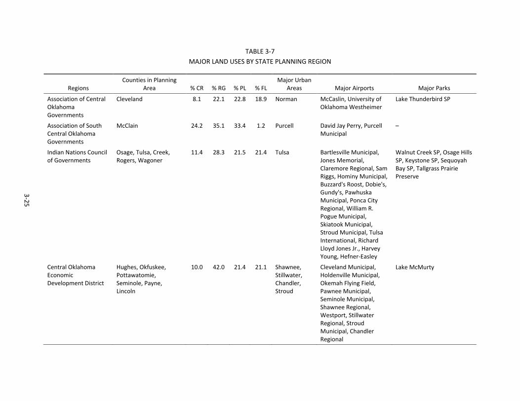
3-25
TABLE 3-7 MAJOR LAND USES BY STATE PLANNING REGION
Regions Counties in Planning
Area % CR % RG % PL % FL Major Urban
Areas Major Airports Major Parks Association of Central Oklahoma Governments
Cleveland 8.1 22.1 22.8 18.9 Norman McCaslin, University of Oklahoma Westheimer
Lake Thunderbird SP
Association of South Central Oklahoma Governments
McClain 24.2 35.1 33.4 1.2 Purcell David Jay Perry, Purcell Municipal
–
Indian Nations Council of Governments
Osage, Tulsa, Creek, Rogers, Wagoner
11.4 28.3 21.5 21.4 Tulsa Bartlesville Municipal, Jones Memorial, Claremore Regional, Sam Riggs, Hominy Municipal, Buzzard's Roost, Dobie's, Gundy's, Pawhuska Municipal, Ponca City Regional, William R. Pogue Municipal, Skiatook Municipal, Stroud Municipal, Tulsa International, Richard Lloyd Jones Jr., Harvey Young, Hefner-Easley
Walnut Creek SP, Osage Hills SP, Keystone SP, Sequoyah Bay SP, Tallgrass Prairie Preserve
Central Oklahoma Economic Development District
Hughes, Okfuskee, Pottawatomie, Seminole, Payne, Lincoln
10.0 42.0 21.4 21.1 Shawnee, Stillwater, Chandler, Stroud
Cleveland Municipal, Holdenville Municipal, Okemah Flying Field, Pawnee Municipal, Seminole Municipal, Shawnee Regional, Westport, Stillwater Regional, Stroud Municipal, Chandler Regional
Lake McMurty
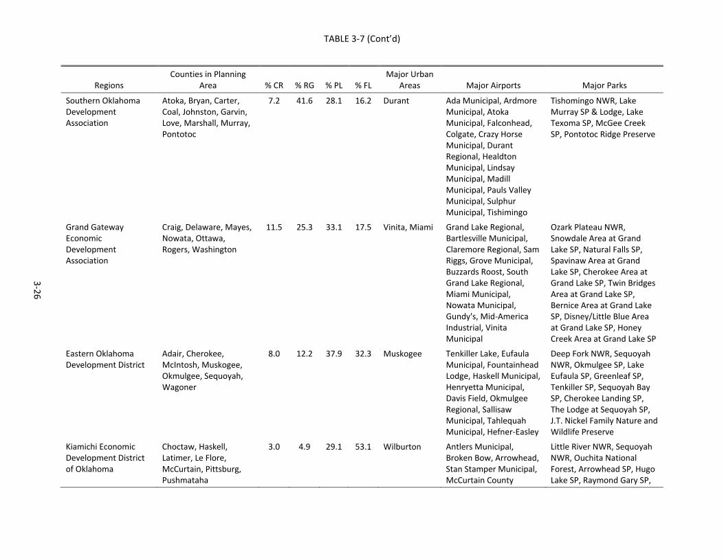
TABLE 3-7 (Cont’d)
3-26
Regions Counties in Planning
Area % CR % RG % PL % FL Major Urban
Areas Major Airports Major Parks Southern Oklahoma Development Association
Atoka, Bryan, Carter, Coal, Johnston, Garvin, Love, Marshall, Murray, Pontotoc
7.2 41.6 28.1 16.2 Durant Ada Municipal, Ardmore Municipal, Atoka Municipal, Falconhead, Colgate, Crazy Horse Municipal, Durant Regional, Healdton Municipal, Lindsay Municipal, Madill Municipal, Pauls Valley Municipal, Sulphur Municipal, Tishimingo
Tishomingo NWR, Lake Murray SP & Lodge, Lake Texoma SP, McGee Creek SP, Pontotoc Ridge Preserve
Grand Gateway Economic Development Association
Craig, Delaware, Mayes, Nowata, Ottawa, Rogers, Washington
11.5 25.3 33.1 17.5 Vinita, Miami Grand Lake Regional, Bartlesville Municipal, Claremore Regional, Sam Riggs, Grove Municipal, Buzzards Roost, South Grand Lake Regional, Miami Municipal, Nowata Municipal, Gundy's, Mid-America Industrial, Vinita Municipal
Ozark Plateau NWR, Snowdale Area at Grand Lake SP, Natural Falls SP, Spavinaw Area at Grand Lake SP, Cherokee Area at Grand Lake SP, Twin Bridges Area at Grand Lake SP, Bernice Area at Grand Lake SP, Disney/Little Blue Area at Grand Lake SP, Honey Creek Area at Grand Lake SP
Eastern Oklahoma Development District
Adair, Cherokee, McIntosh, Muskogee, Okmulgee, Sequoyah, Wagoner
8.0 12.2 37.9 32.3 Muskogee Tenkiller Lake, Eufaula Municipal, Fountainhead Lodge, Haskell Municipal, Henryetta Municipal, Davis Field, Okmulgee Regional, Sallisaw Municipal, Tahlequah Municipal, Hefner-Easley
Deep Fork NWR, Sequoyah NWR, Okmulgee SP, Lake Eufaula SP, Greenleaf SP, Tenkiller SP, Sequoyah Bay SP, Cherokee Landing SP, The Lodge at Sequoyah SP, J.T. Nickel Family Nature and Wildlife Preserve
Kiamichi Economic Development District of Oklahoma
Choctaw, Haskell, Latimer, Le Flore, McCurtain, Pittsburg, Pushmataha
3.0 4.9 29.1 53.1 Wilburton Antlers Municipal, Broken Bow, Arrowhead, Stan Stamper Municipal, McCurtain County
Little River NWR, Sequoyah NWR, Ouchita National Forest, Arrowhead SP, Hugo Lake SP, Raymond Gary SP,
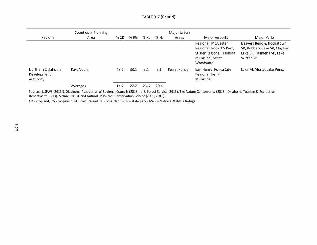
TABLE 3-7 (Cont’d)
3-27
Regions Counties in Planning
Area % CR % RG % PL % FL Major Urban
Areas Major Airports Major Parks Regional, McAlester Regional, Robert S Kerr, Stigler Regional, Talihina Municipal, West Woodward
Beavers Bend & Hochatown SP, Robbers Cave SP, Clayton Lake SP, Talimena SP, Lake Wister SP
Northern Oklahoma Development Authority
Kay, Noble 49.6 38.1 3.1 2.1 Perry, Ponca Earl Henry, Ponca City Regional, Perry Municipal
Lake McMurty, Lake Ponca
Averages 14.7 27.7 25.6 20.4 Sources: USFWS (2013f), Oklahoma Association of Regional Councils (2013), U.S. Forest Service (2013), The Nature Conservancy (2013), Oklahoma Tourism & Recreation Department (2013), AirNav (2013), and Natural Resources Conservation Service (2000, 2013). CR = cropland; RG - rangeland; PL - pastureland; FL = forestland = SP = state park= NWR = National Wildlife Refuge.
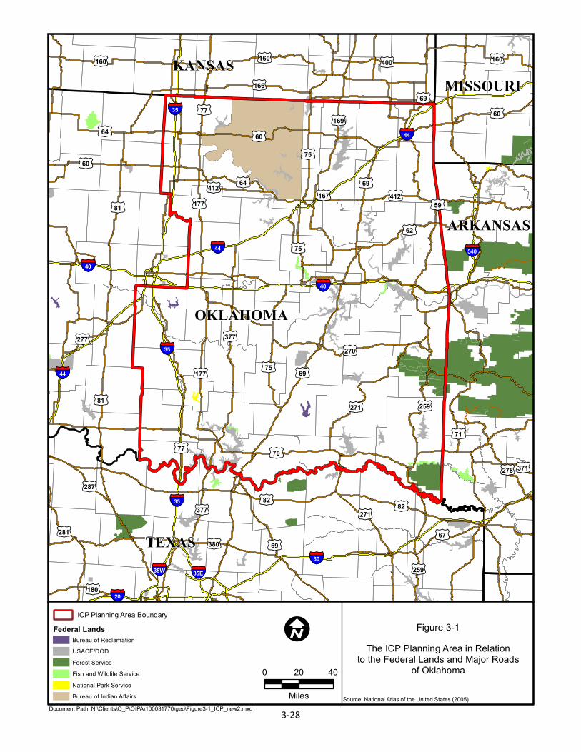
TEXAS
OKLAHOMA
KANSASMISSOURI
ARKANSAS
§̈¦35
§̈¦30
§̈¦40
§̈¦44
§̈¦540
§̈¦35E§̈¦35W
§̈¦44
£¤59
£¤82
£¤60
£¤177
£¤81
£¤71
£¤67
£¤160
£¤270
£¤70
£¤69
£¤271
£¤259
£¤281
£¤64
£¤75
£¤62
£¤169
£¤377
£¤166
£¤380
£¤412
£¤77
£¤400
£¤278
£¤180
£¤277
£¤287
£¤371
£¤60
£¤167
£¤77
£¤75
£¤69
£¤412
§̈¦20
§̈¦35
§̈¦35
§̈¦40§̈¦44
£¤160 £¤160
£¤60
£¤64
£¤81
£¤75
£¤271 £¤82
£¤259
£¤69
£¤69
£¤377
£¤177
Figure 3-1The ICP Planning Area in Relation
to the Federal Lands and Major Roadsof Oklahoma
Document Path: N:\Clients\O_P\OIPA\100031770\geo\Figure3-1_ICP_new2.mxd
I0 20 40
Miles
Federal LandsICP Planning Area Boundary
Source: National Atlas of the United States (2005)
Bureau of ReclamationUSACE/DODForest ServiceFish and Wildlife ServiceNational Park ServiceBureau of Indian Affairs
3-28
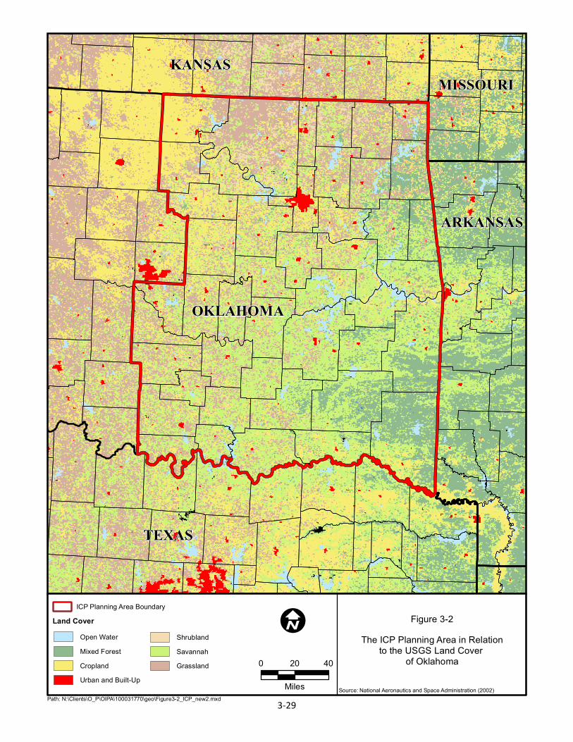
TEXAS
OKLAHOMA
KANSASMISSOURI
ARKANSAS
Figure 3-2The ICP Planning Area in Relation
to the USGS Land Cover of Oklahoma
Path: N:\Clients\O_P\OIPA\100031770\geo\Figure3-2_ICP_new2.mxd
I0 20 40
Miles
Land CoverICP Planning Area Boundary
Source: National Aeronautics and Space Administration (2002)
Open WaterMixed Forest
Urban and Built-UpCropland
ShrublandSavannahGrassland
3-29
Atkins 100031770/140019 3‐30
Rogers,Mayes,andDelawarecounties,respectively,fromwesttoeast.Additionally,theOklahomaDepartment of Transportation is proposing improvements to various roads throughout thePlanning Area, including resurfacing, rebuilding, repairing, upgrading, landscaping, and bridgereplacement and repair (Oklahoma Department of Transportation 2013a). Other major FederalhighwaysinthePlanningAreaincludeI‐44,whichtraversesthenorthernportionofthePlanningAreainasouthwest‐northeastdirection,andI‐40,whichbisectsthePlanningareafromwesttoeast(seeFigure3‐1).
Oklahomacontains fourMetropolitanPlanningOrganizationsdesignedtoprovidecomprehensivetransportationplanningintheirrespectiveregions.ThePlanningAreacontainsthefollowingthreeMetropolitan Planning Organizations: Association of Central Oklahoma Governments, IndianNations Council of Governments, and the Frontier Metropolitan Planning Organization. TheAssociation of Central Oklahoma Governments and Indian Nations Council of GovernmentsMetropolitanPlanningOrganizationsarethesameorganizationsaslistedinTable3‐7;theFrontierMetropolitan Planning Organization is based in Fort Smith, Arkansas, with portions of theMetropolitan Planning Organization extending into extreme eastern Oklahoma (OklahomaDepartmentofTransportation2013b).
Anextensiverailnetwork isalso located throughout thePlanningArea,providingpassengerandfreight service under the operation of multiple rail companies (Federal Railroad Administration2013).
3.11 AESTHETICS AND NOISE
3.11.1 Aesthetics
The term aesthetics refers to the subjective perception of natural beauty in the landscape andattemptstodefineandmeasureanarea’sscenicqualities.Potentialaestheticimpactsareanissueofincreasingconcerntoboththepublicandgovernmentalbodiesdealingwithsitingandapprovingnew oil and gas facilities. Consideration of the visual environment includes a determination ofaesthetic values where the location of a well pad or pipeline could potentially affect the scenicenjoymentofanarea.
The aesthetic analysisdealsprimarilywithpotential visual impacts to thepublic, specifically thepotentialimpactsonviewshedsorscenicareasvisiblefromroads,highways,orpubliclyownedoraccessiblelands(e.g.,parksorprivatelyownedrecreationareasopentothepublic).Severalfactorsare taken into considerationwhen attempting to define the sensitivity, or potential impact, to ascenic resource from theoil andgasprojects.Aesthetic values considered in this analysis,whichcombinetogiveanareaitsaestheticidentity,includethefollowing:
Uniquenessofthelandscapeinrelationtotheregionasawhole
Whetherthescenicareaisaforeground,middleground,orbackgroundview
Atkins 100031770/140019 3‐31
Focusoftheview
Scaleofelementsinthescene
Numberofpotentialviewers
Durationoftheview
Amountofpreviousmodificationordisturbancetothelandscape
Based on these criteria, the Planning Area as a whole exhibits a moderate degree of aestheticqualitybecauseitencompassesavarietyofregionsandlandscapesinOklahoma.ThetopographyofthePlanningAreaisvaried,rangingfromagriculturalfieldsandplainstodenselyforestedhillsandlow mountains. Landscapes with water as a major element (rivers, lakes, etc.) are usuallyconsideredtorepresenthigheraestheticvalues.ThePlanningAreacontainsmanyriversandlakes,especially in the easternmost counties, some of which contain areas of well‐developed riparianvegetation. Conversely, otherwater featureswithin the Planning Area, especially in thewesternportions,canbedryorintermittentandareasofriparianvegetationarepoorlydevelopedaroundthesefeatures.Inaddition,thelevelofhumanimpactwithinportionsofthePlanningAreaishighduetotheextensiveranching,agriculturaloperations,oilandgasoperations,andthedevelopmentofmultiplecitiesandcommunities.
ThehistoricRoute66,runningfromChicagotoLosAngeles,runsacrossthemajorityofOklahoma,fromthenortheastcornertoitswesternborderwithTexas.Thenation’slongestdrivablestretchofRoute66,over400miles(644kilometers),passesbycharmingtowns,roadsidediners,andquirkyattractions that date back to the creation of this national route (Oklahoma Department ofTransportation2013c).
InadditiontothehistoricRoute66,OklahomaplayshosttoanumberofFederalandStatescenicbyways. The National Scenic Byways Program is administered by the Federal HighwaysAdministration.TheCherokeeHillsByway, situated in the foothillsof theOzarkMountains, is an84‐mile (135‐kilometer) federallydesignatedroadwaywithboth lushsceneryanda richculturalbackground. Cherokee heritage can be found in architecture and museums along the roadway,whichinportionscorrelateswiththeoriginalTrailofTears.Muchofthehighwayrunsparalleltothe Illinois River in eastern Oklahoma as well, which adds to the natural beauty of the byway(America’sByways2013).
The Talimena Scenic Drive is a 54‐mile (87‐kilometer) federally designated roadway in theOuachitaNationalForest,locatedinportionsofbothArkansasandOklahoma.ItmeandersovertheWinding Stair and Rich Mountains between Mena, Arkansas, and Talihina, Oklahoma, throughnaturalsettingswithmanyvistasandpanoramicopportunities.Wildlife,includingblackbearsandroadrunners, are common sights along this roadway, along with ample stretches of forest(America’sByways2013).
TheWichitaMountainsBywayisa93‐mile(150‐kilometer)federallydesignatedhighwaythroughthe550‐million‐year‐oldWichitaMountains,whichhostthelargestremainingsectionofsouthern
Atkins 100031770/140019 3‐32
mixed grassland and cross‐timbers in North America. The adjacent Wichita Mountains WildlifeRefugemaintainsherdsofbisonandelk,aswellasturkeys(America’sByways2013).
The Mountain Gateway Scenic Byway is a 22‐mile (35‐kilometer) state‐designated roadwaybetween Heavener, Oklahoma, and the Arkansas‐Oklahoma state line. It runs through forestedvalleys of the OuachitaMountains, cuts through the 26,445‐acre (10,702‐hectare)Winding StairMountainNationalRecreationArea, andoffersviewsof theBlackForkWildernessandRobertS.KerrArboretum(America’sByways2013).
The Osage Nation Heritage Trail Byway is a 70‐mile (113‐kilometer) roadway that runs fromBartlesvilleandPoncaCitythroughtheOsageReservationandPawhuska,thecapitaloftheOsageNation.Whilemostlyculturalinvalue,theroadway’shighlightsincludetheOsageTribalMuseum,theCathedralof theOsage,ConstantineTheater, and theMillionDollarElmMemorial (AmericanProfile2013).
Manyoutstandingaestheticresources,designatedscenicviews,scenicroadways,anduniquevisualelementsarelocatedwithinthePlanningAreainadditiontolargeareasofagricultural,industrial,andurbandevelopment.Insummary,manypartsofthePlanningAreaarevisuallypleasingwhileother parts are highly impacted from human activity. Therefore, the Planning Area possesses avariabledegreeofaestheticqualityfromlowtohigh,spreadovermultipleregionsandlandscapesofOklahoma.
3.11.2 Noise
Noise is defined as unwanted sound that disrupts or interferes with normal activities or thatdiminishesthequalityoftheenvironment.Noiseisusuallycausedbyhumanactivityandisaddedto the natural, or ambient, acoustic setting of an area. Exposure to high levels of noise over anextendedperiodcancausehealthhazardssuchashearingloss;however,themostcommonhumanresponse to environmental noise is annoyance. Individuals respond to similar noise eventsdifferently based upon various factors that may include the existing background level, noisecharacter,levelfluctuation,timeofday,theperceivedimportanceofthenoise,theappropriatenessofthesetting,andthesensitivityoftheindividual.
Noise‐sensitivereceptorsarefacilitiesorareaswhereexcessivenoisemaydisruptnormalactivity,cause annoyance, or loss of business. Land uses such as residential, religious, educational,recreational,andmedicalfacilitiesaremoresensitivetoincreasednoiselevelsthanarecommercialandindustriallanduses.Numerousnoise‐sensitivereceptorsarelocatedwithinthePlanningArea,the majority of which are located within developed communities. Due to the vastness of thePlanning Area, it is not reasonable or practical to identify all noise receptors adjacent to theapplicant’sexistingoilandgasfacilities.NorisitpossibletoidentifythoseadjacenttonewfacilitiesthatcouldbeconstructedwithinthePlanningAreabecausethelocationofthosefacilitiesislargelyunknown.
Atkins 100031770/140019 3‐33
Noise within the Planning Area is produced by a variety of human activities. Transportation,including road traffic (automobiles, tractor trailers, and motorcycles on U.S. Highways, StateHighways,countyroads,andresidentialstreets),railtraffic,andairtransportationcausesavarietyofnoiseatdifferentlevelsthroughoutthePlanningArea.Oilandgasindustryactivitiesthroughoutthe Planning Area produce noise through drilling and construction of facilities. Construction ofhousing,commercial facilities,androads increasesnoisewithinthePlanningAreathroughuseofbulldozers,backhoes,andothertypesofconstructionequipment.Agriculturalequipment,suchastractors,isusedthroughoutthePlanningAreaandincreasenoiselevels.
3.12 SOCIOECONOMICS
The Planning Area encompasses 45 (58 percent) of the 77 counties in Oklahoma (OklahomaHistorical Society 2007). The U.S. Census Bureau (2010) shows that between 2000 and 2010 amajorityof thecounties in thePlanningAreagrew inpopulationbyanaverageofapproximately7.93 percent, ranging from a population decline of –4.05 in Ottawa County, Oklahoma, to anincreaseof27.12percentinWagonerCounty,Oklahoma.Themajorityofthecountiesareprojectedtogrowatanaverageof20.43percentbetween2010and2040.TheareawiththelowestgrowthisexpectedtobeSeminoleCounty,Oklahoma,withadeclineof–11.3percentandthehighestgrowthrate of 47.5 percent is expected in Cleveland County, Oklahoma (Oklahoma Department ofCommerce2012a).
Socioeconomic information foreachWorkforce InvestmentArea forOklahomathatoccurswithinthe Planning Area is presented in Table 3‐8. The information presented in this table provides ageneraldescriptionof themajorpopulationcentersandemploymentsectorswithin thePlanningArea. The counties,major cities, and their population, and themajor employment sectorswithineachareaarealsopresentedinTable3‐8.Forclarity,onlythoseemploymentsectorsthatmakeupsubstantialpercentagesoftotalemploymentarelisted.
3.13 ENVIRONMENTAL JUSTICE
Federal agencies strive to ensure that their actions support environmental justice ideals byidentifying and addressing disproportionately high and adverse human health or environmentaleffectsofprograms,policies,andactivitiesonlow‐incomeandminoritypopulationsintheUnitedStates (59FR 7629 1994WL43891 [Pres], Federal Actions toAddress Environmental Justice inMinorityPopulationsandLow‐IncomePopulations)(U.S.EnvironmentalProtectionAgency1994).TheU.S.DepartmentoftheInterior’senvironmentaljusticepolicyrequiresthatU.S.Departmentofthe Interior bureaus “consider the impacts of their actions and inactions on minority and low‐incomepopulationsandcommunities,aswellastheequityofthedistributionofbenefitsandrisksofthosedecisionsinNEPAdocuments.
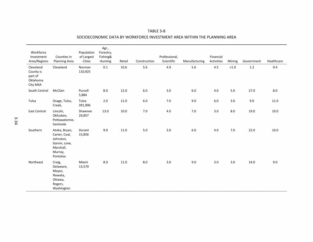
3-34
TABLE 3-8 SOCIOECONOMIC DATA BY WORKFORCE INVESTMENT AREA WITHIN THE PLANNING AREA
Workforce Investment
Area/Regions Counties in
Planning Area Population of Largest
Cities
Agr., Forestry, Fishing& Hunting Retail Construction
Professional, Scientific Manufacturing
Financial Activities Mining Government Healthcare
Cleveland County is part of Oklahoma City MSA
Cleveland Norman 110,925
0.1 10.6 5.6 4.9 5.6 4.5 <1.0 1.2 9.4
South Central McClain Purcell 5,884
8.0 12.0 6.0 3.0 6.0 4.0 5.0 27.0 8.0
Tulsa Osage, Tulsa, Creek,
Tulsa 391,906
2.0 11.0 6.0 7.0 9.0 6.0 3.0 9.0 11.0
East Central Lincoln, Okfuskee, Pottawatomie, Seminole
Shawnee 29,857
13.0 10.0 7.0 4.0 7.0 3.0 8.0 19.0 10.0
Southern Atoka, Bryan, Carter, Coal, Johnston, Garvin, Love, Marshall, Murray, Pontotoc
Durant 15,856
9.0 11.0 5.0 3.0 6.0 4.0 7.0 22.0 10.0
Northeast Craig, Delaware, Mayes, Nowata, Ottawa, Rogers, Washington
Miami 13,570
8.0 11.0 8.0 3.0 9.0 3.0 3.0 14.0 9.0
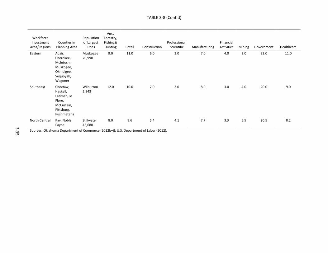
TABLE 3-8 (Cont’d)
3-35
Workforce Investment
Area/Regions Counties in
Planning Area Population of Largest
Cities
Agr., Forestry, Fishing& Hunting Retail Construction
Professional, Scientific Manufacturing
Financial Activities Mining Government Healthcare
Eastern Adair, Cherokee, McIntosh, Muskogee, Okmulgee, Sequoyah, Wagoner
Muskogee 70,990
9.0 11.0 6.0 3.0 7.0 4.0 2.0 23.0 11.0
Southeast Choctaw, Haskell, Latimer, Le Flore, McCurtain, Pittsburg, Pushmataha
Wilburton 2,843
12.0 10.0 7.0 3.0 8.0 3.0 4.0 20.0 9.0
North Central Kay, Noble, Payne
Stillwater 45,688
8.0 9.6 5.4 4.1 7.7 3.3 5.5 20.5 8.2
Sources: Oklahoma Department of Commerce (2012b–j); U.S. Department of Labor (2012).
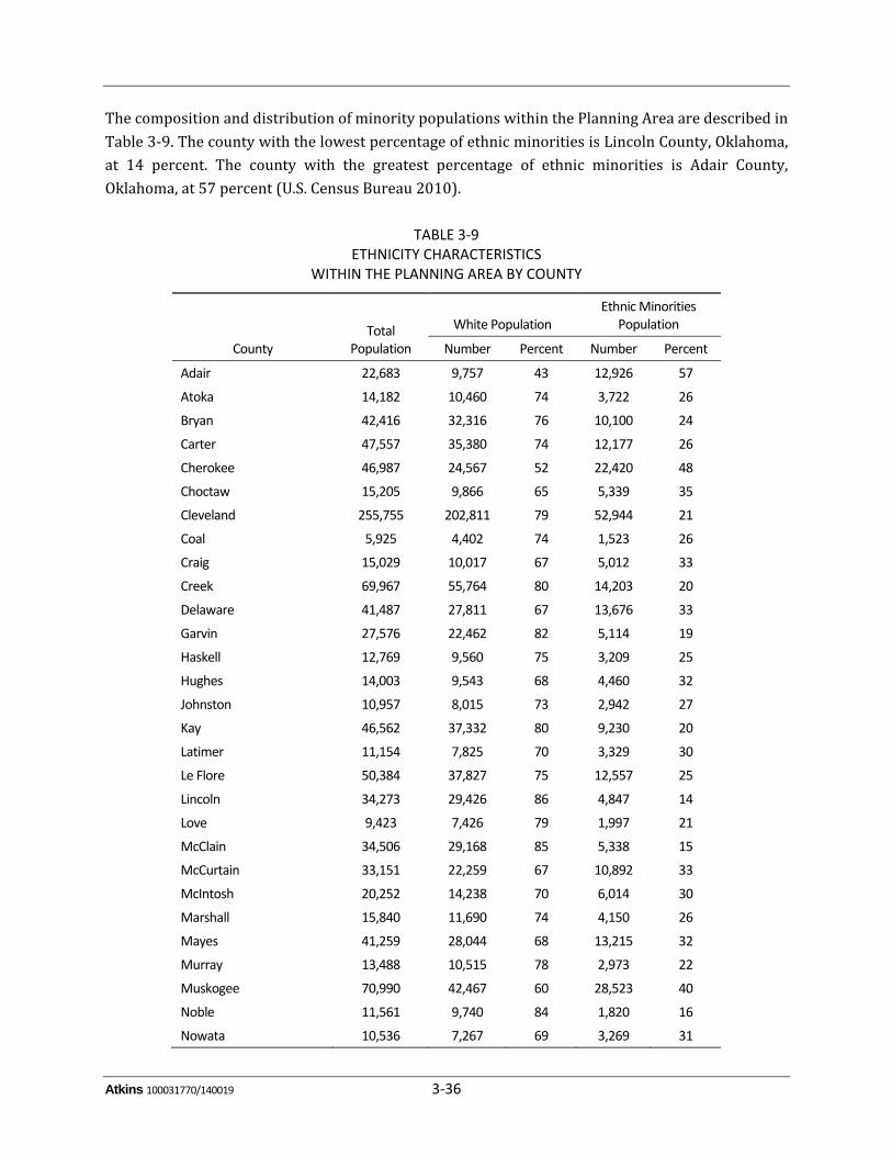
Atkins 100031770/140019 3‐36
ThecompositionanddistributionofminoritypopulationswithinthePlanningAreaaredescribedinTable3‐9.ThecountywiththelowestpercentageofethnicminoritiesisLincolnCounty,Oklahoma,at 14 percent. The county with the greatest percentage of ethnic minorities is Adair County,Oklahoma,at57percent(U.S.CensusBureau2010).
TABLE 3‐9 ETHNICITY CHARACTERISTICS
WITHIN THE PLANNING AREA BY COUNTY
County Total
Population
White Population Ethnic Minorities
Population
Number Percent Number Percent
Adair 22,683 9,757 43 12,926 57
Atoka 14,182 10,460 74 3,722 26
Bryan 42,416 32,316 76 10,100 24
Carter 47,557 35,380 74 12,177 26
Cherokee 46,987 24,567 52 22,420 48
Choctaw 15,205 9,866 65 5,339 35
Cleveland 255,755 202,811 79 52,944 21
Coal 5,925 4,402 74 1,523 26
Craig 15,029 10,017 67 5,012 33
Creek 69,967 55,764 80 14,203 20
Delaware 41,487 27,811 67 13,676 33
Garvin 27,576 22,462 82 5,114 19
Haskell 12,769 9,560 75 3,209 25
Hughes 14,003 9,543 68 4,460 32
Johnston 10,957 8,015 73 2,942 27
Kay 46,562 37,332 80 9,230 20
Latimer 11,154 7,825 70 3,329 30
Le Flore 50,384 37,827 75 12,557 25
Lincoln 34,273 29,426 86 4,847 14
Love 9,423 7,426 79 1,997 21
McClain 34,506 29,168 85 5,338 15
McCurtain 33,151 22,259 67 10,892 33
McIntosh 20,252 14,238 70 6,014 30
Marshall 15,840 11,690 74 4,150 26
Mayes 41,259 28,044 68 13,215 32
Murray 13,488 10,515 78 2,973 22
Muskogee 70,990 42,467 60 28,523 40
Noble 11,561 9,740 84 1,820 16
Nowata 10,536 7,267 69 3,269 31
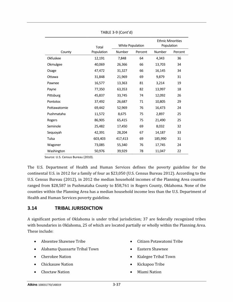
Atkins 100031770/140019 3‐37
TABLE 3‐9 (Cont’d)
County Total
Population
White Population Ethnic Minorities
Population
Number Percent Number Percent
Okfuskee 12,191 7,848 64 4,343 36
Okmulgee 40,069 26,366 66 13,703 34
Osage 47,472 31,327 66 16,145 34
Ottawa 31,848 21,969 69 9,879 31
Pawnee 16,577 13,363 81 3,214 19
Payne 77,350 63,353 82 13,997 18
Pittsburg 45,837 33,745 74 12,092 26
Pontotoc 37,492 26,687 71 10,805 29
Pottawatomie 69,442 52,969 76 16,473 24
Pushmataha 11,572 8,675 75 2,897 25
Rogers 86,905 65,415 75 21,490 25
Seminole 25,482 17,450 69 8,032 32
Sequoyah 42,391 28,204 67 14,187 33
Tulsa 603,403 417,413 69 185,990 31
Wagoner 73,085 55,340 76 17,745 24
Washington 50,976 39,929 78 11,047 22
Source: U.S. Census Bureau (2010).
The U.S. Department of Health and Human Services defines the poverty guideline for thecontinentalU.S.in2012forafamilyoffouras$23,050(U.S.CensusBureau2012).AccordingtotheU.S.CensusBureau(2012), in2012themedianhousehold incomesof thePlanningAreacountiesrangedfrom$28,587inPushmatahaCountyto$58,761inRogersCounty,Oklahoma.Noneof thecountieswithinthePlanningAreahasamedianhouseholdincomelessthantheU.S.DepartmentofHealthandHumanServicespovertyguideline.
3.14 TRIBAL JURISDICTION
A significant portion of Oklahoma is under tribal jurisdiction; 37 are federally recognized tribeswithboundariesinOklahoma,25ofwhicharelocatedpartiallyorwhollywithinthePlanningArea.Theseinclude:
AbsenteeShawneeTribe
AlabamaQuassarteTribalTown
CherokeeNation
ChickasawNation
ChoctawNation
CitizenPotawatomiTribe
EasternShawnee
KialegeeTribalTown
KickapooTribe
MiamiNation
Atkins 100031770/140019 3‐38
ModocTribe
Muscogee(Creek)Nation
OsageNation
OttawaTribe
Otoe‐MissouriaTribe
PawneeNation
PeoriaTribe
QuapawTribe
SacandFoxNation
SeminoleNation
Seneca‐CayugaTribe
ShawneeTribe
ThlopthloccoTribalTown
UnitedKeetoowahBandofCherokees
WyandotteNation
Thesetribaljurisdictionshavetheirhighestconcentrationsinthecentralportionofthestate,andinthe extreme northeastern portion of the state, but are scattered throughout. The only IndianReservation located within the Planning Area, the Osage Indian Reservation, matches theboundaries ofOsageCounty.This county is situated in thenorthwesternportionof thePlanningArea,whichisinthenorth‐centralpartofOklahoma,borderingKansas.
3.15 CULTURAL RESOURCES
Culturalresourcesareprehistoricandhistoricarcheologicalsites,districts,structures,orlocationsconsideredsignificanttoaculture,asubculture,oracommunityforscientific,traditional,religious,orotherreasons.Theprehistoricsettlementsysteminaregionusuallyreflectseconomicactivitiesthat support thepopulationof a given area. In a hunting andgathering economy, the settlementsystemmayconsistofseasonalencampments, temporaryprocurementstations,and locations forobtainingspecialresources.Anagrariansystem, incontrast,mightcontaintradecenters,produc‐tionvillages,andfew,ifany,temporaryprocurementstations.Certainconsiderationsregardingthedecision to occupy one place or another are common to all settlement systems. Primary amongtheseconsiderationsisaccesstotheresourcesneededtophysicallysustainlife, includingpotablewater,food,andthespecializeditemsneededtoobtainandprocessfood.Secondarily,defensibilityandprotection fromthenaturalelements, suchas flooding,wind,andrain,wouldbeconsidered.Accesstotraderoutesisalsoimportantincertainsystems.
Prehistoricarcheologicalresourcesmayincluderockshelters, lithicscatters, flakedstonescatters,rock rings or alignments, tool procurement sites, thermal features/roasting pits with artifactscatters,androckartlocations.Well‐knownprehistoricarcheologicalsitesinthePlanAreaincludethefollowing:thePackardsite,theLawrencesite,theHarlanMoundsite,theNormanMoundsite,theSpiroMoundsite,theThunderbirdDamsite,theHaley’sPointsite,theRaulston‐Rogerssite,theRose‐Fastsite,thePrimroseandStillmanPitsites,andtheBrewerSite.
ThePlanningAreacontinuedtobeinhabitedthroughthehistoricperiod.Historicsitesmayincludebuildings,structures,featuressuchasmineshafts,transportationroutes,bridges,refusedeposits,
Atkins 100031770/140019 3‐39
historichomesand/orassociatedproperty(includingrockwalls,pens,corrals,water/soilretentionstructures,andcisterns),cemeteries,trails,andruralschools.
Additionally,theNationalHistoricPreservationActof1966,asamendedinaccordancewith36CFR800andtheArchaeologicalResourcesProtectionActof1979,asamended,amongotherstateandFederalregulationsrequireFederalagenciestotakeintoaccounttheeffectsoftheirundertakingson prehistoric or historic district, site (including archeological), building, structure, or objectincluded in, or eligible for inclusion the National Register of Historic Places, includingmaking agood faith effort to identify resources listed or eligible for inclusion in the National Register ofHistoricPlaces,aswellastotrytomitigateorlessenadverseeffectsontheseresources.
Using theNationalPark Service'sNationalRegister ofHistoricPlacesdatabase,NationalHistoricLandmarksprogram,andGeographicResourcesProgramNationalHistoricTrailsMapViewer,aswell as the Oklahoma Historical Society's National Register of Historic Places in Oklahoma,Oklahoma OLI websites, and Atkins in‐house list of the Oklahoma Historical Society's Determi‐nationsofEligibility,numerouspreviouslyrecordedculturalresourceswere identifiedwithintheICPPlanningArea.Thesepreviouslyrecordedculturalresourcesincludethefollowing:
15NationalHistoricLandmarks
1NationalHistoricTrail
1NationalHistoricSite
738NationalRegisterofHistoricPlaces
Over84cemeteries
27,276propertiesrecordedintheOklahomaLandmarkInventory
129bridgesrecordedintheOklahomaLandmarkInventory
Atleast715resourcesdeterminedeligibleforinclusionintheNationalRegisterofHistoricPlacesbytheOklahomaStateHistoricPreservationOffice.
Additional previously recorded and unrecorded cultural resources may also occur within thePlanningAreaandmaybeencounteredand/orimpacted.
Atkins 100031770/140019 4‐1
4.0 ENVIRONMENTAL CONSEQUENCES
The impact analysis in this EA includes the No‐Action Alternative, which provides a baselineconditiontowhichtheProposedAlternativecanbecompared.TheNo‐ActionAlternativedescribesthefutureconditionsthatcanbeexpectediftheICPisnotapproved,sothattheoilandgasindustrywould continue to coordinatewith theServiceonanas‐needed,project‐specificbasis.Under theNo‐Action Alternative, covered activities described in Section 2.2, and compliancewith the ESA,wouldstillcontinuethroughoutthe22‐yeartermoftheICP(thedurationoftheICP).
UndertheProposedAlternative,theproposedactionisapprovaloftheICPandissuanceofmultiplesection10(a)(1)(B) incidental takepermitsby theService tooilandgas industryapplicants.TheICPandsubsequentincidentaltakepermitswouldbeineffectforamaximumof22yearsfromthedateofapproval(newconstructionmaybecoveredfor24monthsafterPermitissuance,whereasoperation andmaintenance activitiesmay be covered for up to 20 years after Permit issuance).Issuance of the incidental take permit results in authorization of incidental take of the coveredspecieswithin the Planning Areawithout completing separate coordinationwith the Service forESAcompliance,whichmayfacilitatereliableproductionatareasonablecost.
Effects from covered activities are identified for each resource as being either direct or indirect.Underthesetwotypesofimpact,theeffectscouldbeeitherbeneficialoradverse.Thesetermsaredefined below and are based on the controlling definitions for terms under Council onEnvironmentalQuality’sNEPAregulations(40CFR1508):
DirectImpact: An effect that is caused by an action and occurs in the same time andplace.
IndirectImpact: An effect that is caused by an action but is later in time or furtherremovedindistance,butisstillreasonablyforeseeable.
AdverseImpact: A change that moves the resource away from a desired condition ordetractsfromitsappearanceorcondition.
BeneficialImpact: A positive change in the condition or appearance of the resource or achangethatmovestheresourcetowardadesiredcondition.
An estimated cumulative 37,569 acres (15,204 hectares) of the 22,858,163‐acre/9,250,370‐hec‐tare)(35,716‐squaremile/92,504‐squarekilometer)PlanningAreamaybedirectlyimpactedbyoiland gas activities. Impacts under the Proposed Alternativewould result from covered activities,potentially including an estimated 2,030 miles (3,267 kilometers) of pipeline; 193 miles(311kilometers)of roads(158miles [254kilometers]ofpermanentroadsassociatedwithwells,30 miles [48 kilometers] of temporary roads associated with wells, and 5 miles [8 kilometers]associated with pipelines); 3,319 well pads (approximately 4 acres [1.6 hectares] each); and230miles(370kilometers)ofelectricdistributionlines.
Atkins 100031770/140019 4‐2
Followingtheresource‐by‐resourceanalysesofdirectandindirectimpactsfromcoveredactivitiesin this section, the following sections present analyses of cumulative impacts (Section 5),irreversible and irretrievable commitment of resources (Section 6), and short‐term use of theenvironmentversuslong‐termproductivity(Section7).
4.1 GEOLOGY
4.1.1 No‐Action Alternative
Under the No‐Action Alternative, impacts to geologywould occur at the surface or near‐surfacelevel, aswell as deeper for downhole operations (drilling, hydraulic fracturing). Surface impactsmostly result from construction of surface or near‐surface facilities (construction of well pads,pipelines,roads,etc.)andtheadditionalsurfacespacerequiredtosupplyfluidsandmaterialstothedrilling/hydraulicfracturingoperation—heavyequipmentstorage,ponds,andmilesoftemporarysurfacepipelines.Drillingandhydraulic fracturing impactstogeologymayresult inmicroseismicevents(Ellsworth2013).Opponentstohydraulicfracturingcontendthattheprocessisresponsiblefor an increasedmagnitude of seismic activity (earthquakes), but U.S. Geological Survey studiessuggest that the actual hydraulic fracturing process is only very rarely the direct cause of feltearthquakes(USGS2014).However,increasedearthquakesaremorelikelyaresultof injectionofwastewaterintodisposalwells.Impactstodeepgeologyarelikelytobeminorandnotsignificantbecauseofstandardindustrysafetyprocedures,includingbutnotlimitedtocontinuousmonitoringandworking instages.However, these impactscouldbesignificant if studiesplannedby theU.S.GeologicalSurveyandtheBureauofLandManagementshowtheincreasednumberandmagnitudeofearthquakesintheregion,includingthePlanningArea,aretheresultofwastewaterinjection.
Pipeline trenchexcavationwould typicallybe8 feet (2.4meters)deepor less andusually aboveexisting bedrock. In most cases impacts to the bedrock would be expected to be minimal, andlargely limitedtoareaswherebedrockiswithin8feet(2.4meters)ofthesurface. Inthesecases,rock ripping could be necessary. Ripping is amethod of loosening rock during excavation usingsteel tynes attached to the rear of bulldozers. The tynes are lowered into the ground as thebulldozermoves forward and soil or blocks of rock are displaced by the tynes. Construction ofpipelines,wellpads,andassociatedfacilitiesrequirestheclearingofvegetationandtheremovalofsmallamountsofsurfacematerial,resultinginthepotentialforsoilerosion.Withpipelinesinplace,the previously excavated trenches would be filled with the original earthen material. Similarly,impacts to surface water crossings and construction/maintenance corridors are expected to betemporary.
IntheabsenceoftheICP,eachapplicantwouldcoordinatewiththeServiceonaproject‐by‐projectbasis, iftheapplicantdetermineditwasnecessary(withintheABB’srangewiththepossibilityofimpactingABBhabitat).Throughout thePlanningArea, any temporarywater crossingsoraccesscorridors created during construction/maintenance would be returned to preconstructioncontours. Rock and soilmaterialwould be returned to fill the trench once thepipeline is placed
Atkins 100031770/140019 4‐3
underground. Overall, impacts to surficial geology would be negligible, providing standardprocedureswereimplemented.
4.1.2 Proposed Alternative: ICP with a 22‐year Duration
ImpactstogeologyfromcoveredactivitieswouldmirrorimpactsseenintheNo‐ActionAlternative.Becausemostimpactstosurfacegeologywouldbetemporary,impactstogeologicalresourcesarenotexpectedtobesignificant.
4.2 SOILS, INCLUDING PRIME AND UNIQUE FARMLAND
4.2.1 No‐Action Alternative
Activitiesinvolvingnewwellpadsand/orpipelinesincludevegetationclearing,grading,trenching,layingthepipeline,backfilling,cleanup,andrestoration.Otheractivitiesincludeanynecessarynewelectric transmission or distribution lines associatedwith pipeline pump stations, the grading oftemporaryroads,constructionareas,stagingareas,andclearingofsourceandreceiverlinesduringgeophysical exploration. In general, potential effects on soils from these activities includecompaction (both short term and long term), temporary and short‐term erosion, some loss oftopsoil,soilmixing,andtemporarytopermanentsoilcontamination.
Somepotentialforsoildisturbancewouldoccurduringtheinitialclearingofthevegetativecoverandunderlying topsoil layer,wherenecessary, at the construction sites andwithin the rights‐of‐way. To provide adequate space for construction activities, to minimize corridor maintenanceproblems,andtocomplywithsafetycodes,mostwoodyvegetationisgenerallyremovedwithintheconstructionareasandrights‐of‐way.Thiscouldleadtoorincreasesoilerosion.Soilerosioncouldalsooccurduring theconstructionof thewellpadsandassociated facilities,during the trenchingprocess,andlaterduringthestorageoftheexcavatedsoil(stockpiles).
Clearing the rights‐of‐way for any associated electric distribution or transmission lines wouldresult in less of an impact than laying pipelines because trenching would not be involved.Vegetation clearing could result in some soil erosion. In these areas, only the leaf litter andherbaceous vegetation would remain and both would be disturbed by the movement of heavyequipment,leadingtocompaction.Withincroplandand/orpastureland,therights‐of‐waywouldbetemporarily unavailable for cultivation or grazing during construction of the power lines. Thus,overallimpactsfromoilandgasactivitiesaretypicallyminor.
Operation andmaintenanceactivities typicallyhave lessof an impact thannewprojectsbecausemaintenance activities are less intense and occur only periodically. Right‐of‐way maintenanceinvolvespruningormowingthevegetationandsowouldhavelessimpactonthesoilsthanduringthe original construction. However, minor impacts from soil disturbance and compaction frommowing can be expected (minor, short term) because themowers and some othermaintenance
Atkins 100031770/140019 4‐4
equipmentareheavyenoughtocausesomecompaction.AsnotedinSection2.2,othermaintenanceactivities include pump station maintenance, electric transmission/distribution line rebuilds, orreplacementofwires.
PrimefarmlandsoiloccursthroughoutthePlanningAreainallcounties,butmostagriculturallandusesaregenerallycompatiblewithoilandgasprojectsbecause,apartfromsomepermanentaboveground facilities, in most cases normal agricultural practices can resume once construction hasbeencompleted.Undoubtedly, someareaswhereprime farmlandsoils existwouldhavepipelinerights‐of‐way passing through; however, the excavation of soil for pipeline placement would betemporaryand,dependingonthedepthoftrenching,anyfarmingactivitiesmayresumeoncethesoilhasbeenrefilledtoitsexistingplacement.DirectimpactstoPrimeorUniqueFarmlandsoilsareexpected to beminor and limited to the physical occupation of small areas by pump stations orotherabove‐groundpipelineinfrastructure.Someupturnedsoilalongtheplacementof theactualpipeline may lose some agricultural productivity if the underlying layer is of a less‐desirablechemicalmakeup.NEPAandtheFarmlandProtectionPolicyAct,FederalagenciesarerequiredtocoordinatewiththeNationalResourcesConservationServiceifactionswouldirreversiblyconvertprimeoruniquefarmlandstononagriculturaluse.
Providing that standard industry procedures to avoid/minimize direct and indirect impacts areimplemented in the absence of an ICP, impacts to soils under the No‐Action Alternative are notexpectedtobesignificant.
4.2.2 Proposed Alternative: ICP with a 22‐year Duration
UndertheProposedAlternative,impactstowaterresourcesareexpectedtobethesameasthosedescribed for the No‐Action Alternative. Providing that minimization and mitigation measuresdescribedinSection4.2oftheICPareimplemented,impactstosoilsareexpectedtobeminorandnotsignificantbecausecompliancewithapplicablelawsandregulationsarearequiredcomponentofICPimplementation.
Any temporary water crossings or access corridors created during construction/maintenancewouldbereturnedtopreconstructioncontours.Inaddition,giventhatitisestimatedthatcumula‐tively, 37,569 acres (15,204 hectares) of the 22,858,163‐acre/9,250,370‐hectare (35,716‐square‐mile/92,504‐square kilometer) Planning Area would be directly impacted by covered activities,impactstosoilsundertheProposedAlternativearenotexpectedtobesignificant.
4.3 WATER RESOURCES
4.3.1 No‐Action Alternative
While constructionwould cause short‐term disturbances resulting in potential direct impacts towater resources, thesepotential impactswouldbeminimal and localizedasa resultof efforts to
Atkins 100031770/140019 4‐5
minimizesoilerosionandwaterwaysedimentation.Vegetationremovalwouldresultinincreasederosionpotential in theaffectedareas,so thatslightlyhigher‐than‐normalsedimentyieldswouldbedeliveredtoareawaterwaysduringaheavyrainfall.Theseshort‐termeffectswouldbeminor,however,asaresultoftherelativelysmallareatobedisturbedatanyparticulartimeandtheshortdurationof theconstructionactivity.Tomaximizetheprotectionofwaterresources,specialcarewouldbeexercisedwhenclearingnearwaterways.Vegetationonthestreambankswouldbeleftintactwherepossibleandasappropriate for theprojectand,wherevegetation isremoved, theseareas would be stabilized immediately following construction activity. Most pipeline streamcrossings would use the open‐cut method, whereas other crossings would be bored under thestream.Uponcompletionofthecrossing,thebankswouldberestoredtopreconstructioncontours,revegetated, andmulched.Erosionand sedimentation controlswouldalsobe inplace.Operationandmaintenanceactivitiesareexpectedtohavelittleimpactonsurfacewaterresources.
During drilling and well development, water may be withdrawn for hydraulic fracturing andhorizontaldirectionaldrillingoperations (topreparedrillingmud),Duringpipeline construction,watermaybewithdrawnforhydrostatictesting,anddustcontrolalongtheconstructionrights‐of‐way. Water withdrawals would take place from nearby rivers and streams, privately ownedreservoirs, and/or private or public wells or water systems. For hydrostatic testing of longerpipelinesegments,withdrawalvolumesmaybeupto100,000gallons.Concernhasalsobeenraisedovertheincreasingquantitiesofwaterrequiredforhydraulicfracturing.However,surfacewaterorground water withdrawals for these purposes would require temporary permits from theOklahomaWaterResourcesBoard.Forsurfacewaterwithdrawals, theagencyevaluatespotentialpermits on a case‐by‐case basis to ensure that designated beneficial uses (including fish andwildlife uses) aremaintained andwater rights are protected (OklahomaWaterResourcesBoard2014). Similarly, the Oklahoma Water Resources Board manages the state’s groundwater.Temporary permits are issued for beneficial use, including industrial purposes. Groundwaterpermittingissite‐specificandbasedonwateravailabilitywithintherespectivebasin.Groundwaterpermitting is designed to protect existing beneficial uses, including shallow, domestic wells(Oklahoma Water Resources Board 2014). Therefore, impacts associated with groundwaterwithdrawalsarenotexpected.
Followingstandardindustryprocedures,ifflowingwaterispresentinwaterbodiestobespanned,constructionmachinery and equipmentwouldbe transported aroundvia existing roads to avoiddirectcrossings,wherepracticable.Thiswouldeliminatethenecessityofconstructingtemporarywaterbody crossings that might otherwise result in erosion, siltation, and disturbance of thewaterbodyanditsbiota.Whereitisnotpracticable,temporaryculvertsandfilland/orlow‐watercrossings would typically be used. Fill material may be brought in from an outside commercialsource. Above ground clearing (i.e., use of chainsaws, hydroaxes, or similarmethods) instead ofbulldozing, ifnecessaryatstreamcrossings,wouldbeundertaken tominimizeerosionproblems.Highlyerodibleareasadjacent tostreams(streambanks)wouldnotbeclearedunlessnecessary.OilandgasactivitiesinwatersoftheUnitedStateswouldbeincompliancewithUSACENationwide
Atkins 100031770/140019 4‐6
Permitrequirements,ifapplicableatthattime.Currently,suchactivitiesarerestrictedtothosethatdonotresultinthelossofgreaterthan0.5acre(0.2hectare)ofwatersoftheUnitedStatesandarepermittedunderNationwidePermit12,UtilityLineActivities.
Constructionactivitieswouldnot impactobvious floodchannelsand thuswouldnotsignificantlyaffect flooding. Permanent structures and roads associatedwith oil and gas activitieswithin the100‐yearfloodplainwouldmeetstandardsestablishedbythegoverningflood‐controlauthoritysoasnotto impedetheflowofwaterorcreateanyhazardduring flooding.Similarly,operationandmaintenanceactivitiesareexpected tohave little impacton floodplains.Therefore,no significantimpactsareanticipatedfortheNo‐ActionAlternative.
4.3.2 Proposed Alternative: ICP with a 22‐year Duration
UndertheProposedAlternative,impactstowaterresourcesareexpectedtobethesameasthosedescribed for the No‐Action Alternative. No significant indirect site‐specific or offsite impacts tosurface and groundwater resources are expected as a result of the covered activities because.erosionandsedimentationcontrolswouldbeimplementedduringallaspectsofconstructionandmaintenanceactivitieswithin thePlanningArea toavoiddegradationof surfacewater.Providingthatstandardindustryprocedurestoavoid/minimizedirectandindirectimpactsareimplementedundertheICP,impactstowaterresourceswithinthePlanningAreawouldbenegligibletominor.
UndertheProposedAlternative,adherencetomeasuresdescribedinsections1.5and1.6oftheICP,andmigratorybirdsandeagleavoidancemeasuresandspeciestakeavoidancemeasuresdescribedontheServicewebsite3couldpotentiallyresultindecreasedriskofimpacttowaterresources(e.g.,water withdrawals, modification to hydrology or stream morphology, increased or decreasedrunoff due tomodifications to topography, increased sedimentation, or chemical releaseswheresuch activities could impact a noncovered species listed in Table 3‐6) during implementation ofcoveredactivities.WhilethesemeasureswouldonlyapplytolimitedareasintheICPPlanningAreawhere federally listed species, species proposed for listing, and the bald eagle may occur, theyneverthelessrepresentareductioninpotentialimpactstowaterresources.NosignificantimpactsareanticipatedundertheProposedAlternativebecauseOklahomagroundwaterandsurfacewaterlawsare intendedtoprotectbeneficialuses, includingfishandwildliferesources;watertakeandwater quality permits are issued on a case‐by‐case basis..When an applicant proposes to drill awaterwell,apermitforthewellisrequiredandissuedbytheOklahomaWaterResourcesBoard.Onlywhereadequategroundwaterisavailablewillpermitsbeissued.Thisprocessisdesignedtoprotectgroundwaterresources.
3 http://www.fws.gov/southwest/es/Oklahoma/ABBICP
Atkins 100031770/140019 4‐7
4.4 WATER QUALITY
4.4.1 No‐Action Alternative
Themainpotentialdirectimpactfromoilandgasactivitiesonsurfacewaterresourcesissiltationresulting from erosion and pollution from the accidental spillage of petroleum products (fuel,lubricants, etc.) or other chemicals during construction, operation, and maintenance activities.Efforts to reduce surface water impacts include discouraging littering in construction areas,removingsurpluswastematerials fromtheworksiteandstoring/disposingof themproperly foreachproject.
For hydrostatic testing,waterwithdrawal volumesmay be up to 100,000 gallons. Large volumedischarges of hydrostatic test waters into surface watersmay cause a temporary change in thewater temperature and dissolved oxygen levels and cause increase stream bank and substratescour. However, discharge of hydrostatic test water would take place pursuant to Oklahoma’spollutant discharge elimination system permitting in order to ensure no adverse impacts toreceivingwaters and that beneficial uses are preserved. TheOklahomaCorporation Commissionregulatesthedischargeofhydrostatictestwaterfrompipelinesorothervesselsthatareoutsideofthe facilities regulated by theOklahomaDepartment of Environmental Quality. Discharge of lessthan1,000barrelsoftestwaterfromnewpipelinescanoccurwithoutapermitprovidedthereisnovisible sheen or discoloration and chlorides are less than 1,000 parts per million. For existingpipelines, the Oklahoma Corporation Commission must be notified and certain water qualitycriteriamustbemet(TheOklahomaRegister165:10‐7‐17).
Overrecentyears,broadconcernhasarisenregardingpotentialimpactstogroundwatercausedbyhydraulic fracturing and drilling. Concern exists that hydraulic fracturing fluids may causecontaminationbothas it is injectedunderhighpressure into thegroundandas it returns to thesurface. As the fracturing fluid flows back through the well, it consists of spent fluids andmaycontaindissolvedconstituentssuchasmineralsandbrinewaters.However,groundwaterimpactsfromthisprocessareunlikelyduetostandardindustrypracticesandtherulescurrentlyinplace.Overthepast60years,morethan100,000wellswerehydraulicallyfracturedinOklahomaandtheStatehasnotidentifiedanyinstanceswheretheprocesshasharmedgroundwater(STRONG2011).TheOklahomaCorporationCommissionRule165:10‐3‐10(a)prohibitspollutionofanysurfaceorgroundwater.Protectionofgroundwaterisenhancedthroughcasingandcementingrequirements(OklahomaCorporationCommission165:10‐3‐4).
The effects of other activities on groundwater resourceswould be negligible and not significantbecause structures would be buried at a shallow depth (up to 8 feet [2.4 meters]). However,temporaryincreasesintotalsuspendedsolidsmayoccurwherethewatertableisdisturbedduringtrenching and excavation. Efforts would be made during construction for proper control andhandlingofanypetroleumorotherchemicalproducts.Toavoidandminimizecontamination,oil
Atkins 100031770/140019 4‐8
andgascompaniesarerequiredtodevelopprotocolstorespondtopotentialspillsasdefinedintheSpill Control and Countermeasures section of the Oil Pollution Act (40 CFR §112.3). The SpillControlandCountermeasuresplansdescribehowacompanywouldimplementoilspillprevention,preparedness,andresponsetopreventoildischargestonavigablewatersandadjoiningshorelines.Operationandmaintenanceactivitiesarenotexpectedtoimpactwaterquality.
4.4.2 Proposed Alternative: ICP with a 22‐year Duration
ImpactsundertheProposedAlternativeareexpectedtomirrorthoseoftheNo‐ActionAlternative.Nosignificantindirectimpactstosite‐specificoroffsiteimpactstowaterqualityareexpectedasaresultofthecoveredactivitiesbecauseerosionandsedimentationcontrolswouldbeimplementedduring construction andmaintenance activities andwould prevent orminimize such impacts towaterquality.Offsitesurfacewaterbodieswouldlikelybeunaffectedbyconstruction‐relatedlitter,asthesematerialswouldberoutinelyremovedfromtheworkareaanddisposedofasrequiredbystatelaw.
Adherencetomeasuresdescribedinsections1.5and1.6oftheICP,andmigratorybirdsandeagleavoidance measures and species take avoidance measures described on the Service’s website4would potentially result in decreased risk of impact to water quality (e.g., water withdrawals,modification to hydrology or stream morphology, increased or decreased runoff due tomodifications to topography, increasedsedimentation,or chemical releaseswhere suchactivitiescouldimpactanoncoveredspecieslistedinsection4.9.2below)duringimplementationofcoveredactivities.WhilethesemeasureswouldonlyapplytolimitedareasintheICPPlanningAreawherefederally listed species, species proposed for listing, and the bald eagle may occur, theyneverthelessrepresentareductioninpotentialwaterqualityimpacts.ImpactsundertheProposedAlternativeareexpectedtobeshorttermandnotsignificantbecauseOklahomagroundwaterandsurfacewater laws are intended to protect beneficial uses, including fish andwildlife resources;watertakeandwaterqualitypermitsareissuedonacase‐by‐casebasis.
4.5 AIR QUALITY
4.5.1 No‐Action Alternative
UndertheNo‐ActionAlternative,thelocalizedtemporaryeffectsoffugitivedustandtheemissionsfrom heavy equipment during construction andmaintenance are not expected to result in long‐term impacts toairquality.Wastegas fromthegasproductionsites (fromdrillingandhydraulicfracturing)thatcontainhydrogensulfide(H2S)andothersulfurcompoundsaretypicallyflaredfordisposal. The waste gas routed to the flare is burned as it exits the flare stack and would thus
4 http://www.fws.gov/southwest/es/Oklahoma/ABBICP
Atkins 100031770/140019 4‐9
minimizeemissionsofhydrogensulfidetotheatmosphere.Thecombustionofthiswastegaswouldresult in the conversion of hydrogen sulfide to sulfur dioxide (SO2) and the formation of otherproducts of combustion including nitrogen oxides (NOX), carbon monoxide (CO), and carbondioxide(CO2)gasesthatwouldbeemittedtotheatmosphere.Becauseflaringoftheproducedgasmaybeconsideredatemporaryoccurrenceoncethewellheadhasbeenbroughttocompletion,theimpacts of these air contaminants are also considered to be temporary in nature. Therefore,impactstoairqualityareexpectedtobeshorttermandnotsignificant.
AllPlanningAreacountiesarecurrently inattainment forall airqualitycriteriapollutants, sooilandgasactivitiesshouldnotresult inviolationsof theState ImplementationPlan. In theunlikelycasethatviolationsoccur,suchinstanceswouldbehandledonacase‐by‐casebasis,asneeded.
4.5.2 Proposed Alternative: ICP with a 22‐year Duration
Impacts under the Proposed Alternative are expected to mirror those of the No‐ActionAlternative—short term and not significant. During construction, ambient concentrations offugitive dust and emissions are expected to decrease rapidly with increasing distance from thesourcesothatoff‐propertyparticulate levelswouldrarelyexceedcurrentambient levels.Overall,impactstoairqualityfromcoveredactivitiesareexpectedtobenegligibletominor,shortterm,andnot significant. Waste gas from the gas production would typically be flared for disposal. Nosignificant indirect site‐specific or offsite impacts to air quality are expected as a result of thecoveredactivities.
4.6 VEGETATION
4.6.1 No‐Action Alternative
UndertheNo‐ActionAlternative,theoilandgasindustrywouldcontinuetobuildnewandmaintainexistingoilandnaturalgaspipelines,wellpads,andassociatedfacilitieswithinthePlanningArea.Vegetation would be affected by activities occurring within the Planning Area and may includechanges to theexisting levelsofnativevegetation,removalofnonnativeplantsornoxiousweedsfrom native vegetation communities (a beneficial impact), or replacement of substantial orimportant components of native vegetation communities with nonnative plants (an adverseimpact).Impactintensitydependsonthetypesandquantitiesofvegetationthatareremoved,theamountoftimeittakesforvegetationtoregenerate,andtheintervalsinwhichthepipelinerights‐of‐wayareregularlymaintained.Thearealextentaffectedduringconstructionassociatedwithnewprojectswouldbeprimarilydependentonthetypeoffacilityanddimensionsoftheeasements.
Direct impacts to vegetation resulting from oil and gas activities would be associated withgeophysical exploration, constructionofnew facilities, andmaintenanceof existing facilities.Thedirect impacts of new oil and natural gas pipeline projects on vegetation communities can bedivided intoshort‐termeffectsresulting fromphysicaldisturbanceduringconstructionand long‐
Atkins 100031770/140019 4‐10
term effects resulting from habitat modification and fragmentation. The net effect on localvegetationofthesetwotypesofimpactsisexpectedtoberelativelyminorandnotsignificant.
The primary direct impact to vegetation associatedwith new projects would be the removal ofexistingwoodyvegetation from the areas required for the rights‐of‐way andother facilities. Thegreatestamountofvegetationclearingwouldberequiredinwoodedareas,whileminimalclearingwould be necessary in grasslands or agricultural lands. The amount of forested areas lost orfragmented for new pipeline projects, includingwell pads and other permanent facilities,woulddependon theproject.Within cropland and/or pastureland, the pipeline rights‐of‐waywouldbetemporarily unavailable for cultivation or grazing during construction. Once construction iscompleted,however,herbaceousspecieswouldbeallowedtorecolonizewithintherights‐of‐wayandtherights‐of‐waywouldbeusedasthelandownerdesires,subjecttosomerestrictionsrelatedto safety issues. Permanent facilities such as well pads located in cropland would result in apermanentloss.Ingeneral,impactstolandcultivatedforcropsshouldbeshortterm,providedthatstandardproceduresareadheredtosothatthesoilisnotcompactedandtopsoildoesnotbecomemixedwith subsoil of different chemical composition.Apart fromwell pads andother necessaryabovegroundfacilities,littleifanylandwouldbelosttocultivationasaresultoftheactivities.
Onceconstructionhasbeencompleted,natural recoveryof theherbaceousvegetationwithin therights‐of‐waywouldoccur.Aftervegetationhasbeenremovedandthesoilhasbeendisturbedfromproject activities, the reestablishment of vegetation communities could be hindered by invasivespeciesandnoxiousweeds.Tominimizeerosion,eachoilandgasindustryapplicantwouldreseeddisturbed soils with native species similar to adjacent vegetation immediately followingconstructiontoreducepotentialerosionimpacts,promoterevegetationofnativeherbaceouscover,and facilitate natural succession to promote recovery from project disturbances. Each applicantwoulduseamixofnativespeciesunlessthelandownerobjects.Forareasthatareclearedduringthewintermonths,disturbedareaswillbestabilized,asnecessary.Theseareaswouldbereplantedwithnativespecieswhenseasonallyappropriate,withlandownerconcurrence.
The construction of some new linear projects would result in fragmentation of the existingecologicalcommunities.Theinevitablefragmentationofcontiguoushabitatblocks,theseveranceofriparian forest corridors, and the potentialmodifications of hydrologic and nutrient cycling andtransferprocessesarealsolikelytohaveanimpactonnaturalcommunities.Wetlandandaquaticsystems would be impacted to a lesser degree since these types of features can typically bereturnedtopreconstructioncontoursfollowingplacementofburiedstructures.MorediscussionontheeffectsoffragmentationappearsinSection4.8.
Maintenanceof rights‐of‐way typically involvesmowingorpruning thevegetation,buthasmuchlessofanimpactthanoriginalconstructionactivitiesbecausetheareahasalreadybeendisturbed.Maintenance activities, such asmowing, which typically involves a tractor and bush hog, wouldlimitreestablishmentofwoodyspecies.
Atkins 100031770/140019 4‐11
Clearing of vegetation within new rights‐of‐way, well pads, and other permanent above groundfacilitiesmay indirectly affect adjacent vegetation outside of these areas. Such potential indirectimpacts to vegetation typically occurwith any construction activity and include accumulation offugitivedustonvegetationadjacenttotheconstructionarea,therebytemporarilyreducingprimaryproduction; sedimentation of downstream plant communities as a result of soil erosion; andincreasingtheavailabilityofsunlightandwindexposurealongthenewlycreatededgeoftherights‐of‐wayandpermanentfacilities.Fuelingshouldoccurinalreadyimpacted,ortobeimpacted,areasandvehicle/equipmentmaintenancewouldusuallypreventoil/greasespills.Thus,offsitepollutionofadjacentplantcommunitiesasaresultofrunoffcarryingoilandgreasefromheavyequipmentwouldbenegligible.
Thedegree of potential impact depends on the vegetation community.Newpipelines,well pads,andassociated facilities ingrasslandorurbanareaswouldhavemuch lesspotential impact thannewprojectscrossingorwithinforestedareas.
NewlanddevelopmentassociatedwithpopulationgrowthinthePlanningAreabutoutsideofeachoil and gas industry applicant’s activities, could result in replacement of native vegetation withimpervious cover and landscaping that often consists of nonnative vegetation.While some non‐nativeorintroducedspecies,suchasChineselespedeza(Sericealespedeza)andcheatgrass(Bromustectorum),aswellasnativespecies,mayencroachintotherights‐of‐wayafterpipelineinstallation,regularmowinganduseofselectiveherbicideswouldinhibittheestablishmentoftheseandsimilarspecieswithintherights‐of‐way.
Wastegasfromthegasproductionsitesthatcontainhydrogensulfideandothersulfurcompoundsaretypicallyflaredfordisposal.Thecombustionofthiswastegaswouldresultintheconversionofhydrogensulfidetosulfurdioxideandtheformationofotherproductsofcombustion includingnitrogenoxides,carbonmonoxide,andcarbondioxidegasesthatwouldbeemittedtotheatmosphere.Thesulfurdioxideandnitrogenoxidesemissionsmaydissolveinmoistureintheatmosphereformingacidicdropletsthatmaycontributetotheformationofacidrain,leadingtotheacidificationofsoilsandpotentialchangeinthevegetationcommunity (U.S.EnvironmentalProtectionAgency2012).This impact,however, isnotexpectedtobesignificant.
Each applicant would coordinate with the Service on a project‐by‐project basis, if the applicantdetermineditwasnecessary.IftheprojecthadaFederalnexus,section7wouldbeimplemented.IftheprojecthadnoFederalnexus,anHCPcouldbeprepared.Inbothcases,avoidance,minimization,and conservation measures would be established to protect the ABB or other federally listedspecies. While it is understood that not all areas in the 45‐county General Conservation PlanPlanningAreacontainABBhabitat,insomecaseswhereABBhabitatdoesoccur,thesevegetationtypes would be preserved on a project‐by‐project basis. However, some ABB habitat would beimpacted permanently, some would result in permanent cover change, and some would beimpactedonlytemporarily.Preservationwouldmostlycomeintheformofmitigation.WithinABB
Atkins 100031770/140019 4‐12
habitat,providedthatmitigationmeasuresundersomeothermechanism(Section7consultationorHCP) would be implemented, they would indirectly protect the vegetation so that the level ofimpactwouldnotbesignificant.
Indirectimpactswouldbeminimizedbyimplementingmeasuressuchasproperrunoffanderosioncontrol,fugitivedustsuppression,andcontrolandremovalofaccidentalspillsoffuelorwasteoilduring construction. As soon as practical after construction is complete, exposed soilswould bestabilized. Thus, many of these impacts would be short term. Indirect impacts as a result ofmaintenanceactivitieswouldbesimilar,buttoamuchlesserdegree.Overall,impactstovegetationfrom these activities under the No‐Action Alternative would be minor to moderate and notsignificant.
4.6.2 Proposed Alternative: ICP with a 22‐year Duration
ImpactsundertheProposedAlternativeareexpectedtomirrorthoseoftheNo‐ActionAlternative.In ABB habitat mowing would be restricted to a height of 8 inches (20 centimeters). However,impacts to vegetation would be reduced through use of minimization and mitigation measuresdescribed in Section 4.2 of the ICP, as vegetation impacted by temporary or permanent coverchangedimpactstotheABBwouldberestoredwithin5yearsfromtheinitialimpact.Compositionofadjacentvegetationcommunitiescouldalsobepotentiallyimpactedbytheunintentionalspreadof exotic/invasive species, such as nonnative grass species planted in the rights‐of‐way, intopreviously undisturbed (i.e., native) portions of the Planning Area. In addition, unintentionaland/or illegal introductions of exotic/invasive plant species could potentially be facilitated byincreasedhumanaccess toundisturbedareas.Tooffset impacts frominvasivespecies,applicantswillcoordinatewiththeServicetodevelopandimplementaninvasivespeciescontrolplan.
If herbicides are anticipated to be used, they would be applied by licensed applicators inaccordance with label directions. Herbicides necessary for vegetation maintenance or removalwouldbehandapplied,(herbicidesdeterminedtobedetrimentaltotheABBwillbedisallowed)orthroughspecificbroadcastapplicationmeasures,tominimizespraydrift.
Some level of positivebenefitswouldbe expected from theProposedAlternativebecause avoid‐ance, minimization, conservation, and mitigation measures stipulated in the ICP would allow amoreconsistentandcoordinatedapproachover theentire45‐countyPlanningArea for22years,insteadofworkingandplanningonalocalizedlevelaswouldoccurundertheNo‐ActionAlterna‐tive.AswiththeNo‐ActionAlternative,whileitisunderstoodthatnotallareasinthe45‐countyICPPlanningAreacontainABBhabitat,insomecaseswhereABBhabitatdoesoccur,thesevegetationtypes would be preserved. However, some ABB habitat would be impacted permanently, somewouldresultinpermanentcoverchange,andsomewouldbeimpactedonlytemporarily.Preserva‐tion would mostly come in the form of mitigation. While the Proposed Alternative would haveminortomoderate,long‐termadverseimpactsonsomenativevegetation,giventheprevalenceof
Atkins 100031770/140019 4‐13
nativevegetationinthePlanningArea,theseimpactsarenotexpectedtobesignificant.Inaddition,giventhatanestimated37,569acres(15,204hectares)ofthe22,858,163‐acre/9,250,370‐hectare(35,716‐square‐mile/92,504‐square kilometer) Planning Area would be directly impacted by oiland gas activities, impacts to vegetation under the Proposed Alternative are not expected to besignificant.
4.7 WETLANDS/WATERS OF THE U.S.
4.7.1 No‐Action Alternative
UndertheNo‐ActionAlternative,theoilandgasindustrywouldcontinuetobuildnewandmaintainexisting oil and natural gas pipelines and associated facilitieswithin the PlanningArea.WetlandcommunitieswithinthePlanningArea,particularlythoseassociatedwithriversystems,likelyplayan important role in floodanderosioncontrol, reductionofwaterpollution,andwildlifehabitat.Direct impacts to wetlands resulting from oil and gas activities would be associated withgeophysical exploration, constructionofnew facilities, andmaintenanceof existing facilities.Thedirectimpactsofnewoilandnaturalgaspipelineprojectsonwetlandscanbedividedintoshort‐termeffectsresultingfromphysicaldisturbanceduringconstructionandlong‐termeffectsresultingfromwetlandmodification.
Theabilityofwetlandstoperformecosystemfunctionsmaybeimpactedduringconstructionandmaintenanceactivitiesinoraroundwetlands.Oilandgasactivitieswouldpossiblyaffectwatersofthe U.S., including wetlands, by: potentially increasing turbidity and sedimentation; modifyingwater chemistry due to sediments, nutrients and pollutants; increasing soil erosion and soilcompaction; destroying vegetative cover and topsoil; disturbingwildlife; and alteringwater flow(i.e., channelization and water level changes), and circulation patterns (Adamus and Stockwell1983,Darnell et al. 1976). Potential impacts also include loss due to backfilling or draining. Theeffects of construction primarily fall into two categories: (1) the immediate impacts that wouldoccurduringtheconstructionphase;and(2)thelong‐termeffectsorpermanentchangescausedbythepipelines,wellpads,andassociatedfacilities,orthroughrelatedmanagementpractices(Darnelletal.1976).
In particular, larger intact undisturbed forested wetland areas that have not been disturbed inrecent history provide important wildlife habitat. The structural and species diversity of thevegetation in these communities forms foraging, sheltering, breeding, and nesting habitat for avariety of wildlife species. Clearing activities disturb the structure of the forest and the naturalwater flow through the floodplain, as evidenced by drainage ditches and by pooling in ruts andgouges created by clearing operations. As cleared areas revegetate, a different assemblage ofvegetationandwildlifespeciesmayoccur.
The initial clearingof the landduring construction removes the vegetative cover andunderlyingtopsoil layer.These activities,whether takingplace in grasslandormarsh communities, increase
Atkins 100031770/140019 4‐14
thesurfacerunoffand,subsequently,erosion.Runoffanderosionaddsoilsolidstodrainageareasand tributaries and eventually intowetland areas,manifested through increasedwater turbidityandsedimentation.Highturbidityisoneoftheprimaryconstructionsiteimpacts(Shuldineretal.1979),as itdiminishesthesuitabilityofaquatichabitat forsupportingvertebrates, invertebrates,phytoplankton, and rooted vegetation (Darnell et al. 1976; Environmental Quality Laboratory1977). Impactsfromoperationandmaintenanceactivitiesaresimilartothoseforconstructionofnewprojects,butusuallytoamuchlesserdegreebecausetheareahasalreadybeendisturbed.
Impactsfromerosionandsedimentationwouldbeminimizedbyimplementingcontrolmeasuresatthe beginning of, during, and after construction, with monitoring conducted throughout theconstruction activity. Variousmeans to limit erosion include the use of berms and revegetation.Placementofsuchstructureswouldprecedetheactualconstructionactivities,minimizingerosionimpacts from thebeginning. Eachoil and gas applicantwould reseeddisturbed soilswithnativespecies similar to adjacent vegetation immediately following construction to reduce potentialerosion impacts, promote revegetation, and facilitate natural succession towards recovery fromprojectdisturbances.
Impacts to wetlands are expected to be predominantly short term and minimal due to theavoidance of wetland communities, the minimization of impacts to these communities throughregulatorymeasures protectingwetlands under Section 404 of the CleanWater Act of 1972, asamended, and policy mandating “no net loss” of wetlands. Where impacts are not minimal,mitigation in accordance with USACE regulations would be implemented, where required forcomplianceunderaGeneralPermit (i.e.,NationwideGeneralPermit,RegionalGeneralPermit,orProgrammatic General Permit) or an Individual Permit (i.e., Letter of Permission or StandardIndividualPermit).Whereanticipatedimpactstowetlandsarenotminimal,furtherevaluationandin some cases separate NEPA review may be required to ensure that wetland impacts areappropriatelymitigated.
ImpactsundertheNo‐ActionAlternativeareexpectedtobeminortomoderate,longterm,butnotsignificant.
4.7.2 Proposed Alternative: ICP with a 22‐year Duration
ImpactsundertheProposedAlternativeareexpectedtomirrorthoseoftheNo‐ActionAlternative.Eachoilandgasapplicantwoulduseamixofnativespeciescompositionsimilartothesurroundingareaor,ifrequestedbythelandowner,thesamevegetationtypethatexistedpriortoimpacts.Forareasthatareclearedduringthewintermonths,disturbedareaswouldbestabilized,ifnecessary.Theseareaswouldbemonitoredandreplantedwithnativespecieswhenseasonallyappropriate.
Nosignificantindirect/offsiteimpactstowetlandsareexpectedasaresultofthecoveredactivitiesexceptpotentialdownstreamsedimentationasdescribedabove. If forestedwetlandsarecleared,the increasedsunlightwouldpotentiallyalter thecompositionofwetlandspeciesadjacent to the
Atkins 100031770/140019 4‐15
rights‐of‐wayby reducing thenumberand/ordensityof shade‐tolerant species,while increasingthenumberand/ordensityofthosespeciesbetteradaptedtofullorpartialsun.Spreadofinvasivenonnativespeciescouldalsoresultfromvegetationclearing,althoughminimizationandmitigationmeasures(describedinSection4.2oftheICP)wouldreducethespreadofinvasivespecies.Erosionand sedimentation controls, aswell as otherminimization andmitigationmeasures described inSection4.2of the ICP,wouldbe implementedduringallaspectsofconstructionandmaintenanceactivitieswithinthePlanningArea,thusreducingpotentialimpactstooffsitewetlands.
4.8 GENERAL WILDLIFE
4.8.1 No‐Action Alternative
UndertheNo‐ActionAlternative,theoilandgasindustrywouldcontinuetobuildnewandmaintainexistingoilandnaturalgaspipelines,wellpads,andassociatedfacilitieswithinthePlanningArea.General impacts towildlife fromoil andgasactivities include thepotential to causenegligible tominor direct and indirect adverse impacts through habitat changes, introduction of nonnativespecies, and other alterations to the natural balance of wildlife species.Wildlife in Oklahoma isprotected under various local, State and Federal regulations. However, while these regulationsprotectwildlife to some degree, they do not always provide protection forwildlife habitat. NewlanddevelopmentassociatedwithpopulationgrowthinthePlanningAreaunrelatedtooilandgasactivities,couldreplaceareasofnativevegetationthatprovidehabitatformanywildlifespecies.Insuchcases,habitat couldbereplacedwith imperviouscoverand landscaping thatmayconsistofnonnativevegetation.
Thedirectimpactsofnewoilandnaturalgasprojects,includingwellpads,pipelines,andassociatedfacilities, on wildlife can be divided into short‐term effects resulting from physical disturbanceduringconstructionand long‐termeffectsresulting fromhabitatmodification, fragmentation,andloss.Theneteffectonlocalwildlifeofthesetwotypesofimpactsisexpectedtoberelativelyminorandnotsignificantbecauseofthelimitedspatialextentand/ordurationofimpacts,theavailabilityof identicalhabitatoutsideof impactedareaswherewildlifemayseekrefuge,andthemobilityofmost species. Tables 3‐2 through 3‐5 lists the wildlife within the Planning Area that could beimpactedbyactivitiesassociatedwithgeophysicalexploration,constructionofnewfacilities,andmaintenanceofexistingfacilities.
Any required clearing (including source and receiver lines during geophysical exploration) andotherconstruction‐relatedactivitiesresultingfromimplementationofoilandgasactivitieswoulddirectlyand/orindirectlyaffectmostanimalsthatresideorwanderwithinpotentialrights‐of‐wayandwellpadsites.Largerandmore‐mobilespeciessuchasbirds,deer,foxes,andsquirrelswouldlikelyavoidtheinitialclearing,geophysicalexploration,andconstructionactivitiesandmoveintoadjacent areas outside the rights‐of‐way andwell pad sites. The actual construction process cantemporarilycreateaphysicalbarriertowildlifemovement,andsomesmallanimalscouldbecome
Atkins 100031770/140019 4‐16
trappedinapipelinetrench,althoughsomeportionsofthetrencharetypicallyleftintacttoallowescapeinsuchcircumstances.
It is possible that some small, low‐mobility species such as some amphibians, reptiles, andmammalswouldbekilledbytheheavymachinery.Similarly,fossorialanimals(i.e.,thosethatliveunderground,suchasmolesandshrews)wouldpossiblybenegativelyimpactedasaresultofsoilcompactioncausedbyheavymachineryaswellastrenchingactivitiesduringpipelineconstructionand well pad development. The increased noise and activity levels during construction andmaintenancecouldpotentiallydisturbbreedingorotheractivitiesof species inhabiting theareasadjacent to thepipelines,wellpads,andassociated facilities.These impactsareexpected inmostcases, however, to be temporary. Although the normal behavior ofmanywildlife species wouldlikely be disturbed during construction, the long‐term impacts to those species would not besignificantbecauseofthetemporarynatureofnoiseandhumanactivityimpactsandthetemporaland spatial separation of construction activities, such that the return interval and frequency ofoccurrenceofsuchdisturbancewouldbelongtermandinfrequent.Wildlifeintheimmediateareawould experience a slight loss of browse or forage material during construction; however, theprevalence of similar habitats in adjacent areas and regrowth of vegetation in the rights‐of‐wayfollowingconstructionwouldminimizetheeffectsofthisloss.
Maintenanceactivitieswithinexisting,managedrights‐of‐wayandwellpadsiteswouldhavemuchless of an impact onwildlife than construction of new rights‐of‐way andwell pad sites becausemaintenance activities would be less intense and for a shorter duration than the originalconstructionactivitiesandwouldalsooccur inareas thathavealreadybeendisturbed.Thus, theimpacts are expected to be minor and temporary. Maintained rights‐of‐way typically providehabitatforsmallerspeciessuchasamphibians,reptiles,birds,andsmallmammalsthatpreferedgehabitat.Similartoconstructionofnewrights‐of‐wayandwellpadsites,more‐mobilespecieswouldtypically move out of the area to avoid harm, whereas less‐mobile species would be moresusceptibletomaintenanceactivitiessuchasmowing,brushremoval,andpruning.Theimpactstowildlife of noise fromhuman and vehicular activitywould beminor and not significant becausetheywouldbelessintenseandofashorterdurationthanduringtheclearingofnewrights‐of‐wayandwellpadsites.
The carrying capacity of habitat for any particular species is dependent on the availability oflimitingresourcessuchasfood,shelter,water,territory,andnestingsites(Dempster1975).Forthepurposeofimpactanalysis,availablehabitatsareassumedtobeattheircarryingcapacityforthespeciesthatoccurthere.Activitiessuchasvegetationclearing,vehiculartraffic,installationofnewpipelines,constructionofwellpadsandotherassociatedfacilities,andmaintenanceactivitiessuchas mowing would likely displace individuals in the vicinity of the activities, forcing them intocompetitionwithresidentsofadjacenthabitatfortheavailableresources.Theinevitableresultofthis increased pressurewould be an eventual decrease in birthrate and/or increase inmortalityuntilpopulationsare reduced to levels that thehabitat can support (Dempster1975).The initial
Atkins 100031770/140019 4‐17
stresscreatedbydisplacedwildlifeonadjacenthabitatwouldpotentiallyalsoproducechangesinspeciescompositionandcommunitydynamics(AdamsandGeis1981),possiblyresultinginlong‐term effects. The clearing of tree cover from the pipeline rights‐of‐way, well pad sites, andassociatedworkspacesadjacenttotheseareascouldleadtothedestructionofbatroostsandbirdnesting habitat, aswell as forest cover for a variety ofmammals, reptiles, and insects.However,given the prevalence of suitable habitat in the Planning Area, these impacts would not besignificant.
Onceconstructioniscompletedandtheherbaceousvegetationhasrecovered,somewildlifespecieswouldmovebackintovegetatedportionsoftherights‐of‐way.Speciesdiversityofsmallmammalswould possibly be greater within the rights‐of‐way than in adjacent habitats (Adams and Geis1983).Clearingofpipelinerights‐of‐way,wellpadsites,andassociatedfacilities,whileproducinglargelytemporarynegativeimpactstosomewildlife,generallyimprovesthehabitatforecotonaloredge species, such as the eastern cottontail, white‐tailed deer, Virginia opossum, and grasslandspecies,particularlythewhite‐footedmouse,hispidcottonrat,andeasternharvestmouse(AdamsandGeis1983).
The mowed rights‐of‐way would be detrimental to wildlife utilizing mid‐ and late‐successionalhabitats, but would benefit wildlife utilizing early successional habitats. Thus, the rights‐of‐waywouldprovideafeedingareaforsomebirdssuchastheAmericanrobin,sparrows,andsomesmallmammals, depending on themowing regime (Leedy 1977). Less‐frequentlymowed grassy areasand shrubby or forested areas along the edge of the rights‐of‐way would provide feeding andnestingareasforsomebirdspeciesandcoverforavarietyofwildlife(Leedy1977,AdamsandGeis1983). Forest‐nesting birds would be more vulnerable to nest predation or parasitism by edgespeciessuchasthebluejay,Americancrow,andbrown‐headedcowbird.
Several studies have indicated that forest habitat fragmentation has a detrimental effect onnumerousavianspeciesthatshowamarkedpreferenceforlargeundisturbedforestedtracts,andindividual species are not randomlydistributedwith regard tohabitat patch size (Robbins et al.1989, Terborgh 1989). Also, area‐sensitive species requiring forest interior habitat are typicallymore sensitive to fragmentation than edge‐adapted species and are particularly affected bypredation,brood‐parasitism,andotherimpactsonnestingsuccess(Terborgh1989,Faaborgetal.1992). The severity of fragmentation on any given species is determined by the duration andseasonaltimingofconstruction,sensitivityoftheanimal,andparameterssuchasfoodavailability,climate,cover,andtopography.
The amount of forested areas lost or fragmented for new oil and natural gas pipeline projects,includingwellpadsandassociatedfacilities,woulddependontheproject.Typically,thisimpactisminimized in the original routing of oil andnatural gas pipelines andplacement of thewell padsitesandotherassociatedfeaturessuchasaccessroadsandelectricsubstations,byavoidinglargetractsofcontiguousforest/woodland,co‐locatingwithexistinginfrastructure,andbycuttingacross
Atkins 100031770/140019 4‐18
landsthathavealreadybeendisturbed.Ifanewpipelineorwellpadisbuiltinanagriculturalarea,littleimpacttowoodlandswouldresultsincethelineandwellpadwouldlargelyoccurincroplandandpastureland.
Duringtheconstruction,operation,andmaintenanceoffutureoilandgasfacilities,pollutantssuchas oil and grease originating frommachinery and construction‐related activities could be intro‐duced into wildlife habitat via accidental spills or leaks. These impacts are expected to beminimizedby the implementationofspillpreventionandcontrolmethodsandproper inspectionandmaintenanceofequipment.However,anyescapingpollutantwouldpotentiallyadverselyaffectsurroundingvegetationandpossiblylimititsvalueaswildlifehabitat.
Such pollutants would potentially affect not only wildlife directly, but also their food supply,causing illness or death. In some cases, the pollutants could bioaccumulate in the prey species,leadingtogradualillnessormortality.Anotherpotentialindirectimpactisincreasedsedimentationdownstreamfromconstruction/maintenancesites,whichmaycauseaquaticpreyspeciestoleavethe area, reducing the available food supply. Fugitive dust resulting from construction andmaintenanceactivitieswouldalsopotentiallyimpactwildlifehabitat.
Anunquantifiableeffectfromthedisplacementofwildlifetoadjacentareasisanticipatedthroughincreased competition and exposure to predation. With increased human access duringconstructionormaintenanceactivities,temporaryoffsitedisturbanceofwildlifesuchasdisruptionoffeeding,nesting,sheltering,and/ornurturingwouldlikelyoccur.Migrationcouldpotentiallyleadto an increased burden on existing resources in occupied habitat adjacent to the project site,potentially displacing local residents or causing competition among the immigrating individualsandthecurrentresidentindividuals,ultimatelyleadingtoillnessormortalityiftheareaisalreadyatcarryingcapacity.
The changing composition of vegetative communitieswould potentially affect forage forwildlifespecies in areas adjacent to the project sites. The creation of edge habitat from well padconstruction and along cleared pipeline rights‐of‐waywould result in additional offsite impacts.These edge habitats could deter wildlife species from occupying habitat adjacent to the projectsites. Alteration of native vegetation may also result in the introduction and proliferation ofinvasiveplantspecies,particularlyingrasslandsorshrublands,causingwildlifeindividualstoleavethegeneralprojectvicinity.
Vegetation clearing might also allow infestation of the imported red fire ant (which occursthroughout much of the Planning Area) within the pipeline rights‐of‐way, well pad sites, andassociated facilities. If these fire ants spread into adjacent areas, they could alter the localinvertebratecommunityandadverselyaffecttheinvertebratepreyofsomeherpetofaunalspecies,aswellasdirectlyimpactingherpetofaunalspecies(Allenetal.2004).Fireantsmayalsoimpactthe
Atkins 100031770/140019 4‐19
nestingsuccessofsomeground‐nestingavianspecies,suchasthenorthernbobwhite,bypreyingonnestlings(Allenetal.2004).
Theseindirectimpactstowildlifewouldbeminimizedbyimplementingmeasuressuchasproperrunoff and erosion control measures, fugitive dust suppression, and control and removal ofaccidentalspillsoffuelorwasteoilduringconstruction.Assoonaspracticalafterconstructioniscomplete,exposedsoilswouldbestabilized.Indirectimpactsasaresultofmaintenanceactivitieswouldbesimilar,buttoamuchlesserdegreebecausetheactivitieswouldbelessintenseandforashorterdurationthantheoriginalconstructionactivitiesandwouldalsooccur inareas thathavealreadybeendisturbed.Overall,nosignificantdirectorindirectimpactstowildlifeareanticipatedasaresultofoilandgasactivities.
EachapplicantwouldcoordinatewiththeServicebutonaproject‐by‐projectbasis,iftheapplicantdetermineditwasnecessary.IftheprojecthadaFederalnexus,section7wouldbeimplemented.IftheprojecthadnoFederalnexus,anHCPcouldbeprepared.Inbothcases,avoidance,minimization,and conservation measures would be established to protect the ABB or other federally listedspecies.While it isunderstoodthatnotallareas in the45‐county ICPPlanningAreacontainABBhabitat, in some cases where ABB habitat does occur, these vegetation types serving aswildlifehabitat for some specieswould be preserved on a project‐by‐project basis. However, some ABBhabitatwouldbeimpactedpermanently,somewouldresultinpermanentcoverchange,andsomewouldbe impactedonly temporarily. Preservationwouldmostly come in the formofmitigation.Overall, theNo‐ActionAlternative couldhaveminor tomoderatedirectadverse impacts fromoilandgasindustryactivitiesonwildlifeinthePlanningArea.However,providedthatsuchmeasuresare being implemented theywould indirectly protectwildlife habitat so that the level of impactwouldnotbesignificant.
4.8.2 Proposed Alternative: ICP with a 22‐year Duration
ImpactsundertheProposedAlternativeareexpectedtomirrorthoseoftheNo‐ActionAlternative.The net effect on local wildlife of impacts is expected to be relativelyminor and not significantbecause of the implementation of avoidance, minimization, and other conservation measuresdescribedinSection4.2oftheICP.
Impacts under the Proposed Alternativewould result in some level of positive benefits becauseavoidance,minimization,conservation,andmitigationmeasuresstipulatedintheICPwouldallowamore consistent and coordinated approach over the entire 45‐county Planning Area for up to22years,insteadofworkingandplanningonalocalizedlevelaswouldoccurundertheNo‐ActionAlternative.AswiththeNo‐ActionAlternative,while it isunderstoodthatnotallareas inthe45‐countyICPPlanningAreacontainABBhabitat,insomecaseswhereABBhabitatdoesoccur,thesevegetationtypesservingaswildlifehabitatwouldbepreserved.However,someABBhabitatwouldbe impacted permanently, some would result in permanent cover change, and some would be
Atkins 100031770/140019 4‐20
impactedonly temporarily.Preservationwouldmostly come in the formofmitigation.While theProposedAlternativewouldhaveminortomoderate,long‐termadverseimpactsonwildlife,theseimpacts are not expected to be significant because of reasons stated above and because of theprevalence of wildlife in the Planning Area. In addition, given that an estimated37,569acres(15,204 hectares) of the 22,858,163‐acre/9,250,370‐hectare (35,716‐square‐mile/92,504‐square kilometer) Planning Area would be directly impacted by covered activities,impactstowildlifeundertheProposedAlternativearenotexpectedtobesignificant.
4.9 THREATENED AND ENDANGERED SPECIES
Take,asdefined insection9of theESA, is toharass,harm,pursue,hunt,shoot,wound,kill, trap,capture,orcollect,ortoattempttoengageinanyoftheseactivities.Harmhasbeenfurtherdefinedtoincludesignificanthabitatmodificationordegradationwhereitactuallykillsorinjureswildlifebysignificantly impairingessentialbehavioralpatterns, includingbreeding, feeding,orsheltering.Asdescribed in theService’s1996HCPhandbook(USFWSandNationalMarineFisheriesService1996),takecanbemeasuredintermsofthenumberofindividualsaffectedorbytheareaofhabitataffected,whereitisgenerallyassumedthatallindividualsoccupyingthathabitataretaken.TakeoflistedplantspeciesisnotdefinedintheESA,althoughtheESAdoesidentifyseveralprohibitions.
Thefollowingsectionsprovideadescriptionofpotentialimpactstotheonecoveredspecies(ABB)occurringintheGeneralConservationPlanPlanningArea,aswellasotherfederallylistedspecies,those species proposed for Federal listing, and Federal candidate species that also occur in theGeneralConservationPlanPlanningArea.Acomparisonofthealternativesisalsoprovided.
4.9.1 Covered Species
4.9.1.1 No‐Action Alternative
The only covered species included in the ICP is the ABB. Under the No‐Action Alternative, thecurrent trend relating to the direct mortality and injury of individuals and the loss andfragmentationofhabitatfortheABBwithinthePlanningAreaisexpectedtocontinue.Theoilandgascompanieswouldcontinuetoconstruct,operateandmaintain,andreclaimwellpads,pipelines,andaccompanyingfacilities,includingaccessroads,electricdistributionlinesandsubstations,andoffsite impoundments,within thePlanningArea(seeSection2.2).Continuationof theseactivitieswould requireauthorization throughcoordinationwith theServiceonaproject‐by‐projectbasis;impacts would be negligible to minor because of the minimization and mitigation measuresimposedbytheService.
Oilandgasactivitieswithin thePlanningAreaare likely toresult in takeofABBsand impacts totheirhabitat.TakeofABBs intheformofmortalityor injurytoadults, larvae,oreggsmayresultfromcrushingandcollision;impactstobreeding,feeding,andshelteringhabitat;increasedhabitatfragmentation;andchangesfromonevegetationcommunitytoanother.
Atkins 100031770/140019 4‐21
TakeofABBsisexpectedtoresultfromhumanandequipmentmovementandgrounddisturbanceassociated with construction and installation of well pads, pipelines, access roads, electricaldistribution lines and substations, and off‐site reservoirs. Operation and maintenance, anddecommissioningoftheseactivitiesarealsoexpectedtoresultintakeoftheABB.
Take ofABBs and impacts to their habitatwill differwithmethodologies implemented andwithABBactivitylevelwhentheseactivitiesoccur.Expecteddifferences,ifanticipated,aredescribedfortheABB’sactiveandinactiveseasons.
Activities occurring during the ABB active season could reduce the species’ foraging andreproduction efficiency for the duration of the active season. Species usedbyABB (for food andreproduction) and their habitat within project areas would be impacted, likely reducing theavailablefoodsources,decreasingreproductivepotential,anddecreasingusebyABBsinthearea.Reduced availability of carrionmay result from greater competition fromvertebrate scavengers;this is especially true in those areas where forested ABB habitats are fragmented (Kozol 1995;Ratcliffe1996;Amaraletal.1997;Bedicketal.1999).Installationofanypermanentfacilities(suchasaccessroads)wouldremoveABBhabitatusedforbreeding,feeding,orsheltering.
Potential impactstotheABBwouldbeavoided,minimized,andmitigatedonaproject‐by‐projectbasisthroughindividualsection10(a)(1)(B)permitsandsection7consultations(whereaFederalnexusexists)withtheService.Mitigationwouldbeonaproject‐by‐projectbasisandmorelikelytoresultinrelativelysmallandisolatedpatchesofhabitatwithrelativelylowlong‐termconservationvalueandwithlimitedcontributiontothespecies’recovery.
4.9.1.2 Proposed Alternative: ICP with a 22‐year Duration
ImpactsundertheProposedAlternativeareexpectedtomirrorthoseoftheNo‐ActionAlternative.AlthoughtheABBwouldbeimpactedbytheactivitiesthroughmortalityorinjury,habitatloss,andhabitatfragmentation,becausetheprecisenumbertobetakenbythecoveredactivitiescannotbereasonably estimated, the ICP proposes to measure take in terms of the area of occupied ABBhabitat affected by the covered activities, to the extent that the effects constitute take. OccupiedABBhabitat isdefined in the ICPashabitat suitable forABBuseandwithin theeffective surveyradiusofavalidABBsurveywhereABBswereidentifiedorABBswereassumedpresentbecausenosurveyswereconducted.
The ICP has estimated that of the 19,612,333 acres (7,936,830 hectares) of ABB habitat in thePlanningArea,acumulative32,234acres(13,045hectares)maybeimpacted(authorizedundertheICP)asaresultofthecoveredactivitiesthroughoutthe22‐yeartermoftheICP.Estimatedhabitatimpact acreages are broken down by upstream and midstream activities and by temporary,permanentcoverchange,andpermanentimpacts.Theexpectedtakeof,orimpactsto,theABBasaresultoftheProposedAlternativeisnotexpectedtoreducethepotentialforsurvivalandrecovery
Atkins 100031770/140019 4‐22
ofthisspeciesinthewild,asmandatedbyrequirementsof50CFR17.22(b)(1)(iii).SpecificimpactsresultingintakewillbeanalyzedintheBiologicalOpinion(BO)developedfortheICP.
TheServiceanticipatesthatimplementationoftheICPmayincreasebenefitstotheABBresultingfrommitigationwithinthePlanningArea,comparedwiththeNo‐ActionAlternative.ThemitigationprovidedundertheICPwouldlikelyresultinlarger,contiguoustractsoflandbeingprotected,withgreater conservationvalue, thanwould likelybeachieved if similar acreagewereprotectedon aproject‐by‐project basis (No‐Action Alternative). Increased mitigation through ESA compliancewould benefit the species by ensuring that a larger portion of the anticipated habitat loss anddegradationthroughoutthe22‐yeartermoftheICPwouldbemorecomprehensivelybalancedwithconservation actions, such as habitat protection and management in perpetuity. Furthermore,complianceundertheICPwouldbemoreefficientandmorestreamlinedthanobtainingproject‐by‐project authorization through individual section 10(a)(1)(B) permits and section7 consultations(whereaFederalnexusexists)withtheService.
AdherencetotheminimizationandconservationmeasuresdescribedintheICPwouldminimizeorpreclude take of ABBs through direct and indirect impacts to ABB habitat. In instances whereavoidance of populations/habitat is not possible so that take would occur through impacts tooccupied ABB habitat, the applicants would mitigate project impacts as described in the ICP.Overall,impactstotheABBareconsiderednegligible.
MoreinformationontheanticipatedimpactontheABBasaresultoftheProposedAlternativecanbefoundinSection3.2oftheICP.AnimpactsanalysisandestimatedincidentaltakeoftheABBispresented in Section 3.3 of the ICP, while minimization and mitigation measures, as well asmitigationratios,areprovidedinSection4.2oftheICP.
4.9.2 Noncovered Species
4.9.2.1 No‐Action Alternative
AsnotedinSection3.9.2,severalotherfederallylistedspecies,aswellastwospeciesproposedforFederal listing, two Federal candidate species, and the bald eagle are known to occur in thePlanningArea.These includeoneplant, theendangeredharperella; fivemussels, theendangeredOuachita rock pocketbook, scaleshell mussel, and winged mapleleaf, and the Neosho mucket(proposedforlistingasendangered)andrabbitsfoot(proposedforlistingasthreatened);fivefish,thethreatenedOzarkcavefish,ArkansasRivershiner,Neoshomadtom,andLeoparddater,aswellastheArkansasdarter,acandidatespecies;onereptile,thealligator(threatenedduetosimilarityof appearance); fivebirds, theendangeredwhoopingcrane, interior least tern, and red‐cockadedwoodpecker,thethreatenedpipingplover,Sprague’spipit(acandidatespecies),andthebaldeagle,which althoughnot federally listed, is protectedunder theBald andGoldenEagleProtectionActandtheMigratoryBirdTreatyAct;andthreeendangeredmammals,thegraybat,Indianabat,andOzarkbig‐earedbat.
Atkins 100031770/140019 4‐23
Ingeneral,undertheNo‐ActionAlternativetheexistingthreatstononcoveredspeciesarelikelytoincrease throughout the 22‐year term of the ICP. The impact on these species would have thepotential tocausenegligible tominordirectand indirectadverse impacts topopulations.Oilandgascompanieswouldcontinuetobuildnewandmaintainexistingpipelines,wellpads,roads,andotherassociatedfacilitiessuchassubstationsanddistributionlineswithinthePlanningArea.Newland development associated with population growth in the Planning Area could result inreplacementofareasofpotentialhabitatwithimperviouscoverandlandscapingthatoftenconsistsofnonnativevegetation.
For purposes of this analysis, the above‐mentioned species have been broken down into thefollowinggroups.
Plants. Impacts to the federally listed harperella can be avoided by using the take avoidancemeasuresdescribedon the Service’swebsite5 andbecauseof its limiteddistribution, abundance,and/or niche specificity within or potentially within the Planning Area. Also included in thiscategoryistherattlesnake‐masterborermothbecauseitiscloselyassociatedwiththerattlesnakemasterorbuttoneryngoplant(Eryngiumyuccifolium).Specificactionstoprecludeimpactstothesespeciesmayinclude,butarenotlimitedto:
avoidingpopulationsofthespecies,itshabitat,andlandsmanagedforitsconservationandrecovery in routing new pipelines and siting of new well pads and associated facilities,wherepossible;
constructingnewfacilities,wherepossible,paralleltoexistingmaintainedrights‐of‐way;
minimizingsoildisturbancecausedbyoilandgasactivities;
installingandmaintainingadequateerosioncontrolmeasures;
minimizing (or avoiding altogether) herbicide use for vegetation control and using onlyappropriate herbicides and application methods that limit impacts on nontarget species(e.g.,low‐volumebasalandfoliarapplications,narrow‐spectrumherbicides,andherbicideswith lowenvironmentalpersistence) tominimize thepotential riskofherbicidedrift intoadjacentpopulationsofthesespecies;and
utilizingsomeofthemeasuresnotedbelowforaquaticspecies.
Aquatic Species. These include the five mussel species (Ouachita rock pocketbook, scaleshellmussel,wingedmapleleaf,Neoshomucket,andrabbitsfoot);fivefish(theOzarkcavefish,ArkansasRivershiner,Neoshomadtom,Leoparddater,andArkansasdarter);andonereptile,theAmericanalligator. Existing threats to these aquatic species include a decrease inwater quality, increasedlevelsofsedimentsand/orcontaminants,lowlevelsofdissolvedoxygen,andareductioninwater
5 http://www.fws.gov/southwest/es/Oklahoma/ABBICP
Atkins 100031770/140019 4‐24
flows,particularlyinsprings.AlmostallofthesespecieshavealimiteddistributioninthePlanningArea.ImpactstothesespeciescanbeavoidedbyusingthetakeavoidancemeasuresdescribedontheServicewebsite6andbecauseofthelimiteddistribution,abundance,and/ornichespecificityofseveral of these aquatic specieswithin the Planning Area. Specific actions to prevent impacts totheseaquaticspeciesmayinclude,butarenotlimitedto:
avoidingpopulationsof these species, theirhabitats, and lands/watersmanaged for theirconservation and recovery, in routing new pipelines and associated facilities, wherepossibleandproject‐appropriate;
spanningriparianareasandwetlandstoavoidimpactswherereroutingisimpracticable;
utilizingbridgestothegreatestextentpracticable;
where not practicable, avoiding impacts by horizontal drilling under rivers with knownpopulationsofthesespecies;
foralloilandgasactivities,adheringtostormwaterbestmanagementpracticestominimizeoreliminatetheriskthatoilandgasactivitiescouldexacerbatethreatstothesespeciesandtheirhabitat,asspecifiedabove;
avoidingimpactstosprings,riparianareas,andwetlands;
avoidinguseofherbicidesandpesticidesinriparianareas;
installingandmaintainingadequateerosioncontrolmeasures;
containingonsitehazardousmaterialssuchasfuels,lubricants,andotherchemicalssothattheydonotenterwaterbodies;
avoiding storing hazardousmaterials within 100 feet (30.5meters) of a stream bank orotherwaterbody;and
developingandimplementingaspillpreventionandresponseplantocontainfuelandotherchemicalson‐site.
Birds. These include the whooping crane, interior least tern, red‐cockaded woodpecker, pipingplover, red knot, Sprague’s pipit, and the bald eagle. Impacts to these species can be avoidedbyusingthetakeavoidancemeasuresdescribedontheService’swebsite7.Specificactionstoprecludeimpactstothesespecies,aswellastomigratorybirds,mayinclude,butarenotlimitedto:
avoidingpopulationsof these species (e.g., individuals, nests, nesting colonies, and cavitytrees),theirhabitats,andlandsmanagedfortheirconservationandrecoveryinperformingoilandgasactivities,wherepossibleandproject‐appropriate;
6 http://www.fws.gov/southwest/es/Oklahoma/ABBICP
7 http://www.fws.gov/southwest/es/Oklahoma/ABBICP
Atkins 100031770/140019 4‐25
constructingnewfacilities,wherepossible,adjacenttoexistingmaintainedrights‐of‐way;
spanningriparianareasandwetlandstoavoidimpactswherereroutingisimpracticable;
minimizingpesticideandherbicideuse;
designingapparatusforflaredgaseswithinthePlanningAreasothatnoflamesareexposedandtheendofthepipeisfittedwithdevicesthatdeterbirdsfromperching;
utilizingsomeofthemeasuresnotedaboveforaquaticspecies;
implementingmeasures listed below if an oil and gas activity is proposedwithin 1mile(1.6kilometers) of a critical component of the bald eagle’s life history, such as a nest, acommunal roost site, a river, or a freshwater wetland or reservoir covering more than20acres(8.1hectares)insize.ThesecriticallifehistoryneedsarereferredtoasEagleUseAreas(EUAs);
avoidinglocatingelectricdistributionlinesinEUAsorburyingthelines;
marking new electric distribution lineswith special diverter devices, per Service recom‐mendationsintheAviationPowerLineInteractionCommittee(2012),ifadistributionlinecannot be buried in an EUA. As a minimizing measure for the above ground electricdistribution lines inEUAs,markinganequal amountof existingelectricdistribution lineswithin1mile(1.6kilometers)ofotherEUAs;
designingallpowerpoleswithinanEUAtoprotecteaglesfromelectrocutionrisk,followingstandard practices in the Aviation Power Line Interaction Committee (2012) documentreferencedabove;
markingnewelectricdistribution lines thatcrossorarewithin1mile (1.6kilometers)ofpotentialhabitatandanequalamountofexistinglinesforthewhoopingcrane,interiorleasttern, piping plover, red knot, and Sprague’s pipit with special diverter devices per theServicerecommendationintheAvianPowerLineInteractionCommittee(2012);
conductingeaglenestsurveyspriortoactivitiesthatmayalterpotentialnestsitehabitat;
maintaining a 660‐foot (200‐meter) buffer for all activities near active bald eagle nestsduringthenestingseason(January−June);
avoidingclearcuttingorremovalofoverstorytreeswithin330feet(100meters)ofeaglenestsatanytime;
forothermigratorybirds,conductingtheactivityoutsidethelocalnestingseason;
minimizingtheloss,destruction,ordegradationofmigratorybirdhabitatduringthelocalnestingseasonifactivitiesmustoccurduringthattimeframe;
planning projects well in advance so that clearing of vegetation in the year prior toconstruction(outsidethenestingseason)maydiscouragefuturenestingattemptsofbirdsintheproposedprojectarea,therebydecreasingchanceoftakeduringconstructionactivi‐ties;
completingalldisruptiveactivitiesoutsidethepeakofmigratorybirdnestingseason;
conducting searches for nests if disruptive activities cannot be completed outside thenestingseason;
Atkins 100031770/140019 4‐26
providingtheServicewithanexplanationforwhyworkhastooccurduringthemigratorybird nesting season if a proposed project or action may take migratory birds throughdisturbanceoralterationofnestinghabitat,andworkcannotoccuroutsidethelocalnestingseason;
determining whether migratory birds are nesting onsite by conducting initial generalsurveysoftheprojectareaduringthebestbiologicaltimeframefordetectingthepresenceofthelocallynestingbirdsandthereforepotentiallyatriskfromtheactivity;and
contacting the Service’s Regional Division of Migratory Birds for survey protocolrecommendations.
Mammals.Theseincludefourspeciesofbats,thegray,Indiana,Ozarkbig‐eared,andthenorthernlong‐eared. Impacts to these species can be avoided by using the take avoidance measuresdescribed on the Service’s website8. Specific actions to preclude impacts to these species mayinclude,butarenotlimitedto:
avoiding populations of these species (e.g., hibernacula, roosting areas, caves), theirhabitats,andlandsmanagedfortheirconservationandrecoveryinperformingoilandgasactivities,wherepossibleandproject‐appropriate;
establishingabufferof300feet(91meters)aroundanycavesorsinkholes;
constructingnewfacilities,wherepossible,adjacenttoexistingmaintainedrights‐of‐way;
consulting with the Service if geophysical (seismic) exploration is to occur within theknownrangeofthesebats;and
utilizing some of the measures noted above for aquatic species to protect bat foraginghabitat.
Under theNo‐ActionAlternative, any impacts tohabitatof noncovered species that are federallylisted as threatened or endangered would require authorization through coordination with theServiceonaproject‐by‐projectbasis,ifprojectshavethelikelihoodofresultingintake.WildlifeinOklahoma is protected under various local, State and Federal regulations. However, while theseregulations would protect noncovered species to some degree, the regulations would notnecessarilyprovidehabitatprotection.
4.9.2.2 Proposed Alternative: ICP with a 22‐year Duration
ImpactsundertheProposedAlternativeareexpectedtomirrorthoseoftheNo‐ActionAlternative.
BecauseoftheirlimiteddistributioninthePlanningAreaandbyusingtheSpeciesTakeAvoidanceMeasures for Noncovered Species Related to Selected Oil and Gas Projects within the American
8 http://www.fws.gov/southwest/es/Oklahoma/ABBICP
Atkins 100031770/140019 4‐27
BuryingBeetleRangeinOklahomadescribedontheService’swebsite9,theapplicantscouldavoidimpactingthesespecies.Forinstance,measurestorevegetateareasdisturbedbycoveredactivitieswithnativespecies,unlessspecificallyprohibitedbythelandowner,wouldlikelypreventinvasiveplant species from colonizing, establishing, and then spreading into adjacent habitats supportingfederally listedplantspecies,wheretheycouldoutcompete,displace,andextirpate thesespecies.Avoidance of federally listed and proposed species and their habitat would further precludeindirectimpacts,suchasreductionsinpreyavailability;introductionsofinvasivespecies,diseases,competitors,predators,andparasites;anddisturbancefromincreasesinvehiculartrafficunrelatedtocoveredactivities.Shouldanyapplicantbeunable toavoid takeof listedspeciesor impacts tomigratorybirdsandeagles,theapplicantwouldneedtoconsultwiththeServicetodeterminehowto gain authorization for potential take of these species and ensure compliance with the ESA,MigratoryBirdTreatyAct,andtheBaldandGoldenEagleProtectionAct.
Impacts occurring to thesenoncovered specieswould be negligible tominor throughout the 22‐yeartermoftheICPduetouseofavoidance,minimization,andconservationmeasuresandbecauseof the limited distribution or transient nature of almost all of the federally listed and proposedspecies not covered by the ICP, but potentially occurring within the Planning Area. Thoughunexpected,wherecoveredactivitiescouldtakefederallylistedspeciesnotcoveredundertheICP,theapplicantswouldcoordinatewiththeServicetodeterminehowtogainauthorizationfortakeofthesespeciesandensurecompliancewiththeESA.
TheProposedAlternativewouldhavethepotentialtocausenegligibletominordirectandindirectadverse impacts from covered activities to populations through habitat changes, introduction ofnonnative species, and other alterations to the natural balance of terrestrial and aquatic speciesbecausemorecomprehensiveavoidancewouldbeaccomplishedthroughcompliancewiththeICP.Furthermore, minimization measures in place for the ABB may collaterally benefit some of thenoncoveredspecies,whichwouldthenconcurrentlycontributetotheirconservationandrecovery.
4.10 LAND USE
4.10.1 No‐Action Alternative
UndertheNo‐ActionAlternative,theoilandgasindustrywouldcontinuetobuildnewandmaintainexistingoilandnaturalgaspipelines,wellpads,andassociatedfacilitieswithinthePlanningArea.
Land use impacts from activities associated with construction of new facilities are usuallydeterminedby theamountof landconverted to actualpipeline rights‐of‐way,wellpadsites, andassociated oil and gas facilities, and by the compatibility of these areaswith adjacent land uses.
9 http://www.fws.gov/southwest/es/Oklahoma/ABBICP
Atkins 100031770/140019 4‐28
During the construction of new projects and the maintenance of existing facilities, temporaryimpacts to land uses within the rights‐of‐way and associated facilities could occur due to themovementofworkers,equipment,andmaterialsthroughthearea.Constructionnoiseanddust,aswellastemporarydisruptionoftrafficflow,mayalsotemporarilyaffectresidentsandbusinessesintheareaimmediatelyadjacenttotherights‐of‐way,wellpads,andassociatedoilandgasfacilities.Coordination among the applicants, contractors, and landowners regarding access to these areasandconstructionschedulingwouldhelptominimizethesedisruptions.
Generally, themost important measure of potential land use impact is the number of habitablestructures(i.e.,residences,businesses,schools,churches,hospitals,nursinghomes) locatedinthevicinityofpipelines,wellpadsites,andassociatedoilandgasfacilities.Theleastimpacttolandusegenerally results from locating new pipeline projectswithin or parallel to existing rights‐of‐wayand by locating newwell pads in already disturbed areas. Use of existing roads as access roadswouldalsohelptolessentheimpacttolanduse.Theoveralllengthofanoilornaturalgaspipelineprojectcanbeanindicatoroftherelativeleveloflanduseimpacts.Duringtheroutingprocessfornew pipeline projects and the siting process for the location of new well pads, the number ofhabitablestructureswithincloseproximitytopotentialroutesandsitescanbedetermined,existinginfrastructureidentified,andthecharacteristicsofvariousalternativeroutesandsitesdetermined,including the length of the alternative pipeline routes, by evaluating aerial photography andexistingmaps.Thisinformationisusuallyverifiedinthefieldwherepossible.Obtaininglandforoilandnaturalgaspipelines,wellpadsites,andassociated facilitieswouldrequire theapplicants toacquiretemporaryand/orpermanenteasementswithlandownersalongtherights‐of‐wayoffuturepipelines, aswell as forwell pad sites, pump stations, and other associated facilities used in theoperationof thepipelines.Additionally, temporaryeffects to landusewould include thecreationand construction of temporary workspace areas along the rights‐of‐way of future pipelineconstructionandadjacent towellpadsandotherassociated facilities.Easementswould typicallyprovidecompensationtolandownersforlong‐termlanduse(i.e.,wellpads,maintenanceroads),aswellastemporarylanduselosses(e.g.,cropproduction).Easementswouldalsoaddressrestorationoflandand/orcompensationtolandownersifandwhenunavoidabledamageoccurstoproperty.Insomeinstances, landmaybepurchasedinsteadofusingeasements.Privateroadsoraccessroadswouldonlybeusedwithpermissionofthelandownerorlandmanagementagency.
As noted in Section 3.10, the majority of land use within the Planning Area is agricultural(28percent rangeland, 26 percent pastureland, and 15 percent cropland). Approximately20percentofthePlanningAreais forest land.Impactstoagricultural landuses fromnewoilandgaspipelineprojects,includingwellpadsandassociatedfacilitiessuchasaccessroadsandelectricsubstationsanddistributionlinesormaintenanceofexistingfacilitiesareexpectedtobeminoraslongastherights‐of‐wayforeasementsarenotfencedorotherwiseseparatedfromadjacentlands.The impacts on the agricultural use of rangeland would be negligible as new pipeline facilitieswouldnot interferewith grazing. In addition, inmost cases, the impacts on cropswould alsobeminor as new pipelines would be buried underground, allowing for crops to be planted and
Atkins 100031770/140019 4‐29
harvestedfollowingtheinstallationofthenewpipeline.Thelandowners’useoftheirfieldswouldnot be inhibited and the only land not made available for agricultural use would be the areaoccupiedbypipelinepumpstations,wellpadsites,andanyassociatedpermanentaccessroadsandelectric substations. Such above ground facilities could be sited in nonagricultural areas tominimizeimpacts.Mostexistingagriculturallandusesmayberesumedwithinthepipelinerights‐of‐way following construction. If prime or unique farmlands are irreversibly converted tononagricultural use, NEPA and the Farmland Protection Policy Act require Federal agencies toconsultwiththeNaturalResourcesConservationService.
Potential impacts to recreational landuse include thedisruptionordisplacement of recreationalfacilitiesandactivities.Duringtheroutingandsitingprocessfornewpipelineandwellpadprojects,alternative routes and potential well pad sites are evaluated based on criteria such ascrossing/beinglocatedinorincloseproximitytoanydesignatedparkorrecreationarea.AlthoughlargetractsofparklandandnumerousrecreationalsitesarelocatedwithinthePlanningArea,theapplicantswouldattempt toavoidthese landswhenroutingnewpipelinesandconstructingnewwell pads, therebyminimizing the amount of such land impacted. In addition, applicants wouldcoordinatewiththeappropriategovernmentagenciestoavoidorminimizeconflictswithexistingorplannedparksand/orrecreationalareasthatarelocatedwithintheirindividualincidentaltakepermit areas. These agencies include, but are not limited to the U.S. National Park Service, theService, U.S. Forest Service, tribal lands, U.S. ArmyCorps of Engineers, OklahomaDepartment ofWildlife Conservation, Oklahoma Tourism and Recreation Department, The Nature Conservancy,andcountyand localparksandrecreationdepartments.Asaresultof thesemeasures,parksandrecreationalareaswouldlargelyremainunaffectedbytheoilandgasactivities.
Potentialimpactstotransportationfromnewoilandgasprojectscouldincludedisruptionoftrafficor conflicts with proposed roadway and utility improvements, and may also include increasedtrafficduringtheconstructionperiod.Individualprojectswouldgenerateonlyminorconstructiontrafficatanygiventimeorlocation,however.Thistrafficwouldconsistofconstructionemployee’spersonal vehicles, truck traffic for material deliveries, concrete trucks for structure foundationwork,andmobilecranesforstructureerection.Theseimpactsareusuallytemporary.NewpipelineprojectswouldcrossmultipleU.S.andstatehighways,andcountyroads.Applicantswouldobtainroad‐crossingpermitsfromtheOklahomaDepartmentofTransportationforanyState‐maintainedroads or highways, which includes U.S. and state highways, and local county governments forcounty roads, crossed by the pipelines. Thiswould ensure that proposed projects haveminimaleffectontrafficandroadwayswithinthePlanningArea.
New oil and gas projects should not have any potential effect on aviation operationswithin thePlanningAreabecauseaviationfacilitieswouldbeavoided.Operationsandmaintenanceactivitieswouldnotaffectaviationoperations.
Atkins 100031770/140019 4‐30
The routing and siting process for new oil and gas pipelines,well pads, and associated facilitiestypically takes into consideration land use plans that have been developed by Federal, regional,State,local,andtribalentitieswithinthePlanningAreaforaparticularproject.Throughtheroutingand siting process, potential conflicts with such plans are avoided or minimized to the extentpractical, usually routing and siting new facilities to avoid areas with land use or managementplans. Thus, impacts to land use through conflict with existing land use plans are not typicallyexpected.Intheeventconflictcannotbeavoided,measuresaretakentocometoamutuallyagreed‐upon,project‐specificminimizationmeasuretoreduceimpactstotheextentpractical.Itshouldbenoted thatwithin thePlanningArea, themajorityof land is not included in any typeof landuseplan.Landuseplansmaybefoundinincorporatedurbanareas,areasunderconservationeasementor inpreserves,andState‐or federallyownedormanaged lands.Themajorityof landwithin thePlanning Area is used as pastureland, rangeland, cropland, or is made up of forest, with muchsmallerproportionsofurbanlandandFederal/Stateland.
TwomaintypesofactivityoccurinthePlanningArea:installationandsubsequentmaintenanceofnew oil and natural gas pipelines, well pads, and associated facilities, and maintenance and/orrepairofexistingfacilities.
AsdiscussedinSection3.12,Socioeconomics,thehumanpopulationwithinthePlanningAreahasgrown and would likely continue to grow throughout the life of the permit. Population growthwould increase residential and commercial land development projects. Such projectswould alsolikely lead to the constructionofmore roadsandutilitiesor improvements to existing roadwaysandutilitieswithinthePlanningArea.
NothavingtheICPandincidentaltakepermitsinplacewouldbeexpectedtohavelittleimpactonpotentialeffectstolanduse,whichwouldbeinsignificant.
4.10.2 Proposed Alternative: ICP with a 22‐year Duration
ImpactsundertheProposedAlternativeareexpectedtomirrorthoseoftheNo‐ActionAlternative.ImpactsundertheProposedAlternativeareexpectedtoprovidesomelevelofpositivebenefitsbe‐causeavoidance,minimization,conservation,andmitigationmeasuresstipulatedintheICPwouldallow a more consistent and coordinated approach over the entire 45‐county Planning Areathroughoutthe22‐yeardurationoftheICP,insteadofworkingandplanningonalocalizedlevelaswould occur under theNo‐Action Alternative. No significant impacts to land use are anticipatedunder the Proposed Alternative because in most cases, post‐construction restoration wouldreestablish preconstruction conditions. In addition, it is estimated that 37,569 acres(15,204hectares) of the 22,858,163‐acre/9,250,370‐hectare (35,716‐square‐mile/92,504‐squarekilometer)PlanningAreawouldbedirectlyimpactedbycoveredactivities.
Atkins 100031770/140019 4‐31
4.11 AESTHETICS AND NOISE
4.11.1 Aesthetics
4.11.1.1 No‐Action Alternative
Under the No‐Action Alternative, aesthetic impacts, or impacts on visual resources, exist whenpipeline rights‐of‐way and/or well pads and associated facilities such as roads and electricsubstations anddistribution lines create an intrusion into, or substantially alter the characterof,theexistingview.Thesignificanceoftheimpactisdirectlyrelatedtothequalityoftheview,inthecase of natural scenic areas, or to the importance of the existing setting in the use and/orenjoymentofanarea,inthecaseofvaluedcommunityresourcesandrecreationalareas.
While the placement of new pipelineswould not have the same negative aesthetic impact of anabove ground linear feature like a transmission line, construction of new oil and natural gaspipelines could still have both temporary and permanent aesthetic effects, including views ofcleared pipeline rights‐of‐way and the actual assembly and burying of the pipelines, as well asmovementofconstructionworkersandvehicles.Hydraulicfracturingatwellpadsmaytemporarilyincrease the amount of trucks and other vehicle traffic at a site. Otherwise, hydraulic fracturingwould likely not increase aesthetic effects any more than the standard well pad and drillingequipment. Above ground features such as well pads would also have both temporary andpermanent aesthetic impacts andwould include views of clearing the site for the well pad andconstructionofthewellpad.
Where wooded areas are cleared, the brush and wood debris could possibly have a temporarynegativeimpactonthelocalvisualenvironment.However,thevisualdisturbancesassociatedwithconstructionactivitieswould involverelativelysmallareasandmostwouldbeof shortduration,limitedtotheworkorconstructiontimeframe.Permanentimpactsfromtheprojectwouldinvolveviews of well pads, pump stations, associated electric substations and/or distribution lines, andpipelinemarkersatpropertylinesandroadcrossings,aswellasviewsoftheclearedrights‐of‐way.Dependingonspecificsofanewproject,measurestoprotectvisualresourcescouldincludebutarenotnecessarilylimitedtolocationofnewfacilities(forexample,wellpadsareoftenbuiltonprivatepropertyandinareaswherethegeneralpublicwouldhavenoaccess),finishedgradecontouringofthe rights‐of‐way, and landscape design and revegetation of the cleared rights‐of‐way. Offsiteimpacts to aesthetics may occur, as cleared rights‐of‐way and construction/maintenanceequipmentwould likelybevisible fromroadways, residential areas,parks, andother communityfacilities.
Whilebothtemporaryandpermanentaestheticimpactswouldoccur,theseimpactswouldnotbesignificantbecausemanyofthepipelines,wellpads,andotherassociatedfacilitieswouldbelocatedinareasnot readily seenby thegeneralpublic.Additionally,manyoilandgas facilitieswouldbesitedinareasthatcontainexistingoilandgasinfrastructure.
Atkins 100031770/140019 4‐32
4.11.1.2 Proposed Alternative: ICP with a 22‐year Duration
ImpactsundertheProposedAlternativeareexpectedtomirrorthoseoftheNo‐ActionAlternative.ToparticipateintheICP,applicantsmustagreetocoordinatewithmanagersofexistingorplannedparks and/or recreational areas, which are typically considered as having high aesthetic value.Sitingprojects incoordinationwith thesemanagerswouldreduceanyaesthetic impacts to theseareas. In addition, while both temporary and permanent aesthetic impacts would occur, theseimpactswouldnotbesignificantbecauseinordertoparticipateintheICP,oilandgasapplicantsmustagreetorestoreanytemporarilyimpactedareas(e.g.,revegetationofclearedrights‐of‐way),Permanent impactsmaybe less visible to the generalpublic becausemanyof thepipelines,wellpads, and other associated facilitieswould be located in areas not readily seen or in areaswithexisting infrastructure, thereby not decreasing the visual aesthetics of a specific area. Therefore,impactstoaestheticsisexpectedtobenotsignificant.
4.11.2 Noise
4.11.2.1 No‐Action Alternative
Oil and gas activities are not expected to result in long‐term noise impacts, although somepermanentnoisesourcessuchaswellpads,pumpstations,andpumpjacksmaybeinstalledaspartofaproject.Exploration(seismic)generallyresultsinnoisefromdieselengines(trucks),thumpertrucks (where a heavy weight is raised and dropped to impact the ground), and explosives(dynamiteplacedbetween20and250feet[6and76meters]belowground)couldhaveveryloud,shortdurationnoiseassociatedwiththem.Constructionandoperation/maintenanceactivitiesthatinvolveuseofmotorizedequipmentwouldalsoresultintemporarynoiselevelincreasesatnoise‐sensitivereceptors,suchasresidences.Equipmentusedanddurationofoilandgasactivitieswouldvary for different activities occurring within facility pipeline rights‐of‐way, well pads, andassociatedfacilities.Ingeneral,exceptforfacilitiessuchaspumpjacks,noiselevelsassociatedwithoperation and maintenance activities would be less than those associated with constructionactivities,wouldbemoreperiodic,andwouldbeofshorterduration.
Immediately adjacent to pipeline rights‐of‐way, well pads, and associated facilities, noise couldreach high levels during implementation of oil and gas activities due to the use of motorizedequipment. However, noise would decrease to more‐acceptable levels beyond 400 feet(122meters).Insomeareas,dependingonsurroundinglandusesandfeatures,noiserelatedtooiland gas activities beyond 400 feet (122 meters) would not be differentiated from ambientconditions.Noiselevelswouldbehigheratreceptorsimmediatelyadjacenttooilandgasactivitiescomparedtothoseshieldedbyotherstructures.
The increase in noise levels would likely result in temporary annoyance at nearby receptors.Increases to ambient noise levels in the proximity of major roadwayswould generally bemoretolerable as compared to noise level increases inmore isolated locations. Tominimize potential
Atkins 100031770/140019 4‐33
impacts, equipment used for oil and gas activitieswouldbe operated on an as‐neededbasis andrestricted to daytime hours, where not required for safety reasons, to assist in reducing noiseannoyance.
Noise impacts from construction activities during pipeline installation and development of wellpads and other associated oil and gas facilities would be temporary, minor, and not significant.Hydraulic fracturing and horizontal drilling occurring on well pads and during pipelineconstructionmayincreasenoise,althoughthese impactsarealsotemporary.Hydraulic fracturingmay require specialized equipment and operation of diesel engines that produce noise may betemporarilyrequiredatdrillingsites.Additionaluseoftruckswouldberequiredduringhydraulicfracturingtodeliverandremovewater,sand,andotherfluids.Noiseimpactsassociatedfromthisequipmentwouldbe temporary. Impacts fromnoiseproducedby structures such aspump jackswouldbepermanent.However,sitingof these facilities inareaswith fewpeoplewouldminimizetheseimpacts;thereforenosignificantnoiseimpactsareanticipated.
While both temporary and permanent noise impacts would occur, these impacts would not besignificant; temporary impacts would be of short duration and permanent noise produced bystructuressuchaspumpjackswouldlikelybeminimizedbecausemanyofthesefacilitieswouldbesitedinareaswithfewpeople.
4.11.2.2 Proposed Alternative: ICP with a 22‐year Duration
ImpactsundertheProposedAlternativeareexpectedtomirrorthoseoftheNo‐ActionAlternativeandarethusexpectedtobenotsignificant.
4.12 SOCIOECONOMICS
4.12.1 No‐Action Alternative
UndertheNo‐ActionAlternative,oilandgascompanieswouldconstructnewandmaintainexistingpipelines, well pads, and associated facilities in order to continue to provide reliable energysources.Minimalshort‐termlocalemploymentwouldbegeneratedbytheconstructionofpipelinesandassociatedoilandgasfacilitiesbecauseapplicantsnormallyusecontractorsduringtheclearingand construction phase of their projects that can be based anywhere. However, a portion of theprojectwageswouldhaveapositiveeffectonlocaleconomicactivitythroughlocalpurchasessuchas fuel, food, lodging, and possibly buildingmaterials. Some localsmay be employed in the longterm once the initial construction is over for operation and maintenance of the pipelines andfacilities.
Payments for pipeline rights‐of‐way easements and for land on which to build well pads andassociatedfacilitieswouldbemadeto individualswhose landsareoccupiedorcrossedbytheoilandgasprojectsbasedontheappraised landvalue,andthiswouldresult in increased incometo
Atkins 100031770/140019 4‐34
those landowners.Eachapplicant isalsorequired topaysales taxonpurchasesand issubject topaying local property tax on land or improvements. Since the applicants would only requireeasements foroil andgasprojects,noneof this landwouldbe takenoff the tax rolls.Thecostofpermitting,designing,andconstructingtheprojectswouldbepaidforthroughrevenuegeneratedbythesaleofassociatedservices.
Minimal short‐term local employment would be generated by the construction of pipelines andassociatedoilandgasfacilitiesbecauseapplicantsnormallyusecontractorsduringtheclearingandconstructionphaseoftheirprojectsthatcanbebasedanywhere.However,aportionoftheprojectwageswouldhaveapositiveeffectonlocaleconomicactivitythroughlocalpurchasessuchasfuel,food,lodging,andpossiblybuildingmaterials.Somelocalsmaybeemployedinthelongtermoncetheinitialconstructionisoverforoperationandmaintenanceofthepipelinesandfacilities.Thesepurchases would produce indirect effects within local communities as dollars are spent andcirculated,producinglocalincreasesintotaloutput,valueaddedemployment,andtaxbase.Thus,oil and gas activitieswould have a positive impact on socioeconomicswithin the PlanningArea.DirectandindirectimpactstosocioeconomicresourcesundertheNo‐ActionAlternativewouldbeminorandnotsignificantwithinthePlanningArea
4.12.2 Proposed Alternative: ICP with a 22‐year Duration
ImpactsundertheProposedAlternativeareexpectedtomirrorthoseoftheNo‐ActionAlternative.Directandindirectimpactstosocioeconomicresourcesfromcoveredactivitieswouldbeminorandnot significant because of the limited amount of road construction, geophysical exploration(seismic),development,extraction,transport,and/ordistributionofcrudeoil,naturalgas,and/orotherpetroleumproductsandmaintenance,operation,repair,anddecommissioningofoilandgaspipelinesandwellfieldinfrastructureallowedundertheICP.
4.13 ENVIRONMENTAL JUSTICE
4.13.1 No‐Action Alternative
Theprecise locationsofminorityor low‐incomepopulationsthatcouldbeaffectedbyoilandgasactivities cannot be identified at this time and whether such activities would have dispro‐portionatelyhighandadversehumanhealthorenvironmentaleffectsonthesepopulationscannotbedeterminedbecause theconstruction,operation,andmaintenanceofpipelines,wellpads,andassociatedfacilitiesareimplementedonanas‐neededbasisoverthebroadgeographicregionthatis the 45‐county PlanningArea. Thus, itwould be speculative to identify the location, nature, orseverity of specific environmental justice concerns. Similar impacts of development onminorityandlow‐incomepopulationsarelikelytooccurwhetherornottheICPisapprovedandsubsequentincidental take permits are issued. However, potentially significant effects would be avoided oreffectivelymitigated bymeasures identified for environmental justice in the routing analysis foreachnewpipelineprojectand thesitinganalysis fornewwellpadsandassociated facilities.Any
Atkins 100031770/140019 4‐35
residual effects, and hence any environmental justice concerns, are expected to be minor andinsignificant. It can thus be concluded that the requirements of Executive Order 12898 onEnvironmentalJusticewouldbesatisfied.
4.13.2 Proposed Alternative: ICP with a 22‐year Duration
Impacts from covered activities associatedwithEnvironmental Justicewould be the sameundertheProposedAlternativeasthosedescribedfortheNo‐ActionAlternative.Impactswouldbeminorandnotsignificant.
4.14 TRIBAL JURISDICTION
4.14.1 No‐Action Alternative
UndertheNo‐ActionAlternative,theoilandgasindustrywouldcontinuetobuildnewandmaintainexistingoilandnaturalgaspipelines,wellpads,andassociatedfacilitieswithinthePlanningArea,including on tribal lands. Land use impacts to tribal lands from oil and gas activities would besimilartothatdescribedintheLandUsesectionabove(Section4.10).Duringtheconstructionofnewprojectsandthemaintenanceofexistingfacilities,temporaryimpactstolanduseswithintherights‐of‐wayandassociatedfacilitiescouldoccurduetothemovementofworkers,equipment,andmaterialsthroughthearea.Constructionnoiseanddust,aswellastemporarydisruptionoftrafficflow,mayalsotemporarilyaffectresidentsandbusinessesintheareaimmediatelyadjacenttotherights‐of‐way,wellpads,andassociatedoilandgasfacilities.Additionally,temporaryeffectstolandusewouldincludethecreationandconstructionoftemporaryworkspaceareasalongtherights‐of‐way of future pipeline construction and adjacent to well pads and other associated facilities.Easementswouldtypicallyprovidecompensationtolandownersforlong‐termlanduselosses(e.g.,wellpads,maintenanceroads),aswellastemporarylanduselosses(e.g.,cropproduction).
The impacts on the agricultural use of rangeland would be negligible as new pipeline facilitieswouldnot interferewith grazing. In addition, inmost cases, the impacts on cropswould alsobeminor as new pipelines would be buried underground, allowing for crops to be planted andharvestedfollowingtheinstallationofthenewpipeline.Thetribes’useoftheirfieldswouldnotbeinhibitedandtheonlylandnotmadeavailableforagriculturalusewouldbetheareaoccupiedbypipeline pump stations, well pad sites, and any associated permanent access roads and electricsubstations. Such above ground facilities could be sited in nonagricultural areas to minimizeimpacts. Most existing agricultural land uses may be resumedwithin the pipeline rights‐of‐wayfollowingconstruction.
Potential impacts to recreational landuse include thedisruptionordisplacement of recreationalfacilitiesandactivities.Duringtheroutingandsitingprocessfornewpipelineandwellpadprojects,alternative routes and potential well pad sites are evaluated based on criteria such ascrossing/being located in or in close proximity to any designated park or recreation area. In
Atkins 100031770/140019 4‐36
addition, applicantswould coordinatewith the appropriate tribes to avoid orminimize conflictswithexistingorplannedparksand/or recreational areas that are locatedwithin their individualincidental take permit areas. As a result of thesemeasures, parks and recreational areas undertribaljurisdictionwouldlargelyremainunaffectedbyoilandgasactivities.
Potentialimpactstotransportationfromnewoilandgasprojectscouldincludedisruptionoftrafficor conflicts with proposed roadway and utility improvements, and may also include increasedtrafficduringtheconstructionperiod.Individualprojectswouldgenerateonlyminorconstructiontrafficatanygiventimeorlocation,however.Thistrafficwouldconsistofconstructionemployee’spersonal vehicles, truck traffic for material deliveries, concrete trucks for structure foundationwork,andmobilecranesforstructureerection.Theseimpactsareusuallytemporary,however.
The routing and siting process for new oil and gas pipelines,well pads, and associated facilitiestypicallytakesintoconsiderationlanduseplansthathavebeendevelopedbytribalentitieswithinthe Planning Area for a particular project. Through the routing and siting process, potentialconflictswithsuchplansareavoidedorminimizedtotheextentpractical,usuallyroutingandsitingnewfacilitiestoavoidareaswithlanduseormanagementplans.Thus,impactstolandusethroughconflictwithexistinglanduseplansarenottypicallyexpected.
4.14.2 Proposed Alternative: ICP with a 22‐year Duration
ImpactsundertheProposedAlternativeareexpectedtomirrorthoseoftheNo‐ActionAlternative.Some level of positive benefits would be expected from this alternative because avoidance,minimization, conservation, and mitigation measures stipulated in the ICP would allow a moreconsistentandcoordinatedapproachforthe22‐yeardurationoftheICP.Therefore,nosignificantimpactsareanticipatedundertheProposedAlternative.
4.15 CULTURAL RESOURCES
4.15.1 No‐Action Alternative
Anyconstructionactivityhas thepotential foradversely impactingcultural resourcesites.Underthe No‐Action Alternative, compliance with all applicable local, state, and Federal regulationspertainingtoculturalresourceswouldstilloccur.Thepreferredformofmitigationforimpactstocultural resources is avoidance.Analternative formofmitigationofdirect impacts canbedevel‐oped forarcheologicalandhistoricalsiteswith the implementationofaprogramofdetaileddataretrieval.Indirectimpactsonhistoricalpropertiesandlandscapescanbelessenedthroughcarefuldesignand landscapingconsiderations.Additionally, relocationmaybepossible forsomehistoricstructures. Cultural resources identified on private landmay be protected under state and locallaws,but theNationalHistoricPreservationActmaynotapplywithin theseprivate lands.Underthisalternative,someprojectswouldhaveanegligible/minorandinsignificantimpact,whileotherprojectswouldhaveasignificantimpact.

Atkins 100031770/140019 4‐37
Federalregulationsat36CFRpart800setforthproceduresthatdefinehowfederalagenciesmeettheirobligationsunderSection106of theNationalHistoricPreservationAct to take intoaccounttheeffectsoftheirundertakingsonhistoricpropertiesandaffordtheAdvisoryCouncilonHistoricPreservation a reasonable opportunity to comment on such undertakings. According to theSecretaryof the Interior’sregulations forprotectionofhistoricalandarcheologicalresources(36CFR800),adverseimpactsmayoccurwhenanundertakingmayalter,directlyorindirectly,andofthe characteristics of a historic property that qualify the property for inclusion in the NationalRegister inamanner thatwoulddiminish the integrityof theproperty’s location,design, setting,materials,workmanship,feeling,orassociation.
Directimpactstoculturalresourcesitesmayoccurduringtheconstructionphaseoftheproposedproject and cause physical destruction or alteration of all or part of a resource. Typically, directimpactsarecausedbytheactualconstructionitself(includingclearingandtrenchingforpipelineprojectsandclearingandconstructionofwellpadsandassociatedfacilities),orthroughincreasedvehicularandpedestriantrafficduringtheconstructionphase.Theincreaseinvehiculartrafficmaydamage surficial or shallowly buried sites, while the increase in pedestrian trafficmay result invandalismof somesites.Additionally, constructionof apipeline,wellpad,orassociated facilitiesmay directly alter, damage, or destroy historic buildings, engineering structures, landscapes, ordistricts.Direct impactsmayalso include isolationof ahistoric resource fromoralterationof itssurroundingenvironment(setting).
Indirectimpactsincludethoseeffectscausedbytheprojectthatarefurtherremovedindistance,orthat occur later in time, but are reasonably foreseeable. These indirect impacts may includeintroductionofvisualoraudibleelementsthatareoutofcharacterwiththeresourceoritssetting.Indirect impactsmay also occur as a result of alterations in the pattern of land use, changes inpopulationdensity,acceleratedgrowthrates,or increasedpedestrianorvehiculartraffic.Historicbuildings, structures, landscapes, and districts are among the types of resources that might beadversely impacted by the indirect impact of proposed pipelines, well pads, and associatedfacilities.
4.15.2 Proposed Alternative: ICP with a 22‐year Duration
ImpactsundertheProposedAlternativeareexpectedtomirrorthoseoftheNo‐ActionAlternative.However,toparticipateintheICP,applicantsmustagreetoconductanhistorical/culturalreviewoftheirprojectsiteandworkwithStateHistoricalPreservationOfficer/TribalHistoricalPreservationOfficertoovercomeanysignificantimpacts;accommodateaccesstoandceremonialuseofIndiansacredsitesbyIndianreligiouspractitioners;andavoidadverselyaffectingthephysicalintegrityofsuch sacred sites. Therefore, impacts to cultural resources under the Proposed Alternative areanticipatedtobenegligible/minorandnotsignificant.
Atkins 100031770/140019 5‐1
5.0 CUMULATIVE IMPACTS
The Council on Environmental Quality, which implements NEPA, requires the assessment ofcumulative impacts in the decision‐making process for projects including a Federal action.Cumulative impacts are the incremental impact of activities associated with implementing theProposed Alternative when added to other past, present, and reasonably foreseeable futureactivities regardless of what agency (Federal or non‐Federal) or person undertakes such otheractions (40 CFR 1508.7). Cumulative impacts can result from individuallyminor but collectivelynoteworthyactionstakingplaceoveraperiodoftime.Cumulativeimpactsaremostlikelytoarisewhenarelationshipexistsbetweenaproposedalternativeandotheractionsthathaveoccurredorareexpectedtooccurinasimilarlocationortimeperiod,orthatinvolvesimilaractions.Projectsinclose proximity to the Proposed Alternative would be expected to have more potential forcumulativeimpactsthanthosemoregeographicallyseparated.
TheFederalaction,approvaloftheICPandsubsequentissuanceofsection10(a)(1)(B)incidentaltake permits, does not include the actual construction, operation, and/ormaintenance activitiesproposedtobecoveredbythepermit(coveredactivities).However,implementationoftheICPbyoilandgasapplicantswouldresultinthecoveredactivitiesandhavebeenconsideredintheimpactevaluationinSection4.Thefollowingsubsectionsidentifypast,current,andreasonablyforeseeablefutureprojectsandprogramsrelatedtotheundertakingbeinganalyzed(theProposedAlternative)andprovidesanevaluationoftheircombined(cumulative)effectsontheenvironment.
ThePlanningArea consistsof45counties inOklahoma (seeFigure1‐1).Thedurationof the ICPwouldbefor22years,andthedurationofthesubsequentincidentaltakepermitswouldbeupto22years.Becauseofthisbroadspatialextent,theextended,multidecadalduration,andlimitationsofavailabledata,exactidentificationofallspecificpast,present,andreasonablyforeseeablefutureactivities beyond those proposed under the covered activities is not practicable. However,identification of generalized activities and their impacts is possible and can be used with theenvironmental consequences of proposed covered activities (see Section 4) to analyze theircumulativeeffectontheenvironment.Therefore,thecumulativeimpactsassessmentisnotentirelyproject specific or quantifiable, but provides a general overviewof past, present and reasonablyforeseeableprojecttypeswithintheICPPlanningArea.
5.1 PAST AND PRESENT ACTIONS WITHIN THE PLANNING AREA
Aspreviouslynoted,the45‐countyPlanningAreaisdiverseandincludesavarietyoftopographic,geologic,ecological,andlandusefeatures.PortionsofthePlanningAreahaveundergoneextensiveurban or industrial development, while other portions are primarily agricultural and haveexperiencedlittledevelopment.Majordevelopmentshaveincludedconversionofnativevegetationtoagriculturalcropsorgrazingland,urbanorruraldevelopment,transportationprojects,rights‐of‐wayclearingforutilities,anddevelopmentofindustrialfacilities,suchasoilandgaspipelines,well
Atkins 100031770/140019 5‐2
pads,andassociatedfacilities.TheresultisavarietyofpastandpresentactionswithinthePlanningAreathathaveresultedintheexistingconditionsdescribedinSection3.Althoughnotallpastandpresent actions within the planning are identified herein, the discussion below details a recentmajoractionwithpotentialtoaffecttheABB.
TheTransCanadaGulfCoastPipelineProjectisanapproximately487‐mile(784‐kilometer),36‐inch(0.9‐meter)crudeoilpipelinebeginninginCushing,Oklahoma,andextendingsouthtoNederland,Texas. Approximately 155miles (249 kilometers) of the pipeline is sited in Oklahoma, with theremainderinTexas.ConstructionbeganonAugust6,2012andtheinservicedatewasJanuary22,2014.Althoughthepipelinehasinitialcapacitytotransportupto700,000barrelsofoilperdayandthe potential to transport up to 830,000 barrels per day, projected capacity for the first year ofoperation is 520,000 barrels per day to Gulf Coast refineries. Countieswithin the PlanningAreaintersected by the Gulf Coast Pipeline include Kay, Noble, Payne, Lincoln, Okfuskee, Seminole,Hughes,Pontotoc,Coal,Atoka,andBryancounties(TransCanada2014).
Anticipated impacts from this project to ABB habitat and individuals in the Planning Areawereidentified in the Keystone XL Project Final Environmental Impact Statement for the Gulf CoastSegment (U.S. Department of State 2011), and subsequently revised in the Keystone Gulf CoastPipelineProjectFinalEnvironmentalAssessment(ExpEnergyServices2012)andconcurrentHCP(EnerconServices2012).Bothtemporaryandpermanentimpactstohabitatandindividualswereidentified in Creek, Okfuskee, Seminole, Hughes, Coal, Atoka, and Bryan counties, Oklahoma.Anticipated effects include temporary impact to up to 435 acres (176 hectares) and permanentimpactto17acres(6.9hectares)ofpotentialABBhabitatbyconstruction,impacttoapproximately33acres(13.4hectares)ofpotentialABBhabitatbyfragmentationduetothepermanentalterationof existing cover type (from forest to grassland) in areas that are not already fragmented, and65acres(26.3hectares)ofimpactstoABBhabitatduringoperationsandmaintenanceoftheproject(inadditiontothe485acres[196hectares]ofimpactsdescribedabove).
TheHCPdeveloped for theGulfCoastPipelineProjectestablishesminimizationandconservationmeasuresaswellasmitigationrequirements tominimizeandoffsetadverse impacts to theABB.Based on the Biological Opinion and incidental take permit (TE‐80492A) issued pursuant to10(a)(1)(B) of the ESA by the Service, incidental take under this project may occur within amaximumof550acres(223hectares)oftheGulfCoastPipelineProjectactionareaintheformofharm, harassment, and/or mortality over the 50‐year permit duration. These impacts weredeterminednotlikelytojeopardizethecontinuedexistenceoftheABB(USFWS2012b).Benefitstothe species would result from mitigation measures developed in the habitat conservation plan,whichincludepurchaseofcreditsfromaconservationbankorfundacquisitionandmanagementofmitigationlandsinamountrecommendedbytheServiceinitsdraftConservationStrategyfortheAmerican burying beetle (USFWS 2012c). At the time of the biological opinion, Keystone hadcontracted with the Common Ground Capital, LLC (CGC) and WLLL, LLC (WLLL) to develop aPermitteeResponsibleConservationProjectSitetoconsistofthe865‐acre(350‐hectare)“Keystone
Atkins 100031770/140019 5‐3
McAlesterConservationArea (KMCA).” Inparallel,CGC/WLLLplanned todevelopa conservationbankontheremaining735acres(297hectares)ofthePittsburghCountytractlyingadjacenttotheKMCA,with this conservation bank designed to provide for future potential ABB species creditsneeds of various entities (USFWS 2012b). Both actions have been completed for a 1,600‐acre(647‐hectare)preservefortheABB.
Additionally,Enbridge,Inc.isintheconstructionstageontheFlanaganSouthPipelineProject.Thisprojectincludesanearly600‐mile(966‐kilometer),36‐inch(0.9‐meter)diameterinterstatecrudeoil pipeline that would originate in Pontiac, Illinois, and terminate in Cushing, Oklahoma, withconstructionmostlyalongtherouteofEnbridge’sexistingSpearheadPipeline.CountieswithinthePlanningAreaintersectedbytheFlanaganSouthPipelinewouldincludeOsage,Pawnee,Payne,andWashingtoncountiesinOklahoma.Initialpipelinecapacitywillbe600,000barrelsperday,withananticipated in service date in mid‐2014 (Enbridge, 2012). According to the Biological OpinionissuedJuly24,2013bytheServiceforthisproject,theFlanaganSouthPipelineProjectwouldlikelymodify 205.5 acres (83.2 hectares) of ABB habitat: 115.5 acres (46.7 hectares) of occupiedABBhabitatwouldbedisturbedduringconstruction,and90acres(36.4hectares)ofhabitatintheABBrange would be disturbed during operation and maintenance activities over the next 50 years.However,mosteffectstotheABBareexpectedtobeinfrequent,ofshortduration,andreversible,with expected recolonization of almost all of this area and adverse impacts offset throughmitigation.Consequently,theServicedeterminedthatthisprojectwouldhaveanegativeeffectonthe ABB, but would not appreciably reduce its survival and recovery, and as such, would notjeopardizethecontinuedexistenceofthespecies(USFWS2013g).
Enbridge, in partnership with Enterprise, is also constructing the Seaway Twinning Pipeline, a30‐inch(0.8‐meter)diameterpipelinethatparallelsthealreadycompletedandoperationalSeawaycrude oil pipeline, an approximately 512‐mile (824‐kilometer), 30‐inch (0.8‐meter) pipelinebetweenCushing,Oklahoma,andtheFreeport,Texasarea,andaterminalanddistributioncrudeoilnetworkoriginatinginTexasCity,Texas.Thispipelineisunderconstructionandanticipatedtobeoperational in mid‐2014. The pipeline would intersect the following Planning Area counties inOklahoma: Bryan, Johnston, Pontotoc, Pottawatomie, and Seminole (Seaway Crude PipelineCompany 2013). At the time this EA was published, no publicly available environmentaldocumentationwasavailableforreview.
5.2 REASONABLY FORESEEABLE ACTIONS WITHIN THE PLANNING AREA
Aspreviouslynoted,acomprehensiveandquantifiable,project‐specificevaluationofallreasonablyforeseeable actionswithin the 45‐county PlanningAreawas not completed in the assessment ofcumulative impactsdue touncertainties causedby thebroad spatial extent of thePlanningAreaandthemultidecadaldurationofthePermit.However,majorreasonablyforeseeableprojectswereidentified in thePlanningAreaand includeoilandgasdevelopment, transportationprojects,and
Atkins 100031770/140019 5‐4
urbangrowth.ForeseeableoilandgasoperationswithinthePlanningArea includeseveralmajorpipelines,inadditiontothecontinueddevelopmentofwellpads,smallerpipelines,andassociatedfacilities(Paul2012).TheTallgrassEnergyPonyExpressPipelineProjectinvolvestheconversionofaportionofanexisting500‐mile(805‐kilometer)naturalgaspipelineandnewconstructionofa260‐mile(418‐kilometer),24‐inch(61‐centimeter)extensionfromLincolnCounty,KansastoPayneCounty,Oklahoma.Thenearly700‐mile(1,126‐kilometer)pipeline,oncecompleted,willtransportfrom230,000to320,000barrelsperdayoflightsweetcrudeoilfromtheBakkenproductionareaofNorthDakota and easternMontana. Approximately 80 percent of the routewill be collocatedwithexistingenergyinfrastructure.ThepipelinerouteoriginatesinGuernsey,Wyoming,continuessoutheast through the corners of northeast Colorado and southwest Nebraska, turns south atLincoln, Kansas, and terminates at an existing petroleum facility in Cushing, Oklahoma. CountiesintersectedwithinthePlanningAreaincludeKaye,Noble,andPayne.Theprojectisslatedtocomeonline in August 2014 (Tallgrass Energy 2014). At the time this EA was published, no publiclyavailableenvironmentaldocumentationonthisprojectwasavailableforreview.
AnotherreasonablyforeseeablepipelineprojectwithinthePlanningAreaistheDiamondPipelineProject,which isbeingdeveloped through collaborationbetweenValeroEnergyCorporationandPlains All American Pipeline Company. The proposed project would construct approximately424miles (682kilometers)of20‐inch (51‐centimeter)pipelinebetweenCushing,Oklahoma, andMemphis,Tennessee to transport crudeoilproduced from thePermianBasin,BakkenShale, andMid‐continentoilregions.Theprojectiscurrentlybeingevaluated,whichincludesrouteselection.Proposedproject timing includes the finalizationof engineeringplansandpermits and rights‐of‐wayacquisitionin2014,initiationofconstructionin2015,andanin‐servicegoalof2016.PlanningAreacountiescurrentlycrossedbytheproposedroute, fromwest toeast, includeLincoln,Creek,Okmulgee, Muskogee, McIntosh, Haskell, and Le Flore (Peacock 2014). At the time this EA waspublished, no publicly available environmental documentation on this project was available forreview. In addition to present and foreseeable major pipeline projects, smaller oil and gasoperationswouldcontinueandexpand,aswouldotherunforeseeablemajorpipelineprojectsoverthePermitduration.
Majorhighwayprojects throughout thePlanningArea includeconstructionofnewhighwaysandupgrades to existing highways. Additionally, of the four U.S. Congress‐designated National HighPriorityCorridorslocatedwithinOklahoma,twomajorcorridorscurrentlyunderstudyarelocatedwithin the Planning Area. These corridors are the north‐south Interstate Highway 35 corridorbetweenTexasandKansas,aswellastheeast‐westU.S.Highway412corridorthatrunsfromTulsa,Oklahoma,toMemphis,Tennessee(OklahomaDepartmentofTransportation2013a).
ThePlanningAreaencompassesallorportionsof9ofthe11StatePlanningRegionsinOklahoma.TheCensusBureauinformationshowsthatbetween2000and2010amajorityof thecounties inPlanning Area grew in population by an average of approximately 7.93 percent, ranging from a
Atkins 100031770/140019 5‐5
population decline of –4.05 in Ottawa County, Oklahoma, to an increase of 27.12 percent inWagonerCounty,Oklahoma(U.S.CensusBureau2010).
Themajority of the counties in the Planning Area are projected to grow in population between2010 and 2040. Overall the Planning Area counties are projected to grow at an average of20.43percent.TheareawiththelowestgrowthisexpectedtobeSeminoleCounty,Oklahoma,witha decline of11.3 percent and the highest growth rate of 47.5 percent is expected in ClevelandCounty,Oklahoma(OklahomaDepartmentofCommerce2012a).
Other conservation plans have been, or are being, developed to address the incidental take offederally listed species from futureactivitiesnot coveredunder theproposed ICP.Agroupof19wind energy companies, the Wind Energy Whooping Crane Action Group (WEWAG), incoordinationwiththeServiceandninestatewildlifeagencies,isdevelopinganHCPtoaddressthepotentialimpactsofwindenergydevelopmentonseveralthreatenedandendangeredorcandidatespecies in the central US. Species currently included are thewhooping crane, the lesser prairie‐chicken,theinteriorleasttern,andthepipingplover.TheproposedWEWAGplanareaincludestheapproximately200‐mile(322‐kilometer)‐widewhoopingcranemigrationcorridor,whichoverlapsnumerousPlanningAreacountiesinOklahoma(seeTable3‐6).Theseprojectswouldresultintheincidentaltakeandmitigationforfederallylistedspecies,aswellasadditionalresourceimpacts.
5.3 EVALUATION OF CUMULATIVE EFFECTS
Forevaluationpurposes,theresourcesconsideredintheimpactsassessmenthavebeenplacedintooneoffourresourcegroups,asidentifiedbelow.
PhysicalResources
Geology
Soils,IncludingPrimeandUniqueFarmland
WaterResources
WaterQuality
AirQuality
EcologicalResources
Wetlands
Vegetation
GeneralWildlife
CoveredSpecies
OtherSpeciesofSpecialInterest
SocialResources
LandUse
Aesthetics
Atkins 100031770/140019 5‐6
Socioeconomics
EnvironmentalJustice
CulturalResources
As described in Section 4, an estimated 37,569 acres (15,204 hectares) of the 22,858,163‐acre/9,250,370‐hectare (35,716‐square‐mile/92,504‐squarekilometer)PlanningArea)maybedirectlyimpacted by oil and gas activities. Impacts under the Proposed Alternative would result fromcovered activities, potentially including an estimated 2,030miles (3,267 kilometers) of pipeline;193miles (311 kilometers) of roads (158miles [254 kilometers] of permanent roads associatedwith wells, 30 miles [48 kilometers] of temporary roads associated with wells, and 5 miles[8kilometers] associatedwith pipelines); 3,319well pads (approximately 4 acres [1.6 hectares]each); and 230 miles (3,267 kilometers) of electric distribution lines. However, many of theseresources would not be directly affected by covered activities under the Proposed Alternative.However, the Service recognizes that covered activities have the potential to contribute tocumulative effects within the Planning Area. Thus, a brief discussion for each resource groupfollows.
5.3.1 Physical Resources
Under the Proposed Alternative, implementation of the ICP and issuance of multiple section10(a)(1)(B) incidental take permits, covered activities would have little effect on physicalresources, and as such, would not contribute noticeably to cumulative impacts on physicalresources.Under theNo‐ActionandProposedalternatives, theapplicantwouldcontinue tobuildnewandmaintainexistingoilandnaturalgaspipelines,wellpads,andassociatedfacilitieswithinthe Planning Area. These facilities generally only affect the physical resources within theconstructionfootprint,suchaswherethewellpadsandotherfacilitiesareconstructedandwhereactual trenches are dug and pipelines are placed; thus, impacts to these resources fromconstruction of new pipelines, well pads, and associated facilities would be negligible. Theapplicantswould complywith all applicable local, State, and Federal regulations for erosion andsedimentation control as well as for air quality during construction of new facilities. Standardprocedures aswell asminimization andmitigationmeasures described in Section 4.2 of the ICPwouldbeutilizedduringconstructionandcontinuedmaintenanceoftheapplicants’oilandnaturalgas pipelines, well pads, and associated facilities in order to minimize impacts to physicalresources. Implementation of the ICP would be beneficial to physical resources because theprotectionandmanagementofblocksofnativevegetationcommunitieswouldalsoservetoprotectphysicalresourcesinthoseareas.Thus,theincrementalimpactfromthecoveredactivitieswouldbenegligibleandassuch,wouldnotcontribute,orcontributeminimallysoastobeunnoticeable,tocumulative adverse impacts on physical resources when considering other projects within thePlanning Area. In summary, the covered activities would potentially contribute to cumulativeimpactsinthePlanningAreabasedonassessmentoftheenvironmentalconsequencesofproposed
Atkins 100031770/140019 5‐7
covered activities on physical resources (see Section 4). However, according to this assessment,impactswouldbenegligible.
5.3.2 Ecological Resources
UndertheICP,alterationandremovalofhabitatfromthecoveredactivitieswouldoccurwithinthePlanningArea.Any“take”resultingfromthecoveredactivitieswouldcontributetothecumulativeimpact within the Planning Area. The primary impact of the covered activities to ecologicalresourceswouldresult fromsitepreparationandconstructionassociatedwithnewprojects.Theconstruction of some new facilities would result in fragmentation of the existing ecologicalcommunitiestosomedegree.Maintenanceactivitieswithinexisting,managedrights‐of‐waywouldhavemuch lessof an impacton ecological resources than constructionwithinnewrights‐of‐wayandassociatedfacilities.
However, the ICP would provide for a streamlined ESA compliance process and a standardizedapproachtomitigation.Implementationoftheavoidance,minimization,andconservationmeasuresdescribed for the Proposed Alternative in the ICP would reduce potential negative effects tobiological resources fromapplicants’ projects. Therefore, the covered activitieswould contributelittle to the cumulative impact when combined with past, present, and reasonably foreseeableprojects, such as future land development activities, including the transportation projects andurbangrowthidentifiedabove.
Impacts towetlands from the covered activities are expected to beminimal, sincemost aquaticfeatureswouldbereturnedtopreconstructioncontoursfollowingplacementofburiedstructures.Whereimpactsarenotminimal,mitigationinaccordancewithCleanWaterActregulations(33USC§1251etseq.)wouldbeimplemented.Forthesereasons,littlecontributiontocumulativeimpactsonwetlandswithinthePlanningAreaisexpectedtoresultfromimplementationoftheICPandtheproposedcoveredactivities.
5.3.3 Social Resources
AsdiscussedinSection3.12,Socioeconomics,thepopulationwithinportionsofthePlanningAreahas increasedby an averageof 7.93percentbetween2000 and2010 (U.S. CensusBureau2010)andwouldlikelycontinuetogrowthroughoutthelifeofthepermitbasedonavailablepopulationprojections by the Oklahoma Department of Commerce, which predict an average growth of20.43percent for thePlanningAreacounties (OklahomaDepartmentofCommerce2012a).Somecounties within the Planning Area may continue to experience growth while others may not.ClevelandCounty,Oklahoma,hasthehighestprojectedpopulationgrowthfrom2010to2040,with47.5percent growth and Seminole County, Oklahoma, is predicted to decline in population by11.3percentinthesametimeframe(OklahomaDepartmentofCommerce2012a).
Atkins 100031770/140019 5‐8
As discussed in Section 4.10, population growthwithin portions of the proposed Planning Areawouldmost likely increaseresidentialandcommercial landdevelopmentprojects in thoseareas.Such projects would also likely lead to the construction of more roads and utilities within theproposed Planning Area. Covered activities resulting from implementation of the ICP andsubsequent issuanceof incidentaltakepermitswouldhaveapositivesocioeconomicbenefit.ThiswouldaddtothepositivecumulativesocioeconomicbenefitofotherprojectsinthePlanningArea.Installingnewoilandnaturalgaspipelines,wellpads,andassociatedinfrastructureisaresponsetodemandsforenergyresources.Populationgrowthcouldinducetheneedforexpandedoilandgasproductiontoenableenergysuppliestomeetgrowingdemands.Therefore, theactivitiescoveredbytheproposedincidentaltakepermitswouldbeconductedinresponsetothisincreaseddemand,andwouldbeaffectedbythesupplyofenergyresourcesandchangesthereof,overthe22‐yearlifeof the ICP (Edwards et al. 2010). Covered activities may contribute to population growth andincreaseddevelopment,albeittoanunknownextent,butwouldlikelybenegligible.
5.3.4 Cultural Resources
Covered activities resulting from the Proposed Alternative (implementation of the ICP andsubsequentissuanceofmultiplesection10(a)(1)(B)incidentaltakepermits),wouldmakevaryingcontributionstocumulativeimpactstoculturalresources.Theapplicantstypicallyconductculturalresources surveys on all new pipeline, well pad, and associated facility projects and somemaintenanceprojectsbeforeconstructionbegins,andbecausepipelines,wellpads,andassociatedfacilities can be slightly rerouted or relocated to avoid sites if necessary, impacts are typicallyexpectedtobeminimal.Someprojects,however,mayhaveasignificantimpact.Impactstoculturalresources siteswould be addressed on a project‐by‐project basis in coordinationwith the StateHistoric Preservation Officer. Therefore, the covered activities are mostly expected to make aminimal contribution to cumulative impacts to cultural resources within the Planning Area,althoughsomeprojectsmaymakeamoresignificantcontribution.
5.4 CLIMATE CHANGE AND CUMULATIVE EFFECTS
On October 8, 1997, the Council on Environmental Quality issued “Draft Guidance RegardingConsideration of Global Climatic Change in Environmental Documents Prepared Pursuant to theNational Environmental Policy Act.” The Council on Environmental Quality guidance calls onFederalagenciestoconsider, inthecontextoftheNEPAprocess,bothhowmajorFederalactionscould influence the emissions and sinks of greenhouse gases and how climate change couldpotentially influence such actions. Specifically, Federal agenciesmust determinewhether and towhatextenttheiractionsaffectgreenhousegases.Furthermore,Federalagenciesmustdeterminewhethertheactionstheytake,theplanninganddesignofFederalprojects,maybeaffectedbyanychanges in the environment that might be caused by global climatic change. The Council onEnvironmentalQuality concluded that “global climate change is a seriousenvironmental concern
Atkins 100031770/140019 5‐9
which,giventhecurrentstateofscientificknowledge,mustbeviewedunderNEPAasa‘reasonablyforeseeable’impactofcontinuedemissionsandchangesinsinksofgreenhousegases.”
Covered activities resulting from the Proposed Alternative (approval of the ICP, subsequentissuanceofmultiplesection10(a)(1)(B)incidentaltakepermits,andimplementationoftheICPbyPermittees) would adversely contribute to the cumulative effects of other past, present, andreasonably foreseeable actions on climate change. Covered activities would result in the directemissionofgreenhousegasesfromvarioussourcesandareductionofgreenhousegassinks.Wastegas(e.g.,vehicleandequipmentemissions,escapegassesfromthedrillingandhydraulicfracturingprocess) would result in the conversion of hydrogen sulfide to sulfur dioxide (SO2) and theformationofotherproductsofcombustionincludingnitrogenoxides(NOX),carbonmonoxide(CO),andcarbondioxide(CO2)gasesthatwillbeemittedtotheatmosphere.Inaddition,theclearingofvegetation inrights‐of‐wayand inconstruction footprints forpipelines,wellpads,andassociatedfacilitieswouldresult inthereductionofgreenhousegassinks.Whilethesepotential impactsareknown,insufficientinformationcurrentlyexiststoaccuratelyquantifytheseeffectsinameaningfulmanner.
UndertheProposedAlternative,theconstruction,operation,and/ormaintenanceoftheapplicants’oilandnaturalgaspipelines,wellpads,andassociatedfacilitiesalloccurwithinthePlanningAreaforaperiodofupto22years.Theseactivitieswouldoccurwiththesamefrequencyanddurationasunder the No‐Action Alternative and as such would contribute the same adverse impacts tocumulativeeffectsonclimatechangeasundertheNo‐ActionAlternative.
The construction and maintenance of oil and natural gas pipelines, well pads, and associatedfacilities is a long‐term project. The facilities constructed would likely remain in place for anextended, but indeterminable lifetime that is expected to exceed the permit duration andwhichwouldlikelyincreaseasadvancesintechnologiesareachieved.Assuch,theProposedAlternativehasthepotentialtobeimpactedbytheeffectsofclimatechange.Broadly,theU.S.EnvironmentalProtectionAgencystatesthattheeffectsofclimatechangeobservedtodateandprojectedtooccurinthefuture,include,butarenotlimitedtoincreasedfrequencyofheavydownpoursandfloodingaswellasdrought,greatersea‐levelrise,more intensestorms,harmtowaterresources,harmtoagriculture, and harm to wildlife and ecosystems. These predicted weather changes have thepotential to increase the number of maintenance activities within the Planning Area. However,insufficientinformationcurrentlyexiststodeterminethespecificlocalorregionaleffectsofclimatechange,andtheirimpactontheProposedAlternative.
As discussed in Section 3.12, Socioeconomics, populations withinmost portions of the PlanningArea have increased and would likely continue to grow throughout the 22‐year life of the ICP.PopulationgrowthwithinthoseportionsofthePlanningAreawouldlikelybeaccompaniedbyanincreaseinfossilfuelconsumptionandgreenhousegasemissionsrelatedtotransportation,energyand heat production, commercial and/or industrial production, agriculture, and other activities.

Atkins 100031770/140019 5‐10
Areas of population growth would experience increased land development, which would alsodecreasetheamountofvegetationandnaturalsinkswithinthePlanningArea.
Atkins 100031770/140019 6‐1
6.0 IRREVERSIBLE AND IRRETRIEVABLE COMMITMENT OF RESOURCES
The NEPA regulations at 40 CFR 1502.16 require that the discussion of environmental conse‐quences include “any irreversible or irretrievable commitments of resources which would beinvolved with the proposal should it be implemented.” Irreversible and irretrievable resourcecommitmentsarerelatedtotheuseofnonrenewableresourcesandtheeffectsthatthisusecouldhave on future generations. Irreversible effects primarily result from the use or destruction ofspecific resources that cannot be replaced within a reasonable time frame, such as energy orminerals.Irretrievableresourcecommitmentsinvolvethelossinvalueofanaffectedresourcethatcannot be restored as a result of the action, such as extinction of a threatened or endangeredspeciesorthedisturbanceofaculturalresource.
TheissuanceofincidentaltakepermitsundertheProposedAlternativeforcoveredspeciesduringoilandgasexplorationorconstruction,operation,maintenanceand/ordecommissioningofpipe‐lines,orwellfieldinfrastructurewouldrequirelittletonocommitmentofirreversibleorirretriev‐able resources. The covered activities of the Proposed Alternative would result in the loss ofcoveredspecies’preferredhabitatwithinthePlanningArea.However,theICP’sprescribedavoid‐anceandminimizationmeasures,aswellasmitigation,wouldhelppreservehabitat for theABB;thus,theABB’sviabilitywouldnotbeadverselyaffected.
The commitment and funding by each applicant for acquisition and permanent management ofmitigationpropertieswouldbeirreversible.Thecommitmentandfundingofmitigationandmoni‐toringactivitiesforthedurationofthepermitwouldalsobeirretrievable.
Atkins 100031770/140019 7‐1
7.0 SHORT‐TERM USE OF THE ENVIRONMENT VERSUS LONG‐TERM PRODUCTIVITY
Thissectionsupports40CFR1502.16andprovidesadiscussionofthelong‐termeffectsoftheICPby evaluating the relationship between the short‐term uses of the environment and themaintenanceandenhancementoflong‐termproductivity.
The objectives of the ICP involve the need to conserve biological resources in an organized andeffectivemannerwiththeanticipatedconstruction,operationand/ormaintenanceactivitiesexpec‐tedtooccurwithinthePlanningArea.Thus,long‐termenvironmentalproductivitywouldbemain‐tained through minimization and avoidance measures, and mitigation. Short‐term uses of theenvironment,suchasmaintenanceoffacilitiesandclearingactivitiesassociatedwithnewconstruc‐tion, would be accommodated in a manner least likely to result in permanent damage to thePlanning Area’s natural resources. The long‐term result would be an increase in ecologicalproductivity through preservation, management, andmaintenance of habitat. Ecological produc‐tivity would also be enhanced through the recovery of potentially imperiled species throughmitigationforincidentaltakeundertheProposedAlternative.
Atkins 100031770/140019 8‐1
8.0 LIST OF PREPARERS
U.S.FishandWildlifeService
AtkinsNorthAmerica,Inc.(Atkins)
Atkins 100031770/140019 9‐1
9.0 CONSULTATION AND COORDINATION
FEDERALANDSTATEAGENCIES
BureauofIndianAffairs–EasternOklahomaRegionalOffice
NaturalResourcesConservationService–OklahomaNRCSStateOffice
NationalParkService–ChickasawNationalRecreationArea
FederalHighwaysAdministration–OklahomaDivision
U.S.ForestService–OuachitaNationalForest
OklahomaDepartmentofTransportation–EnvironmentalProgramsDivision
OklahomaDepartmentofEnvironmentalQuality–MainOffice,WaterQualityDivision
OklahomaDepartmentofWildlifeConservation–MainOffice
OklahomaTourismandRecreationDepartment–OklahomaStateParks
TRIBES
GovernorGeorgeBlanchard,Absentee‐ShawneeTribe
ChiefTarpieYargee,Alabama‐QuassarteTribalTown
ChairmanDonnieCabanis,Jr.,ApacheTribeofOklahoma
ChairmanBrendaEdwards,CaddoNationofOklahoma
PrincipalChiefBillJohnBaker,CherokeeNation
GovernorJaniceBoswell,Cheyenne‐ArapahoTribes
GovernorBillAnoatubby,TheChickasawNation
ChiefGregoryE.Pyle,TheChoctawNationofOklahoma
ChairmanJohnA.Barrett,CitizenPotawatomiNation
ChairmanWallaceCoffey,ComancheNationofOklahoma
ChiefPaulaPechonick,DelawareTribeofIndians
ActingPresidentCleananWatkins,DelawareNation
ChiefGlennaJ.Wallace,EasternShawneeTribeofOklahoma
ChairmanJeffreyHaozous,FortSillApacheTribe
ActingChairpersonBobbyWalkup,IowaTribeofOklahoma
ChairmanGuyGeneMunroe,KawNation
Atkins 100031770/140019 9‐2
TownKingJeremeiahHobia,KialegeeTribalTown
ChairmanGilbertSalazar,KickapooTribeofOklahoma
ActingChairpersonAmberToppah,KiowaTribeofOklahoma
ChiefDouglasG.Lankford,MiamiTribeofOklahoma
ChiefBillGeneFollis,TheModocTribeofOklahoma
PrincipalChiefGeorgeTiger,TheMuscogee(Creek)Nation
PrincipalChiefJohnD.RedEagle,TheOsageNationofOklahoma
ChairmanJohnR.Shotton,Otoe‐MissouriaTribe
ChiefEthelE.Cook,OttawaTribeofOklahoma
PresidentMarshallGover,PawneeNation
ChiefJohnP.Froman,PeoriaTribeofIndiansofOklahoma
ChairmanEarlS.Howe,III,PoncaTribeofIndiansofOklahoma
ChairmanJohnBerrey,TheQuapawTribeofOklahoma
PrincipalChiefGeorgeThurman,SacandFox
PrincipalChiefLeonardM.Harjo,TheSeminoleNationofOklahoma
ChiefWilliamL.Fisher,Seneca‐CayugaTribeofOklahoma
ChiefRonSparkman,ShawneeTribe
TownKingGeorgeScott,ThlopthloccoTribalTown
PresidentDonaldPatterson,TonkawaTribeofOklahoma
ChiefGeorgeWickliffe,UnitedKeetoowahBandofCherokeeIndians
PresidentTerriParton,WichitaandAffiliatedTribes
ChiefBillyFriend,WyandotteNation
TribalCouncilMember,Euchee(Yuchi)Tribe
Atkins 100031770/140019 10‐1
10.0 REFERENCES
Adamus, R.R., and L.T. Stockwell. 1983. A method for wetland functional assessment: Volume I.CriticalReviewandEvaluationConcepts.FHWA‐IP‐82‐23.FederalHighwayAdministration,Washington,D.C.
Adams, L.W., andA.D. Geis. 1981. Effects of highways onwildlife. ReportNo. FHWA/RD‐81/067,U.S. Department of Transportation Federal Highway Administration,Washington, D.C. 142pp.
.1983.Effectsofroadsonsmallmammals.JournalofAppliedEcology20:403–415.
AirNav.2013.AirportSearch.http://www.airnav.com/airports/search.html
Allen,C.R.,D.M.Epperson,andA.SGarmestani.2004.Redimportedfireant impactsonwildlife:adecadeofresearch.AmericanMidlandNaturalist152:88–103.
America’sByways.2013.ExploreBywaysinOklahoma.http://byways.org/explore/states/OK.
American Profile. 2013. The Osage Nation Heritage Trail Byway. http://americanprofile.com/articles/the‐osage‐nation‐heritage‐trail‐byway/
AmericanOrnithologists’Union(AOU).1998.Check‐listofNorthAmericanbirds.7thedition.AllenPress,Inc.,Lawrence,Kansas.
.2000.42ndsupplementtothecheck‐listofNorthAmericanbirds.Auk117:847–858.
.2002.43rdsupplementtothecheck‐listofNorthAmericanbirds.Auk119:897–906.
.2003.44thsupplementtothecheck‐listofNorthAmericanbirds.Auk120:923–931.
.2004.45thsupplementtothecheck‐listofNorthAmericanbirds.Auk121:985–995.
.2005.46thsupplementtothecheck‐listofNorthAmericanbirds.Auk122:1026–1031.
.2006.47thsupplementtothecheck‐listofNorthAmericanbirds.Auk123:926–936.
.2007.48thsupplementtothecheck‐listofNorthAmericanbirds.Auk124:1109–1115.
.2008.49thsupplementtothecheck‐listofNorthAmericanbirds.Auk125(3):758–768.
.2009.50thsupplementtothecheck‐listofNorthAmericanbirds.Auk126(3):705–714.
.2010.51stsupplementtothecheck‐listofNorthAmericanbirds.Auk127(3):726–744.
.2011.52ndsupplementtothecheck‐listofNorthAmericanbirds.Auk128(3):600–613.
.2012.53rdsupplementtothecheck‐listofNorthAmericanbirds.Auk129(3):573–588.
Atkins 100031770/140019 10‐2
.2013.54thsupplementtothecheck‐listofNorthAmericanbirds.Auk130(3):558–571.
American Society of Mammalogists. 2014. Mammals of Oklahoma. http://www.mammalsociety.org/mammals‐oklahoma
Anderson,R.S.1982.OntheDecreasingAbundanceofNicrophorusamericanusOlivier(Coleoptera:silphidae) in Eastern North America. The Coleopterists Bulletin 36(2)362–365. TheColeopteristsSociety.
Arkansas Natural Heritage Commission. 2013. Rare Species Search Engine. http://www.naturalheritage.com/research‐data/rarespecies‐search.aspx
AvianPowerLineInteractionCommittee.2012.SuggestedPracticesforAvianProtectiononPowerLines: The State of Art in 2012. Edison Electric Institute, APLIC, and the California EnergyCommission,Washington,D.C.andSacramento,California.
Backlund, D., and G. Marrone. 1995. Surveys for the endangered American burying beetle(Nicrophorusamericanus) inGregory,TrippandToddCounties, SouthDakota.Final rep. totheService,Pierre,SouthDakota.12pp.Unpub.MS.
.1997.NewRecordsof theEndangeredAmericanBuryingBeetle,NicrophorusamericanusOlivier(Coleoptera:Silphidae)inSouthDakota.TheColeopteristsBulletin51(1):53–58.TheColeopteristsSociety.
Bedick,J.C.,B.C.Ratcliffe,W.W.Hoback,andL.G.Higley.1999.Distribution,ecology,andpopulationdynamics of the American burying beetle [Nicrophorus americanus Olivier (Coleoptera,Silphidae)] in south‐central Nebraska, USA. Journal of Insect Conservation 3(3)171–181.UniversityofNebraska,Lincoln.
Bedick,J.C.,W.W.Hoback,andM.C.Albrecht.2006.Highwater‐lossratesandrapiddehydrationinthe burying beetle, Nicrophorus marginatus. Physiological Entomology 31:23–29. TheAuthorsJournalCompilation,TheRoyalEntomologicalSociety.
Blair,W.F.1950.TheBioticProvincesofTexas.TexasJournalofScience2:93–117.
Butler, B. 2005. National status assessment for the Rabbitsfoot (Quadrula cylindrica) Say, 1817.ReporttoU.S.FishandWildlifeService,WashingtonD.C.
Caire, W., J.D. Tyler, B.P. Glass, and M.A. Mares. 1989. Mammals of Oklahoma. University ofOklahomaPress,Norman.567pp.
Campbell, L. 2003. Endangered and threatened animals of Texas: Their life history andmanagement.EndangeredResourceBranch,TexasParksandWildlifeDepartment,Austin.
Carlton, C.E., and F. Rothwein. 1998. The Endangered American Burying Beetle, Nicrophorusamericanus Olivier, at the Edge of Its Range in Arkansas (Coleoptera: Silphidae). TheColeopteristsBulletin52(2):179–185.TheColeopteristsSociety.
Atkins 100031770/140019 10‐3
Carter, B.J., and M.S. Gregory. 1996. General soil map of Oklahoma: Oklahoma AgriculturalExperiment Station, Division of Agricultural Sciences and Natural Resources, Stillwater,Oklahoma,1sheet,scale1:1,000,000.
Conant,R.,andJ.T.Collins.1998.AFieldGuidetoReptilesandAmphibiansofEasternandCentralNorthAmerica.3rdEdition.HoughtonMifflinCompany.616pp.
Cowardin, L.M.,V.Carter, F.Golet, andE. LaRoe.1979.ClassificationofWetlandsandDeepwaterHabitats of the United States. U.S. Fish and Wildlife Service, Office of Biological Services,Washington,D.C.
Creighton, J.C.,R.Bastarache,M.V.Lomolino, andM.C.Belk.2007.Effectof forest removalon theabundanceoftheendangeredAmericanburyingbeetle,Nicrophorusamericanus(Coleoptera:Silphidae).JournalofInsectConservation13:37–43.
Creighton, J.C.,M.V. Lomolino, andG.D. Schnell. 1993. SurveyMethods for the AmericanBuryingBeetle (Nicrophorus Americanus) in Oklahoma and Arkansas. Oklahoma Biological Survey,UniversityofOklahoma,Norman.
Cross,F.B.,andJ.T.Collins.1975.FishesinKansas.UniversityofKansasMuseumofNaturalHistory.PublicEducationSeriesNo.3.189pp.
Crother, B.I. (editor). 2008. Scientific and standard English names of amphibians and reptiles ofNorth America north of Mexico. Society for the Study of Amphibians and Reptiles,HerpetologicalCircularNo.37.January.84pp.
Darnell, R.M., W.E. Pequegnat, B.M. James, F.J. Benson, and R.A. Defenbaugh. 1976. Impacts ofconstructionactivitiesinwetlandsoftheUnitedStates.TerecoCorporation.392pp.
Deacon, J.E. 1961. Fish Populations, following a drought, in the Neosho and Marais des CygnesRiversofKansas.UniversityofKansasPublications,MuseumofNaturalHistory13:359–427.
Decher, J., and J.R. Choate. 1995.Myotis grisecscens. Mammalian Species. No. 510. The AmericanSocietyofMammalogists.October20,1995.pp.1–7,4figs.
Dempster,J.P.1975.AnimalPopulationEcology.AcademicPress,London.155pp.
Dice, L.R. 1943. Thebiotic provinces ofNorthAmerica.University ofMichiganPress, AnnArbor.78pp.
Edwards, S.,O. Ishaq, andO. Johnsen.2010.Oil andgas2030:meeting thegrowingdemands forenergyinthecomingdecades.IBMGlobalBusinessServicesExecutiveReport.16pp.
Ellsworth,W.L.2013.Injection‐inducedearthquakes.Science,Vol.341,No.6142.
Enbridge, Inc. 2012. Flanagan South Pipeline Project. http://www.enbridge.com/FlanaganSouthPipeline.aspx
Atkins 100031770/140019 10‐4
EnerconServices, Inc. 2012.FinalHabitatConservationPlan:TransCanadaKeystonePipeline, LPGulf Coast Project. Prepared for TransCanada Keystone Pipeline, LP. October. 80 pp.http://www.fws.gov/southwest/es/oklahoma/documents/te_species/keystone/final%20keystone%20hcp%20with%20figures%20053087%2020121029.pdf
EnvironmentalLaboratory.1987.1987CorpsofEngineersWetlandsDelineationManual.TechnicalReport Y‐87‐1, U.S. Army Corps of Engineer Waterways Experiment Station, Vicksburg,Mississippi.
EnvironmentalQualityLaboratory,Inc.1977.Engineering,planning,anddesignforconstructioninwetlands.59pp.
ExpEnergyServices Inc.2012.FinalEnvironmentalAssessment:TransCanadaKeystonePipeline,LP’s Gulf Coast Pipeline Project (ABB Range in Oklahoma). Prepared for TransCanadaKeystone Pipeline, LP. October 29. 98 pp. http://www.fws.gov/southwest/es/oklahoma/documents/te_species/keystone/final%20keystone%20ea%2020121029.pdf
Faaborg,J.,M.Brittingham,T.Donovan,andJ.Blake.1992.Habitatfragmentationinthetemperatezone: a perspective for managers. In: D.M. Finch and P.W. Stangel (editors), Status andManagementofNeotropicalMigratoryBirds.USDAForestServiceGeneralTechnicalReportRM229.FortCollins,Colorado.
FederalEmergencyManagementAgency.2013.MapServiceCenter,Digital Flood InsuranceRateMaps. Map Viewer or Flood Maps. https://msc.fema.gov/webapp/wcs/stores/servlet/FemaWelcomeView?storeId=10001&catalogId=10001&langId=‐1
Federal Railroad Administration. 2013. Federal Railroad Administration GIS Application.http://fragis.frasafety.net/GISFRASafety/default.aspx
Godwin, W.B. 2003. Report of the discovery of the American burying beetle (NicrophorusamericanusOlivier) at theTexasArmyNationalGuard facilityCampMaxey, LamarCounty,Texas.Unpubl.MS.
Gray, F., and H.M. Galloway. 1959. Soils of Oklahoma. Oklahoma State University, OklahomaAgriculturalExperimentStation,Stillwater.
Haig,S.M., andE.Elliott‐Smith.2004.Pipingplover.ThebirdsofNorthAmericaOnline(A.Poole,editor). Cornell Laboratory of Ornithology, Ithaca. Retrieved from The Birds of NorthAmericanOnlinedatabasehttp://bna.birds.cornell.edu/BNA/account/Piping_Plover/
Howells, R.G., R.W. Neck, andH.D.Murray. 1996. FreshwaterMussels of Texas. Texas Parks andWildlifeDepartmentInlandFisheriesDivision,Austin.
Jester, D.B., A.A. Echelle, W.J. Matthews, J. Pigg, C.M. Scott, and K.D. Collins. 1992. The fishes ofOklahoma, their gross habitats and their tolerance of degradation in water quality andhabitat.ProceedingsoftheOklahomaAcademyofScience72:7–19.
Atkins 100031770/140019 10‐5
Jones,R.N.1984.Recoveryplanfortheleoparddarter(PercinapantherinaMooreandReeves).U.S.FishandWildlifeService,Albuquerque,NewMexico.70pp.
Jurzenski,J.,D.G.Snethen,M.L.Brust,andW.W.Hoback.2011.NewRecordsofCarrionBeetlesinNebraskaRevealIncreasedPresenceoftheAmericanBuryingBeetle,NicrophorusamericanusOlivier(Coleoptera:Silphidae).GreatPlainsResearch21:131‐43.
Kansas Department of Wildlife, Parks and Tourism. 2013a Threatened and Endangered SpeciesInformation – Arkansas River Shiner (Notropis girardi). Last updated December 13, 2011.http://www.kdwpt.state.ks.us/news/Services/Threatened‐and‐Endangered‐Wildlife/Threatened‐and‐Endangered‐Species/Species‐Information/ARKANSAS‐RIVER‐SHINER
. 2013b Threatened and Endangered Species Information – Arkansas Darter (Etheostomacragini). Last updated November 1, 2011. http://kdwpt.state.ks.us/news/Services/Threatened‐and‐Endangered‐Wildlife/Threatened‐and‐Endangered‐Species/Species‐Information/ARKANSAS‐DARTER
Kozol,A.J.1991.AnnualmonitoringoftheAmericanburyingbeetleonBlockIsland.ReporttotheNatureConservancy,294WashingtonStreet,Boston,Massachusetts.Unpubl.MS.
Kozol, A.J., M.P. Scott, and J.F.A. Traniello. 1988. The American Burying Beetle, Nicrophorusamericanus:StudiesontheNaturalHistoryofaDecliningSpecies.Psyche95:167–176.
Lechner,M.,A.V.Zale,S.O’Donnell,andB.Ben.1987.Distributionandabundancesof the leoparddarter.Percinapantherina(MooreandReeves),intheupperMountainForkandupperLittleRiverBasins.FinalReport,U.S.ArmyCorpsofEngineers,Tulsa,Oklahoma.27pp.
Leedy,D.L.1977.Highwaysandwildlife:implicationsformanagement.In:Classification,Inventory,and Analysis of Fish andWildlife Habitat. Proceedings of a National Symposium, Phoenix,Arizona.January24–27,1977.U.S.FishandWildlifeService,Washington,D.C.Pp.363–383.
Lewis, J.C. 1995.Whooping crane (Grusamericana). In: The birds of North America, No. 153 (A.PooleandF.Gill,editors).TheAcademyofNaturalSciences,Philadelphia,andtheAmericanOrnithologists’Union,Washington,D.C.
Lomolino,M.V.,J.C.Creighton,G.D.Schnell,andD.L.Certain.1995.EcologyandConservationoftheEndangered American Burying Beetle (Nicrophorus americanus). Conservation Biology9(3):605–614.SocietyforConservationBiology.
Lomolino,M.V., and J.C.Creighton.1996.HabitatSelection,BreedingSuccessandConservationofthe Endangered Burying Beetle Nicrophorus americanus. Biological Conservation 77:235–241.
Miller,R.J., andH.W.Robison. 2004. FishesofOklahoma.University ofOklahomaPress,Norman.496pp.
Murphy, T.M. 1982. Size at Sexual Maturity of Male Alligators in South Carolina. South CarolinaWildlifeandMarineResourcesDepartment.UnpublishedMS.21pp.
Atkins 100031770/140019 10‐6
NationalAeronauticsandSpaceAdministration.2002EarthObservatory.GlobalLandCoverTypes.http://earthobservatory.nasa.gov/Newsroom/view.php?id=22585
NationalAtlasoftheUnitedStates.2005.NationalAtlasDataDownload.http://nationalatlas.gov/mld/fedlanp.html
Natural Resources Conservation Service. 2000. Land Use Estimates by County for Texas. 1997NaturalResourcesInventory.U.S.DepartmentofAgriculture,Washington,D.C.
. 2013. 10AcreMap InformationAssembly andDisplay System (MIADS)LanduseDatabyCounty,forOklahoma.http://www.ok.nrcs.usda.gov/technical/GIS/MiadsCoIndex.html
Nature Conservancy, The. 2013. The Oklahoma Nature Conservancy, Places We Protect.http://www.nature.org/ourinitiatives/regions/northamerica/unitedstates/oklahoma/index.htm
Oberholser,H.C.1974.TheBirdLifeofTexas.2vol.UniversityofTexasPress,Austin.1,069pp.
OklahomaAssociationofRegionalCouncils.2013.CouncilsofGovernmentMap.http://oarcok.org/
Oklahoma Department of Commerce. 2012a. 2012 Demographic State of the State Report:OklahomaStateandCountyPopulationProjectionsThrough2075.http://www.okcommerce.gov/Libraries/Documents/Population‐Projections‐Report‐_3648.pdf
.2012b.2012WorkforceInvestmentAreaEconomicProfiles.http://okcommerce.gov/data‐and‐research/workforce‐data/
.2012c.2010TulsaWorkforceInvestmentAreaEconomicProfile.http://okcommerce.gov/assets/files/data‐and‐research/workforce‐data/Tulsa‐WIA‐Economic‐Profile‐201_3160.pdf
.2012d.2011SouthernWorkforceInvestmentAreaEconomicProfile.http://okcommerce.gov/assets/files/data‐and‐research/workforce‐data/Southern‐WIA‐Economic‐Profile‐_3273.pdf
. 2012e. 2011 EasternWorkforce Investment Area Economic Profile. http://okcommerce.gov/assets/files/data‐and‐research/workforce‐data/Eastern‐WIA‐Economic‐Profile‐2_3358.pdf
.2012f.2009NortheastWorkforceInvestmentAreaEconomicProfile.http://okcommerce.gov/assets/files/data‐and‐research/workforce‐data/Northeast‐WIA‐Economic‐Profile_3016.pdf
. 2012g. 2011 East Central Workforce Investment Area Economic Profile.http://okcommerce.gov/assets/files/data‐and‐research/workforce‐data/East‐Central‐WIA‐Economic‐Prof_3272.pdf
Atkins 100031770/140019 10‐7
. 2012h. 2010 South Central Workforce Investment Area Economic Profile.http://okcommerce.gov/assets/files/data‐and‐research/workforce‐data/South‐Central‐Oklahoma‐WIA‐Pro_3061.pdf
.2012i.2011SoutheastWorkforceInvestmentAreaEconomicProfile.http://okcommerce.gov/assets/files/data‐and‐research/workforce‐data/Southeast_WIA_Economic_Profile_2009_1108061959.pdf
. 2012j. 2010 North Central Workforce Investment Area Economic Profile.http://okcommerce.gov/assets/files/data‐and‐research/workforce‐data/North_Central_Oklahoma_WIA_Profile_2010.pdf
Oklahoma Department of Transportation. 2013a. Oklahoma Long Range Transportation Plan,2010–2035.http://www.okladot.state.ok.us/public‐info/index.htm
. 2013b.OklahomaDepartmentofTransportationMetropolitanPlanning, list ofOklahomaMetropolitan Planning Organizations. http://www.okladot.state.ok.us/metro‐planning/index.htm
. 2013c. Oklahoma Official Travel and Tourism, Route 66. http://www.travelok.com/Route_66?CMP=KNC‐Nat_Google10_Route66
OklahomaDepartmentofWildlifeConservation.2013a.NeoshoMucket(Lampsilisrafinesqueana).http://www.wildlifedepartment.com/wildlifemgmt/endangered/mucket.htm
. 2013b. Piping Plover (Charadrius melodus). http://www.wildlifedepartment.com/wildlifemgmt/endangered/plover.htm
. 2013c. Gray Bat (Myotis grisescens). http://www.wildlifedepartment.com/wildlifemgmt/endangered/gray_bat.htm
. 2013d. Indiana Bat (Myotis sodalis). http://www.wildlifedepartment.com/wildlifemgmt/endangered/indiana_bat.htm
. 2013e. Ozark Big‐eared Bat (Corynorhinus townsedii ingens). http://www.wildlifedepartment.com/wildlifemgmt/endangered/ozark_bat.htm
. 2014 Fish ID and Management. http://www.wildlifedepartment.com/fishing/fishspecies.htm
OklahomaGeologicalSurvey.2008.EducationPublication9.EarthSciencesandMineralResourcesofOklahoma,Norman.
OklahomaHistoricalSociety.2007.OklahomaCountiesandCountySeats.www.okhistory.org
Oklahoma Tourism & Recreation Department. 2013. View a map of Oklahoma state parks.http://www.travelok.com/state_parks

Atkins 100031770/140019 10‐8
OklahomaWaterResourcesBoard.2012.OklahomaComprehensiveWaterPlan:ExecutiveReport.OklahomaCity.
.2014.Waterusepermitting.OklahomaWaterResourcesBoardfactsheet.
Paul,S.2012.Fuellingtheeconomy:NorthAmerica’spipelines.PipelinesInternational–September2012. http://pipelinesinternational.com/news/fuelling_the_economy_north_americas_pipelines/077221/
Peacock,L.N.2014.“Crudeoilpipelineplanned,wouldpassthroughthreeGameandFishwildlifemanagement areas.” Arkansas Times, March 20, 2014. Accessed April 7, 2014.http://www.arktimes.com/arkansas/crude‐oil‐pipeline‐planned‐would‐pass‐through‐three‐game‐and‐fish‐wildlife‐management‐areas/Content?oid=3247516
Peck, S.B., andM.M. Kaulbars. 1987. A synopsis of the distribution and bionomics of the carrionbeetles(Coleoptera:Silphidae).ProceedingsoftheEntomologicalSocietyofOntario118:47–81.
Perkins,P.D.1980.NorthAmericaninsectstatusreview.Contract14‐16‐0009‐79‐052finalreporttoUSDIOfficeofEndangeredSpecies.
Ratcliffe, B.C. 1996. The carrion beetles (Coleoptera: Silphidae) of Nebraska. Bulletin of theNebraskaStateMuseumVol.13.
Robbins,C.S.,D.Dawson,andB.Dowell.1989.HabitatarearequirementsofbreedingforestbirdsoftheMiddle Atlantic states.WildlifeMonographs No. 103. TheWildlife Society, Blacksburg,Virginia.
Robbins,M.B.,andB.C.Dale.1999.Sprague’sPipit(AnthusSpragueii).No.439. In:A.PooleandF.Gill (editors), The Birds of North America. The Birds of North America, Inc., Philadelphia,Pennsylvania.16pp.
Roe,K.J.2002.ConservationassessmentfortheRabbitsfoot(Quadrulacylindrica)Say,1817.ReporttoUSDAForestService,EasternRegion.
Scott, M.P., J.F.A. Traniello, and I.A. Fetherston. 1987. Competition for prey between ants andburyingbeetles:differencesbetweennorthernandsoutherntemperatesites.Psyche94:325–333.
Seaway Crude Pipeline Company, LLC (Seaway). 2013. Seaway Pipeline. http://seawaypipeline.com/
Shuldiner,P.W.,D.F.Cope,andR.B.Newton.1979.Ecologicaleffectsofhighway fillsonwetlands.Researchreport.TransportationResearchBoard.33pp.
Sibley,D.A.2000.TheSibleyGuidetoBirds.NationalAudubonSociety,Knopf,NewYork.544pp.
Atkins 100031770/140019 10‐9
Sikes,D.S., andC.J. Raithel. 2002.A reviewof hypothesesof declineof the endangeredAmericanburying beetle (Silphidae:Nicrophorus americanus Olivier). Journal of Insect Conservation6:103–113.
Soil Conservation Service (now theNatural Resources Conservation Service), U.S. Department ofAgriculture.1978.RegulationsforDesignatingPrimeFarmland.FederalRegisterVol.43,No.21,Sec657.5a.
STRONG. 2011. Oklahoma hydraulic fracturing state review. State Review of Oil and GasRegulations.StateofOklahoma.
Tallgrass Energy. 2014. Pony Express Pipeline (PXP). http://www.tallgrassenergylp.com/Pipelines/PonyExpress/
Terborgh,J.1989.WhereHaveAlltheBirdsGone?:EssaysintheBiologyandConservationofBirdsThatMigratetotheAmericanTropics.PrincetonUniversityPress,Princeton,NewJersey.207pp.
TransCanada Pipelines Limited (TransCanada). 2014. Gulf Coast Pipeline Project. http://www.transcanada.com/gulf‐coast‐pipeline‐project.html
U.S.ArmyCorpsofEngineers(USACE).1982.Title33:NavigationandNavigableWaters;Chapter2RegulatoryProgramsoftheCorpsofEngineers.U.S.GovernmentPrintingOffice,Washington,D.C.FederalRegister,47(138),31.810.
U.S.CensusBureau.2010.AmericanFactfinder.http://factfinder2.census.gov
.2012.Povertystatusinthepast12months2008‐2012AmericanCommunitySurvey5‐YearEstimateshttp://factfinder2.census.gov/
U.S. Department of Agriculture (USDA). 2014. Plant Fact Sheet: Rattlesnake Master (Eryngiumyuccifolium).http://plants.usda.gov/factsheet/pdf/fs_eryu.pdf
U.S. Department of Health & Human Service. 2012. 2012 HHS Poverty Guidelines. http://aspe.hhs.gov/poverty/12poverty.shtml
U.S.DepartmentofLabor,BureauofLaborStatistics.2012.OccupationalEmploymentandWagesinOklahomaCity,May2011.http://www.bls.gov/ro6/fax/oes_okc.htm
U.S.DepartmentofState.2011.FinalEnvironmentalImpactStatementKeystoneXLProject.IssuedAugust26,2011.http://keystonepipeline‐xl.state.gov/archive/dos_docs/feis/
U.S. Environmental Protection Agency. 1994. Executive Order 12898 of February 11, 1994.http://www.epa.gov/fedrgstr/eo/eo12898.htm
U.S. Environmental Protection Agency. 2012. Acid Rain. Accessed May 12, 2014.http://www.epa.gov/acidrain/
Atkins 100031770/140019 10‐10
. 2001. Functions and Values of Wetlands. http://water.epa.gov/type/wetlands/outreach/upload/fun_val_pr.pdf.EPA843‐F‐01‐002c
. 2012. The Green Book Nonattainment Areas for Criteria Pollutants. http://www.epa.gov/oar/oaqps/greenbk/
U.S.FishandWildlifeService(USFWS).1984.ProposedThreatenedStatus for theOzarkCavefish(Amblyopsisrosae).FederalRegisterVolume49,No.21(January31,1984).
.1989.SoutheasternStatesBaldEagleRecoveryPlan.Atlanta,Georgia.
.1990a.NeoshoMadtomDeterminedtobeThreatened.FederalRegisterVolume55,No.99(May22,1990).
.1990b.InteriorPopulationoftheLeastTernSternaAntillarumRecoveryPlan.DepartmentoftheInterior.September1990.95pp.
. 1991.AmericanBuryingBeetleRecoveryPlan.Region 5.NewtonCorner,Massachusetts.80pp.
.1995.ThreatenedandendangeredspeciesofTexas.U.S.FishandWildlifeService,Austin.
.2003.RecoveryPlanfortheRed‐cockadedWoodpecker(Picoidesborealis):secondrevision.U.S.FishandWildlifeService,Atlanta,Georgia.296pp.
. 2007. Status of the Red Knot (Calidris canutus rufa) in the Western Hemisphere.http://www.fws.gov/northeast/PDF/RedKnotAssessmentMay2007.pdf
. 2008. American burying beetle (Nicrophorus americanus) 5‐year review: summary andevaluation.Concord,NewHampshire.March.46pp.
. 2009a.WingedMapleleafMussel Fact Sheet. Last updatedNovember2009. http://www.fws.gov/midwest/endangered/clams/winge_fc.html
. 2009b. Assessment and Listing Priority Assignment Form – Rabbitsfoot (Quadrulacylindricacylindrica).LastupdatedMay1,2009.http://www.fws.gov/midwest/endangered/clams/pdf/rabbistfoot_cand_elevation.pdf
. 2010a. Approved Recovery Plan for the Scaleshell Mussel. Federal Register Volume 75,Issue66(April7,2010).
. 2010b. Species Assessment and Listing Priority Assignment Form – Neosho mucket(Lampsilis rafinesqueana). Last updated March 12, 2010. http://ecos.fws.gov/docs/candidate/assessments/2010/r4/F00F_I01.pdf
.2011.EndangeredandThreatenedWildlifeandPlants;Findings forPetitionedCandidateSpecies–Redknot(Calidriscanutusrufa).U.S.FishandWildlifeService,Departmentof theInterior.FederalRegister:October26,2011(Volume76,No.207).
Atkins 100031770/140019 10‐11
. 2012a.Endangered andThreatenedWildlife andPlants; Establishment of aNonessentialExperimental Population of AmericanBurying Beetle in SouthwesternMissouri Final Rule.FederalRegister,Vol.77,No.56.50CFRPart17,pp.16712–16718.
.2012b.BiologicalOpinionfortheTransCanadaKeystonePipeline,LPHabitatConservationPlan–PermitTE‐80492A(ConsultationNo.2012‐F‐1345).EcologicalServices,Albuquerque,NM.61pp.
.2012c.DraftConservationStrategyfortheAmericanBuryingBeetle.DraftversionJuly31,2012.http://www.fws.gov/southwest/es/Oklahoma/
.2013a.IPaC:Information,Planning,andConservationSystem.Endangeredspecieslist:listofspeciesbycountyforOklahoma.http://ecos.fws.gov/ipac/
. 2013b. 12‐Month Finding on a Petition to List the Rattlesnake‐Master Borer Moth(Papaipema eryngii) as an Endangered or Threatened Species. http://www.gpo.gov/fdsys/pkg/FR‐2013‐08‐14/pdf/2013‐19632.pdf
. 2013c. Species fact sheet for the Leopard darter. Last updated April 30, 2012.http://www.fws.gov/southwest/es/oklahoma/Documents/TE_Species/Species%20Profiles/Leopard%20Darter.pdf
. 2013d. Species profile for the Arkansas darter (Etheostoma cragini). http://ecos.fws.gov/speciesProfile/profile/speciesProfile.action?spcode=E06H
.2013e.EndangeredSpeciesoftheMountain‐PrairieRegion–Sprague’sPipit.http://www.fws.gov/mountain‐prairie/species/birds/spraguespipit/index.html
.2013f.NationalWildlifeRefugeSystem,FindYourRefuge.http://www.fws.gov/refuges/
. 2013g. Biological Opinion on Enbridge Pipelines (FSP) L.L.C.’s Flanagan South PipelineProject.July24,2013.USFWSMidwestRegionalOffice,Bloomington,MN.viii+78pp.
.2014.SpeciesProfileoftheNorthernLong‐earedBat(Myotisseptentrionalis).http://ecos.fws.gov/speciesProfile/profile/speciesProfile.action?spcode=A0JE#lifeHistory
U.S. Fish andWildlife Service, andNationalMarineFisheries Service. 1996.HabitatConservationPlanningandIncidentalTakePermitProcessingHandbook.November4.
U.S.ForestService.2013.Findaforestorgrassland,bystate.http://www.fs.fed.us/
U.S. Geological Survey (USGS). 2014. Man‐Made Earthquakes Update. Posted January 17, 2014.http://www.usgs.gov/blogs/features/usgs_top_story/man‐made‐earthquakes/
Wilson, D.E., and S. Ruff (editors). 1999. The Smithsonian book of North American mammals.SmithsonianInstitutionPress,Washington,D.C.750pp.
Wilson,E.O.1971.TheInsectSocieties.HarvardUniversityPress,Cambridge,Massachusetts.

Atkins 100031770/140019 10‐12
Woods, A.J., J.M. Omernik, D.R. Butler, J.G. Ford, J.E. Henley, B.W. Hoagland, D.S. Arndt, and B.C.Moran. 2005. Ecoregions of Oklahoma (color poster with map, descriptive text, summarytables,andphotographs).U.S.GeologicalSurvey(mapscale1:1,250,000),Reston,Virginia.
Appendix
Summary of Comments and
U.S. Fish and Wildlife Service Response