Embed Size (px)
Citation preview

Environmental Assessment
Connector Road Between Highway 102 Aerotech Interchange (Exit 5A) and
Trunk 2 at Wellington
171
TV184002 | August 2019
September 2013 Page 171
APPENDIX F
MI’KMAQ ECOLOGICAL KNOWLEDGE STUDY
(MEKS)

Highway 102 – Aerotech Connector
MEKS
July 2019
Version: 1
Aerotech Connector MEKS
M.E.K.S. Project Team
Jason Googoo, Project Manager
Dave Moore, Author and Research
Craig Hodder, Author and GIS Technician
April Nicholas, Interviewer
Jade Robinson, Interviewer
Riley Howe, Interviewer
Kerry Prosper, Traditionalist
Prepared by: Reviewed by:
___________________ ____________________
Craig Hodder, Author Jason Googoo, Manager
Aerotech Connector MEKS ii
Executive Summary
This Mi’kmaq Ecological Knowledge Study, also commonly referred to as a MEKS or a
Traditional Ecological Knowledge Study (TEKS), was developed by Membertou Geomatics
Solutions (MGS) for Nova Scotia Transportation and Infrastructure Renewal (NSTIR) with
regards to the proposed Highway 102 Aerotech Connector
This MEKS mandate is to consider land and water areas in which the proposed project is located
and to identify what Mi’kmaq traditional use activities have occurred, or are currently occurring
within, and what Mi’kmaq ecological knowledge presently exists in regards to the area. In order
to ensure accountability and ethic responsibility of this MEKS, the MEKS development has
adhered to the “Mi’kmaq Ecological Knowledge Protocol, 2nd Edition”. This protocol is a
document that has been established by the Assembly of Nova Scotia Mi’kmaq Chiefs, which
speaks to the process, procedures and results that are expected of a MEKS.
The Mi’kmaq Ecological Knowledge Study consisted of two major components:
• Mi’kmaq Traditional Land and Resource Use Activities,
both past and present,
• A Mi’kmaq Significance Species Analysis, considering the resources that are
important to Mi’kmaq use.
The Mi’kmaq Traditional Land and Resource Use Activities component utilized interviews as
the key source of information regarding Mi’kmaq use within the Project Site and Study Area.
The Project Site includes a proposed connector road from Exit 5A near the Halifax International
Airport to Trunk 2 Wellington Station, Nova Scotia.
Aerotech Connector MEKS iii
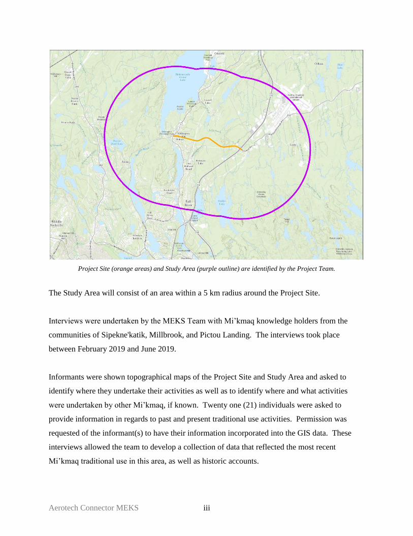
Project Site (orange areas) and Study Area (purple outline) are identified by the Project Team.
The Study Area will consist of an area within a 5 km radius around the Project Site.
Interviews were undertaken by the MEKS Team with Mi’kmaq knowledge holders from the
communities of Sipekne'katik, Millbrook, and Pictou Landing. The interviews took place
between February 2019 and June 2019.
Informants were shown topographical maps of the Project Site and Study Area and asked to
identify where they undertake their activities as well as to identify where and what activities
were undertaken by other Mi’kmaq, if known. Twenty one (21) individuals were asked to
provide information in regards to past and present traditional use activities. Permission was
requested of the informant(s) to have their information incorporated into the GIS data. These
interviews allowed the team to develop a collection of data that reflected the most recent
Mi’kmaq traditional use in this area, as well as historic accounts.

Aerotech Connector MEKS iv
All informant’s names are kept confidential and will not be released by MGS as part of a
consent agreement between MGS and the informant to ensure confidentiality.
The data gathered was also considered in regards to its significance to the Mi’kmaq people.
Each species identified was analyzed by considering their use as food/sustenance resources,
medicinal/ceremonial plant resources and art/tools resources. These resources were also
considered for their availability or abundance in the areas listed above, and their availability in
areas adjacent or in other areas outside of these areas, their use, and their importance, with
regards to the Mi’kmaq.
Historic Review Summary
Overland travel routes established by early peoples made the best use of the topography between
coasts and were logical paths of least resistance between departure locations and destinations.
The Chain of interconnected lakes and river systems of the Shubenacadie River System was an
important travel route crossing the central portion of province mainland roughly in a southwest
to northeast direction.
These early trail routes eventually became roads during the historic British settlement in Nova
Scotia. The trail to Pisaquid (Windsor) eventually became Trunk 1 and the Shubenacadie system
of lakes, rivers and valleys eventually became Trunk 2 to Cobequid (Truro). It is unknown if the
Old Guysborough Road was originally a traditional travel route for early peoples to the
Musquodoboit Valley.
There are several known pre-contact archaeological sites/finds within the Study Area with the
nearest 500m west of the new alignment intersection with Trunk 2 at Wellington Station. The
archaeological period of the sites was determined to be Archaic, Early-Middle Archaic to
Ceramic Period. The artifact stone materials found are available within the Study Area and
Project Site providing the bedrock is exposed for discovery and extraction by early peoples.

Aerotech Connector MEKS v
Other features found within the Study Area include a “15 ft. Fall” and “Gorge” watercourse
emptying into Soldier Lake on the northeastern shore. The Quartzite Barrens landscape and
wetlands also provide support for a variety of plants (Blueberries) and wildlife important to early
peoples
The Project Site and Study Area are within the Traditional Mi’kmaq Territory of Eskikewa’kik.
Eskikewa’kik includes all lands and waters draining into the Atlantic from St. Margarets Bay
including Big Indian Lake, Chebucto (Halifax), Eastern Shore, Strait of Canso to Cape Blue on
St. Georges Bay. The District includes the entire Musquodoboit River watershed, a portion of the
Shubenacadie River to and including the Stewiacke River watershed draining into Cobequid
Bay. In addition, Eskikewa’kik includes the West St. Marys River watershed, East St. Marys
River watershed, Country Harbour River watershed as well as the Salmon River and Milford
Haven River watersheds draining into Chedabucto Bay.
There are no last known Traditional Hunting Territories near the Project Site. The closest
territories are east and inland of the Eastern Shore at Musquodoboit Harbour and others west of
the Project Site inland from St. Margarets Bay and Mahone Bay.
During the mid to late 1700’s, there were hostilities between the Mi’kmaq and British. The
Shubenacadie lakes and river systems provided Mi’kmaq access to attacks on the new settlement
at Halifax Harbour as well as an inland refuge from British patrols and counter attacks. The
constant threat of attacks by the Mi’kmaq kept the British confined to the Halifax Harbour area
and large portions of the Province remained unknown to the British at that time.
As Trunk 2 eventually became the preferred route between Halifax and Truro, the section of Old
Guysborough Road from Lake Thomas to Goffs fell out of favor with travelers as did the
Cobequid Road from Fletchers Lake to Oldham Road. The Construction of Highways 102 and
118 destroyed Lake Thomas and Miller Lake Sections of the Guysborough Road and cut off
access to the Miller Lake to Goffs sections of the original road until construction of Perrin Drive
and Exit 5A on Highway 102.

Aerotech Connector MEKS vi
The nearest Indian Reserve (I.R.) parcel is Shubenacadie I. R. 13, located on the northwestern
shore of Shubenacadie Grand Lake, approximately 8 km north-northwest of the Project Site.
Shubenacadie I.R. 13 is the land of the Sipekne’katik First Nation community located at Indian
Brook I.R. 14, 26.5 km north-northeast of the Project Site.
A review of current status of any claims filed with Crown-Indigenous Relations and Northern
Affairs Canada shows no current claims within the Project Site and Study Area.
Traditional Use - Project Site Summary
Based on the data documented and analyzed, it was concluded that there is no Mi’kmaq use
reported on the Project Site, or in the immediate vicinity.
Traditional Use - Study Area Summary
Bass and trout fishing were the most commonly reported activity by informants within the Study
Area. Overall, the majority of activities took place in what this report categorizes as the Current
Use timeline. There are enough current use activities occurring in the area to suggest concurrent
use throughout all three timelines.
Other Information
A few informants had described utilizing the Shubenacadie Grand Lake for activities such as
canoeing, swimming, fishing and gathering medicines. This water system is an important part to
the Mi’kmaq in this area as there are many historical activities tied to it.
Aerotech Connector MEKS vii
Table of Contents
M.E.K.S Project Team i
Executive Summary ii
1. Introduction
1.1. Membertou Geomatics Solutions 1
1.2. Aerotech Connector 1
2. Mi’kmaq Ecological Knowledge Study – Scope & Objectives
2.1 Mi’kmaq Ecological Knowledge 2
2.2 Mi’kmaq Ecological Knowledge Mandate 3
2.3 MEKS Scope and Objectives 4
2.4 MEKS Study Area 4
3. Methodology
3.1 Interviews 5
3.2 Literature and Archival Research 6
3.3 Field Sampling 7
4. Mi’kmaq Land, Water and Resource Use
4.1 Overview 9
4.2 Limitations 10
4.3 Historical Review Findings 11
4.4 Mi’kmaq Traditional Use Findings 46
4.5 Mi’kmaq Significant Species Process 49
4.6 Mi’kmaq Significant Species Findings 51
5. Conclusions 52
Sources 56
Appendices
A. Mi’kmaq Traditional and Current Use Areas
B. Mi’kmaq Traditional and Current Fishing Areas
C. Mi’kmaq Traditional and Current Hunting Areas
D. Mi’kmaq Traditional and Current Gathering Areas

1 Aerotech Connector MEKS
1.0 INTRODUCTION
1.1 Membertou Geomatics Solutions
Membertou Geomatics Solutions (MGS) is a Membertou First Nation company that was
developed as a result of the 2002 Supreme Court Marshall Decision. MGS was
established as a commercially viable company that could provide expertise in the field of
GIS Services, Database Development, Land Use Planning Services and Mi’kmaq
Ecological Knowledge Studies (MEKS). MGS is one of many companies established by
the Membertou First Nation – Membertou Corporate Division and these companies
provide employment opportunities for aboriginal persons and contribute to Membertou’s
efforts of growth and development. As well, Membertou’s excellent management and
accountability of their operations is further enhanced by their ISO 9001:2015
certification.
For the development of this MEKS, MGS brings to the table a team whose expertise and
skills with land documentation have developed a sound MEKS. The team skills include
knowledge of historical Mi’kmaq research, GIS data analysis, Mi’kmaq ecological and
cultural knowledge, and Mi’kmaq community connections.
1.2 Aerotech Connector
The Highway 102 Aerotech Connector Project is the development of a proposed
connector route from Highway 102 at Exit 5A (Aerotech Business Park) to Trunk 2,
south of Wellington Station.

2 Aerotech Connector MEKS
2.0 MI’KMAQ ECOLOGICAL KNOWLEDGE STUDY
SCOPE & OBJECTIVES
2.1 Mi’kmaq Ecological Knowledge
The Mi’kmaq people have a long-existing, unique and special relationship with the land
and its resources, which involves the harvesting of resources, the conservation of
resources and spiritual ideologies. This relationship is intimate in its overall character, as
it has involved collective and individual harvesting of the resources for various purposes,
be it sustenance, medicinal, ceremonial and/or conservation. This relationship has
allowed the Mi’kmaq to accumulate generations of ecological information and this
knowledge is maintained by the Mi’kmaq people and has been passed on from generation
to generation, youth to elder, kisaku kinutemuatel mijuijij.
The assortment of Mi’kmaq Ecological Information, which is held by various Mi’kmaq
individuals, is the focus of MEKS, also commonly referred to as Traditional Ecological
Knowledge Studies (TEKS). When conducting a MEKS, ecological information
regarding Mi’kmaq/Aboriginal use of specific lands, waters, and their resources are
identified and documented by the project team.
Characteristically, MEKS have some similar components to that of an Environmental
Assessment; yet differ in many ways as well. Among its purpose, Environmental
Assessments measure the impact of developmental activity on the environment and its
resources. This is often done by prioritizing significant effects of project activities in
accordance with resource legislation, such as the Federal Species at Risk Act and the
Nova Scotia Endangered Species Act.
Mi’kmaq Ecological Knowledge Studies are also concerned with the impacts of
developmental activities on the land and its resources, but MEKS do so in context of the
land and resource practices and knowledge of the Mi’kmaq people. This is extremely
important to be identified when developing an environmental presentation of the Study

3 Aerotech Connector MEKS
Area as Mi’kmaq use of the land, waters and their resources differs from that of non-
Mi’kmaq. Thus, the MEKS provides ecological data which is significant to Mi’kmaq
society and adds to the ecological understandings of the Project Site and Study Area.
2.2 Mi’kmaq Ecological Knowledge Study Mandate
Membertou Geomatics Solutions was contacted by the Nova Scotia Department of
Transportation and Infrastructure Renewal to undertake a MEKS for the Project Site and
larger assessment area. This project will require the documentation of key environmental
information in regards to the project activities and its possible impacts on the water, land
and the resources located here. The MEKS must be prepared as per the Mi’kmaq
Ecological Knowledge Study Protocol ratified by the Assembly of Nova Scotia
Mi’kmaq Chiefs on November 22, 2007, and the 2nd Edition released in 2014.
MGS proposed to assist with the gathering of necessary data by developing a MEKS
which will identify Mi’kmaq traditional land use activity within the Project Site and in
the surrounding areas. This MEKS had gathered, identified, and documented the
collective body of ecological knowledge which is held by individual Mi’kmaq people.
The information gathered by the MEKS team is documented within this report and
presents a thorough and accurate understanding of the Mi’kmaq’s use of the land and
resources within the Project Site/Study Area.
It must be stated, however, that this MEKS preparation and/or acceptance of this
report is not considered Consultation within itself, nor is it deemed to fulfill the Duty to
Consult owed by the Crown to the Mi’kmaq. This report does not replace any
Consultation process that may be required or established in regards to Aboriginal
people. As well, this report cannot be used for the justification of the Infringement of
S.35 Aboriginal Rights that may arise from the project.

4 Aerotech Connector MEKS
2.3 Mi’kmaq Ecological Knowledge Study Scope & Objective
This MEKS will identify Mi’kmaq ecological information regarding Mi’kmaq traditional
land, water and resource use within the Project Site/Study Area. The data that the study
will gather and document will include traditional use from both the past and present time
frames. The final MEKS report will also provide information that will identify where the
proposed project activities may impact the traditional land and resource of the Mi’kmaq.
If such possible impact occurrences are identified by the MEKS then the study will also
provide recommendations that should be undertaken by the proponent. As well, if the
MEKS identifies any possible infringements with respect to Mi’kmaq constitutional
rights, the MEKS will provide recommendations on necessary steps to initiate formal
consultation with the Mi’kmaq.
2.4 MEKS Project Site and Study Area
This MEKS will focus on the proposed Project Site. This site is defined as the proposed
connector road. The site is located between Highway 102 Exit 5A, near the Halifax
International Airport, to Wellington Station, Nova Scotia.
The Study Area will consist of a larger area that falls within a 5km radius around the
Project Site.

5 Aerotech Connector MEKS
Figure 1. Project Site (orange areas) and Study Area (purple outline) are identified by the Project Team.
3.0 METHODOLOGY
3.1 Interviews
As a first step to gathering traditional use data, the MEKS team had initiated dialogue
with Sipekne’katik, and Millbrook First Nations given their close proximity with the
Project Site. Pictou Landing was included later on.
Discussions occurred with the MEKS staff to identify individuals who undertake
traditional land use activities or those who are knowledgeable of the land and resources.
Knowledge holders were contacted by the MEKS team members and interviews were
conducted between February and June, 2019.
6 Aerotech Connector MEKS
For this MEKS, twenty-one (21) individuals were asked to provide information in regards
to past and present traditional use activities. The informants were from the communities
of Sipekne’katik, Millbrook, and Pictou Landing. All of the interviews that were
completed following the procedures identified within the Mi’kmaq Ecological
Knowledge Protocol (MEKP) document. Prior to each interview, informants were
provided information about the MEKS, including the purpose and use of the MEKS, an
agreement of non-disclosure of their personal information in any reports, and the future
use of the traditional use information they provided. Information gathered from other
studies conducted in the area were utilized in this study as well.
Informants were asked to sign a consent form, providing permission for MGS to utilize
their interview information within this MEKS. During each interview, individuals were
provided a map of the Project Site/Study Area and asked various questions regarding
Mi’kmaq use activities, including where they undertook their activities or where they
knew of activities by others, when such activities were undertaken, and how that type of
resource was utilized. Other information gathered could be species habitats, changes in
species populations, and/or general information about the land related to its’ use. When
required or preferred, interviews were conducted in the Mi’kmaq language.
3.2 Literature and Archival Research
With regards to this MEKS, various archival documents, maps, oral histories and
published works were reviewed in order to obtain accurate information regarding the past
or present Mi’kmaq use or occupation relevant to the Project Site and Study Area.
As part of the historical review process, it should be noted there may be other sources of
Historical and Archaeological data available but may have restricted access or not
uncovered within this project’s Historical Review. A complete listing of the documents
that were referenced is outlined within the Sources section.
7 Aerotech Connector MEKS
3.3 Field Sampling
Methodology
Field sampling, or site visits, are conducted as another method to gather and document
plants, trees, animal signs/tracks, fish and wildlife habitats, or any other land feature
which would hold significance to the Mi’kmaq (food or sustenance, social, cultural, or
ceremonial purposes).
Site visits consist of site reconnaissance (to evaluate the entrances to the site, terrain
characteristics, and evaluation of any other information that would affect safety or
logistics of the site visit), logistics planning, as well as capturing “observation points”
with the assistance of a Mi’kmaq knowledge holder. Observation points are stops along
the site visit where species or landmarks significant to the Mi’kmaq were observed to be
occurring. These are taken at approximate set intervals, or whenever a species or feature
was deemed worthy to be noted by the knowledge holder. While every effort is made to
ensure the Project Site receives a good coverage of observation points, weather,
vegetation, available paths and trails, or difficult terrain can cause some data gaps.
Initial site visits took place in November 2018. Over two separate days in June and July
2019, MGS staff, accompanied by a Mi’kmaq knowledge holder from Paq’tnkek
conducted a site visit of the Project Site. Throughout the site visit various species (and
subspecies) of plants, trees, and animal signs/tracks were observed.
8 Aerotech Connector MEKS
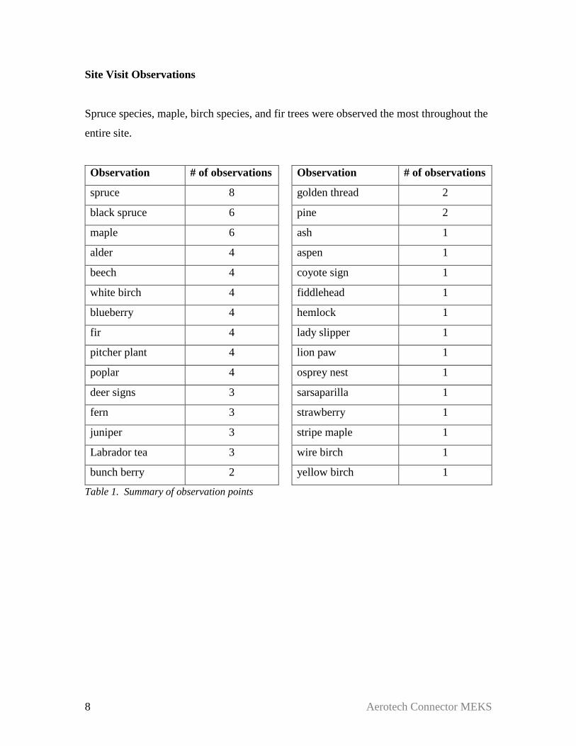
Site Visit Observations
Spruce species, maple, birch species, and fir trees were observed the most throughout the
entire site.
Observation # of observations Observation # of observations
spruce 8 golden thread 2
black spruce 6 pine 2
maple 6 ash 1
alder 4 aspen 1
beech 4 coyote sign 1
white birch 4 fiddlehead 1
blueberry 4 hemlock 1
fir 4 lady slipper 1
pitcher plant 4 lion paw 1
poplar 4 osprey nest 1
deer signs 3 sarsaparilla 1
fern 3 strawberry 1
juniper 3 stripe maple 1
Labrador tea 3 wire birch 1
bunch berry 2 yellow birch 1
Table 1. Summary of observation points
9 Aerotech Connector MEKS
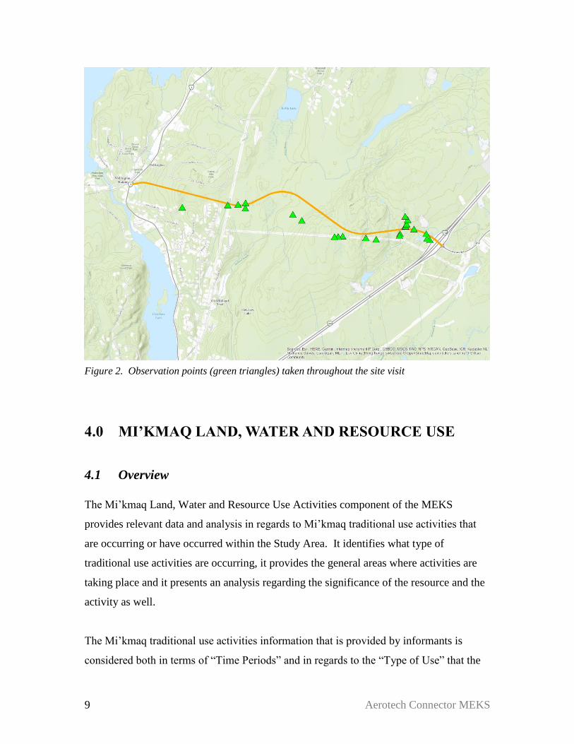
Figure 2. Observation points (green triangles) taken throughout the site visit
4.0 MI’KMAQ LAND, WATER AND RESOURCE USE
4.1 Overview
The Mi’kmaq Land, Water and Resource Use Activities component of the MEKS
provides relevant data and analysis in regards to Mi’kmaq traditional use activities that
are occurring or have occurred within the Study Area. It identifies what type of
traditional use activities are occurring, it provides the general areas where activities are
taking place and it presents an analysis regarding the significance of the resource and the
activity as well.
The Mi’kmaq traditional use activities information that is provided by informants is
considered both in terms of “Time Periods” and in regards to the “Type of Use” that the

10 Aerotech Connector MEKS
resource is being utilized. The Time Periods that the MEKS team differentiates
traditional use activities by are as follows:
“Current Use” – a time period within the last 10 years
“Recent Past” – a time period from the last 11 – 25 years ago
“Historic Past” – a time period previous to 25 years past
The “Type of Use” categories include spiritual use, and sustenance use, such as fishing,
hunting or medicinal gathering activities.
Finally, the study analyzes the traditional use data in consideration of the type of land and
resource use activities and the resource that is being accessed. This is the Mi’kmaq
Significant Species Analysis, an analysis which ascertains whether a species may be
extremely significant to Mi’kmaq use alone and if a loss of the resource was to occur
through project activities, would the loss be unrecoverable and prevent Mi’kmaq use in
the future. This component is significant to the study as it provides details as to Mi’kmaq
use activities that must be considered within the environmental understanding of the
Project Site and Study Area.
By analyzing the traditional use data with these variables, the MEKS thoroughly
documents Mi’kmaq traditional use of the land and resources in a manner that allows a
detailed understanding of potential effects of project activities on Mi’kmaq traditional use
activities and resources.
4.2 Limitations
By undertaking a desktop background review and interviews with Mi’kmaq participants
in traditional activities, this study has identified Mi’kmaq Traditional Use activities that
have occurred or continue to occur in the Study Area and Project Site. This has allowed
the study to identify traditional use activities in a manner that the MEKS team believes is
complete and thorough, as required by the MEKP. Historical documents within public
institutions were accessed and reviewed and individuals from nearby Mi’kmaq

11 Aerotech Connector MEKS
communities were interviewed. The interviews were undertaken with key Mi’kmaq
community people, identified by the MEKS team, who are involved and are
knowledgeable regarding traditional use activities. Through the historical documentation
review and the interview process, the MEKS team is confident that this MEKS has
identified an accurate and sufficient amount of data to properly reflect the traditional use
activities that are occurring in the Study Area.
The MEKS process is highly dependent on the information that is provided to the team.
Because only some of the Mi’kmaq traditional activity users and not all Mi’kmaq
traditional activity users are interviewed, there is always the possibility that some
traditional use activities may not have been identified by this MEKS.
4.3 Historical Review Findings
Historic Review
The Project Site is a road alignment between Exit 5A on the twined Highway 102 and
4.8km southwest at Wellington Station on Trunk 2. The Project Study Area is a 5 km
buffer on each side and ends of the road alignment. The Project Site (road alignment) is a
northwest extension of Aerotech Drive at Exit 5A with a large radius curve to the
southwest (left turn) before a straight run approximate distance of 540m before another
large curve radius to the west (right turn). This section from Exit 5A skirts south of two
high points of 150m and 155m elevation and crosses three watercourses flowing south
towards Soldier Lake. The high points are two of four that form a southwest to northeast
ridge roughly 4.0km x 0.8km wide ridge that the new road alignment crosses at 140m to
145m elevation. The new road alignment continues on an approximate 800m straight
northwest run down the steep northwest slope of the ridge. This straight northwest run of
the alignment drops in elevation from 135m at the top of the slope to 85m elevation at the
bottom of the slope over a distance of 600m. (1)

12 Aerotech Connector MEKS
From the bottom of the slope, the new road alignment makes a southwest (left) turn from
85m elevation and has a short 400m straight southwest run until a small radius northwest
(right) turn towards Trunk 2. The elevation change from the bottom of the slope to the
intersection with Holland Road is -20m from 85m to 65m elevation. Approximately
170m west of the intersection with Holland Road, the new road alignment crosses a
wetland/watercourse flowing south towards Fetcher’s Lake. The road alignment
continues for a straight northwest run between Abeline Avenue and Pine Oak Drive of
approximately 1700m between Holland Road to Trunk 2. The new road alignment
intersects with Trunk 2 at Wellington Station at roughly 30m elevation. The intersection
with Trunk 2 is opposite where Church Street/Sunnylea Road, the railroad and Trunk 2
converge through a narrow transportation corridor. (1)
The Study Area encompasses an area of 5km radius at Exit 5A and at Wellington Station
as well as 5km offset from each side of the total of the new road alignment. The coverage
encompasses the southeast shoreline of Shubenacadie Grand Lake including Laurie
Provincial Park and north to Fish Lake, Oakfield. The Study area includes Sleepy Cove
on the western shore of Shubenacadie Grand and west to include Beaver Bank Lake and
the northern portion of Kinsac Lake. The southern portion of the Study Area includes all
of Fletchers Lake, river run to Lake Thomas and the northern portion of Lake Thomas, all
of Miller Lake and Soldier Lake. The eastern portion of the Study Area includes a portion
of the Waverly Game Sanctuary, all of Granite Lake, King Lake, as well as the Areotech
Business Park and a portion Stanfield International Airport Lands and runway. The
northeastern portion of the StudyArea includes Kelly Lake, Kelly Long Lake and most of
Bennery Lake. Highway 102 runs through the Study Area southwest from where
Highway 118 meets Highway 102 at Fall River to approximately 1.8km northeast of Exit
6. (1)

13 Aerotech Connector MEKS
Figure 3. Project Site Looking South
Landscape Development
The Project Site and Study Area were ice free along the Shubenacadie River and valley at
approximately 12,000 years B.P. while surrounded by a large ice sheet that covered most
of the northern portion of the Province. At approximately 10,500 years B.P., the Project
Site\Study Area was just east of the one of the last province-wide ice sheets centered
approximately at Trafalgar, Guysborough County. This ice sheet was an advancement of
ice during a 200 year cold period known as the Younger Dryas Period. (3)
Evidence from deep-ocean sediments indicate that there have been at least 16 glacial
periods that lasted approximately 100 thousand years each. The last glacial period was
the Wisconsin Glaciation which began 75 thousand years ago and ended between 12 and
10 thousand years ago. After extensive sampling in Nova Scotia, evidence indicates that
successive glaciation had four distinct phases with different and shifting ice centers. (4)

14 Aerotech Connector MEKS
The Phase 1 ice flows moved eastward across the region including Prince Edward Island
and Cape Breton Island before shifting flow direction southeastward across the present
day Bay of Fundy, Mainland Nova Scotia and Cape Breton Island. The Ice flowed across
the Project Site in this phase in a south eastward direction and then at some time shifted
to a more south flow direction. (4)
The Phase 2 ice center was located north of present day Prince Edward Island with flow
direction south over mainland Nova Scotia and southeast over lower southeast portions of
Cape Breton Island. The Phase 2 ice flow direction was south over the Project Site and
Study Area. (4)
The Phase 3 ice center was parallel to the present day Nova Scotia Atlantic Coast and
extended on land from Cape Sable, through Cape Canso to offshore and approximately
south of present day Louisbourg, Cape Breton Island. From this ice divide, ice flows
moved northeast across eastern portions of Cape Breton Island, northwest across western
portions of Cape Breton Island, northeast across northern portions of the mainland from
Cape George to Minas Basin west to northwest across the present day Annapolis Valley.
On the Atlantic side of the ice divide, all flow directions were in a southeast direction
over the Scotia Shelf. The Ice sheet center was over the Project Site during this phase
with the flow moving southeast and northwest from the Project Site and Study Area (4)
Phase 4 was a period when several remnant ice sheets were located throughout the
province and advanced and receded in a radial direction from the ice centers. Cape
Breton had two glaciers that were centered on the Highlands and another centered on the
Bas d’Or Lakes. The Chedabucto Glacier filled the present day Chedabucto Bay and St.
Georges Bay with a westward ice flow direction across the central portion the province
into the Northumberland Strait, Minas Basin and the Atlantic. The Chignecto Glacier was
centered near Baie Verte and Cape Tormentine and the South Mountain Ice Cap was
centered between the Bay of Fundy and Atlantic Coast near present day Kejimkujik
National Park. The direction of ice advance of the Chedabucto Bay Glacier was a west to
southwest flow direction across the mainland. (4)
15 Aerotech Connector MEKS
The last of the glaciers gradually receded with the Bay of Fundy being ice free between
16 and 14 thousand years ago. Northern portions of the province experienced periodic
advancement and stalls in movement of remnant ice caps. By 13 thousand years ago, the
ice sheets had receded to the approximate coastline of today and then only residual ice
caps remained in highland areas at approximately 12 thousand years ago. (4)
Between 11 and 10 thousand years ago, the Younger Dryas Period was an abrupt climate
change with a cold period lasting approximately 200 years. During the Younger Dryas
Period, previously colonized plants that followed the once receding glaciers were covered
in permanent snowfields and some large mammals became extinct. (5) The cold period of
the Younger Dryas may have pushed the Paleo-Indian people south with advancing ice
sheets and permanent snowfields or they may have abandoned the region. (9)
As the last remnant glaciers receded and the climate warmed again. The landscape was
gradually colonized by tundra vegetation of willow shrubs and herbaceous plants
between 10 and 7.5 thousand years ago and were replaced by boreal vegetation such as
fir, spruce and birch until 6 thousand years ago when pine and oak was prominent. (6)
Temperatures were 2 degree Celsius warmer than today for period until 4 thousand years
ago and forests of hemlock mixed with beech and maple was the dominant vegetation.
Gradual cooling to present day temperatures and increased moisture favoured spruce
forests. (7)
Since the end of the last ice age the Chignecto Isthmus provided the land corridor for
plants and animals as well as people to migrate into Nova Scotia as well as assisted
airborne species migrations. (8)
The landscape the receding ice sheets left behind within the Study Area is a mix of barren
bedrock knolls and deep till filled depressions and scattered waterbodies. The Natural
History of Nova Scotia has the Project Site located within the Atlantic Interior Region
400, Quartzite Plains District 410, Halifax Quartzite Barrens 413a, The Quartzite Plains
are typically underlain with resistant Metamorphic bedrock of Greywacke and Shist that

16 Aerotech Connector MEKS
produced till and soils that provide little support for growth other than stout trees, heath
plants and shrubs. The Halifax Quartzite Barrens (413a) typically average a 3m cover in
Quartzite till scraped thinner on ridges and thicker in the swales. There are drumlins or
elongated drumlin-like hills of thick till derived from sandstones and siltstones further
north and deposited by melting glaciers. Well drained stony-sandy loams developed on
quartzite tills with Halifax Soils covering most of the Halifax Quartzite Barrens with
poorly drained Danesville Soils in low areas as well as Aspotogan Soils and Peat. (10)
The soils covering the area of Exit 5A is split between Danesville soils southwest of the
new westward extension and Bridgewater soils covering the area to the northeast.
Bridgewater soils are described as Brown Shaly Loam developed from Shaly Till and
Slate bedrock with good drainage. Danesville soils are described as Dark Grayish-Brown
Sandy Loam developed on Sandy Loam Till and Quartzite Bedrock with imperfect
drainage. The soils covering the ridge crossing portion of the new alignment are Halifax
soils are described as Brown Sandy Loam developed on Stony-Sandy Loam Till and
Quartzite bedrock with good to excessive drainage. The remainder of the new alignment
from the bottom of the northwest ridge slope to Trunk 2 and beyond are covered with
Wolfeville Soils. Wolfeville soils are described as Dark Reddish-Brown Loam to Sandy-
Clay Loam developed on Reddish-Brown Loan Till and Sandy Clay Loam Till derived
from Shale and Sandstone bedrock and with good drainage. Wolfeville soils are suitable
for most crops when deep enough.
The Study Area southeast portion includes the eastern end of another Natural History of
Nova Scotia Regions, District of Granite Ridge 453. The Granite Ridge 453 is a
prominent 8 to 10km narrow Granite outcrop that stretches inland from Spry Harbour and
approximately 78 km westward to near the eastern shore of Soldier Lake. Granite
landscapes are highly erosion resistant and forms high ground in the form of shapeless
ridges, knolls and waterlogged depressions with a thin till veneer cover or exposed
bedrock. The Granite Ridge 453 along the Eastern Shore is narrow and forms an
east/west drainage divide with drainage roughly north and south in a deranged pattern or
following fault lines such as Lake Major and Porters Lake. The west limits Granite

17 Aerotech Connector MEKS
Ridge 453 rises about 50 to 60m above the landscape at roughly 150 m elevation, where
the Granite Ridge abruptly ends approximately 3.5 km southeast of the Project Site Exit
5A. (10)
Archaeology
The Natural History of Nova Scotia lists 5 Archaeological time periods for the Province
of Nova Scotia that are prior to and including European contact with the Mi’kmaq (9):
11,000-10,000 Years BP, Paleo-Indians
The earliest evidence of early peoples east of the State of Maine is found at the foot of the
Cobequid Mountains at Debert, Nova Scotia. There is evidence of an encampment on the
site dated to be in use roughly 11,000 to 10,500 years BP. (11). At this time, local ice
sheets remained centered at locations of Bras d’Or Lakes/Highlands of Cape Breton,
Canso, Baie Verte and South Mountain adjacent the Annapolis Valley. There was a large
ice sheet centered on the Eastern Mainland of province with ice flows into St. Georges
Bay, Minas Basin and along the Eastern Shore. (4) The time of the Debert Site
occupation is within the same period of the glacial re-advances of the Younger Dryas
Period of 11,000 and 10,000 years BP. Increasingly harsh conditions are thought to have
caused the early peoples to abandon the region. (9)
10,000-5,000 Years BP, the Great Hiatus
The rising sea levels and submerging coastlines are thought to be responsible for the lack
of physical evidence of early peoples for this time period. Any evidence of coastal
settlements of that period would be lost to coastal erosion and submergence. (9)
Sea level rise on the Atlantic Coast was a combination of land rebound after ice sheets
receded, rising ocean temperatures and water released by melting glaciers. (9) As the
thick and heavy ice sheet centers depressed the earth’s mantle, the areas of mantel along

18 Aerotech Connector MEKS
the ice sheet margins were less weighted by ice and rose slightly through displacement.
There was an ice sheet center located in the Gulf of St Lawrence. As the weight of the ice
sheets diminished with melting, the depressed center areas of the Gulf rebounded and
rose in elevation while the previously raised mantel at the former ice margin, lowered in
elevation. (13)
5,000-3,500 Years BP, the Archaic Period
A period characterised by physical evidence of stone tools some of which are found
offshore and possibly lost during deep water fishing. There was a cultural influence or
cultural presence of peoples in the southern part of the province dated at a time between
3,500 and 2,500 BP known as the Susquehanna Tradition. The Susquehanna Tradition
originated in area of the mid-Atlantic states of today and is identified by some unique
artifacts. (9)
2,500-500 Years BP, the Ceramic Period
Evidence of pottery is introduced to the archaeological record during this period as are
burial mounds. Ceramic period sites are scattered throughout the province and a 10m
diameter burial mound was discovered at Whites Lake, HRM, dated at 2,300 BP. (9)
500-100 Years BP, the Contact Period
The first European contact with the Mi’kmaq was most likely with Portuguese fishermen
roughly 500 years ago. (9)
However, there are other period delineations being used in the Province and Maritime
publications which differ in the number of periods, names, and time span of periods. The
Archaeological Periods Table below places the periods in context with each other. It is
useful to provide these various periods for reference and context when reviewing
archaeological reports and placing in time the artifacts and features found.

19 Aerotech Connector MEKS
Artifacts are archaeological objects that can be recorded and removed from the site as
flakes (chips from tool or point manufacture), arrow/spear tips (points), tools, bones,
preforms (unfinished tool or point blanks) and pottery sherds. Features are archaeological
finds that cannot be removed from the site and can only be recorded such charred or
discoloured ground, a storage pit or Historic Period building foundations as some
examples.
Table 2. Archaeological Periods (9)(12)
An archaeological survey of the Shubenacadie River System in 1970 inventoried and
revisited known Pre-Contact archaeological sites along the system from Lake Charles to
the Stewiacke River. Known sites within the Study Area visited during the 1970 survey

20 Aerotech Connector MEKS
include a cluster of sites located at the outlet of Shubenacadie Grand Lake to Fletcher’s
Lake, approximately 550m west of the Project Site/Study Area center. This cluster
produced many artifacts during canal construction in the 1850’s and the clearing and
cultivation of a family farm. The Canal Engineer’s collection was documented as 80
piece collection of ground stone forms of gouges and adzes, grooved axes, plummets,
chipped stone specimens including side notched, corner notched and stemmed points.
The mostly Archaic Period collection was later donated to the Nova Scotia Museum.
Later site investigations in the 1960’s produced side notched, corner notched points,
lanceolate point, leaf shaped and triangular knives, scrapers, ground slate and pot sherds.
Little remains of the sites today after development of the area. (14)
Three known sites of artifact finds are approximately 4.3 km south of the new alignment
intersection with Trunk 2 at Wellington Station, along the narrows between Fletcher’s
Lake and Lake Thomas. The sites produced at least 1 Archaic Period gouge artifact. The
sites were determined to be destroyed by development at the time of the 1970 survey.
(14)
A gouge was found approximately 3.7km southwest of Exit 5A, located on the
northwestern shore of Soldier Lake near the former north outlet to Miller Lake. The fully
grooved gouge is thought to be an Early-Middle Archaic Period artifact dating 9000-6000
years. No material type was given. (15) The location is now heavily disturbed by a
dam/dyke structure as part of the controlled lake level infrastructure. The isolated find at
Soldier Lake was not part of the 1970 Shubenacadie River System Survey.
Approximately 9.4 km north of Exit 5A and outside the MEKS Study area, the 1970
Shubenacadie River System Survey visited a series of sites between the Shubenacadie
Grand Lake outlet into the Shubenacadie River and Enfield. The pre-contact to historic
sites were used as fishing stations adjacent river riffle runs where traces of weirs can be
seen today in Google Earth Imagery. Whether these weirs are pre-contact or present-day
is unknown but demonstrates the utility of the locations. These sites were also locations
of tool making. (14)
21 Aerotech Connector MEKS
The 1970 survey Shubenacadie River System Survey was unclear about the specific
artifact material types. One source studied the artifacts recovered from one of the fishing
sites hypothesized how the tools were produced. Nearly 900 artifacts were recovered
from the one site alone and 315 artifacts were studied in detail. The Source grouped the
artifact material types as Quartz and further references Quartz as in the Silica Group of
rock forming minerals that includes Chalcedony, Cristobalite, Silica Glass, Flint and
Chert. It cannot be determined with any certainty at this time if any of the other Silica
group were among the artifact material types in the Shubenacadie River fishing site
collection. (16)
The collection origin site location produced artifacts indicating Late Archaic to Ceramic
use and possible earlier use of the site. (14) To find a representative sample of material
types found at a prehistoric site of similar time frame, the Melanson Site located some
65km northwest of the Goffs MEKS Project Site provides a good sample. The Melanson
Site is a large 1.8km long x 0.75km wide complex of individual fishing sites that covers
an area of both sides of the Gaspereau River near the tidal influence. Most of the artifacts
found are Woodland/Ceramic Period with Archaic Period artifacts a rarity but, found on-
site with another artifact suggesting earlier Archaic use. (17)
The Melanson Site(s) have long been the source of artifacts for farmers, amateur
collectors and academics, leaving little remaining today. One collection alone yielded the
following material types: (17)
Banded Rhyolite 1 Black Rhyolite 1 Rhyolite 17
Sheared Rhyolite 2 Ignium Rhyolite 1 Quartzite 11
Vein Quartz 10 Meta-Greywacke 2 Chalcedony 9
Jasper 1 Chalcedony-Jasper 6 Chalcedony-Banded Agate 1
Banded Jasper 1
Much of the Melanson Rhyolite and Chalcedony materials were sourced locally. The
presence of 11 specimens of Quartzite, 10 Vein Quartz and 2 Meta-Greywacke give good
22 Aerotech Connector MEKS
indication of the raw resources that were of value to early peoples. The tools are a
collection of knives, scrapers, preforms, blanks with the Meta-Greywacke was found in
heavy tools as celts. (17)
The Mi’kmaq Name for Shubenacadie Grand Lake is Tulugadik, meaning “camping
place”. (18) Significant tool making occurred approximately 10.4 km north of the MEKS
Project Site/Study Area center at the Shubenacadie River fishing site. (16) Quartz for tool
making had to be sourced by early peoples and preferably within close proximity and of
easy access.
Vein Quartz may be available within the Goldenville Formation underlying Exit 5A and
the northwest extension of Aerotech Drive providing there are natural outcrops. There are
other areas within the larger Study Area as possible sources of quartz. The barren areas of
the Granite Ridge 453 provided another possible source for Quartz.
Geology
A review of Provincial scale geology Map ME2000-1 shows Exit 5A and roughly 300m
northwest of Highway 102 is underlain with Goldenville Formation bedrock. The
Goldenville Formation (COMg) is described as Sandstone Tubidites and Slate with
places metamorphosed into Schist and Gneiss. (2) Schist is a coarse grain metamorphic
rock with a flat plate-like grain structure that allows it to be split into layers or slabs.
Gneiss is a foliated metamorphic rock formed with parallel bands of mineralization and
colour throughout the rock. (20) Further northwest for the full length of the new road
alignment is underlain with Halifax Formation Bedrock. Halifax Formation (COMh) is
described as Slope-Outer shelf Slate, Siltstone, minor Sandstone, Iron-Manganese
nodules and metamorphosed into Schist in some places. (2)
The northern contact between Goldenville Formation to the northwest and Halifax
Formation to the southeast is located at the approximate south shore of Shubenacadie

23 Aerotech Connector MEKS
Grand Lake before the outlet to Fletchers Lake including Beaver Bank Lake and Bennery
Lake. (2)
The granite bedrock of an unnamed formation (M-LDmbmg) muscovite biotite
monzogranite underlies the Granite Ridge (453) with the west pointed contact area into
the Goldenville Formation approximately 3.5km to the south. Map ME2000-1 shows
granite of the same type as a patch centered approximately 2.7km southwest of the new
alignment proposed intersection at Wellington Station and underlies the high ground
between Fletcher’s Lake and Kinsac Lake. (2)
Figure 4. Exposed Bedrock and Geology
The Provincial scale mapping of surficial geology shows Stony Till Plain covers the
Goldenville Formation bedrock for approximately 300-400m northwest of Trunk 2. Stony
Till Plain (Ground Moraine) is described as stony, sandy matrix, material derived from
local bedrock sources. As the new road alignment crosses the ridge traveling northwest,

24 Aerotech Connector MEKS
the route crosses an area mapped as Bedrock, roughly 1.5 km wide. Bedrock is described
as bedrock of various types and ages; glacially scoured basins and knobs, overlain by
thin, discontinuous veneer of till. As the new alignment reaches the bottom of the steep
northwest slope of the ridge, the Halifax Formation bedrock is covered with Silty Till
Plain. Silty Till Plain (Ground Moraine) silty, compact, material derived from both local
and distant sources. (3)
Thick tills hide bedrock and make outcrops even more important to early peoples as any
useful stone was revealed for possible discovery and accessible for extraction with
minimal effort.
Areas of possible exposed bedrock diminish in size and number further inland from the
coast. There are patches classified as Bedrock centered approximately 2.8 km east of the
Exit 5A and south of the Airport. A review of Google Earth imagery shows signs of
exposed Goldenville Bedrock south of the Airport, west of King Lake and east of Queen
Lake A large area classed as bedrock is centered just north of Oldham, approximately
8.2km northeast of Exit 5A. The area seems heavily disturbed by mining and exposed
bedrock was not obvious in the Google Earth imagery. A patch of Bedrock over
Goldenville Formation is located on the western shore of Shubenacadie Grand Lake,
underlying the western boundary of Shubenacadie I.R.13 and extending approximately
5.8 km southwest. (2)(3) A large area of exposed Goldenville Formation is centered
approximately 10km east of the Exit 5A. A review of Google Earth imagery indicates
exposed bedrock and bedrock ridges within the same area. (3)
There is an area over Halifax Formation mapped as Bedrock with no till cover,
underlying the ridge centered approximately 1.0km north of the Exit 5A with exposed
bedrock confirmed with a review of Google Earth imagery. Goldenville Formation
underlies the area of Bennery Lake with the area south of Bennery Lake showing signs of
exposed bedrock in Google Earth imagery. There are large mapped areas of no Till cover
(Bedrock) over Goldenville Formation Bedrock north of Soldier Lake, Between Soldier
Lake and Miller Lake. A review of Google Earth Imagery shows some signs of exposed

25 Aerotech Connector MEKS
bedrock and Google Earth Street View images of road cuts show bedrock near the surface
but worn smooth with very thin soil cover supporting tree growth. (2)(3)
Figure 5. Surficial Geology and Till Cover
Quartz dissolves and percolates easily under heat and pressure such as was present in
igneous rock (Granite) formation. A liquid brine is produced and carries the minerals into
existing cracks and fissures of existing rock. The liquid enters cracks and fissures of a
cooler formations and results in milky white to clear and coloured seams of recrystallized
quartz. (54)
The most promising sources of Quartz found within 12 to 13 km proximity of the
Fishing/Toolmaking sites near the outlet of Shubenacadie Grand Lake, are the barren
high ground between Fletcher’s Lake and Kinsac Lake as well as the barrens of the
Waverly Game Sanctuary, east of Soldier Lake. (2)

26 Aerotech Connector MEKS
Other features within the Study Area that may have been of interest to early peoples
includes the 5m elevation drop over a distance of roughly 157m of a watercourse draining
toward Soldier Lake, located approximately 3.1km directly south of the Exit 5A. The
1909 Geological Survey of Canada Mapping shown in the Archaeological Study for this
Project shows “Fall 15’” and “Gorge” at this location on “Johnson River”. (22)
The thin tills of Halifax Quartzite Barrens 413a within the Study Area support an
important food source of blueberries as well as other heath plants. Deer are common
throughout and inland bogs and barrens provide habitat for plants and animals. (23)
Traditional Mi’kmaq Territory
The Project Site and Study Area are within the Traditional Mi’kmaq Territory of
Eskikewa’kik. The traditional territories are important reminders of the political and
territorial system that most likely existed in the pre-contact period and continued into the
Post-Contact Period and later Historic Period. The Traditional Mi’kmaq Territories are
referenced today in response to modern events and issues that potentially impact each
territory.
The traditional lands of the Mi’kmaq were comprised of 7 Districts collectively known as
Mi’kma’ki. The sources reviewed provided very general District Boundaries that have
just enough detail to give an approximation of boundaries along the coast but not much
detail for the interior limits. (24)(25)(26)(27)
Using the general boundaries provided by the sources, MGS interpreted the source maps
and recreated detailed District boundaries of the 7 districts of Mi’kma’ki using significant
watersheds as the defining features on the ground. The district boundaries may be
adjusted after review by the Mi’kmaq and Wolastoqiyik (Maliseet) Communities. Until
then, the 7 Districts of Mi’kma’ki are proposed as follows:

27 Aerotech Connector MEKS
Eskikewa’kik (Skin Dressers) Eskikewa’kik includes all lands and waters draining
into the Atlantic from St. Margarets Bay including
Big Indian Lake, Chebucto (Halifax), Eastern
Shore, Strait of Canso to Cape Blue on St. Georges
Bay. The District includes the entire Musquodoboit
River watershed, a portion of the Shubenacadie
River to and including the Stewiacke River
watershed draining into Cobequid Bay. In addition,
Eskikewa’kik includes the West St. Marys River
watershed, East St. Marys River watershed, Country
Harbour River watershed as well as the Salmon
River and Milford Haven River watersheds draining
into Chedabuctou Bay.
Kespek (Last Land) All the land and waters draining into the Gulf of St.
Lawrence north of Escuminac Point, N. B.
including the Miramichi River watershed and north
to include the Gaspe’ Peninsula and south shore of
the St Lawrence River. This was the last land to be
added to Mi’kmaq territory after a war with the
Iroquois.
Siknikt (Drainage Area) All the lands and waters draining into the Gulf of
St. Lawrence and Northumberland Strait south of
Escuminac Point, N. B. to and including the
Wallace River watershed and Wentworth Valley.
All the lands and waters draining into Cobequid
Bay, the Minas Basin, and Bay of Fundy west of
Five Islands N. S. and including the Petitcodiac
River watershed and all drainage along the Bay of

28 Aerotech Connector MEKS
Fundy coast to Mispec Point on the east side of St.
John Harbour.
Epekwitk (Lying in the Water)
aqq Piktuk (The Explosive Place) This District combines the entire Island of Prince
Edward Island with all the lands and waters
draining into the Northumberland Strait and St.
Georges Bay from Mainland N. S. east of
Abercrombie Point to Cape Blue. The District
includes the East River of Pictou watershed to and
including the Tracadie River and Little Tracadie
River watersheds.
Sipekni’katik (Wild Potato Area) This District includes all lands and waters draining
into the Northumberland Strait from Macfarlane
Point, Wallace Harbour to and including the Middle
River of Pictou watershed. Sipekni’katik also
includes all the lands and waters draining into
Cobequid Bay, Minas Basin and Bay of Fundy from
Five Islands Carrs Brook and Economy River
watersheds to and including North River and
Salmon River, Avon River, Cornwallis River
watersheds to MacNeily Brook near Margaretsville.
In addition, Sipekni’katik includes all lands
draining into St. Margarets Bay and Mahone Bay
including the Ingram River watershed to and
including eastern shore of the LaHave River.
Kespukwik (Last Flow, Land Ends) This District includes all the lands and waters
draining into the Bay of Fundy from approximately

29 Aerotech Connector MEKS
Margaretsville, the Gulf of Maine coast and the
Atlantic to the western shore of the LaHave River.
The LaHave River Watershed may have divided by
east and west districts with the eastern watershed a
portion of Sipekni’katik and the western watershed
is a portion of Kespukwik. Champlain’s early map
of the LaHave River show two separate Mi’kmaq
communities on either side of the River located near
Upper Kingsburg and at Green Bay near Petite
Riviere (LaHave Islands Marine Museum, 2016).
This may indicate a community of each district
sharing the LaHave River.
Unama’kik (Land of Fog)
Aqq Ktaqmkuk (Land Across This District combines all of Cape Breton Island
the Water) with the Southern Coast of Newfoundland.

30 Aerotech Connector MEKS
Figure 6. Traditional Mi’kmaq Political Districts with Wolastoqiyik, Passamaquoddy, partial
Penobscot Traditional Territories. (24)(25)(26)(27)
The Project Site and Study Area are within the Traditional Mi’kmaq Political District of
Eskikewa’kik (Skin Dressers). Under the Indian Act assigned Indian Reserves,
Shubenacadie I.R.13 is a 3978966.2 sq. m., 397.9 hectares, parcel located on the western
shore of Shubenacadie Grand Lake approximately 8.0 km northwest of the Project Site.
(1) Shubenacadie I.R.13 is assigned to Sipekne’katik First Nation.
Mi’kmaq had an intimate knowledge of the ecology of their territory and fit their lives to
seasonal cycles of the vegetation and animals and fish. Due to climate conditions,
agriculture for food was a risk for Mi’kmaq. (28) Highly mobile Bands consisting of
several related families would assemble at favorite camp sites. In the fall and winter the
camps would disperse into small groups of 10-15 people for winter hunting. (28)
It was the duty and responsibility of the chief of each political district to assign the
hunting territories to families and any changes were made in the presence of the Council

31 Aerotech Connector MEKS
of Elders which met in the spring and fall of every year. (29) Hunting districts of
approximately 200-300 square miles were assigned to families. (28)
Figure 7. Mainland Nova Scotia Traditional Hunting Territories (30)
The districts were usually surrounded lakes and rivers and were passed on to sons unless
there were no sons where the district was then assigned to another family. (30) The
Mi’kmaq respected the boundaries of the assigned territories and only took from the land
what they needed for the family to survive thereby preserving game and fish for the
family’s future survival. (29)
The hunting territories of the mainland Nova Scotia were numerous compact interior
territories that encompassed the watersheds of interior lakes and rivers as Mi’kmaq did
most their game hunting during colder months of the year when they moved inland from
the summer coastal camps. (30)(29) Cape Breton Island Mi’kmaq hunting territories are
32 Aerotech Connector MEKS
larger and more regional encompassing shorelines and interior river systems indicating a
more sparse population. (30)
Map Reference Name of Family Geographic Territory
25 Joe Brooks Uniacke Lake below Mt. Uniacke
30 Joe Cope North of Jeddore
28 John Newell Cope Musquodoboit River between Middle
Musquodoboit and Musquodoboit Table 3. Mainland Nova Scotia Traditional Hunting Territories Recorded Circa 1919 (30)
The nearest known Traditional Hunting Territory to the Study Area is Territory No. 25
assigned to Joe Brooks and covers the area of Uniacke Lake below Mt. Uniacke. Hunting
territory No. 30 assigned to Joe Cope and covers the area north of Jeddore. A third known
Tradition Hunting Territory, No. 28 assigned to John Newell Cope covers the
Musquodoboit River (Valley) (30) and intended destination of the Guysborough Road.
The territorial reference numbers pertain to the source’s original reference system and it
is unknown if territorial numbers were assigned by Chiefs.
The warmer months were times of abundance with surrounding areas of coastal camps
providing fish, shellfish, fowl and eggs. Offerings were made to spirits but the Mi’kmaq
rarely stockpiled enough food for the entire winter. They brought with them from the
coast smoked and sun-dried seafood, dried and powdered hard boiled eggs. Berries were
boiled and formed into cakes and were sun-dried. Grease and oils from boiled marrow
and fat were stored and transported in animal bladders. Root vegetables such as segubun
(wild potato) which was similar to today’s sweet potatoes and wild nuts were also part of
the winter food supply. (29)
Month Seasonal
Locations
Seasonal
Groupings
Food Resource
Jan. Sea Coast Bands Smelt, Tomcod, Seals & Walrus
Beaver, Moose, Bear, Caribou
Feb.
(Period of
Winter Famine
Begins)
Inland Bands &
Family
Units
Smelt, Tomcod (ending)
Seals & Walrus, Beaver, Moose, Bear,
Caribou

33 Aerotech Connector MEKS
Mar.
(Period of
Winter
Famine)
Inland Bands &
Family
Units
Smelt, Seals & Walrus (ending)
Scallops, Crab, Urchins, Winter
Flounder, Beaver, Moose, Bear, Caribou
April
(Period of
Winter Famine
ends)
Sea Coast Villages Smelt, Winter Flounder, Scallops, Crab,
Urchins, Sturgeon, Brook Trout,
Alewife, Herring, Spring Bird
Migrations, Beaver, Moose, Bear,
Caribou
May Sea Coast Villages Smelt, Scallops, Crab, Urchins, Sturgeon,
Salmon, Brook Trout Alewife, Codfish,
Capelin, Shad, Mackerel, Skates,
Herring, Spring Bird Migrations, Beaver,
Moose, Bear, Caribou
Jun. Sea Coast Villages Scallops, Crab, Urchins, Sturgeon,
Salmon, Brook Trout Alewife, Codfish,
Capelin, Shad, Mackerel, Skates
Lobsters, Spring Bird Migrations,
Beaver, Moose, Bear, Caribou
Jul. Sea Coast Villages Scallops, Crab, Urchins,
Codfish, Capelin, Shad, Mackerel, Skates
Lobsters, Spring Bird Migrations,
Beaver, Moose, Bear, Caribou,
Strawberries, Raspberries
Aug. Sea Coast Villages Scallops, Crab, Urchins,
Codfish, Skates Lobsters, Beaver,
Moose, Bear, Caribou, Strawberries,
Raspberries, Blueberries, Ground Nuts
Sept. Sea Coast Villages Scallops, Crab, Urchins,
Codfish, Skates, Salmon, Herring, Eels,
Fall Bird Migrations, Beaver, Moose,
Bear, Raspberries, Blueberries, Ground
Nuts, Cranberries
Oct. Small
Rivers
Villages Scallops, Crab, Urchins, Smelt
Codfish, Skates, Salmon, Herring, Eels,
Brook Trout, Fall Bird Migrations,
Beaver, Moose, Bear, Blueberries,
Ground Nuts, Cranberries
Nov. Inland Bands Smelt, Tomcod, Turtles, Seals, Beaver,
Moose, Bear, Ground Nuts, Cranberries
Dec. Rivers Bands Smelt, Tomcod, Turtles, Seals, Beaver,
Moose, Bear, Ground Nuts,
Table 4. Mi’kmaq Annual Subsistence (31)
34 Aerotech Connector MEKS
The Shubenacadie River System
In 1604 Samuel de Champlain sailed south along the Acadia Atlantic Coast and into the
Bay of Fundy where there were favorable soils in the Annapolis Valley to begin a
permanent settlement and founded Port Royal. (32) Various sources have different dates
as to when Champlain explored Halifax Harbour. Dates given are of 1604 during his
earliest voyages, (32) and 1631 during his voyage to England, France and return to New
France, (33) and 1607 during an exploration of the Atlantic on a sail between Port Royal
and Canso. (34) When Champlain did first pass Halifax Harbour the only recorded
remark was that the Harbour was “a good safe bay”. (32)
Champlain made no mention of the Mi’kmaq that spent the warm months of the year on
the harbour shores and the coastline east and west of the harbour. The harbour was
known to the Mi’kmaq as “Kjipuktuk” translated as “Great Harbour”. (35) Historical
records and accounts refer to the Mi’kmaq name as “Chebooktook” meaning “at the
biggest harbour” and later it was referred to as “Chebuctou” which is still commonly used
today. (32)
Kjipuktuk is an ice free harbour with a large sheltered basin that attracted European
sailors as well as the Mi’kmaq for the shellfish and fishing and trading with early
European fishermen fishing and drying their catch on the beaches of McNabs Island and
inner harbour coves in 1698. (32) At the end of the basin was a river and valley that was a
transportation route to the Bay of Fundy as well as another transportation route at the
present day Dartmouth Cove and chain of lakes leading to Shubenacadie Grand Lake and
the Shubenacadie River. The Mi’kmaq would use these routes to gather at Kjipuktuk for
an annual spring feast seven days after the first full moon in May. The French
Missionary Father Louis Peter Thury named the annual feast the Feast of St Aspinquid of
Agamenticus and exploited to establish a missionary at Chebucto until his death in 1699
and was buried at present day Point Pleasant. The feast was later celebrated in various
forms by Mi’kmaq and non-Mi’kmaq today on the shores of the Northwest Arm. (36)
35 Aerotech Connector MEKS
The French abandoned the fishing station they established on McNabs Island
approximately at the time of Father Louis Peter Thury’s death and moved their operations
to Port Razoir which is present day Shelburne. The Mission Father Thury had established
in Chebucto for the Mi’kmaq had ended as the French Missionaries could not convince
the Mi’kmaq to stay and settle in one location. (33)
The Shubenacadie River System provides an almost continuous water travel route with
minor elevation change from the Atlantic Coast at Halifax Harbour to Cobequid Bay at
Maitland. From Dartmouth Cove, Halifax Harbour, the Shubenacadie River System route
begins at Sea Level and climbs north to an approximate 15m elevation in less than a
kilometer distance to Sullivan’s Pond, the first in a chain of lakes. The next lake upstream
in the chain is Lake Banook followed by Lake Micmac and both at the same approximate
elevation as Sullivan’s Pond. After an additional 10m climb to 25m in elevation over a
1.5km portage is Lake Charles followed by Lake William which is approximately 10m
drop in elevation over a short distance from Lake Charles. The chain lakes of Lake
William, Lake Thomas and Fletcher Lake add another 14km to the approximate 10km
travelled to the end of Lake Charles to arrive at Shubenacadie Grand Lake. Shubenacadie
Grand Lake is approximately 13 km long in a NE-SW direction and roughly 3km across
at the widest section an is at an elevation of approximately 15m above Sea Level.
Travelling north about 2/3 lake distance along the east shore of Shubenacadie Grand
Lake, the Shubenacadie River meanders in a northeast general direction along the valley
floor for another 33 km in straight flight distance to where the Stewiacke River flows
southwest into the Shubenacadie River from the east bank. The Stewiacke River provides
a NE-SW route that extends approximately 60 km inland from the Shubenacadie River.
Other rivers such as the Nine Mile River flowing southeast and the Gays River flowing
west also meet the Shubenacadie River along the distance between Shubenacadie Grand
Lake and Stewiacke. The Shubenacadie River widens to 1.5km at the widest section as it
continues to meander from where Stewiacke River joins for another approximate 25km in
a northwest flow until it reaches Cobequid Bay at Maitland. (1)

36 Aerotech Connector MEKS
In 1749, the Honourable Edward Cornwallis, Captain General, Governor-in-Chief, set out
for Annapolis with foreign Protestant settlers following in transports. He was then to
proceed to Louisbourg with the transports to evacuate the English troops and transport
them to Chebucto. (37) However, he was wind-blown into Chebucto and decided to stay
and begin the settlement of Halifax. Cornwallis found some French families on both sides
of the harbour upon his arrival but no Mi’kmaq. After surveying the harbour he decided
against the plan provided to him as Sandwich Point was too exposed to Southwest storms
and settlement within Bedford Bay was too far inland for fishermen and was subject to
siege by blockade of the Narrows. He decided to build the settlement on the side of a hill
with a commanding view and with surrounding shores within cannon shot. (38)
The fortification of Halifax was priority with Cornwallis and a necessity against the
Mi’kmaq threat of attacks. In addition to the series of walls and Blockhouses surrounding
the new town of Halifax, Fort Sackville was completed in the first year on raised land
where the Sackville River flows into the Bedford Basin. Manned by Captain Goreham
and his Rangers, they guarded and patrolled the main transportation route between
Halifax and a post established at Minas on the Bay of Fundy. (39)
The French Mission Sainte Ann was located deep within Mi’kmaq territory on the west
bank of Shubenacadie River. It was here where Father Abbe’ Jean-Louis LeLoutre
provided spiritual services to the Mi’kmaq between 1738 and 1749 and where he incited
the Mi’kmaq to fight the English and continued to use the mission as a staging area for
Mi’kmaq attacks on Halifax. (40) A letter written by LeLoutre in July, 1749 stated that
“we cannot do better than to incite the Indians to continue warring on the English”. Not
completely without a purpose of their own, the Mi’kmaq attacks that followed were a
message to Cornwallis that they had the rights to their own territory as well as to hunt and
fish freely within. (41)
In 1749, LeLoutre moved the Mission to the isthmus of Chignecto where he and French
soldiers, officers and French settlers established a new settlement. His announcement
divided the Shubenacadie Mi’kmaq as some wanted to be close to their religious services

37 Aerotech Connector MEKS
and some did not want to abandon their traditional territory. Jean Baptist Cope chose to
stay at Shubenacadie and became the prominent elder and leader. (42)
Since the founding of Halifax, the French have incited the Mi’kmaq to maintain a
campaign of hostilities against the new English town and French could be seen with the
Mi’kmaq scouting the town prior to Mi’kmaq attacks. The similar continuous attacks on
the English network of Block Houses throughout the province confined the English to
garrison towns and unable explore or clear land for settlements and cultivation. (33) 1751
saw the construction of the Peninsular Blockhouses and the Peninsular Road. The series
of 3 Blockhouses connected by a patrol road extended from the Northwest Arm to the
Bedford Basin. The purpose of the Peninsular Blockhouses was to protect the settlers
from Mi’kmaq attacks will they cleared and cultivated the land. (39)
There was no direct Mi’kmaq attack against the fortified town of Halifax but rather the
Mi’kmaq ambushed stragglers who ventured too far from the fortifications. (43) The fear
instilled by the Mi’kmaq attacks severely hampered further development of Halifax and
kept the English confined close to fortifications and prevented them from exploring the
interior of the province.
In September of 1752, Jean Baptist Cope, then Chief of the Shubenacadie Mi’kmaq and
sometimes referred to as Major Cope, arrived with terms for peace which were agreed
upon with the English and dated September 15, 1752. Less than 8 months later Cope was
involved in the abduction and ransom of an Englishman. (43) A delegation of soldiers left
Halifax to meet with Cope and disappeared with the exception of one soldier who was
later ransomed back to the English. The returned soldier recounted that Cope had killed
all the delegation with the exception of himself through the intervention of an Acadian
couple who also arranged his return. He also described how Cope burned his copy of the
treaty and boasted his deception for the purpose of making the English vulnerable to
surprise attacks. (42) However, Cope’s actions may have been in retaliation for the
killing of Mi’kmaq women and children in a skirmish between English sailors and
Mi’kmaq on the Atlantic Coast. (42) Hostilities continued between the Mi’kmaq and the
38 Aerotech Connector MEKS
English with sporadic Mi’kmaq attacks occurring along the coast to the northeast and
southwest of Halifax Harbour which made creating new settlements impractical. (43)
The Mi’kmaq were occupied in helping to build French fortifications at Beausejour and
other locations in the Spring of 1754. The French had 3 Mi’kmaq tribes assisting them in
their fortifications and committed to side with the French against the English. (33) The
English took the opportunity during the lull in hostilities to settle some English out-ports
for the fishery. Captain Floyer and a detachment explored the Shubenacadie lakes and
river system and found good land and timber. (33) Captain Floyer also mapped the
location of the Mission Sainte Ann on the west bank of Shubenacadie River midway
between upriver Gays River confluence and The Stewiacke River confluence. Mission
Sainte Ann is where LeLoutre continued to use the mission as a staging area for Mi’kmaq
attacks on Halifax. (40) The English saw considerable advantage to fortifying the
Shubenacadie system to interrupt the Mi’kmaq transportation route and provide security
to Dartmouth settles so they may properly cultivate their lands. (33)
The sporadic attacks on the English continued in October of 1756 with French and
Mi’kmaq killing Englishmen at the out-ports by laying in-wait in the forest to fire upon
work parties and disappear again into the woods. (33)
More Mi’kmaq attacks in 1757 against areas of Eastern Passage and Point Pleasant Park
caused the English to consider recalling the settlers and troops from Lawrencetown which
they eventually did on August 25, 1757. (33)
Jean Baptist Cope was killed in the spring of 1758 at Point Pleasant Park of today.
Mi’kmaq Leaders secretly met to try and come to a consensus on negotiating a peace
with the English when an argument broke out among the Mi’kmaq and a short skirmish
resulted in 17 Mi’kmaq dead. (44) Jean Baptist Cope was buried at the same location
thought to be Father Abbe Thury’s burial site at Point Pleasant Park. (45)

39 Aerotech Connector MEKS
Post Mi’kmaq and English Hostilities
News of the fall of Quebec on September 18, 1759 reached the town of Halifax. After 10
years of inciting the Mi’kmaq to hostilities against the English in the province, the French
Priest LeLoutre was disowned by the Quebec Bishop and later captured by the English
aboard a ship leaving for France. (33) Father Maillard, who had spent 25 years with the
Mi’kmaq convinced the Chiefs to go to Halifax and bury the hatchet with the English
which finally allowed the English to leave their fortified towns and explore the rest of the
province and bring more settlers into the province. (33)
There was still some residual apprehension thereafter on the English side as to if the
Mi’kmaq would hold the peace. (33)
Although the Mi’kmaq were beginning to suffer as early as 1758 from years of warfare
and diseases, the English remained fearful of the Mi’kmaq, particularly with growing
tensions in the New England Colonies. Both the English and the Mi’kmaq were eager to
negotiate a peace treaty and the Mi’kmaq were still able to negotiate from a position of
strength. The treaties of 1760 did not resolve territorial limits but assured Mi’kmaq
access to the natural resources the land had always provided them. (42) However, the
land provided less over time as they were displaced from traditional territories and the
amount of game available declined. (42)
With the 1760 series of treaty signings with various chiefs of the Mi’kmaq who had
gathered on the coast for the purpose of negotiating peace and trade. The English decided
to build Truckhouses at each of the existing forts for the exclusive trade with the
Mi’kmaq and the first Truckhouse was built at Fort Clearance in Dartmouth. The
Shubenacadie lakes and river system were opened up as a transportation route from
Halifax to the Bay of Fundy. (33)
There were an estimated total 1500 Mi’kmaq men, women and children within mainland
Nova Scotia and Cape Breton Island in 1762. (33) With an increase in tensions in Boston
and the Mi’kmaq threat of hostilities diminishing within the province, a decision was

40 Aerotech Connector MEKS
made to recall the troops from Fort Cumberland, Annapolis Royal, Fort Frederick, Fort
Amherst, St. John and Louisbourg to concentrate them in Halifax. (33)
Michael Franklin was appointed Superintendent of Indian Affairs and periodically
reported and reassured Council in 1777 of the Mi’kmaq tranquility and maintaining the
peace while they were being constantly courted by New England Rebels to take up arms
against the English. (33) To further ensure the Mi’kmaq remain neutral in the American
Revolution, in 1780 the English required that all tribes retreat from the Americas. (33)
As settlers encroached on Mi’kmaq traditional lands, Nova Scotia treaties had guaranteed
Mi’kmaq access to the province’s natural resources and in 1762 issued a proclamation
that there was to be no trespassing on lands claimed by the Indians until the Crown made
a decision on the claims. The proclamation was more of a formality with little
enforcement. The government did begin to issue licenses to the Mi’kmaq in 1783 for
lands they promised to settle. (46)
In the late 1700’s the system of Truckhouses went through a series of revisions in
financial structure and there were closures as trade with the Mi’kmaq had declined due to
mild winters that disrupted traditional hunting and trapping as well as quality of furs. The
Mi’kmaq were encouraged to diversify by manufacturing baskets and tool handles but
this was not enough to prevent Mi’kmaq petitioning for relief supplies. (46)
Fort Ellis was built in 1761 on the north bank of the confluence if the Stewiacke and
Shubenacadie River. It was eventually abandoned in 1767. (18)
The Office of Superintendent of Indian Affairs was established to manage the peace with
the Mi’kmaq and later became a conduit of provisions. As the Mi’kmaq suffered
hardships from European diseases and depletion of fur and food stocks, the British treaty
obligations of providing provisions was later considered charity from the Government’s
perspective. As the Mi’kmaq threat diminished over time so did the British treaty
obligations and provisions were sporadic or had to be petitioned for by the Mi’kmaq. (47)

41 Aerotech Connector MEKS
Early Road Networks
The early roads of the Province began as Mi’kmaq footpaths slightly improved over time
during British settlement of Acadia for horses and later horse-drawn wagon/carriages. A
1755 survey by Captain Lewis of the central portion of the Province shows some of the
overland travel routes adjacent rivers and lake chains including the Shubenacadie lakes
and river system, the Shubenacadie Mission and an unspecified village (not legible) at the
meeting of the Stewiacke River with the Shubenacadie River near Fort Ellis of today. The
1755 map also shows the overland route to Windsor. (48)
One of the first official roads was the road between Halifax and Fort Edward in Windsor
(No.1) which followed the western shore of Bedford Basin and along the Sackville River,
through Mont Uniacke to Windsor. 1817 Woolford mapping shows there was the
beginnings of a road branching east, just past the bridge crossing the Sackville River
behind the Barracks (former Fort Sackville) that would eventually become (Trunk.2)
Rocky Lake Drive. However, the main road heading east at that time was the Cobequid
Road. The Cobequid Road-Windsor Road intersection was at Mile 32 ½ at the same
location as the Cobequid Road and Sackville Drive intersection of today. The original
Fultz Inn at that time was located on the north corner where the present-day Gas Bar is
located. Beyond the intersection, the Windsor Road of 1817 is the Old Sackville Road of
today which eventually fell out of favour for the route on the east side of a shallow valley
that would become Sackville Drive. (49)
The Cobequid Road of today follows of 1817 the route between First Lake on the west
and Rocky Lake to the east and included climbing Beach Hill where carriages had to use
the level route west of the hill now known as Settlers Lane. The Cobequid Road had
Second Lake and Third Lake of today to the west and The Cobequid Road originally
turned northwest just past the route between the two halves of Three Mile Lake. The
original route followed the western shore of Lake Thomas crisscrossing Highway 102
until meeting Blue Hill Road of today. The original route of Blue Hill Road meets Fall
River Road and further north along present-day Lockview Road and crossing the flowage

42 Aerotech Connector MEKS
at Fletcher Inn located between Fletcher Lake and Lake Thomas near the Fletcher’s Lake
outlet and present-day Fletcher Lake Lock Trail/Fletcher Drive. The present-day
Cobequid Road meets Rocky Lake Road (Trunk 2) on the western side of the flowage
between Lake Thomas and a Lake William and crosses at Waverly to become the
Waverly Road (Trunk 2). (49)
The 1817 Woolford mapping does not show any right turn after crossing the flowage at
Fletcher Inn. The road to Truro (Cobequid) is left and north along present-day Trunk 2
until Holland Road which appears to be the original Route until the 1817 intersection at
Kenty Farm which is the present-day three-way intersection of Brookhill Drive, Given
Drive and the northern remnants of Holland Road. Brookhill Drive meets the present-day
Trunk 2 approximately 325m west of the intersection and opposite the cove east of Laurie
Provincial Park. The original Cobequid Road route continued along present-day Given
Drive until it turns into a trail today that roughly parallels Trunk 2 until the remnants of
the original route meets the present-day Highway 102 approximately 950m south of the
Exit 7 overpass. East of Highway 102, the original Cobequid Road route follows the
present-day Old Cobequid Road until it meets Oldham Road of today. (49) Later
mapping in 1834 shows the beginnings of Trunk 2 along the eastern shore of Fletcher
Lake and Shubenacadie Grand Lake but shown incomplete near Halls Bridge (present-
day Highway 102). The 1834 mapping shows Holland Road as the more developed route
with mile markers but is a +45m climb from Fletchers Lake at 25m to a highpoint of 75m
elevation roughly 600m south of the new alignment intersection with Holland Road. The
high 75-70m elevation continues along the old Cobequid Road route with some dramatic
dips in topography and difficult topography near Oakfield while maintaining a high
elevation though to Halls Bridge on the Woolford Mapping. (49) Land Grant Index
Mapping shows Holland Road as Truro Road and as a double dashed line rather than a
solid line of a main road. (19) The Holland Road route most likely fell out of favour with
travellers because of the climb and preferred the longer but more level route along the
shores.
43 Aerotech Connector MEKS
The 1834 Mapping shows a road on the eastern shore of Lake Thomas heading north-
south which became Waverly Road of today. Approximately mid-shoreline of Lake
Thomas’ eastern shore road are the beginnings of a road forking off northeast and may be
Copperhead Road of today. The beginnings of this new road that would become the Old
Guysborough Road of today, climbed the slope diagonally between the lower Lake
Thomas and the upper Miller Lake which would be approximately a 30m difference in
elevation over approximately 965m horizontal distance. The new road crossed the
flowage from Miller Lake to Lake Thomas and followed the western shore of Miller Lake
as the same route of Highway 102 of today. The Old Guysborough Road of 1834 crossed
east at the northern end of Miller Lake. This section of the original route became
Sanctuary Court of today and meets Perrin Drive orientated south-north. (50)
Perrin Drive with long straight alignments joined by large radius curves is a more recent
road to the area than the early 1800’s Guysborough Road that meandered through the
topography. The original Guysborough Road continued through Perrin Drive from
Sanctuary Court and both skirted and bridged wetlands south of Oakbank Lane, in a
northeastward direction. The section of Perrin Drive between Sanctuary Court and
Oakbank Lane may approximate a later rerouting of this section of the Guysborough
Road to avoid wet areas of the original route. The Original Guysborough Road continued
northeast following the bottom of the southeast slope of a ridge to the north. Perrin Drive
officially continues with large radius curves and straight alignments in an approximate
northeast-southwest alignment, past the Project Site and meeting Aerotech Drive (Route
212) at Exit 5A. Beyond Aerotech Drive the original Guysborough Road exists as a trail
through Aerotech Park between Aerotech Drive and Pratt and Whitney Drive. The
section of Old Guysborough Road (Route 212) of today between Pratt and Whitney Drive
and Gove Road, approximates the original route until south of the Halifax International
Airport which was constructed over the original Guysborough Road route and portions of
the original community of Goffs and The Grove.
The Guysborough Road was constructed to provide more direct access for the farmers
and communities of the Musquodoboit Valley to markets in Halifax as well as serving
44 Aerotech Connector MEKS
military movement purposes. It is unknown if the Guysborough Road original route
towards the Musquodoboit Valley began as a Mi’kmaq footpath. However, the route
follows the logical route of least resistance regarding topography and waterbodies. The
Mackay 1834 mapping shows the approximate section of the original Guysborough Road
adjacent the Project Site and Aerotech Park labelled “Wightman’s new Road to Guy”(-
sborough). (50)
The 1870’s A.F. Church mapping clearly show the Guysborough Road starting
intersection with the Waverly Road (Trunk 2) at Lake Thomas as two intersections with
Waverly Road. Both intersections are on the southeastern side of the flowage at that time
from Miller Lake to Lake Thomas with the more northern intersection with Waverly
Road possibly being either Ray’s Lane or Miller Lake Road of today. The 1870’s A.F.
Church mapping shows a possible school house (C.Sh) at Miller Lake and a group of
homes on both sides of the Miller Lake outlet to Lake Thomas. Much of the upper
portions of the 1870’s intersecting roads from the Waverly Road (Trunk 2) leading
northeast to the Guysborough Road, the original Miller Lake outlet flowage and some
residential buildings of that time, are now replaced with present-day Highway 102,
Highway 118, Exit 5 and Exit 14 road infrastructure. (51)
Further north along the route, the 1870’s A.F. Church mapping shows the drier route of
the Guysborough Road between Miller Lake and Parker Lake (Soldier Lake) that would
approximate the large radius curve of Perrin Drive of today. The first recorded residence
along the Guysborough Road north of Soldier Lake is Mrs. Williams approximately
500m east of the Exit 5A. The 1870’s A. F. Church Map shows two hotels intersection of
the Guysborough Road and road to Oldham at Goffs. (51)
Goffs place name is derived from two families of Goff, who received grants between in
the years 1846-1859 although land grants began along the Guysborough Road at Goffs as
early as 1821. Oldham was named by Joe Howe after his ancestor’s birthplace in
England. Gold was discovered at Oldham in 1861 and mining began in 1862. (18)
45 Aerotech Connector MEKS
The 1870’s A.F. Church mapping shows Kently (Kenty) family still at the intersection of
the Cobequid Road and minor road leading west to the shoreline as shown in the 1817
and 1834 mapping. However, the 1870 mapping shows the original Cobequid
discontinued beyond this intersection and turning west to join the more travelled Trunk 2.
The intersection at Grand Lake Station also had a Hotel and the A. F. Church shows the
Nova Scotia R. R. line passing through opposite the new alignment intersection at
Wellington Station. The railroad was built in 1856 as the Intercolonial Railroad. (18) The
1870’s mapping shows the area as Beaver Bank Station and nothing between Holland
Road (originally Cobequid Road) and the Guysborough Road of that time. (51)
The Nova Scotia Official Highway Maps of 1935, shows the Guysborough Road from
Lake Thomas to Elderbank. The map also a road from the intersection on the
Guysborough Road at Goffs, travels north through Oldham to meet Trunk 2 just south of
Enfield. These roads were previously classified as “Local Highway” in the 1935 version
of the Nova Scotia Official Highway Maps and as “Other Roads” in later 1936 and 1938
versions. The 1944 Nova Scotia Official Highway Map eliminated these roads along with
the place names of Goffs and Oldham from the map. In all of the above versions of the
early highway mapping, Trunk 2 was shown as the main highway between Halifax and
Truro at those times (52)
The nearest Reserve parcel is Shubenacadie I. R. 13, located on the northwestern shore of
Shubenacadie Grand Lake, centered approximately 8 km north of the New Alignment
intersection with Highway No.2 at Wellington Station. Shubenacadie I. R. 13 is the land
of the Sipekne’katik First Nation community located at Indian Brook I. R. 14, 26.5 km
north-northeast of the Exit 5A.
A review of current status of any claims filed with Crown-Indigenous Relations and
Northern Affairs Canada shows no current claims within the Project Site and Study Area.
(53)
46 Aerotech Connector MEKS
4.4 Mi’kmaq Traditional Use Findings
The traditional use data gathered for this MEKS was drawn from one primary source:
interviews with Mi’kmaq individuals who reside in the surrounding Mi’kmaq
communities and those who are familiar with or undertake these types of activities. This
data was acquired through interviews with informants that allowed the study team to
identify the various traditional use activities, resources and areas that are currently or
have been used by the Mi’kmaq, and any information that was gathered in previous
MEKS in the area. Informants were asked to identify areas within the Study Area and
Project Site where they knew of traditional use that had taken place, or currently in use.
These interviews took place in November and December, 2018. Information collected
during previous studies was also incorporated into the information gathered.
To easily identify the traditional use data findings of this study, the analysis has been
broken down into two groups. The first is the Project Site analysis, and the second is the
Study Area.
Unless otherwise stated, areas identified by informants are considered to be utilized by
the Mi’kmaq currently, in the recent past, and/or the historic past.
Project Site
The Project Site, as well as locations in the immediate vicinity (within 50 meters) of the
Project Site, will be considered when analyzing traditional use activities.
Fishing
On the western portion of the proposed development, near Wellington Station, there were
reportedly some trout, bass, chain pickerel, and smelt fishing activities occurring. Two
areas of trout fishing, and two areas of bass fishing were identified. (see Appendix B,
map “Aerotech Connector MEKS – Mi’kmaq Traditional and Current Fishing Areas”)
47 Aerotech Connector MEKS
Hunting
No hunting areas were identified by informants in the Project Site (see Appendix C, map
“Aerotech Connector MEKS – Mi’kmaq Traditional and Current Hunting Areas”).
Gathering
No gathering areas were identified by informants in the Project Site (see Appendix D,
map “Aerotech Connector MEKS – Mi’kmaq Traditional and Current Gathering Areas”).
Study Area
As mentioned previously, the MEKS data is also drawn from the Study Area. The
purpose of this portion of the study is to portray other land characteristics and land use
activities that may have been missed in a narrow Project Site data analysis.
Fishing
From the data gathered, this study found that bass and trout were/are the most reported
fishing activity by the informants in the Study Area. (see Appendix B, map “Aerotech
Connector MEKS – Mi’kmaq Traditional and Current Fishing Areas”)
Thirty six (36) bass fishing areas (including striped bass, rock bass and smallmouth bass)
were found to be located:
• Shubenacadie Grand Lake
• Fletchers Lake
• Miller Lake
• Soldier Lake
• Lake Thomas

48 Aerotech Connector MEKS
Twenty two (22) trout fishing areas were found to be located:
• Shubenacadie Grand Lake
• Fletchers Lake to Lake Thomas
• Miller Lake
Other species fished in the Study Area are chain pickerel (3 areas), smelt (3 areas),
gaspereau (3 areas), smelt (3 areas), salmon (1 area), and shad (1 area).
When analyzing timelines for fishing activities, current use activities were reported the
most out of all the fishing use with approximately fifty four percent (~54%) of data
collected as being utilized within the last 10 years. Historic Use accounted for
approximately twenty four percent (~24%) of the information. Recent Past use
accounted for about twenty two percent (~22%) of the information.
Hunting
(see Appendix C, map “Aerotech Connector MEKS – Mi’kmaq Traditional and Current
Hunting Areas”)
One deer hunting area was identified from Bennery Lake through to Kelly Long Lake.
This area has been identified as a Current Use hunting area.
Gathering
Various plant species were found to be harvested in the area. Blueberries were identified
in two areas, cranberries in two areas, mayflowers in two areas and sweet grass was
identified in one area. (see Appendix D, map “Aerotech Connector MEKS – Mi’kmaq
Traditional and Current Gathering Areas”)Also identified were Historic Use gathering
areas for medicines and wood.

49 Aerotech Connector MEKS
These areas were found to be located along the shores of Shubenacadie Grand Lake, by
the airport north west of Goffs, and between Bennery Lake and Highway 102.
Other Information
During the interviews, informants were given the opportunity to describe any other
information they felt would be considered a culturally significant area, or information
about an area. Generally, this is where informants would describe, for example, areas of
past settlements, migration routes, culturally significant areas, or places with ties to
legends, as well voice any concerns they might have towards a particular area or towards
this specific project.
Many informants described using Shubenacadie Grand Lake for various activities,
namely canoeing, swimming, and gathering areas.
4.5 Mi’kmaq Significant Species Process
In order to identify possible project activities which may be of significance to the
Mi’kmaq with regards to traditional use of the Study Area, the project team undertakes a
number of steps in order to properly consider the MEKS data. This involves three main
components: Type of Use, Availability, and Importance.
Type of Use
The first component of analysis is the “Type of Use” of the resource which involves the
categorization of the resource. All resources are placed into various general categories
regarding the Type of Use. The category headings are Medicinal/Ceremonial,
Food/Sustenance, and Tool/Art. These general headings are used so as to ensure further
confidentiality with respect to the resources and the area where they are harvested. As
well, the total number of instances where a resource harvest has been documented by the
study is quantified here as well.

50 Aerotech Connector MEKS
Availability
After the data is considered by the Type of Use, it is considered in accordance with its
availability. This involves considering whether the resource is abundant in the Study
Area or whether it is rare or scarce. Based on the information that is provided to the team
from the ecological knowledge holders and/or written literature sources, the availability
of the resource is then measured in regards to other water or land areas that are outside of
the Study Area. This measuring is primarily done in the context of the areas adjacent to
the Study Area, and if required, other areas throughout the province. By proceeding in
this manner, the study can provide an opinion on whether that resource may be Rare,
Scarce or Abundant.
The data is classified in accordance with following:
Rare – only known to be found in a minimum of areas, may also be on the species at risk
or endangered plants list;
Common – known to be available in a number of areas; and
Abundant – easily found throughout the Study Area or in other areas in the vicinity.
This allows the study team to identify the potential impact of a resource being destroyed,
by the proposed project activities, will affect the traditional use activity being undertaken.
Importance
The final factor the MEKS team considers when attempting to identify the significance of
a resource to Mi’kmaq use is whether the resource is of major importance to Mi’kmaq
traditional use activities. This can be a somewhat subjective process, as any traditional
resource use will be of importance to the individual who is acquiring it, regardless of
whether its use is for food or art, and regardless if the resource is scarce or abundant.
However, to further identify the importance, the MEKS team also considers the
frequency of its use by the Mi’kmaq; whether the resource is commonly used by more
than one individual, the perceived importance to the Mi’kmaq in the area, and finally the
actual use itself. These factors support the broad analysis of many issues in formulating
an opinion on significance and supports identifying whether the loss of a resource will be

51 Aerotech Connector MEKS
a significant issue to future Mi’kmaq traditional use, if it is impacted by the project
activities.
4.6 Mi’kmaq Significance Species Findings
This MEKS identified resource and land/water use areas within the Project Site and
Study Area that continue to be utilized by the Mi’kmaq people, to varying degrees.
Type of Use
The study identified the following in the Study Area:
TYPE OF USE NUMBER OF AREAS NUMBER OF SPECIES
Food/Sustenance 77 14
Medicinal/Ceremonial 6 4
Tools/Art 6 4
Table 5. Resource Use within all Study Area
Availability
During the information gathering for the Study Area, informants had mentioned the
fishing for salmon. The Atlantic Salmon is considered an endangered species in Canada.
(55)
While the striped bass has no listed status with the Nova Scotia species registry, the
federal species at risk registry consider the Gulf of St. Lawrence population of Striped
Bass to be of special concern (56)
No other rare or endangered species were identified by informants.
52 Aerotech Connector MEKS
Importance
While stated above, it is worth noting again that assigning an importance designation for
any activity done by Mi’kmaq can be a subjective process, and that all activities are
considered ways of preserving the Mi’kmaq way of life, in some shape or form. Scarcity
and abundance of a species in an area can both increase the importance of a species.
As noted previously, Atlantic Salmon, and Striped Bass are considered an endangered,
threatened, or species of special concern in Canada and the Mi’kmaq still rely on these
species for sustenance and cultural ceremonies. Any disturbances to their habitats could
have an impact on Mi’kmaq use.
Based upon the high frequency of activities reported by the informants, bass and trout
fishing are considered to be the favored activity for Mi’kmaq in this particular area.
5.0 CONCLUSIONS
This Mi’kmaq Ecological Knowledge Study has gathered, documented and analyzed the
traditional use activities that have been occurring in the Project Site and the Study Area
by undertaking interviews with individuals who practice traditional use, or know of
traditional use activities within these areas and reside in the nearby Mi’kmaq
communities.
The information gathered was then considered in regards to species, location, use,
availability and frequency of use to further understand the traditional use relationship that
the Mi’kmaq maintain within the Project Site and Study Area.
Historic Review Summary
Overland travel routes established by early peoples made the best use of the topography
between coasts and were logical paths of least resistance between departure locations and

53 Aerotech Connector MEKS
destinations. The Chain of interconnected lakes and river systems of the Shubenacadie
River System was an important travel route crossing the central portion of province
mainland roughly in a southwest to northeast direction.
These early trail routes eventually became roads during the historic British settlement in
Nova Scotia. The trail to Pisaquid (Windsor) eventually became Trunk 1 and the
Shubenacadie system of lakes, rivers and valleys eventually became Trunk 2 to Cobequid
(Truro). It is unknown if the Old Guysborough Road was originally a traditional travel
route for early peoples to the Musquodoboit Valley.
There are several known pre-contact archaeological sites/finds within the Study Area
with the nearest 500m west of the new alignment intersection with Trunk 2 at Wellington
Station. The archaeological period of the sites was determined to be Archaic, Early-
Middle Archaic to Ceramic Period. The artifact stone materials found are available within
the Study Area and Project Site providing the bedrock is exposed for discovery and
extraction by early peoples.
Other features found within the Study Area include a “15 ft. Fall” and “Gorge”
watercourse emptying into Soldier Lake on the northeastern shore. The Quartzite Barrens
landscape and wetlands also provide support for a variety of plants (Blueberries) and
wildlife important to early peoples
The Project Site and Study Area are within the Traditional Mi’kmaq Territory of
Eskikewa’kik. Eskikewa’kik includes all lands and waters draining into the Atlantic from
St. Margarets Bay including Big Indian Lake, Chebucto (Halifax), Eastern Shore, Strait
of Canso to Cape Blue on St. Georges Bay. The District includes the entire
Musquodoboit River watershed, a portion of the Shubenacadie River to and including the
Stewiacke River watershed draining into Cobequid Bay. In addition, Eskikewa’kik
includes the West St. Marys River watershed, East St. Marys River watershed, Country
Harbour River watershed as well as the Salmon River and Milford Haven River
watersheds draining into Chedabucto Bay.

54 Aerotech Connector MEKS
There are no last known Traditional Hunting Territories near the Project Site. The closest
territories are east and inland of the Eastern Shore at Musquodoboit Harbour and others
west of the Project Site inland from St. Margarets Bay and Mahone Bay.
During the mid to late 1700’s, there were hostilities between the Mi’kmaq and British.
The Shubenacadie lakes and river systems provided Mi’kmaq access to attacks on the
new settlement at Halifax Harbour as well as an inland refuge from British patrols and
counter attacks. The constant threat of attacks by the Mi’kmaq kept the British confined
to the Halifax Harbour area and large portions of the Province remained unknown to the
British at that time.
As Trunk 2 eventually became the preferred route between Halifax and Truro, the section
of Old Guysborough Road from Lake Thomas to Goffs fell out of favor with travelers as
did the Cobequid Road from Fletchers Lake to Oldham Road. The Construction of
Highways 102 and 118 destroyed Lake Thomas and Miller Lake Sections of the
Guysborough Road and cut off access to the Miller Lake to Goffs sections of the original
road until construction of Perrin Drive and Exit 5A on Highway 102.
The nearest Indian Reserve (I.R.) parcel is Shubenacadie I. R. 13, located on the
northwestern shore of Shubenacadie Grand Lake, approximately 8 km north-northwest of
the Project Site. Shubenacadie I.R. 13 is the land of the Sipekne’katik First Nation
community located at Indian Brook I.R. 14, 26.5 km north-northeast of the Project Site.
A review of current status of any claims filed with Crown-Indigenous Relations and
Northern Affairs Canada shows no current claims within the Project Site and Study Area.
Traditional Use - Project Site Summary
Based on the data documented and analyzed, it was concluded that there is no Mi’kmaq
use reported on the Project Site, or in the immediate vicinity.

55 Aerotech Connector MEKS
Traditional Use - Study Area Summary
Bass and trout fishing were the most commonly reported activity by informants within
the Study Area. Overall, the majority of activities took place in what this report
categorizes as the Current Use timeline. There are enough current use activities
occurring in the area to suggest concurrent use throughout all three timelines.
Other Information
A few informants had described utilizing the Shubenacadie Grand Lake for activities
such as canoeing, swimming, fishing and gathering medicines. This water system is an
important part to the Mi’kmaq in this area as there are many historical activities tied to it.
Recommendations
Based on the information gathered and presented in this report, there is a potential this
project could affect Mi’kmaq traditional use in both the Project and Study Areas.
Although the possible effects of the project could be minimal, considering the number
of traditional use activities and the overall size of the proposed project, it is
recommended that dialog be initiated with the Assembly of Nova Scotia Mi’kmaq
Chiefs, Sipekne'katik, and Millbrook, and that traditional use activities of the Mi’kmaq
be reflected upon in the overall environmental presentation.

56 Aerotech Connector MEKS
Sources
1 Nova Scotia Topographic Database, Nova Scotia Data Directory,
https://nsgi.novascotia.ca/gdd/
2 Keppie, J. D., Fisher, B. E., Poole, J. C., DP ME 43, Version 2, 2006, Nova
Scotia Department of Natural Resources Map ME 2000-1, Geological Map of
the Province of Nova Scotia, 2006
3 Fisher, B., DP ME 36, Version 2, 2006 Digital Version of Map ME 1992-3,
Surficial Geology Map of the Province of Nova Scotia, Stea, R., Conley, H.,
Brown, Y., Nova Scotia Department of Natural Resources, 2011
4 Nova Scotia Museum of Natural History, T3.3 Glaciation, Deglaciation and
Sea-Level Changes, Natural History of Nova Scotia, Volume 1, Topics and
Habitats, 2011
5 Nova Scotia Museum of Natural History, T4.1 Post-Glacial Climatic Change,
Natural History of Nova Scotia, Volume 1, Topics and Habitats, 2011
6 Nova Scotia Museum of Natural History, T4.2 Post-Glacial Colonization by
Plants, Natural History of Nova Scotia, Volume 1, Topics and Habitats, 2011
7 Nova Scotia Museum of Natural History, T4.1 Post-Glacial Climatic Change,
Natural History of Nova Scotia, Volume 1, Topics and Habitats, 2011
8 Nova Scotia Museum of Natural History, T4.3 Post-Glacial Colonization by
Animals, Natural History of Nova Scotia, Volume 1, Topics and Habitats, 2011
9 Nova Scotia Museum of Natural History, T12.1 Colonization by People, Natural
History of Nova Scotia, Volume 1, Topics and Habitats, 2011
10 Nova Scotia Museum of Natural History, Theme Regions, Natural History of
Nova Scotia, Volume 2, 2011
11 Online: Canadian Museum of History, The Debert Palaeo-Indian National
Historic Site, 2014,
http://www.historymuseum.ca/cmc/exhibitions/tresors/ethno/etb0370e.shtml

57 Aerotech Connector MEKS
12 Leavitt, Robert, Maliseet & Micmac First Nations of the Maritimes, Second
Pilot Edition, Micmac-Maliseet Institute, University of New Brunswick,
Fredericton, 1991.
13 DeMont, John, In the eye of the storm, Canadian Geographic, October 2010,
Volume 130, No. 5, Canadian Geographic Enterprises, 2010
14 Preston, Brian, An Archaeological Survey of the Shubenacadie River System
1970, Curatorial Report Number 18, Nova Scotia Museum, 1974
15 CMM, Mi’kmaq Ecological Study for Nova Scotia Highway Planning and
Design, Transportation Infrastructure and Renewal, Highway 107
16 Hall, Gary F., Thesis: Pebble Tool Technology: an Analysis and Replication of
Bi-Polar Quartz Artifacts From A Prehistoric Campsite in Nova Scotia,
Department of Anthropology, Saint Mary’s University, Halifax.
17 Nash, R., Stewart, F., Melanson: A Large Micmac Village in kings County, Nova
Scotia, Curatorial Report Number 67, Nova Scotia Museum, 1990
18 Online: Place Names and Places of Nova Scotia, Nova Scotia Archives,
Government of Nova Scotia, 2019
19 Land Grant Index Map, 065, Province of Nova Scotia, 2019
20 King, H.M., Pictures of Metamorphic Rocks, Photos of Foliated and Non-
Foliated Metamorphic Rock Types, Geology.com, 2019
22 Davis, S., MacIntyre, A., Northern Construction Quarry, Archaeological
Resource Impact Assessment, Davis MacIntyre & Associates limited
23 Nova Scotia Museum of Natural History, 400 Atlantic Interior, Theme Regions,
Natural History of Nova Scotia, Volume 2, 2011
24 Trigger, Bruce G., Northeast, Vol.15, Smithsonian Institute, Washington, 1978
25 Paul, Daniel M., We Were Not Savages, A Collision Between European North
American Civilizations, 3rd ed. Fernwood, Halifax, 2006
26 UINR, CMM, NCNS., The Mi’kmaw Resource Guide, 3rd ed., Eastern Woodland
Publishing
27 Pastore, Ralf T., Newfoundland Micmac A History of Their Traditional Life,
Pamphlet No. 5, Newfoundland Historical Society, 1978
58 Aerotech Connector MEKS
28 Prins, Harold E. L., The Mi’kmaq Resistance, Accommodation and Cultural
Survival, Case Studies in Cultural Anthropology, Holt, Rinehart and Winston,
1996
29 Robertson, M., Red Earth, Nova Scotia Museum, 1969
30 Speck, Frank G., Indian Notes and Monographs, Beothuk and Micmac, Part II,
Micmac Hunting Territories in Nova Scotia and Newfoundland, Museum of the
American Indian, AMS Press, New York, 1922
31 Who Ate What in the Maritimes, A Chart of Micmac Annual Subsistence, Issue
21, Cape Breton’s Magazine.
32 Raddall, Thomas H., Halifax: Warden of the North, Nimbus Publishing, 1993.
33 Trider, Douglas W., History of Dartmouth and Halifax Harbour, 1450 to 1800,
Vol 1, Doug Trider, KenMac Printing Ltd., Dartmouth,1999.
34 Fischer, David H., Champlain’s Dream, Vintage Canada, 2009
35 At the Great Harbour: 250 Years on the Halifax Waterfront, Art Gallery of
Nova Scotia, 1995.
36 Regan, John W., Sketches and Traditions of the Northwest Arm, Hounslow
Press, Willowdale, Ontario, 1978
37 Online: Early Settlement of Sackville, Sackville Nova Scotia, History, 2011.
http;//sackvillenovascotia.ca/history.htm
38 Akins, Thomas B., Selections from the Public Documents of the Province of
Nova Scotia, Resolution of the House of Assembly, 1865.
39 Piers, Harry, The Evolution of the Halifax Fortress, 1749-1928, The Public
Archives of Nova Scotia, 1947
40 Online: Mission Sainte Anne, Shubenacadie, Nova Scotia, Northeast
Archeological Research, www.northeastarch.com/sainte_anne.html
41 Fingard, Guildford, Sutherland, Halifax: The First 250 Years, Formac
Publishing Company, Halifax, 1999
42 Plank, Geoffrey, An Unsettled Conquest, University of Pennsylvania Press,
Philadelphia, 2001
43 Akins, Dr. T. B., History of Halifax City, Mika Publishing, Ontario, 1973

59 Aerotech Connector MEKS
44 Awalt, Don Byrd, Paper: The Mi’kmaq and Point Pleasant Park, The Mi’kmaq
and Amtoukati, An historical essay in progress, 2007
45 Online: International Design Competition 2005, Point Pleasant Park, Halifax
Nova Scotia, Canada. http://www.pointpleasantpark.ca/site-
ppp/competitionwebsite/ppp.isl.ca/media/documents/entry02.pdf
46 McGee, H.F., The Native Peoples of Atlantic Canada: A History in Ethnic
Interaction, McClelland and Stewart, Toronto, 1974
47 Gonzalez, Ellice B., Changing Economic Roles for Micmac Men and Women:
An Ethnohistorical Analysis, Canadian Ethnology Service, Paper No. 72,
National Museum Man Mercury Series, National Museums of Canada, Ottawa
1981
48 Lewis, Captain, Map of the Surveyed Parts of Nova Scotia Taken by Captain
Lewis 1755, Nova Scotia Archives, Government of Nova Scotia, 2019
49 Woolford, J. E., Woolford’s Surveys: The Roads from Halifax to Windsor and
Truro-1817, Nova Scotia Archives, Government of Nova Scotia, 2019
50 Mackay, W., The Great Map -1834, Nova Scotia Archives, Government of Nova
Scotia, 2019
51 Church, A. F., Halifax County, A. F. Church County Map, 1876
52 Online: Historical Maps of Nova Scotia, Nova Scotia Archives, Government of
Nova Scotia, 2019
53 Status Report on Specific Claims, Crown-Indigenous Relations and Northern
Affairs Canada, 2019
54 Online: The Quartz Page, Quartz, Occurrence,
http://www.quartzpage.de/gen_occ.html
55 Online: Species at Risk in Nova Scotia: Identification & Information Guide,
Mersey Tobiatic Research Institute, 2008,
http://www.speciesatrisk.ca/SARGuide/download/SAR%20Guide.pdf
56 Online: Species at Risk Overview: NS Endangered Species Act: Legally Listed
Species NS Dept of Natural Resources, 2018,
https://novascotia.ca/natr/wildlife/biodiversity/species-list.asp

Map A Mi’kmaq Traditional and Current Use Areas

Sources: Esri, HERE, Garmin, Intermap, increment P Corp., GEBCO, USGS, FAO, NPS, NRCAN, GeoBase, IGN, Kadaster NL, Ordnance Survey,Esri Japan, METI, Esri China (Hong Kong), swisstopo, © OpenStreetMap contributors, and the GIS User Community
0 1 2 3 4 50.5Kilometers
AerotechConnector MEKSMi'kmaq Traditional
and Current UseAreas
LegendTraditional Use AreasProject SiteStudy Area
DisclaimerThis map is a graphicalrepresentation of Mi'kmaqecological knowledgegathered throughout the study,and should not be used fornavigation purposes.Features presented may notaccurately representaactualtopographical or proposedfeatures.The Mi'kmaq ecologicalknowledge data presented is asampling of knowledge heldby those interviewed andshould not be interpreted asan absolute measure ofMi'kmaq ecological knowledgeand land use.
Datum: UTMNAD83 Zone 20Scale: 1:50,000
Version: 11 Aug 2019
q

Map B Mi’kmaq Traditional and Current Fishing Areas

Sources: Esri, HERE, Garmin, Intermap, increment P Corp., GEBCO, USGS, FAO, NPS, NRCAN, GeoBase, IGN, Kadaster NL, Ordnance Survey,Esri Japan, METI, Esri China (Hong Kong), swisstopo, © OpenStreetMap contributors, and the GIS User Community
0 1 2 3 4 50.5Kilometers
AerotechConnector MEKSMi'kmaq Traditional
and CurrentFishing Areas
LegendFishing AreasProject SiteStudy Area
DisclaimerThis map is a graphicalrepresentation of Mi'kmaqecological knowledgegathered throughout the study,and should not be used fornavigation purposes.Features presented may notaccurately representaactualtopographical or proposedfeatures.The Mi'kmaq ecologicalknowledge data presented is asampling of knowledge heldby those interviewed andshould not be interpreted asan absolute measure ofMi'kmaq ecological knowledgeand land use.
Datum: UTMNAD83 Zone 20Scale: 1:50,000
Version: 11 Aug 2019
q
Map C Mi’kmaq Traditional and Current Hunting Areas
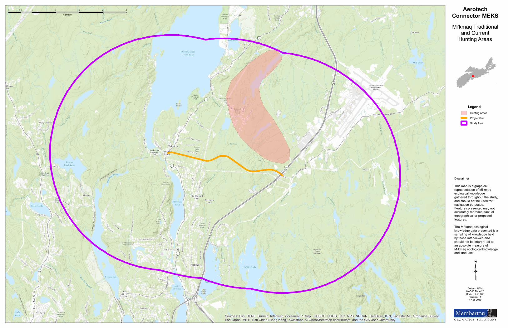
Sources: Esri, HERE, Garmin, Intermap, increment P Corp., GEBCO, USGS, FAO, NPS, NRCAN, GeoBase, IGN, Kadaster NL, Ordnance Survey,Esri Japan, METI, Esri China (Hong Kong), swisstopo, © OpenStreetMap contributors, and the GIS User Community
0 1 2 3 4 50.5Kilometers
AerotechConnector MEKSMi'kmaq Traditional
and CurrentHunting Areas
LegendHunting AreasProject SiteStudy Area
DisclaimerThis map is a graphicalrepresentation of Mi'kmaqecological knowledgegathered throughout the study,and should not be used fornavigation purposes.Features presented may notaccurately representaactualtopographical or proposedfeatures.The Mi'kmaq ecologicalknowledge data presented is asampling of knowledge heldby those interviewed andshould not be interpreted asan absolute measure ofMi'kmaq ecological knowledgeand land use.
Datum: UTMNAD83 Zone 20Scale: 1:50,000
Version: 11 Aug 2019
q

Map D Mi’kmaq Traditional and Current Gathering
Areas
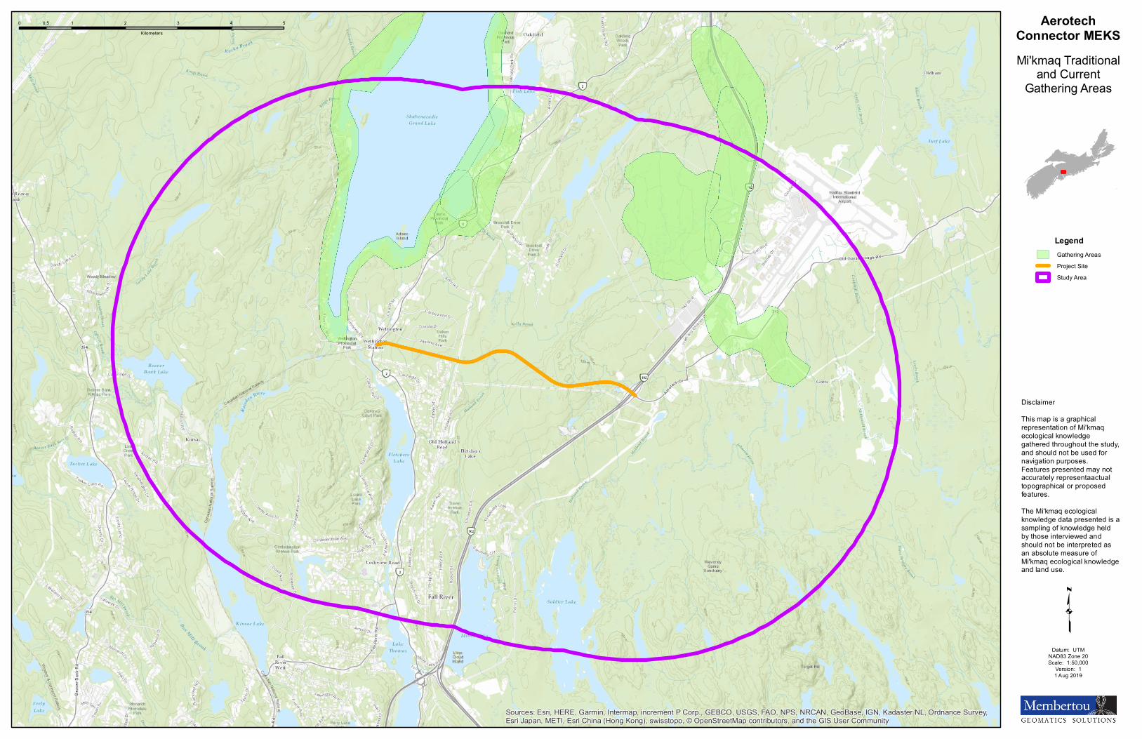
Sources: Esri, HERE, Garmin, Intermap, increment P Corp., GEBCO, USGS, FAO, NPS, NRCAN, GeoBase, IGN, Kadaster NL, Ordnance Survey,Esri Japan, METI, Esri China (Hong Kong), swisstopo, © OpenStreetMap contributors, and the GIS User Community
0 1 2 3 4 50.5Kilometers
AerotechConnector MEKSMi'kmaq Traditional
and CurrentGathering Areas
LegendGathering AreasProject SiteStudy Area
DisclaimerThis map is a graphicalrepresentation of Mi'kmaqecological knowledgegathered throughout the study,and should not be used fornavigation purposes.Features presented may notaccurately representaactualtopographical or proposedfeatures.The Mi'kmaq ecologicalknowledge data presented is asampling of knowledge heldby those interviewed andshould not be interpreted asan absolute measure ofMi'kmaq ecological knowledgeand land use.
Datum: UTMNAD83 Zone 20Scale: 1:50,000
Version: 11 Aug 2019
q