Embed Size (px)
Citation preview
Environment, Planning & Community Committee
Business Paper
17 August 2021
Maclean - 3.30 pm
Chair: Cr Andrew Baker
Members: Cr Jim Simmons
Cr Greg Clancy
Cr Debrah Novak
Cr Richie Williamson
Agenda
01 OPENING OF COMMITTEE MEETING
02 APOLOGIES
03 DISCLOSURE AND DECLARATIONS OF INTEREST
04 REPORTS Page Att.
Items for Decision 6b.21.057 DA2020/0536 – Dwelling (Including Minimum Lot Size Variation) – Back
Lane, Junction Hill (Being Lot 2 DP 816125) 1 Y
6b.21.058
9 Y
6b.21.059
18 Y + TBT
6b.21.060
25 N
6b.21.061
29 TBT
6b.21.062 Submission: Integrity of the NSW Biodiversity Offset Scheme 31 N
05 CONFIDENTIAL BUSINESS
06 LATE ITEMS OF BUSINESS
07 CLOSE OF COMMITTEE MEETING
95 Armidale Street, South GraftonDA2010/0592 Staged Multi-Unit Residential Development (21 Units) atRequest from Clarence Village Limited for S64 Funds Contribution forCouncil Owned Lots at Swan CreekProposed LEP Amendment to Correct Error in Land Descriptions for 3 Building and Lift Overrun, 56 Yamba Road, YambaMOD2021/0041 Modification of DA2019/0331 to Increase the Height of DA2021/0085 Industrial Shed, 61 Trenayr Road, Junction Hill

1
ITEM 6b.21.057 DA2020/0536 – DWELLING (INCLUDING MINIMUM LOT SIZE VARIATION) – BACK LANE, JUNCTION HILL (BEING LOT 2 DP 816125)
Meeting Environment, Planning & Community Committee 17 August 2021 Directorate Environment, Planning & Community Reviewed by Director - Environment & Planning (Adam Cameron) Attachment Yes
SUMMARY
Applicant Jim O’Donohue – O’Donohue Hanna & Associates Pty Ltd
Owner Renae Green
Address Back Lane, Junction Hill being Lot 2 DP 816125
Submissions Yes – 4 first notification period and nil second notification period
Development Application DA2020/0536 seeks approval to construct a dwelling on Lot 2 DP 816125 at the intersection of Back Lane and Pine Street, Junction Hill. The application was notified and advertised, 4 submissions were received during the first exhibition period and nil submissions were received during the second notification period. The applicant has sought approval for a variation under Clause 4.6 – exceptions to development standards of the Clarence Valley Local Environmental Plan 2011 to the minimum lot size for a dwelling. Due to the amount of public interest and the variation sought being greater than 10% is outside of Council staff delegations to determine; therefore the application is forwarded to Council to determine. The report provides an assessment of the application, a summary of the submissions and a recommendation for Council’s consideration. OFFICER RECOMMENDATION That Council: 1. Support the requested variation under Clause 4.6 – Exceptions to Development Standards of the
Clarence Valley Local Environmental Plan 2011 to enable the proposed dwelling to be constructed on a lot below the minimum lot size; and
2. Approve Development Application DA2020/0536 subject to the draft conditions and advices contained in Schedule 1 attached.
LINKAGE TO OUR COMMUNITY PLAN Theme 5 Leadership
Objective 5.1 We will have a strong, accountable and representative Government
Strategy 5.1.4 Ensure transparent and accountable decision making for our community
BACKGROUND Development Application DA2020/0536 was lodged on 14 September 2020 to apply for a concept Development Application (DA) at Back Lane, Junction Hill with Stage 1 establishing a building envelope and Stage 2 being a separate DA for the dwelling. The subject land is zoned RU1 Primary Production under the Clarence Valley Local Environmental Plan 2011 (the LEP). The application was advertised and notified between 7 October and 23 October 2020, 4 submissions were received. A dwelling is permissible with consent in the zone, however the lot does not have dwelling entitlement as it does not meet the minimum 40 hectare lot size required for the erection of a dwelling under Clause 4.2B of the Clarence Valley Local Environmental Plan 2011 (herein referred to as the LEP). The lot is approximately 2.6 hectares in area. The applicant seeks to vary Clause 4.2B using the Exceptions to Development Standards Clause 4.6 of the LEP to vary the minimum lot size from 40 hectares to 2.6 hectares. Council received advice from NSW Department of Planning, Industry and Environment that Clause 4.6 cannot be used for a concept DA and that concurrence would not be granted unless the applicant amended the DA to be for a dwelling. The applicant has sought a Clause 55 amendment to the existing application to now propose a dwelling and provided all necessary supporting information for a dwelling. Upon receipt of the

2
information the application was renotified to those that had made submissions between 6 July and 20 July, no submissions were received. KEY ISSUES 1. Clause 4.6 Variation to Clarence Valley Local Environmental Plan 2011 Lot 2 does not have dwelling eligibility by virtue of the size of the land. The land is in the RU1 zone which requires a minimum lot size of 40 hectares for the construction of a dwelling on the subject site. The land is 2.6 hectares. Clause 4.2B of the LEP states that development consent must not be granted for erection of a dwelling house on land unless the lot is: (a) a lot that is at least the minimum lot size specified for that land by the Lot Size Map, or (b) a lot created before this Plan commenced and on which the erection of a dwelling house or dual
occupancy was permissible immediately before that commencement, or (c) a lot resulting from a subdivision for which development consent (or equivalent) was granted before this
Plan commenced and on which the erection of a dwelling house or dual occupancy would have been permissible if the plan of subdivision had been registered before that commencement, or
(d) an existing holding, or (e) a lot created under clause 4.1A(4), or (f) a lot created following a boundary adjustment, but only if a dwelling house or dual occupancy could be
erected on the lot immediately before that boundary adjustment under paragraph (a), (b), (c), (d) or (e). The applicant has provided a written request to vary a development standard pursuant to Clause 4.6 of the LEP, that being the 40ha minimum lot size for a dwelling on the subject site under Clause 4.2B (3) (a). The objectives of Clause 4.6 are as follows: (a) to provide an appropriate degree of flexibility in applying certain development standards to particular
development, (b) to achieve better outcomes for and from development by allowing flexibility in particular circumstances.
Subclause 4.6 (3) requires that:
(3) Development consent must not be granted for development that contravenes a development standard
unless the consent authority has considered a written request from the applicant that seeks to justify the contravention of the development standard by demonstrating: (a) that compliance with the development standard is unreasonable or unnecessary in the
circumstances of the case, and (b) that there are sufficient environmental planning grounds to justify contravening the development
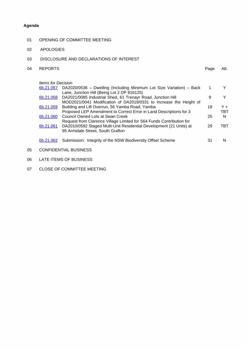
standard. The applicant has provided the following justification for Council to consider their request to vary the minimum lot size for a dwelling: - There are suitable areas to build on the lot above the 1 in 100 year flood height. - The proposed dwelling is in keeping with the locality and will utilise existing infrastructure therefore not
placing an unreasonable increase in demand. - The locality of the site means it will have limited impact on the natural environment. - The primary production and agricultural viability of the land has been compromised by the previous
subdivision of the land. - The proposal does not lead to fragmentation or alienation of resource lands. - Supporting a dwelling on the land will not result in land use conflict due to the existing land use and
subdivision pattern of the locality. - The proposal does not result in dispersal of the rural settlement given its proximity to Junction Hill, and - The erection of a dwelling will not be impacted by natural disasters. Comment In accordance with Clause 4.6(4)(a) of the LEP, Council staff consider that the written request adequately addressed the matters required to be considered under Clause 4.6(3). The applicant has demonstrated that the development standard is unreasonable or unnecessary in the circumstances, there are sufficient environmental planning grounds to justify contravening the development standard and no precedent will be set for the following reasons:
3
- The development site shares a boundary with the adjoining residential zone. - There is suitable road access and public utilities to adequately service the site and the development is
unlikely to result in an unreasonable demand for public services or facilities. - The size of the existing lot is considered too small to be agriculturally viable in its own right and will not
lead to rural land fragmentation. - The development is not inconsistent with the Clarence Valley Settlement Strategy in that the land adjoins
a residential zone which helps reinforce the identity of Junction Hill as a “vibrant and self reliant village”. - The development will result in the creation of a large residential lot for dwelling purposes which is
consistent and of an appropriate character to the surrounding area and subdivision patterns within the vicinity of the development.
- The location of the proposed dwelling is located on flood free land. - The development is not inconsistent with the objectives of the RU1 zone. - Concurrence from the Department of Planning, Industry and Environment has been given to vary Clause
4.6 of the LEP.
Figure 1 shows lot highlighted in red adjacent to rural residential land and proximity to Junction Hill village. The concurrence of the Department of Planning, Industry and Environment has also been granted in this instance under the provisions of Clause 4.6(4)(b) for the following reasons: 1. The proposal does not raise any matters of State or regional planning significance; and 2. There is minimal public benefit in maintaining the 40 hectare minimum lot size development standard given
the existing surrounding rural residential and rural lifestyle land uses. Therefore, it is recommended that a variation to the 40ha minimum lot size for the subject site be supported to allow the proposed dwelling on a 2.63ha lot. Alternatively, Council may opt to not support the requested variation. This will reinforce the status of the lot not having a building entitlement and would likely result in future Clause 4.6 variations not being supported. As previously stated above, the land is not of suitable size to support a viable agriculture entity. This option is not the officer recommendation.
4
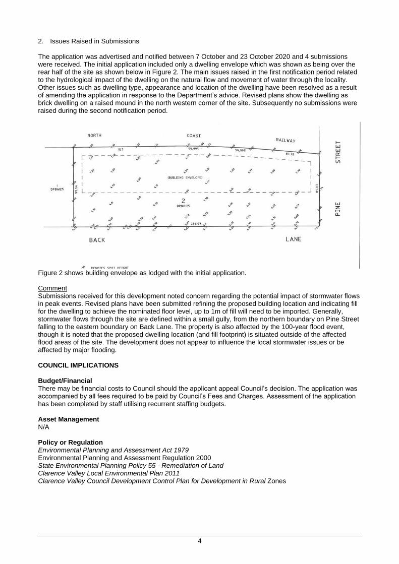
2. Issues Raised in Submissions The application was advertised and notified between 7 October and 23 October 2020 and 4 submissions were received. The initial application included only a dwelling envelope which was shown as being over the rear half of the site as shown below in Figure 2. The main issues raised in the first notification period related to the hydrological impact of the dwelling on the natural flow and movement of water through the locality. Other issues such as dwelling type, appearance and location of the dwelling have been resolved as a result of amending the application in response to the Department’s advice. Revised plans show the dwelling as brick dwelling on a raised mound in the north western corner of the site. Subsequently no submissions were raised during the second notification period.
Figure 2 shows building envelope as lodged with the initial application. Comment Submissions received for this development noted concern regarding the potential impact of stormwater flows in peak events. Revised plans have been submitted refining the proposed building location and indicating fill for the dwelling to achieve the nominated floor level, up to 1m of fill will need to be imported. Generally, stormwater flows through the site are defined within a small gully, from the northern boundary on Pine Street falling to the eastern boundary on Back Lane. The property is also affected by the 100-year flood event, though it is noted that the proposed dwelling location (and fill footprint) is situated outside of the affected flood areas of the site. The development does not appear to influence the local stormwater issues or be affected by major flooding. COUNCIL IMPLICATIONS Budget/Financial There may be financial costs to Council should the applicant appeal Council’s decision. The application was accompanied by all fees required to be paid by Council’s Fees and Charges. Assessment of the application has been completed by staff utilising recurrent staffing budgets. Asset Management N/A Policy or Regulation Environmental Planning and Assessment Act 1979 Environmental Planning and Assessment Regulation 2000 State Environmental Planning Policy 55 - Remediation of Land Clarence Valley Local Environmental Plan 2011 Clarence Valley Council Development Control Plan for Development in Rural Zones
5
Consultation The development application was referred externally to the NSW Department of Planning, Industry and Environment, concurrence has been issued for the proposal. The following sections of Council were consulted during the assessment of the application:
Internal Section or Staff Member Comment
Building Surveyor Supported subject to conditions
Development Engineer Supported subject to conditions
Legal and Risk Management Should the applicant be dissatisfied with Council’s decision, they have a right of appeal to the Land and Environment Court which may incur a financial cost to Council. Prior to any appeal submitted through the Court the applicant can seek a review of Council’s determination in accordance with the provisions of the Environmental Planning and Assessment Act 1979. Climate Change The proposed development would contribute to CO2-equivalent emissions through construction and operation which are considered to be a driver for climate change via building materials, construction methods, maintenance and associated energy and resource use. Notwithstanding the above comments, if the development is approved, the proposed building is required to comply with the energy efficiency requirements of the Building Code of Australia (BCA) and the NSW Building and Sustainability Index (BASIX) which will ensure that the development meets legislative requirements for sustainability.
Prepared by James Hamilton
Attachment A. Proposed Plans B. Submissions C. Section 4.15 Assessment.
6
Schedule 1 Draft Advices and Conditions of Consent for DA2020/0536
Advices 1. The House Number 85 Pine Street, Junction Hill has been allocated to the premises and shall be
clearly displayed so it is visible from the road. Such action can reduce confusion and assist Australia Post, emergency services and the general community. Approval for the site and size of proposed householder mail boxes should be obtained from Australia Post.
2. Prior to building work commencing approval under Section 68 of the Local Government Act shall be
obtained from Council for sewerage work, water plumbing and stormwater work. Two copies of hydraulic plans to AS 3500 detailing the size and location of water, sewer, stormwater and fire services shall be submitted to Council for approval.
3. The following approvals are required for this development and are to be issued by Council and/or
accredited private certifier as applicable to the development. a Roads Act 1993 Sections 138 & 139 – approval for works on a road issued by Council Application to Council for public and/or private property works requires payment in accordance with
the Council’s adopted ‘Fees and Charges’. The application form may be downloaded from Council’s website.
4. Any activity to be carried out on any part of the road reservation requires the prior approval of
Council under the NSW Roads Act 1993. 5. No construction is to be commenced until a Construction Certificate has been issued.
6. Due to the proposed development creating a dwelling entitlement where there was previously no
opportunity to build a dwelling, developer contributions are applicable. Conditions 1. The development being completed in conformity with the Environmental Planning & Assessment
Act, 1979, the Regulations thereunder, the Building Code of Australia (BCA) and being generally in accordance with the following plan(s) as amended in red, or where modified by any conditions of this consent.
Plan Title Drawn by Plan Date Sheet No
Plan Showing Levels, Drainage & Proposed Building Envelope and Dwelling
O’Donohue Hanna & Associates Pty Ltd
2/12/2020 1
Site Plan PJ Dougherty 21/08/2020 2
Floor Plan PJ Dougherty 21/08/2020 3
Elevations PJ Dougherty 21/08/2020 4
2. Payment to Council of the contributions pursuant to Section 7.11 of the Environmental Planning
and Assessment Act: Clarence Valley Contribution Plan 2011 Open Space/Recreation Facilities Grafton and surrounds $3,869.35 x 1 additional dwelling = $3,869.35 GL S94CVCOSGrafton Clarence Valley Contributions Plan 2011 Community Facilities Grafton and surrounds $3,869.35 x 1 additional dwelling = $3,869.35 GL S94CVCCFGrafton Clarence Valley Contributions Plan 2011 Plan of Management Rate per Dwelling/Lot $74.10 x 1 additional dwelling = $74.10 GL S94CVCPoMDwell Roads and Traffic Facilities Contribution Plan 2001 All other development $4,079.44 x 1 additional dwelling = $4,079.44 GL S94 RdsCopmanT1-14 N.B. The contribution(s) as assessed will apply for 12 months from the date of this approval.
7
Contributions not received by Council within 12 months of the date of this notice will be adjusted in accordance with the adopted Schedule of Fees and Charges current at the time of payment.
The contributions are to be paid to Council prior to issue of the Building Construction Certificate. In the event of any subsequent amendment to the approved Development Plans, the calculated
contribution amounts may vary and if so will become the contribution payable. All contribution plans are available for inspection at Clarence Valley Council Offices, 50 River
Street, Maclean and 2 Prince Street, Grafton. 3. Prior to the issue of an Occupation Certificate all requirements listed in the relevant Basix
Certificate for this development shall be completed/installed. 4. A vehicular crossing to provide access to the allotment as detailed on the approved plans is to be
constructed in accordance with the requirements of Council’s Operations Section and be fully completed prior to requesting a final inspection and the issue of an Occupation Certificate. An application for driveway access crossing is to be submitted and approved by Council prior to any work commencing.
5. Roof water, including overflow from a tank, shall be discharged a minimum of 3m clear of
buildings, boundaries and downhill or clear of any effluent disposal area so as not to cause a nuisance.
6. To meet Council’s floodplain development controls the dwelling floor level shall be a minimum of
7.06m Australian Height Datum (AHD), being 500mm above the 1:100 year flood level for the site which is 6.56m AHD
7. Any fill earthworks to be undertaken on the site must be carried out in accordance with the
placement and compaction of fill described in AS 3798, Level 1 inspection and testing and NRDC. 8. Erosion and Sediment Control is to be implemented in accordance with the relevant parts of the
applicable Council Development Control Plans, ‘NSW Managing Urban Stormwater - Soils and Construction (Blue Book)’ and NRDC. These controls are to be maintained and managed by the applicant and/or the appointed contractor until an Occupation Certificate is issued.
9. Due to the close proximity to the rail corridor it is recommended the dwelling be constructed to
reduce noise and vibration from trains passing, details are to be submitted prior to issue of the Building Construction Certificate to demonstrate how this will be achieved.
10. An On-Site Wastewater Management application is to be submitted to issue of the Building
Construction Certificate. 11. Working/Construction Hours Working hours on construction or demolition shall be limited to the
following: 7.00 am to 6.00 pm Monday to Friday 8.00 am to 1.00 pm Saturdays No work permitted on Sundays and public holidays The builder is responsible to instruct and control sub contractors regarding the hours of work and
the requirements of the Protection of the Environment Operations Act 1997 and Regulations. 12. Imported fill shall not come from a contaminated source. Any imported fill shall be free of building
and other demolition waste and only contain virgin excavated natural material (VENM) as defined in Part 3 of Schedule 1 of the Protection of the Environment Operations Act 1997, excavated natural material or the relevant waste resource recovery exemption from the NSW Environment Protection Authority (EPA). Written details of the source of fill shall be submitted to Council prior to fill being imported to the site.
13. The development is not to be occupied or used until such time as an Occupation Certificate has
been issued.
8
14. The developer must bear any costs relating to alterations and extensions of existing roads, drainage and services for the purposes of the development.
15. Prior to commencement of works, a sign must be erected in a prominent position on any work site
on which work is being carried out: a Stating that unauthorised entry to the work site is prohibited; b Showing the name of the person in charge of the work site and a telephone number at which
that person may be contacted outside of working hours, and c Showing the name, address and telephone number of the principal certifier for the work. Any such sign is to be removed when the work has been completed.
16. Site Safety Management Building equipment and/or materials shall be contained wholly within
the site and shall not be stored or operated on the footpath or roadway, unless specific written approval has been obtained from Council beforehand.
All excavations and back filling associated with the erection and demolition of a building must be
executed safely and in accordance with appropriate professional standards and must be properly guarded and protected to prevent them from being dangerous to life or property.

9
ITEM 6b.21.058 DA2021/0085 INDUSTRIAL SHED, 61 TRENAYR ROAD, JUNCTION HILL
Meeting Environment, Planning & Community Committee 17 August 2021 Directorate Environment, Planning & Community Reviewed by Director - Environment & Planning (Adam Cameron) Attachment Yes
SUMMARY
Applicant Big River Group Pty Ltd
Owner Big River Group Pty Ltd
Address 61 Trenayr Road, Junction Hill
Submissions Yes - 2
Big River Group Pty Ltd (BRG) seeks approval for an industrial shed 42m x 24.5m shed with a 36.6 x 15.5m awning at the Big River Timber site in Junction Hill. The shed will be an extension/refurbishment to the building that sustained fire damage in 2014. The new building will reinstate some of the previous operations for wood and timber milling and relocate other operations to be undercover. During the assessment of the application Council requested a noise assessment report which has been provided. The outcomes of the report and issues raised in submissions are discussed in this report and a recommendation is provided for Council’s consideration. OFFICER RECOMMENDATION That DA2021/0085 be approved subject to the imposition of conditions contained in Schedule 1.
LINKAGE TO OUR COMMUNITY PLAN Theme 5 Leadership
Objective 5.1 We will have a strong, accountable and representative Government
Strategy 5.1.4 Ensure transparent and accountable decision making for our community
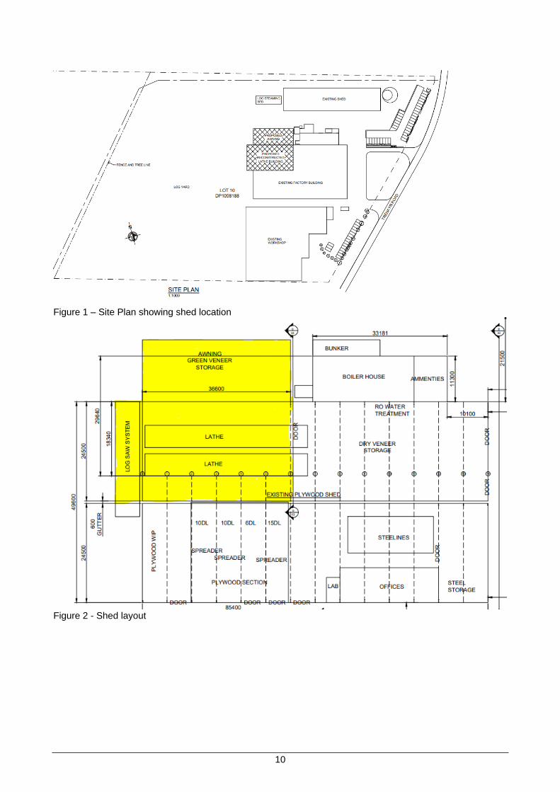
BACKGROUND Timber milling/processing has been undertaken on the site which was established in the early 1900s as a family owned timber business. Today, it has advanced and established a position as a major Australian building materials distributor, supplying an extensive range of plywood and specialty timber products for the residential, commercial, industrial, building and construction industries. The proposal is to reconstruct a shed and awning that will house timber processing operations at the BRG including buildings that were destroyed by fire in 2014. The old shed has since been demolished and removed. The shed is to be constructed over a similar footprint of the previous fire damaged shed and will be a 42m x 24.5m shed with a 36.6 x 15.5m awning, it will have a height of just over 7.1m at its highest point. A veneer peeling lathe, veneer drier, plywood hot presses and sanders will be installed in the shed. It is noted that if timber processing was for more than 50,000 cubic metres of timber per year ,the activities would be declared to be a scheduled activity requiring the premises to be licenced with the Environmental Protection Authority (EPA). The applicant has submitted that the production will only be increasing to approximately 70% of pre-fire output levels. The site previously employed 110 Staff and it is predicted that there will be an increase by 20 staff to a total of 70 at the site within 3 years.
10
Figure 1 – Site Plan showing shed location
Figure 2 - Shed layout
11
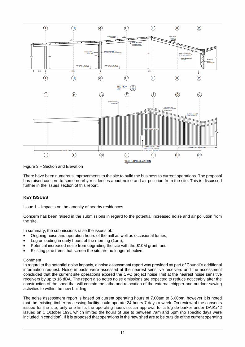
Figure 3 – Section and Elevation There have been numerous improvements to the site to build the business to current operations. The proposal has raised concern to some nearby residences about noise and air pollution from the site. This is discussed further in the issues section of this report.
KEY ISSUES Issue 1 – Impacts on the amenity of nearby residences. Concern has been raised in the submissions in regard to the potential increased noise and air pollution from the site. In summary, the submissions raise the issues of:
• Ongoing noise and operation hours of the mill as well as occasional fumes,
• Log unloading in early hours of the morning (1am),
• Potential increased noise from upgrading the site with the $10M grant, and
• Existing pine trees that screen the site are no longer effective. Comment In regard to the potential noise impacts, a noise assessment report was provided as part of Council’s additional information request. Noise impacts were assessed at the nearest sensitive receivers and the assessment concluded that the current site operations exceed the CVC project noise limit at the nearest noise sensitive receivers by up to 16 dBA. The report also notes noise emissions are expected to reduce noticeably after the construction of the shed that will contain the lathe and relocation of the external chipper and outdoor sawing activities to within the new building. The noise assessment report is based on current operating hours of 7.00am to 6.00pm, however it is noted that the existing timber processing facility could operate 24 hours 7 days a week. On review of the consents issued for the site, only one limits the operating hours i.e. an approval for a log de-barker under DA91/42 issued on 1 October 1991 which limited the hours of use to between 7am and 5pm (no specific days were included in condition). If it is proposed that operations in the new shed are to be outside of the current operating

12
hours, Council should place restrictions that mitigate potential noise impacts from the shed to meet with current industry standards. The Noise Assessment report also recommends that further assessment of mitigation treatments to the existing operations (other than the new shed). While this recommendation is supported by staff, requiring this under this development application would likely be outside of Council’s ability to reasonably impose this, as conditions of consent need to fairly and reasonably relate to the development being determined. It is proposed that conditions of consent be imposed in regard to the potential amenity impacts from the use of the shed only. Appropriate conditions of consent are in the Schedule of Draft Advices and Conditions. The NSW Noise Policy for Industry (NPfI) was released in 2017 and sets out the requirements for the assessment and management of operational noise from industry in NSW. Local Government is an independent regulator for noise under NSW legislation and has discretion for dealing with noise. Clause 6.1.1 of the NPfI states that where noise levels are exceeded for existing sites, Council can assess feasible and reasonable noise mitigation strategies. Staff consider that limiting the hours of operation in line with the NPfI, unless suitable noise mitigation can be achieved in accordance with the Policy, for the new shed only, and requesting improved noise attenuation on the construction standards of the shed to be reasonable noise mitigation measures to improve the amenity of existing residents. This requirement is reflected in Condition 5 of the Draft Schedule of Advices and Conditions. It is proposed that the application be conditioned in line with the conclusions of the noise assessment:
• The industrial shed to be used only between the DAY period of 7.00am and 6.00pm Monday to Saturday unless suitable noise mitigation can be achieved in accordance with the NSW Noise Policy for Industry for EVENING: 6.00pm to 10.00pm and NIGHT: 10.00pm to 7.00am periods. This is to be verified by a Noise Management Plan prepared by a suitably qualified acoustic consultant,
• Submission to Council of noise mitigation measures and acoustic design and construction of the new shed,
• The approval does not increase production/output rates to that already approved,
• For any part of the site that comes under the jurisdiction of another government department, a Controlled Activity approval or license (or similar approval). Any such approval must be obtained and provided to Council,
• Replace the existing aged vegetation screening with new plantings with details to be submitted to Council for approval.
It should be noted that the NPfi differentiates time periods and recommends noise levels:
• DAY: 7.00am to 6.00pm Monday to Saturday; 8.00am to 6.00pm Sundays and Public Holidays
• EVENING: 6.00pm to 10.00pm
• NIGHT: The remaining periods (10.00pm to 7.00am) In regard to air pollution the applicant has submitted that trade waste and operations will continue to be managed in the same way, with all timber waste recycled at the facility through the wood fired co-generation plant. Best practice procedures are recommended for the processing facility in that any potential offensive odours be managed within the current NSW environmental guidelines. It is noted that an Environmental Management Plan was undertaken for the site in 2009 in consultation with Clarence Valley Council and the Environmental Protection Authority. It is proposed that an advice be included recommending that an updated Environmental Management Plan be prepared for the BRG operations at the Junction Hill site to ensure that the site operations comply with relevant State legislation and regulations and that environmental risks are managed appropriately. The options for Council are: 1. Approve the application and require the applicant to meet the NSW Noise Policy for Industry standards
in regard to the operation of the new shed by providing improved noise attenuation measures and limit the hours of operation to reasonable time periods to protect the amenity of nearby residential area,
2. Approve the application and not require the applicant to attenuate noise impacts and meet with NSW Noise Policy for Industry standards for the new shed, accepting that operations at the site already exceed the noise standards and that the shed will likely reduce noise emissions from the site,
3. Refuse the application with valid reasons. Option 1 is the preferred option.
13
COUNCIL IMPLICATIONS Budget/Financial N/A Asset Management N/A Policy or Regulation • Environmental Planning and Assessment Act 1979 • Environmental Planning and Assessment Regulation 2000 • Clarence Valley Local Environmental Plan 2011 Consultation
Internal Section or Staff Member Comment
Engineering Supported with conditions
Health & Building Supported with conditions
Environmental Health Supported with conditions
Legal and Risk Management Should the applicant be dissatisfied with Council’s decision, they have a right of appeal to the Land and Environment Court which may incur a financial cost to Council. Prior to any appeal submitted through the Court the applicant can seek a review of Council’s determination in accordance with the provisions of the Environmental Planning and Assessment Act 1979. Climate Change Obligations are on the applicant in regards to the proposal to reduce greenhouse gas emissions, energy efficiency and reduce potable water consumption. Compliance that these commitments have been met will be through best practice management.
Prepared by Pat Ridgway
Attachment A. Plans B. Noise assessment report C. Submissions D. Section 4.15 Assessment Report
14
Schedule 1 – Draft advices and Conditions Advices 1. No construction is to be commenced until a Construction Certificate has been issued. 2. The building exceeds the maximum fire compartment size in Clause C2.2 of the National
Construction Code (i.e. 2000m2 or 12,000m3). Written details of how the building will comply with Clause C2.3 of the NCC for a large isolated building shall be submitted with the construction certificate application. Details shall include the floor area and volume of each building, provision of an 18m wide open space around the building/group of buildings that is not used for storage or processing of materials and how vehicular access will be provided for emergency vehicles to travel in a forward direction around the entire building/group of buildings.
3. A fire hydrant and hose reel system complying with AS2419.1 and Part E1 of the National
Construction Code (NCC) shall be installed/extended to serve the new building. Hydraulic details shall be submitted with the construction certificate application.
4. Emergency lighting and exit signs shall be provided as per the National Construction Code (NCC)
with plans submitted with the construction certificate application detailing their location. 5. Pedestrian egress doors are to be provided so that no point on the floor of the building is more
than 20m from an exit, or a point from which travel in different directions to two exits is available, in which case the maximum distance to one of those exits must not exceed 40m. The plans submitted with the construction certificate application shall detail the location of exit doors.
6. The energy efficiency requirements in Section J of the NCC apply to this building. All artificial
lighting shall be fluorescent or LED to comply with Section J. 7. Access to the building for disabled persons shall be provided and constructed in accordance with
the requirements of Part D3 of the Building Code of Australia and AS 1428.1-2009. 8. It is recommended that an updated Environmental Management Plan be prepared with
consultation with Clarence Valley Council and the Environmental Protection Authority for the Big River Group Pty Ltd operations at the Junction Hill Site to ensure that the site operations comply with relevant State legislation and regulations and that environmental risks are managed appropriately
CONDITIONS: 1. The development being completed in conformity with the Environmental Planning & Assessment
Act, 1979, the Regulations thereunder, the Building Code of Australia (BCA) and being generally in accordance with the following plan(s) as amended in red, or where modified by any conditions of this consent.
Drawing Drawn by Dated Sheets Rev. Grafton Site Factory Layout Big River 01/12/2020 1/1 A Fire Damage & Site Plan McKenzie Burridge &
Associates Pty Ltd January 2021 01 -
Floor Plan McKenzie Burridge & Associates Pty Ltd
January 2021 02 -
Section & Elevations McKenzie Burridge & Associates Pty Ltd
January 2021 01 -
2. Payment to Council of the contributions pursuant to Section 7.12 of the Environmental Planning
and Assessment Act: $15,000.00 GL S94ACVCOthResAcco This amount is based on the following calculation: A Proposed cost of carrying out the development is more than $200,000 = value of
development x 0.01 B The value of development stated in the application was $1,500,000.00
15
The contributions are to be paid to Council prior to release of the Construction Certificate. All contribution plans are available for inspection at Clarence Valley Council Offices, 50 River Street, Maclean and 2 Prince Street, Grafton.
In the event of any subsequent amendment to the approved Development Plans, the calculated
contribution amounts may vary, and if so will become the contribution payable. A true estimate of the value of development must be provided when application is made for the Construction Certificate.
Environmental
3. Noise associated with activities inside the shed is to comply with the EPA Noise Policy for Industry 2017 (NPfI) and project noise trigger levels provided in section 3.2 of the BRG Grafton Timber Mill Noise Assessment for DA Purposes 2021 (noise assessment).
4. Fast shutting roller doors are to be installed to minimise noise impacts on nearby receivers when
the lathe is in use.
5. Shed operating hours and any deliveries for works associated with the shed, are to be limited to 7am to 6pm Monday to Saturday. No work is permitted on Sundays and Public Holidays unless suitable noise mitigation can be achieved in accordance with the NSW Noise Policy for Industry for EVENING: 6.00pm to 10.00pm and NIGHT: 10.00pm to 7.00am periods. This is to be verified by a Noise Management Plan prepared by a suitably qualified acoustic consultant and submitted to Council for endorsement.
6. A Noise Management Plan must be prepared by a suitably qualified acoustic practitioner with
reference to the conditions of consent and submitted to Council for approval prior to operation of the shed. The plan must detail the methods that will be implemented for the operations associated with the shed to minimise noise impacts on the nearest affected dwellings. Information should include but is not limited to:
a) Identification of nearby residences and other sensitive land uses. b) Hours of operation. c) Project noise trigger levels. d) Detailed examination of all feasible and reasonable management practices that will be
implemented to minimise noise impacts with reference to section 3.4 of the NPfI and section 5.2 of the noise assessment.
e) Strategies to promptly deal with and address noise complaints. This should include any records that should be kept in receiving and responding to noise complaints.
f) Name and qualifications of person who prepared the report.
The shed and associated activities must be managed and operated in accordance with the approved plan. All staff must be inducted to the plan and a copy must be available on the premise at all times.
7. Independent noise monitoring by a suitably qualified acoustic practitioner is to be undertaken within six months of operation of the shed and associated activities. An operational noise monitoring report is to be provided to Council to determine actual project noise levels. Recommendations for additional noise mitigation measures is to be included in this report should the results be non-compliant with the NPfI and project noise trigger levels provided in section 3.2 of the noise assessment.
8. Any wastewater discharge to sewer associated with the development is subject to a trade waste
agreement. 9. The existing vegetative buffer must be enhanced with additional suitable plantings to provide
additional screening between the development and adjoining residential land. A landscape plan prepared by a person competent in the field is to be submitted to Council for approval prior to the issue of a Construction Certificate. The plan shall indicate the mature height, location, quantity and species of all plantings and shall provide details of soil conditions, the planting method and maintenance program.

16
10. Prior to issue of the Construction Certificate, details of noise mitigation measures and acoustic design of the new shed must be submitted to Council for approval.
Building 11. The development is not to be occupied or used until such time as an Occupation Certificate has
been issued. 12.
Working/Construction Hours - Working hours on construction or demolition shall be limited to the following: 7.00 am to 6.00 pm 6 days per week
No work permitted on Sundays and public holidays
The builder is responsible to instruct and control sub contractors regarding the hours of work and the requirements of the Protection of the Environment Operations Act 1997 and Regulations.
13. Site Safety Management Building equipment and/or materials shall be contained wholly within the site and shall not be stored or operated on the footpath or roadway, unless specific written approval has been obtained from Council beforehand.
All excavations and back filling associated with the erection and demolition of a building must be
executed safely and in accordance with appropriate professional standards and must be properly guarded and protected to prevent them from being dangerous to life or property.
14. Prior to commencement of works, a sign must be erected in a prominent position on any work site
on which work is being carried out: A Stating that unauthorised entry to the work site is prohibited, and B Showing the name of the person in charge of the work site and a telephone number at
which that person may be contacted outside of working hours, and C Showing the name, address and telephone number of the principal certifying authority for
the work, and Any such sign is to be removed when the work has been completed. 15. Any new vehicular crossing to provide access to the allotment is to be constructed in accordance
with the requirements of Council’s Operations Section. An application for driveway access crossing is to be submitted and approved by Council prior to any work commencing.
16. The building work involving the installation, modification or extension of a relevant fire safety
system cannot commence unless: A plans have been submitted to Council as the principal certifying authority that show: i in the case of building work involving the installation of the relevant fire safety
system—the layout, extent and location of key components of the relevant fire safety system, or
ii (ii) in the case of building work involving the modification or extension of the relevant fire safety system—the layout, extent and location of any new or modified components of the relevant fire safety system, and
B specifications have been submitted to Council as the principal certifying authority that: i describe the basis for design, installation and construction of the relevant fire safety
system, and ii identify the provisions of the Building Code of Australia upon which the design of the
system is based, and C those plans and specifications: i have been certified by a compliance certificate referred to in 6.4 of the Act as
complying with the relevant provisions of the Building Code of Australia, or ii have been endorsed by a competent fire safety practitioner as complying with the
relevant provisions of the Building Code of Australia.

17
relevant fire safety system means any of the following: A a hydraulic fire safety system including: i a fire hydrant system (including street hydrants) or ii a fire hose reel system, or iii a sprinkler system (including a wall-wetting sprinkler or drencher system), or iv any type of automatic fire suppression system of a hydraulic nature, B a fire detection and alarm system, C a mechanical ducted smoke control system. The principal contractor for building work must ensure that the most recently endorsed copy of the
plans and specifications for any relevant fire safety system for the building that were required to be submitted to the principal certifying authority:
A are kept on the site of the building work, and B are made available for inspection on request by the certifying authority, consent authority,
Council and Fire and Rescue NSW at the times during which the building work is carried out.
17. The waste management plan submitted with this application shall be complied with during
demolition/construction work and all measures required for the ongoing use of waste management facilities in the development shall be in place prior to the issue of the Occupation Certificate.

18
ITEM 6b.21.059 MOD2021/0041 MODIFICATION OF DA2019/0331 TO INCREASE THE HEIGHT OF BUILDING AND LIFT OVERRUN, 56 YAMBA ROAD, YAMBA
Meeting Environment, Planning & Community Committee 17 August 2021 Directorate Environment, Planning & Community Reviewed by Director - Environment & Planning (Adam Cameron) Attachment Yes plus To be tabled Attachment
SUMMARY
Applicant GCB Constructions Pty Ltd
Owner The Uniting Church in Australia Property Trust (NSW)
Address 56 Yamba Road, Yamba
Submissions Yes 4
Council at its meeting of 22 October 2019 (Item 6b.19.034) approved 50 independent seniors’ living apartments that front Yamba Road and approved a variation to the 9 metre maximum building height prescribed by clause 4.3 of the Height of Buildings Map in the Clarence Valley Local Environmental Plan 2011 and an 8 metre maximum height specified in State Environmental Planning Policy (Housing for Seniors or People with a disability) 2004. Further changes to the overall building height have now been determined as a result of the finalisation of the detailed design process and are necessary to achieve compliance with the conditions of approval and other relevant standards. The result will be a marginal increase in height given that the roof pitch needs to be amended to meet the required outcomes. The overall increase in height equates to between approximately 25cm (250mm) and approximately 33cm (330mm). This report provides an assessment of the application including an application for a minor variation to the maximum height requirement, discusses the issues raised in the submissions and a provides a recommendation for Council’s consideration. OFFICER RECOMMENDATION That after consideration of the modification application MOD2021/0041 and clause 4.6 of the Clarence Valley Local Environmental Plan 2011 (CVLEP) Council approve a further minor variation to the 9 metre maximum building height prescribed by clause 4.3 of the Height of Buildings Map in the CVLEP and 8 metre maximum height specified in State Environmental Planning Policy (Housing for Seniors or People with a disability) 2004 as proposed by the applicant.
LINKAGE TO OUR COMMUNITY PLAN Theme 5 Leadership
Objective 5.1 We will have a strong, accountable and representative Government
Strategy 5.1.4 Ensure transparent and accountable decision making for our community
BACKGROUND Development Application DA2019/0331 was approved by Council at its meeting of 22 October 2019 for 50 independent seniors’ living apartments fronting Yamba Road and adjacent to the existing Caroona aged care facility off Freeburn Street, Yamba. In determining DA2019/0331, a variation to the 9m height limit specified in the Clarence Valley Local Environmental Plan 2011 (the LEP) and 8m Height Limit specified in State Environmental Planning Policy (Housing for Senior or People with a Disability) (SEPP Seniors Housing) under Clause 4.6 of the LEP was also approved. Caroona is owned by The Uniting Church in Australian Property Trust which is a registered social housing provider. The proposal will have car parking at ground level and 50 apartments on the above three levels consisting of 32 x 2 bedroom units, 4 x 3 bedroom units and 12 x 1 bedroom units.
19
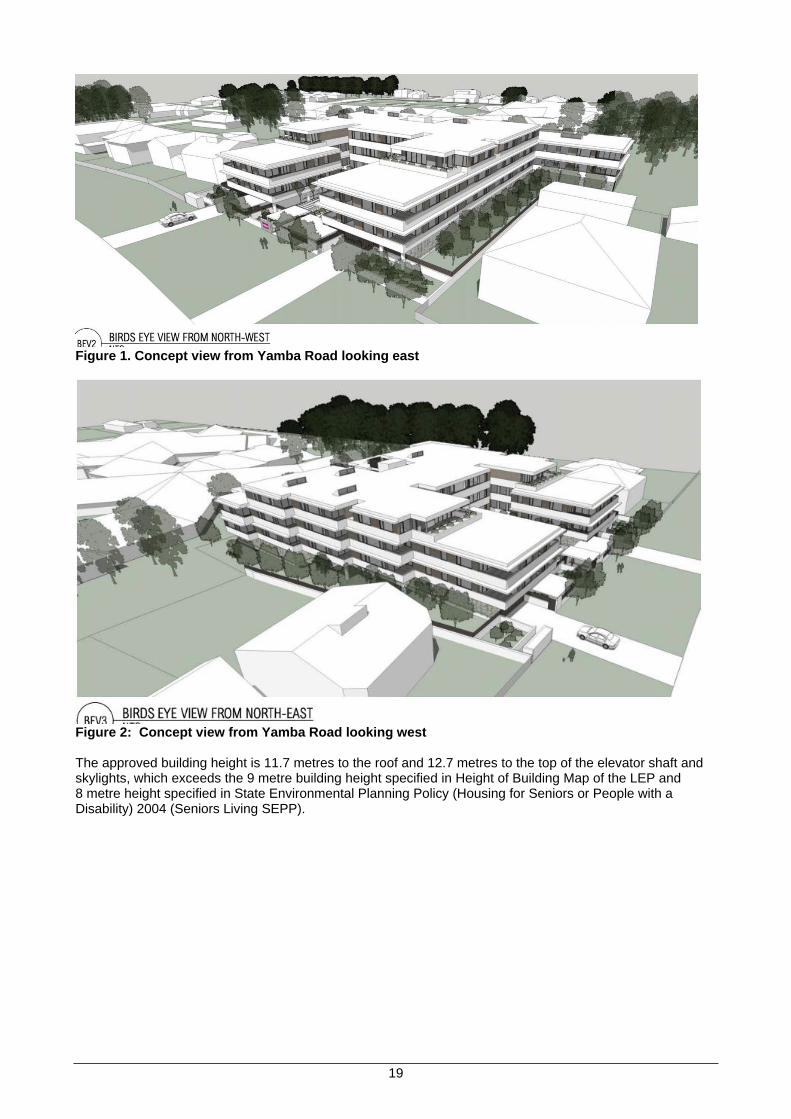
Figure 1. Concept view from Yamba Road looking east
Figure 2: Concept view from Yamba Road looking west The approved building height is 11.7 metres to the roof and 12.7 metres to the top of the elevator shaft and skylights, which exceeds the 9 metre building height specified in Height of Building Map of the LEP and 8 metre height specified in State Environmental Planning Policy (Housing for Seniors or People with a Disability) 2004 (Seniors Living SEPP).
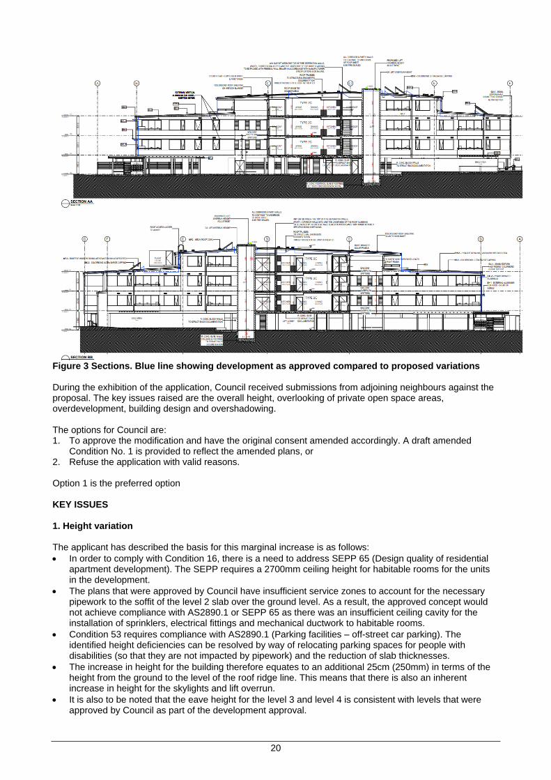
20
Figure 3 Sections. Blue line showing development as approved compared to proposed variations During the exhibition of the application, Council received submissions from adjoining neighbours against the proposal. The key issues raised are the overall height, overlooking of private open space areas, overdevelopment, building design and overshadowing. The options for Council are: 1. To approve the modification and have the original consent amended accordingly. A draft amended
Condition No. 1 is provided to reflect the amended plans, or 2. Refuse the application with valid reasons. Option 1 is the preferred option KEY ISSUES 1. Height variation The applicant has described the basis for this marginal increase is as follows:
• In order to comply with Condition 16, there is a need to address SEPP 65 (Design quality of residential apartment development). The SEPP requires a 2700mm ceiling height for habitable rooms for the units in the development.
• The plans that were approved by Council have insufficient service zones to account for the necessary pipework to the soffit of the level 2 slab over the ground level. As a result, the approved concept would not achieve compliance with AS2890.1 or SEPP 65 as there was an insufficient ceiling cavity for the installation of sprinklers, electrical fittings and mechanical ductwork to habitable rooms.
• Condition 53 requires compliance with AS2890.1 (Parking facilities – off-street car parking). The identified height deficiencies can be resolved by way of relocating parking spaces for people with disabilities (so that they are not impacted by pipework) and the reduction of slab thicknesses.
• The increase in height for the building therefore equates to an additional 25cm (250mm) in terms of the height from the ground to the level of the roof ridge line. This means that there is also an inherent increase in height for the skylights and lift overrun.
• It is also to be noted that the eave height for the level 3 and level 4 is consistent with levels that were approved by Council as part of the development approval.

21
• The extent of the lift overrun depicted on the approval plans means that ultimately it did not meet industry standards for servicing. Through on-going liaisons with various suppliers, the applicant has been able to ensure that a lift can be installed such that the lift overrun increases in height by 33cm (330mm) rather than the more standard 70cm (700mm). The overall height of the lift overrun will be 14.83m (up from 14.5m as originally approved).
• The overall increase in height for the building of 25cm generally and 33cm at the lift shaft overrun is considered to be insignificant in that it will not be readily visible or prominent. It is noted that the skylights will be the highest point of the building (and not the lift shaft). The increase in height also ensures that various design standards can be appropriately achieved.
• Updated shadow diagrams have been prepared to demonstrate that the marginal increase in the building height does not adversely impact on the surrounding area.
Comment The applicant has demonstrated that the development as modified will remain substantially the same as the development which was granted consent. The proposed minor changes meet the requirements outlined in both section 4.55(1A) and 4.15(1) of the Act. The marginal increase in building height has been necessitated by the requirement to achieve compliance with Condition 16 and 53 of the development approval. Under DA2019/0331 Council has already granted development consent for the development that contravened a development standard as per Clause 4.6 of the Clarence Valley Local Environmental Plan 2011. The NSW Department of Planning Circular PS 08-003 dated 9 May 2008, states that Council can assume the Director-General’s concurrence where an environmental planning instrument has adopted clause 4.6 of the Standard Instrument. Council can be satisfied that it has delegation to vary the height requirement and that there are sufficient grounds to justify the further minor contravention to the development standard. 2. Issues raised in submissions A. Overlooking into their yard, loss of winter sunlight, visual impacts, and further 450mm shift closer to
boundary (reduced setback) and based on the impacts generated to the application is not substantially the same to that approved. The applicant should rectify the design issues and change should be made within the existing footprint already approved without impaction further on their amenity.
Comment In regard to overlooking and visual impacts, if the proposed modification is not approved this will not alleviate the neighbours concerns. By comparison to the building that has been approved on the site there will be no changes to the building layout and design other than a minor raising of the roof and slight increase to the roof pitch. The proposal as approved provides side setbacks of greater than 5 metres which allows for large landscape and tree planting areas to reduce potential overlooking and appearance of the apartments. Under the Residential Zones DCP setbacks are required to meet the following objectives:
• sufficient separation of buildings to provide privacy and sunlight access for neighbouring dwellings,
• buildings setback from the street to provide adequate space for landscaping, privacy and an attractive streetscape.
• a design that reduces the apparent bulk of the new buildings. By comparison Council’s Residential Development Control Plan (DCP) allows for a 1.5m setback to a 9m high building and a 3m setback for a 12m high building; i.e. as the height of a building increases the side and rear setbacks are also to be increased, the building as approved is considered to have an appropriate proportional setback.
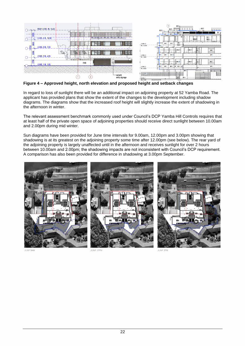
22
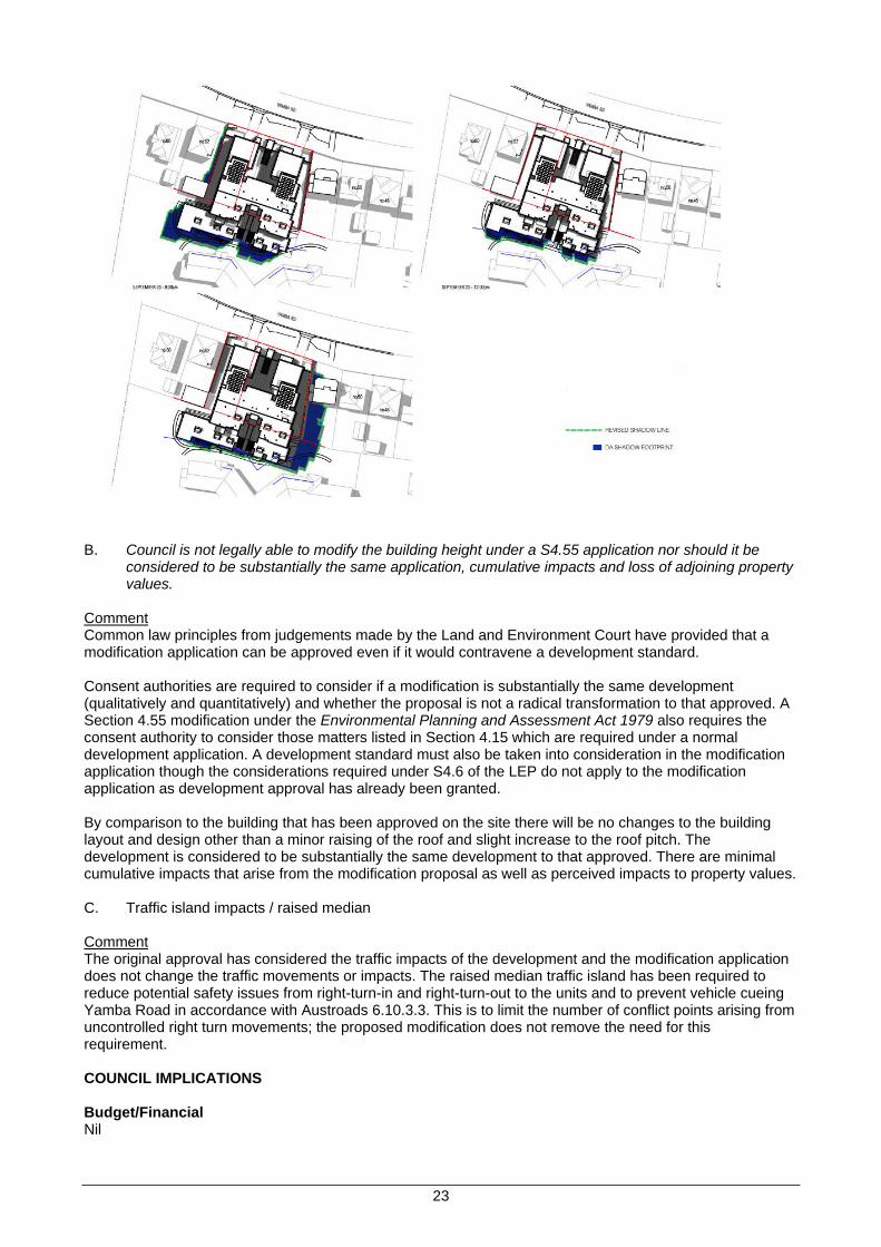
Figure 4 – Approved height, north elevation and proposed height and setback changes In regard to loss of sunlight there will be an additional impact on adjoining property at 52 Yamba Road. The applicant has provided plans that show the extent of the changes to the development including shadow diagrams. The diagrams show that the increased roof height will slightly increase the extent of shadowing in the afternoon in winter. The relevant assessment benchmark commonly used under Council’s DCP Yamba Hill Controls requires that at least half of the private open space of adjoining properties should receive direct sunlight between 10.00am and 2.00pm during mid winter. Sun diagrams have been provided for June time intervals for 9.00am, 12.00pm and 3.00pm showing that shadowing is at its greatest on the adjoining property some time after 12.00pm (see below). The rear yard of the adjoining property is largely unaffected until in the afternoon and receives sunlight for over 2 hours between 10.00am and 2.00pm; the shadowing impacts are not inconsistent with Council’s DCP requirement. A comparison has also been provided for difference in shadowing at 3.00pm September.
23
B. Council is not legally able to modify the building height under a S4.55 application nor should it be
considered to be substantially the same application, cumulative impacts and loss of adjoining property values.
Comment Common law principles from judgements made by the Land and Environment Court have provided that a modification application can be approved even if it would contravene a development standard. Consent authorities are required to consider if a modification is substantially the same development (qualitatively and quantitatively) and whether the proposal is not a radical transformation to that approved. A Section 4.55 modification under the Environmental Planning and Assessment Act 1979 also requires the consent authority to consider those matters listed in Section 4.15 which are required under a normal development application. A development standard must also be taken into consideration in the modification application though the considerations required under S4.6 of the LEP do not apply to the modification application as development approval has already been granted. By comparison to the building that has been approved on the site there will be no changes to the building layout and design other than a minor raising of the roof and slight increase to the roof pitch. The development is considered to be substantially the same development to that approved. There are minimal cumulative impacts that arise from the modification proposal as well as perceived impacts to property values. C. Traffic island impacts / raised median Comment The original approval has considered the traffic impacts of the development and the modification application does not change the traffic movements or impacts. The raised median traffic island has been required to reduce potential safety issues from right-turn-in and right-turn-out to the units and to prevent vehicle cueing Yamba Road in accordance with Austroads 6.10.3.3. This is to limit the number of conflict points arising from uncontrolled right turn movements; the proposed modification does not remove the need for this requirement. COUNCIL IMPLICATIONS Budget/Financial Nil
24
Asset Management N/A Policy or Regulation • Environmental Planning and Assessment Act 1979 • Environmental Planning and Assessment Regulation 2000 • Clarence Valley Local Environmental Plan 2011 • CVC Development Control Plan – Development in Residential Zones • State Environmental Planning Policy (Housing for Seniors or People with a Disability) 2004 Consultation N/A Legal and Risk Management Should the applicant be dissatisfied with Council’s decision, they have a right of appeal to the Land and Environment Court which may incur a financial cost to Council. Prior to any appeal submitted through the Court the applicant can seek a review of Council’s determination in accordance with the provisions of the Environmental Planning and Assessment Act 1979. Climate Change The State Environmental Planning Policy (Building Sustainability Index: BASIX) 2004 requires a BASIX Certificate to be submitted for all BASIX affected development; the proposal triggers the need for this certificate. A valid BASIX Certificate has been submitted with the application which sets out the obligations of the applicant in regards to the proposal to reduce greenhouse gas emissions, energy efficiency and reduce potable water consumption. Compliance that these commitments have been met will be required to be demonstrated prior to issue of the Occupation Certificate.
Prepared by Pat Ridgway, Senior Development Planner
Attachment A. Revised plans B. Statement of Environmental Effects – To be tabled C. Statement to assist assessment – To be tabled D. Section 4.55 Assessment E. Submissions
25
ITEM 6b.21.060 PROPOSED LEP AMENDMENT TO CORRECT ERROR IN LAND DESCRIPTIONS FOR 3 COUNCIL OWNED LOTS AT SWAN CREEK
Meeting Environment, Planning & Community Committee 17 August 2021 Directorate Environment, Planning & Community Reviewed by Director - Environment & Planning (Adam Cameron) Attachment Nil
SUMMARY
Proponent Clarence Valley Council
Date Received N/A
Owner Clarence Valley Council
Subject land Lot 1, 2 and 3 DP 1190372, School Drive, Swan Creek
Current Zoning CVLEP 2011 R2 Low Density Residential
Proposal To amend the Clarence Valley Local Environmental Plan 2011 (CVLEP 2011) to correct land description for the above 3 lots at Swan Creek in Part 1 of Schedule 4 Classification and reclassification of public land of the CVLEP 2011. This will have the effect of properly reclassifying the above 3 lots from community to operational.
This report seeks a resolution to amend the Clarence Valley Local Environmental Plan 2011 (CVLEP 2011) to correct a minor error in the deposited plan (DP) number in the land description for three (3) lots at Swan Creek in Part 1 of Schedule 4 Classification and reclassification of public land of the CVLEP 2011.
The effect of correcting the land descriptions as further discussed below will be to ensure that the correct or target lots become classified as operational rather than remaining classified as community.
OFFICER RECOMMENDATION That: 1. Council prepare a request to consider an expedited amendment under Section 3.22 of the
Environmental Planning and Assessment Act 1979 (the Act) which aims to correct the land descriptions for three (3) lots at Swan Creek in Schedule 4 Classification and reclassification of public land, Part 1 Land classified, or reclassified, as operational land - no interests changed of the CVLEP 2011, as indicated below:
Locality Change from Change to
Swan Creek Lot 1, DP 1109372, being the residence at School Drive
Lot 1, DP 1190372, being the residence at School Drive
Swan Creek Lot 2, DP 1109372, being the former school at School Drive
Lot 2, DP 1190372, being the former school at School Drive
Swan Creek Lot 3, DP 1109372, being vacant land at School Drive
Lot 3, DP 1190372, being vacant land at School Drive
2. In the event of an expedited amendment under Section 3.22 of the Act not being successful, that Council prepare a planning proposal under Section 3.33 of the Act which aims to correct the land descriptions for three (3) lots at Swan Creek in Schedule 4 Classification and reclassification of public land, Part 1 Land classified, or reclassified, as operational land - no interests changed of the CVLEP 2011, as indicated below:
Locality Change from Change to
Swan Creek Lot 1, DP 1109372, being the residence at School Drive
Lot 1, DP 1190372, being the residence at School Drive
Swan Creek Lot 2, DP 1109372, being the former school at School Drive
Lot 2, DP 1190372, being the former school at School Drive
Swan Creek Lot 3, DP 1109372, being vacant land at School Drive
Lot 3, DP 1190372, being vacant land at School Drive
3. Authorise the General Manager to forward the expedited amendment request to the Minister requesting the making of an amending local environmental plan under Section 3.22 of the Act.
4. Authorise the General Manager to forward a planning proposal to the Minister requesting the issue of a Gateway Determination under Section 3.34 (1) of the Act if an expedited amendment is not accepted.
5. Not seek to be the local plan-making authority for this matter under Section 3.36 of the Act.

26
LINKAGE TO OUR COMMUNITY PLAN Theme 5 Leadership
Objective 5.1 We will have a strong, accountable and representative Government
Strategy 5.1.8 Ensure good governance, effective risk management and statutory compliance
BACKGROUND Amendment No. 40 to the CVLEP 2011 concluded a lengthy process of reclassifying 157 public land parcels from community to operational. The reclassification was undertaken through a planning proposal entitled Planning Proposal - Reclassification of Council Land 2018 (REZ2017/0003). Amendment No. 40 was notified on the NSW Legislation website on 3 May 2019. Not long after Amendment No. 40 was concluded an error in the land description for the three (3) subject lots at Swan Creek was detected. The Deposited Plan (DP) number for the above Swan Creek lots should have been “DP 1190372” instead of “DP 1109372”. The effect of this error in the land descriptions is that Lots 1, 2 & 3 DP 1190372 were not correctly reclassified from community to operational as was intended by Planning Proposal - Reclassification of Council Land 2018 (REZ2017/0003). Therefore, strictly speaking Lots 1, 2 & 3 DP 1190372 remain classified as community. The location of Lots 1, 2 & 3 DP 1190372 is shown on the map below.
The Department of Planning, Industry and Environment (DPIE) has advised that a fresh planning proposal is the only way to go about correcting this error although there is the opportunity to use Section 3.22 (Expedited amendments of environmental planning instruments) of the Act to request the Minister to dispense with all or part of the plan-making process. Council has obtained legal advice in this regard. It is noted that there is no land described as Lots 1, 2 and 3 DP 1109372 elsewhere in NSW. Hence, the CVLEP has not inadvertently re-classified land that Council or the CVLEP does not manage. Council’s Property Coordinator advises that Lot 1 DP 1190372 accommodates a residence which is under a current residential tenancy (periodic tenancy arrangement), Lot 2 DP 1190372 accommodates a building (former School) which is now vacant, and Lot 3 DP 1190372 is vacant land.
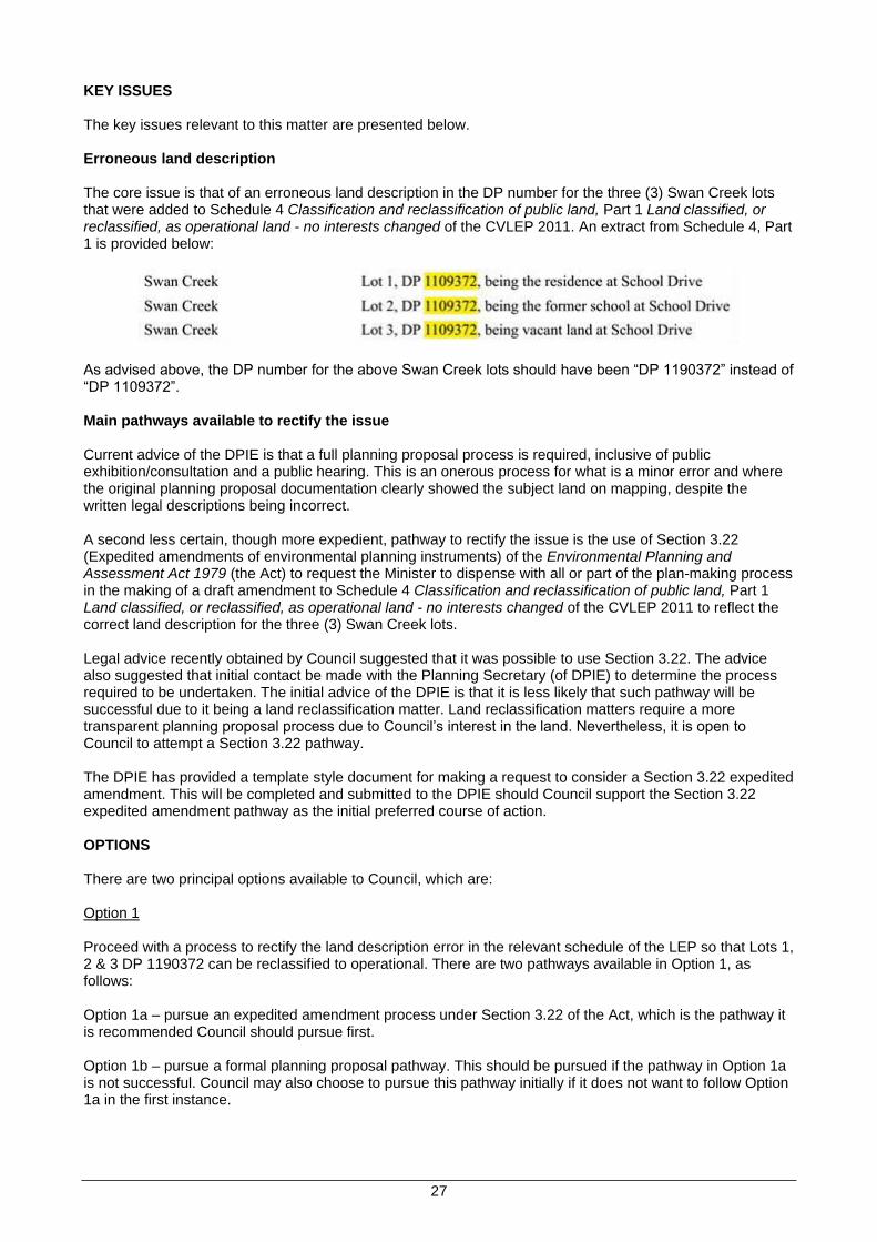
27
KEY ISSUES The key issues relevant to this matter are presented below. Erroneous land description The core issue is that of an erroneous land description in the DP number for the three (3) Swan Creek lots that were added to Schedule 4 Classification and reclassification of public land, Part 1 Land classified, or reclassified, as operational land - no interests changed of the CVLEP 2011. An extract from Schedule 4, Part 1 is provided below:
As advised above, the DP number for the above Swan Creek lots should have been “DP 1190372” instead of “DP 1109372”. Main pathways available to rectify the issue Current advice of the DPIE is that a full planning proposal process is required, inclusive of public exhibition/consultation and a public hearing. This is an onerous process for what is a minor error and where the original planning proposal documentation clearly showed the subject land on mapping, despite the written legal descriptions being incorrect. A second less certain, though more expedient, pathway to rectify the issue is the use of Section 3.22 (Expedited amendments of environmental planning instruments) of the Environmental Planning and Assessment Act 1979 (the Act) to request the Minister to dispense with all or part of the plan-making process in the making of a draft amendment to Schedule 4 Classification and reclassification of public land, Part 1 Land classified, or reclassified, as operational land - no interests changed of the CVLEP 2011 to reflect the correct land description for the three (3) Swan Creek lots. Legal advice recently obtained by Council suggested that it was possible to use Section 3.22. The advice also suggested that initial contact be made with the Planning Secretary (of DPIE) to determine the process required to be undertaken. The initial advice of the DPIE is that it is less likely that such pathway will be successful due to it being a land reclassification matter. Land reclassification matters require a more transparent planning proposal process due to Council’s interest in the land. Nevertheless, it is open to Council to attempt a Section 3.22 pathway. The DPIE has provided a template style document for making a request to consider a Section 3.22 expedited amendment. This will be completed and submitted to the DPIE should Council support the Section 3.22 expedited amendment pathway as the initial preferred course of action. OPTIONS There are two principal options available to Council, which are: Option 1 Proceed with a process to rectify the land description error in the relevant schedule of the LEP so that Lots 1, 2 & 3 DP 1190372 can be reclassified to operational. There are two pathways available in Option 1, as follows: Option 1a – pursue an expedited amendment process under Section 3.22 of the Act, which is the pathway it is recommended Council should pursue first. Option 1b – pursue a formal planning proposal pathway. This should be pursued if the pathway in Option 1a is not successful. Council may also choose to pursue this pathway initially if it does not want to follow Option 1a in the first instance.

28
Option 2 Not proceed with a process to rectify the land description error in the relevant schedule of the LEP. This will have the effect of Lots 1, 2 & 3 DP 1190372 remaining classified as community which will restrict Council’s ability to deal with the land including disposal and leasing of the land. This option is not consistent with the original intention of the 2018 Land Reclassification Planning Proposal and hence, this option is not recommended. Option 1 is the preferred option with Option 1a recommended to be the initial first step followed by Option 1b should Option 1a not be successful. COUNCIL IMPLICATIONS Budget/Financial The preparation of an expedited amendment under Section 3.22 of the Act, and a planning proposal (if this becomes necessary), will be completed with existing strategic planning staff/resources. There should be no other budget implications unless the DPIE determines that a public hearing is necessary. The expedited amendment pathway is a more efficient use of Council resources and hence, is considered worth pursuing. Asset Management The land, and buildings thereon, being a residential dwelling and former school buildings, are Council assets. Formalising the operational classification of the land enables greater flexibility in management of the land by Council. Policy or Regulation Environmental Planning and Assessment Act 1979 Clarence Valley Local Environmental Plan 2011 Consultation Consultation will be undertaken in accordance with any direction issued by the DPIE including any Gateway Determination that is issued for a planning proposal. Legal and Risk Management The undertaking of an expedited amendment under Section 3.22 of the Act (Option 1a above) to rectify the erroneous land descriptions is the preferred initial course of action followed, if necessary, by preparation of a planning proposal (Option 1b above). Council will be able to undertake proper dealings in relation to Lots 1, 2 & 3 DP 1190372 once the LEP is amended to insert the correct land descriptions for the lots in the relevant schedule in the LEP. Climate Change N/A
Prepared by Terry Dwyer, Strategic Planning Coordinator
Attachment Nil
29
ITEM 6b.21.061 REQUEST FROM CLARENCE VILLAGE LIMITED FOR S64 FUNDS CONTRIBUTION FOR DA2010/0592 STAGED MULTI-UNIT RESIDENTIAL DEVELOPMENT (21 UNITS) AT 95 ARMIDALE STREET, SOUTH GRAFTON
Meeting Environment, Planning & Community Committee 17 August 2021 Directorate General Manager Reviewed by General Manager - Ashley Lindsay Attachment To be tabled
SUMMARY Council has received a request from Clarence Village Limited seeking an amendment to the Council resolution from December 2019 (6b.19.056) which provided support via payment of S64 Contributions on behalf of Clarence Village Ltd to support their Building Better Regions grant application for a proposed seniors affordable housing development at 95 Armidale Street South Grafton. OFFICER RECOMMENDATION That Council
1. establish an Internal Financial Reserve titled Seniors Affordable Housing and transfer $237,600 from the Clarence Care and Support funds with this reserve to be used to pay the Clarence Village Ltd’s S64 contributions on the development (DA2010/0592) at 95 Armidale Street, South Grafton conditional on Clarence Village Limited providing the developed dwellings at affordable rental rates as defined by Council’s Affordable Housing Policy
2. advise Clarence Village Ltd that Council will review the progress of their development on an annual basis and should the development not proceed within 2 years Council will reconsider its support.
LINKAGE TO OUR COMMUNITY PLAN Theme 1 Society
Objective 1.4 We will have access and equity of services
Strategy 1.4.2 Encourage the supply of affordable and appropriate housing
BACKGROUND In December 2010 Council resolved at Item 12.212/10 to approve DA2010/0592 subject to the conditions contained in Schedule 1. The Development Application seeks to construct 21 single storey dwelling units over 3 stages which are a combination of 2 and 3 bedroom units (mainly duplexes). At its Ordinary Council Meeting on 17 December 2019, Council resolved at Item 6b.19.056 (Construction of Affordable Seniors Housing Grafton by Clarence Village Limited) the following: That 1. Council pay the section 64 funds of $175,000 on behalf of Clarence Village Limited if the Building Better
Regions application to build 22 seniors affordable housing units is successful and at the completion of the property transfer of 95 Armidale Road, South Grafton to the ownership of Clarence Village Limited.
2. Funding for this be provided by the Clarence Care and Support Administration Reserve RA10240 if the grant is successful.
KEY ISSUES The December 2019 Council resolution was quite specific and tied Council’s support to Clarence Village Ltd’s grant application being successful and the completion of the property transfer. The attached letter from Clarence Village advises that they were unsuccessful for the Round 4 Building Better Regions funding and have now made submissions to Round 5 as well as other funding rounds. The letter also states that they are now the owners of 95 Armidale Street, South Grafton which has been confirmed by Council records.

30
Clarence Village Ltd are now seeking a resolution from Council which provides an ongoing commitment from Council to settle the Section 64 Contributions payable on the development (DA2010/0592) conditional on Clarence Village Ltd providing the developed dwellings at affordable rental rates as defined by Council’s Affordable Housing Policy. Clarence Village Ltd are continuing to seek Federal & State Government financial assistance for the project but at this time it is unknown as to when the development will commence. The contributions payable continue to increase with annual CPI until they are actually paid. This is noted in the conditions for the DA…The contribution(s), as assessed, will hold for a period of 12 months from the date of this approval. Contributions not received by Council within 12 months of the date of this determination will be adjusted in accordance with the adopted Schedule of Fees and Charges current at the time of payment. The S64 Contributions payable on the development are now (based on 2021/22 contribution amounts) $237,600. Comprising Water Headworks $5,017 x 20 additional ET’s = $100,340 plus Sewer Headworks $6,863 x 20 ET’s = $137,260. Council’s December 2019 resolution funded the $175,000 contribution from the funds held in the Clarence Care & Support Reserves. With Council considering a report to the Corporate Governance & Works Committee today (refer Item 6c.21.103) which recommends the allocation of the surplus Clarence Care & Support reserves to specific projects a funding source to support Clarence Village Ltd’s request may not be available. The report to Council’s December 2019 meeting highlighted the lack of affordable rental housing for seniors in the Clarence Valley which has not changed and it is recommended that Council support this request from Clarence Village Ltd. Given the ageing population in the Clarence Valley there is a growing demand for affordable seniors’ rental housing, especially at ground accessible units/townhouses which this development will provide. It is recommended that Council establish an Internal Financial Reserve titled Seniors Affordable Housing and transfer $237,600 from the Clarence Care and Support funds with this reserve to be used to support the Clarence Village Ltd’s request. Clarence Village Ltd be advised that Council will review the progress of their development on an annual basis and should the development not proceed within 2 years Council will reconsider its support. COUNCIL IMPLICATIONS Budget/Financial The report to the Corporate Governance & Works Committee today (refer Item 6c.21.103) states the expected balance of Clarence Care and Support Reserves as at 30 June 2021 will be $3.2 million. Asset Management N/A Policy or Regulation Affordable Housing Policy Consultation Planning Section, Finance & Supply Section Legal and Risk Management N/A Climate Change N/A
Prepared by Ashley Lindsay, General Manager
To be tabled Council Report 6b.19.056 and letter of request

31
ITEM 6b.21.062 SUBMISSION: INTEGRITY OF THE NSW BIODIVERSITY OFFSET SCHEME
Meeting Environment, Planning & Community Committee 17 August 2021 Directorate Environment, Planning & Community Reviewed by Director - Environment & Planning (Adam Cameron) Attachment Nil
SUMMARY This report tables a draft of the submission to the parliamentary inquiry into the integrity of the NSW Biodiversity Offset Scheme (BOS). The Biodiversity Offsets Scheme is the framework for offsetting unavoidable impacts on biodiversity from development with biodiversity gains through landholder stewardship agreements, under the Biodiversity Conservation Act, 2016. There has been widespread concerns since the introduction of the scheme regarding declining biodiversity, and rorting by companies of the offset market. As Clarence Valley Council processes an increasing number of developments that enter the BOS through land clearing, concerns have been raised over the schemes ability to conserve local biodiversity. OFFICER RECOMMENDATION That Council supports this submission to the NSW Legislative Council’s Environment and Planning Committee on the Integrity of the NSW Biodiversity Offset Scheme.
LINKAGE TO OUR COMMUNITY PLAN Theme 4 Environment
Objective 4.1 We will preserve and enhance our natural environment
Strategy 4.1.1 Manage our coastal zone, waterways, catchments and floodplains in an ecologically sustainable manner
BACKGROUND Entry to the Biodiversity Offset Scheme (BOS) is triggered by developments, projects and activities that meet certain thresholds for significant impacts on biodiversity, or on an opt-in basis. The threshold has two elements: 1. Whether the amount of native vegetation being cleared exceeds an area threshold. 2. Whether the impacts occur on an area mapped on the Biodiversity Values Map. If clearing and other impacts, including biodiversity impacts exceed either trigger, the BOS applies to the proposal, and a Biodiversity Development Assessment Report (BDAR) is required to determine how the proponent will avoid, minimise or offset the impact from the proposed development. Offsets obligations are met by the purchase and/or retirement of biodiversity credits or payment to the Biodiversity Conservation Fund, managed by the Biodiversity Conservation Trust (BCT). Landholders can establish Biodiversity Stewardship Agreements to create offset sites on their land to generate biodiversity credits. These credits are then available to the market for purchase by developers, landholders or the BCT to offset the impacts of development or clearing. Biodiversity credits are the common unit of measure for offsets in the BOS. Biodiversity credits are used to measure both:
• The unavoidable impacts on biodiversity from development and clearing at a development site.
• The predicted improvement in biodiversity condition gain at a stewardship site. The Biodiversity Assessment Method (BAM) defines two types of biodiversity credits that are used to measure impacts on both development sites and stewardship sites. The two types of credits are: 1. Ecosystem credits – measure the value of threatened ecological communities (TEC’s), threatened
species habitat for species that can be reliably predicted to occur with a Plant Community Type (PCT), and PCTs generally.
2. Species credits – apply to all other threatened species which are found to occur at that location and cannot be reliably predicted to occur within the identified ecological communities at the development site.

32
Biodiversity credits created at a stewardship site via a Biodiversity Stewardship Agreement, can be used to offset the loss of biodiversity values on development site (a credit obligation) by being traded and retired. This sale is called a biodiversity credit transfer and the credit is then retired to satisfy the credit obligation. Criticisms of the scheme are mainly focussed around that these credit offsets can be purchased anywhere in the state under the ‘like for like’ rules, allowing a decline in biodiversity in one area, whilst protecting biodiversity in another. Currently there are very few offset areas in the Clarence, hence a real potential exists for biodiversity decline across our LGA. The closing for submissions to the Inquiry is 31 August 2021. KEY ISSUES Council’s main concerns over the BOS are: 1. A net loss of biodiversity across the LGA There is little confidence in this legislation for biodiversity conservation as offsets can be facilitated outside of the CVC LGA, meaning a net biodiversity loss within the LGA. To date, only one of the BDAR's processed for CVC has had biodiversity credits offset locally. There are inherent difficulties in entering the credit supply market to source 'like for like' credits from landholders that have had their land approved and assessed for the number and type of credits. These credit suppliers are located all over the state, hence if a developer can source credits, they are unlikely to be sourced within the Clarence, creating a 'net loss' of biodiversity. Suggestions:
• Simplify the process of entering the credit supply market to source suitable credits. A requirement should be placed on the BCT to monitor biodiversity gains/losses in the LGA’s.
2. Lack of stewardship sites in the Clarence
The process for landholders to get their land assessed and approved as a stewardship site involves a large monetary output, with returns only certain if they sell the credits they have been assessed to hold. Currently on the public register, there are only 2 stewardship sites in the Clarence. The opportunity for private landholders to engage in the stewardship scheme has been very limited in the Clarence. Other areas such as Lismore Council have been offered landholder incentive programs to protect land with koalas and koala habitat, however this has not been offered to landholders in the Clarence, highlighting the ineffectiveness of the scheme to enact on ground local protection of koalas. The BCT has been largely absent in the Clarence, and this is evidenced by the small amount of land available under the scheme for locally offsetting development. In August 2021 the first BCT conservation tender is being offered in the Clarence, however the eligibility criteria for this tender will exclude many landholders from being included in the tender due to the minimum size requirement (>10ha) of vegetation to protected. This size criteria does not reflect the realities of the disjunct remnant vegetation patches on the Clarence floodplain. These vegetation communities are even more important to protect as they are often the last remaining remnant of that particular type of vegetation, however as they don't meet the BCT's criteria there is little monetary support to aid landholders in protecting threatened vegetation such as saltmarsh, mangroves, wetlands and swamp forest. In addition, these remnant vegetation patches are usually well below the size threshold that can be considered to establish a stewardship site. The current ‘like for like’ trading rules for TEC’s that can only be offset for the same TEC is often unapplicable in the Clarence Valley as many of our coastal TEC’s are small, and as stated above, do not meet the size requirement to be secured in a stewardship agreement, so there are no similar credits available, leaving the only offset option being to pay into the fund. This is creating a biodiversity drain for the Clarence. Suggestions:
• Expand the stewardship site requirements to suit the local site conditions in terms of patch sizes for PCT’s that can be placed under agreements.
• Simplify the stewardship agreement process to enable landholders to negotiate the process easily.
33
• Remove the ‘like for like’ trading rules for TEC’s on the floodplain to reflect on ground conditions of small patch sizes and allow Council’s to determine local biodiversity conservation actions to meet offset requirements, instead of paying into the BCT.
• Possible conservation actions could be for an applicant to donate land, improve corridors, implement works such as revegetation and install animal friendly fencing.
• Deliver the long awaited PCT mapping for the North Coast, which could aid Council in identifying suitable sites.
3. Lack of transparency in the BOS Many Plant Community Types (PCT's) on the floodplain, which comprises a large percentage of land being developed in the Clarence, are threatened ecological communities (TEC's) which are to be offset for the same TEC forcing developers to pay into the fund as the sole way to offset credits, as there are no locally available credits. There is no way to determine if this money deposited in the Trust is then used to facilitate recovery or protection of TEC's in the Clarence - creating biodiversity loss. Similarly, some threatened species with a limited geographical range do not fit into the 'like for like' rule. The endangered Coastal Emu which generates significant credits (over $1.5 million for a recent BDAR) that can only be paid into the BCT, comes with no guarantee that money is spent on species recovery. Additionally, the Coastal Emu is not listed in the ancillary rules (under S6.5 of the Biodiversity Conservation Regulation 2017) enabling a proponent to carry out a biodiversity conservation action to meet an offset obligation rather than paying into the Trust. This is the situation for the majority of our threatened species that cannot be offset, due to a lack of available credits, leaving no option other than paying into the Trust, with as yet, no benefits to local threatened species or ecosystems evident through BCT programs or activities in the Clarence. Suggestions:
• Council’s be able to negotiate biodiversity conservation actions (outside of the very limited species currently listed in the ancillary rules) directly with the applicant to achieve on ground local biodiversity gains. This should also be expanded to include the like for like trading rules for TEC’s that can only be offset by the same TEC.
• Money generated from what is essentially biodiversity loss in an LGA should remain in that LGA to focus on locally driven recovery efforts for native flora and fauna.
4. Offset prices
Some of our TEC’s are cheaper than if the PCT was not listed as a TEC – for example PCT’s 1235 (Swamp Oak Swamp Forest on Coastal Floodplain) and 1064 (Paperbark Swamp Forest on the Coastal Lowlands) are costed at $7500 per credit, where as if it assessed as a TEC, that price is confusingly reduced to $4005 per credit. Council contacted the department over 18 months ago concerning this and it still has not been remedied. Suggestions:
• Review the calculator for inconsistencies and alter accordingly. Summary The BOS, although well intended, has not produced any gains for biodiversity in the Clarence, rather has ensured a net loss to biodiversity, often of our most threatened flora and fauna. https://www.parliament.nsw.gov.au/committees/inquiries/Pages/inquiry-details.aspx?pk=2822 COUNCIL IMPLICATIONS Budget/Financial N/A Asset Management N/A
34
Policy or Regulation Biodiversity Strategy 2020-2025 Consultation N/A Legal and Risk Management There are no legal or risk matters Climate Change Biodiversity protection is a key driver in ameliorating the effects of climate change.
Prepared by Heather Mitchell, NRM Officer
Attachment Nil