Embed Size (px)
Citation preview
ENVIRONMENT PLAN
SUMMARY
METOCEAN STUDY
Environment Plan Summary – Metocean Study
14/12/12
Page 1
1.0 SUMMARY
Hess Exploration Australia Pty Limited (Hess) has contracted the metocean division of
Fugro Survey Pty Ltd (Fugro) to undertake a metocean study in Commonwealth waters
off the North West coast of Western Australia. The study entails the retrieval,
maintenance and redeployment of up to six (6) moorings over a period of up to seven
(7) days, approximately every four months until 2015.
There are neither ground disturbance activities nor use of sound emitting devices, and
no refuelling at sea is required.
All aspects of the maintenance activities have been subjected to risk assessment in order
to evaluate potential impacts. Risks associated with the vessel as well as the presence of
the moorings themselves are deemed as low as reasonable practicable (ALARP) and can
not be reduced any lower.
An Environment Plan (EP) has been developed by Hess, in accordance with the Offshore
Petroleum and Greenhouse Gas (Environment) Regulations 2009, to support the series
of maintenance voyages. The EP was accepted by NOPSEMA on 6th December 2012.
2.0 DESCRIPTION OF ACTIVITY
Hess must perform vessel-based maintenance activities in support of a metocean study
to obtain information on a range of meteorological and oceanographic conditions, such
as wind, tides, currents, waves, temperature and salinity (conductivity) etc.
Fugro activities may include the following:
Recovery, servicing (including downloading of data and changing batteries) and re-
deployment of a deep-water Current Meter Mooring (ADCP Mooring)
Recovery, servicing (including downloading of data and changing batteries) and re-
deployment of a deep-water Waverider Mooring with HF and Satellite Telemetry
(DWR Mooring)
Recovery, servicing (including downloading of data and changing batteries) and re-
deployment of up to four (4) current meter moorings (CMM) along the scarp
Deployment and subsequent recovery and servicing of further instrumentation for
metocean studies if required
Each service visit will last approximately seven (7) days with the vessel generally
mobilising from Exmouth. Due to the short duration there is no requirement for
refuelling at sea.
All servicing shall be undertaken by experienced personnel. Once retrieved all moorings
are serviced and tested before being re-deployed. If moorings are not fully functioning
they will not be re-deployed.
It is anticipated that all activities shall be undertaken offshore. However, if the weather
is not conducive, moorings may be retrieved, returned to port for servicing, and then
returned to site.
Environment Plan Summary – Metocean Study
14/12/12
Page 2
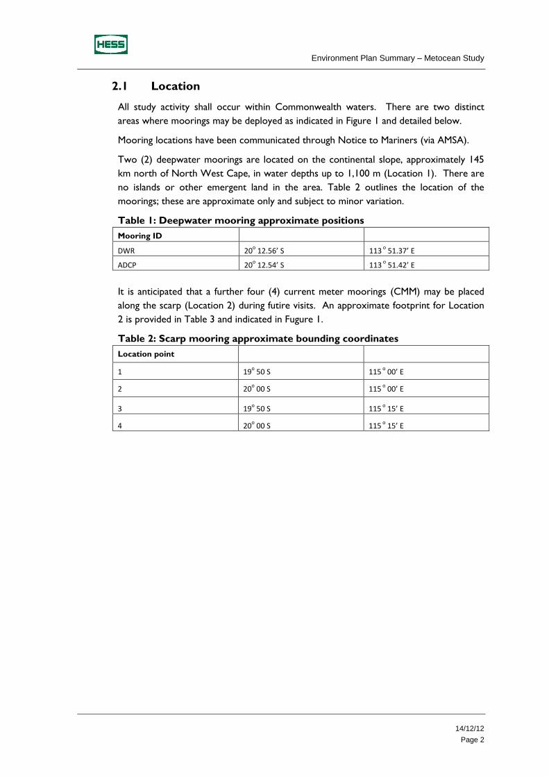
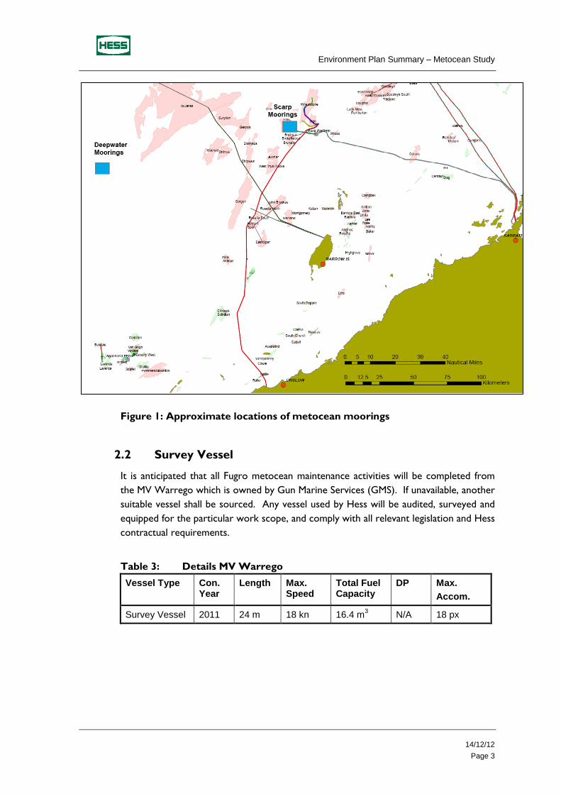
2.1 Location
All study activity shall occur within Commonwealth waters. There are two distinct
areas where moorings may be deployed as indicated in Figure 1 and detailed below.
Mooring locations have been communicated through Notice to Mariners (via AMSA).
Two (2) deepwater moorings are located on the continental slope, approximately 145
km north of North West Cape, in water depths up to 1,100 m (Location 1). There are
no islands or other emergent land in the area. Table 2 outlines the location of the
moorings; these are approximate only and subject to minor variation.
Table 1: Deepwater mooring approximate positions
Mooring ID
DWR 20o 12.56’ S 113
o 51.37’ E
ADCP 20o 12.54’ S 113
o 51.42’ E
It is anticipated that a further four (4) current meter moorings (CMM) may be placed
along the scarp (Location 2) during futire visits. An approximate footprint for Location
2 is provided in Table 3 and indicated in Fugure 1.
Table 2: Scarp mooring approximate bounding coordinates
Location point
1 19o 50 S 115
o 00’ E
2 20o 00 S 115
o 00’ E
3 19o 50 S 115
o 15’ E
4 20o 00 S 115
o 15’ E
Environment Plan Summary – Metocean Study
14/12/12
Page 3
Figure 1: Approximate locations of metocean moorings
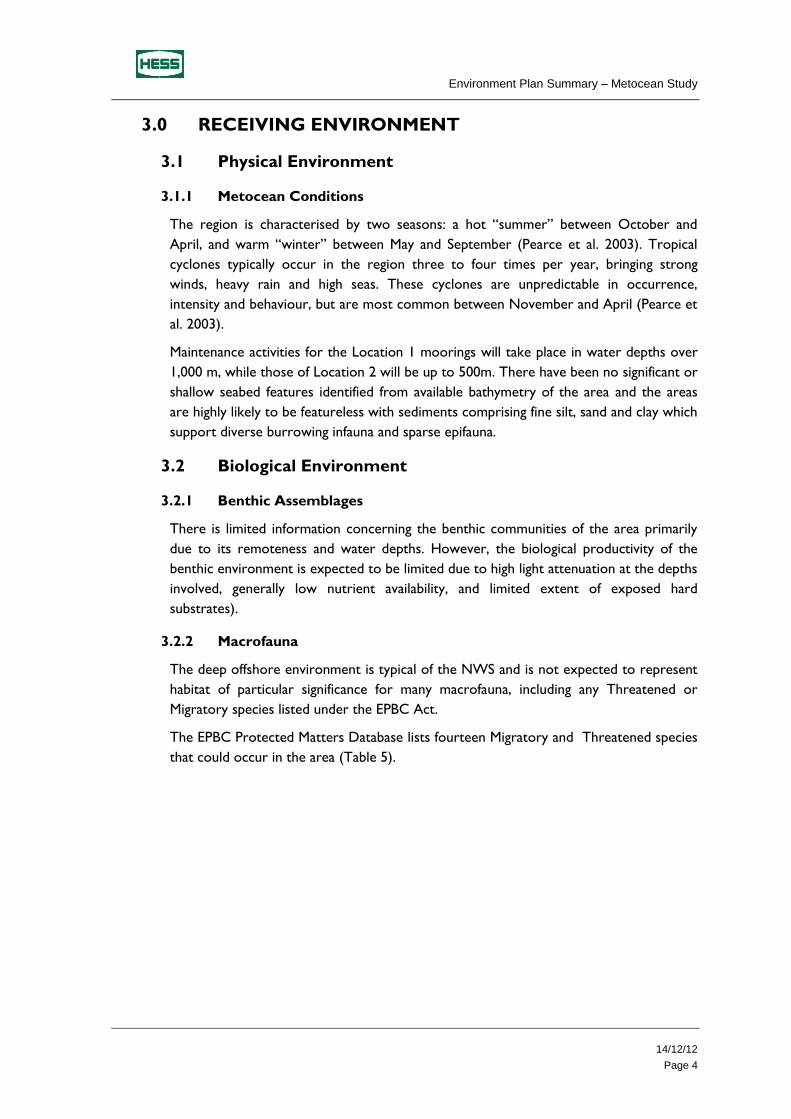
2.2 Survey Vessel
It is anticipated that all Fugro metocean maintenance activities will be completed from
the MV Warrego which is owned by Gun Marine Services (GMS). If unavailable, another
suitable vessel shall be sourced. Any vessel used by Hess will be audited, surveyed and
equipped for the particular work scope, and comply with all relevant legislation and Hess
contractual requirements.
Table 3: Details MV Warrego
Vessel Type Con. Year
Length Max. Speed
Total Fuel Capacity
DP Max.
Accom.
Survey Vessel 2011 24 m 18 kn 16.4 m3 N/A 18 px
Environment Plan Summary – Metocean Study
14/12/12
Page 4
3.0 RECEIVING ENVIRONMENT
3.1 Physical Environment
3.1.1 Metocean Conditions
The region is characterised by two seasons: a hot “summer” between October and
April, and warm “winter” between May and September (Pearce et al. 2003). Tropical
cyclones typically occur in the region three to four times per year, bringing strong
winds, heavy rain and high seas. These cyclones are unpredictable in occurrence,
intensity and behaviour, but are most common between November and April (Pearce et
al. 2003).
Maintenance activities for the Location 1 moorings will take place in water depths over
1,000 m, while those of Location 2 will be up to 500m. There have been no significant or
shallow seabed features identified from available bathymetry of the area and the areas
are highly likely to be featureless with sediments comprising fine silt, sand and clay which
support diverse burrowing infauna and sparse epifauna.
3.2 Biological Environment
3.2.1 Benthic Assemblages
There is limited information concerning the benthic communities of the area primarily
due to its remoteness and water depths. However, the biological productivity of the
benthic environment is expected to be limited due to high light attenuation at the depths
involved, generally low nutrient availability, and limited extent of exposed hard
substrates).
3.2.2 Macrofauna
The deep offshore environment is typical of the NWS and is not expected to represent
habitat of particular significance for many macrofauna, including any Threatened or
Migratory species listed under the EPBC Act.
The EPBC Protected Matters Database lists fourteen Migratory and Threatened species
that could occur in the area (Table 5).
Environment Plan Summary – Metocean Study
14/12/12
Page 5
Table 4: Threatened & Migratory Species that may occur near the proposed
locations
Scientific Name Common Name Status
Birds
Macronectes giganteus
Southern Giant-Petrel
As the northernmost extent of this species’ distribution does not overlap with the study area (disperses north towards the Tropic of Capricorn some 325 km south of the study area), the southern giant-petrel is not expected to occur in significant numbers in the metocean locations.
Reptiles
Caretta caretta Loggerhead turtle The study area does not contain any emergent land or shallow subtidal (reef) features and the nearest areas of known turtle breeding or feeding importance are located at the Barrow and Montebello Islands, approximately 80 km to the south-east of Location 2. Given the distance from land it is expected that only very small numbers of marine turtles are likely to occur in the area during the proposed activities.
Chelonia mydas Green turtle
Dermochelys coriacea
Leatherback turtle
Eretmoschelys imbricate
Hawksbill turtle
Natator depressus Flatback turtle
Mammals
Balaenoptera bonaerensis
Antarctic minke whale A widespread distribution of the mammals plus
an absence of particular bathymetric features within close proximity to the metocean locations, suggest that the environment is unlikely to represent important habitat for any of these species.
Balaenoptera edeni Bryde’s whale
Orcinus orca Killer whale
Physeter macrocephalus
Sperm whale
Balaenoptera musculus
Blue whale The permit area is outside (seaward) of the main humpback and blue whale migration routes and is distant from the nearest known whale aggregation areas
Megaptera novaeangliae
Humpback whale
Sharks
Isurus oxyrinchus Shortfin mako These species occur within a wide-ranging habitat and have a highly transient nature. Although these sharks may pass through the activity areas, no bathymetric features or aggregation areas of importance for these species are known within the areas.
Isurus paucus Longfin mako
3.3 Social and Economic Environment
3.3.1 Petroleum Activities
There is no existing infrastructure near Location 1; however there is petroleum
exploration and production activity near location 2 as described below:
NWS Joint Venture offshore production facilities, approximately 100 km to the
north-east, which includes the Goodwyn, North Rankin and Angel Platforms
Environment Plan Summary – Metocean Study
14/12/12
Page 6
John Brookes unmanned platform, located approximately 50 km east of the study
area, from which gas is sent to the Varanus Island processing facility via a 55 km
pipeline
Pluto Riser platform approximately 40km east of location 2
The nearest land based production facility is situated on Barrow Island, 135 km
south-east of the study area
Jansz pipeline which is under construction, directly to the south of the location
3.3.2 Fisheries
Consultations with various state and federal departments indicate fishing activity in the
area is low due to the water depths, remote location, distance offshore and often
unpredictable weather.
The following Commonwealth-managed fisheries are authorised to operate in the area:
Western Tuna and Billfish Fishery
North-west Slope Trawl Fishery
Southern Bluefin Tuna Fishery
Western Deepwater Trawl Fishery
Western Skipjack Fishery.
In addition, state-managed fisheries are permitted to operate in waters within and
adjacent to the study area and include:
Deep Water Wet Line Fishery
WA North Coast Shark Fishery
West Coast Deep Sea Crab Fishery
Onslow Prawn Fishery
Pilbara Trap Fishery
Spanish Mackeral Fishery.
3.3.3 Shipping
Australian Maritime Safety Authority (AMSA) data indicates that vessel traffic is generally
at low to medium levels. Neither metocean location form part of an approach to any
regional ports and there are no channels or navigation hazards that restrict vessel
movements.
3.3.4 Recreational and Tourism Activities
The distance offshore, unpredictable weather, and deep water are likely to preclude
recreational fishing and charter vessel activity in the study area.
Environment Plan Summary – Metocean Study
14/12/12
Page 7
3.3.5 Marine Protected Areas
The metocean studies will not impact the Ningaloo Coast World Heritage Area or the
Barrow Island Marine Management Area with Location 1 approximately 130 km away
from both and Location 2, 80km away from Barrow Island (Figure 4).
3.3.6 Cultural Heritage
No features of cultural heritage importance have been identified within the study area
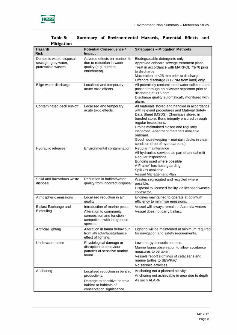
4.0 ENVIRONMENTAL HAZARDS AND CONTROLS
The risk management philosophy of Hess is to demonstrate appropriate systems are in
place to ensure hazards are identified and risk managed to a level that is as low as
reasonably practicable (ALARP) during both day-to-day activities and emergency
situations.
A comprehensive risk assessment has been carried out for all aspects of operations, in
accordance with Hess EHS Risk Management Key Process and the principles outlined in
the Australian Standard AS/NZS 4360:2004 Risk Management, and ISO 140001
Environmental Management Systems
The key environmental hazards and control measures to be applied to the activities are
illustrated in the table below. All control measures associated with the hazards will be
used to reduce environmental risk to ALARP.
All risks carried a ‘low’ risk ranking (Hess Risk Matrix).
Environment Plan Summary – Metocean Study
14/12/12
Page 8
Table 5: Summary of Environmental Hazards, Potential Effects and
Mitigation
Hazard/ Risk
Potential Consequence / Impact
Safeguards – Mitigation Methods
Domestic waste disposal – sewage, grey water, putrescible wastes
Adverse effects on marine life due to reduction in water quality (e.g. nutrient enrichment).
Biodegradable detergents only.
Approved onboard sewage treatment plant.
Treat in accordance with MARPOL 73/78 prior to discharge.
Maceration to <25 mm prior to discharge.
Offshore discharge (>12 NM from land) only.
Bilge water discharge Localised and temporary acute toxic effects.
All potentially contaminated water collected and passed through an oil/water separator prior to discharge at <15 ppm.
Discharge quality automatically monitored with alarm.
Contaminated deck run-off Localised and temporary acute toxic effects.
All materials stored and handled in accordance with relevant procedures and Material Safety Data Sheet (MSDS). Chemicals stored in bunded store. Bund integrity ensured through regular inspections.
Drains maintained closed and regularly inspected. Absorbent materials available onboard.
Good housekeeping – maintain decks in clean condition (free of hydrocarbons).
Hydraulic releases Environmental contamination Regular maintenance
All hydraulics serviced as part of annual refit
Regular inspections
Bunding used where possible
A Frame" has hose guarding
Spill kits available
Vessel Management Plan
Solid and hazardous waste disposal
Reduction in habitat/water quality from incorrect disposal.
Wastes segregated and recycled where possible.
Disposal to licensed facility via licensed wastes contractor.
Atmospheric emissions Localised reduction in air quality.
Engines maintained to operate at optimum efficiency to minimise emissions.
Ballast Exchange and Biofouling
Introduction of marine pests.
Alteration to community composition and function - competition with indigenous species.
Vessel will always remain in Australia waters
Vessel does not carry ballast.
Artificial lighting Alteration in fauna behaviour from attractant/disturbance effect of lighting.
Lighting will be maintained at minimum required for navigation and safety requirements.
Underwater noise Physiological damage or disruption to behaviour patterns of sensitive marine fauna.
Low energy acoustic sources.
Marine fauna observation to allow avoidance measures to be taken.
Vessels report sightings of cetaceans and marine turtles to SEWPaC
No seismic activities.
Anchoring Localised reduction in benthic productivity.
Damage to sensitive benthic habitat or habitats of conservation significance.
Anchoring not a planned activity
Anchoring not achievable in area due to depth
As such ALARP
Environment Plan Summary – Metocean Study
14/12/12
Page 9
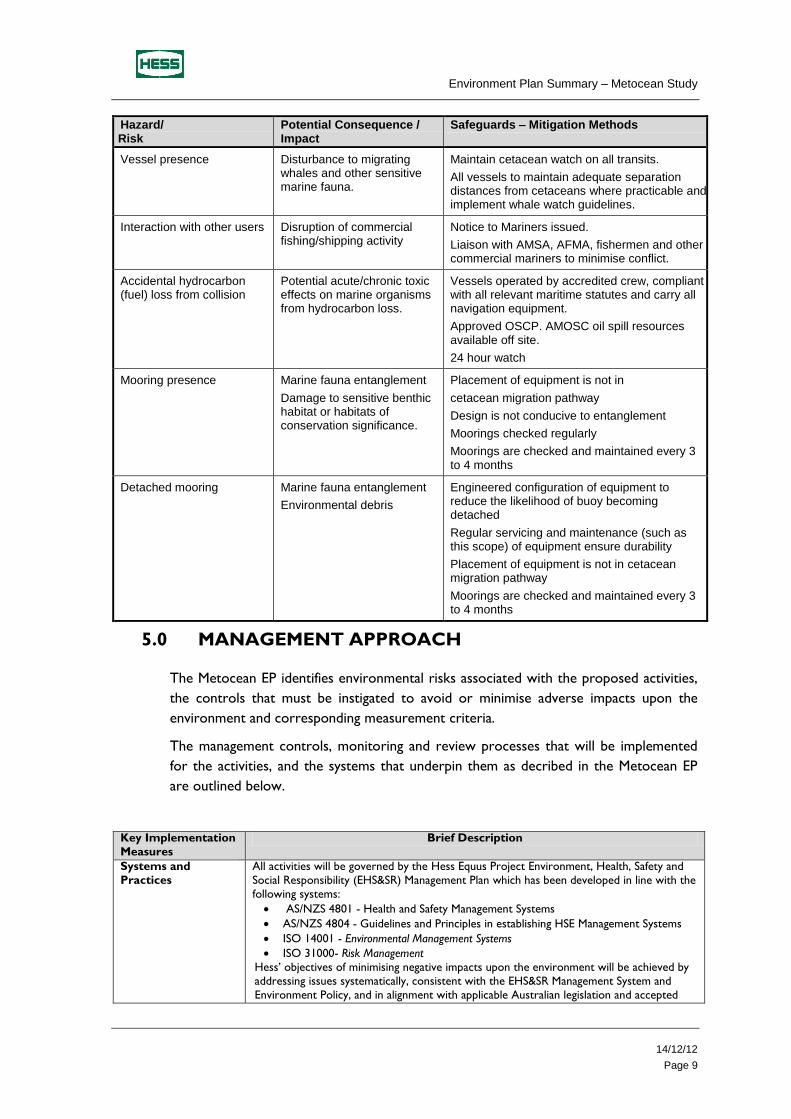
Hazard/ Risk
Potential Consequence / Impact
Safeguards – Mitigation Methods
Vessel presence Disturbance to migrating whales and other sensitive marine fauna.
Maintain cetacean watch on all transits.
All vessels to maintain adequate separation distances from cetaceans where practicable and implement whale watch guidelines.
Interaction with other users Disruption of commercial fishing/shipping activity
Notice to Mariners issued.
Liaison with AMSA, AFMA, fishermen and other commercial mariners to minimise conflict.
Accidental hydrocarbon (fuel) loss from collision
Potential acute/chronic toxic effects on marine organisms from hydrocarbon loss.
Vessels operated by accredited crew, compliant with all relevant maritime statutes and carry all navigation equipment.
Approved OSCP. AMOSC oil spill resources available off site.
24 hour watch
Mooring presence Marine fauna entanglement
Damage to sensitive benthic habitat or habitats of conservation significance.
Placement of equipment is not in
cetacean migration pathway
Design is not conducive to entanglement
Moorings checked regularly
Moorings are checked and maintained every 3 to 4 months
Detached mooring Marine fauna entanglement
Environmental debris
Engineered configuration of equipment to reduce the likelihood of buoy becoming detached
Regular servicing and maintenance (such as this scope) of equipment ensure durability
Placement of equipment is not in cetacean migration pathway
Moorings are checked and maintained every 3 to 4 months
5.0 MANAGEMENT APPROACH
The Metocean EP identifies environmental risks associated with the proposed activities,
the controls that must be instigated to avoid or minimise adverse impacts upon the
environment and corresponding measurement criteria.
The management controls, monitoring and review processes that will be implemented
for the activities, and the systems that underpin them as decribed in the Metocean EP
are outlined below.
Key Implementation
Measures
Brief Description
Systems and
Practices
All activities will be governed by the Hess Equus Project Environment, Health, Safety and
Social Responsibility (EHS&SR) Management Plan which has been developed in line with the
following systems:
AS/NZS 4801 - Health and Safety Management Systems
AS/NZS 4804 - Guidelines and Principles in establishing HSE Management Systems
ISO 14001 - Environmental Management Systems
ISO 31000- Risk Management
Hess’ objectives of minimising negative impacts upon the environment will be achieved by
addressing issues systematically, consistent with the EHS&SR Management System and
Environment Policy, and in alignment with applicable Australian legislation and accepted
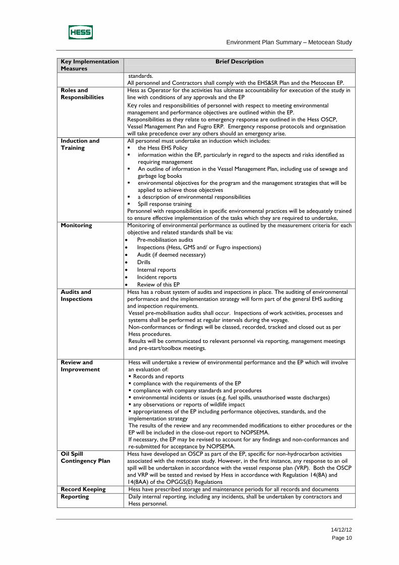
Environment Plan Summary – Metocean Study
14/12/12
Page 10
Key Implementation
Measures
Brief Description
standards.
All personnel and Contractors shall comply with the EHS&SR Plan and the Metocean EP.
Roles and
Responsibilities
Hess as Operator for the activities has ultimate accountability for execution of the study in
line with conditions of any approvals and the EP
Key roles and responsibilities of personnel with respect to meeting environmental
management and performance objectives are outlined within the EP.
Responsibilities as they relate to emergency response are outlined in the Hess OSCP,
Vessel Management Pan and Fugro ERP. Emergency response protocols and organisation
will take precedence over any others should an emergency arise.
Induction and
Training
All personnel must undertake an induction which includes:
the Hess EHS Policy
information within the EP, particularly in regard to the aspects and risks identified as
requiring management
An outline of information in the Vessel Management Plan, including use of sewage and
garbage log books
environmental objectives for the program and the management strategies that will be
applied to achieve those objectives
a description of environmental responsibilities
Spill response training
Personnel with responsibilities in specific environmental practices will be adequately trained
to ensure effective implementation of the tasks which they are required to undertake,
Monitoring Monitoring of environmental performance as outlined by the measurement criteria for each
objective and related standards shall be via:
Pre-mobilisation audits
Inspections (Hess, GMS and/ or Fugro inspections)
Audit (if deemed necessary)
Drills
Internal reports
Incident reports
Review of this EP
Audits and
Inspections
Hess has a robust system of audits and inspections in place. The auditing of environmental
performance and the implementation strategy will form part of the general EHS auditing
and inspection requirements.
Vessel pre-mobilisation audits shall occur. Inspections of work activities, processes and
systems shall be performed at regular intervals during the voyage.
Non-conformances or findings will be classed, recorded, tracked and closed out as per
Hess procedures.
Results will be communicated to relevant personnel via reporting, management meetings
and pre-start/toolbox meetings.
Review and
Improvement
Hess will undertake a review of environmental performance and the EP which will involve
an evaluation of:
Records and reports
compliance with the requirements of the EP
compliance with company standards and procedures
environmental incidents or issues (e.g. fuel spills, unauthorised waste discharges)
any observations or reports of wildlife impact
appropriateness of the EP including performance objectives, standards, and the
implementation strategy
The results of the review and any recommended modifications to either procedures or the
EP will be included in the close-out report to NOPSEMA. If necessary, the EP may be revised to account for any findings and non-conformances and
re-submitted for acceptance by NOPSEMA.
Oil Spill
Contingency Plan
Hess have developed an OSCP as part of the EP, specific for non-hydrocarbon activities
associated with the metocean study. However, in the first instance, any response to an oil
spill will be undertaken in accordance with the vessel response plan (VRP). Both the OSCP
and VRP will be tested and revised by Hess in accordance with Regulation 14(8A) and
14(8AA) of the OPGGS(E) Regulations
Record Keeping Hess have prescribed storage and maintenance periods for all records and documents
Reporting Daily internal reporting, including any incidents, shall be undertaken by contractors and
Hess personnel.
Environment Plan Summary – Metocean Study
14/12/12
Page 11
Key Implementation
Measures
Brief Description
All reportable incidences shall be reported to the relevant authority as stipulated in
legislation.
Within 7 days of returning to shore on completion of all activities, Hess shall submit a
report, in an approved manner, to NOPSEMA
Environment Plan Summary – Metocean Study
14/12/12
Page 12
6.0 CONSULTATIONS
Hess undertook two rounds of extensive stakeholder consultations in regards to future
activities in WA-390-P (the Permit) during 2011 and 2012. The engagements discussed
all facets and anticipated activities, and built upon the stakeholder consultation
previously undertaken for seismic and drilling exploration operations in the area.
The following stakeholder groups were consulted in 2011 and 2012:
Australian Fisheries Management Authority
Cape Conservation Group
Dampier Port Authority
Department of Agriculture, Fisheries and Forestry
Exmouth Chamber of Commerce
Gascoyne Development Commission
Karratha and Districts Chamber of Commerce and Industry
North West Cape Exmouth Aboriginal Corporation
Pilbara Development Commission
Shire of Exmouth
Shire of Roebourne
WA Department of Environment and Conservation
WA Department of Fisheries
WA Department of State Development
WA Department Mines and Petroleum
WA Fishing Industry Council
Various State Member of Parliament
Furthermore, email notification regarding metocean activities was sent to the Australian
Maritime Safety Authority.
To date, except for an email from AMSA acknowledging the proposed metocean
activities, no official verbal or written responses have been received in regards to the
Project or the proposed activities.
The five main areas of discussion raised by stakeholders during the Hess engagement
program were:
the arrangements of fly in/fly out personnel
potential employment and business opportunities
potential training opportunities
establishment of a supply base in Exmouth
potential environmental impact on the environment (including fisheries)
Key Project personnel will periodically visit Exmouth and Karratha to meet with, and
update, key stakeholder groups. In addition, electronic updates of the Project’s
development will be provided as milestones are achieved.
Environment Plan Summary – Metocean Study
14/12/12
Page 13
8.0 CONTACT DETAILS
For further details regarding the Metocean activities please contact the following:
Adrian Marsh
Project EHS Manager
Hess Australia Pty Limited
Level 18 Allendale Square
77 St George Tce
Perth WA 6000
(08) 9426 3000