Embed Size (px)
Citation preview
YEN BAI PROVINCE PEOPLE’S COMMITTEE
YEN BAI PROVINCE CONSTRUCTION INVESTMENT PMU
(Final Report)
DYNAMIC CITIES INTEGRATED DEVELOPMENT PROJECT
YEN BAI CITY – YEN BAI PROVINCE SUB-PROJECT
Yen Bai, 1/ 2019
ENVIRIONMENTAL AND SOCIAL
IMPACT ASSESSMENT REPORT
Pub
lic D
iscl
osur
e A
utho
rized
Pub
lic D
iscl
osur
e A
utho
rized
Pub
lic D
iscl
osur
e A
utho
rized
Pub
lic D
iscl
osur
e A
utho
rized
YEN BAI PROVINCE PEOPLE’S COMMITTEE
YEN BAI PROVINCE CONSTRUCTION INVESTMENT PMU
(Final Report)
DYNAMIC CITIES INTEGRATED DEVELOPMENT PROJECT
YEN BAI CITY – YEN BAI PROVINCE SUB-PROJECT
CLIENT
YEN BAI PROVINCE
CONSTRUCTION INVESTMENT
PROJECT MANAGEMENT UNIT
CONSULTANT
VINTEK VIET NAM
CORPORATION
ENVIRONMENTAL AND SOCIAL
IMPACT ASSESSMENT REPORT

“Dynamic Cities Integrated Development Project – Yen Bai City, Yen Bai Province Sub-project”
Environmental and Social Impact Assessment Report 3
TABLE OF CONTENTS
LIST OF TABLES .................................................................................................................. 7
LIST OF FIGURES ................................................................................................................. 9
ABBREVIATIONS ............................................................................................................... 11
EXECUTIVE SUMMARY ................................................................................................... 12
INTRODUCTION ................................................................................................................. 17
A. GENERAL INTRODUCTION ................................................................................. 17
A.1. Project origin ....................................................................................................... 17
A.2. Yen Bai City Sub-project .................................................................................... 18
A.3. FS and ESIA report approving agency ................................................................ 19
B. COMPLIANCE WITH RELEVANT PLANS AND PROJECTS ............................ 19
B1. Compliance with plans ............................................................................................... 19
B2. Related projects .......................................................................................................... 22
B3. Vietnam’s legal documents ........................................................................................ 23
B4. Activated socio-environmental safeguard policies of World Bank ........................... 26
C. ESIA IMPLEMENTATION ........................................................................................ 29
D. METHODS APPLIED DURING ESIA IMPLEMENTATION .................................. 31
CHAPTER 1. SUBPROJECT DESCRIPTION .................................................................... 33
1.1. GENERAL INFORMATION ................................................................................ 33
1.2. SUBPROJECT LOCATION .................................................................................. 33
1.2.1. Geographical location ............................................................................................. 33
1.2.2. The subproject’s dynamic role for the region ......................................................... 34
1.3. SUB-PROJECT’S INVESTMENT SCALE ......................................................... 35
1.3.1. Subproject objectives .............................................................................................. 35
1.3.2. Quantity and scale of the subproject work items .................................................... 36
1.3.3. Auxiliary items ....................................................................................................... 54
1.4. CONSTRUCTION METHOD ............................................................................... 56
1.5. MACHINERIES, EQUIPMENT AND MANPOWER TO BE INVOLVED .... 60
1.6. SOURCES OF MATERIAL ................................................................................... 61
1.7. DISPOSAL SITES ................................................................................................... 65
1.8. SUBPROJECT SCHEDULE.................................................................................. 70
1.9. INVESTMENT FUND ............................................................................................ 71
1.10. SUBPROJECT IMPLEMENTATION ORGANIZATION .......................... 71
CHAPTER 2. NATURAL AND SOCIO-ECONOMIC CONDITIONS OF THE

“Dynamic Cities Integrated Development Project – Yen Bai City, Yen Bai Province Sub-project”
Environmental and Social Impact Assessment Report 4
SUBPROJECT AREA .......................................................................................................... 72
2.1. NATURAL CONDITIONS .................................................................................... 72
2.1.1. Topography .......................................................................................................... 72
2.1.2. Geology ............................................................................................................... 72
2.1.3. Meteorology, climate ........................................................................................... 73
2.1.4. Hydrology ............................................................................................................ 75
2.1.5. Existing conditions of the environment ............................................................... 79
2.1.6 Eco-system ............................................................................................................... 93
2.1.7. Land use status ........................................................................................................ 93
2.2. ECONOMIC CONDITIONS .................................................................................. 94
2.3. SOCIAL CONDITIONS ......................................................................................... 95
2.3.1. Population ............................................................................................................ 95
2.3.2. Impacts of natual disasters and weather .............................................................. 95
2.4. EXISTING INFRASTRUCTURE AND SERVICE SYSTEM ........................... 98
2.4.1. Transport .............................................................................................................. 98
2.4.2. Water supply ...................................................................................................... 100
2.4.3. Drainage and environmental sanitation ............................................................. 100
2.4.4. Healthcare .......................................................................................................... 101
2.4.5. Power supply and communication ..................................................................... 101
2.5. SOCIO-ENVIRONMENTAL STATUS OF THE SUB-PROJECT AREA ..... 101
2.6. SENSITIVE AREAS OF THE SUB-PROJECT ................................................ 107
CHAPTER 3. ALTERNATIVE ANALYSIS ..................................................................... 111
3.1. WITH-PROJECT AND WITHOUT SUBPROJECT ........................................ 111
3.2. THE SOCIAL ENVIRONMENT FACTORS CONSIDERED DURING
PREPARATION OF FEASIBILITY STUDY ........................................................... 116
3.3. ANALYSIS OF PROPOSED ALTERNATIVES ............................................... 116
CHAPTER 4. ENVIRONMENTAL-SOCIAL IMPACT ASSESSMENT ........................ 133
4.1. POSITIVE IMPACTS ........................................................................................... 134
4.2. ASSESSMENT AND FORECAST OF NEGATIVE IMPACTS AND RISKS 135
4.2.1 Degree of impacts .............................................................................................. 135
4.2.2 Pre-construction phase ....................................................................................... 140
4.2.3 Impacts in the construction phase ...................................................................... 147
4.2.4. Impacts during the peration phase ....................................................................... 189
CHAPTER 5. MITIGATING MEASURES FOR NEGATIVE IMPACTS ................... 194
5.1. MITIGATING MEASURES FOR THE DESIGNING PHASE ....................... 194
5.2. MITIGATION MEASURES FOR IMPACTS IN THE PRE-CONSTRUCTION
“Dynamic Cities Integrated Development Project – Yen Bai City, Yen Bai Province Sub-project”
Environmental and Social Impact Assessment Report 5
AND LAND ACQUISITION PHASES ....................................................................... 194
5.2.1. Mitigation measure from bombs and mines ......................................................... 194
5.2.2. Mitigation measure from from land acquisition and resettlement ........................ 194
5.3. MITIGATION MEASURES IN THE CONSTRUCTION PHASE .................. 196
5.3.1. Environmental Codes of Practice (ECOPs) for mitigation of generic impacts .... 196
5.3.2. Mitigating measures for specific impacts in the construction phase .................... 196
5.4. MITIGATION MEASURES IN THE OPERATION PHASE .......................... 214
5.5. MITIGATION MEASURES FOR RISKS AND INCIDENTS ......................... 216
5.5.1. Risks and incidents in the construction phase ...................................................... 216
5.5.2. Risks and incidents in the operation phase ........................................................... 216
CHAPTER 6. ENVIRONMENTAL - SOCIAL MANAGEMENT PLAN ........................ 219
6.1. MITIGATION MEASURES FOR CONSTRUCTION PHASE ....................... 219
6.1.1. Mitigation measures for generic impacts .............................................................. 219
6.1.2. Mitigation measures for site - specific impacts .................................................... 237
6.1.3. Mitigation measures for impacts on sensititive receptors ..................................... 241
6.2. MITIGATION MEASURES FOR NEGATIVE IMPACTS IN THE
OPERATION PHASE .................................................................................................. 253
6.2.1. Mitigation measures for general impacts .............................................................. 253
6.2.2. Mitigation measures for specific impacts ............................................................. 256
6.3. MITIGATION MEASURES FOR RISKS AND INCIDENTS IN THE
CONSTRUCTION AND OPERATION PHASES .................................................... 257
6.4. IMPLEMENTATION ARRANGEMENT, ROLES AND RESPONSIBILITIES
FOR ESMP IMPLEMENTATION ............................................................................. 260
6.4.1. ESMP Implementation arrangement ..................................................................... 260
6.4.2. Environmental protection responsibilities ............................................................ 260
6.5. ENVIRONMENTAL COMPLIANCE FRAMEWORK ................................... 263
6.5.1. Environmental Duties of the Yen Bai PMU/Detail Design Consultants .............. 263
6.5.2. Environmental Duties of the Contractors ............................................................. 264
6.5.3 Contractor’s Environmental and Social Management Plan ................................... 265
6.5.4 Contractor’s Safety, Social and Environmental Officer (SEO) ............................. 266
6.5.5 Independent Environmental Monitoring Consultant (IEMC) ................................ 266
6.5.6 Environmental and Social Supervision during Construction (CSC) ..................... 267
6.5.7 Compliance with Legal and Contractual Requirements ........................................ 268
6.5.8 Environmental Claims and Penalty System ........................................................... 268
6.5.9 Reporting Arrangement ......................................................................................... 268
6.6. ENVIRONMENTAL MONITORING PROGRAMME .................................... 269
6.6.1. Supervision of contractor’s implementation of safety measures .......................... 269
“Dynamic Cities Integrated Development Project – Yen Bai City, Yen Bai Province Sub-project”
Environmental and Social Impact Assessment Report 6
6.6.2. Environmental quality monitoring ........................................................................ 269
6.4. CAPACITY BUILDING PROGRAM ................................................................. 272
6.4.1. Safeguard management of PMU ........................................................................... 272
6.4.2. Safeguard management capacity building program .............................................. 273
6.5. COST ESTIMATION ............................................................................................ 275
6.6 GRIEVANCE REDRESS MECHANISM (GRM) .............................................. 279
CHAPTER 7. PUBLIC CONSULTATION AND INFORMATION DISCLOSURE ....... 281
7.1. OBJECTIVES AND PRINCIPLES OF PUBLIC CONSULTATION ............. 281
7.2 SUMMARY OF PUBLIC CONSULTATION PROCESS ................................ 281
7.2.1. Participants ............................................................................................................ 281
7.2.2. Consultation methods ........................................................................................... 281
7.2.3. Consultation process ............................................................................................. 282
7.3. PUBLIC CONSULTATION RESULTS .............................................................. 283
7.3.1. First consultation ................................................................................................... 283
7.3.2. Second consultation .............................................................................................. 284
7.4. INFORMATION DISCLOSURE ......................................................................... 288
CONCLUSIONS AND RECOMMENDATIONS ............................................................. 289
CONCLUSIONS ............................................................................................................ 289
RECOMMENDATIONS ................................................................................................ 290
COMMITMENTS .......................................................................................................... 290
REFERENCE ...................................................................................................................... 292
APPENDIX ......................................................................................................................... 293
“Dynamic Cities Integrated Development Project – Yen Bai City, Yen Bai Province Sub-project”
Environmental and Social Impact Assessment Report 7
LIST OF TABLES
Table 1: Summary of the relevant projects .......................................................................... 22
Table 2: List of staff participating in preparation of ESIA Report ................................... 29
Table 3: Proposed investment items of the sub-project ...................................................... 38
Table 4: Demands of labourers for the sub-project ............................................................ 56
Table 5: Monthly average temperatures measured by Yen Bai Station ........................... 73
Table 6: Monthly average relative humidity values measured by Yen Bai Station (%).. 73
Table 7: Average number of sunny hours measured by Yen Bai Station (hours) ............ 74
Table 8: Monthly average rainfall measured by Yen Bai Station ...................................... 74
Table 9: Quality of the air environment ............................................................................... 81
Table 10: Locations of surface water sampling ................................................................... 82
Table 11: Results of surface water quality analysis ............................................................ 84
Table 12: The wastewater sampling locations in the sub-project area .............................. 88
Table 13: Analysis results of domestic wastewater samples in the sub-project area ....... 89
Table 14: Mud environment sampling locations ................................................................. 90
Table 15: Soil quality analysis results ................................................................................... 91
Table 16: Sediment mud sampling locations in the dredged lakes and streams .............. 91
Table 17: Sediment quality analysis results ......................................................................... 92
Table 18: Land use status in Yen Bai City ......................................................................... 93
Table 19: Losses caused by natural disasters in the sub-project area ............................... 97
Table 20: Sensitive points in the sub-project area ............................................................. 107
Table 21: Environment quality in “WITH” and “WITHOUT” sub-project cases ........ 111
Table 22: Selection of design options for embankment of Cau Dai stream (Khe Dai) .. 121
Table 23: Degree of negative impacts caused by the execution of the sub-project’s work
items ....................................................................................................................................... 137
Table 24: Land areas affected by land acquisition for the Yen Bai City sub-project .... 145
Table 25: Quantities of weather layer and waste soil and stone arising from the
construction of the works ..................................................................................................... 147
Table 26: Quantity of dust from dredging, excavating unsuitable materials, excavating,
filling and ground levelling .................................................................................................. 148
Table 27: Dust emission from transportation of soil and stone ........................................ 154
Table 28: Dust emission from construction material loading and gathering .................. 155
Table 29: Dust from pavement during transportation of meterials, soil and stone ....... 157
Table 30: Materials and fuel for operation of construction equipment, machinery and
vehicles ................................................................................................................................... 158
Table 31: Quantities of toxic gas emission from construction of the works .................... 159

“Dynamic Cities Integrated Development Project – Yen Bai City, Yen Bai Province Sub-project”
Environmental and Social Impact Assessment Report 8
Table 32: Emission factors of some toxic substances (kg/u) ............................................. 161
Table 33: Emission quantities of dust and some toxic gases from construction equipment
(mg/m3) .................................................................................................................................. 162
Table 34: Noise level of construction equipment and resonant noise level ..................... 164
Table 35: Noise levels of equipment and machinery by distance from source ............... 165
Table 36: Vibration of construction machinery and equipment ...................................... 166
Table 37: Rainwater quantities on construction sites ....................................................... 168
Table 38: Quantities of worker’s domestic wastewater during the construction period
................................................................................................................................................ 169
Table 39: Quantities of contaminants in worker’s domestic wastewater ........................ 170
Table 40: Concentrations of pollutants in construction wastewater ............................... 171
Table 41: Quantities of worker’s domestic waste at camp sites ....................................... 172
Table 42: Production forest areas affected by the subproject .......................................... 179
Table 43: Mitigation measures for sensitive areas ............................................................ 199
Table 44: Environmental Codes of Practices for addressing generic construction impacts
(ECOPs) ................................................................................................................................. 220
Table 45: Mitigation measures for site- specific impacts .................................................. 238
Table 46: Mitigation measures for sensitive areas ............................................................ 241
Table 47: Mitigation measures for generic impacts in the operation phase ................... 254
Table 48: Mitigation measures for specific impacts in the operation phase ................... 256
Table 49: Environmental protection responsibilities ........................................................ 257
Table 50: Environmental protection responsibilities ........................................................ 261
Table 51: Regular reporting requirements ........................................................................ 268
Table 52: Content of environmental monitoring sample .................................................. 269
Table 53: Quantity of environmental monitoring samples ............................................... 271
Table 54: Training Programs for Environmental Supervision ........................................ 273
Table 55: Costs of environmental monitoring during the execution of the works ......... 275
Table 56: Cost estimate for the independent environmental supervising package ........ 277
Table 57: Cost estimate for training and capacity building ............................................. 277
Table 58: Funding estimate for training on HIV / AIDS .................................................. 278
Table 59: Cost estimate for implementation of ESMP ...................................................... 278
Table 60: Public consultation process – Yen Bai City Sub-project ................................. 282
Table 61: First public consultation – Yen Bai City sub-project ....................................... 283
Table 62: Second consultation – Yen Bai City sub-project .............................................. 284
“Dynamic Cities Integrated Development Project – Yen Bai City, Yen Bai Province Sub-project”
Environmental and Social Impact Assessment Report 9
LIST OF FIGURES
Figure 1: Yen Bai Province and Yen Bai City on the map ................................................. 34
Figure 2: Yen Bai City as a dynamic city of the region ...................................................... 34
Figure 3: Location of Yen Bai City sub-project’s items ..................................................... 37
Figure 4: Some camps are located on the roads and embankments to be constructed ... 54
Figure 5: Some illustrations of Camps and other auxiliary works at the construction site
.................................................................................................................................................. 55
Figure 6: Organisation chart of the Sub-project Management Unit ................................. 71
Figure 7: Red River flowing through Yen Bai City ............................................................. 75
Figure 8: Yen Hoa Lake ......................................................................................................... 76
Figure 9: Hao Gia stream ...................................................................................................... 76
Figure 10: Nam Cuong eco-lake ............................................................................................ 77
Figure 11: Cau Dai stream (Khe Dai stream) ...................................................................... 77
Figure 12: Hao Gia stream .................................................................................................... 78
Figure 13: Ngoi Yen stream ................................................................................................... 78
Figure 14: Ngoi Ong stream .................................................................................................. 79
Figure 15: Flood map of Yen Bai City .................................................................................. 96
Figure 16: Some pictures of flooding in Yen Bai City ......................................................... 97
Figure 17: Key road system of Yen Bai City ....................................................................... 99
Figure 18: Existing condition of lake 1 ............................................................................... 102
Figure 19: Existing condition of lake 2 ............................................................................... 102
Figure 20: Existing condition of lake 3 ............................................................................... 102
Figure 21: Existing condition of Hao Gia stream embankment site ................................ 103
Figure 22: Existing condition of Khe Dai stream embankment site ................................ 103
Figure 23: Existing condition of the road from Dien Bien road to the road connecting
Bach Lam bridge and Van Phu bridge ............................................................................... 104
Figure 24: Existing condition of the road connecting Bach Lam bridge and Van Phu
bridge ..................................................................................................................................... 104
Figure 25: Existing condition of the road connecting Bach Lam bridge and Van Phu
bridge ..................................................................................................................................... 105
Figure 26: Existing condition of Resettlement site no. 1 ................................................... 105
Figure 27: Existing condition of Resettlement site no. 2 ................................................... 105
Figure 28: Existing condition of Resettlement site no. 3 ................................................... 106
Figure 29: Existing condition of Resettlement site no. 4 ................................................... 106

“Dynamic Cities Integrated Development Project – Yen Bai City, Yen Bai Province Sub-project”
Environmental and Social Impact Assessment Report 10
Figure 30: Existing condition of Resettlement site no. 5 ................................................... 107
Figure 31: Flooding map before (a) and after (b) rehabilitation – P=2% ...................... 117
Figure 32: Diagram of road traveller flow in Yen Bai (not yet expanded) ..................... 125
Figure 33: Alley to Hao Gia embankment and the embanked sections .......................... 149
Figure 34: Residential areas along Khe Dai stream embankment ................................... 150
Figure 35: Road no. 1 – road from Dien Bien road to the road connecting Bach Lam
bridge to Van Phu bridge ..................................................................................................... 150
Figure 36: Road no. 2 – from Bach Lam bridge to Van Phu bridge .............................. 151
Figure 37: Road no. 3 – from Nguyen Tat Thanh intersection to Au Co intersection .. 151
Figure 38: Resettlement site no. 1 ...................................................................................... 152
Figure 39: Resettlement site no. 2 ...................................................................................... 152
Figure 40: Resettlement site no. 3 ...................................................................................... 153
Figure 41: Resettlement site no. 4 (a), Resettlement site no. 5 (b) .................................. 153
Figure 42: Residential area on Khe Dai stream embankment ........................................ 160
Figure 43: Residential area on road no. 1, resettlement site no. 1 ................................... 160
Figure 44: Residential area on road no. 2 and resettlement sites no. 2,4,5 ..................... 160
Figure 45: Residential area on road no. 2 and resettlement sites no. 2,4,5 ..................... 161
Figure 46: Ecosystem of Nam Cuong lake 1 – pre-construction ...................................... 176
Figure 47: Areas subject to landslides, subsidence and sedimentation ........................... 177
Figure 48: Existing electric poles in the land acquisition area ......................................... 178
Figure 49: Rails near the sub-project area ......................................................................... 178
Figure 50: Current status of production forest in the sub-project area .......................... 179
Figure 51: Access roads (a, b) in the same sub-project area ............................................ 180
Figure 52: Some images of flooding in sub-project area ................................................... 181
Figure 53: Images of slope embankments .......................................................................... 191
Figure 54: Images of disobeying traffic regulations .......................................................... 192
Figure 55: Changes in land use purpose before and after the sub-project ..................... 192
Figure 56: Embankment collapse and road subsidence .................................................... 193
Figure 57: Embankment and road covered with trees and grass .................................... 218
Figure 58: ESMP implementation structure ...................................................................... 260
Figure 59: Some pictures of first public consultation sessions ........................................ 287
Figure 60: Some pictures of second public consultation sessions .................................... 287
“Dynamic Cities Integrated Development Project – Yen Bai City, Yen Bai Province Sub-project”
Environmental and Social Impact Assessment Report 11
ABBREVIATIONS
MONRE Ministry of Natural Resources and Environment
CC Climate change
PMU Project Management Unit
SW Solid waste
ESIA Environmental-Social Impact Assessment
ODA Official Development Assitance
QCVN National technical regulation
QCXDVN Vietnam construction regulation
DONRE Department of Natural Resources and Environment
TCVN Vietnam standard
PC People’s Committee
AH Affected household
HH Household
“Dynamic Cities Integrated Development Project – Yen Bai City, Yen Bai Province Sub-project”
Environmental and Social Impact Assessment Report 12
EXECUTIVE SUMMARY
Bases of the sub-project
The Dynamic Cities Integrated Development Project (DCIDP) will support class II cities to
enhance their pivotal growth potentials at the present and in the future in order to become
provincial and regional urban economic centers, in line with Vietnam Urban Development
Masterplan up to 2025 and vision up to 2050 and World Bank’s policies. The sub-project aims
at providing improved urban infrastructure services and supporting integrated urban planning
and management in the participating cities in accordance with the cities’ approved masterplans.
There are 5 cities/towns involved in the sub-project, namely Thai Nguyen (Thai Nguyen
Province), Yen Bai (Yen bai Province), Hai Duong (Hai Duong Province), Tinh Gia (Thanh
Hoa) and Ky Anh (Ha Tinh Province), each of which will be benefiting from considerable
resources, thereby speeding up regional and local economic development.
The sub-project comprises 2 components (i) Structure – Rehabilitation and construction of
urban infrastructure system that will improve the accessibility and quality of essential urban
infrastructure services, such as water drainage and supply, environmental sanitation, urban
roads and bridges. (ii) Non-structure – Technical assistance and investment implementation that
helps enhance economic planning capacity and space planning, with reasonable strategies and
efficient infrastructure investment for the city.
Legal and technical bases of ESMP
The sub-project has been classified in group B of environmental projects given its potential
risks and impacts which are site-specific, reversible and controllable through available
measures. World Bank’s safeguard policies applicable to YenBai city sub-project include: (a)
Environmental assessment (OP 4.01); (b) Natural environment (OP/BP 4.04); (d) Cultural
resources (OP/BP 4.11); (e) Involuntary resettlement (OP/BP 4.12). Environmental-social
impact assessment report (ESIA) and Environmental and social management plan (ESMP) have
been prepared in accordance with OP 4.01.
Description of the sub-project
Yen Bai city sub-project comprises the components similar to those of DCIDP: Structural
solutions – Rehabilitation and construction of urban infrastructure system: Sub-component1:
Flood control and urban safety: (1) Nam Cuong lake 1 rehabilitation and embankment
construction: Embankment length: L=2,365 m, dredging at an average depth of 0.5 m; (2) Lake
2: Embankment length L=840 m; (3) Lake 3: Embankment length L=1041 m; (4) Cau Dai
stream embankment construction (embankment length L=3,755m and auxiliary works); (5) Hao
Gia stream embankment construction (embankment length L=1,510m and auxiliary works).
Sub-component 2: Urban transport and connectivity enhancement: (6) Construction of a road
from Dien Bien road to the road connecting Bach Lam bridge to Van Phu bridge L= 1,035 m.(7)
Construction of a road connecting Bach Lam bridge to Van Phu bridge L=4,678 m. (8)
Construction of a road connecting Nguyen Tat Thanh intersection to Au Co intersection
L=4,200 m; (9, 10, 11, 12, 13) Sub-component 3: Resettlement: Construction of resettlement
site no. 1 5 with a total area of 3.1 ha. Component 2: Non-structural solutions – Technical
assistance and investment implementation: Develop urban strategy planning, public transport
development planning, other consulting services. List of works under the sub-project will be
prepared for 3 – 24 months (from 2019 to May 2025).
Social and environmental bases

“Dynamic Cities Integrated Development Project – Yen Bai City, Yen Bai Province Sub-project”
Environmental and Social Impact Assessment Report 13
Base environmental data in 14 locations in the sub-project are demonstrate that air quality in
this area is sound according to QCVN 05:2013/BTNMT and QCVN 06: 2010/BTNMT, only
noise in some locations on Khe Dai stream, roads no. 1,2,3 and resettlement sites is 1.02 – 1.08
times higher than QCVN 26:2010/BTNMT. The existing surface water is good according to
QCVN 08 – MT:2015/BTNMT (10 samples). Underground water quality is within the allowed
limits according to QCVN 09-MT:2015/BTNMT (10 samples). Wastewater quality survey in
the sub-project area under QCVN 14:2008/BTNMT shows that BOD5 is 1.05 – 1.21 times
higher than the allowed limits, TSS is 1.21 – 1.35 times higher and coliform is 1.54 – 1.92 times
higher. 8 mud samples taken in the sub-project area show that heavy metal parameters are all
within the allowed limits under QCVN 03-MT:2015/BTNMT. Lake and stream bottom
sediment sludge were surveyed in 7 locations, and it was found that heavy metal parameters are
all within the allowed limits. Mud and sediment can be used for heightening civil structures,
cultivation or may be disposed. As such, the environment in the sub-project area shows no sign
of pollution and all the surveyed parameters fall within the allowed limits.
Conditions of the existing work items: (1) Lake 1: embankment has not been constructed, bank
has been eroded, lake bed has not been dredged and has been sedimented, agricultural eco-
system has been formed in some sections because local residents encroach on the banks to
practice cultivation of crops. (2) Lake 2: banks are frequently eroded; lakeside road elevation
is higher than lake bottom. Lake 3: concrete road is available but embankment has not been
constructed, leading to frequent soil fall-in. (4) Hao Gia stream embankment: some sections
subject to frequent soil fall-in have been embanked (1,350m embanked/ total length of 2,860m),
frequently flooded at a depth of 1.8 - 3m, civil structures caused flow congestion; (5) Khe Dai
stream embankment: the stream is subject to sediment and garbage dump that causes flow
congestion, some bridges are made by local people; subject to frequent soil fall-in and flooding.
750m/ total of 2630m has been embanked. (6) Road from Dien Bien road to the road connecting
Bach Lam bridge to Van Phu bridge (road no. 1): currently a road for several HHs scattering
around.(7) Road connecting Bach Lam bridge to Van Phu bridge – road no. 2: is a new road
without intersection with the existing roads in some sections. (8) Road connecting Nguyen Tat
Thanh intersection to Au Co intersection – road no. 3: consists mainly of low hills and
mountains, lakes and ponds, an earth road near the residential area is available. (9) Resettlement
site no.1: currently production forest land, consisting mainly of mixed wood trees and bushes,
an earth road is available in the front. (10) Resettlement site no.2: provincial road 168 in the
front leading to the site, which is currently unused land; (11) Resettlement site no.3: currently
production forest land, vegetation consists of mostly acacia and mixed wood trees, a rural
concrete road is available in the front, (12) Resettlement site no.4: currently mixed gardens, a
pathway is available, located near Ha Noi – Lao Cai railway. (13) Resettlement site no.5:
currently gardens and production forest land including fruit trees, acacia and bushes.
Most of the sub-project area is far from residential areas, sparsely populated or empty, distance
to the nearest residential area is 5 – 100m. Sensitive areas include: school, healthcare station,
communal house, temple and pagoda. But the construction site is mostly behind these sensitve
areas.
Environmental and social impacts
Potential negative impacts have been identified and screened for each component of the sub-
project in the preparation, construction and operation stages and are classified by nature of the
construction activities. Most of negative impacts are of temporary, local and reversible nature
due to medium construction scale. The impacts can be limited by adoption of appopriate
technologies and specialised minimising methods. In the meantime, the contractor must
exercise strict control and consultation with local people.
Major impacts: dust, gas, vibration, wastewater, solid waste from worker’s construction
“Dynamic Cities Integrated Development Project – Yen Bai City, Yen Bai Province Sub-project”
Environmental and Social Impact Assessment Report 14
operations and living activities, which are evaluated as from low to medium and may be
mitigated.
Typical impacts
Typical impacts in the construction phase: (1) Impacts on the eco-system from the dredging of
lake 1: given that the lake bed eco-system is poor, terrestrial eco-system consists of crops
cultivated on the reclaimed virgin soil in the lake bed, aquatic eco-system includes principally
frog, toad, crab, etc., the impacts are negligible. (2) Soil fall-in, erosion, sedimentation: from
low to medium level, especially in rainy season of June, July, August. (3) Impact of electric
pole displacement: may affect workers and local people at low level, but incidents may
seriously affect health, life and mentality of victims. (4) Construction activities taking place
near railroad may be dangerous. (5) Impacts on local people’s production forest: these are mild
impacts since the forest is economically inefficient. (6) Traffic disturbance: may occur on roads
no. 1,2,3 and Hao Gia and Khe Dai stream embankment routes. The impact level is low because
other alternative routes are available (inter-hamlet, inter-group roads) and this is not the only
road on this route. (7) Discrepancy in elevation of the works and that of people’s houses and
structures, causing inconvenience to local people, but this impact is short-lived and can be
alleviated by suitable measures. (8) Local floding during the construction of the works in rainy
season from April to September.
Impacts on the sensitive areas: (i) Nam Cuong lakes 1,2,3 embankment construction: 7
sensitives areas include multi-purpose communal house, health station, Cau Den communal
house, Nam Cuong Primary School, Son Ca Kindergarten, war matyr cemetery, Van Thang
pagoda, (ii) Khe Dai stream embankment: sensitives areas include Yen Ninh health station,
Minh Tan market, Kim Dong Primary School, Hoa Hong Kindergarten. (iii) road no. 1: no
sensitive area; road no. 2: 5 sensitive areas include Yen Bai Vocational College, Van Phu
commune communal house, Nam Cuong Secondary and Primary School, Tuy Loc hamlet
communal house, Van Phu temple and pagoda; road no. 3: 5 sensistive areas include Nguyen
Tat Thanh High School, Nguyen Hue High School, Nguyen Trai Primary School, Tan Thinh
commune health station and Tan Thinh church.
Typical impacts in the operation phase: (1) Impacts from change of terrain and flow (2)
Transport: increased traffic accidents due to high traffic volume and non-compliance with road
traffic regulations, (3) transformation of land use purpose on two sides of the embankment,
roads and residential areas, which will affect agricultural production and food supply to local
people, but the impact is mild because this area is under uneconomic cultivation.
Risks and unexpected situations
In the construction phase: (1) Labour accident; (2) Traffic accident, (3) Fuel and chemical spill,
fire, explosion, electric shock (4) uncovering archaeological relics and tombs, (5) drowning
from falling into culverts, food poisoning, plagues.
In the operation phase: (1) Embankment erosion, bridge over embankment breakdown,
collapse/settlement of roads (2) drowning from falling into culverts, lakes or streams (3) railway
and road accidents due to adjacence to road no.2 and residential area no. 4.
Mitigating measures
Based on evaluation of negative environmental impacts, risks and unexpected situations and
consideration of socio-economic and environmental elements, mitigating and preventing
measures and response to the environmental considerations will be devised. Mitigating
measures put forward for each of the above impacts in each phase of the sub-project include
overall plans (ECOPs), specific plans, mitigating measures for sensitive areas social impact
mitigating measures.
“Dynamic Cities Integrated Development Project – Yen Bai City, Yen Bai Province Sub-project”
Environmental and Social Impact Assessment Report 15
Specific mitigating measures in the construction phase: (i) Mitigating impacts on the eco-
system in dredging lake 1 by appropriate construction time, road sign arrangement, traffic
guide; (ii) Mitigating soil fall-in, settlement, sedimentation: appropriate construction plan and
methods, (iii) Mitigating impacts from removal of electric poles: arragement of technical staff,
making appropriate management and removal plans; (iv) Mitigating impacts from the railway:
establish specific regulations and resolution of specific cases. (v) Mitigating impacts on
production forest: carry out the compensation, subsidy and resettlement (if any) in adherence
to the policy framework of Yen Bai Province, (vi) Mitigating impacts from traffic disturbance:
make detailed construction plan and publicise information, avoid loading and transportation of
construction materials in rush hours, (vii) Mitigating elevation discrepancies with local people’s
house: conduct surveys and consult with local people, grant subsidy to HHs with elevation
lower than the connective works, (viii) Mitigating impacts from local flooding: devise
countermeasures against worksite flooding, closely watch weather and climate.
Mitigating measures in operation phase: (i) Air pollution, dust, noise, vibration: clear road
surface, collect scattered waste, water the roads, (ii) Wastewater: regularly collect solid waste,
frequently check culvets and ditches along the embankments and roads, (iii) Garbage: check
sewers and drainage ditches, collect garbage regularly and rules for users must be established
when the works come into operation.
Mitigating measures for typical impacts in the operation phase (i) Change in terrain and flow:
monitor weather and climate developments, strictly comply with regulations for use of
embankments and roads, (ii) Transport: arrange sufficient traffic signs, appropriately organise
traffic flows, boost propaganda through local media, (iii) Transformation of land use purpose:
acknowledge local people’s feedbacks and their desire for conversion of land use purpose,
disclose urban construction plans and policies, handle conflicts promptly, made public relevant
information.
Mitigating measures and unexpected situations:
During the construction phase, mitigating measures and unexpected situations are conformity
to the current regulations for labour safety and training and compulsory working rules,
provision of sufficient labour protective equipment, review and remind staff of daily works,
healthcare, erection of warning and instruction signboards, first aid the victims and transfer
him/her to the nearest hospital, preparation of back-up plan and flood response plan, make
temporary canals available for drainage of rainwater, arrange pump and power generator ready
in emergency cases, rehabilitate the drainage system, set up fences and warning sign posts,
giving instructions on handling of gas, chemicals and waste, strictly comply with fire control
regulations, arrange fire control equipment and prepare disaster response plans, arrange pump
to accelerate drainage in case of heavy rain, closely watch weather, etc. Mitigating measures
and unexpected situations in the operation phase are: closely watch, regularly check the work
items of the sub-project, communicate the issues relating to incidents, conduct periodic and
regular repair and maintenance, remodel the defective parts before rainy seasons, etc.
Environmental and Social Management Plan (ESMP)
ESMP of Yen Bai city sub-project covers mitigating measures for negative impacts, roles and
responsibilities for execution of ESMP, superintendent, environment policy framework,
reporting procedures, environmental control program, capacity building program and cost for
ESMP execution. According to which, environmental quality monitoring cost is approximately
0.018 million USD, independent monitoring consulting cost is 0.107 million USD and capacity
building cost is 0.006 million USD.
During the construction phase, ESMP requests the engagement of some related parties and
ministries, each with its own role and responsibilities, including Yen Bai Province PMU, Yen
“Dynamic Cities Integrated Development Project – Yen Bai City, Yen Bai Province Sub-project”
Environmental and Social Impact Assessment Report 16
Bai Department of Natural Resources and Environment, Contractor, Construction Supervising
Consultant (CSC), Independent Environment Supervising Consultant (IESC) and local people.
Yen Bai City Investment and Construction Project Management Unit will be responsible for
overall supervision of the implementation of the sub-project, including the compliance with
policies for environment and will assign Environment Staff (ES) to support the environmental
issues of the sub-project. CSC will designate ES and supervice all construction activities to
make sure that the Contractor obeys the provisions under the contract, ECOPs and mitigating
measures; CSC and IESC will also asisst provincial PMU in reporting and maintaing contact
with local people. Based on the agreed environmental values stated in the tender and the
contract, the Contractor will prepare its ESMP (CESMP) for each construction site, submit it to
the Province’s PMU and CSC for review and approval prior to commencement of construction.
People are entitled and responsible to supervise the compliance with environmental regulations
during the construction of the works to assure that their rights and safety are protected and
mitigating measures have been conduted effectively by the Contractor and Province PMU; the
execution of the sub-project at the proposal of Yen Bai Province Department of Natural
Resources and Environment and PMU to ascertain that is is executed in accordance with
stiplations of law. Yen Bai Province Department of Natural Resources and Environment is
responsible to supervise the compliance with environmental regulations.
Public consultation and information disclosure
Public consultation: The sub-project will be carried out in 7 commune/towns in 05 wards and
02 communes in Yen Bai city; public consultation was conducted in 2 batches: batch 1 in April-
May 2017 and batch 2 in August – September 2017. The public consultation sessions were
attended by representative of local governmen, organisations and households affected by the
sub-project. Government and residents in the wards/communes in the sub-project area are
totally agreeable to the execution of the sub-project as this will generate socio-economic and
environmental benefits, creating a driving force for socio-economic growth towars sustainable
development. But due attention should be paid to environmental sanitation, particularly dust
and gas pollution, damage to local roads and progress of the works.
Information disclosure: The first draft of ESIA and ESMP in Vietnamese were disclosed in the
offices of 7 wards/communes and Yen Bai City Invsetment and Construction Project
Management Unit in October 2017. The final draft of ESIA/ESMP in Vietnamese were
disclosed in the offices of 7 wards/communes and Yen Bai City Invsetment and Construction
Project Management Unit on 25 November 2017. The final draft in English was disclosed in
the internal website and made public in November 2017.
“Dynamic Cities Integrated Development Project – Yen Bai City, Yen Bai Province Sub-project”
Environmental and Social Impact Assessment Report 17
INTRODUCTION
A. GENERAL INTRODUCTION
A.1. Project origin
The “Dynamic Cities Integrated Development Propject” (DCIDP) will support Class-II cities1
to bring their growth potentials into full play at present and in the future, as well as to reinforce
their role as the provincial and regional economic centers, in line with Vietnam’s urban
development master plan up to 2025 and vision to 2050 and with WB’s objectives. The project’s
aim is to provide improved urban infrastructure services and support comprehensive urban
planning and management for the project cities. In compliance with the approved master plans
of the project cities, the project will provide capital for strategic urban infrastructure
development in oder to help the cities: (i) Improve accessibility to and reliability of urban
services for at least 40% of the total population; (ii) Enhance the development of neighboring
areas in connection with high quality public spaces and public transport system; and (iii)
Support continued socio-economic growth (e.g. by local economic productivity enhancement,
infrastructure obstacle elimination, connectivity enhancement, local job opportunity
improvement, etc.) The project will also support the project cities to address basic urban
development challenges via technical support to improve urban planning and management,
contributing to sustainable urban development and development of neighboring areas.
There are 5 sub-project cities of 5 provinces: Thai Nguyen (Thai Nguyen Province), Yen Bai
(Yen Bai Province), Ninh Binh (Ninh Binh Province), Tinh Gia (Thanh Hoa Province) and Ky
Anh (Ha Tinh Province). Each city of the project benefits from significant resources, thereby
boosting regional economic growth in the past decade. Development objectives of DCIDP are
to provide improved urban infrastructure services and support integrated urban planning and
management in the project’s cities. The project is expected to consist of 2 components:
Structural component: A series of investments will be provided to each subproject city to
improve accessibility and quality of key urban infrastructure services, including water supply
and drainage, environmental sanitation, urban roads and bridges. The selection of infrastructure
sub-projects will be adjusted to comply with updated master plan of each city and priorities will
be given to: (i) Improving accessibility and reliability of urban services for at least 40% of the
total population; (ii) Enhancing development of neighboring areas in connection with high
quality public spaces and public transport system; and (iii) Supporting continued socio-
economic growth; (iv) Meeting acceptable economic and technical standards.
Non-structural component: A technical asistance and project implementation assistance
package will be provided for the provincial people’s committees of the project’s cities in order
to enhance economic and spatial planning capacity of these provinces to ensure strategic
Grade-2 urban centers serve as political, economic, cultural, scientific-technical, education-training or service centers or
interchanges in inter-provincial regions or the whole country; Having a high level of socio-economic development, promoting
the socio-economic development of a province or inter-provincial region. The size of the urban population is 200,000 people
or more. The density of the urban population is 5 thousand people / km2 or more. The proportion of non-agricultural labor is
80%, the system of urban technical infrastructure reaches 80% or more with the synchronous urban social infrastructure, the
completion level reaches 80%.
“Dynamic Cities Integrated Development Project – Yen Bai City, Yen Bai Province Sub-project”
Environmental and Social Impact Assessment Report 18
compliance and efficiency of the infrastructure investments for the cities. This assistance
package is provided under the project’s non-structural component. The technical assistance
activities will include the following fields to well meet specific demands of each project cities:
(i) Comprehensive socio-economic plan; (ii) Integrated urban planning and management
(including public transport development strategy); (iii) Urban asset management; (iv) Disaster
risk management and mitigation; and (v) Sector development planning for key sectors.
A.2. Yen Bai City Sub-project
Yen Bai is the center of politics, economics, culture, science and technology of Yen Bai
province. It is the driving force of the eastern key economic development region of the province
and is identified as one of the subregional centers of the 14 mountainous provinces of the
Northern Midlands. Due to the divided terrain caused by many streams and complex geological
tectonic conditions, many areas in Yen Bai city have low-lying terrain; On the other hand,
because the rainfall in Yen Bai province is higher than other provinces in the region, every year,
in rainy season, Yen Bai city is seriously affected by climate change, many parts of the city are
subject to flooding and landslides, therefore, have caused tremendous impacts on the
socioeconomic life of the people and the security of urban populations.
Although the province has made strong remedying efforts, but due to the low starting point of
the economy and limited resources, investment in the technical infrastructure of the city is not
adequate with the urban development demands. Increasing urban population puts great pressure
on the urban infrastructure and urban management system. In addition, the economic structure
has shifted sharply, reducing the weighting of agro-forestry -fishery products, increasing the
proportion of industry, construction and services; Despite the rising living standards of the city
people, Yen Bai city should continue to attract resources and investors to create incentives and
key areas to promote the development of the city in particular and Yen Bai generally.
In the planning and development of the Northern Midland and Mountain area, the Government
has identified Yen Bai as the driving force of the Northern Midland and Mountainous provinces
- in line with the Ministry's Resolution 37-NQ/TW. Politics and Decision No. 1154/QD-TTg
dated 28 August 2012 by the Prime Minister approving the adjustment of master plan for socio-
economic development of Yen Bai province up to 2020.
Investment has been made in the construction of technical infrastructure and social
infrastructure of Yen Bai City in order to ensure the quality of people’s life, such as the Northern
Mountainous Area Urban Program Phase 1, the Red River embankment for erosion control, the
bypass of Yen Bai city, the Tuan Quan bridge, Bach Lam bridge, each worth hundreds of
billions of VND for each project. However, because of the province’s limited resources, the
capital allocation is inadequate with the needs and level of development, investment and
construction needs; Therefore, most of the projects are not synchronized and responsive to the
actual requirements of urban development in the current period and in the future, i.e,
synchronous construction of urban transport system, technical infrastructure, enhanced capacity
to adapt to climate change, control of bank erosion for rivers, lakes, streams, waste water
collection and treatment, etc. Therefore, the Yen Bai Province People's Committee proposed
the project "Dynamic Cities Integrated Development - Subproject of Yen Bai City, Yen Bai
“Dynamic Cities Integrated Development Project – Yen Bai City, Yen Bai Province Sub-project”
Environmental and Social Impact Assessment Report 19
Province" in accordance with World Bank policies and criteria. World Bank (WB) on the
National Strategy for Cooperation in Vietnam.
The sub-project’s components are are as follows:
Component 1: Structural solution – Improvement and construction of the urban
technical infrastructure system:
- Sub-component 1: Flood control and urban safety
- Sub-component 2: Development of urban corridor and connectivity
enhancement
- Sub-component 3: Resettlement
Component 2: Non-structural solution – Technical assistance and investment
implementation
(i) Development of integrated urban planning strategy integrated with public transport
development
• Focus on renovation of urban land development strategies;
• Develop a green urban development strategy in response to climate change and
disaster reduction;
• Develop a strategy to regulate the urbanization process in tandem with the
economic growth of Vietnam's key economic centers;
• Develop urban infrastructure, underground infrastructure and regional
connectivity strategy;
• Develop a major suburban development strategy related to agricultural
population transition and green belt development management;
• Develop a Public Space Development Strategy and implement Urban Design.
(ii) Natural disaster and flood management modelling.
As such, ESIA/ ESMP are required only for Component 1 of the Sub-project during the
preparation, construction and operation of the Project.
A.3. FS and ESIA report approving agency
FS Report approving agency: Yen Bai PPC
ESIA Report approving agency: Ministry of Natural Resources and Environment.
B. COMPLIANCE WITH RELEVANT PLANS AND PROJECTS
B1. Compliance with plans
Compliance with national plans:
In the past years, thanks to the support of the Government and international organizations, Yen
Bai City has been implementing many projects for socio-economic development, improvement
of infrastructure system and environment of the city. The “Dynamic Cities Integrated
Development Project – Yen Bai City Sub-project” is highly compliant with the National Plan,
in particular:
“Dynamic Cities Integrated Development Project – Yen Bai City, Yen Bai Province Sub-project”
Environmental and Social Impact Assessment Report 20
(i) Decision No.758/QD-Ttg approving national urban upgrading program (2009 – 2020
period), with the following objectives: Directly supporting the implementation of master plan
of Vietnam’s cities; Enhancing urban residents’ living conditions by rehabilitation of technical,
social, environmental infrastructure services. This subproject will help construct roads,
river/stream/reservoir embankments; inner, outer city and regional connection; improve living
conditions and environmental landscape as well as enhance socio-economic development.
Hence, Yen Bai City Sub-project is considered to be compliant with this strategy’s objectives.
(ii) Decision No. 2623/QD-Ttg approving “Vietnam Cities Development in Response to
Climate Change” scheme (2013 – 2020 period), with the following objectives: Actively
coping with climate change; Properly using resources in urban upgrading and development;
Enhancing awareness and the co-operation between central agencies and localities. The sub-
project, with components for flood control and sanitation, climage change resilience urban
management enhancement, has well proved its compliance with the established scheme.
(iii) National climate change strategy: Climate change impacts, combined with urban
development, will significantly affect hydrological regime of Yen Bai City’s rivers and streams.
Therefore, there needs for a comprehensive solution with suitable measures to control flooding
in rainy season by soil fall-in embanking, flow clearance and improvement of temporary
rainwater storage capacity of the eco-lakes, allowing for urban water drainage efficiency. As a
result, the proposed sub-project with investments in lake, stream embankment in Yen Bai City
that prevents soil fall-in and fill-up, creating more water storage area, is highly compliant with
the given objectives. Besides, the calculation and selection of scale of these work items have
been integrated with the published climate change scenarios.
Compliance with regional plans:
(i) Plan for development of Northern Midland and Mountainous Region up to 2030 of the
Prime Minister under Decision No. 980/QD-TTg: The objectives are to connect developed
plain areas with mountainous developing areas; form economic – urban centers, and socio-
technical system to reduce pressure for Hanoi Capital; connect, co-operate with large urban
centers in the region with Hanoi Capital and with Northeastern coastal region; co-operate for
development with the urban, rural system of Vietnam – China and Vietnam – Laos regions, as
such, planning development of central urban centers to connect small and medium urban centers
nearby to form dynamic urban clusters to help boost the socio-economic development of
Northern Midland and Mountainous Region, along the national and regional transport route
connections forming economic – urban corridors to promote comprehensive development of
the Northern Mindland and Mountainous region. In order to address the urban challenges for
improving the quality of infrastructure services, the subproject will build roads linking the
existing roads, namely the construction of riverside roads to Dien Bien Road linking the Tuan
Quan and Van Phu bridges, linking Nguyen Tat Thanh intersection and Au Co intersection,
forming connections with Dien Bien Road, Red Riverside Road, National Highway 70, flooding
by-pass, National Highway 37, etc. The project’s objectives are totally compliant with the
development plan for the Northern Mindland and Mountainous region.
(ii) Socio-economic Development Master Plan for Northern Midland and Mountainous
Region up to 2020 of the Prime Minister under Decision No. 1064/QD-TTg: The objective
is to significantly and uniformly improve the socio-economic infrastructure system, better
“Dynamic Cities Integrated Development Project – Yen Bai City, Yen Bai Province Sub-project”
Environmental and Social Impact Assessment Report 21
meeting the economic development and welfare demands, step by step narrowing the
development and living standard distance between the local people and that of the country. This
project, upon its completion, will create the roads that connect highway routes, the inner and
outer routes, as well as the economic, commercial, service areas of the city. The sub-project is
totally compliant with this socio-economic master plan.
Compliance with local plans
(i) Decision No. 1154/QD-TTg dated 28 August 2012 on adjustment of Socio-Economic
Development Master Plan of Yen Bai Province up to 2020: The aim by 2020: Maintain
reasonable and sustainable economic growth rate; Improve people’s material and spiritual life:
Develop a convenient infrastructure system that well facilitates the Province’s socio-economic
development, in which, transport infrastructure construction must be one step ahead. Develop
inter-regional, inter-provincial, inter-district transport system. Thus, the mentioned sub-project
complies with Yen Bai Province’s socio-economic development master plan up to 2020.
(ii) Decision No. 2598/QD-UBND dated 25 December 2014 of Yen Bai PPC on approval of
Development Plan for Yen Bai Province to 2030 and Vision to 2050.
This decision is to help develop Yen Bai City into an administrative, political, industrial,
commercial, service, tourism, sporting, healthcare, education center and the economic driving
force of the province; Implement the approved urban development programs, including
accommodation areas, resettlement areas, centralized service areas, etc., with a particular focus
on expanding the city to the right of Red River, aiming at becomeing a Class-II city by 2020,
and Class-I city by 2050. With the plan’s urban transport development orientations, the sub-
project “complies with the Province’s general development objectives”.
(iii) Transport Development Plan of Yen Bai Province for 2016 – 2020 Period, Vision to
2030 dated 06 June 2017
The objectives of the master plan include the planning of the transport system, the main trunk
road, the planning of technical infrastructure for the construction of rainwater drainage and
sewerage systems, the planning of water and power supply, wastewater drainage and sanitation,
public works, commercial services, housing, housing services, park space, greenery and
gardens on the route, in line with urban space architecture and nature of each area. The transport
development plan of Yen Bai Province in the 2016-2020 period approved the Yen Bai
subproject funded by the World Bank being among the targets of urban transport planning
prioritized by the city.
(iv) Decision No. 399/QD-UBND dated 23 April 2012 of Yen Bai PPC on approval of
development master plan for Yen Bai City and neighboring areas:
The orientation is for Yen Bai City to become a Class-II city by 2020, and a Class-I City by
2030 – “Double core” development: The old urban area left of Red River – Rehabilitation,
maintenance of the “forest city” image; the urban area right of Red River – New urban area
with the image of economic development and modernization on the basis of ecological city in
harmony with nature. The sub-project’s objectives comply with the city’s development master
plan.
“Dynamic Cities Integrated Development Project – Yen Bai City, Yen Bai Province Sub-project”
Environmental and Social Impact Assessment Report 22
(v) Socio-economic Development Plan for 5 Years of 2016 – 2020 of Yen Bai City:
According to the five-year socio-economic development plan, the plan for improvement of the
income and livelihoods, improve the quality of life and contribute to urban renewal. The Yen
Bai City Subproject with proposed objectives will contribute to the completion of the five-year
socio-economic development plan 2016-2020.
All investment items on roads, embankment, ecological lakes and resettlement sites will be
considered in accordance with national planning and strategy, regional planning, provincial
planning and Yen Bai City.
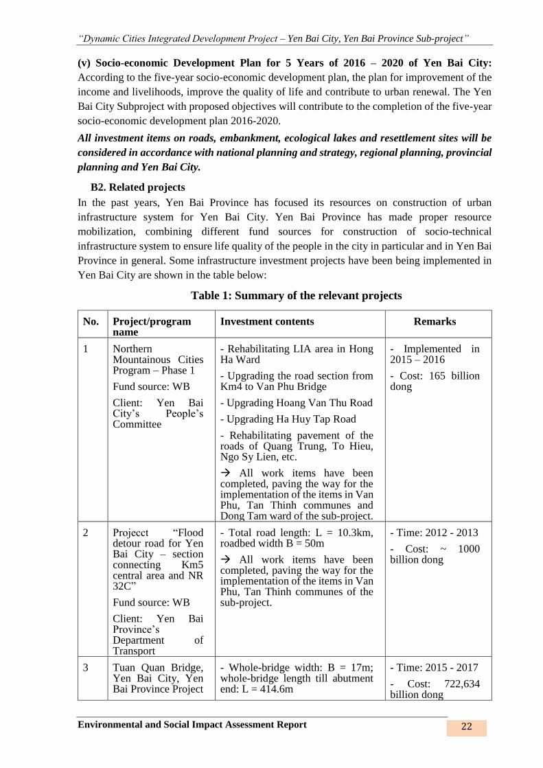
B2. Related projects
In the past years, Yen Bai Province has focused its resources on construction of urban
infrastructure system for Yen Bai City. Yen Bai Province has made proper resource
mobilization, combining different fund sources for construction of socio-technical
infrastructure system to ensure life quality of the people in the city in particular and in Yen Bai
Province in general. Some infrastructure investment projects have been being implemented in
Yen Bai City are shown in the table below:
Table 1: Summary of the relevant projects
No. Project/program name
Investment contents Remarks
1 Northern Mountainous Cities Program – Phase 1
Fund source: WB
Client: Yen Bai City’s People’s Committee
- Rehabilitating LIA area in Hong Ha Ward
- Upgrading the road section from Km4 to Van Phu Bridge
- Upgrading Hoang Van Thu Road
- Upgrading Ha Huy Tap Road
- Rehabilitating pavement of the roads of Quang Trung, To Hieu, Ngo Sy Lien, etc.
All work items have been completed, paving the way for the implementation of the items in Van Phu, Tan Thinh communes and Dong Tam ward of the sub-project.
- Implemented in 2015 – 2016
- Cost: 165 billion dong
2 Projecct “Flood detour road for Yen Bai City – section connecting Km5 central area and NR 32C”
Fund source: WB
Client: Yen Bai Province’s Department of Transport
- Total road length: L = 10.3km, roadbed width B = 50m
All work items have been completed, paving the way for the implementation of the items in Van Phu, Tan Thinh communes of the sub-project.
- Time: 2012 - 2013
- Cost: ~ 1000 billion dong
3 Tuan Quan Bridge, Yen Bai City, Yen Bai Province Project
- Whole-bridge width: B = 17m; whole-bridge length till abutment end: L = 414.6m
- Time: 2015 - 2017
- Cost: 722,634 billion dong

“Dynamic Cities Integrated Development Project – Yen Bai City, Yen Bai Province Sub-project”
Environmental and Social Impact Assessment Report 23
No. Project/program name
Investment contents Remarks
Fund source: WB
Client: Yen Bai Province’s Department of Transport
In finishing stage
4 Construction of Bach Lam Bridge connecting NR 37 and Noi Bai ÷ Lao Cai Highway
Client: Yen Bai Province’s Department of Transport
- The bridge consists of 7 beam spans from beginning to end: (2 x 39) m + (75 + 120 + 75) m + (2 x 39) m; Bridge length Lc = 435.5 m.
In finishing stage
- Time: 2016 – 2020
- Cost: 512.036 billion dong
The Tuan Quan Bridge, Yen Bai City, Yen Bai Province Project and the Project for Construction of Bach Lam Bridge connecting NR 37 and Noi Bai ÷ Lao Cai Highway are underway but have no impacts on the construction works under the DCIDP. As such, these projects are not considered as connective projects to DCIDP
B3. Vietnam’s legal documents
This sub-project will have to comply with Vietnam’s current environmental laws, including Environmental Protection Law No. 55/2014/QH13 dated 23 June 2014, Decree No. 18/2015/ND-CP dated 14 February 2015, the laws, decrees, circulars, decisions, standards and regulations of Vietnam on environment, Circular No. 27/2015/TT-BTNMT dated 29 May 2015 of Minister of Natural Resources and Environment on instructions for strategic environmental assessment, environmental impact assessment, environmental protection commitment, and relevant laws. Specifically:
* Laws
- Environmental Protection Law No. 55/2014/QH13 of the National Assembly of
Vietnam dated June 23, 2014. This law enacted policies and regulations on
environmental safeguards, and rights and obligations of organizations, households and
individuals related to environmental protection activities.
- Land Law No. 45/2013/QH13 ofthe National Assembly of Vietnam dated November
29, 2013 prescribes the regime of land ownership, powers and responsibilities of the
State in representing the entire-people owner of land and uniformly managing land, the
regime of land management and use, the rights and obligations of land users involving
land in the territory of the Socialist Republic of Vietnam.
- Law on Water Resources No. 17/2012/QH13 of the National Assembly of Vietnam
dated June 21, 2012provides on management, protection, exploitation and use of water
resources, as well as the prevention of, combat against and overcoming of harmful
effects caused by water in the territory of the Socialist Republic of Vietnam.
- Law on Biodiversity No. 20/2008/QH12 of the National Assembly of Vietnam dated
November 13, 2008provides for the conservation and sustainable development of
biodiversity; rights and obligations of organizations, households and individuals in the
conservation and sustainable development of biodiversity.
- The Law on Construction No. 50/2014/QH13 approved on 18th June 2014 by 7th
National Assembly of the Socialist Republic of Vietnam;

“Dynamic Cities Integrated Development Project – Yen Bai City, Yen Bai Province Sub-project”
Environmental and Social Impact Assessment Report 24
- The Law on Road Transport No. 23/2008/QH12 dated on 13/11/2008;
- The Law on Complaints 02/2011/QH13 dated 11 November 2011;
- The Law on Culture Heritage No. 10/VBHN-VPQH dated on 23/7/2013;
- The Law on Safety, Labor Sanitation No. 84/2015/QH13 dated June 25, 2015;
- The Law on Dike No. 79/2006/QH11 dated on 29/11/2006;
- The Law on Plant Protection and Quarantine No. 41/2013/QH13 dated on 25/11/2013;
* Decrees:
- Decree No. 38/2015/ND-CP of 24 April 2015 of the Government on management of
waste and discarded materials;
- Decree No. 18/2015/ND-CP dated February 14, 2015 of the Government on
environmental protection planning, strategic environmental assessment, environmental
impact assessment, and environmental protection commitment.
- Decree No.19/2015/ND-CP of 14 February 2015 of the Government detailing the
implementation of a number of articles of the Law on Environmental Protection;
- Decree No.43/2014/ND-CP dated May 15, 2014 of the Government providing guidance
on detailed implementation of some articles from the Land Law 2013.
- Decree No.44/2014/ND-CP dated 15 May 2014 of the Government providing regulations
on land prices.
- Decree No.47/2014/ND-CP dated 15 May 2014 of the Government on compensation,
support, and resettlement when land acquisition is required by the State.
- Decree No. 155/2016/NĐ-CP dated 18 November 2016 of the Government prescribing
administrative sanctions for environmental protection.
- Decree No. 25/2013/ND-CP of 29 March 2013 of the Government on environmental
protection charges for wastewater;
- Decree No. 67/2012/ND-CP of the Government dated 10 September 2012 on the
amendment of Decree No. 143/2003/ND-CP of the Government dated 28 November 2003
on detailing the implementation of a number of articles of the ordinance on exploitation
and protection of irrigation works
- Decree No. 113/2010/NĐ-CP dated 3 December 2010 of the Government on valuation of
damages caused to the environment.
- Decree No. 174/2007/ND-CP of 29 November 2007 on environmental protection charges
for solid waste;
- Decree No. 59/2007/NĐ-CP dated 09/4/2007 of the Government on the management of
solid waste.
* Circulars:

“Dynamic Cities Integrated Development Project – Yen Bai City, Yen Bai Province Sub-project”
Environmental and Social Impact Assessment Report 25
- Circular No. 27/2015/TT-BTNMT dated 19 May 2015 of the Ministry of Natural
Resources and Environment on strategic environmental assessment, environmental
impact assessment, and environmental protection plan.
- Circular No. 36/2014/TT-BTNMT dated 30 June 2014, specifying detailed methods of
valuation of land prices, construction, adjustment of land prices; specific land prices
valuation and land prices valuation consulting service.
- Circular No.37/2014/TT-BTNMT dated 30 June 2014, providing detailed regulation
compensation, assistance, and resettlement when the State acquires land.
- Circular No. 30/2014/TT-BTNM, regulating the records for land allocation or land lease,
the change of land use purposes, land acquisition
- Circular No. 36/2015/TT-BTNMT dated 30/6/2015 of Ministry of Natural Resources and
Environment on hazardous waste management.
- Circular No. 22/2010/TT-BXD dated 03/12/2010 of Ministry of Construction providing
labor safety in construction
- Circular No. 19/2011/TT - BYT of 06 June 2011 of the Minsitry of Health guiding labor
hygiene, laborers’ health and occupational diseases.
- Circular No 13/2007/TT-BXD of December 31st 2007 providing guidance on a number
of articles of Decree no. 59/2007/ND-CP dated 09 April 2007 by the government on solid
waste management.
* Decisions
- Decision 04/2008/QD-BXD dated April 03, 2008 of Ministry of Construction on
Vietnam Building Code.
- Decision No. 52/2012/QD-TTg, dated November 16, 2012 on the support policies on
employment and vocational training to farmers whose agricultural land has been
recovered by the State.
- Document No. 2318/VPCP-QHQT dated 14 March 2017 by the Office of Government
approving proposal for Dynamic Cities Integrated Development Project funded by WB;
- Document No. 799/UBND – XD dated 26 April 2017 by Yen Bai PPC on financial
mechanism for the Dynamic Cities Integrated Development Project, Yen Bai City, Yen
Bai Province Sub-project funded by WB;
- Document No. 2312/UBND-XD dated 07 October 2016 by Yen Bai PPC on assigning
duties to owners of the projects funded by World Bank and Arab Saudi;
- Document No. 1640/UBND-XD dated 08 August 2017 by Yen Bai PPC approving
investment policy for the Dynamic Cities Integrated Development Project, Yen Bai City,
Yen Bai Province Sub-project funded by World Bank.
- Other relevant documents by Yen Bai PPC.
* Applicable standards and codes:
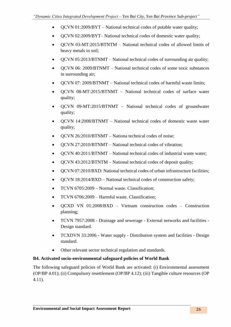
“Dynamic Cities Integrated Development Project – Yen Bai City, Yen Bai Province Sub-project”
Environmental and Social Impact Assessment Report 26
• QCVN 01:2009/BYT – National technical codes of potable water quality;
• QCVN 02:2009/BYT– National technical codes of domestic water quality;
• QCVN 03-MT:2015/BTNTM – National technical codes of allowed limits of
heavy metals in soil;
• QCVN 05:2013/BTNMT – National technical codes of surrounding air quality;
• QCVN 06: 2009/BTNMT – National technical codes of some toxic substances
in surrounding air;
• QCVN 07: 2009/BTNMT – National technical codes of harmful waste limits;
• QCVN 08-MT:2015/BTNMT – National technical codes of surface water
quality;
• QCVN 09-MT:2015/BTNMT – National technical codes of groundwater
quality;
• QCVN 14:2008/BTNMT – National technical codes of domestic waste water
quality;
• QCVN 26:2010/BTNMT – Nationa technical codes of noise;
• QCVN 27:2010/BTNMT – National technical codes of vibration;
• QCVN 40:2011/BTNMT – National technical codes of industrial waste water;
• QCVN 43:2012/BTNTM – National technical codes of deposit quality;
• QCVN 07:2010/BXD: National technical codes of urban infrastructure facilities;
• QCVN 18:2014/BXD – National technical codes of construction safety;
• TCVN 6705:2009 – Normal waste. Classification;
• TCVN 6706:2009 – Harmful waste. Classification;
• QCXD VN 01:2008/BXD – Vietnam construction codes – Construction
planning;
• TCVN 7957:2008 - Drainage and sewerage - External networks and facilities -
Design standard.
• TCXDVN 33:2006 - Water supply - Distribution system and facilities - Design
standard.
• Other relevant sector technical regulation and standards.
B4. Activated socio-environmental safeguard policies of World Bank
The following safeguard policies of World Bank are activated: (i) Environmental assessment
(OP/BP 4.01); (ii) Compulsory resettlement (OP/BP 4.12); (iii) Tangible culture resources (OP
4.11).

“Dynamic Cities Integrated Development Project – Yen Bai City, Yen Bai Province Sub-project”
Environmental and Social Impact Assessment Report 27
Policy OP/BP 4.01 – Environmental assessment 2
The construction and rehabilitation of the urban infrastructure under the subproject involve: i)
new construction of urban roads; ii) upgrading of drainage canals and associated urban roads
and bridges; iii) construction of balancing lakes; and iv) construction of resettlement areas.
Construction and operation of these urban infrastructure would have adverse environmental and
social impacts requiring appropriate mitigations measures which are addressed in details in
subsequent chapters of the ESIA.
This OP 4.01 policy requires that right since the project preparation phase, the socio-
environmental impacts and risks must be well screened and assessed so that proper mitigation
measures and socio-environmental management plans can be proposed for ech project phase to
help minimize negative impacts during project implementation course. OP/BP 4.01 also
requires that the affected community of the project must be consulted during preparation of
ESIA/ESMP. ESIA/ESMP reports must be locally disclosed before project appraisal.
The majority of the potential adverse impacts relate to land acquisition and construction
activities. These include commonly known construction impacts and risks, such as: i) safety
risks related to unexploded ordinances; ii) increased level of dust, noise, vibration; iii) pollution
risks related to generation of waste and wastewater, particularly large amount of
excavated/dredging materials; iv) traffic disturbance, and increased traffic safety risks; iv)
interruption of existing infrastructure and services; v) disturbance to daily socio-economic
activities in project area and social disturbance; vi) health and safety issues related to the public
and the workers at construction sites; vii) social impacts associated with construction disrupting
businesses by construction related activities and mobilization of workers to the construction
site, etc.
The Dynamic Cities Integrated Development Project, Yen Bai Province Sub-project is
classified by WB as an environmental-Category B project, which means that most of the
impacts are of medium level and controllable. The ESIA report is prepared to assess the impacts
caused by the project and propose mitigational measures and management plan for potential
impacts and risks in line with the government's environmental regulations and the Bank's CSR
policy, they will be implemented as part of ESIA preparation. The final ESIAs will be published
on the Bank's and local websites for access by the community prior to the project appraisal.
Policy OP/BP 4.12-Compulsory resettlement 3
This policy helps mitigate negative impacts of involuntary resettlement and disadvantageous
socio-economic impacts; proposes livelihood recovery program to ensure that the affected
households (HHs) of the project will have equal or better living conditions than before the
2 Full version of OP/BP 4.01 can be found at
http://web.worldbank.org/WBSITE/EXTERNAL/PROJECTS/EXTPOLICIES/EXTSAFEPOL/0,,contentMDK:205
43912~menuPK:1286357~pagePK:64168445~piPK:64168309~theSitePK:584435,00.html
3 Details of OP/BP 4.12 ca n be found at
http://web.worldbank.org/WBSITE/EXTERNAL/PROJECTS/EXTPOLICIES/EXTSAFEPOL/0,,contentMDK:2
0543978~menuPK:1286647~pagePK:64168445~piPK:64168309~theSitePK:584435,00.html

“Dynamic Cities Integrated Development Project – Yen Bai City, Yen Bai Province Sub-project”
Environmental and Social Impact Assessment Report 28
subproject implementation. This subproject will acquire homestead land, agricultural land of
local people and requires resettlement of some households.
Screening of the proposed subproject shows that it would affect 992 HHs, and about 115 HHs
have to be relocated. These impacts will cause substantial social risks such as loss of income
and livelihood and disrupted social bonds due to loss of land and/or relocation. However, all
potential impacts and risks could be predicable, mitigatable and manageable by applying all
possible mitigation measures including design alternatives, compensation at replacement cost,
provision of land plots in resettlement sites to be constructed within subproject ward/commune
for relocated households, and provision of livelihood restoration package for severely and
vulnerably affected households. All the potential social impacts and associated mitigation
measures have been included in a Resettlement Action Plan (RAP) for implementation.
Therefore, the OP/BP 4.12 policy is implemented and specifically mentioned in the RP Project
Report of this project.
Policy OP/BP 4.04 - Natural habitats (OP/BP 4.04)4;
The subproject will be implemented in urban areas and will not involve significant conversion
or degradation of critical natural habitats or other natural habitats. However, some civil works
will be implemented on existing natural habitats such as dredging of the Nam Cuong ecological
lake system. The potential impacts and their associated mitigation measures have been
identified and addressed in the subproject ESIA and ESMP.
Policy OP/BP 4.36 - Forest (OP / BP 4.36) 5
This policy aims to reduce forest destruction: (i) Ensure important forest is not invaded, (ii)
Increase the environmental protection of the plantation, (iii) Promote forest plantation, reduce
poverty and encourage economic development; (iv) Protect communities' rights to use
traditional forests in a sustainable manner, integrate forestry effectively into sustainable
economic development, and protect the values of forests.
The project activities and locations of the Yen Bai City Subproject will have an impact on the
health and quality of the forest, the rights and interests of the people, and the degree to which
they depend on or interact with the forest or changes in it. Manage, protect, or use planted or
planted forests. Therefore, this policy is enabled.
Environment, Heath and Safeguard Guidelines of World Bank Group
The sub-projects funded by World Bank will also have to take into account the environmental,
healthcare and safety instructions of World Bank Group (called “EHS instructions”). The EHS
instructions are technical referential materials with specific examples of International Best
Practices.
4Full version of OP/BP 4.04 ca n be found at
http://web.worldbank.org/WBSITE/EXTERNAL/PROJECTS/EXTPOLICIES/EXTSAFEPOL/0,,contentMDK:
20543920~menuPK:1286576~pagePK:64168445~piPK:64168309~theSitePK:584435,00.html
5 Bản đầy đủ của OP/BP 4.36 có thể xem tại
https://policies.worldbank.org/sites/ppf3/PPFDocuments/090224b082301a8c.pdf
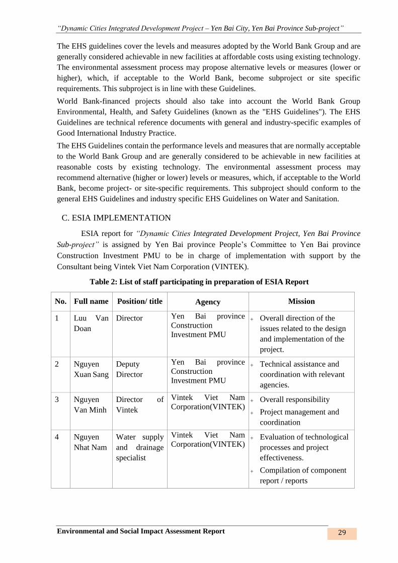
“Dynamic Cities Integrated Development Project – Yen Bai City, Yen Bai Province Sub-project”
Environmental and Social Impact Assessment Report 29
The EHS guidelines cover the levels and measures adopted by the World Bank Group and are
generally considered achievable in new facilities at affordable costs using existing technology.
The environmental assessment process may propose alternative levels or measures (lower or
higher), which, if acceptable to the World Bank, become subproject or site specific
requirements. This subproject is in line with these Guidelines.
World Bank-financed projects should also take into account the World Bank Group
Environmental, Health, and Safety Guidelines (known as the "EHS Guidelines"). The EHS
Guidelines are technical reference documents with general and industry-specific examples of
Good International Industry Practice.
The EHS Guidelines contain the performance levels and measures that are normally acceptable
to the World Bank Group and are generally considered to be achievable in new facilities at
reasonable costs by existing technology. The environmental assessment process may
recommend alternative (higher or lower) levels or measures, which, if acceptable to the World
Bank, become project- or site-specific requirements. This subproject should conform to the
general EHS Guidelines and industry specific EHS Guidelines on Water and Sanitation.
C. ESIA IMPLEMENTATION
ESIA report for “Dynamic Cities Integrated Development Project, Yen Bai Province
Sub-project” is assigned by Yen Bai province People’s Committee to Yen Bai province
Construction Investment PMU to be in charge of implementation with support by the
Consultant being Vintek Viet Nam Corporation (VINTEK).
Table 2: List of staff participating in preparation of ESIA Report
No. Full name Position/ title Agency Mission
1 Luu Van
Doan
Director Yen Bai province
Construction
Investment PMU
Overall direction of the
issues related to the design
and implementation of the
project.
2 Nguyen
Xuan Sang
Deputy
Director
Yen Bai province
Construction
Investment PMU
Technical assistance and
coordination with relevant
agencies.
3 Nguyen
Van Minh
Director of
Vintek
Vintek Viet Nam
Corporation(VINTEK) Overall responsibility
Project management and
coordination
4 Nguyen
Nhat Nam
Water supply
and drainage
specialist
Vintek Viet Nam
Corporation(VINTEK) Evaluation of technological
processes and project
effectiveness.
Compilation of component
report / reports

“Dynamic Cities Integrated Development Project – Yen Bai City, Yen Bai Province Sub-project”
Environmental and Social Impact Assessment Report 30
No. Full name Position/ title Agency Mission
5 Nguyen
Thi Mai
Hoa
Master of
Environmental
Science
Vintek Viet Nam
Corporation(VINTEK) Assessment of present
status and calculation of
pollution.
Summarisation of thematic
reports and preparation of
consolidated reports.
6 Pham Thi
Ngoc Bich
Master of
Environment
Vintek Viet Nam
Corporation(VINTEK) Assessment of present
status and calculation of
water pollution, CTR.
Write a thematic report.
7 Bui Ngoc
Ha
Bachelor of
Social
sciences
Vintek Viet Nam
Corporation(VINTEK) Assessment of the present
economic and social
situation
Compilation of thematic
report.
8 Nguyen
Song
Tung
Master of
Environmental
Science
Vintek Viet Nam
Corporation(VINTEK) Socio-economic survey and
community consultation
Compilation of thematic
report.
9 Le Thi
Thom
Drainage
engineer
Vintek Viet Nam
Corporation(VINTEK) Assessment of the status
and design of processing
technology.
Compilation of thematic
report.
10 Pham
Hong Son
Drainage
engineer
Vintek Viet Nam
Corporation(VINTEK) Evaluation and
identification of risks and
incidents during the
construction and operation
and proposed solutions.
11 Nguyen
Van Hiu
Environmental
engineer
Institute of Tropical
Architecture –
University of
Architecture
Planning, directing,
coordinating the status quo
survey and sampling;
Compilation of the
assessment report of the
quality of the background
environment.
12 Nguyen
Manh Tu
Bachelor of
Environment
Institute of Tropical
Architecture -
University of
Architecture
Status survey and
environmental assessment
Assessment of the quality

“Dynamic Cities Integrated Development Project – Yen Bai City, Yen Bai Province Sub-project”
Environmental and Social Impact Assessment Report 31
No. Full name Position/ title Agency Mission
of the background
environment.
13 Nguyen
Van Hai
Bachelor of
Environment
Institute of Tropical
Architecture -
University of
Architecture
Assessment of the quality
of the background
environment;
Sampling, field
measurement and analysis
of laboratory parameters.
D. METHODS APPLIED DURING ESIA IMPLEMENTATION
- Site survey method: Investigating, surveying existing environmental resource
conditions; Taking soil, water samples, collecting lastest version of materials about the
project area; Researching and selecting observation locations, parameters and methods,
and taking soil, deposit, surface water, groundwater, air samples within the project area;
- Site sampling and analyzing in laboratory: Surface water samples, groundwater
samples, wastewater samples, ambient air, noise, vibration and sediment samples will
be collected and analyzed for environmental quality assessments in the subproject area
in accordance with the current regulations. Samples are preserved and analyzed at a
laboratory meeting the standards required for laboratories qualified for environmental
monitoring services by Environment, Climate, Architecture and Energy Research
Center.
- Community consultation: The Consultant organized community consultation meetings
and group discussions in all areas of subproject construction items, attended by all types
of subject: Indirectly, directly individuals/HHs, management agencies, subproject
developers, other organizations and individuals, etc. Community consultation is
conducted 2 times: (i) 1st time: Determination of impact scope, introduction of the
project, preliminary assessment of environmental impacts caused by the project
activities, collecting comments on mitigating measures; Determining environmental
factors that were not known of before in the project area; (ii) 2nd time: Completion of
draft ESIA report: To report and discuss draft ESIA results and collect feedbacks as well
as agree on the project’s environmental impact assessment results. Benefiting and
affected governments and people will give comments on social, environmental issues
as well as on the proposed technical options and the mitigation measures,
andconstruction methods to be implemented.
“Dynamic Cities Integrated Development Project – Yen Bai City, Yen Bai Province Sub-project”
Environmental and Social Impact Assessment Report 32
- Statistical method: Collecting, processing and analyzing relevant meteorological,
hydrological, environmental, socio-economic documents;
- Expert consultancy method: Via formal and informal meetings: Collecting experts’
comments about negative environmental impacts, proposals on measures to mitigate
negative impacts of the project;
- Matrix method: A matrix board will be established being the comparison of each project
activity with each environmental parameter or element to assess the cause-consequence
relationship. The matrix method is very helpful for determination of the project’s
impacts. This is a simple, manageable method that does not require much environmental
data, yet can clearly analyze many different actions on the same factor. The
environmental matrix method can clearly show the relationship between development
and environment.
- Quick assessment method: Using the pollution coefficients of World Health
Organization (WHO) to estimate waste volume and forecast pollution;
- Comparison method: Assessing the impacts by comparing them with the codes and
standards of soil, water, noise, air quality and other relevant environmental standards;
- Modelling method: Using models to calculate and forecast average contents of
pollutants in waste gases and wastewater to assess their impacts on the environment and
human being;
- Methods of synthesizing, analyzing and formulating the report: Analyzing and
synthesizing the impacts of the project on the components of the natural and socio-
economic environment in the project area.
“Dynamic Cities Integrated Development Project – Yen Bai City, Yen Bai Province Sub-project”
Environmental and Social Impact Assessment Report 33
CHAPTER 1. SUBPROJECT DESCRIPTION
1.1. GENERAL INFORMATION
• Subproject name: “Dynamic Integrated Cities Development Project, Yen Bai Province
Sub-project”
• Executive agency:
Yen Bai Province People’s Committee
Address: Dong Tam Ward, Yen Bai City – Yen Bai Province
Phone: 0216.3856.689 - 0216.3852.343 Email. [email protected]
• Subproject owner:
Yen Bai pronvince People’s Committee Investment Construction PMU
Address: No. 260A, Tran Phu Street, Yen Thinh ward, Yen Bai City, Yên Bai province
Phone: 0439.346.600. Email: [email protected]
Representative: Mr. Luu Van Doan Title: PMU Director
• Consultant supporting the preparaton of ESIA report: Vietnam Vintek JSC (VINTEK)
Director: Mr. Nguyen Van Minh
Address: Floor 1503, Licogi 13 Building, part B, 164 Khuat Duy Tien street, Thanh
Xuan District, Hanoi City
Tel: 043 5134500 Fax: 043 5136642
1.2. SUBPROJECT LOCATION
1.2.1. Geographical location
In the transitional area between Northwest, Viet Bac and Northern Midland regions: Yen Bai
is located at 21.420 N, 104.520 E, being the administrative center of Yen Bai Province, with total
natural area of 106.74 km2;
• The north and the east border on Yen Binh District;
• The west and the south border on Tran Yen District;
The city is on the left of Red River, with average elevation of 35m above sea level. The
topographic structure consists of riverside alluvial strip and ancient riverbed alluvial plain. Low,
round-top mountains/hills, valleys and streams are intertwined with undulating fileds along the
river.

“Dynamic Cities Integrated Development Project – Yen Bai City, Yen Bai Province Sub-project”
Environmental and Social Impact Assessment Report 34
Figure 1: Yen Bai Province and Yen Bai City on the map
1.2.2. The subproject’s dynamic role for the region
According to Northern Midland and Mountainous Region Development Plan to 2030, Yen Bai
Province is to be (i) a regional dynamic city, (ii) an industrial areas amongst Northern industrial
centers, (iii) on national, international tourism routes, and (iv) the provincial-level service
center.
Figure 2: Yen Bai City as a dynamic city of the region
Yen Bai City
“Dynamic Cities Integrated Development Project – Yen Bai City, Yen Bai Province Sub-project”
Environmental and Social Impact Assessment Report 35
(i) Regional dynamism: One of the driving forces for economic development in Yen Bai is the
exchange center of the Northern mountainous provinces (Phu Tho, Son La, Lai Chau, Lao Cai,
Ha Giang, Tuyen Quang, and Thai Nguyen) which is located on one of the three major
economic axes. It is also the gateway that promotes the socio-economic development, trade,
tourism, cultural and scientific-technical services in the border region between Vietnam, China
and Vietnam - Laos in general, the Northern Midlands and Mountains of Vietnam in particular.
(ii) Industrial zone located in the middle of industrial centers in the North: Large and
concentrated industrial zones and clusters, typically three national industrial parks in Yen Bai
city and neighboring areas: Minh Quan Industrial Park covers an area of 112 hectares, the
Southern industrial zone covers an area of 400 hectares, Au Lau industrial zone 120 hectares;
09 industrial clusters with an area of over 264 ha adjacent to the Noi Bai - Lao Cai expressway,
which is favourable for the development of some commodities of the Province's strength to for
domestic consumption and export such as Bat Do bamboo shoots, garments and cinnamon oil,
etc., enhancing the strengths of raw material areas and providing employment for a number of
labors in the Province and neighboring provinces.
(iii) Located on national and international travel routes: Thac Ba Lake Eco-tourism Area; Dam
Hau lake ecotourism project invested by Yen Bai Star Golf Company (including 27 holes golf
course, resort, eco-tourism ...). Vincom shophouse Yen Bai project invested by the Vingroup,
Hoa Sen Yen Bai Hotel, Van Hoi Lake Resort, service areas, warehouses at IC12 intersection
of Noi Bai - Lao Cai highway invested by Hoa Sen Steel Group, etc. Given its adjacence to the
Noi Bai - Lao Cai highway along with the gradual improvement of infrastructure, Yen Bai city
will continue to attract projects and investors to Yen Bai city in particular and other parts of
Yen Bai Province in general, improving job opportunities and incomes of local people and
promoting the socio-economic development of the Province and the region.
(iv) Yen Bai is also planned as a national service center next to international service centers
such as Lang Son and Lao Cai, regional service centers such as Dien Bien, Ha Giang, Tuyen
Quang, Cao Bang, Hoa Binh.
1.3. SUB-PROJECT’S INVESTMENT SCALE
1.3.1. Subproject objectives
General objectives:
- Enhancing accessibility to improved urban technical infrastructure services and urban
planning and management capacity for the cities;
Specific objectives:
- Addressing the city’s challenges; improving the city’s service quality (socio-technical
infrastructure); enhancing the city’s competitiveness and investment appealing;
- Mititgating economic losses due to poor urban infrastructure quality (flooding, traffic
congestion, etc.);
- Supporting the city’s sustainable development based on improvement of strategic
development planning and enhancement of urban management capacity;
- Supporting the city’s/province’s economic development via comprehensive technical
assistance solutions.
“Dynamic Cities Integrated Development Project – Yen Bai City, Yen Bai Province Sub-project”
Environmental and Social Impact Assessment Report 36
1.3.2. Quantity and scale of the subproject work items
The sub-project is to be implemented in 7 wards and communes: 2 communes of Van
Phu and Tan Thinh and 5 wards of Nam Cuong, Yen Ninh, Minh Tan, Dong Tam and Yen
Thinh.
Work scope:
Structural solution – Improvement and construction of urban technical infrastructure
system:
• Sub-component 1: Flood control and urban safety
- Rehabilitating Nam Cuong eco-lake no.1 with total area of 19.6ha and total
bank length L = 2,365m
- Rehabilitating Nam Cuong eco-lake no.2 with total area of 4.26ha and total
bank length L = 850m
- Rehabilitating Nam Cuong eco-lake no.3 with total area of 3.84ha and total
bank length L = 1,041m
- Constructing flood control embankment for Cau Dai Stream with total length L
= 3,755 m
- Constructing flood control embankment for Hao Gia Stream with total length L
= 1,510m
• Sub-component 2: Development of urban corridor and connectivity enhancement
- Road no.1: Constructing road connecting Dien Bien Road to riverside road L =
1,000m
- Road no.2: Constructing road connecting Bach Lam Bridge to Van Phu Bridge
(L = 4,678m)
- Road no.3: Constructing road connecting Nguyen Tat Thanh intersection to Au
Co intersection (L = 4,200m)
• Sub-component 3: Resettlement
- Resettlement site no.1 in Yen Ninh ward – 1.6ha
- Resettlement site no.2 in Van Phu commune – 0.37ha
- Resettlement site no.3 in Yen Ninh ward – 0.44ha
- Resettlement site no.4 in Yen Ninh ward – 0.40ha
- Resettlement site no.5 in Yen Ninh ward – 0.30ha
Plan and technical details of the project items are present in Table 3 and Figure 3
hereunder:
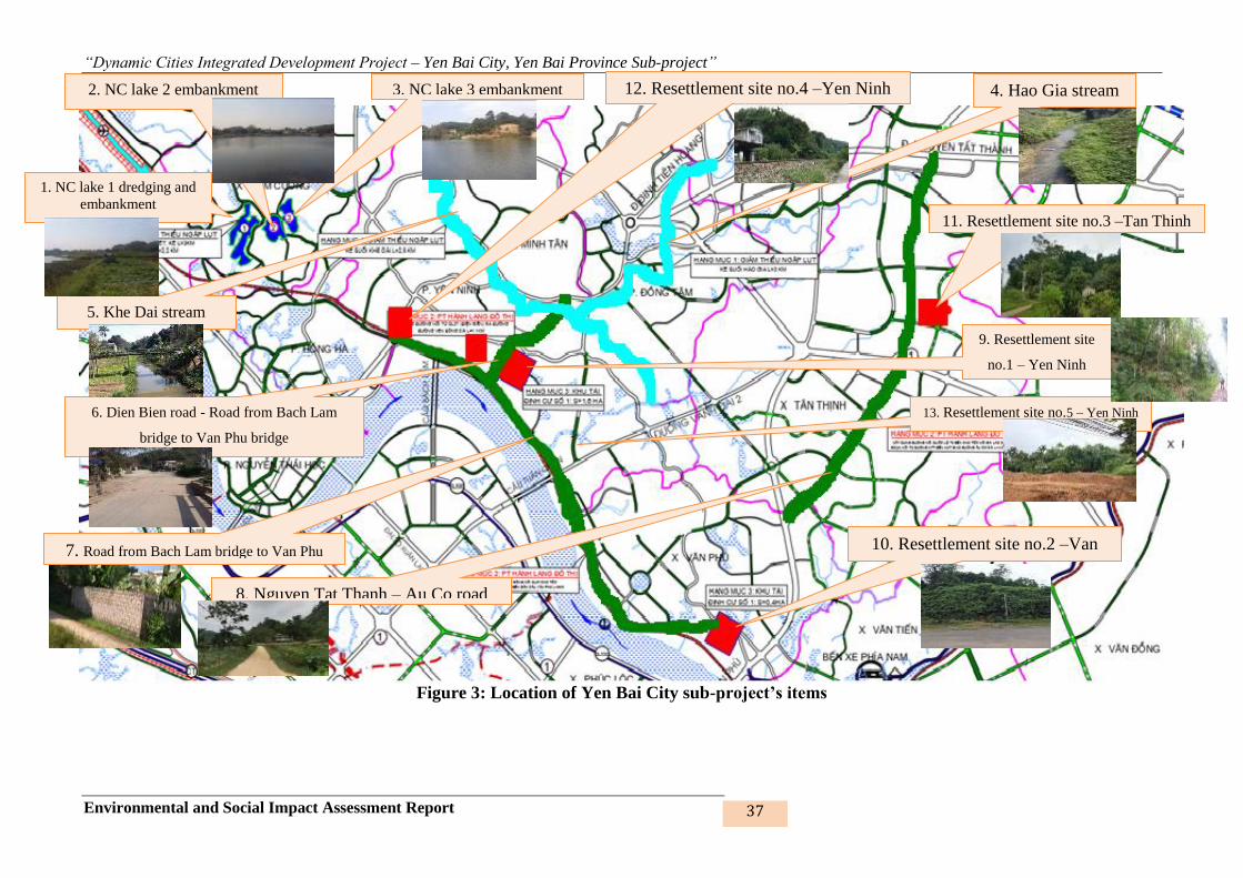
“Dynamic Cities Integrated Development Project – Yen Bai City, Yen Bai Province Sub-project”
Environmental and Social Impact Assessment Report 37
Figure 3: Location of Yen Bai City sub-project’s items
1. NC lake 1 dredging and
embankment
2. NC lake 2 embankment 3. NC lake 3 embankment 4. Hao Gia stream
5. Khe Dai stream
8. Nguyen Tat Thanh – Au Co road
6. Dien Bien road - Road from Bach Lam
bridge to Van Phu bridge
7. Road from Bach Lam bridge to Van Phu
12. Resettlement site no.4 –Yen Ninh
10. Resettlement site no.2 –Van
11. Resettlement site no.3 –Tan Thinh
9. Resettlement site
no.1 – Yen Ninh
13. Resettlement site no.5 – Yen Ninh
ward

“Dynamic Cities Integrated Development Project – Yen Bai City, Yen Bai Province Sub-project”
Environmental and Social Impact Assessment Report 38
Table 3: Proposed investment items of the sub-project
No. Items Description of existing conditions Specifications Land acquisition, resettlement Remarks
I Embankment
1 Rehabilitating
Nam Cuong
eco-lake No. 1:
Dredging,
constructing soil
fall-in control
embankment
around the lake
and other
auxiliary works
- Nam Cuong Ward
- Existing use: To drain
floodwater for the wards of
Hong Ha, Nguyen Thai Hoc,
Nam Cuong.
- Existing technical conditions:
• Not embanked yet; soil fall-
in
• Not dredged yet; severe fill-
up
- Surrounding concrete road: ~
2,5m, M200, 18cm, i=2%.
- Population:
• In some lake sections,
people reside along the lake
bank.
• Main doors of the houses do
not face the lake but only
the gardens and empty land
of the HHs face the lake.
Distance to the nearest
house is 10 – 200m.
- Area: 19.26ha
- Embankmment length: 2,365m
- Dredging depth: 0.5m
- Vertical wall combined with
slope
- Embankment foot: M150 gravity
concrete wall 2m high
- Embankment middle part: applied
to class 1 – road with elevation
higher than lake surface, concrete
M250, 18cm, horizontal slope
i=2%, total length 382.14m/total
embankment length 2,365m.
- Embankment body: Option 1:
from top of foot support wall to
slope’s middle part: placing
M200 cement concrete 15cm
thick; Option Option 2: RC rib
vertical wall
- Slope: Grass-growing concrete
frame
- Embankment top: with combined
traffic/operation and management
- Number of directly affected
HHs6: 12 HHs
- Number of indirectly affected
HHs7: 0 HHs
- No displaced, resettled HHs
- Total affected land area: 8,401
m2
• Homestead land: 270 m2
• Agricultural land: 3,045 m2
• Land area under management
of commune PC: 5,086 m2
6 Directly affected HHs: HHs affected by land and crop acquisition by the project
7 Indirectly affected HHs: HHs affected from practicing cultivation on land under management of commune/town PC

“Dynamic Cities Integrated Development Project – Yen Bai City, Yen Bai Province Sub-project”
Environmental and Social Impact Assessment Report 39
No. Items Description of existing conditions Specifications Land acquisition, resettlement Remarks
road: 3.5 - 6.0m, M300 concrete,
20cm, i=2%
- Green trees, lighting system
along two road sides, rainwater
drainage system along the
embankment.
2 Rehabilitating
Nam Cuong
eco-lake No. 2:
Constructing
soil fall-in
control
embankment
around the lake
- Location: Nam Cuong Ward
- Existing use: Draining
floodwater for the wards of
Hong Ha, Nguyen Thai Hoc,
Nam Cuong
- Existing technical conditions:
• Not embanked yet; frequently
subject to soil fall-in
• Concrete road available (2.5m,
M200, 18cm, i=2%) as
walkway along the lake
• The topography of the lake
- Area: 4.26ha
- Embankment length: 850m
- Embankment food: M150 gravity
concrete, 2m high
- Embankment body: M200
concrete, 15cm
- Embankment slope: M100
cement mortar, 10cm crushed
stone, K = 0.95
- Embankment top: With combined
road 3.5m wide; M300 concrete
structure 20cm thick, i=2%
- No affected or resettled HHs
- No affected land area
MÆT C¾T ®H kÌ hå nam cêng (hå sè 1)Tû lÖ 1:100
MÆT C¾T ®H kÌ hå nam cêng (hå sè 1)-PA so s¸nhTû lÖ 1:100
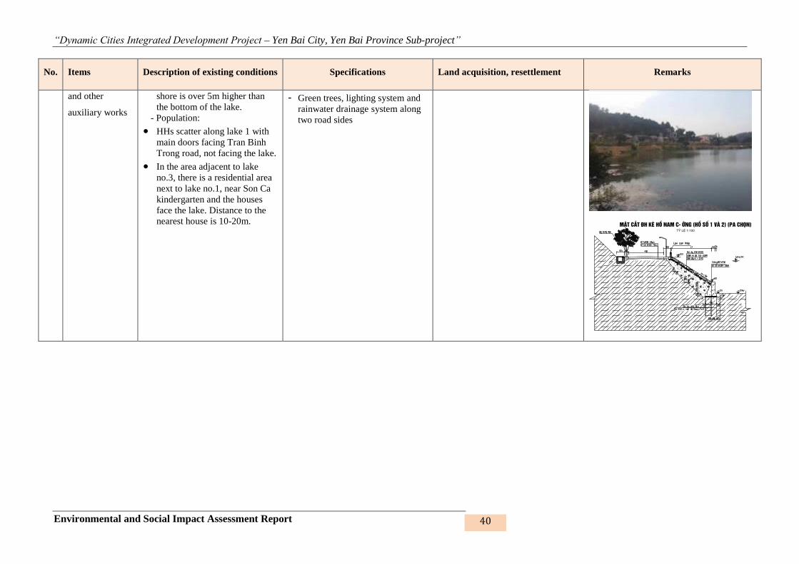
“Dynamic Cities Integrated Development Project – Yen Bai City, Yen Bai Province Sub-project”
Environmental and Social Impact Assessment Report 40
No. Items Description of existing conditions Specifications Land acquisition, resettlement Remarks
and other
auxiliary works
shore is over 5m higher than
the bottom of the lake.
- Population:
• HHs scatter along lake 1 with
main doors facing Tran Binh
Trong road, not facing the lake.
• In the area adjacent to lake
no.3, there is a residential area
next to lake no.1, near Son Ca
kindergarten and the houses
face the lake. Distance to the
nearest house is 10-20m.
- Green trees, lighting system and
rainwater drainage system along
two road sides
MÆT C¾T ®H kÌ hå nam cêng (hå sè 1 vµ 2) (Pa chän)Tû lÖ 1:100
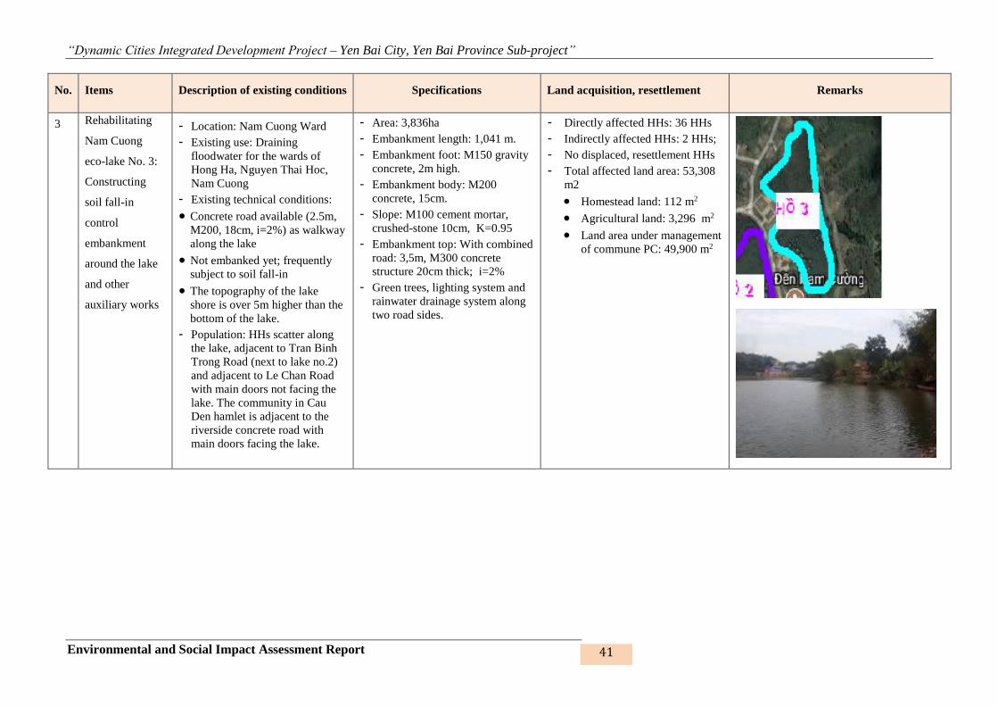
“Dynamic Cities Integrated Development Project – Yen Bai City, Yen Bai Province Sub-project”
Environmental and Social Impact Assessment Report 41
No. Items Description of existing conditions Specifications Land acquisition, resettlement Remarks
3 Rehabilitating
Nam Cuong
eco-lake No. 3:
Constructing
soil fall-in
control
embankment
around the lake
and other
auxiliary works
- Location: Nam Cuong Ward
- Existing use: Draining
floodwater for the wards of
Hong Ha, Nguyen Thai Hoc,
Nam Cuong
- Existing technical conditions:
• Concrete road available (2.5m,
M200, 18cm, i=2%) as walkway
along the lake
• Not embanked yet; frequently
subject to soil fall-in
• The topography of the lake
shore is over 5m higher than the
bottom of the lake.
- Population: HHs scatter along
the lake, adjacent to Tran Binh
Trong Road (next to lake no.2)
and adjacent to Le Chan Road
with main doors not facing the
lake. The community in Cau
Den hamlet is adjacent to the
riverside concrete road with
main doors facing the lake.
- Area: 3,836ha
- Embankment length: 1,041 m.
- Embankment foot: M150 gravity
concrete, 2m high.
- Embankment body: M200
concrete, 15cm.
- Slope: M100 cement mortar,
crushed-stone 10cm, K=0.95
- Embankment top: With combined
road: 3,5m, M300 concrete
structure 20cm thick; i=2%
- Green trees, lighting system and
rainwater drainage system along
two road sides.
- Directly affected HHs: 36 HHs
- Indirectly affected HHs: 2 HHs;
- No displaced, resettlement HHs
- Total affected land area: 53,308
m2
• Homestead land: 112 m2
• Agricultural land: 3,296 m2
• Land area under management
of commune PC: 49,900 m2

“Dynamic Cities Integrated Development Project – Yen Bai City, Yen Bai Province Sub-project”
Environmental and Social Impact Assessment Report 42
No. Items Description of existing conditions Specifications Land acquisition, resettlement Remarks
4 Constructing
flood control
embankment for
Hao Gia Stream
- Location:
• The embankment starts
from Km6 market gate to
D1 bridge, D1 Road
intersecting with Hao Gia
Stream
• The wards of Dong Tam,
Yen Thinh
- Existing use: Draining water for
the wards of Dong Tam, Yen
Ninh, Yen Thinh Commune
- Technical conditions:
• Many sections already
embanked (sections
frequently subject to soil
fall-in, frequently flooded
(1.8 – 3m))
• Total length of embanked
sections: 1,350m/2,860m
• Subject to fill-up,
enroachment, waste disposal
causing flow congestion
- Length: L=1,510m, total length
of the embankment slopes is
3,020m
- Grade of work: grade V
- Stability factor: K=1.1
- Design capacity Q=111m3/s
- Left road is 6m wide, L=2334m
and the right road is 3-6m wide,
1902m long
- Stream bed dredging: 7-9m;
- Two embankment types:
• Passing through residential
area: cannot expand
construction plan: ~800m
• Sections that can be
expanded: ~710m.
- 6 bridges BxH=3x15.7m are
arranged along the embankment,
14 sewers D200, 15cm thick
- Ditches B x H = 0,5 x 0.6m,
concrete structure R200,
reinforced concrete plate M200
- Directly affected HHs: 36 HHs
- Indirectly affected HHs: 2 HHs;
- No displaced, resettlement HHs
- Total affected land area: 53,308
m2
• Homestead land: 112 m2
• Agricultural land: 3,296 m2
• Land area under management
of commune PC: 49,900 m2
MÆT C¾T ®H kÌ hå nam cêng (hå sè 1 vµ 2) (Pa chän)Tû lÖ 1:100
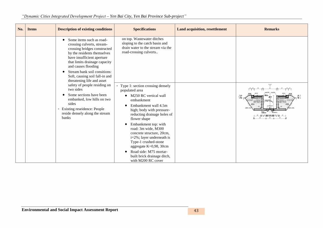
“Dynamic Cities Integrated Development Project – Yen Bai City, Yen Bai Province Sub-project”
Environmental and Social Impact Assessment Report 43
No. Items Description of existing conditions Specifications Land acquisition, resettlement Remarks
• Some items such as road-
crossing culverts, stream-
crossing bridges constructed
by the residents themselves
have insufficient aperture
that limits drainage capacity
and causes flooding
• Stream bank soil consitions:
Soft, causing soil fall-in and
threatening life and asset
safety of people residing on
two sides
• Some sections have been
embanked, low hills on two
sides
- Existing reseidence: People
reside densely along the stream
banks
on top. Wastewater ditches
sloping to the catch basin and
drain water to the stream via the
road-crossing culverts..
- Type 1: section crossing densely
populated area
• M250 RC vertical wall
embankment
• Embankment wall 4.5m
high; body with pressure-
reducting drainage holes of
flower shape
• Embankment top: with
road: 3m wide, M300
concrete structure, 20cm,
i=2%; layer underneath is
Type-1 crushed-stone
aggregate K=0,98, 30cm
• Road side: M75 mortar-
built brick drainage ditch,
with M200 RC cover

“Dynamic Cities Integrated Development Project – Yen Bai City, Yen Bai Province Sub-project”
Environmental and Social Impact Assessment Report 44
No. Items Description of existing conditions Specifications Land acquisition, resettlement Remarks
- Type 2: sparsely populated or
unpopulated area
• Slope embankment
• Embankment foot: M300
RC pile: 20x20, 5m long
• Slope: M200 concrete
15cm thick, with lining
layer of M100 concrete
and slope drainage system
of plastic pipe D=5cm
• Embankment top: Concrete
roads: Left-bank road 6m
wide, right-bank 3m wide
of M300 concrete structure
20cm thick; Layer
underneath is Type-1
crush-stone aggregate, K =
0.98, 30cm
• Road sides with drainage
ditches, slope of 2%
5 Constructing
flood control
embankment for
Cau Dai Stream
(Khe Dai
Stream)
- Location: Minh Tan, Yen Ninh
and Dong Tam wards
- Existing use: Draining water for
the wards of Dong Tam, Yen
Ninh, Minh Tan
- Technical conditions:
• Subject to fill-up,
enroachment, waste disposal
causing flow congestion
• Some items such as road-
crossing culverts, stream-
crossing bridges constructed
by the residents themselves
- Embankment length on each side
L=3,55m.
- Wall embankment combined with
slope
- Grade of work: grade V,
- Embankment stability factor
K=1.1
- Floodwater drainage:
Qp2%=111m3/s
- Frequency P=2%
- Corresponding water levek
H=33.64m
- Directly affected HHs: 199 HHs
- Indirectly affected HHs: 17HHs;
- 28 HHs to be relocated and
resettled
- Total affected land area: 112,994
m2. In which:
• Homestead land: 7,567 m2
• Agricultural land: 82,294
m2, in which, forest
production land is 31,344m2;
• Land area under management
of commune PC: 10,279 m2
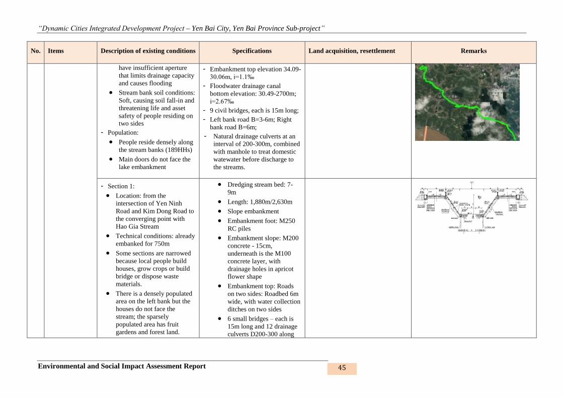
“Dynamic Cities Integrated Development Project – Yen Bai City, Yen Bai Province Sub-project”
Environmental and Social Impact Assessment Report 45
No. Items Description of existing conditions Specifications Land acquisition, resettlement Remarks
have insufficient aperture
that limits drainage capacity
and causes flooding
• Stream bank soil conditions:
Soft, causing soil fall-in and
threatening life and asset
safety of people residing on
two sides
- Population:
• People reside densely along
the stream banks (189HHs)
• Main doors do not face the
lake embankment
- Embankment top elevation 34.09-
30.06m, i=1.1‰
- Floodwater drainage canal
bottom elevation: 30.49-2700m;
i=2.67‰
- 9 civil bridges, each is 15m long;
- Left bank road B=3-6m; Right
bank road B=6m;
- Natural drainage culverts at an
interval of 200-300m, combined
with manhole to treat domestic
watewater before discharge to
the streams.
- Section 1:
• Location: from the
intersection of Yen Ninh
Road and Kim Dong Road to
the converging point with
Hao Gia Stream
• Technical conditions: already
embanked for 750m
• Some sections are narrowed
because local people build
houses, grow crops or build
bridge or dispose waste
materials.
• There is a densely populated
area on the left bank but the
houses do not face the
stream; the sparsely
populated area has fruit
gardens and forest land.
• Dredging stream bed: 7-
9m
• Length: 1,880m/2,630m
• Slope embankment
• Embankment foot: M250
RC piles
• Embankment slope: M200
concrete - 15cm,
underneath is the M100
concrete layer, with
drainage holes in apricot
flower shape
• Embankment top: Roads
on two sides: Roadbed 6m
wide, with water collection
ditches on two sides
• 6 small bridges – each is
15m long and 12 drainage
culverts D200-300 along
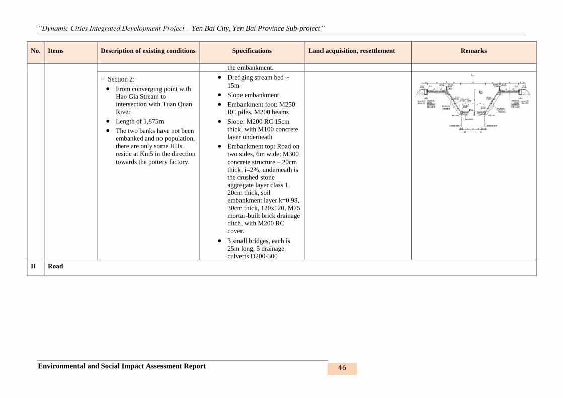
“Dynamic Cities Integrated Development Project – Yen Bai City, Yen Bai Province Sub-project”
Environmental and Social Impact Assessment Report 46
No. Items Description of existing conditions Specifications Land acquisition, resettlement Remarks
the embankment.
- Section 2:
• From converging point with
Hao Gia Stream to
intersection with Tuan Quan
River
• Length of 1,875m
• The two banks have not been
embanked and no population,
there are only some HHs
reside at Km5 in the direction
towards the pottery factory.
• Dredging stream bed ~
15m
• Slope embankment
• Embankment foot: M250
RC piles, M200 beams
• Slope: M200 RC 15cm
thick, with M100 concrete
layer underneath
• Embankment top: Road on
two sides, 6m wide; M300
concrete structure – 20cm
thick, i=2%, underneath is
the crushed-stone
aggregate layer class 1,
20cm thick, soil
embankment layer k=0.98,
30cm thick, 120x120, M75
mortar-built brick drainage
ditch, with M200 RC
cover.
• 3 small bridges, each is
25m long, 5 drainage
culverts D200-300
II Road

“Dynamic Cities Integrated Development Project – Yen Bai City, Yen Bai Province Sub-project”
Environmental and Social Impact Assessment Report 47
No. Items Description of existing conditions Specifications Land acquisition, resettlement Remarks
6 Constructing
road connecting
Dien Bien Road
to the road
connecting Bach
Lam bridge and
Van Phu bridge
(road no.1)
- Location: The wards of Yen
Ninh and Minh Tan
- Existing use:
• This road connects central
area from Dien Bien Road to
the road connecting Bach
Lam bridge and Van Phu
bridge
• Being the traffic road for part
of the community living on
the road intersecting with
Dien Bien Road and at the
interchange with the road to
Bao Luong;
- Existing technical conditions:
• This is an earth road, 3-7m
wide;
• Mostly low hills and
mountains
- Population: sparse population,
mostly concentrated on the road
intersecting with Dien Bien
Road and at the interchange
with the road to Bao Luong
- Distance from the nearest
residential area is 5-10m.
- Length: 1,035m
- Width: 10.5m; sidewalk:
2x5=10m; total pavement width:
20.5m
- Asphalt concrete pavement
structure: compact - 12.5 – 5cm
and rough - 19 – 7cm, on
crushed-stone aggregate
foundation of 25mm - 18cm and
37.5mm - 18cm
- Drainage: Round culvert, box
culvert and slab convert; Beam
bridge L=24m: 1 bridge; Round
culvert D150: 4 culverts
- Design load: H30 - XB80
- Sidewalk: Interlocking block B =
2x5m, i=1% towards roadbed
- Curb of M200 cement concrete;
M200 RC trench cover
(100x100x8cm)
- Proper lighting system
- Directly affected HHs: 47 HHs
- Indirectly affected HHs: 0 HH;
- 11 HHs to be relocated and
resettled;
- Total affected land area: 18.319
m2:
• Homestead land: 2,758 m2
• Agricultural land: 11,196
m2, including 9,923m2 of
forest production land;
• Land under commune PC’s
management: 4,635 m2

“Dynamic Cities Integrated Development Project – Yen Bai City, Yen Bai Province Sub-project”
Environmental and Social Impact Assessment Report 48
No. Items Description of existing conditions Specifications Land acquisition, resettlement Remarks
7 Constructing
road from Bach
Lam Bridge to
Van Phu Bridge
(road no.2)
- Location: Yen Ninh ward and
Van Phu commune
- Existing use: Connecting the
residential area with the road
connecting NR 37, NB-LC
highway, Van Phu Bridge, Tuan
Quan Bridge, Bach Lam Bridge
and Van Tien commune
- Existing technical conditions:
• This is a new road, with
mostly low hills and
mountains intertwined with
residential areas;
• Some sections are earth road,
no road or intersection with
the existing earth road is
available in some sections.
- Population: sparse;
- Distance from the nearest
residential area is about 5 - 10m.
- Length: 4,678m
- Scale: 10.5m+2x5m=20.5m
- Road pavement horizontal slope:
i=2%
- Asphalt concrete pavement
structure: compact - 12.5 – 5cm
and rough - 19 – 7cm, on
crushed-stone aggregate
foundation of 25mm - 18cm and
37.5mm - 18cm
- Drainage: D30-5 culverts; D100-
9 culverts; D200-2 culverts; box
culvert B=75x75-2 culverts;
B100x100-1 culvert; slab culvert
Lo=75– 1 culvert
- Concrete surface water drainage
ditch: M150, 15cm, Lo=80cm
- Sidewalk: Interlocking brick:
B=2x5m, i=1%
- Curb: M200 cement concrete
with M200 RC cover -
100x100x8cm
- Traffic signs: 41 signs
- Design load: HL93.
- Directly affected HHs: 310 HHs
- Indirectly affected HHs: 26 HHs;
- 44 HHs to be relocated and
resettled;
- Total affected land area:
268,662m2, in which:
• Homestead land: 12,728 m2
• Agricultural land: 211,714
m2, including 124,545m2 of
forest production land;
• Land area under management
of commune PC: 38,507 m2

“Dynamic Cities Integrated Development Project – Yen Bai City, Yen Bai Province Sub-project”
Environmental and Social Impact Assessment Report 49
No. Items Description of existing conditions Specifications Land acquisition, resettlement Remarks
8 Constructing
road connecting
Nguyen Tat
Thanh
intersection with
Au Co
intersection
(road no.3)
- Location: Tan Thinh Commune
- Existing technical conditions:
• Terrain consists of mostly
low hills and mountains
intertwined with ponds and
lakes forming uneven terrain
with average height of hill
tops of about 50m;
• A 3-7m earth road is
currently available with no
connective road.
• Population: Small residential
areas scattered along the
existing road;
• No residence on the
remaining sections.
- Length: 4,200m
- Scale: 10.5m+2x5m=20.5m
- Asphalt concrete pavement
structure: compact - 12.5 – 5cm
and rough - 19 – 7cm, on
crushed-stone aggregate
foundation of 25mm - 18cm and
37.5mm - 18cm
- Drainage: D150-10 culverts;
D200-1 culvert; B300x300-1
culvert; 12m slab bridge – 1
bridge
- Concrete surface water drainage
ditch: M150, 15cm, Lo=80cm
- Sidewalk: Interlocking brick:
B=2x5m, i=1%
- Curb: M200 cement curb with
M200 RC cover - 100x100x8cm
- Directly affected HHs: 136 HHs
- Indirectly affected HHs: 5 HHs;
- 9 HHs to be relocated and
resettled;
- Total affected land area: 161,749
m2, in which:
• Homestead land: 6,073 m2
• Agricultural land: 152,334
m2, including 76,347m2 of
forest production land;
• Land area under management
of commune PC: 3,342 m2
III Resettlement site

“Dynamic Cities Integrated Development Project – Yen Bai City, Yen Bai Province Sub-project”
Environmental and Social Impact Assessment Report 50
No. Items Description of existing conditions Specifications Land acquisition, resettlement Remarks
9 Residential site
No. 1
- Location: Group 26, Yen Ninh
Ward
- Existing use: The land is
currently the forest production
land of households, mostly
bushes and mixed wood trees
such as acacia, bamboo, etc.
- Existing technical condition: 5 –
7m wide earth road available in
some sections
- Population: No population in the
proposed resettlement site no.1
- Resettlement site for items 4, 5,
6.
- Area: 1.6ha
- Construction: 64 resettlement
lots, 160m2/lot, (L=8m, B=20m)
- định cư 160m2/lô
- Entrance road to the resettlement
site no.1 is designed with the
main specifications as follows:
+ Embankment width
Bembankment = 12.00m.
+ Pavement width Bpavement =
6.00m.
+ Sidewalk width Bvh =
(3.00mx2) = 6.00m.
+ Cut slope 1/1.00, fill slope
1/1.5.
- Longitudinal ditch with
trapezoidal cross section
B=1.00m. Pavement structure:
cement concrete M300, 18cm
thick. 15cm thick aggregate road
foundation.
- M150 cement concrete drainage
ditch, 15cm thick, with covering
slab
- Greenery, lighting system and
water supply are made available,
with 1 main pipeline D75, HDPE
and 3 branch pipelines D40,
HDPE.
- Reservation lots are designed for
communal house and playground.
- Directly affected HHs: 10 HHs
- Indirectly affected HHs: 8 HHs;
- No displaced, resettlement HHs
- Total affected land area:
16,000m2
• Homestead land: 0 m2
• Agricultural land: 12,058 m2
of forest production land;
• Land area under management
of commune PC: 3,942 m2
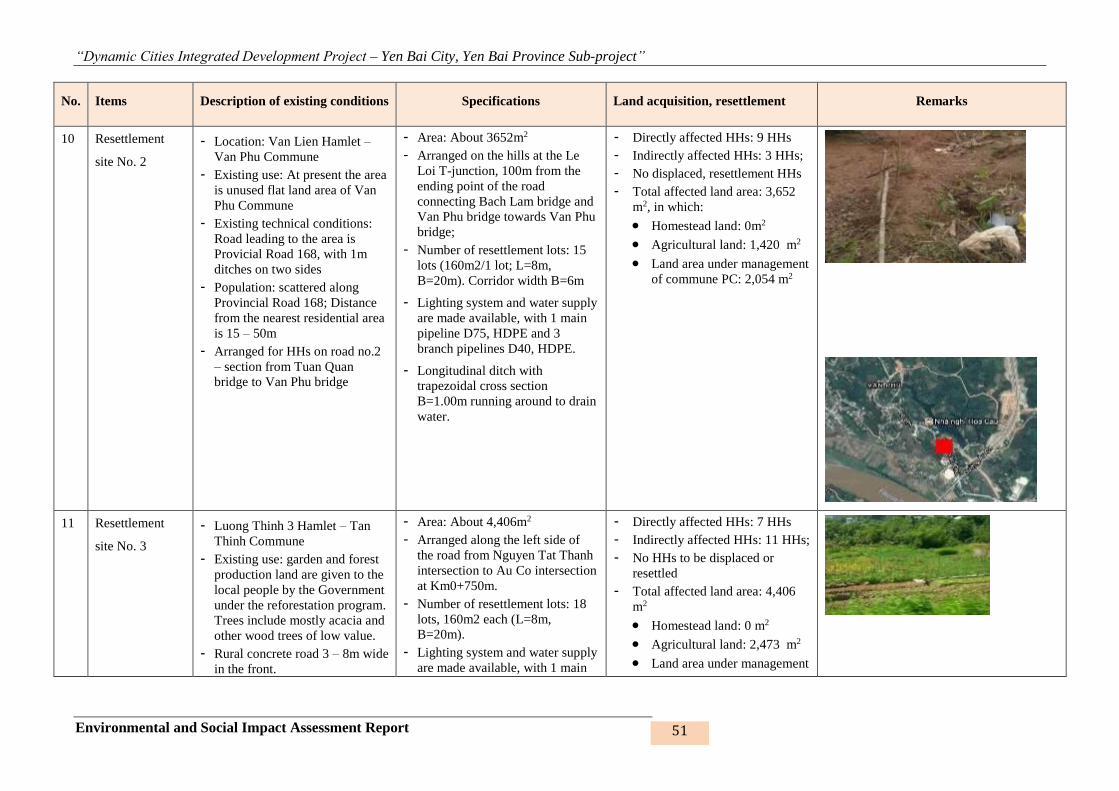
“Dynamic Cities Integrated Development Project – Yen Bai City, Yen Bai Province Sub-project”
Environmental and Social Impact Assessment Report 51
No. Items Description of existing conditions Specifications Land acquisition, resettlement Remarks
10 Resettlement
site No. 2
- Location: Van Lien Hamlet –
Van Phu Commune
- Existing use: At present the area
is unused flat land area of Van
Phu Commune
- Existing technical conditions:
Road leading to the area is
Provicial Road 168, with 1m
ditches on two sides
- Population: scattered along
Provincial Road 168; Distance
from the nearest residential area
is 15 – 50m
- Arranged for HHs on road no.2
– section from Tuan Quan
bridge to Van Phu bridge
- Area: About 3652m2
- Arranged on the hills at the Le
Loi T-junction, 100m from the
ending point of the road
connecting Bach Lam bridge and
Van Phu bridge towards Van Phu
bridge;
- Number of resettlement lots: 15
lots (160m2/1 lot; L=8m,
B=20m). Corridor width B=6m
- Lighting system and water supply
are made available, with 1 main
pipeline D75, HDPE and 3
branch pipelines D40, HDPE.
- Longitudinal ditch with
trapezoidal cross section
B=1.00m running around to drain
water.
- Directly affected HHs: 9 HHs
- Indirectly affected HHs: 3 HHs;
- No displaced, resettlement HHs
- Total affected land area: 3,652
m2, in which:
• Homestead land: 0m2
• Agricultural land: 1,420 m2
• Land area under management
of commune PC: 2,054 m2
11 Resettlement
site No. 3
- Luong Thinh 3 Hamlet – Tan
Thinh Commune
- Existing use: garden and forest
production land are given to the
local people by the Government
under the reforestation program.
Trees include mostly acacia and
other wood trees of low value.
- Rural concrete road 3 – 8m wide
in the front.
- Area: About 4,406m2
- Arranged along the left side of
the road from Nguyen Tat Thanh
intersection to Au Co intersection
at Km0+750m.
- Number of resettlement lots: 18
lots, 160m2 each (L=8m,
B=20m).
- Lighting system and water supply
are made available, with 1 main
- Directly affected HHs: 7 HHs
- Indirectly affected HHs: 11 HHs;
- No HHs to be displaced or
resettled
- Total affected land area: 4,406
m2
• Homestead land: 0 m2
• Agricultural land: 2,473 m2
• Land area under management
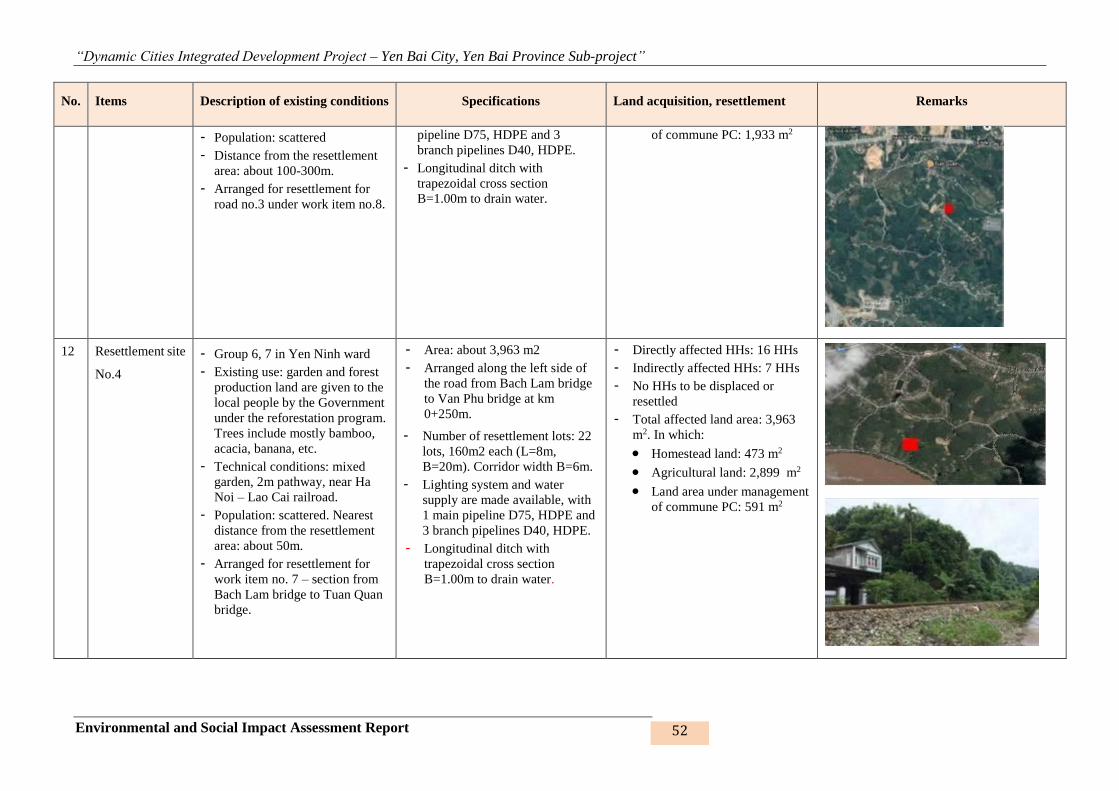
“Dynamic Cities Integrated Development Project – Yen Bai City, Yen Bai Province Sub-project”
Environmental and Social Impact Assessment Report 52
No. Items Description of existing conditions Specifications Land acquisition, resettlement Remarks
- Population: scattered
- Distance from the resettlement
area: about 100-300m.
- Arranged for resettlement for
road no.3 under work item no.8.
pipeline D75, HDPE and 3
branch pipelines D40, HDPE.
- Longitudinal ditch with
trapezoidal cross section
B=1.00m to drain water.
of commune PC: 1,933 m2
12 Resettlement site
No.4
- Group 6, 7 in Yen Ninh ward
- Existing use: garden and forest
production land are given to the
local people by the Government
under the reforestation program.
Trees include mostly bamboo,
acacia, banana, etc.
- Technical conditions: mixed
garden, 2m pathway, near Ha
Noi – Lao Cai railroad.
- Population: scattered. Nearest
distance from the resettlement
area: about 50m.
- Arranged for resettlement for
work item no. 7 – section from
Bach Lam bridge to Tuan Quan
bridge.
- Area: about 3,963 m2
- Arranged along the left side of
the road from Bach Lam bridge
to Van Phu bridge at km
0+250m.
- Number of resettlement lots: 22
lots, 160m2 each (L=8m,
B=20m). Corridor width B=6m.
- Lighting system and water
supply are made available, with
1 main pipeline D75, HDPE and
3 branch pipelines D40, HDPE.
- Longitudinal ditch with
trapezoidal cross section
B=1.00m to drain water.
- Directly affected HHs: 16 HHs
- Indirectly affected HHs: 7 HHs
- No HHs to be displaced or
resettled
- Total affected land area: 3,963
m2. In which:
• Homestead land: 473 m2
• Agricultural land: 2,899 m2
• Land area under management
of commune PC: 591 m2
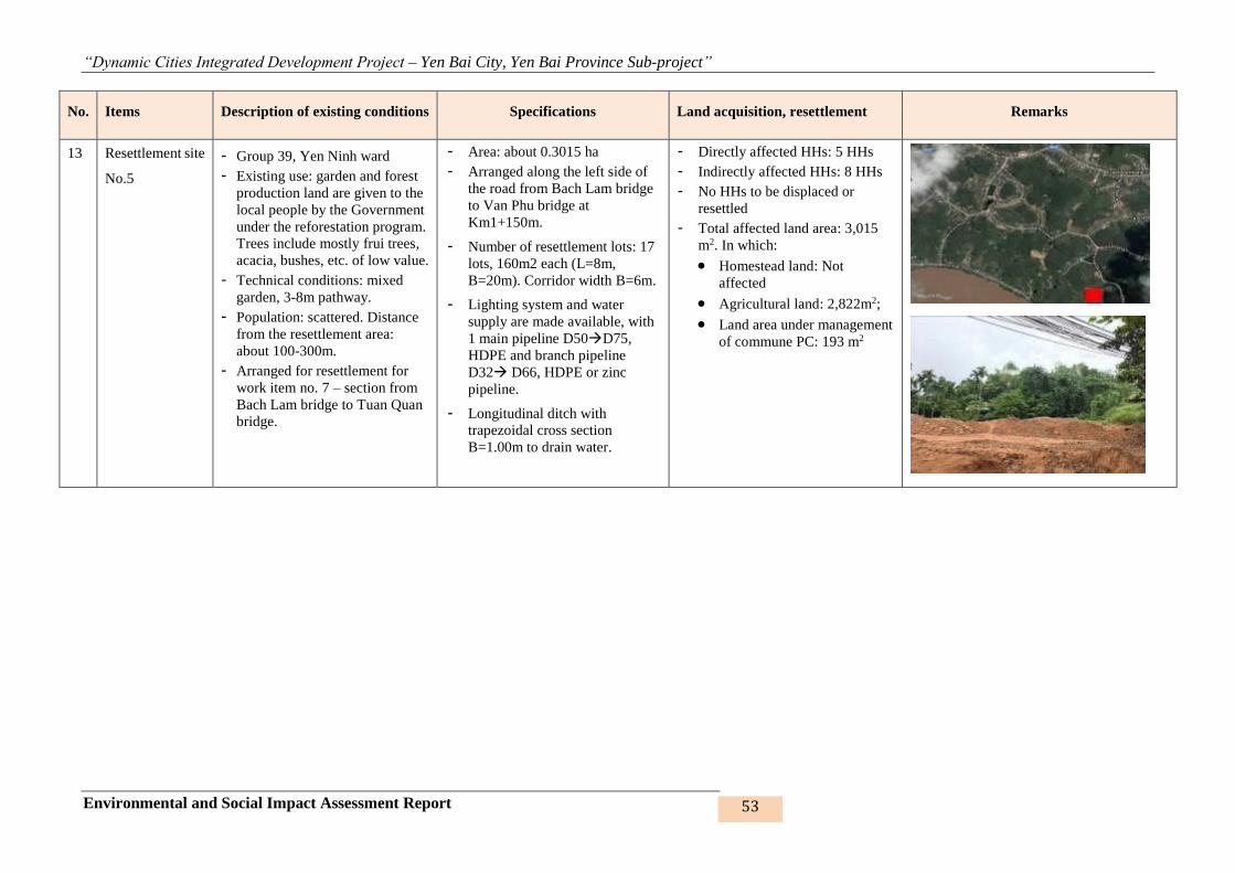
“Dynamic Cities Integrated Development Project – Yen Bai City, Yen Bai Province Sub-project”
Environmental and Social Impact Assessment Report 53
No. Items Description of existing conditions Specifications Land acquisition, resettlement Remarks
13 Resettlement site
No.5
- Group 39, Yen Ninh ward
- Existing use: garden and forest
production land are given to the
local people by the Government
under the reforestation program.
Trees include mostly frui trees,
acacia, bushes, etc. of low value.
- Technical conditions: mixed
garden, 3-8m pathway.
- Population: scattered. Distance
from the resettlement area:
about 100-300m.
- Arranged for resettlement for
work item no. 7 – section from
Bach Lam bridge to Tuan Quan
bridge.
- Area: about 0.3015 ha
- Arranged along the left side of
the road from Bach Lam bridge
to Van Phu bridge at
Km1+150m.
- Number of resettlement lots: 17
lots, 160m2 each (L=8m,
B=20m). Corridor width B=6m.
- Lighting system and water
supply are made available, with
1 main pipeline D50D75,
HDPE and branch pipeline
D32 D66, HDPE or zinc
pipeline.
- Longitudinal ditch with
trapezoidal cross section
B=1.00m to drain water.
- Directly affected HHs: 5 HHs
- Indirectly affected HHs: 8 HHs
- No HHs to be displaced or
resettled
- Total affected land area: 3,015
m2. In which:
• Homestead land: Not
affected
• Agricultural land: 2,822m2;
• Land area under management
of commune PC: 193 m2

“Dynamic Cities Integrated Development Project – Yen Bai City, Yen Bai Province Sub-project”
Environmental and Social Impact Assessment Report 54
1.3.3. Auxiliary items
1. Camps and workes
Camps are built in the construction site to serve the daily life and convenience of workers and
engineers during construction. In particular:
- 13 work items will be arranged in 6 packages.
- 6 camps will be arranged for workers.
Figure 4: Some camps are located on the roads and embankments to be constructed
Proposed camp on road no. 1
Proposed camp on road no. 3
Proposed camp on road no. 2
Proposed camp on Hao Gia embankment
Proposed camp on NC 1 embankment
Proposed camp on Khe Dai embankment
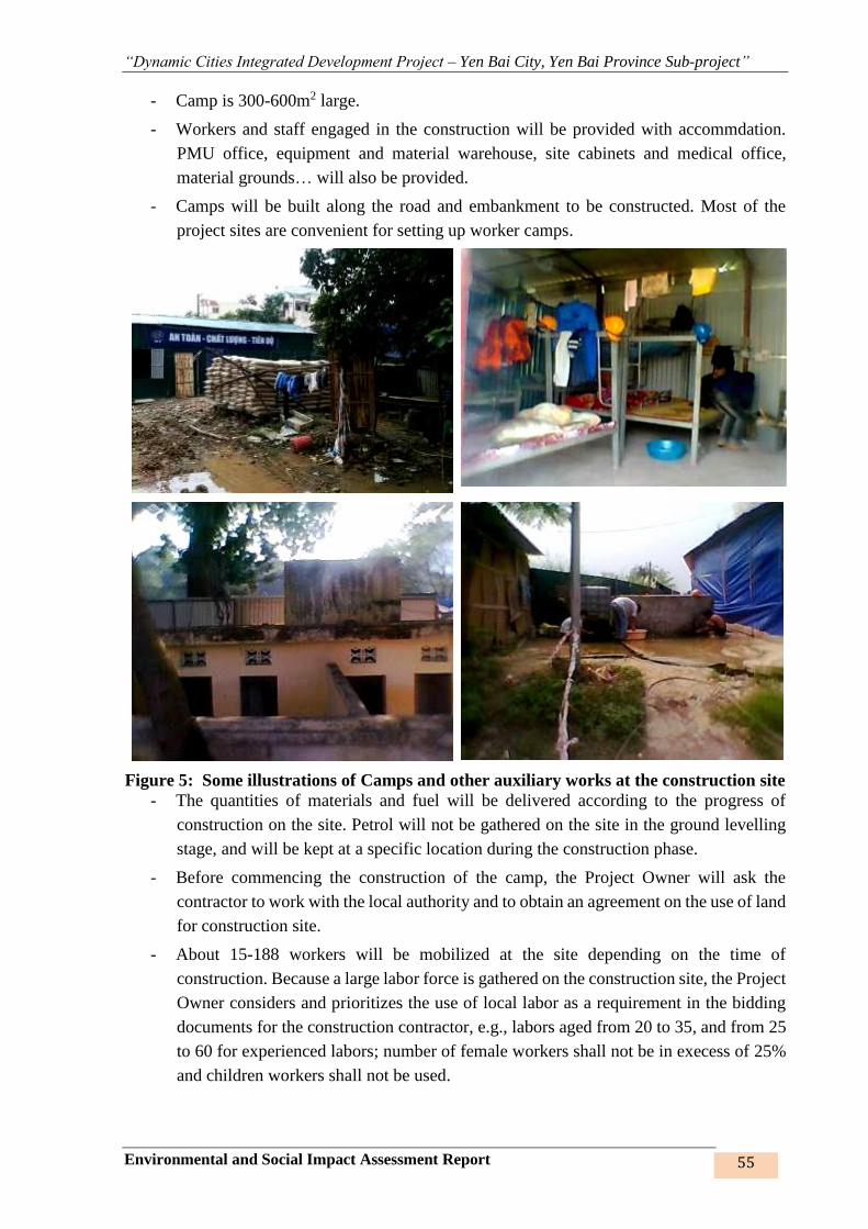
“Dynamic Cities Integrated Development Project – Yen Bai City, Yen Bai Province Sub-project”
Environmental and Social Impact Assessment Report 55
- Camp is 300-600m2 large.
- Workers and staff engaged in the construction will be provided with accommdation.
PMU office, equipment and material warehouse, site cabinets and medical office,
material grounds… will also be provided.
- Camps will be built along the road and embankment to be constructed. Most of the
project sites are convenient for setting up worker camps.
Figure 5: Some illustrations of Camps and other auxiliary works at the construction site
- The quantities of materials and fuel will be delivered according to the progress of
construction on the site. Petrol will not be gathered on the site in the ground levelling
stage, and will be kept at a specific location during the construction phase.
- Before commencing the construction of the camp, the Project Owner will ask the
contractor to work with the local authority and to obtain an agreement on the use of land
for construction site.
- About 15-188 workers will be mobilized at the site depending on the time of
construction. Because a large labor force is gathered on the construction site, the Project
Owner considers and prioritizes the use of local labor as a requirement in the bidding
documents for the construction contractor, e.g., labors aged from 20 to 35, and from 25
to 60 for experienced labors; number of female workers shall not be in execess of 25%
and children workers shall not be used.
“Dynamic Cities Integrated Development Project – Yen Bai City, Yen Bai Province Sub-project”
Environmental and Social Impact Assessment Report 56
Table 4: Demands of labourers for the sub-project
No Items No. of labourers
(persons)
1 Nam Cuong lake 1 embankment 50
2 Nam Cuong lake 2 embankment 25
3 Nam Cuong lake 3 embankment 25
4 Hào Gia stream embankment 56
5 Khe Dai stream embankment 134
6 Road connecting Dien Bien Rd. to road from Bach Lam bridge to Van Phu bridge 72
7 Road from Bach Lam bridge to Van Phu bridge 188
8 Road connecting Nguyen Tat Thanh intersection and Au Co intersection 125
9 Resettlement site no. 1 70
10 Resettlement site no. 2 65
11 Resettlement site no. 3 15
12 Resettlement site no. 4 18
13 Resettlement site no. 5 23
2. Service road
As for the construction of the roads, the Nam Cuong Lake embankment and the resettlement
sites in Yen Ninh and Van Phu wards, there are basically available earth road/asphalt road
leading to the construction sites in the relevant wards/communes. However, road is unavailable
for the embankment of Hao Gia stream and Khe Dai stream, therefore, depending on each
section on the route and whether it can be expanded or not, a service road from 3 to 3.5m in
width will be built along the embankment with soil, K95 stone aggregate to ensure smooth and
safe travel of 5 – 12 ton vehicles. In the case expansion is impossible, the contractor should
consider manual transportation and service road construction to ensure the quality, schedule
and reasonable costs.
1.4. CONSTRUCTION METHOD
1. Detecting and removing remaining bombs and mines left from war time
Demining is very necessary to ensure life safety for workers and other staff members at site and
proper work progress and quality. Client will hire a specialized firm/military unit or a firm
under Ministry of Defense to undertake this work. This task will be done first upon construction
commencement.
2. Preparation of site plan
Positioning
Measuring, recovering and fixing locations of route centerlines, construction sites, elevation
marks along the routes/locations and providing extra marks; additionally checking and
measuring cross-sections when necessary.
For deep and short excavation sites, excavation shall be carried out on the entire cross-section
and along the horizontal axis of the road centerline. For the moderate thickness of the
excavation site, then dig each layer in the longitudinal direction on the entire width of the

“Dynamic Cities Integrated Development Project – Yen Bai City, Yen Bai Province Sub-project”
Environmental and Social Impact Assessment Report 57
excavation. Digging into beds in case of deep excavations. First, excavator digs an open bed
along the excavation, then digs laterally to the sides and at the same time taking advantage of
the digging beds to drain water and move the land out.
Excavation of weathered layer
The soil is dug up about 50-120cm from the surface, if not utilized, it will be transported to the
waste disposal grounds to avoid pollution for the surrounding environment.
Excavation and backfilling
Excavated soil can be used for embankment, so it can be used mechanically to fill the
construction site. Stone, wood, and any other inappropriate material encountered when
excavated must be removed from the site and shall not be used for backfilling. Pripority should
be given to immediately used parts such as campsite and the rest can be filled later.
Some excavated soil may be given to local people who want to use it for building their houses.
The unused and extra quantities shall be delivered to the waste disposal sites which have been
agreed on by Yen Ninh, Dong Tam, Nam Cuong wards and Van Phu, Tan Thinh communes
and accepted by Yen Bai City People’s Committee at Letter No. 1311/CV-UBND dated 02
November 2017.
Execution of any item should be completely finished before the commencement of the next
item; Ensuring the irrigation capacity in the construction phase of about 80% of the present
capacity.
3. Base reinforcement pile construction
Base reinforcement using concrete piles: Using specialized pile driving machine to drive the
piles. Specifically: Reinforcing embankment slope using dry-paved rubbles 30cm thick, with
lining crushed stone layer 10cm thick and geotextile in RC frame, or using specific technical
solution for each construction area.
4. Construction method for the work items
For dredging of lakes and streams: Using barges and mud buckets to load weathered materials
on the barges, gathering them on the lake bank, loading on 5-10 ton trucks and transporting to
dumping grounds.
Construction principles:
- As for Nam Cuong lakes, since lake no. 1 is located downstream, it will be embanked
first, lakes no. 2 and 3 later.
- The lake bed is dredged first, the slope and road later (as for the embankment
construction)
Sequence of embankment construction steps:
- Identifying alignment centerline, establishing monitoring marks.
- Discharging water to lower the lake water elevation down to the dredging elevation
+27.80m.
- Subsequent steps are as stated hereunder.
“Dynamic Cities Integrated Development Project – Yen Bai City, Yen Bai Province Sub-project”
Environmental and Social Impact Assessment Report 58
Embankment: Given the soil fall-in prevention requirement, the embankment lines are to be
constructed by successive construction method:
+ Step 1: Removing weathered layers manually and transporting the waste to an unused
empty land plot near the construction site before transportation to disposal area;
+ Step 2: Constructing surrounding wall manually and using excavator;
+ Step 3: Excavating soil, leveling to create slope’s middle part at the elevation of +0.4
÷ 0.5m;
+ Step 4: Driving two eucalyptus sheet pile lines adjacent to the two rock gabion edges;
+ Step 5: Excavating rock gabion foundation to elevation of -2.10m;
+ Step 6: Constructing bamboo layer between rock gabion and filling soil;
+ Step 7: Rock gabion construction;
+ Step 8: Embankment slope forming soil filling;
+ Step 9: Embankment slope frame construction;
+ Step 10: Tightly laying rocks into embankment slope frame;
+ Step 11: Surrounding wall removal;
+ Step 12: After slope completion, constructing road on embankment top;
+ Step 13: Finishing the remaing works and clearing the site;
RC drainage culverts and drainage system construction
- Step 1: Leveling, creating construction ground; determining culvert laying elevation
- Step 2: Excavating trench to the design drainage culvert and WW drainage culvert
elevations; gathering waste at temporary disposal area and periodically transporting it
to disposal site
- Step 3: Constructing, installing, assembling culvert joints (pre-casted RC culverts) or
assembling formworks, RC slab covers, pouring concrete (RC culverts casted at site)
- Step 4: Installing HDPE D200-300 WW drainage culverts as designed
- Step 5: Reinstatement soil filling as designed
Road construction: Road, bridge construction method consists of steps as follows:
1. Preparation
- Positioning and localizing the works;
- Preparing labor camps and gathering construction materials;
- Mobilizing machineries and equipment;
2. Concrete road construction
- Step 1: Excavating, dredging unsuitable materials
- Step 2: Covering the land surface up to the hardness standard for each design layer
- Step 3: Excavating road foundation for each section’s width; installing formworks and
pouring cement concrete
- Step 4: Drawing forms => completion
3. Asphal concrete layer construction
“Dynamic Cities Integrated Development Project – Yen Bai City, Yen Bai Province Sub-project”
Environmental and Social Impact Assessment Report 59
- Step 1: Excavating, dredging unsuitable materials
- Step 2: Covering the surface up to the hardness standard for each design layers
- Step 3: Excavating road foundation for each section’s width
- Step 4: Spreading and compacting each soil layer; Slapping (Type 2 and Type 1) (road
bed) to the standard hardness for the design layers
- Step 5: Drawing forms => completion
Bridge construction: Construction method consists of steps as follows:
- Abutment construction: Leveling the ground, installing pile drilling construction
equipment to create holes to stabilize the wall by placing concrete by underwater
concrete placing method. Place the pit to the design elevation.
- Terrestrial pillar construction: Leveling the ground, determining the abutment
centerline and position of the pile. Dig pits to design elevation, concrete pile head, flat
concrete lining, formwork installation, reinforcement for nails, reinforced concrete dam,
body cap. Pour concrete and remove pavement, formwork. Fill up to natural altitude and
improve the pillar.
- Underwater pillar construction: Determining the centerline and position of the pile,
seting positioning piles or building the pedestal; Installating pile driving equipment on
floating or pedestal system, driving piles to the design level; Setting the ring of steel
piles, excavating the soil within the circle of steel sheet piles, reinforce the nails, pour
concrete; Installing pavement and formwork, finishing pillars.
- Bridge’s upper part construction: Preparation of beams, gathering materials and
machinery. Construction of molding platform/formwork; Install reinforcement for
girders and cables for post-tensioning and installation of formwork; Pour and cure
concrete; Construction of beam beams and concrete balustrade; Surface waterproofing,
asphalt paving, bridging.
Resettlement site construction
- Step 1: Levelling ground and dividing lots. Leveling ground to make construction
ground; Determining the construction elevation required with the drainage slope i=0.5%, K=0.9
and cut slop 1/1, fill slope 1/1.5.
- Step 2: Designing road (applied to resettlment site no.1 only). The road is newly built
and located within the resettlement site no.1. Bembankment = 12m.
- Step 3: Digging hole down to the sewer and drainge culvert position as designed;
Cement concrete drainage ditch M150, 15cm thick, with cover.
- Step 4: Installing the domestic water system provided by Yen Bai Water Supply and
Construction Joint Stock Company. The system includes 1 main pipeline D75 and 3
branch pipelines D40.
- Step 5: Erecting electric poles on the sidewalk with 01 circuit breaker, anti-thunder
equipment and other auxiliary equipment.
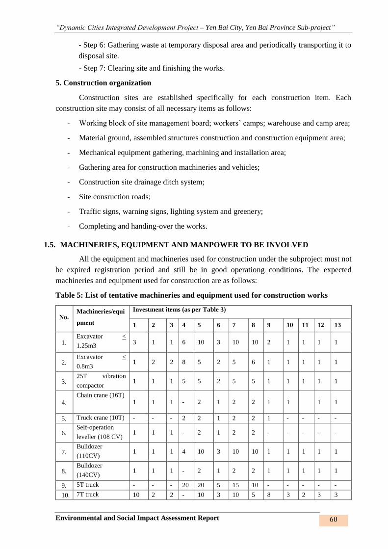
“Dynamic Cities Integrated Development Project – Yen Bai City, Yen Bai Province Sub-project”
Environmental and Social Impact Assessment Report 60
- Step 6: Gathering waste at temporary disposal area and periodically transporting it to
disposal site.
- Step 7: Clearing site and finishing the works.
5. Construction organization
Construction sites are established specifically for each construction item. Each
construction site may consist of all necessary items as follows:
- Working block of site management board; workers’ camps; warehouse and camp area;
- Material ground, assembled structures construction and construction equipment area;
- Mechanical equipment gathering, machining and installation area;
- Gathering area for construction machineries and vehicles;
- Construction site drainage ditch system;
- Site consruction roads;
- Traffic signs, warning signs, lighting system and greenery;
- Completing and handing-over the works.
1.5. MACHINERIES, EQUIPMENT AND MANPOWER TO BE INVOLVED
All the equipment and machineries used for construction under the subproject must not
be expired registration period and still be in good operationg conditions. The expected
machineries and equipment used for construction are as follows:
Table 5: List of tentative machineries and equipment used for construction works
No. Machineries/equi
pment
Investment items (as per Table 3)
1 2 3 4 5 6 7 8 9 10 11 12 13
1. Excavator <
1.25m3 3 1 1 6 10 3 10 10 2 1 1 1 1
2. Excavator <
0.8m3 1 2 2 8 5 2 5 6 1 1 1 1 1
3. 25T vibration
compactor 1 1 1 5 5 2 5 5 1 1 1 1 1
4. Chain crane (16T)
1 1 1 - 2 1 2 2 1 1 1 1
5. Truck crane (10T) - - - 2 2 1 2 2 1 - - - -
6. Self-operation
leveller (108 CV) 1 1 1 - 2 1 2 2 - - - - -
7. Bulldozer
(110CV) 1 1 1 4 10 3 10 10 1 1 1 1 1
8. Bulldozer
(140CV) 1 1 1 - 2 1 2 2 1 1 1 1 1
9. 5T truck - - - 20 20 5 15 10 - - - - -
10. 7T truck 10 2 2 - 10 3 10 5 8 3 2 3 3
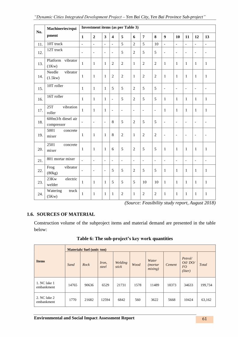
“Dynamic Cities Integrated Development Project – Yen Bai City, Yen Bai Province Sub-project”
Environmental and Social Impact Assessment Report 61
No. Machineries/equi
pment
Investment items (as per Table 3)
1 2 3 4 5 6 7 8 9 10 11 12 13
11. 10T truck - - - - 5 2 5 10 - - - - -
12. 12T truck
- - - - 5 2 5 5 - - - - -
13. Platform vibrator
(1Kw) 1 1 1 2 2 1 2 2 1 1 1 1 1
14. Needle vibrator
(1.5kw) 1 1 1 2 2 1 2 2 1 1 1 1 1
15. 10T roller
1 1 1 5 5 2 5 5 - - - - -
16. 16T roller
1 1 1 - 5 2 5 5 1 1 1 1 1
17. 25T vibration
roller 1 1 1 - - - - - 1 1 1 1 1
18. 600m3/h diesel air
compressor - - - 8 5 2 5 5 - - - - -
19.
5001 concrete
mixer 1 1 1 8 2 1 2 2 - - - - -
20.
2501 concrete
mixer 1 1 1 6 5 2 5 5 1 1 1 1 1
21. 801 mortar mixer - - - - - - - - - - - - -
22. Frog vibrator
(80kg) - - - 5 5 2 5 5 1 1 1 1 1
23. 23Kw electric
welder 1 1 1 5 5 5 10 10 1 1 1 1 1
24. Watering truck
(5Kw) 1 1 1 1 2 1 2 2 1 1 1 1 1
(Source: Feasibility study report, August 2018)
1.6. SOURCES OF MATERIAL
Construction volume of the subproject items and material demand are presented in the table
below:
Table 6: The sub-project’s key work quantities
Items
Materials/ fuel (unit: ton)
Sand Rock Iron,
steel
Welding
stick Wood
Water
(mortar
mixing)
Cement
Petrol/
Oil/ DO/
FO
(liter)
Total
1. NC lake 1
embankment 14765 90636 6529 21731 1578 11489 18373 34633 199,734
2. NC lake 2
embankment 1770 21682 12594 6842 560 3622 5668 10424 63,162
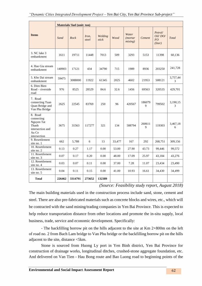
“Dynamic Cities Integrated Development Project – Yen Bai City, Yen Bai Province Sub-project”
Environmental and Social Impact Assessment Report 62
Items
Materials/ fuel (unit: ton)
Sand Rock Iron,
steel
Welding
stick Wood
Water
(mortar
mixing)
Cement
Petrol/
Oil/ DO/
FO
(liter)
Total
3. NC lake 3
embankment 1611 19711 11448 7013 509 3293 5153 11398 60,136
4. Hao Gia stream
embankment
140903
17121
434
34790
715
1989
8936
203250 241,728
5. Khe Dai stream
embankment 59475
3088000
11922
61345
2025
4602
21953
508121 3,757,44
3
6. Dien Bien
Road – riverside
road
976 8525 28529 84.6 32.6 1456 69563 320535 429,701
7. Road
connecting Tuan
Quan Bridge and
Van Phu Bridge
2625 22545 83769 250 96 420567 186079
9 799502
3,190,15
3
8. Road
connecting
Nguyen Tat
Thanh
intersection and
Au Co
intersection
3675 31563 117277 321 134 588794 260611
9 119303
3,467,18
6
9. Resettlement
site no. 1 662 5,788 6 13 33,477 167 292 268,751 309,156
10. Resettlement
site no. 2 0.13 0.27 1.17 0.00 53.00 27.90 43.73 99,446 99,572
11. Resettlement
site no. 3 0.07 0.17 0.20 0.00 48.00 17.09 25.97 43,184 43,276
12. Resettlement
site no. 4 0.03 0.07 0.11 0.00 37.00 7.28 11.07 23,434 23,490
13. Resettlement
site no. 5 0.04 0.11 0.15 0.00 41.00 10.93 16.61 34,430 34,499
Total 226462 3314791 273652 132389
(Source: Feasibility study report, August 2018)
The main building materials used in the construction process include sand, stone, cement and
steel. There are also pre-fabricated materials such as concrete blocks and wires, etc., which will
be contracted with the sand mining/trading companies in Yen Bai Province. This is expected to
help reduce transportation distance from other locations and promote the in-situ supply, local
business, trade, service and economic development. Specifically:
- The backfilling borrow pit on the hills adjacent to the site at Km 2+800m on the left
of road no. 2 from Bach Lam bridge to Van Phu bridge or the backfilling borrow pit on the hills
adjacent to the site, distance <5km.
Stone is sourced from Huong Ly port in Yen Binh district, Yen Bai Province for
construction of drainage works, longitudinal ditches, crushed-stone aggregate foundation, etc.
And delivered on Van Tien - Hau Bong route and Bao Luong road to beginning points of the
“Dynamic Cities Integrated Development Project – Yen Bai City, Yen Bai Province Sub-project”
Environmental and Social Impact Assessment Report 63
construction works (Cao Lanh interchange, Km5, Bach Lam bridge, Dien Bien road) with
distance L=15 km.
- Stone is sourced from Dong Phu borrow pit for execution of the asphalt concrete
pavement and the crushed-stone aggregate foundation and delivered to the site on asphalt road.
Distance L=18 – 23 Km.
- Excavated soil is re-used for backfilling along the route and is transported by 10-ton
trucks with average distance L=500m.
- Materials such as cement, iron, steel, sant, etc. shall be purchased and delivered from
Yen Bai city to the site at a distance L≤5km. Testing shall be conducted before these materials
are incorporated into the works so as to ensure their conformity to the project’s technical
specifications in quality and composition. Iron, steel and mechanical assembled compnents
shall be purchased and ordered from local and overseas firms in conformity to the project’s
technical and mechanical-physical specifications. Testing shall be conducted before these
materials are incorporated into the works so as to make sure that the technical specifications are
compliant with the applicable standards.
- Water for domestic use and construction of the works must be clean water taken from
the local sources and tested for the parameters as required by the applicable standards.
Transportation to the construction sites: Construction materials are transported to the
site by road with 10-12 ton trucks and some specialized vehicles. In narrow gauge sections, the
contractor may flexibly use 5-7ton trucks and / or rudimentary vehicles to travel short distances
on the site.
The main routes for transporting construction materials and waste from the construction site are
surveyed and mentioned as follows:
Table 7: Key transportation routes and distances to the sub-project
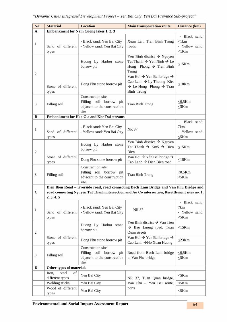
“Dynamic Cities Integrated Development Project – Yen Bai City, Yen Bai Province Sub-project”
Environmental and Social Impact Assessment Report 64
No. Material Location Main transportation route Distance (km)
A Embankment for Nam Cuong lakes 1, 2, 3
1 Sand of different
types
- Black sand: Yen Bai City
- Yellow sand: Yen Bai City
Xuan Lan, Tran Binh Trong
roads
- Black sand:
<1km
- Yellow sand:
<1Km
2
Stone of different
types
Huong Ly Harbor stone
borrow pit
Yen Binh district Nguyen
Tat Thanh Yen Ninh Le
Hong Phong Tran Binh
Trong
<15Km
Dong Phu stone borrow pit
Van Hoi Yen Bai bridge
Cao Lanh Ly Thuong Kiet
Le Hong Phong Tran
Binh Trong
<18Km
3 Filling soil
Construction site
Filling soil borrow pit
adjacent to the construction
site
Tran Binh Trong <0.5Km
<5Km
B Embankment for Hao Gia and Khe Dai streams
1 Sand of different
types
- Black sand: Yen Bai City
- Yellow sand: Yen Bai City NR 37
- Black sand:
7km
- Yellow sand:
<5Km
2
Stone of different
types
Huong Ly Harbor stone
borrow pit
Yen Binh district Nguyen
Tat Thanh Km5 Dien
Bien
<15Km
Dong Phu stone borrow pit Van Hoi Yên Bái bridge
Cao Lanh Dien Bien road <18Km
3 Filling soil
Construction site
Filling soil borrow pit
adjacent to the construction
site
Tran Binh Trong <0.5Km
<5Km
C
Dien Bien Road – riverside road, road connecting Bach Lam Bridge and Van Phu Bridge and
road connecting Nguyen Tat Thanh intersection and Au Co intersection, Resettlement sites no. 1,
2, 3, 4, 5
1 Sand of different
types
- Black sand: Yen Bai City
- Yellow sand: Yen Bai City NR 37
- Black sand:
7km
- Yellow sand:
<5Km
2
Stone of different
types
Huong Ly Harbor stone
borrow pit
Yen Binh district Van Tien
Bao Luong road, Tuan
Quan streets
<15Km
Dong Phu stone borrow pit Van Hoi Yen Bai bridge
Cao Lanh Ho Xuan Huong <23Km
3 Filling soil
Construction site
Filling soil borrow pit
adjacent to the construction
site
Road from Bach Lam bridge
to Van Phu bridge
<0.5Km
<5Km
D Other types of materials
Iron, steel of
different types Yen Bai City
NR 37, Tuan Quan bridge,
Van Phu – Yen Bai route,
ports
<5Km
Welding sticks Yen Bai City <5Km
Wood of different
types Yen Bai City <5Km

“Dynamic Cities Integrated Development Project – Yen Bai City, Yen Bai Province Sub-project”
Environmental and Social Impact Assessment Report 65
Water (mortar
mixing) Yen Bai City <5Km
Cemment of
different types Yen Bai City <5Km
(Source: Surveying on construction material supply sources, August 2018)
Soil, rock, cement and sand for the subproject will be purchased at these borrow pits and
material yards. When carrying out the works, the contractor will require the material supplier
to submit the environmental protection commitment certificate/ or EIA approval decision for
these borrow pits and material yards, etc. and to comply with the environmental protection
regulations, which have been certified for these establishments when they come into operation
and supply these material. In case of exploiting these borrow pits, the contractor shall present
to the Project Owner/PMU the exploitation license and decision approving and EIA
report.Environment protection plan for the exploitation thereof. Thus, this ESIA report does not
eleborate on the mining activities but only assesses and predicts the environmental impacts that
may arise during transportation of the material. Materials are transported to the site on the
principle of where to go to limit the number of material yards.
Electricity supply source
✓ Power supply to the city is sourced from the national electricity grid from the Yen
Bai 220 / 110kv station (2x125MVA). The city currently uses the 22KV power grid.
Therefore, grid electricity can be used for construction.
✓ To prevent blackout, backup generator must be installed so that in the events of
power cut, power is still available for construction of the works, and the work
progress will not be disrupted.
Water supply source
✓ Water for domestic use and construction of the works must be clean water taken
from the local sources and tested for the parameters as required by the applicable
standards.
✓ Water for construction: Water is mainly used for watering, limiting dust, car wash...
The water used is from the Hao Gia, Khe Dai streams and Nam Cuong lakes for the
construction site up to the general requirements for the construction of works.
Where surface water is not available, local residents’ well or well drilled on site
may be used.
1.7. DISPOSAL SITES
According to FS report, estimated quantities of waste disposal for each work item of the sub-
project are based on:
- Total quantity of excavation of weathered layer and soft soil (a),
- Excavation quantity of excavated soil (b): is the quantity of excavated soil to the design
elevation,
- Filling quantity (c): is the quantity of soil used for filling to the design elevation.
- Re-use quantity (d): the excavated soil is re-used for backfilling for the shortfall as
against the design elevation along the embankment routes, roads and resettlment sites,
- Supplementation quantity: is the addition of quantity needed for the shortfall of
backfilling for which the excavated quantity is inadequate for backfilling.
The disposal quantity (f) shall be calculated as: a + b – d. The additional filling quantity shall
be mentioned in the sections regarding number of transportation times in Chapter 3.
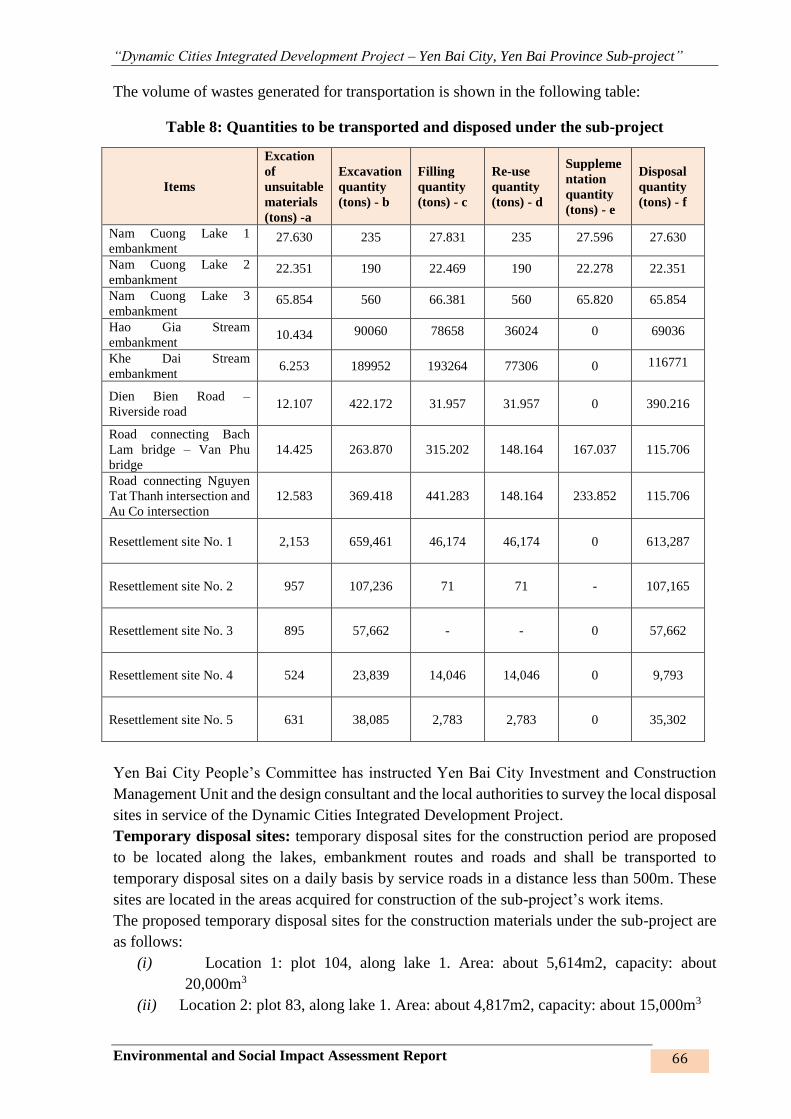
“Dynamic Cities Integrated Development Project – Yen Bai City, Yen Bai Province Sub-project”
Environmental and Social Impact Assessment Report 66
The volume of wastes generated for transportation is shown in the following table:
Table 8: Quantities to be transported and disposed under the sub-project
Items
Excation
of
unsuitable
materials
(tons) -a
Excavation
quantity
(tons) - b
Filling
quantity
(tons) - c
Re-use
quantity
(tons) - d
Suppleme
ntation
quantity
(tons) - e
Disposal
quantity
(tons) - f
Nam Cuong Lake 1
embankment 27.630 235 27.831 235 27.596 27.630
Nam Cuong Lake 2
embankment 22.351 190 22.469 190 22.278 22.351
Nam Cuong Lake 3
embankment 65.854 560 66.381 560 65.820 65.854
Hao Gia Stream
embankment 10.434 90060 78658 36024 0 69036
Khe Dai Stream
embankment 6.253 189952 193264 77306 0 116771
Dien Bien Road –
Riverside road 12.107 422.172 31.957 31.957 0 390.216
Road connecting Bach
Lam bridge – Van Phu
bridge
14.425 263.870 315.202 148.164 167.037 115.706
Road connecting Nguyen
Tat Thanh intersection and
Au Co intersection
12.583 369.418 441.283 148.164 233.852 115.706
Resettlement site No. 1 2,153 659,461 46,174 46,174 0 613,287
Resettlement site No. 2 957 107,236 71 71 - 107,165
Resettlement site No. 3 895 57,662 - - 0 57,662
Resettlement site No. 4 524 23,839 14,046 14,046 0 9,793
Resettlement site No. 5 631 38,085 2,783 2,783 0 35,302
Yen Bai City People’s Committee has instructed Yen Bai City Investment and Construction
Management Unit and the design consultant and the local authorities to survey the local disposal
sites in service of the Dynamic Cities Integrated Development Project.
Temporary disposal sites: temporary disposal sites for the construction period are proposed
to be located along the lakes, embankment routes and roads and shall be transported to
temporary disposal sites on a daily basis by service roads in a distance less than 500m. These
sites are located in the areas acquired for construction of the sub-project’s work items.
The proposed temporary disposal sites for the construction materials under the sub-project are
as follows:
(i) Location 1: plot 104, along lake 1. Area: about 5,614m2, capacity: about
20,000m3
(ii) Location 2: plot 83, along lake 1. Area: about 4,817m2, capacity: about 15,000m3

“Dynamic Cities Integrated Development Project – Yen Bai City, Yen Bai Province Sub-project”
Environmental and Social Impact Assessment Report 67
(iii) Location 3: plot 97, along lake 2. Area: about 1,650m2, capacity: about 5,000m3
(iv) Location 4: plot 81, along lake 3. Area: about 200m2, capacity: about 350m3.
(v) Location 5: at pile T128 on the left of the route. Area of 1,912m2, capacity of
6,000m3.
(vi) Location 6: at pile T128 on the left of the route. Area of 1,868m2, capacity 7,600 m3.
(vii) Location 7: at pile on the right of the route. Area of 2,407m2, capacity of 28,500m3.
(viii) Location 8: pile at T145 on the left of the route. Area of 8,947m2, capacity of
33,700m3.
(ix) Location 9: at pile T160 on the right of the route. Area of about 10,586m2, capacity
of 82,000m3.
(x) Location 10: on Bao Luong in hamlet 2 –Van Phu commune. Area is about 1ha.
Capacity is 100,000m3, distance form the construction site to the disposal site is
200m.
(xi) Location 11: at the end of route no. 2, hamlet 5 – Van Phu commune. Area is 2.6ha,
capacity is 125,000m3. Distance form the construction site to the disposal site is
750m.
(xii) Location 12: at Km 1+900 on the left of the route. Area of about 0.3ha, capacity of
about 42,500m3.
(xiii) Location 13: at Km 3+00 on the left of the route. Area of 0.8ha, capacity of abour
65,100m3.
(xiv) Location 14: at Km 3+400 on the left of the route. Area of 0.4ha, capacity of about
65,000m3.
(xv) Location 15: at Km 3+800 on the left of the route. Area of 4.6ha, capacity of about
526,000m3.
Disposal sites:
The dredged sludged at lake 1, upon local consultation and based on the latest environmental
monitoring results of deposit quality, may be used as input meterial for Xuan Lan Brick Factory
– Nam Cuong ward as it is not polluted with heavy metals, or may be used by local people for
growing trees or heightening low-lying fields. The soil and stone excavated shall be used in
part for backfilling, some may be given to local people for building their houses and the rest
shall be transported to disposal sites. Diposal sites have been surveyed for capacity as
responsive to the surplus soil and stone storage demand of the sub-project and approved by the
city People’s Committee at Letter no. 1311/CV-UBND dated 02 November 2017 for the
disposal site of Van Tien under the management of Nam Thanh Energy and Environment
Co.,Ltd. Upon consultation with local people and authorities, some disposal sites for sludge are
proposed as follows:
(i) Location a: Da Den area: in Dong Phu residential quarter in an area of 0.8ha.
Capacity: 24,000m3
(ii) Location b: Dam Benh, plot 41, map sheets no. 6 + 7. Area: about 0.9ha in residential
quarter Cuong Bac. Capacity: about 50,000m3.
(iii) Location c: Tran Tap area, plot 376, map sheet no. 19. Area: about 0.5ha/ total area
of 1.5ha. Capacity: about 30,000m3.
(iv) Location d: Mr. Vo Thanh’s low-lying land plot no. 1 + 4 in residential quarter Cuong
Bac. Area: about 0,3 ha. Capacity: about 30,000m3.

“Dynamic Cities Integrated Development Project – Yen Bai City, Yen Bai Province Sub-project”
Environmental and Social Impact Assessment Report 68
(v) Location e: Ngoi Sen hamlet, Van Phu commune. Area: 60ha. Capacity: about
5,500,000m3.
Specific routes and distances of the diposal sites under the sub-project are as follows:
Table 9: Routes and distances to the sub-project’s disposal sites

“Dynamic Cities Integrated Development Project – Yen Bai City, Yen Bai Province Sub-project”
Environmental and Social Impact Assessment Report 69
No. Disposal site Location/Description Main transportation
route
Distance
(km)
Temporary disposal sites
A Nam Cuong lakes 1,2,3 embankment
1 Temporary disposal
site
Nam Cuong ward Internal construction rd <1km
Lo. 1: plot 104, along lake 1. Internal construction rd <0.5km
Lo. 2: plot 83, along lake 1 Internal construction rd <0.5km
Lo. 3: plot 97, along lake 2 Internal construction rd <0.5km
Lo. 4: plot 81, along lake 3 Internal construction rd <0.5km
B Hao Gia and Khe Dai stream embankment
1 Temporary disposal
site
Yen Ninh, Minh Tan, Dong Tam
wards
2 Disposal site
Location 5: at pile T128 on the left of
the route.
Internal construction
road ~0.5Km
Location 6: at pile T128 on the left of
the route.
Internal construction
road
~0.5Km
Location 7: at pile on the right of the
route.
Internal construction
road
~0.5Km
Location 8: pile at T145 on the left of
the route.
Internal construction
road
~0.5Km
Location 9: at pile T160 on the right of
the route.
Internal construction
road
~0.5Km
C Dien Bien road – riverside road, resettlement sites no. 1, 4, 5; road connecting Bach Lam Bridge –
Van Phu Bridge and resettlement site no. 2
1 Temporary disposal
site Van Phu commune, Yen Ninh ward
2 Disposal site Van Phu commune
Location 10: on Bao Luong in hamlet
2 –Van Phu commune.
Yen Bai road to Van
Tien commune < 1Km
Location 11: at the end of route no. 2,
hamlet 5 – Van Phu commune.
Yen Bai road to Van
Tien commune < 1Km
D Road connecting Nguyen Tat Thanh intersection and Au Co intersection, resettlement site no. 3
1 Temporary
disposal site Tan Thinh commune
2 Disposal site
Location12: at Km 1+900 on the left
of the route.
Internal construction road <0.5km
Location 13: at Km 3+00 on the left
of the route.
Internal construction road <0.5km
Location 14: at Km 3+400 on the left
of the route.
Internal construction road <0.5km
Location 15: at Km 3+800 on the left
of the route.
Internal construction road <0.5km
Construction waste disposal sites
A Nam Cuong lakes 1,2,3 embankment
Disposal sites Location a: Da Den area
Tran Binh Trong inter-
commune/ward concrete road
disposal site
<3km
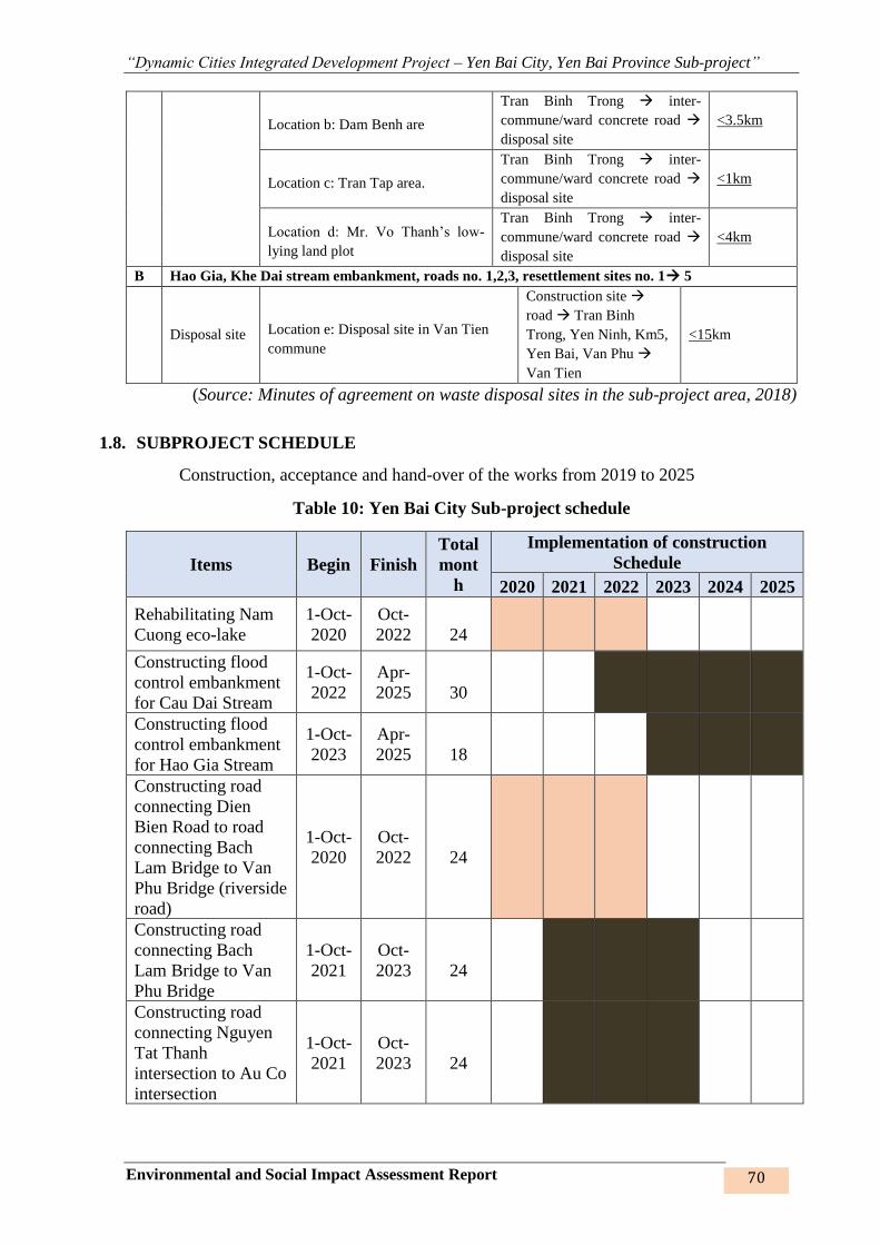
“Dynamic Cities Integrated Development Project – Yen Bai City, Yen Bai Province Sub-project”
Environmental and Social Impact Assessment Report 70
Location b: Dam Benh are
Tran Binh Trong inter-
commune/ward concrete road
disposal site
<3.5km
Location c: Tran Tap area.
Tran Binh Trong inter-
commune/ward concrete road
disposal site
<1km
Location d: Mr. Vo Thanh’s low-
lying land plot
Tran Binh Trong inter-
commune/ward concrete road
disposal site
<4km
B Hao Gia, Khe Dai stream embankment, roads no. 1,2,3, resettlement sites no. 1 5
Disposal site Location e: Disposal site in Van Tien
commune
Construction site
road Tran Binh
Trong, Yen Ninh, Km5,
Yen Bai, Van Phu
Van Tien
<15km
(Source: Minutes of agreement on waste disposal sites in the sub-project area, 2018)
1.8. SUBPROJECT SCHEDULE
Construction, acceptance and hand-over of the works from 2019 to 2025
Table 10: Yen Bai City Sub-project schedule
Items Begin Finish
Total
mont
h
Implementation of construction
Schedule
2020 2021 2022 2023 2024 2025
Rehabilitating Nam
Cuong eco-lake
1-Oct-
2020
Oct-
2022
24
Constructing flood
control embankment
for Cau Dai Stream
1-Oct-
2022
Apr-
2025
30
Constructing flood
control embankment
for Hao Gia Stream
1-Oct-
2023
Apr-
2025
18
Constructing road
connecting Dien
Bien Road to road
connecting Bach
Lam Bridge to Van
Phu Bridge (riverside
road)
1-Oct-
2020
Oct-
2022
24
Constructing road
connecting Bach
Lam Bridge to Van
Phu Bridge
1-Oct-
2021
Oct-
2023
24
Constructing road
connecting Nguyen
Tat Thanh
intersection to Au Co
intersection
1-Oct-
2021
Oct-
2023
24

“Dynamic Cities Integrated Development Project – Yen Bai City, Yen Bai Province Sub-project”
Environmental and Social Impact Assessment Report 71
Items Begin Finish
Total
mont
h
Implementation of construction
Schedule
2020 2021 2022 2023 2024 2025
Resettlement 1-Oct-
2020
Aug-
2021
10
(Source: FS Report, 2018)
1.9. INVESTMENT FUND
Total investment of the project is about 63.27 million USD, equivalent to 1,423,646
million dong (Exchange rate: 1 USD = 22,500 VND):
- Fund from International Bank for Reconstruction and Development (IBRD): 39.46
million USD, equivalent to 887,947 million dong;
- Counterpart fund: 23,81 million USD, equivalent to about 535,699 million dong.
1.10. SUBPROJECT IMPLEMENTATION ORGANIZATION
Executive agency: Yen Bai Province People’s Committee
Subroject Owner (Client): Yen Bai province People’s Committee Construction
Investment Project Management Unit.
Donor: World Bank (WB)
Figure 6: Organisation chart of the Sub-project Management Unit
BOARD OF DIRECTOR
Department of
GENERAL
PLANNING
Department of
administration,
acconting
Department
of PROJECT
MANAGEMENT

“Dynamic Cities Integrated Development Project – Yen Bai City, Yen Bai Province Sub-project”
Environmental and Social Impact Assessment Report 72
CHAPTER 2. NATURAL AND SOCIO-ECONOMIC CONDITIONS OF
THE SUBPROJECT AREA
2.1. NATURAL CONDITIONS
2.1.1. Topography
The sub-project area has natural terrain with average altitude of 50 - 75m above sea level with
3 main terrain types: Topographic elevation of the Red River alluvium; The topography of the
hill is equal to that of the flat top, ribs are smooth, with absolute altitude of less than 300m;
valleys in alternation with hills.
Besides, the city’s terrain is also featured by middlestream low hills, mountainous areas of Chay
River, with valleys of Chay River expanding towards downstream and the reverse-bowl, round
top hill range in alternation with narrow riverside alluvial strips.
2.1.2. Geology
Most of the rock base of Yen Bai Province is terrigen sediment of gravel, gritter, sand, powder,
clay stone and magma formations. The surface layers are normally only 0.3 2m, with some
locations of only 0.1 0.3m. The rock base layer underneath is cracky and therefore has high
permeability and poor water retaining capacity. For long-time cultivation areas, the cracks are
filled with soil and therefore have lower water permeability. According to the geologic
surveying results of the project areas conducted by Vietnam Infrastructure Engineering
Corporation, the geologic characteristics of plain, mountainous areas are as follows:
(*) Nam Cuong lake 1 embankment:
- Layer 2: Clay phase gray, yellowish gray, soft plastic state. 2.314.0m;
- Layer 3: The clay is grayish brown, reddish brown, crushed, hard plastic. 2.314.0m
- Layer 4: Clay is grayish brown, reddish and crushed, semi-rigid. 9.814.0m
(*) Nam Cuong lake 2 embankment:
- Layer 2: Gray, yellowish gray clay, soft plastic state. 2.08.0m;
- Layer 3: The clay is grayish brown, reddish brown, crushed, hard plastic. 2.010.0m
- Layer 4: Clay is grayish brown, reddish and crushed, semi-rigid. 5.814.0m
(*)Nam Cuong lake 3 embankment:
- Layer 2: Clay phase gray, yellowish gray, soft plastic state 1.814.0m;
- Layer 3: The clay is grayish brown, reddish brown, crushed, hard plastic. 1.88.0m
- Layer 4: Clay is grayish brown, reddish and crushed, semi-rigid. 7.814.0m.
(*) Hao Gia stream embankment, road from Dien Bien road to the road connecting Bach Lam
bridge and Van Phu bridge, the road connecting Bach Lam bridge and Van Phu bridge and
resettlement sites no.1, 2, 4, 5:

“Dynamic Cities Integrated Development Project – Yen Bai City, Yen Bai Province Sub-project”
Environmental and Social Impact Assessment Report 73
- Layer 2: Covered soil: Gray clay, grayish gray, white spots, mixed with construction
materials and grit, hard plastic, texture not tight.
- Layer 3: Sandy soil mixed with dark gray, light gray plastic soft state. The composition
of the layer is mainly fine sand and dust, an alluvial product of the newly created river.
- Layer 4: The clayey soil is heavy to lightning, and the crushed stone and crushed shale
is not entirely dark yellow. The gravel content is about 5 ~ 7%.
(*) Khe Dai stream embankment:
- DD layer: The clay is brownish-gray with roots, 0.3 ÷ 1.8m
- Layer 1: Gray, dark gray clay, soft plastic, 3.7 ÷ 6.3m
- Layer 3: Yellow gray and gray clay, hard plastic state, 1.6 ÷ 9.9m
- Layer 4: Gray and yellow gray clay, semi-rigid to hard. 2.2 ÷ 8.3m
- Layer 5: Strongly altered granite, block structure, granular structure, drums get in the
form of chips, 3.3 ÷ 7.6m
- Layer 6: Gray yellow granite in blocks. Altered rocks cracking and drilling in the form
of a stick 3.3 ÷ 3.5m.
(*) Road from Nguyen Tat Thanh intersection to Au Co intersection, resettlement site no. 3:
- Layer 1: soil mixed with grits.
- Layer 2: Black, greenish gray clay, soft plastic state, 0.3m.
- Layer 3: Black, greenish gray clay, 0.3 – 0.7m.
2.1.3. Meteorology, climate
Temperature: The project area’s 2016 average temperature is about 23.80C, with highest
temperature of about 29.8oC in July and lowest temperature of about 15.8oC in February. The
2012 – 2017 monthly average temperatures and annual average temperature variations
measured by Yen Bai City are shown in the table below:
Table 5: Monthly average temperatures measured by Yen Bai Station
Year Monthly average air temperature (0C)
Jan Feb Mar Apr May Jun Jul Aug Sep Oct Nov Dec Avr
2012 14,5 15,6 20,1 25,5 27,8 28,6 28,3 28,0 25,9 25,0 21,8 17,6 23,2
2013 14,5 19,1 23,5 24,2 27,6 28,4 27,5 27,7 26,2 23,3 21,6 14,8 23,2
2014 15,8 16,6 19,6 24,5 28,2 28,7 28,5 28,0 27,8 25,1 21,8 16,1 23,4
2015 17 18,8 21,5 24,3 29,4 29,5 29,3 28,5 27,9 25,5 23,4 17,4 24,4
2016 16,5 15,8 19,5 25,1 27,5 29,8 28,9 28,3 27,7 26,2 21,6 19,1 23,8
(Source: Yen Bai Province’s 2017 Statistical Yearbook)
Air humidity: In the project area, 2016 average relative humidity is 86%. Highest humidity
(January, April) is about 90% and lowest humidity (February) is about 81%. From-year-to-year
humidity variation is not great (1 - 2%), shown in the table below:
Table 6: Monthly average relative humidity values measured by Yen Bai Station (%)
Year Monthly average air humidity values over the years (%)
Jan Feb Mar Apr May Jun Jul Aug Sep Oct Nov Dec Avr
2012 90 89 85 84 85 87 87 86 89 87 90 89 87
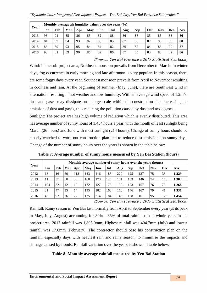
“Dynamic Cities Integrated Development Project – Yen Bai City, Yen Bai Province Sub-project”
Environmental and Social Impact Assessment Report 74
Year Monthly average air humidity values over the years (%)
Jan Feb Mar Apr May Jun Jul Aug Sep Oct Nov Dec Avr
2013 93 91 85 86 85 82 88 86 88 85 85 83 86
2014 84 89 94 93 82 85 85 87 89 87 90 86 88
2015 88 89 93 95 84 84 82 86 87 84 88 90 87
2016 90 81 89 90 86 82 86 87 85 83 88 82 86
(Source: Yen Bai Province’s 2017 Statistical Yearbook)
Wind: In the sub-project area, Northeast monsoon prevails from December to March. In winter
days, fog occurrence in early morning and late afternoon is very popular. In this season, there
are some foggy days every year. Southeast monsoon prevails from April to November resulting
in coolness and rain. At the beginning of summer (May, June), there are Southwest wind in
alternation, resulting in hot weather and low humidity. With an average wind speed of 1.2m/s,
dust and gases may dissipate on a large scale within the construction site, increasing the
emission of dust and gases, thus reducing the pollution caused by dust and toxic gases.
Sunlight: The project area has high volume of radiation which is evenly distributed. This area
has average number of sunny hours of 1,454 hours a year, with the month of least sunlight being
March (26 hours) and June with most sunlight (214 hours). Change of sunny hours should be
closely watched to work out construction plan and to reduce dust emissions on sunny days.
Change of the number of sunny hours over the years is shown in the table below:
Table 7: Average number of sunny hours measured by Yen Bai Station (hours)
Year Monthly average number of sunny hours over the years (hours)
Jan Feb Mar Apr May Jun Jul Aug Sep Oct Nov Dec Avr
2012 13 16 50 118 143 116 188 220 125 127 75 38 1.229
2013 11 37 60 83 160 173 125 161 133 146 74 140 1.303
2014 104 32 12 19 172 127 178 160 153 157 76 78 1.268
2015 81 47 35 14 195 182 168 176 146 167 79 41 1.331
2016 43 92 26 77 125 214 184 146 168 161 95 123 1.454
(Source: Yen Bai Province’s 2017 Statistical Yearbook)
Rainfall: Rainy season in Yen Bai last normally from April to September every year (at its peak
in May, July, August) accounting for 80% - 85% of total rainfall of the whole year. In the
project area, 2017 rainfall was 1,805.0mm; Highest rainfall was 404.7mm (July) and lowest
rainfall was 17.6mm (February). The contractor should base his construction plan on the
rainfall, especially days with heaviest rain and rainy season, to minimise the impacts and
damage caused by floods. Rainfall variation over the years is shown in table below:
Table 8: Monthly average rainfall measured by Yen Bai Station

“Dynamic Cities Integrated Development Project – Yen Bai City, Yen Bai Province Sub-project”
Environmental and Social Impact Assessment Report 75
Year Monthly average rainfall over the years (mm)
Jan Feb Mar Apr May Jun Jul Aug Sep Oct Nov Dec Avr
2012 60,7 25,0 43,3 55,7 672,0 54,2 386,1 406,1 213,9 73,7 62,3 31,3 2.084,3
2013 36,3 50,6 27,9 124,5 118,9 91,0 414,3 262,4 181,7 97,7 7,9 79,7 1.492,9
2014 6,1 44,3 71,8 115,6 71,1 150,3 297,8 375,0 351,7 127,9 107,2 20,5 1.739,3
2015 93,5 28,0 102,3 115,6 185,3 163,4 182,6 364,7 375,8 90,9 195,8 113,8 2.011,7
2016 70,2 17,6 66,0 155,0 355,0 86,7 404,7 353,7 78,5 78,8 83,1 55,7 1.805,0
(Source: Yen Bai Province’s 2017 Statistical Yearbook)
2.1.4. Hydrology
The city’s hydrological regime is relatively diversified thanks to the Red River (Thao River)
flowing through the lake, pond, stream system. The Red River section flowing through Yen Bai
City has lower flow velocity, wide riverbed of 100 – 200m in width and alluvial grounds.
Lowest water level is 2 - 3m (in dry season), and may reach 20 - 30m in rainy season. Red River
has special hydrological peculiarities, with abundant water and alluvial reserves. From
November to April every year, average flow rate is 2,000m3/s, and from May to October
average flow rate is 4,000 m3/s. Ships and boats can travel around the year, and ships and
motorboats can travel only in about 9 months because of many sandbars.
Figure 7: Red River flowing through Yen Bai City
Beside the main water source being Red River, the city also has the key lake, pond, stream
system including Hao Gia, Boi streams (Yen Hoa Park lake), Nam Cuong Lake, Hao Gia
Stream, Cau Dai Stream that are the natural water resources to help drain water, regulate water
distribution, enhance general landscape and increase natural water reserve.
+ Yen Hoa Lake: This lake is adjacent to the arterial roads of Nguyen Thai Hoc and
Thanh Cong, with total area of over 10ha that stores freshwater, regulate the area’s landscape
and ecological system, and is also the urban landscape landmark of the city and helps regulate
water in the rainy season.
Red River
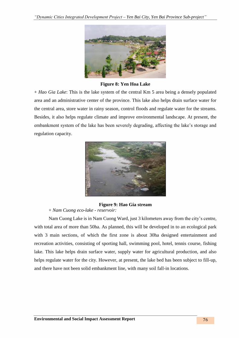
“Dynamic Cities Integrated Development Project – Yen Bai City, Yen Bai Province Sub-project”
Environmental and Social Impact Assessment Report 76
Figure 8: Yen Hoa Lake
+ Hao Gia Lake: This is the lake system of the central Km 5 area being a densely populated
area and an administrative center of the province. This lake also helps drain surface water for
the central area, store water in rainy season, control floods and regulate water for the streams.
Besides, it also helps regulate climate and improve environmental landscape. At present, the
embankment system of the lake has been severely degrading, affecting the lake’s storage and
regulation capacity.
Figure 9: Hao Gia stream
+ Nam Cuong eco-lake - reservoir:
Nam Cuong Lake is in Nam Cuong Ward, just 3 kilometers away from the city’s centre,
with total area of more than 50ha. As planned, this will be developed in to an ecological park
with 3 main sections, of which the first zone is about 30ha designed entertainment and
recreation activities, consisting of sporting hall, swimming pool, hotel, tennis course, fishing
lake. This lake helps drain surface water, supply water for agricultural production, and also
helps regulate water for the city. However, at present, the lake bed has been subject to fill-up,
and there have not been solid embankment line, with many soil fall-in locations.
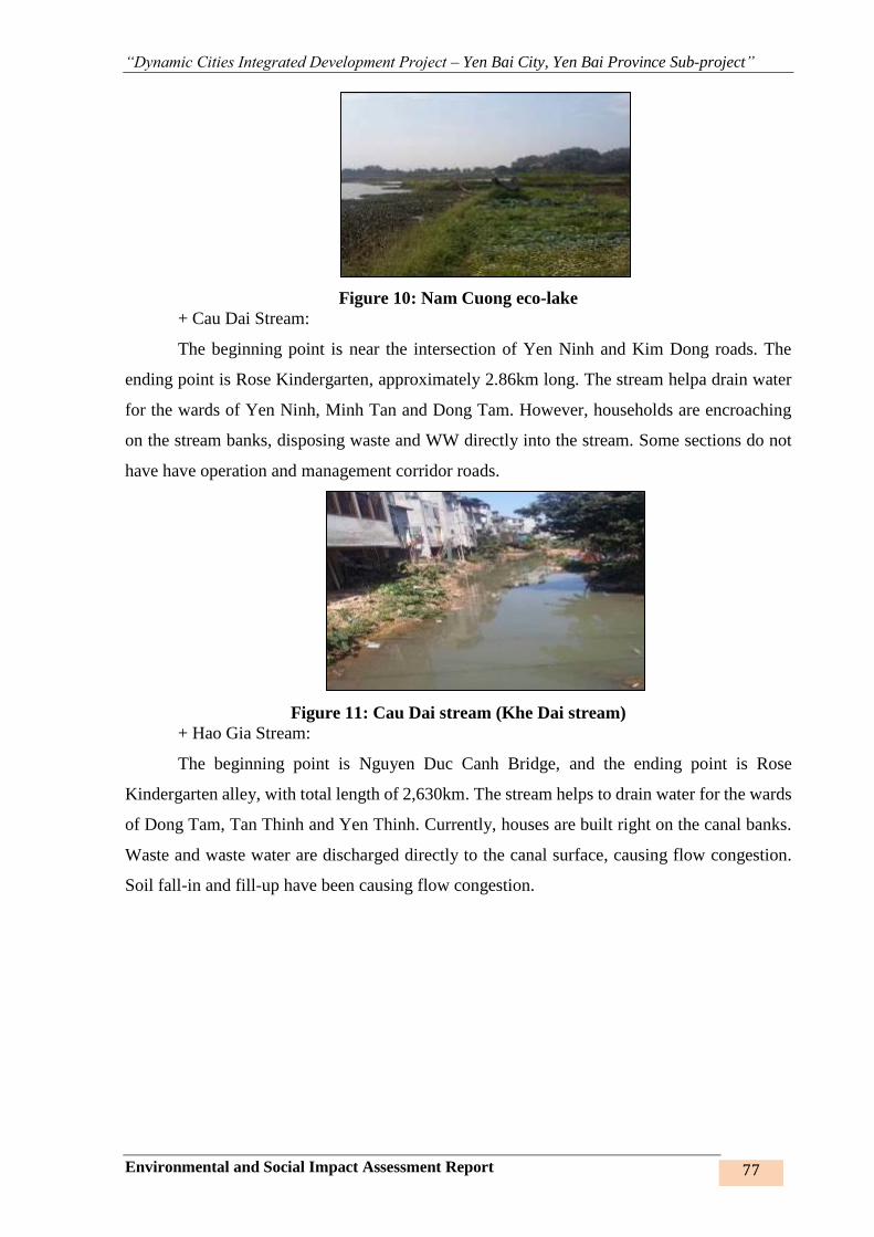
“Dynamic Cities Integrated Development Project – Yen Bai City, Yen Bai Province Sub-project”
Environmental and Social Impact Assessment Report 77
Figure 10: Nam Cuong eco-lake
+ Cau Dai Stream:
The beginning point is near the intersection of Yen Ninh and Kim Dong roads. The
ending point is Rose Kindergarten, approximately 2.86km long. The stream helpa drain water
for the wards of Yen Ninh, Minh Tan and Dong Tam. However, households are encroaching
on the stream banks, disposing waste and WW directly into the stream. Some sections do not
have have operation and management corridor roads.
Figure 11: Cau Dai stream (Khe Dai stream)
+ Hao Gia Stream:
The beginning point is Nguyen Duc Canh Bridge, and the ending point is Rose
Kindergarten alley, with total length of 2,630km. The stream helps to drain water for the wards
of Dong Tam, Tan Thinh and Yen Thinh. Currently, houses are built right on the canal banks.
Waste and waste water are discharged directly to the canal surface, causing flow congestion.
Soil fall-in and fill-up have been causing flow congestion.
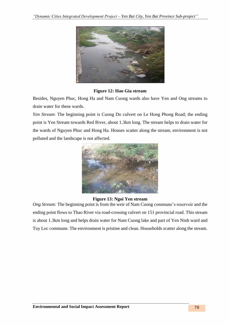
“Dynamic Cities Integrated Development Project – Yen Bai City, Yen Bai Province Sub-project”
Environmental and Social Impact Assessment Report 78
Figure 12: Hao Gia stream
Besides, Nguyen Phuc, Hong Ha and Nam Cuong wards also have Yen and Ong streams to
drain water for these wards.
Yen Stream: The beginning point is Cuong Do culvert on Le Hong Phong Road; the ending
point is Yen Stream towards Red River, about 1.3km long. The stream helps to drain water for
the wards of Nguyen Phuc and Hong Ha. Houses scatter along the stream, environment is not
polluted and the landscape is not affected.
Figure 13: Ngoi Yen stream
Ong Stream: The beginning point is from the weir of Nam Cuong commune’s reservoir and the
ending point flows to Thao River via road-crossing culvert on 151 provincial road. This stream
is about 1.3km long and helps drain water for Nam Cuong lake and part of Yen Ninh ward and
Tuy Loc commune. The environment is pristine and clean. Households scatter along the stream.
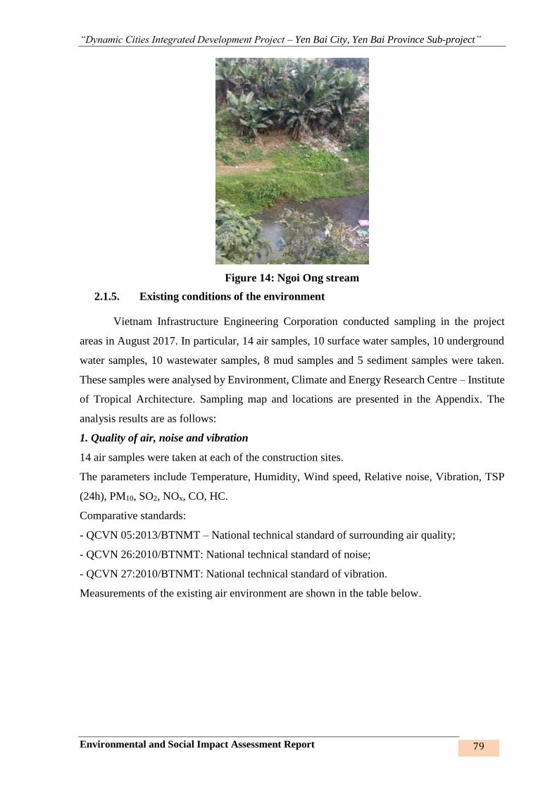
“Dynamic Cities Integrated Development Project – Yen Bai City, Yen Bai Province Sub-project”
Environmental and Social Impact Assessment Report 79
Figure 14: Ngoi Ong stream
2.1.5. Existing conditions of the environment
Vietnam Infrastructure Engineering Corporation conducted sampling in the project
areas in August 2017. In particular, 14 air samples, 10 surface water samples, 10 underground
water samples, 10 wastewater samples, 8 mud samples and 5 sediment samples were taken.
These samples were analysed by Environment, Climate and Energy Research Centre – Institute
of Tropical Architecture. Sampling map and locations are presented in the Appendix. The
analysis results are as follows:
1. Quality of air, noise and vibration
14 air samples were taken at each of the construction sites.
The parameters include Temperature, Humidity, Wind speed, Relative noise, Vibration, TSP
(24h), PM10, SO2, NOx, CO, HC.
Comparative standards:
- QCVN 05:2013/BTNMT – National technical standard of surrounding air quality;
- QCVN 26:2010/BTNMT: National technical standard of noise;
- QCVN 27:2010/BTNMT: National technical standard of vibration.
Measurements of the existing air environment are shown in the table below.

“Dynamic Cities Integrated Development Project – Yen Bai City, Yen Bai Province Sub-project”
Environmental and Social Impact Assessment Report 80
Table 15: Locations of air sampling
No Code Location Coordinates
X Y
Nam Cuong lakes 1, 2, 3 embankment
1 KK1 Air at Nam Cuong lake no.1 at the T-juntion of the concrete
road to the residential area 2402653 0486896
2 KK2 Air at Nam Cuong lake no.1 at the medical station on Tran
Binh Trong road 2402469 0486781
3 KK3 Air in Van Thang pagoda on Nam Cuong lakes 2,3
2402745 0487155
4 KK4 Air near the concrete road, about 2m from Cuong Lo
stream – Dong Phu hamlet 2403268 0486580
Khe Dai and Hao Gia stream embankment
5 KK5 Air at Yen Ninh bridge – Beginning of Khe Dai
embankment route 2402930 0487241
6 KK6 Air at Khe Lap bridge, the converging point between Khe
Dai and Hao Gia streams 2403002 0487011
7 KK7 Air at the State Treasury, intersection between Nguyen Van
Cu road and Nguyen Tat Thanh road – Beginning point of
Hao Gia stream embankment route
2402436 0489338
8 KK8 Air at the ending point of Khe Dai stream embankment
route – near Bao Luong bridge –Dong Tam ward 2401820 0490401
Roads no. 1, 2, 3 and resettlement sites no. 1,2,3,4,5
9 KK9 Air at Ms.Nguyen Thi Lan’s house – Dien Bien road
intersection 2402888 0471982
10 KK10 Air at Bach Lam bridge 2401320 0471634
11 KK11 Air at Tuan Quan bridge 2402066 0489970
12 KK12 Air at Van Phu bridge 2400560 0489768
13 KK13 Air at Nguyen Tat Thanh road intersection
2403414 0413995
14 KK14 Air at Au Co road intersection 2397944 0491779
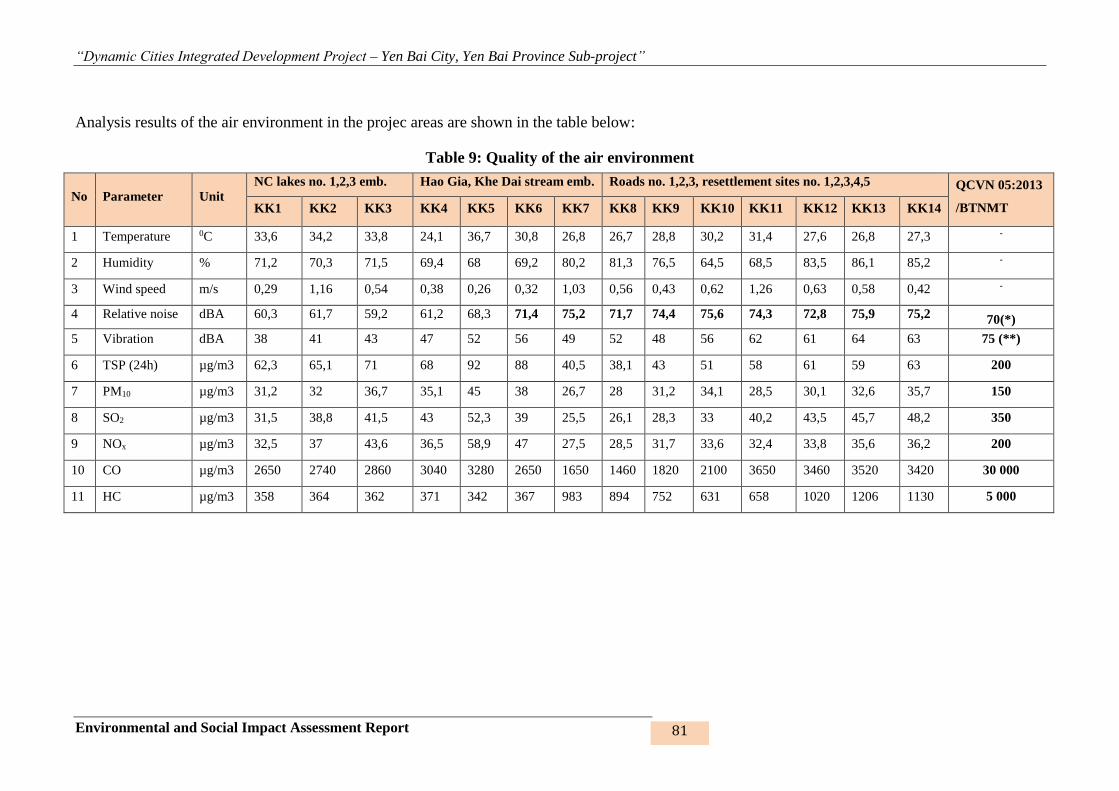
“Dynamic Cities Integrated Development Project – Yen Bai City, Yen Bai Province Sub-project”
Environmental and Social Impact Assessment Report 81
Analysis results of the air environment in the projec areas are shown in the table below:
Table 9: Quality of the air environment
No Parameter Unit
NC lakes no. 1,2,3 emb. Hao Gia, Khe Dai stream emb. Roads no. 1,2,3, resettlement sites no. 1,2,3,4,5 QCVN 05:2013
/BTNMT KK1 KK2 KK3 KK4 KK5 KK6 KK7 KK8 KK9 KK10 KK11 KK12 KK13 KK14
1 Temperature 0C 33,6 34,2 33,8 24,1 36,7 30,8 26,8 26,7 28,8 30,2 31,4 27,6 26,8 27,3 -
2 Humidity % 71,2 70,3 71,5 69,4 68 69,2 80,2 81,3 76,5 64,5 68,5 83,5 86,1 85,2 -
3 Wind speed m/s 0,29 1,16 0,54 0,38 0,26 0,32 1,03 0,56 0,43 0,62 1,26 0,63 0,58 0,42 -
4 Relative noise dBA 60,3 61,7 59,2 61,2 68,3 71,4 75,2 71,7 74,4 75,6 74,3 72,8 75,9 75,2 70(*)
5 Vibration dBA 38 41 43 47 52 56 49 52 48 56 62 61 64 63 75 (**)
6 TSP (24h) µg/m3 62,3 65,1 71 68 92 88 40,5 38,1 43 51 58 61 59 63 200
7 PM10 µg/m3 31,2 32 36,7 35,1 45 38 26,7 28 31,2 34,1 28,5 30,1 32,6 35,7 150
8 SO2 µg/m3 31,5 38,8 41,5 43 52,3 39 25,5 26,1 28,3 33 40,2 43,5 45,7 48,2 350
9 NOx µg/m3 32,5 37 43,6 36,5 58,9 47 27,5 28,5 31,7 33,6 32,4 33,8 35,6 36,2 200
10 CO µg/m3 2650 2740 2860 3040 3280 2650 1650 1460 1820 2100 3650 3460 3520 3420 30 000
11 HC µg/m3 358 364 362 371 342 367 983 894 752 631 658 1020 1206 1130 5 000
“Dynamic Cities Integrated Development Project – Yen Bai City, Yen Bai Province Sub-project”
Environmental and Social Impact Assessment Report 82
* Analysis results of air environment quality
It can be inferred from the table of quality of the air environment that most of the basic parameters
meet the standards. The noise levels in the stream embankment sites near the intersection with
Nguyen Tat Thanh road, Bao Luong road, roads and residential areas are slightly higher than the
allowed level of 1.02 – 1.08 times. At the measuring locations, medium to high traffic volume
cause higher noise level than the allowed standard.
- At some monitoring locations, the vibration level is approximately equal to the allowed standard
but still within the allowed limits (QCVN 27:2010/BTNMT).
- The amount of suspended dust in the samples ranges from 40.5 to 92 µg/m3, 2.2 – 4.9 times lower
than standards.
- Contents of SO2, CO, NOx and HC in the samples are lower than standards. The SO2 content is
6.5 – 11.1 times lower than the standard; CO content is 8.3 – 20.5 times lower than Vietnam’s
standard 05:2013/BTNMT; NOx content is about 3.4 – 7.3 times lower than the allowed limits;
HC content is 4.1 – 14.6 times lower than the allowed limits.
Overall comments: Air quality in the project area is good, the monitoring parameters are much
lower than the allowed limits. Noise level on the embankment sections crossing the intersections
with Nguyen Tat Thanh road, Bao Luong road, roads no. 1, 2, 3 and resettlment sites is 1.02 – 1.08
times higher than the allowed limits.
2. Surface water quality
10 surface water samples were taken at the sub-project’s work items.
Monitoring parameters include Temperature, pH, Fertility, TSS, EC, DO, BOD5, COD, N, NO2-,
NO3-, P, Cl-, Pb, As, Zn, Fe, Detergent, Total oil, fat, total coliform.
Comparative standard:
- QCVN 08-MT:2015/BTNMT – National technical standard of surface water quality, column B2;
Surface water samples were taken at the sub-project’s construction site, specifically shown in the
table below:
Table 10: Locations of surface water sampling
No Code Location Coordinates
X Y
Nam Cuong lakes 1, 2, 3 embankment
1 NM1 Surface water of Nam Cuong lake 1 2402438 04087154
2 NM2 Surface water of Nam Cuong lake 2 2402714 0487097
3 NM3 Surface water of Nam Cuong lake 3 2402745 0487040
Hao Gia and Khe Dai stream embankment
4 NM4 Surface water at Yen Ninh bridge –Khe Dai stream
embankment 2402651 0489339
“Dynamic Cities Integrated Development Project – Yen Bai City, Yen Bai Province Sub-project”
Environmental and Social Impact Assessment Report 83
5 NM5 Surface water at Khe Lap bridge– converging point between
Khe Dai and Hao Gia stream embankments 2402005 0490459
Roads no. 1,2,3 and resettlement sites
6 NM6 Surface water at the bridge on the concrete road to Dien Bien
road 2402866 0490862
7 NM7 Surface water on Hao Gia stream 2401272 0413165
8 NM8 Surface water at Bach Lam bridge on Red River 2401206 04884475
9 NM9 Surface water at Tuan Quan bridge on Red River 2400775 0489424
10 NM10 Surface water near Van Phu bridge on Red River 2398068 0491923
Analysis results of surface water quality are shown in the following table.
- pH ranges from 6.83 to7.28, water samples have medium pH within the allowed limits; suspended
solid contained in water samples is not high, 1.1 – 1.7 times lower than the allowed limits.
- DO content in the samples is within the allowed limits, ranging from 3.48 to 5.26 mg/l.
- BOD5 in the water samples ranges from 7.09 – 13.69 mg/l, which is 1.8 – 3.5 times lower than
the allowed limits, COD values measured at the monitoring locations are much lower than the
allowed limits (1.7 – 3.6 times).
- Heavy metal contents in the water: Pb ranges from 0.0031-0.0092mg/l, As from 0.001 to
0.0068mg/l; Zn from 0.32 to 0.96 mg/l; Fe from 0.42 to 0.94 mg/l. In general, the heavy metal
contents in the samples taken in all the monitoring locations are much lower than the allowed
limits.
- Oil content in all the samples is within the allowed limits (2.8-17.2 times lower than QCVN 08-
MT:2015/BTNMT).
- Detergent content measured in all the monitoring locations is 1.6 – 12.5 times lower than the
allowed limits.
- Total Coliform in the water samples ranges from 1600 to 5300 MPN/100ml, 1.9 – 6.3 times lower
than QCVN 08-MT:2015/BTNMT.
Overall comments: The surface water monitoring parameters fall within the allowed limits. It is
concluded that the surface water quality in the sub-project area is good.

“Dynamic Cities Integrated Development Project – Yen Bai City, Yen Bai Province Sub-project”
Environmental and Social Impact Assessment Report 84
Results of surface water quality analysis are shown in the table below:
Table 11: Results of surface water quality analysis
No Parameter Unit
NC lakes 1,2,3 emb. Hao Gia,
Khe Dai stream emb. Roads no. 1,2,3 and resettlement sites
QCVN
08-MT:
2015,
column
B2
NM1 NM2 NM3 NM4 NM5 NM6 NM7 NM8 NM9 NM10
1 Temperature 0C 29,6 29,5 28,9 28,7 26,8 27,3 26,9 27,5 28,6 27,4 -
2 pH - 7,25 7,11 7,15 6,83 6,96 7,01 7,02 7,21 7,28 7,06 5,5-9
3 Fertility Pt-Co 0,6 0,4 0,5 0,83 0,89 0,96 0,86 2,89 2,65 2,83 -
4 TSS mg/l 60,1 62,3 61,3 70,1 72,1 71,5 72,5 89,1 90,1 87,5 100
5 EC mS/cm 235 221 226 231 238 245 235 312 324 318 -
6 DO mg/l 5,13 5,26 5,28 4,58 4,52 4,51 4,65 3,46 3,48 3,54 ≥2
7 BOD5 mg/l 8,1 7,09 7,13 10,6 11,2 11,8 11,8 13,69 13,58 12,98 25
8 COD mg/l 13,9 14,2 14,6 17,5 16,4 18,3 16,2 28,5 29,1 28,3 50
9 T-N mg/l 3,06 3,08 3,1 4,28 4,16 4,35 4,12 6,3 6,5 6,38 -
10 NO2- mg/l 0,003 0,004 0,006 0,0068 0,0082 0,0086 0,0086 0,0091 0,0095 0,0089 0,05
11 NO3- mg/l 3,93 4,06 4,12 5,02 5,16 5,28 5,13 6,25 6,13 6,18 15
12 T-P mg/l 1,13 1,18 1,26 1,25 1,36 1,09 1,32 3,62 3,58 3,75 -
13 Cl- mg/l 168 172 176 196 206 201 201 263 267 268 -
14 Pb2+ mg/l 0,0032 0,0031 0,0028 0,008 0,0065 0,0073 0,0092 0,0098 0,0091 0,0096 0,05
15 As2+ mg/l 0,001 0,002 0,001 0,004 0,0036 0,0048 0,028 0,056 0,063 0,072 0,1
16 Zn2+ mg/l 0,36 0,32 0,38 0,42 0,48 0,56 0,43 0,96 0,93 0,88 2
17 Fe2+ mg/l 0,43 0,42 0,47 0,56 0,64 0,68 0,62 0,89 0,92 0,94 2
18 Detergent mg/l 0,06 0,04 0,08 0,08 0,072 0,06 0,073 0,32 0,26 0,28 0,5
19 Total oil, fat mg/l 0,058 0,062 0,064 0,082 0,076 0,068 0,072 0,21 0,28 0,36 1
20 Total coliform MPN/100ml 1700 1600 1800 2100 2200 2300 2100 5200 5100 5300 10.000
“Dynamic Cities Integrated Development Project – Yen Bai City, Yen Bai Province Sub-project”
Environmental and Social Impact Assessment Report 85
3. Underground water quality
10 underground water samples were taken at the sub-project’s work items.
The measuring parameters include pH, Hardness, TSS, COD, NH4+, Cl-, NO2
-, NO3-, SO42-,
CN-, As3+, Cd2+, Pb2+, Cu2+, Zn2+, Mn2+, Cr+6, Fe2+, E.coli, Coliform.
Comparative standard:
- QCVN 09-MT:2015/BTNMT – National technical standard of underground water quality
Underground water sampling was conducted at the construction sites of the sub-project as
shown in the following table:
Table 19: Sampling locations of the underground water environment
No Code Location Coordinates
X Y
Road connecting Nguyen Tat Thanh intersection with Au Co intersection – road no. 3
1 NN1 Underground water in the residential quarter on Nguyen Tat
Thanh road, Tan Thinh commune 2402622 0486925
Nam Cuong lakes 1,2,3 embankment
2 NN2 Underground water at Mr. Pham Bao Ngoc’s home - Dong
Phu hamlet – Nam Cuong lake 2402776 0486925
3 NN3 Underground water at Mr. Nguyen Van Bang’s home - Cau
Den hamlet –Nam Cuong lake 2402499 0487212
4 NN4 Underground water at Ms. Ly Thi Nga’s home - Dong Phu
hamlet –Nam Cuong lake 3 2402745 0487126
Khe Dai, Hao Gia stream embankment
5 NN5 Underground water in the residential quarter no.67 Yen Ninh
ward – Khe Dai stream 2402651 0489367
6 NN6 Underground water in the residential quarter near Khe Lap
bridge – Hao Gia stream 2402743 0490747
Road connecting Dien Bien rd. to the road connecting Bach Lam bridge to Van Phu bridge – road no. 1
7 NN7 Underground water at Ms. Nguyen Thi Ha’s home, group no.
24 on the road connecting NR37 – riverside road 2401851 0490315
Road connecting Bach Lam bridge to Van Phu bridge – road no. 2
8 NN8 Underground water at Ms. Nguyen Thi Hoa’s home, group
no.39 near Tuan Quan bridge – Yen Linh ward 2400775 0489855
9 NN9 Underground water at Mr. Nguyen Van Nam - Tuy Loc
hamlet, near Van Phu bridge 298744 0491607
10 NN10 Underground water in the residential quarter no.6 - Yen Ninh
ward
“Dynamic Cities Integrated Development Project – Yen Bai City, Yen Bai Province Sub-project”
Environmental and Social Impact Assessment Report 86
The analysis results of underground water quality at the construction sites of the sub-project’s
work items show that all the parameters are within the allowed limits according to QCVN 09 -
MT: 2015/ BTNMT. In particular:
- Hardness is 2-3 times lower than the allowed limits;
- NH4+ is 10-100 times lower than the allowed limits;
- NO3- is 5- 7 times lower than the allowed limits;
- Coliform is 1.5 – 3 times lower than the allowed limits.
Hence, the underground water parameters are all much lower than the allowed limits and
underground water in this area has not been polluted.
The analysis results of underground water quality at the construction sites of the sub-project’s
work items are shown in the following table:
“Dynamic Cities Integrated Development Project – Yen Bai City, Yen Bai Province Sub-project”
Environmental and Social Impact Assessment Report 87
Table 20: Analysis results of underground water samples
No Parameter Unit NN1 NN2 NN3 NN4 NN5 NN6 NN7 NN8 NN9 NN10 QCVN 09-
MT :2015
1 pH - 6,45 7,12 7,08 6,86 6,92 6,96 6,58 6,63 6,68 6,65 5,5-8,5
2 Hardness mg/l 290 225 228 216 221 218 225 228 231 218 500
3 TSS mg/l 96,3 90,8 91,2 90,5 91,3 90,8 92,3 93,1 92,6 91,3 -
4 COD mg/l 1,2 0,98 0,85 1,16 1,08 1,23 1,02 1,03 1,06 1,04 -
5 NH4+ mg/l 0,08 0,09 0,06 0,04 0,05 0,04 0,02 0,03 0,01 0,01 1
6 Cl- mg/l 24,8 19,7 20,6 26,3 26,4 26,8 28,1 27,2 26,3 25,4 250
7 NO2- mg/l 0,06 0,08 0,09 0,09 0,08 0,07 0,04 0,06 0,08 0,07 1
8 NO3- mg/l 3,09 1,96 1,92 2,16 2,25 2,28 2,38 2,56 2,64 2,53 15
9 SO42- mg/l 1 64,2 64,8 60,2 60,4 60,5 65,4 66,3 67,8 65,5 400
10 CN- mg/l 0,54 0,58 0,62 0,38 0,42 0,46 0,52 0,64 0,48 0,51 -
11 As3+
mg/l 0,016 0,018 0,026 0,023 0,026 0,028 0,038 0,045 0,021 0,025 0,05
12 Cd2+
mg/l <0,0001 <0,0001 <0,0001 <0,0001 <0,0001 <0,0001 <0,0001 <0,0001 <0,0001 <0,0001 0,005
13 Pb2+
mg/l 0,009 0,005 0,003 0,004 0,003 0,005 0,006 0,009 0,008 0,009 0,01
14 Cu2+
mg/l 0,18 0,087 0,092 0,09 0,086 0,085 0,12 0,18 0,36 0,28 1
15 Zn2+
mg/l 0,63 0,21 0,26 0,36 0,38 0,29 0,45 0,39 0,46 0,4 3
16 Mn2+
mg/l 0,02 0,04 0,05 0,04 0,06 0,08 0,09 0,08 0,06 0,06 0,5
17 Cr+6 mg/l 0,006 0,008 0,009 0,003 0,004 0,006 0,007 0,006 0,008 0,005 0,05
18 Fe2+
mg/l 1,52 1,26 1,32 1,06 1,08 1,21 1,18 1,21 1,26 1,22 5
19 E.coli MPN/100 ml KPH KPH KPH KPH KPH KPH KPH KPH KPH KPH KPHT
20 Coliform MPN/100 ml 1 1 1 1 1 1 1 2 1 1 3
“Dynamic Cities Integrated Development Project – Yen Bai City, Yen Bai Province Sub-project”
Environmental and Social Impact Assessment Report 88
4. Wastewater characteristics
10 wastewater samples were taken at the sub-project’s work items.
The measuring parameters include Temperature, Smell, pH, BOD5, TSS, Sulfur, Ammonium,
NO3-, Fe2+, Zn2+, Hg2+, As2+, Mn2+, Cd2+, Cu2+, Tổng N, Tổng P, Coliform.
Comparative standard:
- QCVN 14:2008/BTNMT – National technical standard of wastewater quality, column B
The wastewater sampling locations in the sub-project area are shown in the table below:
Table 12: The wastewater sampling locations in the sub-project area
No Code Location Coordinates
X Y
Road no. 3 - Road connecting Nguyen Tat Thanh intersection with Au Co intersection , resettlement site
no.3
1 NT1 Wastewater in the residential quarter on Nguyen Tat
Thanh road, Tan Thinh commune 2403145 0486724
Nam Cuong lakes 1,2,3 embankment
2 NT2 Wastewater in the residential quarter near Mr. Pham Bao
Ngoc’s home - Dong Phu hamlet –Nam Cuong lake 1 2402376 0486608
3 NT3 Wastewater in the residential quarter near Mr. Nguyen
Van Bang’s home - Cau Den hamet –Nam Cuong ward 2402530 0487212
4 NT4 Wastewater in the residential quarter in Dong Phu hamlet
near Ms. Ly Thi Nga’s home –Nam Cuong lake 3 2402807 0486954
Khe Dai, Hào Gia stream embankment
5 NT5 Wastewater in the residential quarter no. 67, Yen Ninh
ward, Khe Dai stream 2402866 0489425
6 NT6 Wastewater in the residential quarter near Khe Lap
stream, Hao Gia stream 2402866 0490919
Road no. 1 – Road connecting Dien Bien rd. to the road connecting Bach Lam bridge to Van Phu bridge,
resettlement sites no. 1, 4,5
7 NT7 Wastewater in the residential quarter no. 26 on the road
connecting NR 37 – riverside road 2401851 0490459
Road no. 2 – Road connecting Bach Lam bridge to Van Phu bridge, resettlement site no. 2
8 NT8
Wastewater in the residential quarter no.39 Tuan Quan
bridge 2400818 0489639
9 NT9
Wastewater in the residential quarter in Tuy Loc hamlet
near Van Phu bridge 2400560 0489855
10 NT10
Wastewater in the residential quarter no.6 near Bach Lam
bridge
Analysis results of the wastewater samples are shown in the table below:
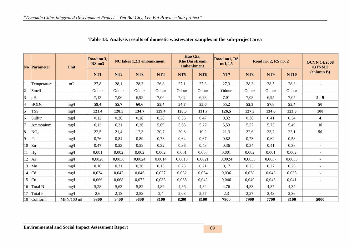
“Dynamic Cities Integrated Development Project – Yen Bai City, Yen Bai Province Sub-project”
Environmental and Social Impact Assessment Report 89
Table 13: Analysis results of domestic wastewater samples in the sub-project area
No Parameter Unit
Road no 3,
RS no3 NC lakes 1,2,3 embankment
Hao Gia,
Khe Dai stream
embankment
Road no1, RS
no1,4,5 Road no. 2, RS no. 2 QCVN 14:2008
/BTNMT
(column B) NT1 NT2 NT3 NT4 NT5 NT6 NT7 NT8 NT9 NT10
1 Temperature oC 27,8 28,1 28,3 26,8 27,1 27,3 27,3 28,3 28,5 28,3 -
2 Smell - Odour Odour Odour Odour Odour Odour Odour Odour Odour Odour -
3 pH - 7,13 7,06 6,98 7,06 7,02 6,93 7,01 7,03 6,95 7,05 5 - 9
4 BOD5 mg/l 59,4 55,7 60,6 55,4 54,7 55,6 55,2 52,3 57,8 55,4 50
5 TSS mg/l 121,4 128,5 134,7 129,4 128,5 131,7 126,5 127,3 134,6 123,5 100
6 Sulfur mg/l 0,12 0,26 0,18 0,28 0,36 0,47 0,32 0,38 0,41 0,34 4
7 Ammonium mg/l 6,13 6,21 6,26 5,69 5,68 5,72 5,53 5,57 5,73 5,49 10
8 NO3- mg/l 22,5 21,4 17,3 20,7 20,3 19,2 21,3 22,6 23,7 22,1 50
9 Fe mg/l 0,76 0,84 0,89 0,73 0,64 0,67 0,82 0,73 0,62 0,58 -
10 Zn mg/l 0,47 0,53 0,58 0,32 0,36 0,43 0,36 0,34 0,41 0,36 -
11 Hg mg/l 0,001 0,002 0,002 0,002 0,001 0,003 0,001 0,002 0,001 0,002 -
12 As mg/l 0,0028 0,0036 0,0024 0,0014 0,0018 0,0021 0,0024 0,0035 0,0037 0,0033 -
13 Mn mg/l 0,16 0,21 0,26 0,13 0,25 0,21 0,17 0,23 0,27 0,26 -
14 Cd mg/l 0,034 0,042 0,046 0,027 0,032 0,034 0,036 0,038 0,043 0,035 -
15 Cu mg/l 0,066 0,068 0,072 0,035 0,038 0,042 0,046 0,049 0,043 0,041 -
16 Total N mg/l 5,28 5,63 5,82 4,89 4,86 4,82 4,76 4,83 4,87 4,37 -
17 Total P mg/l 2,6 2,18 2,53 2,4 2,08 2,57 2,3 2,27 2,43 2,36 -
18 Coliform MPN/100 ml 9300 9400 9600 8100 8200 8100 7800 7900 7700 8100 5000
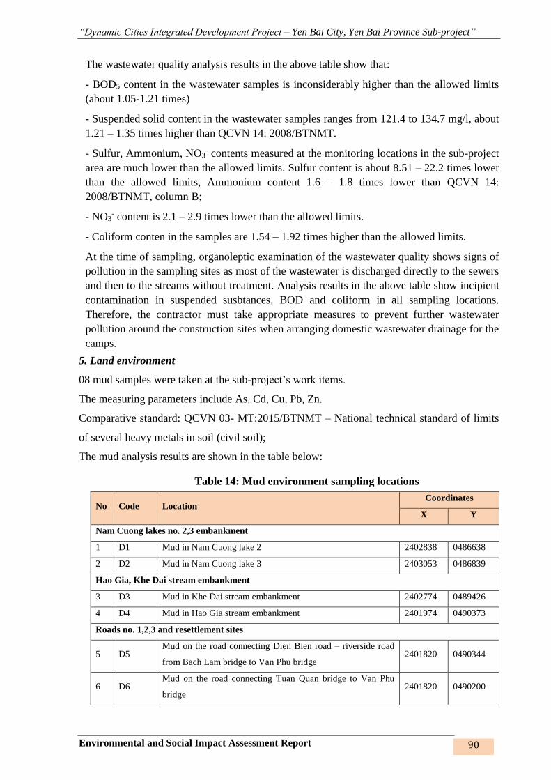
“Dynamic Cities Integrated Development Project – Yen Bai City, Yen Bai Province Sub-project”
Environmental and Social Impact Assessment Report 90
The wastewater quality analysis results in the above table show that:
- BOD5 content in the wastewater samples is inconsiderably higher than the allowed limits
(about 1.05-1.21 times)
- Suspended solid content in the wastewater samples ranges from 121.4 to 134.7 mg/l, about
1.21 – 1.35 times higher than QCVN 14: 2008/BTNMT.
- Sulfur, Ammonium, NO3- contents measured at the monitoring locations in the sub-project
area are much lower than the allowed limits. Sulfur content is about 8.51 – 22.2 times lower
than the allowed limits, Ammonium content 1.6 – 1.8 times lower than QCVN 14:
2008/BTNMT, column B;
- NO3- content is 2.1 – 2.9 times lower than the allowed limits.
- Coliform conten in the samples are 1.54 – 1.92 times higher than the allowed limits.
At the time of sampling, organoleptic examination of the wastewater quality shows signs of
pollution in the sampling sites as most of the wastewater is discharged directly to the sewers
and then to the streams without treatment. Analysis results in the above table show incipient
contamination in suspended susbtances, BOD and coliform in all sampling locations.
Therefore, the contractor must take appropriate measures to prevent further wastewater
pollution around the construction sites when arranging domestic wastewater drainage for the
camps.
5. Land environment
08 mud samples were taken at the sub-project’s work items.
The measuring parameters include As, Cd, Cu, Pb, Zn.
Comparative standard: QCVN 03- MT:2015/BTNMT – National technical standard of limits
of several heavy metals in soil (civil soil);
The mud analysis results are shown in the table below:
Table 14: Mud environment sampling locations
No Code Location Coordinates
X Y
Nam Cuong lakes no. 2,3 embankment
1 D1 Mud in Nam Cuong lake 2 2402838 0486638
2 D2 Mud in Nam Cuong lake 3 2403053 0486839
Hao Gia, Khe Dai stream embankment
3 D3 Mud in Khe Dai stream embankment 2402774 0489426
4 D4 Mud in Hao Gia stream embankment 2401974 0490373
Roads no. 1,2,3 and resettlement sites
5 D5 Mud on the road connecting Dien Bien road – riverside road
from Bach Lam bridge to Van Phu bridge 2401820 0490344
6 D6 Mud on the road connecting Tuan Quan bridge to Van Phu
bridge 2401820 0490200
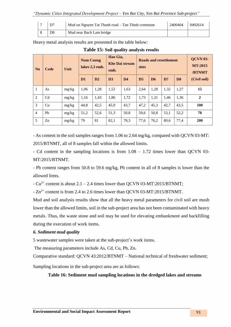
“Dynamic Cities Integrated Development Project – Yen Bai City, Yen Bai Province Sub-project”
Environmental and Social Impact Assessment Report 91
7 D7 Mud on Nguyen Tat Thanh road – Tan Thinh commune 2400404 0492614
8 D8 Mud near Bach Lam bridge
Heavy metal analysis results are presented in the table below:
Table 15: Soil quality analysis results
No Code Unit
Nam Cuong
lakes 2,3 emb.
Hao Gia,
Khe Dai stream
emb.
Roads and resettlement
sites
QCVN 03-
MT:2015
/BTNMT
(Civil soil) D1 D2 D3 D4 D5 D6 D7 D8
1 As mg/kg 1,06 1,28 1,52 1,63 2,64 1,28 1,32 1,27 15
2 Cd mg/kg 1,16 1,43 1,86 1,72 1,73 1,31 1,46 1,36 2
3 Cu mg/kg 44,8 42,5 45,9 43,7 47,2 45,3 42,7 43,5 100
4 Pb mg/kg 51,2 52,6 51,3 50,8 59,6 50,8 53,1 52,2 70
5 Zn mg/kg 79 81 82,1 78,3 77,6 76,2 80,6 77,4 200
- As content in the soil samples ranges from 1.06 to 2.64 mg/kg, compared with QCVN 03-MT:
2015/BTNMT, all of 8 samples fall within the allowed limits.
- Cd content in the sampling locations is from 1.08 – 1.72 times lower than QCVN 03-
MT:2015/BTNMT.
- Pb content ranges from 50.8 to 59.6 mg/kg, Pb content in all of 8 samples is lower than the
allowed limts.
- Cu2+ content is about 2.1 – 2.4 times lower than QCVN 03-MT:2015/BTNMT;
- Zn2+ content is from 2.4 to 2.6 times lower than QCVN 03-MT:2015/BTNMT.
Mud and soil analysis results show that all the heavy metal parameters for civil soil are mush
lower than the allowed limits, soil in the sub-project area has not been contaminated with heavy
metals. Thus, the waste stone and soil may be used for elevating embankment and backfilling
during the execution of work items.
6. Sediment mud quality
5 wastewater samples were taken at the sub-project’s work items.
The measuring parameters include As, Cd, Cu, Pb, Zn.
Comparative standard: QCVN 43:2012/BTNMT – National technical of freshwater sediment;
Sampling locations in the sub-project area are as follows:
Table 16: Sediment mud sampling locations in the dredged lakes and streams

“Dynamic Cities Integrated Development Project – Yen Bai City, Yen Bai Province Sub-project”
Environmental and Social Impact Assessment Report 92
No Code Location Coordinates
X Y
Nam Cuong lake 1 embankment
1 TT1 Sediment taken in Nam Cuong lake 1 at the concrete road
T-junction 2403668 0486351
2 TT2 Sediment taken in Nam Cuong lake 1 in Nam Cuong brick
factory 2402438 0486264
3 TT3 Sediment taken in Nam Cuong lake 1 on Tran Binh Trong
road 2402469 0486781
4 TT4 Sediment taken in Nam Cuong lake 1 at the concrete road
T-junction towards Tran Binh Trong road 2401761 0487125
5 TT5 Sediment taken in Nam Cuong lake 1 – lake foundation 2402284 0487126
Khe Dai, Hao Gia stream embankment
6 TT6 Sediment in Khe Dai stream embankment site 2402774 0489426
7 TT7 Sediment in Hao Gia stream embankment site 2401974 0490373
Followings are analysis results of lake foundation sediment:
Table 17: Sediment quality analysis results
No Parameters Unit
Nam Cuong lake 1 embankment
Khe Dai, Hao Gia
stream
embankment
QCVN 43:
2012
/BTNMT
TT1 TT2 TT3 TT4 TT5 TT6 TT7
1 As mg/kg 3,27 3,26 3,58 3,42 3,36 1,52 1,63 17,0
2 Cd mg/kg 0,69 0,54 0,71 0,68 0,57 1,86 1,72 3,5
3 Cu mg/kg 11,62 11,53 11,32 11,72 12,43 45,9 43,7 197
4 Pb mg/kg 8,42 8,47 8,42 8,53 8,59 51,3 50,8 91,3
5 Zn mg/kg 91 94 89 93 92 82,1 78,3 315
Comments: The analysis results show that heavy metal concentrations in the sediment are much
lower than the allowed limits. Asen is 4.7 – 5.2 times lower than the allowed limts; Cd is about
4.9 – 6.5 times lower than the allowed limits; Cu is 15.8 – 17.4 lower than the allowed limits;
Pb is about 10 times lower than the allowed limits.
Overall assessment: all the heavy metal parameters at the sampling locations are much lower
than the allowed limits according to QCVN 43:2012/BTNMT on freshwater sediment. Thus,
the sediment in the lakes and streams in the sub-project area is not polluted with heavy metals

“Dynamic Cities Integrated Development Project – Yen Bai City, Yen Bai Province Sub-project”
Environmental and Social Impact Assessment Report 93
and may be re-used to grow trees, elevate the gardens and low-lying fields.
2.1.6 Eco-system8
The diversified fauna, flora and genetic sources make enormous contribution to Yen Bai city’s
and Yen Bai Province’s economic growth, particularly in agriculture, forestry and aquaculture,
as they facilitate the production of plant and animal breeds, provide construction materials, raw
materials and medicinal herbs. However, the socio-economic development has transformed the
land uses and imported exotic breeds; climate change and population growth etc. have disturbed
and altered the bio-resources.
At the present, there are 327 wood trees, 419 medicinal herbs, 225 food plants for animals and
humans, such as fruit trees (67 species); starch and seed plants (24 species); Vegetable and spice
plants (104 species), material and small industry – handicraft trees (152 species) such as
snowbell, Chinese black olive, Chinese white olive, brindall berry, lauan meranti, etc.; common
material plants (84 species) and ornamental and protective trees (170 species).
At the present, there are 227 species of animals in 80 families, 24 branches, including 49 species
of mammals, 105 species of birds, 50 species of reptiles, 23 specicies of amphibians. Some
precious species of animals such as purple pheasant, red-necked woodpeck, heron, giant
kingfisher, etc., are falling in numbers.
The sub-project construction site is currently fallow land, the vegetation cover includes bushes,
grass land, sparse forest, water surface; the vegetation cover in the agriculture eco-system area
includes mostly bushes, small wood, sparse forest, mixed gardens; Animal includes mainly
domestic animals, frog, toad, reptile, etc. There are no rare or endangered species of plants or
animals in the sub-project area.
2.1.7. Land use status
With a total area of 10,678.00 hectares, the land use status is reflected in some main features
such as agricultural land: 7,169.00 ha (66.95%), in which, productions forest land account for
36.56% (3,904ha), no specialised forest and protective forest, non-agricultural land accounts
for 32.340% (3,452.90 ha) and unused land accounts for 0.71% (76.10 hectares) of the City’s
area. The land use status of Yen Bai Province is shown in the following table:
Table 18: Land use status in Yen Bai City 9
TT Land use purpose Code Area (ha) Proportion, (%)
Total 10.678,00 100
1 Agricultural land NNP 7.149,00 66,95
1.1 Production agriculture land SXN 3.020,50 28,29
1.2 Forestry land with forests NLP 3.904,00 36,56
8 Yen Bai Province Environment Status Report, 2011 – 2015 period
9 2016 Yen Bai Province Statistical Yearbook
“Dynamic Cities Integrated Development Project – Yen Bai City, Yen Bai Province Sub-project”
Environmental and Social Impact Assessment Report 94
TT Land use purpose Code Area (ha) Proportion, (%)
1.3 Aquaculture land NTS 220,50 2,06
1.4 Other agricultural land NKH 4,00 0,04
2 Non-agricultural land PNN 3.452,90 32,34
2.1 Homstead land 681,00 6,38
2.1.1 Urban land ODT/OTC 436,80 4,09
2.1.2 Rural land ONT 244,20 2,29
2.2 Specialized land CDG 1.888,50 17,69
2.3 Religion, belief land TTN 8,80 0,08
2.4 Cemetery land NTD 45,60 0,43
2.5 End river land and specialized water
surface
SMN 823,60 7,71
2.6 Other non-agricultural land PNK 5,40 0,05
3 Unused land CSD 76,10 0,71
2.2. ECONOMIC CONDITIONS10
The economic structure shifted towards gradually increasing the share of industry and gradual
reduction of the agricultural sector. According to statistics, in 2015, agriculture accounted for
5.4%, industry and construction 23.5% and service sector 71.1%.
Industry, small industry and handicrafts: Yen Bai is in the central location with transport
infrastructure, industrial zones, abundant labor resources, etc., which is especially convenient
for attracting investment projects of production and processing with the raw materials from the
highly potential localities such as Yen Binh, Tran Yen. Therefore, the focus of resources on
expansion of IZs, investment in technical infrastructure will promote Yen Bai city’s
development. In 2016, the value of industry-small industry and handicrafts (2010comparative
price) in the city reached 2,761.3 billion dong, the city run portion is expected to reach 1661
billion = 100.7% of the plan. The production value of the construction industry in the city
(2010comparative price) reached 1,230 billion; increased by 7% compared to 2015 = 100% of
the plan.
Trade and services: Total retail sales is estimated at VND 6,850 billion = 95% of the plan.
Export turnover is estimated at $ 23 million = 85% of the plan; the city run portion is estimated
10 2016 Stastical Yearbook and socio-economic reports by the communes and wards in 2016.
“Dynamic Cities Integrated Development Project – Yen Bai City, Yen Bai Province Sub-project”
Environmental and Social Impact Assessment Report 95
at $ 12 million = 120% of the plan. Budget revenue is estimated at VND420 billion = 100% of
the plan.
Tourism: The development of landscape forests, recreation areas, the urban rehabilitation, etc.
have made Yen Bai city more spacious and attracted more and more visitors to Yen Bai. Over
the past years, millions of tourists have come to Yen Bai to visit the spiritual, cultural relics,
beauty spots and attend tourism festivals. Turnover from hospitality and travel services in 2016
was 750 billion VND, export turnover is estimated at 750 billion VND = 107% of the plan.
Agro-forestry production: The value of agricultural, forestry and fishery production in 2016
reached VND 423 billion (2010comparative price), an increase of 6.3% compared to that of
2015, reaching 100% of the plan. The value of industrial production in the area
(2010comparative price) reached 2820 billion dong = 94% of the plan. The city run portion was
VND1,661 billion = 100.6% of the plan. The value of harvested products per hectare of arable
and aquaculture land in 2016 reached 78 million VND = 93.97% of the plan.
Labor conditions: In 2016, 17,700 people in the Province attended vocational training, reaching
and surpassing the plan, in which, 5,000 laborers were subsidized with vocational training under
Project 1956. By the end of 2016, number of laborers received general training accounted for
47.5%, laborers received vocational training accounted for 32.4%. At present, there are 22
vocational schools in the Province: 02 vocational universities; 02 trường trung cấp nghề; 08
vocational centers and 10 establishements providing vocational training.
2.3. SOCIAL CONDITIONS
2.3.1. Population
Yen Bai's population has increased steadily over the years and maintained a stable population
growth rate from 2012 to 2016. The population in 2016 was 101,059, an increase of more than
4,700 people as against 2012. The average population density was 946 persons / km2 with the
lowest density recorded in Minh Bao, Tan Thinh, Van Phu and Phu Loc communes and the
highest in central wards such as Hong Ha and Nguyen Thai Hoc. The urban population accounts
for 77.51% and the rural population accounts for 22.49%, in which, women make up 49.98%
in urban area and 49.94% in rural area. The rough birth rate in 2016 was 12.35‰, rough death
rate was 5.02‰ and natural population growth rate was 7.33‰.
2.3.2. Impacts of natual disasters and weather
As a result of climate change’s impacts, in recent years (from 2008 until now), rains have
increased in quantity, intensity and duration, the existing capacity of the city’s flood drainage
works does not meet drainage demands, causing waterlogging and landslides across the city.
The most severely waterlogged areas are Yen Ninh, Minh Tan, Dong Tam and Tan Thinh wards
(basin 2) and Hong Ha, Nguyen Phuc, Nguyen Thai Hoc and Nam Cuong wards (basin 1).
These are the cultural, political and economic centers of the city and Yen Bai Province with
main drainage routes including streams such as Hao Gia, Cau Dai, Tuan Quan, Ngoi Yen, Ngoi
Ong and Nam Cuong lake system.
According to the statistics of Yen Bai city, the provincial and city budget speds hundreds of
billion dong every year to remedy the damage caused by floods, in addition to the toll of human

“Dynamic Cities Integrated Development Project – Yen Bai City, Yen Bai Province Sub-project”
Environmental and Social Impact Assessment Report 96
lives. Loss and damage are particularly serious in the downtown area (in basin 1 and basin 2)
such as Yen Ninh, Minh Tan, Dong Tam, Nguyen Thai Hoc and Nam Cuong wards since this
is the lowest part of the city.
Figure 15: Flood map of Yen Bai City
Below are some recent flood images with increasing frequency and damaging impacts and some
pictures of the streets which look like a river during the flooding time in the city:
Flood from 8 to 11 August 2008
Flood in July 2013
Flood on 30 January 2015
Flood on 19 August 2016
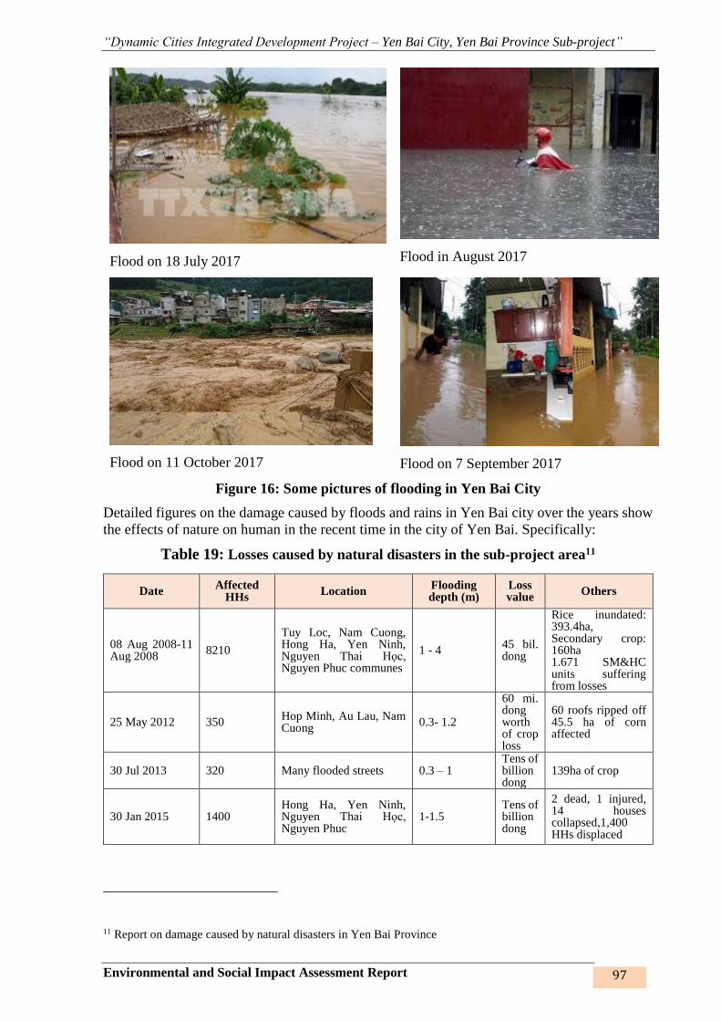
“Dynamic Cities Integrated Development Project – Yen Bai City, Yen Bai Province Sub-project”
Environmental and Social Impact Assessment Report 97
Flood on 18 July 2017
Flood in August 2017
Flood on 11 October 2017
Flood on 7 September 2017
Figure 16: Some pictures of flooding in Yen Bai City
Detailed figures on the damage caused by floods and rains in Yen Bai city over the years show
the effects of nature on human in the recent time in the city of Yen Bai. Specifically:
Table 19: Losses caused by natural disasters in the sub-project area11
Date Affected
HHs Location
Flooding depth (m)
Loss value
Others
08 Aug 2008-11 Aug 2008
8210
Tuy Loc, Nam Cuong, Hong Ha, Yen Ninh, Nguyen Thai Học, Nguyen Phuc communes
1 - 4 45 bil. dong
Rice inundated: 393.4ha, Secondary crop: 160ha 1.671 SM&HC units suffering from losses
25 May 2012 350 Hop Minh, Au Lau, Nam Cuong
0.3- 1.2
60 mi. dong worth of crop loss
60 roofs ripped off 45.5 ha of corn affected
30 Jul 2013 320 Many flooded streets 0.3 – 1 Tens of billion dong
139ha of crop
30 Jan 2015 1400 Hong Ha, Yen Ninh, Nguyen Thai Học, Nguyen Phuc
1-1.5 Tens of billion dong
2 dead, 1 injured, 14 houses collapsed,1,400 HHs displaced
11 Report on damage caused by natural disasters in Yen Bai Province
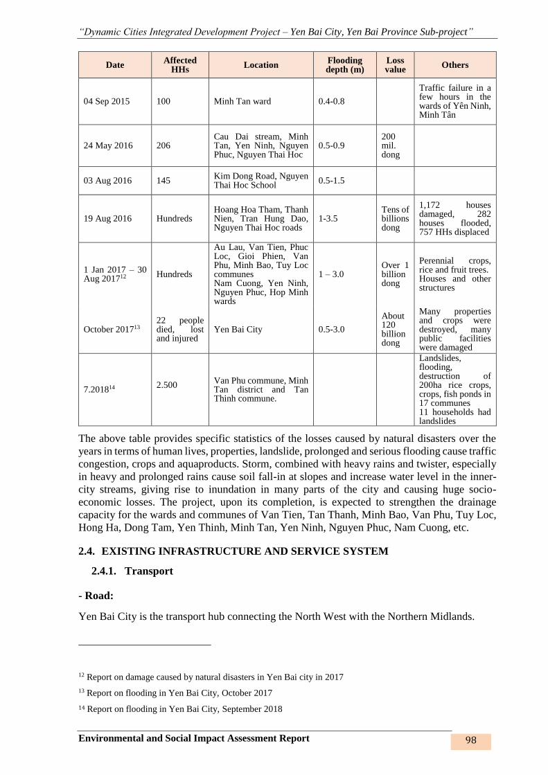
“Dynamic Cities Integrated Development Project – Yen Bai City, Yen Bai Province Sub-project”
Environmental and Social Impact Assessment Report 98
Date Affected
HHs Location
Flooding depth (m)
Loss value
Others
04 Sep 2015 100 Minh Tan ward 0.4-0.8
Traffic failure in a few hours in the wards of Yên Ninh, Minh Tân
24 May 2016 206 Cau Dai stream, Minh Tan, Yen Ninh, Nguyen Phuc, Nguyen Thai Hoc
0.5-0.9 200 mil. dong
03 Aug 2016 145 Kim Dong Road, Nguyen Thai Hoc School
0.5-1.5
19 Aug 2016 Hundreds Hoang Hoa Tham, Thanh Nien, Tran Hung Dao, Nguyen Thai Hoc roads
1-3.5 Tens of billions dong
1,172 houses damaged, 282 houses flooded, 757 HHs displaced
1 Jan 2017 – 30 Aug 201712
Hundreds
Au Lau, Van Tien, Phuc Loc, Gioi Phien, Van Phu, Minh Bao, Tuy Loc communes Nam Cuong, Yen Ninh, Nguyen Phuc, Hop Minh wards
1 – 3.0 Over 1 billion dong
Perennial crops, rice and fruit trees. Houses and other structures
October 201713 22 people died, lost and injured
Yen Bai City 0.5-3.0
About 120 billion dong
Many properties and crops were destroyed, many public facilities were damaged
7.201814 2.500
Van Phu commune, Minh Tan district and Tan Thinh commune.
Landslides, flooding, destruction of 200ha rice crops, crops, fish ponds in 17 communes 11 households had landslides
The above table provides specific statistics of the losses caused by natural disasters over the
years in terms of human lives, properties, landslide, prolonged and serious flooding cause traffic
congestion, crops and aquaproducts. Storm, combined with heavy rains and twister, especially
in heavy and prolonged rains cause soil fall-in at slopes and increase water level in the inner-
city streams, giving rise to inundation in many parts of the city and causing huge socio-
economic losses. The project, upon its completion, is expected to strengthen the drainage
capacity for the wards and communes of Van Tien, Tan Thanh, Minh Bao, Van Phu, Tuy Loc,
Hong Ha, Dong Tam, Yen Thinh, Minh Tan, Yen Ninh, Nguyen Phuc, Nam Cuong, etc.
2.4. EXISTING INFRASTRUCTURE AND SERVICE SYSTEM
2.4.1. Transport
- Road:
Yen Bai City is the transport hub connecting the North West with the Northern Midlands.
12 Report on damage caused by natural disasters in Yen Bai city in 2017
13 Report on flooding in Yen Bai City, October 2017
14 Report on flooding in Yen Bai City, September 2018

“Dynamic Cities Integrated Development Project – Yen Bai City, Yen Bai Province Sub-project”
Environmental and Social Impact Assessment Report 99
+ Outbound communications: including 7 roads, e.g. Noi Bai – Lao Cai expressway, NH70,
NH32, new NH32, NH37; There are two Red River bridges: Van Phu Bridge, Yen Bai Bridge;
02 bridges under construction: Tuan Quan Bridge, Bach Lam Bridge.
+ Local communications: Yen Bai has 84 inner-city roads with the length of 121,928 km, 51%
of which (62.18km) meet urban standards. The remaining 59.748 km are not up to standards,
accounting for 49%. The urban road system in Yen Bai is arranged mainly following the natural
terrain, connecting the old urban area and the center of km5. The pavement system is inadequate
and imcomprehensive.
In recent years, Yen Bai City as well as Yen Bai Province are speeding up investment in
transpor development: Yen Bai city 5 km bypass from Van Phu bridge to IC12 intersection on
Noi Bai - Lao Cai expressway connects Yen Bai city center with Noi Bai - Lao Cai expressway.
The flooding bypass from Van Phu bridge to Noi Bai - Lao Cai expressway has opened up new
opportunities and paved the way for socio-economic development of Yen Bai Province,
facilitating the regional connectivity on the Kunming - Lao Cai - Hanoi - Hai Phong economic
corridor; it is the motivation for Yen Bai Province’s competitiveness in the integration and
development process.
Specialised roads include agricultural, forestry and national defense roads and primarily
accommodate for seasonal transportation. 137 km of these roads meet the standards of grade A,
B rural roads despite inadequate drainage systems.
Figure 17: Key road system of Yen Bai City
Rural roads: Most of the roads are built up to the standards of grade VI, grade A, B - rural,
many new routes have been opened but the travelling still depends on the weather. The low
density of roads, mainly earth roads or 1m concrete roads built by the people themselves with
low quality and small cross section. The construction of new roads from Dien Bien road to the
riverside road, Bach Lam bridge to Van Phu bridge, from Nguyen Tat Thanh intersection to Au
Co intersection will work to intensify the accessibility of the urban technical infrastructure
“Dynamic Cities Integrated Development Project – Yen Bai City, Yen Bai Province Sub-project”
Environmental and Social Impact Assessment Report 100
services, accelerate goods and service circulation and exchange as well as local socio-economic
development.
- Railway:
The Hai Phong - Hanoi - Yen Bai - Lao Cai - Yunnan (China) international railways
crossing the city from have helped boost the economy as well as create regional links. However,
the topographical, hydro-geological and railway signaling systems are outdated.
The traffic warning system and narrow gauge (1.1 meter) are backward and outdated.
Train speed is low; stations, warehouses and services are of low quality.
- Waterways:
The waterway on the Red River crossing the city in a length of 115 km, 10 km of which
from Van Phu – to Yen Bai is managed by the central government, flow of the remaining 105
km has not been cleared and ports and warehouses have not yet been constructed.
- Airport:
Yen Bai Airport is a grade II military airfield qualified for medium and light aircrafts
such as the A320 and AN 26 to protect the North West of the country. 2.2 km long runway,
parking lot suitable for medium-class military aircraft. Telecommunication command and
control system are managed by the Ministry of National Defense. Currently, Yen Bai Airport
is not part of the national transportation development strategy, so it is still a military airport in
the future.
2.4.2. Water supply
At the present, Yen Bai Water Supply and Construction Joint Stock Company is responsible
for supplying water to Yen Bai City and part of Yen Binh Town with the supply capacity of
16,500 m3 / day and water sourced from Thac Ba reservoir ans supplying for 100% of the
population accessible to this clean water service. It satisfies 70-80% of the demand for water
supply in Yen Bai and surrounding areas. The city's water supply system, though incapable to
supply for the whole the city, substantially satisfies the current needs. Yen Bai Water Supply
and Construction Joint Stock Company may flexibly adop forms of investment (the Company’s
owned equity, public-private partnerships, socialization, etc.) to broaden the scope of
investment to suburban area and improve the water supply capacity of the system in the future.
2.4.3. Drainage and environmental sanitation
Environmental sanitation: In Yen Bai City, Nam Thanh Environment and Energy Joint Stock
Company is responsible for waste collection. Nam Thanh Company is fully equipped with
vehicles such as garbage collecting carts and specialized motorised vehicles. The inner city has
public waste bins to ensure public hygiene. The collection of waste is carried out on the streets,
in public places, residential areas, bus stations ... on 87 streets with an area of 600m2 and 76
gathering points to ensure the maximum amount of solid waste collected, gathered, transported
and treated. Nam Thanh Company has operated 340 waste collecting carts, 2 9-ton trucks, 1
dumper truck, 2 forklift trucks, 2 lift trucks for transportation of garbage. Domestic solid waste
treatment technology is a recycling technology, 30% is re-cycled to make plastic resin, 50% for
the production of micro-organic fertilizers, the remaining non-recyclable part (20%) are
incinerated or buried.

“Dynamic Cities Integrated Development Project – Yen Bai City, Yen Bai Province Sub-project”
Environmental and Social Impact Assessment Report 101
The volume of solid waste collected is about 80 tons / day (accounts for 80% of the amount of
solid waste generated, the majority of the remaining is concentrated in peri-urban areas). The
rest is disposed at home gardens or places nearby. Because the composition of the waste is a
decomposing organic substance, which accounts for over 65%, these components self-decay
after a period of time in the natural environment. The current solid waste collection in Yen Bai
city basically meets the current demand of the city.
2.4.4. Healthcare
The healthcare organisation structure and network continue to be strengthened and developed,
infrastructure continues to be enhanced. The project for and the PPC’s decision on the
establishment of Obstetrics and Paediatrics Hospital and Disease Control Centre have been
executed; Improve the organisation structure and human resources; Yen Bai Province General
Hospital (500 beds); establish Yen Bai City Healthcare Centre; Van Chan District Healthcare
Centre The epidemic prevention has been carried out efficiently, the epidemic monitoring
system is reinforced from the grassroots level. Outbreaks of epidemics are detected early,
allowing for timely control measures and curbing their expansion. Policy for attracting and
developing the provincial human resources has been efficiently executed. Medical check-up
and treatment receive great investment focus in terms of facilities and equipment, making the
hospitals more spacious and modern; quality of the services are apparently heightened, many
advanced technologies have been adopted. More importantly, the PPC entered into a
comprehensive medical co-operation agreement with Bach Mai Hospital for 2017- 2021 period.
23/24 assignments laid down for 2016 were fulfilled, 6/6 socio-economic development
assignments set for 2016 by the Province were also fulfilled. Vaccination rate for children under
1 year old reached 98.9%, 100% of the plan; 18 communes meet the national medical standards,
4 communes more than the plan.
2.4.5. Power supply and communication
Power supply for the whole city is the national power grid such as Thac Ba hydroelectric power
plant with a capacity of 110MW and from Yen Bai 220 / 110kV station with a capacity of
2x125MVA and a power grid of 22KV. 100% of the construction sites use the above power
source.
The infrastructure system of the post and telecommunications sector has been continuously
upgraded to meet the communication needs of all organizations and individuals in need, and in
the mean time to well serve the political and socio-economic development of the Province.
100% of the internal information network has been digitalized, 9 out of 9 districts, towns of the
city have microwaves and automatic electronic switchboards.
2.5. SOCIO-ENVIRONMENTAL STATUS OF THE SUB-PROJECT AREA
The environmental and social status in the construction sites of the work items under the Yen
Bai subproject is set out below:
(*) Nam Cuong lake 1 dredging and embankment
The lake system is built as an ecological park, including Nam Cuong lakes 1, 2, 3.
- In Lake no. 1, the lake bed has been deposited for many years and have not been
dredged, an agricultural ecosystem has been formed on the deposited area because
people practise cultivate on the encroached land.
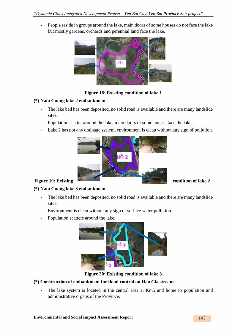
“Dynamic Cities Integrated Development Project – Yen Bai City, Yen Bai Province Sub-project”
Environmental and Social Impact Assessment Report 102
- People reside in groups around the lake, main doors of some houses do not face the lake
but mostly gardens, orchards and perennial land face the lake.
Figure 18: Existing condition of lake 1
(*) Nam Cuong lake 2 embankment
- The lake bed has been deposited, no solid road is available and there are many landslide
sites.
- Population scatter around the lake, main doors of some houses face the lake.
- Lake 2 has not any drainage system, environment is clean without any sign of pollution.
Figure 19: Existing condition of lake 2
(*) Nam Cuong lake 3 embankment
- The lake bed has been deposited, no solid road is available and there are many landslide
sites.
- Environment is clean without any sign of surface water pollution.
- Population scatters around the lake.
Figure 20: Existing condition of lake 3
(*) Construction of embankment for flood control on Hao Gia stream
- The lake system is located in the central area at Km5 and home to population and
administrative organs of the Province.
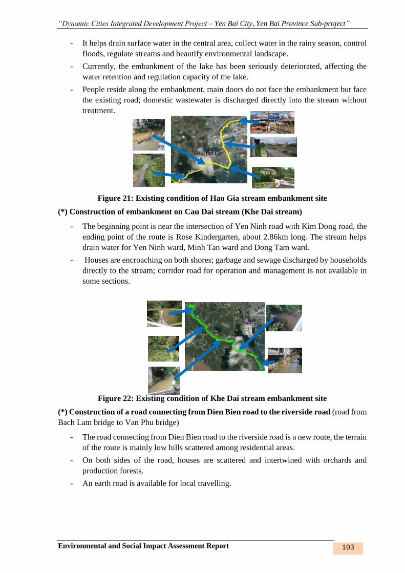
“Dynamic Cities Integrated Development Project – Yen Bai City, Yen Bai Province Sub-project”
Environmental and Social Impact Assessment Report 103
- It helps drain surface water in the central area, collect water in the rainy season, control
floods, regulate streams and beautify environmental landscape.
- Currently, the embankment of the lake has been seriously deteriorated, affecting the
water retention and regulation capacity of the lake.
- People reside along the embankment, main doors do not face the embankment but face
the existing road; domestic wastewater is discharged directly into the stream without
treatment.
Figure 21: Existing condition of Hao Gia stream embankment site
(*) Construction of embankment on Cau Dai stream (Khe Dai stream)
- The beginning point is near the intersection of Yen Ninh road with Kim Dong road, the
ending point of the route is Rose Kindergarten, about 2.86km long. The stream helps
drain water for Yen Ninh ward, Minh Tan ward and Dong Tam ward.
- Houses are encroaching on both shores; garbage and sewage discharged by households
directly to the stream; corridor road for operation and management is not available in
some sections.
Figure 22: Existing condition of Khe Dai stream embankment site
(*) Construction of a road connecting from Dien Bien road to the riverside road (road from
Bach Lam bridge to Van Phu bridge)
- The road connecting from Dien Bien road to the riverside road is a new route, the terrain
of the route is mainly low hills scattered among residential areas.
- On both sides of the road, houses are scattered and intertwined with orchards and
production forests.
- An earth road is available for local travelling.
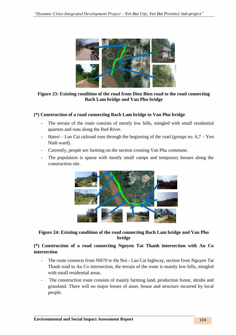
“Dynamic Cities Integrated Development Project – Yen Bai City, Yen Bai Province Sub-project”
Environmental and Social Impact Assessment Report 104
Figure 23: Existing condition of the road from Dien Bien road to the road connecting
Bach Lam bridge and Van Phu bridge
(*) Construction of a road connecting Bach Lam bridge to Van Phu bridge
- The terrain of the route consists of mostly low hills, mingled with small residential
quarters and runs along the Red River.
- Hanoi – Lao Cai railroad runs through the beginning of the road (groups no. 6,7 – Yen
Ninh ward).
- Currently, people are farming on the section crossing Van Phu commune.
- The population is sparse with mostly small camps and temporary houses along the
construction site.
Figure 24: Existing condition of the road connecting Bach Lam bridge and Van Phu
bridge
(*) Construction of a road connecting Nguyen Tat Thanh intersection with Au Co
intersection
- The route connects from NH70 to Ha Noi - Lao Cai highway, section from Nguyen Tat
Thanh road to Au Co intersection, the terrain of the route is mainly low hills, mingled
with small residential areas.
- The construction route consists of mainly farming land, production forest, shrubs and
grassland. There will no major losses of asset, house and structure incurred by local
people.
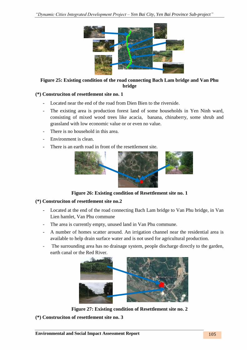
“Dynamic Cities Integrated Development Project – Yen Bai City, Yen Bai Province Sub-project”
Environmental and Social Impact Assessment Report 105
Figure 25: Existing condition of the road connecting Bach Lam bridge and Van Phu
bridge
(*) Construciton of resettlement site no. 1
- Located near the end of the road from Dien Bien to the riverside.
- The existing area is production forest land of some households in Yen Ninh ward,
consisting of mixed wood trees like acacia, banana, chinaberry, some shrub and
grassland with low economic value or or even no value.
- There is no household in this area.
- Environment is clean.
- There is an earth road in front of the resettlement site.
Figure 26: Existing condition of Resettlement site no. 1
(*) Construciton of resettlement site no.2
- Located at the end of the road connecting Bach Lam bridge to Van Phu bridge, in Van
Lien hamlet, Van Phu commune
- The area is currently empty, unused land in Van Phu commune.
- A number of homes scatter around. An irrigation channel near the residential area is
available to help drain surface water and is not used for agricultural production.
- The surrounding area has no drainage system, people discharge directly to the garden,
earth canal or the Red River.
Figure 27: Existing condition of Resettlement site no. 2
(*) Construciton of resettlement site no. 3

“Dynamic Cities Integrated Development Project – Yen Bai City, Yen Bai Province Sub-project”
Environmental and Social Impact Assessment Report 106
- Located at the beginning of the road connecting Nguyen Tat Thanh intersection with
Au Co intersection on Nguyen Tat Thanh street
- Homes scatter.
- There is an earth road with gardens and production forest of people on two sides.
- Environment is clean without any sign of pollution.
Figure 28: Existing condition of Resettlement site no. 3
(*) Construciton of resettlement site no. 4
- Located in groups no. 6,7 in Yen Ninh ward, near Bach Lam bridge.
- Environment is clean without any sign of pollution.
- Homes scatter.
- The existing area is production forest land of some households.
- The surrounding area has no drainage system, people discharge directly to the garden,
earth canal or the Red River.
Figure 29: Existing condition of Resettlement site no. 4
(*) Construciton of resettlement site no. 5
❖ Located in group no. 39 in Yen Ninh ward
❖ The existing area is empty land. Environment is clean without any sign of pollution.
❖ A number of homes scatter, vegetation cover includes bushes and grass and there is
some empty land.
❖ There is no drainage system, wastewater is discharged directly into their gardens but
due to large area and small population, wastewater is treated by the natural
environment, thus, no sign of water pollution has been found.
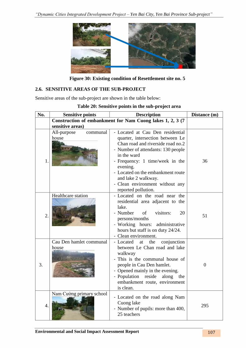
“Dynamic Cities Integrated Development Project – Yen Bai City, Yen Bai Province Sub-project”
Environmental and Social Impact Assessment Report 107
Figure 30: Existing condition of Resettlement site no. 5
2.6. SENSITIVE AREAS OF THE SUB-PROJECT
Sensitive areas of the sub-project are shown in the table below:
Table 20: Sensitive points in the sub-project area
No. Sensitive points Description Distance (m)
Construction of embankment for Nam Cuong lakes 1, 2, 3 (7
sensitive areas)
1.
All-purpose communal
house
- Located at Cau Den residential
quarter, intersection between Le
Chan road and riverside road no.2
- Number of attendants: 130 people
in the ward
- Frequency: 1 time/week in the
evening.
- Located on the embankment route
and lake 2 walkway.
- Clean environment without any
reported pollution.
36
2.
Healthcare station
- Located on the road near the
residential area adjacent to the
lake.
- Number of visitors: 20
persons/months
- Working hours: administrative
hours but staff is on duty 24/24.
- Clean environment.
51
3.
Cau Den hamlet communal
house
- Located at the conjunction
between Le Chan road and lake
walkway
- This is the communal house of
people in Cau Den hamlet.
- Opened mainly in the evening.
- Population reside along the
embankment route, environment
is clean.
0
4.
Nam Cường primary school
- Located on the road along Nam
Cuong lake
- Number of pupils: more than 400,
25 teachers
295
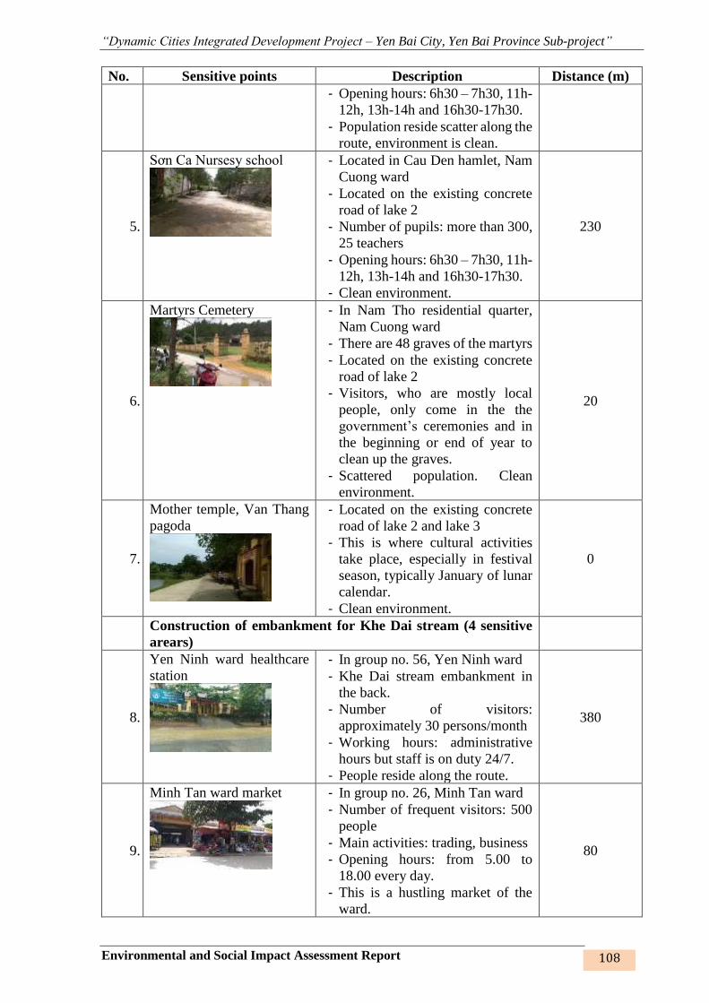
“Dynamic Cities Integrated Development Project – Yen Bai City, Yen Bai Province Sub-project”
Environmental and Social Impact Assessment Report 108
No. Sensitive points Description Distance (m)
- Opening hours: 6h30 – 7h30, 11h-
12h, 13h-14h and 16h30-17h30.
- Population reside scatter along the
route, environment is clean.
5.
Sơn Ca Nursesy school
- Located in Cau Den hamlet, Nam
Cuong ward
- Located on the existing concrete
road of lake 2
- Number of pupils: more than 300,
25 teachers
- Opening hours: 6h30 – 7h30, 11h-
12h, 13h-14h and 16h30-17h30.
- Clean environment.
230
6.
Martyrs Cemetery
- In Nam Tho residential quarter,
Nam Cuong ward
- There are 48 graves of the martyrs
- Located on the existing concrete
road of lake 2
- Visitors, who are mostly local
people, only come in the the
government’s ceremonies and in
the beginning or end of year to
clean up the graves.
- Scattered population. Clean
environment.
20
7.
Mother temple, Van Thang
pagoda
- Located on the existing concrete
road of lake 2 and lake 3
- This is where cultural activities
take place, especially in festival
season, typically January of lunar
calendar.
- Clean environment.
0
Construction of embankment for Khe Dai stream (4 sensitive
arears)
8.
Yen Ninh ward healthcare
station
- In group no. 56, Yen Ninh ward
- Khe Dai stream embankment in
the back.
- Number of visitors:
approximately 30 persons/month
- Working hours: administrative
hours but staff is on duty 24/7.
- People reside along the route.
380
9.
Minh Tan ward market
- In group no. 26, Minh Tan ward
- Number of frequent visitors: 500
people
- Main activities: trading, business
- Opening hours: from 5.00 to
18.00 every day.
- This is a hustling market of the
ward.
80
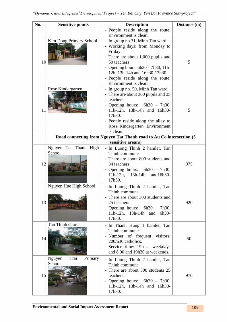
“Dynamic Cities Integrated Development Project – Yen Bai City, Yen Bai Province Sub-project”
Environmental and Social Impact Assessment Report 109
No. Sensitive points Description Distance (m)
- People reside along the route.
Environment is clean.
10.
Kim Dong Primary School
- In group no.31, Minh Tan ward
- Working days: from Monday to
Friday
- There are about 1,000 pupils and
50 teachers
- Opening hours: 6h30 – 7h30, 11h-
12h, 13h-14h and 16h30-17h30.
- People reside along the route.
Environment is clean.
5
11.
Rose Kindergarten
- In group no. 50, Minh Tan ward
- There are about 300 pupils and 25
teachers
- Opening hours: 6h30 – 7h30,
11h-12h, 13h-14h and 16h30-
17h30.
- People reside along the alley to
Rose Kindergarten. Environment
is clean.
5
Road connecting from Nguyen Tat Thanh road to Au Co intersection (5
sensitive arears)
12.
Nguyen Tat Thanh High
School
- In Luong Thinh 2 hamlet, Tan
Thinh commune
- There are about 800 students and
34 teachers
- Opening hours: 6h30 – 7h30,
11h-12h, 13h-14h and16h30-
17h30.
975
13.
Nguyen Hue High School
- In Luong Thinh 2 hamlet, Tan
Thinh commune
- There are about 300 students and
25 teachers
- Opening hours: 6h30 – 7h30,
11h-12h, 13h-14h and 6h30-
17h30.
920
14.
Tan Thinh church
- In Thanh Hung 1 hamlet, Tan
Thinh commune
- Number of frequent visitors:
200/630 catholics.
- Service time: 19h at weekdays
and 8.00 and 19h30 at weekends.
50
15.
Nguyen Trai Primary
School
- In Luong Thinh 2 hamlet, Tan
Thinh commune
- There are about 300 students 25
teachers
- Opening hours: 6h30 – 7h30,
11h-12h, 13h-14h and 16h30-
17h30.
970
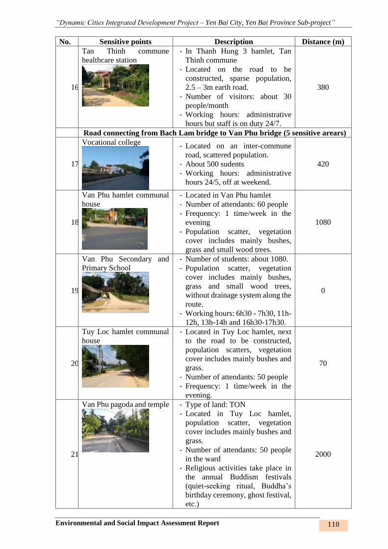
“Dynamic Cities Integrated Development Project – Yen Bai City, Yen Bai Province Sub-project”
Environmental and Social Impact Assessment Report 110
No. Sensitive points Description Distance (m)
16.
Tan Thinh commune
healthcare station
- In Thanh Hung 3 hamlet, Tan
Thinh commune
- Located on the road to be
constructed, sparse population,
2.5 – 3m earth road.
- Number of visitors: about 30
people/month
- Working hours: administrative
hours but staff is on duty 24/7.
380
Road connecting from Bach Lam bridge to Van Phu bridge (5 sensitive arears)
17.
Vocational college
- Located on an inter-commune
road, scattered population.
- About 500 sudents
- Working hours: administrative
hours 24/5, off at weekend.
420
18.
Van Phu hamlet communal
house
- Located in Van Phu hamlet
- Number of attendants: 60 people
- Frequency: 1 time/week in the
evening
- Population scatter, vegetation
cover includes mainly bushes,
grass and small wood trees.
1080
19.
Van Phu Secondary and
Primary School
- Number of students: about 1080.
- Population scatter, vegetation
cover includes mainly bushes,
grass and small wood trees,
without drainage system along the
route.
- Working hours: 6h30 - 7h30, 11h-
12h, 13h-14h and 16h30-17h30.
0
20.
Tuy Loc hamlet communal
house
- Located in Tuy Loc hamlet, next
to the road to be constructed,
population scatters, vegetation
cover includes mainly bushes and
grass.
- Number of attendants: 50 people
- Frequency: 1 time/week in the
evening.
70
21.
Van Phu pagoda and temple
- Type of land: TON
- Located in Tuy Loc hamlet,
population scatter, vegetation
cover includes mainly bushes and
grass.
- Number of attendants: 50 people
in the ward
- Religious activities take place in
the annual Buddism festivals
(quiet-seeking ritual, Buddha’s
birthday ceremony, ghost festival,
etc.)
2000
“Dynamic Cities Integtared Development Project – Yen Bai City, Yen Bai Province Sub-project”
Environmental-Social Impact Assessment Report 111
CHAPTER 3. ALTERNATIVE ANALYSIS
During the impact assessment of the sub-project, analysis of alternatives is a significant step in
the assessment process. The main purpose of analysing alternatives is to identify the location,
design and technology applicable to each specific component of the sub-project so as to
minimize the negative impacts and maximinze the positive ones. The analysis of alternatives
has been conducted for each component of the sub-project in technical, economic, social and
environment aspects. The analysis outcomes are presented hereunder.
3.1. WITH-PROJECT AND WITHOUT SUBPROJECT
As assessed in respect of status of Yen Bai city in Chapter 2 hereinabove, without sub-project,
the City’s negative and disadvantageous considerations in respect of environmental and social
aspects remain existed:
➢ Flooding and social safety: flooding, landslide and waterlogging occur frequently with
increasing rate in the whole Yen Bai city, especially in Yen Ninh, Minh Tan, Dong Tam,
Tan Thinh wards (basin 2) and Hong Ha, Nguyen Phuc, Nguyen Thai Hoc ward (basin
1).
➢ Environmental pollution: along Hao Gia and Khe Dai streams, the wastewater from
households, restaurants, hotels, commercial centers, etc. is not treated or unthoroughly
treated. Besides, there is no culvert system for collecting the wastewater along the
embankment. Therefore, the wastewater is directly discharged into the streams, causing
impact on the environment and urban aesthetics.
➢ Increase of wastewater and sewage: the growth of urban size and increasing
population increase the demands, including domestic water and other eating, drinking
demands, which increases the volume of wastewater and sewage, putting heavy pressure
on the surrounding environment.
➢ Urban safety: The inconvenient traffic, degraded, small and under-standard urban
roads as well as the weak circulation capacity have become a tremendous hindrance for
the economic development and improvement of living quality.
The development of environmental and social matters in “WITH” and “WITHOUT” sub-
project cases is compared in the table below.
Table 21: Environment quality in “WITH” and “WITHOUT” sub-project cases
No Environmental
and social matters “Without” Sub-project case “With” Sub-project case
Embankments of Nam Cuong lake 1,2,3, Hao Gia stream and Khe Dai stream
1. Air quality - Not affected by the
construction activities
- Dust and noise levels will be increased
during the construction; however, this
impact is temporary, partial and
controllable.
- During the operation phase, the emission
from traffic vehicles will be increased when
the traffic volume increases.
- Odour pollution from stagnated
sewage and wastewater in vairous
sections of Hao Gia and Khe Dai
- Odour pollution from stagnated sewage
and wastewater is treated because they are
collected and discharged into the drainage
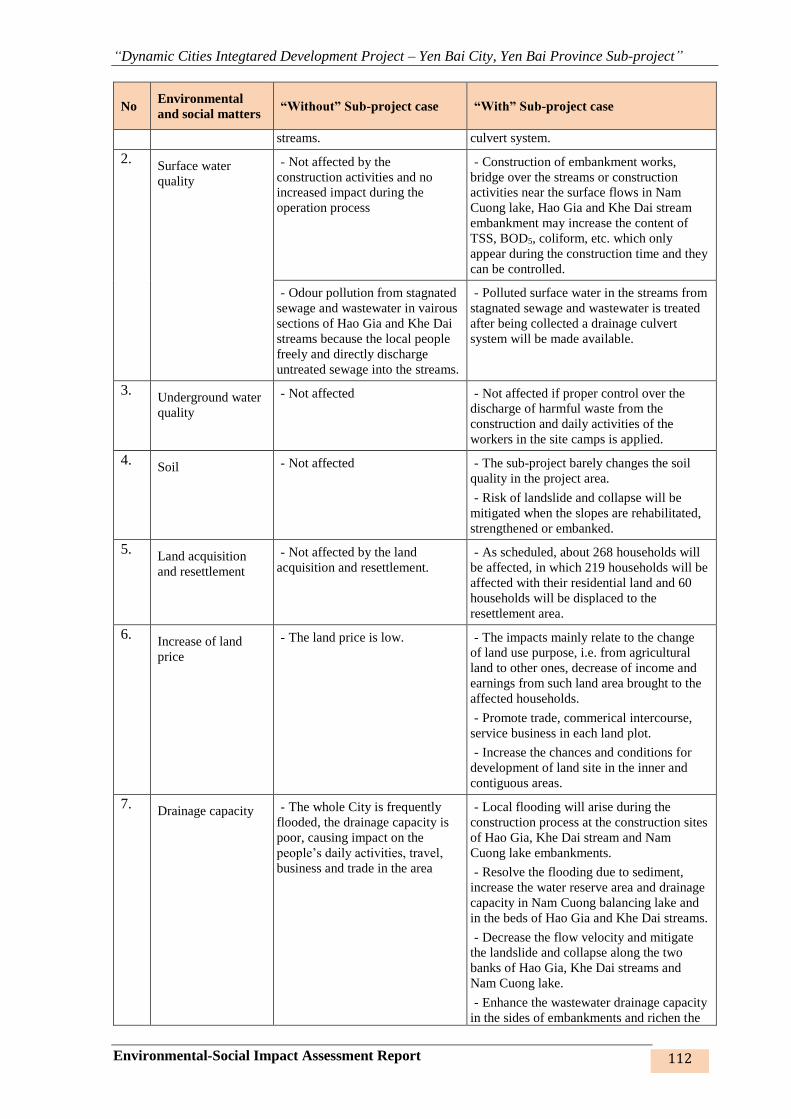
“Dynamic Cities Integtared Development Project – Yen Bai City, Yen Bai Province Sub-project”
Environmental-Social Impact Assessment Report 112
No Environmental
and social matters “Without” Sub-project case “With” Sub-project case
streams. culvert system.
2. Surface water
quality
- Not affected by the
construction activities and no
increased impact during the
operation process
- Construction of embankment works,
bridge over the streams or construction
activities near the surface flows in Nam
Cuong lake, Hao Gia and Khe Dai stream
embankment may increase the content of
TSS, BOD5, coliform, etc. which only
appear during the construction time and they
can be controlled.
- Odour pollution from stagnated
sewage and wastewater in vairous
sections of Hao Gia and Khe Dai
streams because the local people
freely and directly discharge
untreated sewage into the streams.
- Polluted surface water in the streams from
stagnated sewage and wastewater is treated
after being collected a drainage culvert
system will be made available.
3. Underground water
quality
- Not affected - Not affected if proper control over the
discharge of harmful waste from the
construction and daily activities of the
workers in the site camps is applied.
4. Soil - Not affected - The sub-project barely changes the soil
quality in the project area.
- Risk of landslide and collapse will be
mitigated when the slopes are rehabilitated,
strengthened or embanked.
5. Land acquisition
and resettlement
- Not affected by the land
acquisition and resettlement.
- As scheduled, about 268 households will
be affected, in which 219 households will be
affected with their residential land and 60
households will be displaced to the
resettlement area.
6. Increase of land
price
- The land price is low. - The impacts mainly relate to the change
of land use purpose, i.e. from agricultural
land to other ones, decrease of income and
earnings from such land area brought to the
affected households.
- Promote trade, commerical intercourse,
service business in each land plot.
- Increase the chances and conditions for
development of land site in the inner and
contiguous areas.
7. Drainage capacity - The whole City is frequently
flooded, the drainage capacity is
poor, causing impact on the
people’s daily activities, travel,
business and trade in the area
- Local flooding will arise during the
construction process at the construction sites
of Hao Gia, Khe Dai stream and Nam
Cuong lake embankments.
- Resolve the flooding due to sediment,
increase the water reserve area and drainage
capacity in Nam Cuong balancing lake and
in the beds of Hao Gia and Khe Dai streams.
- Decrease the flow velocity and mitigate
the landslide and collapse along the two
banks of Hao Gia, Khe Dai streams and
Nam Cuong lake.
- Enhance the wastewater drainage capacity
in the sides of embankments and richen the

“Dynamic Cities Integtared Development Project – Yen Bai City, Yen Bai Province Sub-project”
Environmental-Social Impact Assessment Report 113
No Environmental
and social matters “Without” Sub-project case “With” Sub-project case
urban landscape.
8. Environmental
sanitation and
community health
conditions
- Degradation of environmental
sanitation, increases of diseases
due to flooding and polluted
water sources.
- Improve the environmental sanitation and
community health conditions by enhancing
the drainage capacity, control of flooding
and developing a healthy ecological system
in the areas of Hao Gia and Khe Dai stream
embankment as well as in Nam Cuong
balancing lake.
- Environmental sanitation and community
health will be improved, especially for those
who live along the embankments of Hao Gia
and Khe Dai streams.
9. Urban landscape - Urban landscape is not
improved and tends to be
unattractive.
- Develop urban landscape: the embankent
routes and walk roads along the stream
banks, lake bank; improvement of the public
space, rehabilitation of the traditional
architectures, tree-planting, etc.
10. Isolation of
residential area and
production land;
Interruption of
people’s daily
activities.
- The residential area and
production land will remain
unchanged as it has been and not
be divided.
- People’s lives and their daily
activities as well as the public
relations will not be affected.
- Some sections will be deepened or filled
higher than the existing ground level,
resulting in isolation of the residential areas.
This impact will be mitigated by the design
measures, such as arrangement of the
underpasses or ramps connecting the
divided areas with the detours, having
regarded to the safety.
- Lives and daily activities of people in the
City will be affected.
11. Benefits - Decrease the living quality and
conditions of people, especially in
the frequently flooded and slipped
areas.
- Increase the worry of people
living along the two sides of
stream embankments about the
safety and environmental
hygiene.
- Regional connectivity,
promotion of developing the
contiguous urban areas, etc are at
low development.
- The project provides direct benefits from
mitigation of flooding, enhancement of
regional environmental quality,
improvement of living condition, etc for
households living along the two
embankments of Hao Gia and Khe Dai
streams, the people living around Nam
Cuong lake and in Nam Cuong ward and the
people living along the routes and in Yen
Ninh, Minh Tan wards, Van Phu and Tan
Thinh communes.
- Improve the quality and conditions of
living environment as well as the urban
landscape.
- Increase the reserve volume and adjust the
water reserve capacity and flooding
drainage capacity, moderate the water level
in the beds of Hao Gia, Khe Dai streams and
Nam Cuong ecological reservoir.
- Improve traffic conditions, decrease
pressure of transportation and circulation in
the urban roads, promote the local socio-
economic development at the construction
areas of roads, embankments and bridges.
- Increase the dynamism, create the
benchmarks for growth and development of
Yen Bai city, connect and link with the

“Dynamic Cities Integtared Development Project – Yen Bai City, Yen Bai Province Sub-project”
Environmental-Social Impact Assessment Report 114
No Environmental
and social matters “Without” Sub-project case “With” Sub-project case
Northern areas for mutual development.
Roads no. 1,2 ,3
1. Air quality - Not affected by the
construction activities
- Dust and noise levels will be increased
during the construction, however, this
impact is temporary, partial and
controllable.
- During the operation phase, the emission
from traffic vehicles will be increased when
the traffic volume increases.
2. Underground water
quality
- Not affected - Not affected if good control measures of
discharging harmful waste from the
construction, daily activities of the workers
in the site huts are applied.
3. Land acquisition
and resettlement
- Not affected by the land
acquisition and resettlement
- As scheduled, about 603 households will
be affected, in which 76 households are
relocated to the resettlement area.
4. Increase of land
price
- The land price is low - The impacts mainly relate to the change
of land use purpose, i.e. from agricultural
land to other ones, decrease of income
sources and earnings from such land area
brought to the affected households.
- Increase the chance of trade, commerical
intercourse, service business-running, etc in
each land slot.
- Increase the chances and conditions for
development of land site in the inner and
contiguous areas.
5. Urban landscape - Urban landscape is not
improved and tends to be
unattractive.
- Develop urban landscape: constructed
roads will create open spaces along two
sides; public spaces will be improved,
traditional architectures will be
rehabilitated, trees will be planted, etc.
6. Isolation of the
residential area and
production land;
Interruption of the
people’s daily
activities
- The residential area and
production land will remain
unchanged as it has been and not
be divided.
- People’s lives and their daily
activities as well as the public
relations will not be affected.
- Some sections will be deepened or filled
higher than the existing grould level,
resulting in isolation of the production land,
or between the production land and
residential areas. This impact will be
mitigated by the design measures, such as
underpasses or ramps connecting the
divided areas with the detours, having
regarded to the safety.
- Lives and daily activities of people in the
City as well as public relations will be
affected because of the construction and
resettlement for the affected households.
7. Benefits - Decrease the living quality and
conditions of people, especially in
the frequently flooded areas.
- Increase traffic pressure on the
roads in the coming time.
- Regional connectivity,
promotion of developing the
- Improve the quality and conditions of
living environment as well as the urban
landscape.
- Improve traffic conditions, decrease
pressure of transportation and circulation on
the urban roads, promote the local socio-
economic development at the construction

“Dynamic Cities Integtared Development Project – Yen Bai City, Yen Bai Province Sub-project”
Environmental-Social Impact Assessment Report 115
No Environmental
and social matters “Without” Sub-project case “With” Sub-project case
contiguous urban areas, etc is at
low level
areas of roads, embankments and bridges.
- Increase the dynamism, create the
benchmarks for growth and development of
Yen Bai city, connect and link with the
Northern areas for mutual development.
Resettlement sites
1. Air quality - Not affected by the
construction activities.
- Dust and noise levels will be increased
during the construction, however, this
impact is temporary, partially and
controllable.
2. Surface water
quality
- Not affected by the
construction activities and there
remains no impact increased
during the operation process
- Construction of roads near the surface
flows adjacent to the Red river may increase
the content of TSS, BOD5, coliform, etc.
However, the impacts only appear during
the construction time and they can be
controlled.
3. Land acquisition
and resettlement
- Not affected by the land
acquisition and resettlement.
- As scheduled, about121households will
be affected, in which no household is
subject to the resettlement.
4. Increase of land
price
- The land price is low - The impacts mainly relate to the change
of land use purpose, i.e. from agricultural
land to other ones, decrease of income
sources and earnings from such land area
brought to the affected households.
- Increase the chance of trade, commerical
intercourse, service business-running, etc in
each land slot.
- Increase the chances and conditions for
development of land site in the inner and
contiguous areas.
5. Benefits - Decrease the living quality and
conditions of people, especially in
the frequently flooded and
landslided areas;
- Increase the worry of people
living along the two sides of
stream embankments about the
safety and environmental
hygiene.
-
- Provide confortable and convenient
accommodation to the households living
under the permitted level of safety and
convenience in their existing
accommodation.
- Satisfy the demands of the household
relocated to the resettlement area.
- Stabilize the life and works in the new
residential area with those who have the
same culture, customs and habit.
The comparison table hereinabove shows that construction of various items under the sub-
project may cause impacts on the surrounding residential communities and workers from dust,
exhaust, noise, vibration, wastewater, sewage, hygiene conditions, etc. But, these impacts are
not significant; just exist only for a short time of construction and they can be mitigated by
proper measures.
The items under the sub-project after being put into operation will generate significant benefits
to Yen Bai city in particular and the mountainous midland regions of the North in general. The
sub-project will (i) create the motive force for sustainable economic development, provide jobs
and stable earnings for a large number of people from the new careers after the transport roads
are developed. (ii) create favorable conditions to trade with the whole mountainous midland of
“Dynamic Cities Integtared Development Project – Yen Bai City, Yen Bai Province Sub-project”
Environmental-Social Impact Assessment Report 116
the North at the aim of promoting economic development in the fields of industry, handicraft,
commerce, service and tourism. (iii) attract and lure the potential investors who have good
financial capability to feel assured and carry their business activities because of an improved
environment, especially the overcoming of flooding, negative impacts from climate change thus
making contribution to GDP growth. (iv) increase the land price in the region after the sub-
project is invested and put into use. In general, the effects from “with sub-project” will provide
significant motive force for development and sustainable development of Yen Bai city in the
future.
3.2. THE SOCIAL ENVIRONMENT FACTORS CONSIDERED DURING
PREPARATION OF FEASIBILITY STUDY
The following matters have been considered and examined in identifying location during
preparation of FS for the work items invested and constructed in the city, namely:
➢ Socio-economic development will result in environmental pollution problems. To
ensure the development and come to the sustainable development, these environmental
pollution problems must be resolved. One of the measures is to consolidate the stream
embankment infrastructure, develop wastewater collection culvert system, rainwater
drainage ditches and canals, dredge the beds of streamsand reservoirs, strengthen the
urban transport system to enhance connectivity and make commercial intercourse in the
city and the region.
➢ The constructed locations may be affected by land acquisition due to site clearance
in service of constructing the work items. However, during the survey, the positioning
of affected area, studying construction methods of the works and discussions with the
Management Unit, local authority and community representatives of locality where the
project is proposed, have been conducted. Therefore, the acquired land area is properly
calculated and cut off in the unnecessary location; the alignment and area are adjusted
so as to minimize going through the existing area where the houses, architectural works,
trees, etc of the local residents exist.
➢ Flooding mitigation and inundation drainage: Proposal of measures for construction
of embankment, walkpaths around the lake, dredging the embankment and lake to
increase the water reserve capacity and decrease the flow velocity in the design areas
for the purpose of enhancing inundation drainage capacity, decline the height and
flooding frequency, etc have been worked out to mitigate the damage against the local
people;
➢ Improvement of living quality: the selection of constructing embankments of streams
and Nam Cuong lake is considered one of the dynamism investment step, at the aim of
improving aesthetics, value and living quality of the local residents, creating
benchmarks for the locality as well as encouraging and attracting the investment into
the location in the time to come.
➢ Consilidation of inner transport system: Comply with the design standard and road
transportation capacity, enhance the connectivity in the city and the main roads for
regional transportation, the roads linking two banks of the Red river in the City and in
the region, contributing to completion of connectivity, development of the city towards
a comprehensive and modern model which is open to the to create momentum for
promotion of socio-economic development and investment attraction.
3.3. ANALYSIS OF PROPOSED ALTERNATIVES
(1) Scale and efficiency of embankment:

“Dynamic Cities Integtared Development Project – Yen Bai City, Yen Bai Province Sub-project”
Environmental-Social Impact Assessment Report 117
To determine the size and efficiency of the aforesaid works, the Consultant has applied
hydrauric models MIKE 11 and MIKE 21, hydrologic model MIKE NAM in calculation.
According to these models, the researched river network is divided into single river sections by
the cross sections. The river sections are contiguous to each other according to their natural
status. By the above method, difference formula and linearization, it will provide a difference
equation for the whole river network via mesh difference. Solving the difference equation will
generate the required root at the mesh, in particular, we can find the water level at the sectional
positions and sectional positions +2*dx, flow at sectional posisions +dx and the positions of the
works, such as culvert, dam, etc, in the whole river network after each calculated time step.
As above-analysed, the calculation of hydrologic aspect, flooding in the Red river and the rain
causing flood in Yen Bai city is not uniform (not happened simultaneously to each other) while
the goal of embankment of Cau Dai and Hao Gia streams is for flooding drainage. Obviously,
it can be confirmed that the embankment these streams is only meaningful for drainage due to
the local rain.
From the above analysis, we propose to calculate the design frequency for embankments of Cau
Dai and Hao Gia P=2% caused by rain. Calculation result of design frequency P=2%, flooded
area due to upstream flood combined with high water level in the downstream after
rehabilitation of Hao Gia, Cau Dai streams and Nam Cuong lake shows that it can reduce 50-
60% of flooded area compared to the time before rehabilitation. The design flooding water level
for embankments of Cau Dai and Hao Gia at the flow merging section is +32.1m. The design
water level for Cau Dai embankment at Tuan Quan flow merging section is +29.1m.
Figure 31: Flooding map before (a) and after (b) rehabilitation – P=2%
Calculation of rain with different frequencies shows that:
Table 31: Comparison of flooded area before and after rehabiliation of Nam Cuong lake
embankment
Frequency
Flooded area (ha) Maximum flooding depth(m)
Before
rehabilitation
After
rehabilitation
Before
rehabilitation
After
rehabilitation
1% 340.6 166.9 1.52 1.17
2% 309.6 114.6 0.92 0.47
5% 278.6 72.4 0.76 0.56
a b
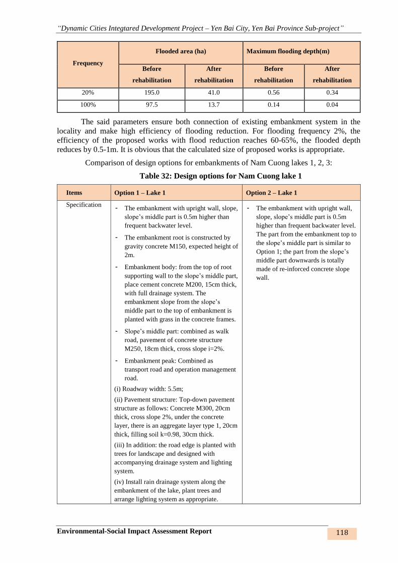
“Dynamic Cities Integtared Development Project – Yen Bai City, Yen Bai Province Sub-project”
Environmental-Social Impact Assessment Report 118
Frequency
Flooded area (ha) Maximum flooding depth(m)
Before
rehabilitation
After
rehabilitation
Before
rehabilitation
After
rehabilitation
20% 195.0 41.0 0.56 0.34
100% 97.5 13.7 0.14 0.04
The said parameters ensure both connection of existing embankment system in the
locality and make high efficiency of flooding reduction. For flooding frequency 2%, the
efficiency of the proposed works with flood reduction reaches 60-65%, the flooded depth
reduces by 0.5-1m. It is obvious that the calculated size of proposed works is appropriate.
Comparison of design options for embankments of Nam Cuong lakes 1, 2, 3:
Table 32: Design options for Nam Cuong lake 1
Items Option 1 – Lake 1 Option 2 – Lake 1
Specification - The embankment with upright wall, slope,
slope’s middle part is 0.5m higher than
frequent backwater level.
- The embankment root is constructed by
gravity concrete M150, expected height of
2m.
- Embankment body: from the top of root
supporting wall to the slope’s middle part,
place cement concrete M200, 15cm thick,
with full drainage system. The
embankment slope from the slope’s
middle part to the top of embankment is
planted with grass in the concrete frames.
- Slope’s middle part: combined as walk
road, pavement of concrete structure
M250, 18cm thick, cross slope i=2%.
- Embankment peak: Combined as
transport road and operation management
road.
(i) Roadway width: 5.5m;
(ii) Pavement structure: Top-down pavement
structure as follows: Concrete M300, 20cm
thick, cross slope 2%, under the concrete
layer, there is an aggregate layer type 1, 20cm
thick, filling soil k=0.98, 30cm thick.
(iii) In addition: the road edge is planted with
trees for landscape and designed with
accompanying drainage system and lighting
system.
(iv) Install rain drainage system along the
embankment of the lake, plant trees and
arrange lighting system as appropriate.
- The embankment with upright wall,
slope, slope’s middle part is 0.5m
higher than frequent backwater level.
The part from the embankment top to
the slope’s middle part is similar to
Option 1; the part from the slope’s
middle part downwards is totally
made of re-inforced concrete slope
wall.

“Dynamic Cities Integtared Development Project – Yen Bai City, Yen Bai Province Sub-project”
Environmental-Social Impact Assessment Report 119
Items Option 1 – Lake 1 Option 2 – Lake 1
Technical
advantages
- This is common option, taking full use of
local material and common workers.
- Simple technique and quick construction
- Suitable to various terrain with low
difference of height, small flow velocity and
stable water level.
- Low cost.
- Flooded height: reducing the water level in
the lake downstream to 0.36m in Ngoi Ong
stream.
- Save the area
- High aesthetics
- Flooded height: reducing the water
level in the lake downstream to 0.36min
Ngoi Ong stream.
Technical
disadvantages
- Less aesthetic - Complicated method of construction
that requires high-qualified manpower,
modern plant and equipment, so it
cannot take full use of local common
workers.
- High construction cost.
Economic aspect - Lower construction cost
- Dredged volume: 140,000 m3
- Higher construction cost’
- Dredged volume: 315,000 m3.
Environment - Increase the fresh water reserve capacity for
Nam Cuong ward;
- Increase the air-conditioning capacity,
micro-climate and develop ecological
environment;
- Enhance drainage capacity for various areas
of Nam Cuong, Hong Ha, Nguyen Thai Hoc
wards while reducing the flooding.
- Increase the fresh water reserve
capacity for Nam Cuong ward;
- Increase the air-conditioning capacity,
micro-climate and develop ecological
environment;
- Enhance drainage capacity for various
areas of Nam Cuong, Hong Ha, Nguyen
Thai Hoc wards while reducing the
flooding..
Social aspect - 6 households are affected, no household is
relocated to the resettlement area; the affected
area is approximate 0.8ha.
- Improve the local people’s living conditions.
- Form an ecological area of the city.
- Balance air and water for the Northwest of
the City.
- 100% of people and authority agree with
and support the project.
- 6 households are affected, no
household is relocated to the
resettlement area; the affected area is
approximate 0.8ha.
- Improve the local people’s living
conditions.
- Form an ecological area of the city.
- Balance air and water for the
Northwest of the City.
- 100% of people and authority agree
with and support the project..
Selection From the premarily comparison in the above table and the actual characteristics of the
flow in the lake bed with small velocity, quite stable water level and insignficant
MÆT C¾T ®H kÌ hå nam cêng (hå sè 1)Tû lÖ 1:100
MÆT C¾T ®H kÌ hå nam cêng (hå sè 1)-PA so s¸nhTû lÖ 1:100

“Dynamic Cities Integtared Development Project – Yen Bai City, Yen Bai Province Sub-project”
Environmental-Social Impact Assessment Report 120
Items Option 1 – Lake 1 Option 2 – Lake 1
difference between lake bank and bottom height, Option 1 is proposed to be selected as
the design option.
Table 33: Design options for Nam Cuong lakes 2,3
Items Option 1 – Lakes 2,3 Option2 – Lakes 2,3
Typical cross
section
Specifications The embankment root is constructed by
gravity concrete M150, expected height of
2m.
+ Embankment body is placed with
gravity concrete M200, 15cm thick, full
drainage system;
+Embankment peak: Combined as
transport road and operation management
road.
(i) Roadway width: 3.5m;
(ii) Pavement structure: Top-down
pavement structure as follows: Concrete
M300, 20cm thick, cross slope 2%, under
the concrete layer, there is an aggregate
layer type 1, 20cm thick, filling soil
k=0.98, 30cm thick.
(iii) In addition: the road edge is planted
with trees for landscape and designed with
accompanying drainage system and
lighting system
(iv) Install rain drainage system along the
embankment of the lake, plant trees and
arrange lighting system as appropriate.
The re-inforced concreteslope wall. The
wall bottom is consolidated by reinforced
concrete piles M300, dimension 25x25. The
road in embankment peak is similar to
Option 1.
Technical
advantages
- This is common option, taking full use of
local materials and common workers.
- Simple technique and quick construction.
- Suitable to various terrains with low
difference of height, small flow velocity
and stable water level.
- Low cost.
- Save the area;
- High aesthetics.
Technical
disadvantages
- Less aesthetic - Complicated method of construction that
requires high-qualified manpower, modern
MÆT C¾T ®H kÌ hå nam cêng (hå sè 1 vµ 2) (Pa chän)Tû lÖ 1:100
MÆT C¾T ®H kÌ hå nam cêng (hå sè 1 vµ 2) PA2
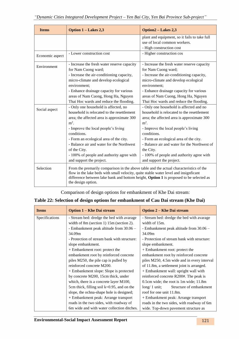
“Dynamic Cities Integtared Development Project – Yen Bai City, Yen Bai Province Sub-project”
Environmental-Social Impact Assessment Report 121
Items Option 1 – Lakes 2,3 Option2 – Lakes 2,3
plant and equipment, so it fails to take full
use of local common workers.
- High construction cost
Economic aspect - Lower construction cost
- Higher construction cos
Environment - Increase the fresh water reserve capacity
for Nam Cuong ward;
- Increase the air-conditioning capacity,
micro-climate and develop ecological
environment;
- Enhance drainage capacity for various
areas of Nam Cuong, Hong Ha, Nguyen
Thai Hoc wards and reduce the flooding.
- Increase the fresh water reserve capacity
for Nam Cuong ward;
- Increase the air-conditioning capacity,
micro-climate and develop ecological
environment;
- Enhance drainage capacity for various
areas of Nam Cuong, Hong Ha, Nguyen
Thai Hoc wards and reduce the flooding.
Social aspect - Only one household is affected, no
household is relocated to the resettlement
area; the affected area is approximate 300
m2.
- Improve the local people’s living
conditions.
- Form an ecological area of the city.
- Balance air and water for the Northwest
of the City.
- 100% of people and authority agree with
and support the project.
- Only one household is affected and no
household is relocated to the resettlement
area; the affected area is approximate 300
m2.
- Improve the local people’s living
conditions.
- Form an ecological area of the city.
- Balance air and water for the Northwest of
the City.
- 100% of people and authority agree with
and support the project.
Selection From the premarily comparison in the above table and the actual characteristics of the
flow in the lake beds with small velocity, quite stable water level and insignficant
difference between lake bank and bottom height, Option 1 is proposed to be selected as
the design option.
Comparison of design options for embankment of Khe Dai stream:
Table 22: Selection of design options for embankment of Cau Dai stream (Khe Dai)
Items Option 1 – Khe Dai stream Option 2 – Khe Dai stream
Specifications - Stream bed: dredge the bed with avarage
width of 8m (section 1) 15m (section 2).
- Embankment peak altitude from 30.06 –
34.09m
- Protection of stream bank with structure:
slope embankment.
+ Embankment root: protect the
embankment root by reinforced concrete
piles M250, the pile cap is pulled by
reinforced concrete M200.
+ Embankment slope: Slope is protected
by concrete M200, 15cm thick, under
which, there is a concrete layer M100,
5cm thick, filling soil k=0.95, and on the
slope, the ochna-shape hole is designed;
+ Embankment peak: Arrange transport
roads in the two sides, with roadway of
6m wide and with water collection ditches.
- Stream bed: dredge the bed with avarage
width of 15m.
- Embankment peak altitude from 30.06 –
34.09m
- Protection of stream bank with structure:
slope embankment.
+ Embankment root: protect the
embankment root by reinforced concrete
piles M250, 4.5m wide and in every interval
of 11.8m, a settlement joint is arranged.
+ Embankment wall: upright wall with
reinforced concrete R200#. The peak is
0.5cm wide; the root is 1m wide; 11.8m
long/ 1 unit; Structure of embankment
roof for one unit 11.8m.
+ Embankment peak: Arrange transport
roads in the two sides, with roadway of 6m
wide. Top-down pavement structure as
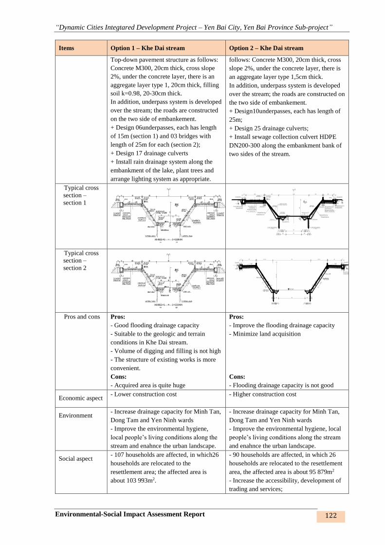
“Dynamic Cities Integtared Development Project – Yen Bai City, Yen Bai Province Sub-project”
Environmental-Social Impact Assessment Report 122
Items Option 1 – Khe Dai stream Option 2 – Khe Dai stream
Top-down pavement structure as follows:
Concrete M300, 20cm thick, cross slope
2%, under the concrete layer, there is an
aggregate layer type 1, 20cm thick, filling
soil k=0.98, 20-30cm thick.
In addition, underpass system is developed
over the stream; the roads are constructed
on the two side of embankement.
+ Design 06underpasses, each has length
of 15m (section 1) and 03 bridges with
length of 25m for each (section 2);
+ Design 17 drainage culverts
+ Install rain drainage system along the
embankment of the lake, plant trees and
arrange lighting system as appropriate.
follows: Concrete M300, 20cm thick, cross
slope 2%, under the concrete layer, there is
an aggregate layer type 1,5cm thick.
In addition, underpass system is developed
over the stream; the roads are constructed on
the two side of embankement.
+ Design10underpasses, each has length of
25m;
+ Design 25 drainage culverts;
+ Install sewage collection culvert HDPE
DN200-300 along the embankment bank of
two sides of the stream.
Typical cross
section –
section 1
Typical cross
section –
section 2
Pros and cons Pros:
- Good flooding drainage capacity
- Suitable to the geologic and terrain
conditions in Khe Dai stream.
- Volume of digging and filling is not high
- The structure of existing works is more
convenient.
Cons:
- Acquired area is quite huge
Pros:
- Improve the flooding drainage capacity
- Minimize land acquisition
Cons:
- Flooding drainage capacity is not good
Economic aspect - Lower construction cost - Higher construction cost
Environment - Increase drainage capacity for Minh Tan,
Dong Tam and Yen Ninh wards
- Improve the environmental hygiene,
local people’s living conditions along the
stream and enahnce the urban landscape.
- Increase drainage capacity for Minh Tan,
Dong Tam and Yen Ninh wards
- Improve the environmental hygiene, local
people’s living conditions along the stream
and enahnce the urban landscape.
Social aspect - 107 households are affected, in which26
households are relocated to the
resettlement area; the affected area is
about 103 993m2.
- 90 households are affected, in which 26
households are relocated to the resettlement
area, the affected area is about 95 879m2
- Increase the accessibility, development of
trading and services;
Bê tông M300 dày 20cm
Cát d?m dày 3cm
Ð?p d?t k = 0.98, dày 30 cm
Bê tông M200 dày 15cm
Bê tông M100 dày 5cm
Ðá xây M100D?m d?c kè
BTCT M200D?m d?c kè
BTCT M200 Ðá xây M100
Bê tông M200 dày 15cm
Bê tông M100 dày 5cm
Ð?p d?t k=0.9
C?c BTCT M250 (20x20cm)
L = 5m/c?c
C?c BTCT M250 (20x20cm)
L = 5m/c?c
Ð?p d?t k=0.9
Ð?p c?p ph?i k=0.9
D?m chân kè
BTCT M200
? ng thoát nu?c mái kè
D=60mm; L=60cm/?ng
Ðá lát khan dày 30cm
Bê tông M300 dày 20cm
Cát d?m dày 3cm
Ð?p d?t k = 0.98, dày 30 cm
D?m d?nh kè
BTCT M200
Lan can
Chân kè
Ð?nh kè
Bê tông M200 dày 20cm
Bê tông lót M100
T?m dan BTCT
m=0.5
Bó v?aT?m dan BTCT
Ðá dam lo?i 1 dày 20cm
mÆt c¾t cÇu dµi ®o¹n 1 pa 2
T?m dan BTCTT?m dan BTCT
mÆt c¾t cÇu dµi ®o¹n 2 pa 2
Bê tông M300 dày 20cm
Cát d?m dày 3cm
Ð?p d?t k = 0.98, dày 30 cm
Bê tông M200 dày 15cm
Bê tông M100 dày 5cm
Ðá xây M100D?m d?c kè
BTCT M200D?m d?c kè
BTCT M200 Ðá xây M100
Bê tông M200 dày 15cm
Bê tông M100 dày 5cm
Ð?p d?t k=0.9
C?c BTCT M250 (20x20cm)
L = 5m/c?c
C?c BTCT M250 (20x20cm)
L = 5m/c?c
Ð?p d?t k=0.9
Ð?p c?p ph?i k=0.9
D?m chân kè
BTCT M200
? ng thoát nu?c mái kè
D=60mm; L=60cm/?ng
Ðá lát khan dày 30cm
Bê tông M300 dày 20cm
Cát d?m dày 3cm
Ð?p d?t k = 0.98, dày 30 cm
D?m d?nh kè
BTCT M200
Lan can
Chân kè
Ð?nh kè
Bê tông M200 dày 20cm
Bê tông lót M100
T?m dan BTCT
m=
0.5
Bó v?aT?m dan BTCT
Ðá dam lo?i 1 dày 20cm
mÆt c¾t cÇu dµi ®o¹n 1 pa 2
T?m dan BTCTT?m dan BTCT
mÆt c¾t cÇu dµi ®o¹n 2 pa 2

“Dynamic Cities Integtared Development Project – Yen Bai City, Yen Bai Province Sub-project”
Environmental-Social Impact Assessment Report 123
Items Option 1 – Khe Dai stream Option 2 – Khe Dai stream
- Increase the accessibility, development
of trading and services;
- Improve the local people’s living
conditions.
- Reduce the damage due to flooding and
landslide in the stream banks.
- Stabilise the people’s lives with their
houses and works degraded.
- 100% of people and authority agree with
and support the project.
- Improve the local people’s living
conditions.
- Reduce the damage due to flooding and
landslide in the stream banks.
- Stabilise the people’s lives with their
houses and works degraded.
- 100% of people and authority agree with
and support the project..
Selection Option 1 proposed to embankment of Khe Dai stream is suitable to the flooding drainage
capacity and prescribed requirements of structures and other criteria.
Comparison of design options for embankment of Hao Gia stream:
Table 35: Design options for embankment of Hao Gia stream
Items Option 1 – Hao Gia stream embankment Option 2 –Hao Gia stream
embankment
Specifications The embankment with upright wall,
reinforced concrete structure M250, applied
to the positions going through the residential
areas.
The embankment wall is 4.5m high; wall
body is designed with ochna-shaped
pressure-reduced water drainage holes; soil is
filled in the mid-wall with compaction
k=0.95.
Embankment peak isarranged with transport
roads in the two sides, with roadway of 3m
wideand with water collection ditches.
Top-down pavement structure as follows:
Concrete M300, 20cm thickcross slope 2%,
under the concrete layer, there is an
aggregate layer type1, 20cm thick, filling soil
k=0.98, 30cm thick.
Slope embankment, the root is supported
by reinforced concrete piles M300,
dimension of 20x20cm, 5m long, the
beam locking pile cap is made of
reinforced concrete M250, dimension of
20x25cm.
The embankment slope is paved with
concrete M200, 15cm thick, coated with
concreted M100, designed with drainage
system by plastic pipe d=5cm.
The embankment peak is designed with
concrete roads, the road in the left side is
6m wide, the road in the right side is 3m
wide.
Top-down pavement structure as follows:
Concrete M300, 20cm thickcross slope
2%, under the concrete layer, there is an
aggregate layer type1, 20cm thick, filling
soil k=0.98, 30cm thick.
Typical cross
section –
section 1
Bê tông M300 dày 20cm
Cát d?m dày 3cm
Ð?p d?t k = 0.98, dày 30 cm
Bê tông M200 dày 15cm
Bê tông M100 dày 5cm
Ðá xây M100D?m d?c kè
BTCT M200D?m d?c kè
BTCT M200 Ðá xây M100
Bê tông M200 dày 15cm
Bê tông M100 dày 5cm
Ð?p d?t k=0.9
C?c BTCT M250 (20x20cm)
L = 5m/c?c
C?c BTCT M250 (20x20cm)
L = 5m/c?c
Ð?p d?t k=0.9
Ð?p c?p ph?i k=0.9
D?m chân kè
BTCT M200
? ng thoát nu?c mái kè
D=60mm; L=60cm/?ng
Ðá lát khan dày 30cm
Bê tông M300 dày 20cm
Cát d?m dày 3cm
Ð?p d?t k = 0.98, dày 30 cm
D?m d?nh kè
BTCT M200
Lan can
Chân kè
Ð?nh kè
Bê tông M200 dày 20cm
Bê tông lót M100
T?m dan BTCT
m=
0.5
Bó v?aT?m dan BTCT
Ðá dam lo?i 1 dày 20cm
mÆt c¾t hµo gia pa 2
®o¹n tõ L38 ®Õn l39
Bê tông M200 dày 20cm
Bê tông lót M100
Bó v?aT?m dan BTCT
Bê tông M300 dày 20cm
Cát d?m dày 3cm
T?m dan BTCT
Bê tông M200 dày 20cm
Bê tông lót M100
Bê tông M300 dày 20cm
Cát d?m dày 3cm
Lan can Lan can
Ð?t d?p k = 0.98 dày 30cm
? ng thoát nu?c mái kè
D=60mm; L=60cm/?ng
dá dam lo?i 1 dày 20 cm
Ð?t d?p k = 0.98 dày 30cm
dá dam lo?i 1 dày 20 cm
mÆt c¾t hµo gia pa 2
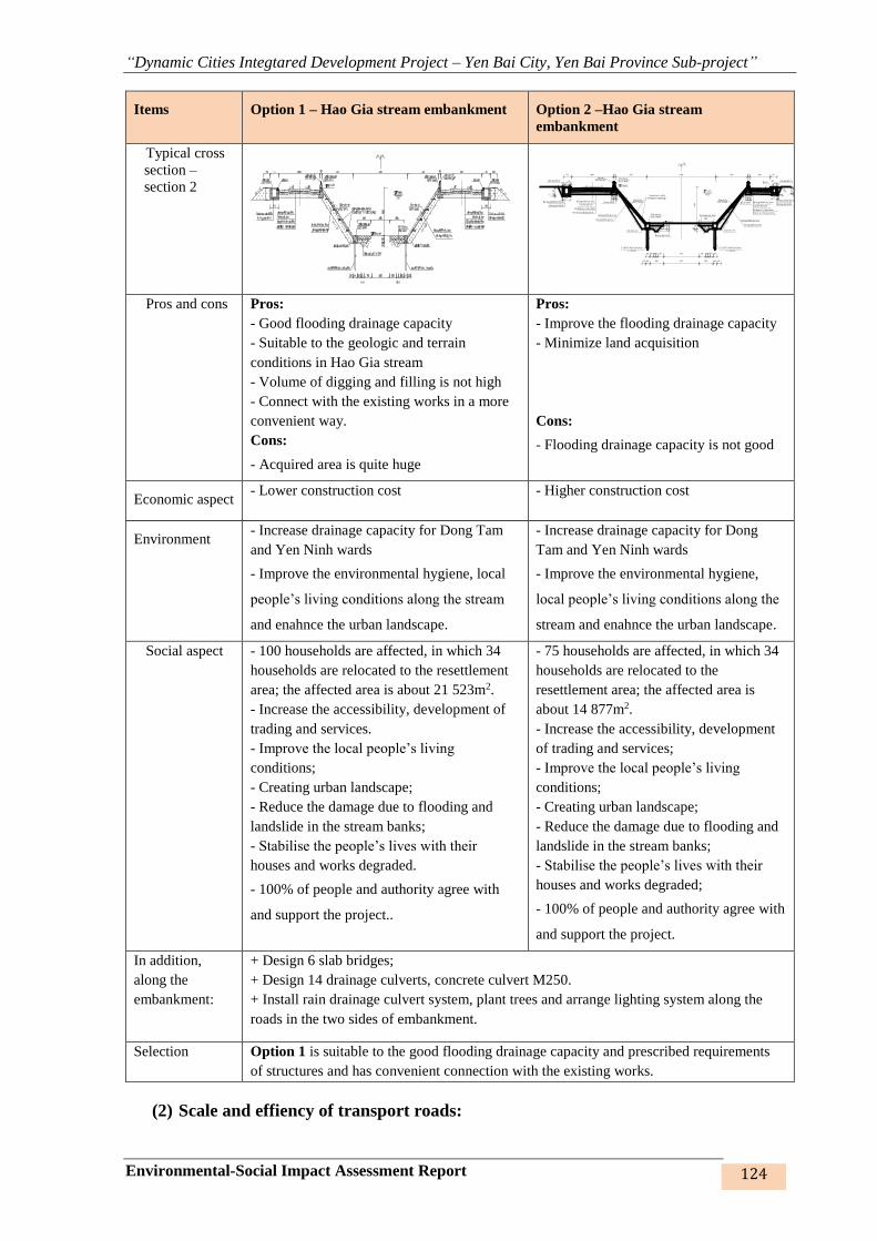
“Dynamic Cities Integtared Development Project – Yen Bai City, Yen Bai Province Sub-project”
Environmental-Social Impact Assessment Report 124
Items Option 1 – Hao Gia stream embankment Option 2 –Hao Gia stream
embankment
Typical cross
section –
section 2
Pros and cons Pros:
- Good flooding drainage capacity
- Suitable to the geologic and terrain
conditions in Hao Gia stream
- Volume of digging and filling is not high
- Connect with the existing works in a more
convenient way.
Cons:
- Acquired area is quite huge
Pros:
- Improve the flooding drainage capacity
- Minimize land acquisition
Cons:
- Flooding drainage capacity is not good
Economic aspect - Lower construction cost - Higher construction cost
Environment - Increase drainage capacity for Dong Tam
and Yen Ninh wards
- Improve the environmental hygiene, local
people’s living conditions along the stream
and enahnce the urban landscape.
- Increase drainage capacity for Dong
Tam and Yen Ninh wards
- Improve the environmental hygiene,
local people’s living conditions along the
stream and enahnce the urban landscape.
Social aspect - 100 households are affected, in which 34
households are relocated to the resettlement
area; the affected area is about 21 523m2.
- Increase the accessibility, development of
trading and services.
- Improve the local people’s living
conditions;
- Creating urban landscape;
- Reduce the damage due to flooding and
landslide in the stream banks;
- Stabilise the people’s lives with their
houses and works degraded.
- 100% of people and authority agree with
and support the project..
- 75 households are affected, in which 34
households are relocated to the
resettlement area; the affected area is
about 14 877m2.
- Increase the accessibility, development
of trading and services;
- Improve the local people’s living
conditions;
- Creating urban landscape;
- Reduce the damage due to flooding and
landslide in the stream banks;
- Stabilise the people’s lives with their
houses and works degraded;
- 100% of people and authority agree with
and support the project.
In addition,
along the
embankment:
+ Design 6 slab bridges;
+ Design 14 drainage culverts, concrete culvert M250.
+ Install rain drainage culvert system, plant trees and arrange lighting system along the
roads in the two sides of embankment.
Selection Option 1 is suitable to the good flooding drainage capacity and prescribed requirements
of structures and has convenient connection with the existing works.
(2) Scale and effiency of transport roads:
Bê tông M300 dày 20cm
Cát d?m dày 3cm
Ð?p d?t k = 0.98, dày 30 cm
Bê tông M200 dày 15cm
Bê tông M100 dày 5cm
Ðá xây M100D?m d?c kè
BTCT M200D?m d?c kè
BTCT M200 Ðá xây M100
Bê tông M200 dày 15cm
Bê tông M100 dày 5cm
Ð?p d?t k=0.9
C?c BTCT M250 (20x20cm)
L = 5m/c?c
C?c BTCT M250 (20x20cm)
L = 5m/c?c
Ð?p d?t k=0.9
Ð?p c?p ph?i k=0.9
D?m chân kè
BTCT M200
? ng thoát nu?c mái kè
D=60mm; L=60cm/?ng
Ðá lát khan dày 30cm
Bê tông M300 dày 20cm
Cát d?m dày 3cm
Ð?p d?t k = 0.98, dày 30 cm
D?m d?nh kè
BTCT M200
Lan can
Chân kè
Ð?nh kè
Bê tông M200 dày 20cm
Bê tông lót M100
T?m dan BTCT
m=0.5
Bó v?aT?m dan BTCT
Ðá dam lo?i 1 dày 20cm
mÆt c¾t cÇu dµi ®o¹n 1 pa 2
T?m dan BTCTT?m dan BTCT
mÆt c¾t cÇu dµi ®o¹n 2 pa 2

“Dynamic Cities Integtared Development Project – Yen Bai City, Yen Bai Province Sub-project”
Environmental-Social Impact Assessment Report 125
Determination of the scale, efficiency, function and tasks of the roads is based on the calculation
result of traffic volume forecast model. Based on the interviewed and surveyed data, vehicle-
counting in some cross sections having influence on the transport volume of the researched
region and the socio-economic development senarios, STRADA software is used to develop
the arising model and attract the trips (G/A), model OD, method and distribution of road
transportation.
From the traffic surveys in the researched area and development orientations as well as planning
of Yen Bai city, the research group developed table of arising demand-attraction of road trips
in inter-communes in expanded Yen Bai city. Then, we develop the flow of commodity,
traveller flow in expanded Yen Bai city.
Figure 32: Diagram of road traveller flow in Yen Bai (not expanded)
2020 (a) and 2025 (b)
Figure 32: Diagram of road traveller flow in Yen Bai (not yet expanded)
2020 (a) and 2025 (b)
After the assessment of the imitating model, the road vehicle density in three proposed roads is
appropriate, including the roads from Dien Bien road to the road connecting Bach Lam bridge
and Van Phu bridge – Road 1; road from Bach Lam bridge to Van Phu bridge – Road 2 and
road from Nguyen Tat Thanh intersection to Au Co intersection – Road 3. However, after the
sub-project is completed, the density of traffic vehicles on three roads in question will be
reduced and distributed to the routes.
Then, the design options for the roads are evaluated for selection in the following table:
a b
a b
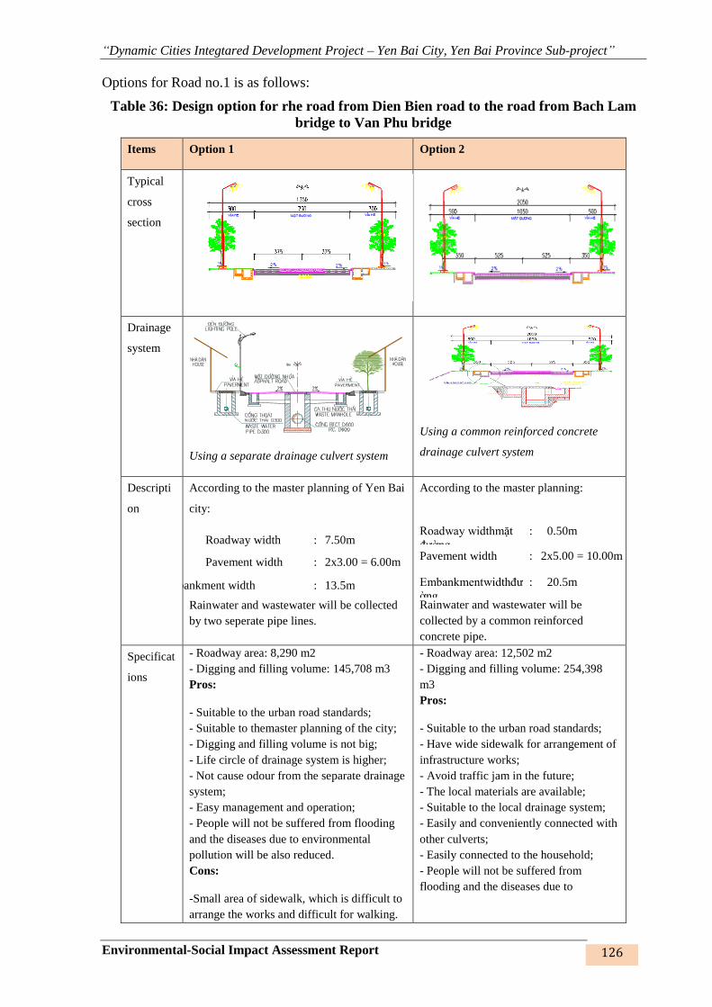
“Dynamic Cities Integtared Development Project – Yen Bai City, Yen Bai Province Sub-project”
Environmental-Social Impact Assessment Report 126
Options for Road no.1 is as follows:
Table 36: Design option for rhe road from Dien Bien road to the road from Bach Lam
bridge to Van Phu bridge
Items Option 1 Option 2
Typical
cross
section
Drainage
system
Using a separate drainage culvert system
Using a common reinforced concrete
drainage culvert system
Descripti
on
According to the master planning of Yen Bai
city:
Roadway width : 7.50m
Pavement width : 2x3.00 = 6.00m
Embankment width : 13.5m
Rainwater and wastewater will be collected
by two seperate pipe lines.
According to the master planning:
Rainwater and wastewater will be
collected by a common reinforced
concrete pipe.
Roadway widthmặt
đường
: 0.50m
Pavement width : 2x5.00 = 10.00m
Embankmentwidthđư
ờng
: 20.5m
Specificat
ions
- Roadway area: 8,290 m2
- Digging and filling volume: 145,708 m3
Pros:
- Suitable to the urban road standards;
- Suitable to themaster planning of the city;
- Digging and filling volume is not big;
- Life circle of drainage system is higher;
- Not cause odour from the separate drainage
system;
- Easy management and operation;
- People will not be suffered from flooding
and the diseases due to environmental
pollution will be also reduced.
Cons:
-Small area of sidewalk, which is difficult to
arrange the works and difficult for walking.
- Roadway area: 12,502 m2
- Digging and filling volume: 254,398
m3
Pros:
- Suitable to the urban road standards;
- Have wide sidewalk for arrangement of
infrastructure works;
- Avoid traffic jam in the future;
- The local materials are available;
- Suitable to the local drainage system;
- Easily and conveniently connected with
other culverts;
- Easily connected to the household;
- People will not be suffered from
flooding and the diseases due to

“Dynamic Cities Integtared Development Project – Yen Bai City, Yen Bai Province Sub-project”
Environmental-Social Impact Assessment Report 127
Items Option 1 Option 2
- The road is not aesthetic.
- The traffic jam may occur in the near future
due to small scale;
- The city has not had its own drainage
system, which causes difficulties in
connection;
- Total length of pipe line is higher;
- Construction volume is higher.
environmental pollution will be also
reduced.
Cons:
- Digging and filling volume is bigger
than Option 1.
- Easily flooded when the wastewater
volume is big.
- Not comply with environmental
sanitation because of the odour emitted
from the surface water collection gates.
Social
aspect
Pros:
- Improve the local people’s living
conditions;
- Travel time from the left bank to the right
bank of the Red river is shorter;
- Reduce the traffic accidients;
- 20% of people agree with Option 1.
Cons:
- Number of affected households: 18
- Number of households subject to
resettlement: 04
- Affected area: 12.05 ha
- In the near future, this road will be easily
jammed, causing difficultites in movement
and development along the route.
Pros:
- Improve the local people’s living
conditions;
- Travel from the left bank to the right
bank of the Red river is faster and more
convenient;
- Reduce the traffic accidients.
- 80% of people agree with Option 2.
Cons
- Number of affected households: 22
- Number of households subject to
resettlement: 04
- Affected area: 18.31ha
Environm
ent
Pros:
- Improve the environment; the flooding will
not exist and odour will not be available
because the wastewater is collected.
- Mitigate the environmental pollution
caused by odour from wastewater.
Cons:
- It is easy to happen that people do not
connect their wastewater pipe line to the
constructed one and they may continue to
discharge the wasteward into the lake thus
causing pollution.
Pros:
- Improve the environment; the flooding
will not exist.
Cons:
- Easily re-polluted by the odour of
wastewater.
- High possibility of stagnated
wastewater, which may overflow onto
the lake because the waste from the pipe
line is stagnated for a long time.
Economic
aspect
- Total construction cost: 52.2 billion dong - Total construction cost: 64.4 billion
dong
Selection Selection of option: propose to selectOption 2as the design option whichsatisfies the
technical design requirements and desire of the people in increasing the urban
connectivity for attracting and encouraging trade, service and investment in the coming
time.
Options for road no.2 is as follows:
Table 37: Design option for Road No.2 - road from Bach Lam bridge to Van Phu bridge

“Dynamic Cities Integtared Development Project – Yen Bai City, Yen Bai Province Sub-project”
Environmental-Social Impact Assessment Report 128
Items Option 1 Option 2
Cross section
Section 1: From Bach Lam bridge to Tuan Quan bridge
Section 2: From Tuan Quan bridge to Van Phu bridge
Description According to the master planning, transport planning of
the province:
Section 1 Section 2
Roadway
width
: 15 m 10.50m
Pavement
width
: 2x5.00 = 10m x5.00 = 10
Embankment
width
: 25m 20.5 m
According to the adjusted master
planning:
Roadway width : 15 m
Pavement width 5 = 10.00m
Embankment
width
: 25 m
Drainage
system

“Dynamic Cities Integtared Development Project – Yen Bai City, Yen Bai Province Sub-project”
Environmental-Social Impact Assessment Report 129
Items Option 1 Option 2
Specification
s
- Roadway area: 49,376 m2
- Digging and filling volume: 983,047 m3
Pros:
- Suitable to the urban road standards;
- Suitable to themaster planning of the cityand transport
planning of Yen Bai province;
- Digging and filling volume is not big.
Cons:
- The landscape of the road is not nice because along the
route there are two scales of road.
- Roadway area: 62,716 m2
- Digging and filling volume:
1,049,745 m3
Pros:
- Suitable to the urban road
standards;
- Nice landscape.
Cons:
- Digging and filling volume is
bigger than Option 1.
Social aspect Pros:
- Improve the local people’s living conditions.
- Travel along the Red river and rescue in the flooding
season are faster and more convenient.
- Reduce the traffic accidients.
- 90% of people agree with the new road construction
project
Cons
- Number of affected households:97
- Number of households subject to resettlement: 54
- Affected area: 33,8 ha.
Pros:
- Improve the local people’s living
conditions.
- Travel along the Red river and
rescue in the flooding season are
faster and more convenient.
- Reduce the traffic accidients.
The local people do not agree with
this option because the volume of
land acquisition is huge.
Cons
- Unsuitable to the orientation and
planning
- Number of affected households:
137
- Number of households subject to
resettlement: 75
- Affected area: 48,9 ha.
Cost - Construction cost: 124.3 billiong dong - Construction cost: 162,3 billion
dong
Environment Pros:
- The environment is improved; the flooding will not
exist and odour will not be available because the
wastewater is collected.
- Mitigate the environmental pollution caused by odour
from wastewater.
Cons:
- It is easy to happen that people do not connect their
wastewater pipe line to the constructed one and they
may continue to discharge the wasteward into the lake
thus causing pollution.
Pros:
- The environment is improved;
the flooding will not exist.
Cons:
- Easily re-polluted by the odour
of wastewater.
- High possibility of stagnated
wastewater, which may overflow
onto the lake because the waste
from the pipe line is stagnated for
a long time.

“Dynamic Cities Integtared Development Project – Yen Bai City, Yen Bai Province Sub-project”
Environmental-Social Impact Assessment Report 130
Items Option 1 Option 2
Option Option: propose to select Option 1 as the design option because it is suitable to the urban
planning and desire of the local people.
Options for Road no.3 is as follows:
Table 38: Design option for Road no.3 –road from Nguyen Tat Thanh intersection to Au
Co intersection
Items Option 1 Option 2
Typical cross
section
Description According to the adjusted master planning
of Yen Bai city:
Roadway width: 10.50m
Pavement width: 2x5.00 = 10m
Embankment width: 20.5 m
According to the master planning of Yen
Bai city:
Roadway width: : 2 x 10.5 =21.00 m
Median strip: : 9.00m
Pavement width: : 2 x 10 = 0.00
Embankment width : 50 m
Typical cross
section of
drainage
system
Using a separate drainage culvert system
Using a common reinforced concrete
drainage culvert system
Specifications - Roadway area: 40,201 m2
- Digging and filling volume: 1,072,307 m3
Pros:
- Suitable to the urban road standards
- Digging and filling volume is not big
- Suitable to the urban development
- Suitable to the calculated traffic volume
Cons:
- The landscape of road is not nice.
- Roadway area: 88,200 m2
- Digging and filling volume: 2,311,370 m3
Pros:
- Suitable to the urban road standards
- Road size is wide, satisfying the master
planning
- The beginning and ending points of the
route (Nguyen Tat Thanh street, Au Co
street), have same size, so the connection
and management in the future will be
easier.
Cons:
- Digging and filling volume is toot big
- Unsuitable to the conditions and transport
need of the city
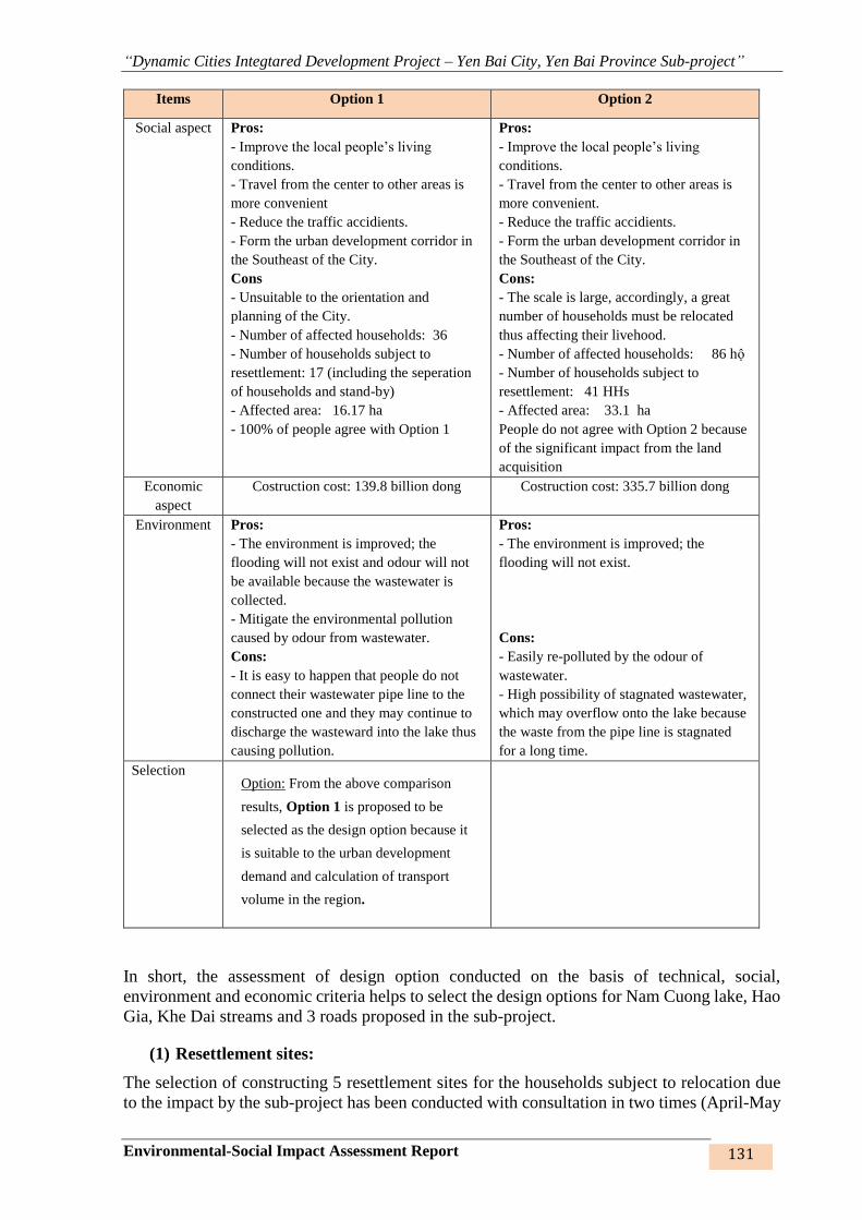
“Dynamic Cities Integtared Development Project – Yen Bai City, Yen Bai Province Sub-project”
Environmental-Social Impact Assessment Report 131
Items Option 1 Option 2
Social aspect Pros:
- Improve the local people’s living
conditions.
- Travel from the center to other areas is
more convenient
- Reduce the traffic accidients.
- Form the urban development corridor in
the Southeast of the City.
Cons
- Unsuitable to the orientation and
planning of the City.
- Number of affected households: 36
- Number of households subject to
resettlement: 17 (including the seperation
of households and stand-by)
- Affected area: 16.17 ha
- 100% of people agree with Option 1
Pros:
- Improve the local people’s living
conditions.
- Travel from the center to other areas is
more convenient.
- Reduce the traffic accidients.
- Form the urban development corridor in
the Southeast of the City.
Cons:
- The scale is large, accordingly, a great
number of households must be relocated
thus affecting their livehood.
- Number of affected households: 86 hộ
- Number of households subject to
resettlement: 41 HHs
- Affected area: 33.1 ha
People do not agree with Option 2 because
of the significant impact from the land
acquisition
Economic
aspect
Costruction cost: 139.8 billion dong Costruction cost: 335.7 billion dong
Environment Pros:
- The environment is improved; the
flooding will not exist and odour will not
be available because the wastewater is
collected.
- Mitigate the environmental pollution
caused by odour from wastewater.
Cons:
- It is easy to happen that people do not
connect their wastewater pipe line to the
constructed one and they may continue to
discharge the wasteward into the lake thus
causing pollution.
Pros:
- The environment is improved; the
flooding will not exist.
Cons:
- Easily re-polluted by the odour of
wastewater.
- High possibility of stagnated wastewater,
which may overflow onto the lake because
the waste from the pipe line is stagnated
for a long time.
Selection Option: From the above comparison
results, Option 1 is proposed to be
selected as the design option because it
is suitable to the urban development
demand and calculation of transport
volume in the region.
In short, the assessment of design option conducted on the basis of technical, social,
environment and economic criteria helps to select the design options for Nam Cuong lake, Hao
Gia, Khe Dai streams and 3 roads proposed in the sub-project.
(1) Resettlement sites:
The selection of constructing 5 resettlement sites for the households subject to relocation due
to the impact by the sub-project has been conducted with consultation in two times (April-May

“Dynamic Cities Integtared Development Project – Yen Bai City, Yen Bai Province Sub-project”
Environmental-Social Impact Assessment Report 132
2017 and August-September 2017). The detailed criteria are as follows: (i) locations of the
resettlement areas are situated in compliance with the development planning of the City in
avoidance of overlapping the land use planning; (ii) the areas are adjacent to the present living
area of the households and their fields, gardens, production areas, etc and their land use area;
(iii) It is assured to have consulted with the affected households and acknowledged their desire
to live in the resettlement, (iv) the resettlement areas are convenient in traffic, commercial
intercourse and daily activities for the affected people. And five resettlement areas have been
selected and agreed by the relocated/resettled households in Yen Ninh ward, Van Phu and Tan
Thinh Commue.
The details of environmental and social impacts when these work items are implemented will
be presented in Chapter 4 hereunder.

“Dynamic Cities Integtared Development Project – Yen Bai City, Yen Bai Province Sub-project”
Environmental-Social Impact Assessment Report 133
CHAPTER 4. ENVIRONMENTAL-SOCIAL IMPACT ASSESSMENT
Yen Bai Sub-project includes Component 1: Strutural solutions – Urban technical infrastructure
rehabilitation and construction, including the following work items:
Figure 34: Sub-project’s investment items
Main rehabilitation and construction items include:
1. Dredging and embankment construction of lake 1: L=2,365 m, average dredging depth
0.5 m
2. Construction of lake 2 embankment: total length L=840 m
3. Construction of lake 3 embankment: total length L=1,041 m
4. Construction of Hao Gia stream flood control embankment, total length L=1,510m
5. Construction of Cau Dai stream flood control embankment, total length L=3,755m
6. Construction of a road from Dien Bien road to the road connecting Bach Lam bridge to
Van Phu bridge L= 1,035 m (road no.1).
7. Construction of a road connecting Bach Lam bridge to Van Phu bridge L=4,678 m (road
no.2)
8. Construction of a road from Nguyen Tat Thanh road to Au Co road L=4,200 m (road
no.3)
1
2 3 4
5
1
9
6
12
7
1
8
11
1,2,3 – Nam Cuong lakes 1, 2, 3
embankment
4 – Hao Gia stream embankment
5 – Khe Dài stream embankment
6 – Road no. 1
7 – Road no. 2
8 – Road no. 3
9, 10, 11, 12, 13 – Resettlement
sites no. 1,2,3,4,5
“Dynamic Cities Integtared Development Project – Yen Bai City, Yen Bai Province Sub-project”
Environmental-Social Impact Assessment Report 134
9. Construction of resettlement site no.1 in Yen Ninh ward in an area of 1.6ha
10. Construction of resettlement site no.2 in Van Phu commune in an area of 0.37ha
11. Construction of resettlement site no.3 in Tan Thinh commune in an area of 0.44ha
12. Construction of resettlement site no.4 in Yen Ninh ward in an area of 0.40ha
13. Construction of resettlement site no.5 in Yen Ninh ward in an area of 0.30ha.
4.1. POSITIVE IMPACTS
The sub-project with the work items of lake and stream embankment construction, construction
of roads and resettlement sites, upon their completion, is expected to produce enormous social,
environment, economic impacts as well as trade and investment opportunities, whereby
promoting the overall socio-economic development of Yen Bai city, Yen Bai Province and the
region. Specifically:
1. Urban infrastructure and regional communication and connectivity improvement: the
construction of roads no. 1,2,3 will:
- Improve the embankment infrastructure and rainwater drainge system, develop urban
corridors and connecting with key zones, thus developing comprehensive technical
infrastructure.
- Take full advantage of Noi Bai – Lao Cai expressway and NR37, facilitating the travel,
trading, socio-economic growth and enhancing living conditions for people adjacent to
the roads.
2. Urban landscape improvement: Hao Gia stream, Khe Dai stream and 3 Nam Cuong lakes
embankment construction will:
- Create a complete urban picture by changing and rehabilitating urban emvironment and
landscape;
- The embankment construction will beautify the landscape and create local micro-
climate conditions;
- The construction of stretching and spacious roads will create modern urban landscape;
- The bridges connecting the regions will be the extended hands that support the urban
development;
- The embanked reservoirs will act as wells that both store freshwater and regulate flood
water and create a clean environment, sustaining the local eco-system.
3. Environmental sanitation and health improvement: Hao Gia, Khe Dai stream and 3 Nam
Cuong lakes embankment construction will:
- Reduce flooding from 0.5 to 0.7m, speed up drainage;
“Dynamic Cities Integtared Development Project – Yen Bai City, Yen Bai Province Sub-project”
Environmental-Social Impact Assessment Report 135
- The embankment on Nam Cuong lakes and Hao Gia, Khe Dai streams will provide
spaces for people to do exercices and organise public activities, etc.
- Control epidemics thanks to lower flooding depth, frequency and time, and reasonable
arrangement of garbage gathering points.
- Prevent encroachment on the flow, partlly control flooding in the upper-stream and in
the residential areas along the Cau Dai, Hao Gia streams and Nam Cuong lakes no.
1,2,3.
- Create clean and spacious urban spaces free of flooding and pollution, facilitating
epidemic control and health improvement for local residents.
4. Socio-economic efficiency: The construction of Hao Gia, Khe Dai stream and 3 Nam Cuong
lakes embankment and roads no. 1,2,3 will:
- Reduce economic losses from flooding and medical costs...
- Create sizeable land areas for arragement of resettlement sites for households whose land
is acquired for the project.
- Increase value of surrounding land, especially land adjacent to the roads, by construction
of roads, embankments and resettlement sites.
- Intensify the access to basic infrastructure services, paving the way for integration,
investment and business.
- Increase job opportunities and incomes, thus alleviating urban poverty.
- Stimulate purchase demands, promote trade and services and accelerate socio-economic
development in the city and the province.
- Ensure stable livelihood for local people and organisations as well as the compliance
with the city’s economic development orientations and masterplan for upgrading the
city to grade II by 2020.
For the above reasons, the Dynamic Cities Integrated Development Project, Yen Bai city, Yen
Bai Province Sub-project, funded by World Bank is a highly feasible project with enormous
socio-economic and environmental effects for Yen Bai city in particular and the entire Midlands
and mountainous areas in the North Central region of the country. However, apart from the
above-mentioned positive impacts, the execution of the sub-project’s work items will cause
negative impacts during the preparation, execution and operation stages. These impacts are
temporary, short-term and controllable by means of impact mitigating measures.
4.2. ASSESSMENT AND FORECAST OF NEGATIVE IMPACTS AND RISKS
4.2.1 Degree of impacts
“Dynamic Cities Integtared Development Project – Yen Bai City, Yen Bai Province Sub-project”
Environmental-Social Impact Assessment Report 136
Types and scales of potential negative environmental impacts of the sub-project’s components
are summarised in the table below. The potential impacts of the sub-project’s components are
categorised as follows: None (N) No impact; low impact (L) – small works, small, local,
revertable, temporary impacts; medium (M) - small works in urban/sensitive areas, of medium
scale with moderate, local, revertable, temporary impacts; high (H) – large-scale works in
urban/sensitive areas with considerable irrivertible and indemnificable impacts (on society and/or
environment).
Overall, all the activities of the work items of the Yen Bai City sub-project involve the execution
of medium and small size works, most of the negative environmental impacts are changeable,
temporary, local and minimizeable by taking appropriate management measures, close
supervision of the contractor’s operations and local community consultation. However, types and
nature of the impacts vary significantly as per the nature and scale of the activities, locations,
socio-economic conditions, people’s habits and time.
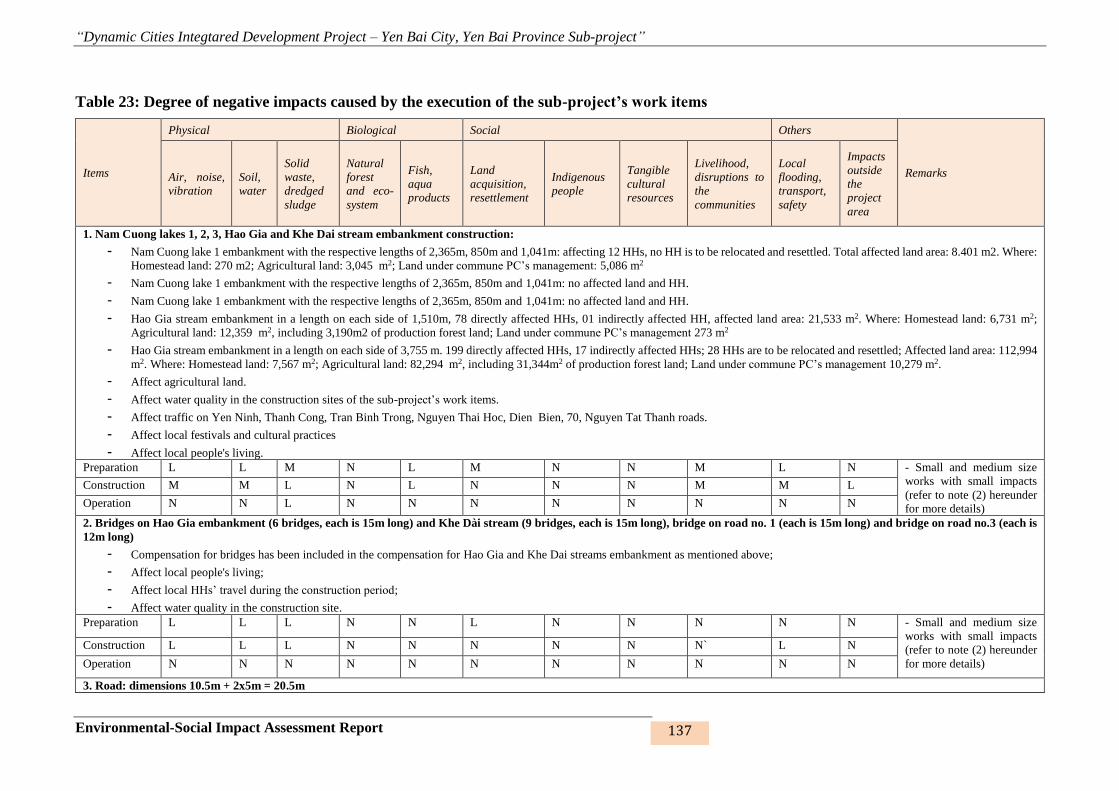
“Dynamic Cities Integtared Development Project – Yen Bai City, Yen Bai Province Sub-project”
Environmental-Social Impact Assessment Report 137
Table 23: Degree of negative impacts caused by the execution of the sub-project’s work items
Items
Physical Biological Social Others
Remarks Air, noise,
vibration
Soil,
water
Solid
waste,
dredged
sludge
Natural
forest
and eco-
system
Fish,
aqua
products
Land
acquisition,
resettlement
Indigenous
people
Tangible
cultural
resources
Livelihood,
disruptions to
the
communities
Local
flooding,
transport,
safety
Impacts
outside
the
project
area
1. Nam Cuong lakes 1, 2, 3, Hao Gia and Khe Dai stream embankment construction:
- Nam Cuong lake 1 embankment with the respective lengths of 2,365m, 850m and 1,041m: affecting 12 HHs, no HH is to be relocated and resettled. Total affected land area: 8.401 m2. Where:
Homestead land: 270 m2; Agricultural land: 3,045 m2; Land under commune PC’s management: 5,086 m2
- Nam Cuong lake 1 embankment with the respective lengths of 2,365m, 850m and 1,041m: no affected land and HH.
- Nam Cuong lake 1 embankment with the respective lengths of 2,365m, 850m and 1,041m: no affected land and HH.
- Hao Gia stream embankment in a length on each side of 1,510m, 78 directly affected HHs, 01 indirectly affected HH, affected land area: 21,533 m2. Where: Homestead land: 6,731 m2;
Agricultural land: 12,359 m2, including 3,190m2 of production forest land; Land under commune PC’s management 273 m2
- Hao Gia stream embankment in a length on each side of 3,755 m. 199 directly affected HHs, 17 indirectly affected HHs; 28 HHs are to be relocated and resettled; Affected land area: 112,994
m2. Where: Homestead land: 7,567 m2; Agricultural land: 82,294 m2, including 31,344m2 of production forest land; Land under commune PC’s management 10,279 m2.
- Affect agricultural land.
- Affect water quality in the construction sites of the sub-project’s work items.
- Affect traffic on Yen Ninh, Thanh Cong, Tran Binh Trong, Nguyen Thai Hoc, Dien Bien, 70, Nguyen Tat Thanh roads.
- Affect local festivals and cultural practices
- Affect local people's living.
Preparation L L M N L M N N M L N - Small and medium size
works with small impacts
(refer to note (2) hereunder
for more details)
Construction M M L N L N N N M M L
Operation N N L N N N N N N N N
2. Bridges on Hao Gia embankment (6 bridges, each is 15m long) and Khe Dài stream (9 bridges, each is 15m long), bridge on road no. 1 (each is 15m long) and bridge on road no.3 (each is
12m long)
- Compensation for bridges has been included in the compensation for Hao Gia and Khe Dai streams embankment as mentioned above;
- Affect local people's living;
- Affect local HHs’ travel during the construction period;
- Affect water quality in the construction site.
Preparation L L L N N L N N N N N - Small and medium size
works with small impacts
(refer to note (2) hereunder
for more details)
Construction L L L N N N N N N` L N
Operation N N N N N N N N N N N
3. Road: dimensions 10.5m + 2x5m = 20.5m

“Dynamic Cities Integtared Development Project – Yen Bai City, Yen Bai Province Sub-project”
Environmental-Social Impact Assessment Report 138
Items
Physical Biological Social Others
Remarks Air, noise,
vibration
Soil,
water
Solid
waste,
dredged
sludge
Natural
forest
and eco-
system
Fish,
aqua
products
Land
acquisition,
resettlement
Indigenous
people
Tangible
cultural
resources
Livelihood,
disruptions to
the
communities
Local
flooding,
transport,
safety
Impacts
outside
the
project
area
- Road from Dien Bien road to the road connecting Bach Lam bridge to Van Phu bridge (road no. 1): 1,035m long. Affecting 47 HHs, 11 HHs to be relocated and resettled. Affected land area:
18,319 m2. Where: Homestead land: 2,758 m2; Agricultural land: 11,196 m2, including 9,923m2 of production forest land; Land under commune PC’s management: 4,635 m2
- Road connecting Bach Lam bridge to Van Phu bridge (road no. 2): 4,678m long, 310 HHs directly affected, 26 HHs indirectly affected, 44 HHs to be relocated and resettled; Affected land
area: 268,662 m2. Where: Homestead land: 12.728 m2; Agricultural land: 211,714 m2, including 124,545m2 of production forest land; Land under commune PC’s management: 38,507 m2;
- Road from Nguyen Tat Thanh intersection to Au Co intersection (road no. 3): 4,200m long. 136 HHs directly affected, 5 HHs indirectly affected, 9 to be relocated and resettled; Affected land
area: 161,749 m2. Where: Homestead land: 6,073 m2; Agricultural land: 152,334 m2, including 76,347m2 of production forest land; Land under commune PC’s management: 3,342 m2.
- Affect local people’s living;
- Affect agricultural production;
- Affect traffic on Nguyen Thai Hoc, Ho Xuan Huong, 70, Dien Bien, Au Co, Nguyen Tat Thanh roads and inter-group and inter-hamlet roads in the sub-project area due to waste material
transportation and disposal.
Preparation L L L L L M N L L L L - Small and medium size
works with small impacts
(refer to note (2) hereunder
for more details)
Construction L L L L L N N N N N N
Operation N N N N N N N N N L N
4. Resettlement
- Resettlement site no. 1 in group 26, Yen Ninh ward, 10 HHs directly affected, 8 HHs indirectly affected, no HHs to be relocated and resettled; Affected land area: 16,000 m2. Where:
Homestead land: 0 m2; Agricultural land: 12,058 m2; Land under commune PC’s management: 3,942 m2.
- Resettlement site no. 2 in Van Lien hamlet, Van Phu commune. 9 HHs directly affected, 3 HHs indirectly affected, no HHs to be relocated and resettled. Affected land area: 3,652 m2. Where:
Homestead land: 0 m2; Agricultural land: 1,420 m2; Land under commune PC’s management: 2,054 m2.
- Resettlement site no. 3 in Luong Thinh 3 hamlet, Tan Thinh commune. 7 HHs directly affected, 11 HHs indirectly affected, no HHs to be relocated and resettled; Affected land area: 4,406
m2. Where: Homestead land: 0 m2; Agricultural land: 2,473 m2; Land under commune PC’s management: 1,933m2
- Resettlement site no. 4 in groups 6,7 in Yen Ninh ward. No HHs to be relocated and resettled. Affected land area: 3,963 m2. Where: Homestead land: 473 m2; Agricultural land: 2,899 m2;
Land under commune PC’s management 591 m2 with 16 directly affected and 7 indirectly affected.
- Resettlement site no. 5 in group 39 in Yen Ninh ward. No HHs to be relocated and resettled. Affected land area: 3.015 m2. Where: Homestead land: Not affected; Agricultural land: 2.822m2;
Land under commune PC’s management 193 m2;
- Affect agricultural production;
- Affect local people’s living.
Preparation L L M L N M N N L L N - Small and medium size
works with small impacts
(refer to note (2) hereunder
for more details)
Construction M M L L N N N N L L L
Operation M N N N N N N N N N N
Notes:

“Dynamic Cities Integtared Development Project – Yen Bai City, Yen Bai Province Sub-project”
Environmental-Social Impact Assessment Report 139
Items
Physical Biological Social Others
Remarks Air, noise,
vibration
Soil,
water
Solid
waste,
dredged
sludge
Natural
forest
and eco-
system
Fish,
aqua
products
Land
acquisition,
resettlement
Indigenous
people
Tangible
cultural
resources
Livelihood,
disruptions to
the
communities
Local
flooding,
transport,
safety
Impacts
outside
the
project
area
(1) The following criteria are used for environmental impact assessment:
None (N) No impact; low impact (L) – small works, small, local, revertable, temporary impact; medium (M) - small works in urban/sensitive areas, of medium scale with moderate, local, revertable,
temporary impacts; high (H) – large-scale works in urban/sensitive areas with considerable impacts (on society and/or environment) with many irrivertible and indemnificable cases. Both M and H
need supervision and mitigating measures as well as corresponding institutional safety capacity. (2) Medium and small size works, with mostly local and temporary impacts which may be minimized
by taking proper technical solutions and management best practices, combined with close supervision, inspection and local community consultation.
“Dynamic Cities Integtared Development Project – Yen Bai City, Yen Bai Province Sub-project”
Environmental-Social Impact Assessment Report 140
4.2.2 Pre-construction phase
The sub-project consists of 13 work items, including 5 embankments (15 bridges on the
embankments; in which 9 bridges on Khe Dai stream and 6 bridges on Hao Gia stream), 3 roads
(including 2 bridges, 1 bridge on the road from Dien Bien road to the road connecting Bach
Lam bridge and Van Phu bridge and 1 bridge on the road connecting Nguyen Tat Thanh
intersection and Au Co intersection) 5 resettlement sites in 7 wards/communes of Yen Bai city.
The execution of the work items (36 months) will cause small to medium short-term impacts
and require acquisition of some land areas which scatter in the wards and communes , therefore,
they will be executed at the same time. Hence, in the pre-construction– land acquisition phase,
only following negative impacts will be discussed: (i) Bomb and mine clearance; (ii) Impacts
on cultural facilities and structures, and (iii) social impacts relating to land acquisition and site
clearance. The waste generating impacts from dredging and excavation in preparation for the
construction will be discussed in the construction phase hereunder.
1. Bomb and mine clearance
The levelling for construction of the work items under the sub-project may be affected by bomb,
mine and chemicals left from war time. Subjects of impact include workers on the site, local
people and workers involved in the construction of the works. Bomb and mine left from war
time may: (i) cause accidents to workers on the site, surrounding people and damage equipment
and machinery, and (ii) pose fire and explosion risks that may kill staff or destroy equipment
of the demining units. Despite their short-term duration, the demining operations may cause
long-term effects on the health and mentality of workers, deminers and local people. However,
these impacts may be controlled by means of appropriate methods. Bomb, mine and chemical
clearance is, therefore, a compulsory requirement before construction of any work items.
2. Architectural and cultural works
No architectural and cultural works within the construction sites of the sub-project’s work items
are to be appropriated or directly affected. There is, therefore, not any such impact.
3. Social impacts attributable to land acquisition
Land acquisition and resettlement may affect life and production of local HHs and give rise to
other social issues. According to the survey’s findings, the execution of 13 work items under
the sub-project will affect 992 HHs, in which 938 HHs are indirectly affected and 54 HHs are
directly affected from their cultivation on the land under ward/commune PC’s management.
“Dynamic Cities Integtared Development Project – Yen Bai City, Yen Bai Province Sub-project”
Environmental-Social Impact Assessment Report 141
400 HHs have affected homstead land, including 297 partially affected HHs15 and 103 wholly
affected HHs16. 115 HHs are to be resettled17, 46 HHs of which are to resettle by themselves
and 69 HHs proposed to move the resettlement sites. Socio-economic survey on the resettled
HHs shows that a total of 69 HHs will be resettled but 136 resettlement lots must be made
available to accommodate for a number of HHs wishing to separate into different HHs (an
increase of 67 HHs/ a total of 69 HHs to occupy the resettlement sites). The proposed
resettlement sites have been consulted with local people in April-May 2017 and August-
September 2017.
Number of resettled HHs is 136, which is a relatively large number. But the survey on the living
conditions of the HHs adjacent to the Hao Gia and Khe Dai stream embankment routes found
that they were living in a polluted area with limited services and utilities, many of them live in
shabby shouses that may collapse at any time due to incessant flooding and inundation, many
families with a large number of members are not allowed to separate into different HHs or
rebuild their houses, etc.
The HHs adjacent to the Nam Cuong lake embankment, and roads from Bach Lam bridge to
Van Phu bridge and from Nguyet Tat Thanh intersection to Au Co intersection are not allowed
to carry out new constrution or separate their land to build new houses for their families because
they are located within the planned construction boundaries agreed between the government
and local people for many years, which cause numerous difficulties and inconvenience to local
people’s life.
Moreover, the HHs removed to the resettlement sites have known each other and share the same
living habits and practices, they are, therefore, friendly and comfortable and they don’t need
time to get acquainted to the new neighbours with different life styles and customs or to adapt
to a new environment.
As such, the arrangement of resettlement sites for HHs wishing to resettle will provide them
new dwelling which is large enough and convenient for their families. Hence, despite the
15 Partially affected HH: The remaining land area after acquisition is enough for the HH to live as stipulated by
the Province.
16 Wholly affected HH: The entire residential land is acquired or the remaining residential land after acquisition
is not enough for the HH to live as stipulated by Yen Bai Province.
17 Resettled HH: HH whose entire or most of the house on their residential land is acquired or affected and the
remaining area is not enough for the HH to live or the acquisition affects the main structure of the house, causing
its demolition.

“Dynamic Cities Integtared Development Project – Yen Bai City, Yen Bai Province Sub-project”
Environmental-Social Impact Assessment Report 142
disturbance to their lives, this is considered a positive impact for them and the negative impacts
are considered as minor and easily managed by the HHs. This is also the objective of the sub-
project in designing and arranging resettlement sites in accordance with the HHs’ proposal and
desire.
Under the sub-project, 240 HHs with less than 20% of agricultural land (< 10% of agricultural
land for highly vulnerable HHs) and 752 HHs with more than 20% of agricultural land (from
10% of agricultural land for highly vulnerable HHs). Subjects of impact are HHs in the land
acquisition areas, which are mainly rice fields, production forest land, orchards, perennial land
or fallow land. Most of agricultural land acquired from HHs produces low yield crops and
inefficient cultivation. Therefore, impact level is considered as low and medium. The impacts
are insignificant but prolonged after the acquisition. Appropriate measures may be adopted to
minimise these impacts.
In general, the impacts from land acquisition and resettlement are inevitable and impacts of
relocation and resettlement are from low to medium. The sub-project has prepared a
resettlement plan to minimise the impacts from land acquisition and resettlement. Mitigating
measures for affected HHs are presented in Resettlement Plan.
Number of HHs and agencies whose land and accompanying properties evicted for the purpose
of the sub-project are shown in the table below:

“Dynamic Cities Integtared Development Project – Yen Bai City, Yen Bai Province Sub-project”
Environmental-Social Impact Assessment Report 143
Table 40: Number of HHs affected by land acquisition for the execution of the sub-project18
No Items Ward/commune
No. of HHs with affected
homestead land
No. of
HHs to
be
resettled
Self-
resettled
(HH)
Concentrated
resettlement
(HH)
No. of HHs with affected
agricultural land (HH)
Partial Whole Total
No.
of
HHs
To be
separated Tota
< 20% and
< 10% for
highly
vulnerable
HHs
From
20%
upwards
and 10%
upwards
for highly
vulnerable
HHs
Total
1 Sub-component 1: Flood
control and urban safety 187 32 219 51 20 31 29 60 72 196 268
1.1 Rehabilitation of 3 Nam
Cuong lakes Nam Cuong 2 0 2 0 0 0 0 0 4 7 11
1.2 Cau Dai stream embankment
Yen Ninh 33 7 40 11 4 7 6 13 21 66 87
Minh Tan 54 6 60 9 3 6 5 11 14 47 61
Dong Tam 15 2 17 8 6 2 0 2 6 35 41
1.3 Hao Gia stream embankment Dong Tam 83 17 100 23 7 16 18 34 27 41 68
Yen Thinh 0 0 0 0 0 0 0 0 0 0 0
2
Sub-component 2:
Development of urban
transport and connectivity
enhancement
110 71 181 64 26 38 38 76 120 483 603
2.1 Yen Ninh 12 0 12 2 2 0 0 0 6 23 29
18 Source: Statistics from Resettlement Plan Report of Yen Bai City Sub-project
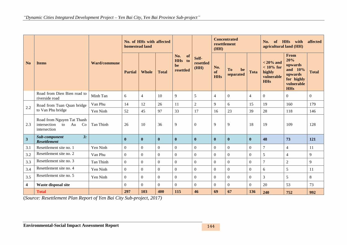
“Dynamic Cities Integtared Development Project – Yen Bai City, Yen Bai Province Sub-project”
Environmental-Social Impact Assessment Report 144
No Items Ward/commune
No. of HHs with affected
homestead land
No. of
HHs to
be
resettled
Self-
resettled
(HH)
Concentrated
resettlement
(HH)
No. of HHs with affected
agricultural land (HH)
Partial Whole Total
No.
of
HHs
To be
separated Tota
< 20% and
< 10% for
highly
vulnerable
HHs
From
20%
upwards
and 10%
upwards
for highly
vulnerable
HHs
Total
Road from Dien Bien road to
riverside road Minh Tan 6 4 10 9 5 4 0 4 0 0 0
2.2 Road from Tuan Quan bridge
to Van Phu bridge
Van Phu 14 12 26 11 2 9 6 15 19 160 179
Yen Ninh 52 45 97 33 17 16 23 39 28 118 146
2.3
Road from Nguyen Tat Thanh
intersection to Au Co
intersection
Tan Thinh 26 10 36 9 0 9 9 18 19 109 128
3 Sub-component 3:
Resettlement 0 0 0 0 0 0 0 0 48 73 121
3.1 Resettlement site no. 1 Yen Ninh 0 0 0 0 0 0 0 0 7 4 11
3.2 Resettlement site no. 2 Van Phu 0 0 0 0 0 0 0 0 5 4 9
3.3 Resettlement site no. 3 Tan Thinh 0 0 0 0 0 0 0 0 7 2 9
3.4 Resettlement site no. 4 Yen Ninh 0 0 0 0 0 0 0 0 6 5 11
3.5 Resettlement site no. 5 Yen Ninh 0 0 0 0 0 0 0 0 3 5 8
4 Waste disposal site 0 0 0 0 0 0 0 0 20 53 73
Total 297 103 400 115 46 69 67 136 240 752 992
(Source: Resettlement Plan Report of Yen Bai City Sub-project, 2017)

“Dynamic Cities Integtared Development Project – Yen Bai City, Yen Bai Province Sub-project”
Environmental-Social Impact Assessment Report 145
641,694 m2 of land will be acquired under the project, including 494,615 m2 of agricultural
land, 33,079 m2 of homestead land, 1,374 m2 of land under agencies’ management, 38,366 m2
of unused land, 70,529 m2 of land under PC’s management. As discussed above, land
acquisition impacts as considered as from low to medium. Most of agricultural land and land
under commune/ward PC’s management is unproductive and has lied fallow for a long time.
Land areas affected by the construction of 13 work items under the sub-project are presented in
the table below:
Table 24: Land areas affected by land acquisition for the Yen Bai City sub-project
N
o Items
Ward/commu
ne
Affected land area (m2)
Total
affected
land
area
( m2)
Agricultur
al land
Non-agricultural
land
Unuse
d land
PC’s
land Homestea
d land
Agencie
s’ land
1 Sub-component 1: Flood control and urban safety
1.
1
Rehabilitatio
n of NC
lakes
Nam Cuong 3,045.4 270.1
0.0 0.0 5,085.5 8,401.0
1.
2
Cau Dai
stream
embankment
Yen Ninh 45,107.1 3,848.6
922.8
5,411.
3 2,968.5 58,258.3
Minh Tan 10,836.9 2,970.4
95.4 0.0 5,956.6 19,859.3
Dong Tam 26,350.3 757.7
0.0
6,414.
6 1,353.8 34,876.3
1.
3
Hao Gia
stream
embankment
Dong Tam 12,359.1 6,730.5
556.6
1,649.
3 237.0 21,532.5
2 Sub-component 2: Development of urban transport, connectivity enhancement
2.
1
Road from
Dien Bien
road to
riverside
road ( road
from Bach
Lam bridge
to Van Phu
bridge)
Yan Ninh 11,195.9 2,518.2
0.0 0.0 4,365.4 18,079.4
Minh Tan 0.0 240.1
0.0 0.0 0.0 240.1
2.
2
Road from
Bach Lam
bridge to
Van Phu
bridge
Van Phu 69,747.5 798.4
0.0
4,010.
6
16,681.
9 91,238.4
Yen Ninh 141,966.8 11,929.7
0.0 702.3
21,825.
0
176,423.
8
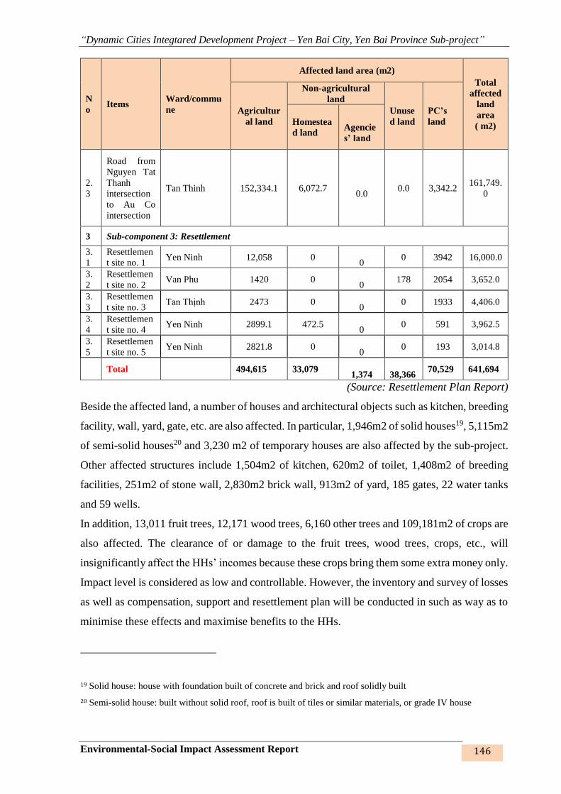
“Dynamic Cities Integtared Development Project – Yen Bai City, Yen Bai Province Sub-project”
Environmental-Social Impact Assessment Report 146
N
o Items
Ward/commu
ne
Affected land area (m2)
Total
affected
land
area
( m2)
Agricultur
al land
Non-agricultural
land
Unuse
d land
PC’s
land Homestea
d land
Agencie
s’ land
2.
3
Road from
Nguyen Tat
Thanh
intersection
to Au Co
intersection
Tan Thinh 152,334.1 6,072.7
0.0 0.0 3,342.2
161,749.
0
3 Sub-component 3: Resettlement
3.
1
Resettlemen
t site no. 1 Yen Ninh 12,058 0
0 0 3942 16,000.0
3.
2
Resettlemen
t site no. 2 Van Phu 1420 0
0 178 2054 3,652.0
3.
3
Resettlemen
t site no. 3 Tan Thịnh 2473 0
0 0 1933 4,406.0
3.
4
Resettlemen
t site no. 4 Yen Ninh 2899.1 472.5
0 0 591 3,962.5
3.
5
Resettlemen
t site no. 5 Yen Ninh 2821.8 0
0 0 193 3,014.8
Total 494,615 33,079
1,374
38,366 70,529 641,694
(Source: Resettlement Plan Report)
Beside the affected land, a number of houses and architectural objects such as kitchen, breeding
facility, wall, yard, gate, etc. are also affected. In particular, 1,946m2 of solid houses19, 5,115m2
of semi-solid houses20 and 3,230 m2 of temporary houses are also affected by the sub-project.
Other affected structures include 1,504m2 of kitchen, 620m2 of toilet, 1,408m2 of breeding
facilities, 251m2 of stone wall, 2,830m2 brick wall, 913m2 of yard, 185 gates, 22 water tanks
and 59 wells.
In addition, 13,011 fruit trees, 12,171 wood trees, 6,160 other trees and 109,181m2 of crops are
also affected. The clearance of or damage to the fruit trees, wood trees, crops, etc., will
insignificantly affect the HHs’ incomes because these crops bring them some extra money only.
Impact level is considered as low and controllable. However, the inventory and survey of losses
as well as compensation, support and resettlement plan will be conducted in such as way as to
minimise these effects and maximise benefits to the HHs.
19 Solid house: house with foundation built of concrete and brick and roof solidly built
20 Semi-solid house: built without solid roof, roof is built of tiles or similar materials, or grade IV house

“Dynamic Cities Integtared Development Project – Yen Bai City, Yen Bai Province Sub-project”
Environmental-Social Impact Assessment Report 147
4.2.3 Impacts in the construction phase
4.2.3.1. Generic impacts
1. Impacts on the air environment
1a. Dust and gas
The emission of dust and gas during the construction of the works may reduce quality of the
ambient air. Sources of dust and gas emission during the construction of the works include: (i)
dredging, excavating unsuitable materials, demolishing trees and structures, clearing the site,
excavating, filling, ground levelling; (ii) transporting, gathering and storing materials,
transporting and disposing waste, (iii) dust from pavement, and (iv) dust and gas from
construction equipment and machinery. Dust emission will affect soil and air environments,
workers and people living in the sub-project area at medium and high level during the short
construction period. Quantity of waste transportation is calculated by quantity of excavation of
unsuitable materials, demolition of old structures and quantity of excavation subtracts re-use
quantity.
Details are shown in the following table of quantities:
Table 25: Quantities of weather layer and waste soil and stone arising from the
construction of the works
No
Quantity of
excavation
of
unsuitable
materials
and
demolishme
nt (tons)
Quantity
of
excavatio
n (tons)
Quantit
y of
filling
(tons)
Quantity of
soil
disposal
(tons)
Quantity
of re-use
(tons)
Quantity
of
suppleme
ntation
(tons)
Quantity
of
constructi
on
materials
(tons)
Total
quantity of
transportati
on
Embankment
1 230360 124407 30639 93768 30639 0 199734 523862
2 5676 17661 10597 7064 10597 0 63162 75902
3 7726 31912 30420 1492 30420 0 60136 69354
4 1276 85913 67247 52374 33539 33708 241728 329086
5 27929 116531 280233 68086 48445 97134 3757443 3950592
Roads
6 7535 312386 45757 390216 31957 13800 429701 841252
7 14425 263870 315202 115706 148164 167038 3190153 3487322
8 12583 369418 441283 115706 148164 293119 3467186 3888594
Resettlement sites
9 2153 659461 46174 613287 46174 0 309156 924596
10 957 107236 71 107165 71 0 99572 207694
11 895 57662 0 57662 0 0 43276 101833
12 524 23839 14046 9793 14046 0 23490 33807
13 631 38085 2783 35302 2783 0 34499 70432
(Source: Cost estimate in the Feasibility Study Report, 2017)
(i) Dust from dredging, excavating unsuitable meterials, demolishing, excavating,
filling, ground levelling

“Dynamic Cities Integtared Development Project – Yen Bai City, Yen Bai Province Sub-project”
Environmental-Social Impact Assessment Report 148
Construction of the roads and transportation of materials will produce impacts on the air quality.
Transportation of soil and stone may affect workers and people living around the construction
sites because of dust, noise and vibration from pile driving. Severity of these impacts depends
on the location of construction and transportation distance. The projected level of impact is
from medium to high during the construction period.
Dust emission is calculated on the bases of pollution coefficient P (Kg/ton) and quantities of
excavation and filling. According to Environmental Assessment Sourcebook Volume II -
Sectoral Guidelines Environment Department, World Bank, Washington DC, 8/1991, quantity
of dust is calculated by the following formula:
P = 3,1
4,1
2
2,20016,0
M
Uk (kg/ton).
Where:
+ P: pollution coefficient (kg/ton)
+ k: granular structure (average value of 0.35)
+ U: wind speed (average value of 1.2 m/s)
+ M: average humidity of material (20 %)
Pollution coefficient calculated following the above formula is P = 0.0048 kg/ton. Dust
emissions from excavation and filling of soil and stone and ground levelling are as follows:
Table 26: Quantity of dust from dredging, excavating unsuitable materials, excavating,
filling and ground levelling
No
Quantity
of
excavation,
filling and
ground
levelling
(ton)
Quantity of
dust
emission (kg)
Tentative
construction
period
(days)
Quantity of
dust emission
(kg/day)
Quantity
of dust
emission
(mg/s)
Quantity
of dust
(mg/m3)
QCVN
05:2013
(mg/m3)
Embankment
1 155,046 741.12 720 1.029 36 0.53
0.3
2 28,258 135.07 720 0.188 7 0.44
3 62,332 297.95 720 0.414 14 1.08
4 153,159 732.1 720 1.017 35 4.51
5 396,764 1896.53 720 2.634 91 6.68
Road
6 358,143 1711.92 540 3.17 110 15.46
0.3 7 579,072 2767.96 720 3.844 133 1.44
8 810,701 3875.15 720 5.382 187 3.33
Resettlement
9 705,636 3372.94 300 11.243 390 70.27
0.3
10 107,307 512.93 90 5.699 198 156.05
11 57,662 275.62 90 3.062 106 69.5
12 37,884 181.09 90 2.012 70 50.77
13 40,869 195.35 90 2.171 75 72.01

“Dynamic Cities Integtared Development Project – Yen Bai City, Yen Bai Province Sub-project”
Environmental-Social Impact Assessment Report 149
Quantities of dust emission from dredging, excavating unsuitable materials, excavating and
filling in the work items of the sub-project show great differences among the work items,
specifically:
Nam Cuong lakes 1, 2, 3 embankment: Dust emission results primarily from the operation of
excavator, grader, trucks, levelling machine, etc. to excavate foundation and scoop soil and
stone onto the trucks. The main subjects of impact are workers directly inovolved in the works
and residents around the construction site. The excavation of soft soil, weathered layer and
cutting off trees are carried out in advance. As almost all the waste like trees, branches and
leaves are to be re-used by local people, dust emission in this work item is inconsiderable; A
large quantity of sludge from lake 1 will be given in part to local people to grow trees, used as
input material for Xuan Lan Brick Factory; the rest will be transported to the waste disposal
sites. Hence, waste emitted from excavation of unsuitable materials for Nam Cuong lakes 1, 2,3
in Nam Cuong ward may be minimised and cause minor impacts. However, the excavation,
filling and ground levelling in the construction site of 3 Nam Cuong lakes will generate a
quantity of dust ranging from 0.44 to 1.08mg/m3, from 1.5 to 3.6 times higher than QCVN
05:2013. The impact of dust resulting from excavation, filling, ground levelling for the lake
embankment is insignificant, the mitigating measures will be discussed hereunder.
Hao Gia stream embankment: Topographical and geological survey in Hao Gia stream shows
that formation of the cover layer includes gray clay, white spots, mixed with construction
materials and grit, hard plastic, texture is not tight and black gray, yellow gray, soft plastic clay.
These 2 layers are unstable, erodible and easily collapse in case of flood or long inundation. A
section on the embankment from Yen Thinh market (at km 6+00) to Khe Lap bridge collapsed
and has been embanked using the government’s urgent repair fund, the execution will proceed
with the roads and surface water drainage ditches bxh=0.45x0.8m. The stream dredging and
excavation of weather layer on the stream shores are manually carried out, trees, branches and
leaves will be re-used by local people, the rest is transported to the disposal site. Dust emission
from excavation, filling and ground levelling in Hao Gia stream embankment site is about
4.51mg/m3, much higher than QCVN 05:2013/BTNMT (0.3mg/m3). Because people reside
along the streams, dust emission from excavation and filling will affect their life at medium and
high levels during the construction phase. Mitigating measures need to be taken to minimise
the impacts of dust caused by excavation of weathered layer, excavation, filling and ground
levelling.
Figure 33: Alley to Hao Gia embankment and the embanked sections

“Dynamic Cities Integtared Development Project – Yen Bai City, Yen Bai Province Sub-project”
Environmental-Social Impact Assessment Report 150
Khe Dai stream embankment: Quantity of dust emission from excavation of weathered layer,
excavation, filling and ground levelling for Khe Dai stream embankment is 1,896 kg during the
construction period, equivalent to 6.68mg/m3, 22 times higher than QCVN 05:2013/BTNMT.
Topographical survey shows that the cover layer contains primarily black gray clay, mixed with
construction materials and grit, layer underneath is black gray, yellow gray, soft plastic sand.
Therefore, this structure is erodible and unstable and easily collapses. The unsuitable materials
will be re-used by local people, the excavated weather layer to the construction gournd amounts
to 27,929 tons, some will be given to local people to elevate their houses, the rest will be
delivered to disposal site, which low-lying sites are located along construction sites. Therefore,
the waste soil and stone are considered to cause no major impact.
Figure 34: Residential areas along Khe Dai stream embankment
Road from Dien Bien road to riverside road (road from Bach Lam bridge to Van Phu bridge)
– road no.1: dust emitted from excavation, filling and ground levelling is estimated at
3.17kg/ngày, equivalent to 15.5mg/m3, around 52 times higher than QCVN05:2013/BTNMT.
The construction works goes through an earth road, with production forest on both sides under
the program for handing over land and forest to people. The section near the intersection and
road to the resettlement site no.1 is densely popuated with many solid houses all along the road.
Dust emission mitigating measures are essential and will be discussed in the next chapter.
Impact in this area is insignificant.
Figure 35: Road no. 1 – road from Dien Bien road to the road connecting Bach Lam
bridge to Van Phu bridge
Road no. 2 – from Bach Lam bridge to Van Phu bridge: The construction works is located on
an uneven terrain consisting of mountains intertwined with lakes and ponds and sparse
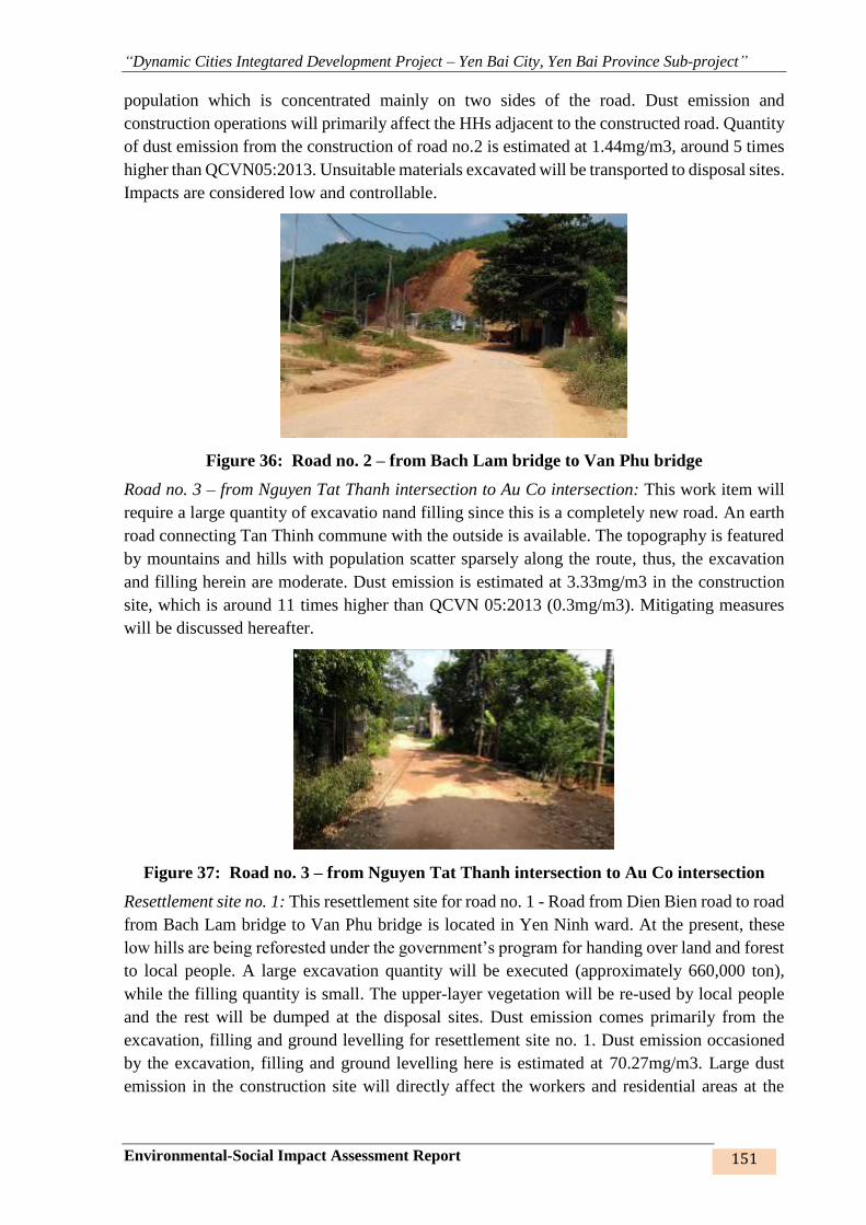
“Dynamic Cities Integtared Development Project – Yen Bai City, Yen Bai Province Sub-project”
Environmental-Social Impact Assessment Report 151
population which is concentrated mainly on two sides of the road. Dust emission and
construction operations will primarily affect the HHs adjacent to the constructed road. Quantity
of dust emission from the construction of road no.2 is estimated at 1.44mg/m3, around 5 times
higher than QCVN05:2013. Unsuitable materials excavated will be transported to disposal sites.
Impacts are considered low and controllable.
Figure 36: Road no. 2 – from Bach Lam bridge to Van Phu bridge
Road no. 3 – from Nguyen Tat Thanh intersection to Au Co intersection: This work item will
require a large quantity of excavatio nand filling since this is a completely new road. An earth
road connecting Tan Thinh commune with the outside is available. The topography is featured
by mountains and hills with population scatter sparsely along the route, thus, the excavation
and filling herein are moderate. Dust emission is estimated at 3.33mg/m3 in the construction
site, which is around 11 times higher than QCVN 05:2013 (0.3mg/m3). Mitigating measures
will be discussed hereafter.
Figure 37: Road no. 3 – from Nguyen Tat Thanh intersection to Au Co intersection
Resettlement site no. 1: This resettlement site for road no. 1 - Road from Dien Bien road to road
from Bach Lam bridge to Van Phu bridge is located in Yen Ninh ward. At the present, these
low hills are being reforested under the government’s program for handing over land and forest
to local people. A large excavation quantity will be executed (approximately 660,000 ton),
while the filling quantity is small. The upper-layer vegetation will be re-used by local people
and the rest will be dumped at the disposal sites. Dust emission comes primarily from the
excavation, filling and ground levelling for resettlement site no. 1. Dust emission occasioned
by the excavation, filling and ground levelling here is estimated at 70.27mg/m3. Large dust
emission in the construction site will directly affect the workers and residential areas at the
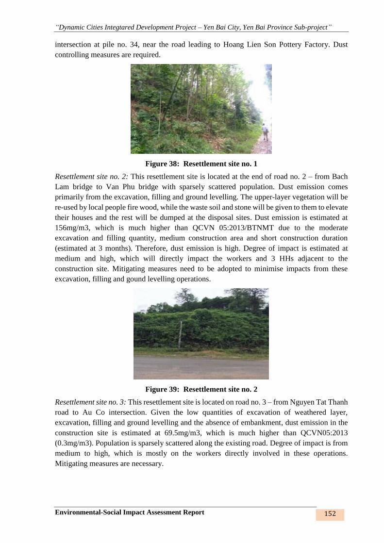
“Dynamic Cities Integtared Development Project – Yen Bai City, Yen Bai Province Sub-project”
Environmental-Social Impact Assessment Report 152
intersection at pile no. 34, near the road leading to Hoang Lien Son Pottery Factory. Dust
controlling measures are required.
Figure 38: Resettlement site no. 1
Resettlement site no. 2: This resettlement site is located at the end of road no. 2 – from Bach
Lam bridge to Van Phu bridge with sparsely scattered population. Dust emission comes
primarily from the excavation, filling and ground levelling. The upper-layer vegetation will be
re-used by local people fire wood, while the waste soil and stone will be given to them to elevate
their houses and the rest will be dumped at the disposal sites. Dust emission is estimated at
156mg/m3, which is much higher than QCVN 05:2013/BTNMT due to the moderate
excavation and filling quantity, medium construction area and short construction duration
(estimated at 3 months). Therefore, dust emission is high. Degree of impact is estimated at
medium and high, which will directly impact the workers and 3 HHs adjacent to the
construction site. Mitigating measures need to be adopted to minimise impacts from these
excavation, filling and gound levelling operations.
Figure 39: Resettlement site no. 2
Resettlement site no. 3: This resettlement site is located on road no. 3 – from Nguyen Tat Thanh
road to Au Co intersection. Given the low quantities of excavation of weathered layer,
excavation, filling and ground levelling and the absence of embankment, dust emission in the
construction site is estimated at 69.5mg/m3, which is much higher than QCVN05:2013
(0.3mg/m3). Population is sparsely scattered along the existing road. Degree of impact is from
medium to high, which is mostly on the workers directly involved in these operations.
Mitigating measures are necessary.

“Dynamic Cities Integtared Development Project – Yen Bai City, Yen Bai Province Sub-project”
Environmental-Social Impact Assessment Report 153
Figure 40: Resettlement site no. 3
Resettlement sites no. 4, 5: These sites are located in the beginning of road no. 2 in groups 6, 7,
and 39 - Yen Ninh ward. Population is scattered in groups. The construction of the works will
affect primarily the workers directly involved and the HHs adjaccent to the construction site.
Dust emission from excavation, filling and ground levelling is estimated at 50.8 – 72.0mg/m3,
much higher than QCVN 05:2013/ BTNMT. Mitigating measures are necessary.
Figure 41: Resettlement site no. 4 (a), Resettlement site no. 5 (b)
As such, estimated dust emission from excavation of weathered layer, excavation, filling and
ground levelling is 1.5 to hundreds of times higher than the allowed limited as per QCVN
05:2013/BTNMT, impact level is from medium to high, which is mostly caused by the
execution of the resettlement sites with the extensive soil works lasting for 6-10 weeks.
However, dust emitted has large size, settles quickly and lasts for a short time, thus causing no
major impacts on local people, who are not concentrated but scatter sparesely in these areas.
Apart from workers directly involved in the execution, some other sensitve areas will also be
affected by dust emission; it is, therefore, advisable that the contractor takes appropriate
measures to alleviate dust emission from the excavation, filling, ground levelling and
excavation of weathered layer.
(ii) Dust from the material loading, transportation and gathering
Sources of dust emission from material loading, transportation and gathering include (i) soil
and stone transportation, and (ii) construction metarial and fuel transportation. Subjects of the
impacts include people living in the construction sites and on the transportation roads such as
Tran Binh Trong, Yen Ninh, Thanh Cong, Ly Thuong Kiet, NR70, Nguyen Tat Thanh, Au Co,
Dien Bien, 32C... and workers directly involved in these operations. Impact level is from
medium to high during the execution time. Impact level may be lowered by means of
appropriate mitigating measures as stated herein.
a b
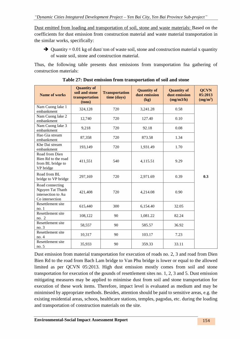
“Dynamic Cities Integtared Development Project – Yen Bai City, Yen Bai Province Sub-project”
Environmental-Social Impact Assessment Report 154
Dust emitted from loading and transportation of soil, stone and waste materials: Based on the
coefficients for dust emission from construction material and waste material transportation in
the similar works, specifically:
Quantity = 0.01 kg of dust/ ton of waste soil, stone and construction material x quantity
of waste soil, stone and construction material.
Thus, the following table presents dust emissions from transportation fna gathering of
construction materials:
Table 27: Dust emission from transportation of soil and stone
Name of works
Quantity of
soil and stone
transportation
(tons)
Transportation
time (days)
Quantity of
dust emission
(kg)
Quantity of
dust emission
(mg/m3/h)
QCVN
05:2013
(mg/m3)
Nam Cuong lake 1
embankment 324,128 720 3,241.28 0.58
0.3
Nam Cuong lake 2
embankment 12,740 720 127.40 0.10
Nam Cuong lake 3
embankment 9,218 720 92.18 0.08
Hao Gia stream
embankment 87,358 720 873.58 1.34
Khe Dai stream
embankment 193,149 720 1,931.49 1.70
Road from Dien
Bien Rd to the road
from BL bridge to
VP bridge
411,551 540 4,115.51 9.29
Road from BL
bridge to VP bridge 297,169 720 2,971.69 0.39
Road connecting
Nguyen Tat Thanh
intersection to Au
Co intersection
421,408 720 4,214.08 0.90
Resettlement site
no. 1 615,440 300 6,154.40 32.05
Resettlement site
no. 2 108,122 90 1,081.22 82.24
Resettlement site
no. 3 58,557 90 585.57 36.92
Resettlement site
no. 4 10,317 90 103.17 7.23
Resettlement site
no. 5 35,933 90 359.33 33.11
Dust emission from material transportation for execution of roads no. 2, 3 and road from Dien
Bien Rd to the road from Bach Lam bridge to Van Phu bridge is lower or equal to the allowed
limited as per QCVN 05:2013. High dust emission mostly comes from soil and stone
transportation for execution of the gounds of resettlement sites no. 1, 2, 3 and 5. Dust emission
mitigating measures may be applied to minimise dust from soil and stone transportation for
execution of these work items. Therefore, impact level is evaluated as medium and may be
minimised by appropriate methods. Besides, attention should be paid to sensitive areas, e.g. the
existing residential areas, schoos, healthcare stations, temples, pagodas, etc. during the loading
and transportation of construction materials on the site.
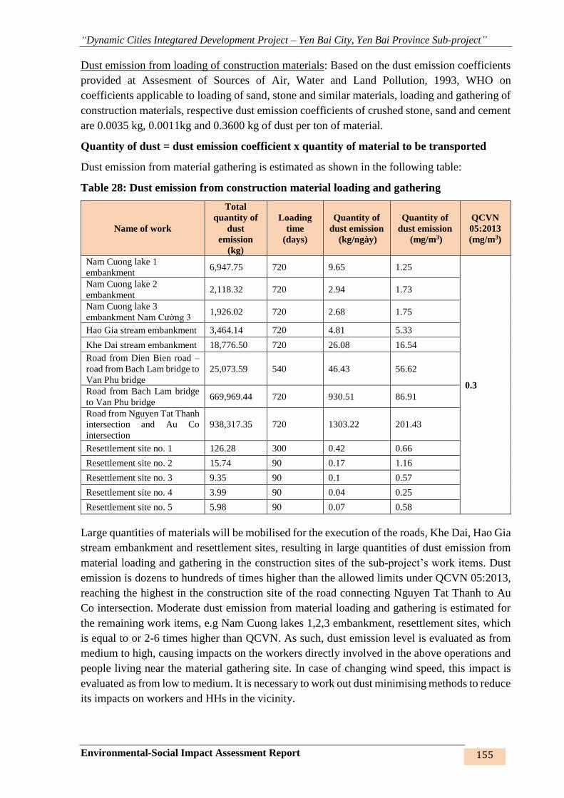
“Dynamic Cities Integtared Development Project – Yen Bai City, Yen Bai Province Sub-project”
Environmental-Social Impact Assessment Report 155
Dust emission from loading of construction materials: Based on the dust emission coefficients
provided at Assesment of Sources of Air, Water and Land Pollution, 1993, WHO on
coefficients applicable to loading of sand, stone and similar materials, loading and gathering of
construction materials, respective dust emission coefficients of crushed stone, sand and cement
are 0.0035 kg, 0.0011kg and 0.3600 kg of dust per ton of material.
Quantity of dust = dust emission coefficient x quantity of material to be transported
Dust emission from material gathering is estimated as shown in the following table:
Table 28: Dust emission from construction material loading and gathering
Name of work
Total
quantity of
dust
emission
(kg)
Loading
time
(days)
Quantity of
dust emission
(kg/ngày)
Quantity of
dust emission
(mg/m3)
QCVN
05:2013
(mg/m3)
Nam Cuong lake 1
embankment 6,947.75 720 9.65 1.25
0.3
Nam Cuong lake 2
embankment 2,118.32 720 2.94 1.73
Nam Cuong lake 3
embankment Nam Cường 3 1,926.02 720 2.68 1.75
Hao Gia stream embankment 3,464.14 720 4.81 5.33
Khe Dai stream embankment 18,776.50 720 26.08 16.54
Road from Dien Bien road –
road from Bach Lam bridge to
Van Phu bridge
25,073.59 540 46.43 56.62
Road from Bach Lam bridge
to Van Phu bridge 669,969.44 720 930.51 86.91
Road from Nguyen Tat Thanh
intersection and Au Co
intersection
938,317.35 720 1303.22 201.43
Resettlement site no. 1 126.28 300 0.42 0.66
Resettlement site no. 2 15.74 90 0.17 1.16
Resettlement site no. 3 9.35 90 0.1 0.57
Resettlement site no. 4 3.99 90 0.04 0.25
Resettlement site no. 5 5.98 90 0.07 0.58
Large quantities of materials will be mobilised for the execution of the roads, Khe Dai, Hao Gia
stream embankment and resettlement sites, resulting in large quantities of dust emission from
material loading and gathering in the construction sites of the sub-project’s work items. Dust
emission is dozens to hundreds of times higher than the allowed limits under QCVN 05:2013,
reaching the highest in the construction site of the road connecting Nguyen Tat Thanh to Au
Co intersection. Moderate dust emission from material loading and gathering is estimated for
the remaining work items, e.g Nam Cuong lakes 1,2,3 embankment, resettlement sites, which
is equal to or 2-6 times higher than QCVN. As such, dust emission level is evaluated as from
medium to high, causing impacts on the workers directly involved in the above operations and
people living near the material gathering site. In case of changing wind speed, this impact is
evaluated as from low to medium. It is necessary to work out dust minimising methods to reduce
its impacts on workers and HHs in the vicinity.
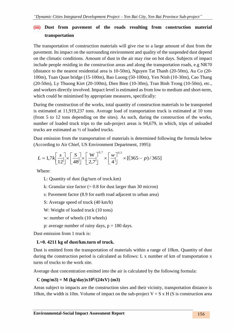
“Dynamic Cities Integtared Development Project – Yen Bai City, Yen Bai Province Sub-project”
Environmental-Social Impact Assessment Report 156
(iii) Dust from pavement of the roads resulting from construction material
transportation
The transportation of construction materials will give rise to a large amount of dust from the
pavement. Its impact on the surrounding environment and quality of the suspended dust depend
on the climatic conditions. Amount of dust in the air may rise on hot days. Subjects of impact
include people residing in the construction areas and along the transportation roads, e.g NR70
(distance to the nearest residential area is 10-50m), Nguyen Tat Thanh (20-50m), Au Co (20-
100m), Tuan Quan bridge (15-100m), Bao Luong (50-100m), Yen Ninh (10-30m), Cao Thang
(20-50m), Ly Thuong Kiet (20-100m), Dien Bien (10-30m), Tran Binh Trong (10-50m), etc.,
and workers directly involved. Impact level is estimated as from low to medium and short-term,
which could be minimised by appropriate measures, specifically:
During the construction of the works, total quantity of construction materials to be transported
is estimated at 11,919,237 tons. Average load of transportation truck is estimated at 10 tons
(from 5 to 12 tons depending on the sites). As such, during the construction of the works,
number of loaded truck trips to the sub-project areas is 94,679, in which, trips of unloaded
trucks are estimated as ½ of loaded trucks.
Dust emission from the transportation of materials is determined following the formula below
(According to Air Chief, US Environment Department, 1995):
]365/)365[42,7
W
48127,1
5,07,0
pwSs
kL
Where:
L: Quantity of dust (kg/turn of truck.km)
k: Granular size factor (= 0.8 for dust larger than 30 micron)
s: Pavement factor (8.9 for earth road adjacent to urban area)
S: Average speed of truck (40 km/h)
W: Weight of loaded truck (10 tons)
w: number of wheels (10 wheels)
p: average number of rainy days, p = 180 days.
Dust emission from 1 truck is:
L=0. 4211 kg of dust/km.turn of truck.
Dust is emitted from the transportation of materials within a range of 10km. Quantity of dust
during the construction period is calculated as follows: L x number of km of transportation x
turns of trucks to the work site.
Average dust concentration emitted into the air is calculated by the following formula:
C (mg/m3) = M (kg/day)x106/(24xV) (m3)
Areas subject to impacts are the construction sites and their vicinity, transportation distance is
10km, the width is 10m. Volume of impact on the sub-project V = S x H (S is construction area
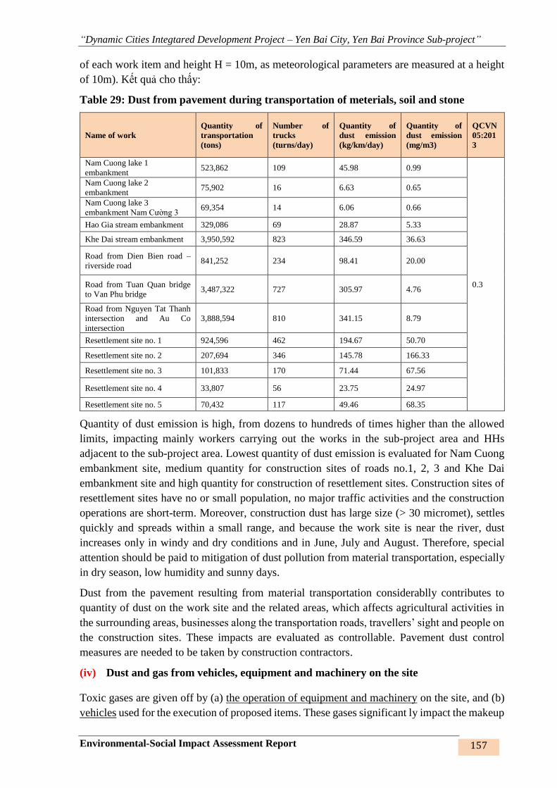
“Dynamic Cities Integtared Development Project – Yen Bai City, Yen Bai Province Sub-project”
Environmental-Social Impact Assessment Report 157
of each work item and height H = 10m, as meteorological parameters are measured at a height
of 10m). Kết quả cho thấy:
Table 29: Dust from pavement during transportation of meterials, soil and stone
Name of work
Quantity of
transportation
(tons)
Number of
trucks
(turns/day)
Quantity of
dust emission
(kg/km/day)
Quantity of
dust emission
(mg/m3)
QCVN
05:201
3
Nam Cuong lake 1
embankment 523,862 109 45.98 0.99
0.3
Nam Cuong lake 2
embankment 75,902 16 6.63 0.65
Nam Cuong lake 3
embankment Nam Cường 3 69,354 14 6.06 0.66
Hao Gia stream embankment 329,086 69 28.87 5.33
Khe Dai stream embankment 3,950,592 823 346.59 36.63
Road from Dien Bien road –
riverside road 841,252 234 98.41 20.00
Road from Tuan Quan bridge
to Van Phu bridge 3,487,322 727 305.97 4.76
Road from Nguyen Tat Thanh
intersection and Au Co
intersection
3,888,594 810 341.15 8.79
Resettlement site no. 1 924,596 462 194.67 50.70
Resettlement site no. 2 207,694 346 145.78 166.33
Resettlement site no. 3 101,833 170 71.44 67.56
Resettlement site no. 4 33,807 56 23.75 24.97
Resettlement site no. 5 70,432 117 49.46 68.35
Quantity of dust emission is high, from dozens to hundreds of times higher than the allowed
limits, impacting mainly workers carrying out the works in the sub-project area and HHs
adjacent to the sub-project area. Lowest quantity of dust emission is evaluated for Nam Cuong
embankment site, medium quantity for construction sites of roads no.1, 2, 3 and Khe Dai
embankment site and high quantity for construction of resettlement sites. Construction sites of
resettlement sites have no or small population, no major traffic activities and the construction
operations are short-term. Moreover, construction dust has large size (> 30 micromet), settles
quickly and spreads within a small range, and because the work site is near the river, dust
increases only in windy and dry conditions and in June, July and August. Therefore, special
attention should be paid to mitigation of dust pollution from material transportation, especially
in dry season, low humidity and sunny days.
Dust from the pavement resulting from material transportation considerablly contributes to
quantity of dust on the work site and the related areas, which affects agricultural activities in
the surrounding areas, businesses along the transportation roads, travellers’ sight and people on
the construction sites. These impacts are evaluated as controllable. Pavement dust control
measures are needed to be taken by construction contractors.
(iv) Dust and gas from vehicles, equipment and machinery on the site
Toxic gases are given off by (a) the operation of equipment and machinery on the site, and (b)
vehicles used for the execution of proposed items. These gases significant ly impact the makeup
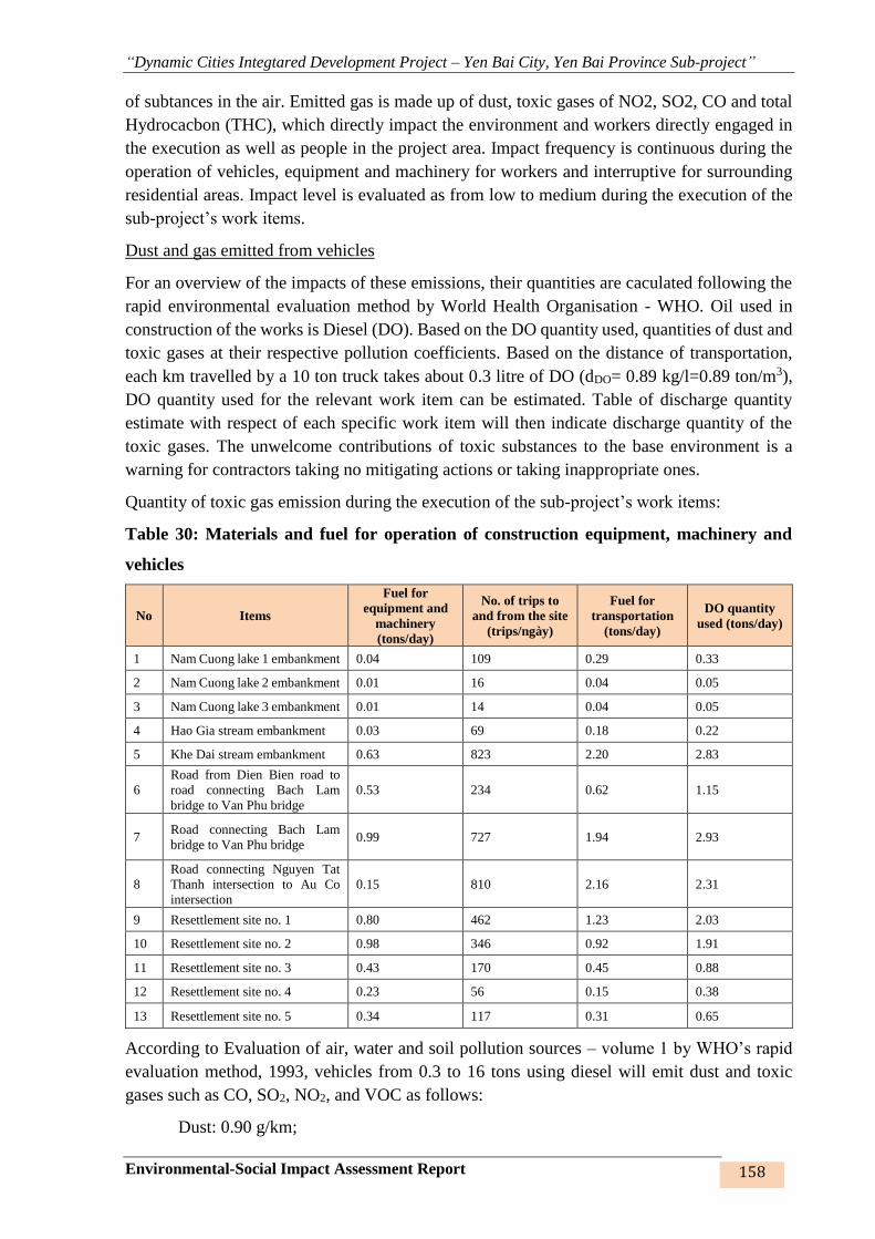
“Dynamic Cities Integtared Development Project – Yen Bai City, Yen Bai Province Sub-project”
Environmental-Social Impact Assessment Report 158
of subtances in the air. Emitted gas is made up of dust, toxic gases of NO2, SO2, CO and total
Hydrocacbon (THC), which directly impact the environment and workers directly engaged in
the execution as well as people in the project area. Impact frequency is continuous during the
operation of vehicles, equipment and machinery for workers and interruptive for surrounding
residential areas. Impact level is evaluated as from low to medium during the execution of the
sub-project’s work items.
Dust and gas emitted from vehicles
For an overview of the impacts of these emissions, their quantities are caculated following the
rapid environmental evaluation method by World Health Organisation - WHO. Oil used in
construction of the works is Diesel (DO). Based on the DO quantity used, quantities of dust and
toxic gases at their respective pollution coefficients. Based on the distance of transportation,
each km travelled by a 10 ton truck takes about 0.3 litre of DO (dDO= 0.89 kg/l=0.89 ton/m3),
DO quantity used for the relevant work item can be estimated. Table of discharge quantity
estimate with respect of each specific work item will then indicate discharge quantity of the
toxic gases. The unwelcome contributions of toxic substances to the base environment is a
warning for contractors taking no mitigating actions or taking inappropriate ones.
Quantity of toxic gas emission during the execution of the sub-project’s work items:
Table 30: Materials and fuel for operation of construction equipment, machinery and
vehicles
No Items
Fuel for
equipment and
machinery
(tons/day)
No. of trips to
and from the site
(trips/ngày)
Fuel for
transportation
(tons/day)
DO quantity
used (tons/day)
1 Nam Cuong lake 1 embankment 0.04 109 0.29 0.33
2 Nam Cuong lake 2 embankment 0.01 16 0.04 0.05
3 Nam Cuong lake 3 embankment 0.01 14 0.04 0.05
4 Hao Gia stream embankment 0.03 69 0.18 0.22
5 Khe Dai stream embankment 0.63 823 2.20 2.83
6
Road from Dien Bien road to
road connecting Bach Lam
bridge to Van Phu bridge
0.53 234 0.62 1.15
7 Road connecting Bach Lam
bridge to Van Phu bridge 0.99 727 1.94 2.93
8
Road connecting Nguyen Tat
Thanh intersection to Au Co
intersection
0.15 810 2.16 2.31
9 Resettlement site no. 1 0.80 462 1.23 2.03
10 Resettlement site no. 2 0.98 346 0.92 1.91
11 Resettlement site no. 3 0.43 170 0.45 0.88
12 Resettlement site no. 4 0.23 56 0.15 0.38
13 Resettlement site no. 5 0.34 117 0.31 0.65
According to Evaluation of air, water and soil pollution sources – volume 1 by WHO’s rapid
evaluation method, 1993, vehicles from 0.3 to 16 tons using diesel will emit dust and toxic
gases such as CO, SO2, NO2, and VOC as follows:
Dust: 0.90 g/km;

“Dynamic Cities Integtared Development Project – Yen Bai City, Yen Bai Province Sub-project”
Environmental-Social Impact Assessment Report 159
SOx: 4.29*S g/km;
NOx: 11.80 g/km;
CO: 6.00 g/km;
THC: 2.60 g/km.
10 ton trucks will be used for the sub-project, avaerage distance of each trip is 10km. Quantities
of dust and gases from transportation of materials and operation of equipment and machinery
are as follows:
Table 31: Quantities of toxic gas emission from construction of the works
No Items
Pollution quantity (mg/m3)
Dust SO2 NOx CO THC
1 Nam Cuong lake 1 embankment 0.0057 0.0001 0.0744 0.0378 0.0164
2 Nam Cuong lake 2 embankment 0.0037 0.0000 0.0485 0.0247 0.0107
3 Nam Cuong lake 3 embankment 0.0038 0.0000 0.0494 0.0251 0.0109
4 Hao Gia stream embankment 0.0304 0.0004 0.3988 0.2028 0.0879
5 Khe Dai stream embankment 0.2090 0.0025 2.7404 1.3934 0.6038
6
Road from Dien Bien road to road
connecting Bach Lam bridge to Van Phu
bridge
0.1141 0.0014 1.4965 0.7610 0.3297
7 Road connecting Bach Lam bridge to Van
Phu bridge 0.0272 0.0003 0.3564 0.1812 0.0785
8 Road connecting Nguyen Tat Thanh
intersection to Au Co intersection 0.0501 0.0006 0.6575 0.3343 0.1449
9 Resettlement site no. 1 0.2893 0.0034 3.7930 1.9287 0.8358
10 Resettlement site no. 2 0.9492 0.0113 12.4445 6.3277 2.7420
11 Resettlement site no. 3 0.3855 0.0046 5.0547 2.5702 1.1137
12 Resettlement site no. 4 0.1425 0.0017 1.8683 0.9500 0.4117
13 Resettlement site no. 5 0.3900 0.0046 5.1138 2.6003 1.1268
QCVN 05:2013/BTNMT 0.3 0.35 0.2 30
QCVN 06:2009/BTNMT 5
It can be concluded from the dust and gas emissions from operation of operation of machinery
and equipment that gas pollution is higher than the allowed limits in the construction sites of
thte sub-project’s work items. The operation of machinery and equipment does not cause SO2,
CO and THC pollution, meanwhile, Nox, THC and dust pollution in most of the sites is from
several to dozens of times higher than the allowed limits under QCVN 05:2013 and QCVN
06:2009/BTNMT.
In Khe Dai stream embankment site: Quantity of NOx is 14 times higher than QCVN05:2013/
BTNMT. However, the area affected by the execution of this work item is located behind
houses at piles from L89 to L92, and HHs along Yen Binh, Nguyen Tat Thanh, Km5, Dien
Bien, Yen Bai bridge, NR37, Cao Lanh, Tran Binh Trong roads. Other quantities of dust and
gas are within the allowed limits.

“Dynamic Cities Integtared Development Project – Yen Bai City, Yen Bai Province Sub-project”
Environmental-Social Impact Assessment Report 160
Figure 42: Residential area on Khe Dai stream embankment
Road from Dien Bien road to the road connecting Bach Lam bridge to Van Phu bridge and
resettlement site no.1: NOx quantity is 7 times higher than allowed limits. In this area, due to
scattered population and low traffic density, diffusion of toxic gases to local people (at piles
TD1, TD3, TD6) are inconsiderable and short-lived. Residential areas along the roads of Yen
Binh, Van Tien, Bao Luong, Cao Lanh, Ho Xuan Huong, NR37 are also subject to impacts.
Figure 43: Residential area on road no. 1, resettlement site no. 1
Road no.2 – road from Bach Lam bridge to Van Phu bridge: Residential areas along this road
are subject to impacts from toxic gases. Specifically, residential areas at Km 0-Km 0+400 at
TD1, TC2; Km 3-4 tại cọc 29, 30, 33, 34; Km 4 – Km 5 at piles 2A, TC4, TC5, piles 24-28,
piles 35-39 and on the roads for transportation of materials (Yen Binh, Van Tien, Bao Luong,
Cao Lanh, Ho Xuan Huong, NR37).
Figure 44: Residential area on road no. 2 and resettlement sites no. 2,4,5
Road no. 3 – from Nguyen Tat Thanh intersection to Au Co intersection, resettlement site no.
3: Subjects of impact are HHs located along the roads of Nguyen Tat Thanh, Au Co, Tuan
Quan, NR70, NR37, and residential area along the road at piles 85, 66A, 49, ND9, A42, A43,
80, 88, 76.
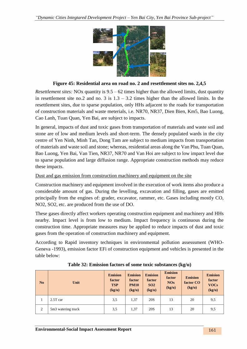
“Dynamic Cities Integtared Development Project – Yen Bai City, Yen Bai Province Sub-project”
Environmental-Social Impact Assessment Report 161
Figure 45: Residential area on road no. 2 and resettlement sites no. 2,4,5
Resettlement sites: NOx quantity is 9.5 – 62 times higher than the allowed limits, dust quantity
in resettlement site no.2 and no. 3 is 1.3 – 3.2 times higher than the allowed limits. In the
resettlement sites, due to sparse population, only HHs adjacent to the roads for transportation
of construction materials and waste meterials, i.e. NR70, NR37, Dien Bien, Km5, Bao Luong,
Cao Lanh, Tuan Quan, Yen Bai, are subject to impacts.
In general, impacts of dust and toxic gases from transportation of materials and waste soil and
stone are of low and medium levels and short-term. The densely populated wards in the city
centre of Yen Ninh, Minh Tan, Dong Tam are subject to medium impacts from transportation
of materials and waste soil and stone; whereas, residential areas along the Van Phu, Tuan Quan,
Bao Luong, Yen Bai, Van Tien, NR37, NR70 and Van Hoi are subject to low impact level due
to sparse population and large diffusion range. Appropriate construction methods may reduce
these impacts.
Dust and gas emission from construction machinery and equipment on the site
Construction machinery and equipment involved in the execution of work items also produce a
considerable amount of gas. During the levelling, excavation and filling, gases are emitted
principally from the engines of: grader, excavator, rammer, etc. Gases including mostly CO,
NO2, SO2, etc. are produced from the use of DO.
These gases directly affect workers operating construction equipment and machinery and HHs
nearby. Impact level is from low to medium. Impact frequency is continuous during the
construction time. Appropriate measures may be applied to reduce impacts of dust and toxic
gases from the operation of construction machinery and equipment.
According to Rapid inventory techniques in environmental pollution assesssment (WHO-
Geneva -1993), emission factor EFi of construction equipment and vehicles is presented in the
table below:
Table 32: Emission factors of some toxic substances (kg/u)
No Unit
Emision
factor
TSP
(kg/u)
Emision
factor
PM10
(kg/u)
Emision
factor
SO2
(kg/u)
Emision
factor
NOx
(kg/u)
Emision
factor CO
(kg/u)
Emision
factor
VOCs
(kg/u)
1 2.5T car 3,5 1,37 20S 13 20 9,5
2 5m3 watering truck 3,5 1,37 20S 13 20 9,5

“Dynamic Cities Integtared Development Project – Yen Bai City, Yen Bai Province Sub-project”
Environmental-Social Impact Assessment Report 162
No Unit
Emision
factor
TSP
(kg/u)
Emision
factor
PM10
(kg/u)
Emision
factor
SO2
(kg/u)
Emision
factor
NOx
(kg/u)
Emision
factor CO
(kg/u)
Emision
factor
VOCs
(kg/u)
3 Dump truck 5T 4,3 1,37 20S 70 14 4,0
4 Dump truck 7T 4,3 1,37 20S 70 14 4,0
5 10T truck 4,3 1,37 20S 70 14 4,0
6 108 CV grader 4,3 1,37 20S 65 10 8
7 108CV bulldozer 4,3 1,37 20S 65 10 8
8 180CV bulldozer 4,3 1,37 20S 65 10 8
9 1.6m3 excavator 4,3 1,37 20S 65 10 8
10 0.8m3 clampshell 4,3 1,37 20S 70 14 4,0
11 75KVA electric generator 3,5 1,37 20S 13 20 9,5
12 15CV pump 3,5 1,37 20S 13 20 9,5
13 Pile driving machine 3,5 1,37 20S 13 20 9,5
14 Concrete mixing machine 4,3 1,37 20S 65 10 8
15 240-360m3/h air compressor 3,5 1,37 20S 13 20 9,5
Average 4,11 1,37 20S 53,94 13,29 7,41
(Source: WHO-Geneva -1993)
Where:
U: unit is 1 ton of fuel consumed by the machine
S: sulphur content (% of weight) of fuel.
Emission quantities of dust and toxic gases from the operation of machinery and equipment are
shown in the following table:
Table 33: Emission quantities of dust and some toxic gases from construction equipment
(mg/m3)

“Dynamic Cities Integtared Development Project – Yen Bai City, Yen Bai Province Sub-project”
Environmental-Social Impact Assessment Report 163
No Items
Fuel for
machinery and
equipment
(ton/day)
Dust PM10 SO2 NOx CO VOC
1 Nam Cuong lake 1 embankment
0.04
0.038
1
0.012
7
0.000
5
0.4996
0.123
1
0.0686
2 Nam Cuong lake 2 embankment
0.01
0.011
5
0.003
8
0.000
1
0.1504
0.037
0
0.0207
3 Nam Cuong lake 3 embankment
0.01
0.012
5
0.004
2
0.000
2
0.1644
0.040
5
0.0226
4 Hao Gia stream embankment
0.03
0.029
1
0.009
7
0.000
4
0.3819
0.094
1
0.0525
5 Khe Dai stream embankment 0.63
0.558
5
0.106
2
0.006
8
7.3294
1.805
9
1.0069
6
Road from Dien Bien road to road
connecting Bach Lam bridge to
Van Phu bridge
0.53
0.469
7
0.146
6
0.005
7
6.1647
1.518
9
0.8469
7 Road connecting Bach Lam
bridge to Van Phu bridge 0.99
0.878
7
0.112
9
0.010
7
11.532
4
2.841
4
1.5843
8
Road connecting Nguyen Tat
Thanh intersection to Au Co
intersection
0.15
0.131
1
0.043
7
0.001
6
1.7209
0.424
0
0.2364
9 Resettlement site no. 1 0.80
0.708
9
0.136
3
0.008
6
9.3038
2.292
3
1.2781
10 Resettlement site no. 2 0.98
0.874
4
0.141
5
0.010
6
11.475
7
2.827
4
1.5765
11 Resettlement site no. 3 0.43
0.309
7
0.126
6
0.004
6
4.9833
1.227
8
0.6846
12 Resettlement site no. 4 0.23
0.206
1
0.068
7
0.002
5
2.7042
0.666
3
0.3715
13 Resettlement site no. 5 0.34
0.302
7
0.100
9
0.003
7
3.9731
0.978
9
0.5458
QCVN 05: 2013 0.3 0.15 0.35 0.2 30
QCVN 06: 2009 5
The above figures show that the operation of construction machinery and equipment on the site
will cause dust pollution at the highest level on the construction site of road no.2 – road
connecting Bach Lam bridge and Van Phu bridge, and lowest level on the construction site of
3 Nam Cuong lakes. Quantity of dust emission in some areas is 1.26 to 2.93 times higher than
the standards, in particular:
- Khe Dai stream (residential areas from pile L89 to L92, distance to the neareast house
is 10 – 200m),
- Road no. 1 and resettlement site no.1 (residential areas at piles TD1, TD3, TD6 with the
shortest distance to the site of 0 - 20m),
- Road no.2 and resettlement site no.2 (residential areas at Km 0 - Km 0+400, Km 3-4,
Km 4 – Km 5 with the shortest distance to the site of 10-100m).
Other gases such as PM10, SO2, NOx, CO, VOC are much lower than the allowed limits under
QCVN 05:2013/BTNMT and QCVN 06:2009/BTNMT.
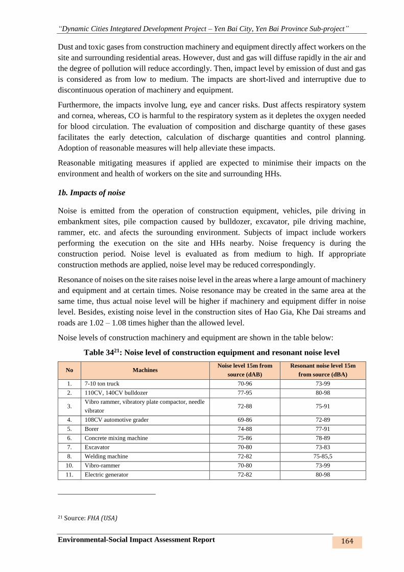
“Dynamic Cities Integtared Development Project – Yen Bai City, Yen Bai Province Sub-project”
Environmental-Social Impact Assessment Report 164
Dust and toxic gases from construction machinery and equipment directly affect workers on the
site and surrounding residential areas. However, dust and gas will diffuse rapidly in the air and
the degree of pollution will reduce accordingly. Then, impact level by emission of dust and gas
is considered as from low to medium. The impacts are short-lived and interruptive due to
discontinuous operation of machinery and equipment.
Furthermore, the impacts involve lung, eye and cancer risks. Dust affects respiratory system
and cornea, whereas, CO is harmful to the respiratory system as it depletes the oxygen needed
for blood circulation. The evaluation of composition and discharge quantity of these gases
facilitates the early detection, calculation of discharge quantities and control planning.
Adoption of reasonable measures will help alleviate these impacts.
Reasonable mitigating measures if applied are expected to minimise their impacts on the
environment and health of workers on the site and surrounding HHs.
1b. Impacts of noise
Noise is emitted from the operation of construction equipment, vehicles, pile driving in
embankment sites, pile compaction caused by bulldozer, excavator, pile driving machine,
rammer, etc. and afects the surounding environment. Subjects of impact include workers
performing the execution on the site and HHs nearby. Noise frequency is during the
construction period. Noise level is evaluated as from medium to high. If appropriate
construction methods are applied, noise level may be reduced correspondingly.
Resonance of noises on the site raises noise level in the areas where a large amount of machinery
and equipment and at certain times. Noise resonance may be created in the same area at the
same time, thus actual noise level will be higher if machinery and equipment differ in noise
level. Besides, existing noise level in the construction sites of Hao Gia, Khe Dai streams and
roads are 1.02 – 1.08 times higher than the allowed level.
Noise levels of construction machinery and equipment are shown in the table below:
Table 3421: Noise level of construction equipment and resonant noise level
No Machines Noise level 15m from
source (dAB)
Resonant noise level 15m
from source (dBA)
1. 7-10 ton truck 70-96 73-99
2. 110CV, 140CV bulldozer 77-95 80-98
3. Vibro rammer, vibratory plate compactor, needle
vibrator 72-88 75-91
4. 108CV automotive grader 69-86 72-89
5. Borer 74-88 77-91
6. Concrete mixing machine 75-86 78-89
7. Excavator 70-80 73-83
8. Welding machine 72-82 75-85,5
10. Vibro-rammer 70-80 73-99
11. Electric generator 72-82 80-98
21 Source: FHA (USA)

“Dynamic Cities Integtared Development Project – Yen Bai City, Yen Bai Province Sub-project”
Environmental-Social Impact Assessment Report 165
No Machines Noise level 15m from
source (dAB)
Resonant noise level 15m
from source (dBA)
12. Pile driving machine 72-85 75-91
QCVN 26:2010/BTNMT (6h – 21h) 70 70
The following formula is used to calculate noise impact radius:
M1-M2=20 x log (R2/R1)22
Where:
M1: Noise level at location 1
M2: Noise level at location 2
R1: Distance from source to location with noise level 1
R2: Distance from source to location with noise level 2
Based on the above formula, noise levels of equipment and machinery are calculated by
distance from source as shown in the table below:
Table 35: Noise levels of equipment and machinery by distance from source
No Machine Noise level from source (dAB)
15m 30m 60m 120m 240m 450m 600m 900m
1. Truck 73-99 80 74 68 62 56,5 54 50,5
2. Bulldozer 80-98 83 77 71 65 59,5 57 53,5
3. Air temper 75-91 77 71 65 59 53,5 51 47,5
4. Air compactor 72-89 74,5 68,5 62,5 56,5 51 48,5 45
5. Mobile crane 78-98 82 76 70 64 58,5 56 52,5
6. Saw machine 83-85 78 72 66 60 54,5 52 48,5
7. Borer 79-102 84,5 78,5 72,5 66,5 61 58,5 55
8. Concrete mixing
machine 77-91 78 72 66 60 54,5 52 48,5
9. excavator 78-89 77,5 71,5 65,5 59,5 54 51,5 48
10. Vibro rammer 73-83 72 66 60 54 48,5 46 42,5
11. Electric generator 75-85,5 74 68 62 56 50,5 48,5 45
12. Pile driving machine 75-88 75,5 69,5 63,5 57,5 52 49,5 46
The noise levels in the above table show that noises emitted from construction machinery and
equipment are lower than 70dAB out of the 240m range and decrease in proportion with
distance from construction site to the affected area.
22 U.S department of transportation, 1972

“Dynamic Cities Integtared Development Project – Yen Bai City, Yen Bai Province Sub-project”
Environmental-Social Impact Assessment Report 166
The most considerable among the above noise sources is noise from trucks carrying materials
passing residential areas. Subjects of these noises are HHs adjacent to the construction site and
transportation roads and workers directly performing the execution.
According to Canter - Environmental Impact Assessment, Mc Graw Hill, (1996), standard
distance from noises cuased by trucks is at least 30m and up to 121 m. Hence, noise level along
the roads for transportation of construction materials and waste soil and stone will be higher
than the standards under QCVN 26:2010/BTNMT. HHs located along these roads will be
subject to noises caused by trucks serving the sub-project components. Most of other sources
of noise are site-specific and affect only workers on the construction site and HHs adjacent to
embankment sites or some HHs in the residential areas along the roads within the distance from
10 to 100m to the nearest residential area. The operation of machinery and machinery will
directly affect the residential area on Khe Dai stream embankment route (30-100m), where
some HHs are adjacent to two shores of the stream, and some HHs in the interchanges with
road no. 1 – from Dien Bien road to the road connecting Bach Lam bridge to Van Phu bridge
(0 – 20m), road no. 2 – road connecting Bach Lam bridge to Van Phu bridge (10 – 100m). Noise
impact from the machinery and equipment only comes up at certain times during the execution
process and will cease when the execution is completed. The machinery and equipment will not
operate continuously during the construction of the works but only in phases/shifts as per
progress and quantity of work items; the equipment will be periodically checked, therefore, its
impacts are evaluated as low and medium. But alleviating measures should be considered and
applied to limit these impacts on workers on the site and people in the sub-project areas.
1c. Impacts of vibration
Impacts of vibration are occasioned by the execution of the sub-project’s work items using
construction equipment. Subjects of the impacts are workers directly carrying out the execution
and structures of people living near the construction site. Vibration affects local people’s life,
business activities and structure of houses and other architectural objects and even causes cracks
and collapse of houses. Impact duration is evaluated as short during the operation of
construction machinery and equipment, which may results in from medium to high level of
vibration. Equipment’s vibration will also cause significant impacts on the ambient
environment as shown in the table below:
Table 36: Vibration of construction machinery and equipment
No Machine
Reference vibration level from source (in vertical
direction, dBA)
10 m 30 m 40m
1. Truck 74 64 59
2. Earth bulldozer 79 69 63
3. Air temper 93 83 75
4. Air compactor 81 71 67
5. Borer 63 52 48
6. Concrete mixing machin 76 66 61
7. excavator 80 71 66
8. Vibro rammer 82 72 65
9. Pile driving machine 93 83 75
QCVN 27:2010/ BTNMT (6h – 21h) 75

“Dynamic Cities Integtared Development Project – Yen Bai City, Yen Bai Province Sub-project”
Environmental-Social Impact Assessment Report 167
The above table shows that the vibrant accelerant caused by construction machinery and
equipment are beyond the standard limits for the range of 10m, but within the standard limits
for the range of 40m upwards. As a result, vibration from construction activities mostly impacts
workers on the site. In particular:
In the embankment site of Nam Cuong lakes 1, 2, 3, some HHs are only 5-10m away from the
construction site. But the construction of the works is carried out behind their houses, adjacent
to their empty land, gardens or fruit trees and production forest land.
The embankment site of Hao Gia and Khe Dai streams is also adjacent to local people’s houses
in some sections (10-100m from the site), Kim Dong Primary School, Hoa Hong Kindergarten
–Minh Tan ward in a distance of 5-10m, but this affects only the land areas behind or near these
residential areas and schools without any impacts on the structures on the land within the impact
range. This impact is, therefore, considered as low.
As for roads no. 1, 2, 3 and resettlement sites, houses are adjacent to construction sites at the
interchanges with the existing roads on the newly built road from Dien Bien road to the road
from Bach Lam bridge to Van Phu bridge (at piles TD1, TD3, TD6), the road from Bach Lam
bridge to Van Phu bridge (at Km 0 – Km0+400, Km 3- Km4 and Km 4 – Km5), some residential
areas are 10-100m away from the construction site. As a result, HHs may be affected by
vbration from operation of machinery and equipment within a range of 10-30m, but at a low
level. Given that the machinery and equipment is not operated continuously and simultaneously,
the local vibration resonance is non-existent.
Impact level of vibration is evaluated as low and short-lived at some construction times.
Appropriate construction methods and plans are expected to limit these impacts on local HHs
and workers.
1c. Impacts of smell
Smell will emit from the dredging of Nam Cuong lake 1, Khe Dai and Hao Gia streams. When
excavated and brought to the surface, the existing balance structure of sludge will be disrupted,
organic matters and some other vaporisable matters will vaporise and give off bad smells.
Smelly gases include VOC, H2S, CH4, amino acid, organix acid, other compounds... Subjects
of smell are workers performing the execution on ths site and HHs near the construction sites.
However, the impact occurs only during the short period of dredging and appropriate
construction methods will minimise this impact. Impact level is, therefore, considered as low.
According to research results of Cambridge Environment Research Organisation on smell based
on awareness magnitude:
- Smell detection: 1 Ou/m3
- Light smell: 5 Ou/m3
- Particular and strong smell: 10 Ou/m3
Based on these awareness magnitudes and the construction of similar projects in Yen Bai city,
smell is likely to diffuse from the dredging of sediment at 1.23 – 4.42 Ou/m3. Smell impact
coming from dredging is evaluated as low and short-lived.
2. Impacts on water environment

“Dynamic Cities Integtared Development Project – Yen Bai City, Yen Bai Province Sub-project”
Environmental-Social Impact Assessment Report 168
During the construction period of work items under component 1 of the sub-project, there are
4 major sources of impacts on water environment, namely: (i) Rain water flowing out from the
construction site; (ii) Domestic wastewater of workers; (iii) wastewater from construction
operations, and (iv) water leaking from dredging of lakes.
Rainwater overflowing on the construction site
Rainwater is considered as clean water without being exposed to such sources of contamination
as: wastewater, waste gas, polluted soil/sludge… Main subjects of impact are catchments of
rainwater from the construction site. During the construction of the works, rainwater
overflowing on the site will sweep away soil, sand, workers’ domesti waste, debris, etc. and
become contaminants to surface water, soil and underground water. Impact duration is short
during the construction period. Total rainwater quantity in the sub-project area during the
construction period is estimated following the formula below:
Q = x q x S
Where:
S: Total rainwater drainage area (m2).
: flow factor of covering surface (road covering surface is usually asphalt and concrete
pavement ( =0.6).
q: Rain intensity (l/s.ha), q: rain intensity = 166.7 x i, with the highest water level in the
month with most rains of July 2016 being 404.7mm.
Number of rainy days in July was 25 days and 3 hours/day, thus, i = 0.067 mm/minute
q = 15.003 (l/s.ha).
According to statistics of World Health Organisation (WHO), quantity factor of contaminants
in overflowing rainwater typically ranges from 0.5 to 1.5 mgN/l; 0.004 – 0.03 mg P/l; 10 – 20
mg COD/l and 10 – 20 mg TSS/l. Then, total rainwater quantities coming out of the sub-
project’s construction sites are:
Table 37: Rainwater quantities on construction sites
Name of works Worksite
area (m2)
Rainwater
quantity
(l/s)
Pollution quawntity (tons/year)
T-N T-P COD TSS
Nam Cuong lake 1 embankment 192600 150.3 6.92 105.21 103.89 103.89
Nam Cuong lake 2 embankment 42600 33.2 1.53 23.24 22.95 22.95
Nam Cuong lake 3 embankment 38260 29.8 1.37 20.86 20.60 20.60
Hao Gia stream embankment 22563 17.6 0.81 12.32 12.17 12.17
Khe Dai stream embankment 39427.5 30.8 1.42 21.56 21.29 21.29
Road from Dien Bien road to road
connecting Bach Lam bridge to Van
Phu bridge
20500 16 0.74 11.20 11.06 11.06
Road connecting Bach Lam bridge
to Van Phu bridge 267661 69.6 3.20 48.72 48.11 48.11
Road connecting Nguyen Tat Thanh
intersection to Au Co intersection 161749 42.1 1.94 29.47 29.10 29.10
Resettlement site no. 1 16000 8.3 0.38 5.81 5.74 5.74
Resettlement site no. 2 3652 0.9 0.04 0.63 0.62 0.62
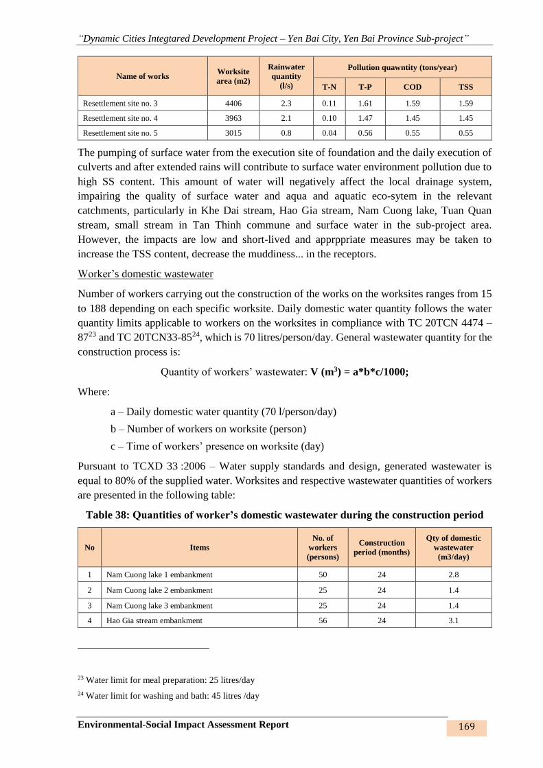
“Dynamic Cities Integtared Development Project – Yen Bai City, Yen Bai Province Sub-project”
Environmental-Social Impact Assessment Report 169
Name of works Worksite
area (m2)
Rainwater
quantity
(l/s)
Pollution quawntity (tons/year)
T-N T-P COD TSS
Resettlement site no. 3 4406 2.3 0.11 1.61 1.59 1.59
Resettlement site no. 4 3963 2.1 0.10 1.47 1.45 1.45
Resettlement site no. 5 3015 0.8 0.04 0.56 0.55 0.55
The pumping of surface water from the execution site of foundation and the daily execution of
culverts and after extended rains will contribute to surface water environment pollution due to
high SS content. This amount of water will negatively affect the local drainage system,
impairing the quality of surface water and aqua and aquatic eco-sytem in the relevant
catchments, particularly in Khe Dai stream, Hao Gia stream, Nam Cuong lake, Tuan Quan
stream, small stream in Tan Thinh commune and surface water in the sub-project area.
However, the impacts are low and short-lived and apprppriate measures may be taken to
increase the TSS content, decrease the muddiness... in the receptors.
Worker’s domestic wastewater
Number of workers carrying out the construction of the works on the worksites ranges from 15
to 188 depending on each specific worksite. Daily domestic water quantity follows the water
quantity limits applicable to workers on the worksites in compliance with TC 20TCN 4474 –
8723 and TC 20TCN33-8524, which is 70 litres/person/day. General wastewater quantity for the
construction process is:
Quantity of workers’ wastewater: V (m3) = a*b*c/1000;
Where:
a – Daily domestic water quantity (70 l/person/day)
b – Number of workers on worksite (person)
c – Time of workers’ presence on worksite (day)
Pursuant to TCXD 33 :2006 – Water supply standards and design, generated wastewater is
equal to 80% of the supplied water. Worksites and respective wastewater quantities of workers
are presented in the following table:
Table 38: Quantities of worker’s domestic wastewater during the construction period
No Items
No. of
workers
(persons)
Construction
period (months)
Qty of domestic
wastewater
(m3/day)
1 Nam Cuong lake 1 embankment 50 24 2.8
2 Nam Cuong lake 2 embankment 25 24 1.4
3 Nam Cuong lake 3 embankment 25 24 1.4
4 Hao Gia stream embankment 56 24 3.1
23 Water limit for meal preparation: 25 litres/day
24 Water limit for washing and bath: 45 litres /day
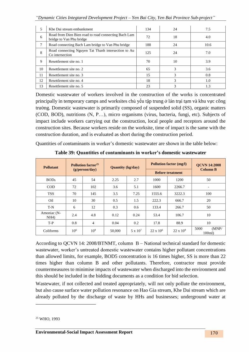
“Dynamic Cities Integtared Development Project – Yen Bai City, Yen Bai Province Sub-project”
Environmental-Social Impact Assessment Report 170
5 Khe Dai stream embankment 134 24 7.5
6 Road from Dien Bien road to road connecting Bach Lam
bridge to Van Phu bridge 72 18 4.0
7 Road connecting Bach Lam bridge to Van Phu bridge 188 24 10.6
8 Road connecting Nguyen Tat Thanh intersection to Au
Co intersection 125 24 7.0
9 Resettlement site no. 1 70 10 3.9
10 Resettlement site no. 2 65 3 3.6
11 Resettlement site no. 3 15 3 0.8
12 Resettlement site no. 4 18 3 1.0
13 Resettlement site no. 5 23 3 1.3
Domestic wastewater of workers involved in the construction of the works is concentrated
principally in temporary camps and worksites chủ yếu tập trung ở lán trại tạm và khu vực công
trường. Domestic wastewater is primarily composed of suspended solid (SS), organic matters
(COD, BOD), nutritions (N, P…), micro organisms (virus, bacteria, fungi, etc). Subjects of
impact include workers carrying out the construction, local people and receptors around the
construction sites. Because workers reside on the worksite, time of impact is the same with the
construction duration, and is evaluated as short during the construction period.
Quantities of contaminants in worker’s domestic wastewater are shown in the table below:
Table 39: Quantities of contaminants in worker’s domestic wastewater
Pollutant Pollution factor25
(g/person/day) Quantity (kg/day)
Pollution factor (mg/l) QCVN 14:2008
Column B Before treatment
BOD5 45 54 2.25 2.7 1000 1200 50
COD 72 102 3.6 5.1 1600 2266.7 -
TSS 70 145 3.5 7.25 1555.6 3222.3 100
Oil 10 30 0.5 1.5 222.3 666.7 20
T-N 6 12 0.3 0.6 133.4 266.7 50
Amoniac (N-
NH4) 2.4 4.8 0.12 0.24 53.4 106.7 10
T-P 0.8 4 0.04 0.2 17.8 88.9 10
Coliforms 106 109 50,000 5 x 10⁷ 22 x 106 22 x 109 5000 (MNP/
100ml)
According to QCVN 14: 2008/BTNMT, column B – National technical standard for domestic
wastewater, worker’s untreated domestic wastewater contains higher pollutant concentrations
than allowed limits, for example, BOD5 concentration is 16 times higher, SS is more than 22
times higher than column B and other pollutants. Therefore, contractor must provide
countermeasures to minimise impacts of wastewater when discharged into the environment and
this should be included in the bidding documents as a condition for bid selection.
Wastewater, if not collected and treated appropriately, will not only pollute the environment,
but also cause surface water pollution resonance on Hao Gia stream, Khe Dai stream which are
already polluted by the discharge of waste by HHs and businesses; underground water at
25 WHO, 1993
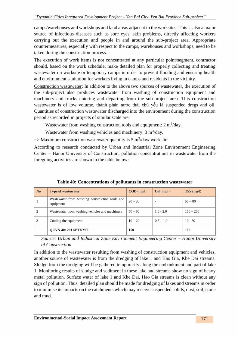
“Dynamic Cities Integtared Development Project – Yen Bai City, Yen Bai Province Sub-project”
Environmental-Social Impact Assessment Report 171
camps/warehouses and workshops and land areas adjacent to the worksites. This is also a major
source of infectious diseases such as sore eyes, skin problems, directly affecting workers
carrying out the execution and people in and around the sub-project area. Appropriate
countermeasures, especially with respect to the camps, warehouses and workshops, need to be
taken during the construction process.
The execution of work items is not concentrated at any particular point/segment, contractor
should, based on the work schedule, make detailed plan for properly collecting and treating
wastewater on worksite or temporary camps in order to prevent flooding and ensuring health
and environment sanitation for workers living in camps and residents in the vicinity.
Construction wastewater: In addition to the above two sources of wastewater, the execution of
the sub-project also produces wastewater from washing of construction equipment and
machinery and trucks entering and departing from the sub-project area. This construction
wastewater is of low volume, thành phần nước thải chủ yếu là suspended dregs and oil.
Quantities of construction wastewater discharged into the environment during the construction
period as recorded in projects of similar scale are:
Wastewater from washing construction tools and equipment: 2 m3/day.
Wastewater from washing vehicles and machinery: 3 m3/day.
=> Maximum construction wastewater quantity is 5 m3/day/ worksite.
According to research conducted by Urban and Industrial Zone Environment Engineering
Center – Hanoi University of Construction, pollution concentrations in wastewater from the
foregoing activities are shown in the table below:
Table 40: Concentrations of pollutants in construction wastewater
No Type of wastewater COD (mg/l) Oil (mg/l) TSS (mg/l)
1 Wastewater from washing construction tools and
equipment 20 – 30 - 50 – 80
2 Wastewater from washing vehicles and machinery 50 – 80 1,0 - 2,0 150 – 200
3 Cooling the equipment 10 – 20 0,5 – 1,0 10 - 50
QCVN 40: 2011/BTNMT 150 100
Source: Urban and Industrial Zone Environment Engineering Center – Hanoi University
of Construction
In addition to the wastewater resulting from washing of construction equipment and vehicles,
another source of wastewater is from the dredging of lake 1 and Hao Gia, Khe Dai streams.
Sludge from the dredging will be gathered temporarily along the embankment and part of lake
1. Monitoring results of sludge and sediment in these lake and streams show no sign of heavy
metal pollution. Surface water of lake 1 and Khe Dai, Hao Gia streams is clean without any
sign of pollution. Thus, detailed plan should be made for dredging of lakes and streams in order
to minimise its impacts on the catchments which may receive suspended solids, dust, soil, stone
and mud.

“Dynamic Cities Integtared Development Project – Yen Bai City, Yen Bai Province Sub-project”
Environmental-Social Impact Assessment Report 172
Subjects of impact are catchments that receive this source of wastewater. Impact level is
evaluated as low and short-lived. The contractor must work out construction methods and
control measures with appropriate arrangement on the worksite so as to minimise impacts of
construction wastewater on the water and soil environments in the sub-project area.
3. Solid waste
Solid waste from the construction of the works include: (i) Domestic waste at camps;
(ii) Construction solid waste.
(1) Domestic solid waste (DSW) at camps
DSW is the waste generated in the worker’s toilets. DSW is made up mainly of easily
decomposed organic matters and hard-to-decompose inorganic matters such as nylon bags,
bottles, used belongings, etc., which will affect the surface water in the sub-project area, if not
collected properly, due to their decomposition process and being swept away rainwater. The
defecation in unallowed places will also contribute to the increase of solid waste and
environmental pollution. Impact level is evaluated as low and medium and short-lived.
According to calculations and surveys, solid waste quantity generated in a day by a person
is 0.5 kg/person/day. With the number of workers constantly present on the worksite of 15-188
persons, solid waste quantity generated by the sub-project is 0.8 – 68 tons/day. Quantity of
DSW, which may vary as per the work progress, will reach a total of 251 tons throughout the
construction process.
Table 41: Quantities of worker’s domestic waste at camp sites
No Items Workers
(persons)
Discharge qty
(kg/person/day)
Construction
time (days)
Waste qty
(tons)
1 Nam Cuong lake 1 embankment 50 0.5 720 18
2 Nam Cuong lake 2 embankment 25 0.5 720 9
3 Nam Cuong lake 3 embankment 25 0.5 720 9
4 Hao Gia stream embankment 56 0.5 720 20
5 Khe Dai stream embankment 134 0.5 720 48
6
Road from Dien Bien road to road
connecting Bach Lam bridge to Van
Phu bridge
72 0.5 540 19
7 Road connecting Bach Lam bridge
to Van Phu bridge 188 0.5 720 68
8 Road connecting Nguyen Tat Thanh
intersection to Au Co intersection 125 0.5 720 45
9 Resettlement site no. 1 70 0.5 300 11
10 Resettlement site no. 2 65 0.5 90 3
11 Resettlement site no. 3 15 0.5 90 0.7
12 Resettlement site no. 4 18 0.5 90 0.8

“Dynamic Cities Integtared Development Project – Yen Bai City, Yen Bai Province Sub-project”
Environmental-Social Impact Assessment Report 173
No Items Workers
(persons)
Discharge qty
(kg/person/day)
Construction
time (days)
Waste qty
(tons)
1 Nam Cuong lake 1 embankment 50 0.50 720 18.00
2 Nam Cuong lake 2 embankment 25 0.50 720 9.00
3 Nam Cuong lake 3 embankment 25 0.50 720 9.00
4 Hao Gia stream embankment 56 0.50 720 20.16
5 Khe Dai stream embankment 134 0.50 720 48.40
6
Road from Dien Bien road to road
connecting Bach Lam bridge to Van
Phu bridge
72 0.50 540 19.38
7 Road connecting Bach Lam bridge to
Van Phu bridge 188 0.50 720 67.84
8 Road connecting Nguyen Tat Thanh
intersection to Au Co intersection 125 0.50 720 45.04
9 Resettlement site no. 1 70 0.50 300 10.50
10 Resettlement site no. 2 65 0.50 90 2.93
11 Resettlement site no. 3 15 0.50 90 0.68
12 Resettlement site no. 4 18 0.50 90 0.81
13 Resettlement site no. 5 23 0.50 90 1.04
Total 252
Impact of solid waste from the daily life of workers in the temporary site camps due to domestic
waste, solid waste from the excess materials when constructing the work items. If solid wastes
are not properly collected and treated, they may obstruct the flow during the construction of the
works, resulting in flooding, flow congestion and impeding the transportation of construction
materials to the site and construction activities of workers. Solid wastes containing pathogens
that cause significant risks to the water, air environments and indirectly affect the lives of
workers, people and animals around the construction area if they are not properly collected and
treated. It is necessary to consider, evaluate and take appropriate measures to collect, transport
and dispose of these wastes, and thereby to mitigate their adverse effects.
b) Construction solid waste
This waste derives from the construction of items within the construction site.
Composition of construction waste is discharged materials such as soil, stone, steel residue,
steel wire, lanyard, package ... about 2-3 kg / month at each work site. But reusable metal
scrapings, packages, scrapers ... will be collected by scrap collectors, some of which can be
utilized in household cooking or making use for breeding and production by households around
the area.
These solid wastes, if not collected, will affect the travel and transportation of workers on site
and the vehicles and machinery operating on the site. In addition, the indiscriminate and
arbitrary disposal of these wastes can affect the people around the site, water bodies and
surrounding landscapes. However, it can be seen that the impact of construction solid waste is
considered to be moderate, short-term impact during construction, which can be minimized by
appropriate measures.
1. Hazardous waste
Hazardous waste is sourced from the construction of items under the sub-project. Components
of these hazardous wastes include (1) wipes, paint drums, oil drums, paintbrushes,
“Dynamic Cities Integtared Development Project – Yen Bai City, Yen Bai Province Sub-project”
Environmental-Social Impact Assessment Report 174
waterproofing, waste oil, (2) welding rods, (3) light bulbs... mainly arising from the operation
of mechanical and construction equipment/ devices on the site.
The amount of hazardous waste generated during the construction process is estimated at 1-2
kg/day/construction site and the amount of waste oil generated in the sub-project area depends
on the number of vehicles and construction machines on site.
Average amount of discharged lubricant is about 7 liters/time of lubricant supply and lubricant
supply takes place every 3 or 4 months. (Research on Recycling of Lubricants into Liquid Fuels
- Military Science and Technology Center - Ministry of Defense 2002).
The impact of hazardous wastes mainly affects the land and water environment in the
construction area. Impacts are considered low to moderate and likely to be mitigated by
appropriate measures. However, most of means of transporting materials are maintained and
maintained in the garages, the construction machines at the site are repaired, maintained by an
unit hired by the contractors, waste oil is collected, so the impact of hazardous liquid waste is
negligible.
These wastes are considered to be on the list of hazardous wastes under the Ministry of Natural
Resources and Environment's Circular No. 36/2015 / TT-BTNMT of June 30, 2015 on the
management of hazardous wastes; therefore, specific measures and guidelines to reduce the
impact on workers and the environment are essential.
2. Impact on the land environment
Vegetation cover is lost due to weathering, land clearance for construction, change of land use
purpose: from residential land and agricultural land to transport land, or empty land for
construction. The change of soil will have impacts on the surrounding environment such as loss
of protection layer, the effects of high temperature in the construction area, surface erosion,
erosion of soil layers and surface water pollution, landslide in nearby areaa ... In the process of
construction, measures should be taken to limit the surface washing as this will affect the
progress of construction, life of workers at the site camps and people around the construction
site, resulting in flooding, local congestion and impact on the surface water environment as it
will take with it solid waste and other contaminants. .
As such, these risks are considered minor and occur in short time of construction, which can be
mitigated by appropriate measures.
3. Impact on the ecosystem
There are no environmentally sensitive areas such as national parks, nature reserves or
biosphere reserves, no discovery of plant and animal species in the Red Book, which should be
protected and preserved in the project area. Therefore, implementation of the project will not
affect these objects.
For terrestrial ecosystems
The construction will cause loss of vegetation cover, weathering layer on the top soil layer,
which may cause ecological terrestrial impacts in the Nam Cuong lake embankment, Hao Gia,
Khe Dai streams, roads no.1,2,3 and resettlement sites. Dust will cover leaves, reducing
photosynthesis. However, the actual surveying in the project area shows that terrestrial
ecosystems in the sub-project area are very poor in flora and fauna. Therefore, this impact on
terrestrial ecosystems is considered low.
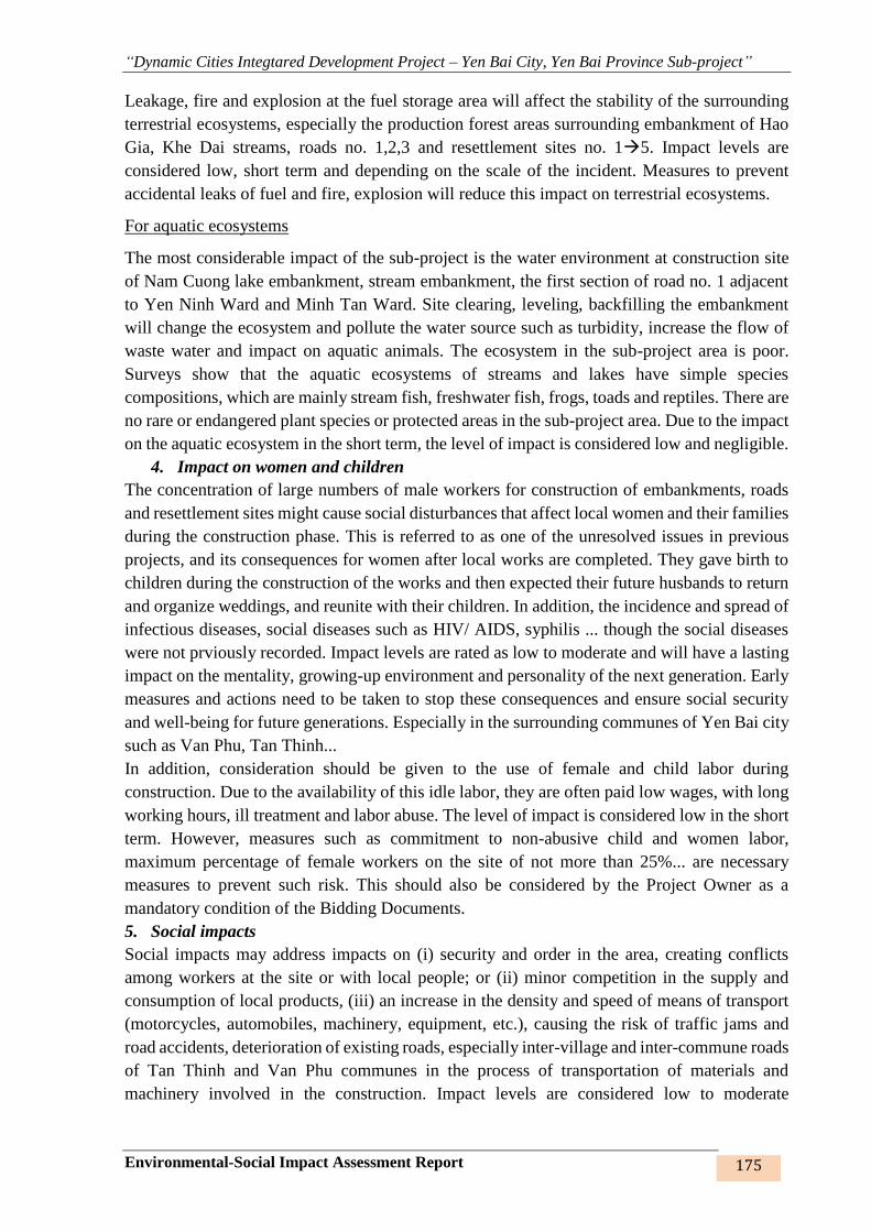
“Dynamic Cities Integtared Development Project – Yen Bai City, Yen Bai Province Sub-project”
Environmental-Social Impact Assessment Report 175
Leakage, fire and explosion at the fuel storage area will affect the stability of the surrounding
terrestrial ecosystems, especially the production forest areas surrounding embankment of Hao
Gia, Khe Dai streams, roads no. 1,2,3 and resettlement sites no. 15. Impact levels are
considered low, short term and depending on the scale of the incident. Measures to prevent
accidental leaks of fuel and fire, explosion will reduce this impact on terrestrial ecosystems.
For aquatic ecosystems
The most considerable impact of the sub-project is the water environment at construction site
of Nam Cuong lake embankment, stream embankment, the first section of road no. 1 adjacent
to Yen Ninh Ward and Minh Tan Ward. Site clearing, leveling, backfilling the embankment
will change the ecosystem and pollute the water source such as turbidity, increase the flow of
waste water and impact on aquatic animals. The ecosystem in the sub-project area is poor.
Surveys show that the aquatic ecosystems of streams and lakes have simple species
compositions, which are mainly stream fish, freshwater fish, frogs, toads and reptiles. There are
no rare or endangered plant species or protected areas in the sub-project area. Due to the impact
on the aquatic ecosystem in the short term, the level of impact is considered low and negligible.
4. Impact on women and children
The concentration of large numbers of male workers for construction of embankments, roads
and resettlement sites might cause social disturbances that affect local women and their families
during the construction phase. This is referred to as one of the unresolved issues in previous
projects, and its consequences for women after local works are completed. They gave birth to
children during the construction of the works and then expected their future husbands to return
and organize weddings, and reunite with their children. In addition, the incidence and spread of
infectious diseases, social diseases such as HIV/ AIDS, syphilis ... though the social diseases
were not prviously recorded. Impact levels are rated as low to moderate and will have a lasting
impact on the mentality, growing-up environment and personality of the next generation. Early
measures and actions need to be taken to stop these consequences and ensure social security
and well-being for future generations. Especially in the surrounding communes of Yen Bai city
such as Van Phu, Tan Thinh...
In addition, consideration should be given to the use of female and child labor during
construction. Due to the availability of this idle labor, they are often paid low wages, with long
working hours, ill treatment and labor abuse. The level of impact is considered low in the short
term. However, measures such as commitment to non-abusive child and women labor,
maximum percentage of female workers on the site of not more than 25%... are necessary
measures to prevent such risk. This should also be considered by the Project Owner as a
mandatory condition of the Bidding Documents.
5. Social impacts
Social impacts may address impacts on (i) security and order in the area, creating conflicts
among workers at the site or with local people; or (ii) minor competition in the supply and
consumption of local products, (iii) an increase in the density and speed of means of transport
(motorcycles, automobiles, machinery, equipment, etc.), causing the risk of traffic jams and
road accidents, deterioration of existing roads, especially inter-village and inter-commune roads
of Tan Thinh and Van Phu communes in the process of transportation of materials and
machinery involved in the construction. Impact levels are considered low to moderate

“Dynamic Cities Integtared Development Project – Yen Bai City, Yen Bai Province Sub-project”
Environmental-Social Impact Assessment Report 176
throughout the construction period. Specific solutions to minimize this impact on the people
around the sub-project area is required.
4.2.3.2. Specific effects during the construction phase
1. Ecosystem change due to dredging of Nam Cuong lake No.1
As for Nam Cuong lakes, since lake no. 1 is located downstream, it will be embanked first,
lakes no. 2 and 3 later. The lake bed is dredged first, the slope and road later (as for the
embankment construction). Sequence of embankment construction steps: (i) Identifying
alignment centerline, establishing monitoring marks; (ii) Discharging water to lower the lake
water elevation down to the dredging elevation +27.80m.
The dredging of sediment in the lake bed has influence on the lake ecosystem. Some sections
in the lake 1 (19.26 hectares and the length of the embankment is 2,800 meters) has been
reclaimed and cultivated as an agricultural ecosystem in the lake by the people. Lake bed
sediment is basically Red River basin alluvial. The analysis results show that there are no heavy
metals in sediment samples. Sediment dredging will affect aquatic and terrestrial ecosystems
of the lake.
Impact is considered low level due to poor lake ecosystem, terrestrial ecosystems mainly of
herbs, some shrubs, animals with amphibians, reptiles, mice. Under the water only some types
of freshwater fish such as snails, crabs, mussels, natural fish...
Duration of impact is about 2 months of construction. After completion, lake bed ecosystem
will be stable and balanced. Impacts on the ecosystem are considered to be mild.
Figure 46: Ecosystem of Nam Cuong lake 1 – pre-construction
2. Erosion, subsidence, sedimentation of streams and lakes
The construction can cause erosion, sedimentation of sand and soil due to excavation and
dredging activities, consolidation of the embankment, construction of culvert... for embankment
of Hao Gia, Khe Dai streams, Nam Cuong lakes no.1,2,3. Particularly, in the rainy season (from
April to September, especially in May, July, August), the area of Hao Gia and Khe Dai streams
are flooded rapidly on a large scale due to low water stream, with flooding depth up to 1.8 -
3.0m. A large amount of water from Ngoi Ong stream is drained through Nam Cuong lakes
No.3 No.2 No.1 Red River through the outlet. If the outlet can not drain a huge amount
of water in time, the water rises rapidly, and a large volume of soil, sediment, building materials
will be drifted with the current to the stream and lake bed when under construction.
“Dynamic Cities Integtared Development Project – Yen Bai City, Yen Bai Province Sub-project”
Environmental-Social Impact Assessment Report 177
Impact levels are rated as low to medium and short term in rainy season. Appropriate
construction methods, construction time and construction quantity are necessary to reduce the
risk of erosion, sedimentation of the streams and lakes during the construction.
Form Lake 1 to Red River
From Ngoi Ong to Lake 3
Discharge door from Lake 2 to lake 1
Discharge door from Lake3 to lake 2
Flooding in Hao Gia stream
Landslide in Hao Gia stream
Flooding in Khe Dai stream
Landslide in Khe Dai stream
Figure 47: Areas subject to landslides, subsidence and sedimentation
3. Impact of electric pole relocation
The total number of electric poles to be relocated for site clearance is 283 poles. The relocated
electric poles are low-voltage ones. The removal and dismantling existing electric poles in the
area will affect workers carrying out the works and nearby residents. The removal of electric
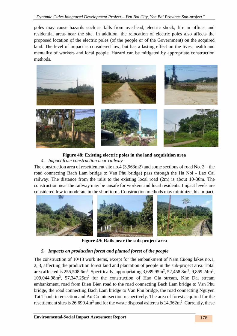
“Dynamic Cities Integtared Development Project – Yen Bai City, Yen Bai Province Sub-project”
Environmental-Social Impact Assessment Report 178
poles may cause hazards such as falls from overhead, electric shock, fire in offices and
residential areas near the site. In addition, the relocation of electric poles also affects the
proposed location of the electric poles (of the people or of the Government) on the acquired
land. The level of impact is considered low, but has a lasting effect on the lives, health and
mentality of workers and local people. Hazard can be mitigated by appropriate construction
methods.
Figure 48: Existing electric poles in the land acquisition area
4. Impact from construction near railway
The construction area of resettlement site no.4 (3,963m2) and some sections of road No. 2 – the
road connecting Bach Lam bridge to Van Phu bridge) pass through the Ha Noi - Lao Cai
railway. The distance from the rails to the existing local road (2m) is about 10-30m. The
construction near the railway may be unsafe for workers and local residents. Impact levels are
considered low to moderate in the short term. Construction methods may minimize this impact.
Figure 49: Rails near the sub-project area
5. Impacts on production forest and planted forest of the people
The construction of 10/13 work items, except for the embankment of Nam Cuong lakes no.1,
2, 3, affecting the production forest land and plantation of people in the sub-project area. Total
area affected is 255,508.6m2. Specifically, appropriating 3,689.95m2, 52,458.8m2, 9,869.24m2,
109,044.98m2, 57,347.25m2 for the construction of Hao Gia stream, Khe Dai stream
embankment, road from Dien Bien road to the road connecting Bach Lam bridge to Van Phu
bridge, the road connecting Bach Lam bridge to Van Phu bridge, the road connecting Nguyen
Tat Thanh intersection and Au Co intersection respectively. The area of forest acquired for the
resettlement sites is 26,690.4m2 and for the waste disposal asiterea is 14,362m2. Currently, these
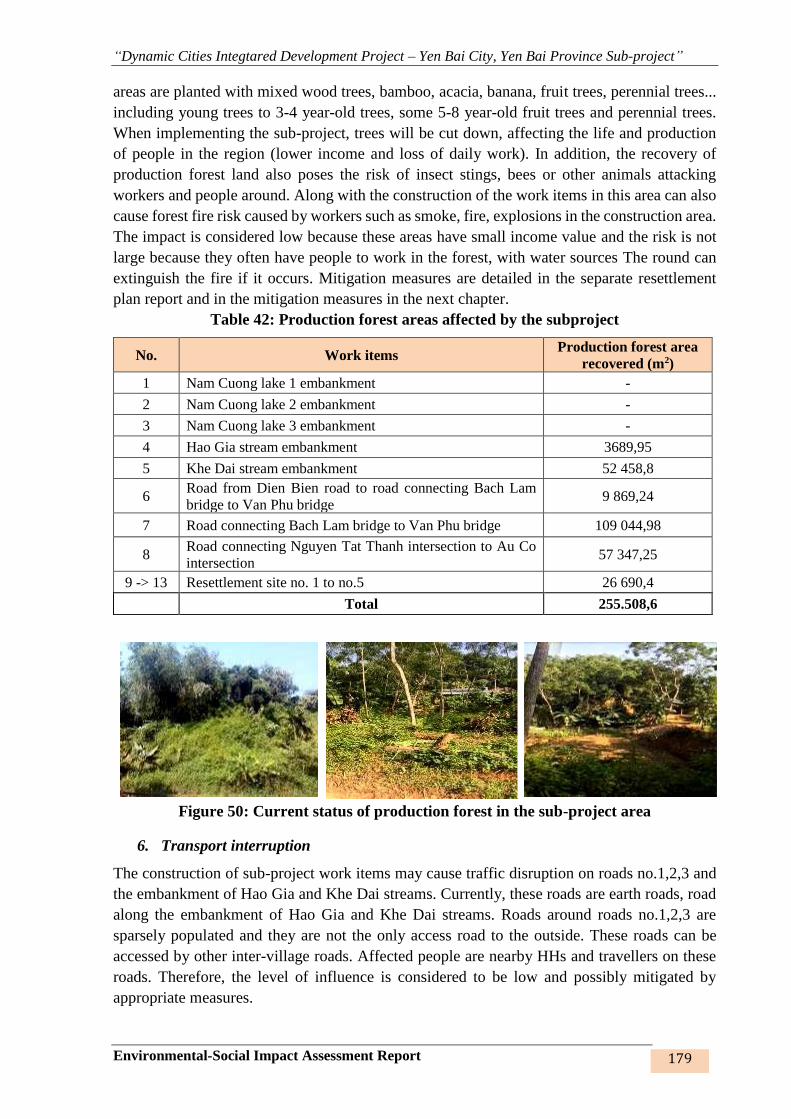
“Dynamic Cities Integtared Development Project – Yen Bai City, Yen Bai Province Sub-project”
Environmental-Social Impact Assessment Report 179
areas are planted with mixed wood trees, bamboo, acacia, banana, fruit trees, perennial trees...
including young trees to 3-4 year-old trees, some 5-8 year-old fruit trees and perennial trees.
When implementing the sub-project, trees will be cut down, affecting the life and production
of people in the region (lower income and loss of daily work). In addition, the recovery of
production forest land also poses the risk of insect stings, bees or other animals attacking
workers and people around. Along with the construction of the work items in this area can also
cause forest fire risk caused by workers such as smoke, fire, explosions in the construction area.
The impact is considered low because these areas have small income value and the risk is not
large because they often have people to work in the forest, with water sources The round can
extinguish the fire if it occurs. Mitigation measures are detailed in the separate resettlement
plan report and in the mitigation measures in the next chapter.
Table 42: Production forest areas affected by the subproject
No. Work items Production forest area
recovered (m2)
1 Nam Cuong lake 1 embankment -
2 Nam Cuong lake 2 embankment -
3 Nam Cuong lake 3 embankment -
4 Hao Gia stream embankment 3689,95
5 Khe Dai stream embankment 52 458,8
6 Road from Dien Bien road to road connecting Bach Lam
bridge to Van Phu bridge 9 869,24
7 Road connecting Bach Lam bridge to Van Phu bridge 109 044,98
8 Road connecting Nguyen Tat Thanh intersection to Au Co
intersection 57 347,25
9 -> 13 Resettlement site no. 1 to no.5 26 690,4
Total 255.508,6
Figure 50: Current status of production forest in the sub-project area
6. Transport interruption
The construction of sub-project work items may cause traffic disruption on roads no.1,2,3 and
the embankment of Hao Gia and Khe Dai streams. Currently, these roads are earth roads, road
along the embankment of Hao Gia and Khe Dai streams. Roads around roads no.1,2,3 are
sparsely populated and they are not the only access road to the outside. These roads can be
accessed by other inter-village roads. Affected people are nearby HHs and travellers on these
roads. Therefore, the level of influence is considered to be low and possibly mitigated by
appropriate measures.

“Dynamic Cities Integtared Development Project – Yen Bai City, Yen Bai Province Sub-project”
Environmental-Social Impact Assessment Report 180
Figure 51: Access roads (a, b) in the same sub-project area
7. Topographic elevation discrepacies between the construction works and houses and
structures
There exists a difference between the elevation of the works and that of the access road or the
structures and houses of HHs around the embankment of Nam Cuong lake, Hao Gia and Khe
Dai stream (5/13 works). This difference affects the access road to structures and houses of 735
people, thus affecting the living and traveling of HHs in the area. The topographic elevation
discrepancy may cause flooding in the area between the HH’s house and the sub-project’s
construction works. The impact is considered not great. Mitigation measures can be applied in
design and construction to limit this impact to the surrounding people.
Figure 54: Some images of tophographic elevation discrepancy
8. Local flooding during construction
a b
a b
Road no.2 – Entrance a
Road no.2 – Entrance b
b
Road no.3 – Entrance a Road no.3 – Entrance b
b

“Dynamic Cities Integtared Development Project – Yen Bai City, Yen Bai Province Sub-project”
Environmental-Social Impact Assessment Report 181
Construction on partitioned sections may create local flooding points at construction sites and
residential areas along the embankments, roads and resettlement sites of the sub-project during
rainy season (from April to September, especially in May, July, August). The main subjects of
impact are workers and surrounding HHs. The degree of flooding is considered low and can be
minimized by appropriate measures.
Figure 52: Some images of flooding in sub-project area
Sensitive areas on construction sites
Specific impacts at sensitive points are shown in the following table:
Table 59: Specific impacts in each sensitive area by the sub-project work items
No. Sensitive areas Description Impacts
Nam Cuong lakes 1,2,3 embankment
1.
Multi-purpose
communal house
- Located in Cau Den residential
group, at intersection of Le Chan
road and lake 2 walkway.
- The distance to the construction
site is about 40m, at TD14 pile.
- Number of attendants: 130 people
in the ward
- Frequency: once a week in the
evenings.
- Distance to construction site is
about 40m, at TD14 pile
- Dust, gas emissions
- Noise, vibration
- Wastewater
- Waste
- Restricted access to the
communal center
- Traffic accidents risk
- Activities of the local people
- Conflict with workers
Hao Gia embankment Khe Dai embankment
Road no.2 Road no.3
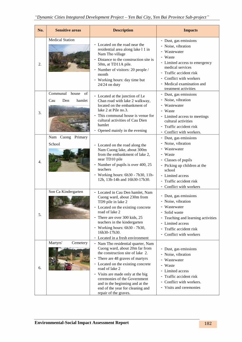
“Dynamic Cities Integtared Development Project – Yen Bai City, Yen Bai Province Sub-project”
Environmental-Social Impact Assessment Report 182
No. Sensitive areas Description Impacts
2.
Medical Station
- Located on the road near the
residential area along lake l 1 in
Nam Tho village
- Distance to the construction site is
50m, at TD11A pile.
- Number of visitors: 20 people /
month
- Working hours: day time but
24/24 on duty
- Dust, gas emissions
- Noise, vibration
- Wastewater
- Waste
- Limited access to emergency
medical services
- Traffic accident risk
- Conflict with workers
- Medical examination and
treatment activities
3.
Communal house of
Cau Den hamlet
- Located at the junction of Le
Chan road with lake 2 walkway,
located on the embankment of
lake 2 at Pile no.3.
- This communal house is venue for
cultural activities of Cau Dien
hamlet
- Opened mainly in the evening
- Dust, gas emissions
- Noise, vibration
- Wastewater
- Waste
- Limited access to meetings
cultural activities
- Traffic accident risk
- Conflict with workers.
4.
Nam Cuong Primary
School
- Located on the road along the
Nam Cuong lake, about 300m
from the embankment of lake 2,
near TD10 pile
- Number of pupils is over 400, 25
teachers
- Working hours: 6h30 - 7h30, 11h-
12h, 13h-14h and 16h30-17h30.
- Dust, gas emissions
- Noise, vibration
- Wastewater
- Waste
- Classes of pupils
- Picking up children at the
school
- Limited access
- Traffic accident risk
- Conflict with workers
5.
Son Ca Kindergarten
- Located in Cau Den hamlet, Nam
Cuong ward, about 230m from
TD9 pile in lake 2
- Located on the existing concrete
road of lake 2
- There are over 300 kids, 25
teachers in the kindergarten
- Working hours: 6h30 - 7h30,
16h30-17h30.
- Located in a fresh environment
- Dust, gas emissions
- Noise, vibration
- Wastewater
- Solid waste
- Teaching and learning activities
- Limited access
- Traffic accident risk
- Conflict with workers
6.
Martyrs' Cemetery
- Nam Tho residential quarter, Nam
Cuong ward, about 20m far from
the construction site of lake 2.
- There are 48 graves of martyrs
- Located on the existing concrete
road of lake 2
- Visits are made only at the big
ceremonies of the Government
and in the beginning and at the
end of the year for cleaning and
repair of the graves.
- Dust, gas emissions
- Noise, vibration
- Wastewater
- Waste
- Limited access
- Traffic accident risk
- Conflict with workers.
- Visits and ceremonies

“Dynamic Cities Integtared Development Project – Yen Bai City, Yen Bai Province Sub-project”
Environmental-Social Impact Assessment Report 183
No. Sensitive areas Description Impacts
7.
Mau Temple, Van
Thang pagoda and
temple
- Located on existing concrete piles
at TD3 and TD4 piles of lake 3
and lake 2
- Place of cultural activities of the
community during festival season,
especially in January of lunar
calendar
- Dust, gas emissions
- Noise, vibration
- Wastewater
- Waste
- Limited access
- Traffic accident risk
- Festival activities and holidays
in the year
8.
Nam Cuong residential
area
- Residential area in lake 3 (TD19,
TD5, TD7, TD14 piles); about 10
– 100m from the construction site
- Residential area in lake 2 (TD6 -
TD9, TD32 – TD36 piles); about
5 – 100m from the construction
site
- Residential area in lake 1 (TD13 –
TD17, TD31 and TD6A – TD19A
piles); about 5 – 50m from the
construction site
- Mainly affect the back of people’s
houses
- Dust, gas emissions
- Noise, vibration
- Wastewater
- Waste
- Limited access
- Traffic accident risk
- Conflict with workers.
- Living and production activities
of people
Hao Gia stream embankment
9.
Residential area in Hao
Gia stream
- Distance from the nearest house to
the site is 10-100m at T4, TD2 –
TD3, T40, T54, T123 – T125
piles
- Back of the residential area is
affected
- Yen Thinh market at Km 6 of Yen
Thinh ward, Yen Bai Newspaper
Office located on the embankment
of Hao Gia stream but the
embankment has been completed
to Khe Lap bridge
- Dust, gas emissions
- Noise, vibration
- Wastewater
- Waste
- Limited access
- Traffic accident risk
- Conflict with workers
- Living, business and production
activities of local people
Khe Dai stream embankment
10.
Yen Ninh Medical
Station
- In group 56, Yen Ninh ward,
400m from the construction site.
- Behind is the Khe Dai stream
embankment
- Number of visitors: about 30
persons/month
- Working hours: Office hours and
24/7 on duty.
- People live on both sides of the
embankment.
- Dust, gas emissions
- Noise, vibration
- Wastewater
- Waste
- Limited access to medical
services and emergency
treatment
- Traffic accident risk
- Conflict with workers
- Activities of patients, nurses,
doctors
11.
Minh Tan ward market - In 26 group, Minh Tan ward,
about 80m from the construction
site
- Number of regular visitors: 500
people
- Dust, gas emissions
- Noise, vibration
- Wastewater
- Waste
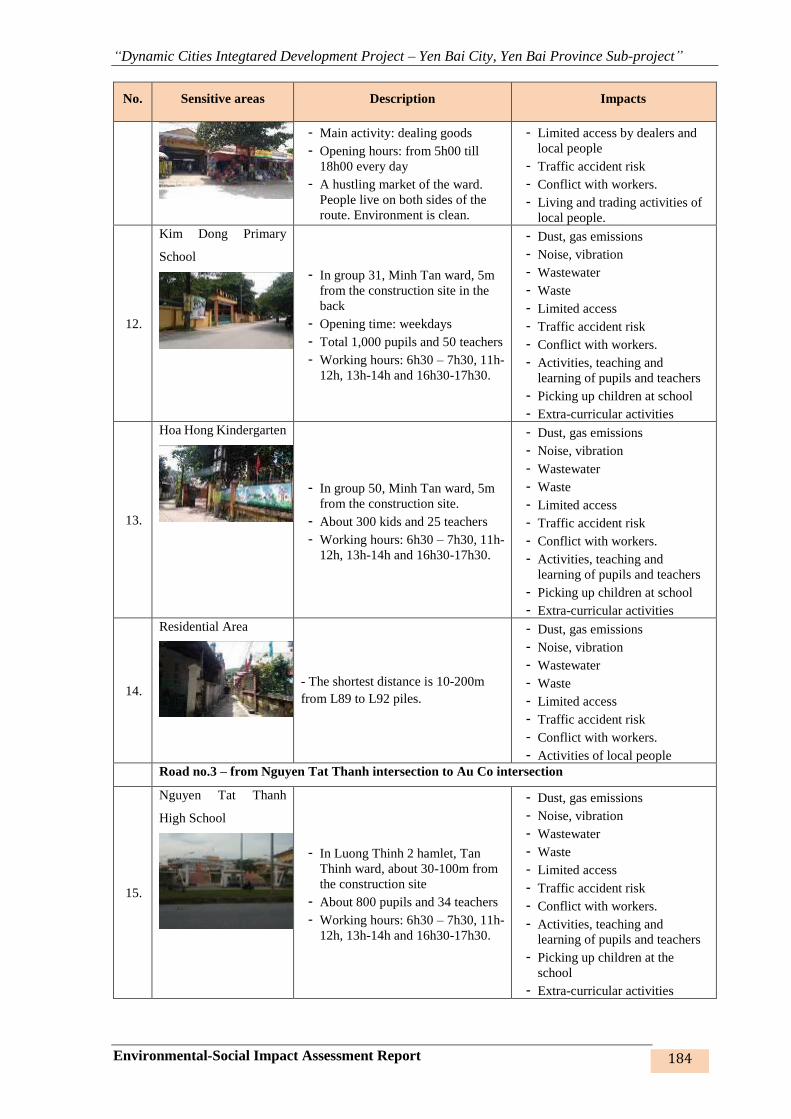
“Dynamic Cities Integtared Development Project – Yen Bai City, Yen Bai Province Sub-project”
Environmental-Social Impact Assessment Report 184
No. Sensitive areas Description Impacts
- Main activity: dealing goods
- Opening hours: from 5h00 till
18h00 every day
- A hustling market of the ward.
People live on both sides of the
route. Environment is clean.
- Limited access by dealers and
local people
- Traffic accident risk
- Conflict with workers.
- Living and trading activities of
local people.
12.
Kim Dong Primary
School
- In group 31, Minh Tan ward, 5m
from the construction site in the
back
- Opening time: weekdays
- Total 1,000 pupils and 50 teachers
- Working hours: 6h30 – 7h30, 11h-
12h, 13h-14h and 16h30-17h30.
- Dust, gas emissions
- Noise, vibration
- Wastewater
- Waste
- Limited access
- Traffic accident risk
- Conflict with workers.
- Activities, teaching and
learning of pupils and teachers
- Picking up children at school
- Extra-curricular activities
13.
Hoa Hong Kindergarten
- In group 50, Minh Tan ward, 5m
from the construction site.
- About 300 kids and 25 teachers
- Working hours: 6h30 – 7h30, 11h-
12h, 13h-14h and 16h30-17h30.
- Dust, gas emissions
- Noise, vibration
- Wastewater
- Waste
- Limited access
- Traffic accident risk
- Conflict with workers.
- Activities, teaching and
learning of pupils and teachers
- Picking up children at school
- Extra-curricular activities
14.
Residential Area
- The shortest distance is 10-200m
from L89 to L92 piles.
- Dust, gas emissions
- Noise, vibration
- Wastewater
- Waste
- Limited access
- Traffic accident risk
- Conflict with workers.
- Activities of local people
Road no.3 – from Nguyen Tat Thanh intersection to Au Co intersection
15.
Nguyen Tat Thanh
High School
- In Luong Thinh 2 hamlet, Tan
Thinh ward, about 30-100m from
the construction site
- About 800 pupils and 34 teachers
- Working hours: 6h30 – 7h30, 11h-
12h, 13h-14h and 16h30-17h30.
- Dust, gas emissions
- Noise, vibration
- Wastewater
- Waste
- Limited access
- Traffic accident risk
- Conflict with workers.
- Activities, teaching and
learning of pupils and teachers
- Picking up children at the
school
- Extra-curricular activities

“Dynamic Cities Integtared Development Project – Yen Bai City, Yen Bai Province Sub-project”
Environmental-Social Impact Assessment Report 185
No. Sensitive areas Description Impacts
16.
Nguyen Hue High
School
- In Luong Thinh 2 hamlet, Tan
Thinh ward
- About 300 pupils and 25 teachers
- Working hours: 6h30 – 7h30, 11h-
12h, 13h-14h and 16h30-17h30.
- Dust, gas emissions
- Noise, vibration
- Wastewater
- Waste
- Limited access
- Traffic accident risk
- Conflict with workers.
- Activities, teaching and
learning of pupils and teachers.
- Picking up children at the
school
- Extra-curricular activities
17.
Tan Thinh Church
- Thanh Hung 1 hamlet, Tan Thinh
ward, about 50m from the
construction site.
- Number of visitors: 200/630
parishioners
- Opening hours: 19h00 at
weekdays; 8h00 and 19h30 at
weekend
- Dust, emissions
- Noise, vibration
- Wastewater
- Waste
- Limited access
- Traffic accident risk
- Conflict with workers.
- Religious activities of the
community
18.
Nguyen Trai Primary
School
- In Luong Thinh 2 hamlet. Tan
Thinh ward
- About 300 pupils and 25 teachers
- Working hours: 6h30 – 7h30, 11h-
12h, 13h-14h and 16h30-17h30.
- Dust, gas emissions
- Noise, vibration
- Wastewater
- Waste
- Limited access
- Traffic accident risk
- Conflict with workers.
- Activities, teaching and
learning of pupils and teachers
- Picking up children at the
schools
- Extra-curricular activities
19.
Tan Thinh Medical
Station
- In Thanh Hung 3 hamlet, Tan
Thinh ward, about 400m from the
construction site
- Located on the construction road,
sparsely populated, 2.5-3m earth
road.
- Number of visitors: about 30
persons/ month,
- Working hours: office hours and
24/7 on duty.
- Dust, gas emissions
- Noise, vibration
- Wastewater
- Waste
- Limited access
- Traffic accident risk
- Conflict with workers.
- Medical examination and
treatment
20.
Residential Area
- Residential area (85, 66A, 49, ND9,
A42, A43, 80, 88, 76 piles), about 30
– 100m from the construction site
- Dust, gas emissions
- Noise, vibration
- Wastewater
- Waste
- Limited access
- Traffic accident risk
- Conflict with workers.
- Activities of local people
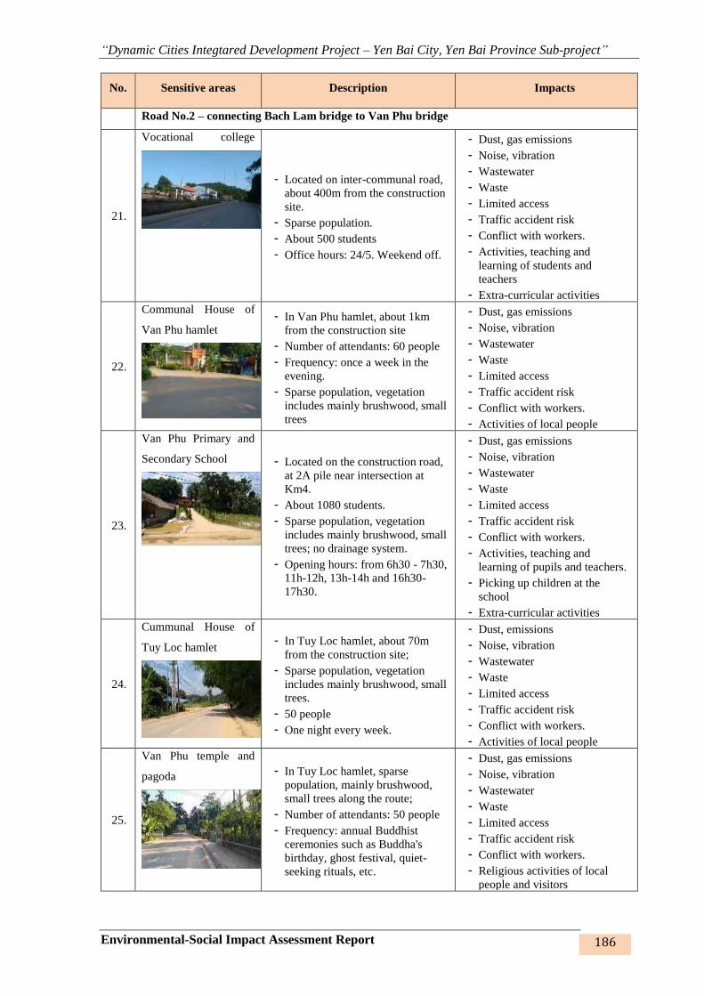
“Dynamic Cities Integtared Development Project – Yen Bai City, Yen Bai Province Sub-project”
Environmental-Social Impact Assessment Report 186
No. Sensitive areas Description Impacts
Road No.2 – connecting Bach Lam bridge to Van Phu bridge
21.
Vocational college
- Located on inter-communal road,
about 400m from the construction
site.
- Sparse population.
- About 500 students
- Office hours: 24/5. Weekend off.
- Dust, gas emissions
- Noise, vibration
- Wastewater
- Waste
- Limited access
- Traffic accident risk
- Conflict with workers.
- Activities, teaching and
learning of students and
teachers
- Extra-curricular activities
22.
Communal House of
Van Phu hamlet
- In Van Phu hamlet, about 1km
from the construction site
- Number of attendants: 60 people
- Frequency: once a week in the
evening.
- Sparse population, vegetation
includes mainly brushwood, small
trees
- Dust, gas emissions
- Noise, vibration
- Wastewater
- Waste
- Limited access
- Traffic accident risk
- Conflict with workers.
- Activities of local people
23.
Van Phu Primary and
Secondary School
- Located on the construction road,
at 2A pile near intersection at
Km4.
- About 1080 students.
- Sparse population, vegetation
includes mainly brushwood, small
trees; no drainage system.
- Opening hours: from 6h30 - 7h30,
11h-12h, 13h-14h and 16h30-
17h30.
- Dust, gas emissions
- Noise, vibration
- Wastewater
- Waste
- Limited access
- Traffic accident risk
- Conflict with workers.
- Activities, teaching and
learning of pupils and teachers.
- Picking up children at the
school
- Extra-curricular activities
24.
Cummunal House of
Tuy Loc hamlet
- In Tuy Loc hamlet, about 70m
from the construction site;
- Sparse population, vegetation
includes mainly brushwood, small
trees.
- 50 people
- One night every week.
- Dust, emissions
- Noise, vibration
- Wastewater
- Waste
- Limited access
- Traffic accident risk
- Conflict with workers.
- Activities of local people
25.
Van Phu temple and
pagoda
- In Tuy Loc hamlet, sparse
population, mainly brushwood,
small trees along the route;
- Number of attendants: 50 people
- Frequency: annual Buddhist
ceremonies such as Buddha's
birthday, ghost festival, quiet-
seeking rituals, etc.
- Dust, gas emissions
- Noise, vibration
- Wastewater
- Waste
- Limited access
- Traffic accident risk
- Conflict with workers.
- Religious activities of local
people and visitors
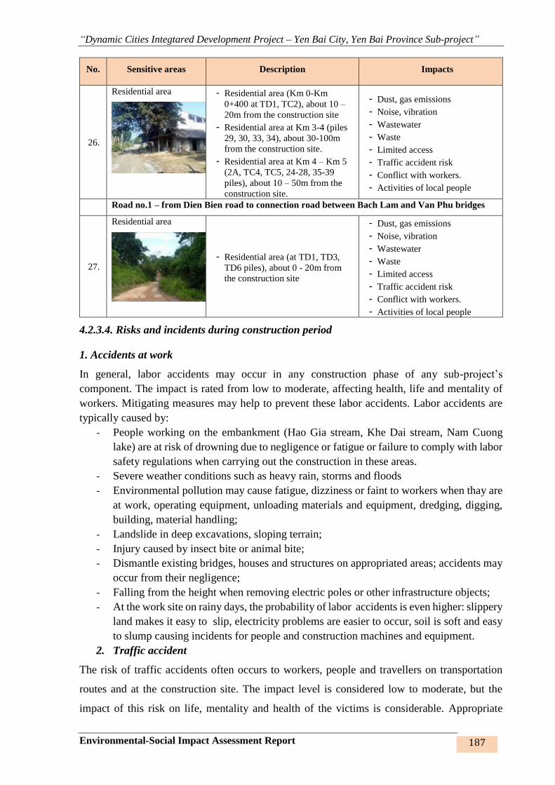
“Dynamic Cities Integtared Development Project – Yen Bai City, Yen Bai Province Sub-project”
Environmental-Social Impact Assessment Report 187
No. Sensitive areas Description Impacts
26.
Residential area
- Residential area (Km 0-Km
0+400 at TD1, TC2), about 10 –
20m from the construction site
- Residential area at Km 3-4 (piles
29, 30, 33, 34), about 30-100m
from the construction site.
- Residential area at Km 4 – Km 5
(2A, TC4, TC5, 24-28, 35-39
piles), about 10 – 50m from the
construction site.
- Dust, gas emissions
- Noise, vibration
- Wastewater
- Waste
- Limited access
- Traffic accident risk
- Conflict with workers.
- Activities of local people
Road no.1 – from Dien Bien road to connection road between Bach Lam and Van Phu bridges
27.
Residential area
- Residential area (at TD1, TD3,
TD6 piles), about 0 - 20m from
the construction site
- Dust, gas emissions
- Noise, vibration
- Wastewater
- Waste
- Limited access
- Traffic accident risk
- Conflict with workers.
- Activities of local people
4.2.3.4. Risks and incidents during construction period
1. Accidents at work
In general, labor accidents may occur in any construction phase of any sub-project’s
component. The impact is rated from low to moderate, affecting health, life and mentality of
workers. Mitigating measures may help to prevent these labor accidents. Labor accidents are
typically caused by:
- People working on the embankment (Hao Gia stream, Khe Dai stream, Nam Cuong
lake) are at risk of drowning due to negligence or fatigue or failure to comply with labor
safety regulations when carrying out the construction in these areas.
- Severe weather conditions such as heavy rain, storms and floods
- Environmental pollution may cause fatigue, dizziness or faint to workers when thay are
at work, operating equipment, unloading materials and equipment, dredging, digging,
building, material handling;
- Landslide in deep excavations, sloping terrain;
- Injury caused by insect bite or animal bite;
- Dismantle existing bridges, houses and structures on appropriated areas; accidents may
occur from their negligence;
- Falling from the height when removing electric poles or other infrastructure objects;
- At the work site on rainy days, the probability of labor accidents is even higher: slippery
land makes it easy to slip, electricity problems are easier to occur, soil is soft and easy
to slump causing incidents for people and construction machines and equipment.
2. Traffic accident
The risk of traffic accidents often occurs to workers, people and travellers on transportation
routes and at the construction site. The impact level is considered low to moderate, but the
impact of this risk on life, mentality and health of the victims is considerable. Appropriate
“Dynamic Cities Integtared Development Project – Yen Bai City, Yen Bai Province Sub-project”
Environmental-Social Impact Assessment Report 188
measures and internal and external construction regulations are necessary to limit these risks.
The risk of traffic accidents is principally attributable to:
- Overloading
- Over-speeding, lack of attention during travelling, especially when crossing residential
areas.
- Landslide, especially at the turns and intersections.
- During the construction of the sub-components, high traffic volume in the sub-project
area and poor quality of the roads may cause collisions to drivers and travellers.
- Accidents caused by crossing the railway near the consruction site of road no.2 and
resettlement site no.4 due to have not the construction and traffic signs at the
constructiion site or near railway location, no a qualified technical staff to supervise and
guidle construction activitives, during transportation, loading and unloading of
construciton materials and wastes near the railway...
3. Spilling of materials and chemicals, causing fire and electric shock
Dust, toxic chemicals, volatile gases from the spill of materias, fuel, chemical into the
construction site or on the transportation road will affect workers, people nearby and travellers,
causing fire, explosion, or even death or permanent injury. The level of impact is considered
low to moderate. Specific measures must be taken and prepared in the prevention and handling
of fuel and chemical spill, fire and electric shocks to minimize this impact. Incidents referred
to are:
- Gasoline and oil leak during storage will release volatile organic solvents to the
environment, which may cause fire and explosion at the fuel depot and strongly affects
the air quality in the surrounding area.
- The emission of these gases also increases the amount of greenhouse gases in the
atmosphere.
- In performing the repair works, worker’s inattentiveness (touching electric circuit,
smoke, start fire, etc.) may also cause fire and explosion.
- Fuel (such as diesel oil, gasoline) often stored at the site is a major source of fire and
explosion. Especially when these warehouses (or yards) are located near heaters or
where there are many people, vehicles passing by.
- A fire or explosion hazard may result from electrical faults.
- Electric shock and injury caused by worker’s negligence.
4. Uncorvering archaeological and historical relics or tombs
During the construction of the embankment pit, roads or resettlement sites, underground
archeological, historical relics or tombs may be revealed. These risks are considered low but
may occur. These archaeological discoveries, if prepared beforehand, will enable proactive
response and rapid reaction.
5. Other incidents
Apart from these incidents, other incidents may also occur during the construction process,
which will directly affect workers and people living in the surrounding areas. The level of
impact is low, but it may seriously affects the life, health and spirit of the victims, disrupt the
construction progress and puts pressure on the local medication and emergency care. Specific
measures might help prevent and mitigate impacts from this incident. The incidents include:
- Drown when falling into the culvert.

“Dynamic Cities Integtared Development Project – Yen Bai City, Yen Bai Province Sub-project”
Environmental-Social Impact Assessment Report 189
- Food poisoning affecting health and life of workers
- Outbreak of plagues at the construction site/ camps and in the residential area such as
dengue fever, HIV / AIDS, cholera, dysentery, skin diseases.
4.2.4. Impacts during the peration phase
4.2.4.1. Generic impacts
1. Air environment
13 work items of of Nam Cuong lake 1,2,3, Hao Gia stream, Khe Dai stream embankment,
roads no.1,2,3 and resettlement sites of the sub-projects when put into operation shall have no
major impact on the environment and the surrounding population. However, when these works
are put into operation, there will be gas and noise emissions from vehicles.
Noise and fumes from vehicles moving on the embankments and roads containing toxic
substances such as SO2, NO2, CO, CO2, THC, dust, etc. may affect the health of travellers and
some HHs in the vicinity; but because the quantity of these emissions is not very large and the
area is clear, the impact is minor. In particular:
Impacts from gas and dust
The operation of vehicles such as motorcycles, cars ... on the lines of Nam Cuong lake, Hao
Gia stream, Khe Dai stream embankments, roads no.1,2,3 and resettlement sites, the traffic flow
and the increased traffic density will generate gas emissions, including:
- Road vehicles are the main cause of high concentrations of CO, especially in the areas
where these vehicles pass.
- Hydrocarbon compounds (CmHn) derive from engine exhaust or evaporation of light
compounds from fuel. Under appropriate weather conditions, NO2, SO2... will be
transformed to secondary pollution: acid rain or fog on a wide range.
- The rise of NO2 increases rapidly as the temperature rises from the internal combustion
engine system, car is a typical example. Temperature in the car engine may reach 500 –
800oC.
Impact of noise and vibration
Noise and vibration are generated by increasing volume and frequency of transportation on
Nam Cuong, Hao Gia, Khe Dai embankments and road from Dien Bien road to the road from
Bach Lam bridge to Van Phu bridge, the road connecting Bach Lam bridge to Van Phu bridge,
the road from Nguyen Tat Thanh intersection to Au Co intersection, after they are completed
and brought into operation. Average noise levels for each type of vehicle are: motorcycle 60-
70dBA, 4-7 seat car 60-62dBA, bus, van with less than 50 seats 72-74dBA, light truck 75 -
88dBA. The overall noise level of the vehicles on the road depends on the noise level of each
vehicle, traffic volume, vehicle composition, road characteristics and surrounding terrain. Noise
level of the vehicle is often unstable and varies very rapidly at the time of operation. Vibration
level ranges from 62 to 76dBA from time to time.
However, in the beginning of operation phase of Hao Gia and Khe Dai stream embankments
and new roads, the transport volume is still low, so the noise level is considered negligible. In
the coming time, as the density and traffic volume increase, a specific plan with necessary
actions need to be drawn up to minimize noise and vibration in the sub-project area.
2. Impacts of wastewater
“Dynamic Cities Integtared Development Project – Yen Bai City, Yen Bai Province Sub-project”
Environmental-Social Impact Assessment Report 190
Wastewater is mainly rainwater that spills over the entire surface and sweeps pollutants from
vehicles and travellers. This runoff is collected at the pre-drainage outlet to the sump. As a
result, part of garbage and dust will be deposited and collected periodically. The impact of
wastewater is considered to be absent.
3. Impacts of garbage
Garbage is mainly generated by people living along the embankments and roads, travellers and
business entities along the embankmenst. In the locations and streets where waste collection
sites are arranged, these impacts are considered to be manageable.
4.2.4.2. Specific effects during operation
Once the sub-project items have been completed, they will change the former terrain of the
sites, creating a new landscape environment. However, the sub-project items will have some
impacts, such as (i) change of topography, change of flow, (ii) transport on new roads.
1. Impact from terrain and flow change
The areas of Hao Gia stream, Khe Dai stream and Nam Cuong lake embankments are often
severely eroded and subject to flood erosion with soft, loose and unstable structures. The
construction of embankments must demolish, change the land use purpose, fruit trees land,
forestry trees land, vacant land, etc., and change the landscape and terrain of the area. The
uneven terrain subject to frequent landslide and erosion will be changed into a flat, firm
embankment that is free from landslide and erosion; In addition, arrangement of drainage
ditches on both sides to the manholes of natural drainage ditches protects lives and properties
of people living along the embankments and provides walkway for local people as well as
increase the land value in the area.
The dredging of streams and lakes and construction of embankments along Hao Gia, Khe Dai
stream, around Nam Cuong lakes 1,2,3 as well as technical altenatives for embankment design
(slope, retaining wall on both sides) for construction of Hao Gia stream embankment (slope),
Khe Dai stream embankment (combining 2 methods for specific section), lake embankment
(slope), for direct reinforcement on the embankment. Specifically, the embankment structure
for a block is 11.7m, M200 reinforced concrete frame system, vertical beam spaced 2.45m
2mx2m size, horizontal beam 3.5m apart 0.3mx0.2m size, M200 concrete placed between
frames, concrete lining M100 thickness 5cm; Reinforced concrete beam, 0.5m high, 0.6m wide
with foot of embankment, M100 concrete wall lining, 5cm thick, anti-settlement joints
coinciding with those of the embankment at an interval of 11.7m, creating stability, reducing
water pressure on the embankment, preventing erosion from the impact of the flow and long-
term flooding. The technical design of the embankment as mentioned above will not change the
hydraulic flow regime, so it does not affect the current flow of Hao Gia and Khe Dai streams.
In addition, the completion of embankment works will facilitate the re-alignment, smooth flow,
improved drainage in the flood season and ensure the stability of the works.
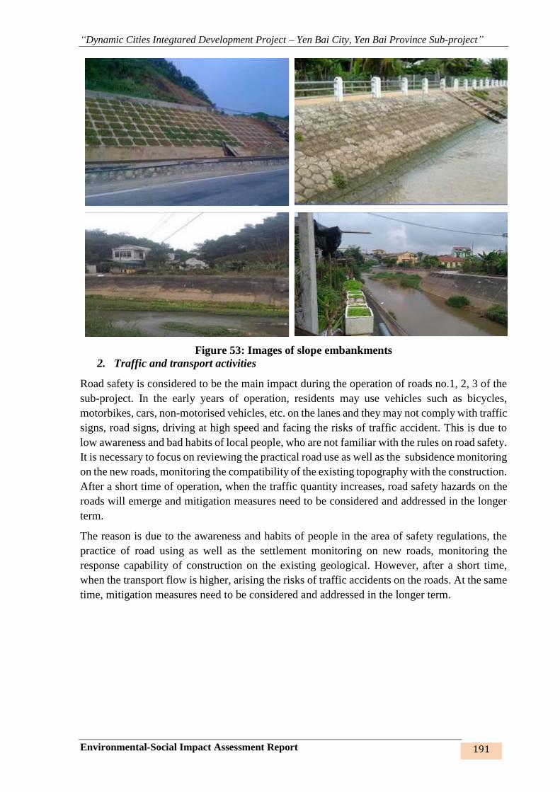
“Dynamic Cities Integtared Development Project – Yen Bai City, Yen Bai Province Sub-project”
Environmental-Social Impact Assessment Report 191
Figure 53: Images of slope embankments
2. Traffic and transport activities
Road safety is considered to be the main impact during the operation of roads no.1, 2, 3 of the
sub-project. In the early years of operation, residents may use vehicles such as bicycles,
motorbikes, cars, non-motorised vehicles, etc. on the lanes and they may not comply with traffic
signs, road signs, driving at high speed and facing the risks of traffic accident. This is due to
low awareness and bad habits of local people, who are not familiar with the rules on road safety.
It is necessary to focus on reviewing the practical road use as well as the subsidence monitoring
on the new roads, monitoring the compatibility of the existing topography with the construction.
After a short time of operation, when the traffic quantity increases, road safety hazards on the
roads will emerge and mitigation measures need to be considered and addressed in the longer
term.
The reason is due to the awareness and habits of people in the area of safety regulations, the
practice of road using as well as the settlement monitoring on new roads, monitoring the
response capability of construction on the existing geological. However, after a short time,
when the transport flow is higher, arising the risks of traffic accidents on the roads. At the same
time, mitigation measures need to be considered and addressed in the longer term.
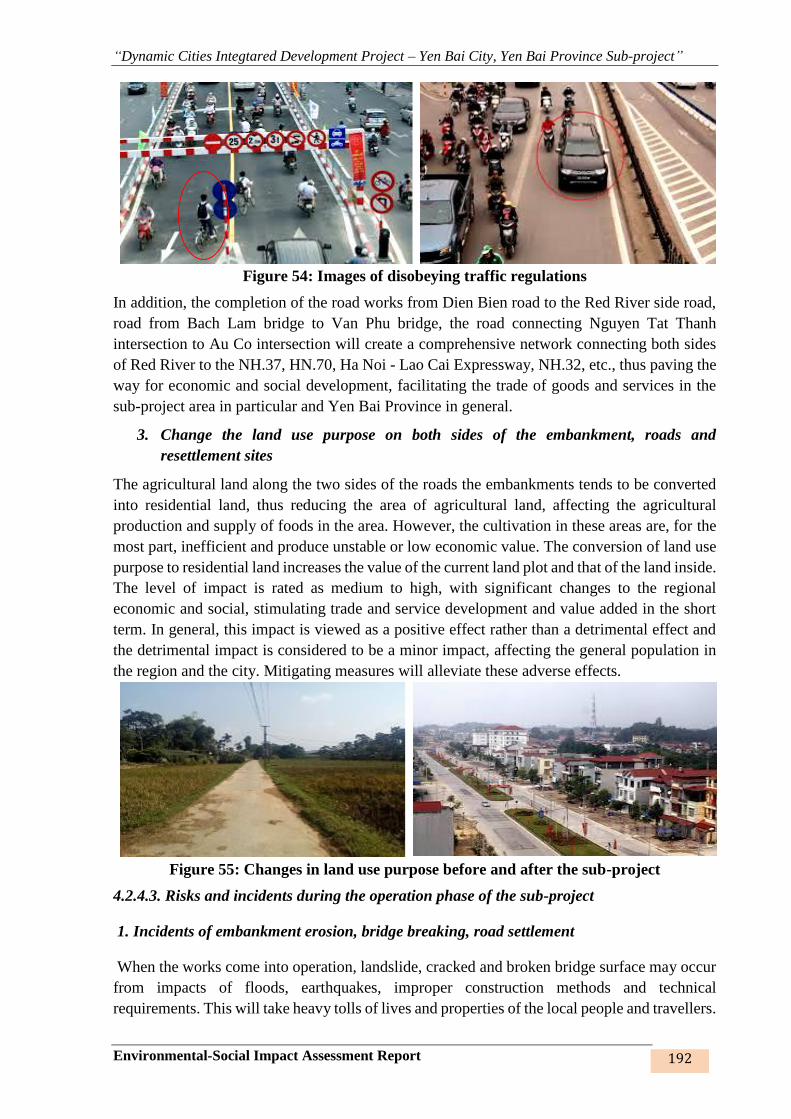
“Dynamic Cities Integtared Development Project – Yen Bai City, Yen Bai Province Sub-project”
Environmental-Social Impact Assessment Report 192
Figure 54: Images of disobeying traffic regulations
In addition, the completion of the road works from Dien Bien road to the Red River side road,
road from Bach Lam bridge to Van Phu bridge, the road connecting Nguyen Tat Thanh
intersection to Au Co intersection will create a comprehensive network connecting both sides
of Red River to the NH.37, HN.70, Ha Noi - Lao Cai Expressway, NH.32, etc., thus paving the
way for economic and social development, facilitating the trade of goods and services in the
sub-project area in particular and Yen Bai Province in general.
3. Change the land use purpose on both sides of the embankment, roads and
resettlement sites
The agricultural land along the two sides of the roads the embankments tends to be converted
into residential land, thus reducing the area of agricultural land, affecting the agricultural
production and supply of foods in the area. However, the cultivation in these areas are, for the
most part, inefficient and produce unstable or low economic value. The conversion of land use
purpose to residential land increases the value of the current land plot and that of the land inside.
The level of impact is rated as medium to high, with significant changes to the regional
economic and social, stimulating trade and service development and value added in the short
term. In general, this impact is viewed as a positive effect rather than a detrimental effect and
the detrimental impact is considered to be a minor impact, affecting the general population in
the region and the city. Mitigating measures will alleviate these adverse effects.
Figure 55: Changes in land use purpose before and after the sub-project
4.2.4.3. Risks and incidents during the operation phase of the sub-project
1. Incidents of embankment erosion, bridge breaking, road settlement
When the works come into operation, landslide, cracked and broken bridge surface may occur
from impacts of floods, earthquakes, improper construction methods and technical
requirements. This will take heavy tolls of lives and properties of the local people and travellers.
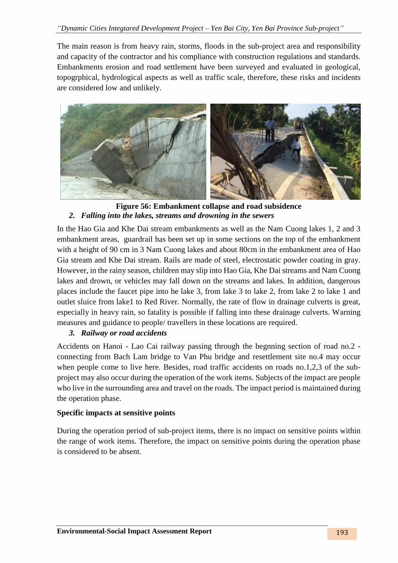
“Dynamic Cities Integtared Development Project – Yen Bai City, Yen Bai Province Sub-project”
Environmental-Social Impact Assessment Report 193
The main reason is from heavy rain, storms, floods in the sub-project area and responsibility
and capacity of the contractor and his compliance with construction regulations and standards.
Embankments erosion and road settlement have been surveyed and evaluated in geological,
topogrphical, hydrological aspects as well as traffic scale, therefore, these risks and incidents
are considered low and unlikely.
Figure 56: Embankment collapse and road subsidence
2. Falling into the lakes, streams and drowning in the sewers
In the Hao Gia and Khe Dai stream embankments as well as the Nam Cuong lakes 1, 2 and 3
embankment areas, guardrail has been set up in some sections on the top of the embankment
with a height of 90 cm in 3 Nam Cuong lakes and about 80cm in the embankment area of Hao
Gia stream and Khe Dai stream. Rails are made of steel, electrostatic powder coating in gray.
However, in the rainy season, children may slip into Hao Gia, Khe Dai streams and Nam Cuong
lakes and drown, or vehicles may fall down on the streams and lakes. In addition, dangerous
places include the faucet pipe into he lake 3, from lake 3 to lake 2, from lake 2 to lake 1 and
outlet sluice from lake1 to Red River. Normally, the rate of flow in drainage culverts is great,
especially in heavy rain, so fatality is possible if falling into these drainage culverts. Warning
measures and guidance to people/ travellers in these locations are required.
3. Railway or road accidents
Accidents on Hanoi - Lao Cai railway passing through the begnning section of road no.2 -
connecting from Bach Lam bridge to Van Phu bridge and resettlement site no.4 may occur
when people come to live here. Besides, road traffic accidents on roads no.1,2,3 of the sub-
project may also occur during the operation of the work items. Subjects of the impact are people
who live in the surrounding area and travel on the roads. The impact period is maintained during
the operation phase.
Specific impacts at sensitive points
During the operation period of sub-project items, there is no impact on sensitive points within
the range of work items. Therefore, the impact on sensitive points during the operation phase
is considered to be absent.

“Dynamic Cities Integtared Development Project – Yen Bai City, Yen Bai Province Sub-project”
Environmental-Social Impact Assessment Report 194
CHAPTER 5. MITIGATING MEASURES FOR NEGATIVE IMPACTS
This Chapter addresses mitigating measures for impacts from the sub-project’s components
arising from the design, land acquisition, construction and operation of the work items. Specific
mitigating measures are presented in the Environmental Codes of Practice (ECOPs), which will
be adopted to minimise the general impacts of the works.
Site-specific impacts require specific mitigating measures for both construction and operation
phases beside the general impacts defined in ECOPs.
5.1. MITIGATING MEASURES FOR THE DESIGNING PHASE
The Hao Gia stream, Khe Dai stream, Nam Cuong lakes 1, 2, 3 embankments, alignments and
land acquisition areas of the roads and resettlement sites are located along the streams and lakes
to avoid eviction of local people’s solidly built houses or otherwise adjust the alignment in such
a way as to minimise land acquisition by means of technical methods and construction methods
and at the same time ensure the smooth curve of the embankment lines without being broken
as well as the drainage capacity and erosion control.
The design of embankments, roads and resettlement sites has been calculated with due regard
to the master plan, socio-economic development plan, thorough surveys of hydraulic regime
(flood, flow regime, etc.), geological and topographical conditions and consultation with local
governments and people in the sub-project area to ensure the safety, convenience and efficiency
of the flood control embankment, flood drainage capacity of Hao Gia stream, Khe Dai stream,
Nam Cuong lakes, transport and communication demands and future road expansion.
The detailed design of the works covers all aspects of sludge and sediment management,
transportation of sludge in covered trucks and disposal of sludge and soil in previously prepared
locations.
As for the roads: designing road surface drainage system, arranging manholes along the roads
and standard traffic signs.
5.2. MITIGATION MEASURES FOR IMPACTS IN THE PRE-
CONSTRUCTION AND LAND ACQUISITION PHASES
5.2.1. Mitigation measure from bombs and mines
Bomb and mine clearance will be conducted immediately after completion of land acquisition
and before the demolition and levelling works. A military unit or another competent entity will
be contracted by the Project Owner to carry out the demining and all associated costs will be
included in the contractor’s construction costs.
Ensure safety distance and danger indicators for people during the execution of the works in
accordance with QCV 01:2012/BQP – National technical regulations for clearance of bomb,
mine and explosive and QCVN 02: 2008/BCT – National technical regulations for safe
transportation, storage, usage and disposal of industrial explosives.
5.2.2. Mitigation measure from from land acquisition and resettlement
Key issues in this period relate to compensation, subsidy and resettlement for people whose
land, house, income and properties are affected. The compensation and subsidy for land

“Dynamic Cities Integtared Development Project – Yen Bai City, Yen Bai Province Sub-project”
Environmental-Social Impact Assessment Report 195
acquisition will adhere to the sub-project’s resettlement plan26.
Resettlement plan (RP) of the sub-project has been compiled with a view to minimising the
impacts relating to land acquisition and resettlement with the main contents as elaborated
below:
- The Project Owner will coordinate with Yen Bai City Land Stock Development Center,
Province Department of Natural Resources and Environment, People’s Committee, City
Department of Natural Resources and Environment, relevant commune/ward People’s
Committees, HHs and individuals whose land and accompanying properties are located
in the eviction area to notify and guide the measurement and declaration of properties
in a detail-oriented, accurate, open manner and approve an appropriate compensation
plan.
- Propagandise to the AHs the compensation, subsidy and resettment policies of the sub-
project.
- Propagandise about the rights and responsibilities as prescribed by laws.
- Publicise the compensation rates for each type of loss to AHs.
- Publicise and notify the accurate compensation, subsidy and resettlement quantities (if
any) of each HH affected by the sub-project.
- Make compensation and subsidy payment to the right people and within the given time-
frame.
- Co-ordinate with local governments in the event of dispute to ensure successful land
acquisition.
- Removal of graves must be completed before commencement of the construction works
in compliance with the Resettlement Plan approved by World Bank.
- The selection of resettlement plan has been discussed with AHs to minimise impacts
and facilitate economic recovery. In the meantime, mitigation of temporary impacts
during the construction phase has also been considered and proposed in order to avoid
and minimise these impacts during the execution of the sub-project.
- The sub-project’s resettlement policy framework has been prepared in line with WB’s
policy on involuntary resettlement (OP.4.12) and Vietnamese Government’s
legislations on compensation, subsidy and resettlement upon land acquisiton by the
Government. The resettlement plan is in line with this policy framework.
- Livelihood recovery program is an important part of the compensation, subsidy and
resettlement plan with a view to stabilising livelihood and ensuring an equal or better
income for AHs. Livelihood recovery program will involve 679 eligible AHs based on
survey of support demands. The proposed activities include (i) vocational training; ii)
loan access, and iii) job creation.
- Consult with the local community and authorities to provide information and
consultancy on the resettlement plan and opportunities for engagement in resettlement
planning, performance and supervision.
26 This resettlement plan is presented in a separate report.
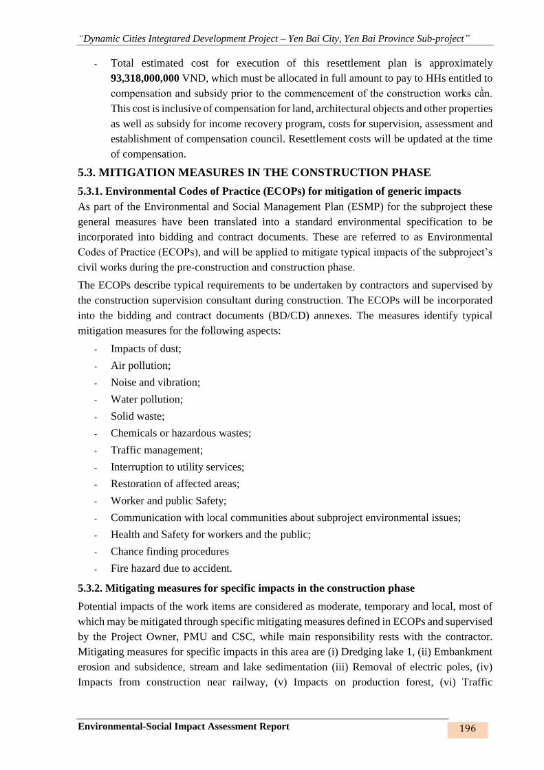
“Dynamic Cities Integtared Development Project – Yen Bai City, Yen Bai Province Sub-project”
Environmental-Social Impact Assessment Report 196
- Total estimated cost for execution of this resettlement plan is approximately
93,318,000,000 VND, which must be allocated in full amount to pay to HHs entitled to
compensation and subsidy prior to the commencement of the construction works cần.
This cost is inclusive of compensation for land, architectural objects and other properties
as well as subsidy for income recovery program, costs for supervision, assessment and
establishment of compensation council. Resettlement costs will be updated at the time
of compensation.
5.3. MITIGATION MEASURES IN THE CONSTRUCTION PHASE
5.3.1. Environmental Codes of Practice (ECOPs) for mitigation of generic impacts
As part of the Environmental and Social Management Plan (ESMP) for the subproject these
general measures have been translated into a standard environmental specification to be
incorporated into bidding and contract documents. These are referred to as Environmental
Codes of Practice (ECOPs), and will be applied to mitigate typical impacts of the subproject’s
civil works during the pre-construction and construction phase.
The ECOPs describe typical requirements to be undertaken by contractors and supervised by
the construction supervision consultant during construction. The ECOPs will be incorporated
into the bidding and contract documents (BD/CD) annexes. The measures identify typical
mitigation measures for the following aspects:
- Impacts of dust;
- Air pollution;
- Noise and vibration;
- Water pollution;
- Solid waste;
- Chemicals or hazardous wastes;
- Traffic management;
- Interruption to utility services;
- Restoration of affected areas;
- Worker and public Safety;
- Communication with local communities about subproject environmental issues;
- Health and Safety for workers and the public;
- Chance finding procedures
- Fire hazard due to accident.
5.3.2. Mitigating measures for specific impacts in the construction phase
Potential impacts of the work items are considered as moderate, temporary and local, most of
which may be mitigated through specific mitigating measures defined in ECOPs and supervised
by the Project Owner, PMU and CSC, while main responsibility rests with the contractor.
Mitigating measures for specific impacts in this area are (i) Dredging lake 1, (ii) Embankment
erosion and subsidence, stream and lake sedimentation (iii) Removal of electric poles, (iv)
Impacts from construction near railway, (v) Impacts on production forest, (vi) Traffic

“Dynamic Cities Integtared Development Project – Yen Bai City, Yen Bai Province Sub-project”
Environmental-Social Impact Assessment Report 197
disturbance, (vii) elevation discrepancy between the works and local people’s houses, (viii)
local flooding, and (ix) sensitive areas, as set out below:
(i) Mitigating impacts on the eco-system from dredging lake 1:
- Selecting season-based construction time for optimal construction conditions.
- Consulting with local people and authorities and the contractor (if any) for proper
planning.
- Setting up boards guiding the environment and landscape protection.
(ii) Mitigating impacts from embankment erosion and subsidence, lake and stream bed
sedimentation
- Arrange appropriate construction site along the embankment route, near the temporary
road connecting to the road to foundation pit.
- Arrange pile and stop plank fabricating and gathering yards and mixing machines in
such a way as to facilitate the supply and transportation of materials to the worksites.
- Arrange soil storage yards along the embankment routes to reduce the transportation
distance and to ensure smooth traffic and sites for adjacent work items.
- Select appropriate construction methods such as arrangement of machines to drive
bamboo piles in the embankment sections next to residential areas to avoid affecting
public works and houses of local people;
- Arrange rainwater drainage and solid waste settlement facilities on the construction sites
to reduce solid waste settlement; conduct regular dredging and monitoring, especially
in cases of rain and flood.
- Prepare concrete construction plan and make public the work schedule; works should
be prioritised in dry season.
- Closely watch weather forecast to carry out the works as per the plan and to the required
quality.
(iii) Mitigating impacts from displacement of electric poles
- Designate technical staff to instruct the removal of electric poles
- Personnel in charge must be qualified in professional skills as required by the works, be
trained and granted with electric safety certificate.
- Communicate information and exchange personnel and technical skills with the local
power supply agency for co-ordination.
- As for electricity grid, structures of electricity grids must be dismantled and recovered
and site be reinstated within 6 months from the separation of the electricity grid from
the electricity system.
- Remove and erect electric poles in accordance with the plan so that people are assured
of their safety.
- The owners of the works must make plan for management and dismantling of the power
works no longer in use.
(iv) Mitigating impacts from construction near railway
- Inform the railway management company of the construction activities and their
potential impacts such the risks of interference with the railway train schedule and
railway traffic safety, and the detail construction work schedule at least 01 month before
construction starts.
- Set up construction and traffic warning signs at the construction site.
- Set up barriers around the construction area to separate working area with the railway
(fence 2.5 m tall).
- Construct the sewer under passing the railway using safe tunneling method.
- Deploy a qualified technical staff to supervise construction activities near the railway.

“Dynamic Cities Integtared Development Project – Yen Bai City, Yen Bai Province Sub-project”
Environmental-Social Impact Assessment Report 198
- Only execute construction activities when there is no train schedule.
- Prohibit scattering of construction material and wastes near and on the railway.
- Deploy staff to guide the traffic during construction during transportation, loading and
unloading of construction materials and wastes, and during transporting materials
crossing the railway.
- Immediately collect any domestic wastes and construction spoils around and near the
railway and dispose in a designated site.
- Slow down when executing the works or transporting materials to allow time for
observation and give signals;
- When a train is coming or going to come, stop at 5m away from the rails as a train
travelling at a very high speed may take anyone nearby with it;
- Observe in both 2 directions and identify the utmost safety position; when a red/yellow
light is on or horn is sounded, stop and wait for the train to pass by.
- If crossing the rails, speed up to rush to the other side of the road.
- If the engine breaks down when crossing the raila and gets stuck there, if no train is
coming, ask passers by, police of railway officers for help.
- If a train is coming, get off the vehicle immediately without wasting time taking
anything in the vehicle and run away from the rails in the opposite direction with the
train to avoid objects and debris that may cause injury.
(v) Mitigating impacts on the production forest land:
- Specific measures are presented in the Resettlement Plan;
- To ensure that the compensation, subsidies and resettlement support rates are compliant
with the donor’s policies and the laws of Vietnam;
- Support the HHs to stabilise their livelihood and production through training courses
and occupation change if HH members are in the working ages.
- Firing, smoking or other fire hazards are strictly prohibited within the construction site
and the dominant forest production area;
- Adhere strictly to this collection, used for the project.
- Ensure the adequacy of land use allocations for the management, conservation, and
sustainable development of forests.
- Propagate people in forest protection and development.
(vi) Mitigating impacts from traffic disturbance
- Make detailed construction plans and make them public 2 weeks before the
construction;
- Completely finish a work item on the worksite before starting work on others;
- Arrange signposts and staff guiding traffic flows (if necessary);
- Refrain from transporting and unloading construction materials and waste materials on
the main routes in rush hours;
- Regulate the vehicles to and from the work sites and appropriate construction quantities;
(vii) Mitigating impacts from elevation discrepancy between the works and local
people’s house
- Study the existing terrain when surveying for detailed design preparation and select
suitable technical option
- Consult with local people and authorities in dealing with elevation discrepancy prior to
carrying out the works.
- Design the connection from the designed works to local people’s houses to ensure
entrance to house/works
- Support HHs with lower elevation than the design elevation to provide connection and
reduce elevation differences.
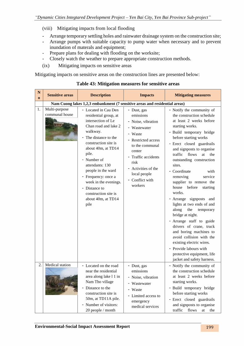
“Dynamic Cities Integtared Development Project – Yen Bai City, Yen Bai Province Sub-project”
Environmental-Social Impact Assessment Report 199
(viii) Mitigating impacts from local flooding
- Arrange temporary settling holes and rainwater drainage system on the construction site;
- Arrange pumps with suitable capacity to pump water when necessary and to prevent
inundation of materals and equipment;
- Prepare plans for dealing with flooding on the worksite;
- Closely watch the weather to prepare appropriate construction methods.
(ix) Mitigating impacts on sensitive areas
Mitigating impacts on sensitive areas on the construction lines are presented below:
Table 43: Mitigation measures for sensitive areas
N
o Sensitive areas Description Impacts Mitigating measures
Nam Cuong lakes 1,2,3 embankment (7 sensitive areas and residential areas)
1. Multi-purpose
communal house
- Located in Cau Den
residential group, at
intersection of Le
Chan road and lake 2
walkway.
- The distance to the
construction site is
about 40m, at TD14
pile.
- Number of
attendants: 130
people in the ward
- Frequency: once a
week in the evenings.
- Distance to
construction site is
about 40m, at TD14
pile
- Dust, gas
emissions
- Noise, vibration
- Wastewater
- Waste
- Restricted access
to the communal
center
- Traffic accidents
risk
- Activities of the
local people
- Conflict with
workers
- Notify the community of
the construction schedule
at least 2 weeks before
starting works.
- Build temporary bridge
before starting works
- Erect closed guardrails
and signposts to organise
traffic flows at the
outstanding construction
sites.
- Coordinate with
removing service
supplier to remove the
house before starting
works.
- Arrange signposts and
lights at two ends of and
along the temporary
bridge at night.
- Arrange staff to guide
drivers of crane, truck
and boring machines to
avoid collision with the
existing electric wires.
- Provide labours with
protective equipment, life
jacket and safety harness.
2. Medical station
- Located on the road
near the residential
area along lake l 1 in
Nam Tho village
- Distance to the
construction site is
50m, at TD11A pile.
- Number of visitors:
20 people / month
- Dust, gas
emissions
- Noise, vibration
- Wastewater
- Waste
- Limited access to
emergency
medical services
- Notify the community of
the construction schedule
at least 2 weeks before
starting works.
- Build temporary bridge
before starting works
- Erect closed guardrails
and signposts to organise
traffic flows at the
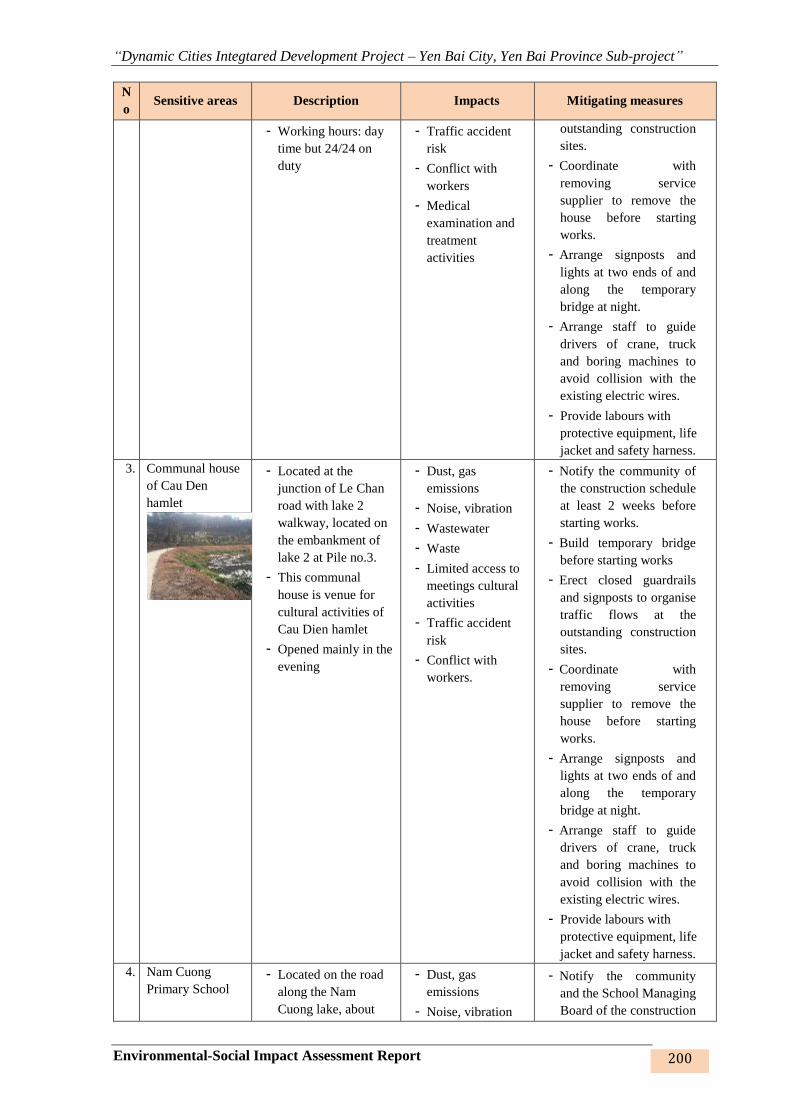
“Dynamic Cities Integtared Development Project – Yen Bai City, Yen Bai Province Sub-project”
Environmental-Social Impact Assessment Report 200
N
o Sensitive areas Description Impacts Mitigating measures
- Working hours: day
time but 24/24 on
duty
- Traffic accident
risk
- Conflict with
workers
- Medical
examination and
treatment
activities
outstanding construction
sites.
- Coordinate with
removing service
supplier to remove the
house before starting
works.
- Arrange signposts and
lights at two ends of and
along the temporary
bridge at night.
- Arrange staff to guide
drivers of crane, truck
and boring machines to
avoid collision with the
existing electric wires.
- Provide labours with
protective equipment, life
jacket and safety harness.
3. Communal house
of Cau Den
hamlet
- Located at the
junction of Le Chan
road with lake 2
walkway, located on
the embankment of
lake 2 at Pile no.3.
- This communal
house is venue for
cultural activities of
Cau Dien hamlet
- Opened mainly in the
evening
- Dust, gas
emissions
- Noise, vibration
- Wastewater
- Waste
- Limited access to
meetings cultural
activities
- Traffic accident
risk
- Conflict with
workers.
- Notify the community of
the construction schedule
at least 2 weeks before
starting works.
- Build temporary bridge
before starting works
- Erect closed guardrails
and signposts to organise
traffic flows at the
outstanding construction
sites.
- Coordinate with
removing service
supplier to remove the
house before starting
works.
- Arrange signposts and
lights at two ends of and
along the temporary
bridge at night.
- Arrange staff to guide
drivers of crane, truck
and boring machines to
avoid collision with the
existing electric wires.
- Provide labours with
protective equipment, life
jacket and safety harness.
4. Nam Cuong
Primary School - Located on the road
along the Nam
Cuong lake, about
- Dust, gas
emissions
- Noise, vibration
- Notify the community
and the School Managing
Board of the construction
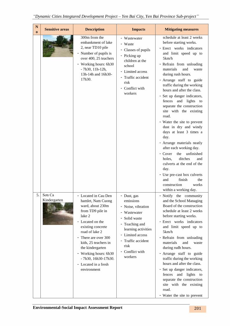
“Dynamic Cities Integtared Development Project – Yen Bai City, Yen Bai Province Sub-project”
Environmental-Social Impact Assessment Report 201
N
o Sensitive areas Description Impacts Mitigating measures
300m from the
embankment of lake
2, near TD10 pile
- Number of pupils is
over 400, 25 teachers
- Working hours: 6h30
- 7h30, 11h-12h,
13h-14h and 16h30-
17h30.
- Wastewater
- Waste
- Classes of pupils
- Picking up
children at the
school
- Limited access
- Traffic accident
risk
- Conflict with
workers
schedule at least 2 weeks
before starting works.
- Erect works indicators
and limit speed up to
5km/h
- Refrain from unloading
materials and waste
during rush hours.
- Arrange staff to guide
traffic during the working
hours and after the class.
- Set up danger indicators,
fences and lights to
separate the construction
site with the existing
road.
- Water the site to prevent
dust in dry and windy
days at least 3 times a
day.
- Arrange materials neatly
after each working day.
- Cover the unfinished
holes, ditches and
culverts at the end of the
day.
- Use pre-cast box culverts
and finish the
construction works
within a working day.
5. Sơn Ca
Kindergarten
- Located in Cau Den
hamlet, Nam Cuong
ward, about 230m
from TD9 pile in
lake 2
- Located on the
existing concrete
road of lake 2
- There are over 300
kids, 25 teachers in
the kindergarten
- Working hours: 6h30
- 7h30, 16h30-17h30.
- Located in a fresh
environment
- Dust, gas
emissions
- Noise, vibration
- Wastewater
- Solid waste
- Teaching and
learning activities
- Limited access
- Traffic accident
risk
- Conflict with
workers
- Notify the community
and the School Managing
Board of the construction
schedule at least 2 weeks
before starting works.
- Erect works indicators
and limit speed up to
5km/h
- Refrain from unloading
materials and waste
during rudh hours.
- Arrange staff to guide
traffic during the working
hours and after the class.
- Set up danger indicators,
fences and lights to
separate the construction
site with the existing
road.
- Water the site to prevent

“Dynamic Cities Integtared Development Project – Yen Bai City, Yen Bai Province Sub-project”
Environmental-Social Impact Assessment Report 202
N
o Sensitive areas Description Impacts Mitigating measures
dust in dry and windy
days at least 3 times a
day.
- Arrange materials neatly
after each working day.
- Cover the unfinished
holes, ditches and
culverts at the end of the
day.
- Use pre-cast box culverts
and finish the
construction works
within a working day.
6. Martyr’s
cemetery
- Nam Tho residential
quarter, Nam Cuong
ward, about 20m far
from the construction
site of lake 2.
- There are 48 graves
of martyrs
- Located on the
existing concrete
road of lake 2
- Visits are made only
at the big ceremonies
of the Government
and in the beginning
and at the end of the
year for cleaning and
repair of the graves.
- Dust, gas
emissions
- Noise, vibration
- Wastewater
- Waste
- Limited access
- Traffic accident
risk
- Conflict with
workers.
- Visits and
ceremonies
- Notify the community of
the construction schedule
at least 2 weeks before
starting works.
- Build temporary bridge
before starting works
- Erect closed guardrails
and signposts to organise
traffic flows at the
outstanding construction
sites.
- Coordinate with
removing service
supplier to remove the
house before starting
works.
- Arrange signposts and
lights at two ends of and
along the temporary
bridge at night.
- Arrange staff to guide
drivers of crane, truck
and boring machines to
avoid collision with the
existing electric wires.
- Provide labours with
protective equipment, life
jacket and safety harness.
7. Mau Temple, Van
Thang pagoda and
temple
- Located on existing
concrete piles at TD3
and TD4 piles of lake
3 and lake 2
- Place of cultural
activities of the
community during
festival season,
- Dust, gas
emissions
- Noise, vibration
- Wastewater
- Waste
- Limited access
- Traffic accident
risk
- Notify the community of
the construction schedule
at least 2 weeks before
starting works.
- Build temporary bridge
before starting works
- Erect closed guardrails
and signposts to organise
traffic flows at the
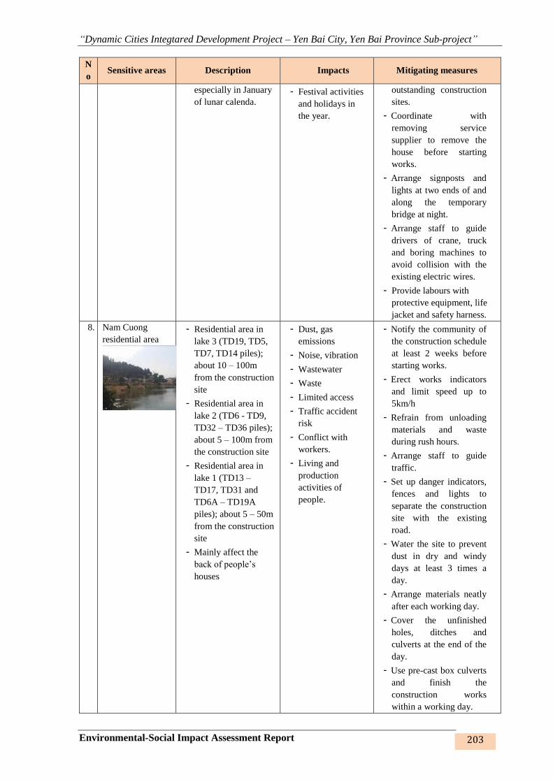
“Dynamic Cities Integtared Development Project – Yen Bai City, Yen Bai Province Sub-project”
Environmental-Social Impact Assessment Report 203
N
o Sensitive areas Description Impacts Mitigating measures
especially in January
of lunar calenda. - Festival activities
and holidays in
the year.
outstanding construction
sites.
- Coordinate with
removing service
supplier to remove the
house before starting
works.
- Arrange signposts and
lights at two ends of and
along the temporary
bridge at night.
- Arrange staff to guide
drivers of crane, truck
and boring machines to
avoid collision with the
existing electric wires.
- Provide labours with
protective equipment, life
jacket and safety harness.
8. Nam Cuong
residential area
- Residential area in
lake 3 (TD19, TD5,
TD7, TD14 piles);
about 10 – 100m
from the construction
site
- Residential area in
lake 2 (TD6 - TD9,
TD32 – TD36 piles);
about 5 – 100m from
the construction site
- Residential area in
lake 1 (TD13 –
TD17, TD31 and
TD6A – TD19A
piles); about 5 – 50m
from the construction
site
- Mainly affect the
back of people’s
houses
- Dust, gas
emissions
- Noise, vibration
- Wastewater
- Waste
- Limited access
- Traffic accident
risk
- Conflict with
workers.
- Living and
production
activities of
people.
- Notify the community of
the construction schedule
at least 2 weeks before
starting works.
- Erect works indicators
and limit speed up to
5km/h
- Refrain from unloading
materials and waste
during rush hours.
- Arrange staff to guide
traffic.
- Set up danger indicators,
fences and lights to
separate the construction
site with the existing
road.
- Water the site to prevent
dust in dry and windy
days at least 3 times a
day.
- Arrange materials neatly
after each working day.
- Cover the unfinished
holes, ditches and
culverts at the end of the
day.
- Use pre-cast box culverts
and finish the
construction works
within a working day.

“Dynamic Cities Integtared Development Project – Yen Bai City, Yen Bai Province Sub-project”
Environmental-Social Impact Assessment Report 204
N
o Sensitive areas Description Impacts Mitigating measures
Hao Gia stream embankment (residential area)
9. Hao Gia stream
residential area
- Distance from the
nearest house to the
site is 10-100m at
T4, TD2 – TD3, T40,
T54, T123 – T125
piles
- Back of the
residential area is
affected
- Yen Thinh market at
Km 6 of Yen Thinh
ward, Yen Bai
Newspaper Office
located on the
embankment of Hao
Gia stream but the
embankment has
been completed to
Khe Lap bridge
- Dust, gas
emissions
- Noise, vibration
- Wastewater
- Waste
- Limited access
- Traffic accident
risk
- Conflict with
workers
- Living, business
and production
activities of local
people
- Notify the community of
the construction schedule
at least 2 weeks before
starting works.
- Prepare construction plan
for carrying out the works
in dry season.
- Provide temporary
entrances when executing
culverts that may obstruct
entrance to houses.
- Build temporary
longitudinal drainage
canals on two sides of the
road.
- Periodically clear the
drainage ditches and
canals.
- Clear all waste and
materials everyday and
not to place them next to
the existing road.
- Set up danger indicators,
fences and lights to
separate the construction
site with the existing
road. Arrange lights at
night.
- Cover and place danger
indicators at unfinished
and uncovered holes and
ditches.
- Water the site during the
construction process at
least twice/day.
Khe Dai stream embankment (4 sensitive areas and residential area )
10. Yen Ninh ward
medical station
- In group 56, Yen
Ninh ward, 400m
from the construction
site.
- Behind is the Khe
Dai stream
embankment
- Number of visitors:
about 30
persons/month
- Working hours:
Office hours and
24/7 on duty.
- Dust, gas
emissions
- Noise, vibration
- Wastewater
- Waste
- Limited access to
medical services
and emergency
treatment
- Traffic accident
risk
- Notify the community of
the construction schedule
at least 2 weeks before
starting works.
- Erect closed guardrails
and signposts to organise
traffic flows at the
outstanding construction
sites.
- Coordinate with
removing service
supplier to remove the
house before starting
“Dynamic Cities Integtared Development Project – Yen Bai City, Yen Bai Province Sub-project”
Environmental-Social Impact Assessment Report 205
N
o Sensitive areas Description Impacts Mitigating measures
- People live on both
sides of the
embankment.
- Conflict with
workers
- Activities of
patients, nurses,
doctors
works.
- Arrange signposts and
lights at two ends of and
along the temporary
bridge at night.
11. Minh Tan ward
market
- In 26 group, Minh
Tan ward, about 80m
from the construction
site
- Number of regular
visitors: 500 people
- Main activity:
dealing goods
- Opening hours: from
5h00 till 18h00 every
day
- A hustling market of
the ward. People live
on both sides of the
route. Environment is
clean.
- Dust, gas
emissions
- Noise, vibration
- Wastewater
- Waste
- Limited access by
dealers and local
people
- Traffic accident
risk
- Conflict with
workers.
- Living and trading
activities of local
people.
- Notify the community of
the construction schedule
at least 2 weeks before
starting works.
- Erect closed guardrails
and signposts to organise
traffic flows at the
outstanding construction
sites.
- Coordinate with
removing service
supplier to remove the
house before starting
works.
12. Kim Dong
Primary School
- In group 31, Minh
Tan ward, 5m from
the construction site
in the back
- Opening time:
weekdays
- Total 1,000 pupils
and 50 teachers
- Working hours: 6h30
– 7h30, 11h-12h,
13h-14h and 16h30-
17h30.
- Dust, gas
emissions
- Noise, vibration
- Wastewater
- Waste
- Limited access
- Traffic accident
risk
- Conflict with
workers.
- Activities,
teaching and
learning of pupils
and teachers
- Picking up
children at school
- Extra-curricular
activities
- Notify the community
and the School Managing
Board of the construction
schedule at least 2 weeks
before starting works.
- Erect works indicators
and limit speed up to
5km/h
- Refrain from unloading
materials and waste
during rush hours.
- Arrange staff to guide
traffic during the working
hours and after the class.
- Set up danger indicators,
fences and lights to
separate the construction
site with the existing
road.
- Water the site to prevent
dust in dry and windy
days at least 3 times a
day.
- Arrange materials neatly
after each working day.
- Cover the unfinished
holes, ditches and
culverts at the end of the
“Dynamic Cities Integtared Development Project – Yen Bai City, Yen Bai Province Sub-project”
Environmental-Social Impact Assessment Report 206
N
o Sensitive areas Description Impacts Mitigating measures
day.
- Use pre-cast box culverts
and finish the
construction works
within a working day.
13. Hoa Hong
Kindergarten
- In group 50, Minh
Tan ward, 5m from
the construction site.
- About 300 kids and
25 teachers
- Working hours: 6h30
– 7h30, 11h-12h,
13h-14h and 16h30-
17h30.
- Dust, gas
emissions
- Noise, vibration
- Wastewater
- Waste
- Limited access
- Traffic accident
risk
- Conflict with
workers.
- Activities,
teaching and
learning of pupils
and teachers
- Picking up
children at school
- Extra-curricular
activities
- Notify the community
and the School Managing
Board of the construction
schedule at least 2 weeks
before starting works.
- Erect works indicators
and limit speed up to
5km/h
- Refrain from unloading
materials and waste
during rush hours.
- Arrange staff to guide
traffic during the working
hours and after the class.
- Set up danger indicators,
fences and lights to
separate the construction
site with the existing
road.
- Water the site to prevent
dust in dry and windy
days at least 3 times a
day.
- Arrange materials neatly
after each working day.
- Cover the unfinished
holes, ditches and
culverts at the end of the
day.
- Use pre-cast box culverts
and finish the
construction works
within a working day.
14. Residential area
- The shortest distance is
10-200m from L89 to
L92 piles.
- Dust, gas
emissions
- Noise, vibration
- Wastewater
- Waste
- Limited access
- Traffic accident
risk
- Conflict with
workers.
- Notify the community of
the construction schedule
at least 2 weeks before
starting works.
- Prepare construction plan
for carrying out the works
in dry season.
- Provide temporary
entrances when executing
culverts that may obstruct
entrance to houses.
- Build temporary

“Dynamic Cities Integtared Development Project – Yen Bai City, Yen Bai Province Sub-project”
Environmental-Social Impact Assessment Report 207
N
o Sensitive areas Description Impacts Mitigating measures
- Activities of local
people
longitudinal drainage
canals on two sides of the
road.
- Periodically clear the
drainage ditches and
canals.
- Clear all waste and
materials everyday and
not to place them next to
the existing road.
- Set up danger indicators,
fences and lights to
separate the construction
site with the existing
road. Arrange lights at
night.
- Cover and place danger
indicators at unfinished
and uncovered holes and
ditches.
- Water the site during the
construction process at
least twice/day.
Road no. 3 – from Nguyen Tat Thanh intersection to Au Co intersection
(5 sensitive areas and residential area)
15. Nguyen Tat
Thanh High
School
- In Luong Thinh 2
hamlet, Tan Thinh
ward, about 30-100m
from the construction
site
- About 800 pupils and
34 teachers
- Working hours: 6h30
– 7h30, 11h-12h,
13h-14h and 16h30-
17h30.
- Dust, gas
emissions
- Noise, vibration
- Wastewater
- Waste
- Limited access
- Traffic accident
risk
- Conflict with
workers.
- Activities,
teaching and
learning of pupils
and teachers
- Picking up
children at the
school
- Extra-curricular
activities
- Notify the community
and the School Managing
Board of the construction
schedule at least 2 weeks
before starting works.
- Erect works indicators
and limit speed up to
5km/h
- Refrain from unloading
materials and waste
during rush hours.
- Arrange staff to guide
traffic during the working
hours and after the class.
- Set up danger indicators,
fences and lights to
separate the construction
site with the existing
road.
- Water the site to prevent
dust in dry and windy
days at least 3 times a
day.
- Arrange materials neatly
“Dynamic Cities Integtared Development Project – Yen Bai City, Yen Bai Province Sub-project”
Environmental-Social Impact Assessment Report 208
N
o Sensitive areas Description Impacts Mitigating measures
after each working day.
- Cover the unfinished
holes, ditches and
culverts at the end of the
day.
- Use pre-cast box culverts
and finish the
construction works
within a working day.
16. Nguyen Hue
High School
- In Luong Thinh 2
hamlet, Tan Thinh
ward
- About 300 pupils and
25 teachers
- Working hours: 6h30
– 7h30, 11h-12h,
13h-14h and 16h30-
17h30.
- Dust, gas
emissions
- Noise, vibration
- Wastewater
- Waste
- Limited access
- Traffic accident
risk
- Conflict with
workers.
- Activities,
teaching and
learning of pupils
and teachers.
- Picking up
children at the
school
- Extra-curricular
activities
- Notify the community
and the School Managing
Board of the construction
schedule at least 2 weeks
before starting works.
- Erect works indicators
and limit speed up to
5km/h
- Refrain from unloading
materials and waste
during rush hours.
- Arrange staff to guide
traffic during the working
hours and after the class.
- Set up danger indicators,
fences and lights to
separate the construction
site with the existing
road.
- Water the site to prevent
dust in dry and windy
days at least 3 times a
day.
- Arrange materials neatly
after each working day.
- Cover the unfinished
holes, ditches and
culverts at the end of the
day.
17. Tan Thinh church
- Thanh Hung 1
hamlet, Tan Thinh
ward, about 50m
from the construction
site.
- Number of visitors:
200/630 parishioners
- Opening hours:
19h00 at weekdays;
8h00 and 19h30 at
weekend
- Dust, emissions
- Noise, vibration
- Wastewater
- Waste
- Limited access
- Traffic accident
risk
- Conflict with
workers.
- Notify the community of
the construction schedule
at least 2 weeks before
starting works.
- Not to place construction
materials and waste
materials within a range
of 20m from the church.
- Water the site to prevent
dust twice/day in front of
the church.
- Clear wast materials after

“Dynamic Cities Integtared Development Project – Yen Bai City, Yen Bai Province Sub-project”
Environmental-Social Impact Assessment Report 209
N
o Sensitive areas Description Impacts Mitigating measures
- Religious
activities of the
community
each working day.
- Refrain from carrying out
the works during service
time (weekday evenings,
weekend afternoons).
18. Nguyen Trai
Primary School
- In Luong Thinh 2
hamlet. Tan Thinh
ward
- About 300 pupils and
25 teachers
- Working hours: 6h30
– 7h30, 11h-12h,
13h-14h and 16h30-
17h30.
- Dust, gas
emissions
- Noise, vibration
- Wastewater
- Waste
- Limited access
- Traffic accident
risk
- Conflict with
workers.
- Activities,
teaching and
learning of pupils
and teachers
- Picking up
children at the
schools
- Extra-curricular
activities
- Notify the community
and the School Managing
Board of the construction
schedule at least 2 weeks
before starting works.
- Erect works indicators
and limit speed up to
5km/h
- Refrain from unloading
materials and waste
during rush hours.
- Arrange staff to guide
traffic during the working
hours and after the class.
- Set up danger indicators,
fences and lights to
separate the construction
site with the existing
road.
- Water the site to prevent
dust in dry and windy
days at least 3 times a
day.
- Arrange materials neatly
after each working day.
- Cover the unfinished
holes, ditches and
culverts at the end of the
day.
- Use pre-cast box culverts
and finish the
construction works
within a working day.
19. Tan Thinh
commune medical
station
- In Thanh Hung 3
hamlet, Tan Thinh
ward, about 400m
from the construction
site
- Located on the
construction road,
sparsely populated,
2.5-3m earth road.
- Number of visitors:
about 30 persons/
month,
- Dust, gas
emissions
- Noise, vibration
- Wastewater
- Waste
- Limited access
- Traffic accident
risk
- Conflict with
workers.
- Notify the community of
the construction schedule
at least 2 weeks before
starting works.
- Erect closed guardrails
and signposts to organise
traffic flows at the
outstanding construction
sites.
- Coordinate with
removing service
supplier to remove the
“Dynamic Cities Integtared Development Project – Yen Bai City, Yen Bai Province Sub-project”
Environmental-Social Impact Assessment Report 210
N
o Sensitive areas Description Impacts Mitigating measures
- Working hours:
office hours and 24/7
on duty.
- Medical
examination and
treatment
house before starting
works.
- Arrange signposts and
lights at two ends of and
along the temporary
bridge at night.
20. Residential area
- Residential area (85,
66A, 49, ND9, A42,
A43, 80, 88, 76 piles),
about 30 – 100m from
the construction site
- Dust, gas
emissions
- Noise, vibration
- Wastewater
- Waste
- Limited access
- Traffic accident
risk
- Conflict with
workers.
- Activities of local
people
- Notify the community of
the construction schedule
at least 2 weeks before
starting works.
- Prepare construction plan
for carrying out the works
in dry season.
- Provide temporary
entrances when executing
culverts that may obstruct
entrance to houses.
- Build temporary
longitudinal drainage
canals on two sides of the
road.
- Periodically clear the
drainage ditches and
canals.
- Clear all waste and
materials everyday and
not to place them next to
the existing road.
- Set up danger indicators,
fences and lights to
separate the construction
site with the existing
road. Arrange lights at
night.
- Cover and place danger
indicators at unfinished
and uncovered holes and
ditches.
- Water the site during the
construction process at
least twice/day.
Road No.2 – connecting Bach Lam bridge to Van Phu bridge
21. Vocational
College
- Located on inter-
communal road,
about 400m from the
construction site.
- Sparse population.
- About 500 students
- Dust, gas
emissions
- Noise, vibration
- Wastewater
- Waste
- Limited access
- Notify the community
and the School Managing
Board of the construction
schedule at least 2 weeks
before starting works.
- Erect works indicators
and limit speed up to

“Dynamic Cities Integtared Development Project – Yen Bai City, Yen Bai Province Sub-project”
Environmental-Social Impact Assessment Report 211
N
o Sensitive areas Description Impacts Mitigating measures
- Office hours: 24/5.
Weekend off.
- Traffic accident
risk
- Conflict with
workers.
- Activities,
teaching and
learning of
students and
teachers
- Extra-curricular
activities
5km/h
- Refrain from unloading
materials and waste
during rush hours.
- Arrange staff to guide
traffic during the working
hours and after the class.
- Set up danger indicators,
fences and lights to
separate the construction
site with the existing
road.
- Water the site to prevent
dust in dry and windy
days at least 3 times a
day.
- Arrange materials neatly
after each working day.
- Cover the unfinished
holes, ditches and
culverts at the end of the
day.
- Use pre-cast box culverts
and finish the
construction works
within a working day.
22. Van Phu
hamlet
communal house
- In Van Phu hamlet,
about 1km from the
construction site
- Number of
attendants: 60 people
- Frequency: once a
week in the evening.
- Sparse population,
vegetation includes
mainly brushwood,
small trees
- Dust, gas
emissions
- Noise, vibration
- Wastewater
- Waste
- Limited access
- Traffic accident
risk
- Conflict with
workers.
- Activities of local
people
- Notify the community of
the construction schedule
at least 2 weeks before
starting works.
- Erect closed guardrails
and signposts to organise
traffic flows at the
outstanding construction
sites.
- Coordinate with
removing service
supplier to remove the
house before starting
works.
23. Van Phu Primary
and Secondary
School
- Located on the
construction road, at
2A pile near
intersection at Km4.
- About 1080 students.
- Sparse population,
vegetation includes
mainly brushwood,
- Dust, gas
emissions
- Noise, vibration
- Wastewater
- Waste
- Limited access
- Traffic accident
risk
- Notify the community
and the School Managing
Board of the construction
schedule at least 2 weeks
before starting works.
- Erect works indicators
and limit speed up to
5km/h
- Refrain from unloading
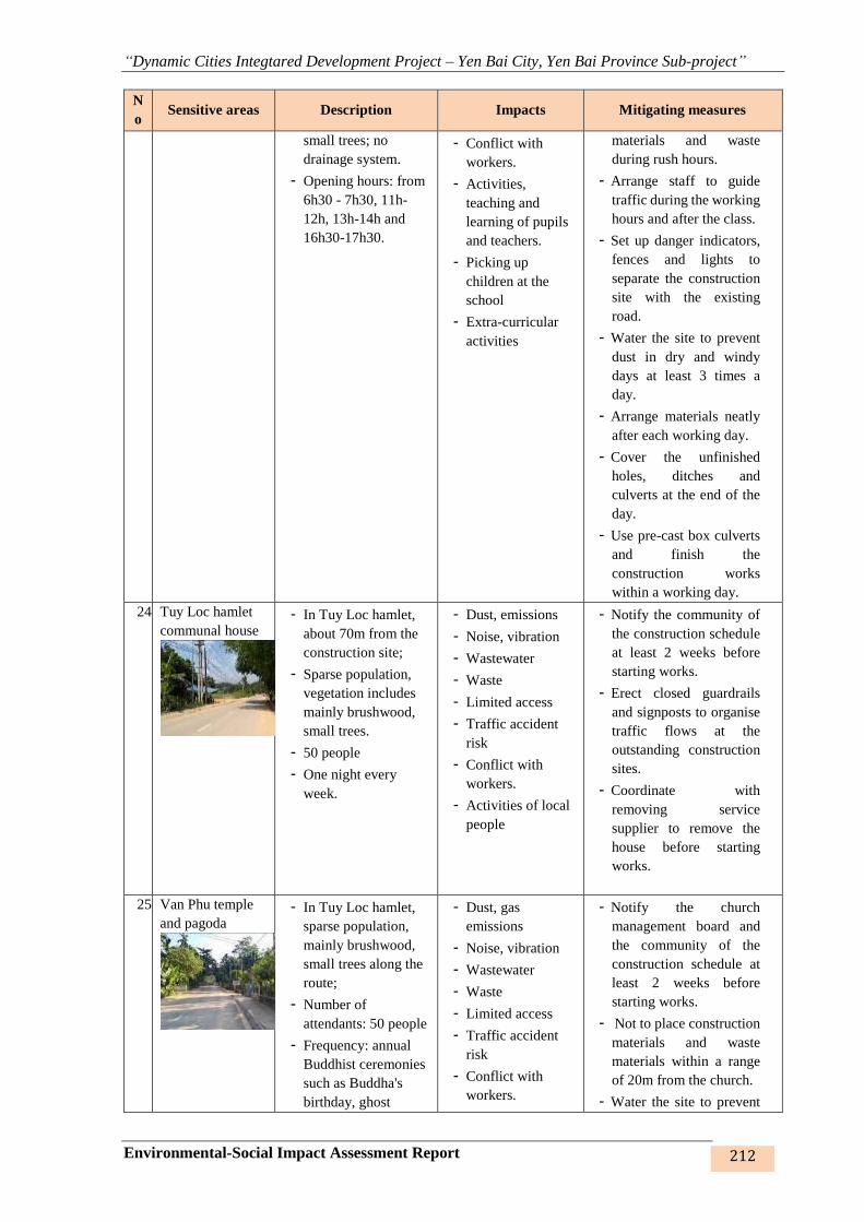
“Dynamic Cities Integtared Development Project – Yen Bai City, Yen Bai Province Sub-project”
Environmental-Social Impact Assessment Report 212
N
o Sensitive areas Description Impacts Mitigating measures
small trees; no
drainage system.
- Opening hours: from
6h30 - 7h30, 11h-
12h, 13h-14h and
16h30-17h30.
- Conflict with
workers.
- Activities,
teaching and
learning of pupils
and teachers.
- Picking up
children at the
school
- Extra-curricular
activities
materials and waste
during rush hours.
- Arrange staff to guide
traffic during the working
hours and after the class.
- Set up danger indicators,
fences and lights to
separate the construction
site with the existing
road.
- Water the site to prevent
dust in dry and windy
days at least 3 times a
day.
- Arrange materials neatly
after each working day.
- Cover the unfinished
holes, ditches and
culverts at the end of the
day.
- Use pre-cast box culverts
and finish the
construction works
within a working day.
24. Tuy Loc hamlet
communal house
- In Tuy Loc hamlet,
about 70m from the
construction site;
- Sparse population,
vegetation includes
mainly brushwood,
small trees.
- 50 people
- One night every
week.
- Dust, emissions
- Noise, vibration
- Wastewater
- Waste
- Limited access
- Traffic accident
risk
- Conflict with
workers.
- Activities of local
people
- Notify the community of
the construction schedule
at least 2 weeks before
starting works.
- Erect closed guardrails
and signposts to organise
traffic flows at the
outstanding construction
sites.
- Coordinate with
removing service
supplier to remove the
house before starting
works.
25. Van Phu temple
and pagoda
- In Tuy Loc hamlet,
sparse population,
mainly brushwood,
small trees along the
route;
- Number of
attendants: 50 people
- Frequency: annual
Buddhist ceremonies
such as Buddha's
birthday, ghost
- Dust, gas
emissions
- Noise, vibration
- Wastewater
- Waste
- Limited access
- Traffic accident
risk
- Conflict with
workers.
- Notify the church
management board and
the community of the
construction schedule at
least 2 weeks before
starting works.
- Not to place construction
materials and waste
materials within a range
of 20m from the church.
- Water the site to prevent

“Dynamic Cities Integtared Development Project – Yen Bai City, Yen Bai Province Sub-project”
Environmental-Social Impact Assessment Report 213
N
o Sensitive areas Description Impacts Mitigating measures
festival, quiet-
seeking rituals, etc. - Religious
activities of local
people and
visitors
dust twice/day in front of
the church.
- Clear waste materials
after each working day.
- Refrain from carrying out
the works during service
time (weekday evenings,
weekend afternoons).
26. Residential area
- Residential area (Km
0-Km 0+400 at TD1,
TC2), about 10 –
20m from the
construction site
- Residential area at
Km 3-4 (piles 29, 30,
33, 34), about 30-
100m from the
construction site.
- Residential area at
Km 4 – Km 5 (2A,
TC4, TC5, 24-28,
35-39 piles), about
10 – 50m from the
construction site.
- Dust, gas
emissions
- Noise, vibration
- Wastewater
- Waste
- Limited access
- Traffic accident
risk
- Conflict with
workers.
- Activities of local
people
- Notify the community of
the construction schedule
at least 2 weeks before
starting works.
- Prepare construction plan
for carrying out the works
in dry season.
- Provide temporary
entrances when executing
culverts that may obstruct
entrance to houses.
- Build temporary
longitudinal drainage
canals on two sides of the
road.
- Periodically clear the
drainage ditches and
canals.
- Clear all waste and
materials everyday and
not to place them next to
the existing road.
- Set up danger indicators,
fences and lights to
separate the construction
site with the existing
road. Arrange lights at
night.
- Cover and place danger
indicators at unfinished
and uncovered holes and
ditches.
- Water the site during the
construction process at
least twice/day.
Road no.1 – from Dien Bien road to connection road between Bach Lam and Van Phu bridges
27. Residential area - Residential area (at
TD1, TD3, TD6
piles), about 0 - 20m
from the construction
site
- Dust, gas
emissions
- Noise, vibration
- Wastewater
- Waste
- Notify the community of
the construction schedule
at least 2 weeks before
starting works.
- Prepare construction plan
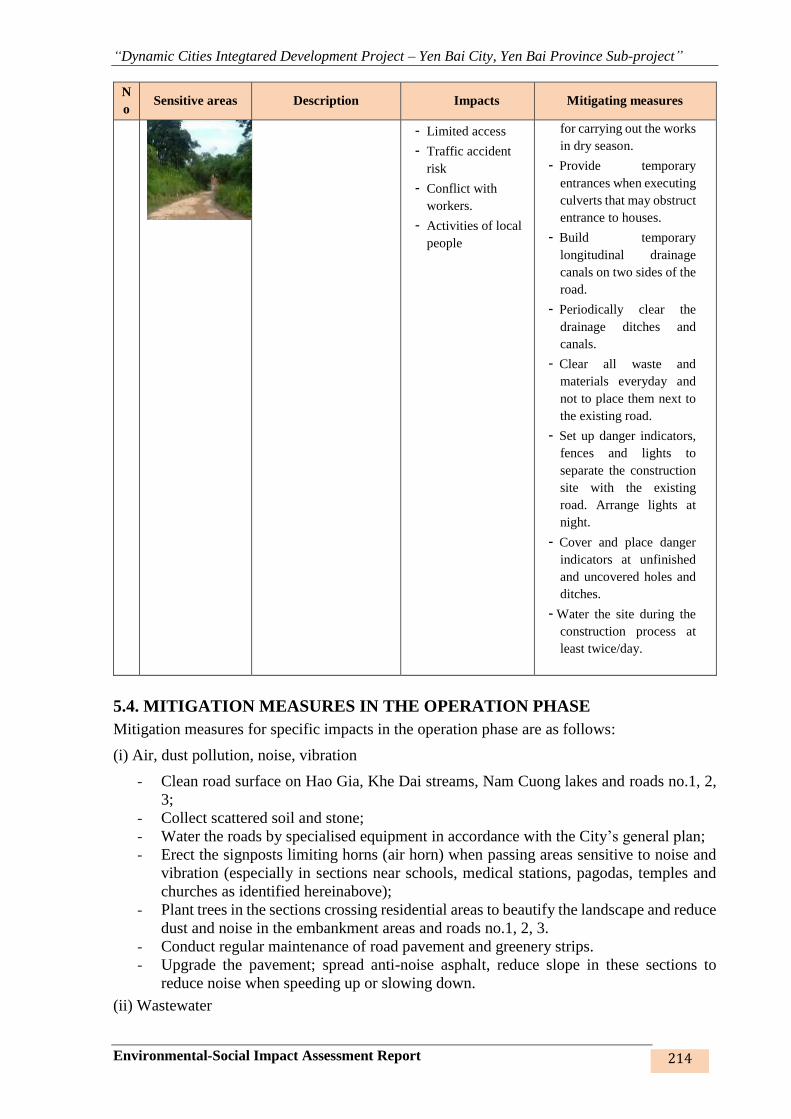
“Dynamic Cities Integtared Development Project – Yen Bai City, Yen Bai Province Sub-project”
Environmental-Social Impact Assessment Report 214
N
o Sensitive areas Description Impacts Mitigating measures
- Limited access
- Traffic accident
risk
- Conflict with
workers.
- Activities of local
people
for carrying out the works
in dry season.
- Provide temporary
entrances when executing
culverts that may obstruct
entrance to houses.
- Build temporary
longitudinal drainage
canals on two sides of the
road.
- Periodically clear the
drainage ditches and
canals.
- Clear all waste and
materials everyday and
not to place them next to
the existing road.
- Set up danger indicators,
fences and lights to
separate the construction
site with the existing
road. Arrange lights at
night.
- Cover and place danger
indicators at unfinished
and uncovered holes and
ditches.
- Water the site during the
construction process at
least twice/day.
5.4. MITIGATION MEASURES IN THE OPERATION PHASE
Mitigation measures for specific impacts in the operation phase are as follows:
(i) Air, dust pollution, noise, vibration
- Clean road surface on Hao Gia, Khe Dai streams, Nam Cuong lakes and roads no.1, 2,
3;
- Collect scattered soil and stone;
- Water the roads by specialised equipment in accordance with the City’s general plan;
- Erect the signposts limiting horns (air horn) when passing areas sensitive to noise and
vibration (especially in sections near schools, medical stations, pagodas, temples and
churches as identified hereinabove);
- Plant trees in the sections crossing residential areas to beautify the landscape and reduce
dust and noise in the embankment areas and roads no.1, 2, 3.
- Conduct regular maintenance of road pavement and greenery strips.
- Upgrade the pavement; spread anti-noise asphalt, reduce slope in these sections to
reduce noise when speeding up or slowing down.
(ii) Wastewater
“Dynamic Cities Integtared Development Project – Yen Bai City, Yen Bai Province Sub-project”
Environmental-Social Impact Assessment Report 215
- Regularly check drainage culverts and ditches along Nam Cuong lake, Hao Gia stream
and Khe Dai stream embankment, drainage culverts along road no.1 – from Dien Bien
road to the road connecting Bach Lam bridge to Van Phu bridge, road no.2 - road
connecting Bach Lam bridge to Van Phu bridge and road no.3 – road connecting from
Nguyen Tat Thanh intersection and Au Co intersection.
- Regularly collect solid waste on Nam Cuong lake, Hao Gia stream, Khe Dai stream
roads and roads no.1, 2, 3 by mechanical/manual methods to prevent them from drifting
along with rainwater into the drainage system.
(iii) Waste
- Regularly check drainage culverts and ditches along the embankments, roads and
resettlement sites;
- Engage a firm for periodic collection of waste;
- Propagandise and prohibit local people, especially commercial services on the
embankments, from littering the embankments;
- Arrange boards guiding the operation of the embankments, roads and resettlement sites;
Mitigation measures for specific impacts are as follows:
(i) Flow and terrain change:
- Closely watch weather developments
- Strictly adhere to the operating rules of the embankments and roads
- Research and monitor subsidence and breakdown (if any) for timely response.
- Inform the managing agency and relevant authorities as soon as possible.
(ii) Transport
- Make available signposts and traffic signs on the embankments and roads when they
come into operation;
- Organise traffic flows, boundary marks and road marks, etc.
- Disseminate traffic rules on the roads;
- Make public the images of traffic accidents in certain information disclosure points to
deter people.
(iii) Land use purpose change
- Execute the compensation and subsidy plans as approved
- Record the community’s feedbacks for appropriate adjustments
- Provide concrete guidelines as to land use purpose change, compliance with local land
use planning and land use planning.
- Publicize the planning and regulations on urban construction for the community.
- Reform of administrative procedures in the field of registration and issuance of
certificates: Continue to simplify the composition of the file, reduce the time to carry
out administrative procedures; improve administrative discipline and improve service
quality to meet the satisfaction of people and enterprises.
- Resolve quickly and appropriately the contradictions caused by conversion of land use
purpose.
- To intensify the examination, inspection and handling of land violations by
organizations assigned or leased land by the State, not allowing repeated and
uninterrupted violations. Overcoming the situation of encroachment, occupied land,
especially agricultural land, public land is not the right purpose.
- Review all cases of public land, public agricultural land in wards and seriously deal with
violations.
- Settlement of land complaints and denunciations in localities should be handled and
dealt with in a comprehensive manner, avoiding many protracted cases and excessive
“Dynamic Cities Integtared Development Project – Yen Bai City, Yen Bai Province Sub-project”
Environmental-Social Impact Assessment Report 216
letters that affect the security, politics and order. society.
- To coordinate and closely coordinate the work of inspection, examination and handling
of land violations.
- Propagate to raise awareness of people in exercising the rights and obligations of land
users and financial obligations on land, land policies and policies
- .
5.5. MITIGATION MEASURES FOR RISKS AND INCIDENTS
5.5.1. Risks and incidents in the construction phase
- Response to labour accidents:
• Observe current regulations of work safety
• Train staff on work safety and require compliance with working rules on the
worksite
• Provide sufficient protective equipment
• Check and remind staff and workers on a daily basis
• Pay due attention to health care and have medical staff on the site at all times
• Provide lighting on worksite at night.
- Traffic accidents:
• Vehicles only operate with the allowed load and speed
• Set up signposts on the worksite
• First aid victim and rush him/her to the nearest hospital or medical ceter.
• Fuel and chemical spill, fire, explosion, electric shock
• Strictly ban smoking and flammable materials in warehouses
• Make available portable fire extinguishers;
• Design and install the electricity system with sufficient safety equipment such as
fire-resistant materials, automatic circuit breaker, etc.
• Design and make available the facilities in compliance with safety regulations on
fire control, install fire prevention systems and must be certified by the competent
authorities of fire safety.
• Regularly propagandise about the fire prevention regulations. Provide regular
training and practice for staff;
• Train on first-aid skills;
• Inform the authorities and Project Owner as soon as possible of the incident, if any
- Uncovering archaeological and historical relics and tombs
• Stop the construction immediately;
• Inform the Project Owner and relevant agencies;
• Protect the scene until the authorities come.
- Other incidents
• Ensure saniation and food hygiene for workers in site capms;
• Ensure minimum living conditions and hygiene at worksite and camps;
• Tidy up and clean regularly
• Spray mosquitocidal and other pest control methods on a regular basis;
• Train workers on first-aid skills before moving victim to the nearest hospital or
medical center;
5.5.2. Risks and incidents in the operation phase

“Dynamic Cities Integtared Development Project – Yen Bai City, Yen Bai Province Sub-project”
Environmental-Social Impact Assessment Report 217
- Embankment erosion, bridge breakdown, road subsidence
• Local governments need to take steps to improve people’s awareness of
environmental protection
• Conduct periodic remodelling of the roads. Remedy any damage to road surface,
slopes and embankments
• Erect signposts guiding loads and types of vehicles permitted to use the bridges,
roads and embankments in notable positions.
• Regularly check quality of bridges and embankments to avoid possible incidents
- Falling into streams and lakes, drowning in sewers
• Local governments need to take steps to improve people’s awareness of
environmental protection
• Propagandise and prohibit local people, especially commercial services on the
embankments, from littering the embankments.
• Arrange waste bins along the emabankments;
• Arrange signposts guiding people to travel safely
• Arrange guardrails or door with height of 80-90cm at the operation and
management stairs to the walkway on the embankment, including danger indicator
and light.
• Check and repair promptly the damaged embankment sections as heavy rain will
cause serious erosion and collapse.
• Design, layout areas of grass landslides of the three lines 1, 2 and 3 respectively
about 8 958m2, 44 717m2 and 64 366m2 of grass; and planting such as lobster,
canaries, black stars... with a diameter of 10-12cm, height 4m, estimated trees about
260, 820 and 830 trees per route.
• Planting trees (canary, canary, black star with a diameter of 10-12cm, height of 4m,
planted along Nam Cuong, Hao Gia and Khe Dai streams, resettlement area with
an estimated number of 950 780, 800 and 360 trees.
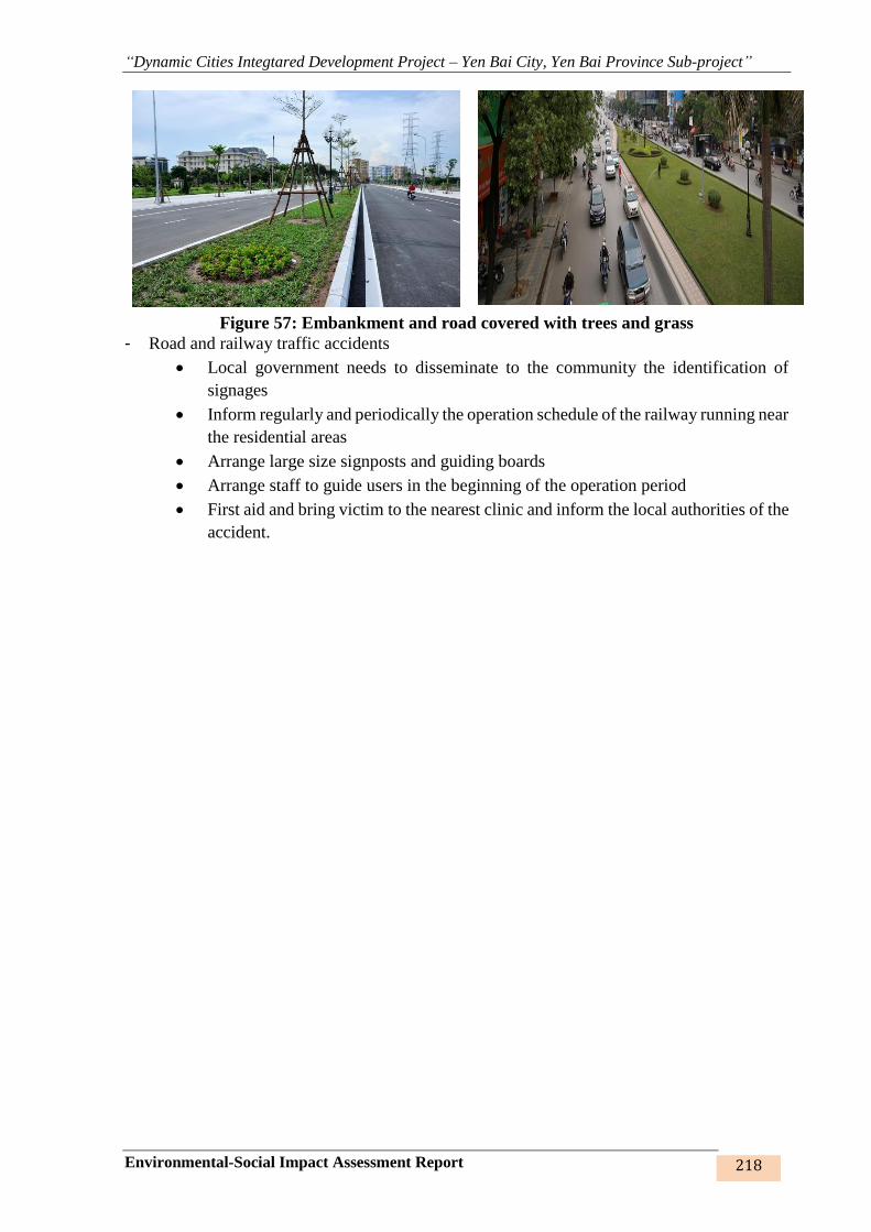
“Dynamic Cities Integtared Development Project – Yen Bai City, Yen Bai Province Sub-project”
Environmental-Social Impact Assessment Report 218
Figure 57: Embankment and road covered with trees and grass
- Road and railway traffic accidents
• Local government needs to disseminate to the community the identification of
signages
• Inform regularly and periodically the operation schedule of the railway running near
the residential areas
• Arrange large size signposts and guiding boards
• Arrange staff to guide users in the beginning of the operation period
• First aid and bring victim to the nearest clinic and inform the local authorities of the
accident.
“Dynamic Cities Integtared Development Project – Yen Bai City, Yen Bai Province Sub-project”
Environmental-Social Impact Assessment Report 219
CHAPTER 6. ENVIRONMENTAL - SOCIAL MANAGEMENT PLAN
On the basis of the assessment of negative impacts presented in Chapter 4 and the impact
mitigating measures recommended in Chapter 5, this Chapter will present the Environmental
and Social Management Plan (ESMP) for Yen Bai city Subproject. The Environmental
Management Program will identify the activities/actions to be implemented in the Yen Bai city
Subproject, including the environmental monitoring program and its implementation schedule,
taking into account the compliance with the provisions of the Government's ESIA and safety
policies of the World Bank (WB).
To ensure that all sources of pollution arising from the subproject activities during the
preparation stage and the construction stage as well as in the operation period will not cause
any negative impacts on the environment and public health, it is compulsory that the
management, monitoring and supervision of environmental quality be executed in a scientific,
systematic and regular manner. Below is a summary of environmental impacts, mitigating
measures and responsibilities of stakeholders.
6.1. MITIGATION MEASURES FOR CONSTRUCTION PHASE
ESMP’s mitigating measures for construction phase are divided into 3 basic parts: (1) ECOPs,
(2) Specific mitigation measures for the specific types of works, and (3) Site-specific mitigation
measures for each sensitive location to be affected by the subproject’s works items.
(1) All of the potential negative impacts on physical, biological, and social environment could
be mitigated through a set of general measures that are typically applied to most of construction
subprojects to minimize impacts such as noise, dust, vibration, waste generation, traffic
hindrance, public safety, etc. In this context, an ECOPs has been prepared describing specific
requirements to be carried out by contractor to mitigate the subproject potential impacts
considered to be general impacts (Section 6.1). The contractor will also be required to mitigate
site-specific impacts which will be identified to address issues specific to the subproject.
(2) In addtion to adopting the ECOPS, specific mitigation measures have been identified
(Section 6.2) for addressing the impacts associated with the specific types of works under the
subproject such as sewers, drainage systems. These measures will be included in the contracts
for corresponding packages.
(3) All the specific impacts for each sensitive receptor of which mitigation measures could not
be addressed through implementation of the ECOPs, site-specific mitigating measures will need
to be implemented (Section 6.3).
Measures to mitigate impacts from land acquisition and resettlement are mentioned separately
in the Resettlement Plan (RP) and those measures will be carried out and supervised separately.
6.1.1. Mitigation measures for generic impacts
Typical common impacts which will be minimized by mitigation measures defined in ECOP
include: (1) Dust, exhaust gases, noise and vibration; (2) wastewater management; (3) Solid
waste management; (4) Hazardous waste; (5) Water pollution management; (6) Impacts on
aquatic species and terrestrial ecology; (7) Management of impacts on urban landscape and
beauty; (8) Management measures of sedimentation, erosion and flooding; (9) Traffic safety
management; (10) Influence to existing infrastructure and services, (11) Management of
impacts on social activities; (12) Management of impacts on cultural and religious works; (13)
Measures to secure community healthand safety; (14) Measures to secure worker’s health and
safety, (15) Management of warehouses and borrow pits, (16) Communication to local
community.

“Dynamic Cities Integtared Development Project – Yen Bai City, Yen Bai Province Sub-project”
Environmental-Social Impact Assessment Report 220
Table 44: Environmental Codes of Practices for addressing generic construction impacts (ECOPs)

“Dynamic Cities Integtared Development Project – Yen Bai City, Yen Bai Province Sub-project”
Environmental-Social Impact Assessment Report 221
Environmental-
social issues Mitigation measures Vietnamese regulation Responsibility
To be
supervised by
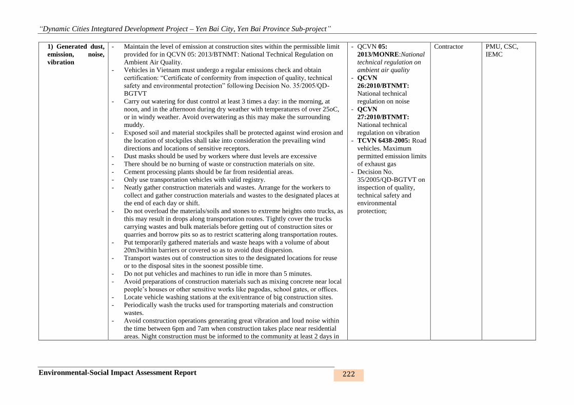
“Dynamic Cities Integtared Development Project – Yen Bai City, Yen Bai Province Sub-project”
Environmental-Social Impact Assessment Report 222
1) Generated dust,
emission, noise,
vibration
- Maintain the level of emission at construction sites within the permissible limit
provided for in QCVN 05: 2013/BTNMT: National Technical Regulation on
Ambient Air Quality.
- Vehicles in Vietnam must undergo a regular emissions check and obtain
certification: “Certificate of conformity from inspection of quality, technical
safety and environmental protection” following Decision No. 35/2005/QD-
BGTVT
- Carry out watering for dust control at least 3 times a day: in the morning, at
noon, and in the afternoon during dry weather with temperatures of over 25oC,
or in windy weather. Avoid overwatering as this may make the surrounding
muddy.
- Exposed soil and material stockpiles shall be protected against wind erosion and
the location of stockpiles shall take into consideration the prevailing wind
directions and locations of sensitive receptors.
- Dust masks should be used by workers where dust levels are excessive
- There should be no burning of waste or construction materials on site.
- Cement processing plants should be far from residential areas.
- Only use transportation vehicles with valid registry.
- Neatly gather construction materials and wastes. Arrange for the workers to
collect and gather construction materials and wastes to the designated places at
the end of each day or shift.
- Do not overload the materials/soils and stones to extreme heights onto trucks, as
this may result in drops along transportation routes. Tightly cover the trucks
carrying wastes and bulk materials before getting out of construction sites or
quarries and borrow pits so as to restrict scattering along transportation routes.
- Put temporarily gathered materials and waste heaps with a volume of about
20m3within barriers or covered so as to avoid dust dispersion.
- Transport wastes out of construction sites to the designated locations for reuse
or to the disposal sites in the soonest possible time.
- Do not put vehicles and machines to run idle in more than 5 minutes.
- Avoid preparations of construction materials such as mixing concrete near local
people’s houses or other sensitive works like pagodas, school gates, or offices.
- Locate vehicle washing stations at the exit/entrance of big construction sites.
- Periodically wash the trucks used for transporting materials and construction
wastes.
- Avoid construction operations generating great vibration and loud noise within
the time between 6pm and 7am when construction takes place near residential
areas. Night construction must be informed to the community at least 2 days in
- QCVN 05:
2013/MONRE:National
technical regulation on
ambient air quality
- QCVN
26:2010/BTNMT:
National technical
regulation on noise
- QCVN
27:2010/BTNMT:
National technical
regulation on vibration
- TCVN 6438-2005: Road
vehicles. Maximum
permitted emission limits
of exhaust gas
- Decision No.
35/2005/QD-BGTVT on
inspection of quality,
technical safety and
environmental
protection;
Contractor PMU, CSC,
IEMC

“Dynamic Cities Integtared Development Project – Yen Bai City, Yen Bai Province Sub-project”
Environmental-Social Impact Assessment Report 223
Environmental-
social issues Mitigation measures Vietnamese regulation Responsibility
To be
supervised by
advance.
- Perform the method of successive construction for each sewer section in
construction sites of long sewer lines.
- Observe and secure construction progress correctly.
- Set up 2.5m-high fences of corrugated iron around the construction sites.
- When needed, measures to reduce noise to acceptable levels must be
implemented and could include silencers, mufflers, acoustically dampened panels
or placement of noisy machines in acoustically protected areas
- Avoiding or minimizing transportation through community areas and avoiding as
well as material processing areas (such as cement mixing).
2) Wastewater
management
- The Contractor must be responsible for compliance with Vietnamese legislation
relevant to wastewater discharges into watercourses.
- Employ local workers to limit the amount of generated domestic wastes and
wastewater.
- Provide septic tanks for toilets for treating wastewater before it can be
discharged into the environment. On-site mobile toilets with 3-compartment
septic tanks can be used in areas for major work items as traffic roads.
Wastewater from toilets as well as kitchens, showers, sinks, etc. shall be
discharged into a conservancy tank for removal from the site or discharged into
municipal sewerage systems; there should be no direct discharges to any
waterbody
- Wastewater containing pollutants over standards set by relevant Vietnamese
technical standards/regulations must be collected in a conservancy tank and
removed from site by licensed waste collectors.
- Clear ditches around the workers’ camps every week.
- Build sedimentation ponds and ditches to receive stormwater runoff at the
construction sites such as the areas for Lam Ha 1 Lake, stormwater and
wastewater pumping stations.
- Make appropriate arrangements for collecting, diverting or intercepting
wastewater from households to ensure minimal discharge or local clogging and
flooding.
- Before construction, all necessary wastewater disposal permits/licenses and/or
wastewater disposal contracts have been obtained.
- At completion of construction works, wastewater collection tanks and septic
tanks shall be safely disposed or effectively sealed off
- QCVN
14:2008/BTNMT:
National technical
regulation on domestic
wastewater;
- QCVN 40: 2011/
BTNMT: National
technical regulationon
industrial wastewater
Contractor PMU, CSC,
IEMC
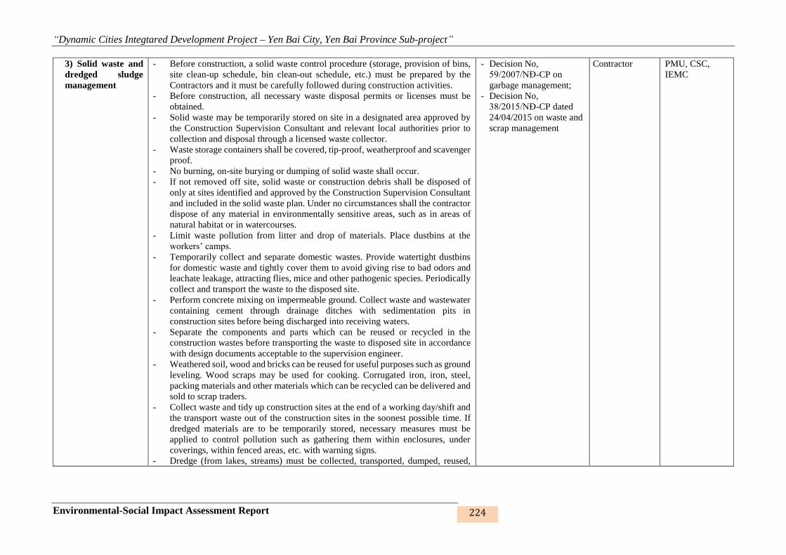
“Dynamic Cities Integtared Development Project – Yen Bai City, Yen Bai Province Sub-project”
Environmental-Social Impact Assessment Report 224
3) Solid waste and
dredged sludge
management
- Before construction, a solid waste control procedure (storage, provision of bins,
site clean-up schedule, bin clean-out schedule, etc.) must be prepared by the
Contractors and it must be carefully followed during construction activities.
- Before construction, all necessary waste disposal permits or licenses must be
obtained.
- Solid waste may be temporarily stored on site in a designated area approved by
the Construction Supervision Consultant and relevant local authorities prior to
collection and disposal through a licensed waste collector.
- Waste storage containers shall be covered, tip-proof, weatherproof and scavenger
proof.
- No burning, on-site burying or dumping of solid waste shall occur.
- If not removed off site, solid waste or construction debris shall be disposed of
only at sites identified and approved by the Construction Supervision Consultant
and included in the solid waste plan. Under no circumstances shall the contractor
dispose of any material in environmentally sensitive areas, such as in areas of
natural habitat or in watercourses.
- Limit waste pollution from litter and drop of materials. Place dustbins at the
workers’ camps.
- Temporarily collect and separate domestic wastes. Provide watertight dustbins
for domestic waste and tightly cover them to avoid giving rise to bad odors and
leachate leakage, attracting flies, mice and other pathogenic species. Periodically
collect and transport the waste to the disposed site.
- Perform concrete mixing on impermeable ground. Collect waste and wastewater
containing cement through drainage ditches with sedimentation pits in
construction sites before being discharged into receiving waters.
- Separate the components and parts which can be reused or recycled in the
construction wastes before transporting the waste to disposed site in accordance
with design documents acceptable to the supervision engineer.
- Weathered soil, wood and bricks can be reused for useful purposes such as ground
leveling. Wood scraps may be used for cooking. Corrugated iron, iron, steel,
packing materials and other materials which can be recycled can be delivered and
sold to scrap traders.
- Collect waste and tidy up construction sites at the end of a working day/shift and
the transport waste out of the construction sites in the soonest possible time. If
dredged materials are to be temporarily stored, necessary measures must be
applied to control pollution such as gathering them within enclosures, under
coverings, within fenced areas, etc. with warning signs.
- Dredge (from lakes, streams) must be collected, transported, dumped, reused,
- Decision No,
59/2007/NĐ-CP on
garbage management;
- Decision No,
38/2015/NĐ-CP dated
24/04/2015 on waste and
scrap management
Contractor PMU, CSC,
IEMC

“Dynamic Cities Integtared Development Project – Yen Bai City, Yen Bai Province Sub-project”
Environmental-Social Impact Assessment Report 225
Environmental-
social issues Mitigation measures Vietnamese regulation Responsibility
To be
supervised by
recycled and handled in accordance with the law.
- The Minister of Agriculture and Rural Development shall regulate the
management of dredged dredging from streams and irrigation works.
- The Minister of Natural Resources and Environment shall regulate the
management of dredged sludge from the lake.
- Provincial-level People's Committees shall stipulate places for dumping and
treatment of dredged sludge.
- The Contractor will sign a contract with URENCO to collect solid waste,
conforming to Decree No. 59/2007/ND-CP dated 09 April 2007 on solid waste
management and Decree No. 38/2015/ND-CP dated 24 April 2015 on
management of waste and waste materials.
“Dynamic Cities Integtared Development Project – Yen Bai City, Yen Bai Province Sub-project”
Environmental-Social Impact Assessment Report 226
Environmental-
social issues Mitigation measures Vietnamese regulation Responsibility
To be
supervised by
4) Hazardous waste
management
- Temporarily collect, store, and transported for treatment all hazardous wastes
(road asphalt, waste oil and grease, organic solvents, chemicals, oil paints, etc.)
in accordance with Circular No. 36/2015/TT-BTNMT on management of
hazardous waste.
- Collect and temporarily store used oil and grease separately in specialized
containers and place in safe and fire-free areas with impermeable floors roofs, at
a safe distance from fire sources. Sign contracts with for oil and grease to be
delivered to suppliers/ manufacturers
- Chemical waste of any kind shall be disposed of at an approved appropriate
landfill site and in accordance with local legislative requirements. The
Contractor shall obtain needed disposal certificates.
- The removal of asbestos-containing materials or other toxic substances shall be
performed and disposed of by specially trained and certified workers.
- Used oil and grease shall be removed from site and sold to an approved used oil
recycling company.
- Used oil, lubricants, cleaning materials, etc. from the maintenance of vehicles
and machinery shall be collected in holding tanks and removed from site by a
specialized oil recycling company for disposal at an approved hazardous waste
site.
- Used oil or oil-contaminated materials that could potentially contain PCBs shall
be securely stored to avoid any leakage or affecting workers.
- Unused or rejected tar or bituminous products shall be returned to the supplier’s
production plant.
- Relevant agencies shall be promptly informed of any accidental spill or incident
- Store chemicals appropriately and with appropriate labeling
- Appropriate communication and training programs should be put in place to
prepare workers to recognize and respond to workplace chemical hazards
- Prepare and initiate a remedial action following any spill or incident. In this
case, the contractor shall provide a report explaining the reasons for the spill or
incident, remedial action taken, consequences/damage from the spill, and
proposed corrective actions.
- Circular No.
36/2015/TT-BTNMT on
hazardous waste
management;
- Decision No.
38/2015/NĐ-CP dated
24/04/2015 on waste and
scrap management
Contractor PMU, CSC,
IEMC

“Dynamic Cities Integtared Development Project – Yen Bai City, Yen Bai Province Sub-project”
Environmental-Social Impact Assessment Report 227
Environmental-
social issues Mitigation measures Vietnamese regulation Responsibility
To be
supervised by
5) Water pollution - The Contractor is responsible for controlling the surface water quality when
discharging it out of the construction site, in accordance with QCVN 08-
MT:2015/BTNMT – National Technical Regulation on surface water quality
and QCVN 14:2008/BTNMT – National Technical Regulation on domestic
wastewater quality.
- Provide preliminary sedimentation ponds and ditches of stormwater runoff at
the construction sites such as the areas for roads, regulation lake.
- Provide construction workers on site with mobile toilets.
- Avoid excavation and backfilling during rains.
- Gather materials and wastes generated during excavation and backfilling,
collect and transport them out of the construction site to the approved disposal
sites within the soonest possible time.
- Do not allow temporary gathering of bulk materials and mixing of concrete
within 50m from ponds, lakes, rivers, streams, or other water sources. Maintain
maximum distances possible between the gathering points to water sources in
the construction of Chau Giang river southern embankment.
- Store used and unused oil and petrol in closed containers on impermeable
ground covered with roofs and contained within surrounding banks for easy
control and collection in case of leakage. Do not locate oil and petrol storages
within 25m from ponds, lakes, rivers, and streams.
- Collect and transport excavated soils from the construction of sewers and
ditches out of the construction site within 24 hours.
- Only perform maintenance work of motored vehicles and equipment, including
oil replacement or lubrication in designated areas, without allowing chemicals,
petrol, oil, or grease to leak onto soil or into the drainage system or water
sources. Trays are to be used to hold rags and materials used in maintenance.
Collect and discard wastes in accordance with hazardous waste management
regulation.
- QCVN
09:2008/BTNMT:
National technical
regulation on
underground water;
- QCVN
14:2008/BTNMT:
National technical
regulation on domestic
wastewater;
- QCVN 40: 2011/
BTNMT: National
technical regulationon
industrial wastewater;
- TCVN 7222: 2002:
General requirements for
concentrated wastewater
treatment plants
Contractor PMU, CSC,
IEMC

“Dynamic Cities Integtared Development Project – Yen Bai City, Yen Bai Province Sub-project”
Environmental-Social Impact Assessment Report 228
Environmental-
social issues Mitigation measures Vietnamese regulation Responsibility
To be
supervised by
6) Impacts on
plants and aquatic
species
- The Contractor shall prepare a Clearance, Re-vegetation and Restoration
Management
- Plan for prior approval by the Construction Engineer, following relevant
regulations. The Clearance Plan shall be approved by the Construction
Supervision Consultant and followed strictly by the contractor. Areas to be
cleared should be minimized as much as possible.
- Limit disturbances to areas with construction operations, especially in locations
covered with green trees or vegetation. Do not use chemicals to clear
vegetation.
- Do not gather materials and wastes at places covered with vegetation or with
green trees, but on vacant land instead.
- Use sheet pile driving method using Larsen piles to limit impacts on the water
quality.
- If possible, green trees should be moved and replanted in other places if the
trees are in the way of the pipelines to be constructed.
- The contractor shall remove topsoil from all areas where topsoil will be
impacted by construction activities, including temporary activities such as
storage and stockpiling, etc; the stripped topsoil shall be stockpiled in areas
agreed to by the Construction Supervision Consultant for later use in re-
vegetation and shall be adequately protected.
- Trees cannot be cut down unless explicitly authorized in the vegetation clearing
plan.
- When needed, temporary protective fencing will be erected to efficiently protect
the preserved trees before commencement of any works within the site.
- No area of potential importance as an ecological resource should be disturbed
unless there is prior authorization from CSC, who should consult with PMU,
IEMC and the relevant local authorities. This could include areas of breeding or
feeding for birds or animals, fish spawning areas, or any area that is protected as
a green space.
- The Contractor shall ensure that no hunting, trapping, shooting, poisoning of
fauna takes place.
- Law on environmental
protection No.
55/2014/QH13
Contractor PMU, CSC,
IEMC

“Dynamic Cities Integtared Development Project – Yen Bai City, Yen Bai Province Sub-project”
Environmental-Social Impact Assessment Report 229
Environmental-
social issues Mitigation measures Vietnamese regulation Responsibility
To be
supervised by
7) Impacts on
urban landscape
and beauty
- Carefully cover transport vehicles for materials and waste and periodically wash
and clean the vehicles.
- Dismantle the camps as well as other temporary works set up during
construction and restore the site before the completed work could be handed
over to the subproject owner. Back fill and tightly seal toilet pits, septic tanks,
and temporary sewerage ditches.
- Do not temporarily gather construction materials and wastes within 20m from
the gate of schools, offices temples, pagodas, etc.
- The Contractor will have to work out construction plans in such a way as to
avoid the 1st and 15th days of each lunar month if construction is to be carried
out near historical and cultural works such as pagodas, churches, temples, etc.
- Regularly collect materials and wastes and tidy up the construction site.
- Materials and waste around the construction site must be regularly collected and
construction sites are to be neatly tidied up.
- Law on environmental
protection No.
55/2014/QH13
- TCVN 4447:1987:
Construction regulation
- Circular No.
22/2010/TT-BXD on
requirements on safety
Contractor PMU, CSC,
IEMC
8) Sedimentation,
erosion, flooding,
subsidence and
slides
- Avoid disturbances and damage to the existing vegetation and green trees.
- Periodically and thoroughly remove soils, stones and wastes from drainage
sewers and ditches inside and around the construction site.
- Neatly gather materials and wastes so as to limit them being swept away by
stormwater.
- Carry out ground leveling and rolling after discarding materials at disposal sites.
- TCVN 4447:1987:
Construction regulation
- Circular No.
22/2010/TT-BXD:
Regulation on
construction safety
- QCVN 08:2008/BTNMT
– National technical
regulation on surface
water quality
Contractor PMU, CSC,
IEMC

“Dynamic Cities Integtared Development Project – Yen Bai City, Yen Bai Province Sub-project”
Environmental-Social Impact Assessment Report 230
Environmental-
social issues Mitigation measures Vietnamese regulation Responsibility
To be
supervised by
9) Traffic
management
- Before construction, carry out consultations with local government and
community and with traffic police.
- Arrange and provide separate passageway with safe and easy access for
pedestrian and for people with disability and mobility issues especially the areas
in proximity of schools, including easy wheel chair access and hand rail. Make
staff available any time for helping people with disability if needed.
- Set up traffic and maintain instruction signs and warnings to secure safety for
people and means of transport during construction.
- Put speed limit signs at a distance of 200m from the construction site.
- Carefully cover materials on trucks. Do not load to a height of 10cm higher than
the truck body so as not to spill out and scatter materials onto roads, giving rise
to dust and endangering road users. Collect spilt soils and materials at the
construction site each day to avoid slippery incidents for vehicles.
- Do not park vehicles in the roads longer than necessary. Do not allow
construction vehicles and materials to encroach upon the pavements.
- During construction near schools, deploy staff at the site to guide the traffic at
the start of school time and when school is over. Water the roads to prevent
dust, limit the speed of traveling trucks, do not allow flared horns, and do not
dispose the waste and wastewater onto areas near schools.
- Install night lighting of all construction sites.
- Significant increases in number of vehicle trips must be covered in a
construction plan previously approved. Routing, especially of heavy vehicles,
needs to take into account sensitive sites such as schools, hospitals, and
markets.
- Installation of lighting at night must be done, if necessary, to ensure safe traffic
circulation.
- Employ safe traffic control measures, including road/rivers/canal signs and flag
persons to warn of dangerous conditions.
- Avoid material transportation for construction during rush hours.
- Passageways for pedestrians and vehicles within and outside construction areas
should be segregated and provide for easy, safe, and appropriate access.
Signposts shall be installed appropriately in both water-ways and roads where
necessary.
- Law on communication
and transport No.
23/2008/QH12;
- Law on construction No.
50/2014/QH13;
- Law No. 38/2009/QH12
dated 19/6/2009
amending and
supplementing some
articles of the Law
relating to capital
construction investment
- Circular No.
22/2010/TT-BXD on
regulation on
construction safety
Contractor PMU, CSC,
IEMC
“Dynamic Cities Integtared Development Project – Yen Bai City, Yen Bai Province Sub-project”
Environmental-Social Impact Assessment Report 231
Environmental-
social issues Mitigation measures Vietnamese regulation Responsibility
To be
supervised by
10) Influence to
existing
infrastructure and
services
- Provide information to affected households on working schedules as well as
planned disruptions (at least 2 days in advance).
- The Contractor must only use vehicles of sizes and loads within permissible
limits for the roads along such vehicles’ route.
- During the construction under power lines, deploy qualified staff to observe and
give instructions to the drivers of cranes and excavators so as to avoid causing
damages to power lines, telecommunications lines, etc.
- Stop construction when existing works are damaged. Identify causes of related
incidents and work out solutions. In case the damages are due to the
Contractors’ faults, the Contractors have to repair, recover, and compensate for
all damages at their own expenses. The results of handling such damages must
be approved by the Supervisor Engineer.
- Reinstall the road surface and sidewalks at construction sites after the
construction of sewer lines has been completed.
- The contractor should ensure alternative water supply to affected residents in
the event of disruptions lasting more than one day.
- Any damages to existing cable utility systems shall be reported to the authorities
and repaired as soon as possible.
- Decree No. 73/2010/ND-
CP on administrative
penalization of violations
related to security and
social affairs
Contractor PMU, CSC,
IEMC
“Dynamic Cities Integtared Development Project – Yen Bai City, Yen Bai Province Sub-project”
Environmental-Social Impact Assessment Report 232
Environmental-
social issues Mitigation measures Vietnamese regulation Responsibility
To be
supervised by
11) Social
mitigation
measures through
worker
management
- Inform the community at least 2 weeks before commencement of the
construction. In case electricity and water supplies are to be disrupted, the PMU
must inform PAHs of the same at least 2 days in advance.
- Employ local laborers for simple tasks. Instruct workers on environmental
issues, safety and health before construction tasks are assigned. It is advisable to
communicate to migrant workers on local customs, practices and habits in order
to avoid conflicts with local people.
- The subproject owner and contractor are to cooperate closely with the local
government in performing effective community sanitation in case of epidemic
symptoms breaking out in the area.
- The subproject owner and contractor are to cooperate with local authorities in
preventing and fighting against social evils. Conduct sensitization campaigns
with both workers and communities on these issues, liaison with local
organizations to ensure monitoring, and a grievance redress system to which the
community can refer to.
- The subproject will cooperate with the local health agency in developing and
implementing plans for control of diseases among workers.
- Workers temporarily residing at the camps and rented houses must be registered
with the local authorities for temporary residence.
- Train workers on issues related to social security, social evils, diseases and
epidemics, prostitution and drug use, environment, safety and health,
HIV/AIDS and infectious diseases within 2 weeks prior to the commencement
of packages with construction items lasting at least 6 months.
- Prohibit workers from:
- Consuming alcoholic drinks during working time
- Quarreling and fighting
- Gambling and indulging in social evils such as drug use and prostitution
- Disposing of garbage indiscriminately
- Decree No. 73/2010/ND-
CP on administrative
penalization of violations
against security and
social affairs
Contractor PMU, CSC,
IEMC
“Dynamic Cities Integtared Development Project – Yen Bai City, Yen Bai Province Sub-project”
Environmental-Social Impact Assessment Report 233
12) Control of
impacts on cultural
works
- Do not gather materials and wastes within 20m from cultural, historical, and
religious works such as temples, pagodas, churches, monuments, historic relics,
etc. Water spray the construction sites next to such works.
- Do not use machines generating loud noise and high vibration levels near
cultural, historical, and religious works.
- In case of archeological objects being unearthed during the implementation of
earthwork, all parties will conform to the following procedures:
+ In case of archeological objects being unearthed during the implementation
of earthwork, all parties will conform to the following procedures:
+ Suspend construction operations at the place of discovery;
+ Preliminarily describe the area where the archaeological objects are to be
unearthed;
+ Strictly protect the area of the discovery so as not to damage or lose moveable
objects. In case the unearthed objects are moveable or sensitive ruins, provide
night protection until the local authorities, the Department of Culture, Sports
and Tourism or the Institute of Archaeology takes over these unearthed
objects;
+ Inform the Supervision Engineer of the event and who in turn will
immediately inform the subproject owner, the local authorities in charge of
the case and the Institute of Archaeology (within 24 hours or less);
+ Local relevant agencies and the Vietnam National Administration of Tourism
will be responsible for protecting and preserving such archaeological relics
before making decisions on the next suitable formalities. The Institute of
Archaeology may be needed in the preliminarily assessment of the unearthed
objects. The significance and importance of such discovered objects will be
assessed by different criteria related to the nature of cultural heritages; such
criteria would include aesthetic, historical, scientific, social or economic
values;
+ Decisions on handling such discovered objects will be made by competent
levels. Such decisions can result in changes in site arrangements (e.g. when
the discovered item is a cultural relic which cannot be displaced or is
archaeologically important, it is necessary to preserve, recover and excavate
it);
+ The implementation of such decision by competent agencies related to the
management of discovered objects will be communicated in writing by local
competent agencies; and
+ Only resume construction activities at the site after being permitted by the
local competent agencies and the PMU in relation to safeguarding such relics
- Law on cultural heritage
No. 28/2001/QH10;
- Amended and
supplemented Law on
cultural heritage No.
32/2009/QH12;
- Amended and
supplemented Decree
No. 98/2010/ND-CP
Contractor PMU, CSC,
IEMC

“Dynamic Cities Integtared Development Project – Yen Bai City, Yen Bai Province Sub-project”
Environmental-Social Impact Assessment Report 234
Environmental-
social issues Mitigation measures Vietnamese regulation Responsibility
To be
supervised by
13) Community’s
safety and health
- The Contractor will have to conform to regulations in Circular No. 22/2010/TT-
BXD by the Ministry of Construction on safety in construction.
- The subproject owner and contractor are to cooperate closely with the local
government in performing effective community sanitation in case of epidemic
symptoms breaking out in the area.
- The subproject owner and contractor are to cooperate with local authorities in
preventing and fighting against social evils.
- Fence of excavation pits and open channels and make off with luminous cordon
and warning signs. Provide sufficient lighting when carry out construction at
night.
- Limit the speed of transport means to 20km/h within 200m from the
construction site so as to minimize dust and noise.
- Keep noise-generating machines and vehicles at such suitable distances that
noise transmitted to residential areas will not be higher than 70dBA.
- Use static compacting when the road base is constructed near areas with many
households and weak temporary works to restrict vibration.
- The subproject will cooperate with the local health agency in developing and
implementing plans for control of diseases among workers.
- Circular No.
22/2010/TT-BXD
regulation on
construction safety
- Directive No.
02/2008/CT-BXD on
safety and sanitation
issues in construction
units
- TCVN 5308-91:
Technical regulation on
construction safety
- Decision No.
96/2008/QD-TTg on
clearance of UXOs
Contractor PMU, CSC,
IEMC

“Dynamic Cities Integtared Development Project – Yen Bai City, Yen Bai Province Sub-project”
Environmental-Social Impact Assessment Report 235
14) Workers’
health safety
- Train workers on issues related to environment, safety and health, thus
enhancing their awareness of HIV/AIDS and infectious diseases within 2 weeks
prior to the commencement of packages with construction items lasting at least
6 months.
- Provide workers with and request them to use adequate safety gear such as
masks, helmets, shoes/boots, goggles, etc. depending on job characteristics.
- Safely install power lines at offices and in construction sites and do not lay
connectors on the ground or water surface. Electric wires must be with plugs.
Place outdoor electric panels in protection cabinets.
- Limit the speeds of vehicles traveling inside construction sites to be 5km/hour.
- Provide fire-extinguishers, first-aid bags, and medical cabinets with sufficient
medicines for treating general diseases in the locality must be provided at
construction sites.
- Safely store fuels and chemicals in areas with impermeable ground with roofs
and surrounding banks, equipped with safety warning signs located at least 20m
from the camps and at the end of prevailing winds.
- In case of chemical and fuel leakage, the following steps will have to be taken:
- Immediate check must be carried out to detect any possible case of injury. In
case of injury, first-aid must be given and the injured person must be rushed to
the nearest medical station for healthcare, and at the same time the case must be
informed to the Supervision Engineer and the PMU;
- Carry assessment to determine the kind of leaking/overflowing fuel/chemical;
- Do not flush overflowing chemicals into drainage systems. Send staff with
suitable safety gear to the site to handle the leakage by scattering sawdust (in
case of small volumes of leaks/overflow) or sand (for high volumes of
leaks/overflow). Use shovels to remove the surface soil layer if the
leakage/overflow takes place on vacant land; and
- Subsequent to the occurrence of such incident or accident, the Contractor will
have to prepare a detailed report describing the incident and performed
activities and submit the same to the Supervision Engineer and the PMU for
consideration and filing. Such report will also be presented to the Department of
Natural Resources and Environment or functional agencies at their request..
- Set up the camps with sufficient supplies of clean water, power, and sanitation
facilities. There must be at least one toilet compartment for every 25 workers,
with separate toilets for males and females. Workers’ beds must be provided
with mosquito nets so as to prevent dengue fever. Temporary tents will be
unacceptable.
- Clean camps, kitchens, baths, and toilets and sanitize regularly, and keep in
- Decree No. 22/2010/TT-
BXD on regulation of
construction safety;
- Directive No. 02
/2008/CT-BXD on safety
and sanitation issues in
construction units;
- TCVN 5308-91:
Technical regulation on
safety in construction;
- Decision No.
96/2008/QD-TTg on
clearance of UXOs.
Contractor PMU, CSC,
IEMC
“Dynamic Cities Integtared Development Project – Yen Bai City, Yen Bai Province Sub-project”
Environmental-Social Impact Assessment Report 236
Environmental-
social issues Mitigation measures Vietnamese regulation Responsibility
To be
supervised by
good sanitation conditions. Provide dustbins and collect wastes daily from the
camps. Clear drainage ditches around the camps periodically.
- Stop all construction activities during rains and storms, or upon accidents or
serious incidents.
15) Management of
warehouses and
borrow pits
- All borrow pit locations to be used must be previously identified in conformity
with approved construction technical specifications. Sensitive sites such as
scenic spots, areas of natural habitat, areas near sensitive receiving waters, or
areas near water sources should be avoided. An open ditch shall be built around
the stockpile site to intercept wastewater.
- Retaining walls are to set uparound disposal areas if necessary.
- The use of new sites for stockpiling, gathering or exploiting materials necessary
for construction operations must obtain prior approval from the Construction
Engineer.
- In case landowners are affected by the use of their areas for stockpiling,
gathering or exploiting materials, such landowners must be included in the
project resettlement plan.
- If access roads are needed for these new sites, they must be considered in the
environmental assessment report.
- PMU’s Environment Officer should conduct due diligence to make sure that
borrow pits and quarries are legally operating by undertaking a rapid review of
quarry sites to assess if operations are in compliance with Vietnamese laws and
Bank requirements prior to construction.
- Include the requirement that the contractors shall be required to buy materials
from licensed borrow pit and quarry operators into the civil work contractual
documents.
Contractor PMU, CSC,
IEMC

“Dynamic Cities Integtared Development Project – Yen Bai City, Yen Bai Province Sub-project”
Environmental-Social Impact Assessment Report 237
Environmental-
social issues Mitigation measures Vietnamese regulation Responsibility
To be
supervised by
16) Communicatio
n to local
community
- Open communications channels are to be maintained with the local government
and concerned communities; the contractor shall coordinate with local
authorities (leaders of local wards or communes, leaders of hamlets) for agreed
schedules of construction operations in areas nearby sensitive places or during
sensitive times (e.g. religious festival days).
- Copies of Vietnamese versions of these ECOPs and of other relevant
environmental protection documents shall be made available to local
communities and to workers at the site.
- Subproject information will be disseminated to affected parties (e.g. local
authorities, enterprises and affected households, etc.) through community
meetings before construction commencement.
- A contact address will be provided to the community.
- The community will be provided with all information, especially technical
findings, in a language that is understandable to the general public and in a form
convenient to interested citizens and elected officials through the preparation of
fact sheets and news releases, when major findings become available during
subproject phase.
- Community concerns and requested information are to be monitored as the
subproject progresses.
- Inquiries must be responded by telephone and written correspondence in a
timely and accurate manner.
- Local residents must be informed about construction and work schedules,
interruption of services, traffic detour routes and provisional bus routes, blasting
and demolition operations, as appropriate.
- Technical documents and drawings will be provided to local People's
Committees, especially the sketch of construction areas and the EMP of the
construction site.
- Notification boards shall be erected at all construction sites providing
information about the subproject, as well as contact information about the site
managers, environmental staff, health and safety staff, telephone numbers and
other contact information so that affected people could have a channel to voice
their concerns and suggestions.
- Decree No. 73/2010/ND-
CP on administrative
penalization of violations
related to security and
social affairs
Contractor PMU, CSC,
IEMC
6.1.2. Mitigation measures for site - specific impacts
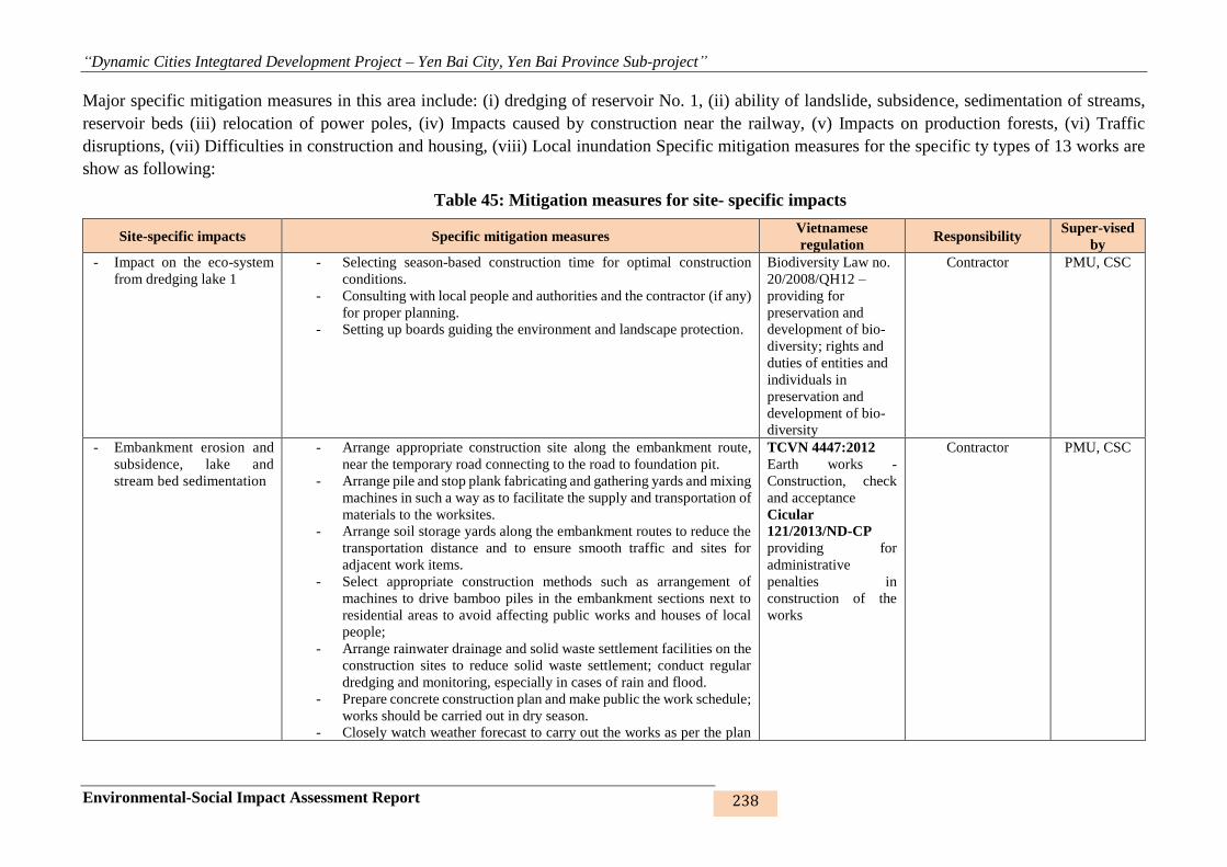
“Dynamic Cities Integtared Development Project – Yen Bai City, Yen Bai Province Sub-project”
Environmental-Social Impact Assessment Report 238
Major specific mitigation measures in this area include: (i) dredging of reservoir No. 1, (ii) ability of landslide, subsidence, sedimentation of streams,
reservoir beds (iii) relocation of power poles, (iv) Impacts caused by construction near the railway, (v) Impacts on production forests, (vi) Traffic
disruptions, (vii) Difficulties in construction and housing, (viii) Local inundation Specific mitigation measures for the specific ty types of 13 works are
show as following:
Table 45: Mitigation measures for site- specific impacts
Site-specific impacts Specific mitigation measures Vietnamese
regulation Responsibility
Super-vised
by
- Impact on the eco-system
from dredging lake 1
- Selecting season-based construction time for optimal construction
conditions.
- Consulting with local people and authorities and the contractor (if any)
for proper planning.
- Setting up boards guiding the environment and landscape protection.
Biodiversity Law no.
20/2008/QH12 –
providing for
preservation and
development of bio-
diversity; rights and
duties of entities and
individuals in
preservation and
development of bio-
diversity
Contractor PMU, CSC
- Embankment erosion and
subsidence, lake and
stream bed sedimentation
- Arrange appropriate construction site along the embankment route,
near the temporary road connecting to the road to foundation pit.
- Arrange pile and stop plank fabricating and gathering yards and mixing
machines in such a way as to facilitate the supply and transportation of
materials to the worksites.
- Arrange soil storage yards along the embankment routes to reduce the
transportation distance and to ensure smooth traffic and sites for
adjacent work items.
- Select appropriate construction methods such as arrangement of
machines to drive bamboo piles in the embankment sections next to
residential areas to avoid affecting public works and houses of local
people;
- Arrange rainwater drainage and solid waste settlement facilities on the
construction sites to reduce solid waste settlement; conduct regular
dredging and monitoring, especially in cases of rain and flood.
- Prepare concrete construction plan and make public the work schedule;
works should be carried out in dry season.
- Closely watch weather forecast to carry out the works as per the plan
TCVN 4447:2012
Earth works -
Construction, check
and acceptance
Cicular
121/2013/ND-CP
providing for
administrative
penalties in
construction of the
works
Contractor PMU, CSC
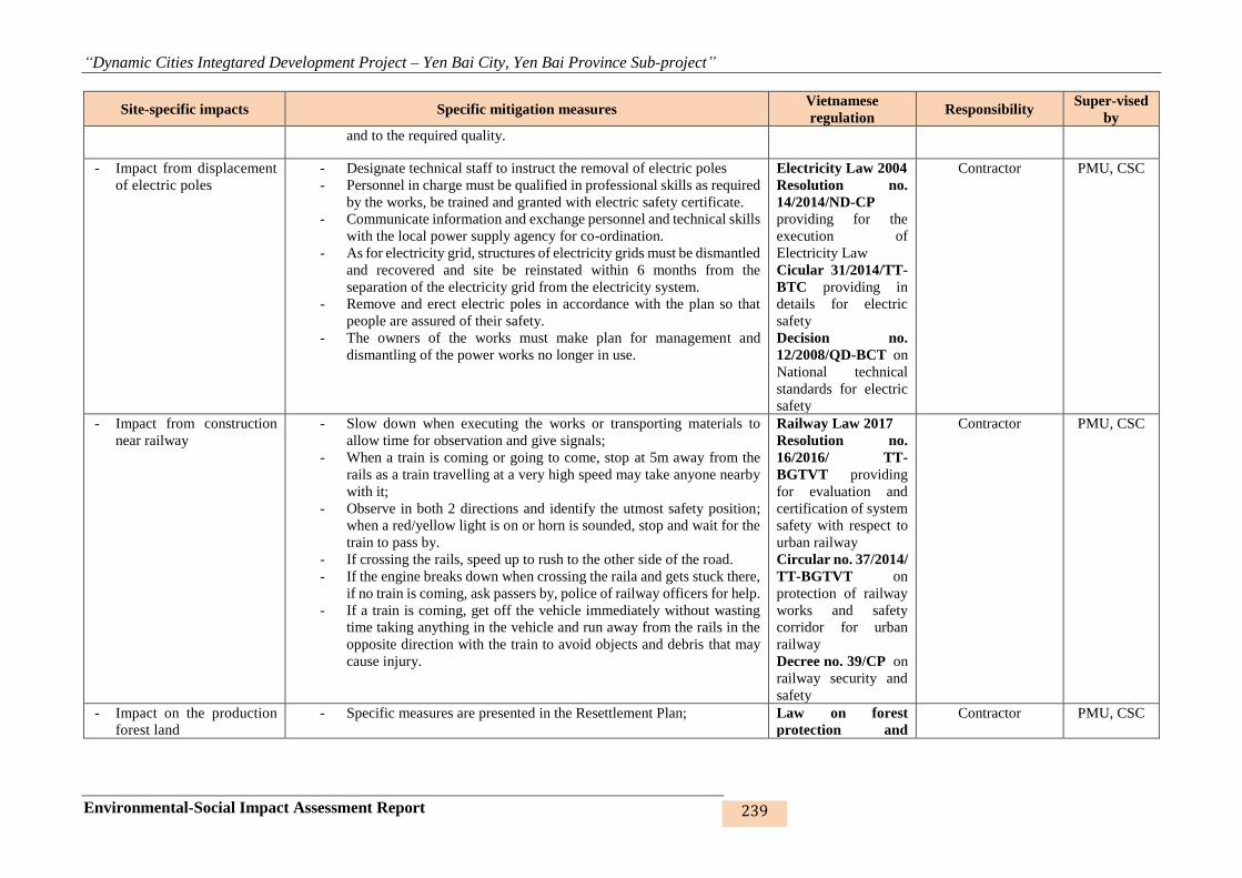
“Dynamic Cities Integtared Development Project – Yen Bai City, Yen Bai Province Sub-project”
Environmental-Social Impact Assessment Report 239
Site-specific impacts Specific mitigation measures Vietnamese
regulation Responsibility
Super-vised
by
and to the required quality.
- Impact from displacement
of electric poles
- Designate technical staff to instruct the removal of electric poles
- Personnel in charge must be qualified in professional skills as required
by the works, be trained and granted with electric safety certificate.
- Communicate information and exchange personnel and technical skills
with the local power supply agency for co-ordination.
- As for electricity grid, structures of electricity grids must be dismantled
and recovered and site be reinstated within 6 months from the
separation of the electricity grid from the electricity system.
- Remove and erect electric poles in accordance with the plan so that
people are assured of their safety.
- The owners of the works must make plan for management and
dismantling of the power works no longer in use.
Electricity Law 2004
Resolution no.
14/2014/ND-CP
providing for the
execution of
Electricity Law
Cicular 31/2014/TT-
BTC providing in
details for electric
safety
Decision no.
12/2008/QD-BCT on
National technical
standards for electric
safety
Contractor PMU, CSC
- Impact from construction
near railway
- Slow down when executing the works or transporting materials to
allow time for observation and give signals;
- When a train is coming or going to come, stop at 5m away from the
rails as a train travelling at a very high speed may take anyone nearby
with it;
- Observe in both 2 directions and identify the utmost safety position;
when a red/yellow light is on or horn is sounded, stop and wait for the
train to pass by.
- If crossing the rails, speed up to rush to the other side of the road.
- If the engine breaks down when crossing the raila and gets stuck there,
if no train is coming, ask passers by, police of railway officers for help.
- If a train is coming, get off the vehicle immediately without wasting
time taking anything in the vehicle and run away from the rails in the
opposite direction with the train to avoid objects and debris that may
cause injury.
Railway Law 2017
Resolution no.
16/2016/ TT-
BGTVT providing
for evaluation and
certification of system
safety with respect to
urban railway
Circular no. 37/2014/
TT-BGTVT on
protection of railway
works and safety
corridor for urban
railway
Decree no. 39/CP on
railway security and
safety
Contractor PMU, CSC
- Impact on the production
forest land
- Specific measures are presented in the Resettlement Plan; Law on forest
protection and
Contractor PMU, CSC

“Dynamic Cities Integtared Development Project – Yen Bai City, Yen Bai Province Sub-project”
Environmental-Social Impact Assessment Report 240
Site-specific impacts Specific mitigation measures Vietnamese
regulation Responsibility
Super-vised
by
- To ensure that the compensation, subsidies and resettlement support
rates are compliant with the donor’s policies and the laws of Vietnam;
- Support the HHs to stabilise their livelihood and production through
training courses and occupation change if HH members are in the
working ages.
- Firing, smoking or other fire hazards are strictly prohibited within the
construction site and the dominant forest production area;
- Adhere strictly to this collection, used for the project.
- Ensure the adequacy of land use allocations for the management,
conservation, and sustainable development of forests.
- Propagate people in forest protection and development.
development no.
29/2004/QH11
Law on forest
protection and
development
(revised), 2017
- Impact from traffic
disturbance
- Make detailed construction plans and make them public 2 weeks before
the construction;
- Completely finish a work item on the worksite before starting work on
others;
- Arrange signposts and staff guiding traffic flows (if necessary);
- Refrain from transporting and unloading construction materials and
waste materials on the main routes in rush hours;
- Regulate the vehicles to and from the work sites and appropriate
construction quantities.
Law on
communication and
transport No.
23/2008/ QH12;
Law No. 38/2009/
QH12 dated
19/6/2009 amending
and supplementing
some articles of the
Law relating to capital
construction
investment.
Contractor PMU, CSC
- Elevation discrepancy
between the works and
local people’s house
- Study the existing terrain when surveying for detailed design
preparation and select suitable technical option
- Consult with local people and authorities in dealing with elevation
discrepancy prior to carrying out the works.
- Design the connection from the designed works to local people’s
houses to ensure entrance to house/works
- Support HHs with lower elevation than the design elevation to provide
connection and reduce elevation differences.
Regulation no. 01-
2008 of Ministry of
Construction on
construction planning
Contractor PMU, CSC
- Impact from local flooding - Arrange temporary settling holes and rainwater drainage system on the
construction site;
- Arrange pumps with suitable capacity to pump water when necessary
and to prevent inundation of materals and equipment;
- Prepare plans for dealing with flooding on the worksite;
TCVN 4447:2012:
Construction
regulation
Circular No. 22/
2010/TT-BXD:
Contractor PMU, CSC

“Dynamic Cities Integtared Development Project – Yen Bai City, Yen Bai Province Sub-project”
Environmental-Social Impact Assessment Report 241
Site-specific impacts Specific mitigation measures Vietnamese
regulation Responsibility
Super-vised
by
- Closely watch the weather to prepare appropriate construction
methods.
Regulation on
construction safety
QCVN 08-MT: 2015/
BTNMT – National
technical regulation
on surface water
quality
6.1.3. Mitigation measures for impacts on sensititive receptors
Mitigation measures for sensitive points are shown in the following table:
Table 46: Mitigation measures for sensitive areas
No Sensitive areas Impacts Mitigating measures Responsibilities Supervised
Nam Cuong lakes 1,2,3 embankment (7 sensitive areas and residential area)
1. Multi-purpose communal
house
- Dust, gas emissions
- Noise, vibration
- Wastewater
- Waste
- Restricted access to the
communal center
- Traffic accidents risk
- Activities of the local people
- Conflict with workers
- Notify the community of the construction schedule at
least 2 weeks before starting works.
- Build temporary bridge before starting works
- Erect closed guardrails and signposts to organise
traffic flows at the outstanding construction sites.
- Coordinate with removing service supplier to remove
the house before starting works.
- Arrange signposts and lights at two ends of and along
the temporary bridge at night.
- Arrange staff to guide drivers of crane, truck and
boring machines to avoid collision with the existing
electric wires.
- Provide labours with protective equipment, life jacket
and safety harness.
- Contractor - Project
Owner,
CSC, IESC
2. Medical station - Dust, gas emissions
- Noise, vibration
- Wastewater
- Waste
- Notify the community of the construction schedule at
least 2 weeks before starting works.
- Build temporary bridge before starting works
- Erect closed guardrails and signposts to organise
- Contractor - Project
Owner,
CSC, IESC
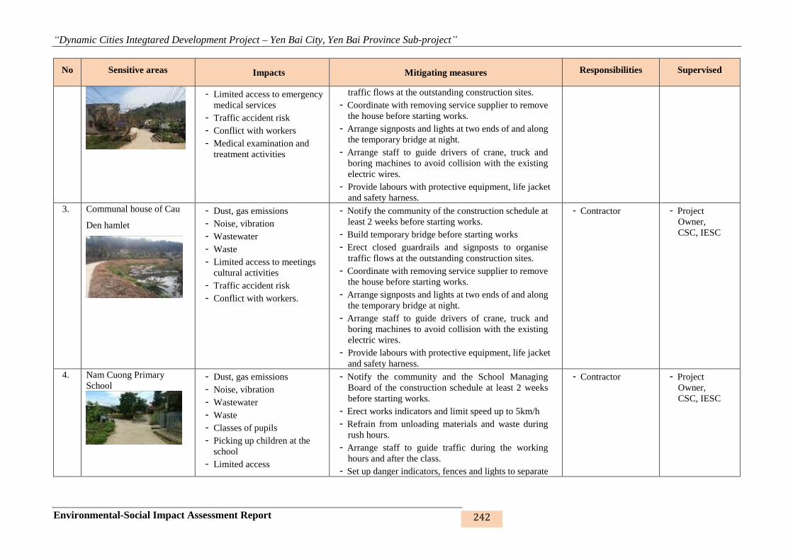
“Dynamic Cities Integtared Development Project – Yen Bai City, Yen Bai Province Sub-project”
Environmental-Social Impact Assessment Report 242
No Sensitive areas Impacts Mitigating measures Responsibilities Supervised
- Limited access to emergency
medical services
- Traffic accident risk
- Conflict with workers
- Medical examination and
treatment activities
traffic flows at the outstanding construction sites.
- Coordinate with removing service supplier to remove
the house before starting works.
- Arrange signposts and lights at two ends of and along
the temporary bridge at night.
- Arrange staff to guide drivers of crane, truck and
boring machines to avoid collision with the existing
electric wires.
- Provide labours with protective equipment, life jacket
and safety harness.
3. Communal house of Cau
Den hamlet
- Dust, gas emissions
- Noise, vibration
- Wastewater
- Waste
- Limited access to meetings
cultural activities
- Traffic accident risk
- Conflict with workers.
- Notify the community of the construction schedule at
least 2 weeks before starting works.
- Build temporary bridge before starting works
- Erect closed guardrails and signposts to organise
traffic flows at the outstanding construction sites.
- Coordinate with removing service supplier to remove
the house before starting works.
- Arrange signposts and lights at two ends of and along
the temporary bridge at night.
- Arrange staff to guide drivers of crane, truck and
boring machines to avoid collision with the existing
electric wires.
- Provide labours with protective equipment, life jacket
and safety harness.
- Contractor - Project
Owner,
CSC, IESC
4. Nam Cuong Primary
School
- Dust, gas emissions
- Noise, vibration
- Wastewater
- Waste
- Classes of pupils
- Picking up children at the
school
- Limited access
- Notify the community and the School Managing
Board of the construction schedule at least 2 weeks
before starting works.
- Erect works indicators and limit speed up to 5km/h
- Refrain from unloading materials and waste during
rush hours.
- Arrange staff to guide traffic during the working
hours and after the class.
- Set up danger indicators, fences and lights to separate
- Contractor - Project
Owner,
CSC, IESC

“Dynamic Cities Integtared Development Project – Yen Bai City, Yen Bai Province Sub-project”
Environmental-Social Impact Assessment Report 243
No Sensitive areas Impacts Mitigating measures Responsibilities Supervised
- Traffic accident risk
- Conflict with workers
the construction site with the existing road.
- Water the site to prevent dust in dry and windy days
at least 3 times a day.
- Arrange materials neatly after each working day.
- Cover the unfinished holes, ditches and culverts at the
end of the day.
- Use pre-cast box culverts and finish the construction
works within a working day.
5. Son Ca Kindergarten
- Dust, gas emissions
- Noise, vibration
- Wastewater
- Solid waste
- Teaching and learning
activities
- Limited access
- Traffic accident risk
- Conflict with workers
- Notify the community and the School Managing
Board of the construction schedule at least 2 weeks
before starting works.
- Erect works indicators and limit speed up to 5km/h
- Refrain from unloading materials and waste during
rudh hours.
- Arrange staff to guide traffic during the working
hours and after the class.
- Set up danger indicators, fences and lights to separate
the construction site with the existing road.
- Water the site to prevent dust in dry and windy days
at least 3 times a day.
- Arrange materials neatly after each working day.
- Cover the unfinished holes, ditches and culverts at the
end of the day.
- Use pre-cast box culverts and finish the construction
works within a working day.
- Contractor - Project
Owner,
CSC, IESC
6. Martyr’s cemetery
- Dust, gas emissions
- Noise, vibration
- Wastewater
- Waste
- Limited access
- Traffic accident risk
- Conflict with workers.
- Notify the community of the construction schedule at
least 2 weeks before starting works.
- Build temporary bridge before starting works
- Erect closed guardrails and signposts to organise
traffic flows at the outstanding construction sites.
- Coordinate with removing service supplier to remove
the house before starting works.
- Contractor - Project
Owner,
CSC, IESC

“Dynamic Cities Integtared Development Project – Yen Bai City, Yen Bai Province Sub-project”
Environmental-Social Impact Assessment Report 244
No Sensitive areas Impacts Mitigating measures Responsibilities Supervised
- Visits and ceremonies - Arrange signposts and lights at two ends of and along
the temporary bridge at night.
- Arrange staff to guide drivers of crane, truck and
boring machines to avoid collision with the existing
electric wires.
- Provide labours with protective equipment, life jacket
and safety harness.
7. Mau Temple, Van Thang
pagoda and temple
- Dust, gas emissions
- Noise, vibration
- Wastewater
- Waste
- Limited access
- Traffic accident risk
- Festival activities and
holidays in the year.
- Notify the community of the construction schedule at
least 2 weeks before starting works.
- Build temporary bridge before starting works
- Erect closed guardrails and signposts to organise
traffic flows at the outstanding construction sites.
- Coordinate with removing service supplier to remove
the house before starting works.
- Arrange signposts and lights at two ends of and along
the temporary bridge at night.
- Arrange staff to guide drivers of crane, truck and
boring machines to avoid collision with the existing
electric wires.
- Provide labours with protective equipment, life jacket
and safety harness.
- Contractor - Project
Owner,
CSC, IESC
8. Nam Cuong residential
area
- Dust, gas emissions
- Noise, vibration
- Wastewater
- Waste
- Limited access
- Traffic accident risk
- Conflict with workers.
- Living and production
activities of people.
- Notify the community of the construction schedule at
least 2 weeks before starting works.
- Erect works indicators and limit speed up to 5km/h
- Refrain from unloading materials and waste during
rush hours.
- Arrange staff to guide traffic.
- Set up danger indicators, fences and lights to separate
the construction site with the existing road.
- Water the site to prevent dust in dry and windy days
at least 3 times a day.
- Arrange materials neatly after each working day.
- Contractor - Project
Owner,
CSC, IESC

“Dynamic Cities Integtared Development Project – Yen Bai City, Yen Bai Province Sub-project”
Environmental-Social Impact Assessment Report 245
No Sensitive areas Impacts Mitigating measures Responsibilities Supervised
- Cover the unfinished holes, ditches and culverts at the
end of the day.
- Use pre-cast box culverts and finish the construction
works within a working day.
Hao Gia stream embankment (no sensitieve area except residential area)
9. Hao Gia stream residential
area
- Dust, gas emissions
- Noise, vibration
- Wastewater
- Waste
- Limited access
- Traffic accident risk
- Conflict with workers
- Living, business and
production activities of local
people
- Notify the community of the construction schedule at
least 2 weeks before starting works.
- Prepare construction plan for carrying out the works
in dry season.
- Provide temporary entrances when executing culverts
that may obstruct entrance to houses.
- Build temporary longitudinal drainage canals on two
sides of the road.
- Periodically clear the drainage ditches and canals.
- Clear all waste and materials everyday and not to
place them next to the existing road.
- Set up danger indicators, fences and lights to separate
the construction site with the existing road. Arrange
lights at night.
- Cover and place danger indicators at unfinished and
uncovered holes and ditches.
- Water the site during the construction process at least
twice/day.
- Contractor - Project
Owner,
CSC, IESC
Khe Dai stream embankment (4 sensitive areas and residential area)
10. Yen Ninh ward medical
station
- Dust, gas emissions
- Noise, vibration
- Wastewater
- Waste
- Limited access to medical
services and emergency
treatment
- Traffic accident risk
- Notify the community of the construction schedule at
least 2 weeks before starting works.
- Erect closed guardrails and signposts to organise
traffic flows at the outstanding construction sites.
- Coordinate with removing service supplier to remove
the house before starting works.
- Arrange signposts and lights at two ends of and along
the temporary bridge at night.
- Contractor - Project
Owner,
CSC, IESC
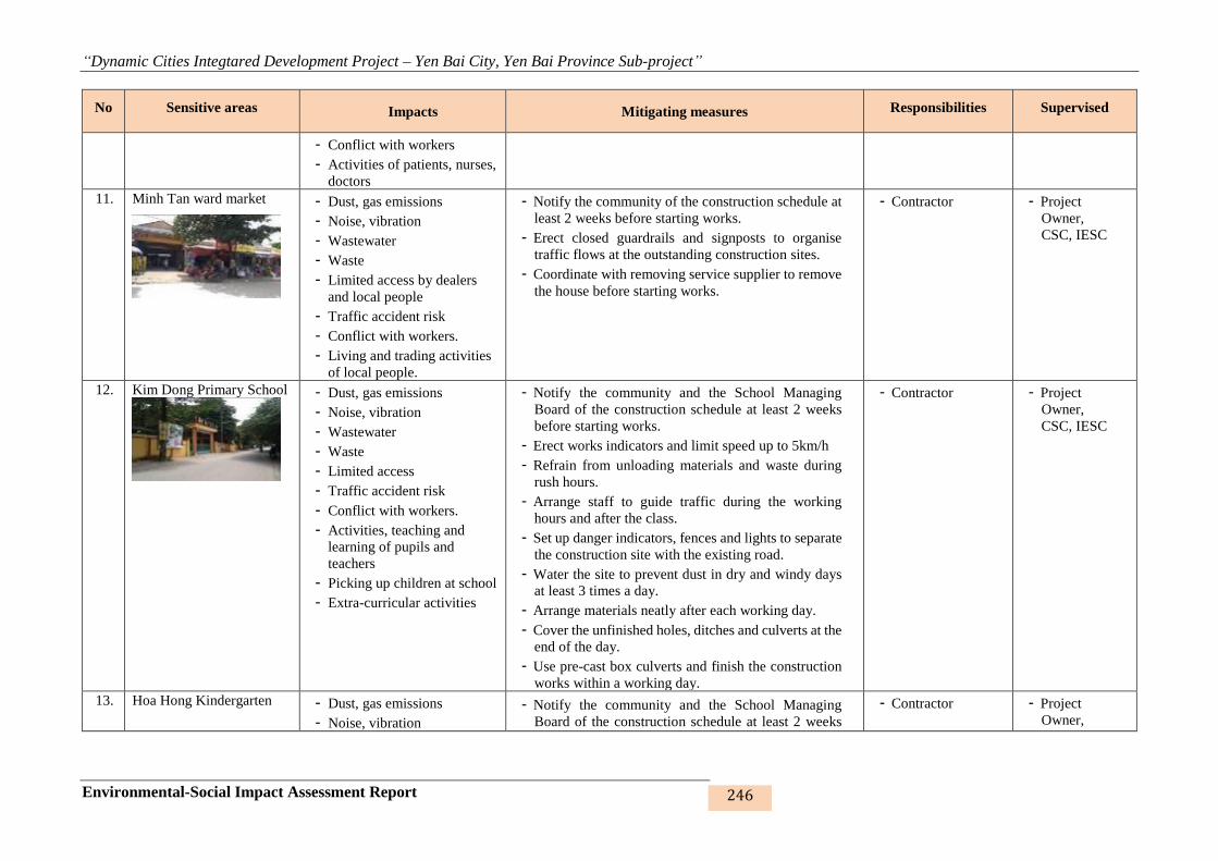
“Dynamic Cities Integtared Development Project – Yen Bai City, Yen Bai Province Sub-project”
Environmental-Social Impact Assessment Report 246
No Sensitive areas Impacts Mitigating measures Responsibilities Supervised
- Conflict with workers
- Activities of patients, nurses,
doctors
11. Minh Tan ward market
- Dust, gas emissions
- Noise, vibration
- Wastewater
- Waste
- Limited access by dealers
and local people
- Traffic accident risk
- Conflict with workers.
- Living and trading activities
of local people.
- Notify the community of the construction schedule at
least 2 weeks before starting works.
- Erect closed guardrails and signposts to organise
traffic flows at the outstanding construction sites.
- Coordinate with removing service supplier to remove
the house before starting works.
- Contractor - Project
Owner,
CSC, IESC
12. Kim Dong Primary School
- Dust, gas emissions
- Noise, vibration
- Wastewater
- Waste
- Limited access
- Traffic accident risk
- Conflict with workers.
- Activities, teaching and
learning of pupils and
teachers
- Picking up children at school
- Extra-curricular activities
- Notify the community and the School Managing
Board of the construction schedule at least 2 weeks
before starting works.
- Erect works indicators and limit speed up to 5km/h
- Refrain from unloading materials and waste during
rush hours.
- Arrange staff to guide traffic during the working
hours and after the class.
- Set up danger indicators, fences and lights to separate
the construction site with the existing road.
- Water the site to prevent dust in dry and windy days
at least 3 times a day.
- Arrange materials neatly after each working day.
- Cover the unfinished holes, ditches and culverts at the
end of the day.
- Use pre-cast box culverts and finish the construction
works within a working day.
- Contractor - Project
Owner,
CSC, IESC
13. Hoa Hong Kindergarten - Dust, gas emissions
- Noise, vibration
- Notify the community and the School Managing
Board of the construction schedule at least 2 weeks
- Contractor - Project
Owner,
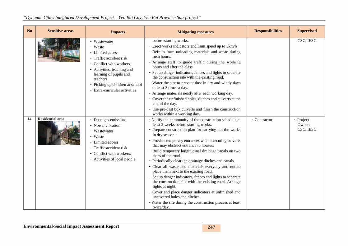
“Dynamic Cities Integtared Development Project – Yen Bai City, Yen Bai Province Sub-project”
Environmental-Social Impact Assessment Report 247
No Sensitive areas Impacts Mitigating measures Responsibilities Supervised
- Wastewater
- Waste
- Limited access
- Traffic accident risk
- Conflict with workers.
- Activities, teaching and
learning of pupils and
teachers
- Picking up children at school
- Extra-curricular activities
before starting works.
- Erect works indicators and limit speed up to 5km/h
- Refrain from unloading materials and waste during
rush hours.
- Arrange staff to guide traffic during the working
hours and after the class.
- Set up danger indicators, fences and lights to separate
the construction site with the existing road.
- Water the site to prevent dust in dry and windy days
at least 3 times a day.
- Arrange materials neatly after each working day.
- Cover the unfinished holes, ditches and culverts at the
end of the day.
- Use pre-cast box culverts and finish the construction
works within a working day.
CSC, IESC
14. Residential area
- Dust, gas emissions
- Noise, vibration
- Wastewater
- Waste
- Limited access
- Traffic accident risk
- Conflict with workers.
- Activities of local people
- Notify the community of the construction schedule at
least 2 weeks before starting works.
- Prepare construction plan for carrying out the works
in dry season.
- Provide temporary entrances when executing culverts
that may obstruct entrance to houses.
- Build temporary longitudinal drainage canals on two
sides of the road.
- Periodically clear the drainage ditches and canals.
- Clear all waste and materials everyday and not to
place them next to the existing road.
- Set up danger indicators, fences and lights to separate
the construction site with the existing road. Arrange
lights at night.
- Cover and place danger indicators at unfinished and
uncovered holes and ditches.
- Water the site during the construction process at least
twice/day.
- Contractor - Project
Owner,
CSC, IESC
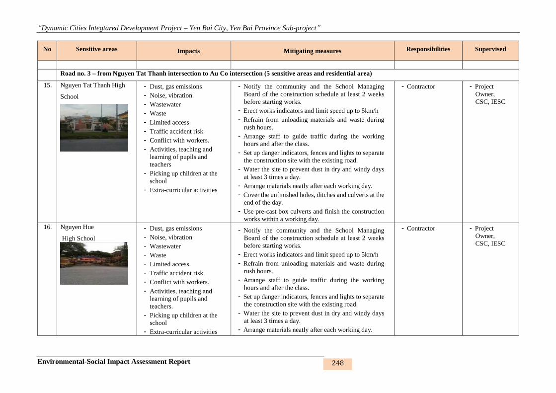
“Dynamic Cities Integtared Development Project – Yen Bai City, Yen Bai Province Sub-project”
Environmental-Social Impact Assessment Report 248
No Sensitive areas Impacts Mitigating measures Responsibilities Supervised
Road no. 3 – from Nguyen Tat Thanh intersection to Au Co intersection (5 sensitive areas and residential area)
15. Nguyen Tat Thanh High
School
- Dust, gas emissions
- Noise, vibration
- Wastewater
- Waste
- Limited access
- Traffic accident risk
- Conflict with workers.
- Activities, teaching and
learning of pupils and
teachers
- Picking up children at the
school
- Extra-curricular activities
- Notify the community and the School Managing
Board of the construction schedule at least 2 weeks
before starting works.
- Erect works indicators and limit speed up to 5km/h
- Refrain from unloading materials and waste during
rush hours.
- Arrange staff to guide traffic during the working
hours and after the class.
- Set up danger indicators, fences and lights to separate
the construction site with the existing road.
- Water the site to prevent dust in dry and windy days
at least 3 times a day.
- Arrange materials neatly after each working day.
- Cover the unfinished holes, ditches and culverts at the
end of the day.
- Use pre-cast box culverts and finish the construction
works within a working day.
- Contractor - Project
Owner,
CSC, IESC
16. Nguyen Hue
High School
- Dust, gas emissions
- Noise, vibration
- Wastewater
- Waste
- Limited access
- Traffic accident risk
- Conflict with workers.
- Activities, teaching and
learning of pupils and
teachers.
- Picking up children at the
school
- Extra-curricular activities
- Notify the community and the School Managing
Board of the construction schedule at least 2 weeks
before starting works.
- Erect works indicators and limit speed up to 5km/h
- Refrain from unloading materials and waste during
rush hours.
- Arrange staff to guide traffic during the working
hours and after the class.
- Set up danger indicators, fences and lights to separate
the construction site with the existing road.
- Water the site to prevent dust in dry and windy days
at least 3 times a day.
- Arrange materials neatly after each working day.
- Contractor - Project
Owner,
CSC, IESC
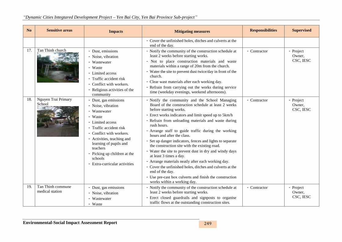
“Dynamic Cities Integtared Development Project – Yen Bai City, Yen Bai Province Sub-project”
Environmental-Social Impact Assessment Report 249
No Sensitive areas Impacts Mitigating measures Responsibilities Supervised
- Cover the unfinished holes, ditches and culverts at the
end of the day.
17. Tan Thinh church
- Dust, emissions
- Noise, vibration
- Wastewater
- Waste
- Limited access
- Traffic accident risk
- Conflict with workers.
- Religious activities of the
community
- Notify the community of the construction schedule at
least 2 weeks before starting works.
- Not to place construction materials and waste
materials within a range of 20m from the church.
- Water the site to prevent dust twice/day in front of the
church.
- Clear wast materials after each working day.
- Refrain from carrying out the works during service
time (weekday evenings, weekend afternoons).
- Contractor - Project
Owner,
CSC, IESC
18. Nguyen Trai Primary
School
- Dust, gas emissions
- Noise, vibration
- Wastewater
- Waste
- Limited access
- Traffic accident risk
- Conflict with workers.
- Activities, teaching and
learning of pupils and
teachers
- Picking up children at the
schools
- Extra-curricular activities
- Notify the community and the School Managing
Board of the construction schedule at least 2 weeks
before starting works.
- Erect works indicators and limit speed up to 5km/h
- Refrain from unloading materials and waste during
rush hours.
- Arrange staff to guide traffic during the working
hours and after the class.
- Set up danger indicators, fences and lights to separate
the construction site with the existing road.
- Water the site to prevent dust in dry and windy days
at least 3 times a day.
- Arrange materials neatly after each working day.
- Cover the unfinished holes, ditches and culverts at the
end of the day.
- Use pre-cast box culverts and finish the construction
works within a working day.
- Contractor - Project
Owner,
CSC, IESC
19. Tan Thinh commune
medical station - Dust, gas emissions
- Noise, vibration
- Wastewater
- Waste
- Notify the community of the construction schedule at
least 2 weeks before starting works.
- Erect closed guardrails and signposts to organise
traffic flows at the outstanding construction sites.
- Contractor - Project
Owner,
CSC, IESC
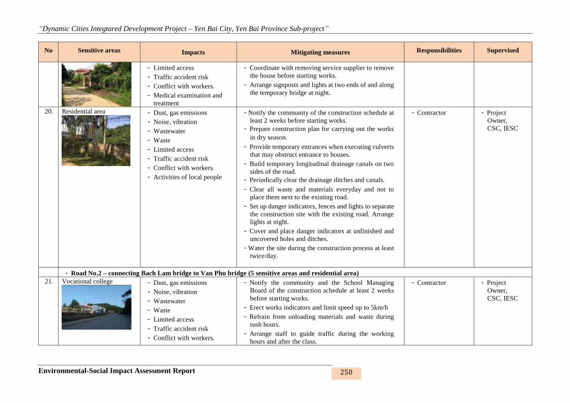
“Dynamic Cities Integtared Development Project – Yen Bai City, Yen Bai Province Sub-project”
Environmental-Social Impact Assessment Report 250
No Sensitive areas Impacts Mitigating measures Responsibilities Supervised
- Limited access
- Traffic accident risk
- Conflict with workers.
- Medical examination and
treatment
- Coordinate with removing service supplier to remove
the house before starting works.
- Arrange signposts and lights at two ends of and along
the temporary bridge at night.
20. Residential area
- Dust, gas emissions
- Noise, vibration
- Wastewater
- Waste
- Limited access
- Traffic accident risk
- Conflict with workers.
- Activities of local people
- Notify the community of the construction schedule at
least 2 weeks before starting works.
- Prepare construction plan for carrying out the works
in dry season.
- Provide temporary entrances when executing culverts
that may obstruct entrance to houses.
- Build temporary longitudinal drainage canals on two
sides of the road.
- Periodically clear the drainage ditches and canals.
- Clear all waste and materials everyday and not to
place them next to the existing road.
- Set up danger indicators, fences and lights to separate
the construction site with the existing road. Arrange
lights at night.
- Cover and place danger indicators at unfinished and
uncovered holes and ditches.
- Water the site during the construction process at least
twice/day.
- Contractor - Project
Owner,
CSC, IESC
- Road No.2 – connecting Bach Lam bridge to Van Phu bridge (5 sensitive areas and residential area)
21. Vocational college
- Dust, gas emissions
- Noise, vibration
- Wastewater
- Waste
- Limited access
- Traffic accident risk
- Conflict with workers.
- Notify the community and the School Managing
Board of the construction schedule at least 2 weeks
before starting works.
- Erect works indicators and limit speed up to 5km/h
- Refrain from unloading materials and waste during
rush hours.
- Arrange staff to guide traffic during the working
hours and after the class.
- Contractor - Project
Owner,
CSC, IESC
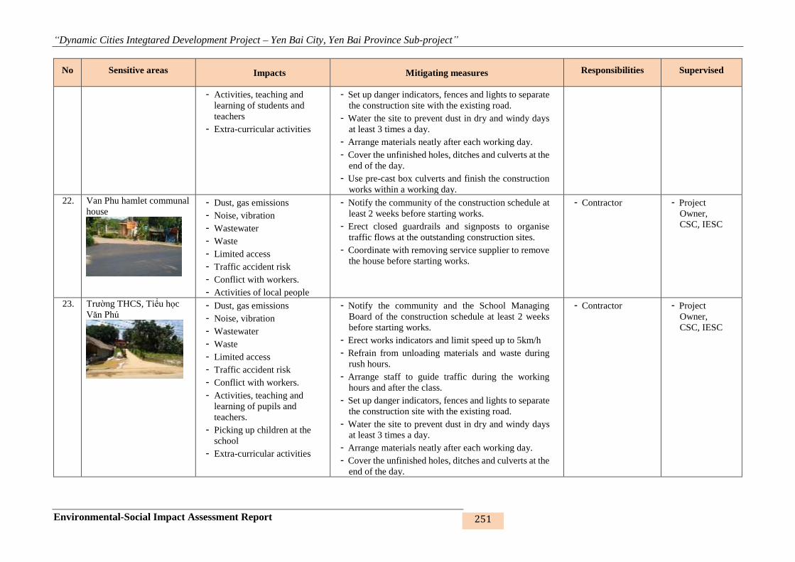
“Dynamic Cities Integtared Development Project – Yen Bai City, Yen Bai Province Sub-project”
Environmental-Social Impact Assessment Report 251
No Sensitive areas Impacts Mitigating measures Responsibilities Supervised
- Activities, teaching and
learning of students and
teachers
- Extra-curricular activities
- Set up danger indicators, fences and lights to separate
the construction site with the existing road.
- Water the site to prevent dust in dry and windy days
at least 3 times a day.
- Arrange materials neatly after each working day.
- Cover the unfinished holes, ditches and culverts at the
end of the day.
- Use pre-cast box culverts and finish the construction
works within a working day.
22. Van Phu hamlet communal
house
- Dust, gas emissions
- Noise, vibration
- Wastewater
- Waste
- Limited access
- Traffic accident risk
- Conflict with workers.
- Activities of local people
- Notify the community of the construction schedule at
least 2 weeks before starting works.
- Erect closed guardrails and signposts to organise
traffic flows at the outstanding construction sites.
- Coordinate with removing service supplier to remove
the house before starting works.
- Contractor - Project
Owner,
CSC, IESC
23. Trường THCS, Tiểu học
Văn Phú
- Dust, gas emissions
- Noise, vibration
- Wastewater
- Waste
- Limited access
- Traffic accident risk
- Conflict with workers.
- Activities, teaching and
learning of pupils and
teachers.
- Picking up children at the
school
- Extra-curricular activities
- Notify the community and the School Managing
Board of the construction schedule at least 2 weeks
before starting works.
- Erect works indicators and limit speed up to 5km/h
- Refrain from unloading materials and waste during
rush hours.
- Arrange staff to guide traffic during the working
hours and after the class.
- Set up danger indicators, fences and lights to separate
the construction site with the existing road.
- Water the site to prevent dust in dry and windy days
at least 3 times a day.
- Arrange materials neatly after each working day.
- Cover the unfinished holes, ditches and culverts at the
end of the day.
- Contractor - Project
Owner,
CSC, IESC

“Dynamic Cities Integtared Development Project – Yen Bai City, Yen Bai Province Sub-project”
Environmental-Social Impact Assessment Report 252
No Sensitive areas Impacts Mitigating measures Responsibilities Supervised
- Use pre-cast box culverts and finish the construction
works within a working day.
24. Tuy Loc hamlet
communal house
- Dust, emissions
- Noise, vibration
- Wastewater
- Waste
- Limited access
- Traffic accident risk
- Conflict with workers.
- Activities of local people
- Notify the community of the construction schedule at
least 2 weeks before starting works.
- Erect closed guardrails and signposts to organise
traffic flows at the outstanding construction sites.
- Coordinate with removing service supplier to remove
the house before starting works.
- Contractor - Project
Owner,
CSC, IESC
25. Van Phu temple and
pagoda
- Dust, gas emissions
- Noise, vibration
- Wastewater
- Waste
- Limited access
- Traffic accident risk
- Conflict with workers.
- Religious activities of local
people and visitors
- Notify the church management board and the
community of the construction schedule at least 2
weeks before starting works.
- Not to place construction materials and waste
materials within a range of 20m from the church.
- Water the site to prevent dust twice/day in front of the
church.
- Clear waste materials after each working day.
- Refrain from carrying out the works during service
time (weekday evenings, weekend afternoons).
- Contractor - Project
Owner,
CSC, IESC
26. Residential area
- Dust, gas emissions
- Noise, vibration
- Wastewater
- Waste
- Limited access
- Traffic accident risk
- Conflict with workers.
- Activities of local people
- Notify the community of the construction schedule at
least 2 weeks before starting works.
- Prepare construction plan for carrying out the works
in dry season.
- Provide temporary entrances when executing culverts
that may obstruct entrance to houses.
- Build temporary longitudinal drainage canals on two
sides of the road.
- Periodically clear the drainage ditches and canals.
- Clear all waste and materials everyday and not to
place them next to the existing road.
- Set up danger indicators, fences and lights to separate
- Contractor - Project
Owner,
CSC, IESC
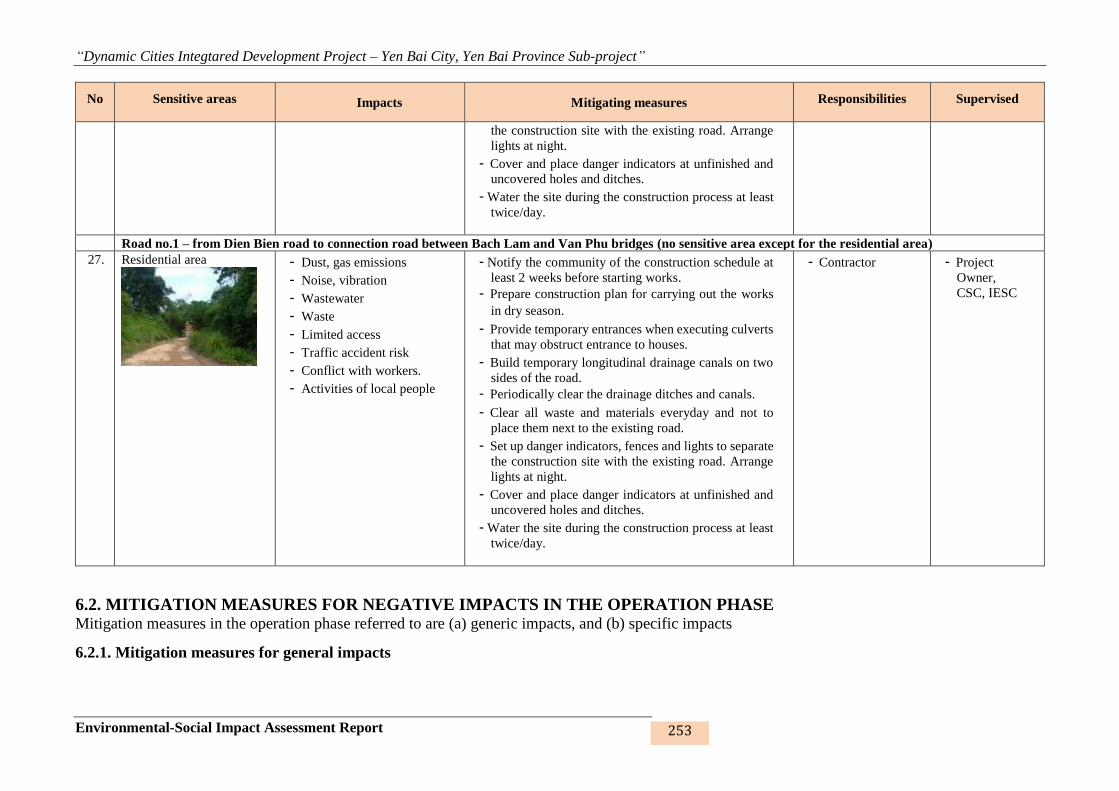
“Dynamic Cities Integtared Development Project – Yen Bai City, Yen Bai Province Sub-project”
Environmental-Social Impact Assessment Report 253
No Sensitive areas Impacts Mitigating measures Responsibilities Supervised
the construction site with the existing road. Arrange
lights at night.
- Cover and place danger indicators at unfinished and
uncovered holes and ditches.
- Water the site during the construction process at least
twice/day.
Road no.1 – from Dien Bien road to connection road between Bach Lam and Van Phu bridges (no sensitive area except for the residential area)
27. Residential area
- Dust, gas emissions
- Noise, vibration
- Wastewater
- Waste
- Limited access
- Traffic accident risk
- Conflict with workers.
- Activities of local people
- Notify the community of the construction schedule at
least 2 weeks before starting works.
- Prepare construction plan for carrying out the works
in dry season.
- Provide temporary entrances when executing culverts
that may obstruct entrance to houses.
- Build temporary longitudinal drainage canals on two
sides of the road.
- Periodically clear the drainage ditches and canals.
- Clear all waste and materials everyday and not to
place them next to the existing road.
- Set up danger indicators, fences and lights to separate
the construction site with the existing road. Arrange
lights at night.
- Cover and place danger indicators at unfinished and
uncovered holes and ditches.
- Water the site during the construction process at least
twice/day.
- Contractor - Project
Owner,
CSC, IESC
6.2. MITIGATION MEASURES FOR NEGATIVE IMPACTS IN THE OPERATION PHASE Mitigation measures in the operation phase referred to are (a) generic impacts, and (b) specific impacts
6.2.1. Mitigation measures for general impacts
“Dynamic Cities Integtared Development Project – Yen Bai City, Yen Bai Province Sub-project”
Environmental-Social Impact Assessment Report 254
Mitigation measures for generic impacts are presented in the table below:
Table 47: Mitigation measures for generic impacts in the operation phase
Site-specific impacts Impacts Specific mitigation measures Responsi-
bility Super-vised
- Air and dust pollution
- Noise, vibration
- Health of travellers and some
HHs nearby
- Obstruct and reduce travel sight
- Houses and sensitve areas such
as market, school, medical
station are affected by noise and
vibration.
- Clean road surface on Hao Gia, Khe Dai streams, Nam Cuong lakes
and roads no.1, 2, 3;
- Collect scattered soil and stone;
- Water the roads by specialised equipment of the city;
- Erect the signposts limiting horns (air horn) when passing areas
sensitive to noise and vibration (especially in sections near schools,
medical stations, pagodas, temples and churches as identified
hereinabove);
- Plant trees in the sections crossing residential areas to beautify the
landscape and reduce dust and noise in the embankment areas and
roads no.1, 2, 3.
- Conduct regular maintenance of road pavement and greenery strips.
- Upgrade the pavement; spread anti-noise asphalt, reduce slope in
these sections to reduce noise when speeding up or slowing down.
PMU/
Other
management
unit
PMU/
Other
management
unit
- Wastewater - Rainwater spills over the sub-
project’s work items, flowing to
the catchments/receptors
- Regularly check drainage culverts and ditches along Nam Cuong
lake, Hao Gia stream and Khe Dai stream embankment, drainage
culverts along road no.1 – from Dien Bien road to the road
connecting Bach Lam bridge to Van Phu bridge, road no.2 - road
connecting Bach Lam bridge to Van Phu bridge and road no.3 – road
connecting from Nguyen Tat Thanh intersection and Au Co
intersection.
- Regularly collect solid waste on Nam Cuong lake, Hao Gia stream,
Khe Dai stream roads and roads no.1, 2, 3 by mechanical/manual
methods to prevent them from drifting along with rainwater into the
drainage system.
PMU/
Other
management
unit
PMU/
Other
management
unit
- Waste - People reside along the
embankments and roads,
travellers and businesses along
the routes.
- Affect urban aesthetic looks.
- Regularly check drainage culverts and ditches along the
embankments, roads and resettlement sites;
- Engage a firm for periodic collection of waste;
- Propagandise and prohibit local people, especially commercial
services on the embankments, from littering the embankments;
- Arrange waste bins along the embankments;
PMU/
Other
management
unit
PMU/
Other
management
unit

“Dynamic Cities Integtared Development Project – Yen Bai City, Yen Bai Province Sub-project”
Environmental-Social Impact Assessment Report 255
Site-specific impacts Impacts Specific mitigation measures Responsi-
bility Super-vised
- Arrange boards guiding the operation of the embankments, roads and
resettlement sites.
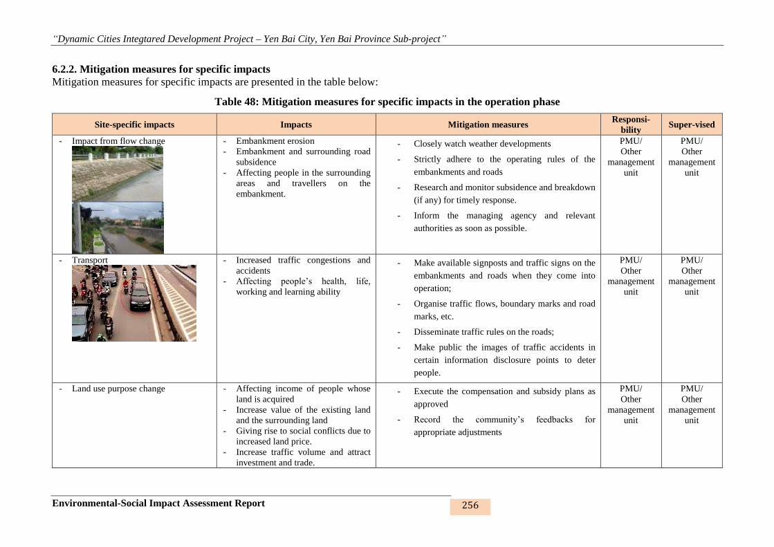
“Dynamic Cities Integtared Development Project – Yen Bai City, Yen Bai Province Sub-project”
Environmental-Social Impact Assessment Report 256
6.2.2. Mitigation measures for specific impacts
Mitigation measures for specific impacts are presented in the table below:
Table 48: Mitigation measures for specific impacts in the operation phase
Site-specific impacts Impacts Mitigation measures Responsi-
bility Super-vised
- Impact from flow change
- Embankment erosion
- Embankment and surrounding road
subsidence
- Affecting people in the surrounding
areas and travellers on the
embankment.
- Closely watch weather developments
- Strictly adhere to the operating rules of the
embankments and roads
- Research and monitor subsidence and breakdown
(if any) for timely response.
- Inform the managing agency and relevant
authorities as soon as possible.
PMU/
Other
management
unit
PMU/
Other
management
unit
- Transport
- Increased traffic congestions and
accidents
- Affecting people’s health, life,
working and learning ability
- Make available signposts and traffic signs on the
embankments and roads when they come into
operation;
- Organise traffic flows, boundary marks and road
marks, etc.
- Disseminate traffic rules on the roads;
- Make public the images of traffic accidents in
certain information disclosure points to deter
people.
PMU/
Other
management
unit
PMU/
Other
management
unit
- Land use purpose change - Affecting income of people whose
land is acquired
- Increase value of the existing land
and the surrounding land
- Giving rise to social conflicts due to
increased land price.
- Increase traffic volume and attract
investment and trade.
- Execute the compensation and subsidy plans as
approved
- Record the community’s feedbacks for
appropriate adjustments
PMU/
Other
management
unit
PMU/
Other
management
unit
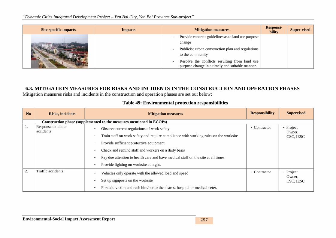
“Dynamic Cities Integtared Development Project – Yen Bai City, Yen Bai Province Sub-project”
Environmental-Social Impact Assessment Report 257
Site-specific impacts Impacts Mitigation measures Responsi-
bility Super-vised
- Provide concrete guidelines as to land use purpose
change
- Publicise urban construction plan and regulations
to the community
- Resolve the conflicts resulting from land use
purpose change in a timely and suitable manner.
6.3. MITIGATION MEASURES FOR RISKS AND INCIDENTS IN THE CONSTRUCTION AND OPERATION PHASES Mitigation measures risks and incidents in the construction and operation phases are set out below:
Table 49: Environmental protection responsibilities
No Risks, incidents Mitigation measures Responsibility Supervised
Construction phase (supplemented to the measures mentioned in ECOPs)
1. Response to labour
accidents - Observe current regulations of work safety
- Train staff on work safety and require compliance with working rules on the worksite
- Provide sufficient protective equipment
- Check and remind staff and workers on a daily basis
- Pay due attention to health care and have medical staff on the site at all times
- Provide lighting on worksite at night.
- Contractor - Project
Owner,
CSC, IESC
2. Traffic accidents - Vehicles only operate with the allowed load and speed
- Set up signposts on the worksite
- First aid victim and rush him/her to the nearest hospital or medical ceter.
- Contractor - Project
Owner,
CSC, IESC
“Dynamic Cities Integtared Development Project – Yen Bai City, Yen Bai Province Sub-project”
Environmental-Social Impact Assessment Report 258
No Risks, incidents Mitigation measures Responsibility Supervised
3. Fuel and chemical spill, fire,
explosion, electric shock - Gather materials in the right places with proper warehouses, labelling and signboards,
away from where many vehicles travel
- Strictly ban smoking and flammable materials in warehouses
- Make available portable fire extinguishers;
- Provide regular training and practice for staff;
- Train on first-aid skills;
- Inform the authorities and Project Owner as soon as possible of the incident, if any
- Contractor - Project
Owner,
CSC, IESC
4. Uncovering archaeological
and historical relics and
tombs
- Stop the construction immediately;
- Inform the Project Owner and relevant agencies;
- Protect the scene until the authorities come.
- Contractor - Project
Owner,
CSC, IESC
5. Other incidents - Ensure saniation and food hygiene for workers in site capms;
- Ensure minimum living conditions and hygiene at worksite and camps;
- Tidy up and clean regularly
- Spray mosquitocidal and other pest control methods on a regular basis;
- Train workers on first-aid skills before moving victim to the nearest hospital or medical
center
- Contractor - Project
Owner,
CSC, IESC
Operation phase
6. Embankment erosion,
bridge breakdown, road
subsidence
- Local governments need to take steps to improve people’s awareness of environmental
protection
- Conduct periodic remodelling of the roads. Remedy any damage to road surface, slopes
and embankments
- Erect signposts guiding loads and types of vehicles permitted to use the bridges, roads and
embankments in notable positions.
- Regularly check quality of bridges and embankments to avoid possible incidents
- Project
Owner/O&
M entity
- Project
Owner/O&
M entity
“Dynamic Cities Integtared Development Project – Yen Bai City, Yen Bai Province Sub-project”
Environmental-Social Impact Assessment Report 259
No Risks, incidents Mitigation measures Responsibility Supervised
7. Falling into streams and
lakes, drowning in sewers - Local governments need to take steps to improve people’s awareness of environmental
protection
- Propagandise and prohibit local people, especially commercial services on the
embankments, from littering the embankments.
- Arrange waste bins along the emabankments;
- Arrange signposts guiding people to travel safely
- Arrange guardrails or door with height of 80-90cm, at the operation and management stairs
to the walkway on the embankment, including danger indicator and light.
- Check and repair promptly the damaged embankment sections as heavy rain will cause
serious erosion and collapse.
- Design and layout of the area of grass under the road and planting with lobster, canary,
black star with a diameter of 10-12cm, height of 4m of the three routelines 1,2 and 3.
- Planting trees (lobster, canary, black star with a diameter of 10-12cm, height of 4m,
planted along the embankment of Hao Gia, Khe Dai, Nam Cuong, and resettlement areas.
- Project
Owner/O&
M entity
- Project
Owner/O&
M entity
8. Road and railway traffic
accidents - Local government needs to disseminate to the community the identification of signages
- Inform regularly and periodically the operation schedule of the railway running near the
residential areas
- Arrange large size signposts and guiding boards
- Arrange staff to guide users in the beginning of the operation period
- First aid and bring victim to the nearest clinic and inform the local authorities of the
accident.
- Project
Owner/O&
M entity
- Project
Owner/O&
M entity
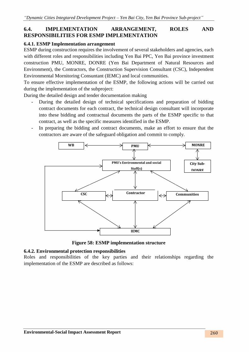
“Dynamic Cities Integtared Development Project – Yen Bai City, Yen Bai Province Sub-project”
Environmental-Social Impact Assessment Report 260
6.4. IMPLEMENTATION ARRANGEMENT, ROLES AND
RESPONSIBILITIES FOR ESMP IMPLEMENTATION
6.4.1. ESMP Implementation arrangement
ESMP during construction requires the involvement of several stakeholders and agencies, each
with different roles and responsibilities including Yen Bai PPC, Yen Bai province investment
construction PMU, MONRE, DONRE (Yen Bai Department of Natural Resources and
Environment), the Contractors, the Construction Supervision Consultant (CSC), Independent
Environmental Mornitoring Consuntant (IEMC) and local communities.
To ensure effective implementation of the ESMP, the following actions will be carried out
during the implementation of the subproject:
During the detailed design and tender documentation making
- During the detailed design of technical specifications and preparation of bidding
contract documents for each contract, the technical design consultant will incorporate
into these bidding and contractual documents the parts of the ESMP specific to that
contract, as well as the specific measures identified in the ESMP.
- In preparing the bidding and contract documents, make an effort to ensure that the
contractors are aware of the safeguard obligation and commit to comply.
Figure 58: ESMP implementation structure
6.4.2. Environmental protection responsibilities
Roles and responsibilities of the key parties and their relationships regarding the
implementation of the ESMP are described as follows:
PMU’s Environmental and social
Staff(s)
CSC Contractor
Communities
IEMC
WB
MONRE
PMU
City Sub-
DONRE
“Dynamic Cities Integtared Development Project – Yen Bai City, Yen Bai Province Sub-project”
Environmental-Social Impact Assessment Report 261
Table 50: Environmental protection responsibilities
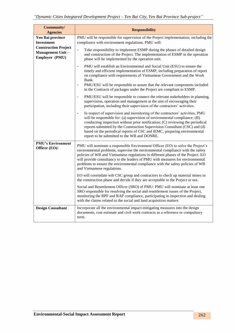
“Dynamic Cities Integtared Development Project – Yen Bai City, Yen Bai Province Sub-project”
Environmental-Social Impact Assessment Report 262
Community/
Agencies Responsibility
Yen Bai province
Investment
Construction Project
Management Unit –
Employer (PMU)
PMU will be responsible for supervision of the Project implementation, including the
compliance with environment regulations. PMU will:
- Take responsibility to implement ESMP during the phases of detailed design
and construction of the Project. The implementation of ESMP in the operation
phase will be implemented by the operation unit.
- PMU will establish an Environmental and Social Unit (ESU) to ensure the
timely and efficient implementation of ESMP, including preparation of report
on compliance with requirements of Vietnamese Government and the Work
Bank.
- PMU/ESU will be responsible to assure that the relevant components included
in the Contracts of packages under the Project are compliant to ESMP.
- PMU/ESU will be responsible to connect the relevant stakeholders in planning,
supervision, operation and management at the aim of encouraging their
participation, including their supervision of the contractors’ activities.
- In respect of supervision and mornitoring of the contractors’ activities, PMU
will be responsible for: (a) supervision of environmental compliance; (B)
conducting inspection without prior notification; (C) reviewing the periodical
reports submitted by the Construction Supervision Consultant (CSC) and (d)
based on the periodical reports of CSC and IEMC, preparing environmental
report to be submitted to the WB and DONRE.
PMU’s Environment
Officer (EO): PMU will nominate a responsible Environment Officer (EO) to solve the Project’s
environmental problems, supervise the environmental compliance with the safety
policies of WB and Vietnamese regulations in different phases of the Project. EO
will provide consultancy to the leaders of PMU with measures for environmental
problems to ensure the environmental compliance with the safety policies of WB
and Vietnamese regulations.
EO will coornidate wih CSC group and contractors to check up material mines in
the construction phase and decide if they are acceptable to the Porject or not.
Social and Resettlement Officer (SRO) of PMU: PMU will nominate at least one
SRO responsible for resolving the social and resettlement issues of the Project,
monitoring the RPF and RAP compliance, participating in inspection and dealing
with the claims related to the social and land acquisition matters
Design Consultant Incorporate all the environmental impact-mitigating measures into the design
documents, cost estimate and civil work contracts as a reference or compulsory
term.
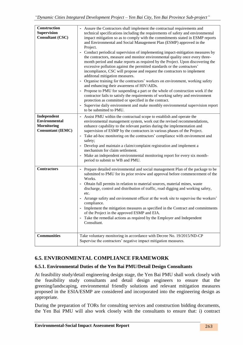
“Dynamic Cities Integtared Development Project – Yen Bai City, Yen Bai Province Sub-project”
Environmental-Social Impact Assessment Report 263
Construction
Supervision
Consultant (CSC)
- Assure the Contractors shall implement the contractual requirements and
technical specifications including the requirements of safety and environmental
impact mitigation so as to comply with the commitments stated in ESMP reports
and Environmental and Social Management Plan (ESMP) approved in the
Project.
- Conduct periodical supervision of implementing impact-mitigation measures by
the contractors, measure and monitor environmental quality once every three-
month period and make reports as required by the Project. Upon discovering the
excessive pollution against the permitted standards or the contractors’
incompliance, CSC will propose and request the contractors to implement
additonal mitigation measures.
- Organise training for the contractors’ workers on environment, working safety
and enhancing their awareness of HIV/AIDs.
- Propose to PMU for suspending a part or the whole of construction work if the
contractor fails to satisfy the requirements of working safety and environment
protection as committed or specified in the contract.
- Supervise daily environment and make monthly environmental supervision report
to be submitted to PMU.
Independent
Environmental
Mornitoring
Consuntant (IEMC)
- Assist PMU within the contractual scope to establish and operate the
environmental management system, work out the revised recommendations,
enhance capability to the relevant parties during the implementation and
supervision of ESMP by the contractors in various phases of the Project.
- Take ad-hoc monitoring on the contractors’ compliance with environment and
safety;
- Develop and maintain a claim/complaint registration and implement a
mechanism for claim settlement.
- Make an independent environmental monitoring report for every six month-
period to submit to WB and PMU.
Contractors - Prepare detailed environmental and social management Plan of the package to be
submitted to PMU for its prior review and approval before commencement of the
Works.
- Obtain full permits in relation to material sources, material mines, waste
discharge, control and distribution of traffic, road digging and working safety,
etc.
- Arrange safety and environment officer at the work site to supervise the workers’
compliance.
- Implement the mitigation measures as specified in the Contract and commitments
of the Project in the approved ESMP and EIA.
- Take the remedial actions as required by the Employer and Independent
Consultant.
Communities Take voluntary monitoring in accordance with Decree No. 19/2015/ND-CP
Supervise the contractors’ negative impact mitigation measures.
6.5. ENVIRONMENTAL COMPLIANCE FRAMEWORK
6.5.1. Environmental Duties of the Yen Bai PMU/Detail Design Consultants
At feasibility study/detail engineering design stage, the Yen Bai PMU shall work closely with
the feasibility study consultants and detail design engineers to ensure that the
greening/landscaping, environmental friendly solutions and relevant mitigation measures
proposed in the ESIA/ESMP are considered and incorporated into the engineering design as
appropriate.
During the preparation of TORs for consulting services and construction bidding documents,
the Yen Bai PMU will also work closely with the consultants to ensure that: i) contract
“Dynamic Cities Integtared Development Project – Yen Bai City, Yen Bai Province Sub-project”
Environmental-Social Impact Assessment Report 264
packaging and cost estimations includes ESMP implementation, including the services on
independent safeguard monitoring, environmental sampling/monitoring and compliance
supervision, reporting etc.; ii) ECOPs and relevant common as well as site-specific mitigation
measures are incorporated into the bidding documents; iii) environmental supervision and
training are included in the scope of works assigned to the construction supervision consultant.
During construction phase, the Yen Bai PMU shall work closely with the supervision consultant
to monitor the compliance of contractors and report to relevant authorities. The Yen Bai PMU
will also direct the supervision consultant and contractors on the actions to be undertaken in
case when issues are arisen, incidents or accidents etc.
The Yen Bai PMU will assign at least one staff with suitable qualifications to be Environmental
Officer (EO) throughout project implementation. The EO will oversee environmental issues
and monitor safeguard compliance of the subproject. The EO will be supported by the
Independent Monitorign Consultant, the Environmetnal Officers of the construction
supervision team as well as the contractors.
6.5.2. Environmental Duties of the Contractors
The contractor firstly shall adhere to minimize the impact that may be result of the project
construction activities and secondly, apply the mitigation measures under ESMP to prevent harm
and nuisances on local communities and environment caused by the impacts in construction and
operation phases.
Prior to construction, the contractor will be required to prepare and submit a contractor’s site-
specific Environmental and Social Management Plan (Contractor’s SEMP) to the CSC and PMU
based on the ESMP of the project and requirement in the Specification of Bidding Document.
The CESMP shall be certified by the CSC with subsequent submission to the PMU for approval.
No construction activity should be implemented before approval of the CESMP.
Remedial actions that cannot be effectively carried out during construction should be carried out
on completion of the works (and before issuance of the acceptance of completion of works).
The duties of the Contractor include but not limiting to:
- Compliance with relevant legislative requirements governing the environment, public
health and safety;
- Work within the scope of contractual requirements and other tender conditions;
- Organize representatives of the construction team to participate in the joint site inspections
undertaken by the Environmental Staffs of the CSC;
- Carry out any corrective actions instructed by the Environmental Staffs of the PPMU and
CSC;
- In case of non-compliances/discrepancies, carry out investigation and submit proposals on
mitigation measures, and implement remedial measures to reduce environmental impact;
- Stop construction activities, which generate adverse impacts upon receiving instructions
from the Environmental Staffs of PPMU and CSC. Propose and carry out corrective actions
and implement alternative construction method, if required, in order to minimize the
environmental impacts; Non-compliance by the Contractor will be cause for suspension of
works and other penalties until the non-compliance has been resolved to the satisfaction of
the ES of PPMU and CSC.
- In case the contractor proposes to use source of raw materials that have not been covered
in subproject ESIA, the contractor will report to the CSCs and PMUs and coordinate with

“Dynamic Cities Integtared Development Project – Yen Bai City, Yen Bai Province Sub-project”
Environmental-Social Impact Assessment Report 265
them in carrying out due –diligence environmental review of these materials sources to
assess their compliance to national environmental requirements. Only complied sources
can be used under DCIDP.
- The contractor shall be responsible for implementation of corrective measures at his costs.
The contractor shall also be responsible for paying the costs of damages caused by non-
compliance to ESMO and/or applicable environmental regulations.
6.5.3 Contractor’s Environmental and Social Management Plan
After contract signing, based on the ESIA and contractual conditions, the contractor will
prepare a CESMP for each contract package and submit to the CSC and PMU for review and
approval.
The objective of the Contractor Environmental and Social Management Plan (CESMP) is to
provide information for environmental management during the proposed works/activities on
site of Hai Duong subproject. This is to ensure that the Contractor (and any subcontractors)
have minimal impact on the environment. The CESMP will detail how the contractor will
mitigate construction impacts and documents the contractor’s response to inspecting,
monitoring, verifying, internal auditing and correcting or improving environmental
performance. The CESMP must be site-specific and should include details of control measures
that will be implemented on site to minimize any potential environmental impacts from the
proposed works/activities. If the proposed works/activities contained within the CESMP are
altered during the Contract, the CESMP will be required to be modified by the Contractor to
reflect these changes or modifications. The CESMP shall include the following contents:
(1) A statement of policy, providing a definition of the Contractor’s environmental policy and
an indication of commitment to the execution of its Site Environmental Management Plan.
(2) A brief document description; Date of issue; Revision status; Distribution list; and
preparation personnel details and signoff.
(3) Applicable laws and regulations associated with the requirements in the subproject ESMP.
(4) Identification of the contractor licenses, permits and approval associated with the CESMP.
(5) Details on how the environmental impacts identified in the subproject ESIA will be
managed on site, including: 1) the site-specific measures to mitigate impacts during
construction (pages 195-213); 2) the risk and incident mitigation measures during
construction (pages 214-215); 3) ECOPs (pages 218-231); 4) site-specific EMP (pages 231-
247); and 5) the Contractor’s Dredging Management Plan that the contractor is required to
develop (page 287).
(6) Contractor’s plan to carry out self-monitoring of implementation of the CESMP.
(7) Detailed environmental training that all site contractor personnel (including subcontractors)
are required to undertake. As a minimum all contractor personnel working at the subproject
sites must: i) be familiar and understand the CESMP for the works; ii) be aware of their
environmental responsibilities and legal obligations on site; and iii) undertake health and
safety and emergency response training.
(8) Specific capabilities, support mechanisms and resources necessary to satisfactorily
implement the CESMP. Detailed environmental responsibilities of all contractor personnel

“Dynamic Cities Integtared Development Project – Yen Bai City, Yen Bai Province Sub-project”
Environmental-Social Impact Assessment Report 266
including subcontractors working on site with appropriate knowledge, skills and training
for specific tasks shall be identified.
(9) The contractor shall be responsible for preparing monthly environmental reports, as a
section within the Progress report required in the bidding document, including accidental
report if any, for submitting to the subproject owner. The contents of these reports may
include following details:
- Implementation of the Contractor’s CESMP complying with the agreed
program;
- Any difficulties encountered in the implementation of the CESMP and
recommendations for remedying them for the future;
- The number and type of non-compliances and proposed corrective actions;
- Reports from the Subcontractors involved in the implementation of the CESMP,
including minutes of meetings and discussions held by the Contractor;
- Minutes of meeting from discussions held with the subproject owner regarding
implementation of the CESMP.
6.5.4 Contractor’s Safety, Social and Environmental Officer (SEO)
The contractor shall be required to appoint competent staff(s) as the Contractor’s on-site safety,
Social and environmental officer (SEO). The SEO must be appropriately trained in
environmental management and must possess the skills necessary to transfer
environmentalmanagement knowledge to all personnel involved in the contract. The SEO will
be responsible for monitoring the contractor‘s compliance with the ESMP requirements and the
environmental specifications. The duties of the SEO shall include but not be limited to the
following:
- Carry out environmental site inspections to assess and audit the contractors' site practice,
equipment and work methodologies with respect to pollution control and adequacy of
environmental mitigation measures implemented;
- Monitor compliance with environmental protection measures, pollution prevention and
control measures and contractual requirements;
- Monitor the implementation of environmental mitigation measures;
- Prepare audit reports for the site environmental conditions;
- Investigate complaints and recommend any required corrective measures;
- Advise the contractor on environment improvement, awareness and proactive pollution
prevention measures;
- Recommend suitable mitigation measures to the contractor in the case of non-compliance.
Carry out additional monitoring of noncompliance instructed by the ES of PPMU and
CSC
- Inform the contractor and ES (of PPMU and CSC) of environmental issues, submit
contractor’s ESMP Implementation Plan to the ES of PPMU and CSC, and relevant
authorities, if required;
- Keep detailed records of all site activities that may relate to the environment.
6.5.5 Independent Environmental Monitoring Consultant (IEMC)
The IEMC will be responsible for assisting the PMU in ESMP implementation. This also
includes advising the CSC, contractors and communities on environmental compliance, and
“Dynamic Cities Integtared Development Project – Yen Bai City, Yen Bai Province Sub-project”
Environmental-Social Impact Assessment Report 267
carrying out the monitoring program in accordance with regulations and procedures of the
Government and World Bank. Once the detailed operational implementation of the
environmental monitoring program is discussed by PMU and World Bank, the IEMC will be
responsible for quarterly checking, and supporting the PMU staff to supervise overall
subproject activities to ensure that unified environmental protection policies of the Government
and World Bank are applied and supervised during subproject implementation. The IEMC will
be responsible to: (1) provide training and capacity building for construction management for
PMU/ESU staff, including field engineers and/or consultants (CSC) in supervising the ESMP
implementation of the contractor; (2) ensure active participation of the local communities and
schools in the subproject areas, (3) monitor environmental parameters to assess the overall
impacts of the subproject, and (4) establish environmental training program.
Specifically, the IEMC’s responsibilities include:
- Ensuring that the approved ESMP and all subproject loan agreements related to
environmental safeguards are fully applied and complied during subproject
implementation.
- Assessing the effectiveness of mitigation measures which are provided by contractor and
CSC in implementation process; providing proposals and recommendations to the PMU
on necessary improvement and supplementation to meet the safeguard requirements.
- Reporting periodically (every 3 months) to the PMU on actual ESMP performance during
subproject implementation.
- Establishing standard procedures, methods and forms to assist the PMU and CSC to
assess contractors’ progress in implementing required impact mitigation and monitoring
measures.
- Assisting the PMU’s environmental staff to review and check the related sections in the
Contract Documents on the bidding packages for construction items of the subproject to
ensure compliance with environmental protection policies and impact mitigation and
monitoring requirements.
- Measuring, taking samples and monitoring periodically environmental parameters (once
per 3 months) during the time of environmental monitoring contract.
- Assistance in the preparation of documents and implementation of training program on
environmental monitoring and supervision for contractors, CSC and relevant staffs of
PMU (environmental staffs and coordinators of packages).
- Via PMU, discussing with relevant enterprises (if necessary) to find suitable solutions for
unexpected risks relating to environmental sanitation.
6.5.6 Environmental and Social Supervision during Construction (CSC)
During construction phase, a qualified CSC reporting to the PPMU shall carry out the
environmental supervision. The CSC will assign environmental and social staff(s), will be
responsible for inspecting, and supervising all construction activities to ensure that mitigation
measures adopted in the ESMP are properly implemented, and that the negative environmental
impacts of the subproject are minimized. The CSC shall engage sufficient number of
Environmental Supervision Engineers with adequate knowledge on environmental protection
and construction subproject management to perform the required duties and to supervise the
Contractor’s performance. Specifically ES of CSC will:
- Review and assess on behalf of the PPMU whether the construction design meets the
requirements of the mitigation and management measures of the ESMP,
- Supervise contractor’s implementation of its CESMP including their performance,
experience and handling of site environmental issues, and provide corrective instructions;
“Dynamic Cities Integtared Development Project – Yen Bai City, Yen Bai Province Sub-project”
Environmental-Social Impact Assessment Report 268
- Review the ESMP implementation by the contractors, verify and confirm environmental
supervision procedures, parameters, monitoring locations, equipment and results;
- Arrange, implement training on HIV/AIDS awareness rising for all workers, the local
community, CSC team and PPMU staff.
- Report ESMP implementation status to PPMU and prepare the environmental supervision
statement during the construction phase;
6.5.7 Compliance with Legal and Contractual Requirements
- The constructions activities shall comply not only with the general contractual condition
on environmental protection and pollution control requirements in the bidding document,
the subproject ESMP, and the CESMP, but also with environmental protection and
pollution control laws of the Socialist Republic of Viet Nam.
- All the works method statements submitted by the Contractor to the CSC and PMU for
approval to see whether sufficient environmental protection and pollution control
measures have been included.
- The CSC and PMU shall also review the progress and program of the works to check that
relevant environmental laws have not been violated, and that any potential for violating
the laws can be prevented.
- The Contractor shall copy relevant documents to the SEO and the ES of CSC and PMU.
The document shall at least include the updated work progress report, the updated work
measure, and the application letters for different license/permits under the environmental
protection laws, and all the valid license/permit. The SEO and the ES shall also have
access, upon request, to the Site Log-Book.
- After reviewing the documents, the SEO or the ES shall advise the PMU and the
contractor of any non-compliance with the contractual and legislative requirements on
environmental protection and pollution control for them to take follow-up actions. If the
SEO or the ES concludes that the status on license/permit application and any
environmental protection and pollution control preparation works may not comply with
the work measure or may result in potential violation of environmental protection and
pollution control requirements, they shall advise the Contractor and the PMU
accordingly.
6.5.8 Environmental Claims and Penalty System
- In the compliance framework, if non-compliance with the Contractor’s ESMP and
environmental regulations are discovered by CSC/ES/IEMC/PMU during the site
supervision, 2% values of interim payment of the contractor of this month will be held
back. The Contractor will be given a grace period (determined by CSC/PMU) to repair the
violation. If the Contractor satisfactorily performs the repairs within the grace period
(confirmed by CSC/PMU), no penalty is incurred and the uphold money will be paid to the
contractor. However, if the Contractor fails to successfully make the necessary repairs
within the grace period, the Contractor will pay the cost for a third party to repair the
damages (deduction from uphold money).
- In case of IEMC/CSC/PMU not detected of non-compliance with environmental
regulations of the contractor, they will be responsibility payment to repair the violation.
6.5.9 Reporting Arrangement
ESMP monitoring and reporting requirements are summarized in Table 51 below
Table 51: Regular reporting requirements

“Dynamic Cities Integtared Development Project – Yen Bai City, Yen Bai Province Sub-project”
Environmental-Social Impact Assessment Report 269
No. Report Prepared by Submitted
to
Frequency of Reporting
1 Contractor to the
Employer
PMU The Contractor is obliged to report (immediately
of certain aspects and monthly with respect to a
wider range of aspects) to the CSC
2 Construction
Supervision consultant
(CSC)
PMU The CSC is required to report to the employer
every weekly and monthly
4 Community Monitoring PMU When the community has any complaint about
the subproject safeguards implementation
5 PMU MONRE PMU is required to report to MONRE every six-
month in accordance with Gov’s regulations
6 PMU WB PMU is required to report to WB every six-month
in accordance with the Section II of the Loan
Agreement
6.6. ENVIRONMENTAL MONITORING PROGRAMME
6.6.1. Supervision of contractor’s implementation of safety measures
Three safety supervision levels will be implemented: frequent supervision, periodical
supervision and supervision by community, namely:
- Frequent supervision: will be executed by CSC assigned by PMU. CSC will include the
supervision outcomes in the project progress report.
- Periodical supervision (once/6 months): is a part of general monitoring of ESMP. SEO
assisted by the IEMC will supervise the contractor’s implementation once/6 months and
the results will reported to PMU,WB and DONRE of Yen Bai.
- Supervision by community: Supervision by local community will be implemented in
accordance with the procedures stipulated by the Governmen with technical and
managerial assistance from PMU.
6.6.2. Environmental quality monitoring
Environmental quality monitoring will be implemented in the construction phase in
accordance with the contents presented in the following table and the specific locations are
stated in the appendices.
Table 52: Content of environmental monitoring sample
No. Monitoring items Construction phase
I Noise, vibration monitoring
1. Monitoring parameter Noise, vibration
2. Monitoring frequency Once every 3 months
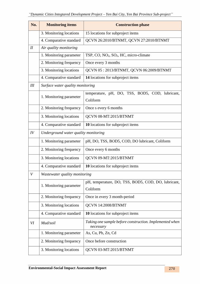
“Dynamic Cities Integtared Development Project – Yen Bai City, Yen Bai Province Sub-project”
Environmental-Social Impact Assessment Report 270
No. Monitoring items Construction phase
3. Monitoring locations 15 locations for subproject items
4. Comparative standard QCVN 26:2010/BTNMT, QCVN 27:2010/BTNMT
II Air quality monitoring
1. Monitoring parameter TSP, CO, NO2, SO2, HC, micro-climate
2. Monitoring frequency Once every 3 months
3. Monitoring locations QCVN 05 : 2013/BTNMT, QCVN 06:2009/BTNMT
4. Comparative standard 14 locations for subproject items
III Surface water quality monitoring
1. Monitoring parameter temperature, pH, DO, TSS, BOD5, COD, lubricant,
Coliform
2. Monitoring frequency Once s every 6 months
3. Monitoring locations QCVN 08-MT:2015/BTNMT
4. Comparative standard 10 locations for subproject items
IV Underground water quality monitoring
1. Monitoring parameter pH, DO, TSS, BOD5, COD, DO lubricant, Coliform
2. Monitoring frequency Once every 6 months
3. Monitoring locations QCVN 09-MT:2015/BTNMT
4. Comparative standard 10 locations for subproject items
V Wastewater quality monitoring
1. Monitoring parameter pH, temperature, DO, TSS, BOD5, COD, DO, lubricant,
Coliform
2. Monitoring frequency Once in every 3 month-period
3. Monitoring locations QCVN 14:2008/BTNMT
4. Comparative standard 10 locations for subproject items
VI Mud/soil Taking one sample before construction. Implemented when
necessary
1. Monitoring parameter As, Cu, Pb, Zn, Cd
2. Monitoring frequency Once before construction
3. Monitoring locations QCVN 03-MT:2015/BTNMT
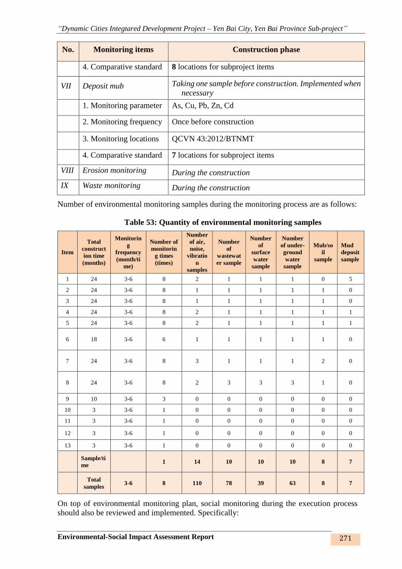
“Dynamic Cities Integtared Development Project – Yen Bai City, Yen Bai Province Sub-project”
Environmental-Social Impact Assessment Report 271
No. Monitoring items Construction phase
4. Comparative standard 8 locations for subproject items
VII Deposit mub Taking one sample before construction. Implemented when
necessary
1. Monitoring parameter As, Cu, Pb, Zn, Cd
2. Monitoring frequency Once before construction
3. Monitoring locations QCVN 43:2012/BTNMT
4. Comparative standard 7 locations for subproject items
VIII Erosion monitoring During the construction
IX Waste monitoring During the construction
Number of environmental monitoring samples during the monitoring process are as follows:
Table 53: Quantity of environmental monitoring samples
Item
Total
construct
ion time
(months)
Monitorin
g
frequency
(month/ti
me)
Number of
monitorin
g times
(times)
Number
of air,
noise,
vibratio
n
samples
Number
of
wastewat
er sample
Number
of
surface
water
sample
Number
of under-
ground
water
sample
Mub/so
il
sample
Mud
deposit
sample
1 24 3-6 8 2 1 1 1 0 5
2 24 3-6 8 1 1 1 1 1 0
3 24 3-6 8 1 1 1 1 1 0
4 24 3-6 8 2 1 1 1 1 1
5 24 3-6 8 2 1 1 1 1 1
6 18 3-6 6 1 1 1 1 1 0
7 24 3-6 8 3 1 1 1 2 0
8 24 3-6 8 2 3 3 3 1 0
9 10 3-6 3 0 0 0 0 0 0
10 3 3-6 1 0 0 0 0 0 0
11 3 3-6 1 0 0 0 0 0 0
12 3 3-6 1 0 0 0 0 0 0
13 3 3-6 1 0 0 0 0 0 0
Sample/ti
me 1 14 10 10 10 8 7
Total
samples 3-6 8 110 78 39 63 8 7
On top of environmental monitoring plan, social monitoring during the execution process
should also be reviewed and implemented. Specifically:
“Dynamic Cities Integtared Development Project – Yen Bai City, Yen Bai Province Sub-project”
Environmental-Social Impact Assessment Report 272
(i) Labour safety supervision (every 3 months) focusing on work log, safety and warning
signs, number of accidents, injuries and losses.
(ii) Environmental hygiene supervision (every 3 months) focusing on quality and hygienic
conditions of tools; first-aid kit, medical box, number of food poisoning cases, number of
disease infected people, propagandising plan of public healthcare.
These findings will serve as important criteria for assessment of the suitability and
responsiveness of workers on worksite and the existing labour safety, thereby making
appropriate and efficient adjustments.
Environmental quality supervision in the operation phase such as ambient air, surface water,
wastewater and underground water is included in Yen Bai city’s general plan. Other
supervisions such as erosion, embankment erosion, road, road and railroad accidents, etc.
shall be incorporated into the operation plan of the firm taking over the works. Therefore, a
concrete opration plan will not be presented in this section of the Report.
6.4. CAPACITY BUILDING PROGRAM
6.4.1. Safeguard management of PMU
Investment and Construction Project Management Unit (PMU) in Yen Bai Province is
established according to Decision No. 699/QĐ-UBND dated 21/12/2006. PMU have been
renamed, regulated to positions, function, tasks, and organization structure on Decision No.
785/QĐ-UBND dated 09/06/2011 and restructured on Decision No. 824/QĐ-UBND dated
30/05/2018, details as follows: Yen Bai province Investment Construction Management Unit
currently has a team of over 28 staffs and 1 board of director (1 director and 2 vice directors)
and 3 other departments, including (i) Department of Administration and Accounting (8
staffs), (ii) Department of General Planning (7 staffs) and (iii) Department of project
management (10 staffs).
100% of which have university education. Most of the staffs are recruited from famous
universities in transport and communications – 8 staffs (27.6%), water resources – 2 staffs
(6.9%), construction – 6 staffs (20.7%), land management and environment – 1 staffs (3.4%),
economic (3.4%), and finance-accounting - 7 staffs (24.1%), and administration, driver and
housekeeper – 4 staffs (13.8%), having high qualification and capability.
The managing team of Yen Bai province Investment Construction Management Unit is
middle (officials aged under 40 make up 80%), in which, 3.6% of the personnel have less
than 10 year working experience, 27.6% have 10-15 years of experience and 69% from 15
years upwards. The staffs have adequate project management capability and skills, including
both hard skills (technical skills to perform professional duties in the project) and soft skills
(communication, negotiation skills…) to coordinate with the project-related agencies,
especially ODA projects and multi-sector projects.
Projects that PMU functions as Investor are 15 projects. Projects that PMU is performing the
function of Project Management Consultant: Traffic works: 30 projects; Construction
projects: 160 projects; Agricultural and rural development projects: 08 projects; Technical
infrastructure projects: 10 projects; Other projects: 15 projects.
In managing these projects, PMU’s team has gained a wealth of experience in organising and
managing projects for transport infrastructure development (over 13 years), urban upgrading
(over 12 years), irrigation works rehabilitation (over 10 years), civil work (over 13 years),
etc., including social and environmental safeguard considerations.
PMU’s team has been informed of the sub-project’s potential environmental issues, impacts,
“Dynamic Cities Integtared Development Project – Yen Bai City, Yen Bai Province Sub-project”
Environmental-Social Impact Assessment Report 273
risks as well as mitigating measures and managing plans through the tasks they carry out
during the preparation of ESIA for the sub-project. PMU arranged and proactively
participated in site surveys and affected community consultation during the preparation of
safeguard documentation of the sub-project, namely ESIA, RP. In the pre-feasibility study
stage, PMU delegated specific tasks to officials with technical, technological, environmental
and social managing capacity. This sub-project is not the first project financed by WB
undertaken by PMU; however, many WB’s environmental and social safety procedures have
been updated over the time. Thus, it is advisable that PMU’s staff be trained on actual
experience with environmental and social management during the construction and operation
phases of the sub-project.
6.4.2. Safeguard management capacity building program
The lack of construction safety management experience will be identified by the
construction supervisor who will also take charge of environmental supervision during the
construction period, Independent Environmental Supervision Consultant will provide some
training activities and compliance check, which will be closely supervised by the Task force
of WB during the construction period.
The following table provides a typical training program on safeguard policies. PMU and
IEMC with the support of the Technical Support Team will provide training to construction
contractor, CSC, and other groups.
- Target group: Staff of PMU, safety and environment officials (SEO), field engineers
(FE), construction supervision consultant (CSC), representatives of construction
contractors of related parties and of communities in the sub-project area.
Construction contractors are responsible to train their labours and drivers.
- Training schedule: Training will be provided 1 month before or at the
commencement of the first construction project. The training can be adjusted in line
with the implementation schedule of the sub subproject/contracts.
- Training frequency: The basic training program given in the table below will be
provided every 6 months, with the contents being adapted and updated for each
specific work item. Training program for PMU’s staff is provided during the first
year of the sub-project. Three days of training for CSC and contractors are also
planned to take place twice a year.
Table 54: Training Programs for Environmental Supervision
I. Objects PMU
Training course Environmental supervision and reporting
Participants Environmental staffs and environmental managers
Training
frequency
Soon after subproject effectiveness but at least 1 month before the
construction of the first contract. The follow-up training will be
scheduled as needed.
Duration 2 days

“Dynamic Cities Integtared Development Project – Yen Bai City, Yen Bai Province Sub-project”
Environmental-Social Impact Assessment Report 274
Contents General environmental management relating to subproject including
requirements of WB, MOET, cooperating with competent authorities and
relevant enterprises
• Requirements on environmental supervision;
• Supervision and implementation of mitigation measures;
• Community participation in environmental supervision
• Guide and supervise contractor, CSC, and community representatives
in implementation of environmental supervision.
• Forms used in environmental supervision;
• Risk response and control;
• Receiving approach and submit forms.
• Other areas to be determined;
Responsibilities PMU, with support of the Technical Assistance team and IEMC for the
implementation of safeguards
II. Objects CSC, CONTRACTOR, COMMUNE/WARDS AUTHORITIES,
COMMUNITY REPRESENTATIVES
Training course Implementation of mitigating measures
Participants CSC; on-site construction management staffs; environmental staffs of
contractor; commune/ward/group authorities
Training
frequency
Soon after bidding, update based on requirements
Duration Two days of training for CSC and contractors and oen day of training for
others
Contents • Overview of environmental monitoring;
• Requirements of environmental monitoring;
• Role and responsibilities of contractors and CSC
• Content and methods of environmental monitoring;
• Response and risk control;
• Propagate monitoring forms and guide how to fill in the forms and risk
report;
• Other areas to be determined.
Resposibilities PMU, with support of the Technical Assistance team and IEMC for the
implementation of safeguards
III. Objects COMMUNITIES AND WORKERS
Training course Environmental sanitation and safety
Participants Representatives of workers (leaders) directly engaged in the work items
of the sub-project
Training
frequency
As appropriate
Duration One-day presentation and one-day on-the job training
“Dynamic Cities Integtared Development Project – Yen Bai City, Yen Bai Province Sub-project”
Environmental-Social Impact Assessment Report 275
Contents • Preliminary presentation on environmental protection and
environmental overview
• Key issues that require community and workers attention to minimize
safety risks (roads, equipment, machines, etc.) as well as reduce
pollution (dust, fume gases, oil/grease spill, waste management, etc.)
• Management of environmental safety and sanitation in work sites and
worker camps
• Mitigating measures at construction site and work camps;
• Safety measures on electricity, mechanical, transportation, air
pollution;
• Procedures to deal with emergency situation
• Other areas to be determined;
Resposibilities CSC, Contractor, PMU
6.5. COST ESTIMATION
The cost of ESMP implementation will include (i) the costs of implementing mitigating
measures by the contractor, (ii) expenses supervised by CSC, (iii) cost of the independent
environmental monitoring consultant (IEMC), including the costs of environmental quality
monitoring, (v) the cost of safety management for the PMU, including both technical assistance
in implementing safety policies and training programs.
(a) The costs of implementing mitigating measures during construction will be a part of the
value of construction contracts
(b) Safeguard policy during construction: the costs for a site-specific environmental monitoring
plan (SEMP) by the construction supervision consultant (CSC) will be provided in construction
supervision contracts.
(c) PMU specialised team for environmental safeguard
The costs of the PMU operations relating to EMP are allocated from the subproject management
budget of the PMU, including safety training programs, and basic allowances to participants in
the monitoring programs. After the subproject has been completed, the costs of environmental
monitoring of constructed works will be taken from the operation and maintenance budget of
the agency taking over the work items.
(d) Costs of environmental monitoring are estimated as follows:
Table 55: Costs of environmental monitoring during the execution of the works
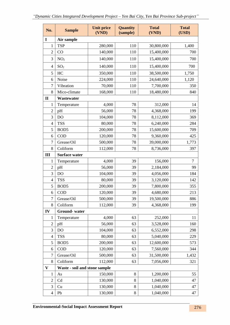
“Dynamic Cities Integtared Development Project – Yen Bai City, Yen Bai Province Sub-project”
Environmental-Social Impact Assessment Report 276
No. Sample Unit price
(VND)
Quantity
(sample)
Total
(VND)
Total
(USD)
I Air sample
1 TSP 280,000 110 30,800,000 1,400
2 CO 140,000 110 15,400,000 700
3 NO2 140,000 110 15,400,000 700
4 SO2 140,000 110 15,400,000 700
5 HC 350,000 110 38,500,000 1,750
6 Noise 224,000 110 24,640,000 1,120
7 Vibration 70,000 110 7,700,000 350
8 Mico-climate 168,000 110 18,480,000 840
II Wastewater
1 Temperature 4,000 78 312,000 14
2 pH 56,000 78 4,368,000 199
3 DO 104,000 78 8,112,000 369
4 TSS 80,000 78 6,240,000 284
5 BOD5 200,000 78 15,600,000 709
6 COD 120,000 78 9,360,000 425
7 Grease/Oil 500,000 78 39,000,000 1,773
8 Coliform 112,000 78 8,736,000 397
III Surface water
1 Temperature 4,000 39 156,000 7
2 pH 56,000 39 2,184,000 99
3 DO 104,000 39 4,056,000 184
4 TSS 80,000 39 3,120,000 142
5 BOD5 200,000 39 7,800,000 355
6 COD 120,000 39 4,680,000 213
7 Grease/Oil 500,000 39 19,500,000 886
8 Coliform 112,000 39 4,368,000 199
IV Ground- water
1 Temperature 4,000 63 252,000 11
2 pH 56,000 63 3,528,000 160
3 DO 104,000 63 6,552,000 298
4 TSS 80,000 63 5,040,000 229
5 BOD5 200,000 63 12,600,000 573
6 COD 120,000 63 7,560,000 344
7 Grease/Oil 500,000 63 31,500,000 1,432
8 Coliform 112,000 63 7,056,000 321
V Waste - soil and stone sample
1 As 150,000 8 1,200,000 55
2 Cd 130,000 8 1,040,000 47
3 Cu 130,000 8 1,040,000 47
4 Pb 130,000 8 1,040,000 47
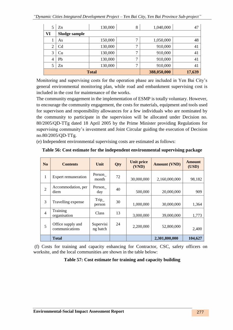
“Dynamic Cities Integtared Development Project – Yen Bai City, Yen Bai Province Sub-project”
Environmental-Social Impact Assessment Report 277
5 Zn 130,000 8 1,040,000 47
VI Sludge sample
1 As 150,000 7 1,050,000 48
2 Cd 130,000 7 910,000 41
3 Cu 130,000 7 910,000 41
4 Pb 130,000 7 910,000 41
5 Zn 130,000 7 910,000 41
Total 388,050,000 17,639
Monitoring and supervising costs for the operation phase are included in Yen Bai City’s
general environmental monitoring plan, while road and embankment supervising cost is
included in the cost for maintenance of the works.
The community engagement in the implementation of ESMP is totally voluntary. However,
to encourage the community engagement, the costs for materials, equipment and tools used
for supervison and responsibility allowances for a few individuals who are nominated by
the community to participate in the supervision will be allocated under Decision no.
80/2005/QD-TTg dated 18 April 2005 by the Prime Minister providing Regulations for
supervising community’s investment and Joint Circular guiding the execution of Decision
no.80/2005/QD-TTg.
(e) Independent environmental supervising costs are estimated as follows:
Table 56: Cost estimate for the independent environmental supervising package
No Contents Unit Qty Unit price
(VND) Amount (VND)
Amount
(USD)
1 Expert remuneration Person_
month 72
30,000,000
2,160,000,000
98,182
2 Accommodation, per
diem
Person_
day 40
500,000
20,000,000
909
3 Travelling expense Trip_
person 30
1,000,000
30,000,000
1,364
4 Training
organisation Class 13
3,000,000
39,000,000
1,773
5 Office supply and
communications
Supervisi
ng batch
24
2,200,000
52,800,000
2,400
Total 2,301,800,000 104,627
(f) Costs for training and capacity enhancing for Contractor, CSC, safety officers on
worksite, and the local communities are shown in the table below:
Table 57: Cost estimate for training and capacity building

“Dynamic Cities Integtared Development Project – Yen Bai City, Yen Bai Province Sub-project”
Environmental-Social Impact Assessment Report 278
Contents Objects Unit Qty
Unit
price Amount
VND VND USD
I. Environmental supervision and report training
PMU
Environmental officers;
managing officers in charge of
environmental issues
Training
course 2 10,000,000 20,000,000 909.09
II. Implementation of mitigation measures
CSC CSC; civil engineer, site
manager
Training
course 4 10,000,000 40,000,000 1,818.18
Contractor (CSC; civil engineer, site
manager
Training
course 4 10,000,000 40,000,000 1,818.18
Locality Ward/commune authorities;
HHs in the sub-project area
Training
course 1 10,000,000 10,000,000 454.55
III. Safety and environmental sanitation
Contractor
Workers diretcly carrying out
the works
Environment and safety officers
Training
course 2 5,000,000 10,000,000 454.55
Locality Ward/commune authorities;
HHs in the sub-project area
Training
course 2 5,000,000 10,000,000 454.55
Total 130,000,000 5,909
(g) Funding for training on HIV / AIDS by the contractor and CSC implemented are
mentioned as follows:Summary of cost for implementation of ESMP:
Table 58: Funding estimate for training on HIV / AIDS
Contents Objects Unit Qty Unit price Amount
VND VND USD
HIV / AIDS training cost for construction contractors and consultants and community
CSC CSC; civil engineer, site
manager
Training
course 7 20,000,000 140,000,000 6,364
Contractor (CSC; civil engineer, site
manager
Locality Ward/commune authorities;
HHs in the sub-project area
Table 59: Cost estimate for implementation of ESMP
Description Total cost (million USD) Source of fund
(a) Minimisation during construction As part of the contracts WB
(b) Safeguard policy supervision during
construction As part of the cost for employing CSC WB
(c) PMU specialised team of
environmental safeguard policies As part of the cost for PMU Counterpart fund
(d) Environmental quality supervision 0.018 WB
“Dynamic Cities Integtared Development Project – Yen Bai City, Yen Bai Province Sub-project”
Environmental-Social Impact Assessment Report 279
Description Total cost (million USD) Source of fund
(e) Independent environmental monitoring
consultant (IEMC) 0.107 WB
(f) Capacity building program for
safeguard policies 0.006 WB
(g) HIV / AIDS training cost for
construction contractors and construction
supervision consultants and community
0.006 WB
6.6 GRIEVANCE REDRESS MECHANISM (GRM)
Under the laws of Vietnam, citizen’s rights to voice complaints is protected. As part of the
sub-project, a grievance redress mechanism (GRM) will be developed by SEO of PMU,
according to which, persons in charge will be designated and contacts will be established. The
sub-project ensures that the complaints will be addressed and resolved at the lowest level as
soon as possible. This mechanism will provide a framework in which any complaints about
environment and safety may be handled and any grievance and dispute may be resolved in a
timely manner. GRM will be made avalable prior to the commencement of the construction
works.
During the construction of the works, GRM will be managed by the contractor under the
supervision of CSC. The contractors will inform the affected communities of the GRM
availabality to handle the complaints and concern about the sub-project. This will be done via
the community consultation and information disclosure process under which the contractors
will communicate with the affected communities and interested authorities on a regular basis.
Meetings will be held at least quarterly, monthly information brochures will be published,
announcements will be placed in local media, and notices of upcoming planned activities will
be posted, etc. The contractors should indicate contact for any complaints when the contractors
announce construction schedule to local communities.
All complaints and corresponding actions undertaken by the contractors will be recorded in
subproject safeguard monitoring reports. Complaints and claims for damages could be lodged
as follows:
- Verbally: direct to the CSC and/or the contractors’ safeguard staffs or representatives
at the site offices.
- In writing: by hand-delivering or posting a written complaint to specified addresses.
- By telephone, fax, e-mails: to the CSC, the contractors’ safeguard staffs or
representatives.
Upon receipt of a complaint, the CSC, the contractors’ safeguard staffs or representatives
will register the complaint in a complaint file and maintain a log of events pertaining to it
thereafter, until it is resolved. Immediately after receipt, four copies of the complaint will
be prepared. The original will be kept in the file, one copy will be used by the contractor’s
safeguard staffs, one copy will be forwarded to the CSC, and the fourth copy to the PMU
within 24 hours since receipt of the complaint.
- Information to be recorded in the complaint log will consist of:
- The date and time of the complaint.
- The name, address and contact details of the complainant.
- A short description of the complaint.

“Dynamic Cities Integtared Development Project – Yen Bai City, Yen Bai Province Sub-project”
Environmental-Social Impact Assessment Report 280
- Actions taken to address the complaint, including contact persons and findings at each
step in the complaint redress process.
- The dates and times when the complainant is contacted during the redress process.
- The final resolution of the complaint.
- The date, time and manner in which the complainant was informed thereof.
- The complainant’s signature when resolution has been obtained.
Minor complaints will be dealt with within one week. Within two weeks (and weekly
thereafter), a written reply will be delivered to the complainant (by hand, post, fax, e-mails)
indicating the procedures taken and progress to date.
The main objective will be to resolve an issue as quickly as possible by the simplest means,
involving as few people as possible, and at the lowest possible level. Only when an issue cannot
be resolved at the simplest level and/or within 15 days, will other authorities be involved. Such
a situation may arise, for example, when damages are claimed, the to-be-paid amount cannot
be resolved, or damage causes are determined.
World Bank Grievance Redress Mechanism: Communities and individuals who believe that
they are adversely affected by a World Bank (WB) supported subproject may submit complaints
to existing subproject-level grievance redress mechanism or the WB’s Grievance Redress
Service (GRS). The GRS ensures that complaints received are promptly reviewed in order to
address subproject-related concerns. Subproject affected communities and individuals may
submit their complaints to the WB’s independent Inspection Panel which determines whether
harms occurred, or could occur, as a result of WB non-compliance with its policies and
procedures. Complaints may be submitted at any time after concerns have been brought directly
to the WB’s attention, and Bank Management has been given an opportunity to respond.For
information on how to submit complaints to the World Bank’s corporate Grievance Redress
Service (GRS), please visit www.worldbank.org/grs. For information on how to submit
complaints to the World Bank Inspection Panel, please visit www.inspectionpanel.org.

“Dynamic Cities Integtared Development Project – Yen Bai City, Yen Bai Province Sub-project”
Environmental-Social Impact Assessment Report 281
CHAPTER 7. PUBLIC CONSULTATION AND INFORMATION
DISCLOSURE
7.1. OBJECTIVES AND PRINCIPLES OF PUBLIC CONSULTATION
The environmental impact assessment, public consultation and information disclosure are to
seek acquiescence from local government and NGOs and affected communitites in the sub-
project area. Community engagement is one of fundamental conditions to ensure their support
and to express their opinions on the sub-project.
In fact, if the community is engaged in the sub-project right from the preparation phase, the
relationship, information exchange and update among the sub-project stakeholders and the
community will be much better and the sub-project will thereby receive valuable
recommendations from the local communities.
The objectives of public consultation were as follows:
- To share all information on the items and tentative activities of the Subproject with local
community and stakeholders;
- To gather opinions/comments and concerns from local authorities and the community on
local particularities and environmentally sensitive matters in the subproject area, especially
matters that the environmental assessment impact group has not been aware of. On such
basis, the concerns of the local community may be proposed for proper settlement during
the selection of subproject design options;
+ Public consultation in ESIA report must adhere to:
➢ WB’s policies on environmental assessment (OP/BP 4.01) and involuntary
resettlement (OP/BP 4.12) requiring consultation and notification to potentially
affected people and local authorities of the environmental and social issues during
the sub-project preparation.
➢ Section 4, Article 12, Resolution no. 18/ND-CP dated 14 February 2015 of the
Government on information disclosure and consultation with the communities
affect by the project.
7.2 SUMMARY OF PUBLIC CONSULTATION PROCESS
7.2.1. Participants
Participants include representative of ward/commune People’s Committee and Fatherland
Front Committee, officials in charge of relevant areas, heads of residential quarters/ heads
of the hamlets, affected HHs and beneficiaries of the sub-project, representatives of the
Prject Owner and Consultant.
7.2.2. Consultation methods
Pursuant to Law on Environment Protection 2014 of Vietnam and policy OP4.01 of World
Bank, representative of the Project Owner – Investment and Construction Project
Management Unit issued letter no. 809/CV-BQL dated 16 August 2017 on public
consultation for the preparation of ESIA Report for Dynamic Cities Integrated Development
Project– Yen Bai City, Yen Bai Province Sub-project to the relevant ward/commune
People’s Committees.
Meetings with the related wards/communes were held and attended by the aforesaid
participants. Opinions were given after the Project Owner’s presentation of overview of
main contents and work items of the sub-project, financial resources for implementation of
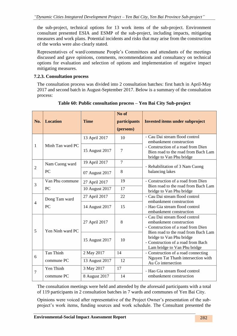
“Dynamic Cities Integtared Development Project – Yen Bai City, Yen Bai Province Sub-project”
Environmental-Social Impact Assessment Report 282
the sub-project, technical options for 13 work items of the sub-project. Environment
consultant presented ESIA and ESMP of the sub-project, including impacts, mitigating
measures and work plans. Potential incidents and risks that may arise from the construction
of the works were also clearly stated.
Representatives of ward/commune People’s Committees and attendants of the meetings
discussed and gave opinions, comments, recommendations and consultancy on technical
options for evaluation and selection of options and implementation of negative impact
mitigating measures.
7.2.3. Consultation process
The consultation process was divided into 2 consultation batches: first batch in April-May
2017 and second batch in August-September 2017. Below is a summary of the consultation
process:
Table 60: Public consultation process – Yen Bai City Sub-project
No. Location Time
No of
participants
(persons)
Invested items under subproject
1 Minh Tan ward PC
13 April 2017 10 - Cau Dai stream flood control
embankment construction
- Construction of a road from Dien
Bien road to the road from Bach Lam
bridge to Van Phu bridge
15 August 2017 7
2 Nam Cuong ward
PC
19 April 2017 7 - Rehabilitation of 3 Nam Cuong
balancing lakes 07 August 2017 8
3 Van Phu commune
PC
27 April 2017 19 - Construction of a road from Dien
Bien road to the road from Bach Lam
bridge to Van Phu bridge 10 August 2017 17
4 Dong Tam ward
PC
27 April 2017 22 - Cau Dai stream flood control
embankment construction
- Hao Gia stream flood control
embankment construction 14 August 2017 15
5 Yen Ninh ward PC
27 April 2017 8
- Cau Dai stream flood control
embankment construction
- Construction of a road from Dien
Bien road to the road from Bach Lam
bridge to Van Phu bridge
- Construction of a road from Bach
Lam bridge to Van Phu bridge
15 August 2017 10
6 Tan Thinh
commune PC
2 May 2017 14 - Construction of a road connecting
Nguyen Tat Thanh intersection with
Au Co intersection 13 August 2017 12
7 Yen Thinh
commune PC
3 May 2017 17 - Hao Gia stream flood control
embankment construction 8 August 2017 14
The consultation meetings were held and attended by the aforesaid participants with a total
of 119 participants in 2 consultation batches in 7 wards and communes of Yen Bai City.
Opinions were voiced after representative of the Project Owner’s presentation of the sub-
project’s work items, funding sources and work schedule. The Consultant presented the
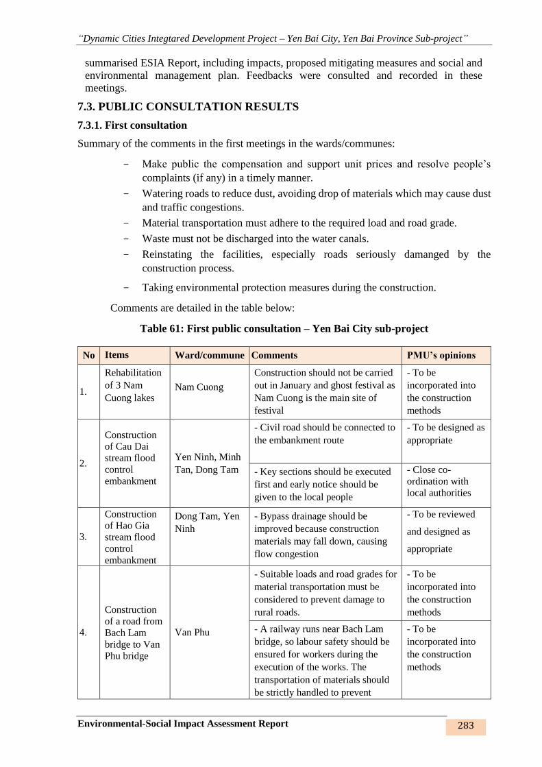
“Dynamic Cities Integtared Development Project – Yen Bai City, Yen Bai Province Sub-project”
Environmental-Social Impact Assessment Report 283
summarised ESIA Report, including impacts, proposed mitigating measures and social and
environmental management plan. Feedbacks were consulted and recorded in these
meetings.
7.3. PUBLIC CONSULTATION RESULTS
7.3.1. First consultation
Summary of the comments in the first meetings in the wards/communes:
- Make public the compensation and support unit prices and resolve people’s
complaints (if any) in a timely manner.
- Watering roads to reduce dust, avoiding drop of materials which may cause dust
and traffic congestions.
- Material transportation must adhere to the required load and road grade.
- Waste must not be discharged into the water canals.
- Reinstating the facilities, especially roads seriously damanged by the
construction process.
- Taking environmental protection measures during the construction.
Comments are detailed in the table below:
Table 61: First public consultation – Yen Bai City sub-project
No Items Ward/commune Comments PMU’s opinions
1.
Rehabilitation
of 3 Nam
Cuong lakes
Nam Cuong
Construction should not be carried
out in January and ghost festival as
Nam Cuong is the main site of
festival
- To be
incorporated into
the construction
methods
2.
Construction
of Cau Dai
stream flood
control
embankment
Yen Ninh, Minh
Tan, Dong Tam
- Civil road should be connected to
the embankment route
- To be designed as
appropriate
- Key sections should be executed
first and early notice should be
given to the local people
- Close co-
ordination with
local authorities
3.
Construction
of Hao Gia
stream flood
control
embankment
Dong Tam, Yen
Ninh
- Bypass drainage should be
improved because construction
materials may fall down, causing
flow congestion
- To be reviewed
and designed as
appropriate
4.
Construction
of a road from
Bach Lam
bridge to Van
Phu bridge
Van Phu
- Suitable loads and road grades for
material transportation must be
considered to prevent damage to
rural roads.
- To be
incorporated into
the construction
methods
- A railway runs near Bach Lam
bridge, so labour safety should be
ensured for workers during the
execution of the works. The
transportation of materials should
be strictly handled to prevent
- To be
incorporated into
the construction
methods

“Dynamic Cities Integtared Development Project – Yen Bai City, Yen Bai Province Sub-project”
Environmental-Social Impact Assessment Report 284
No Items Ward/commune Comments PMU’s opinions
materials from falling down on the
railway, which may affect the
railway operation.
5.
Construction
of a road
connecting
Nguyen Tat
Thanh
intersection
with Au Co
intersection
Tan Thinh
Build retaining wall with stone and
slope; the flow variations from the
mountain downwards should be
reflected in the detailed design;
local people should be consulted
for information about the actual
developments within the past 100
consecutive years.
- To be reviewed
and designed as
appropriate
Prevent fertile top soil from being
washed away to reduce crop losses
- To be
incorporated into
the construction
methods
7.3.2. Second consultation
Below are a summary of the opinions in the second consultation meetings:
- Reasonable compensation and resettlement support unit prices should be established to
enable HHs whose land evicted and who are to be relocated to buy new land and build
new houses.
- Compensation and resettlement support amount must be higher than price of a
resettlement lot in the sub-project, otherwise, support should be provided in case
compensation money is not enough to buy a resettlement lot. This is to avoid them from
becoming poor HHs because the whole money has been spent to buy resettlement land
or build new house, poor health, end of working age, etc.
- Xây dựng phương án và bố trí mặt bằng tái định cư khi thực hiện thu hồi đất (điều kiện
tốt hơn hoặc bằng nơi ở cũ). Resettlement plan and resettlement site plan should be
prepared (with better or equal conditions)
- During the construction of the works, transportation of construction materials and solid
waste should be strictly controlled to prevent them from falling down on the river, lakes
and streams, causing flow congestion, especially in rainy season, and flooding.
- Prepare detailed construction plan for each section/route.
- Information should be publicised and speakers should be used to make information
available to everyone.
- Closely coordinate with local governments during the construction.
Below is a summary of the comments:
Table 62: Second consultation – Yen Bai City sub-project
No Items Ward/commune Comments PMU’s opinions
1
- Rescue instruments should be
arranged for works on the lakes in
case of accidents
- This will be
incorporated into the
construction methods to
ensure labour safety

“Dynamic Cities Integtared Development Project – Yen Bai City, Yen Bai Province Sub-project”
Environmental-Social Impact Assessment Report 285
No Items Ward/commune Comments PMU’s opinions
Rehabilitation
of 3 Nam
Cuong lakes
Nam Cuong
- The compensation and subsidies
must be suitable with the land area
acquired by the sub-project. The
compensation and support unit
prices must be agreed upon by the
people in the meetings.
- The compensation and support
procedures must be clear,
transparent and simple.
- The inventory of
losses will be jointly
conducted by local
authorities and affected
HHs
2
Construction
of Cau Dai
stream flood
control
embankment
Construction
of Hao Gia
stream flood
control
embankment
Yen Ninh,
Minh Tan,
Dong Tam
Dong Tam,
Yen Ninh
- Build resettlement sites prior to
land acquisition so that resettled
HHs have new accommodation in
avoidance of multiple
resettlements.
- To be reviewed and
incorporated into the
construction methods to
minimise multiple
resettlements
- Disposal sites are located along
Cau Dai embankment. So impacts
from the transportation of waste
materials on the residential areas
here should be controlled.
- To make this a
requirement for the firm
doing the daily waste
material transportation
and treatment.
The construction should be carried
out promptly to ensure smooth
flow and prevent flooding.
- To be incorporated
into the contractor’s
construction methods
right from the bidding
stage.
3
Construction
of Cau Dai
stream flood
control
embankment
Yen Ninh,
Minh Tan,
Dong Tam
- HHs with land evicted should be
permitted to convert the land use
purpose in the case their remaining
agricultural land suffices for them
to live on and they can resettle
right there without much
disturbance.
- HHs whose homestead
land evicted will be
entitled to convert the
land use purpose in
respect of other types of
land remaining as they
wish
4
Construction
of a road from
Bach Lam
bridge to Van
Phu bridge
Văn Phú
- Yearly plan should be made and
adhered to in order to avoid
pending plan, which will
negatively affect local people’s
life, for instance: within the
planned land acquisition area, the
conversion of land use purpose,
construction and repair of houses,
trading, assignment and offering of
houses and land, etc. are banned,
giving rise to grievances among
local people and difficulties in land
management for local authorities.
- Upon completion of
inventory of affected
land areas and
properties thereon, the
subsequent steps under
the sub-project will be
taken to meet the work
schedule and minimise
negative impacts on
local people.
- During the soil filling and
compaction, attention should be
paid to avoid impacts on the nearby
agricultural land which may cause
local flooding and impacts on
- To be supplemented as
a requirement for
construction contractor

“Dynamic Cities Integtared Development Project – Yen Bai City, Yen Bai Province Sub-project”
Environmental-Social Impact Assessment Report 286
No Items Ward/commune Comments PMU’s opinions
houses and architectural objects of
nearby HHs.
5
Construction
of a road
connecting
Nguyen Tat
Thanh
intersection
with Au Co
intersection
Tân Thịnh
The inevitable problems
encountered from the construction
of the works including blocked
irrigation ditches, damage to
houses and other structures
adjacent to the worksite should be
jointly dealt with by the local
governments and the sub-project to
avoid prolonged complaints and
petitions to upper level, which may
also delay the progress of the sub-
project.
- To work out
reasonable construction
methods to minimise
impacts on the nearby
communities. In the
events of inevitable
impacts, the Project
Owner will coordinate
closely with local
authorities to resolve.
- Resettlement site must be large
enough for HHs and price of 1
resettlement lot must be
reasonable. Price of a resettlement
lot in commune must be lower than
that in ward.
- To be reviewed for
suitable design and
ensure equal or better
living conditions for
local people.
6
Construction
of a road from
Dien Bien
road to the
road from
Bach Lam
bridge to Van
Phu bridge
Yen Ninh,
Minh Tan
- Dien Bien is the trunk road of
Yen Bai Province and is favourable
for trading. Therefore, price of land
to be acquired on this road must be
higher than the Government’s
price. Survey of replacement price
should be conducted to ensure
legitimate benefits for local people.
- To conduct
replacement price
survey for wards and
communes under the
sub-project
The opinions from the community and local authorities were raised straightforwardly to the
Project Owner. The Project Owner agreed with their opinions and acknowledged their
recommendations as bases for improvement of impact mitigating measures during the
construction, operation and social-environmental monitoring process.
Below are some pictures of the consultation sessions:
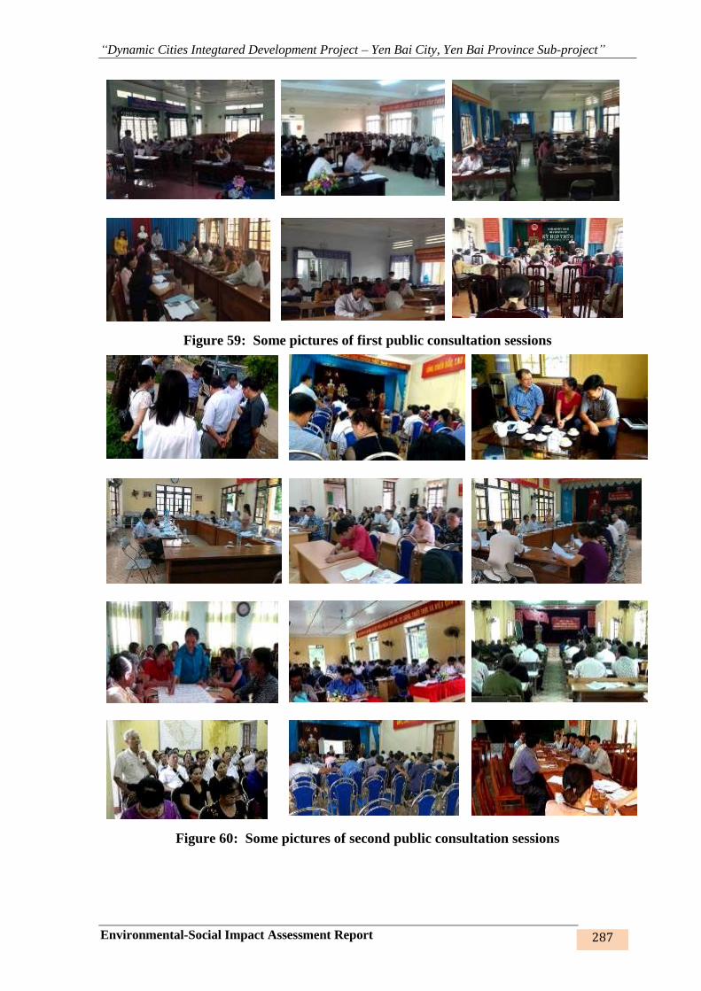
“Dynamic Cities Integtared Development Project – Yen Bai City, Yen Bai Province Sub-project”
Environmental-Social Impact Assessment Report 287
Figure 59: Some pictures of first public consultation sessions
Figure 60: Some pictures of second public consultation sessions
“Dynamic Cities Integtared Development Project – Yen Bai City, Yen Bai Province Sub-project”
Environmental-Social Impact Assessment Report 288
7.4. INFORMATION DISCLOSURE
The first draft was provided to ward/commune PCs in 5 wards and 2 communes in Yen Bai
city. About 7 days before the second public consultation session (August 2017), the Consultant
gave a notice to the local governments of the public consultation plan, time, venue, participants
and issues to be discussed. The first information disclosure was made on 30 October 2017.
The second draft ESIA was published on website of Yen Bai Province People’s Committee and
offices of 7 ward/commune People’s Committees on 25 November 2017. Any disagreements
from the HHs and local authorities on the contents of ESIA wasl constituted a reason for another
public consultation session. This final draft ESIA in English was disclosed at the World Bank's
internal and external websites on November 28th, 2017.

“Dynamic Cities Integtared Development Project – Yen Bai City, Yen Bai Province Sub-project”
Environmental-Social Impact Assessment Report 289
CONCLUSIONS AND RECOMMENDATIONS CONCLUSIONS
1. The “Dynamic Cities Integrated Development Project – Yen Bai City, Yen Bai
Province Sub-project” is a project for improvement and rehabilitation of existing
infrastructure conditions, enhancement of urban sanitation, creating incentives for sustainable
growth of the city. The sub-project focuses on flood control and minimisation of damage caused
by flood and rain as well as transport connectivity to promote commodity and service trading.
The overall impact of the sub-project is positive and responsive to local people’s demand for
urban services.
2. This is among the projects that presents many positive social and environmental
impacts to Yen Bai city and Yen Bai Province in particular and the Midlands and Northern
mountainous region in general. As such, the sub-project is expected to meet local people’s
longing for a clean living environment that would beautify the urban landscape and attract
tourists and investors.
3. Major environmental issues that may arise from the land acquisition are:
- Transform of land use purpose in respect of the work items: loss of residential land,
farming land and existing structures, etc., of local HHs, agencies and businesses.
- Direct impacts on land owners in the sub-project area in respect of agricultural
production, living, cultural and religious activities.
4. Environmental and social issues arising from the construction of work items are:
- Sludge from the dredging of Hao Gia, Khe Dai streams and Nam Cuong lakes.
- Gases, fumes and noises caused by motorised vehicles and construction equipment
and machinery on the worksites; the construction of culverts, rainwater drainage and
water supply systems on the embankment routes, roads and resettlement sites.
- Domestic wastewater and wastewater generated by workers in temporary camps;
- Solid waste of workers and construction waste on the worksites.
- Traffic disturbance and increased risks of traffic accidents
- Social impacts.
- Losses or interruptions to the related services
- Health and safety of local community and workers on the worksites.
The above impacts occur only in a short period of time at low and medium levels, affecting
workers and residents around the construction sites and can be minimised by appropriate
measures as indicated in Chapter 5.
5. Environmental impacts during the execution of the sub-project:
- Gas, vibration and noise emitted from the operation of vehicles on the embankment
routes, roads and resettlement sites;
- Domestic wastewater from nearby residential areas;
- Domestic waste of the residential areas and businesses along the roads;
- Potential environmental incidents such as: collapse/settlement, crack on surface of the
works, especially for the embankments, bridges and roads.
- Increased accidents as smooth traffic flow on newly opened roads will raise the traffic
volume.
“Dynamic Cities Integtared Development Project – Yen Bai City, Yen Bai Province Sub-project”
Environmental-Social Impact Assessment Report 290
- Potential railway accidents as road no.2 and resettlement site no.4 are adjacent to Ha
Noi – Lao Cai railway;
- Potential accidents: falling into sewers, streams, lakes.
The impacts that may arise in the operation phase are mild, yet affecting people’s health and
life. Mitigating measures therefor has been proposed in Chapter 5 hereinabove.
7. Environmental-social management plan will be strictly implemented by the Project
Owner, Design Consultant, Contractor, operation and management firm with support and
guidance from the local environment managing agencies. Objectives of environmental-social
management plan are to strictly control and curb the negative environmental changes;
proactively respond to possible incidents.
8. Given the strict conformity to the stipulations of laws on environment and
recommendations for minimisation of environmental pollution mentioned hereunder, the sub-
project will definitely operate successfully, bringing about positive socio-economic-
environmental impacts, creating motivation for the development of the city, the Midlands and
Northern mountainous regions.
RECOMMENDATIONS
1. Local environment State management agencies should support the Project Owner to
enhance capacity of its staff and train operation and management technicians; organise
propaganda to strengthen local people’s awareness of environmental protection.
2. Given the extended construction period (tentatively 3 years), updates on new
legislations on environmental management and monitoring should be regularly conducted
during the construction of the works.
4. Yen Bai City Investment and Construction Project Management Unit will hand over
the works to local government/operation and management firm after completion of work items
under the sub-project to bring the works into operation as soon as possible.
5. Để Thành phố Yên Bái thực sự trở thành một đô thị xanh, sạch, đẹp, cần có sự hỗ trợ
của một số dự án/ công trình khác có liên quan như xây dựng trung tâm thương mại, chợ kết
nối thương mại kết hợp công viên cây xanh và những chính sách thân thiện môi trường. Kính
đề nghị các cấp chính quyền và các ngành chức năng sớm có kế hoạch thoả đáng. In order for
Yen Bai City to become a green, clean and beautiful city, other related projects/works such as
construction of commercial center, market – park integrated centers and environment friendly
policies are much needed. The central government and line ministries are kindly requested to
take this recommendation into consideration.
3. The competent authorities are kindly requested to appraise and approve the
Environmental-social management plan to speed up the commencement of the sub-project as
the Plan will also serve as basis for environmental management and protection when the sub-
project comes into operation.
COMMITMENTS
Given the environmental impacts deriving from the operation of the sub-project and
provisions under Law on Environment Protection, Circular, Resolutions, decisions and
Ordinances on environmental protection, Safeguard Policy of World Bank
1. Project Owner/PMU and operation and management unit commit to take mitigating
measures, carry out the environmental management program and environmental monitoring
program as stated under Chapter 6 hereinabove; fulfill the commitments to the community as
stated under Chapter 7 herein; comply with general regulations for environmental protection
relating to specific phases of the sub-project.
“Dynamic Cities Integtared Development Project – Yen Bai City, Yen Bai Province Sub-project”
Environmental-Social Impact Assessment Report 291
2. Project Owner/PMU and operation and management unit commit to carry out the
environmental pollution minimising plans during the operation of the sub-project in accordance
with the approved Environmental-social management plan; strictly comply with Vietnam’s
environmental standards and regulations and environmental protection commitment.
3. Project Owner/PMU and operation and management unit commit to make
compensation, support and remedy for environmental pollution in the case of environmental
incidents arising from the construction and operation of the sub-project.
“Dynamic Cities Integtared Development Project – Yen Bai City, Yen Bai Province Sub-project”
Environmental-Social Impact Assessment Report 292
REFERENCE
1. World Bank’s guide book - Environmental Assessment Sourcebook Volume II -
Sectoral Guidelines Environment Department, World Bank, Washington DC,
8/1991. – Quantity of dust arising from the excavation, filling and levelling.
2. Pollution coefficients of WHO (1993) – estimated quantity of dust arising from loading
of construction materials
3. WHO: Assesment of Sources of Air, Water and Land Pollution, 1993. – quantity
of dust arising from compaction and gathering of materials
4. Cambridge Environment Research Institute: identification of smells based on
awareness magnitudes.
5. Statistics of World Health Organisation (WHO), concentrations of pollutants in
normal overflowing rainwater.
6. TC 20TCN 4474 – 87 – Standard of water limits used by worker on construction
site
7. TC 20TCN33 – 85 – Standard of water limits used for washing and bath by worker
on construction site
8. TCXD 33:2006 – Water supply standard and design.
9. ESIA of other projects involing urban upgrating projects, improving in higher
education, medium cities development project, Coastal Cities Sanitary
Environment Project, Emergency flood disaster reconstruction project...
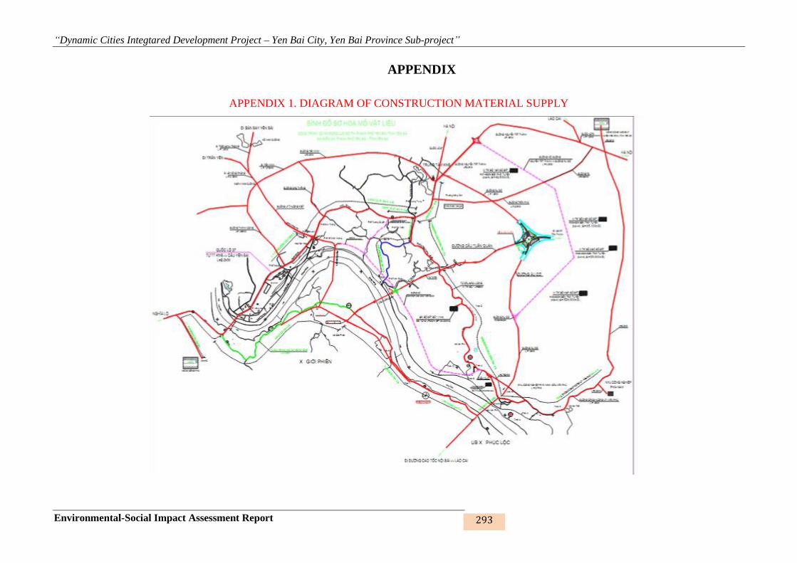
“Dynamic Cities Integtared Development Project – Yen Bai City, Yen Bai Province Sub-project”
Environmental-Social Impact Assessment Report 293
APPENDIX
APPENDIX 1. DIAGRAM OF CONSTRUCTION MATERIAL SUPPLY

“Dynamic Cities Integtared Development Project – Yen Bai City, Yen Bai Province Sub-project”
Environmental-Social Impact Assessment Report 294
APPENDIX 2. DIAGRAM OF ENVIRONMENT MONITORING LOCATIONS

“Dynamic Cities Integtared Development Project – Yen Bai City, Yen Bai Province Sub-project”
Environmental-Social Impact Assessment Report 295
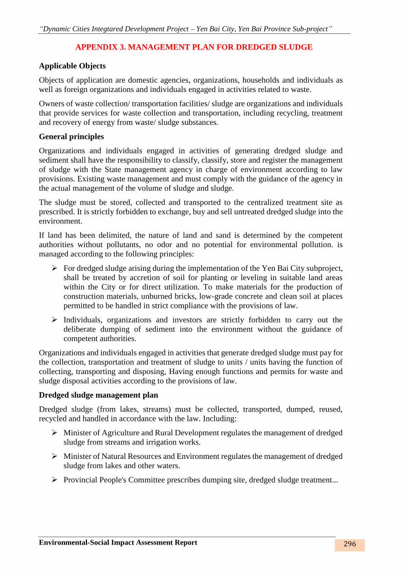
“Dynamic Cities Integtared Development Project – Yen Bai City, Yen Bai Province Sub-project”
Environmental-Social Impact Assessment Report 296
APPENDIX 3. MANAGEMENT PLAN FOR DREDGED SLUDGE
Applicable Objects
Objects of application are domestic agencies, organizations, households and individuals as
well as foreign organizations and individuals engaged in activities related to waste.
Owners of waste collection/ transportation facilities/ sludge are organizations and individuals
that provide services for waste collection and transportation, including recycling, treatment
and recovery of energy from waste/ sludge substances.
General principles
Organizations and individuals engaged in activities of generating dredged sludge and
sediment shall have the responsibility to classify, classify, store and register the management
of sludge with the State management agency in charge of environment according to law
provisions. Existing waste management and must comply with the guidance of the agency in
the actual management of the volume of sludge and sludge.
The sludge must be stored, collected and transported to the centralized treatment site as
prescribed. It is strictly forbidden to exchange, buy and sell untreated dredged sludge into the
environment.
If land has been delimited, the nature of land and sand is determined by the competent
authorities without pollutants, no odor and no potential for environmental pollution. is
managed according to the following principles:
➢ For dredged sludge arising during the implementation of the Yen Bai City subproject,
shall be treated by accretion of soil for planting or leveling in suitable land areas
within the City or for direct utilization. To make materials for the production of
construction materials, unburned bricks, low-grade concrete and clean soil at places
permitted to be handled in strict compliance with the provisions of law.
➢ Individuals, organizations and investors are strictly forbidden to carry out the
deliberate dumping of sediment into the environment without the guidance of
competent authorities.
Organizations and individuals engaged in activities that generate dredged sludge must pay for
the collection, transportation and treatment of sludge to units / units having the function of
collecting, transporting and disposing, Having enough functions and permits for waste and
sludge disposal activities according to the provisions of law.
Dredged sludge management plan
Dredged sludge (from lakes, streams) must be collected, transported, dumped, reused,
recycled and handled in accordance with the law. Including:
➢ Minister of Agriculture and Rural Development regulates the management of dredged
sludge from streams and irrigation works.
➢ Minister of Natural Resources and Environment regulates the management of dredged
sludge from lakes and other waters.
➢ Provincial People's Committee prescribes dumping site, dredged sludge treatment...


![[123doc.vn] Bai Tap Trac Nghiem Tieng Anh 12 Tu Bai de Bai 7 0476](https://img.pdfslide.us/doc/110x75/55cf8f51550346703b9b23a1/123docvn-bai-tap-trac-nghiem-tieng-anh-12-tu-bai-de-bai-7-0476.jpg)