Embed Size (px)
Citation preview
Env Sci Week 6 - Geology, Earth and the Lithosphere
• Geophysical Process of the Earth
Layers of the Earth
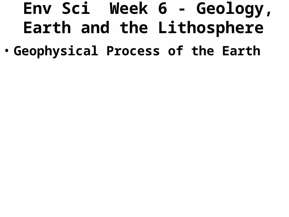
• There are two different ways to describe the layers of the earth. The layers can be described by their chemical properties or their physical properties. Look at the diagram below: chemically defined layers are on the shown the left; physically defined layers are shown on the right. Notice how some of these layers overlap.
Layers of the Earth • The Crust is the layer that starts at the solid surface. Oceanic and continental crusts
are different. The depth of the crust has been defined seismologically. The oceanic crust is about 6 - 7 km thick; the continental crust is about 35 - 40 km. For this class we will say the average depth is down to about 6 miles (10 km).
•The Mantle is the layer of rock that begins at the bottom of the crust at about 6 miles (10 km) below sea level and goes down to about 1,800 miles (2,900 km) below sea level. Since the mantle is so thick compared to the crust, its total thickness can also be estimated to be about 1,800 miles (2,900 km). (Spelling note: "mantel " is over a fireplace. Mantle is a covering, such as a loose, sleeveless coat.) The mantle is composed of an upper and lower layer. The upper mantle is solid, the lower mantle flows.
– The lithosphere is the rigid outer layer of the Earth consisting of the crust and upper mantle. The lithosphere is approximately 100 km (62 mi.) thick The lithosphere is the rigid outer layer of the Earth required by plate tectonic theory. It differs from the underlying layer because of its mechanical ‘flow’ properties, even though the layers are chemically similar. The lithosphere responds essentially as a rigid shell whilst the
– asthenosphere behaves as a highly viscous fluid• The Core is the layer that begins at the bottom of the mantle at 1,800 miles (2,900
km) miles and goes down another 4,000 miles (6,500 km) to the center of the earth.
The types of rocks are:
• (1) Igneous - Rocks that are formed by first heating the earth's material (elements) to a molten lava state. The when the molten lava cools it forms igneous rocks. Today we can see this happening in association with volcanoes.
• (2) Sedimentary rocks are rocks that form when the rocky and organic matter caused by erosion settles into layers (sediments) and over time hardens to form rock.
• (3) Metamorphic rocks are igneous or sedimentary rocks that have been "changed" from their original form through pressure and heat. The metamorphic rock is NOT heated enough to make it molten.
• (4) Conglomerates. Some rocks don't fit nicely into the three categories of rocks. These rocks are a mixture of igneous, sedimentary and/or metamorphic rocks that are cemented together. These are called conglomerates.
Mantel• The Mantle is the layer of rock, which begins at the bottom of the
crust, at about 6 miles (10 km) below sea level down to about to 1,800 miles (2,900 km) below sea level. The boundary between the earth’s crust and mantle Mohorovicic discontinuity or “Moho.”
• There are several overlapping divisions used to describe layers within the Mantle:
• (1) Upper Mantle is solid. Similar to the crust but the minerals that make up the rock material are made up of different elements than the crust. The distinction between crust and mantle is based on chemistry, rock types, deformation, flow and seismic characteristics.
• (2) Lower Mantle is plastic rock. The bottom part up mantle is made up of molten plastic type rock, meaning that is flows.
• (3) Lithosphere: The crust and solid part of the mantle.• (4) Asthenosphere: The hot, plastic lower mantle and
outer core. Convection cells within this layer bring heat to the surface from the earth's molten layer.
Core
• The Core begins at the bottom of the mantle at 1,800 miles (2,900 km) miles and goes down another 4,000 miles (6,500 km) to the center of the earth. Seismic measurements show that the core is divided into two parts:
• (1) A solid inner core with a radius of ~1220 km - The solid inner core was discovered in 1936 by Inge Lehmann and is generally believed to be composed primarily of iron and some nickel that is very hot but made solid by th very high pressure )pressure frizzing).
• (2) A liquid outer core extending beyond it to a radius of ~3400 km.
• (3) Lehman Discontinuity is name for the boundary between the inner and outer core.
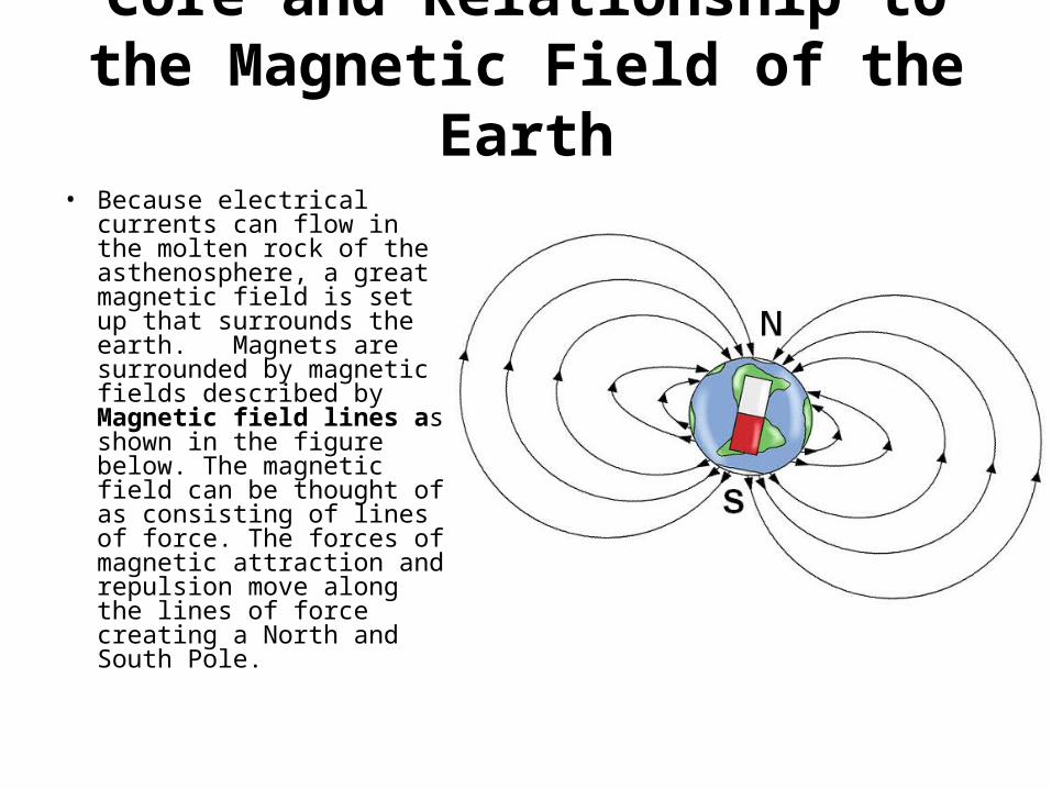
Core and Relationship to the Magnetic Field of the Earth
• Because electrical currents can flow in the molten rock of the asthenosphere, a great magnetic field is set up that surrounds the earth. Magnets are surrounded by magnetic fields described by Magnetic field lines as shown in the figure below. The magnetic field can be thought of as consisting of lines of force. The forces of magnetic attraction and repulsion move along the lines of force creating a North and South Pole.
There are two current • There are two current theories of how the Eath's magnetic field
developed and is maintained. They are the: • Dynamo Theory: The theory that explains the origin of the Earth's
main magnetic field in terms of a self-sustaining dynamo. In this dynamo mechanism, fluid motion in the Earth's outer core moves conducting material (liquid iron) across an already existing, weak magnetic field and generates an electric current. This turn generates the earth’s magnetic field.
• Rapid-Decay Theory: The rapid decay theory states that the Earth’s magnetic field is a function of how it was made. It states that over time the electrical current and therefore the magnetic field is weakening over time. The rapid-decay theory contradicts the Dynamo Theory. The rapid-decay theory is consistent to the observed weakening of the magnetic field that we have been able to observe for about the past 200 years.
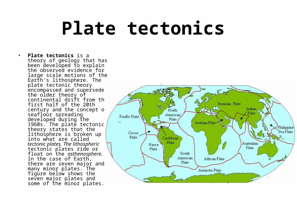
Plate tectonics • Plate tectonics is a theory of
geology that has been developed to explain the observed evidence for large scale motions of the Earth's lithosphere. The plate tectonic theory encompassed and superseded the older theory of continental drift from the first half of the 20th century and the concept of seafloor spreading developed during the 1960s. The plate tectonic theory states that the lithosphere is broken up into what are called tectonic plates. The lithospheric tectonic plates ride or float on the asthenosphere. In the case of Earth, there are seven major and many minor plates. The figure below shows the seven major plates and some of the minor plates.
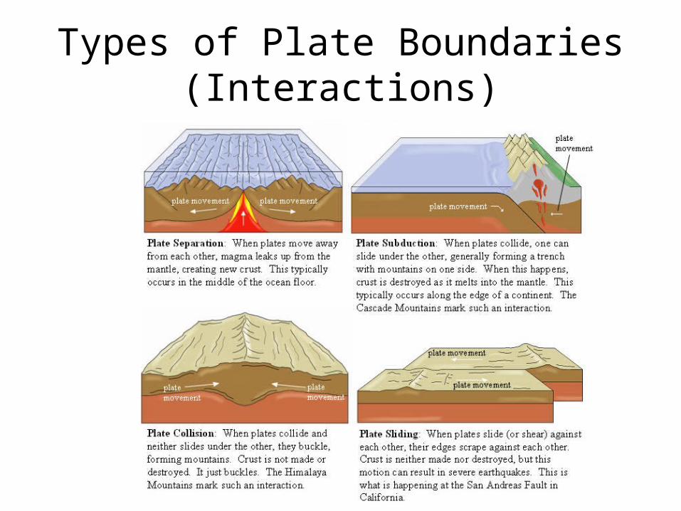
Types of Plate Boundaries (Interactions)
Types of Activity along plate boundaries
• Earthquakes, volcanic activity, mountain-building, and oceanic trench formation occur along plate boundaries. The lateral movement of the plates is typically at speeds of 0.65 to 8.50 centimeters per year. Pangea is the idea that one big super continent existed and before the plates moved apart.
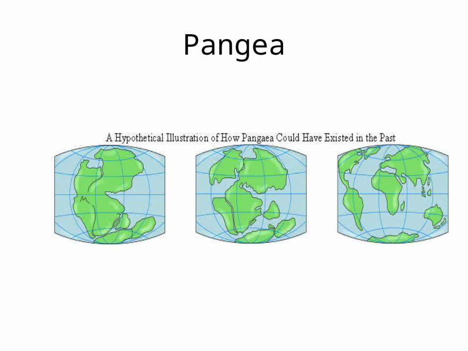
Pangea
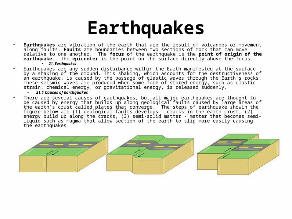
Earthquakes• Earthquakes are vibration of the earth that are the result of volcanoes or movement along faults. Faults are
boundaries between two sections of rock that can move relative to one another. The focus of the earthquake is the point of origin of the earthquake. The epicenter is the point on the surface directly above the focus.
• 21. Earthquakes
• Earthquakes are any sudden disturbance within the Earth manifested at the surface by a shaking of the ground. This shaking, which accounts for the destructiveness of an earthquake, is caused by the passage of elastic waves through the Earth's rocks. These seismic waves are produced when some form of stored energy, such as elastic strain, chemical energy, or gravitational energy, is released suddenly.
– 21.1 Causes of Earthquakes • There are several causes of earthquakes, but all major earthquakes are thought to be caused by energy that
builds up along geological faults caused by large areas of the earth's crust called plates that converge. The steps of earthquake showin the figure below are (1) geological faults develops - cracks in the earth crust, (2) energy build up along the cracks, (3) semi-solid matter - matter that becomes semi-liquid such as magma that allow section of the earth to slip more easily causing the earthquakes.
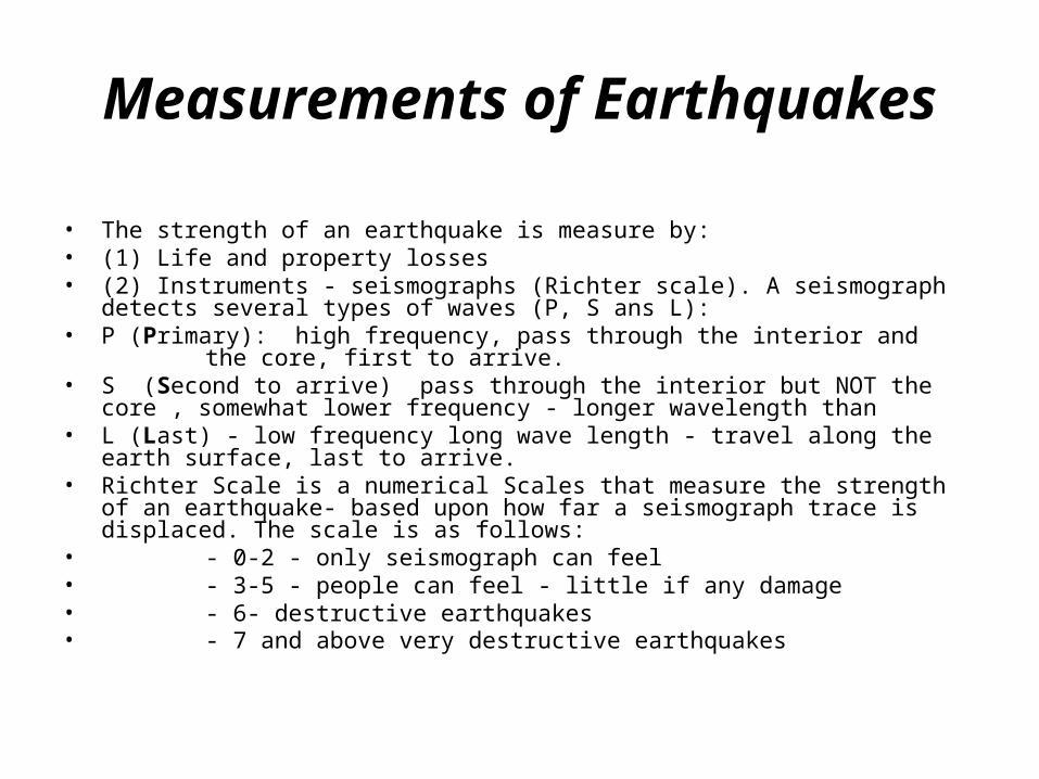
Measurements of Earthquakes
• The strength of an earthquake is measure by:• (1) Life and property losses • (2) Instruments - seismographs (Richter scale). A seismograph detects several types
of waves (P, S ans L):• P (Primary): high frequency, pass through the interior and the core, first to arrive.• S (Second to arrive) pass through the interior but NOT the core , somewhat lower
frequency - longer wavelength than • L (Last) - low frequency long wave length - travel along the earth surface, last to
arrive.• Richter Scale is a numerical Scales that measure the strength of an earthquake-
based upon how far a seismograph trace is displaced. The scale is as follows:• - 0-2 - only seismograph can feel• - 3-5 - people can feel - little if any damage• - 6- destructive earthquakes • - 7 and above very destructive earthquakes
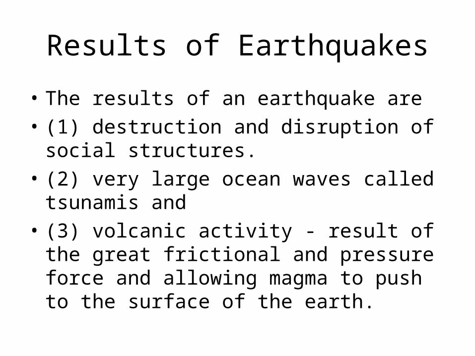
Results of Earthquakes
• The results of an earthquake are
• (1) destruction and disruption of social structures.
• (2) very large ocean waves called tsunamis and
• (3) volcanic activity - result of the great frictional and pressure force and allowing magma to push to the surface of the earth.
Volcanoes
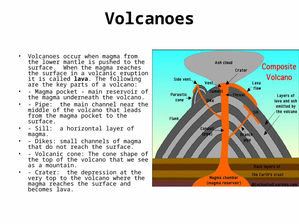
• Volcanoes occur when magma from the lower mantle is pushed to the surface. When the magma reaches the surface in a volcanic eruption it is called lava. The following are the key parts of a volcano:
• - Magma pocket - main reservoir of the magma underneath the volcano.
• - Pipe: the main channel near the middle of the volcano that leads from the magma pocket to the surface.
• - Sill: a horizontal layer of magma.• - Dikes: small channels of magma that
do not reach the surface.• - Volcanic cone: The cone shape of the
top of the volcano that we see as a mountain.
• - Crater: the depression at the very top to the volcano where the magma reaches the surface and becomes lava.
Land Formations Involving Increases in Elevation
• Land formations that involve increase in elevation are features such as hills, mountains and plateaus. The different formations have different processes that from them.
• 22.2.1 Mountains: • Mountains mean a region of land that is raised rather steeply above the surrounding terrain.
Mountains are normally found in groups or ranges consisting of peaks, ridges, and intermontane (between mountains) valleys. The following terms describe groups of mountains.
• Range -smallest group, • Mountain system -Several closely related ranges in a parallel alignment • Mountain chain -An elongated series of systems forms a mountain chain• Belt or Cordillera - An extensive complex of ranges, systems, and chains is known as a belt,
or cordillera.• Special terms used to describe different mountain formations are: • Peak: the highest point on a mountaintop. (Peak is the same as summit.)• Ridge: elongated peak of a mountain so it forms a line of high elevation.• Buttes: (pronounced like "beaut") A butte is flat-topped hill surrounded by a steep escarpment.
An escarpment is along cliff-like ridge of land. From the bottom of the escarpment, a slope descends to the plain. The term butte is sometimes used for an elevation higher than a hill but not high enough for a mountain. Buttes are formed when the land around it erodes away.
• Mesa: The term mesa means a broad, flat-topped elevation with one or more cliff like sides, common in the southwest United States. A mesa is typically larger than a butte. (Remember that you might build a small town on the top of a mesa, but the top of most buttes would be too small.)
• Plateau: a large, relatively flat highland area within a mountain range.
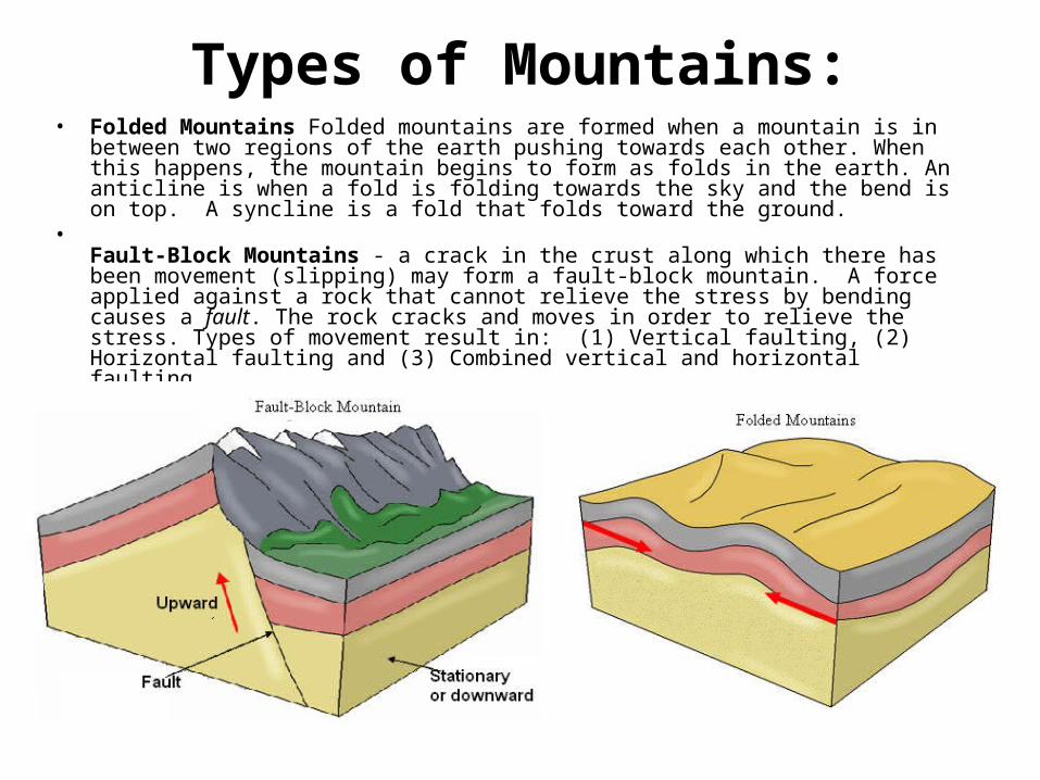
Types of Mountains:• Folded Mountains Folded mountains are formed when a mountain is in between two
regions of the earth pushing towards each other. When this happens, the mountain begins to form as folds in the earth. An anticline is when a fold is folding towards the sky and the bend is on top. A syncline is a fold that folds toward the ground.
•Fault-Block Mountains - a crack in the crust along which there has been movement (slipping) may form a fault-block mountain. A force applied against a rock that cannot relieve the stress by bending causes a fault. The rock cracks and moves in order to relieve the stress. Types of movement result in: (1) Vertical faulting, (2) Horizontal faulting and (3) Combined vertical and horizontal faulting.
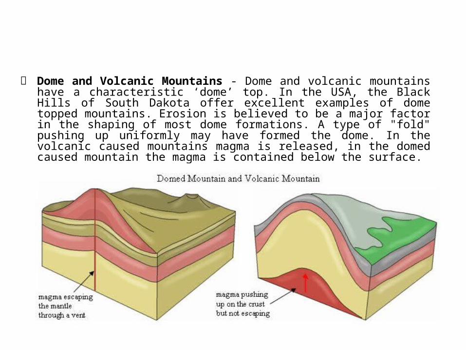
Dome and Volcanic Mountains - Dome and volcanic mountains have a characteristic ‘dome’ top. In the USA, the Black Hills of South Dakota offer excellent examples of dome topped mountains. Erosion is believed to be a major factor in the shaping of most dome formations. A type of "fold" pushing up uniformly may have formed the dome. In the volcanic caused mountains magma is released, in the domed caused mountain the magma is contained below the surface.
Deposition & Erosion
• Some mountains features are caused by accumulation or deposition of material and some by erosion. Volcanoes, glaciers and sand dunes are examples of features caused by deposition. Mesa, buttes and plateaus are examples of mountain features that are the result of erosion of sedimentary rock surrounding a harder rock.
Land Formations Caused By Water Erosion
• Many features we see are caused by flooding and water erosion. These features include:
• (1) Valleys: The space enclosed between ranges of hills or mountains; the strip of land at the bottom of depressions, including usually the bed of a stream, with frequently broad river (alluvial) plains on one or both sides of the stream.
• (2) Ravines, Canyons, Gorges and Gullies: Names given to deep and narrow valleys with abrupt sides. Ravines, canyons, gorges and gullies are usually the result of erosion by water.
• (3) Delta: a region of land that forms a trough of sedimentation that occurs when a river enters a sea or lake. The Mississippi River Delta in Louisiana, U.S.A. and the Nile River Delta in Egypt are good examples.