Embed Size (px)
Citation preview
ENHANCING COLLABORATION FOR CONSERVATION AND
DEVELOPMENT IN SOUTHERN BELIZE
by
Gregory W. De Vries, Margaret F. Haines, Steven B. Hufnagel, Andrew K. Laird,
Kyle D. Rearick, and Osmany E. Salas
A project submittedin partial fulfillment of the requirements
for the degree ofMaster of Science in Resource Policy and Behavior
or Master of Landscape Architecturein the School of Natural Resources & Environment
at the University of Michigan
April 2003
Faculty advisors:
Professor Julia M. Wondolleck
Professor Steven R. Brechin


ii
Abstract
Like many places in the world, Belize is exploring ways to balance the sometimes
complementary and sometimes conflicting objectives of economic development and natural
resource conservation. Collaboration among individuals and organizations is increasingly
used to resolve natural resource conflicts and to facilitate integrated conservation and
development at an ecosystem scale. A team of graduate students from the School of Natural
Resources and Environment at the University of Michigan conducted field research in the
Toledo District of Belize to develop an understanding of collaborative processes in a
Belizean context. The research team interviewed more than 60 individuals involved in
conservation and development, including key government ministers and agency personnel,
NGO staff, community leaders, and representatives from the private sector. Four case studies
were selected and analyzed: the Maya Mountain Marine Area Transect, the Toledo
Watershed Association, the Golden Stream Corridor, and the Bladen Management
Consortium. The research team disaggregated these case studies to understand the factors
that constrain and promote collaboration, and to identify opportunities for building on
existing multi-stakeholder conservation and development initiatives in the Toledo District
and beyond. Analysis of the case studies revealed that lack of trust among stakeholders,
differing visions and strategies, conflict and competition, resource constraints, power and
politics, organizational barriers, and community related constraints present challenges to
collaboration in the District. Nonetheless, when collaboration does take place it is because of
the power of existing relationships, political support, potential for joint gains, shared
concerns, and an interest in moving forward. While collaborative resource management
poses challenges, it holds promise as an effective means to integrate complex interests and
goals into decisions regarding conservation and economic development.

ii
iii
Acknowledgements
This project would not have been possible without the tremendous support we received from
so many people and organizations in Belize. Above all, our sincerest gratitude goes to the
people of the Toledo District who courteously welcomed us into their homes and places of
work, and who unselfishly shared their extensive knowledge and experiences with us. The
people of Indian Creek, Golden Stream, Medina Bank, Santa Cruz, Barranco, Monkey River,
and Punta Gorda were especially patient with us, and helped us to grasp the many details that
would otherwise have eluded us.
We are grateful to the University of Michigan’s School of Natural Resources and
Environment (SNRE) for providing us the opportunity to develop and implement this
Master’s Project. We thank our project advisors, Professor Julia Wondolleck and Professor
Steven Brechin, for their invaluable support and guidance. Julia and Steve were instrumental
in helping us to shape this report into a comprehensible and useful form. Their unwavering
commitment to our project and constructive comments propelled us forward during the many
trying times we faced over the past 12 months.
Our field research was funded by grants from the Horace H. Rackham’s School of Graduate
Studies Discretionary Funds, SNRE and the Prentice Fund, the Ecosystem Management
Initiative at the University of Michigan, National Audubon Society, and World Wildlife
Fund-Central America.
In Belize, Minister of Natural Resources and the Environment John Briceño, Chief Forest
Officer Oswaldo Sabido, and the Protected Areas Conservation Trust’s Executive Director
Valerie Woods supported our project in principle, thereby giving us the credibility we
needed. The staff of the Belize Audubon Society (BAS) helped to initially facilitate some
important project logistics, including lending us a company vehicle on a few occasions. The
BAS library and office facilities were made available to the project team. The staff at the
Toledo Institute for Development and Environment, Ya’axche’ Conservation Trust, Maya
Leaders’ Alliance, Toledo Association for Sustainable Tourism and Empowerment, Toledo
Development Corporation, Fauna & Flora International-Belize, and the Land Information
iv
Center were also extremely helpful and supportive, making important documents and maps
available to the team.
We are also appreciative of the support, constructive feedback, and advice we received from
our colleagues and fellow students at the University of Michigan.
Throughout our study, we were impressed and encouraged by the growing awareness of the
need to develop partnerships and other collaborative arrangements across all stakeholders in
the Toledo District and other parts of Belize. This growing awareness shows that people can
work together to facilitate more integrated management of natural resources.
The following personal acknowledgements cannot be left unstated:
Gregory Wade De Vries: I express gratitude for my fellow team members. Weexperienced firsthand the challenges and rewards of collaboration through theevolution of this project.
Margaret Fenimore Haines: I thank my family for their constant enthusiasmand support and for keeping me in their thoughts.
Steven Butler Hufnagel: I thank my wife Liza for her love, support, and humorover three semesters and a summer with too much time away from each other.
Andrew Laird: Thank you, Emma and Giovanni, for letting us stay at yourplace and providing a great hangout at Earth Runnin’s in Punta Gorda.
Kyle Rearick: I thank Kelley, my friend and partner, for her supportive words,critical eye, and caring thoughts throughout this process.
Osmany Salas: I am grateful to the Japan-IDB Scholarship Program forsponsoring my studies. To my wife Lupi, my daughter Ki’ila, and my momMirta – I would not have been able to face the many challenges over the pasttwo years if it wasn’t for your unflinching love and support.
Ann Arbor, Michigan
April 16, 2003
v
Table of ContentsABSTRACT ........................................................................................................................III
ACKNOWLEDGEMENTS ......................................................................................................III
TABLE OF CONTENTS......................................................................................................... V
FIGURES AND MAPS ....................................................................................................... VIII
TABLES.......................................................................................................................... VIII
FREQUENTLY USED ACRONYMS ....................................................................................... IX
CHAPTER ONE: INTRODUCTION ................................................................................1
OVERVIEW.........................................................................................................................1
RESEARCH QUESTIONS AND APPROACH ..............................................................................3
METHODOLOGY .................................................................................................................6
REPORT STRUCTURE ..........................................................................................................8
CHAPTER TWO: BACKGROUND................................................................................11
BELIZE – NATIONAL CONTEXT .........................................................................................11
CONSERVATION IN BELIZE................................................................................................16
TOLEDO DISTRICT: CONTEXT AND ISSUES.........................................................................27
CHAPTER THREE: THE STRUGGLE FOR LAND TENURE AND RESOURCE
CONTROL IN SOUTHERN BELIZE.............................................................................43
INTRODUCTION ................................................................................................................43
BACKGROUND..................................................................................................................43
ROADS AND RESERVATIONS .............................................................................................47
MAYA ADVOCACY ...........................................................................................................50
CONVOLUTED INTERESTS AND COMPETING CLAIMS ..........................................................54
TOWARDS A RESOLUTION.................................................................................................61
IMPLICATIONS FOR LAND AND RESOURCE MANAGEMENT .................................................65
SARSTOON-TEMASH INSTITUTE FOR INDIGENOUS MANAGEMENT ......................................67
CONCLUSION ...................................................................................................................73
CHAPTER FOUR: FORCES THAT PROMOTE AND CONSTRAIN
COLLABORATION.........................................................................................................77
vi
FACTORS THAT FOSTER COLLABORATION......................................................................... 78
CHALLENGES TO EFFECTIVE COLLABORATION.................................................................. 84
OPPORTUNITIES FOR INCREASING COLLABORATION: CASE STUDY APPROACH................... 88
CHAPTER FIVE: TIDE AND THE MAYA MOUNTAIN MARINE TRANSECT...... 91
INTRODUCTION ................................................................................................................ 91
BACKGROUND ................................................................................................................. 91
ANALYSIS...................................................................................................................... 105
CONCLUSIONS ............................................................................................................... 118
CHAPTER SIX: THE TOLEDO WATERSHED ASSOCIATION AND SAGE......... 121
INTRODUCTION .............................................................................................................. 121
BACKGROUND ............................................................................................................... 122
ANALYSIS...................................................................................................................... 133
CONCLUSIONS ............................................................................................................... 146
CHAPTER SEVEN: THE GOLDEN STREAM CORRIDOR..................................... 149
INTRODUCTION .............................................................................................................. 149
BACKGROUND ............................................................................................................... 150
ANALYSIS...................................................................................................................... 156
CONCLUSIONS ............................................................................................................... 167
CHAPTER EIGHT: THE BLADEN MANAGEMENT CONSORTIUM.................... 169
INTRODUCTION .............................................................................................................. 169
BACKGROUND ............................................................................................................... 170
ANALYSIS...................................................................................................................... 184
CONCLUSIONS ............................................................................................................... 191
CHAPTER NINE: CONCLUSIONS ............................................................................. 193
CONSTRAINTS AND CHALLENGES TO GREATER COLLABORATION .................................... 193
FORCES FACILITATING COLLABORATION IN TOLEDO ...................................................... 205
OPPORTUNITIES FOR EXPANDING AND IMPROVING COLLABORATION IN TOLEDO ............. 213
FINAL THOUGHTS .......................................................................................................... 226
vii
APPENDICES.................................................................................................................229
APPENDIX I – LIST OF INTERVIEWEES .............................................................................230
APPENDIX II -- BELIZE PROTECTED AREAS .....................................................................232
REFERENCES................................................................................................................239
ENDNOTES ....................................................................................................................255
viii
Figures and Maps
Figure 1: Government Agencies with Legal Jurisdiction over Protected Areas.…………...19
Map 1: Belize – Regional Location……………………………………………………...….11
Map 2: Administrative Districts of Belize………………………………………………......12
Map 3: Belize Protected Areas……………………………….…………………….……….23
Map 4: Watersheds of the Toledo District………………………….…………….…….…...38
Map 5: Protected Areas of the Toledo District…...…………………………….…………...39
Map 6: Toledo District Forest Licenses………………………………………..….………...46
Map 7: Toledo District Indian Reserves….………………………………………..………..48
Map 8: Sarstoon-Temash National Park….…………………………………………..……..68
Map 9: Land Parcels in the Golden Stream Watershed…………………………..….….…151
Map 10: Bladen Nature Reserve……………………………………………………..……..170
Tables
Table 1: Broad Ecosystem Classes and Land Uses by Cover…………………………...….18
Table 2: Protected Areas of the Toledo District…………………………………...………..37
ix
Frequently Used Acronyms
AMMA Ancient Monuments and Antiquities ActANDA Association of National Development AgenciesAPAMO Association of Protected Areas Management OrganizationsBACONGO Belize Alliance of Conservation Non-Governmental OrganizationsBAS Belize Audubon SocietyBCER Boden Creek Ecological ReserveBCES Belize Center for Environmental StudiesBFREE Belize Foundation for Research and Environmental EducationBGA Banana Growers AssociationBITI Belize Indigenous Training InstituteBLE Belize Lodge & ExcursionsBNIC Belize National Indigenous CouncilBTB Belize Tourism BoardBTIA Belize Tourism Industry AssociationCARD Community-initiated Agriculture and Resource DevelopmentCBO Community-based organizationCI Conservation InternationalCITES Convention on International Trade in Endangered SpeciesCREP Caribbean Regional Environmental ProgramCZMA Coastal Zone Management AuthorityEDF EcoLogic Development FundEEV EcoLogic Enterprise VenturesESTAP Environmental and Social Technical Assistance ProjectFFI Fauna & Flora InternationalFON Friends of NatureGDP Gross Domestic ProductGEF Global Environmental FacilityGOB Government of BelizeGSC Golden Stream CorridorGSCP Golden Stream Corridor PreserveIACHR Inter-American Commission for Human RightsIADB Inter-American Development BankICC Inuit Circumpolar ConferenceIFAD International Fund for Agricultural DevelopmentILRC Indian Law Resource CenterINGO International non-governmental organizationIUCN World Conservation UnionKCB Kekchi Council of BelizeMBCP Mesoamerican Biological Corridors ProjectMBRS Mesoamerican Barrier Reef SystemMED Ministry of Economic DevelopmentMLA Maya Leaders’ AllianceMMAP Maya Mountains Archaeological ProjectMMMAT Maya Mountain Marine Area Transect
x
MMMC Maya Mountain Marine CorridorMNRECI Ministry of Natural Resources, Environment, Commerce and IndustryMOA Memorandum of AgreementMOU Memorandum of UnderstandingMPA Marine protected areaNGC National Garifuna CouncilNGO Non-governmental organizationNPSA National Parks System ActOAS Organization of American StatesPA Protected areaPACT Protected Areas Conservation TrustPCNP Payne’s Creek National ParkPFB Programme for BelizePHMR Port Honduras Marine ReservePHWA Port Honduras Watershed AssociationPUP Peoples’ United PartyREAs Rapid Ecological AssessmentsRDP Regional Development PlanSAGE Southern Alliance for Grassroots EmpowermentSATIIM Sarstoon-Temash Institute for Indigenous ManagementSCMR Sapodilla Cayes Marine ReserveSCP Site Conservation PlanSIT School for International TrainingSPEAR Society for the Promotion of Education and ResearchSRDC Southern Region Development CorporationSTNP Sarstoon-Temash National ParkSWA Sibun Watershed AssociationTAA Toledo Alcaldes AssociationTASTE Toledo Association for Sustainable Tourism and EmpowermentTDC Toledo Development CorporationTIDE Toledo Institute for Development and EnvironmentTMCC Toledo Maya Cultural CouncilTMWC Toledo Maya Women’s CouncilTNC The Nature ConservancyTRIGOH Tri-national Alliance for the Gulf of HondurasTWA Toledo Watershed AssociationUDP United Democratic PartyUNDP United Nations Development ProgramUSAID United States Agency for International DevelopmentWCS Wildlife Conservation SocietyYCT Ya’axche’ Conservation Trust
Chapter One 1 Introduction
Chapter One: Introduction
Overview
Belize is a developing country possessing a rich tapestry of natural and cultural resources.
Like many nations around the globe it confronts significant dilemmas posed at the interface
of development and conservation. Local, national and international non-governmental
organizations actively pursue conservation objectives through the modification of land use,
land purchases, and the creation of public and private reserves. Meanwhile, deficits in
financial and human resources force the Government of Belize to experiment with innovative
partnerships with individuals and non-governmental organizations (NGOs). Under these
arrangements, various co-management arrangements introduce different levels of
management attention to otherwise neglected yet legally declared protected lands. At the
same time, indigenous communities struggle to maintain and promote their traditional
livelihoods and practices. While protecting their livelihoods and cultural resources, local
people vigorously pursue title to their use of the areas in which they dwell. Land use
decisions also involve private interests in sectors such as, tourism, timber, mineral extraction,
agriculture, fishing, and shrimp farming. These industries contribute significantly to the
economy of Belize. All groups contribute to the complexity of the social landscape in Belize
and create challenges for a reconciliation of ecological sustainability and human
development.
The challenge in Belize, as elsewhere throughout the world, is finding ways to balance the
sometimes complementary and sometimes conflicting objectives of diverse social processes
and ecological systems. The outcomes of this balancing act are expressed in the day-to-day
actions of individuals and the evolving contexts in which they make decisions. The struggles
and accomplishments of many individuals and organizations in Belize provide tremendous
insights into the answer to the question of how to balance environmental and social goals.
Chapter One 2 Introduction
In the past, protected area decision-making in Belize has tended to take a top-down approach
that does not incorporate the interests and needs of a diverse array of stakeholders1 (PFB
1996). Furthermore, the absence of a national management authority or national policy for
Belize’s protected areas system results in the lack of effective and cohesive management
plans. Even where management plans do exist, interaction among the organizations charged
with implementing the plans is characterized by inadequate information sharing,
communication, collective problem solving, and decision-making. This situation fragments
and isolates mutual conservation concerns and initiatives. Given limited financial and human
resources for protected area management and enforcement, meaningful public involvement
and multi-stakeholder collaboration may be essential for successful implementation of policy
and plans both at a macro and micro level. A substantial body of literature suggests that
increasing collaboration among agencies and involvement of community members and
additional constituents in protected area planning results in improved on-the-ground
management (Childers 1994; Derman 1995; Gibson and Marks 1995; Pinkerton 1989;
McNeely and Pitt 1985; Western et al. 1994; White et al. 1994). Collaboration for natural
resource management indicates diverse arrangements in which multiple stakeholders
voluntarily pool resources, information, and responsibility for collectively achieving shared
goals (Gray 1989; Wondolleck and Yaffee 2000). Additionally, collaboration can facilitate
landscape-scale strategies rather than approaches that prioritize individual species regardless
of their communities and larger-scale ecosystem processes that occur across institutional and
political boundaries (Wondolleck and Yaffee 2000).
The current lack of mutual understanding and agreement on protected area goals, the paucity
of information exchange, and the significant overlap in responsibilities strains limited human
and financial resources available for protected areas management in Belize. The success of a
national protected area system – including its relationship to coexisting human populations
and the resulting conservation of species and habitat – stands or falls on the adaptive
management of the sites of which the protected area system is comprised. While the dangers
of over-centralized management regimes are well known (Orlove 2002; Peluso 1992; Scott
1998; Wilshusen et al. 2002), a growing body of evidence substantiates that successful
conservation management can be best enacted if the relevant stakeholders coordinate their
Chapter One 3 Introduction
efforts as part of a collaborative arrangement (Dukes and Firehock 2001; Wondolleck and
Yaffee 2000).
Research Questions and Approach
This project seeks to identify constraints, facilitating factors, and opportunities to increase
interaction among policymakers, resource-dependent communities, conservation groups,
developers, and other stakeholders in protected area management in Belize. It is the
researchers’ assumption that conservation is integral to human development. As such,
conservation initiatives must address the cultural, social, economic, organizational, political,
and ecological context in which these initiatives occur without exacerbating inequalities
among the various actors. Failing to accommodate such issues will result in the eventual
degradation of both natural ecosystems and corresponding environments in which people live
(Wilshusen et al. 2002).
Six graduate students of the University of Michigan’s School of Natural Resources and
Environment focused their research in a distinctive area of Belize – the Toledo District – in
an effort to identify key considerations for the possibility of developing collaborative
arrangements within a multi-ecosystem and culturally diverse context. The Toledo District in
Southern Belize, comprised of multiple watersheds draining into the Gulf of Honduras,
contains a broad array of habitats and ecosystems unique to Central America. Long-term
conservation of these areas requires cooperation among communities, organizations, and
agencies that interact with local resources. By posing questions formed through initial
research with stakeholders and constituencies in Toledo, the project aims to yield insights for
improving multi-stakeholder collaboration applicable for resource management throughout
the Toledo District and locations with similar situations.
This study examined several examples of multi-stakeholder efforts to manage natural
resources in the Toledo District. The project team conducted an intensive analysis of
conservation and development initiatives in the District. To highlight the issues involved in
collaborative efforts in the study area, this report focuses on four case studies. These case
studies were analyzed to answer the following general questions:
Chapter One 4 Introduction
§ What issues are involved at the conservation/development interface in Belize?
§ What challenges are confronted in addressing these issues?
§ What ways do different groups approach these issues?
§ What barriers impinge on effective collaboration?
§ What factors facilitate aspects of collaboration when it has occurred?
§ What lessons from these experiences can be gleaned about future opportunities for
improved collaboration and how they might be harnessed?
The four case studies were selected both for their visibility and because they provide
invaluable insight on constraints, opportunities, and lessons that might apply to future
collaborative efforts in the Toledo District. As a whole, the cases present a wealth of
experience and insights about the potential for and challenges to collaboration from some of
the most outstanding examples of collaborative initiatives in Southern Belize. They
encompass a range of geographical and temporal scales. More importantly, they provide
examples of the range of types of collaboration in the area: from the interchange of
communication among a few stakeholders to the full sharing of responsibility and authority
among many actors. Aspects from the lessons learned from each case study can be applied to
the whole of Southern Belize and beyond.
The first case study focuses on the evolution of a “Ridges to Reef” concept – the Maya
Mountain Marine Area Transect (MMMAT) – into a multi-watershed conservation strategy.
This story explains how the MMMAT represents an effort to confront the challenges posed
by national development projects in Southern Belize. It also describes the involvement of the
MMMAT’s main proponent – the Toledo Institute for Development and Environment
(TIDE) – with two protected areas within the area. Through this description, the case
analyzes the potential of the MMMAT concept to serve as a forum for promoting multi-
stakeholder discussions and coordination in light of the events that have taken place over the
past decade.
Chapter One 5 Introduction
The second case describes the continued development of a collaborative initiative – the
Toledo Watershed Association (TWA) – which was born out of the MMMAT concept. This
story highlights the tendency among organizations to work with other organizations like
themselves rather than across sectoral boundaries and reveals the potential shortcomings of
such an approach. The TWA story also highlights the desire among NGOs to define and
defend organizational turf. Organizations in Toledo exhibit reluctance to share information,
ideas, and especially credit for projects given the funding that reputation draws. Finally, the
story demonstrates the power of models of success to motivate attempts at collaboration.
The third case study of the Golden Stream Corridor describes a smaller-scale collaborative
initiative at the single-watershed scale. The case study focuses on how several organizations
are attempting to coordinate conservation activities within a stretch of contiguous habitat
between the Maya Mountains and Port Honduras in an effort to secure the area from
development threats and fragmentation. An analysis of the interactions among diverse land
managers, organizations and other stakeholders along Golden Stream is helpful for
understanding the challenges to collaborative management in the Toledo District where
similar dynamics play out on a larger scale.
Finally, the fourth case describes the evolution of the Bladen Management Consortium. As a
case study in collaboration, it highlights the many difficulties associated with initiating and
sustaining a multi-stakeholder management body, particularly with regard to the challenges
of funding, staffing, representation, and legitimacy. It also illustrates how a few committed
individuals can drive a collaborative process forward despite such challenges. Understanding
the difficulties and successes that Consortium members have encountered provides insights
for incipient watershed management efforts beyond a single watershed scale.
These four stories vividly capture recognition of the need among diverse groups to work
together if common and complementary natural resource management objectives are to be
realized in combination with the threats and opportunities of development. They also
highlight the foundation and tremendous potential for enhanced collaboration in Belize.
Importantly, the stories illustrate the reality that collaboration, even under the best of
circumstances, is not easy. They reveal that collaboration, as demonstrated by the words and
Chapter One 6 Introduction
actions of those involved, makes sense but nonetheless poses challenges that need to be
recognized and overcome for progress to be made.
Methodology
This report is primarily based on the qualitative analysis of field data gathered in the
southernmost district of Belize. The project emerged from interaction of team members with
Belizean NGOs and the Ministry of Natural Resources and the Environment, Government of
Belize. Originally planned as part of a holistic study for the development of an “Integrated
National Protected Areas Policy,” the project team recognized the significance of
collaborative initiatives in southern Belize and sought to analyze them. In order to discuss the
initial concept and to learn the perspective of relevant stakeholders, two team members
conducted preliminary research in Belize in February 2002. Reaction to the project concept
during this visit was very positive. All the representatives of the visited groups expressed
interest in improving communication and coordination for building more effective
collaborative management strategies for protected areas. The Ministry of Natural Resources
and various NGOs confirmed the importance of the research by offering varying degrees of
logistical support. Consequently, the project team prepared a detailed work plan based on the
observations made during the preliminary visit.
The six project team members gathered the bulk of field data in Belize during June and July
of 2002. Additional field data was gathered in February and March 2003. Conducting
interviews and residing in the Toledo District allowed the team to explore local issues in-
depth, respond to emergent questions, verify data validity, and build better relationships. The
research team based itself out of the town of Punta Gorda for convenient access to numerous
research participants. In addition, many excursions were made throughout the country to
cross-check information and to conduct interviews with people where they work and live.
These trips proved critical for learning firsthand from resource-dependent communities as
well as from bureaucrats in Belmopan and Belize City. The approach also facilitated the
refinement of site-specific insights that directly relate to various people and places studied by
the team.
Chapter One 7 Introduction
Research involved extensive interaction with community members and representatives of
organizations and agencies (see Appendix I). Key interviewees were determined by their
relation to particular conservation and development projects and by their association with
involved organizations and agencies. In addition to unobtrusive observation, the team
employed methods of direct observation and semi-structured and guided interviewing
(Bernard 1995). The team conducted over 70 interviews with representatives of government
agencies, non-governmental and indigenous organizations, community-based organizations,
local communities, and tourism and agricultural sectors. Dr. Julia Wondolleck and Dr. Steven
Brechin, the team’s faculty advisors, reviewed the interview questions and research strategy
prior to commencement of fieldwork. Participants were asked for permission to electronically
record the discussions (using an MD-recorder) in an effort to accurately document their
knowledge and experiences in the region. When it was not feasible to record electronically, at
least two team members took notes. The interview recordings and notes were transcribed for
later reference. These interviews provided the most important data source for this project.
They captured the perspectives of the participants themselves, allowing the team to better
understand the social, cultural, and ecological landscapes of the Toledo District.
The team also relied on primary and secondary-source documents gathered in Belize and the
United States. Pertinent documents in Belize were compiled and reviewed by the project
team, including content analysis of protected area management plans and critical reviews of
government policy documents. These documents were obtained from the resource centers of
relevant governmental agencies and NGOs in Belize. In particular, the libraries of the Belize
Audubon Society, the University of Michigan, the University of Florida, and the Indian Law
Resource Center provided important information for this project.
As a result of researching the potential for collaboration and identifying constraints,
opportunities, interests, resources, connections, and networks, the project team hopes to
encourage a process that creates an open forum for discussion. This dialogue will increase as
participants are brought together, exchange information, learn from each other, and share
their interests, priorities, and objectives. It is imperative that the process continue beyond the
life of this research project. This dynamic outcome is the most critical measure of project
success.
Chapter One 8 Introduction
Report Structure
The remainder of this report is divided into eight chapters. Chapter Two provides background
information on Belize’s geography, cultural setting, political system, and economic setting. It
further describes Belize’s ecological characteristics, and provides information on the national
protected areas legal framework, as well as conservation initiatives and organizations
involved in these initiatives. The chapter also sets the stage for the rest of the report by
highlighting issues pertaining to economic development, social concerns, and environmental
processes in the Toledo District.
Chapter Three provides a detailed analysis of the issues framing land tenure and resource
management in Toledo. By addressing the convoluted interests and competing territorial
claims of the Toledo Maya and the Government of Belize (GOB), the chapter discusses the
potential for a resolution of the long-standing land tenure dispute and the implications for
land and resource management in the district. The chapter then presents the case of the
Sarstoon-Temash Institute for Indigenous Management (SATIIM) as an example of a
fledgling effort to achieve comprehensive indigenous management of a protected area, and
the challenges and opportunities that may arise. The chapter ends by discussing the
importance of SATIIM as an initiative to organize multi-stakeholder support for its efforts at
Sarstoon-Temash National Park.
Chapter Four sets out the theoretical framework used to analyze the four case studies and to
arrive at insights and conclusions. Forces that facilitate and constrain collaboration are
discussed. The introduction to case studies consists of: 1) TIDE and the Maya Mountain
Marine Area Transect, 2) the Toledo Watershed Association and the Southern Alliance for
Grassroots Empowerment, 3) the Golden Stream Corridor, and 4) the Bladen Management
Consortium.
Chapters Five, Six, Seven and Eight comprise the stories themselves. Each chapter includes a
detailed, analytical discussion of the challenges to successful collaboration, and factors that
may facilitate or expand collaboration for the respective case.

Chapter One 9 Introduction
Finally, Chapter Nine draws on the lessons learned from each case study. This chapter
analyzes the constraints and challenges to greater collaboration in Toledo and discusses these
issues along political, socio-cultural, organizational, and economic contexts. Challenges
include lack of enabling legislation, lack of implementation of policy and legislation,
political will, divestment of protected area management responsibility, land tenure disputes,
mistrust, cultural diversity, representation and participation issues, lack of ownership of
plans, organizational norms and culture, capacity, inadequate communication and
information sharing, and resource limitations. The chapter also presents a discussion of
particular forces that facilitate collaboration in Toledo. These forces include a shared sense of
place, common perception of threats, perceived need to act collectively, tight social and
professional networks, specific shared interests, committed individuals, and governmental
support. Drawing on lessons learned but also looking beyond the case studies, the chapter
concludes with a discussion of future opportunities for improving collaboration at the
interface of conservation and development. These opportunities include emerging support for
eco-regional management efforts, designation of biological corridors, financing mechanisms,
tourism and social entrepreneurship, existing governmental and quasi-governmental
initiatives, increasing national and international recognition of the Toledo region, trans-
boundary opportunities, partnership agreements, emerging educational opportunities,
integrated conservation and development opportunities, and existing relationships.

Chapter Two 10 Background
Chapter Two 11 Background
Chapter Two: Background
Belize – National Context
Geography
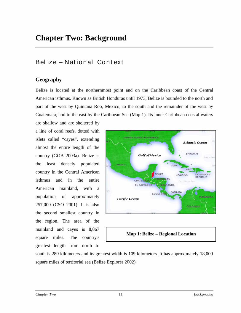
Belize is located at the northernmost point and on the Caribbean coast of the Central
American isthmus. Known as British Honduras until 1973, Belize is bounded to the north and
part of the west by Quintana Roo, Mexico, to the south and the remainder of the west by
Guatemala, and to the east by the Caribbean Sea (Map 1). Its inner Caribbean coastal waters
are shallow and are sheltered by
a line of coral reefs, dotted with
islets called “cayes”, extending
almost the entire length of the
country (GOB 2003a). Belize is
the least densely populated
country in the Central American
isthmus and in the entire
American mainland, with a
population of approximately
257,000 (CSO 2001). It is also
the second smallest country in
the region. The area of the
mainland and cayes is 8,867
square miles. The country's
greatest length from north to
south is 280 kilometers and its greatest width is 109 kilometers. It has approximately 18,000
square miles of territorial sea (Belize Explorer 2002).
Map 1: Belize – Regional Location
Chapter Two 12 Background
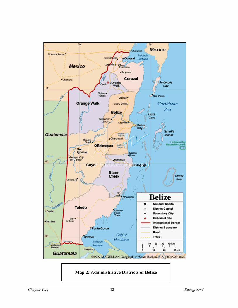
Map 2: Administrative Districts of Belize
Chapter Two 13 Background
The country is divided into six administrative districts: Corozal District and Orange Walk
District to the north, Cayo District in the west, Belize District in the center, and Stann Creek
District and Toledo District in the south (see Map 2, p.12). The only two inland districts are
Cayo and Orange Walk, while the other four districts are located along the Caribbean coast.
The climate is subtropical, tempered by trade winds. Temperatures in coastal districts range
from about 10°C (50°F) to about 35.6°C (96°F); inland the range is greater. Rainfall varies
from an average of 1,295 millimeters in the north to 4,445 millimeters in the extreme south.
The dry season usually extends from February to May and there is sometimes a dry spell in
August (GOB 2003a).
Cultural setting
Belize is a multi-ethnic and multi-lingual country, predominated by Mestizos (people of
Spanish and Maya descent) and Creoles (people of European and African descent). The
Mestizos make up about 49 percent and the Creoles about 25 percent of the population. The
other two major population groups are the Maya and the Garifuna, which comprise eleven
percent and six percent of the population respectively. There are three Maya ethnic groups in
Belize: the Yucatec, the Kekchi, and the Mopan. The Yucatec live mostly in the northern and
western areas of Belize. Most of the Mopans and the Kekchis are concentrated in Belize’s
southernmost region, the Toledo District, where they comprise about 60 percent of the
population (or about 15,000 people). The remainder of the population is comprised of East
Indians (people of Indian and African descent), Mennonites, Chinese, and a spate of North
American and British expatriates. The official language of the country is English, although
Spanish and Creole (a local dialect derived from the English language) are also widely
spoken. To a lesser extent (in terms of population size of the respective ethnic group),
Garifuna, Maya Mopan, Maya Kekchi, Maya Yucatec, German/Deutsch, Indian and Chinese
are also spoken. For the majority of the population in the Toledo and Stann Creek Districts of
Southern Belize, the primary language is either Garifuna, Mopan Maya, or Kekchi Maya.
Chapter Two 14 Background
Political system
Formerly a British colony, Belize gained its political independence from Great Britain on
September 21, 1981. Its political system is based on the principles of parliamentary
democracy based on the Westminster System. The Queen of England is the constitutional
Head of State, represented by a Belizean Governor General, whom she appoints. The Head of
Government is the Prime Minister, who is the leader of the political party that commands the
majority of seats in the House of Representatives. Members of the Executive Branch of
Government, selected from among the National Assembly, are appointed by the Governor
General on the advice of the Prime Minister. The bicameral National Assembly consists of
the Senate (twelve members appointed by the governor general – six on the advice of the
prime minister, three on the advice of the leader of the opposition, and one each on the
advice of the Belize Council of Churches and Evangelical Association of Churches, the
Belize Chamber of Commerce and Industry and the Belize Better Business Bureau, and the
National Trade Union Congress and the Civil Society Steering Committee), whose members
are appointed for five-year terms, and the House of Representatives, which comprises 29
seats. Members of the House of Representatives are elected by direct popular vote to serve
five-year terms. The Honorable Said W. Musa was re-appointed as Prime Minister by the
Governor General for another five-year term after leading the People’s United Party (PUP) to
re-election on March 4, 2003. The PUP controls 22 seats in the House of Representatives,
while the opposition United Democratic Party, headed by the Honorable Dean O. Barrow,
controls seven seats. The Honorable John Briceño was re-appointed as Deputy Prime
Minister and holds the ministerial portfolios of Natural Resources, the Environment,
Commerce and Industry.
The administration of the six districts is jointly run by a number of Government
functionaries, namely the District Accountant, the Officer Commanding the District Police,
and the Heads of various Government departments based in the districts. Each district town
has a locally elected Town Council of seven members. Belize City is administered by a nine-
member City Council, and the capital, Belmopan City, is administered by a seven-member
City Council. Local Government in the villages is carried out with the help of locally elected
Chapter Two 15 Background
village councils of seven members (GOB 2002). Maya villages in the two southern districts,
Toledo and Stann Creek, are jointly governed by village councils and alcalde councils.2
Economic setting
Belize's current economic base dates back to the mid-20th century when there was a shift
from the production of forestry products such as logwood, mahogany and chicle3 towards
large-scale plantation-type agriculture with citrus and banana cultivation in the south of the
country and sugarcane in northern Belize (GOB 2003c).
A new shift is currently taking place. The Government of Belize’s Medium Term Economic
Strategy 2003-2005 states that: “The economy of Belize is gradually undergoing
transformation from one that is primarily agricultural to one that is more service-oriented; the
service sector contributed 59.5 percent to the Gross Domestic Product (GDP) in 2001 whilst
the primary sector contributed just 16.8 percent. Belize has a farming population of about
16,979 operating on a total land area of 265,000 acres, of which 146,000 are for crops and
119,000 acres for pastures. During 2001 the contribution of agriculture to GDP amounted to
11.3 percent, and 88.9 percent of total export earnings. The principal source of income is
sugar, bananas, and citrus fruit production. In 2001, citrus exports replaced sugarcane as the
largest contributor to foreign exchange earnings followed by sugarcane in second place and
bananas in third place. Citrus, sugar, and banana export revenues in 2001 amounted to
$95.1M (includes fresh fruits and by-products), $59.4M and $42.8M, respectively, totaling
$197.3 M for these three traditional commodities.4 Belize is also experiencing increased
levels of expansion and development of new export commodities such as papayas, habanero
peppers and aquaculture” (GOB 2002). Marine products (including farmed shrimp) and small
manufacturing also make notable contributions to exports.
Although Belize’s economic base has shifted to agriculture, the textile industry and the wood
industry also serve as important sources of income. However, the industries that have seen
the most rapid development over the past five years (1998-2003) have been the tourism and
financial services (GOB 2003b). Tourism, in particular, has experienced a phenomenal
increase. According to the Belize Tourism Board (BTB), 2002 saw the highest number of
overnight visitors (arriving by land and air) in Belize’s history.
Chapter Two 16 Background
Cruise passenger arrivals experienced an increase of over 500 percent compared to arrivals
the previous year (BTB 2003a). Additionally, according to the BTB, the figure for total
overnight arrivals in 1998 was 176,054; four years later, after three major hurricanes, and an
overall decline in international travel after 9/11, Belize’s tourism arrivals grew by 13.3
percent. There was also a 4.5 percent growth in the number of hotels in 2002 (BTB 2003a).
The Belizean economy’s relative strength in a large part is due to an abundance of land,
forest, and water resources, Belize’s proximity to the U.S. market, and the country’s
historically close ties to the United Kingdom. Belize’s environmental resources also create
substantial opportunities in the nature-based tourism market. Although historically Belize has
not been significantly impacted by hurricanes, during 2000 and 2001 two substantial
hurricanes and one tropical storm did adversely affect the Belizean economy, illustrating the
vulnerability of Belize to natural disasters. The declining preferred market access, available
to certain export products such as bananas and sugar under various international
arrangements, is another challenge for Belize (GOB 2003b).
Conservation in Belize
Ecological characteristics
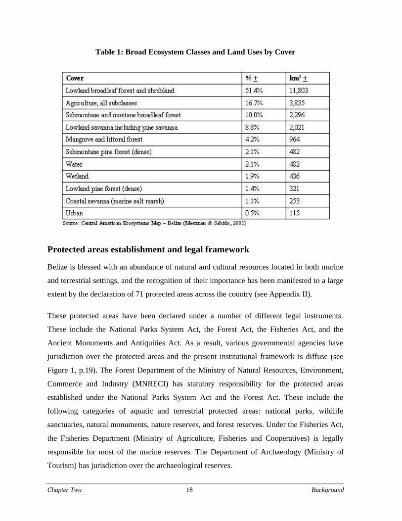
The natural vegetation of Belize consists of a mosaic of major formations, according to
underlying geology, terrain, soil type, wetness, salinity, altitude and rainfall pattern (PFB
1996). The Central American Ecosystems Mapping Project5 identified a total of 85 terrestrial
ecosystems for Belize, as well as two marine ecosystems (sea grass beds and coral reefs).
Based on data obtained from 1996 and 1998 satellite imagery, it was calculated that
approximately 15,867 square kilometers, or 69.1 percent of Belize, was under some form of
forest (including shrublands) cover; 804 square kilometers of this figure was Pine Forest
(five percent of total forest cover) (Meerman & Sabido 2001). The terrestrial ecosystems are
grouped into nine major ecosystem classes and two broad land uses. The nine major broad
ecosystem classes are water, wetland, coastal savanna (marine salt marsh), mangrove and
littoral forest, lowland savanna, lowland pine forest, submontane pine forest, lowland

Chapter Two 17 Background
broadleaf forest and shrublands, and submontane broadleaf forest. The two broad land use
types are agricultural uses (which include aquaculture and forest plantations) and urban
areas. Table 1 lists the broad ecosystems classes and land uses by cover. All of these major
ecosystem classes occur in Southern Belize, where this Master’s Project was based.
The most characteristic feature of Belize is the presence of extensive areas of natural habitat
and relatively low but growing levels of human disturbance. As a result, the country
continues to harbor viable populations of a range of species of conservation concern that are
under pressure throughout the rest of their Central American range. Belize is also within a
local center of endemicity and lies on migration routes for both Nearctic and Neotropical bird
species (PFB 1996). Over 540 bird species have been recorded in Belize, of which over 80
are of special conservation concern. Over 150 mammal species have been recorded in Belize.
Of these, forty-three are considered endangered, threatened, rare and/or hunted throughout
their ranges, with thirteen officially designated as being of international concern and listed in
the CITES appendices, IUCN Red Data Books or under the US Endangered Species Act
(PFB 1996). Amongst the less charismatic wildlife species, 111 species of reptile fauna have
been recorded, and 40 amphibian species have also been recorded to date, although this
figure remains tentative. There is very limited information available on freshwater fish and
invertebrates (PFB 1996).
Suitable wildlife habitat is in serious decline throughout the Central American region. With
large blocks of contiguous habitat still in existence, Belize plays an important role for
survival of nearctic and neotropical migrants, and threatened mammalian populations.
Protected areas in Belize cover adequate areas of critical habitat. These protected areas are
necessary to maintain viable populations and are used as the principal tool for conservation
of these species (PFB 1996). Additionally, Belize’s protected areas form a crucial part of the
Maya Forest Region and the Mesoamerican Biological Corridor, connecting the remaining
forests in Peten, Guatemala, to the forests of Calakmul, Chiapas (Mexico).
Chapter Two 18 Background
Table 1: Broad Ecosystem Classes and Land Uses by Cover
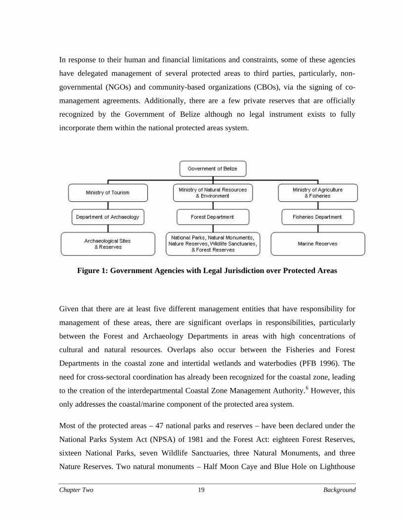
Protected areas establishment and legal framework
Belize is blessed with an abundance of natural and cultural resources located in both marine
and terrestrial settings, and the recognition of their importance has been manifested to a large
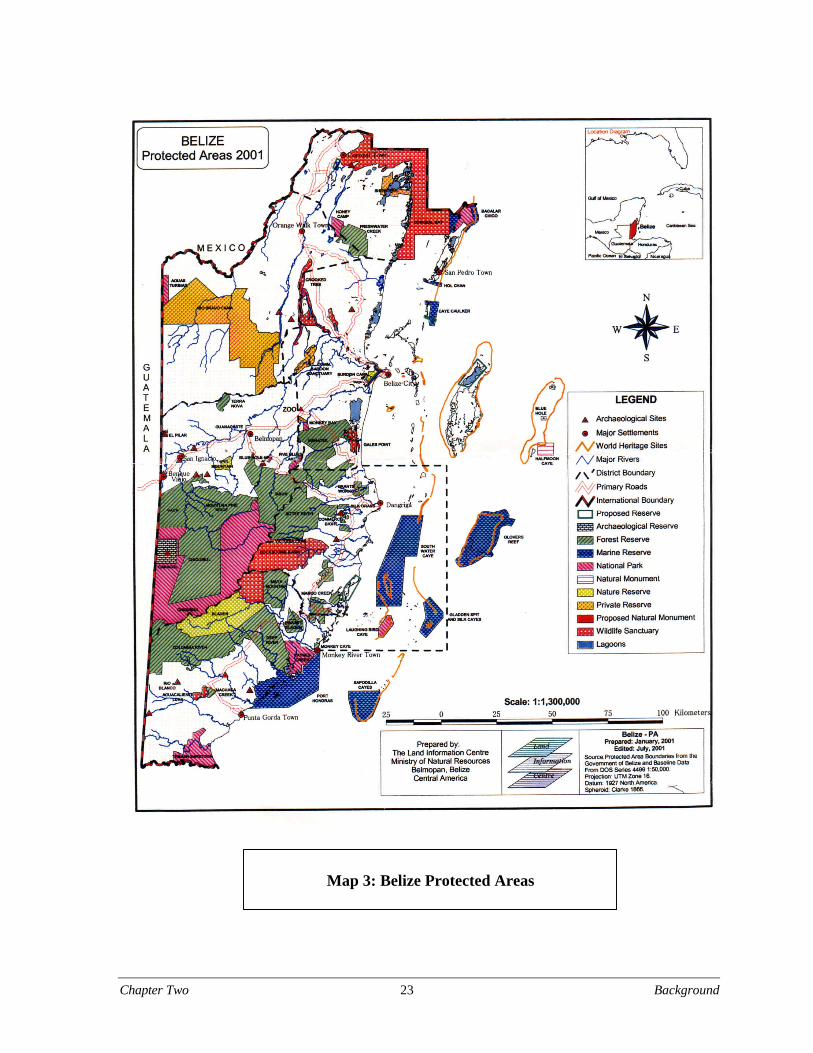
extent by the declaration of 71 protected areas across the country (see Appendix II).
These protected areas have been declared under a number of different legal instruments.
These include the National Parks System Act, the Forest Act, the Fisheries Act, and the
Ancient Monuments and Antiquities Act. As a result, various governmental agencies have
jurisdiction over the protected areas and the present institutional framework is diffuse (see
Figure 1, p.19). The Forest Department of the Ministry of Natural Resources, Environment,
Commerce and Industry (MNRECI) has statutory responsibility for the protected areas
established under the National Parks System Act and the Forest Act. These include the
following categories of aquatic and terrestrial protected areas: national parks, wildlife
sanctuaries, natural monuments, nature reserves, and forest reserves. Under the Fisheries Act,
the Fisheries Department (Ministry of Agriculture, Fisheries and Cooperatives) is legally
responsible for most of the marine reserves. The Department of Archaeology (Ministry of
Tourism) has jurisdiction over the archaeological reserves.
Chapter Two 19 Background
In response to their human and financial limitations and constraints, some of these agencies
have delegated management of several protected areas to third parties, particularly, non-
governmental (NGOs) and community-based organizations (CBOs), via the signing of co-
management agreements. Additionally, there are a few private reserves that are officially
recognized by the Government of Belize although no legal instrument exists to fully
incorporate them within the national protected areas system.
Figure 1: Government Agencies with Legal Jurisdiction over Protected Areas
Given that there are at least five different management entities that have responsibility for
management of these areas, there are significant overlaps in responsibilities, particularly
between the Forest and Archaeology Departments in areas with high concentrations of
cultural and natural resources. Overlaps also occur between the Fisheries and Forest
Departments in the coastal zone and intertidal wetlands and waterbodies (PFB 1996). The
need for cross-sectoral coordination has already been recognized for the coastal zone, leading
to the creation of the interdepartmental Coastal Zone Management Authority.6 However, this
only addresses the coastal/marine component of the protected area system.
Most of the protected areas – 47 national parks and reserves – have been declared under the
National Parks System Act (NPSA) of 1981 and the Forest Act: eighteen Forest Reserves,
sixteen National Parks, seven Wildlife Sanctuaries, three Natural Monuments, and three
Nature Reserves. Two natural monuments – Half Moon Caye and Blue Hole on Lighthouse
Chapter Two 20 Background
Reef Atoll – have been designated as World Heritage Sites and thus have international
recognition. The Crooked Tree Wildlife Sanctuary is Belize’s only Ramsar Site having been
designated under the Convention of Wetlands of International Importance Especially as
Waterfowl Habitat.
There are thirteen marine protected areas (MPAs) in Belize. The first MPA – Half Moon
Caye – was designated in 1982. Eight of the MPAs were declared under the Fisheries Act,
and the others under the NPSA. The eight marine reserves established under the Fisheries
Act are: Hol Chan (1987), Glovers Reef (1993), Bacalar Chico (1996), South Water Caye
(1996), Sapodilla Cayes (1996), Caye Caulker (1998), Port Honduras (2000), and Gladden
Spit (2000). The other areas were declared under the NPSA but are technically MPAs as well
because they protect marine environments: these are Half Moon Caye Natural Monument
(1982), Laughing Bird Cay National Park (1991), Bacalar Chico National Park (1996),
Corozal Bay (Manatee) Wildlife Sanctuary (1998), Blue Hole Natural Monument (1998), and
Swallow Caye Wildlife Sanctuary (2002). It is interesting to note that Bacalar Chico was
designated under both the National Parks System and Fisheries Acts, and Caye Caulker under
both the NPSA and the Forest Act.
Despite their legal designation under the current legal framework, long-term security for
protected areas does not exist. Protected areas and Forest Reserves or sections within them
can be de-reserved (that is, removed from protected status) by Ministerial fiat. Forest
Reserves have been especially subject to official and unofficial de-reservation. Sections of
Swasey-Bladen Forest Reserve, Columbia River Forest Reserve, and Freshwater Creek
Forest Reserve have been de-reserved for banana cultivation, small-scale agriculture, and
sugarcane plantations, respectively (GOB 2000c). Furthermore, as noted in a UNDP/GEF
project report:
Chapter Two 21 Background
The National Parks System Act gives the Minister great discretionary powersto deviate from the Act, and as such provides little guarantee for long-termconservation of biodiversity in [protected areas (PAs)]. Numerous licenses toextract resources in PAs (where this is not normally allowed) or to cultivatecrops inside PAs have been granted by applying such discretionary powers. Inat least one of the PAs included in the project, a human settlement, includingsugarcane fields, exists within the PA, allowed by a former Minister, and largetracts of what was previously part of the PA have been ‘de-reserved’.(Ravndal 2002:11)
Long-term conservation planning and donor investment in protected areas necessitates
stricter legal security.
The de facto management of most protected areas is based on principles and practices
specified in the National Protected Areas Systems Plan for Belize (PFB 1996). While this
1996 document was never signed into law, it guides on-the-ground management practices
and national-level policy making for a number of protected area management agencies.
Furthermore, according to a recent World Bank/WCS survey of the Belizean protected area
(PA) legal framework, there is no mention of “public participation, collaboration, or the
creation and function of any type of advisory committees for protected areas” (Barborak et.
al. 2002:7).7 As shown in Figure 1, management is further complicated by the fact that
protected areas management roles and responsibilities fall under the umbrella of three
government departments – the Forest Department, Fisheries Department and the Department
of Archeology – each located within a separate Ministry. Ministerial portfolios expand and
contract in response to current affairs and political affiliation; this means that funding, staff,
projects, and goals are also in flux. Changes in portfolios have the potential to create
conflicts of interest; for example, the Ministry of Natural Resources and Environment
includes the portfolios of Commerce and Industry.
Although more than 40 percent of Belize has been designated as protected area, there is very
little management on-the-ground due to limited financial support, human resources, and
technical expertise. Of the 71 national parks and protected areas, less than 25 percent have
management plans and personnel (Pinelo 2000). Many parks are considered “paper parks” in
reference to the lack of on-the-ground management. Despite their legal designation, it is
Chapter Two 22 Background
recognized that activities such as milpa farming or shifting cultivation, looting of
archeological sites and hunting and fishing continue to some extent within protected area
borders. Management consists of a diffuse assortment of public agencies, NGOs, and
community organizations that rarely coordinate efforts or openly share information and
resources. Additionally the complex social and political environment of protected areas is
characterized by diverse and competing interests including industry and mining bodies,
indigenous groups, refugee communities, and other public and private stakeholders whose
perspectives and resources are not often represented in protected areas management. Greater
integration of interests, needs, and concerns of various actors is essential to the long-term
viability of Belize’s natural resources and protected areas.
Chapter Two 23 Background
Map 3: Belize Protected Areas
Chapter Two 24 Background
Regional, national, and international conservation initiatives
Demonstrating a commitment to conservation, Belize is a signatory to various regional and
international environmental treaties such as the Central American Convention on Biological
Diversity Protection, and the protection of Priority Protected Areas of Central America and
the Alliance for Sustainable Development. Belize is also a signatory to various international
environmental treaties regarding: Biodiversity, Climate Change, Desertification, Endangered
Species, Hazardous Waste, Law of the Sea, Ozone Layer Protection, Ship Pollution, and
Wetlands (CIA 2002).
Preservation of biological diversity is the focus of several regional, national and international
initiatives. The Nature Conservancy (TNC) and the Toledo Institute for Development and
Environment (TIDE) promote the protection and conservation of a million-acre land
management unit known as the Maya Mountain Marine Area Transect (MMMAT) as part of
their “ridges to reefs” conservation approach (TNC 2003b) The Mesoamerican Biological
Corridor (MBC) and the Mesoamerican Barrier Reef System (MBRS) are both long-term
multifaceted projects funded by the Global Environment Facility (GEF), a multi-lateral
funding mechanism geared toward environmental programs and projects in the developing
world. The MBC is a regional initiative (including seven Central American countries and
southern Mexico) that seeks to: 1) protect key biodiversity sites; 2) connect these sites with
corridors managed in such a way as to enable the movement and dispersal of animals and
plants; and 3) promote socially equitable and culturally sensitive development that conserves
biodiversity (Miller et al. 2001).
The MBRS project is a fifteen-year plan, which aims to protect the vulnerable and unique
barrier reef system that stretches along the coast from Mexico to Honduras. The Belize
Barrier Reef was declared a World Heritage Site in 1996 yet damaging fishing practices,
agricultural and industrial runoff and episodic coral bleaching present a challenge to
preserving the extensive reef systems. Objectives of this project include: 1) Development of
integrated management plans for the sustainable use of coastal and marine ecosystems and
the diverse resources, goods and services they provide; 2) strengthening local and national
capacity for environmental management through education, information sharing and training;
Chapter Two 25 Background
3) standardization of ecosystem monitoring and facilitation of its execution and
dissemination of results throughout the region; 4) strengthening of institutions and programs
for maintenance of water quality and prevention of contamination, particularly in trans-
boundary situations; and 5) establishment of transnational coordination and cooperation
mechanisms for harmonization of policies (including laws, standards, regulations and
enforcement mechanisms) related to the conservation and sustainable use of the MBRS (GEF
2001).
The Tri-national Alliance for the Gulf of Honduras (TRIGOH) is a tri-national network –
consisting of conservation organizations from Belize, Guatemala and Honduras – of coastal
and marine protected areas which seeks to coordinate conservation initiatives and overcome
conflict in the biologically rich Gulf of Honduras. This regional alliance was founded in
1996.
Relevant organizations and agencies
With a rapidly expanding trade deficit and reduced post-hurricane growth rate, the
Government has focused on decentralization and privatization of public activities as a means
to overcome budgetary constraints. Various resource management-related development and
conservation activities have been delegated to quasi-governmental enterprises such as the
Toledo Development Corporation (TDC) and the Coastal Zone Management Authority
(CZMA), as well as to various NGOs.
In the realm of biodiversity and natural resource management, the Protected Areas
Conservation Trust (PACT) acts as the primary in-country funding agency for protected areas
management. The Trust is intricately linked to the overall management and development of
protected areas in Belize. PACT aims to provide a “sustainable means of funding for
activities to help conserve the natural and cultural treasure of Belize” through exit fees levied
on foreign visitors and protected areas entrance fees (PACT 2001). While the Fund does
provide much needed revenue for resource-starved Government and non-governmental
agencies it is not sufficient to manage and maintain Belize’s extensive protected areas
system.
Chapter Two 26 Background
Management of protected areas has also been entrusted to private organizations such as the
Belize Audubon Society (BAS), TIDE, and the Toledo Association for Sustainable Tourism
and Empowerment (TASTE) through various co-management agreements. In a de jure sense
these legally binding agreements between a Government agency (Fisheries Department or
Forest Department) and NGOs or community-based organizations (CBOs) theoretically
allow for protected area management responsibilities to be jointly shared by the parties to the
agreement. Fourteen protected areas are being administered by NGOs and CBOs under co-
management arrangements with the Forest Department. These include the eight protected
areas managed by the BAS – Cockscomb Basin Wildlife Sanctuary, Victoria Peak Natural
Monument, Blue Hole National Park, Tapir Mountain Nature Reserve, Guanacaste National
Park, Blue Hole Natural Monument, Half Moon Caye Natural Monument, and the Crooked
Tree Wildlife Sanctuary. Six other sites are managed by CBOs under co-management
arrangements with the Forest Department: these include Caye Caulker Forest Reserve, Five
Blues Lake National Park, Laughing Bird Caye National Park, Mayflower Bocawina
National Park, Noj Kaax Meen Eligio Panti National Park, and Rio Blanco National Park.
The Sarstoon-Temash Institute for Indigenous Management (SATIIM) has recently
embarked on a World Bank-funded project to institute a co-management system for the
Sarstoon-Temash National Park, the southernmost of all the Belizean protected areas.
TIDE has signed a co-management agreement with the Fisheries Department for Port
Honduras Marine Reserve, and is a member of the committee that has been charged by the
Forest Department with overseeing the management of Payne’s Creek National Park. TASTE
is presently negotiating a co-management agreement for the management of the Sapodilla
Cayes Marine Reserve. Ya’axche’ Conservation Trust (YCT) manages its own property,
known as Golden Stream Corridor Preserve. TIDE also owns and manages private property.
Devolution of management responsibility, however, is not accompanied by necessary
financial resources. Where communities have sought to establish co-management agreements
with Government agencies, the lack of human and financial capacity remains a substantial
barrier to carrying out management responsibilities. While decentralization of protected area
management grants freedom for innovation and a level of on-the-ground management
Chapter Two 27 Background
unlikely under GOB control, means are lacking to ensure that managing organizations are
held accountable to GOB, local populations, and other stakeholders.
Toledo District: Context and Issues
The Toledo District lies at a crossroads. Accelerated development of the area looms in the
future as the Southern Highway nears completion and the road to Guatemala is planned. This
road would traverse areas of traditional Maya occupancy, an area referred to as the “Maya
heartland” or the “Maya Homeland.” Different people have different visions for the future of
Southern Belize.8 Some envision increased economic development through industrial
agriculture, shrimp farms and large-scale infrastructure projects. Others envision an eco-
regional conservation scheme to protect one of the last remaining wilderness areas that runs
unbroken from the Upland forests of the Maya Mountains to the coast. Many people are
trying to maintain their traditional livelihoods in areas that others have demarcated as distinct
political units, logging concessions, and “protected” zones. Concentrated biodiversity
coupled with a complex organizational landscape translates into high visibility for the locale.
Issues that affect resource management unfold at various scales and within overlapping
realms of activity. Some take place at international, national, regional, or local levels while
others transect any number of levels. Many issues are chronic concerns or rapidly emerging
situations. They can be generally categorized as issues pertaining to economic development,
society and culture, and environment.
Economic development issues
Poverty and economic development
The bulk of Belize’s protected areas and reserves are located in Southern Belize, a part of the
country that had for many years been referred to as “the forgotten district” in terms of
economic development. Poverty and illiteracy rates are highest in the Toledo District – the
most economically disadvantaged district in the country. 1993 and 1996 poverty assessments
established that Toledo is the most indigent district in Belize (GOB 2000c).
Chapter Two 28 Background
Characterized by a largely rural agrarian population, many of Toledo’s diverse ethnic groups
maintain their cultural traditions as small scale agriculturalists that depend on their natural
environment for medicinal herbs, food, timber, and construction materials.
Over the past five years, Southern Belize, especially the Toledo District, has received
focused attention from the Government of Belize (GOB). In an effort to reduce and eliminate
poverty, the Government has instituted “new and special approaches and measures... to assist
the south in catching up,” including measures that give special benefits to the Toledo District
(GOB 1998:1). The GOB, however, also stresses the relationship between environment and
development:
Land use planning, environmental management and protection are crosscutting issues which are important in the context of poverty alleviation, healthsector development, tourism [particularity eco-tourism and community basedtourism], industrial and agricultural development, and disaster mitigation andmanagement. (GOB 1998:14)
Perhaps the most significant intervention has been the improvement of the Southern
Highway, which traverses the entire southern region of Belize. Under the Southern Highway
Rehabilitation Project, some 104 miles of the existing Southern Highway – which connects
Southern Belize to the more industrialized and populated northern districts – are being
rehabilitated, upgraded and paved from Stann Creek Valley road to Punta Gorda the capital
of the Toledo District. Similar to other large road projects in previously isolated areas
(Moran 1979), the highway serves as a catalyst for rapid social and environmental change
(Cook 1991). In Toledo, plans to upgrade the road prompted the emergence of various
public, non-profit and private organizations to address potential social and ecological impacts
of the highway many of which are becoming a reality. The highway has already severed
previously intact ecological corridors between the upland forests and the coastal plains.
Highway improvement will likely augment tourism, agricultural exportation, and timber and
mineral extraction by increasing transportation efficiency. There may be a motion for further
de-reservation of national forest lands to augment transportation and commerce. Highway
development will also increase land speculation and the spontaneous emergence of roadside
villages, further destabilizing indigenous villages located near the highway.
Chapter Two 29 Background
Plans are also underway to forge a major transportation route between Southern Belize and
Guatemala. The new highway project forms part of the much contested Plan Puebla de
Panama funded by the Inter-American Development Bank (Hayden 2003). By linking the
Southern Highway to the Pan American Highway across the border, this project is intended
to foster Central American market integration. Similar to the Southern Highway, this route
will open previously isolated areas to settlement and development. A major overland route to
Guatemala has the potential to exacerbate existing tensions between Spanish-speaking
Central American immigrants, Mayas, and other Belizeans.
Timber extraction is also an important element in recent development initiatives for Southern
Belize. In the mid-1990s, the Government of Belize granted at least seventeen concessions
for logging on lands totaling 480,000 acres in the Toledo District. In 1997, the Government
granted a permit to a foreign oil and gas exploration company to explore for oil reserves on
almost 750,000 acres of land in the Toledo District (ILRC 1998). Hurricane Iris devastated
much of the Toledo forests in 2001, in effect destroying the timber industry in Southern
Belize. However, in March 2002, the Government approved a two-year permit to a US-based
timber company to harvest hurricane-damaged trees of commercial value (with extensions
“as long as the remaining salvage is marketable”).9 Clearly, the Government’s vision for
Southern Belize has been to accelerate the pace of development in a region that has always
been regarded as the most economically depressed in the country. This has had serious
implications for the protection of natural habitats and conservation of biodiversity in the
region. Long-term economic growth and development in Toledo will depend on how well
current and new development initiatives are able to balance the needs of people and the
environment. Of special concern is how such initiatives will integrate the needs and
capabilities of indigenous populations.
Chapter Two 30 Background
Development initiatives
Southern Belize is littered with the remains of defunct development projects. It is a common
perception in the region that millions of dollars have been squandered implementing
numerous projects without making substantial improvements to inhabitants’ lives. This
creates difficulties for current and future development attempts in the South. One interviewee
who has worked in Southern Belize for many years describes this phenomenon:
Many groups have focused or had focused on development work in Toledo.CARD [and] ESTAP …were all spending millions to make a difference inToledo but in each case there is failure in having a sustained impact inimproving the overall quality of life there. The health, education, andsocioeconomic and other statistical indicators in the district still reflectappalling levels of poverty as compared to other parts of the country. Smallpockets or groups might have benefited in the short-term from these projectsbut overall for the money spent hardly any of the intended goals have beenrealized. There is also a tendency for the project ideas to be conceived outsideof Toledo with project implementers that are hardly in tune with or connectedto the unique dynamics of the area. They [individuals and implementers] tendto work in the district with an agenda already externally packaged for howthings should be done. Apparently there is very little sensitivity to localculture and little consultation with local stakeholders about what it is that theytruly and deeply need in their development process. Development projectstend to be addressed in a piecemeal basis but there is no overall strategicplanning and concerted efforts for development in the region. (Enriquez 2002)
Recently, the Government has been investing substantial resources in social and economic
development projects and programs aimed at the South. Through the Environmental and
Social Technical Assistance Project (ESTAP), the GOB adopted “a holistic approach to
regional development” in the face of the Southern Highway’s rehabilitation, through the
development of a Regional Development Plan for Southern Belize.
The goals of this Regional Development Plan include the following: 1) enhance the quality of
life of all peoples in the region; 2) ensure the efficient and sustainable allocation, and
utilization of resources in the region; 3) promote and accelerate sustainable economic
growth, and social development in the region; and, 4) increase and enhance the meaningful
participation and contribution of the region’s peoples in the overall development of Belize
(GOB 2000c:1).
Chapter Two 31 Background
Implementation of this ambitious Plan now rests in the hands of the quasi-governmental
Toledo Development Corporation (TDC) – created in early 2002. With limited resources and
staff, how this nascent organization will fulfill its mandate is not yet apparent. The
corporation’s current Director, Ludwig Palacio, explains the role of TDC in Toledo:
TDC will be run by a Board of Directors that will liaise with the Ministry ofEconomic Development, which is the Ministry that will work directly with theTDC. So there is significant Government interest. In fact, it was a vision ofthe Government to do it that way, because Toledo has been stagnant for somany years. This present Government has been giving it quite a bit of thought,of thinking to see what needs to be done in order to have the South develop ata quicker pace. I think that they are looking at the TDC to accomplish it – toaddress that particular problem of stagnation.
Another regional project Community-initiated Agriculture and Resource Development
(CARD) is a seven year community-focused, sustainable livelihoods project initiated March
2000 under the Ministry of Agriculture, Fisheries and Cooperatives. The project seeks to
“develop the productive potential of land use systems in a sustainable way and to ensure
accessible support services to poor small holder families in the southern regions of Belize”
(TIDE 2000). These types of initiatives affect resource management by influencing income-
generation alternatives that relate to land use and natural resources.
Tourism
The only English speaking country in Central America with tremendous cultural and
ecological diversity, Belize is a popular destination for foreign tourists. According to GOB’s
Medium Term Economic Strategy 2003-2005, “tourism is the single largest contributor to the
country’s economic growth and the largest foreign exchange earner for the country with one
out of every four jobs in the tourism industry”. As more traditional industries such as sugar,
citrus and banana become less competitive on the world market it is likely that tourism will
expand in importance. Additionally the GOB has made a commitment to develop and
promote the tourism industry as a means to contribute to the Belizean economy.
According to the Belize Tourism Board Director Tracey Taegar, the Toledo District “offers
the best of Belize in a one-stop-destination” with its significant marine and terrestrial natural
resources and cultural heritage sites. Ecotourism is growing rapidly in the South and has the
Chapter Two 32 Background
potential to balance much needed economic development with sustainable land use and
conservation. The private and non-profit sectors and several community initiatives are
attempting to tap into the expanding market. However, foreign investors, with greater human
and financial resources are better positioned to take advantage of the tourism market than
rural communities. Additionally, the Belize Tourism Board is transitioning away from the
small-scale ecotourism of the 1990s and toward large-scale, cruise ship and hotel tourism.
This diverts investments from smaller, community-based efforts and increases pressure on
archaeological parks, signature national parks, and island dive sites. Retirement immigration
is also a significant force in Southern Belize tourism. Belize Tourism Board features a
section on “Retire in Belize”; outlining the incentives, regulations and application process for
those individuals looking to retire in Belize (BTB 2003b). Tourism expansion in the South is
hampered by divisions between Government agencies, land-tenure insecurity, and territorial
conflict with Guatemala.
Social issues
Territorial conflict
Guatemala claims the southern half of Belize’s territory based on the colonial sovereignty
that Spain held over the region via the Captaincy General of Guatemala (Shoman 1994).
Throughout the late eighteenth and early nineteenth centuries a series of small wars and
treaties between Spain and Britain led to greater British control of Belize and its coastal
territories. The British established permanent settlements in the area related to the rise of the
logwood and mahogany industries. Following the fall of Spanish rule in the Americas, the
ensuing Guatemalan governments continued to contest British claim to Belize. The Mexican
and British governments officially recognized their southern and northern border,
respectively, in 1893. However, the southern Belizean border remained contentious between
the Guatemalan and the British governments. In addition to the Spanish colonial legacy, the
Guatemalan government bases its claim to the territory on the fact that Britain never met the
terms set in Article 7 of the 1853 Treaty of Belize in which Britain promised to construct a
road linking Belize City to the Peten to facilitate cross border trade.
Chapter Two 33 Background
Territorial disputes between Britain/Belize and Guatemala continued to be heated nearly
escalating to war several times between 1947 and 1977 (Shoman 1994). Each confrontation
was marked by the build-up of Guatemalan troops on the border, which were removed after
Britain deployed combat troops and the Royal Air Force to Belize.
These historical events have left much mistrust on both sides of the border and have
politicized decision-making that involves border zones like the Toledo District. Over the past
two years, Guatemala and Belize have been involved in diplomatic negotiations mediated by
the Organization of American States (OAS) and facilitated by official representatives of
Guatemala and Belize. The facilitators developed a series of proposals and presented these
proposals to their respective governments in August 2002. These proposals sought to institute
confidence-building measures between Belize and Guatemala and to resolve the territorial
dispute. The proposals, which include a joint development fund to increase cross border trade
and exchange between the two countries, may only be implemented after they have been put
to a public referendum in Guatemala and Belize, and endorsed by the majority of electors in
both countries. Government decisions affect Kekchi and Mopan Maya whose cultural groups
span both nations. The GOB’s support of projects and programs in Southern Belize carries
many geopolitical implications.
Migration
The migration of agricultural labor from Honduras and Guatemala is more common in the
South than elsewhere in Belize. The lack of “available” land to accommodate the influx of
immigrants and farm workers increases pressure on national, leased and Indian Reservation
lands. Clashes concerning land use practices frequently erupt between self-identified
Belizeans and more recently arrived farm workers from Spanish-speaking Central American
countries. Migrant and resident farm workers and fishermen from Guatemala and Honduras
are perceived to hold different understandings of appropriate use of natural resources.
Chapter Two 34 Background
Social networks and civil society
In Belize, the general informality of working relations, tight integration of professional
circles, significance of extended family, relatively small geographic and demographic size,
and other factors lead to an active civil society and intricate social networks. In response to
the challenges wrought by rapid and large-scale development, civil society organizations in
Southern Belize have proliferated. In the realm of NGOs, different governing boards often
consist of the same individuals or representative organizations. A person may serve on one
board as a national forestry official and on another as an outside consultant. Family members,
colleagues, and coworkers are often staff members of various organizations or serve on the
board of other organizations. In this way, Government ministers, tourism operators, scientific
researchers, elementary school teachers, and local hunters may know each other well and
communicate on a first name basis. An individual with extensive knowledge of civil society
organizations in Belize describes the make-up of Belizean civil society:
In the evening time [high ranking government officials] go home to theirvillages and they’re a part of local civil society. There is that kind of fluiditybetween different parts of the tripartite structure within Belize. It’s inevitable.They will get involved with what interests them. You can look at this as aconflict of interests or as a situation where we have human resourcesconstraints and we have to set up systems of governance so conflicts ofinterests don’t happen but still utilize the fact that many people in Belize wearmany hats at the same time. We go from meeting to meeting…. (Anonymous2002).
If Belize is a country where everyone knows everyone, the Toledo District is a place where it
seems that everyone works with everyone. The NGO landscape of Southern Belize is
teeming with international NGOs, local conservation NGOs, gender advocacy groups,
cultural organizations, and social clubs, among many others. The Maya have formed several
NGOs that have been advocating for recognition of their aboriginal rights over lands and
natural resources in the region. The Maya NGOs are also interested in making sure that
“government projects are to a large extent practical and reflect the needs and priorities of
communities” (Ch’oc 2002). Many environmental NGOs have been created to meet the
growing environmental and development needs of the Toledo District by managing public
and private lands for conservation. International NGOs, such as The Nature Conservancy,
Chapter Two 35 Background
have been flowing into the region to render support to these conservation initiatives. It is
joked that there are more acronyms than people in the Toledo District. In this context, the
“thickening of civil society” is associated with “fierce” competition to secure funding and
inter-organizational “turf” wars.
Environmental issues
Biodiversity
The MMMAT SCP states that “some of the richest bioregions in the New World lie in the
Toledo District of Southern Belize” (TIDE 2000). Converging factors such as high rainfall
(three to four meters annually), a low population density, diverse terrestrial and marine
ecosystems and a healthy population of many endangered species, result in a truly unique and
important region. The region contains a multitude of plant and animal species. Southern
Belize is home to the jaguar and the puma, manatee, and other rare and endangered species.
The southern end of the Mesoamerican Barrier Reef System, the second largest coral reef
system in the world, stretches into the Gulf of Honduras. Few areas in Central America can
compare with the level of ecological integrity that the Toledo district currently enjoys,
capturing the attention of a large contingency of donor agencies, natural resource managers
and the international NGOs.
Watersheds and protected areas
Six principal watershed regions are delineated for Belize according to descriptions of
principal watersheds from the USAID/GOB Environmental Water Quality Monitoring
Program Final Report (Lee and Stednick 1995 in Boles 1999). These include the Northern
Watershed Region, the Northeastern Watershed Region, the Central Watershed Region, the
Southeastern Watershed Region, the Southwestern Watershed Region, and the Southern
Watershed Region. The Toledo District contains most of the Southwestern Watershed Region
and a portion of the Southern Watershed Region, both of which it shares with Guatemala.
The Toledo portion of these two watershed regions is further broken down into eleven
distinct subwatershed areas (see Map 4, p.38).
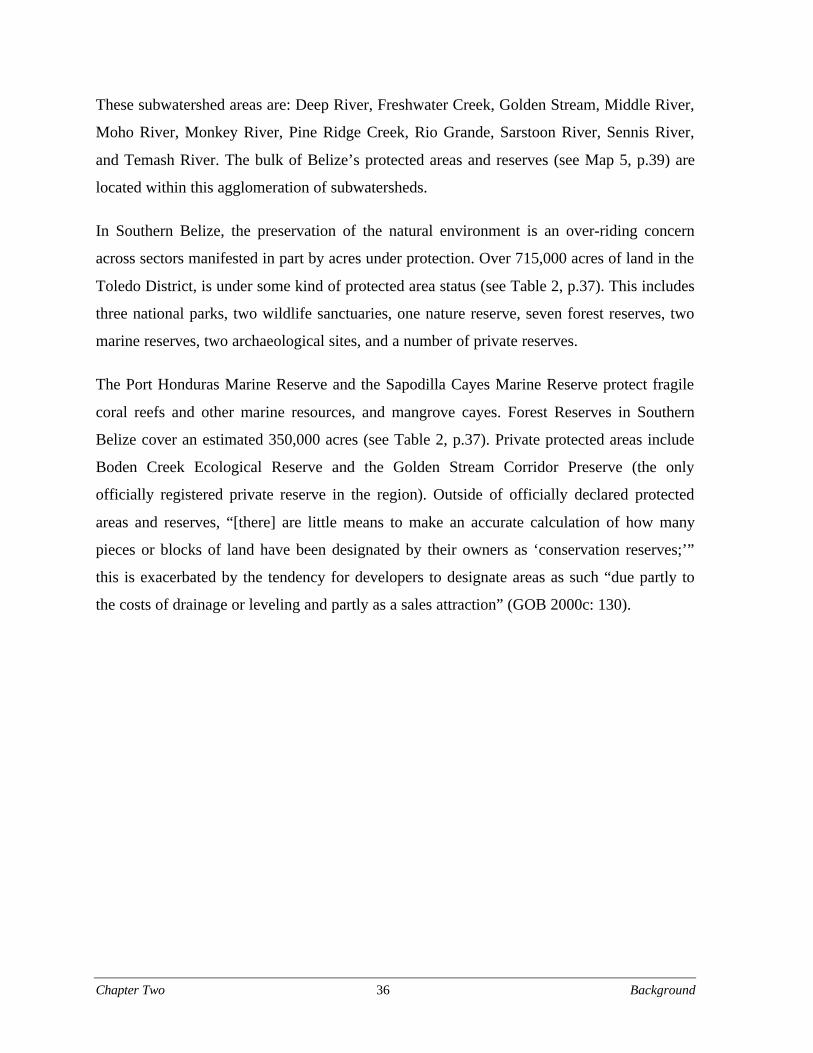
Chapter Two 36 Background
These subwatershed areas are: Deep River, Freshwater Creek, Golden Stream, Middle River,
Moho River, Monkey River, Pine Ridge Creek, Rio Grande, Sarstoon River, Sennis River,
and Temash River. The bulk of Belize’s protected areas and reserves (see Map 5, p.39) are
located within this agglomeration of subwatersheds.
In Southern Belize, the preservation of the natural environment is an over-riding concern
across sectors manifested in part by acres under protection. Over 715,000 acres of land in the
Toledo District, is under some kind of protected area status (see Table 2, p.37). This includes
three national parks, two wildlife sanctuaries, one nature reserve, seven forest reserves, two
marine reserves, two archaeological sites, and a number of private reserves.
The Port Honduras Marine Reserve and the Sapodilla Cayes Marine Reserve protect fragile
coral reefs and other marine resources, and mangrove cayes. Forest Reserves in Southern
Belize cover an estimated 350,000 acres (see Table 2, p.37). Private protected areas include
Boden Creek Ecological Reserve and the Golden Stream Corridor Preserve (the only
officially registered private reserve in the region). Outside of officially declared protected
areas and reserves, “[there] are little means to make an accurate calculation of how many
pieces or blocks of land have been designated by their owners as ‘conservation reserves;’”
this is exacerbated by the tendency for developers to designate areas as such “due partly to
the costs of drainage or leveling and partly as a sales attraction” (GOB 2000c: 130).
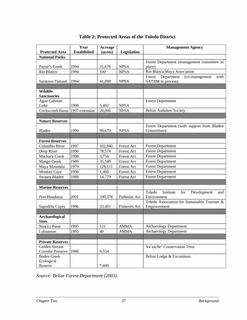
Chapter Two 37 Background
Table 2: Protected Areas of the Toledo District
Protected AreaYear
EstablishedAcreage(acres) Legislation
Management Agency
National Parks
Payne’s Creek 1994 31,676 NPSAForest Department (management committee inplace)
Rio Blanco 1994 100 NPSA Rio Blanco Maya Association
Sarstoon-Temash 1994 41,898 NPSAForest Department (co-management withSATIIM in process)
WildlifeSanctuaries
Agua CalienteLuha 1998 5,492 NPSA
Forest Department
Cockscomb Basin 1997 extension 20,000 NPSA Belize Audubon Society
Nature Reserves
Bladen 1990 99,670 NPSAForest Department (with support from BladenConsortium)
Forest Reserves Columbia River 1997 102,940 Forest Act Forest DepartmentDeep River 1990 78,574 Forest Act Forest DepartmentMachaca Creek 1998 3,756 Forest Act Forest DepartmentMango Creek 1989 35,549 Forest Act Forest DepartmentMaya Mountain 1979 128,111 Forest Act Forest DepartmentMonkey Caye 1996 1,460 Forest Act Forest DepartmentSwasey Bladen 1989 14,779 Forest Act Forest Department
Marine Reserves
Port Honduras 2001 100,378 Fisheries ActToledo Institute for Development andEnvironment
Sapodilla Cayes 1996 33,401 Fisheries ActToledo Association for Sustainable Tourism &Empowerment
ArchaeologicalSites
Nim Li Punit 1995 121 AMMA Archaeology DepartmentLubaantun 1995 40 AMMA Archaeology Department
Private Reserves Golden StreamCorridor Preserve 1998 9,554
Ya’axche’ Conservation Trust
Boden CreekEcologicalReserve 7,600
Belize Lodge & Excursions
Source: Belize Forest Department (2003)
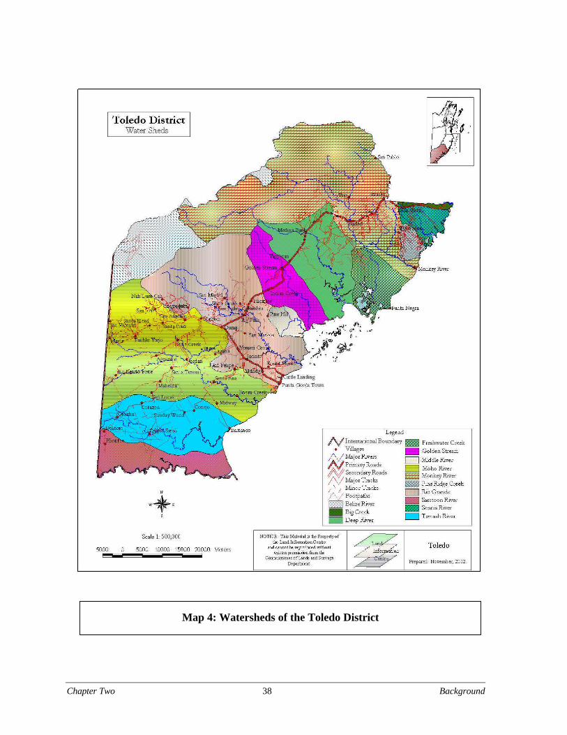
Chapter Two 38 Background
Map 4: Watersheds of the Toledo District
Chapter Two 39 Background
Map 5: Protected Areas of the Toledo District
Chapter Two 40 Background
Pollution
Despite the tendency of environmental organizations to paint Southern Belize as “pristine,”
the region is “impacted by pollution, unsanitary liquid and solid waste disposal practices, and
increased use of agro-chemicals, speculative development, deforestation, uncontrolled fires
and hunting” (GOB 2000c:139). The banana industry depends heavily on pesticides and
fertilizers. While expansion of the citrus and banana industry has leveled off in the Toledo
District, aquaculture is rapidly increasing: “Eight of Belize’s fourteen incorporated and
licensed shrimp farms are located in the southern region [holding title to around 30,000 acres
of land] …approximately 9,250 acres of which are potentially suitable for production use”
(GOB 2000c:46). It is likely that such human activity is responsible for the drastic reduction
of coastal mangroves in recent years (Murray et al. 2002). Effluents from agriculture and
aquaculture severely impact coastal communities and water quality. Aquaculture to date is
largely unregulated yet “...has reached a point where the GOB needs to play a more tangible
role, not only in terms of conventionally regulating issues, such as licensees and permits but
also in relation to strategic analysis of the constraints of the sub-sector, and articulating a
clear and definitive path for its future development” (GOB 2002b).
Hurricanes
Belize lies within the hurricane belt of Central America. In the past three years, four major
storms struck Belize causing significant damage to tourist facilities, utilities, roads, bridges,
and houses, as well as agricultural and fisheries export earnings. Southern Belize is gradually
recovering from the devastation caused by Hurricane Iris in 2001. Estimates of the impact
include damage costs over US$250 million and 13,000 homeless including 62 percent of the
rural population (Monk and Penados 2002:7). In the Toledo District, the hurricane caused
extensive damage to rural villages, forests, and the agricultural sector. Approximately
310,000 hectares of terrestrial ecosystems were severely damaged in southern Belize;
“estimates range from 50-100 years before mature tree species once again dominate the
landscape” (Monk and Penados 2002). In the transition period between relief aid and
development assistance, rural communities depend increasingly on their local resource base.
Chapter Two 41 Background
Logging
Despite the setback to timber resources as a result of Hurricane Iris, the Toledo District
contains extensive forest cover and commercially viable timber. However, unsustainable
management and logging activities as well as a “questionable” leasing policy pose serious
threats to the sustainability of the District’s timber resources. Commercial timber harvests in
neighboring South Stann Creek are already declining due to unsustainable practices (GOB
2000c:140). As of 2002, the Columbia Forest Reserve Management Plan was the only
management plan in the District. Short term leases and lack of management plans provide
little incentives for sustainable forest management. According to the ESTAP Regional
Development Plan:
There is considerably more to sustainable management of forest resourcesthan constructing license plans and counting timber yields…. Sustainablemanagement of forests also depends on development of collateral programsdesigned to promote plantation forestry, agro-forestry, silviculture,reforestation; better political awareness about the value of forests, particularitywith regard to soil and water conservation; enforcement of existinglegislation; and development of forest’s recreational and tourism potential.(GOB 2000c:140)

Chapter Two 42 Background
Chapter Three 43 Struggle for Land Tenure
Chapter Three: The Struggle for Land Tenure and
Resource Control in Southern Belize
The Belizean test of multiculturality lies squarely within the scope ofstatelocal debates over natural resource conservation – Clark (2000b:28)
Introduction
The interplay of politics, community rights, and the control of territory and resources sets the
stage for both opportunities and challenges to resource management in Southern Belize.
While minority ethnic groups in Belize struggle for recognition at the national level, the
Maya people of Toledo present the most outspoken and organized call for rights to natural
resources. The 15,000 Mopan and Kekchi Maya form the largest demographic body in the
region with 60 percent of the District’s total population (Shal 2002a). The relationship of
Maya communities to the land is embedded in their livelihood systems and culture. As the
example of the Sarstoon-Temash Institute for Indigenous Management (SATIIM) will show,
large Government land holdings such as National Parks and Forest Reserves coincide with
communities having longstanding cultural and historic claims to the land but no legal title.
Indeed, the presence of sizable populations without officially recognized land tenure is the
most pressing social concern in the Toledo District. These issues are pervasive throughout
Southern Belize and reappear in subsequent chapters of this report. They are important forces
affecting the interest and ability of indigenous communities to collaborate with other groups
in natural resource management efforts in Belize.
Background
The ancient Maya lived in the 400,000 square kilometer area that is now southern Mexico,
Guatemala, northern Honduras, El Salvador, and Belize. Maya civilization evolved in
complexity from 1800 B.C. to attain its greatest cultural achievements between 250 A.D. and
Chapter Three 44 Struggle for Land Tenure
1000 A.D. Due to uncertain causes, Maya society began to change rapidly by the middle of
the 10th century A.D. The overall population shrank dramatically and numerous large
settlements moved to other areas. At the time of European exploration in the sixteenth and
seventeenth centuries, many Maya still occupied what eventually became Belize (Shoman
1994). The eventual arrival of European colonizers severely disrupted indigenous
populations throughout the Caribbean coast and interior of Central America. The
appropriation of territory and marginalization of indigenous populations continued through
nineteenth and twentieth century transitions to national independence and into the present.
The Maya, transformed by many challenges to their culture, currently live throughout parts
of Guatemala, Mexico, Honduras, and Belize.
Contentious debate surrounds the question of whether or not the Maya abandoned the
southern region of Belize as a result of the conquest efforts of the Spanish colonizers prior to
British settlement in the area now known as Belize. The issue of possible Maya abandonment
has been a crucial point in determining the validity of claims to aboriginal rights over these
lands. Regardless of the historical circumstances, the Kekchi Maya and the Mopan Maya are
now firmly entrenched over a vast area of the Toledo District and the southern portion of the
Stann Creek District. By the mid-1900s, the British colonial government established ten
Maya Indian Reservations in the Toledo District in order to make land available for
residential, farming and subsistence needs.
Currently, sixteen Maya communities, representing 51 percent of the Toledo Maya10
population, reside within reservations. At least twenty villages lay outside reservation
boundaries (TMCC and TAA 1997). The 1992 Belize National Lands Act, which replaced
the Crown Lands Act after national independence in 1981, does not recognize these
reservations (GOB 2000c). According to Belize law, the Maya do not have legal rights even
to the land within the reservations (TMCC and TAA 1997). The lack of legal land tenure is a
factor in the marginalization of these communities.
Nearly all Maya oscillate between cash and subsistence economies (Wilk 1991); however,
many productive activities are dependent on resources to which they have no Government-
sanctioned rights. Lack of control over productive assets contributes to poverty among the
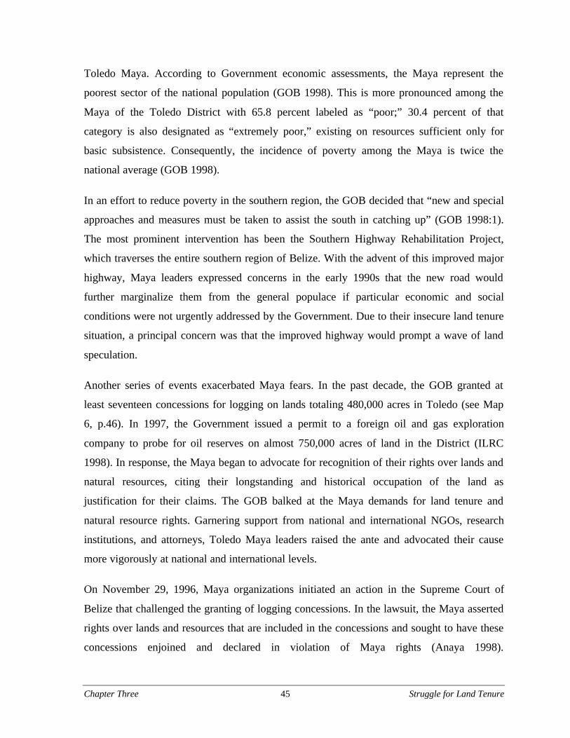
Chapter Three 45 Struggle for Land Tenure
Toledo Maya. According to Government economic assessments, the Maya represent the
poorest sector of the national population (GOB 1998). This is more pronounced among the
Maya of the Toledo District with 65.8 percent labeled as “poor;” 30.4 percent of that
category is also designated as “extremely poor,” existing on resources sufficient only for
basic subsistence. Consequently, the incidence of poverty among the Maya is twice the
national average (GOB 1998).
In an effort to reduce poverty in the southern region, the GOB decided that “new and special
approaches and measures must be taken to assist the south in catching up” (GOB 1998:1).
The most prominent intervention has been the Southern Highway Rehabilitation Project,
which traverses the entire southern region of Belize. With the advent of this improved major
highway, Maya leaders expressed concerns in the early 1990s that the new road would
further marginalize them from the general populace if particular economic and social
conditions were not urgently addressed by the Government. Due to their insecure land tenure
situation, a principal concern was that the improved highway would prompt a wave of land
speculation.
Another series of events exacerbated Maya fears. In the past decade, the GOB granted at
least seventeen concessions for logging on lands totaling 480,000 acres in Toledo (see Map
6, p.46). In 1997, the Government issued a permit to a foreign oil and gas exploration
company to probe for oil reserves on almost 750,000 acres of land in the District (ILRC
1998). In response, the Maya began to advocate for recognition of their rights over lands and
natural resources, citing their longstanding and historical occupation of the land as
justification for their claims. The GOB balked at the Maya demands for land tenure and
natural resource rights. Garnering support from national and international NGOs, research
institutions, and attorneys, Toledo Maya leaders raised the ante and advocated their cause
more vigorously at national and international levels.
On November 29, 1996, Maya organizations initiated an action in the Supreme Court of
Belize that challenged the granting of logging concessions. In the lawsuit, the Maya asserted
rights over lands and resources that are included in the concessions and sought to have these
concessions enjoined and declared in violation of Maya rights (Anaya 1998).
Chapter Three 46 Struggle for Land Tenure
ewrewr
Map 6: Toledo District Forest Licenses
Chapter Three 47 Struggle for Land Tenure
The Maya leadership also filed a petition with the Inter-American Commission on Human
Rights (IACHR) on August 10, 1998, in an effort to compel the GOB to recognize
indigenous land rights and to challenge the legality of logging and oil concessions in the
Toledo District. The conflict remains unresolved despite the ratification of several tentative
agreements concerning resource use and indigenous rights by Maya leaders and the GOB.
Roads and Reservations
Opposition to the Southern Highway Rehabilitation Project pressured its primary funder, the
Inter-American Development Bank (IADB), to abide by the Bank’s policy of not
constructing roads in contested zones (Lockwood 1997). Responding to concerns that the
improvement of the Southern Highway would create environmental degradation and
exacerbate social and economic problems, particularly for the Toledo Maya, the IADB
approved US$2.6 million for the creation of an Environmental and Social Technical
Assistance Project (ESTAP). The Project formulated a Regional Development Plan (RDP)
for the South Stann Creek and Toledo Districts. For undisclosed reasons ESTAP dissolved in
1999 three years earlier than expected (TMCC 1999). Consequently, the Government created
the Southern Region Development Corporation (SRDC) to fill the void left by ESTAP. After
the Toledo District emerged as the focus area for the project, the SRDC transformed into
another government-owned enterprise the Toledo Development Corporation (TDC).
The TDC is charged with executing the original RDP. The Plan specifies a set of
development programs to complement the improvement of the highway. It identifies
particular steps to mitigate potential negative social, economic, and environmental impacts
arising from the substantial civil works project (GOB 2000c). Through these projects, the
Government expects TDC to become the aggregated voice of Toledo. This arrangement
enables potential investors to interact with a singular, representative body. The Government
envisions that the Plan along with the Southern Highway Rehabilitation Project will
accelerate the pace of development in a region that has always been regarded as the most
economically depressed in the country.
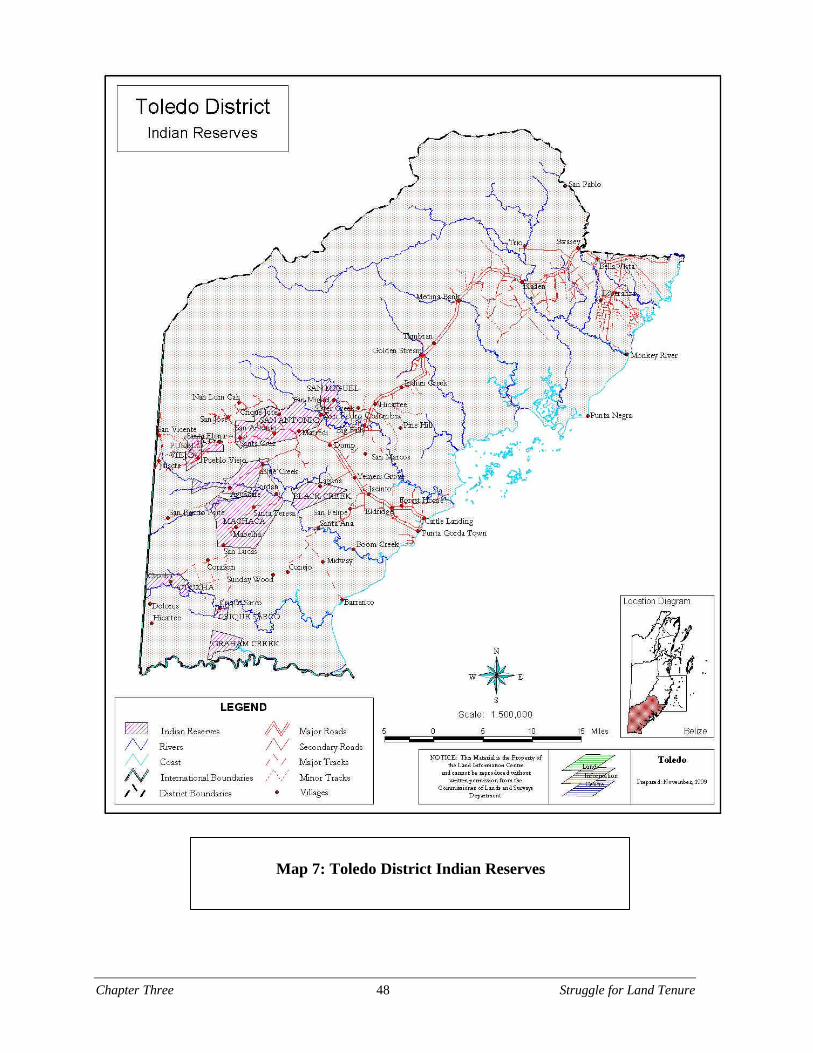
Chapter Three 48 Struggle for Land Tenure
Map 7: Toledo District Indian Reserves

Chapter Three 49 Struggle for Land Tenure
Approximately one-third of the part of the Toledo District subject to the RDP is considered
to be National Land, and is estimated to consist of 336,000 acres (GOB 2000c). National
Land (including lease-land) is governed by the 1992 National Lands Act and is one of three
designations that make up the Government’s National Estate, which is administered by the
Ministry of Natural Resources and Environment (MNRECI). Forest Reserves and National
Parks comprise the remaining two categories. According to the Government, National Land
constitutes public land “that is essentially a passive and un-managed resource” (GOB
2000c:91).
The Maya Reservations in the Toledo District represent the greatest exception to the
conventional forms of land tenure in Belize. Approximately 70,000 acres of the Toledo
District is officially classified as “Indian Reservation” (Emch 2003) (see Map 7, p.48). The
reservations, first established by Britain under the Crown Lands Act, designated block
possession of landholdings for the Kekchi and Mopan peoples of Southern Belize (Clark
2000b). The first reservation—a parcel of land measuring two square miles—was established
in 1896 at San Antonio, Toledo District (GOB 2000c). Establishment ceased in 1962 with the
extension of the Rio Blanco and Pueblo Viejo reservations. Despite the declaration of Indian
Reservations, ownership of the land remains out of local control. “Reservation land is not
owned communally by the Maya; the Government owns it. This system of tenure makes land
ownership among the Maya on reservations impossible. Thus, national authorities have the
power to eliminate Maya rights to this land” (Emch 2003:123, references omitted).
Maya organizations and the GOB fiercely dispute the legal status and function of Maya
Reservations. The only statutory rules governing the reservations, adopted in 1924, have
never been revised (GOB 2000c). The RDP states that the successor to the Crown Lands Act,
the National Lands Act, “makes no mention of Indian Reservations as such, only referring to
“reserves” which may or may not be applicable” (ESTAP 2000:127). Opposing this view, the
Toledo Maya Cultural Council (TMCC), a NGO that represents the Mopan and Kekchi of the
District, claims that these reservations continue to exist under the laws of Belize.
Chapter Three 50 Struggle for Land Tenure
The reservations, however, only include roughly half of contemporary Maya villages that
exist today (IACHR 2000). The RDP also states that according to regulations the occupation
of reservation lands should be at the discretion of the Commissioner of Lands and Surveys of
the Ministry of Natural Resources. At present, de facto authority over occupancy resides with
the village alcaldes11 (a traditional, community-elected leader) and Village Council Chairmen
(GOB 2000c). The ten existing reservations now encompass sixteen communities with an
approximate population of 6,500 Maya (IADB 2001). The IADB Land Management Program
Project Report (2001) states:
There is negligible productive land available for expansion within thereservations and many additional Maya villages are now located outside theboundaries established under the Crown Lands Act. Based on recentestimates, Maya farmers occupy over 25,000 ha. of unleased national lands…
While independent opinions vary, there is consensus that the reservationsystem has deteriorated to the point where confidence in the system has beenlost, owing in part to the absence of any official administrative structure. Todate, there is no formal policy on tenure of reservation land.
At least twenty Maya villages reside outside reservation boundaries. This is not a recent or
unexpected phenomenon. In the Maya Atlas (1997) the TMCC and the Toledo Alcaldes
Association (TAA) declare:
The reserves were never physically demarcated nor defined in the country’sconstitution as the communal property of the Maya. The reservationsconstructed by the British to subjugate the Maya were not honored by theMaya. Many villages were constructed outside of the reservations without thegovernment’s approval, as the Maya regard all of these lands as their own, thehome of their forefathers, who built magnificent temples to manifest theirpresence.
Maya Advocacy
Thirty-six Maya villages located throughout the Toledo District lay within or in close
proximity to the lands on which the GOB has granted logging concessions. These
concessions include forests around villages that are used by Maya for religious purposes as
well as for farming, hunting, and gathering. According to Valentino Shal (2002a) President
of the TMCC, the paving of the Southern Highway and the planned construction of a new
Chapter Three 51 Struggle for Land Tenure
highway to Guatemala “will provide easier access to outsiders to claim land in the area” and
is thus “an additional concern to the security of the land presently under Maya occupation.”
Anaya, an attorney with the Indian Law Resource Center, states that, from the standpoint of
the Maya, “the issue is not simply one of environmental degradation; it is more
fundamentally one of ownership and control over the lands and resources at stake” (1998;
emphasis added). The current core interests and concerns of the Maya organizations confirm
this assertion.
Five major NGOs claim to represent the Maya of the Toledo District. The Toledo Maya
Cultural Council (TMCC), the Kekchi Council of Belize (KCB), the Toledo Maya Women’s
Council (TMWC), and the Toledo Alcaldes Association (TAA) initially arose to address
social and economic needs, cultural and gender concerns, and the lack of political
representation. The rising importance of land availability and tenure necessitated the
incorporation of an overtly political slant to the missions of these organizations. The
politicization of land in Southern Belize prompted these Maya organizations to form the
Maya Leaders’ Alliance (MLA) in 1999. The following analysis discusses the interests of
each of these organizations.
Toledo Maya Cultural Council
In 1982, a group of Mopan and Kekchi Toledo alcaldes established the TMCC as a response
to the Government’s appropriation and distribution of land without consultation of Maya
communities. The men also feared what they perceived as the GOB’s actions to erode the
traditional alcalde system of governance in favor of the newer nationally-endorsed
governance system of village councils (TMCC and TAA 1997). The leaders intended the
TMCC to act as a representative body for cooperation among the Toledo Maya in order to
promote unity and mutual understanding and to search for solutions to shared economic,
social and educational problems. As conflict over land escalated, the TMCC grew
increasingly concerned about the precarious land tenure situation of Maya communities.
Response to this concern evolved into a primary objective of the TMCC: to ensure that the
Maya continue to live in what they consider to be their ancestral territory (TMCC and TAA
1997). Since Mopan Maya and Kekchi Maya face similar threats, six representatives from
Chapter Three 52 Struggle for Land Tenure
each group have been elected to the TMCC Executive Committee. As the Kekchi population
is nearly double the Mopan population, this arrangement has altered power relations between
the two groups.
Kekchi Council of Belize
Despite the efforts of pan-Maya organizations, long-standing tensions between Mopan and
Kekchi people led to the existence of single-ethnicity advocacy groups. The KCB formed as
a splinter organization of the TMCC (Wainwright 1998). After a series of community
consultations, the KCB was incorporated in 1992 by a group of Kekchi leaders who felt it
imperative for a legally established representative body to address the concerns of the Kekchi
community in the Toledo District. The Council is a non-profit, non-religious, and non-
partisan association that collaborates with governmental and non-governmental organizations
to improve the living conditions of the Kekchi people by conducting leadership skills
training, engaging in economic development projects, and documenting indigenous
knowledge. The KCB’s mission is to promote the enhancement and preservation of the
Kekchi language and culture and to promote interracial and interethnic harmony in Belize
and elsewhere (MLA 2003). According to KCB President Gregorio Ch’oc, the Council’s
primary interests include protecting and preserving all ancient and contemporary indigenous
heritage including folkways, territory, monuments, and antiquities. In addition, the KCB
attempts to make certain that development projects “are to a large extent practical and reflect
the needs and priorities of the Maya communities” (Ch’oc 2002). Ever inclusive, the KCB
programmatic portfolio now covers a broad range of aspects, including political and
watershed management issues.
Toledo Maya Women’s Council
Attention to interethnic divisions among the Toledo Maya contributes to the masking of other
important community issues (Wainwright 1998). To respond to gender concerns, in
particular, village-level women’s groups formed the TMWC in 1997. Pulcheria Teul
provided the impetus to organize the Council, prompted by her election to the Belize
National Indigenous Council in the same year. The TMWC may be the most broad-based of
all Maya organizations; its annual meetings host two representatives from every women’s
Chapter Three 53 Struggle for Land Tenure
group in Maya villages throughout Toledo. TMWC serves as a support organization for these
groups. Based on anticipated social changes in the District and the realization that women
will not be able to “move ahead” without training, it seeks to address gender issues and
economic well-being through leadership training, marketing, communication, and
administrative and business management skills (P. Teul 2002). The TMWC is also linked to
direct advocacy through the mediation of domestic violence cases. Limited funding and
staffing (Teul is the only full-time, volunteer staff member) force the TMWC to maintain the
delicate balance between its own institutional strengthening and the facilitation of projects.
The Council expands its capacity and impact by working closely with the Southern Alliance
for Grassroots Empowerment and (SAGE) training with the Community-initiated,
Agricultural and Rural Development project (CARD). Through these endeavors as well as its
focus on women’s livelihood concerns, the TMWC affects the issues of land rights and
resource control in Southern Belize. The inclusion of the TMWC in the MLA is imperative
for the full representation of community concerns given strong cultural barriers to women’s
advocacy and a distinct, gendered division of labor in many Maya communities.
Toledo Alcaldes Association
In 1992, the same year that the KCB emerged from the TMCC, the alcaldes from thirty-six
Maya communities gathered to create the TAA. Incorporated into the GOB in 1994, the
Association serves as the legal representative of Maya communities (TMCC and TAA 1997).
The fact that each village contributes one elected alcalde means that the Association consists
of a Kekchi majority. The TAA strives to preserve the traditional leadership structure and
strengthen the role of alcaldes in community decision-making. These goals entail educating
both its constituency and the national Government about the function and significance of the
alcalde system. The TAA faces difficulty in realizing its objective because it must contend
with other Maya organizations for legitimacy in representing indigenous concerns.
Chapter Three 54 Struggle for Land Tenure
Maya Leader’s Alliance
The shared goal of securing land claims forced Maya organizations to recognize the
fragmentation of Maya leadership and take action to alter this reality. The TAA, TMCC,
KCB, and TMWC assembled the MLA in 1999. Commonly dubbed “Maya Government,”
the Alliance formed for multiple reasons including the monitoring of development projects
and the promotion of languages, traditions, knowledge, and skills that comprise Maya
cultural heritage. More importantly, however, the Alliance sprang from the need for Maya
leadership to collectively negotiate with the GOB for recognition of ancestral resource rights
in Southern Belize. Continuing where the comprehensive documentation initiative of the
Maya Atlas12 left off, the MLA recently began implementation of the Maya Co-Management
Project. In collaboration with the Inuit Circumpolar Conference (ICC)13 and the Canadian
International Development Agency, the project seeks to examine Maya land use and
occupancy in Southern Belize in order to develop a land management system that asserts
indigenous control and ownership of ancestral lands and resources. Geographer Joel
Wainwright explains that projects like this encourage a more-unified Maya voice; “[B]ecause
the case for land claims rests on indigenous rights—which are equated with being Maya—
and not Mopan or Kekchi identities per se, in most public discourses leaders stress Maya
identity, or claim to speak on behalf of ‘the Maya people’” (1998:38).
Convoluted Interests and Competing Claims
A façade of unified parties and convergent interests hides the fissures in relations within and
between indigenous groups and the GOB. The creation of an enabling environment for
economic growth and development continues to be the main thrust of the GOB’s strategy to
address social problems and reduce the impact of poverty in Southern Belize (GOB 1998). In
the National Poverty Elimination Strategy and Action Plan 1998–2003, the GOB outlines its
priorities as employment/livelihoods (including access to land), health, education, the
strengthening of civil society institutions, and the support of “decision-making processes
based on partnerships between central Government, NGOs and local organizations such as
Town Boards, Village Councils and other social groups” (GOB 1998:8).
Chapter Three 55 Struggle for Land Tenure
At first glance, the GOB’s plans for the southern region appear to be laudable and similar to
the interests of the Maya organizations. After all, the Maya are also seeking to improve their
living conditions and access to land. But skepticism about governmental intervention
abounds in Southern Belize. According to Gregorio Ch’oc, President of the KCB:
[The GOB continues] to mortgage the future of Belize on development that isill-conceived. The environment is paying a high price. Over the last 30 years,about 60 million dollars have been spent in the Toledo District. You can godown here and see what has happened and ask what the hell has happened tothe money. (2002b)
The Maya claim
Maya and GOB positions diverge on the issue of legitimacy in access to land. Based on the
research of US anthropologists like Richard Wilk and Grant Jones, Maya representatives
have submitted reports to substantiate their claim that the contemporary Toledo Maya are the
descendants of Maya subgroups that inhabited the territory at least since European
exploration in the seventeenth and eighteenth centuries (Anaya 1998). Government attorney
Jose Cardona of the MNRECI has disputed these accounts with counterclaims portraying the
Toledo Maya as immigrant groups with no ancestral linkages to the territory that predate
British settlement (Anaya 1998). Put simply, the GOB sees itself as the rightful owner of all
national land, including the Maya Reservations, in the southern region. Such a perspective
relegates the Toledo Maya as squatters on Government property. Studies challenge this
perspective by suggesting that the Maya Reservations actually formalized block land
ownership for the Kekchi and the Mopan. Control over these designated zones of traditional
forest use granted communities legal recourse in village/state conflicts over the management
of these areas (Clark 2000b). To further complicate the matter, Maya advocacy organizations
have demanded more than mere title to reservation land; they have pressed for a “Maya
Homeland.” According to Wainwright (1998), the TMCC has issued three distinct positions
on behalf of the Maya claim since 1995:
1. The creation of a separate Maya state within Belize, including the creation of a Maya
flag, and other tropes of Maya nationalism.
Chapter Three 56 Struggle for Land Tenure
2. The creation of a Maya Homeland, which would seek to secure agricultural land-
rights within the framework of a broadly Maya governance system, without
abandoning their privileges as Belizean nationals.
3. The creation of a Maya Lands Administration Program (MALAP), which would
advocate the creation of a new Maya Council that would have authority over all Maya
villages and common lands (plus Reservation lands which are not claimed by any
village) in Toledo. This proposal emphasizes that the MALAP-run area would not be
autonomous from the Belizean nation in any sense, although land use decisions would
be the purview of the Maya Council.
The Maya Atlas, however, states that the creation of a Homeland under the status of a
“Freehold Title” is the ultimate goal of the Maya (TMCC and TAA 1997). According to the
TMCC and the TAA, the goal is to gain “legal security for our ancestral land; we want to
establish a homeland that will also be an environmentally protected area under the
management of the Maya” (TMCC and TAA 1997:1).
According to Valentino Shal, the director of the TMCC, the GOB has never taken a
concerted effort “to take a good look at the [Maya] land tenure issues” (2002). In fact, to
date, the GOB has approached the Maya land tenure issue from the 1992 National Lands Act
framework for land allocation. As previously indicated, “national lands” encompass all
public lands (other than Forest Reserves and National Parks). From the Government’s
perspective, since the Act does not recognize the Maya Reservations, these lands are
officially viewed as public lands. The Act states, “The Minister [of Natural Resources] may
grant leases of national lands on such terms and conditions as he thinks fit and may likewise
renew leases on such terms and for such periods as to him may seem proper” (GOB
2000a:9).
Leasing parcels of contested land is a long-standing Government initiative that exposes
divisions within Maya communities. Government discussion on the privatization of
reservations began in the 1940s (Emch 2003). Active de-reservation continued through the
1980s. This caused residents of reservations to find alternative ways to secure land.
Chapter Three 57 Struggle for Land Tenure
Wilk (1991) explains that many farmers started to plant cacao in reserves in order to develop
land rights. The threat of de-reservation even led to the formation of new organizations. “In
1985, a group of farmers from 10 villages formed a group called the Toledo Cocoa Growers
Association (TCGA). Their main goal is to establish cacao on leasehold land and eventually
gain title to that land” (Emch 2003:124).
In 1998, the IADB allocated funds to ESTAP for the purpose of resolving land issues in
Toledo. ESTAP learned that many Maya communities favor private land leases rather than
communal lands (Van Ausdal 2001). Since the 1980s, communal lands have become
increasingly privatized through local land tenure rules. This process intensified under the
1992 National Lands Act. The appeal of leases results from many villagers’ desire to access
credit, to retain land claims during village absences, and to protect their farms through buffer
zones. The leases create tensions in the Maya communities between those that favor
privatization and those that prefer the traditional communal system.
The realization of Maya discord on the issue reveals a fundamental deviation from positions
posited by Maya organizations. Although initially disputed by the TMCC, the Council did
eventually acknowledge the shift within their constituency (Van Ausdal 2001). This
contradicts the claim made in the Maya Atlas that “The Homeland proposal has the support
of all the villages in the Toledo District” (TMCC and TAA 1997:8). Such contradictions
bring into question Maya organizations’ pronouncements of unanimous grassroots support
for their struggle to achieve recognition of indigenous land and resource rights. Furthermore,
the division strikes at the relationship between Maya organizations and communities. A
senior official of a Maya organization notes:
[There is a] lack of coordination between communities and [Maya] NGOs.Leaders make the decisions, without getting appropriate input from thealcaldes and communities. This includes the… TMCC. These NGOs makedecisions that won’t suit the whole district… [The Maya] NGOs in PuntaGorda14 don’t know what’s happening in the villages. They don’t live there,and don’t know the problems and needs of the community. (Anonymous2002)
Chapter Three 58 Struggle for Land Tenure
The fear of setting precedents for indigenous rights is one reason for the GOB’s reluctance to
concede to Maya demands for legal dominion. Due to the nation’s ethnic diversity, granting
privileges to one group may trigger others groups such as Garifuna, East Indian, and Yucatec
Maya to press for control of national lands. In contrast, Toledo Maya organizations believe
that their case is unique and warrants special consideration. This disagreement raises the
issue of divergent assumptions and understandings regarding the control of land in Toledo.
Contrary to the GOB’s view of land tenure, the issue for Maya advocates is not congruous
with the acquisition of “property.” Gregorio Ch’oc clarifies: “This isn’t about a possession of
resources; this is about a basic right. It isn’t about ‘taking’ land but about land that is already
being used” (Ch’oc 2002a).
The Government’s stake
Although the Toledo District has been the most economically depressed region of the
country, the area is abundant in natural capital including timber and mineral deposits (GEF
2000a). Consequently, exploitation of those resources plays a key role in the GOB’s national
economic development and poverty elimination strategies. These resource rich areas,
however, straddle the land over which the Toledo Maya assert aboriginal rights. In their
petition to the Inter-American Commission on Human Rights (see below), the TMCC claims
“that the State has violated the Rights of the Toledo Maya indigenous communities in
relation to their lands and natural resources” (IACHR 2000; emphasis added). Thus, the
conflict goes beyond mere control or possession of territory; control over resources such as
timber, petroleum deposits, and biodiversity is also at stake. It has therefore behooved the
GOB to ignore Maya claims and to continue perceiving itself as the rightful owner of
national land in the Toledo District. Cardona, representing the GOB’s position, asserts that at
one time “most of southern Belize was privately owned lands but through escheatment, lapse
in leases, and acquisition of land in lieu of taxes, most of the Toledo District is now National
Lands” (in Anaya 1998). As previously mentioned, the GOB effectively and conveniently
considers the Toledo Maya as trespassers on Government property. The following discussion
outlines some of the major economic and development interests that the GOB has at stake in
Southern Belize.
Chapter Three 59 Struggle for Land Tenure
Land as a political tool
Land and development rights are routinely used by officials in Government to reward
partisan supporters and punish opponents (Duffy 2000). This abuse is so ingrained into the
Belizean political culture that it occurs blatantly and without recourse. As a consequence land
allocation, tenure, use, and management often have damaging social, economic and
environmental consequences. As a political tool, land-related decisions can further short-term
objectives, giving little consideration to long-term benefits for the people or the natural
resource base. The People’s United Party, now in its second five-year term, had been
committed by its 1998 Manifesto to de-politicize land, but no significant progress was made
towards achieving this goal. This situation continues despite a loan from the IADB in 2001 to
implement a Land Management Program intended “to improve the enabling environment for
private and public sector development through enhanced land security, effective land
markets, and the promotion of a coherent land policy framework contributing to sustainable
development and efficient use of land resources” (IADB 2001:1). Furthermore, at least up to
2001, there has been little effort on the part of the Government to consult with civil society
on land issues (BAS 2002b).
Timber resources
Southern Belize contains the bulk of the nation’s timber resources. Its seven forest reserves
contain extensive stands of valuable timber species such as pine, mahogany, teak and
gmelina. Harvests on Government lands dominate routine timber production in Toledo. Until
Hurricane Iris in 2001, total hardwood extraction intensified under the perception that the
Toledo District continues to harbor a large supply of natural timber resources (ESTAP 2000).
At least seventeen licenses totaling about 480,000 acres have been issued for logging in the
southern region (ILRC 1998) (see Map 6, p.46). This figure does not include numerous
small-scale timber leases. The southern logging industry is one of the largest direct and
indirect employers. Maya villagers, residing near the various logging operations, comprise
the industry’s primary labor force (GOB 2000c). While wage labor provides some financial
benefits, the GOB has rarely consulted Maya communities before granting licenses in their
area.
Chapter Three 60 Struggle for Land Tenure
Despite this practice, the Chief Forest Officer Oswaldo Sabido recently began to work with
the Southern Alliance for Grassroots Empowerment (SAGE)15 to develop a mechanism for
community consultation before issuing licenses. This significant sign of progress reveals
collaboration between local advocacy NGOs as well as the public servant legally responsible
for upholding forest laws and recommending timber licenses to the Minister of Natural
Resources and Environment. This combined effort originated from direct community input in
a 1998 Logging Review Committee. A Maya representative on the Committee recommended
that communities should be consulted before issuing permits. In addition, he suggested that
Maya leaders should monitor logging concessions in the absence of a functioning mechanism
to do so. According to Chief Forest Officer Sabido:
[In] dialogue with and discussion on this with SAGE, it was decided that theywould assist us by being the facilitator for community consultation withprospective licensees before the licenses are issued. And that is workingreasonably well. It still has some glitches, moving a little slowly, but on awhole it’s taking us where we want to go. A lot of people who are used todecision-making are used to doing things on the “fast-track.” In Toledoespecially when dealing with communities you need to take things one step ata time. (2002)
Oil reserves
In December 1997, the MNRECI granted an oil exploration license to a US/Guatemalan oil
company, Compania Petrolera del Atlantico (Wainwright 1998; GEF 2000a). The license
covers 749,222 acres of land in the lowland Toledo District (IACHR 2000). The prospects
for oil extraction are realistic. Within the region, both Guatemala and Mexico produce
substantial quantities of oil on geological formations similar to those found in the karstic hills
of Southern Belize. Industry practice and laws in Belize dictate that a contract for petroleum
operations guarantees oil extraction rights. These rights may last up to 25 years if
commercially viable oil deposits are located. The TMCC claims that in granting the oil
exploration license the GOB “placed a substantial portion of Maya traditional territory in a
potential position of long term oil development and production activities without consulting
the Maya people” (IACHR 2000).
Chapter Three 61 Struggle for Land Tenure
Shrimp farming
Leasing land in Southern Belize for aquaculture also generates revenue for the GOB and
frustration for indigenous communities. The industry is expanding at an astounding rate of
over 160 percent per annum in Belize (Myvett and Quintana 2002). Written into the 2003
People’s United Party Manifesto, the Government recognizes the US$25 million industry as
an increasingly valuable sector for the nation, “We will: Facilitate the establishment of 4,000
new acres of shrimp farms, and expand the tilapia farms for small farmers” (PUP 2003).
Aquaculture in Belize is based almost entirely on the production and export of Pacific White
Shrimp. In addition to rural employment production and processing, the industry provides
infrastructure development with roads and electrification and jobs through ancillary services
such as freight haulage and customs brokerage.
Factors that have contributed to the rapid expansion of shrimp farming in Belize and the
southern region in particular include the availability of suitable land, the existence of a
trainable work force, and expanding public infrastructure and support services. Currently
there are eleven farms, mostly concentrated on the coastal pine ridge soils in the South Stann
Creek area (Myvett and Quintana 2002). National proposals for new shrimp farms specify
coastal areas of the Toledo District. Accompanying the expansion of the industry has been
the issue of land speculation. Since 1995, the Department of the Environment of the
MNRECI has raised concerns regarding the unchecked leasing of national lands (and the de-
reservation of forest reserves), often to accommodate scantily outlined proposals (BAS
2002b).
Towards a Resolution
Politics as usual
Formal and informal attempts to resolve the land dispute have taken place at grassroots and
international levels. The TMCC claims that “the Maya people have consistently attempted to
have the government address and resolve their concerns, administratively and judicially from
1995 to [October 2000] but to no avail” (IACHR 2000). Consequently, Maya organizations
Chapter Three 62 Struggle for Land Tenure
resorted to legal action. In 1996, Maya organizations brought a case to the Supreme Court of
Belize to assert their rights over lands and resources included in logging concessions.
Although a brief procedural hearing was held before Chief Justice Meerabux in 1997, further
hearings were adjourned indefinitely at the request of the Attorney General’s office (IACHR
2000).
Simultaneously, grassroots actions targeted the land issue at the community level. Between
1995 and 1997, the TMCC and the TAA joined forces to undertake an extensive Maya
Mapping Project. With support from the Indian Law Resource Center (ILRC), the University
of California-Berkeley, and the MacArthur Foundation, the TMCC and TAA produced the
Maya Atlas (1997). The Atlas depicts the dynamic interactions among various Maya
communities and their complex relationship with their environment. In doing so, it
determines the boundaries of a “Maya Homeland” by illustrating the extent of traditional
land use and occupancy. At its release in Belmopan in October 1997, Maya activist Diego
Bol introduced the publication proclaiming, “The Maya Atlas… is our tool to show our
existence, a weapon to press for our legal right to a piece of the jewel, our desire to be active
participants in the sustainable use of our resources…” (in Wainwright 1998:61). One of the
Atlas’ maps, immediately published in major Belizean newspapers, revealed seventeen
logging contracts in the Toledo District. The GOB responded, according to Wainwright,
“with its most explicit and honest policy statement concerning the conflict: the Maya have no
land rights” (1998:64-5).
Frustrated by the Government’s legal firewall, the TMCC elevated their claim to the
international realm. In 1998, attorneys from the ILRC presented a petition to the
Organization of American States’ (OAS) Inter-American Commission on Human Rights
against the State of Belize “for alleged violation of Articles of the American Declaration of
the Rights and Duties of Man” (IACHR 2000). This petition prompted the GOB to respond to
the Maya claims for the first time since the Belize Supreme Court hearings were adjourned.
On November 18, 1998, the GOB and the TMCC made independent requests to the IACHR
for a negotiation process that conforms to “friendly settlement procedures” (IACHR 2000).
Chapter Three 63 Struggle for Land Tenure
The following two years witnessed fluctuating strife between the parties despite attempts at
mediation. The TMCC expressed its exasperation with the GOB’s failure “to engage in a
meaningful dialogue” and to establish conditions “believed to be necessary in order for the
friendly settlement talks to proceed in a fruitful manner” (IACHR 2000). After the TMCC
attempted to withdraw from the negotiation procedures in 1999, the GOB finally replied to
questions posed by the Maya organization (IACHR 2000):
Will the Government of Belize immediately alter its course of action in regardto development activities on Maya traditional lands?
Does the Government of Belize recognize that the Maya have rights to landsand natural resources in Southern Belize based on their traditional use andoccupancy of those lands?
The Government’s response sounded promising:
The Government is prepared to commit to negotiating with the TMCCimmediate interim measures and change the terms under which theGovernment permits activities
The Government of Belize is entirely open to recognizing Maya traditionalland resource tenure patterns
The response encouraged the TMCC by indicating that the Government was willing to
discuss “immediate measures” and alter activities. However, the GOB avoided comment on
defining the basis for indigenous rights. This evasion precipitated diplomatic backsliding.
Through 2000, the Government failed to engage in negotiations with the TMCC and
neglected to respond to IACHR communications.
In October 2000, the Commission reached a final decision and declared the validity of the
TMCC’s petition. As a member of the OAS, the GOB took the IACHR’s decision seriously.
Only days after the IACHR’s decision, the Government and Maya leaders signed a historic
and unprecedented agreement called “Ten Points of Agreement between the Government of
Belize and the Maya Peoples of Southern Belize” (GOB 2000b). The Agreement was signed
by the Prime Minister of Belize and by the Chairpersons of the TMCC, the TAA, the KCB,
the TMWC, and the Toledo District Village Councils Association.
Chapter Three 64 Struggle for Land Tenure
While the Agreement primarily focused on forging a partnership between GOB and the Maya
leaders to design and implement development programs to benefit the Maya communities,
the Government made what appeared to be an extraordinary concession by recognizing that
“Maya People have rights to lands and resources in southern Belize based on their long-
standing use and occupancy” (GOB 2000). However, as the statements below indicate, it is
clear that the Government and the Maya leaders have different interpretations of indigenous
rights. Gregorio Ch'oc, President of the Kekchi Council of Belize, remarked:
It's the government's recognition that the Maya people have a right to the landand resources in southern Belize, particularly around their communities andthe immediate environment. The larger framework [of the Agreement] willdetermine how we proceed to provide titles or ownership of these lands andresources to the communities and how they will benefit, not onlyeconomically, but spiritually, socially, culturally, from the resources. Mayapeople are pretty much a forest dependent people and as such their livelihooddepends on it. It is important that we safe guard this. (News 5 Online 2000;emphasis added)
Said Musa, Prime Minister of Belize, elaborated on the Government’s perspective:
[This Agreement] is setting out a framework for us to work together to ensurethat we have meaningful development here in Toledo that will benefit thepeople. [The Agreement] will ensure that the people who want the titles totheir lands, their leases, who for years have been waiting for this, we will tryand speed up that process now, so they can get their leases and their titles.Those who want to retain communal lands around their villages; we willrespect that as well. There is enough land to satisfy both demands if you like,but it has to be done in an organized fashion and we have to make sure there isan equitable distribution of this land. … The concept of just having a wholesection of Belize put aside and just say that this is a Maya homeland is notwhat this document is about. We do not subscribe to that and this is where wehad to sit down and discuss this with the Maya leaders, that we felt you cannotbalkanize, you cannot separate any part of Belize, because Belize belongs toall the Belizean people and any Belizean is entitled to come and live here inToledo, whether it be Creole, Garifuna, Mestizo. Similarly, any Maya isentitled to live in any part of Belize. (News 5 Online 2000)
The Maya clearly interpret the Agreement as the GOB’s recognition of Maya aboriginal land
rights and acceptance of the Maya homeland, at least in concept. The Maya expectation,
therefore, is for the GOB to provide land titles and ownership to the Maya within the
framework of their Maya Homeland proposal. The GOB clearly disregards the Homeland
Chapter Three 65 Struggle for Land Tenure
concept, but recognizes the need to grant the Maya individual land leases and titles within the
framework of the National Lands Act. The Prime Minister referred to respecting “those who
want to retain communal lands around their villages.” Given the Prime Minister’s
pronouncement regarding the “Maya homeland”, his reference to “communal land” can be
interpreted as GOB’s acceptance of the traditional Maya occupation (without title) of land.
This is effectively GOB’s concession to tolerate Maya “squatting” on Government lands, but
cannot be construed as recognition of Maya aboriginal land rights. In the Agreement, the
Maya leaders agreed that the Toledo Development Corporation will be the main agency for
the implementation of the Regional Development Plan which was developed by ESTAP.
Essentially, the Maya leadership endorsed the development plan for the South Stann Creek
and Toledo Districts and, by so doing, made the most extraordinary concession of the two
parties to the Agreement.
The GOB and the Maya leadership made a significant step forward by agreeing to cooperate
with each other to implement development programs for the Maya communities. However, in
regards to the Maya claims of indigenous land and resource rights, the GOB maintained the
status quo and made little progress. Government and Maya leaders were expected to develop
administrative measures and target dates for the implementation of the program within four
months after signing the Agreement. To the consternation of Maya communities, these
obligations remain unfulfilled. At present, energy and effort to resolve issues of land tenure
and resource rights have dwindled.
Implications for Land and Resource Management
The prospects for a negotiated settlement in the Mayas’ favor are fraught with difficulty.
Notwithstanding international indigenous rights agreements, the power of the State decides
whether or not it will accede to the Maya demand for recognition of their rights to land and
resources. The financially burdened GOB has much at stake – control over land, timber
resources, mineral resources, and the economic benefits that these derive. Maya communities
face far greater risks; resource management decisions jeopardize their livelihoods,
communities, identities, and self-determination.
Chapter Three 66 Struggle for Land Tenure
Similar to other cases of indigenous land claims, the Toledo Maya do not hold sufficient
power in the political realm to move the Government toward a framework of negotiation
based on an understanding of indigenous people and their relationship to ancestral lands and
resources. The Maya, therefore, attempt to use the sphere of international law and the legal
process to shift the balance of power in their favor.
Land and resource management promises to remain a contested process with a diverse and
divided rural population. The future of communal lands faces pressure from people who
desire individual land leases. As ESTAP (GOB 2000c) and Van Ausdal (2001) revealed,
many Maya communities favor private leases rather than communal holdings. While possibly
a device of Government co-optation, the appeal of individual title derives from the current
situation of land tenure insecurity. Understandably, people seek to establish stable
livelihoods and communities. Legalized individual leases, however, already clash with
collective land holdings in villages. These conflicts lead to rifts between Maya leaders as to
who best represents community voices. While the leaders of NGOs are elected through their
own members, alcaldes and village council chairmen are elected by entire villages. Questions
of authority, legitimacy, and accountability drive the tense relation between Maya
organizations. One alcalde shared his discontent, “The KCB and TMCC don’t represent the
people. The TAA and the Village Council Associations do represent the people’s views”
(Anonymous 2002). The GOB ensures the escalation of conflict with its current focus on
restructuring the Lands Department, creating a Land Distribution Authority, and expediting
the process of granting individual titles under the National Lands Act (PUP 2003).
While a fractured Maya leadership impedes the prospect of instigating changes in Toledo-
wide land policies, international networking with indigenous advocates helps to establish a
legal basis for the recognition of Maya Reservations. Although these areas are not recognized
by the National Lands Act of 1992, pre and post-colonial governments never dissolved their
integrity. It is important to remember, however, that these areas, drawn up by the British
between 1896 and 1962, represent a small portion of places in which the Toledo Maya
historically and currently live. Reservation lands, in turn, serve as a formal tool for
communities to assert more inclusive resource rights.
Chapter Three 67 Struggle for Land Tenure
Apart from the acknowledgement of indigenous rights, crucial decisions of how rights are
implemented in land management still lies in the hands of the GOB. The negotiation of their
interpretation will continue into the future.
The articulation of indigenous control over land and natural resources highlights the claims
and interests of communities, NGOs, and government. Oftentimes, these groups compete
with each other. On one hand, the GOB seems unwilling to concede authority over valuable
resources. It grants land titles, distributes concessions, sponsors development projects, and
disregards reservations without consulting the people who live in the immediate area. When
concerns are raised, the GOB must be forced into negotiations. On the other hand, the history
of Government interaction with the Toledo Maya shows prospects for reconciliation. The
State realizes that it must contend with its marginalized but vocal indigenous citizenry. The
GOB now recognizes aboriginal rights, traditional land use patterns, and ancestral
occupancy. It shows flexibility in its willingness to sponsor community consultations for
development projects and timber concessions. In addition, the Government permits the
practice of community co-management on national lands. The formation of one particular
NGO, the Sarstoon-Temash Institute for Indigenous Management, exposes the conflict
between Government and communities concerning national lands, reservations, and resource
rights. It also suggests the tremendous potential for innovative management strategies and
new State-community relationships.
Sarstoon-Temash Institute for Indigenous
Management
Issues of politics, ethnicity, and the control of natural resources interface with protected area
management in the case of the Sarstoon-Temash Institute for Indigenous Management
(SATIIM). The organization attempts to reinforce the culture and livelihoods of six
communities surrounding the Sarstoon-Temash National Park by incorporating them into its
management. SATIIM emerged in direct response to the surreptitious creation of the
Sarstoon-Temash National Park. In 1994, the GOB established the Park without consulting
communities in the area. This action provided the impetus for community organizing and
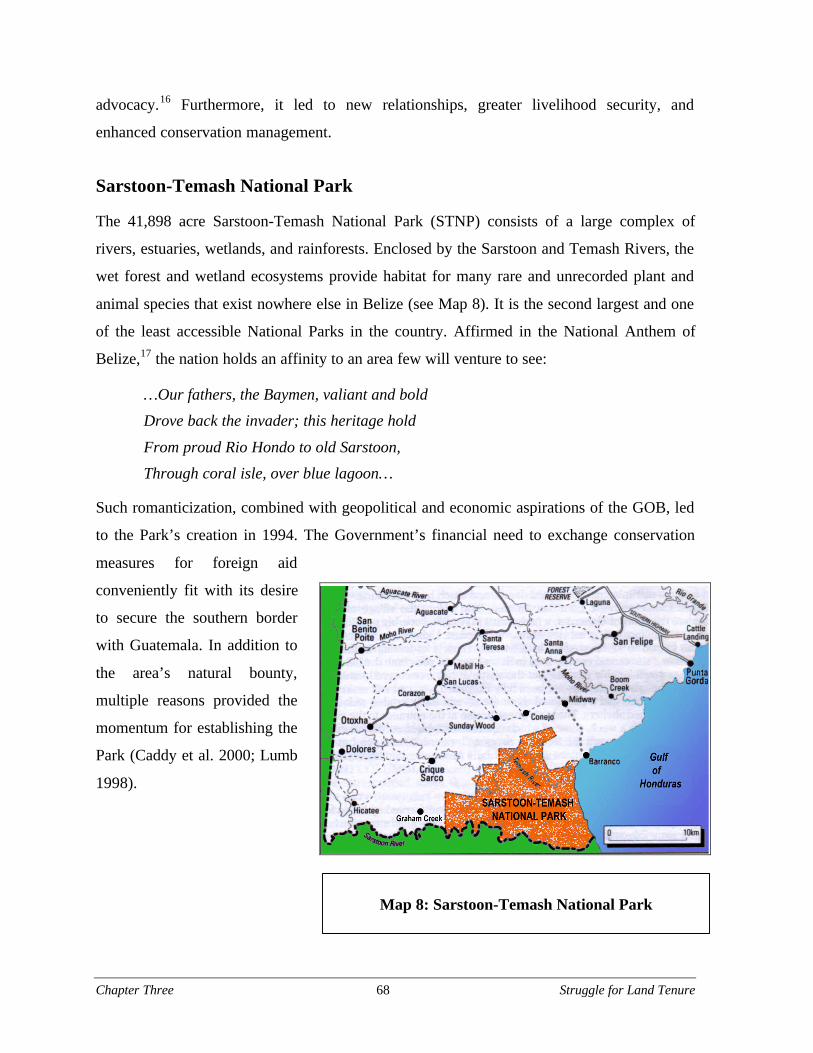
Chapter Three 68 Struggle for Land Tenure
advocacy.16 Furthermore, it led to new relationships, greater livelihood security, and
enhanced conservation management.
Sarstoon-Temash National Park
The 41,898 acre Sarstoon-Temash National Park (STNP) consists of a large complex of
rivers, estuaries, wetlands, and rainforests. Enclosed by the Sarstoon and Temash Rivers, the
wet forest and wetland ecosystems provide habitat for many rare and unrecorded plant and
animal species that exist nowhere else in Belize (see Map 8). It is the second largest and one
of the least accessible National Parks in the country. Affirmed in the National Anthem of
Belize,17 the nation holds an affinity to an area few will venture to see:
…Our fathers, the Baymen, valiant and bold
Drove back the invader; this heritage hold
From proud Rio Hondo to old Sarstoon,
Through coral isle, over blue lagoon…
Such romanticization, combined with geopolitical and economic aspirations of the GOB, led
to the Park’s creation in 1994. The Government’s financial need to exchange conservation
measures for foreign aid
conveniently fit with its desire
to secure the southern border
with Guatemala. In addition to
the area’s natural bounty,
multiple reasons provided the
momentum for establishing the
Park (Caddy et al. 2000; Lumb
1998).
Map 8: Sarstoon-Temash National Park
Chapter Three 69 Struggle for Land Tenure
In the formation of the STNP, the MNRECI neglected to take account of the 750 Maya and
Garifuna citizens that lived near the Park’s perimeter and that depended on resources
encompassed by the new boundaries. The Kekchi villages of Crique Sarco, Sunday Wood,
Conejo, and Midway fell within two miles of the Park. Barranco, a Garifuna community, was
situated on the coast just northeast of the park. A small settlement, known as Temash Bar,
was also encircled by the Park. In addition, the Park partially covered the Graham Creek
Maya Reservation (see Map 7, p.47). The lack of any permanent governmental presence or
demarcation of boundaries meant that residents were unaware of its creation.
In 1996, three years after the Government declared the protected area, the local communities
gradually learned of the Park’s existence through media and governmental sources (Caddy et
al. 2000). The appropriation of ancestral land and livelihood base infuriated the communities
who subsequently attempted to have the park dismantled. In 1997, however, community
representatives invited members of governmental and non-governmental organizations to a
meeting in Barranco to discuss available options. Nearly 72 participants attended the
Sarstoon-Temash National Park Stakeholders Workshop including leaders from each of the
affected villages, and members of the following organizations: KCB, TAA, the National
Garifuna Council (NGC), the Belize Center of Environmental Studies, Protected Areas
Conservation Trust (PACT), the Global Environmental Facility (GEF), Inuit Circumpolar
Conference, Coastal Zone Management Authority, Belize National Association of Tour
Guides, The Nature Conservancy, Indigenous Mapping Project, and the Forest Department
(Lumb 1998). At the meeting, community representatives recognized that seeking co-
management of the park could formalize their precarious land tenure situation. By the end of
the workshop, a steering committee was formed to begin the difficult task of securing co-
management. After the EcoLogic Development Fund (EDF)18, ESTAP, and the International
Fund for Agricultural Development (IFAD) in Rome provided financial assistance and
capacity training, the Steering Committee registered with the Government as SATIIM in
1999.
SATIIM’s area of operation extends along the coast from the Sarstoon River in the south to
the Moho River in the north (see Map 8, p.68). Currently SATIIM works with the 550
Kekchi and 200 Garifuna residents in the original villages around the Park (Caddy et al.
Chapter Three 70 Struggle for Land Tenure
2000; Eltringham 2001). In addition, SATIIM is incorporating the new Kekchi village of
Graham Creek that recently developed on the boundary of the park and the border with
Guatemala. Led by Gregorio Ch’oc, also the President of the KCB, the Executive Board of
SATIIM consists of representatives from each village as well as members of KCB, TAA,
NGC, PACT, and the Forest Department.
Indigenous management
Protected area management takes unconventional meaning under the purview of SATIIM.
Beyond the management of natural resources, the organization emphasizes the
documentation and use of traditional knowledge systems related to the surrounding
environment. This approach inserts an explicitly strong cultural component into the practice
of protected area management and connotes the significance of the relationship between the
communities and their environment. SATIIM strives to simultaneously meet economic,
cultural, and ecological goals. Economic goals include maintaining control of land and
resources at the local level, creating employment, and building local capacity through
training. Cultural goals involve demonstrating the value of indigenous knowledge and
bridging the divide between Maya and Garifuna communities. Ecological goals consist of
managing the park through a blend of Western and traditional environmental knowledge.
Ch’oc elaborates on the importance of bridging competing knowledges to provide long-term
security:
It has to be through adapting local knowledge and processes in a way thatallows [indigenous people] to bridge their local knowledge and subsistencetradition into that of the market-based economy and contemporary knowledgeof natural resource management systems for effective … management.(2002b)
SATIIM also advocates for complete self-governance for Maya communities although the
earlier secessionist calls for a Maya Homeland have been dropped. The organization aims to
strengthen traditional governance structures within villages. Even without a formal co-
management agreement, alcaldes act as guards by enforcing Park rules and monitoring
activities. Ch’oc compares the situation of the Maya and management of the National Park
with other indigenous struggles for land rights:
Chapter Three 71 Struggle for Land Tenure
Several co-management agreements have been signed between indigenouspeople and states. Most have recognized indigenous people’s rights. But inBelize it has always been like if I give [the Mayas] their rights, others willdemand theirs. This is nonsense. It has absolutely no basis for granting rightsof people. Human Rights are not negotiated. (2002b)
In fact, SATIIM draws on precedents from First Nations’ agreements with the Canadian
Government to pattern their own request for co-management. The organization’s guiding
vision is to formalize the relationship between communities dependent on Park resources and
the Government. Securing a co-management agreement with the GOB, however, proves to be
a difficult task. To a large extent, this difficulty is due to the different conceptions each holds
regarding “appropriate” management. In contrast to the Government’s technocratic
perspective, SATIIM understands local resource control as the key to sustainability:
People need to be told that the way they manage has had a positive impact ontheir resources. What I hear especially from Belmopan or the environmentalelites is that every activity that rural or indigenous people engage in is bad,bad and bad. These people (indigenous and rural) are persons with practicalreal world environmental knowledge and those people are dying out. Theworld community is starting to understand that it is the local knowledge thathas allowed local people to have green space around their communities. Thismust be the cornerstone of any successful management program unless it isthe intention to build a “Berlin Wall” around these areas. (Ch’oc 2002b)
Toward collaboration
The interethnic composition of SATIIM from its inception distinguishes it as a unique
resource management organization. Caddy et al. (2000) explain that SATIIM’s formative
workshop, held in English, Spanish, Kekchi, and Garifuna, was the first time different ethnic
groups collaborated to decide how to jointly manage a protected area. SATIIM continues to
bridge historical cultural divides by uniting the Garifuna of Barranco, and the surrounding
Kekchi communities. This merger carries implications for the incorporation of gender
concerns in management and project decisions. Pronounced differences exist between
Garifuna and Maya women concerning expectations and expressions of public involvement.
While Garifuna women take an active and vocal role in the participatory activities of
SATIIM, Maya women in the area have been less inclined to attend general meetings and
express their concerns (Lumb 2002). These differences require SATIIM to implement
Chapter Three 72 Struggle for Land Tenure
different strategies for the incorporation of all community issues. Nevertheless, specific
cultural norms among the Garifuna and Kekchi may be changing as SATIIM enters its sixth
year.
Legitimate community participation in the planning and implementation of all conservation
and development initiatives remains an elusive goal for SATIIM. The goal of genuine
participation dovetails with the objectives of larger projects assisting SATIIM. Imperiled
resources in the region, SATIIM’s innovative management strategy, and hard work by the
organization’s leaders and consultants determined SATIIM’s selection for a medium-sized
project sponsored by the GEF. The Community-Managed Sarstoon-Temash Conservation
Project (COMSTEC) aims to “reduce land degradation and conserve globally significant
biodiversity resources in the Sarstoon Temash National Park” (GEF 2000a:18). The project
supports co-management and complements the rural development activities of the
Government’s CARD project (described elsewhere in this report).
Regardless of its public image as a community-based organization, SATIIM receives
criticism from its constituents (Caddy et al., 2000). The situation relates to the general claim
that the leaders of Maya organizations based out of Punta Gorda are not in touch with village
life. In addition to lingering resentment over the establishment of the STNP, the lack of
tangible benefits from income-generation projects breeds skepticism among communities.
These tensions may be reduced in the future as communities reap the eventual harvests of
projects like organic cacao production and shifting agriculture replacement, both facilitated
by EcoLogic Development Fund.
SATIIM also contributes to larger resource management initiatives in the Toledo District and
Central America. The organization is an active member in the Toledo Watershed Association
(TWA), an evolving District-wide federation of conservation and land management actors
now under the auspices of the Southern Alliance for Grassroots Empowerment (See Chapter
Six). In fact, SATIIM was encouraged to apply for GEF Small Grant Programme funds in
order to support the emergent TWA. Additionally, the STNP falls within priority areas
established under international conservation programs (GEF 2000a).
Chapter Three 73 Struggle for Land Tenure
Complementing corridor projects in northern Belize, the Park forms a component of the
Mesoamerican Biological Corridor conservation and land use management initiative in
Southern Belize. The Park also forms part of the coastal component of the Sarstoon-
Temash/Sarstún marine complex, a key bi-national section of the Mesoamerican Barrier Reef
System (WB 2001). Inclusion in prominent and collaborative programs like these generates
greater legitimacy for SATIIM and, hence, advances its ultimate goal of securing community
control over Maya and Garifuna land, heritage, and futures.
SATIIM exemplifies the promise and peril of collaboration. The organization itself arose
from the shared concerns of six villages. Representatives joined forces with experienced
NGOs and Government liaisons in Toledo attempting to resolve the dilemma of a National
Park. Instead of dismantling the Park, they have used it as a vehicle to assert their own
desires. SATIIM has worked with larger projects and international NGOs to locate funding
and build its own capacity. Additionally, through the Inuit Circumpolar Conference, SATIIM
learned from the experiences of successful indigenous groups with similar priorities and
problems. Now SATIIM continues to form a co-management agreement with the GOB in
order to secure its position in the national sphere. Each of these partnerships, apprenticeships,
and friendships expand and improve its impact within its jurisdiction and far beyond. The
move toward greater fulfillment and complexity through collaboration has not been easy. The
remote communities SATIIM claims to represent continue to question motives, actions, and
leadership of the organization. Their justifiable skepticism stems from a history of
malevolent interaction with more powerful outsiders. State, NGO, and business actors have
all attempted to impose self-serving schemes on the communities around the STNP. In terms
of traditional rights, self-determination, and co-management, SATIIM itself has maintained
an unstable relationship with the GOB. SATIIM’s co-management agreement with the
Government remains to be signed.
Conclusion
In the south of Belize, rural communities have always utilized resources from their
surrounding landscape and waters. The rigid demarcation of territory and the establishment
Chapter Three 74 Struggle for Land Tenure
of exclusive protected areas and concessions do not correspond to the practice of everyday
life for most inhabitants of Toledo. Based on current and historic use and occupation,
international indigenous treaties, and the legal underpinnings of the Maya Reservation
system, the Maya make a strong claim over lands and resources in Southern Belize.
Attention to politics, ethnicity, and control over natural resources reveal the patterns and
idiosyncrasies in negotiations between indigenous people and the GOB for the establishment
of land tenure and livelihood security. The conflict encompasses the entire population of
Southern Belize. Ch’oc explains, “[R]epresentation of Toledo does not rest on the shoulders
of the Mayan people but all the people of Toledo. Land tenure is not just a Mayan problem
though it tends to be viewed as such” (2002b).
Ironically, the international border dispute with Guatemala forces the GOB to recognize and
rely on Maya communities in Belize. The participation of Maya translators and negotiators
serving on Government commissions help to establish legitimacy for settlements of
indigenous groups (Shal 2002b). These occurrences confirm the fluctuating tendencies of
Government to use the existence of southern settlements as a basis for defense of national
sovereignty. “The very people that have not been allowed on their own lands are now the
same ones that the Government is counting on to protect its territory in Southern Belize,”
proclaims Ch’oc (2002b). Communities play the literal and figurative roles of border guard
since the use of lands by villages throughout the region is a factor in securing the
demarcation of boundaries.
SATIIM provides an example where indigenous management in Southern Belize corresponds
with some of needs of the Government. Similarly, the rights and concerns of indigenous
people directly relate to the control of land and management of natural resources. SATIIM
presents a unique case in Belize in which the goals of strengthening of indigenous culture,
livelihoods, and land tenure are attained directly through the protection of natural resources.
In this process, SATIIM must work across ethnic, class, professional, organizational,
regional, and national boundaries. This effort is making progress toward improving the
organization, assisting communities around the National Park, reconciling tensions between
ethnic groups, and expanding SATIIM’s impact far outside of the Sarstoon-Temash area. The
Chapter Three 75 Struggle for Land Tenure
benefits of networking with diverse people and organizations are crucial for the nation of
Belize, proposes a high-ranking Maya leader, “Each different group must be asked to come
together on their own terms. This strengthens the unity of the country. This is collaboration
on a whole other scale” (Anonymous 2002).

Chapter Three 76 Struggle for Land Tenure

Chapter Four 77 Promoting and Constraining Collaboration
Chapter Four: Forces that Promote and Constrain
Collaboration
Collaborative approaches to resolving disputes, optimizing resources, and engaging in joint
decision-making are increasingly called upon in natural resources planning and management.
Factors promoting a more widespread adoption of collaboration include recognition of the
need for broader community and stakeholder involvement, accelerated loss of biodiversity,
and changing conservation strategies. Four case studies of collaborative approaches to
conservation in the Toledo District of Belize are presented in the following chapters,
illustrating many of these points. The cases and the conclusions that follow them are
structured around three central questions:
§ What are the challenges to effective collaboration?
§ What factors foster collaboration?
§ What opportunities exist for increasing collaboration?
Before addressing these questions in the context of the case studies and the Toledo District,
however, this chapter asks these questions about collaboration more broadly, drawing on
alternative dispute resolution and organizational literature. The chapter focuses on the first
two questions in reverse order, starting with facilitating factors. In other words, why does
collaboration occur and what forces help it along? Next, the chapter addresses what makes
collaboration a difficult process. The answer to the third question, regarding opportunities for
expanding collaboration, is introduced through the layout of the case study approach.
Detailed responses to this last question are provided in the individual case studies, as so
many opportunities are site-specific.
Chapter Four 78 Promoting and Constraining Collaboration
Factors that Foster Collaboration
Individuals, governmental agencies, and nongovernmental and international organizations are
coming together in a number of fields such as education, development, tourism, natural
resources management and joint problem solving for a variety of reasons. Diverse parties
may come to realize that they share common problems and aspirations or feel there is a need
to move forward in the face of conflict or uncertainty. Collaborative processes are often
initiated in order to explore new opportunities or solutions that would not otherwise be
possible (Wondolleck and Yaffee 2000). A variety of factors may encourage organizations
and individuals to “build bridges,” or enter into new partnerships and initiatives rather than
“going at it alone.” The following section highlights several of these factors, including:
power differences among actors; the “wicked” nature of the problem at hand; the absence
of suitable alternatives to collaboration; the perception of crisis; a shared sense of place;
the identification of superordinate goals; leadership; public pressure; and personal
relationships.
Power differences
Organizations and individuals choose to collaborate when they perceive that their potential
power within a collaborative body would be sufficient to allow them to serve their interests
more effectively than they would be able to using other processes, such as litigation. When
considering whether or not to enter into a collaborative endeavor, parties must develop an
understanding of the power relationships that exist among organizations with which they
hope to be involved. Gray (1985) describes this situation as turbulence in the space in which
organizations interact, referring to a situation in which one party cannot achieve its goals
without greater coordination and cooperation with other parties. Sufficient countervailing
power must exist among other stakeholders to prohibit unilateral action by any one
stakeholder (Susskind and Cruikshank 1987).
Chapter Four 79 Promoting and Constraining Collaboration
The nature of the problem
Collaboration is also a response to issues that resist resolution because of their complexity.
Questions and problems that are raised in the field of natural resources management and
planning are often “wicked” in nature. The term “wicked” signifies that a problem is not
discrete, where all the information that is needed to solve it can be succinctly stated such as
in a mathematical equation (Rittel and Webber 1973). These wicked problems exist in a
social space and context because they are a direct result of the variation and diversity of the
actors involved (CogNexus Institute 2003).
“Wicked” problems can outstrip the organizational resources, jurisdiction, and expertise of
any single organization. The lack of scientific understanding that surrounds these problems
can lead to uncertainty; this is a classic problem in natural resource and environmental
disputes. Individuals may have competing claims of knowledge or lack the resources and
expertise necessary to overcome uncertainty, access risk, or determine a solution that is
acceptable to all the parties involved. An example of a wicked question might be how to
build a strategy to protect endangered species where overlapping and conflicting mandates,
professional and political interests, and a large number of actors add considerable complexity
to the issue. Additionally, it could be balancing the needs of development with questions of
ecological integrity. For these reasons, organizational collaboration in conservation and
development is occurring at an increasing rate (Brechin et al. 2003).
Collaboration can offer parties a means to bring together mutual knowledge, perspectives,
and interests while forging innovative solutions to complex problems. The collaborative pool
of resources, skills, and knowledge that is brought together by different organizations may be
greater than the sum of its parts. When relationships among collaborating partners are
formalized to take advantage of complementary strengths for the purposes of conservation
and development projects, such “niche arrangements” may maximize project effectiveness
(Brechin 1997).
Chapter Four 80 Promoting and Constraining Collaboration
The alternatives to collaboration
New forms of alternative dispute resolution, and collaboration in particular, have come to the
fore in reaction to the perceived inefficiency of political lobbying and the narrow and often
unsatisfactory outcomes of litigation. In the United States, for example, the proliferation of
laws such as the Clean Water Act, Clean Air Act, and the Endangered Species Act all
provided new and important legal means for parties to take action in order to settle natural
resource oriented disputes. The specificity of legal obligations established in these laws
encouraged the use of litigation as a primary means of resolving disputes in natural resource
cases. However, these legal channels often proved inefficient in handling disputes where the
problems were complex and involved competing interests, expertise, and knowledge. These
natural resource disputes often lasted for years and, given the limited range of remedies
available in the context of the courts, ended in judgments that rarely satisfied either party
(Bacow and Wheeler 1984). The “wicked” nature of these problems made legal action in
many cases ill-equipped to arrive at effective solutions.
Belizean law ranges from specific regulations such as the 1992 Environmental Protection Act
(which outlines Government and citizen obligations and roles and responsibilities) to more
general laws such as the 1992 National Lands Act (which provides few specific requirements
and gives a great degree of discretion to the Minister responsible for lands). These realities
limit, to some degree, the legal options that interested parties have at their disposal to explore
litigation as a tool to resolve disputes. Consequently, they may not offer the types of
resolution desired.
Other forms of dispute resolution may involve political lobbying and public pressure.
Lobbying can be a very effective way to alter natural resource management decision-making
especially where legal power over a resource is in the hands of a Government Ministry and
does not require direct parliamentary action to affect the status of that resource. At the same
time, the resource is susceptible to the political currents of the day and gives very little
security for its long-term management. These ministerial-level land use decisions are often
based on political pragmatism and for this reason they are very unpredictable.

Chapter Four 81 Promoting and Constraining Collaboration
Collaboration is not only a compelling alternative to individual people; when other
alternatives are less attractive, organizations often join in collaborative endeavors. This
especially occurs when organizations are confronted with an impending crisis or a challenge
that must be met.
Crisis
Crisis is often a natural call to action. Throughout history, individuals have been called to act
collectively in the face of a perceived crisis or threat (Oliver-Smith and Hoffman, eds. 2001).
For action to occur, however, the perception of a threat must be coupled with the power and
ability to respond (Kottak and Costa 1993). Crises that motivate people to action can take a
variety of forms (Hewitt 1997; Quarantelli, ed. 1998). Stakeholders may perceive an
impending regulation as a threat and may join forces to address the regulation (Bentrup
2001). In other instances, impacts of national development projects like large mines bring
people together from across the globe (Kirsch 1997). Highway development, increased
logging, expansion of destructive agricultural practices, foreign land ownership, and their
associated effects, can also be powerful incentives for parties to work together.
Sense of place
While crisis has shown to be a strong motivator for collaboration, people often feel a sense of
belonging and value for a place whether it is threatened or not (Feld and Basso, eds. 1996).
Collaborative natural resource management, therefore, is often intimately tied to a “sense of
place.” Environmental policy specialist Charles H. W. Foster states: “Places are considered
to be physical locations imbued with human meaning [that] display three primary
characteristics: a landscape setting, a set of associated activities, and significance to people.
Thus, place involves both humans and nature, not the presence of one to the exclusion of the
other” (Foster 1995 as cited in Wondolleck and Yaffee 2000).
The variety of ways that a place is recognized and created provides opportunities for bringing
people together in a particular area. People know their environment through the inevitability
of their coexistence and interaction with it. In conferring significance to the physical
environment, meaning is not merely attached, but rather drawn from people’s surroundings at
Chapter Four 82 Promoting and Constraining Collaboration
a particular moment (Ingold 1993). The understanding is drawn from the environment
through a person’s relation with its biological, hydrological, and geological components, in
addition to recognized social, historical, and spiritual characteristics. Collaboration itself can
help shape a sense of place. When people perform any action, the action occurs socially and
materially in time and space and imparts the physical world with meaning (Werlen 1993).
This meaning can be shared among people working together and lead to collective senses of
place. A place is then the spatial and temporal axis of conscious human interaction (Casey
1993). How a place becomes identified and made meaningful is a process that involves
shared actions and understandings. This process can help reveal the different values and
levels of influence among the people and groups involved collective action (Crewsswell
1996; Massey 1994).
A “sense of place” and its three characteristics identified by Foster—setting, activities, and
significance—motivate and provide context to collaborative efforts. A sense of place helps
define the scope of the area being managed and the problems to be addressed. Places help to
reveal the various ways that people identify with and relate to them. Such identification
provides a wellspring of energy and concern emanating from an individual or group’s
association with and care for a particular place.
Superordinate goals
Conflict surrounding natural resource issues is often a result of competing positions,
interests, and claims over a specific resource in question. It may take the form of advocacy
for endangered species protection versus the building of a dam for rural electrification
(Wondolleck 1985). These competing positions are often bridged when a superordinate goal
enters the discussion.
Chapter Four 83 Promoting and Constraining Collaboration
Superordinate goals, as stated in the classic work of Muzafer Sherif, are:
[G]oals that could not be attained by the efforts and energies of one groupalone and thus created a state of interdependence between groups…Superordinate goals were indeed effective in reducing inter-group conflict: (1)when the groups in a state of friction interacted in conditions involvingsuperordinate goals, they did co-operate in activities leading toward thecommon goal and (2) a series of joint activities leading toward superordinategoals had the cumulative effect of reducing the prevailing friction betweengroups. (Sherif 1958: 355)
These goals can bridge divides among parties. A goal that exists beyond the conflict changes
the dynamic of interaction in a variety of ways and provides incentives that would otherwise
not exist. A superordinate goal provides a context in which to build positive relationships and
understanding. It sets the stage for the development of a process that leads to greater
understanding of not only positions but interests. Finally, it may lead to a vision that extends
beyond an adversarial view of the situation (“if you get it then I don’t”) to a practical
understanding of the joint gains that can be achieved through cooperation and collaborative
action (White and Runge 1995).
Leadership
Leadership can catalyze collaboration. An individual or organization may possess the energy
and vision that mobilizes other parties to participate (Selin and Chavez 1995). Leaders in
collaborative processes often have a variety of characteristics that allows them to mobilize or
champion these processes. Leaders may take on the role of “cheerleader-energizer, diplomat,
process facilitator, convener, catalyst, and promoter. They are not superhuman; rather, they
put a lot of energy into moving projects forward” (Wondolleck and Yaffee 2000: 178).
Public pressure
The general public can have an effect on the possibility of collaboration. Though the wider
public is not directly involved in the collaborative process it can steer the interests of parties
who participate in that process. Public interest can change the political stakes of collaboration
and raise the awareness of an issue, which may promote the furthering of the project (Yaffee
et al. 1997).
Chapter Four 84 Promoting and Constraining Collaboration
Personal relationships
Many collaborative processes begin with existing friendships and relationships among actors.
Friendships provide legitimacy and the initial trust and respect that are necessary for
collaborative endeavors to take root (Wondolleck and Yaffee 2000; Yaffee et al. 1997).
Collaboration can also come about through existing inter and intra-organizational
arrangements. In addition, relationships provide legitimacy to initiatives that are currently
underway.
Challenges to Effective Collaboration
Collaboration, like all close interpersonal interactions, is in many ways a “dance of
adaptation.” Relationships among individuals involved in a collaborative process must be
able to change and adapt to new challenges that are posed. A variety of challenges are
documented in the literature on collaboration. These theoretical perspectives will be later
used as a means to analyze the four case studies.
Negative preconceptions
Differing perceptions and values present real challenges to the collaborative process.
Perceptions may stem from cultural norms or professional knowledge and views. Negative
personal views and characterizations about other individuals and organizations among
participants can also hinder collaboration (Wondolleck and Yaffee 2000). When personal
views impair the process, parties tend to adopt opposing positions and can restrict the
conversations to an adversarial and less constructive tone. Differences in perception pose the
greatest challenge to collaboration when they are value-laden and rooted in identity or a
strongly held ideology (Carpenter and Kennedy 1988; Gray 1989; Susskind and Cruikshank
1987; Wondolleck et al. forthcoming). Strong positions may make it difficult for parties to
arrive at “reasonable compromises” (Susskind and Weinstein 1980) and may limit
willingness to subdivide complex problems into solvable increments (Gray 1989; Susskind
and Cruikshank 1987).
Chapter Four 85 Promoting and Constraining Collaboration
Differing conservation paradigms
Conservation practitioners and researchers continue to debate the relative value and efficacy
of integrated conservation and development in the tropics. On the one hand, critics like
Terborgh (1999) argue that development-oriented strategies, like alternative income
generating programs for individuals living near protected areas, have largely failed. Instead,
they call for a return to approaches for conservation that focuses on enforcement, such as
boundary monitoring. Extreme crises in biodiversity, they suggest, call for extreme measures.
Critics of this “barbed wire and border guards” approach suggest that it ignores both on-the-
ground management realities, such as lack of resources to enforce contested boundaries in the
absence of community support, and the rights and needs of the individuals who are often
displaced by protected areas (Brechin et al. 2002). The critics of the “resurgent protectionist
paradigm” raise the important question of “conservation for whom?” Organizations view
communities through different lenses depending on their chosen conservation approach.
Interaction with community members built on mutual respect is central to an approach that
values protected area neighbors as partners in conservation rather than simply as threats to
biodiversity.
Conflict and competition among groups
Historic conflict and organizational turf can constrain or impede greater collaboration.
Mutual ill will, especially when the relationship between organizations has been marked with
past instances of intense conflict, can have lasting effects. Bitter adversarial positions can
imperil future consensus on any issue (Selin and Chavez 1995; Yaffee et al. 1997). The
animosity held by individuals taints the types of possibilities organizations can envision
collectively and may impede the development of relationships that are necessary to facilitate
a collaborative process. While past conflict can impede collaboration, so too can current
competition for scarce resources.
Groups receive their funding and self-identity by carrying out specific tasks. Those tasks are
often related to organizational survival. Organizations may carry out specific contracts with
donors, they may take care of a given protected area, or they may be in charge of specific
services or products. “Turf” of this nature, like the turf or territoriality of street gangs, is
Chapter Four 86 Promoting and Constraining Collaboration
highly protected by many organizations. Territoriality comes from the fact that the interests
of a given organization are viewed as crucial to meeting organizational goals and ultimately
preserving its survival (Peck and Hague 2003). Organizations may fear that collaboration
will lead to higher costs due to increased competition from one or more parties on their turf.
For this reason, many organizations prefer the gains that multilateral action provide their
organizations (Levine and White 1961).
Peck and Hague (2003) cite three primary reasons for turf conflict:
1. An organization perceives the other as a direct and regular competitor for resources
that are not likely to be shared;
2. An organization perceives the "marginal cost" (in terms of money, time or energy) of
the proposed cooperation greater than the perceived benefits of collaboration;
3. The degree to which the organization feels it is flexible to change its current goals,
tasks and philosophy to adopt the course of action being proposed.
Collective decision-making prompts organizations to consider these turf-related costs. Costs
of this nature can make groups unresponsive to collaborative proposals and may continue to
be a hindrance until the perception of costs shifts to make collaboration more appealing.
Resource constraints
Financial and human resource constraints are a common threat to collaboration. Resources
are needed for various aspects of collaboration from undertaking joint fact-finding to paying
for mediators (Gray 1989). Collaboration requires resources in the form of money, time, and
personnel (Wondolleck and Yaffee 2000). Often there is need for a resource pool. This can
be a pool of funds that is created and collaboratively administered by members (Gray 1989).
The lack of funds to distribute among members who are less financially capable can be a
barrier to their participation. These discrepancies may lead to power imbalances that will
discourage the participation of parties with fewer resources.
Chapter Four 87 Promoting and Constraining Collaboration
Community capacity issues
Rural communities often lack the human and financial resources needed to participate fully
and fairly in the collaborative process. Individuals and organizations from communities may
lack time, funds, and paid personnel to participate and implement collaborative plans so as to
truly take advantage of the benefits. There are numerous examples in the United States where
plans for community development were created, but the town lacked the professional and
financial resources to implement the vision (Aspen Institute 2003).
Lack of resources and professional staff must be specially considered in the collaborative
process. Research in developing countries shows that support is “critical for self-help
grassroots organizations in the early stages of their development, since these organizations
rarely possess the requisite technical or financial capacity to implement development
projects" (Bryant and Bailey 1997:181). Resource disparities among participants can lead to
resentment of more powerful parties (Wondolleck and Yaffee 2000). Without attention,
community participants may be marginalized by the collaborative process or discontinue
their participation in it.
Power and politics
The potential for collaboration is “hindered when significant power differences exist among
parties or when certain parties are not perceived as having a legitimate claim to participate in
consensus forums” (Selin and Chavez 1995 p 193). The potential for collaboration is severely
diminished when there is a lack of countervailing forces amongst parties, and when a single
party or small group of parties can act independent of the collaborative body (Gray 1985,
Susskind and Cruikshank 1987). Individuals and groups need to feel a sense that they will
gain more from a collaborative process than they would by pursuing other options (Gray
1989). Power imbalances can limit opportunities for certain parties to provide input, thus
limiting the potential for their interests to be met. Imbalances of power can take a variety of
forms. Specifically, power can take the form of control over the collaborative group’s
agenda, control over strategies and suggestions, control of information, and the ability to
authorize actions unilaterally (Gray 1989). All of these factors can impede the collaborative
process, thereby discouraging participants to engage one another in a constructive manner.
Chapter Four 88 Promoting and Constraining Collaboration
These theoretical perspectives give insight to the case studies in the Toledo District. They
provide a lens of analysis to give a sense of why collaboration occurs on the one hand, and
what prevents collaboration on the other hand. The factors described above will be referred
to in the cases that follow.
Opportunities for Increasing Collaboration: Case
Study Approach
Collaboration is occurring in the Toledo District at a rapid rate. Conservation practitioners
are attempting new means to address large landscape-level problems that affect local
communities, regional ecological integrity, and the development of Southern Belize. To gain
insight on opportunities for collaboration in the region, four Southern Belize collaborative
initiatives were studied: the Maya Mountain Marine Area Transect, the Toledo Watershed
Association, the Golden Stream Corridor, and the Bladen Management Consortium.
Methodology that draws from alternative dispute resolution and organization literature was
used to analyze these cases.
The cases were selected both for their visibility and because they provide insight on
constraints, opportunities, and lessons that could apply to future efforts at regional
collaboration. Additionally, they represent a range of geographic scales around which
collaborative efforts are organized, from a single protected area to the entire Toledo District.
Each case is introduced with a detailed background section. These narrative descriptions
provide the reader with the contextual richness of the story. The reader is introduced to the
various actors, their relationships to one another, and the historic issues that affect
development and conservation management decisions of the area. In addition, the situational
factors that led to the beginning of each collaborative initiative are thoroughly discussed.
Each of the four case studies illustrates the challenges posed to collaboration. This section
specifically addresses aspects of trust, shared vision, conflict and competition, resource
constraints, power and politics, organizational barriers, and community issues in the
Chapter Four 89 Promoting and Constraining Collaboration
respective collaborative endeavors. The analysis of these difficulties provides a thematic
understanding of the challenges posed to collaboration.
All the cases discussed show promise and potential for collaboration and provide regionally-
specific insights on collaboration in Southern Belize. The case studies highlight the strong
relationships that exist, the political support for collaboration, the perception of joint gains,
shared concern, and the drive to move forward.

Chapter Four 90 Promoting and Constraining Collaboration
Chapter Five 91 TIDE and the MMMAT
Chapter Five: TIDE and the Maya Mountain
Marine Transect
What’s unique about the [transect] is the interchange between the reef, theestuaries and the rivers; it’s a water-based ecological system. So the ecologyleads to social organization. – Peter Esselman (2002)
Marketing is everything. We are looking for something sexy. You need a sexyname that will sell quickly. I like the Maya Mountain Marine Corridor. It’smarine, it’s the Maya Mountains and it’s in a corridor. It sells the ridges toreef concept. – Wil Maheia (2002)
Introduction
The Maya Mountain Marine Area Transect (MMMAT)19 concept was first developed by a
Belizean environmental research non-governmental organization (NGO), with funding and
technical support from The Nature Conservancy (TNC). The MMMAT represents an effort
to confront the challenges posed by expanding development in Southern Belize. This case
study will look at the three coastal and marine protected areas within the MMMAT, and
analyze the potential value of the MMMAT concept as a forum for promoting multi-
stakeholder discussions and coordination in light of the events that have taken place over the
past decade.
Background
The MMMAT as an ecological system
The MMMAT was defined as a conceptual land management unit by the Belize Center for
Environmental Studies (BCES)20 and TNC in the mid-1990s that would protect biodiversity
and natural ecosystem functions in the Toledo District through a corridor of public and
private protected areas (TIDE 1998:6) (see Map 5, p.39). The conceptual million-acre
corridor area is comprised of six large watersheds that empty into Port Honduras: Monkey
Chapter Five 92 TIDE and the MMMAT
River, Payne’s Creek, Deep River, Golden Stream, Middle River, and Rio Grande
watersheds (TIDE 2000:6-7) (see Map 4, p.38). This corridor connects the Maya Mountains
to the coastal waters and reefs associated with the Gulf of Honduras. Five ecosystem types
are found in the MMMAT: upland forests, coastal plain, freshwater, estuarine and shallow
near shore, and coral reef. These ecosystem types support large and increasingly uncommon
predators like the jaguar, rare and threatened birds like the yellow-headed parrot, 29 of the 78
natural vegetation types in the country, as well as manatee and other species directly
dependent on fresh or salt water (TIDE 2000:7). A Site Conservation Plan (SCP) prepared by
TIDE for the MMMAT states that what integrates this entire site, and serves as an indicator
for overall ecosystem health, are the freshwaters that flow through it. Should the quality of
these waters degrade, not only would the fish and mammals living in the streams suffer, but
so too would estuarine and near shore communities and coral reefs due to their sensitivity to
water quality degradation (TIDE 2000).
The upland forests of the corridor area, which total 99,671 hectares, run from the Main
Divide of the Maya Mountains down through karstic foothills to the coastal plains. These
upland forests comprise the eastern half of Columbia River Forest Reserve, the entire Bladen
Nature Reserve, and the western third of the Cockscomb Basin Wildlife Sanctuary (see Map
5, p.39).
Almost half of the corridor area is represented by wetland ecosystems, which include Pine
Savanna, Riparian Forests, and Estuaries and a Shallow Near Shore Region (including
expansive stands of mangrove forests). On the southern side of the corridor is the Main
Divide of the Maya Mountains and the Deep River Forest Reserve, which stretches from the
mountains to the coastal plains and includes significant wetlands. Adjoining is the Payne’s
Creek National Park which contains a major wetlands network. The wetlands of both the
Payne’s Creek National Park and Deep River and further along the coast are contiguous with
the Port Honduras Marine Reserve, a coastal embayment which contains about 130 cayes
(GOB n.d.[1997]). Further offshore is the Sapodilla Cayes Marine Reserve. This reserve
contains eight small cayes along the southernmost tip of the Belize Barrier Reef.
Chapter Five 93 TIDE and the MMMAT
The coastal plain pine savannas – grasslands and pine forests with patches of oak and
palmetto – account for about 42,500 hectares. Rich riparian forests stripe the abundant
waterways. The rest of the coastal plain is comprised of about 127,500 acres of what was
formerly Broadleaf Forest but has now been heavily exploited (TIDE 2000:14). More than 90
percent of the human population within the corridor lives in this area, and therefore the area
has the highest concentration of human activity (residential, farming, hunting, etc.).
Approximately 35 percent of the land within the corridor has been converted to settlements
and farms with plenty of accompanying roads including the newly paved Southern Highway
(TIDE 2000:14).
Lands belonging to three NGOs – Belize Foundation for Research and Environmental
Education (BFREE), TIDE, and Fauna & Flora International (FFI) – are also located within
the corridor. A for-profit tourism venture, Belize Lodge & Excursions, owns and manages
the 7,600 acre Boden Creek Ecological Reserve, which also lies within the corridor. About
3,000 hectares of the corridor area is Maya Indian Reservation21 (see Map 7, p.48), and the
rest is evenly divided between private and national land (TIDE 2000:9).
The MMMAT as a concept
The MMMAT concept was the brainchild of Lou Nicolait and Evan Cayetano of the now
defunct BCES. Through the efforts of Evan Cayetano, BCES established a branch in Punta
Gorda. After three years of conducting ecological assessments, BCES and TNC staff
determined that the most vulnerable forests that needed urgent protection were in the
southern part of Belize within an area spanned by the Deep River Forest Reserve and the
coastal embayment of Port Honduras. Although protected areas existed, there was growing
concern that they were vulnerable due to the absence of management plans or on-the-ground
management. BCES recognized that the six-watershed area which comprises the MMMAT
could eventually be managed according to the concepts of a biosphere reserve for sustainable
use and resource protection (BCES 1997:2). More specifically, BCES identified the area east
of the Maya Mountain Divide, including the Bladen Nature Reserve, Deep River Forest
Reserve, Payne’s Creek National Park, and Port Honduras Marine Reserve as “critical lands
to maintain [in] protected status or be placed under some protected status in order to maintain
Chapter Five 94 TIDE and the MMMAT
biological diversity” (TIDE 1998:6). For BCES, the final goal would be the improved
management and use of the six connected watershed areas that empty into Port Honduras,
through the preparation and implementation of management plans for the coastal and marine
portions of the corridor, i.e., Payne’s Creek National Park, Port Honduras Marine Reserve,
and Sapodilla Cayes Marine Reserve. It was deemed necessary to have the plans completed
in order to ensure protection of the areas and also to finalize sustainable use plans for
appropriate sites within the marine reserves (BCES 1997:3-4).
TIDE and MMMAT
TNC decided to support the efforts of BCES to conceptualize a corridor concept for the
region, later dubbed the MMMAT, and to make the corridor a reality. TNC hired a marine
scientist, Will Heyman, to assist BCES with the technical and institutional support to do
conservation work in Southern Belize.22 In May 1994, Will Heyman was asked to open a
BCES office in Punta Gorda, which would facilitate BCES’ corridor development work in
Southern Belize. According to Heyman:
By the summer of 1994, I met Wil Maheia, who was working on his M.S. inIdaho… In the course of about one year, a Peace Corp Volunteer came in [towork at BCES-PG], I worked with Wil Maheia, and Evan Cayetano came inand became the Director of the PG branch of BCES. The idea at the time wasthat BCES would begin to transfer more of its operations to Southern Belize.(2003)
BCES depended almost entirely on TNC for funding, and had to close its doors in 1996 when
TNC withdrew funding. According to Heyman, Wil Maheia continued to work “wearing the
BCES cap” for another year-and-a-half promoting the corridor concept at the communities
although he was not getting a salary. Soon after, Heyman and the TNC-Belize Director met
with Maheia and together decided that a new organization – the Toledo Institute for
Development and Environment (TIDE) – should be formed out of the BCES remnants.
According to its Executive Director, TIDE was conceived as a grassroots initiative in
response to the negative environmental effects from activities such as manatee poaching,
illegal fishing, illegal logging, destructive farming methods, and other types of unsustainable
development. Its original staff was made up entirely of volunteers, and its early efforts
involved protection of the West Indian Manatee. TIDE has branched out substantially from
Chapter Five 95 TIDE and the MMMAT
its initial manatee focus. Aside from managing public and private lands, it also provides fly-
fishing and kayaking tours via its for-profit arm, TIDE Tours (TIDE 2003c). TNC has been
one of TIDE’s main partners since TIDE’s inception. TIDE has adopted the MMMAT as a
critical focus area, including the BCES goal of ensuring protection of the three coastal and
marine portions of the corridor – Payne’s Creek, Port Honduras, and Sapodilla Cayes.
From 1999 to 2002, TNC focused much of its efforts at promoting the MMMAT concept.
The main purpose of the MMMAT concept, as originally envisioned, was to guide economic
development in the transect so that long-term ecological and socioeconomic benefits would
be maximized at the ridge to reef scale. TNC hired a consultant to take the lead in developing
a first version Site Conservation Plan (SCP) for the MMMAT, following a planning
methodology developed by TNC.23 The second version of the SCP, which was completed in
December 2000, contained an overview of conservation targets and goals for the MMMAT,
described the stresses and sources of stresses on the five ecosystem types, critical threats and
strategies, as well as monitoring and capacity building action plans. As stated in the
document, the SCP “yielded a series of specific action plans for threat abatement,
monitoring, and increasing TIDE's conservation capacity [within the MMMAT]” (TIDE
2000:76). TNC hired another consultant, Peter Esselman, to draft the third generation of the
MMMAT SCP, this time with a refined and new analysis of aquatic biological communities
(TIDE 2002a).
The main aim of the SCP is to “help tie together the multiple demands of terrestrial and
marine conservation through the freshwater systems that unite them in a Ridge to Reef
Corridor” (TIDE, 2000:77). TIDE organized a two-day meeting in January 2002 to present
the SCP to the public of the Toledo District in an “attempt to draw together key stakeholders
from the local NGO community and the government” (TIDE 2002b). The meeting had the
following objectives: 1) to present the history and ideas behind the delineation of MMMAT,
2) explain the concepts and approach behind the SCP methodology, 3) seek feedback about
the validity and accuracy of the SCP analysis and TIDE’s proposed solutions to conservation
challenges, and 4) to form partnerships and collaborations between national and local
stakeholders (TIDE 2002b).
Chapter Five 96 TIDE and the MMMAT
Several interviewees for this study commented that the approach that TIDE followed to gain
support for the MMMAT concept and the SCP fell short on a number of levels. It was not
clear to participants if the meeting was to seek meaningful input to the SCP or if TIDE’s
intention was simply to obtain consensus among the participants for the SCP. Nevertheless,
TIDE was criticized at the meeting for failing to consult adequately with stakeholders within
the MMMAT area during the formulation of the SCP and failing to involve other
organizations in developing the plan. One participant encapsulated the feelings of many at
the meeting:
The plan was all environmentally focused, with no significant socioeconomiccomponent. People are viewed as threats in this plan…. (Caddy-Foster 2002)
Another participant reiterated concerns about the SCP planning approach:
Stakeholder involvement was brought in after [TIDE] had already proposed[the SCP]. TIDE’s objective was to receive comments on and inputs to theplan. However, support for the SCP was not generated for several reasons: 1)participation of stakeholders was not there, 2) there was too much of a majorfocus on biodiversity issues, and 3) TIDE did not pay attention to thecommunities straddling the area, which are in severe poverty…. The SCP willnot succeed unless the framework is hinged on community participation.(Morrison 2002)
From the BCES and TNC studies, there seems to be compelling ecological evidence that
supports the legitimacy of the MMMAT as an important corridor for conservation. The SCP
consultant remarked that it is “rare that you find these protected areas that stretch from the
ridges to the reefs, in systems that are so little degraded” (Esselman 2002). There have not
been problems with the technical and ecological side of the SCP. But it is very clear that
stakeholders’ concerns are directed at the legitimacy of the plan from the local social and
political perspectives. According to Esselman:
…the suggestions [from the meeting] were to hold wide-scale communityconsultations [on the SCP] and even to go so far as to hold a complementaryprocess, like a socio-SCP, as a counterpart to the ecological-SCP. To go outon a community by community basis and find out what the resourceconservation issues are. (2002)
Most of the discussion on the second day of the meeting explored pathways by which
collaboration could occur to salvage the MMMAT concept. As a result of this discussion a
watershed taskforce was set up, which was charged with taking the steps necessary to lead to
Chapter Five 97 TIDE and the MMMAT
a watershed association of some geographic scope (see Chapter Six). To date, only a few
organizations (including TIDE) have shown interest in making this watershed approach a
reality.24
According to TIDE’s Executive Director, the SCP “will continue to evolve like a
management plan. We will have a draft here and there but I don’t know if we’ll ever have a
draft that says this is the final draft” (Maheia 2002). To date, TIDE has not followed through
on the suggestion to hold wide-scale community consultations. TIDE has instead appeared to
be content at gaining a foothold in the MMMAT area by becoming involved in the
management of the coastal and marine protected areas of the MMMAT – Payne’s Creek
National Park, Port Honduras Marine Reserve, and the Sapodilla Cayes Marine Reserve.
Even in these locations, TIDE has faced tremendous challenges.
TIDE and Payne’s Creek
TIDE has been struggling with gaining management responsibility of the 31,676-acre
Payne’s Creek National Park (PCNP), which was officially declared in 1994. According to
TIDE’s draft management plan (1998) for PCNP, the national park is very rich in
biodiversity and contains outstanding areas that contribute to the comprehensive coverage of
natural communities. The Ycacos Lagoon within PCNP drains directly into the coastal
embayment of Port Honduras.
In a letter to the Minister of Natural Resources and Environment (TIDE 1999), TIDE stated
that it “was counting on participating in the co-management of the PCNP” and strongly
believed “that the park cannot be managed without a sound management plan, approved by
Forestry and the communities.” In September 1998, TIDE prepared a draft management plan
for PCNP at the “invitation … of the Forest Department (FD), Ministry of Natural Resources
(MNR)” (TIDE 1998:6). In the plan, TIDE recommended that, since Payne’s Creek is
contiguous with Port Honduras Marine Reserve, the two areas should ultimately be managed
as one unit, “under one management authority…to be called the Port Honduras Management
Authority” (TIDE 1998:7-8). TIDE further proposed that this management authority should
also be made responsible for the Sapodilla Cayes Marine Reserve since “it has essentially the
same users” as Port Honduras (TIDE 1998:7-8). TIDE’s vision at the time was that the now-
Chapter Five 98 TIDE and the MMMAT
defunct BCES would initially act as the “implementing arm” of the management authority,
with TIDE taking the “responsibility for strengthening and capacitating the authority
particularly [in] community and stakeholder aspects” (TIDE 1998:36). The draft
management plan, which lacked significant community input, remains in its draft stage.
As a result of TIDE’s interest in the PCNP, and community requests for more involvement in
the management of the national park, the Ministry of Natural Resources and Environment
(MNRECI) made a landmark decision on February 22, 1999. The major elements of the
decision were as follows:
§ The PCNP will be managed by an interim committee composed of one representative
from TIDE, four representatives from the Punta Negra and Monkey River
communities, one representative from the Coastal Zone Management Authority and
one representative from the Forest Department. (It was subsequently decided that two
representatives from Punta Gorda would also sit on the committee.)
§ The mission of the interim committee is to complete the draft of an appropriate
management plan based upon the original plan submitted by TIDE for the approval of
the Minister of Natural Resources and Environment.
§ The interim committee will also establish an appropriate mechanism for the sustained
co-management of the national park by the local communities, local NGOs which
have community support, and the Forest Department.
§ The interim committee has the authority to pursue such activities as it may consider
of immediate necessity for the protection of the PCNP and to foster community
involvement in the management of the park….
§ The Managing Director of TIDE is to liaise with the Forest Department to facilitate
the selection of community representatives on the interim committee (GOB 1999).
At the first meeting of the interim committee, the Executive Director of TIDE and a
representative from Punta Gorda were elected co-chairpersons of the committee. The
committee also expressed its support of “the management plan as drafted by TIDE” and
Chapter Five 99 TIDE and the MMMAT
strongly urged the Forest Department to “draft a Memorandum of Understanding such that
TIDE in partnership with the surrounding communities become the managers of the PCNP,
on behalf of the Forest Department in accordance with the management plan” (TIDE 1999).
TIDE and the Payne’s Creek Communities
TIDE subsequently initiated management activities at Payne’s Creek. With funding support
from TNC and other sources, TIDE hired people from the local communities as rangers and
installed ranger stations in Payne’s Creek and Abalone Caye (within Port Honduras) in order
to deter illegal harvesting of mahogany and to stem illegal poaching of manatees especially
from across the border (Guatemala and Honduras) and as a way to enforce conservation
values in this area. Up to that point, TIDE was the only NGO engaged in on-the-ground
protected areas management in the Toledo District.
TIDE’s positive working relationship with the communities, however, did not last long. This
relationship breakdown was probably due to TIDE’s unilateral engagement in PCNP
management activities and little, if any, community input and involvement in the
management of the national park. TIDE had even gone as far as to submit a proposal for the
co-management of PCNP between themselves and the Forest Department, which has legal
jurisdiction over national parks. According to the draft agreement, the staff of the national
park would be responsible for the day-to-day management of PCNP with advice from TIDE,
which would also be responsible for reporting to and consulting with the Forest Department
in respect to PCNP management.
The management plan that was originally circulated in draft form in 1997 had been partly
used by TIDE to conduct some management activities in the park. According to TIDE’s
Executive Director, Wil Maheia:
The Ministry of Natural Resources knows we manage [Payne’s Creek]. Wehave a working committee but no formal agreement. We know theGovernment won’t kick us out so we have not gone through the formalities ofpaper work. (2002)
Recently, the chairlady of the Monkey River Village Council, who also sits on the PCNP
Interim Committee, proposed that the management of the PCNP be given to the communities
Chapter Five 100 TIDE and the MMMAT
of Monkey River and Punta Negra (Sandlin 2002a). The reasons offered for this request
included the fact that the two communities were instrumental in the declaration of the
Payne’s Creek area as a national park, and that they have “consistently supported the
management” of the park (Sandlin 2002a). The following reason was also given:
Both communities [Monkey River and Punta Negra] originally supported theToledo Institute for Development and Environment (TIDE) [sic] managementof the park. After four years of management by TIDE, however, little has beendone. In fact to date no management plan has been developed and if anybenefit has accrued it has been to TIDE and not to the communities. It shouldbe noted, however, that in seeking direct management of the park, it is not theintention of the communities to go against TIDE but merely the belief of bothcommunities that they can derive more benefits from managing the parkthemselves. In fact most NGO’s [sic] have given the idea that they are merelyinterim managers while they train communities to manage their ownresources. Monkey River and Punta Negra would like to be among the first totake these organizations at their word. (Sandlin 2002a)
In relation to the management plan, Sandlin was probably referring to the fact that the
management plan postulated by TIDE had, after almost four years, not been updated to
include community input. In response to this unprecedented move by the communities, TIDE
applied to the Protected Areas Conservation Trust (PACT)25 for funding to revise and update
the PCNP management plan (GOB 2003f). Before the grant funding was approved, TIDE
was required by PACT to submit to the Forest Department a proposed “Methodology for
Revision and Finalization of the Payne’s Creek National Park Management Plan” for review
and approval. In this document, TIDE noted that the PCNP Interim Committee “ultimately
makes decisions on behalf of Payne’s Creek National Park” and that the committee
“proposes to give TIDE the responsibility of the day-to-day operation and administration of
the Park” (TIDE 2003). The Forest Department subsequently approved the methodology but
reminded TIDE that “the custodial responsibility of the management plan remains with the
PCNP Interim Management Committee” (Belize Forest Department 2003). A few days later,
PACT received a letter from the chairlady of the Monkey River Village Council requesting
that PACT suspend the grant funding to TIDE for the revision of the management plan.
PACT responded that for the suspension of the project to be considered, the request would
have to come from the Interim Management Committee, at which both Monkey River and
TIDE are represented (Woods 2003).
Chapter Five 101 TIDE and the MMMAT
According to Maheia, the breakdown in relations between TIDE and the communities was
exacerbated by party politics, particularly as a result of the electioneering that took place in
preparation for the 2003 General Elections. Like much of Belize, Monkey River is very
divided along party lines (People’s United Party and United Democratic Party). For example,
PUP supporters do not shop at the grocery stores of UDP supporters, and vice versa. Monkey
River representatives (Eleanor Sandlin and others) recently asked TIDE to agree that the
communities should manage Payne's Creek. Maheia has reiterated that he has nothing against
Monkey River and Punta Negra managing Payne's Creek. However, he believes that they
cannot and should not do it on their own. According to Maheia, the GOB-appointed
management committee has not played its role, as directed by the Ministry of Natural
Resources. Even though it has the authority to do so, the committee has not completed the
PCNP management plan, nor taken steps to establish an appropriate mechanism for the
sustained co-management of the national park by the local communities, local NGOs, and the
Forest Department. The people on the committee appear to be committed to the management
of Payne’s Creek, but have not been able to work effectively as a group because of the
communication breakdown between the community representatives and TIDE. TIDE has
been chairing the committee, but at every meeting of the committee the respective
representatives change. According to TIDE’s Executive Director, Wil Maheia, even though
the Forest Department has jurisdiction over Payne's Creek, they seem content to observe how
the situation plays out.
The Sapodilla Cayes
The 33,401-acre Sapodilla Cayes Marine Reserve (SCMR) was legally designated in 1996.
That same year, it was further recognized as a component of the Belize Barrier Reef World
Heritage Site (Barborak et al. 2002). A management plan for the SCMR was drafted in 1994
by the Fisheries Department.
According to several sources, TIDE was offered the management of the SCMR in the early
1990s but turned down the offer. The question of who would manage SCMR was again
brought up at a meeting of the Tri-National Alliance of the Gulf of Honduras (TRIGOH)26 in
Honduras in 1997. TIDE again did not express any intention to manage the SCMR, although
Chapter Five 102 TIDE and the MMMAT
the Toledo branch of the Belize Tourism Industry Association27 (BTIA) did express interest
at that same meeting (Anonymous 2002). Several interviewees suggested that TIDE’s
decision not to be involved in the SCMR’s management was due to the fact that its leaders
felt that they did not have any competition in the MMMAT’s marine area and could absorb
the management of the SCMR indirectly. According to TIDE’s Executive Director, Wil
Maheia:
The Nature Conservancy wanted TIDE to manage the Sapodilla Cayes, butdid not offer financial support. TIDE had human resources to manage SCMR,but did not have the funds. (2003)
In the meantime, thousands of tourists were making use of the Sapodilla Cayes every year,
with most of the tourists coming from Honduras and Guatemala. Honduran tourist guides
began to complain about the lack of a management presence in the area and the deleterious
effect that unchecked visitation to the cayes was having. In 1999, BTIA applied for the
management rights of the Sapodilla Cayes. BTIA cited that it was important to empower
local constituencies, which would be the association’s primary goal along with preserving the
ecological integrity of the cayes and reef system.
Several interviewees commented that TIDE and TNC expressed great concern when it
became known that BTIA was applying for the management of the Sapodilla Cayes. Both
organizations felt that BTIA was not adequately equipped to manage the SCMR. These same
sources claim that BTIA membership swelled after it became public knowledge that BTIA
was poised to receive the mandate from the Fisheries Department to manage the SCMR. The
new BTIA members called for a change in leadership of the BTIA. BTIA officials have
alleged that the unprecedented increase in membership of the association was encouraged by
TIDE in an effort to change the leadership structure of the BTIA and derail the signing of the
co-management agreement with the Fisheries Department (Anonymous 2002).
In reaction to these events the members of BTIA formed a new organization, the Toledo
Association for Sustainable Tourism and Empowerment (TASTE), so as to retain control of
the management of the Sapodilla Cayes. TASTE and the Fisheries Department subsequently
signed a co-management agreement for the SCMR in 2001. According to the CEO of the
Ministry of Agriculture and Fisheries (the Fisheries Department’s parent Ministry) TASTE
Chapter Five 103 TIDE and the MMMAT
was selected to manage the SCMR because it presented the only proposal and submitted a
good plan. The Fisheries Department, however, has been carrying out the day-to-day
management of the marine reserve. At a February 2003 meeting of protected area
management agencies in Belmopan, a high-level Fisheries Department official announced
that TASTE will get delegated management of the SCMR in 2004. In the meantime, TASTE
has joined various NGO associations in an effort to familiarize itself with protected area
management issues. These associations include the Toledo Watershed Association (see
Chapter Six), the Association of Protected Area Management Organizations (see Chapter
Nine), and the Tri-National Alliance for the Gulf of Honduras (see Chapters Two and Nine).
TIDE is also a member of each of these associations.
TIDE and Port Honduras
TIDE has had more success with community relations in its efforts at Port Honduras. In 1993
and 1994, the Port Honduras coastal embayment was subject to two rapid ecological
assessments (REAs), which were led by TNC’s Florida and Caribbean Marine and
Conservation Science Center, and included the participation of the Government of Belize,
NGOs, and community-based organizations. The results of both REAs confirmed the results
of earlier studies which documented the importance of Port Honduras as a critical habitat
area. The REA reports concluded that the area warranted special management under marine
protected area regulations. Residents of Monkey River, Punta Negra, Punta Gorda and
nearby communities, and the Port Honduras cayes use the Port Honduras area for small-scale
commercial fisheries, largely for lobster and finfish. These residents – particularly fishers –
agreed with the conclusion of the REAs and proposed that Port Honduras be declared a
marine reserve, mostly due to their concerns about the unabated gillnetting and poaching of
manatees in the bay of Port Honduras by Guatemalan and Honduran fishers. The over fishing
and illegal fishing by foreign nationals may not be surprising given the relative richness of
the fisheries resources in Southern Belize compared to those in coastal Guatemala and
Honduras. Also, Southern Belize has only about 4,500 coastal inhabitants and 125 fishers
whereas the Atlantic Coast of Guatemala alone has 130,000 inhabitants and 5,000 coastal
fishers (TIDE 2000:18).
Chapter Five 104 TIDE and the MMMAT
From early on, TIDE responded favorably and proactively to the marine reserve proposal to
protect the areas from these trans-boundary pressures. As a result, one of TIDE’s original
objectives was to protect the West Indian Manatee. According to TIDE’s Executive Director,
Wil Maheia:
Fishing boats were coming in from Guatemala exploiting the resources… Inone weekend they had killed about nine manatees. We only have around 150in [the Port Honduras] area…. Without TIDE the manatee would have beenextinct. (2002)
This experience at Port Honduras was crucial to TIDE’s development; as mentioned
previously, the organization’s raison d’etre eventually evolved and moved into protected
areas management and development. After three years of planning meetings and workshops
sponsored and conducted by TIDE, the reserve was legally established in January 2000. The
100,378-acre reserve extends from the mouth of the Rio Grande to the mouth of the Monkey
River and goes five miles out to sea. Due to community attendance at these series of
meetings and workshops, the reserve has, from its inception, been characterized by a high
degree of community participation (Barborak et. al. 2002:16), mostly of fishers from the
coastal communities of the Toledo District.
The planning sessions also resulted in the creation of a management plan for Port Honduras
in 2000. According to Barborak, et. al. (2002:16), the management plan was designed as “a
collaborative effort that included participation by representatives from the local communities,
TIDE, and The Nature Conservancy.” The plan proposed that the Belize Fisheries
Department and TIDE “will be responsible for the overall management of the Port Honduras
Marine Reserve” and also recognized that “community and stakeholders will be imperative to
the success of the reserve” (TIDE 2000:62). The Fisheries Department, which has
jurisdiction over all marine reserves, and TIDE signed a memorandum of understanding
(MOU) for the co-management of PHMR in May 2001 (GOB 2001). The main features of
this MOU are as follows:
Chapter Five 105 TIDE and the MMMAT
§ A management committee shall be instituted and maintained by the Fisheries
Department to advise on matters pertinent to the proper development and
management of PHMR. It is important to note that the only agencies specified to be
on the committee are the Fisheries Department, Forest Department and the Coastal
Zone Management Institute.
§ TIDE is responsible for the day-to-day management of the PHMR (including all
aspects of recreation, visitor use, equipment maintenance and public awareness and
education campaigns) with direct advice from the Fisheries Department.
§ The Fisheries Department is responsible to assist with additional security and
enforcement, as well as to assist with providing infrastructure.
The reserve is therefore managed by TIDE, with advisory input from the management
committee; presently comprised of representatives from the agencies specified in the MOU,
as well as from TIDE and local communities. TIDE’s Executive Director claims that the
“Port Honduras advisory committee is a good model for community involvement….
Communities are officially involved in hiring and firing decisions at TIDE.” The committee
meets every three months to address policy and management issues in the reserve. According
to a WCS report to the World Bank:
Management of [PHMR] is truly a community-based process, as the reserve’smanager was born within the area that presently comprises the reserve, andcommunity members chose the reserve’s six rangers. (Barborak et. al.2002:16)
Analysis
While the MMMAT concept has merit from an ecological standpoint, its potential as a forum
for multi-stakeholder discussions and coordination will be more difficult to promote. The
following discussion will attempt to disaggregate the lessons vis-à-vis interests, challenges,
and characteristics of multi-stakeholder collaboration, and will suggest opportunities that
may still exist for promoting multi-stakeholder discussions and collaboration in the
MMMAT.
Chapter Five 106 TIDE and the MMMAT
Challenges for collaboration
Lack of trust
TNC’s involvement in Southern Belize from the early stages of the MMMAT discussions has
been viewed suspiciously; this suspicion reflects on TIDE as well. The TIDE/TNC
connection is strong and goes back to the pre-TIDE days when BCES was still in existence.
As stated previously, the MMMAT concept was first developed by BCES in the mid-1990s,
with funding and technical support from TNC, as an effort to prepare for expanding
development in Southern Belize (mainly as a result of the rehabilitation of the Southern
Highway). An NGO representative based in Punta Gorda observed that TNC promotes the
MMMAT on their website “as if they are the manager of the whole thing” (Anonymous
2002). Others have suggested that TIDE and TNC are more interested in raising money on
the name of the MMMAT than they are about working hard to make sure that the MMMAT
becomes an actual multi-stakeholder management reality. But the harshest accusation leveled
is that “TIDE is a TNC organization” (Anonymous 2002). In response, TIDE’s Executive
Director stated:
We are not a TNC organization. We have partnerships with them like we dowith Rainforest Alliance, WWF [and others]… A lot of people still don’t giveus credit for what we have done. Some of our own people don’t give us a lotof respect…. [We] are locally based. All our board [members] were born andraised here. Out of 27 employees we have only two people that were not bornhere…. [We] have to have our own identity. We are not TNC; we are TIDE.(Maheia 2002)
An INGO official based in Punta Gorda put it another way:
[Local] NGOs are… everywhere and they are [usually] affiliated with a groupoutside – owned may be too strong a word, but… controlled by NGOs fromoutside. Where would Programme for Belize be without TNC, or YCTwithout FFI, SATIIM without EcoLogic, TIDE without TNC…? (McGill2002)
In general, according to Chief Forest Officer Oswaldo Sabido, there is a certain amount of
skepticism in Government circles when you talk about NGOs. Sabido asks: “Where’s the
hidden agenda? What do these people really want?” Questions such as these create a barrier
to Government-NGO cooperation. This barrier could be removed by greater transparency,
that is, by “developing closer relationships so that people are aware of what is happening and
Chapter Five 107 TIDE and the MMMAT
they can see what is being done,” as Sabido suggests. The growing perception is that NGOs
have many more resources than Government agencies, especially in relation to the NGOs’
agenda and the areas under their jurisdiction.
Without question, TIDE has been the dominant player in protected areas advocacy and
management in Southern Belize. Besides promoting the MMMAT concept, TIDE has also
attempted to gain management responsibility over Payne’s Creek, Port Honduras, and the
Sapodilla Cayes. This attempt by TIDE to become involved in the management of coastal
and marine protected areas has led some officials of key stakeholder agencies to suggest that
TIDE would like to have and maintain a “monopoly in conservation” in the region
(Anonymous 2002). TIDE’s Executive Director disputes this suggestion:
[We] don’t get credit for [our protected areas management efforts], but whenit comes to community involvement… name me any other park – here or inthe United States – where the manager was born and raised in the park and therangers too. [Our park] managers are overseen by an advisory group. We havean advisory board that oversees the management. For example the advisorycommittee could sanction a ranger, if he were out of line. (2002)
The monopoly view is probably strengthened by what many see as the similar conservation
strategies that TIDE and TNC have adopted for the identification of critical habitats, the
lobbying for the legal protection of these “hotspots”, preparation of protected area
management plans, and actual management of protected areas. The fact that TIDE has, with
TNC’s financial support, been acquiring lands in the Toledo District through their Private
Lands Initiative has not helped matters either. TIDE’s Executive Director has a different
point of view of what he calls [TIDE’s] “buying back Toledo”:
Belizeans don’t have access to the lands any more…. Over the past year,tenure of seafront properties has changed from local to foreign owned [sic].When I was growing up there wasn’t anyone in this town interested inseafront property. The seafront was for everybody. There were no fences.[These lands] should be in local hands. It is our intention to repatriate some ofthese lands. When we own it, it’s not TIDE owning it but the people of Belize.
Conflict and competition among groups
Competition and rivalry. Competition and rivalry characterize interactions between NGOs,
and between NGOs and communities, and is related to territoriality, funding, and visibility.
Chapter Five 108 TIDE and the MMMAT
TIDE’s original goal was to create a niche for itself at the MMMAT level (so that all other
organizations would play a secondary or support role). At the same time, TIDE worked
feverishly to gain management control of the three coastal and marine reserves within the
MMMAT. In particular, it successfully lobbied to create the Port Honduras Marine Reserve.
According to the Chief Executive Officer (CEO) of the Ministry of Agriculture and Fisheries,
Sergio Garcia, there was “all sorts of infighting” between TASTE and TIDE over the rights
to manage Sapodilla Cayes (2002). The Belize Fisheries Department signed a co-
management agreement with TASTE for the Sapodilla Cayes. According to Garcia, TASTE
had presented an acceptable proposal and plan. Although the working relationship between
the two NGOs has vastly improved recently, this squabble created a serious rift at the time
between TIDE and TASTE.
The communities of Monkey River and Punta Negra are presently at odds with TIDE over
the rights to control the management of Payne’s Creek National Park. TIDE and the
communities are represented on the Payne’s Creek Interim Management Committee, which
was supposed to be a forum for overseeing the management of the national park. However, a
leading community representative has proposed that the communities be given full
management responsibility of the PCNP, and TIDE has been trying to salvage its lead role by
proposing to update the management plan for the park.
Funding relationships. The relationship between local NGOs and donor agencies has
impacted how local NGOs interact with each other in the MMMAT region. In regard to
funding, ESTAP (GOB 2000c:183) notes:
Funding is a constraint for most NGOs and CBOs in the region, and the highcost of operation in the region contributes to the unsustainable nature of theirwork. The absence of proper guidelines and legislation to regulate (andregularize) their activity has meant that many NGOs and CBOs still operate ina climate of suspicion.
One NGO official agreed with this view, saying that “[NGOs] are not honest with one
another. Ideas are sources for funding, so people aren’t always willing to share” (Caddy-
Foster 2002). The director of a Punta Gorda-based US NGO agreed that this is especially the
case with TIDE:
Chapter Five 109 TIDE and the MMMAT
I get the impression that TIDE might be more ambivalent [to pursuecollaboration] than the others. Because they are seeing all these other NGOscoming into the area and thinking they might be taking away from their area.(McGill 2002)
Various stakeholders see TIDE as being more interested in raising money than working hard
to make sure that the MMMAT becomes an actual multi-stakeholder management reality.
Indeed, the strong partnership between TIDE and TNC has not only translated to a secure
funding source for TIDE, but has also increased TIDE’s international visibility. This has
made TIDE the most marketable NGO in Southern Belize, evidenced by the number of
awards, donations and grants that the NGO has received over the last five years. Meanwhile,
other organizations have had to struggle to gain visibility and secure funds for their work.
Maheia recognizes that TIDE’s “bold and aggressive” fundraising strategy has affected its
relationship with other organizations, but points out that “at the end of the day we are proud
to know we are one of the biggest employers in this town and contribute to the economy of
the [Toledo] District while conserving our natural resources” (2002).
Fragmentation and division. Civil society organizations have been proliferating in Southern
Belize. Although some of these organizations have formed various alliances, others seem
content to operate on their own or do not have the will to collaborate with others. The Maya
Leaders’ Alliance (MLA) and the Southern Alliance for Grassroots Empowerment (SAGE)
are probably the only good examples in Southern Belize of multi-organizational
coordination, albeit for cultural and economic interests.28 The protected area management
organizations and landowners of the Toledo District, however, have not been successful at
setting up networks.
At a meeting of protected area management organizations held on January 23, 2003, in
Belmopan City, it was noted that protected area management organizations operate in
isolation from each other and therefore have little impact on the development of Belize and
protected areas at a national level.29 Often these organizations are faced with similar
problems but do not network with other agencies and end up dealing with their problems
alone, including searching for funding support. This exacerbates the fragmentation among
NGOs that already exists. As explained by an INGO official based in Punta Gorda, “There
are more NGOs arising; more people looking for the same amount of money” (McGill 2002).
Chapter Five 110 TIDE and the MMMAT
Organizational challenges
TIDE’s capacity to manage its ambitious protected areas portfolio has been called into
question. Some see TIDE’s portfolio as too large for one organization to handle. The
Executive Director of Friends of Nature, Lindsay Garbutt, who previously worked at TIDE,
commented:
[TIDE’s] popularity grew faster than their institutional capacity; therefore asan organization they never… developed proper strategic planning to knowwhat… to do versus what… the opportunities [are] out there. [As] anorganization they tried to grab all the opportunities that were out there,whether or not it was in their strategic plan. This means [that TIDE has]stretched itself very thin. (2002)
Ministry of Agriculture and Fisheries CEO Garcia echoes this view; he feels that TIDE
created this predicament for itself by jumping into projects “knowing that the money is
there,” even though their human resources are limited. Other interviewees commented that
TIDE’s staff has been rendered ineffective by poor management for real conservation on-the-
ground. Monkey River community leaders claim that after four years of management by
TIDE, little has been done at Payne’s Creek National Park (Sandlin 2002a).
TASTE’s capacity to manage the Sapodilla Cayes has also been questioned. Although the
Fisheries Department signed a co-management agreement with TASTE, the agreement was
mostly symbolic because the Fisheries Department retains day-to-day management
responsibility for the reserve. Several sources indicated to the project team that this
reluctance to transfer management responsibility to TASTE stems from the fact that the
Fisheries Department does not yet have full confidence in TASTE’s ability to manage the
reserve on its own. Although TASTE is comprised of prominent and successful persons
experienced in business management, few of its members are experienced or trained in
natural resource management.
Other challenges – sovereignty issues
The Sapodilla Cayes have long been a contentious issue for the Governments of Belize,
Guatemala, and Honduras. Long-standing territorial claims to the Sapodilla Cayes and other
border regions have set the grounds for this dispute. In addition to Belize, both Guatemala
Chapter Five 111 TIDE and the MMMAT
and Honduras claim the Sapodilla Cayes as part of their territorial boundaries. Each of the
three countries also has substantial economic interest in the Sapodilla Cayes and the
surrounding marine area. The economic concerns over the fishery and the area’s importance
for tourism are fundamental to all three countries. The surrounding waters of the Sapodilla
Cayes are a rich and productive fishery in which all three parties have a vested interest and
on which part of the coastal economies of the three countries are dependent. As succinctly
stated in a televised Belizean newscast on October 14, 2002:
The cayes that make up the Sapodilla Range are among the most beautifulalong the entire barrier reef. Every year, thousands of tourists make use ofthese islands, but most of them come from Guatemala…. As for who actuallyhas sovereignty there is no debate. The cayes are all Belizean. (News 5Online)
All of the cayes within the Sapodilla Cayes archipelago are national land; some are leased to
several Belizeans. Nevertheless, negotiations have been ongoing between the three countries
for several years. These negotiations may have a dramatic effect on the management
practices of the Sapodilla Cayes. In August 2002 a facilitation team developed a settlement
agreement that called for the development of the Belize-Guatemala-Honduras Ecological
Park. The park would include the Sapodilla Cayes and other parts of the barrier reef system.
This puts into question the future management by TASTE of the area. Under the specified
terms all three countries would be involved in the management of the Sapodilla Cayes and
surrounding marine area.
In addition, the facilitators also put forth a proposal for a joint development fund to increase
cross border trade and exchange between the three countries. It is difficult to know what
impact further development in the area will have on the management decisions of the
Sapodilla Cayes.
In the context of the ongoing dispute, the Fisheries Department has had to make decisions
about whether to consult with Honduran and Guatemalan stakeholders (i.e., tour operators,
tourists and fishers) in the Sapodilla Cayes. Pressure exists not to consider these non-
Belizean stakeholders, because it is perceived as potentially fostering territorial claims of
those countries. However, TASTE’s Coordinator, Jack Nightingale, does recognize the
potential benefit of involving non-Belizean stakeholders:
Chapter Five 112 TIDE and the MMMAT
I think it has to be a great idea. For a start, let's face it, the tour operators thathave been coming here for the last thirty to forty years from Guatemala,whereas they say this is Belizean, they also recognize the joy they have inbeing able to use it. If we continue with that kind of relationship which isgood, because they are bringing business, perhaps we would like to bringBelizeans in to enjoy more of it, rather than it all be Guatemalan. So that therecould be a greater balance of things that would make it excellent. (News 5Online 2002)
Opportunities and facilitating factors
Existing relationships
While the MMMAT concept has not yet translated into a forum for multi-stakeholder
discussions, and less so into a multi-stakeholder management reality, there are existing
relationships and emerging collaborative efforts that have good potential for success.
Emerging coalitions. At the invitation of BAS and UNDP-Belize, eleven protected area
management organizations from across Belize (including TIDE, TASTE, and YCT) met on
January 23, 2003, with the intention of formally creating an Association of Protected Areas
Management Organizations (APAMO). Meeting participants recognized that, although other
umbrella organizations exist in Belize, a national network for protected area management
agencies is needed. Other networks do not deal specifically with protected area issues, have
broader objectives and goals, and consequently may not address areas of concern to protected
area managers. Meeting participants supported the creation of APAMO and agreed to work
together to form the association, which would have the following objectives: 1) Provide GOB
and funding agencies with advice and recommendations to improve and promote
management of protected areas; 2) Highlight and promote the contribution which protected
areas make on the economy and environmental image of Belize, and social well-being of
Belizeans; 3) Foster communications between protected areas managers so as to enhance
coordination; 4) Facilitate technical support to member agencies; 5) Provide a forum for
discussion and prioritization of issues, and concerted action; and 6) Create a networked voice
for protected areas managers. A committee, comprised of representatives of agencies present
at the meeting, has been set up to coordinate the formalization process of APAMO (Salas
2003:9).
Chapter Five 113 TIDE and the MMMAT
Working relationships. Whereas there has not been much success at formalizing multi-
agency coordination in Toledo, informal interactions between and among agencies do exist.
For example, due to a lack of financial resources, Forest Department personnel in Toledo are
unable to effectively perform their duties, namely, monitoring of logging operations, and
enforcement of forest and wildlife regulations. Consequently, the Forest Department depends
on the goodwill of community members and NGO personnel to report illegal activities in
protected areas. A forest officer, Wayne Bardalez, posted in the Toledo District observed:
The Forest Department [is] handicapped due to lack of resources. …GOB hasnot provided financial support. NGOs, which have good experience, havebeen helping the Forest Department to do its monitoring. (2002)
TIDE has loaned its vehicles and boats to Police Department, Fisheries Department and
Forest Department staff on a number of occasions to conduct patrols in protected areas and to
monitor reports of illegal poaching or logging activities. According to Bardalez, the Forest
Department raided an illegal logging operation in Sarstoon-Temash National Park in mid-
2002 with transportation assistance from the Community-initiated Agriculture and Resource
Development Project (CARD)30 and with the support of the Police Department. Although
some NGO officials believe that “[GOB] sees NGOs as interfering,” these same officials see
it as an opportunity to counteract GOB’s ambivalence about NGOs by capitalizing on these
Government agencies’ reliance on NGOs.
Conservation easements are another example of working relationships. Although
conservation easements are not permissible under Belize’s laws, landowners can impose
restrictive covenants on their properties. In effect, two landowners may execute contracts that
bind each other, which may be recorded as an encumbrance on the title. In other words,
conservation easements work on private land once the owners are in agreement. The
easements are legally binding between the landowners under their own arrangements. TIDE
and the Ya’axche’ Conservation Trust (YCT) have signed such an “easement” for one of
TIDE’s properties. In September 2001, representatives of TIDE, YCT, and the Forest
Department attended a Land Trust Rally in Baltimore, Maryland, to learn more about how
such easements work.
Chapter Five 114 TIDE and the MMMAT
Shared concerns and interests
The five ecosystem types located within MMMAT are interconnected. Therefore, the
MMMAT is an integrated corridor from an ecological perspective. In the words of Esselman:
“Even if socio-politically the corridor idea is not embraced, it’s still functioning as an
ecological entity” (2002). Occurrences at one property would likely have impacts at another
property. Whether the various stakeholders are currently interested or not, this ecological
contiguity across various protected areas provides an opportunity for CBOs, NGOs, INGOs
and policy makers to join forces to improve management of this unique corridor and address
shared concerns.
Since the folding of BCES and the establishment of TIDE, other environmental NGOs are
now involved in protected areas management in the MMMAT region. These include NGOs
that have co-management agreements with the Government of Belize, notably, TASTE,
which is involved in the management of the Sapodilla Cayes Marine Reserve; Belize
Audubon Society, which manages the Cockscomb Basin Wildlife Sanctuary; and the Belize
Foundation for Research and Environmental Education (BFREE), which is concerned with
the protection and management of the Bladen Nature Reserve31. Friends of Nature, which
manages Laughing Bird Caye National Park and the Gladden Spit and Silk Cayes Marine
Reserve, also operates in Southern Belize, but not within the MMMAT region. Some of the
Maya organizations are also interested in the protection of natural resources: The Toledo
Maya Cultural Council, for instance, trains young Mayas in conservation management and is
represented on the Board of the Ya’axche’ Conservation Trust. The Kekchi Council of Belize
(KCB) promotes “sustainable economic development to foster productivity and self reliance”
and community co-management of protected areas. The KCB is the lead agency involved in
SATIIM, which (as of April 16, 2003) is negotiating a co-management agreement with the
GOB for the Sarstoon-Temash National Park.
International NGOs and foundations have also demonstrated concern for the protection of
resources in the MMMAT region. TNC has long been a key player in promoting the
MMMAT concept. This INGO also has a marine research program based in Toledo. As part
of its global restructuring, TNC is in the process of setting up a permanent country office in
Belize, of which its marine program would be one component.
Chapter Five 115 TIDE and the MMMAT
The Oak Foundation, a private US-based foundation, has set up a Belize country office
(based in Placencia, Stann Creek). This foundation invests in marine conservation initiatives
and has already approved grants to TIDE and other NGOs. A UK-based NGO, Fauna &
Flora International (FFI), purchased a 9,554-acre parcel of land, known as the Golden Stream
Corridor Preserve, which is managed by YCT. Even the US Government has added to this
diverse organizational landscape: Peace Corps-Belize has assigned several volunteers to
work with local counterparts on community-based conservation initiatives at villages in
Toledo and other parts of the country.
Conservation initiatives in the Gulf of Honduras provide opportunities for larger-scale
collaboration. This prospect is possible due to renewed efforts to reconcile international
territorial disagreements. The governments of Belize, Guatemala and Honduras have been
involved in diplomatic negotiations mediated by the Organization of American States (OAS)
and facilitated by official representatives of Guatemala and Belize to arrive at a mutual
resolution of the territorial dispute. The facilitators have developed a series of proposals and
presented these proposals to their respective governments. One of these proposals includes
the development of a Belize-Guatemala-Honduras Ecological Park established “in the form
of an Agreement binding under international law between Belize, Guatemala and Honduras”
(GOB 2002a). The facilitators have noted that the Mesoamerican Barrier Reef System project
and the Mesoamerican Biological Corridors Project provide “a natural platform and an
enabling environment for the establishment of the Ecological Park” and may also be able to
provide technical and financial support (GOB 2002a). The Sapodilla Cayes Marine Reserve
falls within the proposed Ecological Park, and would therefore benefit from this tri-national
initiative. It must be noted that Belize's sovereignty over the Sapodillas would not be affected
by this tri-national initiative. The proposals may only be implemented after they have been
put to a public referendum in Guatemala and Belize, and endorsed by the majority of electors
in both countries.
Political support
The GOB appears to be very keen on promoting the involvement of NGOs and CBOs in the
management of public protected areas. Of the three new terrestrial protected areas that were
Chapter Five 116 TIDE and the MMMAT
declared in 2002, all are based upon some kind of a co-management structure. The entire
Ministry of Natural Resources and Environment (to which the Forest Department belongs)
receives a mere 1.6 percent of the national budget. Given these extreme resource constraints,
it is highly unrealistic to assume that the Forest Department can adequately manage the
nation’s protected areas (Ravndal 2002). “Co-management” arrangements are therefore
expected to continue indefinitely.32
The GOB has signed memoranda of understanding (MOUs) with various NGOs and CBOs
for the co-management of protected areas. For example, as previously mentioned, TIDE is
managing the Port Honduras Marine Reserve on behalf of the Fisheries Department. TASTE
has signed a co-management agreement for the Sapodilla Cayes Marine Reserve. The Rio
Blanco Mayan Association (representing Santa Cruz and Santa Elena villages) has been
charged with the management of the Rio Blanco National Park. SATIIM is poised to enter
into an agreement with the Forest Department for the management of the Sarstoon-Temash
National Park. These MOUs call for the NGOs/CBOs and the GOB to share management
responsibilities. While resource constraints make it difficult for GOB to provide financial
assistance, the GOB has helped by writing up support legislation, providing technical
assistance and training, and providing “moral support” (Garcia 2002). According to Chief
Forest Officer Sabido:
[Forest Department personnel are] trying to develop more coherence betweenthe different stakeholders especially those people who are managing protectedareas or who are directly involved with the whole issue of sustainable use ofthe forest resources. We are trying to facilitate the participation of thedifferent NGOs or CBOs as much as possible in the initiatives that havestarted. And also through the Mesoamerican Biological Corridors Project, wealso have helped to basically fund and facilitate community and NGOinitiatives that tend to bring different stakeholders together. (2002)
Insights on TIDE’s future role in MMMAT
TIDE has been and will continue to be a major player in Southern Belize, given the funds and
contacts that it has at its reach. The majority of interviewees, including directors of other
leading NGOs and officials of Government agencies, recognize TIDE’s importance and
influence. A high-level Government official commented:
Chapter Five 117 TIDE and the MMMAT
TIDE seems to have a lot more expertise, more prominence, perhaps morevoice in what happens with the coastal and marine areas…. On the politicalfront, TIDE seems to be very articulate and is able to get the ears of thedecision-making people…. TIDE following its mentor, TNC, takes a muchmore corporate approach to conservation than say, YCT, which is trying todevelop a more community-based management that involves severalcommunities and a particular ethnic group in Toledo. (Sabido 2002)
The director of a newly established NGO in Southern Belize stated:
I think TIDE is the leading organization [in Southern Belize]. For a long timeit was the only one. It has a huge local, regional, national and maybe eveninternational recognition. It can play a leading and extremely important role inthe development of that whole area. (Garbutt 2002)
A former TIDE Board member put it another way:
TIDE's leadership as an NGO in the area comes through its access tosubstantial international funding and support resources. This organization getsthe most funding of all the NGOs in the Toledo District. By virtue of that,TIDE is poised as a leader but it doesn't necessarily have the strongestconsultative leadership and shared strategic vision to independently take theorganization ahead…. (Enriquez 2002)
TIDE’s leaders have been willing and ready to take on new leadership roles for the NGO in
various conservation projects. When a leadership gap presented itself at Payne’s Creek, TIDE
immediately jumped in. As the trans-boundary pressures on the fishery resources of Port
Honduras increased, TIDE took that as a chance to lobby for the protection of the coastal
embayment.
TIDE has had several chances to take the lead with championing the MMMAT concept and,
for a number of reasons, is still well-positioned to do so. TIDE is the one organization best
suited to playing this leadership role because of its political connections, the substantial
(albeit stretched) human and financial resources at its command (compared to the other
NGOs in the region), its historical involvement with the MMMAT and its technical grasp of
the importance of ecological corridors, and its programmatic presence across a wide swath of
the Toledo District (via the management of private and public protected areas).
However, given the scale and complexity of the MMMAT, TIDE will not be able to “go it
alone.” It is already difficult for TIDE to effectively manage the many different initiatives on
Chapter Five 118 TIDE and the MMMAT
its plate. A former TIDE Board member and a former TIDE staff member both believe that
TIDE does not have the institutional capacity at this time to take on more than it currently
has, even if it would like to realize the huge financial gain and prestige that would come to
the organization by increasing its portfolio.
For TIDE to expand its reach and be more effective, it may need to join forces with other
organizations. As echoed by a former TIDE employee:
Certainly some sort of an alliance is necessary. How that would be structured Idon’t know. NGOs are territorial. I don’t know how much the different NGOswill be willing to share power or benefits that come. (Garbutt 2002)
It is clear that the process of improving coordination and collaboration among organizations
is not without its challenges. However, there is an opportunity for enhanced collaboration if
leadership to do so materializes. TIDE may indeed find it challenging to effectively handle
its current responsibilities and expand its outreach at the same time. Nonetheless, TIDE could
use this as an opportunity to strengthen its organizational capacity by, among other things,
developing an updated organizational strategic plan with measurable objectives and clear
evaluation procedures. As noted by an NGO official, “the MMMAT is bigger than just
TIDE.” TIDE therefore has the opportunity to demonstrate through its actions that is truly
committed to the notion of sharing responsibilities and pooling resources with other agencies
to improve protected areas management across the MMMAT.
Conclusions
The above discussion leads to the following insights regarding the future of the MMMAT as
a multi-stakeholder forum:
§ With the development of the Site Conservation Plan, the MMMAT went from a
concept to an actual conservation strategy. Although having a strong ecological
foundation, the SCP lacks a significant community component. Additionally,
insufficient stakeholder consultations held during the SCP development process have
resulted in a lack of support of TIDE’s MMMAT SCP, even though land managers in
the MMMAT region recognize the ecological significance of the corridor.
Chapter Five 119 TIDE and the MMMAT
§ It appears that TIDE may hold the cards for the creation of a meaningful multi-
stakeholder forum in Southern Belize. An effective collaborative process is not
possible in the Toledo District without TIDE. However, other organizations also need
to play a role in creating a meaningful multi-stakeholder forum in Toledo. Although
such a forum is not possible without TIDE’s involvement, the same holds true if the
other key organizations are not involved.
§ The MMMAT concept and strategy still remains as the most comprehensive effort to
date to promote multi-stakeholder coordination and effect multi-ecosystem
management in Toledo. Compared to the other NGOs in the region, TIDE is best
positioned to play a lead role in the promotion and formation of this effort, whether as
prime instigator or technical advisor. If not TIDE, another organization in the region
could try to mobilize this effort. Regardless, it seems clear that without a concerted
effort to do so, with someone taking the lead, a meaningful multi-stakeholder forum
will not be implemented in Toledo.
§ Whether the various stakeholders are presently supportive or not of the MMMAT
SCP, the contiguity of the five ecosystem types provides an opportunity for land
managers and policy makers to join forces to improve management of this corridor
both at the individual land management unit level and at the landscape level.
§ Because of the lack of organization among the protected areas agencies in Toledo and
the inability to coordinate their efforts and to lobby with one networked voice, the
management agencies are weak and have little impact on the development of Belize
and protected areas at a national level.

Chapter Five 120 TIDE and the MMMAT
§
Chapter Six 121 TWA and SAGE
Chapter Six: The Toledo Watershed Association
and SAGE
The survival of Toledo’s globally significant environmental resources willgreatly depend upon local institutions’ collaborative capacity, rather thancompetitive instincts. (TWA 2002b)
Introduction
The story of the Toledo Watershed Association (TWA) represents the continued
development of the collaborative initiative born out of the Maya Mountain Marine Area
Transect (MMMAT) concept. It highlights the tendency among organizations to work with
other organizations like themselves rather than across sectoral boundaries; it also reveals the
potential shortcomings of such an approach. By working predominantly with other non-
governmental organizations (NGOs) and communities while involving Government and
industry to only a limited extent, the TWA initiative may be more constrained for resources
and less able to build broad support for initiatives.
The story of TWA also highlights the desire among NGOs to define and defend
organizational turf. Organizations in Toledo exhibit reluctance to share information, ideas,
and especially credit for projects given the funding that reputation draws. Finally, it
demonstrates the power of models of success to motivate attempts at collaboration. Two
types of organizational models underlie the TWA concept and are frequently referenced by
participants in the initiative – the Sibun Watershed Association (SWA) and the Belize
Alliance of Conservation NGOs (BACONGO).33 While the story is complex, it reveals a
great deal about organizational interests and inter-organizational dynamics in Toledo.
Chapter Six 122 TWA and SAGE
Background
As discussed earlier, the Site Conservation Plan (SCP) for the MMMAT was presented in a
weekend workshop in Punta Gorda in January 2002 by the Toledo Institute for Development
and Environment’s (TIDE’s) consultant responsible for the plan. Anselmo Castaneda of the
Mesoamerican Biological Corridors Project also helped to facilitate the meeting. According
to other organizational leaders in attendance, it had been anticipated that the meeting would
include community leaders, such as alcaldes, but none were present (Caddy-Foster 2002).
Instead, the group consisted largely of NGOs – including TIDE, the Toledo Association for
Sustainable Tourism and Empowerment (TASTE), Belize Audubon Society (BAS), the
Sarstoon-Temash Institute for Indigenous Management (SATIIM), and John Spang of
Village Farm, as well as Government officials and representatives from a fishing cooperative.
The MMMAT SCP document was viewed with mixed feelings by meeting participants.
While the SCP made a strong case for the region as an ecological entity, they felt, it was not
based on community consultations and therefore did not adequately address central
sociopolitical realities in the area. Secondly, because the analysis followed a threats-based
framework, it presented human activities as threats, which was received negatively by
organizations with a development focus. Finally, TIDE was put forward as the logical leader
of the initiative, raising concern among other local NGOs who were already wary of TIDE’s
relative power in conservation and land management in Toledo. While several NGOs present
at the SCP presentation made suggestions for additions, some participants felt that TIDE did
not incorporate their ideas into subsequent drafts (B. Teul 2002). In sum, participants in the
SCP meeting perceived that the document did not incorporate the interests of a spectrum of
groups, nor did it address social issues. This perception contributed to a lack of ownership of
the document among these groups.
Nonetheless, the argument made by the SCP for an integrated approach to conservation was
compelling to several of the group leaders present at the meeting. A watershed vision
emphasized the interconnections among organizations managing properties and reserves in
the same region, and the value of unified efforts over piecemeal and often overlapping
projects. While these groups suggested that significant consultation with communities and
Chapter Six 123 TWA and SAGE
fellow NGOs would be necessary to strengthen the document and to account for the realities
of communities’ needs for access to resources and interest in development opportunities, they
also expressed guarded support for greater collaboration at the multi-watershed level as
suggested in the SCP. The second day of the SCP presentation workshop was largely
devoted, in fact, to working out potential mechanisms for more collaborative watershed
management in the MMMAT (Esselman 2002).
The Sibun Watershed Association
One significant contribution to thinking about watershed collaboration among the NGO
leaders was a TIDE-organized presentation by Rigoberto Blanco of the Belmopan-based
Sibun Watershed Association (SWA) (Esselman 2002; Genus 2002). SWA popularized the
idea of watershed-based collaboration in Belize and serves as a model for collaboration
initiatives in Toledo. SWA is recognized in Belize as an example of a successful grassroots,
community-driven watershed organization that has yielded tangible improvements for
communities and ecosystems through education and advocacy efforts. It is also respected for
its public involvement strategies. Among other involvement mechanisms, SWA relies on a
community-based board that meets monthly in each of the eleven key communities in the
watershed on a rotating basis (Blanco 2002; Esselman 2002).
SWA’s mission statement, as presented in its Sibun River Watershed Atlas, states:
[SWA is] a non-government community-based organization primarilycommitted to protecting the integrity of the Sibun River’s natural ecosystemsfor the benefit of future generations, while recognizing the diverse interests ofall of its inhabitants. (Boles 1999)
As noted, SWA is a “community-based organization,” or a partnership among communities,
rather than a partnership among organizations. Nonetheless, SWA also involves a broad
spectrum of partners in collaborative management of the watershed. They successfully
involve not only diverse communities, but also Government and industry partners. Through
the efforts of SWA, citrus industry landowners in the region have increased stream-side
buffers, communities have developed improved laundry facilities away from the river, a
gravel-mining company has stopped washing gravel in-stream, and Government enforcement
of environmental violations has increased with the help of SWA-trained community river
Chapter Six 124 TWA and SAGE
watchdogs. The effort began as an idea in 1993 with encouragement from the Belize
Department of the Environment, and eventually SWA became a chartered organization in
1997 (Blanco 2002; Esselman 2002). A major flood provided additional impetus for forming
the organization and raised community consciousness about the need for protecting the river
(Blanco 2002).
The consultant who led the creation of the second version of the SCP for the MMMAT, Peter
Esselman, explicitly envisions, in the longer term, an organization modeled after SWA to
manage the six-watershed corridor. Such an organization, like SWA, would involve a range
of community leaders, industry representatives, and NGO partners. According to Esselman:
A positive example of community-based watershed organization, [SWA] hasreally been successful at drawing together communities and incorporatinginterests of communities in advocacy and outreach . . . I always use the SWAmodel. It’s real. They have the citrus representation. They have 11communities involved. Government support. They have the support of NGOswith cash as well as the University of Belize . . . They started by gettingLighthawk and flew community members around the watershed talking aboutupstream and downstream connectivity and how all communities are tiedtogether by water. (2002)
In addition to using over-flights of the watershed to build a sense of place among
participants, SWA conducts education in schools and facilitates youth participation in river-
related environmental projects. A leading SWA education project is a “mobile classroom”
that they take from community to community, predominantly for youth education.
Furthermore, SWA produced a Sibun River Watershed Atlas with support from the Ministry
of Education that explains, in an accessible style, the natural history of the Sibun Watershed
and the threats to watershed health, as well as provides a history of the Watershed
Association.
Though SWA has been successful in bringing together a broad spectrum of interested parties
in the watershed and achieving positive results, the organization also faces resource
constraints in terms of staff and finances. While they are a membership organization, they are
predominantly grant-funded. Their capacity to conduct projects at any given time is therefore
highly dependent on their success in gaining funding. SWA began with significant funding
from the United Nations Development Programme (UNDP), but the grant eventually ended.
Chapter Six 125 TWA and SAGE
In 1998 and 1999, SWA was in “a slow period (Blanco 2002).” With reduced funding comes
reduced ability to attract staff. Sergio Garcia, CEO of the Ministry of Agriculture, Fisheries,
and Cooperatives, who is familiar with SWA comments, “I think that SWA, normally once
they have money they flourish, but once they can’t access money they decline . . . When
resources dry up, people find other jobs” (Garcia 2002). Maintaining funding may similarly
prove to be a challenge for a watershed management organization in the Toledo District.
What’s in a name? MMMAT, MMMC, PHWA, TWA . . . ?!
While the MMMAT, as it was first dubbed, or the Maya Mountain Marine Corridor, as it was
subsequently marketed, have currency in the sense that organizations aside from TIDE and
TNC attach a geographic area to the name, these particular names are still firmly identified
with TIDE and TNC. According to Valentino Shal of the Toledo Maya Cultural Council
(TMCC), the Maya groups objected to the name “Maya Mountain Marine Area Transect
[because it] was a concept created on paper – TNC and TIDE did not consult locals in the
development of this plan, so there is no ownership of this idea by the local people” (Shal
2002c).
The region is advertised by TNC, for example, in a manner that suggests that they, through
TIDE, manage a regional initiative for the area. According to an NGO leader: “TNC
promotes the MMMAT on their web site as if they were the manager of the whole thing”
(Anonymous 2002). Leaders and staff of other organizations working in the transect express
clear distaste for this presentation, as it appears to ignore their own important contributions to
land protection and conservation development in the area and further supports their suspicion
that TIDE desires to be the conservation organization in the district.
The subsequent evolution of the initiative to work collaboratively at a multi-watershed scale
appears to be driven by the desire of the other NGOs to prevent its domination by TIDE.
Instead of a collaborative process run by TIDE the other leaders pushed for a separate
organization or working group to coordinate management. Nonetheless, early meetings were
still called by TIDE and held at TIDE’s office, as TIDE had both the convening power to
draw attendees and the space to accommodate a large group.
Chapter Six 126 TWA and SAGE
The naming of the new working group or organization became a major point of contention.
On the one hand, TIDE and TNC had already been marketing the Maya Mountain Marine
Corridor and so had a stake in keeping the title and the corresponding symbolic ownership of
the concept. Maintaining such ownership would be key for both recognition and funding
(Maheia 2002). TIDE’s peer NGOs, on the other hand, sought to change the name in order to
both broaden ownership and distance the group from TIDE and the predominantly ecological
SCP.
Building off the idea of a watershed association, like the SWA in Central Belize, the country
director of Fauna & Flora International (FFI), Emma Caddy-Foster, in consultation with
others, suggested the name “Port Honduras Watershed Association.” This name captured the
reality that the six watersheds of the MMMAT flow into Port Honduras, a “bay” within the
larger Gulf of Honduras. Caddy-Foster became a lead driver in the process (Esselman 2002),
along with the TIDE consultant, Peter Esselman, and a few others (Caddy-Foster 2002). The
NGO leaders met several times, with varying levels of participation, to work toward creating
the Port Honduras Watershed Association.
Though the group continued to meet in the TIDE offices, TIDE representatives were often
absent. The other NGO leaders grew increasingly impatient as TIDE staff continued to drag
their heels. It ultimately became clear that TIDE was opposed to, or at least ambivalent
about, the creation of this new organization (McGill 2002). A comment from Wil Maheia,
TIDE’s CEO, in fact, suggests his outright opposition to a new organization: “There are just
too many associations in Punta Gorda. We don’t need more” (Maheia 2003).
Expanding beyond the MMMAT
At one time, some members of the watershed association discussion group suggested
expanding their watershed management effort south beyond the original six watersheds of the
MMMAT to encompass the entire Gulf of Honduras watershed, including the parts in
Guatemala and Honduras, as well as Belize (Caddy-Foster 2002). While other members
wished to keep it to the original geographic scope, organizational realities forced a southward
expansion, drawing in all of the Gulf of Honduras watershed area within Belize. The area of
Chapter Six 127 TWA and SAGE
coverage was thus not as large as the tri-national region pushed by Spang, but it went beyond
the original MMMAT. The motivating organizational reality was funding (TWA 2002a).
Since TIDE had not delivered on start-up monies for registering the group and the other
NGOs wished to move forward, a source of project funding was required. The Global
Environmental Facility (GEF), administered by the United Nations Development
Programme, offered an opportunity through its Small Grants Program (SGP). All key partner
organizations in the incipient Port Honduras Watershed Association, however, had already
received GEF/SGP Grants in 2002 and thus were ineligible to receive another. At this point,
Caddy-Foster approached SATIIM, which seeks to protect the culture and livelihoods of
communities bordering the Sarstoon-Temash National Park by involving them in the
management and operations of the park. SATIIM had not yet applied for a grant with GEF
and furthermore was interested in becoming involved more explicitly in watershed
management activities while simultaneously expanding their sphere of influence northward.
They thus agreed to submit the grant on behalf of the group (TWA 2002a).
Another name change
Since the initiative would no longer be within the MMMAT/Port Honduras watershed only, a
new name was felt to be needed. After some discussion, the group agreed to the name
“Toledo Watershed Association” despite the slight northward extension of the area beyond
the Toledo District and into the Cockscomb Basin Wildlife Sanctuary in the southern Stann
Creek District. Another suggestion for a name change, presented at least half in jest, was
TANGO, the Toledo Association of Non-Governmental Organizations, a Toledo District
equivalent of the country-wide BACONGO, the Belize Alliance of Conservation NGOs.
TANGO, in many respects, would be an appropriate name, as the association as established
in the proposal would have resembled more closely an advocacy coalition than a broad,
collaborative watershed management body.
Nonetheless, the name Toledo Watershed Association, more in line with the original SWA-
like vision, was chosen and written into a proposal to GEF/SGP. Caddy-Foster presented the
concept paper at the meeting of the partner NGOs. She expressed the evolution of the
concept as follows:
Chapter Six 128 TWA and SAGE
The impetus to realize this institutional development coalesced at a workshopheld by the TIDE in late January 2002 to discuss watershed managementissues in the Port Honduras area. A review of the many actors, interests,conservation programmes and development initiatives present in the PortHonduras watershed by the participants revealed many complimentary andoften overlapping activities and concerns. The participants therefore identifiedthe need for a process to enable the different institutions active in watershedmanagement to streamline the diverse initiatives, and ensure that shared goalscould be more readily met through a pooling of resources and effort. (TWA2002b)
The members would keep each other informed about approaching threats and current
projects, and the group might come up with collective policy statements or documents. The
threat of shrimp farms was raised as a possible first target for policy action, for example. The
proposal also called for a staff person to manage the coalition and move projects forward. At
the time the concept paper was written, membership included SATIIM, Ya’axche’
Conservation Trust, TIDE, TASTE, Belize Foundation for Research and Environmental
Education, and Village Farm. The concept paper left the door open for membership by “other
interested organizations” (TWA 2002b, emphasis added).
Southern Alliance for Grassroots Empowerment
The concept paper for TWA was submitted to the UNDP GEF/SGP, but not through
SATIIM. Instead, the paper, with only a few small modifications, was presented under the
banner of the Southern Alliance for Grassroots Empowerment (SAGE). According to the
current proposal, TWA will not become an organization in its own right, but instead will
become a commission within SAGE.
SAGE was formed in 1997 by a group of existing NGOs to address the negative impacts of
the Southern Highway expansion. In the words of Pablo Mis (2002), “Empowering local
leaders is the goal of SAGE and SAGE has made great achievements.” Specifically, SAGE
sought to ensure community representation in the Environmental and Social Technical
Assistance Project (ESTAP), which had been set up as a condition of the Inter-American
Development Bank (IADB) loan for the highway project to mitigate expected impacts and
conflicts from the highway.
Chapter Six 129 TWA and SAGE
The IADB report suggested that the social and ecological ramifications of the highway would
be severe and largely negative, especially for the Maya, whose land title is not secure. It was
further understood that the highway would bisect the corridor connecting the Maya
Mountains to the coast, while opening up land for increased land speculation and
development, farming, ranching, logging, and mineral exploration. Each of these activities
would impact both communities and the environment. SAGE was thus conceived by several
existing NGOs, including both Maya and conservation NGOs, as an umbrella group to unite
efforts of these groups to address these highway impacts and ensure community involvement
in decision-making related to the expansion (P. Mis 2002).
Many of the founding members are involved in the Board, which includes:
§ Toledo Institute for Development and Environment (TIDE)
§ Kekchi Council of Belize (KCB)
§ Toledo Maya Cultural Council (TMCC)
§ National Garifuna Council (NGC)
§ Toledo Alcaldes Association (TAA)
§ Toledo Maya Women’s Council (TMWC)
§ Two other founding members, the Belize Audubon Society (BAS) and the Society for
the Promotion of Education and Research (SPEAR), stepped down from the Board in
2001 but maintain an advisory relationship with SAGE.
The organization managing the Sapodilla Cayes Marine Reserve, TASTE, also recently
became a member of SAGE. SAGE is thus an umbrella organization made up of local
indigenous organizations and well-endowed national organizations, with one representative
of each on the Board. Each group works on different issues and brings unique strengths to
SAGE. For example, the TAA brings the ability to access communities through the member
alcaldes (P. Mis 2002). SAGE has now officially registered as an association under Belizean
law.
Chapter Six 130 TWA and SAGE
Pulcheria Teul and Pablo Mis ran SAGE’s day to day operations until Mis’ recent departure
from SAGE. They are both Maya and are key players in several other organizations in
Toledo. Teul assists with the operation of TMWC and Pablo Mis led efforts to expand
community co-management in Aguacaliente Wildlife Sanctuary through the Aguacaliente
Management Team. Pulcheria Teul is intimately tied into the fabric of civil society in Toledo
through personal and professional relationships. In addition to formal ties through the board
and cross-membership in the organizations noted above, SAGE is connected to Ya’axche’
Conservation Trust (YCT) through Pulcheria Teul, whose husband Bartolo Teul is the head
of YCT. Furthermore, Pulcheria Teul is connected to TASTE, Toledo branch of the Belize
Civil Society Movement, and SATIIM through working relationships and friendships.
As the highway has neared completion and having secured community representation in
ESTAP (now the Toledo Development Corporation), SAGE moved on to other related issues.
SAGE’s main focus is now on illegal logging. They seek to: 1) reduce and prevent illegal
logging and corresponding degradation of environment; 2) involve the local community in
monitoring to promote jobs, local control/involvement, and capacity building/training; and 3)
ensure that local communities are able to enjoy benefits of forest resources.
These goals were particularly important to them given the large number of logging
concessions granted to logging companies in the South through the late 1990s and the
extremely limited ability of the Forest Department to ensure compliance with the
requirements of the concessions. With no fuel, few staff, and not even a functioning vehicle,
the Forest Department was (and is) almost totally unable to enforce restrictions, especially
against highly armed illegal loggers. Abuses are thus rampant. When Hurricane Iris struck, it
leveled Toledo’s forests, curtailing logging as so little timber was left standing. Salvage
operations were undertaken; however, the same extraction activities caused substantial
damage (P. Teul 2002; P. Mis 2002). A large new salvage logging concession was recently
granted to the company ECOFOR34, much of it in the headwaters of Golden Stream, as well
as beyond, without public involvement. This concession prompted SAGE to seek a
Memorandum of Understanding with the Forest Department that would formalize SAGE’s
role in public involvement and ensure adequate community consultation prior to the granting
of new concessions. Such an MOU has been drafted but has not yet been signed.
Chapter Six 131 TWA and SAGE
Prior to TWA’s incorporation into SAGE, the Project Team heard the suggestion from
several interviewees that SAGE should take the lead on regional watershed management. For
one, it was felt, they already had strong ties with key rural communities and a stock of
community trust. Secondly, they have both funding and human capacity as well as
experience in training and working with rural people. Third, observers felt that a totally new
organization, such as TWA, would simply be one organization too many for Toledo. Finally,
watershed management was seen to fit neatly with SAGE’s existing focus on illegal logging
(Genus 2002; P. Teul 2002). While SAGE’s director feared possible conflict with TIDE were
SAGE to take on the watershed management role (P. Teul 2002), TIDE’s operations manager
and executive director both actively supported SAGE’s leadership in the initiative (Genus
2002; Maheia 2002). The following quotes suggest opposition to a new organization and
support for SAGE.

Chapter Six 132 TWA and SAGE
NGO staff believe SAGE should lead watershed management efforts
§ SAGE has now taken up the functions that would have been TWA’s. This is good
for SAGE, and will strengthen it as an alliance. (Maheia 2002)
§ SAGE does have a whole Southern Belize remit and is running the forest
monitoring program right now. There is no reason why SAGE should not take
[watershed management] on. We don’t need another bloody NGO. (McGill 2002)
§ We need to be careful about developing a new project or forming a new
association, which doesn’t really make sense anymore, as all of these groups are
already involved in the management of these areas, so all we need is collaboration.
(P. Teul 2002)
§ SAGE will have a component that is dedicated to watershed, hence the watershed
stuff will be handled by SAGE. That way we will not create another association for
Toledo, and Lord knows we do not need another. But this should make SAGE
stronger. (Maheia 2003)
§ SAGE has potential and would gladly take it on. We would need more staff people
if there were funding and also include other organizations. (P. Teul 2002)
§ When they called the meeting to form the watershed association, I suggested that
SAGE play that role. We do not need another association. (Maheia 2003)
Chapter Six 133 TWA and SAGE
Analysis
This section of the case study presents constraints on collaboration and opportunities for
increased interaction among individuals, agencies, and other organizations in the region.
Dimensions of the current debate among NGOs on how a watershed management body
should be structured are then examined.
Challenges for collaboration
Interviewees identified dozens of constraints that they felt might limit watershed-based
collaboration in the Toledo District. The following challenges were cited most frequently and
forcefully.
Community issues
Limited community capacity and interest. As noted earlier, NGO leaders in Southern
Belize suggest that community capacity in the region is much less than in the Sibun
watershed, limiting potential for leadership from the grassroots and demanding more of
existing NGOs with greater knowledge and skills to manage the process (P. Teul 2002).
Another limiting factor, suggested by Rigoberto Blanco of SWA, is that in the MMMAT area
few settlements lie directly along watercourses. In his experience, it is these communities
that are most responsive and involved as they most clearly recognize their connection to the
water bodies (Blanco 2002). However, starting out with a few small projects with one
community along each major river, he suggests, could represent a good starting point, to
build upon small successes.
Insecure land title. Land title is not secure for local communities, including Garifuna and
Creole people, but most seriously for Maya communities. A lack of secure title and the
likelihood of future exploitation of community land by outside companies limits incentives
for land stewardship. As Caddy-Foster noted,
Chapter Six 134 TWA and SAGE
A community might be concerned about the state of their forest, but there issome company coming in that the Government is going to let clearcut thewhole area pay them a pittance and that is the only option they have, then theywill try to get a job with the company. There is no legal mechanism by whichcommunities, as opposed to individuals, can obtain security over their lands.(2002)
Resource constraints
The few trained natural resource management and development professionals in Toledo are
pressed for time and so find it difficult to participate in meetings. Instead, they feel they need
to focus on their own projects. They are thus not as interested in broader scale collaboration,
except to the extent that it relates to their own piece of land. Ken Karas of Belize Lodge &
Excursions, for example wants to focus on the Golden Stream corridor and Jake Marlin is
most interested in the Bladen Nature Reserve and the management of the Bladen
Consortium: “The [Bladen] Consortium would play whatever role it needs in the MMMAT
plan in order to protect Bladen” (Marlin 2002). The following quotes from land managers
further express the challenge of limited time against the demands of collaboration.
The main problem they are facing is the inability of different organizations tocome together and work. Everybody has their own thing to do and not muchtime to work together. When someone tries to call a meeting, no one has timefor it. (B. Teul 2002)
We cannot be attending all these meetings because we have lots to do.(Maheia 2003)
Organizational barriers
Lack of accountability. Several interviewees highlight the problem of accountability. While
funders may suggest that they favor collaboration among local organizations, if they do not
monitor and evaluate outcomes of the collaborative projects they support, less pressure will
be placed on NGOs to actually follow through with project plans. A lack of monitoring may
in fact encourage non-action, as noted by Emma Caddy-Foster of FFI:
Chapter Six 135 TWA and SAGE
People get money and they don’t implement it the way they said they weregoing to do it . . . Nobody gets back on them and no one makes sure that it isactually done right . . . Recommendations don’t mean anything unless there ispunishment or withdrawal of funding . . . It is a problem of accountability thatis lacking across the board . . . The only people that have any power to changeany of this probably aren’t even in Belize, the people with money that givemoney to NGOs and to the Government, that say ‘account for this.’ (2002)
It may also be difficult for communities and Government to hold NGOs accountable,
especially since NGO funding often comes from sources outside the country or region. John
McGill, himself an NGO staff member, underscores the danger that these organizations may
pose: “NGOs may be a move against democracy, as NGOs are not really accountable”
(McGill 2002).
Lack of strategic plans among local organizations. Lack of strategic plans among local
organizations allows manipulation by outside funders. Pablo Mis of SAGE and Aguacaliente
argued that, “Funders don’t understand the reality down here. We need to be clear about our
needs. What they want to fund may not be what we need most” (P. Mis 2002).
Conflict and competition among groups
Information equals funding for many NGOs. While information sharing may ultimately result
in an “expanded pie” of funding for the region if it facilitates collaboration and interests new
donors, when it comes to dividing up the existing funding pool, NGOs are reluctant to share
ideas with one another. Bartolo Teul of YCT, for example, believes that cross-sector projects
could attract new funding, but he worries that the reluctance among organizations to share
information could prevent the success of such efforts (B. Teul 2002). Teul explained that,
“Collaboration is weak at present among Toledo NGOs. They are not honest with one
another. Ideas are sources for funding, so people don’t want to share” (2002). He later
expanded this explanation:
In Belizean culture we tend to want to do things by ourselves so if it succeeds itis us that gets the good name. We don’t want to share that recognition withothers . . . NGOs will lose their fame if they start working with or throughothers. (2002)
Chapter Six 136 TWA and SAGE
Power and politics
The NGOs in Toledo hold varying levels of power, both in comparison to one another and in
comparison to the international NGOs (INGOs) with whom they partner. While greater
collaboration among local NGOs could strengthen their collective bargaining power in
relation to the INGOs, larger, more powerful local NGOs may be able to capture the funding
and recognition of collaborative efforts more easily than smaller organizations. This
imbalance leads to fears about collaborating. TIDE, for example, is the most powerful board
member of SAGE. This could be a key reason for TIDE’s active support for SAGE as the
leader of the watershed management initiative. Will they try to dominate the process?
SAGE’s leader suggests diplomatically that, “Working with organizations bigger than you
can pose a threat and we have to be very careful” (P. Teul 2002).
Differing conservation paradigms
Unlike TNC’s “science-driven” conservation approach, the other NGOs claim to take a more
“people-centered” approach. The TNC consultant on the MMMAT SCP argues that a more
people-centered approach is important in the Belizean context.
I’ve clearly recognized that TNC’s methodology and the focus onbiodiversity, while it is appropriate for the socio-political sphere of the States,is not really appropriate for down here. A lot of targets that are biologicalshould really be social and economic indicators. I don’t mean to suggest thatthe methodology is invalid, rather that it is not yet fully compatible for adeveloping world context and thus needs modification to include more socialand economic considerations. (Esselman 2002)
The grant proposal for TWA also suggests the need for a more “balanced” paradigm:
The citizens of Toledo struggle daily with the highest poverty figures, lowestemployment and poorest social services in the country. Faced with these greatlife challenges, conservation has little use in their vocabularies. To besuccessful, conservation efforts will therefore have to become equated incommunity perspectives with qualitative livelihood improvements, for withoutlocal support, watershed management regimes will never prove effective orsustainable. (TWA 2002b)
The groups most tied to traditional, mostly Maya, communities are even more “people-
centered.” John McGill, a consultant to SATIIM, and Valentino Shal of TMCC expressed the
differences in focus:
Chapter Six 137 TWA and SAGE
I can endorse the SATIIM philosophy – using the park to attract new fundingfor development in surrounding communities – not the TNC [planning andmethodology], where development is only done for protecting the park,whereas SATIIM does the opposite. (McGill 2002)
One thing that stands out in my mind is that reserves are designed in a waythat doesn’t take into account the people that are in the area . . . It is importantto preserve the environment, but people are part of ecosystems. (Shal 2002c)
Other challenges
§ Lack of shared ownership for the MMMAT Site Conservation Plan. The feeling that
this is a TIDE plan is pervasive, as discussed in Chapter Five. Without broad buy-in,
success may be limited.
§ Disincentives. Legal frameworks do not support conservation. Tax disincentives, like
the land speculation tax, lack of land trust laws, lax enforcement of land use laws, and
limited ownership title security all inhibit conservation.
There is no incentive for any conservation to take place. There’s no taxincentives. There are no incentives to do anything sustainable . . . Except theQueen’s law not to cut anything within 60 feet of the river, anything goes.(Marlin 2002)
The laws in Belize are designed to exploit, not conserve. (B. Teul 2002)
§ Need for funding. Funding is needed for SAGE to coordinate partners, both to cover
meeting expenses and to cover the cost of staff time: “First we need to support
someone to be a full-time advocate for this group” (Esselman 2002).
§ Politicization of natural resource management issues. Several party politicians
have used natural resource issues as a basis for gaining support for either the UDP or
PUP. Due to strong divisions in communities, information is often not shared among
residents of opposing parties (B. Teul 2002; P. Teul 2002).
Chapter Six 138 TWA and SAGE
§ Turf. The intensity of territoriality is evidenced by the following quote from
SATIIM’s consultant, John McGill:
With the coastal zone, we were careful about not moving into TIDE orTASTE territory. The coastal zone is demarcated into little fiefdoms. Weextended our influence up to the mouth of the Moho River, thinking that northof there is approaching into TIDE territory. TIDE goes up to Monkey River,and then you are into maybe the Friends of Nature area. (2002)
Opportunities and facilitating factors
While the challenges to collaboration are many, the interviewees also suggested a number of
opportunities that could promote collaboration.
Potential for joint gains
Complementary strengths and geographic coverage. While the desire to “divide up
Toledo” among NGOs is viewed by some as a constraint to collaboration, it is viewed by
others as an opportunity. It was in fact the sense among NGOs that they were often “tripping
over each other” that led to planning for joint watershed management in the first place (TWA
2002b). By focusing on specific geographic areas or leveraging the unique skills and
strengths of particular organizations, a collaborative management body might be able to
produce the most results with limited resources.
Division along lines of expertise is also an option. SAGE itself is recognized as a leader in
community involvement. Other organizations are more connected to outside agencies or
donors. Alan Genus, Operations Manager of TIDE suggests the following arrangement:
TIDE’s role would be monitoring. Golden Stream [YCT] is grassroots. Theyhave an office and do development activities, so they could do outreach . . .[Also] different organizations have different relationships with funders. Theycould bring these to the table. (2002)
The idea of organizing a collaborative body along lines of complementary strengths
illustrates the notion of organizational niche arrangements (Brechin 1997). According to this
argument, organizations should join forces and each do what they do best in concert with one
Chapter Six 139 TWA and SAGE
another to maximize effectiveness in conservation and development. With respect to
SAGE/TWA, it appears that the participating NGOs plan to do just that.
Interest in moving forward
Interviewees presented mixed views about the possibilities for collaboration, but a majority
of NGO players, at least, felt that it could happen. Further, they suggested that moving
forward was necessary, despite the obstacles. They felt that once the process began to show
success, that momentum would build.
I don’t know what is going to happen, but I know that it is a good thing to do.(Caddy-Foster 2002)
There’s more of a critical mass, more permanent people. There is more of achance it will come to fruition . . . I have a feeling that this is going to happen.(Esselman 2002)
Other opportunities
§ New draft of Site Conservation Plan. TIDE is currently working on a fourth draft of
the SCP that would include more of a socioeconomic focus (Esselman 2002). This
process presents a new opportunity to involve communities and fellow NGOs, as well
as other participants, to promote broader buy-in.
§ The recent salvage logging concession to ECOFOR in the middle of the MMMC
heightens the perceived need for a coordinated response to logging.
§ Ties between local NGOs and large international NGOs suggest access to
substantial funding.
§ Greater emphasis among funders on trans-boundary collaboration for
conservation could tie in well with the Gulf of Honduras initiative, if SAGE/TWA
efforts can be thematically connected with the broader transnational efforts (Blanco
2002).
Chapter Six 140 TWA and SAGE
§ International recognition for Toledo’s biodiversity and increasing exposure of
Toledo to the rest of world suggest the possibility of new funding opportunities.
§ A new natural resource management (NRM) program at the University of Belize
is currently in its third year, training future natural resource managers (P. Teul 2002),
and the University of Belize has recently opened a Toledo campus. Perhaps some
graduates of the NRM program can be encouraged to participate in conservation in
Toledo.
SAGE/TWA: Debates and dimensions
SAGE/TWA is still taking shape and several issues remain in flux. Key interviewees
discussed a range of questions related to watershed management through the SAGE/TWA
amalgam. While they agreed on a number of points, such as the need for information sharing,
they disagreed about how these inter-organizational relationships should be structured. The
central questions framing their debates are described below.
Should SAGE/TWA act as a pressure group or a multi-stakeholder collaborative?
Given that a watershed model along the lines of SWA inspired initial discussions about
collaboration in the Toledo district, the shift toward a single-sector model is significant. Peter
Esselman, who had been a key driver in the discussion about a watershed association,
suggested that while narrowing the field may be better than nothing, broad collaboration is
needed in the long run. Upon learning that TWA was to be founded only by NGOs and
modeled after BACONGO, not SWA, Esselman commented:
That will be a point of conflict, a point of debate. I don’t agree with that. She[Caddy-Foster] voiced it to me as not wanting to have a huge organization, butas a conversation between the players. If we can’t muster the energy to makeit happen as a multi-stakeholder approach at the transect level, then I think it’sgood to have us come together once a month and share. That’s something thathasn’t happened and needs to happen. That’s if we are pulling back . . . [But]the future is not as an NGO forum. (2002)
Chapter Six 141 TWA and SAGE
A key concern about starting as an NGO-only forum is that it may limit future participation
by non-NGOs. For example, Esselman (2002) asked, “How willing would [Sorenson] be to
participate in a heavily NGO-laden organization?”
How should communities be involved?
The NGO leaders developing plans for the TWA debated how to involve local communities
in the organization and in watershed management efforts. The discussion revolved around the
following questions. While the framing of the questions may change with TWA falling under
SAGE, the core issues remain.
§ Should communities be directly represented in TWA or should they be involved
through their representatives in TWA member organizations?
§ What sort of training is necessary to ensure meaningful community participation?
§ How does past experience with conservation projects influence community attitudes?
§ What issues might a collaborative body face in terms of representation from
communities?
§ What are the best methods for reaching community members?
Emma Caddy-Foster of FFI favored indirect involvement of communities, largely because
she wished to avoid raising false expectations among community members. She argued that:
1) communities in the South had already been thoroughly surveyed, 2) they were tired of
plans being made with no follow-through, 3) they would like to see even small tangible
results, and 4) their interests were sufficiently represented through the potential association’s
member NGOs which were already working in communities and often included community
members on their boards (Caddy-Foster 2002). This sentiment was captured in the grant
proposal to GEF:
The [watershed association], itself a purely institutional-member body, willtherefore be ensured a high level of stakeholder participation by virtue of thebroad interest groups their respective member groups provide them access to.(TWA 2002b)
Chapter Six 142 TWA and SAGE
John Spang, on the other hand, felt that more direct community involvement was necessary,
and unsuccessfully pushed for representation of local people through the Toledo Alcaldes
Association, but without success (TWA 2002a). According to Alan Genus of TIDE, the
rationale for NGO leadership in watershed management is that the communities lack
capacity: “With SWA, the communities took the lead. Here the organizations are taking the
lead. Here the capacity is different. People are more set-back and don’t have the capacity”
(2002).
The following comments illustrate perspectives of several additional interviewees on
community involvement. Statements are grouped by category of concern.
Chapter Six 143 TWA and SAGE
Beliefs about Community Involvement
Success hinges on community involvement and education
The indigenous people must be viewed as key players. Effective collaboration is notpossible without them. (B. Teul 2002)
Education to communities is key to everything here. They need to understand the wholepurpose of why we are trying to protect this area. (P. Teul 2002)
Broader representation would enhance credibility
I feel like we would have a more substantive organization if we focused on thecommunity level and not the NGO level. (Esselman 2002)
It is important to have not only leaders, but also other people from the communitypresent at meetings. (B. Teul 2002)
In order to involve women it is necessary to work with the TMWC or to invite womendirectly to meetings, as alcaldes and other men will often not announce that a meeting istaking place to women in the village. (B. Teul 2002)
Past history poses barriers to involvement and trust
People in the communities are tired of being censused. They see someone with aclipboard and they run the other way. (Caddy-Foster 2002)
Communities don’t want to listen anymore. [NGOs] talk about doing innovative things,but don’t do anything. Conservation groups only like to talk about conservation, butcommunities [see their problems as] more pressing than the environment. (Saqui 2002)
Ensuring contact between representatives and constituents is a challenge
[Representatives] are supposed to be reporting back to their communities anything thatthey get involved in and they don’t always do that. Communities within themselveshave their own internal dynamics, whereby you could have somebody go to a meeting,hear about something and not go back and tell anybody. (Caddy-Foster 2002)
YCT attempts to contact the community through radio shows, newsletters, and a boothat community events. (B. Teul 2002)
Training for community members is essential and requires compensation
For communities to participate meaningfully in the conservation concept there has to beaggressive training for community members, for example PACT’s leadership skillstraining . . . I hear at meetings that Mayans think that [training] is a waste of time:‘While you’re training, our people are starving. Training will not help us put food on thetable.’ . . . When we think about designing training, we need to start thinking aboutoffering a stipend to participants (including transportation). (B. Teul 2002)
People can’t volunteer three days a week. They are subsistence farmers and must feed
Chapter Six 144 TWA and SAGE
What role should Government play?
To date, Government has played only a limited role in the discussions surrounding watershed
management in Toledo. NGO leaders appear to be of two minds about Government
involvement. Some feel that their current lack of involvement confers freedom, while others
believe that their absence represents a missed opportunity. Government may be faced with
declining resources, but they could bring legal authority, skills, and institutional-level
influence, as well as possible money to the table. Similarly, Government has mixed feelings
about NGOs. The limits faced by governmental agencies create a void that NGOs are called
to fill, but NGO leaders feel that Government may still have important roles to play, as
revealed in the following quotes.
The Government of Belize (GOB) is notoriously ambivalent about NGOs.They see NGOs as interfering, [but some agencies] are happy to offloadresponsibilities on them . . . If the government is going to rely on NGOs, theyhave to inject transparency. (McGill 2002)
Government can be stronger, I suppose . . . In terms of management of anational park, they have weight, they could speak up, they can make thingshappen. (Caddy-Foster 2002)
Government needs to commit themselves to put people that can makedecisions in these meetings they have with NGOs. And NGOs need to blockthe cloud of suspicion against Government and recognize that government hashuge resources that can be tapped into. Instead of working on separateprojects hampered by resource constraints, NGOs and Government shouldpool resources and work on joint projects . . . In the enforcement area,government has to play a key role. Government needs to recognize NGOcapacities and the fact that NGOs are not trying to work against them. Bothare supposedly working for the development of the communities. (Garbutt2002)
We haven’t had any problems with Government. Since they have no fundsthey say, ‘Go to it’! (Caddy-Foster 2002)
How should industry be involved?
Agriculture is a leading industry in Southern Belize. As the Southern Highway nears
completion, enhancing transportation and access to markets and labor in Toledo, agriculture
will expand rapidly. Agricultural sectors include citrus, bananas, forest products, and rice,
along with a smaller acreage in crops like habanero and mangos, and subsistence swidden
corn production. Aquaculture, especially shrimp farms, is also expanding throughout Belize
Chapter Six 145 TWA and SAGE
and is viewed as a threat in the South. Finally, cacao, and organic cacao in particular, is
increasingly grown in Toledo, mostly in connection with conservation development projects.
Bananas and citrus in particular are grown at massive plantation scales and conventional
processes demand significant inputs of fertilizer and pesticides. These inputs and associated
land use practices present challenges to the maintenance of ground and surface water quality
in the region. As the Cockscomb Basin Wildlife Sanctuary director noted,
[Citrus and banana plantations] cut all the way down to the river. They alsoaerial spray and pollute community water. They don’t listen because they aretoo powerful and always busy. (Saqui 2002)
Improvements in large landowner practices could thus yield substantial water quality
benefits. Finally, according to locals, the foreign laborers associated with large plantations
engage in harmful fishing and land use practices. As major landowners with serious impacts
on water quality, the agricultural industry is thus a key player in the region.
Among the most powerful of these players is Soren Sorenson, with thousands of acres in a
variety of agricultural and timber lands held through several sub-companies. While some
NGO representatives distrust Sorenson, others feel that it would be impossible to do
successful watershed management without his participation. A few even feel that his
company could be a positive force in a watershed management body. In fact, a member of
Sorenson’s team even suggested the idea of creating such an organization: “Christian Beck . .
. the environmental conscience of [Sorenson’s] company . . . has approached Jake [Marlin]
about forming a watershed association” (Esselman 2002). Although, Beck’s “environmental
conscience” is separate from his role with Sorenson’s company, this enthusiasm from Beck
has led Marlin to form a positive impression of Sorenson and his company and interest in
collaborating with them. As Marlin suggests:
Chapter Six 146 TWA and SAGE
They’re the biggest landowners in this part of the country and we have towork with them . . . Yeah, Sorenson represents a company. The company isvery large, world-wide. They have vast amounts in capital and investment.That company is a potential philanthropist, and people in his company areconservationists, and are trying to push some positive things, like ChristianBeck. He’s a dynamic individual. He manages the company’s loggingoperations. He’s also managed their farming. He’s Sorenson’s right-hand man.He’s implemented composting of all the banana waste and he’s pushing thewatershed idea. He wants to do major riverine reforestation. I think Sorenson,everyone has negative things to say about him, but I feel differently . . . (2002)
What will collaboration look like?
Will collaborative watershed management require weekly meetings among all
representatives? Monthly gatherings of a core working group? Annual weekend workshops
and planning sessions? These issues remain to be resolved. TIDE’s SCP consultant suggests
an informal, social approach:
Even just to have a huge party. Advertise free beer to get people to come andthen educate them in the process. That’s a joke, but the message is that peoplelove to party. Bring these stakeholders together in a relaxed atmosphere. Weneed to start slow and recognize that it takes years to build substantivepartnerships between stakeholder groups that for most hours of the week arenot thinking about participating in an organization like this, but are willing togive one day a year to go to a watershed-wide conference and listen topresentations about different issues and be educated about things that interestthem. (Esselman 2002)
Conclusions
An analysis of the case revealed many challenges and opportunities for collaboration among
participants in SAGE/TWA, as described in the previous section. In addition, the case offers
a number of lessons for collaboration more generally. The case suggests the following:
§ When conservation efforts are relevant and responsive to community needs they are
more likely to engage community interest and support.
§ Early, meaningful community consultation is critical in planning efforts if broad
support is necessary for success.
Chapter Six 147 TWA and SAGE
§ Models of success inspire efforts to collaborate, which is especially evident with
SWA and BACONGO’s influence on the development of TWA.
§ Strategic planning both at the protected area level and at the regional level may be
necessary to prevent external domination of local NGOs by foreign NGOs.
§ An opportunity exists for Government agencies and NGOs to work together to ensure
accountability and transparency for both and to complement each other’s efforts.

Chapter Six 148 TWA and SAGE
Chapter Seven 149 Golden Stream Corridor
Chapter Seven: The Golden Stream Corridor
Each organization could bring something to the table in terms of technicalknowledge, community support and financial resources. (Pinelo 2002)
Introduction
While collaborative management appears to be possible for the six-watershed Maya
Mountain Marine Corridor (MMMC) and the district-wide Toledo Watershed
Association/SAGE, smaller-scale partnerships are already in place at the single watershed
scale. In the Golden Stream watershed of the Toledo District, several conservation-oriented
organizations manage a stretch of contiguous habitat between the Maya Mountains and Port
Honduras as a result of an effort to secure the area from development threats and
fragmentation through the purchase of various parcels of land along the Golden Stream
River. Emerging inter-organizational collaborative efforts suggest a degree of
interdependence and interest in managing the area collectively to ward off future threats to
the watershed. Successful conservation initiatives and emerging partnerships in the Golden
Stream watershed could serve as a stepping stone to multiple-watershed collaborative efforts
in southern Belize.
Conservation efforts in the Golden Stream Corridor represent a microcosm of what occurs
throughout the Toledo District to protect the region’s cultural and natural resources. It is an
area characterized by high biodiversity, a complex organizational landscape, and emerging
collaborative efforts to manage protected areas. Meaningful cooperation and collaboration
across institutional and political boundaries is limited between land owners. An analysis of
the interactions among diverse land managers, organizations, and interests along the Golden
Stream is helpful in understanding the challenges to collaborative management in the six-
watershed MMMC where similar dynamics play out on a larger scale.
Chapter Seven 150 Golden Stream Corridor
Background
Golden Stream as an ecosystem
The Golden Stream River as it winds its way through tropical forests on its way to the sea is
one of the six watersheds that empty into Port Honduras. Labeled a “haven for biodiversity,”
the 200,000 acre Golden Stream watershed houses one of the last remaining lowland
broadleaf forests in Central America that runs unbroken from the mountains to the coast (FFI
2003a). Rich in flora and fauna, ocelot, howler monkey, and other endangered species are
found in the Golden Stream watershed. Where the Golden Stream empties into Port
Honduras, productive mangroves line the coast, providing habitat for manatee and other
marine life. It is a biological corridor existing within the larger Maya Mountain Marine
Corridor; a term used by TIDE and The Nature Conservancy to describe a million acre land
management unit in the Toledo District that encompasses the six watersheds draining into
Port Honduras (TNC 2003). Of equal significance, the Golden Stream serves as an important
link in the northern portion of the proposed Mesoamerican Biological Corridor by connecting
the Peten of Guatemala with southeastern Belize.
Golden Stream as a concept: The story of the Five Core Parcels
The Golden Stream watershed as a conservation corridor is a relatively recent phenomena.
Interviews reveal that the concept originated in the 1990s with Ken Karas, a former National
Geographic filmmaker and Managing Director of Belize Lodge & Excursions Ltd. (BLE). He
envisioned the land along the Golden Stream between the terrestrial protected areas and the
marine reserve linked through a corridor preserve. The Columbia River Forest Reserve and
Bladen Nature Reserve protect the headwaters while the Port Honduras Marine Reserve
(PHMR), into which the Golden Stream and other waterways flow, is also under
conservation status (see Map 9, p.151). A watershed scale preserve could prevent the
fragmentation occurring in other parts of Central America by logging, agriculture, and
shrimp farming as well as protect this expanse of tropical forest and coastal habitat.
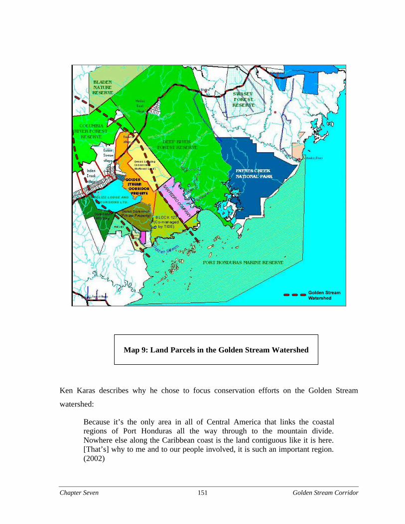
Chapter Seven 151 Golden Stream Corridor
Ken Karas describes why he chose to focus conservation efforts on the Golden Stream
watershed:
Because it’s the only area in all of Central America that links the coastalregions of Port Honduras all the way through to the mountain divide.Nowhere else along the Caribbean coast is the land contiguous like it is here.[That’s] why to me and to our people involved, it is such an important region.(2002)
Map 9: Land Parcels in the Golden Stream Watershed
Chapter Seven 152 Golden Stream Corridor
As originally envisioned, the Corridor was to include five forested and biologically important
parcels of land along the Golden Stream that were largely in private hands yet vulnerable to
development. The purchase and subsequent protection of these “five core parcels” (see Map
9, p.151) would anchor a habitat corridor running from the mountains to the coast to form a
conservation unit referred to as the Golden Stream Conservation Corridor or the Golden
Stream Corridor. However, a feasibility assessment revealed that a single company was
incapable of purchasing and maintaining such a large area so the project was divided into two
components: a for-profit sector that would run a piece like a company and the other part run
by a NGO that could find conservation finance to purchase the land (Karas 2002).
BLE’s focus on the biological significance of the region, as well as its vulnerability, attracted
the attention of Fauna & Flora International (FFI). Through their Arcadia Fund,35 FFI
purchased the first parcel of land in the Golden Stream for conservation in 1998 known as the
Golden Stream Corridor Preserve (GSCP). FFI carries out their conservation activities
according to the belief “…that conservation should be achieved through the application of
scientific understanding, a genuinely participatory approach, local capacity building and
long-term commitment” (FFI 2003c). In the Golden Stream, they are concerned with saving
the forest and its component biodiversity from destruction and fostering local environmental
stewardship. Their website showcases the 9,554 acre GSCP property:
Golden Stream’s conservation value transcends its intrinsic importance as ahaven of biodiversity. Our intervention not only saved the land fromconversion to citrus plantations, but also safeguarded the core area of the PortHonduras marine reserve into which the Golden Stream flows. (FFI 2003a)
FFI co-manages the GSCP with their counterpart, Ya’axche’ Conservation Trust (YCT), a
local community non-governmental (NGO) created around the time of the purchase. As a
“Maya organization”, in the sense that YCT is predominantly run and managed by Maya
individuals, YCT has cultivated a working relationship with Maya communities around the
GSCP (B.Teul 2002). YCT’s organizational goals are to 1) promote biodiversity
conservation; 2) increase capacity for sustainable management of natural resources in the
Golden Stream watershed; and 3) enhance the socio-economic development of the local
Maya communities that border the Golden Stream Corridor Preserve (YCT 2003).
Chapter Seven 153 Golden Stream Corridor
They plan to increase local capacity and conservation awareness through education and
training to ensure greater local involvement in and benefits from conservation initiatives.
YCT Director Bartolo Teul believes:
[When] this idea was conceptualized, it was always thought that communitiesshould always be involved. This idea of conservation should not only be donefrom a biological point of view but rather it should be people centered. (2002)
YCT is willing to explore which activities can still be carried out within the GSCP – such as
small scale gathering of thatch or medicinal plants – while protecting the resource. Following
Hurricane Iris, YCT implemented a Sustainable Livelihood Initiative which offers training in
woodworking and low impact timber extraction techniques (salvage logging) to “strengthen
livelihoods and resource management capacity amongst indigenous communities of
northeastern Toledo” (YCT n.d. [2003]). While YCT issued a moratorium on large scale
extractive activities like hunting, fishing, and logging, they eventually plan to develop a
management plan that will reconcile conservation with community needs.
After we develop the management plan we will go back to the community andsee if this is what they said. Based on a biological survey we will then see if itis possible to allow certain activities to happen in certain areas. So far there isno agreement with community telling them what they can and cannot do. (B.Teul 2002)
Following the procurement of the GSCP parcel, BLE purchased the adjacent 8,000 acres to
create the 7,600 acre Boden Creek Ecological Reserve (BCER) which forms the foundation
of their eco-enterprise consisting of eco-tourism, reforestation, and sustainable land use. BLE
specializes in providing tourists with a “trans-habitat experience” including a marine and
terrestrial component. The company’s website touting itself as a “…unique ecotourism
company and adventure travel operator…” beckons the upscale eco-tourist to “…journey
through and experience one of the most diverse spectrum of ecosystems in the world from
the Maya Mountains to the Barrier Reef and everything in between” (BLE 2002b). For Ken
Karas, BLE Managing Director, conservation is a business investment:
Chapter Seven 154 Golden Stream Corridor
Sometimes we can do more than NGOs because we have resources that NGOsdon’t always have. That’s why BLE agreed to help YCT get started. Welooked at it as a business investment so that we could preserve the other sideof that river. Our economic livelihood is the preservation of those five parcels.If we can’t give our guest the ultimate jungle experience, it all falls apart.(2002)
He is concerned with preventing “islands of biodiversity” or habitat fragmentation that he
fears will make the land unsuitable for eco-tourism. By protecting tropical ecosystems and
generating local employment, BLE hopes to contribute to biodiversity conservation while
providing alternatives to “destructive” land use activities in Toledo.
Acres under protection in the Golden Stream watershed expanded when Toledo Institute for
Development and the Environment (TIDE) acquired Crown Lands Government Block 127
via a debt-for-nature swap signed by the Governments of the United States and Belize and
assisted by TNC (Lazaroff 2001). This 11,000 acre parcel along the eastern bank of the
Golden Stream completes the corridor link to the coast and comprises over seven miles of
coastal mangrove habitat (Lazaroff 2001). TIDE manages the property “to be held in
perpetuity for the people of Belize” because it cares about protecting the Toledo District’s
natural resources for Belizeans (TIDE 2003b). As TIDE Executive Director Wil Maheia
(2002) puts it: “We have the right to take care of our resources.” TIDE is also interested in
maintaining their status as a conservation leader in the District. They have achieved local,
regional, national, and international recognition for their work.36
While the original concept was to include all five parcels along the Golden Stream, two of
the original five were not purchased. The St. Martin parcel at the mouth of the Golden
Stream is owned by a couple based out of Guatemala who are amenable to conservation-
friendly use of the land and any management plan for the area (Karas 2002). This is not the
case with the Flick parcel, a strategic tract of land south of BCER owned by Soren Sorenson,
a developer whose enterprise consists of various for-profit industries: primarily agro-
industry, shrimp farming, and logging. The company, primarily concerned with profit
maximization in large-scale agriculture and aquaculture projects, plans to develop land under
its control and expand current activities. Their land in the South is currently undeveloped yet
sited for shrimp farming: an activity perceived by conservation organizations to be a
Chapter Seven 155 Golden Stream Corridor
significant threat to the ecological integrity of the watershed. According to a Sorenson
employee:
We [Sorenson’s company] have land in the south and we want to do the same.We want to grow cacao and other crops down there and we will also doshrimp farming, cacao, and cattle. (Anonymous 2002)
Communities on the Golden Stream
The remaining mosaic of land use in the Golden Stream watershed is comprised of small-
scale agriculture, grazing, and Maya and Creole villages. Kekchi and Mopan Maya
communities, located on private, national and leased lands, have traditionally relied on the
resources found within the watershed. While they are not recognized as “land owners,”
lacking a legal title to the land, they care about management decisions being made in the
Golden Stream. Resource dependent communities understand the connection between a
healthy environment and clean drinking water and abundant game. Maya occupy lands
adjacent to the GSCP and BCER and have traditionally collected medicinal herbs, thatch, and
timber from the forests and fished the rivers. The archeological site Nim Li Punit, located
near the Mopan village of Golden Stream, represents an important Maya cultural resource.
Before the GSCP and BCER were created, activities in the area were largely unregulated.
Now, in some cases, hunting is equated with poaching and logging and collection of non-
timber forest products is illegal. Villagers who feel they were only marginally consulted
during the initial stages of the planning process do not necessarily recognize the legitimacy
of the private reserves whose borders might overlap with contested land. As one Maya
villager commented:
They tried to get people involved and the people really want to have theirinput taken. But as time goes by they quit taking the input of the people. They[YCT] had a [Board of Directors] but it fell off. Now they have [a new Board]and they will let me sit on it again. When they come back they change theprogram in their own way. They don’t ask the people. The first time it wasGolden Stream and [now it’s] Ya’axche’. (Anonymous 2002)
Chapter Seven 156 Golden Stream Corridor
The Maya around Golden Stream care about livelihood issues such as access to resources and
jobs. Lacking title to the lands they occupy, they are also concerned about land tenure issues.
Some communities are also interested in pursuing small scale eco-tourism ventures on their
own as a means to generate income:
We want to cut down on slash and burn by planting [beans] between Octoberand December. We are trying to protect some areas. We also want to do someincome generating activities. (Anonymous 2002)
Analysis
An emerging landscape-level conservation initiative
Natural resource management decisions are unique with regards to scale. Rivers, forests and
wildlife cross geo-political boundaries. Local forests and protected areas are part of larger
ecosystems. Upstream activities and land use patterns in the Golden Stream watershed
impact water and habitat quality in the Port Honduras Marine Reserve, while human
activities on one parcel of land affects adjacent parcels. While the original vision for the
Golden Stream Corridor – as approximately 49,000 acres of protected habitat running
unbroken from the Maya Mountains to Port Honduras – has yet to be realized, the concept of
a watershed-scale conservation unit catalyzed the purchase of the GSCP and subsequent
parcels along the river. Conceptually, it also marked the creation of a place as an integrated
landscape existing along ecological rather than socio-political borders. A diverse set of
agencies, organizations, and institutions now control and manage an extensive area along the
Golden Stream for conservation. While management decisions regarding individual parcels
reside with the individual organization, a holistic approach to conservation will only be as
successful as the ability of land owners and managers to coordinate activities across parcels
and reconcile them with the larger landscape that lies outside of protected area borders.
Successful conservation initiatives in the small-scale Golden Stream watershed could serve
as a stepping stone to larger and more complex landscape-scale initiatives. The Golden
Stream watershed is an integral component of two landscape-scale conservation initiatives in
the region; the MMMC and the Mesoamerican Biological Corridor (MBC) program.
Chapter Seven 157 Golden Stream Corridor
As discussed earlier, the Golden Stream is an integral part of the regional MMMC, a larger
scale conservation unit embraced by TNC and TIDE. The Golden Stream Corridor, also
referred to as the Southeastern Biological Corridor, has been identified as a potential
component of the MBC National Biological Corridors Program in Belize37 (CBM 2003).
Golden Stream organizations, interests, and issues are replicated in the MMMC and the
MBC. As posited by a TIDE/TNC consultant, successes and challenges at the Golden Stream
watershed level could prove valuable to planning and implementation of these larger scale
initiatives:
I’ll share my vision. I would say that the whole Golden Stream area will beone of the most active parts, because there’s a critical mass. So between YCTand Golden Stream village, this will take off there if it gets funded. (Esselman2002)
One approach to landscape-scale conservation is to start small and gradually connect existing
synergies. A NGO representative suggested, “…the ideal approach would be to start small
(e.g., Golden Stream Corridor area) and grow into a larger area (i.e., Port Honduras
Watershed area)” (Anonymous 2002).
Challenges for collaboration
Interviewees identified various challenges to greater communication, coordination, and
collaboration in the Golden Stream watershed.
Lack of a shared vision
The involvement of multiple participants with different and sometimes conflicting
perceptions and values poses real challenges to collaborative natural resource management.
The watershed is divided into discrete parcels owned by the private sectors, NGOs, the
Government of Belize, absentee landowners, and individuals. The area is home to culturally
diverse ethnic groups. International, national, and regional organizations work here. This
complex social landscape poses significant challenges to managing the area as a corridor in
part reflected by the various ways groups conceptualize the region. The Golden Stream is
defined as a biological corridor running from the Maya Mountains to Port Honduras, a
collection of protected areas, an ecosystem, a component of the MMMC and a concept.
Chapter Seven 158 Golden Stream Corridor
For others it is defined as the foundation of a livelihood or a source of revenue. One
interviewee explains this phenomenon, “The Golden Stream Corridor is a vision from
someone outside, not necessarily that of the individual land owners and managers” (Pinelo
2002).
While BLE, TIDE, YCT, and FFI have expressed an interest in managing the Golden Stream
as an integrated watershed, individual objectives and agendas may impede effective
collaboration. Meanwhile, an over-arching management plan or strategy is lacking. BLE’s
primary interests revolve around protection of the “five core parcels” starting with the
company’s property and moving out towards the Maya Mountain Forest Reserve and the
MBC. They feel eco-tourism is the key to sustainable conservation in the watershed as it
provides protection and economic benefits through local employment. Extractive activities
such as hunting, logging and fishing are incompatible with their view of conservation. FFI
and YCT couple conservation with community development. They take a more “people
oriented” approach and are open to allowing certain activities on their land (such as salvage
logging and collection of non-timber forest products) if practiced in a regulated and
sustainable manner.
TIDE envisions management in the context of the ambitious MMMC as outlined in their Site
Conservation Plan. The MMMC is a “landscape management unit … [that] covers nearly a
million acres connecting the Maya Mountains to the Belize Barrier Reef” and encompasses
five other watersheds in addition to the Golden Stream (TIDE 2000). TIDE practices an
aggressive conservation strategy that encompasses buying back foreign held land, eco-
tourism, education, and protected areas management. Chief Forest Officer Oswaldo Sabido
differentiates the approach followed by YCT and TIDE:
TIDE following its mentor, TNC, takes a much more corporate approach toconservation than say, YCT, which is trying to develop a more community-based management that involves several communities and a particular ethnicgroup in Toledo. (2002)
As long as organizations can successfully accomplish their objectives independent of each
other it seems unlikely they will choose to engage in a more collaborative approach.
Chapter Seven 159 Golden Stream Corridor
Resource constraints
While mentioned as an incentive for greater collaboration, limited resources are also cited as
an inhibiting factor. Various individuals mentioned time and resource constraints.
Government agencies and NGOs lack the human and financial resources to carry out roles
and responsibilities. Small organizations like YCT are strapped financially. FFI and YCT
have limited staff. While the lowland forests and coastline protected areas are in private
hands, the headwaters of the Golden Stream emerge in GOB designated Forest Reserves.
Management responsibility for the Columbia River Forest Reserve and the Bladen Nature
Reserve is in the hands of the Forest Department of the Ministry of Natural Resources and
the Environment. Given limited financial and technical resources and information, the
Department’s activity in the Toledo District is constrained, as explained below:
The Forest Department appears to be handicapped due to lack of resources.Over ten years, even though they have qualified people and generate revenue,GOB has not provided financial support. NGOs which have good experiencehave been helping the Forest Department to do its monitoring. (Bardalez2002)
This view was echoed by Sabido:
The Forest Department first of all does not have all the answers. Secondly, weare still technically weak in protected areas management, especially withcommunity/participatory management even though an overstretched ForestDepartment staff is doing its best with the limited resources available. We arealso weak in the area of knowing what is happening on-the-ground – inToledo, for example. But yet we have the obligation and the responsibility ofproviding the leadership for protected areas management. (2002)
Interviewees also mentioned a lack of time, to build relationships and forge partnerships with
other organizations with similar interests. The Director of YCT encapsulated the feelings of
most of the interviewees in the Golden Stream Corridor: “Everybody has their own things to
do and not much time to work together. When someone tries to call a meeting, no one has
time for it” (B. Teul 2002).
Chapter Seven 160 Golden Stream Corridor
Organizational challenges
Organizational turf. While groups of environmental organizations have embraced landscape
scale or eco-regional conservation planning, contiguous parcels and protected areas remain
divided along organizational rather than ecological lines. Various interviews hinted at turf
issues. In response to a question about potential problems to collaborative management of
protected areas one individual said: “I’m not sure how much the different NGOs are willing
to share power or benefits” (Garbutt 2002). Strong institutional identities and personalities
strengthen territoriality. It seems that individuals within the GSCP identify more with their
institutions than with the geographic region. One individual remarked: “[NGOs] don’t want
to share recognition with others [and believe that] only they should benefit” (Anonymous
2002). The following quote highlights the tendency for organizations to define the watershed
along institutional rather than ecological lines:
We have staked out what we term the Golden Stream Corridor and it has acollection of stakeholders involved in various levels. Our focus is on thecompany’s property first and next what we call the ‘five core parcels’ of theGolden Stream Corridor. (Karas 2002)
Leadership styles. Different leadership styles create conflict and fragmentation. Leading
environmental organizations in the Golden Stream are characterized by strong and vocal
leaders; each with their vision for current and future conservation management in the
watershed. Outside the language hinting at a need for greater collaboration and coordination
in the watershed, no one is really “stepping up to the plate” to consolidate the five core
parcels into a functionally integrated corridor.
Conflict and competition among groups
Criticisms and comments by various interviewees hint at a history of interaction
characterized by conflict and personality clashes. While BLE was instrumental in the
creation of the Golden Stream Corridor Preserve NGO (now YCT) the relationship seems to
have soured. BLE feels that when YCT changed their name they also changed their focus and
are now ignoring their responsibility to the five core parcels by focusing on the broader
Chapter Seven 161 Golden Stream Corridor
watershed. On the other hand, YCT questions how well BLE’s management strategy as a for-
profit organization incorporates local community needs and skills.
Environmental groups perceive Sorenson to be the enemy; using language such as “muscling
his way in” or “a walking environmental disaster” to describe him. He is perceived by the
environmentalists to be a “shrimper/logger who basically wants to trash the land.”
Meanwhile, an employee of Sorenson feels their company is doing things to protect the
environment such as preserving riparian buffers and using natural filtration to remove
effluents produced by shrimp farming: “We get blamed for polluting but we are doing things
that will protect nature…it’s in our best interest. The land must give people on earth a living”
(Anonymous 2002). Popular perceptions paint TIDE as Toledo’s environmental rock star
unwilling to share the spotlight with anyone else: “they mopped up marine areas and now
they are getting into the terrestrial” (Anonymous 2002). On the flip side, TIDE sees itself as a
local success story and attributes the hostility and jealousy to human nature: “It is human
nature to hate those that are doing well. I don’t expect everyone to like me or TIDE” (Maheia
2002).
Lack of trust
Interactions between indigenous communities and NGOs and Government organizations are
characterized by mistrust. Poorly implemented and managed projects have led some to
believe that NGOs are “just like the Government.” Despite numerous projects and millions of
development dollars, quality of life for local community residents has improved little.
Decision making authority is frequently in the hands of international and national
organizations while the local populations affected by those decisions are not necessarily able
to participate in decision making processes. As a result, Maya villagers are skeptical of the
proclaimed benefits of various conservation and development initiatives in Toledo.
Conservation organizations are seen as “locking away resources” while development projects
seem to benefit only a minority.
Despite various attempts by NGOs such as YCT to integrate communities into conservation
and sustainable livelihood initiatives in the Golden Stream, various interviewees questioned
how well indigenous people are represented and integrated into management decisions.
Chapter Seven 162 Golden Stream Corridor
Maya villagers from Golden Stream Village – located across the road from BLE’s upscale
tourist complex – feel the promise of local employment and benefits from conservation
programs was used merely to “get them on board.” As commented by Golden Stream
villagers:
At first they had meetings with us. But after that they did not involve us. Theywanted support from the people but after they have it then things are over.(Anonymous 2002)
He [Karas] is a very tricky guy. In each village he gets stones [to build hisfence, and] he doesn’t pay. He wants to damage our village and improve hisown land. He needs to ask the village to approve it first. (Anonymous 2002)
Opportunities and facilitating factors
Interviews reveal various opportunities to increase collaboration among individuals and
organizations. Interactions and partnerships between them suggest a degree of
interdependence and interconnectedness.
Existing relationships
There is a richness of linkages among conservation oriented organizations in the Golden
Stream largely brought about by the nature of natural resource management at the watershed
scale which exceeds the resources, jurisdiction and expertise of any single organization. They
range from informal to formal arrangements, involve combinations of local, national, and
international non-governmental organizations (INGOs) and bring together the public, private,
and nonprofit sector.
YCT, BLE, and TIDE partner with INGOs. TIDE’s on-going relationship with TNC denotes
a secure source of funding while FFI provides critical technical assistance to YCT. BLE
receives financing from Conservation International’s Conservation Enterprise Fund (CEF)
and EcoLogic Enterprise Ventures (EEV) for their eco-tourism component (BLE 2003c).
These INGO/NGO partnerships elevate the visibility of the region beyond the local level and
provide needed resources.
Chapter Seven 163 Golden Stream Corridor
Partnerships and co-management agreements between GOB and NGOs are an important
source of technical, human, and financial resources, given their inability to carry out
management roles and responsibilities for protected areas on their own. GOB has devolved
management responsibility for Crown Lands Block 127 to TIDE: recognizing TIDE’s
experience working to protect and manage conservation areas in Toledo. BLE, in conjunction
with the Bladen Consortium, rotates some of their rangers in the Government controlled
Bladen Nature Reserve.38
Linkages between environmental organizations are manifested in more formal arrangements
as well; through Memorandums of Agreements (MOA) and conservation easements.39
Eugenio Ah, the former director of BCER, explains the value of such agreements as a tool to
facilitate conservation planning between YCT, BLE and TIDE:
This process is beneficial to both BLE and the NGOs that manage the area.This shows that the efforts of the private sector and NGOs can work together.In terms of forming a common vision as well as a common strategy, to be ableto pursue the common end of protecting this area. BLE is very adamant aboutthis. Each stakeholder has their own niche to fill, but we’ll be workingtogether. (2002)
YCT signed a conservation easement with TIDE for one of their downstream properties. In
essence YCT plays a “watch dog” role by visiting the property once a year to make sure the
agency is managing the land in accordance with the easement: for example no new building,
roads, logging, or farming. YCT cannot reciprocate because it does not yet have a
management plan in place for the property (GSCP) which it manages. However, YCT’s
Director has expressed that they would sign an easement for their property with TIDE once
the management plan for that property in place (B. Teul 2003).
The organizational landscape of the Golden Stream is not static, new partnerships, alliances,
and initiatives continue to develop. BLE and TIDE recently signed a Memorandum of
Agreement, renewable after ten years, “in which both sides agree to work together to
promote conservation and development that will guarantee the long-term sustainable
utilization and maintain the ecological integrity of the Golden Stream River and the Port
Honduras Marine Reserve”40 (BLE 2003a). The document outlines the purpose, scope, and
termination of the agreement and the obligations of the participating organizations.
Chapter Seven 164 Golden Stream Corridor
As part of this agreement, BLE will contribute a “daily user fee” to TIDE for each guest that
participates in BLE’s tourism operations. It is expected that this revenue will be used by
TIDE for their marine patrols and conservation work in the PHMR (BLE 2003e).
Furthermore, starting in November 2002, BLE, TIDE, and YCT rangers started to conduct
joint patrols in the PHMR to reduce poaching and gill netting, with the patrol costs shared by
the three parties (BLE 2003e). In 2002 FFI submitted a Global Environment Facility project
proposal for integrated ecosystem management in the Golden Stream Watershed. The project
seeks to coordinate and strengthen conservation initiatives by addressing local capacity,
governance and local livelihoods as they relate to natural resource management in the Golden
Stream watershed. If approved, the project will provide a tremendous source of technical and
financial support for future collaboration in the watershed.
Potential for joint gains
Participants express an interest in working together and can imagine joint gains from shared
resources, information, and management responsibilities. Others see the potential for more
local employment, monetary benefits from user fees, access to carbon credits from carbon
sequestration, and the ability to tap funds targeted at collaborative or ecosystem management.
The corridor encompasses a large area of land that individuals and organizations cannot
manage alone. Parties identify gaps in baseline data, biodiversity and environmental impact
assessments, and management plans. They mention the need for joint monitoring and
patrolling. These problems could be better met through pooled knowledge and resources.
Greater collaboration can merge the resources and skills of the private and non-profit sector.
Ken Karas posits: “Collaboration is to bring together the strengths and resources of the non-
profit and the private sector” (2002). John Pinelo, formerly of the Forest Department, puts
forth a scenario where each organization could bring something to the table in terms of
technical knowledge, community support, and financial resources:
TIDE has a little bit of the technical knowledge and the money but lackscommunity support. FFI has the greatest technical knowledge of the land butnot the money. BLE has the financial resources but not the knowledge andYCT has the community support. (2002)
Chapter Seven 165 Golden Stream Corridor
Shared concerns and interests
While organizations respond to individual agendas and missions, various organizations in the
Golden Stream share common interests. YCT, FFI, TIDE, and BLE support sustainable
development initiatives, conservation awareness and capacity building. Both TIDE and BLE
embrace eco-tourism as a means to generate revenue and jobs through conservation. BLE is
in the process of developing three tourist lodges on their property and plans to include both
TIDE and YCT’s properties in their eco-tourist destinations:41
BLE is developing three satellite stations on the property for tourism [FigTree, Jungle Camp and a marine site]. This is a collaborative effort wheregroups [YCT and TIDE] use development to help conserve the area in termsof user fees for Port Honduras. If they use the YCT land as well this will beanother way of contributing. (Ah 2002)
Non-profits like YCT and TIDE stand to benefit from the revenue generated from BLE’s
guests while BLE requires access to a broad array of ecosystems if they are to provide their
guests with the “trans-habitat experience.”
The MOA signed by TIDE and BLE highlights their attempts to capture the benefits from
greater collaboration in conjunction with strengthening conservation efforts in the region.
The relationship between TIDE and BLE is increasingly interdependent given that each
organization manages strategic components of the corridor: BLE holds a long term lease on
Moho Cay situated within the PHMR where plans are underway to open the upscale Belize
Island Lodge. TIDE manages PHMR and Block 127, both important components of the
Golden Stream watershed. As neighbors in the Golden Stream watershed, it is in their best
interest to coordinate ranger and tourism activity as well as share expertise, knowledge, and
skills and monitor each other’s activities. According to the MOA, both parties agree to
cooperate on the following:
§ BLE agrees and accepts to charge, collect and allocate funds generated vis-à-vis a
daily and differentiated user fee charge from guests staying at Belize Island Lodge on
Moho Cay and/or partaking in day excursions within the PHMR and/or other marine
locations within the southern Toledo District, with a view to contribute to TIDE’s
conservation efforts in the PHMR…
Chapter Seven 166 Golden Stream Corridor
§ …share and coordinate their respective ranger activity in order to provide protection
for the PHMR and the areas belonging to BLE and TIDE surrounding the Golden
Stream River.
§ BLE hereto agrees to utilize the expertise of TIDE for its Environmental Impact
Assessment for the development of the ecotourism project… [on Moho Cay]. BLE
also agrees to share with TIDE, for feedback and comments, its current management
plan for BLE’s Boden Creek Ecological Reserve as well as any future management
plans….
§ BLE and TIDE hereto agree to work out arrangements to use TIDE trained guides as
part of BLE activities in the PHMR… [and vice versa for TIDE’s tourism activities in
BCER]. (BLE 2003a)
Interest in moving forward
Various interviewees indicate positive interactions and are cautiously optimistic about
moving forward. New activities, initiatives, and partnerships continue to emerge between
YCT, BLE, TIDE, and other organizations. Existing relationships continue to evolve. YCT’s
Director states:
Now [YCT and BLE] are beginning to talk. We realize we are neighbors andwe need to work together. [Karas] owns a block of land on the other side ofthe river that he is putting into protection…. (B. Teul 2002)
In a similar vein, Karas says:
I would like to see the initiative of the Golden Stream Corridor go forward.No one can dominate; each one has its voice and the option to pull out if it’snot working. (2002)
Recently, communities have also shown a renewed interest in participating in the corridor
initiative:
[In] the beginning there was good response [from the communities]. Therewas a time when there was a drop in people’s interest in our work. But theinterest is going back up especially after the hurricane; people are seeing thatit’s important that we protect our natural resources. We do see an increase inparticipation now. (B. Teul 2002)
Chapter Seven 167 Golden Stream Corridor
Conclusions
An analysis of the constraints and opportunities for collaboration in the Golden Stream
watershed leads to the following conclusions:
§ While many parties express an interest in greater communication and cooperation, all
the parties have never sat down face to face to discuss managing this area as a whole.
Communication has been limited to clusters of NGO leaders while communities and
industry have only marginally participated. Future decision making processes in the
Golden Stream Corridor could be strengthened by the inclusion of a broader spectrum
of participants and their interests, skills, and experience.
§ The Golden Stream is defined as a biological corridor running from the Maya
Mountains to Port Honduras, a collection of protected areas, an ecosystem, a
component of the MMMC, and a concept. For others it is defined as the foundation of
a livelihood or a source of revenue. Varied perceptions and values among participants
pose serious challenges to managing the area as an integrated ecosystem. Building a
shared objective could promote greater unity among potential collaborators.
§ A change in the status quo could create the sense of urgency or ‘window of
opportunity’ that could move organizations towards greater cooperation,
communication and collaboration. While many interviewees share common concerns
about the region’s vulnerability perhaps it has not reached crisis level yet. The
highway is almost completed and Sorenson is still planning to develop his land for
shrimp farming.

Chapter Seven 168 Golden Stream Corridor
Chapter Eight 169 Bladen Management Consortium
Chapter Eight: The Bladen Management
Consortium
Introduction
The Bladen Nature Reserve inspires passion among its many advocates and frustration
among residents of the communities that it borders. Called “the jewel in the crown of
Belize’s protected area system,” for its exceptional biodiversity, dramatic topography, and
archeological treasures, the 97,000-acre reserve is afforded Belize’s highest level of
protection (Pinelo 2002). Only education and research are allowed in Bladen: hunting,
fishing, logging, harvesting of plant materials for food, fiber, or medicine, removal of
artifacts, tourism, and trespass of any sort without a permit are all prohibited. While these
restrictions exist “on the books,” until recently the under-resourced Government agencies and
thinly stretched non-governmental organizations tasked with enforcing them have
implemented little real on the ground management in the reserve. With growing population
and mounting development pressure, illegal activities in the reserve have continued to
increase in the last several years, threatening both the natural and archeological resources that
have made the Bladen Nature Reserve famous.
The Bladen Management Consortium was born out of its founders’ conviction that the
Bladen Nature Reserve was a unique resource in dire need of management and their
recognition that the management challenges were beyond the capacity of any one
organization. As a case study in collaboration, it highlights the many difficulties associated
with initiating and sustaining an multi-stakeholder management body, particularly with
regard to funding, staffing, representation, and legitimacy. It also illustrates how a few
committed individuals can drive a collaborative process forward despite such challenges.
Significantly, several of the key individuals and organizations involved in the Bladen
Management Consortium also interact in the broader landscape of the Toledo District.
Understanding the difficulties and successes these groups have encountered in the
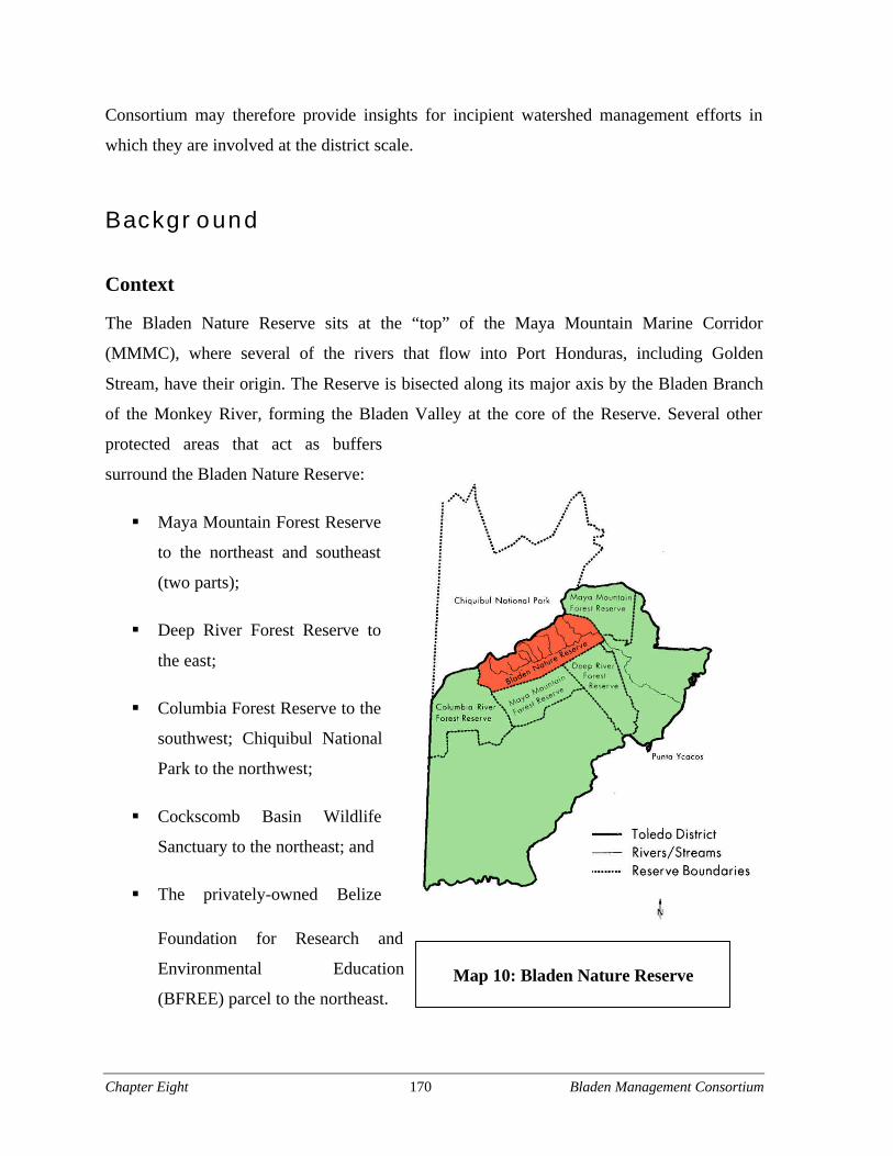
Chapter Eight 170 Bladen Management Consortium
Consortium may therefore provide insights for incipient watershed management efforts in
which they are involved at the district scale.
Background
Context
The Bladen Nature Reserve sits at the “top” of the Maya Mountain Marine Corridor
(MMMC), where several of the rivers that flow into Port Honduras, including Golden
Stream, have their origin. The Reserve is bisected along its major axis by the Bladen Branch
of the Monkey River, forming the Bladen Valley at the core of the Reserve. Several other
protected areas that act as buffers
surround the Bladen Nature Reserve:
§ Maya Mountain Forest Reserve
to the northeast and southeast
(two parts);
§ Deep River Forest Reserve to
the east;
§ Columbia Forest Reserve to the
southwest; Chiquibul National
Park to the northwest;
§ Cockscomb Basin Wildlife
Sanctuary to the northeast; and
§ The privately-owned Belize
Foundation for Research and
Environmental Education
(BFREE) parcel to the northeast.Map 10: Bladen Nature Reserve
Chapter Eight 171 Bladen Management Consortium
Cockscomb Basin is managed by the Belize Audubon Society (BAS) under a co-management
agreement with the Forest Department. The Forest Reserves are managed by the Forest
Department. Bladen Nature Reserve and the Chiquibul National Park also fall officially
under the auspices of the Forest Department. Of the surrounding parcels, the Forest Reserves
are the least restricted and the most vulnerable to future de-reservation. Notably, all of these
organizations are currently Consortium members.
Bladen is oriented along the axis of the Maya Mountains, which traverse Southern Belize
from the southwest to the northeast. The Reserve’s geologic diversity, with both limestone
and granite bedrock, creates its unique and varied topography, including towering karst
formations, extensive cave systems, and peaks, as well as lowlands. The varied topography in
turn supports a rich diversity of flora and fauna. More than 600 species of trees are found in
the Bladen with its intact lowland, tropical, seasonally moist forest. According to Jake Marlin
the founder of BFREE, “It’s probably one of two or three lowland rainforests left in the New
World that has this level of diversity and structure”. The area contains plants that are not
found anywhere else in Belize or even in the world.
The diversity of wildlife is also rich in Bladen. All five species of native cats live here:
jaguars, ocelots, jaguarundi, puma, and margay. Other mammals found here include spider
monkey, tapir, agouti, and the gibnut. The Bladen Valley contains the richest herpetofaunal
region in Belize, with a previously undescribed species of frog discovered in recent years.
(Iremonger et al 1994)
The Bladen area was originally declared a Forest Reserve in May 1977. The area became the
focus of scientific investigation in the late 1980’s. National Geographic also filmed a movie
on the Bladen called Mountains of the Maya. The findings from the investigations and the
attention drawn to it by the National Geographic film drove the re-designation of the Bladen
as a Nature Reserve in 1990. Simply changing the designation of the area did not guarantee
its protection, however.
Chapter Eight 172 Bladen Management Consortium
Organizations involved in the consortium
When the Consortium first met in 1995, thirty individuals representing ten organizations
attended. As discussed later, these numbers quickly declined as the meetings of the
Consortium continued. The core organizations in the first phase of the Consortium were the
Belize Center for Environmental Education, BAS, the Toledo Alcaldes Association, the
Forest Department, BFREE, the Department of Archaeology, and the Toledo Maya Cultural
Council. In the second phase, the leaders have been BFREE, Toledo Institute for
Development and Environment, Ya’axche’ Conservation Trust, and the Forest Department.
These four have recently been joined by BAS and Belize Lodge & Excursions (BLE). Each
organization brings assets to the Consortium. YCT is recognized for its skill in community
relations. TIDE excels in public, Government, and funder relations. BAS is experienced in
protected areas management and is very connected with Government officials. Finally, BLE
offers a well-trained staff of rangers and connections to international funders. While each of
these organizations plays a role in Bladen, the Forest Department and BFREE, introduced
below, have been the lead participants in the consortium to date through key staff.
Forest Department
The Forest Department is one of the three divisions of the Ministry of Natural Resources and
the Environment (MNRE). The Forest Department is responsible for managing the forestry
resources of Belize, which include all national forests, protected areas, wildlife and
biological diversity of terrestrial zones. The mission of the MNRE is to improve the quality
of life for all Belizeans by effectively managing and conserving the natural and
environmental resources in order to improve the sustainable economic development of
Belize. The Forest Department oversees the management of terrestrial protected areas.
The Forest Department gets most of its funding from the MNRE’s annual budgetary
allocations. Recently, it has been able to receive medium-sized grants from the Protected
Areas Conservation Trust. These grants are small, however, and still do not adequately
address their funding needs, which are substantial. A UNDP/GEF Project Report (Ravndal
2002) states:
Chapter Eight 173 Bladen Management Consortium
The Protected Areas Programme [of the Forest Department] receives less than½ of 1% of the already very restrictive budget assigned to the Ministry towhich it belongs, the MNREI… With an annual budget of only US $116,629,(Estimate of Revenue and Expenditures for 2002-2003, Government ofBelize), and with none of this amount allocated for on-the-groundmanagement of PAs, the Protected Areas Programme cannot possiblyadequately co-manage (or manage) PAs, even with backstopping from theentire Forest Department. According to the new institutional structure, theentire Forest Department (as opposed to the Protected Areas Programmealone) should be more involved in PA management. Nevertheless, it seemshighly unlikely that the overall situation regarding management of PAs willsignificantly improve. After all, the Forest Department is, itself, stretched tothe very limit. The entire Ministry of Natural Resources, Environment, Tradeand Industry (to which the Forest Department belongs) receives a mere 1.6%of the national budget (Estimate of Revenue and Expenditures for 2002-2003,Government of Belize). Given these extreme resource constraints, it is highlyunrealistic to assume that the Forest Department can adequately manage thenation’s PAs, or even monitor the management of these PAs by others.
The Department also receives some revenue from protected area entrance fees, but at
insignificant levels. Due to poor financial resources, the Department has very little technical
resources deployed there in the Toledo District, and this has been the case for a number of
years. Wayne Bardalez, the District Forest Officer at Toledo’s Machaca Forest Station stated:
The Forest Department appears to be handicapped due to lack of resources.Over ten years, even though they have qualified people and generate revenue,the Government of Belize has not provided financial support. NGOs, whichhave good experience, have been helping the Forest Department to do itsmonitoring. (2002)
Nonetheless, Forest Department staff – first Rafael Manzanero and then John Pinelo – have
been leaders in establishing and maintaining the Bladen Management Consortium, offering
expertise in protected areas management, time, space, and resources for coordination,
commitment, and legitimacy because of their official jurisdiction over the Bladen.
Legitimacy, as discussed further, proved especially important in convening group members.
Significantly, John Pinelo left the Forest Department this year and joined the Belize Audubon
Society as a senior staff member, from where he has continued to lead the Consortium.
Chapter Eight 174 Bladen Management Consortium
Belize Foundation for Research and Environmental Education
In 1995 a young American herpetologist named Jake Marlin and his partner Kelly Marlin
established BFREE, an environmental non-profit organization. The Marlins had spent time in
the Bladen and sought to locate a research and environmental education center next to it.
BFREE secured a lease for a 1,153 acre parcel of land abutting the Reserve and began to
establish their facility. The land also abuts the Cockscomb Basin Wildlife Sanctuary and the
Maya Mountain Forest Reserve.
The parcel is strategically located at one of the major access points to the Reserve. From this
vantage point and through subsequent research trips in the Bladen, the Marlins observed that
the natural and archeological heritage of the site was being eroded through persistent and
damaging activities, including looting, fishing with poisons, logging, and hunting.
Furthermore, they learned that the Reserve was not actively managed on site by Forest
Department personnel. Jake Marlin approached Rafael Manzanero at the Forest Department
and together they initiated the first meeting of the group that would become the Bladen
Management Consortium in late 1995.
The goals of BFREE are to promote education and research of the Belizean rainforest, as
well as to protect the Bladen Nature Reserve. BFREE is financed by private donations,
mostly from funders from the United States. BFREE, in the person of Jake Marlin, is the
prime organizing force behind the Bladen Consortium today, along with John Pinelo.
Management challenges
The biodiversity of the Bladen Nature Reserve is unparalleled in Belize. The majority of the
forest cover in the area has never been cut, due to the remoteness of the valley, the rugged
karst topography, and the thick tangle of jungle vegetation. These same factors also make
management and monitoring of the Reserve challenging, especially for a budget-constrained
Government agency or a cash-strapped NGO.
Main issues surrounding the management of the Bladen Nature Reserve are unmonitored and
illegal extractive activities occurring within the reserve. These include poaching, fishing,
illegal logging, looting of Maya archaeological sites, and bio-prospecting. According to John
Chapter Eight 175 Bladen Management Consortium
Pinelo, of the Forest Department, these activities are undertaken by opportunists, because
they are “the ones that can get out the most stuff in the fastest amount of time” (2002).
Surrounding communities also impact the Reserve through their customary subsistence
practices.
Traditional activities
Neighboring Maya people, many from the adjacent community of Medina Bank, have
traditionally used the Bladen Reserve for hunting, resource extraction, and other traditional
activities. IN 1989, one year prior to the declaration of the Bladen as a Nature Reserve,
Joseph Cal and his family founded the village of Medina Bank (TMCC and TAA 1997). This
Kekchi and Mopan village is particularly dependent on the Reserve, as it is surrounded by
private and Government protected areas, and they have few places where they can go to
fulfill their subsistence needs. This predicament often pits the local community against
managers of the Reserve. Pinelo explains:
Medina Bank is an island located within the protected areas. They havenowhere to go and the soil they have is not very good, so they have to go intothe park to hunt. Basically, this is why they are against the management of thepark and against the implementation of the plan. (2002)
Many of these activities, such as collecting palm fronds to make the traditional thatch roofs,
incur relatively few impacts when conducted on a small scale. Villagers also collect fruit
from the Reserve and market it as a “Genuine Mayan Product.” (Pinelo 2002)
Other traditional practices place greater pressure on the Reserve. Uncontrolled fishing and
hunting within the reserve can destabilize certain ecosystems. Sometimes toxic chemicals are
poured into streams and rivers to catch fish. Also, local hunters occasionally light fires to
keep savannah areas open for better hunting. As elsewhere in Central America (Nietschmann
1973:88), this practice helps maintain pine-savannah ecosystems although frequent fires
inhibit patches of pine regeneration. While fire occurs naturally in the savannahs surrounding
the Reserve, it also can spread into the protected area. Last year, an uncontrolled fire burned
down a ranger station near the Bladen.
Chapter Eight 176 Bladen Management Consortium
Extraction of natural resources
The illegal extraction of other natural resources also damages the Reserve. These activities
include bio-prospecting and logging. Illegal bio-prospecting is the systematic search and
unsolicited removal of biological sources of new compounds for economic gains that are not
shared with the people or place from which the material was extracted (INBio 2003).
According to a GOB official, a previously-unknown species of cacao was discovered in the
Nature Reserve and was clandestinely collected and smuggled to Trinidad (Anonymous
2002).
The difficulty of accessing the reserve has not stopped illegal logging completely. Much of
the logging in the Toledo district uses chainsaw mills. These are small, basically a chainsaw
and a metal frame, and can be carried into the reserve. Trees are cut down and quickly cut up
into boards. Illegal chainsaw mills waste timber as well as damage the forest. John Pinelo of
the Forest Department commented, “The blades are really thick, you lose a lot just in
sawdust” (2002).
Extraction of archeological resources
The Maya Mountains, including the Bladen Valley, contain an abundance of understudied
and unexcavated Maya ruins (Prufer and Wanyerka 2001). In addition to the research of
professional archaeologists, this cultural wealth in South Belize draws the attention of
occasional and professional looters. Looting, or treasure hunting, is often conducted by
methods that destroy the site’s context which prohibits the interpretation of the significance
of the find. Jake Marlin described one site in the Bladen, “I found clay idols with thousands
of little saucer cups, jaguar skulls at the base of these cliffs, stuff you just wouldn’t believe”
(2003). On a subsequent trip, Marlin discovered that the site had been plundered and largely
destroyed. Highly organized looters have operated in the area for decades. Explosives are
sometimes used to crack open uninvestigated Maya structures. Artifacts commonly surface
on the black market. According to an official from the Department of Archaeology:
Looting is a huge problem. We [the Department of Archaeology] have onestaff member dedicated to deal with the issue of looting and we have 1,400sites all over the country not counting the [unexcavated] mounds.(Anonymous 2002)
Chapter Eight 177 Bladen Management Consortium
While archaeological research recovers important data for understanding regional history,
such projects direct looters to previously undisturbed areas. Long term research projects like
the Maya Mountains Archaeological Project (MMAP) create additional debate through the
training of local field crews. The MMAP began in 1992 under the direction of Cleveland
State University archaeologist Peter Dunham, one of the contributors to the National
Geographic film project. On one hand, Maya organizations argue that local people have
rights to their cultural heritage and demand inclusion in research projects. One Maya leader
explains, “The Mayan community needs to be involved in al the expeditions. We want to
make sure that the community can manage the archaeological reserves” (Anonymous 2002).
On the other hand, conservationists argue that many research projects damage the natural
heritage of the Reserve. The MMAP employed local people to cut trails and a helicopter pad
and a camp within the reserve. After the field season, many of the ruins were looted and
poachers started using the trails and camp. Jake Marlin blames Dunham for this destruction
because “he showed the way, he paid them to cut the trails” (2002).
Another interviewee corroborated that training local people in excavation techniques may
increase looting in the absence of alternative income generating opportunities:
Skilled labor equals skilled looters. When these [archaeology] operations arenot here, you end up with trained looters for the off-season. The guys doingmilpa end up going and doing some pilfering of a site. The country and theissue are so large that the best we can do is raise public awareness. Oneexample is a 5” x 8” engraved zoomorphic limestone artifact that sold forUS$270,000 at Sotheby’s Auction. (Anonymous 2002)
Scientific research projects
Authorized research expeditions also pose challenges for the management of the Reserve.
Officially, the Bladen Nature Reserve is open only to scientific studies, but even these
activities can bring about damaging effects on the environment of the reserve. For example,
Jake Marlin described a project on mammals that a student was undertaking within the
reserve:
Chapter Eight 178 Bladen Management Consortium
[A young researcher] needed a 500 meter transect. So Peter [Dunham] had hisMayan guys cut a line for it. I got up there two weeks later and walked thattransect. So this girl had walked the transect several times, and it was alluseless information. We estimated that several thousand trees had been cutdown. (2002)
Although the 1987 National Geographic film, Mountains of the Maya, did create the
momentum to establish the Reserve, it also attracted the attention of many individuals
interested in profiting from the natural and cultural wealth of the area. Marlin argues that the
activity surrounding the making of the movie and the increased exposure it brought
contributed to more rapid degradation of the area, due especially to the cutting of trails and
the uncovering of archeological sites, both of which enhanced illegal access to game and
artifacts.
La Sierra Multidisciplinary Field Station
La Sierra Multidisciplinary Field Station is a comprehensive research initiative located three
kilometers south of the Bladen Nature Reserve. To complement a similar research station in
northern Belize, the GOB and the London Natural History Museum planned La Sierra with
support from Cleveland State University. Work on it began in 1998. The University intends
to sponsor programs at the Field Station in geology, biology, archaeology, and medicine. It is
expected to be a US$10 million project by the estimated date of completion in 2004 (CSU
2003).
Dubious circumstances surrounding the creation of La Sierra have led to controversy in the
Bladen Nature Reserve and the village of Medina Bank. In the mid-1990s, project initiators
acquired 600 acres of land claimed by the village of Medina Bank to build the Field Station.
Dunham, a principal organizer of the station, suggested to officials in Medina Bank that the
Government would compensate for the land taken by de-reserving land in the Deep River
Forest Reserve (Anonymous 2002). While some of the villagers were discontented, Dunham
placated the local leaders and gained their agreement by promising benefits for them and for
the village. As the Department of Archeology does not have powers related to de-reservation
of forest reserves, however, the takings caused several years of bureaucratic hassle for
numerous Government agencies. Furthermore, the reduction in land available to the villagers
Chapter Eight 179 Bladen Management Consortium
resulted in greater pressure on the Bladen Forest Reserve. In addition, the creation of a new
road for the research station has created a new access point for illegal entry into the Reserve.
Land speculation
The improvement and expansion of the Southern Highway increases pressure on the Bladen
Forest Reserve by facilitating the de-reservation of suitable agricultural lands along the
highway that are currently protected in forest reserves. These reserves serve as critical
buffers for the Bladen and their conversion to banana or citrus farms would both reduce the
buffer and place additional pressures on the reserve as plantation workers move in (Marlin
2002; Pinelo 2002). Additional land pressures stem from fragmentation of surrounding
communities. On one occasion, the Consortium was forced to remove a new settlement that
emerged within the Bladen with the help of a “renegade” U.S.-based religious NGO (Marlin
2002).
History of the Bladen Management Consortium
In the late 1980s, the Belize Audubon Society agreed to manage national parks at the request
of the Government of Belize. The Government of Belize and others assumed that BAS was
also responsible for the management of the Bladen Nature Reserve, but none of the
agreements that BAS signed with GOB explicitly included Bladen. The assumption of BAS
management was likely based on the following facts:
§ Up to 1989/90, BAS was the only NGO managing public protected areas. In fact, at
that time, BAS was responsible for the management of all the national parks, with the
exception of Bladen.
§ In 1992-1994, BAS worked along with a regional TNC/USAID project that carried
out a Rapid Ecological Assessment of the Bladen.
§ In the late 1980s, BAS secured an endowment fund to support its protected area work.
This fund stipulated that BAS provide support to the management of the Bladen.
Chapter Eight 180 Bladen Management Consortium
Given limited staff and budget and faced with a broad mandate to manage protected areas
across Belize, however, BAS was unable to take on the difficult task of managing Bladen on
their own. At the time, Rafael Manzanero was the Protected Areas Officer at the Forest
Department. As a member of the Protected Areas Technical Committee which was
responsible for coordinating the formulation of management plans for national parks,
Manzanero became aware of limitations of BAS managing the reserve, and determined that
Bladen needed greater attention. Given Bladen’s size and challenges, he realized that no one
organization would be able to effectively manage it on its own. The only thing protecting the
area at the time was a single sign. Having also recognized the need for greater management
in Bladen, Jake Marlin of BFREE had contacted Manzanero. Together, Marlin and
Manzanero came up with the proposal for the Bladen Management Consortium.
The beginnings
The Consortium started out with ten organizations, out of fifteen that had been invited.
Marlin tells the story of the inception of the Bladen Management Consortium:
The Bladen Consortium had its first meeting at the Pelican Resort in the fall of‘95 or early ‘96 . . . It came out of meetings to get stakeholders together,whether they be local Mayans, scientists, NGO’s, to talk about the Bladen anddiscuss the issues . . . There were a lot of people interested in Bladen –individuals, communities, NGO’s, Government – [but] there was no onemanaging it. Some people thought BAS was supposed to be managing it, butthey didn’t have capacity at the time. It [officially] falls under [the auspicesof] the Ministry of Natural Resources, but they didn’t have the capacity tomanage it [either] . . . [So] someone put up some money and we had our firstmeeting with about 30 people . . . What came out of it was that we shouldform a committee to create a permanent forum, and it would be called theBladen Consortium. So we started having meetings regularly. (2002)
Toward a management plan
Despite broad interest at the start, many groups and individuals lacked the time, resources, or
interest for continued participation in the Consortium and its regular meetings. According to
John Pinelo (2002), the group met “upwards of 30 times” in its first phase as they laid the
foundation for a management plan. Marlin recounts:
Chapter Eight 181 Bladen Management Consortium
The group got smaller, and we drafted these terms of reference, what ourgoals were. There were six: review opportunities for developing the BladenNature Preserve, develop mechanism to draft a management plan, things likethat. The main players were BAS, the Belize Center for EnvironmentalStudies (the predecessor of TIDE), which became defunct about that sametime, the Forest Department, BFREE, the Department of Archaeology, ToledoAlcaldes Association, and TMCC. We even invited the loggers on, the NewRiver Enterprises, people who have logging concessions. The meetings kepttaking place, and we would draft minutes and memorandums, gaininginformation about the reserve.
We came up with a threats analysis, ‘What are the threats to Bladen and howcan they be resolved?’ We contacted TNC and they sent down their protectedareas specialist, Hernan Torres. He came down and sat in on some Consortiummeetings; we picked his brains on coming up with a management plan. Wewanted to get a management plan drafted, but we didn’t have the money andweren’t sure who would write it. Eventually, what started happening was thatthe protected areas specialist for the [Forest Department], Rafael Manzanero,and myself wrote it. We got a lot of people to help . . . It took about two years,and it didn’t cost anything. It’s a damn good document, it outlines everythingthat should be done. It was finished in ‘98, and it’s been sitting on a shelf eversince. (2002; emphasis added)
Pinelo similarly relates that the management plan is currently in limbo, and adds that with the
management plan complete, the Consortium lost steam:
The group’s first goal was to write a management plan for the area, which wascompleted and submitted to the department [in 1998] and is still awaitingapproval. With the first task complete, the group stopped meeting, as ourprimary goal was accomplished. (2002; emphasis added)
The management plan for the Bladen addresses four key issues: fire prevention,
environmental education, monitoring, and research.
Changing participants
The Consortium relied heavily on the efforts of Marlin and Manzanero. Through his position
in Government, Manzanero gave the Consortium legitimacy that Marlin, as a non-Belizean
and director of a small start-up NGO in the middle of the jungle, could not give to the
Consortium. Manzanero’s departure from the Government was thus a major setback for the
Consortium. As Marlin describes,
Chapter Eight 182 Bladen Management Consortium
In about ‘98 the [Protected Areas Officer of the Forest Department], RafaelManzanero, left his post and took a job in the private sector. At that time, noone stepped forward in the [Forest Department] to take his place, that wasactive and had the background and understanding that he did. So I tried tokeep the Consortium running as best I could. Because BFREE and the ForestDepartment were the primary players, we kept the ball rolling.
I kept calling meetings and no one would show up. It’s because BFREE, fouryears ago we weren’t as well respected as we are now. Being a white guy andcalling meetings for all these Belizeans, it didn’t work so well. TheDepartment of Archaeology, out of about 30 meetings, came to one. Thatwasn’t unusual. BAS was represented by their Cockscomb manager; theywere regulars, that was great. [But] most people weren’t involved. So verylittle happened, while things were [still] going on in Bladen. (2002; emphasisadded)
Revitalizing the Consortium
Several years passed and management plan for Reserve still was not being implemented.
Marlin wanted to get things started again, and tried to decide who to get involved in the next
stage of the development of the Consortium. In assessing which groups to involve in the
revived Consortium, Marlin considered where various groups operate, their jurisdiction, the
level of each group’s interest in Bladen, and the resources they could bring to bear to either
enhance the Consortium if they were involved or to frustrate the Consortium’s efforts if they
were not involved. At the same time, he hoped to keep the Consortium small and efficient.
As he recounted, he asked,
Who do we need to get involved to get things rolling [again]? Of course, theForest Department, it’s their jurisdiction. BFREE is involved, and we weren’tsure from there. BAS, it’s out of their range, maybe they don’t need to getinvolved. TIDE, they didn’t exist when we started the Consortium, [but]they’re very active now in promoting themselves. Politically, we need theMaya involved. The [Toledo] Alcaldes Association (TAA) always shows up,but they change every two years and they never have anything to say. TMCC[the Toledo Maya Cultural Council], well we know what their interests are.The Consortium isn’t going to provide much income for the local people,because there’s no tourism.
YCT and Golden Stream has popped up in the last couple years. They’re ourneighbors. They’re close to here and they’ve got wardens, representing theMaya pretty well. Bartolo Teul is someone we’ve been working with beforewith the Forest Service and BFREE directly for a while now, a very solidrelationship, let’s get YCT involved.
Chapter Eight 183 Bladen Management Consortium
Then I was like, if we don’t get TIDE involved, there’s going to be all sorts ofhoopla, I know there is . . . That’s why I got TIDE involved in theConsortium.
[So we decided to] have our first [revived] Consortium meeting. It [was]Forest Department, TIDE, BFREE, YCT. All local but the Forest Department.[Pinelo and I thought] let’s limit it to that right now and see what happens. Ifyou have too many organizations and people involved, then nothing ever getsdone. Things hardly get done down here anyway. (2002)
Marlin thus assembled a team for the Consortium that brought local contacts (YCT),
legitimacy and technical expertise (Forest Department), proximity, ecological knowledge,
and enthusiasm (BFREE), and powerful external relations (TIDE). La Sierra
Multidisciplinary Field Station was also invited to join due to its location and potential role
in blocking illegal access to the Bladen, but Dunham was not available, as he is based in the
United States.
Recent problems with the pine beetle outbreak and fire provided additional incentive for the
revived Consortium to continue meeting, and, as noted earlier, two more organizations –
BAS and BLE – have since joined. According to Pinelo (2002), the group has started taking
“a more proactive stance,” and is actively implementing education, fire protection and
awareness, boundary demarcation, and patrols. While they have not formally asked the
Government for management status, they have already fought fires in Bladen, and last
summer they hired rangers to patrol the Reserve. This winter, BLE offered additional
assistance with monthly patrols.
Active management is part of the Consortium’s overall plan to gain co-management of the
Reserve. According to Pinelo:
We want to show the Government that we can get the work done even if weare not official managers. Hopefully, after that, we will approach theGovernment and request co-management of Bladen . . . We [the Consortium]are putting our money on the line to get it done. We haven’t asked them[Government] for anything. We’ve hired three people and we’re paying themwith funds we found somewhere else. We’ve done educational work in thecommunities and have done firefighting. Now we’re doing boundarydemarcation, all this with little funds that we’ve identified. Hopefully, thiswill give them more confidence in the group. We hope to do more of this, andthen later go to the Government and say, “we’ve been doing this for a while
Chapter Eight 184 Bladen Management Consortium
now, we’d like to get co-management.” They’ll have a track record of ourperformance. That’s our strategy. (2002)
The Bladen Management Consortium has gained momentum as of late. Continuing forward
will require the Consortium to address the many challenges to collaboration that the group
still faces and that it takes advantage of the opportunities for enhancing joint management
presented by increased interest and shared goals among member and non-member
organizations.
Analysis
Challenges for collaboration
The Bladen Management Consortium has faced, and continues to face, many challenges. The
Consortium must contend with: 1) organizational challenges; 2) continued funding
limitations; 3) varying levels of input and involvement among Consortium members; 4)
potential political obstacles to co-management; and 5) difficult relations with local
communities.
Organizational challenges
The organizational composition of the Bladen Consortium has a tendency to remain in flux.
Changing personnel, such as Manzanero’s and Pinelo’s departure from the Forest
Department, limits the stability of the Consortium. Recent changes within the Forest
Department make it unclear at this point who will have the responsibility for the Bladen
Consortium.
While the Forest Department’s representative in the Bladen Consortium remains unfilled,
leadership will fall to Marlin. Unfortunately, due to his status as a U.S. national, his
legitimacy to lead may not be recognized by Belizeans in the local villages and the Toledo
NGO community.
Chapter Eight 185 Bladen Management Consortium
Difficulties posed by bureaucratic hurdles may limit the effectiveness of the Consortium in
the near future. The delay in the adoption of the management plan has stymied efforts to
bring the Consortium to full operational capacity. Jurisdictional concerns are also an issue,
given that the Consortium is not a registered NGO and has not yet been delegated authority
to manage the preserve.
Resource constraints
Funding. One major challenge for the Bladen Consortium is keeping people involved when
little funding exists to support the process. When attending meetings, participants incur costs,
and many seek to have these expenses covered. Time is also a factor, given limited human
resources. As Pinelo laments:
Many people advocate for the park but then when asked to act they don’tshow up or they want their expenses paid for, their food and hotel room. Butwe are in the same situation they are in, we don’t have funding for this.
This is the ‘project syndrome.’ So many projects have taken place in PuntaGorda and so much money [has been provided] that people expect to be paid,fed and housed. But this is for their own benefit, why should we have to paythem for something that’s going to benefit them. So a lot of people say theycan’t afford the bus, can’t miss work, don’t have the money to go, and thenwhen you start doing stuff they criticize. That’s the biggest problem. (2002)
In addition, the Forest Department has little available funding to support Bladen Consortium.
The Department lacks the funds to purchase vehicles for its staff, let alone to support
projects.
Sharing the burden. Involvement in the Consortium is costly, both in terms of time and
money. Current Consortium members disagree as to whether all members are “pulling their
weight.” According to Pinelo, all of the current members of the Consortium are contributing
to its functioning:
Those that are currently involved with the Consortium now – YCT, BFREE,Forest Department, TIDE – are genuinely interested. They donate time andmoney to the meetings, they work above and beyond what they do normally,to get the Consortium to operate. (2002)
Chapter Eight 186 Bladen Management Consortium
In contrast, Marlin suggests that work is not evenly shared among the groups.
To be honest, in the last few months, BFREE has put in about ten grand and alot of effort. [The Forest Department] has put in quite a bit of work. YCT hasbeen invaluable in the interview process, finding information. TIDE hasn’tdone [much] . . . (2002)
Feelings of unequal input may frustrate attempts to work together over the long term.
Discussing expectations about levels of involvement among Consortium members may ease
brewing frustrations, especially given the varied levels and types of expertise, resources, and
interest among organizations.
Power and politics
Political obstacles could prevent the establishment of co-management, depending on the
interests of key decision makers. As noted, the management plan has been awaiting approval
since 1998. It is not clear to the participants in the Consortium whether this delay is the result
of neglect or active resistance. However, it is clear that support from local stakeholders and
politicians may be necessary to secure co-management. As Pinelo describes:
[Getting co-management] depends on who is supporting you, whether the[Forest] Department supports what you are doing or not. That makes it fast orslow. I have seen co-management agreements signed by other ministers. Ourminister has the mandate or responsibility to sign the co-managementagreements. I have seen some drag on and on, because they didn’t have thecontacts or support behind them, community-wise or politically. There is noone strategy for getting co-management. We want to show the Governmentthat we are being proactive. (2002)
Community issues
Given the possibility that local resistance to the Consortium’s plans could lead to opposition
at the ministerial level, a major challenge faced by the Consortium is managing its
relationship with the local communities. Given that the land in the Reserve has traditionally
been used by local communities to meet subsistence needs, its closure to these activities is a
source of friction with these villages. Pinelo (2002) states that, “Mayan communities are not
opposed to Bladen itself rather they are opposed to not being able to go into Bladen and log
Chapter Eight 187 Bladen Management Consortium
and hunt and fish.” Due to Bladen’s strict protection status, it offers fewer benefits to local
communities through alternative income generating strategies or tourism. As Marlin
confides,
That’s the catch with Bladen, it’s the strictest level of protection, one of themost diverse areas in the country, but research and education are prettylimiting. We’ll need some guys to pack stuff around for the students orresearchers, but let’s face it, it’s not going to generate a lot of money oremploy a lot of people. That’s why an endowment fund is going to be the bestway to sustain it.
It may not only be the restrictions on traditional use that cause community opposition. It
appears that local community leaders may not be satisfied with their current level of
participation in the process of planning for the Bladen. While the Toledo Alcaldes
Association (TAA) once had a seat on the Consortium, no local leaders currently take part in
it. When invited to past meetings, they would rarely participate. It appears that leaders from
Medina Bank were upset by the approach taken by the Consortium. Marlin describes a recent
incident:
So I sent these wardens up to Medina Bank a week ago to do a patrol goingthrough La Sierra [Research Station] to see if anyone was using that accesspoint to enter Bladen to commit illegal activities. When they got there, thealcalde said they had no right to go into La Sierra or the Bladen. He wouldn’tauthorize them to go in there. He had no right to stop them. So they came backand said that the alcalde wouldn’t let them go in there. (2002)
A few days earlier, an interview with the Medina Bank leaders revealed their frustration over
this very incident. They took the visit of the rangers as an insult, it appears. Joseph Cal, a
leader in Medina Bank, expressed his dissatisfaction as follows:
To contact people here, they just send rangers. They have three. People hearabout things by word of mouth! (2002; emphasis added)
An official from the Department of Archeology suggests that dealing directly with village
leaders is key for local buy-in and understanding:
We always have dealt with the alcalde and chairman in the villages. If youwant to get anything done, you have to talk to alcalde first: hire some men, cutthe grass, or put up a sign. We have had some bad experiences in the past,from not communicating, when we didn’t talk to alcalde. But we found outthat we can do just about anything if we first talk with the alcalde. It is simple.You need to talk with these people. (Anonymous 2002)
Chapter Eight 188 Bladen Management Consortium
Community involvement was not a major part of the Consortium or the development of the
management plan, although according to Marlin it was attempted and TAA did have a seat at
the table. John Pinelo said that he feels that “communities are often the main threat to
protected areas, and giving too much power to communities might undermine the resource.”
He continued by saying:
Mayan communities are ‘temperamental.’ They can agree with you at thetable in the morning and in the evening they’re at the minister’s desk tellinghim they don’t want you in the area. They have different agendas. We can’tchange our operations to suit them in the morning and the evening. Theydidn’t participate in the writing of the management plan, even though theywere invited. (2002)
Given the potential of the communities to prevent the Consortium from gaining co-
management, however, engaging local leaders may further Consortium goals, despite the
many difficulties associated with involvement efforts.
The immediate costs of strict protection for neighboring communities may, in the absence of
viable alternative income generating strategies, far outweigh the benefits. Communities may
therefore choose to ignore restrictions. The reserve has little to offer in terms of employment
or benefits. Getting community buy-in may be possible by creating economic opportunities
outside of the reserve. Developing an organic shade-grown cacao initiative within the Toledo
district, for example, would create the kind of opportunity for a more cash-crop based
economy in the villages. Tying the protection of the Bladen Nature Reserve to sustainable
agroforestry development in the area would foster the kind of collaboration needed to protect
this important resource.
Opportunities and facilitating factors
Despite so many obstacles to success, the Bladen Management Consortium has survived for
more than seven years and has continued to move forward. In the last year it has been as
active as ever. Continued motivation for involvement appears to be derived from a
fundamental commitment to the protection of the stunningly beautiful and diverse Bladen
Nature Reserve that is shared by conservation professionals, funders, and other supporters
throughout Belize and beyond.
Chapter Eight 189 Bladen Management Consortium
Potential for joint gains
To date, the Consortium has relied on small infusions of money from member groups,
especially BFREE, whose mission is most closely associated with the protection of Bladen.
Consortium members have been working on securing more permanent funding for managing
the Reserve, however, and current signs point to success in this endeavor. Fortunately, the
high profile of Bladen attracts international donor interest. So while it cannot generate
revenue through tourism, the Consortium may be able to generate grants to protect its
remarkable biodiversity.
Political support
In addition to demonstrating their management readiness by implementing patrols,
conducting education, and fighting fires, as discussed above, the Consortium has made
efforts to ensure a high level of interest in Bladen among politicians and other influential
Belizeans. In addition to keeping these individuals informed, they seek to keep them excited.
The Consortium works with the NGO Lighthawk, which provides free airplane trips to
conservation organizations, to show politicians and others the Bladen from the air. Marlin
also invites key contacts to the BFREE facility to see the Reserve first-hand on-the-ground.
Interest in moving forward
Committed individuals. Marlin and Pinelo are the driving forces behind the Consortium,
and have overcome bureaucratic and organizational inertia to move management forward.
Pinelo left the Forest Department for the BAS in the Fall of 2002. In his interview during the
Summer of 2002, Pinelo suggested that he would continue to work on the Consortium in his
new post, which indeed he has, though he does so as a BAS staff member, not just an
individual as he suggests below:
I myself participate out of interest; while I currently represent the [ForestDepartment] with the Consortium I will continue to do so once I move toBAS. Then I will participate as myself not as an organization. Whomeverreplaces me may or may not continue to support the Bladen Consortium. Thisisn’t a problem for the Consortium: They know how to move independentlyand find their own support. (2002)
Chapter Eight 190 Bladen Management Consortium
The Forest Department by no means required that Pinelo participate in the Consortium. It
seems that, like Marlin, he is driven by a passion for Bladen. When asked why he participates
in the Consortium, Pinelo replied:
I’m trained in park management and there’s only one other person in thecountry trained in park management . . . I have some skills to help. I’m [also]impressed by Bladen. It’s really wild . . . I’ve been with the Consortium fromthe beginning, when we started from scratch. It’s part of me, like a childraised from the time it’s born. It’s also a park with lots of potential, if not forrecreation then for research. Bladen has the potential to become the first self-sustaining park in the country if given proper management. I want to be partof that if it ever occurs. (2002)
Renewed interest in the Consortium. Pinelo noted that now that the difficult work of
creating the plan and having it accepted by the Government is near completion and new
funding is imminent, several more groups are now expressing interest in becoming involved
in the Consortium. Managing a possible growing membership and setting equitable criteria
for who may join may prove challenging. Nonetheless, the groups that have recently become
involved have brought helpful resources to the Consortium.
Belize Lodge & Excursions (BLE), for example, has begun assisting with management of the
Bladen. BLE rangers have conducted patrols of the Bladen Nature Reserve along with other
Consortium members. As reported on BLE’s website:
BLE Rangers began participating this December in patrols held once a monthin the Bladen Nature Reserve. The joint patrols include the ForestDepartment, BFREE, TIDE, the Belize Audubon Society and YCT. Thisunprecedented effort by the NGO, private, and government sectors workingtogether is helping to protect one of Belize’s most valuable protected areas.(BLE 2003e)
Ken Karas, Managing Director of BLE, was an assistant producer for Mountains of the
Maya, and is a passionate advocate for the Bladen. Furthermore, the integrity of the Golden
Stream corridor, with Bladen at the headwaters of the watershed, is “essential to the trans-
habitat experience” for BLE customers (Karas 2002). BLE’s significant resources may prove
to be a helpful addition to the Consortium, despite BLE’s potential interest in using the
Bladen for purposes of tourism, which is currently not permitted.
Chapter Eight 191 Bladen Management Consortium
Other opportunities
§ Through his contacts with Peter Dunham, Ken Karas may be able to persuade La
Sierra Multidisciplinary Field Station to participate in the Consortium, which Marlin
believes could help in addressing problems of illegal access to the reserve through the
La Sierra property (Marlin 2002).
§ Interest among Archaeology staff in the prevention of looting and strong relationships
between Archaeology and the Forest Department may present possibilities for
partnering to protect important Maya sites.
§ With his move to BAS, Pinelo may now bring to the table the resources of one of
Belize’s oldest and most well-respected conservation organizations, potentially more
than offsetting the loss of legitimacy incurred by no longer wearing the mantle of the
Forest Department.
Conclusions
The story of the Bladen Management Consortium not only highlights constraints and
opportunities specific to one context; it also offers broader lessons that may apply to other
collaborative efforts. These lessons include the following:
§ The Bladen Management Consortium did not simply arise out of a general interest in
the area, but rather out of a shared perception that several critical management issues
threatened the area’s integrity. Interest was later rekindled by new threats, namely an
insect infestation and fire, underscoring the motivating power of perceived threats to
valued resources.
§ Individuals passionate about protecting the resource played a central role in
overcoming the many barriers to collaboration that the Consortium faced over the
years of its existence, highlighting the role of committed individuals. Additionally,
having more than one leader of the Consortium allowed it to continue despite the loss
of a key individual, demonstrating the value of shared leadership.
Chapter Eight 192 Bladen Management Consortium
§ Community support for management efforts has proven difficult to garner in the
absence of real incentives for such support. In general, meaningful local involvement
may reduce conflict even if it does not eliminate opposition altogether.
§ Striking the optimal balance between involving too many and too few individuals and
organizations in the Consortium has been a challenge for group members. Multiple
organizations and individuals with varying skills and resources, however, have
strengthened the group by bringing these diverse and complementary assets to the
table.
Chapter Nine 193 Conclusions
Chapter Nine: Conclusions
Southern Belize, with its dense organizational landscape, rich cultural and ecological
diversity, and shifting conservation and development priorities and strategies, provides a
unique opportunity to explore factors that constrain and facilitate extant and emerging
collaboration, as well as opportunities for new and innovative approaches to collaborative
natural resource management. Examples of existing and emerging partnerships among
NGOs, Government agencies, and local communities are described in the four case studies
presented in this document.
Drawing from the case studies as well as the core issues affecting natural resource
management in Belize (discussed in Chapters Two and Three), in this chapter we review our
findings under three broad themes: 1) constraints and challenges to greater collaboration; 2)
factors facilitating collaboration in Toledo; and 3) opportunities for expanding and improving
collaborative management of natural resources. By distilling the salient points from our
research and experiences in Belize, this section seeks to draw out insights and lessons that
will assist a broad array of stakeholders engaged in or interested in greater collaboration in
the Toledo District and beyond.
Constraints and Challenges to Greater
Collaboration
Emerging and extant collaborative initiatives in Southern Belize occur within a broader
political, social, institutional, and economic context adding layers of complexity and
challenge to collaboration. Drawing from the four case studies as well as from broader
conservation and development issues in Belize, the following section examines factors that
constrain or impede greater and more effective collaboration. Political constraints include the
lack of enabling legislation; lack of implementation of legislation; lack of political will;
Chapter Nine 194 Conclusions
divestment of protected areas management responsibility; and the difficulty of integrating the
local, district and central Government levels. Social and cultural constraints include the land
tenure dispute; mistrust; cultural diversity; participation and representation; and lack of
ownership of objectives and plans. Institutional level constraints include organizational
norms and culture; lack of a champion; and lack of capacity. Finally, economic constraints
include limited resources; national development priorities; and donor funding.
Political context
Lack of enabling legislation
Effective collaborative management of natural resources rests on sound legislation and policy
that strengthens and supports long-term conservation planning. Belize lacks a comprehensive
national conservation policy despite the percentage of land set aside for conservation
purposes. For the most part; “…policy is expressed by individual ministers or departments,
as specific statement and/or explicit legislation, to address statutory duties” (PFB 1996:29).
The designation and de-reservation (i.e. removal from protected status) of protected areas
(PAs) and Forest Reserves is highly politicized; sections can be de-reserved by Ministerial
fiat in response to internal or external pressures. It is therefore clear that, despite the legal
designation of PAs by various Acts (such as the National Parks System Act, the Forest Act,
the Fisheries Act, and the Ancient Monuments and Antiquities Act), the current legal
framework does not guarantee their long-term security. This insecure status is an
impediment to conservation planning, because it creates a climate of uncertainty. Donor
agencies and organizations may have little incentive to commit substantial resources or take
part in a collaborative process when the long-term “protected” status of a protected area is in
doubt. This uncertainty also has major ramifications for collaborative management of
protected areas.
Lack of implementation of policy and legislation
Where legislation and plans to protect cultural and ecological resources do exist, enforcement
and implementation may be lacking. While the de facto management of most PAs is based on
principles and practices specified in the National Protected Areas Systems Plan for Belize
Chapter Nine 195 Conclusions
(PFB 1996) this document has not been signed into law or endorsed by the Cabinet.
Additionally, laws that protect “66-foot Reserves” along waterways, outlaw hunting and
looting in PAs, and guide land use planning and management are rarely enforced and
frequently ignored. Many PAs, therefore, are effectively “paper parks,” as evidenced by the
hunting, logging, milpa farming, and looting of Maya archeological sites that continues to
occur within protected area borders. Unregulated and illegal activities threaten the ecological
and archeological resources of Southern Belize. Protected area management organizations
would have little incentive to collaborate given this inconsistent implementation of protected
area legislation.
Political will
The largely “hands-off” approach taken by the Government of Belize (GOB) in the realm of
natural resource management calls into question its commitment to greater cooperation and
collaboration. Despite the expanse of Belize’s territory set aside for conservation, the small
GOB budgetary allocations to natural resource management suggests this may not be an
overriding priority. Furthermore, according to a Wildlife Conservation Society (WCS) report
Community Involvement in Establishment, Planning, and Management of GEF Priority
Protected Areas in the Mesoamerican Barrier Reef System: “None of the various laws that
are relevant to the management of protected natural areas in Belize makes specific mention
of public participation, collaborative management, or the creation and function of any type of
advisory committees for protected natural areas” (Barborak et al., 2002:7). Greater
Government involvement in natural resource management could bring legal authority,
legitimacy, skills, and institutional-level authority “to the table.” As one non-governmental
organization (NGO) representative stated: “In terms of management of a national park, they
[Government] have weight, they could speak up, they can make things happen…” (Caddy-
Foster 2002).
Chapter Nine 196 Conclusions
Divestment of responsibility
In response to budgetary constraints, numerous development and conservation activities have
been delegated to various NGOs and community-based organizations (CBOs). Private NGOs
such as Belize Audubon Society (BAS), Toledo Association for Sustainable Tourism and
Empowerment (TASTE) and community-based organizations (CBOs)42 such as Friend of
Five Blues, manage Government PAs through co-management agreements. In the Belizean
context, “co-management” refers to legally binding agreements between NGOs or CBOs and
a government agency to share protected area management roles and responsibilities.
However, given that the devolution of roles and responsibilities is not accompanied by
necessary financial resources and institutional support, in this context it can be interpreted as
divestment of responsibility rather than a true sharing or roles and responsibilities. This
situation conflates the process of democratic decentralization with that of privatization.43
Insufficient resources have been especially detrimental to CBOs that are signatories of co-
management agreements.
Integrating the local, district, and central levels
Natural resource decisions are unique with regards to questions of scale. Watersheds, rivers,
and ecosystems cross geopolitical boundaries. Local forests and environs are part of larger
ecosystems. Downstream users are affected by the actions and activities of upstream users.
Integrated management decisions made at the watershed or landscape level require a
combination of the local, district, and central level government. However, the majority of
regulatory and planning decisions about the South are made 160 miles north of the District in
the capital city of Belmopan while “no coordinating units are presently in place at the district
level, despite district level officers and NGOs stressing the need to have such bodies to avoid
disorganization” (GOB 2000c:171). The nascent Toledo Development Corporation (TDC) is
an attempt to address the lack or coordination but its impact has not yet registered. An
interviewee describes the political and geographic isolation of the South:
Look at Belize as a whole. The majority of the Cabinet is from the BelizeDistrict [the northern and western part of the country]. We only have twoministers from the South which is almost half the country. The power of thecountry is directed that way [meaning North]. (Anonymous 2002)
Chapter Nine 197 Conclusions
Social and cultural context
Land tenure disputes
A long-standing, unresolved conflict concerning legal title to traditional lands presents a
substantial barrier to collaboration. Land security – and by default access to life-sustaining
resources - is tenuous for many residents of the Toledo District. Indigenous people such as
the Kekchi, Mopan, and Garifuna are disproportionately affected. Where PAs and Forest
Reserves overlap contested land, collaboration has the potential to compromise rights and
access to natural resources. Pending litigation over the status of Maya Reservation lands and
logging concessions exacerbate tensions between Maya leadership and the Government of
Belize.44 Despite efforts to present a united front, local cultural organizations remain
fragmented along ethnic, geographic, and political lines. Southern Belize lacks culturally
appropriate, formalized alternative dispute resolution mechanisms for parties to resolve their
differences.
Mistrust
Mistrust between NGOs and Government, and people and NGOs – stemming from long-
standing conflicts, failed development projects, and negative perceptions – has the potential
to limit communication and understanding. As mentioned in the SAGE/TWA case, NGO–
Government relations appear to be marked by mistrust. An NGO official describes this
perception: “The Government of Belize is notoriously ambivalent about NGOs. They see
NGOs are interfering, [but some agencies] are happy to offload responsibilities on them…If
the Government is going to rely on NGOs, they have to inject transparency” (McGill 2002).
Despite numerous projects and the investment of millions of development dollars down
south, the quality of life for many rural inhabitants remains the same. Poorly implemented
and managed NGO projects have led some community members to believe NGOs are “just
like the Government.” Conservation organizations are seen to “lock away resources” while
the private sector “only cares about money.” According to ESTAP’s Regional Development
Plan: “the absence of proper guidelines and legislation to regulate (and regularize) their
[organizations working in the south] activity has meant that many NGOs and CBOs still
operate in a climate of suspicion” (GOB 2000c:183).
Chapter Nine 198 Conclusions
Cultural diversity
Cultural diversity adds another layer of complexity to collaboration in Southern Belize. The
population of Southern Belize “reflects the country’s greatest ethnic diversity” which
includes Kekchi and Mopan Maya, Mestizo, Garifuna, Creole and East Indian people:
characterized by variations in language, lifestyles, and governance structures (GOB
2000c:19). While all groups are ultimately concerned about the future of Toledo’s natural
resources, they differ in how they value them as well as their proposed strategies to protect
and manage them. Conservation organizations might define “over-hunting” or “sustainable
use” in a way that differs from other groups’ understanding of the issues. Cultural diversity
also implies differences in the understandings of relationship between people and nature. For
many indigenous people rivers, forests, and wildlife provide the foundation of their
livelihood and in many cases, their identity. Collaboration and joint decision making amidst
such rich cultural diversity needs to accommodate differing values and traditions.
Representation and participation
Decision making authority in the region is largely in the hands of international, national, and
regional organizations and “experts” while communities and other local actors affected by
those decisions are largely shut out of decision making processes. Rural farmers, women and
indigenous communities exhibit different levels of organization, education, and ability to
participate in decision making processes. From a single protected area to the six-watershed
conservation unit – the Maya Mountain Marine Corridor (MMMC) – many individuals
expressed the need to involve a broader array of interests and organizations in conservation
planning and projects. As one interviewee framed it: “A collaborative body should have a
variety of interests… an integrated approach must be wide enough to meet all the interests,
both community and individual interests” (Anonymous 2002).
Despite various attempts by NGOs such as Ya’axche’ Conservation Trust, the Sarstoon-
Temash Institute for Indigenous Management, and the Toledo Institute for Development and
Environment to integrate communities into conservation and sustainable livelihood
initiatives, various interviewees questioned their success. Marginalized groups such as
indigenous people and women were frequently cited as being excluded from decision making
Chapter Nine 199 Conclusions
fora. Traditional roles for women can limit educational opportunities and access to
communication channels placing them at a disadvantage to be heard. Successful
collaboration will depend on the ability of leading organizations to include a broader
spectrum of participants and their interests, skills, and experience.
Lack of ownership of objectives and plans
Early involvement in defining the problem and participation in the process is key to fostering
a sense of ownership. Recognition of TIDE and The Nature Conservancy (TNC)’s “Ridges to
Reef” conservation unit (dubbed the MMMC in Toledo) has been problematic since the
outset caused by failure to consult adequately with stakeholders and organizations within the
region during the formulation of the Site Conservation Plan.45 Villagers in the Golden Stream
watershed, who feel they were only marginally consulted during the initial stages of the
planning process, do not necessarily recognize the legitimacy of the Golden Stream
Conservation Corridor. As one Maya villager commented, “They tried to get people involved
and the people really want to have their input taken but as time goes by they quit taking the
input of the people . . . They don’t ask the people” (Anonymous 2002).
Projects and initiatives that fail to adequately engage communities and local organizations
with site-specific knowledge frequently result in a lack of acceptance and understandably,
create resistance during the implementation phase. Toledo is littered with the remains of
unsuccessful development projects driven in part by “…a tendency for the project ideas to be
conceived outside of Toledo with project implementers that are hardly in tune with or
connected to the unique dynamics of the area. They [individuals and implementers] tend to
work in the district with an agenda already externally packaged for how things should be
done” (Enriquez 2002).
Institutional context
Organizational norms and culture
Where interests overlap, organizational norms and culture may impede collaboration across
institutional boundaries. While groups of environmental organizations have embraced
landscape scale or eco-regional conservation planning, contiguous parcels and PAs remain
Chapter Nine 200 Conclusions
divided along organizational rather than ecological lines. Jurisdiction over PAs is divided
between local, regional, and international NGOs, the private sector and the GOB.
Management of Government PAs falls under the umbrella of three Government departments
each located within a separate Ministry. The need for cross-sectoral coordination at the
Government level has already been recognized for the coastal zone, leading to the creation of
the interdepartmental Coastal Zone Management Authority (CZMA) however, this
arrangement only addresses the coastal/marine component of the protected area system.
Southern Belize’s dense organizational landscape creates challenges for organizational
collaboration. All the case studies introduced in the previous chapter, cite turf as a
constraining factor. Collaboration can offset the expansion or maintenance of organizational
turf, power, and interests. The following quote by a NGO representative refers to
organizational territory as “fiefdoms”:
The coastal zone is demarcated into little fiefdoms. We extended our influenceup to the mouth of the Moho River, thinking that north of there is approachingTIDE territory. TIDE goes up to Monkey River, and then you are into maybethe Friends of Nature area. (McGill 2002)
Government agencies, NGOs, and private sector organizations adhere to formal goals for
conservation and development which sometimes conflict. Some organizations practice a
more “science driven approach,” others, a more “people driven” approach. Interests might
revolve around management or protection of a protected area like the Bladen Nature Reserve,
a watershed like the Golden Stream, or multiple watersheds like the MMMC. The challenge
will be to reconcile diverse goals and agendas within a regional strategy for Toledo. Jerry
Enriquez suggested: “Organizations should collaborate their strategic visions and plans, and
should decide together how their goals fit with each other” (2002).
NGOs in Toledo wield varying levels of power – from large well-funded international NGOs
like TNC to small single-staffed organizations like the Toledo Maya Women’s Council.
Power imbalances can produce fears when entering into a collaborative process: Who will
dominate the process? Who will control the agenda?
Chapter Nine 201 Conclusions
Lack of a local champion
Experience with collaborative management of natural resources shows that “[s]uccessful
collaborative efforts usually have one or two individuals who have a ‘we’re in this together’
stance that sharply contrasts with previous adversarial interactions” (Wondolleck and Yaffee
2001). While various individuals and organizations have expressed interest in a regional
approach to conservation in Southern Belize, integrated conservation initiatives such as the
MMMC and Toledo Watershed Association (TWA) remain in the concept or planning stage.
The MMMC concept continues to face challenges as a multi-stakeholder forum to promote
collaboration. Participants in TWA, now the purview of the Southern Alliance for Grassroots
Empowerment, continue to debate its organizational direction and mandate: How will
industry and communities be included? Will the organization form along the lines of the
Sibun Watershed Association (SWA) or shift towards a single sector model? Will SAGE take
an advocacy role or develop into a multi-stakeholder forum? A truly collaborative effort will
require a dedicated leader willing to merge existing synergies and champion the move
towards a new inclusive organizational model built on trust and joint decision making.
Capacity
While collaboration presents opportunities for a broader spectrum of stakeholders to
participate in decisions about and the implementation of conservation and development
initiatives in Toledo, it does not guarantee that all have the capacity to do so. Indigenous
organizations, local elites, industry representatives, and NGOs exhibit different levels of
organization, financial resources, and influence at the local and regional level. Capacity
building and education will be necessary to enable effective problem-solving and
implementation.
Inadequate communication and information sharing
Natural resource managers in Southern Belize are faced with the growing need to share
information, expertise, and data in order to understand let alone manage large scale
ecosystems such as the Golden Stream Corridor and the MMMC. Despite the proliferation of
civil society organizations there has been limited coordination and dialogue between them.
Chapter Nine 202 Conclusions
Conservation planning and development activities in Southern Belize are characterized by
inadequate communication and feedback mechanisms. Given the already limited available
information (ecological, demographic, and topographic) on and about Southern Belize,
shared information and expertise is crucial. Fragmentation makes communication,
collaboration, and streamlining of management activities across the landscape difficult.
NGOs may be reluctant to share ideas and information with each other if this sharing
correlates to recognition and access to funding sources. As stated by the FFI Programme
Director: “[NGOs] are not honest with one another. Ideas are sources for funding, so people
aren’t always willing to share” (Caddy-Foster 2002).
As demonstrated by the establishment of SATIIM and the Port Honduras Marine Reserve
(PHMR), the breakdown in communication between Government, and NGOs and
communities led to misunderstanding and uncertainty. Local communities living in and
around the Sarstoon and Temash Rivers did not learn about the existence of the Sarstoon-
Temash National Park until three years after its establishment (Caddy et al., 2000). At a
meeting in Hopkins village, fishermen expressed concern about being denied access to
resources in the PHMR stemming from lack of information about “no-take” versus “multiple-
use” zones. Experience with communities led a Government official to conclude: “We have
had some bad experiences in the past from not communicating. It is simple. You need to talk
with these people” (Anonymous 2002).
Economic context
Resource limitations
Involvement in collaborative processes requires significant human and financial resources:
for example, travel costs to attend meetings, technical expertise, and time. When asked about
challenges to greater collaboration, various NGO representatives mentioned a lack of time
and money. Additionally, organizations participating in a collaborative arrangement vary in
size, types of expertise, and access to resources. For example, grassroots organizations like
the Kekchi Council of Belize and the Toledo Maya Cultural Council operate with fewer staff
members and on a much smaller budget than TIDE and TNC.
Chapter Nine 203 Conclusions
If collaborative partners feel that costs are not distributed proportionally, it can be a source of
friction and frustrate attempts to work together over the long term. This was the case with
Bladen Consortium where participants disagreed as to whether or not participants were
sharing work and costs related to the function of the Consortium.
National development priorities
In an effort to close the gap between Southern Belize and the more developed Northern
Districts, the GOB has instituted new approaches to accelerate the pace of development in a
region that has always been regarded as the most economically depressed in the country
(GOB 1998). In the mid-1990s, the GOB granted at least seventeen logging concessions on
lands totaling 480,000 acres in the Toledo District (see Map 6, p.46). In 1997, the
Government granted a permit to a foreign oil and gas exploration company to explore for oil
reserves on almost 750,000 acres of land in the Toledo District (TMCC 1998). Current and
new development initiatives can conflict with parallel efforts to expand the protected area
system in the south. One individual stated: “I think protected area management and
sustainable development initiatives are not an integral part of the development philosophy of
the country even though it’s rhetorically said so” (Anonymous 2002). Another concern is
how large-scale economic development initiatives will integrate the needs, skills, and
capabilities of local communities so that they can capture the benefits of local development
efforts.
Donor funding
The Toledo District has captured the attention of a large contingency of donor agencies,
natural resource managers, and INGOs. While this thickening of civil society provides new
opportunities for partnerships between Government agencies, international donors, NGOs
and CBOs, even locally based “…grassroots groups and NGOs may also not be accountable
to or representative of local people…. [They] are constituted to represent the interests of their
members or donors” (Ribot 2002).
Chapter Nine 204 Conclusions
Given the proliferation of INGOs working under the rubric of sustainable development and
the environment, INGOs provide an attractive funding mechanism for under-resourced
Government agencies, NGOs, and CBOs. INGOs and international donor organizations have
been forthcoming with technical and financial support for under-resourced Government
agencies and NGOs in Toledo. TNC partners with TIDE, FFI partners with YCT, EcoLogic
Enterprise Ventures (EEV) supports Belize Lodge & Excursions (BLE), and the EcoLogic
Fund supports SATIIM. Maya organizations receive external assistance from the Canadian
International Development Agency, the Indian Law Resource Center, and the Inuit
Circumpolar Conference, among others.
Funding sources influence conservation strategies and allegiances. Tight relationships
between donor agencies and NGOs have led to skepticism about who sets the agenda. One
must consider: Who sets the agenda? Who benefits from NGO participation and
partnerships? Chief Forest Officer Sabido (2002) commented:
While a lot of the NGOs are locally based down there, there is also a verystrong undercurrent of policies and objectives that follow the agendas set bythe external NGOs or organizations that assist the local NGOs. This is veryclear when you look at, say, the approach of TIDE versus the approach ofYCT, for example. It’s two different types of approaches and outlooks.
Concluding remarks
While the challenges mentioned in this section cast shadows on collaborative resource
management in Toledo, organizations with similar concerns and interests continue to seek
out innovative ways to work together. It is important to note that what can be a constraint in
one context or for one group may act as an opportunity or enabling factor under different
circumstances. The following section describes the forces that facilitate collaboration in
Toledo.

Chapter Nine 205 Conclusions
Forces Facilitating Collaboration in Toledo
Despite the many challenges and obstacles to collaborative management of natural resources
in Toledo identified in the preceding section, collaborative management is already taking
place in the district at a number of geographic scales. Scales of collaboration include: 1)
individual protected areas, such as the Bladen Nature Reserve; 2) single watersheds, like the
Golden Stream Corridor; and 3) multiple watersheds, namely the Maya Mountain Marine
Corridor (MMMC) and now all Toledo watersheds that flow into the Gulf of Honduras, as
coordinated through the Southern Alliance for Grassroots Empowerment (SAGE).
Each case study on collaboration in Toledo reveals that context, specific organizational
dynamics, and history all influence the outcomes of these efforts. Nonetheless, the cases
share many common traits. The cases, framed by an understanding of core issues in the
district, suggest that when individuals and organizations have joined together to collectively
manage protected areas in Toledo, they have done so for several major reasons: a shared
sense of place; common perceptions of threats; legitimate conveners; a perceived need to act
collectively; tight social and professional networks; specific shared interests; committed
individuals; and governmental support.
Shared sense of place
Research on collaborative efforts in areas outside of Belize suggest that a shared sense of
place among people in a region helps to foster a cooperative atmosphere that sets the stage
for joint management. As articulated by the literature, “sense of place” refers to the subtleties
in the relationship of local groups with a particular locale and its resources. An understanding
of a “place” is not merely the conceptualization of a specific area as a distinct geographic
unit in which a “shared sense of place” is agreement about the boundaries and contents of the
unit in question. This interpretation is inadequate to capture the many different ways people
identify, create meaning, and interact with their surroundings and each other.
Chapter Nine 206 Conclusions
A sense of place is shaped by collective action. The phrase connotes a bond with and care for
a particular geographic area, based on the histories, experiences, practices, and cultures that
hold a connection to the location.
In several of the case studies in Belize, a shared sense of place played a central role in
motivating collaboration. “Place” figured prominently in the formation of the Bladen
Management Consortium, for example. Several key members of the Consortium cared deeply
about the Bladen Nature Reserve, not only because of its biological significance, but also
because of its personal and symbolic importance to them. A passion for the Reserve helped
Consortium participants to maintain energy for the planning process through years of
meetings, discussions, and delays. A National Geographic movie and articles about the
Bladen Nature Reserve, as well as fly-overs of the Reserve organized by the Consortium,
helped to build understanding of and connection to Bladen beyond the immediate
Consortium members. This outside support for the Reserve from both Belizean and non-
Belizean funders and decision-makers has further strengthened the Consortium.
Significantly, Bladen’s many distinct characteristics, including incredible biodiversity, rich
archeological resources, and dramatic topography give the reserve even greater mystique and
elevate its perceived importance at a national and global level. Furthermore, the Bladen
Nature Reserve is a named and defined geographical unit with a recognized administrative
boundary under a single legal jurisdiction, which reinforces its status as a place in the minds
of managers and supporters. In contrast, building a shared sense of place among potential
collaborators proved more challenging in other cases described in this document, especially
when the area in question is defined by ecological rather than political boundaries.
Nonetheless, it appears that efforts to foster a sense of place have been successful in
promoting collaboration. The Sibun Watershed, for instance, was not originally understood
as a tangible place by inhabitants of the watershed or related decision makers. Giving
meaning to the idea of the “Sibun Watershed” required a multi-year education and outreach
effort, including the creation of a watershed atlas and, as with the Bladen, over-flights of the
area, in this case with community members. These efforts created popular recognition of the
watershed as a “place” and culminated in the creation of the Sibun Watershed Association.
Chapter Nine 207 Conclusions
The Maya Mountain Marine Corridor (MMMC) is also coming to be understood as a distinct
unit, though its acceptance may not be as widespread as that of the Sibun Watershed. Fewer
years of effort have been invested in popularizing the notion of the MMMC, with less
community outreach undertaken. While community members may not conceptualize the
MMMC as a region, though, some NGO leaders certainly do, with the Site Conservation Plan
providing additional support to the idea and the value of a unified vision of the region.
According to Jake Marlin of BFREE, “I’m not sure what the Maya Mountain Marine
Corridor is, except a concept. It’s not recognized by the Government, but if we talk about it,
it’s real” (Marlin 2002, emphasis added). Marlin’s statement supports the idea that places
may be defined and imbued with meaning through discourse.
In the cases of the Sibun Watershed and the MMMC, the growing currency of the concept of
watersheds helps to support understanding of watersheds as tangible geographic units. By
helping to define watersheds, watershed education may build a case for watersheds as places,
thus facilitating more successful collaborative watershed management.
Finally, the Toledo Watershed Association, now under SAGE, benefits in terms of popular
understanding from the already well-established and well-understood political boundary of
the district. While a few of the watersheds in the district included under the umbrella of the
association extend beyond the district boundaries, most fall within. Thus, TWA overlays a
political concept—the district—and an ecological concept—the watershed. In this case, the
boundaries established by these concepts may fit closely enough to strengthen rather than
confuse the geographic definition of the management area among potential collaborators.
Common perceptions of threats
Chief among reasons for the individuals and organizations in the Belize case studies to join
together to manage resources across boundaries was the common perception of threats to
those resources. This finding is consistent with case studies throughout the world; a sense of
crisis or compelling need can be one of the most powerful factors supporting collaboration.
In the case of TWA/SAGE, commonly perceived threats driving the formation of the
consortium were the Southern Highway Rehabilitation Project, the Pan-American Highway,
and their associated environmental and social impacts. The highway and land development
Chapter Nine 208 Conclusions
tied to the highway have already begun to cause increased habitat fragmentation, threatening
the viability of the region for supporting key species of wildlife. Participants recognized that
collectively they might better be able to address the threat of the highway and target
conservation efforts to support viable ecosystems. Similarly, but on a smaller scale, the key
land managers in the Golden Stream Corridor began working together when they recognized
threats to the viability of the corridor and perceived that joint action would better address
these threats than individual action alone.
The Government’s surreptitious formation of the Sarstoon-Temash National Park raised
alarm bells among communities who depend on areas of the park for sustenance and claimed
rights to the land that was designated as park. The threat was powerful enough to help
differing ethnic communities, who had often been at odds, to agree to jointly manage the
park through a new organization, namely SATIIM. SATIIM provides a framework for local
participation and control of resources through which to counter the threat of outside
domination. In the case of TASTE, threats to the Sapodilla Cayes included lack of
management and overuse. Degradation of the resource prompted Government agencies and
NGOs to act to protect the cayes through the establishment, ultimately, of TASTE, based on
a model of co-management with corresponding capacity building.
Resource threats were also motivating factors in the formation of the Bladen Management
Consortium. Looting, poaching, and illegal logging, among other threats to the Bladen
Nature Reserve, prompted Jake Marlin and Rafael Manzanero to invite interested parties to
discuss the future of the reserve. Several participants in the original discussion group
ultimately created the Consortium to enable formalized joint management of the reserve.
New and re-emerging threats, such as fire and the pine bark beetle epidemic, also helped to
reinvigorate the Consortium when it was flagging.
Importantly, in many cases the communities surrounding protected areas did not necessarily
share NGO perceptions of “threats.” Often, as with Bladen, they seemed to view NGO
intervention as at least as great a threat to their immediate livelihood as the broader, and to
them less salient, regional issues affecting the district. NGOs like YCT that are active in
educating local communities about these regional issues may be helping to bridge the NGO-
Chapter Nine 209 Conclusions
community perception gap, so that community members see conservation efforts as more
consistent with their own self-interest. In turn, a better understanding of community interests
and community perceptions of “threats” may also help NGOs to frame and implement
programs in ways that are more consistent with community needs and thus more successful.
Legitimate conveners
In the case of the Bladen Consortium, Manzanero’s legitimacy as an official in the Forest
Department, which has official jurisdiction over the Reserve, strengthened his hand in
convening a broad spectrum of key stakeholders. “Legitimacy of the convener” was also
important in the MMMC and TWA/SAGE case studies. In these cases, TIDE sent invitations
to potential participants and hosted meetings at their offices. As the oldest and most well-
funded local conservation NGO in Toledo, TIDE had a strong position with which to
assemble key stakeholders. The presence of Government officials at the early MMMC
meetings also encouraged broader participation.
Perceived need to act collectively
Even if many organizations perceive common threats, they are unlikely to work together
unless joint action helps them to achieve organizational goals, and unless they believe that
coordinated planning will better achieve management objectives than individual action alone.
Building on a sense of place and the perception of growing pressures on resources,
organizations and individuals in Toledo have built bridges when they have seen the value of
collective action. In some cases the motivation to work together was based on a growing
recognition of the interconnectedness of properties and protected areas. In the Golden Stream
Corridor, for example, Ken Karas understood that neighboring parcels impact each other and
that the coordinated management of these parcels together is key to the long-term viability of
each. In other cases, organizations joined forces because they realized, “We can’t do it
alone.” This perspective was certainly true of Bladen, where no one agency or NGO could
muster the necessary resources to manage the valuable but inaccessible area by itself.
SAGE/TWA arose based on the recognition among various groups of their overlapping
jurisdictions and complementary strengths, as illustrated by the following quote from a TWA
concept paper:
Chapter Nine 210 Conclusions
A review of the many actors, interests, conservation programmes anddevelopment initiatives present in the Port Honduras watershed by theparticipants revealed many complementary and often overlapping activitiesand concerns. The participants therefore identified the need for a process toenable the different institutions active in watershed management to streamlinethe diverse initiatives, and ensure that shared goals could be more readily metthrough a pooling of resources and effort. (TWA 2002b, emphasis added)
TIDE’s operations manager, Alan Genus, agrees:
The impetus to realize this institutional development coalesced at a workshopheld by the Toledo Institute for Development and Environment (TIDE) in lateJanuary 2002 to discuss watershed management issues in the Port Hondurasarea. Collaboration with organizations of Toledo to recognize their strengthsso as to better manage the Toledo watersheds is also needed. Recognizingstrengths and divisions of responsibility will have the different organizationsworking more productively in watershed management. Outreach andeducation, capacity building at the community level, funding and fundraisingare some of the areas that organizations can work individually or incollaboration. TIDE, SAGE, and YCT have begun working in these areas.(Genus 2002)
Finally, organizations understand that joint action brings new opportunities for funding.
Maheia and Caddy-Foster both suggest that collaboration not only is effective but also that it
looks good to potential funders. Funders may perceive that, as argued in the previous quotes,
well-fashioned collaborative initiatives leverage the skills and capacity of participating
organizations. Furthermore, in a climate of otherwise shrinking support from foundations and
multi-lateral donors, innovative collaborative initiatives such as TWA/SAGE raise the profile
of the Toledo District and suggest that Toledo organizations are working together, ensuring
maximum return on donor investment. Maintaining interest in and funding for collaboration
will require that the organizations involved in these efforts continue to demonstrate that the
benefits of collective action outweigh the costs over time.
Tight social and professional networks
Toledo is a small district with about 35,000 residents. Punta Gorda, the regional center of
governance and NGO activity, is even smaller, with just a few dozen resident leaders and
decision makers in the fields of conservation and development who interact frequently both
professionally and socially. Regular interaction and relationships form a firm foundation on
Chapter Nine 211 Conclusions
which to build collaborative management bodies. Beyond Punta Gorda, frequent interaction
often takes place in Belmopan, and so includes national conservation leaders who also play a
role in Toledo. Furthermore, formal umbrella organizations and existing partnerships are
already in place among many of these same groups. Cross-membership on boards of directors
of conservation and other civil society organizations creates a high level of social capital and
integration, through personal networks and improved information flows. Existing
relationships have enabled collaborative arrangements to date and promise to allow increased
interaction in the future. Since individuals have worked together through umbrella
organizations such as SAGE, and on smaller scales, like at the level of the Golden Stream
Corridor, they may be better able to work together at the scale of the district. Finally, tight
networks may serve as an enforcement mechanism to limit free-riding on collaborative
initiatives. In a tightly integrated environment, group sanctions against individuals and
organizations that do not do their fair share of work may be sufficiently powerful to enforce
meaningful involvement.
Specific shared interests
Beyond broader shared concerns about resource degradation, organizations have also
engaged in collaboration in the Toledo District in order to meet more specific organizational
interests. Organizations have been most effective in joining forces when they understand
their own goals and interests and can articulate how these interests overlap with those of
other organizations. TIDE and BLE, for example, are both able to help the other to meet its
interests through cooperative arrangements. TIDE’s mission includes the protection of
marine and terrestrial resources and BLE depends on a high quality natural environment for
the best possible experiences for its eco-tourism customers. By paying a user fee for access to
TIDE-managed preserves, BLE helps ensure that habitat is protected and TIDE is better able
to finance patrols and management. BLE also volunteers its rangers for joint patrols with
TIDE to further strengthen protection. Similarly, they assist with patrols of Bladen Nature
Reserve, helping to protect the headwaters of the Golden Stream Corridor.
Chapter Nine 212 Conclusions
Committed individuals
Behind each of the collaborative processes highlighted in the case studies stand committed
individuals. They move planning and management forward and overcome challenges with
their energy and skill. They care about and wish to protect resources in the district and to
practice a more people-centered approach to conservation. They recognize that many
opportunities are best pursued in constructive partnerships with other organizations. These
individuals are key drivers of collaboration in the Toledo District.
Governmental support
Finally, governmental support for co-management agreements has created new and
expanding niches for NGO involvement in protected areas management. This support is
based in large part on the lack of Government resources to address land and watershed
management issues in the district and the emergence of NGOs to fill the void. The Bladen
Management Consortium was a response to insufficient management capacity of
Government for the Bladen Nature Reserve nurtured by Government agency staff members
along with NGO counterparts, though it awaits official co-management status. TIDE rose in
the district through management of the Port Honduras Marine Reserve under agreement with
GOB. Finally, TASTE has grown with support from the Department of Fisheries.
Government support for co-management, especially through the instrument of MOUs, has
created space for NGO growth and expanding collaborative management in Toledo.
Existing facilitating factors are also opportunities
The factors facilitating collaboration at present also suggest opportunities for increasing and
improving collaboration in the district in the future. The additional opportunities discussed in
the following section, therefore, build upon the supporting factors identified above.
Chapter Nine 213 Conclusions
Opportunities for Expanding and Improving
Collaboration in Toledo
As discussed in the previous section, forces that facilitate collaboration in Southern Belize
(such as a shared sense of place and tight social networks provide a rich foundation for
expanding and improving collaboration in Toledo. Likewise, landscape scale conservation
initiatives, innovative funding mechanisms, and a change in the status quo, among other
factors, provide incentives and opportunities for greater collaboration. Drawing on lessons
learned from the preceding two sections, but also looking beyond the case studies
themselves, this section focuses on future opportunities, or “windows of opportunity,” for
improved collaboration. Opportunities are grouped thematically under ecological, economic,
political, organizational, and social and cultural context.
Ecological context
Emerging support for landscape-level ecosystem management
Landscape-scale conservation efforts in Southern Belize follow a distinct trend towards a
more holistic approach to natural resource management.46 This shift in conservation
strategies coincides with a shift in conservation planning and funding practiced by several
major international NGOs (INGOs) and multi-lateral funding agencies over the past decade.
The World Wildlife Fund (WWF) now focuses its conservation efforts on 200 marine and
terrestrial ecoregions.47 The global efforts of The Nature Conservancy (TNC),48 and the
Global Environmental Facility (GEF)49 and its implementing agencies follow a similar vein.
TNC launched a landscape-level Marine Initiative “to link land and sea conservation in an
effort to protect the rich array of plant and animal life and safeguard the tremendous benefits
the oceans provide” (TNC 2003a). In Belize, TNC focuses its conservation initiatives across
two biological regions – the MMMC and the Mesoamerican Reef System – in a “Ridges to
Reef” approach, where the million-acre landscape of protected areas (the MMMC) links the
crest of the Maya Mountains to the Belize Barrier Reef.
Chapter Nine 214 Conclusions
The GEF also invests in regional conservation initiatives, with a particular emphasis on the
Mesoamerican Barrier Reef System (MBRS) and the Mesoamerican Biological Corridors
Project (MBC).50 The MBRS spans the entire connected barrier reef systems of Mexico,
Belize, Guatemala and Honduras. GEF allocated US$11 million toward a US$24 million
five-year project entitled The Conservation and Sustainable Use of the Mesoamerican
Barrier Reef System.51 The WWF, Oak Foundation, University of Miami and the
Governments of Canada, Belize, Guatemala, Honduras and Mexico have committed the
remaining project funds over the five-year period (2002-2006).
These regional projects indicate rapid transformation of the funding environment. It has
become increasingly challenging for protected area management agencies to secure financial
support from INGOs and multi-laterals for conservation projects that focus on individual
species and habitats. Protected area managers therefore need to think beyond their individual
subregions and develop plans and projects at the landscape scale. As indicated elsewhere in
this report, occurrences at one property impact adjacent properties, given the interchange
among terrestrial and aquatic ecosystems. This contiguity provides opportunities and
incentives for land managers and policy makers to join forces to secure financial support to
improve management of the protected areas of the Toledo District at the landscape and trans-
boundary scales.
Designation of biological corridors
The designation of biological corridors, and the multi-lateral funding allocated for its
implementation, provide tremendous encouragement and incentives for protected area
management agencies and other land managers to collaborate in the assessments of needs and
development of projects to conserve and manage protected areas along ecological rather than
political boundaries. The GEF allocated another US$11 million toward a US$24 million
project titled Establishment of a Programme for the Consolidation of the Mesoamerican
Biological Corridor.52 The MBC is a regional initiative that covers the entire Central
American isthmus and is an attempt by the region’s countries to develop a series of
interconnected protected area systems from Panama to the southern states of Mexico.
Chapter Nine 215 Conclusions
According to the GEF, this project “builds upon all regional and in-country initiatives to
collaboratively form conservation and sustainable use programmes and harmonization of
regional policies” (2000b:252). All Ministers of Environment of Central America, including
Belize, signed on to the project. As a result, several corridor initiatives have started to
develop in Belize. For example, the Golden Stream Corridor (GSC) initiative, also referred to
as the “Southeastern Biological Corridor,” is being marketed as an essential component of
the MBC.
Economic context
Funding structures and financing mechanisms
While funding for conservation initiatives seems to be taking more of a regional and
landscape-level focus, other innovative financing mechanisms have been developed that may
support more collaborative approaches to country-level and unit-level projects. The Protected
Areas Conservation Trust (PACT)53 is the only in-country trust fund dedicated to supporting
the management and development of protected areas in Belize. PACT has become
increasingly wary about funding protected areas projects in the absence of a national policy
and plan for the Belize protected area system. The need for such a policy and plan creates an
opportunity for PACT to collaborate with protected area management organizations and
other stakeholders to conduct a multi-disciplinary project that will seek to formulate a
comprehensive National Protected Areas System Plan and Policy for Belize. Future PACT
grants could then be strategically invested in collaborative projects that fit within the priority
areas of this national plan. According to PACT’s Executive Director, PACT could support
collaborative initiatives in the Toledo District:
“We could support [collaborative initiatives] and we would want to seesomething like that happen. …we would want [protected area managementorganizations] to get together because it is in our interest. Once you get peopletogether and get a focus, it makes what we do a lot more clear. And it makes itso when we go to [Southern Belize]...” (Woods 2002).
Chapter Nine 216 Conclusions
The debt-for-nature swap initiative is another innovative way of securing and providing
much-needed funding to support existing terrestrial and marine conservation projects. One of
the five core parcels of the Golden Stream Corridor (Block 127, now owned by TIDE) was
protected via the first debt-for-nature swap in Belize.54 As part of the agreement, the GOB
will issue US$7.2 million in local currency obligations payable to three NGOs – TIDE,
Programme for Belize, and BAS – and PACT over a 26-year period for the management of
protected areas. On October 16, 2001, the U.S. House of Representatives passed the Coral
Reef and Coastal Marine Conservation Act to initiate a debt-for-nature swap with developing
countries to protect coral reefs. This may represent another opportunity to secure funding for
the Belize Barrier Reef System, within which the Sapodilla Cayes Marine Reserve is located
(Oceans Daily 2001).
Another opportunity worth noting is the involvement of INGOs in the acquisition, via
outright purchase, of strategically located forest blocks. Without these land acquisitions,
these forested land areas would have been at risk of conversion into farmland or shrimp
farms. TNC has purchased several such blocks in the Toledo District, and has transferred title
of these blocks to TIDE. Similarly, Fauna & Flora International (FFI) purchased the area now
known as the Golden Stream Corridor Preserve (GSCP), which is now owned and managed
by YCT and is an integral part of the Golden Stream Corridor. There may be other such
forest blocks, or even cayes within existing marine reserves, that have not yet been acquired
but are essential for the consolidation of fledgling corridor systems. These gaps in protection
therefore create an opportunity for protected area management organizations to work
together to attract and secure the necessary funding from INGOs, such as TNC and FFI, to
acquire these at-risk areas.55
Tourism and social entrepreneurship
Expanding ecotourism in protected areas could be a boon both to NGOs and local
communities. If practiced responsibly, ecotourism could form the foundation of increased
collaboration between NGOs and communities. Tourism may present the best opportunity for
generating revenue to support management of protected areas across watersheds and
landscapes. TIDE, for example, is well-positioned to capitalize on this opportunity, given its
Chapter Nine 217 Conclusions
ownership and protection of several private properties in Toledo, its management of Port
Honduras Marine Reserve and its involvement at Payne’s Creek National Park. TIDE has
started a tourism enterprise, called TIDE Tours, which employs mostly local people as field
naturalists and fly-fishing guides. TIDE Tours provides tours of the marine protected areas as
well as kayak and boat rentals.
As discussed elsewhere in this report, BLE recognizes the potential for what it calls “trans-
habitat” tourism. BLE’s property, much of which has been set aside as the Boden Creek
Ecological Reserve, is an integral part of the Golden Stream Corridor, and is therefore
connected to a wide swath of protected forest land, including YCT’s GSCP and TIDE’s
Block 127. This contiguity has favored BLE greatly, as it has been able to market and
promote its tourism business as “a multifaceted eco-enterprise company located in an
environmentally sensitive and biologically rich area [that] provides a select offering of
ecotourism excursions within the Boden Creek Ecological Reserve (BCER), Golden Stream
Conservation Corridor (GSCC), Port Honduras Marine Zone, Sapodilla Cayes Marine
Reserve, [and] the surrounding Toledo District” (BLE 2003d).
The proximity of BLE’s and TIDE’s properties and the complementary endeavors of the two
companies, suggest that TIDE and BLE could work together in developing and making full
use of the tourism product which their areas represent. BLE could contract out boat rentals to
TIDE Tours, thereby lessening their management costs, and provide a marine ecotourism
experience from their lodges or jungle camps, while at the same time direct much-needed
revenue to TIDE for its conservation programs.
Cultural-based tourism is another area that has great promise, and one in which Maya
communities have shown interest. Maya communities may have the best opportunity to
participate in this type of tourism, not only as employees but as tourism operators
themselves. In an effort to attract cruise ship passengers to the Toledo District, the GOB has
announced plans for the development of a “tourism village” and marine terminal at the
southern end of Punta Gorda in an area of land previously occupied by the Voice of America
Radio Relay Station. Cruise ship tourism has often been referred to as “9 to 5 tourism”
because of its reliance on one-day trips to sites at the various tourist destinations.
Chapter Nine 218 Conclusions
Given that over the long-term this type of tourism tends to negatively impact local cultures
and natural attractions due to the associated onslaught of visitors, it must be practiced
responsibly. A tourism-focused outcome that showcases Maya contemporary life and
archaeology could be developed with Maya communities in control of these operations. Such
a product should only be developed if the Maya community leaders are in support and
involved in the development of the product. The Maya-led Toledo Ecotourism Association
(TEA) set a precedent by establishing a “Village Guesthouse and Eco-trail Program” in
villages throughout the Maya Mountain foothills.56 Either something similar or an expanded
TEA could be developed in the villages within the MMMC, with the full support of the GOB
through the Belize Tourism Board.
Political and policy context
Existing governmental and quasi-governmental initiatives
Community development projects have created new opportunities for grassroots and
community participation in collaborative arrangements. Although much development and
other project funding have been invested in Toledo over the past fifteen years, many
interviewees felt that there is very little to show for it. Recently, however, there has been an
evolution in the types of community development programs that have been implemented in
the district. The projects of “the old days” were rarely, if at all, developed and implemented
with input from the local people. Recent projects and enterprises – such as the Community-
initiated Agriculture and Resource Development project (CARD) and the Toledo
Development Corporation (TDC) – demonstrate greater involvement of local people,
although additional improvements could further strengthen these programs.
TDC, a quasi-governmental organization, works with the Ministry of Economic
Development to oversee the planning and implementation of economic development
programs for the Toledo District. TDC’s Board is comprised of nine members – three
appointed (the two Toledo area representatives and one representing the town council) and
six elected community members (representing various zones in Southern Belize).
Chapter Nine 219 Conclusions
The Board was structured to enhance the capabilities of the community representatives, and
to delay decision-making in order to give communities more time to engage in their
traditional yet time-consuming decision-making processes. Under this structure, the
community representatives present issues and concerns at Board meetings, are given time to
carry the matter to their communities and engage in community consultation, and then bring
back to the table community feedback on the issue in question. A high Government official
sees this as “Government …bending over backwards to get local representation [on board]
this time around” (Anonymous 2002).
Other projects that are currently underway can potentially create the enabling environment to
improve the capability of communities to participate in conservation and development
programs for Toledo. CARD’s mandate is to accelerate rural development in Southern Belize
by building capacity, providing credit, and improving marketing and infrastructure for
communities.57 In 2001, with funding from the Inter-American Development Bank (IADB),
the Government of Belize commenced the implementation of a Land Management Program
intended to improve the enabling environment for private and public sector development
through enhanced land security, effective land markets, and the promotion of a coherent land
policy framework contributing to sustainable development and efficient use of land
resources. These governmental and quasi-governmental initiatives thereby create an
opportunity for an even greater level of integration of community needs and aspirations into
conservation and development programs for Toledo.
Increasing national and international recognition
Association with one or more protected areas via co-management agreements give NGOs and
community-based organizations (CBOs) a higher degree of credibility, and therefore make
them more marketable to funding agencies. The bulk of Belize’s public protected areas are
located within the Toledo District. GOB has signed agreements (or is negotiating
agreements) with NGOs and CBOs – such as TIDE, TASTE, SATIIM, and the Rio Blanco
Mayan Association – for the management of several protected areas.
Chapter Nine 220 Conclusions
Many of Belize’s national parks and marine reserves were declared after extensive lobbying
on the part of NGOs and CBOs. Given GOB’s resource constraints, the onus is now on the
NGOs and CBOs to step in to manage or assist in the management of these protected areas.
External funding can be accessed to support protected areas management, again creating
another incentive for protected area management organizations to work together in the
development of project workplans and strategies. The Belize Barrier Reef System has been
recognized by UNESCO as a World Heritage Site. This reef system furthermore comprises
about three-quarters of the Mesoamerican Barrier Reef System. This international and
regional recognition has been highly marketed by NGOs and INGOs resulting in the securing
of significant multi-year funding from INGOs and multi-laterals.
Trans-boundary concerns
A tri-national focus on the sustainable management of marine and coastal resources of the
Gulf of Honduras raises the stakes for collaboration at the Toledo District level. The Toledo
District shares the waters of the Gulf of Honduras with Guatemala and Honduras. Due to
resource limitations, Belizean enforcement agencies have been unable to patrol this vast
expanse of sea in order to deter over-fishing and illegal fishing by Guatemalan and Honduran
nationals. Illicit activities are likely to increase given that the Atlantic Coast of Guatemala
alone has 130,000 inhabitants and 5,000 coastal fishers compared to the 4,500 coastal
inhabitants and 125 fishers of Southern Belize. This pressure on the fishery resources has
opened a tremendous window of opportunity for regional cooperation. The Gulf region has
been getting increased attention from INGOs and multi-lateral organizations, such as TNC,
GEF and the IADB. The latter institution (IADB) funded a regional project to develop
mechanisms of cooperation among the three Gulf countries (TIDE 2000:54). Several
conservation NGOs working in the Gulf of Honduras watershed banded together in 1996 to
form the Tri-National Alliance for the Gulf of Honduras (TRIGOH), which serves as the
coordinating body for the IADB-funded project. TRIGOH’s mission is “to preserve the
biological diversity of the Gulf of Honduras and improve the quality of life of the local
communities” (TIDE 2003a). The umbrella organization has a Secretariat that rotates among
member organizations in the three countries. The Belize members of TRIGOH include TIDE,
Chapter Nine 221 Conclusions
the Toledo District chapter of BTIA, the Toledo District chapter of the National Garifuna
Council, Friends of Nature, and TASTE. TIDE holds the Secretariat for 2002–2003.
Improved working relationships among the Belize TRIGOH members will facilitate more
effective regional cooperation. The Toledo NGOs therefore have a real incentive to improve
multi-NGO collaboration.
Institutional context
Partnership agreements
Cognizant of the plethora of pressures faced by Belizean conservation NGOs, but also due in
part to its global organizational restructuring, TNC has started to establish a permanent role
for itself in Belize in partnership with local NGOs. At the same time that TNC has been
setting up its Belize country office, complete with expatriate technical staff, it has offered to
enter into Conservation Partnership Agreements (CPAs) with four protected areas
management organizations – Programme for Belize, BAS, TIDE, and Friends of Nature –
which manage a combined total of 14 protected areas across the length and breadth of Belize.
Through the CPAs, TNC is seeking to establish “channels of communication that permit the
creation and exchange of information as well as scientific, technical, financial, and
institutional collaboration in the area of biodiversity conservation” (TNC 2002b).
Specifically, TNC proposes to work with these NGOs in the following areas – institutional
development, ecotourism and enterprise development, fundraising, protected areas planning
and management, land purchases, and stewardship of properties. Other INGOs – such as
Conservation International, WWF, and the Wildlife Conservation Society – either have
official representatives in Belize or are in the process of setting up country offices
themselves.
Some Belizean NGO officials worry about potential competition for project funding that may
arise between INGOs and local NGOs. However, the presence of these INGOs may be a
blessing in disguise for the local NGOs. While the local NGOs are usually strapped for
funds, the INGOs have contacts beyond Belize as well as technical expertise that may be
accessed for joint conservation initiatives as we saw in the examples of TNC’s efforts with
the debt-for-nature swap and FFI’s and TNC’s actions to secure funds for land acquisition.
Chapter Nine 222 Conclusions
Local conservation capacity
INGOs now recognize that if they want their conservation investments to be effective in
Belize, they must form partnerships with local NGOs and align themselves with local
conservation objectives. While the local NGOs have been heavily dependent on their
working relationships with INGOs in order to secure funding, the situation is starting to
change. The numerous conservation programs that have been set up over the years in
Southern Belize have created a myriad of new career opportunities for Belizean nationals
who otherwise would have had to migrate to Belize City or Belmopan in search of gainful
employment. These budding professionals have benefited from on-the-job training as well as
from intensive training programs, and are now a force to be reckoned with, as individuals, as
staff members of local NGOs, and as NGO representatives on national and regional alliances
and networks. TNC’s efforts to sign CPAs with Belizean NGOs speak to the rise in local
conservation capacity.
Emerging educational opportunities
During the last decade, most Belizean natural resource management and tourism
professionals had to pursue their formal studies in foreign countries, particularly in the
United States, Great Britain, Mexico and the Caribbean. Even now, Belizean conservation
practitioners have to study abroad in order to advance their education beyond an Associate’s
degree, which is the highest degree conferred by the University of Belize. Courses offered at
the university’s Toledo Campus include: People and Parks, Hospitality and Tourism, Coastal
Zone Management, and Protected Areas. As this project has shown, a critical need exists in
Southern Belize to develop leadership capacity and to conduct training in areas such as
conflict management and dispute resolution. The University of Belize could jump to the
challenge by developing expanded and advanced educational programs in partnership with
national and international natural resource management organizations and educational
institutions.
Chapter Nine 223 Conclusions
Social and cultural context
Integrated conservation and development
While tourism creates job opportunities and other associated economic benefits for
surrounding and neighboring communities, private companies and investors are frequently
better positioned to capture the benefits of nature and cultural tourism than rural
communities. Conservation initiatives and protected areas that integrate local needs and skills
as well as provide tangible long-term benefits to surrounding communities are more likely to
foster enthusiasm and support. YCT and FFI have been at the forefront in the creation of
innovative alternatives by boldly experimenting with managed natural resources extraction
and value-added processing at the Golden Stream Corridor Preserve (GSCP). YCT is
currently implementing two projects that seek to address Maya livelihoods. The first project
trains community members from Medina Bank, Golden Stream, Indian Creek, and Tambran
to make basic furniture and to appreciate the value of timber. Community members are also
taught to properly carry out low impact timber extraction with chainsaws. All the timber
extraction (only salvage logging is done) is taking place within GSCP lands (YCT’s
property). YCT’s premise is that “if people learn the basics of furniture-making, how to add
value to the wood, how to extract timber more sustainably, and how to make an income at the
same time, this will add tremendous value to the timber, and therefore to the forest” (B. Teul
2003).
YCT is also assisting in the establishment of ten one-acre gardens in the buffer zone
communities to promote and demonstrate backyard gardening at these communities.
Vegetables will be planted both for subsistence and for sale. Support will be included to
secure a local market for the surplus produce. A training coordinator, funded by YCT, comes
in two times per week to train the participants in vegetable farming techniques and practices.
With support from Counterpart International and the United States Fish and Wildlife Service,
YCT will also develop shade-grown, organic cacao in the four villages. The cacao project is
being conducted in partnership with the Toledo Cacao Growers Association, which provides
a secure market for the cacao produced via the project. SATIIM is also working on a similar
cacao project at Maya and Garifuna villages near the Sarstoon-Temash National Park.
Chapter Nine 224 Conclusions
Given the existence of a secure market, these cacao projects could be promoted and
expanded throughout the Toledo District as a means of providing economic benefits to the
communities.
The Forest Department envisions the promotion of what its Chief Forest Officer calls
“community forestry.” Following the massive impacts from Hurricane Iris in 2001,
community members are directly involved in salvaging timber in order to rebuild their
homes. Salvage logging is therefore a main source of income for communities at present, and
the main source of direct monetary benefit from the forest. If conducted in an ecologically
sound manner, limited salvage logging represents an opportunity to get the communities
involved in forest management via a system of community forestry. This system would
include “the whole gamut of protected areas management to extraction of timber or non-
timber forest products” (Sabido 2002). Reforestation, plantation development, and
sustainable timber extraction could play a key role in being an economic prime mover for
other activities, such as ecotourism. By being involved in community forestry, communities
would realize the importance of the forest resource. Due to its constrained human and
financial resources, the GOB may not be able to take the lead in such a development. It may
again fall on the NGOs to take the lead.
Communities could also benefit through sustainable fisheries management. The marine
reserves of the MMMC – Port Honduras and the Sapodilla Cayes – are in effect multiple-use
protected areas that are set up to allow for sustainable extraction of the fishery resource. The
fishers of the Toledo District – most of whom reside in the coastal communities of Barranco,
Punta Gorda, Punta Negra and Monkey River – could work closely along with marine
reserve managers to conserve the resources of these protected areas. For example, fishers and
NGO staff could engage in joint patrols to deter poaching by fishers from across the border.
TIDE has already approached a local fishers cooperative – Rio Grande Cooperative – and
offered to organize a fisheries management field seminar in Maine, USA, for four Rio
Grande executive officers. Such initiatives indicate that there is a good chance to expand
working relationships between resource users and managers.
Chapter Nine 225 Conclusions
Galvanizing enthusiasm for collaboration (superordinate goals)
The future of conservation in Southern Belize will to a great extent be influenced by the way
in which the pressing development issues are addressed. As discussed previously, these
issues include the pending completion of the Southern Highway, the plans for a Belize
connection to the Pan-American Highway, the rapid proliferation and expansion of shrimp
and tilapia farms, and the seemingly intractable Maya land claim. These issues affect the
entire organizational landscape of Toledo and create opportunities to explore alternative
ways of resolving disputes.
The power of existing relationships
It can safely be said that, when compared to just a few years ago, there is an increased
awareness in Southern Belize about the benefits of collaboration. As previously noted, the
Maya NGOs have organized themselves into an umbrella organization – the Maya Leaders
Alliance – as an effort to pool their resources in order to have greater influence and political
power. The Maya have made some significant achievements, having signed a milestone
agreement – the Ten Points of Agreement – with the Government of Belize to work together
“to achieve an expeditious and amicable settlement of [land tenure] issues in a way that is
mutually satisfactory to both parties” (GOB 2000b). Just last year, several protected area
management organizations and land owners decided to form an association in an effort to
effect a multi-agency approach to addressing watershed issues in Toledo. The functions of
this association – the Toledo Watershed Association – were recently absorbed by the
Southern Alliance for Grassroots Empowerment, an even broader alliance of local and
national NGOs and CBOs. This interest in multi-organizational communication and
collaboration has extended beyond Belize’s boundaries, as can be seen with the existence of
TRIGOH. Several Toledo-based NGOs are members of this regional body. Some of these
same Toledo-based NGOs are founding members of a new coalition – the Association of
Protected Areas Management Organizations – which seeks to provide a national forum for
discussion and prioritization of protected area management issues, and to create a networked
voice for protected area managers.
Chapter Nine 226 Conclusions
These existing and burgeoning relationships provide evidence that there is an increased
recognition about the value of expanded and improved collaboration among organizations.
Although it is mostly NGO-led at present, a distinct trend toward multi-stakeholder working
arrangements has been initiated. The challenge now will be to expand these existing
relationships so as to include the needs, concerns and proposals of local communities,
indigenous groups, industry, and Government.
Final Thoughts
Toledo is no longer “the forgotten district” of Belize. The social and ecological fabrics of the
District—its communities and its ecosystems—are changing rapidly in the face of new
development pressures led by the impending completion of the Southern Highway
Rehabilitation Project. The perception that these changes threaten not only to alter, but to
unravel these fabrics has galvanized local and international action in the Toledo, including
the formation of new governmental projects and NGOs and greater attention from existing
funders and organizations. Against a backdrop of decreasing Government resources, the role
of the non-profit and private sectors may be more important than ever.
The Project Team’s case study research and interviews reveal that interested individuals and
organizations, from both within and outside Toledo, increasingly recognize that managing
change in the District so as to protect its unique cultural and ecological resources will require
a coordinated response to planning across sectors. Government agencies; community leaders;
local, regional, and international non-governmental organizations; funding organizations; and
private sector representatives will all need to play a role in shaping and implementing a
shared vision for Toledo’s future. To the extent that individuals and organizations hold
competing visions and represent potentially opposing interests, mechanisms for resolving and
managing conflict in Toledo will be required. Collaboration is one promising approach to
conflict management. Groups with an interest in conservation and development in Toledo are
already joining together to facilitate more integrated management of natural resources.
Chapter Nine 227 Conclusions
The challenge and the potential to build on existing collaborative efforts lie with these
groups. Ultimately, more integrated natural resource management for conservation and
development may serve to benefit all of Toledo’s residents.

Chapter Nine 228 Conclusions

Appendices
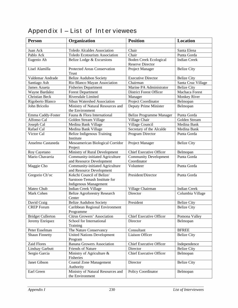
Appendix I 230 List of Interviewees
Appendix I – List of IntervieweesPerson Organization Position Location
Juan Ack Toledo Alcaldes Association Chair Santa ElenaPablo Ack Toledo Ecotourism Association Chair Punta GordaEugenio Ah Belize Lodge & Excursions Boden Creek Ecological
Reserve DirectorIndian Creek
Lisel Alamilla Protected Areas ConservationTrust
Project Manager Belize City
Valdemar Andrade Belize Audubon Society Executive Director Belize CitySantiago Ash Rio Blanco Mayan Association Chairman Santa Cruz VillageJames Azueta Fisheries Department Marine PA Administrator Belize CityWayne Bardalez Forest Department District Forest Officer Machaca ForestChristian Beck Riversdale Limited Manager Monkey RiverRigoberto Blanco Sibun Watershed Association Project Coordinator BelmopanJohn Briceño Ministry of Natural Resources and
the EnvironmentDeputy Prime Minister Belmopan
Emma Caddy-Foster Fauna & Flora International Belize Programme Manager Punta GordaAlfonso Cal Golden Stream Village Village Chair Golden StreamJoseph Cal Medina Bank Village Village Council Medina BankRafael Cal Medina Bank Village Secretary of the Alcalde Medina BankVictor Cal Belize Indigenous Training
InstituteProgram Director Punta Gorda
Anselmo Castaneda Mesoamerican Biological CorridorProject
Project Manager Belize City
Roy Cayetano Ministry of Rural Development Chief Executive Officer BelmopanMario Chavarria Community-initiated Agriculture
and Resource DevelopmentCommunity DevelopmentCoordinator
Punta Gorda
Maggie Cho Community-initiated Agricultureand Resource Development
Volunteer Punta Gorda
Gregorio Ch’oc Kekchi Council of Belize/Sarstoon-Temash Institute forIndigenous Management
President/Director Punta Gorda
Mateo Chub Indian Creek Village Village Chairman Indian CreekMark Cohen Belize Agroforestry Research
CenterDirector Columbia Village
David Craig Belize Audubon Society President Belize CityCREP Forum Caribbean Regional Environment
ProgrammeBelize City
Bridget Cullerton Citrus Growers’ Association Chief Executive Officer Pomona ValleyJeremy Enriquez School for International
TrainingDirector Belmopan
Peter Esselman The Nature Conservancy Consultant BFREEShaun Finnetty United Nations Development
ProgramLiaison Officer Belize City
Zaid Flores Banana Growers Association Chief Executive Officer IndependenceLindsay Garbutt Friends of Nature Director Belize CitySergio Garcia Ministry of Agriculture &
FisheriesChief Executive Officer Belmopan
Janet Gibson Coastal Zone ManagementAuthority
Director Belize City
Earl Green Ministry of Natural Resources andthe Environment
Policy Coordinator Belmopan
Appendix I 231 List of Interviewees
Person Organization Position LocationAllen ‘Doc’ Genus Toledo Institute for Development
and EnvironmentScience & StewardshipCoordinator
Punta Gorda
Knud Hansen Monkey River Estates Operations Manager Monkey RiverWil Heyman The Nature Conservancy Marine Scientist Punta GordaNoel Jacobs Mesoamerican Barrier Reef
SystemRegional Director Belize City
Victor Jacobs Rio Grande Cooperative Chairman Punta GordaKen Karas Belize Lodge & Excursions Managing Director BLE/Indian CreekJudy Lumb Belize Audubon Society Secretary of the Board Belize CityWil Maheia Toledo Institute for Development
and the EnvironmentExecutive Director Punta Gorda
Jake Marlin Belize Foundation for Researchand Environmental Education
Director BFREE
Pablo Maquin Indian Creek Village Alcalde Indian CreekMelanie McField World Wildlife Federation Belize Project Officer Belize CityJohn McGill EcoLogic Fund Country Representative Punta GordaBruce & CarolynMiller
Wildlife Conservation Society Zoologists Belize City
Pablo Mis Aguacaliente Wildlife Sanctuary Director Punta GordaCarlos Montero Ministry of Economic
DevelopmentEconomist Belize City
Imani Morrison Toledo Development Corporation Technical Coordinator Punta GordaMario Muschamp Payne’s Creek National Park Head Ranger Punta GordaNational ParkWorkshop
Forest Department Belmopan
Jack Nightingale Toledo Association for SustainableTourism and Empowerment
Program Director Punta Gorda
Ludwig Palacio Toledo Development Corporation General Manager Belize CityJohn Pinelo Forest Department Protected Areas Officer BelmopanLuis Pop Golden Stream Village Alcalde Golden StreamPlacida Requena Toledo Association for Sustainable
Tourism and EmpowermentPresident of Board Punta Gorda
Edilberto Romero Programme for Belize Executive Director Belize CityOswaldo Sabido Ministry of Natural Resources &
the EnvironmentChief Forest Officer Belmopan
Eleanor Sandlin Monkey River Village Council Chair Monkey RiverErnesto Saqui Belize Audubon Society Cockscomb Director Cockscomb BasinWilliam “Chet”Schmidt
Toledo Ecotourism Association Consultant Punta Gorda
Valentino Shal Toledo Maya Cultural Council /Ya’axche Conservation Trust
President/Chair Punta Gorda
Staff Meeting Belize Audubon Society Belize CityTracy Taegar Belize Tourism Board Director Belize CityBartolo Teul Ya’axche’ Conservation Trust Director Punta GordaPulcheria Teul Southern Alliance for Grassroots
Empowerment / Toledo MayaWomen’s Council
Director/Coordinator Punta Gorda
George Thompson Department of Archaeology Commissioner BelmopanTWA members Toledo Watershed Association Punta GordaUDP Officials Belize CityJ. Villafranco Lands Office Punta GordaValerie Woods-Smith Protected Areas Conservation
TrustExecutive Director Belmopan
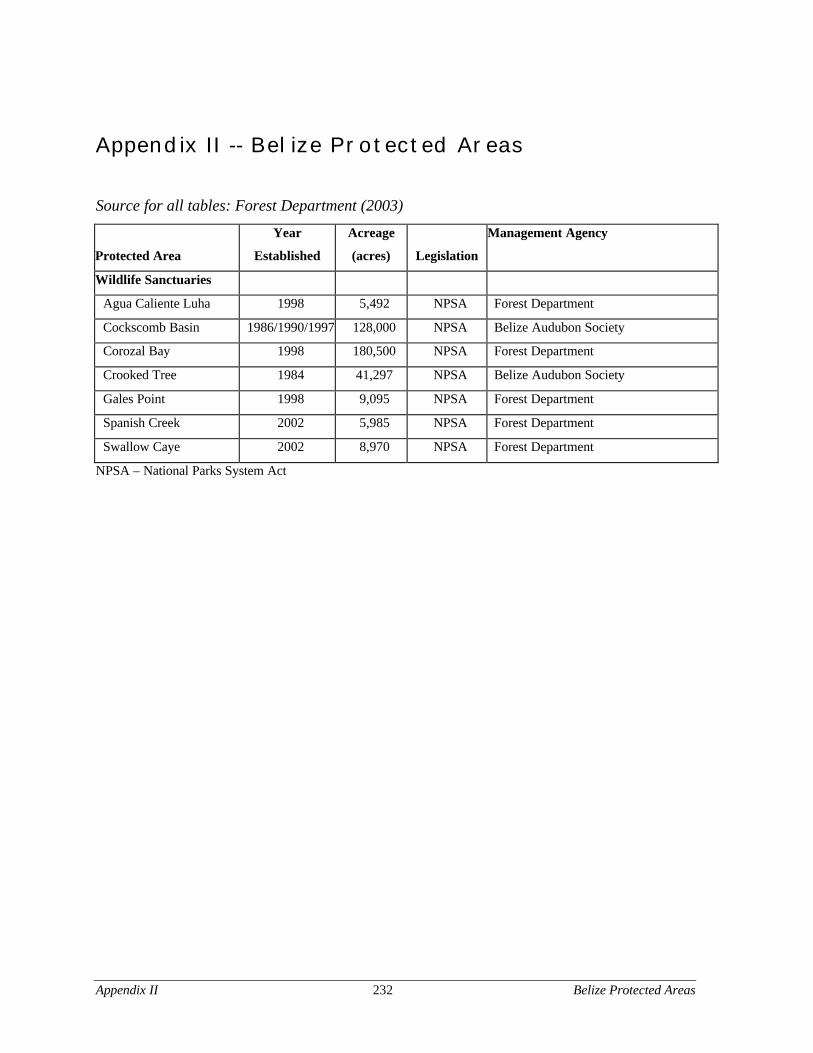
Appendix II 232 Belize Protected Areas
Appendix II -- Belize Protected Areas
Source for all tables: Forest Department (2003)
Protected Area
Year
Established
Acreage
(acres) Legislation
Management Agency
Wildlife Sanctuaries
Agua Caliente Luha 1998 5,492 NPSA Forest Department
Cockscomb Basin 1986/1990/1997 128,000 NPSA Belize Audubon Society
Corozal Bay 1998 180,500 NPSA Forest Department
Crooked Tree 1984 41,297 NPSA Belize Audubon Society
Gales Point 1998 9,095 NPSA Forest Department
Spanish Creek 2002 5,985 NPSA Forest Department
Swallow Caye 2002 8,970 NPSA Forest Department
NPSA – National Parks System Act
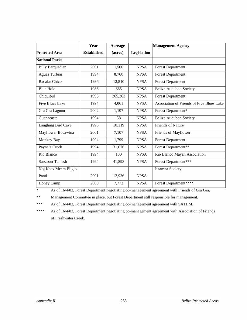
Appendix II 233 Belize Protected Areas
Protected Area
Year
Established
Acreage
(acres) Legislation
Management Agency
National Parks
Billy Barquedier 2001 1,500 NPSA Forest Department
Aguas Turbias 1994 8,760 NPSA Forest Department
Bacalar Chico 1996 12,810 NPSA Forest Department
Blue Hole 1986 665 NPSA Belize Audubon Society
Chiquibul 1995 265,262 NPSA Forest Department
Five Blues Lake 1994 4,061 NPSA Association of Friends of Five Blues Lake
Gra Gra Lagoon 2002 1,197 NPSA Forest Department*
Guanacaste 1994 58 NPSA Belize Audubon Society
Laughing Bird Caye 1996 10,119 NPSA Friends of Nature
Mayflower Bocawina 2001 7,107 NPSA Friends of Mayflower
Monkey Bay 1994 1,799 NPSA Forest Department
Payne’s Creek 1994 31,676 NPSA Forest Department**
Rio Blanco 1994 100 NPSA Rio Blanco Mayan Association
Sarstoon-Temash 1994 41,898 NPSA Forest Department***
Noj Kaax Meem Eligio
Panti 2001 12,936 NPSA
Itzamna Society
Honey Camp 2000 7,772 NPSA Forest Department****
* As of 16/4/03, Forest Department negotiating co-management agreement with Friends of Gra Gra.
** Management Committee in place, but Forest Department still responsible for management.
*** As of 16/4/03, Forest Department negotiating co-management agreement with SATIIM.
**** As of 16/4/03, Forest Department negotiating co-management agreement with Association of Friends
of Freshwater Creek.
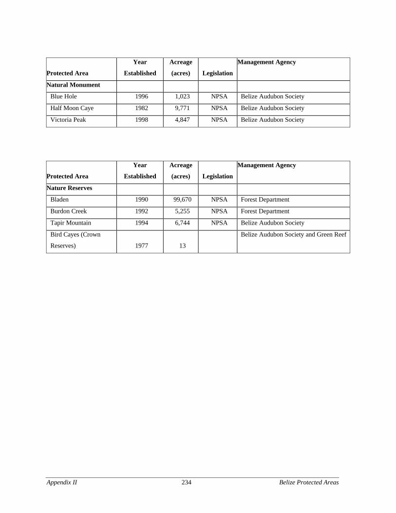
Appendix II 234 Belize Protected Areas
Protected Area
Year
Established
Acreage
(acres) Legislation
Management Agency
Natural Monument
Blue Hole 1996 1,023 NPSA Belize Audubon Society
Half Moon Caye 1982 9,771 NPSA Belize Audubon Society
Victoria Peak 1998 4,847 NPSA Belize Audubon Society
Protected Area
Year
Established
Acreage
(acres) Legislation
Management Agency
Nature Reserves
Bladen 1990 99,670 NPSA Forest Department
Burdon Creek 1992 5,255 NPSA Forest Department
Tapir Mountain 1994 6,744 NPSA Belize Audubon Society
Bird Cayes (Crown
Reserves) 1977 13
Belize Audubon Society and Green Reef
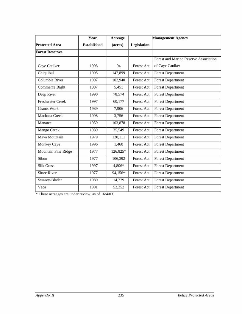
Appendix II 235 Belize Protected Areas
Protected Area
Year
Established
Acreage
(acres) Legislation
Management Agency
Forest Reserves
Caye Caulker 1998 94 Forest Act
Forest and Marine Reserve Association
of Caye Caulker
Chiquibul 1995 147,899 Forest Act Forest Department
Columbia River 1997 102,940 Forest Act Forest Department
Commerce Bight 1997 5,451 Forest Act Forest Department
Deep River 1990 78,574 Forest Act Forest Department
Freshwater Creek 1997 60,177 Forest Act Forest Department
Grants Work 1989 7,906 Forest Act Forest Department
Machaca Creek 1998 3,756 Forest Act Forest Department
Manatee 1959 103,878 Forest Act Forest Department
Mango Creek 1989 35,549 Forest Act Forest Department
Maya Mountain 1979 128,111 Forest Act Forest Department
Monkey Caye 1996 1,460 Forest Act Forest Department
Mountain Pine Ridge 1977 126,825* Forest Act Forest Department
Sibun 1977 106,392 Forest Act Forest Department
Silk Grass 1997 4,806* Forest Act Forest Department
Sittee River 1977 94,156* Forest Act Forest Department
Swasey-Bladen 1989 14,779 Forest Act Forest Department
Vaca 1991 52,352 Forest Act Forest Department
* These acreages are under review, as of 16/4/03.
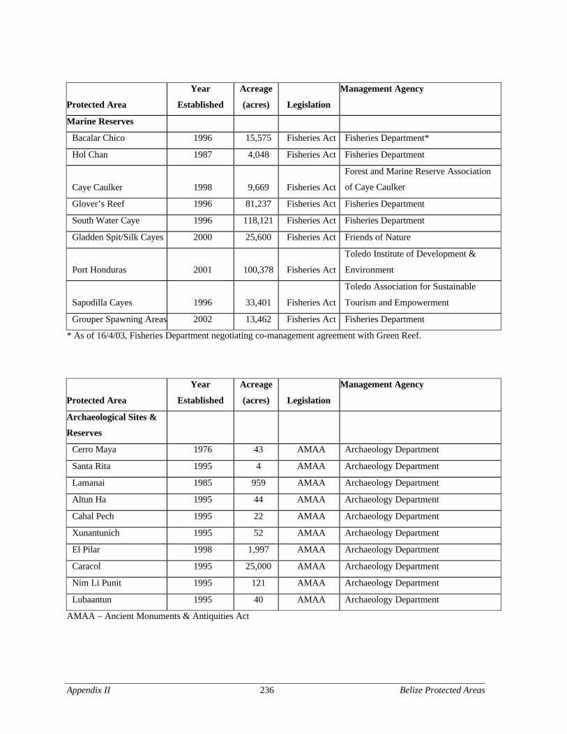
Appendix II 236 Belize Protected Areas
Protected Area
Year
Established
Acreage
(acres) Legislation
Management Agency
Marine Reserves
Bacalar Chico 1996 15,575 Fisheries Act Fisheries Department*
Hol Chan 1987 4,048 Fisheries Act Fisheries Department
Caye Caulker 1998 9,669 Fisheries Act
Forest and Marine Reserve Association
of Caye Caulker
Glover’s Reef 1996 81,237 Fisheries Act Fisheries Department
South Water Caye 1996 118,121 Fisheries Act Fisheries Department
Gladden Spit/Silk Cayes 2000 25,600 Fisheries Act Friends of Nature
Port Honduras 2001 100,378 Fisheries Act
Toledo Institute of Development &
Environment
Sapodilla Cayes 1996 33,401 Fisheries Act
Toledo Association for Sustainable
Tourism and Empowerment
Grouper Spawning Areas 2002 13,462 Fisheries Act Fisheries Department
* As of 16/4/03, Fisheries Department negotiating co-management agreement with Green Reef.
Protected Area
Year
Established
Acreage
(acres) Legislation
Management Agency
Archaeological Sites &
Reserves
Cerro Maya 1976 43 AMAA Archaeology Department
Santa Rita 1995 4 AMAA Archaeology Department
Lamanai 1985 959 AMAA Archaeology Department
Altun Ha 1995 44 AMAA Archaeology Department
Cahal Pech 1995 22 AMAA Archaeology Department
Xunantunich 1995 52 AMAA Archaeology Department
El Pilar 1998 1,997 AMAA Archaeology Department
Caracol 1995 25,000 AMAA Archaeology Department
Nim Li Punit 1995 121 AMAA Archaeology Department
Lubaantun 1995 40 AMAA Archaeology Department
AMAA – Ancient Monuments & Antiquities Act
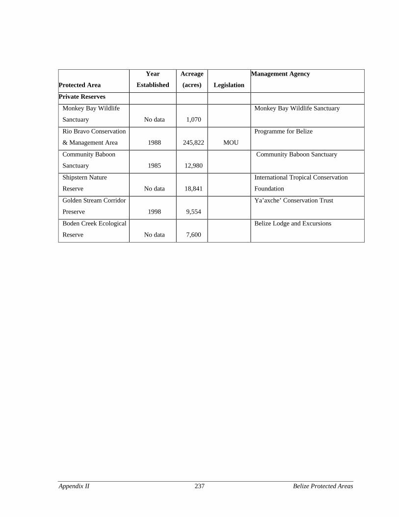
Appendix II 237 Belize Protected Areas
Protected Area
Year
Established
Acreage
(acres) Legislation
Management Agency
Private Reserves
Monkey Bay Wildlife
Sanctuary No data 1,070
Monkey Bay Wildlife Sanctuary
Rio Bravo Conservation
& Management Area 1988 245,822 MOU
Programme for Belize
Community Baboon
Sanctuary 1985 12,980
Community Baboon Sanctuary
Shipstern Nature
Reserve No data 18,841
International Tropical Conservation
Foundation
Golden Stream Corridor
Preserve 1998 9,554
Ya’axche’ Conservation Trust
Boden Creek Ecological
Reserve No data 7,600
Belize Lodge and Excursions

Appendix II 238 Belize Protected Areas
239
References
Ack, Juan. 2002. Chair. Alcaldes Association. Personal communication.
Ah, Eugenio. 2002. Boden Creek Ecological Reserve Director. Belize Lodge & ExcursionsLtd. Personal communication.
Anaya, S. James. 1998. “Maya Aboriginal Land and Resource Rights and the Conflict OverLogging in Southern Belize.” Yale Human Rights & Development Law Journal 1:2.http://www.yale/yhrdlj (31 March 2003).
Aspen Institute. “Community Strategy Group.” www.aspeninst.org/csg/csg_ccb.html (13April 2003).
Bacow, Lawrence S. and Michael Wheeler. 1984. Environmental Dispute Resolution. NewYork: Plenum Press.
Barborak, James R., Amanda D. Holmes, Gerald R. Mueller, and Jocelyn D. Peskin. 2002.Community Involvement in Establishing, Planning, and Management of GEFPriority Protected Areas in the Mesoamerican Barrier Reef System. Final reportsubmitted to the World Bank by the Wildlife Conservation Society. June 2002.
Bardalez, Wayne. 2002. District Forest Officer. Forest Department Ministry of NaturalResources and Environment. Personal communication.
Belize Center for Environmental Studies. 1997. “Proposal for the Completion ofManagement Plans for Payne’s Creek, Port Honduras, and Sapodilla Cayes.” April1997.
Belize Audubon Society. 2002a. “Aquaculture: from the Technical Version of theEnvironmental Agenda for the 21st Century,” Belize Audubon Society NewsletterBelize City: Belize Audubon Society. 34.1:5 June 2002.
Belize Audubon Society. 2002b. “Strengthening the Protected Areas System of Belizethrough Environmental Advocacy: a Project Proposal.” Belize Audubon SocietyNewsletter Belize City: Belize Audubon Society. January 2002.
Belize Explorer. 2002. Naturalight Productions. Belize - A Virtual Guide - An Overview toBelize. http://www.belizeexplorer.com/overview.html (13 April 2003).
Belize Lodge & Excursions Ltd. 2003a. “BLE: MOA BLE and TIDE sign MOA”http://www.belizelodge.com/BLE/moa_popup.html (3 April 2003)
Belize Lodge & Excursions Ltd. 2003b. “Boden Creek Ecological Reserve A Private ReserveOwned and Operated by Belize Lodge & Excursions Ltd.”http://www.belizelodge.com/BLE/cons_bodencreek.html (4 November 2002).
240
Belize Lodge & Excursions Ltd. 2003c. “Conservation Partnerships”http://www.belizelodge.com/BLE/cons_partnerhsips.html (4 November 2002).
Belize Lodge & Excursions Ltd. 2003d. “Lodge Overview.”http://www.belizelodge.com/BLE/overview_lodge.html (14 April 2003).
Belize Lodge & Excursions Ltd. 2003e. “Reports from theField.”http://www.belizelodge.com/BLE/reports.html (13 April 2003).
Belize Tourism Board. 2003a. “Another Record Year for Tourist Arrivals.”http://www.belizetourism.org/press/139.htm (4 February 2003).
Belize Tourism Board. 2003b. “Retire in Belize.” http://www.belizeretirement.org/ (31March 2003).
Belize Tourism Industry Association. 2003. “BTIA – Who We Are.”http://www.btia.org/who.html (14 April 2003).
Beltran, J., ed. 2000. Indigenous and Traditional Peoples and Protected Areas: Principles,Guidelines and Case Studies. Gland, Switzerland and Cambridge, UK: IUCN; Gland,Switzerland: WWF International [Pre-publication].
Bentrup, Gary. 2001. “Evaluation of a Collaborative Model: A Case Study Analysis ofWatershed Planning in the Intermountain West.” Environmental Management27.5:739-748.
Bernard, H. Russell. 1995. Research Methods in Anthropology: Qualitative and QuantitativeApproaches. Second Edition. Walnut Creek, California: Alta Mira Press.
Blanco, Rigoberto. 2002. Project Coordinator. Sibun Watershed Association. Personalcommunication.
Boles, E. 1999. The Sibun River Watershed Atlas. Supported by the Ministry of Education.Belize.
Brechin, Steven R. 1997. Planting Trees in the Developing World: A Sociology ofInternational Organizations. Baltimore: Johns Hopkins University Press.
Brechin, Steven R., Peter R. Wilshusen, and Charles E. Benjamin. 2003. “CraftingConservation Globally and Locally: Complex Organizations and governanceRegimes.” Contested Nature: Promoting International Biodiversity Conservationwith Social Justice in the 21st Century. Steven R. Brechin, Peter R. Wilshusen,Crystal L. Fortwrangler, and Patrick C. West, eds. Pp. 159-182. Albany: StateUniversity of New York Press.

241
Brechin, Steven R., Peter R. Wilshusen, Crystal L. Fortwangler, Patrick C. West. 2002.“Beyond the Square Wheel: Toward a More Comprehensive Understanding ofBiodiversity Conservation as Social and Political Process.” Society and NaturalResources 15:41-64.
Brett, J.M., Stephen B. Goldberg, and William L. Ury. 1994. “Managing Conflict: TheStrategy of Dispute Systems Design.” Business Week Executive Briefing Service 6:1-19.
Bromley, D.W. 1991. Environment and Economy: Property Rights and Public Policy.Cambridge, Mass.: Blackwelt.
Bryant, Raymond L. and Sinead Bailey. 1997. Third World Political Ecology. New York:Routledge.
Caddy-Foster, Emma. 2002. Country Representative. Fauna & Flora International. Personalcommunication.
Caddy-Foster, Emma. 2003. Country Representative. Fauna & Flora International. Personalcommunication.
Caddy, Emma, Gregorio Ch'oc, and Shaun Paul. 2000. "The Sarstoon-Temash Institute forIndigenous Management : A Grassroots Initiative for Social Equity and SustainableDevelopment.” Paper presentment at the IUCN World Conservation Congress,Amman, Jordan. 10 October, 2000.
Carpenter, Susan L. and W.J.D. Kennedy. 1988. Managing Public Disputes. San Francisco:Jossey-Bass Publishers.
Casey, Edward S. 1993. Getting Back into Place: Toward a Renewed Understanding of thePlace-World. Bloomington: Indiana University Press.
Central Intelligence Agency. “The World Factbook 2002 – Belize.”http://www.odci.gov/cia/publications/factbook/geos/bh.html#Govt (19 March 2003).
Central Statistical Office. 2001. “Belize National and Population Census 2000.”http://www.cso.gov.bz/statistics.html (14 April 2003).
Ch’oc, Gregorio. 2002. Chairperson/Executive Officer. Kekchi Council of Belize/ Sarstoon-Temash Institute for Indigenous Management. Personal communication.
Childers, R. A. 1994. "Cultural Protection: A Link to Tradition." Forum for AppliedResearch in Public Policy 9.4:79-83.
Clark, Charles. 2000a. “Land Tenure, Delegitimation, and Social Mobility in Tropical Peten,Guatemala.” Human Organization 59.4:419-427.
242
Clark, Charles. 2000b. “State Leasehold and Mayan Customary Cultivation Rights inBelize.” Society and Natural Resources 13:15-32.
Cleveland State University. 2003. “La Sierra Multidisciplinary Field Station.” Cleveland,Ohio. http://www.csuohio.edu/a_s/lasierra/background.htm. (14/4/2003).
CogNexus Institute. “Wicked Problems.” http://www.cognexus.org/id42.htm (April 2003).
Cook, Cynthia C. 1991. “Social Analysis in Rural Road Projects.” Putting People First:Sociological Variables in Rural Development. Second Edition. Michael Cernea, ed.Pp. 397-427. New York: Oxford University Press.
Corredor Biologico Mesoamericano. “Belize.” http://www.biomeso.net/Magazin.asp (9February 2003).
Cresswell, Tim. 1996. In Place/Out of Place: Geography, Ideology, and Transgression.Minneapolis: University of Minnesota Press.
Derman, Bill. 1995. “Environmental NGOs, Dispossession, and the State: The Ideology andPraxis of African Nature and Development.” Human Ecology 23.2: 199-115.
Duffy, Rosaleen. 2000. “Shadow Players: Ecotourism, Development, Corruption, and StatePolitics in Belize.” Third World Quarterly 21.3: 549-565.
Dukes, E. F. and K. Firehock. 2001. Collaboration: A Guide for Environmental Advocates.Charlottesville: University of Virginia
Ecologic Enterprise Ventures. “Our Borrowers.”http://www.ecologicventures.org/borr_high_bel.html (30 January 2003).
Eltringham, Peter. 2001 The Rough Guide to Belize. London: Rough Guides.
Emch, Michael. 2003. “The Human Ecology of Mayan Cacao Farming in Belize.” HumanEcology 31.1:111-131.
Enriquez, Jerry. 2002. Director. School for International Training. Personal communication.
Esselman, Peter. 2002. Consultant. The Nature Conservancy. Personal communication.
Fauna & Flora International. 2003a. “Americas Programme Golden Steam Corridor PreserveBelize.” http://www.fauna-flora.org/around_the_world/americas/belize.htm (10 April2003).
Fauna & Flora International. 2003b. “Funds & appeals Conservation funds.”http://www.fauna-flora.org/join_us/join_main_funds_frame.htm (4 April 2003).
Fauna & Flora International. 2003c. “Philosophy.” http://www.fauna-flora.org/about_us/about_main_frame.htm (10 April 2003).
243
Feld, Steven and Keith H. Basso, eds. 1996. Senses of Place. Santa Fe, New Mexico: Schoolof American Research Press.
Fowkes, Sandra. 1999. Cape Action Plan for the Environment: Situation Assessment andReview, Public Involvement Programme. Metaplan (Pty) Ltd.
Garbutt, Lindsay. 2002. Executive Director. Friends of Nature. Personal communication.
Genus, Allen. 2002. Science and Stewardship Coordinator. Toledo Institute for Developmentand Environment. Personal communication.
Gibson, Clark C. and Stuart A. Marks. 1995. "Transforming Rural Hunters intoConservationists: An Assessment of Community-Based Wildlife ManagementPrograms in Africa." World Development 23.6: 941-57.
Global Environmental Facility. 2000a. “Belize: Community Managed Sarstoon TemashConservation Project (COMSTEC) Submission of Final MSP for CEOEndorsement.” Office Memorandum. Washington, D.C.: World Bank/GlobalEnvironment Facility.
Global Environmental Facility. 2000b. “Status of GEF Projects.”http://www.gefweb.org/Map/orgp_2000-12.pdf.
Global Environmental Facility. 2001. “Central America – The Conservation and SustainableUse of the MesoAmerican Barrier Reef System (MBRS).” GEF Project Document.Implementing Agency – The World Bank. May 2001.
Government of Belize. n.d.[1997]. Preparation and Implementation of a Training Programfor Protected Wetlands Personnel in Belize. Belize Forest Department.
Government of Belize. 1998. National Poverty Elimination Strategy and Action Plan 1998 –2003. Prepared by the National Human Development Advisory Committee.Belmopan: Government Printer.
Government of Belize. 1999. Memorandum Decision on the Management of Payne's CreekNational Park. Belize Forest Department. 22 February 1999.
Government of Belize. 2000a. “Belize National Lands Act.” Chapter 191. The SubstantiveLaws of Belize. Revised Edition 2000. Belmopan: Government Printer.
Government of Belize. 2000b. “Ten Points of Agreement between the Government of Belizeand the Maya Peoples of Southern Belize.”http://www.belize.gov.bz/features/maya_agreement/agreement.html (13 April 2003).
Government of Belize. 2000c. Environmental & Social Technical Assistance Project 2000Regional Development Plan for Southern Belize – a Plan for the Southern Region ofBelize. Belmopan: GOB, April 2000.
244
Government of Belize. 2001. “Memorandum of Understanding for Co-management of thePort Honduras Marine Reserve between the Fisheries Department Government ofBelize and Toledo Institute for Development and Environment.” Belize FisheriesDepartment. 31 May 2001.
Government of Belize. 2002a. “The Belize-Guatemala-Honduras Ecological Park: BasicElements of Tri-Partite Agreement.” Organization of American States. Washington,D.C. http://www.belize.gov.bz/features/maya_agreement/welcome.html (13 April2003).
Government of Belize. 2002b. Draft Medium Term Economic Strategy Paper 2003-2005.Belmopan: Belize.
Government of Belize.2003a. “About Belize.”http://www.belize.gov.bz/belize/welcome.html (13 April 2003).
Government of Belize. 2003b. “About Belize – the Economy.”http://www.belize.gov.bz/belize/economy.html (13 April 2003).
Government of Belize. 2003c. “About Belize – the Politics.”http://www.belize.gov.bz/belize/political.html (13 April 2003).
Government of Belize. 2003d. “Maya Leaders Celebrate – GOB Delivers.”http://www.belize.gov.bz/features/maya_agreement/welcome.html (13 April 2003).
Government of Belize. 2003e. “Maya People of Southern Belize Millennium Declaration.”http://www.belize.gov.bz/features/maya_guate/welcome.html (13 April 2003).
Government of Belize. 2003f. “Letter from the Forest Department Protected Areas Programto Wil Maheia.” Belize Forest Department. 17 January 2003.
Gray, Barbara. 1985. “Conditions Facilitating Interorganizational Collaboration.” HumanRelations 38.10: 911-936.
Gray, Barbara. 1989. Collaborating: Finding Common Ground for Multiparty Problems. SanFrancisco: Jossey-Bass Publishers.
Grimble, Robin and Man-Kwun Chan. 1995 “Stakeholder Analysis for Natural ResourceManagement in Developing Countries: Some Practical Guidelines for MakingManagement more Participatory and Effective.” Natural Resources Forum 19.2:113-124.
Hayden, Tom. 2003. “Seeking a New Globalism in Chiapas.” The Nation 279.13:18-23.
Hewitt, Kenneth. 1997. Regions of Risk: A Geographical Introduction to Disasters. London:Longman.
245
Heyman, Will. 2003. Senior Marine Scientist. The Nature Conservancy. Personalcommunication.
Indian Law Resource Center. 1998. Maya File Petition with the Inter-American Commissionon Human Rights. August 10, 1998. ILRC Press Release Archives.http://www.indianlaw.org/maya_file_petition.htm (13 April 2003).
Indian Law Resource Center. 2000. Historic Agreement in Belize: Inter-AmericanCommission on Human Rights will decide Indian Law Rights Case against Belize.October 25, 2000. Helena, MT: ILRC Press Release Archives.http://www.indianlaw.org/belize_signing.htm (13 April 2003).
Ingold, Tim. 1993. “The Temporality of Landscape.” World Archaeology 25.2:152-174.
Instituto Nacional de Biodiversidad. 2003. “Prospección de la Biodiversidad.” San Jose,Costa Rica. http://www.inbio.ac.cr/es/pdb/Prosp.html. (14/4/2003).
Inter-American Commission on Human Rights. 2000. Maya Indigenous Communities andtheir Members, Belize. Report No. 78/00 Case 12.053 Organization of AmericanStates. 5 October 2000.
Inter-American Development Bank. 2001. Belize Land Management Program (BL-0017);Project Report. Internal document. Belize City: IADB.
Inuit Circumpolar Conference. 2003. “Co-Management.”http://www.inuitcircumpolar.com/Activities/international_dev_summary/Belize_indigenous_training_ins/co-management/co-management.html (8 April 2003).
Iremonger, S. and R. Sayre. 1994. Bladen Nature Reserve, Rapid Ecological Assessment. AStudy by The Nature Conservancy, Belize Audubon Society, and the Ministry ofNatural Resources.
Johnson, Melissa. 1998. Nature and Progress in Rural Creole Belize: Rethinking SustainableDevelopment. Dissertation for completion of Ph.D. in Anthropology, University ofMichigan.
Karas, Kenneth N. 2002. Managing Director. Belize Lodge & Excursions, Ltd. Personalcommunication.
Kirsch, Stuart. “Indigenous Response to Environmental Impact along the Ok Tedi.”Compensation for Resource Development in Papua New Guinea. Susan Toft, ed. Pp.143-155. Canberra: The Australian National University.
Kottak, Conrad P. and Alberto C. G. Costa. “Ecological Awareness, EnvironmentalistAction, and International Conservation Strategy.” Human Organization 52.4:335-343.
246
Larsen, P.B. 2000. Managing Protected Areas with Indigenous Peoples: A Global Review(Draft). Washington, D.C.: People and Conservation Unit, World Wildlife FundInternational.
Lawrence, R.L. and D.A. Deagen. 2001. “Choosing Public Participation Methods for NaturalResources: A Context-Specific Guide.” Society and Natural Resources 14:857-872.
Lazaroff, Cat. 2001. “Landmark Deal Will Protect Rainforests in Belize.” EnvironmentalNews Service. August 3, 2001. http://forests.org/recent/2001/lmdealwi.htm (27October 2002).
Leslie, Robert, ed. 1995. A History of Belize: Nation in the Making. Revised Edition. BenqueViejo, Belize: Cubola Productions.
Levine, Sol and Paul E. White. 1961. "Exchange as a Conceptual Framework for the Study ofInterorganizational Relationships." Administrative Science Quarterly 5:4 583-601.
Litterer, J. 1997. “Belize Logging Conflict,” ICE Case Studies. Case no. 12. Spring 1997.
Lockwood, Jeff. 1997. “Forest and People of Southern Belize Face New Threats,” NewsNotes. 29 September, 1997. Portland, OR: Rainforest Relief. Rainforest ReliefWebsite: http://www.rainforestrelief.org/newsnotes/belize_threat.htm (13 April2003).
Lumb, Judy. 1998. The Sarstoon-Temash National Park Stakeholders Workshop. CayeCaulker: Producciones de la Hamaca.
Lumb, Judy. 2002. Secretary of the Board. Belize Audubon Society. Personalcommunication.
Maheia, Wil. 2002. Executive Director. Toledo Institute for Development and theEnvironment. Personal communication.
Maheia, Wil. 2003. Executive Director. Toledo Institute for Development and theEnvironment. Personal communication.
Marin, Magali G. 2003. Comments on BAS internal document.
Marlin, Jake. 2002. Director. Belize Foundation for Research and Environmental Education.Personal communication.
Massey, Doreen. 1994. “Double Articulation: A Place in the World. Displacements: CulturalIdentities in Question. A. Bammer, ed. Pp. 110-121. Bloomington: IndianaUniversity Press.
Maya Leaders’ Alliance Mapping Center. “Co-management.”http://www.geocities.com/mayacomanage/comanage.htm (14 April 2003).
247
McGill, John. 2002. Country Representative. EcoLogic Development Fund. Personalcommunication.
McNeely, Jeff A. and David C. Pritt, eds. 1985. Culture and Conservation: The HumanDimension in Environmental Planning. London: Croom Helm.
Meerman, J.C., & W. Sabido. 2001. Central American Ecosystems Map – Belize Volume 1.Programme for Belize, Belize City, Belize.
Miller, K., E. Chang and N. Johnson. 2001. Defining Common Ground for the MesoamericanBiological Corridor. World Resources Institute.
Monk, J.H., and F. Penados. 2002. Beyond Reconstruction: the Post-Hurricane Challenge toGrassroots Development in Toledo District Belize. Punta Gorda, Belize: ToledoMaya Leaders Alliance. 31 January 2002.
Moran, Emilio. 1979. “The Trans-Amazonica: Coping with a New Environment.” Brazil:Anthropological Perspectives – Essays in Honor of Charles Wagely. M.L. Maxine L.Margolis and William E. Carter, eds. Pp. 133-159. New York: Columbia UniversityPress.
Murray, M.R., S.A. Zisman, P.A. Furley, D.M. Munro, J. Gibson, J. Ratter, S. Bridgewater,C.D. Minty, and D.J. Place. 2003. “The Mangroves of Belize: Part 1. Distribution,Composition and Classification.” Forest Ecology and Management 174:265-279.
Myvett, G., and R. Quintana. 2002. “The Status of Aquaculture in Belize 2001,” BelizeAudubon Society Newsletter 34.1:5.
News 5 Online. 2000. “Prime Minister Signs Agreement with Toledo Maya.” Belize City.News 5. 12 October 2000. http://www.channel5belize.com/news/archive/12-10-2000-news.shtml#5 (13 April 2003).
News 5 Online. 2002. “People at cayes say tri-national park can work.” 14 October 2002.News 5. http://www.channel5belize.com/news/archive/14-10-2002-news.shtml#1 (14April 2003).
Nietschmann, Bernard. 1973. Between Land and Water: The Subsistence Ecology of the Miskito Indians, Eastern Nicaragua. New York: Seminar Press.
Oceans Daily. 2001. “House approves coral reef protection measure.” E&E Publishing, LLC.Washington D.C. 18 October 2001.
Oliver-Smith, Anthony and Susanna M. Hoffman, eds. 1999. The Angry Earth: Disaster inAnthropological Perspective. New York: Routledge.
Orlove, Ben. 2002. Lines in the Water: Nature and Culture at Lake Titicaca. Berkeley:University of California Press.
248
Peck, Gregory P. and Carla E. Hague. 2003. “Ohio State Fact Sheet: Turf Issues.”http://ohioline.osu.edu/bc-fact/0012.html (13 April 2003).
Peluso, Nancy L. 1992. Rich Forests, Poor People: Resource Control and Resistance inJava. Berkeley: University of California Press.
People United Party. 2003. “Manifesto: Keep Belize Free.” People’s United Party.http://www.pupbelize.org/manifesto.htm (13 April 2003).
Pinelo, J.A. 2000. A Critical Analysis of the Management Constraints Within the NationalParks System of Belize. Dissertation submitted in partial fulfillment of therequirements for the M.Sc. in Rural Resources and Environmental Policy. ImperialCollege at Wye, University of London.
Pinelo, John. 2002. Protected Areas Officer. Forestry Department Ministry of NaturalResources and Environment. Personal communication.
Pinkerton, Evelyn.1989. Cooperative Management of Local Fisheries: New Directions forImproved Management and Community Development. Vancouver: University ofBritish Columbia Press.
Primack, R., David Bray, Hugo Galleti and Ismael Ponciano. 1998. Timber, Tourists andTemples: Conservation and Development in the Maya Forest of Belize.Guatemalaand Mexico. Washington, D.C. Island Press.
Programme for Belize.1996. National Protected Area Systems Plan for Belize: SynthesisReport. Belize City: Programme in collaboration with Inter-American DevelopmentBank.
Protected Areas Conservation Trust. 2001. “Protected Areas Conservation Trust 2000 AnnualReport.” Belmopan City, Belize.
Prufer, Keith M. and Phil Wanyerka. 2001. “The Maya Mountains Arcaheological Project1992-2000: A Regional Investigation of Late Classic Settlement and Economy.”Paper presented at the 66th Annual Meeting of the Society for American Archaeology.New Orleans, Louisiana.
Ravndal, V. 2002. Final Project Evaluation - Community Co-Managed Park System forBelize (Final Draft). A UNDP/GEF Project funded by GEF and PACT. October2002.
Quarantelli, E.L., ed. 1998. What Is a Disaster? Perspectives on the Question. New York:Routledge.
Ribot, J.C. 2002. Democratic Decentralization of Natural Resources: InstitutionalizingPopular Participation. World Resources Institute.
249
Rittel, Horst W. J. and Melvin M. Webber. 1973. “Dilemmas in a General Theory ofPlanning.” Policy Sciences 4:155-169.
Sabido, Oswaldo. 2002. Chief Forest Officer. Ministry of Natural Resources andEnvironment. Personal communication.
Salas, Osmany. 2003. “Proceedings - Meeting of Protected Areas ManagementOrganizations.” Sponsored by Belize Audubon Society and UNDP-Belize.Belmopan, Belize.
Sandlin, E. 2002a. “Justification for the Management of the Payne’s Creek National Park bythe Monkey River and Punta Negra Communities.” (letter to Prime Minister). 16August 2002.
Sandlin, Eleanor. 2002b Chair. Village Council Monkey River. Personal communication.
Saqui, Ernesto. 2002. Director Cockscomb Wildlife Sanctuary. Belize Audubon Society.Personal communication.
Scott, James C. 1998. Seeing like a State: How Certain Schemes to Improve the HumanCondition Have Failed. New Haven, CT: Yale University Press.
Selin, Steven and Deborah Chavez. 1995. “Developing a Collaborative Model forEnvironmental Planning and Management,” Environmental Management 19:2: 189-195.
Shal, Valentino. 2002a. “The Maya and their Land,” The Belize Times. Belize City. 19 May2002.
Shal, Valentino. 2002b. “Respect the Maya!” The Belize Times. Belize City. 21 July 2002.
Shal, Valentino. 2002c. President/Chair. Toledo Maya Cultural Council/Ya’axcheConservation Trust. Personal communication.
Sherif, Muzafer. 1958. “Superordinate Goals in the Reduction of Intergroup Conflicts.”American Journal of Sociology 63.1:349-358.
Shoman, Assad. 1994. 13 Chapters of a History of Belize. Belize City: The Angelus Press,Ltd.
Susskind , Lawrence E. and Alan Weinstein. 1980. “Towards a Theory of EnvironmentalDispute Resolution.” Boston College Environmental Affairs Law Review 9.31:311-357.
Susskind, Lawernce and Jeffrey Cruikshank. 1987. Breaking the Impasse: ConsensualApproaches to Resolving Public Disputes. New York: Basic Books, Publishers.
Taegar, Tracy. 2002. Director. Belize Tourism Board. Personal communication.
250
Terborgh, John. 1999. Requiem for Nature. Washington, D.C.: Island Press/ShearwaterBooks.
Teul, Bartolo. 2002. Programme Director. Ya’axche’ Conservation Trust. Personalcommunication.
Teul, Bartolo. 2003. Programme Director. Ya’axche’ Conservation Trust. Personalcommunication.
Teul, Pulcheria. 2002. Director/Coordinator. Southern Alliance for GrassrootsEmpowerment/ Toledo Maya Women’s Council. Personal communication.
The Nature Conservancy. 2001. “Landmark Deal to Protect Rainforests in Belize.” August 2,2001. http://nature.org/wherewework/centralamerica/belize/press/press351.html(6 April 2003).
The Nature Conservancy. 2002. “Draft Conservation Partnership Agreement The NatureConservancy and the Belize Audubon Society.” Submitted by TNC to BAS. 17December 2002.
The Nature Conservancy. 2003a. “Marine Initiative.” http://nature.org/initiatives/marine/(6 April 2003).
The Nature Conservancy. 2003b. “Belize Program – Maya Mountain Marine Corridor.” Inhttp://nature.org/wherewework/centralamerica/belize/work/art8603.html (6 April2003).
Toledo Institute for Development and the Environment.1998. “Draft Management Plan forthe Payne’s Creek National Park.” Toledo District, Belize. July 1998.
Toledo Institute for Development and the Environment. 1999. “Letter from TIDE to thePermanent Secretary, Ministry of Natural Resources and the Environment.” 16 April1999.
Toledo Institute for Development and the Environment. 2000. “Maya Mountains MarineArea Transect Site Conservation Plan.” December 2000.
Toledo Institute for Development and the Environment. 2002. “Maya Mountain Marine AreaTransect Aquatic Systems Plan.” Version 3.1. Vol. 2. June 2002.
Toledo Institute for Development and the Environment. 2002. “Maya Mountain Marine AreaTransect Appendices.” Version 3.1. Vol. 3. June 2002.
Toledo Institute for Development and the Environment. 2003a. “Tri-National Alliance for theConservation of the Gulf of Honduras.” http://www.tidebelize.org/Tri-National%20Alliance.htm (14 April 2003).
251
Toledo Institute for Development and the Environment. 2003b. “TIDE Private LandsInitiative” http://www.tidebelize.org/Private%20Lands%20Initiative.doc (4 April2003)
Toledo Institute for Development and the Environment. 2003c. “TIDE Tours.”http://tidebelize.org/ (14 April 2003).
Toledo Institute for Development and the Environment. 2003d. “Methodology for Revisionand Finalization of the Payne’s Creek National Park Management Plan.” PuntaGorda Town, Toledo, Belize. 14 January 2003.
Toledo Maya Cultural Council and Toledo Alcaldes Association. 1997. “Maya Atlas: TheStruggle to Preserve Maya Land in Southern Belize.” Berkeley, CA: North AtlanticBooks.
Toledo Maya Cultural Council.1998. “Maya File Petition with the Inter-AmericanCommission on Human Rights.” Helena, MT: ILRC Press Release Archives. 10August 1998. http://www.indianlaw.org/maya_file_petition.htm (13 April 2003).
Toledo Maya Cultural Council. 1999. “Government of Belize Holds Consultations withToledo Residents for Future Development Plans.” TMCC Newsletter. November1999. http://www.toledomaya.org/nov_news07.html (13 April 2003).
Toledo Maya Cultural Council. 2003. “Maya People of Southern Belize.”http://www.toledomaya.org/maya.html (13 April 2003).
Toledo Watershed Association. 2002a. “TWA Planning Meeting.” 4 July 2002.
Toledo Watershed Association. 2002b. TWA Proposal. “Draft Concept Paper” 11 July 2002.
Van Ausdal, Shawn. 2001. “Development and Discourse among the Maya of SouthernBelize.” Development and Change. 32:563-592.
van der Linde, Harry, Judy Oglethorpe, Trevor Sandwith, Deborah Snelson, and YemeserachTessema (with contributions from Anada Tiéga and Thomas Price). 2001. BeyondBoundaries: Transboundary Natural Resource Management in Sub-Saharan Africa.Washington, D.C.: Biodiversity Support Program.
Wainwright, Joel David. 1998. Interpreting the Political Ecology of Land in Southern Belize.Masters Thesis, Department of Geography. University of Minnesota.
Wainwright, Joel David. 2002. An Evaluation of the CARD Project. Department ofGeography, University of Minnesota.
Werlen, Benno. 1993. Society, Action, and Space: An Alternative Human Geography. NewYork: Routledge.
252
Western, David, R. Michael Wright, and Shirley C. Strum, eds.1994. Natural Connections:Perspectives in Community-Based Conservation. Washington, D.C.: Island Press.
White, Alan T., Lynne Zeitlin Hale, Yves Renard, and Lafcadio Cortesi, eds. 1994.Collaborative and Community Based Management of Coral Reefs. West Hartford,Connecticut: Kumarian Press.
White, T. Anderson and C. Ford Runge. 1995. “The Emergence and Evolution of CollectiveAction: Lessons from Watershed Management in Haiti.” World Development 23.10:1683-1698.
Wilk, Richard. 1991. Household Ecology: Economic Change and Domestic Life Among theKekchi Maya of Belize. Tucson: University of Arizona Press.
Wilshusen, Peter R., Steven R. Brechin, Crystal L. Fortwrangler, and Patrick C. West. 2002.“Reinventing a Square Wheel: Critique of a Resurgent ‘Protection Paradigm’ inInternational Biodiversity Conservation.” Society and Natural Resources 15: 17-40.
Wondolleck, Julia M. 1985. “The Importance of Process in Resolving EnvironmentalDisputes.” Environmental Impact Assessment Review 5:341-356.
Wondolleck, Julia M. and Steven L. Yaffee. 2000. Making Collaboration Work: Lessonsfrom Innovation in Natural Resource Management. Washington, D.C.: Island Press.
Wondolleck, Julia M., Barbara Gray, and Todd Bryan. 2003 (forthcoming). “Us versusThem: How Identities and Characterizations Influence Conflict.” EnvironmentalPractice. September.
Woods, Valerie. 2002. Executive Director. Protected Areas Conservation Trust. Personalcommunication.
Woods, Valerie. 2003. “Letter to Eleanor Sandlin” (on behalf of PACT). 28 January 2003.
World Bank. 2001 Project Appraisal Document on a Proposed Project for US$15.2 Million,including a Grant from the Global Environment Facility Trust Fund in the Amount ofUS$11.0 Million Equivalent to the Central American Commission on Environmentand Development for a Regional Project for the Conservation and Sustainable Use ofthe MesoAmerican Barrier Reef System (MBRS). Washington, D.C.: ESSD/WorldBank. 5 April 2001.
World Wildlife Fund. 2003a.“Ecoregions.”http://www.worldwildlife.org/ecoregions/abstract.htm (31 March 2003).
World Wildlife Fund. 2003b. “Endangered Species: The Global 200.”http://www.worldwildlife.org/global200/spacessection.cfm?sectionid=115&newspaperid=20&contentid=167 (13 March 2003).
253
Ya’axche Conservation Trust n.d.[2003]. Building Sustainable Livelihoods & ForestsBrochure.
Yaffee, Steven L. 1999. “Three Faces of Ecosystem Management.” Conservation Biology13:4: 713-725.
Yaffee, Steven L., Julia M. Wondolleck, and Steven Lippman.1997. “Factors that Promoteand Constrain Bridging: A Summary and Analysis of the Literature.” ReportSubmitted to the USDA Forest Service, Pacific Northwest Research Station underUSDA Cooperative Agreement #PNW 95-0728. Ann Arbor, Michigan: EcosystemManagement Initiative.

254
255
Endnotes
1 This project follows Grimble and Chan’s (1995:114) inclusive definition of key actors or stakeholders: “By
‘stakeholders’ is meant all those who affect, and/or are affected by, the policies, decisions and actions of [a
program]; they can be individuals, communities, social groups or institutions of any size, aggregation or level in
society.” Fowkes (1999) refines the term by focusing on the actions of stakeholders. Stakeholders are “[those]
who will directly influence the outcome [of a program] because of their mandate or close interest...and those
who are directly influenced by the outcome because of their close interest; [those] who will interact with the
developing program, and maintain close contact as it develops…; those who will give input, …and who can in
turn provide information and perspective; and the general public, which may need to be kept informed, but may
not be directly affected” (in van der Linde et. al 2001:19-20; emphasis added).
2 Alcaldes are traditional Maya chieftains or lawmen. The alcalde system dates back to 1871, when the colonial
government granted to local indigenous community elders the right to decide minor civil and criminal cases and
gave them the responsibility to administer the local census. The alcaldes, after deliberation with their local
council of elders, were initially allowed to settle village conflicts over land and forest resources. The first
alcalde was elected in a village in western Belize in 1885, and the alcalde system was brought within the official
national judicial system in 1913 via the passage of the Alcalde Ordinance. This law expressly prohibited the
village alcaldes from exerting power over land disputes. The alcaldes, however, retained distributive authority
over “abandoned and unclaimed land” until 1964, when the GOB instituted the land leasehold system. The state
thereby became the sole authority over land in Belize (Clark 2000b).
3 Chicle is the sap of the Sapodilla tree, and was used as the base ingredient in the production of chewing gum.
4 Earnings and revenues are quoted in Belize dollars. The exchange rate is fixed at BZ$2 to US$1.
5 The Central American Ecosystems Mapping Project is part of a larger project commissioned by the World
Bank and the Government of the Netherlands to undertake a series of regional activities throughout Central
America. The primary objective of the project was to create an ecosystems map on the scale of 1:250,000 for
the region, using a uniform methodology and nomenclature. The objective of the Belizean component of the
project was to update and correct the 1995 vegetation map of Belize.
6 The CZMA is an autonomous public statutory body charged with the responsibility of implementing and
monitoring policies that govern the use and development of the coastal zone in Belize.
7 This 2002 World Bank/Wildlife Conservation Society survey was entitled “Community Involvement in
256
Establishment, Planning, and Management of GEF Priority Protected Areas in the Mesoamerican Barrier Reef
System.”
8 Southern Belize refers to the southern half of the Stann Creek District and the entire Toledo District.
9 ECOFOR is one of several closely-help companies with “responsibility for the management of over 300,000
acres of timberlands”, jointly referred to as Woodward Companies that are owned and operated by the
Woodward family of the United States of America.
10 Mayas in Southern Belize commonly self-identify as “Toledo Maya” to distinguish themselves from the
Yucatec Mayas of northern Belize and the “Belizean Mayas,” Mopan and Kekchi Maya who reside outside of
the District (Wainwright 1998:35n).
11 Descendent from early Spanish codes of governance in the Americas, the Belizean alcalde system was
codified in 1871, when the colonial government granted local indigenous community elders the right to preside
over minor civil and criminal cases and gave them the responsibility to administer the local census. Alcaldes,
after deliberation with their local council of elders, were initially allowed to settle village conflicts over land
and forest resources. The alcalde system was co-opted by the national judicial system in 1913 via the passage of
the Alcalde Ordinance. This law expressly prohibited the village alcaldes from exercising power in land
disputes. Alcaldes retained distributive authority over “abandoned and unclaimed land” until 1964 when the
GOB instituted the “leasehold system.” The state thereby became the sole authority over land in Belize (Clark
2000b).
12 The Maya Atlas (1997) is the product of an extensive mapping project undertaken by the TMCC and TAA
between 1995 and 1997. The Atlas provides a cartographic foundation for the recognition of Maya land claims.
13 The Inuit Circumpolar Conference formed in 1977 as a multi-national indigenous NGO representing Inuit
people of Alaska, Canada, Russia, and Greenland. The ICC is active to the level of the United Nations in order
to protect its homeland, defend Inuit rights, and foster sustainable development. Transfer of skills and
experience to other indigenous organizations like the MLA and SATIIM is part of the International
Development and Trade mission of the ICC. The project with the MLA is primarily based on the experience of
Inuit from Nunavik, Canada (ICC 2003).
14 Nearly all of the Maya organizations (and most other southern NGOs) are based in the coastal town of Punta
Gorda, the largest town in the Toledo District.
257
15 SAGE, a coalition of local and national NGOs, was formed in 1998 to address the negative impacts of the
Southern Highway expansion. SAGE now addresses logging issues and regional watershed management (See
Chapter Six).
16 The combination of governmental antagonism and community resistance is not unique to the story of
SATIIM. A similar scenario unfolded when the establishment of Crooked Tree Wildlife Sanctuary usurped
existing Creole communities’ control over their traditional fishing grounds (Johnson 1998).
17 Land of the Free. Lyrics: Samuel Alfred Haynes, 1963; music: Selwyn Walford Young, 1963; National
Anthem of Belize adopted, 1981.
18 The EcoLogic Development Fund (EDF) and the International Fund for Agricultural Development (IFAD)
helped support SATIIM. EDF, a US-based environmental NGO, started in 1993 to foster conservation in Latin
America through sustainable development and community based management of natural resources. IFAD, a
specialized agency of the United Nations, was created in 1977 to address issues of food insecurity by financing
agricultural development projects in rural areas of developing countries. Pertinent to Southern Belize, IFAD’s
target groups include indigenous people and the rural landless.
19 This area is also referred to as the Maya Mountain Marine Corridor (MMMC) and the Port Honduras
Watershed Area (PHWA).
20 TNC started investing in Belize in early 1993 via a regional project, the Proyecto Ambiental para Centro
America (PACA). At the time, the Belize Center for Environmental Studies (BCES), an environmental research
NGO based in Belize City, was its main partner in Belize. TNC looked at the results of a Critical Habitat Study
conducted by BCES, which determined that it was critical to protect the Deep River-Port Honduras corridor.
21 Approximately 77,000 acres of the Toledo District is officially classified as “Indian Reservation.” There are
disputed accounts of the status of the Maya Reservations. The only statutory rules governing the reservations
were adopted in 1924 and these have never been revised (GOB 2000c). The National Lands Act, “makes no
mention of Indian Reservations as such, only referring to ‘reserves’ which may or may not be applicable” (GOB
2000c). However, the Toledo Maya Cultural Council (TMCC), a non-governmental organization (NGO) which
represents the Mopan and Kekchi of the Toledo District, claims that these reservations continue to exist under
the laws of Belize, but that they only include roughly half of the Maya villages that currently exist (IACHR
Report No. 78/00 2000). Currently, authority to distribute lands within the reservations (for residential and
farming purposes) is unofficially exercised by village alcaldes (traditional Maya chieftains or lawmen) and/or
Village Council Chairmen (GOB 2000c). The ten existing reservations now encompass 16 communities with an
approximate population of 6,500 Maya (IADB 2001). There are at least 21 Maya communities that have been
258
established outside the reservation boundaries. In total, the Toledo District is home to approximately 15,000
Mopan and Kekchi Mayas (Shal 2002a).
22 At the time, with TNC support, Heyman was conducting a multidisciplinary study aimed at determining how
to maximize ecological and socioeconomic benefits of corridors.
23 According to the SCP Consultant, the “SCP is an analysis of ecological systems in need of conservation,
priority threats to these systems, and priority strategies needed to abate these threats. [The SCP is also]
described as a process focused on the conservation of biodiversity, which brings in human considerations in the
discussion of threats to biodiversity and conservation strategies. Because there is no explicit assessment of
human needs, the MMMAT SCP should not be considered a management or development plan for the area, but
rather an appraisal of threats to ecological processes and biodiversity at the site” (TIDE 2002a).
24 The SAGE/TWA story provides more details about these recent collaborative efforts at the multi-watershed
scale.
25 PACT is a statutory trust fund, based in the capital city of Belmopan, which provides financial assistance for
activities that foster conservation, sustainable development, and management of protected areas.
26 Several conservation NGOs working in the Gulf of Honduras watershed banded together in 1996 to form
TRIGOH, whose mission is “to preserve the biological diversity of the Gulf of Honduras and improve the
quality of life of the local communities” (TIDE 2003a).
27 BTIA is a national, non-profit, private-sector membership organization that “promotes the development of
sustainable, eco-cultural tourism.” Its over 400 members are represented on many tourism and environmental-
related government, legislative, advisory, consultative and licensing committees. BTIA’s main purpose is to
“serve and promote the interests of its members, to develop and promote the Belize tourism product and to
influence and secure the improvement of the [tourism] industry” (BTIA 2003).
28 The factors that enable these two alliances to be more effective are discussed in Chapters Three and Six,
respectively.
29 This meeting was co-sponsored by the Belize Audubon Society and UNDP-Belize.
30 CARD was established in 1999 and initiated in March 2000 under the Ministry of Agriculture and Fisheries.
The project was designed to, among other functions, invest in the institutional capacity of community-based
organizations and institute a microfinance program that aims to make credit available to even the poorest
households in Southern Belize (Wainwright 2002).
259
31 See the Bladen Consortium story for more details.
32 Given that these arrangements are rarely accompanied by financial resources, it can be argued that this
represents a devolution of roles and responsibilities from GOB to NGOs and CBOs, rather than actual “co-
management.”
33 BACONGO is a national alliance of Belizean conservation NGOs that seeks to support the efforts of its
members and to advocate for natural resource conservation and sustainable development in Belize.
34 As previously stated, ECOFOR is one of several closely-help companies with “responsibility for the
management of over 300,000 acres of timberlands”, jointly referred to as Woodward Companies, which are
owned and operated by the Woodward family of the USA.
35 The Arcadia Fund “works to secure the future of land with globally significant biodiversity by establishing
protected areas through direct land purchase.” (FFI 2003b)
36 The inception of TIDE is described in Chapter Five.
37 “The National Biological Corridors Program (NBCP) under the guidance of the Mesoamerican Biological
Corridors Project (MBC) is in the process of establishing itself for the continuity and sustainability of all
activities implemented by the MBC towards the establishment of biological corridors locally” (CBM 2003).
38 See Toledo Watershed Association and SAGE Case Study
39 According to Belize Audubon Society an easement is not permissible under Belize’s real estate laws. For an
easement to exist there must be a dominant and servient tenement in essence, two land owners with adjacent
tracts. To achieve the same concept of a conservation easement, restrictive covenants and positive covenants
may be put in place at the time of the acquisition of the title. Additionally the two landowners may execute
contracts that bind each other which may be recorded as an encumbrance on the title (Marin 2003).
40 The purpose of the agreement (signed October 25, 2002) is as follows: “Whereas [BLE] a corporation, and
known as the eco-tourism operator and [TIDE] a non-profit organization, and known as the local conservation
partner have expressed their mutual intention to enhance cooperation between them and to promote the
conservation and development that will guarantee long term sustainable utilization and maintain the ecological
integrity of the Golden Stream River and the Port Honduras Marine Reserve while providing economic benefits
to BLE, TIDE, and local residents” (BLE 2003a)
260
41 In October 2002, EcoLogic Enterprise Ventures, made a US$150,000 loan over five years to BLE. The loan
represents a co-investment with Conservation International and The Nature Conservancy for the construction of
low-impact lodges. (EEV 2003)
42 Various CBOs manage Caye Caulker Forest Reserve, Five Blues Lake National Park, Laughing Bird Caye
National Park, Mayflower Bocawina National Park, Noj Kaax Meen Eligio Panti National Park, and Rio Blanco
National Park.
43 Democratic decentralization occurs when powers and resources are transferred “to authorities representative
of and downwardly accountable to local populations”. This is “considered to be the ‘strong’ form of
decentralization” that “theoretically provides the greatest benefits.” Privatization transfers power to non-state
entities, including individuals and corporations that may not be representative or accountable to local
populations. (Ribot 2002)
44 In 1996 Maya Organizations brought a case to the Supreme Court of Belize to assert their rights over lands
and resources included in logging concessions. In 1998 Maya leadership filed a petition with the Inter-American
Commission on Human Rights (IACHR) in an effort to compel the Belizean Government to recognize Maya
indigenous land rights and to challenge the legality of logging and oil concessions in Toledo.
45 The main purpose of the MMMC concept, as originally envisioned, was to guide economic development in
the transect so that long-term ecological and socioeconomic benefits would be maximized at the ridge to reef
scale (Heyman 2/27/03). The Site Conservation Plan for the region contains an overview of conservation targets
and goals for the MMMC, described the stresses and sources of stresses on the five ecosystem types, critical
threats and strategies, as well as monitoring and capacity building action plans.
46 Landscape scale conservation efforts are also referred to as ecoregional or ecosystem management in the
literature. The principles of ecosystem management include “ …systems thinking, deeper understanding of the
complexity and dynamism of ecological and social systems, more extensive consideration of different spatial
and temporal scales, ecologically derived boundaries, adaptive management to deal with uncertainty, and
collaborative decision making” (Yaffee 1999).
47 According to WWF, ecoregions are “relatively large units of land containing a distinct assemblage of natural
communities and species, with boundaries that approximate the original extent of natural communities prior to
major land-use change.” WWF's interest in ecoregion-based conservation arises, in part, “from a recognition of
the need to find ways to operate at a scale larger than that for most projects. To achieve conservation results that
are ecologically viable, it is necessary to conserve networks of key sites, migration corridors, and the ecological
processes that maintain healthy ecosystems” (WWF 2003).
261
48 TNC is a US-based NGO that supports and implements conservation initiatives worldwide. The NGO owns
and manages about 1,400 preserves in the US, where it has approximately one million members.
49 GEF assists developing countries to protect the global environment in four areas: global warming, pollution
of international waters, destruction of biodiversity, and depletion of the ozone layer. The GEF is jointly
implemented by the United Nations Development Programme, the United Nations Environment Programme,
and the World Bank.
50 The MBC initiative is discussed in the next section below as well as in Chapter Two.
51 This project seeks to manage the MBRS as a “shared, regional ecosystem; safeguard its biodiversity values
and functional integrity; and create a framework for its sustainable use” (GEF 2001).
52 The MBC project is a joint initiative of the United Nations Development Programme (UNDP) and the United
Nations Environment Programme (UNEP).
53 PACT gets its income from a conservation fee of US$3.75 per visitor paid upon departure from the country,
and a 20 percent commission from cruise ship passenger fees. These constitute the primary source of funding
for the trust fund. Since 1997, PACT has awarded over 35 small and medium-sized grants totaling
approximately US$500 thousand to NGOs, CBOs and Government agencies.
54 Enabled by the U.S. Tropical Forest Conservation Act (TFCA), this landmark swap agreement was signed in
August 2001 by the U.S. Government, with the assistance of TNC, to reduce approximately one-half of the debt
obligations of the GOB to the United States in exchange for the protection of 23,000 acres of forest land in the
MMMC (TNC 2001).
55 These land acquisitions could also be seen as unilateral actions to increase organizational turf.
56 TEA guesthouses were completed in 1992 and the first tourists started to arrive in 1993. Each village
established a protected area for an “eco-trail” and for organic and traditional crops. An average of seven to nine
families participated in each village; other food and service providers (non-TEA members) also participated.
57The CARD project was established in 1999 and is expected to run for seven years with funding of US$7
million provided through loans and grants from the Caribbean Development Bank, the International Fund for
Agricultural Development, and the Government of Belize.