Embed Size (px)
Citation preview
Ù̧
HackneyCreek
Lake Anna
Showboat Creek
Sedges Creek
0 0.5 1 Miles
Ù̧
Lake Anna
Topology ofLake Anna
S potsylvaniaLouisa
Enhancing ALOHA Plume with ArcGIS
Population
0 0.5 1 Miles
Uranium Hexafluoride Plume
Uraniume Hexafluoride Plume
0 0.25 0.5 Miles23 Aug 20112:15 PM
23 Aug 20112:15 PM
ALOHA Generated
ALOHA Generated and ArcGIS Modified
SourcesEPA, NOAA, 2010 U.S. Census, ESRI
S potsylvaniaLouisa
Author DateGenii Grimsley 05 May 2012Questions or comments: contact author
_̂
What is ALOHA?ALOHA stands for Areal Locations of Hazardous Atmospheres.
A chemical plume modeler create by the EPA and NOAA for planning and responding to emergency scenarios involving hazardous materials.
Limitation of ALOHAAssumes elevation is consistent for the plume.
Assumes ground cover is consistent for the plume.Time limit of 1 hour for continous release plumes.Not currently modeled for radioactive compounds.
ALOHA Variables for Generating PlumesLocation of chemical source Shelter typeWeather conditions Chemical releasedSource type Duration of releaseSafety Limits
A freeware program available to the general public.Permits addition of new locations and new chemicals.Generates hazard plumes for a variety of chemicals.
Easily integrates multiple variables to create hazard plumes.Allows exporting of plumes into a GIS accessible format.
What are the benefits to ALOHA?
The Purpose of Using ArcGISTo better simulate real world releases by incorporating elevation,land cover and aspect to naturally redirect the flow of the plume
Personal Modifications to ALOHACreated chemical record for Uranium Hexafluoride
Created location record for Lake Anna, VA
Why Modify ALOHA?To evaluate the population affected if the earthquake on 23 August 2011had caused a nuclear accident at the North Anna Power Station in Mineral, VA. North Anna Power Station was 11 miles from the epicenterof this earthquake and was constructed to withstand only half of the peak ground movements this 5.8 magnitude earthquake caused. Uranium Hexafluoride was used to approximate a release of a Uranium materialas the actual chemical data and safety levels are restricted from the public.
ReferencesAssociated Press. 11 Nov 2011. “Dominion’s North Anna Power Station can restart.” WJAL News.Available at http://wj.la/s8F6Ze
National Research Council. 2004. Acute Exposure Guideline Levels for Selected Airborne Chemicals, vol. 4. The National Academies Press: Washington, DC. Available at http://www.epa.gov/oppt/aegl/pubs/tsd58.pdf.Sandia National Laboratories. Apr 2003. FRMAC Assessment Manual Pre-assessed default scenarios, vol 3.: The Federal Manual for Assessing Environmental Data during a Radiological Emergency. Available at https://www.rkb.us/download.cfm?id=1906.U.S. Environmental Protection Agency and National Oceanic and Atmospheric Administration. Feb 2007. ALOHA User's Manual. Available at http://www.epa.gov/osweroe1/docs/cameo/ALOHAManual.pdf
0 0.25 0.5 Miles
Coordinate SystemNAD 1983 State Plane Virginia South
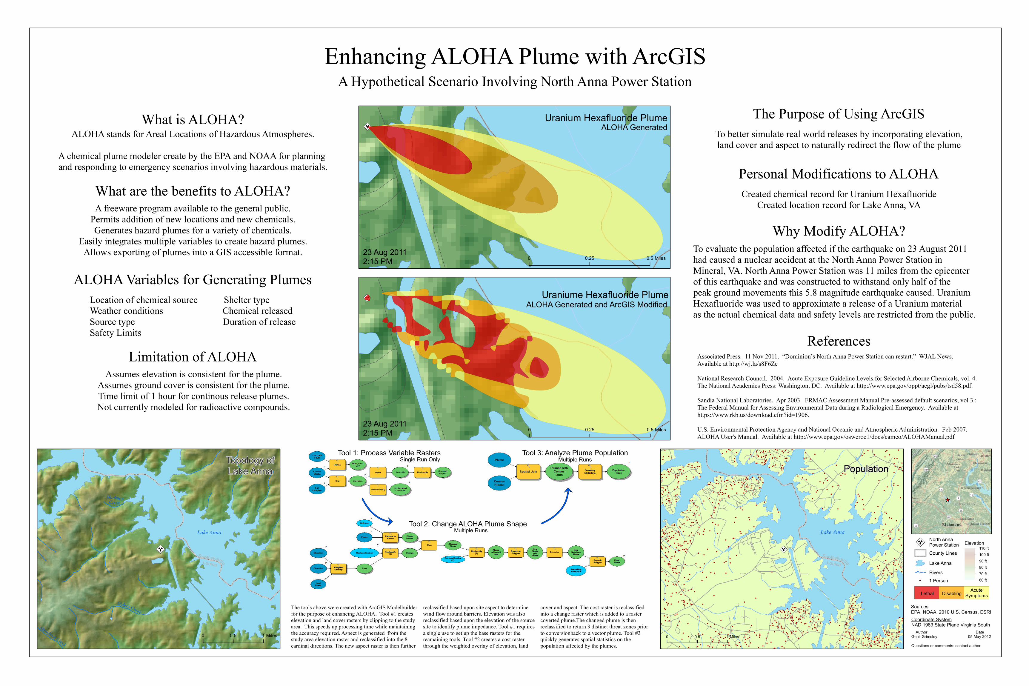
Tool 3: Analyze Plume Population
Tool 2: Change ALOHA Plume Shape
Tool 1: Process Variable RastersSingle Run Only
Multiple Runs
Multiple Runs
Lethal Disabling AcuteSymptoms
1 Person
Lake AnnaRivers
Elevation110 ft100 ft90 ft80 ft70 ft60 ft
Ù̧North AnnaPower StationCounty Lines
A Hypothetical Scenario Involving North Anna Power Station
The tools above were created with ArcGIS Modelbuilderfor the purpose of enhancing ALOHA. Tool #1 createselevation and land cover rasters by clipping to the studyarea. This speeds up processing time while maintainingthe accuracy required. Aspect is generated from thestudy area elevation raster and reclassified into the 8cardinal directions. The new aspect raster is then further
reclassified based upon site aspect to determine wind flow around barriers. Elevation was also reclassified based upon the elevation of the sourcesite to identify plume impedance. Tool #1 requiresa single use to set up the base rasters for the reamaining tools. Tool #2 creates a cost raster through the weighted overlay of elevation, land
cover and aspect. The cost raster is reclassified into a change raster which is added to a raster coverted plume.The changed plume is then reclassified to return 3 distinct threat zones priorto conversionback to a vector plume. Tool #3 quickly generates spatial statistics on the population affected by the plumes.