Embed Size (px)
Citation preview
TLI – Asia Pacific White Papers Series
Volume 15-Aug-SDSS
EEnnhhaanncceedd PPeerrffoorrmmaannccee ooff UUrrbbaann SSiittee SSeelleeccttiioonn iinn YYooggyyaakkaarrttaa uussiinngg tthhee SSppaattiiaall DDeecciissiioonn SSuuppppoorrtt SSyysstteemm ((SSDDSSSS))
The Coordinating Ministry for Economic Affairs is the ministry that coordinates and synchronizes the formulation of the government policy in economic affairs, as well as to control the implementation of the policies. The Coordinating Ministry of Economic Affairs coordinates a number of ministries, including: (1) The Ministry of Finance, (2) The Ministry of Industry, (3) The
Ministry of Commerce, (4) The Ministry of Agriculture, (5) The Ministry of Environment and Forestry, (6) The Ministry of Labor, (7) The Ministry of SOEs, (8) The Ministry of Public Works and Public Housing, (9) Ministry of Agricultural and Spatial, (10) The Ministry of Cooperatives and SMEs. For more information, visit www.ekon.go.id
Temasek Foundation is a non‐profit philanthropic organization anchored in Singapore that seeks to contribute to sustainable growth and a bright future of hope and opportunities for people in Asia. The foundation works with partners to support programmes that develop people through health care, education and research, programmes that build bridges between people,
programmes that build institutions of excellence through governance and ethics, and programmes that rebuild lives and livelihoods affected by natural disasters. For more information, visit www.temasekfoundation.org.sg
A leading global university centred in Asia, the National University of Singapore (NUS) is Singapore’s flagship university, which offers a global approach to education and research, with a focus on Asian perspectives and expertise. NUS has 16 faculties and schools across three campuses. Its transformative education includes a broad‐based curriculum
underscored by multi‐disciplinary courses and cross‐faculty enrichment. Over 37,000 students from 100 countries enrich the community with their diverse social and cultural perspectives. NUS has three Research Centres of Excellence (RCE) and 26 university‐level research institutes and centres. It is also a partner in Singapore’s fifth RCE. NUS shares a close affiliation with 16 national‐level research institutes and centres. Research activities are strategic and robust, and NUS is well‐known for its research strengths in engineering, life sciences and biomedicine, social sciences and natural sciences. It also strives to create a supportive and innovative environment to promote creative enterprise within its community. For more information, visit www.nus.edu.sg.
The Logistics Institute – Asia Pacific was established in 1998 as a collaboration between National University of Singapore (NUS) and Georgia Institute of Technology (GT) for research and educational programs in global logistics. Its vision is to be the Asia Pacific’s premier
institute nurturing logistics excellence through research and education. Since its formation, it has served as the training ground for aspiring logisticians, equipping them with analytical tools to meet supply chain challenges. Over the years, the institute has been voted Asia’s Best Education Course Provider at the annual Asian Freight & Supply Chain Awards for eleventh consecutive years and also awarded the Best Training Provider at the Supply Chain Awards from 2009 to 2011 and 2014. For more information, visit www.tliap.nus.edu.sg
The Center for Transportation and Logistics Studies (PUSTRAL) Gadjah Mada University is a research center for transportation and logistics based at Yogyakarta, Indonesia. Established
at 2001, PUSTRAL aims to answer the problems and challenges in transportation, logistics and infrastructure in Indonesia. It supported by researchers from various disciplinary from universities at Indonesia and outside
Indonesia, private sectors, NGO’s and officials. For more information, visit www.pustral‐ugm.org/en/
Asosiasi Logistik Indonesia (ALI) is a non‐profit organization for the Supply Chain & Logistics professionals in Indonesia. Total number of registered member reached more than 3.000 professional consisting of practitioners, academicians, regulators, and those who have interest in this field. With vision and mission to bringing conducive atmosphere for Indonesian logistics industries to grow and
contribute in developing excellences in human resources, ALI fully supports the establishment of Indonesia Logistics Certification Center and Sembada Pratama ‐ the 1st Supply Chain & Logistics School in Indonesia. For more information, visit www.ali.web.id/
Presented at:
Temasek Foundation ‐ National University of Singapore: Urban Land Transport Management for Policy Leaders and Specialists
28 August 2015 Jakarta, Indonesia
Disclaimer, Limitation of Liability and Terms of Use
NUS and contributors own the copyright to the information contained in this report, we are licensed by the copyright owner to reproduce the information or we are authorised to reproduce it. Please note that you are not authorised to distribute, copy, reproduce or display this report, any other pages within this report or any section thereof, in any form or manner, for commercial gain or otherwise, and you may only use the information for your own internal purposes. You are forbidden from collecting information from this report and incorporating it into your own database, products or documents. If you undertake any of these prohibited activities we put you on notice that you are breaching our and our licensors' intellectual property rights in the report and we reserve the right to take action against you to uphold our rights, which may involve pursuing injunctive proceedings. The information contained in this report has been compiled from sources believed to be reliable but no warranty, expressed or implied, is given that the information is complete or accurate nor that it is fit for a particular purpose. All such warranties are expressly disclaimed and excluded. To the full extent permissible by law, NUS shall have no liability for any damage or loss (including, without limitation, financial loss, loss of profits, loss of business or any indirect or consequential loss), however it arises, resulting from the use of or inability to use this report or any material appearing on it or from any action or decision taken or not taken as a result of using the report or any such material.
Enhanced Performance of Urban Site Selection in Yogyakarta
using the Spatial Decision Support System (SDSS)
Please visit www.tliap.nus.edu.sg for these publications:
Spatial Decision Support System (SDSS) for Urban Freight Distribution Policy Planning (Dual languages) Volume 14‐Sep‐CUL
Strategic Freight Distribution in Java Island using e‐Market (Freight Exchange): Assessing Feasibility (Dual languages) Volume 14‐Sep‐CUL
Challenges & Opportunities in Cluster Urban Logistics: The Jurong Gateway Precinct Volume 14‐Mar‐CUL
Collaborative Urban Logistics: Synchronized Last‐Mile Logistics for Sustainable, Efficient Urban Delivery Volume 13‐Nov‐CUL
OverviewofSDSSandit'sapplicationinYogyakartaPemerintahPusatpadatahun2012,telahmenuangkanSitemLogistikNasionaldalamPeraturanPresiden Nomor 26 tahun 2012 tentang Cetak Biru Sistem Logistik Nasional Indonesia atauSISLOGNAS.HarapandarisistemlogistiknasionalinimampumeningkatkankemampuanlogisticIndonesiadenganmeningkatkanarusbarangdanorangsertameningkatkankonektivitasantaradaerahperdesaandanperkotaandanantaradaerah,pulaudanpelabuhaninternasionalsecaraefisien. Dalam konteks lokal, Cetak Biru SISLOGNAS merupakan panduan untuk pemerintahdaerah (provinsi/kota/kabupaten) untuk merumuskan kebijakan dan program di bidangpengembanganlogistiksebagaibagianstrategisdariperencanaanpembangunandaerah.Namundari hasil riset yang kami lakukan keberadaan SISLOGNAS belum mampu diterjemahkandidaerah untuk menjawab kebutuhan pergerakan dan peningkatan arus barang khususnyamasuk kedalam kota, seperti halnya kebutuhan lokasi pergudangan dan lokasi distributioncenter. Untuk itu penelitian ini mencoba menjawab akan kebutuhan pusat lokasi distribusibarangatauconsolidationcenterdiperkotaangunamendukungSistemLogistikNasional.MetodeyangdigunakandalampenelitianiniyaknidenganmenggunakanpendekatanSDSSdanILWIS sebagai Toolsnya. Penelitian ini menekankan penentuan lokasi terbaik Consolidationcenter di perkotaan Yogyakarta. Penelitian ini mengambil sampel dari pihak pelaku industry(operator), pemerintah daerah dan akademisi.Artinya penelitian ini secara politic juga telahmeminimalkan resikopengambilankeputusankarena telahmelibatkanpemerintah,swastadanakademisi.Yogyakarta
Peningkatanjumlahpendudukperkotaantelahmenimbulkanpermintaandemandbarangyangsangat tinggi. Dari catatan kegiatan penelitian ini, untuk jumlah barang yang masuk ke D.I.Yogyakarta dalam 1 (satu) hari terjadi 70.000 packing delivery barang masuk ke perkotaanYogyakarta.Gambaraninitentumenjadipeluangdanjugatantanganbagiperencanaperkotaandan perencana transportasi daerah. Ketidaksiapan perencanaan daerah dalam menangkappeluang ini tentumenjadimasalahdikemudianhari,sepertimasalahpergudangan,modayangdigunakan dan lainnya. Dari hasil penelitian yang kami lakukan, tercatat bahwa beberapaperusahaanpengirimanbarangsepertiJNE,sudahmulaikesulitanuntukmencaridanmeletakanpergudanganmereka.Peningkatanaktivitaspergerakanbarangperkotaanmemberikandampakyangnyatabagisosialdanlingkungan.Dampaklingkunganterjadinyapeningkatanvolumekendaraanyangmasukkeperkotaan, dan menimbulkan kemacetan serta peningkatan emisi CO2perkotaan Yogyakarta.DarihasilpengolahandatasebaranemisidiPerkotaanYogyakarta,sebaranemisiCO2terbesardiKotakawasanpusatKota,danjalanarteriringroaddanruasjalanutamamasukkeperkotaanseperti JalanMagelang, Jalan Solo, dan jalanGodean.Besarnya emisi CO2di kawasan tersebutsudah mencapai 2800 ton/tahun. Disamping itu banyak terjadi kemacetan di kawasanperkotaandenganditandaiVCRasioyangmendekati0,8.Permasalahanyanglainyakni,
keterlambatan dilevery barang sampai pada konsumen. Proses delivery barang danpergudangan di Perkotaan Yogyakarta belum memiliki regulasi yang baku. Walaupun dariarahan tataruang bahwa pergudangan diarahkan untuk di luar ring road, rest area sudahditentukan, namunmasih banyak pihak swasta yangmelakukan bongkarmuat di sembarangtempat. Hal ini karena belum ada kesepakatan dan kesamaan pemerintah dan masyarakattentangkonseplogisticperkotaanyangakandiatur.Permasalahanyang laindariaktifitasurban logisticyaitukondisigeografisdiKotaYogyakartayangrawanterhadapbencanaalammenjadihambatansendiri.AdabeberapanaturaldisasterdiperkotaanYogyakarta,diantaranyagempabumi,longsor,danbanjirdanvolcano.Untukbencanagempa bumi terjadi dikawasan selatan Kota Yogyakarta, bencana Volcano terjadi di kawasanmerapidanlongsorbeberapaperbukitandibantuldankulonprogo.
HasilPemilihanLokasi
Hasil penelitian ini menunjukan bahwa wilayah yang memiliki berpotensi terbangunnyaConsolidationcenteryaitu: WilayahPatuk
Adabeberapahalyangmenyebabkanwilayahiniterpilihmenjadiprioritasyaitukarenawilayahiniterkasesdenganmodarelkerataapibarang,aksesjalanaterijalanwatestidakberadapadapemukimanpadat, dan landuseyangmendukung,wilayah ini jugamenjadi rekomendasipihakholcimuntukmelakukanpergudanganmereka.
WilayahSedayu
Alasanwilayah ini terpilihmenjadiprioritasyaitumemiliki alasanyangsamadenganwilayahpatuk.Wilayahinisearahdenganjalanarteriwatesdansejajarrelkeetaapi.
WilayahWates
Alasanwilayah ini terpilihmenjadi prioritas yaitu aksesmenuju arteri dan dekat dengan relkeretaapi.Wilayahinikurangoptimaljikadibandingkandenganwilayahpatukdansedayu.
WilayahKalasan
Alasan wilayah ini terpilih menjadi prioritas yaitu memiliki alasan bahwa landuse masihmendukung dan terhubung dengan akses utma jalan solo dan ring road utara.. Beberapapergudangan banyak dikawasan kalasan terutama untuk komoditas barang yang berasal daritimur.KawasanpergudanganyangadadikalasansalahtunyaPergudanganBulog.
TLI – Asia Pacific Whitepaper Series:
Enhanced Performance of Urban Site Selection in Yogyakarta
using the Spatial Decision Support System (SDSS)
Page 1
Executive Summary
This whitepaper is developed as a part of “Temasek Foundation –National University of Singapore: Urban Land Transport Managementfor Policy Leaders/Specialists in Indonesia” program to provide localgovernmental agencies a deep insight into Strategic Freight PlanningandDistribution in response to theBlueprint of theNational LogisticsSystem(orSISLOGNAS)launchedbytheIndonesianPresidentialOffice.
In this whitepaper, Yogyakarta ‐ one of the fast‐growing cities inIndonesiathatisofparticularcharacteristics‐ischosenasapioneeringcity for developing an efficient strategic freight distribution planningpolicy to locate a freight logistics facility (e.g. distribution center orinland port or freight village). The so‐called Spatial Decision SupportSystem(SDSS)–aspatiallyanalyticalplatformtovisualizedifferentkeyinformationtosupportdecisionmaking–isemployedforourstrategicsolutionmethodology.ThebenefitofSDSSistoassistusersordecisionmakers in simultaneously handling and operating different criteria ofinterest (both quantifiable and non‐quantifiable) for the sake ofprecisely pinpointing the proposed location. The findings from SDSSdevelopmentonYogyakartacasearealsodiscussedandvalidatedwiththeexistingpractices,thussignifyingthesuperiorityandpracticalityofthedevelopedplatform.
Executive Summary 1
Recap 2
Introduction to Yogyakarta 3
Efficient Strategic Planning for Site Selection using SDSS 5
Findings 7
Summary 8
EnhancedPerformanceofUrbanSiteSelectioninYogyakarta using the Spatial Decision SupportSystem(SDSS)
INSIDE THE WHITE PAPER
Narath Bhusiri1, Robert de
Souza1, Eriadi2, Hendra Edi
Gunawan2, Nur Yuwono2,
Arif Wismadi2, Kuncoro
Harto Widodo2
1 The Logistics Institute – Asia Pacific, National University of Singapore 2 Center for Transportation and Logistics Studies (Pusat Studi Transportasi dan Logistik), Universitas Gadjah Mada
AUTHORS:
TLI – Asia Pacific Whitepaper Series:
Enhanced Performance of Urban Site Selection in Yogyakarta
using the Spatial Decision Support System (SDSS)
Page 2
Recap
Forthebenefitofthenewreaderwerecapfromthewhitepaperseries.Thereisarequirementfrom the Indonesian Central Government to all local governmental agencies through thePresidentialRegulationNumber26Year2012inregardtotheblueprintoftheNationalLogisticsSystem(SISLOGNAS)1,whichseekstheintegrationofindividualtransportandlogisticsprogramstoeffectivelyandefficientlyconnecttheflowsoffreightandpassengersthroughoutthecountry.The series of whitepapers disseminated in this program have, as a consequence, beencollaboratively researched and developed to further equip local governmental agencies withcomprehensive knowledge and skills on Strategic Freight Planning and Distribution, so as toenabledevelopmentofindividualstrategicroadmapsandaidpolicyplanninginresponsetotheaforementionedrequirement.
The first whitepaper2 conceptually developed a strategic freight planning and monitoringinitiativeofane‐market(freightexchange)platformtotacklethechallengesarisingintheislandofJava.Thee‐marketplatformexecutesbyassemblingthestakeholdersinvolved(i.e.suppliers,regulators, receivers, and service providers), facilitating interaction and enabling sharing ofpertinent information as well as their requirements. With the use of an intelligent auctionmechanism, the platform results in consolidated freight and cooperative routes, encouraginghealthy competition for business and sustainable living for society. The second initiative3 is astrategicfreightdistributionplanningpolicywhitepaperasanextensionofthelogisticsnetworkthroughtheestablishmentofnewfacilities.
Accordingly, the Spatial Decision Support System (SDSS) platform as a computer‐basedvisualizationtoolforgeographicproblemshasbeendeveloped.AholisticframeworkoftheSDSSplatform has systematically been sketched, followed by the recommendations of interestingmodulesandapproachestobeequippedontheplatform.Followingupourpreviousworks,thiswhitepapershowsacasestudyofdevelopinganefficientstrategicfreightdistributionplanningtolocateafreightlogisticsfacilityinYogyakartausingSDSS.
‐‐‐‐‐‐‐‐‐‐‐‐‐‐‐‐‐‐‐‐‐‐‐‐‐‐‐‐‐‐‐‐‐‐‐‐‐‐‐‐ 1 Presiden Republik Indonesia, Peraturan Presiden Republik Indonesia Nomor 26 Tahun 2012 Tentang Cetak Biru Pengembangan Sistem
Logistik Nasional, 5 March 2012. 2 Gunawan, H.E., Wachid, L., Susilo, B., Linawati, Wismadi, A., Sutomo, H, Widodo, K.H, Goh, M. and de Souza, R. 2014. Strategic Freight Distribution in Java Island using e‐Market (Freight Exchange): Assessing Feasibility. TLI‐ Asia Pacific White Paper Series, 14‐Sep‐CUL. 3 Lindawati, Narayan, S., Sijie, H., Eriadi, Wismadi, A., Widodo, K.H., Goh, M. and de Souza, R. 2014. Spatial decision support system for urban freight transportation policy planning. TLI – Asia Pacific White Paper Series, 14‐Sep‐CUL.
TLI – Asia Pacific Whitepaper Series:
Enhanced Performance of Urban Site Selection in Yogyakarta
using the Spatial Decision Support System (SDSS)
Page 3
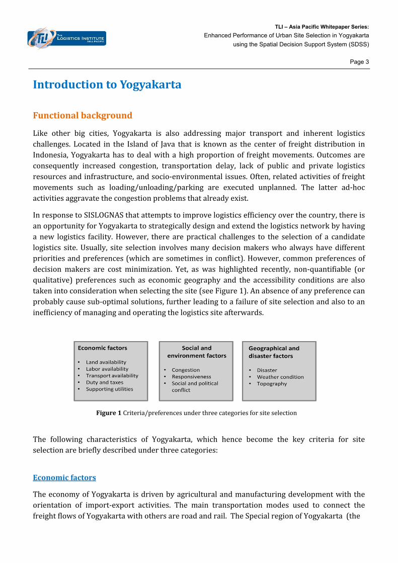
IntroductiontoYogyakarta
Functionalbackground
Like other big cities, Yogyakarta is also addressing major transport and inherent logisticschallenges. Located in the Island of Java that is known as the center of freight distribution inIndonesia,Yogyakartahas todealwithahighproportionof freightmovements.Outcomesareconsequently increased congestion, transportation delay, lack of public and private logisticsresourcesandinfrastructure,andsocio‐environmentalissues.Often,relatedactivitiesoffreightmovements such as loading/unloading/parking are executed unplanned. The latter ad‐hocactivitiesaggravatethecongestionproblemsthatalreadyexist.
InresponsetoSISLOGNASthatattemptstoimprovelogisticsefficiencyoverthecountry,thereisanopportunityforYogyakartatostrategicallydesignandextendthelogisticsnetworkbyhavinganew logistics facility.However, there arepractical challenges to the selectionof a candidatelogistics site.Usually, site selection involvesmanydecisionmakerswhoalwayshavedifferentprioritiesandpreferences(whicharesometimesinconflict).However,commonpreferencesofdecisionmakers are cost minimization. Yet, as was highlighted recently, non‐quantifiable (orqualitative) preferences such as economic geography and the accessibility conditions are alsotakenintoconsiderationwhenselectingthesite(seeFigure1).Anabsenceofanypreferencecanprobablycausesub‐optimalsolutions,furtherleadingtoafailureofsiteselectionandalsotoaninefficiencyofmanagingandoperatingthelogisticssiteafterwards.
Figure1Criteria/preferencesunderthreecategoriesforsiteselection
The following characteristics of Yogyakarta, which hence become the key criteria for siteselectionarebrieflydescribedunderthreecategories:
Economicfactors
TheeconomyofYogyakarta isdrivenbyagriculturalandmanufacturingdevelopmentwiththeorientation of import‐export activities. The main transportation modes used to connect thefreightflowsofYogyakartawithothersareroadandrail.TheSpecialregionofYogyakarta(the
TLI – Asia Pacific Whitepaper Series:
Enhanced Performance of Urban Site Selection in Yogyakarta
using the Spatial Decision Support System (SDSS)
Page 4
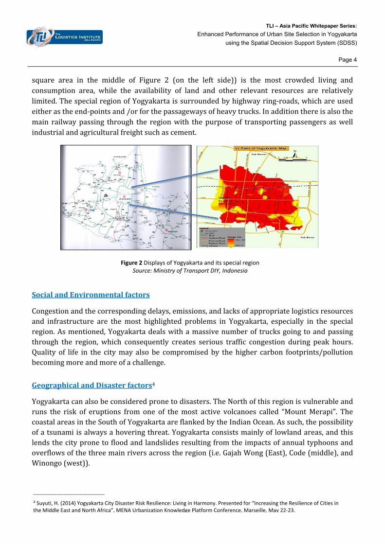
square area in the middle of Figure 2 (on the left side)) is the most crowded living andconsumption area, while the availability of land and other relevant resources are relativelylimited.ThespecialregionofYogyakartaissurroundedbyhighwayring‐roads,whichareusedeitherastheend‐pointsand/orforthepassagewaysofheavytrucks.Inadditionthereisalsothemain railwaypassing through the regionwith thepurpose of transportingpassengers aswellindustrialandagriculturalfreightsuchascement.
Figure 2 Displays of Yogyakarta and its special region Source: Ministry of Transport DIY, Indonesia
SocialandEnvironmentalfactors
Congestionandthecorrespondingdelays,emissions,andlacksofappropriatelogisticsresourcesand infrastructure are themost highlighted problems in Yogyakarta, especially in the specialregion.Asmentioned,Yogyakartadealswithamassivenumberof trucksgoing toandpassingthrough the region, which consequently creates serious traffic congestion during peak hours.Quality of life in the citymay also be compromised by the higher carbon footprints/pollutionbecomingmoreandmoreofachallenge.
GeographicalandDisasterfactors4
Yogyakartacanalsobeconsideredpronetodisasters.TheNorthofthisregionisvulnerableandruns the risk of eruptions from one of themost active volcanoes called “MountMerapi”. ThecoastalareasintheSouthofYogyakartaareflankedbytheIndianOcean.Assuch,thepossibilityofatsunamiisalwaysahoveringthreat.Yogyakartaconsistsmainlyof lowlandareas,andthislendsthecitypronetofloodandlandslidesresultingfromtheimpactsofannualtyphoonsandoverflowsofthethreemainriversacrosstheregion(i.e.GajahWong(East),Code(middle),andWinongo(west)).
‐‐‐‐‐‐‐‐‐‐‐‐‐‐‐‐‐‐‐‐‐‐‐‐‐‐‐‐‐‐‐‐‐‐‐‐‐‐‐‐ 4 Suyuti, H. (2014) Yogyakarta City Disaster Risk Resilience: Living in Harmony. Presented for “Increasing the Resilience of Cities in the Middle East and North Africa”, MENA Urbanization Knowledge Platform Conference, Marseille, May 22‐23.
TLI – Asia Pacific Whitepaper Series:
Enhanced Performance of Urban Site Selection in Yogyakarta
using the Spatial Decision Support System (SDSS)
Page 5
EfficientStrategicPlanningforSiteSelectionusingSDSS
Onceagain,thereasonbehindusingSDSSforthestrategicplanningofsiteselectionisthatmanypreferencesfromdifferentdecisionmakersneedtosimultaneouslybetakenintoaccountwhenexecuting theplan.Therefore, SDSSwhich canhandle andoperatebothquantifiable andnon‐quantifiableinformationatthesametimeisdesiredforthispurpose.
SDSSisananalyticalplatformthatassistsplannersinvisualizingdifferentandkeyinformationvariablesonamulti‐layerdisplayalongwiththeevaluationmodulesinordertoprovidebetterforesight/insightintothestrategicproblemsandchallenges.TheSDSSis,thus,abletosupportinthestrategicdecisionmakingprocess.ThemainhighlightoftheSDSSistheflexibilityoftheplatformthatsimplyallowsvariousfeatures,techniquesorapproachestobeassessed.
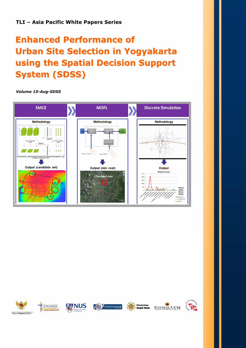
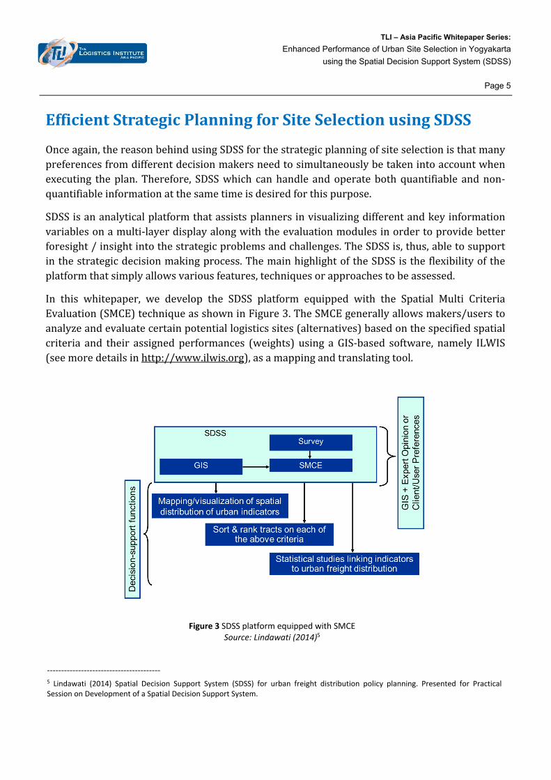
In this whitepaper, we develop the SDSS platform equipped with the Spatial Multi CriteriaEvaluation(SMCE)techniqueasshowninFigure3.TheSMCEgenerallyallowsmakers/userstoanalyzeandevaluatecertainpotentiallogisticssites(alternatives)basedonthespecifiedspatialcriteria and their assigned performances (weights) using aGIS‐based software, namely ILWIS(seemoredetailsinhttp://www.ilwis.org),asamappingandtranslatingtool.
Figure 3 SDSS platform equipped with SMCE
Source: Lindawati (2014)5
‐‐‐‐‐‐‐‐‐‐‐‐‐‐‐‐‐‐‐‐‐‐‐‐‐‐‐‐‐‐‐‐‐‐‐‐‐‐‐‐ 5 Lindawati (2014) Spatial Decision Support System (SDSS) for urban freight distribution policy planning. Presented for Practical Session on Development of a Spatial Decision Support System.
TLI – Asia Pacific Whitepaper Series:
Enhanced Performance of Urban Site Selection in Yogyakarta
using the Spatial Decision Support System (SDSS)
Page 6
The technique of SMCE on SDSS platformbeginswith collecting, storing, aswell asmanagingdata. Important data to be used for evaluation includes the Yogyakarta map, road network,logistics infrastructurenetwork, landuse, population, geographical data, traffic data, emissionlevel, historical and forecasted disaster data, and so on. Since the exploration and gatheringnecessarydataofYogyakartaarequite largeandtime‐consuming, thedatacollectionhasbeenmadethroughfieldobservations,interviewsandsurveysaswellasthesurveythroughliteratureandopensourcedatabases.
Then,criteriaorpreferencesthathelptomeetthespecificobjectivesofsiteselectionneedtobeidentified.Over40criteriaunderthreecategoriesaspreviouslymentionedhavebeenidentifiedfortheYogyakartacase,andexamplesofthesecriteriaareshownbelow.
Economic factors: logistics infrastructureconnectivity,population,utilities, landcost,andindustrialzone
Socialandenvironmentalfactors:trafficcondition,crimerate,airemissions,andnoise
Geographical and disaster factors: disasters including volcano, earthquake, flood, andlandslide
TheperformanceevaluationofSMCEonseveralalternatives isbasedonthe identifiedcriteriaandtheirassignedweights,wheretheseassignedweightstoeachcriterionhavebeencomputedthrough discussions, interviews, and consults with experts from various perspectives inYogyakarta such as academic, regulators, and operators. Ultimately, the outcome of the SMCEtechniqueonSDSSplatformisasetofpotentialcandidatesites.
TLI – Asia Pacific Whitepaper Series:
Enhanced Performance of Urban Site Selection in Yogyakarta
using the Spatial Decision Support System (SDSS)
Page 7
Findings
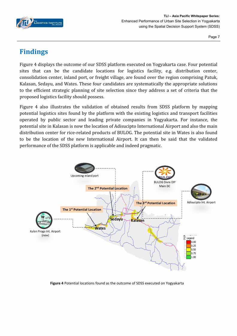
Figure4displaystheoutcomeofourSDSSplatformexecutedonYogyakartacase.Fourpotentialsites that can be the candidate locations for logistics facility, e.g. distribution center,consolidationcenter,inlandport,orfreightvillage,arefoundovertheregioncomprisingPatuk,Kalasan,Sedayu,andWates.Thesefourcandidatesaresystematicallytheappropriatesolutionsto the efficient strategic planning of site selection since they address a set of criteria that theproposedlogisticsfacilityshouldpossess.
Figure 4 also illustrates the validation of obtained results from SDSS platform by mappingpotential logisticssitesfoundbytheplatformwiththeexistinglogisticsandtransportfacilitiesoperated by public sector and leading private companies in Yogyakarta. For instance, thepotentialsiteinKalasanisnowthelocationofAdisuciptoInternationalAirportandalsothemaindistributioncenterforrice‐relatedproductsofBULOG.ThepotentialsiteinWatesisalsofoundto be the location of the new International Airport. It can then be said that the validatedperformanceoftheSDSSplatformisapplicableandindeedpragmatic.
Figure 4 Potential locations found as the outcome of SDSS executed on Yogyakarta
TLI – Asia Pacific Whitepaper Series:
Enhanced Performance of Urban Site Selection in Yogyakarta
using the Spatial Decision Support System (SDSS)
Page 8
Summary
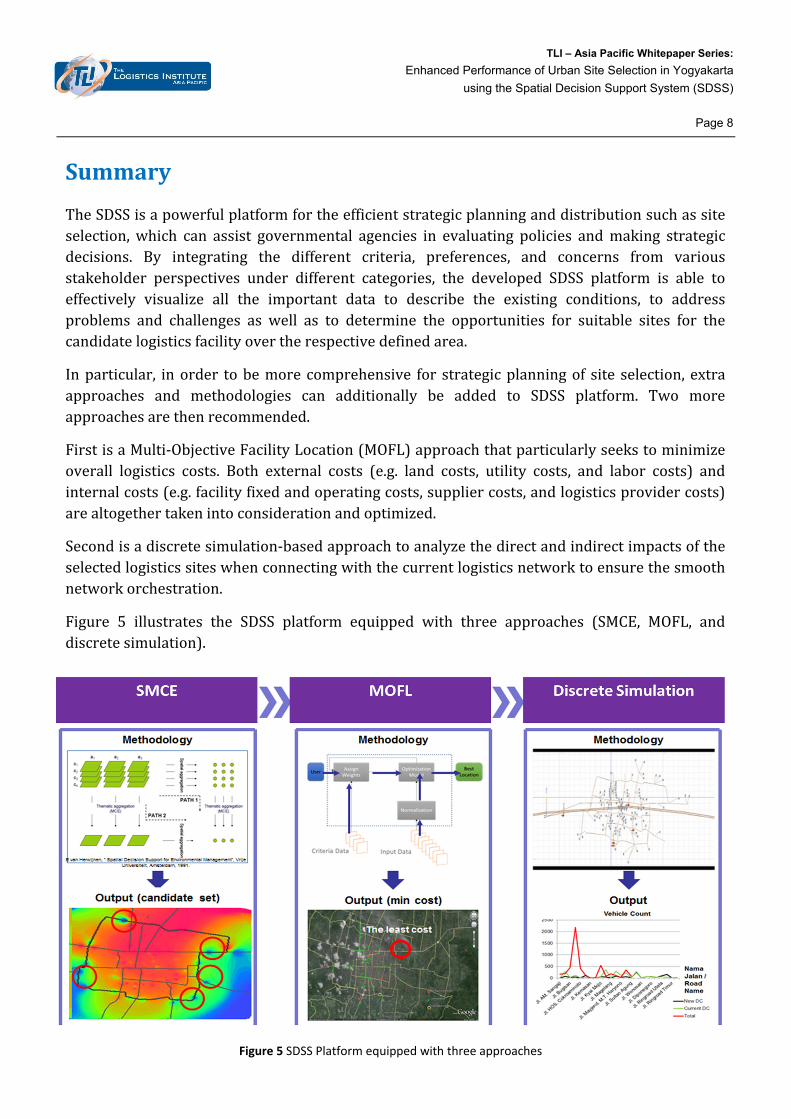
TheSDSSisapowerfulplatformfortheefficientstrategicplanninganddistributionsuchassiteselection,which can assist governmental agencies in evaluating policies andmaking strategicdecisions. By integrating the different criteria, preferences, and concerns from variousstakeholder perspectives under different categories, the developed SDSS platform is able toeffectively visualize all the important data to describe the existing conditions, to addressproblems and challenges as well as to determine the opportunities for suitable sites for thecandidatelogisticsfacilityovertherespectivedefinedarea.
Inparticular, inorder tobemore comprehensive for strategicplanningof site selection, extraapproaches and methodologies can additionally be added to SDSS platform. Two moreapproachesarethenrecommended.
FirstisaMulti‐ObjectiveFacilityLocation(MOFL)approachthatparticularlyseekstominimizeoverall logistics costs. Both external costs (e.g. land costs, utility costs, and labor costs) andinternalcosts(e.g.facilityfixedandoperatingcosts,suppliercosts,andlogisticsprovidercosts)arealtogethertakenintoconsiderationandoptimized.
Secondisadiscretesimulation‐basedapproachtoanalyzethedirectandindirectimpactsoftheselectedlogisticssiteswhenconnectingwiththecurrentlogisticsnetworktoensurethesmoothnetworkorchestration.
Figure 5 illustrates the SDSS platform equipped with three approaches (SMCE, MOFL, anddiscretesimulation).
Figure 5 SDSS Platform equipped with three approaches


The Logistics Institute – Asia PacificNational University of Singapore 21 Heng Mui Keng Terrace, #04‐01, Singapore 119613 Tel: (65) 6516 4842 Fax: (65) 6775 3391 Email: [email protected] URL: www.tliap.nus.edu.sg