Embed Size (px)
Citation preview
Belmont Bridge Replacement 08/12/16 Scope & Fee Proposal
ENGINEERING
SCOPE OF SERVICES &
FEE PROPOSAL
for
Belmont Bridge Replacement
VDOT Project No. 0020-104-101, UPC# 75878
August 12, 2016 Revised on December 12, 2016
Submitted To: City of Charlottesville
Neighborhood Development Services
Submitted By: Kimley-Horn and Associates, Inc.
1700 Willow Lawn Drive, Suite 200
Richmond, VA 23230
804-673-3882
Belmont Bridge Replacement 08/12/16 Scope & Fee Proposal
TABLE OF CONTENTS
PROJECT DESCRIPTION ......................................................................................................... 1
ASSUMPTIONS ........................................................................................................................... 1
INFORMATION PROVIDED BY CLIENT ................................................................................. 2
STANDARD AND REFERENCE DOCUMENTS .................................................................... 2
DRAFTING REQUIREMENTS ................................................................................................... 3
TASK 1 – PROJECT LEADERSHIP AND COMMUNCIATIONS ......................................... 3
Funding / Financing Strategy Development ......................................................................... 3
Project Website......................................................................................................................... 3
Project Meetings ....................................................................................................................... 4
Deliverables............................................................................................................................... 4
TASK 2 – CONSENSUS BUILDING ......................................................................................... 4
Public Engagement Plan ......................................................................................................... 4
Understanding The Context: Background, Site Analysis, And Program Development 7
Urban Design Context: Documentation/Data Collection and Code Review ................... 8
Exploring Ideas: Visioning and Conceptual Design ............................................................ 9
Conceptual Bridge and Urban Design Concepts ............................................................ 9
Final Plan: Concept Plan Refinement ............................................................................ 10
Basis of Design Report .......................................................................................................... 11
Summary Brochure ................................................................................................................ 11
Deliverables: ........................................................................................................................... 11
TASK 3 – SURVEY .................................................................................................................... 12
Limits ........................................................................................................................................ 12
Owner Notification .................................................................................................................. 12
Existing Survey ....................................................................................................................... 12
Survey Control ........................................................................................................................ 12
Property/Right-of-Way Research and Ties ........................................................................ 12
Location Survey ...................................................................................................................... 13
DTM and Contours ................................................................................................................. 13
Storm Drainage and Sanitary Sewer Survey ..................................................................... 13
Utility Survey ........................................................................................................................... 13
Wetlands Survey .................................................................................................................... 13
Geotechnical Soil Boring and Pavement Core Stakeout ................................................. 13
Full Class I Bridge Situation Plan ........................................................................................ 13
Acquisition Plats (UNIT PRICE) ........................................................................................... 13
Deliverables............................................................................................................................. 14
TASK 4 – SUBSURFACE UTILITY ENGINEERING SERVICES ...................................... 14
Limits ........................................................................................................................................ 14
Utility Quality Level Designation .......................................................................................... 14
Quality Level B (QL-B) Designation Standard Procedures ............................................. 14
Standard Procedures – Test Holes (BUDGET ITEM) ...................................................... 15
Belmont Bridge Replacement 08/12/16 Scope & Fee Proposal
CADD ....................................................................................................................................... 16
Deliverables............................................................................................................................. 16
TASK 5 –GEOTECHNICAL INVESTIGATIONS AND ANALYSIS ..................................... 16
Stage I Preliminary Geotechnical Services ........................................................................ 16
Stage II Subsurface Exploration and Final Geotechnical Services ................................ 16
Pavement Design ................................................................................................................... 17
Deliverables............................................................................................................................. 18
TASK 6 – ENVIRONMENTAL SERVICES............................................................................. 18
Project Early Notification Form (EQ-429) ........................................................................... 18
NEPA Concurrence Form ..................................................................................................... 19
NEPA Documentation ............................................................................................................ 19
Project Coordination .......................................................................................................... 19
Project Scoping .................................................................................................................. 19
Socio-Economic Analysis .................................................................................................. 19
Section 4(f) and Section 6(f) ............................................................................................. 19
Cultural Resources............................................................................................................. 20
Natural Resources ............................................................................................................. 21
Agricultural/Open Space/Farmland ................................................................................. 22
Air Conformity Analysis ..................................................................................................... 22
Noise .................................................................................................................................... 24
Hazardous Materials .......................................................................................................... 24
Right-of-Way and Relocations ......................................................................................... 24
Cumulative and Indirect Impacts ..................................................................................... 24
Coordination and Distribution of the CE ............................................................................. 25
Forms ....................................................................................................................................... 25
Deliverables............................................................................................................................. 25
TASK 7 – TRAFFIC ENGINEERING & ANALYSIS .............................................................. 25
Traffic Data Collection ........................................................................................................... 25
Develop Analysis Assumptions Meeting ............................................................................ 26
Traffic Analysis ....................................................................................................................... 26
Develop Synchro Model & Analyze Existing Conditions .............................................. 26
Future No-Build & Build Analysis ..................................................................................... 26
Maintenance of Traffic Analysis ....................................................................................... 26
Traffic Analysis Documentation ....................................................................................... 26
Signing & Pavement Marking Plans .................................................................................... 26
Traffic Signal Plans ................................................................................................................ 27
Lighting and Photometric Plans ........................................................................................... 28
Aesthetic Lighting Specifications ......................................................................................... 29
Deliverables............................................................................................................................. 29
TASK 8 – ROADWAY DESIGN ............................................................................................... 29
Conceptual Roadway Design Plans .................................................................................... 29
Preliminary Roadway Design Plans .................................................................................... 30
Detailed Roadway Design Plans ......................................................................................... 31
Final Roadway Design Plans ............................................................................................... 31
Transportation Management Plan (TMP) ........................................................................... 31
Deliverables............................................................................................................................. 32
TASK 9 – DRAINAGE DESIGN ............................................................................................... 32
Drainage Design Elements and Computations ................................................................. 32
Post Development Stormwater Management Design ...................................................... 33
Belmont Bridge Replacement 08/12/16 Scope & Fee Proposal
Nutrient Credits ....................................................................................................................... 33
Stormwater Pollution Prevention Plan (SWPPP) and Book ............................................ 33
Virginia Stormwater Management Program (VSMP) Construction Permit ................... 34
Deliverables............................................................................................................................. 34
TASK 10 – STRUCTURE AND BRIDGE DESIGN ............................................................... 34
Stage 1 Preliminary Structure Design Plans ...................................................................... 34
Stage 2 Final Structure Design Plans ................................................................................. 35
Load Rating: ............................................................................................................................ 35
Deliverables............................................................................................................................. 35
TASK 11 – LANDSCAPING DESIGN ..................................................................................... 36
Preliminary Landscape and Hardscape Design Plan (60%) ........................................... 36
Detailed Landscape and Hardscape Design Plan (90%) ................................................ 37
Final Landscape and Hardscape Design Plan (100%) .................................................... 37
Bridge Deck Amenities .......................................................................................................... 38
Deliverables............................................................................................................................. 38
TASK 12 – PUBLIC UTILITY (GAS, WATER, SANITARY SEWER AND GAS) DESIGN....................................................................................................................................................... 38
Gas, Water and/ or Sanitary Sewer Relocation Plans ..................................................... 38
Deliverables............................................................................................................................. 39
TASK 13 – PRIVATE UTILITY AND RAILROAD COORDINATION .................................. 39
Private Utility Representative Contact Initiation ................................................................ 39
Utility Field Inspection ............................................................................................................ 39
Utility Relocations ................................................................................................................... 39
Utility Relocation Schedule ................................................................................................... 40
Utility Relocation Opinion of Cost ........................................................................................ 40
Railroad Coordination ............................................................................................................ 40
Deliverables............................................................................................................................. 40
TASK 14 – RIGHT OF WAY ACQUISITION AND COORDINATION ................................ 40
TASK 15 – ENGINEER’S OPINION OF PROBABLE CONSTRUCTION COST ............. 40
Contingencies ......................................................................................................................... 41
Deliverables............................................................................................................................. 41
TASK 16 – DESIGN PHASE SUBMISSIONS AND PLAN REVIEWS .............................. 41
Conceptual Design Phase Submittal (30%) ....................................................................... 42
Preliminary Design Phase Submittal (60%) ....................................................................... 42
Right of Way Design Phase Submittal (90%) .................................................................... 42
Final Construction Design Phase Submittal ...................................................................... 42
TASK 17 – LOCATION AND DESIGN PUBLIC HEARING ................................................. 43
Location and Design Public Hearing ................................................................................... 43
Deliverables............................................................................................................................. 44
TASK 18 – PRECONSTRUCTION ADMINISTRATION ...................................................... 44
Construction Quality Assurance Plan (QAP) and Materials Testing Matrix .................. 44
Invitation for Bid ...................................................................................................................... 44
Bid Document Distribution .................................................................................................... 45
Pre-Bid Meeting ...................................................................................................................... 45
Invitation for Bid Questions and Answers .......................................................................... 45
Bid Analysis and Award Package ........................................................................................ 46
Pre-Construction Meeting ..................................................................................................... 46
Deliverables............................................................................................................................. 46
ADDITIONAL SERVICES ......................................................................................................... 46

Belmont Bridge Replacement 08/12/16 Scope & Fee Proposal
PROJECT SCHEDULE ............................................................................................................. 47
FEE SUMMARY ......................................................................................................................... 47
UNIT PRICE ITEMS................................................................................................................... 48
APPENDIX A – SURVEY LIMITS MAP .................................................................................. 49
APPENDIX B – MAN HOUR BREAKDOWN ......................................................................... 50
Belmont Bridge Replacement 8/12/16
Scope & Fee Proposal
1
Kimley-Horn and Associates, Inc. (“Kimley-Horn”) is pleased to submit this scope and fee to the City of Charlottesville, Virginia (“Client” or “City”) for providing professional engineering services in support of the City’s Belmont Bridge Replacement Project.
PROJECT DESCRIPTION This Project includes: coordination of a public engagement process toward approval of a conceptual design for the replacement bridge and for the residual property within the defined project limits, see Appendix A, the design of right of way and construction plans, the preparation of bid documents, and pre-construction administration for the Belmont Bridge Replacement Project. The proposed improvements total approximately 1,200 linear feet and generally involve the design of a bridge to replace the existing Belmont Bridge (9th Street/Route 20) over Avon Street, the Buckingham Branch Railroad and Water Street in Downtown Charlottesville. The project includes ancillary roadway improvements to both the north and south bridge approaches including accommodations and maintenance of pedestrian traffic through the existing pedestrian tunnel just north of the existing bridge abutment. It is assumed that no impacts will occur to the existing pedestrian tunnel due to the design of the bridge improvements. The project also includes the design of left and right turn lanes, sidewalk, curb and gutter, storm sewer, lighting, landscaping, traffic signal, pavement markings, signs, and maintenance of traffic. The project limits are illustrated in the attached survey area map, Appendix A, and they can generally be identified as along 9th Street from the intersection with East Market Street to the intersection with Garrett Street/Levy Avenue for a total approximate distance of 1,200’. The following services will be provided for the proposed improvements: project management services, public engagement and involvement services, survey, subsurface utility engineering services, geotechnical investigations and analysis, environmental services, traffic engineering, roadway design, drainage design, structure and bridge design, landscaping design, private utility and railroad coordination, engineer’s opinion of probable construction cost, design phase submissions and preconstruction administration. This project is funded with federal funds, and is a Virginia Department of Transportation (VDOT) project locally administered by the City of Charlottesville. ASSUMPTIONS This scope of services is specifically based on the following assumptions concerning the project and applicable requirements and processes.
The project likely will require the acquisition of temporary construction easements to facilitate project construction; however, the exact amount is not defined and Right-of-Way Acquisition services and Right-of-Way Acquisition Coordination services will be added as additional services at a later date.
Existing geotechnical investigation (i.e. borings and preliminary report) information will be referenced for conceptual design purposes.
The scope of work for potential water, sewer or gas (i.e. public utility) betterments will be defined following site investigations, surveys, and input from utility providers. An assumed scope and associated fee estimate for utility relocations necessitated by project
Belmont Bridge Replacement 8/12/16
Scope & Fee Proposal
2
construction are included and will be further assessed following final determination as to the extent and specifics required regarding these utilities.
The scope and fee for structural design services (construction drawings) is based on the following assumptions; however, it is understood that the scope and fee of the structural design services will be contingent upon the design solution and Client direction coming out of the Consensus Building and conceptual design process.
o Traditional bridge construction consisting of cast-in-place reinforced deck on beams
o Up to 3 spans, 2 piers for each bridge structure (4 piers total) o Assume prestressed concrete beam superstructure type. o No more than 1 barrier-separated multi-purpose/bike/pedestrian path o Traditional abutments with jointless abutment technology per VDOT Volume V Part
II o Design includes specification and details for Standard VDOT formliners per (VDOT
Vol 5 Part 2 Chapter 5).
No wayfinding design
INFORMATION PROVIDED BY CLIENT
Kimley-Horn shall be entitled to rely on the completeness and accuracy of all information provided by the City or the City’s consultants or representatives. The City shall provide all available information requested by Kimley-Horn during the project, including but not limited to the following:
Existing survey information (AutoCad or .dwg format)
Existing geotechnical information and investigations
Existing hazardous materials investigations and reports
Prior efforts preliminary design documents and plans
Scanned site plans
City Geographical Information Systems data, shape files and aerials.
Current environmental document file for prior efforts.
Past traffic data collection, analysis and reports.
The City will be responsible for providing an appropriate meeting facility for all meetings unless otherwise indicated. The Public Engagement Plan (Task 2) will identify specific criteria for the various public meeting and outreach events.
STANDARD AND REFERENCE DOCUMENTS This project will be designed in accordance with current edition of the City of Charlottesville’s City Standards and Design Manual, the current revision’s to the 2016 Edition of the VDOT Road and Bridge Standards, the current revision to the, the current edition of the VDOT Survey Manual, the current edition of the VDOT Drainage Manual, the current edition of VDOT Hydraulic Design Advisories, the current edition of the 1999 Virginia Stormwater Management Handbook and/or 2013 Virginia Stormwater Handbook, the current edition of the 1992 Virginia Erosion and Sediment Control Handbook, the current edition of the VDOT Urban Construction Initiative Program Administrative Guide, the 2011 edition of the American Association of State Highway & Transportation Officials (AASHTO) Policy on the Geometric Design of Highways and Streets (AASHTO Green Book), the current edition of the AASHTO LRFD Bridge Design Specifications, the current edition of the 2012 AASHTO Guide for the Development of Bicycle Facilities, the current edition of the 2004 AASHTO Guide for the Planning, Design and Operation of Pedestrian
Belmont Bridge Replacement 8/12/16
Scope & Fee Proposal
3
Facilities, the current edition of the NACTO Urban Street Design Guide and the current edition of the NACTO Urban Bikeway Design Guide, the current edition of the 2009 Manual on Uniform Traffic Control Devices (MUTCD), and the current edition of the VDOT Traffic Operations and Safety Analysis Manual (TOSAM). Other engineering standards and practices will be utilized during the project analysis and design, as appropriate. DRAFTING REQUIREMENTS The project will be designed in English units and the plans will be drafted using AutoCAD 2015 (.dwg) software. Unless otherwise noted, the plans will be prepared at 1” = 20’ scale. Plans submitted for the Final Construction Design Phase will be signed and sealed by a Licensed Surveyor, Professional Engineer(s), and Landscape Architect, as appropriate. Licenses shall be active in the Commonwealth of Virginia as of the date of the submittal. All electronic copies of plans that are submitted to the City of Charlottesville and VDOT will be in PDF format and utilize the conventional file naming system identified in Chapter 7 of the VDOT CADD Manual. TASK 1 – PROJECT LEADERSHIP AND COMMUNCIATIONS
Representatives of Kimley-Horn and key sub-consultants, will participate in e-mail correspondence, telephone calls, and teleconferences with the City, VDOT, FHWA and other agencies throughout the duration of the project. Regular coordination meetings / conference calls will be conducted with the City project manager, the nature and frequency of which will be determined by the City PM. Funding / Financing Strategy Development Kimley-Horn will support the City with evaluation of planning budgets and funding constraints toward developing a funding and financing strategy for the project. Project Website Kimley-Horn will create a website for the Belmont Bridge Replacement project. The site will present and archive information related to the consensus building and public engagement process and design of the new Belmont Bridge. The website will also be utilized to engage stakeholders during the public meetings process and use of survey tools provided by MetroQuest as described in Task 2 below. Website is assumed to include project information (text, photos, graphics, logo and schedule), project design and meeting graphics and reports, mobile platform (i.e. smartphones) view, social media integration and content management system (or CMS). Kimley-Horn will work with the City’s Public Affairs consultant and City PM to establish website presentation and information requirements, and establish a process of updating and maintaining the site through the project schedule. It is assumed that the website will require regular updates (more frequently to get the site populated and keep it up to date as the consensus building and public engagement process progresses), then monthly updates for 9 months through the design and advertisement for construction. Use and/or updates to the project website through construction is NOT included in this scope of services, but can be provided as an additional service.
Belmont Bridge Replacement 8/12/16
Scope & Fee Proposal
4
The process for the creating the project website is assumed to be as follows:
One teleconference with City and Public affairs consultant.
Design and development (including PDFs of site content and private web link)
Up to two (2) rounds of site refinement (Kimley-Horn will address comments from City and other stakeholders)
Website launch (including social media advertising) to public
Website maintenance (updates as described above) Project Meetings The following meetings (not specifically identified elsewhere in the scope of services) and identified numbers of Kimley-Horn staff are assumed to be a part of this scope of services:
weekly regular project meetings – in local office or via conference calls
One (1) Project Kick-off Meeting in Charlottesville
One (1) meeting to review comments received on the Conceptual Design Phase Submittal
One (1) meeting to review comments received on the Preliminary Design Phase Submittal
One (1) meeting to review comments received on the Right of Way Design Phase Submittal
One (1) meeting to review comments received on the Final Design Phase Submittal
Two (2) VDOT Value Engineering (VE) Meetings
Up to 9 monthly progress meetings in Charlottesville Kimley-Horn will prepare agendas that outline important items for discussion and action items for each meeting described herein. A draft agenda and any meeting materials will be provided to the City for review. The City will approve the agenda and meeting materials. The approved agenda and meeting materials will be emailed by Kimley-Horn to all meeting attendees prior to the meeting, assuming the City provides comments and/or approval in prior to the meeting. Kimley-Horn will prepare a summary of meeting notes from each meeting and provide to the City for review after the meeting is held. The City will approve the meeting notes. The approved meeting notes will be emailed by Kimley-Horn to all meeting attendees after the meeting notes are approved by the City, unless otherwise indicated herein. Deliverables
Work plan and staffing schedule
Project schedule (updated monthly)
Teleconference/ Meeting Agendas
Teleconference/ Meeting Notes Monthly Project Updates/Progress report
Project website administration and management
TASK 2 – CONSENSUS BUILDING Public Engagement Plan Kimley-Horn will develop a Public Engagement Plan (or PEP) that describes the process of providing engagement. The PEP also will establish protocols for media engagement and emphasize opportunities to highlight progress and critical milestones with print and electronic media. Kimley-Horn will submit an electronic copy of the PEP for review and comment by the City, Technical Committee and Steering Committee. Kimley-Horn will address one set of consolidated comments on the PEP and finalize and distribute to the project team including City staff and applicable committees.
Belmont Bridge Replacement 8/12/16
Scope & Fee Proposal
5
It is assumed that the PEP will include the following activities;
Steering Committee Meetings It is assumed that the City has established a project steering committee (SC) to be comprised of City staff, residents of nearby neighborhoods, a business representative, a member of the Charlottesville Area Transit Advisory Committee, a City Planning Commissioner and members of the City’s PLACE Taskforce. This SC will guide the process and provide input on the planning and the public engagement process. The SC will meet up to six (6) times during the public engagement process in Charlottesville. The schedule for these six meetings will be identified in the project schedule and the PEP. Additional phone and/or web-based meetings may occur as determined by the City. It is assumed that SC meetings will occur on the same day as a Technical Committee meeting or other project meeting identified throughout this scope of services.
Technical Committee Meetings It is assumed that the City will form a project Technical Committee (TC) to be comprised of City staff and any appropriate appointees deemed necessary by the City. The TC will meet up to six (6) times during the public engagement process in Charlottesville. The schedule for these six meetings will be identified in the project schedule and PEP. Additional phone and/or web-based meetings may occur at the direction of the City. It is assumed that TC meetings will occur on the same day as a SC meeting or other project meeting identified throughout this scope of services.
Elected Officials/Planning Roundtable Kimley-Horn will plan for a day of local meetings for roundtable discussions with elected officials and/or planning commission members. The roundtables will be a hands-on session intended to keep the governing bodies aware of the project process, outcomes, and anticipated recommendations. Kimley-Horn will coordinate with the City on the date, time, and venue. The City will identify and notify the appropriate attendees. Kimley-Horn will facilitate the meetings.
Community Events (Workshops/Symposiums/Charrette) Kimley-Horn will facilitate up to three (3) community events or meetings selected in consultation with the City and described in the PEP. An assumed timing of the events, spaced throughout the planning process, is depicted in the following sections/phases of the Public Engagement Process. However, the final PEP and schedule plan developed with the City will confirm and identify the timing and format of each. Each event likely will have a unique format suitable the appropriate phase of the planning process. The exact format, duration, and activities performed during each event will be communicated in advance for consideration by the City and approved in the PEP. The PEP will also outline the purpose, intent, methods, techniques, and logistic needs of each event. Kimley-Horn will coordinate with the City’s identified public relations consultant on logistics items including event location, advertising, and media communication to promote the events. Kimley-Horn will coordinate with the Client on the date, time, and venue for each of the three events. Kimley-Horn will notify potential attendees of the meeting, facilitate the meeting, and summarize the outcomes and concerns raised at the meeting. The Client
Belmont Bridge Replacement 8/12/16
Scope & Fee Proposal
6
will be responsible for securing the selected venue, postage if invitations are mailed and considering the provision of incidentals such as food and refreshments.
MetroQuest In the PEP Kimley-Horn will identify the appropriate times in the project work plan to perform an online interactive survey. This survey will be designed by and administrated by MetroQuest serving as a public vendor to the Kimley-Horn team (http://metroquest.com). The MetroQuest survey will occur twice (early and later in the process) as identified in the PEP. The surveys will be made available in both English and Spanish.
Newsletters and E-blasts Kimley-Horn will create and distribute E-blasts (i.e. brief emails that highlight ongoing tasks associated with the plan). The frequency and timing of the E-blasts will be dictated by project milestones and identified in the PEP. To communicate more detailed information, Kimley-Horn will also produce and distribute up to three newsletters. A digital (PDF) copy of each newsletter will be provided to the City for printing and distribution by the City. The newsletters and E-blasts will also be posted on the project website by Kimley-Horn.
Branding Kimley-Horn will develop up to two (2) alternative branding themes, which will include a project moniker, color scheme, and set of design templates such as headers/footers, mapping title blocks, fonts. The SC will select the preferred theme, which Kimley-Horn and the City will incorporate into materials generated for the project.
Small Group Outreach Kimley-Horn will work with the TC and SC to identify individuals and small groups that should participate in targeted stakeholder outreach. We anticipate conducting two separate meetings with each having up to 5 groups, which may include a combination of neighborhoods, demographic groups, or theme-based stakeholders (e.g. Downtown, Transportation and Mobility, Economic Vitality, Urban Design, Parks and Open Space, or Gateways). The format, make-up of the stakeholder groups, date in the process and material presented and discussed will be developed in the PEP. It is assumed that each outreach meeting will occur in one day.
Belmont Bridge Replacement 8/12/16
Scope & Fee Proposal
7
Youth Engagement Kimley-Horn will collaborate with the City to identify, schedule, and execute one (1) youth workshop. This is to be scheduled at a neutral site selected by the City. It is a separate event to promote youth engagement, but coordinated with the larger public events. This workshop will occur on site at a selected City school and will allow participants to learn about the planning process and participate in several hands-on exercises. It is assumed that this event would occur during a previously scheduled trip to Charlottesville by Kimley-Horn.
Formal Presentations to Boards and Commissions Kimley-Horn will collaborate with the City, prepare for, attend and present to the following Boards and Commissions below and at the indicated number of times:
o One Presentation to Bike and Pedestrian Committee of Open House Materials o One Presentation to Tree Commission of Open House Materials o One Presentation to PLACE Committee of Open House Materials o One Presentation to Planning Commission o One Presentation to Board of Architectural Review (BAR) of Open House Materials o Up to two (2) Presentations to BAR of preferred design concept o One City Council Presentation of preferred design concept o One City Council Presentation of Preliminary Roadway Design Plans and
Preliminary Structure Design Plans following Public Hearing and resolution of comments (see Task 17)
Understanding The Context: Background, Site Analysis, And Program Development Select members of the Kimley-Horn staff and select subconsultants will work locally in Charlottesville, over a period of days, to participate in a series of SC, TC and stakeholder outreach meetings, and an elected official roundtable, to establish an understanding of the project history, site conditions, urban context and other relevant information as a basis for planning and design. Activities associated with this effort will consist of the following:
Document and data collection
Review of prior relevant studies, policies, and local initiatives
Background review – prior decisions and process outcomes, lessons learned
Goal setting and review of City expectations
Review and finalize the Public Engagement Plan
Workshop Meetings o City Staff and Technical Committee #1 o Planning officials o Local business leaders and stakeholders (as determined with the City) o Elected Officials/Planning Roundtable o Steering Committee Meeting #1 o Small Group Outreach Meeting #1 o Public meeting #1: The goal of public meeting #1 is to establish community values,
priorities and visioning. Public meeting #1 will take the form of a public mobility fair designed to extract information from the public on priorities, aspirations, and concerns. Formal panel discussion will be coupled with this activity to allow for interaction with the project team. This information will be synthesized and reported back to the community through a summary newsletter (to be posted online) and reviewed by the Technical and Steering Committee to establish a set of metrics to evaluate future concept designs.

Belmont Bridge Replacement 8/12/16
Scope & Fee Proposal
8
Urban Design Context: Documentation/Data Collection and Code Review During this phase of work, and prior to undertaking any design work, Kimley-Horn will research the project history, history of the immediate project site and contributing areas, and the urban design precedents that may inform later planning and design activities. During this time, the following activities will occur as background for urban design activities:
Tour the area –Kimley-Horn staff and select subconsultants will tour and observe the physical context and characteristics of the project site, as well as patterns of use and social behavior associated with the study area, as depicted in the map in Appendix A. Kimley-Horn will observe and document the existing bridge alignment, relationship to adjacent properties and structures, pedestrian and vehicular access and approaches, and existing critical viewsheds. Digital photos and video will be taken to document findings.
Obtain and review existing and digital data of the site, including GIS information, as well as survey and subsurface utility mapping as provided in Task 3 and 4 below.
Observe and research relevant infrastructure and relevant urban design precedents in and around Charlottesville.
Review of the previously completed concept plans and supporting documents.
Establish design criteria through a review of relevant code information that will apply to the project, as identified in Standards and Reference Documents above.
The data and processes described above will be evaluated by Kimley-Horn from a planning level perspective to develop strategies to integrate the Belmont Bridge for multiple modes of travel and access, and to develop ideas for integrating the bridge into the surrounding context and character of the community. Each of the areas will be evaluated for the following components:
Site context, physical impacts, and view shed impacts
Existing Vegetation
Vehicular access and potential points of conflicts
Parking needs
Pedestrian access
ADA accessibility
Bicycle network and bicycle access
Public Safety (Crime Prevention Through Environmental Design – CPTED)
Public Transit Needs
Trail project needs under bridge on Water Street
Existing and planned surrounding site uses
Kimley-Horn will prepare a written and graphic analysis of findings and existing conditions to document these steps. The narrative and graphic analysis will consist of the following elements:
Site conditions, challenges and opportunities
Precedent analysis – materials and forms
List of key design principles for the corridor and the bridge
Identify and memorialize project goals, priorities and vision for the project
Project design criteria and requirements Kimley-Horn will process the input from meetings, research and on-site observations into a written and graphic analysis of the site and project history. This will include discussion of guiding design principles, precedent images, a potential materials palette, and a preferred architectural vocabulary. The graphic analysis and written summary will be packaged for presentation and discussion with the SC and TC, stakeholders and the public as identified in the PEP.
Belmont Bridge Replacement 8/12/16
Scope & Fee Proposal
9
Exploring Ideas: Visioning and Conceptual Design Using the findings and input from the review of the urban design context, Kimley-Horn will begin to develop alternative design solutions to be considered by the City for selection of a preferred solution(s) to serve as the basis for final design and engineering. Our findings and alternative concepts will be presented at a series of meetings as described below.
Client Workshop - we will conduct a meeting with the City staff, Steering
Committee, and leadership to present the analysis and outcomes from the
Understanding Context phase of work above.
Charrette (or Public Meeting #2) Public Meeting #2 will take place as a three day design charrette. Kimley-horn will develop a charrette schedule that includes specific times for dedicated subject matter discussions as well as periods of open design. Teams will be organized around elements related to: bridge design, urban design, aesthetics, and mobility. The public will be welcomed to participate in the process throughout the three day period and there will be informal pin-up presentations at the end of each evening with a formal/final pinup occurring on the final evening. The final day of the charrette will include continued opportunities for engagement with concurrent time for closed design production. It is during this time-frame that design elements will be assembled to generate a representation of three design concepts.
Small Group Outreach #2 (as described above in the PEP section)
Youth Engagement (as described above in the PEP section)
Conceptual Bridge and Urban Design Concepts
Corridor Plan Concept
o Kimley-Horn will develop a master plan vision for the corridor, including the bridge, pedestrian and bike connections, access under and up to the bridge, public parking, side slopes and transitions to adjacent development parcels, and connectivity to downtown destinations and neighborhoods as well as adjacent projects (High/Market streetscape). The limits of planning will generally follow the defined Project Limits and include the southern abutment and intersection Avon/Garrett/ Levy, the intersection of 9th street and Market Street, and lateral connections to the neighborhood and downtown.
o Kimley-Horn will explore concepts for landscape development of the adjacent
bridge support spaces and residual spaces within the corridor for landscape
enhancement or public spaces. o The impacts of the bridge on residual real estate opportunities will be assessed as
well as how to improve or enhance access and visibility to existing businesses o Identify issues of public safety and develop goals relative to a CPTED approach to
urban design o Opportunities for public art accommodation within the project limits will be
explored.
Conceptual Bridge Design
o Kimley-Horn will review and synthesize data and input received from the community and other stakeholders to identify potential bridge design aesthetic, and alternative design approaches to achieve that aesthetic including design vocabulary, form, materials, lighting, and landscaping.
Belmont Bridge Replacement 8/12/16
Scope & Fee Proposal
10
Conceptual Design Development
o As part of the activities at Public Meeting #2, the site analysis, input from the Client and stakeholders, the corridor plan and conceptual bridge design will be used to develop three (3) conceptual design concepts. It is anticipated that the alternatives will be developed sufficiently for the public, client, and consultant team to assess the comparative pros and cons of the alternatives and presented in graphic format. The graphics developed will focus on the relationship between the bridge structure, programmatic elements, as well as the relationship to the site and its users.
o Following Public Meeting #2, the three (3) design concepts will be refined by Kimley-Horn and graphics depicting the following will be developed:
Overall plan view of urban design elements Enlarged plan views of selected study areas within the corridor to illustrate
potential design solutions for key nodes, gathering spaces, or redevelopment opportunities.
Critical elevations and cross sections will be developed for each concept to illustrate key design concepts.
o Following completion of the urban design concepts, they will be submitted to the City for review and comment at meetings by the TC and SC. Once consolidated comments have been communicated to the project team, the concepts will be revised based on comments, for use in Public Meeting #3.
Final Plan: Concept Plan Refinement This phase of work is intended to validate the design direction with the client, achieve Informed Consent among the public and stakeholders, and establish a basis for advancing the concepts into detailed design and engineering. In this phase, Kimley-Horn will attend, coordinate and lead the following meetings:
o SC meeting to confirm design direction and packaging for presentation to the public
o Open House (or Public Meeting #3) In advance of public meeting #3, Kimley-Horn will refine three (3) design concepts for presentation. This public event is envisioned as a final interactive Community Forum is envisioned where the process, findings and next steps will be presented. This will be an event where the public can see how each concept performs against the identified set of community criteria. A method of participation will be used to allow individual expression of support for each option once they have been provided information about how each concept performs against the criteria they helped to establish as identified in the PEP. This meeting will also include open house style activities with presentation of process, findings, and next steps followed by a community reception.
o Presentation to Bike and Pedestrian Committee of Open House Materials o Presentation to Tree Commission of Open House Materials o Presentation to PLACE Committee of Open House Materials o Presentation to Board of Architectural Review (BAR) of Open House Materials
Refine Preferred Concept
Following Public Meeting #3, Kimley-Horn will present results and summary of outreach received from the community to the TC and SC. Concepts will be reviewed with the City for comment and direction and then put before the TC and/or SC for selection of a final preferred concept. Comments from the TC and SC will be incorporated and the preferred concept will be revised one (1) time prior. Graphics of the preferred concept will be further
Belmont Bridge Replacement 8/12/16
Scope & Fee Proposal
11
refined by Kimley-Horn to depict overall plan view, key details, elevation views and perspective and three dimensional visualization of the preferred concept.
Preferred Concept Confirmation
Following the selection and refinement of the preferred concept and its acceptance by the TC and SC, Kimley-Horn will present the final concept to the BAR for comment and approval. It is assumed that the BAR will comment one time, then Kimley-Horn will confer with the TC and SC to make refinements to the plan. It is also assumed that the BAR will approve the preferred concept for presentation to City Council on the second presentation to the BAR. Kimley-Horn will meet with the TC and SC to strategize, plan and prepare for the presentation of the preferred concept to City Council. Kimley-Horn will coordinate, prepare and present the preferred concept to City Council for action on approval of the recommendation.
Basis of Design Report Following selection of the preferred concept and validation by the TC, SC and City, Kimley-Horn will prepare a Basis of Design Report. This graphically designed report will memorialize the engagement and concept design process as well as the agreed upon concept design. It will be developed in a print ready format. The report is intended to be distributed through electronic means; however, Kimley-Horn will provide up to ten (10) printed copies to the City. Additional copies can be made available but will be considered additional services. The report will consist of the following sections:
Process summary
Urban design plan
Bridge design and details
Illustrative graphics Summary Brochure At the end of the consensus building task, Kimley-Horn will prepare a summary brochure. This brief, graphically designed document will summarize the engagement and concept design process as well as the agreed upon concept design. It will be developed in a print ready format as well as an electronic flipbook for web posting, social media and electronic distribution. The brochure is intended to be distributed through electronic means; however, Kimley-Horn will provide up to ten (10) printed copies to the City. Additional copies can be made available but will be considered additional services. Deliverables:
One (1) PEP (1 draft and final document) delivered via PDF
Six (6) TC and SC meeting agenda, meeting materials and meeting notes
Two (2) Elected Officials/Planning Roundtables agenda, meeting materials and notes
Three public meetings/events (Public Meeting #1, #2 and #3)
Abstracts, meeting summaries and summarization of input received from each public meeting
Two (2) MetroQuest Online Surveys including analysis of results
Three (3) Newsletters
E-blasts
Project branding (two alternatives)
Small Group Outreach Meeting (one meeting with five separate groups)
Belmont Bridge Replacement 8/12/16
Scope & Fee Proposal
12
Small Group Outreach Summary
One (1) Youth Engagement Activity
Formal Presentations to Boards and Commissions
Written and graphic analysis of Urban Design Context Findings and Existing Conditions
Three conceptual design options
Basis of Design Report
Summary brochure TASK 3 – SURVEY Survey services will be performed by Kimley-Horn’s subconsultant H&B Survey and Mapping, LLC (or H&B) in accordance with the current edition of the VDOT Survey Manual with the exception that all CAD deliverables will be prepared in AutoCAD 2015 (.dwg) format. Limits The survey limits along the project corridor are illustrated in the attached survey area map, Appendix A, and they can generally be identified as along 9th Street from the intersection with East Market Street to the intersection with Garrett Street/Levy Avenue for a total approximate distance of 1,200’. Survey corridor width along 9th Street is approximately 500’ except as shown on Exhibit A where the corridor widens out for side street connections. Portions of Water Street, Avon Street, Graves Street, Levy Avenue, Garrett Street and E. Market Street will be surveyed within the limits shown in Appendix A. The front corners of existing structures/homes located on parcels adjacent to the project will be located provided the structure is within 100’ of the survey limits and visible from the existing roadway edge of pavement. Owner Notification Survey notification letters will be mailed to all property owners located within the survey limits identified above by the City. H&B will provide names and addresses (mailing address and property address) of all property owners located within the survey limits to the City. Survey field work will not begin until 15 days after notification letters are mailed and survey field personnel will carry copies of the notification letters with them in the field during survey activities. Existing Survey The City has provided a survey conducted by others to utilize as the beginning of the survey deliverable for this project. H&B will conduct sufficient professional survey services as specifically outlined below to update and confirm the existing survey for use on this project. Survey Control The survey provided by the City as the beginning of the survey deliverable contains no survey control data, so H&B will reset the survey control based on labeled found property monumentation (horizontally) and the tops of storm and sanitary manholes (vertically). H&B will run a new survey baseline within the project limits. New control will be established using one or all of the following methods, 1) Static GPS methods as set forth by the current edition of the VDOT Survey Manual using OPUS solution, 2) RTK Smartnet and / or 3) Conventional traverse will be run between these points to establish the survey baseline. Property/Right-of-Way Research and Ties H & B will research, locate readily available existing monumentation and build property lines for up to thirty-two (32) parcels of property for within or adjacent to the survey limits and the existing
Belmont Bridge Replacement 8/12/16
Scope & Fee Proposal
13
CSX Transportation Railroad Right-of-Way. Platted easements referred to in the current deed of record will be depicted in the survey. This survey will be completed without the benefit of a complete title research package. Location Survey Base mapping will be re-established within the outlined area as shown inside the survey limits shown in Appendix A to represent the existing conditions. H & B will locate all visible physical features and pavement paint markings, which will include but is not limited to – storm and sanitary sewer as-built to include inverts, sign post, curb and gutter, edges of pavement, driveways, visible and recovered property monumentation such as iron rods, pipes, and concrete monuments, railroad rails, trees, shrubs, woods lines, sidewalk, existing building structures, fences and retaining walls. DTM and Contours Cross section data will be used to create a Digital Terrain Model (DTM) and contour file showing 1’ contours. Storm Drainage and Sanitary Sewer Survey Storm drainage and sanitary sewer features, including ditches and drainage structures, will be located throughout the survey limits. Rim and invert elevations of existing drainage structures will be obtained and existing pipe type, size, length, and direction of flow will be noted. If existing drainage structures extend beyond the project limits, at least one storm drainage or sanitary sewer structure will be located and identified outside the project limits in each direction. Utility Survey All above ground utilities, including utility poles, pedestals, manholes, valves, hydrant top and invert elevations will be located and identified to the greatest extent possible. Any visible utility structure numbers will be recorded and shown on the survey. Survey control will be provided for the subsurface utility engineer, Accurmark. Information provided by the subsurface utility designation will be identified on the Survey Utility File. Wetlands Survey No wetland flags will be located within the project limits. Geotechnical Soil Boring and Pavement Core Stakeout H&B will field locate and stake up to twenty (20) soil borings within the survey limits, Appendix A. H&B will provide the existing ground elevation to the geotechnical engineer, Schnabel Engineering.
Full Class I Bridge Situation Plan H&B will prepare a modified Class I Bridge Situation plan that will include top of abutments, top of piers horizontally and vertically. H&B will provide a complete update of the bridge decks information as well as the bottom of beam elevations. Under the bridge, H&B will prepare full topographic survey mapping that includes pavement, curbing, curb and gutter and top of rails (railroad) out 200 linear feet from the edges of the existing bridge deck. Acquisition Plats (UNIT PRICE) It is assumed that no easement or right of way acquisition will be required for this project, so it is also assumed that no acquisition plats will be needed for this project. However, if acquisition plats are required, the contract price will be adjusted up based on the price per plat provided in the Fee Summary.
Belmont Bridge Replacement 8/12/16
Scope & Fee Proposal
14
All review and recording costs are the responsibility of the City. Up to one minor plat revision is included in the per plat preparation cost. No property corners will be reset as a part of the plat preparation. Right-of-way/easement stakeout and the setting of monuments are not included in this scope. Deliverables
Survey master file
Survey control file
Survey utility file
Survey boundary file (r/w and property lines)
Survey property owner file
Survey points and breaklines file
Survey contour file
XML file with the dtm surface and survey baseline (compatible with Civil 3D) TASK 4 – SUBSURFACE UTILITY ENGINEERING SERVICES Subsurface Utility Designation services will be performed by Kimley-Horn’s subconsultant Accumark in accordance with CI/ASCE 38-02, Standard Guidelines for the Collection and Depiction of Existing Subsurface Utility Data. Limits The subsurface utility designation limits along the project corridor are illustrated per the attached survey area map, Appendix A, and they can generally be identified as along 9th Street from the intersection with East Market Street to the intersection with Garrett Street/Levy Avenue for a total approximate distance of 1,200’. Survey corridor width along 9th Street is approximately 500’ except as shown on Exhibit A where the corridor widens out for side street connections. Portions of Water Street, Avon Street, Graves Street, Levy Avenue, Garrett Street and E. Market Street will be surveyed within the limits shown in Appendix A. Utility Quality Level Designation Accumark will perform utility designating in compliance with Quality Level B, as defined in CI/ASCE 38-02, Standard Guideline for the Collection and Depiction of Existing Subsurface Utility Data, hereinafter referred to as Standard 38-02. Known about non-locatable utilities shall be added to the designating mapping at Quality Level “C” or “D”, as deemed appropriate by Accumark.
Quality Level B (QL-B) Designation Standard Procedures Accumark personnel will contact the client, facility and utility owning agencies, as deemed appropriate by Accumark, in order to request and acquire records of the existing underground facilities. Accumark will use utility record information as an aid in the identification of the number, identity, size and material of utilities located in the field. Records will not be used as a substitute for actual geophysical location unless the system cannot be verified electronically using industry standard techniques for this level of investigation. Upon receiving notice to proceed, contact will be made with the surveyor, H&B Survey and Mapping, LLC, to acquire a digital copy of the base mapping for the project. The base survey will
Belmont Bridge Replacement 8/12/16
Scope & Fee Proposal
15
be used in preparing designating field draft sheets and later for a base mapping background reference used in the QA/QC process. Accumark will draft field sheets that show the location, trend and configuration of utilities detected. Field sheets will show all scoped underground utility surface features and lines, and will be prepared with color to differentiate the utility systems. Utilities will be annotated with size and material where available. Project specific field notes will be shown as deemed appropriate. The collection of designated utility markings (paint) will be collected by using conventional survey methods and equipment. If project requirements and site conditions allow, GPS equipment may be used at Accumark’s discretion. Prior to Accumark survey personnel arriving onsite to locate the designated utility paint, Accumark will coordinate survey control information with H&B Survey and Mapping, LLC as developed in Task 3 above. Using the project’s survey control, the utility paint will be surveyed, processed and plotted for internal review. If available, the Client should provide Accumark with a digital copy of the project’s base mapping for use in the review process. A final field review will also be performed for this project. This quality assurance – quality control function (QA/ QC) involves a Senior Field Project Manager taking the drafted utility locations (review plots) to the project site. Review plots will be prepared by plotting the designated utilities over the existing base mapping which has been faded for clarity. At the site (the final review) the Senior Field Project Manager will check the work of the designators, surveyors and cad personnel by comparing the plotted utilities against the record information, the field draft sheets and the utility paint as marked in the field.
Standard Procedures – Test Holes (BUDGET ITEM) This is a budget item that is provided on a per utility test hole basis depending on hole depth. The cost for any travel, traffic control and/ or permits required to perform the utility test holes is included in this unit price. It is assumed that ten (10) utility test holes will be prepared for this project. If the actual number of utility test holes required for this project is greater (or less) than that identified above, the contract price will be adjusted up (or down) based on the price per utility test hole depending on each hole depth provided in the Fee Summary. The proposed location of utility test holes will be identified on a map or plan sheet and provided to the City for review and approval prior to any utility test holes being performed. Test holes will be performed by air vacuum excavation or other non-destructive techniques at locations yet to be determined. One call notification and excavation permits will be made/obtained by Accumark prior to test hole excavation. The test holes will be staked at the site by Accumark 2 to 3 days before field operations are scheduled to begin so that swing ties can be pulled. Test hole openings will be a minimum 8” x 8” and typically not larger than 12” x 12”. Excavation will proceed to expose the utility in a careful manner with the utmost concern for the safety of personnel, the public and surrounding property. A field test hole form will be completed for each excavation and will contain at a minimum parameters required by the Standard 38-02, which include: depth to the utility, outside diameter, duct systems such as electrical and telecommunication, top, bottom and width will be documented, height of conduits or encasement, utility material, pavement type/ thickness and general soil type. A permanent marker will be placed over a reference point on the utility flush with grade. Typically this reference point is the centerline of pipes or the edge of concrete structures. A minimum of three (3) swing ties will be taken to the permanent marker. The depth to the reference point on the top of the utility will also be measured plumb to the permanent marker. The excavation will
Belmont Bridge Replacement 8/12/16
Scope & Fee Proposal
16
be backfilled utilizing excavated materials. Pavement restoration will be made with a high epoxy content bituminous cold patch and will be guaranteed for a minimum of one (1) year. It is not anticipated that hot patch will be required for this work. The test hole permanent markers will be field located using conventional survey equipment. If project requirements and site conditions allow, GPS equipment may be used at Accumark’s discretion. Using the project’s survey control, the horizontal and vertical coordinates will be determined for each test location. CADD Accumark will provide the client a digital copy of the utility mapping in AutoCAD, Version 2015. Accumark will use its own company utility cad standards, unless the cad standards of the client or their consultant are provided and accepted at the time of this proposal preparation.
Deliverables
Survey Utility File
Utility Field Sheets
10 Utility Test Holes and Test Hole Data Sheets TASK 5 –GEOTECHNICAL INVESTIGATIONS AND ANALYSIS Geotechnical Investigations and Analysis services will be performed by Kimley-Horn’s sub-consultant Schnabel Engineering in accordance with the VDOT Materials Division Manual of Instructions (MOI). Stage I Preliminary Geotechnical Services The Stage 1 preliminary geotechnical will be provided in a memorandum including recommendations for the following:
Estimated subsurface conditions and groundwater levels at the site based on boring and test data provided by others.
Preliminary foundation recommendations including feasible foundation systems and range of bearing pressures or capacities.
Comments on the Seismic Site Class for use in foundation design.
Preliminary earthwork recommendations for construction of embankment fill.
Preliminary evaluation of global stability of proposed slopes and retaining walls based on assumed soil strengths.
Comments on the design of abutment walls.
Preliminary flexible pavement section. Stage II Subsurface Exploration and Final Geotechnical Services
Subsurface exploration including: o Eight test borings to depths of 80 ft. Total drilling depth of 640 lf is proposed.
The proposed location of soil test borings will be identified on a map or plan sheet and provided to the City for review and approval prior to any soil test borings being performed.
o Two temporary water observation wells in selected borings to provide long-term groundwater level data.
o Eight 3-inch diameter Shelby tube samples.
Belmont Bridge Replacement 8/12/16
Scope & Fee Proposal
17
o Rock coring consisting of 10 to 20 ft of rock core in each of the eight bridge borings.
o Traffic control.
Field engineering services, including: o Site reconnaissance. o Private utility screening of the boring locations. o Log the subsurface exploration.
Laboratory testing of materials encountered in the subsurface exploration including: o 150 Moisture Content, ASTM D2216. o 8 Natural Density and Moisture Content. o 20 Grain Size Distribution, ASTM D422 (and/or D1140). o 20 Liquid Limit, Plastic Limit, and Plasticity Index of Soils, ASTM D4318. o 3 Moisture-Density (Proctor) Relationships, ASTM D698 (VTM 1). o 3 California Bearing Ratio Test, ASTM D1883 (VTM 8). o 8 Consolidated-undrained Triaxial Shear Test, ASTM D4767. o 4 One-dimensional Consolidation Test, ASTM D2435. o 4 Corrosion Potential Test Series. o 4 Water-soluble Sulfate and Chloride Test for soil. o 8 Unconfined Compressive Strength of Rock Core. o 8 Rock Core Density.
Geotechnical Engineering Report, including: o Estimated subsurface profiles and groundwater levels within the area explored
based on data collected in the subsurface exploration. o Bridge foundation recommendations including evaluation of various deep
foundation alternatives, allowable capacities or net allowable bearing pressures, and estimated tip or bearing grades. Recommendations will be made in accordance with AASHTO LRFD Bridge Design Specifications.
o Recommendations for design of signal pole foundations. o Recommended Seismic Site Class. o Earthwork recommendations for construction of embankment fill including an
assessment of site soils for use as fill, subgrade preparation, and compaction criteria.
o Evaluation of approach embankment settlement, and the effect on foundations from settling fill (downdrag). Recommendations will be provided to mitigate downdrag if needed.
o Assessment of unsuitable soils present on site. A table listing the depths and locations of the unsuitable soils along with the reason they are unsuitable (e.g. high moisture, low strength or high plasticity) will be provided.
o Evaluation of stability of proposed slopes. o Recommendations for design of abutment walls and site retaining walls including
earth pressure, backfill requirements, and subdrainage. o Evaluation of the external stability of retaining walls including an assessment of
wall sliding, bearing pressure and global stability. o Recommendations regarding permanent subdrainage design and installation. o Recommended flexible pavement section. o Construction considerations related to the implementation of our
recommendations Pavement Design The pavement design for the project will be determined based on the VDOT Materials Division MOI and AASHTO Guide for Design of Pavement Structures – current version. The pavement
Belmont Bridge Replacement 8/12/16
Scope & Fee Proposal
18
design will include recommended section material types, densities and thicknesses for the pavement and base material(s) of all applicable pavement sections (i.e. travel lanes, shoulders, sidewalks, etc.).
Previous geotech reports provided by the City will be used for initial design prior to the
development of plans to a level that will allow for determination of new investigation locations
and exploration depths.
The new Geotechnical Engineering Report associated with this scope will be provided with the plan submissions for Right of Way Design Phase (90%) and the Final Construction Design Phase. Comments received during the plan reviews at these stages will be addressed appropriately.
Deliverables
Geotechnical Engineering Report TASK 6 – ENVIRONMENTAL SERVICES
Environmental Services will be performed by Kimley-Horn and Commonwealth Heritage Group (CHG or Commonwealth) in accordance with the Locally Administered Projects Manual, Part 3, Chapter 15 (Environmental Requirements). The below specified VDOT environmental forms for the Project will be completed and submitted either directly to the agency or to the City, whichever is appropriate, to request the environmental clearances required for this Project. The scope and fee for environmental services is based on the following assumptions:
o The appropriate NEPA document classification for this project will be a Categorical Exclusion (CE).
o No Section 4(f) or Section 6(f) properties will be impacted by the Project. o Up to two (2) identified individual cultural resources will require in depth evaluation
and documentation. o The project will result in No Effect or No Adverse Effect to historic resources. o No floodways exist within the project corridor and therefore, studies and/or permits
are not required. o No wetlands or jurisdictional streams exist within the project corridor and therefore,
a wetland delineation/permits will not be required. o A qualitative “Carbon Monoxide (CO) hotspot” Air Conformity Analysis and a
Mobile Source Air Toxics (MSAT) qualitative analysis of that pollutant group will be sufficient to demonstrate conformity to air quality requirements.
o No noise analysis or study is required. o The project will require three (3) design exceptions.
Environmental processes are outlined below based on the understanding that the Project is funded with federal funds, and, therefore, must follow the federal process for Locally Administered Projects. Kimley-Horn will conduct the following:
Project Early Notification Form (EQ-429) Kimley-Horn will complete and submit to VDOT and the City the Project Early Notification Form
(EQ-429) and topographic map depicting the general project limits within thirty (30) days of the
City approving this Scope and Services Fee Proposal. If we are able to use previous EQ-429
then the hours for this task will be reallocated with approval from the Client.
Belmont Bridge Replacement 8/12/16
Scope & Fee Proposal
19
NEPA Concurrence Form Kimley-Horn will prepare and submit the NEPA Documentation Concurrence form to VDOT and the City. This form is used to secure VDOT approval on the NEPA class of action. This document will consist of a statement of basic project purpose, logical termini and anticipated environmental impacts. Project location figures will be included with the submittal. Based on past experience with similar projects and the City’s Request for Proposals, it is assumed that VDOT and FHWA will require a Categorical Exclusion (CE) to be approved for this project. The NEPA Documentation Concurrence Form will be submitted to the City for review and submission to VDOT.
NEPA Documentation Upon receipt of concurrence from VDOT and FHWA on the level of NEPA documentation to be prepared, Kimley-Horn will prepare a CE in accordance with the appropriate VDOT and Federal Highway Administration (FHWA) guidelines using VDOT form EQ-104. The CE form will consist of a summary of the following coordination, studies, and investigations:
Project Coordination Kimley-Horn will hold one kick off conference call with the City and VDOT. The call will serve to review and establish the project goals, expectations, deliverables and timeline.
Project Scoping Kimley-Horn will submit scoping letters to the following agencies:
o U.S. Army Corps of Engineers (USACE) o Va. Marine Resources Commission (VMRC) o Va. Dept of Environmental Quality (VDEQ) o U.S. Fish & Wildlife Service (USFWS) o Va. Dept of Game & Inland Fisheries (DGIF) o Va. Dept of Conservation & Recreation (VDCR) o Va. Dept of Historic Resources (VDHR)
The purpose of the scoping letters will be to introduce and orient the agencies to the proposed project. Furthermore, the scoping will provide the agencies an opportunity to comment on the project, offer comments or concerns, and provide input on the scope of the environmental document. Socio-Economic Analysis Kimley-Horn will analyze available socio-economic data and proposed impacts to determine if the project has a disproportionate impact on minority or low income populations in accordance with FWHA guidance. Based on a review of available comprehensive and master plans and Geographic Information System (GIS) data, Kimley-Horn will also identify existing or planned recreational, bicycle, and pedestrian facilities and community services, and assess potential impacts to identified resources. It is assumed that there will be no impacts to minority/low income populations, community services, or recreational facilities and that additional coordination beyond a review of the specified available data will not be required. Section 4(f) and Section 6(f) Kimley-Horn will confirm that Section 4(f) resources are not located within the project corridor and will not be impacted based on available GIS data, a field visit and the
Belmont Bridge Replacement 8/12/16
Scope & Fee Proposal
20
Virginia Department of Historic Resources (VDHR) determination. This includes assessment of any potential impacts of the Albemarle and Charlottesville Courthouse Historic District Adjacent. It is assumed that there will be no use of properties protected by Section 4(f). The preparation of a Section 4(f) evaluation or coordination regarding a ‘de minimis’ impact is specifically excluded from this scope. Kimley-Horn will confirm that properties protected by Section 6(f) will not be impacted by the proposed project based on a review of the United States Department of the Interior National Park Service (NPS) Land and Water Conservation Detailed Listing of Grants. It is assumed that no Section 6(f) properties will be impacted by the Project. Cultural Resources Kimley-Horn will initiate the Section 106 process with the Virginia Department of Historic Resources (VDHR) by submitting an Area of Potential Effect (APE) to VDHR for approval. The cultural resources investigations will consist of the following:
Background Research
Prior to fieldwork, Commonwealth will conduct background research to compile data on the previously recorded resources in the APE. This research will include a records check at VDHR in Richmond to obtain copies of previous resource files. Information to support a brief architectural context for the project area will also be gathered from local or regional libraries. Building dates will be gathered from tax sites and historic maps to supplement field analysis of building dates and informant information.
Architectural Survey and Report
It is assumed that 46 resources in the APE will require survey and new or updated V-CRIS documentation, as will the forms for the two historic districts in the APE. Archival black-and-white photographs of architectural resources will be printed and labeled for the required V-CRIS documentation, and sketch maps showing the elements of the resources will be prepared. Resources appearing or known to be more than 50 years old (1966 or earlier) will be recorded during fieldwork conducted by vehicle and on foot. Digital photographs and notes will be taken to complete the descriptions and VDHR V-CRIS forms. Commonwealth will make new or updated recommendations on NRHP eligibility. If resources are located that appear individually potentially eligible for the NRHP, in-depth evaluation may be required. It is assumed that up to two individual identified resources will require in depth evaluation as specifically identified below under Architectural Evaluations. Commonwealth will prepare a survey report meeting VDHR guidelines for environmental review. The report will contain the required components of a cultural resources report including an introduction with definition of the project scope and personnel, a brief architectural context, the methodology, the results of the survey and evaluation with NRHP recommendations, and recommendations for any further work that may be needed, if any.
Belmont Bridge Replacement 8/12/16
Scope & Fee Proposal
21
A draft copy of the report will be submitted electronically in Mircosoft Word (.docx) format. The report will be revised to address comments and five copies of the final report will be submitted along with the required hardcopy V-CRIS packets for each resource. A PDF copy of the final report will be provided to the City.
Architectural Evaluations
In-depth evaluation of up to two individual resources is assumed for the project. It is assumed that evaluation of a district will not be necessary, notwithstanding the existence of the Albemarle and Charlottesville Courthouse Historic District Adjacent. Prior to the fieldwork for the intensive survey, Commonwealth will conduct background research to compile data on each resource to be evaluated in-depth. As necessary, Commonwealth will conduct archival research at local repositories to provide sufficient context for the resource to support the recommendation. Deed research may be included, as appropriate. Fieldwork will be conducted by vehicle and on foot. Digital photographs and notes will be taken to complete an updated architectural description for Virginia Cultural Resource Information System (V-CRIS) documentation, and a site plan will be prepared. If interior access is possible, additional interior photos will be taken for inclusion in the V-CRIS documentation, and a plan drawing will be prepared. If possible, owners or affiliates will be interviewed to obtain additional information about the property. Commonwealth will prepare an addendum-style report meeting VDHR guidelines for environmental review. The report will contain the required components of a Phase II Evaluation report, and updated V-CRIS documentation will be included. A draft copy of the addendum report will be submitted electronically in PDF format. The report will be revised to address comments and five copies of the final report will be submitted along with the required hardcopy V-CRIS packets for each resource. A PDF copy of the final report will be provided to the City.
Effect Determination
Upon receipt of VDHR’s concurrence on eligibility recommendations, Kimley-Horn and Commonwealth will assess the project’s effects on identified historic resources, if any, and consult with VDHR to secure concurrence on an Effect Determination. At this time, it is assumed that the project will result in No Effect or No Adverse Effect to historic resources. Meetings, additional coordination with VDHR, and resolution of an adverse effect are specifically excluded from the scope herein.
Natural Resources Concurrence regarding the potential for impacts to threatened and/or endangered species will be requested from the regulatory agencies. Impacts to threatened and/or endangered species are not anticipated at this time, based on an initial search of the Virginia Department of Game and Inland Fisheries’ (DGIF) online Virginia Fish and Wildlife Information Service database and the United States Fish and Wildlife Service (USFWS) online Information, Planning, and Conservation (IPaC) database. An official clearance/confirmation letter will be requested from DGIF, the Department of Conservation and Recreation (DCR) and USFWS. As part of this coordination for DCR

Belmont Bridge Replacement 8/12/16
Scope & Fee Proposal
22
and DGIF, a description of the Project will be prepared for these two agencies in a letter format. The letter to DGIF will be mailed directly; however, the letter to DCR will be mailed by the City. As part of the FWS coordination, the steps outlined in the IPaC database will be followed and the appropriate information package will be submitted to the agency for review. This scope of work assumes that no additional coordination beyond these letters/ information submittals will be required. The database searches will be conducted only one time, at the onset of coordination efforts. Kimley-Horn will conduct a cursory review of readily available databased to verify changes have not occurred since the initial coordination efforts and the initiation of the project. All coordination materials will be provided to the City for final review. A floodway study is not anticipated within the project corridor and therefore is excluded from the scope herein. It is assumed that there are no wetlands within the project corridor and therefore a wetland delineation and permitting is excluded from the scope herein. Kimley-Horn will prepare a memorandum documenting the absence of wetlands and Waters of the US within the project corridor. Since the presence of wetlands and streams are not anticipated within the project area, it is assumed that permits will not be required from the US Army Corps of Engineers, Virginia Department of Environmental Quality, nor Virginia Marine Resource Commission. Wetland and/or stream mitigation is not included in this scope of services. A formal wetland delineation and preparation of a Joint Permit Application or Pre-Construction Notification for wetland and water quality permits is specifically excluded from this scope. Agricultural/Open Space/Farmland Utilizing available GIS and zoning data and through consultation with DCR, Kimley-Horn will confirm that there are no open space easements and agricultural/forestall districts within the project limits. It is assumed that the Natural Resources Conservation Service (NRCS) Form CPA-106 is not required. Air Conformity Analysis It is assumed that a qualitative “Carbon Monoxide (CO) hotspot” Air Conformity Analysis for the NEPA document and a Mobile Source Air Toxics (MSAT) qualitative analysis of that pollutant group will be sufficient to demonstrate conformity to air quality requirements.
In accordance with the policies and procedures of VDOT Air Quality Project-Level Analysis Consultant Guide, the air quality regulations of FHWA and NEPA requirements, Kimley-Horn will conduct a qualitative CO air quality analysis and a qualitative MSAT analysis for the proposed project. The following scope items are included:
A protocol report detailing methodology used for the air quality assessment will be developed. All parameters for the qualitative CO analysis and the qualitative MSAT analysis will be identified in the protocol report. The Protocol Report will include an assessment of base and design year traffic volumes and levels of service. This information will be used to verify the level of CO analysis required. The protocol and study parameters will be reviewed for approval with VDOT Environmental Division prior
Belmont Bridge Replacement 8/12/16
Scope & Fee Proposal
23
to initiating the analysis. The protocol report will include the following elements as outlined in the VDOT Air Quality Project-Level Analysis Consultant Guide.
Project Description (with appropriate graphics)
Traffic Data
Proposed modeling parameters
Years considered in the analysis
Receptor Locations (if applicable)
The qualitative CO air quality modeling analysis will include the following steps:
Develop Protocol Report detailing methodology used for the air quality assessment. Associated project traffic data will be summarized and findings indicating qualitative analysis levels will be documented. Should the protocol reporting process indicate a quantitative CO analysis is required, it will be considered as an additional service.
Review protocol and study parameters with VDOT Environmental Division.
Perform Air Quality modeling for the one worst-case signalized intersection identified along the study corridor for the base year, interim year (halfway between base and design), and design year. Build and no-build conditions will be analyzed for each study year. The same intersection will be studied for build and no-build conditions.
Develop technical report.
Review model analysis, findings and results with VDOT Environmental Division and revise as appropriate.
MSAT Analysis. The MSAT analysis will include the following steps:
Develop Protocol Report (see above) detailing methodology used for the MSAT qualitative analysis.
Review protocol and study parameters with VDOT Environmental Division.
Using aerial mapping, conduct qualitative assessment for localized areas where ambient concentrations of MSATs are more prevalent.
Develop a technical report section using FHWA Prototype language identified in the Interim Guidance on Air Toxic Analysis in NEPA Documents.
Travel demand modeling is assumed not to be required as a part of this task. A stand-alone technical report will be developed to document the CO and MSAT qualitative air analysis. The technical report will be prepared as a support document for reference by the text of the main environmental document. With this in mind, the technical report will include the following elements as outlined in the VDOT Air Quality Project-Level Analysis Consultant Guide.
Introduction
Project Description
Existing Conditions
Regulatory Standards/Criteria
Conformity
Operational Emission Analysis
Construction Emission Analysis (qualitative assessment)
Mitigation (if required)
Conclusion
Belmont Bridge Replacement 8/12/16
Scope & Fee Proposal
24
Three (3) copies of the Draft Technical Memorandum will be submitted to the City for review. Kimley-Horn will address one round of comments from the City, then support the memorandum to the VDOT Environmental Division for review and comment. Based on one set of combined comments, Kimley-Horn will revise the Technical Memorandum and submit ten (10) copies with the associated analysis and graphics to VDOT. Five copies of the final approved Technical Memorandum will be provided to the City. Kimley-Horn will obtain and/or use the following information to prepare the air quality analysis as described in other tasks contained within this scope of services:
Base, interim, and design year traffic estimates for the Build and No-build conditions.
Capacity analysis for the corridor and associated intersections including level of service and intersection delay.
Digital base mapping showing proposed improvements, edge of pavement, laneage, right of way, elevation data, station points, and existing structures.
Purpose and Need text.
Noise It is assumed that the proposed improvements will be classified as Type 1 improvements as spelled out in the current edition of the VDOT Highway Traffic Noise Impact Analysis Guidance Manual; therefore, based on the type of project, it is anticipated that a traffic noise analysis will not be required. Noise analysis is specifically excluded from the scope herein. Hazardous Materials Kimley-Horn will review the existing hazardous materials investigations report(s) provided by the City. In addition, Kimley-Horn will review current major state and federal databases regarding hazardous materials usage or release or petroleum hydrocarbon release; review historical aerial photography and topographic maps; and conduct a visual inspection of the project corridor and adjacent properties from public thoroughfares. A memorandum of findings and recommendations for additional studies will be prepared based on the review. We will not need a Phase I ESA for NEPA and will do a limited review of what was done previously, including reviewing the databases. After review and the design’s progress, we will recommend additional studies, depending on what we find and what the design warrants. Based upon these assumptions, a Phase I Environmental Site Assessment, updates to previous reports, interviews, and a file review with the Virginia Department of Environmental Quality is excluded from the scope herein. Right-of-Way and Relocations Kimley-Horn will describe right-of-way impacts and in the CE based on the Conceptual Roadway Design Plans and the Preliminary Structure Design Plans. No relocations are anticipated at this time. Cumulative and Indirect Impacts Kimley-Horn will determine if there are present or reasonably foreseeable future projects in the area that may result in cumulative impacts to environmental resources or if there may be indirect impacts associated with the proposed project.
Belmont Bridge Replacement 8/12/16
Scope & Fee Proposal
25
Coordination and Distribution of the CE Kimley-Horn will prepare and send an electronic copy of the CE to the City for internal review and comment. Kimley-Horn will address one round of comments. Subsequently, Kimley-Horn will finalize the CE and provide an electronic copy to the City. The City will submit the CE to VDOT for review and approval. VDOT will submit the CE to FHWA. The City will provide a list of reconciled comments from the City, VDOT and/or FHWA to be addressed by Kimley-Horn. Kimley-Horn will revise the CE and submit to the City for resubmission to VDOT. Upon approval of the CE by VDOT and approval and signature by FHWA, Kimley-Horn will provide three paper copies and an electronic copy of the approved, signed CE and supporting documentation to the City. Forms Kimley-Horn will prepare and provide to the City the following VDOT forms:
VDOT Water Quality Permits and Natural Resource Due Diligence Certification for Locally-Administered Projects Form (EQ-555)
VDOT Hazardous Materials Due Diligence Certification for Locally Administered Projects Form (EQ-121). (The hazardous materials review conducted as part of the CE will be utilized to complete the EQ-121.)
Deliverables
VDOT Form EQ-429
NEPA Concurrence Form
Draft and Final NEPA Document (assumed to be a Categorical Exclusion)
Memo documenting the absence of wetland and stream impacts
VDOT Form EQ-555
Threatened and Endangered Species coordination materials
Air Quality Analysis
Hazardous Material Reconnaissance Memorandum
VDOT Form EQ-121
TASK 7 – TRAFFIC ENGINEERING & ANALYSIS Traffic Data Collection Traffic counts will be conducted by Peggy Malone & Associates and taken on a Tuesday, Wednesday, and/ or Thursday. The following traffic counts will be taken and be utilized for analysis:
Turning Movement Counts at the intersection of 9th Street and Market Street and the intersection of Avon Street/Garrett Street/Levy Avenue during the AM peak hours (7:00AM – 9:00AM) and PM peak hours (4:00PM – 6:00PM). Turning movement counts will include the collection of passenger cars, heavy vehicles, pedestrians, and bicycles, as well as delineate U-turns from left turn movements.
Pedestrian counts on 9th Street/Avon Street between Market Street and Garrett Street.
The scope of work includes visual/anecdotal data collection of pedestrian desire lines to
evaluate need for pedestrian paths on both sides of the bridge / street.
72-hour bi-directional tube counts taken in 15 minute increments on 9th Street/Avon Street between Market Street and Garrett Street.
Belmont Bridge Replacement 8/12/16
Scope & Fee Proposal
26
Develop Analysis Assumptions Meeting Up to two (2) Kimley-Horn staff will attend one meeting to develop the initial traffic analysis assumptions. During this meeting, future traffic volume forecasts, geometric design options, operational considerations, intersection improvements, and reporting requirements will be discussed. The outcome of this meeting will serve as the basis for performing traffic analysis, creating a TMP plan, and designing intersection improvements and lighting.
Traffic Analysis Develop Synchro Model & Analyze Existing Conditions The study area for the traffic analysis is bounded by the intersection of 9th Street and Market Street to the north and the intersection of Avon Street and Garret Street to the south. Synchro 9 will be used to model the existing roadway network and intersections within the study area. Traffic data collected by Peggy Malone and associates will be used with Synchro 9 to model and analyze the Existing Year (2016) AM and PM scenarios. Future No-Build & Build Analysis Synchro 9 will be used to analyze the operations of the roadway network within the study area for up to two (2) different build scenarios for the -bid year (2018) and the design year (2040). Altogether, analyses will be performed for the following twelve (12) future scenarios:
- Advertisement Year (2018) No Build (AM and PM) - Scenario 1 – Advertisement Year (2018) Build (AM and PM) - Scenario 2 - Advertisement Year (2018) Build (AM and PM) - Design Year (2040) No Build (AM and PM) - Scenario 1 - Design Year (2040) Build (AM and PM) - Scenario 2 - Design Year (2040) Build (AM and PM)
Maintenance of Traffic Analysis Synchro 9 will be used to analyze the operations of the roadway network within the study area for up to two (2) different maintenance of traffic scenarios. Traffic Analysis Documentation Kimley-Horn will document the results of the analysis of the Build scenarios and the Maintenance of Traffic scenarios in a technical report. The results will be presented in the report in text, tables, and graphics. Kimley-Horn will compare projected levels of service and delay for intersection operations and mainline progression along 9th Street/Avon Street. Based on these results, Kimley-Horn will make recommendations as to the preferred scenarios. A Draft and a Final technical report will be provided by Kimley-Horn. Comments received during the review of the Draft technical report will be addressed appropriately by Kimley-Horn. Signing & Pavement Marking Plans All proposed signs and pavement markings will be clearly depicted at a 1”-25’ scale. A field inventory of existing signs will be conducted, and all existing signs will be clearly identified on the plans and noted as to whether they will remain, be reset, or removed. All proposed signs and pavement markings will be shown. Signs will be identified by both symbol and the MUTCD designation. The signing and pavement marking improvements associated with the signalized intersection improvements will be a part of the signing and pavement marking plan set.
Belmont Bridge Replacement 8/12/16
Scope & Fee Proposal
27
Any temporary signs or pavement markings used solely for traffic control during construction will be identified as appropriate in the Transportation Management Plan, and will not be shown on the signing and pavement marking plans. The Signing and Pavement Marking Plans will be provided with the plan submissions for the Right of Way Design Phase (90%) and Final Construction Design Phase. Any comments received during the plan reviews at these stages will be addressed appropriately. Traffic Signal Plans Traffic Signal Plans will be prepared for the intersections of Market Street & 9th Street and Avon
Street/Garrett Street/Levy Avenue. The Traffic Signal Plans will be provided with the plan
submissions for the Preliminary Design Phase Submittal (60%), Right-of-Way Design Phase
Submittal (90%) and Final Construction Design Phase Submittal. Review comments from City
and VDOT received during the plan submissions will be addressed by Kimley-Horn. Should less
design be needed, we will modify the scope accordingly and then any excess hours for this task
will be reallocated with approval from the Client.
The Preliminary Design Phase Submittal (60%) Traffic Signal Plans will consist of the following:
Conceptual intersection geometric layout
Identification of existing utility locations
Traffic signal mast arm pole locations and configurations
Signal head locations and alignments
Signal phasing labels shown
Controller cabinet location
Pedestrian signal heads and push buttons
ADA compliant ramp and crosswalk locations The Right of Way Design Phase (90%) Traffic Signal Plans will consist of the following:
Written response to the Preliminary Design Phase Submittal review comments
Detailed intersection design plans showing proposed improvements consisting of: Intersection geometric layout ADA compliant ramp, crosswalk and sidewalk locations Traffic signal mast arm pole locations and configurations Signal head locations and alignments Emergency preemption devices Proposed loop detector/video detector placement Controller cabinet Pedestrian signals and poles Phasing Diagram Color sequence chart Clearance chart Wiring diagram Conduit location/sizing and junction box sizing and location
The Final Construction Drawing Design Phase Traffic Signal Plans will consist of the following:
Written response to the Right of Way Design Phase review comments
Belmont Bridge Replacement 8/12/16
Scope & Fee Proposal
28
Details, quantity summaries and insertable sheets
Final signal plan Lighting and Photometric Plans Roadway lighting will be designed in accordance with Section V of the Traffic Engineering Design
Manual. Kimley-Horn will model the proposed roadway luminaires in the lighting software AGi32
and provide modeling data to the City for review and comment. Individual luminance calculation
points will be given on a 10ft x 10ft grid, at ground level. Photometric calculations showing the
values of average luminance (candela/meter2) and uniformity ratio (average/minimum luminance)
will also be provided. Design in compliance with City’s new lighting standards (to be provided).
Lighting will be designed to meet pedestrian scale needs and roadway lighting levels will be
designed to meet RP-8-14 recommendations if state/federal funds involved.
For purposes of this agreement, aesthetic lighting will mean static illumination of the bridge
façade, and superstructure as well as static surface lighting for pedestrians and vehicles. The
scope includes surface lighting for bridge, static façade illumination, and pedestrian lighting.
Options for special effects or artistic expressions of lighting will be explored during PEP and final
scope and fees for design modified if warranted.
Up to three (3) Kimley-Horn staff will attend one meeting with the City to discuss the goals of aesthetic lighting and determine the desired functionality of the aesthetic lighting control system. The functionality requirements determined by this meeting will be incorporated into the aesthetic lighting design and specifications. Renderings of the lit bridge will be produced using AGi32 software and digital copies (PDFs) will be provided to the City for review and comment. The lighting plans will include the following plan sheets:
General notes
Summary of quantities
Special design/detail sheet(s)
Roadway lighting circuit layout and lighting panel schedule
Roadway lighting plan sheets
Roadway Photometric plan sheets
Aesthetic lighting circuit layout and panel schedule
Aesthetic lighting details
Aesthetic lighting one-line diagram
Aesthetic lighting communication architecture
Aesthetic lighting mounting details The lighting plan sheets will include the following information:
Horizontal location of existing aerial and underground utilities (both publically and privately owned)
Horizontal location of existing & proposed right-of-way and easements
Horizontal location of proposed light poles
Location, size, and type of proposed conduit and junction boxes
Conductor sizes, electrical panel schedules, electrical service details, one-line diagrams, roadway lighting photocontrols, and aesthetic lighting controls.
Belmont Bridge Replacement 8/12/16
Scope & Fee Proposal
29
Kimley-Horn will coordinate with Dominion Virginia Power for electrical service for proposed lighting. The Lighting Plans will be provided with the plan submissions for the Right of Way Design Phase (90%) Submittal and Final Construction Design Phase Submittal. Comments received during the plan reviews at these stages will be addressed appropriately. Aesthetic Lighting Specifications Kimley-Horn will provide specifications for the proposed aesthetic lighting system based on input from public meetings and the desired functionality determined by direction received from the City. Specifications for the following components are anticipated to be provided.
Aesthetic lighting fixtures
Aesthetic lighting cabinet and its components
Aesthetic lighting control system and its functionality. Deliverables
Traffic Count Data
Traffic Analysis Report
Signing and Pavement Marking Plans
Traffic Signal Plans
Lighting Plans
Aesthetic Lighting specifications TASK 8 – ROADWAY DESIGN 9th Street/Avon Street (Route 20) is classified as an Urban Minor Arterial and will be designed in accordance with the VDOT Geometric Design Standard GS-6 with a design speed of 25 mph. Conceptual Roadway Design Plans In order to illustrate and review the basic project alignment, conceptual plans will be developed to a 30% plan design stage. The conceptual plans will consist of the following elements of the proposed improvements:
Typical section(s)
Plan view representation of the horizontal alignment
Profiles of the vertical alignment Plans and profiles will be displayed on rolls and cross sections will not be provided. Minimally, the plan view will depict the following information:
Existing roadway alignment
Existing curb and gutter
Existing sidewalk
Existing Right of Way and Easements
Existing property owner information and property lines
Existing structures on private property identified on the survey
Existing entrances
Existing location and size of culverts and drainage structures (including storm sewer)
Existing utilities
Belmont Bridge Replacement 8/12/16
Scope & Fee Proposal
30
Proposed roadway alignment (which will include appropriate bicycle accommodations; a range of bikeway types will be explored including cycletracks, bike lanes, and shared facilities with pedestrians)
Begin and End Bridge (back of abutments) locations
Proposed sidewalk
Horizontal and vertical curve information for proposed alignment(s)
Approximate Begin and End Project Limits
Railroad facilities (and their rights to parking in existing public lot) The Conceptual Roadway Design Plans will be provided with the plan submission for the Conceptual Design Phase (30%). Comments received during the plan reviews at this stage will be addressed and the plans will be revised by Kimley-Horn. Preliminary Roadway Design Plans Preliminary roadway design plans will be developed to a 60% plan design stage and will be used for review by the general public at a public hearing. The preliminary roadway plans will include the following elements of the plan assembly:
Title Sheet developed in accordance with VDOT IIM-LD-204 and Section 12.5.3 of VDOT’s LAP Manual
Preliminary Right of Way Data Sheet
Utility and Survey Data
Construction Alignment Data
Typical section(s)
Preliminary MOT/ SOC Notes and Narrative
Preliminary MOT/ SOC Plan
Plan Sheets
ESC Plan Sheets
Profile Sheets (1” = 25’ horizontal and 1” = 5’ vertical scale)
Entrance Profiles (1 = 5’ scale)
Cross Sections every 25’ (1” = 5’ scale)
In addition to revising the information that was provided in the Conceptual Roadway Design Plans, the Preliminary Roadway Design Plans will minimally depict the following:
Proposed curb and gutter
Proposed guardrail
Proposed retaining wall(s)
Proposed curb cuts for handicap ramps
Proposed crosswalks
Proposed entrances
Proposed location and preliminary size of culverts and drainage structures (including storm sewer)
Cut and Fill limits of construction
Begin/End bridge stations The Preliminary Roadway Design Plans will be provided with the plan submission for the Preliminary Design Phase (60%). Any comments received by City and VDOT during the plan reviews at this stage will be formally addressed in writing and the plans will be revised by Kimley-Horn. Kimley-Horn will also address comments received from the general public as a result of public involvement as directed by the City.
Belmont Bridge Replacement 8/12/16
Scope & Fee Proposal
31
Detailed Roadway Design Plans Detailed Roadway Design Plans will be developed to a 90% plan design stage. In addition to revising and resubmitting the sheets that were submitted with the Preliminary Roadway Design Plans, the following elements of the plan assembly will be submitted:
Drainage descriptions In addition to revising the information that was provided in the Preliminary Roadway Design Plans, the Detailed Roadway Design Plans will depict the following:
Location of underdrains and cross drains
Proposed location and final size of culverts and drainage structures (including storm sewer)
Final MOT/ SOC Notes and Narrative
Final MOT/ SOC Plan
MOT Cross Sections every 50’ (1” = 5’) at key locations to be determined Up to two(2) Kimley-Horn staff will attend up to two (2) VE meetings with the City, VDOT and FHWA to review the project’s detailed plans, cost estimate and risk. Following the publishing of the findings of the VE report, Kimley-Horn will adjust the drawings to depict the City’s approved VE recommendations.The Detailed Roadway Design Plans will be provided with the plan submission for the Right of Way Design Phase (90%). Any comments received by City and VDOT during the plan reviews at this stage will be formally addressed in writing and the plans will be revised appropriately. Final Roadway Design Plans Final roadway design plans will be developed to a final plan design stage. In addition to the revised plan sheets that were submitted with the Detailed Roadway Design Plans, the following elements of the plan assembly will be submitted:
Roadside Development summary
Special Design Sheets
Quantity summary sheets
Detail Sheets
Insertable sheets
Curb return staking table Information that was provided in the Detailed Roadway Design Plans will be revised as necessary and provided on the Final Roadway Design Plans. The Final Roadway Design Plans will be provided with the plan submission for the Final Construction Design Phase. Comments received during the plan review at this stage will be discussed with the City and addressed appropriately. Transportation Management Plan (TMP) A construction Traffic Management Plan (TMP) is required for this project. The TMP will be completed in accordance with the current edition of VDOT Instructional and Informational Memorandum IIM-LD-241. This will include a Temporary Traffic Control Plan, Public Communications Plan, and Transportation Operation Plan. The TMP will consist of both plan sheet(s) and a brief technical memorandum documenting the plan. The TMP plan sheets will consist of the traffic control plan sheets and maintenance of traffic plan sheets. The TMP will clearly state that this is a construction Traffic Management Plan and include all appropriate details
Belmont Bridge Replacement 8/12/16
Scope & Fee Proposal
32
for a Type B TMP as defined in the current edition of VDOT Instructional and Information Memorandum IIM-LD-241.
The TMP will be submitted as a draft for review in conjunction with the Right of Way Design Phase (90%) submittal, then finalized based on review comments for the Final Construction Design Phase submittal.
Deliverables
Conceptual Roadway Design Plans
Preliminary Roadway Design Plans
Detailed Roadway Design Plans
Final Roadway Design Plans
TMP
TASK 9 – DRAINAGE DESIGN It is assumed that This project will disturb 6,000 square feet or greater and is required to have a Post Construction Stormwater Management Plan, Stormwater Pollution Prevention Plan (SWPPP) and obtain a Virginia Stormwater Management Program (VSMP) Construction Permit. For stormwater quality and quantity control, Kimley-Horn will use revised standards published in the VDOT IIM 195.8. The project was shown in the Fiscal Year 2013 VDOT Six Year Improvement Program and construction is expected to be started prior to July 2019, therefore, the project is technically exempt from the 2013 SWM regulations and allowed to use the 1999 Virginia Stormwater Management Program (VSMP) Permit Regulations as listed in VDOT I&IM 195.8 (Part II C technical criteria listed in Chapter 4VAC50-60 of the Virginia Administrative Code) as a guide for the design of stormwater management. However, Kimley-Horn will develop computations based on both the 1999 Virginia Stormwater Management Handbook and 2013 Virginia Stormwater Management Handbook. The results of the computations and potential recommendations for stormwater management will be presented to the City in a memorandum with the Conceptual Design Phase Submittal. The City will review the memorandum and recommendations and select the desired criteria and best management practices. It is considered likely the project may utilize elements of one or both criteria. Water quality will be met either through s reduction in existing impervious cover, the purchase of nutrient credits, the construction of Best Management Practices (BMP) or some combination. Drainage Design Elements and Computations The design of culverts, ditches and channels storm sewer, underdrains, stormwater management facilities, and erosion and sediment control measures will be completed and identified on the Roadway Design Plans as indicated above. Drainage and Erosion and Sediment Control information required by the City of Charlottesville Neighborhood Development Services Department (such as flow arrows, location of high points, pipe profiles, and ESC details and notes) will also be included on the Roadway Design Plans. Relevant drainage computations, including pre and post development discharges, capacities, and supporting data such as drainage areas (with maps), ground cover calculations, etc., will be provided with the plan submissions for the Right of Way Design Phase (90%) and Final Construction Design Phase. Comments received during the plan reviews at these stages will be addressed appropriately.
Belmont Bridge Replacement 8/12/16
Scope & Fee Proposal
33
Post Development Stormwater Management Design In order to preserve pre-development water quantity and water quality characteristics of the project area, Kimley-Horn will develop a Post Development Stormwater Management Plan for the project in accordance with the latest revision of VDOT Instructional and Informational Memorandum IIM-LD-195. Best Management Practice (BMP) design shall be performed in accordance with VDOT’s BMP Design Manual of Practice. Stormwater management design features will be identified on the Roadway Design Plans as indicated above. Stormwater management computations will be provided with the drainage computations and submitted with the plan submissions for the Detailed Roadway Design Phase (90%) and Final Construction Design Phase. Nutrient Credits Kimley-Horn will evaluate the purchase of nutrient credits for stormwater management water quality reduction purposes and make a recommendation for the use nutrient credits in accordance with the current edition of VDOT Instructional and Informational Memorandum IIM-LD-251 if selected by the City. If selected as a method of meeting required water quality requirements, Kimley-Horn will calculate the amount of nutrient credits required and allowed to be used for stormwater management water quality reduction and obtain up to three (3) quotes for purchasing the required credits from Nutrient Credit Banks certified by the State Water Control Board (SWCB) and regulated by Virginia Department of Environmental Quality (DEQ) will be provided to the City. Once the City has determined which Nutrient Credit Bank to utilize, a purchase agreement from that nutrient bank will be provided to the City Attorney’s office for review. Any changes to the agreement requested by the City Attorney’s office will be coordinated by Kimley-Horn with the selected Nutrient Bank and a revised agreement will be provided to the City for final approval and execution. Coordination efforts detailed herein will be provided; however, the actual cost of nutrient credit mitigation paid to the nutrient bank is not included in this scope of services. Stormwater Pollution Prevention Plan (SWPPP) and Book A SWPPP will be developed for the project in accordance with the current edition of VDOT Instructional and Informational Memorandum IIM-LD-246. The SWPPP will be provided with the plan submissions for the Preliminary Design Phase (60%) Right of Way Design Phase (90%) and Final Construction Design Phase. Comments received during the plan reviews at these stages will be addressed appropriately. A SWPPP Book will be prepared in binder format. The SWPPP Book will be based on the City’s current template for the SWPPP. It is understood that the registration statement will be completed and filed by the contractor prior to start of construction. One copy will be provided to the City’s selected contractor, one copy will be provided to the City’s Inspector, and one copy will be provided to the City at the Pre-Construction Meeting. The SWPPP Book will consist of the following information:
Blank SWPPP Coordinator Form
Table of Contents
Introduction
Plan Requirements
Pollution Prevention Plan (PPP) sketch
Belmont Bridge Replacement 8/12/16
Scope & Fee Proposal
34
Stormwater Construction General Permit No. VAR10
Registration Form, Fee Form, and Site Vicinity Map
Record of Inspections Form, Notice of Termination Form, Transfer Agreement Form, VSMP Construction Permit Inspection Report
Water Calculations
Contractor Certification Form Virginia Stormwater Management Program (VSMP) Construction Permit A VSMP Construction Permit will be obtained by the City for the project in accordance with the current edition of VDOT Instructional and Informational Memorandum IIM-LD-242. Coordination for the VSMP Construction Permit will occur at the Final Construction Design Phase submittal. The VSMP Construction Permit will be obtained by the Contractor following execution of the Construction Contract.. Kimley-Horn will complete the required forms and documentation and submit to the Contractor for proper routing and approval prior to construction starting. After construction of the project is complete and Final Acceptance has been issued to the City’s contractor, Kimley-Horn will complete and submit the Notice of Termination (NOT) form to the Contractor for routing and approval. The actual cost of any fees associated with this permit is not included in this scope of services. Deliverables
Drainage Computations
Post Development Stormwater Management Computations
Nutrient Credits documentation, bank quotes and nutrient credit agreement
SWPPP
SWPPP Book
VSMP Construction Permit Forms
TASK 10 – STRUCTURE AND BRIDGE DESIGN One (1) northbound/southbound 9th Street bridge is proposed over the following features:
Avon Street Extended, Buckingham Branch Railroad and Water Street. Assumptions
The bridge is anticipated to be a standard cast-in-place reinforced slab on beam. Other bridge types (I.e. arches, trusses, cable-stayed, etc) are excluded in scope of services.
The bridge length is equal to less than that of the existing Belmont Bridge. Stage 1 Preliminary Structure Design Plans Kimley-Horn will provide preliminary bridge plans that conform to the current edition of VDOT’s Stage 1 Bridge Plan requirements. Preliminary designs will be performed which result in basic member sizes to the extent to provide a preliminary cost estimate. A preliminary design memo with cost estimate will be provided. This memo will encompass many of the aspects of a VDOT Std Type Size and Location Study. Preliminary plans will consist of:
Plan View
Profile View
General Notes
Address Any Sequence of Structure Construction
Typical Abutment (Typical Section)
Transverse Section
Belmont Bridge Replacement 8/12/16
Scope & Fee Proposal
35
The plan sheets will depict the following information for the structure:
Proposed roadway typical section
Proposed structure typical section
Curb and gutter
Sidewalk
Railing/ parapet
Retaining wall(s)
Vertical clearance to roadways and/or top of high rail for railroads
Horizontal clearances underneath the structure The Preliminary Structure Design Plans and preliminary design memo, including preliminary foundation recommendations for each proposed structure, will be provided with the plan submission for the Preliminary Field Inspection (PFI). Comments received during the plan reviews at this stage will be addressed and the plans will be revised by Kimley-Horn. Stage 2 Final Structure Design Plans Kimley-Horn will provide final bridge plans for the previous described alternative (see Assumptions” section above). Kimley-Horn will provide the plans, specifications and estimates for the bridge construction. Final structure design plans and calculations will be developed to a 100% plan design stage. Information that was provided in the Preliminary Structure Design Plans will be revised and provided on the Final Structure Design Plans.
60% submitted with Field Inspection Plans (or Roadway 60%)
90% submitted with Pre-Advertisement Conference Plans (or Roadway 90%)
100% submitted with Construction and Advertisement Plans (or Roadway 100%)
Bridge Aesthetics Note this currently is an allowance for effort that will be determined following the consensus phase). Kimley-Horn will provide necessary structural engineering for the specification of VDOT standard form liners. The detailing and/or design of special design form liners is not included in this scope of services, but can be provided if needed as an additional service.
Miscellaneous Structural Engineering This task will cover structural efforts related to miscellaneous structural needs off the bridge, to include:
No more than 4 signal foundations
Sidewalk or plaza slab designs
Foundations for no more than 2 aesthetic elements
Any drainage structure modifications (excluding culverts)
Load Rating: Kimley-Horn will provide the initial inventory load rating for the bridges conforming to current VDOT requirements. Deliverables
Stage 1 TSL and Preliminary Plans
Stage 2 60% Bridge Plans
Stage 2 90% Bridge Plans
Stage 2 100% Bridge Plans
Belmont Bridge Replacement 8/12/16
Scope & Fee Proposal
36
Load Rating
TASK 11 – LANDSCAPING DESIGN Basic services for landscape design will be provided for the streetscape environment associated with the bridge and bridge landings between Market Street and Levy Avenue. Additional scope and fees for landscape design for development of enhanced features or public spaces arising from the Public Engagement and conceptual design process may be assessed at the conclusion of those tasks. Irrigation design is not included. An irrigation performance specification suitable for a vendor-assisted design and installation will be provided with the landscape specifications. The landscape and hardscape design will be completed upon approval of the concept as developed during the consensus building process. As part of this task, construction documents will be completed for the landscape and hardscape design for the areas located within the project limits. The landscape design will be performed in accordance with the latest edition of the VDOT Road Design Manual, and, the 2011 AASHTO Green Book. Every effort will be made to provide proposed plant material that is native or indigenous to the area that can adapt and survive in roadside environments. Sight distance at all entrances and cross streets will be considered when locating proposed landscape. The landscape and hardscape construction documents will be produced concurrently with the Roadway Design plans as indicated in Task 8, with submissions to the client at 60%, 90%, and Final design plans. Preliminary Landscape and Hardscape Design Plan (60%) Kimley-Horn will develop the Preliminary Landscape and Hardscape Design plan, defined as approximately 60% design plans. The Preliminary Landscape and Hardscape Design plan will include the following:
- General Landscape and hardscape notes - Existing landscape conditions plan - Draft landscape/tree protection plan - Preliminary amenity plan to include location of streetscape amenities such as benches,
trash receptacles, and bicycle racks - Draft amenity materials plan - Preliminary hardscape plan showing location of hardscape materials such as pavers or
pervious treatments - Draft hardscape horizontal control plan - Draft hardscape material plan - Preliminary landscape plan depicting location of canopy trees, understory trees, shrubs,
and groundcover - Preliminary hardscape detail sheet including draft material schedule - Preliminary landscape detail sheet including draft landscape quantities
It is assumed that the 60% plans will not be used for construction. The plans will be submitted as part of the Preliminary Design Phase Submittal (60%). Kimley-Horn will make one round of revisions to the 60% design plans based on consolidated and reconciled comments as provided by the client.

Belmont Bridge Replacement 8/12/16
Scope & Fee Proposal
37
Detailed Landscape and Hardscape Design Plan (90%) Following receipt of comments on the Preliminary Landscape and Hardscape Design Plan, Kimley-Horn will proceed with the Detailed Landscape and Hardscape Design plan, defined as approximately 90% design plans. The Detailed Landscape and Hardscape Design plan will include the following:
- Detailed Landscape and hardscape notes - Existing landscape conditions plan - Detailed landscape/tree protection plan - Detailed amenity plan to include location of streetscape amenities such as benches, trash
receptacles, and bicycle racks - Detailed amenity materials plan - Detailed hardscape plan showing location of hardscape materials such as pavers or
pervious treatments - Detailed hardscape horizontal control plan - Detailed hardscape material plan - Detailed landscape plan depicting location of canopy trees, understory trees, shrubs, and
groundcover - Detailed hardscape detail sheet including draft material schedule - Detailed landscape detail sheet including draft landscape quantities - Draft technical specifications for hardscape and landscape materials
It is assumed that the 90% plans will not be used for construction. The plans will be submitted as part of the roadway design package as noted in Task 8 for the Right of Way Design Phase Submittal. Kimley-Horn will make one round of revisions to the 90% design plans based on consolidated and reconciled comments as provided by the client. Final Landscape and Hardscape Design Plan (100%) Following receipt of comments on the Detailed Landscape and Hardscape Design Plan, Kimley-Horn will proceed with the Final Landscape and Hardscape Design plan, defined as approximately 100% design plans. The Detailed Landscape and Hardscape Design plan will include the following:
- Final Landscape and hardscape notes - Existing landscape conditions plan - Final landscape/tree protection plan - Final amenity plan to include location of streetscape amenities such as benches, trash
receptacles, and bicycle racks - Final amenity materials plan - Final hardscape plan showing location of hardscape materials such as pavers or pervious
treatments - Final hardscape horizontal control plan - Final hardscape material plan - Final landscape plan depicting location of canopy trees, understory trees, shrubs, and
groundcover - Final hardscape detail sheet including draft material schedule - Final landscape detail sheet including draft landscape quantities - Final technical specifications for hardscape and landscape materials
It is assumed that the 100% design plans are suitable for construction. The plans will be submitted as part of the roadway design package as noted in Task 8 for the Final Construction Design
Belmont Bridge Replacement 8/12/16
Scope & Fee Proposal
38
Phase. Any comments received during the plan reviews at this stage will be discussed with the City and addressed if appropriate. Bridge Deck Amenities As part of this task, Kimley-Horn will develop details for amenities associated with the proposed bridge deck, as developed in the conceptual phase. Amenities include:
Hardscape elements such as concrete pavers
Raised planters
Benches
Vertical elements such as flag poles or seating walls
Bridge architectural treatment details for exposed concrete surfaces The bridge deck amenities will be submitted as part of the Preliminary and Final Structure Design Plans and Bridge package in Task 10 above for review and comment. Comments submitted will be addressed appropriately by Kimley-Horn.
Deliverables
Preliminary Landscape and Hardscape Plans
Detailed Landscape and Hardscape Plans
Final Landscape and Hardscape Plans
Technical Specifications for landscape and hardscape items
TASK 12 – PUBLIC UTILITY (GAS, WATER, SANITARY SEWER AND GAS) DESIGN The design of gas, water and sanitary sewer utility relocation is anticipated and is included in this scope of work. Proposed relocations of gas, water and/ or sanitary sewer facilities will be designed in accordance with the latest edition of the VDOT Utility Manual of Instructions and City of Charlottesville Specifications and Procedures Manual. Gas, Water and/ or Sanitary Sewer Relocation Plans The gas, water and/ or sanitary sewer relocation plans will include the following plan sheets:
General notes
Details sheet(s)
Plan and profile sheet(s) The following information will be provided on the gas, water and/ or sanitary sewer relocation plans:
Location and description of existing aerial and underground utilities (both publicly and privately owned)
Location and description of proposed water and/ or sanitary sewer relocations
Location of existing and proposed storm sewer
Location of existing & proposed right-of-way and easements
Construction notes and summary notes The approximate horizontal location of proposed gas, water and sanitary sewer lines will be coordinated with the City during the Preliminary Design Phase. Approximate easements required and preliminary horizontal alignments for gas, water or sanitary sewer will be shown on the Preliminary Roadway Design Plans.
Belmont Bridge Replacement 8/12/16
Scope & Fee Proposal
39
Gas, Water and/ or Sanitary Sewer Relocation Design Plans will be provided with the plan submissions for the Right of Way Design Phase (90%) and Final Construction Design Phase. One round of comments received during the plan reviews at these stages will be addressed by Kimley-Horn.
Deliverables
Gas, Water and/or Sewer Relocation Design Plans TASK 13 – PRIVATE UTILITY AND RAILROAD COORDINATION Private utilities and railroad right of way are anticipated to be in conflict with the proposed project and coordination with the following railroad and private utilities companies is included in this scope of work: Dominion Virginia Power, Century Link, Comcast, City of Charlottesville Gas, CSX Transportation, and Buckingham Branch Railroad. Coordination with private utility and railroad companies will be performed in accordance with the current version of the VDOT Utility Manual of Instructions and VDOT guidance documents. Kimley-Horn is not responsible for any costs associated with the railroad company’s review of plans or attendance at meetings. Private Utility Representative Contact Initiation The City will invite private utility companies that own facilities which are located within the vicinity of the project limits to attend the Project Kickoff Meeting. Contact information for private utility owners will be provided to Kimley-Horn at this time and coordination with private utility owners that is required after the Kickoff Meeting will be performed by Kimley-Horn. Utility Field Inspection The following information will be provided to private utility companies by Kimley-Horn once comments received following the completion of the Preliminary Design Phase submittal have been appropriately addressed:
A completed VDOT Form UT-9 for each impacted utility
Blank VDOT Form UT-4
Revised Preliminary Roadway and Bridge Design Plans
Proposed utility relocation milestone dates (milestones include: replacement easements information due date, replacement easement forms due date, relocation plan and estimate due date, utility relocation begin date, utility relocation completion date, and project advertisement date)
Kimley-Horn will schedule a Utility Field Inspection (UFI) Meeting to take place on site within 45 days after the above information is provided to the utility companies. In addition to private utility companies, the City Utilities Department will be invited to attend the Utility Field Inspection if water, gasand/ or sanitary sewer are located within the project limits, and City Traffic Engineering will be invited to attend the Utility Field Inspection if any underground traffic signal facilities are located within the project limits. Utility Relocations Comments received during the Utility Field Inspection will be addressed appropriately. Electronic copies of the revised plans will be provided to impacted utility companies to determine easement requirements and design their respective utility relocations. The design of private utility relocations
Belmont Bridge Replacement 8/12/16
Scope & Fee Proposal
40
(not including gas, water and sewer) is the responsibility of the utility company and is not included in the scope of work of this proposal. The approximate horizontal location of proposed private utility relocations will be coordinated with impacted utility companies during the Right of Way Design Phase. It assumed that utilities located within the existing right-of-way will remain within the existing right-of-way or utilty easment in accordance with the City’s current franchise agreements with the private utility agreements. Utility Relocation Schedule The schedule for private utility relocations will be coordinated by Kimley-Horn with the private utility companies. However, Kimley-Horn will have no responsibility for utilities timely relocation of their facilities. Utility Relocation Opinion of Cost Kimley-Horn will develop the engineer’s opinion of probable utility relocation cost and provide the opinion of cost with the Right of Way Design Phase Submittal (90%). Railroad Coordination Representatives of Kimley-Horn and key sub-consultants, will participate in e-mail correspondence, telephone calls, teleconferences and in-person meetings held in either Charlottesville or Diwillyn with representatives of Buckingham Branch Railroad and/or CSX Transportation. It is anticipated that the following meetings will be required each requiring up to three (3) Kimley-Horn staff:
Initial Project Meeting with Buckingham Branch Railroad and/or CSX Transportation
Concept Plan Review Meeting with Buckingham Branch Railroad and/or CSX Transportation
30% Plan Review Meeting with Buckingham Branch Railroad and CSX Transportation
100% Plan Review Meeting with Buckingham Branch Railroad and/or CSX Transportation Deliverables
VDOT Form UT-9
Utility Field Inspection Meeting Agenda and Meeting Notes
Engineer’s opinion of probable utility relocation cost
Agenda and meeting notes for up to four railroad meetings TASK 14 – RIGHT OF WAY ACQUISITION AND COORDINATION The project likely will require the acquisition of temporary construction easements to facilitate project construction; however, the exact amount is not defined and Right-of-Way Acquisition Coordination services will be added as additional services at a later date once the amounts are defined. TASK 15 – ENGINEER’S OPINION OF PROBABLE CONSTRUCTION COST Kimley-Horn will prepare an engineer’s opinion of probable construction cost with each Design Phase Submittal. This opinion of probable construction cost will break down the estimated cost of the work packages required to complete the construction of the project.
Belmont Bridge Replacement 8/12/16
Scope & Fee Proposal
41
The estimate provided at the Final Construction Design Phase will be broken down first by work package and then by the estimated materials, quantities, and unit prices required to complete each work package. Contingencies The level of detail provided in each opinion of probably construction cost will increase with each Design Phase Submittal. As such, the contingency included in the estimate will be adjusted as more information becomes available, the plans are revised, and material quantities are refined. The following contingencies will be applied when developing the engineer’s construction cost opinions for this project:
Conceptual Phase Design Submittal: 30%
Preliminary Design Phase Submittal: 20%
Right of Way Design Phase Submittal: 15%
Final Construction Design Phase Submittal: 10%
Deliverables
Engineer’s Opinion of Probable Construction Cost at Conceptual Design Phase
Engineer’s Opinion of Probable Construction Cost at Preliminary Design Phase
Engineer’s Opinion of Probable Construction Cost at Right of Way Design Phase
Engineer’s Construction Estimate at Final Construction Design Phase TASK 16 – DESIGN PHASE SUBMISSIONS AND PLAN REVIEWS
Prior to making a Design Phase Submission, an internal quality control review of the proposed submittal will be performed which will look for errors, misspellings, ambiguities, and omissions related to the level of Design Phase Submission. A narrative description of any major changes to the design since the last submission will be provided. Unless otherwise directed, the City Project Manager will be provided all submissions for an initial review and/ or comment on major items at least one (1) week prior to the submissions being sent to other departments and/ or agencies. The City will each receive three (3) full size and one (1) half size paper copy set of each submittal. VDOT will receive two (2) full size and one (1) half size paper copy set of the Right of Way Design Phase Submission and Final Construction Design Phase submission. The City and VDOT will each receive one (1) electronic copy (PDF) of each submittal. For the Final Construction Design Phase, Buckingham Branch and CSX Transportation will receive up to eight (8) full size paper copy set of each submittal. For the submission of design plan PDF’s to VDOT as directed by the City Project Manager, an email will be sent to the VDOT Central Office CADD Helpdesk ([email protected]), with a CC to the City Project Manager and VDOT Project Coordinator. The following steps will be followed in order for the CADD Helpdesk to upload the plan sheets to the VDOT Falcon system:
Individual plan sheets (1 sheet per PDF) will be provided either as attachments to the email or in a link to a FTP site
Each plan sheet will be correctly named and numbered in accordance with the current version of VDOT CADD Manual.
The email will clearly indicate if the plan sheets are to be uploaded to “current drawings” for all non-construction plan sheets or “file room” for all approved for construction plans
Belmont Bridge Replacement 8/12/16
Scope & Fee Proposal
42
Plans, specifications, calculations, and other design related documents will be provided for review and comment at the following Design Phase Submittals: Conceptual Design Phase Submittal (30%)
Conceptual Roadway Design Plans
Engineer’s Opinion of Probable Construction Cost at Conceptual Design Phase
Preliminary Design Phase Submittal (60%)
Description of major changes since Conceptual Design Phase Submittal
Preliminary Roadway Design Plans
Traffic Signal Plans
SWPPP
Preliminary Structure and Bridge Plans
Preliminary Landscaping Plans
Engineer’s Opinion of Probable Construction Cost at Preliminary Design Phase Right of Way Design Phase Submittal (90%)
Description of major changes since Preliminary Design Phase Submittal
Geotechnical Engineering Report
Drainage Computations
Stormwater Management Computations
Transportation Management Plan
Preliminary Signing and Marking Plans
Traffic Signal Plans
Preliminary Lighting Plans
Detailed Roadway Design Plans
SWPPP
Landscaping Plans
Engineer’s Opinion of Probably Utility Relocation cost by private utility
VDOT RW-301 Form
Engineer’s Construction Estimate at Right of Way Design Phase
Final Construction Design Phase Submittal
Description of major changes since Right of Way Design Phase Submittal
Geotechnical Engineering Report
Drainage Computations
Stormwater Management Computations
Transportation Management Plan
Signing and Marking Plans
Traffic Signal Plans
Lighting Plans
Roadway Design Plans
SWPPP
Structure and Bridge Plans
Landscaping Plans
Engineer’s Opinion of Probable Construction Cost at Final Construction Design Phase
SWPPP Book
Belmont Bridge Replacement 8/12/16
Scope & Fee Proposal
43
Note that Environmental Services as described above in Task 6 will be performed and coordinated concurrently with the design phase submission process as appropriate and outlined in Task 4. TASK 17 – LOCATION AND DESIGN PUBLIC HEARING The City will mail letters to impacted property owners shortly after receiving the Preliminary Roadway Design Plans. Kimley-Horn will provide an updated address list based on information accessible in the City’s GIS. These letters will describe the purpose and proposed scope of the project and may include an invitation to meet the property owner(s) on site to discuss the project and potential impacts to the property. Location and Design Public Hearing It is anticipated that an open forum Design Public Hearing including opportunity for citizens to address the public from a podium and provide official comments for the transcript will be held for this project in accordance with the current edition of the VDOT Policy Manual for Public Participation in Transportation Projects. Information to be provided by Kimley-Horn for the Public Hearing consists of the following:
Public Hearing Brochures (up to 200 copies)
Public Hearing Sign-In Sheets
Public Hearing Comment Sheets (up to 200 copies)
Box for completed Comment Sheets
One (1) Court Reporter to transcribe oral comments
Signs to identify stations for Right of Way Assistance, Environmental, Traffic Analysis, and Court Reporter
Pens
Two (2) copies of the approved Environmental Document
Two (2) full size copies of the Preliminary Roadway Design Plans, Preliminary Structure and Bridge Plans and traffic studies and analysis
Four (4) color displays, backed on foam board, of the plan view displayed on aerial photography of the project corridor
Four (4) color displays, backed on foam board, of renderings that illustrate the proposed bridge (assumed to be the final deliverable from Task 2 Consensus Building above)
Easels to present the displays Draft Public Hearing brochures, comment sheets, and displays will be provided to the City for review at least four (4) weeks prior to the proposed Public Hearing date for the project. Comments received during the City’s review of the Public Hearing materials will be addressed appropriately in the final documents. Electronic copies of the final brochure, display(s), and will be posted to the project website prior to the Public Hearing. The City will perform the following services in advance of the Public Hearing:
Secure the meeting place for the Public Hearing
Advertise the Public Hearing in the appropriate newspapers in accordance with VDOT Public Involvement Manual.
Mail letters to impacted property owners, inviting them to attend the Public Hearing
Send notice to the Clerk of the Court, City Council, and other appropriate state and federal government agencies
Post signs at the termini of the project
Belmont Bridge Replacement 8/12/16
Scope & Fee Proposal
44
The project manager, bridge lead, consensus building lead, roadway engineer, and an administrative assistant will attend the public hearing. Stations will be staffed and clearly labeled for citizens to ask questions regarding the Environmental Document. Within 45 days after the Public Hearing, a Public Hearing Transcript will be provided to document the date, time and location of the meeting, the number of citizens in attendance, the comments received, and the proposed actions (if any) to address each of the comments. The transcript will be compiled in accordance with the current edition of Section 12.4.7 of the VDOT LAP Manual and submitted to the City and VDOT for review and approval. Comments received during the review of the transcript will be addressed appropriately. Deliverables
Public Hearing Brochures (up to 200 copies)
Public Hearing Sign-In Sheets
Public Hearing Comment Sheets (up to 200 copies)
Box for completed Comment Sheets
One (1) Court Reporter to transcribe oral comments
Signs to identify stations for Right of Way Assistance, Environmental Assistance, Traffic Analysis and the Court Reporter
Pens (up to 50)
Two (2) copies of the approved Environmental Document and supporting appendices
Two (2) full size copies of the Preliminary Roadway Design Plans and Preliminary Structure and Bridge Plans.
Two (2) copies of the traffic study and appendices.
Four (4) color displays, backed on foam board, of the plan view displayed on aerial photography of the project corridor
Four (4) color displays, backed on foam board, of renderings that illustrate the proposed bridge (assumed to be same from the final deliverable from Task 2 Consensus Building Task)
Sufficient number of Easels to present the color displays
Public Hearing Transcript
TASK 18 – PRECONSTRUCTION ADMINISTRATION
After all Final Construction Design Phase Submittal comments have been addressed, the project will be prepared for advertisement and construction. Construction Quality Assurance Plan (QAP) and Materials Testing Matrix Kimley-Horn will provide a Construction Quality Assurance Plan (QAP) and Materials Testing Matrix prior to advertisement for construction. The QAP will be developed using the QAP template provided in Chapter 13 of the current edition of VDOT LAP Manual. The estimated quantities of materials used to develop Kimley-Horn’s Opinion of Probable Construction Cost at the Final Construction Design Phase will be used to determine the approximate number of Quality Control (QC), Independent Assurance (IA) and Verification Sampling and Testing (VST) tests required for the project. Invitation for Bid An updated Invitation for Bid template will be provided by the City for the project. Project specific Supplemental Conditions and Specifications will be provided to describe the scope of work
Belmont Bridge Replacement 8/12/16
Scope & Fee Proposal
45
illustrated in the plans. Applicable current VDOT and FHWA special provision copied notes, special provisions, specifications and supplemental specifications will also be provided by Kimley-Horn. Kimley-Horn will coordinate with VDOT to request the Disadvantaged Business Enterprise (DBE) Goal, Trainee Goal and Davis-Bacon wage rates for the project. Once received from VDOT, Kimley-Horn will incorporate said items into the Invitation for Bids. The Invitation for Bid will be provided to the City and VDOT for review at least four (4) weeks prior to the proposed advertisement date for the project. Any section(s) within the Invitation for Bid documents that either requires a submission with the bid, or specifies special contractor/ subcontractor qualifications, designated subcontractors, no substitute products, and product, manufacturer, or subcontractor exclusions will be specifically noted with the submission for review. The City Purchasing Department will establish the bid opening date, time, and Invitation for Bid Number and provide them to Kimley-Horn for incorporation into the Invitation to Bid. Any comments received during the review of the Invitation for Bid will be addressed appropriately. Bid Document Distribution The City Project Manager will receive one (1) full size paper copy set of the final bid documents (including plans and Invitation for Bid) and VDOT will receive one (1) full size paper copy set of the final bid documents (including plans and invitation bid). The City Project Manager and VDOT will each receive one (1) electronic copy (PDF) of the final bid documents (including plans and Invitation for Bid). The City Purchasing Department will receive one and one (1) electronic copy of the final Invitation for Bid. Paper copies of bid documents (including plans and Invitation for Bid) will be made available for purchase at the Kimley-Horn’s office within two (2) calendar days after the advertisement date for the project. If requested, paper copies of bid documents may also be mailed to contractors for an additional charge. Electronic copy (PDF) of the final bid documents (including plans and Invitation for Bid) will be made available the day of the advertisement with access managed by Kimley-Horn. Paper copies of bid documents (including plans and Invitation for Bid) will be made available at the Plan Rooms designated by the City Purchasing Department within two (2) calendar days after the advertisement date for the project. Kimley-Horn will maintain a plan holders list of companies that have been provided paper copies of the final bid documents (including plans and Invitation for Bid). Pre-Bid Meeting Kimley-Horn will conduct the Pre-Bid Meeting for the project shortly after the project has been advertised for bids. The City will invite City staff, VDOT and FHWA, Potentially interested bidders will be notified of the date, time and place of the Pre-Bid meeting in the Invitation for Bids Document. The City will determine the date and secure the meeting room for the Pre-Bid Meeting and provide to Kimley-Horn prior to advertisement of bids for inclusion in the Invitation for Bids Document. Invitation for Bid Questions and Answers Contractors may submit written questions regarding bid documents prior to the due date and time for questions that is listed in the Invitation for Bid. A draft of responses to these questions will be provided to the City Project Manager and City Purchasing Department for review within two (2)
Belmont Bridge Replacement 8/12/16
Scope & Fee Proposal
46
business days from the time that the questions were received. The City Project Manager and Purchasing Department must approve all responses prior to this information being provided to plan holders by Kimley-Horn in the form of an addendum as described below. Bid Analysis and Award Package Kimley-Horn will be provided a certified copy of the bid tabulation from the public bid opening by the City Purchasing Department. Kimley-Horn will conduct a Bid Analysis within three (3) days after the Bid Opening. The Bid Analysis will assess the degree of competition, the reasonableness of the bids received in comparison to each other and the Engineer’s Opinion of Probable Construction Cost, and the presence of mathematical or material unbalancing. The Bid of the apparent Low Bidder will be reviewed by Kimley-Horn and any items included in the bid proposal that are more than 25% higher than the Engineer’s Opinion of Probable Construction Cost for the same item will be highlighted. Kimley-Horn will provide a summary of the findings of the review of the low bidder and the bid analysis to the City Project Manager. The City will make the final determination as to whether to award the contract and to which bidder. Kimley-Horn will compile a VDOT Project Award Submittal Package in accordance with the applicable requirements of Section 12.6.9.2 of the VDOT LAP Manual and provide to the City for review within five (5) days after the Bid Opening. The City Project Manager will forward the Project Award Submittal Package to VDOT to request authorization to award. Comments received by Kimley-Horn during the review of the VDOT Project Award Submittal Package will be addressed appropriately. Pre-Construction Meeting Kimley-Horn will conduct the Pre-Construction Meeting for the project shortly after the project has been awarded to the contractor and prior to the Notice to Proceed date. City staff, VDOT, FHWA, impacted utility owners, and the contractor will be invited and encouraged to attend the pre-construction meeting. The City will determine the date and secure the meeting room for the Pre-Construction Meeting. Deliverables
Construction Quality Assurance Plan
Materials Testing Matrix
Invitation For Bid
Pre-bid meeting attendance and Summary of Meeting Notes
Answers to Invitation For Bid Questions through one addendum
Up to one (1) Invitation For Bid Addendum
Up to one (1) Bid Analysis
Up to one (1) VDOT Project Award Submittal Package
Pre-Construction Meeting Agenda and Summary of Meeting Notes ADDITIONAL SERVICES
Any services not specifically provided for in the above scope will be billed as additional services and performed upon the specific direction of the City for an approved additional fee. Additional services we can provide include, but are not limited to, the following:
Construction stakeout
Wetland delineation and flagging
Survey of wetland flags
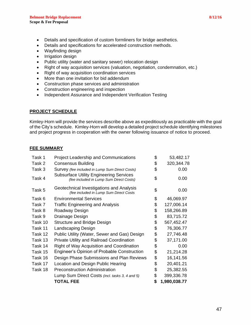
Belmont Bridge Replacement 8/12/16
Scope & Fee Proposal
47
Details and specification of custom formliners for bridge aesthetics.
Details and specifications for accelerated construction methods.
Wayfinding design
Irrigation design
Public utility (water and sanitary sewer) relocation design
Right of way acquisition services (valuation, negotiation, condemnation, etc.)
Right of way acquisition coordination services
More than one invitation for bid addendum
Construction phase services and administration
Construction engineering and inspection
Independent Assurance and Independent Verification Testing
PROJECT SCHEDULE Kimley-Horn will provide the services describe above as expeditiously as practicable with the goal of the City’s schedule. Kimley-Horn will develop a detailed project schedule identifying milestones and project progress in cooperation with the owner following issuance of notice to proceed.
FEE SUMMARY
Task 1 Project Leadership and Communications $ 53,482.17
Task 2 Consensus Building $ 320,344.78
Task 3 Survey (fee included in Lump Sum Direct Costs) $ 0.00
Task 4 Subsurface Utility Engineering Services
(fee included in Lump Sum Direct Costs)
$ 0.00
Task 5 Geotechnical Investigations and Analysis
(fee included in Lump Sum Direct Costs $ 0.00
Task 6 Environmental Services $ 46,069.97
Task 7 Traffic Engineering and Analysis $ 127,006.14
Task 8 Roadway Design $ 158,266.89
Task 9 Drainage Design $ 83,715.72
Task 10 Structure and Bridge Design $ 567,452.47
Task 11 Landscaping Design $ 76,306.77
Task 12 Public Utility (Water, Sewer and Gas) Design $ 27,746.48
Task 13 Private Utility and Railroad Coordination $ 37,171.00
Task 14 Right of Way Acquisition and Coordination $ 0.00
Task 15 Engineer’s Opinion of Probable Construction Cost
$ 21,214.28
Task 16 Design Phase Submissions and Plan Reviews $ 16,141.56
Task 17 Location and Design Public Hearing $ 20,401.21
Task 18 Preconstruction Administration $ 25,382.55
Lump Sum Direct Costs (incl. tasks 3, 4 and 5) $ 399,336.78
TOTAL FEE $ 1,980,038.77
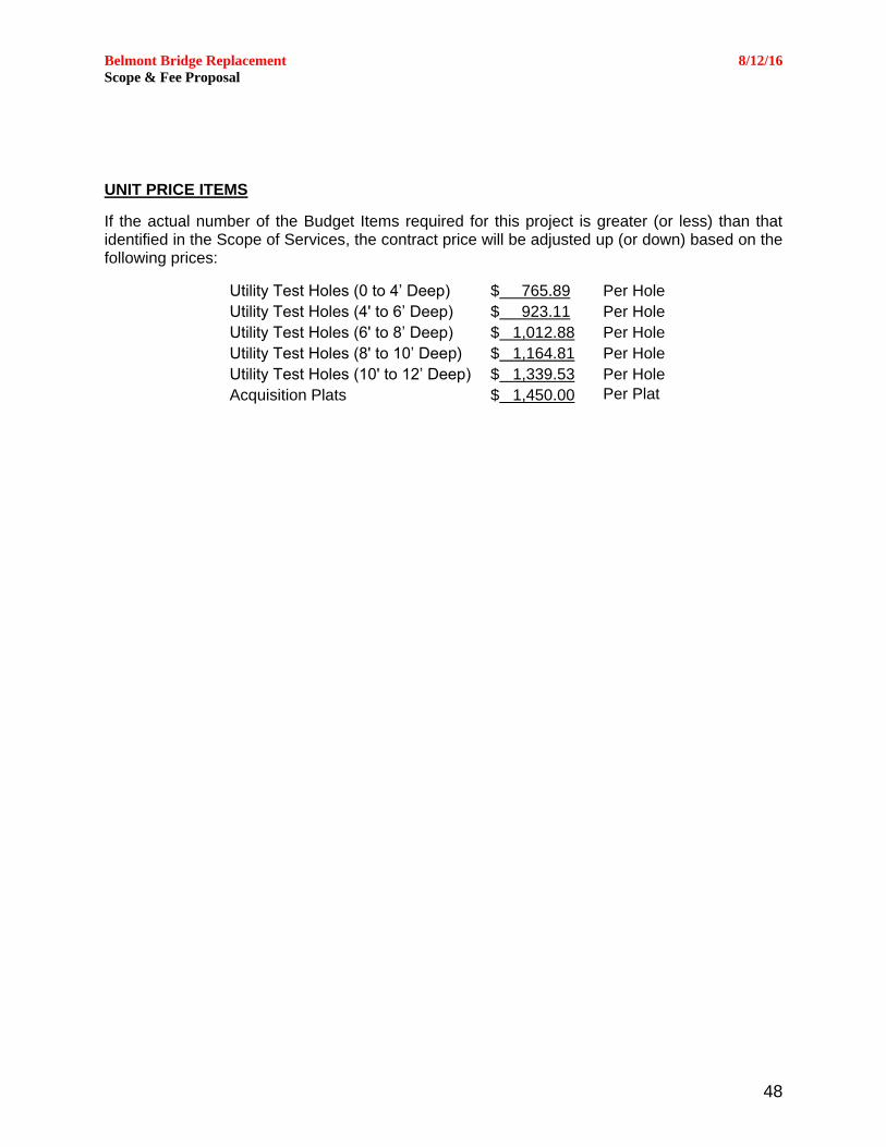
Belmont Bridge Replacement 8/12/16
Scope & Fee Proposal
48
UNIT PRICE ITEMS
If the actual number of the Budget Items required for this project is greater (or less) than that identified in the Scope of Services, the contract price will be adjusted up (or down) based on the following prices:
Utility Test Holes (0 to 4’ Deep) $ 765.89 Per Hole
Utility Test Holes (4' to 6’ Deep) $ 923.11 Per Hole
Utility Test Holes (6' to 8’ Deep) $ 1,012.88 Per Hole
Utility Test Holes (8' to 10’ Deep) $ 1,164.81 Per Hole
Utility Test Holes (10' to 12’ Deep) $ 1,339.53 Per Hole
Acquisition Plats $ 1,450.00 Per Plat

Belmont Bridge Replacement 8/12/16
Scope & Fee Proposal
49
APPENDIX A – SURVEY LIMITS MAP
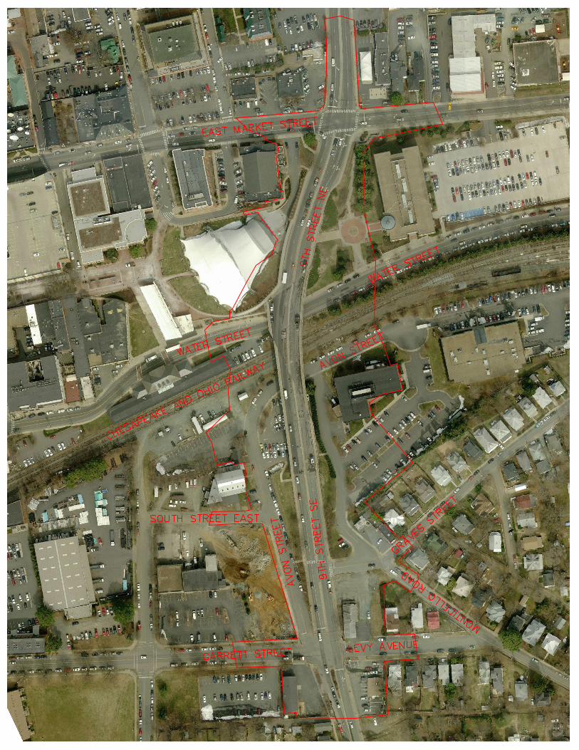

Belmont Bridge Replacement 8/12/16
Scope & Fee Proposal
50
APPENDIX B – MAN HOUR BREAKDOWN
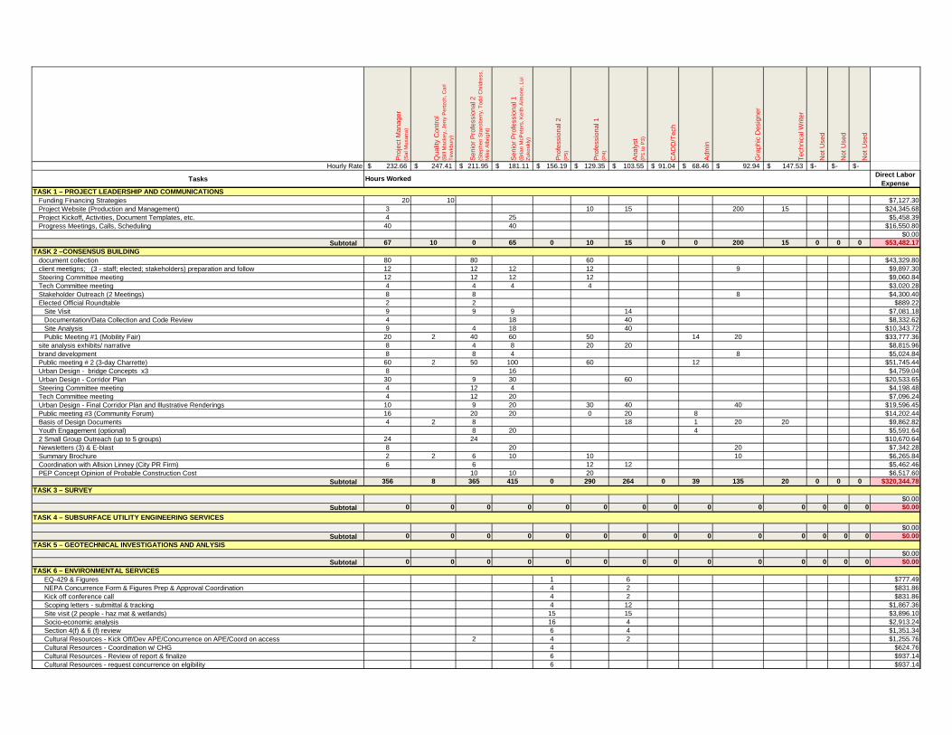
Pro
ject M
anager
(Sa
l M
usa
rra
)
Qualit
y C
ontr
ol
(Bill
Ma
cke
y, Je
rry P
ert
zch
, C
arl
Te
wkb
ury
)
Senio
r P
rofe
ssio
nal 2
(Ste
ph
en
Sta
nsb
err
y, T
od
d C
hild
ress,
Mik
e A
lbrig
ht)
Senio
r P
rofe
ssio
nal 1
(Bria
n M
cP
ete
rs, K
eith
Aim
on
e, L
ui
Zu
ko
skly
)
Pro
fessio
nal 2
(P5
)
Pro
fessio
nal 1
(P4
)
Analy
st
(P1
to
P3
)
CA
DD
/Tech
Adm
in
Gra
phic
Desig
ner
Technic
al W
rite
r
Not U
sed
Not U
sed
Not U
sed
Hourly Rate 232.66$ 247.41$ 211.95$ 181.11$ 156.19$ 129.35$ 103.55$ 91.04$ 68.46$ 92.94$ 147.53$ -$ -$ -$
TasksDirect Labor
Expense
Funding Financing Strategies 20 10 $7,127.30
Project Website (Production and Management) 3 10 15 200 15 $24,345.68
Project Kickoff, Activities, Document Templates, etc. 4 25 $5,458.39
Progress Meetings, Calls, Scheduling 40 40 $16,550.80
$0.00
Subtotal 67 10 0 65 0 10 15 0 0 200 15 0 0 0 $53,482.17
document collection 80 80 60 $43,329.80
client meetigns; (3 - staff; elected; stakeholders) preparation and follow 12 12 12 12 9 $9,897.30
Steering Committee meeting 12 12 12 12 $9,060.84
Tech Committee meeting 4 4 4 4 $3,020.28
Stakeholder Outreach (2 Meetings) 8 8 8 $4,300.40
Elected Official Roundtable 2 2 $889.22
Site Visit 9 9 9 14 $7,081.18
Documentation/Data Collection and Code Review 4 18 40 $8,332.62
Site Analysis 9 4 18 40 $10,343.72
Public Meeting #1 (Mobility Fair) 20 2 40 60 50 14 20 $33,777.36
site analysis exhibits/ narrative 8 4 8 20 20 $8,815.96
brand development 8 8 4 8 $5,024.84
Public meeting # 2 (3-day Charrette) 60 2 50 100 60 12 $51,745.44
Urban Design - bridge Concepts x3 8 16 $4,759.04
Urban Design - Corridor Plan 30 9 30 60 $20,533.65
Steering Committee meeting 4 12 4 $4,198.48
Tech Committee meeting 4 12 20 $7,096.24
Urban Design - Final Corridor Plan and Illustrative Renderings 10 9 20 30 40 40 $19,596.45
Public meeting #3 (Community Forum) 16 20 20 0 20 8 $14,202.44
Basis of Design Documents 4 2 8 18 1 20 20 $9,862.82
Youth Engagement (optional) 8 20 4 $5,591.64
2 Small Group Outreach (up to 5 groups) 24 24 $10,670.64
Newsletters (3) & E-blast 8 20 20 $7,342.28
Summary Brochure 2 2 6 10 10 10 $6,265.84
Coordination with Allsion Linney (City PR Firm) 6 6 12 12 $5,462.46
PEP Concept Opinion of Probable Construction Cost 10 10 20 $6,517.60
Subtotal 356 8 365 415 0 290 264 0 39 135 20 0 0 0 $320,344.78
$0.00
Subtotal 0 0 0 0 0 0 0 0 0 0 0 0 0 0 $0.00
$0.00
Subtotal 0 0 0 0 0 0 0 0 0 0 0 0 0 0 $0.00
$0.00
Subtotal 0 0 0 0 0 0 0 0 0 0 0 0 0 0 $0.00
EQ-429 & Figures 1 6 $777.49
NEPA Concurrence Form & Figures Prep & Approval Coordination 4 2 $831.86
Kick off conference call 4 2 $831.86
Scoping letters - submittal & tracking 4 12 $1,867.36
Site visit (2 people - haz mat & wetlands) 15 15 $3,896.10
Socio-economic analysis 16 4 $2,913.24
Section 4(f) & 6 (f) review 6 4 $1,351.34
Cultural Resources - Kick Off/Dev APE/Concurrence on APE/Coord on access 2 4 2 $1,255.76
Cultural Resources - Coordination w/ CHG 4 $624.76
Cultural Resources - Review of report & finalize 6 $937.14
Cultural Resources - request concurrence on elgibility 6 $937.14
TASK 1 – PROJECT LEADERSHIP AND COMMUNICATIONS
TASK 2 –CONSENSUS BUILDING
TASK 4 – SUBSURFACE UTILITY ENGINEERING SERVICES
TASK 3 – SURVEY
Hours Worked
TASK 5 – GEOTECHNICAL INVESTIGATIONS AND ANLYSIS
TASK 6 – ENVIRONMENTAL SERVICES
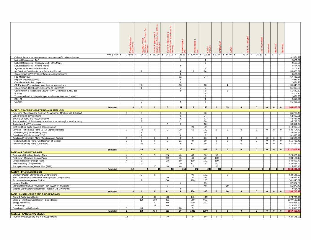
Pro
ject M
anager
(Sa
l M
usa
rra
)
Qualit
y C
ontr
ol
(Bill
Ma
cke
y, Je
rry P
ert
zch
, C
arl
Te
wkb
ury
)
Senio
r P
rofe
ssio
nal 2
(Ste
ph
en
Sta
nsb
err
y, T
od
d C
hild
ress,
Mik
e A
lbrig
ht)
Senio
r P
rofe
ssio
nal 1
(Bria
n M
cP
ete
rs, K
eith
Aim
on
e, L
ui
Zu
ko
skly
)
Pro
fessio
nal 2
(P5
)
Pro
fessio
nal 1
(P4
)
Analy
st
(P1
to
P3
)
CA
DD
/Tech
Adm
in
Gra
phic
Desig
ner
Technic
al W
rite
r
Not U
sed
Not U
sed
Not U
sed
Hourly Rate 232.66$ 247.41$ 211.95$ 181.11$ 156.19$ 129.35$ 103.55$ 91.04$ 68.46$ 92.94$ 147.53$ -$ -$ -$
Cultural Resources - request concurrence on effect determination 12 $1,874.28
Natural Resources - T&E 1 4 $570.39
Natural Resources - floodway (pull FEMA Maps) 1 $103.55
Natural Resources - wetland memo 4 $624.76
Agricultural/Open Space/Farmland 2 $207.10
Air Quality - Coordination and Technical Report 1 4 16 24 $5,426.97
Coordination w/ VDOT to confirm noise is not required 4 $624.76
Haz Mat review 32 24 $7,483.28
Right-of-way Relocations 6 $937.14
Cumulative & Indirect Impacts 4 $624.76
CE Package Preparation - form, figures, appendices 2 18 18 4 $5,443.98
Coordination, Distribution, Response to Comments 1 6 6 $1,805.85
Coordination & response to VDOT/FHWA Comments & final doc 2 6 9 $1,549.82
EQ-555 2 $207.10
Threatened and endangered species clearance update (1 time) 6 $621.30
EQ-121 4 $414.20
QA/QC 2 4 2 $1,326.68
Subtotal 0 6 2 0 167 16 146 0 13 0 0 0 0 0 $46,069.97
Collection of existing And Analysis Assumptions Meeting with City Staff 4 8 8 20 $6,230.44
Synchro Model development 9 24 $3,890.91
Existing analysis and documentation 1 6 12 $2,427.15
Future No-Build & Build analysis and documentation (2 scenarios total) 3 12 30 $5,723.01
Analysis of 2 MOT scenarios 3 9 18 $3,812.94
Draft and final traffic analysis documentation 9 20 80 $13,097.69
Develop Traffic Signal Plans (2 Full Signal Rebuilds) 0 10 0 0 20 50 180 0 0 0 0 0 0 0 $30,704.40
Develop signing and marking plans 6 12 30 $6,465.24
Coordinate ITS elements (CCTV) 1 4 6 $1,493.47
Roadway Photometric Plans (Roadway and Bridge) 0 4 0 0 6 7 26 0 0 0 0 0 0 0 $5,524.53
Roadway Lighting Plans (On Roadway off Bridge) 0 6 0 0 21 37 60 0 0 0 0 0 0 0 $15,763.40
Aesthetic Lighting Plans (On Bridge) 0 40 0 0 9 111 60 0 0 0 0 0 0 0 $31,872.96
Subtotal 4 88 0 3 116 225 546 0 0 0 0 0 0 0 $127,006.14
Conceptual Roadway Design Plans 4 5 5 15 40 40 60 50 $29,856.44
Preliminary Roadway Design Plans 4 0 10 46 40 70 130 $34,184.18
Detailed Roadway Design Plans 4 0 23 60 110 100 110 $49,065.47
Final Roadway Design Plans 0 0 30 132 6 80 $29,664.40
Transportation Management Plan (TMP) 10 10 40 20 30 $15,496.40
Subtotal 12 5 15 58 216 342 236 400 0 0 0 0 0 0 $158,266.89
Drainage Design Elements and Computations 2 8 90 100 0 $24,186.92
Post Development Stormwater Management Computations 10 40 20 $9,056.10
Stormwater Management BMPs 2 50 120 160 $41,640.32
Nutrient Credits 5 15 $2,334.20
Stormwater Pollution Prevention Plan (SWPPP) and Book 2 40 20 $5,873.42
Virginia Stormwater Management Program (VSMP) Permit 4 $624.76
Subtotal 0 4 8 62 9 250 335 0 20 0 0 0 0 0 $83,715.72
Stage 1 Preliminary Design 14 82 112 140 140 $73,733.96
Stage 2 Final Structural Design - Basic Bridge 126 300 450 950 950 $397,513.16
Bridge Aesthetics 40 60 200 200 $65,924.60
Load Rating 12 40 40 $14,961.80
Coordination with Geotech 5 35 20 5 $15,318.95
Subtotal 5 175 434 662 20 1335 1290 0 0 0 0 0 0 0 $567,452.47
Preliminary Landscape and Hardscape Plans 18 30 27 60 9 $20,145.99
TASK 9 – DRAINAGE DESIGN
TASK 8 – ROADWAY DESIGN
TASK 7 – TRAFFIC ENGINEERING AND ANALYSIS
TASK 10 – STRUCTURE AND BRIDGE DESIGN
TASK 11 – LANDSCAPE DESIGN
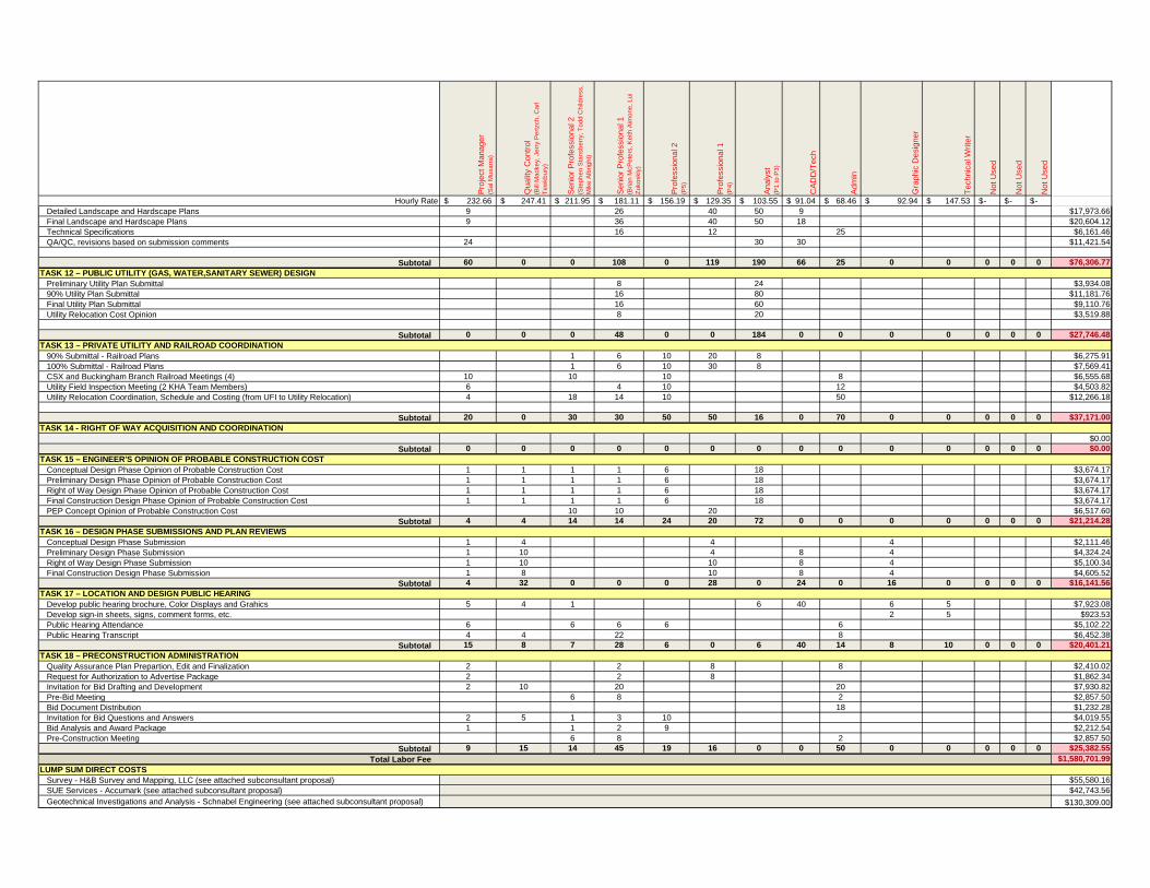
Pro
ject M
anager
(Sa
l M
usa
rra
)
Qualit
y C
ontr
ol
(Bill
Ma
cke
y, Je
rry P
ert
zch
, C
arl
Te
wkb
ury
)
Senio
r P
rofe
ssio
nal 2
(Ste
ph
en
Sta
nsb
err
y, T
od
d C
hild
ress,
Mik
e A
lbrig
ht)
Senio
r P
rofe
ssio
nal 1
(Bria
n M
cP
ete
rs, K
eith
Aim
on
e, L
ui
Zu
ko
skly
)
Pro
fessio
nal 2
(P5
)
Pro
fessio
nal 1
(P4
)
Analy
st
(P1
to
P3
)
CA
DD
/Tech
Adm
in
Gra
phic
Desig
ner
Technic
al W
rite
r
Not U
sed
Not U
sed
Not U
sed
Hourly Rate 232.66$ 247.41$ 211.95$ 181.11$ 156.19$ 129.35$ 103.55$ 91.04$ 68.46$ 92.94$ 147.53$ -$ -$ -$
Detailed Landscape and Hardscape Plans 9 26 40 50 9 $17,973.66
Final Landscape and Hardscape Plans 9 36 40 50 18 $20,604.12
Technical Specifications 16 12 25 $6,161.46
QA/QC, revisions based on submission comments 24 30 30 $11,421.54
Subtotal 60 0 0 108 0 119 190 66 25 0 0 0 0 0 $76,306.77
Preliminary Utility Plan Submittal 8 24 $3,934.08
90% Utility Plan Submittal 16 80 $11,181.76
Final Utility Plan Submittal 16 60 $9,110.76
Utility Relocation Cost Opinion 8 20 $3,519.88
Subtotal 0 0 0 48 0 0 184 0 0 0 0 0 0 0 $27,746.48
90% Submittal - Railroad Plans 1 6 10 20 8 $6,275.91
100% Submittal - Railroad Plans 1 6 10 30 8 $7,569.41
CSX and Buckingham Branch Railroad Meetings (4) 10 10 10 8 $6,555.68
Utility Field Inspection Meeting (2 KHA Team Members) 6 4 10 12 $4,503.82
Utility Relocation Coordination, Schedule and Costing (from UFI to Utility Relocation) 4 18 14 10 50 $12,266.18
Subtotal 20 0 30 30 50 50 16 0 70 0 0 0 0 0 $37,171.00
$0.00
Subtotal 0 0 0 0 0 0 0 0 0 0 0 0 0 0 $0.00
Conceptual Design Phase Opinion of Probable Construction Cost 1 1 1 1 6 18 $3,674.17
Preliminary Design Phase Opinion of Probable Construction Cost 1 1 1 1 6 18 $3,674.17
Right of Way Design Phase Opinion of Probable Construction Cost 1 1 1 1 6 18 $3,674.17
Final Construction Design Phase Opinion of Probable Construction Cost 1 1 1 1 6 18 $3,674.17
PEP Concept Opinion of Probable Construction Cost 10 10 20 $6,517.60
Subtotal 4 4 14 14 24 20 72 0 0 0 0 0 0 0 $21,214.28
Conceptual Design Phase Submission 1 4 4 4 $2,111.46
Preliminary Design Phase Submission 1 10 4 8 4 $4,324.24
Right of Way Design Phase Submission 1 10 10 8 4 $5,100.34
Final Construction Design Phase Submission 1 8 10 8 4 $4,605.52
Subtotal 4 32 0 0 0 28 0 24 0 16 0 0 0 0 $16,141.56
Develop public hearing brochure, Color Displays and Grahics 5 4 1 6 40 6 5 $7,923.08
Develop sign-in sheets, signs, comment forms, etc. 2 5 $923.53
Public Hearing Attendance 6 6 6 6 6 $5,102.22
Public Hearing Transcript 4 4 22 8 $6,452.38
Subtotal 15 8 7 28 6 0 6 40 14 8 10 0 0 0 $20,401.21
Quality Assurance Plan Prepartion, Edit and Finalization 2 2 8 8 $2,410.02
Request for Authorization to Advertise Package 2 2 8 $1,862.34
Invitation for Bid Drafting and Development 2 10 20 20 $7,930.82
Pre-Bid Meeting 6 8 2 $2,857.50
Bid Document Distribution 18 $1,232.28
Invitation for Bid Questions and Answers 2 5 1 3 10 $4,019.55
Bid Analysis and Award Package 1 1 2 9 $2,212.54
Pre-Construction Meeting 6 8 2 $2,857.50
Subtotal 9 15 14 45 19 16 0 0 50 0 0 0 0 0 $25,382.55
Total Labor Fee $1,580,701.99
Survey - H&B Survey and Mapping, LLC (see attached subconsultant proposal) $55,580.16
SUE Services - Accumark (see attached subconsultant proposal) $42,743.56
Geotechnical Investigations and Analysis - Schnabel Engineering (see attached subconsultant proposal) $130,309.00
TASK 15 – ENGINEER'S OPINION OF PROBABLE CONSTRUCTION COST
TASK 16 – DESIGN PHASE SUBMISSIONS AND PLAN REVIEWS
TASK 18 – PRECONSTRUCTION ADMINISTRATION
TASK 12 – PUBLIC UTILITY (GAS, WATER,SANITARY SEWER) DESIGN
TASK 14 - RIGHT OF WAY ACQUISITION AND COORDINATION
TASK 13 – PRIVATE UTILITY AND RAILROAD COORDINATION
LUMP SUM DIRECT COSTS
TASK 17 – LOCATION AND DESIGN PUBLIC HEARING
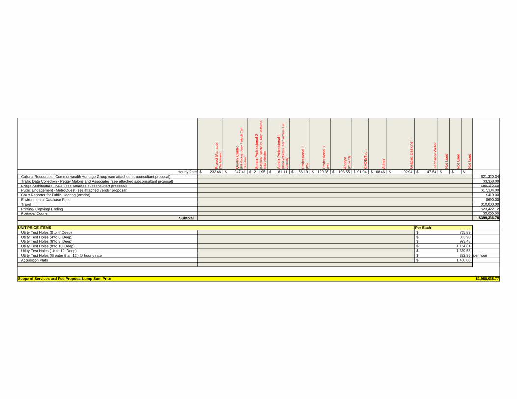
Pro
ject M
anager
(Sa
l M
usa
rra
)
Qualit
y C
ontr
ol
(Bill
Ma
cke
y, Je
rry P
ert
zch
, C
arl
Te
wkb
ury
)
Senio
r P
rofe
ssio
nal 2
(Ste
ph
en
Sta
nsb
err
y, T
od
d C
hild
ress,
Mik
e A
lbrig
ht)
Senio
r P
rofe
ssio
nal 1
(Bria
n M
cP
ete
rs, K
eith
Aim
on
e, L
ui
Zu
ko
skly
)
Pro
fessio
nal 2
(P5
)
Pro
fessio
nal 1
(P4
)
Analy
st
(P1
to
P3
)
CA
DD
/Tech
Adm
in
Gra
phic
Desig
ner
Technic
al W
rite
r
Not U
sed
Not U
sed
Not U
sed
Hourly Rate 232.66$ 247.41$ 211.95$ 181.11$ 156.19$ 129.35$ 103.55$ 91.04$ 68.46$ 92.94$ 147.53$ -$ -$ -$
Cultural Resources - Commonwealth Heritage Group (see attached subconsultant proposal) $21,320.34
Traffic Data Collection - Peggy Malone and Associates (see attached subconsultant proposal) $3,368.00
Bridge Architecture - KGP (see attached subconsultant proposal) $89,150.60
Public Engagement - MetroQuest (see attached vendor proposal) $17,334.00
Court Reporter for Public Hearing (vendor) $419.00
Environmental Database Fees $690.00
Travel $10,000.00
Printing/ Copying/ Binding $23,422.12
Postage/ Courier $5,000.00
Subtotal $399,336.78
UNIT PRICE ITEMS
Utility Test Holes (0 to 4’ Deep)
Utility Test Holes (4' to 6’ Deep)
Utility Test Holes (6' to 8’ Deep)
Utility Test Holes (8' to 10’ Deep)
Utility Test Holes (10' to 12’ Deep)
Utility Test Holes (Greater than 12') @ hourly rate per hour
Acquisition Plats
Scope of Services and Fee Proposal Lump Sum Price $1,980,038.77
1,450.00$
1,339.53$
382.95$
1,164.81$
Per Each
993.48$
765.89$
863.90$