Embed Size (px)
Citation preview

Page 1 of 12
Engineering Report
White River National Forest
Eagle-Holy Cross Ranger District
Analysis of Road # 418
Nolan Creek Road
for Motorized Mixed Use Designation

Page 2 of 12
Forest: White River
District: Eagle-Holy Cross
Road Number: 418
Road Name: Nolan Creek
Beginning Mile Post: 0.0 at NFSR 415
Ending Mile Post 3.8 at the entrance to the Town of Fulford (NFSR 419)
Traffic Service Level - A, B, C, or D: C – Interrupted By Limited Passing Facilities
Objective Maintenance Level – 1, 2, 3, 4, or 5: 3 – Suitable For Passenger Cars
Operational Maintenance Level – 1, 2, 3, 4, or 5: 3 – Suitable For Passenger Cars
Maintenance By: Forest Service and Eagle County
Non-Forest Service ROW or jurisdiction? Yes/No NO
Any road use agreements, maintenance agreements, or other encumbrances? Yes/No YES
Description of agreements or encumbrances: Currently under a “Cooperative Forest Road Agreement” for road maintenance by Eagle County under a “Schedule A” Agreement. Maintenance performed by the county occurs once per year.
Subject to the Highway Safety Act? Yes/No YES
Non-Highway-Legal Vehicles currently permitted? Yes/No NO
Is motorized mixed use consistent with State and Local laws? Yes/No YES Notes:
Description of Road Management Objectives, Existing Use, and Proposed Use:
1999 Road Management Objectives (RMO) Worksheet is on file and signed by the District
Ranger. A recent and updated RMO is currently not available.
NFSR 418 is 5.4 miles long and currently consists of the following Motorized Mixed Use
designations:
M.P. 0.0 – M.P. 3.8 is closed to mixed use and signed with “Highway Legal Vehicles
Only”.
M.P. 3.8 – M.P. 5.4 is open to mixed use and is signed with “Share the Road” and “ATV”
signs.
The Nolan Creek Road is classified as a Collector.
The Nolan Creek Road provides summer access to the small Town of Fulford. There are
approximately 60 cabins in Fulford with maybe 10-15 owners who visit regularly during the
Page 3 of 12
summer season. Current use is recreational and the road provides access for dispersed
camping, hiking, fishing, hunting, sightseeing, and wilderness access.
In 2006, a Motorized Mixed Use Judgment was prepared for the entire length of the Nolan
Creek Road (M.P. 0.0 - M.P. 5.4). The original judgment recommended closure to mixed use
from the junction with NFSR 415 (M.P. 0.0) – junction with NFSR 419 (M.P. 3.8), while also
noting the appropriateness of designating the remaining 1.6 miles (M.P. 3.8 – M.P. 5.4) as open
to mixed use. The Eagle/Holy Cross Ranger District requested that a detailed Motorized Mixed
Use Report be prepared to confirm or to modify the original 2006 Motorized Mixed Use
Judgment recommending closure to mixed use on the first 3.8 miles.
Summary of Findings:
The Nolan Creek Road is a moderately used forest road. This segment (M.P. 0.0 – M.P. 3.8) is
single lane, native surfaced with fair alignment and grade. This segment is currently designated
as closed to Motorized Mixed Use and there are no known or documented mixed use accidents.
Horizontal alignment and grade is generally fair and the adjacent roadside terrain is
predominately steep in nature. The road width varies from 11 to 16 feet with roadside
drainage ditches and culverts. Numerous turnouts occur on the road. There are some sharp
curves/switchbacks and sections that are lined with vegetation (trees and/or brush) that
obscure the roadway and oncoming traffic. The vast majority of the road occurs in a timbered
environment and road is lined with vegetation (trees and/or brush), with trees that are large
enough (8”-12”) to be obstacles to vehicles leaving the road to avoid a collision.
There are no posted speed limits on the segment of the road being studied and the reasonable
and prudent driving speed is 15-20 mph. A speed study was conducted on Friday August 9,
2013). Travel speeds observed varied between 15 and 31 mph with the 85th percentile speed at
25 mph. Pickup trucks/SUV’s were observed traveling at the highest speeds.
A single traffic counter was deployed and traffic volumes were recorded between June 13, 2013
and October 23, 2013. A total of 7,228 vehicles were counted with an Average Daily Traffic
(ADT) of 54 for the 4.25 month sampling period (133 days). Traffic volumes averaged 41 ADT
on weekdays (Mon – Fri) and 88 ADT on weekends. The peak period of use occurred during the
Labor Day Holiday weekend, Sunday September 1, 2013 (141 ADT) and Monday September 2,
2013 (138 ADT). Additional periods of peak use included the Saturday July 20, 2013 (137 ADT),
Thursday July 4, 2013 (128 ADT), and Saturday August 24, 2013 (128 ADT).
Page 4 of 12
Traffic types, observed during speed studies, consisted of the only two vehicle types: passenger
cars (1 vehicle - 7% of traffic) and pickup trucks/SUV’s (13 vehicles - 93% of traffic). No pickup
trucks/SUV’s towing trailers or RV’s were observed during the speed study.
The original 2006 Motorized Mixed Use Judgment rated the crash probability as high/medium
and crash severity as high/medium. Mitigation measures may be used to reduce the probability
and severity by varying degrees.
Factors Considered:
1. Operator Considerations:
This segment of road is subject to the Highway Safety Act and to Colorado State laws for
operators.
Colorado Off-Highway Vehicle (OHV) State Laws – no person under the age of ten years may
operate an off-highway vehicle on such public street, road, or highway of this state or on such
city street or county road. No person ten years or older may operate an off-highway vehicle on
such public street, road, or highway of this state or on such city street or county road unless:
1. The person has in his possession a valid driver’s license issued by the State of Colorado or
another state; or
2. The person is accompanied by and under the immediate supervision of a person who has in
his possession a valid driver’s license issued by the State of Colorado or another state. The
phrase “under immediate supervision” shall mean that, at a minimum, the unlicensed
operator is within visual contact of the licensed supervisor.
There are no Colorado State laws requiring head protection (helmet) for OHV operators.
2. Crash History:
There are no known or documented mixed use accidents on this segment of NFSR 418.

Page 5 of 12
3. Traffic Volume and Type
Non-Highway-Legal-Vehicles
Less than 12 inch tread width:
Less than 50 inch tread width:
Greater than 50 inch tread width:
Highway-Legal-Vehicles
Passenger Cars: X
Pickup Trucks/SUV’s X
Commercial Vehicles:
Recreational Vehicles (RV’s):
Traffic counts were compiled between June 13, 2013 and October 23, 2013. Traffic counters
used were manufactured by TRAFx and utilize magnetometer technology and advanced
embedded software to detect passing vehicles. A single traffic counter was deployed and traffic
volumes were recorded between June 13, 2013 and October 23, 2013. A total of 7,228 vehicles
were counted with an Average Daily Traffic (ADT) of 54 for the 4.25 month sampling period
(133 days).
Traffic volumes averaged 41 ADT on weekdays (Mon – Fri) and 88 ADT on weekends.
The peak period of use occurred during the Labor Day Holiday weekend, Sunday September 1,
2013 (141 ADT) and Monday September 2, 2013 (138 ADT). Additional periods of peak use
included the Saturday, July 20, 2013 (137 ADT); Thursday, July 4, 2013 (128 ADT); and Saturday,
August 24, 2013 (128 ADT).
Based on observations made during speed study, conducted on Thursday August 8, 2013,
passenger cars accounted for 7% (1 vehicle) of the total traffic (14 vehicles), while pickup
trucks/SUV’s made up the remaining 93% (13 vehicles) of the traffic. No pickup trucks/SUV’s
towing trailers or RV’s were observed during the speed study.
4. Speed – Anticipated Average Speed (85th percentile): 25 mph
There are no posted speed limits on the segment of the road being studied and the reasonable
and prudent driving speed is 15-20 mph. Colorado Revised Statue 42-4-1101, Speed Limits
notes the following and (a) is applicable to this segment of the Nolan Creek Road.
(1) No person shall drive a vehicle on a highway at a speed greater than is reasonable and
prudent under the conditions then existing.
(2) Except when a special hazard exists that requires a lower speed, the following speeds shall

Page 6 of 12
be lawful:
(a) Twenty miles per hour on narrow, winding mountain highways or on blind curves;
(b) Twenty-five miles per hour in any business district, as defined in section 42-1-102 (11);
(c) Thirty miles per hour in any residence district, as defined in section 42-1-102 (80);
(d) Forty miles per hour on open mountain highways;
(e) Forty-five miles per hour for all single rear axle vehicles in the business of transporting trash
that exceed twenty thousand pounds, where higher speeds are posted, when said vehicle is
loaded as an exempted vehicle pursuant to section 42-4-507 (3);
(f) Fifty-five miles per hour on other open highways which are not on the interstate system, as
defined in section 43-2-101 (2), C.R.S., and are not surfaced, four-lane freeways or expressways;
(g) Sixty-five miles per hour on surfaced, four-lane highways which are on the interstate system,
as defined in section 43-2-101 (2), C.R.S., or are freeways or expressways;
The speed study was conducted with the Bushnell Speed Radar Gun which utilizes Doppler
Radar technology with +/- one-mile per hour (mph) accuracy. The study was conducted on a
single day (Friday August 9, 2013). The speed study was conducted on a straight section of road
with a good running surface (no protruding rock or rutted surface) and occurred over a five
hour period. It should be noted that the sample size was relatively small (14 vehicles) and
statistically may not be representative of the true speeds at which vehicles are traveling.
Traffic speeds observed varied between 15 and 31 mph with the 85th percentile speed at 25
mph. Two pickup trucks/SUV’s were observed traveling above the 85th percentile (25 mph) and
were observed traveling at 27 mph and 31 mph. Pickup trucks & SUV’s were traveling at the
highest speeds.
5. Road Surface Type:
This segment of road is native surfaced and in fair - poor condition. The native surface is
predominately rough with rocks protruding from the running surface, potholes, and rutted
sections. The vast majority of the road has a rough surface (3.5 miles, 92%) which contributes
to the lower traveling speeds (85th percentile of 25 mph).

Page 7 of 12
6. Intersections With Other Roads and Trails:
There are two road intersections and two access points leading to dispersed campsites along
this segment of the Nolan Creek Road.
The beginning of this section starts at the intersection with Maintenance Level 3 road 415 (East
Brush Creek) and ends at the road into the Town of Fulford (NFSR 419). The intersection with
the Brush Creek Road (NFSR 415) has adequate sight distance to the southeast (up the road),
while sight distance to the northwest (back down the road) is inadequate. At the intersecting
road into Fulford (NFSR 419), sight distance to the north (up the road) is adequate, while sight
distance to the south (back down the road) is inadequate. Roadside brushing and clearing is
needed at both of these intersections to improve sight distance and to allow for earlier
detection of oncoming traffic.
Between M.P. 0.7 and M.P. 0.75, this section of road also intersects with two roads accessing
dispersed campsites. The first campsite has adequate sight distance to the south (up the road)
and inadequate sight distance to the north (back down the road). The second camp site has
adequate sight distance to the north (up the road) and inadequate sight distance to the south
(back down the road). Roadside brushing and clearing is needed at both of these intersections
to improve sight distance and to allow for the earlier detection of oncoming traffic.
7. Other Roadway Factors:
There are numerous sharp curves (7) and/or switchbacks (2) on this 3.8 mile section. The road
also has long tangents (straight sections) between the curves and/or switchback that allows for
adequate sight distance as well as earlier detection of oncoming traffic. As the majority of the
road is lined with vegetation (trees and/or brush), clearing and brushing is necessary at these
sharp curves/switchbacks to improve sight distance which will allow for earlier detection of
oncoming traffic.
Approximately 3.7 miles (97% of the road segment) is lined with vegetation (trees and/or
brush), with much of the road (3.5 miles - 91%) consisting of moderate to steep terrain.
These two factors, tree lined roadway and steep cut/fill slopes, provide very few escape options
for drivers attempting to leave the road to avoid a collision.

Page 8 of 12
8. Roadside Conditions:
As mentioned previously in #7 Other Roadway Factors, the majority of the road is lined with
trees that are large enough (8”-12” diameter) to be obstacles to vehicles leaving the road to
avoid a collision (3.5 miles – 91% of the road).
Due to the moderate/steep terrain that the road is located in, cut and fill slopes are also steep.
The steep cut/fill slopes increase the crash severity as there are limited opportunities for
vehicles to safely leave the road to avoid a collision. There are also sections of road containing
horizontal curves that have reduced and limited sight distance due to overgrown vegetation
(trees and/or brush). This vegetation obscures the roadway and on-coming traffic and requires
clearing and brushing. Clearing and brushing, at a minimum, should be 5’ from the top of the
ditch or 5’ from the edge of the road, whichever is greater.
M.P. 0.725 – Example of inadequate sight distance around curve due to vegetation
(small trees/brush) obscuring roadway around curve.

Page 9 of 12
M.P. 3.4– Example of inadequate sight distance due to vegetation (trees/brush)
obscuring roadway.
M.P. 0.0, Intersection with NFSR 415 – Example of adequate sight distance.
Page 10 of 12
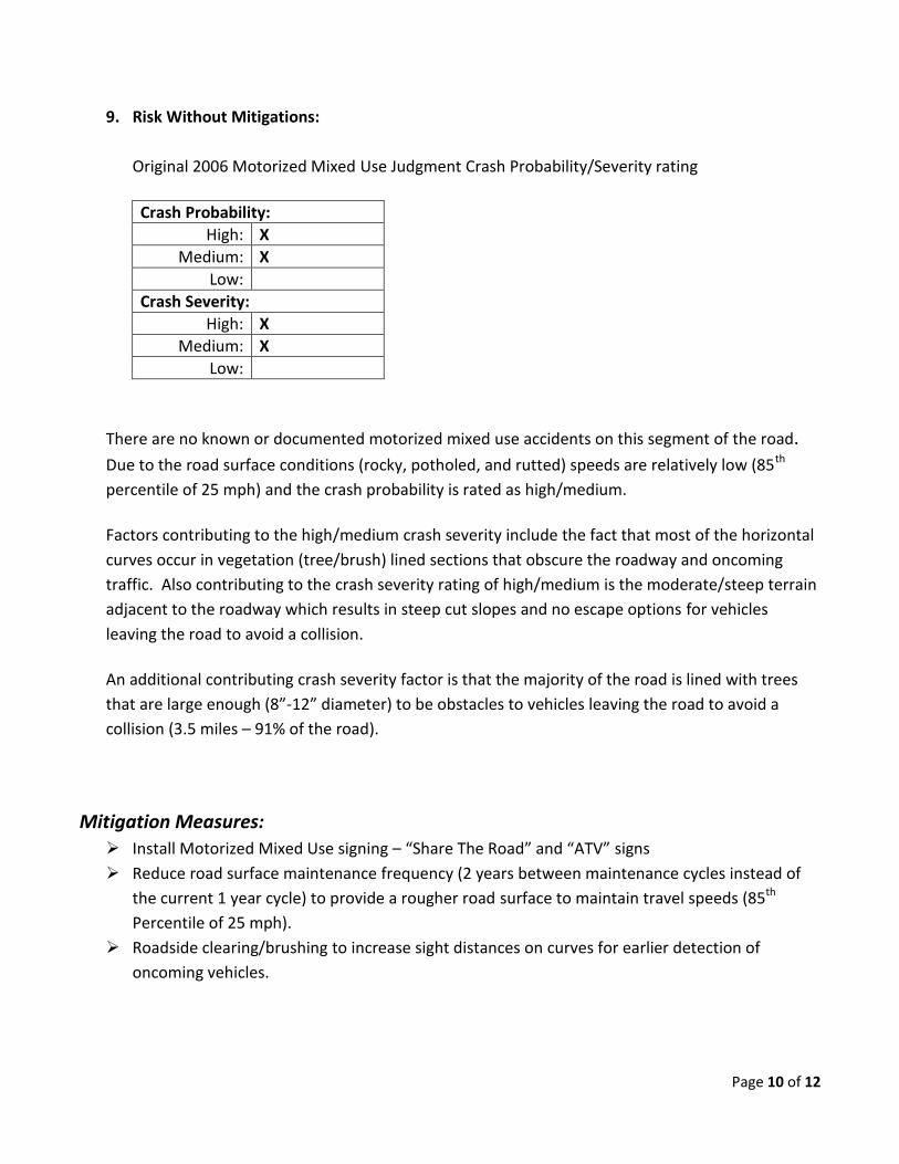
9. Risk Without Mitigations:
Original 2006 Motorized Mixed Use Judgment Crash Probability/Severity rating
Crash Probability:
High: X
Medium: X
Low:
Crash Severity:
High: X
Medium: X
Low:
There are no known or documented motorized mixed use accidents on this segment of the road.
Due to the road surface conditions (rocky, potholed, and rutted) speeds are relatively low (85th
percentile of 25 mph) and the crash probability is rated as high/medium.
Factors contributing to the high/medium crash severity include the fact that most of the horizontal
curves occur in vegetation (tree/brush) lined sections that obscure the roadway and oncoming
traffic. Also contributing to the crash severity rating of high/medium is the moderate/steep terrain
adjacent to the roadway which results in steep cut slopes and no escape options for vehicles
leaving the road to avoid a collision.
An additional contributing crash severity factor is that the majority of the road is lined with trees
that are large enough (8”-12” diameter) to be obstacles to vehicles leaving the road to avoid a
collision (3.5 miles – 91% of the road).
Mitigation Measures:
Install Motorized Mixed Use signing – “Share The Road” and “ATV” signs
Reduce road surface maintenance frequency (2 years between maintenance cycles instead of
the current 1 year cycle) to provide a rougher road surface to maintain travel speeds (85th
Percentile of 25 mph).
Roadside clearing/brushing to increase sight distances on curves for earlier detection of
oncoming vehicles.

Page 11 of 12
Conclusion:
Maintaining overall travel speeds, increasing sight distances for earlier detection of oncoming
vehicles, and informing the traveling public of the types of vehicles that they can expect on the
road is critical to lowering the crash probability and severity. Each of the proposed mitigation
measures will help reduce the probability and/or severity to varying degrees.
Installation of Motorized Mixed Use signing to inform the traveling public of the types of
vehicles that can be expected on the road.
Roadside clearing/brushing to increase sight distances on curves for earlier detection of
oncoming vehicles.
Reduced road surface maintenance frequency (2 years between maintenance cycles instead of
the current 1 year cycle) to provide a rougher road surface to maintain travel speeds.
Implementation of the reduced road surface maintenance frequency (2 years between
maintenance cycles instead of the current 1 year cycle) will help maintain the lower travel
speeds and therefore help in maintaining or possibly lowering the crash probability to medium.
While implementing the clearing/brushing mitigation measures noted above will not decrease
speeds, it will help in lowering the crash probability to medium by allowing earlier detection of
oncoming vehicles which will assist in a motorist’s ability to avoid and/or minimized possible
collisions.
While the installation of Motorized Mixed Use signing will not reduce traveling speeds, it will
assist in lowering the current crash probability rating of high/medium as the traveling public
will be aware of the types of vehicles that they can expect to encounter on the road.