Embed Size (px)
Citation preview
Yu Xiao 28.4.2014
Energy-efficient Mobile Sensing T-110.6120 Spring 2014
Agenda
• Sensors on smartphones
• Energy-efficient Positioning
• Energy-efficient Trajectory Tracking
• Energy-efficient User State Recognition
• Sensor Hub
28.4.2014
Laitoksen nimi
2
Which sensors are available on a smartphone?
28.4.2014
Laitoksen nimi
3
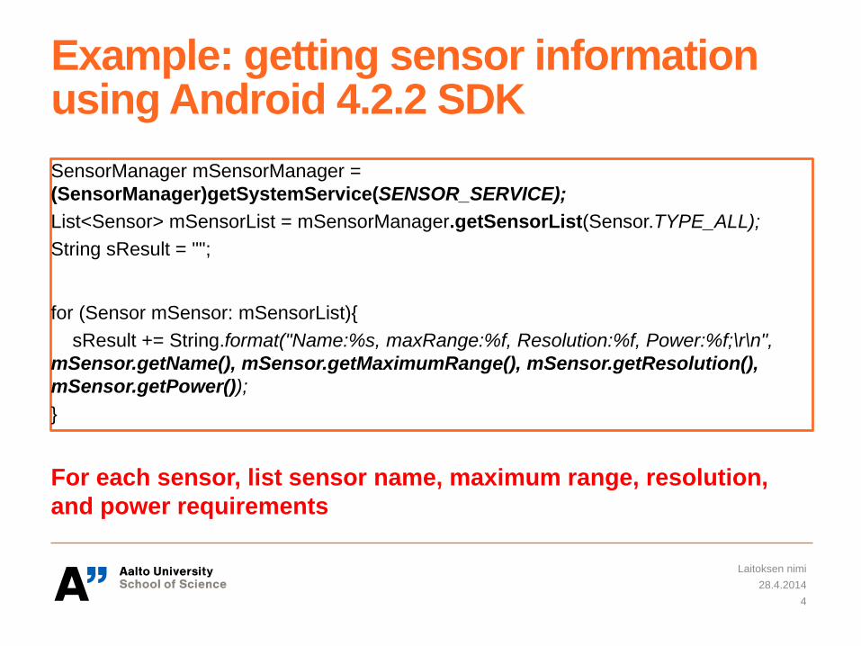
Example: getting sensor information using Android 4.2.2 SDK
28.4.2014
Laitoksen nimi
4
SensorManager mSensorManager =
(SensorManager)getSystemService(SENSOR_SERVICE);
List<Sensor> mSensorList = mSensorManager.getSensorList(Sensor.TYPE_ALL);
String sResult = "";
for (Sensor mSensor: mSensorList){
sResult += String.format("Name:%s, maxRange:%f, Resolution:%f, Power:%f;\r\n",
mSensor.getName(), mSensor.getMaximumRange(), mSensor.getResolution(),
mSensor.getPower());
}
For each sensor, list sensor name, maximum range, resolution,
and power requirements
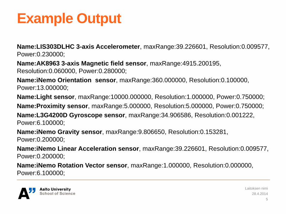
Example Output
Name:LIS303DLHC 3-axis Accelerometer, maxRange:39.226601, Resolution:0.009577,
Power:0.230000;
Name:AK8963 3-axis Magnetic field sensor, maxRange:4915.200195,
Resolution:0.060000, Power:0.280000;
Name:iNemo Orientation sensor, maxRange:360.000000, Resolution:0.100000,
Power:13.000000;
Name:Light sensor, maxRange:10000.000000, Resolution:1.000000, Power:0.750000;
Name:Proximity sensor, maxRange:5.000000, Resolution:5.000000, Power:0.750000;
Name:L3G4200D Gyroscope sensor, maxRange:34.906586, Resolution:0.001222,
Power:6.100000;
Name:iNemo Gravity sensor, maxRange:9.806650, Resolution:0.153281,
Power:0.200000;
Name:iNemo Linear Acceleration sensor, maxRange:39.226601, Resolution:0.009577,
Power:0.200000;
Name:iNemo Rotation Vector sensor, maxRange:1.000000, Resolution:0.000000,
Power:6.100000;
28.4.2014
Laitoksen nimi
5
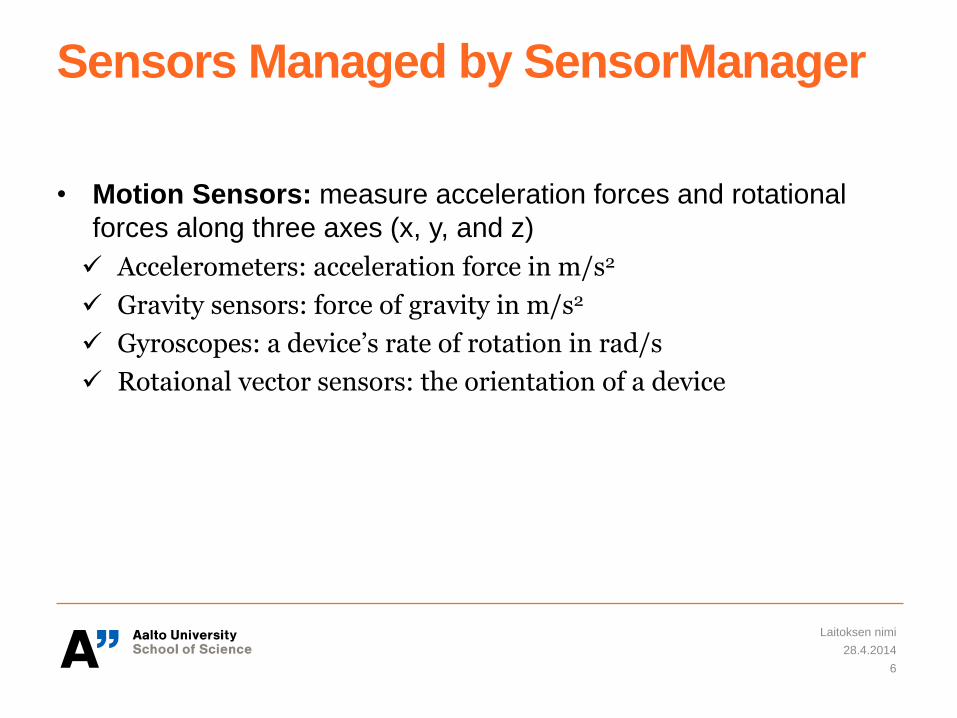
Sensors Managed by SensorManager
• Motion Sensors: measure acceleration forces and rotational
forces along three axes (x, y, and z)
Accelerometers: acceleration force in m/s2
Gravity sensors: force of gravity in m/s2
Gyroscopes: a device’s rate of rotation in rad/s
Rotaional vector sensors: the orientation of a device
28.4.2014
Laitoksen nimi
6
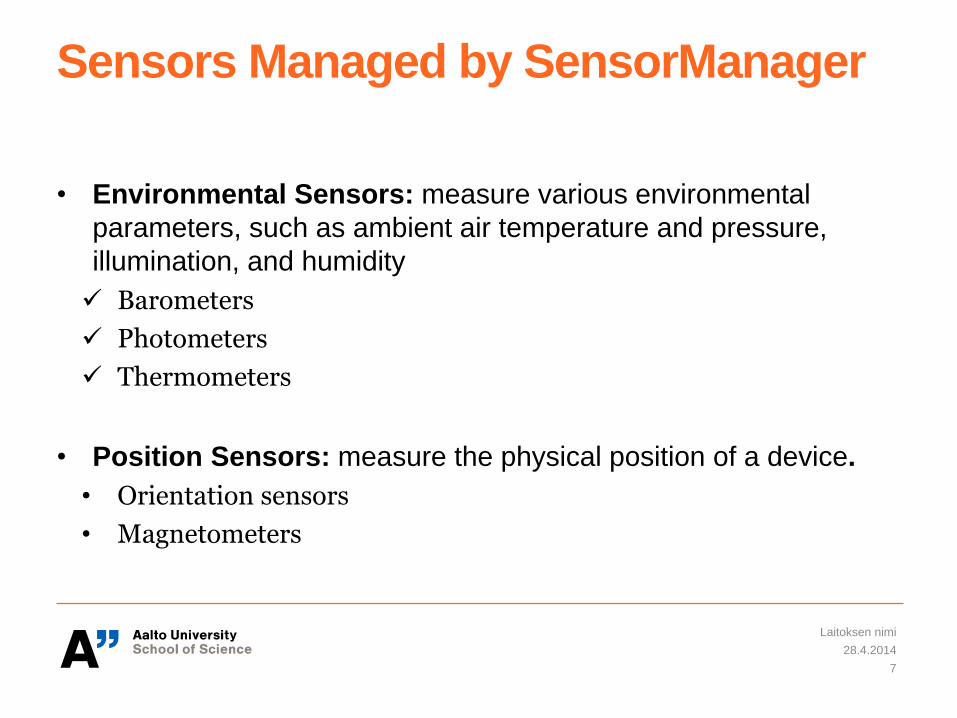
Sensors Managed by SensorManager
• Environmental Sensors: measure various environmental
parameters, such as ambient air temperature and pressure,
illumination, and humidity
Barometers
Photometers
Thermometers
• Position Sensors: measure the physical position of a device.
• Orientation sensors
• Magnetometers
28.4.2014
Laitoksen nimi
7
Any other sensors available on Smartphones?
28.4.2014
Laitoksen nimi
8
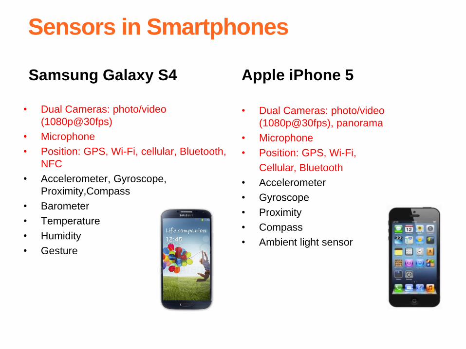
Sensors in Smartphones
Samsung Galaxy S4 Apple iPhone 5
• Dual Cameras: photo/video
(1080p@30fps), panorama
• Microphone
• Position: GPS, Wi-Fi,
Cellular, Bluetooth
• Accelerometer
• Gyroscope
• Proximity
• Compass
• Ambient light sensor
• Dual Cameras: photo/video
(1080p@30fps)
• Microphone
• Position: GPS, Wi-Fi, cellular, Bluetooth,
NFC
• Accelerometer, Gyroscope,
Proximity,Compass
• Barometer
• Temperature
• Humidity
• Gesture
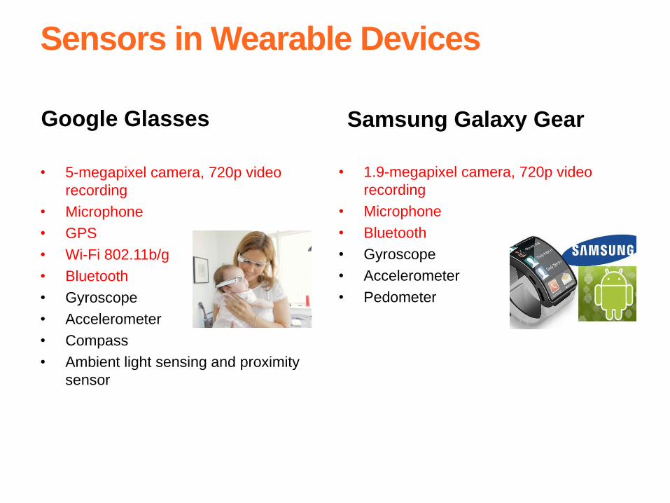
Sensors in Wearable Devices
Google Glasses
• 5-megapixel camera, 720p video
recording
• Microphone
• GPS
• Wi-Fi 802.11b/g
• Bluetooth
• Gyroscope
• Accelerometer
• Compass
• Ambient light sensing and proximity
sensor
Samsung Galaxy Gear
• 1.9-megapixel camera, 720p video
recording
• Microphone
• Bluetooth
• Gyroscope
• Accelerometer
• Pedometer
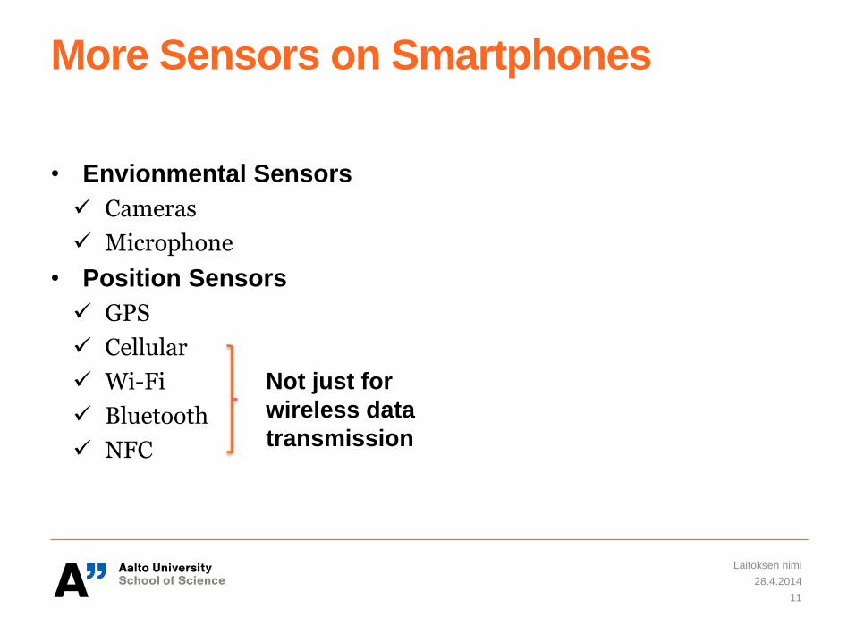
More Sensors on Smartphones
• Envionmental Sensors
Cameras
Microphone
• Position Sensors
GPS
Cellular
Wi-Fi
Bluetooth
NFC
28.4.2014
Laitoksen nimi
11
Not just for
wireless data
transmission
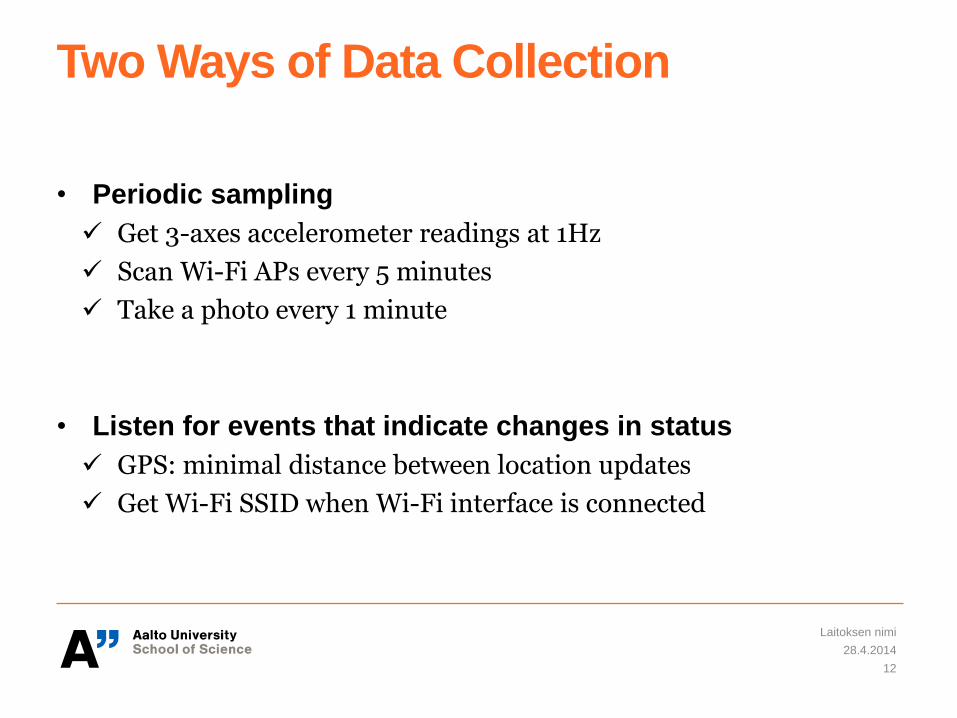
Two Ways of Data Collection
• Periodic sampling
Get 3-axes accelerometer readings at 1Hz
Scan Wi-Fi APs every 5 minutes
Take a photo every 1 minute
• Listen for events that indicate changes in status
GPS: minimal distance between location updates
Get Wi-Fi SSID when Wi-Fi interface is connected
28.4.2014
Laitoksen nimi
12
Is it expensive in terms of power consumption to collect sensor
data?
28.4.2014
Laitoksen nimi
13
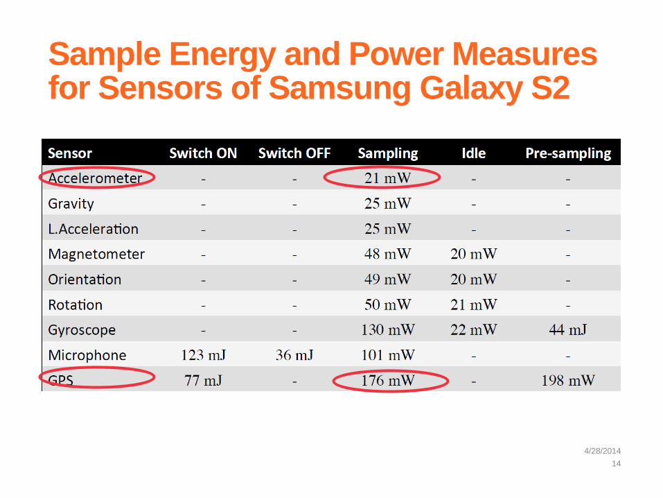
Sample Energy and Power Measures for Sensors of Samsung Galaxy S2
4/28/2014
14
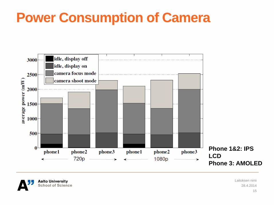
Power Consumption of Camera
28.4.2014
Laitoksen nimi
15
Phone 1&2: IPS
LCD
Phone 3: AMOLED
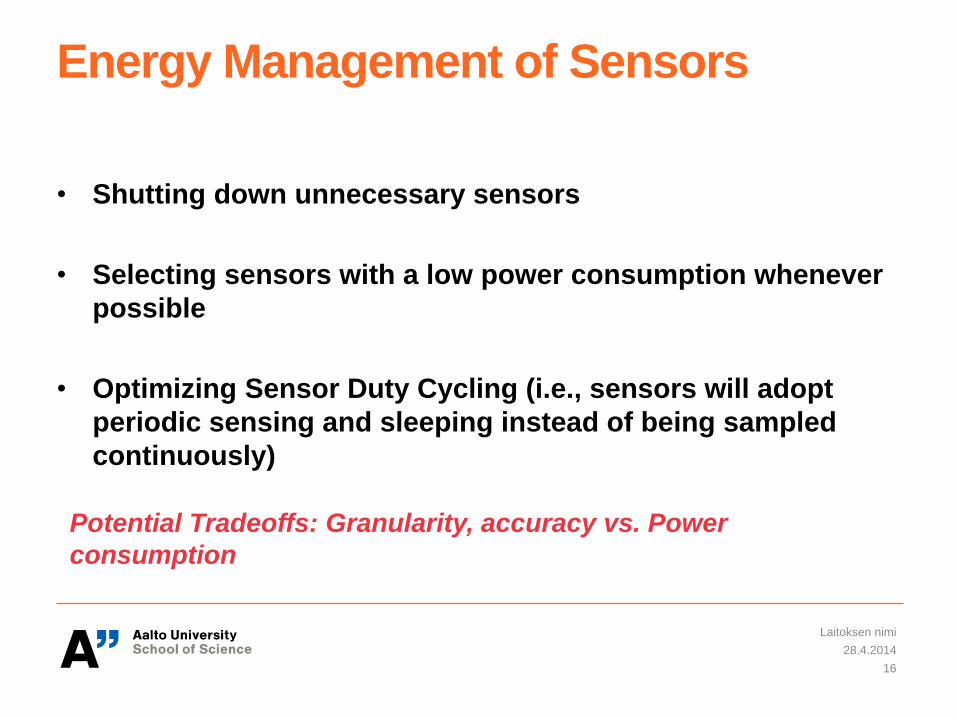
Energy Management of Sensors
• Shutting down unnecessary sensors
• Selecting sensors with a low power consumption whenever
possible
• Optimizing Sensor Duty Cycling (i.e., sensors will adopt
periodic sensing and sleeping instead of being sampled
continuously)
28.4.2014
Laitoksen nimi
16
Potential Tradeoffs: Granularity, accuracy vs. Power
consumption
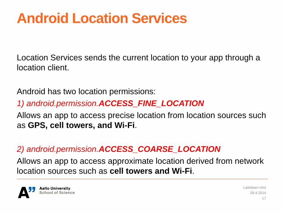
Android Location Services
Location Services sends the current location to your app through a
location client.
Android has two location permissions:
1) android.permission.ACCESS_FINE_LOCATION
Allows an app to access precise location from location sources such
as GPS, cell towers, and Wi-Fi.
2) android.permission.ACCESS_COARSE_LOCATION
Allows an app to access approximate location derived from network
location sources such as cell towers and Wi-Fi.
28.4.2014
Laitoksen nimi
17
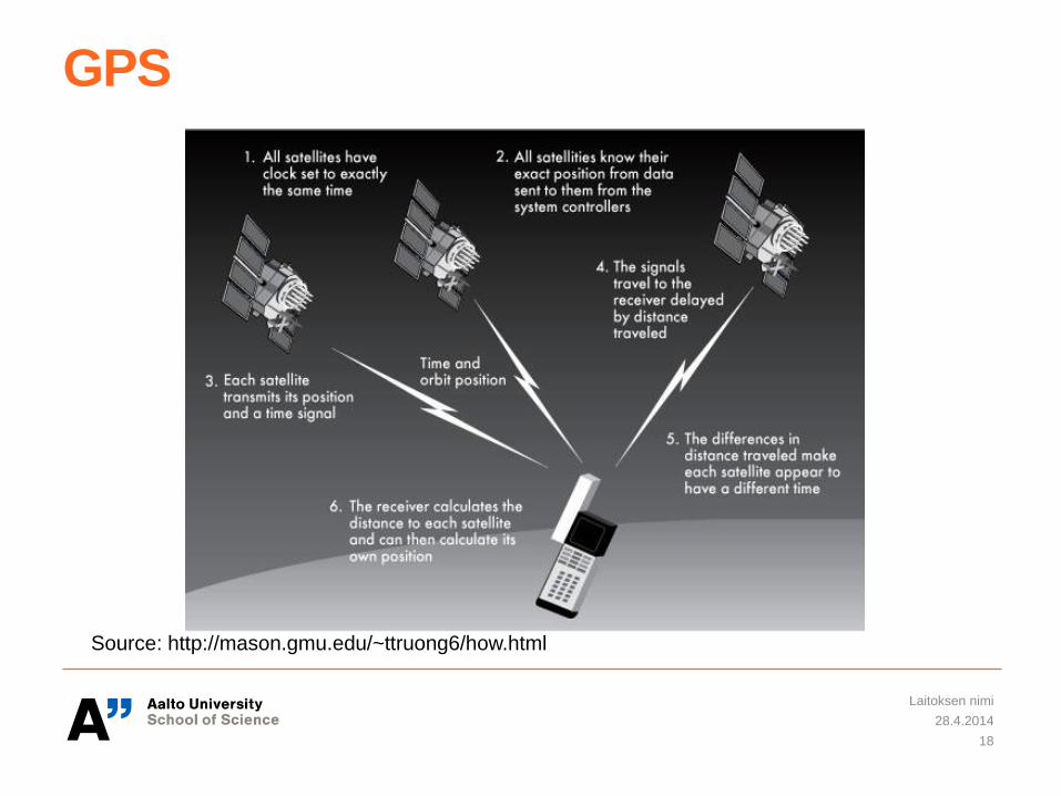
GPS
28.4.2014
Laitoksen nimi
18
Source: http://mason.gmu.edu/~ttruong6/how.html
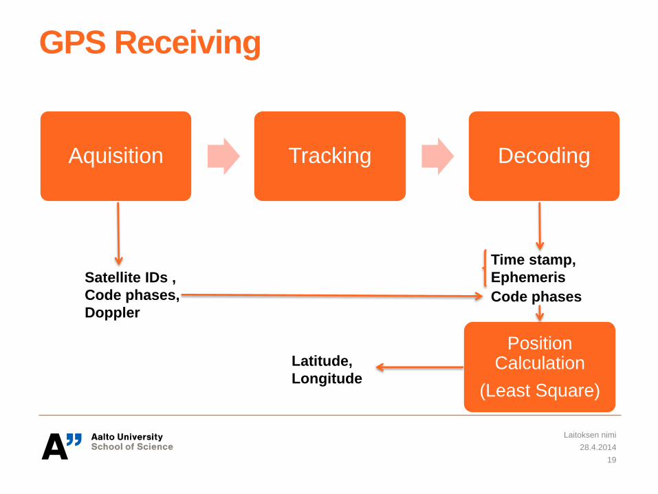
GPS Receiving
Aquisition Tracking Decoding
28.4.2014
Laitoksen nimi
19
Satellite IDs ,
Code phases,
Doppler
Time stamp,
Ephemeris
Code phases
Position Calculation
(Least Square)
Latitude,
Longitude
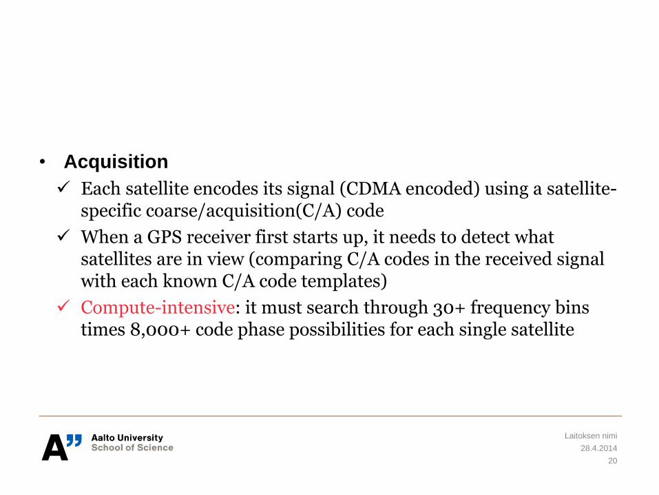
• Acquisition
Each satellite encodes its signal (CDMA encoded) using a satellite-specific coarse/acquisition(C/A) code
When a GPS receiver first starts up, it needs to detect what satellites are in view (comparing C/A codes in the received signal with each known C/A code templates)
Compute-intensive: it must search through 30+ frequency bins times 8,000+ code phase possibilities for each single satellite
28.4.2014
Laitoksen nimi
20
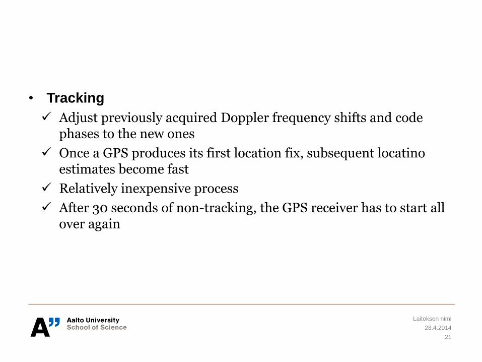
• Tracking
Adjust previously acquired Doppler frequency shifts and code phases to the new ones
Once a GPS produces its first location fix, subsequent locatino estimates become fast
Relatively inexpensive process
After 30 seconds of non-tracking, the GPS receiver has to start all over again
28.4.2014
Laitoksen nimi
21
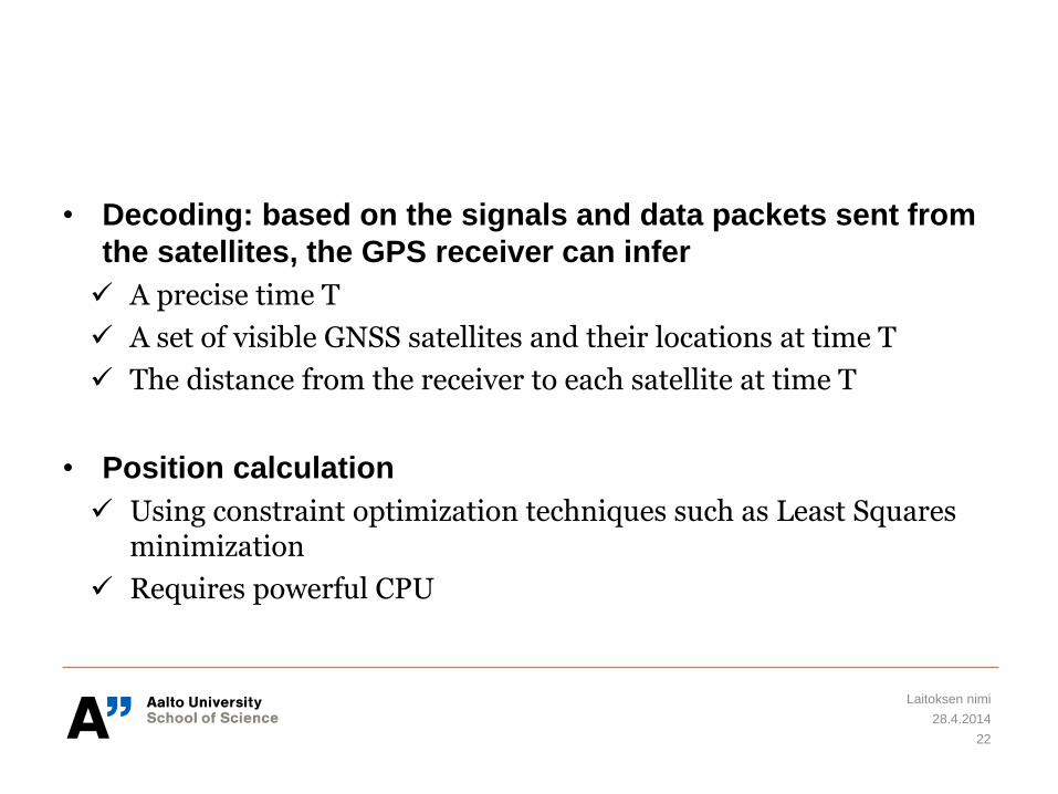
• Decoding: based on the signals and data packets sent from
the satellites, the GPS receiver can infer
A precise time T
A set of visible GNSS satellites and their locations at time T
The distance from the receiver to each satellite at time T
• Position calculation
Using constraint optimization techniques such as Least Squares minimization
Requires powerful CPU
28.4.2014
Laitoksen nimi
22
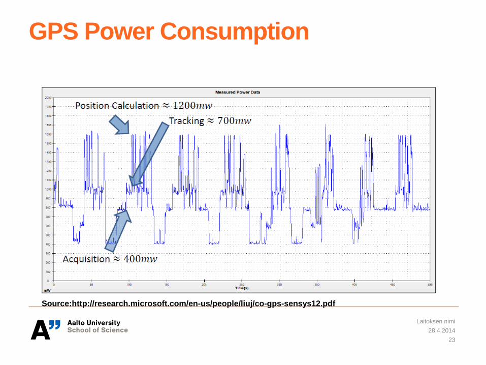
GPS Power Consumption
28.4.2014
Laitoksen nimi
23
Source:http://research.microsoft.com/en-us/people/liuj/co-gps-sensys12.pdf
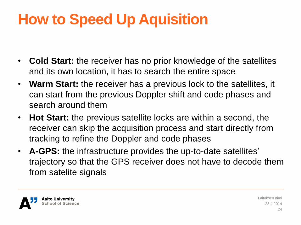
How to Speed Up Aquisition
• Cold Start: the receiver has no prior knowledge of the satellites
and its own location, it has to search the entire space
• Warm Start: the receiver has a previous lock to the satellites, it
can start from the previous Doppler shift and code phases and
search around them
• Hot Start: the previous satellite locks are within a second, the
receiver can skip the acquisition process and start directly from
tracking to refine the Doppler and code phases
• A-GPS: the infrastructure provides the up-to-date satellites’
trajectory so that the GPS receiver does not have to decode them
from satelite signals
28.4.2014
Laitoksen nimi
24
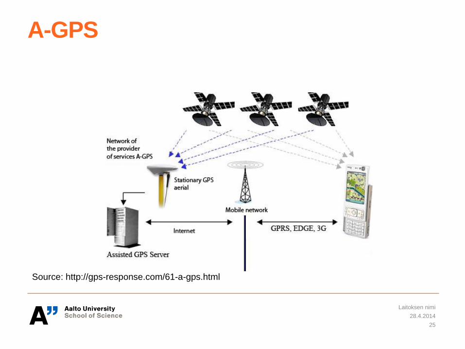
A-GPS
28.4.2014
Laitoksen nimi
25
Source: http://gps-response.com/61-a-gps.html
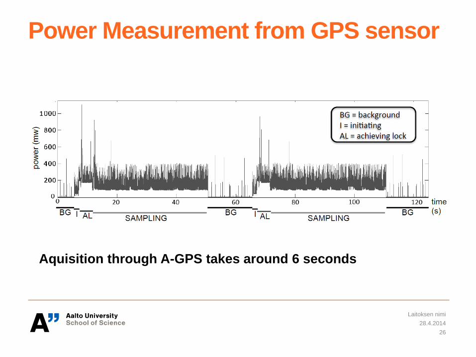
Power Measurement from GPS sensor
28.4.2014
Laitoksen nimi
26
Aquisition through A-GPS takes around 6 seconds
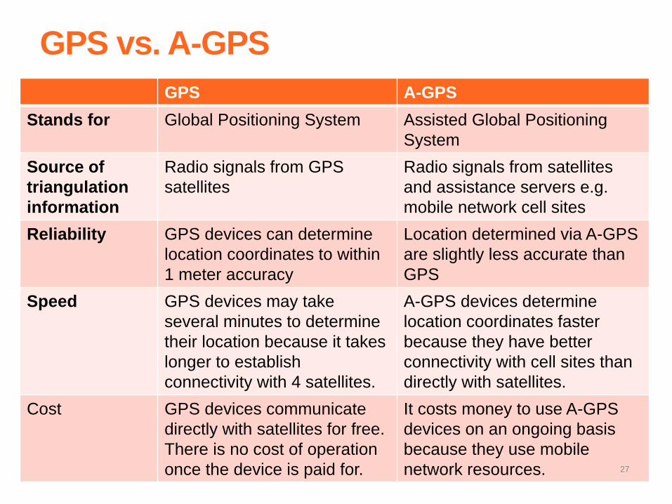
GPS vs. A-GPS
GPS A-GPS
Stands for Global Positioning System Assisted Global Positioning
System
Source of
triangulation
information
Radio signals from GPS
satellites
Radio signals from satellites
and assistance servers e.g.
mobile network cell sites
Reliability GPS devices can determine
location coordinates to within
1 meter accuracy
Location determined via A-GPS
are slightly less accurate than
GPS
Speed GPS devices may take
several minutes to determine
their location because it takes
longer to establish
connectivity with 4 satellites.
A-GPS devices determine
location coordinates faster
because they have better
connectivity with cell sites than
directly with satellites.
Cost GPS devices communicate
directly with satellites for free.
There is no cost of operation
once the device is paid for.
It costs money to use A-GPS
devices on an ongoing basis
because they use mobile
network resources. 27
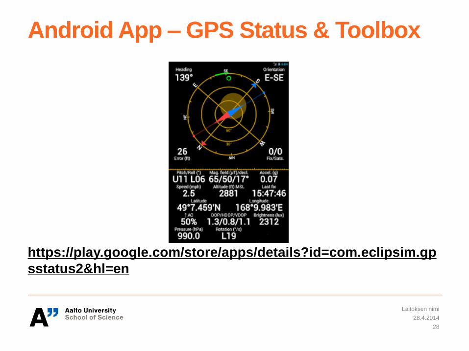
Android App – GPS Status & Toolbox
https://play.google.com/store/apps/details?id=com.eclipsim.gp
sstatus2&hl=en
28.4.2014
Laitoksen nimi
28
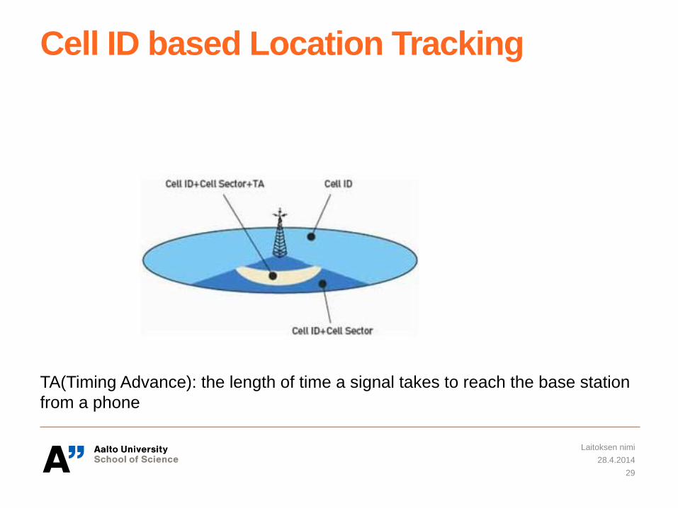
Cell ID based Location Tracking
28.4.2014
Laitoksen nimi
29
TA(Timing Advance): the length of time a signal takes to reach the base station
from a phone
Cell ID based localization
• For example, from Android phones, you can get
GSM Cell ID (CID)
GSM location area code(LAC)
Network Type
Mobile Country Code (MCC)
Mobile Network Code(MNC)
28.4.2014
Laitoksen nimi
30
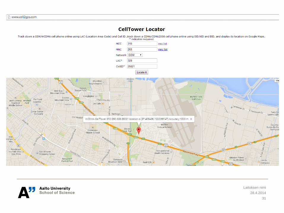
28.4.2014
Laitoksen nimi
31
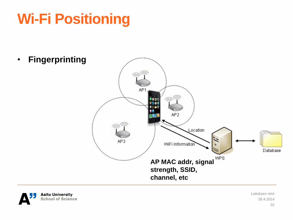
Wi-Fi Positioning
• Fingerprinting
28.4.2014
Laitoksen nimi
32
AP MAC addr, signal
strength, SSID,
channel, etc
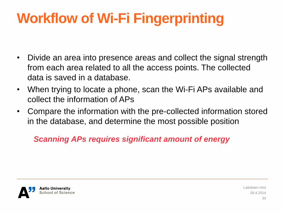
Workflow of Wi-Fi Fingerprinting
• Divide an area into presence areas and collect the signal strength
from each area related to all the access points. The collected
data is saved in a database.
• When trying to locate a phone, scan the Wi-Fi APs available and
collect the information of APs
• Compare the information with the pre-collected information stored
in the database, and determine the most possible position
28.4.2014
Laitoksen nimi
33
Scanning APs requires significant amount of energy
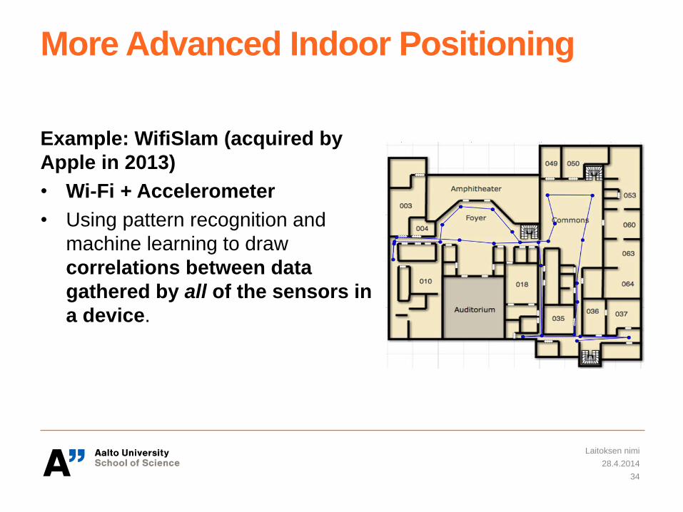
More Advanced Indoor Positioning
Example: WifiSlam (acquired by
Apple in 2013)
• Wi-Fi + Accelerometer
• Using pattern recognition and
machine learning to draw
correlations between data
gathered by all of the sensors in
a device.
28.4.2014
Laitoksen nimi
34
Summary of Position Sensors
• GPS
• A-GPS
• Cell ID
• Wi-Fi
Which ones to use depends on where you are(indoor/outdoor,
urban/rural), availability of network infrastructures, and
requirements of accuracy and energy efficiency.
28.4.2014
Laitoksen nimi
35
Energy-efficient Trajectory Tracking
28.4.2014
Laitoksen nimi
36

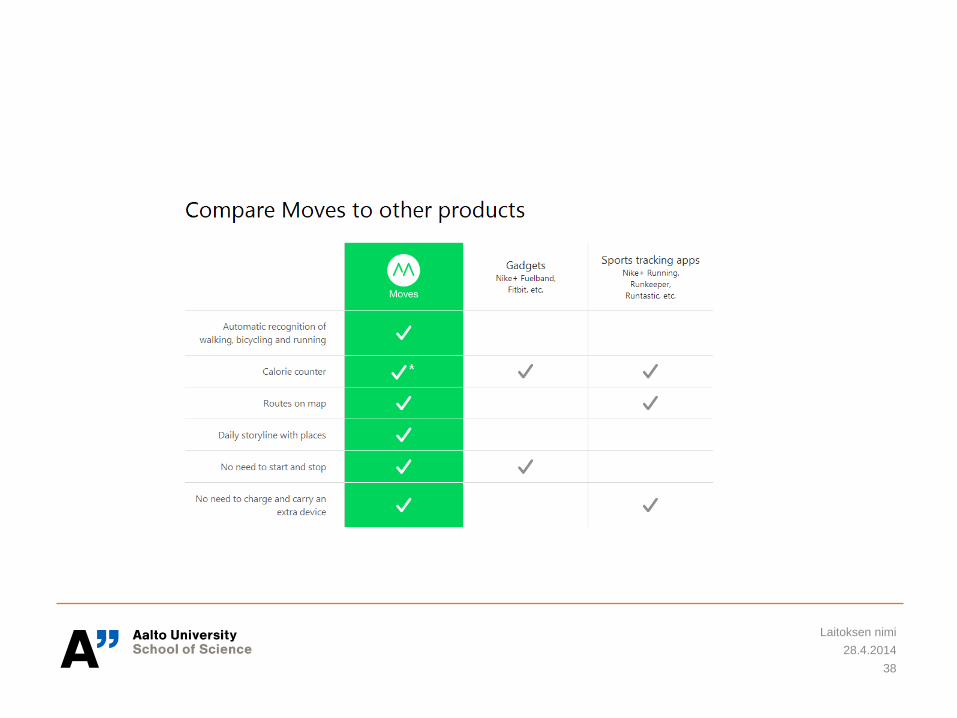
Moves from ProtoGeo Oy
28.4.2014
Laitoksen nimi
37
28.4.2014
Laitoksen nimi
38
Case 1: Energy-efficient Trajectory Tracking
Mikkel Baun Kjærgaard, Sourav Bhattacharya, Henrik Blunck, and Petteri
Nurmi. 2011. Energy-efficient trajectory tracking for mobile devices.
In Proceedings of the 9th international conference on Mobile systems,
applications, and services (MobiSys '11). ACM, New York, NY, USA, 307-320.
DOI=10.1145/1999995.2000025 http://doi.acm.org/10.1145/1999995.2000025
28.4.2014
Laitoksen nimi
39
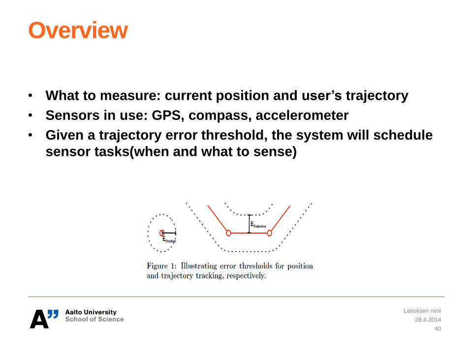
Overview
• What to measure: current position and user’s trajectory
• Sensors in use: GPS, compass, accelerometer
• Given a trajectory error threshold, the system will schedule
sensor tasks(when and what to sense)
28.4.2014
Laitoksen nimi
40
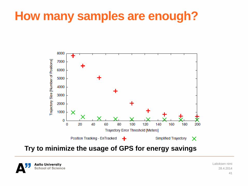
How many samples are enough?
28.4.2014
Laitoksen nimi
41
Try to minimize the usage of GPS for energy savings
Sensor Management Strategies
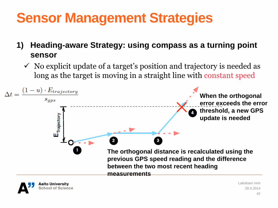
1) Heading-aware Strategy: using compass as a turning point
sensor
No explicit update of a target’s position and trajectory is needed as long as the target is moving in a straight line with constant speed
28.4.2014
Laitoksen nimi
42
The orthogonal distance is recalculated using the
previous GPS speed reading and the difference
between the two most recent heading
measurements
When the orthogonal
error exceeds the error
threshold, a new GPS
update is needed
Sensor Management Strategies
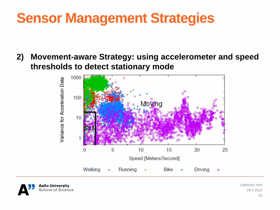
2) Movement-aware Strategy: using accelerometer and speed
thresholds to detect stationary mode
28.4.2014
Laitoksen nimi
43
Sensor Management Strategies
3) Dynamically determining how long the GPS can sleep
between successive position measurements
Usually applied when the target is moving with a low speed and the trajectory error threshold is high, e.g., above 100 meters
28.4.2014
Laitoksen nimi
44
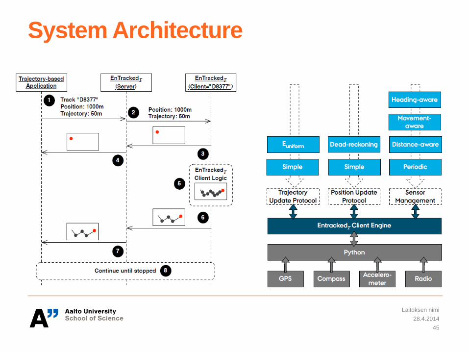
System Architecture
28.4.2014
Laitoksen nimi
45
Trajectory Simplification
• Motivation: reduce the energy cost for communicating trajectory
data
• Tradeoff: reduced communication cost vs. increased computing
cost (computing simplification)
• Simplification: select a subset of the points of the original
polyline, so that the resulting simplified polyline does not deviate
more from the original one than prescribed by a numeric error
threshold
• Detailed algorithms can be found from the reference
28.4.2014
Laitoksen nimi
46
Evaluation
1) Test case design
• Data sets were collected from walking, running, biking and car driving activities undertaken by different users
• Varying the trajectory and positioning error thresholds used for tracking
2) Power consumption is estimated based on power models of
sensors(GPS, accelerometer, and compass), data
transmission over 3G, and CPU
3) Accuracy of the tracked trajectories and positions vs.
Energy consumption
28.4.2014
Laitoksen nimi
47
Case 2:
Yi Wang, Jialiu Lin, Murali Annavaram, Quinn A. Jacobson, Jason Hong,
Bhaskar Krishnamachari, and Norman Sadeh. 2009. A framework of energy
efficient mobile sensing for automatic user state recognition.
In Proceedings of the 7th international conference on Mobile systems,
applications, and services (MobiSys '09). ACM, New York, NY, USA, 179-192.
DOI=10.1145/1555816.1555835 http://doi.acm.org/10.1145/1555816.1555835
28.4.2014
Laitoksen nimi
48
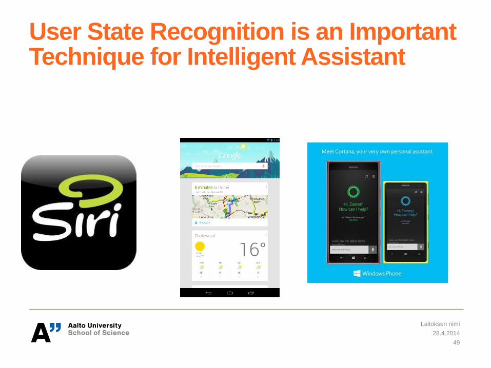
User State Recognition is an Important Technique for Intelligent Assistant
28.4.2014
Laitoksen nimi
49
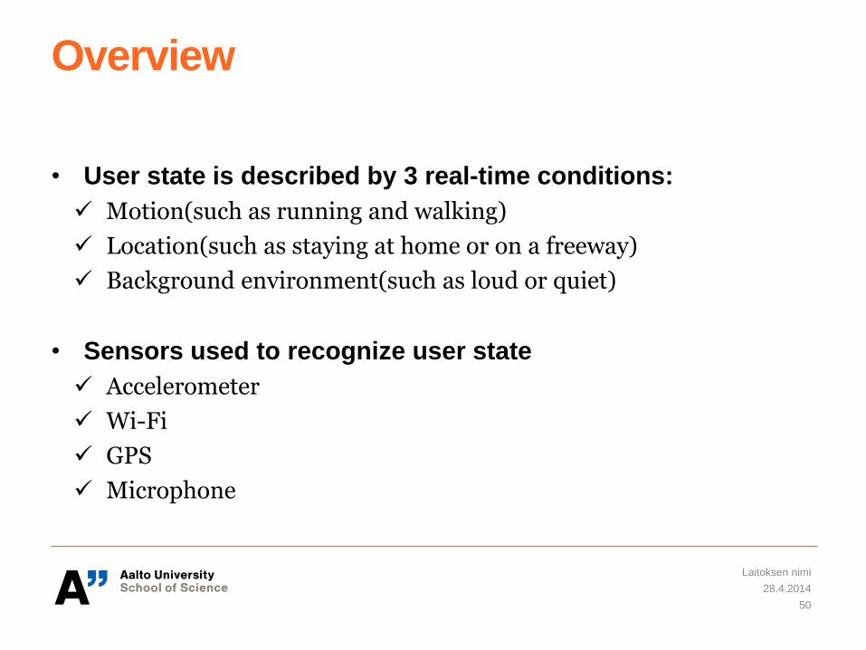
Overview
• User state is described by 3 real-time conditions:
Motion(such as running and walking)
Location(such as staying at home or on a freeway)
Background environment(such as loud or quiet)
• Sensors used to recognize user state
Accelerometer
Wi-Fi
GPS
Microphone
28.4.2014
Laitoksen nimi
50
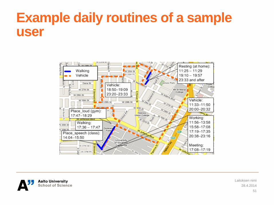
Example daily routines of a sample user
28.4.2014
Laitoksen nimi
51

• System Input: an XML-format state descriptor(including a set
of state names, sensors to be monitored, and conditions for
state transitions)
• A sensor management module is generated automatically
based on the state descriptor
28.4.2014
Laitoksen nimi
52
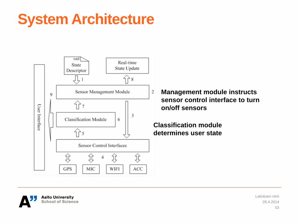
System Architecture
28.4.2014
Laitoksen nimi
53
Management module instructs
sensor control interface to turn
on/off sensors
Classification module
determines user state
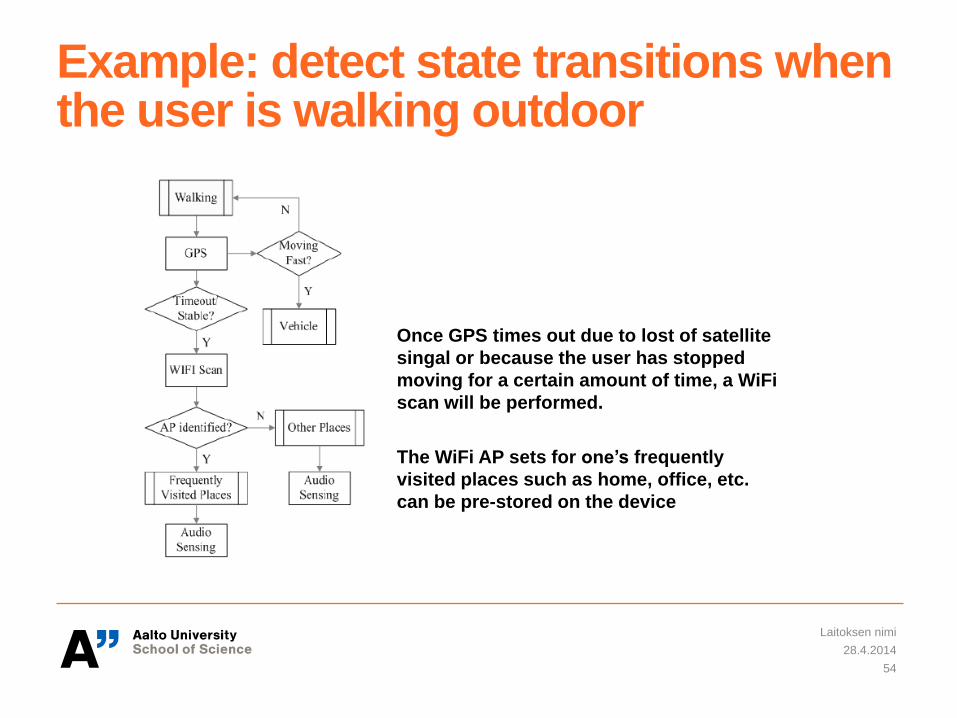
Example: detect state transitions when the user is walking outdoor
28.4.2014
Laitoksen nimi
54
Once GPS times out due to lost of satellite
singal or because the user has stopped
moving for a certain amount of time, a WiFi
scan will be performed.
The WiFi AP sets for one’s frequently
visited places such as home, office, etc.
can be pre-stored on the device
Evaluation
• Power consumption
• Accuracy of state recogition
• State transition detection latency
28.4.2014
Laitoksen nimi
55
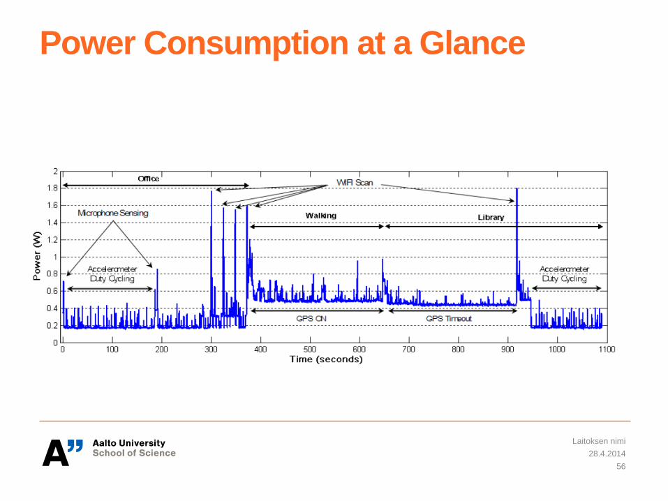
Power Consumption at a Glance
28.4.2014
Laitoksen nimi
56
Stages of Sensor Data Processing
• Sampling and buffering, in which the sensors are sampled and the
data is placed into a buffer.
• Filtering, in which the interesting parts of the data are identified and
selected for further processing.
• Feature extraction, in which features are extracted from the data in
order to perform classification.
• Classification, in which the data is classified based on the extracted
features by using machine learning or probabilistic methods.
• Post processing, in which the applications react to the sensing
result.
28.4.2014
Laitoksen nimi
57
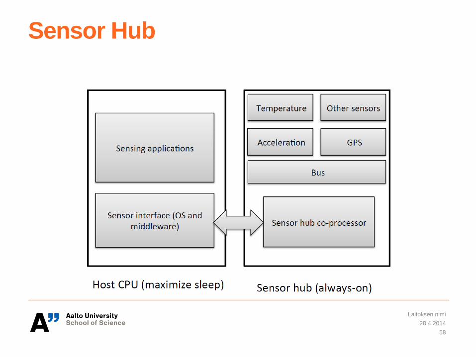
Sensor Hub
28.4.2014
Laitoksen nimi
58
Examples of SensorHub Solutions
QuickLogic SensorHub
http://www.youtube.com/watch?v=Z01AGNkXSS8
Texas Instruments SensorHub
http://www.youtube.com/watch?v=saV77iUesCc
Atmel Corp.
http://www.youtube.com/watch?v=N6aYs80_boM
28.4.2014
Laitoksen nimi
59
Questions?
28.4.2014
Laitoksen nimi
60