Embed Size (px)
Citation preview
Energy data archived, organized, integrated and accessible
By
Laura R.H. Biewick, Nicholas R. Jones and Anna B. Wilson
General Information Product 145 U.S. Department of the Interior U.S. Geological Survey
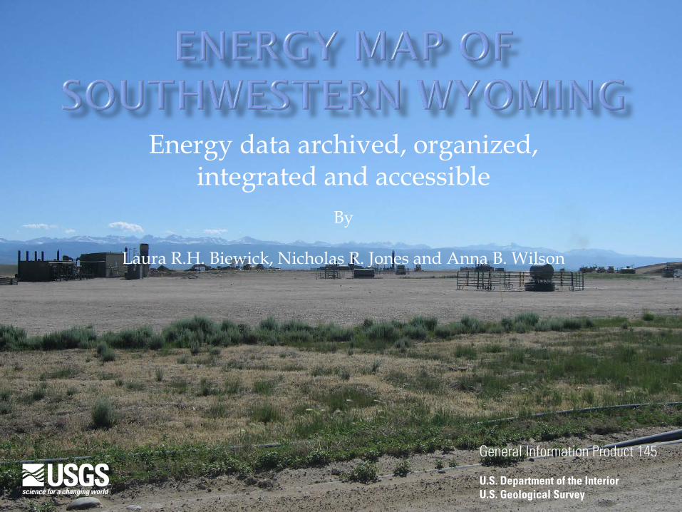
• Purpose • Downloadable Data and the Interactive Map • Electrical Energy Sources: Coal and Wind • Oil and Gas • Oil Shale • Energy Corridor • Solar
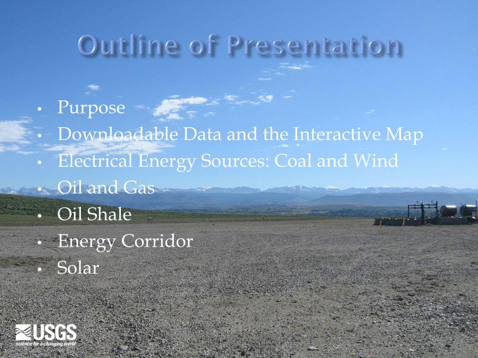
Much of the information in the energy map product is based on published data that can be found elsewhere, but is not assembled together in one place in a way that clarifies what the energy potential looks like.
For the WLCI long-term, science-based effort, a comprehensive inventory of geologic energy data needs to be available as an online resource so that the information is easily accessible in Geographic Information Systems (GIS) and other research-related software, as well as by a variety of disciplines.
The Wyoming Landscape Conservation Initiative (WLCI) focuses on conserving world-class wildlife resources while facilitating responsible energy development.
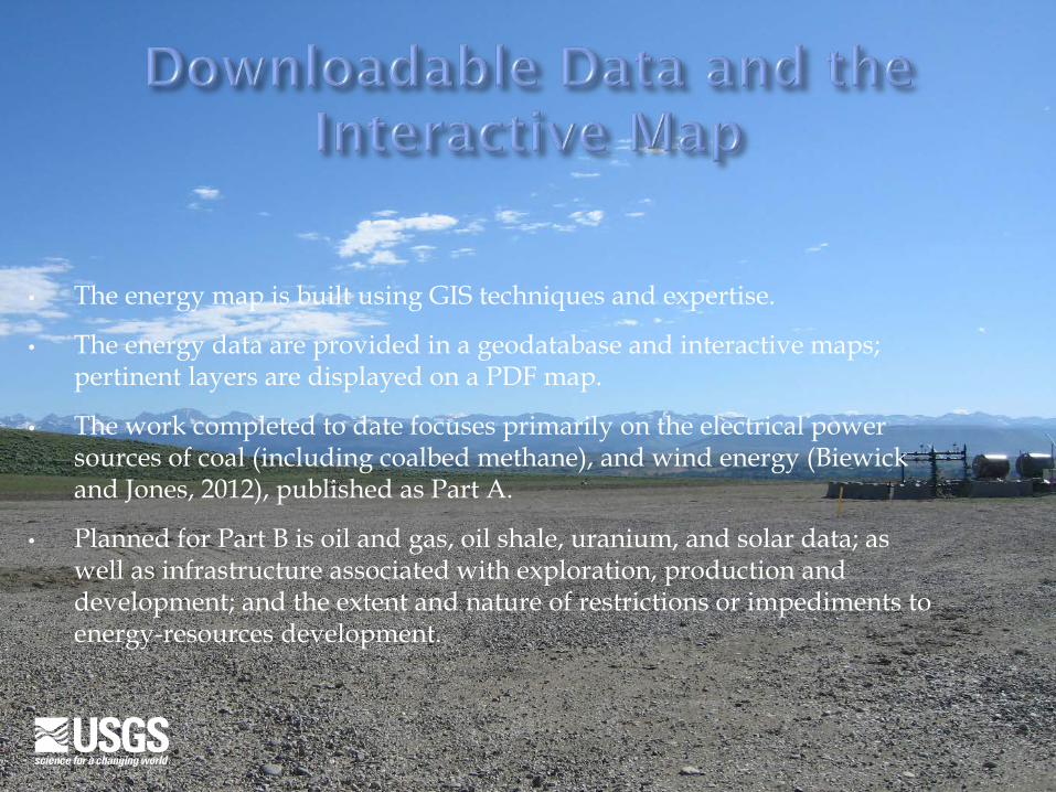
• The energy map is built using GIS techniques and expertise.
• The energy data are provided in a geodatabase and interactive maps; pertinent layers are displayed on a PDF map.
• The work completed to date focuses primarily on the electrical power sources of coal (including coalbed methane), and wind energy (Biewick and Jones, 2012), published as Part A.
• Planned for Part B is oil and gas, oil shale, uranium, and solar data; as well as infrastructure associated with exploration, production and development; and the extent and nature of restrictions or impediments to energy-resources development.
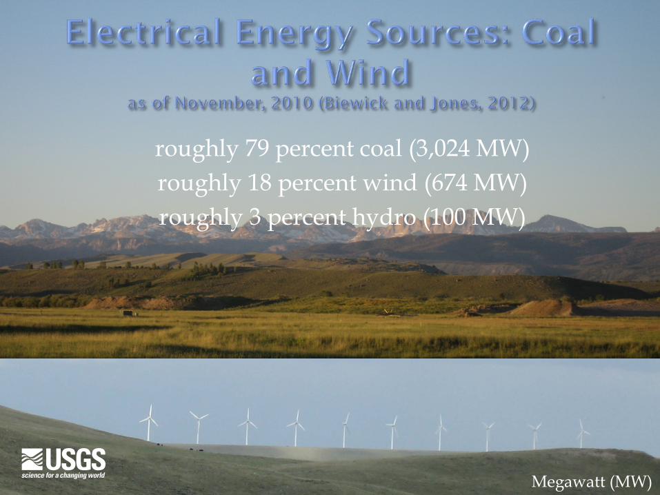
roughly 79 percent coal (3,024 MW) roughly 18 percent wind (674 MW) roughly 3 percent hydro (100 MW)
Megawatt (MW)
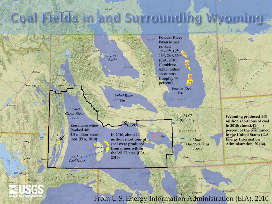
Kemmerer Mine Ranked 40th 4.8 million short tons (EIA, 2010)
Powder River Basin Mines ranked 1st – 8th, 12th, 13th, 26th, 35th (EIA, 2010) Combined 428.3 million short tons (roughly 97 percent)
Bighorn Basin
Wind River Basin
Greater Green River
Basin
Powder River Basin
WLCI Boundary
Surface Coal Mine
Mined Out/Reclaimed
Areas
From U.S. Energy Information Administration (EIA), 2010
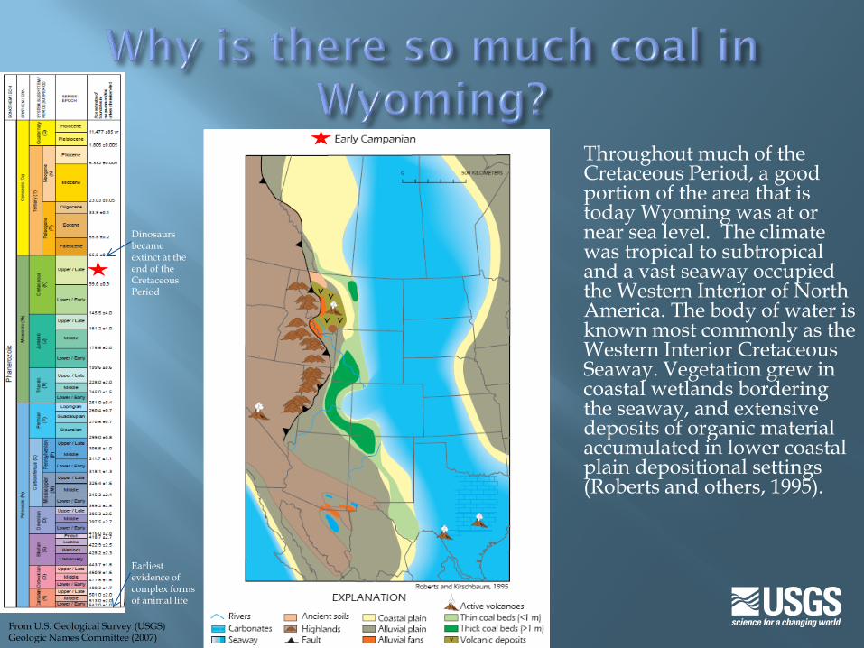
Throughout much of the Cretaceous Period, a good portion of the area that is today Wyoming was at or near sea level. The climate was tropical to subtropical and a vast seaway occupied the Western Interior of North America. The body of water is known most commonly as the Western Interior Cretaceous Seaway. Vegetation grew in coastal wetlands bordering the seaway, and extensive deposits of organic material accumulated in lower coastal plain depositional settings (Roberts and others, 1995).
Earliest evidence of complex forms of animal life
Dinosaurs became extinct at the end of the Cretaceous Period
From U.S. Geological Survey (USGS) Geologic Names Committee (2007)
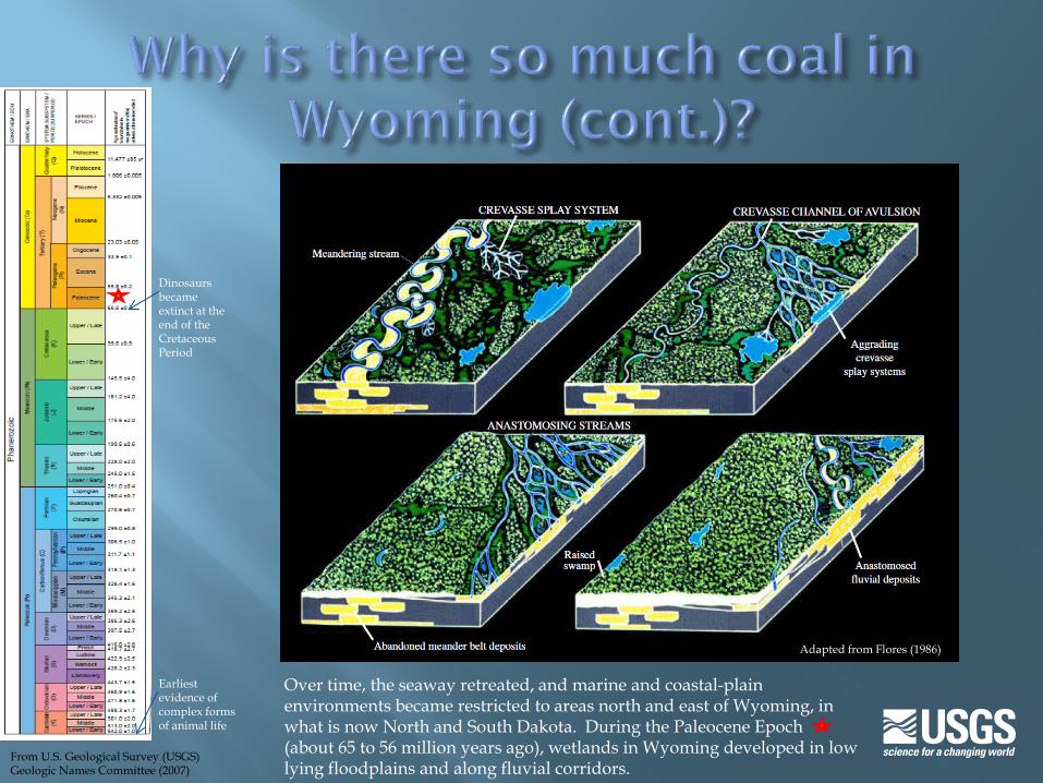
Over time, the seaway retreated, and marine and coastal-plain environments became restricted to areas north and east of Wyoming, in what is now North and South Dakota. During the Paleocene Epoch (about 65 to 56 million years ago), wetlands in Wyoming developed in low lying floodplains and along fluvial corridors.
Earliest evidence of complex forms of animal life
Dinosaurs became extinct at the end of the Cretaceous Period
Adapted from Flores (1986)
From U.S. Geological Survey (USGS) Geologic Names Committee (2007)
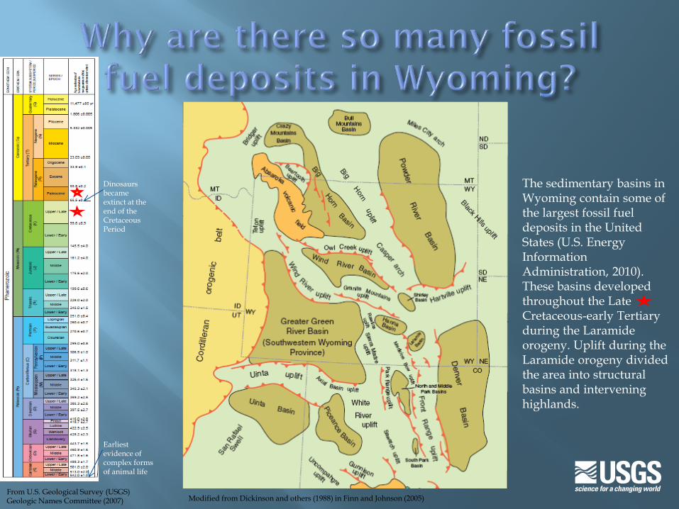
The sedimentary basins in Wyoming contain some of the largest fossil fuel deposits in the United States (U.S. Energy Information Administration, 2010). These basins developed throughout the Late Cretaceous-early Tertiary during the Laramide orogeny. Uplift during the Laramide orogeny divided the area into structural basins and intervening highlands.
Earliest evidence of complex forms of animal life
Dinosaurs became extinct at the end of the Cretaceous Period
Modified from Dickinson and others (1988) in Finn and Johnson (2005) From U.S. Geological Survey (USGS) Geologic Names Committee (2007)
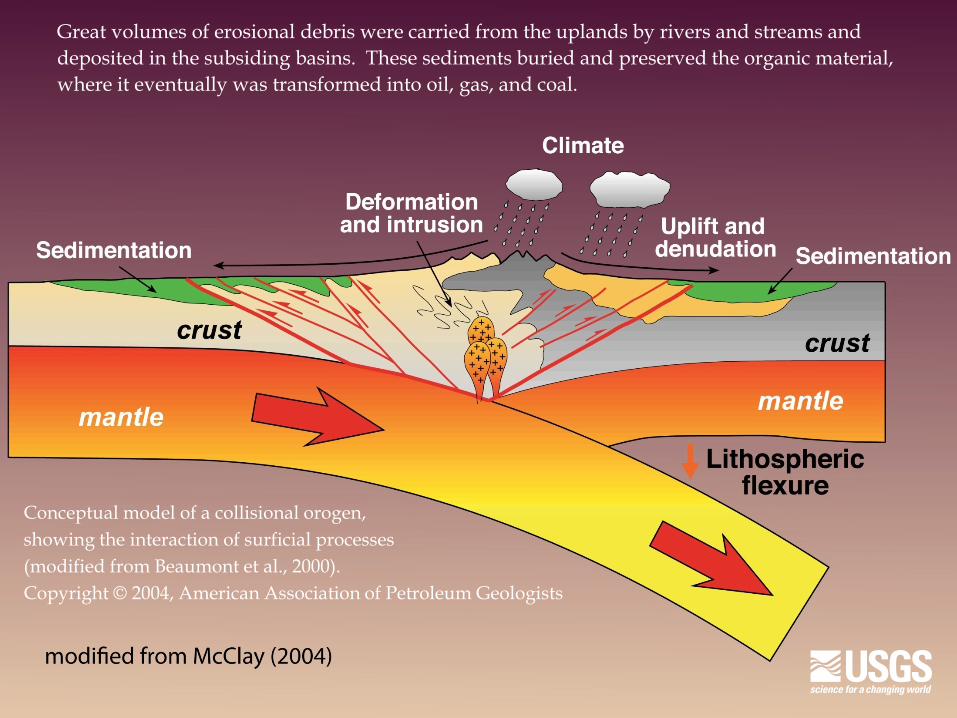
Great volumes of erosional debris were carried from the uplands by rivers and streams and deposited in the subsiding basins. These sediments buried and preserved the organic material, where it eventually was transformed into oil, gas, and coal.
Conceptual model of a collisional orogen, showing the interaction of surficial processes (modified from Beaumont et al., 2000). Copyright © 2004, American Association of Petroleum Geologists
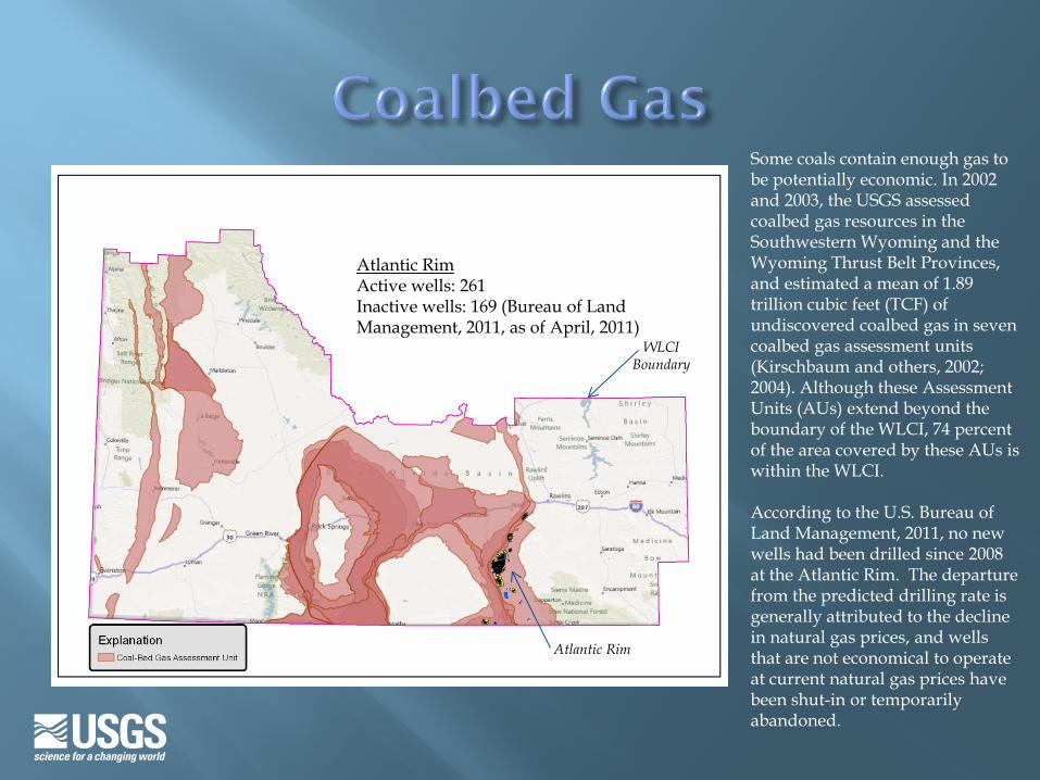
Some coals contain enough gas to be potentially economic. In 2002 and 2003, the USGS assessed coalbed gas resources in the Southwestern Wyoming and the Wyoming Thrust Belt Provinces, and estimated a mean of 1.89 trillion cubic feet (TCF) of undiscovered coalbed gas in seven coalbed gas assessment units (Kirschbaum and others, 2002; 2004). Although these Assessment Units (AUs) extend beyond the boundary of the WLCI, 74 percent of the area covered by these AUs is within the WLCI. According to the U.S. Bureau of Land Management, 2011, no new wells had been drilled since 2008 at the Atlantic Rim. The departure from the predicted drilling rate is generally attributed to the decline in natural gas prices, and wells that are not economical to operate at current natural gas prices have been shut-in or temporarily abandoned.
Atlantic Rim Active wells: 261 Inactive wells: 169 (Bureau of Land Management, 2011, as of April, 2011)
WLCI Boundary
Atlantic Rim
U.S. Department of Energy (2010a)
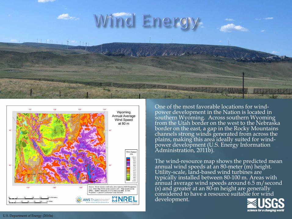
One of the most favorable locations for wind-power development in the Nation is located in southern Wyoming. Across southern Wyoming from the Utah border on the west to the Nebraska border on the east, a gap in the Rocky Mountains channels strong winds generated from across the plains, making this area ideally suited for wind-power development (U.S. Energy Information Administration, 2011b). The wind-resource map shows the predicted mean annual wind speeds at an 80-meter (m) height. Utility-scale, land-based wind turbines are typically installed between 80-100 m. Areas with annual average wind speeds around 6.5 m/second (s) and greater at an 80-m height are generally considered to have a resource suitable for wind development.
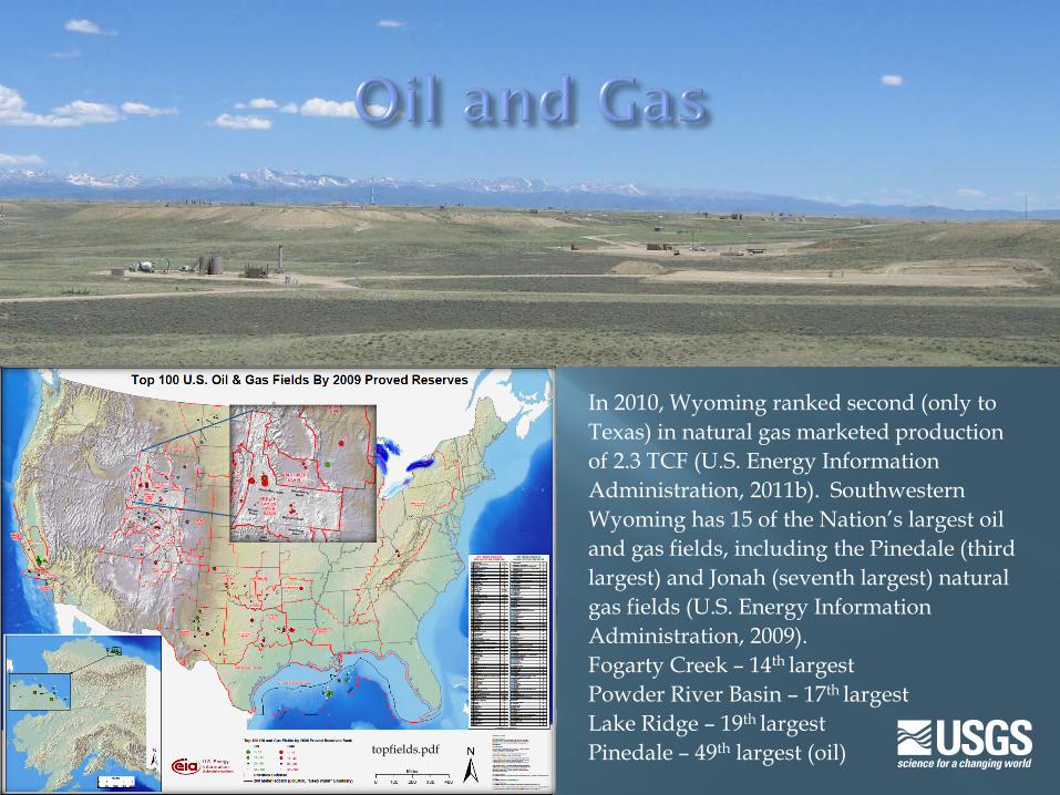
In 2010, Wyoming ranked second (only to Texas) in natural gas marketed production of 2.3 TCF (U.S. Energy Information Administration, 2011b). Southwestern Wyoming has 15 of the Nation’s largest oil and gas fields, including the Pinedale (third largest) and Jonah (seventh largest) natural gas fields (U.S. Energy Information Administration, 2009). Fogarty Creek – 14th largest Powder River Basin – 17th largest Lake Ridge – 19th largest Pinedale – 49th largest (oil) topfields.pdf

Click on this map graphic to open the historical drilling activity slideshow. Press Esc key to return.
From Biewick (2011), using data from WOGCC (2010)
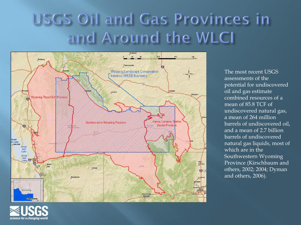
The most recent USGS assessments of the potential for undiscovered oil and gas estimate combined resources of a mean of 85.8 TCF of undiscovered natural gas, a mean of 264 million barrels of undiscovered oil, and a mean of 2.7 billion barrels of undiscovered natural gas liquids, most of which are in the Southwestern Wyoming Province (Kirschbaum and others, 2002; 2004; Dyman and others, 2006).
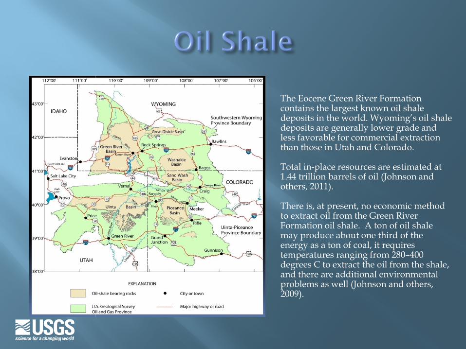
The Eocene Green River Formation contains the largest known oil shale deposits in the world. Wyoming’s oil shale deposits are generally lower grade and less favorable for commercial extraction than those in Utah and Colorado. Total in-place resources are estimated at 1.44 trillion barrels of oil (Johnson and others, 2011). There is, at present, no economic method to extract oil from the Green River Formation oil shale. A ton of oil shale may produce about one third of the energy as a ton of coal, it requires temperatures ranging from 280–400 degrees C to extract the oil from the shale, and there are additional environmental problems as well (Johnson and others, 2009).
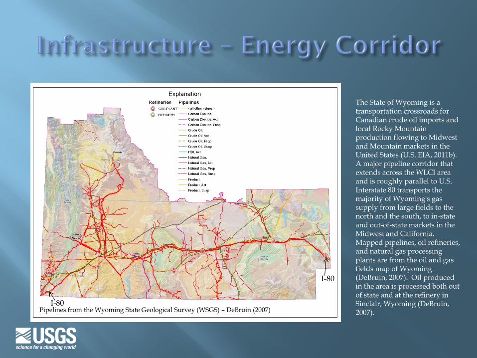
The State of Wyoming is a transportation crossroads for Canadian crude oil imports and local Rocky Mountain production flowing to Midwest and Mountain markets in the United States (U.S. EIA, 2011b). A major pipeline corridor that extends across the WLCI area and is roughly parallel to U.S. Interstate 80 transports the majority of Wyoming's gas supply from large fields to the north and the south, to in-state and out-of-state markets in the Midwest and California. Mapped pipelines, oil refineries, and natural gas processing plants are from the oil and gas fields map of Wyoming (DeBruin, 2007). Oil produced in the area is processed both out of state and at the refinery in Sinclair, Wyoming (DeBruin, 2007). Pipelines from the Wyoming State Geological Survey (WSGS) – DeBruin (2007)
I-80
I-80
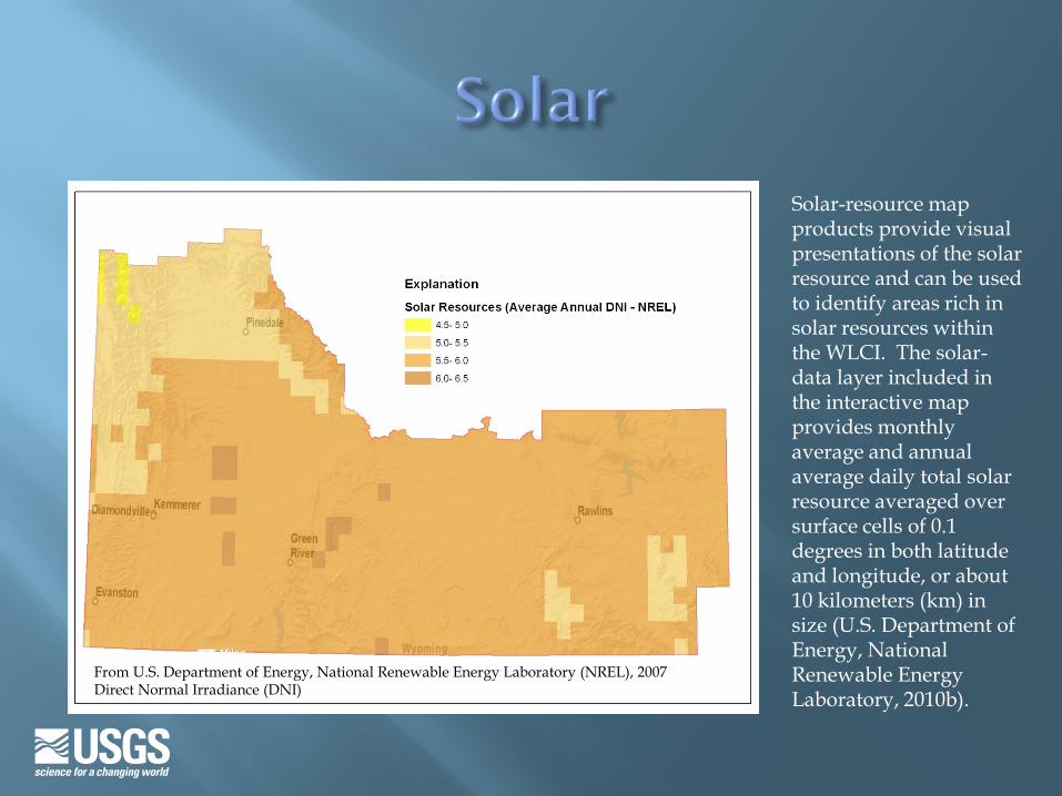
Solar-resource map products provide visual presentations of the solar resource and can be used to identify areas rich in solar resources within the WLCI. The solar-data layer included in the interactive map provides monthly average and annual average daily total solar resource averaged over surface cells of 0.1 degrees in both latitude and longitude, or about 10 kilometers (km) in size (U.S. Department of Energy, National Renewable Energy Laboratory, 2010b).
From U.S. Department of Energy, National Renewable Energy Laboratory (NREL), 2007 Direct Normal Irradiance (DNI)
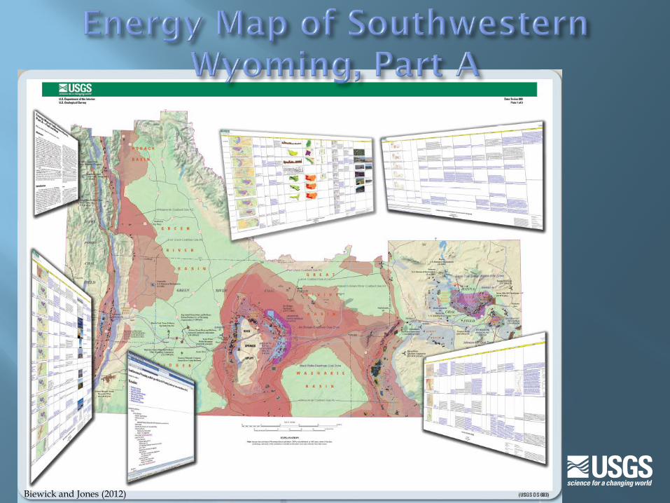
Biewick and Jones (2012)
Biewick, L.R.H., 2011, Geodatabase of Wyoming statewide oil and gas drilling activity to 2010: U.S. Geological Survey Data Series 625. (Also available at http://pubs.usgs.gov/ds/625/.)
Biewick, L.R.H., and Jones, N.R., 2012, Energy map of southwestern Wyoming, Part A—Coal and wind: U.S. Geological Survey Data Series 683, 18 p. pamphlet, 5 plates. (Also available at http://pubs.usgs.gov/ds/683/. )
Beaumont, C., Kooi, H., and Willett, S., 2000, Progress in coupled tectonic-surface process models with applications to rifted margins and collisional orogens, in Summerfield, M.A., ed., Geomorphology and global tectonics: New York, John Wiley, p. 29-55.
DeBruin, R.H., 2007, Oil and gas fields map of Wyoming: Wyoming State Geological Survey (WSGS), Map Series MS-55. Available from http://www.wsgs.uwyo.edu/.
Dickinson, W.R., Klute, M.A., Hayes, M.J., Janecke, S.U., Lundin, E.R., McKittrick, M.A., and Olivares, M.D., 1988, Paleographic and paleotectonic setting of Laramide sedimentary basins in the central Rocky Mountain region: Geological Society of America Bulletin, v. 100, p. 1023–1039.
Dyman, T.S., Condon, S.M., Ahlbrandt, T.S., Charpentier, R.R., Cook, T.A., Klett, T.R., Lewan, M.D., Lillis, P.G., Pawlewicz, M.J., Pollastro, R.M., and Schenk, C.J., 2006, 2005 Assessment of undiscovered oil and gas resources in Hanna, Laramie, and Shirley Basins Province, Wyoming: U.S. Geological Survey Fact Sheet FS-2005-3125, 4 p. (Also available at http://pubs.usgs.gov/fs/2005/3125/.)
Finn, T.M., and Johnson, R.C., 2005, Subsurface stratigraphic cross sections of Cretaceous and Lower Tertiary rocks in the Southwestern Wyoming Province, Wyoming, Colorado, and Utah, chap. 14 of U.S. Geological Survey Southwestern Wyoming Province Assessment Team, ed., Petroleum systems and geologic assessment of oil and gas in the Southwestern Wyoming Province, Wyoming, Colorado, and Utah: U.S. Geological Survey Digital Data Series DDS–69–D, ver. 1.0, 9 p. (Also available at http://pubs.usgs.gov/dds/dds-069/dds-069-d/REPORTS/69_D_CH_14.pdf.)
Flores, R.M., 1986, Styles of coal deposition in Tertiary alluvial deposits, Powder River Basin, Montana and Wyoming, in Lyons, P.C., and Rice, C.L., eds., Paleoenvironmental and tectonic controls in coal-forming basins of the United States: Geological Society of America, Special Paper 210, p. 79-104.
Johnson, R.C., Mercier, T.J., Brownfield, M.E., Pantea, M.P., and Self, J.G., 2009, Assessment of in-place oil shale resources of the Green River Formation, Piceance Basin, western Colorado: U.S. Geological Survey Fact Sheet 2009–3012, 6 p. (Also available at http://pubs.usgs.gov/fs/2009/3012/ and http://energy.usgs.gov/OilGas/UnconventionalOilGas/OilShale.aspx.)
Johnson, R.C., Mercier, T.J., and Brownfield, M.E., 2011, Assessment of in-place oil shale resources of the Green River Formation, Greater Green River Basin in Wyoming, Colorado, and Utah: U.S. Geological Survey Fact Sheet 2011–3063, 4 p. (Also available at http://pubs.usgs.gov/fs/2011/3063/.)
Kirschbaum, M.A., Charpentier, R.R., Crovelli, R.A., Klett, T.R., Pollastro, R.M., and Schenk, C.J., 2004, Assessment of undiscovered oil and gas resources of the Wyoming Thrust Belt Province, 2003: U.S. Geological Survey Fact Sheet 2004–3025, 2 p. (Also available at http://pubs.usgs.gov/fs/2004/3025.)
Kirschbaum, M.A., Finn, T.M., Hettinger, R.D., Johnson, E.A., Johnson, R.C., Kibler, J., Lillis, P.G., Nelson, P.H., Roberts, L.N.R., Roberts, S.B., Charpentier, R.R., Cook, T.A., Crovelli, R.A., Klett, T.R., Pollastro, R.M., and Schenk, C.J., 2002, Assessment of undiscovered oil and gas resources of the Southwestern Wyoming Province, 2002: U.S. Geological Survey Fact Sheet 145–02, 2 p. (Also available at http://pubs.usgs.gov/fs/fs-145-02/.)
McClay, K.R., 2004, Thrust tectonics and hydrocarbon systems—Introduction, in K.R. McClay, ed., Thrust tectonics and hydrocarbon systems: American Association of Petroleum Geologists (AAPG) Memoir 82, p. ix-xx.
Roberts, L.N.R., and Kirschbaum, M.A., 1995, Paleogeography of the Late Cretaceous of the Western Interior of middle North America—Coal distribution and sediment accumulation: U.S. Geological Survey Professional Paper 1561, 115 p. (Also available at http://pubs.usgs.gov/pp/1561/report.pdf.)
Roberts, L.N.R., Kirschbaum, M.A., and McCabe, P.J., 1995, Paleogeography of the Late Cretaceous of the western interior of middle North America: U.S. Geological Survey poster. (Also available at http://energy.cr.usgs.gov/coal_poster/cretcoals/cret.coals.html.)
U.S. Bureau of Land Management, 2011, Wyoming, Atlantic Rim Natural Gas Development Project Documents: U.S. Bureau of Land Management, accessed April, 2011, at http://www.blm.gov/wy/st/en/info/NEPA/documents/rfo/atlantic_rim.html.
U.S. Department of Energy, National Renewable Energy Laboratory, 2007, Concentrating Solar Power Resource, Wyoming: U.S. Department of Energy, National Renewable Energy Laboratory, accessed June 28, 2012, at http://www.nrel.gov/gis/pdfs/eere_csp/eere_csp_h_wyoming.pdf.
U.S. Department of Energy, National Renewable Energy Laboratory, and AWS Truepower, 2010a, Wyoming Annual Average Wind Speed at 80m: Washington, D.C., U.S. Department of Energy, Energy Efficiency and Renewable Energy, accessed March 5, 2012, at http://www.windpoweringamerica.gov/wind_resource_maps.asp?stateab=wy
U.S. Department of Energy, National Renewable Energy Laboratory, 2010b, Solar data, high resolution (10 km), lower 48 DNI high resolution: U.S. Department of Energy, National Renewable Energy Laboratory, accessed June 28, 2012, at http://www.nrel.gov/gis/data_solar.html.
U.S. Energy Information Administration (EIA), 2009, Top 100 U.S. oil & gas fields by 2009 proved reserves: U.S. Energy Information Administration, accessed June 28, 2012, at http://www.eia.doe.gov/oil_gas/rpd/topfields.pdf.
U.S. Energy Information Administration (EIA), 2010, Annual coal report, 2010: Washington, D.C., U.S. Department of Labor, accessed August 1, 2012, at http://www.eia.gov/coal/annual/pdf/acr.pdf.
U.S. Energy Information Administration (EIA), 2011a, Coal—U.S. coal supply and demand—2010 year in review: Washington, D.C., U.S. Department of Labor, accessed August 1, 2012, at http://www.eia.gov/coal/review/coal_production.cfm. [Release date: June 1, 2011]
U.S. Energy Information Administration (EIA), 2011b, Wyoming Energy Fact Sheet: Washington, D.C., U.S. Department of Labor, accessed January 27, 2011, at http://www.eia.gov/state/state-energy-profiles-print.cfm?sid=WY.
U.S. Geological Survey Geologic Names Committee, 2007, Divisions of geologic time—Major chronostratigraphic and geochronologic units: U.S. Geological Survey Fact Sheet 2007-3015, 2 p. (Also available at http://pubs.usgs.gov/fs/2007/3015/.)
Wyoming Oil and Gas Conservation Commission, 2010, Wyoming Oil and Gas Conservation Commission, accessed June 28, 2010, at http://wogcc.state.wy.us/.