Embed Size (px)
Citation preview

End-to-End Workflows for Coupled Climate and Hydrological Modeling
Edwin Sumargo (University of Illinois at Urbana-Champaign) Sylvia Murphy (NOAA/CIRES)
Kathy Saint (SGI Inc)

Outline
• Ongoing Project Objective• System Description• Project Phases• Internship Goals• CAM to SWAT Conversion• Downscaling• Soil and Water Assessment Tool (SWAT)• Remaining Tasks• Summary

Ongoing Project Objective
The development of an end-to-end workflow that executes, in a loosely coupled mode, a distributed modeling system comprised of an atmospheric model (CAM) using ESMF and a hydrological model (SWAT) using OpenMI.

System Description
Data FilesData Files
SWATSWAT
OpenMIOpenMI
CAM OpenMI Wrapper
CAM OpenMI Wrapper
DriverDriver
High Performance ComputerHigh Performance Computer
ESMF Web Services
ESMF Web Services
ESMF CAMComponentESMF CAMComponent
Personal Computer• SWAT (hydrology model) runs on PC
• CAM (atmospheric model) runs on HPC
• Wrappers for both SWAT and CAM provide OpenMI interface to each model
• Driver (OpenMI Configuration Editor) uses OpenMI interface to timestep through models via wrappers
• Access to CAM across the network provided by ESMF Web Services
• CAM output data written to NetCDF files and streamed to CAM wrapper via ESMF Web Services
• Resulting output files archived to science gateway

Project Phases
Phase 1: SWAT & the ESMF stub atmospheric component communicate via an external netCDF file (Jan-Mar 2010)
Phase 2: CAM replaces the ESMF atmospheric stub but both still communicate via the netCDF (Apr-May)
Phase 3: Data flows via socket interfaces with realistic unit conversions (May-June)
Phase 4: Full streaming on public systems. Data archived to a science portal (Sept-Oct)

Internship Goals
• Determine the variable and unit conversions necessary to couple CAM to SWAT
• Investigate downscaling methods and determine under which
conditions to use each• Investigate C/C++ nearest neighbor algorithms• Install SWAT on a public PC at NOAA• Investigate SWAT configuration options• Create graphics of SWAT output• Begin the calibration process for SWAT

CAM to SWAT Conversion
• SWAT reference: (Neitsch et al., 2004)• CAM reference: (McCaa et al., 2004)
Variables needed to be converted:
1. Air Temperature
2. Solar Radiation
3. Precipitation
4. Relative Humidity
5. Wind Speed

Downscaling
• Downscaling methods were investigated (Fowler et al., 2007)
• A method needed to be determined for both the current and future system
• “Downscaling climate data is a strategy for generating locally relevant data from Global Circulation Models (GCMs). The overarching strategy is to connect global scale predictions and regional dynamics to generate regionally specific forecasts” (http://www.climate-decisions.org).
• 3 fundamental downscaling methods:– Dynamical Downscaling (DD)– Statistical Downscaling (SD)– Nearest Neighbor Interpolation (NNI):
the simplest case
Source: www.southwestclimatechange.org

Dynamical Downscaling
• A downscaling method where a higher resolution climate model is embedded within a GCM (Fowler et al., 2007).– Uses regional climate or limited-area models– Typically resolved at approximately 0.5° latitude and longitude
scale and parameterize physical atmospheric processes.• Advantages:
– Performs better at regions where topographic effects are prominent
– Superior for which convective precipitation is involved• Disadvantages:
– Computationally very intensive– Strongly depends on GCM boundary forcing– Has limited number of scenario ensembles available

Statistical Downscaling
• A downscaling method that establishes empirical relationships between GCM-resolution climate variables and local climate (Fowler et al., 2007).
• Advantages:– More efficient than dynamical downscaling– More suitable in handling the extremes, e.g. of temperature– Performs better at higher altitude, mainly with continental
climate• Disadvantages:
– Underestimates variance– Excludes climate feedbacks– Skill is affected by domain size, climatic region, and season

Nearest Neighbor Interpolation
• Nearest Neighbor Interpolation was determined to be the most appropriate downscaling method for the current system. – This is because there is only one atmospheric
grid point in the hydrological domain. – Nearest neighbor interpolation calculates the
distance between the points on the grid and the center of the hydrological domain.
– We adapted this calculation to the sphere using the Haversine formula (http://www.movable-type.co.uk/scripts/latlong.html).
• A future phase of the system will involve more than one atmospheric grid point per hydrological domain.– It is anticipated that statistical downscaling will
be used.

SWAT
• SWAT is a river basin scale model developed to quantify the impact of land management practices in large, complex watersheds (http://swatmodel.tamu.edu).– Runs on Windows platform– Configuration of SWAT is easier with GIS software– MWSwat is a free GIS interface to SWAT
swat2005 Application
GIS with MWSwatSetup file (file.cio)

Setup and Run
• Domain: Lake Fork Creek watershed near Quitman, TX– Default test basin on SWAT2005
• Setup and ran 20-year simulation (1990-2009)• SWAT outputs data as ASCII texts• Developed plots of the output
Lake Fork Creek watershed near Quitman, TX
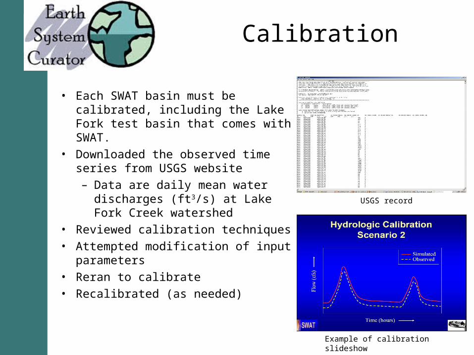
Calibration
• Each SWAT basin must be calibrated, including the Lake Fork test basin that comes with SWAT.
• Downloaded the observed time series from USGS website– Data are daily mean water
discharges (ft3/s) at Lake Fork Creek watershed
• Reviewed calibration techniques• Attempted modification of input
parameters• Reran to calibrate• Recalibrated (as needed)
USGS record
Example of calibration slideshow

Remaining Tasks
• Work on MWSwat to configure the output files of SWAT• Continue SWAT calibration

Summary
To couple an atmospheric model and a hydrological model, careful unit conversions are needed to connect data flows. To determine the best downscaling method for the project also required thorough investigation. Running and calibrating SWAT were crucial to complete Phase 4 of an end-to-end workflow.

Questions
Earth System Curator: http://earthsystemcurator.org
ESMF: http://earthsystemmodeling.org
OpenMI: http://www.openmi.org
CAM: http://www.ccsm.ucar.edu/models/ccsm4.0/cam
SWAT: http://swatmodel.tamu.edu
MWSwat: http://www.waterbase.org/download_mwswat.html
Reference: Fowler, H., Blenkinsop, S., & Tebaldi, C. (2007). Linking climate change modelling to impacts studies. International Journal of Climatology, 27, 1547-1578.