Embed Size (px)
Citation preview
ENCINO-TARZANA
Community Plan
TABLE OF CONTENTS
ACTIVITY LOG
COMMUNITY MAPS
COMMUNITY PLAN
I. Introduction
II. Function of the Community Plan
III. Land Use Policies and Programs
IV. Coordination Opportunities for Public Agencies
V. Urban Design
www.lacity.org/PLN (General Plans)
A Part of the General Plan - City of Los Angeles
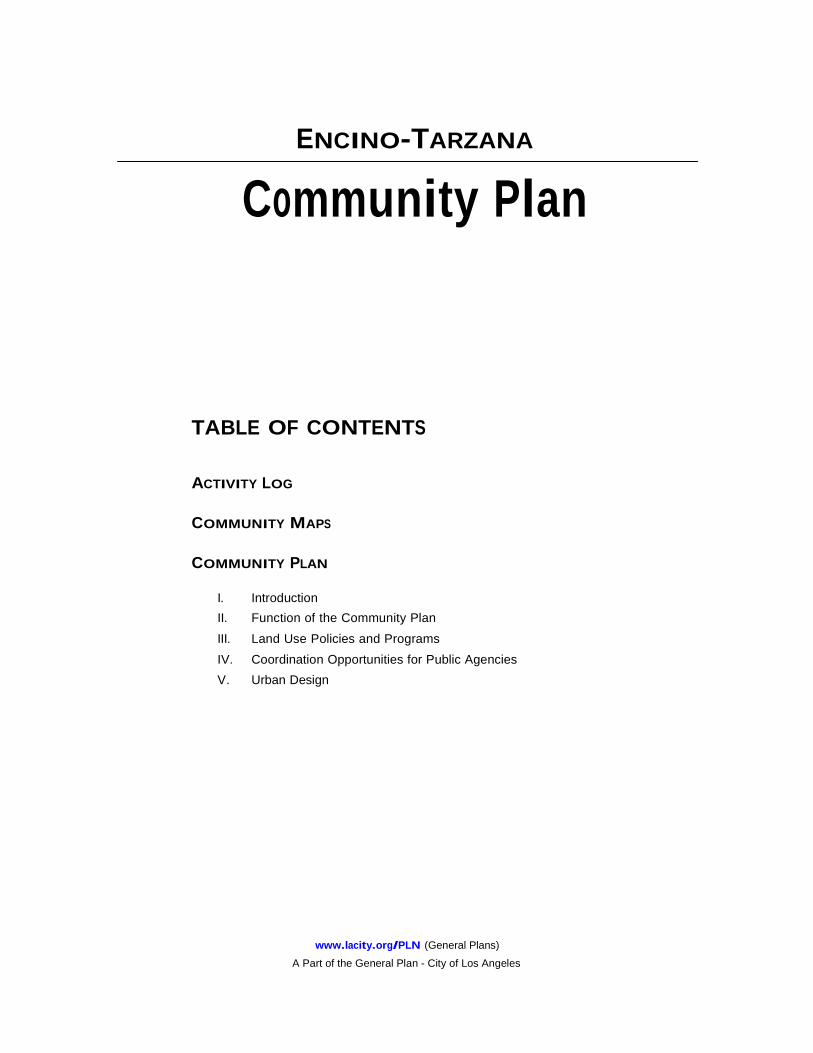
ENCINO-TARZANA
ACTIVITY LOG
ADOPTION DATE
Dec. 16, 1998 Jan. 4, 1991 May 13, 1992
ADOPTION
PLAN
Encino-Tarzana Community Plan Update Ventura-Cahuenga Boulevard Corridor Specific Plan Mulholland Scenic Parkway Specific Plan
AMENDMENT
CPC F LE NO.
97-0042 CPU 85-0383 84-0323 SP CPC F LE NO.
COUNCIL ILE NO.
98-1823 85-0926 S22
86-0945
COUNCIL ILE NO.
I
F
F
I
Sept. 7, 2016 Mobility Plan 2035 Update CPC-2013-910-GPA-SPCA-MSC 15-0719
ENCINO-TARZANA
Community Plan
Chapter I
INTRODUCTION
COMMUNITY BACKGROUND
PLAN AREA Encino-Tarzana Community Plan area is located approximately 13 miles west
of downtown Los Angeles. It is bounded by the communities of Sherman
Oaks-Studio City-Toluca Lake and Van Nuys-North Sherman Oaks on the
east, Canoga Park-Winnetka-Woodland Hills-West Hills to the west,
Brentwood-Pacific Palisades on the south, and Reseda-West Van Nuys on
the north. The Plan is comprised of two community sub-areas, each with
its own identity, described as follows:
• Encino with its roots traced to early Spanish settlers, was named for its
abundance of large spreading oak trees, “Los Encinos”. Today with its
diverse mix of commercial uses that focus along Ventura Boulevard,
Encino has two identities. On the eastern end starting at the 405
Freeway and extending to Balboa Boulevard, one senses that they are
entering a Regional Center. The predominant development pattern is that
of high-rise buildings surrounded by specialty shops and restaurants
which serve the everyday work force that is housed in the large monolith
buildings that line Ventura Boulevard. Further west, the development
pattern generally follows that commonly found throughout the rest of the
Valley, strip-center type commercial development. Residential
development is comprised of large estate size single family lots located
south of Ventura Boulevard, and a mix of single family and multiple
density dwellings located north, between the 101 Freeway and Ventura
Boulevard.
C Tarzana was part of the 116,858 acre Ranch Ex-Mission de San
Fernando which extended over what is the current San Fernando Valley.
In 1910 Tarzana was called Runnymede III, a subdivision developed by
Los Angeles Suburban Homes. In 1928 the area’s name was changed
from Runnymede III to Tarzana, in honor of the largest landowner of the
area, Edgar Rice Burrough, the creator of Tarzan the ape man.
Commercial properties located along Ventura Boulevard are developed
with a mix of pedestrian oriented storefronts and office structures.
Residential development parallels that of Encino, large estate lots south
of Ventura Boulevard and a mix of single-family and multiple density
housing located between the Ventura Freeway and Ventura Boulevard.
ENCINO-TARZANA
I-1
Contained within the diverse residential area north of Ventura Blvd.,
bounded by Tampa Ave. on the east, Corbin Ave. on the west, Topham
Street on the north, and Martha Street on the south lies Melody Acres.
With its own distinctive identity, characterized by large estate lots, quaint
narrow streets, and uniqueness of housing style, this community
provides its residents with a flavor of semi-rural living.
• Specific Plans the Ventura/Cahuenga Boulevard Corridor and Mulholland
Scenic Parkway Specific Plans address the unique development
problems associated with commercial and residential development within
the Encino-Tarzana plan area.
Ventura/Cahuenga Boulevard Corridor Specific Plan
The goals of the Ventura/Cahuenga Boulevard Corridor Specific Plan are to
assure an equilibrium between the transportation infrastructure and land use
development. They also provide for an effective local circulation system;
promote attractive and harmonious site design for commercial development;
provide compatible and harmonious relationships between commercial and
residential areas when adjacent to each other; promote and encourage the
development of pedestrian activity, while reducing traffic congestion; and
maintain the distinct character of each of the five Specific Plan communities
located within its boundaries.
Mulholland Scenic Parkway Specific Plan
The goals of the Mulholland Scenic Parkway Specific plan are to assure
maximum preservation and enhancement of the parkways’ outstanding and
unique scenic features and resources; to assure that design and placement
of buildings and other improvements preserve, complement and/or enhance
views; minimize grading and assure that graded slopes have a natural
appearance. Additionally, the plan seeks to preserve the natural appearance
compatible with the characteristics of the Santa Monica Mountains; to protect
prominent ridges, trees and environmentally sensitive areas; and protect all
identified archaeological and paleontological resources. COMMUNITY
PARTICIPATION The State of California requires citizen participation in the preparation or
amendments of community plans. General Plan Government Code Section
65351 reads, “During the preparation or amendment of the general plan the
planning agency shall provide opportunities for the involvement of citizens,
public agencies, public utility companies, civic, education, and other
community groups through public hearings and any other means the city or
county deems appropriate”.
Drafting of the first community plan involved members of the community who
helped to identify and define the needs, desires, resources, and the unique
nature of the community. Subsequent changes in the plan have served to
broaden the community participation that took place with the formation of the
original plan. Community participation helps to update the plan as to what
changes have taken place since its adoption.
ENCINO-TARZANA
I-2
COMMUNITY ISSUES AND OPPORTUNITIES
The following summarizes the most significant planning and land use issues
and opportunities which were identified in the Encino-Tarzana Community
Plan Area: RESIDENTIAL Issues
• Need to preserve single family neighborhoods.
• Lack of open space in apartment projects.
• Cumulative effects if permitted development exceeds infrastructure
capacity.
• Need to preserve and enhance historic buildings and residences.
• Need for more affordable senior housing.
• Rising cost of housing.
• Compatibility between residential and industrial uses.
Opportunities
• Active homeowners groups promoting identification and preservation and
rehabilitation of historic residences.
• Access and proximity to employment.
• Potential for residential and mixed use development along commercial
corridors.
• Undeveloped or underdeveloped land may allow opportunities for
clustered development.
• Potential for appropriately scaled new housing in proximity to new transit
facilities. COMMERCIAL Issues
• Lack of continuity of complementary uses and cohesiveness along
commercial frontages.
• Lack of overall parking and access within commercial strips due to such
physical constraints as shallow commercial lot depths.
• Unsightliness of new construction due to the lack of landscaping,
architectural character and scale.
• Inadequate transition between commercial and residential uses.
ENCINO-TARZANA
I-3
Opportunities
• Support for efforts to preserve and rehabilitate commercial and residential
historic structures when located on commercial sites.
• Complement any unique existing development/uses to reinforce desirable
design characteristics and uses.
• Establish appropriate transitions between commercial (mixed use) and
adjoining uses, especially residential.
• Create pedestrian/friendly shopping areas by incorporating street trees,
benches, convenient parking/access, and maintaining retail frontage at
ground level. INDUSTRIAL Issues
• To ensure that industrially zoned properties are located north of Ventura
Boulevard.
• To provide adequate protection for residentially zoned properties adjacent
to industrial uses.
Opportunities
• Expand manufacturing uses that generate employment for the local work
force.
• Attract desirable (“clean”) industrial uses, thus generating less harmful
pollutants and lower noise levels.
• Providing appropriate administrative review for major expansions of
existing industrial sites when located near residential uses.
• Excellent access to regional freeways and rail services.
• Availability of sites planned for job producing uses that improve the
economic and physical condition of the area. TRANSPORTATION Issues
• Establishing a route for a possible east-west transit rail line or
transportation corridor.
• Developing standards for development in possible transit station locations
along the east-west route.
Opportunities
• Potential for joint development between private and public sectors to
integrate, optimize and coordinate new construction.
ENCINO-TARZANA
I-4
• Potential to determine the intensity, density and design of development
in proximity to transit station stops.
• Potential to incorporate needed facilities conveniently near transit
stations stops such as child care, senior housing, and art and craft
districts.
• Potential to reflect and enhance community identity with themes for each
transit station stop. RECREATION AND Issues
PARKS AND OPEN SPACE • Addition, expansion and/or improvement of needed local parks throughout
the Community should be accelerated, where feasible.
• Continued development of Equestrian, Hiking and Bicycle Trails.
C Providing public access to state owned parkland.
Opportunities
• Continued efforts to establish State and local park sites within the
hillside areas. MAJOR One area has been identified as a major opportunity site: the rail line located
DEVELOPMENT along Oxnard Street and portion of Topham Street. This designation is
OPPORTUNITY SITE applied to areas which will potentially generate significant community wide impacts.
The MTA rail right-of-way
The rail right-of-way runs east to west adjacent to Oxnard Street until it turns
north at Cahill Avenue onto Topham Street. Properties along the right-of-way
are developed with a variety of uses that include commercial, industrial and
residential.
Issues
C Determine if the rail right-of-way should be retained for possible transit
line use.
C Determine where a transit station should be located along the rail right-of-
way.
C The increase in traffic volume in the vicinity.
Opportunities
C Integrating the development of the rail right-of-way with adjacent
properties.
ENCINO-TARZANA
I-5

C Establishing the proper types of uses if the rail line in not used for transit
uses. C Establish design features that complement adjacent uses for any future
transit station stop. NEIGHBORHOOD
CHARACTER Preserve and enhance the positive characteristics of existing uses which
provide the foundation for community identity, such as scale, height, bulk,
setbacks and appearance.
Issues
• Scale, density and character of multiple dwelling housing adjacent to
single-family homes.
• Impact on street parking from new high density apartments.
• The need to preserve and rehabilitate historic areas with a sensitivity to
the character of the established neighborhood.
• New development that complements significant historic structures.
Opportunities
• Development of areas adjacent to transit station stops provide
opportunities to enhance community identity.
• Potential for appropriately scaled new housing in proximity to transit
facilities.
• Inclusion of mixed use development in commercial areas adjacent to
transit station stops.
• Development of specific design guidelines for areas located adjacent to
commuter rail service and transit station stops.
COMMUNITY PROFILE
The Community Profile provides an overview of population, housing, and
socio/demo-graphics for the Encino-Tarzana Community Plan Area and
compares it to the rest of the city. The following tables contain the statistical
data for previous census dates and rates of growth.
ENCINO-TARZANA
I-6


Chapter II
FUNCTION OF THE COMMUNITY PLAN
Chapter II of the Plan Text contains the statutory requirements for the
Community Plan outlining the mandatory elements that must be addressed.
The chapter contains the explanations of the Role, Purpose, and Organization
of the Community Plan. Chapter II shows the relationship to other General
Plan elements and provides for Plan Monitoring and Consistency.
STATUTORY REQUIREMENTS
California State Law (Government Code 65300) requires that each city prepare
and adopt a comprehensive, long-term general plan for its physical
development. It must contain seven mandatory elements including land use,
circulation, housing, conservation, open space, noise, and safety. In the City
of Los Angeles, thirty five community plans comprise the city’s Land Use
Element.
State of California law requires that the Land Use Element be prepared as
part of the City’s General Plan, and that the Land Use Element be
coordinated with the Circulation Element.
The Land Use Element has the broadest scope of the General Plan elements
required by the State. Since it regulates how land is to be utilized, many
of the issues and policies contained in all other plan elements are impacted
and/or impact this element.
Government Code Section 65302 (a) states that a land use element
designates the proposed general distribution and general location and the
extent of the uses of land for housing, business and industry, open space,
including agriculture, natural resources, recreation, and enjoyment of scenic
beauty, education, public buildings and grounds, solid and liquid waste
disposal facilities, and other categories of public and private uses of land.
The land use element shall include a statement of the standards of population
density and building intensity recommended for the various districts and other
territory covered by the plan.
The Encino-Tarzana Community Plan is a part of the General Plan of the City
of Los Angeles. It of the text and the accompanying map. The Community
Plan text states the goals, objective, policies and programs. The Community
Plan Map, footnotes and legend outline the arrangement and intensities of
land uses, the street system, and the locations and characteristics of public
service facilities.
ENCINO-TARZANA
II-1

ROLE OF THE COMMUNITY PLAN
The Community Plan is intended to promote an arrangement of land uses,
streets, and services which will encourage and contribute to the economic,
social and physical health, safety, welfare, and convenience of the people
who live and work in the community. The plans are also intended to guide
development in order to create a healthful and pleasant environment. Goals,
objectives, policies, and programs are created to meet the existing and future
needs and desires of the community through the year 2010. The general plan
clarifies and articulates the city’s intentions with respect to the rights and
expectations of the general public, property owners, prospective investors
and business interests. Through the Community Plan, the city can inform
these groups of is goals, policies, and development standards, thereby
communicating what is expected of the city government and private sector
to meets its objectives.
The Community Plan ensures that sufficient land is designated which
provides for the housing, commercial, employment, educational, recreational,
cultural, social, and aesthetic needs of the residents of the plan area. The
Plan identifies and provides for the maintenance of any significant
environmental resources within the Plan Area. The Plan also seeks to
enhance community identity and recognizes unique neighborhoods within
the Plan area.
PURPOSE OF THE COMMUNITY PLAN
The last comprehensive update of the Encino-Tarzana Community Plan was
completed in 1987 through the General Plan Consistency Program required
by AB283. In the past 20 years the community has shown a smaller growth
rate than the overall rate for the city. From 1970 to 1980 the community
population increased by 7,514 residents, an increase of 12.7%. Since 1980
the community’s population has decreased by 16 residents representing a
decline of -0.0%. During this time, considerable change has occurred, new
issues have emerged, and new community objectives regarding the
management of new development and community preservation have evolved.
Consequently, it is necessary to update the Community Plan to not only
reflect current conditions, but to accurately reflect the prevailing visions and
objectives of the area’s residents and property and business owners.
This Community Plan was developed in the context of promoting a vision of
the Encino-Tarzana area as a community that looks at its past with pride and
approaches its future with eagerness, while maintaining its individual identity
by:
• Preserving and enhancing the positive characteristics of existing
residential neighborhoods while providing a variety of compatible new
housing opportunities.
• Improving the function, design and economic vitality of the commercial
corridors.
ENCINO-TARZANA
II-2
• Preserving and enhancing the positive characteristics of existing uses
which provide the foundation for community identity, such as scale,
height, bulk, setbacks and appearance.
• Maximizing the development opportunities of the future rail transit
system while minimizing any adverse impacts.
• Planning the remaining commercial and industrial development
opportunity sites for needed job producing uses that improves the
economic and physical condition of the Encino-Tarzana Community Plan
Area.
ORGANIZATION AND CONTENT OF THE COMMUNITY PLAN
This Plan sets forth goals, objectives, policies, and programs that pertain to
Encino-Tarzana. Broader issues, goals, objectives, and policies are provided
by the Citywide General Plan Framework.
The Plan is organized and formatted to facilitate periodic updates. The State
recommends that the entire plan be comprehensively reviewed every five
years to reflect new conditions, local attitudes, and technological advances.
The principal method for the implementation of the Land Use Map is the
Zoning Ordinance. The City’s Zoning Map must be updated to remain
consistent with the adopted Land Use Map. Together, the Zoning Ordinance
and the Zoning Map will identify specific types of land use, intensity of use
and development standards applicable to specific areas and parcels of land
within the community.
RELATIONSHIP TO OTHER GENERAL PLAN ELEMENTS
The City of Los Angeles has the responsibility to maintain and implement
the City’s General Plan. Since State Law requires that the General Plan have
internal consistency, the Encino-Tarzana Community Plan must be
consistent with other Elements and components of the General Plan.
The General Plan Framework is a long range, citywide, comprehensive growth
strategy. It is a special element of the General Plan which looks to the future
as required by law and replaces Concept Los Angeles and the Citywide Plan
(adopted in 1974).
The Framework provides a citywide context within which local planning takes
place. Both the benefits and challenges of growth are shared.
The Citywide General Plan Framework Element neither overrides nor
supersedes the Community Plan. It guides the city’s long range growth and
development policy, establishing citywide standards, goals, policies, and
objectives for citywide elements and community plans. The Framework is
flexible, suggesting a range for uses within its land use definitions. Precise
determinations are make in the Community Plans.
ENCINO-TARZANA
II-3

The General Plan Framework provides the following projections for population,
housing and employment levels for the Encino-Tarzana Community Plan for
the year 2010 are:
Population (2010) Projection 79,352
Employment (2010) Projection 53,641
Housing (2010) Projection 32,628
The above population, employment and housing numbers are provided as
reference during the Community Plan update. It needs to be recognized,
however, that these figures are only best estimates and are derived from
regional data which are disaggregated to the city and then the community
level. Population, jobs and housing could grow more quickly, or slowly, than
anticipated depending on economic trends.
Regional forecast does not always reflect the adopted community plan land
use capacity or buildout estimated from planned land use. Plan capacity
or buildout is also an imprecise estimate and depends on specific
assumptions about future density of development and household size, which
may be more or less, than actually occurs. It should be also noted that the
community plan capacity does not include housing in commercial districts
nor the current residential vacancy rate.
In addition to the seven State mandated elements, the City’s General Plan
includes a Service System Element, a Cultural Element, major Public
Facilities areas Element, and an Air Quality Element. All the provisions and
requirements of the General Plan elements apply to the Encino-Tarzana
Community Plan.
Neighborhood plans involve the preparation of special plans which blend both
policy and implementation functions for unique neighborhoods within a
community. In addition to these neighborhood plans, overlay zones also
combine policy and implementation functions to address issues peculiar to
a specific neighborhood.
The Community Plan includes appropriate policies and implementation
measures generated from the mitigation measures listed in the environmental
clearance. In many instances these measures encompass the policies
contained in the General Plan Framework.
PLAN CONSISTENCY Each plan land use category indicates the corresponding zones permitted
by the Plan unless further restricted by the Plan Text, footnotes, adopted
Specific Plans or other specific limitations on discretionary approvals. The
Plan recognizes that the residential densities, commercial intensities and
industrial intensities depicted on the Plan Map are theoretical and will not
occur due to plan and zone regulations, economic conditions, and design limitations.
For each plan category, the Plan permits all identified corresponding zones,
as well as those zones which are more restrictive, as referenced in Section
ENCINO-TARZANA
II-4

12.23 of the Los Angeles Municipal Code (LAMC). Any subsequent action
that modifies the Plan or any monitoring review that results in changes to
the Plan must make new Plan consistency findings at the time of the
decision.
City actions on most discretionary projects require a finding that the action
is consistent or in conformance with the General Plan. In addition to the
required general finding, decision-makers acting on certain projects in the
Encino-Tarzana Community Plan Area shall refer to each of the applicable
additional findings that the Plan identifies as programs, policies or objectives
in Chapter III of the Plan which are underlined for ease of reference. To
further substantiate the consistency findings decision makers may site other
programs, policies, or objectives which would be furthered by the proposed
project. In addition, Chapter V of the Plan requires a decision maker to
make a finding of conformance with applicable design standards for
discretionary projects.
PLAN MONITORING The Plan has a land use capacity greater than the projected development
likely to occur during the Plan period. During the life of the Plan, growth will
be monitored and reported in the City’s Annual Report on Growth and
Infrastructure which will be submitted to the City Planning Commission,
Mayor, and City Council. In the fifth year following Plan adoption (and every
five years thereafter), the Director shall report to the Commission on the
relationship between population, employment, and housing growth and plan
capacities. If growth has occurred faster than projected, a revised
environmental analysis will be prepared and appropriate changes
recommended to the Community Plan and zoning. These Plan and zoning
changes and any related moratorium of interim control ordinance, shall be
submitted to the Planning Commission, Mayor, and City Council as specified
in the LAMC.
ENCINO-TARZANA
II-5
Chapter III
LAND USE POLICIES AND PROGRAMS
Chapter III of the Plan Text contains Goals, Objectives, Policies, and
Programs for all appropriate land use issues, such as residential,
commercial, and industrial, as well as public and institutional service system
categories. The Planning Department has responsibility for the goals,
objectives, policies, initiation and direct implementation of the programs
contained in Chapter III. The quality of life and stability of neighborhoods
throughout Encino-Tarzana critically depends on providing infrastructure
resources (i.e. police, fire, water, sewerage, parks, traffic circulation, etc.)
Commensurate with the needs of its population. If population growth occurs
faster than projected and without needed infrastructure improvements to keep
pace with that growth, the consequences for livability within Encino-Tarzana
could be problematic.
Accordingly, the proposed Plan has three fundamental premises. First, is
the limiting residential densities in various neighborhoods to the prevailing
density of development in these neighborhoods. Second, is the monitoring
of population growth and infrastructure improvements through the City’s
Annual Report on Growth and Infrastructure with a report to the City Planning
Commission every five years on the Encino-Tarzana following Plan adoption.
Third, if this monitoring finds that population in the Plan area is occurring
faster than projected; and that infrastructure resource capacities are
threatened, particularly critical resources such as water and sewerage: and
that there is not clear commitment to at least begin the necessary
improvements within twelve months; then building controls should be put into
effect, for all or portions of the Encino-Tarzana Community, until land use
designations for the Encino-Tarzana Community Plan and corresponding
zoning are revised to limit development.
RESIDENTIAL Existing residential land use patterns vary greatly according to local
conditions in the neighborhoods and communities which comprise the
Encino-Tarzana Community Plan. Topography, population characteristics,
housing markets, age and degree of existing development have great
influence on the type, location and density of development throughout the
community. Much of the existing residential development in the area was
established by physical controls such as topography, large amounts of then available land and infrastructure.
In recent years, there has been increasing pressure for development in the
hillside areas, much of which is out of scale with adjacent homes. Such new
single-family development impacted the existing street system and
infrastructure. Additionally, development pressure from projects along
Ventura Boulevard have increased an overall concern for the future functional
development of these areas.
Historically, the majority of the area has been planned for residential
purposes. The 1975 Plan designated approximately 63 percent of the total
ENCINO-TARZANA
III-1
land area for residential use. Of this portion 60 percent was designated for
single-family use only. Therefore, current plan policy provides for continued
preservation of the existing residential neighborhoods throughout the area,
retaining existing single family districts and multi-family clusters. Areas
around transit stations and along transit corridors would realize any changes
in densities as existing properties zoned for multi-family development
continue to build out to their maximum potential.
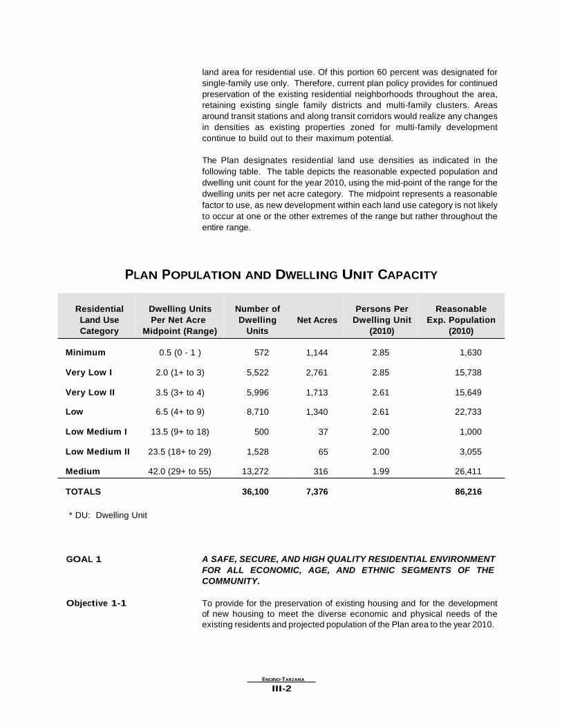
The Plan designates residential land use densities as indicated in the
following table. The table depicts the reasonable expected population and
dwelling unit count for the year 2010, using the mid-point of the range for the
dwelling units per net acre category. The midpoint represents a reasonable
factor to use, as new development within each land use category is not likely
to occur at one or the other extremes of the range but rather throughout the
entire range.
PLAN POPULATION AND DWELLING UNIT CAPACITY
Residential
Land Use
Category Minimum Very Low I Very Low II Low Low Medium I Low Medium II Medium
Dwelling Units
Per Net Acre Midpoint (Range)
0.5 (0 - 1 )
2.0 (1+ to 3)
3.5 (3+ to 4)
6.5 (4+ to 9)
13.5 (9+ to 18)
23.5 (18+ to 29)
42.0 (29+ to 55)
Number of
Dwelling
Units
572
5,522
5,996
8,710
500
1,528
13,272
Net Acres
1,144
2,761
1,713
1,340
37
65
316
Persons Per
Dwelling Unit
(2010)
2.85
2.85
2.61
2.61
2.00
2.00
1.99
Reasonable
Exp. Population
(2010)
1,630
15,738
15,649
22,733
1,000
3,055
26,411 TOTALS 36,100 7,376 86,216
* DU: Dwelling Unit
GOAL 1
Objective 1-1
A SAFE, SECURE, AND HIGH QUALITY RESIDENTIAL ENVIRONMENT
FOR ALL ECONOMIC, AGE, AND ETHNIC SEGMENTS OF THE
COMMUNITY. To provide for the preservation of existing housing and for the development
of new housing to meet the diverse economic and physical needs of the
existing residents and projected population of the Plan area to the year 2010.
ENCINO-TARZANA
III-2
Policies
1-1.1 Designate specific lands to provide for adequate multi-family
residential development.
Program: The Plan Map identifies specific areas where multi-
family residential development is permitted.
1-1.2 Protect existing single family residential neighborhoods from new,
out-of-scale development.
Program: Recent changes in the Zoning Code set height limits
for new single family residential development.
1-1.3 Protect existing stable single-family and low density residential
neigh-borhoods from encroachment by higher density residential
and other incompatible uses.
Program: The Plan Map identifies lands where only single-family
residential development is permitted; it protects these areas from
encroachment by designating appropriate, transitional residential
densities which serve as buffers; and reflects plan amendments and
corresponding zone changes which are directed at minimizing
incompatible uses.
1-1.4 Protect the quality of the residential environment through attention
to the appearance of communities, including attention to building
and site design.
Program: The Plan includes an Urban Design Chapter which is
supplemented by Design Guidelines and Standards for residential
development.
1-1.5 Maintain at least 63% residential land designated for single family
uses.
Program: The Plan designates residential lands to reflect this
percentage.
1-1.6 The city should promote neighbor-hood preservation, particularly
in existing single family neighborhoods, as well as in areas with
existing multi-family residences.
Program: With the implementation of the Community Plan, single
family residential land use categories, all zone changes,
subdivisions, parcel maps, variances, conditional uses, specific
plans, community and neighborhood revitalization programs for
residential projects shall provide for Plan consistency.
Program: The Homeowner’s Encouragement Loan Program
(HELP), administered by the City’s Housing Preservation and
Production Department, provides rehabilitation loans to owners of
small residential buildings (one to four units) to correct code
violation.
ENCINO-TARZANA
III-3
Program: The Residential Rehab-ilitation Loan Program,
administered by the Community Redevelopment Agency (CRA),
makes funds available for the rehabilitation of lower-income multi-
family rental housing. The program is partially funded by the U.S.
Department of Housing and Urban Development (HUD) and requires
matching funds from a private lender with CRA as a last resort. Objective 1-2 To locate new housing in a manner which reduces vehicular trips and makes
it accessible to services and facilities.
Policies
1-2.1 Locate higher residential densities near commercial centers or
transit stations and major bus routes where public services
facilities, utilities and topography will accommodate this
development.
Program: Maintain and continue the implementation of the City’s
Land Use/Transportation Policy.
1-2.2 Encourage multiple residential development in commercial zones.
Program: The Plan provides the potential for a floor area ratio
bonus by providing for mixed use corridors in specific commercial
areas.
Program: Maintain and continue the implementation of the City’s
Land Use/Transportation Policy. Objective 1-3 To preserve and enhance the varied and distinct residential character and
integrity in existing single and multi- family neighborhoods.
Policies
1-3.1 Seek a high degree of compatibility and landscaping for new infill
development to protect the character and scale of existing
residential neighborhoods.
Program: The Plan includes Design Guidelines which establish
design standards for residential development to implement this
policy.
1-3.2 Consider factors such as neighborhood character and identity,
compatibility of land uses, impact on livability, impacts on services
and public facilities, and impacts on traffic levels when changes in
residential densities are proposed.
Program: The decision-maker should adopt a finding which
addresses these factors as part of any decision relating to changes
in planned residential densities.
1-3.3 Preserve existing views in hillside areas.
ENCINO-TARZANA
III-4
Program: Maintain and continue implementation of the adopted
Citywide Hillside Ordinance and the Mulholland Scenic Parkway
Specific Plan which contribute to preservation of views. Objective 1-4 To promote and ensure the provision of adequate housing for all persons
regardless of income, age or ethnic background.
Policies
1-4.1 Promote greater individual choice in type, quality, price and location
of housing.
Program: The plan promotes greater individual choice through its
establishment of residential design standards and its allocation of
lands for a variety of residential densities.
1-4.2 Promote housing in mixed use projects in pedestrian oriented
areas.
Program: Maintain and continue the implementation of the Land
Use/Transportation Policy.
Program: The plan provides a bonus in floor area for mixed use
projects in the areas identified in this policy.
1-4.3 Ensure that new housing opportunities minimize displacement of
the residents.
Program: The decision-maker shall adopt a finding which
addresses any potential displacement of residents as part of any
decision relating to new housing construction.
1-4.4 Provide for development of townhouses and other similar
condominium type of housing units to increase home ownership
options.
Program: The Plan cannot require that condominium units be built
instead of rental units; however, the Plan encourages such type of
development by designating specific areas for Low Medium
residential land use categories. Objective 1-5 To limit the intensity and density in hillside areas.
Policies
1-5.1 Limit development according to the adequacy of the existing and
assured street circulation system within the Plan Area and
surrounding areas.
Program: Continue the implementation of the Citywide Hillside
Ordinance and the Mulholland Scenic Parkway Specific Plan.
ENCINO-TARZANA
III-5
Ensure that a footnote of the Plan Map Legend is considered by
the decision-maker for subdivisions and parcel map applications
within hillside areas.
1-5.2 Ensure the availability of adequate sewers, drainage facilities, fire
protection services and facilities and other public utilities to support
development within hillside areas.
Program: The decision-maker shall adopt a finding which
addresses the availability of these services and utilities as part of
any decision relating to hillside residential development.
1-5.3 Consider the steepness of the topography and suitability of the
geology in any proposal for development within the Plan Area.
Program: The Plan retains hillside areas in restrictive plan
designations and zones due to topography. Continue the
implementation of the Subdivision Map Act on individual project
applications. The decision maker shall follow the standards set
forth in a footnote of the Plan Map Legend when considering hillside
development.
1-5.4 Require that any proposed development be designed to enhance
and be compatible with adjacent development.
Program: Continue the implementation of the Citywide Hillside
Ordinance and the Mulholland Scenic Parkway Specific Plan.
COMMERCIAL Commercial land use in the Encino-Tarzana Community Plan area is a vital
component of the community. It is as diverse as the various areas that make
up the Community Plan Area. The varied mixed forms of commercial uses
that are found along Ventura Boulevard dominate the commercial aspect of
the community. Except for the high-rise development west of the 405
Freeway to Balboa Boulevard, the predominant land use pattern is mainly
strip commercial developed on shallow lots with limited on-site parking.
Along Ventura Boulevard which runs the length of the Plan Area, a specific
plan has been in effect that has helped to address the parking problems.
Plan policy provides for the development of single or aggregated parcels for
mixed use commercial and residential development. These structures would
normally incorporate retail, office, and/or parking on the lower floors and
residential units on the upper floors. The intent is to provide housing in close
proximity to jobs, to reduce vehicular trips, to reduce congestion and air
pollution, to assure adequate sites for housing, and to stimulate pedestrian
oriented areas to enhance the quality of life in the Plan area. While the Plan
does not mandate mixed-use projects, it encourages them in certain
commercially designated areas, such as in pedestrian oriented areas. GOAL 2 A STRONG AND COMPETITIVE COMMERCIAL SECTOR WHICH BEST
SERVES THE NEEDS OF THE COMMUNITY THROUGH MAXIMUM
EFFICIENCY AND ACCESSIBILITY WHILE PRESERVING THE HISTORIC
COMMERCIAL AND CULTURAL CHARACTER OF THE DISTRICT.
ENCINO-TARZANA
III-6
Objective 2-1 To conserve and strengthen viable commercial development
Policies
2-1.1 New commercial uses shall be located in existing established
commercial areas or existing shopping centers.
Program: The plan provides well defined boundaries for
commercial areas, any extended growth outside those boundaries
would require a plan amendment.
2-1.2 Protect commercially planned/zoned areas outside pedestrian
orientated areas from encroachment by residential only
development.
Program: Provisions of the Zoning Code currently restrict floor area
of buildings, including residential buildings, in commercial zones
within Height District 1, to a 1.5 floor area ratio, rather than the 3
to 1 floor area ratio in a residential zone. This provision effectively
discourages residential only developments in commercial zones
outside of pedestrian orientated areas.
2-1.3 Require that projects be designed and developed to achieve a high
level of quality, distinctive character, and compatibility with existing
uses and development
Program: Chapter V- Urban Design, proposes policies for
commercial development which address this policy. Objective 2-2 Allow for the development of automobile-related uses in specifically
designated commercial designations along most boulevards.
Policies
2-2.1 Prohibit the development of new automobile-related uses in
pedestrian oriented areas (POA’s).
Program: Maintain and continue implementation of the adopted
Ventura/Cahuenga Boulevard Corridor Specific Plan, which prohibits
certain uses in the POA’s.
2-2.2 Require screening of open storage and auto repair uses, and
prohibit storage of automobile parts and other noxious commercial
related products in front of commercial development, exposed to
the street.
Program: The Plan and Specific Plan include Design guidelines
which address this policy. Objective 2-3 To enhance the identity of distinctive commercial districts and to identify
pedestrian oriented areas (POA’s).
Policies
ENCINO-TARZANA
III-7

2-3.1 Existing pedestrian oriented areas are to be preserved.
Program: The Plan map identifies specific corridors as pedestrian
oriented areas. Development within these areas is subject to the
applicable design standards of the Design Guidelines. The Plan
identifies appropriate land use designations and establishes height
limits and appropriate zones which preserve and enhance the
existing pedestrian oriented character.
Maintain and continue implementation of the Ventura/Cahuenga
Boulevard Corridor Specific Plan which designates specific areas
as POA’s.
2-3.2 New development needs to add to and enhance the existing
pedestrian street activity.
Program: Development within these areas are subject to the uses
specified within the Specific Plan regulations.
Further development within these areas is subject to the design
standards established in the Design Guidelines for pedestrian
oriented areas.
2-3.3 Ensure that commercial infill projects achieve harmony with the
best of existing development.
Program: Implementation of Design Guidelines and the
Ventura/Cahuenga Boulevard Corridor Specific Plan.
2-3.4 Identify pedestrian oriented areas as preferred locations for mixed-
use projects.
Program: Through this policy and Plan Map designations, the Plan
proposes pedestrian oriented areas as preferred locations for mixed
use projects.
2-3.5 Require that mixed use projects and development in pedestrian
oriented areas be designed and developed to achieve a high level
of quality, distinctive character, and compatibility with existing
uses.
Program: The Plan includes a Design Guidelines provision which
will implement this policy for commercial projects located within
pedestrian oriented areas.
2-3.6 Require that the first floor street frontage of structures, including
mixed use projects and parking structures located in pedestrian
oriented areas, incorporate commercial uses.
Program: Maintain and implement the Ventura/Cahuenga
Boulevard Corridor Specific Plan Design Guidelines which address
this policy for areas within the Specific Plan boundaries.
Additionally, where appropriate establish Pedestrian Oriented Areas
outside of the Specific Plan boundaries.
ENCINO-TARZANA
III-8

Objective 2-4 To enhance the appearance of commercial districts
Policies
2-4.1 Require that any proposed development be designed to enhance
and be compatible with adjacent development.
Program: Continue the implementation of the Ventura/ Cahuenga
Boulevard Corridor Specific Plan, and implement the applicable
design standards identified in the Design Guidelines of the
Community Plan.
2-4.2 Preserve community character, scale and architectural diversity.
Program : The Plan establishes height limits, amends Plan
designations and recommends corresponding zone changes to
implement this policy. Design standards for commercial areas
included in the Design Guidelines of the Community Plan
implement this policy.
2-4.3 Improve safety and aesthetics of parking areas in commercial
areas.
Program: Implement design standards for parking areas
established in the Ventura/Cahuenga Boulevard Corridor Specific
Plan and within the Chapter Design Standards of this plan.
2-4.4 Landscaped corridors should be created and enhanced through the
planting of street trees along segments with no building setbacks
and through median plantings.
Program: The Design Guidelines in this Plan and the
Ventura/Cahuenga Boulevard Corridor Specific Plan include
sections which establishes guidelines for community design and
landscaping. These guidelines are intended to serve as reference
to other city departments and public agencies and any private
entities who participate in projects which involve improvements to
public spaces and right-of-way, including streetscape and
landscaping.
INDUSTRIAL Industrial development within the plan area has been limited to the properties
adjacent to the railroad tracks that run along Oxnard Street. The majority of
the industrial uses are located within several blocks east and west of Reseda
Boulevard. The pattern of industrial development within the plan area is similar
to what has taken place throughout the valley in general, commercial uses
located along arterials. The majority of industrial uses are located east
and west of Reseda Boulevard, the commercial intrusion has taken place
on the corners of Reseda Boulevard and Oxnard Street.
Industrial uses provide needed employment opportunities and economic
benefits to the community and should be encouraged when impacts to
surrounding land uses can be mitigated.
ENCINO-TARZANA
III-9

GOAL 3
Objective 3-1
Provide land of sufficient size for expansion of low intensity non-toxic
producing industrial uses which create employment opportunities and have
minimal adverse impacts on adjacent residential uses. To provide for existing and future industrial uses which contribute job
opportunities for residents and which minimize environmental and visual
impacts to the community.
Policies
3-1.1 Designate lands for the continuation of existing industrial uses,
research and development uses which provide employment
opportunities.
Program: The Plan Map identifies lands, which have industrial
designations to accommodate the variety of uses noted above. The
addition of plan amendments and recommended corresponding
zone changes will implement this policy.
3-1.2 Require that any proposed development be designed to enhance
and be compatible with adjacent development.
Program: Design Guidelines include provisions for industrial
projects which are adjacent to or in the vicinity of residential uses. Objective 3-2 To assure mitigation of potential negative impacts generated by industrial
uses when they are located in proximity to residential neighborhoods, the
Plan proposes design guidelines for new industrial uses when so located.
Policies
3-1.1 Encourage new industrial uses adjacent to residential
neighborhoods to mitigate their impact on the residential
neighborhoods to the extent feasible.
Program: New development of industrial uses located adjacent
to residential neighborhoods shall comply with the
Industrial/Residential design guidelines found in the Urban Design
Chapter (Chapter V) of this Plan.
Program: Restrict new industrial uses located adjacent to a
residential neighborhood to uses first permitted in the CM zone.
PUBLIC AND INSTITUTIONAL LAND USE
Public facilities such as fire stations, libraries, schools, parks shown on the
Encino-Tarzana Community Plan are to be developed in substantial
conformance with the standards of need, site area, design and general
location identified in the Service Systems Element and the Safety Element
of the General Plan. Such development shall be sequenced and timed to
ENCINO-TARZANA
III-10

provide an efficient and adequate balance between land use and public
services.
Development to the full residential, commercial, and industrial densities and
intensities proposed by the Plan are predicated upon substantial compliance
with the standards contained in the Public Facilities and Service Element
of the General Plan. Such development should be sequenced and timed to
provide a workable, efficient and adequate balance between land use and
service facilities.
There is a continuing need for the modernizing of public facilities to improve
services and accommodate changes in the Encino-Tarzana Community Plan.
However, the amenities and environmental quality of the community must
be adequately protected. Cost and equitable distribution are major issues
in the provisions of public facilities. It is essential that priorities be established
and new and different sources of revenue be found. Furthermore, public and
private development must be fully coordinated, in order to avoid expensive
duplication and to assure a balance among needs, services and costs.
This plan seeks to utilize the location, characteristics, and timing of public
facility and utility development as a tool in achieving planned land use
patterns. The intent is to achieve economy and efficiency in the provision of
services and facilities consistent with standards for environmental quality.
The Community Plan includes appropriate policies and implementation
measures generated from the mitigation measures listed in the environmental
clearance. In many instances these measures encompass the policies
contained in the General Plan Framework.
The full residential, commercial, and industrial densities and intensities
proposed by the Plan are predicated upon substantial compliance with the
standards contained in the Public Facilities and Service Element of the
General Plan. Such development should be sequenced and timed to provide
a workable, efficient and adequate balance between land use and service
facilities. RECREATION AND
PARK FACILITES In the Encino-Tarzana Community Plan area public parks and the majority
of recreational areas are managed by the City of Los Angeles Recreation and
Parks Department. There are three types of parks-regional, community and
neighborhood parks.
There are three Neighborhood and two Community Parks which serve the
Encino-Tarzana Community Plan Area. Additionally, the Sepulveda Basin
Recreation Area with its diverse multi-recreational uses is located within the
plan area. Located south of Ventura Boulevard are two private golf courses.
The plan area with its diverse topography limits the placement of
neighborhood park sites south of Ventura Boulevard. However the Santa
Monica Mountain Conservancy has acquired vast sections of the mountain
areas located south of Ventura Boulevard. These open space park lands
serve to fulfill the need when the topography does not allow for the
construction of neighborhood park sites. The community parks serve a much
wider interest range due to the lack of sites in the hillside areas of the plan
ENCINO-TARZANA
III-11

area. While the existing parks satisfy the needs of the current residents, the
community is still deficient in the number of neighborhood parks. GOAL 4
Objective 4-1
ADEQUATE RECREATION AND PARK FACILITIES TO MEET THE
NEEDS OF THE RESIDENTS IN THE PLAN AREA. To conserve, maintain and better utilize existing recreation and park facilities
which promote the recreational experience.
Policies
4-1.1 Preserve the existing recreational facilities and park space.
Program: The plan assists in preserving such facilities and park
space by changing the existing zone as applicable to the Open
Space Zone, which provides such protection.
Program: Encourage the Department of Recreation and Parks to
continue identifying funding sources and other mechanisms such
as, but not limited to developer fees, bond financing, and proposition
funds for the continuing maintenance of recreation and park
facilities. Objective 4-2 To encourage the Department of Recreation and Parks to develop new
recreation and park facilities.
Policies
4-2.1 Promote the development of new recreation and park facilities
through the acquisition of new recreation and park land.
Program: Encourage the Department of Recreation and Parks to
continue utilizing existing funding and to pursue additional sources
of funding and other mechanisms such as, but not limited to
supplemental developer fees, bond financing, proposition funds,
transfer of development rights, and land dedications for the
acquisition and development of suitable recreation and park land
within the plan area.
Program: Encourage the Department of Recreation and Parks to
coordinate efforts with other agencies and non-profit organizations
toward the acquisition and development of recreation and park land. OPEN SPACE In the Encino-Tarzana Community Plan Area, major open space areas exist
separate from land under control of the City of Los Angeles Department of
Recreation and Parks. Open space is important due to its role in both
physical and environmental protection. Open Space is divided onto publicly
owned and privately owned open space.
Open Space is broadly defined as land which is essentially free of structures
and buildings and/or is natural in character and which functions in one or
more of the following ways:
ENCINO-TARZANA
III-12
1. Recreational and educational opportunities.
2. Scenic, cultural and historic values.
3. Public health and safety.
4. Preservation and creation of community peak travel identity.
5. Rights-of-Way for utilities and transportation facilities.
6. Preservation of natural resources or ecologically important areas.
7. Preservation of physical resources including ridge protection.
8. Preservation of access to all open space areas for the use and
enjoyment of the general public. GOAL 5
Objective 5-1
A COMMUNITY WITH SUFFICIENT OPEN SPACE IN BALANCE WITH
DEVELOPMENT TO SERVE THE RECREATIONAL, ENVIRONMENTAL
AND HEALTH NEEDS OF THE COMMUNITY AND TO PROTECT
ENVIRONMENTAL AND AESTHETIC RESOURCES. To preserve existing open space resources and where possible develop new
open space.
Policies
5-1.1 Encourage the retention of passive and visual open space which
provides a balance to the urban development of the Plan Area.
Program: The Plan Map designates areas for open space, thus
protecting them from encroachment of more intense uses.
5-1.2 Accommodate active parklands, and other open space uses.
Program: The Plan Map designates lands for open space uses
including the slopes adjacent to the 101 and 405 freeways. Objective 5-2 Provide access to the regional parks in the Santa Monica Mountains.
Policies
5-2.1 Maintain Reseda Blvd. as a prime access to the open space areas
in the Santa Monica Mountains -- with adequate parking and trail
heads.
Program: The City Council approved a street vacation
redesignating Reseda Blvd. from 100 feet south of Windford Dr. to
Mulholland Dr. from a Collector Street to a Local Street. Any street
vacation should ensure public access into the open space and park
area by the Santa Monica Mountain Conservancy.
ENCINO-TARZANA
III-13
SCHOOLS In the Encino-Tarzana Plan Area, public schools are administered by the
Los Angeles Unified School District (LAUSD).
The Plan encourages shared use of existing school facilities for the general
public after hours and on weekends. School grounds should be made
available so as to facilitate after hour recreational uses.
Six elementary schools serve the plan area; Wilbur Avenue located south
of Ventura Boulevard between Crebes Avenue and Wilbur Avenue at Canasta
Street; Emelita located north of Ventura Boulevard at Emelita Street between
Lindley Avenue and White Oak Avenue; Encino located north of Ventura
Boulevard between Addison Street and Otsego Street; Tarzana between
Collins Street and Hatteras Street and Topeka Drive and Wilbur Avenue;
Newcastle south of Ventura Boulevard between Dobkins Avenue and Doran
Avenue; Lanai south of Ventura Boulevard between Bosque Drive and Lanai
Road; Portel Middle School located south of Ventura Boulevard between
Linnet Street and Canasta Street and Crebs Avenue and Yolanda Avenue,
is the one middle school that serves the Plan Area. GOAL 6 PUBLIC SCHOOLS THAT PROVIDE A QUALITY EDUCATION FOR ALL
OF THE CITY’S CHILDREN, INCLUDING THOSE WITH SPECIAL NEEDS,
AND ADEQUATE SCHOOL FACILITIES TO SERVE EVERY
NEIGHBORHOOD IN THE CITY. Objective 6-1 Work constructively with LAUSD to promote the sitting and construction of
adequate school facilities phased with growth.
Policies
6-1.1 Explore creative alternatives for providing new school sites in the
city, where appropriate.
Program: Develop plans to address issues of siting and joint use
of facilities including strategies for expansion in transit-rich
locations.
Program : Utilize the City’s “Annual Growth Report” to monitor
locations for growth and potential new school sites. Objective 6-2 Maximize the use of local schools for community use and local open space
and parks for school use.
Policies
6-2.1 Encourage the siting of community facilities (libraries, parks,
schools and auditoriums) together.
Program: Formulate/update plans to address issues relating to
siting and the joint use of facilities. Identify strategies for the
expansion of school facilities including:
1. Siting of schools and other community facilities (libraries,
parks, and auditoriums) within a transit station, center, or
ENCINO-TARZANA
III-14
mixed-use area so they can complement each other and
make the most efficient use of the land provided for these
services. 2. Locating middle schools and high schools where possible,
close to transit stations and key centers and mixed-use
districts, so students can use the transit system to get to and
from school.
3. Encouraging private redevelopment of existing school sites
in the immediate vicinity of transit stations and centers so that
the existing site (a low intensity use) would be replaced by
a high intensity mixed-use development that would incorporate
school facilities. LIBRARIES
GOAL 7
The Encino-Tarzana Plan Area is serviced by one public library branch.
ENSURE ADEQUATE LIBRARY FACILITIES AND SERVICES ARE
PROVIDED TO THE AREA’S RESIDENTS BY EXPANDING EXISTING
FACILITIES AND/OR LOCATING NEW SITES WHEN FUNDING BECOMES
AVAILABLE.
Objective 7-1 To encourage the city’s Library Department to provide adequate library
service which responds to the needs of the community.
Policies
7-1.1 Encourage flexibility in siting libraries in mixed-use projects,
shopping malls, pedestrian oriented areas, office buildings, and
similarly accessible facilities.
Program: Through the inclusion of this policy in the Plan Text, the
Plan supports desirable sites for new libraries and recommends that
this policy be considered when the Library Department and
decision-makers review and approve sites for new libraries.
7-1.2 Encourage the expansion and/or refurbishing of the existing Encino-
Tarzana library.
Program: The Board of Library Commissioners adopted a Branch
Facilities Plan which includes a plan to build a new 12,500 square
foot Encino-Tarzana Branch library on the existing site (replacing
the existing 5,404 square foot library) through the purchase of
adjacent property. POLICE PROTECTION
GOAL 8
Police protection services are provided by the Los Angeles Police Department
(LAPD). The police station serving the Plan Area is West Valley which is
located within the Reseda-West Van Nuys Community Plan. A COMMUNITY WITH ADEQUATE POLICE FACILITIES AND SERVICES
ENCINO-TARZANA
III-15
TO PROTECT THE COMMUNITY’S RESIDENTS FROM CRIMINAL
ACTIVITY, REDUCE THE INCIDENCE OF CRIME AND PROVIDE OTHER
NECESSARY LAW ENFORCEMENT SERVICES. Objective 8-1 To provide adequate police facilities and personnel to correspond with
population and service demands.
Policies
8-1.1 Coordinate with the Police Department as part of the review of
significant development projects and General Plan Amendments
affecting land use to determine the impact on service demands.
Program: A decision maker should include a finding which
considers the impact on police service demands of the project or
land use plan change.
This consultation with the Police Department is currently in effect
for plan amendments which must be reviewed by the General Plan
Advisory Board which includes representation from the Police
Department. FIRE PROTECTION The Fire Protection and Prevention Plan of the City of Los Angeles provides
an official guide to city departments, other government agencies, developers
and interested citizens for the construction, maintenance and operation of
fire facilities. It is intended to promote fire prevention by maximizing fire safety
education and minimizing loss of life through fire prevention programs.
Pursuant to their plan it may be necessary to expand or relocate existing
facilities as land patterns change.
Fire protection in the Plan Area is provided by two Single Engine Company
Stations. A third engine company station is located along Mulholland Drive
adjacent to the Plan Area. The adequacy of fire protection is based on the
required fire-flow, (measured in gallons per minute), response distance from
existing fire stations and the Fire Departments judgement for needs in the
area. Los Angeles Fire Department currently considers some portions of the
Encino-Tarzana Community Plan area inadequate in terms of existing staffing
and response distances from existing facilities. Limited street access, steep
terrain which characterize the hillside areas as well as traffic congestion will
additionally slow response time. GOAL 9
Objective 9-1
PROTECT THE COMMUNITY THROUGH A COMPREHENSIVE FIRE AND
LIFE SAFETY PROGRAM. Ensure that fire facilities and protective services are sufficient for the existing
and future population and land uses.
Policies
9-1.1 Coordinate with the Fire Department as part of the review of
significant development projects and General Plan Amendments
affecting land use to determine the impact on service demands.
ENCINO-TARZANA
III-16
Program: Require a decision maker to include a finding as to the
impact on fire service demands for all plan amendments within 5
years of adoption.
This coordination with the Fire Department is currently in effect for
projects which are subject to the subdivision process and for plan
amendments which must be reviewed by the General Plan Advisory
Board which includes representation from the Fire Department.
TRANSPORTATION
TRANSPORTATION
IMPROVEMENT AND
MITIGATION PROGRAM (TIMP)
The Transportation Improvement and Mitigation Program (TIMP) was prepared
for the Encino-Tarzana Community Plan through an analysis of the land use
impacts on transportation. The TIMP establishes a program of specific
measures which are recommended to be undertaken during the life of the
Community Plan. For each of the following programs in the plan text where
implementation measures are taken from the TIMP, these measures will be
identified in brackets [ ] as follows: [TIMP]. The TIMP document, provides
an implementation program for the circulation needs of the Plan area,
roadway improvements, roadway redesignation, bus service improvements,
Metrolink service improvements and the creation of a community transit
center. Additional transportation improvements, paratransit or shuttle bus
service, and transportation system management improvements such as the
Automated Traffic Surveillance and Control (ATSAC) system. Other proposals
include peak hour parking restrictions, the creation of neighborhood traffic
controls plans, and a transportation demand management program which
includes creating bikeways, forming transportation management associations,
a trip reduction ordinance, and continued participation by the city in regional transportation management programs.
The Transportation Improvement and Mitigation Plan establishes a program
of specific measures which are recommended to be undertaken during the
life of the Community Plan. Due consideration should be given to individual
recommendations regarding any potential adverse impacts on existing
commercial activities in the immediate area. Any proposed Capital
Improvements, specifically street widenings, signing and striping
improvements and prohibitions on peak hour parking should be weighed
against the preservation of the commercial viability of the immediate areas
impacted by the proposed mitigation measures. PUBLIC
TRANSPORTATION While it is anticipated that the private automobile will remain a primary mode
of transportation within the Encino-Tarzana community (to the year 2010),
bus service and the shuttle systems or paratransit will be the primary public
transportation modes through the year 2010.
The City Council in November, 1993, adopted a Land Use Transportation
Policy which provides the framework to guide future development around
transit stations. The Policy includes land use, housing, urban design,
ridership strategy, parking and traffic circulation, equity, economic
development and community components.
ENCINO-TARZANA
III-17

The City of Los Angeles Department of Transportation (LADOT) operates
“Cityride”, a city-wide demand-responsive paratransit program for senior
citizens aged 65 or older and persons with mobility impairments. Cityride
registrants may obtain a low-cost book of transit scrip each quarter which
can be exchanged for MTA monthly bus passes and discounts on taxi, private
lift-van and Cityride lift-van Dial-A-Ride services. GOAL 10
Objective 10-1
DEVELOP A PUBLIC TRANSIT SYSTEM THAT IMPROVES MOBILITY
WITH CONVENIENT ALTERNATIVES TO AUTOMOBILE TRAVEL. To encourage improved local and express bus service through the community,
encourage park-and-ride facilities and bus routes to interface with freeways, high occupancy vehicle (HOV) facilities, and rail facilities.
Policies
10-1.1 Coordinate with the Metropolitan Transportation Authority (MTA)
and the City of Los Angeles Department of Transportation (LADOT)
to improve local bus service to and within the Encino-Tarzana plan
area.
Program: Transit improvements [TIMP]
1. Implement and/or support MTA’s implementation of
recommendations contained in the Study of Restructuring
Public Transit Service in the San Fernando Valley (Crain &
Associates, May 1994) including modifications to MTA bus
lines 154, 164/364, 236, 238, 422/424/525, and 561; initiation
of a new MTA bus line 665; expansion of the Encino park-and-
ride lot; and modification to Thousand Oaks express line 423
and Antelope Valley line 787 to serve the Encino park-and-
ride. [TIMP]
2. Implement transit-priority treatments along the following
streets: [TIMP]
• Reseda Blvd. north of Ventura Blvd.
• Victory Blvd. Corridor throughout the Encino-Tarzana plan
area.
• Ventura Blvd. throughout the Encino-Tarzana plan area.
3. Increased bus services including increased bus services along
high demand routes as warranted, provide additional
bus/shuttle service along Reseda Blvd transit corridor, and
provide shuttles and other services that increase access to
and within the Tarzana Community Center and the Ventura
Blvd. mixed use corridor. [TIMP]
ENCINO-TARZANA
III-18
10-1.2 Encourage the expansion, wherever feasible, of programs aimed
at enhancing the mobility of senior citizens, disabled persons and
the transit-dependent population.
Program: Replace existing bus services along particular routes
with new local buses, support the development of a Transit Center
and the implementation of new DASH and paratransit lines.
10-1.3 Encourage the provision of safe, attractive and clearly identifiable
transit stops with user friendly design amenities.
Program: The Plan includes an Urban Design chapter that outlines
design guidelines for transit stops. Objective 10-2 To increase the work trips and non-work trips made on public transit.
Policies
10-2.1 Develop an intermodal mass transportation plan to implement
linkages to future mass transit service.
Program: Development of “transit centers” strategically located
adjacent to the railroad tracks along Oxnard Street. To allow easy
transfers to other routes and services, employment corridors,
shopping centers, and other major community activity centers for
residents of the Encino-Tarzana Community Plan Area.
Program : Implement DASH service to serve the commercial
districts and other activity centers in the area.
Program: Implement community based “circulators” along collector
and local streets to provide convenient access to major rail or bus
transit services and activity centers. TRANSPORTATION
DEMAND MANAGEMENT (TDM)
To the extent feasible and appropriate in light of the Mobility Plan's and the
Community Plans' policies promoting multi-modal transportation and safety, it is
the city’s objective that the traffic level of service (LOS) on the street
system in the community not exceed LOS D. The level of trips generated by
future development in the Encino-Tarzana area and the surrounding
communities require the implementation of a Transportation Demand
Management (TDM) Program and other improvements to enhance safety
and mobility. TDM is a program designed to reduce the number and length of vehicular trips. People are given incentives to utilize TDM measures such
as public transit, ridesharing, modified work schedules, van pools,
telecommuting, and non-motorized transportation modes such as the bicycle.
A Transportation Demand Management (TDM) Program includes the following
components:
1. Transportation Management Association Formation/Coordination.
The city should encourage the formation of Transportation Management
Associations (TMA’s) in order to assist employers in creating and
managing trip reduction programs.
ENCINO-TARZANA
III-19

2. Participation in Regional Transportation Management Programs.
The city will continue to participate in local and regional TDM programs
being implemented by other agencies and adjacent jurisdictions and
coordinate its TDM program with those of other communities, agencies,
and jurisdictions.
3. TDM Ordinance. The Citywide Ordinance on TDM and trip reduction
measures, part of the Los Angeles Municipal Code Section 12.26 J, will
continue to be implemented for the Encino-Tarzana area. This ordinance
calls for several measures to be taken in new development to achieve
trip reduction.
4. Monitoring. The City of Los Angeles Department of Transportation
(LADOT) is responsible for monitoring the current Citywide TDM
Ordinance.
5. The city should continue to implement bikeway development as
specified in the Mobility Plan (2035) as part of an overall
transportation demand management program. GOAL 11
Objective 11-1
ENCOURAGE ALTERNATIVE MODES OF TRANSPORTATION TO THE
USE OF SINGLE OCCUPANCY VEHICLES (SOV) IN ORDER TO REDUCE
VEHICULAR TRIPS To pursue transportation management strategies that can maximize vehicle
occupancy, minimize average trip length, and reduce the number of vehicle
trips.
Policies
11-1.1 Encourage non-residential development to provide employee
incentives for utilizing alternatives to the automobile (i.e. carpools,
vanpools, buses, flex time, bicycles, telecommuting, and walking,
etc.).
Program: The Citywide Ordinance on TDM and trip reduction
measures will continue to be implemented for the Encino-Tarzana
area. This Ordinance calls for several measures to be taken by new
non-residential development to achieve necessary trip reduction
targets. [TIMP]
11-1.2 Require that proposals for major new non-residential development
projects include submission of a TDM Plan to the city.
Program: The decision-maker shall include this in approval of
projects.
11-1.3 Encourage development to provide facilities for telecommuting
Program: Provide incentives for developers of new multiple-
family housing to provide capabilities for telecommunication
equipment. [TIMP]
ENCINO-TARZANA
III-20

TRANSPORTATION
SYSTEM
MANAGEMENT (TSM) GOAL 12
Transportation System Management (TSM) is the modification of the
transportation system in order to improve the flow of traffic with low capital
cost projects and minor construction that can be implemented in a short time
frame. TSM strategies include but not limited to synchronization of traffic
signals, localized intersection improvements, limited on-street parking during
peak travel times, conversion of parallel arterial into one-way couplets, bus
only lanes and reversible lane operations. A well maintained, safe, efficient freeway and street network.
Objective 12-1 12-1 That the Encino-Tarzana signalized intersections are integrated with
the City’s ATSAC system by the year 2010.
Policies
12-1.1 Install ATSAC equipment when funding becomes available. ATSAC
is a computerized system that directs traffic control operations
based on the data collected at each signalized intersection.
Program: Automated Traffic Surveillance and Control (ATSAC).
[TIMP]
ATSAC is recommended to be installed by the year 2010 at all
signalized arterial intersections.
Program: Transportation Systems Management (TSM) Strategies
[TIMP]:
1. Smart Corridors:
• San Diego Freeway Corridor [TIMP]
• Ventura Freeway Corridor [TIMP]
2. Peak Parking Restrictions (to be implemented to the extent feasible and consistent with the policies of the Mobility Plan 2035):
• Tampa Avenue from northern Community Plan Area
border to US 101 ramps: implement peak parking
restrictions on southbound side (similar to existing
restrictions on northbound side) to provide 6 peak lanes.
[TIMP]
3. Intersection Improvements (to be implemented to the extent feasible and consistent with the policies of the Mobility Plan 2035):
• Ventura/Cahuenga Corridor Specific Plan intersection
improvements. [TIMP]
• Identify and implement localized intersection improvements
as warranted and feasible. [TIMP]
ENCINO-TARZANA
III-21

12-1.2 Accelerate controller replacement to upgrade and improve signal
efficiency.
Program: Implement funding when it becomes available. ROADWAYS The Encino-Tarzana Community Plan area is served by the 101 Freeway
which runs east-west along the northern portion of the plan area and the 405
Freeway which runs north-south and forms the eastern boundary of the plan
area.
Arterials that are designated as Boulevards within the plan include
Ventura Blvd., Victory Blvd., Tampa Ave., Reseda Blvd. (north of Ventura
Blvd.) White Oak Ave., Balboa Blvd., , , Sepulveda Blvd. (north of
Sherman Oaks Avenue), and Burbank Blvd. (east of Balboa Blvd.). The
Avenues are Corbin Ave., Wilbur Ave., Lindley Ave., Louise Ave., Mecca
Ave., Woodley Ave., Havenhurst Ave. Reseda Blvd. (south of Ventura
Blvd.), Sepulveda Blvd. (south of Sherman Oaks Avenue),
Magnolia Blvd., and Burbank Blvd. (west of Balboa Blvd., and Oxnard
Street. The plan area also includes Collector Streets.
Streets shall be developed in accordance with standards and criteria
contained in the Transportation Element of the General Plan and the City's
Standard Street Dimensions, except where environmental issues and
planning practices warrant alternate standards consistent with street capacity
requirement.
The full residential, commercial, and industrial densities and intensities
proposed in the plan are predicated upon the eventual development of the
designated infrastructure. No increase in density shall be allowed by zone
change or subdivision unless it is determined that the transportation
infrastructure serving the property can accommodate the traffic generated. GOAL 13 TO THE EXTENT FEASIBLE AND CONSISTENT WITH THE MOBILITY
PLAN 2035'S AND COMMUNITY PLANS’ POLICIES PROMOTING MULTI-
MODAL TRANSPORTATION AND SAFETY, A SYSTEM OF FREEWAYS,
AND STREETS THAT PROVIDES A CIRCULATION SYSTEM WHICH
SUPPORTS EXISTING, APPROVED, AND PLANNED LAND USES WHILE
MAINTAINING A DESIRED LEVEL OF SERVICE AT INTERSECTIONS. Objective 13-1 To the extent feasible and consis tent wi th the Mobi l i ty Plan
2035 's and the Communi ty Plans ' pol ic ies promot ing mul t i -
modal t ransporta t ion and safety, comply with Citywide
performance standards for acceptable levels of service (LOS) and
insure that necessary road access and street
ENCINO-TARZANA
III-22

improvements are provided to accommodate traffic generated by new
development.
Policies 13-1.1 To the extent feasible and consistent with the Mobility Plan 2035's
and the Community Plans' policies promoting multi-modal
transportation (e.g., walking, bicycling, driving, and taking public
transit) and safety, maintain a satisfactory LOS for streets that
should not exceed LOS “D” for Boulevards, Avenues, and
Collector Streets, wherever possible. If existing levels of service
are LOS “E” or LOS “F” on a portion of an a r te r i a l or collector
street, then the level of service for future growth should be
maintained at LOS “E,” where feasible and consistent with the
Mobility Plan.
Program: Improve, to their designated standard specifications,
substandard segments of those arterials which are expected to
experience heavy traffic congestion by the year 2010.
Program: The use of Residential Neighborhood Protection Plans to
relieve congestion on collector streets that are expected to
experience traffic congestion by the year 2010 [TIMP].
Program: Capital Improvements. [TIMP]
1. Proposed street widenings (to be implemented to the extent feasible and consistent with the Mobility Plan):
• Oxnard Street-Lindley Avenue to White Oak Avenue:
improve to avenue standards, provide 4 travel lanes. [TIMP]
• White Oak Avenue-North community plan area boundary
(SPRR) to U.S. 101 ramps: improve to boulevard
standards and implement peak hour parking restrictions to
provide 6 peak travel lanes. [TIMP] 2. Roadway redesignation:
• Reseda Blvd. from 100 feet south of Windford Dr. to
Mulholland Dr. redesignation from a Collector Street to a
Local Street.
13-1.2 Street dedications shall be developed in accordance with standards
and criteria contained in the Transportation Element of the
General Plan and the City’s Standard Street Dimensions, except
where environmental issues and planning practices warrant
alternate standards consistent with capacity requirements.
Program: Implementation of the Transportation Element supports
this policy.
13-1.3 Discourage non-residential traffic flow for streets designed to serve
residential areas only by the use of traffic control measures.
ENCINO-TARZANA
III-23
Program: The use of Residential Neighborhood Protection Plans
to minimize traffic intrusion onto local residential streets. [TIMP]
13-1.4 New development projects should be designed to minimize
disturbance to existing traffic flow with proper ingress and egress
to parking.
Program: Continued driveway and ingress and egress review by
LADOT to prevent auto queuing. Objective 13-2 To ensure that the location, intensity and timing of development is consistent
with the provision of adequate transportation infrastructure utilizing the city’s
streets standards.
Policies
13-2.1 No increase in density and intensity shall be effectuated by zone
change, variance, conditional use, parcel map, or subdivision
unless it is determined that the transportation system can
accommodate the increased traffic generated by the project.
Program: The decision-maker shall adopt a finding which
addresses this factor as part of any decision.
Program : N ew development projects should incorporate
TSM and/or TDM programs and/or transit improvements
consistent with Citywide Land Use Transportation Policy.
13-2.2 Driveway access points onto arterial and collector streets
should be limited in number and be located to insure a smooth,
and safe flow of motor vehicles and bicycles.
Program: Require that new development projects incorporate
such considerations. NON-MOTORIZED The plan provides for various modes of non-motorized transportation/
TRANSPORTATION circulation such as walking, horseback riding, and bicycle riding. The
Mobility Plan (2035) identifies a backbone bikeway system through Encino- Tarzana. The Community Plan establishes policies and standards to
facilitate the development of a bicycle route system which is intended to
complement other transportations modes.
The Citywide Major Equestrian and Hiking Trails Plan identifies proposed
equestrian trails in the community. GOAL 14 A SYSTEM OF SAFE, EFFICIENT AND ATTRACTIVE BICYCLE,
PEDESTRIAN AND EQUESTRIAN FACILITIES. Objective 14-1 To promote an adequate system of safe bikeways for commuter, school and
recreational use.
ENCINO-TARZANA
III-24

Policies
14-1.1 Assure that local bicycle facilities are identified and linked
with facilities of neighboring areas of the city.
Program: The Community Plan endorses full implementation of
the City’s Mobility Plan, which designates bikeways for the
following; Los Angeles River, Hayvenhurst Avenue (north of
Ventura Boulevard), , Mulholland Drive, Reseda Boulevard, and
White Oak Avenue.
14-1.2 Encourage the provision of showers, changing rooms, showers,
and bicycle storage at new and existing non-residential
developments and public places.
Program: Through the inclusion of this policy in the Plan text,
the Plan supports the provision of bicycle facilities particularly in
pedestrian oriented areas and recommends that this policy be
considered, in the revision of the Mobility Plan, In addition,
Los Angeles Municipal Code Sections 12.21 A 16 and 91.0705
provide for bicycle parking requirements and employee facilities
for showers and lockers. Objective 14-2 To promote pedestrian oriented areas and pedestrian routes for commuter,
school, recreational use, economic revitalization, and access to transit
facilities.
Policies
14-2.1 Identify pedestrian oriented areas.
Program: The Ventura/Cahuenga Boulevard Corridor Specific Plan
Text and Map identifies the locations of pedestrian oriented areas
in the Encino-Tarzana Community Plan Area. PARKING
GOAL 15
The Plan supports the city’s continuing efforts to develop city owned (off-
street) parking facilities in Encino-Tarzana so that an adequate supply of
parking can be provided to meet the demand. City owned parking lots should
be located in or near commercial areas. A SUFFICIENT SYSTEM OF WELL DESIGNED AND CONVENIENT ON-
STREET PARKING AND OFF-STREET PARKING FACILITIES
THROUGHOUT THE PLAN AREA. Objective 15-1 To provide parking in appropriate locations in accord with Citywide standards
and community needs.
Policies
15-1.1 Consolidate parking where appropriate, to minimize the number
of ingress and egress points onto Arterials.
ENCINO-TARZANA
III-25

Program: The Plan contains an Urban Design Chapter which
outlines guidelines for parking areas.
15-1.2 Consider new Citywide parking standards for areas around transit
stations, designated centers and pedestrian oriented areas.
Program: The Citywide Land Use Transportation Policy
addresses this issue.
Implement peripheral parking lot/ structure program as
recommended in the Ventura/Cahuenga Boulevard Corridor
Specific Plan.
15-1.3 New parking lots and new parking garages shall be developed in
accordance with design standards.
Program: The Plan contains an Urban Design Chapter which
outlines guidelines for parking facilities.
HISTORIC AND CULTURAL RESOURCES
This section provides a basis to preserve, enhance, and maintain sites and
structures which have been deemed architecturally and historically
significant. The city has designated one site in the community as Historic-
Cultural. The site is the Los Encinos State Historic Park located along
Ventura Boulevard and La Maida Street, where some of the original Hacienda
still remains, is identified on the Plan Map.
The Encino-Tarzana Community Plan Area consists of several distinct
neighborhoods which developed as separate communities.
Encino with its roots traced to early Spanish settlers, was named for its
abundance of large spreading oak trees, Los Encinos. Until the winter storms
of 1998, a massive oak tree approximately 1,000 years old still remained
standing giving testimony to the history of the area.
Tarzana was part of the 116,858 acre Ranch Ex-Mission de San Fernando
which extended over what is the current San Fernando Valley. In 1910
Tarzana was called Runnymede III, a subdivision developed by Los Angeles
Suburban Homes. In 1928 the area’s name was changed from Runnymede
III to Tarzana, in honor of the largest landowner of the area, Egar Rice
Burrough, the creator of Tarzan of the Apes.
Development along the Ventura/Cahuenga Boulevard corridor, is defined by
the topography or architectural character. The numerous hills and vistas
define the area’s topographical character, south of Ventura/ Cahuenga
Boulevard is predominantly developed with single-family dwellings.
Commercial development along Ventura Boulevard has two different visual
looks. The Encino portion of Ventura Boulevard is predominantly developed
with high-rise buildings surrounded by specialty shops and restaurants. The
Tarzana portion is developed with strip center type commercial more
commonly found throughout the rest of the Valley.
ENCINO-TARZANA
III-26
This section provides the basis to preserve, enhance, and maintain sites and
structures which have been deemed architecturally and historically
significant. GOAL 16
Objective 16-1
PRESERVATION AND RESTORATION OF CULTURAL RESOURCES,
NEIGHBORHOODS, AND LANDMARKS WHICH HAVE HISTORICAL
AND/OR CULTURAL SIGNIFICANCE. To ensure that the community’s historically significant resources are
protected, preserved, and/or enhanced.
Policies
16-1.1 Encourage the preservation, maintenance, enhancement, and
reuse of existing historically significant buildings and the
restoration of original facades.
Program: Continued identification of appropriate city designated
historic and cultural monuments and preservation of those
existing. Objective 16-2 To encourage private owners of historic properties/resources to conserve the
integrity of such resources.
Policies
16-2.1 Assist private owners of existing and future historic resources to
maintain and/or enhance their properties in a manner that will
preserve the integrity of such resources in the best possible
condition.
Program: Adherence to the city’s historic properties preservation
ordinances and Cultural Heritage Board requirements for
preservation and design. Implementation of design standards.
Program: Utilize city historic properties restoration programs
which provide funding for renovating and/or reusing historic
structures.
ENCINO-TARZANA
III-27
ENCINO - TARZANA
SUMMARY OF LAND USE
CATEGORY
RESIDENTIAL
Single Family Multiple COMMERCIAL
INDUSTRIAL
PARKING
LAND USE
Minimum Very Low
Very Low I Very Low II
Low Low I
Low II
Low Medium I Low Medium II
Medium
Neighborhood General
Community Regional
Commercial Limited
Parking
CORRESPONDING ZONES
OS, A1, A2, RE40 RE20, RA, RE15, RE11
RE20, RA RE15, RE11
RE9, RS, R1, RU, RD6, RD5 RE9
RS, R1, RU, RD6, RD5
R2, RD3, RD4, RZ3, RZ4, RU, RW1 RD1.5, RD2 , RW2, RZ2.5
R3
C1, C1.5, C2, C4 CR, C1.5, C2, C4
CR, C2, C4 CR, C1.5, C2, C4, R3, R4, R5
CM,P CM, MR1, M1
P, PB
NET %
ACRES AREA
1,120 8.6
34 0.2
2,719 20.9
1,703 13.1
1 0.0
54 0.4
1,300 10.0
39 0.3
65 0.5
316 2.5
39 0.3
21 0.1
179 1.4
100 0.8
1 0.0
26 0.2
0 0.0
TOTAL
NET
ACRES
6,931
420
339
27
0
TOTAL %
AREA
53.2
3.3
2.6
0.2
0.0
OPEN SPACE/PUBLIC FACILITIES
Open Space OS, A1
Public Facilities PF
3,728 28.6
3,151 24.2
577 4.4
STREETS
TOTAL
Private Streets - Public Streets -
1,578 12.1
37 0.3 1,541 11.8
13,023 100.0
ENCINO - TARZANA
Chapter IV
COORDINATION OPPORTUNITIES FOR
PUBLIC AGENCIES
Chapter IV identifies actions which are recommended to be promoted by the
city through the appropriate city departments and through other agencies
including Federal, State, and private sector entities to further the goals of the
Plan. These are objectives or goals that the Planning Department does not
have control over, but which involve issues that should be identified in the
community plan and which help to reinforce the intent of the goals and
objectives found in Chapter III. RECREATION AND
PARK FACILITIES 1. The City Department of Recreation and Parks should work with the Los
Angeles Unified School District to develop a program for shared use of
school sites for both educational and recreation and park opportunities.
2. Encourage continuing efforts by County, State and Federal agencies
to acquire vacant land for publicly owned open space.
3. Ensure that parks are adequately illuminated and secured for safe use
at night, as appropriate.
4. Coordinate with the Department of Recreation and Parks and the Police
Department to insure adequate police patrols and “defensible space”,
where feasible, in the design of recreation and park facilities.
5. Promote the supervision of park activities and enforcement of codes
restricting illegal activity.
6. Improve utilization and development of recreational facilities at existing
parks, as needed, and as funds become available.
7. Coordinate with city departments, neighborhood cities and County,
State and Federal agencies to utilize existing public lands such as flood
control channels, utility easements and Department of Water and Power
properties for such recreational uses as hiking, biking and horseback
riding, where possible.
8. Plan and design the expansion of existing facilities and the acquisition
of new sites to minimize the displacement of housing and the relocation
of the residents.
9. Target the provision of park and recreation facilities in areas with the
greatest deficiencies.
10. Pursue resources to clean up land that could be used for public
recreation safely. SCHOOLS Consider large vacant parcels as a first alternative to accommodate the
ENCINO-TARZANA
IV-1
demand for new schools, prior to the displacement of existing uses. LIBRARIES 1. Seek additional resources to maintain and expand library services to
satisfy service demands to the Year 2010.
2. Develop a Citywide policy for locating non-English language permanent
collections.
3. Support the efforts of the Library Department and the Encino-Tarzana
community to increase the service levels of the libraries so they are
appropriate for the Encino-Tarzana population. POLICE PROTECTION
FIRE PROTECTION
HISTORIC
PRESERVATION
Support and encourage community-based crime prevention efforts such as
Neighborhood Watch, through regular interaction and coordination with
existing community based policing, foot and bicycle patrols, watch programs,
assistance in the formation of new neighborhood watch groups, and regular
communication with neighborhoods and civic organizations. Provide that adequate fire service personnel are maintained by periodically
evaluating population growth, level service (response TIMP and staffing) and
fire hazards in the city. Assist private owners of historic resources to maintain and/or enhance their
properties in a manner that will conserve the integrity of such resources in
the best possible condition. HOUSING 1. Locate senior citizen housing projects in neighborhoods within
reasonable walking distance of health and community facilities, services
and public transportation.
2. Maintain and preserve the character and integrity of existing
neighborhoods and encourage participation in self-help preventive
maintenance to promote neighborhood conservation, beautification and
rehabilitation.
3. Improve the coordination of public services to support neighborhood
conservation activities.
4. Ensure that low and moderate income housing is equitably distributed
throughout the Plan area predicated on a fair share basis in relationship
to all other planning areas.
5. Encourage new and alternative housing concepts, as well as alternative
materials and methods of construction, which are found to be
compatible with city codes.
6. Allow for the assembly and trade of public land in order to encourage
new housing in appropriate locations within the Plan Area.
ENCINO-TARZANA
IV-2
7. Ensure that the development of transitional housing and emergency
shelters is appropriately located.
8. Encourage the development of housing types intended to meet the
special needs of senior citizens and the physically challenged. UTILITIES Install utilities underground through assessment districts or other funding,
when feasible. EMPLOYMENT 1. Encourage businesses to participate in job training programs for local
residents.
2. Develop employment opportunities for a wide range of jobs, skills, and
wages. PUBLIC
TRANSPORTATION 1. Coordinate with the Metropolitan Transportation Authority to improve
local bus service to and within the Encino-Tarzana Community Plan
Area.
2. Encourage the expansion of programs wherever feasible, aimed at
enhancing the mobility of senior citizens, disabled persons, and the
transit-dependent population.
3. Develop an intermodal mass transportation plan to link future rail
service. NON-MOTORIZED
TRANSPORTATION NATURAL DISASTERS
EARTHQUAKE
PREPAREDNESS
Encourage funding and construction of bicycle facilities connecting residential
neighborhoods to schools, open space areas, employment centers and
transit stations. Natural disasters such as the 1971 Sylmar-San Fernando and the 1994
Northridge earthquakes, floods, and fires have and will continue to impact
the Encino-Tarzana community. City government, other governmental
agencies, the private sector, disaster relief agencies, and the citizens of
Encino-Tarzana should be encouraged to work together to minimize the
impacts of a disaster in terms of land development practices, providing
essential services, preventing transportation and communication blockages
and to ensure that recovery will proceed as expeditiously as possible. The 1994 Northridge earthquake devastated portions of the Encino-Tarzana
area. The magnitude 6.8 (Richter Scale) earthquake caused extensive and
widespread property damage to residences, businesses, nonprofit
organizations, public facilities, and infrastructure including freeways, water
lines, power lines, and natural gas lines. Recovery and rebuilding efforts have
already begun following the Northridge earthquake and will continue over the
next several years.
ENCINO-TARZANA
IV-3

Chapter V
URBAN DESIGN
The Encino-Tarzana Community Plan Area is made up of a number of
neighborhoods with distinctive characteristics. It is the purpose of this chapter
to lay out broad, general policies for individual multiple residential and
commercial projects, and community design elements. This chapter is
divided into two sections. The Design Policies section is directed at individual
projects. The Community Design and Landscaping Guidelines section is
directed at a community’s use of streetscape improvements and landscaping
in public spaces and rights-of-way.
The purpose of the document is to provide standards, designs, and guidelines
to carry out the policies of this chapter for individual projects. It is intended
for use by city staff in reviewing plans for development prior to the issuance
of building permits.
The Design Policies in this chapter establish the minimum level of design
that shall be observed in multiple residential and commercial projects within
the entire Plan Area. They also address design issues for parking and
landscaping.
The Administration of the general policies found in this chapter and
implementing Encino-Tarzana Community Design Overlay District Guidelines
and Standards shall be accomplished with the establishment of a Community
Design Overlay District (CDO), for specific portions of the Encino-Tarzana
Community, per the Supplemental Use District Section of the Zoning Code
(Section 13.00).
GOALS AND PURPOSES
These design policies and standards are to ensure that residential,
commercial, and industrial projects and public spaces and right-of-way
incorporate specific elements of good design. The intent is to promote a
stable and pleasant environment. In commercial corridors, the emphasis is
on the provision and maintenance of the visual continuity of street- scapes
and creation of an environment that encourages pedestrian and economic
activity.
In multiple-family residential areas, the emphasis is on the promotion of
architectural design that enhances the quality-of-life, living conditions and
neighborhood pride of the residents.
ENCINO-TARZANA
V-1
DESIGN POLICIES FOR INDIVIDUAL PROJECTS
COMMERCIAL Site Planning
Structures shall be oriented toward the main commercial street where a
parcel is located and shall avoid pedestrian/vehicular conflicts by:
1. Locating surface parking to the rear of structures.
2. Minimizing the number of driveways providing sole access to the rear
of commercial lots.
3. Maximizing retail and commercial service uses along frontages of
commercial developments.
4. Providing front pedestrian entrances for businesses fronting on main
commercial streets.
5. Providing landscaping strips between driveways and walkways
accessing the rear of properties.
6. Providing speed bumps for driveways paralleling walkways for more than
50 feet.
7. Requiring site plans which include ancillary structures, service areas,
pedestrian walkways, vehicular path, loading areas, drop off and
landscaped areas.
8. Providing where feasible, the under grounding of new utility service.
Height and Building Design
The mass, proportion and scale of all new buildings and remodels shall be
at a pedestrian scale. The design of all proposed projects shall be articulated
to provide variation and visual interest, and enhance the streetscape by
providing continuity and avoiding opportunities for graffiti.
Building materials shall be employed to provide relief to bland untreated
portions of exterior building facades. The purpose of these provisions is to
ensure that a project avoids large sterile expanses of building walls, is
designed in harmony with the surrounding neighborhood and creates a stable
environment with a pleasant and desirable character. Accordingly, the
following policies are proposed.
1. No structure should exceed two stories in height within 15 feet and 30
feet of front and rear property lines, respectively.
2. Maximizing the area devoted to transparent building elements, for front
facades and facades facing rear parking.
3. Requiring the use of articulations, recesses, surface perforations,
porticoes to break up long, flat building facades.
ENCINO-TARZANA
V-2

4. Providing accenting, complementary building materials to building
facades.
5. Maximizing the applications of architectural features or articulations or
building facades.
6. Designating architecturally untreated facades for signage.
7. Screening of mechanical and electrical equipment from public view.
8. Screening of all rooftop equipment and building appurtenances from
public view.
9. Requiring the enclosure of trash areas for all projects.
Parking Structures
Parking structures shall be integrated with the design of the building they
serve:
1. Designing parking structure exteriors to match the style, materials and
color of the main building.
2. Landscaping to screen parking structures not architecturally integrated
with the main building.
3. Utilizing decorative walls and landscaping to buffer residential uses from
parking structures.
Surface Parking Landscaping
1. Devoting 2% of total surface area of surface parking lots to landscaping.
2. Providing a landscaped buffer along public streets or adjoining
residential uses.
Light and Glare
1. Installing on-site lighting along all pedestrian walkways and vehicular
access ways.
2. Shielding and directing of on-site lighting onto driveways and walkways,
directed away from adjacent residential uses. MULTIPLE RESIDENTIAL Site Planning
All multiple residential projects, of five or more units shall be designed around
a landscaped focal point or courtyard to serve as an amenity for residents.
Toward that goal the following policies are proposed:
1. Providing a pedestrian entrance at the front of each projects.
ENCINO-TARZANA
V-3
2. Requiring useable open space for outdoor activities, especially for
children.
Design
The design of all buildings shall be of a quality and character that improves
community appearance by avoiding excessive variety and monotonous
repetition. This policy can be accomplished through:
1. Requiring the use of articulations recesses surface perforations and
porticoes to break up long, flat building facades.
2. Utilizing of complementary building facades.
3. Incorporating varying designs to provide definitions for each floor.
4. Integrating building fixtures, awnings, security gates, etc. into design
of the building.
5. Screening all rooftop equipment and building appurtenances from
adjacent properties.
6. Require decorative, masonry walls to enclose trash.
Parking Structures
Parking structures shall be integrated with the design of the building they
serve through:
1. Designing parking structure exterior to match the style, materials and
color of the main building.
2. Utilizing decorative walls, landscaping to buffer residential uses from
parking structures. INDUSTRIAL/RESIDENTIAL
INTERFACE AREAS Design Guidelines
In order to mitigate potential negative impacts generated by industrial uses
when they are located adjacent to residentially zoned or developed
neighborhoods, new development of industrial uses shall incorporate the
following guidelines:
Loading Areas
New development of industrial uses located across a local or collector street
from a residentially zoned or developed lot shall design their loading area in
such a manner that the loading area is visually shielded from the line of sight
of adjacent residential uses by a 3-1/2 to 8 foot solid decorative masonry wall,
depending on whether the wall is located in a front, side, or rear yard.
ENCINO-TARZANA
V-4
Walls/Landscaping
1. Where vehicle parking, loading, or open storage for a new industrial
development is located within 50 feet of a public street which separates
the industrial and residential zones or uses, a minimum 3-1/2 foot high
solid decorative masonry wall shall be provided in a front yard, or a
minimum 5 foot 9 inch to 8 foot solid decorative masonry wall in a side
or rear yard. That a minimum of a 5 foot landscaped setback buffer with
an installed automatic sprinkler system shall be located in front of said
wall, along the street frontage.
2. New industrial development located directly across a local or collector
street from a residentially zoned or developed neighborhood shall provide
a minimum 5 foot landscaped setback along any portion of the frontage,
not required for driveways, facing the residential use. Said landscaping
shall contain a minimum of one 24 inch box tree (with a minimum trunk
diameter of two inches, a height of eight feet at the time of planting, and
with an installed automatic sprinkler system) for every 30 feet of street
frontage.
3. On any other interior property line which separates an industrial use
from an abutting residential zone or use, a minimum 5 foot 9 inch to 8
foot solid decorative masonry wall shall be provided.
Architecture Guidelines
1. New industrial development located directly across a local or collector
street, or with a lot line adjoining a residentially zoned or developed
area, shall have all exterior lighting shielded and directed onto the site
and no floodlighting shall be located so as to be seen directly by
adjacent residential areas. This condition shall not preclude the
installation of low-level security lighting.
2. New industrial development on local or collector streets fronting onto
residentially zoned or developed areas shall be designed with articulated
facades (for example, facades that have architectural details, wall
breaks, or other architectural features which provide at least 5 feet of
relief to a minimum depth of 8 inches every 20 feet of the length of the
building wall) facing the residential development.
3. New industrial development adjacent to residentially zoned or developed
areas shall be designed with no window openings facing residential
properties if the structure is within 10 feet of the side or rear property
lines.
4. On new industrial development adjacent to residentially zoned or
developed areas, all exhaust fans and exterior or rooftop mechanical
equipment shall be screened with such screening material incorporated
in the design of the project. Such equipment shall be set back as far
as possible from residential property lines and sound proofed.
ENCINO-TARZANA
V-5

COMMUNITY DESIGN AND LANDSCAPING GUIDELINES
In addition to identifying Design Policies for individual projects, a community’s
identity can be enhanced through improvements to the streetscape and
landscaping in public spaces and rights-of-way. It is the intent of this section
to establish a set of guidelines that will serve to improve the environment both
aesthetically and physically, as opportunities in the Encino-Tarzana
Community Plan Area occur which involve public improvements or other public
and/or private projects that affect public spaces and rights-of-way. These
guidelines should be referred to and implemented to the extent feasible
through such projects and should be a guide to other city departments as
they develop, update and implement their respective plans.
A sense of entry should be created into the Encino-Tarzana Community from
adjacent cities that serve to define the boundaries and the edges of the city
and the unique attributes of the community. Public spaces and rights-of-way
should capitalize on existing physical access to differentiate the community
as a unique place in the city.
The presence or absence of street trees is an important ingredient in the
aesthetic quality of an area. Consistent use of appropriate street trees
provides shade during hot summer months, emphasizes sidewalk activity
by separating vehicle and pedestrian traffic, and creates an area wide identity
which distinguishes the communities within Encino-Tarzana from each other.
The following improvements are recommended:
ENTRYWAY
IMPROVEMENTS Provide improvements along principal streets at the city boundary with
adjacent jurisdictions, at major identified intersections and edges which
clearly distinguish these as major entries to the city. Such improvements
may include elements such as signage, landscaping, vertical pylons and/or
other distinctive treatments.
Establish primary entry improvements at the following areas:
1. Ventura Boulevard from Balboa Boulevard to Lindley Avenue.
2. Ventura Boulevard from Lindley Avenue to Tampa Avenue.
Establish entry improvements at selected locations on freeway off-ramps
within the Plan Area. STREETSCAPE Provide for coordinated streetscape design at identified entries to the Plan
Area that includes street lighting, street furniture, and sidewalk/crosswalk
improvements in the public right-of-way.
Establish a comprehensive streetscape and landscape improvement program
for identified corridors and districts that will set standards for the selection
and installation of, but not limited to, the following:
1. Street trees
ENCINO-TARZANA
V-6

2. Street lighting
3. Streetscape elements such as sidewalk/crosswalk paving, street
furniture.
4. Public signage
Establish streetscape and landscape standards for, but not limited to, the
following corridors and districts:
1. Ventura Boulevard from Balboa Boulevard to Tampa Avenue.
2. Ventura Boulevard from Lindley Avenue to Corbin Avenue.
3. Reseda Boulevard at Ventura Boulevard south of Burbank Boulevard.
4. Laurel Canyon from Ventura Boulevard to the 101 freeway.
STREET TREES Select species which:
1. Enhance the pedestrian character, and convey a distinctive high quality
visual image for the trees.
2. Are drought and smog tolerant, fire resistant, and complement existing
street trees.
Establish a hierarchy for street trees which shall include:
1. Major Accent Trees
These trees should be located at entry locations, intersections, and
activity centers.
2. Street Trees
Select specific species to be the common tree for the street frontages.
A single flowering species may be selected for all residential
neighborhoods and commercial districts or different species selected
to distinguish one neighborhood, district, or street from another. In
residential neighborhoods the trees should be full, to provide shade and
color. In commercial districts, the trees should provide shade, but be
more transparent to promote views of store fronts and signs.
3. Ornamental or Special Plantings
At special areas along the street frontages, such as linkages to
pedestrian walkways and plazas and outdoor dining areas, ornamental
trees providing shade and color should be utilized to emphasize and
focus attention to those places.
Provide for the installation of street trees along public sidewalks defining the
types and spacing in accordance with a Street Tree Master Plan.
ENCINO-TARZANA
V-7

STREET FURNITURE Install street furniture that encourages pedestrian activity or physical and
visual access to buildings and which is aesthetically pleasing, functional and
comfortable. Street furniture may include such elements as bus and
pedestrian benches, bus shelters, kiosks, trash receptacles, newspaper
racks, bicycle racks, public telephones, landscaped planters, drinking
fountains, and bollards. Priority should be given to pedestrian-oriented areas. STREET LIGHTING Establish street lighting standards for commercial districts which provide
elements of design and compatibility with street furniture and building
facades.
1. Install new street lights in commercial districts which are attractively
designed, and compatible with facades and other street furniture, to
provide adequate visibility, security, and a festive night time
environment.
2. Establish a consistent street lighting type utilizing a light standard that
is compatible with the overall street furniture and graphic/signage
program.
3. Any new street lighting or pedestrian lighting system built in the public
right-of-way must be designed to currently adopted city standards.
Equipment must be tested and approved by the Bureau of Street
Lighting.
4. New lighting systems will be designed to minimize glare and “light
trespass”.
5. No new or replacement lighting systems require due process. Street
lighting is installed through the formation of special assessment
districts. Where any increase in special assessment is anticipated,
public hearings are required.
7. Ornamental or historic poles can not be removed without the prior
approval of the City’s Cultural Affairs Commission. SIDEWALKS/PAVING
SIGNAGE
Develop sidewalk “pull-outs” at intersections where they do not adversely
impact traffic flow or safety, by extending the sidewalk to the depth of a
parking stall to accommodate landscaping and street furniture and reduce
the crosswalk width. Establish a consistent design for all public signage, including fixture type,
lettering, colors, symbols, and logos designed for specific areas or path-
ways.
1. Provide for distinctive signage which identifies principal entries to unique
neighborhoods, historic structures, and public buildings and parks.
2. Ensure that public signage complements and does not detract from
adjacent commercial and residential uses.
ENCINO-TARZANA
V-8

3. Provide for signage which uniquely identifies principal commercial areas.
PUBLIC OPEN SPACE
AND PLAZAS Establish public open space standards that will guide the design of new
public plazas and open spaces. These standard should include the following:
1. Consideration of the siting of open space to maximize pedestrian
accessibility and circulation.
2. Solar exposure or protection.
3. Adjacency to pedestrian routes and other open spaces.
4. Appropriate plant and hard scape materials.
ENCINO-TARZANA
V-9

RICHARD RIORDAN, Mayor
James Kenneth Hahn, City Attorney
Rick Tuttle, Controller
CITY COUNCIL
John Ferraro, President
Richard Alarcon
Richard Alatorre Hal Bernson
Laura Chick
Michael Feuer
Ruth Galanter
Jackie Goldberg
Mike Hernandez
Nate Holden
Cindy Miscikowski Mark Ridley-Thomas
Rudy Svorinich, Jr.
Joel Wachs
Rita Walters
CITY PLANNING COMMISSION
Peter M. Weil, President Robert L. Scott, Vice-President
Marna Schnabel Nicholas H. Stonnington
Jorge Jackson
DEPARTMENT OF CITY PLANNING
Con Howe, Director of Planning
Franklin Eberhard, Deputy Director
Gordon B. Hamilton, Deputy Director
Robert H. Sutton, Deputy Director
COMMUNITY PLAN UPDATE
COMMUNITY PLANNING Jack Sedwick, Principal City Planner
Frank Fielding, Senior City Planner
Deuk Perrin, City Planner
Gary Klein, City Planning Associate
Rita Schack, Planning Assistant
GEOGRAPHIC INFORMATION SYSTEMS
John Butcher, GIS Supervisor II Paul Burns, GIS Supervisor I
Carmen Miraflor, GIS Supervisor I
Daniel Garcia, GIS Specialist
Cecelia Hernandez, GIS Specialist
PUBLICATION
Hilda Garcia, Principal Clerk Typist
Edna Roxas-Zafra, Clerk Typist
Gary Booher, City Planner Jae H. Kim, Planning Assistant
P:\DIVISION\Commplan\PlnBk-PA\WPC Formatted Text\Encino-Tarzana CPU.wpd
Updated January 2003