Embed Size (px)
Citation preview
1
Executive Summary
Introduction This Environmental Impact Statement has been prepared for the proposed Emu Swamp Dam Project (the Project). The proposed dam location is 15 km southwest of Stanthorpe on the Severn River.
Two options are being considered for the Project:
an Urban Water Supply Dam with an Urban Pipeline linking the dam to the Mt Marlay Water Treatment Plant; and
a Combined Urban and Irrigation Dam with the Urban Pipeline and an Irrigation Pipeline connected to number of irrigators in Stanthorpe Shire.
Proponent The proponent for the Urban Water Supply Dam Project is Stanthorpe Shire Council.
The proponent for the Combined Urban and Irrigation Dam is Stanthorpe Shire Council on behalf of a local Irrigators Group.
Stanthorpe Shire Council provides services to the community of the Stanthorpe Shire. Services provided include animal control, building and development planning and control, community health, libraries, rate collection and management, waste management, cleaning and recycling and water and wastewater management.
The Irrigators Group consists of approximately 50 local irrigators who are seeking increased water security for their existing farming operations. The Irrigators Group will be a customer of the Stanthorpe Shire Council who will be responsible for the operation of Emu Swamp Dam and the Urban and Irrigation Pipeline. The Irrigators Group will be responsible for the distribution of water to individual irrigators.
Project Need
Urban Water Stanthorpe has a long history of water supply uncertainty and challenge. Currently water is supplied to Stanthorpe from Storm King Dam which is located southeast of Stanthorpe on Quart Pot Creek. Storm King Dam can deliver a mean annual yield 654 ML/year at 94% monthly reliability.
Water consumption in Stanthorpe ranges between 500 and 1,000 ML/year. Water consumption has been severely constrained by restrictions for a long time because of low water levels in Storm King Dam.
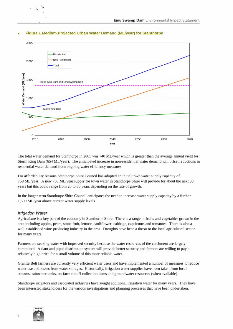
Projected residential, non-residential and total water demands for Stanthorpe to 2070 are presented in Figure 1. Over time the non-residential water demands are expected to exceed the residential demands. This reflects the changing character of Stanthorpe where the urban population is constrained (by young people leaving for education and services sector employment opportunities) while growing tourism and agriculture value-adding are increasing water demand in these sectors.
2
Figure 1 Medium Projected Urban Water Demand (ML/year) for Stanthorpe
0
500
1,000
1,500
2,000
2,500
2010 2020 2030 2040 2050 2060 2070Year
Wat
er D
eman
d (M
L/ye
ar)
Residential
Non-Residential
Total
Storm King Dam and Emu Swamp Dam
Storm King Dam
The total water demand for Stanthorpe in 2005 was 740 ML/year which is greater than the average annual yield for Storm King Dam (654 ML/year). The anticipated increase in non-residential water demand will offset reductions in residential water demand from ongoing water efficiency measures.
For affordability reasons Stanthorpe Shire Council has adopted an initial town water supply capacity of 750 ML/year. A new 750 ML/year supply for town water in Stanthorpe Shire will provide for about the next 30 years but this could range from 20 to 60 years depending on the rate of growth.
In the longer term Stanthorpe Shire Council anticipates the need to increase water supply capacity by a further 1,500 ML/year above current water supply levels.
Irrigation Water Agriculture is a key part of the economy in Stanthorpe Shire. There is a range of fruits and vegetables grown in the area including apples, pears, stone fruit, lettuce, cauliflower, cabbage, capsicums and tomatoes. There is also a well-established wine-producing industry in the area. Droughts have been a threat to the local agricultural sector for many years.
Farmers are seeking water with improved security because the water resources of the catchment are largely committed. A dam and piped distribution system will provide better security and farmers are willing to pay a relatively high price for a small volume of this more reliable water.
Granite Belt farmers are currently very efficient water users and have implemented a number of measures to reduce water use and losses from water storages. Historically, irrigation water supplies have been taken from local streams, rainwater tanks, on-farm runoff collection dams and groundwater resources (when available).
Stanthorpe irrigators and associated industries have sought additional irrigation water for many years. They have been interested stakeholders for the various investigations and planning processes that have been undertaken.
3
Ten farmers agreed to participate in an effluent reuse scheme in Stanthorpe approximately 5 years ago. This scheme provides a relatively small supply of water (300 to 400 ML/year) but it is very reliable. The irrigators involved in the effluent reuse scheme consider that the improved water security leads to improved agricultural products and farming sustainability. The extra water provided by the effluent reuse scheme has not resulted in any increase in irrigation area.
The water entitlement for the Irrigation component of the Project is 1,740 ML/year. This water represents an increase of 8% above existing irrigation entitlements. The percentage increase in total irrigation water volume would be much less because of the additional volume of direct rainfall and on-farm runoff collection. The increased irrigation water from the Project will not lead to increased cropping areas.
Project Alternatives There have been a number of investigations for project alternatives including other water resources, decreasing water demand, and other dam locations. There are no significant groundwater resources in the Shire and other surface water resources in the region are already committed for either urban or irrigation purposes. Further significant reductions in water demand are unlikely because Stanthorpe Shire Council has implemented water restrictions more than 47% of the time over the last 32 years. There are a number of other potential dam options but they cannot provide the yield required.
Project Description The Emu Swamp Dam Project has four major components. These are:
Emu Swamp Dam; Stalling Lane Access; Urban Pipeline; and Irrigation Pipeline.
The Urban Water Supply Dam has a storage capacity of 5,000 ML and an average annual yield of 696ML. The Full Supply Level is 734.5 m AHD with an associated inundation area of 110 ha. The proposed dam and pipeline are sized to deliver 750 ML/year.
The Combined Urban and Irrigation Dam has a storage capacity of 10,500 ML. The Full Supply Level is 738 m AHD with an associated inundation area of 196 ha. This dam option can deliver an average 696 ML/year of urban water plus 1,384 ML/year of irrigation water.
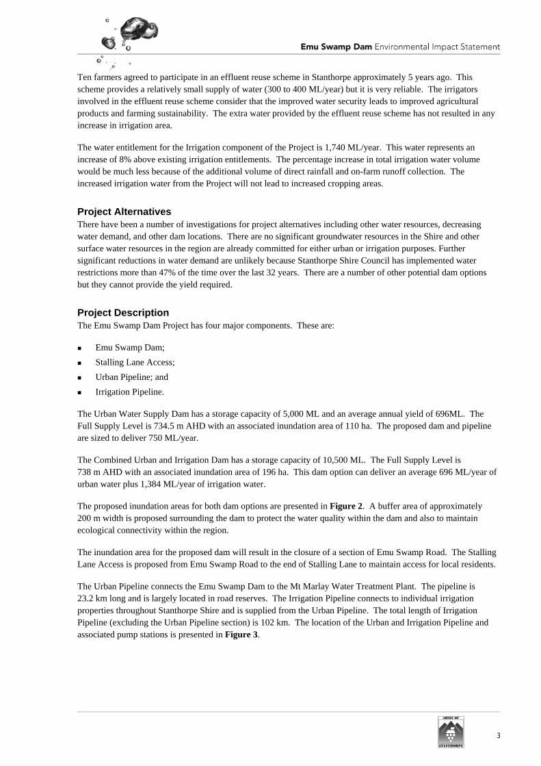
The proposed inundation areas for both dam options are presented in Figure 2. A buffer area of approximately 200 m width is proposed surrounding the dam to protect the water quality within the dam and also to maintain ecological connectivity within the region.
The inundation area for the proposed dam will result in the closure of a section of Emu Swamp Road. The Stalling Lane Access is proposed from Emu Swamp Road to the end of Stalling Lane to maintain access for local residents.
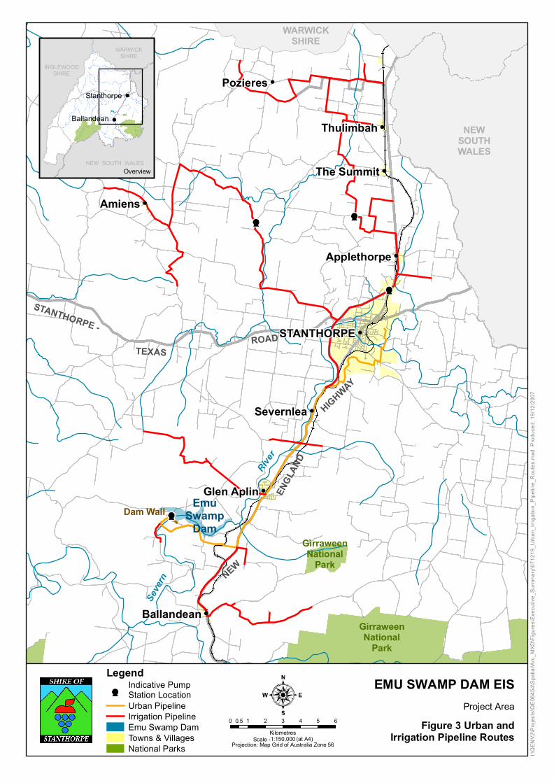
The Urban Pipeline connects the Emu Swamp Dam to the Mt Marlay Water Treatment Plant. The pipeline is 23.2 km long and is largely located in road reserves. The Irrigation Pipeline connects to individual irrigation properties throughout Stanthorpe Shire and is supplied from the Urban Pipeline. The total length of Irrigation Pipeline (excluding the Urban Pipeline section) is 102 km. The location of the Urban and Irrigation Pipeline and associated pump stations is presented in Figure 3.
I:\QENV2\Projects\QE06454\Spatial\Arc_MXD\Figures\Executive_Summary\080103_Inundation_Areas.mxd
Produced:3/1/2008
EMU SWAMP DAM EISEmu Swamp Dam Site
Projection: Map Grid of Australia Zone 56
0 200 400 600 800100
Metres
LegendFull Supply Level 734.5m AHDFull Supply Level 738m AHDBuffer Area
Dam WallStalling Lane AccessCadastre Figure 2
Inundation Areasand Buffer Area
Scale - 1:20,000 (at A4)
NEW
SOUTH
WALES
WARWICK SHIRE
New
England
Hwy
Amiens
PozieresThulimbah
Severnlea
STANTHORPE
The Summit
Ballandean
Glen Aplin
Applethorpe
Overview
Seve
rn
River
Dam Wall EmuSwamp
Dam
GirraweenNational
Park
GirraweenNational
ParkNEW
ENGL
AND
HIGHWAY
STANTHORPE -
TEXASROAD
NEWSOUTHWALES
WARWICKSHIRE
Amiens
Pozieres
Thulimbah
Severnlea
STANTHORPE
The Summit
Ballandean
Applethorpe
Glen Aplin
I:\QEN
V2\P
rojec
ts\QE
0645
4\Spa
tial\A
rc_MX
D\Fig
ures\E
xecu
tive_
Summ
ary\07
1219
_Urba
n_Irri
gatio
n_Pip
eline
_Rou
tes.m
xd P
roduc
ed: 1
9/12/2
007
EMU SWAMP DAM EIS
Figure 3 Urban andIrrigation Pipeline Routes
Project Area
NEW SOUTH WALES
INGLEWOODSHIRE
WARWICKSHIRE
Stanthorpe
Ballandean
Overview
Projection: Map Grid of Australia Zone 56
0 1 2 3 4 5 60.5Kilometres
Scale -1:150,000 (at A4)
LegendIndicative PumpStation LocationUrban PipelineIrrigation PipelineEmu Swamp DamTowns & VillagesNational Parks
6
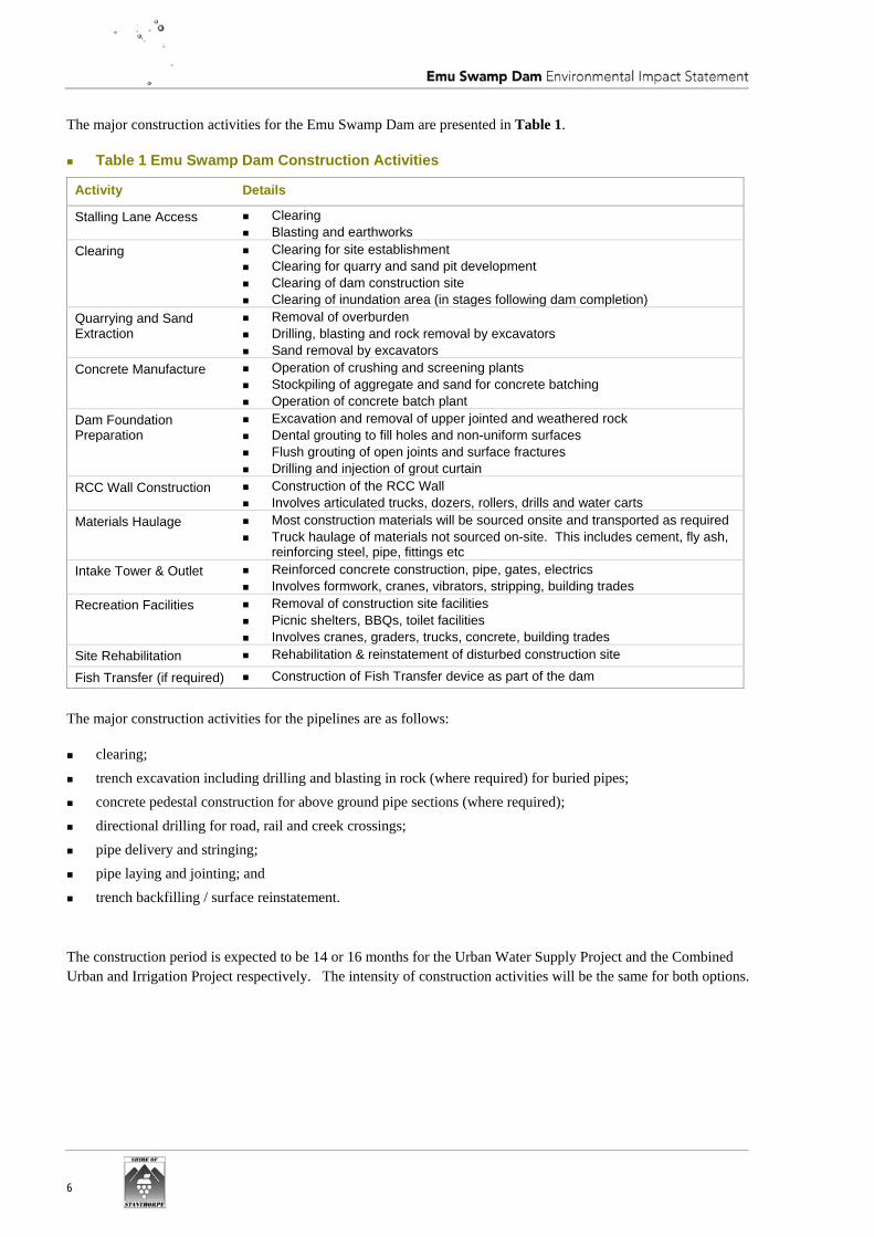
The major construction activities for the Emu Swamp Dam are presented in Table 1.
Table 1 Emu Swamp Dam Construction Activities
Activity Details
Stalling Lane Access Clearing Blasting and earthworks
Clearing Clearing for site establishment Clearing for quarry and sand pit development Clearing of dam construction site Clearing of inundation area (in stages following dam completion)
Quarrying and Sand Extraction
Removal of overburden Drilling, blasting and rock removal by excavators Sand removal by excavators
Concrete Manufacture Operation of crushing and screening plants Stockpiling of aggregate and sand for concrete batching Operation of concrete batch plant
Dam Foundation Preparation
Excavation and removal of upper jointed and weathered rock Dental grouting to fill holes and non-uniform surfaces Flush grouting of open joints and surface fractures Drilling and injection of grout curtain
RCC Wall Construction Construction of the RCC Wall Involves articulated trucks, dozers, rollers, drills and water carts
Materials Haulage Most construction materials will be sourced onsite and transported as required Truck haulage of materials not sourced on-site. This includes cement, fly ash,
reinforcing steel, pipe, fittings etc Intake Tower & Outlet Reinforced concrete construction, pipe, gates, electrics
Involves formwork, cranes, vibrators, stripping, building trades Recreation Facilities Removal of construction site facilities
Picnic shelters, BBQs, toilet facilities Involves cranes, graders, trucks, concrete, building trades
Site Rehabilitation Rehabilitation & reinstatement of disturbed construction site
Fish Transfer (if required) Construction of Fish Transfer device as part of the dam
The major construction activities for the pipelines are as follows:
clearing; trench excavation including drilling and blasting in rock (where required) for buried pipes; concrete pedestal construction for above ground pipe sections (where required); directional drilling for road, rail and creek crossings; pipe delivery and stringing; pipe laying and jointing; and trench backfilling / surface reinstatement.
The construction period is expected to be 14 or 16 months for the Urban Water Supply Project and the Combined Urban and Irrigation Project respectively. The intensity of construction activities will be the same for both options.
7
Assessment and Management
Topography, Geology, Soils and Geomorphology The proposed Emu Swamp Dam is located on the Severn River 15 km southwest of Stanthorpe. There are mountains on either side of the Severn River at the proposed dam location.
The geology of the inundation area has been interpreted to be competent, resistant to weathering and reasonably tectonically stable. Geotechnical investigations for the preliminary engineering design did not identify any particular problems with the proposed dam site. Further geotechnical investigations will be undertaken for the detailed design of the dam.
The major soil types identified within the inundation area are uniform coarse sands overlying bedrock or gritty gravels. The major soil types along the Urban and Irrigation Pipeline routes are uniform coarse sands.
The construction works will involve the disturbance of soil, removal of vegetation and the movement of spoil creating a potential for erosion and sedimentation to affect water quality and land condition. The soils surveys indicate a low erosion potential. The potential for soil erosion will be managed through the development and implementation of erosion and sediment control plans.
The geomorphology of the upper Severn River is dominated by granite bedrock with thin overlying sands. Some sediment is being transported along the stream and captured in small weirs downstream of the Emu Swamp Dam site. Construction of the Project is unlikely to affect erosion processes significantly but deposition of alluvial material is likely to decrease downstream of the dam.
Land Use and Planning The inundation area for Emu Swamp Dam would be acquired and would result in the loss of Rural zoned land of which most is in freehold tenure. While mostly vegetated, this land also contains cleared areas for dwelling houses, farm sheds, orchards, vineyards and other rural uses. The inundation area would be rezoned from Rural to Community Infrastructure.
Direct adverse impacts would occur to the areas subject to the construction of the dam wall and the inundation area. Based on the size of the inundation area, the Urban Water Supply Dam would have a smaller direct impact area than the Combined Urban and Irrigation Dam.
The Urban and Irrigation Pipelines are mainly located within road reserves although a number cross freehold properties.
The provision of additional water to Stanthorpe would support its future planned development particularly for the identified residential and industrial growth areas. The Planning Scheme would manage how this land is developed.
The provision of water for irrigation to the nominated properties would improve reliability and support the ongoing use of these properties for horticultural and other rural uses. Changes to rural uses and the development of ancillary tourism uses may occur within these properties. Council’s Planning Scheme contains provisions which manage the type and scale of development on Rural zoned properties.
Overall the availability and improved reliability of water supply allows the planned future development of urban and rural growth in Stanthorpe Shire and strengthens the role of Stanthorpe Shire as a key provider of quality rural produce, tourist attractions and diverse residential opportunities.
Land Contamination The contaminated land assessment did not identify any potential contamination concerns within the proposed Emu Swamp Dam inundation and buffer areas. No potential Notifiable Activities were observed from historical aerial
8
photographs and no potential contamination issues were observed during the drive-by survey within and around the proposed inundation and buffer areas.
Historical alluvial tin mining occurred around the Stanthorpe district. The alluvial tin mining process did not include or generate any potential sources of contamination.
Potential contamination sites were identified along the proposed pipeline network at four service stations south of Stanthorpe along the New England Highway and at three railway corridors listed on the EPA’s Environmental Management Register. These sites have the Notifiable Activity listing of Hazardous Contaminants identifying them as having possible high levels of arsenic contamination.
The pipelines will be located to avoid or minimise conflict with these locations.
Surface Water and Water Quality The proposed Emu Swamp Dam will be located in the Granite Belt catchment which is part of the Border Rivers Drainage Basin. The Water Resources (Border Rivers) Plan 2003 was legislated to provide a sustainable framework for allocation and water management to achieve a balance between consumptive uses and the needs of the environment.
The Water Resources (Border Rivers) Plan 2003 requires the achievement of Environmental Flow Objectives (EFOs) and the preservation of Water Allocation Security Objectives (WASOs). The effect of the Emu Swamp Dam on EFOs and WASOs was assessed using an Integrated Quantity and Quality Model (IQQM) provided by DNRW.
The flow statistics highlight the following characteristics of the flow regime of the Severn River:
the Severn River is an ephemeral stream; there is significant monthly variability in median daily flow; there is significant reduction from predevelopment to the existing entitlements scenario; and Accommodation Creek inflows are significant.
The mean annual diversion for the Urban Water Supply Dam is predicted to be 696 ML at a monthly reliability of 93%. The mean annual diversion for the urban component of Combined Urban and Irrigation Dam is predicted to be 698 ML at a monthly reliability of 93 %. The mean annual diversion for the irrigation component of the Combined Urban and Irrigation Dam is predicted to be 1,302 ML at a monthly reliability of 75%.
The environmental release regime proposed for Emu Swamp Dam is to pass flows up to 30 ML/day through the dam in order to meet the flow objectives set at Farnbro (46 km downstream of the dam site) for both the Urban Water Supply Dam and the Combined Urban and Irrigation Dam.
The EFO performance indicators under the Water Resources (Border Rivers) Plan 2003 show the Urban Water Supply Dam and the Combined Urban and Irrigation Dam have no impact on the low flow days and the summer flow days.
The majority of the water allocations downstream of the dam have passing flow conditions of 0-25 ML/day before they can take water. The release strategy for the dam is designed to preserve the access to water for the existing water allocations.
The effects of the Urban Water Supply Dam and Combined Urban and Irrigation Dam on the flow regime of the Severn River are:
no impact on flow regime upstream of the proposed dam; downstream impacts are localised to between the proposed dam and the confluence of Accommodation Creek;
9
the dam has minimal impact on the flow regime downstream of Accommodation Creek; and the dam has negligible impact on the flow regime at Sundown National Park.
There is a 50 to 60% probability of filling the Urban Water Supply Dam in the first year while maintaining the environmental release strategy outlined above. There is a 40 to 45% probability of filling the Combined Urban and Irrigation Dam in the first year while maintaining the environmental release strategy.
The flood assessment shows there is a minor reduction in peak flood level downstream of the proposed dam and a minimal increase in flooding within the buffer area. There is no effect upstream of the buffer area.
The major dam construction activities have the potential to impact on surface water quality both during construction and operation. The key mitigation measures that will be implemented to protect surface water quality include stabilisation of exposed soils, re-vegetation of impacted areas, installation of bunding and spill equipment for hazardous materials. A routine water quality monitoring program will be undertaken to confirm the success of the mitigation measures.
Groundwater Assessment of existing data indicates that there is no regional groundwater resource of significance within the vicinity of the Project. The data indicates only low to very low yields of groundwater.
The Stanthorpe Adamellites dominate the local geological setting which have low to moderate permeability.
A localised increase in groundwater levels may potentially occur in the immediate vicinity of the Emu Swamp Dam. However, no significant adverse impacts are anticipated because of the quality of stored surface waters; the absence of local or regional sensitive receptors and the absence of a groundwater resource.
Whilst mitigation measures for groundwater are not considered necessary a series of observation points for groundwater monitoring in the vicinity of the Project area will be installed and monitored for the construction and operation of the Project as a due diligence measure.
Terrestrial Ecology The Commonwealth Environment Protection and Biodiversity Conservation Online Protected Matters database indicates a ‘Critically Endangered’ vegetation community described as ‘White Box, Yellow Box, Blakely’s Red Gum Grassy Woodland and derived Native Grassland’ is present in the Project area. Six Regional Ecosystems (REs) are mapped within the Project area, three of which are listed as ‘Endangered’, one as ‘Of Concern’ and one as ‘Not of Concern’
A total of 295 species of vascular plants were recorded within the dam inundation and Stalling Lane Access areas. The survey of the inundation area recorded 5 of the 51 species of Endangered Vulnerable Rare (EVR) taxa potentially occurring in the Project area; including Acacia latisepala, Melaleuca flavovirens, Melaleuca williamsii, Rulingia hermaniifolia, and Thelionema grande. The survey of the proposed Stalling Lane Access recorded 2 of the 51 species of potential EVR taxa including Acacia pubiflora and Melaleuca williamsii . The survey of the Urban Pipeline route recorded 3 of the 51 potential EVR species including Acacia latisepala, Mibelia confertiflora and Melaleuca williamsii. The survey of the Irrigation Pipeline route recorded 3 of the 51 potential EVR species including Acacia latisepala, Grevillea scortechinii subsp scortechinii and Melaleuca williamsii.
In total, 187 terrestrial vertebrate species were recorded from the Project area, including 35 species of mammals, 118 birds, 23 reptiles and 11 amphibians. Fourteen species of special conservation significance were recorded in the Project area. Twenty-three species of special conservation significance were not recorded but are predicted to occur in the Project area.
The proposed inundation area is located in a Regional Wildlife Corridor as mapped by the EPA. The potential disruption to fauna movement as a result of the Project has been assessed to be minor.
10
The potential impacts of the Project on terrestrial flora and fauna include the loss of remnant and non-remnant vegetation; fragmentation of riparian vegetation along parts of the Severn River; disturbance from construction activities and proliferation of exotic species, including pests and weeds.
There is limited scope for the avoidance of impacts to terrestrial flora within the proposed inundation area. Mitigation measures proposed relate to the establishment of compensatory habitat through a number of inter-related mechanisms being:
a suitable vegetation management offset strategy developed to meet the regulatory requirements of the Policy for Vegetation Management Offsets;
creation of adequate and suitable compensatory habitat for EVR species affected by inundation; conservation of habitat for EVR species though establishment of binding conservation agreements; and a specific Species Management Plan for individual EVR flora species affected by inundation
A number of weeds and pests were recorded in the Project area during the flora and fauna surveys. Ongoing management is recommended to minimise the potential impacts of these species.
Aquatic Ecology There are a number of weirs on the Severn River and some of these weirs would represent major barriers for fish passage. Fish passage is currently extremely limited along at least 12 km of river below Campbell’s Weir (located within the inundation area of the proposed Emu Swamp Dam) and above the junction with Accommodation Creek. The level of existing weir development will have led to significant impacts on ecology, particularly on fish that rely on shallow flowing areas or need a period of sustained higher flows to disperse.
In total, 38 species of aquatic flora have been recorded in the Project area. The macroinvertebrate fauna appeared reasonably diverse and abundant, with representatives of all the major taxonomic groups. The main fish species captured in the aquatic ecology surveys were large numbers of Eel-tailed catfish, four species of native carp gudgeon, three species of introduced native predators (Murray cod, Silver perch and Yellowbelly), and introduced Mosquito fish. Two Bell’s turtle were captured during the surveys; one in Bald Rock Creek (a reference tributary) and another in the Severn River near Somme Lane, downstream from the proposed dam site.
Species of conservation significance in the area include Maccullochella peelii peelii (Murray Cod), Bidyanus bidyanus (Silver Perch), Mogurnda adspersa, Ambassis agassizii, and Elseya belli (Bell’s turtle).
The construction of Emu Swamp Dam will not represent a significant change in fish movement opportunities in comparison with the existing situation. The benefit of a fish transfer device at Emu Swamp Dam would probably be limited. Stanthorpe Shire Council intends to fund a study of the present distribution and abundance of those endemic species that are currently impacted and develop a management plan to repopulate areas of remaining suitable habitat.
Air Quality and Greenhouse Gases The existing air quality in the Project area is good with emissions sources including agricultural activities, motor vehicles and occasional bushfires and control burns. Air quality goals for the Project have been adopted from the Environmental Protection (Air) Policy 1997.
Construction activities with the potential to generate dust include quarrying, sand extraction, screening and haulage of materials on unsealed roads. The intensity of construction activities will be the same for both dam options. The construction period is expected to be 14 or 16 months for the Urban Water Supply Project and the Combined Urban and Irrigation Project respectively.
11
The potential air quality impacts of Project construction was determined through air dispersion modelling. The air quality goals are unlikely to be exceeded during construction of the Project. Mitigation measures and a monitoring program will be implemented to minimise the impacts of construction dust on the nearest sensitive receivers.
Greenhouse gas emissions from construction of the dam are approximately 3,666 and 4,231 t CO2-e for the Urban Water Supply Project and the Combined Urban and Irrigation Project respectively. These emissions represent a small fraction of Queensland’s greenhouse gas emissions.
The Project is generally not vulnerable to impacts of climate change although there is a potential for reduced flows in the Severn River. The construction of Emu Swamp Dam will improve water security and reduce the impacts of climate change on the Stanthorpe community.
Noise and Vibration Noise levels were monitored at sensitive receivers close the proposed dam construction area. Background noise levels were low with insects, birds and occasional motor vehicles the most significant noise sources.
There are no formal noise guidelines for construction projects in Queensland. The ambient noise goal of 55 dB(A) in the Environmental Protection (Noise) Policy 1997.has been adopted for daytime (6am to 6pm) and evening (6pm to 10pm) periods. For construction works at night between 10pm and 6am, an ambient noise goal of 52 dB(A) has been adopted to minimise the potential for sleep disturbance impacts. Targets for noise and vibration from blasting have been established by the EPA.
Construction equipment such as haul trucks, excavators, dozers, loaders, concrete batching plant and screening plant has the potential to generate noise impacts at the nearest sensitive receivers. The construction period is expected to be 14 or 16 months for the Urban Water Supply Dam and the Combined Urban and Irrigation Dam respectively. Most construction activities will occur for 10 hours per day for 6 days per weeks except concrete batching (24 hours per day) and crushing (two 10 hour shifts per day)
Noise modelling for dam construction has determined the potential for noise impacts at the nearest sensitive receivers. Predicted noise levels were generally below the adopted noise targets. Concrete batching at night during the Left Half RCC Wall Construction exceeded the night time noise goal at one sensitive receiver.
The potential impact of noise and vibration from blasting is not expected to exceed EPA guidelines.
The major noise sources during dam operation include the pump stations for the Urban and Irrigation Pipeline. Other potential noise sources may include recreational boating and people using the recreational area. The pump stations are located significant distances (between 200 and 500 m) from sensitive receivers and are unlikely to generate noise impacts.
Mitigation measures such as maximising the distance between noisy plant and nearby noise sensitive receivers and limiting vehicle speeds in critical areas both on and off site will be implemented to minimise the impacts of construction noise on the nearest sensitive receivers and a monitoring program established.
Transport and Infrastructure The inundation area for the proposed dam will result in the closure of a section of Emu Swamp Road. The Stalling Lane Access is to be constructed from Emu Swamp Road to Stalling Lane to maintain access for local residents.
The total traffic generated during the construction phase of the Project is 370 light vehicles and 30 heavy vehicles per day mainly accessing the Project site from the New England Highway and Fletcher Road. The construction phase of the Project is not expected to have significant impacts on traffic operations of any of the local road links. Mitigation measures have been recommended to minimise potential impacts on the road network.
12
Some telephone lines and low voltage power lines are located within the inundation area of the proposed dam and will require realignment. The disturbance caused by the relocation and decommissioning of existing infrastructure will be minimal and temporary in nature. Infrastructure will be relocated within existing infrastructure corridors, such as road reserves so that disturbance to land and vegetation is minimised.
Cultural Heritage There are no native title claims on the Project area. Stanthorpe Shire Council has commenced development of a Cultural Heritage Management Plan to manage indigenous cultural heritage. It is anticipated the Cultural Heritage Management Plan will be registered by early 2008.
European cultural heritage has been formed through key phases in the development of the region with tin mining in the late 1800s; development of fruit farming; the soldier resettlement program following World War I and large scale Italian immigration in the 1920s (which eventually contributed to the development of the wine industry).
A cultural heritage survey was undertaken for the Severn River Mining Precinct which included graves along the Severn River; the original mining reserve and other sites likely to be associated with the early tin mining industry in the area. The survey identified ten sites with low to moderate levels of cultural heritage significance within the Project area - four of these would be directly impacted by the Project.
Further historic items may exist within the Severn River Mining Precinct and a systematic assessment of this immediate area will be conducted to ensure that the type and extent of any surviving archaeological material is researched, investigated, recorded and mitigated (if required).
Socio-Economic Local residents are generally supportive of the Project and believe that the provision of a reliable urban water supply is necessary for the future growth and sustainability of the Shire. The development of a reliable irrigation supply is also seen as important for the future development of the Shire’s primary industries.
Maximising the direct and indirect benefits of the Project for local residents is important for the local community. This could be achieved through:
ensuring local employment and training opportunities during construction, particularly for young people; ensuring access to the recreational and amenity values of the dam; and ensuring business opportunities during construction, through the use of local goods and services.
A number of potential impacts on the social environment have been identified. These would need to be managed by construction management and by consultation and communication with key stakeholders, community service providers, and local residents. In particular, this includes:
management of potential impacts on rental housing, particularly for low income earners; management of potential impacts on community facilities, such as local schools and health services, from an
increase in population during construction, through consultation with agencies and service providers; and management of construction traffic, to ensure safety for motorists on roads likely to experience an increase in
construction traffic and in the vicinity of construction works.
Both the Urban Water Supply Project and the Combined Urban and Irrigation Project options will have a positive economic benefit on the Darling Downs economy. The economic benefits from the dam and pipeline construction result from employment of people (especially from the local and regional area); purchase of raw materials and equipment for construction; and flow-on effects to the local and regional economy.

13
The provision of a more secure water supply for Stanthorpe will allow the recent growth in industrial and commercial activity to continue. The Irrigation component of the Combined Urban and Irrigation Dam will deliver significant economic benefits for the Darling Downs.
Scenic Values The proposed Emu Swamp Dam will be visible from the scenic ridgelines and slopes but there are only a few residents on these elevated areas; the distance is significant and the views are largely screened by topography and local vegetation.
There are a number of local receptors in close proximity to the Project particularly along Fletcher Road and downstream of the dam wall.
Overall the significance of the changes to the landscape and visual amenity of the surrounding catchment for these local receptors is considered moderate to low. While the significance of the change is considered substantial much of the change, from a landscape perspective could be considered beneficial.
Waste Management Waste produced on site during construction will include construction material wastes (timber framing, concrete, rock, gravel, scrap metals, cable, wire, insulation, plastics and packaging), vegetation and soils as a result of clearing, regulated waste (hydrocarbon waste, chemical resides, detergents, solvents, batteries, tyres), drums and containers from supply of chemicals and oils, domestic and other general waste (food scraps, packaging, rags), recyclable waste (aluminium cans, glass, cardboard and paper), scrap metal; and sewage effluent and sludge.
The waste generated during construction and operation will be handled, stored, treated, transported and disposed with a low level of impact on environmental values. Waste management implementation procedures will focus on the waste hierarchy of waste avoidance, re-use and recycling.
All waste generated on-site during the construction and operation phase will be disposed of in accordance with a Waste Management Plan (WMP), which will include waste stream characterisation and separation, assessment of waste reduction opportunities for identified waste and management of waste in accordance with the waste management hierarchy. Standard procedures for the storage, handling, disposal and spill response for potentially hazardous waste materials will be applied.
Hazard and Risk The hazards and risks associated with the Project have been identified through the use of a Preliminary Hazard Analysis which assisted in the identification of potential incident scenarios, consequences, prevention, protection and mitigation measures.
The major hazards identified are associated with dam failure and public safety. In terms of this preliminary risk assessment, it is considered that the risk levels are tolerable, and can be managed through the design process through to construction and operation.
The risk profile during construction is generally ‘low’ to ‘moderate’ with the exception of safety risks from blasting, which have been assessed as ‘high’ risk. These are assessed as high because there is significant energy involved and the controls can only reduce the probability of the event. These risks are common to all blasting operations and are subject to standard controls and a rigorous site-based safety management system.
The Project will implement a safety management system, which adopts an integrated approach to risk management, recognising the hazards at all points in the operations and how these are controlled. The analysis of the hazards indicates that risks to the public and to the environment are moderate. It is considered that the risk levels are tolerable and can be managed with the processes identified in the Environmental Management Plan.
14
Management Plans A draft Environmental Management Plan has been prepared to provide input into the detailed planning and design phase of the Project. The draft Environmental Management Plan will form the basis of the development of the final plan to be used on site during construction and operation of Emu Swamp Dam. The Construction Environmental Management Plan will cover the management of erosion, stormwater, water quality air quality, noise and vibration, vegetation and traffic. The Operational Environmental Management Plan will cover the management of the water storage, water quality, aquatic ecology, and noise and vibration.
Submissions on the EIS The EIS for the Project will be on public display for 30 business days from 12th January 2007 at a number of locations including Stanthorpe Shire Library and Stanthorpe Shire Council offices. This process aims to inform and engage stakeholders with an interest in the Project.
Members of the community, organisations and Government agencies are invited to make formal submissions on the EIS, in accordance with the State Development and Public Works Organisation Act. Submissions are to be written (either electronically or in hard copy) and, in the case of hard copy submissions, signed by each person making the submission. The submission should state the name and address of each person making the submission and state the grounds of the submission and the facts and circumstances relied on to support the submission.
The Coordinator-General will consider all properly made submissions on the EIS received within the submission period. Copies of all submissions will be provided to the Proponent. All submissions will be treated as public documents, unless the author of the submission requests that the submission be treated as a confidential submission.
Submissions are to be received by the Coordinator-General on or before close of business on the last day of the submission period. The submission period will be clarified in public advertisements made in the Courier Mail and the Border Post.
Written submissions should be addressed to:
Attention: EIS Project Manager - Emu Swamp Dam Project
Major Projects Division
Department of Infrastructure and Planning
PO Box 15009
Brisbane City East QLD 4002; or
Fax on: (07) 3225 8282; or
Email to: [email protected]